loss of the steamship valbanera - key west maritime
TRANSCRIPT
Florida Keys
Sea Heritage Journal
VOL. 15, NO. 3 SPRING 2005 USS SHARK
$2
OFFICIAL QUARTERLY PUBLICATION OF THE KEY WEST MARITIME HISTORICAL SOCIETY
In the Wilhelmina Harvey Collection (see Society News on page 2) at the Monroe County Library is information and photographs from the Navy on hurricanes that we had never seen before. We may never know how the Harveys came by the file. Did C.B. (her Husband) save it when the Naval Station closed and the Engineering Office where he worked moved to Boca Chica or did the Navy give him copies for his duties as Mayor of Key West (1951-57 and 1961-1963) or did Wilhelmina come by the file when she worked in the Navy Yard or her many years in Monroe County government.
The report that follows on communication with the Spanish passenger liner Valbanera during and after the Hurricane of 1919 has been a subject of speculation and has been missing for years. Fernando J. Garcia Eckegogan, who wrote the story of the loss of the Valbanera in the Summer 1996 Journal, searched for the report in Washington and Spain. We searched for the report in the National Archives in Washington and Atlanta and found the Navy’s report on the Hurricane of 1919 which was printed in the Fall Journal of 1999 but not the report about the
messages from the ill fated ship. The loss of the Valbanera with over 500 passengers and crewmen made the 1919 Hurricane the third deadliest storm to strike the United States. The report does not answer all the questions but does end the speculation about radio communication with the ship after the storm.
On page three is the Navy’s report on the 1909 Hurricane. One interesting fact is the maximum wind recorded by the Navy during
the 1909 Hurricane was 84 mph. This goes in contradiction of the destruction reported from the storm and shown in the photographs in the Library. Newspaper accounts reported 400 buildings were destroyed and 300 boats in the harbor were totally destroyed. Even later accounts of this storm put the maximum wind at 94 mph with 6.13 inches of rain. So all accounts make this a category 1 storm on the Saffir-Simpson scale. The question
Loss of the Steamship Valbanera
(Continued on page 14)
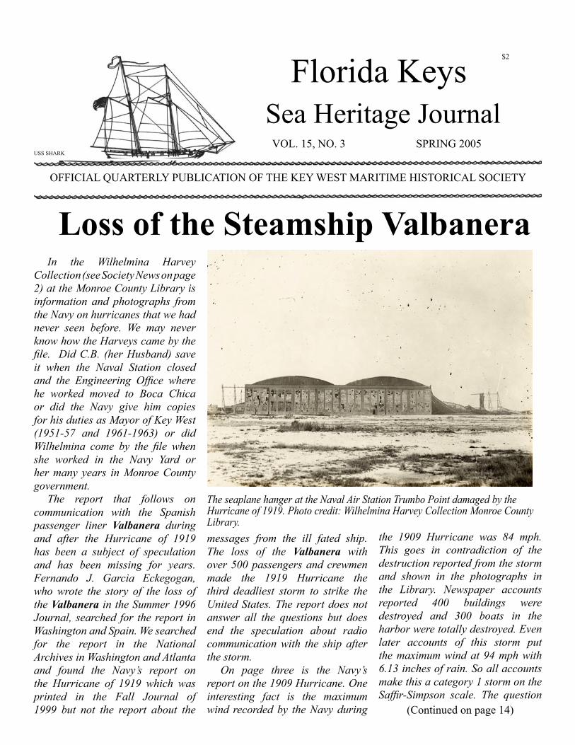
The seaplane hanger at the Naval Air Station Trumbo Point damaged by the Hurricane of 1919. Photo credit: Wilhelmina Harvey Collection Monroe County Library.

2 - FLORIDA KEYS SEA HERITAGE JOURNAL - SPRING 2005
The Florida Keys Sea Heritage Journal is published quarterly. Subscription is available through membership. Copyright 2005 by the Key West Maritime Historical Society of the Florida Keys, Inc. The art on the masthead, the USS Shark, was drawn by Bill Muir.
Editor: Lynda HambrightProduction:Tom Hambright
Letters and articles are welcome. Please write to: Editor, Florida Keys Sea Heritage Journal, KWMHS, P.O. Box 695, Key West, FL 33041.
Key West MaritimeHistorical SocietyBoard of Directors
President: Edward J.Little,Jr.Vice President: Winifred FryzelSecretary: Corey MalcomTreasurer: Lynda Hambright
Shauna CameronTom HambrightMary HaffenrefferJohn JonesSheri LohrDon LoweT.J. McDermottJulie McEnroeWilliam McKinleyDavid RoummJohn Viele
New Member
Soceity NewsBy Tom & Lynda Hambright
Hal Burrgert, Colleyville, Texas; Robbie Hopcraft, Key West; Robert N. Macomber, Matlacua Island,
Florida; Tony Skrebys, Michigan City, Indiana; Jean Thornton, Key West.
The past few months Key West and the Society have suffered serious losses with the deaths of many community leaders and friends of the Society.
The Society lost a dear friend and one of our hardest working members with the death of Pam Viele in May 2005. Pam with her husband John had been with the Society since it was revived in the mid 1980’s and as John’s chief researcher had been a part of the Journal since we began 15 years ago. Until her illness Pam and John arranged, scheduled and did all the work required for our very successful education program. Pam will be missed by all and our sympathy to John and the family.
Nancy Jameson who we lost in April 2005 was serving on our Board of Directors at the time of her death. Nancy supported the Society for years and most other nonprofit organizations in Key West. She was best known for her work with the Oldest House Museum which she ran for many years with an
all volunteer staff. During the lean tourist years of the 1980’s for the slow summer months often meant her late husband, Colin, and Nancy were the only volunteers.
So much has been written about Monroe County Monroe Mayor Emeritus Wilhelmina Harvey who died on May 3, 2005 there is little we can add. She was truly a legend and it was our honor to call her a friend and special honor for us to be entrusted with the Harvey archives which she donated to the Monroe County Library. These papers and photographs range from early 1900’s to 2005. The stories in this issue are from the collection plus some of the photographs, see the introduction to the story on page one.
We also lost City Commissioner Merili McCoy who was a loyal supporter of the Society. A couple that quietly gave us financial support and attended most of the Society’s lectures and field trips was Mary and Ralph Bates. Mary died in 2003 and Ralph on April 1, 2005.
Pam and John Viele. Photo credit: Monroe County Library.

SPRING 2005 - FLORIDA KEYS SEA HERITAGE JOURNAL - 3
October 28, 1909
From Commandant of Naval Station Key WestTo Bureau of Equipment, Navy Department
Sir:In obedience to your No. 27906-
610, of October 15th I respectfully submit the following information in regard to the storm of October 11th.
2. On Sunday October 10th rain fell in frequent showers with light winds from the eastward. At 7 p.m. Sunday a telegram was received from the Weather Bureau in Washington, as follows “Northeast storm warning 5 p.m., Mobile, Pensacola, Panama City, Applachicola, Garabell, City Keys, Rockwell, Tampa, Punta Gorda, Punta Rassa and Key West. Tropical disturbance west of Havana moving northeast by north, with apparently increasing intensity. Increasing northeast winds tonight along both coasts of central and southern Florida, and on Monday along the entire middle and east gulf coast. (Signed) Moore.”
3. Official meteorological data in regard to this storm has been kindly furnished me by the Weather Bureau at Key West. The winds and barometer charts are enclosed herewith.
4. The track of the storm center passed over Cuba, west of Havana, and as shown by the telegram, was expected to take the usual course and strike the north shore of the Gulf of Mexico. In this exceptional case the storm recurved to the eastward and passed along with the Gulf Stream through the Straits of Florida. It was a storm of remarkable intensity but of comparatively small area. The track of the storm center passed about 50 miles south of Key West
moving about E.N.E., afterwards it seemed to follow the axis of the Gulf Stream.
5. The U.S.S. Osceola was at Tortugas Sunday October 10, and the storm began to be felt there that afternoon, its center being west of south of Tortugas. The Osceola left Tortugas Tuesday morning and arrived at Key West at 1 p.m. Tuesday.
6. Sunday night at Key West it was raining in torrents, but the storm was not expected. After midnight, from 1 a.m. October 11th, the wind increased. By 75th meridian time the following is a record of the wind that day.2 a.m. 15 mph East3 a.m. 22 mph East4 a.m. 26 mph South East5 a.m. 25 mph South East6 a.m. 29 mph South East7 a.m. 30 mph South East8 a.m. 32 mph East9 a.m. 39 mph North East10 a.m. 50 mph North East10:05 a.m. 82 mph North East10:50 a.m. 69 mph North East11 a.m. 69 mph North East11:05 a.m. 84 mph North East 11:12 a.m. 74 mph North West 1:20 p.m. 66 mph North West 2 p.m. 63 mph North West
3 p.m. 29 mph North West7. The wind was East and
Southeast until 9 o’clock in the morning showing that the storm was approaching and it was southeast of Key West.
8. The wind came out more to the northeastward, showing the center to be to the southward. At noon the wind shifted to the N.W. with a raising barometer. At 1 p.m. when the barometer had fallen to 28.50, its lowest point, there was a marked change of 8 points in the direction of the wind, showing that the storm had passed about due south of Key West following the axis of the stream. The center did not pass near enough to Key West to make the “eye” of the storm visible. It was raining during the entire period in torrents. No other cloud formation was visible except heavy minibus clouds, very dark.
9. At noon it brightened up a little, showing a close proximity to the center. There was, however, no uplifting wind at Key West the houses that were blown over having no foundation and not being otherwise anchored, but there was
Hurricane 1909
(Continued on page 4)
Nichols Cigar Factory before and after the Hurricane of 1909. Photo credit: Monroe County Library.

4 - FLORIDA KEYS SEA HERITAGE JOURNAL - SPRING 2005
nothing in the way of an uplifting force, showing that the center was fully 50 miles south of Key West.
10. The storm seemed to have traveled at the rate of about 20 miles an hour as it passed South of Key West. The strong winds due to the remarkably steep barometer gradient prevailed for about four hours with a wind force ranging from 50 to 63 miles an hour with its greatest force from 10:45 a.m. until 1 p.m. There were three periods when the wind reached a maximum velocity of 84 miles for 5 minutes, 82 miles for another 5 minutes and 80 miles at 1:20 p.m.
11 The storm was of no greater severity than is frequently experienced with blizzards, ice and snow on our New England coast during the winter, and there were no precautions taken against it as the buildings, except those of the Government, are very frail structures, and were blown down, but they have since, for the most part been set upright again.
12. The pilot boats Nonpareil and J.E. Jewett rode safely in the harbor at their anchorage; the pilot boat Magic cut away her spars and rode out the storm. The U.S. Army Engineers’ Dredge Key West was at anchor in Man of War Harbor drifted down on Navy moorings No. 5, in which her anchor caught and held her, after which she rode safely throughout the storm. The Mallory steamer Lampassas lay alongside the Mallory wharf and was uninjured. The four masted schooner Wilson, loaded with coal at the William Curry’s Sons Co.’s wharf carried away the bollards on the wharf. She got a line to the Lampassas alongside the Mallory wharf where she remained during the rest of the storm.
13 The Revenue Cutter Forward attempted to go to the moorings in
Man of War Harbor but was not able to head up to the storm. She is an old low power steamer with a maximum speed of 7 knots, and she drifted on the N.E. edge of Frankford Banks in Man of War Harbor.
14. The Army tug A.G. Force left Pier B at the Naval Station to go up into Man of War Harbor. She
was too late in leaving and badly handled. She was blown back and went ashore on Crawfish Key. If she had remained alongside Pier B she would have suffered no damage but this vessel, belonging to the Army, was not under the control of the Commandant of the Station, although allowed the privilege of lying alongside the dock.
(Hurricane 1909 from page 3)
Duval Street after the Hurricane of 1909. Photo credit: Monroe County Library.

SPRING 2005 - FLORIDA KEYS SEA HERITAGE JOURNAL - 5
15. The Danish Bark Eber, lying in the channel, dragged to the west side of the channel and remained there during the storm. The British schooner F.W. Pickles, lying at anchor off Fort Taylor dragged her anchors and being broadside to the wind, she cut away her fore and main masts leaving the mizzenmast standing, which brought her head to the wind and she rode out the storm in the West Channel without any further damage. The steamer Evelyn lay alongside the P. & O. Dock and rode out the gale without damage. The Lighthouse Tender Mangrove remained at the Lighthouse pier and sustained no damage.
16. The U.S.S. Massasoit remained at her berth at Pier B. And sustained no damage. One of the steam launches moored at the landing in between the new fill sustained no damage. The anchor-bouy at the Naval Station, by Pier B rode out the gale without difficulty. The coal barges were anchored in Man of War Harbor. Nos. 149 and 150 drifted from their mooring and were missing; No. 150 has since been located at Jaruse River, on the north coast of Cuba, 25 miles east of Havana. The other barges dragged in the harbor.
17. The fleet of fishing boats were in a crowded basin on the north side of the island and exposed to the northeast wind. Many of them were blown ashore by the force of the wind and more or less damaged. Two schooners in that basin, names unknown, were sunk and others very badly damaged, all very small craft comprising the fishing and sponging fleet of Key West.
18. During the entire storm the sea was comparatively smooth; the shoals and flats to the northward and eastward gave a lee so that only the force of the wind was left with no sea.
19. The schooner Medford, lying alongside Pier A with sand and gravel
for the Penn Bridge Co., who are building a new pier at Pier A under contract, rode out the gale safely until the coal conveyor on Pier A was blown down. The eye bolt supporting the mainstay of the rig broke, due to the wobbling of the pier, and the other supports gave way in succession, the coal rig was then blown down, causing the most serious damage done at this station. The Medford cast out from the wharf to get clear of the wreck of the coal rig and was blown down to Sand Key where she went ashore on Western Dry Rocks. The Massasoit went down and brought off her crew and the ship has been abandoned.
20. The wireless masts were very much exposed but their supports were sufficient and the only damage was the parting of one of the antenna halyards with several other halyards chafed.
21. The newspaper reports of the storm were grossly exaggerated. The total loss of life was only two persons instead of 800 as reported in some papers, and in others as high as 3000. A careful estimate of the total loss of property placed it at not over $400,000, instead of over $5,000,000, as reported.
22. The last storm that did any serious damage to Key West was on the same anniversary October 11, 1846, and the fact that the houses are so frail and unresisting in Key West shows that the appearance of cyclones here is very rare. During the period that I have been here this is the only severe blow that I have experienced. Cyclones rarely cross Cuba and even then rarely come to Key West but rather go towards the north
shore of the Gulf. This storm is the great exception and the sensational press has grossly exaggerated the damages.
23. The harbor is perfectly secure and vessels that were properly handled and properly moored rode out the gale without sustaining any damage. The crowded condition of the fishermen’s harbor made it impossible to take proper precautions in that basin.
24. In regard to rules governing vessels in Key West during a hurricane, in case of a repetition of such a hurricane, the very seldom to be expected, vessels should take extra precautions to secure their moorings if alongside the pier and if at anchor back their anchors and be prepared to steam ahead against such a fierce wind. During the months of September and October only may such storms be expected, and special precautions must be taken against winds from the E.N.W. around N.W. since such hurricanes coming near Key West would invariably appear from S.W. with Easterly winds and would leave Key West through the Straits of Florida with N.W. winds.
25. No tropical cyclone from the eastern end of Cuba would go against the prevailing forces of the Gulf Stream and strike Key West from the eastward. Such storms would be carried north along the coast and up to Charleston and Hatteras.
26. The storm that passes west of Cuba is carried to the north shore of the gulf only in the rare event of a storm crossing Cuba near Havana would tropical cyclone pass near Key West.
Very respectfully,(S) W.H. Beehler.Commodore, U.S.N.Commandant.

6 - FLORIDA KEYS SEA HERITAGE JOURNAL - SPRING 2005
Top: Ruy Lopez Cigar Factory before and after the 1909 Hurricane. Bottom The Manuel Lopez before and after the 1909 Hurricane. Photo credit: Monroe County Library.

SPRING 2005 - FLORIDA KEYS SEA HERITAGE JOURNAL - 7
U.S. Naval Station, Key West, Fla.November 10th, 1910.
Sir:-The Board appointed by your
order No. 3500-1910, of October 17th, 1910, (copy appended marked “A”), to investigate and report upon the damage done to Government property at this Station by the storm of that date, after careful examination and estimate, reports as follows:
1. The Storm. On Thursday, October 13th, 1910, at about 1:00 p.m., signals were hoisted on the Weather Bureau for heavy southeast winds, changing soon to northeast, and then quickly back again to those from the southeast. Thursday night was very stormy; so were Friday and Saturday. Sunday, however, broke quite pleasantly, and so continued all day. During Sunday night the storm came back in greater force, growing worse all day Monday until about 3:10 in the afternoon, when it culminated with a barometer of 28.46. From this on the wind switched well to the southwestward, with a velocity estimated to be from 80 to 100 miles per hour, bringing a very heavy sea from that direction which completed the destructive work already begun by the smaller seas of the previous four days. Monday night, late, the storm practically ceased, though there was a strong wind Tuesday. Since then the weather has been pleasant. The Storm of 1909 passed to the southward of Key West, the wind changing from east to north with the movement of the center; the direction of the wind during the storm of this year was first southeast, veering to southwest as the center passed west of this place on its way north. Last year the
principal damage was due to high water and heavy seas on the north and east sides of the island; this year to the same causes on the south and west sides. The tide was abnormal, reaching an elevation of 126.77, M.L.W. being 120.00, the ordinary range of the tide being 1.25 feet. This height exceeded that of last year’s storm by almost exactly one foot.
2. Grounds of Station. Except along the immediate water front, there was little damage done to the grounds of the Station. But one tree was completely overthrown, though trees and shrubs suffered greatly from the wind and salt spray, which bent them to the ground in many instances and blighted all the foliage and flowers. Perhaps the damage most immediately annoying is the sweeping upon the grounds along the water front of large qualities of debris of all kinds, sea weed, timber, and floating wreckage, so that a large mount of labor becomes necessary to clear this refuse away, for the sake of cleanliness and health. Especially is this true of the seaweed, which rapidly becomes offensive of it is permitted to decay along he shore. It is estimated to clear the debris of all kinds will require the expenditure of $150.00.
3. Water-Front of Station. The storm of October 13-17, 1910, has shown beyond question, the necessity of having a well protected water front along the entire Naval Station. Wherever this was present, the damage from the sea has been nothing at all, or very slight; where it is wanting, the seas have swept everything that was movable away, doing considerable damage.
4. Southern Dike and Fill. South of the Marine Railway slip, the dike completed, with its fill, summer
before last, has suffered greatly. The accompanying survey, plotted upon the plan of the Station, shows that there have been washed out from behind the dike, about 9,000 cubic years of sands and coral rock, while the dike framework has lost many thousand feet of sheathing and bracing, a number of piles have been broken off, several pieces of creosoted sheet piling have been undermined, and there has been yielding of the west face for quite a distance, so that a part of this may have to be rebuilt. The surface of the fill, as far back as the west side of the station buildings west of Front Street, was covered with debris and refuse of every kind from seaweed to large timbers, the framework of structures which had been thrown down by the waves. Just south of the Station, Eaton Street was filled from the sea wall as far back as Front Street with seaweed, timber, boats, and all kinds of flotsam which the sea brought in and left stranded.
5. Northwest Dike and Fill. North of Marine Railway slip, the dike, a continuation of that already described, has also suffered much. Up to Monday morning this part of the protective work stood well there being but little wash back of the dike. The change of the wind from east and southeast to southwest brought in much heavier sea, however, and this swept away the sheathing back of the framework of the dike, giving free entrance to the waves, which quickly undermined the bathing pavilion, wrecking it, and ate away the fill as shown upon the plan of the station, dropping the two launches which had been placed on shore for safety, as the sand washed from under them, and
Navy’s Report on 1910 Hurricane
(Continued on page 8)

8 - FLORIDA KEYS SEA HERITAGE JOURNAL - SPRING 2005
wrecking the shore connection of the approach to Pier “B”. At this part of the dike there was no piling up of debris, as on that south of the Marine Railway, the only damage done being to the dike and fill. The fill lost amounts to about 5000 cubic yards.
6. The estimated cost of repairs to place the dike and fill in approximately the same condition as before the storm is as follows:
8000 ft. B.M. 8” x 6” x 16’, equal to 316 pieces,
7000 ft. B.M. 2” x 10” x 8’, equal to 528 pieces,
2000 ft. B.M. 6” x 6” x 16’, equal to 48 pieces,
17000 ft. B.M. yellow pine material at $35.00 per M. $595.00
15 Piles, Y.P. at $15.00 each $225.00
12 Piles creosoted at $30.00 each $360.00
300 lbs. Galvanized iron spikes, 6” at $.035 per pound $10.50
200 lbs. Galvanized iron spikes, 5” at $.035 per pound $7.00
Labor on lumber $175.00Labor on sheet piles $125.00Labor on creosoted sheet piles,
to drive and secure $300.00Bolts for wales and repairs
$15.00Labor on wales $85.00Fill to original grade, 14000
cubic yards, at $.50 per cu. yd. $7000.00 Totals $7685.00 $1212.50 Aggregate $8897.50 Contingent $102.50 Total $9000.00.
7. Marine Railway Slip. In this, a few days previous to the beginning of the storm on October 13th, 1910, the Government had been washing out sand from the
upper hump which had drifted in, and was preventing the further driving of piles by the contractors. Excellent results were being obtained, and there was fair prospect that a few more days washing would have cleared away the hump entirely, the material being distributed on either side where it would have been available for use later by the contractors as filling. The storm has refilled the washed out areas, and has besides brought into the slip a large mount, estimated from a rough survey made, at 1213 cubic yards, which has shoaled the slip as indicated upon the accompanying station plan. The Government has to remove this material, and an understanding has been made with the contractor’s agent that instead of this being done at one time, with the probability that recurring storms will again refill the cleared areas, it will be under certain in connection with such refilling as the contract calls for, the contractor bearing a part of the expense as the spoils as far as possible will be availed of by them directly for their own good. The estimated cost of dredging due to the storm is:- 1213 cubic yards of dredging at $.50 $606.50.
8. Approach to Pier “B”. This already in need of extensive repairs, was much injured by the storm. A careful examination shows that until it is repaired it is not in condition to be used. Twenty-one piles are either missing or so badly decayed or
broken as to require renewal, while there, yet in place, are more of less deteriorated, and should be spliced. Several caps are unfit for use. Deck plank is fast decaying. Repairs, all of which are by no means due to the storm, which are absolutely necessary to place the approach in serviceable condition at last until a permanent approach, such as has been asked for in the annual reports can be appropriated for, are estimated as follows:-
21 piles supplied and driven, creosoted, at $35. $755.00
5 piles, spliced, at $6.00 $30.007 caps to be replaced, at $15.00
$105.00Deck plank, floor joist, etc.
$150.00 Total
$1000.00.9. Pier “B”. This was exposed
to the heaviest winds and seas. Due to the meeting beneath it of the direct waves and the backlash of these reflected from the coal shed foundation, the concrete floor of the pier was lifted and broken over about half its area. Where ever there was sufficient weight on it to hold it down under the blows of the waves, as under the new boilers of the Osceola, and beneath the coal conveyers, or where coal buckets were resting on it, there it remained intact; elsewhere, it was damaged so as to require renewal. It is proposed to make it heavier this time, and to lay it of stone instead of cinder
(Hurricane 1910 from page 7)
The north side of the dikes and dredge for filling in front of the Naval Station. Photo credit: Little White House.

SPRING 2005 - FLORIDA KEYS SEA HERITAGE JOURNAL - 9
concrete, tying it to the supporting eye beams so that it will resist and upward thrust. Twenty fenders are missing or require renewal. The estimated cost is:
7000 ft. B.H. yellow pine, 16” x 16” x 16’. At $40. $280.00
23 bolts, 1” x 4’ with 2 nuts each and 2 washers $15.00
Labor upon fenders $105.00120 barrels Portland cement, at
$2.00 $240.0064 cubic yards broken stone or
gravel, at $4.00 $256.0040 cubic yards sand, silica, at
$3.50 $140.005000 ft. B.M. Y.P. lumber for
forms, at $35.00 $175.006000 Sq. Ft. wire fabric, at $.03
$180.00Other reinforcement $50.00Nails, bolts, etc. $25.00Teams, labor for laying ect.
$300.00Total
$1766.00.10. Pier “B” Extension. Damage
to this is only partly due to the storm. Through use and decay several of the main parts of the framework were already gone or badly weakened. The repairs proposed include these as well as repairs which the storm caused. The estimate is as follows:-
Material $100.00Labor $300.00Bolts $15.00Total $415.00.11. Pier “A”. This pier is being
reconstructed in connection with contract N. 1526 for Quay Wall, Pier, and Coal Shed, with the Penn Bridge Company. A part of the old pier, however, is still in use for the support of the north conveyer while the remainder of the new pier is being built. Under this a year or more age additional supports were placed. Some of these were pushed out of position during the storm, and as a matter of precaution that the
coal conveyor shall not fall through their giving way, it is necessary to set these supports back again. This is estimated to cost:-
For labor replacing struts beneath Pier “A” $50.00.
12. Lighthouse Pier. This was damaged during the storm by the Osceola, which pulled away from her moorings alongside the approach to Pier “B”, and drifted with the wind against the lighthouse pier and storehouse, breaking out the corner of the latter, and tearing away a number of bents of the former. No accurate estimate has been made of the damage done, but it is roughly thought to be about $1500.
13. Foundation of Coal Shed “B”. About this coal shed’s foundation of pile and timber there has always been a berm of coral rock, into which sand has more or less washed, preventing access of the teredo and limnoria to the wood which would otherwise have been exposed. Of late years, as a more effective protection during the moderately heavy blows which have been experienced, the upper part of this berm has been covered with concrete. This withstood generally the hurricane of last year, being more of less protected from the waves, but that of October 17th was sufficient to remove the concrete for the most part away from the building, and sink it in deeper portions of the adjacent waters. In consequence
the wooden substructure of the coal shed foundation is now exposed to the attacks of marine insects, and radical repairs are at once necessary to prevent their so weakening the timber as to affect the stability and strength of the coal shed. The exposed plank and caps along a considerable extent of the circuit of the shed, show that the limnoria has been at work, and traces of the teredo’s presence have also been detected. It is therefore recommended, as a measure of absolute necessity for the preservation of the coal shed foundation, that the entire shed be surrounded with concrete sheet piling backed by yellow pine sheet piling, something in the manner in which the foundation of the new coal shed is protected, so that in case of another hurricane, the wash of the heavy surf against the concrete sheet piling will not be able to dislodge them, and uncovering the wood again. In addition to the uncovering of the wooden part of the foundation along the margin of the area covered by the shed, the sea washed out more or less sand from beneath the wood floor at about tide level, so that it will be necessary besides giving the protection recommended above, to fill again beneath the floor that the teredo and limnoria may not work there. Along the west side of this coal shed the walk has been washed away except the projecting 12” I beams. This should be renewed to provide access to the doors of the
(Continued on page 10)
The south side of the dikes and dredge for filling in front of the Naval Station. Photo credit: Little White House.

10 - FLORIDA KEYS SEA HERITAGE JOURNAL - SPRING 2005
shed. The estimated cost of repairs recommended is:-
Renewing walk west side with permanent support and concrete floor $400.00
42000 ft. B.M. sheet piling, 3”, at $35.00 $1470.00
400 concrete sheet piles, at $4.00 $1600.00
Belts $80.00Reinforcement $80.00Excavating old rock berm 500
yds. at $1.00 $600.00Driving piles, wood & concrete
sheet $1600.00Other concrete $350.00Filling $600.00Total $7000.00.14 Buildings. The buildings
of the Station were more or less damaged, mainly by the blowing off of roof coverings and shutters, the breaking of glass in windows and doors, the blowing in of sash and the like. Details follows:-
Building No. 1, Offices, Commandant and Paymaster. Hatch blown off; one square of slate gone; 45 feet of lead flashing to be replaced; three panes broken in a window. To repair $60.
Building No. 2, Condenser Plant. Three hatches blown off; about two and one-half squares of tin shingles gone. To repair, $28.00.
Building No. 7, Machine Shop. Two round windows in ends, gone; large door at the south end of shop blown in and broken badly; five hundred tile off roof and monitor; two monitor skylights smashed; machinery water-soaked. Estimated cost to repair, $250.00.
Building No. 8, Offices, Manufacturing Department. About fifty tiles broken or gone. To repair, $15.00.
Building No. 9, Foundry. One shutter gone; doors blown in; four window panes gone. To make repairs, $9.00.
Building No. 11, Smith shop, Manufacturing Department. About ten feet of ridge roll and a few slate gone; copper gutter off. To repair, $20.00.
Building No. 17, Supplies and Accounts Coal Shed. Gutter off south side, lying on the ground. To repair will cost $10.00.
Building No. 21, Equipment Shops. 600 tiles gone or broken, and two monitors sashes gone entirely. To repair will require for tile, $150.00, for new monitor sash, $15.00, a total of $165.00.
Building No. 29, Coal Shed “A”. Damaged by hurricane of October 11th, 1909; further injury slight. Estimated cost of repairs, installing new gutters, $600.00.
Building No. 30. Coal Shed “B”. Walkways on both bridges of conveyors torn loose. Repairs, $100.00.
Building No. 37. Yards and Docks. Master and Workhouse. South door twisted; one shutter gone; new fastenings to door of blueprint frame frame broken. To make repairs $5.00.
Building No. 39. Storehouse for Oils. Roof leaking badly; no tiles gone. Repairs, $5.00.
Building No. 41. Naval Athletic Building. Building badly twisted at second floor and leaning out of plumb. To repair, $50.00.
Building No. 42. Sailors’ Barracks. Wall of porch to be replaced where blown in and away; thirteen shutters to be replaced; twenty feet of baluster railing gone; five tiles off the walkway roof; three and one-half squares of roof covering gone; twenty-five panes of glass smashed in various windows; plastering on inside down in a number of places; one scuttle gone; and one window, south side, gone entirely. To make repairs, $85.00.
Building No. 44. Wireless Operating Building. One hundred
tiles broken or gone; roof leaking about hood. Repairs, $15.00.
Building No. 45. Pumping Plant, Yards and Docks. One hundred fifty tiles broken or gone; sixty feet of galvanized gutter to be renewed; five window panes broken. Estimated cost of repairs, $45.00.
Building No. 48. Storehouse for Supplies and Accounts. Glass in east leaf of door of attic, south end, gone; same of second story door, south end, cracked; one glass tile and 75 clay tiles, also 25 feet of ridge roll, broken or gone; one window pane south side second mezzanine floor, broken. To repair will require the expenditure of perhaps $30.00.
Building No. 49. North Latrine. This has lost three window panes and a few tiles, perhaps twenty. Repairs, $7.00.
Recapitulation:- Repairs will require:-
Building No. 1 Offices $6.00Building No. 2. Condensing
Plant $28.00Building No. 7. Machine Shop
$250.00Building No. 8. Offices,
Manufacturing Dept. $15.00Building No. 9. Foundry $9.00Building No. 11 Smith Shop
$20.00Building No. 17. Coal Shed
$10.00Building No. 21. Equipment
Shops $165.00Building No. 29. Coal Shed “A”
$600.00Building No. 30. Coal Shed “B”
$100.00Building No. 37. Y & D Master
& Workhouse $5.00Building No. 39. Storehouse for
oils $5.00Building No. 42. Sailors’
Barracks $85.00Building No. 43. Wireless
Operating Building $15.00
(Hurricane 1910 from page 9)

SPRING 2005 - FLORIDA KEYS SEA HERITAGE JOURNAL - 11
Building No. 45. Pumping Plant, Y. & D. building No. 48. Storehouse, S. and A. building No. 49. North Latrine $7.00
Total for Buildings $1395.00.15. Wireless Station. This worked
through the earlier part of the storm, and until about 4:00 o’clock Monday morning, when the antenna carried away from the top of the operating house, at once stopping the sending of messages. A few were received, however, through a single wire led from the top of one of the masts to the quarters of the electrician in charge, Mr. Keepers, who later succeeded in making a temporary antenna from some of the hanging wires by which messages were sent and received from vessels within a couple hundred miles or so distant. After the storm a much better temporary antenna was rigged by which communication was held with Washington. A modified form of the old antenna has since been installed which gives promise of far better results than have hitherto before been obtainable.
16. Fences. Two hundred feet of iron fence at the south end of the fill, extending from Building No. 8 to the waterfront, was blown down, as also twenty panels of the similar fence, together with the concrete coping, on top of the retaining concrete wall on Whitehead Street, north of the Sailors’ Barracks, Building No. 42. In other parts of the Station, back stops of the tennis courts are blown over, and the basket ball stations. It is estimated that ir will require:-
For repairs of fences, Building 8 to waterfront $30.00
For repairs of fences, Whitehead Street $50.00.
Other repairs noted $20.00Total $100.00.
17. Yard Craft. These suffered greatly, being, whether moored
at the Station, or in Man of War Harbor, exposed to the direct or nearly direct action of wind and wave. In consequence the damage has been large, and yet cannot be estimated closely. The figures given are such approximations as can be made at this time.
U.S.S. Osceola. In commission, but under repairs. She was moored alongside the approach to pier “B”. During the earlier part of the storm her moorings were shifted and strengthened from time to time, and additional lines led out, but when the change in the direction of the hurricane came, and she was exposed more directly to the sweep of wind and sand she broke adrift and was blown across the slip to the shallow water beyond. Being very light, she lifted more or less on the bank, breaking it down, gradually drifting against the southwest corner of the storehouse of the Light-House Establishment, and the wharf, where she hung grinding until she had damaged both to the extent roughly estimated of $1,500.00.
Careful examination of the hull of the Osceola from within shows the vessel to have suffered no apparent injury to the under body other than a few dents. The cement in the bilges, which is only of moderate thickness, does not seem to be broken or to show any cracks. The plating on the port side under the counter has received some dents, about six in all, which are visible from outboard, and are of no great size or importance. No trouble has been experienced with leakage, the vessel being as tight as previous to the storm. The rudder and propeller were examined by a diver during the afternoon of October 25th, 1910. The rudder was found unshipped, with pintles corroded somewhat. The rudder stock shows a slight
bend near bottom of trunk where stock joints the body of the rudder proper. The roller bearing on deck was dislodged, but not seriously. One blade has been broken from the propeller. The jacking gear has been damaged. Other damages to the fittings of the vessel are detailed in the list of repairs which follows:Remove 28 to 30 feet of bottom guard, and make new section with batten, bolts, etc. Labor, $300.00; material, $75.00; total $575.00
Renew section of rail, 20 to 25 feet, with batten, etc. Labor, $150.00; material, $50.00; total $200.00
Repair grating of fantail. Labor $10.00; material, $5.00; total $15.00
Bow chocks, both sides. Labor $45.00; material, $15.00; total $60.00
Awning stanchions. Labor and material $50.00
Straighten one davit, take out, replace, ect. Labor and material $6.00
Repair controllers, broken springs & other parts. Labor $40.00; material, $20.00; total $60.00
Galley stack, repair. Labor $10.00; material, $5.00; total $15.00
To replace one 18 foot dinghy $500.00
To replace one 10 foot punt $75.00
To repair life rail on top of cabin. Labor and material $35.00
Straighten crutch for cargo boom. Labor $4.00
Renew locks, cabin doors. Labor $2.00; material, $5.00; total $7.00.
U.S. Massasoit. This vessel was at Dry Tortugas during the storm, which she rode out lying at the pier near the Sally Port of Fort Jefferson. The pilot house received a severe shaking up. This structure was removed in part when the new
(continued on page 12)
12 - FLORIDA KEYS SEA HERITAGE JOURNAL - SPRING 2005
boiler was installed about two years ago, and has been repaired from time to time since, but in its present state unsafe, and its rebuilding is recommended. The cowl has been lost from the ventilator. The roof of the deck house needs recovering with canvas, and some repairs to the woodwork should be made; these being due not only to the storm but to the effects of wear and use as well. The rail should be straightened, and a section of the guard needs renewing. These repairs are estimated to cost:-
To pilot house, for labor $550.00; for material $200.00; a total of $750.00
To place new cowl on ventilator will require for labor, $25.00; material, $10.00; a total of $35.00
To recover roof of deck house and repair woodwork, labor, $200.00; material, $100.00, in all $300.00
To straighten rail and renew section of guard, labor $200.00; material, $50.00; total $250.00
Total $1335.00.Launch No. 355. This was sunk
and destroyed at her moorings. Cost unknown. Her boiler can be saved, and possibly other fittings. No estimate can be given at this time.
Launch No. 185. Was partly capsized on the new fill. Her stem was broken, canopy frame bent, and some holes were made in her planking. Estimated cost of repairs $200.00.
Coal Barge No. 7. This barge capsized at moorings in Man of War Harbor. It filled from seas that swept the decks, and now lies with one side above water. The hoisting engine and water tank have in all probability broken from their fastenings. The lack of available floats and tugs to enable work of
examination and recovery to start immediately makes it impossible to give a more thorough report at this time.
Ash Lighter No. 1. This lighter lies sunk at moorings to the west of the new fill in about 12 to 16 feet of water. This has been examined by a diver and is reported in such condition as to preclude repair. Part of the deck has been carried away, and the beams that are left and the frames are badly broken, as well as that part of the hull that can be seen. Sand from the new fill has almost completely covered this wreckage.
The lighter appears to have been held by its moorings, and was more than likely broken by logs and floating wreckage driven in by the southwest wind.
Ash Lighter No. 2. This lighter broke adrift from moorings, pulling entire deck from the hull or body. The bottom and part of the ends and sides were located on the South Beach at the foot of Whitehead Street. This portion of the lighter will be of no value, and repairs would not be practicable.
Tug Floats, G. And R., were injured to the extent of probably
$150.00.Maine Cutter F-7, has its stern
benches broken, and one footing gone. To repair, labor, $25.00; material, $5.00, total $30.00.
Whale Boat. Damages general to repair which will take labor, $25.00; material, $5.00, total $30.00.
Coal Barge No. 114. This barge will need extensive repairs previous to being moored again in Man-Of-War-Harbor. The high coal bin was partially removed so that the barge might present less surface to the wind. This precautionary measure undoubtedly prevented the barge from being lost.
During the storm the barge filled with water and lies with deck awash at moorings. The sea, in sweeping over it, carried away nearly all of the remainder of the coal bin, damaging it so that it will have to be almost entirely replaced.
The deck now shows the need of extensive repairs, it being rotten where the sheathing was removed in coal bin. This, however, is not due to the effects of the storm. Fenders and iron battens are missing from one end and on the sides.
A rough estimate to repair is $1,000.00 for labor and material.
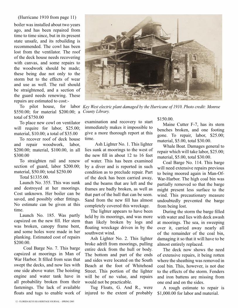
Key West electric plant damaged by the Hurricane of 1910. Photo credit: Monroe County Library.
(Hurricane 1910 from page 11)

SPRING 2005 - FLORIDA KEYS SEA HERITAGE JOURNAL - 13
Great Gun Target will have to be blocked up. A 175 pound anchor was lost from the dock, and two stone anchors from the fill, also lines used for moorings.
Fittings of Yard Craft, Ect. Of these many were lost, boat hooks, cars, anchors and chain, and fenders, in amount not ascertainable at present, as the items are discovered only from day to day.
Large Line. The following lines were used in trying to moor the Osceola safely, and were rendered unfit for further service:
250 fathoms of manila, belonging to the Osceola
2 7” manila hawsers, belonging to the Osceola
1 7” manila hawsers belonging to Yards and Docks
1 6”hawser belonging to the Massasoit.
The estimated value of the above lines is approximately $1000.00.
18. Foundations for Fuel Oil and Gasoline Storage Tanks. These were washed considerably, the materials in the embankments being coral sand quite recently thrown up, and not yet protected by grass. To repair them is estimated to require labor to the value of $100.00.
19. Target Range at Woman Key. This was entirely demolished by the hurricane. The loss is approximately $1000.
20. Contractors’ Losses. Penn Bridge Company. The dredge and derrick scow combined of the Penn Bridge Co., was overturned at her moorings; the sand pump recently purchased was broken, and the machinery was lost overboard. At the other end of the new coal shed the timber bulkhead retaining the fill was damaged, and a considerable part of the fill which had just been placed was washed overboard. Roughly the loss is estimated a several hundred dollars, but more in hindrance of work then the actual
money.The New Jersey Foundry and
Machine Co., estimate their loss roughly at $1200.00. This incudes their driver which has been found a long distance away where it drifted in the storm. If this is recovered, as it doubtless will be, their loss will be materially reduced.
Bryan and Company, contractors for the concrete cistern, lost nothing by the storm.
Dry Tortugas. At Dry Tortugas the hurricane was central, probably. Considerable damage was done to buildings within Fort Jefferson and at the waterfront. The two coal conveyors of each coal shed blew down, wrecking them to an estimated fifty per cent of their original cost.
Special reports have been made of this damage.
21. Recapitulating, the loses, where estimated, may be summed as follows:-
Grounds $150.00Water front, Southwest dike
and fill, Northwest dike and fill $9000.00
Marine Railway Slip $606.50Approach to Pier “B” $1000.00Pier “B” $1766.00Pier “B” Extension $415.00Pier “A” $50.00Lighthouse Pier & Storehouse
$1500.00Foundation of Coal Shed “B”
$19,837.50Buildings. No. 1, Officers and
Storehouse $60.00.No. 2, Condenser Plant $28.00No. 7, Machine Shop $250.00No. 8, Offices, Manufacturing
Dept. $15.00No. 9, Foundry $9.00No. 11, Smith Shop $20.00No. 17, Coal Shed $10.00No. 21, Equipment Shops &
Wireless Plant $165.00No. 29, Coal Shed “A” $600.00No. 30, Coal Shed “B” $100.00
No. 37, Y. And D. Muster and Workhouse $5.00
No. 39, Storehouse for Oils $5.00
No. 42, Sailors Barracks $85.00No. 44, Wireless Operating
Building $15.00No. 45, Pumping Plant, Yards
and Docks $45.00No. 48, Storehouse for S. and A.
$30.00No. 49, North Latrine $7.00Total
$1,449.00Fences $100.00Total for Station proper
$21,536.50Yard CraftU.S.S. Osceola $1400.00U.S.S. Massasoit $1335.00Launch No. 335 value unknownLaunch No. 183 $200.00Coal Bark No. 7 cannot estimate
until wreckedAsh Lighter No. 1, value
unknownAsh Lighter No. 2, value
unknownTwo Floats, C. & R. $150.00Maine Cutter F-7 $30.00Whale Boat $30.00Total Yard Craft $3,145.00Large Lines $1,000.00Foundations for Fuel and
Gasoline Storage Tanks $100.00Target Range at Woman Key
$1,000.00Total for Station and
Appurtenances $26,781.50.
Respectfully submitted,
Frank O. MaxsonCivil Engineer, U.S.N. Senior Member.
W.H. DohertyPaymaster, U.S.N., Member.
J.J. HoldenChief Boatswain, U.S.N., Member.
Clifton GreewellChief Carpenter, U.S.N., Member.

14 - FLORIDA KEYS SEA HERITAGE JOURNAL - SPRING 2005
EDUCATION PROGRAM SPONSORS
$100 OR MORE
CAPT. RICHARD G. BRIGHTBETTY L. DESBIENSBUD DRETTMANN
JOHN & BEATRICE DUKEMARY HAFFENREFFER
TOM & LYNDA HAMBRIGHTDR. & MRS. RICHARD F. HNAT
CLYDE W. HENSLEYJOHN H. JONES
EDWARD B. KNIGHTTOM KNOWLES
RADM J.H. MAURERROSS & ANN MCKEE
BILL MUIRJOHN & KAY PLIMPTON
DAN & VIRGINIA PROBERTLARRY & GRETCHEN RACHLIN
MRS. WILLIAM SHALLOWED SWIFT
JAN & TY SYMROSKI
West tried to raise the Valbanera but did not succeed in getting in communication with her. About three P.M. September 13, 1919, the operator on watch, Bennett J.L. (CE) Radio, USN, heard Morro Castle call all ships and the Valbanera, telling them to stand by and listen in for the Valbanera, Morro saying “Think ECV is in distress”. No distress signals were received from the Valbanera or from any other ship. When the Valbanera was working, her signals were strong and clear.”
3. Both radio operators are very positive that they heard the Valbanera working on September 12, 1919. The Radio Operator of the Lake Winona overheard the ECV communicate with Morro on the morning of Tuesday September 9, 1919.
4. Officers in command of Subchasers that had passed along the Shoals and Reefs to the Westward were directed to investigate what wrecks they saw, and a subchaser was sent to Tortugas to investigate the waters in that vicinity. The first boat that left Key West after the hurricane was Subchaser No. 320 which left at 3:20 A.M. on September 12th for Tortugas in response to a call for medical assistance on the Lake Winona. On his return that evening the Captain reported seeing, while on his way back about 2:30 P.M., in the vicinity of Rebecca Shoals Light, a four masted schooner above water and a two masted schooner, the hull of which was submerged, the masts projecting.
5. On Saturday September 13th another chaser and the L.H.T. Ivy, passed through these waters and did not report seeing anything of importance, that could be connected with this ship. There were rumors received of a large ship being sighted to the Westward of Tortugas,
but on investigation I was unable to secure any reliable information on this subject. However, as the Cuban Consul stated that he had such rumor, I directed a Subchaser to investigate the report, she sailed at 2:10 P.M. on the 16th and returned the following day. This boat brought the first reliable information of there being a large ship on Half Moon Shoal, submerged, with two masts showing. A chaser was sent out to make further investigation and chasers were sent back daily until by Friday the 19th, officers reported that they saw the name Valbanera, when the water was smooth.
6. On the following day the officer who reported the two masted schooner ashore on the 12th, went to the scene and identified the wreck of the Valbanera as the wreck he had reported on that trip. The discrepancy between the report of the chaser Captain and the Radio Operators was impossible to reconcile, one or the other must be mistaken.
7. Investigation and communication with Morro Radio Station, has convinced me that our operators mistook the call letters ECY for ECV. ECY, the Infante Isabel, was in the vicinity of Key West at times reported.
8. This would show that the
(Valbanera from page 1)how did this storm produce so much damage?
On page six is the Navy Survey Board’s report to the Commandant on damage caused by the Hurricane of 1910, which for the Navy was much greater than the 1909, while most of the reports from the city show less damage even with higher winds.
From: Commandant Seventh NavalTo: Secretary of Navy.
SUBJECT: Loss of the Spanish Steamship Valbanera.
1. The subject of the safety of this vessel first brought to my attention on Saturday September 13th, when certain messages relative to the safety of the ship were received. On Sunday, the Cuban Consul and other Cuban citizens, made particular inquiry about certain rumors of the loss of the ship, and requested my assistance in seeking further information. On Sunday and Monday nights messages were broadcasted, seeking information about this ship.
2.This inquiry led to investigation and the following information was obtained from the Radio Station:
“Key West Radio Station was placed back in commission at eight 8 P.M. September 11, 1919. The operator on the Mid to eight A.M. watch September 12, 1919, Whitt J.S. Elec. 2c Radio, USN states he heard the Valbanera, (call letters ECV) working Morro Castle Radio (call letter M) all during the watch, last number of message sent by the Valbanera to Morro being number thirty-six. The last time Key West heard the Valbanera was at eleven fifteen P.M. September 12, 1919, when the operator on watch, Ludwig A. P. (CE) Radio USN, received a “QRU” from the ship,(meaning, have, you anything for me) , about ten minutes later Key

SPRING 2005 - FLORIDA KEYS SEA HERITAGE JOURNAL - 15
BUSINESS MEMBERS
CAPE AIRKEY WEST INTERNATIONAL AIRPORT
KEY WEST 33040 800-352-0714
COASTAL SAILING ADVENTURE, INC.28555 JOLLY ROGER DRIVE
LITTLE TORCH KEY, FL 33042-0839 295-8844
CONCH TOUR TRAINS, INC.601 DUVAL ST.
KEY WEST, FL 33040 294-4142
FRIENDS OF ISLAMORADA AREA STATE PARKSP.O. BOX 236
ISLAMORADA, FL 33036
DR. ELIAS GERTH3412 DUCK AVENUE
KEY WEST, FL 33040 305-295-6790
HERITAGE HARBOR TOURS201 FRONT STREET
KEY WEST, FL 33040 305-295-8687
HISTORICAL PRESERVATIONSOCIETY OF THE UPPER KEYS, INC.
P.O. BOX 2200KEY LARGO, FL 33037
KEY WEST AQUARIUM#1 WHITEHEAD STREET
KEY WEST, FL 33040 296-2051
KEY WEST ENGINE SERVICE, INC.P.O. BOX 2521
KEY WEST, FL 33045
THE LANGLEY PRESS, INC.821 GEORGIA STREET
KEY WEST, FL 33040 294-3156
MEL FISHER MARITIME HERITAGE SOCIETY200 GREENE ST.
KEY WEST, FL 33040 294-2633
MYSTIC SEAPORTP.O. BOX 6000
MYSTIC, CT 6355-0990
OLD TOWN TROLLEY6631 MALONEY AVENUE
KEY WEST, FL 33040 296-6688
PIGEON KEY FOUNDATIONP.O. BOX 500130
MARATHON, FL 33050
A.R. SAVAGE & SONS, INC.1803 EASTPORT DR.
TAMPA, FL 33605 813-247-4550
SEACAMP ASSOC.RT. 3, BOX 170
BIG PINE KEY, FL 33043 872-2331
SEA STORE614 GREENE ST.
KEY WEST, FL 33040 294-3438
SOUTHERNMOST HOTEL IN THE USA1319 DUVAL STREET
KEY WEST, FL 33040 296-6577
SCHOONER WESTERN UNION202R WILLIAM STREET
KEY WEST, FL 33040 587-2715
ST. LOUIS AUTOMATIC SPRINKLER CO.3928 CLAYTON AVE.
ST. LOUIS, MO 63110 314-533-7710
WASHINGTON STREET INN807 WASHINGTON STREETKEY WEST, FL 305-296-0550
Valbanera had not communicated with any station since Tuesday morning before the gale, when a message was sent to the Morro Radio Station, overheard by the Lake Winona. It therefore seems probable that the ship went ashore during the hurricane. Her position within six miles of Rebecca Shoals Light which is a 14 mile light, would indicate that the grounding took place subsequent to the extinguishing of the light. This is reported to have been after midnight of the 9th and 10th. The rate of advance of the hurricane was about 8 miles an hour, so that the center would be in the vicinity of Rebecca Shoals about 6:00 A.M. The center passed about forty miles south of Key West and over Dry Tortugas, and to south of Rebecca Shoals being south of position of wreck about 6:00 A.M. on the 10th. The wind was therefore from Northeast to South and little west, which would have driven heavy seas on this exposed position from South and East.
9. It is thought that the ship went ashore while heading on a northerly and westerly course, that the wind and sea lifted her
over part of the 3-1/2 fathom shoal, that she was bumped on the bottom and began to leak, losing her smoke stack and radio; that the heavy seas forced her around to her present heading, viz: about Southwest and broke the vessel in two parts, at the break of the bridge deck. The forward end points 12 degrees more to the northward than the after end. Soundings about the ship show her to be lying in a hole on her starboard side, angle of deck about 60 degrees from horizontal; at a distance of about 200 feet from the wreck the water shoals to 3-1/2 to 3 fathoms; ahead at 400 feet it is 4 fathoms. Close to the ship the depths are from 6 to 10 fathoms; the deepest being ahead. The port boat davits are swung in board, and lower block of one fall in place and the strap of another.
10. Up to the present time not a vestige has been seen of bodies or fixtures of the ship. The clear sweep of sea to the Northward and Westward probably accounts for this, though this part of the sea has been passed over by craft of different types.
Benton C. Decker
Naval Air Station at Trumbo Point showing damage from the Hurricane of 1919. The railroad tracks are seen and in the back ground is Palm Avenue. The large buildings on the left in the background are the Army Barracks (today Peary Court). Photo credit: Wilhelmina Harvey Collection Monroe County Library.

16 - FLORIDA KEYS SEA HERITAGE JOURNAL - SPRING 2005
Key West Maritime Historical SocietyP.O. Box 695Key West, FL 33041
NONPROFIT ORG.U.S. POSTAGEPAIDKEY WEST, FLPERMIT NO. 30
The Naval Air Station Trumbo Point showing the damage from the Hurricane of 1919. In the background the narrow strip of land is now Hilton Haven. Photo credit: Wilhelmina Harvey Collection Monroe County Library.