loudoun county parkway and route 50 conceptual …
TRANSCRIPT

Loudoun County Parkway and Route 50 Conceptual Interchange Design
Marc Dreyfuss, Transportation PlannerDepartment of Transportation and Capital Infrastructure
August 30, 2016Liberty Elementary School
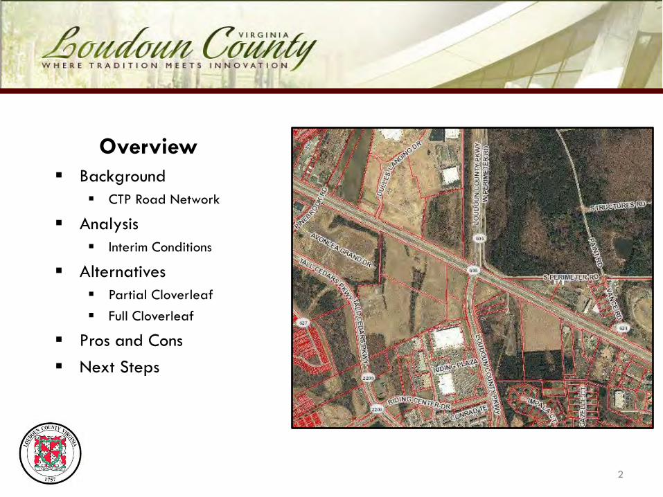
Overview Background
CTP Road Network
Analysis Interim Conditions
Alternatives Partial Cloverleaf Full Cloverleaf
Pros and Cons Next Steps
2
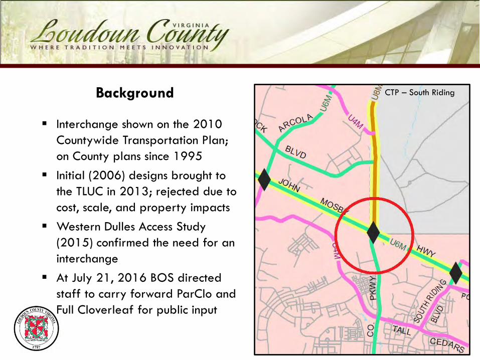
Interchange shown on the 2010 Countywide Transportation Plan; on County plans since 1995
Initial (2006) designs brought to the TLUC in 2013; rejected due to cost, scale, and property impacts
Western Dulles Access Study (2015) confirmed the need for an interchange
At July 21, 2016 BOS directed staff to carry forward ParClo and Full Cloverleaf for public input
CTP – South Riding
3
Background
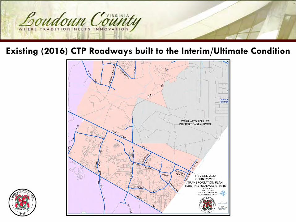
Existing (2016) CTP Roadways built to the Interim/Ultimate Condition

Planned (2017) CTP Roadway Network (Interim/Ultimate Condition)
* Based upon anticipated completation date of under-construction County road projects
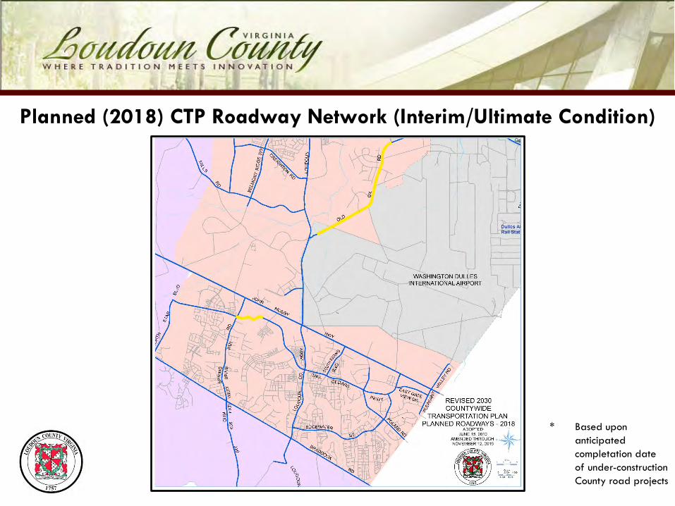
Planned (2018) CTP Roadway Network (Interim/Ultimate Condition)
* Based upon anticipated completation date of under-construction County road projects

Planned (2023) CTP Roadway Network (Interim/Ultimate Condition)
* Based upon current (FY2017-FY2022 Capital Improvement Program)

Planned (Future) CTP Roadway Network (Interim/Ultimate Condition)
* Based upon 2010 Countywide Transportation Plan

Ultimate 2030 CTP Roadway Network
* Based upon 2010 Countywide Transportation Plan

Arcola Boulevard
Provides a more direct route from Stone Ridge and Gum Spring Road corridor to Old Ox Road and Ashburn
Shorter distance than current route (1.7 miles vs 2.7 miles)
Saves more than a minute (1:04) in free-flow
Fewer traffic signals than the current route
2.7 Miles55 MPH2min 29secs
1.7 Miles45 MPH1min 25secs
Free-Flow Travel Time Comparison
* Based upon 2010 Countywide Transportation Plan
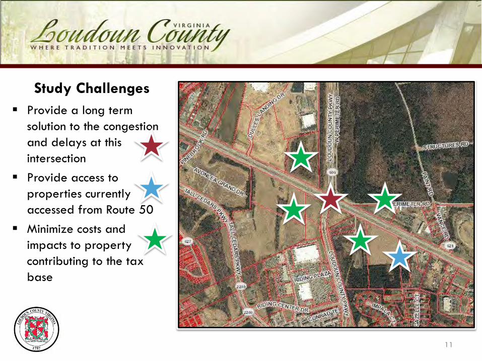
Study Challenges Provide a long term
solution to the congestion and delays at this intersection
Provide access to properties currently accessed from Route 50
Minimize costs and impacts to property contributing to the tax base
11

Initial Analysis Four interchange concepts
were considered: Modified Single-Point
Urban Interchange (SPUI) Diverging Diamond
Interchange (DDI) Partial Cloverleaf (ParClo) Modified Full Cloverleaf
ParClo was the only alternative that met all of the objectives: lower costs, reduced impacts, and meets CTP policies.
12
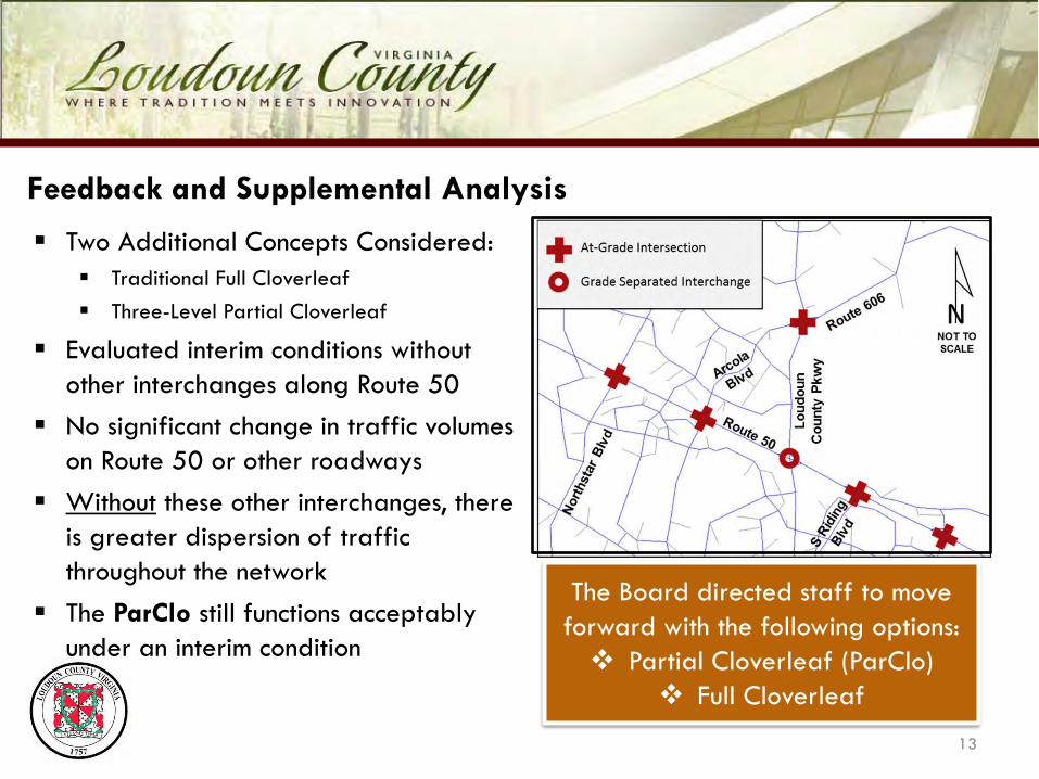
Feedback and Supplemental Analysis
Two Additional Concepts Considered: Traditional Full Cloverleaf Three-Level Partial Cloverleaf
Evaluated interim conditions without other interchanges along Route 50
No significant change in traffic volumes on Route 50 or other roadways
Without these other interchanges, there is greater dispersion of traffic throughout the network
The ParClo still functions acceptably under an interim condition
13
The Board directed staff to move forward with the following options: Partial Cloverleaf (ParClo)
Full Cloverleaf

Why These Alternatives?
Both require only a single bridge span -lower construction costs
Both have a low profile design and would have fewer visual impacts
Both would operate acceptably and improve mobility
Both are less costly than an interchange with flyover ramps, which traffic analysis indicated was not needed
14
15
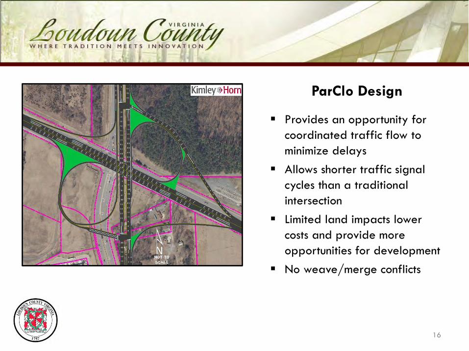
ParClo Design
Provides an opportunity for coordinated traffic flow to minimize delays
Allows shorter traffic signal cycles than a traditional intersection
Limited land impacts lower costs and provide more opportunities for development
No weave/merge conflicts
16
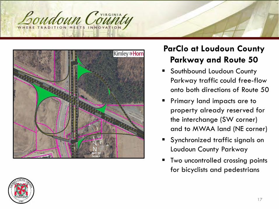
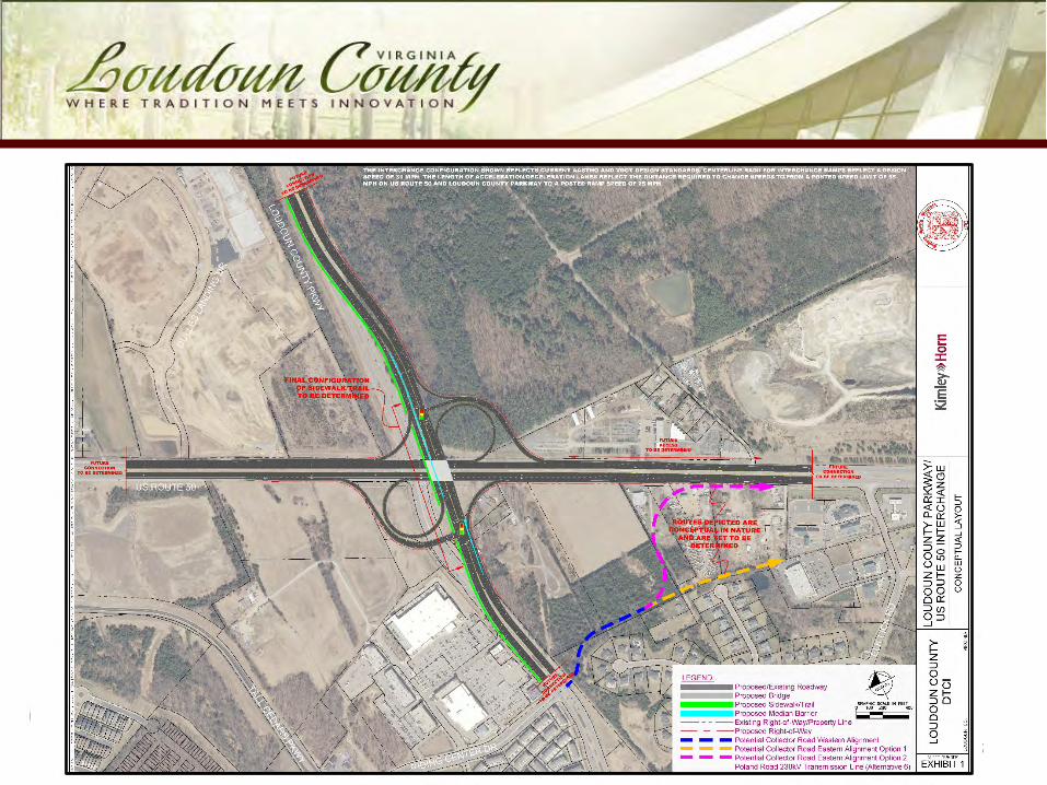
ParClo at Loudoun County Parkway and Route 50
Southbound Loudoun County Parkway traffic could free-flow onto both directions of Route 50
Primary land impacts are to property already reserved for the interchange (SW corner) and to MWAA land (NE corner)
Synchronized traffic signals on Loudoun County Parkway
Two uncontrolled crossing points for bicyclists and pedestrians
17
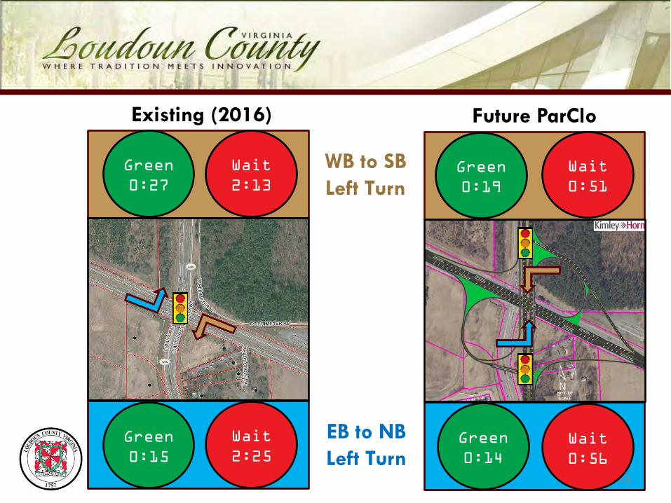
Existing (2016)
18
Wait2:13
Green0:27
Wait0:51
Green0:19
Wait2:25
Green0:15
Wait0:56
Green0:14
Future ParClo
WB to SB Left Turn
EB to NB Left Turn

Existing (2016)
19
Wait1:59
Green0:36
Wait0:31+0:26
Green0:39+0:44
Wait2:22
Green0:18
Future ParClo
NB Through Movement
SB Through Movement
Wait0:31+0:26
Green0:39+0:44
20
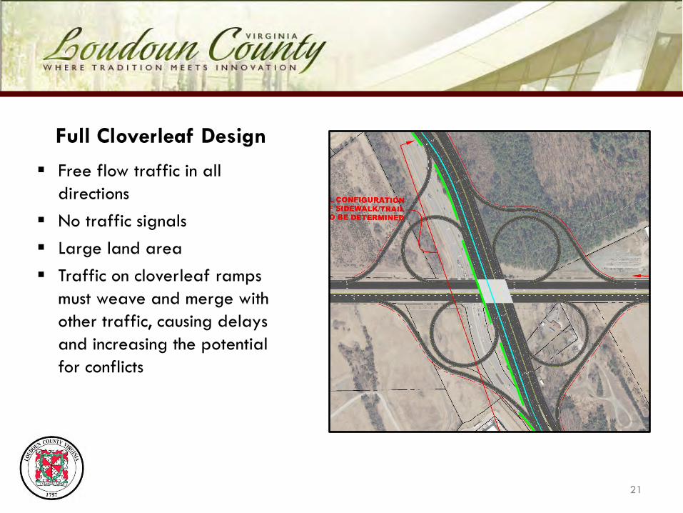
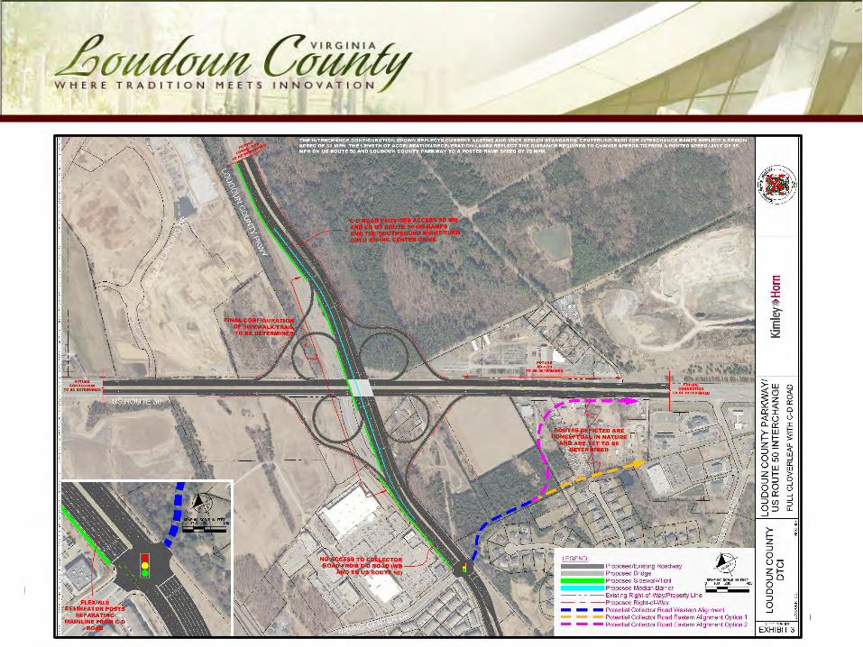
Full Cloverleaf Design
Free flow traffic in all directions
No traffic signals Large land area Traffic on cloverleaf ramps
must weave and merge with other traffic, causing delays and increasing the potential for conflicts
21

Full Cloverleaf at Loudoun County Parkway and Route 50 Collector-Distributor (C-D) local
lanes needed on southbound Loudoun County Parkway due to high traffic volumes
Primary land impacts are to all four quadrants, restricting potential development
Four uncontrolled crossing points for bicyclists and pedestrians
Higher costs for land, design, and construction
22

Full Cloverleaf Design:Riding Center Drive
Free-flow ramp is too close to Riding Center Drive; does not meet VDOT standards
Collector-Distributor (C-D) lane continues through the intersection
SB Loudoun County Parkway traffic uses C-D lanes to access WB Riding Center Drive
EB Riding Center Drive would not be accessible to traffic from Route 50
23

Similarities of the ParClo and Full Cloverleaf Designs
24
Only a single bridge span - lower construction costs than a flyover design Low profile design would have fewer visual impacts
Shown to operate acceptably and improve mobility through the area
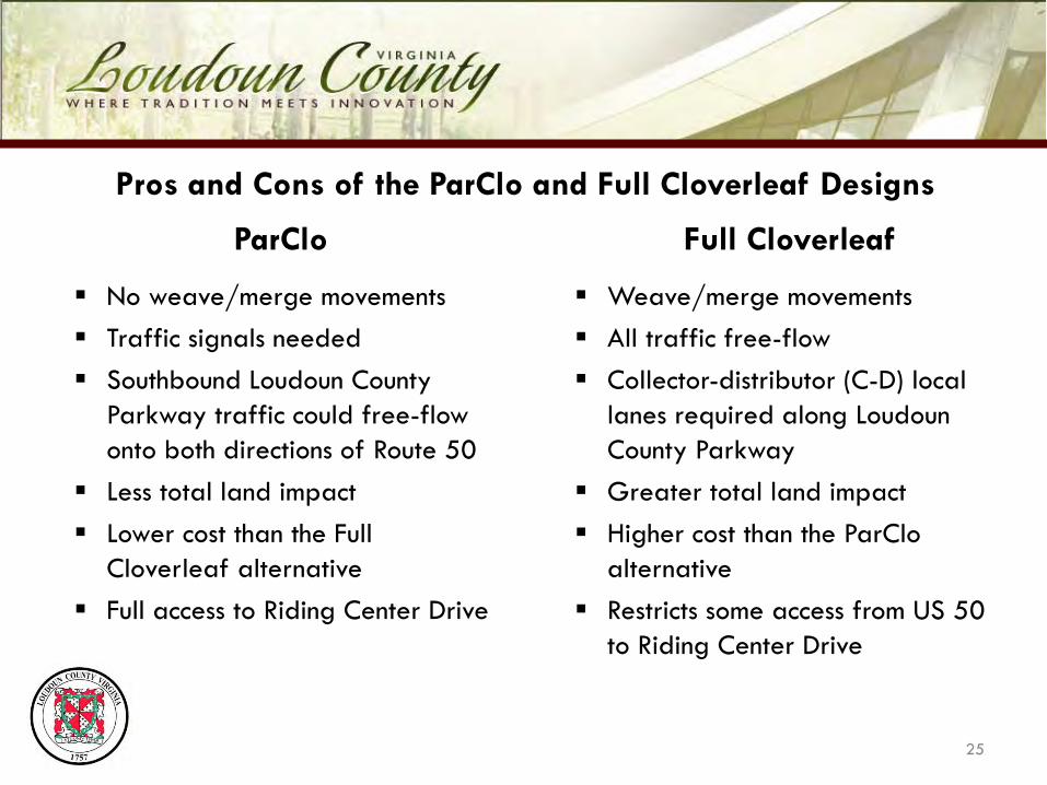
Pros and Cons of the ParClo and Full Cloverleaf Designs
Weave/merge movements All traffic free-flow Collector-distributor (C-D) local
lanes required along Loudoun County Parkway
Greater total land impact Higher cost than the ParClo
alternative Restricts some access from US 50
to Riding Center Drive
25
ParClo Full Cloverleaf
No weave/merge movements Traffic signals needed Southbound Loudoun County
Parkway traffic could free-flow onto both directions of Route 50
Less total land impact Lower cost than the Full
Cloverleaf alternative Full access to Riding Center Drive
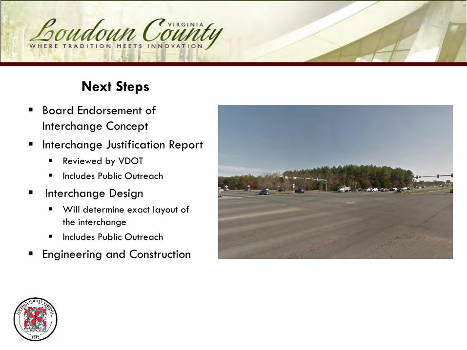
Next Steps
Board Endorsement of Interchange Concept
Interchange Justification Report Reviewed by VDOT Includes Public Outreach
Interchange Design Will determine exact layout of
the interchange Includes Public Outreach
Engineering and Construction
Loudoun County Parkway and Route 50 Conceptual Interchange Design
Marc Dreyfuss, Transportation PlannerDepartment of Transportation and Capital Infrastructure
August 30, 2016Liberty Elementary School

LOS by movement
Overall Intersection
LOS (Delay)
AA
(9.9)
F(107.3)
AM Peak Hour*
*based upon August 2016 traffic volumes (29% higher than April 2015) and August 2016 signal timings (160 sec cycle)
F(80.4)
PM Peak Hour*
*based upon August 2016 traffic volumes (20% higher than April 2015) and August 2016 signal timings (160 sec cycle)
Existing (2016) Study Intersection Levels of Service
LOS
Control Delay per Vehicle
(seconds per vehicle)
A ≤ 10
B > 10 – 20
C > 20 – 35
D > 35 – 55
E > 55 – 80
F > 80