loudoun county road orders - virginia department of ... · sponsoring agency code: richmond, ......
TRANSCRIPT
Loudoun County Road Orders
1757 - 1783
Historic Roads of Virginia
Patricia B. Duncan
Transportation History Consultant
and
Ann Brush Miller
Senior Research Scientist
Virginia Center for Transportation Innovation & Research
http://www.virginiadot.org/vtrc/main/online_reports/pdf/13-r10.pdf
by

Standard Title Page - Report on Federally Funded Project 1. Report No.: 2. Government Accession No.: 3. Recipient’s Catalog No.: FHWA/VCTIR 13-R10
4. Title and Subtitle: 5. Report Date: Loudoun County Road Orders 1757-1783
May 2013 6. Performing Organization Code:
7. Author(s): Patricia B. Duncan, and Ann Brush Miller
8. Performing Organization Report No.: VCTIR 13-R10
9. Performing Organization and Address: Virginia Center for Transportation Innovation and Research 530 Edgemont Road Charlottesville, VA 22903
10. Work Unit No. (TRAIS): 11. Contract or Grant No.: 101596
12. Sponsoring Agencies’ Name and Address: 13. Type of Report and Period Covered: Virginia Department of Transportation 1401 E. Broad Street Richmond, VA 23219
Federal Highway Administration 400 North 8th Street, Room 750 Richmond, VA 23219-4825
Final 14. Sponsoring Agency Code:
15. Supplementary Notes: 16. Abstract: The road history projects undertaken by the Virginia Center for Transportation Innovation and Research (formerly the Virginia Transportation Research Council) establish the feasibility of studies of early road networks and their use in the environmental review process. These projects, by gathering and publishing the early road orders of the vast parent counties and other significant areas, also lay the foundation for additional research by local groups over a broad area of Virginia. This volume marks the 28th entry in the Historic Roads of Virginia series, initiated in 1973 by the Virginia Highway & Transportation Research Council (subsequently the Virginia Transportation Research Council, and now the Virginia Center for Transportation Innovation and Research). Loudoun County Road Orders 1757-1783 is a cooperative effort between the Virginia Center for Transportation Innovation and Research and independent researcher Patricia B. Duncan. This volume furthers the coverage of early Northern Virginia transportation records begun in the previously published Fairfax County Road Orders 1749-1800, Frederick County Road Orders 1743-1772, and Orange County Road Orders 1734-1749. This volume covers the period from the creation of Loudoun County, Virginia, until the years immediately following the end of the Revolutionary War. By the last half of the 18th century, Loudoun County was already one of the most populous and economically important counties in Northern Virginia, and it contained major east-west and north-south transportation routes. The county’s early transportation records provide important information relating to transportation connections with not only neighboring counties and other southern counties in Virginia but also the Washington, D.C., region and the adjoining states of Maryland and what is now West Virginia. This publication will have particular application to the cultural resource research relating to transportation projects in this area of Northern Virginia. This information will eliminate the need for further research into the early Loudoun County road order records. If questions arise about early roads once a VDOT road improvement project is already underway (or nearly underway), primary historical research of this nature can take 6 to 12 months to complete. Therefore, this volume can be a source of potentially significant cost savings for VDOT, including the avoided costs of project delays and avoided consultant costs for cultural resource studies should questions arise. 17 Key Words: 18. Distribution Statement: Virginia, Early Roads, Loudoun County, Northern Virginia No restrictions. This document is available to the public
through NTIS, Springfield, VA 22161. 19. Security Classif. (of this report): 20. Security Classif. (of this page): 21. No. of Pages: 22. Price: Unclassified Unclassified 441
Form DOT F 1700.7 (8-72) Reproduction of completed page authorized

FINAL REPORT
LOUDOUN COUNTY ROAD ORDERS 1757-1783
Patricia B. Duncan Transportation History Consultant
Ann Brush Miller
Senior Research Scientist
In Cooperation with the U.S. Department of Transportation Federal Highway Administration
Virginia Center for Transportation Innovation and Research (A partnership of the Virginia Department of Transportation
and the University of Virginia since 1948)
Charlottesville, Virginia
May 2013 VCTIR 13-R10
ii
DISCLAIMER
The contents of this report reflect the views of the authors, who are responsible for the facts and the accuracy of the data presented herein. The contents do not necessarily reflect the official views or policies of the Virginia Department of Transportation, the Commonwealth Transportation Board, or the Federal Highway Administration. This report does not constitute a standard, specification, or regulation. Any inclusion of manufacturer names, trade names, or trademarks is for identification purposes only and is not to be considered an endorsement.
Copyright 2013 by the Commonwealth of Virginia. All rights reserved.
iii
HISTORIC ROADS OF VIRGINIA Louisa County Road Orders 1742-1748, by Nathaniel Mason Pawlett Goochland County Road Orders 1728-1744, by Nathaniel Mason Pawlett Albemarle County Road Orders 1744-1748, by Nathaniel Mason Pawlett The Route of the Three Notch’d Road, by Nathaniel Mason Pawlett and Howard Newlon An Index to Roads in the Albemarle County Surveyor’s Books 1744-1853, by Nathaniel Mason
Pawlett A Brief History of the Staunton and James River Turnpike, by Douglas Young Albemarle County Road Orders 1783-1816, by Nathaniel Mason Pawlett A Brief History of Roads in Virginia 1607-1840, by Nathaniel Mason Pawlett A Guide to the Preparation of County Road Histories, by Nathaniel Mason Pawlett Early Road Location: Key to Discovering Historic Resources?, by Nathaniel Mason Pawlett and
K. Edward Lay Albemarle County Roads 1725-1816, by Nathaniel Mason Pawlett “Backsights,” A Bibliography, by Nathaniel Mason Pawlett Orange County Road Orders 1734-1749, by Ann Brush Miller Spotsylvania County Road Orders 1722-1734, by Nathaniel Mason Pawlett Brunswick County Road Orders 1732-1749, by Nathaniel Mason Pawlett Orange County Road Orders 1750-1800, by Ann Brush Miller Lunenburg County Road Orders 1746-1764, by Nathaniel Mason Pawlett and Tyler Jefferson
Boyd Culpeper County Road Orders 1763-1764, by Ann Brush Miller Augusta County Road Orders 1745-1769, by Nathaniel Mason Pawlett, Ann Brush Miller,
Kenneth Madison Clark and Thomas Llewellyn Samuel, Jr. Amelia County Road Orders 1735-1753, by Nathaniel Mason Pawlett, Ann Brush Miller, and
Kenneth Madison Clark

iv
Fairfax County Road Orders 1749-1800, by Beth Mitchell New Kent County and Hanover County Road Orders 1706-1743, Transcribed from the Vestry Book of St. Paul’s Parish, by Ann Brush Miller Frederick County Road Orders 1743-1772, by Gene Luckman and Ann Brush Miller Botetourt County Road Orders 1770-1778, by Ann Brush Miller Fincastle County Road Orders 1773-1776, by Betty E. Spillman, Shirley P. Thomas, and Ann Brush Miller Montgomery County Road Orders 1777-1806, by Betty E. Spillman, Shirley P. Thomas, and Ann Brush Miller New Kent County Road Orders 1684-1758, Transcribed from the Vestry Book of St. Peter’s Parish, by Ann Brush Miller
v
FOREWORD
by
Ann Brush Miller Virginia Center for Transportation Innovation and Research
Loudoun County Road Orders 1757-1783 is a cooperative project between Patricia B. Duncan and the Virginia Center for Transportation Innovation and Research (formerly the Virginia Transportation Research Council). It is the eighth volume of road orders produced cooperatively between a private group or individual and the Virginia Center for Transportation Innovation and Research. This volume follows similar projects with the Orange County Historical Society (which sponsored the production of Orange County Road Orders 1734-1749 and Orange County Road Orders 1750-1800); the Culpeper County Historical Society (which sponsored Culpeper County Road Orders 1763-1764); the Fairfax County History Commission (which sponsored Fairfax County Road Orders 1749-1800); Shenandoah University (which sponsored Frederick County Road Orders 1743-1772); and the New River Historical Society (which sponsored Fincastle County Road Orders 1773-1776 and Montgomery County Road Orders 1777-1806).
The location and transcription of the Loudoun County road orders were undertaken by
Patricia B. Duncan as part of her ongoing research and publication of the early Loudoun County records. Final proofreading, formatting, and indexing were undertaken at the Virginia Center for Transportation Innovation and Research by Ann Brush Miller.
Loudoun County Road Orders 1757-1783 is the first of two volumes covering the 18th
century transportation records for an important portion of northern Virginia (the second volume, Loudoun County Road Orders 1783-1800, is currently in preparation). Created from Fairfax County in 1757, Loudoun County is located in extreme north-central Virginia. It is bounded by Fairfax County to the east, and to the west is the northern Shenandoah Valley. West Virginia (part of Virginia until 1863) lies northwest of Loudoun County, and to the north is the Potomac River, Virginia’s boundary with Maryland. To the south of Loudoun County are Prince William and Fauquier counties. By the second half of the 18th century, these various regions were connected by a number of major transportation corridors running through Loudoun County.
This volume is the twenty-eighth entry in the Historic Roads of Virginia series, initiated
in 1973 by the Virginia Highway & Transportation Research Council (subsequently the Virginia Transportation Research Council, and now the Virginia Center for Transportation Innovation and Research). Loudoun County Road Orders 1757-1783 is the fourth volume of published road orders to be concerned with the early transportation records of the northernmost portion of Virginia. It follows Fairfax County Road Orders 1749-1800, Frederick County Road Orders 1743-1772, and Orange County Road Orders 1734-1749 (which included road orders for the period during which the northwestern portion of Virginia, west of the Blue Ridge Mountains, was part of Orange County, prior to 1745).

vi
vii
A NOTE ON THE METHODS, EDITING, AND DATING SYSTEM
by
Nathaniel Mason Pawlett (Faculty Research Historian, Virginia Transportation Research Council, 1973-1995)
The road and bridge orders contained in the order books of an early Virginia county are
the primary source of information for the study of its roads. When extracted, indexed, and published by the Virginia Transportation Research Council, they greatly facilitate this. All of the early county court order books are in manuscript, sometimes so damaged and faded as to be almost indecipherable. Usually rendered in the rather ornate script of the time, the phonetic spellings of this period often serve to complicate matters further for the researcher and recorder.
With these road orders available in an indexed and cross-indexed published form, it will be possible to produce chronological chains of road orders illustrating the development of many of the early roads of a vast area from the threshold of settlement through much of the eighteenth century. Immediate corroboration for these chains of road orders will usually be provided by other evidence such as deeds, plats, and the Confederate Engineers maps. Often, in fact, the principal roads will be found to survive in place under their early names.
With regard to the general editorial principles of the project, it has been our perception over the years as the road orders of Louisa, Hanover, Goochland, Albemarle, and other counties have been examined and recorded that road orders themselves are really a variety of “notes,” often cryptic, incomplete, or based on assumptions concerning the level of knowledge of the reader. As such, any further abstracting or compression of them would tend to produce “notes” taken from “notes,” making them even less comprehensible. The tendency has, therefore, been in the direction of restraint in editing, leaving any conclusions with regard to meaning up to the individual reader or researcher using these publications. In pursuing this course, we have attempted to present the reader with a typescript text that is as near a type facsimile of the manuscript itself as we can come.
Our objective is to produce a text that conveys as near the precise form of the original as we can, reproducing all the peculiarities of the eighteenth-century orthography. While some compromises have had to be made because of the modern keyboard, this was really not that difficult a task. Most of their symbols can be accommodated by modern typography, and most abbreviations are fairly clear as to meaning.
Punctuations may appear misleading at times, with unnecessary commas or commas
placed where periods should be located; appropriate terminal punctuation is often missing or else takes the form of a symbol such as a long dash, etc. The original capitalization has been retained insofar as it was possible to determine from the original manuscript whether capitals were intended. No capitals have been inserted in place of those originally omitted. The original spelling and syntax have been retained throughout, even including the obvious errors in various places, such as repetitions of words and simple clerical errors. Ampersands have been retained
viii
throughout to include such forms as “&c” for “etc.” Superscript letters have also been retained where used in ye, yt, sd. The thorn symbol (y), pronounced as “th,” has been retained in the aforesaid “ye,” pronounced “the,” and “yt” (that). The tailed “p” (resembling a capital “p” with the tail extended into a loop) has also been retained. This symbol has no counterpart in modern typography; given the limits of the modern keyboard, we have rendered it as a capital “p” (P). This should be taken to mean either “per” (by), “pre,” or “pro” (sometimes “par” as in “Pish” for parish) as the context by the order may demand. For damaged and missing portions of the manuscripts we have used square brackets to denote the [missing], [torn] or [illegible] portions. Because of the large number of ancient forms of spelling, grammar, and syntax, it has been deemed impracticable to insert the form [sic] after each one to indicate a literal rendering. Therefore, the reader must assume that apparent errors are merely the result of our literal transcription of the road orders, barring the introduction of typographical errors, of course. If, in any case, this appears to present insuperable problems, resort should be made to the original records.
As to dating, most historians and genealogists who have worked with early Virginian records will be aware of the English dating system in use down to 1752. Although there was an eleven-day difference from our calendar in the day of the month, the principal difference lay in the fact that the beginning of the year was dated from March 25 rather than January 1, as was the case from 1752 onward to the present. Thus, January, February, and March (to the 25th) were the last three months in a given year, and the new year came in only on March 25.
Early Virginian records usually follow this practice, though in some cases dates during these three months will be shown in the form 1732/3, showing both the English date and that in use on the Continent, where the year began January 1. For researchers using material with dates in the English style, it is important to remember that under this system (for instance) a man might die in January 1734 yet convey property or serve in public office in June 1734, since June came before January in a given year under this system.

ix
INTRODUCTION
by
Ann Brush Miller
The roads are under the government of the county courts, subject to be controuled by the general court. They order whenever they think them necessary. The inhabitants of the county are by them laid off into precincts, to each of which they allot a convenient portion of the public roads to be kept in repair. Such bridges as may be built without the assistance of artificers, they are to be built. If the stream be such as to require a bridge of regular workmanship, the court employs workmen to build it, at the expense of the whole county. If it be too great for the county, application is made to the general assembly, who authorize individuals to build it, and to take a fixed toll from all passengers, or give sanction to such other proposition as to them appears reasonable.
—Thomas Jefferson, Notes on the State of Virginia, 1781
The establishment and maintenance of public roads were among the most important functions of the county court during the colonial period in Virginia. Each road was opened and maintained by an Overseer of the Highways appointed by the Gentlemen Justices yearly. He was usually assigned all the “Labouring Male Titheables” living on or near the road for this purpose. These individuals then furnished all their own tools, wagons, and teams and were required to labor for six days each year on the roads.
Major projects, such as bridges over rivers, demanding considerable expenditure were executed by commissioners appointed by the court to select the site and to contract with workmen for the construction. Where bridges connected two counties, a commission was appointed by each and they cooperated in executing the work.
Created from the western portion of Fairfax County in 1757, Loudoun County occupies a significant location in the extreme north-central portion of Virginia. To the east of Loudoun County is Fairfax County, and to the west, beyond the Blue Ridge Mountains, are Clarke County (part of Frederick County during the 18th century) and the other counties of the northern Shenandoah Valley. South of Loudoun County are Prince William and Fauquier counties. West Virginia (part of Virginia until 1863) lies northwest of Loudoun County, and to the north is the Potomac River, which is Loudoun’s, as well as Virginia’s, northern boundary with Maryland.
At its creation and for most of the 18th century, Loudoun County included, in addition to
its present territory, a portion of present day Fairfax County. The original boundary line between Fairfax and Loudoun ran along Difficult Run, several miles to the east of the current boundary; the present boundary line is the result of the 1798 boundary adjustment between those counties.

x
By the last half of the 18th century, Loudoun County was already one of the most populous and economically important counties in northern Virginia, and it contained major east-west and north-south transportation routes. Various ferry crossings of the Potomac River connected roads between Loudoun County and Maryland, and south from Loudoun roads ran further into Virginia and ultimately to the Carolinas. Also, roads from Loudoun ran westward through the Blue Ridge Mountains to the Shenandoah Valley and points farther west, and east to port towns such as Colchester and Alexandria.
The county’s early transportation records provide important information relating not only
to transportation connections with neighboring counties and other southern counties in Virginia but also with the Washington, D.C., region and the adjoining states of Maryland and what is now West Virginia. The road orders contained in this volume cover the period from the creation of Loudoun County in 1757 through the end of the American Revolution. These orders comprise much of the principal extant evidence concerning the early development of roads over an important area of northern Virginia, and adjoining regions, during the last half of the 18th century.
1
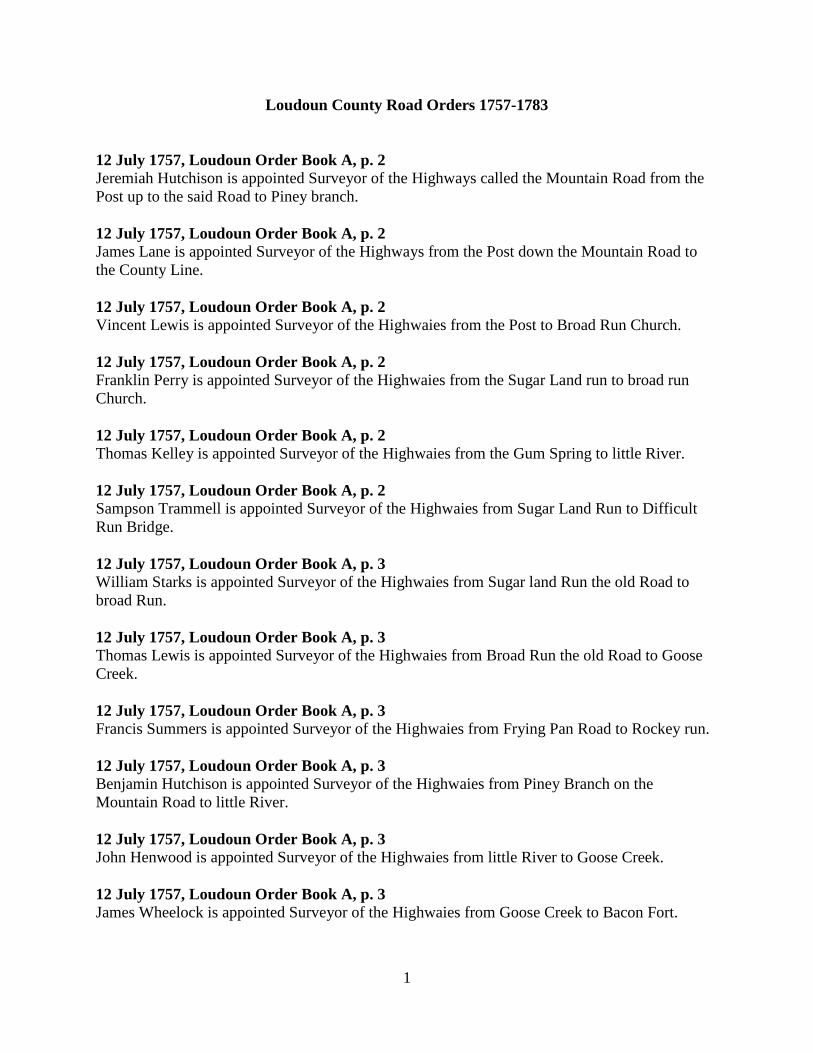
Loudoun County Road Orders 1757-1783
12 July 1757, Loudoun Order Book A, p. 2 Jeremiah Hutchison is appointed Surveyor of the Highways called the Mountain Road from the Post up to the said Road to Piney branch. 12 July 1757, Loudoun Order Book A, p. 2 James Lane is appointed Surveyor of the Highways from the Post down the Mountain Road to the County Line. 12 July 1757, Loudoun Order Book A, p. 2 Vincent Lewis is appointed Surveyor of the Highwaies from the Post to Broad Run Church. 12 July 1757, Loudoun Order Book A, p. 2 Franklin Perry is appointed Surveyor of the Highwaies from the Sugar Land run to broad run Church. 12 July 1757, Loudoun Order Book A, p. 2 Thomas Kelley is appointed Surveyor of the Highwaies from the Gum Spring to little River. 12 July 1757, Loudoun Order Book A, p. 2 Sampson Trammell is appointed Surveyor of the Highwaies from Sugar Land Run to Difficult Run Bridge. 12 July 1757, Loudoun Order Book A, p. 3 William Starks is appointed Surveyor of the Highwaies from Sugar land Run the old Road to broad Run. 12 July 1757, Loudoun Order Book A, p. 3 Thomas Lewis is appointed Surveyor of the Highwaies from Broad Run the old Road to Goose Creek. 12 July 1757, Loudoun Order Book A, p. 3 Francis Summers is appointed Surveyor of the Highwaies from Frying Pan Road to Rockey run. 12 July 1757, Loudoun Order Book A, p. 3 Benjamin Hutchison is appointed Surveyor of the Highwaies from Piney Branch on the Mountain Road to little River. 12 July 1757, Loudoun Order Book A, p. 3 John Henwood is appointed Surveyor of the Highwaies from little River to Goose Creek. 12 July 1757, Loudoun Order Book A, p. 3 James Wheelock is appointed Surveyor of the Highwaies from Goose Creek to Bacon Fort.
2
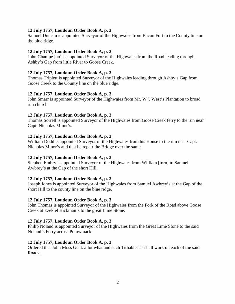
12 July 1757, Loudoun Order Book A, p. 3 Samuel Duncan is appointed Surveyor of the Highwaies from Bacon Fort to the County line on the blue ridge. 12 July 1757, Loudoun Order Book A, p. 3 John Champe junr. is appointed Surveyor of the Highwaies from the Road leading through Ashby’s Gap from little River to Goose Creek. 12 July 1757, Loudoun Order Book A, p. 3 Thomas Triplett is appointed Surveyor of the Highwaies leading through Ashby’s Gap from Goose Creek to the County line on the blue ridge. 12 July 1757, Loudoun Order Book A, p. 3 John Smarr is appointed Surveyor of the Highwaies from Mr. Wm. West’s Plantation to broad run church. 12 July 1757, Loudoun Order Book A, p. 3 Thomas Sorrell is appointed Surveyor of the Highwaies from Goose Creek ferry to the run near Capt. Nicholas Minor’s. 12 July 1757, Loudoun Order Book A, p. 3 William Dodd is appointed Surveyor of the Highwaies from his House to the run near Capt. Nicholas Minor’s and that he repair the Bridge over the same. 12 July 1757, Loudoun Order Book A, p. 3 Stephen Embry is appointed Surveyor of the Highwaies from William [torn] to Samuel Awbrey’s at the Gap of the short Hill. 12 July 1757, Loudoun Order Book A, p. 3 Joseph Jones is appointed Surveyor of the Highwaies from Samuel Awbrey’s at the Gap of the short Hill to the county line on the blue ridge. 12 July 1757, Loudoun Order Book A, p. 3 John Thomas is appointed Surveyor of the Highwaies from the Fork of the Road above Goose Creek at Ezekiel Hickman’s to the great Lime Stone. 12 July 1757, Loudoun Order Book A, p. 3 Philip Noland is appointed Surveyor of the Highwaies from the Great Lime Stone to the said Noland’s Ferry across Potowmack. 12 July 1757, Loudoun Order Book A, p. 3 Ordered that John Moss Gent. allot what and such Tithables as shall work on each of the said Roads.
3
10 August 1757, Loudoun Order Book A, p. 11 Ordered that David Richardson, David Davis and John Poltney or any two of them being first Sworn view and mark out the most Convenient way from the Road leading to Noland’s Ferry to the Ferry of Josias Clapham Gent. and return their report to the said Court. 10 August 1757, Loudoun Order Book A, p. 11 Ordered that the Tithables in this County Work on the several Roads as formerly. 14 September 1757, Loudoun Order Book A, p. 18 The Report of the Road leading from Noland’s Ferry to the Ferry of Josias Clapham Gent. not being returned is Continued til the next Court. 14 September 1757, Loudoun Order Book A, p. 23 Ordered that Anthony Russell Gent. allot the Hands working on the road leading from the Post to broad run Church whereof Vincent Lewis is Surveyor. 14 September 1757, Loudoun Order Book A, p. 23 Ordered that Richard Coleman Gent. allot the hands working on the road leading from the Sugar Land run to broad run Church whereof Franklin Perry is Surveyor. 14 September 1757, Loudoun Order Book A, p. 23 Ordered that William West Gent. allot the hands to work on the roads whereof John Champ John Henwood and James Wheelock are Surveyors. 12 October 1757, Loudoun Order Book A, p. 33 Upon the Petition of Josias Clapham Gent. for a Road leading from the Road of Noland’s ferry to the ferry of said Clapham’s. A Report was returned in these Words following to wit, “In Pursuance to an order of Loudoun Court dated August 10th 1757 We the Subscribers have viewed a Road therein mentioned and find it most Convenient from the Ford by John Gibson’s to go a straight course to a large Poplar by a run which we marked thence thro an old Field to two white Oaks marked by us thence to the main Road by marked Trees about a Mile from the River Witness our hands this 11th day of October 1757. John Poultney David Richardson” Whereupon it is Ordered that the same be established as a public Rod that the said Josias Clapham be appointed Surveyor thereof and that Nicholas Minor Gent. allot the hands to work on the said Road. 12 October 1757, Loudoun Order Book A, p. 37 Ordered that William Mead, John Ratcliff and William Ross do view the most convenient way for a road leading from Morris’s ford of Goose Creek to the Mountain Road and also from Morris’s ford to Broad Run Chappel & make report. 8 November 1757, Loudoun Order Book A, p. 39 [Grand Jury Presentments] Thomas Lewis Surveyor of the Road from Goose Creek to Broad run Bridge for not keeping the same in repair according to Law within one Month last past.
4
[Note: There is no p. 40 in Order Book A.] 8 November 1757, Loudoun Order Book A, p. 41 [Grand Jury Presentments] John Trammell for not keeping Broad run Bridge in repair. 9 November 1757, Loudoun Order Book A, p. 52 The Petition of the Inhabitants of George Town praying that the Roads leading from Alexandria to Winchester and from Noland’s Ferry towards Carolina may be opened to go through the said Town in the most convenient manner Ordered that the same be done accordingly and that James Hamilton John Moss Gent. and Thomas Sorrell do view the most convenient way for the same and make report to the Court. 14 March 1758, Loudoun Order Book A, p. 67 Ordered that William West Gent. allot and set apart the Hands to work on the Road leading from Bacon Fort to the top of the Ridge whereof Samuel Duncan is Surveyor. 11 April 1758, Loudoun Order Book A, p. 80 Ordered that Nicholas Minor John Moss Gent. and Ezekiel Hickman or any two of them do view the Road from George Town to the upper side of the Mouth of Goose Creek and make report to the Court. 11 April 1758, Loudoun Order Book A, p. 85 Ordered that Francis Summers James Lane Robert Thomas Junr. and James Lane junr. Gent. do view the most convenient way for a Road leading from the Road that leads from Rockey run to the Ox Road and make report to the Court. 12 April 1758, Loudoun Order Book A, p. 91 Thomas Cockrill is appointed Surveyor of the Road from little Rockey run called the Mountain Road up the said road to the Post, and It is Ordered that James Lane Gent. to allot the hands to Work on the said Road. 12 April 1758, Loudoun Order Book A, p. 91 Dempse Carroll is appointed Surveyor of the Road from little Rockey run down the Mountain Road to the end of the County including the bridge over little Rockey run in the room of James Lane Gent. who is discharged from that Office, and it is Ordered that the said James Allot the hands to work on the said road. 12 April 1758, Loudoun Order Book A, p. 91 Upon the Petition of the Inhabitants of George Town praying that the Road from Alexandria to Winchester and from Noland’s Ferry towards Carolina may be opened so as to go through the said Town in the most convenient manner A report was returned in the words following, to wit, “Pursuant to an Order of the Court of Loudoun We the Subscribers have viewed the most convenient ways for the Roads to pass through the Town and find them convenient and good with proper clearing. John Moss James Hamilton Thomas Sorrell” Whereupon It is Ordered that the same be established as public Roads.
5
12 April 1758, Loudoun Order Book A, p. 92 John Moss Gent. is appointed Surveyor of the Road that leads from George Town to Secolon’s Branch near John Ratcliffs. 12 April 1758, Loudoun Order Book A, p. 94 John Thomas is appointed Surveyor of the Road from the fork of the Road above Goose Creek at Ezekiel Hickman’s to the great Lime stone and from that Road to the Shanando Road as it now stands and It is Ordered that Nicholas Minor Gent. allot the hands to Work on the said Road. 9 May 1758, Loudoun Order Book A, p. 98 [Grand Jury Presentments] The Surveyor of the road from Mr. Clapham’s ferry to the fork of Noland’s Road for not having it in repair within two Months last part. * * * The Surveyor of the Road for not having a Sign Post up where Vincent Lewis’s Road goes into William Wests Road. The Surveyor of the road from Broad run Church to little River for not having a sign post up at the fork of the road. The Surveyor of the Road from little River to Goose Creek for not having a sign post up at the fork of the Road. 9 May 1758, Loudoun Order Book A, p. 99 [Grand Jury Presentments] The Surveyor of the Road from Broad run Church to William Wests for not keeping up a Sign Post. 14 June 1758, Loudoun Order Book A, p. 118 William West Gent. is appointed Overseer of the Road from little River to the extreme part of the County to meet Prince William Road. 14 June 1758, Loudoun Order Book A, p. 119 John Radcliff is appointed Overseer of the Road from the ford of Secolons Branch near his Fence to little River and It is Ordered that William West Gent. allot the hands to Work on the said Road. 14 June 1758, Loudoun Order Book A, p. 120 Ordered that William West Gent. allot the hands to work on the Road leading from George Town to Secolons branch whereof John Moss is overseer. 14 June 1758, Loudoun Order Book A, p. 121 Ordered that William Dodd clear the Road from the Road at Canary’s to the Town and that William West Gent. allot the hands to work on said Road.

6
14 June 1758, Loudoun Order Book A, p. 122 Ordered that Thomas Sorrell clear the Road from George Town to Goose Creek at the Ferry and that William West Gent. allot the hands to work on the said Road. 14 June 1758, Loudoun Order Book A, p. 122 George Juring is appointed Overseer of the Road in the room of Vincent Lewis who is discharged from that Office and It is Ordered that Fielding Turner Gent. allot the hands to work on the said Road. 14 June 1758, Loudoun Order Book A, p. 122 Jacob Morris is appointed Overseer of the Road from Morris’s ford to broad run Chappel and It is Ordered that George West Gent. Allot the hands to Work on the said Road. 15 June 1758, Loudoun Order Book A, p. 123 A Report of the way for a Road leading from the road that leads from Rockey Run to the Ox Road was returned in these Words following to wit, “In Obedience to the within Order we have viewed the Road and find it convenient to continue the Road from Rockey run Church to the Horse Mill, and leading to Frying Pan a straight course by an old House frame to the Ox Road. Francis Summers James Lane James Lane Junior” Whereupon It is Ordered by the Court that the same be established as a Public Road that William Landrum be Surveyor of the said Road and that he open the same according to Law. 15 June 1758, Loudoun Order Book A, p. 123 Ordered that James Lane junr. Gent allot the hands to work on the road whereof William Landrum is Overseer. 15 June 1758, Loudoun Order Book A, p. 127 Ordered that James Lane Gent. allot the hands to work on the Road from Sugar Land run to Broad run Church whereof Franklin Perry is Overseer and that Franklin Perry clear and open the said Road according to Law. 11 July 1758, Loudoun Order Book A, p. 129 Silvester Gardner is appointed Surveyor of the Highwaies in the room of John Smarr who is discharged from that Office. 11 July 1758, Loudoun Order Book A, p. 129 Richard Keen is appointed Surveyor of the Highwaies from John Keen’s Spring to broad run church in the room of John Smarr who is discharged from that Office. 11 July 1758, Loudoun Order Book A, p. 130 Samuel Winn is appointed Overseer of the Road in the room of Jeremiah Hutchison who is discharged from that Office. 11 July 1758, Loudoun Order Book A, p. 131 Ordered that Richard Coleman Gentleman allot the hands to work on the Road whereof Franklin Perry is Surveyor.

7
11 July 1758, Loudoun Order Book A, p. 131 William Colvin is appointed Overseer of the road in the room of Josias Clapham Gent. who is discharged from that Office. 10 August 1758, Loudoun Order Book A, p. 145 Ordered that Benjamin Shreeve John Radcliff and Thomas Squires being first sworn before a Justice of the Peace of this County do view the most convenient way for a Road leading from George Town in this County to Vincent Lewis’s Road and make Report thereof to the Court. 12 September 1758, Loudoun Order Book A, p. 159 Ordered that Francis Hague John Hough and Mahlon Janney being first affirmed before a Justice for this County view the most convenient way for a Road leading from William Kirks Mill to the road leading by William Dodd’s to Leesburgh and make Report thereof to the Court. 12 September 1758, Loudoun Order Book A, p. 162 Ordered that William Trammell Edward Harding and John Poultney or any two of them being first sworn before a justice for this County view the most convenient way for a Road leading from Kirks Mill to the Road leading by Edward Hardings to Leesburgh and make Report thereof to the Court. 10 October 1758, Loudoun Order Book A, p. 169 A Report of the Road leading from William Kirks Mill to the Road leading by William Dodds to Leesburgh was returned in these Words Vizt. “In Obedience to an Appointment of last Court We have viewed for a Road from William Kirks to William Dodds and find a convenient way to be laid out without prejudice to plantations and according to the Prayer of the Petitioners from William Kirks with the old Road to Edwd: Nortons with the East side of Norton’s plantation about twenty poles to the east of Sands plantation with the same course continued to the So.Et. corner of Claypooles thence by Patrick Rices House thence with or near the old Road to the meeting House still continuing with or near the old Road to the main road by William Dodds to which we found no opposition of any person but consent of Parties concerned. October 10th. 1758. Francis Hague—Mahlon Janney—John Hough”, Whereupon It is Ordered by the Court that the same be established as a public Road that John Hough be appointed Overseer thereof and that Æneas Campbell Gent. allot the hands to work on the same. 10 October 1758, Loudoun Order Book A, p. 169 A Report of the Road from Leesburgh to Vincent Lewis’s Road the most [Note: The word “convenient” was apparently omitted here.] way was returned & by the Court adjudged to be insufficient. Therefore It is again Ordered that Benjamin Grayson Gent. Thomas Sorrell & William Ross being first sworn before a Justice for this County view the most convenient way for the said Road and make report thereof to the Court. 11 October 1758, Loudoun Order Book A, p. 173 Ordered that William Ross be appointed Surveyor of the Road in the room of William Dodd who is discharged from that Office.
8
14 November 1758, Loudoun Order Book A, p. 175 [Grand Jury Presentments] Also the Surveyor of the Road from Frying Pan to Difficult Bridge to the knowledge of two of us within six months last past. * * * Also the Surveyor of the Road from Frying Pan to the Beaver Dam. 15 November 1758, Loudoun Order Book A, p. 180 A Report of the Road leading from George Town to Vincent Lewis’s Road the most convenient was returned in these Words Vizt. “Loudoun Ss: Pursuant to the within Order the subscribers have viewed the within mentioned Road which we Judge should be as follows Vizt. From George Town along the new Road to a Glade between John Moss’s and Thomas Sorrells then leaving said Road and running near in a streight line to the East end of Benjamin Shreeves Plantation thence to the same end of William Shreeves plantation thence to the West end of John Dawsons plantation to Dawson’s ford thence along an old Road by Mr. Ellzeys plantation and so by Vincent Lewis’s. Given under our Hands this 14th of Novr. 1758. Benja. Grayson Thomas Sorrell William Ross” Whereupon it is Ordered that the same be established as a public Road that Benjamin Shreeves be appointed Overseer of the same from Leesburg to Siccolons & that John Davis be also appointed Overseer from Siccolons to Vincent Lewis’s road. 15 November 1758, Loudoun Order Book A, p. 182 A Report of the most convenient way for a Road leading from Kirks Mill to the Road leading by Edward Hardings to the Town in this County was returned in the Words following. Vizt. “We the subscribers by Virtue of the annexed order have viewed the most convenient Road from William Kirks Mill to the main Road leading by Edward Hardings Vizt. from William Kirks as the old Road goes to a Maple Swamp and from the Maple Swamp to a marked white Walnut tree on the Right hand of the old Road thence to a Walnut and Poplar on a run side then to a black Oak in Steer’s old field thence to a black Oak on the side of a Ditch thence to a black Oak on the main Road side sundry Trees marked all the way. Pr. John Poultney, Edward Harding” Whereupon It is Ordered that the same be established as a public Road. 12 December 1758, Loudoun Order Book A, p. 188 Ordered that Joshua Gore junr. be appointed Overseer of the Road in the room of Stephen Emery who is discharged from that Office. 12 December 1758, Loudoun Order Book A, p. 188 Ordered that James Leith be appointed Overseer of the Road in the room of John Henward who is discharged from that Office. 12 December 1758, Loudoun Order Book A, p. 188 Ordered that William West Gentn. and Henry Taylor (being first sworn before a Justice of the Peace for this County) view the most convenient way for a Road leading from Ashby’s Gap to the Road of Williams’s Gap and make Report thereof to the Court.

9
12 December 1758, Loudoun Order Book A, p. 189 Ordered that John Davis and Benjamin Shreeve pursuant to the last Court’s Order Clear the Road whereof they are Overseers and that the Tithable persons within one and half miles of the said road on each side Assist in clearing the same. 14 February 1759, Loudoun Order Book A, p. 191 Ordered that James Spurr be appointed Overseer of the Road in the room of Franklin Perry who is discharged from that Office. 14 February 1759, Loudoun Order Book A, p. 192 A Report of the road leading from Ashby’s Gap to the Road of Williams’s Gap was returned in the Words following Vizt. “In Obedience to the within Order We have viewed the Road and find there may be a Road cleared as good as the other that now stands but it will be further West. Henry his H mark Taylor”. 14 February 1759, Loudoun Order Book A, p. 192 Ordered that Henry Taylor, William Owsley and Thomas Triplett or any two of them being first sworn before a Justice for this County view the most convenient way for a Road leading from the Road of Ashby’s Gap to the road of Williams’s Gap and make Report to the Court. 14 February 1759, Loudoun Order Book A, p. 192 Ordered that Jonas Potts Farmer be appointed Overseer of the Road in the room of Joseph Jones who is discharged from that Office. 15 February 1759, Loudoun Order Book A, p. 204 Upon the Presentment of the Grand Jury against The Overseer of the Road from Limestone Run to Goose Creek ferry the said Overseer being returned not found Ordered that an Alias Summon issue against him returnable here at the next Court. 15 February 1759, Loudoun Order Book A, p. 205 Upon the Presentment of the Grand Jury against the Surveyor of the Road from Frying Pan to Difficult Bridge the said Surveyor being returned not found Ordered that an Alias Summon issue against him returnable here at the next Court. 15 February 1759, Loudoun Order Book A, p. 205 Upon the Presentment of the Grand Jury against the Surveyor of the Road from Frying Pan to Beaver Dam the said Surveyor being returned not found Ordered that an Alias Summon issue against him returnable here at the next Court. 13 March 1759, Loudoun Order Book A, p. 209 A Report of the Road from Ashby’s Gap to the Road of Williams’s Gap was returned in the following Words Vizt. “In Obedience to an Order of Court to us directed for to view road that leads from Ashby’s Gap to the Road that leads from William’s Gap We find that the most convenient way is for that Road is to lead from the foot of the Ridge into Williams’s road nigh the Creek. Henry Taylor, William Owsley” Whereupon It is Ordered by the Court that the same be established as a public Road that Aaron Botts be appointed Overseer of the same from the
10
foot of the Ridge to his house and that William Norris be also appointed Overseer of the same from said Botts’s to the old Road that leads to Williams’s Gap. 13 March 1759, Loudoun Order Book A, p. 209 Ordered that Francis Peyton Gent. allot the hands to work on the road whereof Aaron Botts and William Norris are Overseers. 13 March 1759, Loudoun Order Book A, p. 210 Ordered that John Ethell William Stephens and James Bertley being first sworn before a Justice of this County view the most convenient way for a Road from Adam’s Ford on Goose Creek to where the Road crosses little River and make their Report to the Court. 14 March 1759, Loudoun Order Book A, p. 210 Ordered that Daniel Hutchison be appointed Overseer of the Road in the room of Samuel Winn who is discharged. 14 March 1759, Loudoun Order Book A, p. 211 John Stone is appointed Overseer of the Road from the Fork of Belhaven Road to Frying Pan. 14 March 1759, Loudoun Order Book A, p. 211 Robert Thomas is appointed Overseer of the Road from Frying Pan to Difficult Bridge. 15 March 1759, Loudoun Order Book A, p. 218 Ordered that Mark Chelton be appointed overseer of the road in the room of John Ratcliff dec’d. 15 March 1759, Loudoun Order Book A, p. 218 Ordered that Thomas Owsley John Owsley Joshua Gore and Nicholas Osborn or any of them being first sworn before a Justice of this County view the most convenient way for a Road from the Town of Leesburgh to Williams’s Gap and make report thereof to the Court. 10 April 1759, Loudoun Order Book A, p. 229 Francis Elgin is appointed Overseer of the Road in the room of John Thomas who is discharged from that Office. 10 April 1759, Loudoun Order Book A, p. 230 Ordered that William Mead be appointed Overseer of the Road in the room of John Moss who is discharged from that Office. 10 April 1759, Loudoun Order Book A, p. 231 Ordered that Jacob Ramey junr. be appointed Overseer of the Road in the room of Thomas Cockrill who is discharged from that office. 8 May 1759, Loudoun Order Book A, p. 233 [Grand Jury Presentments] Benjamin Shrieve for not clearing the Road that he is Overseer of from hence to Goose Creek to the knowledge of two of us.
11
8 May 1759, Loudoun Order Book A, p. 234 Ordered that Nicholas Minor Gent. join with a commissioner of Fairfax County to agree with workmen to repair the bridge over Difficult Bridge. 8 May 1759, Loudoun Order Book A, p. 234 Ordered that Richard Coleman, Benjamin Grayson and Josias Clapham Gent. or any two of them agree with Workmen to repair the Bridge over Broad run. 8 May 1759, Loudoun Order Book A, p. 234 On the motion of Ann Neale to have the Mountain Road turn’d as it’s Injurous to her as it now stands It is ordered that Thomas Cockrill Jeremiah Hutchison Jacob Remey and Thomas Connell or any of three of them being first sworn before a Justice for this County view the most convenient way to view the most convenient way for the said Intended Alteration and make report of the conveniency and Inconveniency thereof to the Court. 8 May 1759, Loudoun Order Book A, p. 235 A Report of the most convenient way for a road from Adam’s Ford on Goose Creek to where the road crosses little River was returned and is in the Words following, to wit, “By Virtue of an Order of Court to us directed We find there may be a Road got from the Ford of Adam’s down to the Mountain Road by John Champs, William Stephens James Bartley” Whereupon It is Ordered that the same be cleared agreeable to the said Report according to Law that John Champ be appointed Overseer of the same and that Francis Peyton Gent. allot the hands to work thereon. 8 May 1759, Loudoun Order Book A, p. 235 A Report of the Road from the Town of Leesburgh to Williams’s Gap the most convenient way was returned and is in the Words following, to wit, “May the 8th. 1759 We the Subscribers in Compliance of the within Order have viewed the road leading from Williams’s Gap to the Town of Leesburgh to come by John Palmer’s and by Isaac Nichols’s and from thence to the road where Samuel Davis formerly lived and from thence to the Town. Thomas Owsley Nicholas Osborn Joshua Gore” Whereupon It is Ordered that the same be cleared agreeable to the said report according to Law that Samuel Compton be appointed Overseer of the same to Isaac Nichols’s and & that Jacob Janney be appointed Overseer from said Nichols’s to the road that leads to Leesburgh. 8 May 1759, Loudoun Order Book A, p. 236 Ordered that Thomas Cockrill John Goram Richard Headen and Burr Harrison or any three of them being first sworn before a Justice of this County view the most convenient way for a Road from Rockey run Church to Bull run and make report of the Conveniency and Inconveniency thereof to the Court. 9 May 1759, Loudoun Order Book A, p. 243 Ordered that William West and Francis Peyton Gentn. allot the hands to work on the several roads from little River to Shanando.
12
12 June 1759, Loudoun Order Book A, p. 245 John Trammell came into Court and undertook to keep in repair for Travellers the Bridge over Broad run until the 14th. day of June 1760 the said John informing of this Court that he had entered into Bond with the Justices of Fairfax Court to keep the same in repair for the Term of seven years which Term will expire on the 14th. Day of June 1760. 12 June 1759, Loudoun Order Book A, p. 245 Ordered that Thomas Clewes Francis Wilks Jeremiah Fairhurst and William Janney or any three of them being first sworn before a Justice for this County view the most convenient way for a Road from Williams’s Gap to Leesburgh marke the same and and make Report thereof to the Court. 12 June 1759, Loudoun Order Book A, p. 247 A Report of the Road petitioned for by Anne Neale was returned in the following Words Vizt. “In Obedience to an Order of the Court of Loudoun County We the Subscribers being appointed to view the conveniency or Inconveniency of turning the Mountain Road by Ann Neale’s Plantation and being sworn comformable do report that a way may be got from the Plantation by cutting a way near half a mile from the leaving the old Road to where it will again Intersect and the new way will be almost as near as the old Road but it will be attended with the inconveniency that part of the new way will be Stony, it will also cross a Branch that will require a long Bridge and from the said branch it must go over a hill and will leave the Church about 40 or 50 Yards to the Plantation and that the new way can never be made so good as the old Road. Thos. Cockrill—Jacob Remey—Jer. Hutchison”. On Consideration whereof It is ordered that the old Road continue as it now stands and that the Petition be dismissed. 12 June 1759, Loudoun Order Book A, p. 249 Ordered that Josias Clapham Gent. Philip Noland Thomas Awbrey and John Trammell or any three of them being first sworn before a Justice for this County view the most convenient way for a road from Kirk’s Mill by Edward Harding’s to Leesburgh and make Report thereof to the Court. 14 August 1759, Loudoun Order Book A, p. 264 A Report of the most convenient way for a Road from Williams’s Gap to Leesburgh was returned and is in the Words following, to wit, “Pursuant to an Order of June Court 1759 We the Subscribers have viewed and markt the way from Williams’s Gap to Leesburgh and are of opinion that the most suitable way for a road to be as followeth to turn out of the road at some markt Trees at the foot of the Mountain near Cumpton’s path then by the southend of the roundhill thence a Direct Course from there to Nathan Spencers and from there to Jacob Janney’s Mill then a Direct Course into the Great Road near Richard Canary’s” Whereupon It is Ordered that the same be cleared according to Law that Francis Wilks be appointed Overr of the same from Nathan Spencers to Richard Canarys and that Samuel Compton be appointed Overseer from the foot of the Blue Ridge to said Spencer’s. 14 August 1759, Loudoun Order Book A, p. 265 Ordered that James Hamilton Gentn. Allot the hands to work on the Road whereof Francis Wilks and Samuel Compton are Overseers.
13
12 September 1759, Loudoun Order Book A, p. 289 Thomas Starks is appointed Overseer of the Road in the room of James Wheelock who is discharged from that Office. 13 November 1759, Loudoun Order Book A, p. 298 Ordered that John Owsley be appointed overseer of the road in the room of William Norris who is discharged from that office 13 November 1759, Loudoun Order Book A, p. 298 Ordered that William West Junr. be appointed Overseer of the Road in the room of William West Gent. who is discharged from that Office. 13 November 1759, Loudoun Order Book A, p. 299 [Grand Jury Presentments] Benjamin Shreeve for not keeping the road according to law between Gooscreek and Tuskaroro by the Knowledge of two of us within two Months last past. Philip Noland for not keeping the Road according to Law between Noland’s Ferry and the great Limestone by the Knowledge of two of us within two months last past. Josias Clapham Gentl. for not keeping a Post at the fork of the Roads between Claphams and Philip Nolands by the Knowledge of two of us within two months last past. 13 November 1759, Loudoun Order Book A, p. 300 [Grand Jury Presentments] John Davis Farmer for not keeping the Road according to Law between William Shreeves and the Gum Spring by the Knowledge of two of us within two Months last past. The Surveyor of the Road for not keeping a Post at the fork of Roads near Edward Porters where one Road leads to Alexandria and the other to Occoquan Warehouse by the Knowledge of two of us within two months last past. 13 November 1759, Loudoun Order Book A, p. 300 Ordered that John Lewis be appointed Overseer of the Road in the Room of George Juren who is discharged from that Office. 13 November 1759, Loudoun Order Book A, p. 301 Ordered that William Hancocke be appointed Overseer of the Road in the room of James Spurr who is discharged from that Office. 13 November 1759, Loudoun Order Book A, p. 301 Ordered that John Mucklehaney Gentl. Joseph Jones and William Smith or any two thereof being first sworn before a Justice of this County view the most Convenient way for a road from John Hough’s Mill to the Mouth of Dutchman’s Run and make their Report to the Court.
14
14 November 1759, Loudoun Order Book A, p. 304 Ordered that John Osborn Nicholas Osborn & Joshua Gore or any two thereof being first sworn before a Justice for this County view the most convenient way for a road from John Hough’s Mill to the foot of the Ridge at Williams’s Gap and make Report thereof to the Court. 14 November 1759, Loudoun Order Book A, p. 304 Ordered that John Davis be continued Overseer of the Road from Dawson’s Ford to Vincent Lewis’s Road and that Fielding Turner Gent. allot the Hands to work thereon. 14 November 1759, Loudoun Order Book A, p. 304 Ordered that William Shreeve be appointed Overseer of the Road from Siccolons Run to Dawson’s Ford. 14 November 1759, Loudoun Order Book A, p. 304 Ordered that Benjamin Shreeve be Continued Overseer of the Road from Siccolons to Tuscorora. 14 November 1759, Loudoun Order Book A, p. 304 Ordered that Nicholas Minor Gent. allot the hands to work on the Roads whereof William Shreeve and Benjamin Shreeve are overseers. 11 March 1760, Loudoun Order Book A, p. 326 Upon the Petition of Richard Trenary setting forth that he suffers greatly by reason of the Road’s running through a good piece of meadow Ground and spoiling his Plantation and praying that the said Road may be turned It is ordered that Nicholas Minor Gent. John Moss junr. and William Mead being first sworn before a Justice for this county view the most convenient way for the said intended Alteration and make a Report of the Conveniency and Inconveniency thereof to the Court. 11 March 1760, Loudoun Order Book A, p. 326 Ordered that John Hutcheson be appointed Overseer of the Road in the room of Daniel Hutcheson who is discharged from that Office. 12 March 1760, Loudoun Order Book A, p. 329 A Report of the Persons appointed to view the most convenient way for a Road from John Hough’s Mill to the mouth of Dutchman’s Run was returned in the Words following Vizt. “Pursuant to the within order the Subscribers have viewed from the within mentioned Mill to the mouth of the Dutchman’s and find that it will not Answer for a Road neither can any Ferry be there kept but running through John Mucklehany’s Plantation and so under the short Hill to the River opposite to John Payne’s about a mile above the mouth of the Dutchman may be a good Road and Ferry. Given under our Hands the 11th Day of March 1760. Joseph Jones, William Smith” Whereupon It is Considered by the Court that the same be Quashed.

15
13 March 1760, Loudoun Order Book A, p. 331 A Report of the most convenient way leading from Rockey run Church to Bull run was returned in these Words Vizt. “In Obedience to the within Order we have viewed the most convenient way for a Road from Rockey run Church to Bull run and find the most convenient way for a Road is to turn out of the Mountain Road about a mile below the said Church and along an old Path to Bull run oposite to Blackburn’s Quarter. Thos. Cockrill John Goram Richard Haden” Whereupon It is Ordered that a Road be cleared agreeable to the Report and that Thomas Cockrill be Appointed Overseer thereof. 13 March 1760, Loudoun Order Book A, p. 331 Ordered that James Lane allot the hands to work on the Road whereof Thomas Cockrill is Overseer. 13 May 1760, Loudoun Order Book A, p. 343 [Grand Jury Presentments] John Davis for not keeping the Road between Goose Creek and Broad Run according to Law by the Knowledge of two of us. William Shreeve for not having the Road from his House to Goose Creek in repair to the Knowledge of two of us. 10 June 1760, Loudoun Order Book A, p. 363 Ordered that Charles Eskridge be appointed Overseer of the Road in the room of Jacob Remey Junr. who is discharged from that Office. 11 June 1760, Loudoun Order Book A, p. 366 Ordered that Benjamin Edwards be appointed Overseer of the Road from Leesburg to Goose Creek in the room of Ezekiel Hickman who is discharged from that Office and that the hands under him and Thomas Lewis Assist in clearing the Ford where John Jenkins formerly kept Ferry. 11 June 1760, Loudoun Order Book A, p. 366 On motion of William Douglass for leave to clear a Bridle way from his House to strike the main road that leads from Difficult to Leesburgh It is Ordered that Richd. Coleman Gent. Henry Brewer and Thomas Lewis being first sworn before a Justice for this County do view the most convenient way for the same and make a report of the Conveniency and Inconveniency that will attend the same. 12 June 1760, Loudoun Order Book A, p. 367 [Grand Jury Presentments] The Presentment of the Grand Jury against The Overseer of the Road from Limestone Run to Goose Creek Ferry is Discontinued. The Presentment of the Grand Jury against The Overseer of the Road from Frying Pan to Difficult Bridge is Discontinued. * * *
16
The Presentment of the Grand Jury against the Surveyor of the Road from Frying Pan to the Beaver Dam is Discontinued. 12 June 1760, Loudoun Order Book A, p. 368 Philip Noland who stands Presented by the Grand Jury for not keeping the Road according to Law between Nowland’s Ferry and the great Limestone having been duly Summoned and not appearing It is Considered by the Court that for the said Offence he forfeit and pay the Churchwardens of Cameron Parish where the Offence was committed fifteen shillings to the use of the said Parish and that he pay the Costs of this Prosecution and may be taken &c. 12 June 1760, Loudoun Order Book A, p. 369 John Davis Farmer who stands Presented by the Grand Jury for not keeping the Road according to Law between William Shreeve’s and the Gum Spring having been duly served with a Copy of the Summons & not appearing altho’ solemnly called It is Considered by the Court that for the said offence he forfeit and pay to the Churchwardens of Cameron Parish where the said Offence was Committed fifteen shillings to the use of the said Parish & that he pay the costs of this Prosecution & may be taken &c. 12 June 1760, Loudoun Order Book A, p. 370 Demse Carroll who stands Presented by the Grand Jury for not keeping a Post at the Fork of the Roads near Edward Porter’s on being heard is Excused. * * * William Shreeve who stands Presented by the Grand Jury for not having the Road from his House to Goose Creek in repair having been duly summoned & not appearing It is Considered by the Court that for the said offence he forfeit and pay to the Churchwardens of Cameron Parish where the said Offence was Committed fifteen shillings to the use of the said Parish and that he pay the Costs of this Prosecution & may be taken &c. 12 June 1760, Loudoun Order Book A, p. 379 Ordered that William Owsley be appointed Overseer of the Road in the room of Samuel Duncan who is Discharged from that Office 12 August 1760, Loudoun Order Book A, p. 386 Ordered that George Taylor be appointed Overseer of the Road in the room of Mark Chelton who is discharged from that Office. 13 August 1760, Loudoun Order Book A, p. 390 Ordered that William Starks Gabriel Adams and John Jenkins or any two thereof being first sworn before a Justice of this County view the most convenient way to Cross Broad Run at the old Ford and make a report therof to the Court. 11 November 1760, Loudoun Order Book A, p. 402 George West Gent. is appointed Surveyor of the Highwaies in the room of Jacob Morris who is discharged from that Office and It is Ordered that the hands of the said George West do work thereon over and above the hands formerly allotted.
17
11 November 1760, Loudoun Order Book A, p. 402 Ordered that William Ross be appointed Surveyor of the Road in the room of Benjamin Shrieve who is discharged from that Office. 11 November 1760, Loudoun Order Book A, p. 403 Ordered that John Peake be appointed Surveyor of the Highwaies in the room of William Shrieve who is discharged from that Office. 11 November 1760, Loudoun Order Book A, p. 403 Ordered that James Spencer be appointed Surveyor of the Highwaies in the room of John Davis who is discharged from that Office. 11 November 1760, Loudoun Order Book A, p. 403 Ordered that Anthony Russell be appointed Surveyor of the Highwaies in the room of John Lewis who is discharged from that Office. 11 November 1760, Loudoun Order Book A, p. 403 [Grand Jury Presentments] Josias Clapham for stoping and not having the Road to his Ferry or Ford open and in good repair within this six Months last past. 11 November 1760, Loudoun Order Book A, p. 403 Ordered that Thomas Pursley be Appointed Surveyor of the Highwaies from lower Kittockton Run to the Gap of the Short Hills. 11 November 1760, Loudoun Order Book A, p. 403 Ordered that John Mucklehaney Gentl. allot the hands to work on the Road whereof John Pursley is Surveyor. 12 November 1760, Loudoun Order Book A, p. 405 Ordered that Æneas Campbell Gent. Allot the hands to work on the Road whereof Benjamin Edwards is Surveyor. 12 November 1760, Loudoun Order Book A, p. 407 Ordered that Nicholas Minor Richard Coleman and Josias Clapham Gent. Agree with Workmen to repair Broad run Bridge and take Bond with Security for keeping the same in Repair for seven Years. 10 February 1761, Loudoun Order Book A, p. 409 On the Petition of Dennis Dallis Overseer of John Berryman setting forth that he as Overseer aforesaid suffer great Inconveniency by reason of the main Road’s running thro’ a piece of tended Ground which renders it almost useless and praying that the road may be turned the most convenient way It is Ordered that Anthony Russell Gent. Vincent Lewis and James Spencer do view the way to turn the said Road and make Report of the Conveniency & Inconveniency that will Attend the same to the Court.

18
11 February 1761, Loudoun Order Book A, p. 413 Ordered that Æneas Campbell Gent. Allot the Hands to work on the several Roads whereof William Mead William Ross and Benjamin Edwards are Overseers. 11 February 1761, Loudoun Order Book A, p. 414 Ordered that Thomas Williams be appointed Surveyor of the Road in the room of James Leith who is discharged from that Office. 10 March 1761, Loudoun Order Book A, p. 427 Ordered that John Osborn be appointed Surveyor of the Road from his Farm to John Hough’s Mill the most Convenient way. 10 March 1761, Loudoun Order Book A, p. 428 Ordered that James Whaley be appointed Surveyor of the Ox Road from Frying Pan to the Road that leads from Alexandria to Leesburgh. 10 March 1761, Loudoun Order Book A, p. 428 Ordered that Greenbury Dorsey be appointed Surveyor of the Road in the room of William Hancocke who is discharged from that Office. 10 March 1761, Loudoun Order Book A, p. 429 Ordered that Richard Coleman Gentl. Allot the hands to work on the Road whereof James Whaley is Surveyor. 11 March 1761, Loudoun Order Book A, p. 434 Upon the petition of Dennis Dallis Overseer of John Berryman setting forth that he as Overseer aforesaid suffer great Inconvenience by reason of the main road running through a piece of tended Ground which render it almost useless and praying that the said Road may be turned It is Ordered that the said Dennis Dallis have leave to turn the same according to his Desire It appearing to the Court that it will be of no disadvantage. 9 June 1761, Loudoun Order Book A, p. 449 Ordered that Jeremiah Hutcheson be appointed Surveyor of the Mountain Road in the room of John Hutcheson who is discharged from that Office. 9 June 1761, Loudoun Order Book A, p. 450 Ordered that Richard Coleman Gent. Allot the hands to work on the Road whereof Greenbury Dorsey is Surveyor. 9 June 1761, Loudoun Order Book A, p. 450 Ordered that James Williamson Jacob Morris Richard Piles John Piles John Price and the hands of George West Gent. do work on the road whereof the said George West is Surveyor. 9 June 1761, Loudoun Order Book A, p. 450 Ordered that George West Gent. Allot the hands to work on the Roads whereof John Peake and George Taylor are Overseers.

19
9 June 1761, Loudoun Order Book A, p. 450 Ordered that John Peake Andrew Adam and George West Gent. or any two thereof being first sworn before a Justice of this County do view the most convenient way for a road from Morris’s Ford to the road that leads to Dawson’s Ford and make a Report of the conveniency and Inconveniency to the Court. 9 June 1761, Loudoun Order Book A, p. 450 Ordered that Sterman Chelton be appointed Surveyor of the Highwaies in the room of Thomas Lewis who is discharged from that Office. 9 June 1761, Loudoun Order Book A, p. 451 A Report of the Persons appointed to view the most convenient way for a Road from William Kirk’s Mill to Leesburgh was returned in these Words Vizt. Whereas there was an Order Issued from the Court some time ago directed to us the Subscribers requiring us to view and report the best way for a Road to be got from Wm. Kirks Mill to this Place We being well Acquainted with the Situation of the Lands recommend that a Road be brought along by Ralph Braddock’s thence to Richard Roberts’s and thence with a straight course to a Bridge in the main road nigh Robert Popkins’s Fence (above Popkins’s Plantation). June 9, 1761. Josias Clapham John Trammell” Whereupon It is Ordered that the same be cleared according to Law that Richard Roberts be appointed Surveyor thereof and that Josias Clapham Gent. allot the hands to work thereon. 9 June 1761, Loudoun Order Book A, p. 453 Ordered that James Hamilton Gent. Allot the hands to work on the Road whereof Francis Wilks is Surveyor. 9 June 1761, Loudoun Order Book A, p. 453 Ordered that Robert Yeldall Nicholas Osborn and James Connard or any two thereof being first sworn before a Justice for this County do view the most convenient way for a Road leading from Potowmack River between the Blue Ridge and Short Hills into the Road that leads to John Hough’s Mill and make a Report of the Conveniency and Inconveniency that will attend the same to the Court. 9 June 1761, Loudoun Order Book A, p. 454 Ordered that Fielding Turner Gent. Allot the hands to Work on the Road whereof Anthony Russell Gent. is Surveyor. 11 June 1761, Loudoun Order Book A, p. 465 Ordered that William Triplett Daniel Adams William Smith and Thomas Lewis or any three thereof being first sworn before a Justice of this County do view the most convenient way for a Road from the Ford of Little River to Ashby’s Gap and make a Report of the Conveniency and Inconveniency that will attend the same to the Court.
20
11 June 1761, Loudoun Order Book A, p. 465 Ordered that Henry Taylor William Smith Thomas Lewis and Robert Wood or any three thereof being first sworn before a Justice of this County do view the most convenient way for a Road from Lasswell’s Ford to the Mountain Road by Robert Wood’s and make a report of the Conveniency and Inconveniency that will attend the same to the Court. 14 July 1761, Loudoun Order Book A, p. 481 Upon the petition of Henry Moore setting forth that the Mountain road as it now stands is very Injurious to him and praying that the said Road may be turned the most convenient way It is ordered that Fielding Turner Charles Tyler and Francis Peyton Gent. or any two thereof being first sworn before a Justice for this County do view the most convenient way to turn said Road and make a report of the Conveniency and Inconveniency that will attend the same to the Court. 14 July 1761, Loudoun Order Book A, p. 481 Ordered that James Lewis be appointed Surveyor of the Highwaies in the room of Francis Elgin who is discharged from that Office. 11 August 1761, Loudoun Order Book A, p. 483 A Report of the Persons appointed to view the most convenient way for a Road leading from Potowmack River between the blue Ridge and short Hills into the road that leads to John Hough’s Mill was returned in these Words Vizt: “These are to acquaint the Honble. Gentlemen of the Bench that we have upon Oath looked over and marked out a way for a road leading from Potowmack River to the Mountain Road between the Blue Ridge and Short Hills to the best of our skill and knowledge both for good Ground and Conveniency of the inhabitants. August the 8th. 1761. Robert Yeldall, Nicholas Osborn” Whereupon It is Ordered by the Court that the Road be cleared according to the said report that James Conard be appointed Surveyor thereof and that John Mucklehany Gent. Allot the Hands to Work thereon. 11 August 1761, Loudoun Order Book A, p. 483 Ordered that Samuel Smith William Smith and Thomas Stump or any two of them being first sworn before a Justice of this County do view the most Convenient way for a Road from Thomas Stump’s Landing to Leesburg and make a Report of the Conveniency and Inconveniency that will attend the same to the Court. 8 September 1761, Loudoun Order Book A, p. 493 Ordered that John Mucklehany Gent. Allot the hands to work on the Road whereof John Osborn is Surveyor. 8 September 1761, Loudoun Order Book A, p. 493 Ordered that the Order and Report formerly made for Clearing of a Road from Potowmack River between the Blue ridge and Short Hills be set aside. 10 September 1761, Loudoun Order Book A, p. 521 Ordered that the Surveyor of the Road between the Sugar Land Run and Broad run and the Surveyor between Broad run and Goose Creek clear a Road over Broad Run just below the Bridge.
21
10 September 1761, Loudoun Order Book A, p. 522 Ordered that Hugh West Gent. put in Suit a Bond from John Trammell to the Justices of this Court for keeping in repair the Bridge over Broad Run. 13 October 1761, Loudoun Order Book A, p. 525 Ordered that William Pearl be appointed Surveyor of the road in the room of William West junr. who is discharged from that Office. 13 October 1761, Loudoun Order Book A, p. 527 Ordered that Henry Brewer be appointed Surveyor of the Road in the room of Sampson Trammell who is discharged from that Office. 11 November 1761, Loudoun Order Book A, p. 533 Ordered that the hands at the Quarter where Nicholas Wren is Overseer belonging to Frans. Lightfoot Lee Gent. and the hands of Bray’s Quarter be discharged from working on the Road whereof James Whaley is Surveyor & that they work on the Road whereof Anthony Russell Gent. is Surveyor. 12 November 1761, Loudoun Order Book A, p. 538 Upon the Petition of Samuel Mead Solomon Hoge William Weldman William Hatcher John Little William Dodd Thomas Field Francis Wilks Samuel Wilks John Sims Robert Stukesbury Isaac Nichols and Benjamin Poole praying that a Road may be opened from Jacob Janney’s to Andrew Adam’s Mill on Sakelon It is Ordered that William mead William Ross John Moss and Thomas Sorrell or any three thereof being first sworn before a Justice of this County do view the most convenient way for the same and make a Report of the Conveniency and Inconveniency that will attend the same to the Court. 9 December 1761, Loudoun Order Book A, p. 551 Ordered that Owen Roberts be appointed Surveyor of the Road in the room of James Hamilton Gent. who is discharged from that Office. 9 December 1761, Loudoun Order Book A, p. 551 Ordered that James Hamilton Gent. allot the hands to work on the Roads whereof Owen Roberts and John Hough are Surveyors. 9 February 1762, Loudoun Order Book A, p. 552 Ordered that William Barkley be appointed Surveyor of the Road in the room of Thomas Williams who is discharged from that office 9 February 1762, Loudoun Order Book A, p. 553 On motion of John Carlyle Gent. and John Hough It is Ordered that they have leave to keep a Ferry from the lower side of Goose Creek in this County to the usual place of Landing on the upper side of the said Creek on the Road leading from Leesburg to Alexandria it being the Land formerly belonging to Ann Mason Widow and now said to be the Land of the Children of Samuel Seldon Gent.

22
9 February 1762, Loudoun Order Book A, p. 554 Ordered that the Surveyor of the Road from Leesburg to Goose Creek clear the Road to the usual Ferry Landing at the mouth of Tuscorora. 9 February 1762, Loudoun Order Book A, p. 554 A Report of the Persons appointed to view the most convenient way for a Road from Thomas Stump’s Landing to Leesburg was returned in these Words Vizt. “We the within Nominated have agreable to the within Order viewed the most convenient Road and have markt it agreably the said Road leads through Colo. Fairfax’s Land as we believe. Samuel Smith, William Smith, Thomas Stump” Whereupon It is Ordered by the Court that the Road be cleared according to Law that William Smith be appointed Surveyor thereof and that John Mucklehany Gent. Allot the hands to work thereon. 10 February 1762, Loudoun Order Book A, p. 555 Ordered that Isaac Fouch be appointed Surveyor of the Road in the room of William Ross who is discharged from that Office 11 May 1762, Loudoun Order Book A, p. 583 Ordered that John Sasser be appointed Surveyor of the Road in the room of Richard Keen who is discharged from that Office. 11 May 1762, Loudoun Order Book A, p. 585 Ordered that John Steere John Trammell and William Jones or any two thereof view the most convenient way for a Road leading from Richard Roach’s Mill to the Road that leads from William Kirk’s Mill to Leesburgh and make a Report on Oath of the Conveniency & Inconveniency that will attend the same to the Court. 12 May 1761, Loudoun Order Book A, p. 599 [Grand Jury Presentments] William Beevers of the County for stoping the Road adjacent to his House to the knowledge of two of us within one Month last past. 14 May 1762, Loudoun Order Book A, p. 607 Ordered that John Tramell be appointed Surveyor of the Road in the room of William Colvin who is discharged from that Office. 14 May 1762, Loudoun Order Book A, p. 618 Ordered that Nicholas Seward be appointed Surveyor of the Road in the room of Steerman Chelton who is discharged from that Office. 14 May 1762, Loudoun Order Book A, p. 622 Ordered that Jonathan Price William Jones Edward Harden and John Popkins or any three of them being first sworn before a Justice of this County view the most convenient way for a Road from Jenny’s Mill into the main road leading from Leesburgh to Clapham’s & Noland’s Ferries and make a Report of the Conveniency and Inconveniency that will attend the same to the Court.
23
9 June 1762, Loudoun Order Book A, p. 632 Jonathan Palmer is appointed Surveyor of the Road in the room of William Owsley who is discharged. 11 June 1762, Loudoun Order Book A, p. 645 Ordered that Benjamin Smith be appointed Surveyor of the Road in the room of Benjamin Hutchison who is discharged from that Office. 13 July 1762, Loudoun Order Book B, p. 1 Ordered that Benjamin Grayson Gent. be appointed Surveyor of the Road from [torn] Branch to the old Post in the room of Jeremiah Hutchison who is discharged from that [torn]. [Note: This probably refers to the road from Piney Branch to the old Post; see Order Book B, p. 574.] 13 July 1762, Loudoun Order Book B, p. 1 Ordered that William Starks be appointed Surveyor of the Road from Broad r[torn; probably: “run to”] Sugar Land Run in the room of James Coleman who is discharged from that Office. 15 July 1762, Loudoun Order Book B, p. 25 Ordered that Henry O’Daniel be appointed Surveyor of the Highwaies in the room of John Hough who is discharged from that Office. 10 August 1762, Loudoun Order Book B, p. 29 Ordered that Jonas Potts Blacksmith be appointed Surveyor of the Highwaies in the room of Samuel Compton who is discharged from that Office. 10 August 1762, Loudoun Order Book B, p. 30 Ordered that John Connellie be appointed Surveyor of the Highwaies from the Sugar Land Run to Broad Run Church. 15 September 1762, Loudoun Order Book B, p. 55 Ordered that William Littleton be appointed Surveyor of the Highwaies in the room of Nicholas Seaward deceased. 15 September 1762, Loudoun Order Book B, p. 55 Ordered that James Abbett be appointed Surveyor of the Highwaies in the room of Benjamin Edwards who is discharged from that Office. 15 September 1762, Loudoun Order Book B, p. 58 Ordered that the following hands be Allotted to Philip Noland Gent. Vizt. William Wollard David Smith James Saunders Senr. James Saunders Junr., Henry Eaton William Molton Griffith Merrick David Davis William Douglass’s Negroes Thomson Mason’s Ditto at the River Quarter, Richard Self James Green John Sinclair John Hanby Thomas Phillips Paul Noland William Noland and Lee Massey’s.
24
15 September 1762, Loudoun Order Book B, p. 58 Ordered that the several following hands be allotted to John Trammell Vizt. Joseph Arter Josiah Clapham Gent. his hands Patrick Mc.Kenzey Peter Noland Wm. Patterson Henry Riley and Silvester Tipton. 15 September 1762, Loudoun Order Book B, p. 58 Ordered that John Steere be appointed Surveyor of the Road leading from Kirk’s Mill to John Popkin’s and that the following hands be allotted to him Vizt. Thomas Awbrey John Lister John Galloway Frederick Weisel William Jones James Steere John Griffey Philip Lynham James Kid John Stanton Samuel Mobley Thomas Fleming Joseph Bookout Charles Stafford Thomas Pyburn and Joseph Hopkins. 15 September 1762, Loudoun Order Book B, p. 58 Ordered that Farlan Ball be appointed Surveyor of the Road leading from Kirk’s Mill to the new road from Noland’s Ferry and that the following hands be allotted to him Vizt. Richd. Williams Edmund Sands Henry Brown John Hickson Matthew Hickson Abner Howell Daniel Howell Timothy Howell William Gossett William Schooley James Kennady Ralph Broddock William Broddock and John Broddock. 15 September 1762, Loudoun Order Book B, p. 59 Ordered that George Gregg be appointed Surveyor of the Road leading from Janney’s Mill to the road from Leesburg to Noland’s Ferry and that the following hands be Allotted to him Vizt. John Robbins Thomas Green John Popkins Jonathan Price George Lewis John Oxley Henry Oxley Junr. Clear Oxley Everitt Oxley Conrad Cornelius Giles Stephens Edward Stephens William Brookes James Stephens Thomas Mc.Geach Griffith Matthias Joseph Caldwell Samuel Harris Edward Harding Mahlon Janney Francis Hague John Walton Abel Lewis John Scott Patrick Mc.Holland Richard Mercer John Ball and Abraham Dawson. 14 December 1762, Loudoun Order Book B, p. 76 Ordered that Richard Stephens be appointed Surveyor of the Highwaies in the room of James Whaley who is discharged from that Office. 15 December 1762, Loudoun Order Book B, p. 78 Ordered that John Heryford be appointed Surveyor of the Highwaies in the room of Owen Roberts who is discharged from that Office. 13 April 1763, Loudoun Order Book B, p. 106 Ordered that Elijah Chinn Henry Downs and Thomas Dawson or any two thereof being first sworn before a Justice of this County do view the most convenient way for a road leading from the Road that leads from Ashby’s Gap to Alexandria from Leven Powell’s Plantation to Goose Creek Chappel and make a Report of the Conveniency and Inconveniency that will attend the same to the Court. 13 April 1763, Loudoun Order Book B, p. 108 Ordered that George Ashford be appointed Surveyor of the Highwaies in the room of James Spencer who is discharged from that Office.

25
14 April 1763, Loudoun Order Book B, p. 111 Ordered that Nicholas Minor Gent. Allot the hands to work on the Road whereof James Abbett and John Heryford are Overseers. 14 April 1763, Loudoun Order Book B, p. 111 Ordered that Philip Noland Gent. Allot the hands to work on the Road whereof John Trammell is Surveyor. 10 May 1763, Loudoun Order Book B, p. 122 Ordered that the following hands be allotted John Connellie Surveyor of the Road from Sugar Land run to broad run Chappel Vizt. Abraham Lay’s Tithables Nicholas Grymes’s Ditto William Perry’s Ditto Thomas John Bishop’s Ditto Arthur Mortimore’s Ditto Zachariah Davis Richard Spurr Original Williams Joseph Peck Thomas Williams Mr. Ellzey’s Tithables Col. Lee’s Ditto where Jesper Grant is overseer and Cornelius Vaughan. 10 May 1763, Loudoun Order Book B, p. 122 Ordered that Bushrod Fauntleroy Jacob Remey and Thomas Connell being first sworn before a Justice of this County do view the most convenient way for a Road leading from the Mountain Road below Charles Eskridge’s to Capt. James Lane’s Mill and from thence to the Road that leads to Prince William Court and make a Report of the Conveniency and Inconveniency that will attend the same. 10 May 1763, Loudoun Order Book B, p. 123 Ordered that Reubin Suttle be appointed Surveyor of the Highwaies in the room of Benja. Grayson. 10 May 1763, Loudoun Order Book B, p. 124 Upon the petition of Thomas Dodd It is Ordered that Thomas Lamb Michael VanBuskirk Adam Winsel and Simon Shoemaker or any three thereof being first sworn before a Justice of this County do view the most convenient way for a Road leading from the said Dodd’s Mill to Mahlon Janney’s Mill and make a Report of the Conveniency and Inconveniency that may attend the same to the Court. 10 May 1763, Loudoun Order Book B, p. 124 Ordered that Benjamin Berkley be appointed Surveyor of the Road in the room of Demsey Carroll who is discharged from that Office. 11 May 1763, Loudoun Order Book B, p. 126 Ordered that John Lewis be appointed Surveyor of the Road from the South Fork of Broad run to the Mountain Road and that Anthony Russell be continued surveyor of the road from the South fork of the said Run to Beaver Dam Chapel and that the hands that formerly worked under the said Russell be equally divided between him and the said Lewis.
26
11 May 1763, Loudoun Order Book B, p. 131 [Grand Jury Presentments] The Overseer of the Road leading from John Keen’s Spring to broad run Church for not keeping the same in lawful Repair within one Month last past by the knowledge of two of us. The Overseer of the Road leading from the Lime Stone to the fork of the Roads by where John Markley now lives for not keeping the same in lawful Repair within one Month last past by the knowledge of two of us. The Overseer of the Road leading from the lower ford of Goose Creek to Leesburg for not keeping the same in lawful repair within one Month last past by the knowledge of two of us. The Overseer of the Road leading from Leesburg to Wm. Dodd’s also the Overseer of the Road leading from Wm. Dodd’s to the Catocton Creek for not keeping the said Roads in lawful repair within one Month last past by the knowledge of two of us. 11 May 1763, Loudoun Order Book B, p. 134 [Grand Jury Presentments] The Overseer of the Road leading from the fork of the Roads to Mc.Kinzey’s Ferry for not keeping the same in lawful repair in one Month last past by Information of Josias Clapham. 12 May 1763, Loudoun Order Book B, p. 153 Ordered that James Hamilton Gent. Jacob Janney Robert Cavens and Israel Thompson or any two thereof being first sworn before a Justice of this County do view the most convenient way for a Road leading from William Dodd’s to Goose Creek through Leesburg and make Report of the Conveniency and Inconveniency that will attend the same to the Court. 14 June 1763, Loudoun Order Book B, p. 160 Ordered that John Hall be appointed Surveyor of the Road from Capt. William West’s to John Keen’s Spring in the room of Sylvester Gardner who is discharged from that Office. 14 June 1763, Loudoun Order Book B, p. 161 A Report of the Persons appointed to view the most convenient way from the Ford of Little River to Ashby’s Gap was returned in the Words and figures as follows Vizt. “Pursuant to an Order of Court dated June Court 1761 We whose names are hereunto subscribed being Sworn before Eneas Campbell Gent. have viewed the most convenient way for a Road from the Ford of Little River to Ashby’s Gap and returns as followeth Vizt. from Little River following the old Road to Mercer’s Meadow Ground thence through the Meadow a Straight Course to the plantation of Mr. Craven Peyton’s thence into the said Plantation and meeting with the old Road again within the Fence thence keeping the old road to Cromwell’s run thence runing [rising?] the hill leaving the Road to the left hand to the top of the hill thence the old Road to Ashby’s Gap” Whereupon It is Ordered that the Road be opened according to the Report except thro’ Mr. Mercer’s Meadow and instead thereof the Road to be carried the old way round the Meadow and thence to fall into the new Road according to the Report. And Charles Chinn is appointed Surveyor of the same from Goose Creek to the County line and Thomas Lewis is appointed Surveyor from little River to Goose Creek.
27
14 June 1763, Loudoun Order Book B, p. 161 A Report of the persons appointed to view the most convenient way from the Road leading from Ashby’s Gap to Alexandria from Leven Powell’s plantation to Goose Creek Church was returned in the Words and figures following Vizt. “In Obedience to the within Order we the Subscribers have viewed the way from Leven Powell’s Plantation to Goose Creek Church and find that there may be got a very convenient way and not Prejudicial to any Person. Given under our hands this 9th. day of June 1763. Elijah Chinn Henry Downs and Thomas Dawson” Whereupon it is Ordered that the same be opened accordingly that Leven Powell be appointed Surveyor thereof and Francis Peyton Gent. allot the hands to work thereon. 14 June 1763, Loudoun Order Book B, p. 161 Ordered that Philip Noland Lee Massey Gent. John Trammell and Thomas Awbrey or any three thereof being first sworn view the most convenient way for a Road leading from Mahlon Janney’s Mill to John Hough’s house and view whether the old Road or the Road Petitioned for by Thomas Dodd be the most convenient and whether both Roads be necessary or one will Answer for the Conveniency of the People and make a Report thereof to the Court. 15 June 1763, Loudoun Order Book B, p. 169 On the Petition of John Hough for a Road from his Grist Mill on the North fork Kittockton Creek at the Gap of the short Hills to Potomack River opposite or near Frail Pain’s it is Ordered that Samuel Compton John Osborn David Potts and Joshua Gore junr. or any three thereof being first sworn before a Justice of this County do view the most convenient way for the same and make Report of the Conveniency and Inconveniency that will attend the same to the Court. 12 July 1763, Loudoun Order Book B, p. 192 A Report of the road leading from Richard Roaches Mill to the road that leads from William Kirk’s Mill to Leesburg was returned in the Words following to wit, “In Obedience to the within order we have viewed and marked out a road from Roach’s Mill to Wm. Kirk’s road the most convenient way which we (or any one of us) are ready to shew to the Person whom the Court shall appoint to open and Overseer the same road Witness our hands the 10th. day of January 1763. John Steere William Jones” Whereupon It is Ordered that Edmund Sands be appointed Surveyor thereof that John Steere & Farlan Ball with their hands do Assist him to open and clear the said Road and that the following hands be allotted Edmund, to wit Richard Williams Jenkin Williams Joseph Williams James Johns Henry Brown John Scott Abraham Dawson John Walton Thomas Gordon Isaac Sands Jacob Sands and William Gossett. 12 July 1763, Loudoun Order Book B, p. 193 Ordered that Nicholas Minor Gent. allot the hands to work on the several Roads whereof William Stark William Littleton and John Connellie are overseers. 9 August 1763, Loudoun Order Book B, p. 195 A Report of the Road from out of the Mountain Road below Charles Eskridge’s to Capt. James Lane’s Mill and from thence to the Road that leads to Prince William returned in the Words following to wit “In Obedience to the within Order we have Subscribers being first sworn before James Lane one of his Majesty’s Justices for the said County have viewed the Road conformable to the within Order and find that a Road to be opened from the Mountain Road to Capt. James
28
Lane’s Mill and from thence to the road to Prince William Court will be very convenient to the Public and Prejudice no plantation ye 8th Day August 1763. Thos. Connell Jacob Remey” Whereupon It is Ordered that a road be opened accordingly and that Charles Eskridge be appointed Surveyor thereof from the Mountain Road to the Mill and Thomas Cockerill from thence to the Road that leads to Prince William Courthouse. 10 August 1763, Loudoun Order Book B, p. 198 Ordered that Samuel Duncan be appointed Surveyor of the Highwaies in the room of William Owsley dec’d and that the former hands do Work thereon. 11 August 1763, Loudoun Order Book B, p. 214 Ordered that Francis Peyton Gent. Allot the hands to work on the several Roads whereof Charles Chinn and Thomas Lewis are Overseers. 8 November 1763, Loudoun Order Book B, p. 262 [Grand Jury Presentments] John Herryford Overseer of the Road from Leesburg to Trenar[torn; probably: “Trenary’s] for not keeping the same in lawful repair within one Month last past to the knowledge of two of us. The Overseer of the Road from Dawson’s Ford on Goose Creek to Broad run for not keeping the same in lawful repair within one Month last past to the knowledge of two of us. * * * The Overseer of the Mountain Road from Little River to Piney Branch for not keeping the same in lawful repair within one Month last past to the knowledge of two of us. Charles Chinn Overseer of the road from Daniel Adams’s to the Blue ridge for not keeping the same in lawful repair within one Month last past to the knowledge of two of us. 8 November 1763, Loudoun Order Book B, p. 263 [Grand Jury Presentments] Charles Eskridge Overseer of the road from Cub run down by Rockey run Church for not keeping the same in lawful repair within one Month last past to the knowledge of two of us. 9 November 1763, Loudoun Order Book B, p. 265 Ordered that Æneas Campbell Nicholas Minor Gent. and Benjamin Edwards do view the most convenient ways for Roads to be opened to John Hough’s Mill on Goose Creek and make a Report to the Court. 9 November 1763, Loudoun Order Book B, p. 265 Ordered that Anthony Russell Gent. Vincent Lewis and John Pyles do view the most convenient ways for Roads to be opened to John Hough’s Mill on Goose Creek and make a Report to the Court.
29
14 February 1764, Loudoun Order Book B, p. 270 Ordered that Hugh West Gent. Deputy King’s Attorney prosecute a Bond in the General Court against John Trammell for not keeping Broadrun Bridge in repair according to the condition of the said Bond. 14 February 1764, Loudoun Order Book B, p. 270 Ordered that Benjamin Sebastian Hugh West and William Douglass and John Moss Junr. Gent. or any three thereof do agree with Persons to repair Broad run Bridge and make a Report thereof to the Court. 15 February 1764, Loudoun Order Book B, p. 272 Ordered that James Coleman William Starks and Joseph Stephens or any two thereof being first sworn view the most convenient way for a Road from the Sugar Lands to the great Falls of Potowmack River and make a Report of the same to the Court. 15 February 1764, Loudoun Order Book B, p. 272 On petition of John Carr It is Ordered that he have leave to turn the road the way that he has cleared for the same. 15 February 1764, Loudoun Order Book B, p. 273 Ordered that Joseph Stephens Richard Stephens and James Whaley or any two thereof being first sworn view the most convenient way for a road from the Ford where the Ox Road crosses Broad run to John Hough’s Mill on Goose Creek and make a Report of the same to the Court. 15 February 1764, Loudoun Order Book B, p. 273 A Report of the Persons appointed to view the most convenient ways for Roads to John Hough’s Mill on Goose Creek was returned in the Words following to wit, “Pursuant to an Order of this County Court We the Subscribers went on the way marked by John Mill and by him shewed find there may be a good Road but all through the Woods and through Sundry Persons Lands & are of opinion if cleared will not exceed two Miles from the road now Opposite which we think is as convenient—We have also viewed from Hough’s Mill to Morris’s Ford and think it convenient a Road should be made there and find that it is Convenient to the Mill & Inhabitants Certified under our hands this 15th Day of 1764. Nichs. Minor Benjn. Edwards” Whereupon It is Ordered that James Abbett Surveyor of the road from this place to Goose Creek do open the road from where it turns of the road leading to Alexandria to the mill the most convenient way. 15 February 1764, Loudoun Order Book B, p. 274 A Report of the Persons appointed to view the most [Note: The word “convenient” was apparently omitted here.] way for a road from Broad run Church to John Hough’s Mill was returned in the Words following to wit, “In Obedience to an Order of Court We the Subscribers have viewed a road leading from Broad run Church to John Hough’s Mill on Goose Creek and find it the most convenient way as it is now Marked out and also from said Mill to the main road where the Ox Road breaks off. Witness our hands this 15th Day of February 1764. Anthony Russell John Piles” Whereupon It is Ordered that a Road be cleared agreeable thereto that John Pyles be appointed Surveyor thereof and that Charles Tyler Gent. allot the hands to clear the same.

30
15 February 1764, Loudoun Order Book B, p. 274 Ordered that Jesper Grant be appointed Surveyor of the Road from Broad run to Goose Creek in the room of William Littleton who is discharged from that Office 15 February 1764, Loudoun Order Book B, p. 274 James Coleman is appointed Surveyor of the road from Broad run to Sugar Land run in the room of William Starks who is discharged from that Office 13 March 1764, Loudoun Order Book B, p. 278 Ordered that Jacob Janney be appointed Surveyor of the new Road from Williams’s Gap to the forks of the Roads where Christian Hames [Harnes?] now lives in the room of Francis Wilks who is discharged from that Office. 14 March 1764, Loudoun Order Book B, p. 286 On motion of Leven Powell Gent. It is Ordered that Thomas Owsley William Stevens Walter Middleton and Elisha Robinson or any two thereof being first sworn view the road leading from Mercer’s Mill to Ashby’s Gap by the said Leven turned & now opened and make a Report to the Court. 15 March 1764, Loudoun Order Book B, p. 287 Ordered that John Hopewell be appointed Surveyor of the Road in the room of Richard Stephens who is discharged from that Office 11 April 1764, Loudoun Order Book B, p. 337 A Report of the Viewers of the Road from where the Ox Road crosses Broad Run to Hough’s Mill was returned in the Words and figures following Vizt. “In Obedience to an Order of the Court We the Subscribers being sworn before James Lane Gent. do find that the Ox Road to be turned on a straight course from where the said Road crosses Broad run to Hough’s Mill will be more convenient to the Public and will Prejudice no Plantation Given under our hands this 10th day of April 1764. James Whaley Richard Stephens” Whereupon It is Ordered that the said Road be cleared agreeable thereto that James Whaley be appointed Surveyor thereof and that James Lane Gent. Allot the hands to work thereon. 12 April 1764, Loudoun Order Book B, p. 338 Ordered that William Baker be appointed Surveyor of the Road from William Dodd’s to Leesburg in the room of John Heryford who is discharged from that Office. 12 April 1764, Loudoun Order Book B, p. 338 Ordered that Benjamin Berkley be appointed Surveyor of the Road from little Rockey Run to the County line and from there on the road that leads to Alexandria as low as the County line in the room of Demsey Carroll who is discharged from that Office 12 April 1764, Loudoun Order Book B, p. 338 Ordered that John Evans be appointed Surveyor of the Road (that leads by Capt. West’s) from the Ford of little River to the County line in the room of William Peirl who is discharged from that Office.
31
12 April 1764, Loudoun Order Book B, p. 339 Ordered that Craven Peyton be appointed Surveyor of the Road from Leesburg to the Ford of Goose Creek that leads to Alexandria in the room of James Abbett who is discharged from that Office. 12 April 1764, Loudoun Order Book B, p. 340 Ordered that George Norman Jonathan Richardson Joseph Jones and James Tobine or any three thereof being first sworn view the most convenient way for a Bridle Road from Abel Janney’s House to John Hough’s Mill and make a Report to the Court. 12 April 1764, Loudoun Order Book B, p. 340 Ordered that William Berry be appointed Surveyor of the Road from Morris’s Ford to John Hough’s Mill and that George West Gent. Allot the hands to work thereon. 12 June 1764, Loudoun Order Book B, p. 358 A Report of the Road from Abel Janney’s to Mahlon Janney’s Mill returned in the following Words to wit, We whose Names are here underwritten have pursuant to the order of Court dated last April being first legally Sworn before Squire Mc.ilheney one of his Majesty’s Justices of the Peace have viewed the Road from Abel Janney’s to Mahlon Janney’s Mill and it is our judgment that the Convenientest and best way is where it formerly went to Rachel Hollingsworth’s then to leave the old Road and go the back side of her Plantation to the said Mill. June the 8th. 1764. George Norman Jonathan Richardson James Tobin” Whereupon It is Ordered that a Road be Opened agreeable thereto that Abell Janney be appointed Surveyor thereof and John Mc.ilhaney Gent. Allot the hands to work thereon. 12 June 1764, Loudoun Order Book B, p. 359 Ordered that Sampson Trammell William Noding Hugh Conn and William Trammell or any three thereof being first Sworn before a Justice of the County do view the most convenient way for a Road to be Opened from the great Falls to Difficult Run to meet a Road to be cleared from thence through part of Fairfax County to the Fall’s Warehouse and make a Report thereof to the Court. 12 June 1764, Loudoun Order Book B, p. 359 Ordered that Josias Clapham Philip Noland Gent. William Wollard and William Jones or any three thereof being first Sworn before a Justice of this County do view the most convenient way for a Road to be Opened from John Trammell’s Mill to the road that leads from William Douglass’s Plantation to David Smith’s so as to Intersect the road between the said Douglass’s and Smith’s Plantations and also view the most convenient and best for a Road from the said Trammell’s Mill to the Road below Mr. Lee Massey’s leading to Leesburgh and make a Report to the Court of the Conveniency and Inconveniency that will Attend the same. 13 June 1764, Loudoun Order Book B, p. 366 Ordered that Thomas Triplett be appointed Surveyor of the Road from the County Line to Daniel Adams’s Ford on Goose Creek in the room of Charles Chinn who is discharged from that Office.
32
13 June 1764, Loudoun Order Book B, p. 367 Ordered that John Miller be appointed Surveyor of the road from the great Limestone to Philip Noland Gent. his Ferry in the room of the said Philip Noland who is discharged from that Office. 14 June 1764, Loudoun Order Book B, p. 373 Ordered that George West Gent. Allot the hands to work on the Road whereof William Mead is Surveyor. 14 August 1764, Loudoun Order Book B, p. 405 Ordered that Nicholas Minor George West and Philip Noland Gent. or any two of them view in what manner broad run bridge is done and receive the same if done Sufficiently and make A Report to the Court. 14 August 1764, Loudoun Order Book B, p. 408 A Report of the Viewers of the Road from the great Falls of Difficult Run was returned in the Words and figures following Vizt. In Obedience to an Order of Loudoun Court bearing date the 12th day of June 1764 We the Subscribers being first sworn have Viewed the most convenient Way for a Road to be opened from the great Falls to Difficult Run to begin at the upper end of a Ditch opened by Mr. John Ballendine to Convey the water to his works on the Lands of Mr. Bryan Fairfax thence down the said Ditch about a Quarter of a Mile then to cross the Ditch into the Fall Island and to go down the said Island to the lower end of the Fall Meadow then to Cross the said Meadow and go up a Valley cross a small ridge to Difficult run an old Ford commonly called the Rockey Ford Given under our hands this 14th day of August 1764. William Trammell William Noding his X mark. Sworn before John Pearce. Whereupon It is Ordered that the Road be Cleared agreeable thereto that William Noding be appointed Surveyor thereof and that Nicholas Minor Gent. allot the hands to work thereon. 15 August 1764, Loudoun Order Book B, p. 410 Ordered that John Warford be appointed Surveyor of the Road from Nathan Spencer’s to the Road near Williams’s Gap in the Room of Jonas Potts Blacksmith who is discharged from that Office. 15 August 1764, Loudoun Order Book B, p. 413 Ordered that James Hamilton Gent. allot the hands to work on the Road whereof Henry O’Daniel is Surveyor. 10 October 1764, Loudoun Order Book B, p. 484 Ordered that Israel Thompson Joshua Gore and William Janney or any two thereof being first sworn before a Justice of the County do view the most Convenient way for a Road from William Dodd’s to Williams’s Gap and Report the Conveniency and Inconveniency that may Attend the same.
33
10 October 1764, Loudoun Order Book B, p. 484 Ordered that John Champe William Fielder and Jacob Reed or any two thereof being first sworn before a Justice of the County do View the most convenient way for a Road from the Road against Mr. Francis Peyton’s to Lasswell ford on Goose Creek and report the Conveniency and Inconveniency that may Attend the same. 10 October 1764, Loudoun Order Book B, p. 491 Ordered that William Dodd be appointed Surveyeor of the Road from his House to Kittocton Creek and that James Hamilton Gent; allot the hands to work thereon. 10 October 1764, Loudoun Order Book B, p. 491 Ordered that the Surveyors of the Road from Sugarland Run and from Goose Creek to Broad Run with their Hands make proper Causeways at each end of Broad Run Bridge. 10 October 1764, Loudoun Order Book B, p. 491 Ordered that the Surveyor of the Road from Leesburg to Goose Creek Clear and open the ford and open a Passage for the Water to flow down the said Creek. 13 November 1764, Loudoun Order Book B, p. 492 Ordered that Thomas Triplett William Triplett Joseph Coombs and Francis Marbury or any three being first sworn before a Justice of this County do View the most Convenient way for a Road leading from Ashby’s Gap above Goose Creek to Leesburg and report the Conveniency and Inconveniency that may attend the same to the Court. 13 November 1764, Loudoun Order Book B, p. 492 [Grand Jury Presentments] The Overseer of the road that leads from Little River to Ashby’s Gap as far as Goose Creek for not keeping the same in lawful repair within one Month last past by the knowledge of two of us. 13 November 1764, Loudoun Order Book B, p. 493 [Grand Jury Presentments] The Overseers of the Road from Difficult Bridge to the Sugarland run and also from Broad Run to Leesburg for not keeping the same in Repair by the Information of Benjamin Sebastian. The Overseer of the Road from William Dodd’s to the Kittocton for not keeping the same in lawful repair to the knowledge of two of us within two Months last past. 13 November 1764, Loudoun Order Book B, p. 493 A Report of the Viewers of the Road from the Road against Mr. Francis Peyton’s to Lasswell’s Ford was returned in the Words and figures following Vizt. Pursuant to an Order of the Worshipful the Court of Loudoun County we the Subscribers have viewed the most Conveneint way for a Road as to us directed by the said Order and Report on Oath taken before Francis Peyton Gent. as followeth Beginning in the Road that leads from Ashby’s Gap to the Road that leads from Williams’s Gap to Alexandria and at about one hundred yards Distance from where the said Roads Intersect turning to the left hand to strike a path that leads to a Road called Williams’s Rolling road going in or near the said Path crossing the said Road and down a Ridge

34
near Leonard Marbury’s leaving his Plantation on the right hand to strike a path that leads from the said Marbury’s to Lasswell’s Ford thence along or near the said Path to the ford aforesaid as Witness our hands this 9th day November 1764. Jacob Reed John Champ. Whereupon It is Ordered that the same be Cleared agreeable thereto that James Leith be appointed Surveyor thereof and that Leven Powell Gent. allot the hands to work thereon. 13 November 1764, Loudoun Order Book B, p. 494 Ordered that Charles Tyler Gent. allot the hands to work on the Road whereof John Pyles is Surveyor. 13 November 1764, Loudoun Order Book B, p. 494 Ordered that William Perry be appointed Surveyor of the Road from Sugarland Run to Broad Run Church in the Room of John Connellee who is discharged from that Office. 14 November 1764, Loudoun Order Book B, p. 496 A report of the persons appointed to view the work done by James Hamilton Gent. to Broad Run bridge was returned and Ordered to be Recorded in the Words and figures following Vizt. “Loudoun County Sct. Pursuant to an Order of the County Court of Loudoun County dated the 14th. Day of this Instant We have Viewed the Bridge over Broad Run undertaken by Major James Hamilton and find the same sufficiently Built and Compleatly finished. Given under our hands this 17th. day of August 1764. Nich. Minor, Phil. Noland”. 14 November 1764, Loudoun Order Book B, p. 499 A Report of the Viewers of the Road from John Trammell’s Mill towards Mr. Massey’s and also of a Road from said Mill to David Smith’s was returned in the Words and figures following Vizt. In Obediance to an Order of the Worshipful the Court of Loudoun We the Subscribers Veiwed a Road from John Trammell’s Mill towards Mr. Massey’s in Order to go towards Leesburg &c. We Report it as our opinion that the Road be opened from the said Mill nigh or with a path already in use which goes near William Jones’s from thence to a Corner of Mr. Massey’s fence and thence with the said Path unto the road from Noland’s Ferry towards Leesburg &c. also In Obedience to an Order of said Court to Lay off a road from said Mill to David Smith’s We give it as our opinion that it be opened from the Corner of said Trammell’s Fence or the Mill up an old path to John Lester’s Line thence by the said Lester’s Line and J. Clapham’s line to the Ferry Road thence along the said Road to a path that leads to David Smith’s near William Woolard’s Fence. Josias Clapham Phil. Noland. November 11th. 1764. Whereupon It is Ordered that the same be Cleared agreeable thereto that John Lester be appointed Surveyor thereof and that Philip Noland Gent. allot the hands to work thereon. 14 November 1764, Loudoun Order Book B, p. 499 Ordered that James Mc.Grew be appointed Surveyor of the Road from Mr. Clapham’s Ferry Landing to the fork of the Roads in the room of John Trammell who is Discharged from that Office. 12 December 1764, Loudoun Order Book B, p. 516 Ordered that William Trammell be appointed Surveyor of the Road from Difficult Bridge to Sugarland Run in the room of Henry Brewer who is Discharged from that Office.
35
12 December 1764, Loudoun Order Book B, p. 516 Ordered that Thomas Connell be appointed Surveyor of the Road from the Mountain Road by Capt. James Lane’s Mill to the Road leading to Bull Run and that William Carr Lane Gent. allot the hands to work thereon. 11 March 1765, Loudoun Order Book B, p. 521 Ordered that George West Gent. allot the Hands to open the Road which William Noding was Ordered to Clear by former Order of this Court. 11 March 1765, Loudoun Order Book B, p. 521 Upon the petition of George West setting forth that John Trammell hath obtained an Order to have a Road laid out and Opened through the Petitioners Land in a manner very Prejudicial to him leading from a Machine or Mill which the said Trammell has erected into the main road from Nolands Ferry to Leesburg. It is Ordered that John Moss John Moss Junr. John Minor and Richard Coombs or any three thereof being first sworn before a Justice of this County do View and Report the Conveniency and Inconveniency that will attend the same or whether Necessary to be opened according to the former Order or not and in the mean time that the Surveyor thereof cease opening the same any further. 12 March 1765, Loudoun Order Book B, p. 526 Ordered that William Humphreys be appointed Surveyor of the Road from Broad Run to Goose Creek in the room of Jesper Grant who is Discharged from that Office. 12 March 1765, Loudoun Order Book B, p. 527 Ordered that John Lane be appointed Surveyor of the Road in the Room of Charles Eskridge who is discharged from that Office. 12 March 1765, Loudoun Order Book B, p. 527 Ordered that Benony Dement be appointed Surveyor of the Road in the room of James Coleman who is Discharged from that Office and that the same hands work thereon as formerly. 13 March 1765, Loudoun Order Book B, p. 533 A Report of the Viewers of the Road from William Dodd’s to Williams’s Gap was returned in the words and figures following vizt. March 11th.1765 Pursuant to an Order of Last October We whose Names are underwritten being Qualified before James Hamilton Gent. have carefully viewed the Grounds directed in said Order and are of Opinion that the most Convenient way for a Road may be as followeth vizt. Beginning or turning out of the Main County road at the Corner of Owen Robert’s fence next William Dodd’s a direct course towards Williams’s Gap through Joseph Claypoole’s Lane & keeping near the same Course past Jehu Lewis’s and a little further through Mahlon Kirkbride’s then turning to the left past James Dillions & so through the lands of Colo. G. W. Fairfax to Nicholas Osborn’s then turning to the righthand round Taylor’s Hill to John Pearce and from there to the said Williams’s Gap not finding much Inconveniency in the way for a Road nor any Person disatisfied with the roads going through their Lands We do make this report &c. Israel Thompson William Janney. Whereupon It is Ordered that the same be Cleared agreeable thereto that Benjamin Hough be appointed Surveyor thereof and that James Hamilton Gent. allot the hands to work thereon.

36
8 April 1765, Loudoun Order Book B, p. 536 Ordered that David Smith be appointed Surveyor of the Road from the Great Limestone to Noland’s Ferry in the room of John Miller who is Discharged from that Office. 8 April 1765, Loudoun Order Book B, p. 536 Ordered that William Janney be appointed Surveyor of the Road from William Dodd’s towards Williams’s Gap as far as a Run that leads down by Isaac Nichols’s that Benjamin Hough be Continued Surveyor from the said Run to Williams’s Gap and that James Hamilton Gent. allot the hands to work thereon. 8 April 1765, Loudoun Order Book B, p. 536 Ordered that Thomas Lewellin be appointed Surveyor of the Road in the room of John Osborn who is discharged and that the hands at the Several Plantations formerly belonging to the Road work thereon. 10 April 1765, Loudoun Order Book B, p. 554 Ordered that Francis Elgin be appointed surveyor of the Road from Leesburg to Sicolon in the Room of William Mead who is discharged from that Office. 10 April 1765, Loudoun Order Book B, p. 559 Ordered that John Markley be appointed Surveyor of the Road from Leesburg to the ford of Goose Creek towards Alexandria in the Room of Craven Peyton Gent. who is discharged from that Office. 10 April 1765, Loudoun Order Book B, p. 559 Ordered that Joseph Janney be appointed Surveyor of the Road from Leesburg to William Dodd’s in the room of William Baker who is discharged from that Office. 13 May 1765, Loudoun Order Book B, p. 570 [Grand Jury Presentments] The Overseer of the Road from Little Rockey Run to Hutchison’s Post for not keeping the same in Repair by the knowledge of two of us within two Months last past. Samuel Conner for Stopping the Road by erecting a Lane by the knowledge of Two of us within two Months last past. The Overseer of the Road from Leesburg to Goose Creek for not keeping the same in Repair by the knowledge of two of us within Two Months last past. The Overseer of the Road from Goose Creek to Broad Run Bridge for not keeping the same in Repair by the knowledge of Two of us within Two Months last past. The Overseer of the Road from Broad Run to Sugarland Land Run for not keeping the same in repair by the knowledge of Two of us within Two Months last past.
37
The Overseer of the road from Sugarland Run to Difficult Bridge for not keeping the same in Repair by the knowledge of Two of us within two Months last past. The Overseer of the Road from Williams Gap to the new Church for not keeping the same in Repair by the knowledge of Two of us within Two Months last past. The Overseer of the Road from William Dodd’s to Kittocton for not keeping the same in Repair by the knowledge of Two of us within two Months last past. The Overseer of the Road from the Gap of the short hill to the Top of the Ridge for not keeping the same in Repair by the knowledge of Two of us within two Months last past. 13 May 1765, Loudoun Order Book B, p. 572 Ordered that William Beavers be appointed Surveyor of the Road from Dawson’s ford to the Road by the Gum Spring in the Room of George Ashford who is Discharged from that Office. 13 May 1765, Loudoun Order Book B, p. 573 Ordered that Fielding Turner Gent. allot the hands to work on the Roads whereof John Lewis and Daniel Hutchison are Surveyors. 13 May 1765, Loudoun Order Book B, p. 574 Ordered that William Muirhead be appointed Surveyor of the Road from where the Ox Road Crosses the ford of Broad Run to John Hough’s Mill in the room of James Whaley who is discharged from that Office. 13 May 1765, Loudoun Order Book B, p. 574 Ordered that Daniel Hutchison be appointed Surveyor of the Road from the Post to Piney branch in the room of Reubin Settle who is discharged from that Office. 13 May 1765, Loudoun Order Book B, p. 574 Ordered that Benjamin Berkley be appointed Surveyor of the Roads from Little Rockey Run to the County Line the roads that Leads to Alexandria & Colchester. 14 May 1765, Loudoun Order Book B, p. 581 Ordered that Philip Noland Gent. allot the hands to work on the roads whereof David Smith and John Lester are surveyors and the road from John Popkins’s to Kirk’s Mill. 14 May 1765, Loudoun Order Book B, p. 581 Ordered that Philip Noland Gent. lay off a Road from Josias Clapham’s House to John Trammell’s Mill Road. 10 June 1765, Loudoun Order Book B, p. 619 Ordered that Henry Taylor be appointed Surveyor of the Road from Goose Creek to Little River the Road that leads from Capt. West’s to Winchester in the Room of William Berkley who is discharged from that office.
38
10 June 1765, Loudoun Order Book B, p. 619 Ordered that John Moss Gent. allot the hands to work on the Road from the Widow Bruistoe’s Landing to Difficult Run. 10 June 1765, Loudoun Order Book B, p. 620 Ordered that John Moss Gent. William Douglass James Coleman and Thomas Lewis (on Difficult) or any three thereof being first sworn before a Justice of this County do view the most Convenient way for a Road between the Sugarland Run and Difficult run leading from the Sugarlands at the Seneca falls across into the Ox Road and report the Conveniency and Inconveniency that may attend the same to the Court. 10 June 1765, Loudoun Order Book B, p. 626 Ordered that Æneas Campbell Nicholas Minor John Hough & John Moss Gent. or any three thereof being first sworn before a Justice of this County do view the Most Convenient way for a Road from Williams’s Gap to the Town of Leesburg and report the Conveniency and Inconveniency that may attend the same to the Court. 12 June 1765, Loudoun Order Book B, p. 647 Ordered that Anthony Russell and William West being first sworn before a Justice of this County do View the most Convenient way for a Road leading from Dawson’s ford so as to Intersect the Church Road about Thomas Beavers’s and report the Conveniency and Inconveniency that will attend the same to the Court. 8 July 1765, Loudoun Order Book B, p. 674 Ordered that Vincent Lewis Anthony Russell and John Lewis or any two of them being first sworn before a Justice of this County do View the most Convenient way for a Road from the Gum Spring near Vincent Lewis’s to John Carter’s Mill and Report the Conveniency and Inconveniency that will attend the same to the Court. 12 August 1765, Loudoun Order Book C, p. 2 Ordered that William Mead Joseph Coombs William Triplet and Thomas Triplet or any three thereof being first sworn before a Justice of this County do view the most convenient way for a Road leading from Ashby’s Gap above Goose Creek to Leesburg and make a Report of the Conveniency and Inconveniency that may attend the same to the Court. 13 August 1765, Loudoun Order Book C, p. 16 Ordered that John Sinclair be appointed Surveyor of the Road from Limestone Run in the room of David Smith who is discharged from that Office. 9 September 1765, Loudoun Order Book C, p. 31 A Report of the road from Ashby’s Gap to Leesburg was returned in the Words following Vizt. “Pursuant to an order of Court to us the Subscribers Directed have viewed and find that a convenient Road may be cleared from Ashby’s Gap to William Mead’s and twill be useful to a great many People. Thomas Triplett, William Triplett.” Whereupon it is Ordered that a Road be opened agreeable thereto that John Jones be appointed Surveyor from Wm. Mead’s to
39
Joseph Gardner’s Field and Thomas Starks from said Field to the Road and that Francis Peyton Gent. allot the hands to work thereon. 10 September 1765, Loudoun Order Book C, p. 39 Ordered that William Trammell John Jenkins Junr. Francis Summers and James Lane or any thereof being first sworn before a Justice of this County do view the most convenient way for a Road from the Seneca Falls into the Ox Road that leads to Colchester and make a Report of the Conveniency & Inconveniency that may attend the same to the Court. 16 October 1765, Loudoun Order Book C, p. 68 Ordered that Jacob Janney Thomas Gore George Taylor and William Smith or any three thereof being first sworn before a Justice of this County do view the most convenient way for a Road from little River to strike into the road by the Mountain Church and make a Report of the Conveniency and Inconveniency that may attend the same to the Court. 16 October 1765, Loudoun Order Book C, p. 68 Ordered that John Peak Francis Elgin Benjamin Shreive and Andrew Adam or any three thereof being first sworn before a Justice of this County do view the most convenient way for a road from Dawson’s ford on Goose Creek into the Church road by Thomas Beavers’s and make a Report of the Conveniency and Inconveniency that may attend the same to the Court. 14 April 1766, Loudoun Order Book C, p. 74 Ordered that the Surveyors of the Roads above and below Broad run Bridge join to disengage the Trees and Lumber lodged against the said Bridge. 14 April 1766, Loudoun Order Book C, p. 74 William Smith Thomas Shore William Musgrove and Nathaniel Smith or any three thereof being first sworn before a Justice of this County do view the most convenient way for a Road from the Ford of little River on Carolina Road to Capt. West’s Church Road at John Keen’s Spring and make a Report of the Conveniency and Inconveniency that may attend the same to the Court. 14 April 1766, Loudoun Order Book C, p. 74 Ordered that John Moss junr. Gent. together with George William Fairfax Esqr. agree with Workmen to repair Difficult Bridge. 14 April 1766, Loudoun Order Book C, p. 74 Ordered that George West and John Moss junr. Gent. William Starks & William Trammell or any three thereof being first sworn before a Justice of this County do view the most convenient way for a Road to be cleared from Broad Run to meet one lately cleared by Order of Fairfax Court from the little Falls to Difficult Run and make a Report thereof to the Court.

40
14 April 1766, Loudoun Order Book C, p. 74 Ordered that Nicholas Minor Gent. William Mead John Moss and Francis Wilks or any three thereof being first sworn before a Justice of this County do view the most convenient way for a Road from Thomas Starks’s to William Mead’s and whether it be necessary that such a Road should be cleared and make a Report of the Conveniency and Inconveniency that may attend the same to the Court. 14 April 1766, Loudoun Order Book C, p. 74 Ordered that William Cotton George Taylor Thomas Lewis and William Whiteley or any three thereof being first sworn before a Justice of this County do view the most convenient way to Alter the Road leading from Leesburg to Lasswell’s Ford and make a Report of the Conveniency & Inconveniency that may attend the same to the Court. 12 May 1766, Loudoun Order Book C, p. 75 [Grand Jury Presentments] The Surveyor of the Road from Nathan Spencer’s to Tuskorora for not repairing the same according to Law by the knowledge of two of us within six Months last past. The Surveyor of the Road for not repairing the Bridge over little Rockey run according to Law by the knowledge of two of us within six months last past. The Surveyor of the Road from little River to the Piney branch for not keeping the same in repair by the knowledge of two of us within six Months last past. 12 May 1766, Loudoun Order Book C, p. 77 Ordered that William Mead Junr. be appointed Surveyor of the Road from Leesburg the Carolina Road to Secolon in the room of Francis Elgin who is discharged from that Office. 12 May 1766, Loudoun Order Book C, p. 77 Ordered that William Buchannan be appointed Surveyor of the Road from the fork of the Road that leads to Alexandria to Broad run and that William Carr Lane Gent. allot the hands to Work thereon. 12 May 1766, Loudoun Order Book C, p. 77 Ordered that Joseph Stephens be appointed Surveyor of the Road from Broad run to Frying Pan in the room of John Hopewell decd. and that William Carr Lane Gent. allot the hands to Work thereon. 12 May 1766, Loudoun Order Book C, p. 77 Ordered that Jeremiah Foster be appointed Surveyor of the Road from Rogue’s Road to Piney Branch and that William Carr Lane Gent. allot the hands to Work thereon. 12 May 1766, Loudoun Order Book C, p. 77 Ordered that Jonathan Davis be appointed Surveyor of the Road from Keen’s Spring to Broad run Church and that William Carr Lane Gent. allot the hands to Work thereon.

41
9 June 1766, Loudoun Order Book C, p. 79 A Report of the road from the Carolina road near little River to Capt. West’s Church Road at John Keen’s Spring was returned and Ordered that the same be cleared agreeable to the said Report that William Musgrove be appointed Surveyor thereof and that Francis Peyton Gent. Allot hands to Work thereon. 9 June 1766, Loudoun Order Book C, p. 79 A Report of the road from Leesburgh to Lasswell’s Ford Petitioned for by Craven Peyton was returned and Ordered that the same be Quashed. 9 June 1766, Loudoun Order Book C, p. 79 Ordered that Griffith Evans be appointed Surveyor of the Road from Sugarland run to Broad run in the room of Benomi Dement who is discharged from that Office. 9 June 1766, Loudoun Order Book C, p. 80 Thomas Stark is discharged from being Overseer of the road from his House to Joseph Gardner’s Field. 9 June 1766, Loudoun Order Book C, p. 81 Ordered that Thomas Pursley Isaac Thompson Joshua Gore and Samuel Compton or any three thereof being first sworn before a Justice of this County do view the most convenient way for a Road from the Short Hills near where Joseph Jones now lives and from thence to Israel Thompson’s Mill and make a Report of the Conveniency and Inconveniency that will attend the same to the Court. 9 June 1766, Loudoun Order Book C, p. 81 Ordered that Henry Wisheart be appointed Surveyor of the Road from little Rockey run to the County line the way to Alexandria in the room of Benjamin Berkley who is discharged from that Office and that Fielding Turner Gent. allot more hands to the said Surveyor to work thereon. 9 June 1766, Loudoun Order Book C, p. 81 Ordered that Hugh Conn Richard Vallandingham Henry Boggess and Benjamin Brown or any three thereof being first sworn before a Justice of this County do view the most convenient way for a Road from the County road leading from Leesburg to Alexandria to John Trammell’s Mill and make a Report to the Court of the Conveniency and Inconveniency that will attend the same. 10 June 1766, Loudoun Order Book C, p. 86 Ordered that the former Order of Court for viewing a road from Broadrun Bridge to the Seneca Falls from thence to Difficult Run be quashed, and It is further Ordered that Francis Summers James Lane James Coleman and Henry Brewer or any three thereof being first sworn before a Justice of this County do view and report the most convenient way for the said Road.

42
10 June 1766, Loudoun Order Book C, p. 86 Ordered that the following persons, to wit, James Coleman’s hands at his Quarter at Broad Run Bridge, William Littleton, William Starks, Daniel James, Benomi Dement, John Reece, Original Williams and Richard Spurr and their several Male Tithables do work on the Road whereof William Humphreys is Surveyor. 10 June 1766, Loudoun Order Book C, p. 88 Ordered that Joseph Cadwallader be appointed Surveyor of the road from William Dodd’s to Catocton Creek and that James Hamilton Gent. Allot the hands to work thereon. 10 June 1766, Loudoun Order Book C, p. 95 Ordered that James Lane Gent. be appointed to Allot the hands to work on the Road whereof William Muirhead is Surveyor. 12 June 1766, Loudoun Order Book C, p. 126 Ordered that Richard Williams be appointed Surveyor of the Road from William Kirk’s to William Gossett’s where the new Road from Noland’s Ferry to George Gregg’s Intersects in the room of Farlan Ball who is discharged from that Office and that Philip Noland Gent. Allot the hands to work thereon. 12 June 1766, Loudoun Order Book C, p. 127 Ordered that James Lane Gent. be appointed surveyor of the Road from the Mountain Road by his Mill over Bullrun in the room of Thomas Connell who is discharged from that Office. 11 August 1766, Loudoun Order Book C, p. 148 Ordered that Nicholas Minor Gent. allot hands to work on the road whereof William Mead junr. is Surveyor. 11 August 1766, Loudoun Order Book C, p. 148 Ordered that Coleman Brown be appointed Surveyor of the Road in the room of John Lane who is discharged from that Office. 12 August 1766, Loudoun Order Book C, p. 154 Ordered that Henry Oxley Junr. be appointed Surveyor of the Road in the room of George Gregg who is discharged from that Office. 12 August 1766, Loudoun Order Book C, p. 154 Ordered that William Muirhead be appointed Surveyor of the road from Broad run Church to Broadrun and Nicholas Grimes is appointed Surveyor of the Road from Broadrun to the road leading from Sugarland run to Leesburgh and that James Lane Gent. allot the hands to work thereon. 13 August 1766, Loudoun Order Book C, p. 165 A Report of the road from the County Road leading from Alexandria to John Trammell’s Mill was returned & is Continued till the next Court.

43
8 September 1766, Loudoun Order Book C, p. 185 Ordered that James Buckley be appointed Surveyor of the Road from Joseph Gardner’s to the Mountain Road near Thos. Starks’s in the room of said Thomas Starks who is discharged from that Office. 8 September 1766, Loudoun Order Book C, p. 186 A Report of the road from Dawson’s Ford on Goose Creek into the Church road by Thomas Beaver’s was returned in the Words following, to wit, “Persuant to an Order of Court dated Octr. 1765 The Subscribers being first sworn Vizt. Frans. Elgin and Benjamin Shrieve before Ens. Campbell and John Peake before George West have viewed the several courses to find that there may be a convenient Road made from the foot of the Hill on the South side of Dawson’s ford near a Branch and running up the said Branch till you come near a Cabbin on the left hand from thence in a straight course to Daniel’s old Field where you meet with the Church Road” Pr. John Peake Francis Elgin Benjamin Shrieve. Whereupon It is Ordered that the same be cleared agreeable thereto that Thomas Beavers be appointed surveyor thereof and that George West Gent. allot the hands to work thereon. 8 September 1766, Loudoun Order Book C, p. 186 Ordered that Gilbert Simpson be appointed Surveyor of the Road from where it leaves the Carolina Road near William Meads to Joseph Gardner’s Plantation in the room of John Jones who is discharged from that Office. 10 September 1766, Loudoun Order Book C, p. 192 Nicholas Minor, John Moss Gent. and William Mead who were appointed to View the most convenient way for a Road from Thomas Starks to William Meads now Report they are of Opinion that no way shewed to them was so good or convenient as the Road in Use where John Jones was Surveyor, Therefore it is Ordered that the old Road should be continued as the same now stands. 14 October 1766, Loudoun Order Book C, p. 208 Ordered that Nicholas Minor and John Moss Junr. Gent. in company with two of the Justices of Fairfax County do meet and View the work done to difficult Bridge and make Report of their Opinion thereof to the next Court. 14 October 1766, Loudoun Order Book C, p. 208 Ordered that Spencer Wigginton, George Fling, Sturman Chilton and William Starks or any three of them View the most convenient way for a Road to be opened from Broadrun Bridge to the Seneca Falls Mill and from thence to difficult Run to meet a Road Ordered by Fairfax Court and make their Report to the Court. 14 October 1766, Loudoun Order Book C, p. 209 The Report of a Road from Short Hills near Joseph Jones to Israel Thompsons Mill and from thence into the great Road was returned in the following words, “Pursuant to an Order of Court we whose names are under written have carefully viewed and considered the way for a Road from Short hill near Joseph Jone’s and are of opinion that both in regard to the conveniency of the People in general and as much as possible avoiding the hurting of Mens Lands is and may be

44
Beginning at the mouth of Joseph Jones Lane and from there with the old Road through John Greggs Lane keeping near the same course till it falls in with Samuel Greggs line and then with said Line until it pass the lott of James Toben and then turning with the old road between John Tribbe and Robert Akers keeping directly the same course to a white oak corner between the Lott of Isaac Thompson and Jenkin Morris and so continue the course between said Lott and a dry ridge of Land to Israel Thompsons Tan yard and from there with his Lane to his mill.” Samuel Compton, Thomas Pusley, Isaac Thompson. It is Ordered that the said road be opened, and Joseph Jones is appointed Surveyor and to keep in good repair and erect Stones or posts where the same may be necessary according to the direction of the Act of Assembly in that Case made and provided and John Mc.ilhaney Gent. is desired to allot the Hands to work on the said Road. 11 November 1766, Loudoun Order Book C, p. 221 Joshua Wilson is appointed Surveyor of the Road from the Top of the Ridge on Sniggers’s Road to where Samuel Duncan formerly lived in the Room of the said Samuel who is removed out of the County, and Ordered that he keep the same in Repair and erect Stones or posts where necessary. 11 November 1766, Loudoun Order Book C, p. 223 [Grand Jury Presentments] We present the Overseer of the Road from Snickers’s Gap to Bacon Fort for not keeping the same in repair within two months last past by the Knowledge of two of us. * * * We present the Overseer of the Road from Little River to Piney branch and from thence to the fork of the Road at John Homes’s within two months last past by the Knowledge of two of us. 13 November 1766, Loudoun Order Book C, p. 229 William Trammell is appointed Surveyor of the Road from Difficult Bridge to Sugarland Run, Ordered that he keep the same in Repair and Erect Stones or Posts where necessary according to the Direction of the Act of Assembly in that case lately made and provided. 13 November 1766, Loudoun Order Book C, p. 229 A Report of a Road from Broadrun Bridge to the Seneca Falls and from thence to Difficult run to meet a Road ordered by Fairfax Court being returned by the Viewers, Ordered that the same be opened agreeable to the Report, provided Mr. John Ballendine do the same with his own hands and those of Daniel Mc.Carty and Abraham Barnes, which said Hands are to be exempted from working on any other Road. 13 November 1766, Loudoun Order Book C, p. 229 Absolom Fox is appointed Overseer of the Road leading from Broadrun to beaver dam Church in the Room of Anthony Russell who is discharged from that office, And Ordered he keep the same in Repair according to the Direction of the Act of Assembly in that case made and provided. 13 November 1766, Loudoun Order Book C, p. 230 John Moss Gent. is appointed and desired to Allot the hands which are to work on the Road whereof Griffith Evans is appointed Surveyor.
45
9 December 1766, Loudoun Order Book C, p. 232 William Stephens is appointed Overseer of the Road from Mercers Mill to Ashbys Gap as far as Goose Creek whereof Thomas Lewis was lately Surveyor and is now discharged. Ordered that he keep the same in Repair and Erect Stones or posts were necessary according to the Directions of the Act of Assembly in that case made and provided. And Levin Powell Gent. is appointed and desired to allot the Hands who are to work on the said Road. 10 March 1767, Loudoun Order Book C, p. 240 Ordered that Joseph Thomas, Thomas George Abraham Dehaven and John Steere or any three of them being first sworn View the most convenient way for a Road from Thomas Johns to Joseph Thomas’s Cross Road and make their Report to the Court whether it may be convenient to the Public to have the same opened. 10 March 1767, Loudoun Order Book C, p. 241 Ordered that Benjamin Cockrill, Sandford Cockrill, Amos Fox and James Shed or any three of them being first sworn View the most convenient way for a Road to be opened from the Ox Road to Lane’s Mill and Report whether it may be convenient or inconvenient to the Public. 13 April 1767, Loudoun Order Book C, p. 244 William Stanhope is appointed Surveyor of the Road from little River over Piney branch in the Room of Benjamin Smith who is removed to Halifax County, and Fielding Turner Gent. is appointed and desired to allott the hands to work thereon. 13 April 1767, Loudoun Order Book C, p. 245 James Lane Gent. is appointed Surveyor of his Mill Road, from the Mountain Road to Bull Run in the room of Thomas Connell who is removed from this County and Fielding Turner Gent. is appointed and desired to allott the hands to work on the said Road. 13 April 1767, Loudoun Order Book C, p. 245 Fielding Turner Gent. is appointed and desired to allott the hands who are to work on the Road whereof Coleman Brown is Surveyor. 13 April 1767, Loudoun Order Book C, p. 245 William Littleton is appointed Surveyor of the Road whereof William Humphreys was lately Surveyor who is now discharged from that Office. 14 April 1767, Loudoun Order Book C, p. 246 Joseph Thomas, Abraham Dehaven, Thomas George and John Steere who were appointed to view the Way for a Road from Thomas Johns to the Cross Road by Joseph Thomas, Now make the following Report on Oath to the Court, “We find the Road is to Run with the line of John Todhunter and Thomas John about thirty poles and the Land of George Gregg being by a Spring in the said Line which we find is as good and nearer than the old Road which we or any of us willing to show to them who shall be appointed to open the same.” Ordered that the same be opened according to the Report and deemed a Public Road, and that Jonathan Price be Surveyor thereof which he is Ordered to keep in Repair according to the direction of the Act of Assembly
46
in that case made and provided, And Josias Clapham Gent. is appointed and desired to Allott the hands to work on the said Road. 14 April 1767, Loudoun Order Book C, p. 248 William Jones is appointed Overseer of the Road from Kirk’s Mill to Thomas John’s whereof John Steere was lately Surveyor, and now is discharged from that Office. 15 April 1767, Loudoun Order Book C, p. 250 John Ballendine is appointed Surveyor of a Road to be opened from Broad run Bridge by the Seneca Falls to Difficult run, which he is Ordered to keep in Repair according to the directions of the Act of Assembly in that case made and provided, And that all the Hands living between the old Road and the River Assist in clearing the said Road. 15 April 1767, Loudoun Order Book C, p. 251 Benjamin Shreive is appointed Surveyor of the Road from the fork of the Roads near Tuskarora to Siccolin in the Room of Isaac Fouch who was lately Surveyor thereof and is now discharged from that Office. 15 April 1767, Loudoun Order Book C, p. 251 Benjamin Cockeril Sanford Cockeril and Amos Fox were appointed to view the most convenient way for a Road from the Ox Road to and by the plantation where John Morris formerly lived from thence to Lane’s Store to and cross the main Road down to Lane’s Mill now make the following Report upon Oath, “That it is convenient for the said Road to be cleared from the Ox Road to and by the said John Morris’s plantation and from thence to Lane’s Store and across the mountain Road down to the said Mill”, Ordered the same be cleared according to the Report and Benjamin Cockeril is appointed Surveyor thereof and William Carr Lane Gent. is desired to allott the hands who are to work thereon. 15 April 1767, Loudoun Order Book C, p. 251 Henry Brown is appointed Surveyor of the Road whereof Edmond Sands was lately Surveyor and is now discharged from that Office. 15 April 1767, Loudoun Order Book C, p. 251 Francis Marbury is appointed Surveyor of the Road from Goose Creek to Capt. Francis Peytons in the Room of James Leith who was lately Surveyor thereof and now is discharged from that Office. 11 May 1767, Loudoun Order Book C, p. 262 [Grand Jury Presentments] Henry Wisheart for not keeping the Road in Repair whereof he is Surveyor. 11 May 1767, Loudoun Order Book C, p. 264 Ordered that James Coleman William Starks James Allan William Trammell and Ezekiel Jenkins or any three of them being first sworn view the most convenient way for a Road from the Seneca Falls to the Ox Road leading down to Colchester and make their Report to the next Court.
47
8 June 1767, Loudoun Order Book C, p. 278 Henry Brown is appointed Overseer of the Road from William Kirks Mill to William Gossetts place and from Richard Roach’s Mill to the Road leading from Kirks to Leesburg and Ordered that he do keep the same in Repair according to Law. 8 June 1767, Loudoun Order Book C, p. 279 William Morland is appointed Surveyor of the Road from Leesburg to Secolon the way to Capt. Wests in the room of William Mead Junr. who is discharged from that Office. 9 June 1767, Loudoun Order Book C, p. 281 Abraham Lay is appointed Surveyor of the Road from Sugar land Run to Broad Run in the room of Griffith Evans who is discharged from that Office. 10 August 1767, Loudoun Order Book C, p. 290 Nicholas Osborn is appointed Surveyor of the Road from Nathan Spencers to Williams’s Gap in the Room of Jonas Potts who is discharged from that Office. 10 August 1767, Loudoun Order Book C, p. 290 It is now Ordered that a former Order of this Court for viewing a Road from Owen Robert’s fence to John Pearce’s be set aside and that Benjamin Hough and William Janney Proceed to clear the Road whereof they are appointed Surveyors according to the former Orders of this Court. 10 August 1767, Loudoun Order Book C, p. 291 Thomas Owsley is appointed Surveyor of the Road from Goose Creek to Bacon Fort in the Room of Thomas Starks who is discharged from that Office and that Leven Powell Gent. allot the hands to work thereon. 10 August 1767, Loudoun Order Book C, p. 291 James Metcalfe is appointed Surveyor of the Road from little River to Goose Creek in the room of Henry Taylor who is discharged from that Office. And Levin Powell Gent. is desired to allot the hands to work on said Road. 11 August 1767, Loudoun Order Book C, p. 295 The Report of a Road from Seneca Falls to the Ox Road leading to Colchester was returned by James Coleman, Sandford Cockerill, and James Allen who were appointed to View the same in words following, “We the Subscribers being sworn, have Viewed a way for a Road from the upper end of Capt. Mc.Carty’s Island into the Sugar land Road and along the said Road opposite to James Fryers where it takes Difficult Ridge, thence on the said Ridge into the Ox Road at Sandford Cockerills where Ellzey’s Tract goes into the Ox Road, which may be made a good Road when it is cleared and the old Road repaired the distance of the Road is twelve Miles at least and eight of them now to open, which will be very burdensom to the Inhabitants and of no Use to them at present that We know of.” It is Ordered that the said Road be cleared according to the Report and Established as a public Road. And William Fox is appointed Surveyor thereof from the River to the main Road and William Lane Junr. from the said Road to the Ox Ross and John Moss Gent. is appointed and desired to Allott the Hands to work on the same.
48
[Note: “Ox Ross” is apparently a clerk’s error for “Ox Road.”] 11 August 1767, Loudoun Order Book C, p. 295 Ordered that William Smith Joseph Power James Buckley and Thomas Williams or any three of them being first sworn before a Justice of this County do View the most convenient way for a Road from the Ford of little River through the Fork of Goose Creek to the mountain Church and make Report of the Conveniency and Inconveniency that may attend the same to the Court. 11 August 1767, Loudoun Order Book C, p. 297 It is Ordered that the Road leading from Snigger’s mountain Road to Ashby’s Gap be cleared from Champes Mountain as it now stands to Ashby’s Gap. 11 August 1767, Loudoun Order Book C, p. 297 Thomas Chinn is appointed Surveyor of the Road from the Big branch above Leven Powells Gent. to Goose Creek which he is Ordered to keep in repair according to the Directions of the Act of Assembly and Levin Powell Gent. is desired to Allot the hands to work thereon. 11 August 1767, Loudoun Order Book C, p. 297 William Stephens is appointed Surveyor of the Road from Champes Mountain to the great Branch by Mr. Leven Powells which he is Ordered to keep in repair according to the Directions of the Act of Assembly and the said Leven Powell is desired to Allot the hands to work thereon. 11 August 1767, Loudoun Order Book C, p. 298 Ordered that the former Order of Court for clearing and opening a Road agreeable to the Petition of John Ballendine be Quashed till such time as the said Ballendine shall Erect a public mill at the Seneca Falls, and the several hands ordered to work on the said Road do assist in keeping the old Road in Repair. 12 August 1767, Loudoun Order Book C, p. 302 Ordered that Thomas Owsley, Jeremiah Hampton, William Stephens and John Burk or any three of them being first sworn before a Justice of this county View the most convenient way for a Road from the bigg Road leading from William’s Gap to the County line in a direct course to George Berry’s and Report the Conveniency or inconveniency that may attend the same to the Court. 13 August 1767, Loudoun Order Book C, p. 304 Stephen Donaldson is appointed Surveyor of the Road from Leesburg to William Dodd’s in the Room of Joseph Janney who is discharged from that Office. 14 September 1767, Loudoun Order Book C, p. 311 John Dyer is appointed Surveyor of the Road from Goose Creek to Ashby’s Gap in the room of Charles Chinn who is now discharged from that Office and Leven Powell Gent. is appointed and desired to Allott the hands to work on the said Road.
49
14 September 1767, Loudoun Order Book C, p. 312 A Report of a Road from the big Road leading from Ashby’s Gap at the upper end of Elijahs Chinn’s being Ordered to be viewed by William Stephens, John Brown, and Jeremiah Hampton was returned in the following words Vizt. “We have viewed the way for a Road in the Order contained and are of opinion the said Road should be taken from the big Road leading from Ashby’s Gap at the upper end of Elijah Chinn’s old Field and to be cleared a Streight course from thence to a large spanish Oak standing in a branch, on the path side that leads from the said Chinn’s to George Heale’s Quarter, supposed to be in or near the County line, and that it may be made a convenient way and not to the Prejudice of any person,” It is Ordered that the said Road be cleared according to the Report and John Burk is appointed Surveyor thereof, and Leven Powell Gent. is appointed and desired to allott the Hands to work on the said Road. 14 September 1767, Loudoun Order Book C, p. 312 This Court having directed a Road to be cleared from the main road leading from Ashby’s Gap to Capt. William Wests with an intent to cross Bull run Mountain at George Berry’s, But as part of the intended Road will lead through the County of Fauquier, It is Ordered that William Ellzey Gent. apply to the said Court of Fauquier to continue and clear the said Road from this County Line to the said George Berry’s. 15 September 1767, Loudoun Order Book C, p. 317 Ordered that Joseph Thomas, William Wollard, and Henry Oxley Junior or any two of them being first sworn before a Justice of the Peace for this County, View the most convenient way for a Road from Jacob Everhart’s Mill to Richard Roache’s Mill and make their Report to the Court the Conviency and also the Inconveniencies that may attend the same. 12 October 1767, Loudoun Order Book C, p. 334 Henry Brewer is appointed Surveyor of the Road in the Room of William Fox who now is discharged from that Office. 11 November 1767, Loudoun Order Book D, p. 6 Philip Fersell is appointed Surveyor of the Road from Hough’s Mill to Morris’s Ford in the Room of William Berry late Surveyor who has removed out of the county, Ordered that he keep the same in Repair and Erect Stones or Posts where necessary according to the directions of the Act of Assembly in that case lately made and provided, And Nicholas Minor Gent. is appointed and desired to Allot the hands to work thereon. 11 November 1767, Loudoun Order Book D, p. 7 Abraham Dehaven is appointed Surveyor of the Road from the Great Limestone to Nolands Ferry in the room of John Sinclair who is discharged from that Office, which he is Ordered to keep in Repair and Erect Stones or Posts where necessary according to the directions of the Act of Assembly in that case made and provided.

50
11 November 1767, Loudoun Order Book D, p. 7 Ordered that Thomas Garrett be appointed Surveyor of the Road from the Beaver dam to Bacon Fort in the room of Thomas Owsley who is discharged from that Office, which he is Ordered to keep in Repair and Erect Stones or Posts where necessary according to the directions of the Act of Assembly in that case made and provided, and Leven Powell Gent. is appointed and desired to allott the hands to work thereon. 11 November 1767, Loudoun Order Book D, p. 7 Ordered that Thomas Owsley be continued Surveyor of the Road from the Beaver dam to Goose Creek which he is Ordered to keep in Repair and Erect Stones or Posts where necessary according to the directions of the Act of Assembly in that case made and provided, and Leven Powell Gent. is appointed and desired to allott the hands to work thereon. 11 November 1767, Loudoun Order Book D, p. 8 A Report of a Way for a Road from Jacob Everharts Mill to Richard Roach’s Mill was returned as follows Vizt. “We have found a way from the said Everhart’s Mill up Round as the Road now goes on the Ridge to a white Oak tree, marked, and then marked through the woods near Isaac Vanbuskirks field, so then near Samuel Smiths Plantation, thence along on the back side of Nicholas Phillip’s field through a piece of cleared new Land, and then between Adam Vincels and Henry Topes and so from thence along by William Laycock’s field from thence along between Samuel Schooleys and James Ferguson, and to cross broadrun, near the mouth of Schooley’s spring drein so then along the Path that leads from Fergusons to Roach’s Mill to a spring drein on the said Path, so up the drein and round the head or cross it near the head from thence along the said Path to the upper ford by Roache’s Mill, so over to the mill &c. William Woolard, Henry Oxley Junr.” And it is Ordered that the said Road be opened according to the Report, And Henry Oxley Junr. is appointed Surveyor thereof which he is Ordered to keep in Repair according to the directions of the Act of Assembly in that case made and provided, And William Douglass Gent is desired to Allot the hands to work on the said Road. 13 November 1767, Loudoun Order Book D, p. 17 On motion of Robert Bland for leave to turn the Road leading from this place to Colchester from about Rogues road so as to fall into the said Road near John Holme’s, It is Ordered that Vincent Lewis Anthony Russell, and John Lewis or any two of them being first sworn before a Justice of the Peace for this County, view the most convenient way to turn the said Road and make Report to the Court. 15 March 1768, Loudoun Order Book D, p. 20 Upon the Petition of sundry Inhabitants of this County, praying for a Road leading from Trenarys Run to William Meads, It is Ordered that Thomas Lewis, Francis Elgin, Benjamin Shreive and Isaac Fouch, or any three of them being first sworn before a Justice of the Peace for this county, View the most convenient way for the said Road and make their Report thereof to the Court.
51
15 March 1768, Loudoun Order Book D, p. 20 Upon petition of Edward Wyatt, It is Ordered that John Mc.ilhaney Gent. Israel Thompson and Thomas Pursley or any two of them being first sworn before a Justice of the Peace for this County, View the Road leading from Payne’s Ferry through the said Wyat’s Plantation and Report the Conveniency or inconveniency thereof to the court. 15 March 1768, Loudoun Order Book D, p. 21 Ordered that a Road be opened and cleared from the Landing at the Seneca Falls to Difficult Run agreeable to a Report returned by Sturman Chilton, Spencer Wigginton, and George Fling to meet a Road cleared by order of the County Court of Fairfax and that all the hands between Broad Run and Difficult from the old Road to the River assist in opening the same. And William Ballendine is appointed Surveyor thereof which he is Ordered to keep in repair according to the directions of the Act of Assembly. 15 March 1768, Loudoun Order Book D, p. 21 On motion of Nicholas Minor Gent. It is Ordered that William Buchanan, Peter Carter, William Veale and James Jennings or any three of them view the most convenient way to turn a Road through the said Minor’s plantation and report the Conveniences or inconveniences that may attend the same upon Oath to the court. 15 March 1768, Loudoun Order Book D, p. 22 Ordered that John Mc.ilhaney Gent. Thomas Pursley Samuel Gregg and William Hanks or any three of them View away for a Road to be opened from Israel Thompsons Mill to a Road leading from Payne’s Ferry on Potomack and report the conveniency and inconveniency that may attend the same upon Oath to the Court. 15 March 1768, Loudoun Order Book D, p. 22 William Nicholls is appointed Surveyor of the Road from William Dodds to the head of Isaac Nicholl’s run whereof William Janney was lately Overseer, And it is Ordered that he keep the same in repair according to the directions of the Act of Assembly in that case made and provided. 15 March 1768, Loudoun Order Book D, p. 22 Ordered that Jonathan Toole, Jeremiah Hampton, John Burk and James Batson or any three of them being first sworn View the most convenient way for a Road from the Branch below Mr. Levin Powell’s Plantation to Goose Creek and report to the Convenience and inconvenience that may attend the Public by opening the same. 15 March 1768, Loudoun Order Book D, p. 23 Israel Thompson is appointed Surveyor of the Road from his Mill to the Kittockton And Ordered that he keep the same in Repair according to the directions of the Act of Assembly in that case lately made and provided.
52
15 March 1768, Loudoun Order Book D, p. 23 Ordered that Josias Clapham and William Douglass Gent. View the most convenient way for a Road to be cleared from the Mill that was Thomas Dodds to Roach’s Mill and report to the court the conveniency and inconveniency that may attend opening the same. 11 April 1768, Loudoun Order Book D, p. 39 Jonathan Tole, John Burk and James Battson who were appointed to View a way for a Road to be cleared, Now make the following Report to the Court, “We are of Opinion the Road shall be taken from the old Road at the upper end of an old field near the Plantation of Leven Powells running thence along the said Leven Powell and Elijah Chinns line till it come within View of Christopher Chinns Plantation thence down a small branch and crossing the same some distance below, keeping partly a direct course to the old road about half a mile above the Plantation of Thomas Chinns near where a small path goes into the same and that the said Road will be a more convenient way than where it stands at present.” Ordered that the same be cleared according to the Report, and Thomas Chinn is appointed Surveyor thereof which he is Ordered to keep in Repair, and Erect Stones or Posts where necessary according to the Directions of the Act of Assembly in that case lately made and Provided. 11 April 1768, Loudoun Order Book D, p. 39 Upon the petition of John Piles praying to have a Road turned that leads from William Wests to Sugarland Run, It is Ordered that Nicholas Minor Gent. Peter Carter, William Buchanan and William Veale, or any three of them being first sworn before a justice of the peace for this County, View the way Petitioned for and make Report to the court the Conveniency and inconveniency that may attend the same. 11 April 1768, Loudoun Order Book D, p. 40 William Buchanan, Peter Carter and William Veale who were appointed to view the way most convenient for turning a Road through the Plantation of Nicholas Minor Gent. and by him Petitioned for Now Report to the Court as followeth, Vizt. “Pursuant to the Order of Court, We the Subscribers have viewed the Road Petitioned for by Nicholas Minor Gent. to have turned from his Plantation and think that a very good Road may be got to take it out of the old Ox Road so along the Mill Road, to the foot of the white Ridge, and so into the said Ox Road Opposite or just below Richard Pile’s plantation.” It is Ordered that the same be cleared according to the Report and William Buchanan is appointed Surveyor thereof which he is ordered to keep in Repair and Erect Stones or Posts where necessary according to the directions of the Act of Assembly in that case lately made and provided and George West Gent. is desired to allot the hands to work thereon. 12 April 1768, Loudoun Order Book D, p. 43 Thomas Lewis Gent. Francis Elgin, Isaac Fouch and Benjamin Shreive who were appointed to View the way for a Road to be cleared from Trenary’s Run to William Meads make the following Report to the Court Vizt. “We the Subscribers (three of which being first sworn) have viewed the most convenient way for a Road from Trenarys Run to William Meades, from Trenarys Run keeping the old Path through a corner of said Trenarys fence to Jonathan Monkhouse’s corner tree and moving a few Pannells of said Monkhouses fence, which appears to us to be lately made for no other use but to stop the way, thence leaving the old path to the left
53
hand keeping under the foot of the Mountain to (or near a Spring) thence a straight course to the old path again where Moses Rhode’s path comes in, thence with and near the old path to a branch at the Corner of William Meads Meadow, thence leaving the old Path to the right hand keeping on a Ridge and falling into the main road about sixty or seventy paces above the upper corner of William Meads Meadow. The aforesaid Road will be very convenient to the Inhabitants, it will be some damage to Jonathan Monkhouse and We conceive it may be of some Prejudice to Leesburg. Upon the whole in our Opinion the conveniency will Surpass the inconvenience.” Thereupon it is Ordered the said Road be Cleared and established a Public Road. Jonathan Monkhouse prayed an Appeal to the next General Court which is granted he having with William Ellzey Gent. his Security Entered into and acknowledging Bond for the prosecution thereof with Effect. It is to be Remembered that after granting the Appeal the matter in dispute was agreed by the Parties and the Appeal dropt. 12 April 1768, Loudoun Order Book D, p. 44 James Dillon is appointed Overseer of the Road whereof Benjamin Hough was lately Surveyor, which he is Ordered to keep in Repair and Erect Stones or Posts where necessary according to the Directions of the Act of Assembly in that case lately made and provided. 12 April 1768, Loudoun Order Book D, p. 44 Abraham Warfurd is appointed Overseer of the Road whereof William Beavers was lately Surveyor which he is Ordered to keep in Repair and Erect Stones or Posts where necessary according to the Directions of the Act of Assembly in that case lately made and provided. 13 April 1768, Loudoun Order Book D, p. 47 Samuel Gregg, William Hanks and John Mc.ilhaney who were appointed to view a way for a Road from Frail Pains Ferry to Mahlon Janneys Mill, now Report upon Oath as followeth Vizt. “In Obedience to an order of Court to us directed have viewed the Road that leads to Pains Ferry and the road at Edward Wiats Plantation will be nigher and better to go by his house than where it is now, the Road to Turn off at David Mulls down Jacob Shoemakers Lane to Abel Janneys Road, and from thence down to Daniel Lovetts Plantation and to be cleared close to the Fence until it comes to George Nixons Lane as between him and Shaver, and from thence as the Road is now to Israel Thompson’s Mill.” It is Ordered that the same be cleared according to the Report, William Hanks is appointed Surveyor thereof which he is to keep in repair and erect Stones or Posts where necessary according to the directions of the Act of Assembly in that case made and provided, and John Mc.ilhaney Gent. is desired to allott the hands to work on the said Road. 13 April 1768, Loudoun Order Book D, p. 49 Upon the Petition of John Lewis praying leave to turn the main Road leading through his Land of great prejudice to him, and that the same would be more advantageous to the Publick for to pass through a part of the Land of Vincent Lewis, It is Ordered that the Petitioner have liberty to open and clear the same, and that it be taken as a publick way. 14 April 1768, Loudoun Order Book D, p. 51 On the motion of John Patterson leave is given him to Streighten the Road from above Richard Stewards lot in Leesburgh to the old Road leading to Noland’s Ferry.
54
14 April 1768, Loudoun Order Book D, p. 52 Ordered that the Surveyor of the Road from Lasswells Ford to William Wests Turn the Road near the said Ford as he shall be directed by Thomas Lewis Gent. in order to Shun a very Miery place. 14 April 1768, Loudoun Order Book D, p. 52 A Report of a Road returned by William Smith, Joseph Power and Thomas Williams, that is to lead from the Ford of little River through the Fork of Goose creek to the mountain church. It is Ordered that the same be cleared accordingly, and Joseph Power is appointed Surveyor thereof which he is Ordered to keep in Repair and Erect Posts or Stones where necessary according to the Directions of the Act of Assembly in that case made and provided, and Thomas Lewis Gent. is desired to allot the hands to work thereon. 9 May 1768, Loudoun Order Book D, p. 53 [Grand Jury Presentments] The Surveyor of the Road leading from little River to Secolon Run for not keeping the same in Repair. 9 May 1768, Loudoun Order Book D, p. 54 Anthony Russell Gent. is appointed Overseer of the Road whereof Abraham Warfurd was nominated and of which William Beavers was lately Surveyor, Ordered that he keep the same in Repair and Erect Stones or Posts where necessary according to the directions of the Act of Assembly in that case lately made and provided. 9 May 1768, Loudoun Order Book D, p. 55 George Saunders is appointed Overseer of the Road where of Thomas Owsley was lately Surveyor from Goose Creek to the Beaver dams, which he is Ordered to keep in Repair and Erect Stones or Posts where necessary according to the directions of the Act of Assembly in that case made and provided. 9 May 1768, Loudoun Order Book D, p. 55 Michael Shryock is appointed Overseer of the Road whereof Jacob Shilling was lately Surveyor from Leesburg to Goose Creek which he is Ordered to keep in repair and Erect Stones or Posts where necessary according to the directions of the Act of Assembly in that case made and provided. 10 May 1768, Loudoun Order Book D, p. 57 Upon the motion of Bryan Fairfax Esqr., It is Ordered that Richard Valangdihan, Henry Boggess, Robert Fryer, and John Reece or any three of them being first sworn before a Justice of the Peace for the County, View the most convenient way for a Road to be opened from William Fox’s to the said Bryan Fairfax’s Mill on Difficult Run and report to the Court the Conveniences or inconveniences that may attend the same.
55
10 May 1768, Loudoun Order Book D, p. 59 William Schooley is appointed Surveyor of the Road that leads from Nolands Ferry to the Road by Mahlon Janney’s Mill whereof Henry Oxley Junior was lately Surveyor Ordered that he do keep the same in Repair and Erect Stones or Posts where necessary according to the directions of the Act of Assembly in that case late made and provided. 11 May 1768, Loudoun Order Book D, p. 62 Upon the motion of John Ballendine by William Ellzey his Attorney and it appearing to be the intent and meaning of the last Court that a Road should be cleared from the Landing made by Ballendine at the Seneca Falls to intersect the way viewed by Sturman Chilton and others and so to continue on according to that View to difficult Run at the Rockey Ford. It is now again Ordered that it be done and compleated and that those hands who have heretofore refused to work thereon do clear and compleat the same, it being partly cleared by hands who did not refuse the work and if the same is not compleated in three days, Ballendine agrees to finish it. 13 May 1768, Loudoun Order Book D, p. 76 On the motion of John Carter Gent. It is Ordered that Vincent Lewis George Duren, Jeremiah Hutchison and Jeremiah Foster or any three of them being first sworn View the most convenient way for a Road from Carters Mill into the main Road near Vincent Lewis’ and report to the Court the Conveniency and inconveniency that may attend the same. 13 May 1768, Loudoun Order Book D, p. 76 On the motion of John Carter Gent. It is Ordered that Daniel Hutchison, John Berkley, Jacob Remy Jr., and George Hancock or any three of them being first sworn View the most convenient way for a Road from Carters Mill into the Mountain Road near Fielding Turners and report to the Court the Conveniency and inconveniency that may attend the same. 13 June 1768, Loudoun Order Book D, p. 76 Jeremiah Foster, George Duren, and Vincent Lewis who were on the motion of John Carter Gent. appointed to View upon Oath the most convenient way for a Road from the said Carters Mill into the main Road near Vincent Lewis’s Now make to the Court the following report “In Pursuance to an Order of Loudoun County Court, We the Subscribers have viewed the most direct way for a road from the Gum Spring to Mr. John Carters Mill and we believe it will be a very useful Road to go to Church Court house and Mill, and not prejudicial to any mans Plantation,” It is Ordered that the same be cleared accordingly and Peter Rozel is appointed Surveyor thereof which he is ordered to keep in repair according to the Directions of the Act of Assembly in that case made and provided and James Lane Gent. is desired to allott the hands to work on the said Road. 13 June 1768, Loudoun Order Book D, p. 76 Daniel Hutchison, John Berkley, and George Hancock who were on the motion of John Carter gent. appointed to View upon Oath the most convenient way for a Road from the said Carters mill into the Mountain Road by Fielding Turners Now make to the Court here the following Report, “In Obedience to the within Order We have made a View and find it convenient for Mr. John Carter to bring the Road from the said Carters Lane to the long branch along the old Waggon Road then to the right hand of the lower side of the Rock hill then Strait on crossing Elk licking Run to the head of Salisbury plains and ground[?] from there to the Ford of cub run
56
where the old Bridge was, we look upon it to hurt no body nor of no service to any but himself.” The said Carter thereupon has liberty to clear and open the said way himself after which the same is to be deemed and taken as a public Road. 13 June 1768, Loudoun Order Book D, p. 77 Upon the Petition of John Osborn for a Road to be cleared, It is Ordered that Francis Ferguson and Joshua Gore being first sworn before a Justice of the Peace for this County, View the way petitioned for and report to the Court the conveniency and inconveniency that may attend the same. 14 June 1768, Loudoun Order Book D, p. 82 Jonathan Monkhouse is appointed Overseer of the Road whereof William Morland was late Surveyor, which he is ordered to keep in Repair and Erect Stones or Posts where necessary according to the directions of the Act of Assembly in that case made and provided. 15 June 1768, Loudoun Order Book D, p. 84 On the motion of James Leith, It is Ordered that Thomas Lewis and William Smith View the way and report to the Court whether it be reasonable for the said Leith to have a Road to Mill and Market through the Lot of Land of Henry Taylor. 11 July 1768, Loudoun Order Book D, p. 88 Isaac Fouch is appointed Surveyor of the Road from William Meads to Tuscorara Run by Trenarys, Ordered that he do keep the same in repair according to the directions of the Act of Assembly in that case made and provided. 11 July 1768, Loudoun Order Book D, p. 88 Samuel Smith is appointed Overseer of the Road whereof Henry Oxley Junr. was lately Surveyor, from Jacob Everarts Mill to Richard Roach’s Mill, Ordered that he do keep the same in repair according to the directions of the Act of Assembly in that case made and provided. 11 July 1768, Loudoun Order Book D, p. 89 Ordered that Jacob Shilling with the hands that work on the Road whereof he is the Surveyor clear the Ford of Goose creek under the Direction of Stephen Donaldson Gent. who is appointed and desired to Oversee the same. 28 July 1768, Loudoun Order Book D, p. 90 [Court of Oyer and Terminer for the trial of Mercer, slave of Samuel Selden of Stafford County; Mercer pled guilty to murder and was sentenced to be hanged by the neck until dead, and the sheriff was ordered to then] . . . sever his head from his body, and place the same on a pole near the Gallows, and also set up his four Quarters Vizt. one at Thompson Mason Esqr his Mill another at the forks of the Roads at John Griffiths, one other at the place where the Ox Road leaves Alexandria Road below Goose creek, and the last at the Fork of the Roads at Moss’s and Sorrell’s . . .

57
12 September 1768, Loudoun Order Book D, p. 114 Spencer Wigginton is appointed Overseer of the Road from Difficult to Sugar land Run in the room of William Trammell who was lately Surveyor thereof Ordered that he keep the same in repair and Erect Stones or Posts where necessary according to the Directions of the Act of Assembly in that case made and provided. 12 September 1768, Loudoun Order Book D, p. 114 John Dodd is appointed Overseer of the Road whereof Joseph Cadwallader was lately Surveyor, Ordered that he keep the same in Repair and Erect Stone or Posts were necessary according to the directions of the Act of Assembly in that case made and provided. 14 September 1768, Loudoun Order Book D, p. 124 [Grand Jury Presentments] The Presentment of the Grand Jury against William Beavers for stopping a Road adjacent to his House for reasons appearing to the Court is Ordered to be Dismissed. 15 September 1768, Loudoun Order Book D, p. 127 Thomas Lewis Gent. is appointed and desired to Allott the hands to work the Road whereof Anthony Russell is the Surveyor. 15 September 1768, Loudoun Order Book D, p. 128 [Grand Jury Presentments] Upon a Presentment of the Grandjury against Charles Eskridge for not keeping the Road from Cub run down by Rockey Run Church in lawful repair whereof he was Surveyor he being duly summoned and not appearing, It is considered by the Court that he be fined for such his neglect fifteen shillings current money according to Law, and also pay the costs accrueing by reason of this Presentment and may be taken &c. 15 September 1768, Loudoun Order Book D, p. 129 [Grand Jury Presentments] Upon a Presentment of the Grandjury against Henry Brewer for not keeping the Road in lawful repair from Sugar land run to difficult bridge whereof he was the Surveyor, and he being duly summoned and not appearing, It is considered by the Court that he be fined for such his neglect fifteen shillings current money according to Law, and also pay the costs accrueing by reason of this Presentment and may be taken &c. The Presentment of the Grandjury against James Coleman for not keeping the Road in lawful repair from Sugar land run to Broad run, whereof he was the Surveyor for reasons appearing to the Court is Ordered to be dismissed. The Presentment of the Grandjury against Jasper Grant for not keeping the Road in lawful repair from Broad run to Hough’s mill road, whereof he was the Surveyor for reasons appearing to the Court is Ordered to be dismissed.

58
15 September 1768, Loudoun Order Book D, p. 130 [Grand Jury Presentments] The Presentment of the Grandjury against William Meade as surveyor of the Road from Leesburgh to Secolon for for reasons appearing to the Court is Ordered to be dismissed. * * * The Presentment of the Grandjury against William Baker for not keeping the Road in lawful repair from Leesburgh to William Dodds whereof he was the Surveyor for reasons appearing to the Court is Ordered to be dismissed. 10 October 1768, Loudoun Order Book D, p. 131 Thomas Lewellin Senr. is appointed Overseer of the Road from the top of the Blue ridge on Snigger’s Road to where Samuel Duncan formerly lived and whereof Joshua Wilson was late Surveyor, and it is Ordered that he keep the same in repair according to Law. 10 October 1768, Loudoun Order Book D, p. 132 John Davis is appointed Overseer of the Road whereof William Littleton was lately Surveyor which he is Ordered to keep in Repair and Erect Stones or Posts where the same may be necessary according to the directions of the Act of Assembly. 11 September 1768, Loudoun Order Book D, p. 134 [Grand Jury Presentments] The Presentment of the Grandjury against John Sasser for not keeping the Road in lawful repair from John Keens Spring to broad run whereof he was Surveyor Is Ordered to be dismissed for reasons appearing to the Court. * * * The Grandjurys Presentment against Thomas Lewis for not keeping the Road in lawful repair that leads from little River to Ashbys Gap as far as Goose creek whereof he was Surveyor for reasons appearing to the Court is Ordered to be dismissed. 11 October 1768, Loudoun Order Book D, p. 135 [Grand Jury Presentments] The Presentment of the Grandjury against Henry Brewer for not keeping the Road in lawful repair from Difficult bridge to the Sugar land run whereof he was Surveyor for reasons appearing to the Court is Ordered to be dismissed. The Presentment of the Grandjury against James Coleman for not keeping the Road in lawful repair from Broad run to Sugar land run whereof he was Surveyor for reasons appearing to the Court is Ordered to be dismissed. The Presentment of the Grandjury against Jasper Grant for not keeping the Road in lawful repair from Broad run to Goose creek whereof he was Surveyor for reasons appearing to the Court is Ordered to be dismissed. The Presentment of the Grandjury against Craven Peyton gent. for not keeping the Road in lawful repair from Leesburg to Goose creek whereof he was Surveyor for reasons appearing to the Court is Ordered to be dismissed.

59
The Presentment of the Grandjury against the Overseer of the Road from William Dodds to Kittocton for not keeping the same in lawful repair for reasons appearing to the Court is Ordered to be dismissed. The Presentment of the Grandjury against Samuel Conner for stopping up a Road Abates the said Samuel being dead. Upon a Presentment of the Grandjury against John Markley for not keeping the Road from Leesburg to Goose creek in lawful repair whereof he was Surveyor the said John being fully heard by his Counsel It is considered by the Court that he for such his Neglect forfeit and pay fifteen shillings current money according to Law together with the costs of this Prosecution and may be taken &c. 11 October 1768, Loudoun Order Book D, p. 136 [Grand Jury Presentments] Upon a Presentment of the Grandjury against William Humphries for not keeping the Road in repair from Goose creek to broad run bridge whereof he was Surveyor the said William being duly summoned and not appearing It is considered by the Court that he for his Offence be fined fifteen shillings current money according to Law and pay the costs accrueing by reason of this Presentment and may be taken &c. Upon a Presentment of the Grandjury against Benony Dement for not keeping the Road in repair from Broad run to Sugar land run whereof he was Surveyor the said Benony being duly summoned and not appearing It is considered by the Court that he for his Offence be fined fifteen shillings current money according to Law and pay the Costs accruing by reason of this Presentment and may be taken &c. Upon a Presentment of the Grandjury against William Dodd for not keeping the Road in repair from his House to Kittocton whereof he was Surveyor the said William being duly summoned and not appearing It is considered by the Court that he for his Offence be fined fifteen shillings current money according to Law and pay the Costs accruing by reason of this Presentment and may be taken &c. The Presentment of the Grandjury against the Overseer of the Road from William’s Gap to the new Church for reasons appearing to the Court is Ordered to be dismissed. The Presentment of the Grandjury against Jonas Potts for not keeping the Road in lawful repair from the Gap of the Short Hill to the top of the Ridge whereof he was Surveyor Abates the said Jonas being dead. 11 October 1768, Loudoun Order Book D, p. 136 Samuel Love is appointed Overseer of the Road whereof Coleman Brown was late Surveyor which he is Ordered to keep in repair and Erect Stones or Posts according to the directions of the Act of Assembly in that case made and provided.
60
11 October 1768, Loudoun Order Book D, p. 136 John Miller is appointed Overseer of the Road from Leesburg to William Dodds plantation whereof Stephen Donaldson was lately Surveyor which he is Ordered to keep in repair according to the Directions of the Act of Assembly in that case made and provided. 11 October 1768, Loudoun Order Book D, p. 137 On the motion of William Douglass Gent. leave is granted him to open a Road from his House to Trammells Mill upon his opening and clearing the same himself. 12 October 1768, Loudoun Order Book D, p. 137 [Grand Jury Presentments] The Presentment of the Grandjury against the Overseer of the Road from little river to piney branch for neglecting to keep the same for reasons appearing to the Court is Ordered to be dismissed. The Presentment of the Grandjury against Benjamin Berkeley for not repairing the Bridge over little Rockey run Abates the said Benjamin being dead. The Presentment of the Grandjury against Samuel Duncan for not keeping the Road in repair from Snigger’s Gap to Bacon Fort for reasons appearing to the Court is dismissed. The Presentment of the Grandjury against the Overseer of the Road from little river to Piney branch and from thence to the Fork of the Road at John Home’s for reasons appearing to the Court is Ordered to be dismissed. 12 October 1768, Loudoun Order Book D, p. 138 Upon the motion of James Leith for leave to open a Road to Mill and Market through the Land of Henry Taylor, It is Ordered that Leven Powell and Elijah Chinn gent. View the most convenient way and make Report thereof to the Court. 12 October 1768, Loudoun Order Book D, p. 138 Upon the Petition of John Ballendine desiring to have the hands from Lees Quarter to assist with his other hands at the Sugarlands and Seneca falls and the hands of William Trammell William Noddy, Mary Bruster, Francis Rose and Henry Boggess to clear his new road from Broadrun to the Seneca Falls, and from the Landing on the said Falls to difficult run, It is Ordered that those hands be allotted him for that purpose with which he is to open the said Roads and keep them in repair according to Law, and that William Trammell be Surveyor of the lower Road, and Sturman Chilton of the upper road, and those hands are to be exempted from all other roads, and it is further Ordered that Nicholas Minor Gent. allott the hands to assit in clearing the old road from Goose creek to broad run in Lieu of Lees hands if to him it shall seem necessary. 14 November 1768, Loudoun Order Book D, p. 142 Joshua Gore and Francis Ferguson who were appointed to View away for a Road to be opened from John Osborns to the William’s Gap road “Now report to the Court the most convenient way (the people being generally satisfied therewith) may be beginning at Osborns house and from thence as marked passing near Richard Osborns Philip Slaughs, and so into the said Gap Road.”

61
It is Ordered that the same be opened and cleared pursuant to the Report and Thomas Humphreys is appointed Surveyor thereof who is to keep the same in repair and Francis Peyton gent. is desired to allott the hands to work thereon. 15 November 1768, Loudoun Order Book D, p. 145 Upon reading and considering a Petition of James Stephens and others, praying to have a Road to Town and Courthouse opened from Leesburg by John Lewis’s and Stephen’s into an old road leading over the Mountain, being useful and necessary to many. It is Ordered that Craven Peyton and Stephen Donaldson Gent. and William Baker or any two of them, View the way petitioned for and Report to the Court upon Oath whether it may be convenient to the Public to have the same opened and cleared. 15 November 1768, Loudoun Order Book D, p. 145 Daniel Reader is appointed Overseer of the Road whereof William Stanhope was lately Surveyor, Ordered that he do keep the same in repair and Erect Stones or Posts where the same shall be necessary according to the directions of the Act of Assembly in that case lately made and provided. 15 November 1768, Loudoun Order Book D, p. 145 Ezekiel Potts is appointed Overseer of the Road whereof Jonas Potts was lately Surveyor, Ordered that he do keep the same in repair and erect Stones or posts where necessary according to the directions of the Act of Assembly in that case lately made and provided. 16 November 1768, Loudoun Order Book D, p. 148 Henry Talbert is appointed Overseer of the Road whereof Joseph Stephens was late Surveyor from Frying pan run to broad run, Ordered that he do keep the same in repair and Erect Stones or posts where necessary according to the directions of the Act of Assembly. 16 November 1768, Loudoun Order Book D, p. 150 [Grand Jury Presentments] Samuel Smith for Stopping up a Road leading from Owen Roberts’ to Sniggers Gap. * * * The Overseer of the Road leading from Broad run to Frying pan Run * * * The Overseer of the Road from Paynes Ferry to Kittocton creek The Overseer of the Road leading from John Griffiths to Mahlon Janneys Mill The Overseer of the Road leading from Jacob Everhearts Mill to Richard Roach’s Mill 13 March 1769, Loudoun Order Book D, p. 158 Peter Harman is appointed Overseer of the Road whereof Absolom Fox was lately Surveyor from the Great Road above Gum spring to Broadrun Church, Ordered that he do keep the same in repair and Erect Stones or Posts where necessary according to the directions of the Act of Assembly in that case made and provided.
62
13 March 1769, Loudoun Order Book D, p. 160 John Rowler is appointed Surveyor of the Road from Everhart’s Mill to Richard Roach’s Mill, in the Room of Samuel Smith who is discharged, Ordered that he keep the same in repair according to the Directions of the Act of Assembly in that case lately made and provided. 14 March 1769, Loudoun Order Book D, p. 160 Henry Boggess is appointed Surveyor of the Road from Capt. Bryan Fairfax’s Mill to the main Road near Fox’s Ordered that he keep the same in Repair according to the Directions of the Act of Assembly in that case made and provided, and Nicholas Minor gent. is desired to allott the hands who are to work on the said Road. 14 March 1769, Loudoun Order Book D, p. 160 Ordered that Isaac Nicholls Junr., Joshua Gore, Thomas Gore, and Benjamin Pool or any three of them being first sworn before a Justice of the Peace View the most convenient way for a Road to be turned near Samuel Smiths and make their Report to the Court. 14 March 1769, Loudoun Order Book D, p. 165 William Lane (son of James Lane Senr.) is appointed Overseer of the Road from Rockey Run Church to Frying Pan in the room of William Landrum who is discharged and it is Ordered that he keep the same in repair and Erect Stones or posts where the same may be necessary according to the directions of the Act of Assembly. 10 April 1769, Loudoun Order Book D, p. 168 John Guest is appointed Surveyor of the Road whereof John Lewis was lately Surveyor and now discharged, Ordered that he keep the same in repair and Erect Stones or Posts where the same shall be necessary according to the directions of the Act of Assembly in that case made and provided. 10 April 1769, Loudoun Order Book D, p. 169 Ordered that John Cavens, John Bast, James Rattakin and John Lewis or any three of them being first sworn before a Justice of the Peace for this County do View the most convenient way for a Road from the meeting house by Cavens’s across the mountain the nearest way to Thomson Mason’s Mill and report to the Court whether it may be convenient to the public to open the same. 10 April 1769, Loudoun Order Book D, p. 170 Isaac Nicholls, Joshua Gore, Thomas Gore and Benjamin Pool who were ordered to View the most convenient way for a Road to be turned near Samuel Smith’s Report to the Court upon Oath. “That the Road laid out and cleared by Samuel Smith is equal to or better than any place it can be made but is about twenty four yards further than the place marked formerly and the conveniency that attends the keeping it is it now stands, is that it runs nearly as the dividing line between the said Smith and Joseph Richardson and leaves clear about three Acres of high Land and about one and an half acres of meadow land which the other Road would make of little or no use to the said Smith.” It is Ordered that the same be cleared according to the report and be deemed and taken as a public Road for the future.
63
10 April 1769, Loudoun Order Book D, p. 170 Stephen Donaldson Gent. and William Baker to whom it was Ordered to view a way for a Road to be opened to the Town and Courthouse from John Lewis’s and James Stephen’s into an old road leading over the mountain, now report to the Court upon Oath “That a Road may be had along the way to Suit the Petitioner, without inconvenience to the Publick, or Prejudice to any private Person, as the Road intended will direct it’s course from the plantation of old Abbett, along near a plantation of Philip Saunder’s and through a lane of John Lewis’s and from thence through the Land of Thomson Mason Esqr. near to a Plantation of his called Rasberry Plane, and through a piece of low ground near the foot of the Mountain, and into the old Road within mentioned, and across the same about four or five hundred yards to the Plantation of the within named James Stephens.” It is Ordered that the same be cleared according to the Report and be deemed and taken as a Public road for the future. 10 April 1769, Loudoun Order Book D, p. 171 John Davis, Henry Ringo, John Smarr, and John Hall who were appointed and Ordered to View a Road in the said Order mentioned, now Report to the Court, “That the most convenient way to Bull run is for the Road to go by where Charles West now lives and from thence to the new Road now cleared, and so along the said new road to Bull run.” It is Ordered that the same be cleared according to the Report and be deemed and taken as a Public Road and that John Davis be continued Surveyor thereof. 10 April 1769, Loudoun Order Book D, p. 171 Robert Stephens is appointed Overseer of the Road whereof Benjamin Shrieve was lately Surveyor and is now discharged, which he is Ordered to keep in repair according to the Directions of the Act of Assembly in that case made and provided. 10 April 1769, Loudoun Order Book D, p. 173 Leven Powell and Elijah Chinn Gent. to whom it was referred to View a way for a Road to Mill and Market as Petitioned for by James Leith through the Land of Henry Taylor Now report to the Court here upon Oath, “They are of Opinion the said Leith should have liberty to open the same and that the said Road shall go on the upper side of the said Taylor’s Field and then the Straitest way to the house of the said Taylors and from thence to go through the Plantation to a large Gate made use of by the said Taylor to go to Market, and that the said Leith have liberty to Fix a Gate or a pair of Barrs where a little Gate now stands leading out of the said Taylors Pasture for a Way to Mill, Provided Nevertheless, if the said Henry Taylor will make sufficient a small part of the road which he has cleared to the Mill, that is to say to cut down a Hillside just opposite his Still house so as to make the same passable that the said Leith shall not have liberty to go through the Plantation in his way to Mill.” It is Ordered that the said James Leith have liberty of opening the same pursuing the said Report and that afterwards the same be deemed and taken as a public way. 10 April 1769, Loudoun Order Book D, p. 174 Samuel Love is appointed Overseer of the Road whereof James Lane Gent. is at present Surveyor and resigns, who is to have the sole management of the hands allotted to work on the said Road, with those allotted for the Road whereof the said Samuel Love was formerly appointed Surveyor, And he is Ordered to keep both the said Roads in repair and Erect Stones or

64
Posts where the same shall be necessary according to the directions of the Act of Assembly in that Case made and provided. 12 April 1769, Loudoun Order Book D, p. 180 William Stanhope is appointed Overseer of the Road whereof Daniel Reader was lately Surveyor, and is now discharged, Ordered that he do keep the same in repair and erect Stones or Posts where necessary according to the directions of the Act of Assembly in that case made and provided. 13 April 1769, Loudoun Order Book D, p. 187 John Cavens, John Best and James Rattikin to whom it was Ordered to view the most convenient way for a road from the meeting house across the mountain to Thomson Masons Mill, Now Report to the Court on Oath, “That they find a convenient Road may be had without any considerable prejudice for any Person, which way for the said Road to be laid off they had marked.” It is Ordered that the same be cleared accordingly and deemed a Public Road, and John Cavens is appointed Surveyor thereof which he is Ordered to keep in repair, according to the directions of the Act of Assembly in that case made and provided and James Hamilton Gent. is desired to allott the hands to work thereon. 13 April 1769, Loudoun Order Book D, p. 187 Thomas George is appointed Overseer of the Road whereof Abraham Dehaven was lately Surveyor and now discharged. Ordered that he do keep the same in repair according to the directions of the Act of Assembly in that case late made and provided. 13 April 1769, Loudoun Order Book D, p. 189 Upon a petition preferred by sundry of the Inhabitants of this County praying that an old road leading to Israel Thompson’s Mill, be established as a public Road. It is Ordered that Joshua Gore, Samuel Compton, Thomas Pursley and Benjamin Burson or any three of them being first sworn View the way Petitioned for, and make their Report to the Court of the Conveniencies and inconveniencies that may attend the same. 14 April 1769, Loudoun Order Book D, p. 199 Ordered that Philip Noland and William Douglass Gent. View the Road from Everharts Mill to Roache’s Mill and desired to allott the hands to work on the said Road. 14 April 1769, Loudoun Order Book D, p. 199 Ordered that William Ballendine, William Noddy, Sturman Chilton and Sampson Trammell or any three of them being first sworn before a Justice of the peace for this county View the most convenient way for a Road to be opened from the Widow Bruesters Landing to Ballendine’s Road and report to the Court whether it may be convenient to the public to have the same cleared.
65
8 May 1769, Loudoun Order Book D, p. 205 William Ballendine, William Noddie and Sturman Chilton who were Ordered to View the most convenient way for a Road to be opened from the Widow Bruester’s landing to Ballendines Road Now report to the Court here on Oath “That upon View they find there may be a road made which would be convenient to Mr. Sample and severals of that neighbourhood but prejudicial to none.” It is Ordered that the same be cleared according to the Report and William Noddie is appointed Surveyor thereof which he is to keep in repair according to the directions of the Act of Assembly in that case made and provided and William Douglass Gent. is appointed and desired to allott the hands to work thereon. 8 May 1769, Loudoun Order Book D, p. 205 Upon the petition of John Sample to have a carrying place past the Seneca Falls and public Landings established, It is Ordered that Josias Clapham William Douglass John Moss Gent., William Trammell, Sturman Chilton, Spencer Wigginton and William Ballendine or any three of them being first sworn View the way Petitioned for and Report to the Court whether it may be convenient to the Public to have the same Established. 8 May 1769, Loudoun Order Book D, p. 205 John Todhunter is appointed Overseer of the Road whereof Thomas George was lately Surveyor and now discharged, which he is Ordered to keep in repair and Erect Stones or Posts where necessary according to the directions of the Act of Assembly. 8 May 1769, Loudoun Order Book D, p. 205 James Williams is appointed Overseer of the Road whereof Philip Phasael was lately Surveyor and now discharged which he is Ordered to keep in repair and Erect Stones or Posts where necessary according to the directions of the Act of Assembly. 8 May 1769, Loudoun Order Book D, p. 206 William Carr Lane Gent. is appointed and desired to Allot the hands who are to work on the Roads whereof John Gess and Anthony Russell are the Surveyors. 8 May 1769, Loudoun Order Book D, p. 206 John Steer is appointed Overseer of the Road from Richard Roach’s Mill to the Baptist meeting house which he is Ordered to keep in repair and erect Stones or Posts where necessary according to the directions of the Act of Assembly in that case made and provided, and Josias Clapham and William Douglass gent. or one of them are desired to Allott the hands to work on the said Road. 8 May 1769, Loudoun Order Book D, p. 206 [Grand Jury Presentments] The Overseer of the Road from Sugarland Run to broad run for not keeping the same in Repair according to Law. 13 June 1769, Loudoun Order Book D, p. 222 William Stanhope is appointed Surveyor of the Road whereof Peter Rozel was late Surveyor and now discharged which he is Ordered to keep in Repair according to the directions of the Act of Assembly in that case made and provided.
66
13 June 1769, Loudoun Order Book D, p. 223 Upon a Petition of sundry Inhabitants praying for a Road to be opened leading from Potomack River into the main Waggon road between the blue ridge and Short hill, It is Ordered that Thomas Pursley Joshua Gore and Isaac Thompson being first sworn View the way Petitioned for and Report to the Court the Conveniences and inconveniences that may attend opening the same. 13 June 1769, Loudoun Order Book D, p. 226 Thomas Humphrey is appointed Surveyor of the Road whereof James Dillon was lately Overseer and now discharged, which he is Ordered to keep in repair and erect Stones or Posts where necessary according to the directions of the Act of Assembly. 13 June 1769, Loudoun Order Book D, p. 226 John Howell is appointed Surveyor of the Road whereof Henry Brown was lately Overseer from William Kirks Mill to William Gossetts old place, also from Roaches Mill to the Baptist meeting house in the room of John Steer who are now discharged which he is Ordered to keep in repair and Erect Stones or Posts where necessary according to the directions of the Act of Assembly and Josias Clapham or Philip Noland Gent. to allott the hands to work thereon. 13 June 1769, Loudoun Order Book D, p. 226 William Trammell, John Moss and Spencer Wigginton who were appointed to View a way for a Road to be opened now make their Report and it is Ordered that the same be cleared pursuant thereto, and John Moss Gent. is appointed Surveyor thereof which he is Ordered to keep in repair according to the directions of the Act of Assembly in that case made and provided. 14 June 1769, Loudoun Order Book D, p. 236 Ordered that Josias Clapham Philip Noland Gent. and Timothy Howell view a convenient way from Roach’s Mill to the main Road leading from Kirk’s Mill to Leesburgh and Report to the Court the Conveniencies or inconveniencies that may attend the same. 14 June 1769, Loudoun Order Book D, p. 236 Upon a motion of James Stephens leave is given him to open a Bridle way from his House to the town of Leesburg. 14 August 1769, Loudoun Order Book D, p. 245 Upon the motion of William Schooley to turn a Road, It is Ordered that John Cavens John Bast Samuel Hill and Nathan Lacock or any three of them being first sworn View the way and Report to the Court whether it may be convenient to the Public to turn the same. 14 August 1769, Loudoun Order Book D, p. 245 Upon a Petition of sundry Inhabitants for leave to open and clear a Road from the Road that comes from Snigger’s Gap by John Pearces and to take out near John Pearces and from thence to cross the Road that leads from Leesburg to Snigger’s Gap about four miles from the Ridge and from thence the nearest and best way to Isaac Nickoll’s Mill and into the same Road near Jacob Janney’s mill, It is Ordered that William Janney, William Brown, Samuel Compton and Joshua Gore or any three of them being first sworn or affirmed as the case may be, do View the way
67
Petitioned for and Report to Court whether it may be of service to the Public to have the same cleared. 14 August 1769, Loudoun Order Book D, p. 247 Upon a Petition of sundry the inhabitants, It is Ordered that Stephen Donaldson Craven Peyton Gent. Owen Roberts and John Dodd or any three of them being first sworn View the way Petitioned for from Mahlon Janneys Mill to Goose creek Meeting house, thence to Nichol’s Mill, and also that Thomas Owsley, Aaron Botts, William Rust and Thomas Williams or any three of them likewise upon Oath View the Way from Nichol’s Mill as aforesaid to Ashbys Gap and report to the Court whether it may be convenient to the Public to have the said Roads opened. 14 August 1769, Loudoun Order Book D, p. 247 James Nicholls is appointed Overseer of the Road whereof Thomas Humphreys was lately Surveyor, which he is Ordered to keep in repair and erect Stones or Posts according to the directions of the Act of Assembly in that case made and provided. 15 August 1769, Loudoun Order Book D, p. 251 Upon reading a Petition of Everet Oxley and considering the Allegations thereof it is Ordered that the Petitioner have leave to open a road along the line between his Father Henry Oxley and John Oxley for a distance of about seventy poles. 11 September 1769, Loudoun Order Book D, p. 258 William Stephens is appointed Overseer of the Road from Goose creek to Chinns old field in the room of Thomas Chinn who is now discharged, which he is Ordered to keep in repair according to the directions of the Act of Assembly and Leven Powell gent. is appointed to allott the hands to work thereon. 11 September 1769, Loudoun Order Book D, p. 259 Jonathan Toole is appointed Overseer of the Road from Chinns old fields to Champes Mountains in the Room of William Stephens who is now discharged which he is ordered to keep in repair according to the directions of the Act of Assembly and Leven Powell Gent. is appointed to allott the hands to work thereon. 11 September 1769, Loudoun Order Book D, p. 259 John Cavens, Nathan Lacock and Samuel Hill who were appointed to View a way for a Road as Petitioned for by William Schooley now make the following Report Vizt. “We the Subscribers have Viewed the Road motioned by William Schooley and agreed to report that We don’t find any Inconveniency can attend the altering of the road being but a few Perches Addition to the distance and a considerable advantage to the Petitioner Respecting the Improvement of his plantation.” It is Ordered that the same be cleared according to report and that the same be deemed and taken as a public Road. 11 September 1769, Loudoun Order Book D, p. 260 Joseph Gibson is appointed Overseer of the Road from Goose Creek to Ashbys Gap in the room of John Dyer who is now discharged, and Leven Powell gent. is desired to allott the hands who are to work on the said Road.

68
11 September 1769, Loudoun Order Book D, p. 260 Upon a Motion of Farling Ball, It is Ordered that Owen Roberts Henry Oxley Junior Joseph Cadwallader and Peter Carr or any three of them first sworn before a Justice of the peace for this County do View the most convenient way for a Road from the Quaker meeting house across the Mountain to Leesburg and make report to the Court the Conveniency or inconveniency that may attend the same. 12 September 1769, Loudoun Order Book D, p. 263 William Noddy is appointed Surveyor of the Road whereof William Trammell was lately Overseer from the Seneca Falls to Difficult Run which he is Ordered to keep in repair and Erect Stones or Posts where the same may be necessary according to the directions of the Act of Assembly in that case made and provided. 13 September 1769, Loudoun Order Book D, p. 267 Philip Noland and William Douglas Gent who were appointed to View a way for a Road from Everhart’s Mill to Roach’s Mill now report to the Court as follows “We have viewed the Road from Everharts Mill to Roach’s Mill and We do say that as the Road now goes by Samuel Schooleys is the best and most convenient Road.” It is ordered that the said Road be established according to Report and for the future deemed and taken as a public Road. 13 September 1769, Loudoun Order Book D, p. 268 Upon a motion of William Mead, Jonathan Monkhouse personally consenting thereto, It is Ordered that the old Road from Trenary’s Run to William Meads be cleared and for the future be deemed and taken as a Public Road. 13 September 1769, Loudoun Order Book D, p. 268 James Hamilton Gent. is appointed and desired to Allott the hands who are to work on the Road whereof Israel Thompson is appointed Surveyor. 11 October 1769, Loudoun Order Book D, p. 280 Upon a motion of John Trammell, It is Ordered that John Moss, Hugh Conn, Henry Boggess and Richard Valangdigam or any three of them being first duly sworn do View the most convenient way for a Road to be opened, from the main Road just below John Moss’s to John Trammell’s Mill on Difficult Run and from the Mill to the next convenient Ford on Difficult Run and Report to the Court whether it may be convenient for the Public to have the same opened. 11 October 1769, Loudoun Order Book D, p. 282 Samuel Compton, William Janney and William Brown to whom it was Ordered to view a way for a Road to be cleared from the Road that leads from Snigger’s gap by John Pearces and to take out near the said Pearces and from thence to cross the Road that leads from Leesburg to Sniggers Gap about four miles from the Ridge and from thence the nearest and best way to Isaac Nickols’ Mill and into the same Road near Jacob Janneys Mill; “Now make their report as followeth, We the Subscribers having viewed the way as within directed, find that there may be a road had to suit the convenience of the Petitioners without prejudice to any private person.” Ordered that the same be cleared and established as and for a public road, and John Warfurd is appointed Surveyor thereof which he is Ordered to keep in repair according to the directions of the Act of
69
Assembly in that case made and provided, and James Hamilton Gent. is desired to Allott the Hands to work on the same. 13 November 1769, Loudoun Order Book D, p. 293 Henry Ringo is appointed Overseer of the Road whereof William Stanhope was lately Surveyor and now discharged, which he is Ordered to keep in repair according to the directions of the Act of Assembly in that case made and provided. 13 November 1769, Loudoun Order Book D, p. 293 John Carter Gent. is appointed Surveyor of the Road from the Gum spring the new road to his Mill which he is Ordered to keep in Repair according to the directions of the Act of Assembly in that case made and provided. 13 November 1769, Loudoun Order Book D, p. 293 Jacob Remy Junr. is appointed Surveyor of the Road whereof Samuel Love was lately Surveyor and now discharged which he is Ordered to keep in repair according to the directions of the Act of Assembly in that case made and provided. 14 November 1769, Loudoun Order Book D, p. 298 [Grand Jury Presentments] The Overseer of the Road leading from the mountain Road to the Ox Road for not keeping the same in Repair. The Overseer of the Road leading from Joseph Gardners to the Goose creek Road below William Meads for not keeping the same in Repair. The Overseer of the Road leading from broad run Bridge to Goose Creek for not keeping the same in Repair. The Overseer of the Road leading from the Ford of Goose Creek to Leesburg for not keeping the same in Repair. The Overseer of the Road leading from where William Dodd formerly lived to Leesburg for not keeping the same in Repair. 16 November 1769, Loudoun Order Book D, p. 302 Benjamin Edwards is appointed Overseer of the Road whereof Michael Shryock was lately Surveyor and now discharged, which he is Ordered to keep in repair according to the directions of the Act of Assembly in that case made and provided. 8 January 1770, Loudoun Order Book D, p. 304 Ordered that Craven Peyton, Stephen Donaldson and Fleming Patterson Gent. View the way for a Road from Leesburg to Snigger’s Gap both ways and Report the Conveniencies that may attend the same to the Court.
70
8 January 1770, Loudoun Order Book D, p. 304 Ordered that Thomas Pursley, Robert Jamison Charles Mc.manimy and Isaac Thompson or any three of them being first sworn or affirmed as the case may be, do View the way for a Road from John Hough’s Gap Mill to the Road leading to Pains Ferry as also from the Gap to Joshua Gores below the Short hills, and Report to the Court whether it may be useful and convenient to the Public to have the same opened. 12 March 1770, Loudoun Order Book D, p. 308 Charles West is appointed Surveyor of the Road from his House to Bull run which he is Ordered to keep in repair according to the directions of the Act of Assembly in that case made and provided, and Francis Peyton gent. is appointed and desired to Allott the hands who are to work on the said Road. 12 March 1770, Loudoun Order Book D, p. 308 Thomas Blinco is appointed Overseer of the Road whereof Henry Talbat was late Surveyor and now discharged, which he is Ordered to keep in repair according to the directions of the Act of Assembly in that case made and provided. 12 March 1770, Loudoun Order Book D, p. 308 Henry Tobb is appointed Overseer of the Road whereof John Rowler was late Surveyor and now discharged, which he is Ordered to keep in repair according to the directions of the Act of Assembly in that case made and provided. 13 March 1770, Loudoun Order Book D, p. 311 Upon reading and considering a Petition of the Inhabitants of the Town of Leesburg, It is Ordered that William Baker be appointed Surveyor to See the Streets of the said Town raised and kept in good repair pursuant to the Prayer of the Petitioners and that the said Inhabitants be exempted from working on any other Roads in consideration thereof. 13 March 1770, Loudoun Order Book D, p. 311 A Report of Owen Roberts, Henry Oxley and Peter Carr for opening and clearing a Road is Established accordingly and William Cavens is appointed Surveyor thereof which he is Ordered to keep in repair according to the directions of the Act of Assembly in that case made and provided, And that he carry the same near the line dividing the Lands of Fleming Patterson Harrison Manley and Samuel Tillett in such manner as to prejudice neither of them and James Hamilton gent. is desired to Allott the hands to work on the same. 13 March 1770, Loudoun Order Book D, p. 312 Upon a motion of John Hough, it is ordered that James Hamilton, Israel Thompson, and Francis Hague View a way for a Road from Rachel Hollingsworths to Mahlon Janneys Mill to be altered, and Report to the Court whether it may be convenient to the public to alter the same. 13 March 1770, Loudoun Order Book D, p. 314 Stephen Emrey is appointed Surveyor of the Road in the room of Benjamin Edwards who is discharged. Ordered that he do keep same in repair according to the directions of the Act of Assembly in that case made and provided.
71
13 March 1770, Loudoun Order Book D, p. 314 Ordered that Simon Triplet, Simon Hancock, William Smith and Thomas Owsley or any three of them View upon Oath the Road proposed to be turned by Leven Powell gent. and Report to the Court whether it may be convenient to the Public to turn or alter the same. 13 March 1770, Loudoun Order Book D, p. 314 Thomas Chinn is appointed Surveyor of the New Road which is to be cleared from Chinns old field to the County Line. Ordered that he do keep the same in repair according to the directions of the Act of Assembly in that case made and provided, and Elijah Chinn gent. is desired to allott the hands to work on the said Road. 14 March 1770, Loudoun Order Book D, p. 315 Thomas Marbury is appointed Overseer of the Road from Goose Creek to Francis Peyton Gent.’s, which he is Ordered to keep in repair according to the directions of the Act of Assembly in that case made and provided, and the said Francis Peyton is desired to allott the hands who are to work on the said Road. 14 March 1770, Loudoun Order Book D, p. 315 Upon a petition of William Carr Lane gent., It is Ordered that Daniel Hutchison, Jeremiah Hutchison, Benjamin Mason Junr. and George Ashford or any three of them first being duly sworn View the most convenient ways for Roads to lead to the Petitioner’s Mill now Built and report to the Court the Conveniencies or Inconveniencies that may attend the same. 14 March 1770, Loudoun Order Book D, p. 315 Peter Carr is appointed Overseer of the Road from Leesburg to Dodds in the room of John Miller who is now discharged, Ordered that he keep the same in repair according to the directions of the Act of Assembly in that case made and provided. 14 March 1770, Loudoun Order Book D, p. 315 Spencer Wigginton is appointed Overseer of the Road from the Sugar Land to Difficult Run, which he is Ordered to keep in repair according to the directions of the Act of Assembly in that case made and provided. 14 March 1770, Loudoun Order Book D, p. 315 Silvester Lay is appointed Overseer of the Road from the Sugar Land to Broad Run, which he is Ordered to keep in repair according to the directions of the Act of Assembly in that case made and provided. 9 April 1770, Loudoun Order Book D, p. 331 Simon Hancock, William Smith and Thomas Owsley, who were appointed to View the Road proposed to be turned by Leven Powell gent. now Report to the court here upon Oath “That they are of opinion the new road opened by the said Powell and Thomas Chinn is fully as convenient and with some small repairs will be as good as where the old road now runs and seems to be so little difference in the distance that we cannot easily determine which will be the farthest way and that as the old road now stands it is vastly prejudicial to the Plantations of Thomas Chinn and Leven Powell which inconvenience is removed by establishing the new Road and not

72
prejudicial to any other person,” Ordered that the said new way be Established according to Report, and that the Present Overseer open and clear the same pursuant to the directions of the Act of Assembly in that case made and provided. 9 April 1770, Loudoun Order Book D, p. 331 Daniel Hutchison, Jeremiah Hutchison, Benjamin Mason and George Ashford who were appointed to View ways for Roads to William Carr Lanes Mill now report to the Court here upon Oath “That they think it necessary a Road be opened from a Ford on broad run below Reuben Berkleys and to cross Cub run a little before George Ashfords and from thence to cross Flat lick run at the church road, and from thence to the Mill, And also think it convenient that a Road be opened from the main road below Mr. Love’s Plantation to the Mill, there being a road already opened from the Mill to Mr. Lanes House which we think convenient to be kept in repair, Also that a road is wanting from difficult run about Capt. Ellzeys Quarters to the Mill, and apprehend it may be useful for that Neighbourhood.” Ordered that the same be cleared and Established pursuant to the Report, And that Benjamin Mason be Overseer from broad Run to Cub Run, Daniel Hutchison from Cub run to Flack Lick, Jonathan Pike from Flat lick to the Mill, and from thence to the mountain road below Samuel Loves, and William Carr Lane from the Mill to the mountain road at his House, which they are severally Ordered to keep in repair according to the directions of the Act of Assembly in that case made and provided, And George Summers gent. is desired and appointed to Allott the hands to work on the said Roads. [Note: “Flack Lick” is apparently a clerk’s error for “Flat Lick.”] 9 April 1770, Loudoun Order Book D, p. 332 Samuel Russell is appointed Overseer of the Road in the room of Nicholas Osborn who is now discharged from that Office, which he is Ordered to keep in repair according to the directions of the Act of General Assembly in that case made and provided. 9 April 1770, Loudoun Order Book D, p. 332 Francis Hague, James Hamilton and Israel Thompson who were appointed upon Oath and Affirmation to View the most convenient way for a Road to be altered from Rachel Hollingsworths to Mahlon Janneys Mill now Report to the Court here, “That they are of Opinion that where the Road now goes is the firmest Ground, but that the Hills on each side the Creek is more of a Pinch than those by Houghs Mill, and as it leads through his cleared Land lays him under the necessity of making and supporting two Lanes. We apprehend the difference in the length of the way proposed and that of the Road where it now goes to be very little, but find the place of crossing Rachel Hollingsworths creek will be attended with difficulty unless a causeway be made on one side the Creek. From there to John Houghs tolerable good road may be had, His creek deep fording and ought to have a Bridge, or be otherwise helped with filling the crossing place with Stones &c. The ground from there to Mahlon Janneys Mill Equally good with the other road but will require some part of it to be cut and Opened.” Ordered that the same be cleared and established according to Report, and that the old Road be discontinued, and John Hough is appointed Surveyor thereof which he is Ordered to keep in repair according to the directions of the Act of Assembly in that case made and provided and James Hamilton Gent. is desired to Allott the hands to work thereon.
73
10 April 1770, Loudoun Order Book D, p. 337 Ordered that William Kirk, Thomas Thompson, George Day and Richard Williams or any three of them being first sworn or affirmed View the way for a Road from William Kirk’s Mill to Thomas Awbreys Ferry and report to the Court the conveniencies and inconveniencies that may attend the same. 10 April 1770, Loudoun Order Book D, p. 337 Ordered that Josias Clapham gent., Joseph Thomas, William Lewis and Joseph Steer or any three of them being first duly qualified View the way for a Road the most convenient from Awbreys Ferry to Leesburg and make their report thereof to the Court. 9 July 1770, Loudoun Order Book D, p. 339 Nicholas Minor, James Lane, and Stephen Donaldson gent. are appointed and desired to meet and treat with the Gent. commissioners appointed by Fairfax County Court to agree with a workman to repair or rebuild the bridge over difficult Run. 13 August 1770, Loudoun Order Book E, p. 3 Upon a Petition of sundry the Inhabitants praying for a Road to be cleared from the Loudoun line, in the great mountain Road that leads from Wests Ordinary to Snickers’s it is Ordered that Jacob Reed, John Smarr, John Hall and Silvester Garner or any three of them being first duly sworn View the way Petitioned for, and Report to the Court whether it might be convenient to the publick to have such Road opened and cleared. 13 August 1770, Loudoun Order Book E, p. 4 Upon a petition of Amos Fox praying for a Road to be opened from the Ox road to his Mill on the Waters of Difficult, It is Ordered that William Lane, Sandford Cockrell, Thomas Winn and Benjamin Cockrell or any three of them being first sworn before a Justice of the Peace View the Way Petitioned for and Report to the Court whether it may be convenient to the public . 13 August 1770, Loudoun Order Book E, p. 5 Elisha Marks is appointed Overseer of the Road whereof William Nicholls was lately Surveyor and now discharged from that Office, which he is Ordered to keep in repair according to the directions of the Act of Assembly in that case made and provided. 13 August 1770, Loudoun Order Book E, p. 5 Thomas Shepard Junr. is appointed Overseer of the Road whereof James Nicholls was lately Surveyor and now discharged from that Office, which he is Ordered to keep in repair according to the directions of the Act of Assembly in that case made and provided. 13 August 1770, Loudoun Order Book E, p. 5 Reuben Settle is appointed Overseer of the Road whereof Jeremiah Foster was lately Surveyor and now discharged from that Office, which he is Ordered to keep in repair according to the directions of the Act of Assembly in that case made and provided.
74
13 August 1770, Loudoun Order Book E, p. 5 Upon a motion of Farling Ball to open a Road from William Smiths under the Short Hill to his Mill, It is Ordered that John Jackson Alexander Ross, John Malone and Benjamin Purdom, or any three of them being first duly sworn or affirmed, as the case may be, do View the way moved for, and make Report to the Court, whether it may be advantageous or not to the Public to have the same opened. 13 August 1770, Loudoun Order Book E, p. 5 Thomas Pursel and Isaac Thompson who were appointed to View the best and most convenient way for a Road to be opened from the Road near James Connards to Potomack River towards Harpers Ferry now report to the Court, “That a Road would be most useful to the public to leave the main road by Michael Seller’s then by George Fout’s, then by Robert Russells, thence by marked trees to Harpers Spring near Potomack, and thence to the River Potomack.” It is Ordered that the same be cleared according to the Report and be deemed and taken as a public Road, of which John Connard is appointed Surveyor, and he is Ordered to keep the same in repair according to the directions of the Act of Assembly in that case made and provided, and James Hamilton Gent. is desired to allott the hands who are to work on the said Road. 14 August 1770, Loudoun Order Book E, p. 7 Jasper Ball is appointed Surveyor of the Road from the Blue Ridge to Leesburg Road which he is Ordered to keep in repair according to the directions of the Act of Assembly in that case made and provided. 14 August 1770, Loudoun Order Book E, p. 7 Stephen Rozel is appointed Surveyor of the Road from the Leesburg road to the Beaver dam, which he is Ordered to keep in repair according to the directions of the Act of Assembly in that case made and provided. 14 August 1770, Loudoun Order Book E, p. 7 Absolom Ramey is appointed Surveyor of the Road from the Beaver dam to Goose Creek which he is Ordered to keep in repair according to the directions of the Act of General Assembly in that case made and provided. 14 August 1770, Loudoun Order Book E, p. 7 Jacob Reid is appointed Surveyor of the Road from Goose creek to little River which he is Ordered to keep in repair according to the directions of the Act of General Assembly in that case made and provided. 14 August 1770, Loudoun Order Book E, p. 7 Francis Peyton, Leven Powell and Simon Triplet Gent. are appointed and desired to allott the hands who are to work on the above mentioned Roads. 14 August 1770, Loudoun Order Book E, p. 11 James Jennings is appointed Surveyor of the Road in the room of William Buchanan who is now discharged, which he is Ordered to keep in repair and Erect Stones or Posts where necessary according to the directions of the Act of Assembly in that case made and provided.
75
15 August 1770, Loudoun Order Book E, p. 16 Upon a motion of Thomas Blinco, It is Ordered that Francis Summers, James Lane Jacob Ramey Junr. and William Lane son of James or any three of them being first sworn do View the way for a Road from Smith Kings to Frying pan run and report to Court the Conveniencies or Inconveniencies that may attend the same. 15 August 1770, Loudoun Order Book E, p. 22 William Kirk, Richard Williams and George Day who were appointed to View the most convenient way for a Road from William Kirks Mill to Thomas Awbreys Ferry now report to the Court “That they had viewed the within mentioned way for a Road and were of Opinion it would answer best from the said Awbreys Landing on the River by his House then up a small run nearly as a path now goes, continuing on a ridge near the Path by Enoch William’s thence with the said Path to Kirks Mill.” It is Ordered that the same be opened and cleared pursuant to the Report and that Isaac Custard be appointed Surveyor thereof which he is Ordered to keep in repair according to the directions of the Act of General Assembly in that case made and provided. 16 August 1770, Loudoun Order Book E, p. 27 Ordered that the Surveyor of the Road below Goose Creek on the Road leading from Leesburg to Alexandria do clear the Ford on the said Creek and keep the same in Repair. 16 August 1770, Loudoun Order Book E, p. 27 Sanford Cockril is appointed Surveyor of the Road whereof Robert Thomas was late Surveyor and is now discharged which he is Ordered to keep in repair according to the directions of the Act of Assembly in that case made and provided, and George Summers gent. is appointed and desired to Allott the hands who are to work on the said Road. 11 September 1770, Loudoun Order Book E, p. 30 A Petition of Sundry Inhabitants being produced and read, Upon consideration whereof It is Ordered that the Surveyor desist in having the same cleared until such time as Thomas Awbrey prepares a proper Boat for the Ferry, and until he may be further Ordered by the Court. 11 September 1770, Loudoun Order Book E, p. 31 John Jones is appointed Overseer of the Road in the Room of Gilbert Simpson who is discharged from that Office, Ordered that he keep the same in repair and Erect Stones or Posts where the same may be necessary according to the directions of the Act of Assembly. 11 September 1770, Loudoun Order Book E, p. 31 Isaac Pearsall is appointed Overseer of the Road in the Room of James Buckley who is discharged from that Office, Ordered that he do keep the same in Repair and Erect Stones or Posts were the same may be necessary according to the directions of the Act of Assembly. 11 September 1770, Loudoun Order Book E, p. 31 Mahlon Janney is appointed Surveyor of the Road from William Dodd’s former dwelling to Mahlon Janneys Mill, which he is Ordered to keep in repair and Erect Stones or Posts where the same may be necessary according to the directions of the Act of Assembly.

76
11 September 1770, Loudoun Order Book E, p. 31 Stephen Rozell is appointed Surveyor of the Road from the Beaver dam to Bacon Fort which he is Ordered to keep in repair and Erect Stones or Posts where the same may be necessary according to the directions of the Act of Assembly. 13 September 1770, Loudoun Order Book E, p. 44 Benjamin John is appointed Surveyor of the Road in the room of John Todhunter who is now discharged from that Office which he is Ordered to keep in repair and Erect Stones or Posts where the same may be necessary according to the directions of the Act of Assembly. 13 September 1770, Loudoun Order Book E, p. 44 Robert Bland is appointed Surveyor of the Road in the room of John Gess who is now discharged from that Office, which he is Ordered to keep in repair and Erect Stones or Posts where the same may be necessary according to the directions of the Act of Assembly. 13 September 1770, Loudoun Order Book E, p. 44 Upon a motion of Anthony Russell, Ordered that Thomas Lewis Gent. allott the Hands who are to work on and clear the Road whereof he is Surveyor. 9 October 1770, Loudoun Order Book E, p. 52 Upon a petition of Leven Powell Gent. for a Road to be cleared to his Mill, It is Ordered that William Smith, Thomas Gibson, Thomas Owsley and Charles Pullen or any three of them first being duly sworn before some Justice of the Peace for this County do View the way Petitioned for and Report to the Court the conveniency and Inconveniencies that may attend the same. 9 October 1770, Loudoun Order Book E, p. 53 William Lane, Sanford Cockrill and Benjamin Cockrill who were appointed to View a way for a Road to be opened from the Ox Road to Amos Fox’s Mill on the Waters of Difficult run Now report to the Court here upon Oath, “That they had viewed the way and find it convenient and necessary to have the same opened agreeable to the prayer of the Petition” Ordered that the same be cleared according to report, and Amos Fox is appointed Surveyor thereof which he is to keep in repair as directed by the the Act of Assembly in that case, and George Summers gent is desired to allott the hands to work thereon. 10 October 1770, Loudoun Order Book E, p. 57 Upon a Motion of George West gent., It is Ordered that Nicholas Minor, Stephen Donaldson and Fleming Patterson Gent. View the most convenient way for a Road from Morris’s Ford to the Road leading from Dawsons Ford on Goose Creek to Leesburg and also for a Bridle Road from Houghs Mill Road leading over Morris’ ford to Fields’ ford and Report to the Court the Conveniencies and Inconveniencies that may attend the same. 12 November 1770, Loudoun Order Book E, p. 70 Joseph Hough is appointed Overseer of the Road in the room of John Howell who is discharged from that Office, which he is Ordered to keep in Repair and Erect Stones or Posts where the same may be necessary according to the directions of the Act of Assembly in that case made and provided.
77
12 November 1770, Loudoun Order Book E, p. 71 Upon a Petition of sundry the Inhabitants praying for a Road to be opened from Thompsons Mill to a new Mill of Brown and others, It is Ordered that William Brown George Taverner, William Hatcher and Mercer Brown or any three of them being first duly sworn do View the way Petitioned for and Report to the Court the conveniency and inconveniencies that may attend the same. 12 November 1770, Loudoun Order Book E, p. 71 John Griffith is appointed Overseer of the Road from Kirks Mill in the room of William Jones who is now discharged from that Office which he is Ordered to keep in repair and Erect Stones or Posts where the same may be necessary according to the directions of the Act of Assembly in that case made and provided. 12 November 1770, Loudoun Order Book E, p. 71 Upon a Petition of sundry the Inhabitants praying for a Road to be opened from Richard Thatchers in William’s Gap into the mountain Road to Leesburg, It is Ordered that Thomas Pursley Joshua Gore, Robert Jamieson and Nicholas Osborn or any three of them being first duly sworn do View the way Petitioned for and report to the Court the conveniency and inconveniencies that may attend the same. 12 November 1770, Loudoun Order Book E, p. 72 Charles Pullen, Thomas Gibson and Thomas Owsley who were appointed and Ordered to View the way for roads to be opened to Leven Powell’s Mill now report to the Court as follows Vizt. “That the following roads should be opened from the said Mill over little River at an old Ford and through Capt. Francis Peyton’s Quarter Plantation and going as near the foot the mountain as the Ground will admit of to Fauquier County line. The second is from the said Mill directing it’s course down the river along the edge of the old field and so to the corner of Thomas Gibsons fence thence with the Fence and running thro’ a small part of his Field and to where the old road was formerly turnd round James Sinkler’s plantation and round his fence as the Road now runs, to where the said Road was turn’d round Mr. Mercers Quarter Plantation thence thro’ the woods as streight a course as the ground will admit of to a little old field opposite Mercer’s Fod[d]er house and thro’ a corner of his Field and little Meadow to the old road and with the same to the Hay stacks thence up a little Hill as the old road formerly run as near as can be to the great road leading from Snicker’s Gap, and further We are of Opinion that it would be much more convenient for the above road to be brought thro’ James Sinkler’s Plantation tho’ the way round may do, and that instead of cutting off a corner of Mr. Mercers field and Meadow it might be made passable but not nearly equal to going thro’ and that by going thro’ it does him but very little if any Injury. And the third is from the said Mill and streight a course as can be had to James Battsons going to the northward of Richard Cruppers plantation and from Battsons along the old road to the Church road thence with the Church road to Thomas Owsleys Waggon road and with the said Waggon road crossing Goose creek at his ford and through his plantation as the aforesaid Waggon road now runs to the Road that comes down by French’s Quarter.” It is Ordered that the said Roads be opened and cleared according to the Report, and Charles Pullen appointed Surveyor of that which leads from the Mill to the Mountain at Mercers Mill, Thomas Owsley of that from the Mill to the road leading from French’s Quarter, and Edmond Collens of that from the said Mill to Fauquier County line, which they are severally to keep in repair
78
according to the directions of the Act of Assembly in that case made and provided and Francis Peyton Gent. is appointed and desired to allott the hands to work on the said Roads. 12 November 1770, Loudoun Order Book E, p. 73 Ordered that Solomon Dixon Edward West Samuel Butcher and William Rust or any three of them being first duly sworn do View the most convenient way for a Road from Oldacre’s Mill into the mountain Road by Thomas Owsley’s Quarter and make their Report to the Court of the Conveniency and inconveniencies that may attend the same. 12 November 1770, Loudoun Order Book E, p. 73 Upon a motion of John Simms for a way to Mill and Market, It is Ordered that William Cotton, William Cotton Junr., George Taylor and William Whitely or any three of them being first duly sworn do View the way and make report to the Court of the Conveniency and Inconveniencies that may attend the same. 12 November 1770, Loudoun Order Book E, p. 73 Ordered that William Stephens do clear the Road whereof he is Surveyor from his house to the usual place of clearing the same, and that the other Overseer be discharged. 12 November 1770, Loudoun Order Book E, p. 73 Conrad Wagener is appointed Overseer of the Road in the room of William Muirhead who is discharged from that Office which he is Ordered to keep in repair and Erect Stones or Posts where the same may be necessary according to the directions of the Act of Assembly in that case made and provided. 12 November 1770, Loudoun Order Book E, p. 74 Benjamin Purdom, John Melone, and Alexander Ross who were appointed to view a way for a Road as Petitioned for by Farling Ball now make the following Report “We have viewed the way from William Smiths to Farlin Balls Mill, We think it convenient for the Neighbourhood to have the same cleared, beginning at said Smiths going with an old path a place belonging to James Clemons, John Folkes Lyne, and with the said Lyne to a Line of Adam Axlyne thence to John Jacksons line near the corner to a Line of John Axline to a line of Abner Robert’s with the said line till it crosses the Buffaloe branch, so into the Road leading to Pains and with it near a line between Hutton &c and down to the Mill &c.” It is Ordered that the same be cleared and established pursuant to the Report, and Daniel Matheney is appointed Surveyor thereof which he is to keep in repair according to the directions of the Act of Assembly in that case made and provided, and William Douglass gent. to allott the hands to work thereon. 13 November 1770, Loudoun Order Book E, p. 76 [Grand Jury Presentments] The Surveyor of the Road from Secolens run to the Fork of the Road near Tuscarora Run for not keeping the same in Repair. The Surveyor of the Road from Thomas Goodwins to Leesburg for not keeping the same in repair.
79
Robert Bland Surveyor of the Road from broad run to the mountain Road for not keeping the same in Repair. * * * William Schooley Surveyor of the Road from Mahlon Janneys Mill to the Road leading from Leesburg to Noland’s Ferry for not keeping the same in Repair. 14 January 1771, Loudoun Order Book E, p. 88 Ordered that the Sherif out of the Depositum in his hands pay Timothy Carrington and Michael Ashford five pounds four shillings for their repairing difficult bridge. 11 February 1771, Loudoun Order Book E, p. 89 Edward West, Samuel Butcher and William Rust who were appointed to View a way for a Road from Oldacres Mill to Thomas Owsleys Quarter now report to the court as follows, “That they are of Opinion it will be convenient to the public a road should be opened in the following manner Beginning at Old Acres Mill nigh a Streight course leaving the dreins of Polser’s spring branch to the right hand to Graysons Quarter, thence through the plantation to a couple of white oaks below a partition fence, thence near a Streight course to Thomas Drakes meadow at the old Ford along the old road to big Rock, thence along a new Road through the northeast corner of Samuel Smiths wheat field, thence across the line between Isaac Fotaw and Samuel Smith, then along the old road to William Smiths field, thence near a Streight course to Thomas Owsleys Quarter Field thence into the mountain road.” It is Ordered that the same be opened and cleared according to the Report and Established and taken as and for a public Road. 11 February 1771, Loudoun Order Book E, p. 89 Upon a petition of Henry Edrys [Ettrys?] and others praying for a Road to be opened from Jacob Everharts Mill into the Road leading therefrom to Richard Roach’s Mill, It is Ordered that William Douglass and Josias Clapham Gent. William Smith and Samuel Smith being first duly sworn View the way Petitioned for and Report to the Court the Conveniency and inconveniencies that may attend the same. 8 April 1771, Loudoun Order Book E, p. 91 Upon a motion of Thomas Sorrell for leave to Stop up a road leading by his House, It is Ordered that Charles Binns Francis Elgin, William Mead and Andrew Adam or any three of them on Oath or Affirmation as the case may be View the way and report to the court whether it may be convenient to the public to have the same stopped up and disused. 8 April 1771, Loudoun Order Book E, p. 91 Simon Shoemaker is appointed Overseer of the Road in the room of Henry Toop who is discharged from that Office which he is Ordered to keep in repair according to the directions of the Act of Assembly in that case made and provided. 8 April 1771, Loudoun Order Book E, p. 91 Jacob Reed, John Hall and Silvester Garner, who were appointed to View the way for a Road from the Loudoun line into the great Mountain road that leads from Wests ordinary to Snicker’s, Now report to the Court as follows, “That a good Road may be opened which we have laid off in the following manner, Beginning at Fauquier county line at the end of the new road cleared by an

80
order of the Court of Fauquier and running thence to Benjamin Chandlers and thro’ his plantation as the old road formerly went to the corner of the Widow Morris’s field thence by James Lampkin’s plantation and crossing little river at the mouth of William Berkley’s spring branch to Powell’s Mill road and with the said Road to Snicker’s Gap road and that the same will be convenient for sundry inhabitants in the Bull run Mountains,” It is Ordered that the same be opened and cleared according to Report, and William Berkley is appointed Surveyor thereof which he is Ordered to keep in repair according to the directions of the Act of Assembly in that case made and provided and Leven Powell gent. is desired to allott the hands to work on the same. 8 April 1771, Loudoun Order Book E, p. 94 Samuel Harriss is appointed Overseer of the Road in the room of William Schooley who is discharged from that Office which he is Ordered to keep in repair and Erect Stones or Posts where the same may be necessary according to the directions of the Act of Assembly in that case made and provided. 8 April 1771, Loudoun Order Book E, p. 94 John Treby is appointed Overseer of the Road in the room of Joseph Jones who is discharged from that Office, which he is Ordered to keep in repair and Erect Stones or posts where the same may be necessary according to the directions of the Act of Assembly in that case made and provided. 8 April 1771, Loudoun Order Book E, p. 94 Zachariah Davis is appointed Overseer of the Road from Goose Creek to Broad run and which he is Ordered to keep in repair according to the directions of the Act of Assembly and with the assistance of the lower Overseer Clear and keep the Ford in such order that it may be passable for Waggons, and Fleming Patterson gent. is desired to allott the hands. 8 April 1771, Loudoun Order Book E, p. 96 William Rust is appointed Overseer of the Road from Goose Creek to Ashby’s Gap which he is Ordered to keep in repair according to the directions of the Act of General Assembly in that case made and provided and Leven Powell gent. is desired to Allott the hands to work thereon. 8 April 1771, Loudoun Order Book E, p. 98 Ordered that Joseph Combs Thomas Owsley William Allen and Pines Owsley or any three of them being first duly sworn do view the most convenient way for a Road to be turned from Goose Creek to Ashbys Gap through the Land of William Cocke Gent. and report to the Court the Conveniencies and inconveniencies that may attend the same. 9 April 1771, Loudoun Order Book E, p. 98 Edward West is appointed Overseer of the Road from Thomas Owsleys Quarter to Oldacre’s Mill which he is Ordered to keep in repair and Erect Stones or Posts where the same shall be necessary according to the directions of the Act of Assembly in that case made and provided, and Leven Powell gent. to allott the hands to work thereon.

81
9 April 1771, Loudoun Order Book E, p. 100 Upon a Petition of William Brown praying for a Road to be opened from the Kittocton meeting house by Goose Creek meeting house to Isaac Nicholl’s Mill, It is Ordered that Owen Roberts, John Dodd, James Hamilton gent. and John Cavens or any three of them being first duly sworn View the way Petitioned for and make their Report to the court of the conveniency and inconveniencies that may attend the same. 10 April 1771, Loudoun Order Book E, p. 103 Upon a Petition of John Hough setting forth that the Road from Leesburg to Alexandria would go by Houghs Mill a nearer and better way than it does at present and would therefor be advantagious to the public. It is Ordered that William Mead John Lewis Fleming Patterson and William Douglass gent. or any three of them being first duly sworn or affirmed as the case may be do View the way Petitioned for and report to the court the conveniencies and inconveniencies that may attend the same. 10 April 1771, Loudoun Order Book E, p. 103 Ordered that Nicholas Minor Craven Peyton William Douglass and Fleming Patterson gent. or any three of them agree with workmen to build a bridge at the usual place over broad run from Leesburg to Alexandria and make their report to the Court and also that they cause public Advertisements to be set up for Workmen to undertake the same. 11 April 1771, Loudoun Order Book E, p. 111 Ordered that Cornelius Vaughan, Moses Thomas, James Whaley and Henry Talbert or any three of them being first duly sworn do View the way for a Road proposed to be turned by Thomas Blinco and Report to the Court whether it be convenient to the public to have the same done. 13 May 1771, Loudoun Order Book E, p.117 Upon a Petition of Samuel Love for leave to turn a Road, It is Ordered that James Lane George Summers Gent. Fielding Turner and Jeremiah Hutchison or any three of them being first duly sworn do View the way Petitioned for and Report to the Court the Conveniencies and Inconveniencies that may attend the same. 13 May 1771, Loudoun Order Book E, p.117 Ordered that Francis Peyton and Leven Powell gent., Jacob Reid and Thomas Gibson being first duly sworn or any three of them View the most convenient way for a Road to be turned from Goose Creek to little River and Report to the Court the Conveniencies and Inconveniencies that may attend the same. 13 May 1771, Loudoun Order Book E, p. 118 A Petition of Samuel Potts and others praying to have a Road opened from his Mill near the Blue Ridge across the lands of the Honorable George William Fairfax into the main road leading over Vestals Gap, as also from the said Mill along under the said Ridge to the End of John Osborn Seniors Land which being read, It is Ordered that Joshua Gore, Benjamin Hough and Robert Jamieson being first duly sworn do View the way Petitioned for and Report to the Court the Conveniencies and Inconveniencies that may attend the same.

82
13 May 1771, Loudoun Order Book E, p. 118 William Brown, George Taverner William Hatcher, and Mercer Brown or any three of them who were appointed to View a way for a Road to be opened from Israel Thompsons Mill to a new Mill of John Brown and others, now make the following Report, Vizt. “That they had viewed the way Petitioned for and were of opinion the Road should not be opened as it was a very troublesome way and of no great use.” It is therefore Ordered that the same be rejected. 13 May 1771, Loudoun Order Book E, p. 118 William Laycock is appointed Overseer of the Road to be Assistant to Simon Shoemaker who is Surveyor of a Road from Adam Winsels spring branch to Roach’s Mill which they are Ordered to keep in repair according to the directions of the Act of Assembly. 13 May 1771, Loudoun Order Book E, p. 118 Reece Cadwallader is appointed Overseer of the Road in the Room of John Dodd who is now discharged from that Office, which the said Reece is Ordered to keep in Repair according to the directions of the Act of Assembly in that case made and provided. 13 May 1771, Loudoun Order Book E, p. 119 William Mead, Francis Elgin and Charles Binns who were appointed to View a Way where a Road was Stopped up by Thomas Sorrell, Now Report to the Court, “That they have Viewed the Road stopped up by the said Sorrell and likewise the Road turned and found upon measuring both Roads that the one Stopped up was rather nearer than that turned, But that the Road so turned as it then stood was the dryest and best of the two, and would be attended with no Inconveniency to the Public by stopping up the other,” Thereupon it is Ordered that the said Sorrell may have liberty to Stop up the said Road as useless. 13 May 1771, Loudoun Order Book E, p. 119 William Stanhope is appointed Overseer of the Road from Goose Creek to Broad run which he is Ordered to keep in repair according to the directions of the Act of Assembly in that case made and provided and that the following hands allotted to work on the same, John Reece, Isaac Rose and his hands, William Littleton, William Hanks, James Colemans Quarter, Capt. Minors, Joseph Butler, Michael Ashford, Charles Muirhead, Benajah Dement, Luke Goings, John Price, Daniel Belford, William Boyd Junr., William Boyd Senr., Widow Smith’s hands, Thomas Watson, William Muirhead, William Stanhope, and hands, and John Moss’ Quarter. 13 May 1771, Loudoun Order Book E, p. 119 Upon a Motion of Dempsey Carroll, It is Ordered that William Rust, William Taylor, William Taylor Junr. and John Adams or any three of them being first duly Qualified do View the way for an outlet from the said Dempsey Carrolls plantation to the main Road and Report to the Court the Conveniencies and Inconveniencies that may attend the same. 13 May 1771, Loudoun Order Book E, p. 119 Ordered that Edward West be continued Overseer of the Road from the Beaver dam to Oldacres Mill, and Leven Powell Gent. to Allott the hands to work thereon.
83
13 May 1771, Loudoun Order Book E, p. 119 Ordered that Thomas Owsley be continued Overseer of the Road from the said Beaver dam to his Ford on Goose Creek, and Leven Powell Gent. to Allott the hands to work thereon. 13 May 1771, Loudoun Order Book E, p. 119 Upon a motion of John Hough, It is Ordered that Francis Hague, George Gregg, Samuel Harriss and Hugh Howell or any three of them being first duly qualified View the most convenient way for a Road to be opened from George Greggs to the said Hough’s Mill and report the Conveniencies and inconveniencies that may attend the same to the Court. 13 May 1771, Loudoun Order Book E, p. 120 Jacob Feizil is appointed Overseer of the Road in the room of James Williams who is discharged from that Office who is Ordered to keep the same in repair according to the directions of the Act of Assembly in that case made and provided, and it is Ordered that the same hands who worked on the Road under the former Overseer work on the present one. 13 May 1771, Loudoun Order Book E, p. 120 The Hands allotted by George Summers Gent. to work on a Road whereof Daniel Hutchison is Surveyor, from Cub run to Flat lick run, are Ordered to Assist in clearing the same according to the List for that purpose returned. 13 May 1771, Loudoun Order Book E, p. 121 John Berkley is appointed Overseer of the Road from Rogues road to the old Post in the room of Daniel Hutchison who is discharged from that Office which he is Ordered to keep in Repair according to the directions of the Act of Assembly in that case lately made and provided. 13 May 1771, Loudoun Order Book E, p. 121 Joseph Brown is appointed Overseer of the Road whereof Jacob Ramey was lately Surveyor and is now discharged from that Office which he is Ordered to keep in repair and Erect Stones or Posts where necessary according to the directions of the Act of Assembly in that case made and provided. 14 May 1771, Loudoun Order Book E, p. 128 A Petition of sundry the Inhabitants praying for a Review of a way for a Road from Leesburg to the Quaker meeting house near Mahlon Janneys. It is Ordered that Craven Peyton and William Douglass gent., William Baker and John Lewis or any three of them being first duly sworn or affirmed as the case may be do View the way Petitioned for and Rreport to the Court the conveniencies and inconveniencies that may attend the same. 10 June 1771, Loudoun Order Book E, p. 151 Upon a Petition of sundry the Inhabitants praying a Division of the Road from the Piney branch to little River, It is Ordered that the same be divided according to the prayer of the Petition and Samuel Wyckoff is appointed Surveyor of the upper part, and Henry Ringo the lower part which they are Ordered to keep in repair according to the directions of the Act of Assembly, and the several Hands to work on and clear the same according to the List for that purpose returned.

84
10 June 1771, Loudoun Order Book E, p. 153 Upon a Petition of Nathan Spencer that a Road from Mahlon Janneys Mill to Isaac Nickoll’s Mill, goes through his Land in such manner as to be very injurious to him, It is Ordered that Benjamin Pool, Thomas Gore, Jacob Janney and Benjamin Davis or any three of them being first duly sworn or affirmed as the case may be do View the way Petitioned for and Report to the Court the Convenienices and inconveniencies that may attend the same. 11 June 1771, Loudoun Order Book E, p. 155 Everet Oxley having been fined for not keeping the Road in repair whereof he was Surveyor according to Law, came into Court and his Excuse being heard and adjudged reasonable, It is Ordered that his fine be remitted. 11 June 1771, Loudoun Order Book E, p. 157 Joseph Stephens is appointed Surveyor of the Road from Leesburg to Goose Creek which he is Ordered to keep in repair and Erect Stones or Posts where the same may be necessary according to the directions of the Act of Assembly in that case made and provided, And Ordered that the same Hands formerly allotted to work thereon continue yet to do the same. 12 June 1771, Loudoun Order Book E, p. 159 The following Hands are Ordered to work on and clear the Road from Leven Powells Mill to Fauquier County line, to wit, Francis Peytons tithables at his Quarter, Thomas Gibson, Samuel Henderson, William Owen, James Lamkin, Moses Lasswell, Elias Lasswell, Andrew Lasswell, Robert Stephen’s Tithables at his Plantation in the Mountains, and of which Road Edmund Collens is the Surveyor. 12 June 1771, Loudoun Order Book E, p. 159 The following Hands are Ordered to work on and clear the Road from Oldacres Mill to the Bever dam, to wit, William Taylor, Henry Oldacre Junr., George Turner, Luke Holder, Manly Taylor, Elizabeth Graysons Tithables, Isaac Oldacre, Henry Oldacre, John Oldacre, Casper Cypolt, James Cypolt, Solomon Dixon, Joseph Fred, Thomas Drake, Isaac Humphreys, Jonathan Drake, Saml. Hopewell, Richard Richards, William Robinson, Jonathan Cummins, Malachi Cummins, James Carter, Thomas Smith, William Hough, Isaac Volan, John Volan, John O’Neale, John Lemon, Joseph Hague, Joseph Brown, Isaac Brown, Dawson Brown, Benjamin Overfield, Joseph Burson, Benja. Burson, Jonathan Burson, James Burson, Jacob Lady, Thomas Lewellin and Isaac Cogill of which said Road Edward West is the Surveyor. 12 June 1771, Loudoun Order Book E, p. 159 The following hands are Ordered to work on and clear the Road from Goose creek at William Stephen’s Ford to the Painter Skin, to wit, All the hands included in the said Painterskin and Fauquier County Line as high up as Jeffrey’s branch and then between the said branch and said County line as high up the said branch as will include William Taylors and across to the said Line near the Painter skin ford including Elias Wood and Joseph Gibson and of which said Road James Glascock is the Surveyor.
85
12 June 1771, Loudoun Order Book E, p. 160 The following hands are Ordered to work on and clear the Road whereof William Rust is appointed Surveyor to wit, those between Jeffrey’s branch and Fauquier and Frederick lines to begin on the said branch a little above William Taylor’s Senr. and so to the County line near the Painter skin ford, leaving out Joseph Gibson and Elias Wood, except George Turner and Henry Oldacre who are Ordered on another Road. 12 June 1771, Loudoun Order Book E, p. 160 The following hands are Ordered to work on and clear the Road from Goose Creek to Charles Chinns Spring branch to wit, John Violet, Samuel Davis, Enoch Triplet, Abel Triplet, John Bayne, Thomas Bayne, Daniel French’s Tithables, William Wornald, Joshua Yates, George Yates, William Smith, John Preston, and James Tugman of which said Road William Stephens is appointed the Surveyor. 12 June 1771, Loudoun Order Book E, p. 160 The following hands are Ordered to work on and clear the Road from Charles Chinn’s spring branch to the Wonkapin, and from Chinns old field to Fauquier County line, to wit, Joseph Cummins, George Cummins, John Dunlap, Charles Wests Tithables, Leven Powells Tithables, Elijah Chinn’s Estate Tithables, Samuel Smithiman and Charles Chinns Tithables of which said Road Thomas Chinn is appointed the Surveyor. 12 June 1771, Loudoun Order Book E, p. 160 The following hands are Ordered to work on and clear the Road from Levin Powells Mill to Thomas Owsleys Ford on Goose creek, to wit, John Mc.Millian, Jonathan Toole, Thomas Brown, William Brown, James Brown, Benjamin Clark, Henry Downes, Benjamin Downes, Richard Crupper, John Swart, Christopher Metcalf, Charles Russell, George Mackey, Arthur Rogers, Jeremiah Hampton, William Williams, Gilbert Simpson, Oliver Taylor, Moses Hall, and James Mc.Cannahaugh, of which road James Batson is Surveyor. 12 June 1771, Loudoun Order Book E, p. 160 The following hands are Ordered to work on and clear the Road from Levin Powells Mill Road to Champes Mountain to wit, Capt. Peytons home house Tithables, John Turner, John Champe, Thomas Champe, Joseph Farrow, Thaddeus Mc.Carty and John Kendrick of which said Road William Hutchison is the Surveyor. 12 June 1771, Loudoun Order Book E, p. 160 The following hands are Ordered to work on and clear the Road whereof Charles Pullen is appointed Surveyor to wit, Richard Collens, Lewis Pearce, William Dixon, John Walker, James Sinckler, William Berkley, Mary Morin’s, and Benjamin Chandler. 15 June 1771, Loudoun Order Book E, p. 180 William Allen is appointed Overseer of the Road in the room of Charles West who is discharged from that Office which he is Ordered to keep in repair according to the directions of the Act of Assembly in that case made and provided, and the former hands who worked on the said Road are yet continued to do the same.
86
12 August 1771, Loudoun Order Book E, p. 184 Upon a Petition of Tunis Johnson and sundry other Inhabitants setting forth that Samuel Wycoff had fenced up the usual way to the said Johnsons house, that he had no way of getting to Mill or Customers coming to his Shop, which being read and considered, It is Ordered that John Hall, John Smarr and Joseph Hutchison or any two of them first being duly sworn do View the way mentioned in the Petition and Report to the Court the conveniencies and Inconveniencies that may attend the same. 14 August 1771, Loudoun Order Book E, p. 192 A Petition of sundry the Inhabitants of this County being presented and read setting forth the hardships and incoveniencies they lie under in working on and clearing several Roads in the Petition mentioned, Upon consideration whereof it is Ordered that the several Surveyors of those Roads do bring in a List of their Hands to the next Court and also of the Hands. 14 August 1771, Loudoun Order Book E, p. 192 Ordered that William Douglass gent. allott the hands to work on the Road whereof Joseph Stephens is the Surveyor. 14 August 1771, Loudoun Order Book E, p. 192 Joseph Stephens is appointed Surveyor of Leesburg Town Road in the Room of William Baker who is discharged from that Office which he is Ordered to keep in repair according to the directions of the Act of Assembly in that case made and provided. 14 August 1771, Loudoun Order Book E, p. 192 Samuel Cox is appointed Overseer of the Road from Secolon to Dawson’s Ford on Goose Creek which he is Ordered to keep in repair according to the directions of the Act of Assembly in that case made and provided. 17 August 1771, Loudoun Order Book E, p. 205 Ordered that Anthony Russell John Lewis James James Sanders Israel Thompson and Francis Hague or any three of them being first duly sworn or affirmed as the case may be do View the most convenient way for a Road from Adam’s to Goodwins and make Report thereof to the Court. [Note: “James James Sanders” is apparently a clerk’s error for “James Sanders.”] 10 September 1771, Loudoun Order Book E, p. 214 Upon a Petition of James Mercer Esqr. praying that the Roads from the ford of little River to Snicker’s Gap and also from the said little River to Powells Mill might be turned being prejudicial to his Plantation. It is Ordered that Francis Peyton Gent. Cornelius Bodine Jacob Reid and Lewis Pearce or any three of them being first duly sworn do View the way Petitioned for and report to the Court the Conveniency and Inconveniencies that may attend the same. 10 September 1771, Loudoun Order Book E, p. 215 Thomas Pursley Robert Jamieson and Joshua Gore who were appointed to View a way for a Road from Richard Thatchers in William’s Gap to Shepards Mill and from thence into the main Road leading to Leesburg, Now report to the Court here on Oath, “That the old Road should be continued and streightened from the end of said Thatchers lane said Mill also from said Mill
87
across said Shepards Land and William Tates Land also through John Greggs Land thence on the line betwixt the said Gregg and John Brown thence through Harman Cox’s land thence through a corner of Land in possession of John Grant thence on the line betwixt Timothy Howell and said Grant into the main Road to Leesburg.” It is Ordered that the same be cleared and established according to the Report, and Thomas Shepard is appointed Surveyor thereof which he is Ordered to keep in repair and Erect Stones or Posts where the same shall be necessary according to the directions of the Act of Assembly in that case made and provided, and Leven Powell gent. is appointed and desired to allott the hands to work thereon. 10 September 1771, Loudoun Order Book E, p. 221 Upon a motion of John Hough, It is Ordered that Thomas Pursley, Samuel Gregg, George Gregg, and Charles Mc.Manimy or any three of them being first duly sworn or affirmed as the case may be, View the most convenient way for a Road from the Gap of the Short Hill to Abel Janneys Road, near the Hill and also from the Gap of the Short Hill along under the Hill till it intersects the Road leading from Snigger’s Gap to Leesburg and report to the Court the Conveniency and inconveniencies that may attend the same. 13 September 1771, Loudoun Order Book E, p. 234 James Lane, George Summers and Fielding Turner Gent. who were appointed to View the way for turning the mountain Road As Petitioned for by Samuel Love now make their Report as followeth Vizt. “We the Subscribers being first sworn have viewed the way for the mountain Road to be turned Petitioned for by Samuel Love Gent., and Report that it will be convenient to the public (upon Mr. Love’s opening the same making a sufficient Bridge and causeway over Flat lick Run and delivering it in good repair to the Surveyor of that District) to turn the same as followeth, To begin where the line of said Love and Thomas Neale intersect the Mountain Road, thence along their Lines a Streight course to Flat lick Run thence a Streight course to a white Oak said Loves line by Jacob Remys fence, thence continued Streight to the mountain Road, and the old Road not to be stopped until the Surveyor has received the new.” It is Ordered that the same be cleared and Established agreeable to the said report. 11 November 1771, Loudoun Order Book E, p. 243 Thomas Pursley, Robert Jamieson and Joshua Gore who were appointed to View the way for a Road from Richard Thatchers to Thomas Shepards Mill and from thence into the main Road leading to Leesburg having formerly returned their Report and Thomas Shepard was appointed Surveyor thereof who is now discharged from that Office and John Peirce Junr. is appointed Surveyor in his Stead which he is Ordered to keep in repair according to the directions of the Act of Assembly in that case made and provided. 11 November 1771, Loudoun Order Book E, p. 243 William Mc.Knight is appointed Overseer of the Road in the Room of James Nicholls who is discharged from that Office which he is Ordered to keep in repair according to the directions of the Act of Assembly in that case made and provided.

88
11 November 1771, Loudoun Order Book E, p. 243 John Williams is appointed Overseer of the Road whereof Peter Carr was formerly Surveyor thereof and is now discharged from that Office which he is ordered to keep in repair according to the directions of the Act of Assembly in that case made and provided. 11 November 1771, Loudoun Order Book E, p. 244 Abraham Dawson is appointed Overseer of the Road whereof Joseph Hough was lately Surveyor and now is discharged from that Office and which he is Ordered to keep in Repair and Erect Stones and Posts where the same may be necessary according to the directions of the Act of Assembly in that case made and provided. 11 November 1771, Loudoun Order Book E, p. 244 Ordered that William Bronaugh William Smith and Thomas Lewis Gent. being first duly sworn View the way for a Road as petitioned for by James Mercer Gent. the former Order in this case being set aside, and Report to the Court the Conveniencies and Inconveniencies that may attend the same. 11 November 1771, Loudoun Order Book E, p. 244 Henry Smith, Simon Matthews and John Osborn who were appointed to View the way for a Road from Potts Mill across the Honorable George William Fairfax’s land now make their Report as followeth Vizt. “through Ezekiel Potts Land thence through David Williams Land thence near the Lines of the said Williams and John Russells Land thence through a corner of John Arvecross land, thence down to a branch leading from Evan Evan’s Meadow about twenty or thirty Rods below his field, thence on a Streight line as the Ground will allow to the Northwest corner of James Connards Field, thence into the main road leading from Alexandria over the Blue ridge at Vestals Gap twenty poles below the new Roads that leads betwixt the Hill to Robert Harpers Ferry which we allow and report for a public Road.” Ordered that the same be opened and cleared according to the Report and deemed and taken as and for a publick Road and Robert Jamieson is appointed Surveyor thereof which he is Ordered to keep in repair and Erect Stones or Posts where the same may be Necessary according to the directions of the Act of Assembly in that case made and provided. 11 November 1771, Loudoun Order Book E, p. 245 Philip Noland Gent. is appointed Surveyor of the Road from his Ferry to Todhunters which he is Ordered to keep in repair according to the directions of the Act of Assembly in that case made and provided, And Josias Clapham Gent. to Allott the Hands. 11 November 1771, Loudoun Order Book E, p. 245 James Sanders is appointed Surveyor of the Road from the Great Lime Stone to John Todhunters which he is Ordered to keep in repair according to the directions of the Act of Assembly in that case made and provided, and Josias Clapham Gent. to Allott the hands. 11 November 1771, Loudoun Order Book E, p. 245 Sturman Chilton is appointed Surveyor of the Road from Broad run to the Sugar Land Run which he is Ordered to keep in repair according to the directions of the Act of Assembly in that case made and provided.
89
11 November 1771, Loudoun Order Book E, p. 245 Jacob Shoemaker is appointed Surveyor of the Road from the Cross Road by William Hibb’s to Rachael Hollingsworths Lane which he is Ordered to keep in repair and Erect Stones or Posts where the same may be necessary according to the directions of the Act of Assembly in that case made and provided, and John Mc.ilhaney Gent. to allott the hands. 11 November 1771, Loudoun Order Book E, p. 245 Thomas Stump is appointed Surveyor of the Road from Paynes Ferry to the cross Road by William Hibbs which he is Ordered to keep in repair and Erect Stones or Posts where the same may be necessary according to the directions of the Act of Assembly in that case made and provided and John Mc.ilhaney Gent. to Allott the hands. 12 November 1771, Loudoun Order Book E, p. 247 Leven Powell Gent. is appointed and desired to move the Court of Fauquier County for an Order to open a Road to meet one cleared from the said Powells Mill to the county line by Order of this Court in a direct Line to Fauquier Court house. 12 November 1771, Loudoun Order Book E, p. 249 Thomson Mason, George West, and William Douglass Gent or any two of them are appointed and desired to View the bridge built on Broad run by Josias Clapham gent. and make their Report of the Sufficiency thereof to the court, or receive the same in the name of the Court if they adjudge it performed agreeable to the Plann. 12 November 1771, Loudoun Order Book E, p. 249 Upon a Motion of Benjamin Huff, Robert Sinkler, and Griffith Pearce, It is Ordered that they be exempted from working on the Road whereof Jasper Ball is the Surveyor. 14 November 1771, Loudoun Order Book E, p. 252 Upon a Petition of Francis Willis Steward for Mann Page Esqr. It is Ordered that William Mead, Benjamin Shreive, James Rattakin, and John Cavens or any three of them upon Oath or Affirmation as the case may be View the way for a Road from Goose creek Ford, leading to Nolands Ferry and make Report to the Court the Conveniencies and Inconveniencies that may attend the same. 9 December 1771, Loudoun Order Book E, p. 254 Ordered that Craven Peyton Stephen Donaldson Gent and William Baker, and Samuel Canby or any three of them being first sworn or affirmed as the case may be View the Road leading from Leesburg to Owen Roberts and make report thereof to the Court. 9 December 1771, Loudoun Order Book E, p. 254 Upon a Petition of James Connard and sundry others setting forth that the Road lately laid out from the great main road to Pott’s Mill is very prejudicial and disadvantagious to the Petitioners and praying that the same may be again reviewed, It is Ordered that John Mc.ilhaney Gent., Thomas Pursley, Nicholas Osborn, and John Connard or any three of them being first duly sworn do View the way petitioned for and make report to the Court of the Conveniencies as also the Inconveniencies that may attend the same.
90
9 March 1772, Loudoun Order Book E, p. 256 James Connard is appointed Overseer of the Road in the room of Ezekiel Potts who is discharged from that Office which he is Ordered to keep in repair and Erect Stones or Posts where the same may be necessary according to the directions of the Act of General Assembly in that case made and provided. 9 March 1772, Loudoun Order Book E, p. 256 James Coleman Gent. is appointed and desired to Allott the Hands who are to work on and clear the Road whereof Sturman Chilton is the Surveyor and return a List thereof to the Court. 9 March 1772, Loudoun Order Book E, p. 256 William Douglass Gent. is appointed and desired to Allott the Hands to work on and clear the Roads whereof Simon Shoemaker, William Lacock, Daniel Matheney, Thomas Stump, Jacob Shoemaker and William Smith are Surveyors, and that he return Lists thereof to the Court. 10 March 1772, Loudoun Order Book E, p. 265 Ordered that Samuel Love Gent. Allott the Hands who are to work on and clear the Road whereof Robert Bland is the Surveyor. 11 March 1772, Loudoun Order Book E, p. 266 Ordered that Ferdinando O’Neale John Jones and Gilbert Simpson View the most convenient way for Streightening the Road leading from the Fork at William Meads to Samuel Canbys Mill on the North fork of Goose Creek and return their Report thereof to the Court. 13 April 1772, Loudoun Order Book E, p. 269 Ferdinando O’Neale John Jones and Gilbert Simpson who were appointed to View the most convenient way for a Road to be Streightened leading from the Fork at William Meads to Samuel Canby’s Mill on the North fork of Goose Creek made their Report as follows, “We the Subscribers have viewed the Road therein mentioned and find a convenient way for a Road to go by Canbys Mill, to leave the old Road between said Mill and George Wilsons.” It is Ordered that the same be cleared and Established Pursuant to Report, and John Peake is appointed Surveyor thereof which he is Ordered to keep in repair according to the directions of the Act of General Assembly in that case made and provided, and Fleming Patterson Gent. is desired to Allott the hands who are to work on and clear the same. 13 April 1772, Loudoun Order Book E, p. 269 Charles Brent is appointed Surveyor of the Road in the Room of Spencer Wigginton who is now discharged from that Office which he is Ordered to keep in repair according to the directions of the Act of General Assembly in that case made and provided. 13 April 1772, Loudoun Order Book E, p. 270 William Mead Benjamin Shreive and James Rattakin who were appointed to View the most convenient way for a Road to be cleared from the Ford of Goose creek leading to Nolands Ferry now make the following Report, “We have Viewed the Road leading out of the Alexandria Road into the Leesburg Road by Hugh Fouch’s and find that a Road may be had turning out of the said Road at the upper end of the Lane through the Cat tail meadow plantation and running along the
91
Fence of the said Plantation to the first turn of the said Fence except a Road cannot be had without going on Robert Adams Land in that case the said Fence must be moved a sufficient distance within for a Road to the said Turn from thence round the Fence to the next corner from thence to be[?] Continued through the upper corner of Richard Mets wheat Field from thence to a red Oak tree marked with three Notches standing near the side of the said Leesburg Road from thence across the said Road into a Valley from thence down the said Valley into the said Road at a Turn a Short distance above the upper corner of the said Fouches Fence. We have agreed that a Road cleared in the above manner will be equally good if not better than as it now is and the distance very little farther if any.” It is Ordered that the same may be cleared pursuant to the report and that the same be deemed and taken as a public Road for the future. 13 April 1772, Loudoun Order Book E, p. 271 Upon a Petition of Thomas West setting forth that the great Road leading from Ashby’s Gap to Belhaven running through his Land is very detrimental to him, It is Ordered that William Rust, William Stephens, Joseph Gibson and Isaac Gibson or any three of them being first duly sworn do View the way Petitioned for and Report to the Court the Conveniency and Inconveniencies that may attend the same. 13 April 1772, Loudoun Order Book E, p. 271 The following Hands are allotted to work on the Road whereof Jacob Reid is the Surveyor Vizt. James Leith’s Tiths. on little River, Henry Taylor, Cornelius Bodine, James Mercers Tiths., Lewis Pearce, William Dixon, Thomas Marlborough, John Champe, Simon Triplet, John Fryer, Isaac Wright, William Mc.Knabb, John Mc.Vickar, Samuel Bishop, Thomas Hunt, Joseph Bradley, John Luke and Thomas Thompson. 13 April 1772, Loudoun Order Book E, p. 271 The Hands Allotted to work on the Road whereof Thomas Marbury is Surveyor to wit, the Tithables between Little River Goose Creek, the Road that leads from Wests to Leesburg, and the Road that leads from Wests to Snickers’s. 14 April 1772, Loudoun Order Book E, p. 276 William Finch is appointed Surveyor of the Road from the Mountain Road by Lanes Mill to the Bull run Road which he is Ordered to keep in Repair according to the directions of the Act of General Assembly in that case made and provided, and George Summers Gent. is desired to Allott the hands who are to work on and clear the same. 14 April 1772, Loudoun Order Book E, p. 276 William Millan is appointed Surveyor of the Road from little Rockey Run bridge to the County line to the Belhaven Road in the room of Henry Wishart who is discharged from that Office which he is Ordered to keep in repair according to the directions of the Act of General Assembly in that case made and provided.
92
14 April 1772, Loudoun Order Book E, p. 276 Henry Lander is appointed Surveyor of the Road from Bull run to little River which he is Ordered to keep in repair according to the directions of the Act of General Assembly in that case made and provided, and Francis Peyton and Simon Triplett Gent. are desired to allott the hands who are to work on and clear the same. 14 April 1772, Loudoun Order Book E, p. 277 Upon a Petition of sundry Inhabitants praying a Road from Israel Thompsons Mill the most convenient and direct way through the Neighbourhood and from thence Keeping nearly the same course passing through or near Benjamin Pools Plantation until it intersects the Road leading from Leesburg to William’s Gap. It is Ordered that Jonathan Myers, William Wildman, Andrew Orason and John Schooley or any three of them being first duly Qualified View the way Petitioned for and report to the Court the Conveniency and inconveniencies that may attend the same. 15 April 1772, Loudoun Order Book E, p. 281 William Bronaugh, Thomas Lewis and William Smith Gent. who were appointed to View the way for a Road Petitioned for by James Mercer Esqr. now make the following Report Vizt. “That the way Mr. Mercers Overseer first showed to us a passable Road cannot be had, he then requested that part of Mr. Mercers Lane might be turned to the right hand of the Road leading upwards from little River and the Road to run through a flat piece of old field, which we agree may be made a better and convenienter Road than where it now stands provided it is not turned till the 1st day of April next,” It is Ordered that the same be cleared according to Report and for the future be deemed and taken as a public Road. 16 April 1772, Loudoun Order Book E, p. 290 John Pearce is appointed Overseer of the Road from Richard Thatchers to Shepards Mill and from thence to the main Road leading from the said Mill to Leesburg which he is Ordered to keep in repair, and Erect Stones or Posts where the same shall be necessary according to the directions of the Act of Assembly in that case made and provided and John Mc.ilhaney Gent. is desired to allott the hands to work thereon. 16 April 1772, Loudoun Order Book E, p. 290 Andrew Adam is appointed Overseer of the Road from Secolon Run to the Forks of the Road at Thomas Sorrells which he is Ordered to keep in repair according to the directions of the Act of Assembly in that case made and provided. . 16 April 1772, Loudoun Order Book E, p. 291 Joseph Lewis is appointed Overseer of the Road in the room of Benjamin Mason who is discharged from that Office, It is Ordered that he do keep the same in repair and Erect Stones or Posts where the same may be necessary according to the directions of the Act of Assembly in that case made and provided.
93
25 May 1772, Loudoun Order Book E, p. 307 Ordered that William Douglass gent. William Winn and John Buscart or any two of them View the most convenient way for a Road from the main Road leading from Leesburg to Furrows Ferry and Report the Conveniency and Inconveniencies that may attend the same to the Court. 27 May 1772, Loudoun Order Book E, p. 315 Ordered that the Sherif summon the several Overseers of the Roads from Snicker’s and Vestals Gaps to Alexandria and Colchester to appear at the next Court and bring with them the Lists of their hands. 28 May 1772, Loudoun Order Book E, p. 330 The following Hands are allotted to work on the Road whereof Henry Lander is Surveyor from Bull run to little River Vizt. Phineas Skinners hands, Charles Pullens hands, Charles Suttons hands, Nicholas Wyckoffs hands, Richard Skinners hands, Aaron Sworts hands, William Evan’s hands, John Robert’s hands, Abraham Acburds hands, Jacob Bodines hands, Richard Reeds hands, Simon Simonsons hands, Jacob Falconer, Thomas Clayton, Mary Wests hands, Alexander Beavers, and Edward Arterbury. 28 May 1772, Loudoun Order Book E, p. 330 The following hands are allotted to work on the Road whereof John Hall is appointed Surveyor from Keens Spring to the Mountain Road Vizt. Robert Stephens, John Tyler, James Beavers, Joseph Beavers, David Carlyle, Martha Adam’s tithables, James Adams, Isaac Adams, John Morrison, John Slone, Benjamin Rounseval, Abraham Warfurd, Andrew Smalley, Morris Mc.Grew and Andrew Race. 28 May 1772, Loudoun Order Book E, p. 330 The following Hands are allotted to work on the Road whereof Jacob Reid is the Surveyor Vizt. James Mercers Tithables, Lewis Pearce, William Dixon, and all the Hands that live between little River, Goose creek, the Road that leads from Wests to Leesburg, and from Wests to Snicker’s (Except Thomas Marbury, Alexander Smith, Thomas Gosham, Thomas Berdine and John Mc.Lane). 28 May 1772, Loudoun Order Book E, p. 330 The following Hands are Allotted to work on the Road whereof Thomas Marbury is the Surveyor from Goose Creek to Capt. Francis Peytons Vizt. Alexander Smith, John Mc.Clean and John Mc.Vicar. 29 May 1772, Loudoun Order Book E, p. 334 Upon a Petition of Sundry Inhabitants for a Road from Potts Mill across the Honorable George William Fairfax’s Land into the main Road leading over the Blue Ridge at Vestals Gap. It is Ordered that James Hamilton Gent. Israel Thompson John Cavens and Samuel Hill or any three of them being first duly sworn or affirmed as the Case may be do View the way Petitioned for and Report to the Court the Conveniency and Inconveniencies that may attend the same.
94
29 May 1772, Loudoun Order Book E, p. 336 James Sanders is appointed Surveyor of the Road from Todhunters to the Limestone spring which he is Ordered to keep in repair and Erect Stones or posts where the same may be necessary according to the directions of the Act of Assembly in that case made and provided, and Josias Clapham gent. is desired to Allott the hands who are to work on and keep the said Road in Repair. 29 May 1772, Loudoun Order Book E, p. 336 Ordered that Joseph Stephens Overseer of the Road from Goose creek to Leesburg keep both Roads leading that way in Repair to Leesburg And the following hands are allotted to Assist him to wit, Fleming Pattersons Quarter hands, Henry Wilsons, Robert Adam’s, Jacob Newmans, George Herryfords Benjamin Edward’s John Edward’s, John Fouch’s, Jacob Fesil, Barnet Fesil, Philip Fesil, Major Evans and John Bright. 29 May 1772, Loudoun Order Book E, p. 336 Ordered that Peter Carr Overseer of the Road from Goodwins to Leesburg open and keep the same in Repair agreeable to former Orders, and that the hands before allotted do work on and Assist him in clearing the same. 22 June 1772, Loudoun Order Book E, p. 339 Ordered that William Smith Gent. Allott the hands to work on the Road whereof Samuel Russell is Surveyor and make a Report thereof to the next Court. 22 June 1772, Loudoun Order Book E, p. 339 Ordered that John Williams be still continued Overseer of the Road as formerly, and that the Order respecting Peter Carr be reversed. 22 June 1772, Loudoun Order Book E, p. 339 Ordered that Simon Triplett Gent. Allott the hands to work on the Road whereof Jacob Reid was the Surveyor and return a List thereof to the next Court. 22 June 1772, Loudoun Order Book E, p. 340 Pursuant to an Act of Assembly for repairing the great Roads leading from Frederick to Alexandria and Colchester, It is hereby certified that the following Hands are allotted to work on the Road from Piney branch to Hutchison’s Spring Vizt. Joseph Hutchison 2 Hands, George Duren 2 Hands, John Haddox 2 Hands, Joseph Reader 2 Hands, Daniel Reader 1 Hand, Thomas Luke 1 Hand, Nathaniel Pegg 1 Hand, John Walden 4 Hands, William Walden 2 Hands, David Reader 1 Hand, John Huff 1 Hand, and Henry Ringo 2 Hands. 22 June 1772, Loudoun Order Book E, p. 340 The upper part of the Road from Piney branch to little River, Garrett Snidiker 1 Hand, Thomas West 4 Hands, Robert Beaty 3 Hands, Samuel Wyckoff 3 Hands, Tunis Johnson 2 Hands, George Dowdall 1 Hand, Cornelius Anderson 2 Hands, James Stocker 1 Hand, William Beavers 1 Hand, James Bennett 1 Hand, and John Downes 1 Hand.
95
22 June 1772, Loudoun Order Book E, p. 340 From little Rockey run up the Road to a part of the Road known by the name of the old post Vizt. Jacob Ramey Senr. 1 Hand, Samuel Love 6 Hands, Bayley Washington 4 Hands, Henry Moore 4 Hands, Alexander Henderson 4 Hands, Thomas Brown 6 Hands, John Groves 2 Hands, Mrs. Lane Widow 3 Hands, James Wilson 1 Hand, Jeremiah Cockrel 2 Hands, and Joseph Brown 3 Hands. 22 June 1772, Loudoun Order Book E, p. 340 From little Rockey run to Fairfax County line Vizt. John Buckley 2 Hands, Thomas Harris 2 Hands, William Fryer 1 Hand, George Oldham 1 Hand, John Turley 3 Hands, Henry Wishart 2 hands, Dempsey Carroll 1 Hand, Charles Tuel 1 Hand, Daniel Howell 2 Hands, William Read 2 Hands, John Field 1 Hand, Daniel Combs 1 Hand, George Headon Junr. 2, William Miller 1 Hand. 22 June 1772, Loudoun Order Book E, p. 340 From Goose Creek to Broad Run Vizt. John Minor 3 Hands, Daniel Jennings 4 Hands, Charles Muirhead 1 Hand, Joseph Going 1 Hand, William Muirhead 2 Hands, Luke Going 2 Hands, Daniel Belford 1 Hand, [blank] Willie 2 Hands, Benoni Dement 2 Hands, Philip Sanders 1 Hand, Zachariah Davis 2 Hands, Mary Smith’s 3 Hands, Thomas Watson 1 Hand, [blank] Pink 1 Hand, William Boyd Senr. 3 Hands, William Boyd Junr. 1 Hand, Isaac Rose 4 Hands, John Harle 1 Hand, James Whaley Junr. 1 Hand, William Smith 1 Hand, and William Stanhope 6 Hands. 22 June 1772, Loudoun Order Book E, p. 340 Between Sugar land run and broad run Vizt. Henry Brewer 3 Hands, William Chilton 2 Hands, John Hurst 3 Hands, William Moss 3 Hands, Daniel Mc.Carty, 6 Hands, Thomas Duty Senr. 2 Hands, Abraham Fletcher 2 Hands, Richard Pemberton 2 Hands, Michael Homer 2 Hands, Patrick Rattakin 1 Hand, John Rattakin 1 Hand, Robert Campbell 1 Hand, Philip Merchant 1 Hand, William Littleton 3 Hands, Alexander Lucas 5 Hands, George Willis 1 Hand, Thomas Hunter 2 Hands, Thomas Sheilds 1 Hand, Christopher Cockrel 2 Hands, Joseph Cockrel 1 Hand, Adam Lancaster 1 Hand, Abraham Lay 2 Hands, Samuel Jenkins 1 Hand, William Evans 1 Hand, Joshua Evans 5 Hands, James Coleman 6 Hands, Robert Popkins 1 Hand, John Gist 2, James Rice 1 Hand, John Reece 1 Hand, Samuel Moore 1 Hand, John Steel 2 Hands, James Harper 3 Hands, James Rumsey 2 Hands Archibald Hamilton 1 Hand, William Currans 1 Hand, Sturman Chilton 3 Hands, Peter Kelley 1 Hand, Joshua Hunter 1 Hand, and Charles Broadwater 1 Hand. 22 June 1772, Loudoun Order Book E, p. 341 From Goodwin’s to Leesburg Vizt. George Nafies 1 Hand, William Roberts 2 Hands, Peter Carr 2 Hands, John Carr Senr. 1 Hand, John Carr Junr. 1 Hand, Christopher Tetrick 1 Hand, Henry Tetrick 2 Hands, Thomas Carr 1 Hand, Hamilton Rogers 2 Hands, John Beaty 3 Hands, John Weir 1 Hand, Craven Peyton 3 Hands, Samuel Tillett 3 Hands, Mann Page Junr. 3 Hands, Christopher Perfect 3 Hands, John Redford 1 Hand, John Herryford 3 Hands, James Cummings 2 Hands, Thomas Pugh 1 Hand, William Folks 1 Hand, and John Williams 2 Hands.

96
22 June 1772, Loudoun Order Book E, p. 341 Ordered that the Road viewed by Samuel Compton, William Janney and William Brown October the 11th 1769 be Quashed, and that the old Road under the Direction of Samuel Russell be Continued. 22 June 1772, Loudoun Order Book E, p. 342 Robert Jamieson is appointed Surveyor of the Road in the room of Thomas Lewellin who is discharged from that Office which he is Ordered to keep in repair according to the directions of the Act of General Assembly in that case Late made and provided. 22 June 1772, Loudoun Order Book E, p. 343 Upon a Petition of Sundry the Inhabitants, It is Ordered that William Woolard, James Sanders, Jacob Wells and James Thomas or any three of them being first duly sworn or affirmed as the case may be, View the most convenient way for a Road from Nolands Ferry to Mahlon Janneys Mill and Report to the next Court the Conveniency and inconveniencies that may attend the same. 23 June 1772, Loudoun Order Book E, p. 351 Thomas Cockrel Senr. is appointed Surveyor of the Road from Newgate to Savages Mill which he is Ordered to keep in Repair according to the directions of the Act of Assembly in that case made and provided, and Samuel Love Gent. is desired to Allott the Hands to work thereon. 25 June 1772, Loudoun Order Book E, p. 355 John Buscart is appointed Surveyor of the Road opened from Furrows Ferry to Leesburg which he is Ordered to keep in repair according to the directions of the Act of General Assembly in that case made and provided, and the following Hands are allotted to work on and clear the same Vizt. John Furrow, Adam Furrow, Adam Shover, Daniel Michael, Nicholas Sweker, Abraham Carran, Peter Miller, David Tottell, John Barrier, William Lykins, William Winn, Jacob Snyder, John Hibbs, Pilser Decout, Michael Helmedal, and George Bowling. 25 June 1772, Loudoun Order Book E, p. 355 The following hands are allotted to work on the Road where Simon Shoemaker is the Surveyor Vizt. Henry Toub, Nicholas Phillips, Conrade Hickman, Frederick Isener, Adam Vincel Junr., John Teel, Christian Phillips, Bartley Efawgh, Henry Shanks, Christian Roads, Peter Teel, Daniel Teel, Fredrick Croft, John Falley, Leonard May and his Sons, Jacob Crotz, Martin Woolem, Henry Hamery, Jacob Hamery, Francis Ritchie and William Howell. 25 June 1772, Loudoun Order Book E, p. 355 The following Hands are allotted to work on the Road whereof Abraham Dawson is the Surveyor Vizt. William Kirk, Messer Brown, William Gregg, James John, Richard Williams, Joseph Williams, Jenkin Williams, Henry Brown, Edmond Sands family, Richard Roach’s family, Farling Ball and hands, John Hanby, William Walton, James Walton, James Jones, Jabas Jones, Thomas Green and Son, Thomas Jones, William Hixon, Robert Fowler, John Mc.Dad, Timothy Hixon, Daniel Hixon, Hugh Howell, Andrew Howell, John Houghs Son John, Joseph Hough & Son John, Benjamin Howell, John Dalkens, Thomas James, James Martin, Andrew Brown, Thomas Warmar, Henry Brown.

97
25 June 1772, Loudoun Order Book E, p. 355 The following Hands are allotted to work on the Road whereof Jacob Shoemaker is the Surveyor Vizt. George Dyke, Daniel Lovett, Jacob Hibbs, James McCarney, Jonathan Nutt, Thomas Wayett, Benjamin Hiskett, Henry Stone, Daniel Shoemaker, George Shoemaker, Patrick Lesley, Benjamin Purdom, Alexander Ross, Ezekiel Phillips, Jacob Tafflinger, David Mull, Fredrick Cooper, Michael Cooper, Philip Brawner, Michael Carron, John Wayott. 25 June 1772, Loudoun Order Book E, p. 355 The following Hands are allotted to work on the Road whereof Thomas Stump is the Surveyor Vizt. John Walters, John Gore, John Roberts, Thomas Price, John France, Edward Wyatt, Edward Wyatt Junior, Basil Silkwood, James Donaldson, Joseph Hibbs, William Hibbs, George Shakard, John Stump, Samuel Fielder, John Dunnings, Henry Hettreys, John Booth, Mathias Coby, Michael Whistleman, Stephen Feircesner, Lawrence France, Jacob Snyder, Thomas Davis, William Hibbs, John Roller, Conrade Roller, Thomas Cunninghame, John Cunninghame, Adam Counts, Peter Mower, Jacob Harblery, Samuel Teal, Henry Teal, Thomas Parsons, Henry Counts, Philip Finck, Nicholas Oale [Oate?] & George Hammond. 25 June 1772, Loudoun Order Book E, p. 355 The following Hands and allotted to work on the Road whereof Michael Brown is the Surveyor Vizt. William Smith and hands, John Jones, John Smith, John Wayett, Griffith Dobbin, Robert Ranney, John Nickam, Jacob Sonnafrank, Adam Axline, John Axline, James Adams, Conrade Wartz, John Jackson, Michael Brown, Stephen Dykar, Daniel Addleman, John Edwards, Henry Tafflinger, Fredrick Foland and Hands, John Cook, John Melone, George Rinker, William Ball, Robert Jackson, Thomas Wayatt Junr., Philip Baker and William Jackson. 25 June 1772, Loudoun Order Book E, p. 355 The following Hands are Allotted to work on the Road whereof William Lacock is the Surveyor Vizt. George Pettit, Andrew Pettit, Samuel Schooley, Isaac Pettit, William Durine, Andrew Tanner, Charles Saxton, Nathaniel Saxton, James Ryley, Joseph Bonam, Moses Heaton, Christian Ruce, Jacob Foland, Anthony Gordner, John Shaver, Jacob Snider, Adam Sich, David Troxill, Jacob Stoneburner, Isaac Anderson, George Mann, John Davis, Anthony Lambough, Abraham Gooding, Matthew Fry, David Nace, Jacob Hufman, David Hufman, Isaac Custard, John Heaton, William Heaton, Benjamin Heaton, John Heaton Junr., John Currants, Robert Currants, Jacob Stake, Jacob Cramour, Richard Mercer, John Adams, William Adams, John Adams Junr., Martin Yearky [Yeaky?], Thomas Thomson, James Thompson and Frederick Horn. 27 July 1772, Loudoun Order Book E, p. 370 The following Hands are allotted to work upon the Road whereof Joseph Stephens is Surveyor from Leesburg to the Ford of Goose creek, Vizt. Fleming Pattersons Quarter, John Ling Overseer and two Negroes 3, Man Page’s Quarter, Henry Wilson overseer and six Negroes 7, Robert Adams Quarter, Stephen Smith and four hands 5, Jacob Newman 1, George Herryford and James Herryford 2, Benjamin Edwards and three Negroes 3, John Edwards 1, Philip Feesel 1, Barnabas Feesel 1, Major Evans 1, John McBright 1, Joseph Stephens 1.

98
27 July 1772, Loudoun Order Book E, p. 371 Ordered that John Alexander, William Morlan, Jason Morlan and Gilbert Simpson or any three of them being first duly Qualified View the most convenient way for a Road from William Meads to Samuel Canbys Mill which shall be shewed to them by Samuel Cheshire, and make Report thereof to the Court. 24 August 1772, Loudoun Order Book E, p. 374 William Stephens, Joseph Gibson and Isaac Gibson who were appointed to View the way for a Road to be turned leading from Ashbys Gap to Belhaven, now make their Report in the words and Figures following. “22 day of August 1772, We the appointed Viewers of the new Road by Thomas Wests have viewed it, and think it to be as good or better than the old Road.” It is therefore Ordered that the same be established according to Report and be deemed and taken as publick Road for the Future. 24 August 1772, Loudoun Order Book E, p. 374 Thomas West is appointed Surveyor of the Road in the room of William Rust who is a discharged from that Office, It is Ordered that he keep the same in Repair according to the Directions of the Act of Assembly in that case made and provided. 24 August 1772, Loudoun Order Book E, p. 376 Upon a Petition of Sundry the Inhabitants of this County praying leave to open the old Road from the Locust Thicket where Samuel Smith formerly lived to Kirks Mill, It is Ordered that James Hamilton and Josias Clapham gent., William Cavens and John Steer or any three of them being first duly sworn do View the way Petitioned for and make report to the Court the Conveniency and Inconveniencies that may attend the same. 24 August 1772, Loudoun Order Book E, p. 376 William Woolard, James Sanders, and Jacob Wells, who were appointed to View a way for a Road from Nolands Ferry to Mahlon Janneys Mill now make the following Report Vizt. “In Obedience to the within order We the Subscribers have viewed the within mentioned Road from Nolands Ferry to Mahlon Janneys Mill, and are of Opinion that the Road as it now goes is the best and most convenient way.” It is Ordered that the same be established according to report and taken as and for a public Road 24 August 1772, Loudoun Order Book E, p. 376 Upon a Petition of Sundry Inhabitants of this County praying for a Road from Canbys Mill by William Hoges into the Frederick Road near Joseph Cadwallader’s, It is Ordered that William Hoge, William Holmes and Joseph Cadwallader being first duly sworn or affirmed as the case may be, do View the way Petitioned for and Report to the Court the Conveniency and Inconveniencies that may attend the same.

99
24 August 1772, Loudoun Order Book E, p. 376 Upon a Petition of Sundry Inhabitants of this County praying for a Road from Canbys Mill by Thomas Greggs Potter, to the great Road leading from Snicker’s Gap to Alexandria by James Martins plantation, It is Ordered that Thomas Gregg potter, Isaac Sanders, and Spencer Cooper being first duly Qualified do View the way Petitioned for and Report to the Court the Conveniency and Inconveniencies that may attend the same. 25 August 1772, Loudoun Order Book E, p. 378 The following Hands are allotted to work on the Road whereof Joseph Poore is Surveyor Vizt. Ferdinando O’Neale’s, Peter Harbour, Simon Tripletts, William Cooper, George Chiltons Exors., Alexander Frazer, Joseph Hardin, Alexander Mc.Mullin, John O’Neale, Thomas Thompson, Valentine Corngiver, Anthony Burnsides. 25 August 1772, Loudoun Order Book E, p. 378 Upon a View of a Road returned by Thomas Cockrell and others as Petitioned for by John Orr, Leave is given the said John Orr to open the Road agreeable to the Limits described in the Report and Anthony Russell, Fielding Turner and Benjamin Mason are to View the same and Report to the Court the Sufficiency and insufficiency of the said Road when completed by the said Orr. 25 August 1772, Loudoun Order Book E, p. 379 John Mc.ilhaney Gent., Thomas Pursell and Samuel Gregg who were appointed to View the way for a Road from Paynes Ferry to Israel Thompsons Mill now make their Report to the Court as follows Vizt. “We find there may be a good Road had with small expence Beginning at or turning out of Paynes Road at a Locust tree in the edge of Jacob Shoemakers Field, and from there the directest way through the Barley to his Barn then with his Lane the way now in use to the corner of Jacob Hibbs field then with the Line between said Hibbs and David Lovat to the corner of George Shaffers Lott, then on the Line between said Shaffer and George Nixons to the corner of the said Nixons wheat Field, and from thence the most direct way to Israel Thompsons Mill.” It is ordered that the same be cleared according to the Report and deemed and taken as and for a publick Road, and Jacob Shoemaker is appointed Surveyor thereof and ordered that he keep the same in repair according to the directions of the Act of Assembly in that case made and provided, and John Mc.ilhaney Gent. is appointed and desired to allot the Hands who are to work on and clear the same. 25 August 1772, Loudoun Order Book E, p. 383 Ordered that James Coleman Gent. Act in Conjunction with Henry Gunnell Gent. of Fairfax County to agree with Workmen to repair the Bridge over Difficult run, and make return thereof to the Court. 25 August 1772, Loudoun Order Book E, p. 385 Upon a Motion of Josias Clapham Gent. for a Road to be cleared from his River side Plantation to Leesburg, Ordered that James Saunders, William Woollard, John Lewis and John Sinclair or any three being first duly Qualified before some Magistrate of the County, View the said way and make report thereof to the Court of the Conveniencies and inconveniencies that may attend the same.
100
26 August 1772, Loudoun Order Book E, p. 386 Ordered that Robert Jamison, Thomas Owsley, Joshua Gore and Samuel Potts or any three who being first duly Qualified before some Magistrate for this County do again View the Road intended from Thompson’s Mill to the Road leading from Leesburg to Snicker’s Gap and that they report what Difference it will make to Establish the Road so as to avoid the Plantation of Craven Peyton Gent. and also how far the Road as at present Marked will run through through the said Peytons plantation and Meadow, and further that they also report how many of the Inhabitants resort to the said Mill along the said Road. 26 August 1772, Loudoun Order Book E, p. 386 Ordered that the following Hands Work on and clear the road under the Surveyor thereof, from the upper part of the Road leading from Piney branch to Little River, Vizt. Garrett Snedekar, Thomas Wests Tithables, Robert Beatty’s Tithables Samuel Wyckoff’s Tithables, Tunis Johnsons Tithables, George Dowdle, William Beavers, James Bennett, John Downes and the Tithables living on the Plantations where Cornelius Anderson and James Stoker formerly lived. 26 August 1772, Loudoun Order Book E, p. 392 Ordered that Thomas Shore, John McClain, Jacob Reid and Thomas Marbury or any three of them being first Qualified before some Magistrate for this County, View the most convenient way for a road to be cleared from Whitelys Ford on Go[o]se Creek to Leven Powell’s Mill and make report thereof to the Court of the Conveniencies and inconveniencies that may attend the same being opened. 28 September 1772, Loudoun Order Book E, p. 411 John Picket is appointed Surveyor of the Road whereof Elisha Marks was lately Surveyor which he is Ordered to keep in Repair and Erect Stones or Posts where the same may be necessary according to the Directions of the Act of Assembly in that case made and provided, and the said Elisha Marks is discharged from that Office. 28 September 1772, Loudoun Order Book E, p. 411 The following Hands are appointed and Ordered to work on the Road whereof Thomas Marbury is the Surveyor Vizt. John Mc.Wicker, William Mc.Nabb, John Mc.Lain, John Luke, Alexander Mc.Mullin, John O’Neale, Valentine Corngiver and Thomas Thompson. 28 September 1772, Loudoun Order Book E, p. 415 Upon a Petition of Sundry Inhabitants to have a Road opened at Thomas Drakes meadow and to go a direct Course to Hezekiah Guys Grist Mill, and near the Quaker meeting House thence to cross Goose Creek at James Leiths and to keep that old Road to Leven Powells Mill Road It is Ordered that Thomas Smith, Thomas Russell, James Leith and Isaac Coghill or any three of them being first duly sworn do View the way Petitioned for and Report the Conveniencies and Inconveniencies to the Court.
101
28 September 1772, Loudoun Order Book E, p. 416 Jacob Reid, Thomas Shore and Thomas Marbury who were appointed to View the most convenient Way for a Road from Leven Powells Mill to Whiteleys Ford now return to the Court their Report as follows Vizt. “That they are of Opinion that a good and necessary Road may be had to leave the Powells Mill Road below James Sinklers Plantation where an old Road now turns out, Just above the mouth of a Branch, thence keeping up the said branch and by Capt. Peytons Plantation and crossing Snicker’s Road to the Leesburg Road and keeping the said Leesburg Road to the said Ford that the same will not be attended with any inconveniency to any Person.” It is Ordered that the same be Established according to the Report and be deemed and taken as and for a Public Road, of which Thomas Marbury is appointed Surveyor and Ordered that he do keep the same in Repair according to the directions of the Act of Assembly in that case made and provided, And Thomas Gorham, Thomas Bardin, John Mc.Lane, William Shore, Joshua Taylor, John Luke, John Neale, Alexander Mc.Mollon, Thomas Thompson, Andrew Burnsides, Valentine Corngiver, and Alexander Frazer are allotted to work on the same under the direction of the said Thomas Marbury. 29 September 1772, Loudoun Order Book E, p. 417 Ordered that Henry Batterton, Richard Crupper, William Hutchison, and John Walker or any three of them being first duly Qualified View the most convenient way for a Road to Goose Creek Church from Leven Powells Mill Road and Report to the Court the Conveniency and Inconveniencies that may attend the same. 29 September 1772, Loudoun Order Book E, p. 418 Israel Thompson, John Cavens, and Samuel Hill who were appointed to View the way for a Road through the Lands of George William Fairfax Esqr. now Report to the Court as follows, “That a good Road may be had Beginning at Potts’ Mill and from there through a part of Ezekiel Potts Land, then through the Lott of David Williams near to his Field, on the right hand, Thence on or near the line between said Williams and John Russell, Then with or near the Line between Evan Evans and John Arbecost, the most direct way to the corner of Valentine Millers Field on the right hand and from there near the line between said Miller and John Fearst through a corner of Henry Michaels Lott, to the Tail race of John Vestalls Mill, and from thence through a Lane, between the Lotts of Michael and Reuben Doughty into the main Road.” It is Ordered that the same be cleared according to the Report and Established and deemed and taken as and for a public Road. 29 September 1772, Loudoun Order Book E, p. 420 The following Persons Vizt. Colo. Minors Tithables two in number, William Veales Do. two in number, James Jennings Do. three in Number, Thomas Watson and William Beard, Peter Carters Tithables three in Number, Jacob Morris and his Brother in Law that now lives with him Jacob Helm, William Dawson, Adam Barb, Abram Barb, Adam Smith, Jacob Howdershell and his Tithables, John Linton and his Tithables, Jacob Barb, Josias Dawson, Richard Canary, and Spence Minor, are Allotted to work on the Road whereof James Jennings is the Surveyor.
102
2 October 1772, Loudoun Order Book E, p. 433 William Hoge, William Holmes and Joseph Cadwallader who were appointed to View the way for a Road from Samuel Canbys Mill to the Frederick Road near Joseph Cadwalladers now Report “That they are of Opinion that the way it now goes to the Plantation where Thomas Moore lives then to turn to the left on the top of the mountain near the present path and along with the same between William Holmes House and Barn thence by the side of the said Holme’s Fence to the Lane in the line between William Holmes and Samuel Comb’s Plantations thence in said Line until it comes to the Line between said Samuel Combs and Richard Whites and with it until it passes Samuel Combs Fence thence with the Path it now goes with such Variations as is necessary to Streighten it until it comes to the Road that goes by Jacob Janneys Mill, thence across said Road and paralel with the lines of Samuel Davis and Francis Clark into the Frederick Road by Goodwins Ordinary” It is Ordered that the same be opened and cleared according to Report and deemed and taken as and for a public Road, and Samuel Combs is appointed Surveyor of the same from his House to the said Canbys Mill, and Joseph Cadwallader Surveyor of the residue thereof which they are Ordered to keep in Repair according to the directions of the Act of Assembly in that case made and provided. And James Hamilton Gent. is appointed to allott them the Hands to work on and clear the said Roads. 2 October 1772, Loudoun Order Book E, p. 435 The following hands are allotted to work on the Road lately Established whereof John Peake is the Surveyor Vizt. Ferdinando O’Neale, the hands of George Chiltons estate, Peter Harbout, William Cooper, John Harris, James Fitzsimons, Ann William’s hands, Apollos Cooper, Francis Triplet, Isaac Sanders, the Widow Sander’s hands, Gilbert Vansickle, Andrew Combs, Patrick Carty, Spencer Cooper, Joseph Comb’s Quarter, Aram Heagerman, Isaac Betsel, George Muirhead, George Wilson, and the hands of Winifred Athell. 26 October 1772, Loudoun Order Book E, p. 438 Ordered that the several and respective Tithables who usually work on the Roads leading from Vestals and Snicker’s Gaps and agreeable to such Lists as are returned, and, also any Tithable who shall come in the place of any such who shall remove do attend and work under such Person or Persons who shall be employed be the Commissioners to clear the same and repair them in their several Precincts according to the directions of the Act of Assembly, And that such persons be exempted from any other Roads. 26 October 1772, Loudoun Order Book E, p. 438 Upon a Petition of Sundry Inhabitants, It is Ordered that Richard Williams, John Eaton, Moses Eaton, and Joseph Bonham or any three of them being first duly sworn do View the way Petitioned for and report to the Court whether it may be convenient to the public to open and clear the same. 26 October 1772, Loudoun Order Book E, p. 439 Ordered that James Coleman Gent. Act in Conjunction with Mr. Henry Gunnell of Fairfax County to agree with proper persons to Repair or Build a bridge anew, over Difficult Run as to them may seem most convenient.
103
23 November 1772, Loudoun Order Book E, p. 440 Ordered that Absolom Ramey, Daniel Feagin, Stephen Rozell, and Jasper Grant or any three of them being first duly sworn, do View the most convenient way for a Road from Stephen Rozells to Goose Creek and Report to the Court the Conveniency and Inconveniencies that may attend the same. 24 November 1772, Loudoun Order Book E, p. 443 Whereas the Different Overseers of the Great Roads leading from Vestals Gap to Alexandria, and from Snickers Gap to Colchester have omitted to return a List of their Hands, It is Ordered that all the Male Labouring Tithables within one and a half Miles on each side of the said Roads do Work under such overseers as the Commissioners appointed by the late Act of Assembly shall appoint. 24 November 1772, Loudoun Order Book E, p. 443 Adam Poke is appointed Surveyor of the Road in the room of Conrad Wagner who is now discharged. Ordered that he keep the same in repair according to an Act of Assembly in that case made & provided. 24 November 1772, Loudoun Order Book E, p. 444 Upon the Petition of William Horseman for leave to turn the Road leading from Evans Shop at Sugarland run to the Broadrun Church. Ordered that John Piles, Joshua Evans, Richard Spurr and James Whaley or any three who being first duly Qualified do View the most Convenient way for Turning the said to the Advantage of the Petition and make report thereof to the Court of the Conveniencies and inconveniencies that may attend the same. 24 November 1772, Loudoun Order Book E, p. 446 David Carlyle is appointed Surveyor of the Road leading from Dawsons Ford on Goose Creek to the Church Road which he is Ordered to keep in repair according to Law, and the following Hands are allotted to work thereon to wit. Abraham Warford, Andrew Smalley, Andrew Race, David Carlile, David Watkins, James Adams, Isaac Adams, Matthew Adams, Joseph Beavers, James Beavers, John Morrison and Morris Mc.Graw. 24 November 1772, Loudoun Order Book E, p. 447 [Grand Jury Presentments] Andrew Adam for not keeping the Road from Seaconnells Branch to to the fork of the Road near Tuskarrora in lawful repair. Reuben Suttle for not keeping the road in lawfull repair that leads from Sniggers Gap to Alexander [Alexandria?] his district thereof. 24 November 1772, Loudoun Order Book E, p. 449 James Leith, Isaac Cowgal, and Thomas Smith who were appointed to View the most convenient way for a Road opened from Thomas Drakes Meadow to Hezekiah Guys Grist Mill and near the Quaker meeting House and from thence to Leven Powell’s Mill returned the following report Vizt. “Beginning at Thomas Drakes Meadow, thence a Straight course through James Carter’s Lane & so a long by the upper corner of Malakiah Cumming’s Field, thence through Samuel

104
Smiths Field by his consent thence through the upper corner of John Neals Field, thence through Thomas Smiths Lane, through and by a corner of Thomas Russells Field thence a Straight course between the two Plantations of Thomas Lewis into the old Tract in or near Richard Hansons Grubbing, thence to Goose Creek a known good ford at the upper end of an old piece of cleared Bottom thence along the bottom of the said Creek, on the South side to the old Tract, thence in and near said Tract to Mr. Leven Powell’s Mill. And as to the way to Hezekiah Guys Mill we can’t find a way without leaving the Road aforesaid a few poles below a certain Quaker meeting House and to return the same way.” Ordered that the same be cleared agreeable to the report and taken as and for a Publick Road. Thomas Smith is appointed Surveyor thereof and Thomas Lewis Gent. is desired to allott the hands to work thereon. 25 November 1772, Loudoun Order Book E, p. 466 Thomas Gibson is appointed Surveyor of the Road in the room of Charles Pullin who is now Discharged. Ordered that he with the usual Hands keep the said road in repair according to Law. 25 November 1772, Loudoun Order Book E, p. 466 Ordered that James Sinkler’s Tithables, the Tithables living where Mr. Mercer’s Little River Quarter was kept, the Tithables living at the said Mercers new Quarter, Benjamin Chandler, Mary Moren’s Tiths., James Lamkin’s and William Buckley’s Tithables do work on the Road whereof Thomas Gibson is Surveyor. 25 November 1772, Loudoun Order Book E, p. 467 Thomas Whitledge is appointed Surveyor of the Road from Powell’s Mill to Fauquier line in the room of Edmond Collins who is now Discharged & that he keep the Same in repair according to Law, and the following Hands are allotted to Work thereon, Vizt. The Tithables at Capt. Peytons Quarter, Benjamin Rust and Samuel Henderson. 27 November 1772, Loudoun Order Book E, p. 481 John Heaton, Joseph Bonham and Moses Heaton who were appointed to View the way for a Road to be opened from the Valentine Quarter on Potowmack River to Farling Ball’s Mill and Store now make their Report as follows “We find that the most convenient way is to go with or near the Old Road as far as Leonard May’s fence and from there a direct course by Moses Heatons to said Mill and Store.” Ordered that the same be opened agreeable to the above report and to be taken and Deemed as a Publick Road. Moses Heaton is appointed Surveyor thereof which he is Ordered to clear and keep in repair according to Law and James Hamilton Gent. is appointed and desired to allott the Hands to work thereon and to return a list thereof to the Court. 27 November 1772, Loudoun Order Book E, p. 483 John Walker is appointed Surveyor of the Road whereof William Hutchison was Surveyor. Ordered that he keep the same in repair according to Law and the same Hands that usually work thereon do assist him when required. 28 December 1772, Loudoun Order Book E, p. 486 John Moss Gent. is appointed and desired by the Court to View the Bridge lately Built over Difficult run and report the Sufficiency thereof to the Court.
105
22 March 1773, Loudoun Order Book E, p. 491 On the Petition of Benjamin Chandler for leave to turn the Road that leads through his Plantation, Ordered that William Berkely, James Lampkin and Benjamin Rust who being first duly Qualified do the most convenient way for turning the said road round the fence of the said Chandler and make report thereof to the Court. 22 March 1773, Loudoun Order Book E, p. 491 Upon the Petition of Henry Brown for a Road to be cleared from his Plantation near George Hanns and Mercer Browns by his present Dwelling House to Richard Roach’s Mill, Ordered that Richard Williams, Farling Ball, Jenkin Williams and Isaac Sands or any three of them who being first duly Qualified do View the said Way and make report thereof to the Court of the Conveniencies and inconveniencies that may attend the same. 22 March 1773, Loudoun Order Book E, p. 492 William Schooley is appointed Overseer of the Road from Janneys Mill to Thomas Goodwins which he is Ordered to keep in repair according to Law and James Hamilton Gent. is appointed to allott the Hands to Work thereon having respect to a General order for appointing all the Hands within one mile and a half to Work on the Road from Vestal’s Gap to Alexandria. 23 March 1773, Loudoun Order Book E, p. 493 Ordered that Nathan Spencer, George Tavner, William Brown and James Best or any three of them who being first duly Qualified before some Majestrate for this County do View the most convenient way for a Road to be cleared from Mahlon Janney’s Mill to the Main Road by Nathan Spencer’s and make report thereof to the Court of the Conveniencies and inconveniencies that may attend the same. 23 March 1773, Loudoun Order Book E, p. 498 Thomas Owsley is appointed overseer of the Road in the room of Thomas Smith who is Now discharged, Ordered that the said Thomas Owsley do keep the said road in Lawfull repair and Thomas Lewis Gent. is appointed and Desired to allott the Hands to Work thereon. 23 March 1773, Loudoun Order Book E, p. 498 James Sanders, William Woollard, and John St. Clair who were appointed to View the Way for a Road from Josias Clapham’s river side Plantation into the road leading from Nolands Ferry to Leesburg now report Vizt. “We are of Opinion the nearest and best way for it is to go from a corner of a young Orchard fence of his on a direct line to a corner or elbow of an old Road near Samuel Erwin’s, then a straight line by a Blaz’d mark on Trees to an old Road or Path near a Gate on the Plantation where the said Clapham now lives, thence along the said old Road into Nolands Ferry Road at Jason Thomas’s &c.” Ordered that the said Josias Clapham may have leave to open the same. 26 April 1773, Loudoun Order Book E, p. 505 A Report of the Road turned by Mr. John Orr was returned into Court, and being adjudged sufficient, Ordered to be Established and that the said Orr may have Liberty to Stop up the old Road.

106
26 April 1773, Loudoun Order Book E, p. 505 A List of Hands to work on the Road from Frederick County line to Bacon Fort returned into Court, and Ordered to attend the Surveyor when required. 26 April 1773, Loudoun Order Book E, p. 505 Ordered that Anthony Russell, Abraham Warford and Vincent Lewis who being first duly Qualified, do View the most convenient way for a Road to be opened from Capt. Anthony Russells to the Mountain Road, and make report thereof to the Court of the Conveniencies and inconveniencies that may attend the same. 26 April 1773, Loudoun Order Book E, p. 506 Richard Spurr, Joshua Evans, and James Whaley who were appointed to View the way for turning the Road by William Horsemans now make their report “that they way they have Viewed is near the same Distance at the present, and that the way may be made equally as good, except a small Hollow Place which may be made Good.” Ordered that the same be Established, and that the said Horseman may have leave to stop up the old road. 26 April 1773, Loudoun Order Book E, p. 507 Upon the motion of William Douglass Gent., Ordered that James Sanders William Woollard, Joseph Thomas, and Everett Oxley or any three of them who being first duly Qualified do View the most convenient way for a Road to be cleared from Douglass’s Dwelling House to Richard Roach’s Mill and make report to the Court of the Conveniencies and inconveniencies that may attend the same. 26 April 1773, Loudoun Order Book E, p. 508 Ordered that Jacob Reed, Thomas Marberry, Francis Peyton and James Sinkler or any three of them who being first duly Qualified as the Law Directs do View the most convenient way for a road to be cleared from Simon Triplett’s House to the Mountain Road, and make report thereof to the next Court of the conveniencies and inconveniencies that may attend the same. 27 April 1773, Loudoun Order Book E, p. 511 Ordered that Philip Noland and William Douglass Gent., John Sinkler and John Todhunter or any three of them who being first duly Qualified according to Law, do View the most convenient way for a Road to be cleared from or near Henry Stones to Farling Balls Mill and make report thereof to the next Court of the Conveniencies and inconveniencies that may attend the same. 27 April 1773, Loudoun Order Book E, p. 511 Ordered that Samuel Love, Charles Eskridge, George Hancocke and Jacob Ramey Junr. or any Three of them who being first duly Qualified according to Law do View the most convenient way for a Road to be cleared from Lanes Mill to the Mountain Road and make report thereof to the next Court of the Conveniencies and inconveniencies that may attend the same.

107
30 April 1773, Loudoun Order Book F, p. 1 Upon the Petition of Francis Willis It is Ordered that Benjamin Edwards, George Herryford, Oliver Price and Alexander McIntyre or any three of them who being first Sworn before some Magistrate for the County do View most convenient way for a Road to be cleared from Leesburg into the Road leading from the said Town to Campbell’s Ferry and make report thereof to the Court of the Conveniencies and inconveniencies that may attend the same. 10 May 1773, Loudoun Order Book F, p. 31 Ordered that the following Hands do Work on the Road from Piney Branch to the old Posts as follows, Jeremiah Hutchison John Holmes, Arthur Edwards, Mary Debells, John Cross, William James, Elijah Major, Benjamin Bonham, Elijah Bonham and Nehemiah Bonham, when required by the Surveyor thereof. 10 May 1773, Loudoun Order Book F, p. 32 Nathan Spencer, George Taverner and William Brown who were appointed to View the most convenient way for a Road from Mahlon Janney’s Mill into the Main Road by Nathan Spencers now make the following report “That they think a Road may be got without Prejudice to any Body, agreeable as they have maked” Ordered that the same may be cleared agreeable to the above report. 10 May 1773, Loudoun Order Book F, p. 32 Ordered that Jeremiah Hutchison, Benjamin Hutchison, John Holmes and George Riddle or any three of them being first duly Qualified according to Law, do View the most convenient way for a Road to be cleared from Majr. Fielding Turner’s House into the Mountain Road at the Forks, and make report thereof of the Conveniencies and inconveniencies that may attend the same. 10 May 1773, Loudoun Order Book F, p. 33 Ordered that the New Road to be opened from the Quaker meeting House to Nathan Spencers be cleared as follows, that Willm. Schooley and the Hands under him do clear from the said meeting House to Peter Eblin’s Lane, and that John Packett and the Hands under him do clear the same from that place to Hatchers Lane and lastly that Jacob Janney and the Hands under him clear from thence to Nathan Spencers. 11 May 1773, Loudoun Order Book F, p. 36 Ordered that Fielding Turner, George Summers and James Lane Gent. View the Road as turned by Samuel Love and make report the condition thereof to the Court. 11 May 1773, Loudoun Order Book F, p. 38 John Moss Gent. returned his report of Difficult Bridge as follows, “In obedience to an Order of the County Court of Loudoun Directing me to View the Bridge built by Mr. James Coleman over Difficult run, Have Examined the same, and am of Opinion that the Work is sufficiently done.” Ordered that the same be received.
108
11 May 1773, Loudoun Order Book F, p. 45 Ordered that the Tithables living between Goose Creek, Difficult Potowmack and the Great Road (except William Noving, Daniel Mc.Rae, Henry Boggess, John Dowdle, John Noving, and Francis Rose) do work on the aforementioned Great Road from Goose Creek to Difficult when required by the Overseers or Surveyors appointed by the Commissioners to keep the same in repair agreable to an Act of Assembly in that case made and provided. 14 May 1773, Loudoun Order Book F, p. 66 Upon the Petition of Isaac Fouch for an out let to mill and Markett, It is ordered that Francis Elgin, Benjamin Shreve, Jacob Wildman and Cornelius Donohoe or any three who being first duly Qualified do View a way for the same, and make report therof to the Court. 14 June 1773, Loudoun Order Book F, p. 79 Ordered that Absalom Ramey, Daniel Feagin, William Allen and Edwin Furr or any three of them being first Qualified before some Justice for this County according to Law, do View the most convenient way for a Road to be cleared from Joseph Parker’s shop to the Mountain Church and make report thereof to the Court of the Conveniencies and inconveniencies that may attend the Same. 14 June 1773, Loudoun Order Book F, p. 80 Francis Elgin, Benjamin Shreve and Jacob Wildman who were appointed to View the way for an out let from the Plantation of Isaac Fouch returned their report as follows “We find it most convenient to go on the line of Francis Elgin and the said Isaac Fouch to the corner of Fouch’s Land thence continuing the said line of Elgins and Shreeves to the main road leading from Dawsons ford to Leesburg.” Ordered that the said Isaac Fouch have Liberty to open the said way agreeable to this report. 14 June 1773, Loudoun Order Book F, p. 82 Ordered that Craven Peyton, William Baker, Josiah Moffett and Nathan Baker or any three of them (being first Qualified according to Law) do View the Road from Leesburg to Tuscarora and report whether or not the said road may be turned to the advantage of the Publick. 15 June 1773, Loudoun Order Book F, p. 85 John March is appointed Surveyor of the Road from the Baptist Meeting House to the Main road at Benjamin Johns old place, and William Douglass Gent. is desired to allot the Hands to work thereon. 15 June 1773, Loudoun Order Book F, p. 85 Thomas Owsley is appointed Surveyor of the Road leading from Thomas Drakes to Leven Powell’s Grist Mill as far as Goose Creek and James Leith is appointed Surveyor from Goose Creek to the said Mill and it’s Ordered that they do keep their several Districts in repair agreeable to an Act of Assembly in that case made and provided, and Leven Powell Gent. is appointed and desired to allot the Hands to Work thereon.
109
15 June 1773, Loudoun Order Book F, p. 94 Frederick Foland is appointed Surveyor of the Road from William Smiths to Farling Ball’s Mill which he is Ordered to keep in repair according to Law. 15 June 1773, Loudoun Order Book F, p. 99 Upon the Petition of Sundry Inhabitants of this County for leave to open a Road from Potowmack River opposite William Luckett Junrs. Ferry to Pursley’s Ordinary. Ordered that Josias Clapham and William Douglass Gent., Farling Ball and Richard Roach or any three of them being first duly Qualified according to Law do View the most convenient way to open the said Road and make report thereof to the Court. 9 August 1773, Loudoun Order Book F, p. 133 Upon the petition of Joseph Cummins, It is Ordered that Thomas Gibson, Thomas Chinn, John Dunlap and Edward Taylor or any three of them being first duly Qualified according to Law do View the most convenient way for Straightening the road leading from Thomas Drakes Meadow to Leven Powells Mill, by the Petitioners Plantation and make report thereof to the Court. 9 August 1773, Loudoun Order Book F, p. 133 George West Gent. is appointed and Desired to allott the Hands to Work on the Roads whereof John Piles, Jacob Morris and Jonathan Davis are Surveyors and return the Lists thereof to the Court. 9 August 1773, Loudoun Order Book F, p. 135 Upon the Petition of George Taylor It is Ordered that George West, Francis Peyton, Simon Triplett and Gilbert Simpson or any three of them being first duly Qualified before some Magistrate for this County do view the most convenient way for the said Taylor to have an out let into the Waggon Road, and make report thereof to the Court. 10 August 1773, Loudoun Order Book F, p. 142 James Leith is appointed Surveyor of the new Road from Goose Creek above his Plantation to Leven Powell’s Mill which he is Ordered to keep in Lawful repair, and it is further Ordered that the Hands formerly allotted to James Batson together with the said Batson do work on the said when required by the said James Leith and also that his own Tithables do also assist in working upon the road and that they be exempted from working under Thomas Owsley. 10 August 1773, Loudoun Order Book F, p. 142 Ordered that all Male Tithables living between the Road leading from Oldacre’s Mill to Goose Creek at Thomas Owsleys Ford, Ashby’s Gap Road and Goose Creek (except those already Ordered to work on the said Ashby’s Gap road) do Assist in opening and keeping in repair the new Road whereof Thomas Owsley is appointed Surveyor and that each of those Tithables be exempted from working on the Great Road leading from Snicker’s Gap to Colchester.

110
10 August 1773, Loudoun Order Book F, p. 153 Ordered that the same Persons who Viewed the way for a Road from Thomas Lewis Gent.’s to the Mountain Church do again view the same way and make Report to the Court the Difference both of the Distance and Conveniencies between the two ways now Proposed, and that they Give Stephen Roszell Notice of the time of Viewing the same. 10 August 1773, Loudoun Order Book F, p. 155 Thomas Shores is appointed Surveyor of the Road in the room of Thomas Marbury, Ordered that he with the usual Hands that Work thereon keep the same in repair agreeable to the Act of Assembly in that Case made and provided. 11 August 1773, Loudoun Order Book F, p. 159 Upon the Petition of the Vestry for Cameron Parish, It is Ordered that Francis Peyton, William Smith, Simon Hancock and Thomas Lewis or any three of them being first duly Qualified according to Law do View the most convenient way for Turning the Road (leading from Broad run Church to Sugarland run) by the New Church now Building near Sugarland run, and make report thereof to the Court of the Conveniencies and inconveniencies that may attend the Same. 11 August 1773, Loudoun Order Book F, p. 161 Upon the petition of John Alexander, Ordered that William Cotton Senr., William Whitely, George Taylor and Francis Elgin or any three of them being first duly Qualified before some Magistrate for this County, do View the way for a Road to be cleared from the said John Alexander’s Plantation to Mr. George Wests Lane and make report thereof to the Court of the conveniencies and inconveniencies that may attend the same. 11 August 1773, Loudoun Order Book F, p. 163 Aaron Hagarman is appointed Surveyor of the road from John Jones’ Plantation to Absalom Rameys in the room of John Peake who is now Discharged. 11 August 1773, Loudoun Order Book F, p. 163 Upon the Motion of James Lane Gent. for leave to open a Road from Wilson’s Ford on Bull run to the said Lanes Grist Mill, It is Ordered that John Orr, William Matthews, Nathaniel Grigsby and George Hancock or any three of them being first Sworn according to Law do View the most convenient way for clearing the same, and make report thereof to the Court. 13 September 1773, Loudoun Order Book F, p. 183 Ordered that Benjamin Purdom be appointed Surveyor of the Road in the room of John Hough who is now Discharged and the said Benjamin is Ordered to keep the same in Lawful repair and that the usual Hands work thereon. 13 September 1773, Loudoun Order Book F, p. 184 Lists of hands to work on the several Roads hereafter mentioned was returned by George West Gent. and Ordered to be Recorded, to wit, Hands allotted to Jonathan Davis are William Hancock 2, John Keen 1, John Sinkler 2, Jacob Sinkler 1, Philip Michael 1, Philip Michael Junr. 1, Philip Brown, 1, Peter Brown 1, William Cline 1, Adam Reeder 1, and Boston Darr 1. Hands allotted Jacob Morris are Benja. Hardy 1, James Haggard 1, Solomon Hardy 1, William Hardy 1,
111
Daniel Fisher 1, John Root 1, Thomas Jordan 1, George Hardy 1, Mrs. Mary Wests Tithables and Henry Crum 1. Hands allotted to John Pyles are, Michael Howdershell, John Price, John Branson, William Hickman, William Donning, Charles Dawson, John Dawson Junr., Thomas Dawson, Henry Smith, William Barker, John Sirnemain[?], and John Pyles Tithables. 14 September 1773, Loudoun Order Book F, p. 191 Craven Peyton, Josiah Moffett and Nathan Baker who were appointed to View the way for turning the Great Road from Tuskarora to Leesburg now make their report, but as the way being Difficult to Describe, It is Ordered that some [of] the Viewers attend the Surveyor in opening the same way. 14 September 1773, Loudoun Order Book F, p. 196 Ordered that Francis Summers, George Summers, Thomas Lewis and Thomas Lewis Junr. or any three of them being first duly Qualified do view the most convenient way for a Road from Majr. Broadwaters Mill to the Frying Pan Road and report the conveniencies and inconveniencies that may attend the same. 15 September 1773, Loudoun Order Book F, p. 198 A report for opening a Road from Major Fielding Turners Plantation to the main Road being returned by the Viewers as follows to wit, “Being met and the Parties concerned being present they mutually agreed that the Road should be opened from a large hickory in Majr. Turners line the most convenient and Direct way to John Holmes spring and we are of Opinion that the said Road will be convenient for Majr. Turner and of no Prejudice to any Body as we know of Jeremiah Hutchison, George Riddle, John Holmes” It is Ordered that Fielding Turner may have Liberty to open the same agreeable to this report. 15 September 1773, Loudoun Order Book F, p. 198 Ordered that Thomas Gregg (Potter), Ferdinando Oneale, George Wilson Senr. and Joseph Pour or any three of them being first duly Qualified for that Purpose do View the most convenient way for to open a Road from Canbys Mill to James Martins by the Plantation of the said Greggs and make a report thereof to the Court the conveniencies and inconveniencies that may attend the same. 15 September 1773, Loudoun Order Book F, p. 198 Simon Triplett Gent. is appointed and Desired to allot the Hands to Work on the Road whereof Aaron Hagarman is Overseer. 15 September 1773, Loudoun Order Book F, p. 198 Samuel Canby is appointed Surveyor of the Road in the room of Joseph Pour and Simon Triplett Gent. is appointed and Desired to allott the Hands to Work thereon. 15 September 1773, Loudoun Order Book F, p. 200 Joseph Janney is appointed Overseer of the Road in the room of Samuel Harris which he is Ordered to keep in Lawful repair, and that the Hands as Pr. List returned do work on the said Road when required.

112
15 September 1773, Loudoun Order Book F, p. 200 Ordered that George Gregg, William Cavins, William Hixon and Timothy Hixon or any three of them being first duly Qualified for that Purpose do View the way for a Road to be cleared from John Hanbys Plantation by James Stevens to Leesburg and make report thereof to the Court of the conveniencies and inconveniencies that may attend the same. 16 September 1773, Loudoun Order Book F, p. 211 Upon the motion of Simon Triplett, Ordered that Francis Peyton William Bronaugh, Thomas Chinn, Thomas Wrenn, and Thos. Mobly or any three of them being first duly Qualified before a Majestrate for this County do View the most convenient way for opening a Road from the Mountain Road near the Church by the said Tripletts Mill and near Jacob Reads’s and that they make report to the Court of the Conveniencies and inconveniencies that may attend the same. 17 September 1773, Loudoun Order Book F, p. 223 Upon the Motion of William Carnan, It is Ordered that Steerman Chelton, Patrick Ratikin, William Littleton and Christopher Cockerill or any three of them being first duly Qualified do view the way for opening a Road from the main Road near William Harpers to the said Carnans Mill and that William Trammell, Jacob Huguely, Thomas Johnson, and Roger Wiggington or any three of them being Qualified as above do view the way for opening a Road from the said Mill to the main road leading towards Difficult Bridge and make report thereof to the Court of the conveniencies and inconveniencies that may attend the same. 17 September 1773, Loudoun Order Book F, p. 223 Thomas Gibson, John Dunlap and Edward Taylor who were appointed to View the most convenient way for altering the Road leading from Thomas Drakes Meadow to Leven Powells Mill so as not to injure Joseph Cummings as it is suggested now make their report as follows, “Beginning at the Ford of Goose Creek where the other left off and Crossing the big Branch near the Mouth of it and then following the Blazes to the line of the said Cummings and between him and Leven Powells and to continue the said line until it intersects with the Old Road.” Ordered that the present Overseer on that Road with the Hands under him clear the way as reported which when performed, is to be deemed the publick Road instead of the present way. 11 October 1773, Loudoun Order Book F, p. 232 Ordered that James Lampkin be appointed Surveyor of the Road in the room of William Barkley. 11 October 1773, Loudoun Order Book F, p. 232 Upon petition of John Gibson, ordered that Thomas West, Thomas Owsley, James Lewis and William Robinson or any three of them being first duly Qualified do View the most Convenient way for Clearing a Road from the County line near Ashby’s Gap to the said Gibson’s Mill and from thence into the Road leading to Alexandria and make report thereof to the Court of the conveniencies and inconveniencies that may attend the same. 11 October 1773, Loudoun Order Book F, p. 233 A report of a Road from Henry Browns Plantation to Roach’s Mill was returned, and on the Motion of the said Henry Brown, It is Ordered he may leave to open the same agreable to the report.
113
11 October 1773, Loudoun Order Book F, p. 236 Ordered that the same persons who viewed the way for a Road to begin near the Church and to lead to Simon Tripletts Mill do again View the same way and make report to the Court of the conveniences and inconveniences that may attend the same. 12 October 1773, Loudoun Order Book F, p. 238 Ordered that Stephen Emrey be appointed Surveyor of the Streets of Leesburg which he is Ordered to keep in repair according to Law. 12 October 1773, Loudoun Order Book F, p. 239 A Report of a road from Major Broadwaters Mill to the Frying Pan Road was returned and Ordered to be established Edward Day is appointed Surveyor thereof and George Summers Gent. is appointed to allot the Hands to work thereon. 12 October 1773, Loudoun Order Book F, p. 239 Ordered that the following Hands Work on the Road whereof John Jones is Surveyor Vizt. Gilbert Simpson, Patrick Burns, A. Stafford, David Wilson, Jason Morland, Elisha Edwards, Samuel Cheshire, Joel Cheshire, Mr. Jones’s Negroes, Thomas Williams, Thomas Moore, Joseph Phillis, Absalom Stafford, Salathiel Goff and James Goff. 13 October 1773, Loudoun Order Book F, p. 242 Ordered that the Surveyor of the Road leading from Leesburg to Goose Creek at Luke Goings Ford do open a convenient way out of the said Road to the Mouth of Tuscarora where a Ferry is intended to be kept, and that the Surveyor on the other side do open a way from the said Ferry landing into the said Road. 13 October 1773, Loudoun Order Book F, p. 242 Ordered that Henry Seagler, John William Sine, William Veale, Richard Trenary and Jacob Morris Work on the road whereof William Stanhope is Surveyor when required. 8 November 1773, Loudoun Order Book F, p. 244 Ordered that William Alexander, Charles Eskridge, Chas. Davis, The Widow Gorhams hands, The Blacksmith at Newgate, George Ashford, Henry Lee’s, Michael Ashford, Thomas Askren, Francis Keene, John Hutchison, Jeremiah Hutchison Junr., and George Hancock and their Hands under them do Work on the Road from Fairfax County Line to Richard Majors when required by the Surveyor thereof. From which Order George West Gent. Dissented. 8 November 1773, Loudoun Order Book F, p. 247 William Bronaugh, Thomas Chinn and Thomas Marberry who were appointed to Review the way for a Road from the Mountain Road near the Church to simon Triplett’s mill, now make their report as follows “We are of Opinion that the said Road ought to begin at the Lane between Garrett and Mc.Geach and keep near their Line the way shown by Isaac Sanders to the great bent of the Southwest fork of Goose Creek, and from thence between the Plantations of Fitzimons and the Widow Williams, down a ridge to the said Mill, And from the Mill up the side of the Mountain near Mr. Tripletts House in the old Road, and continue the old Road to the Plantation of William Mc.Nabb and then through the Plantation near his House into the old Road again

114
which must be continued to the Plantation of Jacob Read, and round his Fence the way cleared by him into the Mountain Road.” Ordered that the same be Established agreable to this report, and that Francis Triplett be appointed to open the said Road and Francis Peyton Gent. is appointed to allott the hands to Work thereon. 9 November 1773, Loudoun Order Book F, p. 249 [County Levy] To the Commissioners for repairing the Great Roads leading from Vestals and Williams Gaps to Alexandria and Colchester Pr. Act of Assembly. . . . . £ 55 Tobo. 8800 9 November 1773, Loudoun Order Book F, p. 250 Ordered that Bartley Ephor be appointed Surveyor of the Road in the room of Simon Shoemaker and that he keep the same in Lawful repair, and Erect stones or Posts where necessary. Samuel Teel, Adam Counts, Henry Counts, Barnett Power and Peter Mason are Ordered to Work thereon. 9 November 1773, Loudoun Order Book F, p. 251 Ordered that the following hands work on the Road where Thomas Gibson is Surveyor to wit, Jacob Falkeneer, Benja. Rust, Stephen Tear, John Gardner, Francis Gardner, Edmund Collens, The Tithables of Capt. Francis Peytons Quarter, Saml. Henderson and Thomas Whitledge’s Tithables. 10 November 1773, Loudoun Order Book F, p. 259 Ordered that William Douglass Gent., William Mead, Francis Elgin, and Isaac Fouch or any three of them being first duly Qualified do View the Ground for a Road to be cleared from Morris’s Ford on Goose Creek into the Road leading from Dawson’s Ford on said Creek to Leesburg and make report thereof to the Court of the conveniencies and inconveniencies that may attend the same. 10 November 1773, Loudoun Order Book F, p. 260 Ordered that Benjamin Jamison be appointed Surveyor of the Road from Janney’s Mill to Thomas Goodwin’s and James Hamilton Gent. is appointed to allott the Hands to Work thereon, also allott the Hands to Work on the Road whereof John Cavins is Surveyor and also the Hands to Work on the main County Road, and return Lists thereof to the Court. 11 November 1773, Loudoun Order Book F, p. 276 [Grand Jury Presentments] The Surveyor of the Road from Segolon to Thomas Sorrells. * * * The Surveyor of the Road leading from Cox’s Mill to the Widow Adams. 11 November 1773, Loudoun Order Book F, p. 277 Ordered that Anthony Russell, Thomas Hampton, and William Beavers or any two of them being first duly Qualified do View the most convenient way for turning the Road from Charles Conners to Coxes Mill and make Report.
115
12 November 1773, Loudoun Order Book F, p. 290 Ordered that the following Hands Work on the Road whereof Samuel Canby is Surveyor Vizt. Apollos Cooper’s Hands, Ann William’s, John Simms Senr., Bernard Simms, John Simms Junr., Hugh Henderson, Travis Wren, Thomas Moore, Evan Wilkison, Aram Hagarman, Walter Kerrick, Isaac Betsel, Samuel Garner, Josiah Craig, Samuel Chesher and Joel Chesher. 12 November 1773, Loudoun Order Book F, p. 290 Ordered that the following Hands Work on the Road whereof Aaron Hagarman is Surveyor Vizt. Joseph Poors hands, John Pour, Winifred Ethel’s Hands, Joseph Phillis, Charles Phillis, John Muirhead, Absalom Stafford, Patrick Byrn, Salathiel Goff, James Goff, Samuel Canby’s Hands, Ferdinando Oneal’s Hands, Edward ONeal, Isaac Sanders (Overseer), Cheltons Quarter, Peter Herbouts Hands, John Vanhorne, Thomas Gorham’s Hands, Nathan Smith, John Mc.Clain, Thomas Dardin, and Richard Hill. 13 December 1773, Loudoun Order Book F, p. 292 Ordered that the following Hands Work on the Road whereof Isaac Sanders is Surveyor towit, Appollos Cooper’s Hands, Ann William’s, John Simms, Bernard Simms, John Simms Junr., Hugh Henderson, Evan Wilkison, Aram Hagarman, John Poor, Winifred Ethels, Joseph Phillis, Charles Phillis, John Muirhead, Absalom Stafford, Patrick Byrn, Salathiel Goff, James Goff, Samuel Canby, Ferdinando Oneale, Edward Oneale, Chelton’s Quarter Hands and Peter Harbouts Hands. 13 December 1773, Loudoun Order Book F, p. 293 Ordered that Joseph Cumings be appointed Surveyor of the Road in the room of James Leith, and it is also Ordered that the usual Hands together with Rawleigh Chinns (the Elder), Richard Shore the Hands living on Hamilton Roger’s Lott, Daniel Johns and Tarrence Currey Work thereon when required. 13 December 1773, Loudoun Order Book F, p. 294 Ordered that Samuel Schooley be appointed Surveyor of the Road in the room of William Lacock. 13 December 1773, Loudoun Order Book F, p. 294 Thomas Hampton, Anthony Russell and William Beavers Senr. who were appointed to View the way for turning the Road from Charles Conners to the Ford of Goose Creek agreable to Samuel Cox’s Petition returned their report which being objected to by Amos Dunham whereupon the Parties by their Attornies was fully heard and the matter fully considered. It is the Opinion of the Court that the old Road be continued and the way Proposed by Cox be rejected. From which Order Samuel Cox prayed an appeal to the [blank] Day of the next General Court which is granted upon his giving Bond and Security in the Clerks Office for this County before next Court. 13 December 1773, Loudoun Order Book F, p. 296 Samuel Wilks is appointed Surveyor of the Road in the room of Jacob Janney who is now Discharged.

116
13 December 1773, Loudoun Order Book F, p. 296 Ordered that Craven Peyton, William Baker and Samuel Canby or any two of them being first duly Qualified do View the way for [blank] Roads to be cleared from the Glebe of Shelburne Parish to the Church at Roszell, to Canby’s Mill, and to the Vestry House and make report thereof to the Court of the Conveniencies and inconveniencies that may attend the same by reason of Opening the said Roads. 13 December 1773, Loudoun Order Book F, p. 297 Ordered that Henry Hampton be appointed Surveyor of the Road whereof Anthony Russell was Surveyor, and the usual Hands are also Ordered to Work thereon. 13 December 1773, Loudoun Order Book F, p. 297 Ordered that Andrew Adams be appointed Overseer of the Road from the Ford of Seconell to the Forks by Sorrells and the former Hands are Ordered to Work thereon. 13 December 1773, Loudoun Order Book F, p. 297 Ordered that Amos Dunham be appointed Overseer of the Road from the Ford of Seconell to Dawson’s Ford on Goose Creek and the usual Hands are Ordered to Work thereon. 13 December 1773, Loudoun Order Book F, p. 297 Ordered that the same Persons who Viewed the way for a Road from Canby’s Mill to Goodwin’s Ordinary through the Land of Jacob Janney do again View the said way and give the said Janney Notice thereof. 13 December 1773, Loudoun Order Book F, p. 298 Josias Clapham, Farling Ball, and Richard Roach who were appointed to View the way for a Road from Balls Mill to Lucketts Ferry and from Ball’s Mill to Israel Thompson’s, returned their reports as follows “From the said Mill to lead between Frederick Coopers Plantation and David Mulls by Anthony Wright’s Lane into a Road leading to Thompson’s Mill and from Balls Mill towards Potowmack To go along the Road leading from the said Mill to the Valentine Quarter to a corner of Leonard Mays Plantation thence between William Raslers and Isaac Shown’s Plantations, thence by the marked Poplar by a Path thence along the said path to the said Ferry.” Ordered that the said Roads be opened agreable to the above Reports, and that Alexander Ross be appointed Surveyor of that Road which is to lead from the said Mill to Israel Thompson’s Mill, and William Rasler is appointed Surveyor of the other leading to Luckett’s Ferry and Josias Clapham Gent. is appointed to allott the Hands to Work thereon. 14 December 1773, Loudoun Order Book F, p. 299 Upon the Petition of Mahlon Janney, Ordered that Thomson Mason Esqr., William Brooks and John Lewis or any two of them being first sworn do View the Ground for a Road to be cleared from the said Janneys Mill a cross the Kittockton Mountain by William Cavins Plantation into the Road leading from Leesburg to Noland’s Ferry, and make report thereof to the Court the conveniencies and inconveniencies that may attend the same.
117
14 December 1773, Loudoun Order Book F, p. 299 Ferdinando Oneale, Joseph Power and George Wilson who were appointed to View the Ground for a Road to be cleared from Canby’s Mill to James Martins returned their report as follows “To go along the Road towards Leesburg to the Top of the Hill, thence to the left along a marked Track by the upper side of Evan Wilkisons plantation across the Northwest Fork of Goose Creek, from thence with a mark’d Tract to the plantation of Thomas Gregg (Potter) through the said Plantation and with the old Shennadore Tract with such Variations as may be necessary to straighten it to the Frederick Road a small Distance below the Plantation of the said Martin.” Ordered that the same be cleared agreable to this Report and that Thomas Gregg be appointed Surveyor and Thomas Lewis Gent. is Desired to allot the Hands to work thereon. 14 December 1773, Loudoun Order Book F, p. 300 Thomson Mason Esqr. is appointed Surveyor of the Road from the Limestone to Leesburg and the usual Hands are Ordered to Work thereon. 14 March 1774, Loudoun Order Book F, p. 304 Thomas Owsley, James Lewis and William Robinson who were appointed to View the Ground for a Road from the County Line to John Gibsons Mill and from thence to the Road leading to Alexandria returned their report as follows, “To go from the County line to Lewis Lemon’s, with a straight Course thence to Thomas Wests, thence to a New House as straight as Convenience suits, thence to a Field that was Daniel Johns the best way is to go through but may go of either side, thence to Abraham Lewis’, to go between the Meadow and the House with the least Damage, Likewise by Patrick Beeks, thence to the Mill, Thence to the Widow Gibson’s Lane and crossing the Branch through a corner of her Field to the Alexandria Road.” Ordered the same be cleared agreable to this report which when performed is to be taken for and Deemed as a Publick Road, of which Thomas West (of Blue ridge) is appointed Surveyor and William Smith Gent. is desired to allott the Hands to work thereon and return a List thereof to the Court. 14 March 1774, Loudoun Order Book F, p. 305 James Cleveland is appointed Surveyor of the Road in the room of James Lane Junr. and George Summers Gent. is desired to allott the Hands to Work thereon. 14 March 1774, Loudoun Order Book F, p. 306 Ordered that John Steere, James Jones, John Todhunter and Joseph Coleman or any three of them being first duly Qualified do View the Ground for a Road to be opened from Mahlon Janney’s Mill through the Neighborhood by William Cavins and make report thereof to the Court. 14 March 1774, Loudoun Order Book F, p. 313 Ordered that Robert Jamison, Samuel Potts, James Conard and Samuel Gregg or any three of them being first duly Qualified do View the Ground for a Road from Abel Janneys under the Short Hill to Houghs Gap Mill and make report to the Court the conveniencies and inconveniencies that may attend the same.

118
15 March 1774, Loudoun Order Book F, p. 317 Benjamin Jamison is appointed Surveyor of the Road from the Quaker meeting House to Nathan Spencer’s which he is Ordered to keep in repair according to Law. 15 March 1774, Loudoun Order Book F, p. 323 Ordered that John Moss, Thomas Lewis, William Fox and Oliver Price or any three of them being first duly Qualified do View the most convenient way for clearing a Road from Capt. John Moss’s to Difficult Bridge and make report thereof to the Court. 15 March 1774, Loudoun Order Book F, p. 323 Ordered that William Fox, Joseph Scott, Robert Frier, and Oliver Price or any three of them being first duly Qualified do View the way for turning the Road up the Hill by Mr. James Colemans Fence towards Foxes and report to the Court the Conveniencies and inconveniencies that may attend the same. 15 March 1774, Loudoun Order Book F, p. 324 Ordered that Isaac Gibson be appointed Surveyor of the road in the room of James Glasscock and that he keep the same in Lawful repair with the usual Hands that Work thereon. 15 March 1774, Loudoun Order Book F, p. 324 George West Gent. is appointed and desired to allott the Hands to Work on the Road whereof David Carlyle is Surveyor and also the Road whereof John Hall is Surveyor. 15 March 1774, Loudoun Order Book F, p. 328 Jacob Link is appointed Surveyor of the Road in the room of Adam Poke which he is Ordered to keep in Lawful repair and that the usual hands Work thereon when required. 17 March 1774, Loudoun Order Book F, p. 340 Ordered that a former Order of this Court, appointing Craven Peyton, William Baker and Samuel Canby to View the Ground for the most convenient way for Roads leading from the Glebe to the Church at Roszells, to Canby’s Mill and to Thomas Clews be set aside, and its now Ordered that Jacob Reed, Samuel Canby and William Bronaugh or any two of them being first duly Qualified do View the Ground agreable to the first Order and make report thereof to the Court. 11 April 1774, Loudoun Order Book F, p. 370 [Grand Jury Presentments] The Presentment of the Granjury against David Carlyle for not keeping the Road in repair whereof he is Surveyor is Ordered to be Dismissed. 15 April 1774, Loudoun Order Book F, p. 438 Ordered that William Woollard be appointed Surveyor of the Road from Capt. Nolands Ferry to Todhunters and that he keep the same in repair agreable to an Act of the General Assembly in that Case made and Provided.

119
15 April 1774, Loudoun Order Book F, p. 438 Ordered that Philip Noland, William Douglass Gent. and John Lewis or any two of them being first Sworn before some Magistrate for this County do review the way Petitioned for by William Cavins, and that they give Notice thereof to each Person who owns Land through which the said Road may be cleared, and that the former order of Court respecting William Cavins Petition be set aside, and the said Viewers are Ordered to make report to Court of the conveniencies and inconveniencies that may attend the same. 9 May 1774, Loudoun Order Book F, p. 442 Ordered that James Leith, James Lewis and William Rust being first duly Qualified before some Magistrate for this County do View the Ground for a Road to be opened from Ashbys Gap to Absalom Rameys and make Report thereof to the Court of the conveniencies and inconveniences that may attend the same. 9 May 1774, Loudoun Order Book F, p. 444 Ordered that John Cavins, James Best and Nathan Lacock or any two of them being first duly Qualified before some Magistrate for this County do View the way for turning the Road round Colo. Hamiltons and make report thereof to the Court. 9 May 1774, Loudoun Order Book F, p. 447 Ordered that John Linton be appointed Surveyor of the Road in the room of James Jennings and that he keep the same in Lawful repair, the usual to work thereon. 9 May 1774, Loudoun Order Book F, p. 450 Upon the motion of Joseph Lewis, Ordered that Anthony Russell John Sigler, Samuel Cox and Gabriel Fox or any three of them being first duly Qualified before some Magistrate for this County do view the Ground for opening a Road from Broadrun to Cox’s Mill and repo[r]t to the Court the conveniencies and inconveniencies that may attend the same. 10 May 1774, Loudoun Order Book F, p. 455 John Moss, Thomas Lewis and Thomas Francis who were heretofore appointed to view the way for altering the Great Road from Capt. John Moss’s to Difficult returned the following report to wit “We are of Opinion that in case the Road shou’d be turned from the lower end of John Moss’s Lane, with a straight course to the Top of Difficult Hill, that it will both shorten the Distance and be also a better way than the Main Road at present goes.” Ordered that the present Overseer of that District to open a way agreable to the aforegoing report, and when the same is completed, that it be taken for and deemed as the Publick Road. 10 May 1774, Loudoun Order Book F, p. 463 Ordered that the Overseer appointed to open the Road from Thomas Drakes Meadow to the Ford of Goose Creek by James Leith’s, be Attached for his contempt in not opening the said Road. 10 May 1774, Loudoun Order Book F, p. 464 [Grand Jury Presentments] The Overseer of the Road le[a]ding from the Ford of Goose Creek to Leven Powell’s Mill.
120
11 May 1774, Loudoun Order Book F, p. 468 John Cavins and Nathan Laycock who were appointed to View the way for turning the Road round Col. Hamilton’s Plantation, returned their report as follows, “Wee the subscribers have Viewed the Road above mentioned and the way we have marked out will be a nearer way and better.” Ordered that the Road be turned agreable to the Report. 13 June 1774, Loudoun Order Book F, p. 482 John Lewis and William Brooks who were appointed to View the ground for clearing a Road from Mahlon Jannys Mill to the Great Road leading from Nolands Ferry, returned the following report to wit, “We judge a convenient Road may be had from the Quaker meeting House on the line between William Schooley’s Land and Land that William Morrison lives on, some distance, then across a corner of William Schooley’s Land, thence on the line between Schooley’s Land and Joseph Caldwell’s, then between the said Caldwell’s Land and William Cavins’s, then along an old Road ‘til it comes to a line between Mr. Mason’s and Mr. Page’s Land, thence to the said Ferry Road.” Ordered that the said Road be cleared agreable to the said report and that William Cavins be appointed the Surveyor thereof, and James Hamilton Gent. is desired to allot the Hands to work thereon. 8 August 1774, Loudoun Order Book F, p. 487 Ordered that Pearce Bailey, Joseph Baily, William Robison and William Rust or any three of them being first duly Qualified before some Magistrate for this County, do View the Ground for a Road to be cleared from Thomas Drakes Meadow to Leven Powell’s Mill and make report thereof to the Court of the conveniencies and inconveniencies that may attend the same. 12 September 1774, Loudoun Order Book F, p. 493 Ordered that Thomas Lewis Gent, Simon Hancock, Thomas Owsley, and Joseph Farrow or any three of them being first duly Qualified before some Magistrate of this County do View the Ground for clearing a Road from Roszells to Little River at Mercers Quarter and make report to the Court of the Conveniencies and inconveniencies that may attend the same. 12 September 1774, Loudoun Order Book F, p. 494 Ordered that William Bronaugh, Charles West, Jacob Reed and Stephen Roszell or any three of them being first duly Qualified before some Magistrate for this County, do View the Ground for a Road to lead from Ashbys Gap to Absalom Rameys, and make report to the Court of the conveniencies and inconveniencies that may attend the same. 12 September 1774, Loudoun Order Book F, p. 495 Ordered that Benjamin Purdom, Daniel Matheny, John Malone and Joseph Hough or any three of them being first duly Qualified before some Justice of the Peace for this County, do View the way for a Road to be cleared from Farling Ball’s to John Hough’s Mill and make report to the Court of the conveniencies and inconveniencies that may attend the same.
121
10 October 1774, Loudoun Order Book F, p. 502 Joseph Hough, Benjamin Purdom and John Meelone who were appointed to View the Ground for a Road from Farling Balls to John Hough’s Mill returned the following report “We find that the most convenient is to clear it on or near the line between Tankerville and Fairfax by and between Joseph Wilkison and Joseph Hough so with the line on or near it into a Road leading from the Widow Hallingsworth [Hollingsworth] to the said Mill.” Ordered that the said Road be opened agreable to this report and the same when cleared shall be taken and deemed a Publick Road and it is also ordered that Benjamin Purdom be appointed Surveyor to open the said Road & keep the same in Lawful repair, and James Hamilton Gent. is appointed and desired to allot the Hands to work thereon. 10 October 1774, Loudoun Order Book F, p. 503 Ordered that Joseph Farrow, Simon Hancock, Stephen Roszel and Edwin Furr or any three of them being first duly Qualified before some Magistrate for this County, do View the way for a Road to be cleared from the Frederick Road to begin at a branch about a Mile below Stephen Roszells to cross Goose Creek near Combs’s Mill then to Little River at Mercers old Quarter and make report to the conveniencies and inconveniencies that may attend the same. 10 October 1774, Loudoun Order Book F, p. 504 Ordered that the following Hands work on the Road whereof Isaac Sanders is appointed Surveyor to wit Apollas Coppers hands, Ann Williams, John Simms, Bernard Simms, John Simms Junr, Joseph Mc.Gee, Francis Triplett, Reuben Triplett, John Chamberlain, Ferdinando Oneale, Chelton’s Quarter, Sarah Sanders, Simon Tripletts, William Smith, John Oneale, Alexander McMullin, John Luke, John Vanhorn, Andrew Burnside, Thomas Thompson, Valentine Corngiver, Thomas Hunt, Michael Gahagan, Joseph Harding (alias Combs), John Mcwicker, William McNabb. 10 October 1774, Loudoun Order Book F, p. 506 Peirce Baily, Joseph Baily and William Robinson who were appointed to View the way for a Road to be cleared from Thomas Drakes Meadow to Leven Powells Mill, returned the following report towit, “To go from the said Drakes Meadow along the old way to Dawson Brown’s plantation and through a corner of his Wheat field, thence across the Beaverdam along the old way by Capt. William Bronaugh and between William Smith Gent. and Simon Hancock’s, thence across the Road leading from Ashbys Gap to Absalom Rameys with a straight line to strike the Road that leads from the Ford of Goose Creek on the land of Mr. Owsly, where the said Owsly has now a still House, thence along the said Road until it meets the road leading from Ashbys Gap to Mr. Powell’s Mill.” Ordered that the Road be opened agreable to this report, and that Thomas Owsly be appointed Surveyor thereof which he is ordered to clear and keep in lawful repair, and Thomas Lewis Gent. is appointed and desired to allot the Hands to Work thereon. 11 October 1774, Loudoun Order Book F, p. 506 Isaac Vanbuskirk, John Vanbuskirk, and Adam Shover who were appointed to View the way for a Road from George Bowlings to John Georges Mill returned the following report towit, “to begin where the road comes down from George Bowlings to the Quarter branch, then up the Quarter Branch to Peter Millers, then between Peter Millers and Daniel Michaels to the corner of

122
Peter Miller’s field, from that in a straight line to Adam Farrers new Ground in the road that comes from Fries Ferry.” Ordered that the road be opened agreable to this report, and that Isaac Vanbuskirk be appointed Surveyor thereof to keep the same in Lawful repair and William Douglass Gent. is appointed and desired to allot the Hands to Work thereon. 14 November 1774, Loudoun Order Book F, p. 508 Ordered that James Batson, James McConochee, Richard Crupper and John Walker or any three of them being first duly Qualified before some Justice of the Peace for the said County do View the View for a Road to be cleared from the Main road to meet another Road cleared in Fauquier County, at the County line, directing the Course thereof toward George Hills Quarter, and make their report to the Court of the conveniencies and inconveniencies that may attend the same. 14 November 1774, Loudoun Order Book F, p. 508 Ordered that John Hanby be appointed Surveyor in the room of Abraham Dawson, and that he keep the same in Lawful repair. 14 November 1774, Loudoun Order Book F, p. 508 Ordered that William Neilson be appointed Surveyor of the Road in the room of Richard Thatcher, and that he keep the same in Lawful repair. 14 November 1774, Loudoun Order Book F, p. 508 Ordered that Timothy Howell, John Brown and John Warford or any two of them being first duly Qualified before some Magistrate for this County do Review the way for a Road leading from William Neilson’s Plantation to Leesburg by John Browns and John Greggs Plantations and make Report thereof to the Court of the conveniencies and inconveniencies that may attend the same. 14 November 1774, Loudoun Order Book F, p. 509 Ordered that James Adams be appointed Surveyor of the Road in the Room of David Carlyle, and that he keep the same in Lawful repair. 14 November 1774, Loudoun Order Book F, p. 511 Ordered that Nathaniel Smith be appointed Surveyor of the Road in the room of William Taylor and that he keep the same in Lawful repair, and George West Gent. is appointed and desired to allott the Hands to work thereon. 14 November 1774, Loudoun Order Book F, p. 511 A Report of a Road from the road below Stephen Roszels to leave the same at a Branch to cross Goose Creek near Combs Mill, then to Mercers Quarter on Little River was returned by Simon Hancock, Stephen Roszel and Joseph Farrow as follows, “Beginning at the aforesaid Branch extending on or near the line of Capt. Cock’s to William Allens Lane, thence down said Lane through a small Field of Allens near Mr. Combs Mill, to the old Ford on Goose Creek, thence up a Hollow and upon the line between Thaddeus McCarty and Joseph Farrow and then the best way between Andrew and Thomas Batey into the road by Capt. Francis Peyton and down that Road into the Mountain road & down the said Mountain Road to Mercers Old Quarter.[”] Ordered that the said road be opened agreeable to this report, and that Joseph Farrow be appointed
123
Serveyor to clear the same and keep it in Lawful repair, and Thomas Owsley, James Wheellock, William Smith, Edwin Furr, Joseph Combs, William Cock gt., Thomas Williams, Mrs. Goreham’s Tiths., Edward Cavens, Edward Burton, William Allen, Absalom Ramey, Daniel Fagan, Joseph Parker, Richard Husk, Jasper Grant, John Kendrick, John Mcmillon, John Mcfarling, Charles Russell, Jonathan Tole, Thaddeus McCarty, Cornelius Reynolds, Henry Batterton, Joseph Farrow, George Johnston’s Tiths., Thomas Champe, Thomas Bayty, Andrew Bayty, John Turner, William Wornald, Moses Hall, John Norton and samuel Davis work thereon. 15 November 1774, Loudoun Order Book F, p. 513 Ordered that John Hough Junr. be appointed Surveyor of the Road in the room of Joseph Janney, and that he keep the same in Lawful repair, the usual Hands are ordered to work thereon. 15 November 1774, Loudoun Order Book F, p. 513 Ordered that Samuel Janney be appointed Surveyor of the Road in the room of Abel Janney, and that he keep the same in Lawful repair, and Josias Clapham or William Douglass is desired to allott the Hands to work thereon. 15 November 1774, Loudoun Order Book F, p. 516 Ordered that George Johnston Esq. be appointed Surveyor of the streets of Leesburg, and that he keep the same in good repair. 12 December 1774, Loudoun Order Book F, p. 517 Ordered that Hands that work under James Whaley do not work on the Mountain Road. 13 December 1774, Loudoun Order Book F, p. 518 Ordered that Edward West, Solomon Dixon, John Brown, and Jenkin Phillips or any three of them being first duly Qualified before some Magistrate for this County, do View which of the two Roads, the one cleared by Mr. Combs Mill and the other by Mr. Tripletts Mill, is the most convenient to be established for the main Road and also report the same with their reasons to the Court, and by consent of the Parties concerned the Order of last Court is discontinued. 13 December 1774, Loudoun Order Book F, p. 519 A Report of a Road from Wilson’s Ford on Bull run to Capt. Lane’s Mill being returned by William Matthews, Nathaniel Grigsby and George Hancock as follows, “We find it very convenient through a corner of the Lands of The Honle. Robert Carter, William Mitchell and the said James Lane, it interfering with no Plantations the most of the said Lands near the said Road being very poor.” Ordered that a Road be cleared agreable to the said report, and that William Matthews be appointed the Surveyor thereof and Samuel Love Gent. to allott the Hands to work thereon. 13 December 1774, Loudoun Order Book F, p. 519 Ordered that Richard Jenkins be appointed Surveyor of the Road in the room of Thomas Whitledge and that he keep the same in Lawfull repair, and the usual Hands are ordered to Work thereon.
124
10 January 1775, Loudoun Order Book F, p. 522 Ordered that Thomas Owsley, Simon Hancock, John Norton and Thomas Lewis or any three of them being first duly Qualified before some Magistrate for this County, do View the Ground for a Road to be cleared from Thomas Drakes Meadow to Leven Powells Mill and make report thereof to the Court of the conveniencies and inconveniencies that may attend the same. 10 January 1775, Loudoun Order Book F, p. 523 Ordered that William Smith Gent. be appointed to allot the hands to clear a Road from James Martin’s to Samuel Canby’s Mill and return his List to Court. 10 January 1775, Loudoun Order Book F, p. 523 Ordered that Jacob Reed, William Bronaugh, Thomas Chinn and Thomas Lewis or any three of them being first duly Qualified before some Magistrate for this County, do View the most convenient way for a Road to be cleared from Simon Tripletts Mill (through William McNabb’s Plantation) to Jacob Reed’s and make report thereof to the Court of the conveniencies and inconveniencies that may attend the same. 13 February 1775, Loudoun Order Book F, p. 524 Ordered that Benjamin Shreve, Jacob Wildman, John Piles and Benjamin Mason or any three of them being first duly Qualified before some Justice of the Peace for this County do View the way for a Road from Leesburg to Mr. Amos Thompsons Mill and from thence to the Ox Road and make report thereof to the Court of the Conveniences and inconveniencies that may attend the same. 13 February 1775, Loudoun Order Book F, p. 524 Ordered that John Moss, Benjamin Brown, Thomas Lewis and Charles Brent or any three of them being first duly Qualified before some Justice of the Peace for this County do View the Ground for clearing a Road from the Mine Bridge to the Ford on Difficult run by Thomas Lewis’s and make report to the Court of the conveniencies and inconveniencies that may attend the same. 13 February 1775, Loudoun Order Book F, p. 525 Ordered that Henry Lander, Richard Skinner, Phinehas Skinner and William Beavers or any three of them being first duly Qualified before some Justice of the Peace for this County, do View the way for clearing a Road from Charles Pullins to Cox’s Mill, and make a report thereof to the Court of the conveniencies and inconveniencies that may attend the same. 13 February 1775, Loudoun Order Book F, p. 525 Ordered that Charles West be appointed Surveyor of the Road from Bull run to the Forks and that Cornelius Skinner’s hands, Cornelius Skinner Junr. and hands Simon Simons &c Curtice [blank] Joseph Lacey, John Smarr and Hands work thereon. 13 February 1775, Loudoun Order Book F, p. 525 Ordered that Henry Lander be appointed Surveyor of the Road from the Forks to little River, and the usual Hands are ordered to work thereon except those allotted to Charles West.

125
13 February 1775, Loudoun Order Book F, p. 525 Ordered that the same Persons who Viewed the way for clearing a Road from the Vestry House to the Mountain Church, do again View the said way and give Henry Brown, John Brown and William Brown notice thereof and make their report to the Court concerning the same. 13 February 1775, Loudoun Order Book F, p. 525 Ordered that Benjamin Mason, Joseph Lewis, William Humphreys and John Giles or any three of them being first duly Qualified before some Magistrate for this County do View the Ground for a Road from the Glebe (of Cameron) to Joseph Cross’s Mill on Horsepen run, and make report thereof to the Court of the Conveniencies and inconveniencies that may attend the same. 13 February 1775, Loudoun Order Book F, p. 525 James Batson, John Walker and Richard Crupper who were appointed to view the way for a Road to be cleared from the main Road to meet a Road cleared in Fauquier County returned the following report to wit “We are of opinion that the said Road ought to begin at the main Road near Richard Cruppers at a Glade, running thence to the line of John Swart keeping the same and William Brown’s line, to the line of Chinn and keeping the said line of Chinn to the County line, where it meets the road cleared by order of Fauquier Court we are of opinion the said Road will be usefull and attended with no inconvenience to any body.” Ordered that the Road be cleared agreable to the above Road, and that Richard Crupper be appointed Surveyor thereof which he is ordered to clear and keep in Lawful repair, and Leven Powell Gent. is appointed to allott the Hands to work thereon. 13 February 1775, Loudoun Order Book F, p. 526 Joel Read, William Bronaugh, Thomas Chinn and Thomas Lewis who were appointed to View the way for a Road from Simon Triplett (thro’ William McNabbs Plantation to Jacob Reads) returned the following report “Keeping the old Road or nearly from the Mill til it comes near the said McNabb’s Plantation thence leaving the former Road a little to the left hand, and going through a corner of said McNabbs Field and through the woods to his line, thence keeping said line a little way, thence through a corner of Colo. Francis Peyton’s Land into the already cleared Road at the head of a Vally, thence with the said Road to Jacob Reads and upon the whole we can’t see that it will be much prejudice to any person, and the Road will be very serviceable to the Publick.” Ordered that the said be cleared agreeable to this report, that Isaac Sanders be appointed Surveyor thereof, and the Hands that were allotted to work on the Old Road are ordered to work under him. 13 February 1775, Loudoun Order Book F, p. 527 Upon the motion of Simon Triplett Gent. to have a Road opened from his Mill then to cross little River near Joshua Taylors Plantation and to intersect the Carolina Road near Charles Pullens, Ordered that Charles Pullen, Nicholas Wyckoff, Joshua Taylor and Jacob Read or any three of them being first duly Qualified as the Law directs do view the said way and make report thereof to the Court of the conveniencies and inconveniencies that may attend the same.

126
13 March 1775, Loudoun Order Book F, p. 530 Ordered that Benjamin Mason, John Piles, Robert Stephens and Gabriel Fox or any three of them being first duly Qualified do view the Ground for opening a Road from the Revd. Mr. Amos Thompson’s Mill to the Ox Road and make report thereof to the Court of the conveniencies and inconveniencies that may attend the same. 13 March 1775, Loudoun Order Book F, p. 530 Ordered that Benjamin Shreve, Jacob Wildman, Joseph Wildman and John Piles or any three of them being first duly Qualified do view the Ground for opening a Road from the Revd. Mr. Amos Thompsons Mill to Leesburg and make report thereof to the Court of the conveniencies and inconveniencies that may attend the same. 13 March 1775, Loudoun Order Book F, p. 530 Ordered that Anthony Russell, William Ellzey Gent., Peter Acker and Peter Overfield or any three of them being first duly Qualified do View the way proposed for turning the Road round the Revd. Mr. Spence Graysons fence and make report thereof to the Court. 10 April 1775, Loudoun Order Book F, p. 531 Ordered that William Rust be appointed Surveyor of the Road from the Alexandria Road to John Gibsons Mill in the room of Thomas West, and that he keep the said Road in lawful repair. 10 April 1775, Loudoun Order Book F, p. 531 Ordered that Lewis Lamert be appointed Surveyor of the Road in the room of Thomas West, and that he keep the same (being the Alexandria Road) in lawful repair. 10 April 1775, Loudoun Order Book F, p. 532 Ordered that the following Hands work on the road whereof Thomas Gregg is Surveyor to wit, Samuel Canbys Hands, John Tongs, Evan Wilkison, Stephen Binghams hands, Jacob Vandevender’s, William Morelands, Thos. Wren’s Quarter, Thomas Greggs, Patrick Mc.Carty, Joseph McKee, John Garrett and the widow Combs’s hands. 10 April 1775, Loudoun Order Book F, p. 533 Jacob Reed, Samuel Canby and William Bronaugh who were appointed to View the way for a Road from the Vestry House to the Church called the Mountain Church returned the following report to wit, “Beginning at the great Road some distance below the Vestry House at or near the line between Janney and Gore thence up a ridge and with or near the said line to a white oak corner to Janney and Hoge from thence nearly on a straight course below Hoges Meadow and thro’ his land across a spring branch leaving the spring on the left also, from thence nearly on a line to the present Road at the head of a Valley near the stone Cabbin, then down the Valley to the Northwest fork of Goose Creek, from thence across the low grounds of Brown, between the low ground and Hill, leaving the Hill on the left till it crosses a spring branch, then up the Hill to the left to a line of blazed trees, then with that line til it comes in sight of Thomas Greggs plantation then in nearly a direct line along the south side of the said Plantation at some distance to John Garretts Field, then the best and nearest way to the upper corner of Thomas Garrett’s field to the Mountain Road that leads to the Church.” Ordered that the said road be opened

127
agreeable to the aforegoing report and Thomas Garrett be appointed Surveyor thereof, and William Smith Gent. is desired to allot the Hands to work thereon. 10 April 1775, Loudoun Order Book F, p. 534 Henry Batterton, Richard Crupper, and John Walker who were appointed to view the way for a Road from Goose Creek Church to Leven Powells Mill returned the following report “To leave the big new Road opposite to the corner of Thaddeus McCarty’s new ground fence then tho’ [thro’] the Plantation of Henry Batterton a straight corner in a line with about Twenty Yards to the Westward of an old Cabbin in the Field of George Johnstons the same course continued thro’ the said Johnstons Wheat field and from thence a straight course to Leven Powell’s Mill Road opposite to a schoolhouse at Richard Cruppers Archibald Johnson & Henry Batterton consenting to the said road being cleared agreable to this report as soon as their crops are secured.” Ordered that the same be cleared agreeable to this report, and that Richard Crupper be appointed Surveyor thereof, Leven Powell Gent. is appointed to allot the hands to Work thereon. 10 April 1775, Loudoun Order Book F, p. 534 The Persons appointed to view the way for a Road from Simon Tripletts Mill to the Carolina Road return’d the following report “To take out of the already cleared Road near William McNabbs Plantation leaving said Plantation to the right hand thence through a corner of Michael Gahagan’s cleared Ground, thence down a ridge to the Watry branch, thence down the branch to Joshua Taylors Plantation thence through said Plantation to little River near the line between Phineas Skinners and Nicholas Wyckoffs thence with their line and the line between Charles Pullen and Richard Skinner to James Wrightmires Shop.” Ordered that the said Road be opened agreable to this report and that Charles Pullen be appointed Surveyor thereof who with the Hands as P. list returned do open and keep the same in lawful repair. 10 April 1775, Loudoun Order Book F, p. 535 Ordered that William Musgrove, Phineas Skinner, Nathaniel Smith and Nicholas Wyckoff or any three of them being first duly Qualified before some Justice of the Peace for this County do view the Ground for a road to be cleared from William Cottons to Coxes Mill and make report thereof to the Court of the conveniencies and inconveniencies that may attend the same. 10 April 1775, Loudoun Order Book F, p. 535 Benjamin Mason, Robert Stephens, and John Piles who were appointed to view the way for a road to be opened from the Revd. Amos Thompsons Mill to the Ox Road returned the following report towit “That a Road to lead from said Mill to Joseph Cross’s Mill and from thence to the Ox Road would be very convenient and don’t appear to injure any Person.” Ordered that the said way be opened and that James Jenings be appointed Surveyor thereof and John Minor Gent. is appointed to allott the Hands to work thereon. 10 April 1775, Loudoun Order Book F, p. 536 Robert Jamison, Samuel Potts and James Connard who were heretofore appointed to view the Ground for a Road from Abel Janneys near the Short Hill to Houghs Gap Mill return’d the following report towit “Beginning at an old Road, near Abel Janney’s lane end, thence through Samuel Janney’s Land, thence through Joseph Janney’s by the Dwelling house. thence above Israel Thompson’s Fields at his old Quarter, thence through Dumb John Greggs Land into his

128
lane, thence to the right hand, through Samuel Greggs land on the line between said Gregg and Andrew Thompson’s thence on the line between Charles Mcmanemys and James Nixon’s, thence through a corner of said Nixons Land on the line of Mchaney’s two lotts, thence through William Russells Land into the main Road on the line of Thomas Pursels Land from thence along the great Road to the Gap Mill.” Ordered that the said way be opened and that Samuel Gregg be appointed Surveyor thereof to open & keep the same in lawful repair, Josias Clapham Gt. to allot the Hands. 10 April 1775, Loudoun Order Book F, p. 537 Ordered that Farling Ball, Joseph Hough and Benjamin Purdom or any two of them being first duly Qualified before some Justice of the Peace for this County do view the way for turning the Road round John Short’s Plantation agreable to his Petition and make report thereof to the Court. 10 April 1775, Loudoun Order Book F, p. 538 Simon Hancock, John Norton and Thomas Lewis who were appointed to View the way for a Road to be opened from Thomas Drakes Meadow to Leven Powells Mill returned the following report “From Drakes Meadow down the old Road to a lane between Isaac Browns Field and Joshua Dixons thence running between Isaac and Dawson Brown to the Beaver dam, thence up a Hollow to a corner of Capt. William Bronaughs land thence with his line and William Owsleys to a lane between said Bronaugh and Owsley the said line continued to another of said Bronaugh’s corners, thence a line of the same course between Thos. Owsley and Thomas Williams, thence near the same course through a corner of Capt. Wm. Cocks land to the Mouth of Joseph Comb’s lane, thence to his Mill thence along Mr. Leven Powells Church road to his Mill.” Ordered that a Road be opened agreable to the aforegoing report, and that William Owsly be appointed Surveyor to open and keep the same in Lawful repair and William Smith Gent. is appointed and desired to allott the Hands to work thereon. 10 April 1775, Loudoun Order Book F, p. 539 The Persons appointed to view the way for turning the road round Benjamin Chandlers Plantation having reported “that a good Road may be got round” Ordered that the said Chandler may have leave to turn the said Road. 10 April 1775, Loudoun Order Book F, p. 539 Ordered that William Rasley, John Corran, John Heaton and Nicholas Souder or any three of them being first duly sworn for that purpose, do view the way for a Road to be opened from Mercer Browns Mill into the road leading to Pains Ferry and make report thereof to the Court of the conveniencies and inconveniencies that may attend the same. 10 April 1775, Loudoun Order Book F, p. 540 Henry Lander, Richard Skinner and Phineas Skinner who were appointed to view the Ground for a road to be opened from Pullins to Cox’s Mill, returned the following report to wit “To leave the old Road a little above Charles Pullins where the old Mill Tract leaves the same keeping the said old Path through John Reigns Land to the head of the long glade and from thence near a straight course to Bevers road.” Ordered that the same be cleared agreeable to the aforegoing report and that Nicholas Wyckoff be appointed Surveyor and keep the same in lawful repair, Francis Peyton Gent. is appointed and desired to allot the Hands to work thereon.
129
8 May 1775, Loudoun Order Book F, p. 543 Ordered that Richard Valendigham Allen Davis, William Tramell, and Roger Wigginton or any three of them being first sworn do view the way for clearing a Road from the Sugarland meeting House to John Dowdalls Mill and from thence the best way to the Road leading to Alexandria and make report thereof to the Court of the conveniencies and inconveniencies that may attend the same. 8 May 1775, Loudoun Order Book F, p. 545 Ordered that John Tyler, John Taylor, Charles West and William Whitely or any three of them being first sworn do review the way for a Road to be opened from Pullings to Cox’s Mill and make report to the Court of the conveniences and inconveniences that may attend the same. 8 May 1775, Loudoun Order Book F, p. 545 Ordered that Nicholas Wyckoff, Phinehas Skinner, Nathaniel Smith and John Alexander review the way for opening a Road from William Cottons to Cox’s Mill they being first duly sworn for that purpose and make report thereof to the Court of the conveniencies and inconveniencies that may attend the same. 8 May 1775, Loudoun Order Book F, p. 547 John Brown, John Warford and Timothy Howell who were appointed to view the way for a Road from William Neilson’s Plantation to Leesburg returned the following report to wit “To turn out of the old Road near the corner of William Neilson’s Field at a tree marked by us, and to run near a straight line to the corner of Robert Mcwhorters field who is a Tenant on Colo. Tayloe’s Land, crossing the Neilson’s and John Gregg’s Land from thence to continue on the line between Tayloe and Gregg to the corner of Tayloes Land and from thence to continued on the line between John Brown and the said Gregg to where the first viewers ordered it to be crossing a branch of Goose Creek that comes from Nicholas Osburns, then turn to the left hand in order to avoid a bad Hill, bearing round into the old Road again on the Land of Harmon Cox.” Ordered that the Road be established agreable to the aforegoing report. 8 May 1775, Loudoun Order Book F, p. 548 Ordered that William Mitchell, Samuel Love, John Orr and Thomas Cockerill or any three of them being first duly sworn do View the Way for opening a Road from James Lanes Mill to Carr Town, and make report thereof to the Court of the conveniencies and inconveniencies that may attend the same. 8 May 1775, Loudoun Order Book F, p. 548 Ordered that Robert Stephens, Benjamin Mason, William Humphrys and John Giles or any three of them being first sworn do view the way for opening a Road from Cross’s Mill to Sugarland run, and make report thereof to the Court of the conveniencies and inconveniences that may attend the same. 12 June 1775, Loudoun Order Book F, p. 554 Ordered that James Sanders, William Cavens and Clare Oxley View the way for James Stevens to have a Road from his Dwelling House to his Plantation and make report on Oath to the Court.

130
12 June 1775, Loudoun Order Book F, p. 554 Benjamin Mason, Robert Stephens and John Giles, who were appointed to View the Ground for a Road from Cross’s Mill to Sugarland run returned the following report to wit, “We viewed the Ground and find a good Road may be got, & on good Ground, to go by the Church now Building.” Ordered that a Road be cleared agreable thereto and that Robert Stephens be appointed Surveyor to open and keep the same in lawful repair. James Coleman Gent. is appointed and desired to allott the Hands to work thereon. 12 June 1775, Loudoun Order Book F, p. 554 Ordered that Richard Roach, Farling Ball, Francis Hague and John Hanby or any three of them being first duly Qualified before some Justice of the peace for this County do View the way again from Mercer Browns Mill towards the short Hill and make report thereof to the Court of the conveniencies and inconveniencies that may attend the same. 12 June 1775, Loudoun Order Book F, p. 555 Ordered that Fielding Turner, Jeremiah Hutchison, Jacob Ramey Junr. and Arthur Edwards or any three of them being first sworn do view the way for turning the road (which now leads by Robert Blands) so as the same may lead by the Church, and make report thereof to the Court. 12 June 1775, Loudoun Order Book F, p. 555 Ordered that William Southard, Scarlet Barkley, James Whaley and George Summers or any three of them being first duly sworn do view the way for turning the Church Road from the corner of Capt. Turbervills plantation to the Ox Road and make report thereof to the Court of the conveniencies and inconveniencies that may attend the same. 12 June 1775, Loudoun Order Book F, p. 555 Ordered that Edwin Furr be appointed Surveyor of the Road in the room of Joseph Farrow, and that he keep the same in Lawful repair. 14 August 1775, Loudoun Order Book F, p. 559 James Sanders and Clare Oxley who were appointed to view the way for an out let for James Stevens returned their report which is established and that Stevens shall have liberty to open a road for his out let agreable thereto. 14 August 1775, Loudoun Order Book F, p. 559 Richard Vallandigham, William Trammell and Roger Wigginton who were appointed to view the Ground for opening a road from the Sugarland meeting House to John Dowdalls Mill and from thence the best way into the Alexandria Road returned the following report to wit “Beginning at the corner of Andrew Beens fence next to the said meeting House, thence near an old Smith’s Shop now in possession of Thomas Self leaving said shop on the North west side of the road from thence through Lands now Tenanted by Roger Wigginton, from thence to the Plantation of the said Dowdall running through his Fields Northwest of the old house and so to said Dowdall’s Mill, and from the Mill up the North side of a small branch, about a Quarter of a Mile, thence crossing the said branch to Jacob Huguelys Plantation, leaving it on the East side of said road from thence to Trammells old Road keeping the Course of said Road crossing the long glade between Capt. John Moss’s and Matthew Whites Field and so to the main road leading to

131
Alexandria.” Ordered that a Road be opened agreable to this report & that Allen Davis be appointed Surveyor thereof. James Coleman Gent. is appointed and desired to allott the Hands to Work thereon. 15 August 1775, Loudoun Order Book F, p. 561 A report for clearing of a Road from Mercer Browns Mill to the Dutch Mill was returned as follows “From Mercer Browns Mill to John Hettons and from that to Anthony Souders and part of Jacob Fri’s from that to Conrod Hickmans, and then to the Dutch Mill.” Ordered that a Road be cleared agreable to this report, and Conrod Hickman be appointed Surveyor thereof. Josias Clapham Gent. is appointed to allott the Hands to work thereon. 11 September 1775, Loudoun Order Book F, p. 563 A report for opening a road from the Mine bridge to the ford of Difficult run at Thomas Lewis’s Plantation was returned by the viewers as follows “To take out of the Main Road leading to Alexandria a little way below the Mine bridge and then to continue along a Ridge between Benjamin Brown and Samuel Yates to the old Ford on Colvins Branch, from thence along a ridge past Nicholas Money’s to the Ford on Difficult run run at Mr. Thomas Lewis’s Plantation.” Ordered that a Road be opened agreable to this report and that Thomas Lewis be appointed Surveyor thereof to open and keep the same in Lawful repair. James Coleman Gent. is appointed to allott the Hands to work thereon. 11 September 1775, Loudoun Order Book F, p. 565 A report for opening a Road from William Cottons to Cox’s Mill was returned by the Viewers as follows “To leave the Carolina road near Goldings Shop, thence running back of the House of Cornelius Holdren, thence following the lane on back of said Holdren’s House to corner of a stubble Field thence with a straight course to the corner of Joseph Moxleys Field into the Old Road thence following the old Road through Amos Dunham’s Field in the upper Tract, from thence following sd. tract to the Road leading to the said Saml. Cox’s Mill.” Ordered that a road be cleared agreeable to this report, and that William Cotton Junior be appointed Surveyor to open and keep the same in lawful repair. Simon Triplett Gent. is appointed to allot the Hands to work thereon. 11 September 1775, Loudoun Order Book F, p. 565 A report for turning the Church road was returned by the viewers as follows “to begin a little below Capt. Turbervill’s fence thence across Frying pan run, and then along a line between William Southard and Hardage Lane to the Ox Road.” Ordered that the said Road be turned agreeable to this report and that the Overseer thereof clear the same [remainder of the entry is crossed out]. 9 October 1775, Loudoun Order Book F, p. 566 Report of a Road from The Revd. Spence Grayson’s to Cross Mill was returned by the Viewers. Ordered that the same be opened as the Viewers have marked it, that Benjamin Mason be appointed Surveyor there of and George Summers Gent. to allott the Hands to work thereon.
132
9 October 1775, Loudoun Order Book F, p. 568 Ordered that Joshua Yates be appointed Surveyor of the Road in the room of William Stephens and that he keep the same in Lawful repair. 13 November 1775, Loudoun Order Book F, p. 569 Ordered that Joseph Hutchison, John Smarr, John Hall and Silvester Garner or any three of them being first sworn, do View the way for clearing a Road from the Loudoun line at the North thoroughfare of Bull run to the Baptist meeting House at Joseph Hutchison’s and make report thereof to the Court of the conveniencies and inconveniencies that may attend the same. 14 November 1775, Loudoun Order Book F, p. 570 Jacob Wildman, Benjamin Shreve and Joseph Wildman who were appointed to view the way for a Road to lead from Leesburg to the Revd. Amos Thompson’s Mill returned the following report towit “Beginning just below the said Town, then to Segolon about 50 Poles below the fork, thence to Martin Polands and thence to the said Mill.” Ordered that a Road be cleared agreable to this report, and Joseph Wildman be Surveyor thereof to open and keep the same in Lawful repair and George West Gent. appointed to allot the Hands to work thereon. 14 November 1775, Loudoun Order Book F, p. 570 John Tyler, Charles West and John Taylor who were appointed to View the way for opening a Road from Chas. Pullens to Cox’s Mill returned the following report towit “To leave the Carolina Road at the upper end of Richard fence, and from thence to the old Church Road ford on Owsleys branch, from thence on the upper side of Jacob Gardners House and along Thomas Kelleys fence to the corner of his said Kelleys fence then near the said Kelleys line between him and William Musgrove to a branch, then up said branch and to a ridge then along the ridge to Jonathan Davis’s new Field on the main Road leading to Cox’s Mill.” Ordered that the said View be established. 14 November 1775, Loudoun Order Book F, p. 572 Ordered that Frederick Cooper be appointed Surveyor of the Road in the room of Alexander Ross, and that he keep the same in lawful repair. 14 November 1775, Loudoun Order Book F, p. 573 Ordered that John Jones, Jacob Reed, Richard Skinner, and William Musgrove or any three of them being first sworn do again view the way for a Road from William Cottons to Cox’s Mill and make report thereof to the Court of the conveniencies that may attend the same. 12 February 1776, Loudoun Order Book F, p. 575 Ordered that Francis Elgin, Benjamin Shreve, Thomas Shores and Charles Conner or any three of them being first duly sworn do View the Ground for turning the Road from Charles Conners to Cox’s Mill and report to Court the conveniencies and inconveniencies that may attend the same. 12 February 1776, Loudoun Order Book F, p. 575 Ordered that Amos Hough be appointed Surveyor of the Road in the room of Benjamin Purdom, and that he keep the same in Lawfull repair.

133
12 February 1776, Loudoun Order Book F, p. 575 Ordered that Joseph Hough be appointed Surveyor of the Road in the room of Benjamin Purdom (on another Road) and that he keep the same in lawfull repair. 13 February 1776, Loudoun Order Book F, p. 577 Ordered that Absalom Ramy, Daziel Fegan, Edwin Furr and William Allen or any three of them being first duly sworn do review the way for a Road to be cleared from Thomas Lewis Gent. to the Mountain Church and make report to the Court the conveniencies and inconveniencies that may attend the same. 11 March 1776, Loudoun Order Book F, p. 578 Jacob Reed, Richard Skinner and William Musgrove who were appointed to view the Ground for a Road from William Cottons to Cox’s Mill, returned the following report towit “To go through Cornelius Holdrens lane and with the Road opened leading from Holdrens lane on the Ridge where it intersects Moxlys and Conners line, with Conners line to the black branch & thence to Cox’s Mill along the old Tract.” Ordered the said way be opened, and that Amos Dunham be appointed Surveyor thereof who with Joseph Moxly agrees to keep the said Road in lawful repair. 11 March 1776, Loudoun Order Book F, p. 578 Ordered that Alexander Mcmickin be appointed Surveyor of the Road from the forks thereof by Josiah Moffetts to Seconells branch and Stephen Donaldson Gent. appointed to allott the Hands to work thereon. 11 March 1776, Loudoun Order Book F, p. 578 Ordered that Amos Dunham be appointed Surveyor of the Road from Secollens branch to Goose Creek at Cox’s Mill and George West Gent. is appointed to allot the Hands to work thereon. 11 March 1776, Loudoun Order Book F, p. 579 Ordered that John Jones, Jacob Reed, Richard Skinner and William Musgrove or any three of them being first duly sworn do view the way for turning the Road from Leesburg to Colchester, so that it may go by Saml. Cox’s Mill and make report thereof to the Court of the conveniencies and inconveniencies that may attend the same. 11 March 1776, Loudoun Order Book F, p. 579 Ordered that Robert Bland open the way that has been lately viewed for a Road by the new Church and that the usual Hands work thereon. 11 March 1776, Loudoun Order Book F, p. 579 Ordered that Stephen Donaldson Gent., Joshua Gore, Thomas Humphrey and John Russell or any three of them being first sworn do view the way for an outlet for Nathan Potts to the main County Road and make report thereof to the Court.

134
11 March 1776, Loudoun Order Book F, p. 579 Ordered that Coleman Brown be appointed Surveyor of the Road from little rocky run to the forks by Edwards and that he keep the same in lawful repair, the usual Hands are to work thereon. 12 March 1776, Loudoun Order Book F, p. 582 Ordered that Robert Thomas, Adam Mitchell, James Whaley and William Bernard Sears or any three of them being first duly sworn do view the way for turning the Church Road from James Lanes to Adam Mitchells and make report thereof to the Court of the Conveniencies and inconveniencies that may attend the same. 12 March 1776, Loudoun Order Book F, p. 582 Ordered that Christopher Greenup, Alexander McIntyre, Alexander Mcmakin and Philip Phezil or any three of them being first sworn, do view the way for turning the Carolina Road as proposed by Josiah Moffett and make report thereof to the Court. 8 April 1776, Loudoun Order Book F, p. 585 Christopher Greenup, Alexander McIntyre and Alexander Mc.makin who were appointed to view the way for turning the Road round Mr. Moffett’s plantation, reported that they had measured the way proposed and found it about One Hundred steps farther than the old Road, and that the “same was equally as good” Ordered that the said Moffett may have liberty to clear the way as Viewed, and as soon as the same is compleated that he may stop up the old way. 9 April 1776, Loudoun Order Book F, p. 588 The Persons who were appointed to view the way proposed for turning the Road from Charles Conners to Cox’s Mill returned their report, which was objected to by Amos Dunham, whereupon the contending parties were fully heard. It is therefore ordered that the report be rejected, and that the old way be continued. 13 May 1776, Loudoun Order Book F, p. 590 Ordered that William Rust, James Lewis, William Taylor Senr. and Moses Furr or any three view the Ground for a Road to be cleared from Samuel Davis’s the Elder on the blue Ridge to John Gibsons Mill and make their report to the Court of the Conveniencies and inconveniencies that may attend the same. 13 May 1776, Loudoun Order Book F, p. 591 Ordered that Thomas West be appointed Surveyor of the Road from Wests Ordinary to the Prince William line in the room of Charles West. 10 June 1776, Loudoun Order Book F, p. 596 Joshua Gore, Thomas Humphrey and Stephen Donaldson who were appointed to view an outlet for Nathan Potts returned the following report towit: “from said Potts Dwelling House about a North East course until it strikes the dividing line between Nathan Potts and his brother Ezekiel Potts and from thence along the said line until it intersects the line of Robert Jamison and thence along the dividing line of said Jamison and Ezekiel Potts near a North course to the head of said Jamison’s lane and thence down the said Lane and into the Road leading from Alexandria to

135
Snicker’s Gap.” Ordered that the said Potts have liberty to open the same agreable to this report, and where the said Road is to run between Ezekiel Potts and Robert Jamison, each of them shall leave Ten feet of Land, from their line for the said Road. 10 June 1776, Loudoun Order Book F, p. 597 Ordered that Farling Ball be appointed Surveyor of the Road in the room of Frederick Cooper, and that he keep the same in lawful repair. 10 June 1776, Loudoun Order Book F, p. 597 Robert Jamison came into Court and objected to Nathan Pott’s having an outlet established according to the Viewers report this day returned, because it wou’d occasion him to keep up a large string of Fence, and thereby destroy the Timber on the Land which belonged to an Orphan. But the same was over ruled by the Court, Whereupon the said Robert Jamison prayed for an Appeal to the [blank] day of the next General Court and the same is granted him upon his entering into bond with good security in the Clerk’s Office of this County between this and next Court for prosecuting the same with Effect. (Note: This Bond was never Executed, the Appeal set aside.) 11 June 1776, Loudoun Order Book F, p. 598 Ordered that Christopher Greenup, Alexander McIntyre and Alexander Mcmakin who viewed the way for turning the road round Josiah Moffetts do again View whether the Carolina Road cannot be more conveniently turned round by William Moss’s, that is, to take out of the said road as it runs at present between Leesburg and Tuscarrora and so in again near William Meads, and also to view whether the Road leading by Cox’s Mill from Leesburg cannot be continued along the Carolina Road until it passes Mr. Moffett’s new clearing and then be carried on the line between said Moffett and William Moss, so as to answer the purpose prayed for, instead of turning the Road agreable to the former report. And that they make a report On Oath to the Court which of the said ways will be most convenient to the Publick. 11 June 1776, Loudoun Order Book F, p. 598 Ordered that William Douglass and Stephen Donaldson Gent., Henry McCabe and James Kirk or any three of them being first sworn do view the way for opening a Road from Morris’s ford on Goose Creek, into the Road leading from Leesburg to Cox’s Mill so that the same may come into the said road near Benjamin Shreves, and make report thereof to the Court of the Conveniencies and inconveniences that may attend the same. 12 August 1776, Loudoun Order Book G, p. 3 Ordered that Thomas Lewis, William Smith, William Douglass Gent. and Israel Thompson or any three of them review the way for Nathan Potts’s outlet and report, and that the former Order for an Appeal be set aside and also that the said Viewers be directed to Report all such matters and things as shall be required by either Robert Jamison or the said Nathan Potts.
136
13 January 1777, Loudoun Order Book G, p. 5 Ordered that William Neilson, John Thomas, Stephen Gregg and John Philips or any three of them being first duly sworn do view the most convenient way for turning the main Road that leads thro’ Mr. Craven Peytons plantation, round the said plantation and report the Conveniences and inconveniences attending the same. 13 January 1777, Loudoun Order Book G, p. 9 Benjamin Brown is appointed Surveyor of the Road from Sugarland Run to Difficult. Ordered that he keep the same in repair according to Law. 13 January 1777, Loudoun Order Book G, p. 9 Christopher Cockerill is appointed Surveyor of the Road from Sugarland Run to Broad Run the usual hands to work thereon. Ordered that he keep the same in repair according to Law. 13 January 1777, Loudoun Order Book G, p. 9 William Stanhope Gent. is appointed Surveyor of the Road from Broad run to Goose Creek the usual hands to work thereon. Ordered that he keep the same in repair according to Law. 13 January 1777, Loudoun Order Book G, p. 9 Joseph Stephens is appointed Surveyor of the Road from Goose Creek to Leesburg the usual Hands to work thereon, Ordered that he keep the same in repair according to Law. 13 January 1777, Loudoun Order Book G, p. 9 William Millan is appointed Surveyor of the Road from Fairfax line to Newgate. Ordered that he keep the same in repair according to Law. 13 January 1777, Loudoun Order Book G, p. 9 Coleman Brown is appointed Surveyor of the Road from Newgate to Arthur Edwards Shop. Ordered that he keep the same in repair according to Law. 13 January 1777, Loudoun Order Book G, p. 9 Benjamin Hutchison is appointed Surveyor of the Road from Edwards Shop to Patrick Kellys. Ordered that he keep the same in repair according to Law. 13 January 1777, Loudoun Order Book G, p. 9 Elijah Majors is appointed Surveyor of the Road from Kellys to John Boils. Ordered that he keep the same in repair according to Law. 13 January 1777, Loudoun Order Book G, p. 9 John Hall is appointed Surveyor of the Road from John Boils to little River. Ordered that he keep the same in repair according to Law. 13 January 1777, Loudoun Order Book G, p. 9 Ordered that Samuel Love Gent. appoint the hands to work under Coleman Brown, William Millan, Benjamin Hutchison and Elijah Majors And Leven Powell Gent. to allott the hands to work under John Hall.
137
13 January 1777, Loudoun Order Book G, p. 10 William Moss is appointed Surveyor of the Road whereof Jonathan Monkhouse was Surveyor, the usual hands to work thereon, Ordered that he keep the same in repair according to Law. 13 January 1777, Loudoun Order Book G, p. 10 Cornelius Holdren appointed Surveyor of the Road in the room of George Taylor (who is discharged from that Office) the usual Hands to work thereon, Ordered that keep the same in repair according to Law. 13 January 1777, Loudoun Order Book G, p. 10 Ordered that all the Overseers of Roads in this County (not mentioned in the foregoing Orders) be directed to keep the Roads under their direction in lawful repair and that the usual Hands work thereon. 10 February 1777, Loudoun Order Book G, p. 12 Ordered that Israel Thomson, Thomas Lewis, Thomas Owsley and Stephen Davis or any three of them being first duly Qualified do review the way for turning the road round Mr. Craven Peyton’s plantation and report the Conveniences and inconveniences that may attend the same. 10 March 1777, Loudoun Order Book G, p. 16 Ordered that Thomas Humphrey, Stephen Gregg, John Philips and William Wildman or any three of them being first duly Qualified do view the most convenient way to turn the Road which at present goes from the gap of the shorthill by John Osbornes to Snicker’s Gap so as to go by William Neilson’s Mill & report to the Court. 11 March 1777, Loudoun Order Book G, p. 21 Ordered that William Millan, Nathaniel Grigsby, Thomas Cockerill Senr. and Daniel Howell or any three of them do View the most convenient way for a Road (from the Great Road leading from Newgate to Bull Run) to lead to Bull Run Meeting house and report the Conveniences and inconveniences attending the same. 14 April 1777, Loudoun Order Book G, p. 24 Report for turning the Road leading from the Gap of the Short hill to John Osbourn returned & established. Ordered that the same be opened by the Overseer. 15 April 1777, Loudoun Order Book G, p. 27 Ordered that Robert Jamison, David Williams, Nathan Potts and John Russell or any three of them being first duly Qualified do View the way for opening a road from John Osbornes Lane between him and Craven Peyton Esqr. to the Road leading to Mr. Neilsons Mill and to the Baptist Meeting House and report the Conveniences and inconveniences Attending the same. 15 April 1777, Loudoun Order Book G, p. 28 Report of a Road for an outlet to Nathan Potts returned and Established. Ordered that the said Potts have leave to open the same agreeable to report.
138
15 April 1777, Loudoun Order Book G, p. 28 Joel White is appointed Surveyor of the road in the Room of William Stanhope Gent. (who is discharged from that Office) and the usual hands to work thereon. 15 April 1777, Loudoun Order Book G, p. 29 John Boyd, William Boyd Jr., James Boyd and William Stanhope or any three of them on Oath do view the way for turning the road leading from William Houghs Mill into the Alexandria Road along the line between Adam Hambler and Mary Holmes & make report. 15 April 1777, Loudoun Order Book G, p. 30 Upon the Motion of William Douglass Gent. for leave to clear a Road from his House to the Main Road at Roach’s Mill, Ordered that Josias Clapham, Farling Ball and John Lewis Gentlemen or any two of them being first duly Qualified do view the same and Report. 12 May 1777, Loudoun Order Book G, p. 36 John Wrenn is appointed Surveyor of the Road from Thornton’s Quarter to Absalom Remey’s (John Alexander Gent. to the allott the Hands to work thereon) Ordered that he keep the same in repair according to Law. 12 May 1777, Loudoun Order Book G, p. 36 John Williams appointed Surveyor of the Road from Leesburg to James Willson’s (Joshua Daniel Gent. to Allott the Hands to work thereon) Ordered that he keep the same in repair According to Law. 12 May 1777, Loudoun Order Book G, p. 36 Richard Skinner is appointed Surveyor of the Road from Charles Pullens to Samuel Coxes Mill (John Tyler Gent. to Allott the Hands to work thereon) Ordered that he keep the same in repair According to Law. 12 May 1777, Loudoun Order Book G, p. 37 Isaac Sands is appointed Surveyor of the Road from Roach’s Mill to the main road leading to Leesburg (William Douglass, Gt. to Allott the Hands to work thereon) Ordered that he keep the same in repair according to Law. 13 May 1777, Loudoun Order Book G, p. 39 Philip Branner is appointed Surveyor of the road from Farling Ball’s Mill to John Houghs Mill (the usual hands to work thereon) Ordered that he keep the same in repair According to Law. 13 May 1777, Loudoun Order Book G, p. 39 Isaac Shound is appointed Surveyor of the Road from Farling Ball’s Mill to Lucketts Ferry (the usual hands to work thereon) Ordered that he keep the same in repair According to Law. 12 August 1777, Loudoun Order Book G, p. 50 Ordered that the road leading from Pains Ferry be turn’d round John Short’s fence between the said Short and John Axline &c.
139
12 August 1777, Loudoun Order Book G, p. 50 William Millan is appointed Surveyor of the Road from Rocky Cedar Run including the Bridge to the County line, Ordered he keep the same in Repair According to Law. 12 August 1777, Loudoun Order Book G, p. 51 Charles Eskridge Gent. appointed Surveyor of the Road from the Mountain Road to Bull Run (in the Room of Thomas Cockerill Senr. deceased) Ordered that he keep the same in repair according to Law. 8 September 1777, Loudoun Order Book G, p. 54 Thomas Respess appointed Surveyor of the Road from the great lime stone to Josias Miles and that his Own and Mr. Masons hands to work thereon. Ordered that he keep the same in repair According to Law. 8 September 1777, Loudoun Order Book G, p. 57 Report of the Road from John Osborn’s lane to the Baptist Meeting House returned and established. Robert Jamison and Thomas Humphries are appointed Overseers with the usual hands to work &c. 9 September 1777, Loudoun Order Book G, p. 58 Ordered that William Wollard be appointed Surveyor of the Road from Noland’s Ferry to John Todhunter’s & that the usual hands work thereon. 9 September 1777, Loudoun Order Book G, p. 58 Ordered that James Saunders be appointed Surveyor of the Road from John Todhunter’s to the Limestone Spring and that the usual hands Work thereon. 13 October 1777, Loudoun Order Book G, p. 63 John Todhunter is appointed Surveyor of the Road in the room of James Saunders who is discharged from that Office. 14 October 1777, Loudoun Order Book G, p. 64 Ordered that Thomas Respess Gent. hands be added to the hands that work under John Todhunter on the road from said Todhunter’s to Limestone. 14 October 1777, Loudoun Order Book G, p. 64 John Shepherd is appointed Surveyor of the road in the room of Thomas Respess who has taken the road in repair from the Limestone to Josias Miles with Thomson Mason’s hands. 14 October 1777, Loudoun Order Book G, p. 65 John Orr Gent. is appointed Surveyor of the Road in the room of William Matthews who is discharged from that Office & that Charles Eskridge Gent. allot the hands to Work thereon. 14 October 1777, Loudoun Order Book G, p. 65 Henry McCabe is appointed Surveyor of the Streets in Leesburg.
140
14 October 1777, Loudoun Order Book G, p. 65 Ordered that George Summers, Hardage Lane, William Stanhope, and John Minor Gent. or any three of them being first duly Qualified for that purpose view the most convenient way for a road from Leesburg by William Hough’s Mill to Broadrun Bridge & make Report &c. 10 November 1777, Loudoun Order Book G, p. 68 Jacob Remey Junr. is appointed Surveyor of the road in the room of Coleman Brown who is discharged from that Office. [Note: An identical entry is made for 8 December 1777 at Loudoun Order Book G, p. 69.] 10 November 1777, Loudoun Order Book G, p. 68 John Lewis Gent. is appointed Surveyor of the road from the old Shop to Leesburg and that William Douglass Gent. Allot the hands to work thereon. 8 December 1777, Loudoun Order Book G, p. 69 Jacob Remey Junr. is appointed Surveyor of the road in the room of Coleman Brown who is discharged from that Office. 9 March 1778, Loudoun Order Book G, p. 75 Ordered that Robert Jamison, John Cunnard, Jonathan Cunnard and Thomas Pursley being first duly sworn before a Majestrate for that purpose do view the way to open a road to lead from the end of the short hill on the North West side at Potomack river to the great road leading to Keyes’s Ferry and make report of the Conveniencies and inconveniencies thereof. 14 April 1778, Loudoun Order Book G, p. 84 A Report of a Road from the end of the Short Hills to the great Road leading to Keyes Ferry returned & established. John Connard is appointed Surveyor thereof who is ordered to keep in lawful repair & that Farling Ball Gent. Allot the hands to Work thereon. 14 April 1778, Loudoun Order Book G, p. 86 Ordered that Josias Clapham, William Douglass, Philip Noland and Philip Noland Junr. or any three of them being first duly Qualified for that purpose view the way for a Road to be opened from John Trammill’s Mill & make report &c. 11 May 1778, Loudoun Order Book G, p. 90 A Report of a Road to be cleared to Trammill’s Mill returned to Court and ordered to be established. Ordered that Leonard Poston be appointed Surveyor of the said Road and that Josias Clapham Gent. allot the hands to work thereon. 12 May 1778, Loudoun Order Book G, p. 91 Ordered that Jacob Short be appointed Surveyor of the Road from Farling Balls Mill to the Short hill in the room of Frederick Foland who is discharged.

141
12 May 1778, Loudoun Order Book G, p. 91 Ordered that Cylas Rose be appointed Surveyor of the County Road leading from Little River to Goose Creek. 12 May 1778, Loudoun Order Book G, p. 91 Ordered that Francis Triplett be appointed Surveyor of the road le[a]ding from Goose Creek to the forks above the Church. 12 May 1778, Loudoun Order Book G, p. 91 Ordered that Joshua Duncan be appointed Surveyor of the Road leading from the forks above the Church to Bacon Fort. 12 May 1778, Loudoun Order Book G, p. 91 Ordered that Jenkin Phillips be appointed Surveyor of the Road from Bacon Fort to Frederick County Line. 12 May 1778, Loudoun Order Book G, p. 94 Ordered that Samuel Cox be appointed Surveyor of the road leading from Seconell Run to Goose Creek and also of the road leading from Goose Creek to the Carolina Road in the room of Amos Dunham, who is discharged. And that George West Gent. allot the hands to work thereon. 12 May 1778, Loudoun Order Book G, p. 95 Ordered that Benjamin Shreve be appointed Surveyor of the road leading from Seconels Branch to the Forks by Sorrels in the room of Alexander McMakin who is discharged. 12 May 1778, Loudoun Order Book G, p. 98 [Grand Jury Presentments] The overseer of the Road from Leesburg to the run by Sorrells in Shelburn Parish for not keeping the Road in Repair. The several and respective Overseers of the road leading from Thorntons Quarter to Seconell run in Shelburn Parish for not keeping the road in repair. 8 June 1778, Loudoun Order Book G, p. 102 Ordered that David Carlyle be appointed Surveyor of the road from Cox’s Mill to Wests Ordinary and that George West Gent. allott the hands to work thereon. 8 June 1778, Loudoun Order Book G, p. 103 Ordered that William Finch be appointed overseer of the road leading out of the Mountain Road by William Lanes Mill to the road leading from Newgate to Bull Run, and that Saml. Love Gent. allott the hands to work thereon. 8 June 1778, Loudoun Order Book G, p. 103 Ordered that Simon Triplett and Pierce Bayly Gent. allott the hands to work under the several Overseers on the Snickers’s Gap Road.

142
9 June 1778, Loudoun Order Book G, p. 104 Ordered that George Summers Gent. allott the hands to work on the road leading from Cross’s Mill to Sugarland Run under Robert Stevens the Surveyor of said road. 9 June 1778, Loudoun Order Book G, p. 105 Ordered that Francis Triplett be appointed Surveyor of the road leading from Thorntons Quarter to Absolom Remeys and that Simon Triplett Gent. allott the hands to work thereon. 9 June 1778, Loudoun Order Book G, p. 109 Ordered that John Alexander Gent. be appointed to allot the hands to work on the Road whereon William Moss is Overseer. 10 August 1778, Loudoun Order Book G, p. 113 Ordered that Benjamin Edwards be appointed Surveyor of the Road leading from Leesburg to Moxleys Ferry and that he open it as it antiently run as near as can be and that William Douglass Gent. allott the hands to work thereon. 10 August 1778, Loudoun Order Book G, p. 115 Jonathan Nutt is appointed Surveyor of the Road from the Widow Hollingsworth’s Lane to Mahlon Janney’s Mill & that he keep the same in lawful repair and that Farling Ball Gent. allot the hands to work thereon. 10 August 1778, Loudoun Order Book G, p.116 Ordered that Thomas Cockerill, Charles Eskridge and William Millan or any two thereof being first duly Qualified for the purpose do view the way for turning the road below Rockey road bridge at the Hill & make report &c. 10 August 1778, Loudoun Order Book G, p.116 John Cotton is appointed Surveyor of the Road in the room of Cornelius Holdron who is discharged from that office. 14 September 1778, Loudoun Order Book G, p. 120 Thomas Carr is appointed Surveyor of the Road in the room of John Williams from Leesburg to Doughtys who is discharged from that office. 14 September 1778, Loudoun Order Book G, p.121 Edwin Furr is appointed Surveyor of the Road from Thomas Garrett’s to Goose [Creek] below Joseph Combs & Thomas Beaty from thence to Jacob Reeds who are Ordered to keep the same in lawful repair & Thomas Lewis Gt. to Allot the hands to work thereon. 9 November 1778, Loudoun Order Book G, p. 128 On the Motion of George Nixon ordered that John Jones, David Wilson, Francis Elgin, Thomas Wrenn, John Cotton and Christopher Greenup view the most convenient ways for Roads to be cleared from the said Nixons Mill to Samuel Houghs Mill also from the said Mill to William Houghs Mill & from the said Mill to William Cottons Senr. & report &c.

143
9 November 1778, Loudoun Order Book G, p. 129 Ordered that Joseph Lacey be appointed Surveyor of the Carolina road from little River to Bullrun & hands Allotted as Pr list returned. 9 November 1778, Loudoun Order Book G, p. 130 Ordered that Jacob Reed, Thomas Shores, Richard Skinner & Nathaniel Smith do view the most convenient way for turning a Road from the Carolina road to Powell’s Mill & make report &c. 9 November 1778, Loudoun Order Book G, p. 130 Ordered that Colo. Henry Lee’s hands to work on the Mountain Road. 14 December 1778, Loudoun Order Book G, p. 135 Ordered that Nathaniel Weedon’s hands do Work on the road whereof Thomas Gibson is Surveyor. 14 December 1778, Loudoun Order Book G, p. 135 Thomas Chinn is appointed Surveyor of the road from Charles Chinn’s Spring branch to the Wancopin & Leven Powell Gent. to Allot the hands to work thereon. 14 December 1778, Loudoun Order Book G, p. 136 John Murray is appointed Surveyor of the road from Colo. Powells Mill to Fauquier line that goes under the Mountain & that Simon Triplett Gent. Allott the hands to work thereon. 14 December 1778, Loudoun Order Book G, p. 136 Ordered that James Jenings & William Veale with William Stanhope & John Minor Gent. view the way for a road from Leesburg by Houghs Mill to Broad run Bridge & make report &c. 14 December 1778, Loudoun Order Book G, p. 137 Nathaniel Grigsby is appointed Surveyor of the road from John Fryer’s ford on Bullrun to the Mountain road. 14 December 1778, Loudoun Order Book G, p. 137 William McClelan is appointed Surveyor of the Road from Goose Creek to Little River and that Simon Triplett Gent. Allott the hands to Work thereon. 14 December 1778, Loudoun Order Book G, p. 137 Francis Elgin is appointed Surveyor of the Road in the room of William Moss who is discharged from that office. 14 December 1778, Loudoun Order Book G, p. 137 Thomas Goreham is appointed Surveyor of the road from little River to Canby’s Mill. 14 December 1778, Loudoun Order Book G, p. 137 Nicholas France is appointed Surveyor of the road in the room of Jonathan Nutt who is discharged from that Office. [Note: An identical entry is made for 8 March 1779 at Loudoun Order Book G, p. 148.]
144
14 December 1778, Loudoun Order Book G, p. 137 Adam Wolf is appointed Surveyor of the road in the room of Isaac Shown who is discharged from that Office. 14 December 1778, Loudoun Order Book G, p. 137 Anthony Hammond is appointed Surveyor of the road in the room of William Raciler who is discharged from that Office. 14 December 1778, Loudoun Order Book G, p. 137 Ordered that Richard Skinner, Nathl. Smith, Thomas Goreham & William McClelan or any three of them being first sworn for that purpose do view the way for turning the road by John McClain & make report &c. 14 December 1778, Loudoun Order Book G, p. 138 A Report of the road from the Carolina Road to Nixon’s Mill returned established & that William Cotton be appointed Surveyor thereof also from said Mill to Samuel Houghs Mill, Abraham Hugeley appointed Surveyor thereof & from said Mill to William Houghs Mill, Peter Harbourt appointed Surveyor thereof & Abraham Hugeley appointed Surveyor of the road from George Nixon’s to Jones Road & that John Alexander Gent. Allott the hands to Work on the said Road. 8 February 1779, Loudoun Order Book G, p. 139 John Alexander Gent. is appointed to allot the Hands to work under Francis Elgin. 8 February 1779, Loudoun Order Book G, p. 140 Ordered that the following persons with their hands work on the Carolina Road whereof Wm. McClellan is overseer Vizt. William McClellans, William Fields, Thomas Fields, Nathaniel Smiths, Thomas Shores, John McClain’s, & John Wells they being Allotted by Colo. Triplett. 8 March 1779, Loudoun Order Book G, p. 147 Ordered that Simon Triplett Gent. Allott the hands to work on the road whereof Thomas Goreham is Surveyor, 8 March 1779, Loudoun Order Book G, p. 147 Ordered that John Alexander Gent. Allot the hands to work on the road whereof John Cotton is Surveyor. 8 March 1779, Loudoun Order Book G, p. 148 Ordered that Nicholas France be appointed Surveyor of the road in the room of Jonathan Nutt who is discharged from that Office. 9 March 1779, Loudoun Order Book G, p. 149 A Report of the Road for turning the road leading from Goose Creek to Leven Powell’s Mill established the way cleared by John McClain.

145
9 March 1779, Loudoun Order Book G, p. 149 Ordered that George Nixon be appointed Surveyor of the road from William Mead’s to his Mill & that John Alexander Gent. Allott the hands to Work thereon. 9 March 1779, Loudoun Order Book G, p. 150 Ordered that John Tyler, Benjamin Mason, James Adams & John Seiglar or any three of them view the most convenient way for an outlet from Jonathan Davis’s Gent. into the Colchester Road & report. 12 April 1779, Loudoun Order Book G, p. 152 Ordered that John Turley, John Hough, John Spencer and John Lewis View the way for to open a Road from the Mountain Road to the Gumspring and report. 12 April 1779, Loudoun Order Book G, p. 152 John Mitchell appointed Surveyor of the Road from Powells Mill to Cromwells Run. Ordered that he keep the same in repair. 12 April 1779, Loudoun Order Book G, p. 152 Hands allotted by John Alexander Gent. to work under John Cotton returned a list of them & Ordered that they work under the said Surveyor. 13 April 1779, Loudoun Order Book G, p. 155 James Kirk appointed Surveyor of the Streets of Leesburg which is to extend along the Carolina Road to the Tanyard run the Inhabitants to work thereon. Ordered that he keep the same in repair. 14 April 1779, Loudoun Order Book G, p. 163 David Wilson appointed Surveyor of the Road in the room of John Jones (who is discharged) the usual Hands to work thereon Ordered that he keep the same in repair. 10 May 1779, Loudoun Order Book G, p. 165 Ordered that Spencer Wigginton, Richard Vallandingham, Samson Trammell & Sturman Melton or any three of them view the way for a Road from Broad run bridge to John Dowdals Mill & report. 10 May 1779, Loudoun Order Book G, p. 165 Report of the Road from the Mountain road to the Gumspring returned & Established. Garrett Snedekar appointed Overseer (Peirce Bayley Gent. to allott the hands to work thereon) Ordered that he keep the said road in repair. 10 May 1779, Loudoun Order Book G, p. 166 Hands Allotted to Thomas Goreham returned & ordered that they work under the said Thomas Accordingly.

146
10 May 1779, Loudoun Order Book G, p. 168 Ordered that Robert Fryer and James Jennings Gent. be appointed to meet Commissioners from Fairfax County in order to repair Difficult Bridge or build a new one at their discretion who in Conjunction with the said Commissioners be impowered to hire workman for that purpose. 10 May 1779, Loudoun Order Book G, p. 168 Ordered that Farling Ball, William Taylor, Alexander Mc.Maken and John Alexander or any three of them view the way for a Road from Leesburg to the Quaker Stone Meeting House & report. 14 June 1779, Loudoun Order Book G, p. 172 John Lewis Gent. appointed Overseer of the Road from the limestone to Leesburg & that Thomson Mason & Thomas Respess’s hands work thereon. Ordered that he keep the same in repair. 9 August 1779, Loudoun Order Book G, p. 182 John Mc.Clain appointed Surveyor of the road from the forks by Goose Creek, Whitely’s ford to Colo. Powell’s Mill (Jonathan Davis Gent. to Allott the hands) Ordered that he keep the same in repair. 10 August 1779, Loudoun Order Book G, p. 185 Thomas Respess Gent. appointed Surveyor of the road from limestone to Leesburg (the usual hands to work thereon) Ordered that he keep the same in repair. 10 August 1779, Loudoun Order Book G, p. 188 William Hutchison appointed Surveyor in the room of Jenkin Philips the Usual hands to work thereon & Ordered that he keep it in repair. 11 October 1779, Loudoun Order Book G, p. 201 report of the road Petitioned for by William Hough returned by the Viewers & Established. William Hough appointed Surveyor thereof, And William Stanhope Gent. appointed to allot the Hands to work thereon & Ordered that the said Hough keep the same in repair. 11 October 1779, Loudoun Order Book G, p. 202 William Stanhope Gent. to allott the hands to work on the road whereof James Jenning Gent. is Surveyor. 11 October 1779, Loudoun Order Book G, p. 202 Report of a Road from Broad run Bridge to John Dowdals Mill returned & Established & John Harle appointed Surveyor of the Road aforesaid & James Coleman Gent. to allot the Hands to work thereon.

147
11 October 1779, Loudoun Order Book G, p. 203 Ordered that Joshua Daniel, John Cavens, William Cavens and Joseph Colwell or any three of them being first duly qualified for that purpose do View the way for a Road leading from James Balls Mill to the Presbyterian Meeting House and make report thereof to the Court of the Conveniences and inconveniences that may attend the same. 11 October 1779, Loudoun Order Book G, p. 204 David Carlile appointed Surveyor of the Road from Joseph Lacey’s to Goose Creek by Cox’s Mill (Jonathan Davis Gent to allott the hands) Ordered that he keep the same in repair. 11 October 1779, Loudoun Order Book G, p. 204 Hands allotted to William Finch & John McClain as P. Lists returned and Ordered that they work under the said Overseers. 11 October 1779, Loudoun Order Book G, p. 204 Michael Schryock appointed Surveyor of the Road from Goose Creek by Coxes Mill to the Gumspring & James Lewis from thence to the fork below the Church (Jonathan Davis Gent. to Allott the hands to work thereon) Ordered that they keep the same in repair. 12 October 1779, Loudoun Order Book G, p. 207 William Muirheid appointed Surveyor of the Road from William Houghs Bridge to the Ox Road. Ordered that he clear the same (William Stanhope Gent. to allott the Hands for the same). 12 October 1779, Loudoun Order Book G, p. 208 Martin Winter is appointed Surveyor of the Road from John Keens Spring to Broad Run Church (Jonathan Davis Gent. to Allott the hands to work thereon) Ordered that he keep the same in repair. 8 November 1779, Loudoun Order Book G, p. 212 Report of a Road from James Balls Mill to the Presbyterian Meeting House returned and Established. James Ball appointed Surveyor of the same (Farling Ball Gent. to allot the Hands to Work thereon) Ordered that he keep the same in repair. 8 November 1779, Loudoun Order Book G, p. 214 James Hardage Lane appointed Surveyor of the Road from Little Rocky run to Edwards’s Old Shop (Samuel Love Gent. to allot the hands to work thereon) Ordered that he keep the same in repair. 8 November 1779, Loudoun Order Book G, p. 214 Ordered that Samuel Love Gent. do Allot the hands to work on the Road from little Rocky run frying pan under the Overseer of the Same. 9 November 1779, Loudoun Order Book G, p. 215 Benjamin Brown appointed overseer to clear the Loudoun side of Difficult Run Ford according to the direction of Robert Fryer Gent. (the said Fryer to allott him the hands to work on the same). The same is Ordered accordingly.
148
9 November 1779, Loudoun Order Book G, p. 215 William Stanhope and James Jenings Gent. appointed to agree with workmen to repair Broad run Bridge at their discretion. 14 February 1780, Loudoun Order Book G, p. 221 Ordered that Hardage Lane and William Stanhope Gent. be appointed Commissioners to meet the Commissioners of Fairfax and employ Workmen to build a bridge over difficult run. 14 February 1780, Loudoun Order Book G, p. 221 James Jones appointed Surveyor of the Road Whereof Lewis Lemert was Surveyor. Ordered that he keep the same in repair. 14 February 1780, Loudoun Order Book G, p. 222 John Barker appointed Surveyor of the Road in the room of William Owsley. Ordered that he keep the same in repair. 15 February 1780, Loudoun Order Book G, p. 227 Samuel Canby appointed Surveyor of the Road in the room of Francis Triplett who is discharged (Cuthbert Harrison Gent. to allot the hands to work on the same) Ordered that he keep the same in repair. 13 March 1780, Loudoun Order Book G, p. 230 Ordered that Thomas Respess, Jonathan Price and Charles Bell view the way to turn a road Agreeable to the request of Jonathan Todhunter and report. 13 March 1780, Loudoun Order Book G, p. 231 Ordered that James Ratekin, Joshua Daniel, John Dodd and Thomas Hague or any three of them review the way for opening the road from Balls Mill to the Meeting House (at the request of Milholland). 10 April 1780, Loudoun Order Book G, p. 236 Ordered that Samson Trammell, Spencer Wiggington and Richard Vallandigham being first Qualified for that purpose do Review the way for a Road from the Sugarland meeting House to John Dowdalls Mill and from thence to the Alexandria road at difficult Bridge and make report thereof to the Court of the Conveniences and Inconveniences that may attend the same. 10 April 1780, Loudoun Order Book G, p. 236 Upon the motion of Jacob Reed Ordered that Thomas Shores, John Taylor, Richard Crupper and Thomas Gregg or any three of them being first duly qualified for that purpose, do view the way for a Road leading from the new Road on the ridge to Canbys Mill near Thomas Greggs thence by Robert McCully’s to Colo. Tripletts Mill and make report thereof to the Court of the Conveniences and Inconveniences that may attend the same.

149
10 April 1780, Loudoun Order Book G, p. 236 Upon the motion of George Iserman Ordered that John Cunnard, John Wolf, James Russell and Jonathan Cunnard or any three of them being first duly qualified for that purpose do view the way for a Road from George Iserman’s Mill to Callahams ferry and also into the Mill Stone road and make report of the Conveniences and Inconveniences thereof to the Court. 10 April 1780, Loudoun Order Book G, p. 237 Upon the motion of Timothy Howell Ordered that Thomas Humphrey, William Janney and John Brown being first qualified for that purpose do view the Way to turn the Road as proposed by said Howell and make report thereof to the Court of the Conveniences and Inconveniences that may attend the same. 11 April 1780, Loudoun Order Book G, p. 239 Ordered that Thomas Shores, Nathaniel Smith, William Fields and John McClain or any three of them being first duly Qualified for that purpose do View the way for Turning the Carolina Road as proposed by William McClellan and make report of the Conveniences and Inconveniences that may attend the same to the Court. 11 April 1780, Loudoun Order Book G, p. 240 Ordered that William Stanhope Gent. allott Joseph Stephens the hands to work on the Road from Leesburg to Goose Creek. 8 May 1780, Loudoun Order Book G, p. 241 Ordered that Wethers Smith, Sanford Cockrill and Benjamin Cockrill being first duly Qualified for that purpose do View the way proposed by James Jenkins to turn the Lawyers Old road by his plantation and make report to the Court of the Conveniences and inconveniences that may attend the same. 8 May 1780, Loudoun Order Book G, p. 243 A Report of a Road Turned as prayed for by William McClellan returned and Established. 8 May 1780, Loudoun Order Book G, p. 243 A Report of the road from Isermans Mill to Millstone road returned and Established. John Conrade appointed Surveyor of the same (James McIlhaney Gent. to allot the hands to work thereon) Ordered that the said John keep the same in repair. 8 May 1780, Loudoun Order Book G, p. 243 Cuthbert Harrison Gent. returned a List of Hands to work on the Road from the run by Mr. John Thorntons to the Mountain Road under Samuel Canby Ordered that they work on the same. 12 June 1780, Loudoun Order Book G, p. 247 Ordered that Benjamin Cockrill, Sanford Cockrill, John Whaley and John Curtis or any three of them being first Qualified for that purpose do view the way for turning the Ox Road as proposed by Wethers Smith and make report thereof to the Court of the Conveniences and Inconveniences that may attend the same.
150
12 June 1780, Loudoun Order Book G, p. 248 Report of the Road from the road near Thomas Greggs to Colo. Simon Tripletts Mill returned and Established. Thomas Mount appointed Overseer of the same (Simon Triplett Gent. to allott him the hands to work on the same) Ordered that the said thomas keep the same in repair. 12 June 1780, Loudoun Order Book G, p. 248 Report of the Road from Sugarland Meeting House to John Dowdalls Mill returned and Established. Smith King appointed Surveyor of the same (Robert Fryer Gent. to allott him the hands to work thereon) Ordered he keep the same in repair. 12 June 1780, Loudoun Order Book G, p. 248 Spencer Wiggington appointed Surveyor of the road in the room of John Harle who is discharged from that Office (James Coleman Gent. to allott him the Hands to work thereon) Ordered that he keep the same in repair. 12 June 1780, Loudoun Order Book G, p. 248 Robert Hutchings is appointed Surveyor of Captain Lanes Mill Road in the room of William Finch who is discharged Ordered that he keep the same in repair. 12 June 1780, Loudoun Order Book G, p. 248 John Whaley is appointed Surveyor of the Church Road in the Room of William Lane who is discharged Ordered that he keep the same in repair. 12 June 1780, Loudoun Order Book G, p. 249 Ordered that James Coleman and William Stanhope do view the Bridge repaired over Broad Run & make report of the sufficiency or insufficiency of the same to the Court. 14 August 1780, Loudoun Order Book G, p. 254 Report of the Road as proposed by Wethers Smith for turning the same was returned and established, he opening the same. 14 August 1780, Loudoun Order Book G, p. 254 Ordered that Samuel Coleman, Robert Fryer and William Stanhope Gent. or any two of them do meet the Commissioners of Fairfax County to view Difficult Bridge and make report thereof to the Court, and that they be furnished with the List of Titheables to settle the proportion. 14 August 1780, Loudoun Order Book G, p. 256 Upon the Motion of Jacob Reed Ordered that Richard Crupper, Thaddeus McCarty and John Walker being first Qualified for that purpose do view the way for a Road from Colo. Tripletts Mill by Aram Hagarman’s crossing Goose Creek between there and Bernard Vanhorns and to fall to the Road near David Reeses Shop and make report to the Court of the Conveniences and inconveniences that may attend the same.

151
11 September 1780, Loudoun Order Book G, p. 285 Report of a Road from Colo. Simon Triplets Mill to an old road nigh to David Reeces Shop Returned and Established. Aram Hagerman appointed Surveyor thereof (the Hands allotted as P List) Ordered that he keep the same in repair. 11 September 1780, Loudoun Order Book G, p. 286 Hands Allotted to Thomas Mount returned Vizt. John Kendricks, Isaac Bodine, Samuel Shrieve’s, Widow Combs, John Muirheid’s, Joseph McKees, Robert McCully’s, [blank] March’s, Abel Triplett’s, John Albritton’s, James Mahoner’s, John Oneal, Thomas Mounts, It is Ordered that they work on the Road under the said Thomas Mount Surveyor. 11 September 1780, Loudoun Order Book G, p. 286 John Alexander and Jonathan Davis Gent. are appointed to Allott the Hands to work under Majr. Samuel Cox, in two districts Also to John Cotton. 13 November 1780, Loudoun Order Book G, p. 298 Report of the Commissioners who viewed Difficult Bridge was returned and allowed sufficient. 13 November 1780, Loudoun Order Book G, p. 298 Richard Skinner is appointed Surveyor of the Road in the Room of Joseph Lacey who is discharged, the usual Hands to work thereon. 13 November 1780, Loudoun Order Book G, p. 300 Stephen Tolle appointed Surveyor of the Road from the Wonkapin Branch to Weedons Mill (Cuthbert Harrison Gent. to allot the hands to work thereon) Ordered that he keep the same in repair. 14 November 1780, Loudoun Order Book G, p. 303 Pierce Bayley & John Tyler Gent. to allot the Hands to work on the Road under John Hall Surveyor. 15 November 1780, Loudoun Order Book G, p. 311 John Romine is appointed Surveyor of the Road in the room of William Hutchison who is therefrom discharged, Ordered that he keep the same in repair. 12 February 1781, Loudoun Order Book G, p. 317 On the motion of Pressley Sanders Ordered that Capt. Thomas Respess, Capt. Douglass and Joshua Daniel Gent. being first qualified for that purpose do view the way for turning the Road leading from Mr. Daniels Mill to the main road leading from Leesburg to Nolands ferry and make report thereof to the Court of the Conveniences and Inconveniences that may attend the same.
152
12 March 1781, Loudoun Order Book G, p. 323 Report of a Way for turning the Road leading from Joshua Danniels Saw Mill to the main road leading from Leesburg to Nolands Ferry returned that a good Road may be had by following the line of partition Between Mr. Thompson Mason and Mrs. Mary Mason Page to leave the Old Road opposite Mr. John Lewis’s Dwelling House near a Walnut Tree upon the side of the Limestone Run and from thence with the said dividing Line to the Main Road leading to Nolands Ferry. But that the said road is not to be opened for Twelve Months from this date and the Road in use is to go as followeth (by the Consent of Mr. Stevs. Tho. Mason) to leave the present Road below said Jno. Lewis’s House and with what has formerly been Called the Mill path to continue to the Main Road aforesaid, which is Established. 12 March 1781, Loudoun Order Book G, p. 323 Allotment of hands to work under Stephen Tolle Overseer of the Road from the Wonkapin Branch to Weedons Mill returned by Cuthbert Harrison Gent. as follows Vizt. Rawleigh Chinn Junrs., Christopher Chinn’s, Zelos Reno, John Downs, Henry Downes, James McCaffrey, John Dennis, Richard Crupper, Benjamin Downes, Nathaniel Weedon, John Batsons, Peyton Harrisons, John Crupper’s, Joseph Hamptons, Daniel Johns, Thomas Sealocks, and Joseph Cummins, Ordered they work under the said Overseer. 13 March 1781, Loudoun Order Book G, p. 326 On the Motion of Thompson Mason Esqr. Ordered that William Douglass, Thomas Respess and Joshua Danniel Gent. being first qualified for that purpose do View the way to Turn the main Road from James Cooks House to the Quarter of the said Mason and make report to the Court of the Conveniences and Inconveniences that may attend the same. 11 April 1781, Loudoun Order Book G, p. 350 On the Motion of Daniel Moxley ordered that James Purvis, Daniel King, John Minor Gent and Samuel Tillett or any three of them being first qualified for that purpose do view the way for Turning the road leading from Leesburg to Benjamin Edwards’s by the Plantation of the said Daniel Moxley and make report to the Court of the Conveniences and Inconveniences that may attend the same. 11 April 1781, Loudoun Order Book G, p. 354 Abraham Dawson is appointed Surveyor of the Road from Roaches Mill to Charles Bells (the usual Hands to work thereon) Ordered that he keep the same in repair. 15 May 1781, Loudoun Order Book G, p. 363 Report for turning the main Road from the House of James Crook below the Great Spring to the Plantation of Thompson Mason Esqr. was returned and Established and it is Ordered that Mason clear the road agreeable to the report. And also that the Overseer of that District keep the same in repair. [Note: The name was written as “James Cook” in the order to view the road, recorded at Loudoun Order Book G, p. 326.]
153
15 May 1781, Loudoun Order Book G, p. 365 [Grand Jury Presentments] Samuel Schooley Surveyor of a Road for not keeping it in repair. The Surveyor of the Road from William Meads to Leesburg for not keeping said Road in repair. The Surveyor of the Road from Combs Mill to Drakes Meadow for not keeping said road in repair. The Surveyor of the Road from Newgate to Laceys Tavern for not keeping said road in repair. 15 May 1781, Loudoun Order Book G, p. 366 Abraham Lewis is appointed Surveyor of the Road from the main Road near Ashbys Gap to Gibsons Mill (Colo. Bronaugh to allott the hands to work thereon) Ordered that he keep the same in repair. 15 May 1781, Loudoun Order Book G, p. 366 John Haddox is appointed Surveyor of the Road from Patrick Kelly’s to Piney branch (Pierce Bayley Gent. to allott him the hands to work thereon) Ordered that he keep the same in repair. 11 June 1781, Loudoun Order Book G, p. 368 John Turley is appointed Surveyor of the Road from the Gum Spring to the Mountain road in the room of Garrat Snediker who is removed. 11 June 1781, Loudoun Order Book G, p. 369 Capt. Joseph Lewis is appointed Surveyor of the Road from Cox’s Bridge to Broad run in the room of Michael Schryock who is discharged (Jonathan Davis Gent. to allot the hands to work thereon) Ordered that he keep the same in repair. 11 June 1781, Loudoun Order Book G, p. 369 Joseph Wallace is appointed Surveyor of the Road from Balls Mill to John Houghs Mill in the room of Phillip Brehnor who is discharged, Ordered that he keep the same in repair. 10 September 1781, Loudoun Order Book G, p. 374 Robert Stephens is appointed Surveyor of the Road in the place of Francis Elgin. Ordered that he keep the same in repair. 8 October 1781, Loudoun Order Book G, p. 376 Ordered that James McGeach, Stephen Roszell, Thomas Gregg, and Joshua Dunkin or any three of them being first Qualified for that purpose do view the way for a Road from Thomas Garrets at the mountain road to Joseph Janneys Mill and make report of the Conveniences and Inconveniences that may attend the same to the Court. 13 March 1782, Loudoun Order Book G, p. 387 William Roberts is appointed Overseer of the road from Leesburg to Reuben Doughtys, Ordered that he keep the same in repair.
154
13 May 1782, Loudoun Order Book G, p. 395 Ordered that William Stanhope, James Coleman, James Jenings and Benjamin Edwards or any three of them do view the most convenient place for a Bridge over Goose Creek on the Road Leading from Leesburg to Alexandria and make report of the Conveniences and Inconveniences that may attend the same to the Court. 13 May 1782, Loudoun Order Book G, p. 397 Thomas Chinn is appointed Surveyor of the Road from Chinn’s branch to the Wancopin branch, and Stephen Tolle from thence to the Mill road at James Sinklairs (Leven Powell Gent. to allott them the Hands to work thereon) Ordered that they keep the same in repair. 13 May 1782, Loudoun Order Book G, p. 397 Herben Moore is appointed Surveyor of the road from Weedon’s Mill to Fauquier line (the usual Hands to work thereon) Ordered that he keep the same in repair. 13 May 1782, Loudoun Order Book G, p. 398 [Grand Jury Presentments] The Overseer of the Road from Leesburg to Sorrells run for not keeping the same in repair. The Several and Respective overseers of the Road from Thorntons Quarter to the Secolin Run for not keeping the same in repair. 14 May 1782, Loudoun Order Book G, p. 400 Charles Turley is appointed Surveyor of the Mountain Road from the lower side of Little Rocky run to Edwards’s Old Shop in the room of James Hardage Lane who is discharged (The usual Hands to work thereon) Ordered that he keep the same in repair. 10 June 1782, Loudoun Order Book G, p. 406 Report of the Road to run from the Mountain Road upon the line between Garret & Nickols till it comes into Canbys Road, then along said Road to the foot of a hill, opposite Thomas Greggs Meadow then along the side of the hill to Benja. Cleary’s land then through his Wood Land down to Janneys Mill, being returned and Established. Thomas Garrett is appointed Overseer (William Bronaugh Gent. to allot him the Hands to Work thereon) Ordered that he keep the same in repair. 10 June 1782, Loudoun Order Book G, p. 407 Ordered that John Todhunter, Jonathan Price and Charles Bell being first qualified for that purpose do view the way for a Road from John Oxley’s to the main road, and make report of the Conveniences and Inconveniences that may attend the same to the Court. 10 June 1782, Loudoun Order Book G, p. 409 A Report of the Road from Benjamin Edwards to Leesburg returned and Established as follows, the road to go as it now does from Mr. Benjamin Edwards’s to a pole bridge, Thence in a straight Line to a gate that stands in the ferry road, from thence as the road now is to Leesburg.
155
8 July 1782, Loudoun Order Book G, p. 410 David Wilson is appointed Surveyor of the Road leading from the Main Carolina Road to Thornton’s Quarter (John Alexander Gent. to allott the hands to work thereon) Ordered that he keep the same in repair. 8 July 1782, Loudoun Order Book G, p. 410 On the Motion of Joseph Lacey, Ordered that Jonathan Davis, John Tyler, John Smarr and John Hall or any three of them being first Qualified for that purpose do view the way to Turn the Road leading from Samuel Cox’s Mill to the Prince William Line near Major Charles Wests and make report of the Conveniences and Inconveniences that may attend the same to the Court. 12 August 1782, Loudoun Order Book G, p. 415 Report of the Road from Cox’s Mill to the Prince William line as proposed by Joseph Lacey is Ordered to be set aside on hearing and the Old Road Continued. 12 August 1782, Loudoun Order Book G, p. 416 William Chambling is appointed Overseer of the Road in the room of John Romine who is therefrom discharged, The usual Hands to work thereon, Ordered that he keep the same in repair. 12 August 1782, Loudoun Order Book G, p. 416 On the motion of Farling Ball Gent., Ordered that Charles Bennett, Capt. Hixon, Simon Shoemaker and Philip Frye or any three of them being first Qualified for that purpose do View the way for a Road from the road leading from Roaches Mill to the Dutch Mill across to the said Ball’s Mill on or near the lines of Tankerville and Fairfax and make report of the conveniences and inconveniences that may attend the same to the Court. 13 August 1782, Loudoun Order Book G, p. 426 A Report of the Road Petitioned for by John Oxley returned that the said Oxley open a private Road on the line between his Land and George Gregg’s till it intersects the line of Evan Price late of this place thence on the lines of the said Price and Gregg to the main road, and Established, and the said Oxley is allowed to clear the said Road in December next. 9 September 1782, Loudoun Order Book G, p. 431 John Bagley is appointed Surveyor of the Road in the room of Samuel Schooley who is discharged therefrom. Ordered that he keep the same in repair. 9 September 1782, Loudoun Order Book G, p. 431 On the motion of Peter Carr Ordered that John Dodd, William Roberts, James Claypole and Hamilton Rogers or any three of them being first duly Qualified for that purpose do view the way to Turn the road leading from Leesburg to Winchester and make Report of the Conveniences and Inconveniences that may Attend the same to the Court. 13 October 1782, Loudoun Order Book G, p. 456 Report of the Road motioned for by Peter Carr last Court was returned and Continued till next for hearing objections.
156
11 November 1782, Loudoun Order Book G, p. 459 Ordered that James Craig, Israel Janney, and Jonas Janney being first Qualified for that purpose do view the way for a Road agreeable to the Petition of Thomas Gregg and make report of the same to the Court. 11 November 1782, Loudoun Order Book G, p. 459 Ordered that Samuel Canby, David Wilson, Isaac Wrenn and John Jones being first Qualified for that purpose do view the way for turning the Road as Petitioned for by Elisha Edwards and make report of the Conveniences and inconveniences thereof to the Court. 11 November 1782, Loudoun Order Book G, p. 459 On the motion of Mahlon Hough Ordered that Stephen Gregg, William Janney, Timothy Howell and Richard Roach or any three of them being first Qualified for that purpose do view the way to open a Road from his mill to Joshua Gores and make report of the Conveniences and inconveniences that may attend the same to the Court. 12 November 1782, Loudoun Order Book G, p. 465 On the motion of John Littlejohn Ordered that James Jenings, George West, Joseph Wildman and Samuel Donohoe or any three of them being first Qualified for that purpose do view the Way for Turning the Road leading from Leesburg to his Mill and make report to the Court of the Conveniences and inconveniences that may attend the same. 12 November 1782, Loudoun Order Book G, p. 467 Ordered that Joshua Danniel, Thomas Respess, James Kirk and Patrick Cavan or any three of them being first Qualified for that purpose do review the Road Petitioned for by Peter Carr and make report of the Conveniences and Inconveniences that may attend the same to the Court. 12 November 1782, Loudoun Order Book G, p. 469 [Grand Jury Presentments] The Overseer of road from the Vestry House to the Mountain on the road leading to leesburg for not keeping the same in repair. 12 November 1782, Loudoun Order Book G, p. 472 Ordered that Benjamin Edwards, Thomas Chew, Thomas King and Samuel Tillett or any three of them being first Qualified for that purpose do view the way for turning the Road leading from Leesburg to Moxleys Ferry through the Lands of Mrs. Page and make report of the conveniences and Inconveniences that may attend the same to the Court. 12 November 1782, Loudoun Order Book G, p. 472 Anthony Souder is appointed Surveyor of the Road in the room of Adam Wolf who is discharged, Ordered that he keep the same in repair. 12 November 1782, Loudoun Order Book G, p. 472 Peter Glasscock is appointed Surveyor of the Road from Painter Skin to the Blue Ridge in the room of James Jones who is hereby discharged (Leven Powell Gent. to allot the hands to work thereon) Ordered that he keep the same in repair.
157
12 November 1782, Loudoun Order Book G, p. 472 John Wren is appointed Surveyor of the Road from Goose Creek to Broad run Bridge in the room of William Stanhope who is discharged (William Stanhope Gent. to allot him the hands to work thereon) Ordered that he keep the same in repair. 12 November 1782, Loudoun Order Book G, p. 473 Benjamin Jamison is appointed Surveyor of the Road from Reuben Doughty’s to Mahlon Janneys Mill (Joshua Danniel Gent. to allot him the hands to work thereon) Ordered that he keep the same in repair. 13 November 1782, Loudoun Order Book G, p. 475 William Thrift is appointed Surveyor of the Alexandria Road from Leesburg to Goose Creek in the Room of Joseph Stephens who is discharged. (William Stanhope Gent. to allott the hands to work thereon) Ordered that he keep the same in repair. 9 December 1782, Loudoun Order Book G, p. 476 Report of the review of the road leading from Thomas Garretts to Joseph Janneys Mill being returned and Ordered that the Road be opened agreeable to the first Report till it clears the Land of Garrett and then by the Last Report. 9 December 1782, Loudoun Order Book G, p. 477 Thomas Wince is appointed Surveyor of the new road from Balls Mill to Frederick in the room of Anthony Amond who is discharged. Ordered that he keep the same in repair. 9 December 1782, Loudoun Order Book G, p. 477 Report of a Review of the road petitioned for by Peter Carr being returned, it is Ordered that the road be continued without any Alteration. 9 December 1782, Loudoun Order Book G, p. 477 On motion of Major Samuel Cox Ordered that Benjamin Mason, Joseph Lewis, Joseph Hutchison and Richard Skinner or any three of them being first Qualified for that purpose do view the way to turn the Road leading from his Mill to John Campbells field and make report of the Conveniences and Inconveniences thereof to the Court. 9 December 1782, Loudoun Order Book G, p. 477 Joseph Gilbert is appointed Surveyor of the Streets of Leesburg in the room of James Kirk, Ordered that he keep the same in repair. 9 December 1782, Loudoun Order Book G, p. 477 Report of the Road from Mahlon Hough’s Mill to Joshua Gore’s returned and Established agreeable thereto. William Janney appointed Surveyor of the same (James McIlhaney Gent. to allott the hands to work thereon) Ordered that he keep the same in repair.
158
9 December 1782, Loudoun Order Book G, p. 478 John Truax is appointed Surveyor of the Road in the room of Samuel Wilks who is discharged. Ordered that he keep the same in proper repair. 9 December 1782, Loudoun Order Book G, p. 478 Colo. Simon Triplett is appointed to allott the Hands to work under Samuel Cox on the road from Seconells branch to his Mill and from thence to the Carolina Road. 9 December 1782, Loudoun Order Book G, p. 479 Joshua Danniel Gent. is appointed to allott the Hands to work on the road from Leesburg to Reuben Doughtys under William Roberts Surveyor. 13 January 1783, Loudoun Order Book G, p. 481 Chareles Bennett is appointed Surveyor of the road from Roaches Mill to Charles Bells in the room of Abraham Dawson the Usual Hands to Work thereon. 13 January 1783, Loudoun Order Book G, p. 482 On the motion of Joseph Lacey, Ordered that Charles West, John Smarr, Joseph Hutchison and Thomas Flood or any three of them being first Qualified for that purpose do view the way for turning the road leading from Snigers’s Gap to Alexandria and make report of the Conveniences and Inconveniences that may attend the same to the Court. 10 February 1783, Loudoun Order Book G, p. 484 Report of the road from Leesburg to Moxleys Ferry returned that it shall go by the House of John Sanders to Carters line and to come into Town at Drishes and Established. Benjamin Edwards is appointed Surveyor of said Road with the usual Hands to work thereon, Ordered that he keep the same in repair. 10 February 1783, Loudoun Order Book G, p. 484 A Report of the Road Petitioned for by Joseph Lacey returned as follows, taking it out of the Alexandria road near the line between the said Lacey and John Moore and coming in near Owsleys branch and Established. 11 March 1783, Loudoun Order Book G, p. 502 Liberty is granted Stephen Roszell to Erect Gates on the main road leading through his plantation. 14 April 1783, Loudoun Order Book G, p. 513 Report of the road Petitioned for by Elisha Edwards returned and Established agreeable to Petition and Ordered that the said Elisha open the same. [Note: The 14 April 1783 entry is the last road order entry in Order Book G. Loudoun County Road Orders 1783-1800 will commence with Order Book H.]

159
INDEX
This index is arranged by subject: Bridges and Causeways; Churches, Chapels, Glebes, Meeting Houses, Parishes; County and Virginia Government; Ferries; Fords; Land Features; Mills and Mill Dams; Miscellaneous Subjects (houses, landmarks, neighborhoods, plantations, quarters, stores, towns, etc.); Ordinaries and Taverns; Personal Names; Rivers, Runs, Springs, Creeks, and Other Water Features; Roads. [Note: In this index, a question mark after a word or group of words signifies that what precedes it appears possible or probable but is not absolutely specified or legible in the text of the order book entry. For example, “Road over Broad Run just below the bridge” is indexed under Fords as “Road [ford?] over Broad Run just below the bridge” because it is probable that a road crossing Broad Run that was not a bridge would have run through a ford. A question mark is also used in a few cases where the spelling of a word or a name is partly, but not completely, legible. A number in parentheses after a page number indicates the number of entries for the index subject on the page. A word or group of words in parentheses indicates additional information on the subject from the text. For example, see “(to repair) Broad Run bridge” indexed under Bridges and Causeways. A word or group of words in brackets indicates additional information on the subject inferred but not actually stated from the text. For example, see “[probably John] Hough’s mill” indexed under Mills and Mill Dams.] [Note: The 18th century Loudoun County Order Books exhibit some unusual conventions, particularly for possessives: in names ending with an “s,” the possessive is often indicated by an apostrophe before the final “s” (for example, the possessive for the name “Nichols” is often given as “Nichol’s” or simply “Nichols” rather than “Nichols’” or “Nichols’s”). Although considerable care was exercised to identify the correct names for this index, in cases where researchers have questions, they are urged to check spellings against other contemporary sources.] Bridges and Causeways Broad Run bridge / bridge over Broad Run, 3, 4, 11, 12, 17, 20, 21, 29(2), 32, 33, 34, 36, 39, 41,
42, 43, 44, 46, 59, 69, 140, 143, 145, 146, 157 Broad Run bridge (on the road from Leesburg to Alexandria), 81 bridge on Broad Run (built by Josias Clapham Gent.), 89 (to repair) Broad Run bridge / bridge repaired over Broad Run, 148, 150 Causeways at each end of Broad Run Bridge, 33 Cox’s bridge, 153 Ford of Cub Run where the old bridge was, 55 Difficult Run bridge / Difficult bridge, 1, 8, 9, 10, 11, 15, 33, 34, 37, 39, 43, 44, 57, 58, 73, 79,
112, 118, 148, 150, 151 (to repair) the bridge over Difficult Run, 99 (to repair or build anew) the bridge over Difficult Run / Difficult bridge, 102, 146 (to build a) bridge over Difficult Run, 148
160
the bridge lately built over Difficult Run, 104 Difficult bridge (built by Mr. James Coleman over Difficult Run), 107 Bridge and causeway over Flat Lick Run (to be built by Samuel Love), 87 Bridge over Goose Creek on the road leading from Leesburg to Alexandria, 154 (Causeway needed at) Rachel Hollingsworth’s Creek, 72 Ford at John Hough’s Creek (bridge or stone ford needed), 72 William Hough’s bridge, 147 Bridge over Little Rockey Run / Little Rockey Run bridge, 4, 40, 60, 91 Mine bridge, 124, 131 Bridge over the run near Capt. Nicholas Minor’s, 2 Pole bridge near Capt. Benjamin Edwards’s, 154 the bridge near Robert Popkins’s plantation, 19 Rockey road bridge, 142 bridge over Rocky Cedar Run, 139 Churches, Chapels, Glebes, Meeting Houses, Parishes the Baptist Meeting House, 65, 66, 108, 137, 139 the Baptist Meeting House at Joseph Hutchison’s, 132 Beaver Dam Chapel, 25 Beaver Dam Church, 44 Broad Run Chapel, 3, 6, 25 Broad Run Church, 1(2), 2, 3(2), 5(2), 6, 23, 26, 29, 34, 40, 42, 61, 103, 110, 147 Bull Run Meeting House, 137 Cameron Parish, 16(3), 110, 125 the Glebe (Cameron Parish), 125 the Church, 12, 112, 113(2), 130, 141(2), 147 the Church at Roszell/Roszell’s, 116, 118 the Church now building, 130 Goose Creek Chapel, 24 Goose Creek Church, 27, 101, 127 Goose Creek Meeting House, 67, 81 Kittocton Meeting House, 81 the Meeting House, 7 the Meeting House (by [John] Cavens’s), 62, 64 the Mountain Church, 39, 48, 54, 108, 110, 125, 126, 133 the new Church, 37, 59, 133 the new Church now building near Sugarland Run, 110 the Presbyterian Meeting House, 147(2), 148 the Quaker Meeting House, 68, 100, 103, 104, 107, 118, 120 the Quaker Meeting House near Mahlon Janney’s, 83 the Quaker Stone Meeting House, 146 Rockey Run Church, 6, 11, 15, 28, 57, 62 Shelburne/Shelburn Parish, 116, 141 the Glebe (Shelburne Parish), 116, 118 the Vestry House (Shelburne Parish), 116
161
Sugarland Meeting House, 129, 130, 148, 150 the Vestry House, 125, 126, 156 County and Virginia Government Act of Assembly for repairing the Great roads leading from Frederick to Alexandria and
Colchester, 94 Act of Assembly for repairing the Great roads leading from Vestals and Williams Gaps to
Alexandria and Colchester, 114 the County line / the end of the County / the extreme part of the county, 1, 4, 5, 26, 30(2), 31, 37,
41, 48, 49(2), 71, 73, 85, 89, 91, 122, 125, 139 the County line (near Ashby’s Gap), 112, 117 the County line on the Blue Ridge, 2(3) Fairfax County, 11, 31, 43, 99, 102, 146, 148, 150 Fairfax County Court, 12, 39, 43, 44, 51, 73 Fairfax line / Fairfax County line, 95, 113, 136 Fauquier County, 49, 122, 125 Fauquier County Court, 49, 80, 89, 125 Fauquier [County] line, 77, 79, 84(2), 85(2), 104, 143, 154 Frederick [County], 98, 102, 117, 121, 157 Frederick County line, 85, 106, 141 General Court, 29, 53, 115, 135 Halifax County, 45 Loudoun County line, 73, 79, 132 [Note: See also the County line.] Prince William [County] line, 5, 134, 155(2) Prince William Court[house], 25, 27, 28 Stafford County, 56 Ferries Thomas Awbrey’s ferry, 73(2), 75(2) Callaham’s ferry, 149 Campbell‘s ferry, 107 Clapham’s / Josias Clapham’s / Mr. Clapham’s ferry, 3(3), 5, 22 Josias Clapham’s ferry (or ford), 17 Mr. Clapham’s ferry landing, 34 Fries ferry, 122 Furrow’s ferry, 93, 96 Goose Creek ferry, 2, 6, 9, 15 John Carlyle, Gent.’s and John Hough’s ferry across Goose Creek (ferry landing on the road
leading from Leesburg to Alexandria, on the land formerly belonging to Ann Mason widow and now said to be the land of the children of Samuel Seldon, Gent.), 21
Harper’s ferry / Robert Harper’s ferry, 74, 88 (the ford) where John Jenkins formerly kept ferry, 15 Keyes’s ferry, 140(2) Landings:
162
• Thomas Awbrey’s landing on the River, 75 • the landing made by John Ballendine at the Seneca Falls, 55 • Widow Bruester’s/Bruistoe’s landing, 38, 64, 65 • Public landings, 65 • (John Sample’s petition for) a carrying place past the Seneca Falls and public
landings, 65 • the landing at/on the Seneca Falls, 51, 60 • Thomas Stump’s landing, 20, 22 • Ferry landing at the mouth of Tuscorora, 22
Luckett’s / William Luckett, Jr.’s ferry, 109, 116, 138 McKinzey’s ferry, 26 Moxley’s ferry, 142, 156, 158 Noland’s ferry / Capt. Noland’s ferry / Philip Noland’s ferry / Nowland’s ferry (on Potomac
River), 2, 3(3), 4(2), 13, 16, 22, 24(2), 32, 34, 35, 36, 42, 49, 53, 55, 79, 88, 89, 90, 96, 98, 105, 116, 118, 120, 139, 151, 152
Pain’s ferry / Frail Pain’s ferry / Payne’s ferry (on Potomack), 51, 53, 61, 70, 89, 99, 128, 138 ferry to be kept at the Mouth of Tuscarora,113 Fords Adam’s ford / Daniel Adams’s ford (on Goose Creek), 10, 11, 31 the ford of Broad Run, 37 ford on Broad Run below Reuben Berkley’s, 72 Crossing of Broad Run at the old ford, 16 Road [ford?] over Broad Run just below the bridge, 20 Ford where the Ox road crosses Broad Run, 29 John Fryer’s ford on Bull Run, 143 Josias Clapham’s (ferry or) ford, 17 the old ford on Colvins Branch, 131 Ford of Cub Run where the old bridge was, 55 Dawson’s ford, 8, 14(2), 19, 37, 38, 108 Dawson’s ford on Goose Creek, 28, 39, 43, 76, 86, 103, 114, 116 Difficult Run ford, 147 Ford on Difficult Run (near John Trammell’s mill), 68 Ford on Difficult Run by/at (Mr.) Thomas Lewis’s plantation, 124, 131 the old ford (near Thomas Drake’s meadow), 79 Field’s ford, 76 the ford by John Gibson’s, 3 Luke Going’s ford on Goose Creek, 113 the ford of Goose Creek / Goose Creek ford, 56, 89, 90, 97, 112, 115, 119(2) a known good ford on Goose Creek, 104 lower ford of Goose Creek, 26 the old ford on Goose Creek, 122 the ford of Goose Creek (leading to Alexandria), 31, 36 the ford on Goose Creek (on the road to Leesburg), 33, 69 the ford on Goose Creek (on the road leading from Leesburg to Alexandria), 75
163
Ford at John Hough’s Creek (bridge or stone ford needed), 72 the ford where John Jenkins formerly kept ferry, 15 Lasswell’s ford / Lasswell’s ford on Goose Creek, 20, 33(2), 34, 40, 41, 54 Road crossing [ford?] of Little River, 10 the ford of Little River, 19, 26, 30, 48, 54, 86 the ford of Little River on the Carolina road, 39 An old ford at Little River, 77 Morris’s ford (of/on Goose Creek), 3, 6, 19, 29, 31, 49, 76, 114, 135 the old Church road ford on Owsleys Branch, 132 Thomas Owsley’s ford on Goose Creek, 77, 83, 85, 109 the ford of Goose Creek on the land of Mr. Owsley where he now has a still house, 121 Painter Skin ford, 84, 85 the upper ford by (Richard) Roach’s mill, 50 Rockey ford, 32 the Rockey ford (on Difficult Run), 55 the ford of Secolons branch, 5 the ford of Seconell, 116(2) William Stephen’s ford on Goose Creek, 84 Whitely’s/Whiteley’s ford on Goose Creek, 100, 101, 146 Wilson’s ford on Bull Run, 110, 123 Land Features Ashby’s Gap, 2(2), 8, 9(3), 19, 24, 26(2), 27, 30, 33(3), 38(2), 45, 48(2), 49(2), 58, 67(2), 80(2),
91, 98, 109, 112, 119, 120, 121, 153 the Blue Ridge, 2(3), 12, 19, 20(2), 28, 66, 81, 88, 93, 134, 156 the Ridge (Blue Ridge), 4, 14, 37, 66, 68
• Foot of the Ridge / Blue Ridge / the foot of the [Blue Ridge] Mountain, 9, 10, 12 • the foot of the Ridge (at Williams’s Gap), 14 • the top of the Ridge / Blue Ridge, 37, 44, 58, 59
Ridge between Benjamin Brown’s and Samuel Yates’s, 131 Bull Run Mountain / Bull Run Mountains, 49, 80 Champes Mountain / Champes Mountains, 48(2), 67, 85 Difficult Hill, 119 Difficult Ridge, 47 the Fall Island, 32 Hough’s Gap / John Hough’s Gap, 70, 117, 127 the Kittockton Mountain, 116 Capt. McCarty’s Island, 47 Ridge near Nicholas Money’s, 131 The Mountain, 61, 62, 63, 64, 68, 77, 102, 143, 156 the Mountain (near Jonathan Monkhouse’s), 53 the Mountains, 84 the Rock Hill, 55 the Roundhill, 12 the Short Hill / Short Hills, 2(2), 19, 20(2), 37, 41, 43, 66, 70, 74, 87, 117, 127, 130, 140(3)

164
• Gap of the Short Hill / Short Hills, 2(2), 17, 27, 37, 59, 87, 137(2) the short hill (near John Mucklehany’s plantation), 14 Snickers’s Gap / Snigers’s Gap / Sniggers’s Gap, 44, 60, 61, 66, 68, 69, 73, 77, 79, 80, 86, 87,
91 (called “Snickers” only), 93(2), 99, 100, 102, 103(2), 109, 135, 137, 141 Taylor’s Hill, 35 head of a Valley near the stone cabin, 126 Vestal’s Gap, 81, 88, 93(2), 102, 103, 105, 114 the White Ridge, 52 Williams’s Gap, 8, 9(3), 10, 11, 12(2), 14, 30, 32(2), 33, 35, 36, 37, 38, 47, 48, 59, 60, 77, 86,
92, 114 Ridge between Benjamin Brown’s and Samuel Yates’s, 131 Mills and Mill Dams Andrew Adam’s mill on Sakelon, 21 Ball’s mill, 116, 153, 157 Farling Ball’s mill, 74, 78, 104, 106, 109, 138(2), 140, 155 James Ball’s mill, 147(2) Mill at the Seneca Falls (to be erected by John Ballendine), 48 Maj. Broadwater’s mill, 111, 113 a new mill of Brown / John Brown and others, 77, 82 Mercer Brown’s mill, 128, 130, 131 Canby’s mill, 98, 99, 111, 116(2), 117, 118, 143, 148 Samuel Canby’s mill, 98, 102, 124 Samuel Canby’s mill on the North Fork of Goose Creek, 90(2) William Carnan’s mill, 112 Carter’s / John Carter’s mill, 38, 55(4), 69 Combs’s / Mr. Combs’s mill, 121, 122, 123, 153 Joseph Combs’s mill, 128 Cox’s mill, 114(2), 119, 124, 127, 128, 129(2), 132(3), 133(2), 134, 135(2), 141 Cox’s mill (at Goose Creek), 147(2) Saml. / Samuel / Maj. Samuel Cox’s mill, 131, 133, 138, 155(2), 157 Cross’s mill, 129, 130, 131, 142 Joseph Cross’s mill, 127 Joseph Cross’s mill on Horsepen Run, 125 Mr. [Joshua] Daniel’s mill, 151 Joshua Danniel’s saw mill, 152 Thomas Dodd’s mill, 25 the mill that was Thomas Dodd’s, 52 John Dowdal’s / Dowdall’s mill, 129, 130, 145, 146, 148, 150 The Dutch mill, 131, 155 Jacob Everhart’s/Everart’s/Everhart’s/Everheart’s mill, 49, 50, 56, 61, 62, 64, 68, 79 (Capt.) Bryan Fairfax’s mill (on Difficult Run), 54, 62 Amos Fox’s mill on the waters of Difficult Run, 73, 76 Gibson’s mill, 153 John Gibson’s mill, 112, 117, 126, 134
165
John George’s mill, 121 Hezekiah Guy’s grist mill, 100, 103, 104 the Horse Mill, 6 Hough’s mill, 143 [probably John] Hough’s mill, 49, 57, 72, 76, 81, Hough’s Gap mill / John Hough’s Gap mill / the [Hough’s] Gap mill, 70, 117, 127, 128 John Hough’s mill, 13, 14(2), 18, 19, 20, 31(2), 37, 83, 120, 121, 138, 153 John Hough’s mill on Goose Creek, 28, 29(3), 30 John Hough’s grist mill (on the North Fork Kittockton Creek), 27 Mahlon Hough’s mill, 156,
157 Samuel Hough’s mill, 142, 144 William Hough’s mill, 138, 140, 142, 144 Iserman’s / George Iserman’s mill, 149(2) Janney’s mill, 24, 105, 114, 154 Jacob Janney’s mill, 12, 66, 68, 102 Joseph Janney’s mill, 153, 157 Mahlon Janney’s mill, 25, 27, 31, 53, 55, 61, 67, 70, 72, 75, 79, 84, 96, 98, 105, 107, 116, 117,
120, 142, 157 Jenny’s mill, 22 Kirk’s mill / William Kirk’s mill, 7(3), 8, 12, 19, 22, 24(2), 27, 37, 46, 47, 66(2), 73, 75, 77, 98 Lane’s mill, 45, 46, 91, 106 (Capt.) James Lane’s mill / James Lane, Gent.’s mill / grist mill, 25, 27, 35, 42, 45, 110, 123, 129 Capt. (William) Lane’s / William Lane’s mill, 141, 150 William Carr Lane’s mill, 71, 72 John Littlejohn’s mill, 156 Thompson/Thomson Mason, Esqr.’s mill, 56, 62, 64 Mercer’s mill, 30, 45, 77 William Neilson’s mill / Mr. Neilson’s mill, 137(2) Nichol’s mill, 67 Isaac Nicholl’s/Nickol’s/Nickoll’s mill, 66, 68, 81, 84 Nixon’s / George Nixon’s mill, 142, 144, 145 Oldacre’s mill, 78, 79, 80, 82, 84, 109 Potts’s / Samuel Potts’s mill, 81, 88, 89, 93, 101 Powell’s mill, 80, 86, 143, 145 Col. Powell’s mill, 143 Leven Powell’s / Levin Powell’s mill / Leven Powell’s grist mill, 76, 77, 84, 85(2), 89, 100(2),
101(2), 103, 104(2), 108, 109(2), 112, 119, 120, 121, 124, 127, 128, 144 Richard Roach’s mill, 22, 27, 47, 49, 50, 56, 61, 62, 65, 79, 105, 106 Roach’s mill, 52, 64, 66(2), 68, 82, 112, 139(2), 152, 155, 158 Savage’s mill, 96 Seneca Falls mill, 43 Shepard’s / Thomas Shepard’s mill, 86, 87, 92 Thompson’s mill, 77, 100 Mr. Amos Thompson’s / Rev. Mr. Amos Thompson’s mill, 124, 126(2), 127, 132 Israel Thompson’s mill, 41, 43, 44, 51(2), 53, 64, 82, 92, 99, 116

166
Trammell’s / Trammill’s / John Trammell’s / John Trammill’s mill, 31, 34, 35, 37, 41, 42, 60, 140(2)
John Trammell’s mill on Difficult Run, 68 Col. Triplett’s mill, 148, 150 Mr. Triplett’s mill, 123 (Col.) Simon Triplett’s mill, 112, 113(2), 124, 125, 127, 150, 151, 158 John Vestall’s mill, 101 Weedon’s mill, 151, 152, 154 Miscellaneous Subjects (houses, landmarks, neighborhoods, plantations, quarters, stores, towns, etc.) old Abbett’s plantation, 63 Adams’s, 86 Daniel Adams’s, 28 Robert Adams’s land, 91 Robert Adams’s quarter, 97 the Widow Adams’s, 114 Robert Akers’s land, 44 John Alexander’s plantation, 110 Alexander [Alexandria?], 103 Alexandria, 4(2), 13, 18, 24, 27, 29, 30, 31, 33, 36, 37, 40, 41(2), 42, 56, 75, 81(2), 88, 90, 93,
99, 103, 105, 112, 114, 117, 129, 130, 131(2), 134, 138, 148, 154, 157, 158(2) [William] Allen’s small field, 122 Plantation where Cornelius Anderson formerly lived, 100 line between Evan Evans and John Arbecost, 101 John Arvecross’s land, 88 George Ashford’s, 72 Samuel Awbrey’s at the Gap of the Short Hill, 2(2) Thomas Awbrey’s house, 75 John Axline’s line, 78 [line] between John Short and John Axline, 138 Adam Axlyne’s line, 78 Bacon Fort, 1, 2, 4, 44, 47, 50, 60, 76, 106, 141(2) Farling Ball’s, 120, 121 Farling Ball’s (mill and) store, 104 Ditch opened by Mr. John Ballendine to convey the water to his works on the lands of Mr. Bryan
Fairfax, 32 [line] between [the land of] Andrew and Thomas Batey, 122 the plantation of Henry Batterton, 127 James Battson’s, 77 Thomas Beavers’s, 38, 39, 43 William Beavers’s / Beevers’s house, 22, 57 Patrick Beek’s, 117 Andrew Been’s fence, 130 Belhaven, 10, 91(2), 98
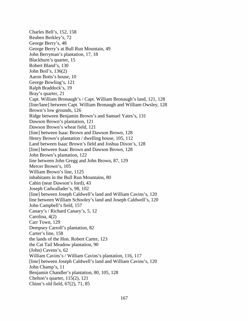
167
Charles Bell’s, 152, 158 Reuben Berkley’s, 72 George Berry’s, 48 George Berry’s at Bull Run Mountain, 49 John Berryman’s plantation, 17, 18 Blackburn’s quarter, 15 Robert Bland’s, 130 John Boil’s, 136(2) Aaron Botts’s house, 10 George Bowling’s, 121 Ralph Braddock’s, 19 Bray’s quarter, 21 Capt. William Bronaugh’s / Capt. William Bronaugh’s land, 121, 128 [line/lane] between Capt. William Bronaugh and William Owsley, 128 Brown’s low grounds, 126 Ridge between Benjamin Brown’s and Samuel Yates’s, 131 Dawson Brown’s plantation, 121 Dawson Brown’s wheat field, 121 [line] between Isaac Brown and Dawson Brown, 128 Henry Brown’s plantation / dwelling house, 105, 112 Land between Isaac Brown’s field and Joshua Dixon’s, 128 [line] between Isaac Brown and Dawson Brown, 128 John Brown’s plantation, 122 line between John Gregg and John Brown, 87, 129 Mercer Brown’s, 105 William Brown’s line, 1125 inhabitants in the Bull Run Mountains, 80 Cabin (near Dawson’s ford), 43 Joseph Cadwallader’s, 98, 102 [line] between Joseph Caldwell’s land and William Cavins’s, 120 line between William Schooley’s land and Joseph Caldwell’s, 120 John Campbell’s field, 157 Canary’s / Richard Canary’s, 5, 12 Carolina, 4(2) Carr Town, 129 Dempsey Carroll’s plantation, 82 Carter’s line, 158 the lands of the Hon. Robert Carter, 123 the Cat Tail Meadow plantation, 90 (John) Cavens’s, 62 William Cavins’s / William Cavins’s plantation, 116, 117 [line] between Joseph Caldwell’s land and William Cavins’s, 120 John Champ’s, 11 Benjamin Chandler’s plantation, 80, 105, 128 Chelton’s quarter, 115(2), 121 Chinn’s old field, 67(2), 71, 85
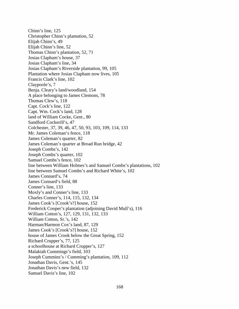
168
Chinn’s line, 125 Christopher Chinn’s plantation, 52 Elijah Chinn’s, 49 Elijah Chinn’s line, 52 Thomas Chinn’s plantation, 52, 71 Josias Clapham’s house, 37 Josias Clapham’s line, 34 Josias Clapham’s Riverside plantation, 99, 105 Plantation where Josias Clapham now lives, 105 Francis Clark’s line, 102 Claypoole’s, 7 Benja. Cleary’s land/woodland, 154 A place belonging to James Clemons, 78 Thomas Clew’s, 118 Capt. Cock’s line, 122 Capt. Wm. Cock’s land, 128 land of William Cocke, Gent., 80 Sandford Cockerill’s, 47 Colchester, 37, 39, 46, 47, 50, 93, 103, 109, 114, 133 Mr. James Coleman’s fence, 118 James Coleman’s quarter, 82 James Coleman’s quarter at Broad Run bridge, 42 Joseph Combs’s, 142 Joseph Combs’s quarter, 102 Samuel Combs’s fence, 102 line between William Holmes’s and Samuel Combs’s plantations, 102 line between Samuel Combs’s and Richard White’s, 102 James Connard’s, 74 James Connard’s field, 88 Conner’s line, 133 Moxly’s and Conner’s line, 133 Charles Conner’s, 114, 115, 132, 134 James Cook’s [Crook’s?] house, 152 Frederick Cooper’s plantation (adjoining David Mull’s), 116 William Cotton’s, 127, 129, 131, 132, 133 William Cotton, Sr.’s, 142 Harman/Harmon Cox’s land, 87, 129 James Cook’s [Crook’s?] house, 152 house of James Crook below the Great Spring, 152 Richard Crupper’s, 77, 125 a schoolhouse at Richard Crupper’s, 127 Malakiah Cummings’s field, 103 Joseph Cummins’s / Cumming’s plantation, 109, 112 Jonathan Davis, Gent.’s, 145 Jonathan Davis’s new field, 132 Samuel Davis’s line, 102

169
place where Samuel Davis formerly lived, 11 Samuel Davis’s the Elder on the Blue Ridge, 134 John Dawson’s plantation, 8 James Dillion’s, 35 Land between Isaac Brown’s field and Joshua Dixon’s, 128 Dodd’s, 71 William Dodd’s / William Dodd’s house/plantation, 2, 7(2), 26(2), 30, 32, 33(2), 35, 36(2), 37,
42, 48, 51, 58, 59, 60, 106 place where William Dodd formerly lived, 69 William Dodd’s former dwelling, 75 Doughty’s, 142 Reuben Doughty’s, 153, 157, 158 the lots of Michael and Reuben Doughty, 101 William Douglass’s house/plantation, 15, 31, 60, 138 John Dowdall’s plantation/fields, 130 old house on John Dowdall’s plantation, 130 Drake’s meadow, 153 Thomas Drake’s, 108 Thomas Drake’s meadow, 79, 100, 103, 109, 112, 119, 120, 121, 124, 128 (the) big rock (near Thomas Drake’s and Samuel Smith’s), 79 Drish’s, 158 place where Samuel Duncan formerly lived, 44, 58 Amos Dunham’s field, 131 Edwards’s, 134 Edwards’s shop / Arthur Edwards’s shop, 136(2) Edwards’s old shop, 147, 154 Benjamin Edwards’s, 152, 154 line of Francis Elgin and Isaac Fouch, 108 line of Francis Elgin and Benjamin Shreeve, 108 Capt. Ellzey’s quarters, 72 Mr. Ellzey’s plantation, 8 Samuel Erwin’s, 105 Charles Eskridge’s, 25, 27 Evans’s shop, 103 Evan Evans’s meadow, 88 line between Evan Evans and John Arbecost, 101 line between Tankerville and Fairfax, 121, 155 Col. Fairfax’s land, 22 the lands of Mr. Bryan Fairfax, 32 the lands of Col. / the Hon. G. W. / George William Fairfax (and Esqr.), 35, 81, 88, 93, 101 the Fall Meadow, 32 the Falls warehouse (Fairfax County), 31 Adam Farrer’s new ground, 122 line between Thaddeus McCarty and Joseph Farrow, 122 line between Valentine Miller and John Fearst, 101 James Ferguson’s [line] between the plantations of Fitzimons and the Widow Williams, 113
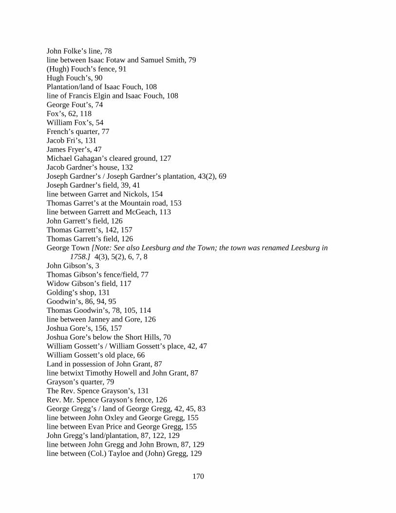
170
John Folke’s line, 78 line between Isaac Fotaw and Samuel Smith, 79 (Hugh) Fouch’s fence, 91 Hugh Fouch’s, 90 Plantation/land of Isaac Fouch, 108 line of Francis Elgin and Isaac Fouch, 108 George Fout’s, 74 Fox’s, 62, 118 William Fox’s, 54 French’s quarter, 77 Jacob Fri’s, 131 James Fryer’s, 47 Michael Gahagan’s cleared ground, 127 Jacob Gardner’s house, 132 Joseph Gardner’s / Joseph Gardner’s plantation, 43(2), 69 Joseph Gardner’s field, 39, 41 line between Garret and Nickols, 154 Thomas Garret’s at the Mountain road, 153 line between Garrett and McGeach, 113 John Garrett’s field, 126 Thomas Garrett’s, 142, 157 Thomas Garrett’s field, 126 George Town [Note: See also Leesburg and the Town; the town was renamed Leesburg in
1758.] 4(3), 5(2), 6, 7, 8 John Gibson’s, 3 Thomas Gibson’s fence/field, 77 Widow Gibson’s field, 117 Golding’s shop, 131 Goodwin’s, 86, 94, 95 Thomas Goodwin’s, 78, 105, 114 line between Janney and Gore, 126 Joshua Gore’s, 156, 157 Joshua Gore’s below the Short Hills, 70 William Gossett’s / William Gossett’s place, 42, 47 William Gossett’s old place, 66 Land in possession of John Grant, 87 line betwixt Timothy Howell and John Grant, 87 Grayson’s quarter, 79 The Rev. Spence Grayson’s, 131 Rev. Mr. Spence Grayson’s fence, 126 George Gregg’s / land of George Gregg, 42, 45, 83 line between John Oxley and George Gregg, 155 line between Evan Price and George Gregg, 155 John Gregg’s land/plantation, 87, 122, 129 line between John Gregg and John Brown, 87, 129 line between (Col.) Tayloe and (John) Gregg, 129
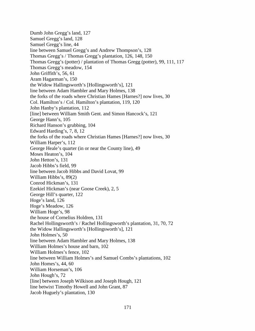
171
Dumb John Gregg’s land, 127 Samuel Gregg’s land, 128 Samuel Gregg’s line, 44 line between Samuel Gregg’s and Andrew Thompson’s, 128 Thomas Gregg’s / Thomas Gregg’s plantation, 126, 148, 150 Thomas Gregg’s (potter) / plantation of Thomas Gregg (potter), 99, 111, 117 Thomas Gregg’s meadow, 154 John Griffith’s, 56, 61 Aram Hagarman’s, 150 the Widow Hallingsworth’s [Hollingsworth’s], 121 line between Adam Hambler and Mary Holmes, 138 the forks of the roads where Christian Hames [Harnes?] now lives, 30 Col. Hamilton’s / Col. Hamilton’s plantation, 119, 120 John Hanby’s plantation, 112 [line] between William Smith Gent. and Simon Hancock’s, 121 George Hann’s, 105 Richard Hanson’s grubbing, 104 Edward Harding’s, 7, 8, 12 the forks of the roads where Christian Hames [Harnes?] now lives, 30 William Harper’s, 112 George Heale’s quarter (in or near the County line), 49 Moses Heaton’s, 104 John Hetton’s, 131 Jacob Hibbs’s field, 99 line between Jacob Hibbs and David Lovat, 99 William Hibbs’s, 89(2) Conrod Hickman’s, 131 Ezekiel Hickman’s (near Goose Creek), 2, 5 George Hill’s quarter, 122 Hoge’s land, 126 Hoge’s Meadow, 126 William Hoge’s, 98 the house of Cornelius Holdren, 131 Rachel Hollingsworth’s / Rachel Hollingsworth’s plantation, 31, 70, 72 the Widow Hallingsworth’s [Hollingsworth’s], 121 John Holmes’s, 50 line between Adam Hambler and Mary Holmes, 138 William Holmes’s house and barn, 102 William Holmes’s fence, 102 line between William Holmes’s and Samuel Combs’s plantations, 102 John Homes’s, 44, 60 William Horseman’s, 106 John Hough’s, 72 [line] between Joseph Wilkison and Joseph Hough, 121 line betwixt Timothy Howell and John Grant, 87 Jacob Huguely’s plantation, 130
172
Hutchison’s Post, 36 [Note: See also the Post, the old Post.] Joseph Hutchison’s, 132 line between Hutton, &c., 78 John Jackson’s line, 78 the line of Robert Jamison, 134 the dividing line of Robert Jamison and Ezekiel Potts, 134 Janney’s land, 126 line between Janney and Gore, 126 Abel Janney’s house / Abel Janney’s, 31(2) Abel Janney’s (near/under the Short Hill), 117, 127 Jacob Janney’s / land of Jacob Janney, 21, 116 Joseph Janney’s land / dwelling house, 127 Mahlon Janney’s, 83 Samuel Janney’s land, 127 James Jenkins’s plantation, 149 Benjamin John’s old place, 108 a field that was Daniel John’s, 117 Thomas John’s, 45(2), 46 Tunis Johnson’s house, 86 Tunis Johnson’s shop, 86 George Johnston’s field / wheat field, 127 an old cabin in George Johnston’s field, 127 John Jones’s plantation, 110 Joseph Jones’s / place where Joseph Jones now lives (near the Short Hills), 41, 43 William Jones’s, 34 Thomas Kelley’s fence, 132 line between Thomas Kelley and William Musgrove, 132 Kelly’s / Patrick Kelly’s, 136(2), 153 Smith King’s, 75 William Kirk’s [Note: See also Kirk’s mill.], 7, 42 Mahlon Kirkbride’s, 35 Joseph Lacey’s, 147 line between Joseph Lacey and John Moore, 158 James Lampkin’s plantation, 80 Lane’s store, 46 line between William Southard and Hardage Lane, 131 James Lane’s / James Lane’s land, 123, 134 Mr. Lane’s / William Carr Lane’s house, 72 William Laycock’s field, 50 Lee’s quarter, 60 Francis Lightfoot Lee, Gent.’s quarter, 21 Leesburg/Leesburgh [Note: See also George Town and the Town; the town was renamed
Leesburg in 1758.], 7(4), 8, 10, 11, 12(3), 15(2), 18, 19, 20, 22(3), 24, 26(3), 27, 28, 30, 31(2), 33(2), 34, 35, 36(4), 38(3), 40(2), 41(2), 42, 47(2), 48, 53(2), 54, 58(3), 59, 60, 61, 66(3), 68(2), 69(3), 70, 71, 73, 75, 76, 77, 78, 79, 81(2), 83, 84, 86(2), 87(3), 89, 90, 91(2), 92(2), 93(2), 94(2), 95, 96, 97, 99, 100, 101, 107, 108(2), 111, 112, 113(2), 114,

173
116, 117(2), 122, 123, 124, 126, 129, 132, 133, 135(2), 136, 138(2), 140(2), 141, 142(2), 143, 146(3), 149, 151, 152(2), 153(2), 154(3), 155, 156(3), 157(2), 158(2)
James Leith’s / James Leith’s plantation, 100, 109, 119 James Leith’s on Little River, 91 Lewis Lemon’s, 117 John Lester’s line, 34 Abraham Lewis’s meadow/house, 117 Jehu Lewis’s, 35 John Lewis’s / land of John Lewis, 53, 61, 63 Mr. John Lewis’s dwelling house, 152 Thomas Lewis’s, 110, 124 Thomas Lewis, Gent’s, 133 Mr. Thomas Lewis’s plantation, 131 Thomas Lewis’s two plantations, 104 Vincent Lewis’s / land of Vincent Lewis, 8, 38, 53, 55(2) The Locust Thicket where Samuel Smith formerly lived, 98 The long glade, 128 line between Jacob Hibbs and David Lovat, 99 Samuel Love’s line, 87 Samuel Love’s / Samuel Love’s plantation, 72 Daniel Lovett’s plantation, 53 Thaddeus McCarty’s new ground fence, 127 line between Thaddeus McCarty and Joseph Farrow, 122 John McClain’s, 144 Robert McCully’s, 148 line between Garrett and McGeach, 113 line of McHaney’s two lotts,128 line between Charles McManemy’s and James Nixon’s, 128 Plantation/field/house of William McNabb, 113, 124, 125, 127 Robert Mcwhorter’s field (tenant on Col. Tayloe’s land), 129 Richard Major’s, 113 line dividing the lands of Fleming Patterson, Harrison Manley, and Samuel Tillett, 70 Leonard Marbury’s plantation, 34 Place where John Markley now lives (near the fork of the roads), 26 James Martin’s / James Martin’s plantation, 99, 111, 117, 124 Land formerly belonging to Ann Mason, widow (now said to be the land of the children of Samuel Seldon, Gent.), 21 line between Mr. Mason’s and Mr. Page’s land, 120 Land of Thomson Mason Esqr. near his plantation called Rasberry Plane, 63 Thomson Mason’s River quarter, 23 Thompson Mason’s quarter, 152 the plantation of Thompson Mason Esqr., 152 line of partition between Mr. Thompson Mason and Mrs. Mary Mason Page, 152 Mr. Massey’s, 34 Mr. Massey’s fence, 34 Mr. Lee Massey’s, 31
174
Leonard May’s fence, 104 Leonard May’s plantation, 116 William Mead’s, 38, 40, 43(2), 50, 52, 56, 68, 69, 90(2), 98, 135, 145, 153 William Mead’s meadow, 53 James Mercer, Esqr.’s plantation, 86 Mr. Mercer’s Meadow Ground, 26 Mr. Mercer’s quarter plantation (and field, meadow, fodder house, hay stacks), 77 Mercer’s quarter (on Little River), 120, 122 Mercer’s old quarter (at Little River), 121, 122 Place where Mr. Mercer’s Little River quarter was kept, 104 [Mr.] Mercer’s new quarter, 104 Richard Mets’s wheat field, 91 Daniel Michael’s, 121 Henry Michael’s lot, 101 Josias Miles’s, 139(2) Peter Miller’s, 121 Peter Miller’s field, 122 Valentine Miller’s field, 101 line between Valentine Miller and John Fearst, 101 Capt. Nicholas Minor’s / Nicholas Minor, Gent.’s plantation, 2(2), 51, 52 Adam Mitchell’s, 134 William Mitchell’s land, 123 Josiah Moffett’s / (Mr.) Josiah Moffett’s plantation, 134, 135 Mr. Josiah Moffett’s new clearing, 135 line between [Josiah] Moffett and William Moss, 135 Nicholas Money’s, 131 Jonathan Monkhouse’s corner tree and fence, 52 Henry Moore’s, 20 line between Joseph Lacey and John Moore, 158 the plantation where Thomas Moore lives, 102 Jenkin Morris’s land, 44 plantation where John Morris formerly lived, 46 Widow Morris’s field, 80 line between William Schooley’s land and land that William Morrison lives on, 120 Moss’s, 56 John / Capt. John Moss’s, 8, 68, 118, 119 John Moss’s quarter, 82 the long glade between Capt. John Moss’s and Matthew White’s field, 130 William Moss’s, 135 line between [Josiah] Moffett and William Moss, 135 the plantation of Daniel Moxley, 152 Joseph Moxley’s field, 131 Moxly’s and Conner’s line, 133 John Mucklehany’s plantation, 14 David Mull’s, 53 David Mull’s (adjoining Frederick Cooper’s), 116
175
line between Thomas Kelley and William Musgrove, 132 Ann Neale’s plantation, 12 John Neal’s field, 104 Thomas Neale’s line, 87 William Neilson’s field, 129 William Neilson’s plantation, 122, 129 Newgate, 96, 113, 136(2), 137, 141, 153 the Blacksmith at Newgate, 113 Isaac Nichols’s, 11, 36 line between Garret and Nickols, 154 George Nixon’s, 53, 144 George Nixon’s wheat field, 99 line between George Shaffer and George Nixon, 99 James Nixon’s land, 128 line between Charles McManemy’s and James Nixon’s, 128 Edwd. Norton’s plantation, 7 Occoquan warehouse, 13 the old Post, 23, 83, 95 [Note: See also Hutchson’s Post, the Post.] the old Posts, 107 [Note: See also Hutchson’s Post, the Post.] the old shop, 140 John Osborne’s, 137(2) [line] between John Osborne and Craven Peyton Esqr., 137 John Osborn’s house/plantation, 18, 60 John Osborn, Sr’s land, 81 Nicholas Osborn’s, 35 Richard Osborn’s, 60 Nicholas Osburn’s, 129 the land of Mr. Owsl[e]y, where he now has a still house, 121 Thomas Owsley’s plantation, 77 Thomas Owsley’s quarter / quarter field, 78, 79, 80 line between Thos. Owsley and Thomas Williams, 128 [line/lane] between Capt. William Bronaugh and William Owsley, 128 line between (land of) Henry Oxley and John Oxley, 67 John Oxley’s, 154 line between John Oxley and George Gregg, 155 Man(n) Page’s quarter, 97 line between Mr. Mason’s and Mr. Page’s land, 120 the lands of Mrs. Page, 156 line of partition between Mr. Thompson Mason and Mrs. Mary Mason Page, 152 Pain’s, 78 Frail Pain’s, 27 John Palmer’s, 11 Joseph Parker’s shop, 108 line dividing the lands of Fleming Patterson, Harrison Manley, and Samuel Tillett, 70 Fleming Patterson’s quarter, 94, 97 John Payne’s, 14
176
John Pearce’s, 35, 47, 66, 68 Capt. Peyton’s home house, 85 Capt. Peyton’s plantation, 101 Capt. Peyton’s quarter, 104 Mr. Craven Peyton’s plantation, 26, 136, 137 Craven Peyton’s plantation and meadow, 100 [line] between John Osborne and Craven Peyton Esqr., 137 Capt. / Mr. Francis Peyton’s, 33(2), 46, 71, 93, 122 Capt. Francis Peyton’s quarter plantation / quarter, 77, 84, 114 Col. Francis Peyton’s land, 125 Nicholas Phillips’s field, 50 Richard Pile’s plantation, 52 Martin Poland’s, 132 Benjamin Pool’s plantation, 92 John Popkins’s, 24, 37 Robert Popkins’s plantation, 19 Edward Porter’s, 13, 16 the Post, 1(3), 3, 4, 37 [Note: See also Hutchison’s Post, the old Post.] Ezekiel Potts’s land, 88, 101 dividing line of Robert Jamison and Ezekiel Potts, 134 dividing line between Nathan Potts and his brother Ezekiel Potts, 134 Nathan Potts’s, 137 Nathan Potts’s dwelling house, 134 (Mr.) Leven / Levin Powell’s / Leven Powell’s plantation, 24, 27, 48(2), 51, 52, 71 line between Evan Price and George Gregg, 155 Pullin’s, 128 Charles/Chas. Pullen’s/Pullin’s/Pulling’s, 124, 125, 128, 129, 132, 138 line between Charles Pullen’s and Richard Skinner’s, 127 line of Thomas Pursel’s land, 128 John Radcliff’s fence, 5 Rasberry Plane (Thomson Mason’s plantation), 63 John Ratcliff’s, 5 Absalom Ramey’s, 110, 119, 120, 121 [line] between William Rasler’s plantation and Isaac Shown’s plantation, 116 Jacob Read’s, 112, 125 Jacob Read’s plantation/fence, 114 Red oak tree marked with three Notches, 91 Jacob Reed’s, 124, 142 David Reece’s/Reese’s shop, 150, 151 John Reign’s land, 128 Absalom/Absolom Remey’s, 138, 142 Jacob Remy’s fence, 87 Patrick Rice’s house, 7 Richard fence, 132 dividing line between Joseph Richardson and Samuel Smith, 62 Abner Roberts’s line, 78
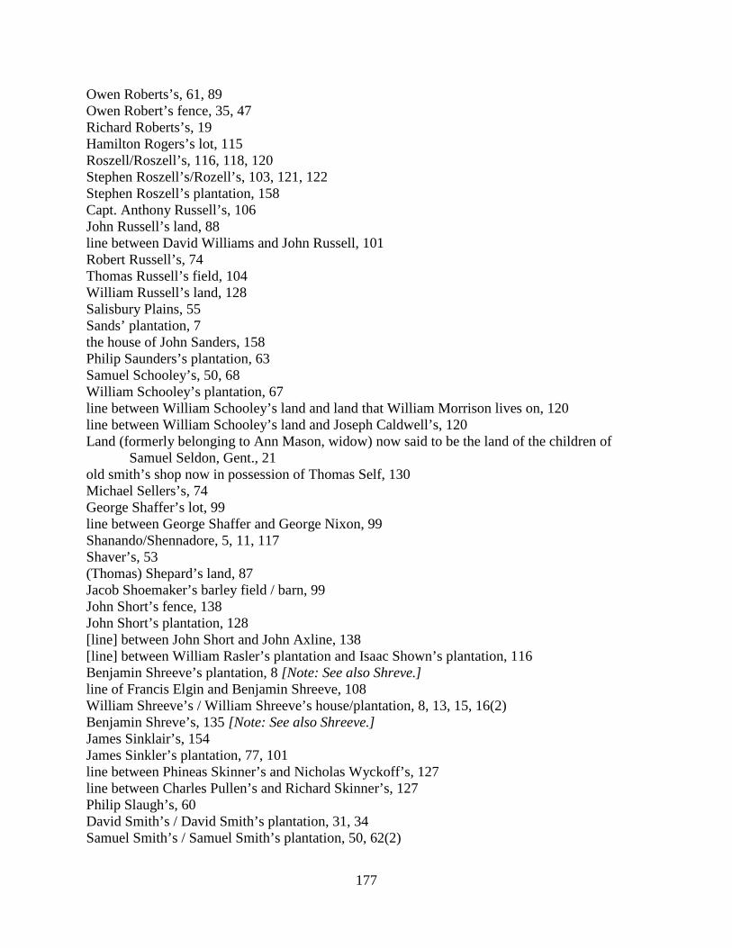
177
Owen Roberts’s, 61, 89 Owen Robert’s fence, 35, 47 Richard Roberts’s, 19 Hamilton Rogers’s lot, 115 Roszell/Roszell’s, 116, 118, 120 Stephen Roszell’s/Rozell’s, 103, 121, 122 Stephen Roszell’s plantation, 158 Capt. Anthony Russell’s, 106 John Russell’s land, 88 line between David Williams and John Russell, 101 Robert Russell’s, 74 Thomas Russell’s field, 104 William Russell’s land, 128 Salisbury Plains, 55 Sands’ plantation, 7 the house of John Sanders, 158 Philip Saunders’s plantation, 63 Samuel Schooley’s, 50, 68 William Schooley’s plantation, 67 line between William Schooley’s land and land that William Morrison lives on, 120 line between William Schooley’s land and Joseph Caldwell’s, 120 Land (formerly belonging to Ann Mason, widow) now said to be the land of the children of
Samuel Seldon, Gent., 21 old smith’s shop now in possession of Thomas Self, 130 Michael Sellers’s, 74 George Shaffer’s lot, 99 line between George Shaffer and George Nixon, 99 Shanando/Shennadore, 5, 11, 117 Shaver’s, 53 (Thomas) Shepard’s land, 87 Jacob Shoemaker’s barley field / barn, 99 John Short’s fence, 138 John Short’s plantation, 128 [line] between John Short and John Axline, 138 [line] between William Rasler’s plantation and Isaac Shown’s plantation, 116 Benjamin Shreeve’s plantation, 8 [Note: See also Shreve.] line of Francis Elgin and Benjamin Shreeve, 108 William Shreeve’s / William Shreeve’s house/plantation, 8, 13, 15, 16(2) Benjamin Shreve’s, 135 [Note: See also Shreeve.] James Sinklair’s, 154 James Sinkler’s plantation, 77, 101 line between Phineas Skinner’s and Nicholas Wyckoff’s, 127 line between Charles Pullen’s and Richard Skinner’s, 127 Philip Slaugh’s, 60 David Smith’s / David Smith’s plantation, 31, 34 Samuel Smith’s / Samuel Smith’s plantation, 50, 62(2)
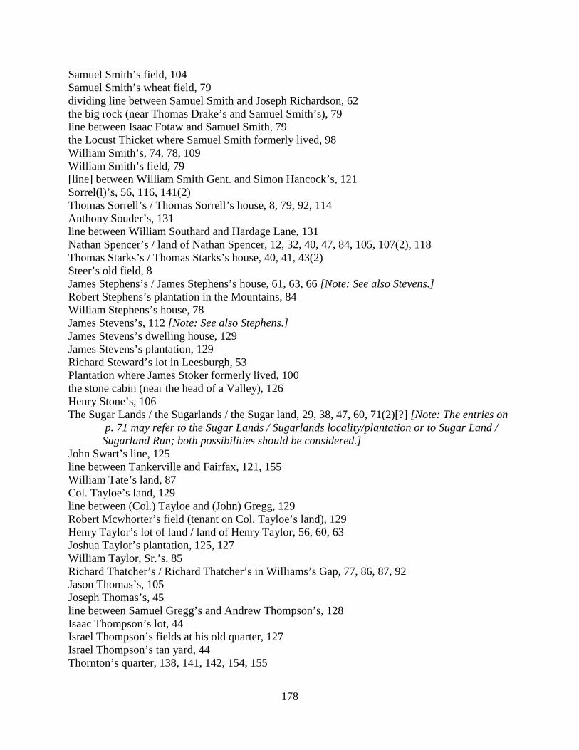
178
Samuel Smith’s field, 104 Samuel Smith’s wheat field, 79 dividing line between Samuel Smith and Joseph Richardson, 62 the big rock (near Thomas Drake’s and Samuel Smith’s), 79 line between Isaac Fotaw and Samuel Smith, 79 the Locust Thicket where Samuel Smith formerly lived, 98 William Smith’s, 74, 78, 109 William Smith’s field, 79 [line] between William Smith Gent. and Simon Hancock’s, 121 Sorrel(l)’s, 56, 116, 141(2) Thomas Sorrell’s / Thomas Sorrell’s house, 8, 79, 92, 114 Anthony Souder’s, 131 line between William Southard and Hardage Lane, 131 Nathan Spencer’s / land of Nathan Spencer, 12, 32, 40, 47, 84, 105, 107(2), 118 Thomas Starks’s / Thomas Starks’s house, 40, 41, 43(2) Steer’s old field, 8 James Stephens’s / James Stephens’s house, 61, 63, 66 [Note: See also Stevens.] Robert Stephens’s plantation in the Mountains, 84 William Stephens’s house, 78 James Stevens’s, 112 [Note: See also Stephens.] James Stevens’s dwelling house, 129 James Stevens’s plantation, 129 Richard Steward’s lot in Leesburgh, 53 Plantation where James Stoker formerly lived, 100 the stone cabin (near the head of a Valley), 126 Henry Stone’s, 106 The Sugar Lands / the Sugarlands / the Sugar land, 29, 38, 47, 60, 71(2)[?] [Note: The entries on
p. 71 may refer to the Sugar Lands / Sugarlands locality/plantation or to Sugar Land / Sugarland Run; both possibilities should be considered.] John Swart’s line, 125 line between Tankerville and Fairfax, 121, 155 William Tate’s land, 87 Col. Tayloe’s land, 129 line between (Col.) Tayloe and (John) Gregg, 129 Robert Mcwhorter’s field (tenant on Col. Tayloe’s land), 129 Henry Taylor’s lot of land / land of Henry Taylor, 56, 60, 63 Joshua Taylor’s plantation, 125, 127 William Taylor, Sr.’s, 85 Richard Thatcher’s / Richard Thatcher’s in Williams’s Gap, 77, 86, 87, 92 Jason Thomas’s, 105 Joseph Thomas’s, 45 line between Samuel Gregg’s and Andrew Thompson’s, 128 Isaac Thompson’s lot, 44 Israel Thompson’s fields at his old quarter, 127 Israel Thompson’s tan yard, 44 Thornton’s quarter, 138, 141, 142, 154, 155
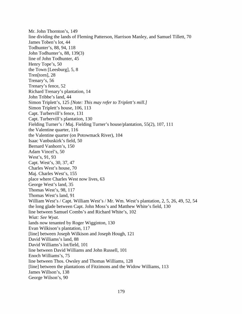
179
Mr. John Thornton’s, 149 line dividing the lands of Fleming Patterson, Harrison Manley, and Samuel Tillett, 70 James Toben’s lot, 44 Todhunter’s, 88, 94, 118 John Todhunter’s, 88, 139(3) line of John Todhunter, 45 Henry Tope’s, 50 the Town [Leesburg], 5, 8 Tren[torn], 28 Trenary’s, 56 Trenary’s fence, 52 Richard Trenary’s plantation, 14 John Tribbe’s land, 44 Simon Triplett’s, 125 [Note: This may refer to Triplett’s mill.] Simon Triplett’s house, 106, 113 Capt. Turbervill’s fence, 131 Capt. Turbervill’s plantation, 130 Fielding Turner’s / Maj. Fielding Turner’s house/plantation, 55(2), 107, 111 the Valentine quarter, 116 the Valentine quarter (on Potowmack River), 104 Isaac Vanbuskirk’s field, 50 Bernard Vanhorn’s, 150 Adam Vincel’s, 50 West’s, 91, 93 Capt. West’s, 30, 37, 47 Charles West’s house, 70 Maj. Charles West’s, 155 place where Charles West now lives, 63 George West’s land, 35 Thomas West’s, 98, 117 Thomas West’s land, 91 William West’s / Capt. William West’s / Mr. Wm. West’s plantation, 2, 5, 26, 49, 52, 54 the long glade between Capt. John Moss’s and Matthew White’s field, 130 line between Samuel Combs’s and Richard White’s, 102 Wiat: See Wyat. lands now tenanted by Roger Wigginton, 130 Evan Wilkison’s plantation, 117 [line] between Joseph Wilkison and Joseph Hough, 121 David Williams’s land, 88 David Williams’s lot/field, 101 line between David Williams and John Russell, 101 Enoch Williams’s, 75 line between Thos. Owsley and Thomas Williams, 128 [line] between the plantations of Fitzimons and the Widow Williams, 113 James Willson’s, 138 George Wilson’s, 90
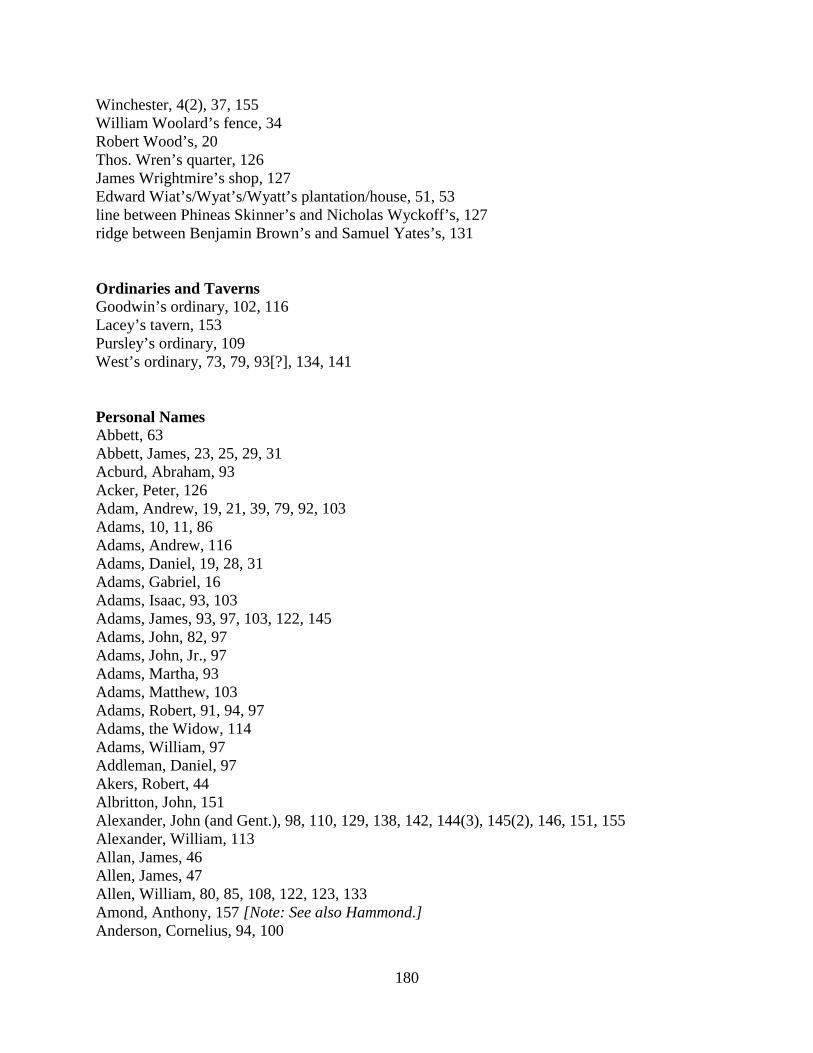
180
Winchester, 4(2), 37, 155 William Woolard’s fence, 34 Robert Wood’s, 20 Thos. Wren’s quarter, 126 James Wrightmire’s shop, 127 Edward Wiat’s/Wyat’s/Wyatt’s plantation/house, 51, 53 line between Phineas Skinner’s and Nicholas Wyckoff’s, 127 ridge between Benjamin Brown’s and Samuel Yates’s, 131 Ordinaries and Taverns Goodwin’s ordinary, 102, 116 Lacey’s tavern, 153 Pursley’s ordinary, 109 West’s ordinary, 73, 79, 93[?], 134, 141 Personal Names Abbett, 63 Abbett, James, 23, 25, 29, 31 Acburd, Abraham, 93 Acker, Peter, 126 Adam, Andrew, 19, 21, 39, 79, 92, 103 Adams, 10, 11, 86 Adams, Andrew, 116 Adams, Daniel, 19, 28, 31 Adams, Gabriel, 16 Adams, Isaac, 93, 103 Adams, James, 93, 97, 103, 122, 145 Adams, John, 82, 97 Adams, John, Jr., 97 Adams, Martha, 93 Adams, Matthew, 103 Adams, Robert, 91, 94, 97 Adams, the Widow, 114 Adams, William, 97 Addleman, Daniel, 97 Akers, Robert, 44 Albritton, John, 151 Alexander, John (and Gent.), 98, 110, 129, 138, 142, 144(3), 145(2), 146, 151, 155 Alexander, William, 113 Allan, James, 46 Allen, James, 47 Allen, William, 80, 85, 108, 122, 123, 133 Amond, Anthony, 157 [Note: See also Hammond.] Anderson, Cornelius, 94, 100
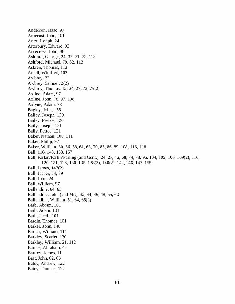
181
Anderson, Isaac, 97 Arbecost, John, 101 Arter, Joseph, 24 Arterbury, Edward, 93 Arvecross, John, 88 Ashford, George, 24, 37, 71, 72, 113 Ashford, Michael, 79, 82, 113 Askren, Thomas, 113 Athell, Winifred, 102 Awbrey, 73 Awbrey, Samuel, 2(2) Awbrey, Thomas, 12, 24, 27, 73, 75(2) Axline, Adam, 97 Axline, John, 78, 97, 138 Axlyne, Adam, 78 Bagley, John, 155 Bailey, Joseph, 120 Bailey, Pearce, 120 Baily, Joseph, 121 Baily, Peirce, 121 Baker, Nathan, 108, 111 Baker, Philip, 97 Baker, William, 30, 36, 58, 61, 63, 70, 83, 86, 89, 108, 116, 118 Ball, 116, 148, 153, 157 Ball, Farlan/Farlin/Farling (and Gent.), 24, 27, 42, 68, 74, 78, 96, 104, 105, 106, 109(2), 116,
120, 121, 128, 130, 135, 138(3), 140(2), 142, 146, 147, 155 Ball, James, 147(2) Ball, Jasper, 74, 89 Ball, John, 24 Ball, William, 97 Ballendine, 64, 65 Ballendine, John (and Mr.), 32, 44, 46, 48, 55, 60 Ballendine, William, 51, 64, 65(2) Barb, Abram, 101 Barb, Adam, 101 Barb, Jacob, 101 Bardin, Thomas, 101 Barker, John, 148 Barker, William, 111 Barkley, Scarlet, 130 Barkley, William, 21, 112 Barnes, Abraham, 44 Bartley, James, 11 Bast, John, 62, 66 Batey, Andrew, 122 Batey, Thomas, 122

182
Batson, James, 51, 52, 85, 109, 122, 125 Batson, John, 152 Batterton, Henry, 101, 123, 127 Battson, James, 77 Bayley, Peirce/Pierce, Gent., 145, 151, 153 Bayly, Pierce, Gent., 141 Bayne, John, 85 Bayne, Thomas, 85 Bayty, Andrew, 123 Bayty, Thomas, 123 Beard, William, 101 Beaty, John, 95 Beaty, Robert, 94 Beaty, Thomas, 142 Beatty, Robert, 100 Beavers, Alexander, 93 Beavers, James, 93, 103 Beavers, Joseph, 93, 103 Beavers, Thomas, 38, 39, 43 Beavers, William, 37, 53, 54, 57, 94, 100, 114, 124 Beavers, William, Sr., 115 Beek, Patrick, 117 Beens, Andrew, 130 Beevers, William, 22 Belford, Daniel, 82, 95 Bell, Charles, 148, 152, 154, 158 Bennett, Chareles/Charles, 155, 158 Bennett, James, 94, 100 Berdine, Thomas, 93 Berkeley, Benjamin, dec., 60 Berkely, William, 105 Berkley, Benjamin, 25, 30, 37, 41 Berkley, John, 55(2), 83 Berkley, Reuben, 72 Berkley, William, 37, 80, 85 Berry, George, 48, 49 Berry, William, 31 Berry, William (removed out of the county), 49 Berryman, John, 17, 18 Bertley, James, 10 Best, James, 105, 119 Best, John, 64 Betsel, Isaac, 102, 115 Bever, 128 Bingham, Stephen, 126 Binns, Charles, 79, 82

183
Bishop, Thomas John, 25 Bishop, Samuel, 91 Blackburn, 15 Bland, Robert, 50, 76, 79, 90, 130, 133 Blinco, Thomas, 70, 75, 81 Bodine, Cornelius, 86, 91 Bodine, Isaac, 151 Bodine, Jacob, 93 Boggess, Henry, 41, 54, 60, 62, 68, 108 Boil, John, 136 Bonam, Joseph, 97 Bonham, Benjamin, 107 Bonham, Elijah, 107 Bonham, Joseph, 102, 104 Bonham, Nehemiah, 107 Bookout, Joseph, 24 Booth, John, 97 Botts, Aaron, 9, 10(2), 67 Bowling, George, 96, 121 Boyd, James, 138 Boyd, John, 138 Boyd, William, Jr., 82, 95, 138 Boyd, William, Sr., 82, 95 Braddock, Ralph, 19 Bradley, Joseph, 91 Branner, Philip, 138 Branson, John, 111 Brawner, Philip, 97 Bray, 21 Brehnor, Phillip, 153 Brent, Charles, 90, 124 Brewer, Henry, 15, 21, 34, 41, 49, 57, 58, 95 Bright, John, 94 Broadwater, Charles, 95 Broadwater, Maj., 111, 113 Broddock, John, 24 Broddock, Ralph, 24 Broddock, William, 24 Bronaugh, Col., 153 Bronaugh, William (and Capt.), 88, 92, 112, 113, 118, 120, 121, 124, 125, 126, 128, 154 Brookes, William, 24 Brooks, William, 116, 120 Brown, 77, 126 Brown, Andrew, 96 Brown, Benjamin, 41, 124, 131, 136, 147 Brown, Coleman, 42, 45, 59, 134, 136(2), 140(2)
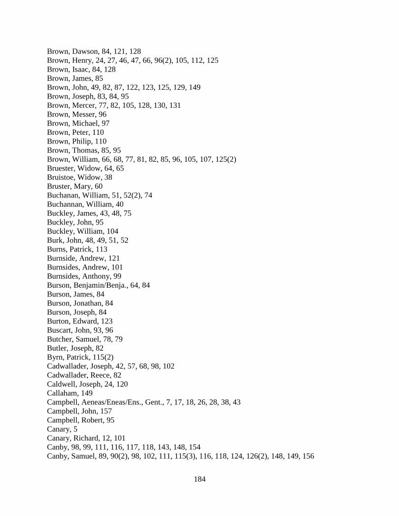
184
Brown, Dawson, 84, 121, 128 Brown, Henry, 24, 27, 46, 47, 66, 96(2), 105, 112, 125 Brown, Isaac, 84, 128 Brown, James, 85 Brown, John, 49, 82, 87, 122, 123, 125, 129, 149 Brown, Joseph, 83, 84, 95 Brown, Mercer, 77, 82, 105, 128, 130, 131 Brown, Messer, 96 Brown, Michael, 97 Brown, Peter, 110 Brown, Philip, 110 Brown, Thomas, 85, 95 Brown, William, 66, 68, 77, 81, 82, 85, 96, 105, 107, 125(2) Bruester, Widow, 64, 65 Bruistoe, Widow, 38 Bruster, Mary, 60 Buchanan, William, 51, 52(2), 74 Buchannan, William, 40 Buckley, James, 43, 48, 75 Buckley, John, 95 Buckley, William, 104 Burk, John, 48, 49, 51, 52 Burns, Patrick, 113 Burnside, Andrew, 121 Burnsides, Andrew, 101 Burnsides, Anthony, 99 Burson, Benjamin/Benja., 64, 84 Burson, James, 84 Burson, Jonathan, 84 Burson, Joseph, 84 Burton, Edward, 123 Buscart, John, 93, 96 Butcher, Samuel, 78, 79 Butler, Joseph, 82 Byrn, Patrick, 115(2) Cadwallader, Joseph, 42, 57, 68, 98, 102 Cadwallader, Reece, 82 Caldwell, Joseph, 24, 120 Callaham, 149 Campbell, Aeneas/Eneas/Ens., Gent., 7, 17, 18, 26, 28, 38, 43 Campbell, John, 157 Campbell, Robert, 95 Canary, 5 Canary, Richard, 12, 101 Canby, 98, 99, 111, 116, 117, 118, 143, 148, 154 Canby, Samuel, 89, 90(2), 98, 102, 111, 115(3), 116, 118, 124, 126(2), 148, 149, 156
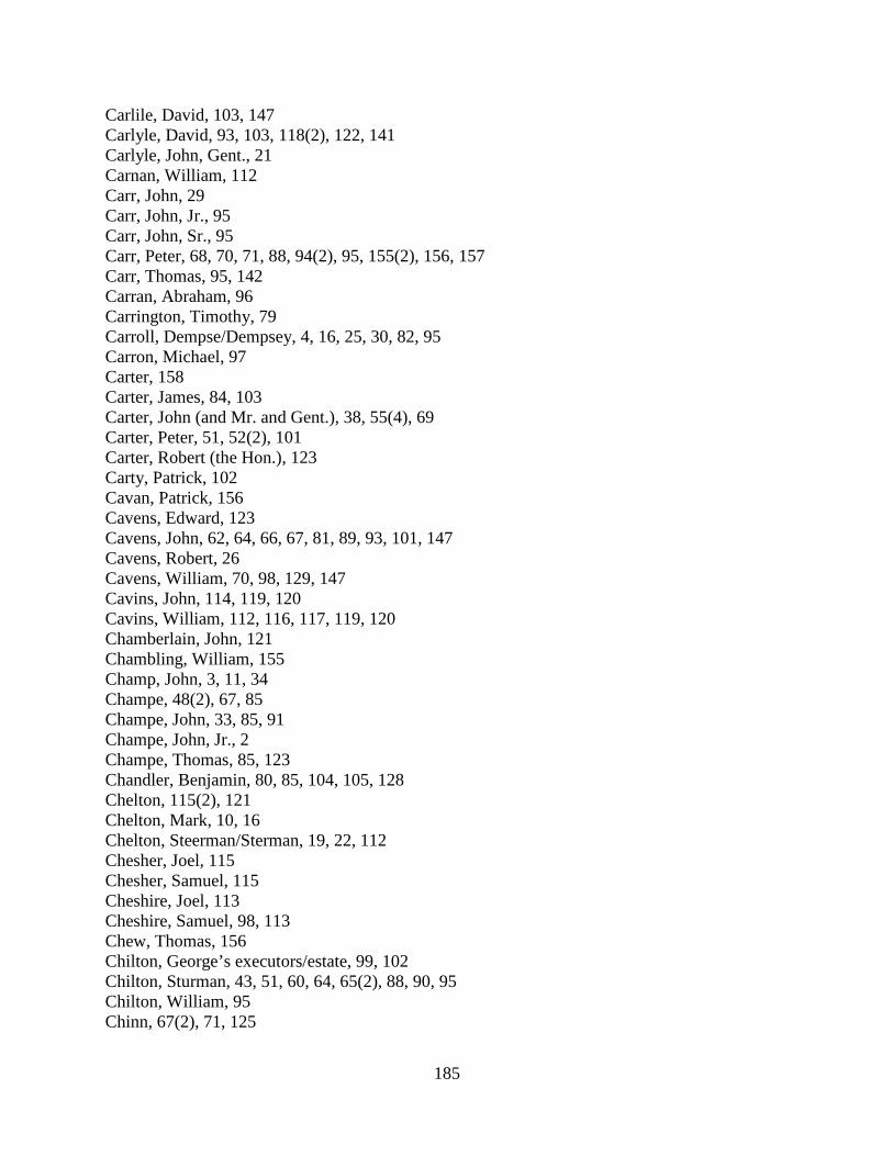
185
Carlile, David, 103, 147 Carlyle, David, 93, 103, 118(2), 122, 141 Carlyle, John, Gent., 21 Carnan, William, 112 Carr, John, 29 Carr, John, Jr., 95 Carr, John, Sr., 95 Carr, Peter, 68, 70, 71, 88, 94(2), 95, 155(2), 156, 157 Carr, Thomas, 95, 142 Carran, Abraham, 96 Carrington, Timothy, 79 Carroll, Dempse/Dempsey, 4, 16, 25, 30, 82, 95 Carron, Michael, 97 Carter, 158 Carter, James, 84, 103 Carter, John (and Mr. and Gent.), 38, 55(4), 69 Carter, Peter, 51, 52(2), 101 Carter, Robert (the Hon.), 123 Carty, Patrick, 102 Cavan, Patrick, 156 Cavens, Edward, 123 Cavens, John, 62, 64, 66, 67, 81, 89, 93, 101, 147 Cavens, Robert, 26 Cavens, William, 70, 98, 129, 147 Cavins, John, 114, 119, 120 Cavins, William, 112, 116, 117, 119, 120 Chamberlain, John, 121 Chambling, William, 155 Champ, John, 3, 11, 34 Champe, 48(2), 67, 85 Champe, John, 33, 85, 91 Champe, John, Jr., 2 Champe, Thomas, 85, 123 Chandler, Benjamin, 80, 85, 104, 105, 128 Chelton, 115(2), 121 Chelton, Mark, 10, 16 Chelton, Steerman/Sterman, 19, 22, 112 Chesher, Joel, 115 Chesher, Samuel, 115 Cheshire, Joel, 113 Cheshire, Samuel, 98, 113 Chew, Thomas, 156 Chilton, George’s executors/estate, 99, 102 Chilton, Sturman, 43, 51, 60, 64, 65(2), 88, 90, 95 Chilton, William, 95 Chinn, 67(2), 71, 125

186
Chinn, Charles, 26, 28(2), 31, 48, 85(2), 143 Chinn, Christopher, 52, 152 Chinn, Elijah (and Gent.), 24, 27, 49, 52, 60, 63, 71 Chinn, Elijah (estate), 85 Chinn, Rawleigh (the elder), 115 Chinn, Rawleigh, Jr., 152 Chinn, Thomas, 48, 52, 67, 71(2), 85, 109, 112, 113, 124, 125, 143, 154 Clapham, 22 Clapham, Josias (and Gent.), 3(3), 7, 11, 12, 13, 17(2), 19, 24, 26, 31, 34, 37, 46, 52, 65(2),
66(2), 73, 79, 88, 89, 94, 98, 99, 105, 109, 116, 123, 128, 131, 138, 140(2) Clapham, Mr., 5, 34 Clark, Benjamin, 85 Clark, Francis, 102 Claypole, James, 155 Claypoole, 7 Claypoole, Joseph, 35 Clayton, Thomas, 93 Cleary, Benja., 154 Clemons, James, 78 Cleveland, James, 117 Clews, Thomas, 118 Clewes, Thomas, 12 Cline, William, 110 Coby, Mathias, 97 Cock, Capt., 122 Cock, William/Wm. (and Capt. and Gent.), 123, 128 Cocke, William, Gent., 80 Cockeril, Benjamin, 46 Cockeril, Sanford, 46 Cockerill, Christopher, 112, 136 Cockerill, Sandford, 47 Cockerill, Thomas, 28, 129, 142 Cockerill, Thomas, Sr., 137 Cockerill, Thomas, Sr., deceased, 139 Cockrel, Christopher, 95 Cockrel, Jeremiah, 95 Cockrel, Joseph, 95 Cockrel, Thomas, Sr., 96 Cockrell, Benjamin, 73 Cockrell, Sandford, 73 Cockrell, Thomas, 99 Cockril, Sanford, 75 Cockrill, Benjamin, 45, 76, 149(2) Cockrill, Thomas/Thos., 4, 10, 11(2), 12, 15(2) Cockrill, Sandford/Sanford, 45, 76, 149(2) Coghill, Isaac, 100
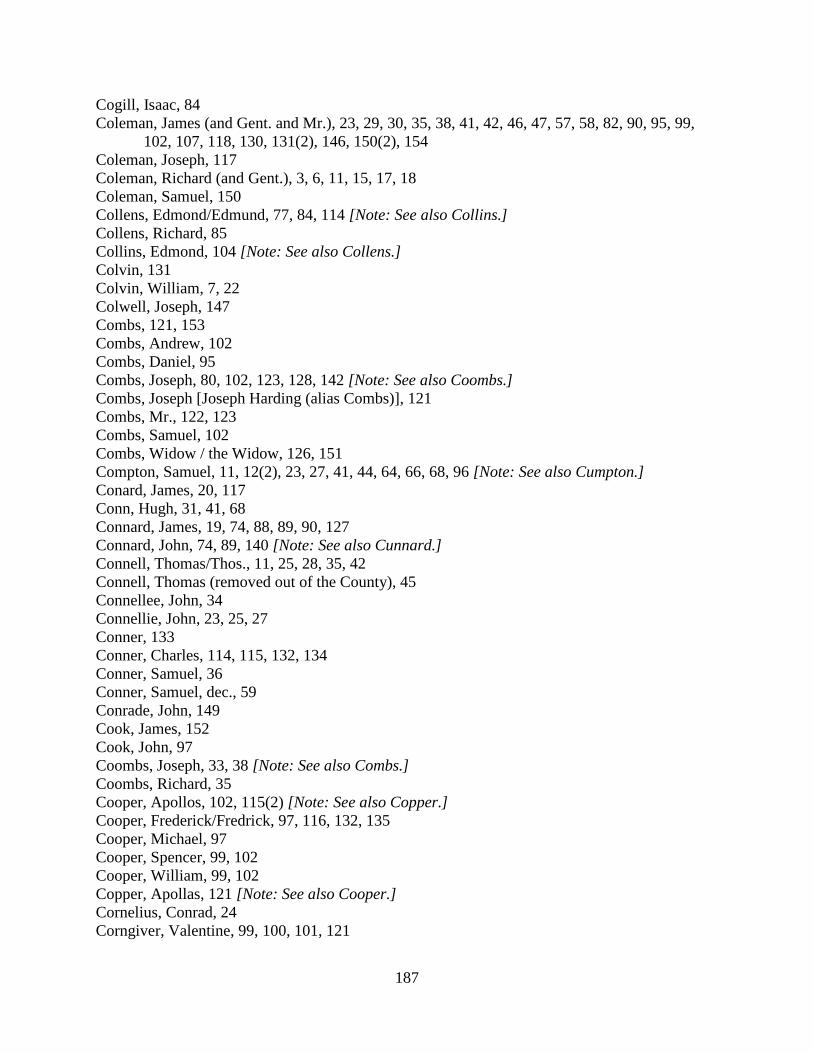
187
Cogill, Isaac, 84 Coleman, James (and Gent. and Mr.), 23, 29, 30, 35, 38, 41, 42, 46, 47, 57, 58, 82, 90, 95, 99,
102, 107, 118, 130, 131(2), 146, 150(2), 154 Coleman, Joseph, 117 Coleman, Richard (and Gent.), 3, 6, 11, 15, 17, 18 Coleman, Samuel, 150 Collens, Edmond/Edmund, 77, 84, 114 [Note: See also Collins.] Collens, Richard, 85 Collins, Edmond, 104 [Note: See also Collens.] Colvin, 131 Colvin, William, 7, 22 Colwell, Joseph, 147 Combs, 121, 153 Combs, Andrew, 102 Combs, Daniel, 95 Combs, Joseph, 80, 102, 123, 128, 142 [Note: See also Coombs.] Combs, Joseph [Joseph Harding (alias Combs)], 121 Combs, Mr., 122, 123 Combs, Samuel, 102 Combs, Widow / the Widow, 126, 151 Compton, Samuel, 11, 12(2), 23, 27, 41, 44, 64, 66, 68, 96 [Note: See also Cumpton.] Conard, James, 20, 117 Conn, Hugh, 31, 41, 68 Connard, James, 19, 74, 88, 89, 90, 127 Connard, John, 74, 89, 140 [Note: See also Cunnard.] Connell, Thomas/Thos., 11, 25, 28, 35, 42 Connell, Thomas (removed out of the County), 45 Connellee, John, 34 Connellie, John, 23, 25, 27 Conner, 133 Conner, Charles, 114, 115, 132, 134 Conner, Samuel, 36 Conner, Samuel, dec., 59 Conrade, John, 149 Cook, James, 152 Cook, John, 97 Coombs, Joseph, 33, 38 [Note: See also Combs.] Coombs, Richard, 35 Cooper, Apollos, 102, 115(2) [Note: See also Copper.] Cooper, Frederick/Fredrick, 97, 116, 132, 135 Cooper, Michael, 97 Cooper, Spencer, 99, 102 Cooper, William, 99, 102 Copper, Apollas, 121 [Note: See also Cooper.] Cornelius, Conrad, 24 Corngiver, Valentine, 99, 100, 101, 121
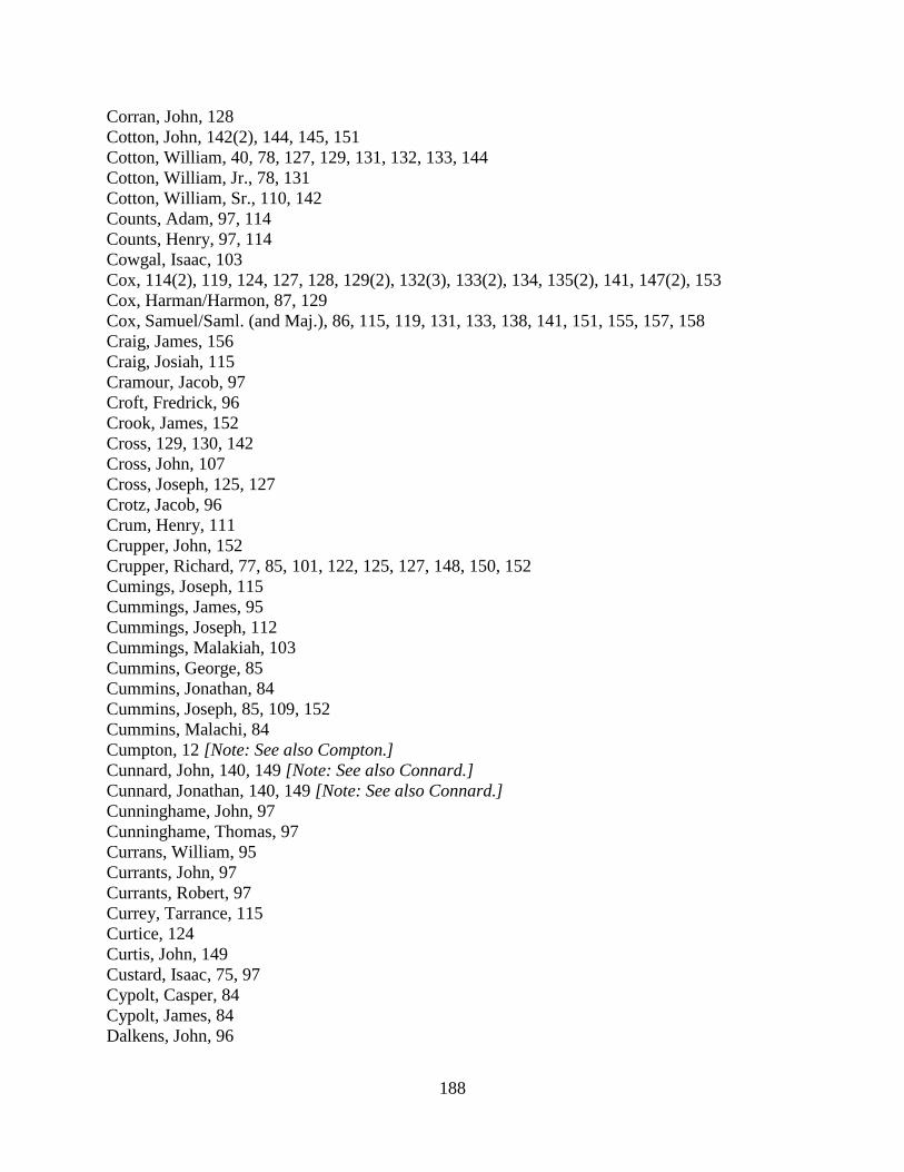
188
Corran, John, 128 Cotton, John, 142(2), 144, 145, 151 Cotton, William, 40, 78, 127, 129, 131, 132, 133, 144 Cotton, William, Jr., 78, 131 Cotton, William, Sr., 110, 142 Counts, Adam, 97, 114 Counts, Henry, 97, 114 Cowgal, Isaac, 103 Cox, 114(2), 119, 124, 127, 128, 129(2), 132(3), 133(2), 134, 135(2), 141, 147(2), 153 Cox, Harman/Harmon, 87, 129 Cox, Samuel/Saml. (and Maj.), 86, 115, 119, 131, 133, 138, 141, 151, 155, 157, 158 Craig, James, 156 Craig, Josiah, 115 Cramour, Jacob, 97 Croft, Fredrick, 96 Crook, James, 152 Cross, 129, 130, 142 Cross, John, 107 Cross, Joseph, 125, 127 Crotz, Jacob, 96 Crum, Henry, 111 Crupper, John, 152 Crupper, Richard, 77, 85, 101, 122, 125, 127, 148, 150, 152 Cumings, Joseph, 115 Cummings, James, 95 Cummings, Joseph, 112 Cummings, Malakiah, 103 Cummins, George, 85 Cummins, Jonathan, 84 Cummins, Joseph, 85, 109, 152 Cummins, Malachi, 84 Cumpton, 12 [Note: See also Compton.] Cunnard, John, 140, 149 [Note: See also Connard.] Cunnard, Jonathan, 140, 149 [Note: See also Connard.] Cunninghame, John, 97 Cunninghame, Thomas, 97 Currans, William, 95 Currants, John, 97 Currants, Robert, 97 Currey, Tarrance, 115 Curtice, 124 Curtis, John, 149 Custard, Isaac, 75, 97 Cypolt, Casper, 84 Cypolt, James, 84 Dalkens, John, 96
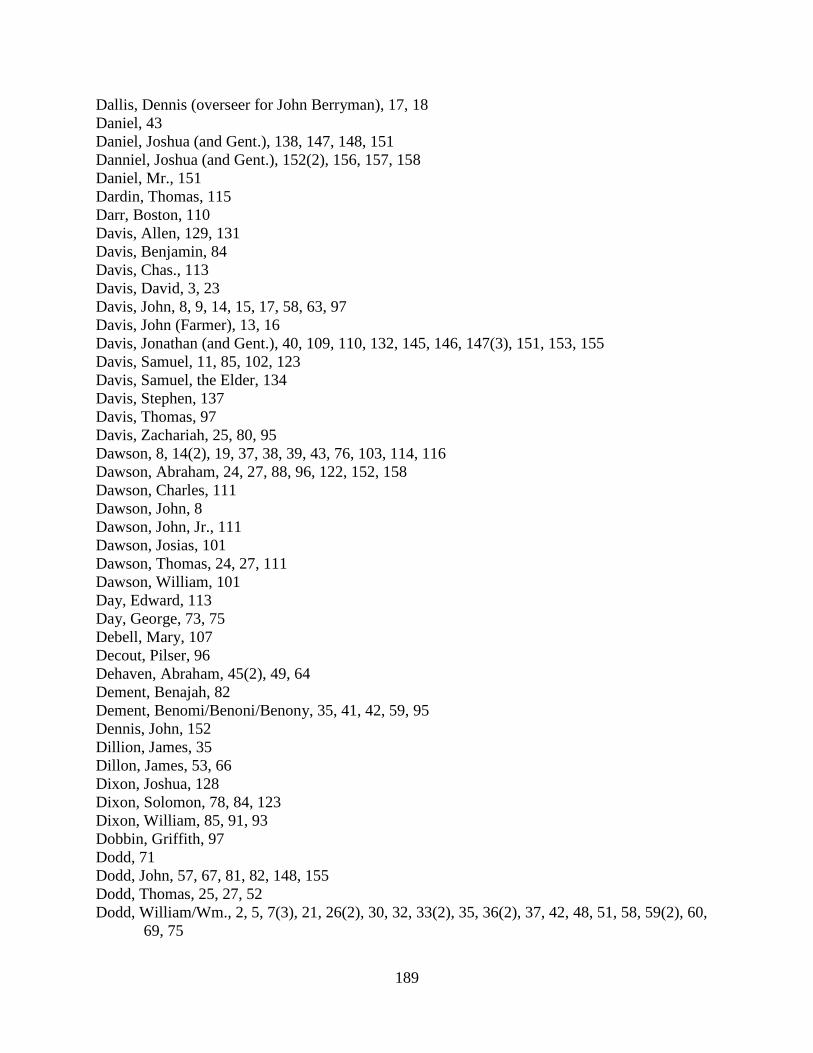
189
Dallis, Dennis (overseer for John Berryman), 17, 18 Daniel, 43 Daniel, Joshua (and Gent.), 138, 147, 148, 151 Danniel, Joshua (and Gent.), 152(2), 156, 157, 158 Daniel, Mr., 151 Dardin, Thomas, 115 Darr, Boston, 110 Davis, Allen, 129, 131 Davis, Benjamin, 84 Davis, Chas., 113 Davis, David, 3, 23 Davis, John, 8, 9, 14, 15, 17, 58, 63, 97 Davis, John (Farmer), 13, 16 Davis, Jonathan (and Gent.), 40, 109, 110, 132, 145, 146, 147(3), 151, 153, 155 Davis, Samuel, 11, 85, 102, 123 Davis, Samuel, the Elder, 134 Davis, Stephen, 137 Davis, Thomas, 97 Davis, Zachariah, 25, 80, 95 Dawson, 8, 14(2), 19, 37, 38, 39, 43, 76, 103, 114, 116 Dawson, Abraham, 24, 27, 88, 96, 122, 152, 158 Dawson, Charles, 111 Dawson, John, 8 Dawson, John, Jr., 111 Dawson, Josias, 101 Dawson, Thomas, 24, 27, 111 Dawson, William, 101 Day, Edward, 113 Day, George, 73, 75 Debell, Mary, 107 Decout, Pilser, 96 Dehaven, Abraham, 45(2), 49, 64 Dement, Benajah, 82 Dement, Benomi/Benoni/Benony, 35, 41, 42, 59, 95 Dennis, John, 152 Dillion, James, 35 Dillon, James, 53, 66 Dixon, Joshua, 128 Dixon, Solomon, 78, 84, 123 Dixon, William, 85, 91, 93 Dobbin, Griffith, 97 Dodd, 71 Dodd, John, 57, 67, 81, 82, 148, 155 Dodd, Thomas, 25, 27, 52 Dodd, William/Wm., 2, 5, 7(3), 21, 26(2), 30, 32, 33(2), 35, 36(2), 37, 42, 48, 51, 58, 59(2), 60,
69, 75
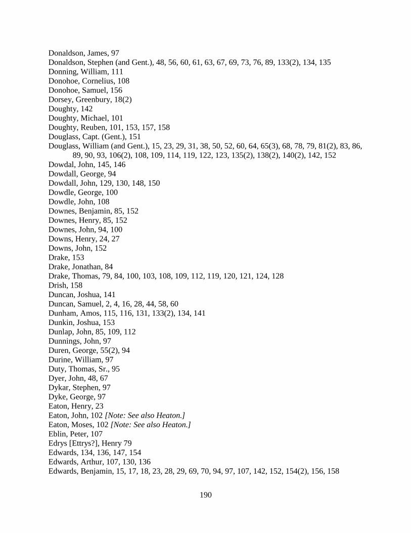
190
Donaldson, James, 97 Donaldson, Stephen (and Gent.), 48, 56, 60, 61, 63, 67, 69, 73, 76, 89, 133(2), 134, 135 Donning, William, 111 Donohoe, Cornelius, 108 Donohoe, Samuel, 156 Dorsey, Greenbury, 18(2) Doughty, 142 Doughty, Michael, 101 Doughty, Reuben, 101, 153, 157, 158 Douglass, Capt. (Gent.), 151 Douglass, William (and Gent.), 15, 23, 29, 31, 38, 50, 52, 60, 64, 65(3), 68, 78, 79, 81(2), 83, 86, 89, 90, 93, 106(2), 108, 109, 114, 119, 122, 123, 135(2), 138(2), 140(2), 142, 152 Dowdal, John, 145, 146 Dowdall, George, 94 Dowdall, John, 129, 130, 148, 150 Dowdle, George, 100 Dowdle, John, 108 Downes, Benjamin, 85, 152 Downes, Henry, 85, 152 Downes, John, 94, 100 Downs, Henry, 24, 27 Downs, John, 152 Drake, 153 Drake, Jonathan, 84 Drake, Thomas, 79, 84, 100, 103, 108, 109, 112, 119, 120, 121, 124, 128 Drish, 158 Duncan, Joshua, 141 Duncan, Samuel, 2, 4, 16, 28, 44, 58, 60 Dunham, Amos, 115, 116, 131, 133(2), 134, 141 Dunkin, Joshua, 153 Dunlap, John, 85, 109, 112 Dunnings, John, 97 Duren, George, 55(2), 94 Durine, William, 97 Duty, Thomas, Sr., 95 Dyer, John, 48, 67 Dykar, Stephen, 97 Dyke, George, 97 Eaton, Henry, 23 Eaton, John, 102 [Note: See also Heaton.] Eaton, Moses, 102 [Note: See also Heaton.] Eblin, Peter, 107 Edrys [Ettrys?], Henry 79 Edwards, 134, 136, 147, 154 Edwards, Arthur, 107, 130, 136 Edwards, Benjamin, 15, 17, 18, 23, 28, 29, 69, 70, 94, 97, 107, 142, 152, 154(2), 156, 158

191
Edwards, Elisha, 113, 156, 158 Edwards, John, 94, 97(2) Efawgh, Bartley, 96 [Note: See also Ephor.] Elgin, Francis/Frans., 10, 20, 36, 39, 40, 43, 50, 52, 79, 82, 108, 110, 114, 132, 142, 143, 144,
153 Ellzey, 47 Ellzey, Capt., 72 Ellzey, Mr., 8, 25 Ellzey, William (and Gent.), 49, 53, 55, 126 Embrey, Stephen, 2 Emery, Stephen, 8 Emrey, Stephen, 70, 113 Ephor, Bartley, 114 [Note: See also Efawgh.] Erwin, Samuel, 105 Eskridge, Charles (and Gent.), 15, 25, 27, 28(2), 35, 57, 106, 113, 139(2), 142 Ethel, Winifred, 115(2) Ethell, John, 10 Ettrys [Edrys?], Henry 79 Evans, 103 Evans, Evan, 88, 101 Evans, Griffith, 41, 44, 47 Evans, John, 30 Evans, Joshua, 95, 103, 106 Evans, Major, 94, 97 Evans, William, 93, 95 Everart, Jacob, 56 Everhart, 62, 64, 68 Everhart, Jacob, 49, 50, 79 Everheart, Jacob, 61 Fagan, Daniel, 123 Fairfax, 121, 155 Fairfax, Col., 22 Fairfax, Bryan (and Capt. and Mr. and Esqr.), 32, 54, 62 Fairfax, George William / G. W. (and Col. and Esqr. and the Hon.), 35, 39, 81, 88, 93, 101 Fairhurst, Jeremiah, 12 Falconer, Jacob, 93 Falkeneer, Jacob, 114 Falley, John, 96 Farmer, John Davis [Note: See Davis, John (Farmer).] Farrer, Adam, 122 Farrow, Joseph, 85, 120, 121, 122, 123, 130 Fauntleroy, Bushrod, 25 Feagin, Daniel, 103, 108 Fearst, John, 101 Feesel, Barnabas, 97 Feesel, Philip, 97

192
Fegan, Daziel, 133 Feircesner, Stephen, 97 Feizil, Jacob, 83 [Note: See also Fersell, Fesil, Phasael, Phezil.] Ferguson, Francis, 56, 60 Ferguson, James, 50 Fersell, Philip, 49 [Note: See also Feizil, Fesil, Phasael, Phezil.] Fesil, Barnet, 94 Fesil, Jacob, 94 Fesil, Philip, 94 Field, 76 Field, John, 95 Field, Thomas, 21, 144 Field, William, 144 Fields, William, 149 Fielder, Samuel, 97 Fielder, William, 33 Finch, William, 91, 141, 147, 150 Finck, Philip, 97 Fisher, Daniel, 111 Fitzimons, 113 Fitzsimons, James, 102 Fleming, Thomas, 24 Fletcher, Abraham, 95 Fling, George, 43, 51 Flood, Thomas, 158 Foland, Frederick/Fredrick, 97, 109, 140 Foland, Jacob, 97 Folkes, John, 78 Folks, William, 95 Foster, Jeremiah, 40, 55(2), 73 Fotaw, Isaac, 79 Fouch, [Hugh], 91 Fouch, Hugh, 90 Fouch, Isaac, 22, 46, 50, 52, 56, 108(2), 114 Fouch, John, 94 Fout, George, 74 Fowler, Robert, 96 Fox, 62, 118 Fox, Absolom, 44, 61 Fox, Amos, 45, 46, 73, 76 Fox, Gabriel, 119, 126 Fox, William, 47, 49, 54, 118(2) France, John, 97 France, Lawrence, 97 France, Nicholas, 143, 144 Francis, Thomas, 119

193
Frazer, Alexander, 99, 101 Fred, Joseph, 84 French, 77 French, Daniel, 85 Fri, Jacob, 131 Frier, Robert, 118 Fries, 122 Fry, Matthew, 97 Frye, Philip, 155 Fryer, James, 47 Fryer, John, 91, 143 Fryer, Robert (and Gent.), 54, 146, 147, 150(2) Fryer, William, 95 Furr, Edwin, 108, 121, 123, 130, 133, 142 Furr, Moses, 134 Furrow, 93, 96 Furrow, Adam, 96 Furrow, John, 96 Gahagan, Michael, 121, 127 Galloway, John, 24 Gardner, Francis, 114 Gardner, Jacob, 132 Gardner, John, 114 Gardner, Joseph, 39, 41, 43(2), 69 Gardner, Silvester/Sylvester, 6, 26 Garner, Samuel, 115 Garner, Silvester, 73, 79, 132 Garret, 154 Garret, Thomas, 153 Garrett, 113 Garrett, John, 126(2) Garrett, Thomas, 50, 126, 127, 142, 154, 157 George, John, 121 George, Thomas, 45(2), 64, 65 Gess, John, 65, 76 Gibson, 153 Gibson, Isaac, 91, 98, 118 Gibson, John, 3, 112, 117, 126, 134 Gibson, Joseph, 67, 84, 85, 91, 98 Gibson, Thomas, 76, 77, 81, 84, 104(2), 109, 112, 114, 143 Gibson, Widow, 117 Gilbert, Joseph, 157 Giles, John, 125, 129, 130 Gist, John, 95 Glascock, James, 84 Glasscock, James, 118

194
Glasscock, Peter, 156 Goff, James, 113, 115(2) Goff, Salathiel, 113, 115(2) Going, Joseph, 95 Going, Luke, 82, 95, 113 Golding, 131 Gooding, Abraham, 97 Goodwin, 86, 94, 95, 102, 116 Goodwin, Thomas, 78, 105, 114 Goram, John, 11, 15 Gordner, Anthony, 97 Gordon, Thomas, 27 Gore, 126 Gore, John, 97 Gore, Joshua, 10, 11, 14, 32, 41, 56, 60, 62(2), 64, 66(2), 70, 77, 81, 86, 87, 100, 133, 134, 156,
157 Gore, Joshua, Jr., 8, 27 Gore, Thomas, 39, 62(2), 84 Goreham, Mrs., 123 Goreham, Thomas, 143, 144(2), 145 Gorham, Thomas, 101, 115 Gorham, the Widow, 113 Gosham, Thomas, 93 Gossett, William, 24, 27, 42, 47, 66 Grant, Jasper/Jesper (and overseer for Col. Lee), 25, 30, 35, 57, 58, 103, 123 Grant, John, 87 Grayson, 79 Grayson, Benjamin/Benja. (and Gent.), 7, 8, 11, 23, 25 Grayson, Elizabeth, 84 Grayson, Rev. Mr. / Rev. Spence, 126, 131 Green, James, 23 Green, Thomas, 24 Greenup, Christopher, 134, 135, 142 Gregg, George, 24, 42(2), 45, 83, 87, 112, 155 Gregg, John (Dumb John), 127 Gregg, John, 44, 87, 122, 129 Gregg, Samuel, 44, 51, 53, 87, 99, 117, 128 Gregg, Stephen, 136, 137, 156 Gregg, Thomas, 126(2), 148, 150, 153, 154, 156 Gregg, Thomas (potter), 99, 111, 117 Gregg, William, 96 Green, Thomas, 96
• Thomas Green’s son, 96 Griffey, John, 24 Griffith, John, 56, 61, 77 Grigsby, Nathaniel, 110, 123, 137, 143
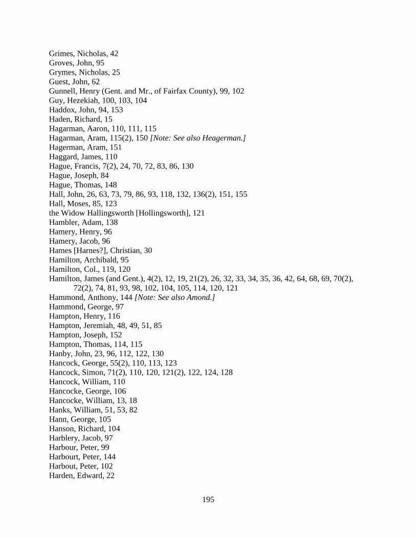
195
Grimes, Nicholas, 42 Groves, John, 95 Grymes, Nicholas, 25 Guest, John, 62 Gunnell, Henry (Gent. and Mr., of Fairfax County), 99, 102 Guy, Hezekiah, 100, 103, 104 Haddox, John, 94, 153 Haden, Richard, 15 Hagarman, Aaron, 110, 111, 115 Hagarman, Aram, 115(2), 150 [Note: See also Heagerman.] Hagerman, Aram, 151 Haggard, James, 110 Hague, Francis, 7(2), 24, 70, 72, 83, 86, 130 Hague, Joseph, 84 Hague, Thomas, 148 Hall, John, 26, 63, 73, 79, 86, 93, 118, 132, 136(2), 151, 155 Hall, Moses, 85, 123 the Widow Hallingsworth [Hollingsworth], 121 Hambler, Adam, 138 Hamery, Henry, 96 Hamery, Jacob, 96 Hames [Harnes?], Christian, 30 Hamilton, Archibald, 95 Hamilton, Col., 119, 120 Hamilton, James (and Gent.), 4(2), 12, 19, 21(2), 26, 32, 33, 34, 35, 36, 42, 64, 68, 69, 70(2),
72(2), 74, 81, 93, 98, 102, 104, 105, 114, 120, 121 Hammond, Anthony, 144 [Note: See also Amond.] Hammond, George, 97 Hampton, Henry, 116 Hampton, Jeremiah, 48, 49, 51, 85 Hampton, Joseph, 152 Hampton, Thomas, 114, 115 Hanby, John, 23, 96, 112, 122, 130 Hancock, George, 55(2), 110, 113, 123 Hancock, Simon, 71(2), 110, 120, 121(2), 122, 124, 128 Hancock, William, 110 Hancocke, George, 106 Hancocke, William, 13, 18 Hanks, William, 51, 53, 82 Hann, George, 105 Hanson, Richard, 104 Harblery, Jacob, 97 Harbour, Peter, 99 Harbourt, Peter, 144 Harbout, Peter, 102 Harden, Edward, 22
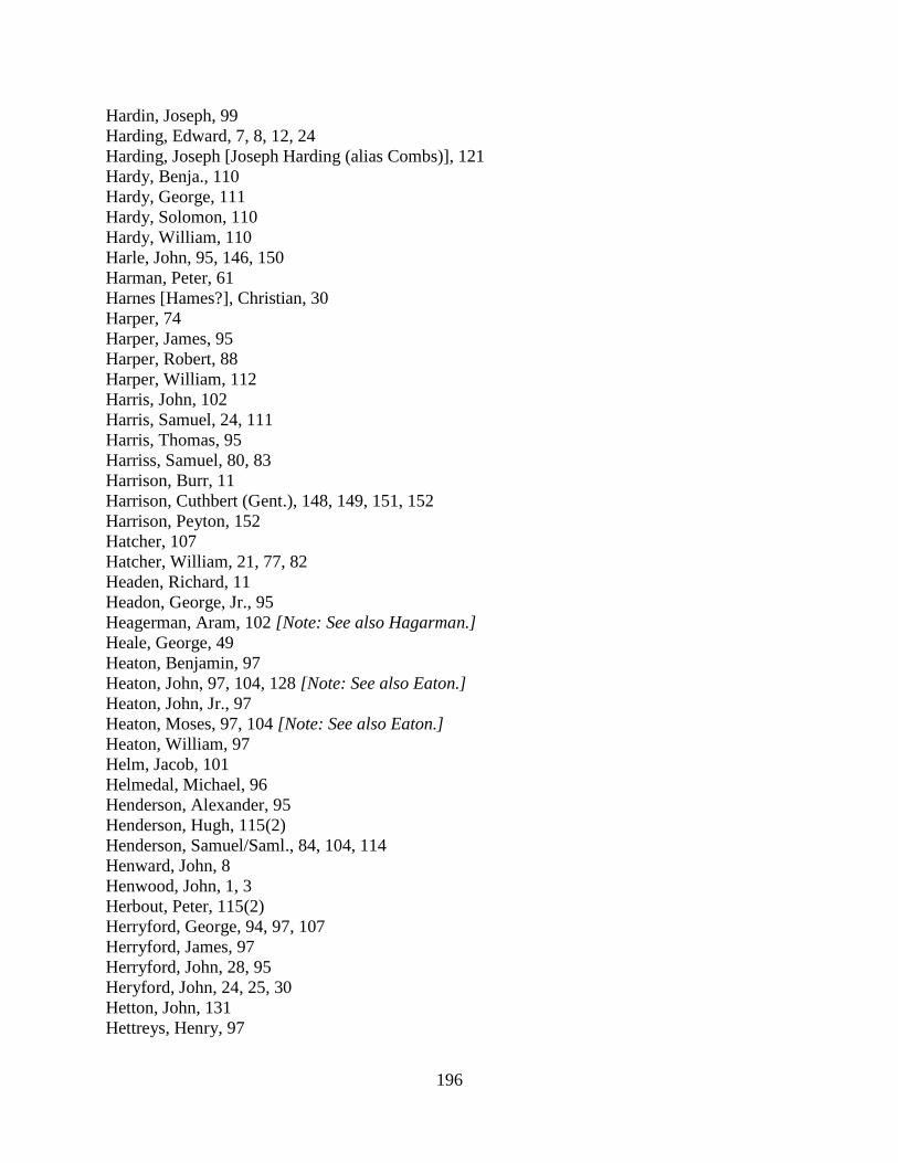
196
Hardin, Joseph, 99 Harding, Edward, 7, 8, 12, 24 Harding, Joseph [Joseph Harding (alias Combs)], 121 Hardy, Benja., 110 Hardy, George, 111 Hardy, Solomon, 110 Hardy, William, 110 Harle, John, 95, 146, 150 Harman, Peter, 61 Harnes [Hames?], Christian, 30 Harper, 74 Harper, James, 95 Harper, Robert, 88 Harper, William, 112 Harris, John, 102 Harris, Samuel, 24, 111 Harris, Thomas, 95 Harriss, Samuel, 80, 83 Harrison, Burr, 11 Harrison, Cuthbert (Gent.), 148, 149, 151, 152 Harrison, Peyton, 152 Hatcher, 107 Hatcher, William, 21, 77, 82 Headen, Richard, 11 Headon, George, Jr., 95 Heagerman, Aram, 102 [Note: See also Hagarman.] Heale, George, 49 Heaton, Benjamin, 97 Heaton, John, 97, 104, 128 [Note: See also Eaton.] Heaton, John, Jr., 97 Heaton, Moses, 97, 104 [Note: See also Eaton.] Heaton, William, 97 Helm, Jacob, 101 Helmedal, Michael, 96 Henderson, Alexander, 95 Henderson, Hugh, 115(2) Henderson, Samuel/Saml., 84, 104, 114 Henward, John, 8 Henwood, John, 1, 3 Herbout, Peter, 115(2) Herryford, George, 94, 97, 107 Herryford, James, 97 Herryford, John, 28, 95 Heryford, John, 24, 25, 30 Hetton, John, 131 Hettreys, Henry, 97

197
Hibbs, Jacob, 97, 99 Hibbs, John, 96 Hibbs, Joseph, 97 Hibbs, William, 89(2), 97(2) Hickson, John, 24 Hickson, Matthew, 24 Hickman, Conrade/Conrod, 96, 131 Hickman, Ezekiel, 2, 4, 5, 15 Hickman, William, 111 Hill, George, 122 Hill, Richard, 115 Hill, Samuel, 66, 67, 93, 101 Hiskett, Benjamin, 97 Hixon, Capt., 155 Hixon, Daniel, 96 Hixon, Timothy, 96, 112 Hixon, William, 96, 112 Hoge, 126 Hoge, Solomon, 21 Hoge, William, 98, 102 Holder, Luke, 84 Holdren, Cornelius, 131, 133, 137, 142 Hollingsworth, Rachel, 31, 70, 72, 89 the Widow Hollingsworth [Hallingsworth], 121, 142 Holmes, John, 50, 107(2), 111 Holmes, Mary, 138 Holmes, William, 98, 102 Homer, Michael, 95 Homes, John, 44, 60 Hopewell, John, 30 Hopewell, John, dec., 40 Hopewell, Saml., 84 Hopkins, Joseph, 24 Horn, Frederick, 97 Horseman, William, 103, 106 Hough, 30, 49, 57, 76, 81, 127, 143 Hough, Amos, 132 Hough, Benjamin, 35, 36, 47, 53, 81 Hough, John, 7(2), 13, 14(2), 18, 19, 20, 21(2), 23, 27(2), 28(2), 29(3), 31(2), 37, 38, 70(2), 72,
81, 83, 87, 96, 110, 120, 121, 138, 145, 153 Hough, John, Jr., 123 Hough, John (son of John Hough), 96 Hough, John (son of Joseph Hough), 96 Hough, Joseph, 76, 88, 96, 120, 121, 128, 133 Hough, Mahlon, 156, 157 Hough, Samuel, 142, 144
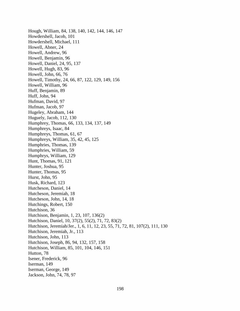
198
Hough, William, 84, 138, 140, 142, 144, 146, 147 Howdershell, Jacob, 101 Howdershell, Michael, 111 Howell, Abner, 24 Howell, Andrew, 96 Howell, Benjamin, 96 Howell, Daniel, 24, 95, 137 Howell, Hugh, 83, 96 Howell, John, 66, 76 Howell, Timothy, 24, 66, 87, 122, 129, 149, 156 Howell, William, 96 Huff, Benjamin, 89 Huff, John, 94 Hufman, David, 97 Hufman, Jacob, 97 Hugeley, Abraham, 144 Huguely, Jacob, 112, 130 Humphrey, Thomas, 66, 133, 134, 137, 149 Humphreys, Isaac, 84 Humphreys, Thomas, 61, 67 Humphreys, William, 35, 42, 45, 125 Humphries, Thomas, 139 Humphries, William, 59 Humphrys, William, 129 Hunt, Thomas, 91, 121 Hunter, Joshua, 95 Hunter, Thomas, 95 Hurst, John, 95 Husk, Richard, 123 Hutcheson, Daniel, 14 Hutcheson, Jeremiah, 18 Hutcheson, John, 14, 18 Hutchings, Robert, 150 Hutchison, 36 Hutchison, Benjamin, 1, 23, 107, 136(2) Hutchison, Daniel, 10, 37(2), 55(2), 71, 72, 83(2) Hutchison, Jeremiah/Jer., 1, 6, 11, 12, 23, 55, 71, 72, 81, 107(2), 111, 130 Hutchison, Jeremiah, Jr., 113 Hutchison, John, 113 Hutchison, Joseph, 86, 94, 132, 157, 158 Hutchison, William, 85, 101, 104, 146, 151 Hutton, 78 Isener, Frederick, 96 Iserman, 149 Iserman, George, 149 Jackson, John, 74, 78, 97

199
Jackson, Robert, 97 Jackson, William, 97 James, Daniel, 42 James, Thomas, 96 James, William, 107 Jamieson, Robert, 77, 81, 86, 87, 88, 96 Jamison, Benjamin, 114, 118, 157 Jamison, Robert, 70, 100, 117, 127, 134, 135(3), 137, 139, 140 Janney, 24, 105, 114, 126, 154 Janney, Abel, 31(2), 53, 87, 117, 123, 127 Janney, Israel, 156 Janney, Jacob, 11, 12, 21, 26, 30, 39, 66, 68, 84, 102, 107, 115, 116 Janney, Jonas, 156 Janney, Joseph, 36, 48, 111, 123, 127, 153, 157 Janney, Mahlon, 7(2), 24, 25, 27, 31, 53, 55, 61, 67, 70, 72, 75, 79, 83, 84, 96, 98, 105, 107, 116,
117, 120, 142, 157 Janney, Samuel, 123, 127 Janney, William, 12, 32, 35, 36, 47, 51, 66, 68, 96, 149, 156, 157 Jenings, James (and Gent.), 127, 143, 148, 154, 156 Jenkins, Ezekiel, 46 Jenkins, James, 149 Jenkins, John, 15, 16 Jenkins, John, Jr., 39 Jenkins, Richard, 123 Jenkins, Samuel, 95 Jenning, James, 146 Jennings, Daniel, 95 Jennings, James, 51, 74, 101, 119, 146 Jenny, 22 John, Benjamin, 76, 108 John, Daniel, 115, 117, 152 John, James, 96 John, Thomas, 45(2), 46 Johns, James, 27 Johnson, Archibald, 127 Johnson, Thomas, 112 Johnson, Tunis, 86, 94, 100 Johnston, George (and Esqr.), 123(2), 127 Jones, Jabas, 96 Jones, James, 96, 117, 148, 156 Jones, John, 38, 43(2), 75, 90(2), 97, 110, 113, 132, 133, 142, 145, 156 Jones, Joseph, 2, 9, 13, 14, 31, 41, 43, 44, 80 Jones, Mr., 113 Jones, Thomas, 96 Jones, William, 22(2), 24, 27, 31, 34, 46, 77 Jordan, Thomas, 111

200
Juren, George, 13 Juring, George, 6 Keen, 40, 93 Keen, John, 6, 26(2), 39, 41, 58, 110, 147 Keen, Richard, 6, 22 Keene, Francis, 113 Kelley, Peter, 95 Kelley, Thomas, 1, 132 Kelly, 136 Kelly, Patrick, 136, 153 Kendrick, John, 85, 123, 151 Kennady, James, 24 Kerrick, Walter, 115 Keyes, 140(2) Kid, James, 24 King, Daniel, 152 King, Smith, 75, 150 King, Thomas, 156 Kirk, 7, 8, 12, 24(2), 46, 47, 66, 77, 98 Kirk, James, 135, 145, 156, 157 Kirk, William, 7(2), 19, 22, 27, 42, 47, 66, 73, 75, 96 Kirkbride, Mahlon, 35 Lacey, 153 Lacey, Joseph, 124, 143, 147, 151, 155(2), 158(2) Lacock, Nathan, 66, 67, 119 [Note: See also Laycock.] Lacock, William, 90, 97, 115 Lady, Jacob, 84 Lamb, Thomas, 25 Lambough, Anthony, 97 Lamert, Lewis, 126 Lamkin, James, 84, 104 Lampkin, James, 80, 105, 112 Lancaster, Adam, 95 Lander, Henry, 92, 93, 124(2), 128 Landrum, William, 6(2), 62 Lane, 45, 46, 91, 106 Lane, Capt., 123, 150 Lane, Hardage, 131, 140, 148 Lane, James (and Capt. and Gent.), 1, 4(3), 6(2), 15, 25, 27, 30, 35, 39, 41, 42(3), 45, 55, 63, 73, 75, 81, 87, 107, 110, 123, 129, 134 Lane, James, Jr., Gent., 4, 6(2), 117 Lane, James, Sr., 62 Lane, James Hardage, 147, 154 Lane, John, 35, 42 Lane, Mrs. (Widow), 95 Lane, William, 73, 76, 141, 150

201
Lane, William, (son of James Lane / James Lane, Sr.), 62, 75 Lane, William Carr (and Gent. and Mr.), 35, 40(4), 46, 65, 71, 72 Lane, William, Jr., 47 Lasswell, 20, 33(2), 34, 40, 41, 54 Lasswell, Andrew, 84 Lasswell, Elias, 84 Lasswell, Moses, 84 Lay, Abraham, 25, 47, 95 Lay, Silvester, 71 Laycock, Nathan, 120 Laycock, William, 50, 82 Lee, 60 Lee, Col., 25 Lee, Frans. Lightfoot, Gent., 21 Lee, Henry (and Col.), 113, 143 Leith, James, 8, 18, 34, 46, 56, 60, 63, 91, 100, 103, 108, 109, 115, 119(2) Lemert, Lewis, 148 Lemon, John, 84 Lemon, Lewis, 117 Lesley, Patrick, 97 Lester, John, 34, 37 Lewellin, Thomas, 36, 84, 96 Lewellin, Thomas, Sr., 58 Lewis, Abel, 24 Lewis, Abraham, 117, 153 Lewis, George, 24 Lewis, James, 20, 112, 117, 119, 134, 147 Lewis, Jehu, 35 Lewis, John (and Gent. and Mr.), 13, 17, 25, 37, 38, 50, 53, 61, 62(2), 63, 81, 83, 86, 99, 116,
119, 120, 138, 140, 145, 146, 152 Lewis, Joseph (and Capt.), 92, 119, 125, 153, 157 Lewis, Thomas (and Gent. and Mr.), 1, 3, 15(2), 19(2), 20, 26, 28, 40, 45, 50, 52, 54(2), 56, 57,
58, 76, 88, 92, 104, 105, 110(2), 111, 117, 118, 119, 120, 121, 124(3), 125, 128, 131, 133, 135, 137, 142
Lewis, Thomas, Jr., 111 Lewis, Thomas (on Difficult), 38 Lewis, Vincent, 1, 3, 5, 6, 7(2), 8, 14, 17, 28, 38, 50, 53, 55(2), 106 Lewis, William, 73 Ling, John (overseer for Fleming Patterson’s quarter), 97 Link, Jacob, 118 Linton, John, 101, 119 Lister, John, 24 Little, John, 21 Littlejohn, John, 156 Littleton, William, 23, 27, 30, 42, 45, 58, 82, 95, 112 Lovat, David, 99

202
Love, Samuel/Saml. (and Gent.), 59, 63, 69, 72, 81, 87, 90, 95, 96, 106, 107, 123, 129, 136, 141, 147(2)
Lovett, Daniel, 53, 97 Lucas, Alexander, 95 Luckett, 116, 138 Luckett, William, Jr., 109 Luke, John, 91, 100, 101, 121 Luke, Thomas, 94 Lykins, William, 96 Lynham, Philip, 24 McBright, John, 97 McCabe, Henry, 135, 139 McCaffrey, James, 152 McCannahaugh, James, 85 McCarney, James, 97 McCarty, Capt., 47 McCarty, Daniel, 44, 95 McCarty, Patrick, 126 McCarty, Thaddeus, 85, 122, 123, 127, 150 McClain, John, 100, 115, 144(3), 146, 147, 149 McClean, John, 93 McClelan, William, 143, 144 McClellan, William/Wm., 144, 149(2) McConochee, James, 122 McCully, Robert, 148, 151 McDad, John, 96 Mcfarling, John, 123 McGeach, 113 McGeach, James, 153 McGeach, Thomas, 24 McGee, Joseph, 121 McGraw, Morris, 103 McGrew, James, 34 McGrew, Morris, 93 McHaney, 128 McHolland, Patrick, 24 McIlhaney, James, Gent., 149, 157 Mcilhaney, John, Gent., 31, 44, 51(2), 53, 89(3), 92, 99 Mcilheney, Squire, 31 McIntyre, Alexander, 107, 134(2), 135 McKee, Joseph, 126, 151 McKenzey, Patrick, 24 McKinzey, 26 McKnabb, William, 91 McKnight, William, 87 McLain, John, 100
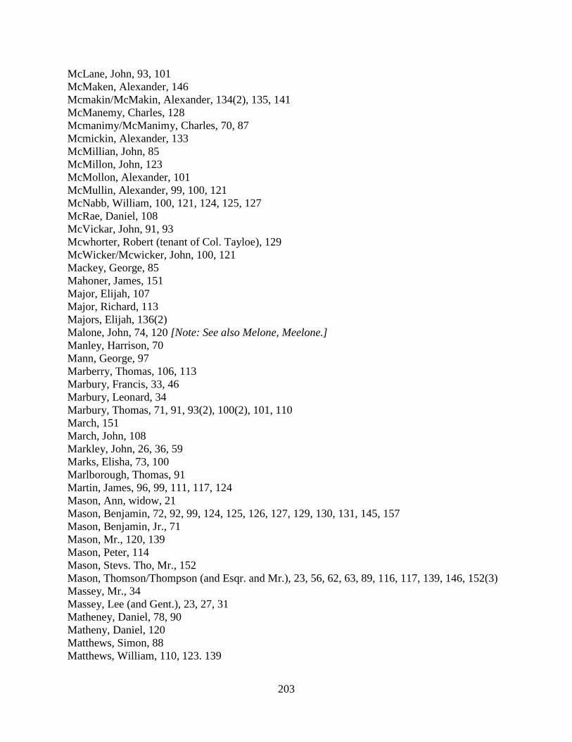
203
McLane, John, 93, 101 McMaken, Alexander, 146 Mcmakin/McMakin, Alexander, 134(2), 135, 141 McManemy, Charles, 128 Mcmanimy/McManimy, Charles, 70, 87 Mcmickin, Alexander, 133 McMillian, John, 85 McMillon, John, 123 McMollon, Alexander, 101 McMullin, Alexander, 99, 100, 121 McNabb, William, 100, 121, 124, 125, 127 McRae, Daniel, 108 McVickar, John, 91, 93 Mcwhorter, Robert (tenant of Col. Tayloe), 129 McWicker/Mcwicker, John, 100, 121 Mackey, George, 85 Mahoner, James, 151 Major, Elijah, 107 Major, Richard, 113 Majors, Elijah, 136(2) Malone, John, 74, 120 [Note: See also Melone, Meelone.] Manley, Harrison, 70 Mann, George, 97 Marberry, Thomas, 106, 113 Marbury, Francis, 33, 46 Marbury, Leonard, 34 Marbury, Thomas, 71, 91, 93(2), 100(2), 101, 110 March, 151 March, John, 108 Markley, John, 26, 36, 59 Marks, Elisha, 73, 100 Marlborough, Thomas, 91 Martin, James, 96, 99, 111, 117, 124 Mason, Ann, widow, 21 Mason, Benjamin, 72, 92, 99, 124, 125, 126, 127, 129, 130, 131, 145, 157 Mason, Benjamin, Jr., 71 Mason, Mr., 120, 139 Mason, Peter, 114 Mason, Stevs. Tho, Mr., 152 Mason, Thomson/Thompson (and Esqr. and Mr.), 23, 56, 62, 63, 89, 116, 117, 139, 146, 152(3) Massey, Mr., 34 Massey, Lee (and Gent.), 23, 27, 31 Matheney, Daniel, 78, 90 Matheny, Daniel, 120 Matthews, Simon, 88 Matthews, William, 110, 123. 139

204
Matthias, Griffith, 24 May, Leonard, 96, 104, 116
• Leonard May’s sons, 96 Mead, Samuel, 21 Mead, William, 3, 10, 14, 18, 21, 32, 36, 38(2), 40, 43(2), 50, 52, 53, 56, 68, 69, 79, 81, 82, 89,
90(3), 98, 114, 135, 145, 153 Mead, William, Jr., 40, 42, 47 Meade, William, 58 Meelone, John, 121 [Note: See also Malone.] Melone, John, 78, 97 [Note: See also Malone.] Melton, Sturman, 145 Mercer, 30, 45, 120, 121, 122 Mercer (slave of Samuel Selden of Stafford County), 56 Mercer, James (and Esqr. and Gent.), 86, 88, 91, 92, 93 Mercer, Mr., 26, 77, 104 Mercer, Richard, 24, 97 Merchant, Philip, 95 Merrick, Griffith, 23 Metcalf, Christopher, 85 Metcalfe, James, 47 Mets, Richard, 91 Michael, Daniel, 96, 121 Michael, Henry, 101 Michael, Philip, 110 Michael, Philip, Jr., 110 Middleton, Walter, 30 Miles, Josias, 139(2) Milholland, 148 Mill, John, 29 Millan, William, 91, 136(2), 137, 139, 142 Miller, John, 32, 36, 60, 71 Miller, Peter, 96, 121, 122 Miller, Valentine, 101 Miller, William, 95 Minor, Capt., 82 Minor, Col., 101 Minor, John (and Gent.), 35, 95, 127, 140, 143, 152 Minor, Nicholas/Nich./Nichs. (and Capt. and Gent.), 2(2), 3, 4, 5, 11, 14(2), 17, 25, 27, 28, 29,
32(2), 34, 38, 40, 42, 43(2), 49, 51, 52(2), 60, 62, 73, 76, 81 Minor, Spence, 101 Mitchell, Adam, 134 Mitchell, John, 145 Mitchell, William, 123, 129 Mobley, Samuel, 24 Mobly, Thos., 112 Moffett, Mr., 134

205
Moffett, Josiah, 108, 111, 133, 134, 135 Molton, William, 23 Money, Nicholas, 131 Monkhouse, Jonathan, 52, 53, 56, 68, 137 Moore, Henry, 95 Moore, Herben, 154 Moore, John, 158 Moore, Samuel, 95 Moore, Thomas, 102, 113, 115 Moreland, William, 126 Moren, Mary, 104 Morin, Mary, 85 Morlan, Jason, 98 Morlan, William, 98 Morland, Jason, 113 Morland, William, 47, 56 Morris, 3, 6, 19, 29, 31, 49, 76, 114, 135 Morris, Jacob, 6, 16, 18, 101, 109, 110, 113 Morris, Jenkin, 44 Morris, John, 46 Morris, Widow, 80 Morrison, John, 93, 103 Morrison, William, 120 Mortimore, Arthur, 25 Moss, 56 Moss, John, (and Gent. and Capt.), 2, 4(3), 5(2), 8, 10, 21, 35, 38(3), 40, 43, 44, 47, 65, 66, 68,
82, 104, 107, 118, 119, 124, 130 Moss, John, Jr. (and Gent.), 14, 29, 35, 39(2), 43 Moss, William, 95, 135, 137, 142, 143 Mount, Thomas, 150, 151 Mower, Peter, 97 Moxley, 142, 156, 158 Moxley, Daniel, 152 Moxley, Joseph, 131 Moxly, 133 Moxly, Joseph, 131 Mucklehaney, John, Gent., 13, 17 Mucklehany, John (and Gent.), 14, 20(2), 22 Muirhead, Charles, 82, 95 Muirhead, George, 102 Muirhead, John, 115(2) Muirhead, William, 37, 42(2), 78, 82, 95 Muirheid, John, 151 Muirheid, William, 147 Mull, David, 53, 97, 116 Murray, John, 143
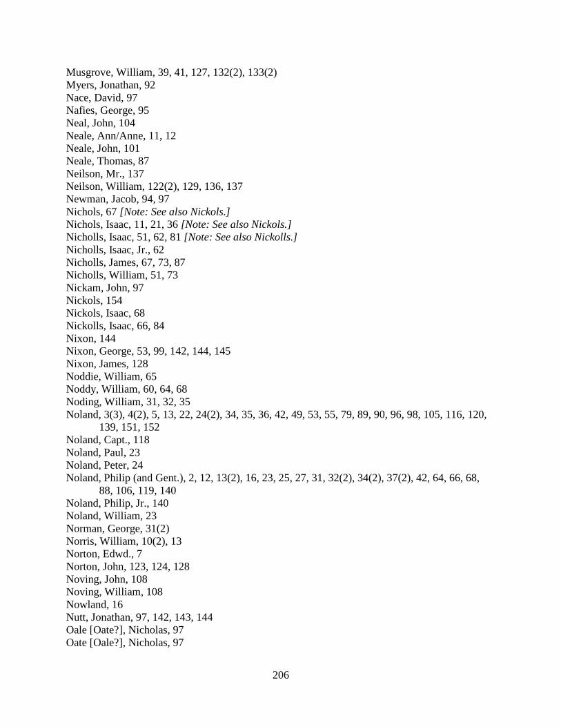
206
Musgrove, William, 39, 41, 127, 132(2), 133(2) Myers, Jonathan, 92 Nace, David, 97 Nafies, George, 95 Neal, John, 104 Neale, Ann/Anne, 11, 12 Neale, John, 101 Neale, Thomas, 87 Neilson, Mr., 137 Neilson, William, 122(2), 129, 136, 137 Newman, Jacob, 94, 97 Nichols, 67 [Note: See also Nickols.] Nichols, Isaac, 11, 21, 36 [Note: See also Nickols.] Nicholls, Isaac, 51, 62, 81 [Note: See also Nickolls.] Nicholls, Isaac, Jr., 62 Nicholls, James, 67, 73, 87 Nicholls, William, 51, 73 Nickam, John, 97 Nickols, 154 Nickols, Isaac, 68 Nickolls, Isaac, 66, 84 Nixon, 144 Nixon, George, 53, 99, 142, 144, 145 Nixon, James, 128 Noddie, William, 65 Noddy, William, 60, 64, 68 Noding, William, 31, 32, 35 Noland, 3(3), 4(2), 5, 13, 22, 24(2), 34, 35, 36, 42, 49, 53, 55, 79, 89, 90, 96, 98, 105, 116, 120,
139, 151, 152 Noland, Capt., 118 Noland, Paul, 23 Noland, Peter, 24 Noland, Philip (and Gent.), 2, 12, 13(2), 16, 23, 25, 27, 31, 32(2), 34(2), 37(2), 42, 64, 66, 68,
88, 106, 119, 140 Noland, Philip, Jr., 140 Noland, William, 23 Norman, George, 31(2) Norris, William, 10(2), 13 Norton, Edwd., 7 Norton, John, 123, 124, 128 Noving, John, 108 Noving, William, 108 Nowland, 16 Nutt, Jonathan, 97, 142, 143, 144 Oale [Oate?], Nicholas, 97 Oate [Oale?], Nicholas, 97
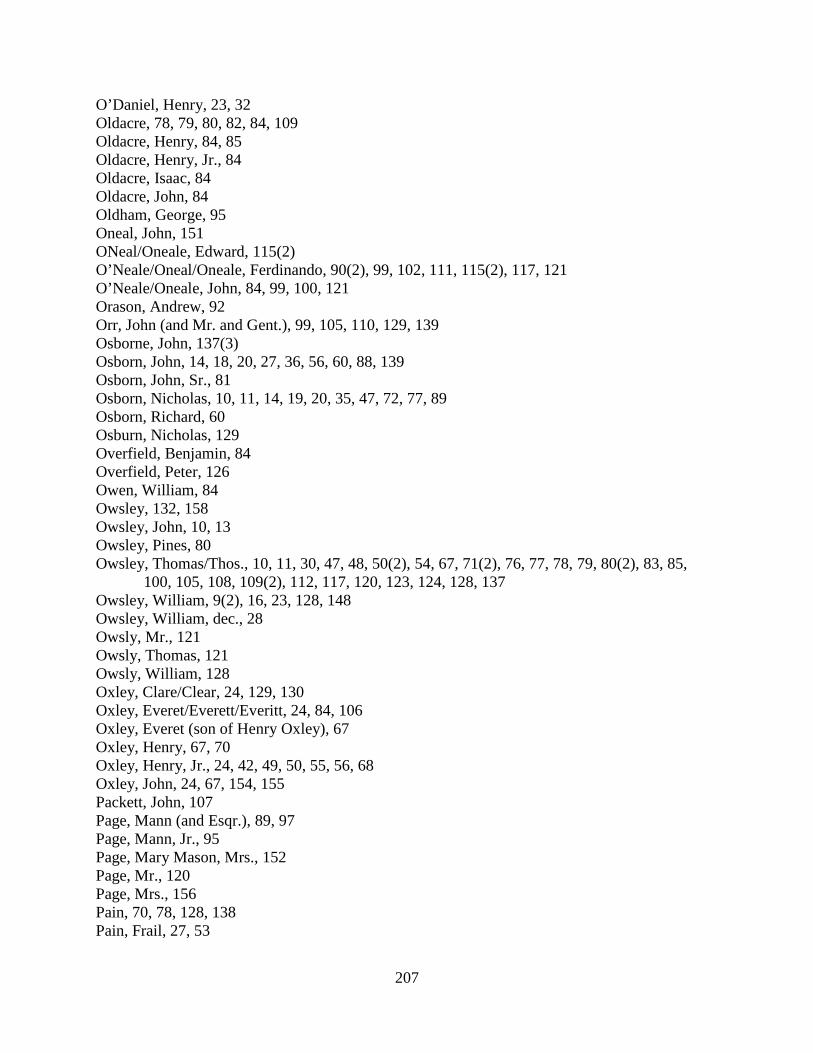
207
O’Daniel, Henry, 23, 32 Oldacre, 78, 79, 80, 82, 84, 109 Oldacre, Henry, 84, 85 Oldacre, Henry, Jr., 84 Oldacre, Isaac, 84 Oldacre, John, 84 Oldham, George, 95 Oneal, John, 151 ONeal/Oneale, Edward, 115(2) O’Neale/Oneal/Oneale, Ferdinando, 90(2), 99, 102, 111, 115(2), 117, 121 O’Neale/Oneale, John, 84, 99, 100, 121 Orason, Andrew, 92 Orr, John (and Mr. and Gent.), 99, 105, 110, 129, 139 Osborne, John, 137(3) Osborn, John, 14, 18, 20, 27, 36, 56, 60, 88, 139 Osborn, John, Sr., 81 Osborn, Nicholas, 10, 11, 14, 19, 20, 35, 47, 72, 77, 89 Osborn, Richard, 60 Osburn, Nicholas, 129 Overfield, Benjamin, 84 Overfield, Peter, 126 Owen, William, 84 Owsley, 132, 158 Owsley, John, 10, 13 Owsley, Pines, 80 Owsley, Thomas/Thos., 10, 11, 30, 47, 48, 50(2), 54, 67, 71(2), 76, 77, 78, 79, 80(2), 83, 85,
100, 105, 108, 109(2), 112, 117, 120, 123, 124, 128, 137 Owsley, William, 9(2), 16, 23, 128, 148 Owsley, William, dec., 28 Owsly, Mr., 121 Owsly, Thomas, 121 Owsly, William, 128 Oxley, Clare/Clear, 24, 129, 130 Oxley, Everet/Everett/Everitt, 24, 84, 106 Oxley, Everet (son of Henry Oxley), 67 Oxley, Henry, 67, 70 Oxley, Henry, Jr., 24, 42, 49, 50, 55, 56, 68 Oxley, John, 24, 67, 154, 155 Packett, John, 107 Page, Mann (and Esqr.), 89, 97 Page, Mann, Jr., 95 Page, Mary Mason, Mrs., 152 Page, Mr., 120 Page, Mrs., 156 Pain, 70, 78, 128, 138 Pain, Frail, 27, 53
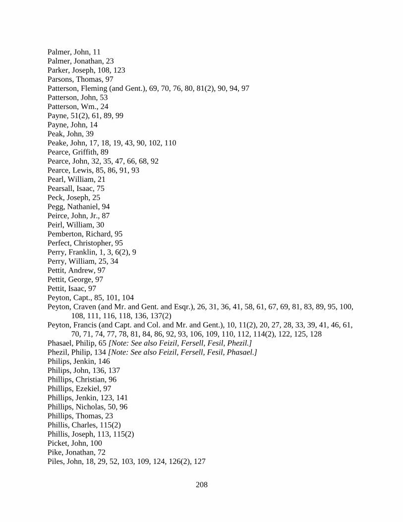
208
Palmer, John, 11 Palmer, Jonathan, 23 Parker, Joseph, 108, 123 Parsons, Thomas, 97 Patterson, Fleming (and Gent.), 69, 70, 76, 80, 81(2), 90, 94, 97 Patterson, John, 53 Patterson, Wm., 24 Payne, 51(2), 61, 89, 99 Payne, John, 14 Peak, John, 39 Peake, John, 17, 18, 19, 43, 90, 102, 110 Pearce, Griffith, 89 Pearce, John, 32, 35, 47, 66, 68, 92 Pearce, Lewis, 85, 86, 91, 93 Pearl, William, 21 Pearsall, Isaac, 75 Peck, Joseph, 25 Pegg, Nathaniel, 94 Peirce, John, Jr., 87 Peirl, William, 30 Pemberton, Richard, 95 Perfect, Christopher, 95 Perry, Franklin, 1, 3, 6(2), 9 Perry, William, 25, 34 Pettit, Andrew, 97 Pettit, George, 97 Pettit, Isaac, 97 Peyton, Capt., 85, 101, 104 Peyton, Craven (and Mr. and Gent. and Esqr.), 26, 31, 36, 41, 58, 61, 67, 69, 81, 83, 89, 95, 100,
108, 111, 116, 118, 136, 137(2) Peyton, Francis (and Capt. and Col. and Mr. and Gent.), 10, 11(2), 20, 27, 28, 33, 39, 41, 46, 61,
70, 71, 74, 77, 78, 81, 84, 86, 92, 93, 106, 109, 110, 112, 114(2), 122, 125, 128 Phasael, Philip, 65 [Note: See also Feizil, Fersell, Fesil, Phezil.] Phezil, Philip, 134 [Note: See also Feizil, Fersell, Fesil, Phasael.] Philips, Jenkin, 146 Philips, John, 136, 137 Phillips, Christian, 96 Phillips, Ezekiel, 97 Phillips, Jenkin, 123, 141 Phillips, Nicholas, 50, 96 Phillips, Thomas, 23 Phillis, Charles, 115(2) Phillis, Joseph, 113, 115(2) Picket, John, 100 Pike, Jonathan, 72 Piles, John, 18, 29, 52, 103, 109, 124, 126(2), 127

209
Piles, Richard, 18, 52 Pink, [blank], 95 Poke, Adam, 103, 118 Poland, Martin, 132 Polser, 79 Poltney, John, 3 Pool, Benjamin, 62(2), 84, 92 Poole, Benjamin, 21 Poor, John, 115 Poor, Joseph, 115 Poore, Joseph, 99 Popkins, John, 22, 24, 37 Popkins, Robert, 19, 95 Porter, Edward, 13, 16 Poston, Leonard, 140 Potts, 88, 89, 93, 101 Potts, David, 27 Potts, Ezekiel, 61, 88, 90, 101, 134, 135 Potts, Jonas, 47, 61 Potts, Jonas, dec., 59 Potts, Jonas (Blacksmith), 23, 32 Potts, Jonas (Farmer), 9 Potts, Nathan, 133, 134, 135(3), 137(2) Potts, Samuel, 81, 100, 117, 127 Poultney, John, 3, 7, 8 Pour, John, 115 Pour, Joseph, 111(2) Powell, 80, 86, 104, 143, 145 Powell, Col., 143, 146 Powell, Leven/Levin (and Mr. and Gent.), 24, 27, 30, 34, 45, 47(2), 48(3), 49, 50(2), 51, 52, 60,
63, 67(3), 71(2), 74, 76, 77, 80(3), 81, 82, 83, 84, 85(3), 87, 89, 100(2), 101(2), 103, 104, 108, 109(2), 112, 119, 120, 121, 124, 125, 127, 128, 136, 143, 144, 154, 156
Power, Barnett, 114 Power, Joseph, 48, 54, 117 Preston, John, 85 Price, Evan, 155 Price, John, 18, 82, 111 Price, Jonathan, 22, 24, 45, 148, 154 Price, Oliver, 107, 118(2) Price, Thomas, 97 Pugh, Thomas, 95 Pullen, Charles/Chas., 76, 77, 85, 93, 125, 127, 132, 138 Pullin, 128 Pullin, Charles, 104, 124, 128 Pulling, 129 Purdom, Benjamin, 74, 78, 97, 110, 120, 121, 128, 132, 133
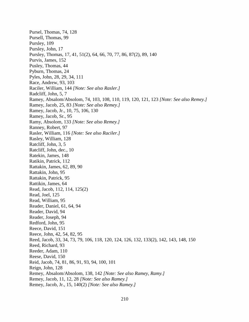
210
Pursel, Thomas, 74, 128 Pursell, Thomas, 99 Pursley, 109 Pursley, John, 17 Pursley, Thomas, 17, 41, 51(2), 64, 66, 70, 77, 86, 87(2), 89, 140 Purvis, James, 152 Pusley, Thomas, 44 Pyburn, Thomas, 24 Pyles, John, 28, 29, 34, 111 Race, Andrew, 93, 103 Raciler, William, 144 [Note: See also Rasler.] Radcliff, John, 5, 7 Ramey, Absalom/Absolom, 74, 103, 108, 110, 119, 120, 121, 123 [Note: See also Remey.] Ramey, Jacob, 25, 83 [Note: See also Remey.] Ramey, Jacob, Jr., 10, 75, 106, 130 Ramey, Jacob, Sr., 95 Ramy, Absolom, 133 [Note: See also Remey.] Ranney, Robert, 97 Rasler, William, 116 [Note: See also Raciler.] Rasley, William, 128 Ratcliff, John, 3, 5 Ratcliff, John, dec., 10 Ratekin, James, 148 Ratikin, Patrick, 112 Rattakin, James, 62, 89, 90 Rattakin, John, 95 Rattakin, Patrick, 95 Rattikin, James, 64 Read, Jacob, 112, 114, 125(2) Read, Joel, 125 Read, William, 95 Reader, Daniel, 61, 64, 94 Reader, David, 94 Reader, Joseph, 94 Redford, John, 95 Reece, David, 151 Reece, John, 42, 54, 82, 95 Reed, Jacob, 33, 34, 73, 79, 106, 118, 120, 124, 126, 132, 133(2), 142, 143, 148, 150 Reed, Richard, 93 Reeder, Adam, 110 Reese, David, 150 Reid, Jacob, 74, 81, 86, 91, 93, 94, 100, 101 Reign, John, 128 Remey, Absalom/Absolom, 138, 142 [Note: See also Ramey, Ramy.] Remey, Jacob, 11, 12, 28 [Note: See also Ramey.] Remey, Jacob, Jr., 15, 140(2) [Note: See also Ramey.]

211
Remy, Jacob, 87 Remy, Jacob, Jr., 55, 69 Reno, Zelos, 152 Respess, Thomas (and Capt. and Gent.), 139(3), 146(2), 148, 151, 152, 156 Reynolds, Cornelius, 123 Rhodes, Moses, 53 Rice, James, 95 Rice, Patrick, 7 Richard, 132 Richards, Richard, 84 Richardson, David, 3(2) Richardson, Jonathan, 31(2) Richardson, Joseph, 62 Riddle, George, 107, 111 Riley, Henry, 24 Ringo, Henry, 63, 69, 83, 94 Rinker, George, 97 Ritchie, Francis, 96 Roach, 52, 64, 66(2), 68, 82, 112, 138(2), 152, 155, 158 Roach, Richard, 22, 27, 47, 49, 50, 56, 61, 62, 65, 79, 96, 105, 106, 109, 116, 130, 156 Roads, Christian, 96 Roberts, Abner, 78 Roberts, John, 93, 97 Roberts, Owen, 21(2), 24, 35, 47, 61, 67, 68, 70, 81, 89 Roberts, Richard, 19 Roberts, William, 95, 153, 155, 158 Robbins, John, 24 Robinson, Elisha, 30 Robinson, William, 84, 112, 117, 121 Robison, William, 120 Rogers, Arthur, 85 Rogers, Hamilton, 95, 115, 155 Roller, Conrade, 97 Roller, John, 97 Romine, John, 151, 155 Root, John, 111 Rose, Cylas, 141 Rose, Francis, 60, 108 Rose, Isaac, 82, 95 Ross, Alexander, 74, 78, 97, 116, 132 Ross, William, 3, 7(2), 8, 17, 18, 21, 22 Roszel, Stephen, 122 Roszell, 116, 118, 120 Roszell, Stephen, 110, 120, 121, 153, 158 Rounseval, Benjamin, 93 Rowler, John, 62, 70

212
Rozel, Peter, 55, 65 Rozel, Stephen, 74 Rozell, Stephen, 76, 103 Ruce, Christian, 97 Rumsey, James, 95 Russell, Anthony (and Capt. and Gent.), 3, 17(2), 19, 21, 25, 28, 29, 38(2), 44, 50, 54, 57, 65, 76,
86, 99, 106, 114, 115, 116, 119, 126 Russell, Charles, 85, 123 Russell, James, 149 Russell, John, 88, 101, 133, 137 Russell, Robert, 74 Russell, Samuel, 72, 94, 96 Russell, Thomas, 100, 104 Russell, William, 128 Rust, Benjamin/Benja., 104, 105, 114 Rust, William, 67, 78, 79, 80, 82, 85, 91, 98, 119, 120, 126, 134 Ryley, James, 97 Sample, John, 65 Sample, Mr., 65 Sanders, Isaac, 99, 102, 113, 115(2), 121, 125 Sanders, James, 86, 88, 94, 96, 98, 105, 106, 129, 130 Sanders, John, 158 Sanders, Philip, 95 Sanders, Pressley, 151 Sanders, Sarah, 121 Sanders, the Widow, 102 Sands, 7 Sands, Edmond/Edmund, 24, 27, 46, 96 Sands, Isaac, 27, 105, 138 Sands, Jacob, 27 Sasser, John, 22, 58 Saunders, George, 54 Saunders, James, 99, 139(2) Saunders, James, Jr., 23 Saunders, James, Sr., 23 Saunders, Philip, 63 Savage, 96 Saxton, Charles, 97 Saxton, Nathaniel, 97 Schooley, John, 92 Schooley, Samuel, 50, 68, 97, 115, 153, 155 Schooley, William/Willm., 24, 55, 66, 67, 79, 80, 105, 107, 120 Schryock, Michael, 147, 153 Scott, John, 24, 27 Scott, Joseph, 118 Seagler, Henry, 113
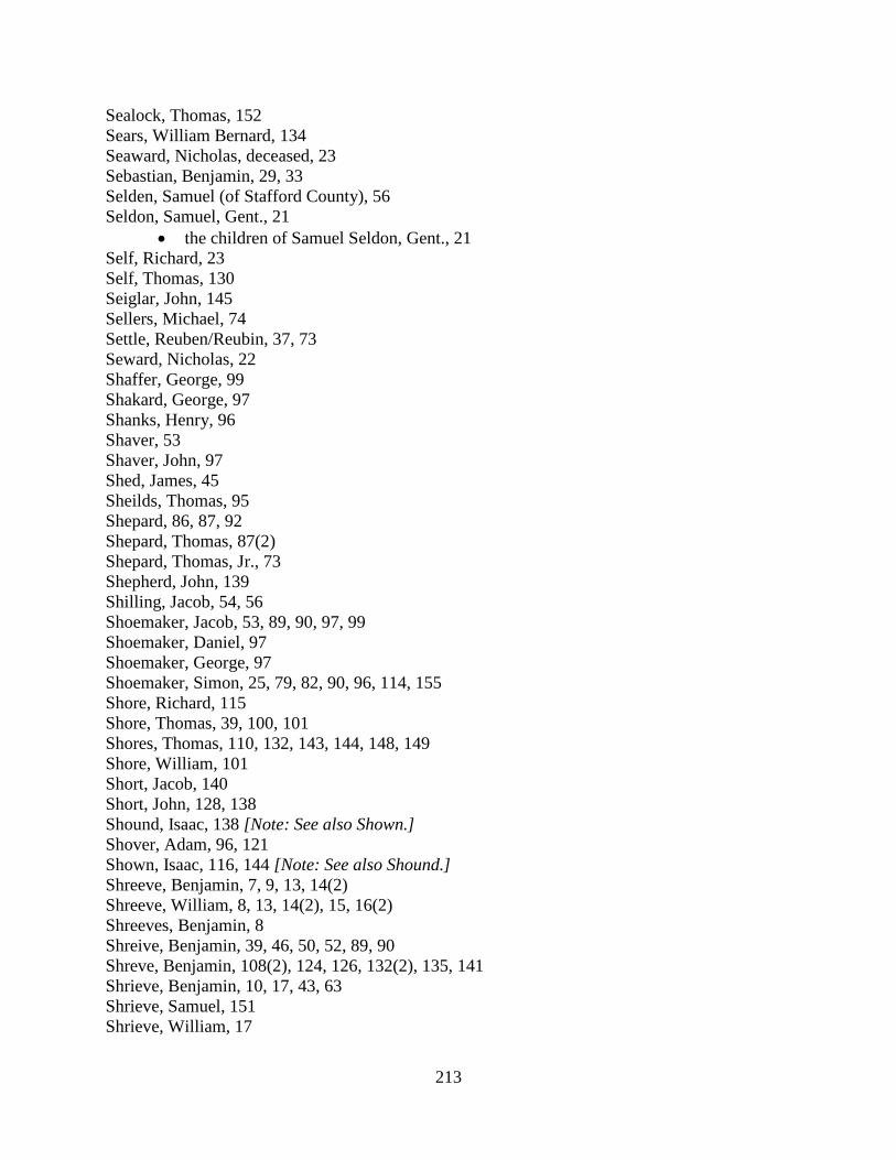
213
Sealock, Thomas, 152 Sears, William Bernard, 134 Seaward, Nicholas, deceased, 23 Sebastian, Benjamin, 29, 33 Selden, Samuel (of Stafford County), 56 Seldon, Samuel, Gent., 21
• the children of Samuel Seldon, Gent., 21 Self, Richard, 23 Self, Thomas, 130 Seiglar, John, 145 Sellers, Michael, 74 Settle, Reuben/Reubin, 37, 73 Seward, Nicholas, 22 Shaffer, George, 99 Shakard, George, 97 Shanks, Henry, 96 Shaver, 53 Shaver, John, 97 Shed, James, 45 Sheilds, Thomas, 95 Shepard, 86, 87, 92 Shepard, Thomas, 87(2) Shepard, Thomas, Jr., 73 Shepherd, John, 139 Shilling, Jacob, 54, 56 Shoemaker, Jacob, 53, 89, 90, 97, 99 Shoemaker, Daniel, 97 Shoemaker, George, 97 Shoemaker, Simon, 25, 79, 82, 90, 96, 114, 155 Shore, Richard, 115 Shore, Thomas, 39, 100, 101 Shores, Thomas, 110, 132, 143, 144, 148, 149 Shore, William, 101 Short, Jacob, 140 Short, John, 128, 138 Shound, Isaac, 138 [Note: See also Shown.] Shover, Adam, 96, 121 Shown, Isaac, 116, 144 [Note: See also Shound.] Shreeve, Benjamin, 7, 9, 13, 14(2) Shreeve, William, 8, 13, 14(2), 15, 16(2) Shreeves, Benjamin, 8 Shreive, Benjamin, 39, 46, 50, 52, 89, 90 Shreve, Benjamin, 108(2), 124, 126, 132(2), 135, 141 Shrieve, Benjamin, 10, 17, 43, 63 Shrieve, Samuel, 151 Shrieve, William, 17
214
Shryock, Michael, 54, 69 Sich, Adam, 97 Sigler, John, 119 Silkwood, Basil, 97 Simons, Simon, 124 Simonson, Simon, 93 Simpson, Gilbert, 43, 75 Sims, John, 21 Simms, Bernard, 115(2), 121 Simms, John, 78, 115, 121 Simms, John, Jr., 115(2), 121 Simms, John, Sr., 115 Simpson, Gilbert, 43, 75, 85, 90(2), 98, 109, 113 Sinclair, John, 23, 38, 49, 99 [Note: See also Sinkler.] Sinckler, James, 85 [Note: See also Sinklair, Sinkler.] Sine, John William, 113 Sinklair, James, 154 [Note: See also Sinckler, Sinkler.] Sinkler, Jacob, 110 Sinkler, James, 77, 101, 104, 106 [Note: See also Sinckler, Sinklair.] Sinkler, John, 106, 110 Sinkler, Robert, 89 Sirnemain[?], John, 111 Skinner, Cornelius, 124 Skinner, Cornelius, Jr., 124 Skinner, Phineas/Phinehas, 93, 124, 127(2), 128, 129 Skinner, Richard, 93, 124, 127, 128, 132, 133(2), 138, 143, 144, 151, 157 Slaugh, Philip, 60 Slone, John, 93 Smalley, Andrew, 93, 103 Smarr, John, 2, 6(2), 63, 73, 86, 124, 132, 155, 158 Smith, Adam, 101 Smith, Alexander, 93(2) Smith, Benjamin, 23 Smith, Benjamin (removed to Halifax County), 45 Smith, David, 23, 31, 34, 36, 37, 38 Smith, Henry, 88, 111 Smith, John, 97 Smith, Mary, 95 Smith, Nathan, 115 Smith, Nathaniel/Nathl., 39, 122, 127, 129, 143, 144(2), 149 Smith, Samuel, 20, 22, 50, 56, 61, 62(3), 79(2), 98, 104 Smith, Stephen (living at Robert Adams’s quarter), 97 Smith, Thomas, 84, 100, 103, 104, 105 Smith, Wethers, 149(2), 150 Smith, Widow, 82 Smith, William (and Gent.), 13, 14, 19, 20(2), 22, 39(2), 48, 54, 56, 71(2), 74, 76, 78, 79(2), 85,

215
88, 90, 92, 94, 95, 97, 109, 110, 117, 121(2), 123, 124, 127, 128, 135 Smithiman, Samuel, 85 Snedekar, Garrett, 100, 145 Snediker, Garrat, 153 Snickers, 101 Snider, Jacob, 97 Snidiker, Garrett, 94 Snigger(s), 44, 48, 58 Snyder, Jacob, 96, 97 Sonnafrank, Jacob, 97 Sorrel, 141 Sorrell, 56, 116, 141 Sorrell, Thomas, 2, 4(2), 6, 7, 8, 21, 79, 82, 92, 114 Souder, Anthony, 131, 156 Souder, Nicholas, 128 Southard, William, 130, 131 Spencer, James, 17(2), 24 Spencer, John, 145 Spencer, Nathan, 12, 32, 40, 47, 84, 105, 107(2), 118 Spurr, James, 9, 13 Spurr, Richard, 25, 42, 103, 106 Squires, Thomas, 7 St. Clair, John, 105 Stafford, A., 113 Stafford, Absalom, 113, 115(2) Stafford, Charles, 24 Stake, Jacob, 97 Stanhope, William (and Gent.), 45, 61, 64, 65, 69, 82, 95, 113, 136, 138(2), 140, 143, 146, 147,
148(2), 149, 150(2), 154, 157(2) Stanton, John, 24 Stark, Thomas, 41 Stark, William, 27 Starks, Thomas, 13, 39, 40, 43(2), 47 Starks, William, 1, 16, 23, 29, 30, 39, 42, 43, 46 Steel, John, 95 Steer, 8 Steer, John, 46, 65, 66, 98 Steer, Joseph, 73 Steere, James, 24 Steere, John, 22, 24, 27, 45(2), 117 Stephens, Edward, 24 Stephens, Giles, 24 Stephens, James, 24, 61, 63, 66, 112 Stephens, Joseph, 29, 40, 61, 84, 86(2), 94, 97, 136, 149, 157 Stephens, Richard, 24, 29, 30(2) Stephens, Robert, 63, 84, 93, 126, 127, 129, 130, 142, 153
216
Stephens, William, 10, 11, 45, 48(2), 49, 67(2), 78, 84, 85, 91, 98, 132 Stevens, James, 129, 130 Stevens, William, 30 Steward, Richard, 53 Stocker, James, 94 Stoker, James, 100 Stone, Henry, 97, 106 Stone, John, 10 Stoneburner, Jacob, 97 Stukesbury, Robert, 21 Stump, John, 97 Stump, Thomas, 20, 22, 89, 90, 97 Summers, Francis, 1, 4, 6, 39, 41, 75, 111 Summers, George (and Gent.), 72, 75, 76, 81, 83, 87, 91, 107, 111, 113, 117, 130, 131, 140, 142 Suttle, Reuben/Reubin, 25, 103 Sutton, Charles, 93 Swart, John, 85, 125 Sweker, Nicholas, 96 Swort, Aaron, 93 Tafflinger, Henry, 97 Tafflinger, Jacob, 97 Talbat, Henry, 70 Talbert, Henry, 61, 81 Tankerville, 121, 155 Tanner, Andrew, 97 Tate, William, 87 Taverner, George, 77, 82, 107 Tavner, George, 105 Tayloe, Col., 129 Taylor, Edward, 109, 112 Taylor, George, 16, 18, 39, 40, 78, 109, 110, 137 Taylor, Henry, 8, 9(3), 20, 37, 47, 56, 60, 63, 91 Taylor, John, 129, 132, 148 Taylor, Joshua, 101, 125, 127 Taylor, Manly, 84 Taylor, Oliver, 85 Taylor, William, 82, 84(2), 122, 146 Taylor, William, Jr., 82 Taylor, William, Sr., 85, 134 Teal, Henry, 97 Tear, Stephen, 114 Teel, Daniel, 96 Teel, John, 96 Teel, Peter, 96 Teel, Samuel, 97, 114 Tetrick, Christopher, 95
217
Tetrick, Henry, 95 Thatcher, Richard, 77, 86, 87, 92, 122 Thomas, James, 96 Thomas, Jason, 105 Thomas, John, 2, 5, 10, 136 Thomas, Joseph, 45(2), 49, 73, 106 Thomas, Moses, 81 Thomas, Robert, 10, 75, 134 Thomas, Robert, Jr., 4 Thompson, 77, 100 Thompson, Amos (Mr. and Rev. and Rev. Mr.), 124, 126(2), 127, 132 Thompson, Andrew, 128 Thompson, Isaac 41, 44, 66, 70, 74 Thompson, Israel, 26, 32, 35, 41, 43, 44, 51(3), 53, 64, 68, 70, 72, 82, 86, 92, 93, 99, 101, 116,
127, 135 Thompson, James, 97 Thompson, Thomas, 73, 91, 99, 100, 101, 121 Thomson, Israel, 137 Thomson, Thomas, 97 Thornton, 138, 142, 154, 155 Thornton, John, Mr., 149 Thrift, William, 157 Tillett, Samuel, 70, 95, 152, 156 Tipton, Silvester, 24 Tobb, Henry, 70 Toben, James, 44 Tobin, James, 31 Tobine, James, 31 Todhunter, 88, 94 Todhunter, John, 45, 65, 76, 88, 106, 117, 118, 139(3), 154 Todhunter, Jonathan, 148 Tole, Jonathan, 52, 123 Tolle, Stephen, 151, 152, 154 Tong, John, 126 Toole, Jonathan, 51, 67, 85 Toop, Henry, 79 Tope, Henry, 50 Tottell, David, 96 Toub, Henry, 96 Tramell, John, 22 Tramell, William, 129 Trammell, 60, 130 Trammell, John, 4, 12(2), 19, 21, 22, 24, 25, 27, 29, 31, 34(2), 35, 37, 41, 42, 68 Trammell, Samson/Sampson, 1, 21, 31, 64, 145, 148 Trammell, William, 7, 31, 32, 34, 39(2), 44, 46, 57, 60, 65, 66, 68, 112, 130 Trammill, 140

218
Trammill, John, 140 Treby, John, 80 Trenary, 50, 52, 56 Trenary, Richard, 14, 113 Tribbe, John, 44 Triplet, Abel, 85 Triplet, Enoch, 85 Triplet, Francis, 102 Triplet, Simon (and Col. and Gent.), 71, 74, 91, 151 Triplet, Thomas, 38 Triplet, William, 38 Triplett, Abel, 151 Triplett, Col., 144, 148, 150 Triplett, Francis, 114, 121, 141, 142, 148 Triplett, Mr., 123 Triplett, Reuben, 121 Triplett, Simon, (and Col. and Gent.), 92, 94, 99, 106, 109, 111, 112, 113(2), 121, 124, 125(2),
127, 131, 141, 142, 143(2), 144, 150, 158 Triplett, Thomas, 2, 9, 31, 33, 38 Triplett, William, 19, 33, 38 Troxill, David, 97 Truax, John, 158 Tuel, Charles, 95 Tugman, James, 85 Turbervill, Capt., 130, 131 Turley, Charles, 154 Turley, John, 95, 145, 153 Turner, Fielding (and Gent. and Maj.), 6, 14, 19, 20, 37, 41, 45(3), 55(2), 81, 87, 99, 107(2), 111,
130 Turner, George, 84, 85 Turner, John, 85, 123 Tyler, Charles (and Gent.), 20, 29, 34 Tyler, John (and Gent.), 93, 129, 132, 138, 145, 151, 155 Valangdigam, Richard, 68 Valangdihan, Richard, 54 Valendigham, Richard, 129 Vallandigham, Richard, 130, 148 Vallandingham, Richard, 41, 145 Vanbuskirk, Isaac, 50, 121, 122 Vanbuskirk, John, 121 VanBuskirk, Michael, 25 Vandevender, Jacob, 126 Vanhorn, Bernard, 150 Vanhorn, John, 121 Vanhorne, John, 115 Vansickle, Gilbert, 102
219
Vaughan, Cornelius, 25, 81 Veale, William, 51, 52(2), 101, 113, 143 Vestall, John, 101 Vincel, Adam, 50 Vincel, Adam, Jr., 96 Violet, John, 85 Volan, Isaac, 84 Volan, John, 84 Wagener, 78 Wagner, Conrad, 103 Walden, John, 94 Walden, William, 94 Walker, John, 85, 101, 104, 122, 125, 127, 150 Wallace, Joseph, 153 Walters, John, 97 Walton, James, 96 Walton, John, 24, 27 Walton, William, 96 Warford, Abraham, 103 Warford, John, 32, 122, 129 Warfurd, Abraham, 53, 54, 93 Warfurd, John, 68 Warmar, Thomas, 96 Wartz, Conrade, 97 Washington, Bayley, 95 Watkins, David, 103 Watson, Thomas, 82, 95, 101 Wayatt, Thomas, Jr., 97 Wayett, John, 97 Wayett, Thomas, 97 Wayott, John, 97 Weedon, 151, 152, 154 Weedon, Nathaniel, 143, 152 Weir, John, 95 Weisel, Frederick, 24 Weldman, William, 21 Wells, Jacob, 96, 98 Wells, John, 144 West, 73, 79, 91, 93, 134, 141 West, Capt., 30, 37, 39, 41, 47 West, Charles (and Maj.), 63, 70, 85(2), 120, 124(2), 129, 132, 134, 155, 158 West, Edward, 78, 79, 80, 82, 84, 123 West, George (and Gent. and Mr.), 6, 16, 18, 19, 31, 32, 35(2), 39, 43, 52, 76, 89, 109(2), 110(2),
113, 118, 122, 132, 133, 141(2), 156 West, Hugh (and Gent.), 21, 29(2) West, Mary (and Mrs.), 93, 111
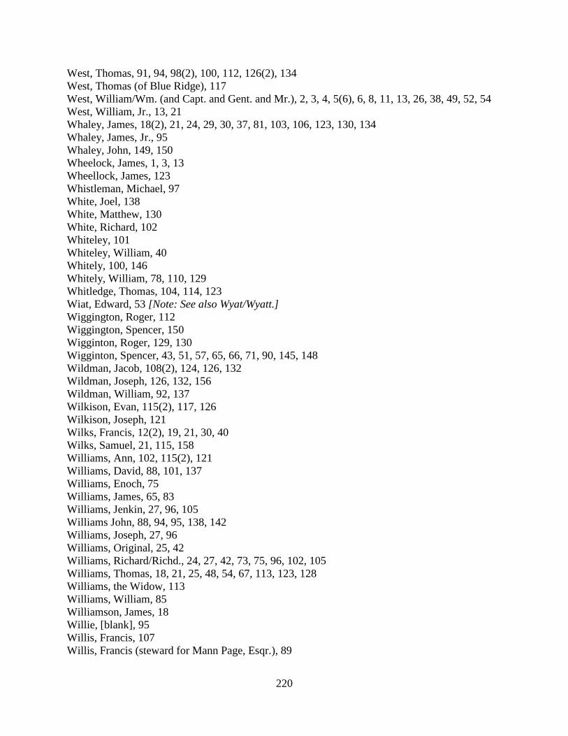
220
West, Thomas, 91, 94, 98(2), 100, 112, 126(2), 134 West, Thomas (of Blue Ridge), 117 West, William/Wm. (and Capt. and Gent. and Mr.), 2, 3, 4, 5(6), 6, 8, 11, 13, 26, 38, 49, 52, 54 West, William, Jr., 13, 21 Whaley, James, 18(2), 21, 24, 29, 30, 37, 81, 103, 106, 123, 130, 134 Whaley, James, Jr., 95 Whaley, John, 149, 150 Wheelock, James, 1, 3, 13 Wheellock, James, 123 Whistleman, Michael, 97 White, Joel, 138 White, Matthew, 130 White, Richard, 102 Whiteley, 101 Whiteley, William, 40 Whitely, 100, 146 Whitely, William, 78, 110, 129 Whitledge, Thomas, 104, 114, 123 Wiat, Edward, 53 [Note: See also Wyat/Wyatt.] Wiggington, Roger, 112 Wiggington, Spencer, 150 Wigginton, Roger, 129, 130 Wigginton, Spencer, 43, 51, 57, 65, 66, 71, 90, 145, 148 Wildman, Jacob, 108(2), 124, 126, 132 Wildman, Joseph, 126, 132, 156 Wildman, William, 92, 137 Wilkison, Evan, 115(2), 117, 126 Wilkison, Joseph, 121 Wilks, Francis, 12(2), 19, 21, 30, 40 Wilks, Samuel, 21, 115, 158 Williams, Ann, 102, 115(2), 121 Williams, David, 88, 101, 137 Williams, Enoch, 75 Williams, James, 65, 83 Williams, Jenkin, 27, 96, 105 Williams John, 88, 94, 95, 138, 142 Williams, Joseph, 27, 96 Williams, Original, 25, 42 Williams, Richard/Richd., 24, 27, 42, 73, 75, 96, 102, 105 Williams, Thomas, 18, 21, 25, 48, 54, 67, 113, 123, 128 Williams, the Widow, 113 Williams, William, 85 Williamson, James, 18 Willie, [blank], 95 Willis, Francis, 107 Willis, Francis (steward for Mann Page, Esqr.), 89

221
Willis, George, 95 Willson, James, 138 Wilson, 110, 123 Wilson, David, 113, 142, 145, 155, 156 Wilson, George, 90, 102, 117 Wilson, George, Sr., 111 Wilson, Henry, 94 Wilson, Henry (overseer for Mann Page’s quarter), 97 Wilson, James, 95 Wilson, Joshua, 44, 58 Wince, Thomas, 157 Winn, Samuel, 6, 10 Winn, Thomas, 73 Winn, William, 93, 96 Winsel, Adam, 25, 82 Winter, Martin, 147 Wishart, Henry, 91, 95 Wisheart, Henry, 41, 46 Wolf, Adam, 144, 156 Wolf, John, 149 Wollard, William, 23, 31, 49, 139 Woolard, William, 34, 50, 96, 98 Woollard, William, 99, 105, 106, 118 Woolem, Martin, 96 Wood, Elias, 84, 85 Wood, Robert, 20 Wornald, William, 85, 123 Wren, John, 157 Wren, Nicholas (overseer for Francis Lightfoot Lee), 21 Wren, Thos., 126 Wren, Travis, 115 Wrenn, Isaac, 156 Wrenn, John, 138 Wrenn, Thomas, 112, 142 Wright, Anthony, 116 Wright, Isaac, 91 Wrightmire, James, 127 Wyat, Edward, 51 [Note: See also Wiat.] Wyatt, Edward, 51, 97 Wyatt, Edward, Jr., 97 Wyckoff, Nicholas, 93, 125, 127(2), 128, 129 Wyckoff, Samuel, 83, 94, 100 Wycoff, Samuel, 86 Yates, George, 85 Yates, Joshua, 85, 132 Yeaky [Yearky?], Martin, 97

222
Yearky [Yeaky?], Martin, 97 Yeldall, Robert, 19, 20 Rivers, Runs, Springs, Creeks, and Other Water Features Beaver Dam / the Beaver Dam / the Beaverdam / the Beaver dam / the Beaver Dams, 8, 9, 16,
50(2), 54, 74, 76, 82, 83, 84, 121, 128 William Berkley’s Spring Branch, 80 the Black Branch, 133 Broad Run, 1(2), 3, 4, 11, 12, 15, 16, 17, 20, 21, 23, 28, 29(2), 30(3), 32, 33(2), 34, 35, 36(2), 37,
39(2), 40(2), 41, 42(2), 43, 44, 46, 47, 50, 51, 57(2), 58(3), 59(2), 60(2), 61(2), 65, 69, 71, 72, 79, 80, 81, 82, 88, 89, 95(2), 119, 136(2), 140, 143, 145, 146, 148, 150, 153, 157
• South Fork of Broad Run, 25 Buffaloe Branch, 78 Bull Run, 11, 15, 35, 42, 45, 63, 70, 91, 92, 93, 110, 123, 124, 137, 139, 141, 143(2)
• the North thoroughfare of Bull Run, 132 Catocton Creek, 26, 42 [Note: See also Kittocton/Kittockton Creek.] Chinn’s Branch, 154 Charles Chinn’s Spring Branch, 85(2), 143 Colvin’s Branch, 131 Cromwell’s Run, 26, 145 Cub Run, 28, 55, 57, 72, 83 Difficult/Difficult Run, 1, 8, 9, 10, 11, 15(2), 31, 32, 33, 34, 37, 38(2), 39(2), 41, 43(2), 44, 46,
51, 54, 55, 57(2), 58, 60, 68(2), 71, 72, 73(2), 76, 79, 99, 102, 104, 107, 108, 112, 118, 119, 124, 131, 136, 146, 147, 148(2), 150, 151
(Mouth of) Dutchman’s Run, 13, 14 Elk Licking Run, 55 Branch leading from Evan Evan’s meadow, 88 Flat Lick Run, 72, 83, 87 Frying Pan / Frying Pan Run, 1, 6, 8(2), 9(2), 10(2), 15, 16, 18, 40, 61(2), 62, 75, 111, 113, 131,
147 Goose Creek, 1(3), 2(4), 3(2), 5(2), 6, 9, 10, 11, 13, 15(4), 16, 20, 21, 22, 26(3), 28(3), 29(3), 30,
31(2), 33(5), 35, 36(3), 37, 38, 39, 43, 45, 46, 47(2), 48(2), 51, 54(3), 56(2), 58(3), 59(2), 60, 67(2), 69(3), 71, 74(2), 75, 76, 77, 80(3), 81, 82, 83, 84(2), 85(2), 86, 89, 90, 91, 93, 94, 95, 97, 100(2), 103(2), 104, 108, 109(2), 111, 113, 114, 115, 116, 119(2), 121(2), 122, 133, 135, 136(2), 141(3), 142, 143, 144, 146, 147(2), 149, 150, 154, 157(2)
• branch of Goose Creek (that comes from Nicholas Osburn’s), 129 • Fork of Goose Creek, 48, 54 • North Fork of Goose Creek, 90 • the Northwest Fork of Goose Creek, 117, 126 • the great bent of the southwest fork of Goose Creek, 113 • Mouth of Goose Creek, 4
The Great Falls, 31, 32 The Great Falls of Potowmack River, 29
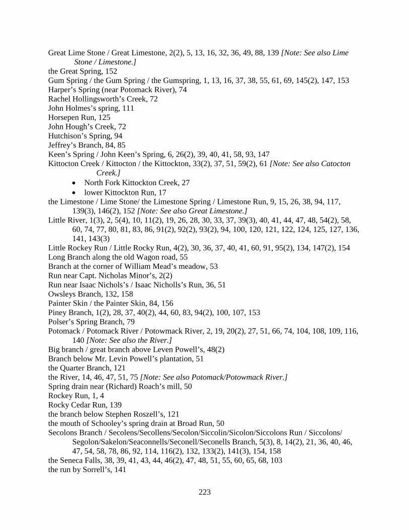
223
Great Lime Stone / Great Limestone, 2(2), 5, 13, 16, 32, 36, 49, 88, 139 [Note: See also Lime Stone / Limestone.]
the Great Spring, 152 Gum Spring / the Gum Spring / the Gumspring, 1, 13, 16, 37, 38, 55, 61, 69, 145(2), 147, 153 Harper’s Spring (near Potomack River), 74 Rachel Hollingsworth’s Creek, 72 John Holmes’s spring, 111 Horsepen Run, 125 John Hough’s Creek, 72 Hutchison’s Spring, 94 Jeffrey’s Branch, 84, 85 Keen’s Spring / John Keen’s Spring, 6, 26(2), 39, 40, 41, 58, 93, 147 Kittocton Creek / Kittocton / the Kittockton, 33(2), 37, 51, 59(2), 61 [Note: See also Catocton
Creek.] • North Fork Kittockton Creek, 27 • lower Kittockton Run, 17
the Limestone / Lime Stone/ the Limestone Spring / Limestone Run, 9, 15, 26, 38, 94, 117, 139(3), 146(2), 152 [Note: See also Great Limestone.]
Little River, 1(3), 2, 5(4), 10, 11(2), 19, 26, 28, 30, 33, 37, 39(3), 40, 41, 44, 47, 48, 54(2), 58, 60, 74, 77, 80, 81, 83, 86, 91(2), 92(2), 93(2), 94, 100, 120, 121, 122, 124, 125, 127, 136, 141, 143(3)
Little Rockey Run / Little Rocky Run, 4(2), 30, 36, 37, 40, 41, 60, 91, 95(2), 134, 147(2), 154 Long Branch along the old Wagon road, 55 Branch at the corner of William Mead’s meadow, 53 Run near Capt. Nicholas Minor’s, 2(2) Run near Isaac Nichols’s / Isaac Nicholls’s Run, 36, 51 Owsleys Branch, 132, 158 Painter Skin / the Painter Skin, 84, 156 Piney Branch, 1(2), 28, 37, 40(2), 44, 60, 83, 94(2), 100, 107, 153 Polser’s Spring Branch, 79 Potomack / Potomack River / Potowmack River, 2, 19, 20(2), 27, 51, 66, 74, 104, 108, 109, 116,
140 [Note: See also the River.] Big branch / great branch above Leven Powell’s, 48(2) Branch below Mr. Levin Powell’s plantation, 51 the Quarter Branch, 121 the River, 14, 46, 47, 51, 75 [Note: See also Potomack/Potowmack River.] Spring drain near (Richard) Roach’s mill, 50 Rockey Run, 1, 4 Rocky Cedar Run, 139 the branch below Stephen Roszell’s, 121 the mouth of Schooley’s spring drain at Broad Run, 50 Secolons Branch / Secolens/Secollens/Secolon/Siccolin/Sicolon/Siccolons Run / Siccolons/
Segolon/Sakelon/Seaconnells/Seconell/Seconells Branch, 5(3), 8, 14(2), 21, 36, 40, 46, 47, 54, 58, 78, 86, 92, 114, 116(2), 132, 133(2), 141(3), 154, 158
the Seneca Falls, 38, 39, 41, 43, 44, 46(2), 47, 48, 51, 55, 60, 65, 68, 103 the run by Sorrell’s, 141

224
Sorrells Run, 154 Sugar Land Run / Sugarland Run, 1(3), 3, 20, 23, 25, 30, 33, 34(2), 36, 37, 38, 41, 42, 44, 47, 52,
57(3), 58(2), 59, 65, 71(2), 88, 95, 103, 110, 129, 130, 136(2), 142 [Note: The entries on p. 71 may refer to Sugar Land / Sugarland Run or to the Sugar Lands / Sugarlands locality/plantation; both possibilities should be considered.]
the Tanyard Run, 145 the run by Mr. John Thornton’s, 149 Trenarys Run, 50, 52, 68 Tuscarora Run / Tuscarrora / Tuskarora / Tuscorara / Tuscorora /Tuskaroro /Tuskarrora /
Tuskorora, 13, 14, 40, 46, 56, 78, 103, 108, 111 • Mouth of Tuscorora, 22, 113
the Watry Branch, 127 Adam Winsel’s Spring Branch, 82 the Wancopin / the Wonkapin / Wonkapin Branch, 85, 143, 151, 152, 154

225
Roads [Note: Roads are cross-indexed to all locations and persons mentioned. Descriptions have been slightly standardized to simplify the preparation of this index. The key word for each entry is underlined. Where several sections or descriptions are given for a road, the page number for the earliest entry is used to determine the indexing order, even if the key word appeared in a subsequent entry. Where only surnames are given, these entries appear first in the entries under that surname. It should be noted that the Loudoun County clerk of this era recorded some of the most detailed road order entries encountered in the 40-year history of the Historic Roads of Virginia project, resulting in unusually long road descriptions. It is hoped that these extremely detailed descriptions will be of particular use to researchers in identifying early roads in this area.] Road to town and courthouse opened from Leesburg by John Lewis’s and (James) Stephens’s into an old road leading over the Mountain (by old Abbett’s and Philip Saunders’s plantations, and through a lane of John Lewis’s and from thence through the land of Thomson Mason Esqr. near his plantation called Rasberry Plane, and by the foot of the Mountain, and into the old road and to the plantation of James Stephens), 61, 63 Road from Jacob Janney’s to Andrew Adam’s mill on Sakelon, 21 Road from Adams’s ford on Goose Creek to where the road crosses Little River (road from Adams’s ford down to the Mountain road by John Champ’s), 10, 11 Road from Adams’s to Goodwin’s, 86 Road from Daniel Adams’s to the Blue Ridge, 28 Probably the same as: Road from the County line to Daniel Adams’s ford on Goose Creek, 31 Road from the ford of Goose Creek to Noland’s ferry (leading out of the Alexandria road into the Leesburg road by Hugh Fouch’s and through the Cat Tail Meadow plantation, via the lands of Robert Adams and Richard Mets, to a red oak tree marked with three notches standing near the side of the said Leesburg road, and across the road, down a valley, and into the road again near Hugh Fouch’s fence), 89, 90-91 Road from Cox’s mill to the Widow Adams’s, 114 Road from the Short Hills near where Joseph Jones now lives and from thence to Israel Thompson’s mill (road from Short Hills near Joseph Jones’s to Israel Thompson’s mill and from thence into the Great road; road from the mouth of Joseph Jones’s lane and with the old road through John Gregg’s lane and by the lands of Samuel Gregg, James Toben, John Tribbe, Robert Akers, Isaac Thompson and Jenkin Morris, and to Israel Thompson’s tan yard and from there with his lane to his mill), 41, 43-44 Road from John Alexander’s plantation to Mr. George West’s lane, 110

226
Mountain road, 1, 4, 18, 123, 143, 154 Sections:
• from the Post up to the road to Piney Branch (road from Little Rockey Run called the Mountain road up the said road to the Post / old Post; road from the Post / old Posts to Piney Branch), 1, 4, 37, 95, 107 Probably the same as: Road from [torn] Branch to the old Post, 23
• from the Post to the County line; road from Little Rockey Run down the Mountain road to the end of the County / County line, including the bridge over Little Rockey Run; road from Little Rockey Run to the County line / Fairfax County line; road from Little Rockey Run to the County line the way to Alexandria, 1, 4, 30, 41, 95
• from Little Rocky Run to the forks by Edwards’s; road from Little Rocky Run / from the lower side of Little Rocky Run to Edwards’s old shop, 134, 147, 154
Related roads or sections: • Road that leads to Alexandria (portion as low as the County line), 30 • Roads from Little Rockey Run to the County line the roads that lead to Alexandria
and Colchester, 37 Road from Alexandria to Winchester (through George Town [Leesburg]), 4(2) fork of the roads near Edward Porter’s (where one road leads to Alexandria and the other to Occoquan warehouse), 13, 16 the Ox road from Frying Pan to the road that leads from Alexandria to Leesburg, 18 Road from Leesburg to Alexandria, 21, 75, 81, 154
• section of[?] the road below Goose Creek, 75 • (alteration of) the road (to go nearer to Hough’s mill), 81 • bridge to be built at the usual place across Broad Run, 81
Road from the road that leads from Ashby’s Gap to Alexandria from Leven Powell’s plantation to Goose Creek Chapel (road leading from Ashby’s Gap to Alexandria from Leven Powell’s plantation to Goose Creek Church), 24, 27 Road(s) to John Hough’s mill on Goose Creek, 28, 29
• Road marked by John Mill (probably not cleared), 29 • Road from Hough’s / John Hough’s mill to Morris’s ford (from where it turns off the
road leading to Alexandria), 29, 31, 49 • Road from the ford where the Ox road crosses Broad Run to John Hough’s mill on
Goose Creek (road from where the Ox road crosses Broad Run / the ford of Broad Run to [John] Hough’s mill), 29, 30, 37
• Road from Broad Run Church to John Hough’s mill on Goose Creek, 28, 29 • Road from (John) Hough’s mill to the Main road where the Ox road breaks off, 28, 29
Road from Leesburg to the ford of Goose Creek that leads to/towards Alexandria, 29, 31, 36
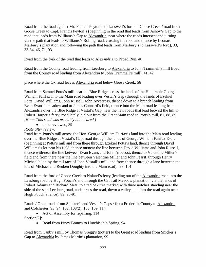
227
Road from the road against Mr. Francis Peyton’s to Lasswell’s ford on Goose Creek / road from Goose Creek to Capt. Francis Peyton’s (beginning in the road that leads from Ashby’s Gap to the road that leads from Williams’s Gap to Alexandria, near where the roads intersect and turning via the path that leads to Williams’s Rolling road, crossing the road and thence by Leonard Marbury’s plantation and following the path that leads from Marbury’s to Lasswell’s ford), 33, 33-34, 46, 71, 93 Road from the fork of the road that leads to Alexandria to Broad Run, 40 Road from the County road leading from Leesburg to Alexandria to John Trammell’s mill (road from the County road leading from Alexandria to John Trammell’s mill), 41, 42 place where the Ox road leaves Alexandria road below Goose Creek, 56 Road from Samuel Potts’s mill near the Blue Ridge across the lands of the Honorable George William Fairfax into the Main road leading over Vestal’s Gap (through the lands of Ezekiel Potts, David Williams, John Russell, John Arvecross, thence down to a branch leading from Evan Evans’s meadow and to James Connard’s field, thence into the Main road leading from Alexandria over the Blue Ridge at Vestal’s Gap, near the new roads that lead betwixt the hill to Robert Harper’s ferry; road lately laid out from the Great Main road to Potts’s mill, 81, 88, 89 [Note: This road was probably not cleared.]
• to be reviewed, 89 Route after review: Road from Potts’s mill across the Hon. George William Fairfax’s land into the Main road leading over the Blue Ridge at Vestal’s Gap; road through the lands of George William Fairfax Esqr. (beginning at Potts’s mill and from there through Ezekiel Potts’s land, thence through David Williams’s lot near his field, thence on/near the line between David Williams and John Russell, thence with/near the line between Evan Evans and John Arbecost, thence to Valentine Miller’s field and from there near the line between Valentine Miller and John Fearst, through Henry Michael’s lot, by the tail race of John Vestall’s mill, and from thence through a lane between the lots of Michael and Reuben Doughty into the Main road), 93, 101 Road from the ford of Goose Creek to Noland’s ferry (leading out of the Alexandria road into the Leesburg road by Hugh Fouch’s and through the Cat Tail Meadow plantation, via the lands of Robert Adams and Richard Mets, to a red oak tree marked with three notches standing near the side of the said Leesburg road, and across the road, down a valley, and into the road again near Hugh Fouch’s fence), 89, 90-91 Roads / Great roads from Snicker’s and Vestal’s Gaps / from Frederick County to Alexandria and Colchester, 93, 94, 102, 103(2), 105, 109, 114
• Act of Assembly for repairing, 114 Section[?]:
• Road from Piney Branch to Hutchison’s Spring, 94 Road from Canby’s mill by Thomas Gregg’s (potter) to the Great road leading from Snicker’s Gap to Alexandria by James Martin’s plantation, 99
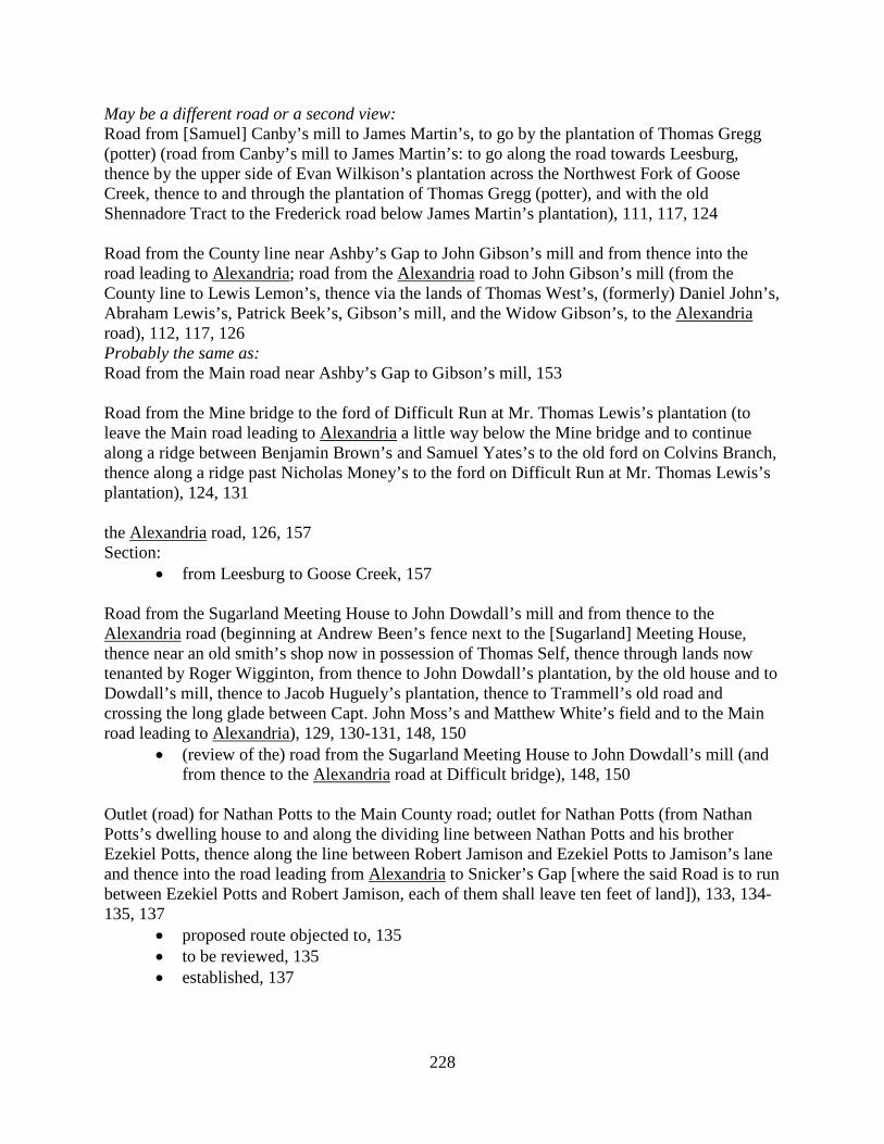
228
May be a different road or a second view: Road from [Samuel] Canby’s mill to James Martin’s, to go by the plantation of Thomas Gregg (potter) (road from Canby’s mill to James Martin’s: to go along the road towards Leesburg, thence by the upper side of Evan Wilkison’s plantation across the Northwest Fork of Goose Creek, thence to and through the plantation of Thomas Gregg (potter), and with the old Shennadore Tract to the Frederick road below James Martin’s plantation), 111, 117, 124 Road from the County line near Ashby’s Gap to John Gibson’s mill and from thence into the road leading to Alexandria; road from the Alexandria road to John Gibson’s mill (from the County line to Lewis Lemon’s, thence via the lands of Thomas West’s, (formerly) Daniel John’s, Abraham Lewis’s, Patrick Beek’s, Gibson’s mill, and the Widow Gibson’s, to the Alexandria road), 112, 117, 126 Probably the same as: Road from the Main road near Ashby’s Gap to Gibson’s mill, 153 Road from the Mine bridge to the ford of Difficult Run at Mr. Thomas Lewis’s plantation (to leave the Main road leading to Alexandria a little way below the Mine bridge and to continue along a ridge between Benjamin Brown’s and Samuel Yates’s to the old ford on Colvins Branch, thence along a ridge past Nicholas Money’s to the ford on Difficult Run at Mr. Thomas Lewis’s plantation), 124, 131 the Alexandria road, 126, 157 Section:
• from Leesburg to Goose Creek, 157 Road from the Sugarland Meeting House to John Dowdall’s mill and from thence to the Alexandria road (beginning at Andrew Been’s fence next to the [Sugarland] Meeting House, thence near an old smith’s shop now in possession of Thomas Self, thence through lands now tenanted by Roger Wigginton, from thence to John Dowdall’s plantation, by the old house and to Dowdall’s mill, thence to Jacob Huguely’s plantation, thence to Trammell’s old road and crossing the long glade between Capt. John Moss’s and Matthew White’s field and to the Main road leading to Alexandria), 129, 130-131, 148, 150
• (review of the) road from the Sugarland Meeting House to John Dowdall’s mill (and from thence to the Alexandria road at Difficult bridge), 148, 150
Outlet (road) for Nathan Potts to the Main County road; outlet for Nathan Potts (from Nathan Potts’s dwelling house to and along the dividing line between Nathan Potts and his brother Ezekiel Potts, thence along the line between Robert Jamison and Ezekiel Potts to Jamison’s lane and thence into the road leading from Alexandria to Snicker’s Gap [where the said Road is to run between Ezekiel Potts and Robert Jamison, each of them shall leave ten feet of land]), 133, 134-135, 137
• proposed route objected to, 135 • to be reviewed, 135 • established, 137

229
(Alteration of) the road from William Hough’s mill into the Alexandria road along the line between Adam Hambler and Mary Holmes, 138 (Alteration of) the road leading from Snigers’s Gap to Alexandria (road petitioned for by Joseph Lacey; to come out of the Alexandria road near the line between Joseph Lacey and John Moore and come in near Owsleys Branch, 158(2) Road from Roszell’s to Little River at Mercer’s quarter, 120 May be a second viewing or a review: Road from the Frederick road to begin at a branch about a mile below Stephen Roszell’s to cross Goose Creek near Combs’s mill then to Little River at Mercer’s old quarter; road from the road below Stephen Roszel’s to cross Goose Creek near Combs’s mill, then to Mercer’s quarter on Little River (beginning at a branch, extending on or near the line of Capt. Cock’s to William Allen’s lane and field near Mr. Combs’s mill, to the old ford on Goose Creek, thence upon the line between Thaddeus McCarty and Joseph Farrow, and between Andrew and Thomas Batey into the road by Capt. Francis Peyton, and down that road into the Mountain road and down the Mountain road to Mercer’s old quarter), 121, 122-123 [Note: Entries for Arbecost and Arvecross are combined.] Road from Samuel Potts’s mill near the Blue Ridge across the lands of the Honorable George William Fairfax into the Main road leading over Vestal’s Gap (through the lands of Ezekiel Potts, David Williams, John Russell, John Arvecross, thence down to a branch leading from Evan Evans’s meadow and to James Connard’s field, thence into the Main road leading from Alexandria over the Blue Ridge at Vestal’s Gap, near the new roads that lead betwixt the hill to Robert Harper’s ferry; road lately laid out from the Great Main road to Potts’s mill, 81, 88, 89 [Note: This road was probably not cleared.]
• to be reviewed, 89 Route after review: Road from Potts’s mill across the Hon. George William Fairfax’s land into the Main road leading over the Blue Ridge at Vestal’s Gap; road through the lands of George William Fairfax Esqr. (beginning at Potts’s mill and from there through Ezekiel Potts’s land, thence through David Williams’s lot near his field, thence on/near the line between David Williams and John Russell, thence with/near the line between Evan Evans and John Arbecost, thence to Valentine Miller’s field and from there near the line between Valentine Miller and John Fearst, through Henry Michael’s lot, by the tail race of John Vestall’s mill, and from thence through a lane between the lots of Michael and Reuben Doughty into the Main road), 93, 101 [Road from Little River to Ashby’s Gap], 2(2) Apparently sections of the same road:
• Road leading through Ashby’s Gap, from Little River to Goose Creek, 2 • Road leading through Ashby’s Gap, from Goose Creek to the County line on the Blue
Ridge, 2 See also: (New) Road from the ford of Little River to Ashby’s Gap (road from the ford of Little River to Ashby’s Gap (from Little River and following the old road around Mercer’s Meadow Ground,

230
thence into Mr. Craven Peyton’s plantation, thence with the old road again to Cromwell’s Run, thence to the top of the hill, and thence with the old road to Ashby’s Gap), 19, 26 Sections:
• from Goose Creek to the County line, 26 • from Little River to Goose Creek, 26, 33, 56
May be the same as: Road from Mercer’s mill to Ashby’s Gap (portion turned by Leven Powell), 30, 45 Section:
• as far as Goose Creek, 45 Road leading from Ashby’s Gap to the road of Williams’s Gap (and alteration to lead from the foot of the [Blue] Ridge into Williams’s road near the creek, 8, 9(3), 10 Sections:
• from the foot of the Ridge to Aaron Botts’s house, 10 • from Aaron Botts’s house to the old road leading to Williams’s Gap, 10
Road from the road that leads from Ashby’s Gap to Alexandria from Leven Powell’s plantation to Goose Creek Chapel (road leading from Ashby’s Gap to Alexandria from Leven Powell’s plantation to Goose Creek Church), 24, 27 Road from the road against Mr. Francis Peyton’s to Lasswell’s ford on Goose Creek / road from Goose Creek to Capt. Francis Peyton’s (beginning in the road that leads from Ashby’s Gap to the road that leads from Williams’s Gap to Alexandria, near where the roads intersect and turning via the path that leads to Williams’s Rolling road, crossing the road and thence by Leonard Marbury’s plantation and following the path that leads from Marbury’s to Lasswell’s ford), 33, 33-34, 46, 71, 93 Road from Ashby’s Gap above Goose Creek to Leesburg (road from Ashby’s Gap to William Mead’s), 33, 38(2) Sections:
• from William Mead’s to Joseph Gardner’s field (road from where it leaves the Carolina road near William Mead’s to Joseph Gardner’s plantation; road from Joseph Gardner’s to the Goose Creek road below William Mead’s), 38-39, 43, 69
• from Joseph Gardner’s field to the (Mountain) road (near Thomas Starks’s house), 38-39, 41, 43
Related road: Road from Thomas Starks’s to William Mead’s, 40, 43
• to be viewed and determined if necessary, 40 • road in use to be retained, 43
Road leading from Sniggers’s Mountain road to Ashby’s Gap (to be cleared from Champes Mountain as it now stands to Ashby’s Gap), 48 Road from Goose Creek to Ashby’s Gap, 48, 67, 80
• (alteration of) the road from Goose Creek to Ashby’s Gap (to be turned through the land of William Cocke Gent.), 80
231
Road from the big road leading from Ashby’s Gap at the upper end of Elijah Chinn’s (road from the big road leading from Ashby’s Gap at the upper end of Elijah Chinn’s old field, along the path from Chinn’s to George Heale’s quarter, supposed to be in or near the County line), 49 Road from the Main road leading from Ashby’s Gap to Capt. William West’s (to cross Bull Run Mountain at George Berry’s), 49
• portion in Fauquier County, from the County line to George Berry’s (Fauquier County requested to clear), 49
Road from Mahlon Janney’s mill to Goose Creek Meeting House, thence to Nichols’s mill, 67 Related road: Road from Nichols’s mill to Ashby’s Gap, 67 See also: (Proposed alteration of [by Nathan Spencer]) the road from Mahlon Janney’s mill to Isaac Nickolls’s mill, where it goes through the land of Nathan Spencer in such manner as to be very injurious to him, 84 (Alteration of) the Great road from Ashby’s Gap to Belhaven (running through Thomas West’s land), 91, 98 Ashby’s Gap road, 109 Road from the County line near Ashby’s Gap to John Gibson’s mill and from thence into the road leading to Alexandria; road from the Alexandria road to John Gibson’s mill (from the County line to Lewis Lemon’s, thence via the lands of Thomas West’s, (formerly) Daniel John’s, Abraham Lewis’s, Patrick Beek’s, Gibson’s mill, and the Widow Gibson’s, to the Alexandria road), 112, 117, 126 Probably the same as: Road from the Main road near Ashby’s Gap to Gibson’s mill, 153 Road from Ashby’s Gap to Absalom Ramey’s, 119 See also (another view of the route?): Road from Ashby’s Gap to Absalom Ramey’s, 120 (Another) road from Thomas Drake’s meadow to Leven Powell’s mill (from Drake’s meadow to Dawson Brown’s plantation, thence across the Beaverdam by Capt. William Bronaugh’s and between William Smith Gent. and Simon Hancock’s, thence across the road leading from Ashby’s Gap to Absalom Ramey’s to strike the road that leads from the ford of Goose Creek on the land of Mr. Owsly, thence along the said road until it meets the road leading from Ashby’s Gap to Leven Powell’s mill), 120, 121 See also: (Another) road from Thomas Drake’s meadow to Leven Powell’s mill (from Drake’s meadow down the old road to a lane between Isaac Brown’s field and Joshua Dixon’s thence running between Isaac and Dawson Brown to the Beaverdam, thence up a hollow to Capt. William Bronaugh’s land thence with his line and William Owsley’s to a lane between said Bronaugh and
232
Owsley, thence on a line between Thos. Owsley and Thomas Williams, thence through a corner of Capt. Wm. Cock’s land to the mouth of Joseph Combs’s lane, thence to his mill thence along Mr. Leven Powell’s Church road to his mill), 124, 128 Roads to William Carr Lane’s mill, 71, 72
• Road from a ford on Broad Run below Reuben Berkley’s and to cross Cub Run a little before George Ashford’s and from thence to cross Flat Lick Run at the Church road, and from thence to William Carr Lane’s mill, 72
• Road from William Carr Lane’s mill to the Mountain road at Mr. Lane’s / William Carr Lane’s house, 72
• Road from Difficult Run about Capt. Ellzey’s quarters to William Carr Lane’s mill, 72
• Road from the Main road below Mr. Love’s plantation to William Carr Lane’s mill, 72 Sections: from Broad Run to Cub Run, 72 from Cub Run to Flack / Flat Lick Run, 72, 83 from Flat Lick to the mill, and from thence to the Mountain road below Samuel
Love’s, 72 Road from Awbrey’s ferry to Leesburg, 73 Road from William [torn] to Samuel Awbrey’s at the Gap of the Short Hill, 2 Road from Samuel Awbrey’s at the Gap of the Short Hill to the County line on the Blue Ridge, 2 May be the same as: Road from the Gap of the Short Hill to the top of the [Blue] Ridge, 37, 59 Road from William Kirk’s mill to Thomas Awbrey’s ferry (from Thomas Awbrey’s landing on the River by his house, then up a small run nearly as a path now goes, by Enoch Williams’s, and thence with the path to Kirk’s mill), 73, 75
• clearing to be delayed, 75 [Note: Entries for Axline and Axlyne are combined.] Road from William Smith’s under the Short Hill to Farling Ball’s mill (road from William Smith’s to Farling Ball’s mill, beginning at William Smith’s, going with an old path to a place belonging to James Clemons, and along the lines of John Folkes, Adam Axlyne, John Jackson, John Axline, and Abner Roberts’s, until it crosses the Buffaloe Branch, into the road leading to Pain’s, and with it near a line between Hutton &c. and down to Farling Ball’s mill), 74, 78 Probably the same as:
• Road from William Smith’s to Farling Ball’s mill, 109 • Road from Farling Ball’s mill to the Short Hill, 140
Road from William Smith’s under the Short Hill to Farling Ball’s mill (road from William Smith’s to Farling Ball’s mill, beginning at William Smith’s, going with an old path to a place
233
belonging to James Clemons, and along the lines of John Folkes, Adam Axlyne, John Jackson, John Axline, and Abner Roberts’s, until it crosses the Buffaloe Branch, into the road leading to Pain’s, and with it near a line between Hutton &c. and down to Farling Ball’s mill), 74, 78 Probably the same as:
• Road from William Smith’s to Farling Ball’s mill, 109 • Road from Farling Ball’s mill to the Short Hill, 140
(Alteration of) road from Pain’s ferry (to be turned round John Short’s fence between the said Short and John Axline &c.), 138 Road from Goose Creek to Bacon Fort, 1, 47 Probable sections:
• Road from the Beaver Dam to Bacon Fort, 50, 76 • Road from the Beaver Dam / the Beaver dams to Goose Creek, 50, 54, 74 • Road leading from Goose Creek to the forks above the Church, 141 • Road leading from the forks above the Church to Bacon Fort, 141
Road from Bacon Fort to the County line on the Blue Ridge / top of the Ridge, 2, 4 May be the same as: Road from Sniggers’s Gap / Snickers’s Gap to Bacon Fort, 44, 60 May be the same as: Road from Frederick County line to Bacon Fort, 106, 141 New road from Ball’s mill to Frederick [County], 157 Road from William Smith’s under the Short Hill to Farling Ball’s mill (road from William Smith’s to Farling Ball’s mill, beginning at William Smith’s, going with an old path to a place belonging to James Clemons, and along the lines of John Folkes, Adam Axlyne, John Jackson, John Axline, and Abner Roberts’s, until it crosses the Buffaloe Branch, into the road leading to Pain’s, and with it near a line between Hutton &c. and down to Farling Ball’s mill), 74, 78 Probably the same as:
• Road from William Smith’s to Farling Ball’s mill, 109 • Road from Farling Ball’s mill to the Short Hill, 140
Road from the Valentine quarter on Potowmack River to Farling Ball’s mill and store (to go with or near the old road as far as Leonard May’s fence and thence by Moses Heaton’s to Farling Ball’s mill and store), 102, 104 Road from or near Henry Stone’s to Farling Ball’s mill, 106 Road from Potowmack River opposite William Luckett Jr.’s ferry to Pursley’s ordinary; road(s) from Ball’s mill to Luckett’s ferry and from Ball’s mill to Israel Thompson’s mill, 109, 116 Probable sections:
• Road from Ball’s mill to Israel Thompson’s mill (from Ball’s mill, then between Frederick Cooper’s plantation and David Mull’s by Anthony Wright’s lane into a road leading to Thompson’s mill), 116

234
• Road from (Farling) Ball’s mill to Luckett’s ferry (from Ball’s mill towards Potowmack, along the road leading from Ball’s mill to the Valentine quarter, by Leonard May’s plantation, thence between William Rasler’s and Isaac Shown’s plantations, thence by a path to Luckett’s ferry), 116, 138
Road from Farling Ball’s/Ball’s mill / Farling Ball’s mill to John Hough’s mill (on/near the line between Tankerville and Fairfax, by and between Joseph Wilkison and Joseph Hough with the line, thence into a road leading from the Widow Hallingsworth [Hollingsworth] to John Hough’s mill), 120, 121, 138, 153 Road from the road leading from Roach’s mill to the Dutch mill across to Farling Ball’s mill on or near the lines of Tankerville and Fairfax, 155 Road from James Ball’s mill / Ball’s mill to the Presbyterian Meeting House / Meeting House, 147(2), 148
• to be reviewed at the request of Milholland, 148 Road to be opened from the Widow Bruester’s landing to Ballendine’s road, 64, 65 Road from the Great Falls to Difficult Run to meet a road through part of Fairfax County to the Falls warehouse (road from the Great Falls to Difficult Run, via Mr. John Ballendine’s ditch, the Fall Island, the Fall Meadow and to Difficult Run at Rockey ford), 31, 32 Road to be cleared from Broad Run to meet one lately cleared by order of Fairfax Court from the Little Falls to Difficult Run (road from Broad Run bridge to the Seneca Falls / Seneca Falls mill / the [John Ballendine’s] landing at Seneca Falls and from thence to Difficult Run [at the Rockey ford] to meet a road ordered cleared by Fairfax Court), 39, 41, 43, 44, 46, 51, 55, 60
• Former order quashed and to be reviewed, 41 • Old road to be used until John Ballendine erects the public mill, 46, 48, 51 • Order to clear the road to be quashed until John Ballendine erects a public mill at
Seneca Falls, 48 Sections:
• from Broad Run to the Seneca Falls (the upper road), 60 • from Seneca Falls / the landing on the Seneca Falls to Difficult Run (the lower road),
60, 68 Road from Roach’s / Richard Roach’s mill to the Baptist Meeting House, 65, 66 Road from the Baptist Meeting House to the Main road at Benjamin John’s old place, 108 Road from the Loudoun line at the north thoroughfare of Bull Run to the Baptist Meeting House at Joseph Hutchison’s, 132 Road from John Osborne’s lane between him and Craven Peyton Esqr. to the road leading to Mr. Neilson’s mill and to the Baptist Meeting House (road from John Osborn’s lane to the Baptist Meeting House), 137, 139
235
Road from Roszell’s to Little River at Mercer’s quarter, 120 May be a second viewing or a review: Road from the Frederick road to begin at a branch about a mile below Stephen Roszell’s to cross Goose Creek near Combs’s mill then to Little River at Mercer’s old quarter; road from the road below Stephen Roszel’s to cross Goose Creek near Combs’s mill, then to Mercer’s quarter on Little River (beginning at a branch, extending on or near the line of Capt. Cock’s to William Allen’s lane and field near Mr. Combs’s mill, to the old ford on Goose Creek, thence upon the line between Thaddeus McCarty and Joseph Farrow, and between Andrew and Thomas Batey into the road by Capt. Francis Peyton, and down that road into the Mountain road and down the Mountain road to Mercer’s old quarter), 121, 122-123 Road from Goose Creek Church to Leven Powell’s mill / mill road (leaving the big new road opposite to Thaddeus McCarty’s new ground fence, thence through the plantation of Henry Batterton, by an old cabin in George Johnston’s field and through Johnston’s wheat field, thence to Leven Powell’s mill road opposite to a schoolhouse at Richard Crupper’s), 101, 127 Road(s) to Leven Powell’s mill, 76, 77
• Road from Leven Powell’s / Col. Powell’s mill to Fauquier County line that goes under the Mountain (from Leven Powell’s mill, crossing Little River at an old ford and through Capt. Francis Peyton’s quarter plantation and going as near the foot the Mountain as the ground will admit of to Fauquier County line), 77, 84, 104, 143
• Road from Leven Powell’s mill to the Mountain at Mercer’s mill (from Leven Powell’s mill thence down the river and via Thomas Gibson’s, James Sinkler’s plantation, and Mr. Mercer’s quarter plantation and up a little hill to the Great road leading from Snicker’s Gap), 77
• Road from Leven Powell’s mill to the road leading from French’s quarter; road from Levin Powell’s mill to Thomas Owsley’s ford on Goose Creek (from Leven Powell’s mill to James Battson’s [northward of Richard Crupper’s plantation] and from Battson’s along the old road to the Church road thence with the Church road to Thomas Owsley’s wagon road and crossing Goose Creek at his ford and through his plantation to the road that comes down by French’s quarter), 77, 85
• (Fauquier County requested to clear) road from Fauquier Court house to meet one cleared from Leven Powell’s mill to the County line, 89
[Note: Entries for Beavers, Beevers, and Bevers are combined.] Road from Pullin’s / Pulling’s / Charles Pullin’s to Cox’s mill (to leave the old road a little above Charles Pullin’s where the old mill tract leaves the same, keeping the old path through John Reign’s land to the head of the long glade and from thence to Bever’s road), 124, 128, 129
• to be reviewed, 129 Route after review: Road from Charles/Chas. Pullen’s to Cox’s / Samuel Cox’s mill (to leave the Carolina road at the upper end of Richard fence, and from thence to the old Church road ford on Owsleys Branch, from thence by Jacob Gardner’s house and along Thomas Kelley’s fence and along Kelley’s line
236
between him and William Musgrove, up a branch, then along a ridge to Jonathan Davis’s new field on the Main road leading to Cox’s mill), 132, 138 Road from Dawson’s ford on Goose Creek into the Church road by Thomas Beavers’s (road from Dawson’s ford, running up a branch, by a cabin, and by Daniel’s old field into the Church road by Thomas Beavers’s), 38, 39, 43, 103 Road adjacent to William Beavers’s/Beevers’s house (stopped by Beavers/Beevers), 22, 57 Road from the Mountain road, crossing the South Fork of Broad Run to Beaver Dam Chapel, 25 Apparent sections:
• Road from the South Fork of Broad Run to the Mountain road, 25 • Road from the South Fork of Broad Run to Beaver Dam Chapel, 25
Road from Broad Run to Beaver Dam Church, 44 Road from Goose Creek to Bacon Fort, 1, 47 Probable sections:
• Road from the Beaver Dam to Bacon Fort, 50, 76 • Road from the Beaver Dam / the Beaver dams to Goose Creek, 50, 54, 74 • Road leading from Goose Creek to the forks above the Church, 141 • Road leading from the forks above the Church to Bacon Fort, 141
Road from Frying Pan to the Beaver Dam, 8, 9, 16 Road from the Leesburg road to the Beaver Dam, 74 Road from Oldacre’s mill into the Mountain road by Thomas Owsley’s quarter; road from Oldacre’s mill to Thomas Owsley’s quarter (beginning at Oldacre’s mill, going [with the drains of Polser’s spring branch to the right hand], to and through Grayson’s quarter, thence via Thomas Drake’s meadow at the old ford along the old road to big rock, thence along a new road through a corner of Samuel Smith’s wheat field, thence across the line between Isaac Fotaw and Samuel Smith, then along the old road to William Smith’s field, thence to Thomas Owsley’s quarter field, thence into the Mountain road), 78, 79, 80 Probable sections:
• Road from the Beaver Dam to Oldacre’s mill, 82, 84 • Road from the Beaver Dam to Thomas Owsley’s ford on Goose Creek, 83
May be the same as: Road from Oldacre’s mill to Goose Creek at Thomas Owsley’s ford, 109 (Another) road from Thomas Drake’s meadow to Leven Powell’s mill (from Drake’s meadow to Dawson Brown’s plantation, thence across the Beaverdam by Capt. William Bronaugh’s and between William Smith Gent. and Simon Hancock’s, thence across the road leading from Ashby’s Gap to Absalom Ramey’s to strike the road that leads from the ford of Goose Creek on the land of Mr. Owsly, thence along the said road until it meets the road leading from Ashby’s Gap to Leven Powell’s mill), 120, 121
237
See also: (Another) road from Thomas Drake’s meadow to Leven Powell’s mill (from Drake’s meadow down the old road to a lane between Isaac Brown’s field and Joshua Dixon’s thence running between Isaac and Dawson Brown to the Beaverdam, thence up a hollow to Capt. William Bronaugh’s land thence with his line and William Owsley’s to a lane between said Bronaugh and Owsley, thence on a line between Thos. Owsley and Thomas Williams, thence through a corner of Capt. Wm. Cock’s land to the mouth of Joseph Combs’s lane, thence to his mill thence along Mr. Leven Powell’s Church road to his mill), 124, 128 Road from the County line near Ashby’s Gap to John Gibson’s mill and from thence into the road leading to Alexandria; road from the Alexandria road to John Gibson’s mill (from the County line to Lewis Lemon’s, thence via the lands of Thomas West’s, (formerly) Daniel John’s, Abraham Lewis’s, Patrick Beek’s, Gibson’s mill, and the Widow Gibson’s, to the Alexandria road), 112, 117, 126 Probably the same as: Road from the Main road near Ashby’s Gap to Gibson’s mill, 153 Road from the Sugarland Meeting House to John Dowdall’s mill and from thence to the Alexandria road (beginning at Andrew Been’s fence next to the [Sugarland] Meeting House, thence near an old smith’s shop now in possession of Thomas Self, thence through lands now tenanted by Roger Wigginton, from thence to John Dowdall’s plantation, by the old house and to Dowdall’s mill, thence to Jacob Huguely’s plantation, thence to Trammell’s old road and crossing the long glade between Capt. John Moss’s and Matthew White’s field and to the Main road leading to Alexandria), 129, 130-131, 148, 150
• (review of the) road from the Sugarland Meeting House to John Dowdall’s mill (and from thence to the Alexandria road at Difficult bridge), 148, 150
Road from the fork of Belhaven road to Frying Pan, 10 (Alteration of) the Great road from Ashby’s Gap to Belhaven (running through Thomas West’s land), 91, 98 Road from Little Rockey Run bridge to the County line to the Belhaven road, 91 Road from Roach’s mill to Charles Bell’s, 152, 158 Roads to William Carr Lane’s mill, 71, 72
• Road from a ford on Broad Run below Reuben Berkley’s and to cross Cub Run a little before George Ashford’s and from thence to cross Flat Lick Run at the Church road, and from thence to William Carr Lane’s mill, 72
• Road from William Carr Lane’s mill to the Mountain road at Mr. Lane’s / William Carr Lane’s house, 72
• Road from Difficult Run about Capt. Ellzey’s quarters to William Carr Lane’s mill, 72
• Road from the Main road below Mr. Love’s plantation to William Carr Lane’s mill, 72
238
Sections: from Broad Run to Cub Run, 72 from Cub Run to Flack / Flat Lick Run, 72, 83 from Flat Lick to the mill, and from thence to the Mountain road below Samuel
Love’s, 72 Road from the Loudoun County line into the Great Mountain road that leads from West’s ordinary to Snickers’s Gap (beginning at Fauquier County line at the end of the new road cleared by an order of the Court of Fauquier and running thence through Benjamin Chandler’s plantation, a corner of the Widow Morris’s field, and by James Lampkin’s plantation, crossing Little River at the mouth of William Berkley’s spring branch to Powell’s mill road, and with the said road to Snicker’s Gap road), 73, 79-80 Road from the big road leading from Williams’s Gap to the County line (in a direct course to George Berry’s), 48 Road from the Main road leading from Ashby’s Gap to Capt. William West’s (to cross Bull Run Mountain at George Berry’s), 49
• portion in Fauquier County, from the County line to George Berry’s (Fauquier County requested to clear), 49
(Alteration of) the road through John Berryman’s plantation, 17, 18 Road from William Cotton’s to Cox’s mill (to be viewed, reviewed, and then viewed again), 127, 129, 131, 132, 133 Proposed route after first review: Road from William Cotton’s to [Samuel] Cox’s mill (to leave the Carolina road near Golding’s shop, thence running back of the house of Cornelius Holdren, to Joseph Moxley’s field, following the old road through Amos Dunham’s field, and to the road leading to Saml. Cox’s mill), 131 Route after second view: Road from William Cotton’s to Cox’s mill (to go through Cornelius Holdren’s lane and to the ridge where it intersects Moxly’s and Conner’s line, with Conner’s line to the Black Branch and thence to Cox’s mill along the old Tract), 133 Road from Rockey Run Church to Bull Run (to turn out of the Mountain road about a mile below the Church and along an old path to Bull Run opposite to Blackburn’s quarter), 11, 15 (Alteration of) the road (which now leads by Robert Bland’s) so it may lead by the Church, 130 (Alteration of) the road (as proposed by Thomas Blinco), 81 Road from Bacon Fort to the County line on the Blue Ridge / top of the Ridge, 2, 4 May be the same as: Road from Sniggers’s Gap / Snickers’s Gap to Bacon Fort, 44, 60 May be the same as:
239
Road from Frederick County line to Bacon Fort, 106, 141 [Road from Little River to Ashby’s Gap], 2(2) Apparently sections of the same road:
• Road leading through Ashby’s Gap, from Little River to Goose Creek, 2 • Road leading through Ashby’s Gap, from Goose Creek to the County line on the Blue
Ridge, 2 See also: (New) Road from the ford of Little River to Ashby’s Gap (road from the ford of Little River to Ashby’s Gap (from Little River and following the old road around Mercer’s Meadow Ground, thence into Mr. Craven Peyton’s plantation, thence with the old road again to Cromwell’s Run, thence to the top of the hill, and thence with the old road to Ashby’s Gap), 19, 26 Sections:
• from Goose Creek to the County line, 26 • from Little River to Goose Creek, 26, 33, 56
May be the same as: Road from Mercer’s mill to Ashby’s Gap (portion turned by Leven Powell), 30, 45 Section:
• as far as Goose Creek, 45 Road from Samuel Awbrey’s at the Gap of the Short Hill to the County line on the Blue Ridge, 2 May be the same as: Road from the Gap of the Short Hill to the top of the [Blue] Ridge, 37, 59 Road leading from Ashby’s Gap to the road of Williams’s Gap (and alteration to lead from the foot of the [Blue] Ridge into Williams’s road near the creek, 8, 9(3), 10 Sections:
• from the foot of the Ridge to Aaron Botts’s house, 10 • from Aaron Botts’s house to the old road leading to Williams’s Gap, 10
Road from Williams’s Gap to Leesburgh (to turn out of the road at the foot of the [Blue Ridge] Mountain near Cumpton’s path and by the Roundhill thence to Nathan Spencer’s and thence to Jacob Janney’s mill thence into the Great road near Richard Canary’s), 12(2) Sections:
• from Nathan Spencer’s to Richard Canary’s, 12 • from the foot of the Blue Ridge to [Nathan] Spencer’s (road from Nathan Spencer’s
to Williams’s Gap / the road near Williams’s Gap), 12, 32, 47 Road from John Hough’s mill to the foot of the [Blue] Ridge at Williams’s Gap, 14 Road from Potowmack River between the Blue Ridge and Short Hills into the road that leads to John Hough’s mill (road from Potowmack River to the Mountain road between the Blue Ridge and Short Hills), 19, 20(2)
• order set aside, 20 Road from Daniel Adams’s to the Blue Ridge, 28
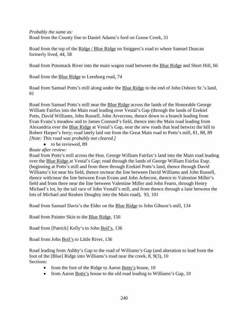
240
Probably the same as: Road from the County line to Daniel Adams’s ford on Goose Creek, 31 Road from the top of the Ridge / Blue Ridge on Sniggers’s road to where Samuel Duncan formerly lived, 44, 58 Road from Potomack River into the main wagon road between the Blue Ridge and Short Hill, 66 Road from the Blue Ridge to Leesburg road, 74 Road from Samuel Potts’s mill along under the Blue Ridge to the end of John Osborn Sr.’s land, 81 Road from Samuel Potts’s mill near the Blue Ridge across the lands of the Honorable George William Fairfax into the Main road leading over Vestal’s Gap (through the lands of Ezekiel Potts, David Williams, John Russell, John Arvecross, thence down to a branch leading from Evan Evans’s meadow and to James Connard’s field, thence into the Main road leading from Alexandria over the Blue Ridge at Vestal’s Gap, near the new roads that lead betwixt the hill to Robert Harper’s ferry; road lately laid out from the Great Main road to Potts’s mill, 81, 88, 89 [Note: This road was probably not cleared.]
• to be reviewed, 89 Route after review: Road from Potts’s mill across the Hon. George William Fairfax’s land into the Main road leading over the Blue Ridge at Vestal’s Gap; road through the lands of George William Fairfax Esqr. (beginning at Potts’s mill and from there through Ezekiel Potts’s land, thence through David Williams’s lot near his field, thence on/near the line between David Williams and John Russell, thence with/near the line between Evan Evans and John Arbecost, thence to Valentine Miller’s field and from there near the line between Valentine Miller and John Fearst, through Henry Michael’s lot, by the tail race of John Vestall’s mill, and from thence through a lane between the lots of Michael and Reuben Doughty into the Main road), 93, 101 Road from Samuel Davis’s the Elder on the Blue Ridge to John Gibson’s mill, 134 Road from Painter Skin to the Blue Ridge, 156 Road from [Patrick] Kelly’s to John Boil’s, 136 Road from John Boil’s to Little River, 136 Road leading from Ashby’s Gap to the road of Williams’s Gap (and alteration to lead from the foot of the [Blue] Ridge into Williams’s road near the creek, 8, 9(3), 10 Sections:
• from the foot of the Ridge to Aaron Botts’s house, 10 • from Aaron Botts’s house to the old road leading to Williams’s Gap, 10
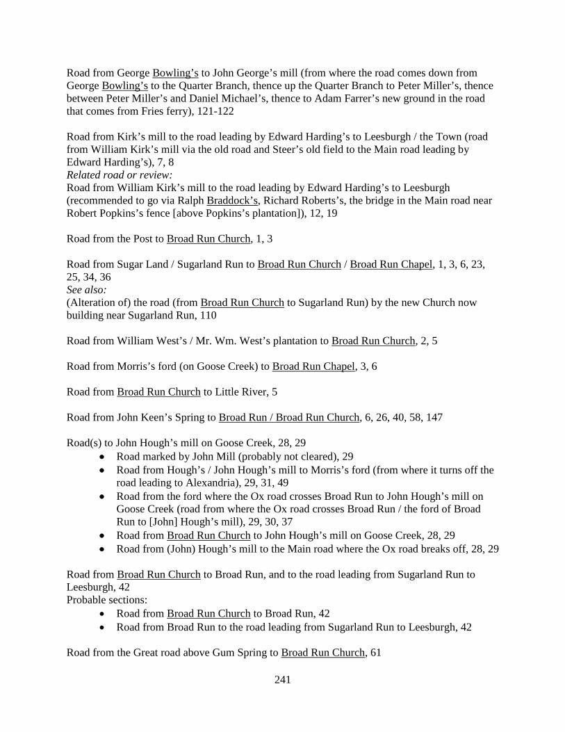
241
Road from George Bowling’s to John George’s mill (from where the road comes down from George Bowling’s to the Quarter Branch, thence up the Quarter Branch to Peter Miller’s, thence between Peter Miller’s and Daniel Michael’s, thence to Adam Farrer’s new ground in the road that comes from Fries ferry), 121-122 Road from Kirk’s mill to the road leading by Edward Harding’s to Leesburgh / the Town (road from William Kirk’s mill via the old road and Steer’s old field to the Main road leading by Edward Harding’s), 7, 8 Related road or review: Road from William Kirk’s mill to the road leading by Edward Harding’s to Leesburgh (recommended to go via Ralph Braddock’s, Richard Roberts’s, the bridge in the Main road near Robert Popkins’s fence [above Popkins’s plantation]), 12, 19 Road from the Post to Broad Run Church, 1, 3 Road from Sugar Land / Sugarland Run to Broad Run Church / Broad Run Chapel, 1, 3, 6, 23, 25, 34, 36 See also: (Alteration of) the road (from Broad Run Church to Sugarland Run) by the new Church now building near Sugarland Run, 110 Road from William West’s / Mr. Wm. West’s plantation to Broad Run Church, 2, 5 Road from Morris’s ford (on Goose Creek) to Broad Run Chapel, 3, 6 Road from Broad Run Church to Little River, 5 Road from John Keen’s Spring to Broad Run / Broad Run Church, 6, 26, 40, 58, 147 Road(s) to John Hough’s mill on Goose Creek, 28, 29
• Road marked by John Mill (probably not cleared), 29 • Road from Hough’s / John Hough’s mill to Morris’s ford (from where it turns off the
road leading to Alexandria), 29, 31, 49 • Road from the ford where the Ox road crosses Broad Run to John Hough’s mill on
Goose Creek (road from where the Ox road crosses Broad Run / the ford of Broad Run to [John] Hough’s mill), 29, 30, 37
• Road from Broad Run Church to John Hough’s mill on Goose Creek, 28, 29 • Road from (John) Hough’s mill to the Main road where the Ox road breaks off, 28, 29
Road from Broad Run Church to Broad Run, and to the road leading from Sugarland Run to Leesburgh, 42 Probable sections:
• Road from Broad Run Church to Broad Run, 42 • Road from Broad Run to the road leading from Sugarland Run to Leesburgh, 42
Road from the Great road above Gum Spring to Broad Run Church, 61
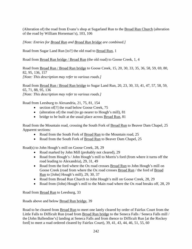
242
(Alteration of) the road from Evans’s shop at Sugarland Run to the Broad Run Church (alteration of the road by William Horseman’s), 103, 106 [Note: Entries for Broad Run and Broad Run bridge are combined.] Road from Sugar Land Run [to?] the old road to Broad Run, 1 Road from Broad Run bridge / Broad Run (the old road) to Goose Creek, 1, 4 Road from Broad Run / Broad Run bridge to Goose Creek, 15, 20, 30, 33, 35, 36, 58, 59, 69, 80, 82, 95, 136, 157 [Note: This description may refer to various roads.] Road from Broad Run / Broad Run bridge to Sugar Land Run, 20, 23, 30, 33, 41, 47, 57, 58, 59, 65, 71, 88, 95, 136 [Note: This description may refer to various roads.] Road from Leesburg to Alexandria, 21, 75, 81, 154
• section of[?] the road below Goose Creek, 75 • (alteration of) the road (to go nearer to Hough’s mill), 81 • bridge to be built at the usual place across Broad Run, 81
Road from the Mountain road, crossing the South Fork of Broad Run to Beaver Dam Chapel, 25 Apparent sections:
• Road from the South Fork of Broad Run to the Mountain road, 25 • Road from the South Fork of Broad Run to Beaver Dam Chapel, 25
Road(s) to John Hough’s mill on Goose Creek, 28, 29
• Road marked by John Mill (probably not cleared), 29 • Road from Hough’s / John Hough’s mill to Morris’s ford (from where it turns off the
road leading to Alexandria), 29, 31, 49 • Road from the ford where the Ox road crosses Broad Run to John Hough’s mill on
Goose Creek (road from where the Ox road crosses Broad Run / the ford of Broad Run to [John] Hough’s mill), 29, 30, 37
• Road from Broad Run Church to John Hough’s mill on Goose Creek, 28, 29 • Road from (John) Hough’s mill to the Main road where the Ox road breaks off, 28, 29
Road from Broad Run to Leesburg, 33 Roads above and below Broad Run bridge, 39 Road to be cleared from Broad Run to meet one lately cleared by order of Fairfax Court from the Little Falls to Difficult Run (road from Broad Run bridge to the Seneca Falls / Seneca Falls mill / the [John Ballendine’s] landing at Seneca Falls and from thence to Difficult Run [at the Rockey ford] to meet a road ordered cleared by Fairfax Court), 39, 41, 43, 44, 46, 51, 55, 60
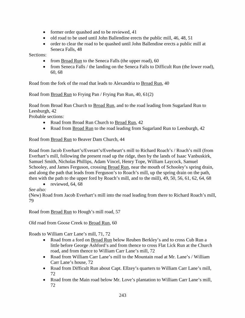
243
• former order quashed and to be reviewed, 41 • old road to be used until John Ballendine erects the public mill, 46, 48, 51 • order to clear the road to be quashed until John Ballendine erects a public mill at
Seneca Falls, 48 Sections:
• from Broad Run to the Seneca Falls (the upper road), 60 • from Seneca Falls / the landing on the Seneca Falls to Difficult Run (the lower road),
60, 68 Road from the fork of the road that leads to Alexandria to Broad Run, 40 Road from Broad Run to Frying Pan / Frying Pan Run, 40, 61(2) Road from Broad Run Church to Broad Run, and to the road leading from Sugarland Run to Leesburgh, 42 Probable sections:
• Road from Broad Run Church to Broad Run, 42 • Road from Broad Run to the road leading from Sugarland Run to Leesburgh, 42
Road from Broad Run to Beaver Dam Church, 44 Road from Jacob Everhart’s/Everart’s/Everheart’s mill to Richard Roach’s / Roach’s mill (from Everhart’s mill, following the present road up the ridge, then by the lands of Isaac Vanbuskirk, Samuel Smith, Nicholas Phillips, Adam Vincel, Henry Tope, William Laycock, Samuel Schooley, and James Ferguson, crossing Broad Run, near the mouth of Schooley’s spring drain, and along the path that leads from Ferguson’s to Roach’s mill, up the spring drain on the path, then with the path to the upper ford by Roach’s mill, and to the mill), 49, 50, 56, 61, 62, 64, 68
• reviewed, 64, 68 See also: (New) Road from Jacob Everhart’s mill into the road leading from there to Richard Roach’s mill, 79 Road from Broad Run to Hough’s mill road, 57 Old road from Goose Creek to Broad Run, 60 Roads to William Carr Lane’s mill, 71, 72
• Road from a ford on Broad Run below Reuben Berkley’s and to cross Cub Run a little before George Ashford’s and from thence to cross Flat Lick Run at the Church road, and from thence to William Carr Lane’s mill, 72
• Road from William Carr Lane’s mill to the Mountain road at Mr. Lane’s / William Carr Lane’s house, 72
• Road from Difficult Run about Capt. Ellzey’s quarters to William Carr Lane’s mill, 72
• Road from the Main road below Mr. Love’s plantation to William Carr Lane’s mill, 72

244
Sections: from Broad Run to Cub Run, 72 from Cub Run to Flack / Flat Lick Run, 72, 83 from Flat Lick to the mill, and from thence to the Mountain road below Samuel
Love’s, 72 Road from Broad Run to the Mountain road, 79 Road from Broad Run to Cox’s mill, 119 Road from Leesburg by Hough’s / William Hough’s mill to Broad Run bridge, 140, 143
• second view ordered, 143 Road from Broad Run bridge to John Dowdal’s mill, 145, 146 Road from Cox’s bridge to Broad Run, 153 Road from Maj. Broadwater’s mill to the Frying Pan road, 111, 113 (Another) road from Thomas Drake’s meadow to Leven Powell’s mill (from Drake’s meadow to Dawson Brown’s plantation, thence across the Beaverdam by Capt. William Bronaugh’s and between William Smith Gent. and Simon Hancock’s, thence across the road leading from Ashby’s Gap to Absalom Ramey’s to strike the road that leads from the ford of Goose Creek on the land of Mr. Owsly, thence along the said road until it meets the road leading from Ashby’s Gap to Leven Powell’s mill), 120, 121 See also: (Another) road from Thomas Drake’s meadow to Leven Powell’s mill (from Drake’s meadow down the old road to a lane between Isaac Brown’s field and Joshua Dixon’s thence running between Isaac and Dawson Brown to the Beaverdam, thence up a hollow to Capt. William Bronaugh’s land thence with his line and William Owsley’s to a lane between said Bronaugh and Owsley, thence on a line between Thos. Owsley and Thomas Williams, thence through a corner of Capt. Wm. Cock’s land to the mouth of Joseph Combs’s lane, thence to his mill thence along Mr. Leven Powell’s Church road to his mill), 124, 128 Road from the Vestry House to the Mountain Church (beginning at the Great road some distance below the Vestry House at or near the line between Janney and Gore thence with or near the said line to a corner to Janney and Hoge, thence below Hoge’s Meadow and through his land, across a spring branch, to the present road at the head of a valley near the stone cabin, then down the valley to the northwest fork of Goose Creek, thence across Brown’s low grounds, across a spring branch, up the hill to a line of blazed trees, thence along Thomas Gregg’s plantation, near John Garrett’s field, and by Thomas Garrett’s field to the Mountain road that leads to the [Mountain] Church), 125, 126-127
• to be viewed again, 125 Road from the Mine bridge to the ford of Difficult Run at Mr. Thomas Lewis’s plantation (to leave the Main road leading to Alexandria a little way below the Mine bridge and to continue
245
along a ridge between Benjamin Brown’s and Samuel Yates’s to the old ford on Colvins Branch, thence along a ridge past Nicholas Money’s to the ford on Difficult Run at Mr. Thomas Lewis’s plantation), 124, 131 (Another) road from Thomas Drake’s meadow to Leven Powell’s mill (from Drake’s meadow to Dawson Brown’s plantation, thence across the Beaverdam by Capt. William Bronaugh’s and between William Smith Gent. and Simon Hancock’s, thence across the road leading from Ashby’s Gap to Absalom Ramey’s to strike the road that leads from the ford of Goose Creek on the land of Mr. Owsly, thence along the said road until it meets the road leading from Ashby’s Gap to Leven Powell’s mill), 120, 121 See also: (Another) road from Thomas Drake’s meadow to Leven Powell’s mill (from Drake’s meadow down the old road to a lane between Isaac Brown’s field and Joshua Dixon’s thence running between Isaac and Dawson Brown to the Beaverdam, thence up a hollow to Capt. William Bronaugh’s land thence with his line and William Owsley’s to a lane between said Bronaugh and Owsley, thence on a line between Thos. Owsley and Thomas Williams, thence through a corner of Capt. Wm. Cock’s land to the mouth of Joseph Combs’s lane, thence to his mill thence along Mr. Leven Powell’s Church road to his mill), 124, 128 Road from Henry Brown’s plantation near George Hann’s and Mercer Brown’s by his present dwelling house to Richard Roach’s mill (road from Henry Brown’s plantation to Roach’s mill), 105, 112 (Another) road from Thomas Drake’s meadow to Leven Powell’s mill (from Drake’s meadow to Dawson Brown’s plantation, thence across the Beaverdam by Capt. William Bronaugh’s and between William Smith Gent. and Simon Hancock’s, thence across the road leading from Ashby’s Gap to Absalom Ramey’s to strike the road that leads from the ford of Goose Creek on the land of Mr. Owsly, thence along the said road until it meets the road leading from Ashby’s Gap to Leven Powell’s mill), 120, 121 See also: (Another) road from Thomas Drake’s meadow to Leven Powell’s mill (from Drake’s meadow down the old road to a lane between Isaac Brown’s field and Joshua Dixon’s thence running between Isaac and Dawson Brown to the Beaverdam, thence up a hollow to Capt. William Bronaugh’s land thence with his line and William Owsley’s to a lane between said Bronaugh and Owsley, thence on a line between Thos. Owsley and Thomas Williams, thence through a corner of Capt. Wm. Cock’s land to the mouth of Joseph Combs’s lane, thence to his mill thence along Mr. Leven Powell’s Church road to his mill), 124, 128 Road from Richard Thatcher’s in Williams’s Gap into the Mountain road to Leesburg; road from Richard Thatcher’s in Williams’s Gap to Thomas Shepard’s mill and from thence into the Main road leading to Leesburg (old road to be continued and straightened from Richard Thatcher’s lane to [Thomas] Shepard’s mill and also from the mill via the lands of [Thomas] Shepard, William Tate, John Gregg, on the line betwixt Gregg and John Brown thence through Harman Cox’s land, the land in possession of John Grant, the line betwixt Timothy Howell and said Grant into the Main road to Leesburg), 77, 86-87, 87, 92
246
Road from (Israel) Thompson’s mill to a new mill of (John) Brown and others, 77, 82 • rejected, 82
Road from William Neilson’s plantation to Leesburg by John Brown’s and John Gregg’s plantations; road from William Neilson’s plantation to Leesburg (turning out of the old road near the corner of William Neilson’s field, thence to Robert Mcwhorter’s field who is a tenant on Col. Tayloe’s land, crossing Neilson’s and John Gregg’s land, thence to continue on the line between Tayloe and Gregg, thence on the line between John Brown and John Gregg, [to where the first viewers ordered it to be crossing a branch of Goose Creek that comes from Nicholas Osburn’s], thence into the old road again on the land of Harmon Cox), 122, 129
• review, 122, 129 Road from Henry Brown’s plantation near George Hann’s and Mercer Brown’s by his present dwelling house to Richard Roach’s mill (road from Henry Brown’s plantation to Roach’s mill), 105, 112 Road from Mercer Brown’s mill into the road to Pain’s ferry, 128 Road from Mercer Brown’s mill towards the Short Hill, 130
• to be viewed again, 130 Road from Mercer Brown’s mill to the Dutch mill (from Mercer Brown’s mill to John Hetton’s and thence to Anthony Souder’s, Jacob Fri’s, and Conrod Hickman’s, and then to the Dutch mill), 131 Road from the Main road to meet another road cleared in Fauquier County, at the County line, to go toward George Hill’s quarter (road from the Main road to meet a road cleared in Fauquier County (to begin at the Main road near Richard Crupper’s at a Glade, thence to the line of John Swart, to William Brown’s line, to the line of Chinn and to the County line, where it meets the road cleared by order of Fauquier Court), 122, 125 [Note: Entries for Bruester and Bruistoe are combined.] Road from the Widow Bruistoe’s landing to Difficult Run, 38 Road to be opened from the Widow Bruester’s landing to Ballendine’s road, 64, 65 Road from William Smith’s under the Short Hill to Farling Ball’s mill (road from William Smith’s to Farling Ball’s mill, beginning at William Smith’s, going with an old path to a place belonging to James Clemons, and along the lines of John Folkes, Adam Axlyne, John Jackson, John Axline, and Abner Roberts’s, until it crosses the Buffaloe Branch, into the road leading to Pain’s, and with it near a line between Hutton &c. and down to Farling Ball’s mill), 74, 78 Probably the same as:
• Road from William Smith’s to Farling Ball’s mill, 109 • Road from Farling Ball’s mill to the Short Hill, 140
247
Road (from the Great road leading from Newgate to Bull Run) to Bull Run Meeting House, 137 Road from the Main road leading from Ashby’s Gap to Capt. William West’s (to cross Bull Run Mountain at George Berry’s), 49
• portion in Fauquier County, from the County line to George Berry’s (Fauquier County requested to clear), 49
Road from Rockey Run Church to Bull Run (to turn out of the Mountain road about a mile below the Church and along an old path to Bull Run opposite to Blackburn’s quarter), 11, 15 Road from the Mountain road by Capt. James Lane’s mill to the road leading to Bull Run (road from the Mountain road by James Lane’s mill over Bull Run; James Lane, Gent.’s mill road, from the Mountain road to Bull Run; road from the Mountain road by Lane’s mill to the Bull Run road), 35, 42, 45, 91 (Road to Bull Run; road from Charles West’s house to Bull Run) to go by where Charles West now lives and from thence to the new road now cleared, and so along the new road to Bull Run, 63, 70 Road from Bull Run to Little River, 92, 93 Probable sections:
• Road from Bull Run to the Forks, 124 • Road from the Forks to Little River, 124
Road from Wilson’s ford on Bull Run to James Lane’s grist mill; road from Wilson’s ford on Bull Run to Capt. Lane’s mill (through the lands of the Hon. Robert Carter, William Mitchell and James Lane), 110, 123 Road from the Loudoun line at the north thoroughfare of Bull Run to the Baptist Meeting House at Joseph Hutchison’s, 132 Road (from the Great road leading from Newgate to Bull Run) to Bull Run Meeting House, 137 Road from the Mountain road to Bull Run, 139 Road leading out of the Mountain road by William Lane’s mill to the road leading from Newgate to Bull Run; Capt. [William] Lane’s mill road, 141, 150 Road from John Fryer’s ford on Bull Run to the Mountain road, 143 the Carolina road, 143, 144
• section from Little River to Bull Run, 143 Road from Canby’s mill by William Hoge’s into the Frederick road near Joseph Cadwallader’s; road from Samuel Canby’s mill to the Frederick road near Joseph Cadwallader’s (by the plantation where Thomas Moore, to the top of the mountain near/along the present path and by

248
William Holmes’s house/barn/fence, to the lane in the line between William Holmes’s and Samuel Combs’s plantations, thence to the line between Samuel Combs’s and Richard White’s, to the road that goes by Jacob Janney’s mill, and by the lines of Samuel Davis and Francis Clark into the Frederick road by Goodwin’s ordinary, 98, 102 Sections:
• from Samuel Combs’s house to Samuel Canby’s mill, 102 • the residue, 102
See also: Road from Canby’s mill to Goodwin’s ordinary through the land of Jacob Janney (to be re-viewed), 116 Road from Mahlon Janney’s mill across the Kittockton Mountain by William Cavins’s plantation into the road leading from Leesburg to Noland’s ferry; road from Mahlon Janny’s mill to the Great road leading from Noland’s ferry (from the Quaker Meeting House on the line between William Schooley’s land and land that William Morrison lives on, then across William Schooley’s land, thence on the line between Schooley’s land and Joseph Caldwell’s, then between Joseph Caldwell’s land and William Cavins’s, thence along an old road to the line between Mr. Mason’s and Mr. Page’s land, thence to the Noland’s ferry road), 116, 120 This is apparently a different road than: Road from Mahlon Janney’s mill through the neighborhood by William Cavins’s, 117 Road from George Iserman’s mill to Callaham’s ferry and also into the Mill Stone road, 149(2) Road from Leesburg into the road leading from the said town to Campbell’s ferry, 107 (Alteration of) the road from Maj. Samuel Cox’s mill to John Campbell’s field, 157 Road from the Glebe (of Cameron) to Joseph Cross’s mill on Horsepen Run, 125 May be the same as: Road from the Rev. Spence Grayson’s to Cross’s mill, 131 Road from the road at Canary’s to the Town [Leesburg], 5 Road from Williams’s Gap to Leesburgh (to turn out of the road at the foot of the [Blue Ridge] Mountain near Cumpton’s path and by the Roundhill thence to Nathan Spencer’s and thence to Jacob Janney’s mill thence into the Great road near Richard Canary’s), 12(2) Sections:
• from Nathan Spencer’s to Richard Canary’s, 12 • from the foot of the Blue Ridge to [Nathan] Spencer’s (road from Nathan Spencer’s
to Williams’s Gap / the road near Williams’s Gap), 12, 32, 47 Roads from the Glebe of Shelburne Parish to the Church at Roszell, to Canby’s mill, and to the Vestry House (roads from the Glebe to the Church at Roszell’s, to Canby’s mill and to Thomas Clew’s), 116, 118
• former view to be set aside / new view ordered, 118
249
Road from Little River to Canby’s mill, 143 Road leading from the new road on the ridge to Canby’s mill near Thomas Gregg’s thence by Robert McCully’s to Col. Triplett’s mill (road from the road near Thomas Gregg’s to Col. Simon Triplett’s mill), 148, 150 Road from Thomas Garret’s/Garrett’s (at the Mountain road) to Joseph Janney’s mill (road to run from the Mountain road upon the line between Garret and Nickols to Canby’s road, then along said road to the foot of a hill, opposite Thomas Gregg’s meadow then along the side of the hill to Benja. Cleary’s land then through his woodland down to Janney’s mill), 153, 154, 157
• upon review, to be opened agreeable to the first report till it clears the land of Garrett and then by the last report, 157
Road from Canby’s mill by William Hoge’s into the Frederick road near Joseph Cadwallader’s; road from Samuel Canby’s mill to the Frederick road near Joseph Cadwallader’s (by the plantation where Thomas Moore, to the top of the mountain near/along the present path and by William Holmes’s house/barn/fence, to the lane in the line between William Holmes’s and Samuel Combs’s plantations, thence to the line between Samuel Combs’s and Richard White’s, to the road that goes by Jacob Janney’s mill, and by the lines of Samuel Davis and Francis Clark into the Frederick road by Goodwin’s ordinary, 98, 102 Sections:
• from Samuel Combs’s house to Samuel Canby’s mill, 102 • the residue, 102
See also: Road from Canby’s mill to Goodwin’s ordinary through the land of Jacob Janney (to be re-viewed), 116 Road from Canby’s mill by Thomas Gregg’s (potter) to the Great road leading from Snicker’s Gap to Alexandria by James Martin’s plantation, 99 May be a different road or a second view: Road from [Samuel] Canby’s mill to James Martin’s, to go by the plantation of Thomas Gregg (potter) (road from Canby’s mill to James Martin’s: to go along the road towards Leesburg, thence by the upper side of Evan Wilkison’s plantation across the Northwest Fork of Goose Creek, thence to and through the plantation of Thomas Gregg (potter), and with the old Shennadore Tract to the Frederick road below James Martin’s plantation), 111, 117, 124 (Alteration of) the road from the fork at William Mead’s to Samuel Canby’s mill on the North Fork of Goose Creek (to leave the old road between Canby’s mill and George Wilson’s), 90(2) See also: Road from William Mead’s to Samuel Canby’s mill (route to be shown by Samuel Cheshire), 98 Road from the Main road near William Harper’s to William Carnan’s mill, 112 Related road: Road from William Carnan’s mill to the Main road leading towards Difficult bridge, 112 Road from Noland’s ferry towards Carolina (through George Town [Leesburg]), 4(2)

250
Road from Siccolons Run / Secolon / the ford of Seconell to Dawson’s ford (on Goose Creek), 14, 86, 116 See also: Road leading from Seconell Run to Goose Creek [and] Road leading from Goose Creek to the Carolina road, 141 Probably the same as: Road from Seconells Branch to Col. Simon Triplett’s mill and from thence to the Carolina road, 158 Road from Ashby’s Gap above Goose Creek to Leesburg (road from Ashby’s Gap to William Mead’s), 33, 38(2) Sections:
• from William Mead’s to Joseph Gardner’s field (road from where it leaves the Carolina road near William Mead’s to Joseph Gardner’s plantation; road from Joseph Gardner’s to the Goose Creek road below William Mead’s), 38-39, 43, 69
• from Joseph Gardner’s field to the (Mountain) road (near Thomas Starks’s house), 38-39, 41, 43
Related road: Road from Thomas Starks’s to William Mead’s, 40, 43
• to be viewed and determined if necessary, 40 • road in use to be retained, 43
Road from Leesburgh to Secolon, 36, 58 See also: Road from Leesburg the Carolina road to Secolon; road from Leesburg to Secolon the way to Capt. West’s, 40, 47 Road from the ford of Little River on the Carolina road to Capt. West’s Church road at John Keen’s Spring (road from the Carolina road near Little River to Capt. West’s Church road at John Keen’s Spring), 39, 41 Streets of/in Leesburg, 70, 113, 123, 139, 145, 157
• to extend along the Carolina road to the Tanyard Run, 145 • Leesburg Town road [Note: road, not roads], 86
Road from Pullin’s/Pulling’s / Charles Pullin’s to Cox’s mill (to leave the old road a little above Charles Pullin’s where the old mill tract leaves the same, keeping the old path through John Reign’s land to the head of the long glade and from thence to Bever’s road), 124, 128, 129
• to be reviewed, 129 Route after review: Road from Charles/Chas. Pullen’s to Cox’s / Samuel Cox’s mill (to leave the Carolina road at the upper end of Richard fence, and from thence to the old Church road ford on Owsleys Branch, from thence by Jacob Gardner’s house and along Thomas Kelley’s fence and along Kelley’s line between him and William Musgrove, up a branch, then along a ridge to Jonathan Davis’s new field on the Main road leading to Cox’s mill), 132, 138
251
Road from Simon Triplett Gent.’s mill to cross Little River near Joshua Taylor’s plantation and to intersect the Carolina road near Charles Pullen’s; road from Simon Triplett’s mill to the Carolina road (to take out of the cleared road near William McNabb’s plantation, thence through a corner of Michael Gahagan’s cleared ground, thence to the Watry Branch, thence to and through Joshua Taylor’s plantation to Little River near the line between Phineas Skinner’s and Nicholas Wyckoff’s thence with their line and the line between Charles Pullen and Richard Skinner to James Wrightmire’s shop), 125, 127 Road from William Cotton’s to Cox’s mill (to be viewed, reviewed, and then viewed again), 127, 129, 131, 132, 133 Proposed route after first review: Road from William Cotton’s to [Samuel] Cox’s mill (to leave the Carolina road near Golding’s shop, thence running back of the house of Cornelius Holdren, to Joseph Moxley’s field, following the old road through Amos Dunham’s field, and to the road leading to Saml. Cox’s mill), 131 Route after second view: Road from William Cotton’s to Cox’s mill (to go through Cornelius Holdren’s lane and to the ridge where it intersects Moxly’s and Conner’s line, with Conner’s line to the Black Branch and thence to Cox’s mill along the old Tract), 133 (Alteration of) the Carolina road round Mr./Josiah Moffett’s plantation, 134(2)
• to be reviewed (as to whether the Carolina road can be more conveniently turned round by William Moss’s, to take out of the road as it runs at present between Leesburg and Tuscarrora and in again near William Mead’s, and also to view whether the road leading by Cox’s mill from Leesburg cannot be continued along the Carolina road until it passes Mr. Moffett’s new clearing and then be carried on the line between said Moffett and William Moss), 135
Roads from/to George Nixon’s mill:
• from George Nixon’s mill to Samuel Hough’s mill, 142, 144 • from George Nixon’s mill to William Hough’s mill, 142, 144 • from George Nixon’s mill to William Cotton Sr.’s, 142 • Road from the Carolina road to Nixon’s mill, 144 • Road from William Mead’s to George Nixon’s mill, 145
the Carolina road, 143, 144
• section from Little River to Bull Run, 143 (Alteration of) the road from the Carolina road to Powell’s mill, 143 (Alteration of) the Carolina road (as proposed by William McClellan), 149(2) Road from the Main Carolina road to Thornton’s quarter, 155 Road from James Lane’s mill to Carr Town, 129
252
(Alteration of) the road by John Carr, 29 (Alteration of) the road leading from Leesburg to Winchester (petitioned by Peter Carr), 155(2)
• to be reviewed, 156 • Road to be continued without alteration, 157
Outlet [road] from Dempsey Carroll’s plantation to the Main road, 82 Road from Leesburg to Moxley’s ferry, 142
• to be opened as it antiently run, 142 • (alteration of) the road leading from Leesburg to Moxley’s ferry through the lands of
Mrs. Page, 156 • Road from Leesburg to Moxley’s ferry (to go by the house of John Sanders to
Carter’s line and to come into the Town at Drishes), 158 Road from Thomas Drake’s to Leven Powell’s grist mill; road from Thomas Drake’s meadow to Hezekiah Guy’s grist mill, and near the Quaker Meeting House and thence to cross Goose Creek at James Leith’s and to Leven Powell’s mill road; road from Thomas Drake’s meadow to Hezekiah Guy’s grist mill and near the Quaker Meeting House and from thence to Leven Powell’s mill (beginning at Thomas Drake’s meadow, thence through James Carter’s lane and by Malakiah Cumming’s field, thence through the lands of Samuel Smith, John Neal, Thomas Smith, Thomas Russell, Thomas Lewis, thence into the old tract in or near Richard Hanson’s grubbing, thence to a good ford on Goose Creek and along the bottom of the creek, and to Leven Powell’s mill), 100, 103-104, 108, 109, 119 Sections:
• [from Drake’s] to Goose Creek, 108, 109, 119 • from Goose Creek (by James Leith’s plantation) to Powell’s mill, 108, 109
Road from the Gum Spring near Vincent Lewis’s to John Carter’s mill, 38 See also: (New) road from Carter’s mill into the Main road near Vincent Lewis’s (road from the Gum Spring to Mr. John Carter’s mill; road from the Gum Spring the new road to John Carter’s mill), 55(2), 69 Road from Carter’s mill into the Mountain road near Fielding Turner’s (road from John Carter’s lane to the Long Branch along the old Wagon road thence by the Rock hill, thence crossing Elk Licking Run to the head of Salisbury Plains and thence to the ford of Cub Run where the old bridge was), 55, 55-56 Road from Wilson’s ford on Bull Run to James Lane’s grist mill; road from Wilson’s ford on Bull Run to Capt. Lane’s mill (through the lands of the Hon. Robert Carter, William Mitchell and James Lane), 110, 123 Road from William Dodd’s / William Dodd’s house to Catocton Creek / Kittocton Creek / Kittocton, 26, 33(2), 37, 42, 59(2)

253
Road from the ford of Goose Creek to Noland’s ferry (leading out of the Alexandria road into the Leesburg road by Hugh Fouch’s and through the Cat Tail Meadow plantation, via the lands of Robert Adams and Richard Mets, to a red oak tree marked with three notches standing near the side of the said Leesburg road, and across the road, down a valley, and into the road again near Hugh Fouch’s fence), 89, 90-91 [Note: Entries for Cavens and Cavins are combined.] Road from the Meeting House (by [John] Cavens’s) across the mountain the nearest way to Thomson Mason’s mill, 62, 64 Road from Mahlon Janney’s mill across the Kittockton Mountain by William Cavins’s plantation into the road leading from Leesburg to Noland’s ferry; road from Mahlon Janny’s mill to the Great road leading from Noland’s ferry (from the Quaker Meeting House on the line between William Schooley’s land and land that William Morrison lives on, then across William Schooley’s land, thence on the line between Schooley’s land and Joseph Caldwell’s, then between Joseph Caldwell’s land and William Cavins’s, thence along an old road to the line between Mr. Mason’s and Mr. Page’s land, thence to the Noland’s ferry road), 116, 120 This is apparently a different road than: Road from Mahlon Janney’s mill through the neighborhood by William Cavins’s, 117 Road from Adams’s ford on Goose Creek to where the road crosses Little River (road from Adams’s ford down to the Mountain road by John Champ’s), 10, 11 Road leading from Sniggers’s Mountain road to Ashby’s Gap (to be cleared from Champes Mountain as it now stands to Ashby’s Gap), 48 Road from Champes Mountain to the big branch / great branch by Leven Powell’s, 48 Road from Chinn’s old fields to Champes Mountains, 67 Road from Levin Powell’s mill road to Champes Mountain, 85 Road from the Loudoun County line into the Great Mountain road that leads from West’s ordinary to Snickers’s Gap (beginning at Fauquier County line at the end of the new road cleared by an order of the Court of Fauquier and running thence through Benjamin Chandler’s plantation, a corner of the Widow Morris’s field, and by James Lampkin’s plantation, crossing Little River at the mouth of William Berkley’s spring branch to Powell’s mill road, and with the said road to Snicker’s Gap road), 73, 79-80 (Alteration of) the road through/round Benjamin Chandler’s plantation, 105, 128 (Alteration of) the road from the fork at William Mead’s to Samuel Canby’s mill on the North Fork of Goose Creek (to leave the old road between Canby’s mill and George Wilson’s), 90(2) See also:

254
Road from William Mead’s to Samuel Canby’s mill (route to be shown by Samuel Cheshire), 98 Road from Goose Creek to Chinn’s old field, 67 Road from Chinn’s old fields to Champes Mountains, 67 (New) road from Chinn’s old field to the (Fauquier) County line, 71, 85 Road from the Main road to meet another road cleared in Fauquier County, at the County line, to go toward George Hill’s quarter (road from the Main road to meet a road cleared in Fauquier County (to begin at the Main road near Richard Crupper’s at a Glade, thence to the line of John Swart, to William Brown’s line, to the line of Chinn and to the County line, where it meets the road cleared by order of Fauquier Court), 122, 125 Road from (Charles) Chinn’s (Spring) Branch to the Wancopin / Wancopin Branch / Wonkapin (and thence to the mill road at James Sinklair’s), 85, 143, 154 Sections:
• from Chinn’s Branch to the Wancopin Branch, 85, 143, 154 • from [the Wancopin Branch] to the mill road at James Sinklair’s, 154
Road from Goose Creek to Charles Chinn’s Spring Branch, 85 Road from the branch below Mr. Levin Powell’s plantation to Goose Creek, (to be taken from the old road at the upper end of an old field near Leven Powell’s plantation and along Leven Powell’s and Elijah Chinn’s line to near Christopher Chinn’s plantation thence along and crossing a small branch, and keeping partly a direct course to the old road about half a mile above Thomas Chinn’s plantation near where a small path goes into the same), 51, 52 Road from the big road leading from Ashby’s Gap at the upper end of Elijah Chinn’s (road from the big road leading from Ashby’s Gap at the upper end of Elijah Chinn’s old field, along the path from Chinn’s to George Heale’s quarter, supposed to be in or near the County line), 49 Road from the branch below Mr. Levin Powell’s plantation to Goose Creek, (to be taken from the old road at the upper end of an old field near Leven Powell’s plantation and along Leven Powell’s and Elijah Chinn’s line to near Christopher Chinn’s plantation thence along and crossing a small branch, and keeping partly a direct course to the old road about half a mile above Thomas Chinn’s plantation near where a small path goes into the same), 51, 52 Road from the branch below Mr. Levin Powell’s plantation to Goose Creek, (to be taken from the old road at the upper end of an old field near Leven Powell’s plantation and along Leven Powell’s and Elijah Chinn’s line to near Christopher Chinn’s plantation thence along and crossing a small branch, and keeping partly a direct course to the old road about half a mile above Thomas Chinn’s plantation near where a small path goes into the same), 51, 52 (Alteration of) the road by Leven Powell and Thomas Chinn (near their plantations), 71(2)
255
[Note: For roads associated with a specific chapel or church (i.e., Broad Run Chapel/Church, Goose Creek Church, Mountain Church, Rockey Run Church, etc.), please see the entries for the particular chapel or church.] Road from Williams’s Gap to the new Church, 37, 59 Road by the new Church, 133 Road from Goose Creek to Bacon Fort, 1, 47 Probable sections:
• Road from the Beaver Dam to Bacon Fort, 50, 76 • Road from the Beaver Dam / the Beaver dams to Goose Creek, 50, 54, 74 • Road leading from Goose Creek to the forks above the Church, 141 • Road leading from the forks above the Church to Bacon Fort, 141
Road from Dawson’s ford on Goose Creek into the Church road by Thomas Beavers’s (road from Dawson’s ford, running up a branch, by a cabin, and by Daniel’s old field into the Church road by Thomas Beavers’s), 38, 39, 43, 103 Road from the ford of Little River on the Carolina road to Capt. West’s Church road at John Keen’s Spring (road from the Carolina road near Little River to Capt. West’s Church road at John Keen’s Spring), 39, 41 Roads to William Carr Lane’s mill, 71, 72
• Road from a ford on Broad Run below Reuben Berkley’s and to cross Cub Run a little before George Ashford’s and from thence to cross Flat Lick Run at the Church road, and from thence to William Carr Lane’s mill, 72
• Road from William Carr Lane’s mill to the Mountain road at Mr. Lane’s / William Carr Lane’s house, 72
• Road from Difficult Run about Capt. Ellzey’s quarters to William Carr Lane’s mill, 72
• Road from the Main road below Mr. Love’s plantation to William Carr Lane’s mill, 72 Sections: from Broad Run to Cub Run, 72 from Cub Run to Flack / Flat Lick Run, 72, 83 from Flat Lick to the mill, and from thence to the Mountain road below Samuel
Love’s, 72 Road(s) to Leven Powell’s mill, 76, 77
• Road from Leven Powell’s / Col. Powell’s mill to Fauquier County line that goes under the Mountain (from Leven Powell’s mill, crossing Little River at an old ford and through Capt. Francis Peyton’s quarter plantation and going as near the foot the Mountain as the ground will admit of to Fauquier County line), 77, 84, 104, 143
• Road from Leven Powell’s mill to the Mountain at Mercer’s mill (from Leven Powell’s mill thence down the river and via Thomas Gibson’s, James Sinkler’s
256
plantation, and Mr. Mercer’s quarter plantation and up a little hill to the Great road leading from Snicker’s Gap), 77
• Road from Leven Powell’s mill to the road leading from French’s quarter; road from Levin Powell’s mill to Thomas Owsley’s ford on Goose Creek (from Leven Powell’s mill to James Battson’s [northward of Richard Crupper’s plantation] and from Battson’s along the old road to the Church road thence with the Church road to Thomas Owsley’s wagon road and crossing Goose Creek at his ford and through his plantation to the road that comes down by French’s quarter), 77, 85
• (Fauquier County requested to clear) road from Fauquier Court house to meet one cleared from Leven Powell’s mill to the County line, 89
Roads from the Glebe of Shelburne Parish to the Church at Roszell, to Canby’s mill, and to the Vestry House (roads from the Glebe to the Church at Roszell’s, to Canby’s mill and to Thomas Clew’s), 116, 118
• former view to be set aside / new view ordered, 118 Road from Sugar Land / Sugarland Run to Broad Run Church / Broad Run Chapel, 1, 3, 6, 23, 25, 34, 36 See also: (Alteration of) the road (from Broad Run Church to Sugarland Run) by the new Church now building near Sugarland Run, 110 Road from Simon Triplett’s house to the Mountain road, 106 This is apparently a different road than: Road from the Mountain road near the Church by Simon Triplett’s mill and near Jacob Read’s (road to begin near the Church and to lead to Simon Triplett’s mill; road from the Mountain road near the Church to Simon Triplett’s mill, from the lane between Garrett and McGeach and along their line to the great bent of the southwest fork of Goose Creek, and from thence between the plantations of Fitzimons and the Widow Williams, to Simon Triplett’s mill, and thence near Mr. Triplett’s house in the old road, and continue with old road to and through the plantation of William McNabb and near McNabb’s house into the old road again, and to the plantation of Jacob Read, and into the Mountain road), 112, 113, 113-114 (Another) road from Thomas Drake’s meadow to Leven Powell’s mill (from Drake’s meadow to Dawson Brown’s plantation, thence across the Beaverdam by Capt. William Bronaugh’s and between William Smith Gent. and Simon Hancock’s, thence across the road leading from Ashby’s Gap to Absalom Ramey’s to strike the road that leads from the ford of Goose Creek on the land of Mr. Owsly, thence along the said road until it meets the road leading from Ashby’s Gap to Leven Powell’s mill), 120, 121 See also: (Another) road from Thomas Drake’s meadow to Leven Powell’s mill (from Drake’s meadow down the old road to a lane between Isaac Brown’s field and Joshua Dixon’s thence running between Isaac and Dawson Brown to the Beaverdam, thence up a hollow to Capt. William Bronaugh’s land thence with his line and William Owsley’s to a lane between said Bronaugh and Owsley, thence on a line between Thos. Owsley and Thomas Williams, thence through a corner

257
of Capt. Wm. Cock’s land to the mouth of Joseph Combs’s lane, thence to his mill thence along Mr. Leven Powell’s Church road to his mill), 124, 128 Road from Pullin’s / Pulling’s / Charles Pullin’s to Cox’s mill (to leave the old road a little above Charles Pullin’s where the old mill tract leaves the same, keeping the old path through John Reign’s land to the head of the long glade and from thence to Bever’s road), 124, 128, 129
• to be reviewed, 129 Route after review: Road from Charles/Chas. Pullen’s to Cox’s / Samuel Cox’s mill (to leave the Carolina road at the upper end of Richard fence, and from thence to the old Church road ford on Owsleys Branch, from thence by Jacob Gardner’s house and along Thomas Kelley’s fence and along Kelley’s line between him and William Musgrove, up a branch, then along a ridge to Jonathan Davis’s new field on the Main road leading to Cox’s mill), 132, 138 Road from Cross’s mill to Sugarland Run, 129, 130, 142
• to go by the Church now building), 130 (Alteration of) the road (which now leads by Robert Bland’s) so it may lead by the Church, 130 (Alteration of) the Church road from the corner of Capt. Turbervill’s plantation to the Ox road (turning the Church road from below Capt. Turbervill’s fence thence across Frying Pan Run, and then along a line between William Southard and Hardage Lane to the Ox road), 130, 131 (Alteration of) the Church road from James Lane’s to Adam Mitchell’s, 134 Road from Goose Creek by Cox’s mill to the Gumspring and from thence to the fork below the Church, 147 Sections:
• from Goose Creek by Cox’s mill to the Gumspring, 147 • from [the Gumspring] to the fork below the Church, 147
the Church road, 150 Road from Jenny’s [Janny’s] mill into the main road leading from Leesburgh to Clapham’s and Noland’s ferries (road from Janney’s mill to the road from Leesburg to Noland’s ferry), 22, 24 May be same as: Road from Noland’s ferry to the road to Mahlon Janney’s (road from Mahlon Janney’s mill to the road leading from Leesburg to Noland’s ferry), 55, 79 Road from the road leading to Noland’s ferry / from Noland’s ferry to the ferry of Josias Clapham, Gent. (road from the ford by John Gibson’s, going by a run and an old field, to the main road; road from Mr. Clapham’s ferry to the fork of Noland’s road), 3(3), 5 May be the same as: Road from Mr. Clapham’s ferry landing to the fork of the roads, 34 Road to Josias Clapham’s ferry or ford, 17
258
Road(s) from John Trammell’s mill, 31, 34, 35
• Road from John Trammell’s mill to the road that leads from William Douglass’s plantation to David Smith’s plantation so as to intersect the road between the said Douglass’s and Smith’s plantations (road from John Trammell’s mill to David Smith’s; road from Trammell’s mill up an old path to John Lester’s line thence via Lester’s line and Josias Clapham’s line to the ferry road and along the road to a path that leads to David Smith’s near William Woolard’s fence), 31, 34
• Road from John Trammell’s mill to the road below Mr. Lee Massey’s leading to Leesburgh (road from John Trammell’s mill towards Mr. Massey’s, to go toward Leesburg; road from Trammell’s mill via the path to William Jones’s, by Mr. Massey’s fence, and to the [Main] road from Noland’s ferry to Leesburg), 31, 34, 35
• Route through George West’s land in dispute; review ordered, 35 Road from Josias Clapham’s house to John Trammell’s mill road, 37 Road from Josias Clapham’s Riverside plantation to Leesburg; road from Josias Clapham’s Riverside plantation into the road leading from Noland’s ferry to Leesburg (from Josias Clapham’s orchard fence to part of an old road near Samuel Erwin’s, and with blazed trees to an old road or path near a gate on the plantation where Josias Clapham now lives, thence with the old road into Noland’s ferry road at Jason Thomas’s), 99, 105 Road from Canby’s mill by William Hoge’s into the Frederick road near Joseph Cadwallader’s; road from Samuel Canby’s mill to the Frederick road near Joseph Cadwallader’s (by the plantation where Thomas Moore, to the top of the mountain near/along the present path and by William Holmes’s house/barn/fence, to the lane in the line between William Holmes’s and Samuel Combs’s plantations, thence to the line between Samuel Combs’s and Richard White’s, to the road that goes by Jacob Janney’s mill, and by the lines of Samuel Davis and Francis Clark into the Frederick road by Goodwin’s ordinary, 98, 102 Sections:
• from Samuel Combs’s house to Samuel Canby’s mill, 102 • the residue, 102
See also: Road from Canby’s mill to Goodwin’s ordinary through the land of Jacob Janney (to be re-viewed), 116 Road from William Kirk’s mill to the road leading by William Dodd’s to Leesburgh (from William Kirk’s with or near the old road to Edwd. Norton’s plantation, Sands’s plantation, Claypoole’s, Patrick Rice’s house, the Meeting House, and to the Main road by William Dodd’s), 7(2) Road from William Dodd’s to/toward Williams’s Gap (turning out of the Main county road near the corner of Owen Robert’s fence and William Dodd’s thence a direct course towards Williams’s Gap through Joseph Claypoole’s lane and by Jehu Lewis’s, Mahlon Kirkbride’s, James Dillion’s, the lands of Col. G. W. Fairfax, Nicholas Osborn’s, then turning round Taylor’s Hill to John Pearce’s and from there to Williams’s Gap), 32, 35, 36

259
Sections: • [from William Dodd’s] to a run that leads down by Isaac Nichols’s (road from
William Dodd’s to the head of Isaac Nicholls’s Run), 36, 51 • from the run by Isaac Nichols’s to Williams’s Gap, 36
May be the same as: Road from Owen Roberts’s to Sniggers’s Gap, 61 See also: Road from Owen Robert’s fence to John Pearce’s (order set aside), 47 Road from Thomas Garret’s/Garrett’s (at the Mountain road) to Joseph Janney’s mill (road to run from the Mountain road upon the line between Garret and Nickols to Canby’s road, then along said road to the foot of a hill, opposite Thomas Gregg’s meadow then along the side of the hill to Benja. Cleary’s land then through his woodland down to Janney’s mill), 153, 154, 157
• upon review, to be opened agreeable to the first report till it clears the land of Garrett and then by the last report, 157
Road from William Smith’s under the Short Hill to Farling Ball’s mill (road from William Smith’s to Farling Ball’s mill, beginning at William Smith’s, going with an old path to a place belonging to James Clemons, and along the lines of John Folkes, Adam Axlyne, John Jackson, John Axline, and Abner Roberts’s, until it crosses the Buffaloe Branch, into the road leading to Pain’s, and with it near a line between Hutton &c. and down to Farling Ball’s mill), 74, 78 Probably the same as:
• Road from William Smith’s to Farling Ball’s mill, 109 • Road from Farling Ball’s mill to the Short Hill, 140
Roads from the Glebe of Shelburne Parish to the Church at Roszell, to Canby’s mill, and to the Vestry House (roads from the Glebe to the Church at Roszell’s, to Canby’s mill and to Thomas Clew’s), 116, 118
• former view to be set aside/new view ordered, 118 [Note: Entries for Cock and Cocke are combined.] Road from Roszell’s to Little River at Mercer’s quarter, 120 May be a second viewing or a review: Road from the Frederick road to begin at a branch about a mile below Stephen Roszell’s to cross Goose Creek near Combs’s mill then to Little River at Mercer’s old quarter; road from the road below Stephen Roszel’s to cross Goose Creek near Combs’s mill, then to Mercer’s quarter on Little River (beginning at a branch, extending on or near the line of Capt. Cock’s to William Allen’s lane and field near Mr. Combs’s mill, to the old ford on Goose Creek, thence upon the line between Thaddeus McCarty and Joseph Farrow, and between Andrew and Thomas Batey into the road by Capt. Francis Peyton, and down that road into the Mountain road and down the Mountain road to Mercer’s old quarter), 121, 122-123 Road from Goose Creek to Ashby’s Gap, 48, 67, 80
• (alteration of) the road from Goose Creek to Ashby’s Gap (to be turned through the land of William Cocke Gent.), 80

260
(Another) road from Thomas Drake’s meadow to Leven Powell’s mill (from Drake’s meadow to Dawson Brown’s plantation, thence across the Beaverdam by Capt. William Bronaugh’s and between William Smith Gent. and Simon Hancock’s, thence across the road leading from Ashby’s Gap to Absalom Ramey’s to strike the road that leads from the ford of Goose Creek on the land of Mr. Owsly, thence along the said road until it meets the road leading from Ashby’s Gap to Leven Powell’s mill), 120, 121 See also: (Another) road from Thomas Drake’s meadow to Leven Powell’s mill (from Drake’s meadow down the old road to a lane between Isaac Brown’s field and Joshua Dixon’s thence running between Isaac and Dawson Brown to the Beaverdam, thence up a hollow to Capt. William Bronaugh’s land thence with his line and William Owsley’s to a lane between said Bronaugh and Owsley, thence on a line between Thos. Owsley and Thomas Williams, thence through a corner of Capt. Wm. Cock’s land to the mouth of Joseph Combs’s lane, thence to his mill thence along Mr. Leven Powell’s Church road to his mill), 124, 128 Road from the Seneca Falls to the Ox road that leads to Colchester (road from the upper end of Capt. McCarty’s Island into the Sugar Land road and along that road opposite to James Fryer’s where it takes Difficult Ridge, thence on the Ridge into the Ox road at Sandford Cockerill’s where Ellzey’s tract goes into the Ox road), 39, 46, 47 Sections:
• from the River to the Main road, 47 • from the Main road to the Ox road, 47
Mountain road, 1, 4, 18, 123, 143, 154 Sections:
• from the Post up to the road to Piney Branch (road from Little Rockey Run called the Mountain road up the said road to the Post/old Post; road from the Post/old Posts to Piney Branch), 1, 4, 37, 95, 107 Probably the same as: Road from [torn] Branch to the old Post, 23
• from the Post to the County line; road from Little Rockey Run down the Mountain road to the end of the County/County line, including the bridge over Little Rockey Run; road from Little Rockey Run to the County line / Fairfax County line; road from Little Rockey Run to the County line the way to Alexandria, 1, 4, 30, 41, 95
• from Little Rocky Run to the forks by Edwards’s; road from Little Rocky Run / from the lower side of Little Rocky Run to Edwards’s old shop, 134, 147, 154
Related roads or sections: • Road that leads to Alexandria (portion as low as the County line), 30 • Roads from Little Rockey Run to the County line the roads that lead to Alexandria
and Colchester, 37 Road from the Seneca Falls to the Ox road that leads to Colchester (road from the upper end of Capt. McCarty’s Island into the Sugar Land road and along that road opposite to James Fryer’s where it takes Difficult Ridge, thence on the Ridge into the Ox road at Sandford Cockerill’s where Ellzey’s tract goes into the Ox road), 39, 46, 47
261
Sections: • from the River to the Main road, 47 • from the Main road to the Ox road, 47
(Alteration of) the road from this place [Leesburg] to Colchester (from about Rogues road to near John Holmes’s, 50 Roads / Great roads from Snicker’s and Vestal’s Gaps / from Frederick County to Alexandria and Colchester, 93, 94, 102, 103(2), 105, 109, 114
• Act of Assembly for repairing, 114 Section[?]
• Road from Piney Branch to Hutchison’s Spring, 94 (Alteration of) the road from Leesburg to Colchester, so that it may go by Saml. Cox’s mill, 133 Outlet road from Jonathan Davis’s Gent. into the Colchester road, 145 (Turning the) road up the hill by Mr. James Coleman’s fence towards Fox’s, 118 Road from the Mine bridge to the ford of Difficult Run at Mr. Thomas Lewis’s plantation (to leave the Main road leading to Alexandria a little way below the Mine bridge and to continue along a ridge between Benjamin Brown’s and Samuel Yates’s to the old ford on Colvins Branch, thence along a ridge past Nicholas Money’s to the ford on Difficult Run at Mr. Thomas Lewis’s plantation), 124, 131 Road from Roszell’s to Little River at Mercer’s quarter, 120 May be a second viewing or a review: Road from the Frederick road to begin at a branch about a mile below Stephen Roszell’s to cross Goose Creek near Combs’s mill then to Little River at Mercer’s old quarter; road from the road below Stephen Roszel’s to cross Goose Creek near Combs’s mill, then to Mercer’s quarter on Little River (beginning at a branch, extending on or near the line of Capt. Cock’s to William Allen’s lane and field near Mr. Combs’s mill, to the old ford on Goose Creek, thence upon the line between Thaddeus McCarty and Joseph Farrow, and between Andrew and Thomas Batey into the road by Capt. Francis Peyton, and down that road into the Mountain road and down the Mountain road to Mercer’s old quarter), 121, 122-123 (Comparison of) the road by Mr. Combs’s mill and the road by Mr. Triplett’s mill (to determine which is the most convenient to be established for the Main road), 123 Road from Combs’s mill to Drake’s meadow, 153 (Another) road from Thomas Drake’s meadow to Leven Powell’s mill (from Drake’s meadow to Dawson Brown’s plantation, thence across the Beaverdam by Capt. William Bronaugh’s and between William Smith Gent. and Simon Hancock’s, thence across the road leading from Ashby’s Gap to Absalom Ramey’s to strike the road that leads from the ford of Goose Creek on
262
the land of Mr. Owsly, thence along the said road until it meets the road leading from Ashby’s Gap to Leven Powell’s mill), 120, 121 See also: (Another) road from Thomas Drake’s meadow to Leven Powell’s mill (from Drake’s meadow down the old road to a lane between Isaac Brown’s field and Joshua Dixon’s thence running between Isaac and Dawson Brown to the Beaverdam, thence up a hollow to Capt. William Bronaugh’s land thence with his line and William Owsley’s to a lane between said Bronaugh and Owsley, thence on a line between Thos. Owsley and Thomas Williams, thence through a corner of Capt. Wm. Cock’s land to the mouth of Joseph Combs’s lane, thence to his mill thence along Mr. Leven Powell’s Church road to his mill), 124, 128 Road from Thomas Garrett’s to Goose Creek below Joseph Combs’s and thence to Jacob Reed’s, 142 Sections:
• from Thomas Garrett’s to Goose Creek below Joseph Combs’s, 142 • from thence [Combs’s] to Jacob Reed’s, 142
Road from Canby’s mill by William Hoge’s into the Frederick road near Joseph Cadwallader’s; road from Samuel Canby’s mill to the Frederick road near Joseph Cadwallader’s (by the plantation where Thomas Moore, to the top of the mountain near/along the present path and by William Holmes’s house/barn/fence, to the lane in the line between William Holmes’s and Samuel Combs’s plantations, thence to the line between Samuel Combs’s and Richard White’s, to the road that goes by Jacob Janney’s mill, and by the lines of Samuel Davis and Francis Clark into the Frederick road by Goodwin’s ordinary, 98, 102 Sections:
• from Samuel Combs’s house to Samuel Canby’s mill, 102 • the residue, 102
See also: Road from Canby’s mill to Goodwin’s ordinary through the land of Jacob Janney (to be re-viewed), 116 Road from the road near James Connard’s to Potomack River towards Harper’s ferry (to leave the Main road by Michael Sellers’s then by George Fout’s, then by Robert Russell’s, thence by marked trees to Harper’s Spring near Potomack, and thence to the River Potomack), 74 Road from Samuel Potts’s mill near the Blue Ridge across the lands of the Honorable George William Fairfax into the Main road leading over Vestal’s Gap (through the lands of Ezekiel Potts, David Williams, John Russell, John Arvecross, thence down to a branch leading from Evan Evans’s meadow and to James Connard’s field, thence into the Main road leading from Alexandria over the Blue Ridge at Vestal’s Gap, near the new roads that lead betwixt the hill to Robert Harper’s ferry; road lately laid out from the Great Main road to Potts’s mill, 81, 88, 89 [Note: This road was probably not cleared.]
• to be reviewed, 89 Route after review: Road from Potts’s mill across the Hon. George William Fairfax’s land into the Main road leading over the Blue Ridge at Vestal’s Gap; road through the lands of George William Fairfax Esqr.
263
(beginning at Potts’s mill and from there through Ezekiel Potts’s land, thence through David Williams’s lot near his field, thence on/near the line between David Williams and John Russell, thence with/near the line between Evan Evans and John Arbecost, thence to Valentine Miller’s field and from there near the line between Valentine Miller and John Fearst, through Henry Michael’s lot, by the tail race of John Vestall’s mill, and from thence through a lane between the lots of Michael and Reuben Doughty into the Main road), 93, 101 Road from William Cotton’s to Cox’s mill (to be viewed, reviewed, and then viewed again), 127, 129, 131, 132, 133 Proposed route after first review: Road from William Cotton’s to [Samuel] Cox’s mill (to leave the Carolina road near Golding’s shop, thence running back of the house of Cornelius Holdren, to Joseph Moxley’s field, following the old road through Amos Dunham’s field, and to the road leading to Saml. Cox’s mill), 131 Route after second view: Road from William Cotton’s to Cox’s mill (to go through Cornelius Holdren’s lane and to the ridge where it intersects Moxly’s and Conner’s line, with Conner’s line to the Black Branch and thence to Cox’s mill along the old Tract), 133 (Alteration of) the road from Charles Conner’s to Cox’s mill / to the ford of Goose Creek, 114, 115, 132, 134
• rejected; the old road to be continued, 115 • proposed route objected to; the old way to be continued, 134
Lane erected by Samuel Conner (blocking the road), 36, 59 (Alteration of) the Main road from James Cook’s house / James Crook’s house below the Great Spring to the plantation/quarter of Thompson Mason Esqr., 152(2) Road from Potowmack River opposite William Luckett Jr.’s ferry to Pursley’s ordinary; road(s) from Ball’s mill to Luckett’s ferry and from Ball’s mill to Israel Thompson’s mill, 109, 116 Probable sections:
• Road from Ball’s mill to Israel Thompson’s mill (from Ball’s mill, then between Frederick Cooper’s plantation and David Mull’s by Anthony Wright’s lane into a road leading to Thompson’s mill), 116
• Road from (Farling) Ball’s mill to Luckett’s ferry (from Ball’s mill towards Potowmack, along the road leading from Ball’s mill to the Valentine quarter, by Leonard May’s plantation, thence between William Rasler’s and Isaac Shown’s plantations, thence by a path to Luckett’s ferry), 116, 138
Road from William Cotton’s to Cox’s mill (to be viewed, reviewed, and then viewed again), 127, 129, 131, 132, 133 Proposed route after first review: Road from William Cotton’s to [Samuel] Cox’s mill (to leave the Carolina road near Golding’s shop, thence running back of the house of Cornelius Holdren, to Joseph Moxley’s field,
264
following the old road through Amos Dunham’s field, and to the road leading to Saml. Cox’s mill), 131 Route after second view: Road from William Cotton’s to Cox’s mill (to go through Cornelius Holdren’s lane and to the ridge where it intersects Moxly’s and Conner’s line, with Conner’s line to the Black Branch and thence to Cox’s mill along the old Tract), 133 Roads from/to George Nixon’s mill:
• from George Nixon’s mill to Samuel Hough’s mill, 142, 144 • from George Nixon’s mill to William Hough’s mill, 142, 144 • from George Nixon’s mill to William Cotton Sr.’s, 142 • Road from the Carolina road to Nixon’s mill, 144 • Road from William Mead’s to George Nixon’s mill, 145
[Note: For the county line of a specific county (i.e., Fauquier County, Frederick County, Prince William County, etc.), please see the entries for the particular county.] Mountain road, 1, 4, 18, 123, 143, 154 Sections:
• from the Post up to the road to Piney Branch (road from Little Rockey Run called the Mountain road up the said road to the Post / old Post; road from the Post / old Posts to Piney Branch), 1, 4, 37, 95, 107 Probably the same as: Road from [torn] Branch to the old Post, 23
• from the Post to the County line; road from Little Rockey Run down the Mountain road to the end of the County/County line, including the bridge over Little Rockey Run; road from Little Rockey Run to the County line / Fairfax County line; road from Little Rockey Run to the County line the way to Alexandria, 1, 4, 30, 41, 95
• from Little Rocky Run to the forks by Edwards’s; road from Little Rocky Run / from the lower side of Little Rocky Run to Edwards’s old shop, 134, 147, 154
Related roads or sections: • Road that leads to Alexandria (portion as low as the County line), 30 • Roads from Little Rockey Run to the County line the roads that lead to Alexandria
and Colchester, 37 Road from Bacon Fort to the County line on the Blue Ridge / top of the Ridge, 2, 4 May be the same as: Road from Sniggers’s Gap / Snickers’s Gap to Bacon Fort, 44, 60 May be the same as: Road from Frederick County line to Bacon Fort, 106, 141 [Road from Little River to Ashby’s Gap], 2(2) Apparently sections of the same road:
• Road leading through Ashby’s Gap, from Little River to Goose Creek, 2 • Road leading through Ashby’s Gap, from Goose Creek to the County line on the Blue
Ridge, 2
265
See also: (New) Road from the ford of Little River to Ashby’s Gap (road from the ford of Little River to Ashby’s Gap (from Little River and following the old road around Mercer’s Meadow Ground, thence into Mr. Craven Peyton’s plantation, thence with the old road again to Cromwell’s Run, thence to the top of the hill, and thence with the old road to Ashby’s Gap), 19, 26 Sections:
• from Goose Creek to the County line, 26 • from Little River to Goose Creek, 26, 33, 56
May be the same as: Road from Mercer’s mill to Ashby’s Gap (portion turned by Leven Powell), 30, 45 Section:
• as far as Goose Creek, 45 Road from Samuel Awbrey’s at the Gap of the Short Hill to the County line on the Blue Ridge, 2 May be the same as: Road from the Gap of the Short Hill to the top of the [Blue] Ridge, 37, 59 Road from Little River to the extreme part of the County to meet Prince William road, 5 May be the same as: Road (that leads by Capt. West’s) from the ford of Little River to the County line, 30 Road from Daniel Adams’s to the Blue Ridge, 28 Probably the same as: Road from the County line to Daniel Adams’s ford on Goose Creek, 31 Road from the big road leading from Williams’s Gap to the County line (in a direct course to George Berry’s), 48 Road from the big road leading from Ashby’s Gap at the upper end of Elijah Chinn’s (road from the big road leading from Ashby’s Gap at the upper end of Elijah Chinn’s old field, along the path from Chinn’s to George Heale’s quarter, supposed to be in or near the County line), 49 Road from the Main road leading from Ashby’s Gap to Capt. William West’s (to cross Bull Run Mountain at George Berry’s), 49
• portion in Fauquier County, from the County line to George Berry’s (Fauquier County requested to clear), 49
Road(s) to Leven Powell’s mill, 76, 77
• Road from Leven Powell’s / Col. Powell’s mill to Fauquier County line that goes under the Mountain (from Leven Powell’s mill, crossing Little River at an old ford and through Capt. Francis Peyton’s quarter plantation and going as near the foot the Mountain as the ground will admit of to Fauquier County line), 77, 84, 104, 143
• Road from Leven Powell’s mill to the Mountain at Mercer’s mill (from Leven Powell’s mill thence down the river and via Thomas Gibson’s, James Sinkler’s plantation, and Mr. Mercer’s quarter plantation and up a little hill to the Great road leading from Snicker’s Gap), 77

266
• Road from Leven Powell’s mill to the road leading from French’s quarter; road from Levin Powell’s mill to Thomas Owsley’s ford on Goose Creek (from Leven Powell’s mill to James Battson’s [northward of Richard Crupper’s plantation] and from Battson’s along the old road to the Church road thence with the Church road to Thomas Owsley’s wagon road and crossing Goose Creek at his ford and through his plantation to the road that comes down by French’s quarter), 77, 85
• (Fauquier County requested to clear) road from Fauquier Court house to meet one cleared from Leven Powell’s mill to the County line, 89
Road from Jeffrey’s Branch a little above William Taylor, Sr.’s and to the County line near the Painter Skin ford, 85 Road from Little Rockey Run bridge to the County line to the Belhaven road, 91 Road from the County line near Ashby’s Gap to John Gibson’s mill and from thence into the road leading to Alexandria; road from the Alexandria road to John Gibson’s mill (from the County line to Lewis Lemon’s, thence via the lands of Thomas West’s, (formerly) Daniel John’s, Abraham Lewis’s, Patrick Beek’s, Gibson’s mill, and the Widow Gibson’s, to the Alexandria road), 112, 117, 126 Probably the same as: Road from the Main road near Ashby’s Gap to Gibson’s mill, 153 Road from the Main road to meet another road cleared in Fauquier County, at the County line, to go toward George Hill’s quarter (road from the Main road to meet a road cleared in Fauquier County (to begin at the Main road near Richard Crupper’s at a Glade, thence to the line of John Swart, to William Brown’s line, to the line of Chinn and to the County line, where it meets the road cleared by order of Fauquier Court), 122, 125 Road from Rocky Cedar Run (including the bridge) to the County line, 139 Road from the County road leading from Leesburg to Alexandria to John Trammell’s mill (road from the County road leading from Alexandria to John Trammell’s mill), 41, 42 Road from Cox’s mill to the Widow Adams’s, 114 (Alteration of) the road from Charles Conner’s to Cox’s mill / to the ford of Goose Creek, 114, 115, 132, 134
• rejected; the old road to be continued, 115 • proposed route objected to; the old way to be continued, 134
Road from Broad Run to Cox’s mill, 119 Road from Secollens Branch to Goose Creek at Cox’s mill, 133 (Alteration of) the Carolina road round Mr./Josiah Moffett’s plantation, 134(2)
267
• to be reviewed (as to whether the Carolina road can be more conveniently turned round by William Moss’s, to take out of the road as it runs at present between Leesburg and Tuscarrora and in again near William Mead’s, and also to view whether the road leading by Cox’s mill from Leesburg cannot be continued along the Carolina road until it passes Mr. Moffett’s new clearing and then be carried on the line between said Moffett and William Moss), 135
Road from Morris’s ford on Goose Creek into the road leading from Leesburg to Cox’s mill, so that the same may come into the said road near Benjamin Shreve’s, 135 Road from Cox’s mill to West’s ordinary, 141 Road from Joseph Lacey’s to Goose Creek by Cox’s mill, 147 Road from Goose Creek by Cox’s mill to the Gumspring and from thence to the fork below the Church, 147 Sections:
• from Goose Creek by Cox’s mill to the Gumspring, 147 • from [the Gumspring] to the fork below the Church, 147
Road from Cox’s bridge to Broad Run, 153 Road from Richard Thatcher’s in Williams’s Gap into the Mountain road to Leesburg; road from Richard Thatcher’s in Williams’s Gap to Thomas Shepard’s mill and from thence into the Main road leading to Leesburg (old road to be continued and straightened from Richard Thatcher’s lane to [Thomas] Shepard’s mill and also from the mill via the lands of [Thomas] Shepard, William Tate, John Gregg, on the line betwixt Gregg and John Brown thence through Harman Cox’s land, the land in possession of John Grant, the line betwixt Timothy Howell and said Grant into the Main road to Leesburg), 77, 86-87, 87, 92 Road from William Neilson’s plantation to Leesburg by John Brown’s and John Gregg’s plantations; road from William Neilson’s plantation to Leesburg (turning out of the old road near the corner of William Neilson’s field, thence to Robert Mcwhorter’s field who is a tenant on Col. Tayloe’s land, crossing Neilson’s and John Gregg’s land, thence to continue on the line between Tayloe and Gregg, thence on the line between John Brown and John Gregg, [to where the first viewers ordered it to be crossing a branch of Goose Creek that comes from Nicholas Osburn’s], thence into the old road again on the land of Harmon Cox), 122, 129
• review, 122, 129 Road from Pullin’s/Pulling’s / Charles Pullin’s to Cox’s mill (to leave the old road a little above Charles Pullin’s where the old mill tract leaves the same, keeping the old path through John Reign’s land to the head of the long glade and from thence to Bever’s road), 124, 128, 129
• to be reviewed, 129 Route after review: Road from Charles/Chas. Pullen’s to Cox’s / Samuel Cox’s mill (to leave the Carolina road at the upper end of Richard fence, and from thence to the old Church road ford on Owsleys Branch,
268
from thence by Jacob Gardner’s house and along Thomas Kelley’s fence and along Kelley’s line between him and William Musgrove, up a branch, then along a ridge to Jonathan Davis’s new field on the Main road leading to Cox’s mill), 132, 138 Road from William Cotton’s to Cox’s mill (to be viewed, reviewed, and then viewed again), 127, 129, 131, 132, 133 Proposed route after first review: Road from William Cotton’s to [Samuel] Cox’s mill (to leave the Carolina road near Golding’s shop, thence running back of the house of Cornelius Holdren, to Joseph Moxley’s field, following the old road through Amos Dunham’s field, and to the road leading to Saml. Cox’s mill), 131 Route after second view: Road from William Cotton’s to Cox’s mill (to go through Cornelius Holdren’s lane and to the ridge where it intersects Moxly’s and Conner’s line, with Conner’s line to the Black Branch and thence to Cox’s mill along the old Tract), 133 (Alteration of) the road from Leesburg to Colchester, so that it may go by Saml. Cox’s mill, 133 (Alteration of) the road from Samuel Cox’s mill to the Prince William line near Major Charles West’s, 155
• order set aside and the old road continued, 155 (Alteration of) the road from Maj. Samuel Cox’s mill to John Campbell’s field, 157 [Road from Little River to Ashby’s Gap], 2(2) Apparently sections of the same road:
• Road leading through Ashby’s Gap, from Little River to Goose Creek, 2 • Road leading through Ashby’s Gap, from Goose Creek to the County line on the Blue
Ridge, 2 See also: (New) Road from the ford of Little River to Ashby’s Gap (road from the ford of Little River to Ashby’s Gap (from Little River and following the old road around Mercer’s Meadow Ground, thence into Mr. Craven Peyton’s plantation, thence with the old road again to Cromwell’s Run, thence to the top of the hill, and thence with the old road to Ashby’s Gap), 19, 26 Sections:
• from Goose Creek to the County line, 26 • from Little River to Goose Creek, 26, 33, 56
May be the same as: Road from Mercer’s mill to Ashby’s Gap (portion turned by Leven Powell), 30, 45 Section:
• as far as Goose Creek, 45 Road from Powell’s mill to Cromwell’s Run, 145 (Alteration of) the Main road from James Cook’s house / James Crook’s house below the Great Spring to the plantation/quarter of Thompson Mason Esqr., 152(2)

269
Road from Cross’s mill to Sugarland Run, 129, 130, 142
• to go by the Church now building), 130 Road from Leesburg to Mr. Amos Thompson’s mill and from thence to the Ox road, 124 Views were divided into sections:
• Road from the Rev. Mr. Amos Thompson’s mill to the Ox road (road to lead from [Thompson’s] mill to Joseph Cross’s mill and from thence to the Ox road), 126, 127
• Road from Leesburg to the Rev. Amos Thompson’s mill (beginning just below Leesburg, then to Segolon, thence to Martin Poland’s and thence to [Rev. Thompson’s] mill), 126, 132
Road from the Glebe (of Cameron) to Joseph Cross’s mill on Horsepen Run, 125 May be the same as: Road from the Rev. Spence Grayson’s to Cross’s mill, 131 Road(s) to Leven Powell’s mill, 76, 77
• Road from Leven Powell’s / Col. Powell’s mill to Fauquier County line that goes under the Mountain (from Leven Powell’s mill, crossing Little River at an old ford and through Capt. Francis Peyton’s quarter plantation and going as near the foot the Mountain as the ground will admit of to Fauquier County line), 77, 84, 104, 143
• Road from Leven Powell’s mill to the Mountain at Mercer’s mill (from Leven Powell’s mill thence down the river and via Thomas Gibson’s, James Sinkler’s plantation, and Mr. Mercer’s quarter plantation and up a little hill to the Great road leading from Snicker’s Gap), 77
• Road from Leven Powell’s mill to the road leading from French’s quarter; road from Levin Powell’s mill to Thomas Owsley’s ford on Goose Creek (from Leven Powell’s mill to James Battson’s [northward of Richard Crupper’s plantation] and from Battson’s along the old road to the Church road thence with the Church road to Thomas Owsley’s wagon road and crossing Goose Creek at his ford and through his plantation to the road that comes down by French’s quarter), 77, 85
• (Fauquier County requested to clear) road from Fauquier Court house to meet one cleared from Leven Powell’s mill to the County line, 89
Road from Goose Creek Church to Leven Powell’s mill / mill road (leaving the big new road opposite to Thaddeus McCarty’s new ground fence, thence through the plantation of Henry Batterton, by an old cabin in George Johnston’s field and through Johnston’s wheat field, thence to Leven Powell’s mill road opposite to a schoolhouse at Richard Crupper’s), 101, 127 Road from the Main road to meet another road cleared in Fauquier County, at the County line, to go toward George Hill’s quarter (road from the Main road to meet a road cleared in Fauquier County (to begin at the Main road near Richard Crupper’s at a Glade, thence to the line of John Swart, to William Brown’s line, to the line of Chinn and to the County line, where it meets the road cleared by order of Fauquier Court), 122, 125 Road from Cub Run down by Rockey Run Church, 28, 57
270
Road from Carter’s mill into the Mountain road near Fielding Turner’s (road from John Carter’s lane to the Long Branch along the old Wagon road thence by the Rock hill, thence crossing Elk Licking Run to the head of Salisbury Plains and thence to the ford of Cub Run where the old bridge was), 55, 55-56 Roads to William Carr Lane’s mill, 71, 72
• Road from a ford on Broad Run below Reuben Berkley’s and to cross Cub Run a little before George Ashford’s and from thence to cross Flat Lick Run at the Church road, and from thence to William Carr Lane’s mill, 72
• Road from William Carr Lane’s mill to the Mountain road at Mr. Lane’s / William Carr Lane’s house, 72
• Road from Difficult Run about Capt. Ellzey’s quarters to William Carr Lane’s mill, 72
• Road from the Main road below Mr. Love’s plantation to William Carr Lane’s mill, 72 Sections: from Broad Run to Cub Run, 72 from Cub Run to Flack / Flat Lick Run, 72, 83 from Flat Lick to the mill, and from thence to the Mountain road below Samuel
Love’s, 72 (Straightening the) road from Thomas Drake’s meadow to Leven Powell’s mill (by Joseph Cummins’s plantation); (altering the) road from Thomas Drake’s meadow to Leven Powell’s mill so as not to injure Joseph Cummings’s [plantation], (beginning at the ford of Goose Creek, crossing the big branch then following the blazes to the line of Cummings and between him and Leven Powell’s and to continue to it intersects with the old road), 109, 112 Road from Thomas Drake’s to Leven Powell’s grist mill; road from Thomas Drake’s meadow to Hezekiah Guy’s grist mill, and near the Quaker Meeting House and thence to cross Goose Creek at James Leith’s and to Leven Powell’s mill road; road from Thomas Drake’s meadow to Hezekiah Guy’s grist mill and near the Quaker Meeting House and from thence to Leven Powell’s mill (beginning at Thomas Drake’s meadow, thence through James Carter’s lane and by Malakiah Cumming’s field, thence through the lands of Samuel Smith, John Neal, Thomas Smith, Thomas Russell, Thomas Lewis, thence into the old tract in or near Richard Hanson’s grubbing, thence to a good ford on Goose Creek and along the bottom of the creek, and to Leven Powell’s mill), 100, 103-104, 108, 109, 119 Sections:
• [from Drake’s] to Goose Creek, 108, 109, 119 • from Goose Creek (by James Leith’s plantation) to Powell’s mill, 108, 109
Road from Williams’s Gap to Leesburgh (to turn out of the road at the foot of the [Blue Ridge] Mountain near Cumpton’s path and by the Roundhill thence to Nathan Spencer’s and thence to Jacob Janney’s mill thence into the Great road near Richard Canary’s), 12(2) Sections:
• from Nathan Spencer’s to Richard Canary’s, 12
271
• from the foot of the Blue Ridge to [Nathan] Spencer’s (road from Nathan Spencer’s to Williams’s Gap / the road near Williams’s Gap), 12, 32, 47
Road from Dawson’s ford on Goose Creek into the Church road by Thomas Beavers’s (road from Dawson’s ford, running up a branch, by a cabin, and by Daniel’s old field into the Church road by Thomas Beavers’s), 38, 39, 43, 103 (Alteration of) the road leading from Mr. [Joshua] Daniel’s mill to the main road leading from Leesburg to Noland’s ferry (alteration of the road leading from Joshua Danniel’s saw mill to the main road leading from Leesburg to Noland’s ferry, to leave the old road opposite Mr. John Lewis’s dwelling house near a walnut tree upon the side of the Limestone Run and follow the line of partition between Mr. Thompson Mason and Mrs. Mary Mason Page to the Main road leading to Noland’s ferry; not to be opened for twelve months: the road in use is to leave the present road below John Lewis’s house and follow what has formerly been called the Mill path to the Main road), 151, 152 Road from Pullin’s/Pulling’s / Charles Pullin’s to Cox’s mill (to leave the old road a little above Charles Pullin’s where the old mill tract leaves the same, keeping the old path through John Reign’s land to the head of the long glade and from thence to Bever’s road), 124, 128, 129
• to be reviewed, 129 Route after review: Road from Charles/Chas. Pullen’s to Cox’s / Samuel Cox’s mill (to leave the Carolina road at the upper end of Richard fence, and from thence to the old Church road ford on Owsleys Branch, from thence by Jacob Gardner’s house and along Thomas Kelley’s fence and along Kelley’s line between him and William Musgrove, up a branch, then along a ridge to Jonathan Davis’s new field on the Main road leading to Cox’s mill), 132, 138 Outlet road from Jonathan Davis’s Gent. into the Colchester road, 145 Road from the Town of Leesburgh to Williams’s Gap (via John Palmer’s and by Isaac Nichols’s and from thence to the road where Samuel Davis formerly lived and from thence to the Town), 10, 11 Sections:
• [from Williams’s Gap] to Isaac Nichols’s, 11 • from Isaac Nichols’s to the road that leads to Leesburgh, 11
Road from Canby’s mill by William Hoge’s into the Frederick road near Joseph Cadwallader’s; road from Samuel Canby’s mill to the Frederick road near Joseph Cadwallader’s (by the plantation where Thomas Moore, to the top of the mountain near/along the present path and by William Holmes’s house/barn/fence, to the lane in the line between William Holmes’s and Samuel Combs’s plantations, thence to the line between Samuel Combs’s and Richard White’s, to the road that goes by Jacob Janney’s mill, and by the lines of Samuel Davis and Francis Clark into the Frederick road by Goodwin’s ordinary, 98, 102 Sections:
• from Samuel Combs’s house to Samuel Canby’s mill, 102 • the residue, 102

272
See also: Road from Canby’s mill to Goodwin’s ordinary through the land of Jacob Janney (to be re-viewed), 116 Road from Samuel Davis’s the Elder on the Blue Ridge to John Gibson’s mill, 134 Road from George Town / Leesburg / Leesburgh to Vincent Lewis’s road (road from George Town along the new road to a glade between John Moss’s and Thomas Sorrell’s then leaving the said road and running nearly in a straight line to the east ends of Benjamin Shreeve’s plantation and William Shreeve’s plantation, thence to the west end of John Dawson’s plantation to Dawson’s ford, thence along an old road by Mr. Ellzey’s plantation and to Vincent Lewis’s), 7(2), 8 Sections:
• from Leesburg to Siccolons, 8 • from Siccolons to Vincent Lewis’s road, 8
Road from Siccolons Run / Secolon / the ford of Seconell to Dawson’s ford (on Goose Creek), 14, 86, 116 See also: Road leading from Seconell Run to Goose Creek [and] Road leading from Goose Creek to the Carolina road, 141 Probably the same as: Road from Seconells Branch to Col. Simon Triplett’s mill and from thence to the Carolina road, 158 Road from Morris’s ford to the road that leads to Dawson’s ford, 19 Road from Dawson’s ford to the road by the Gum Spring, 37 Road from Dawson’s ford on Goose Creek into the Church road by Thomas Beavers’s (road from Dawson’s ford, running up a branch, by a cabin, and by Daniel’s old field into the Church road by Thomas Beavers’s), 38, 39, 43, 103 Road from Morris’s ford to the road leading from Dawson’s ford on Goose Creek to Leesburg, 76 [Note: This road may not have been viewed; a new view was later ordered.]: Road from Morris’s ford on Goose Creek into the road leading from Dawson’s ford on Goose Creek to Leesburg, 114 Isaac Fouch’s road to mill and market (to go on the line of Francis Elgin and Isaac Fouch to the corner of Fouch’s land thence continuing the said line of Elgin’s and Benjamin Shreeve’s to the Main road leading from Dawson’s ford to Leesburg), 108(2) Road from George Town / Leesburg / Leesburgh to Vincent Lewis’s road (road from George Town along the new road to a glade between John Moss’s and Thomas Sorrell’s then leaving the said road and running nearly in a straight line to the east ends of Benjamin Shreeve’s plantation
273
and William Shreeve’s plantation, thence to the west end of John Dawson’s plantation to Dawson’s ford, thence along an old road by Mr. Ellzey’s plantation and to Vincent Lewis’s), 7(2), 8 Sections:
• from Leesburg to Siccolons, 8 • from Siccolons to Vincent Lewis’s road, 8
Road from Capt. John Moss’s to Difficult bridge, 118 See also: (Alteration of) the Great road from Capt. John Moss’s to Difficult (turned from the lower end of John Moss’s lane, with a straight course to the top of Difficult Hill), 119 Road from the Seneca Falls to the Ox road that leads to Colchester (road from the upper end of Capt. McCarty’s Island into the Sugar Land road and along that road opposite to James Fryer’s where it takes Difficult Ridge, thence on the Ridge into the Ox road at Sandford Cockerill’s where Ellzey’s tract goes into the Ox road), 39, 46, 47 Sections:
• from the River to the Main road, 47 • from the Main road to the Ox road, 47
[Note: Entries for Difficult Run and Difficult bridge are combined.] Road from Sugar Land Run / Sugarland Run to Difficult/Difficult Run / Difficult (Run) bridge / Difficult bridge, 1, 33, 34, 37, 44, 57(2), 58, 71, 136 Road from Frying Pan to Difficult bridge, 8, 9, 10, 15 Bridle way from William Douglass’s house to strike the Main road that leads from Difficult to Leesburgh, 15 Road from the Great Falls to Difficult Run to meet a road through part of Fairfax County to the Falls warehouse (road from the Great Falls to Difficult Run, via Mr. John Ballendine’s ditch, the Fall Island, the Fall Meadow and to Difficult Run at Rockey ford), 31, 32 Road from the Widow Bruistoe’s landing to Difficult Run, 38 Road between the Sugarland Run and Difficult Run leading from the Sugarlands at the Seneca Falls across into the Ox road, 38 Road to be cleared from Broad Run to meet one lately cleared by order of Fairfax Court from the Little Falls to Difficult Run (road from Broad Run bridge to the Seneca Falls / Seneca Falls mill / the [John Ballendine’s] landing at Seneca Falls and from thence to Difficult Run [at the Rockey ford] to meet a road ordered cleared by Fairfax Court), 39, 41, 43, 44, 46, 51, 55, 60
• former order quashed and to be reviewed, 41 • old road to be used until John Ballendine erects the public mill, 46, 48, 51
274
• order to clear the road to be quashed until John Ballendine erects a public mill at Seneca Falls, 48
Sections: • from Broad Run to the Seneca Falls (the upper road), 60 • from Seneca Falls / the landing on the Seneca Falls to Difficult Run (the lower road),
60, 68 Road from William Fox’s to Bryan Fairfax’s mill on Difficult Run (road from Capt. Bryan Fairfax’s mill to the Main road near Fox’s), 54, 62 Road from the Main road just below John Moss’s to John Trammell’s mill on Difficult Run and from the mill to the next convenient ford on Difficult Run, 68 Roads to William Carr Lane’s mill, 71, 72
• Road from a ford on Broad Run below Reuben Berkley’s and to cross Cub Run a little before George Ashford’s and from thence to cross Flat Lick Run at the Church road, and from thence to William Carr Lane’s mill, 72
• Road from William Carr Lane’s mill to the Mountain road at Mr. Lane’s / William Carr Lane’s house, 72
• Road from Difficult Run about Capt. Ellzey’s quarters to William Carr Lane’s mill, 72
• Road from the Main road below Mr. Love’s plantation to William Carr Lane’s mill, 72 Sections: from Broad Run to Cub Run, 72 from Cub Run to Flack / Flat Lick Run, 72, 83 from Flat Lick to the mill, and from thence to the Mountain road below Samuel
Love’s, 72 Road from the Ox road to Amos Fox’s mill on the waters of Difficult Run, 73, 76 the Great road, 108 Section:
• from Goose Creek to Difficult Run, 108 Road from the Main road near William Harper’s to William Carnan’s mill, 112 Related road: Road from William Carnan’s mill to the Main road leading towards Difficult bridge, 112 Road from Capt. John Moss’s to Difficult bridge, 118 See also: (Alteration of) the Great road from Capt. John Moss’s to Difficult (turned from the lower end of John Moss’s lane, with a straight course to the top of Difficult Hill), 119 Road from the Mine bridge to the ford of Difficult Run at Mr. Thomas Lewis’s plantation (to leave the Main road leading to Alexandria a little way below the Mine bridge and to continue
275
along a ridge between Benjamin Brown’s and Samuel Yates’s to the old ford on Colvins Branch, thence along a ridge past Nicholas Money’s to the ford on Difficult Run at Mr. Thomas Lewis’s plantation), 124, 131 Road from the Sugarland Meeting House to John Dowdall’s mill and from thence to the Alexandria road (beginning at Andrew Been’s fence next to the [Sugarland] Meeting House, thence near an old smith’s shop now in possession of Thomas Self, thence through lands now tenanted by Roger Wigginton, from thence to John Dowdall’s plantation, by the old house and to Dowdall’s mill, thence to Jacob Huguely’s plantation, thence to Trammell’s old road and crossing the long glade between Capt. John Moss’s and Matthew White’s field and to the Main road leading to Alexandria), 129, 130-131, 148, 150
• (review of the) road from the Sugarland Meeting House to John Dowdall’s mill (and from thence to the Alexandria road at Difficult bridge), 148, 150
Road from William Dodd’s to/toward Williams’s Gap (turning out of the Main county road near the corner of Owen Robert’s fence and William Dodd’s thence a direct course towards Williams’s Gap through Joseph Claypoole’s lane and by Jehu Lewis’s, Mahlon Kirkbride’s, James Dillion’s, the lands of Col. G. W. Fairfax, Nicholas Osborn’s, then turning round Taylor’s Hill to John Pearce’s and from there to Williams’s Gap), 32, 35, 36 Sections:
• [from William Dodd’s] to a run that leads down by Isaac Nichols’s (road from William Dodd’s to the head of Isaac Nicholls’s Run), 36, 51
• from the run by Isaac Nichols’s to Williams’s Gap, 36 May be the same as: Road from Owen Roberts’s to Sniggers’s Gap, 61 See also: Road from Owen Robert’s fence to John Pearce’s (order set aside), 47 (Another) road from Thomas Drake’s meadow to Leven Powell’s mill (from Drake’s meadow to Dawson Brown’s plantation, thence across the Beaverdam by Capt. William Bronaugh’s and between William Smith Gent. and Simon Hancock’s, thence across the road leading from Ashby’s Gap to Absalom Ramey’s to strike the road that leads from the ford of Goose Creek on the land of Mr. Owsly, thence along the said road until it meets the road leading from Ashby’s Gap to Leven Powell’s mill), 120, 121 See also: (Another) road from Thomas Drake’s meadow to Leven Powell’s mill (from Drake’s meadow down the old road to a lane between Isaac Brown’s field and Joshua Dixon’s thence running between Isaac and Dawson Brown to the Beaverdam, thence up a hollow to Capt. William Bronaugh’s land thence with his line and William Owsley’s to a lane between said Bronaugh and Owsley, thence on a line between Thos. Owsley and Thomas Williams, thence through a corner of Capt. Wm. Cock’s land to the mouth of Joseph Combs’s lane, thence to his mill thence along Mr. Leven Powell’s Church road to his mill), 124, 128 Road from Thomas Dodd’s mill to Mahlon Janney’s mill, 25 Road from Mahlon Janney’s mill to John Hough’s house, 27
276
• and comparison of the old road or the road petitioned for by Thomas Dodd, 27 Road from the mill that was Thomas Dodd’s to Roach’s mill, 52 Road from William Dodd’s house to the run near Capt. Nicholas Minor’s, 2 Road from William Kirk’s mill to the road leading by William Dodd’s to Leesburgh (from William Kirk’s with or near the old road to Edwd. Norton’s plantation, Sands’s plantation, Claypoole’s, Patrick Rice’s house, the Meeting House, and to the Main road by William Dodd’s), 7(2) Road from William Dodd’s to Goose Creek through Leesburg; road(s) from Leesburg to William Dodd’s / William Dodd’s plantation, 26(2), 30, 36, 48, 58, 60 [Note: This description may refer to various roads.] See also: Road from where William Dodd formerly lived to Leesburg (road from Leesburg to Dodd’s), 69, 71 Road from William Dodd’s / William Dodd’s house to Catocton Creek / Kittocton Creek / Kittocton, 26, 33(2), 37, 42, 59(2) Road from William Dodd’s to/toward Williams’s Gap (turning out of the Main county road near the corner of Owen Robert’s fence and William Dodd’s thence a direct course towards Williams’s Gap through Joseph Claypoole’s lane and by Jehu Lewis’s, Mahlon Kirkbride’s, James Dillion’s, the lands of Col. G. W. Fairfax, Nicholas Osborn’s, then turning round Taylor’s Hill to John Pearce’s and from there to Williams’s Gap), 32, 35, 36 Sections:
• [from William Dodd’s] to a run that leads down by Isaac Nichols’s (road from William Dodd’s to the head of Isaac Nicholls’s Run), 36, 51
• from the run by Isaac Nichols’s to Williams’s Gap, 36 May be the same as: Road from Owen Roberts’s to Sniggers’s Gap, 61 See also: Road from Owen Robert’s fence to John Pearce’s (order set aside), 47 Road from William Dodd’s former dwelling to Mahlon Janney’s mill, 75 Road from Samuel Potts’s mill near the Blue Ridge across the lands of the Honorable George William Fairfax into the Main road leading over Vestal’s Gap (through the lands of Ezekiel Potts, David Williams, John Russell, John Arvecross, thence down to a branch leading from Evan Evans’s meadow and to James Connard’s field, thence into the Main road leading from Alexandria over the Blue Ridge at Vestal’s Gap, near the new roads that lead betwixt the hill to Robert Harper’s ferry; road lately laid out from the Great Main road to Potts’s mill, 81, 88, 89 [Note: This road was probably not cleared.]
• to be reviewed, 89 Route after review:
277
Road from Potts’s mill across the Hon. George William Fairfax’s land into the Main road leading over the Blue Ridge at Vestal’s Gap; road through the lands of George William Fairfax Esqr. (beginning at Potts’s mill and from there through Ezekiel Potts’s land, thence through David Williams’s lot near his field, thence on/near the line between David Williams and John Russell, thence with/near the line between Evan Evans and John Arbecost, thence to Valentine Miller’s field and from there near the line between Valentine Miller and John Fearst, through Henry Michael’s lot, by the tail race of John Vestall’s mill, and from thence through a lane between the lots of Michael and Reuben Doughty into the Main road), 93, 101 Road from Leesburg to Doughty’s, 142 May be the same as: Road from Leesburg to Reuben Doughty’s, 153, 158 Road from Reuben Doughty’s to Mahlon Janney’s mill, 157 Bridle way from William Douglass’s house to strike the Main road that leads from Difficult to Leesburgh, 15 Road(s) from John Trammell’s mill, 31, 34, 35
• Road from John Trammell’s mill to the road that leads from William Douglass’s plantation to David Smith’s plantation so as to intersect the road between the said Douglass’s and Smith’s plantations (road from John Trammell’s mill to David Smith’s; road from Trammell’s mill up an old path to John Lester’s line thence via Lester’s line and Josias Clapham’s line to the ferry road and along the road to a path that leads to David Smith’s near William Woolard’s fence), 31, 34
• Road from John Trammell’s mill to the road below Mr. Lee Massey’s leading to Leesburgh (road from John Trammell’s mill towards Mr. Massey’s, to go toward Leesburg; road from Trammell’s mill via the path to William Jones’s, by Mr. Massey’s fence, and to the [Main] road from Noland’s ferry to Leesburg), 31, 34, 35
• Route through George West’s land in dispute; review ordered, 35 (New) road from William Douglass’s house to Trammell’s mill, 60 Road from William Douglass’s dwelling house to Richard Roach’s mill, 106 This is apparently a different road than: Road from William Douglass, Gent.’s house to the Main road at Roach’s mill, 138 [Note: Entries for Dowdal and Dowdall are combined.] Road from the Sugarland Meeting House to John Dowdall’s mill and from thence to the Alexandria road (beginning at Andrew Been’s fence next to the [Sugarland] Meeting House, thence near an old smith’s shop now in possession of Thomas Self, thence through lands now tenanted by Roger Wigginton, from thence to John Dowdall’s plantation, by the old house and to Dowdall’s mill, thence to Jacob Huguely’s plantation, thence to Trammell’s old road and crossing the long glade between Capt. John Moss’s and Matthew White’s field and to the Main road leading to Alexandria), 129, 130-131, 148, 150
278
• (review of the) road from the Sugarland Meeting House to John Dowdall’s mill (and from thence to the Alexandria road at Difficult bridge), 148, 150
Road from Broad Run bridge to John Dowdal’s mill, 145, 146 Road from Oldacre’s mill into the Mountain road by Thomas Owsley’s quarter; road from Oldacre’s mill to Thomas Owsley’s quarter (beginning at Oldacre’s mill, going [with the drains of Polser’s spring branch to the right hand], to and through Grayson’s quarter, thence via Thomas Drake’s meadow at the old ford along the old road to big rock, thence along a new road through a corner of Samuel Smith’s wheat field, thence across the line between Isaac Fotaw and Samuel Smith, then along the old road to William Smith’s field, thence to Thomas Owsley’s quarter field, thence into the Mountain road), 78, 79, 80 Probable sections:
• Road from the Beaver Dam to Oldacre’s mill, 82, 84 • Road from the Beaver Dam to Thomas Owsley’s ford on Goose Creek, 83
May be the same as: Road from Oldacre’s mill to Goose Creek at Thomas Owsley’s ford, 109 Road from Thomas Drake’s to Leven Powell’s grist mill; road from Thomas Drake’s meadow to Hezekiah Guy’s grist mill, and near the Quaker Meeting House and thence to cross Goose Creek at James Leith’s and to Leven Powell’s mill road; road from Thomas Drake’s meadow to Hezekiah Guy’s grist mill and near the Quaker Meeting House and from thence to Leven Powell’s mill (beginning at Thomas Drake’s meadow, thence through James Carter’s lane and by Malakiah Cumming’s field, thence through the lands of Samuel Smith, John Neal, Thomas Smith, Thomas Russell, Thomas Lewis, thence into the old tract in or near Richard Hanson’s grubbing, thence to a good ford on Goose Creek and along the bottom of the creek, and to Leven Powell’s mill), 100, 103-104, 108, 109, 119 Sections:
• [from Drake’s] to Goose Creek, 108, 109, 119 • from Goose Creek (by James Leith’s plantation) to Powell’s mill, 108, 109
(Straightening the) road from Thomas Drake’s meadow to Leven Powell’s mill (by Joseph Cummins’s plantation); (altering the) road from Thomas Drake’s meadow to Leven Powell’s mill so as not to injure Joseph Cummings’s [plantation], (beginning at the ford of Goose Creek, crossing the big branch then following the blazes to the line of Cummings and between him and Leven Powell’s and to continue to it intersects with the old road), 109, 112 (Another) road from Thomas Drake’s meadow to Leven Powell’s mill (from Drake’s meadow to Dawson Brown’s plantation, thence across the Beaverdam by Capt. William Bronaugh’s and between William Smith Gent. and Simon Hancock’s, thence across the road leading from Ashby’s Gap to Absalom Ramey’s to strike the road that leads from the ford of Goose Creek on the land of Mr. Owsly, thence along the said road until it meets the road leading from Ashby’s Gap to Leven Powell’s mill), 120, 121 See also: (Another) road from Thomas Drake’s meadow to Leven Powell’s mill (from Drake’s meadow down the old road to a lane between Isaac Brown’s field and Joshua Dixon’s thence running

279
between Isaac and Dawson Brown to the Beaverdam, thence up a hollow to Capt. William Bronaugh’s land thence with his line and William Owsley’s to a lane between said Bronaugh and Owsley, thence on a line between Thos. Owsley and Thomas Williams, thence through a corner of Capt. Wm. Cock’s land to the mouth of Joseph Combs’s lane, thence to his mill thence along Mr. Leven Powell’s Church road to his mill), 124, 128 Road from Combs’s mill to (Thomas) Drake’s meadow, 153 Road from Leesburg to Moxley’s ferry, 142
• to be opened as it antiently run, 142 • (alteration of) the road leading from Leesburg to Moxley’s ferry through the lands of
Mrs. Page, 156 • Road from Leesburg to Moxley’s ferry (to go by the house of John Sanders to
Carter’s line and to come into the Town at Drishes), 158 Road from the top of the Ridge / Blue Ridge on Sniggers’s road to where Samuel Duncan formerly lived, 44, 58 Road from William Cotton’s to Cox’s mill (to be viewed, reviewed, and then viewed again), 127, 129, 131, 132, 133 Proposed route after first review: Road from William Cotton’s to [Samuel] Cox’s mill (to leave the Carolina road near Golding’s shop, thence running back of the house of Cornelius Holdren, to Joseph Moxley’s field, following the old road through Amos Dunham’s field, and to the road leading to Saml. Cox’s mill), 131 Route after second view: Road from William Cotton’s to Cox’s mill (to go through Cornelius Holdren’s lane and to the ridge where it intersects Moxly’s and Conner’s line, with Conner’s line to the Black Branch and thence to Cox’s mill along the old Tract), 133 Road from Mercer Brown’s mill to the Dutch mill (from Mercer Brown’s mill to John Hetton’s and thence to Anthony Souder’s, Jacob Fri’s, and Conrod Hickman’s, and then to the Dutch mill), 131 Road from the road leading from Roach’s mill to the Dutch mill across to Farling Ball’s mill on or near the lines of Tankerville and Fairfax, 155 Road from John Hough’s mill to the mouth of Dutchman’s Run, 13, 14
• land judged not suitable for a road, 14 Road from the Quaker Meeting House to Nathan Spencer’s, 107, 118 Sections:
• from the Quaker Meeting House to Peter Eblin’s lane, 107 • from Eblin’s lane to Hatcher’s lane, 107 • from Hatcher’s lane to Nathan Spencer’s, 107

280
Mountain road, 1, 4, 18, 123, 143, 154 Sections:
• from the Post up to the road to Piney Branch (road from Little Rockey Run called the Mountain road up the said road to the Post / old Post; road from the Post / old Posts to Piney Branch), 1, 4, 37, 95, 107 Probably the same as: Road from [torn] Branch to the old Post, 23
• from the Post to the County line; road from Little Rockey Run down the Mountain road to the end of the County/County line, including the bridge over Little Rockey Run; road from Little Rockey Run to the County line / Fairfax County line; road from Little Rockey Run to the County line the way to Alexandria, 1, 4, 30, 41, 95
• from Little Rocky Run to the forks by Edwards’s; road from Little Rocky Run / from the lower side of Little Rocky Run to Edwards’s old shop, 134, 147, 154
Related roads or sections: • Road that leads to Alexandria (portion as low as the County line), 30 • Roads from Little Rockey Run to the County line the roads that lead to Alexandria
and Colchester, 37 Road from Newgate to Arthur Edwards’s shop, 136 Road from [Arthur] Edwards’s shop to Patrick Kelly’s, 136 (Alteration of) the road leading from Leesburg to Benjamin Edwards’s by the plantation of Daniel Moxley (road from Benjamin Edwards’s to Leesburg, to go as it now does from Mr. Benjamin Edwards’s to a pole bridge, thence in a straight line to a gate that stands in the ferry road, from thence as the road now is to Leesburg), 152, 154, (Alteration of) the road (as petitioned for by Elisha Edwards), 156, 158 Isaac Fouch’s road to mill and market (to go on the line of Francis Elgin and Isaac Fouch to the corner of Fouch’s land thence continuing the said line of Elgin’s and Benjamin Shreeve’s to the Main road leading from Dawson’s ford to Leesburg), 108(2) Road from Carter’s mill into the Mountain road near Fielding Turner’s (road from John Carter’s lane to the Long Branch along the old Wagon road thence by the Rock hill, thence crossing Elk Licking Run to the head of Salisbury Plains and thence to the ford of Cub Run where the old bridge was), 55, 55-56 Road from George Town / Leesburg / Leesburgh to Vincent Lewis’s road (road from George Town along the new road to a glade between John Moss’s and Thomas Sorrell’s then leaving the said road and running nearly in a straight line to the east ends of Benjamin Shreeve’s plantation and William Shreeve’s plantation, thence to the west end of John Dawson’s plantation to Dawson’s ford, thence along an old road by Mr. Ellzey’s plantation and to Vincent Lewis’s), 7(2), 8 Sections:
• from Leesburg to Siccolons, 8

281
• from Siccolons to Vincent Lewis’s road, 8 Road from the Seneca Falls to the Ox road that leads to Colchester (road from the upper end of Capt. McCarty’s Island into the Sugar Land road and along that road opposite to James Fryer’s where it takes Difficult Ridge, thence on the Ridge into the Ox road at Sandford Cockerill’s where Ellzey’s tract goes into the Ox road), 39, 46, 47 Sections:
• from the River to the Main road, 47 • from the Main road to the Ox road, 47
Roads to William Carr Lane’s mill, 71, 72
• Road from a ford on Broad Run below Reuben Berkley’s and to cross Cub Run a little before George Ashford’s and from thence to cross Flat Lick Run at the Church road, and from thence to William Carr Lane’s mill, 72
• Road from William Carr Lane’s mill to the Mountain road at Mr. Lane’s / William Carr Lane’s house, 72
• Road from Difficult Run about Capt. Ellzey’s quarters to William Carr Lane’s mill, 72
• Road from the Main road below Mr. Love’s plantation to William Carr Lane’s mill, 72 Sections: from Broad Run to Cub Run, 72 from Cub Run to Flack / Flat Lick Run, 72, 83 from Flat Lick to the mill, and from thence to the Mountain road below Samuel
Love’s, 72 Road from Josias Clapham’s Riverside plantation to Leesburg; road from Josias Clapham’s Riverside plantation into the road leading from Noland’s ferry to Leesburg (from Josias Clapham’s orchard fence to part of an old road near Samuel Erwin’s, and with blazed trees to an old road or path near a gate on the plantation where Josias Clapham now lives, thence with the old road into Noland’s ferry road at Jason Thomas’s), 99, 105 Road leading from the Mountain road below Charles Eskridge’s to Capt. James Lane’s mill and from thence to the road that leads to Prince William Court[house], 25, 27-28, 35 Sections:
• from the Mountain road to [Lane’s] mill, 28 • from [Lane’s mill] to the road that leads to Prince William Courthouse, 28
(Alteration of) the road from Evans’s shop at Sugarland Run to the Broad Run Church (alteration of the road by William Horseman’s), 103, 106 Road from Samuel Potts’s mill near the Blue Ridge across the lands of the Honorable George William Fairfax into the Main road leading over Vestal’s Gap (through the lands of Ezekiel Potts, David Williams, John Russell, John Arvecross, thence down to a branch leading from Evan Evans’s meadow and to James Connard’s field, thence into the Main road leading from

282
Alexandria over the Blue Ridge at Vestal’s Gap, near the new roads that lead betwixt the hill to Robert Harper’s ferry; road lately laid out from the Great Main road to Potts’s mill, 81, 88, 89 [Note: This road was probably not cleared.]
• to be reviewed, 89 Route after review: Road from Potts’s mill across the Hon. George William Fairfax’s land into the Main road leading over the Blue Ridge at Vestal’s Gap; road through the lands of George William Fairfax Esqr. (beginning at Potts’s mill and from there through Ezekiel Potts’s land, thence through David Williams’s lot near his field, thence on/near the line between David Williams and John Russell, thence with/near the line between Evan Evans and John Arbecost, thence to Valentine Miller’s field and from there near the line between Valentine Miller and John Fearst, through Henry Michael’s lot, by the tail race of John Vestall’s mill, and from thence through a lane between the lots of Michael and Reuben Doughty into the Main road), 93, 101 Road from Jacob Everhart’s/Everart’s/Everheart’s mill to Richard Roach’s/Roach’s mill (from Everhart’s mill, following the present road up the ridge, then by the lands of Isaac Vanbuskirk, Samuel Smith, Nicholas Phillips, Adam Vincel, Henry Tope, William Laycock, Samuel Schooley, and James Ferguson, crossing Broad Run, near the mouth of Schooley’s spring drain, and along the path that leads from Ferguson’s to Roach’s mill, up the spring drain on the path, then with the path to the upper ford by Roach’s mill, and to the mill), 49, 50, 56, 61, 62, 64, 68
• reviewed, 64, 68 See also: (New) Road from Jacob Everhart’s mill into the road leading from there to Richard Roach’s mill, 79 Mountain road, 1, 4, 18, 123, 143, 154 Sections:
• from the Post up to the road to Piney Branch (road from Little Rockey Run called the Mountain road up the said road to the Post / old Post; road from the Post / old Posts to Piney Branch), 1, 4, 37, 95, 107
Probably the same as: Road from [torn] Branch to the old Post, 23 • from the Post to the County line; road from Little Rockey Run down the Mountain
road to the end of the County/County line, including the bridge over Little Rockey Run; road from Little Rockey Run to the County line / Fairfax County line; road from Little Rockey Run to the County line the way to Alexandria, 1, 4, 30, 41, 95
• from Little Rocky Run to the forks by Edwards’s; road from Little Rocky Run / from the lower side of Little Rocky Run to Edwards’s old shop, 134, 147, 154
Related roads or sections: • Road that leads to Alexandria (portion as low as the County line), 30 • Roads from Little Rockey Run to the County line the roads that lead to Alexandria
and Colchester, 37 Road from the Great Falls to Difficult Run to meet a road through part of Fairfax County to the Falls warehouse (road from the Great Falls to Difficult Run, via Mr. John Ballendine’s ditch, the Fall Island, the Fall Meadow and to Difficult Run at Rockey ford), 31, 32

283
Road from Fairfax County line to Richard Major’s, 113 Road from Fairfax line to Newgate, 136 Road to be cleared from Broad Run to meet one lately cleared by order of Fairfax Court from the Little Falls to Difficult Run (road from Broad Run bridge to the Seneca Falls / Seneca Falls mill / the [John Ballendine’s] landing at Seneca Falls and from thence to Difficult Run [at the Rockey ford] to meet a road ordered cleared by Fairfax Court), 39, 41, 43, 44, 46, 51, 55, 60
• former order quashed and to be reviewed, 41 • old road to be used until John Ballendine erects the public mill, 46, 48, 51 • order to clear the road to be quashed until John Ballendine erects a public mill at
Seneca Falls, 48 Sections:
• from Broad Run to the Seneca Falls (the upper road), 60 • from Seneca Falls / the landing on the Seneca Falls to Difficult Run (the lower road),
60, 68 Road from Thomas Stump’s landing to Leesburg (through Col. Fairfax’s land), 20, 22 Road from Farling Ball’s/Ball’s mill / Farling Ball’s mill to John Hough’s mill (on/near the line between Tankerville and Fairfax, by and between Joseph Wilkison and Joseph Hough with the line, thence into a road leading from the Widow Hallingsworth [Hollingsworth] to John Hough’s mill), 120, 121, 138, 153 Road from the road leading from Roach’s mill to the Dutch mill across to Farling Ball’s mill on or near the lines of Tankerville and Fairfax, 155 Road from William Fox’s to Bryan Fairfax’s mill on Difficult Run (road from Capt. Bryan Fairfax’s mill to the Main road near Fox’s), 54, 62 Road from William Dodd’s to/toward Williams’s Gap (turning out of the Main county road near the corner of Owen Robert’s fence and William Dodd’s thence a direct course towards Williams’s Gap through Joseph Claypoole’s lane and by Jehu Lewis’s, Mahlon Kirkbride’s, James Dillion’s, the lands of Col. G. W. Fairfax, Nicholas Osborn’s, then turning round Taylor’s Hill to John Pearce’s and from there to Williams’s Gap), 32, 35, 36 Sections:
• [from William Dodd’s] to a run that leads down by Isaac Nichols’s (road from William Dodd’s to the head of Isaac Nicholls’s Run), 36, 51
• from the run by Isaac Nichols’s to Williams’s Gap, 36 May be the same as: Road from Owen Roberts’s to Sniggers’s Gap, 61 See also: Road from Owen Robert’s fence to John Pearce’s (order set aside), 47
284
Road from Samuel Potts’s mill near the Blue Ridge across the lands of the Honorable George William Fairfax into the Main road leading over Vestal’s Gap (through the lands of Ezekiel Potts, David Williams, John Russell, John Arvecross, thence down to a branch leading from Evan Evans’s meadow and to James Connard’s field, thence into the Main road leading from Alexandria over the Blue Ridge at Vestal’s Gap, near the new roads that lead betwixt the hill to Robert Harper’s ferry; road lately laid out from the Great Main road to Potts’s mill, 81, 88, 89 [Note: This road was probably not cleared.]
• to be reviewed, 89 Route after review: Road from Potts’s mill across the Hon. George William Fairfax’s land into the Main road leading over the Blue Ridge at Vestal’s Gap; road through the lands of George William Fairfax Esqr. (beginning at Potts’s mill and from there through Ezekiel Potts’s land, thence through David Williams’s lot near his field, thence on/near the line between David Williams and John Russell, thence with/near the line between Evan Evans and John Arbecost, thence to Valentine Miller’s field and from there near the line between Valentine Miller and John Fearst, through Henry Michael’s lot, by the tail race of John Vestall’s mill, and from thence through a lane between the lots of Michael and Reuben Doughty into the Main road), 93, 101 Road from the Great Falls to Difficult Run to meet a road through part of Fairfax County to the Falls warehouse (road from the Great Falls to Difficult Run, via Mr. John Ballendine’s ditch, the Fall Island, the Fall Meadow and to Difficult Run at Rockey ford), 31, 32 Road from the Great Falls to Difficult Run to meet a road through part of Fairfax County to the Falls warehouse (road from the Great Falls to Difficult Run, via Mr. John Ballendine’s ditch, the Fall Island, the Fall Meadow and to Difficult Run at Rockey ford), 31, 32 Road from George Bowling’s to John George’s mill (from where the road comes down from George Bowling’s to the Quarter Branch, thence up the Quarter Branch to Peter Miller’s, thence between Peter Miller’s and Daniel Michael’s, thence to Adam Farrer’s new ground in the road that comes from Fries ferry), 121-122 Road from Roszell’s to Little River at Mercer’s quarter, 120 May be a second viewing or a review: Road from the Frederick road to begin at a branch about a mile below Stephen Roszell’s to cross Goose Creek near Combs’s mill then to Little River at Mercer’s old quarter; road from the road below Stephen Roszel’s to cross Goose Creek near Combs’s mill, then to Mercer’s quarter on Little River (beginning at a branch, extending on or near the line of Capt. Cock’s to William Allen’s lane and field near Mr. Combs’s mill, to the old ford on Goose Creek, thence upon the line between Thaddeus McCarty and Joseph Farrow, and between Andrew and Thomas Batey into the road by Capt. Francis Peyton, and down that road into the Mountain road and down the Mountain road to Mercer’s old quarter), 121, 122-123 Road from the Main road leading from Ashby’s Gap to Capt. William West’s (to cross Bull Run Mountain at George Berry’s), 49
• portion in Fauquier County, from the County line to George Berry’s (Fauquier County requested to clear), 49
285
(New) road from Chinn’s old field to the (Fauquier) County line, 71, 85 Road from the Loudoun County line into the Great Mountain road that leads from West’s ordinary to Snickers’s Gap (beginning at Fauquier County line at the end of the new road cleared by an order of the Court of Fauquier and running thence through Benjamin Chandler’s plantation, a corner of the Widow Morris’s field, and by James Lampkin’s plantation, crossing Little River at the mouth of William Berkley’s spring branch to Powell’s mill road, and with the said road to Snicker’s Gap road), 73, 79-80 Road(s) to Leven Powell’s mill, 76, 77
• Road from Leven Powell’s / Col. Powell’s mill to Fauquier County line that goes under the Mountain (from Leven Powell’s mill, crossing Little River at an old ford and through Capt. Francis Peyton’s quarter plantation and going as near the foot the Mountain as the ground will admit of to Fauquier County line), 77, 84, 104, 143
• Road from Leven Powell’s mill to the Mountain at Mercer’s mill (from Leven Powell’s mill thence down the river and via Thomas Gibson’s, James Sinkler’s plantation, and Mr. Mercer’s quarter plantation and up a little hill to the Great road leading from Snicker’s Gap), 77
• Road from Leven Powell’s mill to the road leading from French’s quarter; road from Levin Powell’s mill to Thomas Owsley’s ford on Goose Creek (from Leven Powell’s mill to James Battson’s [northward of Richard Crupper’s plantation] and from Battson’s along the old road to the Church road thence with the Church road to Thomas Owsley’s wagon road and crossing Goose Creek at his ford and through his plantation to the road that comes down by French’s quarter), 77, 85
• (Fauquier County requested to clear) road from Fauquier Court house to meet one cleared from Leven Powell’s mill to the County line, 89
Road from the Main road to meet another road cleared in Fauquier County, at the County line, to go toward George Hill’s quarter (road from the Main road to meet a road cleared in Fauquier County (to begin at the Main road near Richard Crupper’s at a Glade, thence to the line of John Swart, to William Brown’s line, to the line of Chinn and to the County line, where it meets the road cleared by order of Fauquier Court), 122, 125 Road from Weedon’s mill to Fauquier line, 154 Road from Samuel Potts’s mill near the Blue Ridge across the lands of the Honorable George William Fairfax into the Main road leading over Vestal’s Gap (through the lands of Ezekiel Potts, David Williams, John Russell, John Arvecross, thence down to a branch leading from Evan Evans’s meadow and to James Connard’s field, thence into the Main road leading from Alexandria over the Blue Ridge at Vestal’s Gap, near the new roads that lead betwixt the hill to Robert Harper’s ferry; road lately laid out from the Great Main road to Potts’s mill, 81, 88, 89 [Note: This road was probably not cleared.]
• to be reviewed, 89 Route after review:
286
Road from Potts’s mill across the Hon. George William Fairfax’s land into the Main road leading over the Blue Ridge at Vestal’s Gap; road through the lands of George William Fairfax Esqr. (beginning at Potts’s mill and from there through Ezekiel Potts’s land, thence through David Williams’s lot near his field, thence on/near the line between David Williams and John Russell, thence with/near the line between Evan Evans and John Arbecost, thence to Valentine Miller’s field and from there near the line between Valentine Miller and John Fearst, through Henry Michael’s lot, by the tail race of John Vestall’s mill, and from thence through a lane between the lots of Michael and Reuben Doughty into the Main road), 93, 101 Road from Jacob Everhart’s/Everart’s/Everheart’s mill to Richard Roach’s/Roach’s mill (from Everhart’s mill, following the present road up the ridge, then by the lands of Isaac Vanbuskirk, Samuel Smith, Nicholas Phillips, Adam Vincel, Henry Tope, William Laycock, Samuel Schooley, and James Ferguson, crossing Broad Run, near the mouth of Schooley’s spring drain, and along the path that leads from Ferguson’s to Roach’s mill, up the spring drain on the path, then with the path to the upper ford by Roach’s mill, and to the mill), 49, 50, 56, 61, 62, 64, 68
• reviewed, 64, 68 See also: (New) Road from Jacob Everhart’s mill into the road leading from there to Richard Roach’s mill, 79 Bridle road from Hough’s mill road leading over Morris’s ford to Field’s ford, 76 Road from Simon Triplett’s house to the Mountain road, 106 This is apparently a different road than: Road from the Mountain road near the Church by Simon Triplett’s mill and near Jacob Read’s (road to begin near the Church and to lead to Simon Triplett’s mill; road from the Mountain road near the Church to Simon Triplett’s mill, from the lane between Garrett and McGeach and along their line to the great bent of the southwest fork of Goose Creek, and from thence between the plantations of Fitzimons and the Widow Williams, to Simon Triplett’s mill, and thence near Mr. Triplett’s house in the old road, and continue with old road to and through the plantation of William McNabb and near McNabb’s house into the old road again, and to the plantation of Jacob Read, and into the Mountain road), 112, 113, 113-114 Roads to William Carr Lane’s mill, 71, 72
• Road from a ford on Broad Run below Reuben Berkley’s and to cross Cub Run a little before George Ashford’s and from thence to cross Flat Lick Run at the Church road, and from thence to William Carr Lane’s mill, 72
• Road from William Carr Lane’s mill to the Mountain road at Mr. Lane’s / William Carr Lane’s house, 72
• Road from Difficult Run about Capt. Ellzey’s quarters to William Carr Lane’s mill, 72
• Road from the Main road below Mr. Love’s plantation to William Carr Lane’s mill, 72 Sections: from Broad Run to Cub Run, 72 from Cub Run to Flack / Flat Lick Run, 72, 83
287
from Flat Lick to the mill, and from thence to the Mountain road below Samuel Love’s, 72
(Alteration of) the Mountain road (proposed to be turned by Samuel Love) (to begin where the lines of Samuel Love and Thomas Neale intersect the Mountain road, thence along their lines to Flat Lick Run, to Love’s line by Jacob Remy’s fence, and thence to the Mountain road), 81, 87 Road from William Smith’s under the Short Hill to Farling Ball’s mill (road from William Smith’s to Farling Ball’s mill, beginning at William Smith’s, going with an old path to a place belonging to James Clemons, and along the lines of John Folkes, Adam Axlyne, John Jackson, John Axline, and Abner Roberts’s, until it crosses the Buffaloe Branch, into the road leading to Pain’s, and with it near a line between Hutton &c. and down to Farling Ball’s mill), 74, 78 Probably the same as:
• Road from William Smith’s to Farling Ball’s mill, 109 • Road from Farling Ball’s mill to the Short Hill, 140
Road from Bull Run to Little River, 92, 93 Probable sections:
• Road from Bull Run to the Forks, 124 • Road from the Forks to Little River, 124
Road from Maj. Fielding Turner’s house into the Mountain road at the Forks; road from Maj. Fielding Turner’s plantation to the Main road (to run from a large hickory in Maj. Turner’s line to John Holmes’s spring), 107, 111 Road from Oldacre’s mill into the Mountain road by Thomas Owsley’s quarter; road from Oldacre’s mill to Thomas Owsley’s quarter (beginning at Oldacre’s mill, going [with the drains of Polser’s spring branch to the right hand], to and through Grayson’s quarter, thence via Thomas Drake’s meadow at the old ford along the old road to big rock, thence along a new road through a corner of Samuel Smith’s wheat field, thence across the line between Isaac Fotaw and Samuel Smith, then along the old road to William Smith’s field, thence to Thomas Owsley’s quarter field, thence into the Mountain road), 78, 79, 80 Probable sections:
• Road from the Beaver Dam to Oldacre’s mill, 82, 84 • Road from the Beaver Dam to Thomas Owsley’s ford on Goose Creek, 83
May be the same as: Road from Oldacre’s mill to Goose Creek at Thomas Owsley’s ford, 109 Road from the ford of Goose Creek to Noland’s ferry (leading out of the Alexandria road into the Leesburg road by Hugh Fouch’s and through the Cat Tail Meadow plantation, via the lands of Robert Adams and Richard Mets, to a red oak tree marked with three notches standing near the side of the said Leesburg road, and across the road, down a valley, and into the road again near Hugh Fouch’s fence), 89, 90-91

288
Isaac Fouch’s road to mill and market (to go on the line of Francis Elgin and Isaac Fouch to the corner of Fouch’s land thence continuing the said line of Elgin’s and Benjamin Shreeve’s to the Main road leading from Dawson’s ford to Leesburg), 108(2) Road from the road near James Connard’s to Potomack River towards Harper’s ferry (to leave the Main road by Michael Sellers’s then by George Fout’s, then by Robert Russell’s, thence by marked trees to Harper’s Spring near Potomack, and thence to the River Potomack), 74 (Turning the) road up the hill by Mr. James Coleman’s fence towards Fox’s, 118 Road from the Ox road to Amos Fox’s mill on the waters of Difficult Run, 73, 76 Road from William Fox’s to Bryan Fairfax’s mill on Difficult Run (road from Capt. Bryan Fairfax’s mill to the Main road near Fox’s), 54, 62 Road from Bacon Fort to the County line on the Blue Ridge / top of the Ridge, 2, 4 May be the same as: Road from Sniggers’s Gap / Snickers’s Gap to Bacon Fort, 44, 60 May be the same as: Road from Frederick County line to Bacon Fort, 106, 141 Roads / Great roads from Snicker’s and Vestal’s Gaps / from Frederick County to Alexandria and Colchester, 93, 94, 102, 103(2), 105, 109, 114
• Act of Assembly for repairing, 114 Section[?]:
• Road from Piney Branch to Hutchison’s Spring, 94 Road from Canby’s mill by William Hoge’s into the Frederick road near Joseph Cadwallader’s; road from Samuel Canby’s mill to the Frederick road near Joseph Cadwallader’s (by the plantation where Thomas Moore, to the top of the mountain near/along the present path and by William Holmes’s house/barn/fence, to the lane in the line between William Holmes’s and Samuel Combs’s plantations, thence to the line between Samuel Combs’s and Richard White’s, to the road that goes by Jacob Janney’s mill, and by the lines of Samuel Davis and Francis Clark into the Frederick road by Goodwin’s ordinary, 98, 102 Sections:
• from Samuel Combs’s house to Samuel Canby’s mill, 102 • the residue, 102
See also: Road from Canby’s mill to Goodwin’s ordinary through the land of Jacob Janney (to be re-viewed), 116 Road from Canby’s mill by Thomas Gregg’s (potter) to the Great road leading from Snicker’s Gap to Alexandria by James Martin’s plantation, 99
289
May be a different road or a second view: Road from [Samuel] Canby’s mill to James Martin’s, to go by the plantation of Thomas Gregg (potter) (road from Canby’s mill to James Martin’s: to go along the road towards Leesburg, thence by the upper side of Evan Wilkison’s plantation across the Northwest Fork of Goose Creek, thence to and through the plantation of Thomas Gregg (potter), and with the old Shennadore Tract to the Frederick road below James Martin’s plantation), 111, 117, 124 Road from Roszell’s to Little River at Mercer’s quarter, 120 May be a second viewing or a review: Road from the Frederick road to begin at a branch about a mile below Stephen Roszell’s to cross Goose Creek near Combs’s mill then to Little River at Mercer’s old quarter; road from the road below Stephen Roszel’s to cross Goose Creek near Combs’s mill, then to Mercer’s quarter on Little River (beginning at a branch, extending on or near the line of Capt. Cock’s to William Allen’s lane and field near Mr. Combs’s mill, to the old ford on Goose Creek, thence upon the line between Thaddeus McCarty and Joseph Farrow, and between Andrew and Thomas Batey into the road by Capt. Francis Peyton, and down that road into the Mountain road and down the Mountain road to Mercer’s old quarter), 121, 122-123 New road from Ball’s mill to Frederick [County], 157 Road(s) to Leven Powell’s mill, 76, 77
• Road from Leven Powell’s / Col. Powell’s mill to Fauquier County line that goes under the Mountain (from Leven Powell’s mill, crossing Little River at an old ford and through Capt. Francis Peyton’s quarter plantation and going as near the foot the Mountain as the ground will admit of to Fauquier County line), 77, 84, 104, 143
• Road from Leven Powell’s mill to the Mountain at Mercer’s mill (from Leven Powell’s mill thence down the river and via Thomas Gibson’s, James Sinkler’s plantation, and Mr. Mercer’s quarter plantation and up a little hill to the Great road leading from Snicker’s Gap), 77
• Road from Leven Powell’s mill to the road leading from French’s quarter; road from Levin Powell’s mill to Thomas Owsley’s ford on Goose Creek (from Leven Powell’s mill to James Battson’s [northward of Richard Crupper’s plantation] and from Battson’s along the old road to the Church road thence with the Church road to Thomas Owsley’s wagon road and crossing Goose Creek at his ford and through his plantation to the road that comes down by French’s quarter), 77, 85
• (Fauquier County requested to clear) road from Fauquier Court house to meet one cleared from Leven Powell’s mill to the County line, 89
Road from George Bowling’s to John George’s mill (from where the road comes down from George Bowling’s to the Quarter Branch, thence up the Quarter Branch to Peter Miller’s, thence between Peter Miller’s and Daniel Michael’s, thence to Adam Farrer’s new ground in the road that comes from Fries ferry), 121-122 Road from Mercer Brown’s mill to the Dutch mill (from Mercer Brown’s mill to John Hetton’s and thence to Anthony Souder’s, Jacob Fri’s, and Conrod Hickman’s, and then to the Dutch mill), 131
290
Road from the Seneca Falls to the Ox road that leads to Colchester (road from the upper end of Capt. McCarty’s Island into the Sugar Land road and along that road opposite to James Fryer’s where it takes Difficult Ridge, thence on the Ridge into the Ox road at Sandford Cockerill’s where Ellzey’s tract goes into the Ox road), 39, 46, 47 Sections:
• from the River to the Main road, 47 • from the Main road to the Ox road, 47
Road from John Fryer’s ford on Bull Run to the Mountain road, 143 Road from Frying Pan road to Rockey Run, 1 May be the same as: Road from Little Rocky Run [to] Frying Pan, 147 Road leading from the road that leads from Rockey Run to the Ox road (road continued from Rockey Run Church to the Horse mill, and to Frying Pan and thence to the Ox road); road from Rockey Run Church to Frying Pan, 4, 6, 62 Road from Frying Pan to Difficult bridge, 8, 9, 10, 15 Road from Frying Pan to the Beaver Dam, 8, 9, 16 Road from the fork of Belhaven road to Frying Pan, 10 the Ox road from Frying Pan to the road that leads from Alexandria to Leesburg, 18 Road from Broad Run to Frying Pan / Frying Pan Run, 40, 61(2) Road from Smith King’s to Frying Pan Run, 75 Road from Maj. Broadwater’s mill to the Frying Pan road, 111, 113 (Alteration of) the Church road from the corner of Capt. Turbervill’s plantation to the Ox road (turning the Church road from below Capt. Turbervill’s fence thence across Frying Pan Run, and then along a line between William Southard and Hardage Lane to the Ox road), 130, 131 Road from the Main road leading from Leesburg to Furrow’s ferry; road from Furrow’s ferry to Leesburg, 93, 96 Road from Simon Triplett Gent.’s mill to cross Little River near Joshua Taylor’s plantation and to intersect the Carolina road near Charles Pullen’s; road from Simon Triplett’s mill to the Carolina road (to take out of the cleared road near William McNabb’s plantation, thence through a corner of Michael Gahagan’s cleared ground, thence to the Watry Branch, thence to and through Joshua Taylor’s plantation to Little River near the line between Phineas Skinner’s and
291
Nicholas Wyckoff’s thence with their line and the line between Charles Pullen and Richard Skinner to James Wrightmire’s shop), 125, 127 Road from Pullin’s /Pulling’s / Charles Pullin’s to Cox’s mill (to leave the old road a little above Charles Pullin’s where the old mill tract leaves the same, keeping the old path through John Reign’s land to the head of the long glade and from thence to Bever’s road), 124, 128, 129
• to be reviewed, 129 Route after review: Road from Charles/Chas. Pullen’s to Cox’s / Samuel Cox’s mill (to leave the Carolina road at the upper end of Richard fence, and from thence to the old Church road ford on Owsleys Branch, from thence by Jacob Gardner’s house and along Thomas Kelley’s fence and along Kelley’s line between him and William Musgrove, up a branch, then along a ridge to Jonathan Davis’s new field on the Main road leading to Cox’s mill), 132, 138 Road from Ashby’s Gap above Goose Creek to Leesburg (road from Ashby’s Gap to William Mead’s), 33, 38(2) Sections:
• from William Mead’s to Joseph Gardner’s field (road from where it leaves the Carolina road near William Mead’s to Joseph Gardner’s plantation; road from Joseph Gardner’s to the Goose Creek road below William Mead’s), 38-39, 43, 69
• from Joseph Gardner’s field to the (Mountain) road (near Thomas Starks’s house), 38-39, 41, 43
Related road: Road from Thomas Starks’s to William Mead’s, 40, 43
• to be viewed and determined if necessary, 40 • road in use to be retained, 43
Road from Simon Triplett’s house to the Mountain road, 106 This is apparently a different road than: Road from the Mountain road near the Church by Simon Triplett’s mill and near Jacob Read’s (road to begin near the Church and to lead to Simon Triplett’s mill; road from the Mountain road near the Church to Simon Triplett’s mill, from the lane between Garrett and McGeach and along their line to the great bent of the southwest fork of Goose Creek, and from thence between the plantations of Fitzimons and the Widow Williams, to Simon Triplett’s mill, and thence near Mr. Triplett’s house in the old road, and continue with old road to and through the plantation of William McNabb and near McNabb’s house into the old road again, and to the plantation of Jacob Read, and into the Mountain road), 112, 113, 113-114 Road from the Vestry House to the Mountain Church (beginning at the Great road some distance below the Vestry House at or near the line between Janney and Gore thence with or near the said line to a corner to Janney and Hoge, thence below Hoge’s Meadow and through his land, across a spring branch, to the present road at the head of a valley near the stone cabin, then down the valley to the northwest fork of Goose Creek, thence across Brown’s low grounds, across a spring branch, up the hill to a line of blazed trees, thence along Thomas Gregg’s plantation, near John Garrett’s field, and by Thomas Garrett’s field to the Mountain road that leads to the [Mountain] Church), 125, 126-127

292
• to be viewed again, 125 Road from the Vestry House to the Mountain Church (beginning at the Great road some distance below the Vestry House at or near the line between Janney and Gore thence with or near the said line to a corner to Janney and Hoge, thence below Hoge’s Meadow and through his land, across a spring branch, to the present road at the head of a valley near the stone cabin, then down the valley to the northwest fork of Goose Creek, thence across Brown’s low grounds, across a spring branch, up the hill to a line of blazed trees, thence along Thomas Gregg’s plantation, near John Garrett’s field, and by Thomas Garrett’s field to the Mountain road that leads to the [Mountain] Church), 125, 126-127
• to be viewed again, 125 Road from Thomas Garrett’s to Goose Creek below Joseph Combs’s and thence to Jacob Reed’s, 142 Sections:
• from Thomas Garrett’s to Goose Creek below Joseph Combs’s, 142 • from thence [Combs’s] to Jacob Reed’s, 142
Road from Thomas Garret’s/Garrett’s (at the Mountain road) to Joseph Janney’s mill (road to run from the Mountain road upon the line between Garret and Nickols to Canby’s road, then along said road to the foot of a hill, opposite Thomas Gregg’s meadow then along the side of the hill to Benja. Cleary’s land then through his woodland down to Janney’s mill), 153, 154, 157
• upon review, to be opened agreeable to the first report till it clears the land of Garrett and then by the last report, 157
Road from George Bowling’s to John George’s mill (from where the road comes down from George Bowling’s to the Quarter Branch, thence up the Quarter Branch to Peter Miller’s, thence between Peter Miller’s and Daniel Michael’s, thence to Adam Farrer’s new ground in the road that comes from Fries ferry), 121-122 [Note: Georgetown was renamed Leesburg in 1758; for Georgetown /George Town entries see Leesburg/Leesburgh.] Road from the road leading to Noland’s ferry / from Noland’s ferry to the ferry of Josias Clapham, Gent. (road from the ford by John Gibson’s, going by a run and an old field, to the main road; road from Mr. Clapham’s ferry to the fork of Noland’s road), 3(3), 5 May be the same as: Road from Mr. Clapham’s ferry landing to the fork of the roads, 34 Road from the County line near Ashby’s Gap to John Gibson’s mill and from thence into the road leading to Alexandria; road from the Alexandria road to John Gibson’s mill (from the County line to Lewis Lemon’s, thence via the lands of Thomas West’s, (formerly) Daniel John’s, Abraham Lewis’s, Patrick Beek’s, Gibson’s mill, and the Widow Gibson’s, to the Alexandria road), 112, 117, 126 Probably the same as: Road from the Main road near Ashby’s Gap to Gibson’s mill, 153
293
Road from Samuel Davis’s the Elder on the Blue Ridge to John Gibson’s mill, 134 Road(s) to Leven Powell’s mill, 76, 77
• Road from Leven Powell’s / Col. Powell’s mill to Fauquier County line that goes under the Mountain (from Leven Powell’s mill, crossing Little River at an old ford and through Capt. Francis Peyton’s quarter plantation and going as near the foot the Mountain as the ground will admit of to Fauquier County line), 77, 84, 104, 143
• Road from Leven Powell’s mill to the Mountain at Mercer’s mill (from Leven Powell’s mill thence down the river and via Thomas Gibson’s, James Sinkler’s plantation, and Mr. Mercer’s quarter plantation and up a little hill to the Great road leading from Snicker’s Gap), 77
• Road from Leven Powell’s mill to the road leading from French’s quarter; road from Levin Powell’s mill to Thomas Owsley’s ford on Goose Creek (from Leven Powell’s mill to James Battson’s [northward of Richard Crupper’s plantation] and from Battson’s along the old road to the Church road thence with the Church road to Thomas Owsley’s wagon road and crossing Goose Creek at his ford and through his plantation to the road that comes down by French’s quarter), 77, 85
• (Fauquier County requested to clear) road from Fauquier Court house to meet one cleared from Leven Powell’s mill to the County line, 89
Road from the County line near Ashby’s Gap to John Gibson’s mill and from thence into the road leading to Alexandria; road from the Alexandria road to John Gibson’s mill (from the County line to Lewis Lemon’s, thence via the lands of Thomas West’s, (formerly) Daniel John’s, Abraham Lewis’s, Patrick Beek’s, Gibson’s mill, and the Widow Gibson’s, to the Alexandria road), 112, 117, 126 Probably the same as: Road from the Main road near Ashby’s Gap to Gibson’s mill, 153 Road from the Glebe (of Cameron) to Joseph Cross’s mill on Horsepen Run, 125 May be the same as: Road from the Rev. Spence Grayson’s to Cross’s mill, 131 Roads from the Glebe of Shelburne Parish to the Church at Roszell, to Canby’s mill, and to the Vestry House (roads from the Glebe to the Church at Roszell’s, to Canby’s mill and to Thomas Clew’s), 116, 118
• former view to be set aside / new view ordered, 118 Road from Leesburg to Goose Creek at Luke Going’s ford, 113
• Road to be cleared out of this road to the Mouth of Tuscarora where a ferry is intended to be kept, 113
Road from William Cotton’s to Cox’s mill (to be viewed, reviewed, and then viewed again), 127, 129, 131, 132, 133 Proposed route after first review:
294
Road from William Cotton’s to [Samuel] Cox’s mill (to leave the Carolina road near Golding’s shop, thence running back of the house of Cornelius Holdren, to Joseph Moxley’s field, following the old road through Amos Dunham’s field, and to the road leading to Saml. Cox’s mill), 131 Route after second view: Road from William Cotton’s to Cox’s mill (to go through Cornelius Holdren’s lane and to the ridge where it intersects Moxly’s and Conner’s line, with Conner’s line to the Black Branch and thence to Cox’s mill along the old Tract), 133 Road from Adams’s to Goodwin’s, 86 Road from Canby’s mill by William Hoge’s into the Frederick road near Joseph Cadwallader’s; road from Samuel Canby’s mill to the Frederick road near Joseph Cadwallader’s (by the plantation where Thomas Moore, to the top of the mountain near/along the present path and by William Holmes’s house/barn/fence, to the lane in the line between William Holmes’s and Samuel Combs’s plantations, thence to the line between Samuel Combs’s and Richard White’s, to the road that goes by Jacob Janney’s mill, and by the lines of Samuel Davis and Francis Clark into the Frederick road by Goodwin’s ordinary, 98, 102 Sections:
• from Samuel Combs’s house to Samuel Canby’s mill, 102 • the residue, 102
See also: Road from Canby’s mill to Goodwin’s ordinary through the land of Jacob Janney (to be re-viewed), 116 Road from Thomas Goodwin’s to Leesburg, 78 Probably the same as: Road from Goodwin’s to Leesburg, 94, 95 Road from Janney’s mill to Thomas Goodwin’s, 105, 114 Road from the road that leads from Ashby’s Gap to Alexandria from Leven Powell’s plantation to Goose Creek Chapel (road leading from Ashby’s Gap to Alexandria from Leven Powell’s plantation to Goose Creek Church), 24, 27 Road from the road that leads from Ashby’s Gap to Alexandria from Leven Powell’s plantation to Goose Creek Chapel (road leading from Ashby’s Gap to Alexandria from Leven Powell’s plantation to Goose Creek Church), 24, 27 Road from Mahlon Janney’s mill to Goose Creek Meeting House, thence to Nichols’s mill, 67 Related road: Road from Nichols’s mill to Ashby’s Gap, 67 See also: (Proposed alteration of [by Nathan Spencer]) the road from Mahlon Janney’s mill to Isaac Nickolls’s mill, where it goes through the land of Nathan Spencer in such manner as to be very injurious to him, 84

295
Road from the Kittocton Meeting House by Goose Creek Meeting House to Isaac Nicholls’s mill, 81 Road from Goose Creek Church to Leven Powell’s mill / mill road (leaving the big new road opposite to Thaddeus McCarty’s new ground fence, thence through the plantation of Henry Batterton, by an old cabin in George Johnston’s field and through Johnston’s wheat field, thence to Leven Powell’s mill road opposite to a schoolhouse at Richard Crupper’s), 101, 127 Road from Broad Run bridge / Broad Run (the old road) to Goose Creek, 1, 4 Road from Little River to Goose Creek, 1, 5, 37, 47, 74, 141, 143 May be the same as: Road that leads from Capt. West’s to Winchester, 37 Road from Goose Creek to Bacon Fort, 1, 47 Probable sections:
• Road from the Beaver Dam to Bacon Fort, 50, 76 • Road from the Beaver Dam / the Beaver dams to Goose Creek, 50, 54, 74 • Road leading from Goose Creek to the forks above the Church, 141 • Road leading from the forks above the Church to Bacon Fort, 141
Road from Goose Creek ferry to the run near Capt. Nicholas Minor’s, 2 [Road from Little River to Ashby’s Gap], 2(2) Apparently sections of the same road:
• Road leading through Ashby’s Gap, from Little River to Goose Creek, 2 • Road leading through Ashby’s Gap, from Goose Creek to the County line on the Blue
Ridge, 2 See also: (New) Road from the ford of Little River to Ashby’s Gap (road from the ford of Little River to Ashby’s Gap (from Little River and following the old road around Mercer’s Meadow Ground, thence into Mr. Craven Peyton’s plantation, thence with the old road again to Cromwell’s Run, thence to the top of the hill, and thence with the old road to Ashby’s Gap), 19, 26 Sections:
• from Goose Creek to the County line, 26 • from Little River to Goose Creek, 26, 33, 56
May be the same as: Road from Mercer’s mill to Ashby’s Gap (portion turned by Leven Powell), 30, 45 Section:
• as far as Goose Creek, 45 Road from the fork of the road above Goose Creek at Ezekiel Hickman’s to the Great Lime Stone, 2, 5 Related road:
• Road from that road to the Shanando road, 5

296
Road from Morris’s ford (on Goose Creek) to the Mountain road, 3 Road from Morris’s ford (on Goose Creek) to Broad Run Chapel, 3, 6 Road from George Town [Leesburg] to the upper side of the mouth of Goose Creek, 4 Road from Limestone Run to Goose Creek ferry, 9, 15 Road from [Leesburg]/Leesburg to Goose Creek, 10, 15, 22, 29, 33, 36, 54, 58, 59, 84, 94, 136, 149, 157 [Note: This description may refer to various roads.] See also: Road(s) from Goose Creek to Leesburg (both roads leading that way to be kept in repair), 94 Road from Adams’s ford on Goose Creek to where the road crosses Little River (road from Adams’s ford down to the Mountain road by John Champ’s), 10, 11 Road between Goose Creek and Tuskaroro, 13 Road from Siccolons Run / Secolon / the ford of Seconell to Dawson’s ford (on Goose Creek), 14, 86, 116 See also: Road leading from Seconell Run to Goose Creek [and] Road leading from Goose Creek to the Carolina road, 141 Probably the same as: Road from Seconells Branch to Col. Simon Triplett’s mill and from thence to the Carolina road, 158 Road from Broad Run / Broad Run bridge to Goose Creek, 15, 20, 30, 33, 35, 36, 58, 59, 69, 80, 82, 95, 136, 157 [Note: This description may refer to various roads.] Road from William Shreeve’s house to Goose Creek, 15, 16 Road from Leesburg to Alexandria, 21, 75, 81, 154
• section of[?] the road below Goose Creek, 75 • (alteration of) the road (to go nearer to Hough’s mill), 81 • bridge to be built at the usual place across Broad Run, 81
Overseer of the road from Leesburg to Goose Creek to clear the road to the usual ferry landing at the mouth of Tuscorora, 22 Road from the lower ford of Goose Creek to Leesburg, 26

297
Road from William Dodd’s to Goose Creek through Leesburg; road(s) from Leesburg to William Dodd’s / William Dodd’s plantation, 26(2), 30, 36, 48, 58, 60 [Note: This description may refer to various roads.] See also: Road from where William Dodd formerly lived to Leesburg (road from Leesburg to Dodd’s), 69, 71 Road from Daniel Adams’s to the Blue Ridge, 28 Probably the same as: Road from the County line to Daniel Adams’s ford on Goose Creek, 31 Road(s) to John Hough’s mill on Goose Creek, 28, 29
• Road marked by John Mill (probably not cleared), 29 • Road from Hough’s / John Hough’s mill to Morris’s ford (from where it turns off the
road leading to Alexandria), 29, 31, 49 • Road from the ford where the Ox road crosses Broad Run to John Hough’s mill on
Goose Creek (road from where the Ox road crosses Broad Run / the ford of Broad Run to [John] Hough’s mill), 29, 30, 37
• Road from Broad Run Church to John Hough’s mill on Goose Creek, 28, 29 • Road from (John) Hough’s mill to the Main road where the Ox road breaks off, 28, 29
Road from Leesburg to the ford of Goose Creek that leads to/towards Alexandria, 29, 31, 36 Road from the road against Mr. Francis Peyton’s to Lasswell’s ford on Goose Creek / road from Goose Creek to Capt. Francis Peyton’s (beginning in the road that leads from Ashby’s Gap to the road that leads from Williams’s Gap to Alexandria, near where the roads intersect and turning via the path that leads to Williams’s Rolling road, crossing the road and thence by Leonard Marbury’s plantation and following the path that leads from Marbury’s to Lasswell’s ford), 33, 33-34, 46, 71, 93 Road from Ashby’s Gap above Goose Creek to Leesburg (road from Ashby’s Gap to William Mead’s), 33, 38(2) Sections:
• from William Mead’s to Joseph Gardner’s field (road from where it leaves the Carolina road near William Mead’s to Joseph Gardner’s plantation; road from Joseph Gardner’s to the Goose Creek road below William Mead’s), 38-39, 43, 69
• from Joseph Gardner’s field to the (Mountain) road (near Thomas Starks’s house), 38-39, 41, 43
Related road: Road from Thomas Starks’s to William Mead’s, 40, 43
• to be viewed and determined if necessary, 40 • road in use to be retained, 43
Road from Dawson’s ford on Goose Creek into the Church road by Thomas Beavers’s (road from Dawson’s ford, running up a branch, by a cabin, and by Daniel’s old field into the Church road by Thomas Beavers’s), 38, 39, 43, 103
298
Road from the ford of Little River through the fork of Goose Creek to the Mountain Church, 48, 54 Road from the big branch / great branch above Leven Powell’s to Goose Creek, 48 Road from Goose Creek to Ashby’s Gap, 48, 67, 80
• (alteration of) the road from Goose Creek to Ashby’s Gap (to be turned through the land of William Cocke Gent.), 80
Road from the branch below Mr. Levin Powell’s plantation to Goose Creek, (to be taken from the old road at the upper end of an old field near Leven Powell’s plantation and along Leven Powell’s and Elijah Chinn’s line to near Christopher Chinn’s plantation thence along and crossing a small branch, and keeping partly a direct course to the old road about half a mile above Thomas Chinn’s plantation near where a small path goes into the same), 51, 52 place where the Ox road leaves Alexandria road below Goose Creek, 56 Old road from Goose Creek to Broad Run, 60 Road from Goose Creek to Chinn’s old field, 67 Road from Leesburg to the ford of Goose Creek, 69, 97 Road(s) to Leven Powell’s mill, 76, 77
• Road from Leven Powell’s / Col. Powell’s mill to Fauquier County line that goes under the Mountain (from Leven Powell’s mill, crossing Little River at an old ford and through Capt. Francis Peyton’s quarter plantation and going as near the foot the Mountain as the ground will admit of to Fauquier County line), 77, 84, 104, 143
• Road from Leven Powell’s mill to the Mountain at Mercer’s mill (from Leven Powell’s mill thence down the river and via Thomas Gibson’s, James Sinkler’s plantation, and Mr. Mercer’s quarter plantation and up a little hill to the Great road leading from Snicker’s Gap), 77
• Road from Leven Powell’s mill to the road leading from French’s quarter; road from Levin Powell’s mill to Thomas Owsley’s ford on Goose Creek (from Leven Powell’s mill to James Battson’s [northward of Richard Crupper’s plantation] and from Battson’s along the old road to the Church road thence with the Church road to Thomas Owsley’s wagon road and crossing Goose Creek at his ford and through his plantation to the road that comes down by French’s quarter), 77, 85
• (Fauquier County requested to clear) road from Fauquier Court house to meet one cleared from Leven Powell’s mill to the County line, 89
Road from Morris’s ford to the road leading from Dawson’s ford on Goose Creek to Leesburg, 76 [Note: This road may not have been viewed; a new view was later ordered.]:
299
Road from Morris’s ford on Goose Creek into the road leading from Dawson’s ford on Goose Creek to Leesburg, 114 Road from Oldacre’s mill into the Mountain road by Thomas Owsley’s quarter; road from Oldacre’s mill to Thomas Owsley’s quarter (beginning at Oldacre’s mill, going [with the drains of Polser’s spring branch to the right hand], to and through Grayson’s quarter, thence via Thomas Drake’s meadow at the old ford along the old road to big rock, thence along a new road through a corner of Samuel Smith’s wheat field, thence across the line between Isaac Fotaw and Samuel Smith, then along the old road to William Smith’s field, thence to Thomas Owsley’s quarter field, thence into the Mountain road), 78, 79, 80 Probable sections:
• Road from the Beaver Dam to Oldacre’s mill, 82, 84 • Road from the Beaver Dam to Thomas Owsley’s ford on Goose Creek, 83
May be the same as: Road from Oldacre’s mill to Goose Creek at Thomas Owsley’s ford, 109 (Alteration of) road from Goose Creek to Little River, 81 Road from Goose Creek at William Stephens’s ford to the Painter Skin, 84 Road from Goose Creek to Charles Chinn’s Spring Branch, 85 Road from the ford of Goose Creek to Noland’s ferry (leading out of the Alexandria road into the Leesburg road by Hugh Fouch’s and through the Cat Tail Meadow plantation, via the lands of Robert Adams and Richard Mets, to a red oak tree marked with three notches standing near the side of the said Leesburg road, and across the road, down a valley, and into the road again near Hugh Fouch’s fence), 89, 90-91 (Alteration of) the road from the fork at William Mead’s to Samuel Canby’s mill on the North Fork of Goose Creek (to leave the old road between Canby’s mill and George Wilson’s), 90(2) See also: Road from William Mead’s to Samuel Canby’s mill (route to be shown by Samuel Cheshire), 98 Road from Canby’s mill by Thomas Gregg’s (potter) to the Great road leading from Snicker’s Gap to Alexandria by James Martin’s plantation, 99 May be a different road or a second view: Road from [Samuel] Canby’s mill to James Martin’s, to go by the plantation of Thomas Gregg (potter) (road from Canby’s mill to James Martin’s: to go along the road towards Leesburg, thence by the upper side of Evan Wilkison’s plantation across the Northwest Fork of Goose Creek, thence to and through the plantation of Thomas Gregg (potter), and with the old Shennadore Tract to the Frederick road below James Martin’s plantation), 111, 117, 124 Road from Whitely’s/Whiteley’s ford on Goose Creek to Leven Powell’s mill (to leave Powell’s mill road below James Sinkler’s plantation where an old road turns out, up a branch, and by Capt. Peyton’s plantation and crossing Snickers’s road to the Leesburg road and with the Leesburg road to Whiteley’s ford), 100, 101
300
Probably the same as: Road from the forks by Goose Creek, Whitely’s ford to Col. Powell’s mill, 146 Road from Thomas Drake’s to Leven Powell’s grist mill; road from Thomas Drake’s meadow to Hezekiah Guy’s grist mill, and near the Quaker Meeting House and thence to cross Goose Creek at James Leith’s and to Leven Powell’s mill road; road from Thomas Drake’s meadow to Hezekiah Guy’s grist mill and near the Quaker Meeting House and from thence to Leven Powell’s mill (beginning at Thomas Drake’s meadow, thence through James Carter’s lane and by Malakiah Cumming’s field, thence through the lands of Samuel Smith, John Neal, Thomas Smith, Thomas Russell, Thomas Lewis, thence into the old tract in or near Richard Hanson’s grubbing, thence to a good ford on Goose Creek and along the bottom of the creek, and to Leven Powell’s mill), 100, 103-104, 108, 109, 119 Sections:
• [from Drake’s] to Goose Creek, 108, 109, 119 • from Goose Creek (by James Leith’s plantation) to Powell’s mill, 108, 109
Road from Stephen Rozell’s to Goose Creek, 103 Road from Simon Triplett’s house to the Mountain road, 106 This is apparently a different road than: Road from the Mountain road near the Church by Simon Triplett’s mill and near Jacob Read’s (road to begin near the Church and to lead to Simon Triplett’s mill; road from the Mountain road near the Church to Simon Triplett’s mill, from the lane between Garrett and McGeach and along their line to the great bent of the southwest fork of Goose Creek, and from thence between the plantations of Fitzimons and the Widow Williams, to Simon Triplett’s mill, and thence near Mr. Triplett’s house in the old road, and continue with old road to and through the plantation of William McNabb and near McNabb’s house into the old road again, and to the plantation of Jacob Read, and into the Mountain road), 112, 113, 113-114 the Great road, 108 Section:
• from Goose Creek to Difficult Run, 108 (Straightening the) road from Thomas Drake’s meadow to Leven Powell’s mill (by Joseph Cummins’s plantation); (altering the) road from Thomas Drake’s meadow to Leven Powell’s mill so as not to injure Joseph Cummings’s [plantation], (beginning at the ford of Goose Creek, crossing the big branch then following the blazes to the line of Cummings and between him and Leven Powell’s and to continue to it intersects with the old road), 109, 112 Road from Leesburg to Goose Creek at Luke Going’s ford, 113
• Road to be cleared out of this road to the Mouth of Tuscarora where a ferry is intended to be kept, 113
(Alteration of) the road from Charles Conner’s to Cox’s mill / to the ford of Goose Creek, 114, 115, 132, 134
• rejected; the old road to be continued, 115
301
• proposed route objected to; the old way to be continued, 134 (Another) road from Thomas Drake’s meadow to Leven Powell’s mill (from Drake’s meadow to Dawson Brown’s plantation, thence across the Beaverdam by Capt. William Bronaugh’s and between William Smith Gent. and Simon Hancock’s, thence across the road leading from Ashby’s Gap to Absalom Ramey’s to strike the road that leads from the ford of Goose Creek on the land of Mr. Owsly, thence along the said road until it meets the road leading from Ashby’s Gap to Leven Powell’s mill), 120, 121 See also: (Another) road from Thomas Drake’s meadow to Leven Powell’s mill (from Drake’s meadow down the old road to a lane between Isaac Brown’s field and Joshua Dixon’s thence running between Isaac and Dawson Brown to the Beaverdam, thence up a hollow to Capt. William Bronaugh’s land thence with his line and William Owsley’s to a lane between said Bronaugh and Owsley, thence on a line between Thos. Owsley and Thomas Williams, thence through a corner of Capt. Wm. Cock’s land to the mouth of Joseph Combs’s lane, thence to his mill thence along Mr. Leven Powell’s Church road to his mill), 124, 128 Road from Roszell’s to Little River at Mercer’s quarter, 120 May be a second viewing or a review: Road from the Frederick road to begin at a branch about a mile below Stephen Roszell’s to cross Goose Creek near Combs’s mill then to Little River at Mercer’s old quarter; road from the road below Stephen Roszel’s to cross Goose Creek near Combs’s mill, then to Mercer’s quarter on Little River (beginning at a branch, extending on or near the line of Capt. Cock’s to William Allen’s lane and field near Mr. Combs’s mill, to the old ford on Goose Creek, thence upon the line between Thaddeus McCarty and Joseph Farrow, and between Andrew and Thomas Batey into the road by Capt. Francis Peyton, and down that road into the Mountain road and down the Mountain road to Mercer’s old quarter), 121, 122-123 Road from William Neilson’s plantation to Leesburg by John Brown’s and John Gregg’s plantations; road from William Neilson’s plantation to Leesburg (turning out of the old road near the corner of William Neilson’s field, thence to Robert Mcwhorter’s field who is a tenant on Col. Tayloe’s land, crossing Neilson’s and John Gregg’s land, thence to continue on the line between Tayloe and Gregg, thence on the line between John Brown and John Gregg, [to where the first viewers ordered it to be crossing a branch of Goose Creek that comes from Nicholas Osburn’s], thence into the old road again on the land of Harmon Cox), 122, 129
• review, 122, 129 Road from the Vestry House to the Mountain Church (beginning at the Great road some distance below the Vestry House at or near the line between Janney and Gore thence with or near the said line to a corner to Janney and Hoge, thence below Hoge’s Meadow and through his land, across a spring branch, to the present road at the head of a valley near the stone cabin, then down the valley to the northwest fork of Goose Creek, thence across Brown’s low grounds, across a spring branch, up the hill to a line of blazed trees, thence along Thomas Gregg’s plantation, near John Garrett’s field, and by Thomas Garrett’s field to the Mountain road that leads to the [Mountain] Church), 125, 126-127
• to be viewed again, 125
302
the Alexandria road, 126, 157 Section:
• from Leesburg to Goose Creek, 157 Road from Secollens Branch to Goose Creek at Cox’s mill, 133 Road from Morris’s ford on Goose Creek into the road leading from Leesburg to Cox’s mill, so that the same may come into the said road near Benjamin Shreve’s, 135 Road from Thomas Garrett’s to Goose Creek below Joseph Combs’s and thence to Jacob Reed’s, 142 Sections:
• from Thomas Garrett’s to Goose Creek below Joseph Combs’s, 142 • from thence [Combs’s] to Jacob Reed’s, 142
(Alteration of) the road by John McClain’s, 144 May be the same as: (Alteration of) the road from Goose Creek to Leven Powell’s mill: the way cleared by John McClain established, 144 Road from Joseph Lacey’s to Goose Creek by Cox’s mill, 147 Road from Goose Creek by Cox’s mill to the Gumspring and from thence to the fork below the Church, 147 Sections:
• from Goose Creek by Cox’s mill to the Gumspring, 147 • from [the Gumspring] to the fork below the Church, 147
Road from Col. Triplett’s mill by Aram Hagarman’s crossing Goose Creek between there and Bernard Vanhorn’s and to fall to the road near David Reese’s shop (road from Col. Simon Triplet’s mill to an old road nigh to David Reece’s shop), 150, 151 Road from the Vestry House to the Mountain Church (beginning at the Great road some distance below the Vestry House at or near the line between Janney and Gore thence with or near the said line to a corner to Janney and Hoge, thence below Hoge’s Meadow and through his land, across a spring branch, to the present road at the head of a valley near the stone cabin, then down the valley to the northwest fork of Goose Creek, thence across Brown’s low grounds, across a spring branch, up the hill to a line of blazed trees, thence along Thomas Gregg’s plantation, near John Garrett’s field, and by Thomas Garrett’s field to the Mountain road that leads to the [Mountain] Church), 125, 126-127
• to be viewed again, 125 Road from John Hough’s Gap mill to the road leading to Pain’s ferry as also from the Gap to Joshua Gore’s below the Short Hills, 70

303
Road from Mahlon Hough’s mill to Joshua Gore’s, 156, 157 Road from Kirk’s mill to the new road from Noland’s ferry; road from William Kirk’s to William Gossett’s where the new road from Noland’s ferry to George Gregg’s intersects, 24, 42 Road from William Kirk’s mill to William Gossett’s place / old place, 47, 66 Road from Richard Thatcher’s in Williams’s Gap into the Mountain road to Leesburg; road from Richard Thatcher’s in Williams’s Gap to Thomas Shepard’s mill and from thence into the Main road leading to Leesburg (old road to be continued and straightened from Richard Thatcher’s lane to [Thomas] Shepard’s mill and also from the mill via the lands of [Thomas] Shepard, William Tate, John Gregg, on the line betwixt Gregg and John Brown thence through Harman Cox’s land, the land in possession of John Grant, the line betwixt Timothy Howell and said Grant into the Main road to Leesburg), 77, 86-87, 87, 92 Road from Oldacre’s mill into the Mountain road by Thomas Owsley’s quarter; road from Oldacre’s mill to Thomas Owsley’s quarter (beginning at Oldacre’s mill, going [with the drains of Polser’s spring branch to the right hand], to and through Grayson’s quarter, thence via Thomas Drake’s meadow at the old ford along the old road to big rock, thence along a new road through a corner of Samuel Smith’s wheat field, thence across the line between Isaac Fotaw and Samuel Smith, then along the old road to William Smith’s field, thence to Thomas Owsley’s quarter field, thence into the Mountain road), 78, 79, 80 Probable sections:
• Road from the Beaver Dam to Oldacre’s mill, 82, 84 • Road from the Beaver Dam to Thomas Owsley’s ford on Goose Creek, 83
May be the same as: Road from Oldacre’s mill to Goose Creek at Thomas Owsley’s ford, 109 Road from the Glebe (of Cameron) to Joseph Cross’s mill on Horsepen Run, 125 May be the same as: Road from the Rev. Spence Grayson’s to Cross’s mill, 131 (Turning) the road round the Rev. Mr. Spence Grayson’s fence, 126 Road from the Sugar Lands to the Great Falls of Potowmack River, 29 Road from the Great Falls to Difficult Run to meet a road through part of Fairfax County to the Falls warehouse (road from the Great Falls to Difficult Run, via Mr. John Ballendine’s ditch, the Fall Island, the Fall Meadow and to Difficult Run at Rockey ford), 31, 32 Great Lime Stone / Great Limestone: See Lime Stone / Limestone. Road from Williams’s Gap to Leesburgh (to turn out of the road at the foot of the [Blue Ridge] Mountain near Cumpton’s path and by the Roundhill thence to Nathan Spencer’s and thence to Jacob Janney’s mill thence into the Great road near Richard Canary’s), 12(2) Sections:
304
• from Nathan Spencer’s to Richard Canary’s, 12 • from the foot of the Blue Ridge to [Nathan] Spencer’s (road from Nathan Spencer’s
to Williams’s Gap / the road near Williams’s Gap), 12, 32, 47 Road from the Short Hills near where Joseph Jones now lives and from thence to Israel Thompson’s mill (road from Short Hills near Joseph Jones’s to Israel Thompson’s mill and from thence into the Great road; road from the mouth of Joseph Jones’s lane and with the old road through John Gregg’s lane and by the lands of Samuel Gregg, James Toben, John Tribbe, Robert Akers, Isaac Thompson and Jenkin Morris, and to Israel Thompson’s tan yard and from there with his lane to his mill), 41, 43-44 Road from the Great road above Gum Spring to Broad Run Church, 61 Road from the Loudoun County line into the Great Mountain road that leads from West’s ordinary to Snickers’s Gap (beginning at Fauquier County line at the end of the new road cleared by an order of the Court of Fauquier and running thence through Benjamin Chandler’s plantation, a corner of the Widow Morris’s field, and by James Lampkin’s plantation, crossing Little River at the mouth of William Berkley’s spring branch to Powell’s mill road, and with the said road to Snicker’s Gap road), 73, 79-80 Road(s) to Leven Powell’s mill, 76, 77
• Road from Leven Powell’s / Col. Powell’s mill to Fauquier County line that goes under the Mountain (from Leven Powell’s mill, crossing Little River at an old ford and through Capt. Francis Peyton’s quarter plantation and going as near the foot the Mountain as the ground will admit of to Fauquier County line), 77, 84, 104, 143
• Road from Leven Powell’s mill to the Mountain at Mercer’s mill (from Leven Powell’s mill thence down the river and via Thomas Gibson’s, James Sinkler’s plantation, and Mr. Mercer’s quarter plantation and up a little hill to the Great road leading from Snicker’s Gap), 77
• Road from Leven Powell’s mill to the road leading from French’s quarter; road from Levin Powell’s mill to Thomas Owsley’s ford on Goose Creek (from Leven Powell’s mill to James Battson’s [northward of Richard Crupper’s plantation] and from Battson’s along the old road to the Church road thence with the Church road to Thomas Owsley’s wagon road and crossing Goose Creek at his ford and through his plantation to the road that comes down by French’s quarter), 77, 85
• (Fauquier County requested to clear) road from Fauquier Court house to meet one cleared from Leven Powell’s mill to the County line, 89
Road from Samuel Potts’s mill near the Blue Ridge across the lands of the Honorable George William Fairfax into the Main road leading over Vestal’s Gap (through the lands of Ezekiel Potts, David Williams, John Russell, John Arvecross, thence down to a branch leading from Evan Evans’s meadow and to James Connard’s field, thence into the Main road leading from Alexandria over the Blue Ridge at Vestal’s Gap, near the new roads that lead betwixt the hill to Robert Harper’s ferry; road lately laid out from the Great Main road to Potts’s mill, 81, 88, 89 [Note: This road was probably not cleared.]
• to be reviewed, 89
305
Route after review: Road from Potts’s mill across the Hon. George William Fairfax’s land into the Main road leading over the Blue Ridge at Vestal’s Gap; road through the lands of George William Fairfax Esqr. (beginning at Potts’s mill and from there through Ezekiel Potts’s land, thence through David Williams’s lot near his field, thence on/near the line between David Williams and John Russell, thence with/near the line between Evan Evans and John Arbecost, thence to Valentine Miller’s field and from there near the line between Valentine Miller and John Fearst, through Henry Michael’s lot, by the tail race of John Vestall’s mill, and from thence through a lane between the lots of Michael and Reuben Doughty into the Main road), 93, 101 (Alteration of) the Great road from Ashby’s Gap to Belhaven (running through Thomas West’s land), 91, 98 Roads / Great roads from Snicker’s and Vestal’s Gaps / from Frederick County to Alexandria and Colchester, 93, 94, 102, 103(2), 105, 109, 114
• Act of Assembly for repairing, 114 Section[?]:
• Road from Piney Branch to Hutchison’s Spring, 94 Road from Canby’s mill by Thomas Gregg’s (potter) to the Great road leading from Snicker’s Gap to Alexandria by James Martin’s plantation, 99 May be a different road or a second view: Road from [Samuel] Canby’s mill to James Martin’s, to go by the plantation of Thomas Gregg (potter) (road from Canby’s mill to James Martin’s: to go along the road towards Leesburg, thence by the upper side of Evan Wilkison’s plantation across the Northwest Fork of Goose Creek, thence to and through the plantation of Thomas Gregg (potter), and with the old Shennadore Tract to the Frederick road below James Martin’s plantation), 111, 117, 124 the Great road, 108 Section:
• from Goose Creek to Difficult Run, 108 (Alteration of) the (Great) road from Leesburg to Tuscarora/Tuskarora, 108, 111 Road from Mahlon Janney’s mill across the Kittockton Mountain by William Cavins’s plantation into the road leading from Leesburg to Noland’s ferry; road from Mahlon Janny’s mill to the Great road leading from Noland’s ferry (from the Quaker Meeting House on the line between William Schooley’s land and land that William Morrison lives on, then across William Schooley’s land, thence on the line between Schooley’s land and Joseph Caldwell’s, then between Joseph Caldwell’s land and William Cavins’s, thence along an old road to the line between Mr. Mason’s and Mr. Page’s land, thence to the Noland’s ferry road), 116, 120 This is apparently a different road than: Road from Mahlon Janney’s mill through the neighborhood by William Cavins’s, 117 Road from Abel Janney’s under/near the Short Hill to Hough’s Gap mill (from an old road, near Abel Janney’s lane end, thence through Samuel Janney’s land, thence through Joseph Janney’s
306
by the dwelling house. thence by Israel Thompson’s fields at his old quarter, thence through Dumb John Gregg’s land into his lane, thence through Samuel Gregg’s land, on the line between Samuel Gregg’s and Andrew Thompson’s, thence on the line between Charles McManemy’s and James Nixon’s, thence through James Nixon’s land on the line of McHaney’s two lotts, thence through William Russell’s land into the Main road on the line of Thomas Pursel’s land, from thence along the Great road to the [Hough’s] Gap mill), 117, 127-128 Road from Capt. John Moss’s to Difficult bridge, 118 See also: (Alteration of) the Great road from Capt. John Moss’s to Difficult (turned from the lower end of John Moss’s lane, with a straight course to the top of Difficult Hill), 119 Road from the Vestry House to the Mountain Church (beginning at the Great road some distance below the Vestry House at or near the line between Janney and Gore thence with or near the said line to a corner to Janney and Hoge, thence below Hoge’s Meadow and through his land, across a spring branch, to the present road at the head of a valley near the stone cabin, then down the valley to the northwest fork of Goose Creek, thence across Brown’s low grounds, across a spring branch, up the hill to a line of blazed trees, thence along Thomas Gregg’s plantation, near John Garrett’s field, and by Thomas Garrett’s field to the Mountain road that leads to the [Mountain] Church), 125, 126-127
• to be viewed again, 125 Road (from the Great road leading from Newgate to Bull Run) to Bull Run Meeting House, 137 Road from the end of the Short Hill / Short Hills (on the north west side at Potomack River) to the Great road leading to Keyes’s ferry, 140(2) (Alteration of) the Main road from James Cook’s house / James Crook’s house below the Great Spring to the plantation/quarter of Thompson Mason Esqr., 152(2) Road from Kirk’s mill to the new road from Noland’s ferry; road from William Kirk’s to William Gossett’s where the new road from Noland’s ferry to George Gregg’s intersects, 24, 42 Road from Thomas John’s to the cross road by Joseph Thomas’s (to run by the lands of John Todhunter, Thomas John, and George Gregg), 45(2) Road from George Gregg’s to John Hough’s mill, 83 Road from John Oxley’s to the Main road (private road on the line between John Oxley’s land and George Gregg’s till it intersects the line of Evan Price [late of this place] thence on the lines of the said Evan Price and George Gregg to the Main road, 154, 155 Road from the Short Hills near where Joseph Jones now lives and from thence to Israel Thompson’s mill (road from Short Hills near Joseph Jones’s to Israel Thompson’s mill and from thence into the Great road; road from the mouth of Joseph Jones’s lane and with the old road through John Gregg’s lane and by the lands of Samuel Gregg, James Toben, John Tribbe, Robert
307
Akers, Isaac Thompson and Jenkin Morris, and to Israel Thompson’s tan yard and from there with his lane to his mill), 41, 43-44 Road from Richard Thatcher’s in Williams’s Gap into the Mountain road to Leesburg; road from Richard Thatcher’s in Williams’s Gap to Thomas Shepard’s mill and from thence into the Main road leading to Leesburg (old road to be continued and straightened from Richard Thatcher’s lane to [Thomas] Shepard’s mill and also from the mill via the lands of [Thomas] Shepard, William Tate, John Gregg, on the line betwixt Gregg and John Brown thence through Harman Cox’s land, the land in possession of John Grant, the line betwixt Timothy Howell and said Grant into the Main road to Leesburg), 77, 86-87, 87, 92 Road from Abel Janney’s under/near the Short Hill to Hough’s Gap mill (from an old road, near Abel Janney’s lane end, thence through Samuel Janney’s land, thence through Joseph Janney’s by the dwelling house. thence by Israel Thompson’s fields at his old quarter, thence through Dumb John Gregg’s land into his lane, thence through Samuel Gregg’s land, on the line between Samuel Gregg’s and Andrew Thompson’s, thence on the line between Charles McManemy’s and James Nixon’s, thence through James Nixon’s land on the line of McHaney’s two lotts, thence through William Russell’s land into the Main road on the line of Thomas Pursel’s land, from thence along the Great road to the [Hough’s] Gap mill), 117, 127-128 Road from William Neilson’s plantation to Leesburg by John Brown’s and John Gregg’s plantations; road from William Neilson’s plantation to Leesburg (turning out of the old road near the corner of William Neilson’s field, thence to Robert Mcwhorter’s field who is a tenant on Col. Tayloe’s land, crossing Neilson’s and John Gregg’s land, thence to continue on the line between Tayloe and Gregg, thence on the line between John Brown and John Gregg, [to where the first viewers ordered it to be crossing a branch of Goose Creek that comes from Nicholas Osburn’s], thence into the old road again on the land of Harmon Cox), 122, 129
• review, 122, 129 Road from the Short Hills near where Joseph Jones now lives and from thence to Israel Thompson’s mill (road from Short Hills near Joseph Jones’s to Israel Thompson’s mill and from thence into the Great road; road from the mouth of Joseph Jones’s lane and with the old road through John Gregg’s lane and by the lands of Samuel Gregg, James Toben, John Tribbe, Robert Akers, Isaac Thompson and Jenkin Morris, and to Israel Thompson’s tan yard and from there with his lane to his mill), 41, 43-44 Road from Abel Janney’s under/near the Short Hill to Hough’s Gap mill (from an old road, near Abel Janney’s lane end, thence through Samuel Janney’s land, thence through Joseph Janney’s by the dwelling house. thence by Israel Thompson’s fields at his old quarter, thence through Dumb John Gregg’s land into his lane, thence through Samuel Gregg’s land, on the line between Samuel Gregg’s and Andrew Thompson’s, thence on the line between Charles McManemy’s and James Nixon’s, thence through James Nixon’s land on the line of McHaney’s two lotts, thence through William Russell’s land into the Main road on the line of Thomas Pursel’s land, from thence along the Great road to the [Hough’s] Gap mill), 117, 127-128
308
Road from Canby’s mill by Thomas Gregg’s (potter) to the Great road leading from Snicker’s Gap to Alexandria by James Martin’s plantation, 99 May be a different road or a second view: Road from [Samuel] Canby’s mill to James Martin’s, to go by the plantation of Thomas Gregg (potter) (road from Canby’s mill to James Martin’s: to go along the road towards Leesburg, thence by the upper side of Evan Wilkison’s plantation across the Northwest Fork of Goose Creek, thence to and through the plantation of Thomas Gregg (potter), and with the old Shennadore Tract to the Frederick road below James Martin’s plantation), 111, 117, 124 Road from the Vestry House to the Mountain Church (beginning at the Great road some distance below the Vestry House at or near the line between Janney and Gore thence with or near the said line to a corner to Janney and Hoge, thence below Hoge’s Meadow and through his land, across a spring branch, to the present road at the head of a valley near the stone cabin, then down the valley to the northwest fork of Goose Creek, thence across Brown’s low grounds, across a spring branch, up the hill to a line of blazed trees, thence along Thomas Gregg’s plantation, near John Garrett’s field, and by Thomas Garrett’s field to the Mountain road that leads to the [Mountain] Church), 125, 126-127
• to be viewed again, 125 Road leading from the new road on the ridge to Canby’s mill near Thomas Gregg’s thence by Robert McCully’s to Col. Triplett’s mill (road from the road near Thomas Gregg’s to Col. Simon Triplett’s mill), 148, 150 Road from Thomas Garret’s/Garrett’s (at the Mountain road) to Joseph Janney’s mill (road to run from the Mountain road upon the line between Garret and Nickols to Canby’s road, then along said road to the foot of a hill, opposite Thomas Gregg’s meadow then along the side of the hill to Benja. Cleary’s land then through his woodland down to Janney’s mill), 153, 154, 157
• upon review, to be opened agreeable to the first report till it clears the land of Garrett and then by the last report, 157
Forks of the roads at John Griffith’s, 56 Road from John Griffith’s to Mahlon Janney’s mill, 61 Road from the Gum Spring to Little River, 1 Road between William Shreeve’s and the Gum Spring, 13, 16 Road from Dawson’s ford to the road by the Gum Spring, 37 Road from the Gum Spring near Vincent Lewis’s to John Carter’s mill, 38 See also: (New) road from Carter’s mill into the Main road near Vincent Lewis’s (road from the Gum Spring to Mr. John Carter’s mill; road from the Gum Spring the new road to John Carter’s mill), 55(2), 69

309
Road from the Great road above Gum Spring to Broad Run Church, 61 Road from the Mountain road to the Gumspring / Gum Spring, 145(2), 153 Road from Goose Creek by Cox’s mill to the Gumspring and from thence to the fork below the Church, 147 Sections:
• from Goose Creek by Cox’s mill to the Gumspring, 147 • from [the Gumspring] to the fork below the Church, 147
Road from Thomas Drake’s to Leven Powell’s grist mill; road from Thomas Drake’s meadow to Hezekiah Guy’s grist mill, and near the Quaker Meeting House and thence to cross Goose Creek at James Leith’s and to Leven Powell’s mill road; road from Thomas Drake’s meadow to Hezekiah Guy’s grist mill and near the Quaker Meeting House and from thence to Leven Powell’s mill (beginning at Thomas Drake’s meadow, thence through James Carter’s lane and by Malakiah Cumming’s field, thence through the lands of Samuel Smith, John Neal, Thomas Smith, Thomas Russell, Thomas Lewis, thence into the old tract in or near Richard Hanson’s grubbing, thence to a good ford on Goose Creek and along the bottom of the creek, and to Leven Powell’s mill), 100, 103-104, 108, 109, 119 Sections:
• [from Drake’s] to Goose Creek, 108, 109, 119 • from Goose Creek (by James Leith’s plantation) to Powell’s mill, 108, 109
Road from Col. Triplett’s mill by Aram Hagarman’s crossing Goose Creek between there and Bernard Vanhorn’s and to fall to the road near David Reese’s shop (road from Col. Simon Triplet’s mill to an old road nigh to David Reece’s shop), 150, 151 Road from Farling Ball’s / Ball’s mill / Farling Ball’s mill to John Hough’s mill (on/near the line between Tankerville and Fairfax, by and between Joseph Wilkison and Joseph Hough with the line, thence into a road leading from the Widow Hallingsworth [Hollingsworth] to John Hough’s mill), 120, 121, 138, 153 (Alteration of) the road from William Hough’s mill into the Alexandria road along the line between Adam Hambler and Mary Holmes, 138 (New) Road from Williams’s Gap to the forks of the roads where Christian Hames [or Harnes?] now lives, 30 (Alteration of) the road round Col. Hamilton’s plantation, 119, 120 Road from John Hanby’s plantation by James Stevens’s to Leesburg, 112 (Another) road from Thomas Drake’s meadow to Leven Powell’s mill (from Drake’s meadow to Dawson Brown’s plantation, thence across the Beaverdam by Capt. William Bronaugh’s and between William Smith Gent. and Simon Hancock’s, thence across the road leading from Ashby’s Gap to Absalom Ramey’s to strike the road that leads from the ford of Goose Creek on
310
the land of Mr. Owsly, thence along the said road until it meets the road leading from Ashby’s Gap to Leven Powell’s mill), 120, 121 See also: (Another) road from Thomas Drake’s meadow to Leven Powell’s mill (from Drake’s meadow down the old road to a lane between Isaac Brown’s field and Joshua Dixon’s thence running between Isaac and Dawson Brown to the Beaverdam, thence up a hollow to Capt. William Bronaugh’s land thence with his line and William Owsley’s to a lane between said Bronaugh and Owsley, thence on a line between Thos. Owsley and Thomas Williams, thence through a corner of Capt. Wm. Cock’s land to the mouth of Joseph Combs’s lane, thence to his mill thence along Mr. Leven Powell’s Church road to his mill), 124, 128 Road from Henry Brown’s plantation near George Hann’s and Mercer Brown’s by his present dwelling house to Richard Roach’s mill (road from Henry Brown’s plantation to Roach’s mill), 105, 112 Road from Thomas Drake’s to Leven Powell’s grist mill; road from Thomas Drake’s meadow to Hezekiah Guy’s grist mill, and near the Quaker Meeting House and thence to cross Goose Creek at James Leith’s and to Leven Powell’s mill road; road from Thomas Drake’s meadow to Hezekiah Guy’s grist mill and near the Quaker Meeting House and from thence to Leven Powell’s mill (beginning at Thomas Drake’s meadow, thence through James Carter’s lane and by Malakiah Cumming’s field, thence through the lands of Samuel Smith, John Neal, Thomas Smith, Thomas Russell, Thomas Lewis, thence into the old tract in or near Richard Hanson’s grubbing, thence to a good ford on Goose Creek and along the bottom of the creek, and to Leven Powell’s mill), 100, 103-104, 108, 109, 119 Sections:
• [from Drake’s] to Goose Creek, 108, 109, 119 • from Goose Creek (by James Leith’s plantation) to Powell’s mill, 108, 109
Road from Kirk’s mill to the road leading by Edward Harding’s to Leesburgh / the Town (road from William Kirk’s mill via the old road and Steer’s old field to the Main road leading by Edward Harding’s), 7, 8 Related road or review: Road from William Kirk’s mill to the road leading by Edward Harding’s to Leesburgh (recommended to go via Ralph Braddock’s, Richard Roberts’s, the bridge in the Main road near Robert Popkins’s fence [above Popkins’s plantation]), 12, 19 (New) Road from Williams’s Gap to the forks of the roads where Christian Hames [or Harnes?] now lives, 30 Road from the road near James Connard’s to Potomack River towards Harper’s ferry (to leave the Main road by Michael Sellers’s then by George Fout’s, then by Robert Russell’s, thence by marked trees to Harper’s Spring near Potomack, and thence to the River Potomack), 74 Road from the road near James Connard’s to Potomack River towards Harper’s ferry (to leave the Main road by Michael Sellers’s then by George Fout’s, then by Robert Russell’s, thence by marked trees to Harper’s Spring near Potomack, and thence to the River Potomack), 74

311
Road from Samuel Potts’s mill near the Blue Ridge across the lands of the Honorable George William Fairfax into the Main road leading over Vestal’s Gap (through the lands of Ezekiel Potts, David Williams, John Russell, John Arvecross, thence down to a branch leading from Evan Evans’s meadow and to James Connard’s field, thence into the Main road leading from Alexandria over the Blue Ridge at Vestal’s Gap, near the new roads that lead betwixt the hill to Robert Harper’s ferry; road lately laid out from the Great Main road to Potts’s mill, 81, 88, 89 [Note: This road was probably not cleared.]
• to be reviewed, 89 Route after review: Road from Potts’s mill across the Hon. George William Fairfax’s land into the Main road leading over the Blue Ridge at Vestal’s Gap; road through the lands of George William Fairfax Esqr. (beginning at Potts’s mill and from there through Ezekiel Potts’s land, thence through David Williams’s lot near his field, thence on/near the line between David Williams and John Russell, thence with/near the line between Evan Evans and John Arbecost, thence to Valentine Miller’s field and from there near the line between Valentine Miller and John Fearst, through Henry Michael’s lot, by the tail race of John Vestall’s mill, and from thence through a lane between the lots of Michael and Reuben Doughty into the Main road), 93, 101 Road from the Main road near William Harper’s to William Carnan’s mill, 112 Related road: Road from William Carnan’s mill to the Main road leading towards Difficult bridge, 112 Road from the Quaker Meeting House to Nathan Spencer’s, 107, 118 Sections:
• from the Quaker Meeting House to Peter Eblin’s lane, 107 • from Eblin’s lane to Hatcher’s lane, 107 • from Hatcher’s lane to Nathan Spencer’s, 107
Road from the big road leading from Ashby’s Gap at the upper end of Elijah Chinn’s (road from the big road leading from Ashby’s Gap at the upper end of Elijah Chinn’s old field, along the path from Chinn’s to George Heale’s quarter, supposed to be in or near the County line), 49 Road from the Valentine quarter on Potowmack River to Farling Ball’s mill and store (to go with or near the old road as far as Leonard May’s fence and thence by Moses Heaton’s to Farling Ball’s mill and store), 102, 104 Road from Mercer Brown’s mill to the Dutch mill (from Mercer Brown’s mill to John Hetton’s and thence to Anthony Souder’s, Jacob Fri’s, and Conrod Hickman’s, and then to the Dutch mill), 131 Road from Payne’s ferry to Israel Thompson’s mill (turning out of Payne’s road, through Jacob Shoemaker’s barley field by his barn and lane to Jacob Hibbs’s field, thence with the line between Jacob Hibbs and David Lovat to George Shaffer’s lot, thence with the line between George Shaffer and George Nixon, thence by George Nixon’s wheat field, and from thence the most direct way to Israel Thompson’s mill), 99
312
Road from the crossroad by William Hibbs’s to Rachael Hollingsworth’s lane, 89 Road from Payne’s ferry to the crossroad by William Hibbs’s, 89 Road from Mercer Brown’s mill to the Dutch mill (from Mercer Brown’s mill to John Hetton’s and thence to Anthony Souder’s, Jacob Fri’s, and Conrod Hickman’s, and then to the Dutch mill), 131 Road from the fork of the road above Goose Creek at Ezekiel Hickman’s to the Great Lime Stone, 2, 5 Related road:
• Road from that road to the Shanando road, 5 Road from the Main road to meet another road cleared in Fauquier County, at the County line, to go toward George Hill’s quarter (road from the Main road to meet a road cleared in Fauquier County (to begin at the Main road near Richard Crupper’s at a Glade, thence to the line of John Swart, to William Brown’s line, to the line of Chinn and to the County line, where it meets the road cleared by order of Fauquier Court), 122, 125 Road from the Vestry House to the Mountain Church (beginning at the Great road some distance below the Vestry House at or near the line between Janney and Gore thence with or near the said line to a corner to Janney and Hoge, thence below Hoge’s Meadow and through his land, across a spring branch, to the present road at the head of a valley near the stone cabin, then down the valley to the northwest fork of Goose Creek, thence across Brown’s low grounds, across a spring branch, up the hill to a line of blazed trees, thence along Thomas Gregg’s plantation, near John Garrett’s field, and by Thomas Garrett’s field to the Mountain road that leads to the [Mountain] Church), 125, 126-127
• to be viewed again, 125 Road from Canby’s mill by William Hoge’s into the Frederick road near Joseph Cadwallader’s; road from Samuel Canby’s mill to the Frederick road near Joseph Cadwallader’s (by the plantation where Thomas Moore, to the top of the mountain near/along the present path and by William Holmes’s house/barn/fence, to the lane in the line between William Holmes’s and Samuel Combs’s plantations, thence to the line between Samuel Combs’s and Richard White’s, to the road that goes by Jacob Janney’s mill, and by the lines of Samuel Davis and Francis Clark into the Frederick road by Goodwin’s ordinary, 98, 102 Sections:
• from Samuel Combs’s house to Samuel Canby’s mill, 102 • the residue, 102
See also: Road from Canby’s mill to Goodwin’s ordinary through the land of Jacob Janney (to be re-viewed), 116 Road from William Cotton’s to Cox’s mill (to be viewed, reviewed, and then viewed again), 127, 129, 131, 132, 133
313
Proposed route after first review: Road from William Cotton’s to [Samuel] Cox’s mill (to leave the Carolina road near Golding’s shop, thence running back of the house of Cornelius Holdren, to Joseph Moxley’s field, following the old road through Amos Dunham’s field, and to the road leading to Saml. Cox’s mill), 131 Route after second view: Road from William Cotton’s to Cox’s mill (to go through Cornelius Holdren’s lane and to the ridge where it intersects Moxly’s and Conner’s line, with Conner’s line to the Black Branch and thence to Cox’s mill along the old Tract), 133 Road from Abel Janney’s to Mahlon Janney’s mill (by Rachel Hollingsworth’s plantation), 31 See also: (Alteration of) the road from Rachel Hollingsworth’s to Mahlon Janney’s mill (to go via John Hough’s, and to cross Rachel Hollingsworth’s Creek and John Hough’s Creek), 70, 72
• old road to be discontinued, 72 Probably the same as: Road from the Widow Hollingsworth’s lane to Mahlon Janney’s mill, 142 Road from the crossroad by William Hibbs’s to Rachael Hollingsworth’s lane, 89 Road from Farling Ball’s / Ball’s mill / Farling Ball’s mill to John Hough’s mill (on/near the line between Tankerville and Fairfax, by and between Joseph Wilkison and Joseph Hough with the line, thence into a road leading from the Widow Hallingsworth [Hollingsworth] to John Hough’s mill), 120, 121, 138, 153 (Alteration of) the road from this place [Leesburg] to Colchester (from about Rogues road to near John Holmes’s, 50 Road from Maj. Fielding Turner’s house into the Mountain road at the Forks; road from Maj. Fielding Turner’s plantation to the Main road (to run from a large hickory in Maj. Turner’s line to John Holmes’s spring), 107, 111 (Alteration of) the road from William Hough’s mill into the Alexandria road along the line between Adam Hambler and Mary Holmes, 138 Road from Canby’s mill by William Hoge’s into the Frederick road near Joseph Cadwallader’s; road from Samuel Canby’s mill to the Frederick road near Joseph Cadwallader’s (by the plantation where Thomas Moore, to the top of the mountain near/along the present path and by William Holmes’s house/barn/fence, to the lane in the line between William Holmes’s and Samuel Combs’s plantations, thence to the line between Samuel Combs’s and Richard White’s, to the road that goes by Jacob Janney’s mill, and by the lines of Samuel Davis and Francis Clark into the Frederick road by Goodwin’s ordinary, 98, 102 Sections:
• from Samuel Combs’s house to Samuel Canby’s mill, 102 • the residue, 102
See also:
314
Road from Canby’s mill to Goodwin’s ordinary through the land of Jacob Janney (to be re-viewed), 116 Road from Piney Branch on the Mountain road to Little River, 1, 28, 40, 45, 60 Sections:
• the upper part of the road from Piney Branch to Little River, 83, 94, 100 • the lower part, 83
May be a different road: Road from Little River to Piney Branch and from thence to the fork of the road at John Homes’s, 44, 60 Road leading from the road that leads from Rockey Run to the Ox road (road continued from Rockey Run Church to the Horse mill, and to Frying Pan and thence to the Ox road); road from Rockey Run Church to Frying Pan, 4, 6, 62 (Alteration of) the road from Evans’s shop at Sugarland Run to the Broad Run Church (alteration of the road by William Horseman’s), 103, 106 Road from the Glebe (of Cameron) to Joseph Cross’s mill on Horsepen Run, 125 May be the same as: Road from the Rev. Spence Grayson’s to Cross’s mill, 131 Road from Leesburg to Alexandria, 21, 75, 81, 154
• section of[?] the road below Goose Creek, 75 • (alteration of) the road (to go nearer to Hough’s mill), 81 • bridge to be built at the usual place across Broad Run, 81
Road from Broad Run to Hough’s mill road, 57 Bridle road from Hough’s mill road leading over Morris’s ford to Field’s ford, 76 Road from Abel Janney’s under/near the Short Hill to Hough’s Gap mill (from an old road, near Abel Janney’s lane end, thence through Samuel Janney’s land, thence through Joseph Janney’s by the dwelling house. thence by Israel Thompson’s fields at his old quarter, thence through Dumb John Gregg’s land into his lane, thence through Samuel Gregg’s land, on the line between Samuel Gregg’s and Andrew Thompson’s, thence on the line between Charles McManemy’s and James Nixon’s, thence through James Nixon’s land on the line of McHaney’s two lotts, thence through William Russell’s land into the Main road on the line of Thomas Pursel’s land, from thence along the Great road to the [Hough’s] Gap mill), 117, 127-128 Road from John Hough’s mill to the mouth of Dutchman’s Run, 13, 14
• land judged not suitable for a road, 14 Road from John Hough’s mill to the foot of the [Blue] Ridge at Williams’s Gap, 14 Road from John Osborn’s farm to John Hough’s mill, 18

315
Road from Potowmack River between the Blue Ridge and Short Hills into the road that leads to John Hough’s mill (road from Potowmack River to the Mountain road between the Blue Ridge and Short Hills), 19, 20(2)
• order set aside, 20 Road from Mahlon Janney’s mill to John Hough’s house, 27
• and comparison of the old road or the road petitioned for by Thomas Dodd, 27 Road from John Hough’s grist mill on the North Fork Kittockton Creek at the Gap of the Short Hills to Potomack River opposite or near Frail Pain’s, 27 Road(s) to John Hough’s mill on Goose Creek, 28, 29
• Road marked by John Mill (probably not cleared), 29 • Road from Hough’s / John Hough’s mill to Morris’s ford (from where it turns off the
road leading to Alexandria), 29, 31, 49 • Road from the ford where the Ox road crosses Broad Run to John Hough’s mill on
Goose Creek (road from where the Ox road crosses Broad Run / the ford of Broad Run to [John] Hough’s mill), 29, 30, 37
• Road from Broad Run Church to John Hough’s mill on Goose Creek, 28, 29 • Road from (John) Hough’s mill to the Main road where the Ox road breaks off, 28, 29
Bridle road from Abel Janney’s house to John Hough’s mill, 31 Road from Abel Janney’s to Mahlon Janney’s mill (by Rachel Hollingsworth’s plantation), 31 See also: (Alteration of) the road from Rachel Hollingsworth’s to Mahlon Janney’s mill (to go via John Hough’s, and to cross Rachel Hollingsworth’s Creek and John Hough’s Creek), 70, 72
• old road to be discontinued, 72 Probably the same as: Road from the Widow Hollingsworth’s lane to Mahlon Janney’s mill, 142 Road from John Hough’s Gap mill to the road leading to Pain’s ferry as also from the Gap to Joshua Gore’s below the Short Hills, 70 Road from George Gregg’s to John Hough’s mill, 83 Road from Farling Ball’s / Ball’s mill / Farling Ball’s mill to John Hough’s mill (on/near the line between Tankerville and Fairfax, by and between Joseph Wilkison and Joseph Hough with the line, thence into a road leading from the Widow Hallingsworth [Hollingsworth] to John Hough’s mill), 120, 121, 138, 153 Road from Farling Ball’s / Ball’s mill / Farling Ball’s mill to John Hough’s mill (on/near the line between Tankerville and Fairfax, by and between Joseph Wilkison and Joseph Hough with the line, thence into a road leading from the Widow Hallingsworth [Hollingsworth] to John Hough’s mill), 120, 121, 138, 153
316
Road from Mahlon Hough’s mill to Joshua Gore’s, 156, 157 Roads from/to George Nixon’s mill:
• from George Nixon’s mill to Samuel Hough’s mill, 142, 144 • from George Nixon’s mill to William Hough’s mill, 142, 144 • from George Nixon’s mill to William Cotton Sr.’s, 142 • Road from the Carolina road to Nixon’s mill, 144 • Road from William Mead’s to George Nixon’s mill, 145
(Alteration of) the road from William Hough’s mill into the Alexandria road along the line between Adam Hambler and Mary Holmes, 138 Road from Leesburg by Hough’s / William Hough’s mill to Broad Run bridge, 140, 143
• second view ordered, 143 Roads from/to George Nixon’s mill:
• from George Nixon’s mill to Samuel Hough’s mill, 142, 144 • from George Nixon’s mill to William Hough’s mill, 142, 144 • from George Nixon’s mill to William Cotton Sr.’s, 142 • Road from the Carolina road to Nixon’s mill, 144 • Road from William Mead’s to George Nixon’s mill, 145
Road from William Hough’s bridge to the Ox road, 147 Road from Richard Thatcher’s in Williams’s Gap into the Mountain road to Leesburg; road from Richard Thatcher’s in Williams’s Gap to Thomas Shepard’s mill and from thence into the Main road leading to Leesburg (old road to be continued and straightened from Richard Thatcher’s lane to [Thomas] Shepard’s mill and also from the mill via the lands of [Thomas] Shepard, William Tate, John Gregg, on the line betwixt Gregg and John Brown thence through Harman Cox’s land, the land in possession of John Grant, the line betwixt Timothy Howell and said Grant into the Main road to Leesburg), 77, 86-87, 87, 92 (Alteration of) the road as proposed by Timothy Howell, 149 Road from the Sugarland Meeting House to John Dowdall’s mill and from thence to the Alexandria road (beginning at Andrew Been’s fence next to the [Sugarland] Meeting House, thence near an old smith’s shop now in possession of Thomas Self, thence through lands now tenanted by Roger Wigginton, from thence to John Dowdall’s plantation, by the old house and to Dowdall’s mill, thence to Jacob Huguely’s plantation, thence to Trammell’s old road and crossing the long glade between Capt. John Moss’s and Matthew White’s field and to the Main road leading to Alexandria), 129, 130-131, 148, 150
• (review of the) road from the Sugarland Meeting House to John Dowdall’s mill (and from thence to the Alexandria road at Difficult bridge), 148, 150
Road from Little Rockey Run to Hutchison’s Post, 36

317
Roads / Great roads from Snicker’s and Vestal’s Gaps / from Frederick County to Alexandria and Colchester, 93, 94, 102, 103(2), 105, 109, 114
• Act of Assembly for repairing, 114 Section[?]
• Road from Piney Branch to Hutchison’s Spring, 94 Road from the Loudoun line at the north thoroughfare of Bull Run to the Baptist Meeting House at Joseph Hutchison’s, 132 Road from William Smith’s under the Short Hill to Farling Ball’s mill (road from William Smith’s to Farling Ball’s mill, beginning at William Smith’s, going with an old path to a place belonging to James Clemons, and along the lines of John Folkes, Adam Axlyne, John Jackson, John Axline, and Abner Roberts’s, until it crosses the Buffaloe Branch, into the road leading to Pain’s, and with it near a line between Hutton &c. and down to Farling Ball’s mill), 74, 78 Probably the same as:
• Road from William Smith’s to Farling Ball’s mill, 109 • Road from Farling Ball’s mill to the Short Hill, 140
Road from George Iserman’s mill to Callaham’s ferry and also into the Mill Stone road, 149(2) Road from William Smith’s under the Short Hill to Farling Ball’s mill (road from William Smith’s to Farling Ball’s mill, beginning at William Smith’s, going with an old path to a place belonging to James Clemons, and along the lines of John Folkes, Adam Axlyne, John Jackson, John Axline, and Abner Roberts’s, until it crosses the Buffaloe Branch, into the road leading to Pain’s, and with it near a line between Hutton &c. and down to Farling Ball’s mill), 74, 78 Probably the same as:
• Road from William Smith’s to Farling Ball’s mill, 109 • Road from Farling Ball’s mill to the Short Hill, 140
Outlet (road) for Nathan Potts to the Main County road; outlet for Nathan Potts (from Nathan Potts’s dwelling house to and along the dividing line between Nathan Potts and his brother Ezekiel Potts, thence along the line between Robert Jamison and Ezekiel Potts to Jamison’s lane and thence into the road leading from Alexandria to Snicker’s Gap [where the said Road is to run between Ezekiel Potts and Robert Jamison, each of them shall leave ten feet of land]), 133, 134-135, 137
• proposed route objected to, 135 • to be reviewed, 135 • established, 137
Road from Jenny’s [Janny’s] mill into the main road leading from Leesburgh to Clapham’s and Noland’s ferries (road from Janney’s mill to the road from Leesburg to Noland’s ferry), 22, 24 May be same as: Road from Noland’s ferry to the road to Mahlon Janney’s (road from Mahlon Janney’s mill to the road leading from Leesburg to Noland’s ferry), 55, 79
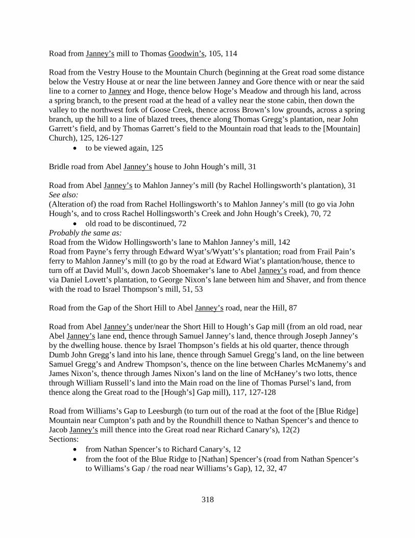
318
Road from Janney’s mill to Thomas Goodwin’s, 105, 114 Road from the Vestry House to the Mountain Church (beginning at the Great road some distance below the Vestry House at or near the line between Janney and Gore thence with or near the said line to a corner to Janney and Hoge, thence below Hoge’s Meadow and through his land, across a spring branch, to the present road at the head of a valley near the stone cabin, then down the valley to the northwest fork of Goose Creek, thence across Brown’s low grounds, across a spring branch, up the hill to a line of blazed trees, thence along Thomas Gregg’s plantation, near John Garrett’s field, and by Thomas Garrett’s field to the Mountain road that leads to the [Mountain] Church), 125, 126-127
• to be viewed again, 125 Bridle road from Abel Janney’s house to John Hough’s mill, 31 Road from Abel Janney’s to Mahlon Janney’s mill (by Rachel Hollingsworth’s plantation), 31 See also: (Alteration of) the road from Rachel Hollingsworth’s to Mahlon Janney’s mill (to go via John Hough’s, and to cross Rachel Hollingsworth’s Creek and John Hough’s Creek), 70, 72
• old road to be discontinued, 72 Probably the same as: Road from the Widow Hollingsworth’s lane to Mahlon Janney’s mill, 142 Road from Payne’s ferry through Edward Wyat’s/Wyatt’s’s plantation; road from Frail Pain’s ferry to Mahlon Janney’s mill (to go by the road at Edward Wiat’s plantation/house, thence to turn off at David Mull’s, down Jacob Shoemaker’s lane to Abel Janney’s road, and from thence via Daniel Lovett’s plantation, to George Nixon’s lane between him and Shaver, and from thence with the road to Israel Thompson’s mill, 51, 53 Road from the Gap of the Short Hill to Abel Janney’s road, near the Hill, 87 Road from Abel Janney’s under/near the Short Hill to Hough’s Gap mill (from an old road, near Abel Janney’s lane end, thence through Samuel Janney’s land, thence through Joseph Janney’s by the dwelling house. thence by Israel Thompson’s fields at his old quarter, thence through Dumb John Gregg’s land into his lane, thence through Samuel Gregg’s land, on the line between Samuel Gregg’s and Andrew Thompson’s, thence on the line between Charles McManemy’s and James Nixon’s, thence through James Nixon’s land on the line of McHaney’s two lotts, thence through William Russell’s land into the Main road on the line of Thomas Pursel’s land, from thence along the Great road to the [Hough’s] Gap mill), 117, 127-128 Road from Williams’s Gap to Leesburgh (to turn out of the road at the foot of the [Blue Ridge] Mountain near Cumpton’s path and by the Roundhill thence to Nathan Spencer’s and thence to Jacob Janney’s mill thence into the Great road near Richard Canary’s), 12(2) Sections:
• from Nathan Spencer’s to Richard Canary’s, 12 • from the foot of the Blue Ridge to [Nathan] Spencer’s (road from Nathan Spencer’s
to Williams’s Gap / the road near Williams’s Gap), 12, 32, 47
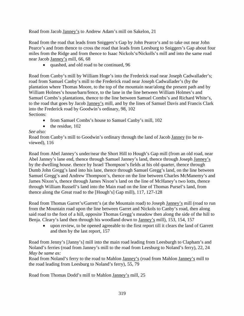
319
Road from Jacob Janney’s to Andrew Adam’s mill on Sakelon, 21 Road from the road that leads from Sniggers’s Gap by John Pearce’s and to take out near John Pearce’s and from thence to cross the road that leads from Leesburg to Sniggers’s Gap about four miles from the Ridge and from thence to Isaac Nickols’s/Nickolls’s mill and into the same road near Jacob Janney’s mill, 66, 68
• quashed, and old road to be continued, 96 Road from Canby’s mill by William Hoge’s into the Frederick road near Joseph Cadwallader’s; road from Samuel Canby’s mill to the Frederick road near Joseph Cadwallader’s (by the plantation where Thomas Moore, to the top of the mountain near/along the present path and by William Holmes’s house/barn/fence, to the lane in the line between William Holmes’s and Samuel Combs’s plantations, thence to the line between Samuel Combs’s and Richard White’s, to the road that goes by Jacob Janney’s mill, and by the lines of Samuel Davis and Francis Clark into the Frederick road by Goodwin’s ordinary, 98, 102 Sections:
• from Samuel Combs’s house to Samuel Canby’s mill, 102 • the residue, 102
See also: Road from Canby’s mill to Goodwin’s ordinary through the land of Jacob Janney (to be re-viewed), 116 Road from Abel Janney’s under/near the Short Hill to Hough’s Gap mill (from an old road, near Abel Janney’s lane end, thence through Samuel Janney’s land, thence through Joseph Janney’s by the dwelling house. thence by Israel Thompson’s fields at his old quarter, thence through Dumb John Gregg’s land into his lane, thence through Samuel Gregg’s land, on the line between Samuel Gregg’s and Andrew Thompson’s, thence on the line between Charles McManemy’s and James Nixon’s, thence through James Nixon’s land on the line of McHaney’s two lotts, thence through William Russell’s land into the Main road on the line of Thomas Pursel’s land, from thence along the Great road to the [Hough’s] Gap mill), 117, 127-128 Road from Thomas Garret’s/Garrett’s (at the Mountain road) to Joseph Janney’s mill (road to run from the Mountain road upon the line between Garret and Nickols to Canby’s road, then along said road to the foot of a hill, opposite Thomas Gregg’s meadow then along the side of the hill to Benja. Cleary’s land then through his woodland down to Janney’s mill), 153, 154, 157
• upon review, to be opened agreeable to the first report till it clears the land of Garrett and then by the last report, 157
Road from Jenny’s [Janny’s] mill into the main road leading from Leesburgh to Clapham’s and Noland’s ferries (road from Janney’s mill to the road from Leesburg to Noland’s ferry), 22, 24 May be same as: Road from Noland’s ferry to the road to Mahlon Janney’s (road from Mahlon Janney’s mill to the road leading from Leesburg to Noland’s ferry), 55, 79 Road from Thomas Dodd’s mill to Mahlon Janney’s mill, 25
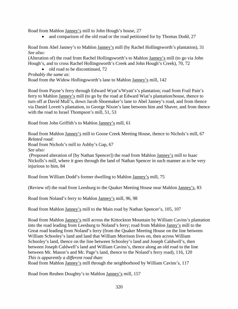
320
Road from Mahlon Janney’s mill to John Hough’s house, 27 • and comparison of the old road or the road petitioned for by Thomas Dodd, 27
Road from Abel Janney’s to Mahlon Janney’s mill (by Rachel Hollingsworth’s plantation), 31 See also: (Alteration of) the road from Rachel Hollingsworth’s to Mahlon Janney’s mill (to go via John Hough’s, and to cross Rachel Hollingsworth’s Creek and John Hough’s Creek), 70, 72
• old road to be discontinued, 72 Probably the same as: Road from the Widow Hollingsworth’s lane to Mahlon Janney’s mill, 142 Road from Payne’s ferry through Edward Wyat’s/Wyatt’s’s plantation; road from Frail Pain’s ferry to Mahlon Janney’s mill (to go by the road at Edward Wiat’s plantation/house, thence to turn off at David Mull’s, down Jacob Shoemaker’s lane to Abel Janney’s road, and from thence via Daniel Lovett’s plantation, to George Nixon’s lane between him and Shaver, and from thence with the road to Israel Thompson’s mill, 51, 53 Road from John Griffith’s to Mahlon Janney’s mill, 61 Road from Mahlon Janney’s mill to Goose Creek Meeting House, thence to Nichols’s mill, 67 Related road: Road from Nichols’s mill to Ashby’s Gap, 67 See also: (Proposed alteration of [by Nathan Spencer]) the road from Mahlon Janney’s mill to Isaac Nickolls’s mill, where it goes through the land of Nathan Spencer in such manner as to be very injurious to him, 84 Road from William Dodd’s former dwelling to Mahlon Janney’s mill, 75 (Review of) the road from Leesburg to the Quaker Meeting House near Mahlon Janney’s, 83 Road from Noland’s ferry to Mahlon Janney’s mill, 96, 98 Road from Mahlon Janney’s mill to the Main road by Nathan Spencer’s, 105, 107 Road from Mahlon Janney’s mill across the Kittockton Mountain by William Cavins’s plantation into the road leading from Leesburg to Noland’s ferry; road from Mahlon Janny’s mill to the Great road leading from Noland’s ferry (from the Quaker Meeting House on the line between William Schooley’s land and land that William Morrison lives on, then across William Schooley’s land, thence on the line between Schooley’s land and Joseph Caldwell’s, then between Joseph Caldwell’s land and William Cavins’s, thence along an old road to the line between Mr. Mason’s and Mr. Page’s land, thence to the Noland’s ferry road), 116, 120 This is apparently a different road than: Road from Mahlon Janney’s mill through the neighborhood by William Cavins’s, 117 Road from Reuben Doughty’s to Mahlon Janney’s mill, 157

321
Road from Abel Janney’s under/near the Short Hill to Hough’s Gap mill (from an old road, near Abel Janney’s lane end, thence through Samuel Janney’s land, thence through Joseph Janney’s by the dwelling house. thence by Israel Thompson’s fields at his old quarter, thence through Dumb John Gregg’s land into his lane, thence through Samuel Gregg’s land, on the line between Samuel Gregg’s and Andrew Thompson’s, thence on the line between Charles McManemy’s and James Nixon’s, thence through James Nixon’s land on the line of McHaney’s two lotts, thence through William Russell’s land into the Main road on the line of Thomas Pursel’s land, from thence along the Great road to the [Hough’s] Gap mill), 117, 127-128 Road from Jeffrey’s Branch a little above William Taylor, Sr.’s and to the County line near the Painter Skin ford, 85 (Turning the) Lawyers’ old road by James Jenkins’s plantation (proposed by James Jenkins), 149 Road from the Baptist Meeting House to the Main road at Benjamin John’s old place, 108 Road from Thomas John’s to the cross road by Joseph Thomas’s (to run by the lands of John Todhunter, Thomas John, and George Gregg), 45(2) Road from Kirk’s mill to John Popkins’s, 24, 37 May be same as: Road from Kirk’s mill to Thomas John’s (road from Kirk’s mill), 46, 77 Road from the County line near Ashby’s Gap to John Gibson’s mill and from thence into the road leading to Alexandria; road from the Alexandria road to John Gibson’s mill (from the County line to Lewis Lemon’s, thence via the lands of Thomas West’s, (formerly) Daniel John’s, Abraham Lewis’s, Patrick Beek’s, Gibson’s mill, and the Widow Gibson’s, to the Alexandria road), 112, 117, 126 Probably the same as: Road from the Main road near Ashby’s Gap to Gibson’s mill, 153 Way to Tunis Johnson’s house (fenced up by Samuel Wycoff), 86 Road from Goose Creek Church to Leven Powell’s mill / mill road (leaving the big new road opposite to Thaddeus McCarty’s new ground fence, thence through the plantation of Henry Batterton, by an old cabin in George Johnston’s field and through Johnston’s wheat field, thence to Leven Powell’s mill road opposite to a schoolhouse at Richard Crupper’s), 101, 127 Road from George Nixon’s to Jones’s road, 144 Road from John Jones’s plantation to Absalom Ramey’s, 110 Road from the Short Hills near where Joseph Jones now lives and from thence to Israel Thompson’s mill (road from Short Hills near Joseph Jones’s to Israel Thompson’s mill and from thence into the Great road; road from the mouth of Joseph Jones’s lane and with the old road

322
through John Gregg’s lane and by the lands of Samuel Gregg, James Toben, John Tribbe, Robert Akers, Isaac Thompson and Jenkin Morris, and to Israel Thompson’s tan yard and from there with his lane to his mill), 41, 43-44 Road(s) from John Trammell’s mill, 31, 34, 35
• Road from John Trammell’s mill to the road that leads from William Douglass’s plantation to David Smith’s plantation so as to intersect the road between the said Douglass’s and Smith’s plantations (road from John Trammell’s mill to David Smith’s; road from Trammell’s mill up an old path to John Lester’s line thence via Lester’s line and Josias Clapham’s line to the ferry road and along the road to a path that leads to David Smith’s near William Woolard’s fence), 31, 34
• Road from John Trammell’s mill to the road below Mr. Lee Massey’s leading to Leesburgh (road from John Trammell’s mill towards Mr. Massey’s, to go toward Leesburg; road from Trammell’s mill via the path to William Jones’s, by Mr. Massey’s fence, and to the [Main] road from Noland’s ferry to Leesburg), 31, 34, 35
• Route through George West’s land in dispute; review ordered, 35 Road from Keen’s Spring to the Mountain road, 93 Road from John Keen’s Spring to Broad Run / Broad Run Church, 6, 26, 40, 58, 147 Road from Capt. William West’s to John Keen’s Spring, 26 Road from the ford of Little River on the Carolina road to Capt. West’s Church road at John Keen’s Spring (road from the Carolina road near Little River to Capt. West’s Church road at John Keen’s Spring), 39, 41 [Note: Entries for Kelley and Kelly are combined.] Road from [Arthur] Edwards’s shop to Patrick Kelly’s, 136 Road from [Patrick] Kelly’s to John Boil’s, 136 Road from Patrick Kelly’s to Piney Branch, 153 Road from Pullin’s / Pulling’s / Charles Pullin’s to Cox’s mill (to leave the old road a little above Charles Pullin’s where the old mill tract leaves the same, keeping the old path through John Reign’s land to the head of the long glade and from thence to Bever’s road), 124, 128, 129
• to be reviewed, 129 Route after review: Road from Charles/Chas. Pullen’s to Cox’s / Samuel Cox’s mill (to leave the Carolina road at the upper end of Richard fence, and from thence to the old Church road ford on Owsleys Branch, from thence by Jacob Gardner’s house and along Thomas Kelley’s fence and along Kelley’s line between him and William Musgrove, up a branch, then along a ridge to Jonathan Davis’s new field on the Main road leading to Cox’s mill), 132, 138
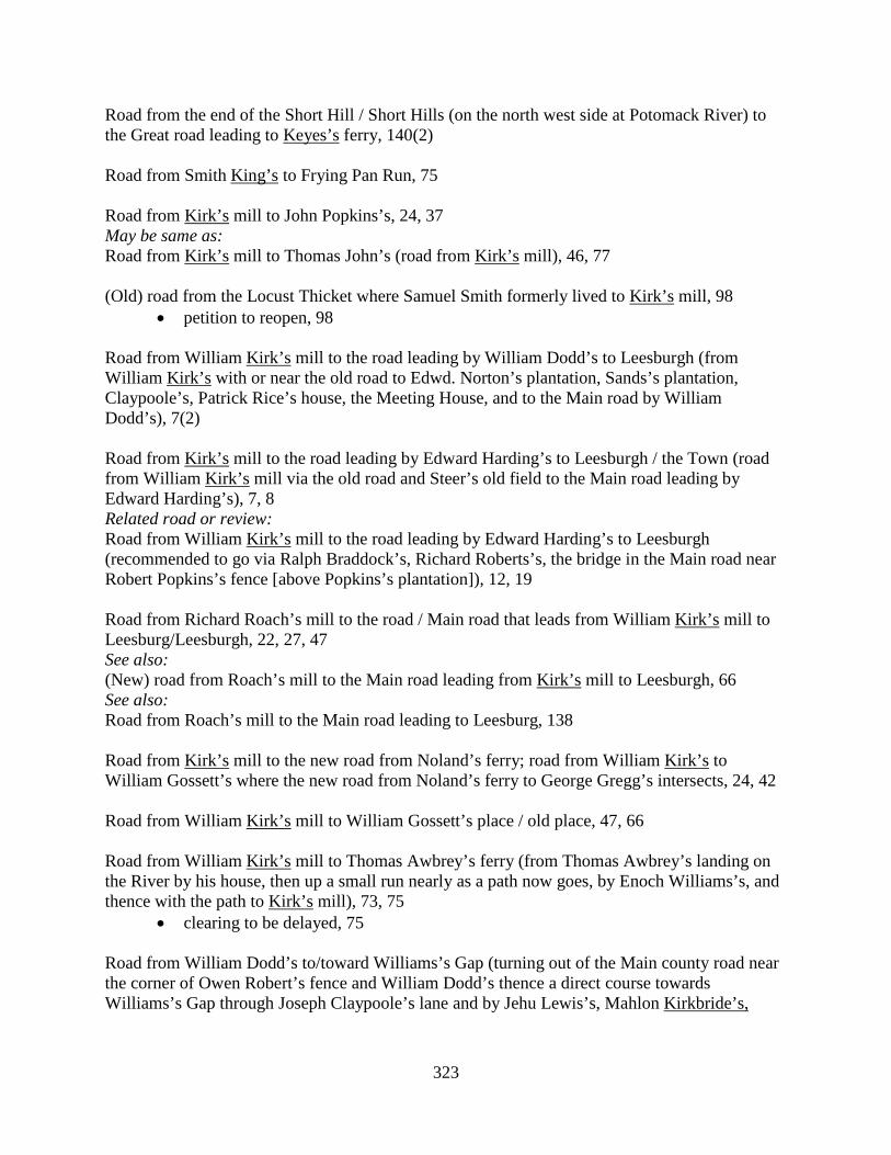
323
Road from the end of the Short Hill / Short Hills (on the north west side at Potomack River) to the Great road leading to Keyes’s ferry, 140(2) Road from Smith King’s to Frying Pan Run, 75 Road from Kirk’s mill to John Popkins’s, 24, 37 May be same as: Road from Kirk’s mill to Thomas John’s (road from Kirk’s mill), 46, 77 (Old) road from the Locust Thicket where Samuel Smith formerly lived to Kirk’s mill, 98
• petition to reopen, 98 Road from William Kirk’s mill to the road leading by William Dodd’s to Leesburgh (from William Kirk’s with or near the old road to Edwd. Norton’s plantation, Sands’s plantation, Claypoole’s, Patrick Rice’s house, the Meeting House, and to the Main road by William Dodd’s), 7(2) Road from Kirk’s mill to the road leading by Edward Harding’s to Leesburgh / the Town (road from William Kirk’s mill via the old road and Steer’s old field to the Main road leading by Edward Harding’s), 7, 8 Related road or review: Road from William Kirk’s mill to the road leading by Edward Harding’s to Leesburgh (recommended to go via Ralph Braddock’s, Richard Roberts’s, the bridge in the Main road near Robert Popkins’s fence [above Popkins’s plantation]), 12, 19 Road from Richard Roach’s mill to the road / Main road that leads from William Kirk’s mill to Leesburg/Leesburgh, 22, 27, 47 See also: (New) road from Roach’s mill to the Main road leading from Kirk’s mill to Leesburgh, 66 See also: Road from Roach’s mill to the Main road leading to Leesburg, 138 Road from Kirk’s mill to the new road from Noland’s ferry; road from William Kirk’s to William Gossett’s where the new road from Noland’s ferry to George Gregg’s intersects, 24, 42 Road from William Kirk’s mill to William Gossett’s place / old place, 47, 66 Road from William Kirk’s mill to Thomas Awbrey’s ferry (from Thomas Awbrey’s landing on the River by his house, then up a small run nearly as a path now goes, by Enoch Williams’s, and thence with the path to Kirk’s mill), 73, 75
• clearing to be delayed, 75 Road from William Dodd’s to/toward Williams’s Gap (turning out of the Main county road near the corner of Owen Robert’s fence and William Dodd’s thence a direct course towards Williams’s Gap through Joseph Claypoole’s lane and by Jehu Lewis’s, Mahlon Kirkbride’s,
324
James Dillion’s, the lands of Col. G. W. Fairfax, Nicholas Osborn’s, then turning round Taylor’s Hill to John Pearce’s and from there to Williams’s Gap), 32, 35, 36 Sections:
• [from William Dodd’s] to a run that leads down by Isaac Nichols’s (road from William Dodd’s to the head of Isaac Nicholls’s Run), 36, 51
• from the run by Isaac Nichols’s to Williams’s Gap, 36 May be the same as: Road from Owen Roberts’s to Sniggers’s Gap, 61 See also: Road from Owen Robert’s fence to John Pearce’s (order set aside), 47 Road from the Kittocton Meeting House by Goose Creek Meeting House to Isaac Nicholls’s mill, 81 Road from Mahlon Janney’s mill across the Kittockton Mountain by William Cavins’s plantation into the road leading from Leesburg to Noland’s ferry; road from Mahlon Janny’s mill to the Great road leading from Noland’s ferry (from the Quaker Meeting House on the line between William Schooley’s land and land that William Morrison lives on, then across William Schooley’s land, thence on the line between Schooley’s land and Joseph Caldwell’s, then between Joseph Caldwell’s land and William Cavins’s, thence along an old road to the line between Mr. Mason’s and Mr. Page’s land, thence to the Noland’s ferry road), 116, 120 This is apparently a different road than: Road from Mahlon Janney’s mill through the neighborhood by William Cavins’s, 117 Road from lower Kittockton Run to the Gap of the Short Hills, 17 Road from John Hough’s grist mill on the North Fork Kittockton Creek at the Gap of the Short Hills to Potomack River opposite or near Frail Pain’s, 27 Road from William Dodd’s / William Dodd’s house to Catocton Creek / Kittocton Creek / Kittocton, 26, 33(2), 37, 42, 59(2) Road from Israel Thompson’s mill to the Kittockton, 51 Road from Payne’s ferry to Kittocton Creek, 61 Road from Newgate to Lacey’s tavern, 153 Road from Joseph Lacey’s to Goose Creek by Cox’s mill, 147 (Alteration of) the road leading from Snigers’s Gap to Alexandria (road petitioned for by Joseph Lacey; to come out of the Alexandria road near the line between Joseph Lacey and John Moore and come in near Owsleys Branch, 158(2) Road from the Loudoun County line into the Great Mountain road that leads from West’s ordinary to Snickers’s Gap (beginning at Fauquier County line at the end of the new road cleared
325
by an order of the Court of Fauquier and running thence through Benjamin Chandler’s plantation, a corner of the Widow Morris’s field, and by James Lampkin’s plantation, crossing Little River at the mouth of William Berkley’s spring branch to Powell’s mill road, and with the said road to Snicker’s Gap road), 73, 79-80 Road to be opened from the Ox road to Lane’s mill (road from the Ox road going by the plantation where John Morris formerly lived, thence to Lane’s store to and cross the Main road / the Mountain road down to Lane’s mill), 45, 46 May be the same as: Road from the Mountain road to the Ox road, 69 Road from Lane’s mill to the Mountain road, 106 (Alteration of) the Church road from the corner of Capt. Turbervill’s plantation to the Ox road (turning the Church road from below Capt. Turbervill’s fence thence across Frying Pan Run, and then along a line between William Southard and Hardage Lane to the Ox road), 130, 131 Road leading from the Mountain road below Charles Eskridge’s to Capt. James Lane’s mill and from thence to the road that leads to Prince William Court[house], 25, 27-28, 35 Sections:
• from the Mountain road to [Lane’s] mill, 28 • from [Lane’s mill] to the road that leads to Prince William Courthouse, 28
Road from the Mountain road by Capt. James Lane’s mill to the road leading to Bull Run (road from the Mountain road by James Lane’s mill over Bull Run; James Lane, Gent.’s mill road, from the Mountain road to Bull Run; road from the Mountain road by Lane’s mill to the Bull Run road), 35, 42, 45, 91 Road from Wilson’s ford on Bull Run to James Lane’s grist mill; road from Wilson’s ford on Bull Run to Capt. Lane’s mill (through the lands of the Hon. Robert Carter, William Mitchell and James Lane), 110, 123 Road from James Lane’s mill to Carr Town, 129 (Alteration of) the Church road from James Lane’s to Adam Mitchell’s, 134 Road leading out of the Mountain road by William Lane’s mill to the road leading from Newgate to Bull Run; Capt. [William] Lane’s mill road, 141, 150 Roads to William Carr Lane’s mill, 71, 72
• Road from a ford on Broad Run below Reuben Berkley’s and to cross Cub Run a little before George Ashford’s and from thence to cross Flat Lick Run at the Church road, and from thence to William Carr Lane’s mill, 72
• Road from William Carr Lane’s mill to the Mountain road at Mr. Lane’s / William Carr Lane’s house, 72
326
• Road from Difficult Run about Capt. Ellzey’s quarters to William Carr Lane’s mill, 72
• Road from the Main road below Mr. Love’s plantation to William Carr Lane’s mill, 72 Sections: from Broad Run to Cub Run, 72 from Cub Run to Flack / Flat Lick Run, 72, 83 from Flat Lick to the mill, and from thence to the Mountain road below Samuel
Love’s, 72 Road from Lasswell’s ford to the Mountain road by Robert Wood’s, 20 Road from the road against Mr. Francis Peyton’s to Lasswell’s ford on Goose Creek / road from Goose Creek to Capt. Francis Peyton’s (beginning in the road that leads from Ashby’s Gap to the road that leads from Williams’s Gap to Alexandria, near where the roads intersect and turning via the path that leads to Williams’s Rolling road, crossing the road and thence by Leonard Marbury’s plantation and following the path that leads from Marbury’s to Lasswell’s ford), 33, 33-34, 46, 71, 93 (Alteration of) the road from Leesburg to Lasswell’s ford, 40, 41 (Alteration of) the road from Lasswell’s ford to William West’s, 54 (Turning the) Lawyers’ old road by James Jenkins’s plantation (proposed by James Jenkins), 149 Road from Jacob Everhart’s/Everart’s/Everheart’s mill to Richard Roach’s/Roach’s mill (from Everhart’s mill, following the present road up the ridge, then by the lands of Isaac Vanbuskirk, Samuel Smith, Nicholas Phillips, Adam Vincel, Henry Tope, William Laycock, Samuel Schooley, and James Ferguson, crossing Broad Run, near the mouth of Schooley’s spring drain, and along the path that leads from Ferguson’s to Roach’s mill, up the spring drain on the path, then with the path to the upper ford by Roach’s mill, and to the mill), 49, 50, 56, 61, 62, 64, 68
• reviewed, 64, 68 See also: (New) Road from Jacob Everhart’s mill into the road leading from there to Richard Roach’s mill, 79 [Note: Entries for Georgetown / George Town (renamed Leesburg in 1758) are combined with entries for Leesburg, Leesburgh, and the Town.] Road from Alexandria to Winchester (through George Town [Leesburg]), 4(2) Road from Noland’s ferry towards Carolina (through George Town [Leesburg]), 4(2) Road from George Town [Leesburg] to the upper side of the mouth of Goose Creek, 4 Road from George Town [Leesburg] to Secolons Branch (near John Radcliff’s/Ratcliff’s), 5(2)
327
Related road: Road from the ford of Secolons Branch near John Radcliff’s fence to Little River, 5 Road from the road at Canary’s to the Town [Leesburg], 5 Road from Kirk’s mill to the road leading by Edward Harding’s to Leesburgh / the Town (road from William Kirk’s mill via the old road and Steer’s old field to the Main road leading by Edward Harding’s), 7, 8 Related road or review: Road from William Kirk’s mill to the road leading by Edward Harding’s to Leesburgh (recommended to go via Ralph Braddock’s, Richard Roberts’s, the bridge in the Main road near Robert Popkins’s fence [above Popkins’s plantation]), 12, 19 Road from William Kirk’s mill to the road leading by William Dodd’s to Leesburgh (from William Kirk’s with or near the old road to Edwd. Norton’s plantation, Sands’s plantation, Claypoole’s, Patrick Rice’s house, the Meeting House, and to the Main road by William Dodd’s), 7(2) Road from George Town / Leesburg/Leesburgh to Vincent Lewis’s road (road from George Town along the new road to a glade between John Moss’s and Thomas Sorrell’s then leaving the said road and running nearly in a straight line to the east ends of Benjamin Shreeve’s plantation and William Shreeve’s plantation, thence to the west end of John Dawson’s plantation to Dawson’s ford, thence along an old road by Mr. Ellzey’s plantation and to Vincent Lewis’s), 7(2), 8 Sections:
• from Leesburg to Siccolons, 8 • from Siccolons to Vincent Lewis’s road, 8
Road from the Town of Leesburgh to Williams’s Gap (via John Palmer’s and by Isaac Nichols’s and from thence to the road where Samuel Davis formerly lived and from thence to the Town), 10, 11 Sections:
• [from Williams’s Gap] to Isaac Nichols’s, 11 • from Isaac Nichols’s to the road that leads to Leesburgh, 11
Road from [Leesburg]/Leesburg to Goose Creek, 10, 15, 22, 29, 33, 36, 54, 58, 59, 84, 94, 136, 149, 157 [Note: This description may refer to various roads.] See also: Road(s) from Goose Creek to Leesburg (both roads leading that way to be kept in repair), 94 Road from Williams’s Gap to Leesburgh (to turn out of the road at the foot of the [Blue Ridge] Mountain near Cumpton’s path and by the Roundhill thence to Nathan Spencer’s and thence to Jacob Janney’s mill thence into the Great road near Richard Canary’s), 12(2) Sections:
• from Nathan Spencer’s to Richard Canary’s, 12
328
• from the foot of the Blue Ridge to [Nathan] Spencer’s (road from Nathan Spencer’s to Williams’s Gap / the road near Williams’s Gap), 12, 32, 47
Bridle way from William Douglass’s house to strike the Main road that leads from Difficult to Leesburgh, 15 the Ox road from Frying Pan to the road that leads from Alexandria to Leesburg, 18 Road from Thomas Stump’s landing to Leesburg (through Col. Fairfax’s land), 20, 22 Road from Leesburg to Alexandria, 21, 75, 81, 154
• section of[?] the road below Goose Creek, 75 • (alteration of) the road (to go nearer to Hough’s mill), 81 • bridge to be built at the usual place across Broad Run, 81
Overseer of the road from Leesburg to Goose Creek to clear the road to the usual ferry landing at the mouth of Tuscorora, 22 Road from Richard Roach’s mill to the road / Main road that leads from William Kirk’s mill to Leesburg/Leesburgh, 22, 27, 47 See also: (New) road from Roach’s mill to the Main road leading from Kirk’s mill to Leesburgh, 66 See also: Road from Roach’s mill to the Main road leading to Leesburg, 138 Road from Jenny’s [Janny’s] mill into the main road leading from Leesburgh to Clapham’s and Noland’s ferries (road from Janney’s mill to the road from Leesburg to Noland’s ferry), 22, 24 May be same as: Road from Noland’s ferry to the road to Mahlon Janney’s (road from Mahlon Janney’s mill to the road leading from Leesburg to Noland’s ferry), 55, 79 Road from the lower ford of Goose Creek to Leesburg, 26 Road from William Dodd’s to Goose Creek through Leesburg; road(s) from Leesburg to William Dodd’s / William Dodd’s plantation, 26(2), 30, 36, 48, 58, 60 [Note: This description may refer to various roads.] See also: Road from where William Dodd formerly lived to Leesburg (road from Leesburg to Dodd’s), 69, 71
Road from Leesburg to Trenar[y’s], 28 Road from Leesburg to the ford of Goose Creek that leads to/towards Alexandria, 29, 31, 36 Road(s) from John Trammell’s mill, 31, 34, 35

329
• Road from John Trammell’s mill to the road that leads from William Douglass’s plantation to David Smith’s plantation so as to intersect the road between the said Douglass’s and Smith’s plantations (road from John Trammell’s mill to David Smith’s; road from Trammell’s mill up an old path to John Lester’s line thence via Lester’s line and Josias Clapham’s line to the ferry road and along the road to a path that leads to David Smith’s near William Woolard’s fence), 31, 34
• Road from John Trammell’s mill to the road below Mr. Lee Massey’s leading to Leesburgh (road from John Trammell’s mill towards Mr. Massey’s, to go toward Leesburg; road from Trammell’s mill via the path to William Jones’s, by Mr. Massey’s fence, and to the [Main] road from Noland’s ferry to Leesburg), 31, 34, 35
• Route through George West’s land in dispute; review ordered, 35 Road from Ashby’s Gap above Goose Creek to Leesburg (road from Ashby’s Gap to William Mead’s), 33, 38(2) Sections:
• from William Mead’s to Joseph Gardner’s field (road from where it leaves the Carolina road near William Mead’s to Joseph Gardner’s plantation; road from Joseph Gardner’s to the Goose Creek road below William Mead’s), 38-39, 43, 69
• from Joseph Gardner’s field to the (Mountain) road (near Thomas Starks’s house), 38-39, 41, 43
Related road: Road from Thomas Starks’s to William Mead’s, 40, 43
• to be viewed and determined if necessary, 40 • road in use to be retained, 43
Road from Broad Run to Leesburg, 33 Road from Leesburgh to Secolon, 36, 58 See also: Road from Leesburg the Carolina road to Secolon; road from Leesburg to Secolon the way to Capt. West’s, 40, 47 Road from Williams’s Gap to the Town of Leesburg, 38 (Alteration of) the road from Leesburg to Lasswell’s ford, 40, 41 Road from the County road leading from Leesburg to Alexandria to John Trammell’s mill (road from the County road leading from Alexandria to John Trammell’s mill), 41, 42 Road from Broad Run Church to Broad Run, and to the road leading from Sugarland Run to Leesburgh, 42 Probable sections:
• Road from Broad Run Church to Broad Run, 42 • Road from Broad Run to the road leading from Sugarland Run to Leesburgh, 42

330
(Alteration of) the road from this place [Leesburg] to Colchester (from about Rogues road to near John Holmes’s, 50 (Straightening of) the road from above Richard Steward’s lot in Leesburgh to the old road leading to Noland’s ferry, 53 Road to town and courthouse opened from Leesburg by John Lewis’s and (James) Stephens’s into an old road leading over the Mountain (by old Abbett’s and Philip Saunders’s plantations, and through a lane of John Lewis’s and from thence through the land of Thomson Mason Esqr. near his plantation called Rasberry Plane, and by the foot of the Mountain, and into the old road and to the plantation of James Stephens), 61, 63 Bridle way from James Stephens’s house to the town of Leesburg, 66 Road from the road that leads from Sniggers’s Gap by John Pearce’s and to take out near John Pearce’s and from thence to cross the road that leads from Leesburg to Sniggers’s Gap about four miles from the Ridge and from thence to Isaac Nickols’s/Nickolls’s mill and into the same road near Jacob Janney’s mill, 66, 68
• quashed, and old road to be continued, 96 Road from the Quaker Meeting House across the Mountain to Leesburg (near the line dividing the lands of Fleming Patterson, Harrison Manley, and Samuel Tillett, 68, 70 Road from Leesburg to the ford of Goose Creek, 69, 97 Road from Leesburg to Sniggers’s Gap (to be viewed both ways), 69 Streets of/in Leesburg, 70, 113, 123, 139, 145, 157
• to extend along the Carolina road to the Tanyard Run, 145 • Leesburg Town road [Note: road, not roads], 86
Road from Awbrey’s ferry to Leesburg, 73 Road from the Blue Ridge to Leesburg road, 74 Road from the Leesburg road to the Beaver Dam, 74 Road from Morris’s ford to the road leading from Dawson’s ford on Goose Creek to Leesburg, 76 [Note: This road may not have been viewed; a new view was later ordered.]: Road from Morris’s ford on Goose Creek into the road leading from Dawson’s ford on Goose Creek to Leesburg, 114 Road from Richard Thatcher’s in Williams’s Gap into the Mountain road to Leesburg; road from Richard Thatcher’s in Williams’s Gap to Thomas Shepard’s mill and from thence into the Main road leading to Leesburg (old road to be continued and straightened from Richard Thatcher’s

331
lane to [Thomas] Shepard’s mill and also from the mill via the lands of [Thomas] Shepard, William Tate, John Gregg, on the line betwixt Gregg and John Brown thence through Harman Cox’s land, the land in possession of John Grant, the line betwixt Timothy Howell and said Grant into the Main road to Leesburg), 77, 86-87, 87, 92 Road from Thomas Goodwin’s to Leesburg, 78 Probably the same as: Road from Goodwin’s to Leesburg, 94, 95 (Review of) the road from Leesburg to the Quaker Meeting House near Mahlon Janney’s, 83 Road from the Gap of the Short Hill along under the Hill till it intersects the road leading from Sniggers’s Gap to Leesburg, 87 Road from the ford of Goose Creek to Noland’s ferry (leading out of the Alexandria road into the Leesburg road by Hugh Fouch’s and through the Cat Tail Meadow plantation, via the lands of Robert Adams and Richard Mets, to a red oak tree marked with three notches standing near the side of the said Leesburg road, and across the road, down a valley, and into the road again near Hugh Fouch’s fence), 89, 90-91 Road from Leesburg to Owen Roberts’s, 89 Road from West’s to Leesburg, 91, 93 Road from Israel Thompson’s mill, going through or near Benjamin Pool’s plantation until it intersects the road leading from Leesburg to Williams’s Gap, 92
• (review of) the road intended from Thompson’s mill to the road leading from Leesburg to Snicker’s Gap, 100
• review to report the difference to establish the road to avoid the plantation of Craven Peyton Gent. and also how far the road as marked will run through Peyton’s plantation and meadow, and further to report how many of the inhabitants resort to the mill along the said road, 100
Road from the Main road leading from Leesburg to Furrow’s ferry; road from Furrow’s ferry to Leesburg, 93, 96 Road from Canby’s mill by Thomas Gregg’s (potter) to the Great road leading from Snicker’s Gap to Alexandria by James Martin’s plantation, 99 May be a different road or a second view: Road from [Samuel] Canby’s mill to James Martin’s, to go by the plantation of Thomas Gregg (potter) (road from Canby’s mill to James Martin’s: to go along the road towards Leesburg, thence by the upper side of Evan Wilkison’s plantation across the Northwest Fork of Goose Creek, thence to and through the plantation of Thomas Gregg (potter), and with the old Shennadore Tract to the Frederick road below James Martin’s plantation), 111, 117, 124
332
Road from Josias Clapham’s Riverside plantation to Leesburg; road from Josias Clapham’s Riverside plantation into the road leading from Noland’s ferry to Leesburg (from Josias Clapham’s orchard fence to part of an old road near Samuel Erwin’s, and with blazed trees to an old road or path near a gate on the plantation where Josias Clapham now lives, thence with the old road into Noland’s ferry road at Jason Thomas’s), 99, 105 Road from Whitely’s/Whiteley’s ford on Goose Creek to Leven Powell’s mill (to leave Powell’s mill road below James Sinkler’s plantation where an old road turns out, up a branch, and by Capt. Peyton’s plantation and crossing Snickers’s road to the Leesburg road and with the Leesburg road to Whiteley’s ford), 100, 101 Probably the same as: Road from the forks by Goose Creek, Whitely’s ford to Col. Powell’s mill, 146 Road from Leesburg into the road leading from the said town to Campbell’s ferry, 107 Isaac Fouch’s road to mill and market (to go on the line of Francis Elgin and Isaac Fouch to the corner of Fouch’s land thence continuing the said line of Elgin’s and Benjamin Shreeve’s to the Main road leading from Dawson’s ford to Leesburg), 108(2) (Alteration of) the (Great) road from Leesburg to Tuscarora/Tuskarora, 108, 111 Road from John Hanby’s plantation by James Stevens’s to Leesburg, 112 Road from Leesburg to Goose Creek at Luke Going’s ford, 113
• Road to be cleared out of this road to the Mouth of Tuscarora where a ferry is intended to be kept, 113
Road from Mahlon Janney’s mill across the Kittockton Mountain by William Cavins’s plantation into the road leading from Leesburg to Noland’s ferry; road from Mahlon Janny’s mill to the Great road leading from Noland’s ferry (from the Quaker Meeting House on the line between William Schooley’s land and land that William Morrison lives on, then across William Schooley’s land, thence on the line between Schooley’s land and Joseph Caldwell’s, then between Joseph Caldwell’s land and William Cavins’s, thence along an old road to the line between Mr. Mason’s and Mr. Page’s land, thence to the Noland’s ferry road), 116, 120 This is apparently a different road than: Road from Mahlon Janney’s mill through the neighborhood by William Cavins’s, 117 Road from the Limestone to Leesburg, 117, 146(2) Road from William Neilson’s plantation to Leesburg by John Brown’s and John Gregg’s plantations; road from William Neilson’s plantation to Leesburg (turning out of the old road near the corner of William Neilson’s field, thence to Robert Mcwhorter’s field who is a tenant on Col. Tayloe’s land, crossing Neilson’s and John Gregg’s land, thence to continue on the line between Tayloe and Gregg, thence on the line between John Brown and John Gregg, [to where the first viewers ordered it to be crossing a branch of Goose Creek that comes from Nicholas Osburn’s], thence into the old road again on the land of Harmon Cox), 122, 129
333
• review, 122, 129 Road from Leesburg to Mr. Amos Thompson’s mill and from thence to the Ox road, 124 Views were divided into sections:
• Road from the Rev. Mr. Amos Thompson’s mill to the Ox road (road to lead from [Thompson’s] mill to Joseph Cross’s mill and from thence to the Ox road), 126, 127
• Road from Leesburg to the Rev. Amos Thompson’s mill (beginning just below Leesburg, then to Segolon, thence to Martin Poland’s and thence to [Rev. Thompson’s] mill), 126, 132
the Alexandria road, 126, 157 Section:
• from Leesburg to Goose Creek, 157 (Alteration of) the road from Leesburg to Colchester, so that it may go by Saml. Cox’s mill, 133 (Alteration of) the Carolina road round Mr./Josiah Moffett’s plantation, 134(2)
• to be reviewed (as to whether the Carolina road can be more conveniently turned round by William Moss’s, to take out of the road as it runs at present between Leesburg and Tuscarrora and in again near William Mead’s, and also to view whether the road leading by Cox’s mill from Leesburg cannot be continued along the Carolina road until it passes Mr. Moffett’s new clearing and then be carried on the line between said Moffett and William Moss), 135
Road from Morris’s ford on Goose Creek into the road leading from Leesburg to Cox’s mill, so that the same may come into the said road near Benjamin Shreve’s, 135 Road from Leesburg to James Willson’s, 138 Road from Leesburg by Hough’s / William Hough’s mill to Broad Run bridge, 140, 143
• second view ordered, 143 Road from the old shop to Leesburg, 140 Road from Leesburg to the run by Sorrell’s / Sorrell’s Run, 141, 154 Road from Leesburg to Moxley’s ferry, 142
• to be opened as it antiently run, 142 • (alteration of) the road leading from Leesburg to Moxley’s ferry through the lands of
Mrs. Page, 156 • Road from Leesburg to Moxley’s ferry (to go by the house of John Sanders to
Carter’s line and to come into the Town at Drishes), 158 Road from Leesburg to Doughty’s, 142 May be the same as: Road from Leesburg to Reuben Doughty’s, 153, 158
334
Road from Leesburg to the Quaker Stone Meeting House, 146 (Alteration of) the road leading from Mr. [Joshua] Daniel’s mill to the main road leading from Leesburg to Noland’s ferry (alteration of the road leading from Joshua Danniel’s saw mill to the main road leading from Leesburg to Noland’s ferry, to leave the old road opposite Mr. John Lewis’s dwelling house near a walnut tree upon the side of the Limestone Run and follow the line of partition between Mr. Thompson Mason and Mrs. Mary Mason Page to the Main road leading to Noland’s ferry; not to be opened for twelve months: the road in use is to leave the present road below John Lewis’s house and follow what has formerly been called the Mill path to the Main road), 151, 152 (Alteration of) the road leading from Leesburg to Benjamin Edwards’s by the plantation of Daniel Moxley (road from Benjamin Edwards’s to Leesburg, to go as it now does from Mr. Benjamin Edwards’s to a pole bridge, thence in a straight line to a gate that stands in the ferry road, from thence as the road now is to Leesburg), 152, 154, Road from William Mead’s to Leesburg, 153 (Alteration of) the road leading from Leesburg to Winchester (petitioned by Peter Carr), 155(2)
• to be reviewed, 156 • Road to be continued without alteration, 157
(Alteration of) the road from Leesburg to John Littlejohn’s mill, 156 Road from the Vestry House to the Mountain on the road leading to Leesburg, 156 James Leith’s road to mill and market (through the land/lot of land of Henry Taylor), 56, 60, 63 Road from Thomas Drake’s to Leven Powell’s grist mill; road from Thomas Drake’s meadow to Hezekiah Guy’s grist mill, and near the Quaker Meeting House and thence to cross Goose Creek at James Leith’s and to Leven Powell’s mill road; road from Thomas Drake’s meadow to Hezekiah Guy’s grist mill and near the Quaker Meeting House and from thence to Leven Powell’s mill (beginning at Thomas Drake’s meadow, thence through James Carter’s lane and by Malakiah Cumming’s field, thence through the lands of Samuel Smith, John Neal, Thomas Smith, Thomas Russell, Thomas Lewis, thence into the old tract in or near Richard Hanson’s grubbing, thence to a good ford on Goose Creek and along the bottom of the creek, and to Leven Powell’s mill), 100, 103-104, 108, 109, 119 Sections:
• [from Drake’s] to Goose Creek, 108, 109, 119 • from Goose Creek (by James Leith’s plantation) to Powell’s mill, 108, 109
Road from the County line near Ashby’s Gap to John Gibson’s mill and from thence into the road leading to Alexandria; road from the Alexandria road to John Gibson’s mill (from the County line to Lewis Lemon’s, thence via the lands of Thomas West’s, (formerly) Daniel John’s,

335
Abraham Lewis’s, Patrick Beek’s, Gibson’s mill, and the Widow Gibson’s, to the Alexandria road), 112, 117, 126 Probably the same as: Road from the Main road near Ashby’s Gap to Gibson’s mill, 153 Road(s) from John Trammell’s mill, 31, 34, 35
• Road from John Trammell’s mill to the road that leads from William Douglass’s plantation to David Smith’s plantation so as to intersect the road between the said Douglass’s and Smith’s plantations (road from John Trammell’s mill to David Smith’s; road from Trammell’s mill up an old path to John Lester’s line thence via Lester’s line and Josias Clapham’s line to the ferry road and along the road to a path that leads to David Smith’s near William Woolard’s fence), 31, 34
• Road from John Trammell’s mill to the road below Mr. Lee Massey’s leading to Leesburgh (road from John Trammell’s mill towards Mr. Massey’s, to go toward Leesburg; road from Trammell’s mill via the path to William Jones’s, by Mr. Massey’s fence, and to the [Main] road from Noland’s ferry to Leesburg), 31, 34, 35
• Route through George West’s land in dispute; review ordered, 35 Road from the County line near Ashby’s Gap to John Gibson’s mill and from thence into the road leading to Alexandria; road from the Alexandria road to John Gibson’s mill (from the County line to Lewis Lemon’s, thence via the lands of Thomas West’s, (formerly) Daniel John’s, Abraham Lewis’s, Patrick Beek’s, Gibson’s mill, and the Widow Gibson’s, to the Alexandria road), 112, 117, 126 Probably the same as: Road from the Main road near Ashby’s Gap to Gibson’s mill, 153 Road from William Dodd’s to/toward Williams’s Gap (turning out of the Main county road near the corner of Owen Robert’s fence and William Dodd’s thence a direct course towards Williams’s Gap through Joseph Claypoole’s lane and by Jehu Lewis’s, Mahlon Kirkbride’s, James Dillion’s, the lands of Col. G. W. Fairfax, Nicholas Osborn’s, then turning round Taylor’s Hill to John Pearce’s and from there to Williams’s Gap), 32, 35, 36 Sections:
• [from William Dodd’s] to a run that leads down by Isaac Nichols’s (road from William Dodd’s to the head of Isaac Nicholls’s Run), 36, 51
• from the run by Isaac Nichols’s to Williams’s Gap, 36 May be the same as: Road from Owen Roberts’s to Sniggers’s Gap, 61 See also: Road from Owen Robert’s fence to John Pearce’s (order set aside), 47 (Alteration of) the Main road through the land John Lewis (to be turned to pass through a part of the land of Vincent Lewis), 53 Road to town and courthouse opened from Leesburg by John Lewis’s and (James) Stephens’s into an old road leading over the Mountain (by old Abbett’s and Philip Saunders’s plantations, and through a lane of John Lewis’s and from thence through the land of Thomson Mason Esqr.

336
near his plantation called Rasberry Plane, and by the foot of the Mountain, and into the old road and to the plantation of James Stephens), 61, 63 (Alteration of) the road leading from Mr. [Joshua] Daniel’s mill to the main road leading from Leesburg to Noland’s ferry (alteration of the road leading from Joshua Danniel’s saw mill to the main road leading from Leesburg to Noland’s ferry, to leave the old road opposite Mr. John Lewis’s dwelling house near a walnut tree upon the side of the Limestone Run and follow the line of partition between Mr. Thompson Mason and Mrs. Mary Mason Page to the Main road leading to Noland’s ferry; not to be opened for twelve months: the road in use is to leave the present road below John Lewis’s house and follow what has formerly been called the Mill path to the Main road), 151, 152 Road from Thomas Drake’s to Leven Powell’s grist mill; road from Thomas Drake’s meadow to Hezekiah Guy’s grist mill, and near the Quaker Meeting House and thence to cross Goose Creek at James Leith’s and to Leven Powell’s mill road; road from Thomas Drake’s meadow to Hezekiah Guy’s grist mill and near the Quaker Meeting House and from thence to Leven Powell’s mill (beginning at Thomas Drake’s meadow, thence through James Carter’s lane and by Malakiah Cumming’s field, thence through the lands of Samuel Smith, John Neal, Thomas Smith, Thomas Russell, Thomas Lewis, thence into the old tract in or near Richard Hanson’s grubbing, thence to a good ford on Goose Creek and along the bottom of the creek, and to Leven Powell’s mill), 100, 103-104, 108, 109, 119 Sections:
• [from Drake’s] to Goose Creek, 108, 109, 119 • from Goose Creek (by James Leith’s plantation) to Powell’s mill, 108, 109
Road from Thomas Lewis Gent.’s to the Mountain Church, 110, 133
• two proposed ways to be reviewed, 110 • to be reviewed, 133
Road from the Mine bridge to the ford of Difficult Run at Mr. Thomas Lewis’s plantation (to leave the Main road leading to Alexandria a little way below the Mine bridge and to continue along a ridge between Benjamin Brown’s and Samuel Yates’s to the old ford on Colvins Branch, thence along a ridge past Nicholas Money’s to the ford on Difficult Run at Mr. Thomas Lewis’s plantation), 124, 131 (Fork) where Vincent Lewis’s road goes into William West’s road, 5 Road from George Town / Leesburg / Leesburgh to Vincent Lewis’s road (road from George Town along the new road to a glade between John Moss’s and Thomas Sorrell’s then leaving the said road and running nearly in a straight line to the east ends of Benjamin Shreeve’s plantation and William Shreeve’s plantation, thence to the west end of John Dawson’s plantation to Dawson’s ford, thence along an old road by Mr. Ellzey’s plantation and to Vincent Lewis’s), 7(2), 8 Sections:
• from Leesburg to Siccolons, 8 • from Siccolons to Vincent Lewis’s road, 8

337
Road from the Gum Spring near Vincent Lewis’s to John Carter’s mill, 38 See also: (New) road from Carter’s mill into the Main road near Vincent Lewis’s (road from the Gum Spring to Mr. John Carter’s mill; road from the Gum Spring the new road to John Carter’s mill), 55(2), 69 (Alteration of) the Main road through the land John Lewis (to be turned to pass through a part of the land of Vincent Lewis), 53 [Note: Entries for Great Lime Stone / Great Limestone and Lime Stone / Limestone are combined.] Road from the fork of the road above Goose Creek at Ezekiel Hickman’s to the Great Lime Stone, 2, 5 Related road:
• Road from that road to the Shanando road, 5 Road from the Great Lime Stone / Great Limestone to (Philip) Noland’s/Nowland’s ferry across Potomac River (Road from Limestone Run), 2, 13, 16, 32, 36, 38, 49 Probable sections:
• Road from Noland’s / Capt. Noland’s / Philip Noland’s ferry to Todhunter’s / John Todhunter’s, 88, 118, 139
• Road from the Great Lime Stone / Limestone Spring / Limestone to Todhunter’s / John Todhunter’s, 88, 94, 139(2)
Road from Limestone Run to Goose Creek ferry, 9, 15 Road from the Lime Stone to the fork of the roads by where John Markley now lives, 26 Road from the Limestone to Leesburg, 117, 146(2) Road from the Great Lime Stone / the Limestone to Josias Miles’s, 139(2) (Alteration of) the road leading from Mr. [Joshua] Daniel’s mill to the main road leading from Leesburg to Noland’s ferry (alteration of the road leading from Joshua Danniel’s saw mill to the main road leading from Leesburg to Noland’s ferry, to leave the old road opposite Mr. John Lewis’s dwelling house near a walnut tree upon the side of the Limestone Run and follow the line of partition between Mr. Thompson Mason and Mrs. Mary Mason Page to the Main road leading to Noland’s ferry; not to be opened for twelve months: the road in use is to leave the present road below John Lewis’s house and follow what has formerly been called the Mill path to the Main road), 151, 152 Road to be cleared from Broad Run to meet one lately cleared by order of Fairfax Court from the Little Falls to Difficult Run (road from Broad Run bridge to the Seneca Falls / Seneca Falls mill /

338
the [John Ballendine’s] landing at Seneca Falls and from thence to Difficult Run [at the Rockey ford] to meet a road ordered cleared by Fairfax Court), 39, 41, 43, 44, 46, 51, 55, 60
• former order quashed and to be reviewed, 41 • old road to be used until John Ballendine erects the public mill, 46, 48, 51 • order to clear the road to be quashed until John Ballendine erects a public mill at
Seneca Falls, 48 Sections:
• from Broad Run to the Seneca Falls (the upper road), 60 • from Seneca Falls / the landing on the Seneca Falls to Difficult Run (the lower road),
60, 68 Road from the Gum Spring to Little River, 1 Road from Piney Branch on the Mountain road to Little River, 1, 28, 40, 45, 60 Sections:
• the upper part of the road from Piney Branch to Little River, 83, 94, 100 • the lower part, 83
May be a different road: Road from Little River to Piney Branch and from thence to the fork of the road at John Homes’s, 44, 60 Road from Little River to Goose Creek, 1, 5, 37, 47, 74, 141, 143 May be the same as: Road that leads from Capt. West’s to Winchester, 37 [Road from Little River to Ashby’s Gap], 2(2) Apparently sections of the same road:
• Road leading through Ashby’s Gap, from Little River to Goose Creek, 2 • Road leading through Ashby’s Gap, from Goose Creek to the County line on the Blue
Ridge, 2 See also: (New) Road from the ford of Little River to Ashby’s Gap (road from the ford of Little River to Ashby’s Gap (from Little River and following the old road around Mercer’s Meadow Ground, thence into Mr. Craven Peyton’s plantation, thence with the old road again to Cromwell’s Run, thence to the top of the hill, and thence with the old road to Ashby’s Gap), 19, 26 Sections:
• from Goose Creek to the County line, 26 • from Little River to Goose Creek, 26, 33, 56
May be the same as: Road from Mercer’s mill to Ashby’s Gap (portion turned by Leven Powell), 30, 45 Section:
• as far as Goose Creek, 45 Road from George Town [Leesburg] to Secolons Branch (near John Radcliff’s/Ratcliff’s), 5(2) Related road: Road from the ford of Secolons Branch near John Radcliff’s fence to Little River, 5
339
Road from Little River to the extreme part of the County to meet Prince William road, 5 May be the same as: Road (that leads by Capt. West’s) from the ford of Little River to the County line, 30 Road from Broad Run Church to Little River, 5 Road from Adams’s ford on Goose Creek to where the road crosses Little River (road from Adams’s ford down to the Mountain road by John Champ’s), 10, 11 the several roads from Little River to Shanando, 11 Road from Little River to strike into the road by the Mountain Church, 39 Road from the ford of Little River on the Carolina road to Capt. West’s Church road at John Keen’s Spring (road from the Carolina road near Little River to Capt. West’s Church road at John Keen’s Spring), 39, 41 Road from the ford of Little River through the fork of Goose Creek to the Mountain Church, 48, 54 Road from Little River to Secolon Run, 54 Road from the Loudoun County line into the Great Mountain road that leads from West’s ordinary to Snickers’s Gap (beginning at Fauquier County line at the end of the new road cleared by an order of the Court of Fauquier and running thence through Benjamin Chandler’s plantation, a corner of the Widow Morris’s field, and by James Lampkin’s plantation, crossing Little River at the mouth of William Berkley’s spring branch to Powell’s mill road, and with the said road to Snicker’s Gap road), 73, 79-80 Road(s) to Leven Powell’s mill, 76, 77
• Road from Leven Powell’s / Col. Powell’s mill to Fauquier County line that goes under the Mountain (from Leven Powell’s mill, crossing Little River at an old ford and through Capt. Francis Peyton’s quarter plantation and going as near the foot the Mountain as the ground will admit of to Fauquier County line), 77, 84, 104, 143
• Road from Leven Powell’s mill to the Mountain at Mercer’s mill (from Leven Powell’s mill thence down the river and via Thomas Gibson’s, James Sinkler’s plantation, and Mr. Mercer’s quarter plantation and up a little hill to the Great road leading from Snicker’s Gap), 77
• Road from Leven Powell’s mill to the road leading from French’s quarter; road from Levin Powell’s mill to Thomas Owsley’s ford on Goose Creek (from Leven Powell’s mill to James Battson’s [northward of Richard Crupper’s plantation] and from Battson’s along the old road to the Church road thence with the Church road to Thomas Owsley’s wagon road and crossing Goose Creek at his ford and through his plantation to the road that comes down by French’s quarter), 77, 85
340
• (Fauquier County requested to clear) road from Fauquier Court house to meet one cleared from Leven Powell’s mill to the County line, 89
(Alteration of) road from Goose Creek to Little River, 81 Alteration of roads as requested by James Mercer, 86
• Road from the ford of Little River to Snicker’s Gap, 86, 88, 92 • Road from Little River to Powell’s mill, 86, 88, 92
Road from Bull Run to Little River, 92, 93 Probable sections:
• Road from Bull Run to the Forks, 124 • Road from the Forks to Little River, 124
Road from Roszell’s to Little River at Mercer’s quarter, 120 May be a second viewing or a review: Road from the Frederick road to begin at a branch about a mile below Stephen Roszell’s to cross Goose Creek near Combs’s mill then to Little River at Mercer’s old quarter; road from the road below Stephen Roszel’s to cross Goose Creek near Combs’s mill, then to Mercer’s quarter on Little River (beginning at a branch, extending on or near the line of Capt. Cock’s to William Allen’s lane and field near Mr. Combs’s mill, to the old ford on Goose Creek, thence upon the line between Thaddeus McCarty and Joseph Farrow, and between Andrew and Thomas Batey into the road by Capt. Francis Peyton, and down that road into the Mountain road and down the Mountain road to Mercer’s old quarter), 121, 122-123 Road from Simon Triplett Gent.’s mill to cross Little River near Joshua Taylor’s plantation and to intersect the Carolina road near Charles Pullen’s; road from Simon Triplett’s mill to the Carolina road (to take out of the cleared road near William McNabb’s plantation, thence through a corner of Michael Gahagan’s cleared ground, thence to the Watry Branch, thence to and through Joshua Taylor’s plantation to Little River near the line between Phineas Skinner’s and Nicholas Wyckoff’s thence with their line and the line between Charles Pullen and Richard Skinner to James Wrightmire’s shop), 125, 127 Road from John Boil’s to Little River, 136 the Carolina road, 143, 144
• section from Little River to Bull Run, 143 Road from Little River to Canby’s mill, 143 Little Rockey Run: See Rockey Run. (Alteration of) the road from Leesburg to John Littlejohn’s mill, 156 (Old) road from the Locust Thicket where Samuel Smith formerly lived to Kirk’s mill, 98
• petition to reopen, 98

341
Road from Carter’s mill into the Mountain road near Fielding Turner’s (road from John Carter’s lane to the Long Branch along the old Wagon road thence by the Rock hill, thence crossing Elk Licking Run to the head of Salisbury Plains and thence to the ford of Cub Run where the old bridge was), 55, 55-56 Road from the Loudoun County line into the Great Mountain road that leads from West’s ordinary to Snickers’s Gap (beginning at Fauquier County line at the end of the new road cleared by an order of the Court of Fauquier and running thence through Benjamin Chandler’s plantation, a corner of the Widow Morris’s field, and by James Lampkin’s plantation, crossing Little River at the mouth of William Berkley’s spring branch to Powell’s mill road, and with the said road to Snicker’s Gap road), 73, 79-80 Road from the Loudoun line at the north thoroughfare of Bull Run to the Baptist Meeting House at Joseph Hutchison’s, 132 Road from Payne’s ferry to Israel Thompson’s mill (turning out of Payne’s road, through Jacob Shoemaker’s barley field by his barn and lane to Jacob Hibbs’s field, thence with the line between Jacob Hibbs and David Lovat to George Shaffer’s lot, thence with the line between George Shaffer and George Nixon, thence by George Nixon’s wheat field, and from thence the most direct way to Israel Thompson’s mill), 99 Roads to William Carr Lane’s mill, 71, 72
• Road from a ford on Broad Run below Reuben Berkley’s and to cross Cub Run a little before George Ashford’s and from thence to cross Flat Lick Run at the Church road, and from thence to William Carr Lane’s mill, 72
• Road from William Carr Lane’s mill to the Mountain road at Mr. Lane’s / William Carr Lane’s house, 72
• Road from Difficult Run about Capt. Ellzey’s quarters to William Carr Lane’s mill, 72
• Road from the Main road below Mr. Love’s plantation to William Carr Lane’s mill, 72 Sections: from Broad Run to Cub Run, 72 from Cub Run to Flack / Flat Lick Run, 72, 83 from Flat Lick to the mill, and from thence to the Mountain road below Samuel
Love’s, 72 (Alteration of) the Mountain road (proposed to be turned by Samuel Love) (to begin where the lines of Samuel Love and Thomas Neale intersect the Mountain road, thence along their lines to Flat Lick Run, to Love’s line by Jacob Remy’s fence, and thence to the Mountain road), 81, 87 (Alteration of) the road by Samuel Love, 107 Road from Payne’s ferry through Edward Wyat’s/Wyatt’s’s plantation; road from Frail Pain’s ferry to Mahlon Janney’s mill (to go by the road at Edward Wiat’s plantation/house, thence to
342
turn off at David Mull’s, down Jacob Shoemaker’s lane to Abel Janney’s road, and from thence via Daniel Lovett’s plantation, to George Nixon’s lane between him and Shaver, and from thence with the road to Israel Thompson’s mill, 51, 53 Road from Potowmack River opposite William Luckett Jr.’s ferry to Pursley’s ordinary; road(s) from Ball’s mill to Luckett’s ferry and from Ball’s mill to Israel Thompson’s mill, 109, 116 Probable sections:
• Road from Ball’s mill to Israel Thompson’s mill (from Ball’s mill, then between Frederick Cooper’s plantation and David Mull’s by Anthony Wright’s lane into a road leading to Thompson’s mill), 116
• Road from (Farling) Ball’s mill to Luckett’s ferry (from Ball’s mill towards Potowmack, along the road leading from Ball’s mill to the Valentine quarter, by Leonard May’s plantation, thence between William Rasler’s and Isaac Shown’s plantations, thence by a path to Luckett’s ferry), 116, 138
Road from the Seneca Falls to the Ox road that leads to Colchester (road from the upper end of Capt. McCarty’s Island into the Sugar Land road and along that road opposite to James Fryer’s where it takes Difficult Ridge, thence on the Ridge into the Ox road at Sandford Cockerill’s where Ellzey’s tract goes into the Ox road), 39, 46, 47 Sections:
• from the River to the Main road, 47 • from the Main road to the Ox road, 47
Road from Goose Creek Church to Leven Powell’s mill / mill road (leaving the big new road opposite to Thaddeus McCarty’s new ground fence, thence through the plantation of Henry Batterton, by an old cabin in George Johnston’s field and through Johnston’s wheat field, thence to Leven Powell’s mill road opposite to a schoolhouse at Richard Crupper’s), 101, 127 Road from Roszell’s to Little River at Mercer’s quarter, 120 May be a second viewing or a review: Road from the Frederick road to begin at a branch about a mile below Stephen Roszell’s to cross Goose Creek near Combs’s mill then to Little River at Mercer’s old quarter; road from the road below Stephen Roszel’s to cross Goose Creek near Combs’s mill, then to Mercer’s quarter on Little River (beginning at a branch, extending on or near the line of Capt. Cock’s to William Allen’s lane and field near Mr. Combs’s mill, to the old ford on Goose Creek, thence upon the line between Thaddeus McCarty and Joseph Farrow, and between Andrew and Thomas Batey into the road by Capt. Francis Peyton, and down that road into the Mountain road and down the Mountain road to Mercer’s old quarter), 121, 122-123 (Alteration of) the road by John McClain’s, 144 May be the same as: (Alteration of) the road from Goose Creek to Leven Powell’s mill: the way cleared by John McClain established, 144 (Alteration of) the Carolina road (as proposed by William McClellan), 149(2)
343
Road leading from the new road on the ridge to Canby’s mill near Thomas Gregg’s thence by Robert McCully’s to Col. Triplett’s mill (road from the road near Thomas Gregg’s to Col. Simon Triplett’s mill), 148, 150 Road from Simon Triplett’s house to the Mountain road, 106 This is apparently a different road than: Road from the Mountain road near the Church by Simon Triplett’s mill and near Jacob Read’s (road to begin near the Church and to lead to Simon Triplett’s mill; road from the Mountain road near the Church to Simon Triplett’s mill, from the lane between Garrett and McGeach and along their line to the great bent of the southwest fork of Goose Creek, and from thence between the plantations of Fitzimons and the Widow Williams, to Simon Triplett’s mill, and thence near Mr. Triplett’s house in the old road, and continue with old road to and through the plantation of William McNabb and near McNabb’s house into the old road again, and to the plantation of Jacob Read, and into the Mountain road), 112, 113, 113-114 Road from Abel Janney’s under/near the Short Hill to Hough’s Gap mill (from an old road, near Abel Janney’s lane end, thence through Samuel Janney’s land, thence through Joseph Janney’s by the dwelling house. thence by Israel Thompson’s fields at his old quarter, thence through Dumb John Gregg’s land into his lane, thence through Samuel Gregg’s land, on the line between Samuel Gregg’s and Andrew Thompson’s, thence on the line between Charles McManemy’s and James Nixon’s, thence through James Nixon’s land on the line of McHaney’s two lotts, thence through William Russell’s land into the Main road on the line of Thomas Pursel’s land, from thence along the Great road to the [Hough’s] Gap mill), 117, 127-128 Road from the fork of the roads to McKinzey’s ferry, 26 Road from Abel Janney’s under/near the Short Hill to Hough’s Gap mill (from an old road, near Abel Janney’s lane end, thence through Samuel Janney’s land, thence through Joseph Janney’s by the dwelling house. thence by Israel Thompson’s fields at his old quarter, thence through Dumb John Gregg’s land into his lane, thence through Samuel Gregg’s land, on the line between Samuel Gregg’s and Andrew Thompson’s, thence on the line between Charles McManemy’s and James Nixon’s, thence through James Nixon’s land on the line of McHaney’s two lotts, thence through William Russell’s land into the Main road on the line of Thomas Pursel’s land, from thence along the Great road to the [Hough’s] Gap mill), 117, 127-128 Road from Simon Triplett’s house to the Mountain road, 106 This is apparently a different road than: Road from the Mountain road near the Church by Simon Triplett’s mill and near Jacob Read’s (road to begin near the Church and to lead to Simon Triplett’s mill; road from the Mountain road near the Church to Simon Triplett’s mill, from the lane between Garrett and McGeach and along their line to the great bent of the southwest fork of Goose Creek, and from thence between the plantations of Fitzimons and the Widow Williams, to Simon Triplett’s mill, and thence near Mr. Triplett’s house in the old road, and continue with old road to and through the plantation of William McNabb and near McNabb’s house into the old road again, and to the plantation of Jacob Read, and into the Mountain road), 112, 113, 113-114

344
Road from Simon Triplett’s through William McNabb’s plantation to Jacob Read’s (keeping on/near the old road from the mill, thence though a corner and on the line of William McNabb’s plantation, thence through a corner of Col. Francis Peyton’s land into the already cleared road at the head of a valley, thence with the said road to Jacob Read’s), 124, 125 Road from Simon Triplett Gent.’s mill to cross Little River near Joshua Taylor’s plantation and to intersect the Carolina road near Charles Pullen’s; road from Simon Triplett’s mill to the Carolina road (to take out of the cleared road near William McNabb’s plantation, thence through a corner of Michael Gahagan’s cleared ground, thence to the Watry Branch, thence to and through Joshua Taylor’s plantation to Little River near the line between Phineas Skinner’s and Nicholas Wyckoff’s thence with their line and the line between Charles Pullen and Richard Skinner to James Wrightmire’s shop), 125, 127 Road from William Neilson’s plantation to Leesburg by John Brown’s and John Gregg’s plantations; road from William Neilson’s plantation to Leesburg (turning out of the old road near the corner of William Neilson’s field, thence to Robert Mcwhorter’s field who is a tenant on Col. Tayloe’s land, crossing Neilson’s and John Gregg’s land, thence to continue on the line between Tayloe and Gregg, thence on the line between John Brown and John Gregg, [to where the first viewers ordered it to be crossing a branch of Goose Creek that comes from Nicholas Osburn’s], thence into the old road again on the land of Harmon Cox), 122, 129
• review, 122, 129 [Note: The term “Main road” signifies the major road in an area and may refer to different roads in various parts of the county.] Road from Kirk’s mill to the road leading by Edward Harding’s to Leesburgh / the Town (road from William Kirk’s mill via the old road and Steer’s old field to the Main road leading by Edward Harding’s), 7, 8 Related road or review: Road from William Kirk’s mill to the road leading by Edward Harding’s to Leesburgh (recommended to go via Ralph Braddock’s, Richard Roberts’s, the bridge in the Main road near Robert Popkins’s fence [above Popkins’s plantation]), 12, 19 Road from William Kirk’s mill to the road leading by William Dodd’s to Leesburgh (from William Kirk’s with or near the old road to Edwd. Norton’s plantation, Sands’s plantation, Claypoole’s, Patrick Rice’s house, the Meeting House, and to the Main road by William Dodd’s), 7(2) Bridle way from William Douglass’s house to strike the Main road that leads from Difficult to Leesburgh, 15 Road from Richard Roach’s mill to the road / Main road that leads from William Kirk’s mill to Leesburg/Leesburgh, 22, 27, 47 See also: (New) road from Roach’s mill to the Main road leading from Kirk’s mill to Leesburgh, 66 See also:

345
Road from Roach’s mill to the Main road leading to Leesburg, 138 Road(s) to John Hough’s mill on Goose Creek, 28, 29
• Road marked by John Mill (probably not cleared), 29 • Road from Hough’s / John Hough’s mill to Morris’s ford (from where it turns off the
road leading to Alexandria), 29, 31, 49 • Road from the ford where the Ox road crosses Broad Run to John Hough’s mill on
Goose Creek (road from where the Ox road crosses Broad Run / the ford of Broad Run to [John] Hough’s mill), 29, 30, 37
• Road from Broad Run Church to John Hough’s mill on Goose Creek, 28, 29 • Road from (John) Hough’s mill to the Main road where the Ox road breaks off, 28, 29
Road(s) from John Trammell’s mill, 31, 34, 35
• Road from John Trammell’s mill to the road that leads from William Douglass’s plantation to David Smith’s plantation so as to intersect the road between the said Douglass’s and Smith’s plantations (road from John Trammell’s mill to David Smith’s; road from Trammell’s mill up an old path to John Lester’s line thence via Lester’s line and Josias Clapham’s line to the ferry road and along the road to a path that leads to David Smith’s near William Woolard’s fence), 31, 34
• Road from John Trammell’s mill to the road below Mr. Lee Massey’s leading to Leesburgh (road from John Trammell’s mill towards Mr. Massey’s, to go toward Leesburg; road from Trammell’s mill via the path to William Jones’s, by Mr. Massey’s fence, and to the [Main] road from Noland’s ferry to Leesburg), 31, 34, 35
• Route through George West’s land in dispute; review ordered, 35 Road from William Dodd’s to/toward Williams’s Gap (turning out of the Main county road near the corner of Owen Robert’s fence and William Dodd’s thence a direct course towards Williams’s Gap through Joseph Claypoole’s lane and by Jehu Lewis’s, Mahlon Kirkbride’s, James Dillion’s, the lands of Col. G. W. Fairfax, Nicholas Osborn’s, then turning round Taylor’s Hill to John Pearce’s and from there to Williams’s Gap), 32, 35, 36 Sections:
• [from William Dodd’s] to a run that leads down by Isaac Nichols’s (road from William Dodd’s to the head of Isaac Nicholls’s Run), 36, 51
• from the run by Isaac Nichols’s to Williams’s Gap, 36 May be the same as: Road from Owen Roberts’s to Sniggers’s Gap, 61 See also: Road from Owen Robert’s fence to John Pearce’s (order set aside), 47 Road from the Seneca Falls to the Ox road that leads to Colchester (road from the upper end of Capt. McCarty’s Island into the Sugar Land road and along that road opposite to James Fryer’s where it takes Difficult Ridge, thence on the Ridge into the Ox road at Sandford Cockerill’s where Ellzey’s tract goes into the Ox road), 39, 46, 47 Sections:
• from the River to the Main road, 47 • from the Main road to the Ox road, 47

346
Road to be opened from the Ox road to Lane’s mill (road from the Ox road going by the plantation where John Morris formerly lived, thence to Lane’s store to and cross the Main road / the Mountain road down to Lane’s mill), 45, 46 May be the same as: Road from the Mountain road to the Ox road, 69 Road from the Main road leading from Ashby’s Gap to Capt. William West’s (to cross Bull Run Mountain at George Berry’s), 49
• portion in Fauquier County, from the County line to George Berry’s (Fauquier County requested to clear), 49
Road from Trenarys Run to William Mead’s; road from William Mead’s to Tuscorara Run by Trenary’s (from Trenarys Run along the old path through a corner of Trenary’s fence and Jonathan Monkhouse’s fence, thence leaving the old path, going along under the foot of the Mountain to the old path again where Moses Rhodes’s path comes in, thence with and near the old path to a branch at the corner of William Mead’s meadow, thence leaving the old path, keeping on a Ridge and falling into the Main road above the upper corner of William Mead’s meadow) 50, 52-53, 56 See also: Old road from Trenary’s Run to William Mead’s, 68 (Alteration of) the Main road through the land John Lewis (to be turned to pass through a part of the land of Vincent Lewis), 53 Road from William Fox’s to Bryan Fairfax’s mill on Difficult Run (road from Capt. Bryan Fairfax’s mill to the Main road near Fox’s), 54, 62 Road from the Gum Spring near Vincent Lewis’s to John Carter’s mill, 38 See also: (New) road from Carter’s mill into the Main road near Vincent Lewis’s (road from the Gum Spring to Mr. John Carter’s mill; road from the Gum Spring the new road to John Carter’s mill), 55(2), 69 Road from the Main road just below John Moss’s to John Trammell’s mill on Difficult Run and from the mill to the next convenient ford on Difficult Run, 68 Roads to William Carr Lane’s mill, 71, 72
• Road from a ford on Broad Run below Reuben Berkley’s and to cross Cub Run a little before George Ashford’s and from thence to cross Flat Lick Run at the Church road, and from thence to William Carr Lane’s mill, 72
• Road from William Carr Lane’s mill to the Mountain road at Mr. Lane’s / William Carr Lane’s house, 72
• Road from Difficult Run about Capt. Ellzey’s quarters to William Carr Lane’s mill, 72

347
• Road from the Main road below Mr. Love’s plantation to William Carr Lane’s mill, 72 Sections: from Broad Run to Cub Run, 72 from Cub Run to Flack / Flat Lick Run, 72, 83 from Flat Lick to the mill, and from thence to the Mountain road below Samuel
Love’s, 72 Road from the road near James Connard’s to Potomack River towards Harper’s ferry (to leave the Main road by Michael Sellers’s then by George Fout’s, then by Robert Russell’s, thence by marked trees to Harper’s Spring near Potomack, and thence to the River Potomack), 74 Road from Richard Thatcher’s in Williams’s Gap into the Mountain road to Leesburg; road from Richard Thatcher’s in Williams’s Gap to Thomas Shepard’s mill and from thence into the Main road leading to Leesburg (old road to be continued and straightened from Richard Thatcher’s lane to [Thomas] Shepard’s mill and also from the mill via the lands of [Thomas] Shepard, William Tate, John Gregg, on the line betwixt Gregg and John Brown thence through Harman Cox’s land, the land in possession of John Grant, the line betwixt Timothy Howell and said Grant into the Main road to Leesburg), 77, 86-87, 87, 92 Road from Samuel Potts’s mill near the Blue Ridge across the lands of the Honorable George William Fairfax into the Main road leading over Vestal’s Gap (through the lands of Ezekiel Potts, David Williams, John Russell, John Arvecross, thence down to a branch leading from Evan Evans’s meadow and to James Connard’s field, thence into the Main road leading from Alexandria over the Blue Ridge at Vestal’s Gap, near the new roads that lead betwixt the hill to Robert Harper’s ferry; road lately laid out from the Great Main road to Potts’s mill, 81, 88, 89 [Note: This road was probably not cleared.]
• to be reviewed, 89 Route after review: Road from Potts’s mill across the Hon. George William Fairfax’s land into the Main road leading over the Blue Ridge at Vestal’s Gap; road through the lands of George William Fairfax Esqr. (beginning at Potts’s mill and from there through Ezekiel Potts’s land, thence through David Williams’s lot near his field, thence on/near the line between David Williams and John Russell, thence with/near the line between Evan Evans and John Arbecost, thence to Valentine Miller’s field and from there near the line between Valentine Miller and John Fearst, through Henry Michael’s lot, by the tail race of John Vestall’s mill, and from thence through a lane between the lots of Michael and Reuben Doughty into the Main road), 93, 101 Outlet [road] from Dempsey Carroll’s plantation to the Main road, 82 Road from the Main road leading from Leesburg to Furrow’s ferry; road from Furrow’s ferry to Leesburg, 93, 96 Road from Mahlon Janney’s mill to the Main road by Nathan Spencer’s, 105, 107 Road from William Douglass’s dwelling house to Richard Roach’s mill, 106

348
This is apparently a different road than: Road from William Douglass, Gent.’s house to the Main road at Roach’s mill, 138 Road from Maj. Fielding Turner’s house into the Mountain road at the Forks; road from Maj. Fielding Turner’s plantation to the Main road (to run from a large hickory in Maj. Turner’s line to John Holmes’s spring), 107, 111 Isaac Fouch’s road to mill and market (to go on the line of Francis Elgin and Isaac Fouch to the corner of Fouch’s land thence continuing the said line of Elgin’s and Benjamin Shreeve’s to the Main road leading from Dawson’s ford to Leesburg), 108(2) Road from the Baptist Meeting House to the Main road at Benjamin John’s old place, 108 Road from the Main road near William Harper’s to William Carnan’s mill, 112 Related road: Road from William Carnan’s mill to the Main road leading towards Difficult bridge, 112 Road from the County line near Ashby’s Gap to John Gibson’s mill and from thence into the road leading to Alexandria; road from the Alexandria road to John Gibson’s mill (from the County line to Lewis Lemon’s, thence via the lands of Thomas West’s, (formerly) Daniel John’s, Abraham Lewis’s, Patrick Beek’s, Gibson’s mill, and the Widow Gibson’s, to the Alexandria road), 112, 117, 126 Probably the same as: Road from the Main road near Ashby’s Gap to Gibson’s mill, 153 the Main County road, 114 Road from Abel Janney’s under/near the Short Hill to Hough’s Gap mill (from an old road, near Abel Janney’s lane end, thence through Samuel Janney’s land, thence through Joseph Janney’s by the dwelling house. thence by Israel Thompson’s fields at his old quarter, thence through Dumb John Gregg’s land into his lane, thence through Samuel Gregg’s land, on the line between Samuel Gregg’s and Andrew Thompson’s, thence on the line between Charles McManemy’s and James Nixon’s, thence through James Nixon’s land on the line of McHaney’s two lotts, thence through William Russell’s land into the Main road on the line of Thomas Pursel’s land, from thence along the Great road to the [Hough’s] Gap mill), 117, 127-128 Road from the Main road to meet another road cleared in Fauquier County, at the County line, to go toward George Hill’s quarter (road from the Main road to meet a road cleared in Fauquier County (to begin at the Main road near Richard Crupper’s at a Glade, thence to the line of John Swart, to William Brown’s line, to the line of Chinn and to the County line, where it meets the road cleared by order of Fauquier Court), 122, 125 (Comparison of) the road by Mr. Combs’s mill and the road by Mr. Triplett’s mill (to determine which is the most convenient to be established for the Main road), 123

349
Road from the Mine bridge to the ford of Difficult Run at Mr. Thomas Lewis’s plantation (to leave the Main road leading to Alexandria a little way below the Mine bridge and to continue along a ridge between Benjamin Brown’s and Samuel Yates’s to the old ford on Colvins Branch, thence along a ridge past Nicholas Money’s to the ford on Difficult Run at Mr. Thomas Lewis’s plantation), 124, 131 Road from Pullin’s / Pulling’s / Charles Pullin’s to Cox’s mill (to leave the old road a little above Charles Pullin’s where the old mill tract leaves the same, keeping the old path through John Reign’s land to the head of the long glade and from thence to Bever’s road), 124, 128, 129
• to be reviewed, 129 Route after review: Road from Charles/Chas. Pullen’s to Cox’s / Samuel Cox’s mill (to leave the Carolina road at the upper end of Richard fence, and from thence to the old Church road ford on Owsleys Branch, from thence by Jacob Gardner’s house and along Thomas Kelley’s fence and along Kelley’s line between him and William Musgrove, up a branch, then along a ridge to Jonathan Davis’s new field on the Main road leading to Cox’s mill), 132, 138 Road from the Sugarland Meeting House to John Dowdall’s mill and from thence to the Alexandria road (beginning at Andrew Been’s fence next to the [Sugarland] Meeting House, thence near an old smith’s shop now in possession of Thomas Self, thence through lands now tenanted by Roger Wigginton, from thence to John Dowdall’s plantation, by the old house and to Dowdall’s mill, thence to Jacob Huguely’s plantation, thence to Trammell’s old road and crossing the long glade between Capt. John Moss’s and Matthew White’s field and to the Main road leading to Alexandria), 129, 130-131, 148, 150
• (review of the) road from the Sugarland Meeting House to John Dowdall’s mill (and from thence to the Alexandria road at Difficult bridge), 148, 150
Outlet (road) for Nathan Potts to the Main County road; outlet for Nathan Potts (from Nathan Potts’s dwelling house to and along the dividing line between Nathan Potts and his brother Ezekiel Potts, thence along the line between Robert Jamison and Ezekiel Potts to Jamison’s lane and thence into the road leading from Alexandria to Snicker’s Gap [where the said Road is to run between Ezekiel Potts and Robert Jamison, each of them shall leave ten feet of land]), 133, 134-135, 137
• proposed route objected to, 135 • to be reviewed, 135 • established, 137
(Alteration of) the Main road that leads through Mr. Craven Peyton’s plantation (to go round the said plantation), 136, 137
• to be reviewed, 137 (Alteration of) the road leading from Mr. [Joshua] Daniel’s mill to the main road leading from Leesburg to Noland’s ferry (alteration of the road leading from Joshua Danniel’s saw mill to the main road leading from Leesburg to Noland’s ferry, to leave the old road opposite Mr. John Lewis’s dwelling house near a walnut tree upon the side of the Limestone Run and follow the line of partition between Mr. Thompson Mason and Mrs. Mary Mason Page to the Main road
350
leading to Noland’s ferry; not to be opened for twelve months: the road in use is to leave the present road below John Lewis’s house and follow what has formerly been called the Mill path to the Main road), 151, 152 (Alteration of) the Main road from James Cook’s house / James Crook’s house below the Great Spring to the plantation/quarter of Thompson Mason Esqr., 152(2) Road from John Oxley’s to the Main road (private road on the line between John Oxley’s land and George Gregg’s till it intersects the line of Evan Price [late of this place] thence on the lines of the said Evan Price and George Gregg to the Main road, 154, 155 Road from the Main Carolina road to Thornton’s quarter, 155 Road from Fairfax County line to Richard Major’s, 113 Road from the Quaker Meeting House across the Mountain to Leesburg (near the line dividing the lands of Fleming Patterson, Harrison Manley, and Samuel Tillett, 68, 70 Road from the road against Mr. Francis Peyton’s to Lasswell’s ford on Goose Creek / road from Goose Creek to Capt. Francis Peyton’s (beginning in the road that leads from Ashby’s Gap to the road that leads from Williams’s Gap to Alexandria, near where the roads intersect and turning via the path that leads to Williams’s Rolling road, crossing the road and thence by Leonard Marbury’s plantation and following the path that leads from Marbury’s to Lasswell’s ford), 33, 33-34, 46, 71, 93 Road from the Lime Stone to the fork of the roads by where John Markley now lives, 26 Road from Canby’s mill by Thomas Gregg’s (potter) to the Great road leading from Snicker’s Gap to Alexandria by James Martin’s plantation, 99 May be a different road or a second view: Road from [Samuel] Canby’s mill to James Martin’s, to go by the plantation of Thomas Gregg (potter) (road from Canby’s mill to James Martin’s: to go along the road towards Leesburg, thence by the upper side of Evan Wilkison’s plantation across the Northwest Fork of Goose Creek, thence to and through the plantation of Thomas Gregg (potter), and with the old Shennadore Tract to the Frederick road below James Martin’s plantation), 111, 117, 124 Road from Mahlon Janney’s mill across the Kittockton Mountain by William Cavins’s plantation into the road leading from Leesburg to Noland’s ferry; road from Mahlon Janny’s mill to the Great road leading from Noland’s ferry (from the Quaker Meeting House on the line between William Schooley’s land and land that William Morrison lives on, then across William Schooley’s land, thence on the line between Schooley’s land and Joseph Caldwell’s, then between Joseph Caldwell’s land and William Cavins’s, thence along an old road to the line between Mr. Mason’s and Mr. Page’s land, thence to the Noland’s ferry road), 116, 120 This is apparently a different road than: Road from Mahlon Janney’s mill through the neighborhood by William Cavins’s, 117
351
Road to town and courthouse opened from Leesburg by John Lewis’s and (James) Stephens’s into an old road leading over the Mountain (by old Abbett’s and Philip Saunders’s plantations, and through a lane of John Lewis’s and from thence through the land of Thomson Mason Esqr. near his plantation called Rasberry Plane, and by the foot of the Mountain, and into the old road and to the plantation of James Stephens), 61, 63 Road from the Meeting House (by [John] Cavens’s) across the mountain the nearest way to Thomson Mason’s mill, 62, 64 (Alteration of) the road leading from Mr. [Joshua] Daniel’s mill to the main road leading from Leesburg to Noland’s ferry (alteration of the road leading from Joshua Danniel’s saw mill to the main road leading from Leesburg to Noland’s ferry, to leave the old road opposite Mr. John Lewis’s dwelling house near a walnut tree upon the side of the Limestone Run and follow the line of partition between Mr. Thompson Mason and Mrs. Mary Mason Page to the Main road leading to Noland’s ferry; not to be opened for twelve months: the road in use is to leave the present road below John Lewis’s house and follow what has formerly been called the Mill path to the Main road), 151, 152 (Alteration of) the Main road from James Cook’s house / James Crook’s house below the Great Spring to the plantation/quarter of Thompson Mason Esqr., 152(2) Road(s) from John Trammell’s mill, 31, 34, 35
• Road from John Trammell’s mill to the road that leads from William Douglass’s plantation to David Smith’s plantation so as to intersect the road between the said Douglass’s and Smith’s plantations (road from John Trammell’s mill to David Smith’s; road from Trammell’s mill up an old path to John Lester’s line thence via Lester’s line and Josias Clapham’s line to the ferry road and along the road to a path that leads to David Smith’s near William Woolard’s fence), 31, 34
• Road from John Trammell’s mill to the road below Mr. Lee Massey’s leading to Leesburgh (road from John Trammell’s mill towards Mr. Massey’s, to go toward Leesburg; road from Trammell’s mill via the path to William Jones’s, by Mr. Massey’s fence, and to the [Main] road from Noland’s ferry to Leesburg), 31, 34, 35
• Route through George West’s land in dispute; review ordered, 35 Road from the Valentine quarter on Potowmack River to Farling Ball’s mill and store (to go with or near the old road as far as Leonard May’s fence and thence by Moses Heaton’s to Farling Ball’s mill and store), 102, 104 Road from Potowmack River opposite William Luckett Jr.’s ferry to Pursley’s ordinary; road(s) from Ball’s mill to Luckett’s ferry and from Ball’s mill to Israel Thompson’s mill, 109, 116 Probable sections:
• Road from Ball’s mill to Israel Thompson’s mill (from Ball’s mill, then between Frederick Cooper’s plantation and David Mull’s by Anthony Wright’s lane into a road leading to Thompson’s mill), 116
• Road from (Farling) Ball’s mill to Luckett’s ferry (from Ball’s mill towards Potowmack, along the road leading from Ball’s mill to the Valentine quarter, by
352
Leonard May’s plantation, thence between William Rasler’s and Isaac Shown’s plantations, thence by a path to Luckett’s ferry), 116, 138
Road from Ashby’s Gap above Goose Creek to Leesburg (road from Ashby’s Gap to William Mead’s), 33, 38(2) Sections:
• from William Mead’s to Joseph Gardner’s field (road from where it leaves the Carolina road near William Mead’s to Joseph Gardner’s plantation; road from Joseph Gardner’s to the Goose Creek road below William Mead’s), 38-39, 43, 69
• from Joseph Gardner’s field to the (Mountain) road (near Thomas Starks’s house), 38-39, 41, 43
Related road: Road from Thomas Starks’s to William Mead’s, 40, 43
• to be viewed and determined if necessary, 40 • road in use to be retained, 43
Road from Trenarys Run to William Mead’s; road from William Mead’s to Tuscorara Run by Trenary’s (from Trenarys Run along the old path through a corner of Trenary’s fence and Jonathan Monkhouse’s fence, thence leaving the old path, going along under the foot of the Mountain to the old path again where Moses Rhodes’s path comes in, thence with and near the old path to a branch at the corner of William Mead’s meadow, thence leaving the old path, keeping on a Ridge and falling into the Main road above the upper corner of William Mead’s meadow) 50, 52-53, 56 See also: Old road from Trenary’s Run to William Mead’s, 68 (Alteration of) the road from the fork at William Mead’s to Samuel Canby’s mill on the North Fork of Goose Creek (to leave the old road between Canby’s mill and George Wilson’s), 90(2) See also: Road from William Mead’s to Samuel Canby’s mill (route to be shown by Samuel Cheshire), 98 (Alteration of) the Carolina road round Mr. / Josiah Moffett’s plantation, 134(2)
• to be reviewed (as to whether the Carolina road can be more conveniently turned round by William Moss’s, to take out of the road as it runs at present between Leesburg and Tuscarrora and in again near William Mead’s, and also to view whether the road leading by Cox’s mill from Leesburg cannot be continued along the Carolina road until it passes Mr. Moffett’s new clearing and then be carried on the line between said Moffett and William Moss), 135
Roads from/to George Nixon’s mill:
• from George Nixon’s mill to Samuel Hough’s mill, 142, 144 • from George Nixon’s mill to William Hough’s mill, 142, 144 • from George Nixon’s mill to William Cotton Sr.’s, 142 • Road from the Carolina road to Nixon’s mill, 144 • Road from William Mead’s to George Nixon’s mill, 145

353
Road from William Mead’s to Leesburg, 153 [Note: For roads associated with a specific meeting house (i.e., the Baptist Meeting House, Goose Creek Meeting House, Kittocton Meeting House, the Quaker Meeting House, Sugarland Meeting House, etc.), please see the entries for the particular meeting house.] Road from William Kirk’s mill to the road leading by William Dodd’s to Leesburgh (from William Kirk’s with or near the old road to Edwd. Norton’s plantation, Sands’s plantation, Claypoole’s, Patrick Rice’s house, the Meeting House, and to the Main road by William Dodd’s), 7(2) Road from the Meeting House (by [John] Cavens’s) across the mountain the nearest way to Thomson Mason’s mill, 62, 64 [Road from Little River to Ashby’s Gap], 2(2) Apparently sections of the same road:
• Road leading through Ashby’s Gap, from Little River to Goose Creek, 2 • Road leading through Ashby’s Gap, from Goose Creek to the County line on the Blue
Ridge, 2 See also: (New) Road from the ford of Little River to Ashby’s Gap (road from the ford of Little River to Ashby’s Gap (from Little River and following the old road around Mercer’s Meadow Ground, thence into Mr. Craven Peyton’s plantation, thence with the old road again to Cromwell’s Run, thence to the top of the hill, and thence with the old road to Ashby’s Gap), 19, 26 Sections:
• from Goose Creek to the County line, 26 • from Little River to Goose Creek, 26, 33, 56
May be the same as: Road from Mercer’s mill to Ashby’s Gap (portion turned by Leven Powell), 30, 45 Section:
• as far as Goose Creek, 45 Road(s) to Leven Powell’s mill, 76, 77
• Road from Leven Powell’s / Col. Powell’s mill to Fauquier County line that goes under the Mountain (from Leven Powell’s mill, crossing Little River at an old ford and through Capt. Francis Peyton’s quarter plantation and going as near the foot the Mountain as the ground will admit of to Fauquier County line), 77, 84, 104, 143
• Road from Leven Powell’s mill to the Mountain at Mercer’s mill (from Leven Powell’s mill thence down the river and via Thomas Gibson’s, James Sinkler’s plantation, and Mr. Mercer’s quarter plantation and up a little hill to the Great road leading from Snicker’s Gap), 77
• Road from Leven Powell’s mill to the road leading from French’s quarter; road from Levin Powell’s mill to Thomas Owsley’s ford on Goose Creek (from Leven Powell’s mill to James Battson’s [northward of Richard Crupper’s plantation] and from Battson’s along the old road to the Church road thence with the Church road to
354
Thomas Owsley’s wagon road and crossing Goose Creek at his ford and through his plantation to the road that comes down by French’s quarter), 77, 85
• (Fauquier County requested to clear) road from Fauquier Court house to meet one cleared from Leven Powell’s mill to the County line, 89
Road from Roszell’s to Little River at Mercer’s quarter, 120 May be a second viewing or a review: Road from the Frederick road to begin at a branch about a mile below Stephen Roszell’s to cross Goose Creek near Combs’s mill then to Little River at Mercer’s old quarter; road from the road below Stephen Roszel’s to cross Goose Creek near Combs’s mill, then to Mercer’s quarter on Little River (beginning at a branch, extending on or near the line of Capt. Cock’s to William Allen’s lane and field near Mr. Combs’s mill, to the old ford on Goose Creek, thence upon the line between Thaddeus McCarty and Joseph Farrow, and between Andrew and Thomas Batey into the road by Capt. Francis Peyton, and down that road into the Mountain road and down the Mountain road to Mercer’s old quarter), 121, 122-123 Alteration of roads as requested by James Mercer, 86
• Road from the ford of Little River to Snicker’s Gap, 86, 88, 92 • Road from Little River to Powell’s mill, 86, 88, 92
Road from the ford of Goose Creek to Noland’s ferry (leading out of the Alexandria road into the Leesburg road by Hugh Fouch’s and through the Cat Tail Meadow plantation, via the lands of Robert Adams and Richard Mets, to a red oak tree marked with three notches standing near the side of the said Leesburg road, and across the road, down a valley, and into the road again near Hugh Fouch’s fence), 89, 90-91 Road from George Bowling’s to John George’s mill (from where the road comes down from George Bowling’s to the Quarter Branch, thence up the Quarter Branch to Peter Miller’s, thence between Peter Miller’s and Daniel Michael’s, thence to Adam Farrer’s new ground in the road that comes from Fries ferry), 121-122 Road from Samuel Potts’s mill near the Blue Ridge across the lands of the Honorable George William Fairfax into the Main road leading over Vestal’s Gap (through the lands of Ezekiel Potts, David Williams, John Russell, John Arvecross, thence down to a branch leading from Evan Evans’s meadow and to James Connard’s field, thence into the Main road leading from Alexandria over the Blue Ridge at Vestal’s Gap, near the new roads that lead betwixt the hill to Robert Harper’s ferry; road lately laid out from the Great Main road to Potts’s mill, 81, 88, 89 [Note: This road was probably not cleared.]
• to be reviewed, 89 Route after review: Road from Potts’s mill across the Hon. George William Fairfax’s land into the Main road leading over the Blue Ridge at Vestal’s Gap; road through the lands of George William Fairfax Esqr. (beginning at Potts’s mill and from there through Ezekiel Potts’s land, thence through David Williams’s lot near his field, thence on/near the line between David Williams and John Russell, thence with/near the line between Evan Evans and John Arbecost, thence to Valentine Miller’s field and from there near the line between Valentine Miller and John Fearst, through Henry
355
Michael’s lot, by the tail race of John Vestall’s mill, and from thence through a lane between the lots of Michael and Reuben Doughty into the Main road), 93, 101 Road from the Great Lime Stone / the Limestone to Josias Miles’s, 139(2) Road from James Ball’s mill / Ball’s mill to the Presbyterian Meeting House / Meeting House, 147(2), 148
• to be reviewed at the request of Milholland, 148 Road(s) to John Hough’s mill on Goose Creek, 28, 29
• Road marked by John Mill (probably not cleared), 29 • Road from Hough’s / John Hough’s mill to Morris’s ford (from where it turns off the
road leading to Alexandria), 29, 31, 49 • Road from the ford where the Ox road crosses Broad Run to John Hough’s mill on
Goose Creek (road from where the Ox road crosses Broad Run / the ford of Broad Run to [John] Hough’s mill), 29, 30, 37
• Road from Broad Run Church to John Hough’s mill on Goose Creek, 28, 29 • Road from (John) Hough’s mill to the Main road where the Ox road breaks off, 28, 29
Road from George Bowling’s to John George’s mill (from where the road comes down from George Bowling’s to the Quarter Branch, thence up the Quarter Branch to Peter Miller’s, thence between Peter Miller’s and Daniel Michael’s, thence to Adam Farrer’s new ground in the road that comes from Fries ferry), 121-122 Road from Samuel Potts’s mill near the Blue Ridge across the lands of the Honorable George William Fairfax into the Main road leading over Vestal’s Gap (through the lands of Ezekiel Potts, David Williams, John Russell, John Arvecross, thence down to a branch leading from Evan Evans’s meadow and to James Connard’s field, thence into the Main road leading from Alexandria over the Blue Ridge at Vestal’s Gap, near the new roads that lead betwixt the hill to Robert Harper’s ferry; road lately laid out from the Great Main road to Potts’s mill, 81, 88, 89 [Note: This road was probably not cleared.]
• to be reviewed, 89 Route after review: Road from Potts’s mill across the Hon. George William Fairfax’s land into the Main road leading over the Blue Ridge at Vestal’s Gap; road through the lands of George William Fairfax Esqr. (beginning at Potts’s mill and from there through Ezekiel Potts’s land, thence through David Williams’s lot near his field, thence on/near the line between David Williams and John Russell, thence with/near the line between Evan Evans and John Arbecost, thence to Valentine Miller’s field and from there near the line between Valentine Miller and John Fearst, through Henry Michael’s lot, by the tail race of John Vestall’s mill, and from thence through a lane between the lots of Michael and Reuben Doughty into the Main road), 93, 101 Road from George Iserman’s mill to Callaham’s ferry and also into the Mill Stone road, 149(2) Road from the Mine bridge to the ford of Difficult Run at Mr. Thomas Lewis’s plantation (to leave the Main road leading to Alexandria a little way below the Mine bridge and to continue

356
along a ridge between Benjamin Brown’s and Samuel Yates’s to the old ford on Colvins Branch, thence along a ridge past Nicholas Money’s to the ford on Difficult Run at Mr. Thomas Lewis’s plantation), 124, 131 Road from Goose Creek ferry to the run near Capt. Nicholas Minor’s, 2 Road from William Dodd’s house to the run near Capt. Nicholas Minor’s, 2 (Alteration of) the road through Nicholas Minor Gent.’s plantation, to have it turned from his plantation (to take it out of the old Ox road and along the mill road, to the foot of the White Ridge, and back into the Ox road opposite or just below Richard Pile’s plantation), 51, 52 (Alteration of) the Church road from James Lane’s to Adam Mitchell’s, 134 Road from Wilson’s ford on Bull Run to James Lane’s grist mill; road from Wilson’s ford on Bull Run to Capt. Lane’s mill (through the lands of the Hon. Robert Carter, William Mitchell and James Lane), 110, 123 Road from the forks by Josiah Moffett’s to Seconells Branch, 133 (Alteration of) the Carolina road round Mr. / Josiah Moffett’s plantation, 134(2)
• to be reviewed (as to whether the Carolina road can be more conveniently turned round by William Moss’s, to take out of the road as it runs at present between Leesburg and Tuscarrora and in again near William Mead’s, and also to view whether the road leading by Cox’s mill from Leesburg cannot be continued along the Carolina road until it passes Mr. Moffett’s new clearing and then be carried on the line between said Moffett and William Moss), 135
Road from the Mine bridge to the ford of Difficult Run at Mr. Thomas Lewis’s plantation (to leave the Main road leading to Alexandria a little way below the Mine bridge and to continue along a ridge between Benjamin Brown’s and Samuel Yates’s to the old ford on Colvins Branch, thence along a ridge past Nicholas Money’s to the ford on Difficult Run at Mr. Thomas Lewis’s plantation), 124, 131 Road from Trenarys Run to William Mead’s; road from William Mead’s to Tuscorara Run by Trenary’s (from Trenarys Run along the old path through a corner of Trenary’s fence and Jonathan Monkhouse’s fence, thence leaving the old path, going along under the foot of the Mountain to the old path again where Moses Rhodes’s path comes in, thence with and near the old path to a branch at the corner of William Mead’s meadow, thence leaving the old path, keeping on a Ridge and falling into the Main road above the upper corner of William Mead’s meadow) 50, 52-53, 56 See also: Old road from Trenary’s Run to William Mead’s, 68 (Alteration of) the Mountain road by Henry Moore’s, 20

357
(Alteration of) the road leading from Snigers’s Gap to Alexandria (road petitioned for by Joseph Lacey; to come out of the Alexandria road near the line between Joseph Lacey and John Moore and come in near Owsleys Branch, 158(2) Road from Canby’s mill by William Hoge’s into the Frederick road near Joseph Cadwallader’s; road from Samuel Canby’s mill to the Frederick road near Joseph Cadwallader’s (by the plantation where Thomas Moore, to the top of the mountain near/along the present path and by William Holmes’s house/barn/fence, to the lane in the line between William Holmes’s and Samuel Combs’s plantations, thence to the line between Samuel Combs’s and Richard White’s, to the road that goes by Jacob Janney’s mill, and by the lines of Samuel Davis and Francis Clark into the Frederick road by Goodwin’s ordinary, 98, 102 Sections:
• from Samuel Combs’s house to Samuel Canby’s mill, 102 • the residue, 102
See also: Road from Canby’s mill to Goodwin’s ordinary through the land of Jacob Janney (to be re-viewed), 116 Road from Morris’s ford (on Goose Creek) to the Mountain road, 3 Road from Morris’s ford (on Goose Creek) to Broad Run Chapel, 3, 6 Road from Morris’s ford to the road that leads to Dawson’s ford, 19 Road(s) to John Hough’s mill on Goose Creek, 28, 29
• Road marked by John Mill (probably not cleared), 29 • Road from Hough’s / John Hough’s mill to Morris’s ford (from where it turns off the
road leading to Alexandria), 29, 31, 49 • Road from the ford where the Ox road crosses Broad Run to John Hough’s mill on
Goose Creek (road from where the Ox road crosses Broad Run / the ford of Broad Run to [John] Hough’s mill), 29, 30, 37
• Road from Broad Run Church to John Hough’s mill on Goose Creek, 28, 29 • Road from (John) Hough’s mill to the Main road where the Ox road breaks off, 28, 29
Road from Morris’s ford to the road leading from Dawson’s ford on Goose Creek to Leesburg, 76 [Note: This road may not have been viewed; a new view was later ordered.]: Road from Morris’s ford on Goose Creek into the road leading from Dawson’s ford on Goose Creek to Leesburg, 114 Bridle road from Hough’s mill road leading over Morris’s ford to Field’s ford, 76 Road from Morris’s ford on Goose Creek into the road leading from Leesburg to Cox’s mill, so that the same may come into the said road near Benjamin Shreve’s, 135

358
Road from the Short Hills near where Joseph Jones now lives and from thence to Israel Thompson’s mill (road from Short Hills near Joseph Jones’s to Israel Thompson’s mill and from thence into the Great road; road from the mouth of Joseph Jones’s lane and with the old road through John Gregg’s lane and by the lands of Samuel Gregg, James Toben, John Tribbe, Robert Akers, Isaac Thompson and Jenkin Morris, and to Israel Thompson’s tan yard and from there with his lane to his mill), 41, 43-44 Road to be opened from the Ox road to Lane’s mill (road from the Ox road going by the plantation where John Morris formerly lived, thence to Lane’s store to and cross the Main road / the Mountain road down to Lane’s mill), 45, 46 May be the same as: Road from the Mountain road to the Ox road, 69 Road from the Loudoun County line into the Great Mountain road that leads from West’s ordinary to Snickers’s Gap (beginning at Fauquier County line at the end of the new road cleared by an order of the Court of Fauquier and running thence through Benjamin Chandler’s plantation, a corner of the Widow Morris’s field, and by James Lampkin’s plantation, crossing Little River at the mouth of William Berkley’s spring branch to Powell’s mill road, and with the said road to Snicker’s Gap road), 73, 79-80 Road from Mahlon Janney’s mill across the Kittockton Mountain by William Cavins’s plantation into the road leading from Leesburg to Noland’s ferry; road from Mahlon Janny’s mill to the Great road leading from Noland’s ferry (from the Quaker Meeting House on the line between William Schooley’s land and land that William Morrison lives on, then across William Schooley’s land, thence on the line between Schooley’s land and Joseph Caldwell’s, then between Joseph Caldwell’s land and William Cavins’s, thence along an old road to the line between Mr. Mason’s and Mr. Page’s land, thence to the Noland’s ferry road), 116, 120 This is apparently a different road than: Road from Mahlon Janney’s mill through the neighborhood by William Cavins’s, 117 Fork of the roads at Moss’s and Sorrell’s, 56 Road from George Town / Leesburg / Leesburgh to Vincent Lewis’s road (road from George Town along the new road to a glade between John Moss’s and Thomas Sorrell’s then leaving the said road and running nearly in a straight line to the east ends of Benjamin Shreeve’s plantation and William Shreeve’s plantation, thence to the west end of John Dawson’s plantation to Dawson’s ford, thence along an old road by Mr. Ellzey’s plantation and to Vincent Lewis’s), 7(2), 8 Sections:
• from Leesburg to Siccolons, 8 • from Siccolons to Vincent Lewis’s road, 8
Road from the Main road just below John Moss’s to John Trammell’s mill on Difficult Run and from the mill to the next convenient ford on Difficult Run, 68 Road from Capt. John Moss’s to Difficult bridge, 118
359
See also: (Alteration of) the Great road from Capt. John Moss’s to Difficult (turned from the lower end of John Moss’s lane, with a straight course to the top of Difficult Hill), 119 Road from the Sugarland Meeting House to John Dowdall’s mill and from thence to the Alexandria road (beginning at Andrew Been’s fence next to the [Sugarland] Meeting House, thence near an old smith’s shop now in possession of Thomas Self, thence through lands now tenanted by Roger Wigginton, from thence to John Dowdall’s plantation, by the old house and to Dowdall’s mill, thence to Jacob Huguely’s plantation, thence to Trammell’s old road and crossing the long glade between Capt. John Moss’s and Matthew White’s field and to the Main road leading to Alexandria), 129, 130-131, 148, 150
• (review of the) road from the Sugarland Meeting House to John Dowdall’s mill (and from thence to the Alexandria road at Difficult bridge), 148, 150
(Alteration of) the Carolina road round Mr. / Josiah Moffett’s plantation, 134(2)
• to be reviewed (as to whether the Carolina road can be more conveniently turned round by William Moss’s, to take out of the road as it runs at present between Leesburg and Tuscarrora and in again near William Mead’s, and also to view whether the road leading by Cox’s mill from Leesburg cannot be continued along the Carolina road until it passes Mr. Moffett’s new clearing and then be carried on the line between said Moffett and William Moss), 135
Road from Trenarys Run to William Mead’s; road from William Mead’s to Tuscorara Run by Trenary’s (from Trenarys Run along the old path through a corner of Trenary’s fence and Jonathan Monkhouse’s fence, thence leaving the old path, going along under the foot of the Mountain to the old path again where Moses Rhodes’s path comes in, thence with and near the old path to a branch at the corner of William Mead’s meadow, thence leaving the old path, keeping on a Ridge and falling into the Main road above the upper corner of William Mead’s meadow) 50, 52-53, 56 See also: Old road from Trenary’s Run to William Mead’s, 68 Road to town and courthouse opened from Leesburg by John Lewis’s and (James) Stephens’s into an old road leading over the Mountain (by old Abbett’s and Philip Saunders’s plantations, and through a lane of John Lewis’s and from thence through the land of Thomson Mason Esqr. near his plantation called Rasberry Plane, and by the foot of the Mountain, and into the old road and to the plantation of James Stephens), 61, 63 Road from the Quaker Meeting House across the Mountain to Leesburg (near the line dividing the lands of Fleming Patterson, Harrison Manley, and Samuel Tillett, 68, 70 Road(s) to Leven Powell’s mill, 76, 77
• Road from Leven Powell’s / Col. Powell’s mill to Fauquier County line that goes under the Mountain (from Leven Powell’s mill, crossing Little River at an old ford and through Capt. Francis Peyton’s quarter plantation and going as near the foot the Mountain as the ground will admit of to Fauquier County line), 77, 84, 104, 143

360
• Road from Leven Powell’s mill to the Mountain at Mercer’s mill (from Leven Powell’s mill thence down the river and via Thomas Gibson’s, James Sinkler’s plantation, and Mr. Mercer’s quarter plantation and up a little hill to the Great road leading from Snicker’s Gap), 77
• Road from Leven Powell’s mill to the road leading from French’s quarter; road from Levin Powell’s mill to Thomas Owsley’s ford on Goose Creek (from Leven Powell’s mill to James Battson’s [northward of Richard Crupper’s plantation] and from Battson’s along the old road to the Church road thence with the Church road to Thomas Owsley’s wagon road and crossing Goose Creek at his ford and through his plantation to the road that comes down by French’s quarter), 77, 85
• (Fauquier County requested to clear) road from Fauquier Court house to meet one cleared from Leven Powell’s mill to the County line, 89
Road from the Vestry House to the Mountain on the road leading to Leesburg, 156 Road from Little River to strike into the road by the Mountain Church, 39 Road from the ford of Little River through the fork of Goose Creek to the Mountain Church, 48, 54 Road from Joseph Parker’s shop to the Mountain Church, 108 Road from Thomas Lewis Gent.’s to the Mountain Church, 110, 133
• two proposed ways to be reviewed, 110 • to be reviewed, 133
Road from the Vestry House to the Mountain Church (beginning at the Great road some distance below the Vestry House at or near the line between Janney and Gore thence with or near the said line to a corner to Janney and Hoge, thence below Hoge’s Meadow and through his land, across a spring branch, to the present road at the head of a valley near the stone cabin, then down the valley to the northwest fork of Goose Creek, thence across Brown’s low grounds, across a spring branch, up the hill to a line of blazed trees, thence along Thomas Gregg’s plantation, near John Garrett’s field, and by Thomas Garrett’s field to the Mountain road that leads to the [Mountain] Church), 125, 126-127
• to be viewed again, 125 Mountain road, 1, 4, 18, 123, 143, 154 Sections:
• from the Post up to the road to Piney Branch (road from Little Rockey Run called the Mountain road up the said road to the Post / old Post; road from the Post / old Posts to Piney Branch), 1, 4, 37, 95, 107 Probably the same as: Road from [torn] Branch to the old Post, 23
• from the Post to the County line; road from Little Rockey Run down the Mountain road to the end of the County/County line, including the bridge over Little Rockey

361
Run; road from Little Rockey Run to the County line / Fairfax County line; road from Little Rockey Run to the County line the way to Alexandria, 1, 4, 30, 41, 95
• from Little Rocky Run to the forks by Edwards’s; road from Little Rocky Run / from the lower side of Little Rocky Run to Edwards’s old shop, 134, 147, 154
Related roads or sections: • Road that leads to Alexandria (portion as low as the County line), 30 • Roads from Little Rockey Run to the County line the roads that lead to Alexandria
and Colchester, 37 Road from Piney Branch on the Mountain road to Little River, 1, 28, 40, 45, 60 Sections:
• the upper part of the road from Piney Branch to Little River, 83, 94, 100 • the lower part, 83
May be a different road: Road from Little River to Piney Branch and from thence to the fork of the road at John Homes’s, 44, 60 Road from Morris’s ford (on Goose Creek) to the Mountain road, 3 Road from Adams’s ford on Goose Creek to where the road crosses Little River (road from Adams’s ford down to the Mountain road by John Champ’s), 10, 11 (Alteration of) the Mountain road by Ann Neale’s plantation, 11, 12
• old road to continue, 12 Road from Rockey Run Church to Bull Run (to turn out of the Mountain road about a mile below the Church and along an old path to Bull Run opposite to Blackburn’s quarter), 11, 15 Road from Potowmack River between the Blue Ridge and Short Hills into the road that leads to John Hough’s mill (road from Potowmack River to the Mountain road between the Blue Ridge and Short Hills), 19, 20(2)
• order set aside, 20 Road from Lasswell’s ford to the Mountain road by Robert Wood’s, 20 (Alteration of) the Mountain road by Henry Moore’s, 20 Road leading from the Mountain road below Charles Eskridge’s to Capt. James Lane’s mill and from thence to the road that leads to Prince William Court[house], 25, 27-28, 35 Sections:
• from the Mountain road to [Lane’s] mill, 28 • from [Lane’s mill] to the road that leads to Prince William Courthouse, 28
Road from the Mountain road, crossing the South Fork of Broad Run to Beaver Dam Chapel, 25 Apparent sections:
• Road from the South Fork of Broad Run to the Mountain road, 25

362
• Road from the South Fork of Broad Run to Beaver Dam Chapel, 25 Road from Ashby’s Gap above Goose Creek to Leesburg (road from Ashby’s Gap to William Mead’s), 33, 38(2) Sections:
• from William Mead’s to Joseph Gardner’s field (road from where it leaves the Carolina road near William Mead’s to Joseph Gardner’s plantation; road from Joseph Gardner’s to the Goose Creek road below William Mead’s), 38-39, 43, 69
• from Joseph Gardner’s field to the (Mountain) road (near Thomas Starks’s house), 38-39, 41, 43
Related road: Road from Thomas Starks’s to William Mead’s, 40, 43
• to be viewed and determined if necessary, 40 • road in use to be retained, 43
Road from the Mountain road by Capt. James Lane’s mill to the road leading to Bull Run (road from the Mountain road by James Lane’s mill over Bull Run; James Lane, Gent.’s mill road, from the Mountain road to Bull Run; road from the Mountain road by Lane’s mill to the Bull Run road), 35, 42, 45, 91 Road to be opened from the Ox road to Lane’s mill (road from the Ox road going by the plantation where John Morris formerly lived, thence to Lane’s store to and cross the Main road / the Mountain road down to Lane’s mill), 45, 46 May be the same as: Road from the Mountain road to the Ox road, 69 Road from Carter’s mill into the Mountain road near Fielding Turner’s (road from John Carter’s lane to the Long Branch along the old Wagon road thence by the Rock hill, thence crossing Elk Licking Run to the head of Salisbury Plains and thence to the ford of Cub Run where the old bridge was), 55, 55-56 Roads to William Carr Lane’s mill, 71, 72
• Road from a ford on Broad Run below Reuben Berkley’s and to cross Cub Run a little before George Ashford’s and from thence to cross Flat Lick Run at the Church road, and from thence to William Carr Lane’s mill, 72
• Road from William Carr Lane’s mill to the Mountain road at Mr. Lane’s / William Carr Lane’s house, 72
• Road from Difficult Run about Capt. Ellzey’s quarters to William Carr Lane’s mill, 72
• Road from the Main road below Mr. Love’s plantation to William Carr Lane’s mill, 72 Sections: from Broad Run to Cub Run, 72 from Cub Run to Flack / Flat Lick Run, 72, 83 from Flat Lick to the mill, and from thence to the Mountain road below Samuel
Love’s, 72
363
Road from the Loudoun County line into the Great Mountain road that leads from West’s ordinary to Snickers’s Gap (beginning at Fauquier County line at the end of the new road cleared by an order of the Court of Fauquier and running thence through Benjamin Chandler’s plantation, a corner of the Widow Morris’s field, and by James Lampkin’s plantation, crossing Little River at the mouth of William Berkley’s spring branch to Powell’s mill road, and with the said road to Snicker’s Gap road), 73, 79-80 Road from Richard Thatcher’s in Williams’s Gap into the Mountain road to Leesburg; road from Richard Thatcher’s in Williams’s Gap to Thomas Shepard’s mill and from thence into the Main road leading to Leesburg (old road to be continued and straightened from Richard Thatcher’s lane to [Thomas] Shepard’s mill and also from the mill via the lands of [Thomas] Shepard, William Tate, John Gregg, on the line betwixt Gregg and John Brown thence through Harman Cox’s land, the land in possession of John Grant, the line betwixt Timothy Howell and said Grant into the Main road to Leesburg), 77, 86-87, 87, 92 Road from Oldacre’s mill into the Mountain road by Thomas Owsley’s quarter; road from Oldacre’s mill to Thomas Owsley’s quarter (beginning at Oldacre’s mill, going [with the drains of Polser’s spring branch to the right hand], to and through Grayson’s quarter, thence via Thomas Drake’s meadow at the old ford along the old road to big rock, thence along a new road through a corner of Samuel Smith’s wheat field, thence across the line between Isaac Fotaw and Samuel Smith, then along the old road to William Smith’s field, thence to Thomas Owsley’s quarter field, thence into the Mountain road), 78, 79, 80 Probable sections:
• Road from the Beaver Dam to Oldacre’s mill, 82, 84 • Road from the Beaver Dam to Thomas Owsley’s ford on Goose Creek, 83
May be the same as: Road from Oldacre’s mill to Goose Creek at Thomas Owsley’s ford, 109 Road from Broad Run to the Mountain road, 79 (Alteration of) the Mountain road (proposed to be turned by Samuel Love) (to begin where the lines of Samuel Love and Thomas Neale intersect the Mountain road, thence along their lines to Flat Lick Run, to Love’s line by Jacob Remy’s fence, and thence to the Mountain road), 81, 87 Road from Keen’s Spring to the Mountain road, 93 Road from Capt. Anthony Russell’s to the Mountain road, 106 Road from Simon Triplett’s house to the Mountain road, 106 This is apparently a different road than: Road from the Mountain road near the Church by Simon Triplett’s mill and near Jacob Read’s (road to begin near the Church and to lead to Simon Triplett’s mill; road from the Mountain road near the Church to Simon Triplett’s mill, from the lane between Garrett and McGeach and along their line to the great bent of the southwest fork of Goose Creek, and from thence between the plantations of Fitzimons and the Widow Williams, to Simon Triplett’s mill, and thence near Mr.
364
Triplett’s house in the old road, and continue with old road to and through the plantation of William McNabb and near McNabb’s house into the old road again, and to the plantation of Jacob Read, and into the Mountain road), 112, 113, 113-114 Road from Lane’s mill to the Mountain road, 106 Road from Maj. Fielding Turner’s house into the Mountain road at the Forks; road from Maj. Fielding Turner’s plantation to the Main road (to run from a large hickory in Maj. Turner’s line to John Holmes’s spring), 107, 111 Road from Roszell’s to Little River at Mercer’s quarter, 120 May be a second viewing or a review: Road from the Frederick road to begin at a branch about a mile below Stephen Roszell’s to cross Goose Creek near Combs’s mill then to Little River at Mercer’s old quarter; road from the road below Stephen Roszel’s to cross Goose Creek near Combs’s mill, then to Mercer’s quarter on Little River (beginning at a branch, extending on or near the line of Capt. Cock’s to William Allen’s lane and field near Mr. Combs’s mill, to the old ford on Goose Creek, thence upon the line between Thaddeus McCarty and Joseph Farrow, and between Andrew and Thomas Batey into the road by Capt. Francis Peyton, and down that road into the Mountain road and down the Mountain road to Mercer’s old quarter), 121, 122-123 Road from the Vestry House to the Mountain Church (beginning at the Great road some distance below the Vestry House at or near the line between Janney and Gore thence with or near the said line to a corner to Janney and Hoge, thence below Hoge’s Meadow and through his land, across a spring branch, to the present road at the head of a valley near the stone cabin, then down the valley to the northwest fork of Goose Creek, thence across Brown’s low grounds, across a spring branch, up the hill to a line of blazed trees, thence along Thomas Gregg’s plantation, near John Garrett’s field, and by Thomas Garrett’s field to the Mountain road that leads to the [Mountain] Church), 125, 126-127
• to be viewed again, 125 Road from the Mountain road to Bull Run, 139 Road leading out of the Mountain road by William Lane’s mill to the road leading from Newgate to Bull Run; Capt. [William] Lane’s mill road, 141, 150 Road from John Fryer’s ford on Bull Run to the Mountain road, 143 Road from the Mountain road to the Gumspring / Gum Spring, 145(2), 153 Road from the run by Mr. John Thornton’s to the Mountain road, 149 Road from Thomas Garret’s/Garrett’s (at the Mountain road) to Joseph Janney’s mill (road to run from the Mountain road upon the line between Garret and Nickols to Canby’s road, then along said road to the foot of a hill, opposite Thomas Gregg’s meadow then along the side of the hill to Benja. Cleary’s land then through his woodland down to Janney’s mill), 153, 154, 157
365
• upon review, to be opened agreeable to the first report till it clears the land of Garrett and then by the last report, 157
Road from Leesburg to Moxley’s ferry, 142
• to be opened as it antiently run, 142 • (alteration of) the road leading from Leesburg to Moxley’s ferry through the lands of
Mrs. Page, 156 • Road from Leesburg to Moxley’s ferry (to go by the house of John Sanders to
Carter’s line and to come into the Town at Drishes), 158 (Alteration of) the road leading from Leesburg to Benjamin Edwards’s by the plantation of Daniel Moxley (road from Benjamin Edwards’s to Leesburg, to go as it now does from Mr. Benjamin Edwards’s to a pole bridge, thence in a straight line to a gate that stands in the ferry road, from thence as the road now is to Leesburg), 152, 154, Road from William Cotton’s to Cox’s mill (to be viewed, reviewed, and then viewed again), 127, 129, 131, 132, 133 Proposed route after first review: Road from William Cotton’s to [Samuel] Cox’s mill (to leave the Carolina road near Golding’s shop, thence running back of the house of Cornelius Holdren, to Joseph Moxley’s field, following the old road through Amos Dunham’s field, and to the road leading to Saml. Cox’s mill), 131 Route after second view: Road from William Cotton’s to Cox’s mill (to go through Cornelius Holdren’s lane and to the ridge where it intersects Moxly’s and Conner’s line, with Conner’s line to the Black Branch and thence to Cox’s mill along the old Tract), 133 Road from Payne’s ferry through Edward Wyat’s/Wyatt’s’s plantation; road from Frail Pain’s ferry to Mahlon Janney’s mill (to go by the road at Edward Wiat’s plantation/house, thence to turn off at David Mull’s, down Jacob Shoemaker’s lane to Abel Janney’s road, and from thence via Daniel Lovett’s plantation, to George Nixon’s lane between him and Shaver, and from thence with the road to Israel Thompson’s mill, 51, 53 Road from Potowmack River opposite William Luckett Jr.’s ferry to Pursley’s ordinary; road(s) from Ball’s mill to Luckett’s ferry and from Ball’s mill to Israel Thompson’s mill, 109, 116 Probable sections:
• Road from Ball’s mill to Israel Thompson’s mill (from Ball’s mill, then between Frederick Cooper’s plantation and David Mull’s by Anthony Wright’s lane into a road leading to Thompson’s mill), 116
• Road from (Farling) Ball’s mill to Luckett’s ferry (from Ball’s mill towards Potowmack, along the road leading from Ball’s mill to the Valentine quarter, by Leonard May’s plantation, thence between William Rasler’s and Isaac Shown’s plantations, thence by a path to Luckett’s ferry), 116, 138

366
Road from Pullin’s / Pulling’s / Charles Pullin’s to Cox’s mill (to leave the old road a little above Charles Pullin’s where the old mill tract leaves the same, keeping the old path through John Reign’s land to the head of the long glade and from thence to Bever’s road), 124, 128, 129
• to be reviewed, 129 Route after review: Road from Charles/Chas. Pullen’s to Cox’s / Samuel Cox’s mill (to leave the Carolina road at the upper end of Richard fence, and from thence to the old Church road ford on Owsleys Branch, from thence by Jacob Gardner’s house and along Thomas Kelley’s fence and along Kelley’s line between him and William Musgrove, up a branch, then along a ridge to Jonathan Davis’s new field on the Main road leading to Cox’s mill), 132, 138 [Note: Entries for Neal and Neale are combined.] (Alteration of) the Mountain road by Ann Neale’s plantation, 11, 12
• old road to be continued, 12 Road from Thomas Drake’s to Leven Powell’s grist mill; road from Thomas Drake’s meadow to Hezekiah Guy’s grist mill, and near the Quaker Meeting House and thence to cross Goose Creek at James Leith’s and to Leven Powell’s mill road; road from Thomas Drake’s meadow to Hezekiah Guy’s grist mill and near the Quaker Meeting House and from thence to Leven Powell’s mill (beginning at Thomas Drake’s meadow, thence through James Carter’s lane and by Malakiah Cumming’s field, thence through the lands of Samuel Smith, John Neal, Thomas Smith, Thomas Russell, Thomas Lewis, thence into the old tract in or near Richard Hanson’s grubbing, thence to a good ford on Goose Creek and along the bottom of the creek, and to Leven Powell’s mill), 100, 103-104, 108, 109, 119 Sections:
• [from Drake’s] to Goose Creek, 108, 109, 119 • from Goose Creek (by James Leith’s plantation) to Powell’s mill, 108, 109
(Alteration of) the Mountain road (proposed to be turned by Samuel Love) (to begin where the lines of Samuel Love and Thomas Neale intersect the Mountain road, thence along their lines to Flat Lick Run, to Love’s line by Jacob Remy’s fence, and thence to the Mountain road), 81, 87 Road from John Osborne’s lane between him and Craven Peyton Esqr. to the road leading to Mr. Neilson’s mill and to the Baptist Meeting House (road from John Osborn’s lane to the Baptist Meeting House), 137, 139 Road from William Neilson’s plantation to Leesburg by John Brown’s and John Gregg’s plantations; road from William Neilson’s plantation to Leesburg (turning out of the old road near the corner of William Neilson’s field, thence to Robert Mcwhorter’s field who is a tenant on Col. Tayloe’s land, crossing Neilson’s and John Gregg’s land, thence to continue on the line between Tayloe and Gregg, thence on the line between John Brown and John Gregg, [to where the first viewers ordered it to be crossing a branch of Goose Creek that comes from Nicholas Osburn’s], thence into the old road again on the land of Harmon Cox), 122, 129
• review, 122, 129
367
(Alteration of) the road from the Gap of the Short Hill by John Osborne’s to Snicker’s Gap so as to go by William Neilson’s mill (road from the Gap of the Short Hill to John Osbourn’s), 137(2) Road from Newgate to Savage’s mill, 96 Road from Fairfax line to Newgate, 136 Road from Newgate to Arthur Edwards’s shop, 136 Road (from the Great road leading from Newgate to Bull Run) to Bull Run Meeting House, 137 Road leading out of the Mountain road by William Lane’s mill to the road leading from Newgate to Bull Run; Capt. [William] Lane’s mill road, 141, 150 Road from Newgate to Lacey’s tavern, 153 [Note: Entries for all spelling variants of Nichols are combined.] Road from Thomas Garret’s/Garrett’s (at the Mountain road) to Joseph Janney’s mill (road to run from the Mountain road upon the line between Garret and Nickols to Canby’s road, then along said road to the foot of a hill, opposite Thomas Gregg’s meadow then along the side of the hill to Benja. Cleary’s land then through his woodland down to Janney’s mill), 153, 154, 157
• upon review, to be opened agreeable to the first report till it clears the land of Garrett and then by the last report, 157
Road from the Town of Leesburgh to Williams’s Gap (via John Palmer’s and by Isaac Nichols’s and from thence to the road where Samuel Davis formerly lived and from thence to the Town), 10, 11 Sections:
• [from Williams’s Gap] to Isaac Nichols’s, 11 • from Isaac Nichols’s to the road that leads to Leesburgh, 11
Road from William Dodd’s to/toward Williams’s Gap (turning out of the Main county road near the corner of Owen Robert’s fence and William Dodd’s thence a direct course towards Williams’s Gap through Joseph Claypoole’s lane and by Jehu Lewis’s, Mahlon Kirkbride’s, James Dillion’s, the lands of Col. G. W. Fairfax, Nicholas Osborn’s, then turning round Taylor’s Hill to John Pearce’s and from there to Williams’s Gap), 32, 35, 36 Sections:
• [from William Dodd’s] to a run that leads down by Isaac Nichols’s (road from William Dodd’s to the head of Isaac Nicholls’s Run), 36, 51
• from the run by Isaac Nichols’s to Williams’s Gap, 36 May be the same as: Road from Owen Roberts’s to Sniggers’s Gap, 61 See also: Road from Owen Robert’s fence to John Pearce’s (order set aside), 47
368
Road from the road that leads from Sniggers’s Gap by John Pearce’s and to take out near John Pearce’s and from thence to cross the road that leads from Leesburg to Sniggers’s Gap about four miles from the Ridge and from thence to Isaac Nickols’s/Nickolls’s mill and into the same road near Jacob Janney’s mill, 66, 68
• quashed, and old road to be continued, 96 Road from Mahlon Janney’s mill to Goose Creek Meeting House, thence to Nichols’s mill, 67 Related road: Road from Nichols’s mill to Ashby’s Gap, 67 See also: (Proposed alteration of [by Nathan Spencer]) the road from Mahlon Janney’s mill to Isaac Nickolls’s mill, where it goes through the land of Nathan Spencer in such manner as to be very injurious to him, 84 Road from the Kittocton Meeting House by Goose Creek Meeting House to Isaac Nicholls’s mill, 81 Road from Payne’s ferry through Edward Wyat’s/Wyatt’s’s plantation; road from Frail Pain’s ferry to Mahlon Janney’s mill (to go by the road at Edward Wiat’s plantation/house, thence to turn off at David Mull’s, down Jacob Shoemaker’s lane to Abel Janney’s road, and from thence via Daniel Lovett’s plantation, to George Nixon’s lane between him and Shaver, and from thence with the road to Israel Thompson’s mill, 51, 53 Road from Payne’s ferry to Israel Thompson’s mill (turning out of Payne’s road, through Jacob Shoemaker’s barley field by his barn and lane to Jacob Hibbs’s field, thence with the line between Jacob Hibbs and David Lovat to George Shaffer’s lot, thence with the line between George Shaffer and George Nixon, thence by George Nixon’s wheat field, and from thence the most direct way to Israel Thompson’s mill), 99 Roads from/to George Nixon’s mill:
• from George Nixon’s mill to Samuel Hough’s mill, 142, 144 • from George Nixon’s mill to William Hough’s mill, 142, 144 • from George Nixon’s mill to William Cotton Sr.’s, 142 • Road from the Carolina road to Nixon’s mill, 144 • Road from William Mead’s to George Nixon’s mill, 145
Road from George Nixon’s to Jones’s road, 144 Road from Abel Janney’s under/near the Short Hill to Hough’s Gap mill (from an old road, near Abel Janney’s lane end, thence through Samuel Janney’s land, thence through Joseph Janney’s by the dwelling house. thence by Israel Thompson’s fields at his old quarter, thence through Dumb John Gregg’s land into his lane, thence through Samuel Gregg’s land, on the line between Samuel Gregg’s and Andrew Thompson’s, thence on the line between Charles McManemy’s and James Nixon’s, thence through James Nixon’s land on the line of McHaney’s two lotts, thence through William Russell’s land into the Main road on the line of Thomas Pursel’s land, from thence along the Great road to the [Hough’s] Gap mill), 117, 127-128

369
Road from the Great Lime Stone / Great Limestone to (Philip) Noland’s/Nowland’s ferry across Potomac River (Road from Limestone Run), 2, 13, 16, 32, 36, 38, 49 Probable sections:
• Road from Noland’s / Capt. Noland’s / Philip Noland’s ferry to Todhunter’s / John Todhunter’s, 88, 118, 139
• Road from the Great Lime Stone / Limestone Spring / Limestone to Todhunter’s / John Todhunter’s, 88, 94, 139(2)
Road from the road leading to Noland’s ferry / from Noland’s ferry to the ferry of Josias Clapham, Gent. (road from the ford by John Gibson’s, going by a run and an old field, to the main road; road from Mr. Clapham’s ferry to the fork of Noland’s road), 3(3), 5 May be the same as: Road from Mr. Clapham’s ferry landing to the fork of the roads, 34 Road from Noland’s ferry towards Carolina (through George Town [Leesburg]), 4(2) Road from Jenny’s [Janny’s] mill into the main road leading from Leesburgh to Clapham’s and Noland’s ferries (road from Janney’s mill to the road from Leesburg to Noland’s ferry), 22, 24 May be same as: Road from Noland’s ferry to the road to Mahlon Janney’s (road from Mahlon Janney’s mill to the road leading from Leesburg to Noland’s ferry), 55, 79 Road from Kirk’s mill to the new road from Noland’s ferry; road from William Kirk’s to William Gossett’s where the new road from Noland’s ferry to George Gregg’s intersects, 24, 42 Road(s) from John Trammell’s mill, 31, 34, 35
• Road from John Trammell’s mill to the road that leads from William Douglass’s plantation to David Smith’s plantation so as to intersect the road between the said Douglass’s and Smith’s plantations (road from John Trammell’s mill to David Smith’s; road from Trammell’s mill up an old path to John Lester’s line thence via Lester’s line and Josias Clapham’s line to the ferry road and along the road to a path that leads to David Smith’s near William Woolard’s fence), 31, 34
• Road from John Trammell’s mill to the road below Mr. Lee Massey’s leading to Leesburgh (road from John Trammell’s mill towards Mr. Massey’s, to go toward Leesburg; road from Trammell’s mill via the path to William Jones’s, by Mr. Massey’s fence, and to the [Main] road from Noland’s ferry to Leesburg), 31, 34, 35
• Route through George West’s land in dispute; review ordered, 35
(Straightening of) the road from above Richard Steward’s lot in Leesburgh to the old road leading to Noland’s ferry, 53 Road from the ford of Goose Creek to Noland’s ferry (leading out of the Alexandria road into the Leesburg road by Hugh Fouch’s and through the Cat Tail Meadow plantation, via the lands of Robert Adams and Richard Mets, to a red oak tree marked with three notches standing near the
370
side of the said Leesburg road, and across the road, down a valley, and into the road again near Hugh Fouch’s fence), 89, 90-91 Road from Noland’s ferry to Mahlon Janney’s mill, 96, 98 Road from Josias Clapham’s Riverside plantation to Leesburg; road from Josias Clapham’s Riverside plantation into the road leading from Noland’s ferry to Leesburg (from Josias Clapham’s orchard fence to part of an old road near Samuel Erwin’s, and with blazed trees to an old road or path near a gate on the plantation where Josias Clapham now lives, thence with the old road into Noland’s ferry road at Jason Thomas’s), 99, 105 Road from Mahlon Janney’s mill across the Kittockton Mountain by William Cavins’s plantation into the road leading from Leesburg to Noland’s ferry; road from Mahlon Janny’s mill to the Great road leading from Noland’s ferry (from the Quaker Meeting House on the line between William Schooley’s land and land that William Morrison lives on, then across William Schooley’s land, thence on the line between Schooley’s land and Joseph Caldwell’s, then between Joseph Caldwell’s land and William Cavins’s, thence along an old road to the line between Mr. Mason’s and Mr. Page’s land, thence to the Noland’s ferry road), 116, 120 This is apparently a different road than: Road from Mahlon Janney’s mill through the neighborhood by William Cavins’s, 117 (Alteration of) the road leading from Mr. [Joshua] Daniel’s mill to the main road leading from Leesburg to Noland’s ferry (alteration of the road leading from Joshua Danniel’s saw mill to the main road leading from Leesburg to Noland’s ferry, to leave the old road opposite Mr. John Lewis’s dwelling house near a walnut tree upon the side of the Limestone Run and follow the line of partition between Mr. Thompson Mason and Mrs. Mary Mason Page to the Main road leading to Noland’s ferry; not to be opened for twelve months: the road in use is to leave the present road below John Lewis’s house and follow what has formerly been called the Mill path to the Main road), 151, 152 Road from William Kirk’s mill to the road leading by William Dodd’s to Leesburgh (from William Kirk’s with or near the old road to Edwd. Norton’s plantation, Sands’s plantation, Claypoole’s, Patrick Rice’s house, the Meeting House, and to the Main road by William Dodd’s), 7(2) fork of the roads near Edward Porter’s (where one road leads to Alexandria and the other to Occoquan warehouse), 13, 16 Road from Oldacre’s mill into the Mountain road by Thomas Owsley’s quarter; road from Oldacre’s mill to Thomas Owsley’s quarter (beginning at Oldacre’s mill, going [with the drains of Polser’s spring branch to the right hand], to and through Grayson’s quarter, thence via Thomas Drake’s meadow at the old ford along the old road to big rock, thence along a new road through a corner of Samuel Smith’s wheat field, thence across the line between Isaac Fotaw and Samuel Smith, then along the old road to William Smith’s field, thence to Thomas Owsley’s quarter field, thence into the Mountain road), 78, 79, 80 Probable sections:

371
• Road from the Beaver Dam to Oldacre’s mill, 82, 84 • Road from the Beaver Dam to Thomas Owsley’s ford on Goose Creek, 83
May be the same as: Road from Oldacre’s mill to Goose Creek at Thomas Owsley’s ford, 109 (Alteration of) the road by John Orr, 99, 105 [Note: Entries for Osborn, Osborne, and Osburn are combined.] Road from John Osborn’s farm to John Hough’s mill, 18 Road from John Osborn’s to the Williams’s Gap road (beginning at John Osborn’s house and from thence passing near Richard Osborn’s, Philip Slaugh’s, and into the Gap road), 56, 60 Road from Samuel Potts’s mill along under the Blue Ridge to the end of John Osborn Sr.’s land, 81 (Alteration of) the road from the Gap of the Short Hill by John Osborne’s to Snicker’s Gap so as to go by William Neilson’s mill (road from the Gap of the Short Hill to John Osbourn’s), 137(2) Road from John Osborne’s lane between him and Craven Peyton Esqr. to the road leading to Mr. Neilson’s mill and to the Baptist Meeting House (road from John Osborn’s lane to the Baptist Meeting House), 137, 139 Road from William Dodd’s to/toward Williams’s Gap (turning out of the Main county road near the corner of Owen Robert’s fence and William Dodd’s thence a direct course towards Williams’s Gap through Joseph Claypoole’s lane and by Jehu Lewis’s, Mahlon Kirkbride’s, James Dillion’s, the lands of Col. G. W. Fairfax, Nicholas Osborn’s, then turning round Taylor’s Hill to John Pearce’s and from there to Williams’s Gap), 32, 35, 36 Sections:
• [from William Dodd’s] to a run that leads down by Isaac Nichols’s (road from William Dodd’s to the head of Isaac Nicholls’s Run), 36, 51
• from the run by Isaac Nichols’s to Williams’s Gap, 36 May be the same as: Road from Owen Roberts’s to Sniggers’s Gap, 61 See also: Road from Owen Robert’s fence to John Pearce’s (order set aside), 47 Road from William Neilson’s plantation to Leesburg by John Brown’s and John Gregg’s plantations; road from William Neilson’s plantation to Leesburg (turning out of the old road near the corner of William Neilson’s field, thence to Robert Mcwhorter’s field who is a tenant on Col. Tayloe’s land, crossing Neilson’s and John Gregg’s land, thence to continue on the line between Tayloe and Gregg, thence on the line between John Brown and John Gregg, [to where the first viewers ordered it to be crossing a branch of Goose Creek that comes from Nicholas Osburn’s], thence into the old road again on the land of Harmon Cox), 122, 129
• review, 122, 129
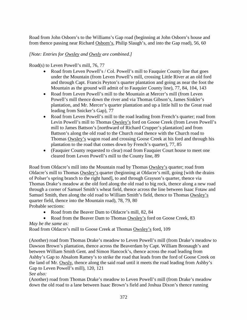
372
Road from John Osborn’s to the Williams’s Gap road (beginning at John Osborn’s house and from thence passing near Richard Osborn’s, Philip Slaugh’s, and into the Gap road), 56, 60 [Note: Entries for Owsley and Owsly are combined.] Road(s) to Leven Powell’s mill, 76, 77
• Road from Leven Powell’s / Col. Powell’s mill to Fauquier County line that goes under the Mountain (from Leven Powell’s mill, crossing Little River at an old ford and through Capt. Francis Peyton’s quarter plantation and going as near the foot the Mountain as the ground will admit of to Fauquier County line), 77, 84, 104, 143
• Road from Leven Powell’s mill to the Mountain at Mercer’s mill (from Leven Powell’s mill thence down the river and via Thomas Gibson’s, James Sinkler’s plantation, and Mr. Mercer’s quarter plantation and up a little hill to the Great road leading from Snicker’s Gap), 77
• Road from Leven Powell’s mill to the road leading from French’s quarter; road from Levin Powell’s mill to Thomas Owsley’s ford on Goose Creek (from Leven Powell’s mill to James Battson’s [northward of Richard Crupper’s plantation] and from Battson’s along the old road to the Church road thence with the Church road to Thomas Owsley’s wagon road and crossing Goose Creek at his ford and through his plantation to the road that comes down by French’s quarter), 77, 85
• (Fauquier County requested to clear) road from Fauquier Court house to meet one cleared from Leven Powell’s mill to the County line, 89
Road from Oldacre’s mill into the Mountain road by Thomas Owsley’s quarter; road from Oldacre’s mill to Thomas Owsley’s quarter (beginning at Oldacre’s mill, going [with the drains of Polser’s spring branch to the right hand], to and through Grayson’s quarter, thence via Thomas Drake’s meadow at the old ford along the old road to big rock, thence along a new road through a corner of Samuel Smith’s wheat field, thence across the line between Isaac Fotaw and Samuel Smith, then along the old road to William Smith’s field, thence to Thomas Owsley’s quarter field, thence into the Mountain road), 78, 79, 80 Probable sections:
• Road from the Beaver Dam to Oldacre’s mill, 82, 84 • Road from the Beaver Dam to Thomas Owsley’s ford on Goose Creek, 83
May be the same as: Road from Oldacre’s mill to Goose Creek at Thomas Owsley’s ford, 109 (Another) road from Thomas Drake’s meadow to Leven Powell’s mill (from Drake’s meadow to Dawson Brown’s plantation, thence across the Beaverdam by Capt. William Bronaugh’s and between William Smith Gent. and Simon Hancock’s, thence across the road leading from Ashby’s Gap to Absalom Ramey’s to strike the road that leads from the ford of Goose Creek on the land of Mr. Owsly, thence along the said road until it meets the road leading from Ashby’s Gap to Leven Powell’s mill), 120, 121 See also: (Another) road from Thomas Drake’s meadow to Leven Powell’s mill (from Drake’s meadow down the old road to a lane between Isaac Brown’s field and Joshua Dixon’s thence running
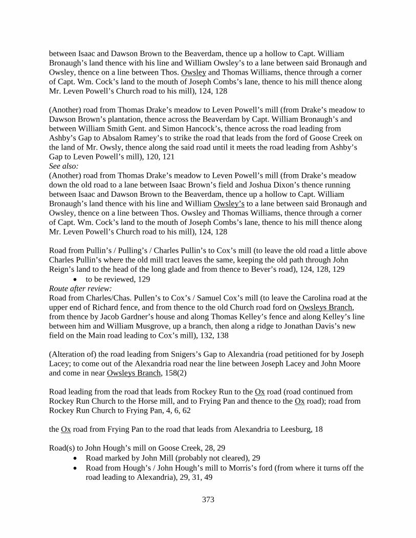
373
between Isaac and Dawson Brown to the Beaverdam, thence up a hollow to Capt. William Bronaugh’s land thence with his line and William Owsley’s to a lane between said Bronaugh and Owsley, thence on a line between Thos. Owsley and Thomas Williams, thence through a corner of Capt. Wm. Cock’s land to the mouth of Joseph Combs’s lane, thence to his mill thence along Mr. Leven Powell’s Church road to his mill), 124, 128 (Another) road from Thomas Drake’s meadow to Leven Powell’s mill (from Drake’s meadow to Dawson Brown’s plantation, thence across the Beaverdam by Capt. William Bronaugh’s and between William Smith Gent. and Simon Hancock’s, thence across the road leading from Ashby’s Gap to Absalom Ramey’s to strike the road that leads from the ford of Goose Creek on the land of Mr. Owsly, thence along the said road until it meets the road leading from Ashby’s Gap to Leven Powell’s mill), 120, 121 See also: (Another) road from Thomas Drake’s meadow to Leven Powell’s mill (from Drake’s meadow down the old road to a lane between Isaac Brown’s field and Joshua Dixon’s thence running between Isaac and Dawson Brown to the Beaverdam, thence up a hollow to Capt. William Bronaugh’s land thence with his line and William Owsley’s to a lane between said Bronaugh and Owsley, thence on a line between Thos. Owsley and Thomas Williams, thence through a corner of Capt. Wm. Cock’s land to the mouth of Joseph Combs’s lane, thence to his mill thence along Mr. Leven Powell’s Church road to his mill), 124, 128 Road from Pullin’s / Pulling’s / Charles Pullin’s to Cox’s mill (to leave the old road a little above Charles Pullin’s where the old mill tract leaves the same, keeping the old path through John Reign’s land to the head of the long glade and from thence to Bever’s road), 124, 128, 129
• to be reviewed, 129 Route after review: Road from Charles/Chas. Pullen’s to Cox’s / Samuel Cox’s mill (to leave the Carolina road at the upper end of Richard fence, and from thence to the old Church road ford on Owsleys Branch, from thence by Jacob Gardner’s house and along Thomas Kelley’s fence and along Kelley’s line between him and William Musgrove, up a branch, then along a ridge to Jonathan Davis’s new field on the Main road leading to Cox’s mill), 132, 138 (Alteration of) the road leading from Snigers’s Gap to Alexandria (road petitioned for by Joseph Lacey; to come out of the Alexandria road near the line between Joseph Lacey and John Moore and come in near Owsleys Branch, 158(2) Road leading from the road that leads from Rockey Run to the Ox road (road continued from Rockey Run Church to the Horse mill, and to Frying Pan and thence to the Ox road); road from Rockey Run Church to Frying Pan, 4, 6, 62 the Ox road from Frying Pan to the road that leads from Alexandria to Leesburg, 18 Road(s) to John Hough’s mill on Goose Creek, 28, 29
• Road marked by John Mill (probably not cleared), 29 • Road from Hough’s / John Hough’s mill to Morris’s ford (from where it turns off the
road leading to Alexandria), 29, 31, 49
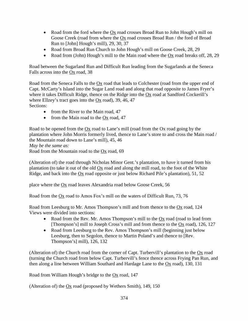
374
• Road from the ford where the Ox road crosses Broad Run to John Hough’s mill on Goose Creek (road from where the Ox road crosses Broad Run / the ford of Broad Run to [John] Hough’s mill), 29, 30, 37
• Road from Broad Run Church to John Hough’s mill on Goose Creek, 28, 29 • Road from (John) Hough’s mill to the Main road where the Ox road breaks off, 28, 29
Road between the Sugarland Run and Difficult Run leading from the Sugarlands at the Seneca Falls across into the Ox road, 38 Road from the Seneca Falls to the Ox road that leads to Colchester (road from the upper end of Capt. McCarty’s Island into the Sugar Land road and along that road opposite to James Fryer’s where it takes Difficult Ridge, thence on the Ridge into the Ox road at Sandford Cockerill’s where Ellzey’s tract goes into the Ox road), 39, 46, 47 Sections:
• from the River to the Main road, 47 • from the Main road to the Ox road, 47
Road to be opened from the Ox road to Lane’s mill (road from the Ox road going by the plantation where John Morris formerly lived, thence to Lane’s store to and cross the Main road / the Mountain road down to Lane’s mill), 45, 46 May be the same as: Road from the Mountain road to the Ox road, 69 (Alteration of) the road through Nicholas Minor Gent.’s plantation, to have it turned from his plantation (to take it out of the old Ox road and along the mill road, to the foot of the White Ridge, and back into the Ox road opposite or just below Richard Pile’s plantation), 51, 52 place where the Ox road leaves Alexandria road below Goose Creek, 56 Road from the Ox road to Amos Fox’s mill on the waters of Difficult Run, 73, 76 Road from Leesburg to Mr. Amos Thompson’s mill and from thence to the Ox road, 124 Views were divided into sections:
• Road from the Rev. Mr. Amos Thompson’s mill to the Ox road (road to lead from [Thompson’s] mill to Joseph Cross’s mill and from thence to the Ox road), 126, 127
• Road from Leesburg to the Rev. Amos Thompson’s mill (beginning just below Leesburg, then to Segolon, thence to Martin Poland’s and thence to [Rev. Thompson’s] mill), 126, 132
(Alteration of) the Church road from the corner of Capt. Turbervill’s plantation to the Ox road (turning the Church road from below Capt. Turbervill’s fence thence across Frying Pan Run, and then along a line between William Southard and Hardage Lane to the Ox road), 130, 131 Road from William Hough’s bridge to the Ox road, 147 (Alteration of) the Ox road (proposed by Wethers Smith), 149, 150
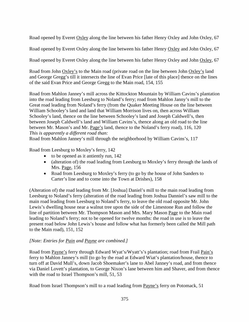
375
Road opened by Everet Oxley along the line between his father Henry Oxley and John Oxley, 67 Road opened by Everet Oxley along the line between his father Henry Oxley and John Oxley, 67 Road opened by Everet Oxley along the line between his father Henry Oxley and John Oxley, 67 Road from John Oxley’s to the Main road (private road on the line between John Oxley’s land and George Gregg’s till it intersects the line of Evan Price [late of this place] thence on the lines of the said Evan Price and George Gregg to the Main road, 154, 155 Road from Mahlon Janney’s mill across the Kittockton Mountain by William Cavins’s plantation into the road leading from Leesburg to Noland’s ferry; road from Mahlon Janny’s mill to the Great road leading from Noland’s ferry (from the Quaker Meeting House on the line between William Schooley’s land and land that William Morrison lives on, then across William Schooley’s land, thence on the line between Schooley’s land and Joseph Caldwell’s, then between Joseph Caldwell’s land and William Cavins’s, thence along an old road to the line between Mr. Mason’s and Mr. Page’s land, thence to the Noland’s ferry road), 116, 120 This is apparently a different road than: Road from Mahlon Janney’s mill through the neighborhood by William Cavins’s, 117 Road from Leesburg to Moxley’s ferry, 142
• to be opened as it antiently run, 142 • (alteration of) the road leading from Leesburg to Moxley’s ferry through the lands of
Mrs. Page, 156 • Road from Leesburg to Moxley’s ferry (to go by the house of John Sanders to
Carter’s line and to come into the Town at Drishes), 158 (Alteration of) the road leading from Mr. [Joshua] Daniel’s mill to the main road leading from Leesburg to Noland’s ferry (alteration of the road leading from Joshua Danniel’s saw mill to the main road leading from Leesburg to Noland’s ferry, to leave the old road opposite Mr. John Lewis’s dwelling house near a walnut tree upon the side of the Limestone Run and follow the line of partition between Mr. Thompson Mason and Mrs. Mary Mason Page to the Main road leading to Noland’s ferry; not to be opened for twelve months: the road in use is to leave the present road below John Lewis’s house and follow what has formerly been called the Mill path to the Main road), 151, 152 [Note: Entries for Pain and Payne are combined.] Road from Payne’s ferry through Edward Wyat’s/Wyatt’s’s plantation; road from Frail Pain’s ferry to Mahlon Janney’s mill (to go by the road at Edward Wiat’s plantation/house, thence to turn off at David Mull’s, down Jacob Shoemaker’s lane to Abel Janney’s road, and from thence via Daniel Lovett’s plantation, to George Nixon’s lane between him and Shaver, and from thence with the road to Israel Thompson’s mill, 51, 53 Road from Israel Thompson’s mill to a road leading from Payne’s ferry on Potomack, 51

376
Road from Payne’s ferry to Kittocton Creek, 61 Road from John Hough’s Gap mill to the road leading to Pain’s ferry as also from the Gap to Joshua Gore’s below the Short Hills, 70 Road from William Smith’s under the Short Hill to Farling Ball’s mill (road from William Smith’s to Farling Ball’s mill, beginning at William Smith’s, going with an old path to a place belonging to James Clemons, and along the lines of John Folkes, Adam Axlyne, John Jackson, John Axline, and Abner Roberts’s, until it crosses the Buffaloe Branch, into the road leading to Pain’s, and with it near a line between Hutton &c. and down to Farling Ball’s mill), 74, 78 Probably the same as:
• Road from William Smith’s to Farling Ball’s mill, 109 • Road from Farling Ball’s mill to the Short Hill, 140
Road from Payne’s ferry to the crossroad by William Hibbs’s, 89 Road from Payne’s ferry to Israel Thompson’s mill (turning out of Payne’s road, through Jacob Shoemaker’s barley field by his barn and lane to Jacob Hibbs’s field, thence with the line between Jacob Hibbs and David Lovat to George Shaffer’s lot, thence with the line between George Shaffer and George Nixon, thence by George Nixon’s wheat field, and from thence the most direct way to Israel Thompson’s mill), 99 Road from Mercer Brown’s mill into the road to Pain’s ferry, 128 (Alteration of) road from Pain’s ferry (to be turned round John Short’s fence between the said Short and John Axline &c.), 138 Road from John Hough’s grist mill on the North Fork Kittockton Creek at the Gap of the Short Hills to Potomack River opposite or near Frail Pain’s, 27 Road from Goose Creek at William Stephens’s ford to the Painter Skin, 84 Road from Jeffrey’s Branch a little above William Taylor, Sr.’s and to the County line near the Painter Skin ford, 85 Road from Painter Skin to the Blue Ridge, 156 Road from the Town of Leesburgh to Williams’s Gap (via John Palmer’s and by Isaac Nichols’s and from thence to the road where Samuel Davis formerly lived and from thence to the Town), 10, 11 Sections:
• [from Williams’s Gap] to Isaac Nichols’s, 11 • from Isaac Nichols’s to the road that leads to Leesburgh, 11
Road from Joseph Parker’s shop to the Mountain Church, 108
377
Road from the Quaker Meeting House across the Mountain to Leesburg (near the line dividing the lands of Fleming Patterson, Harrison Manley, and Samuel Tillett, 68, 70 Payne: See Pain. Road from William Dodd’s to/toward Williams’s Gap (turning out of the Main county road near the corner of Owen Robert’s fence and William Dodd’s thence a direct course towards Williams’s Gap through Joseph Claypoole’s lane and by Jehu Lewis’s, Mahlon Kirkbride’s, James Dillion’s, the lands of Col. G. W. Fairfax, Nicholas Osborn’s, then turning round Taylor’s Hill to John Pearce’s and from there to Williams’s Gap), 32, 35, 36 Sections:
• [from William Dodd’s] to a run that leads down by Isaac Nichols’s (road from William Dodd’s to the head of Isaac Nicholls’s Run), 36, 51
• from the run by Isaac Nichols’s to Williams’s Gap, 36 May be the same as: Road from Owen Roberts’s to Sniggers’s Gap, 61 See also: Road from Owen Robert’s fence to John Pearce’s (order set aside), 47 Road from the road that leads from Sniggers’s Gap by John Pearce’s and to take out near John Pearce’s and from thence to cross the road that leads from Leesburg to Sniggers’s Gap about four miles from the Ridge and from thence to Isaac Nickols’s/Nickolls’s mill and into the same road near Jacob Janney’s mill, 66, 68
• quashed, and old road to be continued, 96
Road from Whitely’s/Whiteley’s ford on Goose Creek to Leven Powell’s mill (to leave Powell’s mill road below James Sinkler’s plantation where an old road turns out, up a branch, and by Capt. Peyton’s plantation and crossing Snickers’s road to the Leesburg road and with the Leesburg road to Whiteley’s ford), 100, 101 Probably the same as: Road from the forks by Goose Creek, Whitely’s ford to Col. Powell’s mill, 146 [Road from Little River to Ashby’s Gap], 2(2) Apparently sections of the same road:
• Road leading through Ashby’s Gap, from Little River to Goose Creek, 2 • Road leading through Ashby’s Gap, from Goose Creek to the County line on the Blue
Ridge, 2 See also: (New) Road from the ford of Little River to Ashby’s Gap (road from the ford of Little River to Ashby’s Gap (from Little River and following the old road around Mercer’s Meadow Ground, thence into Mr. Craven Peyton’s plantation, thence with the old road again to Cromwell’s Run, thence to the top of the hill, and thence with the old road to Ashby’s Gap), 19, 26 Sections:
• from Goose Creek to the County line, 26 • from Little River to Goose Creek, 26, 33, 56
378
May be the same as: Road from Mercer’s mill to Ashby’s Gap (portion turned by Leven Powell), 30, 45 Section:
• as far as Goose Creek, 45 Road from Israel Thompson’s mill, going through or near Benjamin Pool’s plantation until it intersects the road leading from Leesburg to Williams’s Gap, 92
• (review of) the road intended from Thompson’s mill to the road leading from Leesburg to Snicker’s Gap, 100
• review to report the difference to establish the road to avoid the plantation of Craven Peyton Gent. and also how far the road as marked will run through Peyton’s plantation and meadow, and further to report how many of the inhabitants resort to the mill along the said road, 100
(Alteration of) the Main road that leads through Mr. Craven Peyton’s plantation (to go round the said plantation), 136, 137
• to be reviewed, 137 Road from John Osborne’s lane between him and Craven Peyton Esqr. to the road leading to Mr. Neilson’s mill and to the Baptist Meeting House (road from John Osborn’s lane to the Baptist Meeting House), 137, 139 Road from the road against Mr. Francis Peyton’s to Lasswell’s ford on Goose Creek / road from Goose Creek to Capt. Francis Peyton’s (beginning in the road that leads from Ashby’s Gap to the road that leads from Williams’s Gap to Alexandria, near where the roads intersect and turning via the path that leads to Williams’s Rolling road, crossing the road and thence by Leonard Marbury’s plantation and following the path that leads from Marbury’s to Lasswell’s ford), 33, 33-34, 46, 71, 93 Road(s) to Leven Powell’s mill, 76, 77
• Road from Leven Powell’s / Col. Powell’s mill to Fauquier County line that goes under the Mountain (from Leven Powell’s mill, crossing Little River at an old ford and through Capt. Francis Peyton’s quarter plantation and going as near the foot the Mountain as the ground will admit of to Fauquier County line), 77, 84, 104, 143
• Road from Leven Powell’s mill to the Mountain at Mercer’s mill (from Leven Powell’s mill thence down the river and via Thomas Gibson’s, James Sinkler’s plantation, and Mr. Mercer’s quarter plantation and up a little hill to the Great road leading from Snicker’s Gap), 77
• Road from Leven Powell’s mill to the road leading from French’s quarter; road from Levin Powell’s mill to Thomas Owsley’s ford on Goose Creek (from Leven Powell’s mill to James Battson’s [northward of Richard Crupper’s plantation] and from Battson’s along the old road to the Church road thence with the Church road to Thomas Owsley’s wagon road and crossing Goose Creek at his ford and through his plantation to the road that comes down by French’s quarter), 77, 85
• (Fauquier County requested to clear) road from Fauquier Court house to meet one cleared from Leven Powell’s mill to the County line, 89
379
Road from Roszell’s to Little River at Mercer’s quarter, 120 May be a second viewing or a review: Road from the Frederick road to begin at a branch about a mile below Stephen Roszell’s to cross Goose Creek near Combs’s mill then to Little River at Mercer’s old quarter; road from the road below Stephen Roszel’s to cross Goose Creek near Combs’s mill, then to Mercer’s quarter on Little River (beginning at a branch, extending on or near the line of Capt. Cock’s to William Allen’s lane and field near Mr. Combs’s mill, to the old ford on Goose Creek, thence upon the line between Thaddeus McCarty and Joseph Farrow, and between Andrew and Thomas Batey into the road by Capt. Francis Peyton, and down that road into the Mountain road and down the Mountain road to Mercer’s old quarter), 121, 122-123 Road from Simon Triplett’s through William McNabb’s plantation to Jacob Read’s (keeping on/near the old road from the mill, thence though a corner and on the line of William McNabb’s plantation, thence through a corner of Col. Francis Peyton’s land into the already cleared road at the head of a valley, thence with the said road to Jacob Read’s), 124, 125 Road from Jacob Everhart’s/Everart’s/Everheart’s mill to Richard Roach’s/Roach’s mill (from Everhart’s mill, following the present road up the ridge, then by the lands of Isaac Vanbuskirk, Samuel Smith, Nicholas Phillips, Adam Vincel, Henry Tope, William Laycock, Samuel Schooley, and James Ferguson, crossing Broad Run, near the mouth of Schooley’s spring drain, and along the path that leads from Ferguson’s to Roach’s mill, up the spring drain on the path, then with the path to the upper ford by Roach’s mill, and to the mill), 49, 50, 56, 61, 62, 64, 68
• reviewed, 64, 68 See also: (New) Road from Jacob Everhart’s mill into the road leading from there to Richard Roach’s mill, 79 (Alteration of) the road through Nicholas Minor Gent.’s plantation, to have it turned from his plantation (to take it out of the old Ox road and along the mill road, to the foot of the White Ridge, and back into the Ox road opposite or just below Richard Pile’s plantation), 51, 52 Mountain Road, 1, 4, 18, 123, 143, 154 Sections:
• from the Post up to the road to Piney Branch (road from Little Rockey Run called the Mountain road up the said road to the Post / old Post; road from the Post / old Posts to Piney Branch), 1, 4, 37, 95, 107 Probably the same as: Road from [torn] Branch to the old Post, 23
• from the Post to the County line; road from Little Rockey Run down the Mountain road to the end of the County / County line, including the bridge over Little Rockey Run; road from Little Rockey Run to the County line / Fairfax County line; road from Little Rockey Run to the County line the way to Alexandria, 1, 4, 30, 41, 95
• from Little Rocky Run to the forks by Edwards’s; road from Little Rocky Run / from the lower side of Little Rocky Run to Edwards’s old shop, 134, 147, 154
Related roads or sections:

380
• Road that leads to Alexandria (portion as low as the County line), 30 • Roads from Little Rockey Run to the County line the roads that lead to Alexandria
and Colchester, 37 Road from Piney Branch on the Mountain road to Little River, 1, 28, 40, 45, 60 Sections:
• the upper part of the road from Piney Branch to Little River, 83, 94, 100 • the lower part, 83
May be a different road: Road from Little River to Piney Branch and from thence to the fork of the road at John Homes’s, 44, 60 Road from Rogues road to Piney Branch, 40 Roads / Great roads from Snicker’s and Vestal’s Gaps / from Frederick County to Alexandria and Colchester, 93, 94, 102, 103(2), 105, 109, 114
• Act of Assembly for repairing, 114 Section[?]:
• Road from Piney Branch to Hutchison’s Spring, 94 Road from Patrick Kelly’s to Piney Branch, 153 Road from Leesburg to Mr. Amos Thompson’s mill and from thence to the Ox road, 124 Views were divided into sections:
• Road from the Rev. Mr. Amos Thompson’s mill to the Ox road (road to lead from [Thompson’s] mill to Joseph Cross’s mill and from thence to the Ox road), 126, 127
• Road from Leesburg to the Rev. Amos Thompson’s mill (beginning just below Leesburg, then to Segolon, thence to Martin Poland’s and thence to [Rev. Thompson’s] mill), 126, 132
Road from Oldacre’s mill into the Mountain road by Thomas Owsley’s quarter; road from Oldacre’s mill to Thomas Owsley’s quarter (beginning at Oldacre’s mill, going [with the drains of Polser’s spring branch to the right hand], to and through Grayson’s quarter, thence via Thomas Drake’s meadow at the old ford along the old road to big rock, thence along a new road through a corner of Samuel Smith’s wheat field, thence across the line between Isaac Fotaw and Samuel Smith, then along the old road to William Smith’s field, thence to Thomas Owsley’s quarter field, thence into the Mountain road), 78, 79, 80 Probable sections:
• Road from the Beaver Dam to Oldacre’s mill, 82, 84 • Road from the Beaver Dam to Thomas Owsley’s ford on Goose Creek, 83
May be the same as: Road from Oldacre’s mill to Goose Creek at Thomas Owsley’s ford, 109 Road from Israel Thompson’s mill, going through or near Benjamin Pool’s plantation until it intersects the road leading from Leesburg to Williams’s Gap, 92
381
• (review of) the road intended from Thompson’s mill to the road leading from Leesburg to Snicker’s Gap, 100
• review to report the difference to establish the road to avoid the plantation of Craven Peyton Gent. and also how far the road as marked will run through Peyton’s plantation and meadow, and further to report how many of the inhabitants resort to the mill along the said road, 100
Road from Kirk’s mill to the road leading by Edward Harding’s to Leesburgh / the Town (road from William Kirk’s mill via the old road and Steer’s old field to the Main road leading by Edward Harding’s), 7, 8 Related road or review: Road from William Kirk’s mill to the road leading by Edward Harding’s to Leesburgh (recommended to go via Ralph Braddock’s, Richard Roberts’s, the bridge in the Main road near Robert Popkins’s fence [above Popkins’s plantation]), 12, 19 Road from Kirk’s mill to John Popkins’s, 24, 37 May be same as: Road from Kirk’s mill to Thomas John’s (road from Kirk’s mill), 46, 77 fork of the roads near Edward Porter’s (where one road leads to Alexandria and the other to Occoquan warehouse), 13, 16 Road from Little Rockey Run to Hutchison’s Post, 36 Mountain Road, 1, 4, 18, 123, 143, 154 Sections:
• from the Post up to the road to Piney Branch (road from Little Rockey Run called the Mountain road up the said road to the Post / old Post; road from the Post / old Posts to Piney Branch), 1, 4, 37, 95, 107 Probably the same as: Road from [torn] Branch to the old Post, 23
• from the Post to the County line; road from Little Rockey Run down the Mountain road to the end of the County / County line, including the bridge over Little Rockey Run; road from Little Rockey Run to the County line / Fairfax County line; road from Little Rockey Run to the County line the way to Alexandria, 1, 4, 30, 41, 95
• from Little Rocky Run to the forks by Edwards’s; road from Little Rocky Run / from the lower side of Little Rocky Run to Edwards’s old shop, 134, 147, 154
Related roads or sections: • Road that leads to Alexandria (portion as low as the County line), 30 • Roads from Little Rockey Run to the County line the roads that lead to Alexandria
and Colchester, 37 Road from the Post to Broad Run Church, 1, 3 Road from Rogues road to the old Post, 83
382
[Note: All spelling variants of Poto(w)mac(k) are combined.] Road from the Great Lime Stone / Great Limestone to (Philip) Noland’s/Nowland’s ferry across Potomac River (Road from Limestone Run), 2, 13, 16, 32, 36, 38, 49 Probable sections:
• Road from Noland’s / Capt. Noland’s / Philip Noland’s ferry to Todhunter’s / John Todhunter’s, 88, 118, 139
• Road from the Great Lime Stone / Limestone Spring / Limestone to Todhunter’s / John Todhunter’s, 88, 94, 139(2)
Road from Potowmack River between the Blue Ridge and Short Hills into the road that leads to John Hough’s mill (road from Potowmack River to the Mountain road between the Blue Ridge and Short Hills), 19, 20(2)
• order set aside, 20 Road from John Hough’s grist mill on the North Fork Kittockton Creek at the Gap of the Short Hills to Potomack River opposite or near Frail Pain’s, 27 Road from the Sugar Lands to the Great Falls of Potowmack River, 29 Road from Israel Thompson’s mill to a road leading from Payne’s ferry on Potomack, 51 Road from Potomack River into the main wagon road between the Blue Ridge and Short Hill, 66 Road from the road near James Connard’s to Potomack River towards Harper’s ferry (to leave the Main road by Michael Sellers’s then by George Fout’s, then by Robert Russell’s, thence by marked trees to Harper’s Spring near Potomack, and thence to the River Potomack), 74 Road from the Valentine quarter on Potowmack River to Farling Ball’s mill and store (to go with or near the old road as far as Leonard May’s fence and thence by Moses Heaton’s to Farling Ball’s mill and store), 102, 104 Road from Potowmack River opposite William Luckett Jr.’s ferry to Pursley’s ordinary; road(s) from Ball’s mill to Luckett’s ferry and from Ball’s mill to Israel Thompson’s mill, 109, 116 Probable sections:
• Road from Ball’s mill to Israel Thompson’s mill (from Ball’s mill, then between Frederick Cooper’s plantation and David Mull’s by Anthony Wright’s lane into a road leading to Thompson’s mill), 116
• Road from (Farling) Ball’s mill to Luckett’s ferry (from Ball’s mill towards Potowmack, along the road leading from Ball’s mill to the Valentine quarter, by Leonard May’s plantation, thence between William Rasler’s and Isaac Shown’s plantations, thence by a path to Luckett’s ferry), 116, 138
Road from the end of the Short Hill / Short Hills (on the north west side at Potomack River) to the Great road leading to Keyes’s ferry, 140(2)
383
Road from Samuel Potts’s mill near the Blue Ridge across the lands of the Honorable George William Fairfax into the Main road leading over Vestal’s Gap (through the lands of Ezekiel Potts, David Williams, John Russell, John Arvecross, thence down to a branch leading from Evan Evans’s meadow and to James Connard’s field, thence into the Main road leading from Alexandria over the Blue Ridge at Vestal’s Gap, near the new roads that lead betwixt the hill to Robert Harper’s ferry; road lately laid out from the Great Main road to Potts’s mill, 81, 88, 89 [Note: This road was probably not cleared.]
• to be reviewed, 89 Route after review: Road from Potts’s mill across the Hon. George William Fairfax’s land into the Main road leading over the Blue Ridge at Vestal’s Gap; road through the lands of George William Fairfax Esqr. (beginning at Potts’s mill and from there through Ezekiel Potts’s land, thence through David Williams’s lot near his field, thence on/near the line between David Williams and John Russell, thence with/near the line between Evan Evans and John Arbecost, thence to Valentine Miller’s field and from there near the line between Valentine Miller and John Fearst, through Henry Michael’s lot, by the tail race of John Vestall’s mill, and from thence through a lane between the lots of Michael and Reuben Doughty into the Main road), 93, 101 Outlet (road) for Nathan Potts to the Main County road; outlet for Nathan Potts (from Nathan Potts’s dwelling house to and along the dividing line between Nathan Potts and his brother Ezekiel Potts, thence along the line between Robert Jamison and Ezekiel Potts to Jamison’s lane and thence into the road leading from Alexandria to Snicker’s Gap [where the said Road is to run between Ezekiel Potts and Robert Jamison, each of them shall leave ten feet of land]), 133, 134-135, 137
• proposed route objected to, 135 • to be reviewed, 135 • established, 137
Outlet (road) for Nathan Potts to the Main County road; outlet for Nathan Potts (from Nathan Potts’s dwelling house to and along the dividing line between Nathan Potts and his brother Ezekiel Potts, thence along the line between Robert Jamison and Ezekiel Potts to Jamison’s lane and thence into the road leading from Alexandria to Snicker’s Gap [where the said Road is to run between Ezekiel Potts and Robert Jamison, each of them shall leave ten feet of land]), 133, 134-135, 137
• proposed route objected to, 135 • to be reviewed, 135 • established, 137
Road from Samuel Potts’s mill along under the Blue Ridge to the end of John Osborn Sr.’s land, 81 Road from Samuel Potts’s mill near the Blue Ridge across the lands of the Honorable George William Fairfax into the Main road leading over Vestal’s Gap (through the lands of Ezekiel Potts, David Williams, John Russell, John Arvecross, thence down to a branch leading from Evan Evans’s meadow and to James Connard’s field, thence into the Main road leading from

384
Alexandria over the Blue Ridge at Vestal’s Gap, near the new roads that lead betwixt the hill to Robert Harper’s ferry; road lately laid out from the Great Main road to Potts’s mill, 81, 88, 89 [Note: This road was probably not cleared.]
• to be reviewed, 89 Route after review: Road from Potts’s mill across the Hon. George William Fairfax’s land into the Main road leading over the Blue Ridge at Vestal’s Gap; road through the lands of George William Fairfax Esqr. (beginning at Potts’s mill and from there through Ezekiel Potts’s land, thence through David Williams’s lot near his field, thence on/near the line between David Williams and John Russell, thence with/near the line between Evan Evans and John Arbecost, thence to Valentine Miller’s field and from there near the line between Valentine Miller and John Fearst, through Henry Michael’s lot, by the tail race of John Vestall’s mill, and from thence through a lane between the lots of Michael and Reuben Doughty into the Main road), 93, 101 Road from the Loudoun County line into the Great Mountain road that leads from West’s ordinary to Snickers’s Gap (beginning at Fauquier County line at the end of the new road cleared by an order of the Court of Fauquier and running thence through Benjamin Chandler’s plantation, a corner of the Widow Morris’s field, and by James Lampkin’s plantation, crossing Little River at the mouth of William Berkley’s spring branch to Powell’s mill road, and with the said road to Snicker’s Gap road), 73, 79-80 Alteration of roads as requested by James Mercer, 86
• Road from the ford of Little River to Snicker’s Gap, 86, 88, 92 • Road from Little River to Powell’s mill, 86, 88, 92
(Alteration of) the road from the Carolina road to Powell’s mill, 143 Road from Powell’s mill to Cromwells Run, 145 [Road from Little River to Ashby’s Gap], 2(2) Apparently sections of the same road:
• Road leading through Ashby’s Gap, from Little River to Goose Creek, 2 • Road leading through Ashby’s Gap, from Goose Creek to the County line on the Blue
Ridge, 2 See also: (New) Road from the ford of Little River to Ashby’s Gap (road from the ford of Little River to Ashby’s Gap (from Little River and following the old road around Mercer’s Meadow Ground, thence into Mr. Craven Peyton’s plantation, thence with the old road again to Cromwell’s Run, thence to the top of the hill, and thence with the old road to Ashby’s Gap), 19, 26 Sections:
• from Goose Creek to the County line, 26 • from Little River to Goose Creek, 26, 33, 56
May be the same as: Road from Mercer’s mill to Ashby’s Gap (portion turned by Leven Powell), 30, 45 Section:
• as far as Goose Creek, 45

385
Road from the road that leads from Ashby’s Gap to Alexandria from Leven Powell’s plantation to Goose Creek Chapel (road leading from Ashby’s Gap to Alexandria from Leven Powell’s plantation to Goose Creek Church), 24, 27 Road from the big branch / great branch above Leven Powell’s to Goose Creek, 48 Road from Champes Mountain to the big branch / great branch by Leven Powell’s, 48 Road from the branch below Mr. Levin Powell’s plantation to Goose Creek, (to be taken from the old road at the upper end of an old field near Leven Powell’s plantation and along Leven Powell’s and Elijah Chinn’s line to near Christopher Chinn’s plantation thence along and crossing a small branch, and keeping partly a direct course to the old road about half a mile above Thomas Chinn’s plantation near where a small path goes into the same), 51, 52 (Alteration of) the road by Leven Powell and Thomas Chinn (near their plantations), 71(2) Road(s) to Leven Powell’s mill, 76, 77
• Road from Leven Powell’s / Col. Powell’s mill to Fauquier County line that goes under the Mountain (from Leven Powell’s mill, crossing Little River at an old ford and through Capt. Francis Peyton’s quarter plantation and going as near the foot the Mountain as the ground will admit of to Fauquier County line), 77, 84, 104, 143
• Road from Leven Powell’s mill to the Mountain at Mercer’s mill (from Leven Powell’s mill thence down the river and via Thomas Gibson’s, James Sinkler’s plantation, and Mr. Mercer’s quarter plantation and up a little hill to the Great road leading from Snicker’s Gap), 77
• Road from Leven Powell’s mill to the road leading from French’s quarter; road from Levin Powell’s mill to Thomas Owsley’s ford on Goose Creek (from Leven Powell’s mill to James Battson’s [northward of Richard Crupper’s plantation] and from Battson’s along the old road to the Church road thence with the Church road to Thomas Owsley’s wagon road and crossing Goose Creek at his ford and through his plantation to the road that comes down by French’s quarter), 77, 85
• (Fauquier County requested to clear) road from Fauquier Court house to meet one cleared from Leven Powell’s mill to the County line, 89
Road from Levin Powell’s mill road to Champes Mountain, 85 Road from Whitely’s/Whiteley’s ford on Goose Creek to Leven Powell’s mill (to leave Powell’s mill road below James Sinkler’s plantation where an old road turns out, up a branch, and by Capt. Peyton’s plantation and crossing Snickers’s road to the Leesburg road and with the Leesburg road to Whiteley’s ford), 100, 101 Probably the same as: Road from the forks by Goose Creek, Whitely’s ford to Col. Powell’s mill, 146 Road from Thomas Drake’s to Leven Powell’s grist mill; road from Thomas Drake’s meadow to Hezekiah Guy’s grist mill, and near the Quaker Meeting House and thence to cross Goose Creek

386
at James Leith’s and to Leven Powell’s mill road; road from Thomas Drake’s meadow to Hezekiah Guy’s grist mill and near the Quaker Meeting House and from thence to Leven Powell’s mill (beginning at Thomas Drake’s meadow, thence through James Carter’s lane and by Malakiah Cumming’s field, thence through the lands of Samuel Smith, John Neal, Thomas Smith, Thomas Russell, Thomas Lewis, thence into the old tract in or near Richard Hanson’s grubbing, thence to a good ford on Goose Creek and along the bottom of the creek, and to Leven Powell’s mill), 100, 103-104, 108, 109, 119 Sections:
• [from Drake’s] to Goose Creek, 108, 109, 119 • from Goose Creek (by James Leith’s plantation) to Powell’s mill, 108, 109
Road from Goose Creek Church to Leven Powell’s mill / mill road (leaving the big new road opposite to Thaddeus McCarty’s new ground fence, thence through the plantation of Henry Batterton, by an old cabin in George Johnston’s field and through Johnston’s wheat field, thence to Leven Powell’s mill road opposite to a schoolhouse at Richard Crupper’s), 101, 127 (Straightening the) road from Thomas Drake’s meadow to Leven Powell’s mill (by Joseph Cummins’s plantation); (altering the) road from Thomas Drake’s meadow to Leven Powell’s mill so as not to injure Joseph Cummings’s [plantation], (beginning at the ford of Goose Creek, crossing the big branch then following the blazes to the line of Cummings and between him and Leven Powell’s and to continue to it intersects with the old road), 109, 112 (Another) road from Thomas Drake’s meadow to Leven Powell’s mill (from Drake’s meadow to Dawson Brown’s plantation, thence across the Beaverdam by Capt. William Bronaugh’s and between William Smith Gent. and Simon Hancock’s, thence across the road leading from Ashby’s Gap to Absalom Ramey’s to strike the road that leads from the ford of Goose Creek on the land of Mr. Owsly, thence along the said road until it meets the road leading from Ashby’s Gap to Leven Powell’s mill), 120, 121 See also: (Another) road from Thomas Drake’s meadow to Leven Powell’s mill (from Drake’s meadow down the old road to a lane between Isaac Brown’s field and Joshua Dixon’s thence running between Isaac and Dawson Brown to the Beaverdam, thence up a hollow to Capt. William Bronaugh’s land thence with his line and William Owsley’s to a lane between said Bronaugh and Owsley, thence on a line between Thos. Owsley and Thomas Williams, thence through a corner of Capt. Wm. Cock’s land to the mouth of Joseph Combs’s lane, thence to his mill thence along Mr. Leven Powell’s Church road to his mill), 124, 128 (Alteration of) the road by John McClain’s, 144 May be the same as: (Alteration of) the road from Goose Creek to Leven Powell’s mill: the way cleared by John McClain established, 144 Road from James Ball’s mill / Ball’s mill to the Presbyterian Meeting House / Meeting House, 147(2), 148
• to be reviewed at the request of Milholland, 148
387
Road from John Oxley’s to the Main road (private road on the line between John Oxley’s land and George Gregg’s till it intersects the line of Evan Price [late of this place] thence on the lines of the said Evan Price and George Gregg to the Main road, 154, 155 Road from Little River to the extreme part of the County to meet Prince William road, 5 May be the same as: Road (that leads by Capt. West’s) from the ford of Little River to the County line, 30 Road from West’s ordinary to the Prince William line, 134 (Alteration of) the road from Samuel Cox’s mill to the Prince William line near Major Charles West’s, 155
• order set aside and the old road continued, 155 Road leading from the Mountain road below Charles Eskridge’s to Capt. James Lane’s mill and from thence to the road that leads to Prince William Court[house], 25, 27-28, 35 Sections:
• from the Mountain road to [Lane’s] mill, 28 • from [Lane’s mill] to the road that leads to Prince William Courthouse, 28
Road from Pullin’s / Pulling’s / Charles Pullin’s to Cox’s mill (to leave the old road a little above Charles Pullin’s where the old mill tract leaves the same, keeping the old path through John Reign’s land to the head of the long glade and from thence to Bever’s road), 124, 128, 129
• to be reviewed, 129 Route after review: Road from Charles/Chas. Pullen’s to Cox’s / Samuel Cox’s mill (to leave the Carolina road at the upper end of Richard fence, and from thence to the old Church road ford on Owsleys Branch, from thence by Jacob Gardner’s house and along Thomas Kelley’s fence and along Kelley’s line between him and William Musgrove, up a branch, then along a ridge to Jonathan Davis’s new field on the Main road leading to Cox’s mill), 132, 138 Road from Simon Triplett Gent.’s mill to cross Little River near Joshua Taylor’s plantation and to intersect the Carolina road near Charles Pullen’s; road from Simon Triplett’s mill to the Carolina road (to take out of the cleared road near William McNabb’s plantation, thence through a corner of Michael Gahagan’s cleared ground, thence to the Watry Branch, thence to and through Joshua Taylor’s plantation to Little River near the line between Phineas Skinner’s and Nicholas Wyckoff’s thence with their line and the line between Charles Pullen and Richard Skinner to James Wrightmire’s shop), 125, 127 Road from Abel Janney’s under/near the Short Hill to Hough’s Gap mill (from an old road, near Abel Janney’s lane end, thence through Samuel Janney’s land, thence through Joseph Janney’s by the dwelling house. thence by Israel Thompson’s fields at his old quarter, thence through Dumb John Gregg’s land into his lane, thence through Samuel Gregg’s land, on the line between Samuel Gregg’s and Andrew Thompson’s, thence on the line between Charles McManemy’s and James Nixon’s, thence through James Nixon’s land on the line of McHaney’s two lotts, thence

388
through William Russell’s land into the Main road on the line of Thomas Pursel’s land, from thence along the Great road to the [Hough’s] Gap mill), 117, 127-128 Road from Potowmack River opposite William Luckett Jr.’s ferry to Pursley’s ordinary; road(s) from Ball’s mill to Luckett’s ferry and from Ball’s mill to Israel Thompson’s mill, 109, 116 Probable sections:
• Road from Ball’s mill to Israel Thompson’s mill (from Ball’s mill, then between Frederick Cooper’s plantation and David Mull’s by Anthony Wright’s lane into a road leading to Thompson’s mill), 116
• Road from (Farling) Ball’s mill to Luckett’s ferry (from Ball’s mill towards Potowmack, along the road leading from Ball’s mill to the Valentine quarter, by Leonard May’s plantation, thence between William Rasler’s and Isaac Shown’s plantations, thence by a path to Luckett’s ferry), 116, 138
Road from the Quaker Meeting House across the Mountain to Leesburg (near the line dividing the lands of Fleming Patterson, Harrison Manley, and Samuel Tillett, 68, 70 (Review of) the road from Leesburg to the Quaker Meeting House near Mahlon Janney’s, 83 Road from Thomas Drake’s to Leven Powell’s grist mill; road from Thomas Drake’s meadow to Hezekiah Guy’s grist mill, and near the Quaker Meeting House and thence to cross Goose Creek at James Leith’s and to Leven Powell’s mill road; road from Thomas Drake’s meadow to Hezekiah Guy’s grist mill and near the Quaker Meeting House and from thence to Leven Powell’s mill (beginning at Thomas Drake’s meadow, thence through James Carter’s lane and by Malakiah Cumming’s field, thence through the lands of Samuel Smith, John Neal, Thomas Smith, Thomas Russell, Thomas Lewis, thence into the old tract in or near Richard Hanson’s grubbing, thence to a good ford on Goose Creek and along the bottom of the creek, and to Leven Powell’s mill), 100, 103-104, 108, 109, 119 Sections:
• [from Drake’s] to Goose Creek, 108, 109, 119 • from Goose Creek (by James Leith’s plantation) to Powell’s mill, 108, 109
Road from the Quaker Meeting House to Nathan Spencer’s, 107, 118 Sections:
• from the Quaker Meeting House to Peter Eblin’s lane, 107 • from Eblin’s lane to Hatcher’s lane, 107 • from Hatcher’s lane to Nathan Spencer’s, 107
Road from Mahlon Janney’s mill across the Kittockton Mountain by William Cavins’s plantation into the road leading from Leesburg to Noland’s ferry; road from Mahlon Janny’s mill to the Great road leading from Noland’s ferry (from the Quaker Meeting House on the line between William Schooley’s land and land that William Morrison lives on, then across William Schooley’s land, thence on the line between Schooley’s land and Joseph Caldwell’s, then between Joseph Caldwell’s land and William Cavins’s, thence along an old road to the line between Mr. Mason’s and Mr. Page’s land, thence to the Noland’s ferry road), 116, 120 This is apparently a different road than:
389
Road from Mahlon Janney’s mill through the neighborhood by William Cavins’s, 117 Road from Leesburg to the Quaker Stone Meeting House, 146 Road from George Bowling’s to John George’s mill (from where the road comes down from George Bowling’s to the Quarter Branch, thence up the Quarter Branch to Peter Miller’s, thence between Peter Miller’s and Daniel Michael’s, thence to Adam Farrer’s new ground in the road that comes from Fries ferry), 121-122 Road from George Town [Leesburg] to Secolons Branch (near John Radcliff’s / Ratcliff’s), 5(2) Related road: Road from the ford of Secolons Branch near John Radcliff’s fence to Little River, 5 [Note: Entries for all spelling variants of Ramey and Remey are combined.] Road from John Jones’s plantation to Absalom Ramey’s, 110 Road from Ashby’s Gap to Absalom Ramey’s, 119 See also (another view of the route?): Road from Ashby’s Gap to Absalom Ramey’s, 120 (Another) road from Thomas Drake’s meadow to Leven Powell’s mill (from Drake’s meadow to Dawson Brown’s plantation, thence across the Beaverdam by Capt. William Bronaugh’s and between William Smith Gent. and Simon Hancock’s, thence across the road leading from Ashby’s Gap to Absalom Ramey’s to strike the road that leads from the ford of Goose Creek on the land of Mr. Owsly, thence along the said road until it meets the road leading from Ashby’s Gap to Leven Powell’s mill), 120, 121 See also: (Another) road from Thomas Drake’s meadow to Leven Powell’s mill (from Drake’s meadow down the old road to a lane between Isaac Brown’s field and Joshua Dixon’s thence running between Isaac and Dawson Brown to the Beaverdam, thence up a hollow to Capt. William Bronaugh’s land thence with his line and William Owsley’s to a lane between said Bronaugh and Owsley, thence on a line between Thos. Owsley and Thomas Williams, thence through a corner of Capt. Wm. Cock’s land to the mouth of Joseph Combs’s lane, thence to his mill thence along Mr. Leven Powell’s Church road to his mill), 124, 128 Road from Thornton’s quarter to Absalom/Absolom Remey’s, 138, 142 (Alteration of) the Mountain road (proposed to be turned by Samuel Love) (to begin where the lines of Samuel Love and Thomas Neale intersect the Mountain road, thence along their lines to Flat Lick Run, to Love’s line by Jacob Remy’s fence, and thence to the Mountain road), 81, 87 Road to town and courthouse opened from Leesburg by John Lewis’s and (James) Stephens’s into an old road leading over the Mountain (by old Abbett’s and Philip Saunders’s plantations, and through a lane of John Lewis’s and from thence through the land of Thomson Mason Esqr.
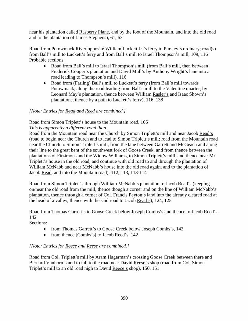
390
near his plantation called Rasberry Plane, and by the foot of the Mountain, and into the old road and to the plantation of James Stephens), 61, 63 Road from Potowmack River opposite William Luckett Jr.’s ferry to Pursley’s ordinary; road(s) from Ball’s mill to Luckett’s ferry and from Ball’s mill to Israel Thompson’s mill, 109, 116 Probable sections:
• Road from Ball’s mill to Israel Thompson’s mill (from Ball’s mill, then between Frederick Cooper’s plantation and David Mull’s by Anthony Wright’s lane into a road leading to Thompson’s mill), 116
• Road from (Farling) Ball’s mill to Luckett’s ferry (from Ball’s mill towards Potowmack, along the road leading from Ball’s mill to the Valentine quarter, by Leonard May’s plantation, thence between William Rasler’s and Isaac Shown’s plantations, thence by a path to Luckett’s ferry), 116, 138
[Note: Entries for Read and Reed are combined.] Road from Simon Triplett’s house to the Mountain road, 106 This is apparently a different road than: Road from the Mountain road near the Church by Simon Triplett’s mill and near Jacob Read’s (road to begin near the Church and to lead to Simon Triplett’s mill; road from the Mountain road near the Church to Simon Triplett’s mill, from the lane between Garrett and McGeach and along their line to the great bent of the southwest fork of Goose Creek, and from thence between the plantations of Fitzimons and the Widow Williams, to Simon Triplett’s mill, and thence near Mr. Triplett’s house in the old road, and continue with old road to and through the plantation of William McNabb and near McNabb’s house into the old road again, and to the plantation of Jacob Read, and into the Mountain road), 112, 113, 113-114 Road from Simon Triplett’s through William McNabb’s plantation to Jacob Read’s (keeping on/near the old road from the mill, thence though a corner and on the line of William McNabb’s plantation, thence through a corner of Col. Francis Peyton’s land into the already cleared road at the head of a valley, thence with the said road to Jacob Read’s), 124, 125 Road from Thomas Garrett’s to Goose Creek below Joseph Combs’s and thence to Jacob Reed’s, 142 Sections:
• from Thomas Garrett’s to Goose Creek below Joseph Combs’s, 142 • from thence [Combs’s] to Jacob Reed’s, 142
[Note: Entries for Reece and Reese are combined.] Road from Col. Triplett’s mill by Aram Hagarman’s crossing Goose Creek between there and Bernard Vanhorn’s and to fall to the road near David Reese’s shop (road from Col. Simon Triplet’s mill to an old road nigh to David Reece’s shop), 150, 151

391
Road from Pullin’s / Pulling’s / Charles Pullin’s to Cox’s mill (to leave the old road a little above Charles Pullin’s where the old mill tract leaves the same, keeping the old path through John Reign’s land to the head of the long glade and from thence to Bever’s road), 124, 128, 129
• to be reviewed, 129 Route after review: Road from Charles/Chas. Pullen’s to Cox’s / Samuel Cox’s mill (to leave the Carolina road at the upper end of Richard fence, and from thence to the old Church road ford on Owsleys Branch, from thence by Jacob Gardner’s house and along Thomas Kelley’s fence and along Kelley’s line between him and William Musgrove, up a branch, then along a ridge to Jonathan Davis’s new field on the Main road leading to Cox’s mill), 132, 138 Road from Trenarys Run to William Mead’s; road from William Mead’s to Tuscorara Run by Trenary’s (from Trenarys Run along the old path through a corner of Trenary’s fence and Jonathan Monkhouse’s fence, thence leaving the old path, going along under the foot of the Mountain to the old path again where Moses Rhodes’s path comes in, thence with and near the old path to a branch at the corner of William Mead’s meadow, thence leaving the old path, keeping on a Ridge and falling into the Main road above the upper corner of William Mead’s meadow) 50, 52-53, 56 See also: Old road from Trenary’s Run to William Mead’s, 68 Road from William Kirk’s mill to the road leading by William Dodd’s to Leesburgh (from William Kirk’s with or near the old road to Edwd. Norton’s plantation, Sands’s plantation, Claypoole’s, Patrick Rice’s house, the Meeting House, and to the Main road by William Dodd’s), 7(2) Road from Pullin’s / Pulling’s / Charles Pullin’s to Cox’s mill (to leave the old road a little above Charles Pullin’s where the old mill tract leaves the same, keeping the old path through John Reign’s land to the head of the long glade and from thence to Bever’s road), 124, 128, 129
• to be reviewed, 129 Route after review: Road from Charles/Chas. Pullen’s to Cox’s / Samuel Cox’s mill (to leave the Carolina road at the upper end of Richard fence, and from thence to the old Church road ford on Owsleys Branch, from thence by Jacob Gardner’s house and along Thomas Kelley’s fence and along Kelley’s line between him and William Musgrove, up a branch, then along a ridge to Jonathan Davis’s new field on the Main road leading to Cox’s mill), 132, 138 (Alteration of) the road near Samuel Smith’s (running near the dividing line between Samuel Smith and Joseph Richardson), 62(2) Road from the Seneca Falls to the Ox road that leads to Colchester (road from the upper end of Capt. McCarty’s Island into the Sugar Land road and along that road opposite to James Fryer’s where it takes Difficult Ridge, thence on the Ridge into the Ox road at Sandford Cockerill’s where Ellzey’s tract goes into the Ox road), 39, 46, 47 Sections:
• from the River to the Main road, 47
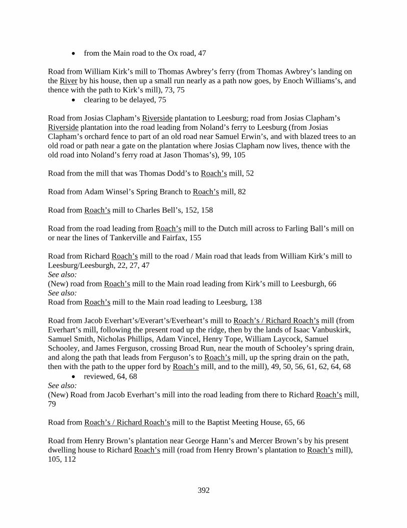
392
• from the Main road to the Ox road, 47 Road from William Kirk’s mill to Thomas Awbrey’s ferry (from Thomas Awbrey’s landing on the River by his house, then up a small run nearly as a path now goes, by Enoch Williams’s, and thence with the path to Kirk’s mill), 73, 75
• clearing to be delayed, 75 Road from Josias Clapham’s Riverside plantation to Leesburg; road from Josias Clapham’s Riverside plantation into the road leading from Noland’s ferry to Leesburg (from Josias Clapham’s orchard fence to part of an old road near Samuel Erwin’s, and with blazed trees to an old road or path near a gate on the plantation where Josias Clapham now lives, thence with the old road into Noland’s ferry road at Jason Thomas’s), 99, 105 Road from the mill that was Thomas Dodd’s to Roach’s mill, 52 Road from Adam Winsel’s Spring Branch to Roach’s mill, 82 Road from Roach’s mill to Charles Bell’s, 152, 158 Road from the road leading from Roach’s mill to the Dutch mill across to Farling Ball’s mill on or near the lines of Tankerville and Fairfax, 155 Road from Richard Roach’s mill to the road / Main road that leads from William Kirk’s mill to Leesburg/Leesburgh, 22, 27, 47 See also: (New) road from Roach’s mill to the Main road leading from Kirk’s mill to Leesburgh, 66 See also: Road from Roach’s mill to the Main road leading to Leesburg, 138 Road from Jacob Everhart’s/Everart’s/Everheart’s mill to Roach’s / Richard Roach’s mill (from Everhart’s mill, following the present road up the ridge, then by the lands of Isaac Vanbuskirk, Samuel Smith, Nicholas Phillips, Adam Vincel, Henry Tope, William Laycock, Samuel Schooley, and James Ferguson, crossing Broad Run, near the mouth of Schooley’s spring drain, and along the path that leads from Ferguson’s to Roach’s mill, up the spring drain on the path, then with the path to the upper ford by Roach’s mill, and to the mill), 49, 50, 56, 61, 62, 64, 68
• reviewed, 64, 68 See also: (New) Road from Jacob Everhart’s mill into the road leading from there to Richard Roach’s mill, 79 Road from Roach’s / Richard Roach’s mill to the Baptist Meeting House, 65, 66 Road from Henry Brown’s plantation near George Hann’s and Mercer Brown’s by his present dwelling house to Richard Roach’s mill (road from Henry Brown’s plantation to Roach’s mill), 105, 112
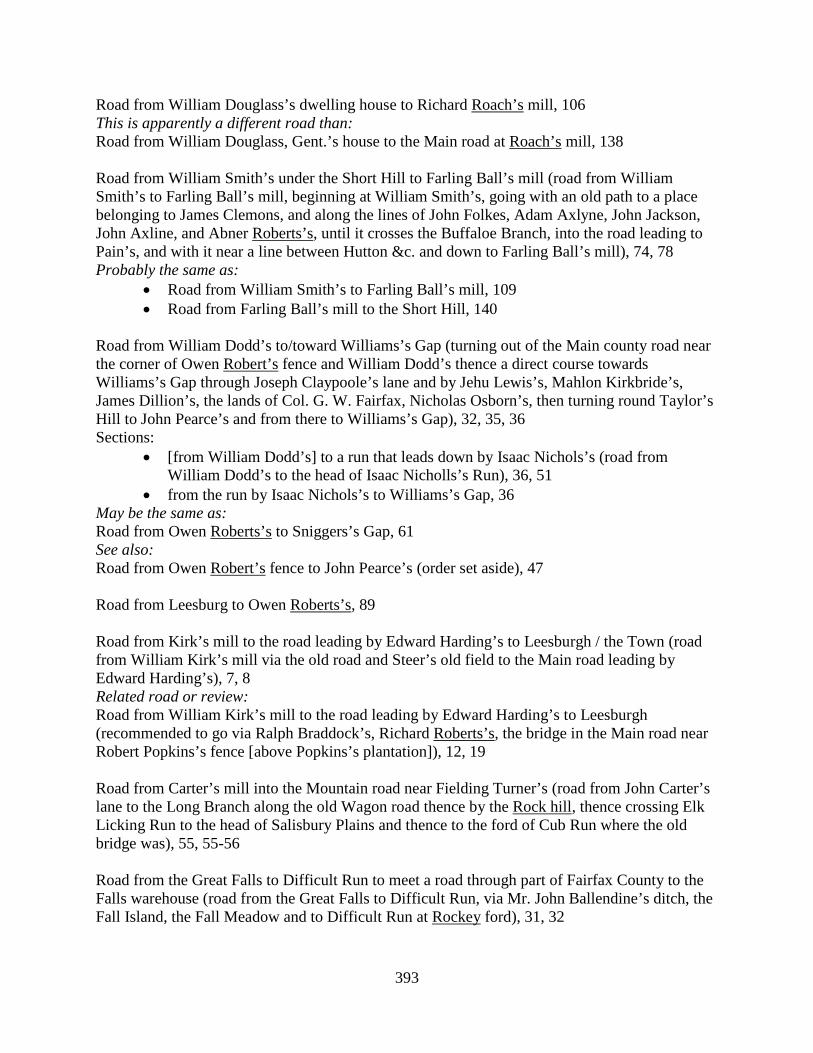
393
Road from William Douglass’s dwelling house to Richard Roach’s mill, 106 This is apparently a different road than: Road from William Douglass, Gent.’s house to the Main road at Roach’s mill, 138 Road from William Smith’s under the Short Hill to Farling Ball’s mill (road from William Smith’s to Farling Ball’s mill, beginning at William Smith’s, going with an old path to a place belonging to James Clemons, and along the lines of John Folkes, Adam Axlyne, John Jackson, John Axline, and Abner Roberts’s, until it crosses the Buffaloe Branch, into the road leading to Pain’s, and with it near a line between Hutton &c. and down to Farling Ball’s mill), 74, 78 Probably the same as:
• Road from William Smith’s to Farling Ball’s mill, 109 • Road from Farling Ball’s mill to the Short Hill, 140
Road from William Dodd’s to/toward Williams’s Gap (turning out of the Main county road near the corner of Owen Robert’s fence and William Dodd’s thence a direct course towards Williams’s Gap through Joseph Claypoole’s lane and by Jehu Lewis’s, Mahlon Kirkbride’s, James Dillion’s, the lands of Col. G. W. Fairfax, Nicholas Osborn’s, then turning round Taylor’s Hill to John Pearce’s and from there to Williams’s Gap), 32, 35, 36 Sections:
• [from William Dodd’s] to a run that leads down by Isaac Nichols’s (road from William Dodd’s to the head of Isaac Nicholls’s Run), 36, 51
• from the run by Isaac Nichols’s to Williams’s Gap, 36 May be the same as: Road from Owen Roberts’s to Sniggers’s Gap, 61 See also: Road from Owen Robert’s fence to John Pearce’s (order set aside), 47 Road from Leesburg to Owen Roberts’s, 89 Road from Kirk’s mill to the road leading by Edward Harding’s to Leesburgh / the Town (road from William Kirk’s mill via the old road and Steer’s old field to the Main road leading by Edward Harding’s), 7, 8 Related road or review: Road from William Kirk’s mill to the road leading by Edward Harding’s to Leesburgh (recommended to go via Ralph Braddock’s, Richard Roberts’s, the bridge in the Main road near Robert Popkins’s fence [above Popkins’s plantation]), 12, 19 Road from Carter’s mill into the Mountain road near Fielding Turner’s (road from John Carter’s lane to the Long Branch along the old Wagon road thence by the Rock hill, thence crossing Elk Licking Run to the head of Salisbury Plains and thence to the ford of Cub Run where the old bridge was), 55, 55-56 Road from the Great Falls to Difficult Run to meet a road through part of Fairfax County to the Falls warehouse (road from the Great Falls to Difficult Run, via Mr. John Ballendine’s ditch, the Fall Island, the Fall Meadow and to Difficult Run at Rockey ford), 31, 32

394
Road to be cleared from Broad Run to meet one lately cleared by order of Fairfax Court from the Little Falls to Difficult Run (road from Broad Run bridge to the Seneca Falls / Seneca Falls mill / the [John Ballendine’s] landing at Seneca Falls and from thence to Difficult Run [at the Rockey ford] to meet a road ordered cleared by Fairfax Court), 39, 41, 43, 44, 46, 51, 55, 60
• former order quashed and to be reviewed, 41 • old road to be used until John Ballendine erects the public mill, 46, 48, 51 • order to clear the road to be quashed until John Ballendine erects a public mill at
Seneca Falls, 48 Sections:
• from Broad Run to the Seneca Falls (the upper road), 60 • from Seneca Falls / the landing on the Seneca Falls to Difficult Run (the lower road),
60, 68 (Alteration of) the road below Rockey road bridge at the hill, 142 Road leading from the road that leads from Rockey Run to the Ox road (road continued from Rockey Run Church to the Horse mill, and to Frying Pan and thence to the Ox road); road from Rockey Run Church to Frying Pan, 4, 6, 62 Road from Rockey Run Church to Bull Run (to turn out of the Mountain road about a mile below the Church and along an old path to Bull Run opposite to Blackburn’s quarter), 11, 15 Road from Cub Run down by Rockey Run Church, 28, 57 [Note: Entries for Rockey Run and Little Rockey Run are combined.] Mountain Road, 1, 4, 18, 123, 143, 154 Sections:
• from the Post up to the road to Piney Branch (road from Little Rockey Run called the Mountain road up the said road to the Post / old Post; road from the Post / old Posts to Piney Branch), 1, 4, 37, 95, 107 Probably the same as: Road from [torn] Branch to the old Post, 23
• from the Post to the County line; road from Little Rockey Run down the Mountain road to the end of the County / County line, including the bridge over Little Rockey Run; road from Little Rockey Run to the County line / Fairfax County line; road from Little Rockey Run to the County line the way to Alexandria, 1, 4, 30, 41, 95
• from Little Rocky Run to the forks by Edwards’s; road from Little Rocky Run / from the lower side of Little Rocky Run to Edwards’s old shop, 134, 147, 154
Related roads or sections: • Road that leads to Alexandria (portion as low as the County line), 30 • Roads from Little Rockey Run to the County line the roads that lead to Alexandria
and Colchester, 37 Road from Frying Pan road to Rockey Run, 1 May be the same as:
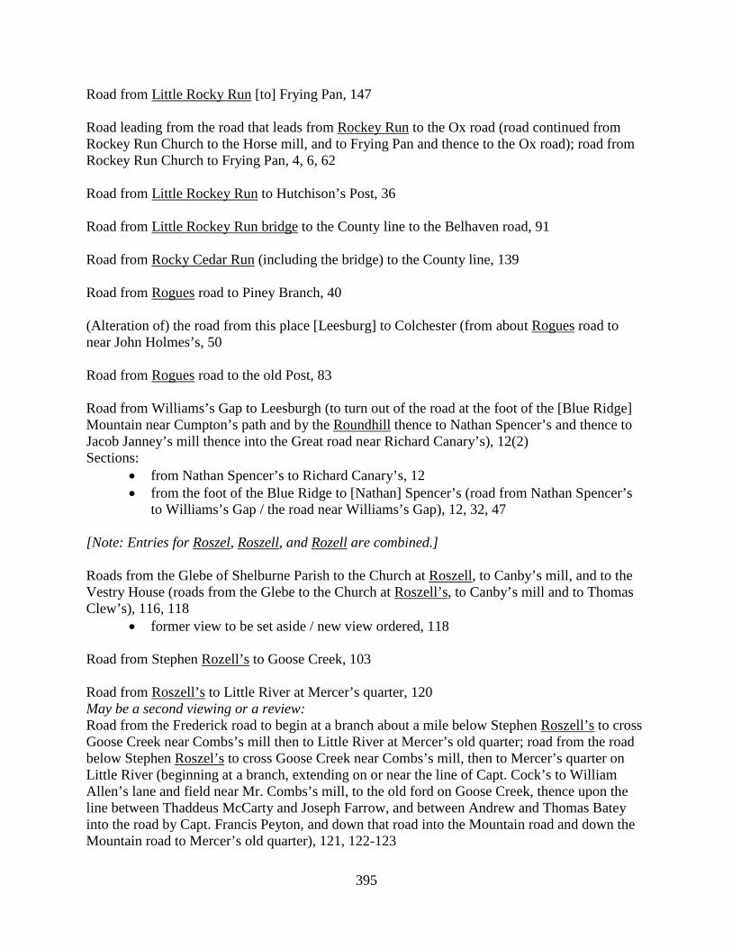
395
Road from Little Rocky Run [to] Frying Pan, 147 Road leading from the road that leads from Rockey Run to the Ox road (road continued from Rockey Run Church to the Horse mill, and to Frying Pan and thence to the Ox road); road from Rockey Run Church to Frying Pan, 4, 6, 62 Road from Little Rockey Run to Hutchison’s Post, 36 Road from Little Rockey Run bridge to the County line to the Belhaven road, 91 Road from Rocky Cedar Run (including the bridge) to the County line, 139 Road from Rogues road to Piney Branch, 40 (Alteration of) the road from this place [Leesburg] to Colchester (from about Rogues road to near John Holmes’s, 50 Road from Rogues road to the old Post, 83 Road from Williams’s Gap to Leesburgh (to turn out of the road at the foot of the [Blue Ridge] Mountain near Cumpton’s path and by the Roundhill thence to Nathan Spencer’s and thence to Jacob Janney’s mill thence into the Great road near Richard Canary’s), 12(2) Sections:
• from Nathan Spencer’s to Richard Canary’s, 12 • from the foot of the Blue Ridge to [Nathan] Spencer’s (road from Nathan Spencer’s
to Williams’s Gap / the road near Williams’s Gap), 12, 32, 47 [Note: Entries for Roszel, Roszell, and Rozell are combined.] Roads from the Glebe of Shelburne Parish to the Church at Roszell, to Canby’s mill, and to the Vestry House (roads from the Glebe to the Church at Roszell’s, to Canby’s mill and to Thomas Clew’s), 116, 118
• former view to be set aside / new view ordered, 118 Road from Stephen Rozell’s to Goose Creek, 103 Road from Roszell’s to Little River at Mercer’s quarter, 120 May be a second viewing or a review: Road from the Frederick road to begin at a branch about a mile below Stephen Roszell’s to cross Goose Creek near Combs’s mill then to Little River at Mercer’s old quarter; road from the road below Stephen Roszel’s to cross Goose Creek near Combs’s mill, then to Mercer’s quarter on Little River (beginning at a branch, extending on or near the line of Capt. Cock’s to William Allen’s lane and field near Mr. Combs’s mill, to the old ford on Goose Creek, thence upon the line between Thaddeus McCarty and Joseph Farrow, and between Andrew and Thomas Batey into the road by Capt. Francis Peyton, and down that road into the Mountain road and down the Mountain road to Mercer’s old quarter), 121, 122-123
396
Main road leading through Stephen Roszell’s plantation, 158
• gates can be erected, 158 Road from Capt. Anthony Russell’s to the Mountain road, 106 Road from Samuel Potts’s mill near the Blue Ridge across the lands of the Honorable George William Fairfax into the Main road leading over Vestal’s Gap (through the lands of Ezekiel Potts, David Williams, John Russell, John Arvecross, thence down to a branch leading from Evan Evans’s meadow and to James Connard’s field, thence into the Main road leading from Alexandria over the Blue Ridge at Vestal’s Gap, near the new roads that lead betwixt the hill to Robert Harper’s ferry; road lately laid out from the Great Main road to Potts’s mill, 81, 88, 89 [Note: This road was probably not cleared.]
• to be reviewed, 89 Route after review: Road from Potts’s mill across the Hon. George William Fairfax’s land into the Main road leading over the Blue Ridge at Vestal’s Gap; road through the lands of George William Fairfax Esqr. (beginning at Potts’s mill and from there through Ezekiel Potts’s land, thence through David Williams’s lot near his field, thence on/near the line between David Williams and John Russell, thence with/near the line between Evan Evans and John Arbecost, thence to Valentine Miller’s field and from there near the line between Valentine Miller and John Fearst, through Henry Michael’s lot, by the tail race of John Vestall’s mill, and from thence through a lane between the lots of Michael and Reuben Doughty into the Main road), 93, 101 Road from the road near James Connard’s to Potomack River towards Harper’s ferry (to leave the Main road by Michael Sellers’s then by George Fout’s, then by Robert Russell’s, thence by marked trees to Harper’s Spring near Potomack, and thence to the River Potomack), 74 Road from Thomas Drake’s to Leven Powell’s grist mill; road from Thomas Drake’s meadow to Hezekiah Guy’s grist mill, and near the Quaker Meeting House and thence to cross Goose Creek at James Leith’s and to Leven Powell’s mill road; road from Thomas Drake’s meadow to Hezekiah Guy’s grist mill and near the Quaker Meeting House and from thence to Leven Powell’s mill (beginning at Thomas Drake’s meadow, thence through James Carter’s lane and by Malakiah Cumming’s field, thence through the lands of Samuel Smith, John Neal, Thomas Smith, Thomas Russell, Thomas Lewis, thence into the old tract in or near Richard Hanson’s grubbing, thence to a good ford on Goose Creek and along the bottom of the creek, and to Leven Powell’s mill), 100, 103-104, 108, 109, 119 Sections:
• [from Drake’s] to Goose Creek, 108, 109, 119 • from Goose Creek (by James Leith’s plantation) to Powell’s mill, 108, 109
Road from Abel Janney’s under/near the Short Hill to Hough’s Gap mill (from an old road, near Abel Janney’s lane end, thence through Samuel Janney’s land, thence through Joseph Janney’s by the dwelling house. thence by Israel Thompson’s fields at his old quarter, thence through Dumb John Gregg’s land into his lane, thence through Samuel Gregg’s land, on the line between Samuel Gregg’s and Andrew Thompson’s, thence on the line between Charles McManemy’s and
397
James Nixon’s, thence through James Nixon’s land on the line of McHaney’s two lotts, thence through William Russell’s land into the Main road on the line of Thomas Pursel’s land, from thence along the Great road to the [Hough’s] Gap mill), 117, 127-128 Road from Carter’s mill into the Mountain road near Fielding Turner’s (road from John Carter’s lane to the Long Branch along the old Wagon road thence by the Rock hill, thence crossing Elk Licking Run to the head of Salisbury Plains and thence to the ford of Cub Run where the old bridge was), 55, 55-56 (John Sample’s petition for) a carrying place past the Seneca Falls and public landings, 65, 66 Road from Leesburg to Moxley’s ferry, 142
• to be opened as it antiently run, 142 • (alteration of) the road leading from Leesburg to Moxley’s ferry through the lands of
Mrs. Page, 156 • Road from Leesburg to Moxley’s ferry (to go by the house of John Sanders to
Carter’s line and to come into the Town at Drishes), 158 Road from William Kirk’s mill to the road leading by William Dodd’s to Leesburgh (from William Kirk’s with or near the old road to Edwd. Norton’s plantation, Sands’s plantation, Claypoole’s, Patrick Rice’s house, the Meeting House, and to the Main road by William Dodd’s), 7(2) Road to town and courthouse opened from Leesburg by John Lewis’s and (James) Stephens’s into an old road leading over the Mountain (by old Abbett’s and Philip Saunders’s plantations, and through a lane of John Lewis’s and from thence through the land of Thomson Mason Esqr. near his plantation called Rasberry Plane, and by the foot of the Mountain, and into the old road and to the plantation of James Stephens), 61, 63 Road from Newgate to Savage’s mill, 96 Road from Jacob Everhart’s/Everart’s/Everheart’s mill to Richard Roach’s/Roach’s mill (from Everhart’s mill, following the present road up the ridge, then by the lands of Isaac Vanbuskirk, Samuel Smith, Nicholas Phillips, Adam Vincel, Henry Tope, William Laycock, Samuel Schooley, and James Ferguson, crossing Broad Run, near the mouth of Schooley’s spring drain, and along the path that leads from Ferguson’s to Roach’s mill, up the spring drain on the path, then with the path to the upper ford by Roach’s mill, and to the mill), 49, 50, 56, 61, 62, 64, 68
• reviewed, 64, 68 See also: (New) Road from Jacob Everhart’s mill into the road leading from there to Richard Roach’s mill, 79 (Alteration of) the road by William Schooley’s plantation, 66, 67 Road from Mahlon Janney’s mill across the Kittockton Mountain by William Cavins’s plantation into the road leading from Leesburg to Noland’s ferry; road from Mahlon Janny’s mill to the

398
Great road leading from Noland’s ferry (from the Quaker Meeting House on the line between William Schooley’s land and land that William Morrison lives on, then across William Schooley’s land, thence on the line between Schooley’s land and Joseph Caldwell’s, then between Joseph Caldwell’s land and William Cavins’s, thence along an old road to the line between Mr. Mason’s and Mr. Page’s land, thence to the Noland’s ferry road), 116, 120 This is apparently a different road than: Road from Mahlon Janney’s mill through the neighborhood by William Cavins’s, 117 Secolon: See Sicolin, etc. Road from the Sugarland Meeting House to John Dowdall’s mill and from thence to the Alexandria road (beginning at Andrew Been’s fence next to the [Sugarland] Meeting House, thence near an old smith’s shop now in possession of Thomas Self, thence through lands now tenanted by Roger Wigginton, from thence to John Dowdall’s plantation, by the old house and to Dowdall’s mill, thence to Jacob Huguely’s plantation, thence to Trammell’s old road and crossing the long glade between Capt. John Moss’s and Matthew White’s field and to the Main road leading to Alexandria), 129, 130-131, 148, 150
• (review of the) road from the Sugarland Meeting House to John Dowdall’s mill (and from thence to the Alexandria road at Difficult bridge), 148, 150
Road from the road near James Connard’s to Potomack River towards Harper’s ferry (to leave the Main road by Michael Sellers’s then by George Fout’s, then by Robert Russell’s, thence by marked trees to Harper’s Spring near Potomack, and thence to the River Potomack), 74 Road between the Sugarland Run and Difficult Run leading from the Sugarlands at the Seneca Falls across into the Ox road, 38 Road from the Seneca Falls to the Ox road that leads to Colchester (road from the upper end of Capt. McCarty’s Island into the Sugar Land road and along that road opposite to James Fryer’s where it takes Difficult Ridge, thence on the Ridge into the Ox road at Sandford Cockerill’s where Ellzey’s tract goes into the Ox road), 39, 46, 47 Sections:
• from the River to the Main road, 47 • from the Main road to the Ox road, 47
Road to be cleared from Broad Run to meet one lately cleared by order of Fairfax Court from the Little Falls to Difficult Run (road from Broad Run bridge to the Seneca Falls / Seneca Falls mill / the [John Ballendine’s] landing at Seneca Falls and from thence to Difficult Run [at the Rockey ford] to meet a road ordered cleared by Fairfax Court), 39, 41, 43, 44, 46, 51, 55, 60
• former order quashed and to be reviewed, 41 • old road to be used until John Ballendine erects the public mill, 46, 48, 51 • order to clear the road to be quashed until John Ballendine erects a public mill at
Seneca Falls, 48 Sections:
• from Broad Run to the Seneca Falls (the upper road), 60
399
• from Seneca Falls / the landing on the Seneca Falls to Difficult Run (the lower road), 60, 68
(John Sample’s petition for) a carrying place past the Seneca Falls and public landings, 65, 66 Road from Payne’s ferry to Israel Thompson’s mill (turning out of Payne’s road, through Jacob Shoemaker’s barley field by his barn and lane to Jacob Hibbs’s field, thence with the line between Jacob Hibbs and David Lovat to George Shaffer’s lot, thence with the line between George Shaffer and George Nixon, thence by George Nixon’s wheat field, and from thence the most direct way to Israel Thompson’s mill), 99 Road from the fork of the road above Goose Creek at Ezekiel Hickman’s to the Great Lime Stone, 2, 5 Related road:
• Road from that road to the Shanando road, 5 the several roads from Little River to Shanando, 11 Road from Payne’s ferry through Edward Wyat’s/Wyatt’s’s plantation; road from Frail Pain’s ferry to Mahlon Janney’s mill (to go by the road at Edward Wiat’s plantation/house, thence to turn off at David Mull’s, down Jacob Shoemaker’s lane to Abel Janney’s road, and from thence via Daniel Lovett’s plantation, to George Nixon’s lane between him and Shaver, and from thence with the road to Israel Thompson’s mill, 51, 53 Roads from the Glebe of Shelburne Parish to the Church at Roszell, to Canby’s mill, and to the Vestry House (roads from the Glebe to the Church at Roszell’s, to Canby’s mill and to Thomas Clew’s), 116, 118
• former view to be set aside / new view ordered, 118 Road from Canby’s mill by Thomas Gregg’s (potter) to the Great road leading from Snicker’s Gap to Alexandria by James Martin’s plantation, 99 May be a different road or a second view: Road from [Samuel] Canby’s mill to James Martin’s, to go by the plantation of Thomas Gregg (potter) (road from Canby’s mill to James Martin’s: to go along the road towards Leesburg, thence by the upper side of Evan Wilkison’s plantation across the Northwest Fork of Goose Creek, thence to and through the plantation of Thomas Gregg (potter), and with the old Shennadore Tract to the Frederick road below James Martin’s plantation), 111, 117, 124 Road from Richard Thatcher’s in Williams’s Gap into the Mountain road to Leesburg; road from Richard Thatcher’s in Williams’s Gap to Thomas Shepard’s mill and from thence into the Main road leading to Leesburg (old road to be continued and straightened from Richard Thatcher’s lane to [Thomas] Shepard’s mill and also from the mill via the lands of [Thomas] Shepard, William Tate, John Gregg, on the line betwixt Gregg and John Brown thence through Harman Cox’s land, the land in possession of John Grant, the line betwixt Timothy Howell and said Grant into the Main road to Leesburg), 77, 86-87, 87, 92
400
Road from Payne’s ferry through Edward Wyat’s/Wyatt’s’s plantation; road from Frail Pain’s ferry to Mahlon Janney’s mill (to go by the road at Edward Wiat’s plantation/house, thence to turn off at David Mull’s, down Jacob Shoemaker’s lane to Abel Janney’s road, and from thence via Daniel Lovett’s plantation, to George Nixon’s lane between him and Shaver, and from thence with the road to Israel Thompson’s mill, 51, 53 Road from Payne’s ferry to Israel Thompson’s mill (turning out of Payne’s road, through Jacob Shoemaker’s barley field by his barn and lane to Jacob Hibbs’s field, thence with the line between Jacob Hibbs and David Lovat to George Shaffer’s lot, thence with the line between George Shaffer and George Nixon, thence by George Nixon’s wheat field, and from thence the most direct way to Israel Thompson’s mill), 99 (Alteration of) the road round John Short’s plantation, 128 (Alteration of) road from Pain’s ferry (to be turned round John Short’s fence between the said Short and John Axline &c.), 138 [Note: Entries for Short Hill and Short Hills are combined.] Road from William [torn] to Samuel Awbrey’s at the Gap of the Short Hill, 2 Road from Samuel Awbrey’s at the Gap of the Short Hill to the County line on the Blue Ridge, 2 May be the same as: Road from the Gap of the Short Hill to the top of the [Blue] Ridge, 37, 59 Road from lower Kittockton Run to the Gap of the Short Hills, 17 Road from Potowmack River between the Blue Ridge and Short Hills into the road that leads to John Hough’s mill (road from Potowmack River to the Mountain road between the Blue Ridge and Short Hills), 19, 20(2)
• order set aside, 20 Road from John Hough’s grist mill on the North Fork Kittockton Creek at the Gap of the Short Hills to Potomack River opposite or near Frail Pain’s, 27 Road from the Short Hills near where Joseph Jones now lives and from thence to Israel Thompson’s mill (road from Short Hills near Joseph Jones’s to Israel Thompson’s mill and from thence into the Great road; road from the mouth of Joseph Jones’s lane and with the old road through John Gregg’s lane and by the lands of Samuel Gregg, James Toben, John Tribbe, Robert Akers, Isaac Thompson and Jenkin Morris, and to Israel Thompson’s tan yard and from there with his lane to his mill), 41, 43-44 Road from Potomack River into the main wagon road between the Blue Ridge and Short Hill, 66 Road from John Hough’s Gap mill to the road leading to Pain’s ferry as also from the Gap to Joshua Gore’s below the Short Hills, 70
401
Road from William Smith’s under the Short Hill to Farling Ball’s mill (road from William Smith’s to Farling Ball’s mill, beginning at William Smith’s, going with an old path to a place belonging to James Clemons, and along the lines of John Folkes, Adam Axlyne, John Jackson, John Axline, and Abner Roberts’s, until it crosses the Buffaloe Branch, into the road leading to Pain’s, and with it near a line between Hutton &c. and down to Farling Ball’s mill), 74, 78 Probably the same as:
• Road from William Smith’s to Farling Ball’s mill, 109 • Road from Farling Ball’s mill to the Short Hill, 140
Road from the Gap of the Short Hill to Abel Janney’s road, near the Hill, 87 Road from the Gap of the Short Hill along under the Hill till it intersects the road leading from Sniggers’s Gap to Leesburg, 87 Road from Abel Janney’s under/near the Short Hill to Hough’s Gap mill (from an old road, near Abel Janney’s lane end, thence through Samuel Janney’s land, thence through Joseph Janney’s by the dwelling house. thence by Israel Thompson’s fields at his old quarter, thence through Dumb John Gregg’s land into his lane, thence through Samuel Gregg’s land, on the line between Samuel Gregg’s and Andrew Thompson’s, thence on the line between Charles McManemy’s and James Nixon’s, thence through James Nixon’s land on the line of McHaney’s two lotts, thence through William Russell’s land into the Main road on the line of Thomas Pursel’s land, from thence along the Great road to the [Hough’s] Gap mill), 117, 127-128 Road from Mercer Brown’s mill towards the Short Hill, 130
• to be viewed again, 130 (Alteration of) the road from the Gap of the Short Hill by John Osborne’s to Snicker’s Gap so as to go by William Neilson’s mill (road from the Gap of the Short Hill to John Osbourn’s), 137(2) Road from the end of the Short Hill / Short Hills (on the north west side at Potomack River) to the Great road leading to Keyes’s ferry, 140(2) Road from Potowmack River opposite William Luckett Jr.’s ferry to Pursley’s ordinary; road(s) from Ball’s mill to Luckett’s ferry and from Ball’s mill to Israel Thompson’s mill, 109, 116 Probable sections:
• Road from Ball’s mill to Israel Thompson’s mill (from Ball’s mill, then between Frederick Cooper’s plantation and David Mull’s by Anthony Wright’s lane into a road leading to Thompson’s mill), 116
• Road from (Farling) Ball’s mill to Luckett’s ferry (from Ball’s mill towards Potowmack, along the road leading from Ball’s mill to the Valentine quarter, by Leonard May’s plantation, thence between William Rasler’s and Isaac Shown’s plantations, thence by a path to Luckett’s ferry), 116, 138
[Note: Entries for Shreeve and Shreve are combined.]
402
Road from George Town / Leesburg / Leesburgh to Vincent Lewis’s road (road from George Town along the new road to a glade between John Moss’s and Thomas Sorrell’s then leaving the said road and running nearly in a straight line to the east ends of Benjamin Shreeve’s plantation and William Shreeve’s plantation, thence to the west end of John Dawson’s plantation to Dawson’s ford, thence along an old road by Mr. Ellzey’s plantation and to Vincent Lewis’s), 7(2), 8 Sections:
• from Leesburg to Siccolons, 8 • from Siccolons to Vincent Lewis’s road, 8
Isaac Fouch’s road to mill and market (to go on the line of Francis Elgin and Isaac Fouch to the corner of Fouch’s land thence continuing the said line of Elgin’s and Benjamin Shreeve’s to the Main road leading from Dawson’s ford to Leesburg), 108(2) Road from Morris’s ford on Goose Creek into the road leading from Leesburg to Cox’s mill, so that the same may come into the said road near Benjamin Shreve’s, 135 Road from George Town / Leesburg / Leesburgh to Vincent Lewis’s road (road from George Town along the new road to a glade between John Moss’s and Thomas Sorrell’s then leaving the said road and running nearly in a straight line to the east ends of Benjamin Shreeve’s plantation and William Shreeve’s plantation, thence to the west end of John Dawson’s plantation to Dawson’s ford, thence along an old road by Mr. Ellzey’s plantation and to Vincent Lewis’s), 7(2), 8 Sections:
• from Leesburg to Siccolons, 8 • from Siccolons to Vincent Lewis’s road, 8
Road between William Shreeve’s and the Gum Spring, 13, 16 Road from William Shreeve’s house to Goose Creek, 15, 16 [Note: Entries for all spelling variants of Secolon, Sicolin, etc., are combined.] Road from George Town [Leesburg] to Secolons Branch (near John Radcliff’s/Ratcliff’s), 5(2) Related road: Road from the ford of Secolons Branch near John Radcliff’s fence to Little River, 5 Road from George Town / Leesburg / Leesburgh to Vincent Lewis’s road (road from George Town along the new road to a glade between John Moss’s and Thomas Sorrell’s then leaving the said road and running nearly in a straight line to the east ends of Benjamin Shreeve’s plantation and William Shreeve’s plantation, thence to the west end of John Dawson’s plantation to Dawson’s ford, thence along an old road by Mr. Ellzey’s plantation and to Vincent Lewis’s), 7(2), 8 Sections:
• from Leesburg to Siccolons, 8 • from Siccolons to Vincent Lewis’s road, 8

403
Road from Siccolons Run / Secolon / the ford of Seconell to Dawson’s ford (on Goose Creek), 14, 86, 116 See also: Road leading from Seconell Run to Goose Creek [and] Road leading from Goose Creek to the Carolina road, 141 Probably the same as: Road from Seconells Branch to Col. Simon Triplett’s mill and from thence to the Carolina road, 158 Road from Siccolons [Run] to Tuscorora, 14 May be the same as: Road from the fork of the roads near Tuscarora Run / Tuskarora / Tuskarrora to Seaconnells Branch / Secolens Run / Siccolin, 46, 78, 103 Road from Jacob Janney’s to Andrew Adam’s mill on Sakelon, 21 Road from Leesburgh to Secolon, 36, 58 See also: Road from Leesburg the Carolina road to Secolon; road from Leesburg to Secolon the way to Capt. West’s, 40, 47 Road from Little River to Secolon Run, 54 Road from Secolon Run / Segolon / the ford of Seconnell to Thomas Sorrell’s / the forks of the road at/by Sorrell’s / Thomas Sorrell’s, 92, 114, 116, 141 Road from Leesburg to Mr. Amos Thompson’s mill and from thence to the Ox road, 124 Views were divided into sections:
• Road from the Rev. Mr. Amos Thompson’s mill to the Ox road (road to lead from [Thompson’s] mill to Joseph Cross’s mill and from thence to the Ox road), 126, 127
• Road from Leesburg to the Rev. Amos Thompson’s mill (beginning just below Leesburg, then to Segolon, thence to Martin Poland’s and thence to [Rev. Thompson’s] mill), 126, 132
Road from the forks by Josiah Moffett’s to Seconells Branch, 133 Road from Secollens Branch to Goose Creek at Cox’s mill, 133 Road leading from Thornton’s quarter to Secolin Run / Seconell Run, 141, 154 John Simms’s road to mill and market, 78 [Note: Entries for Sinklair and Sinkler are combined.] Road(s) to Leven Powell’s mill, 76, 77
404
• Road from Leven Powell’s / Col. Powell’s mill to Fauquier County line that goes under the Mountain (from Leven Powell’s mill, crossing Little River at an old ford and through Capt. Francis Peyton’s quarter plantation and going as near the foot the Mountain as the ground will admit of to Fauquier County line), 77, 84, 104, 143
• Road from Leven Powell’s mill to the Mountain at Mercer’s mill (from Leven Powell’s mill thence down the river and via Thomas Gibson’s, James Sinkler’s plantation, and Mr. Mercer’s quarter plantation and up a little hill to the Great road leading from Snicker’s Gap), 77
• Road from Leven Powell’s mill to the road leading from French’s quarter; road from Levin Powell’s mill to Thomas Owsley’s ford on Goose Creek (from Leven Powell’s mill to James Battson’s [northward of Richard Crupper’s plantation] and from Battson’s along the old road to the Church road thence with the Church road to Thomas Owsley’s wagon road and crossing Goose Creek at his ford and through his plantation to the road that comes down by French’s quarter), 77, 85
• (Fauquier County requested to clear) road from Fauquier Court house to meet one cleared from Leven Powell’s mill to the County line, 89
Road from (Charles) Chinn’s (Spring) Branch to the Wancopin / Wancopin Branch / Wonkapin (and thence to the mill road at James Sinklair’s), 85, 143, 154 Sections:
• from Chinn’s Branch to the Wancopin Branch, 85, 143, 154 • from [the Wancopin Branch] to the mill road at James Sinklair’s, 154
Road from Whitely’s/Whiteley’s ford on Goose Creek to Leven Powell’s mill (to leave Powell’s mill road below James Sinkler’s plantation where an old road turns out, up a branch, and by Capt. Peyton’s plantation and crossing Snickers’s road to the Leesburg road and with the Leesburg road to Whiteley’s ford), 100, 101 Probably the same as: Road from the forks by Goose Creek, Whitely’s ford to Col. Powell’s mill, 146 Road from Simon Triplett Gent.’s mill to cross Little River near Joshua Taylor’s plantation and to intersect the Carolina road near Charles Pullen’s; road from Simon Triplett’s mill to the Carolina road (to take out of the cleared road near William McNabb’s plantation, thence through a corner of Michael Gahagan’s cleared ground, thence to the Watry Branch, thence to and through Joshua Taylor’s plantation to Little River near the line between Phineas Skinner’s and Nicholas Wyckoff’s thence with their line and the line between Charles Pullen and Richard Skinner to James Wrightmire’s shop), 125, 127 Road from Simon Triplett Gent.’s mill to cross Little River near Joshua Taylor’s plantation and to intersect the Carolina road near Charles Pullen’s; road from Simon Triplett’s mill to the Carolina road (to take out of the cleared road near William McNabb’s plantation, thence through a corner of Michael Gahagan’s cleared ground, thence to the Watry Branch, thence to and through Joshua Taylor’s plantation to Little River near the line between Phineas Skinner’s and Nicholas Wyckoff’s thence with their line and the line between Charles Pullen and Richard Skinner to James Wrightmire’s shop), 125, 127

405
Road from John Osborn’s to the Williams’s Gap road (beginning at John Osborn’s house and from thence passing near Richard Osborn’s, Philip Slaugh’s, and into the Gap road), 56, 60 Road(s) from John Trammell’s mill, 31, 34, 35
• Road from John Trammell’s mill to the road that leads from William Douglass’s plantation to David Smith’s plantation so as to intersect the road between the said Douglass’s and Smith’s plantations (road from John Trammell’s mill to David Smith’s; road from Trammell’s mill up an old path to John Lester’s line thence via Lester’s line and Josias Clapham’s line to the ferry road and along the road to a path that leads to David Smith’s near William Woolard’s fence), 31, 34
• Road from John Trammell’s mill to the road below Mr. Lee Massey’s leading to Leesburgh (road from John Trammell’s mill towards Mr. Massey’s, to go toward Leesburg; road from Trammell’s mill via the path to William Jones’s, by Mr. Massey’s fence, and to the [Main] road from Noland’s ferry to Leesburg), 31, 34, 35
• Route through George West’s land in dispute; review ordered, 35 Road from Jacob Everhart’s/Everart’s/Everheart’s mill to Richard Roach’s/Roach’s mill (from Everhart’s mill, following the present road up the ridge, then by the lands of Isaac Vanbuskirk, Samuel Smith, Nicholas Phillips, Adam Vincel, Henry Tope, William Laycock, Samuel Schooley, and James Ferguson, crossing Broad Run, near the mouth of Schooley’s spring drain, and along the path that leads from Ferguson’s to Roach’s mill, up the spring drain on the path, then with the path to the upper ford by Roach’s mill, and to the mill), 49, 50, 56, 61, 62, 64, 68
• reviewed, 64, 68 See also: (New) Road from Jacob Everhart’s mill into the road leading from there to Richard Roach’s mill, 79 (Alteration of) the road near Samuel Smith’s (running near the dividing line between Samuel Smith and Joseph Richardson), 62(2) Road from Oldacre’s mill into the Mountain road by Thomas Owsley’s quarter; road from Oldacre’s mill to Thomas Owsley’s quarter (beginning at Oldacre’s mill, going [with the drains of Polser’s spring branch to the right hand], to and through Grayson’s quarter, thence via Thomas Drake’s meadow at the old ford along the old road to big rock, thence along a new road through a corner of Samuel Smith’s wheat field, thence across the line between Isaac Fotaw and Samuel Smith, then along the old road to William Smith’s field, thence to Thomas Owsley’s quarter field, thence into the Mountain road), 78, 79, 80 Probable sections:
• Road from the Beaver Dam to Oldacre’s mill, 82, 84 • Road from the Beaver Dam to Thomas Owsley’s ford on Goose Creek, 83
May be the same as: Road from Oldacre’s mill to Goose Creek at Thomas Owsley’s ford, 109 (Old) road from the Locust Thicket where Samuel Smith formerly lived to Kirk’s mill, 98
• petition to reopen, 98
406
Road from Thomas Drake’s to Leven Powell’s grist mill; road from Thomas Drake’s meadow to Hezekiah Guy’s grist mill, and near the Quaker Meeting House and thence to cross Goose Creek at James Leith’s and to Leven Powell’s mill road; road from Thomas Drake’s meadow to Hezekiah Guy’s grist mill and near the Quaker Meeting House and from thence to Leven Powell’s mill (beginning at Thomas Drake’s meadow, thence through James Carter’s lane and by Malakiah Cumming’s field, thence through the lands of Samuel Smith, John Neal, Thomas Smith, Thomas Russell, Thomas Lewis, thence into the old tract in or near Richard Hanson’s grubbing, thence to a good ford on Goose Creek and along the bottom of the creek, and to Leven Powell’s mill), 100, 103-104, 108, 109, 119 Sections:
• [from Drake’s] to Goose Creek, 108, 109, 119 • from Goose Creek (by James Leith’s plantation) to Powell’s mill, 108, 109
(Alteration of) the Ox road (proposed by Wethers Smith), 149, 150 Road from William Smith’s under the Short Hill to Farling Ball’s mill (road from William Smith’s to Farling Ball’s mill, beginning at William Smith’s, going with an old path to a place belonging to James Clemons, and along the lines of John Folkes, Adam Axlyne, John Jackson, John Axline, and Abner Roberts’s, until it crosses the Buffaloe Branch, into the road leading to Pain’s, and with it near a line between Hutton &c. and down to Farling Ball’s mill), 74, 78 Probably the same as:
• Road from William Smith’s to Farling Ball’s mill, 109 • Road from Farling Ball’s mill to the Short Hill, 140
Road from Oldacre’s mill into the Mountain road by Thomas Owsley’s quarter; road from Oldacre’s mill to Thomas Owsley’s quarter (beginning at Oldacre’s mill, going [with the drains of Polser’s spring branch to the right hand], to and through Grayson’s quarter, thence via Thomas Drake’s meadow at the old ford along the old road to big rock, thence along a new road through a corner of Samuel Smith’s wheat field, thence across the line between Isaac Fotaw and Samuel Smith, then along the old road to William Smith’s field, thence to Thomas Owsley’s quarter field, thence into the Mountain road), 78, 79, 80 Probable sections:
• Road from the Beaver Dam to Oldacre’s mill, 82, 84
407
• Road from the Beaver Dam to Thomas Owsley’s ford on Goose Creek, 83 May be the same as: Road from Oldacre’s mill to Goose Creek at Thomas Owsley’s ford, 109 (Another) road from Thomas Drake’s meadow to Leven Powell’s mill (from Drake’s meadow to Dawson Brown’s plantation, thence across the Beaverdam by Capt. William Bronaugh’s and between William Smith Gent. and Simon Hancock’s, thence across the road leading from Ashby’s Gap to Absalom Ramey’s to strike the road that leads from the ford of Goose Creek on the land of Mr. Owsly, thence along the said road until it meets the road leading from Ashby’s Gap to Leven Powell’s mill), 120, 121 See also: (Another) road from Thomas Drake’s meadow to Leven Powell’s mill (from Drake’s meadow down the old road to a lane between Isaac Brown’s field and Joshua Dixon’s thence running between Isaac and Dawson Brown to the Beaverdam, thence up a hollow to Capt. William Bronaugh’s land thence with his line and William Owsley’s to a lane between said Bronaugh and Owsley, thence on a line between Thos. Owsley and Thomas Williams, thence through a corner of Capt. Wm. Cock’s land to the mouth of Joseph Combs’s lane, thence to his mill thence along Mr. Leven Powell’s Church road to his mill), 124, 128 [Note: Entries for Snickers and Sniggers are combined.] Road from Bacon Fort to the County line on the Blue Ridge / top of the Ridge, 2, 4 May be the same as: Road from Sniggers’s Gap / Snickers’s Gap to Bacon Fort, 44, 60 May be the same as: Road from Frederick County line to Bacon Fort, 106, 141 Road from William Dodd’s to/toward Williams’s Gap (turning out of the Main county road near the corner of Owen Robert’s fence and William Dodd’s thence a direct course towards Williams’s Gap through Joseph Claypoole’s lane and by Jehu Lewis’s, Mahlon Kirkbride’s, James Dillion’s, the lands of Col. G. W. Fairfax, Nicholas Osborn’s, then turning round Taylor’s Hill to John Pearce’s and from there to Williams’s Gap), 32, 35, 36 Sections:
• [from William Dodd’s] to a run that leads down by Isaac Nichols’s (road from William Dodd’s to the head of Isaac Nicholls’s Run), 36, 51
• from the run by Isaac Nichols’s to Williams’s Gap, 36 May be the same as: Road from Owen Roberts’s to Sniggers’s Gap, 61 See also: Road from Owen Robert’s fence to John Pearce’s (order set aside), 47 Road from the top of the Ridge / Blue Ridge on Sniggers’s road to where Samuel Duncan formerly lived, 44, 58 Road leading from Sniggers’s Mountain road to Ashby’s Gap (to be cleared from Champes Mountain as it now stands to Ashby’s Gap), 48

408
Road from the road that leads from Sniggers’s Gap by John Pearce’s and to take out near John Pearce’s and from thence to cross the road that leads from Leesburg to Sniggers’s Gap about four miles from the Ridge and from thence to Isaac Nickols’s/Nickolls’s mill and into the same road near Jacob Janney’s mill, 66, 68
• quashed, and old road to be continued, 96 Road from Leesburg to Sniggers’s Gap (to be viewed both ways), 69 Road from the Loudoun County line into the Great Mountain road that leads from West’s ordinary to Snickers’s Gap (beginning at Fauquier County line at the end of the new road cleared by an order of the Court of Fauquier and running thence through Benjamin Chandler’s plantation, a corner of the Widow Morris’s field, and by James Lampkin’s plantation, crossing Little River at the mouth of William Berkley’s spring branch to Powell’s mill road, and with the said road to Snicker’s Gap road), 73, 79-80 Road(s) to Leven Powell’s mill, 76, 77
• Road from Leven Powell’s / Col. Powell’s mill to Fauquier County line that goes under the Mountain (from Leven Powell’s mill, crossing Little River at an old ford and through Capt. Francis Peyton’s quarter plantation and going as near the foot the Mountain as the ground will admit of to Fauquier County line), 77, 84, 104, 143
• Road from Leven Powell’s mill to the Mountain at Mercer’s mill (from Leven Powell’s mill thence down the river and via Thomas Gibson’s, James Sinkler’s plantation, and Mr. Mercer’s quarter plantation and up a little hill to the Great road leading from Snicker’s Gap), 77
• Road from Leven Powell’s mill to the road leading from French’s quarter; road from Levin Powell’s mill to Thomas Owsley’s ford on Goose Creek (from Leven Powell’s mill to James Battson’s [northward of Richard Crupper’s plantation] and from Battson’s along the old road to the Church road thence with the Church road to Thomas Owsley’s wagon road and crossing Goose Creek at his ford and through his plantation to the road that comes down by French’s quarter), 77, 85
• (Fauquier County requested to clear) road from Fauquier Court house to meet one cleared from Leven Powell’s mill to the County line, 89
Alteration of roads as requested by James Mercer, 86
• Road from the ford of Little River to Snickers’s Gap, 86, 88, 92 • Road from Little River to Powell’s mill, 86, 88, 92
Road from the Gap of the Short Hill along under the Hill till it intersects the road leading from Sniggers’s Gap to Leesburg, 87 Road from West’s to Snickers’s [Gap], 91, 93 Road from Israel Thompson’s mill, going through or near Benjamin Pool’s plantation until it intersects the road leading from Leesburg to Williams’s Gap, 92
409
• (review of) the road intended from Thompson’s mill to the road leading from Leesburg to Snicker’s Gap, 100
• review to report the difference to establish the road to avoid the plantation of Craven Peyton Gent. and also how far the road as marked will run through Peyton’s plantation and meadow, and further to report how many of the inhabitants resort to the mill along the said road, 100
Roads / Great roads from Snicker’s and Vestal’s Gaps / from Frederick County to Alexandria and Colchester, 93, 94, 102, 103(2), 105, 109, 114
• Act of Assembly for repairing, 114 Section[?]:
• Road from Piney Branch to Hutchison’s Spring, 94 Road from Canby’s mill by Thomas Gregg’s (potter) to the Great road leading from Snicker’s Gap to Alexandria by James Martin’s plantation, 99 May be a different road or a second view: Road from [Samuel] Canby’s mill to James Martin’s, to go by the plantation of Thomas Gregg (potter) (road from Canby’s mill to James Martin’s: to go along the road towards Leesburg, thence by the upper side of Evan Wilkison’s plantation across the Northwest Fork of Goose Creek, thence to and through the plantation of Thomas Gregg (potter), and with the old Shennadore Tract to the Frederick road below James Martin’s plantation), 111, 117, 124 Road from Whitely’s/Whiteley’s ford on Goose Creek to Leven Powell’s mill (to leave Powell’s mill road below James Sinkler’s plantation where an old road turns out, up a branch, and by Capt. Peyton’s plantation and crossing Snickers’s road to the Leesburg road and with the Leesburg road to Whiteley’s ford), 100, 101 Probably the same as: Road from the forks by Goose Creek, Whitely’s ford to Col. Powell’s mill, 146 Outlet (road) for Nathan Potts to the Main County road; outlet for Nathan Potts (from Nathan Potts’s dwelling house to and along the dividing line between Nathan Potts and his brother Ezekiel Potts, thence along the line between Robert Jamison and Ezekiel Potts to Jamison’s lane and thence into the road leading from Alexandria to Snicker’s Gap [where the said Road is to run between Ezekiel Potts and Robert Jamison, each of them shall leave ten feet of land]), 133, 134-135, 137
• proposed route objected to, 135 • to be reviewed, 135 • established, 137
(Alteration of) the road from the Gap of the Short Hill by John Osborne’s to Snicker’s Gap so as to go by William Neilson’s mill (road from the Gap of the Short Hill to John Osbourn’s), 137(2) Snickers’s Gap road, 141

410
(Alteration of) the road leading from Snigers’s Gap to Alexandria (road petitioned for by Joseph Lacey; to come out of the Alexandria road near the line between Joseph Lacey and John Moore and come in near Owsleys Branch, 158(2) Fork of the roads at Moss’s and Sorrell’s, 56 Road from Leesburg to the run by Sorrell’s / Sorrell’s Run, 141, 154 Road from George Town / Leesburg / Leesburgh to Vincent Lewis’s road (road from George Town along the new road to a glade between John Moss’s and Thomas Sorrell’s then leaving the said road and running nearly in a straight line to the east ends of Benjamin Shreeve’s plantation and William Shreeve’s plantation, thence to the west end of John Dawson’s plantation to Dawson’s ford, thence along an old road by Mr. Ellzey’s plantation and to Vincent Lewis’s), 7(2), 8 Sections:
• from Leesburg to Siccolons, 8 • from Siccolons to Vincent Lewis’s road, 8
(Application to stop up) a road leading by Thomas Sorrell’s house, 79, 82 Road from Secolon Run / Segolon / the ford of Seconnell to Thomas Sorrell’s / the forks of the road at/by Sorrell’s / Thomas Sorrell’s, 92, 114, 116, 141 Road from Mercer Brown’s mill to the Dutch mill (from Mercer Brown’s mill to John Hetton’s and thence to Anthony Souder’s, Jacob Fri’s, and Conrod Hickman’s, and then to the Dutch mill), 131 (Alteration of) the Church road from the corner of Capt. Turbervill’s plantation to the Ox road (turning the Church road from below Capt. Turbervill’s fence thence across Frying Pan Run, and then along a line between William Southard and Hardage Lane to the Ox road), 130, 131 Road from Williams’s Gap to Leesburgh (to turn out of the road at the foot of the [Blue Ridge] Mountain near Cumpton’s path and by the Roundhill thence to Nathan Spencer’s and thence to Jacob Janney’s mill thence into the Great road near Richard Canary’s), 12(2) Sections:
• from Nathan Spencer’s to Richard Canary’s, 12 • from the foot of the Blue Ridge to [Nathan] Spencer’s (road from Nathan Spencer’s
to Williams’s Gap / the road near Williams’s Gap), 12, 32, 47 Road from Nathan Spencer’s to Tuskorora, 40 Road from Mahlon Janney’s mill to Goose Creek Meeting House, thence to Nichols’s mill, 67 Related road: Road from Nichols’s mill to Ashby’s Gap, 67 See also:
411
(Proposed alteration of [by Nathan Spencer]) the road from Mahlon Janney’s mill to Isaac Nickolls’s mill, where it goes through the land of Nathan Spencer in such manner as to be very injurious to him, 84 Road from Mahlon Janney’s mill to the Main road by Nathan Spencer’s, 105, 107 Road from the Quaker Meeting House to Nathan Spencer’s, 107, 118 Sections:
• from the Quaker Meeting House to Peter Eblin’s lane, 107 • from Eblin’s lane to Hatcher’s lane, 107 • from Hatcher’s lane to Nathan Spencer’s, 107
Road from Ashby’s Gap above Goose Creek to Leesburg (road from Ashby’s Gap to William Mead’s), 33, 38(2) Sections:
• from William Mead’s to Joseph Gardner’s field (road from where it leaves the Carolina road near William Mead’s to Joseph Gardner’s plantation; road from Joseph Gardner’s to the Goose Creek road below William Mead’s), 38-39, 43, 69
• from Joseph Gardner’s field to the (Mountain) road (near Thomas Starks’s house), 38-39, 41, 43
Related road: Road from Thomas Starks’s to William Mead’s, 40, 43
• to be viewed and determined if necessary, 40 • road in use to be retained, 43
Road from Kirk’s mill to the road leading by Edward Harding’s to Leesburgh / the Town (road from William Kirk’s mill via the old road and Steer’s old field to the Main road leading by Edward Harding’s), 7, 8 Related road or review: Road from William Kirk’s mill to the road leading by Edward Harding’s to Leesburgh (recommended to go via Ralph Braddock’s, Richard Roberts’s, the bridge in the Main road near Robert Popkins’s fence [above Popkins’s plantation]), 12, 19 [Note: Entries for Stephens and Stevens are combined.] Road to town and courthouse opened from Leesburg by John Lewis’s and (James) Stephens’s into an old road leading over the Mountain (by old Abbett’s and Philip Saunders’s plantations, and through a lane of John Lewis’s and from thence through the land of Thomson Mason Esqr. near his plantation called Rasberry Plane, and by the foot of the Mountain, and into the old road and to the plantation of James Stephens), 61, 63 Bridle way from James Stephens’s house to the town of Leesburg, 66 Road from John Hanby’s plantation by James Stevens’s to Leesburg, 112 (Outlet) road from James Stevens’s dwelling house to his plantation, 129, 130
412
Road from William Stephens’s house (to the usual place of clearing the same), 78 Road from Goose Creek at William Stephens’s ford to the Painter Skin, 84 (Straightening of) the road from above Richard Steward’s lot in Leesburgh to the old road leading to Noland’s ferry, 53 Road from or near Henry Stone’s to Farling Ball’s mill, 106 Road from Thomas Stump’s landing to Leesburg (through Col. Fairfax’s land), 20, 22 Road from the Sugarland Meeting House to John Dowdall’s mill and from thence to the Alexandria road (beginning at Andrew Been’s fence next to the [Sugarland] Meeting House, thence near an old smith’s shop now in possession of Thomas Self, thence through lands now tenanted by Roger Wigginton, from thence to John Dowdall’s plantation, by the old house and to Dowdall’s mill, thence to Jacob Huguely’s plantation, thence to Trammell’s old road and crossing the long glade between Capt. John Moss’s and Matthew White’s field and to the Main road leading to Alexandria), 129, 130-131, 148, 150
• (review of the) road from the Sugarland Meeting House to John Dowdall’s mill (and from thence to the Alexandria road at Difficult bridge), 148, 150
[Note: Entries for Sugar Land(s) / Sugarland(s) and Sugar Land Run / Sugarland Run are combined.] Road from Sugar Land / Sugarland Run to Broad Run Church / Broad Run Chapel, 1, 3, 6, 23, 25, 34, 36 See also: (Alteration of) the road (from Broad Run Church to Sugarland Run) by the new Church now building near Sugarland Run, 110 Road from Sugar Land Run / Sugarland Run to Difficult / Difficult Run / Difficult (Run) bridge / Difficult bridge, 1, 33, 34, 37, 44, 57(2), 58, 71, 136 Road from Sugar Land Run [to?] the old road to Broad Run, 1 Road from Broad Run / Broad Run bridge to Sugar Land Run, 20, 23, 30, 33, 41, 47, 57, 58, 59, 65, 71, 88, 95, 136 [Note: This description may refer to various roads.] Road between the Sugarland Run and Difficult Run leading from the Sugarlands at the Seneca Falls across into the Ox road, 38 Road from the Seneca Falls to the Ox road that leads to Colchester (road from the upper end of Capt. McCarty’s Island into the Sugar Land road and along that road opposite to James Fryer’s
413
where it takes Difficult Ridge, thence on the Ridge into the Ox road at Sandford Cockerill’s where Ellzey’s tract goes into the Ox road), 39, 46, 47 Sections:
• from the River to the Main road, 47 • from the Main road to the Ox road, 47
Road from Broad Run Church to Broad Run, and to the road leading from Sugarland Run to Leesburgh, 42 Probable sections:
• Road from Broad Run Church to Broad Run, 42 • Road from Broad Run to the road leading from Sugarland Run to Leesburgh, 42
(Alteration of) the road that leads from William West’s to Sugarland Run, 52 Road from the Sugar Lands to the Great Falls of Potowmack River, 29 Road between the Sugarland Run and Difficult Run leading from the Sugarlands at the Seneca Falls across into the Ox road, 38 (Alteration of) the road from Evans’s shop at Sugarland Run to the Broad Run Church (alteration of the road by William Horseman’s), 103, 106 Road from Cross’s mill to Sugarland Run, 129, 130, 142
• to go by the Church now building), 130 Road from the Main road to meet another road cleared in Fauquier County, at the County line, to go toward George Hill’s quarter (road from the Main road to meet a road cleared in Fauquier County (to begin at the Main road near Richard Crupper’s at a Glade, thence to the line of John Swart, to William Brown’s line, to the line of Chinn and to the County line, where it meets the road cleared by order of Fauquier Court), 122, 125 Road from Farling Ball’s / Ball’s mill / Farling Ball’s mill to John Hough’s mill (on/near the line between Tankerville and Fairfax, by and between Joseph Wilkison and Joseph Hough with the line, thence into a road leading from the Widow Hallingsworth [Hollingsworth] to John Hough’s mill), 120, 121, 138, 153 Road from the road leading from Roach’s mill to the Dutch mill across to Farling Ball’s mill on or near the lines of Tankerville and Fairfax, 155 Streets of/in Leesburg, 70, 113, 123, 139, 145, 157
• to extend along the Carolina road to the Tanyard Run, 145 • Leesburg Town road [Note: road, not roads], 86
Road from Richard Thatcher’s in Williams’s Gap into the Mountain road to Leesburg; road from Richard Thatcher’s in Williams’s Gap to Thomas Shepard’s mill and from thence into the Main road leading to Leesburg (old road to be continued and straightened from Richard Thatcher’s
414
lane to [Thomas] Shepard’s mill and also from the mill via the lands of [Thomas] Shepard, William Tate, John Gregg, on the line betwixt Gregg and John Brown thence through Harman Cox’s land, the land in possession of John Grant, the line betwixt Timothy Howell and said Grant into the Main road to Leesburg), 77, 86-87, 87, 92 Road from William Neilson’s plantation to Leesburg by John Brown’s and John Gregg’s plantations; road from William Neilson’s plantation to Leesburg (turning out of the old road near the corner of William Neilson’s field, thence to Robert Mcwhorter’s field who is a tenant on Col. Tayloe’s land, crossing Neilson’s and John Gregg’s land, thence to continue on the line between Tayloe and Gregg, thence on the line between John Brown and John Gregg, [to where the first viewers ordered it to be crossing a branch of Goose Creek that comes from Nicholas Osburn’s], thence into the old road again on the land of Harmon Cox), 122, 129
• review, 122, 129 Road from William Dodd’s to/toward Williams’s Gap (turning out of the Main county road near the corner of Owen Robert’s fence and William Dodd’s thence a direct course towards Williams’s Gap through Joseph Claypoole’s lane and by Jehu Lewis’s, Mahlon Kirkbride’s, James Dillion’s, the lands of Col. G. W. Fairfax, Nicholas Osborn’s, then turning round Taylor’s Hill to John Pearce’s and from there to Williams’s Gap), 32, 35, 36 Sections:
• [from William Dodd’s] to a run that leads down by Isaac Nichols’s (road from William Dodd’s to the head of Isaac Nicholls’s Run), 36, 51
• from the run by Isaac Nichols’s to Williams’s Gap, 36 May be the same as: Road from Owen Roberts’s to Sniggers’s Gap, 61 See also: Road from Owen Robert’s fence to John Pearce’s (order set aside), 47 Outlet [road] for George Taylor into the Wagon road, 109 James Leith’s road to mill and market (through the land/lot of land of Henry Taylor), 56, 60, 63 Road from Simon Triplett Gent.’s mill to cross Little River near Joshua Taylor’s plantation and to intersect the Carolina road near Charles Pullen’s; road from Simon Triplett’s mill to the Carolina road (to take out of the cleared road near William McNabb’s plantation, thence through a corner of Michael Gahagan’s cleared ground, thence to the Watry Branch, thence to and through Joshua Taylor’s plantation to Little River near the line between Phineas Skinner’s and Nicholas Wyckoff’s thence with their line and the line between Charles Pullen and Richard Skinner to James Wrightmire’s shop), 125, 127 Road from Jeffrey’s Branch a little above William Taylor, Sr.’s and to the County line near the Painter Skin ford, 85 Road from Richard Thatcher’s in Williams’s Gap into the Mountain road to Leesburg; road from Richard Thatcher’s in Williams’s Gap to Thomas Shepard’s mill and from thence into the Main road leading to Leesburg (old road to be continued and straightened from Richard Thatcher’s
415
lane to [Thomas] Shepard’s mill and also from the mill via the lands of [Thomas] Shepard, William Tate, John Gregg, on the line betwixt Gregg and John Brown thence through Harman Cox’s land, the land in possession of John Grant, the line betwixt Timothy Howell and said Grant into the Main road to Leesburg), 77, 86-87, 87, 92 Road from Josias Clapham’s Riverside plantation to Leesburg; road from Josias Clapham’s Riverside plantation into the road leading from Noland’s ferry to Leesburg (from Josias Clapham’s orchard fence to part of an old road near Samuel Erwin’s, and with blazed trees to an old road or path near a gate on the plantation where Josias Clapham now lives, thence with the old road into Noland’s ferry road at Jason Thomas’s), 99, 105 Road from Thomas John’s to the cross road by Joseph Thomas’s (to run by the lands of John Todhunter, Thomas John, and George Gregg), 45(2) Road from Leesburg to Mr. Amos Thompson’s mill and from thence to the Ox road, 124 Views were divided into sections:
• Road from the Rev. Mr. Amos Thompson’s mill to the Ox road (road to lead from [Thompson’s] mill to Joseph Cross’s mill and from thence to the Ox road), 126, 127
• Road from Leesburg to the Rev. Amos Thompson’s mill (beginning just below Leesburg, then to Segolon, thence to Martin Poland’s and thence to [Rev. Thompson’s] mill), 126, 132
Road from Abel Janney’s under/near the Short Hill to Hough’s Gap mill (from an old road, near Abel Janney’s lane end, thence through Samuel Janney’s land, thence through Joseph Janney’s by the dwelling house. thence by Israel Thompson’s fields at his old quarter, thence through Dumb John Gregg’s land into his lane, thence through Samuel Gregg’s land, on the line between Samuel Gregg’s and Andrew Thompson’s, thence on the line between Charles McManemy’s and James Nixon’s, thence through James Nixon’s land on the line of McHaney’s two lotts, thence through William Russell’s land into the Main road on the line of Thomas Pursel’s land, from thence along the Great road to the [Hough’s] Gap mill), 117, 127-128 Road from the Short Hills near where Joseph Jones now lives and from thence to Israel Thompson’s mill (road from Short Hills near Joseph Jones’s to Israel Thompson’s mill and from thence into the Great road; road from the mouth of Joseph Jones’s lane and with the old road through John Gregg’s lane and by the lands of Samuel Gregg, James Toben, John Tribbe, Robert Akers, Isaac Thompson and Jenkin Morris, and to Israel Thompson’s tan yard and from there with his lane to his mill), 41, 43-44 Road from the Short Hills near where Joseph Jones now lives and from thence to Israel Thompson’s mill (road from Short Hills near Joseph Jones’s to Israel Thompson’s mill and from thence into the Great road; road from the mouth of Joseph Jones’s lane and with the old road through John Gregg’s lane and by the lands of Samuel Gregg, James Toben, John Tribbe, Robert Akers, Isaac Thompson and Jenkin Morris, and to Israel Thompson’s tan yard and from there with his lane to his mill), 41, 43-44 Road from Israel Thompson’s mill to the Kittockton, 51
416
Road from Payne’s ferry through Edward Wyat’s/Wyatt’s plantation; road from Frail Pain’s ferry to Mahlon Janney’s mill (to go by the road at Edward Wiat’s plantation/house, thence to turn off at David Mull’s, down Jacob Shoemaker’s lane to Abel Janney’s road, and from thence via Daniel Lovett’s plantation, to George Nixon’s lane between him and Shaver, and from thence with the road to Israel Thompson’s mill, 51, 53 Road from Israel Thompson’s mill to a road leading from Payne’s ferry on Potomack, 51 Old road to Israel Thompson’s mill (to be established as a public road), 64 Road from (Israel) Thompson’s mill to a new mill of (John) Brown and others, 77, 82
• rejected, 82 Road from Israel Thompson’s mill, going through or near Benjamin Pool’s plantation until it intersects the road leading from Leesburg to Williams’s Gap, 92
• (review of) the road intended from Thompson’s mill to the road leading from Leesburg to Snicker’s Gap, 100
• review to report the difference to establish the road to avoid the plantation of Craven Peyton Gent. and also how far the road as marked will run through Peyton’s plantation and meadow, and further to report how many of the inhabitants resort to the mill along the said road, 100
Road from Payne’s ferry to Israel Thompson’s mill (turning out of Payne’s road, through Jacob Shoemaker’s barley field by his barn and lane to Jacob Hibbs’s field, thence with the line between Jacob Hibbs and David Lovat to George Shaffer’s lot, thence with the line between George Shaffer and George Nixon, thence by George Nixon’s wheat field, and from thence the most direct way to Israel Thompson’s mill), 99 Road from Potowmack River opposite William Luckett Jr.’s ferry to Pursley’s ordinary; road(s) from Ball’s mill to Luckett’s ferry and from Ball’s mill to Israel Thompson’s mill, 109, 116 Probable sections:
• Road from Ball’s mill to Israel Thompson’s mill (from Ball’s mill, then between Frederick Cooper’s plantation and David Mull’s by Anthony Wright’s lane into a road leading to Thompson’s mill), 116
• Road from (Farling) Ball’s mill to Luckett’s ferry (from Ball’s mill towards Potowmack, along the road leading from Ball’s mill to the Valentine quarter, by Leonard May’s plantation, thence between William Rasler’s and Isaac Shown’s plantations, thence by a path to Luckett’s ferry), 116, 138
Road from Abel Janney’s under/near the Short Hill to Hough’s Gap mill (from an old road, near Abel Janney’s lane end, thence through Samuel Janney’s land, thence through Joseph Janney’s by the dwelling house. thence by Israel Thompson’s fields at his old quarter, thence through Dumb John Gregg’s land into his lane, thence through Samuel Gregg’s land, on the line between Samuel Gregg’s and Andrew Thompson’s, thence on the line between Charles McManemy’s and James Nixon’s, thence through James Nixon’s land on the line of McHaney’s two lotts, thence

417
through William Russell’s land into the Main road on the line of Thomas Pursel’s land, from thence along the Great road to the [Hough’s] Gap mill), 117, 127-128 Road from Thornton’s quarter to Absalom/Absolom Remey’s, 138, 142 Road leading from Thornton’s quarter to Secolin Run / Seconell Run, 141, 154 Road from the Main Carolina road to Thornton’s quarter, 155 Road from the run by Mr. John Thornton’s to the Mountain road, 149 Road from the Quaker Meeting House across the Mountain to Leesburg (near the line dividing the lands of Fleming Patterson, Harrison Manley, and Samuel Tillett, 68, 70 Road from the Short Hills near where Joseph Jones now lives and from thence to Israel Thompson’s mill (road from Short Hills near Joseph Jones’s to Israel Thompson’s mill and from thence into the Great road; road from the mouth of Joseph Jones’s lane and with the old road through John Gregg’s lane and by the lands of Samuel Gregg, James Toben, John Tribbe, Robert Akers, Isaac Thompson and Jenkin Morris, and to Israel Thompson’s tan yard and from there with his lane to his mill), 41, 43-44 Road from the Great Lime Stone / Great Limestone to (Philip) Noland’s/Nowland’s ferry across Potomac River (Road from Limestone Run), 2, 13, 16, 32, 36, 38, 49 Probable sections:
• Road from Noland’s / Capt. Noland’s / Philip Noland’s ferry to Todhunter’s / John Todhunter’s, 88, 118, 139
• Road from the Great Lime Stone / Limestone Spring / Limestone to Todhunter’s / John Todhunter’s, 88, 94, 139(2)
Road from Thomas John’s to the cross road by Joseph Thomas’s (to run by the lands of John Todhunter, Thomas John, and George Gregg), 45(2) (Alteration of) the road agreeable to the request of Jonathan Todhunter, 148 Road from Jacob Everhart’s/Everart’s/Everheart’s mill to Richard Roach’s/Roach’s mill (from Everhart’s mill, following the present road up the ridge, then by the lands of Isaac Vanbuskirk, Samuel Smith, Nicholas Phillips, Adam Vincel, Henry Tope, William Laycock, Samuel Schooley, and James Ferguson, crossing Broad Run, near the mouth of Schooley’s spring drain, and along the path that leads from Ferguson’s to Roach’s mill, up the spring drain on the path, then with the path to the upper ford by Roach’s mill, and to the mill), 49, 50, 56, 61, 62, 64, 68
• reviewed, 64, 68 See also: (New) Road from Jacob Everhart’s mill into the road leading from there to Richard Roach’s mill, 79 (New) road from William Douglass’s house to Trammell’s mill, 60
418
Road from the Sugarland Meeting House to John Dowdall’s mill and from thence to the Alexandria road (beginning at Andrew Been’s fence next to the [Sugarland] Meeting House, thence near an old smith’s shop now in possession of Thomas Self, thence through lands now tenanted by Roger Wigginton, from thence to John Dowdall’s plantation, by the old house and to Dowdall’s mill, thence to Jacob Huguely’s plantation, thence to Trammell’s old road and crossing the long glade between Capt. John Moss’s and Matthew White’s field and to the Main road leading to Alexandria), 129, 130-131, 148, 150
• (review of the) road from the Sugarland Meeting House to John Dowdall’s mill (and from thence to the Alexandria road at Difficult bridge), 148, 150
Road(s) from John Trammell’s mill, 31, 34, 35
• Road from John Trammell’s mill to the road that leads from William Douglass’s plantation to David Smith’s plantation so as to intersect the road between the said Douglass’s and Smith’s plantations (road from John Trammell’s mill to David Smith’s; road from Trammell’s mill up an old path to John Lester’s line thence via Lester’s line and Josias Clapham’s line to the ferry road and along the road to a path that leads to David Smith’s near William Woolard’s fence), 31, 34
• Road from John Trammell’s mill to the road below Mr. Lee Massey’s leading to Leesburgh (road from John Trammell’s mill towards Mr. Massey’s, to go toward Leesburg; road from Trammell’s mill via the path to William Jones’s, by Mr. Massey’s fence, and to the [Main] road from Noland’s ferry to Leesburg), 31, 34, 35
• Route through George West’s land in dispute; review ordered, 35 Road from Josias Clapham’s house to John Trammell’s mill road, 37 Road from the County road leading from Leesburg to Alexandria to John Trammell’s mill (road from the County road leading from Alexandria to John Trammell’s mill), 41, 42 Road from the Main road just below John Moss’s to John Trammell’s mill on Difficult Run and from the mill to the next convenient ford on Difficult Run, 68 Road from/to John Trammill’s mill, 140(2) Road from Leesburg to Trenar[y’s], 28 Road from Trenarys Run to William Mead’s; road from William Mead’s to Tuscorara Run by Trenary’s (from Trenarys Run along the old path through a corner of Trenary’s fence and Jonathan Monkhouse’s fence, thence leaving the old path, going along under the foot of the Mountain to the old path again where Moses Rhodes’s path comes in, thence with and near the old path to a branch at the corner of William Mead’s meadow, thence leaving the old path, keeping on a Ridge and falling into the Main road above the upper corner of William Mead’s meadow) 50, 52-53, 56 See also: Old road from Trenary’s Run to William Mead’s, 68

419
(Alteration of) the road through Richard Trenary’s plantation, 14 Road from the Short Hills near where Joseph Jones now lives and from thence to Israel Thompson’s mill (road from Short Hills near Joseph Jones’s to Israel Thompson’s mill and from thence into the Great road; road from the mouth of Joseph Jones’s lane and with the old road through John Gregg’s lane and by the lands of Samuel Gregg, James Toben, John Tribbe, Robert Akers, Isaac Thompson and Jenkin Morris, and to Israel Thompson’s tan yard and from there with his lane to his mill), 41, 43-44 [Note: Entries for Triplet and Triplett are combined.] (Comparison of) the road by Mr. Combs’s mill and the road by Mr. Triplett’s mill (to determine which is the most convenient to be established for the Main road), 123 Road from Siccolons Run / Secolon / the ford of Seconell to Dawson’s ford (on Goose Creek), 14, 86, 116 See also: Road leading from Seconell Run to Goose Creek [and] Road leading from Goose Creek to the Carolina road, 141 Probably the same as: Road from Seconells Branch to Col. Simon Triplett’s mill and from thence to the Carolina road, 158 Road leading from the new road on the ridge to Canby’s mill near Thomas Gregg’s thence by Robert McCully’s to Col. Triplett’s mill (road from the road near Thomas Gregg’s to Col. Simon Triplett’s mill), 148, 150 Road from Col. Triplett’s mill by Aram Hagarman’s crossing Goose Creek between there and Bernard Vanhorn’s and to fall to the road near David Reese’s shop (road from Col. Simon Triplet’s mill to an old road nigh to David Reece’s shop), 150, 151 Road from Simon Triplett’s house to the Mountain road, 106 This is apparently a different road than: Road from the Mountain road near the Church by Simon Triplett’s mill and near Jacob Read’s (road to begin near the Church and to lead to Simon Triplett’s mill; road from the Mountain road near the Church to Simon Triplett’s mill, from the lane between Garrett and McGeach and along their line to the great bent of the southwest fork of Goose Creek, and from thence between the plantations of Fitzimons and the Widow Williams, to Simon Triplett’s mill, and thence near Mr. Triplett’s house in the old road, and continue with old road to and through the plantation of William McNabb and near McNabb’s house into the old road again, and to the plantation of Jacob Read, and into the Mountain road), 112, 113, 113-114 Road from Simon Triplett’s through William McNabb’s plantation to Jacob Read’s (keeping on/near the old road from the mill, thence though a corner and on the line of William McNabb’s plantation, thence through a corner of Col. Francis Peyton’s land into the already cleared road at the head of a valley, thence with the said road to Jacob Read’s), 124, 125
420
Road from Simon Triplett Gent.’s mill to cross Little River near Joshua Taylor’s plantation and to intersect the Carolina road near Charles Pullen’s; road from Simon Triplett’s mill to the Carolina road (to take out of the cleared road near William McNabb’s plantation, thence through a corner of Michael Gahagan’s cleared ground, thence to the Watry Branch, thence to and through Joshua Taylor’s plantation to Little River near the line between Phineas Skinner’s and Nicholas Wyckoff’s thence with their line and the line between Charles Pullen and Richard Skinner to James Wrightmire’s shop), 125, 127 (Alteration of) the Church road from the corner of Capt. Turbervill’s plantation to the Ox road (turning the Church road from below Capt. Turbervill’s fence thence across Frying Pan Run, and then along a line between William Southard and Hardage Lane to the Ox road), 130, 131 Road from Carter’s mill into the Mountain road near Fielding Turner’s (road from John Carter’s lane to the Long Branch along the old Wagon road thence by the Rock hill, thence crossing Elk Licking Run to the head of Salisbury Plains and thence to the ford of Cub Run where the old bridge was), 55, 55-56 Road from Maj. Fielding Turner’s house into the Mountain road at the Forks; road from Maj. Fielding Turner’s plantation to the Main road (to run from a large hickory in Maj. Turner’s line to John Holmes’s spring), 107, 111 [Note: Entries for all spelling variants of Tuscarora are combined.] Road between Goose Creek and Tuskaroro, 13 Road from Siccolons [Run] to Tuscorora, 14 May be the same as: Road from the fork of the roads near Tuscarora Run / Tuskarora / Tuskarrora to Seaconnells Branch / Secolens Run / Siccolin, 46, 78, 103 Overseer of the road from Leesburg to Goose Creek to clear the road to the usual ferry landing at the mouth of Tuscorora, 22 Road from Nathan Spencer’s to Tuskorora, 40 Road from Trenarys Run to William Mead’s; road from William Mead’s to Tuscorara Run by Trenary’s (from Trenarys Run along the old path through a corner of Trenary’s fence and Jonathan Monkhouse’s fence, thence leaving the old path, going along under the foot of the Mountain to the old path again where Moses Rhodes’s path comes in, thence with and near the old path to a branch at the corner of William Mead’s meadow, thence leaving the old path, keeping on a Ridge and falling into the Main road above the upper corner of William Mead’s meadow) 50, 52-53, 56 See also: Old road from Trenary’s Run to William Mead’s, 68

421
(Alteration of) the (Great) road from Leesburg to Tuscarora/Tuskarora, 108, 111 Road from Leesburg to Goose Creek at Luke Going’s ford, 113
• Road to be cleared out of this road to the Mouth of Tuscarora where a ferry is intended to be kept, 113
(Alteration of) the Carolina road round Mr. / Josiah Moffett’s plantation, 134(2)
• to be reviewed (as to whether the Carolina road can be more conveniently turned round by William Moss’s, to take out of the road as it runs at present between Leesburg and Tuscarrora and in again near William Mead’s, and also to view whether the road leading by Cox’s mill from Leesburg cannot be continued along the Carolina road until it passes Mr. Moffett’s new clearing and then be carried on the line between said Moffett and William Moss), 135
Road from the Valentine quarter on Potowmack River to Farling Ball’s mill and store (to go with or near the old road as far as Leonard May’s fence and thence by Moses Heaton’s to Farling Ball’s mill and store), 102, 104 Road from Potowmack River opposite William Luckett Jr.’s ferry to Pursley’s ordinary; road(s) from Ball’s mill to Luckett’s ferry and from Ball’s mill to Israel Thompson’s mill, 109, 116 Probable sections:
• Road from Ball’s mill to Israel Thompson’s mill (from Ball’s mill, then between Frederick Cooper’s plantation and David Mull’s by Anthony Wright’s lane into a road leading to Thompson’s mill), 116
• Road from (Farling) Ball’s mill to Luckett’s ferry (from Ball’s mill towards Potowmack, along the road leading from Ball’s mill to the Valentine quarter, by Leonard May’s plantation, thence between William Rasler’s and Isaac Shown’s plantations, thence by a path to Luckett’s ferry), 116, 138
Road from Jacob Everhart’s/Everart’s/Everheart’s mill to Richard Roach’s/Roach’s mill (from Everhart’s mill, following the present road up the ridge, then by the lands of Isaac Vanbuskirk, Samuel Smith, Nicholas Phillips, Adam Vincel, Henry Tope, William Laycock, Samuel Schooley, and James Ferguson, crossing Broad Run, near the mouth of Schooley’s spring drain, and along the path that leads from Ferguson’s to Roach’s mill, up the spring drain on the path, then with the path to the upper ford by Roach’s mill, and to the mill), 49, 50, 56, 61, 62, 64, 68
• reviewed, 64, 68 See also: (New) Road from Jacob Everhart’s mill into the road leading from there to Richard Roach’s mill, 79 Road from Col. Triplett’s mill by Aram Hagarman’s crossing Goose Creek between there and Bernard Vanhorn’s and to fall to the road near David Reese’s shop (road from Col. Simon Triplet’s mill to an old road nigh to David Reece’s shop), 150, 151 Road from Samuel Potts’s mill near the Blue Ridge across the lands of the Honorable George William Fairfax into the Main road leading over Vestal’s Gap (through the lands of Ezekiel
422
Potts, David Williams, John Russell, John Arvecross, thence down to a branch leading from Evan Evans’s meadow and to James Connard’s field, thence into the Main road leading from Alexandria over the Blue Ridge at Vestal’s Gap, near the new roads that lead betwixt the hill to Robert Harper’s ferry; road lately laid out from the Great Main road to Potts’s mill, 81, 88, 89 [Note: This road was probably not cleared.]
• to be reviewed, 89 Route after review: Road from Potts’s mill across the Hon. George William Fairfax’s land into the Main road leading over the Blue Ridge at Vestal’s Gap; road through the lands of George William Fairfax Esqr. (beginning at Potts’s mill and from there through Ezekiel Potts’s land, thence through David Williams’s lot near his field, thence on/near the line between David Williams and John Russell, thence with/near the line between Evan Evans and John Arbecost, thence to Valentine Miller’s field and from there near the line between Valentine Miller and John Fearst, through Henry Michael’s lot, by the tail race of John Vestall’s mill, and from thence through a lane between the lots of Michael and Reuben Doughty into the Main road), 93, 101 Roads / Great roads from Snicker’s and Vestal’s Gaps / from Frederick County to Alexandria and Colchester, 93, 94, 102, 103(2), 105, 109, 114
• Act of Assembly for repairing, 114 Section[?]:
• Road from Piney Branch to Hutchison’s Spring, 94 Road from Samuel Potts’s mill near the Blue Ridge across the lands of the Honorable George William Fairfax into the Main road leading over Vestal’s Gap (through the lands of Ezekiel Potts, David Williams, John Russell, John Arvecross, thence down to a branch leading from Evan Evans’s meadow and to James Connard’s field, thence into the Main road leading from Alexandria over the Blue Ridge at Vestal’s Gap, near the new roads that lead betwixt the hill to Robert Harper’s ferry; road lately laid out from the Great Main road to Potts’s mill, 81, 88, 89 [Note: This road was probably not cleared.]
• to be reviewed, 89 Route after review: Road from Potts’s mill across the Hon. George William Fairfax’s land into the Main road leading over the Blue Ridge at Vestal’s Gap; road through the lands of George William Fairfax Esqr. (beginning at Potts’s mill and from there through Ezekiel Potts’s land, thence through David Williams’s lot near his field, thence on/near the line between David Williams and John Russell, thence with/near the line between Evan Evans and John Arbecost, thence to Valentine Miller’s field and from there near the line between Valentine Miller and John Fearst, through Henry Michael’s lot, by the tail race of John Vestall’s mill, and from thence through a lane between the lots of Michael and Reuben Doughty into the Main road), 93, 101 Roads from the Glebe of Shelburne Parish to the Church at Roszell, to Canby’s mill, and to the Vestry House (roads from the Glebe to the Church at Roszell’s, to Canby’s mill and to Thomas Clew’s), 116, 118
• former view to be set aside / new view ordered, 118

423
Road from the Vestry House to the Mountain Church (beginning at the Great road some distance below the Vestry House at or near the line between Janney and Gore thence with or near the said line to a corner to Janney and Hoge, thence below Hoge’s Meadow and through his land, across a spring branch, to the present road at the head of a valley near the stone cabin, then down the valley to the northwest fork of Goose Creek, thence across Brown’s low grounds, across a spring branch, up the hill to a line of blazed trees, thence along Thomas Gregg’s plantation, near John Garrett’s field, and by Thomas Garrett’s field to the Mountain road that leads to the [Mountain] Church), 125, 126-127
• to be viewed again, 125 Road from the Vestry House to the Mountain on the road leading to Leesburg, 156 Road from Jacob Everhart’s/Everart’s/Everheart’s mill to Richard Roach’s/Roach’s mill (from Everhart’s mill, following the present road up the ridge, then by the lands of Isaac Vanbuskirk, Samuel Smith, Nicholas Phillips, Adam Vincel, Henry Tope, William Laycock, Samuel Schooley, and James Ferguson, crossing Broad Run, near the mouth of Schooley’s spring drain, and along the path that leads from Ferguson’s to Roach’s mill, up the spring drain on the path, then with the path to the upper ford by Roach’s mill, and to the mill), 49, 50, 56, 61, 62, 64, 68
• reviewed, 64, 68 See also: (New) Road from Jacob Everhart’s mill into the road leading from there to Richard Roach’s mill, 79 Road from Carter’s mill into the Mountain road near Fielding Turner’s (road from John Carter’s lane to the Long Branch along the old Wagon road thence by the Rock hill, thence crossing Elk Licking Run to the head of Salisbury Plains and thence to the ford of Cub Run where the old bridge was), 55, 55-56 Outlet [road] for George Taylor into the Wagon road, 109 [Note: Entries for Wancopin and Wonkapin are combined.] Road from (Charles) Chinn’s (Spring) Branch to the Wancopin / Wancopin Branch / Wonkapin (and thence to the mill road at James Sinklair’s), 85, 143, 154 Sections:
• from Chinn’s Branch to the Wancopin Branch, 85, 143, 154 • from [the Wancopin Branch] to the mill road at James Sinklair’s, 154
Road from the Wonkapin Branch to Weedon’s mill, 151, 152 [Note: Entries for warehouses are combined.] Road from the Great Falls to Difficult Run to meet a road through part of Fairfax County to the Falls warehouse (road from the Great Falls to Difficult Run, via Mr. John Ballendine’s ditch, the Fall Island, the Fall Meadow and to Difficult Run at Rockey ford), 31, 32
424
Fork of the roads near Edward Porter’s (where one road leads to Alexandria and the other to Occoquan warehouse), 13, 16 Road from Simon Triplett Gent.’s mill to cross Little River near Joshua Taylor’s plantation and to intersect the Carolina road near Charles Pullen’s; road from Simon Triplett’s mill to the Carolina road (to take out of the cleared road near William McNabb’s plantation, thence through a corner of Michael Gahagan’s cleared ground, thence to the Watry Branch, thence to and through Joshua Taylor’s plantation to Little River near the line between Phineas Skinner’s and Nicholas Wyckoff’s thence with their line and the line between Charles Pullen and Richard Skinner to James Wrightmire’s shop), 125, 127 Road from the Wonkapin Branch to Weedon’s mill, 151, 152 Road from Weedon’s mill to Fauquier line, 154 Road from the Loudoun County line into the Great Mountain road that leads from West’s ordinary to Snickers’s Gap (beginning at Fauquier County line at the end of the new road cleared by an order of the Court of Fauquier and running thence through Benjamin Chandler’s plantation, a corner of the Widow Morris’s field, and by James Lampkin’s plantation, crossing Little River at the mouth of William Berkley’s spring branch to Powell’s mill road, and with the said road to Snicker’s Gap road), 73, 79-80 Road from West’s to Leesburg, 91, 93 Road from West’s to Snicker’s [Gap], 91, 93 Road from West’s ordinary to the Prince William line, 134 Road from Cox’s mill to West’s ordinary, 141 Road from Little River to Goose Creek, 1, 5, 37, 47, 74, 141, 143 May be the same as: Road that leads from Capt. West’s to Winchester, 37 Road from Little River to the extreme part of the County to meet Prince William road, 5 May be the same as: Road (that leads by Capt. West’s) from the ford of Little River to the County line, 30 Road from Leesburgh to Secolon, 36, 58 See also: Road from Leesburg the Carolina road to Secolon; road from Leesburg to Secolon the way to Capt. West’s, 40, 47 Road from the ford of Little River on the Carolina road to Capt. West’s Church road at John Keen’s Spring (road from the Carolina road near Little River to Capt. West’s Church road at John Keen’s Spring), 39, 41

425
(Road to Bull Run; road from Charles West’s house to Bull Run) to go by where Charles West now lives and from thence to the new road now cleared, and so along the new road to Bull Run, 63, 70 (Alteration of) the road from Samuel Cox’s mill to the Prince William line near Major Charles West’s, 155
• order set aside and the old road continued, 155 Road(s) from John Trammell’s mill, 31, 34, 35
• Road from John Trammell’s mill to the road that leads from William Douglass’s plantation to David Smith’s plantation so as to intersect the road between the said Douglass’s and Smith’s plantations (road from John Trammell’s mill to David Smith’s; road from Trammell’s mill up an old path to John Lester’s line thence via Lester’s line and Josias Clapham’s line to the ferry road and along the road to a path that leads to David Smith’s near William Woolard’s fence), 31, 34
• Road from John Trammell’s mill to the road below Mr. Lee Massey’s leading to Leesburgh (road from John Trammell’s mill towards Mr. Massey’s, to go toward Leesburg; road from Trammell’s mill via the path to William Jones’s, by Mr. Massey’s fence, and to the [Main] road from Noland’s ferry to Leesburg), 31, 34, 35
• Route through George West’s land in dispute; review ordered, 35 Road from John Alexander’s plantation to Mr. George West’s lane, 110 (Alteration of) the Great road from Ashby’s Gap to Belhaven (running through Thomas West’s land), 91, 98 Road from the County line near Ashby’s Gap to John Gibson’s mill and from thence into the road leading to Alexandria; road from the Alexandria road to John Gibson’s mill (from the County line to Lewis Lemon’s, thence via the lands of Thomas West’s, (formerly) Daniel John’s, Abraham Lewis’s, Patrick Beek’s, Gibson’s mill, and the Widow Gibson’s, to the Alexandria road), 112, 117, 126 Probably the same as: Road from the Main road near Ashby’s Gap to Gibson’s mill, 153 Road from William West’s / Mr. Wm. West’s plantation to Broad Run Church, 2, 5 (Fork) where Vincent Lewis’s road goes into William West’s road, 5 Road from Capt. William West’s to John Keen’s Spring, 26 Road from the Main road leading from Ashby’s Gap to Capt. William West’s (to cross Bull Run Mountain at George Berry’s), 49
• portion in Fauquier County, from the County line to George Berry’s (Fauquier County requested to clear), 49
426
(Alteration of) the road that leads from William West’s to Sugarland Run, 52 (Alteration of) the road from Lasswell’s ford to William West’s, 54 (Alteration of) the road through Nicholas Minor Gent.’s plantation, to have it turned from his plantation (to take it out of the old Ox road and along the mill road, to the foot of the White Ridge, and back into the Ox road opposite or just below Richard Pile’s plantation), 51, 52 Road from the Sugarland Meeting House to John Dowdall’s mill and from thence to the Alexandria road (beginning at Andrew Been’s fence next to the [Sugarland] Meeting House, thence near an old smith’s shop now in possession of Thomas Self, thence through lands now tenanted by Roger Wigginton, from thence to John Dowdall’s plantation, by the old house and to Dowdall’s mill, thence to Jacob Huguely’s plantation, thence to Trammell’s old road and crossing the long glade between Capt. John Moss’s and Matthew White’s field and to the Main road leading to Alexandria), 129, 130-131, 148, 150
• (review of the) road from the Sugarland Meeting House to John Dowdall’s mill (and from thence to the Alexandria road at Difficult bridge), 148, 150
Road from Canby’s mill by William Hoge’s into the Frederick road near Joseph Cadwallader’s; road from Samuel Canby’s mill to the Frederick road near Joseph Cadwallader’s (by the plantation where Thomas Moore, to the top of the mountain near/along the present path and by William Holmes’s house/barn/fence, to the lane in the line between William Holmes’s and Samuel Combs’s plantations, thence to the line between Samuel Combs’s and Richard White’s, to the road that goes by Jacob Janney’s mill, and by the lines of Samuel Davis and Francis Clark into the Frederick road by Goodwin’s ordinary, 98, 102 Sections:
• from Samuel Combs’s house to Samuel Canby’s mill, 102 • the residue, 102
See also: Road from Canby’s mill to Goodwin’s ordinary through the land of Jacob Janney (to be re-viewed), 116 Road from Whitely’s/Whiteley’s ford on Goose Creek to Leven Powell’s mill (to leave Powell’s mill road below James Sinkler’s plantation where an old road turns out, up a branch, and by Capt. Peyton’s plantation and crossing Snickers’s road to the Leesburg road and with the Leesburg road to Whiteley’s ford), 100, 101 Probably the same as: Road from the forks by Goose Creek, Whitely’s ford to Col. Powell’s mill, 146 Wiat: See Wyat/Wyatt. Road from the Sugarland Meeting House to John Dowdall’s mill and from thence to the Alexandria road (beginning at Andrew Been’s fence next to the [Sugarland] Meeting House, thence near an old smith’s shop now in possession of Thomas Self, thence through lands now tenanted by Roger Wigginton, from thence to John Dowdall’s plantation, by the old house and to Dowdall’s mill, thence to Jacob Huguely’s plantation, thence to Trammell’s old road and

427
crossing the long glade between Capt. John Moss’s and Matthew White’s field and to the Main road leading to Alexandria), 129, 130-131, 148, 150
• (review of the) road from the Sugarland Meeting House to John Dowdall’s mill (and from thence to the Alexandria road at Difficult bridge), 148, 150
Road from Canby’s mill by Thomas Gregg’s (potter) to the Great road leading from Snicker’s Gap to Alexandria by James Martin’s plantation, 99 May be a different road or a second view: Road from [Samuel] Canby’s mill to James Martin’s, to go by the plantation of Thomas Gregg (potter) (road from Canby’s mill to James Martin’s: to go along the road towards Leesburg, thence by the upper side of Evan Wilkison’s plantation across the Northwest Fork of Goose Creek, thence to and through the plantation of Thomas Gregg (potter), and with the old Shennadore Tract to the Frederick road below James Martin’s plantation), 111, 117, 124 Road from Farling Ball’s / Ball’s mill / Farling Ball’s mill to John Hough’s mill (on/near the line between Tankerville and Fairfax, by and between Joseph Wilkison and Joseph Hough with the line, thence into a road leading from the Widow Hallingsworth [Hollingsworth] to John Hough’s mill), 120, 121, 138, 153 Road from William [torn] to Samuel Awbrey’s at the Gap of the Short Hill, 2 Road leading from Ashby’s Gap to the road of Williams’s Gap (and alteration to lead from the foot of the [Blue] Ridge into Williams’s road near the creek, 8, 9(3), 10 Sections:
• from the foot of the Ridge to Aaron Botts’s house, 10 • from Aaron Botts’s house to the old road leading to Williams’s Gap, 10
Road from the Town of Leesburgh to Williams’s Gap (via John Palmer’s and by Isaac Nichols’s and from thence to the road where Samuel Davis formerly lived and from thence to the Town), 10, 11 Sections:
• [from Williams’s Gap] to Isaac Nichols’s, 11 • from Isaac Nichols’s to the road that leads to Leesburgh, 11
Road from Williams’s Gap to Leesburgh (to turn out of the road at the foot of the [Blue Ridge] Mountain near Cumpton’s path and by the Roundhill thence to Nathan Spencer’s and thence to Jacob Janney’s mill thence into the Great road near Richard Canary’s), 12(2) Sections:
• from Nathan Spencer’s to Richard Canary’s, 12 • from the foot of the Blue Ridge to [Nathan] Spencer’s (road from Nathan Spencer’s
to Williams’s Gap / the road near Williams’s Gap), 12, 32, 47 Road from John Hough’s mill to the foot of the [Blue] Ridge at Williams’s Gap, 14 (New) Road from Williams’s Gap to the forks of the roads where Christian Hames [or Harnes?] now lives, 30
428
Road from William Dodd’s to/toward Williams’s Gap (turning out of the Main county road near the corner of Owen Robert’s fence and William Dodd’s thence a direct course towards Williams’s Gap through Joseph Claypoole’s lane and by Jehu Lewis’s, Mahlon Kirkbride’s, James Dillion’s, the lands of Col. G. W. Fairfax, Nicholas Osborn’s, then turning round Taylor’s Hill to John Pearce’s and from there to Williams’s Gap), 32, 35, 36 Sections:
• [from William Dodd’s] to a run that leads down by Isaac Nichols’s (road from William Dodd’s to the head of Isaac Nicholls’s Run), 36, 51
• from the run by Isaac Nichols’s to Williams’s Gap, 36 May be the same as: Road from Owen Roberts’s to Sniggers’s Gap, 61 See also: Road from Owen Robert’s fence to John Pearce’s (order set aside), 47 Road from the road against Mr. Francis Peyton’s to Lasswell’s ford on Goose Creek / road from Goose Creek to Capt. Francis Peyton’s (beginning in the road that leads from Ashby’s Gap to the road that leads from Williams’s Gap to Alexandria, near where the roads intersect and turning via the path that leads to Williams’s Rolling road, crossing the road and thence by Leonard Marbury’s plantation and following the path that leads from Marbury’s to Lasswell’s ford), 33, 33-34, 46, 71, 93 Road from Williams’s Gap to the new Church, 37, 59 Road from Williams’s Gap to the Town of Leesburg, 38 Road from the big road leading from Williams’s Gap to the County line (in a direct course to George Berry’s), 48 Road from John Osborn’s to the Williams’s Gap road (beginning at John Osborn’s house and from thence passing near Richard Osborn’s, Philip Slaugh’s, and into the Gap road), 56, 60 Road from Richard Thatcher’s in Williams’s Gap into the Mountain road to Leesburg; road from Richard Thatcher’s in Williams’s Gap to Thomas Shepard’s mill and from thence into the Main road leading to Leesburg (old road to be continued and straightened from Richard Thatcher’s lane to [Thomas] Shepard’s mill and also from the mill via the lands of [Thomas] Shepard, William Tate, John Gregg, on the line betwixt Gregg and John Brown thence through Harman Cox’s land, the land in possession of John Grant, the line betwixt Timothy Howell and said Grant into the Main road to Leesburg), 77, 86-87, 87, 92 Road from Israel Thompson’s mill, going through or near Benjamin Pool’s plantation until it intersects the road leading from Leesburg to Williams’s Gap, 92
• (review of) the road intended from Thompson’s mill to the road leading from Leesburg to Snicker’s Gap, 100
• review to report the difference to establish the road to avoid the plantation of Craven Peyton Gent. and also how far the road as marked will run through Peyton’s
429
plantation and meadow, and further to report how many of the inhabitants resort to the mill along the said road, 100
Road from Samuel Potts’s mill near the Blue Ridge across the lands of the Honorable George William Fairfax into the Main road leading over Vestal’s Gap (through the lands of Ezekiel Potts, David Williams, John Russell, John Arvecross, thence down to a branch leading from Evan Evans’s meadow and to James Connard’s field, thence into the Main road leading from Alexandria over the Blue Ridge at Vestal’s Gap, near the new roads that lead betwixt the hill to Robert Harper’s ferry; road lately laid out from the Great Main road to Potts’s mill, 81, 88, 89 [Note: This road was probably not cleared.]
• to be reviewed, 89 Route after review: Road from Potts’s mill across the Hon. George William Fairfax’s land into the Main road leading over the Blue Ridge at Vestal’s Gap; road through the lands of George William Fairfax Esqr. (beginning at Potts’s mill and from there through Ezekiel Potts’s land, thence through David Williams’s lot near his field, thence on/near the line between David Williams and John Russell, thence with/near the line between Evan Evans and John Arbecost, thence to Valentine Miller’s field and from there near the line between Valentine Miller and John Fearst, through Henry Michael’s lot, by the tail race of John Vestall’s mill, and from thence through a lane between the lots of Michael and Reuben Doughty into the Main road), 93, 101 Road from William Kirk’s mill to Thomas Awbrey’s ferry (from Thomas Awbrey’s landing on the River by his house, then up a small run nearly as a path now goes, by Enoch Williams’s, and thence with the path to Kirk’s mill), 73, 75
• clearing to be delayed, 75 (Another) road from Thomas Drake’s meadow to Leven Powell’s mill (from Drake’s meadow to Dawson Brown’s plantation, thence across the Beaverdam by Capt. William Bronaugh’s and between William Smith Gent. and Simon Hancock’s, thence across the road leading from Ashby’s Gap to Absalom Ramey’s to strike the road that leads from the ford of Goose Creek on the land of Mr. Owsly, thence along the said road until it meets the road leading from Ashby’s Gap to Leven Powell’s mill), 120, 121 See also: (Another) road from Thomas Drake’s meadow to Leven Powell’s mill (from Drake’s meadow down the old road to a lane between Isaac Brown’s field and Joshua Dixon’s thence running between Isaac and Dawson Brown to the Beaverdam, thence up a hollow to Capt. William Bronaugh’s land thence with his line and William Owsley’s to a lane between said Bronaugh and Owsley, thence on a line between Thos. Owsley and Thomas Williams, thence through a corner of Capt. Wm. Cock’s land to the mouth of Joseph Combs’s lane, thence to his mill thence along Mr. Leven Powell’s Church road to his mill), 124, 128 Road from Simon Triplett’s house to the Mountain road, 106 This is apparently a different road than: Road from the Mountain road near the Church by Simon Triplett’s mill and near Jacob Read’s (road to begin near the Church and to lead to Simon Triplett’s mill; road from the Mountain road near the Church to Simon Triplett’s mill, from the lane between Garrett and McGeach and along
430
their line to the great bent of the southwest fork of Goose Creek, and from thence between the plantations of Fitzimons and the Widow Williams, to Simon Triplett’s mill, and thence near Mr. Triplett’s house in the old road, and continue with old road to and through the plantation of William McNabb and near McNabb’s house into the old road again, and to the plantation of Jacob Read, and into the Mountain road), 112, 113, 113-114 Road from Wilson’s ford on Bull Run to James Lane’s grist mill; road from Wilson’s ford on Bull Run to Capt. Lane’s mill (through the lands of the Hon. Robert Carter, William Mitchell and James Lane), 110, 123 (Alteration of) the road from the fork at William Mead’s to Samuel Canby’s mill on the North Fork of Goose Creek (to leave the old road between Canby’s mill and George Wilson’s), 90(2) See also: Road from William Mead’s to Samuel Canby’s mill (route to be shown by Samuel Cheshire), 98 Road from Leesburg to James Willson’s, 138 Road from Little River to Goose Creek, 1, 5, 37, 47, 74, 141, 143 May be the same as: Road that leads from Capt. West’s to Winchester, 37 Road from Alexandria to Winchester (through George Town [Leesburg]), 4(2) (Alteration of) the road leading from Leesburg to Winchester (petitioned by Peter Carr), 155(2)
• to be reviewed, 156 • Road to be continued without alteration, 157
Road from Adam Winsel’s Spring Branch to Roach’s mill, 82 Road from Lasswell’s ford to the Mountain road by Robert Wood’s, 20 Road(s) from John Trammell’s mill, 31, 34, 35
• Road from John Trammell’s mill to the road that leads from William Douglass’s plantation to David Smith’s plantation so as to intersect the road between the said Douglass’s and Smith’s plantations (road from John Trammell’s mill to David Smith’s; road from Trammell’s mill up an old path to John Lester’s line thence via Lester’s line and Josias Clapham’s line to the ferry road and along the road to a path that leads to David Smith’s near William Woolard’s fence), 31, 34
• Road from John Trammell’s mill to the road below Mr. Lee Massey’s leading to Leesburgh (road from John Trammell’s mill towards Mr. Massey’s, to go toward Leesburg; road from Trammell’s mill via the path to William Jones’s, by Mr. Massey’s fence, and to the [Main] road from Noland’s ferry to Leesburg), 31, 34, 35
• Route through George West’s land in dispute; review ordered, 35 Road from Potowmack River opposite William Luckett Jr.’s ferry to Pursley’s ordinary; road(s) from Ball’s mill to Luckett’s ferry and from Ball’s mill to Israel Thompson’s mill, 109, 116

431
Probable sections: • Road from Ball’s mill to Israel Thompson’s mill (from Ball’s mill, then between
Frederick Cooper’s plantation and David Mull’s by Anthony Wright’s lane into a road leading to Thompson’s mill), 116
• Road from (Farling) Ball’s mill to Luckett’s ferry (from Ball’s mill towards Potowmack, along the road leading from Ball’s mill to the Valentine quarter, by Leonard May’s plantation, thence between William Rasler’s and Isaac Shown’s plantations, thence by a path to Luckett’s ferry), 116, 138
Road from Simon Triplett Gent.’s mill to cross Little River near Joshua Taylor’s plantation and to intersect the Carolina road near Charles Pullen’s; road from Simon Triplett’s mill to the Carolina road (to take out of the cleared road near William McNabb’s plantation, thence through a corner of Michael Gahagan’s cleared ground, thence to the Watry Branch, thence to and through Joshua Taylor’s plantation to Little River near the line between Phineas Skinner’s and Nicholas Wyckoff’s thence with their line and the line between Charles Pullen and Richard Skinner to James Wrightmire’s shop), 125, 127 Road from Payne’s ferry through Edward Wyat’s/Wyatt’s plantation; road from Frail Pain’s ferry to Mahlon Janney’s mill (to go by the road at Edward Wiat’s plantation/house, thence to turn off at David Mull’s, down Jacob Shoemaker’s lane to Abel Janney’s road, and from thence via Daniel Lovett’s plantation, to George Nixon’s lane between him and Shaver, and from thence with the road to Israel Thompson’s mill, 51, 53 [Note: Entries for Wycoff and Wyckoff are combined.] Road from Simon Triplett Gent.’s mill to cross Little River near Joshua Taylor’s plantation and to intersect the Carolina road near Charles Pullen’s; road from Simon Triplett’s mill to the Carolina road (to take out of the cleared road near William McNabb’s plantation, thence through a corner of Michael Gahagan’s cleared ground, thence to the Watry Branch, thence to and through Joshua Taylor’s plantation to Little River near the line between Phineas Skinner’s and Nicholas Wyckoff’s thence with their line and the line between Charles Pullen and Richard Skinner to James Wrightmire’s shop), 125, 127 Way to Tunis Johnson’s house (fenced up by Samuel Wycoff), 86 Road from the Mine bridge to the ford of Difficult Run at Mr. Thomas Lewis’s plantation (to leave the Main road leading to Alexandria a little way below the Mine bridge and to continue along a ridge between Benjamin Brown’s and Samuel Yates’s to the old ford on Colvins Branch, thence along a ridge past Nicholas Money’s to the ford on Difficult Run at Mr. Thomas Lewis’s plantation), 124, 131