lower danube in prehistory 2011 florea stefan
DESCRIPTION
danubeTRANSCRIPT

THE LOWER DANUBE IN PREHISTORY: LANDSCAPE
CHANGES AND HUMAN-ENVIRONMENT INTERACTIONS
PUBLICAŢIILE MUZEULUI JUDEŢEAN TELEORMAN
(III)

THE LOWER DANUBE IN PREHISTORY: LANDSCAPE
CHANGES AND HUMAN-ENVIRONMENT INTERACTIONS
Proceedings of the International Conference
Alexandria, 3 - 5 November 2010
Edited by Steve Mills and Pavel Mirea
Contributors: Sorin Ailincăi, Radian-Romus Andreescu, Douglass W. Bailey, Adrian Bălăşescu, Amy Bogaard, Albane Burens, Glicherie Caraivan, Laurent Carozza, Jean-Michel Carozza, Dimitar Chernakov, Alexandra Comşa, Mihai Ştefan Florea, Georges Ganetzovski, Maria Gurova, Costantin Haită, Andy J. Howard, Cătălin Lazăr, Mark G. Macklin, Boryana Mateva, Florian Mihail, Cristian Micu, Katia Moldoveanu, Alexandru Morintz, Amelia Pannett, Valentin Radu, Ruth A. J. Robinson, Cristian Schuster, Cosmin Ioan Suciu, Cristian Eduard Ştefan, Laurens Thissen, Svetlana Venelinova, Valentina Voinea, Angela Walker
Editura Renaissance Bucureşti
2011
PUBLICAŢIILE MUZEULUI JUDEŢEAN TELEORMAN
(III)
The International Conference The Lower Danube in Prehistory: Landscape Changes and Human-Environment Interaction was part of the Art-Landscape Transformations EC Project 2007-4230, Cardiff University partner scenario Măgura Past and Present funded by the European Union. Organising Committee: Professor Douglass W. Bailey, Chairman (San Francisco State University), Dr. Steve Mills, Vice-chairman (Cardiff University), Dr. Radian-Romus Andreescu, Vice-chairman (Romanian National History Museum, Bucharest), Dr. Cristian Schuster, Vice-chairman (‘Vasile Pârvan’ Institute of Archaeology, Bucharest), Drd. Pavel Mirea, Secretary (Teleorman County Museum, Alexandria). Cover design: Pompilia Zaharia (Teleorman County Museum, Alexandria)
Descrierea CIP a Bibliotecii Naţionale a României
The Lower Danube in Prehistory: Landscape Changes and Human-Environment Interactions/Proceedings of the International Conference, Alexandria 3-5 November 2010/ Editori: Steve Mills; Pavel Mirea
Bucureşti, Editura Renaissance, 2011
ISBN 978-606-8321-01-1 I. Steve Mills (Ed.)
II. Pavel Mirea (Ed.)
903(282.243.75) This volume has been supported by the Art-Landscape Transformation EC Project 2007-4230. European Union Education, Audiovisual and Culture Executive Agency Culture Programme (2007-2013).
Renaissance 2011 - www.editurarenaissance.ro (Recognized Publishing House by C.N.C.S.I.S.)
Director: Sorin Alexandru ŞONTEA Phone/fax: +4.031.808.91.97/+4.0744.652118
E-mail: [email protected]
Copyright 2011 by Cardiff University, Teleorman County Museum and Renaissance Publishing House. All rights reserved.
ISBN 978-606-8321-01-1 Printed in Romania by ABSTRACT MEDIA SRL
Tel/fax: +4.031.808.91.97
F O R E W O R D
This volume is dedicated to the conference ‘The Lower Danube in Prehistory:
landscape changes and human-environment interactions’ held in Alexandria between the 3
and 5 November 2010. The conference was funded by the European Commission as
rd
th part
of the Art-Landscape Transformations Project 2007-4230 - Cardiff University partner
scenario: ‘Măgura Past and Present’. The Măgura project was developed by Cardiff University
and a local partner, the Teleorman County Museum, Alexandria. The project is a continuation
of the fieldwork conducted in the Teleorman Valley between 1998 and 2004 as part of the
Southern Romania Archaeological Project (SRAP); SRAP is a collaboration between Cardiff
University, the Romanian National History Museum and the Teleorman County Museum.
For three days, 36 specialists (archaeologists, archaeozoologists, geomorphologists,
and palaeobotanists) from Bulgaria, France, Great Britain, Romania and the U.S.A. met in the
Alexandria Museum. The participants gave presentations that focused chronologically from
the Neolithic to the Bronze Age and geographically throughout the Lower Danube Basin,
both north and south of the Danube and including the Danube Delta and western Black Sea
coast.
This volume includes papers that are based on some of the conference
presentations as well as other research relevant to the conference topics. In keeping with
the conference working sessions, the volume is divided into several sections: ‘Landscape,
settlements and paleoenvironmental reconstruction’, ‘Landscape, demography and funerary
space’, ‘Seasonality, subsistence and raw material sourcing’, and ‘New approaches to
prehistoric landscape research’.
The volume editors and the conference organisers (Cardiff University, School of
History, Archaeology and Religion, and the Teleorman County Museum) express their
gratitude to all of the participants and especially for the research contributions that drive
forward our understanding of the prehistory of south-eastern Europe and of the Lower
Danube area more specifically.
Steve Mills and Pavel Mirea

C O N T E N T S
Foreword ……………………………………………………………………………………………………………………………… 7 I. LANDSCAPE, SETTLEMENTS, AND PALEOENVIRONMENTAL RECONSTRUCTION
Mark G. MACKLIN, Douglass W. BAILEY, Andy J. HOWARD, Steve MILLS, Ruth A.J. ROBINSON, Pavel MIREA, Laurens THISSEN River Dynamics and the Neolithic of the Lower Danube Catchment ………………………………………………
9
Radian-Romus ANDREESCU, Katia MOLDOVEANU Dynamic of Neolithic Habitation in Teleorman Valley, Southern Romania ………………………………………
15
Laurent CAROZZA, Cristian MICU, Jean-Michel CAROZZA, Costantin HAITĂ, Adrian BĂLĂŞESCU, Valentin RADU, Albane BURENS, Florian MIHAIL, Sorin AILINCĂI, Mihai FLOREA L’habitat Chalcolithique de Taraschina (Mila 23 - Roumanie) et le peuplement ancien du delta du Danube durant la première moitié du 5ème millénaire avant notre ère ……………………………………………
31
Valentina VOINEA, Glicherie CARAIVAN Human - Environment Coevolution in Western Black Sea Coastal Region (5th Millennium BC) …………
49
Georges GANETZOVSKI Nouvelles donées sur le neolithique ancien dans le Nord-Ouest de la Bulgarie ………………………………
61
Cosmin Ioan SUCIU Early Vinča Culture Dynamic in South-Easthern Transylvania ………………………………………………………
75
Svetlana VENELINOVA Archaeological Researches of the Ivanovo Chalcolithic Tell, Shumen Region in 2008-2010 ……………
87
II. LANDSCAPE, DEMOGRAPHY, AND FUNERARY SPACE
Cătălin LAZĂR Some Observations about Spatial Relation and Location of the Kodjadermen-Gumelniţa-Karanovo VI Extra Muros Necropolis ……………………………………………………………………………………………………………
95
Dimitar CHERNAKOV Newly Discovered Chalcolithic Necropolis near Kosharna tell ………………………………………………………
117
Cristian SCHUSTER Landscape and Demographic Dynamics in Southern Romanian Bronze Age …………………………………
133
Alexandra COMŞA Some Human - Environmental Interactions in Necropolises of the Neolithic and Metal Ages on the Territory of Romania ………………………………………………………………………………………………………………
145
III. SEASONALITY, SUBSISTENCE, AND RAW MATERIAL SOURCING
Angela WALKER, Amy BOGAARD Preliminary Archaeobotanical Results from Teleor 003/ Măgura ‘Buduiasca’ …………………………………
151
Valentin RADU Exploitation des ressources animales aquatiques aux périodes néo- et énéolithique dans la vallée de Teleorman ………………………………………………………………………………………………………………………………
161
Amelia PANNETT Lithic Exploitation in the Neolithic of the Teleorman Valley, Southern Romania: Preliminary Discussion of Results ………………………………………………………………………………………………………………
167
Boryana MATEVA Exploiting Flint Deposits in Northeastern Bulgaria in the Chalcolithic ……………………………………………
173
Maria GUROVA A Late Chalcolithic Flint Assemblage from the Site of Kosharna, Russe District ………………………………
179
IV. NEW APPROACHES TO PREHISTORIC LANDSCAPE RESEARCH
Doug BAILEY Towards an Archaeology of Pit-Huts: a Proposition from Contemporary Art …………………………………
197
Steve MILLS The Potential of Historic Landscape Characterisation for the Lower Danube Area …………………………
203
Mihai Ştefan FLOREA, Cristian Eduard ŞTEFAN Bringing the Past into the Present. Restoring Landscape Around Archaeological Sites with the Help of Old Maps ……………………………………………………………………………………………………………………………
221
Alexandru S. MORINTZ Topographic Considerations Regarding the Archaeological Site from Iepureşti, Location ‘La Izlaz’ (Giurgiu County) ………………………………………………………………………………………………………………………
233
Pavel MIREA A Neolithic Microlandscape - the Story of Complex 40 from Măgura-Buduiasca (Teleor 003), Teleorman County, Southern Romania ………………………………………………………………………………………
241
Contributors ……………………………………………………………………………………………………………………………
257
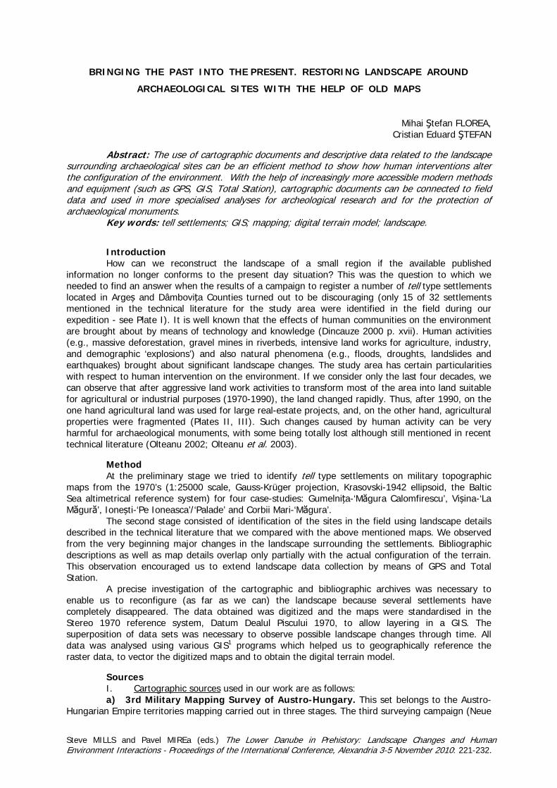
BRINGING THE PAST INTO THE PRESENT. RESTORING LANDSCAPE AROUND
ARCHAEOLOGICAL SITES WITH THE HELP OF OLD MAPS
Mihai Ştefan FLOREA, Cristian Eduard ŞTEFAN
Abstract: The use of cartographic documents and descriptive data related to the landscape
surrounding archaeological sites can be an efficient method to show how human interventions alter the configuration of the environment. With the help of increasingly more accessible modern methods and equipment (such as GPS, GIS, Total Station), cartographic documents can be connected to field data and used in more specialised analyses for archeological research and for the protection of archaeological monuments.
Key words: tell settlements; GIS; mapping; digital terrain model; landscape. Introduction How can we reconstruct the landscape of a small region if the available published
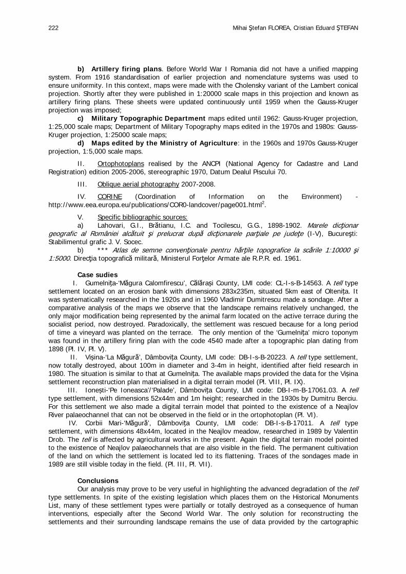
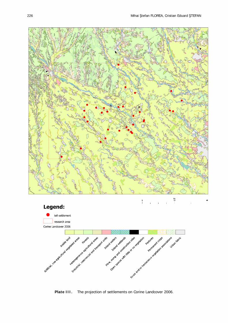
information no longer conforms to the present day situation? This was the question to which we needed to find an answer when the results of a campaign to register a number of tell type settlements located in Argeș and Dâmbovița Counties turned out to be discouraging (only 15 of 32 settlements mentioned in the technical literature for the study area were identified in the field during our expedition - see Plate I). It is well known that the effects of human communities on the environment are brought about by means of technology and knowledge (Dincauze 2000 p. xvii). Human activities (e.g., massive deforestation, gravel mines in riverbeds, intensive land works for agriculture, industry, and demographic ‘explosions’) and also natural phenomena (e.g., floods, droughts, landslides and earthquakes) brought about significant landscape changes. The study area has certain particularities with respect to human intervention on the environment. If we consider only the last four decades, we can observe that after aggressive land work activities to transform most of the area into land suitable for agricultural or industrial purposes (1970-1990), the land changed rapidly. Thus, after 1990, on the one hand agricultural land was used for large real-estate projects, and, on the other hand, agricultural properties were fragmented (Plates II, III). Such changes caused by human activity can be very harmful for archaeological monuments, with some being totally lost although still mentioned in recent technical literature (Olteanu 2002; Olteanu et al. 2003).
Method At the preliminary stage we tried to identify tell type settlements on military topographic
maps from the 1970’s (1:25000 scale, Gauss-Krüger projection, Krasovski-1942 ellipsoid, the Baltic Sea altimetrical reference system) for four case-studies: Gumelnița-‘Măgura Calomfirescu’, Vișina-‘La Măgură’, Ionești-‘Pe Ioneasca’/‘Palade’ and Corbii Mari-‘Măgura’.
The second stage consisted of identification of the sites in the field using landscape details described in the technical literature that we compared with the above mentioned maps. We observed from the very beginning major changes in the landscape surrounding the settlements. Bibliographic descriptions as well as map details overlap only partially with the actual configuration of the terrain. This observation encouraged us to extend landscape data collection by means of GPS and Total Station.
A precise investigation of the cartographic and bibliographic archives was necessary to enable us to reconfigure (as far as we can) the landscape because several settlements have completely disappeared. The data obtained was digitized and the maps were standardised in the Stereo 1970 reference system, Datum Dealul Piscului 1970, to allow layering in a GIS. The superposition of data sets was necessary to observe possible landscape changes through time. All data was analysed using various GIS1 programs which helped us to geographically reference the raster data, to vector the digitized maps and to obtain the digital terrain model.
Sources I. Cartographic sources used in our work are as follows: a) 3rd Military Mapping Survey of Austro-Hungary. This set belongs to the Austro-
Hungarian Empire territories mapping carried out in three stages. The third surveying campaign (Neue
Steve MILLS and Pavel MIREa (eds.) The Lower Danube in Prehistory: Landscape Changes and Human Environment Interactions - Proceedings of the International Conference, Alexandria 3-5 November 2010: 221-232.
Mihai Ştefan FLOREA, Cristian Eduard ŞTEFAN 222
b) Artillery firing plans. Before World War I Romania did not have a unified mapping system. From 1916 standardisation of earlier projection and nomenclature systems was used to ensure uniformity. In this context, maps were made with the Cholensky variant of the Lambert conical projection. Shortly after they were published in 1:20000 scale maps in this projection and known as artillery firing plans. These sheets were updated continuously until 1959 when the Gauss-Kruger projection was imposed;
c) Military Topographic Department maps edited until 1962: Gauss-Kruger projection, 1:25,000 scale maps; Department of Military Topography maps edited in the 1970s and 1980s: Gauss-Kruger projection, 1:25000 scale maps;
d) Maps edited by the Ministry of Agriculture: in the 1960s and 1970s Gauss-Kruger projection, 1:5,000 scale maps.
II. Ortophotoplans realised by the ANCPI (National Agency for Cadastre and Land Registration) edition 2005-2006, stereographic 1970, Datum Dealul Piscului 70.
III. Oblique aerial photography 2007-2008.
IV. CORINE (Coordination of Information on the Environment) -http://www.eea.europa.eu/publications/COR0-landcover/page001.html2.
V. Specific bibliographic sources: a) Lahovari, G.I., Brătianu, I.C. and Tocilescu, G.G., 1898-1902. Marele dicţionar
geografic al României alcătuit şi prelucrat după dicţionarele parţiale pe judeţe (I-V), Bucureşti: Stabilimentul grafic J. V. Socec.
b) *** Atlas de semne convenţionale pentru hărţile topografice la scările 1:10000 şi 1:5000. Direcţia topografică militară, Ministerul Forţelor Armate ale R.P.R. ed. 1961.
Case sudies
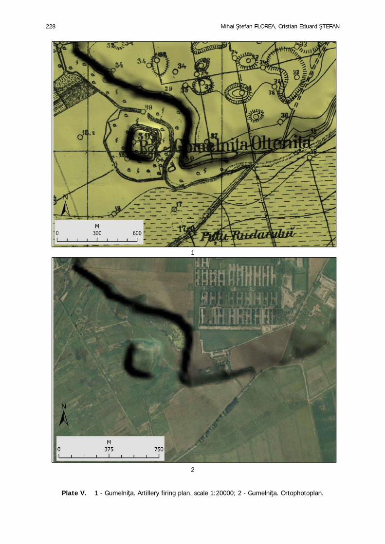
I. Gumelnița-‘Măgura Calomfirescu’, Călărași County, LMI code: CL-I-s-B-14563. A tell type settlement located on an erosion bank with dimensions 283x235m, situated 5km east of Oltenița. It was systematically researched in the 1920s and in 1960 Vladimir Dumitrescu made a sondage. After a comparative analysis of the maps we observe that the landscape remains relatively unchanged, the only major modification being represented by the animal farm located on the active terrace during the socialist period, now destroyed. Paradoxically, the settlement was rescued because for a long period of time a vineyard was planted on the terrace. The only mention of the ‘Gumelnița’ micro toponym was found in the artillery firing plan with the code 4540 made after a topographic plan dating from 1898 (Pl. IV, Pl. V).
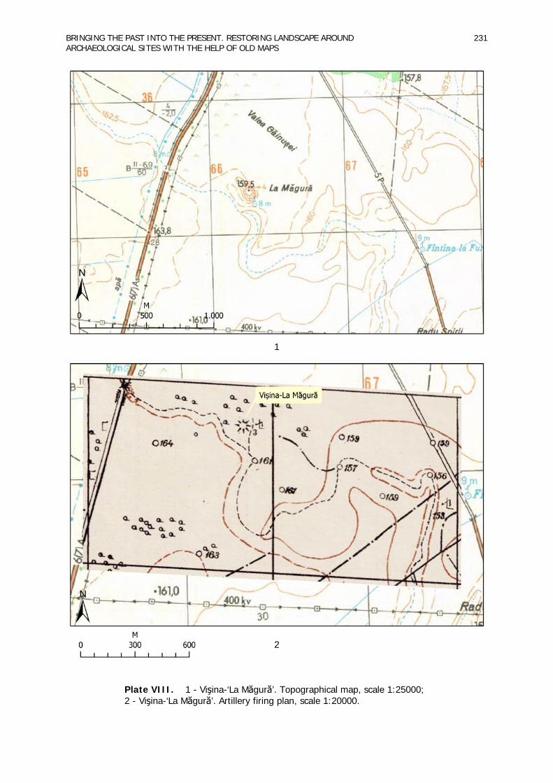
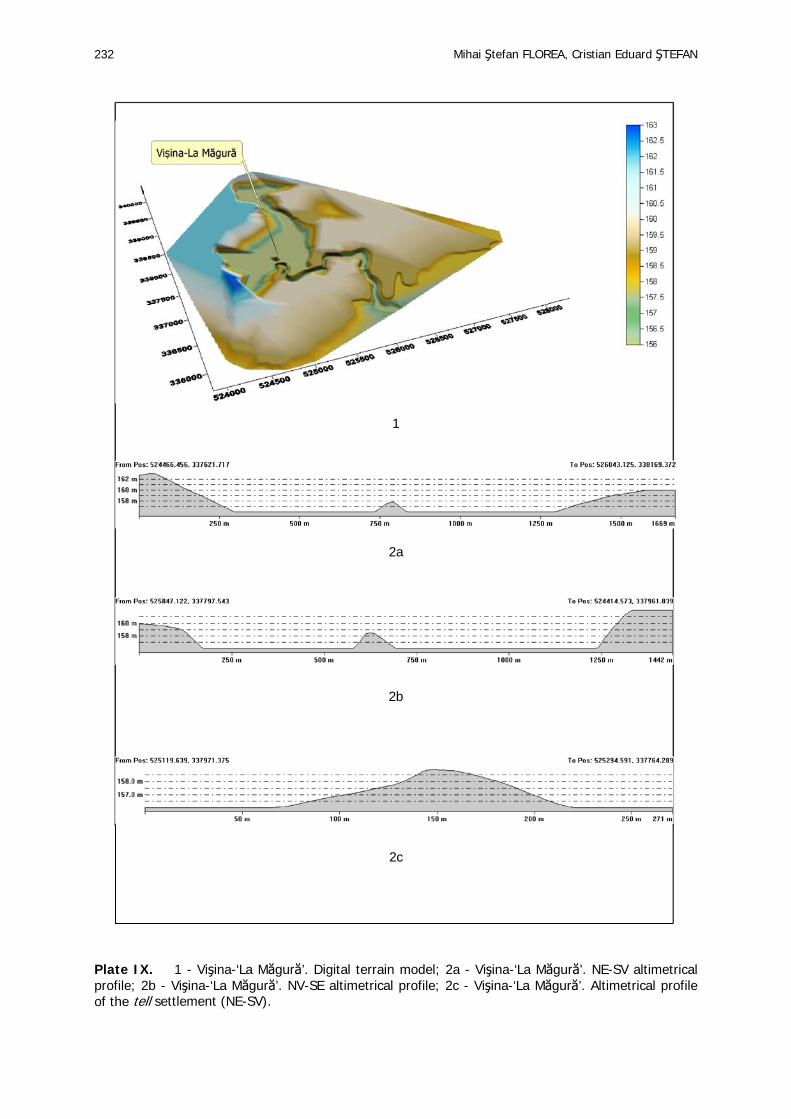
II. Vișina-‘La Măgură’, Dâmbovița County, LMI code: DB-I-s-B-20223. A tell type settlement, now totally destroyed, about 100m in diameter and 3-4m in height, identified after field research in 1980. The situation is similar to that at Gumelnița. The available maps provided the data for the Vișina settlement reconstruction plan materialised in a digital terrain model (Pl. VIII, Pl. IX).
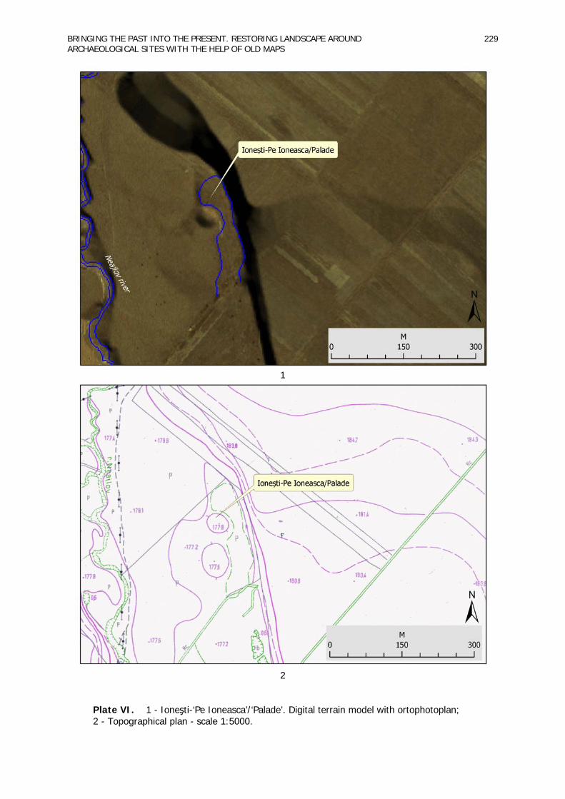
III. Ionești-‘Pe Ioneasca’/‘Palade’, Dâmbovița County, LMI code: DB-I-m-B-17061.03. A tell type settlement, with dimensions 52x44m and 1m height; researched in the 1930s by Dumitru Berciu. For this settlement we also made a digital terrain model that pointed to the existence of a Neajlov River palaeochannel that can not be observed in the field or in the ortophotoplan (Pl. VI).
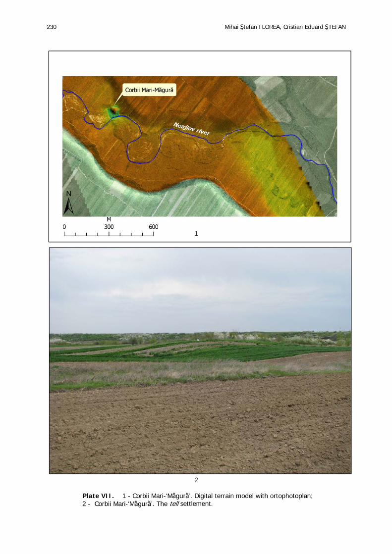
IV. Corbii Mari-‘Măgură’, Dâmbovița County, LMI code: DB-I-s-B-17011. A tell type settlement, with dimensions 48x44m, located in the Neajlov meadow, researched in 1989 by Valentin Drob. The tell is affected by agricultural works in the present. Again the digital terrain model pointed to the existence of Neajlov palaeochannels that are also visible in the field. The permanent cultivation of the land on which the settlement is located led to its flattening. Traces of the sondages made in 1989 are still visible today in the field. (Pl. III, Pl. VII).
Conclusions Our analysis may prove to be very useful in highlighting the advanced degradation of the tell
type settlements. In spite of the existing legislation which places them on the Historical Monuments List, many of these settlement types were partially or totally destroyed as a consequence of human interventions, especially after the Second World War. The only solution for reconstructing the settlements and their surrounding landscape remains the use of data provided by the cartographic
BRINGING THE PAST INTO THE PRESENT. RESTORING LANDSCAPE AROUND ARCHAEOLOGICAL SITES WITH THE HELP OF OLD MAPS
223
and bibliographic documents mentioned above. These types of documents are more accessible today because the data are no longer held secret by the Military Topographic Department making our work easier.
Our analysis is preliminary and with great potential for future projects of larger extent with interdisciplinary teams which may lead to a more balanced research of tell type settlements. The present map of tell type settlements in Romania shows us small areas in which the sites are concentrated (Teleorman, Bucșani, Argeș-Dâmbovița, Mostiștea) and areas in which tell settlements are few or missing altogether (Giurgiu, Călărași) (Andreescu and Mirea 2008; Ștefan 2010).
Acknowledgements Many thanks are due to Monica Constantin for translating the text into English. Notes
1. For the GIS analyses see also Chapman and Van de Noort 2001:366-8 2. EEA grants free access to all its data/applications provided that the user agrees: - to acknowledge the source as follows: Copyright EEA, Copenhagen, 2007 - to display a link to the EEA web site http://www.eea.europa.eu - not to use the data/applications for commercial purposes unless the Agency has expressly granted the right to do so; Ministry of Environment and Sustainable Development: http://www.mmediu.ro; The Danube Delta National Institute for Research and Development : http://www.indd.tim.ro.
References
Andreescu, R. and Mirea, P. (2008) ‘Tell settlements: a pattern of landscape occupation in the Lower Danube’, in D.W. Bailey, A. Whittle and D. Hofman (eds.): Living Well Together? Settlement and Materiality in the Neolithic of South-East and Central Europe. pp. 28-34, Oxford: Oxbow Books Limited.
*** Atlas de semne convenţionale pentru hărţile topografice la scările 1:10000 şi 1:5000. Direcţia topografică militară, Ministerul Forţelor Armate ale R.P.R. ed. 1961.
Chapman, H.P. and Van de Noort, R. (2001) ‘High-Resolution Wetland Prospection, using GPS and GIS: Landscape Studies at Sutton Common (South Yorkshire), and Meare Village East (Somerset)’, Journal of Archaeological Science 28(4): 365-75.
Dincauze, D. (2000) Environmental archaeology: principles and practice. Cambridge UK; New York: Cambridge University Press.
Lahovari, G.I., Brătianu, I.C. and Tocilescu, G.G. (1898) Marele dicţionar geografic al României alcătuit şi prelucrat după dicţionarele parţiale pe judeţe (I), Bucureşti: Stabilimentul grafic J.V. Socec.
─── (1899) Marele dicţionar geografic al României alcătuit şi prelucrat după dicţionarele parţiale pe judeţe (II), Bucureşti: Stabilimentul grafic J.V. Socec.
─── (1900) Marele dicţionar geografic al României alcătuit şi prelucrat după dicţionarele parţiale pe judeţe (III), Bucureşti: Stabilimentul grafic J.V. Socec.
─── (1901) Marele dicţionar geografic al României alcătuit şi prelucrat după dicţionarele parţiale pe judeţe (IV), Bucureşti: Stabilimentul grafic J.V. Socec.
─── (1902) Marele dicţionar geografic al României alcătuit şi prelucrat după dicţionarele parţiale pe judeţe (V), Bucureşti: Stabilimentul grafic J.V. Socec.
Olteanu, G. 2002. Repertoriul arheologic al județului Dâmbovița. Târgoviște: Cetatea de Scaun. Olteanu, G., Cârstina, O. and Căprăroiu, D. (2003) Repertoriul arheologic al județului Dâmbovița.
Târgovişte: Cetatea de Scaun. Ștefan, C.E. (2010) Settlement types and enclosures in the Gumelnita culture. Târgovişte: Cetatea de
Scaun.
Mihai Ştefan FLOREA, Cristian Eduard ŞTEFAN 224
Plate I. Argeş-Dâmboviţa research area.

BRINGING THE PAST INTO THE PRESENT. RESTORING LANDSCAPE AROUND ARCHAEOLOGICAL SITES WITH THE HELP OF OLD MAPS
225
Plate II. The projection of settlements on Corine Landcover 2000.
Mihai Ştefan FLOREA, Cristian Eduard ŞTEFAN 226
Plate III. The projection of settlements on Corine Landcover 2006.

BRINGING THE PAST INTO THE PRESENT. RESTORING LANDSCAPE AROUND ARCHAEOLOGICAL SITES WITH THE HELP OF OLD MAPS
227
1 a
1 b
1 c
2
Plate IV. 1a - Digital terrain model of the Gumelniţa settlement; 1b - Gumelniţa. N-S altimetrical profile; 1c - Gumelniţa. E-V altimetrical profile; 2 - Gumelniţa. Oblique aerial photography.
Mihai Ştefan FLOREA, Cristian Eduard ŞTEFAN 228
1
2
Plate V. 1 - Gumelniţa. Artillery firing plan, scale 1:20000; 2 - Gumelniţa. Ortophotoplan.
BRINGING THE PAST INTO THE PRESENT. RESTORING LANDSCAPE AROUND ARCHAEOLOGICAL SITES WITH THE HELP OF OLD MAPS
229
1 2
Plate VI. 1 - Ioneşti-‘Pe Ioneasca’/‘Palade’. Digital terrain model with ortophotoplan; 2 - Topographical plan - scale 1:5000.
Mihai Ştefan FLOREA, Cristian Eduard ŞTEFAN 230
1 2
Plate VII. 1 - Corbii Mari-‘Măgură’. Digital terrain model with ortophotoplan; 2 - Corbii Mari-‘Măgură’. The tell settlement.
BRINGING THE PAST INTO THE PRESENT. RESTORING LANDSCAPE AROUND ARCHAEOLOGICAL SITES WITH THE HELP OF OLD MAPS
231
1
2
Plate VIII. 1 - Vişina-‘La Măgură’. Topographical map, scale 1:25000; 2 - Vişina-‘La Măgură’. Artillery firing plan, scale 1:20000.
Mihai Ştefan FLOREA, Cristian Eduard ŞTEFAN 232
1
2a
2b
2c
Plate IX. 1 - Vişina-‘La Măgură’. Digital terrain model; 2a - Vişina-‘La Măgură’. NE-SV altimetrical profile; 2b - Vişina-‘La Măgură’. NV-SE altimetrical profile; 2c - Vişina-‘La Măgură’. Altimetrical profile of the tell settlement (NE-SV).