lower grande ronde subbasins tmdl - · pdf file2.7.3 point sources of heat ... table 2-5....
TRANSCRIPT

LOWER GRANDE RONDE SUBBASINS TMDL CHAPTER 2: STREAM TEMPERATURE

This page left intentionally blank.

Lower Grande Ronde Subbasins TMDL September 2010
OREGON DEPARTMENT OF ENVIRONMENTAL QUALITY I
TABLE OF CONTENTS
2.1 Overview ............................................................................................................................................... 1 2.1.1 Summary of Stream Temperature TMDL Approach ....................................................................... 1
2.2 Waterbodies .......................................................................................................................................... 4 2.3 Pollutant Identification ........................................................................................................................ 4 2.4 Beneficial Use Identification ............................................................................................................... 4
2.4.1 Salmonid Thermal Requirements .................................................................................................... 5 2.5 Target Identification ............................................................................................................................. 6
2.5.1 Applicable Water Quality Standard ................................................................................................. 6 2.5.2 Deviation from Biologically Based Numeric Criteria ........................................................................ 9
2.6 Seasonal Variation and Critical Period ............................................................................................ 10 2.7 Existing Heat Sources ....................................................................................................................... 15
2.7.1 Natural Background Sources of Heat ............................................................................................ 15 2.7.2 Nonpoint Sources of Heat ............................................................................................................. 15 2.7.3 Point Sources of Heat ................................................................................................................... 16
2.8 Loading Capacity and Allocation Approach ................................................................................... 16 2.8.1 Allocation Approach ...................................................................................................................... 17 2.8.2 Loading Capacity and Excess Load for the Wallowa River .......................................................... 18
2.9 Load Allocations (Nonpoint Sources) .............................................................................................. 18 2.9.1 Site Specific Heat Load Allocations and Effective Shade Surrogates .......................................... 19 2.9.2 Generalized Heat Load Allocations and Effective Shade Surrogate ............................................. 20
2.10 Wasteload Allocations (Point Sources) ......................................................................................... 27 2.10.1 Joseph Sewage Treatment Plant ................................................................................................ 30 2.10.2 Enterprise and Wallowa Sewage Treatment Plants .................................................................... 31 2.10.3 Cumulative Effects Analysis ........................................................................................................ 32
2.11 Margin of Safety ............................................................................................................................... 35 2.12 Reserve Capacity ............................................................................................................................. 35 2.13 Water Quality Standard Attainment Analysis & Reasonable Assurances ................................. 36
2.13.1 Implementation Responsibilities .................................................................................................. 38 2.14 References ........................................................................................................................................ 39
Lower Grande Ronde Subbasins TMDL September 2010
OREGON DEPARTMENT OF ENVIRONMENTAL QUALITY II
FIGURES Figure 2-1. Fish use designations in the Lower Grande Ronde Subbasins (from Figure 151A in
OAR 340-041-0028) ........................................................................................................... 7 Figure 2-2. Waters designated as salmon and steelhead trout spawning habitat in the Lower
Grande Ronde Subbasins (from Figure 151B in OAR 340-041-0028) .............................. 8 Figure 2-3. 2004/2006 303(d) listed streams for temperature (bolded red lines)............................... 10 Figure 2-4. Observed seasonal stream temperatures ........................................................................ 12 Figure 2-5. Comparison of instream temperature profiles among years on the Wallowa River near
Lostine.............................................................................................................................. 14 Figure 2-6. Simulated temperature profile for Wallowa River based on instream temperature
measurements and Thermal Infrared Imagery (TIR) ....................................................... 14 Figure 2-7. Wallowa River heat load allocation and effective shade surrogate (mid-August) ........... 20 Figure 2-8. Generalized warm-season system potential effective shade curves for the Lower
Grande Ronde Subbasins (North-South, East-West, and Northeast-Northwest refer to stream aspect) ................................................................................................................. 22
Figure 2-9. Temperature profiles (7-day average of daily maximum temperatures) of Prairie Creek upstream and downstream of the Joseph STP outfall and the STP effluent in holding lagoon during 2006-2007 ................................................................................................. 31
Figure 2-10. Wallowa River temperature simulation results (maximum 7DADM) .............................. 37
TABLES
Table 2-1. Lower Grande Ronde Subbasins Temperature TMDL Components .................................. 2 Table 2-2. Designated beneficial uses in the Grande Ronde Basin (OAR 340-041-0151) .................. 5 Table 2-3. Modes of thermally induced cold water fish mortality (Brett 1952; Bell 1986, Hokanson
et al. 1977) ...................................................................................................................... 6 Table 2-4. Oregon’s biologically-based numeric temperature criteria (DEQ 2007a) ........................... 7 Table 2-5. Allocation of the Human Use Allowance (HUA) (0.3°C or 0.54°F) ................................... 17 Table 2-6. Daily loading capacity and excess solar load for the Wallowa River (August 23, 1999) .. 18 Table 2-7. System potential vegetation communities (Wallowa County TMDL Committee, 2003).... 25 Table 2-8. Measures of progress. ...................................................................................................... 26 Table 2-9. Facility discharge information and applicable biologically-based numeric criteria ............ 27 Table 2-10. Wasteload allocations for point source discharges in the Lower Grande Ronde
Subbasins (critical period of April-October) .................................................................. 29 Table 2-11. Input parameters and results of Reasonable Potential Analysis for the Joseph STP .... 33 Table 2-12. Input parameters and results of Reasonable Potential Analysis for the Enterprise STP 33 Table 2-13. Input parameters and results of Reasonable Potential Analysis for the Wallowa STP .. 34 Table 2-14. Input parameters and results of Reasonable Potential Analysis results for the
Enterprise and Wallowa STP combined ....................................................................... 34

Lower Grande Ronde Subbasins TMDL September 2010
OREGON DEPARTMENT OF ENVIRONMENTAL QUALITY 2-1
2.1 OVERVIEW Human activities and aquatic species that are to be protected by water quality standards are deemed beneficial uses. Water quality standards are developed to protect the most sensitive beneficial use within a waterbody of the State. The stream temperature standard is designed to protect cold water fish (salmonids) rearing and spawning as the most sensitive beneficial use. Oregon’s stream temperature standard includes both numeric and narrative criteria. Numeric biologically-based criteria are based on temperatures that protect various salmonid life stages. Narrative criteria specify conditions that deserve special attention, such as protection of cold waters. Oregon’s temperature standard also includes Natural Conditions criteria which apply if DEQ determines that the biologically-based numeric temperature criteria may not be met under natural conditions at a particular site. When this determination is made, a “natural thermal potential” (NTP) temperature becomes the new criterion. Based on the analysis presented in this TMDL, the Natural Conditions criteria apply throughout the Lower Grande Ronde Subbasins and NTP conditions become the TMDL target. Exceptions occur where and when numeric targets are needed and the natural potential temperatures have not been assessed. This is typically a concern for point sources outside of the warm season. When stream temperature data demonstrate non-attainment of a criterion, the waterbody is designated water quality limited and placed on the 303(d) list. Total Maximum Daily Loads (TMDLs) must then be completed for the 303(d) listed waterbodies. This temperature TMDL applies to all perennial and intermittent streams within the Lower Grande Ronde Subbasins.
2.1.1 Summary of Stream Temperature TMDL Approach Stream temperature TMDLs are generally scaled to a subbasin or basin and include all perennial and intermittent surface waters with either salmonid presence or that contribute to areas with salmonid presence. Since stream temperature results from cumulative interactions between upstream and local sources, the TMDL considers all surface waters that affect the temperatures of 303(d) listed waterbodies. For example, the Lower Grande Ronde and Wallowa Rivers are water quality limited for temperature. To address these listings in the TMDL, all tributaries in the Subbasins receive load allocations.
An important step in the TMDL is to perform a source assessment which quantifies the anthropogenic contributions to stream heating. One anthropogenic contribution to solar radiation heat loading results from decreased stream surface shade. Decreased stream shade may be caused by near-stream vegetation disturbance/removal and channel morphology changes. Other anthropogenic sources of stream warming may include stream flow reductions and warm water point source effluent discharges. Heat is the identified pollutant. Anthropogenic nonpoint and point sources are collectively not allowed to heat a waterbody more than 0.3oC above the applicable criteria, after complete mixing and cumulatively at the point of maximum impact. This permitted amount of heating is called the Human Use Allowance (HUA) (OAR 340-041-0028 12(b)). Allocated conditions are expressed as solar heat load. Nonpoint source heat load allocations are translated into effective shade surrogate measures. Effective shade surrogate measures provide site-specific targets for land managers that are easily measured. Attainment of the surrogate measures ensures compliance with the nonpoint source allocations. Point source wasteload allocations are based on the applicable numeric and/or narrative criteria. In this TMDL, point sources on a given waterbody are not allowed to increase stream temperatures more than 0.2oC (a portion of the 0.3oC HUA) cumulatively after complete mixing with the receiving water. Table 2-1 summarizes the components of this TMDL. Appendix A describes the stream temperature analysis used to develop this TMDL in greater detail than is provided in this Chapter. The purpose of the stream temperature analysis used in this TMDL was to: (1) determine temperatures for various scenarios on the Wallowa River including natural thermal potential, (2) assess heat loading for the purpose of TMDL

Lower Grande Ronde Subbasins TMDL September 2010
OREGON DEPARTMENT OF ENVIRONMENTAL QUALITY 2-2
allocation, and (3) compute readily measurable surrogates for the allocations. Heat Source, version 7.0 (Boyd and Kasper 2003) was the model used for TMDL development in this TMDL. Table 2-1. Lower Grande Ronde Subbasins Temperature TMDL Components
Waterbodies OAR 340-042-
0040(4)(a)
Perennial and intermittent streams (as identified in OAR 340-041-151; Figures 151A & 151B) in the Lower Grande Ronde Subbasins, 4th field HUCs 17060102, 17060105, and 17060106. This area generally covers Wallowa County.
Pollutant Identification OAR 340-042-
0040(4)(b)
Pollutant: Heat from human-caused sources such as: (1) solar radiation loading, (2) warm water discharge to surface waters and (3) flow modifications that affect natural thermal regimes.
Beneficial Uses OAR 340-042-
0040(4)(c) OAR 340-041-151,
Table 151A
Fish and aquatic life are the most temperature-sensitive beneficial uses in the Grande Ronde Basin.
Target Identification
(Applicable Water Quality Standards)
OAR 340-042-0040(4)(c)
OAR 340-041-0028(4)(a)
OAR 340-041-0028(4)(b)
OAR 340-041-0028(4)(c)
OAR 340-041-0028(8)
OAR 340-041-002811)
CWA §303(d)(1)
OAR 340-041-0028 provides numeric and narrative temperature criteria. Maps and tables provided in OAR 340-041-151 specify where and when the criteria apply. Biologically based numeric criteria applicable to the Lower Grande Ronde Subbasins, as measured using the seven-day average maximum stream temperature, include:
• 12.0oC during times and at locations of bull trout spawning and juvenile rearing.
• 13.0°C during times and at locations of salmon and steelhead spawning.
• 16.0°C during times and at locations of core cold water habitat identification.
• 18.0°C during times and at locations of salmon and trout rearing and migration.
Oregon water quality standards include provisions for natural conditions. When DEQ determines that the natural thermal potential of a water body exceeds these biological based criteria, as is the case with the Wallowa River, the natural thermal potential temperatures (natural conditions) are deemed the applicable criterion for that water body. DEQ has determined that the natural conditions criterion is the primary warm season target throughout the Lower Grande Ronde Subbasins. Exceptions occur where and when numeric targets are needed and the natural potential temperatures have not been assessed (such as for point sources).
Seasonal Variation OAR 340-042-
0040(4)(j) CWA §303(d)(1)
Peak temperatures typically occur in July and August, although the biologically-based numeric criteria can be exceeded during the critical period of April-October. The TMDL applies year-around.
Existing Sources OAR 340-042-
0040(4)(f) CWA §303(d)(1)
Nonpoint sources include excessive inputs of solar radiation because of streamside vegetation removal or reduction, anthropogenic channel disturbance, and flow modifications. Point sources include municipal facilities that discharge warm water to receiving streams.

Lower Grande Ronde Subbasins TMDL September 2010
OREGON DEPARTMENT OF ENVIRONMENTAL QUALITY 2-3
Table 2-1 (continued). Lower Grande Ronde Subbasins Temperature TMDL Components
TMDL Loading Capacity and Allocations OAR 340-042-
0040(4)(d) OAR 340-042-
0040(4)(e) OAR 340-042-
0040(4)(g) OAR 340-042-
0040(4)(h) OAR 340-042-
0040(4)(k) 40 CFR 130.2(f) 40 CFR 130.2(g) 40 CFR 130.2(h)
Loading Capacity: OAR 340-041-0028 (12)(b)(B) states all anthropogenic sources of heat may cumulatively increase stream temperature no more than 0.3°C (0.5oF) above the applicable criteria at the point of maximum impact. Loading capacity is the heat load that corresponds to the natural conditions criterion plus the increases in temperature provided through the human use allowance (HUA). Wasteload Allocations (NPDES Point Sources [PS]): NPDES permitted point sources combined are allowed an increase in temperature of not more than 0.2ºC increase in 50% of low stream flow. Wasteload allocations apply during the critical period of April-October. Load Allocations (Nonpoint Sources [NPS]): Natural background heat loads from solar radiation associated with system potential near-stream vegetation are the targeted load allocation. A surrogate of system potential shade is used as a surrogate allocation. A portion (0.05oC) of the human use allowance has been allocated to nonpoint source activities to address anthropogenic heat loads in excess of background rates. Excess Load: The difference between the current pollutant load and the loading capacity of the waterbody is the excess heat load. For the Wallowa River, the excess hear load is 73.5 megawatts. Reserve Capacity: The Reserve Capacity can be summarized as: RC = HUA – (NPS HUA + PS HUA); where HUA=0.3oC, NPS HUA = 0.05oC and PS HUA = no more than 0.2oC.
Surrogate Measures
OAR 340-042-0040(5)(b)
40 CFR 130.2(i)
Surrogate Measures are used throughout the temperature TMDL. Effective shade targets translate nonpoint source solar radiation loads into measurable riparian vegetation targets.
Margins of Safety OAR 340-042-
0040(4)(i) CWA §303(d)(1)
Margins of Safety are implicitly demonstrated in conservative critical condition assumptions for point source load calculations and are inherent in the methodology for determining nonpoint source loads.
Water Quality Management Plan
OAR 340-042-0040(4)(l)
The Water Quality Management Plan (WQMP) (Chapter 4) provides the framework of management strategies to attain and maintain water quality standards and reasonable assurance that the TMDL and associated allocations will be met. The WQMP is designed to work in conjunction with detailed plans and analyses provided in sector-specific or source-specific implementation plans.

Lower Grande Ronde Subbasins TMDL September 2010
OREGON DEPARTMENT OF ENVIRONMENTAL QUALITY 2-4
2.2 WATERBODIES This temperature TMDL applies to all perennial and intermittent streams within the Lower Grande Ronde, Wallowa River and Imnaha River Subbasins, as identified in Figures 151A and 151B in OAR 340-041-151.
2.3 POLLUTANT IDENTIFICATION Development of stream temperature TMDLs requires an understanding of the natural and human processes that contribute to stream warming. Temperature is the water quality parameter of concern, but heat, in particular heat from human activities or anthropogenic sources, is the pollutant of concern in this TMDL. Specifically, water temperature change is an expression of heat energy exchange per unit volume:
VolumeEnergyHeateTemperatur ∆
∝∆
Stream temperature is influenced by natural factors such as climate, geomorphology, hydrology, and vegetation. Human or anthropogenic heat sources may include discharges of heated water to surface waters, increases in sunlight reaching the water’s surface due to the removal of streamside vegetation and reductions in stream shading, changes to stream channel form, and reductions in natural stream flows and the reduction of cold water inputs from groundwater (see Appendix A for a more thorough discussion of stream heating processes). The pollutant targeted in this TMDL is heat from the following sources: (1) human-caused solar radiation loading increases to the stream network, as a result of alterations in near-stream vegetation, channel morphology, and flow modifications; and (2) warm water of human origin, such as waste water treatment plants.
2.4 BENEFICIAL USE IDENTIFICATION Water quality standards include designation of beneficial uses, numeric and narrative criteria for individual parameters to protect those uses, and anti-degradation policies to protect overall water quality. Beneficial uses and the associated water quality criteria are generally determined by Basin and are applicable throughout the Basin (Table 2-2). In practice, water quality standards have been set at a level to protect the most sensitive beneficial uses and seasonal standards may be applied for uses that do not occur year-round. Salmon and trout (salmonids) and other cold water species that inhabit most streams in the Lower Grande Ronde Subbasins (part of the Grande Ronde Basin as identified in OAR 340-041) are considered the beneficial uses most sensitive to stream temperature. Biologically-based numeric criteria were developed that are specific to salmonid life stages such as spawning and rearing. Criteria were also developed for critical habitat areas that serve as the core for salmonid protection and restoration efforts as well as for areas that support bull trout spawning and juvenile rearing. The complete Oregon temperature standard rule (OAR 340-041-0028) (DEQ 2007a) can be accessed at http://www.deq.state.or.us and is described further in Section 2.5.1 below.

Lower Grande Ronde Subbasins TMDL September 2010
OREGON DEPARTMENT OF ENVIRONMENTAL QUALITY 2-5
Table 2-2. Designated beneficial uses in the Grande Ronde Basin (OAR 340-041-0151) Temperature-sensitive beneficial uses are marked in grey.
Beneficial Uses Grande Ronde River (RM 39 to 165)
All Other Basin Waters
Public Domestic Water Supply¹ X X Private Domestic Water Supply¹ X X Industrial Water Supply X X Irrigation X X Livestock Watering X X Fish & Aquatic Life² X X Wildlife & Hunting X X Fishing X X Boating X X Water Contact Recreation X X Aesthetic Quality X X Hydro Power X X Commercial Navigation & Transportation ¹ With adequate pretreatment (filtration & disinfection) and natural quality to meet drinking water standards.
² See also Figures 151A and 151B for fish use designations for this basin. These figures are adapted to the specific geographic region of the Lower Grande Ronde Subbasins and are provided in Section 3.5.
2.4.1 Salmonid Thermal Requirements Oregon’s water temperature standard employs a logic that relies on using sensitive species as indicators of water quality impairment. If temperatures are protective of these indicator species, other less sensitive species will share in protection as well. Cold water aquatic organisms, such as salmon and trout and some amphibians are very sensitive to temperature, and are used as indicators of temperature impairments. Numeric temperature criteria have been adopted in the temperature standard to protect specific life stages of salmon and trout. If stream temperatures become too hot, fish may die almost instantaneously due to denaturing of critical enzyme systems in their bodies (Hogan 1970). The ultimate instantaneous lethal limit occurs in high temperature ranges (upper-90oF) that are rare or unknown in the Wallowa County subbasins. More common and widespread within the Lower Grande Ronde Subbasins are summertime stream temperatures in the 70oF to 80°F range (mid- to high-20oC range). These temperatures can cause death of cold water fish species during exposure times lasting as little as a few hours. The exact temperature at which a cold water fish succumbs to such a thermal stress depends on the temperature that the fish is acclimated, as well as particular development life-stages. This cause of mortality, termed the incipient lethal limit, results from breakdown of physiological regulation of vital processes such as respiration and circulation (Heath and Hughes 1973). The most common and widespread cause of thermally induced fish mortality is attributed to interactive effects of decreased or lack of metabolic energy for feeding, growth or reproductive behavior, increased exposure and susceptibility to pathogens (viruses, bacteria and fungus), decreased food supply (impaired macroinvertebrate populations) and increased competition from warm-water-tolerant species. This mode of thermally induced mortality, termed indirect or sub-lethal, is delayed, and occurs weeks to months after the onset of elevated temperatures above 64°F, but less than incipient lethal limits. These conditions may hold fish in a weakened state until a short-term extreme event kills them. Table 2-3 summarizes the modes of cold water fish mortality.

Lower Grande Ronde Subbasins TMDL September 2010
OREGON DEPARTMENT OF ENVIRONMENTAL QUALITY 2-6
Salmon and trout can survive excessive temperatures for short durations if there are cool places available in the stream offering refuge. These “refugia” must be common enough to allow recovery to fish during upstream migration or following excursions into warmer water. Table 2-3. Modes of thermally induced cold water fish mortality (Brett 1952; Bell 1986, Hokanson et al. 1977)
Modes of Thermally Induced Fish Mortality Temperature Range
Time to Death
Instantaneous Lethal Limit – Denaturing of bodily enzyme systems > 90oF > 32oC Instantaneous
Incipient Lethal Limit – Breakdown of physiological regulation of vital bodily processes, namely: respiration and circulation
70oF - 77oF 21oC - 25oC Hours to Days
Sub-Lethal Limit – Conditions that cause decreased or lack of metabolic energy for feeding, growth or reproductive behavior, encourage increased exposure to pathogens, decreased food supply and increased competition from warm water tolerant species
64oF - 74oF 17.8oC - 23oC
Weeks to Months
2.5 TARGET IDENTIFICATION
2.5.1 Applicable Water Quality Standard Oregon’s water quality standard for temperature is contained in OAR 340-0411-0028 (DEQ 2007a, available online from DEQ at http://www.deq.state.or.us/wq/standards/standards.htm). The standard includes both narrative and numeric criteria designed to protect beneficial uses, such as cold water salmon and trout species, based on requirements of specific life stages. Some of the criteria specifically pertinent to this TMDL are described in further detail below. There are additional standards for antidegradation (OAR 340-041-0004) and mixing zones (OAR 340-041-0053) which also have bearing on implementation the temperature standard. A more extensive analysis of water temperature related to aquatic life and supporting documentation for the temperature standard can be found in the 1992-1994 Water Quality Standards Review Final Issue Papers (DEQ 1995) and in EPA Region 10 Guidance for Pacific Northwest State and Tribal Temperature Water Quality Standards (USEPA 2003). Biologically Based Numeric Criteria (OAR 340-041-0028(4)) Numeric stream temperature criteria are assessed as a seven-day average of daily maximum temperatures (7DADM). Table 2-4 lists the numeric biologically based criteria that are applicable in the Lower Grande Ronde Subbasins. Designations of habitat use during non-spawning periods (salmon and trout rearing and migration, core cold water habitat, and bull trout uses) are illustrated in Figure 2.1. For Subbasin waters where fish uses are not identified the applicable criteria are the same as the nearest downstream waterbody that is identified in fish use maps. Locations and timing of salmon and steelhead spawning through fry emergence are illustrated in Figure 2-2 and vary depending on the waterbody.

Lower Grande Ronde Subbasins TMDL September 2010
OREGON DEPARTMENT OF ENVIRONMENTAL QUALITY 2-7
Table 2-4. Oregon’s biologically-based numeric temperature criteria (DEQ 2007a) Uses are defined for specific waterbodies in OAR 340-041-0028, Figures 151A and 151B (repeated as Figure 2-1 and Figure 2-2 in this document).
Beneficial Use Temperature Criteriaa Season
Bull Trout Spawning and Rearing 12.0°C (53.6°F) Year around
Salmon and Steelhead Spawning 13.0°C (55.4°F) Varies by geography (refer to Figure 2-2)
Core Cold Water Habitat 16.0°C (60.8°F) Year aroundb
Salmon and Trout Rearing and Migration 18.0°C (64.4 °F) Year aroundb a = Stream temperature is calculated using the average of seven consecutive daily maximum temperatures on a rolling basis (7-day average of the daily maximum). b = Except during periods when superseded by spawning criteria.
Figure 2-1. Fish use designations in the Lower Grande Ronde Subbasins (from Figure 151A in OAR 340-041-0028)

Lower Grande Ronde Subbasins TMDL September 2010
OREGON DEPARTMENT OF ENVIRONMENTAL QUALITY 2-8
Figure 2-2. Waters designated as salmon and steelhead trout spawning habitat in the Lower Grande Ronde Subbasins (from Figure 151B in OAR 340-041-0028)
Natural Conditions Criteria (OAR 340-041-0028(8)) The Oregon temperature water quality standard includes provisions for natural conditions. The natural conditions criteria are the general target of this temperature TMDL. The temperature standard states “Where the Department (DEQ) determines that the natural thermal potential of all or a portion of a water body exceeds the biologically-based criteria in section (4) of this rule, the natural thermal potential temperatures supersede the biologically based criteria, and are deemed to be the applicable temperature criteria for that water body” (OAR 340-041-0028(8)). This determination has been made by DEQ for the warm season in the Lower Grande Ronde Subbasins. TMDLs typically attempt to quantify the natural thermal potential (NTP) of major streams through computer modeling. In this TMDL, NTP was modeled for the Wallowa River below Wallowa Lake (Appendix A). Simulations performed to estimate NTP stream temperatures used system potential vegetation heights and densities and natural flow conditions. For all reaches of the river that were modeled, NTP temperatures during the simulation period of August 14-Sept 2, 1999 exceeded the biologically-based core cold water criterion. Based on this analysis, NTP is the warm season target [Natural Condition Criteria, OAR 340-041-0028(8)] for the Wallowa River and all of its tributaries.

Lower Grande Ronde Subbasins TMDL September 2010
OREGON DEPARTMENT OF ENVIRONMENTAL QUALITY 2-9
Similarly, in the TMDL completed for the Upper Grande Ronde Subbasin (DEQ 2000), natural thermal conditions were set as the target to meet water quality standards. Although an NTP analysis was not done for other Grande Ronde Basin water bodies, the natural conditions criterion is assumed applicable throughout the Lower Grande Ronde and Imnaha River Subbasins as well. NTP conditions are the target for all streams in the Lower Grande Ronde Subbasins. Exceptions occur where and when numeric targets are needed and the natural potential temperatures have not been assessed (such as for point source discharges). Human Use Allowance (OAR 340-041-0028(12)(b)) Oregon’s temperature standard contains provisions for stream heating due to human activities. The human use allowance (HUA) limits cumulative anthropogenic heating of surface waters to no more than 0.3°C (0.5°F) above the applicable criterion after complete mixing in the water and at the point of maximum impact. The HUA is considered an insignificant amount of temperature increase in surface waters. The HUA addresses heat from all human sources; point source discharges, nonpoint sources and a reserve capacity for future growth. The HUA typically does not significantly influence nonpoint source objectives (load allocations). The value is small enough to be masked by the uncertainty associated with instream measurement and modeling methods. The HUA can be significant with regard point source discharges. In this TMDL, the HUA is divided between sources, with 2/3 going to designated existing point sources, 1/6 to nonpoint sources and the remainder to reserve capacity. The amount available for reserve capacity will vary based on the presence or absence of point source discharges on a waterbody. Consistency with Washington’s Water Quality Standards The Grande Ronde River and several of its tributaries originate in Oregon, but terminate in the State of Washington. Washington’s water quality standard for temperature is contained in WAC 173-201A-200(1)(c) (available on-line at http://www.ecy.wa.gov/programs/wq/swqs/index.html). As with Oregon, Washington’s standard contains biologically-based numeric targets along with natural conditions criteria and a human use allowance. When a water body does not meet the numeric criteria because of natural conditions, the natural conditions constitute the water quality criteria (WAC 173-201A-260(1)) and human activities may not cause more that a 0.3oC increase in the 7-day average of daily maximum temperatures (WAC173-201A-200(1)(c)(I)). The Natural Conditions criteria and HUA targeted by Oregon in this TMDL are expected to be compliant with Washington’s temperature criteria at the border.
2.5.2 Deviation from Biologically Based Numeric Criteria The Lower Grande Ronde Subbasins have 30 streams on the 2004/2006 303(d) list (DEQ 2007b) for not meeting the biologically based numeric criteria for temperature (Figure 2-3, refer back to Table 1-1). There is at least one listing for each of the four numeric criterion listed in Table 2-4. For specific information regarding Oregon’s 303(d) listing procedures, and to obtain more information regarding the Lower Grande Ronde Subbasins 303(d) listed streams, visit DEQ’s web page at http://www.deq.state.or.us/wq/assessment/rpt0406/search.asp.

Lower Grande Ronde Subbasins TMDL September 2010
OREGON DEPARTMENT OF ENVIRONMENTAL QUALITY 2-10
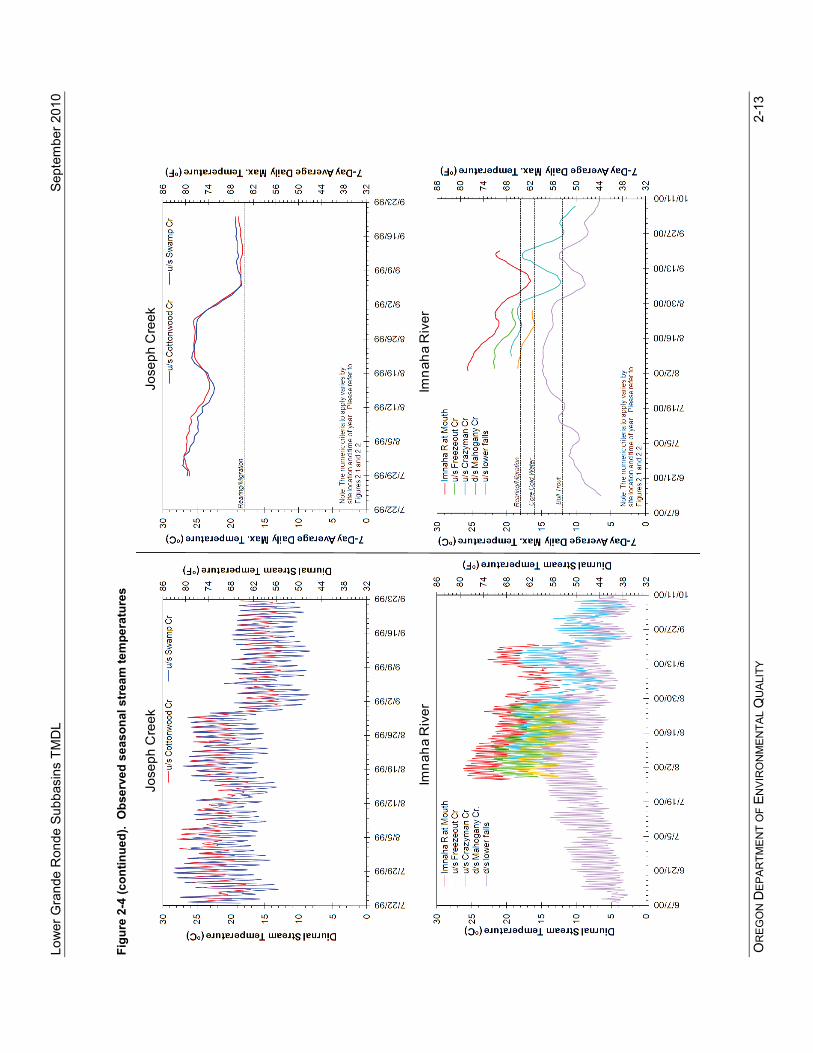
Figure 2-3. 2004/2006 303(d) listed streams for temperature (bolded red lines)
2.6 SEASONAL VARIATION AND CRITICAL PERIOD Maximum temperatures typically occur in July and August during warm weather and naturally low stream flow rates. This TMDL focuses the analysis during the August period as a critical condition where the core cold water and rearing/migration criteria are exceeded as identified by 1999 and 2000 temperature data. Data for most sites were collected during 1999, although data for the Imnaha River was collected in 2000. Selected station profiles are provided to illustrate the pattern of temperatures through the summer in each of the Lower Grande Ronde Subbasins (Figure 2-4). The left frame of each set of plots in presents diurnal (daily) variation in temperature with time, while the right frame presents the 7DADM. In each of the legends, the sites are listed in longitudinal order starting at the most downstream location. The locations of these sites are shown in Figure 2-3. These profiles show a common pattern of variation on a daily scale, and maximum values generally in the midsummer period from mid July to late August.

Lower Grande Ronde Subbasins TMDL September 2010
OREGON DEPARTMENT OF ENVIRONMENTAL QUALITY 2-11
Temperature modeling for this TMDL was done using 1999 data for the Wallowa River. To assess the representativeness of this year, inter-annual variation was assessed by comparing temperature profiles at one station among several years in the Wallowa River Subbasin (Figure 2-5). Most of the data used for this inter-annual comparison were collected by the Wallowa County SWCD near the town of Lostine (2000-2004), upstream of the Cross-Country Canal. This is also the site of a USGS stream flow gaging station. DEQ data was collected in 1999 at a site on the Wallowa River upstream of the Lostine River. Although there is some physical separation between these two locations, Thermal Infrared Imagery (TIR) suggests there is little difference in temperature between these sites (Figure 2-6). These profiles indicate that, although instream temperatures are variable both within and among years, the data for 1999 fits within this variability and does not indicate an unusual year. The data presented in Figure 2-5 for the site on the Wallowa River near Lostine depicts seasonal variation in stream temperature over a longer time period than the patterns shown in Figure 2-4. The data from this site demonstrates that there are regular exceedances of the spawning criterion observed on the Wallowa River between approximately April and October. This defines the critical period for both core coldwater and spawning criteria as April through October. During this time, one or both of the temperature criteria were commonly exceeded on the Wallowa River (Figure 2-5). The Lower Grande Ronde Subbasins temperature TMDL applies year round. As will be discussed further (Section 2.9), because the load allocations invoke measures that must be sustained perennially, nonpoint sources are addressed on a year-round basis, with regard to stream heating. Although the current allocation scheme does not specifically address nonpoint source loading rates during spawning periods, implementation of the potential effective shade surrogate represents a long-term perennial condition, protecting water quality to the greatest extent throughout the year. Point source wasteload allocations are defined for the critical period of April through October of each year. Through the TMDL assessment, point sources were assigned targets based on the human use allowance, the natural condition criteria during the warm season, and the various other applicable biologically based temperature criteria through the remainder of the year (Section 2.10). An analysis was done for each month of the year to estimate the effects of these discharges.

Lower G
rande Ronde Subbasins TM
DL
Septem
ber 2010 O
RE
GO
N D
EPA
RTM
EN
T OF E
NV
IRO
NM
EN
TAL Q
UA
LITY 2-12
Figure 2-4. Observed seasonal stream
temperatures
Lower G
rande Ronde R
iverLow
er Grande R
onde River
Wallow
a River
Wallow
a River
Low
er G
rand
e R
onde
Sub
basi
ns T
MD
L
Sept
embe
r 201
0 O
RE
GO
N D
EPA
RTM
EN
T O
F EN
VIR
ON
ME
NTA
L Q
UA
LITY
2-1
3
Figu
re 2
-4 (c
ontin
ued)
. O
bser
ved
seas
onal
str
eam
tem
pera
ture
s
Imna
ha R
iver
Imna
ha R
iver
Jose
ph C
reek
Jose
ph C
reek

Lower Grande Ronde Subbasins TMDL September 2010
OREGON DEPARTMENT OF ENVIRONMENTAL QUALITY 2-14
Figure 2-5. Comparison of instream temperature profiles among years on the Wallowa River near Lostine Data for 1999 (DEQ) were collected upstream of the confluence with the Lostine River. All other years were collected by the Wallowa County SWCD at a site upstream of the Cross Country Canal near the town of Lostine.
Figure 2-6. Simulated temperature profile for Wallowa River based on instream temperature measurements and Thermal Infrared Imagery (TIR)
5
10
15
20
25
4/30 5/31 7/1 8/1 9/1 10/2 11/2
7-D
ay
Ave
rag
e D
aily
Ma
xim
um
Te
mp
era
ture
(oC
)
Date
1999 (u/s Lostine River)
2000
2001
2002
2003
2004
Core Cold Water Criterion
Spawning Criterion
Wallowa River – 23 August 1999, 13:35-14:26
CanyonAg
Joseph Enterprise Lostine Wallowa
CanyonAg
Joseph Enterprise Lostine Wallowa
5
10
15
20
25
3005101520253035404550556065707580
Stream Kilometer
Tem
per
atu
re (
oC
)
41
46
51
56
61
66
71
76
81
86
Tem
per
atu
re (
oF
)Instream LoggerCalibrated SimulationTIR

Lower Grande Ronde Subbasins TMDL September 2010
OREGON DEPARTMENT OF ENVIRONMENTAL QUALITY 2-15
2.7 EXISTING HEAT SOURCES Riparian vegetation, stream morphology, hydrology, climate, and geographic location influence stream temperature. While climate and geographic location are outside of human control, riparian condition, channel morphology and hydrology are affected by land use activities. The following discussion of heat sources includes background sources as well as point and nonpoint sources. Load and wasteload allocations for these sources are described in Section 2.9 and Section 2.10.
2.7.1 Natural Background Sources of Heat Streams in Oregon are generally warmest in summer when solar radiation inputs are greatest and stream flows are low. The amount of solar energy that actually reaches the surface of a stream is determined by many factors including the position of the sun in the sky, cloud cover, local topography, stream aspect, stream width, and streamside vegetation. Streams generally warm in a downstream direction as they become wider and streamside vegetation is less effective at shading the surface of the water. Also, the cooling influences of ground water inflow and of smaller tributaries decrease as the stream becomes larger. Streams of greater volume and mass are less sensitive to natural and human sources of heat. Historically, in the absence of human disturbance, many low elevation streams were likely warmer at times than is optimal for aquatic species. These species may not have occupied these waters during the peak heat of the summer period. Channel complexity, cool water inflows, and hyporheic exchange (groundwater inflow) are thought to provide local but important thermal refuges in these inhospitable environments during the warmest months of the year. Natural disturbance events are essential elements for healthy and productive salmonid streams. Flooding, fire, windstorms and other natural disturbances contribute to the complexity of the riverine environment. These disturbances often affect streamside vegetation and the riparian tree canopy, potentially decreasing stream shade for decades. However, in a functional riparian community, riparian canopy and shade will recover with time and the salmon, trout and other native species will benefit from the large wood and habitat complexity these disturbance processes provide. For the purposes of this plan these disturbance processes are considered a part of the natural background thermal load.
2.7.2 Nonpoint Sources of Heat European settlement of the Wallowa County area in the mid-1800s brought about changes in the near- stream vegetation and hydrologic characteristics of the streams. Historically, agricultural and logging practices have altered the stream morphology and hydrology and decreased the amount of riparian vegetation in the drainage. Additionally, major diversions and multiple points of diversion, as well as return flows from irrigation canals, influence stream flow levels. Conversion of forest or agricultural lands to residential development is also occurring, which can result in reduced riparian vegetation and altered hydrology. The flood plains of some streams, such as the Wallowa River, have also been affected by the development of transportation corridors. The Subbasins include urban, agricultural and forested lands. Human-induced changes can cause streams to heat up in the following ways: 1. Near-stream vegetation disturbance or removal reduces stream surface shading via decreased
riparian vegetation height, width and/or density, thus increasing the amount of solar radiation reaching the stream surface (shade is commonly measured as percent effective shade or open sky percentage). Riparian vegetation also plays an important role in shaping the channel morphology, resisting erosive high flows and maintaining floodplain roughness.
2. Channel modifications and widening (increased width to depth ratios) increases the stream surface area exposed to energy processes, namely solar radiation. Channel widening decreases potential shading effectiveness of shade-producing near-stream vegetation. Loss of streamside vegetation and lack of large woody debris contribute to conditions that lead to channel widening.
3. Reduction of summertime flows decrease the thermal assimilative capacity of streams, causing larger temperature increases in stream segments where flows are reduced.

Lower Grande Ronde Subbasins TMDL September 2010
OREGON DEPARTMENT OF ENVIRONMENTAL QUALITY 2-16
4. Irrigation canals and ditches are often unshaded and increase the surface area of water exposed to solar radiation. Where these irrigation waters are allowed to mix with natural stream flows, stream temperatures can increase. In addition, irrigation return flows coming off fields or pastures can contribute warm waters to streams.
2.7.3 Point Sources of Heat Point source discharges can be sources of stream heating. In the Lower Grande Ronde Subbasins, there are seven permitted point-source discharges administered by DEQ and six permitted Confined Feeding Animal Operations (CAFOs) administered by ODA (recall Table 1-6, Table 1-7 and Figure 1-9). All of these are in the Wallowa River Subbasin. In addition, there are also three fish acclimation facilities - one in the Wallowa River Subbasin and two in the Imnaha River Subbasin. These are low-volume fish-holding facilities which are exempt from needing an NPDES permit. Of these point sources, specific wasteload allocations were developed for the three sewage treatment plants (Enterprise, Wallowa and Joseph). The wasteload allocations were developed to address both the summer season and spawning season. The Enterprise and Wallowa STPs discharge into the Wallowa River on a year-round basis, while the Joseph’s STP discharges into Prairie Creek only from November 1 through May 31. The spawning season on Prairie Creek and the Wallowa River near the two discharges has been identified as August 15-June 15th (Figure 2-2). There is no identified spawning time period for the Wallowa River at or below the Wallowa STP. As is discussed further in Section 2-10, wasteload allocations were developed to address the following seasons for each STP:
• Enterprise STP: both summer and spawning seasons • Wallowa STP: summer season • Joseph STP: spawning season
The rest of the point sources in the Lower Grande Ronde Subbasins, all on general permits, have been determined to not have a thermal affect on their receiving waterbodies. Wallowa Forest Products holds general permits for boiler blowdown and for stormwater and the City of Enterprise holds a general stormwater construction permit for the upgrade of their STP. The volume of boiler blowdown water, which is mixed with stormwater when both occur, is very small (1,500 gal/day) with temperatures of approximately 52-55°F. This is a very small, sporadic discharge for this reach of the Wallowa River and temperature increases in the river would be unmeasurable. Stormwater is generally not considered a significant contributor of heat over a seven day period as specified in the temperature standard. This applies to both industrial stormwater permits (as with Wallowa Forest Products) and the general construction stormwater permits. Data were not available to evaluate the impact of the fish hatchery and acclimation facilities. Because the acclimation facilities are low-volume facilities which are not required to have an NPDES permit, they are assumed to have no thermal impact. The CAFOs are prohibited from discharging at any time of year. All of these sources on general permits are assigned a wasteload allocation equal to their existing operating conditions. If data collected at a later date indicates that any of these facilities do contribute to heating beyond that allowed in the Human Use Allowance, that issue will be addressed at that time and incorporated into a new permit.
2.8 LOADING CAPACITY AND ALLOCATION APPROACH EPA’s current regulation defines loading capacity as “the greatest amount of loading that a water can receive without violating water quality standards.” (40 CFR § 130.2(f)). It provides a reference for calculating the amount of pollutant reduction needed to bring water into compliance with water quality standards. Loading capacity can be quantified and allocated as the sum of natural background heat load and allowable heat loads from nonpoint sources (load allocations) and point sources (wasteload allocations) sectors. Portions of the loading capacity may also be reserved to accommodate future growth (reserve capacity) and as an explicit margin of safety. The established loading capacity must ensure that water quality standards are met regardless of seasonal variation and foreseeable increases in pollutant loads from point or nonpoint source activities.
Lower Grande Ronde Subbasins TMDL September 2010
OREGON DEPARTMENT OF ENVIRONMENTAL QUALITY 2-17
The loading capacity can be described as follows: LC = WLA + LAnps + LAbkgd + MOS + RC Where:
LC = Loading Capacity WLA = Wasteload Allocation (WLA) LAnps = Load Allocation (LA) from human nonpoint sources LAbkgd = Load Allocation from natural background MOS = Margin of Safety RC = Reserve Capacity, such as for population growth or increased human loading
In this TMDL, loading capacity is expressed as a daily heat load in megawatts (MW). The loading capacity for the Wallowa River was assessed through deterministic computer simulation of heat and temperature during the warm season. The loading capacity for the Lower Grande Ronde Subbasins is defined as the amount of solar radiation received by the stream network under NTP conditions (encompassing the site-specific and generalized load allocations described in Section 2.9) plus the heat load corresponding to the Human Use Allowance (HUA). WLAs were calculated to ensure that this portion of the heat load was included in the point-source portion of the HUA (Section 2.10). The loading capacity varies daily, based primarily on changing stream flow, cloud cover and solar altitude. Changes in foliage add seasonal variability.
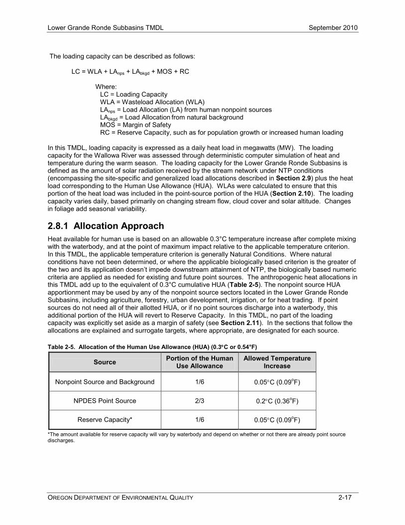
2.8.1 Allocation Approach Heat available for human use is based on an allowable 0.3°C temperature increase after complete mixing with the waterbody, and at the point of maximum impact relative to the applicable temperature criterion. In this TMDL, the applicable temperature criterion is generally Natural Conditions. Where natural conditions have not been determined, or where the applicable biologically based criterion is the greater of the two and its application doesn’t impede downstream attainment of NTP, the biologically based numeric criteria are applied as needed for existing and future point sources. The anthropogenic heat allocations in this TMDL add up to the equivalent of 0.3°C cumulative HUA (Table 2-5). The nonpoint source HUA apportionment may be used by any of the nonpoint source sectors located in the Lower Grande Ronde Subbasins, including agriculture, forestry, urban development, irrigation, or for heat trading. If point sources do not need all of their allotted HUA, or if no point sources discharge into a waterbody, this additional portion of the HUA will revert to Reserve Capacity. In this TMDL, no part of the loading capacity was explicitly set aside as a margin of safety (see Section 2.11). In the sections that follow the allocations are explained and surrogate targets, where appropriate, are designated for each source. Table 2-5. Allocation of the Human Use Allowance (HUA) (0.3°C or 0.54°F)
Source Portion of the Human Use Allowance
Allowed Temperature Increase
Nonpoint Source and Background 1/6 0.05°C (0.09oF)
NPDES Point Source 2/3 0.2°C (0.36oF)
Reserve Capacity* 1/6 0.05°C (0.09oF)
*The amount available for reserve capacity will vary by waterbody and depend on whether or not there are already point source discharges.

Lower Grande Ronde Subbasins TMDL September 2010
OREGON DEPARTMENT OF ENVIRONMENTAL QUALITY 2-18
2.8.2 Loading Capacity and Excess Load for the Wallowa River A river-specific, quantitative loading capacity was determined for the Wallowa River from the Wallowa Lake outlet to the mouth and is expressed as a daily heat load in megawatts (MW) (Table 2-6). Computer simulations were conducted for the period August 14-September 2, 1999, with August 23rd selected as the date to represent summer conditions for loading capacity calculations (Appendix A). The referenced natural background solar radiation is the loading immediately above (prior to) the stream surface, throughout the surface area of the stream network. Point sources contribute very little (<1%) of the total heat loading relative to nonpoint sources and WLAs fall within the point source HUA (discussed further in Section 2.10). Excess load is the difference between the current pollutant load and the loading capacity of a water body. Because solar radiation has the largest influence on temperature, and point source heat inputs are slight in comparison, solar radiation was used as the surrogate measure to approximate the difference between the current pollutant load and the loading capacity. The total daily heat load for the Wallowa River calculated for August 23, 1999 was 499.2 megawatts. Background loading was calculated as 425.7 megawatts, which represents an excess daily load of 73.5 megawatts. Anthropogenic nonpoint source loading along the Wallowa River needs to decrease by 15% in order to achieve the TMDL. Table 2-6. Daily loading capacity and excess solar load for the Wallowa River (August 23, 1999)
ΗTotal NPS ΗSP NPS ΗAnthro NPS Current Condition
Solar Radiation Heat Load (Megawatts)
Load Capacity –Background NTP Solar Radiation Heat Load
(Megawatts)
Excess Load Solar Radiation Heat Load
(Megawatts)
499.2 425.7 73.5 where, ΗTotal NPS = current solar input assessed immediately above the water ΗSP NPS = natural solar component of Load Capacity ΗAnthro NPS = human-related solar heating
2.9 LOAD ALLOCATIONS (NONPOINT SOURCES) Load allocation (LA) is defined as “The portion of a receiving water’s loading capacity that is attributed either to one of its existing or future nonpoint sources or to natural background sources” [OAR 340-041-0002(30)]. “Sources” means sources of pollutants, in this case excess heat. The Lower Grande Ronde Subbasins load allocations are defined here as the daily sum of the natural background solar heat load, throughout the stream network, and the heat load corresponding to the additional 0.05ºC HUA. Load allocations and surrogate measures were assessed during August, but apply year-round since the implementation measures of restoring system potential vegetation are in effect year-round. In this TMDL, load allocations were simulated via two methods and through LA surrogates that more plainly define measures in the field. Load allocations were expressed as a heating rate per stream surface area (heat flux in W/m2). The two allocation methods – site specific and generalized solar heating curves - are described below in Sections 2.9.1 and 2.9.2.
As allowed under EPA regulations (40 CFR 130.2(i)), this TMDL allocates “other appropriate measures” (or surrogate measures) in addition to heat energy loads. Effective shade is inversely proportional to heat flux, which is a measure of the daily longitudinal heating rate per stream surface area. Although a daily load allocation for heat energy is derived, it is of limited value in guiding management activities needed to solve identified water quality problems. In order for the TMDL to be more meaningful to the public and

Lower Grande Ronde Subbasins TMDL September 2010
OREGON DEPARTMENT OF ENVIRONMENTAL QUALITY 2-19
guide implementation efforts, load allocations for nonpoint source heat limits are expressed in terms of percent effective shade. This temperature TMDL targets NTP (system potential) effective shade as the surrogate measure to meet the TMDL load allocation for nonpoint sources. System potential vegetation corresponds to no anthropogenic increase above natural background temperatures. Appendix A contains detailed descriptions of the methodology used to develop system potential near-stream vegetation. Although the current allocation scheme does not specifically address nonpoint source loading rates during spawning periods, implementation of the potential effective shade surrogate represents a long-term perennial condition, protecting water quality to the greatest extent throughout the year. Moreover, the allocation of NTP conditions in general allows for adjustment of expectations through time as more information regarding site-specific conditions becomes available. The effective shade targets may not be met immediately as it can take a number of years for vegetation to mature and grow once established. In the short term, meeting the targets in this TMDL will be demonstrated by implementation of a management plan or Best Management Practices (BMPs) that adaptively target natural conditions. DEQ recognizes that even with effective management, some sites will pose challenges for the establishment of system potential vegetation. These challenges may include locations with a severely down cut channel or a water table that is no longer near the plant root zone. Restoration in these situations will take time. Reductions in effective shade will generally not be considered violations of this TMDL if DEQ determines the reduction is caused by natural disturbance or for the purpose of establishing a healthy natural riparian condition that will in time, meet the TMDL targets. This TMDL contains two types of load allocations and surrogate measures:
1. Site-specific solar loading and effective shade allocations apply to the Wallowa River where longitudinal temperature simulations were completed.
2. Generalized (non site-specific) solar loading and effective shade curves apply to all other Lower Grand Ronde Subbasins streams covered by this TMDL where temperature, heating and shade were not simulated.
Each of these two types of allocations and surrogate measures is described in more detail below. This section also discusses additional measures of progress, such as increased stream flow and increased channel complexity, which will help streams in the Lower Grande Ronde Subbasins move towards natural conditions.
2.9.1 Site Specific Heat Load Allocations and Effective Shade Surrogates The load allocation for the simulated Wallowa River corridor is the NTP warm season solar heating, summarized graphically in Figure 2-7, as a critical season longitudinal heating rate per stream surface area (heat flux in W/m2). Heat flux was assessed at 100 meter (328 feet) intervals along the river. Effective shade is inversely proportional to heat flux and is shown in the figures as well and discussed subsequently in this section as a surrogate measure. Current Condition is the existing solar loading and effective shade at the stream surface (mid-August), including the effects of near-stream vegetation and topography. System Potential is the solar loading and effective shade at the stream surface under system potential near-stream vegetation conditions. This represents NTP conditions. The Natural Disturbance Range indicates the solar loading and shade levels that could potentially occur in the event of natural disturbances. The lower end of that range represents that amount of shade that the stream would receive if topography was the only shade-producing feature (i.e., in the absence of vegetation). Appendix A contains detailed descriptions of the methodology used to develop system potential near-stream vegetation and the temperature TMDL, along with a discussion of the limitations of the assessment of system potential conditions. On average, the Heat Source model

Lower Grande Ronde Subbasins TMDL September 2010
OREGON DEPARTMENT OF ENVIRONMENTAL QUALITY 2-20
predicted Current Condition shade of 25% for the simulated Wallowa River corridor, as compared to 40% for the System Potential simulation. Topographic shade provided an average of 6% effective shade along the modeled corridor. Caution should be used when interpreting Figure 2-7. This TMDL recognizes that is impossible for an entire stream to be at its maximum potential effective shade everywhere, all the time. In reality, natural disturbances will create a variety of tree heights and densities and effective shade levels could be lower than “System Potential” and be somewhere within the “Natural Disturbance Range”. Reductions in effective shade caused by natural disturbance are not considered a violation of the TMDL or water quality standards. Figure 2-7. Wallowa River heat load allocation and effective shade surrogate (mid-August)
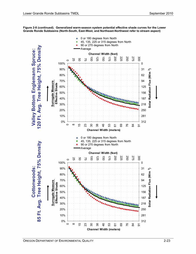
2.9.2 Generalized Heat Load Allocations and Effective Shade Surrogate Generalized (non site-specific) heating curves were developed as load allocations for streams where temperature and heating were not simulated. As with site-specific heating, the generalized heat assessment of this section is expressed as both heat loading and percent effective shade. The effective shade surrogate is expressed as a solar heat load versus channel width relationship for specified stream aspects (Figure 2-8). The heat load and effective shade surrogates are identified by region and channel width for different types of system potential vegetation communities. The effective shade curves account for latitude, critical summertime period (August), elevation and stream aspect. Stream aspect is based on coordinate directions, such as North-South, East-West, and Northeast-Northwest. Effective shade curves represent the maximum possible effective shade for a given vegetation type. The values presented within the effective shade curves represent the effective shade that would be attained if the vegetation were at its stated potential height and density. Local geology, geography, soils, climate, legacy impacts, natural disturbance rates, and other factors may prevent effective shade from reaching the values presented in the effective shade curves. The goal of this Temperature TMDL is to minimize anthropogenic impacts on effective shade. Natural conditions or natural disturbances (non-

Lower Grande Ronde Subbasins TMDL September 2010
OREGON DEPARTMENT OF ENVIRONMENTAL QUALITY 2-21
anthropogenic) that result in effective shade below the maximum potential will not be considered out of compliance with the TMDL. This TMDL recognizes that unpredictable natural disturbances may result in effective shade well below the levels presented in the effective shade curves. System potential vegetation communities were identified for the Lower Grande Ronde Subbasins (Table 2-7) and effective shade curves were developed for each community (Figure 2-8). The potential vegetation types and the associated height and density were determined by the Wallowa County TMDL technical committee which consisted of local experts (refer to Chapter 1 for the list of participants). Appendix A provides more detailed information regarding the potential vegetation types and tree heights. When using the effective shade curves presented in Figure 2-8, the determination of the appropriate system potential vegetation community is the responsibility of each designated management agency (DMA). Since there is not a map showing where each potential vegetation community is located, it is the responsibility of the resource manager to consult with the appropriate experts to make that determination. This would typically be part of implementation plan development, subject to DEQ review. In order to quantify solar loading, one would: (1) choose a stream location, (2) choose the appropriate system potential vegetation community and the corresponding chart in Figure 2-8, (3) measure the existing channel width, and (4) select the appropriate curve based on the channel compass direction. The effective shade indicated by the curve for that channel width is the expected shade if system potential vegetation height and density is in place. The determination of channel width should be evaluated at bankfull stage, or where bankfull indicators are lacking, at the boundary of the active channel area of disturbance. For field assessment, riffles may be the best feature to characterize a reach, consistent with various channel classification methods. TMDL attainment of effective shade targets would be assessed throughout the longitudinal profile. There may be instances where a given stream reach may not match one of the seven generalized communities described in Table 2-7 and Figure 2-8 and a resource manager may have more site specific information about the appropriate system potential community. In such instances, the resource manager should describe the expected community. This determination would typically be part of implementation plan development and would be subject to DEQ review.

Lower Grande Ronde Subbasins TMDL September 2010
OREGON DEPARTMENT OF ENVIRONMENTAL QUALITY 2-22
Figure 2-8. Generalized warm-season system potential effective shade curves for the Lower Grande Ronde Subbasins (North-South, East-West, and Northeast-Northwest refer to stream aspect)
Lodg
epol
e, S
ub-A
lpin
e Fi
r >60
00’ E
lev.
:70
Ft.
Avg.
Tre
e H
eigh
t, 75
% D
ensi
ty
0%
10%
20%
30%
40%
50%
60%
70%
80%
90%
100%
0 25 50 75
100
125
150
175
200
225
250
275
300
Channel Width (meters)
Surr
ogat
e M
easu
reEf
fect
ive
Shad
e0
31
62
94
125
156
187
218
250
281
312
0 8 15 23 30 38 46 53 61 69 76 84 91
Channel Width (feet)
Sola
r Rad
iatio
n Fl
ux (W
/m2 )
0 or 180 degrees from North45, 135, 225 or 315 degrees from North90 or 270 degrees from NorthAverage
Old
Gro
wth
Pon
dero
sa, D
oug.
Fir:
120
Ft. A
vg. T
ree
Hei
ght,
75%
Den
sity
0%
10%
20%
30%
40%
50%
60%
70%
80%
90%
100%
0 25 50 75
100
125
150
175
200
225
250
275
300
Channel Width (meters)
Surr
ogat
e M
easu
reEf
fect
ive
Shad
e
0
31
62
94
125
156
187
218
250
281
312
0 8 15 23 30 38 46 53 61 69 76 84 91
Channel Width (feet)So
lar
Radi
atio
n Fl
ux (W
/m2 )
0 or 180 degrees from North45, 135, 225 or 315 degrees from North90 or 270 degrees from NorthAverage
Lower Grande Ronde Subbasins TMDL September 2010
OREGON DEPARTMENT OF ENVIRONMENTAL QUALITY 2-23
Figure 2-8 (continued). Generalized warm-season system potential effective shade curves for the Lower Grande Ronde Subbasins (North-South, East-West, and Northeast-Northwest refer to stream aspect)
Valle
y B
otto
m E
ngle
man
nSp
ruce
:12
0 Ft
. Avg
. Tre
e H
eigh
t, 75
% D
ensi
ty
0%
10%
20%
30%
40%
50%
60%
70%
80%
90%
100%
0 25 50 75
100
125
150
175
200
225
250
275
300
Channel Width (meters)
Surr
ogat
e M
easu
reEf
fect
ive
Shad
e
0
31
62
94
125
156
187
218
250
281
312
0 8 15 23 30 38 46 53 61 69 76 84 91
Channel Width (feet)
Sola
r Rad
iatio
n Fl
ux (W
/m2 )
0 or 180 degrees from North45, 135, 225 or 315 degrees from North90 or 270 degrees from NorthAverage
Cot
tonw
oods
:85
Ft.
Avg.
Tre
e H
eigh
t, 75
% D
ensi
ty
0%
10%
20%
30%
40%
50%
60%
70%
80%
90%
100%
0 25 50 75
100
125
150
175
200
225
250
275
300
Channel Width (meters)
Surr
ogat
e M
easu
reEf
fect
ive
Shad
e
0
31
62
94
125
156
187
218
250
281
312
0 8 15 23 30 38 46 53 61 69 76 84 91
Channel Width (feet)So
lar R
adia
tion
Flux
(W/m
2 )
0 or 180 degrees from North45, 135, 225 or 315 degrees from North90 or 270 degrees from NorthAverage

Lower Grande Ronde Subbasins TMDL September 2010
OREGON DEPARTMENT OF ENVIRONMENTAL QUALITY 2-24
Figure 2-8 (continued). Generalized warm-season system potential effective shade curves for the Lower Grande Ronde Subbasins (North-South, East-West, and Northeast-Northwest refer to stream aspect)
Valle
y B
otto
m M
ixed
Dec
iduo
us:
25 F
t. Av
g. T
ree
Hei
ght,
75%
Den
sity
0%
10%
20%
30%
40%
50%
60%
70%
80%
90%
100%
0 25 50 75
100
125
150
175
200
225
250
275
300
Channel Width (meters)
Surr
ogat
e M
easu
reEf
fect
ive
Shad
e
0
31
62
94
125
156
187
218
250
281
312
0 8 15 23 30 38 46 53 61 69 76 84 91
Channel Width (feet)
Sola
r Rad
iatio
n Fl
ux (W
/m2 )
0 or 180 degrees from North45, 135, 225 or 315 degrees from North90 or 270 degrees from NorthAverage
Pond
eros
a, D
oug.
Fir.
, Lar
ch:
100
Ft.
Avg.
Tre
e H
eigh
t, 75
% D
ensi
ty
0%
10%
20%
30%
40%
50%
60%
70%
80%
90%
100%
0 25 50 75
100
125
150
175
200
225
250
275
300
Channel Width (meters)
Surr
ogat
e M
easu
reEf
fect
ive
Shad
e
0
31
62
94
125
156
187
218
250
281
312
0 8 15 23 30 38 46 53 61 69 76 84 91
Channel Width (feet)
Sola
r Ra
diat
ion
Flux
(W/m
2 )
0 or 180 degrees from North45, 135, 225 or 315 degrees from North90 or 270 degrees from NorthAverage

Lower Grande Ronde Subbasins TMDL September 2010
OREGON DEPARTMENT OF ENVIRONMENTAL QUALITY 2-25
Figure 2-8 (continued). Generalized warm-season system potential effective shade curves for the Lower Grande Ronde Subbasins (North-South, East-West, and Northeast-Northwest refer to stream aspect)
Table 2-7. System potential vegetation communities (Wallowa County TMDL Committee, 2003)
System Potential Vegetation Communities with Dominant Species Composition
Average Mature Tree height
feet (meters)
Average Shade Producing Height
feet (meters)
Mixed Conifer above 6000 feet: Lodgepole Pine & alpine fir
65-75 (19.8-22.9)
45-55 (13.7-16.8)
Old Growth Conifer: Ponderosa Pine & Douglas fir
120 (36.6)
120 (36.6)
Wallowa River valley bottom: Englemann Spruce
120 (36.6)
100 (30.5)
Cottonwood Galleries 80-90 (24.4–27.4)
80-90 (24.4–27.4)
Valley Bottom Mixed Deciduous: Alder, Willow, Cottonwood
Hawthorne, Snowberry, Dogwood Currents, Mock Orange, Rose
25 (7.6) 25 (7.6)
Mixed Conifer: Ponderosa Pine, Douglas Fir, Larch
100-105 (30.5–32.0)
80-85 (24.4–25.9)
Mixed Deciduous <2000 feet elevation: Where alders are dominant, increase heights to as much as 35 ft (Lower Grande Ronde River, Lower
Imnaha River, Lower Joseph Creek)
30-35 (9.1-10.7)
30-35 (9.1-10.7)
Mix
ed D
ecid
uous
<20
00’ E
lev.
:32
.5 F
t. Av
g. T
ree
Hei
ght,
75%
Den
sity
0%
10%
20%
30%
40%
50%
60%
70%
80%
90%
100%
0 25 50 75
100
125
150
175
200
225
250
275
300
Channel Width (meters)
Surr
ogat
e M
easu
reEf
fect
ive
Shad
e
0
31
62
94
125
156
187
218
250
281
312
0 8 15 23 30 38 46 53 61 69 76 84 91
Channel Width (feet)
Sola
r Rad
iatio
n Fl
ux (W
/m2 )
0 or 180 degrees from North45, 135, 225 or 315 degrees from North90 or 270 degrees from NorthAverage
Lower Grande Ronde Subbasins TMDL September 2010
OREGON DEPARTMENT OF ENVIRONMENTAL QUALITY 2-26
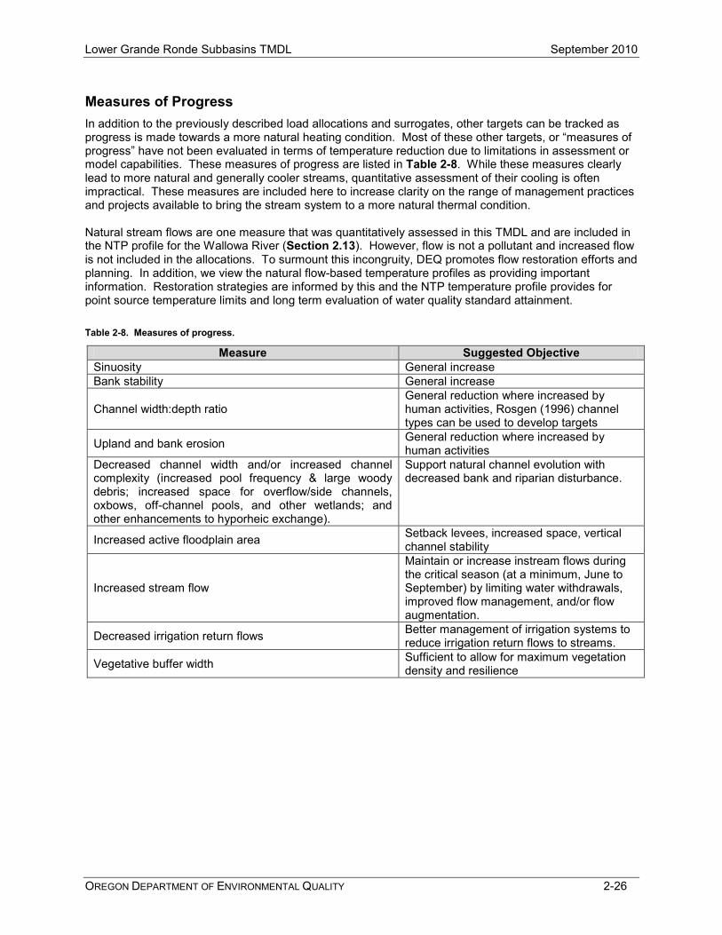
Measures of Progress In addition to the previously described load allocations and surrogates, other targets can be tracked as progress is made towards a more natural heating condition. Most of these other targets, or “measures of progress” have not been evaluated in terms of temperature reduction due to limitations in assessment or model capabilities. These measures of progress are listed in Table 2-8. While these measures clearly lead to more natural and generally cooler streams, quantitative assessment of their cooling is often impractical. These measures are included here to increase clarity on the range of management practices and projects available to bring the stream system to a more natural thermal condition. Natural stream flows are one measure that was quantitatively assessed in this TMDL and are included in the NTP profile for the Wallowa River (Section 2.13). However, flow is not a pollutant and increased flow is not included in the allocations. To surmount this incongruity, DEQ promotes flow restoration efforts and planning. In addition, we view the natural flow-based temperature profiles as providing important information. Restoration strategies are informed by this and the NTP temperature profile provides for point source temperature limits and long term evaluation of water quality standard attainment. Table 2-8. Measures of progress.
Measure Suggested Objective Sinuosity General increase Bank stability General increase
Channel width:depth ratio General reduction where increased by human activities, Rosgen (1996) channel types can be used to develop targets
Upland and bank erosion General reduction where increased by human activities
Decreased channel width and/or increased channel complexity (increased pool frequency & large woody debris; increased space for overflow/side channels, oxbows, off-channel pools, and other wetlands; and other enhancements to hyporheic exchange).
Support natural channel evolution with decreased bank and riparian disturbance.
Increased active floodplain area Setback levees, increased space, vertical channel stability
Increased stream flow
Maintain or increase instream flows during the critical season (at a minimum, June to September) by limiting water withdrawals, improved flow management, and/or flow augmentation.
Decreased irrigation return flows Better management of irrigation systems to reduce irrigation return flows to streams.
Vegetative buffer width Sufficient to allow for maximum vegetation density and resilience

Lower Grande Ronde Subbasins TMDL September 2010
OREGON DEPARTMENT OF ENVIRONMENTAL QUALITY 2-27
2.10 WASTELOAD ALLOCATIONS (POINT SOURCES) A wasteload allocation (WLA) is the amount of pollutant that a point source can contribute to the stream without violating water quality criteria. WLAs were developed for point sources that discharge heated effluent with a potential to increase temperatures in receiving waterbodies of the Wallowa River Subbasin. The Enterprise, Wallowa and Joseph sewage treatment plants (STPs) are the three point sources where specific WLAs were calculated for this TMDL (refer back to Section 1.3.5.1 for a more detailed description of all of the point sources). As discussed in Section 2.7.3, we determined that the facilities on general permits with DEQ (Enterprise stormwater construction, Wallowa Forest Products stormwater and boiler blowdown, and Wallowa Fish Hatchery) did not have a reasonable potential to impact stream temperatures. Therefore, these facilities are allocated their current heat load. The facilities’ impact is expected to be negligible but may utilize a portion of the 0.2oC point source HUA should further analysis indicate otherwise. Because the CAFOs in the Subbasins are not allowed to discharge to surface waters, they are assigned a WLA of zero. In order to ensure water quality standard attainment, each WLA was calculated to ensure that each discharge would not cause an increase in stream temperature more than the point source HUA of 0.2oC above the applicable instream criterion. Wasteload allocations were calculated based on temperature and flow of the river, given the 0.2°C allowable increase and 50%1 of the available instream flow for dilution. Information about the discharges and the appropriate applicable numeric criteria are summarized in Table 2-9. Table 2-9. Facility discharge information and applicable biologically-based numeric criteria
Facility Receiving Stream (river mile)
Season of Discharge
Applicable Criterion
Season the Criterion Applies
Enterprise Wallowa River (40.7) Year around Spawning August 15-June 15
Core cold-water June 16-August 14
Wallowa Wallowa River (23.0) Year around Core cold-water Year around
Joseph Prairie Creek (4.0) November 1-May 31 Spawning August 15-June 15 A Reasonable Potential Analysis of the capacity to increase river temperature beyond the allowable HUA increase was calculated from river temperature, effluent temperatures and flows from discharge monitoring reports for each STP. We assumed the highest effluent temperature reported for a given facility in recent years, and conservatively low river flows. The thermal effects of each discharge were determined for each month of the year to ensure that the appropriate temperature criteria were not exceeded. A separate analysis was also done of the combined effects of the Enterprise and Wallowa STPs on the Wallowa River. The following equations, variables, and assumptions were used to calculate temperature increase due to the discharge and the thermal wasteload allocations: Equations:
1.
2. )1186.0)()(( RPSWLA QQHUAH += and,
1 Although100% of the stream flow is allowed for mixing following the development of the TMDL, only 50% of the stream flow was used in this analysis. This reduction in the allowable stream flow to be used for dilution is part of the Margin of Safety for the analysis. This decision is also in keeping with DEQ’s Antidegradation Policy ((OAR 340-041-0004(9)(c)) which states that “…Oregon’s water bodies have a finite capacity to assimilate waste. Unused assimilative capacity is an exceedingly valuable resource…”

Lower Grande Ronde Subbasins TMDL September 2010
OREGON DEPARTMENT OF ENVIRONMENTAL QUALITY 2-28
3. PS
RRRRPSWLA Q
TQHUATQQT ))(())(( −++=
Where, ∆TR = Change in River Temperature QPS = Point Source Flow (cfs) QR = Upstream River Flow ((50% of low stream flow (cfs)) TWLA = Wasteload Allocation Temperature (°C) TR = Applicable Temperature Criterion or Upstream Natural Thermal Potential Temperature for Receiving Stream (°C) TE = Effluent Temperature (°C) S = Dilution Ratio (River Flow:Effluent Flow in percent) HUA = Human Use Allowance (0.2°C) HWLA = Wasteload Allocation Heat Load (MW) 0.1186 = Conversion Factor into Megawatts Further details about the reasonable potential analysis and the development of the WLAs for each facility are described further in Sections 2.10.1 - 2.10.3. The analyses were based on very conservative assumptions for inputs into the equations above. A summary of the WLAs is provided in Table 2-10. For all three facilities, the reasonable potential analyses calculated that there was no likelihood of increasing receiving stream temperatures beyond the allowable increase of 0.2oC above the applicable criterion, therefore effluent limits beyond the current permits are not required. The critical period was determined to be the April-October (refer back to Section 2.6) so WLAs apply during these months of the year. Effluent temperature limits may be calculated during permit development with TWLA as defined above where appropriate.

Low
er G
rand
e R
onde
Sub
basi
ns T
MD
L
Sept
embe
r 201
0
OR
EG
ON
DE
PAR
TME
NT
OF
ENV
IRO
NM
EN
TAL
QU
ALI
TY
2
-29
Tabl
e 2-
10.
Was
telo
ad a
lloca
tions
for p
oint
sou
rce
disc
harg
es in
the
Low
er G
rand
e R
onde
Sub
basi
ns (c
ritic
al p
erio
d of
Apr
il-O
ctob
er)
Var
iabl
es in
dica
ted
in th
e fir
st ro
w o
f thi
s ta
ble
refe
r to
varia
bles
use
d in
Equ
atio
ns 1
-3 p
rese
nted
on
the
prev
ious
two
page
s.
QR*
QPS
T E
T R
H
UA
ΗW
LA**
T WLA
Faci
lity
Nam
e R
ecei
ving
Wat
er
Rec
eivi
ng
Wat
er L
ow
Flow
(c
fs)
Faci
lity
Des
ign
Flow
(c
fs)
Poin
t So
urce
Ef
fluen
t Te
mp.
(o C
)
Max
D
aily
Si
te
Pote
ntia
l R
iver
Te
mp.
(o C
)
Hum
an
Use
Al
low
ance
(H
UA)
(o C
)
Prop
ortio
n of
Stre
am
Allo
wed
for
Mix
ing
(m
ax =
10
0%)
Allo
wab
le
Poin
t So
urce
H
eat
Load
ing
in
Zone
of
Dilu
tion
(MW
/day
)
Perc
ent
Red
uctio
n in
Poi
nt
Sour
ce
Hea
t Loa
d
Max
imum
Al
low
able
Ef
fluen
t Te
mp.
(o C
)
Mon
ths
whe
n W
LA
appl
ies
Jose
ph S
TP
Prai
rie C
reek
28
.3*
0.23
Va
riabl
e by
M
onth
N
A***
0.
2 50
%
0.34
**
Non
e Ex
istin
g C
ondi
tion
April
- M
ay
Ente
rpris
e ST
P W
allo
wa
Riv
er
112*
1.
53
21.1
17
.0
0.2
50%
1.
36**
N
one
Exis
ting
Con
ditio
n Ap
ril -
Oct
ober
Wal
low
a ST
P W
allo
wa
Riv
er
112*
0.
31
23.3
15
.5
0.2
50%
1.
33**
N
one
Exis
ting
Con
ditio
n Ap
ril -
Oct
ober
*
For
the
Jose
ph S
TP, r
epre
sent
s th
e m
easu
red
low
mon
thly
low
stre
am fl
ow d
urin
g th
e cr
itica
l per
iod
for P
rairi
e C
reek
. Fo
r the
Ent
erpr
ise
and
Wal
low
a S
TPs,
repr
esen
ts th
e an
nual
7Q
10 lo
w fl
ow b
ased
on
gage
dat
a fo
r Wal
low
a R
iver
abo
ve C
ross
Cou
ntry
Can
al (U
SG
S N
o. 1
3329
770)
**
Hea
t loa
d m
ay a
lso
be fl
ow b
ased
as
cond
ition
s va
ry th
roug
h th
e ye
ar.
The
WLA
pre
sent
ed h
ere
is c
onse
rvat
ive
and
base
d on
the
assu
mpt
ion
of l
ow fl
ow c
ondi
tions
occ
urrin
g ye
ar-a
roun
d.
*** W
ater
bod
y w
as n
ot s
imul
ated
for t
empe
ratu
re –
no
natu
ral t
herm
al p
oten
tial t
empe
ratu
re e
stab
lishe
d
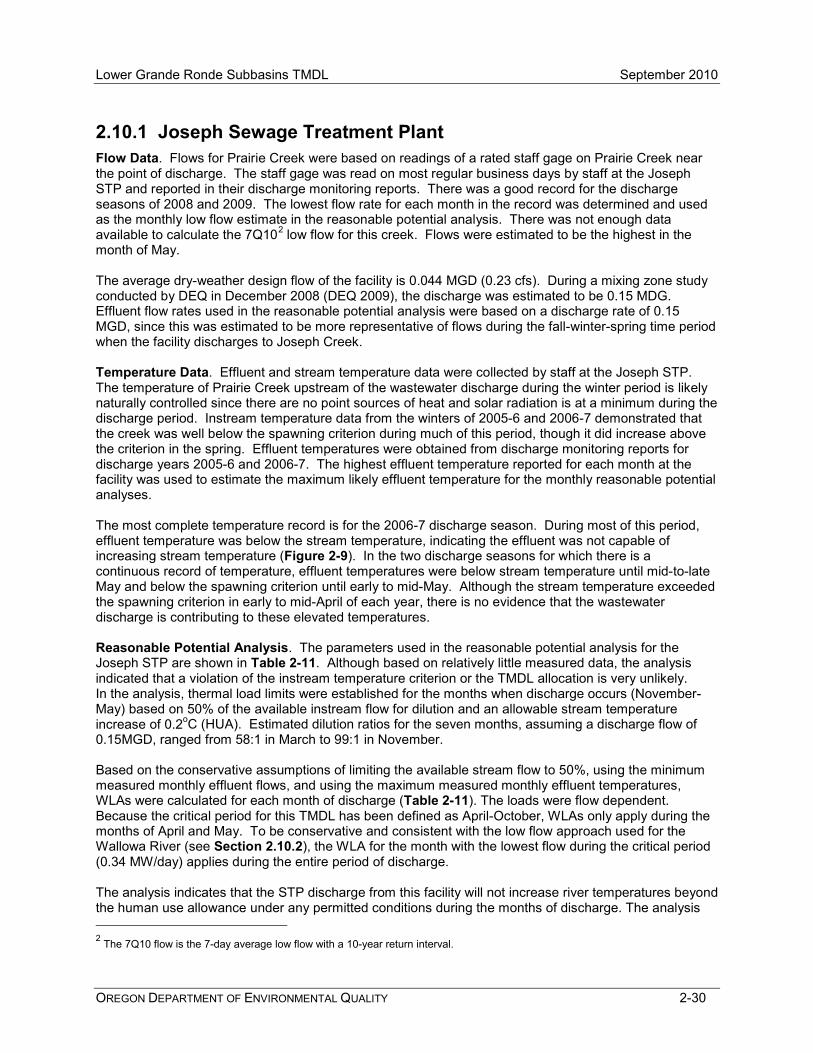
Lower Grande Ronde Subbasins TMDL September 2010
OREGON DEPARTMENT OF ENVIRONMENTAL QUALITY 2-30
2.10.1 Joseph Sewage Treatment Plant Flow Data. Flows for Prairie Creek were based on readings of a rated staff gage on Prairie Creek near the point of discharge. The staff gage was read on most regular business days by staff at the Joseph STP and reported in their discharge monitoring reports. There was a good record for the discharge seasons of 2008 and 2009. The lowest flow rate for each month in the record was determined and used as the monthly low flow estimate in the reasonable potential analysis. There was not enough data available to calculate the 7Q102 low flow for this creek. Flows were estimated to be the highest in the month of May. The average dry-weather design flow of the facility is 0.044 MGD (0.23 cfs). During a mixing zone study conducted by DEQ in December 2008 (DEQ 2009), the discharge was estimated to be 0.15 MDG. Effluent flow rates used in the reasonable potential analysis were based on a discharge rate of 0.15 MGD, since this was estimated to be more representative of flows during the fall-winter-spring time period when the facility discharges to Joseph Creek. Temperature Data. Effluent and stream temperature data were collected by staff at the Joseph STP. The temperature of Prairie Creek upstream of the wastewater discharge during the winter period is likely naturally controlled since there are no point sources of heat and solar radiation is at a minimum during the discharge period. Instream temperature data from the winters of 2005-6 and 2006-7 demonstrated that the creek was well below the spawning criterion during much of this period, though it did increase above the criterion in the spring. Effluent temperatures were obtained from discharge monitoring reports for discharge years 2005-6 and 2006-7. The highest effluent temperature reported for each month at the facility was used to estimate the maximum likely effluent temperature for the monthly reasonable potential analyses. The most complete temperature record is for the 2006-7 discharge season. During most of this period, effluent temperature was below the stream temperature, indicating the effluent was not capable of increasing stream temperature (Figure 2-9). In the two discharge seasons for which there is a continuous record of temperature, effluent temperatures were below stream temperature until mid-to-late May and below the spawning criterion until early to mid-May. Although the stream temperature exceeded the spawning criterion in early to mid-April of each year, there is no evidence that the wastewater discharge is contributing to these elevated temperatures. Reasonable Potential Analysis. The parameters used in the reasonable potential analysis for the Joseph STP are shown in Table 2-11. Although based on relatively little measured data, the analysis indicated that a violation of the instream temperature criterion or the TMDL allocation is very unlikely. In the analysis, thermal load limits were established for the months when discharge occurs (November-May) based on 50% of the available instream flow for dilution and an allowable stream temperature increase of 0.2oC (HUA). Estimated dilution ratios for the seven months, assuming a discharge flow of 0.15MGD, ranged from 58:1 in March to 99:1 in November. Based on the conservative assumptions of limiting the available stream flow to 50%, using the minimum measured monthly effluent flows, and using the maximum measured monthly effluent temperatures, WLAs were calculated for each month of discharge (Table 2-11). The loads were flow dependent. Because the critical period for this TMDL has been defined as April-October, WLAs only apply during the months of April and May. To be conservative and consistent with the low flow approach used for the Wallowa River (see Section 2.10.2), the WLA for the month with the lowest flow during the critical period (0.34 MW/day) applies during the entire period of discharge. The analysis indicates that the STP discharge from this facility will not increase river temperatures beyond the human use allowance under any permitted conditions during the months of discharge. The analysis 2 The 7Q10 flow is the 7-day average low flow with a 10-year return interval.
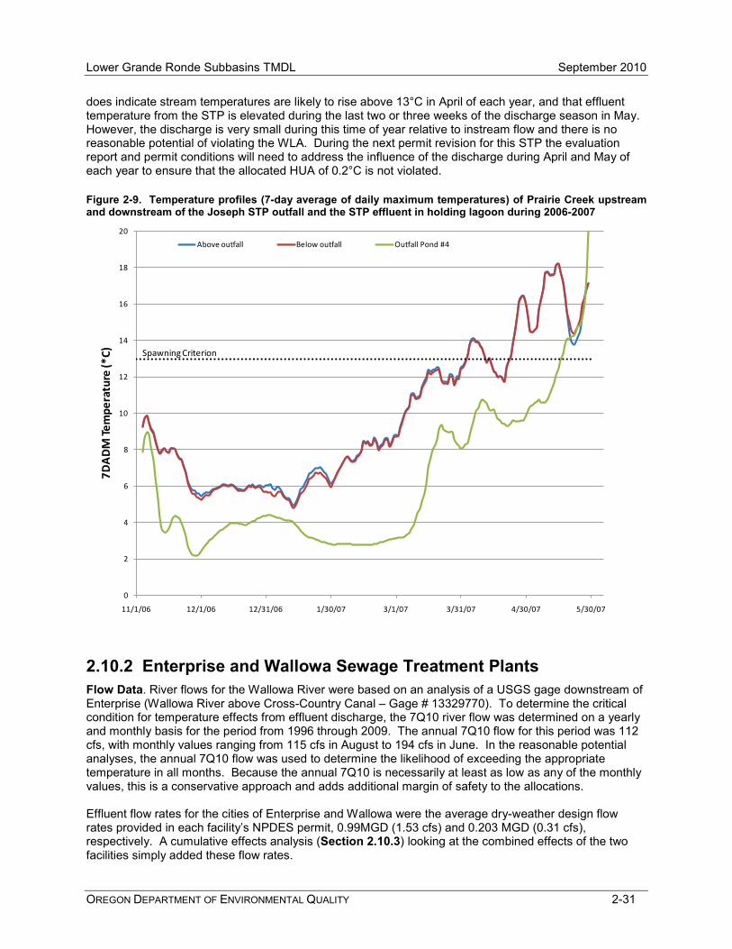
Lower Grande Ronde Subbasins TMDL September 2010
OREGON DEPARTMENT OF ENVIRONMENTAL QUALITY 2-31
does indicate stream temperatures are likely to rise above 13°C in April of each year, and that effluent temperature from the STP is elevated during the last two or three weeks of the discharge season in May. However, the discharge is very small during this time of year relative to instream flow and there is no reasonable potential of violating the WLA. During the next permit revision for this STP the evaluation report and permit conditions will need to address the influence of the discharge during April and May of each year to ensure that the allocated HUA of 0.2°C is not violated. Figure 2-9. Temperature profiles (7-day average of daily maximum temperatures) of Prairie Creek upstream and downstream of the Joseph STP outfall and the STP effluent in holding lagoon during 2006-2007
2.10.2 Enterprise and Wallowa Sewage Treatment Plants Flow Data. River flows for the Wallowa River were based on an analysis of a USGS gage downstream of Enterprise (Wallowa River above Cross-Country Canal – Gage # 13329770). To determine the critical condition for temperature effects from effluent discharge, the 7Q10 river flow was determined on a yearly and monthly basis for the period from 1996 through 2009. The annual 7Q10 flow for this period was 112 cfs, with monthly values ranging from 115 cfs in August to 194 cfs in June. In the reasonable potential analyses, the annual 7Q10 flow was used to determine the likelihood of exceeding the appropriate temperature in all months. Because the annual 7Q10 is necessarily at least as low as any of the monthly values, this is a conservative approach and adds additional margin of safety to the allocations. Effluent flow rates for the cities of Enterprise and Wallowa were the average dry-weather design flow rates provided in each facility’s NPDES permit, 0.99MGD (1.53 cfs) and 0.203 MGD (0.31 cfs), respectively. A cumulative effects analysis (Section 2.10.3) looking at the combined effects of the two facilities simply added these flow rates.
0
2
4
6
8
10
12
14
16
18
20
11/1/06 12/1/06 12/31/06 1/30/07 3/1/07 3/31/07 4/30/07 5/30/07
7DA
DM
Tem
pera
ture
(*C)
Above outfall Below outfall Outfall Pond #4
Spawning Criterion

Lower Grande Ronde Subbasins TMDL September 2010
OREGON DEPARTMENT OF ENVIRONMENTAL QUALITY 2-32
Temperature Data. Estimates of ambient instream temperatures for the reasonable potential analysis varied depending on the month of analysis. Heat Source modeling of the Wallowa River indicated August was the critical month and provided an estimate of NTP temperature at points along the River. The NTP temperature in Enterprise (kilometer 67.5 in the model) was 17.0°C and in Wallowa (kilometer 37.5 in the model) it was 15.5°C. These temperatures were used for the reasonable potential analysis in August. The appropriate biologically based numeric temperature criterion was used for all other months. Effluent temperatures were based on discharge monitoring reports from 2008 and 2009 for the Wallowa STP and 2006-2009 for the Enterprise STP. The highest effluent temperature reported for each month at each facility estimated the effluent temperature for the monthly reasonable potential analyses. Reasonable Potential Analyses. The parameters used in the reasonable potential analysis for the Enterprise and Wallowa STPs are shown in Table 2-12 and Table 2-13 respectively. In each analysis, WLAs were established for each month of the year based on 50% of the available instream flow for dilution and an allowable stream temperature increase of 0.2oC (HUA). The calculations indicate that the STP discharges from each facility will not increase river temperatures beyond the human use allowance under any permitted conditions during any month of the year. For the Enterprise STP, the months of May, June, September and October came close to exceeding the HUA, but it was never exceeded. The limitation of available flow to only 50% and use of the annual 7Q10 for all months is very conservative and ensures the facilities are incapable of causing a violation of the water quality standard. This leaves additional reserve capacity in the system, and the remaining 50% of flow for dilution should be reserved specifically for future needs of point source discharges. The WLAs for the Enterprise and Wallowa STPs were calculated to be 1.36 MW/day and 1.33 MW/day, respectively, and apply during the critical period of April through October.
2.10.3 Cumulative Effects Analysis A cumulative effects analysis was done to assess the combined effects of the Wallowa and Enterprise STPs on the Wallowa River (Table 2-14). The Joseph discharge was not included in this analysis because it does not discharge during the summer period (July/August) for the Wallowa River, and effects of the discharge diminish during the fall-winter-spring when the Joseph STP discharges to Prairie Creek. In this analysis, it was assumed that both Wallowa and Enterprise STPs were discharging to the Wallowa River at Wallowa with a combined flow of 1.193 MGD (1.85 cfs), a flow-weighted monthly average effluent temperature. This cumulative effects analysis determined that the combined effects of the two treatment plants discharging at a single site near Wallowa would not cause an increase greater than the HUA in the Wallowa River when fully mixed. The greatest increase was observed in the month of August, when the calculated temperature increase was 0.16°C (0.29°F) above the NTP temperature.
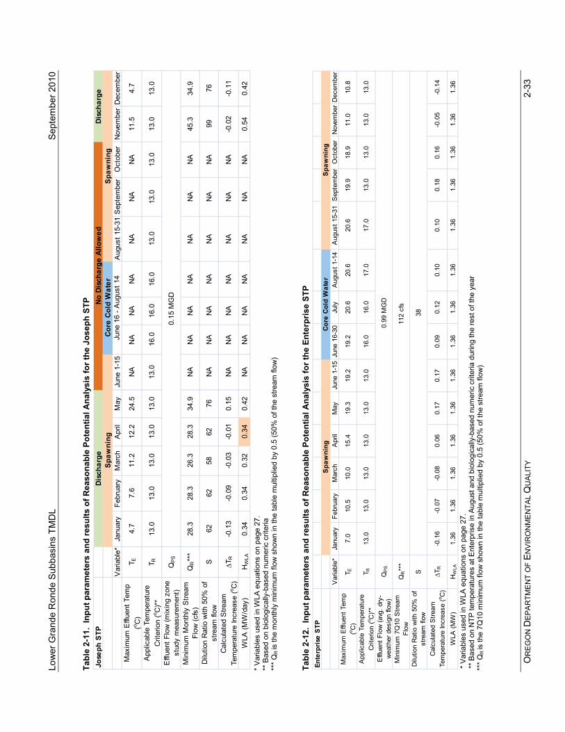
Low
er G
rand
e R
onde
Sub
basi
ns T
MD
L
Sept
embe
r 201
0
OR
EG
ON
DE
PAR
TME
NT
OF
ENV
IRO
NM
EN
TAL
QU
ALI
TY
2
-33
Tabl
e 2-
11.
Inpu
t par
amet
ers
and
resu
lts o
f Rea
sona
ble
Pote
ntia
l Ana
lysi
s fo
r the
Jos
eph
STP
*
Var
iabl
es u
sed
in W
LA e
quat
ions
on
page
27.
** B
ased
on
biol
ogic
ally
-bas
ed n
umer
ic c
riter
ia
***
QR
is th
e m
onth
ly m
inim
um fl
ow s
how
n in
the
tabl
e m
ultip
lied
by 0
.5 (5
0% o
f the
stre
am fl
ow)
Tabl
e 2-
12.
Inpu
t par
amet
ers
and
resu
lts o
f Rea
sona
ble
Pote
ntia
l Ana
lysi
s fo
r the
Ent
erpr
ise
STP
*
Var
iabl
es u
sed
in W
LA e
quat
ions
on
page
27.
** B
ased
on
NTP
tem
pera
ture
s at
Ent
erpr
ise
in A
ugus
t and
bio
logi
cally
-bas
ed n
umer
ic c
riter
ia d
urin
g th
e re
st o
f the
yea
r **
* Q
R is
the
7Q10
min
imum
flow
sho
wn
in th
e ta
ble
mul
tiplie
d by
0.5
(50%
of t
he s
tream
flow
)
Jose
ph S
TP
Var
iabl
e*Ja
nuar
yFe
brua
ryM
arch
Apr
ilM
ayJu
ne 1
-15
Aug
ust 1
5-31
Sep
tem
ber
Oct
ober
Nov
embe
rD
ecem
ber
Max
imum
Effl
uent
Tem
p (o C
)T E
4.7
7.6
11.2
12.2
24.5
NA
NA
NA
NA
NA
NA
NA
11.5
4.7
App
licab
le T
empe
ratu
re
Crit
erio
n (o C
)**
T R13
.013
.013
.013
.013
.013
.016
.016
.016
.013
.013
.013
.013
.013
.0
Effl
uent
Flo
w (m
ixin
g zo
ne
stud
y m
easu
rem
ent)
QP
S
Min
imum
Mon
thly
Stre
am
Flow
(cfs
)Q
R**
*28
.328
.326
.328
.334
.9N
AN
AN
AN
AN
AN
AN
A45
.334
.9
Dilu
tion
Rat
io w
ith 5
0% o
f st
ream
flow
S62
6258
6276
NA
NA
NA
NA
NA
NA
NA
9976
Cal
cula
ted
Stre
am
Tem
pera
ture
Incr
ease
(o C)
∆TR
-0
.13
-0.0
9-0
.03
-0.0
10.
15N
AN
AN
AN
AN
AN
AN
A-0
.02
-0.1
1
WLA
(MW
/day
)H
WLA
0.
340.
340.
320.
340.
42N
AN
AN
AN
AN
AN
AN
A0.
540.
42
0.1
5 M
GD
June
16
- Aug
ust 1
4
Disc
harg
eNo
Dis
char
ge A
llow
edDi
scha
rge
Spaw
ning
Core
Col
d W
ater
Spaw
ning
Ente
rpri
se S
TP
Var
iabl
e*Ja
nuar
yFe
brua
ryM
arch
Apr
ilM
ayJu
ne 1
-15
June
16-
30Ju
lyA
ugus
t 1-1
4A
ugus
t 15-
31S
epte
mbe
rO
ctob
erN
ovem
ber
Dec
embe
rM
axim
um E
fflue
nt T
emp
(o C)
T E7.
010
.510
.015
.419
.319
.219
.220
.620
.620
.619
.918
.911
.010
.8
App
licab
le T
empe
ratu
re
Crit
erio
n (o C
)**
T R13
.013
.013
.013
.013
.013
.016
.016
.017
.017
.013
.013
.013
.013
.0
Effl
uent
Flo
w (a
vg. d
ry-
wea
ther
des
ign
flow
)Q
PS
Min
imum
7Q
10 S
tream
Fl
ow
QR**
*
Dilu
tion
Rat
io w
ith 5
0% o
f st
ream
flow
S
Cal
cula
ted
Stre
am
Tem
pera
ture
Incr
ease
(o C)
∆TR
-0
.16
-0.0
7-0
.08
0.06
0.17
0.17
0.09
0.12
0.10
0.10
0.18
0.16
-0.0
5-0
.14
WLA
(MW
)H
WLA
1.
361.
361.
361.
361.
361.
361.
361.
361.
361.
361.
361.
361.
361.
36
Spa
wni
ngC
ore
Col
d W
ater
Spa
wni
ng
112
cfs
0.9
9 M
GD
38
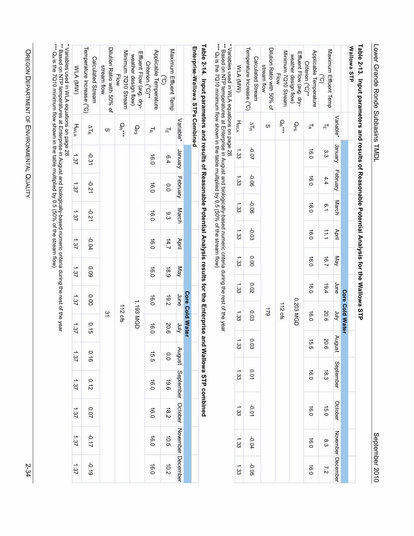
Lower G
rande Ronde Subbasins TM
DL
Septem
ber 2010
OR
EG
ON
DE
PAR
TME
NT O
F EN
VIR
ON
ME
NTA
L QU
ALITY
2-34
Table 2-13. Input parameters and results of R
easonable Potential Analysis for the W
allowa STP
* V
ariables used in WLA equations on page 28.
** Based on N
TP tem
peratures at Enterprise in A
ugust and biologically-based numeric criteria during the rest of the year
*** QR
is the 7Q10 m
inimum
flow show
n in the table multiplied by 0.5 (50%
of the stream flow
) Table 2-14. Input param
eters and results of Reasonable Potential A
nalysis results for the Enterprise and Wallow
a STP combined
* V
ariables used in WLA equations on page 28.
** Based on N
TP tem
peratures at Enterprise in A
ugust and biologically-based numeric criteria during the rest of the year
*** QR
is the 7Q10 m
inimum
flow show
n in the table multiplied by 0.5 (50%
of the stream flow
)
Wallow
a STP
Variable*
JanuaryFebruary
March
April
May
JuneJuly
August
Septem
berO
ctoberN
ovember
Decem
berM
aximum
Effluent Tem
p ( oC
)T
E3.3
4.46.1
11.116.7
19.420.6
20.618.3
15.08.3
7.2
Applicable Tem
perature C
riterion ( oC)**
TR
16.016.0
16.016.0
16.016.0
16.015.5
16.016.0
16.016.0
Effluent Flow
(avg. dry-w
eather design flow)
QP
S
Minim
um 7Q
10 Stream
Flow
Q
R ***
Dilution R
atio with 50%
of stream
flowS
Calculated S
tream
Temperature Increase ( oC
)∆T
R
-0.07-0.06
-0.06-0.03
0.000.02
0.030.03
0.01-0.01
-0.04-0.05
WLA
(MW
)H
WLA
1.33
1.331.33
1.331.33
1.331.33
1.331.33
1.331.33
1.33
Core C
old Water
0.203 MG
D
112 cfs
179
Enterprise-Wallow
a STP
s Com
bined
Variable*
JanuaryFebruary
March
April
May
JuneJuly
August
Septem
berO
ctoberN
ovember
Decem
berM
aximum
Effluent Tem
p ( oC
)T
E6.4
0.09.3
14.718.9
19.220.6
0.019.6
18.210.5
10.2
Applicable Tem
perature C
riterion ( oC)**
TR
16.016.0
16.016.0
16.016.0
16.015.5
16.016.0
16.016.0
Effluent Flow
(avg. dry-w
eather design flow)
QP
S
Minim
um 7Q
10 Stream
Flow
Q
R ***
Dilution R
atio with 50%
of stream
flowS
Calculated S
tream
Temperature Increase ( oC
)∆T
R
-0.31-0.21
-0.21-0.04
0.090.00
0.150.16
0.120.07
-0.17-0.19
WLA
(MW
)H
WLA
1.37
1.371.37
1.371.37
1.371.37
1.371.37
1.371.37
1.37
Core C
old Water
1.193 MG
D
112 cfs
31

Lower Grande Ronde Subbasins TMDL September 2010
OREGON DEPARTMENT OF ENVIRONMENTAL QUALITY 2-35
2.11 MARGIN OF SAFETY The Clean Water Act requires that each TMDL be established with a margin of safety (MOS). The statutory requirement that TMDLs incorporate a MOS is intended to account for uncertainty in available data or in the actual effect controls will have on loading reductions and receiving water quality. A MOS is expressed as unallocated assimilative capacity or conservative analytical assumptions used in establishing the TMDL (e.g., derivation of numeric targets, modeling assumptions or effectiveness of proposed management actions). The MOS for the Lower Grande Ronde Subbasins Temperature TMDL is implicit, based on conservative analytical assumptions and numeric targets. These conservative assumptions include:
• Conservatively low estimates for groundwater inflow were used in the stream temperature calibration. Specifically, unless measured or inferred from a mass balance analysis, groundwater inflow was assumed to be zero. Generally, groundwater has a cooling influence on stream temperatures via mass transfer/mixing. These underestimates of groundwater influence are considered a margin of safety.
• Conservatively low estimates of wind speed were used in the stream temperature calibration. Simulations were performed with wind speeds at zero or at low levels of recorded data. Wind speeds influence evaporation, a cooling influence on stream temperatures. The underestimation of wind speed is considered a margin of safety.
• Cooler microclimates associated with mature natural near-stream land cover were not accounted for in the simulation methodology.
• The natural condition simulation used to develop the NTP river temperatures used riparian vegetation overhang values of zero. As riparian vegetation increases, particularly during the late seral stages, the potential for vegetation to overhang the stream is very high. More area of stream that is shaded from direct sunlight keeps streams from warming. This conservative estimate of overhang is considered a margin of safety.
• Simulations of point source impacts using Reasonable Potential Analyses were used to develop waste load allocations. A number of conservative assumptions were used, including: sources were discharging at their effluent design flows and maximum effluent temperatures at all times; the annual 7Q10 low flow was used for all months of the year; and only 50% of the available stream flow was used to determine dilution. Waste load allocations do not exceed the human use allowance at any time of year nor is it expected that all sources will be discharging at their maximum levels at the same time or all the time. These conservative factors will yield a cooler river and is considered a margin of safety.
• DEQ allocated one-sixth of the human use allowance to non point sources but is basing the load allocation on system potential conditions. DEQ considers this conservative methodology to be part of the implicit margin of safety.
For further information regarding stream temperature modeling assumptions, refer to Appendix A.
2.12 RESERVE CAPACITY There is an explicit allocation for reserve capacity throughout the Lower Grande Ronde Subbasins set aside for future growth and new, expanded or unidentified sources. The general framework of the TMDL allocates 0.05°C or 1/6th of the HUA to reserve capacity, at the points of maximum impact. On streams without any point sources, an additional 0.2°C will be available for reserve capacity. In addition, reserve capacity will likely be available during much of the year due to the conservative assumptions used in developing WLAs for existing point sources. Reserve capacity is available for use by either nonpoint or point sources to accommodate future growth as well as to provide an allocation to any existing source that may not have been identified during the development of this TMDL.
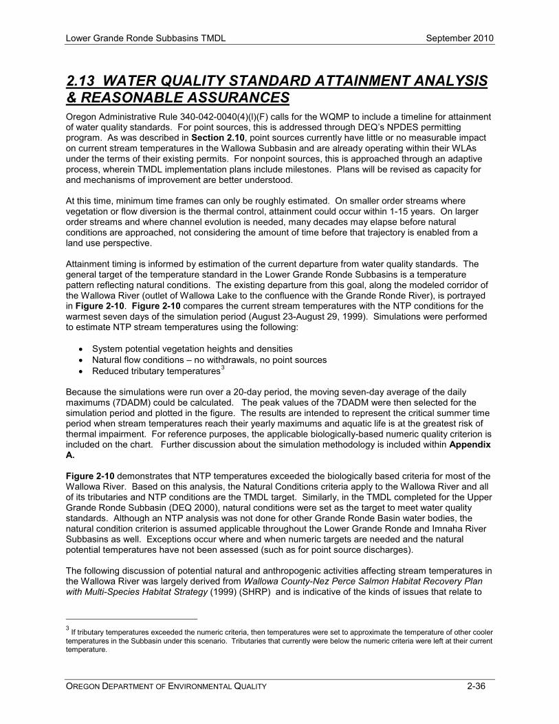
Lower Grande Ronde Subbasins TMDL September 2010
OREGON DEPARTMENT OF ENVIRONMENTAL QUALITY 2-36
2.13 WATER QUALITY STANDARD ATTAINMENT ANALYSIS & REASONABLE ASSURANCES Oregon Administrative Rule 340-042-0040(4)(l)(F) calls for the WQMP to include a timeline for attainment of water quality standards. For point sources, this is addressed through DEQ’s NPDES permitting program. As was described in Section 2.10, point sources currently have little or no measurable impact on current stream temperatures in the Wallowa Subbasin and are already operating within their WLAs under the terms of their existing permits. For nonpoint sources, this is approached through an adaptive process, wherein TMDL implementation plans include milestones. Plans will be revised as capacity for and mechanisms of improvement are better understood. At this time, minimum time frames can only be roughly estimated. On smaller order streams where vegetation or flow diversion is the thermal control, attainment could occur within 1-15 years. On larger order streams and where channel evolution is needed, many decades may elapse before natural conditions are approached, not considering the amount of time before that trajectory is enabled from a land use perspective. Attainment timing is informed by estimation of the current departure from water quality standards. The general target of the temperature standard in the Lower Grande Ronde Subbasins is a temperature pattern reflecting natural conditions. The existing departure from this goal, along the modeled corridor of the Wallowa River (outlet of Wallowa Lake to the confluence with the Grande Ronde River), is portrayed in Figure 2-10. Figure 2-10 compares the current stream temperatures with the NTP conditions for the warmest seven days of the simulation period (August 23-August 29, 1999). Simulations were performed to estimate NTP stream temperatures using the following:
• System potential vegetation heights and densities • Natural flow conditions – no withdrawals, no point sources • Reduced tributary temperatures3
Because the simulations were run over a 20-day period, the moving seven-day average of the daily maximums (7DADM) could be calculated. The peak values of the 7DADM were then selected for the simulation period and plotted in the figure. The results are intended to represent the critical summer time period when stream temperatures reach their yearly maximums and aquatic life is at the greatest risk of thermal impairment. For reference purposes, the applicable biologically-based numeric quality criterion is included on the chart. Further discussion about the simulation methodology is included within Appendix A. Figure 2-10 demonstrates that NTP temperatures exceeded the biologically based criteria for most of the Wallowa River. Based on this analysis, the Natural Conditions criteria apply to the Wallowa River and all of its tributaries and NTP conditions are the TMDL target. Similarly, in the TMDL completed for the Upper Grande Ronde Subbasin (DEQ 2000), natural conditions were set as the target to meet water quality standards. Although an NTP analysis was not done for other Grande Ronde Basin water bodies, the natural condition criterion is assumed applicable throughout the Lower Grande Ronde and Imnaha River Subbasins as well. Exceptions occur where and when numeric targets are needed and the natural potential temperatures have not been assessed (such as for point source discharges). The following discussion of potential natural and anthropogenic activities affecting stream temperatures in the Wallowa River was largely derived from Wallowa County-Nez Perce Salmon Habitat Recovery Plan with Multi-Species Habitat Strategy (1999) (SHRP) and is indicative of the kinds of issues that relate to
3 If tributary temperatures exceeded the numeric criteria, then temperatures were set to approximate the temperature of other cooler temperatures in the Subbasin under this scenario. Tributaries that currently were below the numeric criteria were left at their current temperature.
Lower Grande Ronde Subbasins TMDL September 2010
OREGON DEPARTMENT OF ENVIRONMENTAL QUALITY 2-37
achievement of NTP conditions along the Wallowa River. This discussion refers to thermal effects seen in Figure 2-10. The Wallowa River rises in the Eagle Cap Wilderness, flows north to Wallowa Lake and then northwest to join the Grande Ronde River. Major tributaries to the Wallowa River include Prairie Creek, the Lostine River, Bear Creek and the Minam River. There are a number of diversions from the Wallowa River, with the largest ones located below Wallowa Lake and near stream kilometer 55. Anthropogenic activities that affect stream temperatures include: reduction of riparian vegetation and shade levels primarily through recreation, grazing, and logging activities and the location of roads and railroads; manipulation of instream flows through instream diversions and impoundments; and irrigation return flows. Three to four kilometers below the outlet of Wallowa Lake, large inputs of groundwater cause stream temperatures to decrease significantly. It is interesting to note that the simulated Wallowa River temperatures are warmer under potential flow conditions between stream kilometers 69 and 79. This is likely due to the fact that large volumes of water are diverted into canals just below the Wallowa Lake outlet. Leaving this water instream dampens the cooling effects that springs have on the river at approximately stream kilometer 79. The effects of this scenario can be observed quite a ways downstream. It is also interesting to note that both the Lostine and Minam Rivers appear to increase the temperature of the Wallowa River under both current conditions and natural thermal potential conditions. Finally, it should be noted that the presence of the road and railroad along the river below the community of Wallowa will likely conflict with attainment of system potential vegetation along much of this reach. Figure 2-10. Wallowa River temperature simulation results (maximum 7DADM)
Wallowa River7-Day Average Daily Maximum Temperatures (8/23/99-8/29/99)
CanyonAg
City ofJoseph
City ofWallowa
LostineRiver
City ofEnterprise
Prairie CreekBearCreek
Minam River
5
10
15
20
25
30
05101520253035404550556065707580
Stream Kilometer
Tem
pera
ture
(o C)
41
46
51
56
61
66
71
76
81
86
Tem
pera
ture
(o F)
Natural Thermal Potential Current Condition
Numeric Criterion

Lower Grande Ronde Subbasins TMDL September 2010
OREGON DEPARTMENT OF ENVIRONMENTAL QUALITY 2-38
2.13.1 Implementation Responsibilities The Water Quality Management Plan (WQMP) (Chapter 4) provides the framework of management strategies needed to attain and maintain water quality standards. Designated Management Agencies (DMAs) are identified in the WQMP. These agencies are responsible for developing and implementing plans (called Implementation Plans) to fulfill TMDL load allocations and surrogate measures. The agency Implementation Plans typically stem from their existing programs, and must meet the requirements of OAR 340-042. The process for identifying DMAs is straightforward. DEQ identifies existing jurisdictional responsibility for water quality in the areas where the load allocations apply. For example, the Oregon Department of Agriculture is the DMA for areas near the stream in which agriculture land use is predominant. Through management planning, projects and ongoing assessment, the DMAs are expected to ensure that all feasible steps are taken toward attainment of the load allocations and surrogate measures identified in the TMDLs. Much restoration and conservation planning and implementation has already commenced, in a manner supportive of TMDL attainment. And, in much of the Subbasins, more restoration is needed and long term planning needs to provide for maintenance of effort over time. The SHRP describes the potential anthropogenic activities affecting the stream corridors for many of the streams in the TMDL geographic area. Restoration measures are described in the Stream Analysis Section, with management suggestions made on a reach-by-reach basis. In addition, Appendix B of the SHRP includes a Problems/Solutions Summary that includes specific guidance on management measures that can be used to address a number of water quantity, water quality, and stream structure issues. Reasonable assurance of implementation is represented by the initiative and commitment shown in the development of this plan.
Lower Grande Ronde Subbasins TMDL September 2010
OREGON DEPARTMENT OF ENVIRONMENTAL QUALITY 2-39
2.14 REFERENCES Bell, M.C. 1986. Fisheries handbook of engineering requirements and biological criteria. Fish Passage Development and Evaluation Program, U. S. Army Corps of Engineers, North Pacific Division. Portland, Oregon, 290 pp. Boyd, M. and B. Kasper. 2003. Analytical Methods for Dynamic Open Channel Heat and Mass Transfer: Methodology for Heat Source Model Version 7.0. Available at: http://www.deq.state.or.us/wq/TMDLs/tools.htm. Brett, J.R. 1952. Temperature Tolerance in Young Pacific Salmon, Genus Oncorhynchus. J. Fish. Res. Bd. Can., 9(6):265-323. Department of Environmental Quality. 1995. 1992-1994 Water Quality Standards Review Final Issue Paper: Temperature. Prepared by the Oregon Department of Environmental Quality. Available at: http://www.fishlib.org/Documents/Oregon/DEQ/wqsrtemp.pdf Department of Environmental Quality. 2000. Upper Grande Ronde Subbasin TMDL. Prepared by the Oregon Department of Environmental Quality. Available at: http://www.deq.state.or.us/wq/TMDLs/granderonde.htm#ugrs. Department of Environmental Quality. 2007a. Oregon’s Water Quality Standards. Prepared by the Oregon Department of Environmental Quality. Available at: http://www.deq.state.or.us/wq/standards/standards.htm Department of Environmental Quality. 2007b. Oregon’s 2004/2006 Integrated Report Prepared by the Oregon Department of Environmental Quality. Available at: http://www.deq.state.or.us/wq/assessment/rpt0406/search.asp. Department of Environmental Quality. 2009. City of Joseph WWTP Mixing Zone Evaluation, Study Date: December 10, 2008. Prepared by Lori Pillsbury, Laboratory and Environmental Assessment Division, Oregon Department of Environmental Quality. 14 pp. Heath A.G. and G.M. Hughes. 1973. Cardiovascular and respiratory changes during heat stress in rainbow trout (Salmo gairneri). J. Exp. Biol., 59:323-338. Hogan, J.W. 1970. Water temperature as a source of variation in specific activity of brain acetylcholinesterase of bluegills. Bull. Environment. Contam. Toxicol., 5:347-353. Hokanson, K., C.F. Kleiner and T.W. Thorslund. 1977. Effects of Constant Temperatures and Diel Temperature Fluctuations on Specific Growth and Mortality Rates and Yield of Juvenile Rainbow Trout, Salmo gairdneri. J. Fish. Res. Bd. Can., 34:639-648. Rosgen, D., L. 1996. Applied River Morphology, Wildland Hydrology Books, 1481 Stevens Lake Road, Pagosa Springs CO, 385 pp.
U.S. Environmental Protection Agency. 2003. EPA Region 10 Guidance for Pacific Northwest State and Tribal Temperature Water Quality Standards. EPA 910-B-03-002. 57 pp. Wallowa County and Nez Perce Tribe. 1993, revised 1999. Salmon Habitat Recovery Plan with Multi-Species Habitat Strategy. Available at: http://www.co.wallowa.or.us/salmonplan/ Washington Department of Ecology. 2006. Water quality standards for surface waters of the State of Washington. Downloaded from the website in 2009: http://www.ecy.wa.gov/programs/wq/swqs/index.html