loyalhanna watershed macro study 2004-2005
DESCRIPTION
Loyalhanna Watershed Macroinvertebrate Study wfor ColdWater Heritage Partnership.TRANSCRIPT

Macroinvertebrate StudyMacroinvertebrate Study 20042004--20052005
submitted by
Loyalhanna Watershed Association
Prepared by Jamie Marie Heinzman, AmeriCorps Intern Edited / Layout by Susan L. Huba, Program Manager
Project funded by:
The Coldwater Heritage Partnership
PA Fish & Boat Commission

Table of ContentsTable of Contents
1
Introduction & Background …………………………………………………………………………………2-3
Description & Previous Studies of the Loyalhanna Watershed Loyalhanna Creek …………………………………………………………………………………………….5 Mill Creek……………………. …………………………………………………………………………………6-7 Hannas Run…………………. …………………………………………………………………………………….7 Coal Pit Run……………….. …………………………………………………………………………………….8
Analysis of the Watershed: The LWA Macroinvertebrate Study Data Collection / Analysis……………………………………………………………………………...9 Macroinvertebrate Collection …………………………………………………………………….10 Microbiology ………………………………………………………………………………………………….…11 Overall Stream Site Health …………………………………………………………………………..12
Results Macroinvertebrate Multimetric Index ………………………………………………..12-13 Macroinvertebrate Biotic Index …………………………………………………………...14-15 Macroinvertebrate Percent EPT ………………………………………………………………...16 Macroinvertebrate Relative Abundance …………………………………………………..17 Bacterial Abundance………………………………………………………………………………………..18 Summary of Results.………………………………………………………………………………………..19 Conclusions…………………………………………………………………………………………………..…..20
Recommendations and Next Steps
Stream Action Loyalhanna Creek ……………………………………………………………………………………..21-22 Mill Creek……………………. …………………………………………………………………………………..22 Hannas Run…………………. …………………………………………………………………………………..23 Coal Pit Run……………….. ……………………………………………………………………………………23 Funding Opportunities for Stream Interventions ………………………….24-25
Project Improvements…………………………………………………………………………...…………...26-27
Project Summary………………………………………………………………………………………………………….28
Bibliography………………………………………………………………………………………………………………….29

Introduction and BackgroundIntroduction and Background
T he Loyalhanna Watershed Association (LWA) was established in 1971 with a
mission to “protect, conserve, and restore the natural resources of the Loyalhanna Creek Watershed.” The watershed is comprised of 2,526 miles of waterways draining 300 square miles of land in Westmoreland County. The watershed flows from headwaters on Laurel Mountain to Saltsburg, where the Loyalhanna Creek enters the Conemaugh River forming the Kiskiminetas River. Four major divisions of LWA activities include water protection, land conservation, environmental education, and community outreach. Specifically, the LWA is extremely active in addressing environmental issues through monitoring streams and abandoned mine drainage discharges, developing restoration plans for waterways with environmental issues, educating citizens regarding environmental issues, and maintaining recycling programs for plastics, paper, glass, cans, and electronics. The Loyalhanna Watershed Association is a well-established environmental advocate in the Loyalhanna Creek Watershed with over 400 members.
In December 2003, the LWA applied for a grant from the Coldwater Heritage Partnership (CHP) of the Pennsylvania Fish & Boat Commission in order to conduct a macroinvertebrate study, which would assess stream health in the Ligonier Valley. The project was originally designed with two objectives: 1) to develop an efficient, low-cost method for assessing water quality and 2) to establish a volunteer program for conducting fieldwork and identifying macroinvertebrates. After receiving the grant in February 2004, the LWA established the macroinvertebrate sampling program throughout the upper section of the Loyalhanna Creek Watershed in order to produce a conservation plan for the area. This
program has been and continues to be pursued aggressively by the LWA, as the Macroinvertebrate Study addresses all four focuses of the organization. Macroinvertebrate sampling is performed to assess water quality and to address issues through water protection. In addition, land conservation is a significant issue in this study, as stream health is a reflection of actions taken on land. Remediation of problems in the watershed determined by the study will be accomplished through education of citizens in the Ligonier area as well as community outreach.
Summer on the Loyalhanna Creek
2

3
The LWA Macroinvertebrate Study began in 2004, with an April sampling at ten stream locations. Macroinvertebrates were chosen as the preferred sampling method because these organisms are important biological indicators of stream health. Their populations are affected by stream chemistry and microbiology, both of which reflect land use. Many circumstances can therefore negatively affect macroinvertebrate populations including organic pollution, erosion, and abandoned mine drainage.
Organic pollution is pollution produced by living things including animals and humans, especially from metabolic breakdown of foodstuff released as fecal matter, which negatively affects macroinvertebrates. This process can cause an overabundance of nutrients and bacteria in waterways leading to the death of aquatic organisms1, including macroinvertebrates and fish. Macroinvertebrates have varying tolerances to organic pollution. Tolerance can be a confusing term: low tolerance values are correlated with healthy streams and high tolerance values with unhealthy streams. According to the EPA2, organisms tolerant to organic pollution, which can be found in polluted streams, include worms, true flies, leeches, and lunged snails. Sensitive/intolerant organisms, including beetles, dobsonflies and alderflies, mayflies, stoneflies, and gilled snails are not abundantly found in
streams with an organic pollution issue. Other organisms, such as caddisflies, have some tolerance to organic pollution, and can be present in trace quantity even in moderately polluted streams.
Erosion and Abandoned Mine Drainage (AMD) result in destruction of macroinvertebrate and fish populations because of compromised habitat conducive to their life cycles. Specifically, the stream substrate of cobble, rocks, and trees becomes covered. In the case of erosion, sediment covers stream substrate. With AMD, the culprit is iron oxide deposition. Adding to the problem, sediment or iron oxide can cover food resources such as algae and fallen leaves, eliminating the ability of macroinvertebrates and fish to obtain nourishment, and may clog the delicate gills of these organisms, inhibiting adequate oxygen take from the water. As a result of these stream impacts, all organisms suffer. Macroinvertebrate life is often reduced with regards to both abundance and diversity, and fish
populations begin to dwindle, as their primary food resources are algae and macroinvertebrates. In all, the LWA Macroinvertebrate Study is a significant project in the Loyalhanna Creek Watershed. The mission of the LWA is carried out through the project as the four primary areas of concern for the organization, water protection, land conservation, environmental education, and community outreach, are addressed. This study allowed the LWA to identify problem sites and develop remediation plans for this year and for years to come.
1Mark B. Bush. Ecology of a Changing Planet. 3rd Edition. 2003. Page 196. 2EPA Volunteer Stream Monitoring: A Methods Manual. EPA 841-B-97-003. November 1997. www.epa.gov/owow/ monitoring/volunteer/stream/
Mayfly nymphs are highly sensitive to all forms of
water pollution.
Blackfly larvae are tolerant to water pollution, and can be found in both polluted and non-polluted
streams.
Iron oxide deposition on the bottom of an AMD impacted stream.

Description and Previous Studies of the Description and Previous Studies of the Loyalhanna WatershedLoyalhanna Watershed
4
A ll four of the monitored streams, Loyalhanna Creek, Mill Creek, Hannas Run and Coal Pit Run, are part of the Loyalhanna Creek Watershed. The Loyalhanna Creek Watershed covers 300 square miles of
land with 2,526 miles of waterways in Westmoreland County from Laurel Mountain to Saltsburg. Streams were chosen for the study based on location and characterization. First, all streams chosen for the LWA Macroinvertebrate Study are located in the upper part of the watershed, near Ligonier, Pennsylvania. Second, all streams have been previously characterized as coldwater fisheries according to Chapter 93 of the Pennsylvania Code. The project is significant because, although similar programs have been established in the lower parts of the watershed, no macroinvertebrate sampling programs existed in this section of the upper part of the watershed. In all, ten sites were sampled on the four streams monitored. All are depicted in Map 1 (shown below.)
The Loyalhanna Watershed Association is in the process of completing a Watershed Assessment and Restoration Plan. This document also provides background information for the Description of the Watershed and Previous Studies section of the report, and should be available by the Summer of 2006.
Map 1: LWA Macroinvertebrate Study Streams and Sampling Sites

5
Loyalhanna Creek—
The Loyalhanna Creek was monitored during this study because it is the main waterway that flows from Laurel Mountain to Saltsburg. The headwaters of the Loyalhanna Creek originate on Laurel Ridge in a Stahlstown farm springhouse. This fourth order stream passes through many municipalities including Ligonier, Latrobe, New Alexandria, and Saltsburg. For the LWA Macroinvertebrate Study, the Loyalhanna Creek was monitored at three sites in the upper watershed areas, which drain over 100 square miles of land. These sites are located at the PA Route 381 Bridge near Rector, the Swinging Bridge on the Loyalhanna Nature Trail in Ligonier, and Hollow Causeway between Ligonier and Latrobe. The substrate in the sampling region includes boulders, cobble, gravel, and silt, all of which provide ample habitat variety for macroinvertebrates. The majority of the headwater streams pass through forested areas with mountain laurel as well as conifer, oak, and maple trees, serving as a food source for stream life throughout the sampling region. The Route 381 sampling site is also located in heavily forested area with a minimal number of farms and residences, while the other two sampling locations are located in more developed areas.
The Swinging Bridge is located in the Borough of Ligonier, while the Hollow Causeway, though forested, is located between the eastbound and westbound lanes of Route 30 downstream of Ligonier. Additionally, the Swinging Bridge site is located in a PA Fish and Boat Commission Delayed Harvest Area. Previous studies are limited for the upper section of the Loyalhanna Creek, as the majority of the property is privately owned and few significant impacts are present. A June 2002 PA Fish and Boat Commission study identified 19 fish species in the Route 381 area and 21 fish species in the Swinging Bridge area.
The visual assessment conducted by the LWA revealed a number of erosion impacts that affect the Loyalhanna Creek in this area. Erosion is a significant issue with two separate causes. First, riparian vegetation is degraded due to livestock access to the stream and mowing by landowners for aesthetic purposes. Second, erosion is magnified in the Ligonier area due to the relocation of the Loyalhanna Creek when Route 30 was expanded. Downstream of Ligonier, the Loyalhanna Creek and some tributaries have been channeled for road safety, creating erosion issues as well as fish barriers. The proximity of the road to the stream also allows runoff to enter the stream constantly. Organic pollution impacts the stream, as septic output and agriculture are prevalent on tributaries and the mainstem of the Loyalhanna Creek. The presence of blue-green algae on the stream substrate indicates nutrient enrichment, reinforcing the belief that organic pollution is a significant issue. AMD showed no major impact on the Loyalhanna Creek in the upper watershed area.
Loyalhanna Creek, Route 381 Sampling Site
Loyalhanna Creek, Swinging Bridge Sampling Site
Loyalhanna Creek, Hollow Causeway Sampling Site

6
— Mill Creek
The Mill Creek watershed is a subwatershed of the larger Loyalhanna Creek watershed, draining 25.7 square miles of land. The majority of the Mill Creek watershed is rural, as the third order stream passes only through the small town of Waterford and Ligonier Borough. Three branches form the headwaters of the stream on Laurel Ridge, with two classified by Chapter 93 of the Pennsylvania Code as Exceptional Value coldwater fisheries and the other as a High Quality coldwater fishery. The remainder of Mill Creek is a coldwater fishery. A number of tributaries enter Mill Creek including Macks Run and Hannas Run. Macks Run is a coldwater fishery that flows from a valley with fields, some in early stages of succession and others serving as active pastures.
Hannas Run is also a coldwater fishery, and is described in detail in another section of this report. In all, three sampling locations were monitored on Mill Creek, one at each of the following sites: the Robert Road Bridge, the McKelvey Bridge, and Weller Football Field.. The first two sites were chosen as locations above and below both Waterford and Hannas Run, which introduce pollution impacts. The substrate of Mill Creek is varied with boulders, cobble, gravel, and sand providing habitat diversity. The canopy is composed of hardwoods with hemlock and mountain laurel along the headwaters, which provide an ample source of food for aquatic life in Mill Creek.
A number of studies have been conducted in the Mill Creek watershed. The 1972 Scarlift Report, which surveyed the entire Loyalhanna Creek watershed for mining impacts, reported four acidic mine drainages in the Mill Creek watershed and recommended re-mining and re-grading to minimize the impacts downstream. In 1981, the PA Fish and Boat Commission conducted a fish survey on Mill Creek above and below the confluence with Hannas Run. Above the confluence, 11 fish species were recovered, including brown and brook trout, but macroinvertebrate diversity was poor. Below Hannas Run, only three fish species were identified, including brown trout, and macroinvertebrate diversity was fair. The biological and chemical tests
indicated impacts from agriculture and mining. Additionally, the DEP monitored Mill Creek during surface mining operations in the 1980s and 1990s. Only one abandoned mine drainage discharge was located and was reduced from 50 to 80 gallons per minute to less than 1 gallon per minute. Most recently, the PA Trout Unlimited Forbes Trail Chapter developed a Coldwater Conservation Plan for Mill Creek and its tributaries, including Hannas Run. Additional information on their research is available in the “Mill Creek Watershed Conservation Plan.”3
3PA Trout Unlimited Forbes Trail Chapter. Mill Creek Watershed Conservation Plan. 2005.
Mill Creek, McKelvey Sampling Site
Mill Creek, Robert Road Sampling Site
Mill Creek, Football Field Sampling Site

Mill Creek (ctnd.)
The LWA Watershed Assessment and Restoration Plan determined the major impacts on the Mill Creek watershed to be organic pollution and erosion. Organic pollution is a major challenge in the Mill Creek watershed as sewage and agriculture impact the stream. This is especially true in and below Waterford, where municipal sewage treatment is not available and septic systems are failing. Furthermore, land use practices cause erosion throughout this watershed. Practices contributing to erosion include removal of vegetation from stream banks for aesthetic purposes and allowing livestock access to streams. Abandoned mine drainage is present in the watershed, but in very small quantities that are neutralized by alkaline headwaters prior to entering Mill Creek.
7
Hannas Run—
Hannas Run is a part of the Mill Creek subwatershed of the Loyalhanna Creek. This tributary drains 7.13 square miles of land, approximately one-third of the Mill Creek watershed. Hannas Run is a second order stream that flows from Laurel Ridge through a rural landscape dominated by fields, some of which support agriculture, as well as the small community of Wilpen. Two sites were monitored as part of the LWA Macroinvertebrate Study, one at the Ramsey Bridge and one at the Menzie Bridge, above and below Wilpen, respectively. Substrate includes cobble, woody debris, and gravel. In the sampling area, however, sediment covers most of this substrate, compromising the habitat quality available for aquatic organisms. The canopy cover is limited to shrubs that have replaced open fields in early stages of succession so food resources for stream life are also limited.
A few studies have been conducted on Hannas Run. The 1975 Scarlift Report noted that Hannas Run had eight abandoned mine drainage discharges controlled by Works Progress Administration mine seals. These seals were part of the Roosevelt administration’s work program in the 1930s and 1940s to encourage economic recovery after the depression. In 1979 and 1997, the PA Fish and Boat Commission surveyed Hannas Run close to the mouth. Nine fish species were collected in 1979 and ten in 1991, including brown and rainbow trout. Hannas Run has a number of impacts, according to the LWA Watershed Assessment and Restoration Plan. Specifically, erosion and organic pollution were significant in this watershed. Erosion was found to be a major problem, as macroinvertebrate and fish habitats were
covered by sediment. Causes of erosion include agricultural land use, such as plowing and livestock access to the streams, and removal of riparian vegetation by residents. Additionally, organic pollution was significant in this watershed. This is especially true in Wilpen, where sewage treatment is dependent on septic systems, which are often failing. Compounding the sewage problem is agricultural production of organic pollution. AMD slightly impacts the watershed, as most discharges have been controlled by mine seals.
Hannas Run, Ramsey Sampling Site
Hannas Run, Menzie Sampling Site

8
— Coal Pit Run
Coal Pit Run composes its own subwatershed of the Loyalhanna Creek and is a third order stream at the sampling locations. With headwaters in Chestnut Ridge, Coal Pit Run passes through forested hills and fields with some residences, draining 12.47 square miles of land. Some of the fields are used for farming while others are in early stages of succession. Trout Run, a tributary of Coal Pit Run, has supplied the Latrobe Reservoir with water for the Municipality of Latrobe since 1919. Two sampling sites were selected on Coal Pit Run, one at Springer Road and the other at the intersection of Route 259 and Route 30, which is relevant because a major farming operation lies between these sites. The substrate of Coal Pit Run varies from boulders in the headwaters to cobble and gravel in the sampling locations. The fields and forest create a varying canopy throughout the length including mature forests of pine and oak as well as fields with small shrubs and
deciduous trees. Together, the substrate and canopy provides a variety of habitat and food resources to support aquatic life.
No historical studies concerning water quality or land use have been conducted on the Coal Pit Run watershed, primarily because there have been no reports of abnormal occurrences. In fact, the LWA Watershed Assessment and Restoration Plan found very few impacts in the Coal Pit Run watershed. Erosion was present, but only on a few small tributaries with minimal impact in the mainstem of Coal Pit Run. Erosion was not a major impact on the Coal Pit Run watershed because landowners maintain adequate riparian vegetation. However, there are locations in which cattle have direct access to the stream, creating some erosion problems as well as introducing organic pollution. This is most significant in the mainstem section on a dairy farm downstream of McCurdy Trail Road, between the LWA Macroinvertebrate Study sampling sites. Additionally, road culverts are present on Coal Pit Run, which can prevent fish migration and limit populations throughout the stream.
Coal Pit Run, Springer Sampling Site
Coal Pit Run, Rt 259 & Rt 30 Sampling Site

Analysis of the Watershed:Analysis of the Watershed: The LWA Macroinvertebrate StudyThe LWA Macroinvertebrate Study
Data Collection
T he methods used for data collection in this study were based on Environmental Protection Agency (EPA) recommendations4, and the chosen stream sites were required to meet certain qualifications. Specifically, sites
were required to be equal to a 100-meter stream reach and sites could not have tributaries entering within the 100-meter reach. Also, bridges and stream crossings were to be minimal.
Each stream site was sampled three times in 2004, in April, August, and October, with the exception of Mill Creek-Football Field and the Loyalhanna-381, which were not sampled in August due to lack of volunteer resources. A single habitat approach was used — each sample consists of three kick-net trials performed in riffle areas with a standard kick-net screen (1m x 1m, 500 micrometer mesh). The macroinvertebrates were then removed from the screens on-site and placed in 80% ethanol. Following collection, the macroinvertebrates were sorted and identified to order at the watershed office. These organisms were preserved in 80% ethanol and are currently in storage at the LWA Office.
Additional tests included chemistry and microbiology. All pH levels and water temperatures were recorded at the sites during sampling. A microbiology sample was obtained prior to the October macroinvertebrate sample sessions. These were collected in 100mL sample bottles according to PA Department of Environmental Protection (DEP) requirements and were analyzed in a DEP microbiology laboratory.
Data Analysis
D ata analysis was performed using percentages of organisms present. These percentages were then used in five different indexes to determine the health of the streams. Stream sites were compared to acceptable values for
each index given in texts as well as to one another. Together, these indexes combine to give an overall view of macroinvertebrate life and stream quality. These methods, described in greater detail below, were used to minimize sampling error so results can be considered valid.
4Environmental Protection Agency. Summary of Biological Assessment Programs and Biocriteria Development for States, Tribes, Territories, and Interstate Commissions: Streams and Wadeable Rivers 2002 Update. EPA-822-R-20-048.
9

10
— Macroinvertebrate Collection
In the macroinvertebrate sampling process, some error was involved, mostly due to different people sampling different sites from month to month. Although all volunteers were trained in the proper techniques, sampling error was introduced given that different people collect with different amounts of force and consistency. Additionally, macroinvertebrates were removed from some samples in the LWA office rather than on-site, due to time and weather limitations. This created sampling error since these samples had at least three times more organisms than samples in which macroinvertebrates were removed on-site because smaller organisms were easier to see in the office setting. For these reasons, the data were analyzed as average percentage of
macroinvertebrates present in the sample. Specifically, the number of macroinvertebrates in each order or category were calculated for each stream over the three sampling months. The total was then converted to a percentage by dividing by the total number of organisms collected at that site. This average percentage of macroinvertebrates in each order or category was then used to perform the analysis of data. The use of percentages required the assumption that the same macroinvertebrate distribution would be obtained regardless of the number of macros collected. For instance, a stream would have ten percent mayfly nymphs whether 150 or 1500 insects were collected. This is probably true of the samples since there was a wide range of macroinvertebrates with regards to type as well as size in each sample. Overall, the use of percentages is an acceptable way to minimize sampling error when analyzing results.
Error could also be caused by sampling date, as larvae mature and emerge into adulthood over time and diapause phases, as well as large differences in the stream conditions. The samples from each month were performed within approximately two weeks. April sampling occurred between April 9 and April 25, 2004, August sampling occurred between August 2 and August 6, 2004, with the exception of one August 31, 2004 sample, and October sampling occurred on October 14 through October 27, 2004. As a result, there should be little error due to maturation. Additionally, stream conditions were similar as measured parameters indicated. Water temperatures and pH were not recorded in April. In August, while no temperatures were recorded, pH values ranged from 6.9 to 8.5. In October, water temperatures ranged from 49 to 55 degrees Fahrenheit and pH values ranged from 7.2 to 8.6. In all, samples were taken in the same general time frame and stream conditions were relatively similar from one stream to another on recorded parameters.
The use of percentages has minimized sampling error, and because stream conditions were similar, analysis of the data is possible and results and comparisons can be considered valid. The data analysis techniques used for the macroinvertebrate study include: a Multimetric Index, a Biotic Index, Percent EPT, and Macroinvertebrate Relative Abundance.
A volunteer carefully searches a kick-net for tiny insects.
Volunteers retrieve macroinvertebrates from kick-nets.

11
Microbiology—
The microbiological analysis performed was Bacterial Abundance, or Total and Fecal Coliform counts. Again, the microbiology sampling was done only in October of 2004. There was relatively little sampling error in the microbiological study. The same individual performed every one of the ten samples in the same way on the same day. The stream was entered downstream so as not to disturb the water, and the collector leaned forward when taking the sample to minimize contamination. Also, the streams were very much alike in pH, dissolved oxygen, and temperature ranges. The pH values of the streams on this day ranged from 8.0 to 8.6, the dissolved oxygen varied from 13.0 to 16.0 mg/L, and the water temperatures were between 49 and 52 degrees Fahrenheit. Overall, sampling error was minimized and stream conditions were similar for the microbiology samples so analysis of the data is possible and results are acceptable. The Bacterial Abundance was used as the data analysis technique for the microbiology samples.
Overall Stream Site Health—
The results of the individual indexes were combined to
determine which streams require remediation. Specifically, for each of the five indexes, the three stream sites lowest in the ranking were recorded. Then, the number of times each site was rated in the lowest three was added, resulting in a final prioritization of stream site remediation. Those sites that ranked in the lowest three the greatest number of times were marked as areas of concern and given highest priority for remediation. Alternatively, streams that did not rank in the lowest three on any index were considered to be outstanding values. To facilitate an understanding of the results, sites ranking in the lowest three are given in the conclusion for each index. Following the results for each index, an overall Summary of Results is provided.
Fishing in the Loyalhanna.

ResultsResults
Macroinvertebrate Multimetric Index
T he multimetric index is a guideline based on the optimal abundance of different organisms that should be present in healthy streams. High rankings indicate a high percentage of sensitive organisms with a low
percentage of tolerant organisms. The opposite is also true, with low rankings indicating the presence of a high percentage of tolerant organisms and a low percentage of sensitive organisms. Therefore, high ranks indicate a healthy stream and low ranks indicate unhealthy conditions.
Table 1: American Entomologist Multimetric Index5
* Percent Tolerant Macroinvertebrates include: worms, flatworms, aquatic sowbugs, scuds, dragonfly and damselfly nymphs, midges, black fly larvae, lunged snails, and clams.
** Percent Non-Insect Macroinvertebrates include: worms, flatworms, leeches, crayfish, aquatic sowbugs, scuds, gilled and lunged snails, and clams.
Calculations Total number of 2s ___________________ x 2 = ____________________
Total number of 1s ___________________ x 1 = ____________________
Total number of 0s ___________________ x 0 = ____________________
Grand Total (sum of subtotals) = _________________________
5 Macroinvertebrate ID Workshop. November 2003. Penn State-Westmoreland Conservation District, Donohoe Center, Greensburg. Vivian Williams, Education Programs Manager. Presented by Stroud Water Research Center. American Entomologist. Virginia Save-Our-Streams Protocol. Volume 48, Number 3.
12
Metric 2 1 0
% Mayflies, Stoneflies, Most Caddisflies
Greater than 32.2 16.1-32.2 Less than 16.1
% Common Net spinners
Less than 19.7 19.7-34.5 Greater than 34.5
% Lunged Snails Less than 0.3 0.3-1.5 Greater than 1.5
% Beetles Greater than 6.4 3.2-6.4 Less than 3.2
% Tolerant Macroinvertebrates *
Less than 46.7 46.7-61.5 Greater than 61.5
% Non-Insect Macroinvertebrates **
Less than 5.4 5.4-20.8 Greater than 20.8

Macroinvertebrate Multimetric Index (ctnd.)
Adaptations for the LWA Macroinvertebrate Study • The Caddisfly calculation involves placement of 70% of the caddisfly larvae in the Hydropsychidae
(Netspinner) group and 30% in the General Caddisfly group. This is an estimation based on findings from a number of random samples.
• The Lunged Snail value includes any snail found. This does not have a significant affect on the calculation since snails were less than 0.3% of the sample for all samples except Coal Pit-Springer, which still received an overall rating of 11, and Hannas Run-Ramsey, which received moderate ranks in two other categories.
• For Percent Tolerant Macroinvertebrates, total Dipterans were substituted for midges and blackfly larvae. This did not affect the index, as the Percent Tolerant Macroinvertebrates was always less than 46.7%.
Results
13
Multimetric Index Grand Total
Ecological Condition
12-7 Acceptable
6-0 Unacceptable
Table 2: Multimetric Index Evaluation of Results
Stream Location Rank Ecological Condition
Loyalhanna Creek Route 381 10 Acceptable
Swinging Bridge 11 Acceptable
Hollow Causeway 7 Acceptable
Mill Creek Robert Road 11 Acceptable
McKelvey 10 Acceptable
Football Field 9 Acceptable
Hannas Run Ramsey 9 Acceptable
Menzie 11 Acceptable
Coal Pit Run Springer 10 Acceptable
Rt 259 & Rt 30 9 Acceptable
Table 3: Multimetric Index Applied to LWA Streams: Final Results and Ecological Conditions

Macroinvertebrate Biotic Index
T he biotic index is based on pollution tolerance values for different types of macroinvertebrates. High pollution tolerance values are given to orders that are tolerant of organic pollution; therefore, these organisms can be
found in both polluted and non-polluted streams. Alternatively, low pollution tolerance values are given to sensitive organisms that will not be present in polluted waters. As a result, this system ranks healthy streams with low values and unhealthy with higher values.
Calculations Total Number of Organisms x Pollution Tolerance Value = Total Tolerance Value
Tolerance Total = Sum of Individual Tolerances
Stream Tolerance Level = Tolerance Total / Total Number of Organisms 6Macroinvertebrate ID Workshop. November 2003. Penn State-Westmoreland Conservation District, Donohoe Center, Greensburg. Vivian Williams, Education Programs Manager. Presented by Stroud Water Research Center. Stroud Water Research Center. Biotic Index Worksheet.
14
Taxon Pollution Tolerance Value
Ephemeroptera 3.6
Plecoptera 1.0
Trichoptera 4.3
Odonata 4.0
Megaloptera 3.5
Coleoptera 4.6
Diptera 5.5
Amphipoda 6.0
Isopoda 8.0
Decapoda 5.0
Oligochaeta 8.0
Hirudinea 8.0
Turbellaria 8.0
Gastropoda 7.0
Table 4: LWA Biotic Index (Modified from Stroud Water Research Center6)

Macroinvertebrate Biotic Index(ctnd.)
Adaptations for the LWA Macroinvertebrate Study
15
Biotic Index Water Quality Degree of Organic Pollution
<3.75 Excellent Organic Pollution Unlikely
3.76-5.0 Good Some Organic Pollution
5.1-6.5 Fair Substantial Pollution Likely
6.6-10.0 Poor Severe Organic Pollution Likely
Table 5: Biotic Index Evaluation of Results
Stream Location Tolerance Water Quality Stream Condition
Loyalhanna Creek Route 381 3.67 Excellent Organic Pollution Unlikely
Swinging Bridge 4.29 Good Some Organic Pollution
Hollow Causeway 4.38 Good Some Organic Pollution
Mill Creek Robert Road 3.55 Excellent Organic Pollution Unlikely
McKelvey 4.05 Good Some Organic Pollution
Football Field 3.56 Excellent Organic Pollution Unlikely
Hannas Run Ramsey 4.44 Good Some Organic Pollution
Menzie 4.01 Good Some Organic Pollution
Coal Pit Run Springer 4.06 Good Some Organic Pollution
Rt 259 & Rt 30 3.98 Good Some Organic Pollution
Table 3: Biotic Index Applied to LWA Streams: Final Results and
• As with the Stroud Multimetric Index, the Caddisflies are split into the two groups, Hydropsychidae (70%) and Other (30%). This required using a Pollution Tolerance Value for Caddisflies of 4.3.
• The Anisoptera (dragonfly) and Zygoptera (damselfly) families are combined into one Order—Odonata. The tolerance for this order is given a value of 7.0, that of the damselfly family, to err on the side of caution. However, both values were used in calculation and resulted in the same water quality index, so this does not compromise the analysis. This is true because there are relatively few dragonfly and damselfly nymphs compared to the total number of organisms present in each sample.
• Megaloptera was given a Pollution Tolerance Value of 3.5; the average for dobsonfly larvae, 3.0, and alderfly larvae, 4.0. All three of the values, 3.0, 3.5, and 4.0, were entered, and all resulted in the same pollution tolerance levels for all of the streams.
• The Dipterans received a Pollution Tolerance Value of 5.5, close to the 6.0 value for Chironomidae, Simuliidae, and Other Diptera. Like with the Odonata, this value errs on the side of caution, as the Athericidae and Tipulidae are the less tolerant, more sensitive, Dipteran families with lower tolerance values.
Results Table 6: Biotic Index Applied to LWA Streams: Final Results and Stream Conditions

Macroinvertebrate Percent EPT
P ercent EPT is the total percent of insects making up the orders Ephemeroptera, Plecoptera, and Tricoptera. These orders comprise macroinvertebrates that are sensitive to pollution. Theoretically, healthy streams should
have high EPT values. Please note: Tricoptera percentage does not include those caddisfly larvae from Family Hydropsychidae, since these organisms are more tolerant to pollution than other caddisfly larvae.
Calculations Percent EPT = %Ephemeroptera + %Plecoptera + %Tricoptera - %Hydropsychidae
Results
7 Macroinvertebrate ID Workshop. November 2003. Penn State-Westmoreland Conservation District, Donohoe Center, Greensburg. Vivian Williams, Education Programs Manager. Presented by Stroud Water Research Center. American Entomologist. Virginia Save-Our-Streams Protocol. Volume 48, Number 3.
16
Stream Location %EPT Water Quality
Loyalhanna Creek Route 381 54.9 Good
Swinging Bridge 38.6 Good
Hollow Causeway 31.2 Fair
Mill Creek Robert Road 68.0 Good
McKelvey 53.2 Good
Football Field 64.5 Good
Hannas Run Ramsey 22.0 Fair
Menzie 28.0 Fair
Coal Pit Run Springer 47.0 Good
Rt 259 & Rt 30 50.4 Good
Percent Water Quality
> 32.2 Good
16.1-32.2 Fair
< 16.1 Poor
Table 7: Evaluation of Results from the EPT (From Stroud Water Research Center7
Table 8: Percent EPT Applied to LWA Streams: Final Results & Stream Conditions

Macroinvertebrate Relative Abundance
M acroinvertebrate Relative Abundance is an important measure of stream health. Populations should be diverse, with a variety of sensitive species. Excessive populations of one type of macroinvertebrate can
inhibit the growth of others, so imbalanced diversity signifies a stream health challenge. Graph 1 (below) depicts the relative distribution of significant orders given in percent abundance. Significant orders, those with a sizable population in at least one stream, include Plecoptera, Ephemeroptera, Tricoptera, Coleoptera, and Diptera. The “others” category includes all organisms not named which have a low percent abundance at all sites. EPT species appear first on the graph, allowing simple visualization of this important parameter.
Calculations No category should compose the majority of the macroinvertebrates for a site, preferably not more
than 50% of the organisms found at each location. There should be relatively even distribution between the significant orders and relatively few “others.”
Results
17
0%
20%
40%
60%
80%
100%
381
Swin
ging
Bri
dge
Hol
low
Cau
sew
ay
Rob
ert
Roa
d
McK
elve
y
Foo
tbal
lF
ield
Ram
sey
Men
zie
Spri
nger
259
and
30
Loyalhanna Mill Creek Hannas Run Coal Pit Run
Stream and Location
Per
cent
Abu
ndan
ce (
%)
OtherDipteraColeopteraTricopteraPlecopteraEphemeroptera
Graph 1: Relative Percent Abundance of Significant Orders in LWA Streams
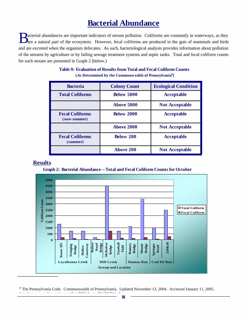
Bacterial Abundance
B acterial abundances are important indicators of stream pollution. Coliforms are constantly in waterways, as they are a natural part of the ecosystem. However, fecal coliforms are produced in the guts of mammals and birds
and are excreted when the organism defecates. As such, bacteriological analysis provides information about pollution of the streams by agriculture or by failing sewage treatment systems and septic tanks. Total and fecal coliform counts for each stream are presented in Graph 2 (below.)
Results
8 The Pennsylvania Code. Commonwealth of Pennsylvania. Updated November 13, 2004. Accessed January 11, 2005. http://www.pacode.com/secure/data/025/chapter93/s93.7.html.
18
Bacteria Colony Count Ecological Condition
Total Coliforms Below 5000 Acceptable
Above 5000 Not Acceptable
Fecal Coliforms (non-summer)
Below 2000 Acceptable
Above 2000 Not Acceptable
Fecal Coliforms (summer)
Below 200 Acceptable
Above 200 Not Acceptable
Table 9: Evaluation of Results from Total and Fecal Coliform Counts (As Determined by the Commonwealth of Pennsylvania8)
0
500
1000
1500
2000
2500
3000
3500
4000
4500
5000
Rou
te 3
81
Swin
ging
Bri
dge
Hol
low
Cau
sew
ay
Rob
ert
Roa
dB
ridg
e
McK
elve
yB
ridg
e
Foo
tbal
lF
ield
Ram
sey
Bri
dge
Men
zie
Bri
dge
Spri
nger
Roa
d
259&
30
Loyalhanna Creek Mill Creek Hannas Run Coal Pit Run
Stream and Location
Col
ifor
m C
ount
Total ColiformFecal Coliform
Graph 2: Bacterial Abundance—Total and Fecal Coliform Counts for October

Summary of ResultsSummary of Results Macroinvertebrate Multimetric Index All stream locations are in the “Acceptable” range according to the American Entomologist Multimetric Index. The locations with the lowest ranks include the Loyalhanna-Hollow Causeway, Mill Creek-Football Field, Hannas Run-Ramsey Road, and Coal Pit-259&30. The Loyalhanna-Hollow Causeway had high numbers of netspinners and low numbers of beetle larvae, which caused a lower ranking. Mill Creek-Football and Coal Pit Run-259&30 locations had moderate numbers of netspinners and low numbers of beetle larvae. Hannas Run-Ramsey received moderate rankings for its low percentage of mayfly nymphs, stonefly nymphs, and caddisfly larvae, moderate snail percentage, and moderate number of tolerant species. Again, all of these ratings are in the acceptable range, from 7 to 12.
Macroinvertebrate Biotic Index All stream locations are in good to excellent condition, as indicated by the biotic index. Streams that received Excellent ratings for the Biotic Index included: Mill Creek-Football Field, Mill Creek-Robert Road, and Loyalhanna-Route 381. A number of locations may be affected by organic pollution to some degree. These locations include: Mill Creek-McKelvey, Coal Pit-259 and 30, Coal Pit-Springer, Loyalhanna-Hollow Causeway, Loyalhanna-Swinging Bridge, Hannas Run-Ramsey, and Hannas Run-Menzie. The three stream sites with the highest tolerance values, or highest possibility of organic pollution, included the Hollow Causeway, the Swinging Bridge, and Ramsey.
Macroinvertebrate Percent EPT Three locations ranked “Fair” on the EPT, Hannas Run-Ramsey, Hannas Run-Menzie, and Loyalhanna-Hollow Causeway. All other locations ranked “Good.”
Macroinvertebrate Relative Abundance Most sites, including all Mill Creek locations, both Coal Pit locations, and the Loyalhanna-381 and the
Swinging Bridge, have good relative distributions of macroinvertebrates. Sites with uneven distribution include the Loyalhanna-Hollow Causeway and both Hannas Run sites.
Although the EPT values were high for the Loyalhanna-Hollow Causeway, there are very few mayfly and stonefly nymphs (8.6% total), compared to an overabundance of caddisfly larvae (75.2%), at this location. As was determined in the EPT calculation, both of the Hannas Run sites, Ramsey and Menzie, have low EPT values. Even These streams also have very low percentages of mayfly nymphs, 1.2 and 1.3 percent, respectively. Also, Ramsey has a relatively large number of the Dipterans (54.4%), which are generally organic pollution tolerant, and Menzie has a relatively large number of beetle larvae (34.8%), which are moderately tolerant.
Bacterial Abundance All streams have acceptable levels of both total and fecal coliforms for non-summer samples. Stream sites with relatively high total coliforms include Mill Creek-McKelvey (4500 colonies/100mL), Hannas Run-Menzie (3400 colonies/100 mL), and Coal Pit-259&30 (2500 colonies/100 mL). Streams with relatively high fecal coliforms include Mill Creek-McKelvey (700 colonies/100 mL) and Coal Pit-259&30 (280 colonies/100 ml). Again, these values were acceptable for non-summer months, but were high relative to other stream sites.
19

ConclusionsConclusions
I n all, five data analysis techniques were used in this study: Multimetric Index, Biotic Index, Percent EPT, Macroinvertebrate Relative Abundance of Significant Orders, and Bacterial Abundance. When combining all of
these techniques, an overall picture of the Macroinvertebrate Study stream sites develops. Again, in order to combine all of the data, the three stream sites lowest in the ranking were recorded for each of the five indexes. Then, the number of times the sites was rated in the lowest three was added, resulting in a final prioritization of stream site remediation. Of the ten sites, Loyalhannna-Hollow Causeway and Hannas Run-Ramsey, ranked among the lowest three sites on four of the five indexes. Hannas Run-Menzie, ranked in the lowest three on three indexes. As a result, these three sites are given priority as streams with problems that need addressed. The other sites are given lower priority, including sites that rated in the lowest three twice, such as Coal Pit-259&30, and once, such as Loyalhanna-Swinging Bridge, Mill Creek-Football Field and Mill Creek-McKelvey. Stream locations never found in the lowest three included Mill Creek-Robert Road, Coal Pit-Springer, and Loyalhanna-381. These three sites are headwater locations of the streams surveyed. A discussion of specific stream impacts and remediation techniques is presented in the next section, Recommendations and Next Steps.
Unique Areas From the LWA Macroinvertebrate Study, it has been determined that a number of sites are unique. These include Loyalhanna-381, Mill Creek-Robert Road, and Coal Pit-Springer. The sites are on relatively healthy streams, which never ranked in the lowest three on any of the indexes measured. With minimal human impact, these sites have high diversity of macroinvertebrates and low bacterial abundances. As a result, these sites have been established as goal comparisons for the less healthy streams. Since all streams are similar in geographic location and terrain, the quality of the streams should be attainable in streams throughout the upper watershed area.
Areas of Concern Three sites of concern for the LWA are Hannas Run-Ramsey, Hannas Run Menzie, and the Loyalhanna-Hollow Causeway. The sites are on highly impacted streams with agriculture and human development. As a result, the sites ranked low on a number of the indexes. As such, Hannas Run and the Loyalhanna Creek have been established as waterways that require remediation.
20
Coal Pit-Springer — a relatively healthy site.

Recommendations and Next StepsRecommendations and Next Steps—— Stream ActionStream Action
General Interventions—
I n general, the LWA Macroinvertebrate Study streams are healthy. Improvements can be made, however, to minimize the impacts of organic pollution, erosion, and abandoned mine drainage. The first two issues can be
controlled to a great extent by education. Specifically, area residents should be informed of the importance of canopy cover and riparian vegetation, agricultural best management practices, and septic system maintenance. AMD remediation is more complex, requiring installation of treatment systems. Although this pollution problem is not as significant as in other parts of the watershed, action should still be considered for upper watershed streams. Furthermore, continued monitoring should also be a goal for this part of the watershed, as macroinvertebrate sampling programs already established do not address the upper portion of the Loyalhanna Creek watershed. The data collected will serve as an indicator of water quality changes at the sample sites for years to come. More specific action for individual streams is described below. Additionally, following the Individual Stream Interventions section is Funding Individual Stream Interventions. In this section, a table is presented with each pollution source and organizations that are capable of funding remediation.
Individual Stream Interventions—
Loyalhanna Creek Macroinvertebrate results indicate that portions of the Loyalhanna Creek may be slightly impaired in some locations. Specifically, the Hollow Causeway site ranked in the lowest three on four different indexes, marking this site for remediation. Some impact is probably caused by organic pollution from Four Mile Run, which enters the Loyalhanna Creek just upstream of this sampling location. Additionally, the Loyalhanna Creek is impacted itself by septic system failure9. The results also indicate the Swinging Bridge site may be slightly impacted by erosion and organic pollution, since the site ranked low on one of the indexes. Despite the compromised macroinvertebrate life, visual analysis showed great diversity in
substrate and canopy cover, creating a healthy stream environment for macroinvertebrates and fish. Together, these results indicate that a healthy environment is available but that the stream is being impacted, which compromises macroinvertebrate populations. Erosion and organic pollution are the primary impacts on the Loyalhanna Creek. Erosion can be addressed in a number of ways. Citizens can be informed about the importance of maintaining riparian vegetation and canopy cover and minimizing access of livestock to streams. In addition, the maintenance of effective stream channels and removal of inefficient channels will decrease erosion and eliminate fish barriers.
9 The Pennsylvania Code. Commonwealth of Pennsylvania. Updated November 13, 2004. Accessed January 11, 2005. http://www.pacode.com/secure/data/025/chapter93/s93.7.html.
21
Rainbow Trout abound in the upper Loyalhanna Creek.

Loyalhanna Creek (ctnd.) Attemps should be made to minimize road runoff into the stream, possibly through the construction of diversion ditches at major runoff sites. Organic pollution, like erosion, can also be addressed through education. Specifically, informing the public of septic system maintenance techniques and ensuring these techniques are followed will mini-mize organic pollution by humans. Action should be taken to minimize livestock access to the stream through educating farmers and encouraging installation of agricultural best management practices.
It is recommended that macroinvertebrate monitoring should continue on the Loyalhanna Creek sites at least twice per year. This is primarily because this stream is the major waterway flowing from Laurel Ridge to Saltsburg. Additionally, impacts throughout the watershed will affect this waterway, so changes at a given location can be indicative of new problems upstream.
Mill Creek The LWA Macroinvertebrate Study results reveal Mill Creek is a relatively healthy stream, with sites rarely ranking in the lowest three for any of the indexes (Robert Road: 0/5, McKelvey: 1/5, Football Field: 1/5). Visual analysis confirms variety in substrate and canopy cover throughout the length of Mill Creek, which make this stream a suitable habitat for macroinvertebrates as well as fish. Even so, the stream has some issues that can be addressed.
Mill Creek is somewhat impacted by organic pollution, erosion, and abandoned mine drainage. Organic pollution is a significant issue for the Mill Creek watershed, originating from agricultural as well as human sources. Installation of agricultural best management practices is important. In fact, a stream bank fencing project is planned along an unnamed tributary just before the stream enters Mill Creek, funded by a Pennsylvania Department of Environmental Protection Growing Greener Grant. This will positively affect macroinvertebrate life at the Football Field sampling site by decreasing organic pollution as well as sedimentation. Additionally, there will be similar projects on Hannas Run, which is a major tributary of Mill Creek. Therefore, stream health should improve downstream of the confluence. These remediation projects will also be monitored by the Western Pennsylvania Conservancy Watershed Assistance Center, which will allow for the verification of results
obtained in the LWA Macroinvertebrate Study. Sewage treatment in the small town of Waterford would further eliminate a major source of organic pollution
in this stream. At the very least, educating the public and encouraging septic system maintenance should address the issue of constantly failing septic systems. Erosion issues have developed in Mill Creek due to landowner practices such as allowing livestock access to streams and plowing or mowing stream banks. For the most part, landowner education about the importance of vegetation along streams would be most effective. Additionally, as mentioned above, the planned stream bank fencing project should improve the erosion issue. Lastly, abandoned mine drainage is present on a tributary of Mill Creek. Although the effects on the main stem are insignificant due to neutralized headwater alkalinity, further action would improve the quality of the affected tributary. There is a project currently in the planning process in which this area will be re-mined, possibly eliminating the discharge.
22
Erosion along the bank of Mill Creek.

Hannas Run
It has been determined that Hannas Run is impaired relative to the other streams. This site ranked in the lowest three overall, with lower index values and diversity combined with high coliform counts. Visual analysis revealed stream habitat and canopy cover are limited in the Hannas Run watershed. Both the macroinvertebrate results and visual analysis indicate stream impacts, specifically erosion and organic pollution. As was the case with the Loyalhanna Creek and Mill Creek, public education will improve the quality of Hannas Run. Citizens should be made aware of the importance of riparian vegetation and problems caused by livestock access to streams, septic system discharges, and stream bank mowing. Furthermore, due to the
widespread loss of vegetation surrounding this stream, attempts should be made to restore streamside vegetation. Currently, a stream bank fencing project has been initiated in the headwaters of Hannas Run, above both sampling sites, funded by a Pennsylvania Department of Environmental Protection Growing Greener Grant. This should have a positive influence on the macroinvertebrate populations in Hannas Run, as erosion and organic pollution from agriculture will be minimized. This remediation project will be monitored by the Western Pennsylvania Conservancy Watershed Assistance Center, which will allow for the verification of results obtained by the LWA. Additionally, sewage treatment in Wilpen would be beneficial to stream quality, whether by municipal treatment or through proper maintenance of septic systems.
Continued monitoring is a necessity for Hannas Run, as this is one of the areas of concern for the study. Sampling at least twice a year will allow LWA staff members to track improvements in water quality as remediation projects begin.
Coal Pit Run Results revealed that Coal Pit Run is a healthy stream. The Rt 259 & Rt 30 location has been given low priority for remediation as it ranked in the lowest three sites in two different indexes, while the Springer location is not a concern since the site never ranked in the lowest three on any index. Visual analysis found that stream substrate and canopy were diverse, providing a prime habitat for stream life. Organic pollution and erosion are present, but minimal.
The most probable cause for organic pollution and erosion on this stream is farming practices, which can be changed through education. Additionally, agricultural best management practices will be installed on the dairy farm along Coal Pit Run. The project was funded by a DEP Growing Greener Grant, which was awarded to the LWA in Fall 2004. This location is between the two sampling sites along the stream and should positively influence macroinvertebrate life at the 259&30 location. Stream bank fencing and stabilized stream crossings will be installed in headwater locations above both the Springer and Rt 259& Rt 30 sampling locations. This should improve stream life at both sites. This remediation project will be monitored by the Western Pennsylvania Conservancy Watershed Assistance Center, which will allow for the verification of results obtained in the LWA Macroinvertebrate Study. Road culverts present in the Coal Pit Run watershed should also be modified so that fish populations are able to migrate without these major barriers. Because Coal Pit Run is an exceptional value stream in the watershed, monitoring should continue at least twice a year. This will allow the LWA to establish acceptable values for streams in the upper watershed.
23
A view from Coal Pit Run

—Funding Opportunities for Stream Interventions
T he table below provides information regarding pollution types and sources, techniques for remediation, and organizations that can provide funding or assistance. Below the table, a description of the techniques and each
of the organizations is provided. Types of Pollution and Organizations Capable of Funding Remediation
24
Type of Pollution Source Techniques Funding Organizations
Organic Pollution: Source A
Failing or Non-existing Septic Systems
1. Educate on septic system maintenance 2. Installation of municipal sewage treatment where possible
Townships/Municipal Authority
Organic Pollution: Source B
Agriculture-Livestock Access
1. Educate on Agriculture BMPs 2. Installation of Ag BMPs
Private Foundations,
WPC-Riparian Restoration Program,
DEP-Growing Greener,
Federal: NRCS-WHIP, EQUIP,
FSA-CREP
Erosion: Source A Removal of Riparian Vegetation by Mowing
1. Educate on Stream Buffers 2. Restore stream-side vegetation
Private and Local, DEP-Growing
Greener
Erosion: Source B Agriculture-Plowing or Livestock Access
1. Educate on Stream Buffers
2. Installation of Ag BMPs
Private Foundations, WPC-Riparian
Restoration Program,
DEP-Growing Greener,
Federal: NRCS-WHIP, EQIP, FSA-
CREP
Erosion: Source C Channelization 1. Educate on alternatives 2. Remove or repair
ineffective stream channelization
Local, DEP-Growing
Greener
AMD Abandoned Mines 1. Investigate treatment possibilities
DEP-Growing Greener, EPA, OSM

Funding Opportunities for Stream Interventions (ctnd.)—
Description of Techniques • Education is often the first technique, and most effective, for managing pollution problems. This
involves simply informing landowners of detrimental practices as well as educating them regarding the alternatives. Education involves public meetings as well as providing landowners with literature addressing environmental issues. In many cases, these techniques will encourage individuals to manage their lands in sustainable ways.
• Agricultural Best Management Practices (Ag BMPs) include stream bank fencing and stabilized stream crossings which minimize livestock access to the stream to minimize erosion and organic pollution introduced by agriculture.
Description of Sources of Funding
• Western Pennsylvania Conservancy (WPC) is an organization with the mission to advance policy and funding for conservation with the goal of preserving the heritage of the region. The WPC has a number of divisions focused on different environmental issues and has developed a variety of grant programs to address these issues, one of which is the Riparian Restoration Program.10
• PA Department of Environment Protection (PA DEP) is the state agency for environmental protection. This organization awards Growing Greener Grants with the goal of “protecting and preserving our environment while restoring our communities” and creating employment opportunities.11
• Natural Resource Conservation Service (NRCS) is focused on conserving, maintaining, and improving natural resources including the environment. As such, this organization provides funding for a wide variety of environmentally beneficial activities. Programs for communities and landowners, including farmers, exist. For example, Environmental Qualities Incentives Program (EQIP) is a program developed by the Farm Security and Rural Investment Act of 2002 that provides financial and technical assistance to implement sustainable land practice management techniques. Cost-sharing and incentive payments are offered. Also, Wildlife Habitat Improvement Program (WHIP) provides technical assistance and cost sharing for individuals who wish to develop and improve wildlife habitat, usually on private lands.12
• Farm Service Agency (FSA) provides a wide variety of resources for agricultural landowners. This includes, but is not limited to, the Conservation Reserve Enhancement Program (CREP), which awards incentives for agricultural landowners who use conservation practices. State and federal partnerships make possible this program, which offers rental assistance and cost-sharing opportunities.13
• Environmental Protection Agency (EPA), an agency of the United States federal government, was established to address issues concerning the environment as well as human health. This organization provides resources for a wide variety of environmental issues.14
• Office of Surface Mining (OSM) is a subdivision of the United States Department of the Interior. OSM is involved with all aspects of mining operations from regulating active mines to reclamation of impacted lands and waterways. The organization also has grants to help fund projects pertaining to abandoned mines.15
10Western Pennsylvania Conservancy. http://www.wpconline.org/. Pennsylvania. 11Department of Environmental Protection. http://www.dep.state.pa.us/. 12Natural Resources Conservation Service. United States Department of Agriculture. http://www.nrcs.usda.gov/. 13Conservation Reserve Enhancement Program. Farm Service Agency Online. http://www.fsa.usda.gov/dafp/cepd/crep.htm.14U.S. Environmental Protection Agency. http://www.epa.gov/.15Office of Surface Mining. United States Department of the Interior. http://www.osmre.gov/.
25

Recommendations and Next StepsRecommendations and Next Steps—— Project ImprovementsProject Improvements
U pon evaluating the results from the first year of macroinvertebrate sampling, the LWA has
determined a number of aspects of the project that can be improved. Issues often involved sampling time, data collection and techniques, and identification.
Sampling time became a problem with this project. For example, kick-net screen sampling for each site required approximately three hours with four people. Then, sorting usually involved the majority of a day for each site. With ten sites, this turned into weeks of sorting and identification for just a few people. Therefore, one of the goals of the organization is to get more members and schools involved in sampling and identification. Additionally, upon speaking with Jane Earle, DEP Entomologist, it was determined that setting a time limit of 30 minutes for macroinvertebrate collection from the nets on site will allow quantification of the macroinvertebrates collected and limit the time staff and volunteers spend in the field while maintaining the quality of the project.
Another issue encountered was data collection, as chemical and microbiological tests were not always performed. Chemical testing, which included pH, conductivity, alkalinity, and total suspended solids, and microbiological testing, which included fecal and total coliforms, should be performed prior to each sampling at every site. At the very least, pH and water temperature should be recorded at each location. These steps need to be taken because, together, stream chemistry, microbiology, and biology form a complete picture of the health of a stream. Should macroinvertebrate data deviate greatly, chemistry and microbiology could offer an explanation. In recognition that the single habitat approach to macroinvertebrate sampling, such as riffle sampling, has limitations in that samples may not be representative of the entire 100-meter reach, improvements in sampling techniques should be made. An effort should be made to obtain samples in areas with slightly different stream velocities. This technique would retrieve macroinvertebrates that are able to live in water moving at different rates with different concentrations of oxygen. Sampling should not occur within three days of a heavy rainfall event, since aquatic organisms can be carried downstream and be absent from samples. Together, these modifications will improve the validity of the results and allow for more complex analysis of the data obtained.
Level of identification was another challenge faced by LWA staff and volunteers. The LWA staff and volunteers were limited in identification ability by equipment and experience. Currently, the LWA uses light microscopes, limiting accurate identification to order level. Although significant trends were discovered with Order level data, a greater level of identification would allow for more complex analyses, such as ecological functional group classifications.
26
Much of the sorting and identification occurred in the LWA main office.

Project Improvements (ctnd.) —
A number of sorting changes would improve the macroinvertebrate study and can be obtained with the
equipment available at the LWA. Tricoptera should be separated into Hydropsychidae and Others; Diptera into Chironomidae, Simulidae, and Others; Coleoptera into Water Pennies and Riffle Beetles; Odonata into Dragonflies and Damselflies; Megaloptera into Alderflies and Dobsonflies; and Gastropoda into Gilled and Lunged Snails. These are fairly simple breakdowns to accomplish visually, as the organisms have distinctive characteristics at this level, and this level of sorting will greatly improve data analysis. Additionally, a relationship has been built between the LWA and Saint Vincent College where the College allows staff to use dissecting microscopes to identify macroinvertebrates more precisely, sometimes to family level, and Dr. Cynthia Walter, Associate Professor of Biology, has volunteered her time for identification. In the future, the purchase of a dissecting microscope as well as lessons from an entomologist on identification would aid in accurate identification to family level at the LWA office. In all, the LWA feels the issues encountered in the first year of sampling can be addressed and the project can continue to provide
useful information in the future. After the initial year of sampling, more intricate data analysis will also be possible. Comparison of macroinvertebrate populations from season to season as well as from year to year will be available. Furthermore, the effects of weather and other extraneous factors on stream chemistry, microbiology, and biology will be determined. Most significantly, the LWA will be able to monitor the effects of improvement projects Implemented on the streams.
27
A group of student volunteers.

Project SummaryProject Summary
U pon completion of the 2003-2004 Pilot Study, the LWA was able to evaluate the costs and time associated with monitoring stream health through the use of macroinvertebrates as a bioindicator. The organization has
determined that the project is feasible and will continue monitoring macroinvertebrate life in the Loyalhanna Creek, Mill Creek, Hannas Run, and Coal Pit Run. While issues arose during the first year of sampling, the data obtained and analyses developed are valid and reveal a great deal about the upper part of the Loyalhanna Creek watershed. All of the streams are relatively healthy, with a diversity of organisms present throughout the year. However, a number of significant impacts have been noted including erosion, organic pollution, and abandoned mine drainage. These impacts are most prevalent in Hannas Run and the Loyalhanna Creek, which have been targeted for remediation. All streams would benefit from public education concerning riparian vegetation and canopy cover, septic system maintenance, and agricultural best management practices. Ultimately, baseline data has been recorded for four different streams and a conservation plan has been developed for the future. In the long-term, continued macroinvertebrate monitoring will allow the LWA to assess long-term trends in water quality, alert the organization to sudden changes in water quality, and determine remediation plans for streams with major impacts.
28
A Blue Heron stands in Mill Creek near the LWA office.

BibliographyBibliography
29
Bush, Mark B. Ecology of a Changing Planet. 3rd Edition. 2003. Page 196. Conservation Reserve Enhancement Program. Farm Service Agency Online. http://www.fsa.usda.gov/
dafp/cepd/crep.htm Accessed 6 April 2005. Environmental Protection Agency. Summary of Biological Assessment Programs and Biocriteria
Development for States, Tribes, Territories, and Interstate Commissions: Streams and Wadeable Rivers 2002 Update. EPA-822-R-20-048.
Environmental Protection Agency. Volunteer Stream Monitoring: A Methods Manual. EPA 841-B-97-
003. November 1997. www.epa.gov/owow/monitoring/volunteer/stream/ Loyalhanna Watershed Association. Watershed Assessment and Restoration Plan. 2005. Macroinvertebrate ID Workshop. November 2003. Penn State-Westmoreland Conservation District,
Donohoe Center, Greensburg. Vivian Williams, Education Programs Manager. Presented by Stroud Water Research Center. American Entomologist. Virginia Save Our Streams. Volume 48, Number 3.
Macroinvertebrate ID Workshop. November 2003. Penn State-Westmoreland Conservation District,
Donohoe Center, Greensburg. Vivian Williams, Education Programs Manager. Presented by Stroud Water Research Center. Stroud Water Research Center. Biotic Index Worksheet.
Natural Resources Conservation Service. United States Department of Agriculture. http://
www.nrcs.usda.gov/ Accessed 6 April 2005. PA Trout Unlimited Forbes Trail Chapter. Mill Creek Watershed Conservation Plan. 2005. Pennsylvania Code, The. Commonwealth of Pennsylvania. Updated November 13, 2004. Accessed
11 January 2005. http://www.pacode.com/secure/data/025/chapter93/s93.7.html. Pennsylvania Department of Environmental Protection. http://www.dep.state.pa.us/ Accessed 6 April
2005. Western Pennsylvania Conservancy. http://www.wpconline.org/ Last Updated 2004. Accessed 6 April
2005. U.S. Environmental Protection Agency. http://www.epa.gov/ Updated 5 April 2005. Accessed 6 April
2005. Office of Surface Mining. United States Department of the Interior. http://www.osmre.gov/ Updated 6
April 2005. Accessed 6 April 2005.