lp.a4 north face survey · funding for the project was kindly provided by the heritage lottery fund...
TRANSCRIPT

LP.A4 NORTH FACE SURVEY
Project Report Phase 1 2014
Report compiled by Tristan Semple Development Manager, Nevis Landscape Partnership
August 2014
The Nevis Partnership is a Charity registered in Scotland, No SCO33418

P a g e | 2

P a g e | 3
The Survey Team, August 2014
Contents Acknowledgements ................................................................................................................................ 4
Summary ................................................................................................................................................. 5
Ben Nevis SSSI Citation ........................................................................................................................... 6
Project Background ................................................................................................................................ 7
Project Description ................................................................................................................................. 7
The Training Week .................................................................................................................................. 8
The Survey ............................................................................................................................................ 11
Preliminary Botanical Report ................................................................................................................ 14
Preliminary Geology Report ................................................................................................................. 19
Outputs & Outcomes ............................................................................................................................ 23
Heritage Conservation .......................................................................................................................... 24
Beneficiaries ......................................................................................................................................... 24
Access & Safety ..................................................................................................................................... 25
Project Team ......................................................................................................................................... 29
Appendices ........................................................................................................................................... 30

P a g e | 4
Acknowledgements The survey of the north face of Ben Nevis is the most comprehensive and logistically challenging survey of a Scottish Mountain. This innovative project would not have been possible without the support, professional expertise and vision of the following organisations and individuals: Funding for the project was kindly provided by the Heritage Lottery Fund (HLF), Scottish Natural Heritage (SNH) and The Highland Council (THC). The technical and logistical challenges of the survey would not have been met without the generous support of equipment manufacturer Mammut and the collaboration of Midland Valley Exploration. Central to the survey are Ben Nevis’ two landowners, Rio Tinto Alcan and the John Muir Trust, both of whom must be acknowledged for their ongoing support of this project and the Nevis Landscape Partnership. Particular recognition is deserving of Fran Lockhart, Sarah Lewis and Alison Austin of the John Muir Trust, and Jim Beattie of Rio Tinto Alcan. The success of the project has arisen from the input of leading botanical and geological experts, including Ian Strachan, Gordon Rothero, Roddy Muir and Jenny Ellis. Equally important have been the energy, flexibility and knowledge of the survey team: Mike Pescod, Donald King, Alan Halewood, Scott Kirkhope, David Buckett, Dave Anderson, Will Rowland, Connor Holdsworth, Andy Hague and Edward Holt. The project would not have been possible without the strategic, ecological and site specific knowledge and support of SNH, and in particular the many hours of planning provided by Cathy Mayne. Jane Morrison and Teresa de Billot were also pivotal in the eighteen month period developing the project. A major objective of the project has been to raise public awareness of our fascinating and fragile mountain environments. Special thanks is extended to film maker Dave MacLeod of Rare Breed Productions along with BBC teams including Chris Sleight (Out of Doors) and Dougie Vipond (Landward) for their professional ingenuity and resolve in the face of Hurricane Bertha. Further recognition and thanks are extended to: the Scottish Mountaineering Club for provision of the CIC hut as a base camp for the survey; Noel Williams of the Lochaber Geopark Association for his time and knowledge; Jim McIntosh of the Botanical Society of Britain and Ireland; the Royal Botanic Garden Edinburgh; Mountaineering Council of Scotland, Association of Mountaineering Instructors; and the British Mountain Guides. Images are reproduced courtesy of: Dave Anderson, David Buckett, Jenny Ellis, Alan Halewood, Scott Kirkhope, Dave MacLeod, Roddy Muir, and Tristan Semple.
P a g e | 5
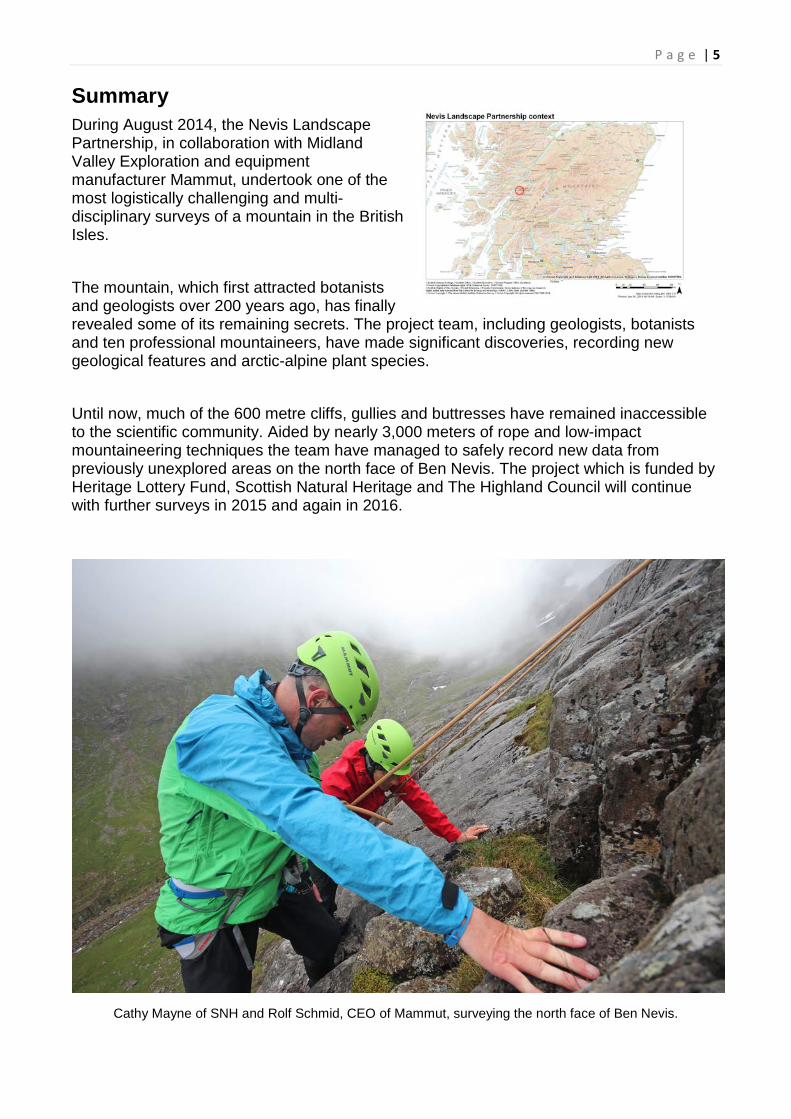
Summary During August 2014, the Nevis Landscape Partnership, in collaboration with Midland Valley Exploration and equipment manufacturer Mammut, undertook one of the most logistically challenging and multi-disciplinary surveys of a mountain in the British Isles. The mountain, which first attracted botanists and geologists over 200 years ago, has finally revealed some of its remaining secrets. The project team, including geologists, botanists and ten professional mountaineers, have made significant discoveries, recording new geological features and arctic-alpine plant species. Until now, much of the 600 metre cliffs, gullies and buttresses have remained inaccessible to the scientific community. Aided by nearly 3,000 meters of rope and low-impact mountaineering techniques the team have managed to safely record new data from previously unexplored areas on the north face of Ben Nevis. The project which is funded by Heritage Lottery Fund, Scottish Natural Heritage and The Highland Council will continue with further surveys in 2015 and again in 2016.
Cathy Mayne of SNH and Rolf Schmid, CEO of Mammut, surveying the north face of Ben Nevis.

P a g e | 6
Ben Nevis SSSI Citation
The Ben Nevis Site of Special Scientific Interest (SSSI) is an extensive upland site centred on a massif which stretches for over 12 kilometres from Ben Nevis, the highest ground in the UK, eastwards to Stob Coire na Ceannain, and has an altitudinal range from 30m OD (above sea level) in Glen Nevis to 1344m OD on the summit of ‘The Ben’. It encompasses rocks and geological features, of which the ‘Ben Nevis Complex’ is of particular significance, relating to the Caledonian mountain building period.
Geologist Jenny Ellis taking readings beside the August snow beds in Coire na Ciste. Photo T.Semple
The range in altitude and geology gives rise to a diversity of habitats including native pine and oak woodlands, montane cliffs, semi-permanent snow beds and upland heaths and grasslands. A wide variety of plants, both vascular and non-vascular are present. The flora and altitudinal range has also affected the fauna of the site, influencing, for example, the range of bird and invertebrate species present. Ben Nevis and the associated peaks of Aonach Mor and Aonach Beag form a massif that has the highest land in the UK and contains the only three peaks greater than 1200m outwith the Cairngorms. The SSSI supports an assemblage of upland habitats which includes the only semi-permanent snow beds outside the Cairngorms, and the most extensive scree snow-beds in the UK.

P a g e | 7
Project Background Ben Nevis provides unique habitats for rare arctic-alpine flora. The importance of this flora is reflected in the Ben Nevis SSSI feature for vascular plants. Some of the key locations that are already known about are at risk from recreational activity but are also potentially threatened by changing climate. While the feature is currently in favourable condition, failure to locate some of the original populations and the fragility of the very few known locations presents a management challenge. Impacts to these isolated populations would lead to the feature falling into unfavourable condition, which would be contrary to the Scottish Government’s targets for designated sites.
Botanists and Geologists working with Professional Mountaineers. Photo T.Semple
Within landscape management decision-making it is often necessary to focus on the micro-pressures which can arise between the demands of conservation and recreation, especially in sensitive and/or isolated ‘hot-spots’. This project undertook to find sustainable solutions to these issues through multi-disciplinary approaches and relationship building combined with new approaches to inspire and educate the wider public.
Project Description Significant areas of the north face of Ben Nevis, which extends to roughly 125Ha of rock and steep scree have now been accessed for the first time by scientists. Due to the sensitivity of the site; its ecological and geological significance; and designations (NSA, SSSI, SAC): no fixed anchors were placed in the rock.

P a g e | 8 Rather than employing heavy duty industrial access techniques (such as placing bolts in the rock) the survey team utilised specially designed climbing equipment which can be placed without damaging the rock. All safety equipment was removed after the survey with no physical or visual impact to the site. Many of the sites being accessed were either damp, ‘flush’ areas or along geological contacts. These locations often coincide with large fractures in the rock and as such are full of loose, wet rock. Climbers usually avoid such places. The team therefore used many of their more usual ‘guiding techniques’ but also had to develop some new approaches, especially with regard to 200 metre abseils.The training week allowed the team of professionally qualified Mountaineering Instructors to work alongside an IFMGA Mountain Guide and the Lochaber Mountain Rescue trainer to develop a wide range of systems incorporating mountain rescue as well as big-wall and alpine climbing techniques. The team of mountaineers also brought an extensive and detailed knowledge of the mountain to the scientific survey. Thousands of days guiding clients on the north face of Ben Nevis gave the geologists and botanists insight into the mountain’s topography as well taking them safely to previously unrecorded areas.
The Training Week Besides being incredibly constructive and informative the training week also uncovered the first ever Alpine Saxifrage on Ben Nevis as well as a range of other important finds. The training week followed a flexible structure with the syllabus reviewed and updated at the end of each day. Presentations, practical sessions and workshops facilitated knowledge exchange and the development of appropriate survey techniques. This week was integral to the success of the survey and to the multi-disciplinary and collaborative nature of the project. The training was very much a two-way process with everyone involved in pooling their collective knowledge and professional experience. Core areas covered included:
• survey techniques and data collection;
• GPS, checks and calibration with maps and altimeter;
• geological processes, rock types, features and structures;
• montane habitats and indicator species;
• identification of arctic-alpine species;
• safety equipment and access logistics;
• radios and communications;
• rope systems and rigging;
• FieldMove Clino App;

P a g e | 9 Day 1: Morning work with Lochaber MRT Training officer (also IRATA Lvl 3) in the Mountain Rescue Training facility. Workshop on use of long rope lowers and abseils on major cliffs on N face of Ben Nevis from his experience of both IRATA work and rescue work on the Ben. Practise of systems and use of specialist equipment. Afternoon Session included: Introduction to geology of Ben Nevis; workshop on identification of geological features and rock types and use of specialist data-capture App to create digital map of Ben Nevis. This included training on quality checks when recording data such as GPS accuracy, cross referencing with OS maps and how to record features of importance to geologists. This session also included use of digital photography with the GPS to locate plant species. This was followed by an introduction to the history of botanical recording on Ben Nevis and the particular flora with specific focus on those rare and scarce species identified in the SSSI Citation. Introduction to botanical recording, existing records, botanical significance of Red Data List species and criteria for defining rare and scarce species. This session also covered the more general montane range of habitats and their indicator species. Day 2 : A full day in the field with 2 specialist mountain botanists on Ben Nevis identifying common and rare flora and indicator species (species indicative of particular soil types worthy of further investigation for rare plants). A great deal of input on particular flora and their habitat, how this ties in with geology of area. International Mountain Leader level of further training or higher. Practice using data capture app to record key information critical to botanical survey.

P a g e | 10 Day 3: Full day investigating key areas and known populations on Ben Nevis. Input from IGMGA Guide on mountaineering ropework to protect party in rough untracked mountaineering terrain. Further training in botanical identification, surveying areas with previously known rare plants under supervision of botanists. Refining techniques, including sweep versus deep, measuring population size and coverage, the importance of scale, underlying rock type, angle of terrain, stability of soil, size of scree. Further training on the specific methodology for identification, recording and quality checks . Day 4: Full day on Ben Nevis working around Carn Dearg Buttress. Use of specialist equipment and big wall/IRATA/MRT techniques as whole team to look at using long line (200m) abseils with independent back up rope to access and survey full height of major cliff on Ben Nevis. Assisting/instructing the botanical and geological experts in use of specialist equipment to access areas on the abseil line. Rigging fixed ropes as hand-lines for safe access and egress from abseil station and instructing in appropriate use of shunts and transfer across anchors. It is anticipated that the training week will be endorsed by the Association of Mountaineering Instructors as accredited CPD. It is hoped that Ben Nevis can be established as a nationally recognised training venue for those involved in conservation work, ecology and botany as well as professional mountain guides and instructors. Those involved during the three years could deliver similar training as CPD in the future. For a detailed breakdown of the Training Week see appendices and the excellent Blog by Mountaineering Instructor Alan Halewood. (http://www.climbwhenyoureready.com/Blog.html)

P a g e | 11
The Survey (Week 2) During the survey week many new areas of the north face were explored and recorded for the first time finding many new colonies of nationally rare and scarce plant species: in particular saxifrages, grasses and mousears. This is in addition to those areas surveyed during the training week – Number 5 Gully, Moonlight Gully Buttress, Ledge Route, Trident Buttresses and Number 4 Gully. Once the 3D map is generated we will be able to measure the size of the area covered, but a safe estimate is that a third of the viable sites across the 125 hectares have now been surveyed. Besides the huge scale of the task and the challenge of multi-disciplinary surveying in extremely difficult terrain, the survey team had to contend with complex logistical challenges and the need to physically carry huge amounts of rope, safety equipment and survey items around the mountain each day. At the end of each day the team had to review any issues, gather data, and develop plans for the following day.
Every morning was equally structured with a 7am meet at the North Face car park, and an 8:30 briefing at the CIC hut. Survey teams were finalised, with key sites identified and access routes determined to manage safety and communications. Each location was allocated specific team members with botanists and geologists allocated as required. The daily logistics were recorded on a rota board at the CIC hut for the communications manager.

P a g e | 12 Communications and radio checks were continued throughout the day with regular updates on team locations and most importantly managing the hazard of rock fall onto either other survey teams or the public. A summit safety officer and a base camp and Comms. officer managed radio communications between teams and monitored public access to the site with a telescope. Before entering terrain with a hazard of rock fall the teams would communicate with the base camp officer and other teams to ensure the public were not exposed to any risk. Signage around the area was also used, as were numerous communications during the preceding weeks to the survey on walkers and climbers forums, blogs and websites.
The survey was conducted with four teams of two mountaineers either working independently or with a geologist/botanist as a rope of three. Those teams working without expert guidance would carry out a sweep survey of technical terrain, noting indicator species and recording any finds on the field App. To ensure accuracy of records, digital photos of species were taken (with GPS data recorded and checked) and then checked with the relevant expert back at the base camp at the end of each day. If an area proved of interest, a geologist or botanist would then be taken back to the key areas. This ensured an efficiency of resources and a balance between macro and micro scale surveying.

P a g e | 13 Day 1: One team surveyed South Castle Gully area with no significant finds – this area was reported as very loose ground and considered too high risk for a return visit. One team went to the broken ground right of No.3 Gully and hunted for botanical finds across to and up North Gully- wanting to compare this ground with No.4 Gully. Another team surveyed the across the base of Carn Dearg Buttress round to Castle Gully Area. The fourth team surveyed Garadh Gully and round the lower sections of Trident South, including the intervening scree slopes.
Day 2: One team surveyed the lower sections of NE Buttress and was joined by Chris Sleight from BBC Radio Scotland Out of Doors (interviews were broadcast on Good Morning Scotland on 15 Aug and Out of Doors on 16 Aug) – they covered the grassy ledges below the traverse to the first platform on the Buttress and then headed round onto the lower flanks of the Brenva face . Other teams surveyed the upper sections of the Brenva face round into Coire Leis. The final team carried equipment to the summit and set up the rigging on The Comb ready for Wednesday. Day 3: The survey was joined by Jim McIntosh of the Botanical Society of Britain and Ireland who went with a survey team to the upper fan of Number 5 Gully where new populations of Highland Saxifrage were recorded. The survey was also joined by the BBC Landward team who carried out interviews and worked with the safety crew and cameraman to film presenter Dougi Vipond and team members abseiling 200 metres down the Tower Face of The Comb. Another team took lead botanist Ian Strachan down the other 200 m abseil, to Asperidies Ledge where significant new populations of rare species were located including the second population of Alpine Saxifrage. The fourth team surveyed across the north face of Castle Ridge, traversing the grassy ledge systems – no significant finds, but it was noted that some of the gullies could be worth closer inspection via top-down abseil.

P a g e | 14 Day 4: One team surveyed Number 3 Gully Buttress and surrounding slopes. Another team surveyed Arch Gully and areas around top of Ledge Route. The rest of the team were engaged in the complex de-rigging of The Comb. Day 5: One team surveyed the area around Raeburn’s Easy Route and upper reaches of Coire na Ciste to the foot of the Cascades – would be worth a revisit with a botanist on a dry day. Another team returned to the Brenva face to locate a geological contact. Number 2 Gully was surveyed with finds recorded, Lower section of Green Gully surveyed with finds recorded. The top section of Castle Gully North was surveyed – lots of saxifrage and good indicator species – needs to be revisited with a botanist. Central Gully upto Jubilation/Jubilee surveyed and recorded as not worth revisiting. South Trident to Pinnacle Ridge surveyed and recorded as not worth revisiting. Teams also assisted in de-rigging. The findings from year one of survey will be mapped onto an interactive 3 dimensional model of Ben Nevis. This will allow different topographical and geological layers to be overlaid on the mountain whilst also allowing users to pinpoint the exact locations of finds. The data recorded so far will give a clearer geological picture of the mountain. This evidence may well challenge the accepted model of the Ben's formation. The well known caldera collapse theory does not fit with some of the data recorded at contact points between rock types and orientation of lava flows. Along with a better understanding today of how caldera's form the 'old' model may need revision and It will be interesting to hear the geologists conclusions.
Preliminary Botanical Report Ian Strachan and Gordon Rothero, 27 August 2014
Introduction This is a preliminary report of the botanical findings from the first phase of the Nevis Landscape Partnership North Face Survey (4-15 August 2014). A comprehensive report with full details of records and distribution maps will be submitted when further data analysis has been completed by geologists of Midland Valley Exploration. The survey went very well despite the weather and late snow-lie conditions, and certainly exceeded our expectations. This was a result of excellent organisation and project management, and the professional skill and enthusiasm of the climbers.

P a g e | 15 Botanical training for the climbers was carried out by IS and GR, with laminated ID cards for the key species prepared by Cathy Mayne of SNH, who also assisted with fieldwork for much of the period. IS took part in the survey for the whole period, GR for the first week only, and Jim McIntosh, Scottish Officer for the Botanical Society of Britain and Ireland, joined us for a day in the second week. The focus of recording was on the Nationally Rare (NR) and Nationally Scarce (NS) species already known from Ben Nevis, which form part of the Ben Nevis SSSI vascular plant assemblage feature (Table 1). Other likely or possible NR/NS species were also searched for. A number of other notable species such as Alpine Saw-wort Saussurea alpina and Moss Campion Silene acaulis were also recorded, as ‘indicator species’ for good habitat. Patches of the distinctive moss Pohlia wahlenbergii were also noted, as they can provide good habitat for Highland Saxifrage. Other NR/NS bryophytes were recorded by GR. Most records were made on iPhones using the FieldMove app, which had been adapted by the geologists working with the team to record both geological and botanical information. The app included images of the key species and a list of habitats. Notes were made of e.g. counts or population/habitat extent, also associated photographs were taken and labelled. Climbing teams surveying without an expert botanist took photographs to confirm plant identifications. Visits were made to many parts of the North Face that had not, as far as we know, been previously explored botanically. These included crags, ledges, scree slopes and gullies, from Coire Leis to Castle Ridge.

P a g e | 16
Findings The findings for NR and NS vascular plant species are summarised in Table 1. Many new locations were recorded, also counts were made for several known populations which had not been adequately or recently counted because of access difficulties. Particular highlights include:
• New locations in total for three NR and eight NS species.
• Two new populations of Wavy Meadow-grass (NR), previously known from only one location in the SSSI.
• Two new locations for Tufted Saxifrage (NR), previously known at only two locations in the SSSI.
• Two new locations for Alpine Saxifrage, previously unknown from the North Face.
• Large new populations for several species including Highland Saxifrage (NR), Alpine Meadow-grass, Alpine Speedwell and Russet Sedge.
Future plans Although excellent progress has been made, there remain plenty of locations for survey in 2015-16. For example Observatory Gully and associated gullies and faces to the east of Tower Ridge, where there was much late snow in 2014, also Tower Ridge itself. Using the 3-D model developed by the geologists we will review coverage in 2014 and make detailed plans for subsequent years. Could we find a second location for Drooping Saxifrage or for Hare’s-foot Sedge, or even find another new species for the Ben? We will also need to review the data and consider what improvements are needed for next year in terms of recording protocols. One area for consideration is the use of photography, since it is apparent that the quality of close-up images obtained with the iPhones, particularly in poor weather, was not always adequate for identification purposes. It would also be useful to record GPS tracks for each group on each day to gain a better idea of coverage.

P a g e | 17 Table 1. Nationally Rare (bold) and Nationally Scarce vascular plant species recorded from Ben Nevis North Face, August 2014. * species not recorded previously from North Face
Species name Common name August 2014 findings
Athyrium distentifolium Alpine
Lady-fern
Found at several new locations.
Carex lachenalii Hare’s-foot Sedge
Known site at base of Trident Buttress counted and wider area explored.
Carex saxatilis Russet Sedge Several new and large populations found e.g. North-east Buttress, Observatory Gully, Carn Dearg Buttress.
Cerastium nigrescens Arctic
Mouse-ear
Small stands found at several new locations e.g. No 5 Gully, Little Brenva Face, Hesperides ledge/Comb Buttress.
Cerastium cerastoides Starwort Mouse-ear
Found at several new locations e.g No 5 Gully, Comb Gully Buttress.
Poa alpina Alpine
Meadow-grass
Found at several new locations including exceptional population (000’s) in upper part of No 5 Gully – possibly largest population in UK?
Poa flexuosa Wavy
Meadow-grass
2 significant new populations found, one ca 100m below existing stand in Observatory Gully, another ca 1 km away at top of gully on Trident Buttress (new UK altitudinal record).
Saxifraga cernua Drooping Saxifrage
Count made of known population at top of No 4 Gully (not counted since 2002)
Saxifraga cespitosa Tufted Saxifrage
Count made of known population at top of No 4 Gully (not counted since 2002), also 2 new locations found, including 11 plants on ledges in Comb Gully/ Buttress, and a single plant in No 2 Gully.
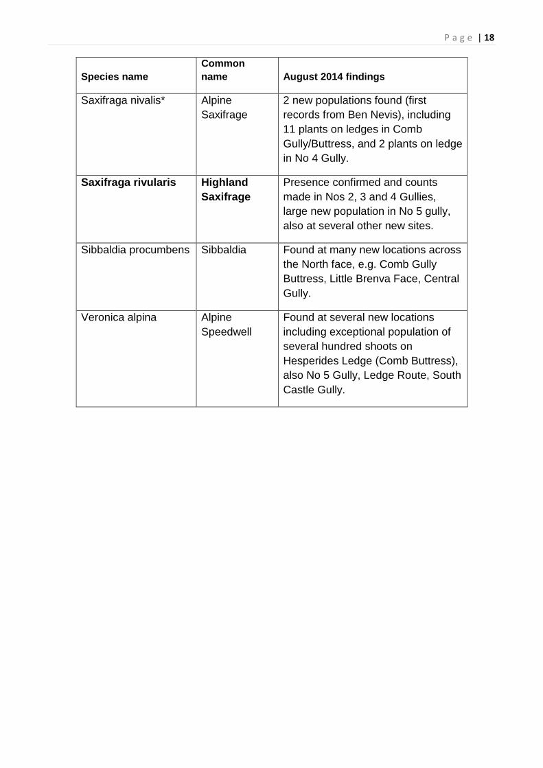
P a g e | 18
Species name Common name August 2014 findings
Saxifraga nivalis* Alpine Saxifrage
2 new populations found (first records from Ben Nevis), including 11 plants on ledges in Comb Gully/Buttress, and 2 plants on ledge in No 4 Gully.
Saxifraga rivularis Highland Saxifrage
Presence confirmed and counts made in Nos 2, 3 and 4 Gullies, large new population in No 5 gully, also at several other new sites.
Sibbaldia procumbens Sibbaldia Found at many new locations across the North face, e.g. Comb Gully Buttress, Little Brenva Face, Central Gully.
Veronica alpina Alpine Speedwell
Found at several new locations including exceptional population of several hundred shoots on Hesperides Ledge (Comb Buttress), also No 5 Gully, Ledge Route, South Castle Gully.

P a g e | 19
Preliminary Geology Report Dr Roddy Muir – Managing Director of Midland Valley Jenny Ellis – Senior Geologist at Midland Valley
Geology Summary August 2014 For the past year Midland Valley have been using the North Face of Ben Nevis and various sites around Glencoe as a testing ground for our digital mapping app for geologists, FieldMove Clino: http://www.mve.com/software/fieldmoveclino The North Face of the Ben contains a variety of easily identifiable rock types and structures on well-exposed steep ground. The FieldMove Clino app uses the internal sensors in your smartphone (a magnetometer, gyroscope and accelerometer) to determine the orientation of planar and linear features in the rocks. Measurements taken on the phone are displayed on a basemap and the location is determined using the internal GPS in the device. It is important for us to test the accuracy of the measured data and the GPS location when we have with limited or no network connectivity. The North Face of Ben Nevis is therefore an ideal testing site. During the testing phase of the app, it quickly became apparent that the distribution of rock types originally mapped by the geological survey was incorrect. Ben Nevis and Glencoe are widely quoted in the published literature as classic examples of cauldron subsidence where a central volcanic complex has collapsed on a circular ring fault into the underlying magma chamber. We have observed that many of the distinctive features associated with cauldron subsidence are not present in the Ben Nevis area, and different models for the generation of the volcanic and plutonic rocks should therefore be considered. We have already begun the task of mapping out the distribution of the various different rock types in the Allt a Mhuillin and on the North Face. However, the only way that we can access the steep cliffs is with assistance from the climbing community. Our primary objectives during the geological survey are to:
• Use the FieldMove Clino app to map out the distribution of the different rock types on the North Face;
• To collect data on the spatial orientation of geological contacts, faults and joints/fractures for characterising fracture networks in igneous rock suites;
• To better understand how the Ben Nevis area has evolved through geological time; • To construct a 3d model of the Ben Nevis area in our Move software that can be
shared with the wider community for teaching, research and public awareness.

P a g e | 20 Week 1 - Training Monday 4th August Overview of Midland Valley’s technology, Move and FieldMove Clino for model building and data collection. Tuesday 5th August Introduction for the climbers and botanists to the FieldMove Clino app and demonstration of how the technology could be used to capture important information on the alpine plant species and the geological features on the North Face.
Climbers using the FieldMove Clino app to measure the orientation of geological features during the training session. Thursday 7th of August Geological data was collected during the ascent of Ledge route, at various locations near the top of No.4 Gully and then during the descent (on foot) of No.4 Gully. Good joint measurements were recorded and contacts between rhoylite and breccia units were traversed on the ascent of Ledge route. Additionally, observation were made on the fine-grained sedimentary rocks on Ledge route. A contact between rhoylite and andesite is present in No. 4. Gully. Friday 8th of August Geological data was collected from the lower part of No. 5. Gully and then during a long abseil (200m) down the north face of Carn Dearg Buttress. A contact between breccia and rhoylite was observed at the base of the abseil.

P a g e | 21 Week 2 - Survey Tuesday 12th August Geological data was collected from the NE Buttress and the lower slopes of the Brenva Face – seriously wet! Wednesday 13th August Geological data was collected during the ascent of Ledge Route and down a long abseil into Comb Gully. Very good joint measurements. Data was then collected during an ascent of Gully No. 3. (very good exposure of fault rock) and then a long abseil down the front face of the Comb. The contact between volcanic breccia (with clasts of rhyolite lava) and the overlying andesite can be found on the front face of the Comb.
Ascending No.3 Gully Fault Zone in No.3 Gully
Good joint sets on the north face of the Comb Thursday 14th August Rapid ascent of Ledge Route. Lowered down steep face to the west of Ledge Route. Good joint measurements and laminar flow in the andesitic lavas (also aligned feldspar crystals). Collected geological data across to the top of Arch Gully. Long abseil down the front face of Gully No. 3. Buttress.
P a g e | 22
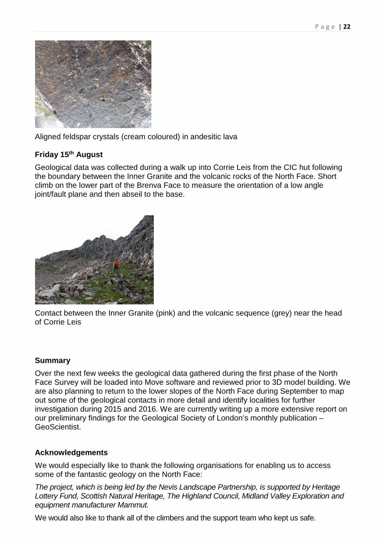
Aligned feldspar crystals (cream coloured) in andesitic lava Friday 15th August Geological data was collected during a walk up into Corrie Leis from the CIC hut following the boundary between the Inner Granite and the volcanic rocks of the North Face. Short climb on the lower part of the Brenva Face to measure the orientation of a low angle joint/fault plane and then abseil to the base.
Contact between the Inner Granite (pink) and the volcanic sequence (grey) near the head of Corrie Leis Summary Over the next few weeks the geological data gathered during the first phase of the North Face Survey will be loaded into Move software and reviewed prior to 3D model building. We are also planning to return to the lower slopes of the North Face during September to map out some of the geological contacts in more detail and identify localities for further investigation during 2015 and 2016. We are currently writing up a more extensive report on our preliminary findings for the Geological Society of London’s monthly publication – GeoScientist. Acknowledgements We would especially like to thank the following organisations for enabling us to access some of the fantastic geology on the North Face: The project, which is being led by the Nevis Landscape Partnership, is supported by Heritage Lottery Fund, Scottish Natural Heritage, The Highland Council, Midland Valley Exploration and equipment manufacturer Mammut.
We would also like to thank all of the climbers and the support team who kept us safe.

P a g e | 23
Outputs & Outcomes The passion and knowledge of professional mountaineers, geologists and botanists has been shared and pooled with tangible and positive outcomes.
• Previously unrecorded parts of the Ben Nevis SSSI/SAC have now been recorded
• New data (botanical and geological) including many new populations and species have been recorded. This will inform future management plans.
• Professional mountaineers (total of 8 local guides with their own outdoor companies) working with conservation experts and now trained in field identification of arctic-alpine plants.
• Climbers acting as Landscape Champions. Following on from the survey, the climbers who have taken part in the training and survey will act as landscape champions, building on their new knowledge and giving them a novel and fascinating slant to their professional guiding and instructing activities. This increased knowledge of ecology and geology, will assist in minimising recreational impacts and increasing wider stewardship of the mountain environment by cascading down to the mountain instructors’ daily clients as well as increasing their reputation and professional standing.
• Raising public awareness of natural heritage, our mountain environment sand issues such as climate change – The project has gained popular attention in national broadsheets as well as regional and local press. BBC coverage through film and radio programmes has extended this coverage to a much wider audience. BBC Landward alone will reach an estimated 280,000 people. It is difficult to estimate the total audience engagement for the project but, given the circulation of the Times, The Scotsman and various BBC news articles, it likely to have reached an audience of 750,000.
• Interactive 3 Dimensional Digital Map of the North Face with geological and botanical data will be uploaded to the Nevis Website
• Film - Footage for a documentary of the survey has been recorded throughout the 2 week period. Dramatic shots of the north face, including time lapse footage, the extreme weather conditions of hurricane Bertha, the huge abseils and cliff faces are combined with interviews of the team and their discoveries, as well as capturing some of the logistical challenges and human stories behind the survey. The film will be premiered at the Fort William Mountain Festival, where it will inspire and educate an audience of people likely to venture into the hills.
• Education – The film will be uploaded to the website where colleges and schools will be encouraged to access it as the first step into educational projects centred around

P a g e | 24
the interactive 3D map and the rest of the Nevis Heritage Website. Visitors and charity eventers will also be encouraged to access the film as a first step in broadening their awareness of the fragile mountain environment. Local school field trips will also be delivered later in the project.
• Closer links have been forged between the mountaineering community and conservation bodies. MCofS, AMI, BMG, RBGE, SNH, JMT, BSBI have all been directly involved in the project or have endorsed it. Over the next two years the project will strengthen this network.
• Training ID cards developed. These will be built upon for next years survey.
Heritage Conservation The survey has provided a more accurate assessment of the presence and abundance of the rare plants and will therefore lead to a more focused approach to management and a greater likelihood of securing their survival. The previously identified need for an action plan, based on the few samples and their threats, looks now to be premature, especially if more locations are found in the next two years. This could well lead to less or no need for management action. The installation of ropes to facilitate access to the cliffs has been carried out with removable anchors, such that no damage will be visible after their removal. The survey team have taken appropriate appropriate measures (such as making the decision to not use number 4 gully as a descent route) to leave those areas that they access untrampled and undamaged. No samples were taken by the Survey team.
Beneficiaries There is no direct benefit to any landowner (Rio Tinto Alcan or John Muir Trust) from the survey. All of the benefit accrues directly to biodiversity and the public in terms of information and data, or indirectly through greater awareness and understanding via our landscape champions and securing the feature in favourable condition for the benefit of the Scottish people. SNH will benefit directly with additional data for a fuller assessment of the Ben Nevis SSSI feature “vascular plants”. Data will be kept by SNH and will also be passed to the HBRC and the BSBI.

P a g e | 25 The new Landscape Champions will have new skills and interests to share with their clients and fellow climbers, enhancing their professional reputation and raising their awareness of conservation issues. This should lead to better practices with regard to conserving the environment. Observers from the Mountaineering Council of Scotland, the British Mountain Guides Association, the Association of Mountaineering Instructors and the Mountain Leader Training Boards will develop an awareness of ecological fragility and conservation needs; this should enhance the environmental elements of the National Governing Body awards in mountaineering and climbing. The public will learn about the natural heritage of Ben Nevis via dedicated film, television programmes (BBC Landward), radio programmes (BBC Out of Doors), social media, the website, and articles in broadsheets and regional/local press. The film element will be able to disseminate the key messages about the importance of this landscape for supporting rare flora, its fragility and sensitivity to change. The academic/geological community will benefit from new data and new structural modelling. Schools and colleges will benefit from free access to the interactive 3D digital map of the North Face and educational material on the website. Access & Safety Access and safety report, 17/08/2014, Mike Pescod, Abacus Mountain Guides: Access and safety were managed successfully during the four training days and the five days of the survey itself. There were two injuries requiring medical attention which were unfortunate but also well within the normal scope of mountaineering. Given the scale of the project, the challenging ground that was encountered and the weather presented to us by ex-hurricane Bertha this should be seen as a reasonable result. After finishing the big abseil on the last day of the training, Scott Kirkhope stumbled while walking back to the CIC Hut. He put out his hand as he fell over and managed to dislocate his finger. He walked to the vehicles and was driven to Belford Hospital where the finger was reduced and strapped to the next finger. Scott continued to work the full five days of the survey with little or no problem caused by his finger. The second injury was to Donald King who sprained his ankle while walking to the vehicles on the last day of the survey carrying a large pack. He continued walking out and did not mention the injury until down in the North Face Car Park. After a trip to Belford Hospital and an x-ray it was decided there was no bone fracture. He used crutches for one day and will seek physiotherapy to aid his recovery. This was a repeat of a preexisting injury.

P a g e | 26 These two injuries serve as a good reminder that most mountaineering accidents occur in descent after the difficult part of the activity has been completed. Despite warnings and reminders of this well understood fact, even very experienced mountaineers are prone to simple trips and slips on easy ground.
The more challenging areas accessed during the survey were reached with secure and robust systems. Since the techniques used were a combination of mountaineering, mountain rescue and IRATA, the training week was a valuable opportunity to practice and assess different approaches. General approaches were agreed and preferred options for different types of ground were discussed. The input from Robert Skinner was very well received.
General approaches decided on and used during the survey included –
• Double ropes used for steep areas with loose rock.
• Top down approach to fix ropes and for access once ropes were in place.
• Dip in, dip out technique of lowering and hauling for surveying the top section of crags and gullies was quick and effective.
• Setting fixed lines with re-belays was most useful when lines were accessed by several experts and used several times. This also gave the best security for all involved.
• Alpine movement over moderate terrain was very effective and time efficient.
• Communication is a key aspect of this work.
The training days were also very useful to work with the experts. They allowed us to coach some core skills in Alpine movement and on big abseils and fixed hand lines. In so doing we assessed the experts' competence and confidence in these skills in order to guide us in choosing the best technique for accessing different areas. We were very impressed with the experts' abilities and fitness throughout the project. The experts continued to develop their skills during the survey and this can be taken in to account for the next survey. If different experts are used we will need to start this process again.

P a g e | 27 Communication is a key aspect of the project. Having someone at or near the CIC Hut and someone else on the plateau was extremely valuable. This should be seen as a paid role as it was this year, not one for volunteers. Many recreational climbers were in the area of the survey and it was important to monitor this. On the plateau there were fewer people due to the weather. However on the last day with the best weather a cairn on the Pony Track was used as an anchor with a rope reaching from there to Number Two Gully. It is obvious that this must be monitored properly. Having another person available on the plateau is very useful for many other reasons including carrying equipment, maintaining radio communications and leading experts and media to different locations.
The morning meeting was essential to coordinate teams, make everyone aware of each other's locations of work and to spread the work load. It also gave an opportunity to share knowledge of best techniques, access routes and survey results.
There were some issues with the VHF radios. This was due to the charge indicator not functioning well. The radios should be charged every other day as a minimum and everyone should have a radio including experts. The charging capacity available at the CIC Hut was limited but ensuring that radios are fully charged is a priority.
There were many occasions of rock fall. This was sometimes caused purposefully, sometimes accidentally and sometimes naturally. In all occasions it was well managed and nobody was caught in rock fall primarily due to good radio communications and awareness of other teams. Dave Bucket was close to a falling rock when he stripped the fixed line from Comb Gully. He was taking out re-belays as he abseiled the line. The rope has the potential to move across the face and it was this that caused the rock to fall near him. This risk was noted and assessed in advance.
Setting double ropes in a fixed line is difficult work and time consuming. For a line of 200m plus it takes one day to fix the line, one day to work on it and one day strip the line. However it is the most secure method of access to steep terrain. This technique can be made more efficient in future.
If the line is set down an area where Alpine techniques can be used away and back to the line, a greater area can be covered, so the investment in time is more productive.

P a g e | 28 Once experts' skills and knowledge are sufficiently high, we will feel comfortable with them descending the line as it is being fixed in place. Proficient use of jumars to ascent ropes is required for this.
Equally, if a line can be stripped by removing re-belays on abseil, an expert can descend the line with the line being stripped after them. The elevated risk of rock fall will probably make this a rarely used option however.
Once guides' surveying skills are sufficient, the need to have an expert abseil a line will be reduced.
Each of these improvements to using fixed lines will reduce a three day process to a two day process with little loss in security. However, if there is appropriate ground and appropriate experience and knowledge of mountaineering skills, areas might be accessed by standard light weight mountaineering techniques. This would involve Alpine movement and abseiling on dynamic ropes, retrieving the ropes after each abseil and surveying while abseiling. Clearly this is a much more committing approach but one that will allow an area to be surveyed in one day.
Alpine movement is even more time efficient and given dry conditions and good visibility this technique will offer the most effective approach. These conditions were notably absent this year!
Recommendations for next year:
• Include at least one training day. This should be paid and will include carrying equipment to the CIC Hut, botany and geology refreshers as well as further coaching for the experts.
• Once guides' surveying skills are higher and experts' mountaineering skills are higher, more mountaineering techniques can be utilised which will allow for quicker surveying. Also if the survey feels more like a mountaineering exercise the links between conservationists and climbers will strengthen.
• Using the same experts and guides will make this much easier.
• Keep the number of surveyors the same. There is much security in having other guides close by. Also, the work load is quite demanding but it can be managed better by rotating guides through different jobs.
• Ensure that media teams have their own guides and that they are aware of what they can achieve so as not to disrupt the survey too much. This was done well this year.
• We should continue not to be prescriptive with techniques and their detail. Mountaineering will continue to demand a flexible approach and the most valuable

P a g e | 29
skill is that of making good judgments in advance and on the spot. The team of guides showed they are able to make good judgments throughout this survey and the feedback from the experts demonstrated this.
• In summary, the guides operated with enthusiasm, energy and intuition. Their combined experience is what led to the success of the survey along with the very impressive knowledge of the experts. The experience of this survey, of its operation and of working with the experts, is now stored within each of the guides. Going in to the next survey, this specific experience is what will ensure the next survey is even more successful than this one
Project Team
Project Manager
Tristan Semple
Nevis Landscape Partnership
Digital Mapping & Geology
Roddy Muir & Jenny Ellis
Project Botanists
Ian Strachan
Gordon Rothero
PR & Media
BBC production teams
NLP staff and member organisations
Survey Safety Manager
Mike Pescod
Abacus Mountain Guides
PROFESSIONAL MOUNTAINEERING
INSTRUCTORS & GUIDES
Project Advisor
Cathy Mayne
SNH
Film producer/camera
Dave MacLeod
Rare Breed Productions
Commercial Sponsor
Rob Sykes
Mammut

P a g e | 30
Appendices The ID cards below are just a sample of those developed for the survey by Cathy Mayne, SNH:
Alpine or polar foxtail (Alopecurus borealis)
This distinctive grass has purplish or grey-green flowering heads in a tight cylindrical shape, 1.5 – 3 cm long. Leaf blades are flat and hairless. Beside streams and in flushes, on mud and rocks in the stream or on wet mossy and grassy slopes, often associated with late-lying snow.
Alpine Cat’s-tail (Phleum alpinum) Erect or ascending shoots from a curved base, this grass possesses a distinctive flowerhead, with a dense panicle (cluster) of individual spikelets 10-30 (50) long and 8,5-12mm wide. This panicle is broadly
cylindrical and does not narrow at the base. Leaves are 2.5-5mm wide, and are flat, without hairs.

P a g e | 31 Alpine saxifrage (Saxifraga nivalis)
Basal rosette of leaves, not dissimilar to starry saxifrage but the pattern of teeth is very distinctive and the leaf shape is more elliptical than oblong. The leaves are also reddish-purple underneath. Flowers all together in a tight cluster at the end of the stem, with the red sepals upright around the 5 white, unspotted petals.

P a g e | 32
Similar species – Arctic mouse-ear. Petals less deeply notched and usually more bent over. Sparsely hairy or with at least some glandular hairs. Most hairs short and straight, yellowish, making the plant appear more green.
Alpine mouse-ear (Cerastium alpinum) Flower Low, mat-forming perennial, grayish-green, hairy. Vegetative stems creeping, flowering stems more upright. Leaves densely matted with long (>1mm), tapering, shaggy, white hairs, especially on underside. Lowest leaves oval or elliptical, upper more pointed. Bracts with white magins. Stems with 1 – 4 large white flowers (18-25mm) with petals usually deeply notched, nearly to base. Sepals half the length of petals. Both arctic and alpine
mouse-ears are quite variable

P a g e | 33
Hare’s-foot sedge (Carex lachenalii) This rather inconspicuous sedge has stems to 20cm, bluntly 3-sided with fine lines or grooves. The leaves are shorter than the stems, 1-2mm broad, flat, dark green. The flower head is 2-4cm, red-brown with 2-5 spikes close together, the uppermost at the apex of a triangle completed by the next 2 spikes below. Wet slopes and ledges, especially in areas of late snow-lie.

P a g e | 34
Planning Day Date: Monday 4th August.
Location: Lochaber Mountain Rescue Base Glen Nevis Business Park, Fort William, Highland PH33 6RX
Arrangements: Lunch and refreshments provided on this day.
Time: Arrive 09:00; Depart 17:00
Attendees
• Project Manager - Tristan Semple, Nevis Landscape Partnership
• Project Administrator - Teresa de Billot, Nevis Landscape Partnership
• Project Advisor -Cathy Mayne, Scottish Natural Heritage
• Film Director – Dave MacLeod, Rare Breed Productions
• Safety & Logistics Manager – Mike Pescod, Abacus Mountain Guides
• Digital Mapping/Geology Team – Jenny Ellis, Midland Valley Exploration
• Survey Botanists – Ian Strachan & Gordon Rothero
Planning Day Agenda
Item Time Detail Lead Person Check List
09:00 Coffee/Tea & informal introductions Tristan Semple & Mike Pescod
1 09:15 Introduction: • Team members • Facilities & Emergency Exits • Format for the 2 Weeks • Agenda for the Day (Handouts) • Discussion/Questions
Tristan Semple & Mike Pescod
2 09:40 - 10:10
Project Details: • NLP programme • Aims, objectives, outputs and
outcomes (Handouts) • Multi-disciplinary teamwork - Year One
Pilot • Discussion/Questions
Tristan Semple & SNH advisor - (Cathy Mayne)

P a g e | 35 3 10:15 -
11.15 Filming
• Introduction & purpose • Outline of general proposal • Discussion of example scenes:
logistics, locations etc. • Collaboration and impromptu
footage- working with the survey team - staging shots etc
• Equipment logistics, access & safety • Specific requirements of film crew • Creative contributions from the wider
team • Specialist subject knowledge - input
to script • Risk Assessment • Discussion/Questions
Dave MacLeod
Refreshment Break - 15 mins 4 11:30 -
12:30 Digital Mapping:
• Multiple purposes of mapping • Introduction to software • Use of smart phones for data
recording (geological and biological) • Outline of basic training content &
format for Climbers & Botanists • Discussion on key locations for
Geological Survey Data • Logistics • Post-survey processing of data and
production • Specific requirements of mapping
team • Discussion/Questions
Jenny Ellis
Lunch - 30 mins 5 13:00 -
14:00 Botanical Recording:
• Introduction to existing records, botanical significance and species
• General approach- sweep versus deep
• Locations and survey approach • Specific methodology for
identification, recording and checking
• Content, materials & format for training Climbers in identification
• Specific requirements of botanists • Discussion/Questions
Ian Strachan & Gordon Rothero
Refreshment Break - 15 mins 6 14:15 -
15:15 Logistics & Safety: Mike Pescod

P a g e | 36
• Access - techniques • Daily procedures: morning
meeting/briefing; ongoing checks; end of day review
• Personal equipment, clothing, food, drink, medication, sunscreen etc
• Use/management of climbing equipment
• Outline of Mountain Access Training days
• Communications, reporting & emergency procedure
• Refreshment Break - 15 mins 7 15:30 Planning Session:
• Agreement on general approach to survey
• Priority locations for Year 1 • Use of different teams
Full Team
8 16:30 Promotion and Public Education: • Website content • Educational material/activities • Special interest articles & Journals • Press release • Acknowledging Funders (Heritage
Lottery Fund, The Highland Council & Scottish Natural Heritage), Sponsors (Mammut) and Partners (Midland Valley Exploration)
Tristan Semple & Teresa de Billot
17:00 Finish
Date
Tuesday 5th August
Location
Lochaber Mountain Rescue Base, Fort William
Time
Arrive 08:45
Depart 17:00
Arrangements
Lunch provided on this day.
Attendees
Surveyors / Mountaineering Instructors
Donald King Alan Halewood Scott Kirkhope David Buckett Dave Anderson Will Rowland
Training Providers
Digital Mapping & Geology
Jenny Ellis, Midland Valley Exploration
Noel Williams. Lochaber Geopark

P a g e | 37
Connor Holdsworth Craig McDonald
Film Director Dave MacLeod, Rare Breed Productions
Project Adviser Cathy Mayne, Scottish Natural Heritage
Project Manager Tristan Semple, Nevis Landscape Partnership
Botanical Identification Ian Strachan
Gordon Rothero
Safety , Access & Logistics
Mike Pescod, Abacus Mountain Guides
Robert Skinner, Mountain Rescue
INDOOR TRAINING ITINERARY Morning Session – Access Techniques
• Mountain Rescue techniques including: long line lowers and hoists from the plateau; communications and use of radios; specific hazards of working on 200+ metre ropes on loose ground; handrails; ascending fixed lines; descending weighted lines; Figure eights for abseiling past knots and use within hoist; Petzl traxion for rescues.
• Big-wall climbing techniques – moving 400 metre lengths of rope around, re-belays, rigging and de-rigging, use of shunts, hoisting
• Strategic Planning – mixed approaches for specific locations, ground-up versus top-down, alpine rope techniques, abseiling with safety lines
3D Mapping
• Introduction to Digital Mapping Software, • Field use and handheld devices • Indoor practice
Afternoon Session - Botanical Identification part 1
• Identifying habitats and likely locations • Likely species in each habitat • The rare/threatened species • Identification terminology
Logistics for Wednesday
• Equipment – depot for morning transit • Transport, Location & Time • Mobile phone numbers

P a g e | 38
TRAINING DAY 2. Date
Wednesday 6th August
Location OUTDOORS:
Meet - North Face car park, Torlundy
Time
Arrive 07:00
Depart 17:00
Arrangements
You will be required to provide your own packed lunch.
Come prepared with outdoor clothing, personal safety equipment, smart phones, plant identification material, medication, etc.
OUTDOOR TRAINING ITINERARY 07:00 - Meet at North Face car park – collect equipment 07:30- 09:00 – Carry-in and Species/Habitat Identification on walk to CIC hut 9:00 Morning meeting 09:30 - 13:00 - Species Identification on scree slopes and lower butresses 13:00 Lunch 13:30 - 15:30 - Identification and recording - use of mapping software 15:30 - 16:00 - Review and feedback 16:00 Depart for car park
OUTLINE ITINARY FROM 7th - 15th August DATE DETAILS Thursday 7th
August
Training Day 3: Meet North Face car park 07:00 – collect equipment/supplies Safety Training
• equipment, scrambling and pitched climbing, communication, emergency procedure
Friday 8th
August
Training Day 4: Meet North Face car park 07:00 – collect equipment/supplies Safety Training
• rope drums, abseiling, double ropes, abseil-stations and accessing ledges.
Monday Pilot

P a g e | 39 11th
August Meet North Face car park 07:00 Putting it all together
• Pilot methodology for access, identification and recording
Tuesday 12th
Survey Day 1: Meet North Face car park 07:00 Data gathery
• Locations and Teams identified - (equipment checked) BBC Out of Doors show (interview and possible abseil)
Wednesday 13th
Survey Day 2: Meet North Face car park 07:00 Data gathery
• Locations and Teams identified - (equipment checked) BBC Landward Filming (interview including climb and abseil)
Thursday 14th
Survey Day 3: Meet North Face car park 07:00 Data gathery
• Locations and Teams identified - (equipment checked)
Friday 15th Survey Day 4: Meet North Face car park 07:00 Data gathery
• Locations and Teams identified - (equipment checked) Filming – Fran (JMT) on site.
Post-Survey
Reports prepared Contributions and feedback from all team members

P a g e | 40
PROJECT TEAM
Title Name Email Project Manager Tristan Semple [email protected]
Project Advisor Cathy Mayne [email protected]
Project Administrator
Teresa de Billot [email protected]
Safety, Access & Logistics Manager
Mike Pescod [email protected]
Project Botanist Ian Strachan [email protected]
Project Botanist Gordon Rothero [email protected]
Geo-mapping Manager
Roddy Muir [email protected]
Geo-mapping Trainer
Jenny Ellis [email protected]
Film Director Dave MacLeod [email protected]
Lead Surveyor Donald King [email protected] Lead Surveyor Alan Halewood [email protected]
Lead Surveyor Scott Kirkhope [email protected]
Assistant Surveyor David Buckett [email protected] Assistant Surveyor Dave Anderson [email protected]
Assistant Surveyor Will Rowland [email protected]
Assistant Surveyor Connor Holdsworth
Summit Safety Officer
Andy Hague [email protected]
Base Camp Officer
Ed Holt [email protected]