m. awad, m. khawlie – ncrs - lebanon j. crimi, c. giupponi, a. sgobbi – feem - italy wasamed...
Post on 20-Dec-2015
217 views
TRANSCRIPT

M. Awad, M. Khawlie – NCRS - LebanonJ. Crimi, C. Giupponi, A. Sgobbi – FEEM - Italy
Wasamed final conferenceValenzano 15 | 02 | 07
Availability and Accuracy of Mediterranean Databases Relevant to Agricultural Water Uses
2
Introduction
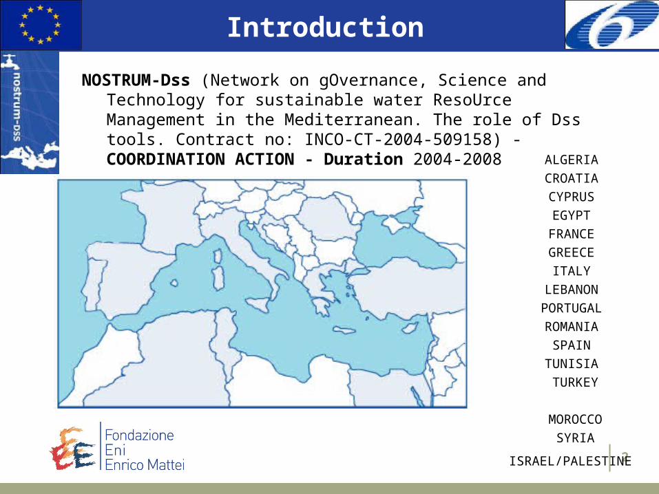
NOSTRUM-Dss (Network on gOvernance, Science and Technology for sustainable water ResoUrce Management in the Mediterranean. The role of Dss tools. Contract no: INCO-CT-2004-509158) - COORDINATION ACTION - Duration 2004-2008
ALGERIA
CROATIA
CYPRUS
EGYPT
FRANCE
GREECE
ITALY
LEBANON
PORTUGAL
ROMANIA
SPAIN
TUNISIA
TURKEY
MOROCCO
SYRIA
ISRAEL/PALESTINE

3
IntroductionGOALS:
1. to establish durable links between scientific institutions, governments, NGOs, SMEs and other stakeholders and improve public awareness on water management;
2. to improve scientific knowledge and applied methodologies in IWRM;
3. to promote the development of suitable Dss tools built upon real needs of policy making in IWRM.
By establishing a network between the science, policy, and civil society spheres,
Fostering active involvement of the relevant stakeholders in the different project’s stages,
Through the development and dissemination of Best Practices Guidelines for the design and implementation of Dss tools for IWRM in the Mediterranean Area.

4
Introduction

5
Introduction
In the framework of Nostrum-dss CA, WP4 was dedicated to: GIS, Remote sensing, and Statistical Information in support of policy making:
Task a) Statistical data issues: to investigate the needed data for meaningful research and informed policy making, as well as existing database and efforts in the socio-economic sector (SUMER).
Task b) Territorial analysis & implementation of GIS systems: to set up a knowledge base about the availability of geographical data (remote sensed information, geophysical databases, monitoring networks, etc.) (NCSR).
Task c) Water and climate change in the Mediterranean: inventory of data and studies on climate change, and climate change modelling and scenario building, in the Mediterranean area. A state of the art review on the topic will be performed, in order to provide policy makers with long term perspective needed for decision making towards sustainability.(MEDIAS FRANCE).
Task d) Data needs assessment for supporting Dss use for IWRM: the final aim is to compile an interactive meta-data analysis based on the data surveys performed in task a), b) and c) (NCSR).

6
Task a and b
SUMER and NCRS carried out a desk survey of relevant information centers and sources in the Mediterranean basin including all information pertinent to the availability of:– Statistical– geographical data (remote sensed information,
geophysical databases, monitoring networks, etc.)
These surveys relied on many sources such as the National reports, Internet, books and journals, as well as MEDIAS contribution…
To investigate the needed data for meaningful research and informed policy making, as well as existing database and efforts in the socio-economic sectorTo set up a knowledge base about the availability of geographical data (remote sensed information, geophysical databases, monitoring networks, etc.)

7
Task c)Water and climate change in the Mediterranean
Data sets : generally “global seasonal forecast categories maps or global climate predictions” (temperatures, rainfall) coming from
– Metoffice, – IRI (International Research Institute for Climate and Society) Columbia University-USA)– ECPC (Experimental Climate Prediction Center) - USA– IPCC (Data Distribution Center (DDC) of the Intergovernmental Panel on Climate
Change (IPCC) -hosted by University of East Anglia (UK)…They include climatic scenarios simulations from
– CERA Database (Climate and Environmental Retrieving and Archiving) Hamburg – Germany ;
– IMAGE 2,2 Implementation of the SRES scenarios (Integrated Model to Asses the Global Environment) - Netherlands Environmental Assessment Agency (MNP) (Netherlands) ;
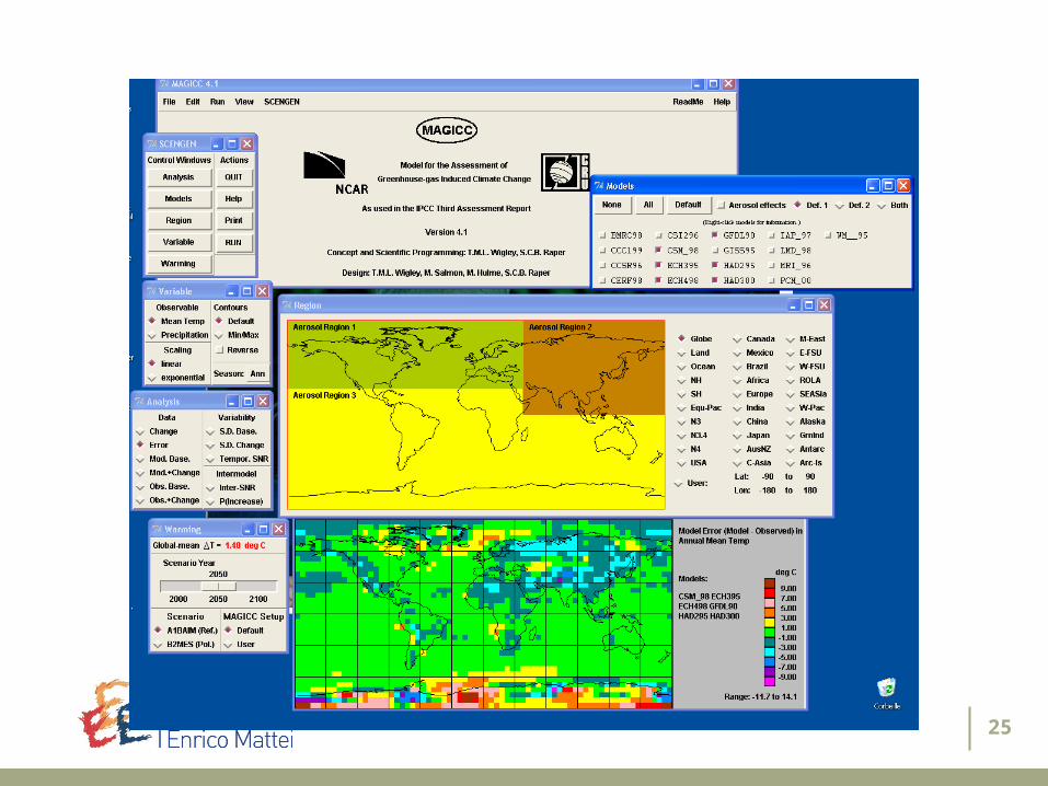
– MAGICC (Model for the Assessment of Greenhouse-gas Induced Climate Change) and SCENGEN (A Regional Climate SCENario GENerator)
– National Center for Atmospheric Research (NCAR) Colorado-USA Projects
– LandWaterMED (Geo-Information for Sustainable Management of Land and Water Resources in the Mediterranean Region)
– MED-CLIVAR (Mediterranean CLImate VARiability and predictability) – MEDEX (Mediterranean Experiment on Cyclones that produce High Impact Weather in
the Mediterranean)… Organizations are the ones linked to
– the data sets like Universities or National Meteorological offices – the described projects like research laboratories or others
To set up a knowledge base about the availability of geographical data (remote sensed information, geophysical databases, monitoring networks, etc.)
8
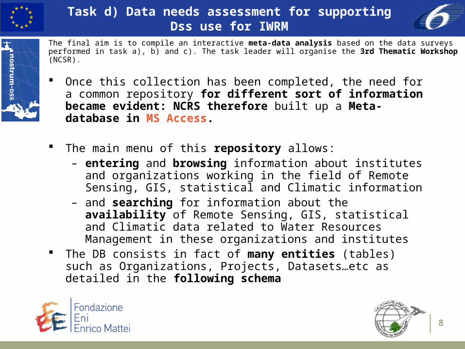
Task d) Data needs assessment for supportingDss use for IWRM
Once this collection has been completed, the need for a common repository for different sort of information became evident: NCRS therefore built up a Meta-database in MS Access.
The main menu of this repository allows:– entering and browsing information about institutes and
organizations working in the field of Remote Sensing, GIS, statistical and Climatic information
– and searching for information about the availability of Remote Sensing, GIS, statistical and Climatic data related to Water Resources Management in these organizations and institutes
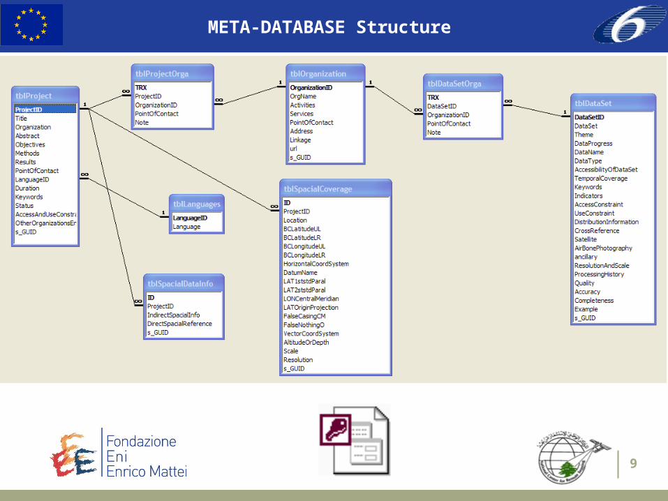
The DB consists in fact of many entities (tables) such as Organizations, Projects, Datasets…etc as detailed in the following schema
The final aim is to compile an interactive meta-data analysis based on the data surveys performed in task a), b) and c). The task leader will organise the 3rd Thematic Workshop (NCSR).
9
META-DATABASE Structure
10
META-DATABASE Interface
To widen the impacts of this survey:
– e.g. to avoid scarce dissemination and to provide policy makers/advisors with an effective tool
– e.g. to facilitate its use
It has been decided to deploy the DB on the WWW…

11
WEB interface
NOSTRUM-Dss is a Co-ordinated Action (CA) funded by the EC; it started in August 2004 and will last 3 years. It addresses the needs for reorientation of science to support policy making and for the adoption of multi-sectoral and multi-disciplinary approaches by analyzing the needs expressed by stakeholders and fostering mediation between policy objectives and scientific knowledge. The goal is to create an enabling environment for a more equitable and efficient water resource management in the Mediterranean Basin trough the development of Best Practice Guidelines. The ultimate aim of NOSTRUM-DSS Co-ordination Action is to contribute to bridge the gaps between science and real life, in order to provide Dss developers with insight into the language and the needs of policy makers (PMs) and stakeholders, and subsequently to provide PMs effective tools based on an integrated approach for problem solving in the context of IWRM.

12
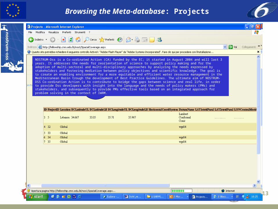
Browsing the Meta-database: Projects
13
Browsing the Meta-database: Projects
NOSTRUM-Dss is a Co-ordinated Action (CA) funded by the EC; it started in August 2004 and will last 3 years. It addresses the needs for reorientation of science to support policy making and for the adoption of multi-sectoral and multi-disciplinary approaches by analyzing the needs expressed by stakeholders and fostering mediation between policy objectives and scientific knowledge. The goal is to create an enabling environment for a more equitable and efficient water resource management in the Mediterranean Basin trough the development of Best Practice Guidelines. The ultimate aim of NOSTRUM-DSS Co-ordination Action is to contribute to bridge the gaps between science and real life, in order to provide Dss developers with insight into the language and the needs of policy makers (PMs) and stakeholders, and subsequently to provide PMs effective tools based on an integrated approach for problem solving in the context of IWRM.
14
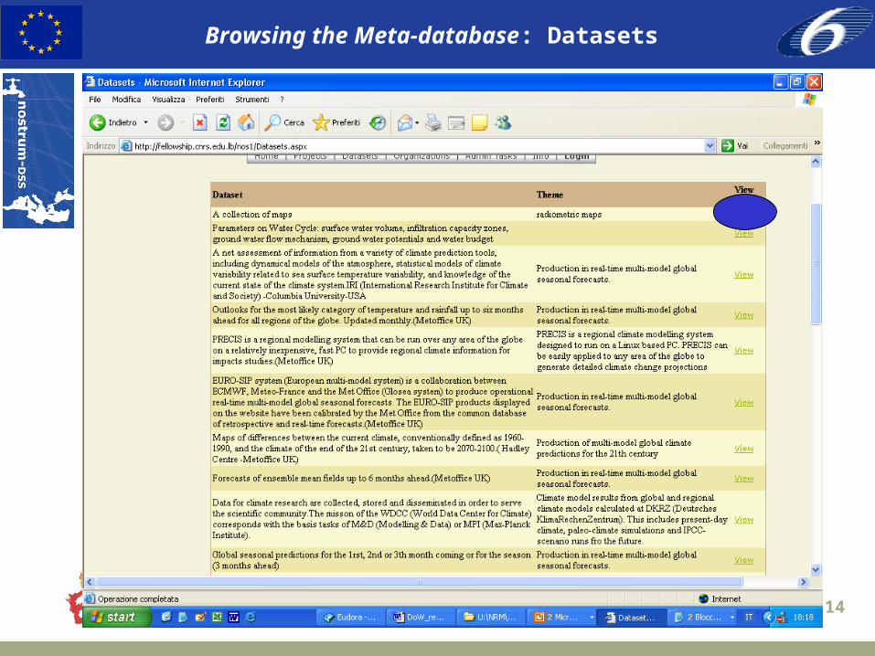
Browsing the Meta-database: Datasets
15
Browsing the Meta-database: Datasets

16
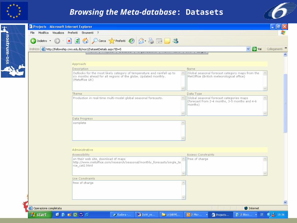
Browsing the Meta-database: Datasets

17
Browsing the Meta-database: Organisations
NOSTRUM-Dss is a Co-ordinated Action (CA) funded by the EC; it started in August 2004 and will last 3 years. It addresses the needs for reorientation of science to support policy making and for the adoption of multi-sectoral and multi-disciplinary approaches by analyzing the needs expressed by stakeholders and fostering mediation between policy objectives and scientific knowledge. The goal is to create an enabling environment for a more equitable and efficient water resource management in the Mediterranean Basin trough the development of Best Practice Guidelines. The ultimate aim of NOSTRUM-DSS Co-ordination Action is to contribute to bridge the gaps between science and real life, in order to provide Dss developers with insight into the language and the needs of policy makers (PMs) and stakeholders, and subsequently to provide PMs effective tools based on an integrated approach for problem solving in the context of IWRM.

18
Browsing the Meta-database: Organisations

19
Browsing the Meta-database: Administrative tasks
Laws and regulations related to basic water use rights and
protectionExisting policies
10 years plan for Additional water resources for drinking water and irrigation
Monitoring water resources operations
How these policies are implemented
NOSTRUM-Dss is a Co-ordinated Action (CA) funded by the EC; it started in August 2004 and will last 3 years. It addresses the needs for reorientation of science to support policy making and for the adoption of multi-sectoral and multi-disciplinary approaches by analyzing the needs expressed by stakeholders and fostering mediation between policy objectives and scientific knowledge. The goal is to create an enabling environment for a more equitable and efficient water resource management in the Mediterranean Basin trough the development of Best Practice Guidelines. The ultimate aim of NOSTRUM-DSS Co-ordination Action is to contribute to bridge the gaps between science and real life, in order to provide Dss developers with insight into the language and the needs of policy makers (PMs) and stakeholders, and subsequently to provide PMs effective tools based on an integrated approach for problem solving in the context of IWRM.

20
Editing the Meta-database: LOGIN
NOSTRUM-Dss is a Co-ordinated Action (CA) funded by the EC; it started in August 2004 and will last 3 years. It addresses the needs for reorientation of science to support policy making and for the adoption of multi-sectoral and multi-disciplinary approaches by analyzing the needs expressed by stakeholders and fostering mediation between policy objectives and scientific knowledge. The goal is to create an enabling environment for a more equitable and efficient water resource management in the Mediterranean Basin trough the development of Best Practice Guidelines. The ultimate aim of NOSTRUM-DSS Co-ordination Action is to contribute to bridge the gaps between science and real life, in order to provide Dss developers with insight into the language and the needs of policy makers (PMs) and stakeholders, and subsequently to provide PMs effective tools based on an integrated approach for problem solving in the context of IWRM.
21
Editing the Meta-database
A serious concern about the information deployed is its updating and maintenance:– Add new information– Correct changed information– …
Many IT tools do now exist (such as Wiki) etc… but they need experienced users
NOSTRUM-DSS decided to use directly the web interface to edit the records…

22
Editing the Meta-database: LOGIN
Add new record

23
CONCLUSIONS
Future improvement Changing from MS-ACCESS to SQL 2000 for better performance Fixing problems of updating A restyling of the home page (logo, description, help) A complex query tool ( searching all entities) A link to other sites and resources A geographical query method will be added A secure access to the site (partners will be given a username and password)
depending on the need for using this site
Next month, the Meta-database will be published on the Nostrum-dss web site:
http://www.nostrum-dss.eu
24
corso Magenta 6320123 Milano - Italy
tel +39 | 02 | 5203.6975fax +39 | 02 | 5203.6946web http://www.feem.it
Thank you!
Lebanese National Center for Remote SensingPO Box 11-8281 Code 1107 2260 - Beirut – Lebanon
tel + 961 | 4 | 409845 fax + 961 | 4 | 409847Web http://www.cnrs.edu.lb/remotesensing.html
25
26
3rd NOSTRUM-DssThematic Workshop
Metadata base – cartographic data
Cartographic data sets : most of them have a global scale (1km) and are free of charge for use constraint :
– World soil Resources from FAO’s (32 classes) ;
– Forest maps (FRA2000) from USGS, FAO, UN, … ;
– Global Land Cover (GLC2000) ;
– Global lakes and wetlands (developed in partnership with WWF) ;
– Satellite images (VEGETATION 10 days synthesis archive) ;
– …
27
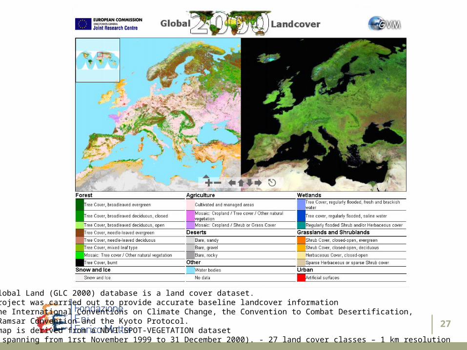
The Global Land (GLC 2000) database is a land cover dataset. The project was carried out to provide accurate baseline landcover information to the International Conventions on Climate Change, the Convention to Combat Desertification, the Ramsar Convention and the Kyoto Protocol.This map is derived from a NDVI-SPOT-VEGETATION dataset (data spanning from 1rst November 1999 to 31 December 2000). - 27 land cover classes – 1 km resolution