m o n i t o r & m a n a ge
TRANSCRIPT

2021 MAINTENANCE DREDGING
PROJECT, DREDGE ENVIRONMENTAL
MANAGEMENT PLAN (DEMP)
Marine fauna observers on board vessel
Aerial surveillance to monitor turbidity
Nearshore placement site hydrographic surveys
Regular monitoring of water quality and light levels
Beach profiles
Seagrass health surveys
Wind, waves, currents
Outlines MWPA environmental performance measures and targets for the successful execution of thedredge program;Informs the dredging contractor’s management plans and procedures;Defines the monitoring methods, frequency, sampling locations and triggers for action;Outlines how the GEMMS dredge plume and sediment fate model will be validated; andDefines MWPA stakeholder and performance reporting requirements.
The Dredge EnvironmentalManagement Plan is designed tomanage the dredge program toprotect and maintain the ecologicalvalues of Champion Bay.
Prepared by
www.midwestports.com.au
Purpose
Importance
OutcomesMONITOR & MANAGE
The DEMP describes the Maintenance Dredge Program and outlines the environmental protection objectives,management measures and targets for the project.For each activity, MWPA has identified the potential environmental impact and set management targets andactions. The project’s environmental performance is monitored and validated through a detail managementand monitoring program. The monitoring program is focused on maintaining water quality and protecting thebenthic communities and habitats within Champion Bay.
Public Input
Input from a public two weekconsultation period held in July 2021,have been incorporated into thisplan.

CLIENT: Midwest Ports Authority
STATUS: Rev 0 REPORT No.: R210027
ISSUE DATE: 19 August 2021
Port of Geraldton Maintenance Dredging Project 2021
Dredging Environmental Management Plan

ii Midwest Ports Authority
Project Subtitle: Geraldton Port Maintenance Dredging 2021
21WAU-0002 / 210027
Important Note
This report and all its components (including images, audio, video, text) is copyright. Apart from fair
dealing for the purposes of private study, research, criticism or review as permitted under the Copyright
Act 1968, no part may be reproduced, copied, transmitted in any form or by any means (electronic,
mechanical or graphic) without the prior written permission of O2 Marine.
This report has been prepared for the sole use of the Mid West Ports Authority (herein, ‘MWPA’), for a
specific site (herein ‘the site’, the specific purpose specified in Section 1 of this report (herein ‘the
purpose’). This report is strictly limited for use by the client, to the purpose and site and may not be
used for any other purposes.
Third parties, excluding regulatory agencies assessing an application in relation to the purpose, may
not rely on this report. O2 Marine waives all liability to any third-party loss, damage, liability or claim
arising out of or incidental to a third-party publishing, using or relying on the facts, content, opinions or
subject matter contained in this report.
O2 Marine waives all responsibility for loss or damage where the accuracy and effectiveness of
information provided by the Client or other third parties was inaccurate or not up to date and was relied
upon, wholly or in part in reporting.
This report contains maps that include data that are copyright to the Commonwealth of Australia
(Geoscience Australia) 2006 & 2009, Microsoft Corporation Earthstar Geographics SIO (2021),
Department of Biodiversity, Conservation and Attractions (2021), Australian Government Department
of Agriculture and Water, the Environment (2020) and Department of Transport (2021) and Esri,
GEBCO, NOAA, National Geographic, DeLorme, HERE, Geonames.org, and other contributors.
Maps are created in WGS 84 - Pseudo-Mercator (EPSG:3857) coordinate reference system and are
not to be used for navigational purposes.
Positional accuracy should be considered as approximate.

iii Midwest Ports Authority
Project Subtitle: Geraldton Port Maintenance Dredging 2021
21WAU-0002 / 210027
WA Marine Pty Ltd t/as O2 Marine ACN 168 014 819
Originating Office – Fremantle
11 Mews Road, FREMANTLE WA 6160
T 1300 739 447 | [email protected]
Version Register
Version Status Author Reviewer Change from
Previous Version
Authorised for Release
(signed and dated)
Rev A Draft R Stevens G Motherwell
Rev B Draft R Stevens K Reynolds
I Le Provost
Internal review
comments addressed
R Stevens 29 June 2021
Rev C Draft R Stevens Public Review Client review
comments incorporated
R Stevens 9 July 2021
Rev 0 Final R Stevens Update for contractor’s
equipment
R Stevens 19 August 2021
Transmission Register
Controlled copies of this document are issued to the persons/companies listed below. Any copy of this
report held by persons not listed in this register is deemed uncontrolled. Updated versions of this report
if issued will be released to all parties listed below via the email address listed.
Name Email Address
Kylie Reynolds [email protected]
Collen Steamer [email protected]

iv Midwest Ports Authority
Project Subtitle: Geraldton Port Maintenance Dredging 2021
21WAU-0002 / 210027
Acronyms and Abbreviations
Acronyms/Abbreviation Description
ASS Acid Sulfate Soil
ASSMP Acid Sulfate Soil Management Plan
BCH Benthic Communities And Habitat
DEMP Dredge Management and Monitoring Plan
DMPA Dredge Material Placement Area
EIA Environmental Impact Assessment
EPO Environmental Protection Outcomes
HEPA High Ecological Protection Area
LEPA Low Ecological Protection Area
MEPA Moderate Ecological Protection Area
MFO Marine Fauna Observer
MT Management Target
MWPA Mid West Ports Authority
MWQM Marine Water Quality Monitoring
MEQMP Marine Environmental Quality Monitoring Program
NATA National Association of Testing Authorities
PAR Photosynthetic Active Radiation
SPL Species Protection Levels
TRM Tailwater Return Monitoring
TSHD Trailer Suction Hopper Dredge
TSS Total Suspended Solids
ZoHI Zone of High Impact
ZoI Zone of Influence
ZoMI Zone of Moderate Impact

v Midwest Ports Authority
Project Subtitle: Geraldton Port Maintenance Dredging 2021
21WAU-0002 / 210027
Table of Contents
1. Introduction 7
Project Summary 7
Purpose of this Plan 7
Proponent Details 7
Legislation, Regulation and Guidelines 7
Project Description 9
2. Dredging Program 11
Schedule 11
Proposed Operational Elements 11
3. Roles and Responsibilities 20
4. Environmental Factors and Objectives 21
5. Management 26
Benthic Communities and Habitat 27
Marine Environmental Quality 29
Marine Fauna 31
Coastal Processes 33
Introduced Marine Pests 34
Hydrocarbon Management 35
Waste Management 37
6. Monitoring 39
Marine Environmental Quality Monitoring Program (MEQMP) 43
Benthic Communities and Habitat Monitoring 53
Model Validation Monitoring Program 60
7. Reporting 64
8. Reference List 67
Figures
Figure 1-1 Proposed dredging and relocation footprints and associated development envelope 10
Figure 2-1 Example TSHD (image source https://products.damen.com) 12
Figure 2-2 Example TSHD drag head (image source https://products.damen.com) 12
Figure 2-3 Bund wall cross section 14
Figure 2-4 August 2019 survey of the existing Northern Reclamation DMPA 16
Figure 2-5 Inner Harbour sediment height above design depth 17
Figure 2-6 Entrance Channel sediments above design depth 18
Figure 4-1 Proposed levels of ecological protection for the Port of Geraldton and surrounding water 24
Figure 4-2 Predicted Seagrass impact zones from smothering and light reduction 25
Figure 6-1 Tiered management response for tailwater return monitoring. 46

vi Midwest Ports Authority
Project Subtitle: Geraldton Port Maintenance Dredging 2021
21WAU-0002 / 210027
Figure 6-2 Proposed Water quality monitoring locations 51
Figure 6-3 Tiered management response for marine water quality monitoring 52
Figure 6-4 Proposed post-dredge seagrass survey locations 55
Figure 6-5 Proposed post-dredge BCH survey locations. 57
Tables
Table 1-1 Proponent Details 7
Table 1-2 Summary of the Proposal 9
Table 1-3 Location and proposed extent of operational elements 9
Table 3-1 Roles and responsibilities of key personnel 20
Table 4-1 Key environmental factors, potential environmental impact pathways and management outcomes 21
Table 5-1 Management actions to minimise impacts on Benthic Communities and Habitats 27
Table 5-2 Management actions to minimise impacts on Marine Environmental Quality 29
Table 5-3 Management actions to minimise impacts on marine fauna. 31
Table 5-4 Management actions to minimise the risk to Coastal Processes. 33
Table 5-5 Management actions to minimise the risk of introduced marine pests 34
Table 5-6 Management actions to minimise the risk of hydrocarbon pollution 35
Table 5-7 Management actions to manage waste 37
Table 6-1 Monitoring Program Overview 40
Table 6-2 Impact management targets for tailwater return water monitoring. 44
Table 6-3 Marine Water Quality Sample Location Coordinates (GDA94 MGA50) 47
Table 6-4 Impact management targets for marine water quality monitoring 48
Table 6-5 Seagrass sampling location coordinates (GDA94 MGA50) 54
Table 6-6 BCH sampling location coordinates (GDA94 MGA50) 56
Table 6-7 Impact management targets for BCH monitoring programs 58
Table 6-8 Impact management targets for model validation 61
Table 7-1 Project reporting requirements 64
Table 7-2 Reporting requirements for environmental monitoring programs to determine if MTs are met 65
Table 7-3 External reporting requirements 66
Appendices
Appendix A Existing Environment A

7 Midwest Ports Authority
Project Subtitle: Geraldton Port Maintenance Dredging 2021
21WAU-0002 / 210027
1. Introduction
Project Summary
The Mid West Ports Authority (MWPA) is proposing to undertake maintenance dredging within the inner
harbour and navigation channel using a trailing suction hopper dredge at the Port of Geraldton, Western
Australia. The Project will require dredging of approximately 235,000 m3 of dredging material with
disposal of approximately 45,000 m3 of inner harbour dredge material into the Northern Reclamation
Dredge Material Placement Area (DMPA) and approximately 190,000 m3 of accumulated sediment in
the entrance channel being relocated to a designated Nearshore DMPA.
Purpose of this Plan
The purpose of this Dredging Environmental Management Plan (DEMP) is to outline the Environmental
Protection Outcomes (EPOs) and Management Targets (MTs) associated with the dredging and dredge
material disposal to be undertaken for the maintenance dredging project. Detailed management and
monitoring actions are included to ensure that the project EPOs are achieved.
Proponent Details
The proponent for the project is the Midwest Ports Authority (MWPA). Proponent details are provided
in Table 1-1.
Table 1-1 Proponent Details
Entity Name: Midwest Ports Authority
Australian Business Number (ABN): 73 384 989 178
Address: 298 Marine Terrace, Geraldton Western Australia 6530
Key Contact (Role): Damian Tully – A/CEO
Key Contact Email: [email protected]
Legislation, Regulation and Guidelines
1.4.1. Commonwealth Environment Protection and Biodiversity Conservation Act
1999
The Environmental Protection and Biodiversity Conservation Act (1999) (EPBC Act) establishes a
process for the assessment and approval of proposed actions that are likely to have a significant impact
on matters of national environmental significance or on Commonwealth land.

8 Midwest Ports Authority
Project Subtitle: Geraldton Port Maintenance Dredging 2021
21WAU-0002 / 210027
1.4.2. Other Commonwealth legislation, regulation and guidelines
Other applicable Commonwealth legislation and guidelines include, but are not limited to, the following
Acts, Regulations (and relevant amendments):
Protection of the Seas (Prevention of Pollution from Ships) Act 1983;
Australian Ballast Water Management Requirements Version 7 2017;
Biosecurity Act 2015;
Biosecurity Regulations (2016); and
National Water Quality Management Strategy (Commonwealth Government of Australia
1992).
1.4.3. State legislation, regulation and guidelines
The key Western Australian legislation, regulation and guidelines relevant to dredging at the Port of
Geraldton include:
Biodiversity Conservation Act 2016;
Port Authorities Act 1999;
Navigable Waters Regulations 1958;
Shipping and Pilotage (Port and Harbour) Regulations 1967
Western Australian Marine Act 1982;
Pollution of Waters by Oil and Noxious Substances Act 1987;
Marine and Harbours Act 1981;
Environmental Protection Act 1986;
Environmental Protection Regulations 1987;
Fisheries Resource Management Act 1994 (the State Act addressing Introduced Marine
Pests);
Western Australia Environmental Protection Authority Technical Guidance - Assessment
Guidelines of Marine Dredging Proposals (WA EPA, 2016a);
Western Australia Environmental Protection Authority Technical Guidance - Protecting the
Quality of Western Australia’s Marine Environment (WA EPA, 2016b); and
Western Australia Environmental Protection Authority Technical Guidance – Protection of
Benthic Communities and Habitats (WA EPA, 2016c).

9 Midwest Ports Authority
Project Subtitle: Geraldton Port Maintenance Dredging 2021
21WAU-0002 / 210027
Project Description
Table 1-2 Summary of the Proposal
Project Title Geraldton Port 2021 Maintenance Dredging Project
Proponent Name Midwest Ports Authority
Short Description Conduct maintenance dredging of accumulated sediments within the inner harbour
(~45,000m3) and entrance channel (~190,000m3). Inner harbour sediments have
been identified as mildly contaminated and will be placed into the existing land
reclamation area north of Berth 7 with tailwater discharge returning to the north-
western corner of the inner harbour. Entrance Channel sediments are considered of
natural origins and free from contamination and will be sustainably relocated into the
natural system at a designated 530,000 m2 nearshore DMPA.
Table 1-3 Location and proposed extent of operational elements
Element Location Proposed Extent
Maintenance dredging
of accumulated inner
harbour sediments
Figure 1-1 Removal of up to ~45,000 m3 sediments from an area of
334,869 m2 via trailing suction hopper dredge.
Landside reclamation
at existing Northern
Reclamation DMPA
Figure 1-1
Placement of up to ~45,000 m3 of dredge material from the
inner harbour via pipeline into an existing land reclamation
area of 21,833 m2 north of Berth 7.
Tailwater return from
the Northern
Reclamation DMPA
Figure 1-1
Managed tailwater return from land reclamation into the
north-western corner of the inner harbour into a temporary
Low Ecological Protection Area.
Maintenance dredging
of accumulated
entrance channel
sediments
Figure 1-1
Removal of up to ~190,000 m3 sediments from an area of
851,948 m2 via trailing suction hopper dredge.
Nearshore placement
of dredge material from
entrance channel at
designated Nearshore
DMPA
Figure 1-1
Placement of up to ~190,000 m3 of dredge material from the
entrance channel directly at a 529,140 m2 Nearshore DMPA
from dredge hopper.
10 Midwest Ports Authority
Project Subtitle: Geraldton Port Maintenance Dredging 2021
21WAU-0002 / 210027
Figure 1-1 Proposed dredging and relocation footprints and associated development envelope

11 Midwest Ports Authority
Project Subtitle: Geraldton Port Maintenance Dredging 2021
21WAU-0002 / 210027
2. Dredging Program
Schedule
The detailed schedule of works is yet to be confirmed, however it is confirmed that the dredging and
material placement activities will be undertaken using a trailer suction hopper dredge (TSHD). Under
the current project schedule, activities are planned to commence in early September and be completed
by late October – early November. Dredging and material placement from the inner harbour is
anticipated be completed within less that month and the entire program within less than two months.
Proposed Operational Elements
2.2.1. Dredging Equipment
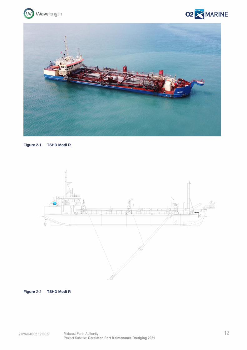
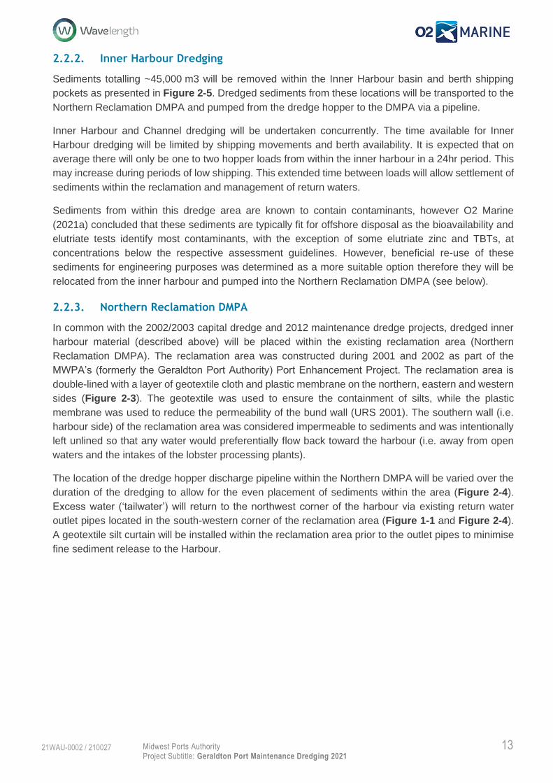
Dredging will be completed by the TSHD Modi R (Figure 2-1), the dredge will be equipped with a
suction pipe which ends in a drag head (Figure 2-2). The drag head is lowered to the seabed and then
slowly moved along the channel removing accumulated sediments by suction. The mixture of sediments
and seawater will be pumped into the dredge’s hopper, as the hopper starts to fill excess waters will be
overflowed until the hopper reaches capacity. Once the hopper capacity is reached the dredge will sail
to the designated DMPA.
The dredge size and specification is slightly smaller than the the previous 2012 maintenance dredging,
the TSHD Modi R has the following specification:
Hopper capacity: 1,393m3
Length: 67.05m
Breadth: 12.8m
Draught loaded: 3.8m
Based on monitoring data collected during the 2012 maintenance dredging it is expected the hopper
net capacity will be ~20% (~300m3) prior to overflowing and ~70% (~1,000m3) at full capacity following
overflowing. Similarly, based on monitoring data collected during the 2012 maintenance dredging it is
expected that an operational efficiency of 85% will be achieved, which allows for operational constrains
such as weather and shipping. The average production rate over the duration of the project is expected
to be ~200m3/hr.
12 Midwest Ports Authority
Project Subtitle: Geraldton Port Maintenance Dredging 2021
21WAU-0002 / 210027
Figure 2-1 TSHD Modi R
Figure 2-2 TSHD Modi R
13 Midwest Ports Authority
Project Subtitle: Geraldton Port Maintenance Dredging 2021
21WAU-0002 / 210027
2.2.2. Inner Harbour Dredging
Sediments totalling ~45,000 m3 will be removed within the Inner Harbour basin and berth shipping
pockets as presented in Figure 2-5. Dredged sediments from these locations will be transported to the
Northern Reclamation DMPA and pumped from the dredge hopper to the DMPA via a pipeline.
Inner Harbour and Channel dredging will be undertaken concurrently. The time available for Inner
Harbour dredging will be limited by shipping movements and berth availability. It is expected that on
average there will only be one to two hopper loads from within the inner harbour in a 24hr period. This
may increase during periods of low shipping. This extended time between loads will allow settlement of
sediments within the reclamation and management of return waters.
Sediments from within this dredge area are known to contain contaminants, however O2 Marine
(2021a) concluded that these sediments are typically fit for offshore disposal as the bioavailability and
elutriate tests identify most contaminants, with the exception of some elutriate zinc and TBTs, at
concentrations below the respective assessment guidelines. However, beneficial re-use of these
sediments for engineering purposes was determined as a more suitable option therefore they will be
relocated from the inner harbour and pumped into the Northern Reclamation DMPA (see below).
2.2.3. Northern Reclamation DMPA
In common with the 2002/2003 capital dredge and 2012 maintenance dredge projects, dredged inner
harbour material (described above) will be placed within the existing reclamation area (Northern
Reclamation DMPA). The reclamation area was constructed during 2001 and 2002 as part of the
MWPA’s (formerly the Geraldton Port Authority) Port Enhancement Project. The reclamation area is
double-lined with a layer of geotextile cloth and plastic membrane on the northern, eastern and western
sides (Figure 2-3). The geotextile was used to ensure the containment of silts, while the plastic
membrane was used to reduce the permeability of the bund wall (URS 2001). The southern wall (i.e.
harbour side) of the reclamation area was considered impermeable to sediments and was intentionally
left unlined so that any water would preferentially flow back toward the harbour (i.e. away from open
waters and the intakes of the lobster processing plants).
The location of the dredge hopper discharge pipeline within the Northern DMPA will be varied over the
duration of the dredging to allow for the even placement of sediments within the area (Figure 2-4).
Excess water (‘tailwater’) will return to the northwest corner of the harbour via existing return water
outlet pipes located in the south-western corner of the reclamation area (Figure 1-1 and Figure 2-4).
A geotextile silt curtain will be installed within the reclamation area prior to the outlet pipes to minimise
fine sediment release to the Harbour.

14 Midwest Ports Authority
Project Subtitle: Geraldton Port Maintenance Dredging 2021
21WAU-0002 / 210027
Figure 2-3 Bund wall cross section
To allow for placement capacity within the reclamation and management of the tailwaters, bunds may
be built around the edge of the reclamation area to allow the height of the reclamation to be increased.
The most recent survey of the reclamation area indicates a capacity of approximately 145,000 m3
remains within this area (Figure 2-4). The total dredge material anticipated to be generated by the
harbour dredging (~45,000 m3) will not exceed this capacity.
At the completion of dredging and once dredged sediments have sufficiently consolidated to allow for
trafficable access, placed material will be capped with 300mm of clean material (refer to Acid Sulfate
Soils Management Plan (ASSMP)).
2.2.4. Entrance Channel Dredging
As with inner harbour dredging, entrance channel sediments will be removed via trailing suction hopper
dredge (TSHD) (Figure 2-1).
Sediments totalling ~190,000 m3 will be removed from high spots occurring within the entrance channel
as presented in Figure 2-6. Dredged sediments from the entrance channel will be transported to the
Nearshore DMPA.
Dredging of the channel will occur concurrently with the inner harbour, until the inner harbour dredging
is completed. It is assumed that on average three in every four dredge loads will be from the channel,
while the inner harbour is being completed then all loads will be from the channel. This will equate to 3-
4 loads and then 4-5 loads in a 24-hour period.
Sediments from within this dredge area are characterised as medium to fine grained, yellow to grey
sands of natural origins such as coastal silicate sands transported to the entrance channel via localised
northern longshore drift, or marine carbonate sediments transported via oceanic currents and swell (O2
Marine 2021a). No contaminants of potential concern were identified for entrance channel sediments,
therefore they are considered to be clean. Therefore, beneficial use of these sediments from the
entrance channel and harbour entrance via hopper discharge to the Nearshore DMPA is proposed (see
below).
15 Midwest Ports Authority
Project Subtitle: Geraldton Port Maintenance Dredging 2021
21WAU-0002 / 210027
2.2.5. Nearshore DMPA
Material dredged from the entrance channel (~190,000m3) will be relocated within the dredge hopper
to the Nearshore DMPA (Figure 1-1). The Nearshore DMPA as presented is the largest maximum size
allowed for sediment disposal and will be reviewed prior to the activities commencing with the dredging
contractor. Once the dredge reaches the Nearshore DMPA the sediments will be released from the
hopper by opening doors on the underside of the vessel and allowing the sediments to fall to the ocean
floor. Each time the dredge will place material to a different location within the DMPA to allow for the
even placement of material across the whole area.
Upon award of contract, MWPA, in consultation with the contractor, will determine an appropriate buffer
between the actual DMPA boundary and adjacent benthic communities and habitat (BCH) (typically the
high-density seagrass to the east). This will be based upon discussion with the contractor as to their
sediment placement methodologies and accuracy to ensure no impacts occur to adjacent BCH.
Hydrographic surveys will be used during the placement to ensure the material is not being deposited
in favour of one location rather than being evenly deposited which could result in high spots. A final
hydrographic survey will take place, and areas greater than one metre in height from pre-existing levels
will be levelled using an underwater drag plough or similar to ensure uniform distribution, and minimum
height of material at the Nearshore DMPA. At the completion of the dredging, the placed material is not
anticipated to be greater than one metre in height above the natural seabed levels and have an average
placement height of ~0.5m.

16 Midwest Ports Authority
Project Subtitle: Geraldton Port Maintenance Dredging 2021
21WAU-0002 / 210027
Figure 2-4 August 2019 survey of the existing Northern Reclamation DMPA

17 Midwest Ports Authority
Project Subtitle: Geraldton Port Maintenance Dredging 2021
21WAU-0002 / 210027
Figure 2-5 Inner Harbour sediment height above design depth

18 Midwest Ports Authority
Project Subtitle: Geraldton Port Maintenance Dredging 2021
21WAU-0002 / 210027
Figure 2-6 Entrance Channel sediments above design depth

19 Midwest Ports Authority
Project Subtitle: Geraldton Port Maintenance Dredging 2021
21WAU-0002 / 210027
2.2.6. Potential Acid Sulfate Soils
The Sediment Quality Assessment (O2 Marine 2021a) identified a small presence of potential Acid
Sulfate Soils (ASS) within the proposed dredge areas. However, the natural acid neutralising capacity
of the sediments was found to provide sufficient buffering for any acid-generating processes and the
material was considered unlikely to require treatment (i.e. lime dosing) during onshore placement within
the Northern Reclamation DMPA.
However, to ensure there are no contamination issues arising from soil acidification which then have
the potential to mobilise contaminants with tailwater release into the marine environment, an ASSMP
has been developed for the project. The ASSMP specifically addresses concerns with onshore
placement and identifies monitoring and controls additional to those outlined within this management
document.

20 Midwest Ports Authority
Project Subtitle: Geraldton Port Maintenance Dredging 2021
21WAU-0002 / 210027
3. Roles and Responsibilities
The roles and responsibilities for the implementation of the DEMP are summarised in Table 3-1.
Table 3-1 Roles and responsibilities of key personnel
Position Responsibility
Proponent
(Mid West Ports Authority)
• Overall responsibility for implementation of this DEMP
• Overall responsibility for complying with relevant legislation, standards and
guidelines
• Ensures dredging activities are conducted in an environment safe for both site
personnel and the public
• Reports on environmental performance for the project to key stakeholders
• Responsible for environmental compliance reporting
• Responsible for reporting all environmental non-compliance incidents
Proponent’s Representative
(Wavelength Consulting)
• Complies with the requirements of this DEMP
• Provides advice on dredging and dredge material environmental issues
• Oversee implementation of environmental controls, monitoring programs,
inspections, audits and management actions in this DEMP
• Completes compliance reporting requirements
• Responsible for the implementation of the environmental monitoring program and
inspections
• Prepares environmental monitoring reports
• Provides advice with respect to environmental issues as required
Dredging Contractor
(RN Dredging)
• Undertakes dredging and placement works
• Prepares and implements an environmental management plan in accordance with
the requirements of this DEMP
• Conducts tailwater return water monitoring in accordance with Section 6.1.1.
• Implements the management actions of this DEMP
• Ensures all staff are adequately trained for their area of responsibility
• Ensures all equipment is adequately maintained and correctly operated
• Responsible for reporting all environmental incidents to the Proponent within 24
hours in accordance with MWPA incident reporting procedures
All persons involved in the
project
• Comply with the requirements of this DEMP
• Comply with all legal requirements under the approvals documents and relevant
Acts
• Exercise a Duty of Care to the environment at all times
• Report all environmental incidents
21 Midwest Ports Authority
Project Subtitle: Geraldton Port Maintenance Dredging 2021
21WAU-0002 / 210027
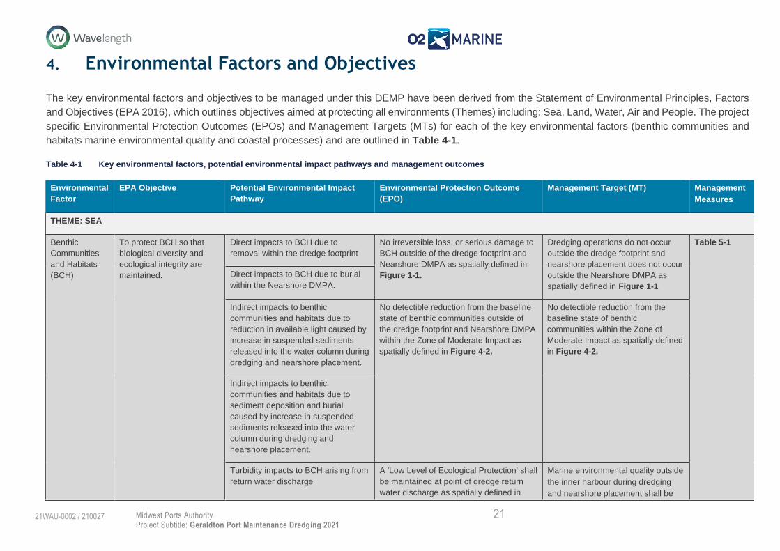
4. Environmental Factors and Objectives
The key environmental factors and objectives to be managed under this DEMP have been derived from the Statement of Environmental Principles, Factors
and Objectives (EPA 2016), which outlines objectives aimed at protecting all environments (Themes) including: Sea, Land, Water, Air and People. The project
specific Environmental Protection Outcomes (EPOs) and Management Targets (MTs) for each of the key environmental factors (benthic communities and
habitats marine environmental quality and coastal processes) and are outlined in Table 4-1.
Table 4-1 Key environmental factors, potential environmental impact pathways and management outcomes
Environmental
Factor
EPA Objective Potential Environmental Impact
Pathway
Environmental Protection Outcome
(EPO)
Management Target (MT) Management
Measures
THEME: SEA
Benthic
Communities
and Habitats
(BCH)
To protect BCH so that
biological diversity and
ecological integrity are
maintained.
Direct impacts to BCH due to
removal within the dredge footprint
No irreversible loss, or serious damage to
BCH outside of the dredge footprint and
Nearshore DMPA as spatially defined in
Figure 1-1.
Dredging operations do not occur
outside the dredge footprint and
nearshore placement does not occur
outside the Nearshore DMPA as
spatially defined in Figure 1-1
Table 5-1
Direct impacts to BCH due to burial
within the Nearshore DMPA.
Indirect impacts to benthic
communities and habitats due to
reduction in available light caused by
increase in suspended sediments
released into the water column during
dredging and nearshore placement.
No detectible reduction from the baseline
state of benthic communities outside of
the dredge footprint and Nearshore DMPA
within the Zone of Moderate Impact as
spatially defined in Figure 4-2.
No detectible reduction from the
baseline state of benthic
communities within the Zone of
Moderate Impact as spatially defined
in Figure 4-2.
Indirect impacts to benthic
communities and habitats due to
sediment deposition and burial
caused by increase in suspended
sediments released into the water
column during dredging and
nearshore placement.
Turbidity impacts to BCH arising from
return water discharge
A 'Low Level of Ecological Protection' shall
be maintained at point of dredge return
water discharge as spatially defined in
Marine environmental quality outside
the inner harbour during dredging
and nearshore placement shall be

22 Midwest Ports Authority
Project Subtitle: Geraldton Port Maintenance Dredging 2021
21WAU-0002 / 210027
Figure 4-1 and will return to a ‘Moderate
Level of Ecological Protection’ within one
month following cessation of discharge.
maintained as far as practicable to a
'High Level of Ecological Protection'
as spatially defined in Figure 4-1
Marine
Environmental
Quality
To maintain the quality of
water, sediment and biota
so that environmental
values are protected
Disturbance of contaminants in
sediments during dredging and return
water discharge has the potential to
deteriorate water quality and
contaminate marine organisms
A 'Low Level of Ecological Protection' shall
be maintained at point of dredge return
water discharge as spatially defined in
Figure 4-1 and will return to a ‘Moderate
Level of Ecological Protection’ within one
month following cessation of discharge.
Marine environmental quality outside
the inner harbour during dredging
and nearshore placement shall be
maintained as far as practicable to a
'High Level of Ecological Protection'
as spatially defined in Figure 4-1
Table 5-2
Changes to the physico-chemical
properties of the water column as a
result of dredging and nearshore
placement.
A temporary, localised reduction in marine
environmental quality during dredging in
the immediate vicinity of the dredge
footprint and Nearshore DMPA .
Marine environmental quality
maintained to a ‘Moderate Level of
Ecological Protection' inside the
harbour and to a 'High Level of
Ecological Protection' outside the
harbour as spatially defined in
Figure 4-1 during dredging and
nearshore placement far as
practicable.
Hydrocarbon release into the marine
environment from a vessel spill and
or bunkering operations
Manage vessel bunkering, chemical
storage and spill response to ensure no
adverse impacts to the marine
environment.
Coastal
Processes
To maintain the
geophysical processes that
shape coastal morphology
so that the environmental
values of the coast are
protected.’
Relocation of sediment within the
Point Moore to Glenfield secondary
sediment cell impacting natural
transport mechanisms.
No residual impact on coastal processes
as a result of the Project and Project
activities.
Localised minor impacts upon
sediment transport and currents
immediately surrounding the
Nearshore DMPA.
Table 5-4
Sustainable relocation of dredge
material resulting in localised
alteration of the morphology of the
coastal zone potentially resulting in
changes to erosion/deposition
patterns.
Potential environmental benefits for
coastal resilience to coastal erosion
of northern beaches.
Sustainable relocation of dredge
material resulting in localised
alteration of the morphology of the
coastal zone potentially impacting
Chapman River hydrology with
secondary impacts to the TEC –
Coastal Salt Marshes

23 Midwest Ports Authority
Project Subtitle: Geraldton Port Maintenance Dredging 2021
21WAU-0002 / 210027
Alterations to the existing physical
characteristics of the designated
Nearshore DMPA.
Alteration of the structure of adjacent
marine communities through
placement of material.

24 Midwest Ports Authority
Project Subtitle: Geraldton Port Maintenance Dredging 2021
21WAU-0002 / 210027
Figure 4-1 Proposed levels of ecological protection for the Port of Geraldton and surrounding water

25 Midwest Ports Authority
Project Subtitle: Geraldton Port Maintenance Dredging 2021
21WAU-0002 / 210027
Figure 4-2 Predicted Seagrass impact zones from smothering and light reduction
26 Midwest Ports Authority
Project Subtitle: Geraldton Port Maintenance Dredging 2021
21WAU-0002 / 210027
5. Management
The potential environmental impacts (Table 4-1), have been assigned monitoring and management
actions to measure compliance against the EPOs1 and MTs. Management actions have been separated
into Tier 1 (which specifically address the three identified key environmental factors, benthic
communities and habitat, marine environmental quality, and marine fauna); and Tier 2 (which relate to
the overall works and can be managed through standard operational procedures (including introduced
marine pests, hydrocarbons and waste).
A description of the existing environment is presented within Appendix A. This provides context for the
environmental monitoring program detailed below with regards to the identified receptors that occur
within the project area. This existing environment also formed the basis of the Project Environmental
Impact Assessment (O2 Marine 2021b) which identified potential impacts which this plan aims to
manage and monitor to ensure the EPOs and MTs are met during implementation of the Project.
1 EPOs identified in Table 4-1 are not presented in the following tables as it is assumed that if the MT is achieved then the corresponding
EPO will also be achieved.

27 Midwest Ports Authority
Project Subtitle: Geraldton Port Maintenance Dredging 2021
21WAU-0002 / 210027
Benthic Communities and Habitat
The (Tier 1) management actions to minimise potential impacts on the environmental factor ‘Benthic Communities and Habitat’ are presented in Table 5-1.
Table 5-1 Management actions to minimise impacts on Benthic Communities and Habitats
Environmental Factor Benthic Communities and Habitats
Activity Dredging and return water discharge
Potential Impacts • Direct loss of benthic communities and habitats due to dredging activities
• Indirect impacts of benthic communities and habitats due to reduction in available light caused by increase in suspended sediments released into the water column during dredging and discharge of dredge return water
• Turbidity impacts on BCH arising from return water discharge
Management Targets
Management Actions Environmental Performance
Item Actions Responsibility Reporting/Evidence Timing Contingency
Marine environmental quality
outside the inner harbour
during dredging and nearshore
placement shall be maintained
as far as practicable to a 'High
Level of Ecological Protection'
as spatially defined in Figure
4-1.
1.1 Implement the Marine
Environmental Quality
Monitoring Program (MEQMP)
described in Section 6.1.
Proponent and
Contractor
• Weekly and final reports
Tailwater return monitoring:
• Monthly data logging pre-dredge; and
• Daily assessment pH data during tailwater discharge.
Marine Water Quality
Monitoring:
• Water sampling every second week for four weeks pre-dredge;
• Weekly water quality sampling during dredging and tailwater release; and
• Weekly water quality sampling for either two weeks post dredging or until trigger achieved.
Tailwater return monitoring:
• Implement tiered management framework as described in Figure 6-1; and
• Manage water quality to targets presented in Table 6-2.
Marine Environmental quality
monitoring:
• Implement tiered management framework as described in Figure 6-3; and
• Manage water quality to targets presented in Table 6-4.
Consider requirement for
additional BCH monitoring.
28 Midwest Ports Authority
Project Subtitle: Geraldton Port Maintenance Dredging 2021
21WAU-0002 / 210027
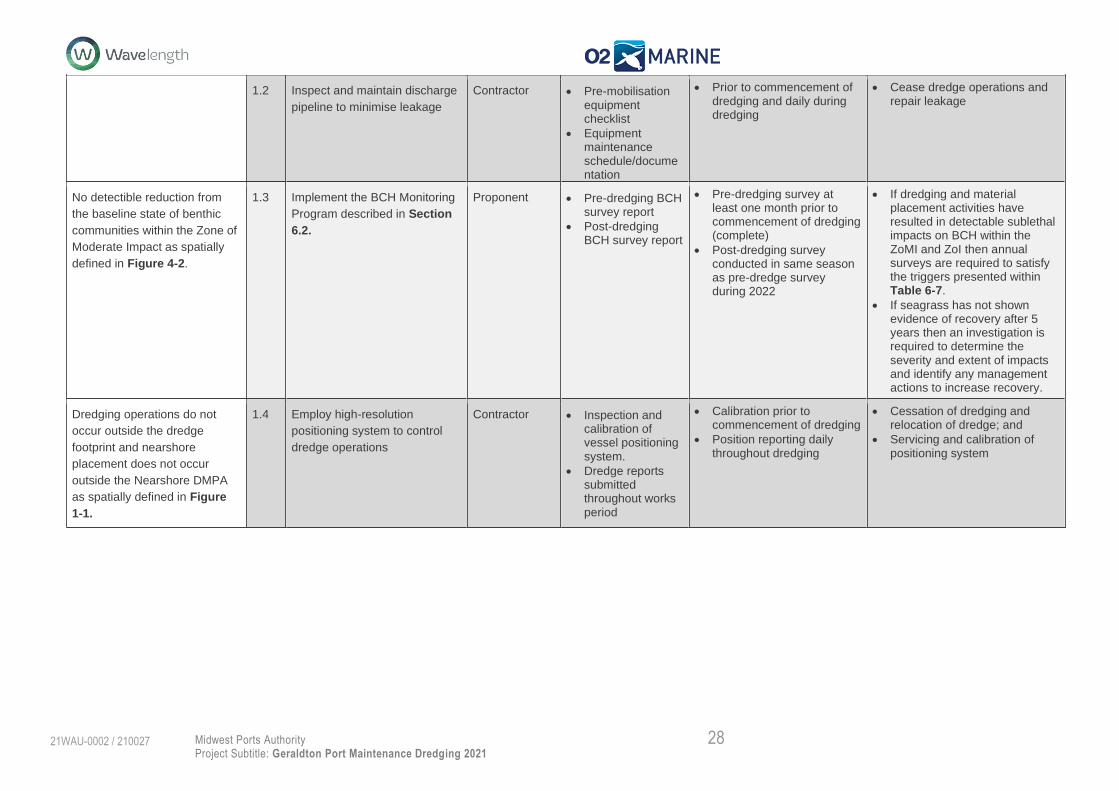
1.2 Inspect and maintain discharge
pipeline to minimise leakage
Contractor • Pre-mobilisation equipment checklist
• Equipment maintenance schedule/documentation
• Prior to commencement of dredging and daily during dredging
• Cease dredge operations and repair leakage
No detectible reduction from
the baseline state of benthic
communities within the Zone of
Moderate Impact as spatially
defined in Figure 4-2.
1.3 Implement the BCH Monitoring
Program described in Section
6.2.
Proponent • Pre-dredging BCH survey report
• Post-dredging BCH survey report
• Pre-dredging survey at least one month prior to commencement of dredging (complete)
• Post-dredging survey conducted in same season as pre-dredge survey during 2022
• If dredging and material placement activities have resulted in detectable sublethal impacts on BCH within the ZoMI and ZoI then annual surveys are required to satisfy the triggers presented within Table 6-7.
• If seagrass has not shown evidence of recovery after 5 years then an investigation is required to determine the severity and extent of impacts and identify any management actions to increase recovery.
Dredging operations do not
occur outside the dredge
footprint and nearshore
placement does not occur
outside the Nearshore DMPA
as spatially defined in Figure
1-1.
1.4 Employ high-resolution
positioning system to control
dredge operations
Contractor • Inspection and calibration of vessel positioning system.
• Dredge reports submitted throughout works period
• Calibration prior to commencement of dredging
• Position reporting daily throughout dredging
• Cessation of dredging and relocation of dredge; and
• Servicing and calibration of positioning system

29 Midwest Ports Authority
Project Subtitle: Geraldton Port Maintenance Dredging 2021
21WAU-0002 / 210027
Marine Environmental Quality
The (Tier 1) management actions proposed to minimise potential impacts on the environmental factor ‘Marine Environmental Quality’ are described in
Table 5-2.
Table 5-2 Management actions to minimise impacts on Marine Environmental Quality
Environmental
Factor
Marine Environmental Quality
Activity Dredging and return water discharge
Potential Impacts
• Disturbance of contaminants in sediments during dredging and return water discharge has the potential to deteriorate water quality and contaminate marine
organisms
• Changes to the physico-chemical properties of the water column as a result of dredging and return water discharge
Management
Targets
Management Actions Environmental Performance
Item Actions Responsibility Reporting/Evidence Timing Contingency
Marine
environmental
quality maintained to
a ‘Moderate Level of
Ecological
Protection' inside the
harbour and to a
'High Level of
Ecological
Protection' outside
the harbour as
spatially defined in
Figure 4-1 during
dredging and
nearshore placement
far as practicable.
2.1 Implement the
Marine
Environmental
Quality Monitoring
Program (MEQMP)
described in
Section 6.1.
Proponent and
Contractor
• Weekly and final reports
Tailwater return monitoring:
• Monthly data logging pre-dredge; and
• Daily assessment pH data during tailwater discharge.
Marine Water Quality Monitoring:
• Water sampling every second week for four weeks pre-dredge;
• Weekly water quality sampling during dredging and tailwater release; and
• Weekly water quality sampling for either two weeks post dredging or until trigger achieved.
Tailwater return monitoring:
• Implement tiered management framework as described in Figure 6-1; and
• Manage water quality to targets presented in Table 6-2.
Marine Environmental quality monitoring:
• Implement tiered management framework as described in Figure 6-3; and
• Manage water quality to targets presented in Table 6-4.
Consider requirement for additional BCH monitoring.
2.2 Inspections of all
dredge equipment
and pipelines to
check for leaks or
damage
Contractor • Vessel and Site Environment Safety and Health inspection checklist
• Prior to the commencement of dredging
• Daily throughout dredging
• Cease works if significant spillage or damage observed
• Activate spill response actions (control drainage, clean up) as required; and
• Undertake incident investigation and implement recommendations
• Continue MWQMP

30 Midwest Ports Authority
Project Subtitle: Geraldton Port Maintenance Dredging 2021
21WAU-0002 / 210027
2.3 Deploy and
maintain silt curtain
around tailwater
outfall pipes
Contractor • Daily dredge logs • Prior to and post tailwater discharge
• Alter deployment location
• Alter the deployment method
• Alter the silt curtain mesh size
• Continue to implement the MEQNP

31 Midwest Ports Authority
Project Subtitle: Geraldton Port Maintenance Dredging 2021
21WAU-0002 / 210027
Marine Fauna
The (Tier 1) Management actions proposed to minimise potential impacts on the environmental factor ‘Marine Fauna’ are described in Table 5-3.
Table 5-3 Management actions to minimise impacts on marine fauna.
Environmental
Factor
Marine Fauna
Activity Dredging operations
Potential Impacts • Injury or death of marine fauna as a result of dredge operations
• Injury or death of marine fauna due to vessel movement (strike)
• Disturbance to juvenile rock lobster and or whale migration
• Water quality impacts on marine fauna
Management
Targets
Management Actions Environmental Performance
Item Actions Responsibility Reporting/Evidence Timing Contingency
No reported
incidences of
marine fauna injury
or death as a result
of water quality
impacts.
3.1 Implement the Marine
Environmental Quality
Monitoring Program (MEQMP)
described in Section 6.1.
Proponent and
Contractor
• Weekly and final reports
Tailwater return monitoring:
• Monthly data logging pre-dredge; and
• Daily assessment pH data during tailwater discharge.
Marine Water Quality Monitoring:
• Water sampling every second week for four weeks pre-dredge;
• Weekly water quality sampling during dredging and tailwater release; and
• Weekly water quality sampling for either two weeks post dredging or until trigger achieved.
Tailwater return monitoring:
• Implement tiered management framework as described in Figure 6-1; and
• Manage water quality to targets presented in Table 6-2.
Marine Environmental quality
monitoring:
• Implement tiered management framework as described in Figure 6-3; and
• Manage water quality to targets presented in Table 6-4.
No reported
incidences of
marine fauna injury
3.2 Implement a soft start procedure
prior to commencing operations.
Contractor • Daily dredge logs. • Each occasion, prior to activating TSHD head.
• Dredge operations not to commence unless a soft start procedure has been implemented.
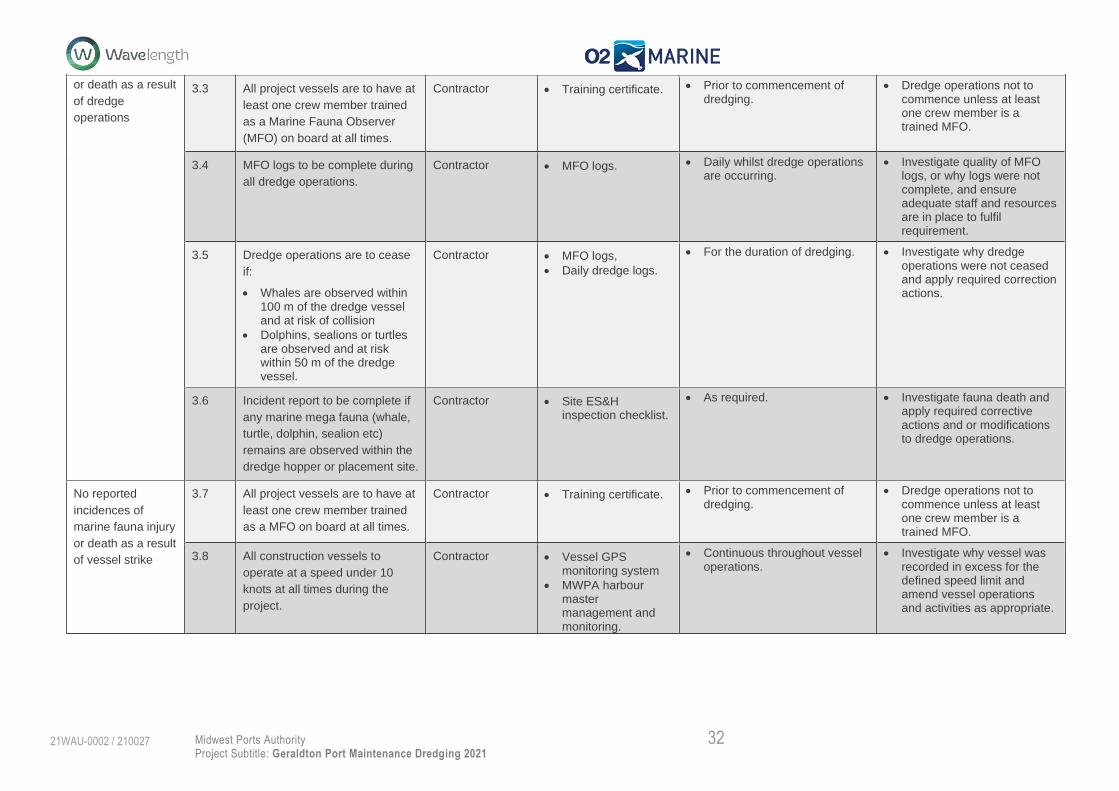
32 Midwest Ports Authority
Project Subtitle: Geraldton Port Maintenance Dredging 2021
21WAU-0002 / 210027
or death as a result
of dredge
operations
3.3 All project vessels are to have at
least one crew member trained
as a Marine Fauna Observer
(MFO) on board at all times.
Contractor • Training certificate. • Prior to commencement of dredging.
• Dredge operations not to commence unless at least one crew member is a trained MFO.
3.4 MFO logs to be complete during
all dredge operations.
Contractor • MFO logs. • Daily whilst dredge operations are occurring.
• Investigate quality of MFO logs, or why logs were not complete, and ensure adequate staff and resources are in place to fulfil requirement.
3.5 Dredge operations are to cease
if:
• Whales are observed within 100 m of the dredge vessel and at risk of collision
• Dolphins, sealions or turtles are observed and at risk within 50 m of the dredge vessel.
Contractor • MFO logs,
• Daily dredge logs.
• For the duration of dredging. • Investigate why dredge operations were not ceased and apply required correction actions.
3.6 Incident report to be complete if
any marine mega fauna (whale,
turtle, dolphin, sealion etc)
remains are observed within the
dredge hopper or placement site.
Contractor • Site ES&H inspection checklist.
• As required. • Investigate fauna death and apply required corrective actions and or modifications to dredge operations.
No reported
incidences of
marine fauna injury
or death as a result
of vessel strike
3.7 All project vessels are to have at
least one crew member trained
as a MFO on board at all times.
Contractor • Training certificate. • Prior to commencement of dredging.
• Dredge operations not to commence unless at least one crew member is a trained MFO.
3.8 All construction vessels to
operate at a speed under 10
knots at all times during the
project.
Contractor • Vessel GPS monitoring system
• MWPA harbour master management and monitoring.
• Continuous throughout vessel operations.
• Investigate why vessel was recorded in excess for the defined speed limit and amend vessel operations and activities as appropriate.
33 Midwest Ports Authority
Project Subtitle: Geraldton Port Maintenance Dredging 2021
21WAU-0002 / 210027
Coastal Processes
The (Tier 2) Management actions proposed to minimise potential coastal processes impacts from beneficial re-use of clean sediments to maintain northward
natural input of sediments into Champion Bay that have been trapped by shipping channel are described in Table 5-4.
Table 5-4 Management actions to minimise the risk to Coastal Processes.
Environmental Factor Coastal Processes
Activity Material Placement at Nearshore DMPA
Potential Impacts • Localised alteration of the morphology of the coastal zone causing coastal erosion. • Localised alteration of the morphology potentially impacting Chapman River hydrology • Alteration of the structure of adjacent marine communities through placement of material.
Management Targets Management Actions Environmental Performance
Item Actions Responsibility Reporting/Evidence Timing Contingency
Localised minor impacts
upon sediment transport and
currents immediately
surrounding the Nearshore
DMPA.
4.1 Placement of material at Nearshore DMPA must be <1 m height above existing seabed compared with pre-dredge hydrographic survey
Contractor • During and post dredging hydrographic survey
• Daily hydrographic survey during dredging
• Final post-dredge hydrographic survey
• Seabed leveling of any high spots
4.2 Employ high-resolution positioning system to control dredge operations
Contractor • Calibrate and inspect positioning and vessel monitoring system
• Dredge reports submitted throughout works period
• Calibration prior to dredge operations
• Reporting daily during dredging
• Cessation of dredging and relocation of dredge; and
• Services of positioning system
Potential environmental
benefits for coastal
resilience to coastal erosion
of northern beaches.
4.3 Continuation of coastal beach profiling in accordance with the Northern Beaches Stabilisation Program
Proponent • Annul beach survey report
• Annually • To be investigated with City of Greater Geraldton and Department of Transport if impacts are identified
34 Midwest Ports Authority
Project Subtitle: Geraldton Port Maintenance Dredging 2021
21WAU-0002 / 210027
Introduced Marine Pests
The (Tier 2) Management actions proposed to minimise potential impacts associated with introduced marine pests are described in Table 5-5.
Table 5-5 Management actions to minimise the risk of introduced marine pests
Environmental Factor Marine Fauna
Activity Vessel mobilisation to site
Potential Impacts • Translocation of introduced marine pests to the environment adjacent to the project area
Management Targets Management Actions Environmental Performance
Item Actions Responsibility Reporting/Evidence Timing Contingency
Manage vessel activities to
prevent the introduction of
introduced marine pests into
and within State waters.
4.1 All interstate and overseas vessels that mobilise to the project site are required to complete the Department of Primary Industry and Regional Development (DPIRDs) Vessel Check 2.0 assessment.
Contractor A copy of the Vessel Check 2.0 report is to be submitted to MWPA for assessment along with any supporting documentation including antifoul certificates and inspection reports.
Prior to dredge entering Western Australian Waters from overseas or interstate.
Vessel not to enter Western Australia without approved Introduced Marine Pest documentation
4.2 Adhere with MWPA’s Marine
Pest Management procedure
(HSE-PR0-022).
Contractor A copy of the Vessel Check
2.0 report is to be submitted to
MWPA for assessment along
with any supporting
documentation including
antifoul certificates and
inspection reports.
Prior to dredge vessels
entering Australian
waters or mobilising to
the Port of Geraldton
until all dredging
operations have
ceased.
Implementation of contingency
measures as required by MWPA
and Department of Fisheries
quarantine requirements.
4.3 Continue to implement the
MWPA marine pest monitoring
program
Proponent Annual report Biannual Implementation of contingency
measures as required by MWPA
and Department of Fisheries
quarantine requirements.

35 Midwest Ports Authority
Project Subtitle: Geraldton Port Maintenance Dredging 2021
21WAU-0002 / 210027
Hydrocarbon Management
The (Tier 2) Management actions proposed to minimise potential impacts associated with hydrocarbon pollution are described in Table 5-6.
Table 5-6 Management actions to minimise the risk of hydrocarbon pollution
Environmental
Factor
Marine Environmental Quality
Activity Dredging operations
Potential
Impacts
• Hydrocarbon release into the marine environment from a vessel spill and or bunkering operations
Management
Targets
Management Actions Environmental Performance
Item Actions Responsibility Reporting/Evidence Timing Contingency
Manage vessel
bunkering,
chemical
storage and
spill response
to ensure no
adverse
impacts to the
marine
environment.
5.1 Implement the Marine
Water Quality Monitoring
component of Marine
Environmental Quality
Monitoring Program
(MEQMP) described in
Section 6.1.
Proponent and
Contractor
Weekly and final
reports
Marine Water
Quality
Monitoring:
• Weekly water quality sampling during dredging and tailwater release; and
Weekly water
quality
sampling for
either two
weeks post
dredging or
until trigger
achieved.
Marine Environmental quality monitoring:
• Implement tiered management framework as described in Figure 6-3; and
• Manage water quality to targets presented in Table 6-4.
36 Midwest Ports Authority
Project Subtitle: Geraldton Port Maintenance Dredging 2021
21WAU-0002 / 210027
5.2 Comply with MWPA’s
vessel bunkering
procedure and permit
system during operations
Contractor Vessel management
procedures
The proponent is to
be notified
immediately in the
event of a
hydrocarbon spill of
any volume to water
Prior to
commencement
of dredging
Dredge operations not to commence prior to development and approval
of vessel management procedures.
Investigate spill event and review management actions and responses
5.3 Document vessel
bunkering management,
including appropriately
licensed bunkering
facilities
Contractor Vessel management
procedures
Prior to
commencement
of dredging
Dredge operations not to commence prior to development and
proponent approval of vessel bunkering management procedure
5.4 Undertake vessel
maintenance and
bunkering in accordance
with dredging contractors
approved vessel
bunkering management
systems/plans/procedures
Contractor Vessel management
procedures
For the duration
of dredging
Vessel bunkering management systems to be reviewed and refined (if
required) in the event of an identified procedural breach or hydrocarbon
spill
5.5 Implement industry
standard hydrocarbon
management practices
(chemical handling,
storage, segregation and
spill response)
Contractor Vessel management
procedures
The proponent is to
be notified
immediately in the
event of a
hydrocarbon spill of
any volume to water
Prior to
commencement
of dredging
Dredge operations not to commence prior to development and approval of all required operational procedures. Investigate spill event and review management actions and responses
5.6 Undertake an
environmental inspection
of dredging vessel
Contractor Vessel management
procedures
Prior to the
commencement
of dredging
Dredge operations not to commence prior to development and approval
of environmental inspection checklist

37 Midwest Ports Authority
Project Subtitle: Geraldton Port Maintenance Dredging 2021
21WAU-0002 / 210027
Waste Management
The (Tier 2) Management actions proposed to minimise potential impacts that waste management may have on the environment are listed in Table 5-7.
Table 5-7 Management actions to manage waste
Environmental
Factor
Marine Environmental Quality
Activity Incorrect or accidental disposal of liquid or solid waste from a vessel
Potential
Impacts
• Impacts on the marine environmental quality (both sediment and water) due presence of foreign materials • Decrease in viability of flora and fauna at species and population levels due to excess waste in water column
Management
Targets
Management Actions Environmental Performance
Item Actions Responsibility Reporting/Evidence Timing Contingency
Manage
disposal
systems in
compliance
with
requirements
for MWPA and
in accordance
with MARPOL
73/78
Convention
Annex IV
(sewage) and
Annex V
(garbage).
6.1 Dredging contractor to establish
a sewage and garbage disposal
plan in accordance with MWPA
and MARPOL 73/78
Contractor Within 12 hours of a
reportable incidence
Duration
of
dredging
operations
Contingency measures as required by MWPA
Manage the
correct onshore
disposal and
6.2 Biosecurity Controlled Wastes
(e.g. Garbage) from
international commercial
vessels must be managed in
Contractor Consent from
appropriate avenues
needs to be obtain
Duration
of
Contingency measures as required by MWPA
38 Midwest Ports Authority
Project Subtitle: Geraldton Port Maintenance Dredging 2021
21WAU-0002 / 210027
reporting
systems
accordance with the Australian
Biosecurity Regulation 2016
and MWPA procedures.
before correct
disposal of waste
dredging
operations
6.3 Only a licenced Controlled
Waste Carrier to be used for
any controlled waste
discharged ashore
Contractor Controlled waste
tracking forms to be
completed as soon
as possible
Duration
of
dredging
operations
Contingency measures as required by MWPA
6.4 All forms of waste need to be
stored in appropriately labelled
drums or tanks and be correctly
disposed of and not discharged
to the environment
Contractor Approval certification
and tracking forms to
be completed as
soon as possible
Duration
of
dredging
operations
Contingency measures as required by MWPA
6.5 Reporting of any type of
spillage within the marine
environment directly to the
MWPA Harbour Master
Contractor Within 12 hours of
reportable
During the
duration
of
dredging
operations
Contingency measures as required by MWPA

39 Midwest Ports Authority
Project Subtitle: Geraldton Port Maintenance Dredging 2021
21WAU-0002 / 210027
6. Monitoring
To ensure that proposed management requirements outlined in Section 5 are adequate to minimise
and reduce the potential environmental impacts, MWPA have designed a comprehensive marine
environmental monitoring program. The monitoring is broken down into three discrete programs as
presented in
1. Marine Environmental Quality Monitoring Program; 2. Benthic Communities and Habitat Monitoring Program; and 3. Model Validation Monitoring Program.
A summary and overview of the three programs is presented in Table 6-1 and a detailed description of
each in the following sections.

40 Midwest Ports Authority
Project Subtitle: Geraldton Port Maintenance Dredging 2021
21WAU-0002 / 210027
Table 6-1 Monitoring Program Overview
Element Management
Target
Frequency Duration Parameters Methods Sample Locations Trigger for
management
action
Marine Environmental Quality Monitoring Program
Tailwater Return
Monitoring
During dredging and
nearshore placement
marine environmental
quality is maintained
to a ‘Moderate Level
of Ecological
Protection' inside the
harbour and to a
'High Level of
Ecological Protection'
outside the harbour
as spatially defined in
Figure 4-1.
Daily water
column profiles
For entire duration of
inner harbour dredging
and tailwater discharge
activities
pH
Dissolved Oxygen.
Handheld water
quality meter
WQD1 at
LEPA/MEPA
boundary (Figure
6-2)
Refer Table 6-2
Water Quality
Monitoring
Pre-dredge –
every second
week.
During Harbour
dredging – weekly.
Post harbour
dredging – weekly
until target
achieved.
Water sampling will
commence four weeks
prior to dredging and
continue post dredging
until target is achieved.
Water sample
analysis:
i. Dissolved metals to include Al, As, Cd, Cr, Cu, Pb, Mn, Ni, Zn, Hg
ii. Sulphate iii. Chloride iv. Nutrients (Total
N, TKN, NH3, NOx-N)
v. TRH vi. TBT
Water column
profiles:
i. pH ii. DO iii. NTU iv. Temp v. Conductivity
Water sampling
through water column
Physicochemical
profiling with
handheld water
quality meter
WQD1, WQ2, WQL3
& WQ4 (Figure 6-2) Refer Table 6-4

41 Midwest Ports Authority
Project Subtitle: Geraldton Port Maintenance Dredging 2021
21WAU-0002 / 210027
Element Management
Target
Frequency Duration Parameters Methods Sample Locations Trigger for
management
action
Hourly in-situ
measurements
Commencement one
month prior to tailwater
release.
Completion one month
post tailwater discharge
(weir box closure).
pH
Dissolved Oxygen.
In-situ data logger
WQD1 at
LEPA/MEPA
boundary (Figure
6-2)
Refer Table 6-4
Benthic Communities and Habitat Monitoring Program
Seagrass Monitoring No detectible
reduction from the
baseline state of
benthic communities
within the Zone of
Moderate Impact as
spatially defined in
Figure 4-2.
Annually
Pre-dredge survey –
Completed Jan/Feb
2021
Post-Dredge Survey
planned Jan/Mar 2022
Seagrass health
metrics
i. Seagrass shoot density and height
ii. Species composition
iii. Presence of epiphyte and epifauna
iv. Habitat type v. Percent
coverage
Diver based surveys
in accordance with
BMT (2021a)
12 locations within
Champion Bay
(Figure 6-4)
Refer Table 6-7.
BCH Monitoring
Pre-dredge survey –
Planned August 2021
Post-Dredge Survey
planned Jan-Mar 2022
i. Percent coverage
ii. Species composition
iii. Habitat type iv. Habitat extent
Drop down camera
survey in accordance
with BMT (2021b)
combined with side
scan sonar of study
area.
36 drop camera
locations and side
scan sonar survey
area as presented in
Figure 6-4 and
Figure 6-5
Model Validation Program
42 Midwest Ports Authority
Project Subtitle: Geraldton Port Maintenance Dredging 2021
21WAU-0002 / 210027
Element Management
Target
Frequency Duration Parameters Methods Sample Locations Trigger for
management
action
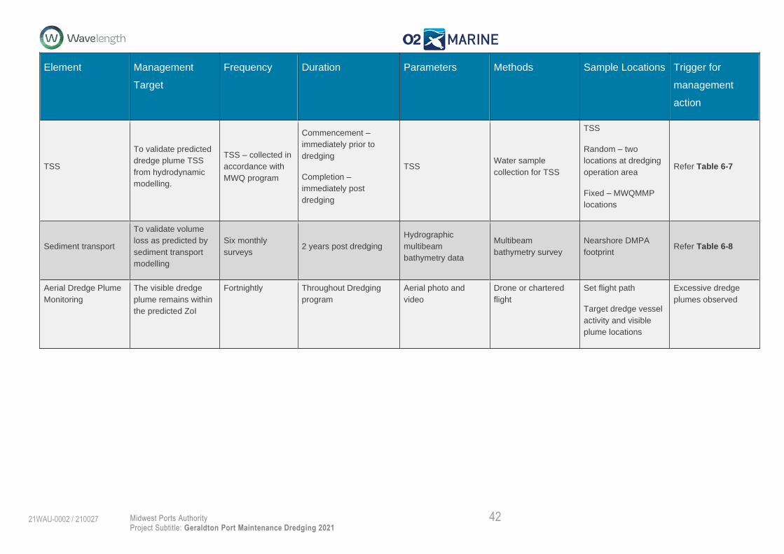
TSS
To validate predicted
dredge plume TSS
from hydrodynamic
modelling.
TSS – collected in
accordance with
MWQ program
Commencement –
immediately prior to
dredging
Completion –
immediately post
dredging
TSS Water sample
collection for TSS
TSS
Random – two
locations at dredging
operation area
Fixed – MWQMMP
locations
Refer Table 6-7
Sediment transport
To validate volume
loss as predicted by
sediment transport
modelling
Six monthly
surveys 2 years post dredging
Hydrographic
multibeam
bathymetry data
Multibeam
bathymetry survey
Nearshore DMPA
footprint Refer Table 6-8
Aerial Dredge Plume
Monitoring
The visible dredge
plume remains within
the predicted ZoI
Fortnightly Throughout Dredging
program
Aerial photo and
video
Drone or chartered
flight
Set flight path
Target dredge vessel
activity and visible
plume locations
Excessive dredge
plumes observed

43 Midwest Ports Authority
Project Subtitle: Geraldton Port Maintenance Dredging 2021
21WAU-0002 / 210027
Marine Environmental Quality Monitoring Program (MEQMP)
6.1.1. Tailwater Return Monitoring (TRM)
Rationale
Monitoring of the return water will be undertaken to ensure that the EPOs and MTs for protection of
marine environmental quality are achieved and potential acidification in the Northern Reclamation
DMPA is managed. The monitoring approach is based on daily monitoring of the return water quality.
The EPOs, MTs and associated trigger levels were adopted assuming the potential for a temporary,
localised reduction in marine environmental quality in the immediate vicinity of the return water
discharge. This is spatially presented as the Low Ecological Protection Area (LEPA) in Figure 4-1.
Management actions have also been developed for the management of potential acidification in the
Northern Reclamation DMPA (Refer to the ASSMP).
Monitoring Locations & Frequency
Return water will be monitored at site WQD1 located on the LEPA/MEPA boundary daily (Table 6-3
and Figure 6-2). Return water shall be discharged directly to the north-eastern corner of the inner
harbour. Sampling will commence immediately as dredge material is placed onshore and will continue
until no further return water is discharged to the marine environment.
Combined with daily monitoring, physicochemical profiles are included as part of the weekly water
sampling program at four locations as well as continuous data logging on the LEPA/MEPA boundary
for the duration of the water sampling program (Section 6.1.2).
Environmental Protection Outcomes, Management Targets and Trigger Levels
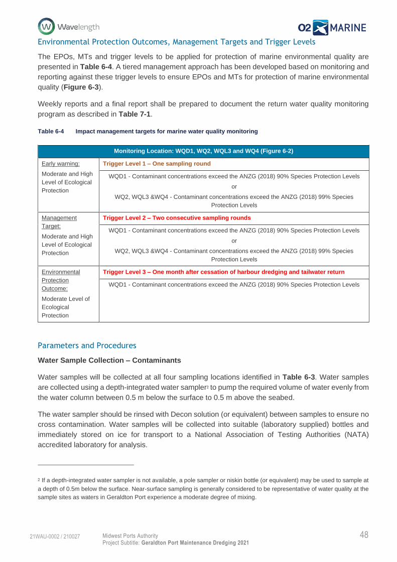
The EPOs, MTs and trigger levels to be applied for protection of marine environmental quality are
presented in Table 5-2. A tiered management approach has been developed based on monitoring and
reporting against these trigger levels to ensure EPOs and MTs for protection of marine environmental
quality (Figure 6-1). Weekly reports and a final report shall be prepared to document the return water
quality monitoring program as described in Table 7-1.

44 Midwest Ports Authority
Project Subtitle: Geraldton Port Maintenance Dredging 2021
21WAU-0002 / 210027
Table 6-2 Impact management targets for tailwater return water monitoring.
Note: Trigger is exceeded if any one of the factors are exceeded
Parameters and Procedures
pH and DO will be collected daily at site WQD1 using a handheld multiparameter sonde. Measurements
are required to be undertaken at two separate locations within 10 m of the provided site coordinate for
WQD1 at the following measurement levels:
0.5 m below surface
5 m below surface and
8 m below surface.
An average value is to be calculated from the six measurements for comparison against the established
trigger levels.
The sonde is required to be calibrated and serviced in accordance with the manufacturer’s standards
throughout the duration of the project to ensure data collected are accurate.
Corrective Actions
Tailwater return water monitoring data shall be reviewed daily against the Trigger Levels (Table 5-2).
If Trigger Level 1 is exceeded the proponent shall be notified and monitoring shall continue. If Trigger
Level 1 or 2 are exceeded the dredge program will be reviewed and may be modified if appropriate. In
addition, the following modifications to the return water may also be considered:
Cease discharge from the onshore management area to either stop release of water or reduce
the proportion of fine sediments released;
Modify the dredge plan to relocate dredge to another site to reduce frequency of inner harbour
dredging; and/or
Monitoring Location: WQD1 on LEPA/MEPA Boundary (Figure 6-2)
Early warning:
High Level of
Ecological
Protection
Trigger Level 1 – Instantaneous
pH: >80th or <20th percentile of baseline marine water quality data
OR
Dissolved Oxygen = <70% Saturation
Management
Target:
Moderate
Level of
Ecological
Protection
Trigger Level 2 – Instantaneous
Physico-chemical
pH: >95th or <5th percentile of baseline marine water quality data
OR
Dissolved Oxygen = <60% Saturation
Management
Target:
Moderate
Level of
Ecological
Protection
Trigger Level 3 – two consecutive sample events
Physico-chemical
pH: >95th or <5th percentile of baseline marine water quality data
OR
Dissolved Oxygen = <60% Saturation

45 Midwest Ports Authority
Project Subtitle: Geraldton Port Maintenance Dredging 2021
21WAU-0002 / 210027
Other tailwater response management as directed within the ASSMP.
Management of return water from Northern Reclamation DMPA shall continue until the Trigger Levels
are no longer exceeded.
Discharge from Northern Reclamation DMPA will cease immediately if the Trigger Level 3 is exceeded
for two consecutive days (‘continued exceedance’). In this instance direction for tailwater and reclaim
sediment acidity management will be completed in accordance with the ASSMP. Recommencing
tailwater discharge will occur only when actions under the ASSMP are completed and return water is
of suitable quality for discharge.
In addition, detailed investigations on the likely causes of the exceedance and the recommended
changes to the dredge program or Northern Reclamation DMPA is required within 7 days of any Trigger
Level 3 exceedance. Results from Marine Water Quality Monitoring should be reviewed in light of the
investigation.

46 Midwest Ports Authority
Project Subtitle: Geraldton Port Maintenance Dredging 2021
21WAU-0002 / 210027
Figure 6-1 Tiered management response for tailwater return monitoring.

47 Midwest Ports Authority
Project Subtitle: Geraldton Port Maintenance Dredging 2021
21WAU-0002 / 210027
6.1.2. Marine Water Quality Monitoring (MWQM)
Rationale
MWQM has been included to validate the impact assessment and sediment characterisation
conclusions that the removal and land reclamation of harbour sediments have a low potential for risk to
marine environmental quality. Samples are required to be freighted to Perth and require laboratory
analysis, therefore, a delay of up to five days is required for laboratory reporting of contaminant
concentrations. Therefore, the key reactive aspect for marine environmental quality is provided within
the TRM as the low risk of ASS, which has the potential to digest contaminants from sediments and
mobile them into the marine environment.
Monitoring of the marine water quality will be undertaken to ensure that the EPOs and MTs for protection
of marine environmental quality are achieved and the potential for contaminants to be released from
dredge sediments or return water are adequately assessed. The monitoring approach is based on
weekly monitoring of marine water quality at the LEPA/MEPA and MEPA/HEPA boundaries and within
the HEPA as spatially defined in Figure 4-1. The EPOs, MTs and associated management actions
were adopted assuming the potential for a temporary, localised reduction in marine environmental
quality in the immediate vicinity of the return water discharge. This is spatially presented as the LEPA
in Figure 4-1. As there are no contamination concerns related to the dredging of channel sediments,
this water quality program is specific only to inner harbour dredging.
Results from MWQM will be used to validate the TRM reactive management program, whilst also
introducing a second layer of management based upon the triggers presented within Table 6-4.
Monitoring Locations & Frequency
Marine water quality will be monitored at four locations as presented within Table 6-3 and Figure 6-2.
Sites represent the LEPA/MEPA (WQD1) and MEPA/HEPA (WQ2) boundaries and the HEPA (WQL3
and WQ4). In-situ data logging will occur at WQD1 only.
Marine water quality will be sampled according to the following frequency:
Pre-dredge - every second week for one month;
During dredging – Weekly for duration of inner harbour dredging; and
Post dredging – weekly until target met.
In-situ data logging will occur over the same duration as water sampling with the exception of hourly
data recording.
Table 6-3 Marine Water Quality Sample Location Coordinates (GDA94 MGA50)
Site ID Easting Northing
WQD1 265265 6814854
WQ2 265808 6815192
WQL3 263823 6814599
WQ4 264389 6818655
48 Midwest Ports Authority
Project Subtitle: Geraldton Port Maintenance Dredging 2021
21WAU-0002 / 210027
Environmental Protection Outcomes, Management Targets and Trigger Levels
The EPOs, MTs and trigger levels to be applied for protection of marine environmental quality are
presented in Table 6-4. A tiered management approach has been developed based on monitoring and
reporting against these trigger levels to ensure EPOs and MTs for protection of marine environmental
quality (Figure 6-3).
Weekly reports and a final report shall be prepared to document the return water quality monitoring
program as described in Table 7-1.
Table 6-4 Impact management targets for marine water quality monitoring
Parameters and Procedures
Water Sample Collection – Contaminants
Water samples will be collected at all four sampling locations identified in Table 6-3. Water samples
are collected using a depth-integrated water sampler2 to pump the required volume of water evenly from
the water column between 0.5 m below the surface to 0.5 m above the seabed.
The water sampler should be rinsed with Decon solution (or equivalent) between samples to ensure no
cross contamination. Water samples will be collected into suitable (laboratory supplied) bottles and
immediately stored on ice for transport to a National Association of Testing Authorities (NATA)
accredited laboratory for analysis.
2 If a depth-integrated water sampler is not available, a pole sampler or niskin bottle (or equivalent) may be used to sample at
a depth of 0.5m below the surface. Near-surface sampling is generally considered to be representative of water quality at the
sample sites as waters in Geraldton Port experience a moderate degree of mixing.
Monitoring Location: WQD1, WQ2, WQL3 and WQ4 (Figure 6-2)
Early warning:
Moderate and High
Level of Ecological
Protection
Trigger Level 1 – One sampling round
WQD1 - Contaminant concentrations exceed the ANZG (2018) 90% Species Protection Levels
or
WQ2, WQL3 &WQ4 - Contaminant concentrations exceed the ANZG (2018) 99% Species
Protection Levels
Management
Target:
Moderate and High
Level of Ecological
Protection
Trigger Level 2 – Two consecutive sampling rounds
WQD1 - Contaminant concentrations exceed the ANZG (2018) 90% Species Protection Levels
or
WQ2, WQL3 &WQ4 - Contaminant concentrations exceed the ANZG (2018) 99% Species
Protection Levels
Environmental
Protection
Outcome:
Moderate Level of
Ecological
Protection
Trigger Level 3 – One month after cessation of harbour dredging and tailwater return
WQD1 - Contaminant concentrations exceed the ANZG (2018) 90% Species Protection Levels
49 Midwest Ports Authority
Project Subtitle: Geraldton Port Maintenance Dredging 2021
21WAU-0002 / 210027
All sample containers will be marked with a unique identifier, the date/time and the sampler’s name and
clarification that the samples are marine water using a waterproof permanent maker. All samples
Dissolved metals to include Al, As, Cd, Cr, Cu, Pb, Mn, Ni, Zn, Hg
Sulphate
Chloride
Nutrients (Total N, TKN, NH3, NOx-N)
TRH
TBT
Water Column Profiling
A pre-calibrated, Water Quality Sonde (i.e. YSI ProDSS or equivalent) will be used to collect physico-
chemical water quality profiles at all four sampling locations identified in Table 6-3. As a minimum, the
following parameters should be measured at 0.5 metre (m) intervals throughout the water column (i.e.
0.5 m below surface to 0.5 m above seafloor):
Depth (m);
Water temperature (°C);
pH;
Salinity (ppt);
Electrical Conductivity (mS/cm);
Turbidity (NTU); and
Dissolved oxygen (% saturation & mg/L).
All recorded measurements will be stored on the sonde hand-held unit and downloaded to a secure
server within 24 hours. The data should be immediately assessed to ensure validity and, any erroneous
data should be removed from the analysis as appropriate.
The sonde is required to be calibrated and serviced in accordance with the manufacturer’s standards
throughout the duration of the project to ensure data collected are accurate.
In-situ Data Logging
A pre-calibrated water quality data logger will be used to collect physico-chemical water quality data at
site WQD1 identified in Table 6-3. The data logger will record pH and DO as a minimum, hourly
throughout the duration of the sampling period.
The data logger is required to be calibrated and serviced in accordance with the manufacturer’s
standards throughout the duration of the project to ensure data collected are accurate.
Corrective Actions
MWQM data shall be immediately reviewed upon receipt of laboratory results against the Trigger Levels
(Table 6-4). If Trigger Level 1 is exceeded the proponent shall be notified and monitoring shall continue.
If Trigger Level 1 or 2 are exceeded the dredge program will be reviewed and may be modified if
appropriate. In addition, the following modifications to the dredging operations or return water may also
be considered:

50 Midwest Ports Authority
Project Subtitle: Geraldton Port Maintenance Dredging 2021
21WAU-0002 / 210027
Cease discharge from the onshore management area to either stop release of water or reduce
the proportion of fine sediments released;
Modify the dredge plan to relocate dredge to another site to reduce frequency of inner harbour
dredging; and/or
Other tailwater response management as directed within the ASSMP.
Management of dredging and return water from the Northern Reclamation DMPA shall continue until
the Trigger Levels are no longer exceeded.
In addition, detailed investigations on the likely causes of the exceedance and the recommended
changes to the dredge program or Northern Reclamation DMPA is required within 7 days of any Trigger
Level 3 exceedance. Results from the TWR program should be reviewed in light of the investigation.
Trigger level 3 has been included to assess the rate of return of water quality post dredging to MEPA
(90% SPLs) within the inner harbour which has a MT assigned to return to the moderate protection
level within one month post completion of inner harbour dredging and tailwater release. Trigger level 3
is breached if the 90% SPLs are not achieved within the first month of sampling. The target is
considered met once two consecutive monitoring events meet the 90% SPL criteria and monitoring can
cease.

51 Midwest Ports Authority
Project Subtitle: Geraldton Port Maintenance Dredging 2021
21WAU-0002 / 210027
Figure 6-2 Proposed Water quality monitoring locations

52 Midwest Ports Authority
Project Subtitle: Geraldton Port Maintenance Dredging 2021
21WAU-0002 / 210027
Figure 6-3 Tiered management response for marine water quality monitoring

53 Midwest Ports Authority
Project Subtitle: Geraldton Port Maintenance Dredging 2021
21WAU-0002 / 210027
Benthic Communities and Habitat Monitoring
6.2.1. Rationale
A validated hydrodynamic and sediment transport model was used to assess the fate of sediment
plumes associated with dredging and sediment transport from the Nearshore DMPA (GEMS 2021).
Modelling works were conducted based upon a total dredge volume of approximately 235,000 m3, with
approximately 190,000 m3 dredged from the entrance channel and identified for beneficial re-use via
relocation to the Nearshore DMPA. Based upon dredge plume light reduction investigations and
sediment smothering thresholds applied for the Oakajee project (Oceanica 2010) and sediment
smothering investigations by Coupland (1997) a series of impact zones for BCH impacts, predominantly
focused on Amphibolis griffithii, were predicted as per the below:
1. ZoHI – This is considered to represent the direct footprint of the dredge area and boundary of the Nearshore DMPA.
2. ZoMI: a. Sedimentation/smothering - A. griffithii experience smothering >15 cm for a duration
>eight weeks. 3. ZoI:
a. Shading – A. griffithii experience a reduction of >71 hours of saturating irradiance, measured as photosynthetic active radiation (PAR) from ambient during dredging.
b. Sedimentation/smothering - A. griffithii experience smothering >4 cm for a duration >six weeks.
The predicted impact zones are presented in Figure 4-2 and described in further detail within the
Environmental Impact Assessment (O2 Marine 2021b).
As there are no predicted ‘irreversible loss’ and ‘recoverable impacts’ (as defined by EPA 2016) are
described as highly conservative (O2 Marine 2021b), along with a short project duration, no reactive
BCH sampling program is included for this project. Rather, a post dredge BCH health assessment
designed to provide qualitative data to validate model predictions and assess any ‘recoverable impacts’
associated with the project was determined commensurate with predicted impacts.
Monitoring of BCH health post-dredging will be undertaken to ensure that the EPOs for protection of
BCH are achieved and the potential for smothering and light reduction from dredging and material
placement are adequately assessed. The monitoring approach is based on completing a post dredge
seagrass assessment at representative sites surveyed pre-dredge during January February and March
2021 (BMT 2021a and BMT 2021b). Sites selected are suitably located within the ZoMI, on the ZoMI
boundary as spatially defined in Figure 4-2, and within no impact zones to allow a static and temporal
assessment of potential impacts. The EPOs were adopted assuming the potential for a ‘recoverable
impact’ of BCH located within the ZoMI.
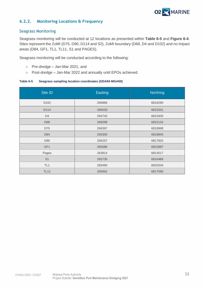
54 Midwest Ports Authority
Project Subtitle: Geraldton Port Maintenance Dredging 2021
21WAU-0002 / 210027
6.2.2. Monitoring Locations & Frequency
Seagrass Monitoring
Seagrass monitoring will be conducted at 12 locations as presented within Table 6-5 and Figure 6-4.
Sites represent the ZoMI (D75, D90, D114 and S2), ZoMI boundary (D68, D4 and D102) and no impact
areas (D84, GF1, TL1, TL11, S1 and PAGES).
Seagrass monitoring will be conducted according to the following:
Pre-dredge – Jan-Mar 2021; and
Post-dredge – Jan-Mar 2022 and annually until EPOs achieved.
Table 6-5 Seagrass sampling location coordinates (GDA94 MGA50)
Site ID Easting Northing
D102 266866 6816290
D114 266033 6815331
D4 264742 6815405
D68 266098 6822134
D75 266367 6818968
D84 265300 6818845
D90 266257 6817825
GF1 265086 6822887
Pages 263814 6814517
S1 265735 6816486
TL1 265490 6820334
TL11 265962 6817095

55 Midwest Ports Authority
Project Subtitle: Geraldton Port Maintenance Dredging 2021
21WAU-0002 / 210027
Figure 6-4 Proposed post-dredge seagrass survey locations

56 Midwest Ports Authority
Project Subtitle: Geraldton Port Maintenance Dredging 2021
21WAU-0002 / 210027
BCH Monitoring
BCH monitoring will be conducted at all 36 locations as presented within Table 6-5 and Table 6-6,
whilst side scan sonar data will be collected within the study area as displayed within Figure 6-5. BCH
monitoring will be conducted as follows:
Pre-dredge – July / August 2021; and
Post-dredge – March / April 2022 and annually until EPOs achieved.
Side scan sonar sampling should avoid the Nearshore DMPA footprint where possible as this habitat
type is known and will be monitored by ongoing hydrographic surveys in accordance with Section 6.3.
Table 6-6 BCH sampling location coordinates (GDA94 MGA50)
Site ID Easting Northing
DC1 265846 6819011
DC2 265728 6818780
DC3 265647 6818646
DC4 265632 6818309
DC5 265597 6818034
DC6 266129 6817898
DC7 266383 6818058
DC8 266700 6818030
DC9 266214 6818376
DC10 266279 6818617
DC11 266712 6818719
DC12 266335 6818769
DC13 266360 6818997
DC14 266363 6819182
DC15 266651 6819354
DC16 266602 6819670
DC17 266231 6819606
DC18 266215 6819978
DC19 265900 6819863
DC20 265881 6819327
SH1 267122 6820507
TA1 266425 6821980
TA4 266304 6822308
TA6 266720 6821586

57 Midwest Ports Authority
Project Subtitle: Geraldton Port Maintenance Dredging 2021
21WAU-0002 / 210027
Figure 6-5 Proposed post-dredge BCH survey locations.

58 Midwest Ports Authority
Project Subtitle: Geraldton Port Maintenance Dredging 2021
21WAU-0002 / 210027
Environmental Protection Outcomes, and Performance Assessment Criteria
The EPOs and performance assessment criteria to be applied for protection of BCH are presented in
Table 6-7. As this program occurs pre- and post-dredging there is no reactive dredge management
actions, only actions to ensure the EPO is achieved.
An annual report and a final report (if trigger exceeded) shall be prepared to document the BCH
monitoring program as described in Table 7-1.
Table 6-7 Impact management targets for BCH monitoring programs
6.2.3. Parameters and Procedures
Seagrass Monitoring
For the purposes of conducting pre- and post-dredge seagrass health assessment at each of the
sampling locations presented within Table 6-5 and Figure 6-4 the following minimum parameters may
be recorded in-situ or post-hoc:
1. Seagrass shoot density and height
2. Species composition
3. Presence of epiphyte and epifauna
4. Habitat type
5. Percent coverage
Procedures for the sampling of parameters 1-4 remain consistent with BMT (2021a) with the following
exceptions:
1. Seagrass shoot density and height may be counted in-situ rather than removal and laboratory
analysis:
2. Parameters previously collected such as aboveground biomass, leaves per cluster and
presence of dead rhizome mat are not required for assessment of dredging related impacts.
Parameter 5 will be sampled in accordance with the methods described in BMT (2021a).
Monitoring Locations as per Figure 6-4 and Figure 6-5
Performance
Measure:
Early warning for no
negative change
from baseline state
on BCH
Performance Assessment Criteria 1
Annual seagrass health assessment indicates sub-lethal impacts, decreased extent or significant
community shift related to dredging and material placement
or
Annual BCH monitoring decreased habitat extent or significant community shift related to dredging
and material placement
Environmental
Protection
Outcome:
No negative change
from baseline state
on BCH
Performance Assessment Criteria 2
Annul seagrass health assessment identifies recovery from observed impacts > 5 years
or
Annual BCH monitoring identifies recovery from observed impacts > 5 years

59 Midwest Ports Authority
Project Subtitle: Geraldton Port Maintenance Dredging 2021
21WAU-0002 / 210027
BCH Monitoring
BCH monitoring will be completed using a combination of side scan sonar and drop-down cameras at
the study area and sampling locations presented within Table 6-5, Table 6-6 and Figure 6-5.
Parameters and procedures for BCH monitoring using drop-down cameras will be in accordance with
or to the same standard as the methods described by BMT (2021b) and AECOM (2020).
Side scan sonar will be used to collect data within the defined study area in accordance with procedures
associated with the equipment used. This typically requires associated equipment such as the sonar
unit and data capture laptop operated by trained marine scientists, DGPS and survey vessel. Transects
will be defined prior to commencing survey operations with corresponding georeferenced paths
uploaded to the survey vessel navigation equipment to determine the best method for data capture
across the entire study area.
6.2.4. Data Analysis
Seagrass Monitoring
Data collected from the seagrass monitoring program will be analysed using suitable statistical methods
to determine the following null hypothesis:
1. Measured seagrass health metrics at ZoMI locations are statistically similar with health metrics
at reference sites thus no dredge related impacts are measured; and
2. Measured seagrass health metrics are statistically similar to pre-dredge survey results as
presented in BMT (2021a).
Annual reports and a final report shall be prepared to document the findings from seagrass surveys.
BCH Monitoring
Field data collected from side scan sonar and drop-down cameras will be analysed post-hoc with
specialised software to determine habitat type and extent. The most recent habitat map (O2 Marine
2021b) will be used as a base layer upon which revised data will be interpolated to create a pre-dredge
habitat map for the Nearshore DMPA and adjacent area. A similar approach will be used for post-
dredge data capture to provide the ability to undertake a pre- and post-dredge habitat type and extent
interrogation using GIS or similar suitable software.
Data collected from the BCH monitoring program will be analysed using suitable statistical methods to
determine the following null hypothesis:
1. Observed BCH habitat classes are statistically similar for pre- and post-dredge datasets; and
2. Measured BCH habitat extents are statistically similar for pre- and post-dredge datasets.
In addition, habitat type and extent data collected from the pre-dredge BCH survey will be used to define
appropriate buffers for material placement within the Nearshore DMPA prior to commencing placement
activities.
A pre dredge summary report, annual reports and a final report shall be prepared to document the
findings from BCH surveys.

60 Midwest Ports Authority
Project Subtitle: Geraldton Port Maintenance Dredging 2021
21WAU-0002 / 210027
6.2.5. Corrective Actions
Annual reporting shall be reviewed against the performance assessment criteria presented within Table
6-7. If performance assessment criteria 1 is not exceeded (i.e. no impacts are identified within the ZoMI
from dredging and placement of material) then the EPO is considered met and no further monitoring is
required.
If performance assessment criteria 1 is exceeded, then annual monitoring should continue until
recovery to pre-dredging baseline conditions are observed. If recovery has not been observed within
five years the EPO is not considered achieved.
If the EPO is not met, an investigation is required to determine the severity and extent of related impacts
and management actions identified to ensure no future impacts from dredging and material placement
arise.
If the dredge project is identified as having significant environmental impacts, MWPA may consider
consultation with the EPA branch within DWER to consider future corrective actions.
Model Validation Monitoring Program
6.3.1. Rationale
To predict impacts upon BCH from light reduction and smothering, hydrodynamic and sediment
transport modelling was conducted (GEMS 2021). The impact assessment concluded that minimal
impacts to BCH were predicted from project activities, typically due to the short duration of the project
and the site selection for the Nearshore DMPA (O2 Marine 2021b).
However, MWPA are committed to continual improvement, and as such have developed a sampling
program which aims to collect actual data during dredging and nearshore placement with the aim of
validating the model and ensuring the impact assessment predictions are commensurate with any
actual impacts.
This monitoring program is aimed at collecting data on the dredge plume and sediment transport as a
mechanism to validate hydrodynamic and sediment transport modelling. The first aspect aims to collect
suspended sediments and use results from aerial photography as a means to validate plume outputs
and light loss predictions used to establish the ZoI. The second aims to quantify the volume of material
lost from the Nearshore DMPA over the dredge model duration (two years) to validate the sediment
transport model.
Results will also provide a feedback loop to assist interpretation of BCH monitoring results if any impacts
are identified.
6.3.2. Monitoring Locations & Frequency
Dredge Plume Validation
Total Suspended Sediments
Total suspended sediments (TSS) will be collected at all six locations presented in Table 6-3 and Figure
6-2 in conjunction with weekly MWQM. In addition to these sites, two targeted sites will be sampled
during each weekly event which target the actual dredge plume as it is occurring at the time from either
channel dredging or nearshore material placement activities.

61 Midwest Ports Authority
Project Subtitle: Geraldton Port Maintenance Dredging 2021
21WAU-0002 / 210027
TSS will be collected during all MWQM events pre-dredge and during dredge (channel and inner
harbour).
Aerial Photography
Aerial photography will be collected along a pre-determined flight path across project area, including
channel and harbour dredging and material placement activities at the Nearshore DMPA. Monitoring
will be conducted at least fortnightly during throughout dredging and material placement activities.
Sediment Transport Validation
Upon completion of the material placement within the Nearshore DMPA the contractor is required to
complete a hydrographic survey. The survey extent for the post placement survey will be completed on
a six-monthly basis for a period of two years. The Nearshore DMPA footprint is presented in Figure
1-1.
6.3.3. Environmental Protection Outcomes and Performance Assessment Criteria
The EPOs and performance assessment criteria to be applied for model validation are presented in
Table 6-8.
The dredge plume validation program shall have a final close out report presented to MWPA. Six
monthly reports and a final report shall be prepared to document the sediment transport program. These
are described in Table 7-1.
Table 6-8 Impact management targets for model validation
Dredge Plume Validation- Monitoring Location:
PAR - LL1, LL2 & WQL3 (Figure 6-2)
TSS - LL1, LL2 , WQD1, WQ2, WQL3 and WQ4 (Figure 6-2) plus random dredging plume locations
Performance
Measure:
PAR/TSS exceed
model prediction for
ZoMI and indicate
potential ZoHI
Performance assessment criteria 1
Actual dredge TSS levels recorded are >25% lower over the dredge project than model predictions
or
Predicted dredge plume visible extent is 50% greater than model predictions
Sediment Transport Validation – Monitoring Location – Nearshore DMPA
Performance
Measure:
Sediment volumes
naturally transported
from the Nearshore
DMPA exceed model
predictions for ZoMI
and indicate potential
ZoHI
Performance assessment criteria 2
Actual sediment volumes mobilised from the Nearshore DMPA are >25% higher for each sampling
period than model predictions.

62 Midwest Ports Authority
Project Subtitle: Geraldton Port Maintenance Dredging 2021
21WAU-0002 / 210027
6.3.4. Parameters and Procedures
Dredge Plume Validation
Suspended Sediments
SSC samples will be conducted concurrently with the MWQM sampling program. SSC samples will be
collected as per the methods described for contaminants, however three subsamples will be collected
per site. At each site subsamples will be collected from:
0.5 m below surface;
Centre of water column; and
0.5 m above seafloor.
Whilst this program is concurrently implemented with the MWQM program, TSS samples are required
to be collected for number of dredge scenarios to adequately verify the hydrodynamic modelling.
Therefore, when scheduling weekly water sampling events, liaison with the dredge contractor should
be included to ensure data is obtained across a range of channel dredging and nearshore placement
activities.
Aerial Photography
Oblique aerial photography will be captured using either a drone set to a pre-determined flight path, or
via commercial light aircraft. Photographs will be targeted at locations where the dredge vessel is
actively dredging or placing material. Turbidity plumes developed from natural events, such as wind or
swell, will also be targeted during the same flight to provide context to observed dredging and placement
plumes. GPS coordinates of photographs should be recorded where possible.
Sediment Transport Validation
Post dredging channel and Nearshore DMPA bathymetric surveys will be conducted every six months
concurrently with the Ports Draft Under Keel Clearance surveys. Ongoing surveys will be completed
using the same methodology and using similar equipment as the final survey collected upon completion
of the dredging project.
6.3.5. Data assessment
Data obtained through this program will be fed back into modelling to determine the level of accuracy
of the predicted outputs (dredge plume and sediment transport).
Dredge plume aerial photography will be compared to dredging model outputs provided by GEMMS
(2021) to determine the accuracy of predicted visible plumes. An assessment of naturally occurring
turbidity collected at sites not impacted from dredging and material placement activities will also be
considered in the interpretation. Photographs may be used by MWPA on the website for stakeholder
engagement during dredging activities.
Sediment transport data analysis can be completed by conducting a simple loss calculation to
determine the volume moved through natural sediment relocation mechanisms during each sampling
period. This value will then be compared to the model predictions for each period to determine the
accuracy of predicted sediment transport.
63 Midwest Ports Authority
Project Subtitle: Geraldton Port Maintenance Dredging 2021
21WAU-0002 / 210027
Any significant weather events (i.e. cyclone activity, large storm or swell events, flushing from Chapman
River mouth etc.) are to be considered when evaluating results as these will likely alter the accuracy of
modelled predictions. When considering this aspect, a reference to the modelled parameters should be
considered (i.e. what weather scenarios were included in the dredging period) Benthic PAR will also
need to be evaluated against the reference location to determine if any measured light reduction was a
natural occurrence (swell induced turbidity or cloud cover) or related to dredge plumes.
6.3.6. Corrective Actions
Where performance criteria for TSS, visible dredge plume extent or sediment transport are not achieved
MWPA will undertake an investigation to determine further actions. This may consider, but not be limited
to:
Consider additional BCH or seagrass sampling;
Evaluate the and refine the model to ensure future predictions are more accurate;
Identify and collect additional data to support future dredge plume and sediment transport
modelling outputs;
Consult stakeholders to evaluate potential impacts to adjacent operations.
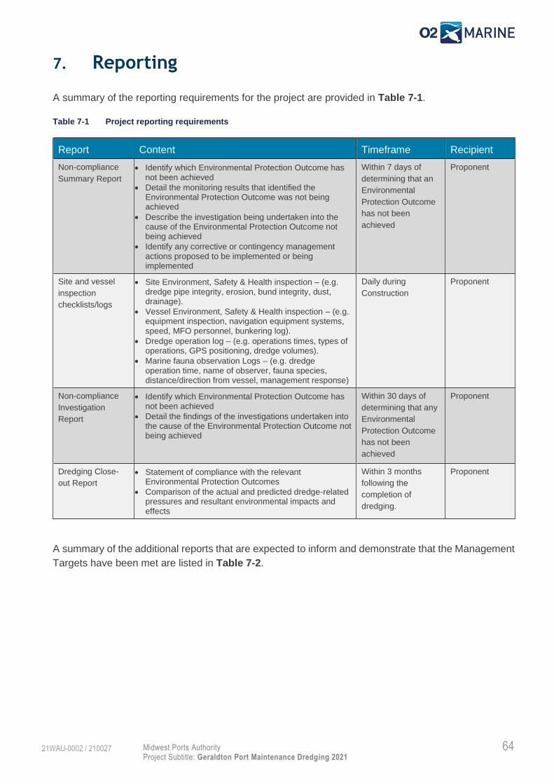
64 Midwest Ports Authority
Project Subtitle: Geraldton Port Maintenance Dredging 2021
21WAU-0002 / 210027
7. Reporting
A summary of the reporting requirements for the project are provided in Table 7-1.
Table 7-1 Project reporting requirements
Report Content Timeframe Recipient
Non-compliance
Summary Report
• Identify which Environmental Protection Outcome has not been achieved
• Detail the monitoring results that identified the Environmental Protection Outcome was not being achieved
• Describe the investigation being undertaken into the cause of the Environmental Protection Outcome not being achieved
• Identify any corrective or contingency management actions proposed to be implemented or being implemented
Within 7 days of
determining that an
Environmental
Protection Outcome
has not been
achieved
Proponent
Site and vessel
inspection
checklists/logs
• Site Environment, Safety & Health inspection – (e.g. dredge pipe integrity, erosion, bund integrity, dust, drainage).
• Vessel Environment, Safety & Health inspection – (e.g. equipment inspection, navigation equipment systems, speed, MFO personnel, bunkering log).
• Dredge operation log – (e.g. operations times, types of operations, GPS positioning, dredge volumes).
• Marine fauna observation Logs – (e.g. dredge operation time, name of observer, fauna species, distance/direction from vessel, management response)
Daily during
Construction
Proponent
Non-compliance
Investigation
Report
• Identify which Environmental Protection Outcome has not been achieved
• Detail the findings of the investigations undertaken into the cause of the Environmental Protection Outcome not being achieved
Within 30 days of
determining that any
Environmental
Protection Outcome
has not been
achieved
Proponent
Dredging Close-
out Report
• Statement of compliance with the relevant Environmental Protection Outcomes
• Comparison of the actual and predicted dredge-related pressures and resultant environmental impacts and effects
Within 3 months
following the
completion of
dredging.
Proponent
A summary of the additional reports that are expected to inform and demonstrate that the Management
Targets have been met are listed in Table 7-2.

65 Midwest Ports Authority
Project Subtitle: Geraldton Port Maintenance Dredging 2021
21WAU-0002 / 210027
Table 7-2 Reporting requirements for environmental monitoring programs to determine if MTs are met
Topic Content Timeframe Responsibility
Benthic habitat pre-
dredge survey
Results, including updated habitat map of study
area, and discussion of pre-dredge benthic habitat
survey
Prior to
commencement of
dredging
Proponent
Benthic habitat
post-dredging
survey
Results, including updated habitat map of study
area, and discussion of post-dredge benthic habitat
survey including ZoMI
Within eight-months
following completion
of dredging
Proponent
Seagrass
monitoring post-
dredging survey
Results and discussion of post-dredge seagrass
survey including statistical comparison of ZoMI and
non ZoMI sites and pre- and post-dredge health
metrics.
Within eight-months
following completion
of dredging
Proponent
Marine water quality
monitoring
Summary of water quality health relative to the
Environmental Protection Outcomes and
Management Targets
Weekly
Monthly
Final report within
one-month following
cessation of dredging
Proponent
Tailwater return
monitoring
Summary of water quality health relative to the
Environmental Protection Outcomes and
Management Targets
Weekly
Monthly
Final report within
one-month following
cessation of tailwater
discharge
Proponent
Dredge plume
Validation
Results from benthic light and TSS will be compared
against model outputs and the associated
management targets.
Final report within two
months from
completion of data
capture
Proponent
Sediment transport
validation
Results from sediment transport will be compared
against model outputs and the associated
management targets.
Biannual summary
reports
Final close out report
at two years
Proponent
Dredging and
Nearshore
Placement Close-
out Report
Evaluation of all environmental monitoring programs including:
• Statement of compliance with the relevant Environmental Protection Outcomes
• Comparison of the actual and predicted dredge-related pressures and resultant environmental impacts and effects
• Summarise the effectiveness of nearshore placement as a future strategy for dredge material management
• Summarise the effectiveness of management and monitoring programs
• Provide recommendation for future improvements to dredge planning, impact assessment, management and monitoring.
Within 3 months
following the
completion of
environmental
monitoring programs.
Proponent

66 Midwest Ports Authority
Project Subtitle: Geraldton Port Maintenance Dredging 2021
21WAU-0002 / 210027
A summary of the external reporting requirements for the project are provided in Table 7-3.
Table 7-3 External reporting requirements
Report Content Timeframe Recipient
Biosecurity Incident Reporting potential, suspected or known marine pest incursion.
Within 24 hours of potential
identification of marine pest
incursion
DPIRD –
FishWatch –
1800 815 507
Major hydrocarbon
spillage
Complete a POLREP - https://www.transport.wa.gov.au/imarine/reporting-marine-oil-pollution.asp
Immediately DoT – MEER
(08) 6480 9924
Major pollution
incident
Details regarding the incident such as time, place, pollution type, severity, extent etc.
Immediately DWER –
1300 784 782
Significant Impact
arising from project
There is no formal process for reporting significant environmental impacts. A report detailing the significant impact, technical investigations undertaken to support conclusions and all associated incident investigations and actions implemented to reduce the impact should be compiled for consultation.
Liaison should commence
immediately upon identification
of impacts.
Reports to be submitted upon
completion.
Consultation
with the EPA
branch of
DWER

67 Midwest Ports Authority
Project Subtitle: Geraldton Port Maintenance Dredging 2021
21WAU-0002 / 210027
8. Reference List
AECOM (2020). Benthic Habitat Mapping Report – Champion Bay and Surrounds. Report prepared for
Midwest Ports Authority. Report No.R1889/M&C4168
ANZG (2018). Australian and New Zealand Guidelines for Fresh and Marine Water Quality, Australian
and New Zealand Governments and Australian state and territory Governments, Canberra ACT,
Australia. Available at www.waterquality.gov.au/anz-guidelines
ATA (1999). Deepwater Port at Point Moore, Public Environmental Review, Volume 1 General Report.
Report prepared for the Geraldton Port Authority by Alan Tingay & Associates, Perth, Western
Australia, Report No. 94/6, October 1994.
BMT (2021a). Seagrass Communities in Champion Bay and Surroundings. Report prepared for
Midwest Ports Authority. Report No. R-1799_00-3
BMT (2021b). Assessment of Potential Dredge Material Placement Areas within Champion Bay, WA.
Report prepared for Midwest Ports Authority. Report No. R-10708-1
Coffey (2021). Geraldton Port Acid Sulfate Soils Management Plan. Report currently being prepared
for Mid West Ports Authority.
Coupland G (1997). Rhizome and shoot structure, growth and response to sediment burial in
Amphibolis griffithii (Black) den Hartog. Honours, University of Western Australia
Department of Agriculture and Water Resources (2017). Australian Ballast Water Management
Requirements. Version 7.
DER (2014). Assessment and Management of Contaminated Sites. Department of Environment
regulation (DER). Government of Western Australia.
DER. (2015). Identification and Investigation of Acid Sulfate Soils and Acidic Landscapes. Government
of Western Australia, Department of Environment Regulation (DER).
Environmental Protection Authority (2016). Technical Guidance – Environmental Impact Assessment
of Marine Dredging Proposals, EPA, Western Australia.
Environmental Protection Authority (2016b). Technical Guidance – Protecting the Quality of Western
Australia’s Marine Environment, EPA, Western Australia.
Environmental Protection Authority (2016c). Technical Guidance – Protection of Benthic Communities
and Habitats, EPA, Western Australia.
GEMMS (2021). Mid West Ports Authority Maintenance Dredging Simulations at Geraldton. Report
prepared for the Mid West Ports Authority.
MWPA (2013). 2012 Maintenance Dredge Project – Environmental Monitoring Report. Report prepared
by the Geraldton Port Authority, July 2013.
NAGD (2009). National Assessment Guidelines for Dredging. Department of the Environment, Water,
Heritage and the Arts, Commonwealth of Australia.

68 Midwest Ports Authority
Project Subtitle: Geraldton Port Maintenance Dredging 2021
21WAU-0002 / 210027
O2 Marine (2021a). Sediment Characterisation Assessment Report. Report prepared for Midwest Ports
Authority. Report No. R190125
O2 Marine (2021b). Environmental Impact Assessment – Geraldton Port Maintenance Dredging Project
2021. Report prepared for Midwest Ports Authority. Report No. R210034
O2 Marine (2021c). Maintenance Dredging Sediment Characterisation Sample and Analysis Plan –
Geraldton Port. Report prepared for Midwest Ports Authority. Report No. R190101
O2 Marine (2021d). Marine Fauna Occurrence Assessment – Geraldton Maintenance Dredging. Report
prepared for Midwest Ports Authority. Report No. R210037
O2 Metocean (2020). Metocean Measurements at Sunset Beach, City of Greater Geraldton. Report
prepared for City of Greater Geraldton. Report No. R200298
Oceanica (2010). Oakajee Port; Benthic Primary Producer impacts from construction of the Proposed
Oakajee Port. Report prepared for Oakajee Port and Rail. Report No. 503_009/1
Tecchiato, S., Collins, L.B., and Stevens, A. M., (2012). Geraldton Embayments Coastal Sediment
Budget Study.
Stul T, Gozzard JR, Eliot IG and Eliot MJ (2014) Coastal Sediment Cells for the Mid-West Region
between the Moore River and Glenfield Beach, Western Australia. Report prepared by Seashore
Engineering Pty Ltd and Geological Survey of Western Australia for the Western Australian
Department of Transport, Fremantle.
URS (2001). Port Enhancement Project and Preparatory Works for the Town Beach Foreshore
Redevelopment. Report prepared for the Geraldton Port Authority. Report No. R842

A
Mid West Ports Authority Project Name: Geraldton Port Maintenance Dredging - 2021
21WAU-0002 / R210027
Appendix A Existing Environment
A.1 Coastal processes
A.1.1 Regional Setting
Geraldton is located within the Midwest region on the west coast of Western Australia, approximately
400 km north of Perth. The Port is located on the northern side of the Point Moore peninsula with the
Port and city centre facing north into Champion Bay. Champion Bay is a semi-sheltered embayment
protected from raw ocean swell conditions by a series of shallow subtidal reef systems extending off
Point Moore and a deeper parallel limestone ridge which runs north towards Drummond Cove. East of
the limestone ridge, water depths up to approximately 11 m occur within two kilometres of the coast.
To the west of the limestone ridge, water depths rapidly increase to 20-30 m, and then gradually deepen
to 50 m before shallowing again at the Houtman Abrolhos Islands located some 50 km offshore.
To the north and south of Point Moore, the coast is comprised primarily of sandy beaches generally
overlying beach rock. Occasional areas of shallow beach rock and limestone platform are exposed at
locations such as at Drummond Cove, Bluff Point, Point Moore and adjacent to the mouth of the
Greenough River. Two main rivers, the Greenough River (~10 km south of Point Moore), and Chapman
River (~5 km north of Point Moore), periodically discharge into coastal waters in the Geraldton area.
These rivers are typically closed at the river mouth discharging only after significant rain falls within the
two catchments.
A.1.2 Climate and Oceanography
Offshore coastal waters, west of Champion Bay and Point Moore, experience moderate to high wave-
energy. O2 Metocean (2021) undertook a metocean measurement programme on behalf of the City
of Greater Geraldton in 2020. Waves, water levels, currents, and water temperature measurements
collected at two sites distanced 1,100 m from each other, both approximately 500 m west of Sunset
Beach foreshore in 10m water depth, were collected to improve the understanding of the metocean
conditions contributing to beach change at Sunset Beach. Anticipating that most severe beach erosion
would occur in winter, the measurement campaign commenced in March 2020 and extended to October
2020. Summer conditions were later added to the programme, with the summer measurement
campaign lasting six (6) weeks from late November 2020 to early January 2021.
The significant wave height (Hs, total) at the measurement sites (10m depth) peaked at Hs~2.6m during
a late May 2020 (winter) storm. The data revealed that Hs>2m is a relatively common occurrence
during winter, where Hs>1.4m occurs approximately 30% of the time between June and October. Long
period swells with peak spectral wave periods (Tp) longer than 20s were very rarely observed (<2%),
however winter swells presented a peak period of 10<Tp<20s. Substantially more benign conditions
were recorded in summer, with Hs>1.4m less than 1% of the time and Hs<1m 83% of the time.
The currents are tidally driven and predominantly parallel to the coast, rotating from northward to
southward (and vice versa) with the tidal cycle. Depth averaged peak current speeds typically range
from 0.10 to 0.20m/s in winter and rarely exceed 0.10m/s in summer. Only once during the
measurement campaign the current exceeded 0.25m/s (May 2020 storm). Geraldton experiences
diurnal tides with a small range (~0.9m spring).

B
Mid West Ports Authority Project Name: Geraldton Port Maintenance Dredging - 2021
21WAU-0002 / R210027
Geraldton experiences a seasonal wind pattern on which is superimposed a diurnal land-sea breeze
system. During winter, night and morning winds are generally moderate (6–30km/hr) and prevail from
the north-east, then swing through north-west to south in the afternoon (URS 2001). Summer morning
winds are moderate (11–30km/hr) and generally originate from the east to south-east. In the afternoon
the winds shift to moderate to strong (generally 21–40km/hr) through south to south-west (URS 2001).
Typically, December is the windiest month and July the least windy. Extreme winds occur mainly in
summer and generally are isolated events associated with thunderstorms and tropical cyclones (ATA
1994).
A.1.3 Geomorphology
The Central West Coast Region is an area where the continental shelf is relatively narrow and there is
a diversity of moderate energy coastal landforms developed. The coast is formed over the Perth
Sedimentary basin. Through the Pleistocene (10,000 to 2,000,000 years ago) there was a succession
of transgressions and regressions of the sea over the Swan Coastal Plain. As sea level fell during each
regression it left behind a coastal dune field, the oldest of which have consolidated to form North-South
aligned ridges of aeolianite limestones (URS 2001). Ridges that occur above present-day sea level
usually bear a mantle of Holocene dunes. Those below sea level form sublittoral reefs, often undercut
and cavernous on the seaward side. Small islands, representing high points of flooded ridges, are a
relatively common feature within a few kilometres of the shore.
Semi-sheltered lagoonal habitats are developed behind offshore limestone reefs in many localities. The
degree of shelter is variable, depending on the depth and continuity of the offshore reefs and islands.
The shore is commonly comprised of long sandy beaches with occasional rocky cliffs and headlands
where the limestone outcrops. Notched intertidal rock platforms are a feature of this coast.
The sediments of the littoral and shallow water zone of Champion Bay are primarily seagrass derived
(i.e. mainly composed of microscopic shells of seagrass-associated organisms), with secondary riverine
quartz sediment input and dune related carbonate sediment input (Tecchiato et al 2012). There is an
overall south to north transport pattern driven by south-westerly swell waves and strong sea breeze
wave fields, however, temporary reversal can occur during powerful north-west swells potentially
associated with tropical storms or large winter storms (Tecchiato et al 2012, Stull et al 2014).
Champion Bay is one of many partially protected embayments that occur along the coast within the
Central West Coast Region. While the Bay has extensive reef along its western side, this generally
rises to only 8 to 10 m below sea level and there are no offshore islands to provide protection from
wave energy. Swell height at the coast is attenuated by coastal limestone ridges; however wave heights
and periods are sufficient to initiate bottom sediment particle movement over the entire Geraldton
inshore platform (Tecchiato et al 2012). The limited protection of Champion Bay is evidenced by the
relatively narrow, high energy beaches found along most of its length and the relatively small amount
of sediment which is present on the floor of the Bay. Only the south-eastern corner of the Bay has a
level of protection sufficient to allow the development of extensive seagrass beds on thick sand veneers
overlying the limestone basement.

C
Mid West Ports Authority Project Name: Geraldton Port Maintenance Dredging - 2021
21WAU-0002 / R210027
A.2 Marine Environmental Quality
A.2.1 Water Quality
Water clarity in Champion Bay is variable during the year as a result of wind driven current strengths
and wave energy, as well as intermittent rainfall runoff in the catchments of the rivers, such as the
Greenough and Chapman Rivers that drain the hinterland. Typically, the season of lowest water clarity
is winter as a higher energy swells mobilising bottom sediments and due to this being the main time
during which the intermittent discharge to the Bay of alluvial sediments from river discharge. In wet
years, the Bay remains turbid for many months and salinity of nearshore waters slightly decreases as
a result of river inflow. Strong winds in summer create waves that also cause an increase in suspended
particulate matter which can also reduce water clarity. The period of greatest water clarity is usually in
late summer to autumn (February to May) and occurs in response to reduced wind strengths and wave
energy and absence of riverine sediment input.
Turbidity within Champion Bay typically increases closer to shore, mostly as a consequence of wave
action that lifts sands and silt-sized particles into the water column (URS 2001). During spring and
summer there is often a marked diurnal effect, with the increased wave action generated by the strong
mid-morning to evening sea breezes increasing coastal turbidity compared to the early morning and
dawn calms. During autumn and winter, turbidity and cloudiness (discolouration) is also often elevated
in the inner half of Champion Bay, a period when fine organic material from the nearshore and shoreline
wracks of decaying seaweed and seagrass is suspended and dispersed through the nearshore water
column. Apart from the natural sources and cycles of turbidity, propeller wash from ship and tug
movements along the inner sector of the entrance channel also contributes to turbidity. Marked
variations in turbidity therefore occur within hourly, daily, weather-system and seasonal time cycles, as
well as with depth.
MWPA have implemented a passive water quality monitoring program targeting key metal contaminants
since November 2012. This involves the collection of time weighted average samples at three locations
within the Inner harbour (Berths 4, 5 and 6) and one reference site within Champion Bay north of the
entrance channel. Analytes collected during this period include cadmium, cobalt, copper, lead, nickel
and zinc as these are known elements occurring withing exported metal concentrate ores. A summary
of the water quality sampling results are provided below.
General:
o No exceedances of the 90% species protection level (SPL) (typically applied to Ports)
or the 95% SPL have occurred within the inner harbour throughout the monitoring
program.
o Water quality within the inner harbour is considered to be of a very high quality with
slight elevations from natural conditions occurring for copper, lead and zinc.
o Two exceedances of the copper 99% SPL were reported from the reference sites
however detections to the ultra-trace for copper may result in handling or laboratory
errors.
Cadmium:
o Cadmium concentrations at impact sites are typically very low, ranging from below the
laboratory detection levels to 0.046 µg/L. The 90% SPL typically applied to a Port
environment is 14.0 µg/L.

D
Mid West Ports Authority Project Name: Geraldton Port Maintenance Dredging - 2021
21WAU-0002 / R210027
o Inner harbour and reference sites typically have comparable concentrations.
Cobalt:
o Cobalt concentrations at impact sites are typically very low, ranging from below the
laboratory detection levels to 0.031 µg/L. The 90% SPL typically applied to a Port
environment is 14.0 µg/L.
o Inner harbour and reference sites typically have comparable concentrations.
Copper:
o Copper concentrations at impact sites are typically low, ranging from low level
detections of 0.24 µg/L to 2.65 µg/L. The 90% SPL typically applied to a Port
environment is 3.0 µg/L.
o Whilst there have been no exceedances of the 90% SPL, copper concentrations are
generally elevated within the inner harbour compared to reference sites which range
from below the laboratory detection level to 1.46 µg/L.
Lead:
o Lead concentrations at impact sites are typically very low, ranging from low level
detections of 0.05 µg/L to 0.89 µg/L. The 90% SPL typically applied to a Port
environment is 6.6 µg/L.
o Whilst there have been no exceedances of the 90% SPL, lead concentrations are
generally elevated within the inner harbour compared to reference sites which range
from below the laboratory detection level to 0.43 µg/L.
Nickel:
o Nickel concentrations at impact sites are typically very low, ranging from low level
detections of 0.10 µg/L to 0.32 µg/L. The 90% SPL typically applied to a Port
environment is 200 µg/L.
o Inner harbour and reference sites typically have comparable concentrations.
Zinc:
o Zinc concentrations at impact sites are typically low, ranging from 2.0 µg/L to
11.3 µg/L. The 90% SPL typically applied to a Port environment is 23 µg/L.
o Whilst there have been no exceedances of the 90% SPL, zinc concentrations are
generally elevated within the inner harbour than reference sites which range from
0.3 µg/L to 6.2 µg/L.
A water quality monitoring program was also implemented by MWPA (2013) as part of the
environmental management program developed for the 2012 maintenance dredging program. The
program was typically identified to determine the water quality within the moderate ecological protection
area (i.e. the inner harbour) and the high ecological protection area (i.e. Champion Bay).
It should be noted that during this program no low ecological protection area (LEPA) was established
and it is likely that several monitoring sites may have been located within a defined LEPA. As the LEPA
has a lower SPL assigned within, several exceedances reported in MWPA (2013) may be
overestimated.
The sampling program incorporated collection and laboratory analysis of dissolved metals, tributyltin
(TBT) and polycyclic aromatic hydrocarbons. TBT and PAHs were dismissed during post dredging as
no detection occurred in pre dredge or during dredge monitoring.

E
Mid West Ports Authority Project Name: Geraldton Port Maintenance Dredging - 2021
21WAU-0002 / R210027
Sampling events included one round pre-dredging, two rounds during dredging and seven events post
dredging.
A summary of the key sampling results is provided below.
Pre-dredging:
o No results exceeded the 90% SPL within the MEPA;
o Copper exceeded the 99% SPL at six of seven sites in the HEPA;
o PAH and TBT concentrations were all below the LoRs.
During Dredging:
o Zinc exceeded the 90% SPL on both sampling events at one location within the MEPA;
o Lead exceeded the 90% SPL on one occasion at one site within the MEPA;
o Copper and zinc exceeded the 99% SPL within the HEPA at several sites on both
sampling rounds;
o Silver (two sites) and nickel (one site) exceeded the 99% SPL on the second sample
round only:
o PAH and TBT concentrations were all below the LoRs.
Post Dredging
o TBT and PAH were not samples based upon no detection during or pre dredging;
o No concentrations exceeded the 90% SPL within any sample round for MEPA sites;
o Zinc and copper exceeded the 99% SPL at some sites during the first two rounds;
o Silver exceeded the 99% SPL at one site during round two;
o No exceedances occurred at MEPA or HEPA sites during rounds three to seven.
Limited data is available for the wider Champion Bay marine environment, though there are limited
activities which are likely to result in any marine environmental impacts. Identified activities and their
potential, temporary impacts may include:
1. Aquaculture fish farming within Champion Bay may have a localised impact over short
duration on water quality, such as minor nutrient loading.
2. Shipping and tug movement within the entrance channel result in localised, short duration
turbidity plumes on a regular basis.
3. Commercial and recreation vessel activities may have minor, highly localised impacts on water
quality from hydrocarbon spillages, rubbish or vessel anode deterioration.
During periods of warmer water, when swell and wind conditions result in very calm sea surface
condition, temporary blooms of Trichodesmium, a filamentous cyanobacteria, may occur within
Champion Bay. These blooms typically dissipate quickly when wind or sea state become more unsettled
and are considered natural events, however they may have short duration impacts upon water quality
during periods of extended blooms.
A.2.2 Sediment Quality
O2 Marine developed a Sediment Characterisation Sampling and Analysis Plan (2021c) and conducted
SAP Implementation sampling and reporting (2021b) to determine the quality of the material to be
dredged and disposed of within the two proposed DMPA’s. The assessment included both preliminary
F
Mid West Ports Authority Project Name: Geraldton Port Maintenance Dredging - 2021
21WAU-0002 / R210027
and detailed site investigations in accordance with the DER (2014) guidelines for the Assessment and
Management of Contaminated Sites.
Preliminary Site Investigation
The preliminary site investigation reviewed historical sediment investigations and sources of
contaminants. The desktop assessment identified that existing contaminants occur within the inner with
current extent typically limited to the Berth 3, 4 and 5 shipping pockets, whilst the central and eastern
sediments had limited information and entrance channel sediments were likely to clean and free from
contamination. Assessment of the accumulated sediments was divided into three categories in
accordance with the NAGD (2009) to include:
1. ‘Probably Clean’ channel sediments;
2. ‘Probably Contaminated’ harbour sediments associated with the Berths 3, 4 and 5 pockets;
and
3. ‘Suspect’ sediments within the remaining harbour sediments.
Within the berth 3, 4 and 5 pockets copper, zinc lead and tributyltin (TBT) have historically exceeded
the respective guideline values. Historical sampling has also identified potential acid sulphide soils
(PASS) within sediments.
Outcomes of the preliminary site investigation provided a basis for determining the scope of the detailed
site investigation, including defining the contaminants of potential concern (CoPC) and identifying the
number, depth and location of required sampling (O2 Marine 2021c).
Detailed Site Investigation
Detailed site investigations to characterise sediments were undertaken during June 2019, February
2020 and March 2021 (O2 Marine 2021a). A total of 31 surface and subsurface samples were collected
and analysed from 28 sediment sampling locations during the field survey. Sediment samples were
collected using SCUBA divers and push cores. Observations and photos were taken prior to sediments
being homogenised and packed into laboratory containers. Collected sediment samples were sent to a
NATA-accredited laboratory for testing of:
Physical Sediment Characteristics: Particle size analysis (PSA), total organic carbon (TOC),
moisture content;
Inorganic Compounds: Metals and Metalloids (Al, Ag, As, Cd, Cr, Cu, Fe, Pb, Hg, Ni and Zn);
Nutrients (Sediments: TKN & TP; Porewater NH4, NO2+NO3, FRP);
Organotins (TBT, DBT and MBT); and
Acid sulfate soils (SCr).
Additional sediment samples were also collected and analysed for SPOCAS to inform the Acid Sulphate
Management Plan (Coffey 2021).
‘Probably Clean’ sediments were characterised by fine grained, yellow to grey sands of natural origins
such as coastal silicate sands transported to the entrance channel via localised northern longshore drift,
or marine carbonate sediments transported via oceanic currents and swell. No contaminants of potential

G
Mid West Ports Authority Project Name: Geraldton Port Maintenance Dredging - 2021
21WAU-0002 / R210027
concern (COPC) were identified for probably clean sediments, which is consistent with previous
assessments of entrance channel sediments.
Sediments at the proposed Nearshore DMPA were characterised by fine grained, yellow to light brown
sands of natural origins such as coastal silicate sands and marine carbonate sediments. No
contaminants of potential concern (COPC) were identified at any of the five sites assessed.
‘Suspect’ and ‘Probably Contaminated’ sediments occurring within the harbour were typically comprised
of consistently finer material than channel sediments with the exception of sites near the channel
entrance which were physically similar to those within the channel. The sediments occurring in Berths
3-7 were comprised of slightly coarser material, described as medium/fine silty sands, than the south-
eastern corner of the harbour characterised by fine silty sands. Appearance ranged from grey to dark
grey and brown throughout the berth pockets and the south-eastern corner.
Total copper, zinc and mercury at ‘Suspect’ sediment sites were detected above DGV levels, with the
95% UCL of the mean for copper and zinc exceeding the DGV. Total cadmium, copper, lead and zinc
in ‘Probably Contaminated’ sediment sites were detected above the DGV screening levels, with the
95% UCL of the mean for copper and zinc exceeding the DGV. Terrestrial based ecological and health-
based investigation levels were also referenced within this report with the aim of providing a generalised
comparison with soil guidelines to consider an option for onshore disposal of dredge spoils. The
terrestrial investigation levels indicate contaminants would not exceed soil Environmental Investigation
Levels (EILs).
Comparison of total metals to ambient background was undertaken through normalising raw results
using aluminum as a normalising element to represent differences in metal concentrations based on
particle size between samples for total metals cadmium, copper, lead, iron, manganese, mercury,
vanadium and zinc. All metals display a strong linear correlation with aluminum. Normalised ‘Suspect’
sediments indicated ‘Minor’ to ‘Moderate’ enrichment for copper, ‘Moderately Severe’ to ‘Severe’
enrichment for zinc and ‘No Enrichment’ for mercury. Metals manganese, iron and vanadium, with no
screening guideline values, recorded ‘No Enrichment’ to ‘Minor’. Normalised ‘Probably Contaminated’
sediments indicated ‘Minor’ to ‘Moderately Severe’ enrichment for cadmium, copper and lead, with
‘Severe’ to ‘Extremely Severe’ zinc enrichment. Metals manganese, iron and vanadium, with no
screening guideline values, recorded ‘No Enrichment’ to ‘Minor’.
Except for mercury, all samples of total metals that exceeded DGV screening levels were tested using
elutriate (dissolved metals) and bioavailable (dilute acid extraction) techniques. Dissolved metal
concentrations from ‘Suspect’ sediments for copper were below the laboratory limit of reporting (LoR)
and zinc concentrations from two samples exceed the 90% ecosystem protection guideline. Dissolved
metal concentrations from ‘Probably Contaminated’ sediments for cadmium, copper and lead were
below the LoR, with zinc concentrations exceeding the 95% ecosystem protection guideline at one site
and 90% at two sites. The dilute acid extraction (DAE) assessment returned results below the LoR for
all cadmium and lead samples, whilst copper was only detected at two sites. Zinc ranged between 2-
8 mg/kg for all sites within the harbour. All DAE test results were below DGV levels and recorded levels
considered acceptable for ocean disposal or onshore placement/reuse.
Tributyltin (TBT) was assessed for all ‘Suspect’ sites and three ‘Probably Contaminated’ sites. TBTs
normalised to 1% total organic carbon are below the SQG of 9.0 µgSn/kg at all ‘Suspect’ sites, while
the 95% UCL of the means and two sites from the ‘Probably Contaminated’ sites exceed this level.
H
Mid West Ports Authority Project Name: Geraldton Port Maintenance Dredging - 2021
21WAU-0002 / R210027
Subsequent assessment undertaken on three samples from the ‘Probably Contaminated’ sites CH4,
CH5 and CH6 were analysed for elutriate TBTs. All results were reported below the laboratory LoR and
the 95% recommended for moderately disturbed ecosystems (ANZG 2018).
Acid Sulfate Soil (ASS) Action level criteria were exceeded at all inner harbour sites and at one
‘Probably Clean’ site. Acid based accounting results indicate that the potential acidity of these
sediments are effectively buffered from the acid neutralising capacity (ANC), and therefore there would
be a negative net acidity following disturbance of these sediments. However, as the DER (2015) action
criteria was exceeded an Acid Sulfate Soils Management Plan will need to be developed to manage all
potential impacts associated with ASS.
Nutrients in sediments and porewaters were assessed from ‘Probably Contaminated’ soils. Results
identified typically consistent results for total nitrogen and total phosphorous ranging between
870 mg/kg to 2,300 mg/kg and 370 mg/kg to 710 mg/kg, respectively. Total nitrogen was typically of
100% organic origins, as nitrate/nitrite results for all sites were below the laboratory detection levels.
Nutrients in porewater were considered very low in comparison with nitrate and nitrate are typically very
low, with only one real detection at CH2. Ammonia was quite variable with results ranging from
0.06 mg/L (CH7) to 29 mg/L (CH1). FRP results are all very low ranging between 0.03 mg/L (CH7) to
0.94 mg/L (CH1). Interestingly, ammonia and FRP results for CH1 and CH2 show a high level of
variability, considering they are sampled from the same shipping pocket at Berth 3.
A.3 Benthic Communities and Habitats (BCH)
A.3.1 Characteristics, Distribution and Condition of BCH
Broadscale Habitat Mapping – Champion Bay
Habitat mapping undertaken by AECOM (2020) identified that the benthic habitats of Champion Bay
and the surrounding area can be broken down into a range of habitats, with the key feature of the Bay
the limestone substrate which underlies most of the bay and surrounds. Limestone reef presence, relief
or reef profile, and the depth of sand overlaying reef, are key factors which influence the epibenthic
communities in the bay and surrounding areas. Exposure from prevailing south westerly swell and seas
is also a key factor as they play a pivotal role in the movement and dispersal of sand within the bay.
Deposition, erosion or frequent resuspension of sand due to wave and tidal water movement greatly
influences what type of epibenthic communities colonise certain areas in the bay. Key distinctions can
be seen in habitats with similar depths, topography and substrate slope but with varying levels of
protection from swell and waves. AECOM described the following natural habitat types, and associated
communities:
1. Deep water sand, No epibenthic macrobiota;
2. Deep water pavement with sand, Macroalgae dominant;
3. Deep water reef slope, Macroalgae;
4. High profile deep reef 1-4 m, Macroalgae dominant;
5. Sloping pavement with sand, Low density macroalgae and seagrass;
6. Pavement with sand, No macrobiota;
7. Pavement with sand, Low density seagrass;
8. Pavement with sand, High density seagrass;

I
Mid West Ports Authority Project Name: Geraldton Port Maintenance Dredging - 2021
21WAU-0002 / R210027
9. Pavement with shallow sand, Seagrass dominant;
10. Pavement with sand, Macroalgae
11. Low profile reef with sand, Macroalgae and seagrass codominant;
12. Low profile reef with deep sand, Low density seagrass and macroalgae;
13. Low profile reef with sand, seagrass and macroalgae; and
14. High profile shallow reef 1-4 m, Macroalgae dominant.
A summary of the habitat mapping is described below. Please refer to AECOM (2019) for further details.
Deep Water Communities and Habitat (1-4)
The deep-water habitats typically occur west of a series of north south orientated limestone reef
systems which run from Point Moore to the north of Champion Bay and continue on past Drummonds
Point. These habitats occur where the low-profile reef with sand become the high profile reef line which
forms the western edge of Champion Bay and the deep water offshore habitats of Geelvink Channel.
The habitat is highly variable as it transitions from high profile macroalgae dominated reef in relatively
shallow waters (8–12 m) to the deeper (>20 m) sand and sand covered pavement offshore habitats.
The area is characterised by very high profile (> 4 m) reef walls and overhangs which give way to
sloping pavement into deeper water. Epibenthic biota were also highly variable.
Benthic communities associated with low and high relief reef are macroalgal with common species such
as red and brown algae (Sargassum and Ecklonia) with a conspicuous understory of Amphibolis and
Thalassodendron seagrass. Interspersed amongst these floral assemblages are substantial patches of
completely bare, heavily rippled deep sand. The deep-water reef slope benthic communities are highly
variable with small red and brown algae, brown lobed algae, crustose coralline algae, and sporadic
sponges and solitary hard corals including Turbinaria, Faviids and small Acropora species. Deep water
pavement and sand habitats typically comprised no benthic communities or were dominated by
Sargassum and Ecklonia some patches of low cover Amphibolis and Thalassodendron.
Limestone Pavement and Sand Communities and Habitats (5-10)
Limestone pavement, with overlying sand of varying depth which receives regular resuspension from
swell waves and currents, comprise most of the habitat type in the eastern side of Champion Bay. It’s
characterised by gradually sloping sand veneered pavement and supports a mosaic of mixed
assemblages of macroalgae and seagrass interspersed with equal areas of bare sand. The south-
eastern corner of Champion Bay and directly north of the fishing boat harbour entrance is characterised
by areas of stable sand generally overlaying pavement. The area receives some protection from swell
waves and consequently supports large high-density seagrass meadows, typically dominated by
Halophila, Syringodium and Posidonia with up to 90% coverage mapped.
The seabed in the central part of Champion Bay is the deepest continuous area in the bay forming a
natural basin between the eastern nearshore area and the high-profile western reefs. The topography
is relatively flat with no sloping in either direction. The area is predominantly sand covered substrate
with seagrass meadows of mostly moderate to dense (up to 70% cover) Amphibolis with Halophila and
Syringodium. Low densities of small red and brown algae, Ecklonia and Sargassum also occur.
Several areas in shallow water fringing the fishing boat harbour, and north of the Northern Reclamation
DMPA, consisted of deeper sand on pavement which supported little to no benthic communities. The

J
Mid West Ports Authority Project Name: Geraldton Port Maintenance Dredging - 2021
21WAU-0002 / R210027
area is often characterised by loose seagrass and macroalgal wrack. Two areas further seaward also
featured sand across large areas with very little benthic communities.
Low density seagrass meadows on sand veneered pavement account for a large area directly north of
the fishing boat harbour up to the start of the shipping channel. The 10 m isobath appeared to be the
depth limit for seagrass dominance in this habitat. West of the fishing boat harbour a band of low density
meadows stretching from the 4 m isobath seaward to the start of the low profile reef areas gradually
curving south towards Point Moore. Substrate in the area was characterised by moderately deeper
sand veneers on pavement with seagrass density ranging from 5% to 50% and dominated by Halophila.
Smaller patches of low cover Posidonia and Syringodium were also observed.
Shallow Reef Communities and Habitats (11-14)
Running along the south-eastern shoreline of the Bay from Sunset Beach southwards to just north of
the marina, and extending out ~400 m from shore, is an area of dissected limestone shoreline platform
with high relief at the offshore end. The habitat contains numerous holes and depressions and supports
predominantly large Ecklonia and Sargassum, with occasional patches of high density Amphibolis and
Thalassodendron seagrass.
North of the shipping channel, low profile reef with sand encompasses the transition between the central
basin and the high-profile western reefs. Topographically, the area is predominantly moderate profile
(0-1 m) with a gradual rise of approximately 2-4 m from the border of the central basin to the base of
the high-profile western reefs. Macroalgae dominate the higher relief areas, while seagrass dominate
the lower relief areas which also feature sand. Both biota groups were recorded at up to 50% cover
with Amphibolis dominating the seagrass taxa and Sargassum with Ecklonia dominating the
macroalgae.
The south-eastern corner of the Bay is characterised by a shallow nearshore area of low-profile reef
consisting of rocks, cobbles and low-profile limestone outcrops, surrounded by areas of mostly bare
sand. As the seabed becomes shallower towards the shoreline, progressively less limestone is
exposed, and deep sand becomes more prominent. Reef areas support low density small algae, with
areas of sand supporting low density Posidonia and Halophila seagrasses. The area also comprised
areas of dense seagrass wrack on bare sand.
South of the shipping channel areas of undulating substrate comprising a mix of low-profile limestone
rises interpreted with sandy patches and higher relief reef occur. Low-profile limestone predominantly
comprises macroalgae, whilst sand inundated pockets support seagrass such as Halophila and
Posidonia. Sections of higher relief support dense communities of small red and brown algae, Ecklonia
and Sargassum. Notably, Posidonia is distinct to the southern areas as the northern low profile reef
areas are dominated by Amphibolis.

K
Mid West Ports Authority Project Name: Geraldton Port Maintenance Dredging - 2021
21WAU-0002 / R210027
Finescale Habitat Mapping – Nearshore DMPA
To support the final spatial location of the Nearshore DMPA, BMT (2021b) undertook further habitat
investigations at a much finer scale. These fine scale investigations targeted three proposed placement
areas. A brief description if the findings are summarised below.
Nearshore Placement Area A
Nearshore Placement area A was dominated by patches of bare sand and low relief reef (<1 m) with a
mixed seagrass and macroalgal community. The seagrasses on low relief reefs included Amphibolis
antarctica, A. griffithii, Thalassodendron pachyrhizum, sparse patches of Halophila spp. and
Syringodium isoetifolium, with occasional Posidonia australis and P. sinuosa. The macroalgae growing
on low relief reefs were Sargassum spp., Ecklonia spp., Padina spp. and other brown algae. Small
patches to relatively large extensive meadows (ranging from 5–50 m) of A. antarctica and A. griffithii
were recorded in some sections, along with sparse meadows of S. isoetifolium and Halophila spp. The
sections of bare sand observed were either flat (no profile) or contained small ripples with undulations
1–10 cm arranged in a westerly to south-westerly direction.
Nearshore Placement Area B
Nearshore Placement Area B was dominated by large sections of bare sand with small ripples (1–10
cm undulations) aligned in a south-westerly direction and floating wrack comprised of primarily
Sargassum spp., Ecklonia spp., other brown algae and some Amphibolis spp. leaves. The southern
end comprised the largest section of bare sand. Low relief reefs (<1 m) were observed throughout the
area with a mixed community of seagrass including A. antarctica, A. griffithii, Halophila spp., T.
pachyrhizum, and S. isoetifolium, and macroalgae (Sargassum spp., Ecklonia spp. and filamentous red
algae). Dense and sparse patches of A. antarctica were also observed throughout the area.
Nearshore Placement Area C
Nearshore Placement Area C comprised unconsolidated sediments with few areas of low relief reef (<1
m). Benthic communities were largely dominated by mixed seagrasses and macroalgae. Seagrasses
included Posidonia sinuosa, Amphibolis antarctica, A. griffithii, Halophila spp. and Syringodium
isoetifolium. The macroalgae growing on low relief reefs were Sargassum spp., Ecklonia spp., Padina
spp. and other brown and red algae. The sections of bare sand observed throughout Disposal Site C
were either flat (no profile) or contained small ripples with undulations 1–10 cm.
A.3.3 Champion Bay Habitat Map
Based on data from AECOM (2020) and BMT (2021b), O2 Marine (2021b) created a consolidated habit
map for the Project area. The consolidated habitat map is presented in Figure A - 1.

L
Mid West Ports Authority Project Name: Geraldton Port Maintenance Dredging - 2021
21WAU-0002 / R210027
Figure A - 1 Champion Bay Benthic Communities and Habitat Map

M
Mid West Ports Authority Project Name: Geraldton Port Maintenance Dredging - 2021
21WAU-0002 / R210027
A.3.4 Seagrass Condition
To determine the current baseline, or pre-dredging, seagrass health and condition, BMT (2021a)
undertook a health investigation at key locations previously incorporated into Geraldton Port dredging
programs (2002/2003 and 2012). BMT (2021a) collected data on six key seagrass health indicators
across 14 sites within Champion Bay, along with sites at Greenough, Dongara and Jurien Bay to provide
regional context. As many of these sites have historical data a comparison with previous data to provide
statistical assessment on the current health was completed.
Overall BMT (2021) summarised that seagrass indicators, such as shoot density, shoot height, leaves
per shoot/cluster and aboveground biomass measured at A. antarctica and P. sinuosa sites showed a
relative increase compared to the historical dataset. BMT (2021a) also identified fluctuations within
community composition and health over the years. It was identified that this had also occurred within
the wider monitoring program and also worldwide. BMT (2021a) surmised that the dynamic nature of
Champion Bay (strong waves and currents) are continuously responsible for redistributing sand within
the Bay, which is responsible for both creating new, and destroying old BCH communities. It is also
possible that global water rise, and the marine heatwave from 2011 may have been responsible for
community shifts observed during 2021. It is therefore reasonable to assume that a high level of natural
variability occurs within Champion Bay BCH habitats, particularly seagrasses.
A.4 Marine Fauna
O2 Marine (2021d) completed a desktop assessment search of the online EPBC Act Protected Matters
Search Tool. The desktop assessment revealed that a number of threatened or migratory marine
species may occur within the vicinity of the Geraldton Port channel. The main species identified include:
Australian sea lion (Neophoca cinerea);
Humpback whale (Megaptera novaeangliae);
Indo-Pacific bottlenose dolphin (Tursiops aduncus); and
Western rock lobster (Panulirus cygnus).
Geraldton is home to a small, non-breeding (male) colony of Australian sea lions (Neophoca cinerea).
Approximately 17 to 20 mainly sub-adult males and the occasional female are known to use the
breakwaters of the Port as haul-out sites (URS 2001a). The sea lion is native to Western Australia and
is listed in Schedule 4 of the WA Wildlife Conservation (Specially Protected Fauna) Notice 1998.
Humpback whales (Megaptera novaeangliae) are found in the Geraldton area between late-May to
early-December with the peak of the southern migration occurring in September to November (DEH
2005). The humpback whale is a listed threatened migratory species (Vulnerable) under the
Environmental Protection and Biodiversity Conservation (EPBC) Act 1999 and is listed as rare or likely
to become extinct under the Wildlife Conservation Act 1950.
Western rock lobsters (Panulirus cygnus) occur widely along the mid-west coastline. Juveniles are
observed closer along the shoreline and within the protection of bays, such as Champion Bay and use
seagrass area and shallow rocky reef areas for foraging and protection. The Geraldton region supports
one of the largest commercial and recreation rock lobster fisheries in Australia, although the range is
wide and extends far greater than Champion Bay.
N
Mid West Ports Authority Project Name: Geraldton Port Maintenance Dredging - 2021
21WAU-0002 / R210027
The Indo-Pacific bottlenose dolphin (Tursiops aduncus) is likely to occur in the area though is
considered a key species. It has a low conservation status level and is not listed under the EPBC or BC
Act. However, it is listed as near threatened according to the IUCN Red List. They occur over a very
wide region and are regularly seen within Champion Bay and surrounding waters.