m2g biodiversity offset monitoring report
TRANSCRIPT

M2G Biodiversity Offset Monitoring Report
Spring 2016
Prepared for
Icon Water
January 2017
M 2G B i o d i ve r s i t y O f fs e t M o n i t or i n g R e p or t – S pr i n g 2 0 1 6
© E CO LO G ICA L A U S T RA L IA P T Y LT D i
DOCUMENT TRACKING
Item Detail
Project Name M2G Biodiversity Offset Monitoring Report – Spring 2015
Project Number 16MUD-5586
Project Manager
Sarah Dickson-Hoyle
Level 2, 11 London Circuit
Canberra, ACT 2601
0403 433 725
Prepared by Sarah Dickson-Hoyle, Tomas Kelly
Reviewed by Matthew Dowle
Approved by Matthew Dowle
Status FINAL
Version Number V2
Last saved on 11 January 2017
Cover photo (Clockwise from top left): Rosenberg’s Goanna; Billy-button; Pink-tailed Worm Lizard; Hoary
Sunray; regenerating Blakely’s Red Gum grassy woodland
This report should be cited as ‘Eco Logical Australia 2017. M2G Biodiversity Offset Monitoring Report –
Spring 2016. Prepared for Icon Water’.
ACKNOWLEDGEMENTS
This document has been prepared by Eco Logical Australia Pty Ltd with support from Icon Water.
Disclaimer
This document may only be used for the purpose for which it was commissioned and in accordance with the contract between
Eco Logical Australia Pty Ltd and Icon Water. The scope of services was defined in consultation with Icon Water, by time and
budgetary constraints imposed by the client, and the availability of reports and other data on the subject area. Changes to
available information, legislation and schedules are made on an ongoing basis and readers should obtain up to date information.
Eco Logical Australia Pty Ltd accepts no liability or responsibility whatsoever for or in respect of any use of or reliance upon this
report and its supporting material by any third party. Information provided is not intended to be a substitute for site specific
assessment or legal advice in relation to any matter. Unauthorised use of this report in any form is prohibited.
Template 12/04/13
M 2G B i o d i ve r s i t y O f fs e t M o n i t or i n g R e p or t – S pr i n g 2 0 1 6
© E CO LO G ICA L A U S T RA L IA P T Y LT D ii
Contents
1 Introduction ................................................................................................................................. 3
1.1 Background................................................................................................................................... 3
1.2 Purpose of document ................................................................................................................... 3
1.3 Study area .................................................................................................................................... 3
2 Methodology ............................................................................................................................... 5
2.1 Vegetation plot monitoring ............................................................................................................ 5
2.1.1 Floristic quadrats .......................................................................................................................... 5
2.1.2 Point transects .............................................................................................................................. 6
2.1.3 Flora inventory methodology ........................................................................................................ 6
2.2 Fauna monitoring .......................................................................................................................... 8
2.2.1 Bird surveys .................................................................................................................................. 8
2.2.2 Fauna habitat assessment ........................................................................................................... 8
2.2.3 Opportunistic observations ........................................................................................................... 8
2.3 Swainsona recta monitoring ....................................................................................................... 10
2.4 Weed monitoring ........................................................................................................................ 12
2.5 Erosion monitoring ...................................................................................................................... 12
2.6 Fencing monitoring ..................................................................................................................... 12
2.7 Rehabilitation survival assessment ............................................................................................ 12
3 Vegetation plots ........................................................................................................................ 16
3.1.1 Monitoring plot 1 ......................................................................................................................... 17
3.1.2 Monitoring plot 2 ......................................................................................................................... 18
3.1.3 Monitoring plot 3 ......................................................................................................................... 19
3.1.4 Monitoring plot 4 ......................................................................................................................... 20
3.1.5 Monitoring plot 5 ......................................................................................................................... 21
3.1.6 Monitoring plot 6 ......................................................................................................................... 22
3.1.7 Monitoring plot 7 ......................................................................................................................... 23
3.1.8 Monitoring Plot 8 ......................................................................................................................... 24
4 Biodiversity values ................................................................................................................... 25
4.1 Ecosystem health ....................................................................................................................... 25
4.2 Flora ............................................................................................................................................ 25
4.2.1 Threatened flora species ............................................................................................................ 26
4.2.2 Rare and uncommon ACT species ............................................................................................ 27
4.3 Fauna .......................................................................................................................................... 29

M 2G B i o d i ve r s i t y O f fs e t M o n i t or i n g R e p or t – S pr i n g 2 0 1 6
© E CO LO G ICA L A U S T RA L IA P T Y LT D iii
4.3.1 Bird monitoring............................................................................................................................ 29
4.3.2 Fauna habitat assessment ......................................................................................................... 30
4.3.3 Threatened fauna ....................................................................................................................... 31
5 Swainsona recta monitoring ................................................................................................... 33
5.1 Results summary ........................................................................................................................ 33
5.1.1 Plot 1 ........................................................................................................................................... 34
Plot 1 - 2015 ............................................................................................................................................ 34
5.1.2 Plot 2 ........................................................................................................................................... 35
Plot 2 - 2015 ............................................................................................................................................ 35
5.1.3 Plot 3 ........................................................................................................................................... 36
Plot 3 - 2015 ............................................................................................................................................ 36
6 Weed monitoring ...................................................................................................................... 37
6.1 Weed management actions undertaken to date......................................................................... 37
6.2 Priority areas for weed control works ......................................................................................... 37
7 Erosion monitoring .................................................................................................................. 42
7.1 Erosion management actions undertaken to date ...................................................................... 42
7.2 Erosion monitoring point results – spring 2016 .......................................................................... 42
8 Feral animals ............................................................................................................................. 54
8.1 Feral animal monitoring results (opportunistic observations) – spring 2016 .............................. 54
8.1.1 Vulpes vulpes (European Fox) ................................................................................................... 54
8.1.2 Oryctolagus cuniculus (European Rabbits) and Lepus europaeus (Hares) ............................... 54
8.1.3 Dama dama (Feral Deer) ............................................................................................................ 54
8.1.4 Capra hircus (Feral Goat) ........................................................................................................... 54
8.1.5 Sus scrofus (Feral Pig) ............................................................................................................... 55
8.2 Recommendations and actions .................................................................................................. 55
9 Fencing monitoring .................................................................................................................. 57
9.1 Fence condition spring 2016 ...................................................................................................... 57
10 Rehabilitation survival assessment ....................................................................................... 59
11 Summary ................................................................................................................................... 60
11.1 General ....................................................................................................................................... 60
11.2 Bushfire ....................................................................................................................................... 60
11.3 Threatened, rare and uncommon plant species ......................................................................... 60
11.4 Weeds ......................................................................................................................................... 60
11.5 Erosion ........................................................................................................................................ 60
11.6 Feral animal ................................................................................................................................ 61

M 2G B i o d i ve r s i t y O f fs e t M o n i t or i n g R e p or t – S pr i n g 2 0 1 6
© E CO LO G ICA L A U S T RA L IA P T Y LT D iv
11.7 Fencing ....................................................................................................................................... 61
11.8 Grazing ....................................................................................................................................... 61
12 Management recommendations.............................................................................................. 62
References ............................................................................................................................................. 63
Appendix A: Flora species list – monitoring plots ............................................................................ 64
Appendix B: Fauna lists ....................................................................................................................... 79

M 2G B i o d i ve r s i t y O f fs e t M o n i t or i n g R e p or t – S pr i n g 2 0 1 6
© E CO LO G ICA L A U S T RA L IA P T Y LT D v
List of figures Figure 1: Study area ................................................................................................................................... 4
Figure 2: Monitoring plots, management units and baseline offset site ecological values ........................ 7
Figure 3: Bird monitoring transects ............................................................................................................ 9
Figure 4: Swainsona recta translocation plots ......................................................................................... 11
Figure 5: Erosion monitoring points in southern offset ............................................................................. 14
Figure 6: Erosion monitoring points in northern offset ............................................................................. 15
Figure 7: Monitoring Plot 1. (Left: Baseline monitoring photo, October 2011. Right: monitoring photo
November 2016) ....................................................................................................................................... 17
Figure 8: Monitoring Plot 2. (Left: Baseline monitoring photo, March 2012. Right: monitoring photo
November 2016) ....................................................................................................................................... 18
Figure 9: Monitoring Plot 3. (Left: Baseline monitoring photo, October 2011. Right: monitoring photo
November 2016) ....................................................................................................................................... 19
Figure 10: Monitoring Plot 4. (Left: Baseline monitoring photo, October 2011. Right: monitoring photo
November 2016) ....................................................................................................................................... 20
Figure 11: Monitoring Plot 5. (Left: Baseline monitoring photo, October 2011. Right: monitoring photo
November 2016) ....................................................................................................................................... 21
Figure 12: Monitoring Plot 6. (Left: Baseline monitoring photo, March 2012. Right: monitoring photo
November 2016) ....................................................................................................................................... 22
Figure 13: Monitoring Plot 7. (Left: Baseline monitoring photo, March 2012. Right: monitoring photo
November 2016) ....................................................................................................................................... 23
Figure 14: Monitoring Plot 8. (Left: Baseline monitoring photo, October 2011. Right: monitoring photo
November 2016) ....................................................................................................................................... 24
Figure 15: Opportunistic records of threatened, rare and uncommon flora species within the offset site,
spring 2016 ............................................................................................................................................... 28
Figure 16: Opportunistic records of threatened fauna within the Williamsdale property, spring 2016 ..... 32
Figure 17: Relative weed distribution within the southern offset site, spring 2016 .................................. 40
Figure 18: Relative weed distribution within the northern offset site, spring 2016 ................................... 41
Figure 19: Opportunistic records of feral animals within the Williamsdale property, spring 2016 ........... 56
Figure 20: Williamsdale property fence with points recommended for repair .......................................... 58

M 2G B i o d i ve r s i t y O f fs e t M o n i t or i n g R e p or t – S pr i n g 2 0 1 6
© E CO LO G ICA L A U S T RA L IA P T Y LT D i
List of tables
Table 1: Monitoring plot co-ordinates (GDA 1994 MGA Zone 55) ............................................................. 6
Table 2: Planting key ................................................................................................................................ 10
Table 3: Threatened flora species within the offset site ........................................................................... 26
Table 4: Rare and uncommon species recorded within the offset site .................................................... 27
Table 5: Species abundance index (highest to lowest) ............................................................................ 29
Table 6: Fauna habitat features observed across the offset site ............................................................. 30
Table 7: Habitat assessment within 50 m x 20 m vegetation monitoring plots ........................................ 31
Table 8: Plot 1 monitoring results ............................................................................................................. 34
Table 9: Plot 2 monitoring results ............................................................................................................. 35
Table 10: Plot 3 monitoring results ........................................................................................................... 36
Table 11: Summary of prior weed occurrence and spring 2016 monitoring results ................................. 38
Table 12: Rehabilitation survival counts ................................................................................................... 59
Table 13: Summary of proposed actions relating to the ODP .................................................................. 62

M 2G B i o d i ve r s i t y O f fs e t M o n i t or i n g R e p or t – S pr i n g 2 0 1 6
© E CO LO G ICA L A U S T RA L IA P T Y LT D ii
Abbreviations
Abbreviation Description
DBH Diameter at Breast Height
EIS Environmental Impact Statement
ELA Eco Logical Australia Pty Ltd
EPBC Act Environment Protection and Biodiversity Conservation Act 1999 (Commonwealth)
HBT Hollow Bearing Tree
m metres
M2G Murrumbidgee to Googong Water Transfer Project
MU Management Unit
ODP Offset Delivery Plan
PER Public Environment Report
RFAC Regional Feral Animal Control

M 2G B i o d i ve r s i t y O f fs e t M o n i t or i n g R e p or t – S pr i n g 2 0 1 6
© E CO LO G ICA L A U S T RA L IA P T Y LT D 3
1 Introduction
1.1 Background
Eco Logical Australia Pty Ltd (ELA) was commissioned by Icon Water (formerly ACTEW Water) to
deliver terrestrial ecology services as required by the environmental approval process for the
Murrumbidgee to Googong Water Transfer Project (M2G).
The M2G projects falls under the jurisdiction of the Commonwealth (Department of the Environment
and Energy, previously, Department of Sustainability, Environment, Water, Population and
Communities), NSW (Department of Planning), and ACT (ACT Planning and Land Authority)
Governments and has been subject to assessment and environmental approval processes in all three
jurisdictions. Project approval (granted in 2010) has been attained from all three governments, with a
considerable number of approval conditions and commitments applied.
Under the environmental approvals process, Icon Water (conditioned as ACTEW Water) was required
to provide compensatory habitat as an offset for vegetation and habitat losses arising from the
construction activities for the M2G pipeline. The offset was required to be delivered to meet the
conditions outlined in a range of documents including but not limited to, the Environmental Impact
Statement (EIS) and Public Environment Report (PER) prepared for the development and relevant
approval conditions.
1.2 Purpose of document
Under Condition 2.9b of the NSW Approval and Condition 3.1 of the Commonwealth approval
conditions for the M2G Project (see Offset Delivery Plan (ODP) for further information), management
and monitoring of the offset site is required. The ODP prepared by ELA (April 2012) describes the
actions to be taken in establishing and managing the offset site according to the approval conditions
and commitments, including the provision of monitoring actions (ELA, 2012).
This report details the spring monitoring surveys for 2016 that were undertaken in accordance with the
methodology and aims established in the ODP. It is designed to be a standalone monitoring report
consistent with the format of the previous biannual monitoring reports, but also to relate to the ODP.
The purpose of this document is to report on the ecological condition of the site and the management
actions conducted throughout the previous year, in order to guide future actions within the offset site.
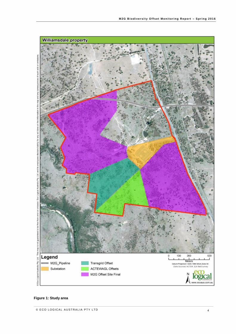
1.3 Study area
Icon Water own a land parcel in southern ACT (Block 1675), referred to here as the Williamsdale
property (or ‘the property’). The property is approximately 208 hectares in size and is located just south
of Williamsdale. The property is bounded by the Monaro Highway to the east; the NSW border to the
south; Angle Crossing Road to the north; and the Murrumbidgee River corridor to the west (Figure 1).
The monitoring surveys were conducted within the offset site (study area of approximately 110 ha),
which is wholly contained within the property.
The offset site has been set aside for conservation due to its high biodiversity value; including the
Commonwealth Environment Protection and Biodiversity Conservation Act 1999 (EPBC Act) listed
White Box, Yellow Box, Blakely’s Red Gum Grassy Woodland and Derived Native Grassland (Box-
Gum Woodland), threatened flora and fauna species and/or threatened species habitat.
M 2G B i o d i ve r s i t y O f fs e t M o n i t or i n g R e p or t – S pr i n g 2 0 1 6
© E CO LO G ICA L A U S T RA L IA P T Y LT D 4
Figure 1: Study area

M 2G B i o d i ve r s i t y O f fs e t M o n i t or i n g R e p or t – S pr i n g 2 0 1 6
© E CO LO G ICA L A U S T RA L IA P T Y LT D 5
2 Methodology
The native vegetation and biodiversity values present within the offset site are managed under the ODP
and its sub-plans. The ODP establishes the monitoring methodology for each of these values. A
summary of the monitoring methodology outlined in the ODP and previous monitoring reports (ELA,
2013; ELA, 2014; ELA, 2015), is presented below, and followed by the results of the spring 2016
monitoring surveys.
2.1 Vegetat ion plot monitoring
The monitoring methodology has been adapted from the NSW Biobanking methodology to suit the
offset site management requirements. The modified Biobanking methodology proforma uses a
combination of quadrat and transect surveys to establish vegetation condition, and this approach is
mirrored under the monitoring methodology.
Vegetation surveys have been designed to collect the following data:
Species diversity, including native and exotic species.
Cover abundance of native and exotic species.
Identification of any threatened flora.
Condition of the vegetation community.
2.1.1 Floristic quadrats
Eight 20 m x 20 m monitoring quadrats (plots) were established to collect baseline data on the condition
and species composition of the offset site during autumn and spring each year (Figure 2). The
quadrats are permanently erected and marked using a star picket at each corner tagged with flagging
tape. The location of each quadrat has been recorded using a hand-held GPS device (north-west
corner) (Figure 2).
Each quadrat was surveyed by walking back and forth along 10 parallel transects approximately 2
metres (m) apart. A cumulative list of flora species within each quadrat was recorded and assigned a
cover abundance score using the Braun-Blanquet scale.
Two of the eight plots (control plots) were chosen in order to observe natural changes in species
composition over time. Both plots were located in areas of good quality EPBC Act listed Box-Gum
Woodland and were free from noxious weeds at the time of establishment. Where possible,
management actions, such as erosion control, or rehabilitation will not occur within these monitoring
plots over the duration of the monitoring period. However, it is noted that some actions such as feral
animal control occurs on an offset site scale. Also, if noxious weeds are observed within the control
plots during the biannual monitoring surveys, the weeds will be identified, recorded and then removed.
The removal of noxious weeds from the control plots is required to maintain the overall conservation
principles of the offset site.
The other six monitoring plots were located in units where management actions were planned or likely
to occur as outlined in the management sub-plans, in order to observe the effect that the actions have
on ecological values and species composition over the course of the monitoring program.
The GPS co-ordinates of the north-west corner of each monitoring plot are provided below in Table 1.
A species list for each of the monitoring plots is included in Appendix A.

M 2G B i o d i ve r s i t y O f fs e t M o n i t or i n g R e p or t – S pr i n g 2 0 1 6
© E CO LO G ICA L A U S T RA L IA P T Y LT D 6
Table 1: Monitoring plot co-ordinates (GDA 1994 MGA Zone 55)
Monitoring plot
Plot location
Established
North-west corner Transect
Easting Northing Easting Northing
1 MU1A October 2011 693669.49 6059272.51 693674.98 6059300.56
2 MU2B March 2012 693529.99 6059555.34 693541.22 6059504.10
3 MU3 October 2011 693872.06 6059467.44 693874.65 6059490.73
4 MU4 October 2011 692349.35 6060568.08 692365.82 6060517.43
5 MU5 October 2011 692559.98 6059906.52 692526.40 6059902.85
6* MU6 March 2012 692576.25 6060344.05 692622.53 6060358.54
7 MU7 March 2012 692860.59 6060583.39 692874.01 6060542.87
8* MU3 October 2011 693414.37 6059863.02 693445.95 6059828.31
* Refers to the control plot
2.1.2 Point transects
A 50 m transect (50 m length of tape) was established at each of the monitoring plots to compliment
the floristic quadrat surveys and to determine the projective foliage cover of various structural
components of the community. Each transect was referenced using a GPS device and three photos
were taken from the start of the transect (left side, centre, and right side). The 50 m transect was
surveyed as follows:
At every 1 m along the 50 m tape, the understorey layer was assessed (50 survey points per
transect). The presence of native grass, native shrubs (<1m high), native other or exotic
species was recorded at each point. For each group the number of hits was then tallied and
doubled, and presented as a percentage cover for the whole site.
At every 5 m along the 50 m tape, the percentage projective foliage cover of native and exotic
species in the mid and overstorey layer was recorded (10 survey points per transect). For
each group the cover values were then summed and divided by 10, and presented as a
percentage cover for the whole site.
2.1.3 Flora inventory methodology
A cumulative list of species has been maintained since the initial baseline surveys were conducted.
Species included on the list included those recorded within the eight monitoring plots and those
encountered whilst traversing the sites during the weed, fence line and erosion monitoring surveys. A
species list for offset site is provided in Appendix A.

M 2G B i o d i ve r s i t y O f fs e t M o n i t or i n g R e p or t – S pr i n g 2 0 1 6
© E CO LO G ICA L A U S T RA L IA P T Y LT D 7
Figure 2: Monitoring plots, management units and baseline offset site ecological values

M 2G B i o d i ve r s i t y O f fs e t M o n i t or i n g R e p or t – S pr i n g 2 0 1 6
© E CO LO G ICA L A U S T RA L IA P T Y LT D 8
2.2 Fauna monitoring
2.2.1 Bird surveys
A quantitative bird survey methodology was established in spring 2015 and was undertaken again in
spring 2016 to gather quantitative information on species abundance and species richness. Bird
surveys were undertaken along two transects, one in each of the offset sites. Each transect comprised
five points located approximately 100 m apart. The transects were oriented to follow areas of suitable
habitat (Figure 3).
At each point along the transect the abundance and species richness of bird species was surveyed in
a circle with a 50 m radius over a 10 minute survey period (total of 50 minutes per transect which covers
an area of 0.07ha). Birds were recorded in the following distance classes from the survey point:
0-15 m
15-30 m
30-50 m
Any other species observed during the survey period either outside of 50 m, flying over the site or
between points was recorded as opportunistic.
2.2.2 Fauna habitat assessment
During the baseline survey a fauna habitat assessment was conducted within each 20 m x 50 m
vegetation monitoring plot to observe the number of hollow bearing trees, length of fallen logs (greater
than 10 cm width) and dominant habitat features present. In addition, a qualitative assessment of fauna
habitat features was undertaken for each of the northern and southern offsets. This assessment
included features such as, hollow-bearing trees, logs, litter, fallen timber, stags, surface or outcropping
rocks, termite mounds, mistletoe presence, large trees, natural regeneration and exotic or native shrub
thickets. These features were checked during each monitoring period to ensure they remained
applicable.
The results of fauna habitat assessments are outlined in Section 4.3.2.
2.2.3 Opportunistic observations
Visual and aural observations of all vertebrate fauna species (including signs of feral animal activity)
were recorded opportunistically whilst conducting targeted monitoring surveys across the offset site
and using random meander techniques. A full list of all fauna observed during spring 2016 monitoring
is presented in Appendix B. Locations of rare or threatened fauna and signs of feral animal presence
were recorded using a handheld GPS device.
Opportunistic herpetology searches were also undertaken in areas of good quality habitat, such as
partially embedded rock.

M 2G B i o d i ve r s i t y O f fs e t M o n i t or i n g R e p or t – S pr i n g 2 0 1 6
© E CO LO G ICA L A U S T RA L IA P T Y LT D 9
Figure 3: Bird monitoring transects

M 2G B i o d i ve r s i t y O f fs e t M o n i t or i n g R e p or t – S pr i n g 2 0 1 6
© E CO LO G ICA L A U S T RA L IA P T Y LT D 10
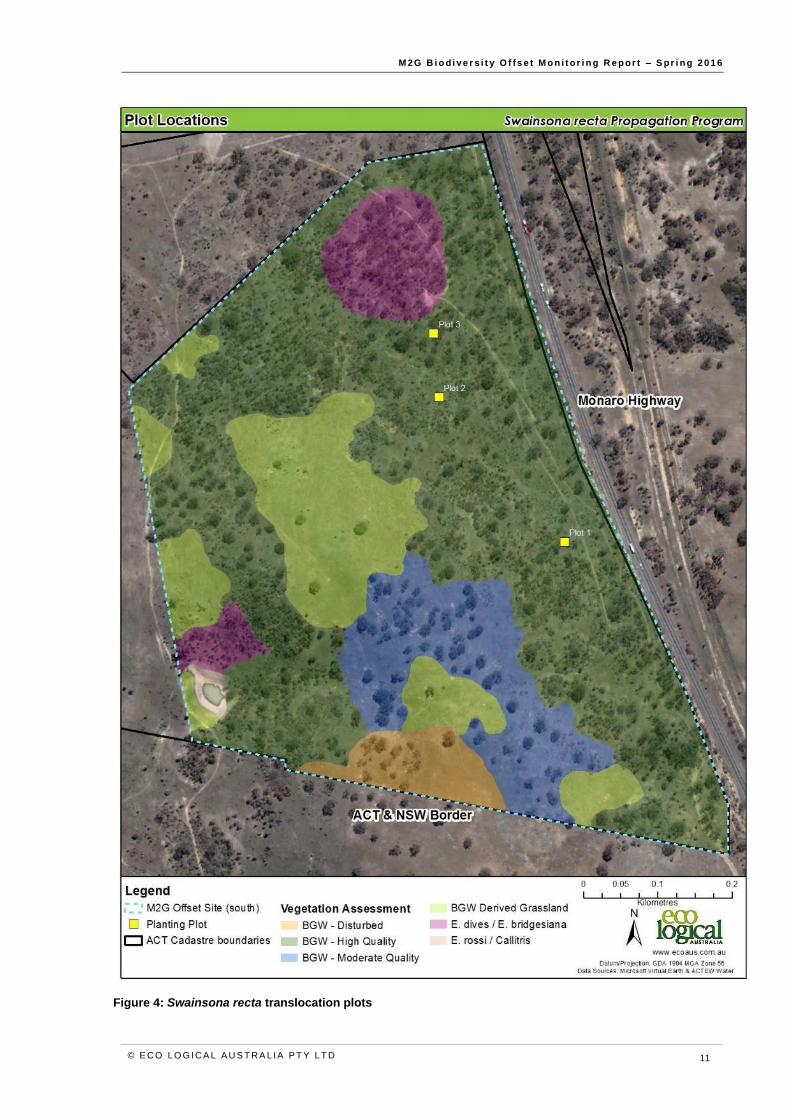
2.3 Swainsona recta monitoring
Monitoring of translocated Swainsona recta plants is conducted during the peak flowering period in
October to November each year. The location of the three translocation plots is shown in Figure 4.
Full details of the propagation and translocation program are provided in ELA (2013). Information
relevant to the interpretation of monitoring results is summarized below.
Plants translocated were initially raised from seed sourced from Mt. Taylor, Williamsdale and Burra,
and grown on in containers filled with either:
Potting mix (standard nursery mix), or
Soil mix containing a 1:1 ratio of potting mix and local soil from the seed collection sites.
A total of 112 individuals were planted across the three translocation plots, of which 66 were
translocated in June 2012 and a further 46 translocated in September 2013. Each translocation plot
was designed to accommodate up to 40 plants. Individuals were planted in blocks according to
provenance and growing media to facilitate comparison. A key to the planting design and other relevant
data is provided in Table 2.
Table 2: Planting key
Collection location Growing media Key Planted Water crystals
Mt Taylor Potting mix 2012 No
Mt Taylor Soil and potting mix 2012 No
Williamsdale Potting mix 2013 Yes
Burra Potting mix 2013 Yes
Individuals were planted at one metre spacing in a grid format (8 x 5 plants) with a one metre buffer
from the outer most plants. Plots were established with the longest axis orientated in a north-south
direction. Fencing was erected around the plots to incorporate a one metre buffer from the outer most
plants. Fencing consisted of rabbit proof fencing (1.2 m high) with steel pickets at least every three
metres.
At planting, all competition (e.g. grasses and other forbs) was removed in the immediate area of each
individual (creating a cleared patched approximately 20 cm in diameter). For the 2013 plantings, a
small handful or water crystals were also planted with each individual. All plants were watered on the
day of planting and subsequently watered one week after planting
Each individual plant translocated is assessed annually for its survivorship and reproductive condition.
The follow is recorded:
Presence or absence of Swainsona recta at each planting location.
Presence or absence of flowers or developing seed pods.
In addition, the translocation plots are inspected for signs of recruitment. The results allow a
comparison of survivorship, condition and recruitment events at the end of each monitoring period and
provide a picture of the overall success of the translocation program.
M 2G B i o d i ve r s i t y O f fs e t M o n i t or i n g R e p or t – S pr i n g 2 0 1 6
© E CO LO G ICA L A U S T RA L IA P T Y LT D 11
Figure 4: Swainsona recta translocation plots
M 2G B i o d i ve r s i t y O f fs e t M o n i t or i n g R e p or t – S pr i n g 2 0 1 6
© E CO LO G ICA L A U S T RA L IA P T Y LT D 12
2.4 Weed monitoring
The management of weeds within the M2G offset site is undertaken in accordance with the Weed
Monitoring Sub-Plan. The sub-plan outlines the weed management activities to be undertaken in order
to satisfy relevant approval conditions and commitments. As an action under the sub-plan, the monitoring
of weeds within the offset is required on a biannual basis to incorporate the seasonal changes in weed
abundance and weed control activities.
Weed monitoring in spring 2016 was undertaken opportunistically with an overall assessment of each
management unit focussed on occurrences of declared species (Cotoneaster spp., Crataegus
monogyna, Eragrostis curvula, Hypericum perforatum, Nassella trichotoma, Pyracantha spp., Rosa
rubiginosa, Rubus fruticosus and various species of thistle), non-declared woody weeds and species
not previously recorded for the site.
2.5 Erosion monitoring
Erosion monitoring sites were established during the autumn 2012 monitoring surveys. During these
baseline surveys a representative sample of erosion points within each of the main drainage lines were
selected for future monitoring. For each erosion point selected, notes were made on their size, their
location was recorded using a GPS and a photo was taken in order to observe any changes over time.
A number of erosion monitoring points were discontinued from spring 2013 onwards, as these points
did not shown signs of erosion since the baseline surveys, despite large rain events occurring over this
two year period.
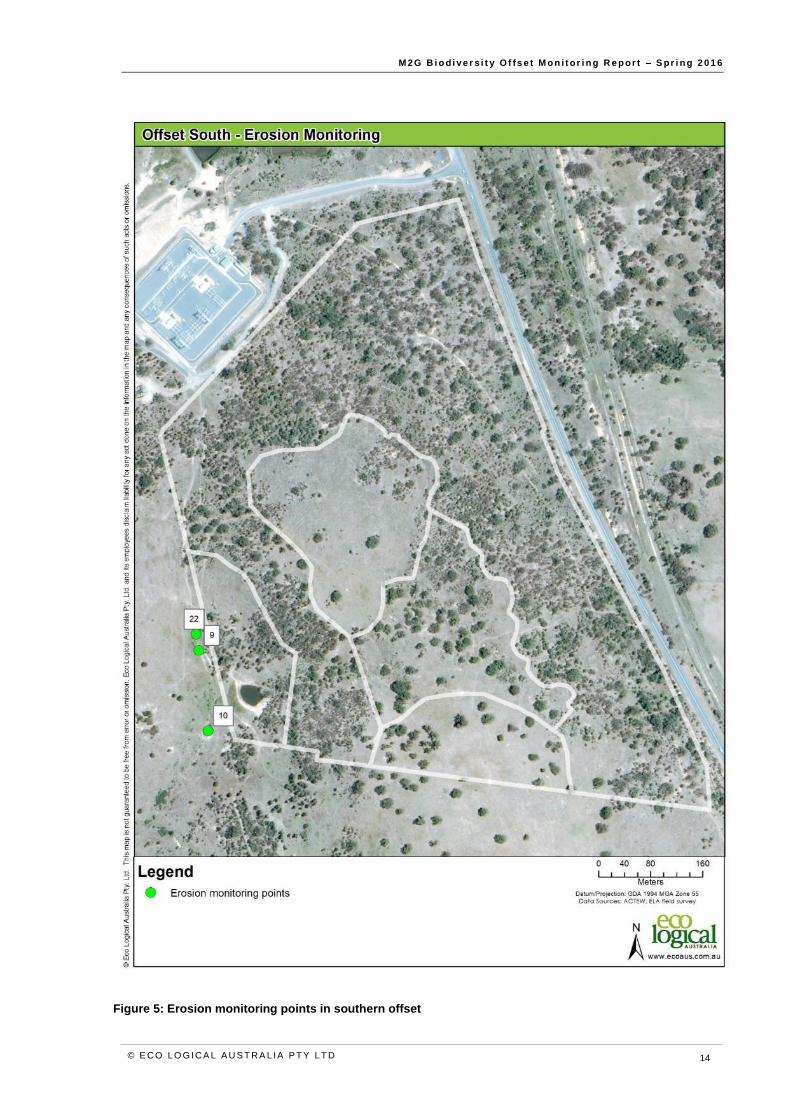
Erosion monitoring point locations included in the spring 2016 surveys are mapped in Figure 6 and
Figure 5.
When each monitoring survey is undertaken, a set of baseline photographs are taken into the field to
facilitate accurate relocation of erosion monitoring photo points and assessment of change.
2.6 Fencing monitoring
Fence monitoring was undertaken by traversing the Williamsdale property border and assessing the
condition of the fence. Any damaged areas observed along the fence line were noted and a GPS point
taken. Fence damage was categorised into three categories to represent the level of risk of unwanted
grazers (such as cattle) entering the offset site:
Low risk– Small holes observed at the bottom of the fence that does not require immediate
attention and allows native fauna (e.g. wombats) to pass through.
Moderate risk – Small to moderate sized holes or fence damage that requires monitoring, but
no immediate action. Often observed along the fence line bordering the Murrumbidgee River
corridor and represents a potential goat or sheep access point. Note; there can be a small
difference between the low and moderate categories. However, other evidence such as tracks
and scats that may represent feral presence was used to inform the level of risk.
High risk – Represents points along the fence line requiring attention. These points represent
a high risk of cattle and sheep entering the property.
2.7 Rehabil itat ion survival assessment
During winter 2016, 2,000 native shrubs were planted across two locations within the property (1,400
in the large gully near the TransGrid substation, and 600 along a smaller gully within the northern offset
site. Rapid survival counts were undertaken in each of these locations, which involved walking down

M 2G B i o d i ve r s i t y O f fs e t M o n i t or i n g R e p or t – S pr i n g 2 0 1 6
© E CO LO G ICA L A U S T RA L IA P T Y LT D 13
the planting row from a random start point and assessing individuals, recording live (identified to genus)
or dead. One hundred individuals were assessed across two survey points along the planting in the
northern offset, and 50 individuals were assessed along the large gully near the substation.
M 2G B i o d i ve r s i t y O f fs e t M o n i t or i n g R e p or t – S pr i n g 2 0 1 6
© E CO LO G ICA L A U S T RA L IA P T Y LT D 14
Figure 5: Erosion monitoring points in southern offset

M 2G B i o d i ve r s i t y O f fs e t M o n i t or i n g R e p or t – S pr i n g 2 0 1 6
© E CO LO G ICA L A U S T RA L IA P T Y LT D 15
Figure 6: Erosion monitoring points in northern offset

M 2G B i o d i ve r s i t y O f fs e t M o n i t or i n g R e p or t – S pr i n g 2 0 1 6
© E CO LO G ICA L A U S T RA L IA P T Y LT D 16
3 Vegetation plots
Since the baseline monitoring was undertaken in 2011, species diversity has generally remained stable
or increased across the majority of monitoring plots. The majority of plots, particularly in woodland
sites, showed an increase in the diversity in native grass and forbs between baseline surveys and
spring 2016 monitoring, likely due in part to the wet spring in 2016 and recent warm weather prior to
monitoring. This demonstrates the influence of seasonal conditions on variation in floristic diversity,
particularly in the ground layer, and is a major consideration when analysing trends in floristic data,
particularly over a relatively short period. The cessation of grazing since offset site establishment may
also have resulted in increased native grass and forb diversity.
Corresponding to this increase in native species was an increase in exotic species cover in all except
one plot, compared to baseline conditions. Similarly, this is likely due to the favourable winter and
spring conditions promoting growth of exotic annual grasses such as Bromus species, as well as
thistles and other exotic annual forbs.
All monitoring plots remain below the overstorey cover and the total length of fallen logs benchmark
values established for the ACT (Sharp & Milner 2014). This reflects the fact that sites are either in
regenerating or cleared formations of Box-Gum Woodland, rather than mature remnants. Saplings of
overstorey species are present at most sites and in time will likely contribute to an increase in
overstorey cover as they grow and develop fuller canopies. However it should be noted that a decline
in canopy cover was recorded across a number of sites, due to visible dieback of Blakely’s Red Gum
canopies (see Section 4.1 for further discussion).
The results of the vegetation monitoring are provided Section 3.1.1 to 3.1.8 below. The raw floristic
data for each plot are provided in Appendix A.

M 2G B i o d i ve r s i t y O f fs e t M o n i t or i n g R e p or t – S pr i n g 2 0 1 6
© E CO LO G ICA L A U S T RA L IA P T Y LT D 17
3.1.1 Monitoring plot 1
Plot Description
Management unit MU1A Plot number 1
Vegetation type Box-Gum Woodland Condition Low-Mod
Plot Statistics (%) Baseline spring 2016 Overstorey
Native overstorey cover 0 0 Regeneration
Yes
Native midstorey cover 0 0 Species E. melliodora
Native understorey cover (grass) 40 28 Habitat features
Native understorey cover (other) 6 14 Tree hollows 0
Exotic midstorey plant cover 0 0 Fallen logs 0 m
Exotic understorey plant cover 58 64
Native species diversity 14 12
Figure 7: Monitoring Plot 1. (Left: Baseline monitoring photo, October 2011. Right: monitoring photo November 2016)
Monitoring plot 1 is located within MU1A in the southern offset area. The plot
is composed of lower condition Box-Gum Woodland. A single eucalypt sapling
was observed within the plot with several others also observed in the surrounding
zone. Native species diversity was low (12 species) and down from 19 species
recorded in spring 2015. Nineteen exotic species were recorded, with both the
exotic species richness and cover increasing in comparison to baseline results.
Carthamus lanatus, Bromus hordeaceus and Trifolium subterraneum were the
dominant species within the plot. Fauna habitat features within MU1A have not
changed noticeably since the baseline surveys. Native plant species richness,
overstorey cover and the total length of fallen logs remain well below benchmark
values (Sharp & Milner 2014).
M 2G B i o d i ve r s i t y O f fs e t M o n i t or i n g R e p or t – S pr i n g 2 0 1 6
© E CO LO G ICA L A U S T RA L IA P T Y LT D 18
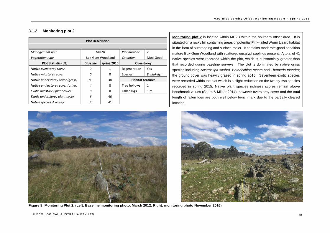
3.1.2 Monitoring plot 2
Figure 8: Monitoring Plot 2. (Left: Baseline monitoring photo, March 2012. Right: monitoring photo November 2016)
Plot Description
Management unit MU2B Plot number 2
Vegetation type Box-Gum Woodland Condition Mod-Good
Plot Statistics (%) Baseline spring 2016 Overstorey
Native overstorey cover 0 1 Regeneration Yes
Native midstorey cover 0 0 Species E. blakelyi
Native understorey cover (grass) 80 38 Habitat features
Native understorey cover (other) 4 8 Tree hollows 1
Exotic midstorey plant cover 0 0 Fallen logs 1 m
Exotic understorey plant cover 6 46
Native species diversity 30 41
Monitoring plot 2 is located within MU2B within the southern offset area. It is
situated on a rocky hill containing areas of potential Pink-tailed Worm Lizard habitat
in the form of outcropping and surface rocks. It contains moderate-good condition
mature Box-Gum Woodland with scattered eucalypt saplings present. A total of 41
native species were recorded within the plot, which is substantially greater than
that recorded during baseline surveys. The plot is dominated by native grass
species including Austrostipa scabra, Bothriochloa macra and Themeda triandra;
the ground cover was heavily grazed in spring 2016. Seventeen exotic species
were recorded within the plot which is a slight reduction on the twenty-two species
recorded in spring 2015. Native plant species richness scores remain above
benchmark values (Sharp & Milner 2014), however overstorey cover and the total
length of fallen logs are both well below benchmark due to the partially cleared
location.

M 2G B i o d i ve r s i t y O f fs e t M o n i t or i n g R e p or t – S pr i n g 2 0 1 6
© E CO LO G ICA L A U S T RA L IA P T Y LT D 19
3.1.3 Monitoring plot 3
Plot Description
Management unit MU3 Plot number 3
Vegetation type Box-Gum Woodland Condition Mod-Good
Plot Statistics (%) Baseline spring 2016 Overstorey
Native overstorey cover 3.7 2.5 Regeneration Yes
Native midstorey cover 5.2 5.5 Species E. blakelyi
Native understorey cover (grass) 80 30 Habitat features
Native understorey cover (other) 16 8 Tree hollows 0
Exotic midstorey plant cover 0.2 0 Fallen logs 2 m
Exotic understorey plant cover 10 32
Native species diversity 27 35
Figure 9: Monitoring Plot 3. (Left: Baseline monitoring photo, October 2011. Right: monitoring photo November 2016)
Monitoring plot 3 is located within MU3 in the southern offset. The plot is located
in moderate to good quality Box-Gum Woodland. A large number of eucalypt
saplings are present both within the plot and the surrounding zone. The
understorey is dominated by exotic grass species including Avena barbata, Briza
minor and Bromus spp., with a total of 22 exotic species recorded. It should be
noted however, that the dominance of exotic grasses within the plot is not
consistent with the surrounding areas which have a much higher proportion of
native grass species and cover. A total of 35 native species were recorded within
the plot, which is similar to the species richness recorded in spring 2015 (38
species), however native understorey covers were much lower compared to
previous years. Native plant species richness for the plot remains above
benchmark values (Sharp & Milner 2014), however overstorey cover and the total
length of fallen logs remain well below benchmark.

M 2G B i o d i ve r s i t y O f fs e t M o n i t or i n g R e p or t – S pr i n g 2 0 1 6
© E CO LO G ICA L A U S T RA L IA P T Y LT D 20
3.1.4 Monitoring plot 4
Plot Description
Management unit MU4 Plot number 4
Vegetation type Box-Gum Woodland Condition Mod-Good
Plot Statistics (%) Baseline spring 2016 Overstorey
Native overstorey cover 4.7 7 Regeneration Yes
Native midstorey cover 11.5 4.5 Species E. blakelyi
Native understorey cover (grass) 74 62 Habitat features
Native understorey cover (other) 18 28 Tree hollows 0
Exotic midstorey plant cover 2 0 Fallen logs 15 m
Exotic understorey plant cover 28 24
Native species diversity 24 34
Figure 10: Monitoring Plot 4. (Left: Baseline monitoring photo, October 2011. Right: monitoring photo November 2016)
Monitoring plot 4 is located in the northern offset in MU4. It is located in
moderate to good quality Box-Gum Woodland with an overstorey dominated by
Eucalyptus blakelyi. A total of 34 native species were recorded within the plot
which is the same number of species recorded in spring 2015. 20 exotic species
were recorded within the plot which is also comparable to the 21 species recorded
in spring 2015. The understorey is dominated by both native and exotic grass
species including Aira sp., Bothriochloa macra and Bromus hordeaceus. Control
of the noxious weed Rosa rubiginosa has been largely effective, with cover of this
species much reduced compared to earlier years. However, seedlings are
beginning to re-emerge and follow up control may be required. Fauna habitat
features within MU4 have not changed noticeably since the baseline surveys.

M 2G B i o d i ve r s i t y O f fs e t M o n i t or i n g R e p or t – S pr i n g 2 0 1 6
© E CO LO G ICA L A U S T RA L IA P T Y LT D 21
3.1.5 Monitoring plot 5
Plot Description
Management unit MU5 Plot number 5
Vegetation type Box-Gum Woodland Condition Mod-Good
Plot Statistics (%) Baseline spring 2016 Overstorey
Native overstorey cover 0 0 Regeneration Yes
Native midstorey cover 11 6.2 Species E. blakelyi
Native understorey cover (grass) 76 52 Habitat features
Native understorey cover (other) 14 20 Tree hollows 0
Native understorey cover (shrub) 0 18 Fallen logs 0 m
Exotic understorey plant cover 4 22
Native species diversity 29 40
Figure 11: Monitoring Plot 5. (Left: Baseline monitoring photo, October 2011. Right: monitoring photo November 2016)
Monitoring plot 5 is a control plot located in MU5. No management actions will
occur within the boundaries of the plot. Plot 5 is located in moderate-good quality
Box-Gum Woodland with an overstorey dominated by Eucalyptus blakelyi. This
overstorey species is also undergoing considerable natural regeneration. However,
extensive eucalypt defoliation and dieback, potentially associated with psyllid
infestation, was observed in spring 2016. The plot supports a high diversity of native
understorey species with a total of 40 species recorded, comparable to the 46
species recorded in spring 2015. Themeda triandra and Chrysocephalum
apiculatum are the most common understorey species within the plot. Fourteen
exotic species were recorded, which is comparable to the 15 species recorded in
spring 2015, however the cover of exotic species along the 50 m transect has
reduced considerably since last spring, down from 60% to 22%. Native plant
species richness is above benchmark values (Sharp & Milner 2014), however
overstorey cover and the length of fallen logs remain below benchmark, reflective
of the regenerating rather than mature woodland stage of this vegetation.

M 2G B i o d i ve r s i t y O f fs e t M o n i t or i n g R e p or t – S pr i n g 2 0 1 6
© E CO LO G ICA L A U S T RA L IA P T Y LT D 22
3.1.6 Monitoring plot 6
Plot Description
Management unit MU6 Plot number 6 Vegetation type Box-Gum Woodland Condition Mod-Good
Plot Statistics (%) Baseline spring 2016 Overstorey
Native overstorey cover 5.3 5 Regeneration Yes
Native midstorey cover 0 0 Species E. blakelyi
Native understorey cover (grass) 80 36 Habitat features
Native understorey cover (other) 10 10 Tree hollows 0
Exotic midstorey plant cover 0 0 Fallen logs 0 m
Exotic understorey plant cover 8 40
Native species diversity 28 38
Figure 12: Monitoring Plot 6. (Left: Baseline monitoring photo, March 2012. Right: monitoring photo November 2016)
Monitoring plot 6 is located in MU6, along the central ridge line of the property, in
moderate-good quality Box-Gum Woodland with an overstorey dominated by
Eucalyptus blakelyi. The plot is situated in a transition zone between the woodland
and derived grassland forms of the ecological community. Abundant E. blakelyi
regeneration is present within the plot. The plot supports a diverse understorey of
both native and exotic grasses and forbs. The most dominant species observed
were the exotic grasses Aira sp. and Bromus hordeaceus. 38 native and 24 exotic
species were recorded, highly comparable with the 39 and 24 respective species
recorded in spring 2015. Fauna habitat features within MU6 have not changed
noticeably since the baseline surveys. Native plant species richness is above
benchmark values (Sharp & Milner 2014), however overstorey cover and the total
length of fallen logs remain well below benchmark.

M 2G B i o d i ve r s i t y O f fs e t M o n i t or i n g R e p or t – S pr i n g 2 0 1 6
© E CO LO G ICA L A U S T RA L IA P T Y LT D 23
3.1.7 Monitoring plot 7
Plot Description
Management unit MU7 Plot number 7
Vegetation type Box-Gum Woodland Condition Low
Plot Statistics (%) Baseline spring 2016 Overstorey
Native overstorey cover 0 0 Regeneration No
Native midstorey cover 0 0 Species N/A
Native understorey cover (grass) 74 4 Habitat features
Native understorey cover (other) 0 14 Tree hollows 0
Exotic midstorey plant cover 0 0 Fallen logs 2.5 m
Exotic understorey plant cover 34 94
Native species diversity 13 19
Figure 13: Monitoring Plot 7. (Left: Baseline monitoring photo, March 2012. Right: monitoring photo November 2016)
Monitoring plot 7 is located within MU7 in the northern offset area. The
management unit is composed of degraded Box-Gum Woodland with the
overstorey dominated by scattered remnant Eucalyptus blakelyi. No recruitment of
E. blakelyi was observed within the plot. Native species diversity in the plot was
relatively low for this ecological community (19 species) but higher than recorded
during both baseline and spring 2015 surveys (13 and 12 respectively). The plot is
dominated by exotic species with less than 5% of the groundcover comprising
native perennial grass species. Dominant exotic species include Bromus
hordeaceus, Hordeum glaucum and Trifolium subterraneum. Fauna habitat
features within MU7 remain consistent with those recorded during baseline surveys.
All site parameters were well below benchmark values (Sharp & Milner 2014), with
the exception of native understorey (other) cover.
M 2G B i o d i ve r s i t y O f fs e t M o n i t or i n g R e p or t – S pr i n g 2 0 1 6
© E CO LO G ICA L A U S T RA L IA P T Y LT D 24
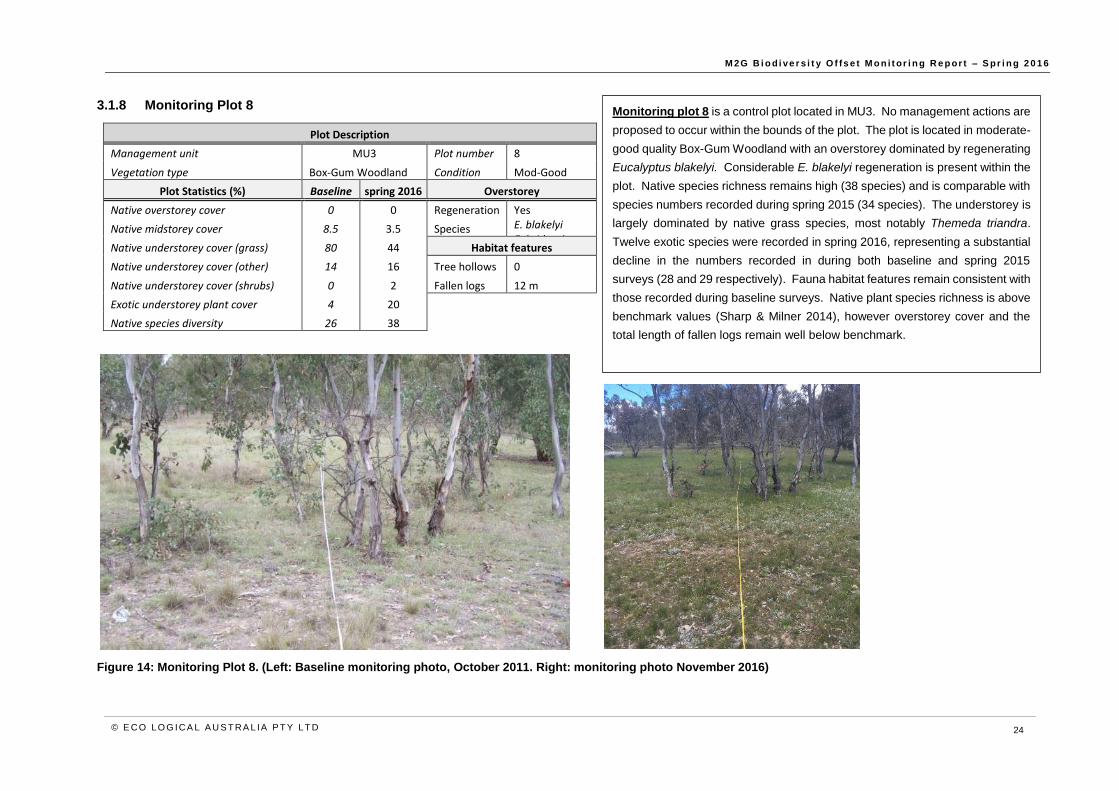
3.1.8 Monitoring Plot 8
Plot Description
Management unit MU3 Plot number 8
Vegetation type Box-Gum Woodland Condition Mod-Good
Plot Statistics (%) Baseline spring 2016 Overstorey
Native overstorey cover 0 0 Regeneration Yes
Native midstorey cover 8.5 3.5 Species E. blakelyi E. bridgesiana
Native understorey cover (grass) 80 44 Habitat features
Native understorey cover (other) 14 16 Tree hollows 0
Native understorey cover (shrubs) 0 2 Fallen logs 12 m
Exotic understorey plant cover 4 20
Native species diversity 26 38
Figure 14: Monitoring Plot 8. (Left: Baseline monitoring photo, October 2011. Right: monitoring photo November 2016)
Monitoring plot 8 is a control plot located in MU3. No management actions are
proposed to occur within the bounds of the plot. The plot is located in moderate-
good quality Box-Gum Woodland with an overstorey dominated by regenerating
Eucalyptus blakelyi. Considerable E. blakelyi regeneration is present within the
plot. Native species richness remains high (38 species) and is comparable with
species numbers recorded during spring 2015 (34 species). The understorey is
largely dominated by native grass species, most notably Themeda triandra.
Twelve exotic species were recorded in spring 2016, representing a substantial
decline in the numbers recorded in during both baseline and spring 2015
surveys (28 and 29 respectively). Fauna habitat features remain consistent with
those recorded during baseline surveys. Native plant species richness is above
benchmark values (Sharp & Milner 2014), however overstorey cover and the
total length of fallen logs remain well below benchmark.

M 2G B i o d i ve r s i t y O f fs e t M o n i t or i n g R e p or t – S pr i n g 2 0 1 6
© E CO LO G ICA L A U S T RA L IA P T Y LT D 25
4 Biodiversity values
4.1 Ecosystem health
As noted during autumn 2015 surveys, a large proportion of the Eucalyptus blakelyi (Blakely’s Red Gum)
within the offset site have been subject to leaf attack psyllids, as evidenced by the presence of lerps on
leafs, and extensive defoliation and dieback in some areas. Severe infestations by lerps can be
detrimental to trees resulting in leaf-drop, defoliation and subsequently die-back if the lerps are present
over several seasons (Stone and Urquhart, 1995). Anecdotal evidence suggests that psyllid infestations
occur broadly across the ACT region with infestations also noted in the broader region and not currently
confined to the M2G offset site.
Outbreaks of lerps are known to be associated with the presence of Manorina melanocephala in some
areas. However, bird surveys conducted within the offset site in spring 2015, indicate that the population
of Noisy Miners (Manorina melanocephala) within the offset site preferentially occurs in some areas over
others such as the drainage line along the northern side of the north offset. However the incidence of
lerp is widespread across the site and surrounding areas and appears to be higher in areas of the
Southern Offset site, where bird surveys recorded a lower abundance of Noisy Miners and a higher
abundance of smaller woodland bird species. As such, it does not appear likely that these outbreaks are
strongly related to Noisy Miner populations. This is supported by the fact that similar widespread dieback
and associated psyllid infestations have been observed throughout the ACT and NSW tablelands over
the course of 2016.
4.2 Flora
Two hundred and eighteen native plant species and 123 exotic species have been recorded for the M2G
offset site since the baseline surveys were undertaken (Appendix A). The list has continued to grow with
each survey. The detection of new records for the site is influenced by factors such as time since
cessation of grazing, seasonal conditions and the varying meander routes chosen by the ecologists
undertaking the surveys. A total of 143 flora species (93 native and 50 exotic) were opportunistically
recorded during spring 2016 surveys.
The flora recorded since baseline surveys includes a range of widely distributed characteristic woodland
species, several rare and uncommon species in the ACT, and four threatened species listed under the
EPBC Act (Table 3, Table 4, and Figure 15). The spring 2016 surveys recorded the presence of three
EPBC Act listed species (including translocated Swainsona recta, located outside the fenced exclosure
area), and five species considered rare or uncommon in the ACT. The locations of opportunistic
observations of threatened, rare or uncommon flora are presented in Figure 15.

M 2G B i o d i ve r s i t y O f fs e t M o n i t or i n g R e p or t – S pr i n g 2 0 1 6
© E CO LO G ICA L A U S T RA L IA P T Y LT D 26
4.2.1 Threatened flora species
An annotated list of nationally threatened species occurring, or known to have occurred, on the offset is
provided in Table 3 below.
Table 3: Threatened flora species within the offset site
Species EPBC Act
Status NC Act Status Notes
Leucochrysum
albicans var.
tricolor (Hoary
Sunray)
Endangered Not listed
Endangered herbaceous perennial. Noted as rare in
the offset site in spring 2014. The species is
abundant within adjacent land managed by
Transgrid where it is growing profusely on batters
surrounding the substation, and was recorded at
multiple locations within the southern offset
(including monitoring plot 8) up to approximately 300
m from the Transgrid land. It is unclear whether
Hoary Sunray has seeded naturally onto the batters
or whether it has been planted. It is considered
likely that the individuals within the offset site have
originated from the adjacent population.
Pomaderris
pallida (Pale
Pomaderris)
Vulnerable Not listed
Vulnerable shrub to about 1.5 m high. Located in
the central western part of the northern offset. A
solitary flowering adult plant approximately 90 cm
high was found in spring 2014 and was again
located in spring 2016, along with approximately 5
juveniles and 2 sub-adults (flowering but only about
30-40 cm high).
The species is known to occur within the
Murrumbidgee River corridor, and it appears that the
population within the offset site has established as
an outlier.
Swainsona recta
(Small Purple-
pea)
Endangered Endangered Endangered herbaceous perennial. This species
was found on the M2G offset site during initial
surveys of the site in 2010 but has not been
encountered since. Three translocation exclosure
plots have been established on site (refer to Section
5.1).
Thesium australe
(Austral Toadflax,
Toadflax)
Vulnerable Not listed
Austral Toadflax is a hairless, yellowish-green
perennial herb with slender, wiry stems to 40 cm
high. The species is semi-parasitic on roots of a
range of grass species, notably Themeda triandra
(Kangaroo Grass). Approximately 4 individuals were
recorded in spring 2015 within the northern offset,
however these were not re-located during spring
2016.
The species is only known from a few records within
the Canberra region.

M 2G B i o d i ve r s i t y O f fs e t M o n i t or i n g R e p or t – S pr i n g 2 0 1 6
© E CO LO G ICA L A U S T RA L IA P T Y LT D 27
4.2.2 Rare and uncommon ACT species
A number of species considered to be rare or uncommon within the ACT have also been recorded within
the offset site to date. These species are outlined in Table 4 below.
Table 4: Rare and uncommon species recorded within the offset site
Species Notes
Austrostipa setacea
(Corkscrew Grass)
Tufted perennial grass. Noted in the south-eastern corner of the southern offset in
spring 2014, however not observed during 2016.
Bossiaea prostrata
(Creeping Bossiaea)
Prostrate perennial subshrub. Previously recorded in monitoring plot 5 in the
northern offset and in the surrounding area however not recorded during 2016.
Desmodium
brachypodum
(Large Tick-trefoil)
Large pea-flowered herb. Previously recorded in the south-eastern part of the
southern offset, however not observed during 2016.
Discaria pubescens
(Australian Anchor Plant)
Rigid shrub with prominent paired stem spines. A localised patch of approximately
26 plants occurs in the northern offset. This species was observed again in 2016.
Glossostigma elatinoides Prostrate perennial wetland forb. Localised patch noted in spring 2014 on the banks
of the dam in the northern offset, however not recorded during 2016.
Limosella australis
(Australian Mudwort)
Diminutive perennial wetland forb. Localised plants noted in spring 2014 on the
banks of the dam in the northern offset, however not recorded during 2016.
Microseris lanceolata
(Yam Daisy)
Perennial forb with fleshy tuberous roots. Previously recorded in monitoring plot 3 in
the southern offset, and present in high abundance (patches of greater than 100
individuals) at various locations throughout the southern offset in 2016. Generally
occurs in better condition vegetation within the offset.
Plantago gaudichaudii
(Narrow Plantain)
Perennial forb with thick fleshy taproot. Recorded in monitoring plot 3 (southern
offset) in spring 2016, and has previously been recorded in monitoring plot 4
(northern offset).
Stylidium despectum
(Dwarf Triggerplant)
Erect diminutive annual forb occurring in moist situations. Localised plants noted in
spring 2014 along moist drainage line in the northern part of the southern offset.,
however not recorded in 2016.
Swainsona monticola
(Notched Swainson-pea)
Low spreading herbaceous perennial. Noted in the south-eastern corner of the
southern offset in spring 2014 and recorded again in 2016. Dozens of plants seen
but extent of distribution on site not established. Plants probably die back to a
rootstock in summer and are difficult to detect unless flowering.
Swainsona sericea
(Silky Swainson-pea)
Low spreading herbaceous perennial. Recorded in monitoring plots 3 (southern
offset) and 5 (northern offset) in spring 2016. This species was abundant and widely
distributed across both the north and southern offsets in spring 2014, 2015 and
2016. Plants are easily overlooked unless flowering.
Zornia dyctiocarpa Low herbaceous perennial. Previously noted in the north eastern corner of the
southern offset but not recorded during 2016 despite detailed searches.

M 2G B i o d i ve r s i t y O f fs e t M o n i t or i n g R e p or t – S pr i n g 2 0 1 6
© E CO LO G ICA L A U S T RA L IA P T Y LT D 28
Figure 15: Opportunistic records of threatened, rare and uncommon flora species within the offset site, spring 2016

M 2G B i o d i ve r s i t y O f fs e t M o n i t or i n g R e p or t – S pr i n g 2 0 1 6
© E CO LO G ICA L A U S T RA L IA P T Y LT D 29
4.3 Fauna
A broad range of fauna species have been recorded within the offset site since the offset was established
including 77 bird species, 14 mammal species, 9 reptiles, and 6 amphibians. A cumulative list of species
recorded is provided in Appendix B. A total of 56 fauna species were recorded, either opportunistically
or through bird surveys, across the offset site in spring 2016. This consisted of 41 bird species, seven
mammal species (of which three were feral/exotic) and eight reptile or amphibian species. This
represents the greatest total and bird fauna species richness, and equal greatest reptile species richness,
recorded in any one season since monitoring commenced.
4.3.1 Bird monitoring
Previous monitoring on the offset site has recorded a number of woodland bird species recognised as
being in decline throughout their range including Diamond Firetail (Stagonopleura guttata), Jacky Winter
(Microeca fascinans), Southern White-face (Aphelocephala leucopsis), Speckled Warbler (Chthonicola
sagittatus), Eastern Yellow Robin (Eopsaltria australis), White-winged Triller (Lalage tricolor) and Hooded
Robin (Melanodryas cucullata cucullata).
Bird monitoring undertaken during spring 2016 recorded 41 species of which 18 were opportunistic
records. The transect monitoring recorded 128 individuals across 23 species. An abundance index was
generated and is outlined in Table 5 below.
The monitoring identified that the Noisy Miner (Manorina melanocephala) was by far the most abundant
species recorded within the offset property. Interestingly, Noisy Miners were only recorded in the northern
offset site, which provides favourable open woodland habitat for this species. However, it should be noted
that this species was also recorded opportunistically in lower numbers in the southern offset site.
The Yellow-faced Honeyeater (Lichenostomus chrysops) and Striated Pardalote (Pardalotus striatus)
were the equally second most abundant species recorded during monitoring. The strong presence of
psyllid insects and associated lerps on the foliage of Blakely’s Red Gum trees throughout the offset site
presents a key food resource for both of these species and is likely contributing to their relative
abundance.
Table 5: Species abundance index (highest to lowest)
Common Name Latin Name No. of
records No. of
individuals Abundance index
Noisy Miner Manorina melanocephala 10 26 0.87
Honeyeater, Yellow Faced Lichenostomus chrysops 6 11 0.37
Pardalote, Striated Pardalotus striatus 8 11 0.37
White-winged Chough Corcorax melanorhamphos 4 10 0.33
Rosella, Eastern Platycercus eximius 5 9 0.30
Australian Magpie Gymnorhina tibicen 4 8 0.27
Weebill Smicrornis brevirostris
6 8 0.27
Black-faced Cuckoo-Shrike Coracina novaehollandiae 4 7 0.23
Magpie Lark Grallina cyanoleuca 4 7 0.23
Galah Eolophus roseicapillus 3 5 0.17
Red Wattlebird Anthochaera carunculata 4 4 0.13
Thornbill, Yellow-Rumped Acanthiza chrysorrhoa 3 4 0.13
Pied Currawong Strepera graculina 2 3 0.10
Whistler, Rufous Pachycephala rufiventris 3 3 0.10
Grey Fantail Rhipidura albiscapa 2 2 0.07

M 2G B i o d i ve r s i t y O f fs e t M o n i t or i n g R e p or t – S pr i n g 2 0 1 6
© E CO LO G ICA L A U S T RA L IA P T Y LT D 30
Common Name Latin Name No. of
records No. of
individuals Abundance index
Honeyeater, White-Eared Lichenostomus penicillatus 2 2 0.07
Noisy Friarbird Philemon corniculatus 2 2 0.07
Australian Raven Corvus coronoides 1 1 0.03
Fan-tailed Cuckoo Cacomantis flabelliformis
1 1 0.03
Kookaburra Dacelo novaeguineae 1 1 0.03
Pied Butcherbird Cracticus nigrogularis 1 1 0.03
Superb Fairy Wren Malurus cyaneus 1 1 0.03
Willie Wagtail Rhipidura leucophrys 1 1 0.03
4.3.2 Fauna habitat assessment
A rapid assessment of the range of fauna habitat features present across the offset site and their
abundance was undertaken during the baseline surveys in 2010. These values were subsequently
confirmed during surveys in spring 2016 and are presented below in Table 6. The following categories
were used to identify abundance or frequency of each feature:
Abundant = feature occurs in an almost continuous manner.
Common = feature encountered commonly, i.e. without having to search for it.
Occasional = feature occurs in more than a few cases, but not encountered frequently.
Rare = feature observed very infrequently, one to a few cases at most.
Table 6: Fauna habitat features observed across the offset site
Fauna habitat feature Northern Southern
Tree hollows Occasional Occasional
Large trees > 60 cm DBH Occasional Occasional
Dead standing trees Occasional Rare
Stumps (<2 m) Rare Rare
Mistletoes Occasional Occasional
Regenerating tree thickets Abundant Abundant
Native shrub thickets Common Occasional
Exotic shrub thickets Rare Rare
Logs (fallen) Occasional Occasional
Timber (fallen) Occasional Occasional
Litter (leaf, twig, bark) Common Common
Loose rocks Common Common
Outcropping rocks Common Common
Termite mounds Rare Rare
Meat ant nests Occasional Occasional
Earth banks/deep gully walls Rare Rare
The plantings of mixed native shrubs, particularly Acacia species, along the gullies within the northern
offset will further enhance habitat values for a range of native woodland birds that forage and nest in mid-
canopies of forests and woodlands.

M 2G B i o d i ve r s i t y O f fs e t M o n i t or i n g R e p or t – S pr i n g 2 0 1 6
© E CO LO G ICA L A U S T RA L IA P T Y LT D 31
An assessment of the dominant habitat features recorded within each 50 m x 20 m vegetation monitoring
plot was also undertaken during the baseline surveys. These features were again reassessed in spring
2016. No substantial change was observed amongst these features relative to the baseline conditions.
Table 7: Habitat assessment within 50 m x 20 m vegetation monitoring plots
Plot HBT Logs Comment Dominant habitat features present within 50 m x 20 m plot Autumn 2015
1 0 0 m No
change
Limited surface rocks; abundant exotic annuals
2 1 1 m No
change
Surface and outcropping rocks abundant; minor course woody debris
3 0 2 m No
change
Litter common; minor coarse woody debris
4 0 15 m No
change
Developing canopy regeneration; course woody debris
5 0 0 m No
change
Developing canopy regeneration; limited surface rocks
6 0 0 m No
change
Developing canopy regeneration
7 0 2.5 m
mm
No
change
Minor surface rocks and course woody debris; abundant exotic annuals
8 0 12 m No
change
Litter; course woody debris; hollow logs; surface rocks
4.3.3 Threatened fauna
In addition to the fauna species summarised in Section 4.3 and Appendix B, two species of threatened
fauna were recorded within the broader Williamsdale property during the course of monitoring. These
were Pink-tailed Worm Lizard (Aprasia parapulchella) and Rosenberg’s Goanna (Varanus rosenbergi),
with one individual of each directly observed (Figure 16).
While these species were not recorded within the M2G offset site itself, the mobile nature of the
Rosenberg’s Goanna means that it is likely that this species utilises the offset site for foraging or nesting
habitat. Furthermore, it is considered likely that individuals of the Pink-tailed Worm Lizard are still present
in areas of similarly suitable habitat within the offset site.

M 2G B i o d i ve r s i t y O f fs e t M o n i t or i n g R e p or t – S pr i n g 2 0 1 6
© E CO LO G ICA L A U S T RA L IA P T Y LT D 32
Figure 16: Opportunistic records of threatened fauna within the Williamsdale property, spring 2016

M 2G B i o d i ve r s i t y O f fs e t M o n i t or i n g R e p or t – S pr i n g 2 0 1 6
© E CO LO G ICA L A U S T RA L IA P T Y LT D 33
5 Swainsona recta monitoring
5.1 Results summary
The spring 2016 Swainsona recta census was undertaken on 31 October 2015. Of the 112 individuals
planted within the three translocation plots, 36 were present in spring 2016, an increase of three compared
to spring 2015. This represents an overall survivorship of 32%, which is down substantially from the 79%
overall survivorship recorded in spring 2013, however is a slight increase compared to both 2014 and
2015.
All 36 plants present in spring 2016 were in flower or fruit. The vast majority (81%) of these plants were
of Mt Taylor provenance. This represents 44% of total Mt Taylor plantings, compared to only 19% of Mt
Taylor plantings present in 2015. These results contrast with the results of previous monitoring, which
indicated a stronger survival of Burra and Williamsdale individuals.
Twenty-three of the 36 individuals recorded during spring 2016 were not recorded in the 2015 surveys.
As discussed previous monitoring reports (ELA, 2014; ELA, 2015), and as demonstrated by these
fluctuating year-on-year results, the spring 2016 surveys demonstrate the difficulty in accurately
quantifying survivorship in planted S. recta individuals in only a single season, due to the species ability
to die back to below ground root stock, and only develop above ground growth when conditions are
favourable.
M 2G B i o d i ve r s i t y O f fs e t M o n i t or i n g R e p or t – S pr i n g 2 0 1 6
© E CO LO G ICA L A U S T RA L IA P T Y LT D 34
Collection location Growing media Key Planted Water crystals
Mt Taylor Potting mix 2012 No
Mt Taylor Soil and potting mix 2012 No
Williamsdale Potting mix 2013 Yes
Burra Potting mix 2013 Yes
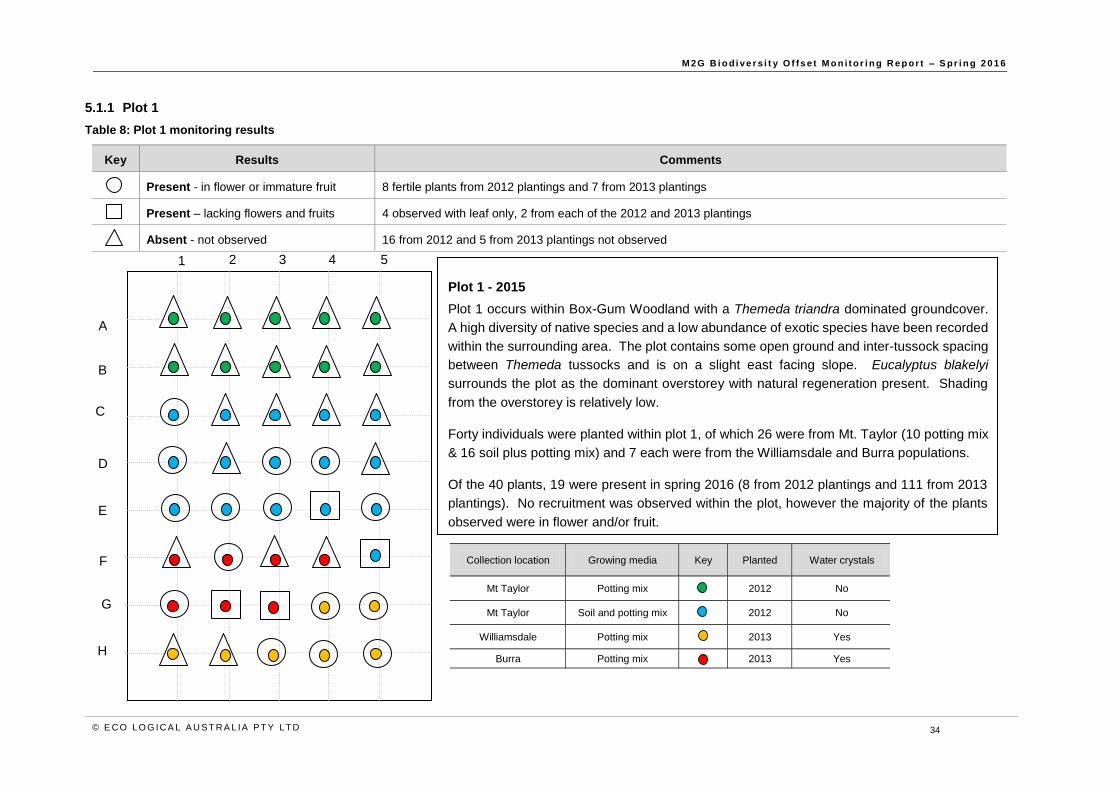
5.1.1 Plot 1
Table 8: Plot 1 monitoring results
Key Results Comments
Present - in flower or immature fruit 8 fertile plants from 2012 plantings and 7 from 2013 plantings
Present – lacking flowers and fruits 4 observed with leaf only, 2 from each of the 2012 and 2013 plantings
Absent - not observed 16 from 2012 and 5 from 2013 plantings not observed
1 2 3 4 5
A
B
C
D
E
F
G
H
Plot 1 - 2015
Plot 1 occurs within Box-Gum Woodland with a Themeda triandra dominated groundcover.
A high diversity of native species and a low abundance of exotic species have been recorded
within the surrounding area. The plot contains some open ground and inter-tussock spacing
between Themeda tussocks and is on a slight east facing slope. Eucalyptus blakelyi
surrounds the plot as the dominant overstorey with natural regeneration present. Shading
from the overstorey is relatively low.
Forty individuals were planted within plot 1, of which 26 were from Mt. Taylor (10 potting mix
& 16 soil plus potting mix) and 7 each were from the Williamsdale and Burra populations.
Of the 40 plants, 19 were present in spring 2016 (8 from 2012 plantings and 111 from 2013
plantings). No recruitment was observed within the plot, however the majority of the plants
observed were in flower and/or fruit.

M 2G B i o d i ve r s i t y O f fs e t M o n i t or i n g R e p or t – S pr i n g 2 0 1 6
© E CO LO G ICA L A U S T RA L IA P T Y LT D 35
Collection location Growing media Key Planted Water crystals
Mt Taylor Potting mix 2012 No
Mt Taylor Soil and potting mix 2012 No
Williamsdale Potting mix 2013 Yes
Burra Potting mix 2013 Yes
5.1.2 Plot 2
Table 9: Plot 2 monitoring results
Key Results Comments
Present - in flower or immature fruit 7 plants fertile, all from 2012 plantings
Present - lacking flowers and fruits None
Absent - not observed 13 from 2012 & 16 from 2013 plantings not observed
1 2 3 4 5
A
B
C
D
E
F
G
H
Plot 2 - 2015
Plot 2 occurs within E. blakelyi dominated Box-Gum Woodland with the
understorey dominated by Austrostipa spp. (Speargrass). A high diversity of
native species and a low abundance of exotic species have been recorded
within the surrounding area. The plot is established on a slight north-east
facing slope. Natural regeneration is present in the general area, but no
shading of the overstorey trees is likely to occur. Some rocky habitat occurs
adjacent to the plot, but not within the plot.
Thirty-six individuals were planted within plot 2, of which 20 were from Mt.
Taylor (6 potting mix & 14 soil plus potting mix) and 8 were from each of the
Williamsdale and Burra populations. Fourteen individuals are located outside
the fenced boundary of the plot (columns one and two).
Of the 36 individuals planted, 7 were present in spring 2016, all from 2012
plantings. No recruitment was observed within the plot.

M 2G B i o d i ve r s i t y O f fs e t M o n i t or i n g R e p or t – S pr i n g 2 0 1 6
© E CO LO G ICA L A U S T RA L IA P T Y LT D 36
Collection location Growing media Key Planted Water crystals
Mt Taylor Potting mix 2012 No
Mt Taylor Soil and potting mix 2012 No
Williamsdale Potting mix 2013 Yes
Burra Potting mix 2013 Yes
5.1.3 Plot 3
Table 10: Plot 3 monitoring results
Key Results Comments
Present - in flower or immature fruit 10 plants fertile, all from 2012 plantings
Present - lacking flowers and fruits None
Absent - not observed 10 from 2012 & 16 from 2013 plantings not observed
1 2 3 4 5
A
B
C
D
E
F
G
H
Plot 3 - 2015
Plot 3 occurs in Eucalyptus bridgesiana (Apple-box) / E. dives (Peppermint) woodland
with an understorey dominated by Themeda triandra. A high diversity of native species
and a low abundance of exotic species have been recorded within the surrounding area.
The plot is established on a flat area on top of a small knoll. Limited surface rocks were
observed within and immediately adjacent to the plot. Plot 3 is likely to experience
moderate shading throughout the day from surrounding overstorey.
Thirty-six individuals have been planted within plot 2, of which 20 were from Mt. Taylor
(9 potting mix & 11 soil plus potting mix), 7 of which were from the Williamsdale population
and 9 of which were from the Burra population.
Of the 36 individuals, 10 were present in spring 2012, all from 2012 plantings. No
recruitment was observed within the plot.

M 2G B i o d i ve r s i t y O f fs e t M o n i t or i n g R e p or t – S pr i n g 2 0 1 6
© E CO LO G ICA L A U S T RA L IA P T Y LT D 37
6 Weed monitoring
6.1 Weed management actions undertaken to date
Weed management on site has included control of the perennial grasses Eragrostis curvula (African
Lovegrass) and Nassella trichotoma (Serrated Tussock) in mid-2012 and mid to late-2013, and control
of the perennial broad-leaved species Rosa rubiginosa (Sweet Briar), Rubus sp. (Blackberry), and
Hypericum perforatum (St. John’s Wort) over the summer 2012 / 2013 and summer 2013 / 2014 periods.
Follow up control was also undertaken in December 2014.
Additional weed spraying operations targeting Sweet Briar and Blackberry were undertaken during the
spring 2015; these predominantly involved spot spraying of re-shooting Sweet Briar.
In 2015, Icon Water were advised by the ACT Parks and Conservation Service (PSC) to not conduct any
spraying of St John’s Wort within the offset site until further notice, as a biological control program for
this species is being implemented in the region.
A weed management program is planned for summer 2016/2017 based on the results of this monitoring
report.
6.2 Priority areas for weed control works
A summary of weed occurrences across the offset site, comparison with prior weed occurrence, and a
summary of priorities for weed control works in 2017/2018 is provided in Table 11.
Priority areas for weed control works have also been identified across the offset site, with priority areas
defined by management units. The priority areas for works have been assessed for six different species
or groups of species as shown in Figure 17 and Figure 18, with the overall priority for each species
across the offset site summarised in Table 11.

M 2G B i o d i ve r s i t y O f fs e t M o n i t or i n g R e p or t – S pr i n g 2 0 1 6
© E CO LO G ICA L A U S T RA L IA P T Y LT D 38
Table 11: Summary of prior weed occurrence and spring 2016 monitoring results
Species Prior weed occurrence Current status
African
Lovegrass
(Eragrostis
curvula)
Low, relatively few isolated
individuals or small patches
along tracks across the offset
site with some heavier
infestations around the main
drainage line around MU5/6.
Scattered individuals recorded along the eastern
boundary of MU3.
MU occurrence: MU3
Recommendation: Follow-up weed control required
targeting isolated individuals to avoid spread.
Priority: Low
Serrated
Tussock
(Nassella
trichotoma)
Low, scattered individuals in
some areas. Scattered plants
persist within MU1 near the
southern boundary of the
southern offset.
This species persists near the southern boundary of the
southern offset, with approximately 100 individuals
recorded in MU1A. Scattered individuals were also
recorded across MU2, suggesting that this species may
be increasing in extent. Given the isolated nature of the
species within the offset site, control should be a high
priority.
MU occurrence: MU1A, 1B, 2A, 2B
Recommendation: Follow-up weed control required in
accordance with weed control program outlined in the
sub-plan.
Priority: High
Blackberry
(Rubus
fruticosus)
Low, localised areas of
dominance.
Occasional isolated patches
and scattered young
individuals are present,
particularly in MU4 along the
drainage line. The species is
abundant in the broader
Williamsdale property,
particularly close to the river
corridor.
Targeted control work has been largely successful.
Occasional isolated patches and scattered young
individuals were observed in 2016, predominantly as
reshooting from sprayed individuals but also as one
larger patch in the north-east corner of MU4. The
species remains abundant in the broader Williamsdale
property, particularly close to the river corridor and in
drainage lines.
MU occurrence: MU2B, MU3, MU4, MU5, MU6, MU7
Recommendation: Follow-up control required.
Priority: Moderate
Woody Weeds
(Hawthorn,
Prunus,
Pyracantha &
Cotoneaster)
Very low, isolated individuals.
Present within the study area
as isolated individuals.
Very few scattered plants persist within MU5 and MU6
and should be removed. Plants are typically in difficult to
access areas.
MU occurrence: MU5, MU6
Recommendation: Targeted control of isolated
individuals using cut and paint or manual removal of the
tree.
Priority: Moderate

M 2G B i o d i ve r s i t y O f fs e t M o n i t or i n g R e p or t – S pr i n g 2 0 1 6
© E CO LO G ICA L A U S T RA L IA P T Y LT D 39
Species Prior weed occurrence Current status
St John’s Wort
(Hypericum
perforatum)
Scattered and moderate
occurrence across the offset
site. Widely distributed across
both the northern and southern
offset sites, however typically
with low cover.
Despite previous control efforts, the species remains
widely distributed across both the northern and southern
offsets and appears to have increased in both extent and
abundance. While covers of this species had previously
been low, dense patches were recorded in the majority
of MUs. The species is particularly prevalent in open
areas of the site.
MU occurrence: All units
Recommendation: Investigate control options through
discussion with ACT parks and conservation.
Priority: High
Thistles
(Carthamus
lanatus,
Carduus spp. &
Onopordum
spp.)
Moderate, localised areas of
dominance, predominantly in
areas with significant history of
disturbance.
Thistles were most prevalent in areas with a strong
history of grazing disturbance. Carduus spp. and
Carthamus lanatus (Saffron Thistle) were commonly
encountered beneath the canopy of trees, and both were
present, along with Cirsium vulgare (Spear Thistle) as
scattered patches in open areas, particularly within MU1
and MU4.
MU occurrence: All units
Recommendation: For Carthamus lanatus particularly,
consider control options within a broader program
encompassing the adjacent property.
Priority: Moderate
Sweet Briar
(Rosa
rubiginosa)
Isolated presence scattered
throughout offset site, largely
present as re-sprouting or
juvenile individuals.
Weed control work on Rosa rubiginosa appears to have
been largely successful. However, as in 2015, some re-
sprouting or recruitment from soil seed stores was
observed and it is expected that continued follow up
work for the species will be necessary
MU occurrence: MU2A, 2B, 3, 4, 5, 6, 7
Recommendation: Further spot spraying of individuals
missed or re-sprouting.
Priority: Moderate

M 2G B i o d i ve r s i t y O f fs e t M o n i t or i n g R e p or t – S pr i n g 2 0 1 6
© E CO LO G ICA L A U S T RA L IA P T Y LT D 40
Figure 17: Relative weed distribution within the southern offset site, spring 2016

M 2G B i o d i ve r s i t y O f fs e t M o n i t or i n g R e p or t – S pr i n g 2 0 1 6
© E CO LO G ICA L A U S T RA L IA P T Y LT D 41
Figure 18: Relative weed distribution within the northern offset site, spring 2016

M 2G B i o d i ve r s i t y O f fs e t M o n i t or i n g R e p or t – S pr i n g 2 0 1 6
© E CO LO G ICA L A U S T RA L IA P T Y LT D 42
7 Erosion monitoring
7.1 Erosion management actions undertaken to date
During the ERG site visit to the M2G Biodiversity Offset on 22 October 2014, concern was expressed
over potential erosion problems in two areas adjacent to the main drainage channel in the northern
offset. The two sites are located along the main drainage line separating MU5 & MU6 within the
northern offset. Recommendations around rehabilitation options were presented in the spring 2014
monitoring report. As recommended in the report, options to rehabilitate these points should be
investigated.
On ground erosion management activities were undertaken during winter 2016 in the form of placement
of woody debris piles in active gullies, in an attempt to slow erosion at the gully heads. For further detail
on management actions recommended refer to the ODP and Erosion Management Sub-plan.
The spring 2015 monitoring report (ELA, 2015) recommended that an erosion rehabilitation concept
plan be developed, with a particular focus on the main drainage line. While the small-scale erosion
management activities undertaken in winter 2016 appear to have been effective, it is still recommended
that the cost of more wide-scale rehabilitation be investigated and the development of an over-arching
concept plan be considered.
7.2 Erosion monitoring point results – spring 2016
The majority of erosion monitoring points are located along ephemeral drainage lines in the northern
offset. While these points remain in a diversity of conditions and severities, on the whole vegetative
ground cover appears to be increasing, generally limiting ongoing active erosion. Remediation works
appear to have been successful in stabilising gully heads; further works of similar scope are
recommended for a number of other points.
It should be noted that approval is required to undertake any remediation works within a drainage line
(see erosion sub-plan), and may influence the type of work to be undertaken. A summary of the erosion
points monitored within the offset property is provided below with a detailed description of each point
and an accompanying photo.
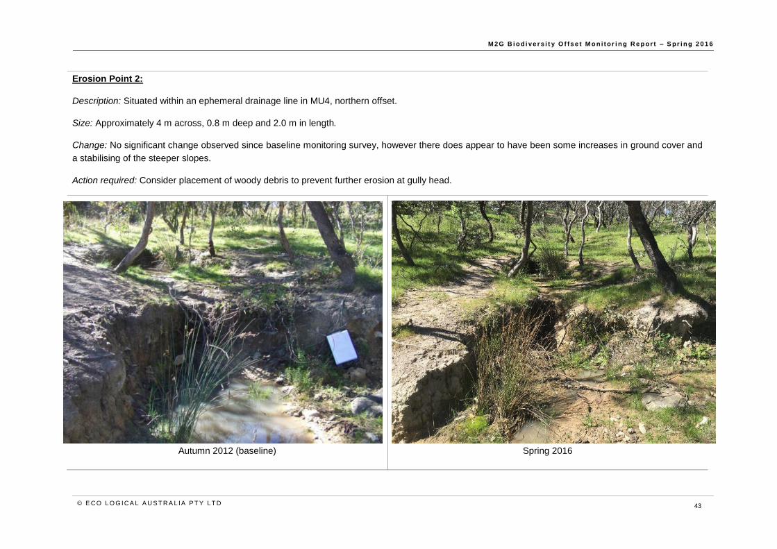
M 2G B i o d i ve r s i t y O f fs e t M o n i t or i n g R e p or t – S pr i n g 2 0 1 6
© E CO LO G ICA L A U S T RA L IA P T Y LT D 43
Erosion Point 2:
Description: Situated within an ephemeral drainage line in MU4, northern offset.
Size: Approximately 4 m across, 0.8 m deep and 2.0 m in length.
Change: No significant change observed since baseline monitoring survey, however there does appear to have been some increases in ground cover and
a stabilising of the steeper slopes.
Action required: Consider placement of woody debris to prevent further erosion at gully head.
Autumn 2012 (baseline)
Spring 2016

M 2G B i o d i ve r s i t y O f fs e t M o n i t or i n g R e p or t – S pr i n g 2 0 1 6
© E CO LO G ICA L A U S T RA L IA P T Y LT D 44
Erosion Point 4:
Description: Located within an ephemeral drainage line within MU4, northern offset.
Size: Approximately 2.0 m wide, 0.5 m deep, 2.5 m long.
Change: An increase in ground cover growth was observed on the bank above, which appears to be stabilising.
Action required: No works required at this stage.
Autumn 2012 (baseline)
Spring 2016
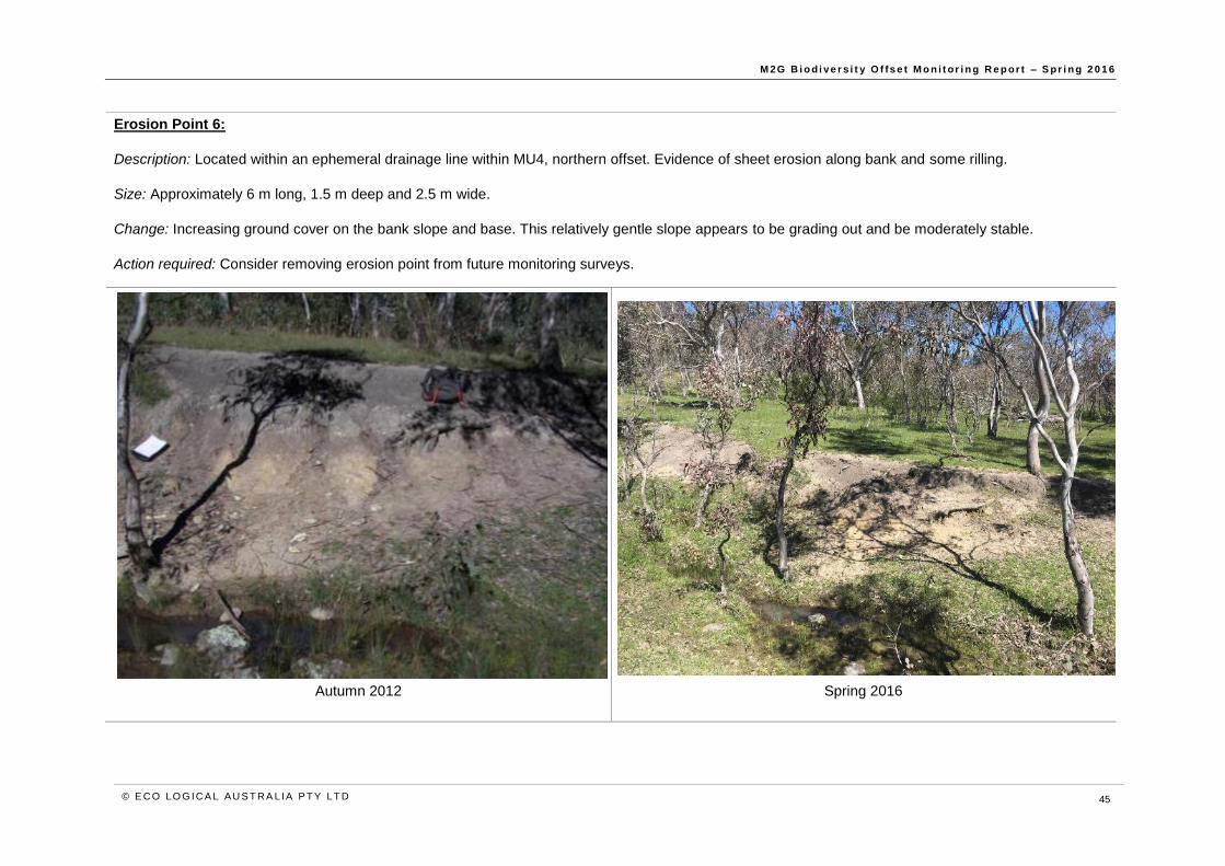
M 2G B i o d i ve r s i t y O f fs e t M o n i t or i n g R e p or t – S pr i n g 2 0 1 6
© E CO LO G ICA L A U S T RA L IA P T Y LT D 45
Erosion Point 6:
Description: Located within an ephemeral drainage line within MU4, northern offset. Evidence of sheet erosion along bank and some rilling.
Size: Approximately 6 m long, 1.5 m deep and 2.5 m wide.
Change: Increasing ground cover on the bank slope and base. This relatively gentle slope appears to be grading out and be moderately stable.
Action required: Consider removing erosion point from future monitoring surveys.
Autumn 2012
Spring 2016

M 2G B i o d i ve r s i t y O f fs e t M o n i t or i n g R e p or t – S pr i n g 2 0 1 6
© E CO LO G ICA L A U S T RA L IA P T Y LT D 46
Erosion Point 7:
Description: Located along the main creek line within northern offset. Photo taken from Photo Point 1 (co-ordinates; 6059835, 692700) looking north-west
(315o) and showing the north bank.
Size: Approximately 20 m long and 1.0 m deep.
Change: Minor active erosion along the banks. The southern side is moderately well vegetated.
Action required: Remediation measures to slow surface water flow and stop progression of head cut should be considered.
Autumn 2012 (baseline)
Spring 2016

M 2G B i o d i ve r s i t y O f fs e t M o n i t or i n g R e p or t – S pr i n g 2 0 1 6
© E CO LO G ICA L A U S T RA L IA P T Y LT D 47
Erosion Point 8:
Description: Located along the main creek line within northern offset. Photo taken from Photo Point 1 (co-ordinates; 6059835, 692700) looking north-east
(45o) and showing the north bank (upstream from erosion point 7).
Size: Approximately 15 m long and 1.0 m deep.
Change: Minor active erosion on the northern side, however there has been an increase in ground cover on the bank top.
Action required: None. Expected to grade out over time and naturally revegetate.
Autumn 2012 (baseline)
Spring 2016

M 2G B i o d i ve r s i t y O f fs e t M o n i t or i n g R e p or t – S pr i n g 2 0 1 6
© E CO LO G ICA L A U S T RA L IA P T Y LT D 48
Erosion Point 9:
Description: Situated near the western boundary of the southern offset.
Size: Approximately 20 m long and 1 m deep.
Change: No significant change observed since baseline monitoring survey. Side walls and head show signs of minor ongoing erosion.
Action required: Consider remediation of head cut to stop progress of gully.
Autumn 2012 (baseline)
Spring 2016

M 2G B i o d i ve r s i t y O f fs e t M o n i t or i n g R e p or t – S pr i n g 2 0 1 6
© E CO LO G ICA L A U S T RA L IA P T Y LT D 49
Erosion Point 10:
Description: Situated along the western fence line of the southern offset. Small area of erosion due to upslope runoff.
Size: Approximately 5.0 m long and 0.5 m deep.
Change: This point appears to be grading out and stabilising, with no signs of active erosion.
Action required: No immediate action required.
Autumn 2012 (baseline)
Spring 2016

M 2G B i o d i ve r s i t y O f fs e t M o n i t or i n g R e p or t – S pr i n g 2 0 1 6
© E CO LO G ICA L A U S T RA L IA P T Y LT D 50
Erosion Point 13:
Description: Moderately sized erosion point in northern offset. Evidence of existing slumping.
Size: Approximately 4.0 m long, 1.5 m deep and approximately 3 m wide.
Change: Some further slumping at the gully head observed, with roots remaining exposed.
Action required: Consider placement of woody debris or other stabilising materials to remediate and prevent further erosion.
Autumn 2012 (baseline)
Spring 2016

M 2G B i o d i ve r s i t y O f fs e t M o n i t or i n g R e p or t – S pr i n g 2 0 1 6
© E CO LO G ICA L A U S T RA L IA P T Y LT D 51
Erosion Point 18:
Description: Located along an ephemeral drainage line within the northern offset. Evidence of stream bed exposure, pooling and in-stream vegetation.
Size: Approximately1.5 m deep, 2.5 m wide, 3 m long.
Change: Woody debris placed at gully head; this erosion point now appears to be fully stabilising and increasing in vegetative cover.
Action required: Continue to monitor and supplement woody debris if required.
Autumn 2012 (baseline)
Spring 2016
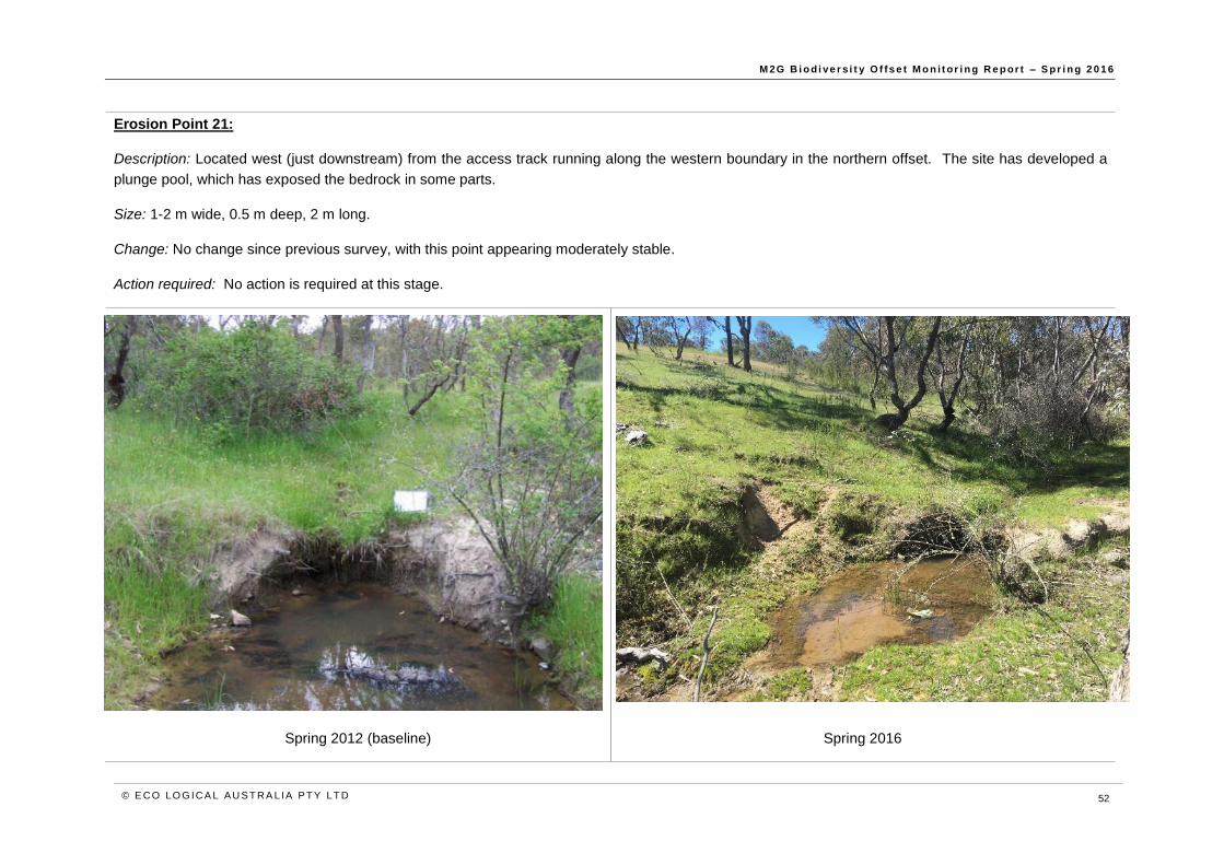
M 2G B i o d i ve r s i t y O f fs e t M o n i t or i n g R e p or t – S pr i n g 2 0 1 6
© E CO LO G ICA L A U S T RA L IA P T Y LT D 52
Erosion Point 21:
Description: Located west (just downstream) from the access track running along the western boundary in the northern offset. The site has developed a
plunge pool, which has exposed the bedrock in some parts.
Size: 1-2 m wide, 0.5 m deep, 2 m long.
Change: No change since previous survey, with this point appearing moderately stable.
Action required: No action is required at this stage.
Spring 2012 (baseline)
Spring 2016

M 2G B i o d i ve r s i t y O f fs e t M o n i t or i n g R e p or t – S pr i n g 2 0 1 6
© E CO LO G ICA L A U S T RA L IA P T Y LT D 53
Erosion Point 22: Point established at overflow point of southern dam during the spring 2013 monitoring surveys.
Description: Southern dam overflow – flowing water causing erosion at exit point.
Size: 50 cm wide, 20 cm deep, 1.5 m long.
Change: Water over-flow from the dam appears to be causing continued active erosion.
Action required: No immediate works required at this stage.
Spring 2013 (baseline)
Spring 2016

M 2G B i o d i ve r s i t y O f fs e t M o n i t or i n g R e p or t – S pr i n g 2 0 1 6
© E CO LO G ICA L A U S T RA L IA P T Y LT D 54
8 Feral animals
The autumn and spring 2012 monitoring surveys identified Sus scrofa (Feral Pig) within the offset
property. Prior to the autumn 2012 monitoring, this species had not been observed. Disturbance within
the offset included pig rooting, often in areas associated with a forage source, and tracks through
boggier areas of the site. The disturbance caused by the pigs was locally significant, but pig activity
was at a low density across the whole of the offset. It was recommended that the level of disturbance
be monitored and appropriate action taken if the level of disturbance increased substantially. In
response to the recommendation, Regional Feral Animal Control (RFAC) was engaged to conduct
control activities at the M2G offset site during 2012 and 2014.
Feral Goats (Capra hircus) were observed within the offset site during the spring 2013 monitoring
surveys. The species was considered likely to be utilising a large area, including the offset site,
neighbouring properties and Murrumbidgee River corridor. The lack of disturbance (agriculture
activities) within the offset site is likely to provide a refuge for the goats. The spring 2013 monitoring
surveys observed localised goat camps (e.g. under a stand of trees) and increased grazing pressures
at these points. However, the overall quality and condition of the offset site did not appear to be greatly
impacted. As a proactive measure Icon Water undertook goat control activities in December 2013. A
total of 150 feral goats were removed from the offset site. Subsequent aerial monitoring did not record
any goats within the offset site. RFAC observed goats within the offset site during July 2014.
Further feral animal control measures were undertaken during spring 2015 (feral pig trapping) and
winter 2016 (feral goat removal and fox shooting). Further operations to remove the large population
of feral goats present on site are planned for 2017.
8.1 Feral animal monitoring results (opportunistic observat ions) – spring 2016
Opportunistic records (direct and indirect) of feral animals are presented in Figure 19.
8.1.1 Vulpes vulpes (European Fox)
A single fox was observed within the Williamsdale property during the course of fencing monitoring
during spring 2016. While this was located outside the M2G offset site, it is likely that this species
utilises the offset site.
8.1.2 Oryctolagus cuniculus (European Rabbits) and Lepus europaeus (Hares)
One active rabbit warren were observed within the offset site, and an additional warren and one rabbit
were observed within the Williamsdale property during the course of monitoring. This is the first record
of rabbit warrens within the offset site.
Hares have previously been recorded, however not for the past two monitoring periods.
8.1.3 Dama dama (Feral Deer)
Two feral deer were recorded within the Williamsdale property during the spring 2016 surveys. The
species is considered likely to utilise the offset site periodically.
8.1.4 Capra hircus (Feral Goat)
Large numbers of feral goats (up to 70 in one single herd) were observed within the offset site. This
indicates an increase in population compared to the previous year, during which no feral goats were

M 2G B i o d i ve r s i t y O f fs e t M o n i t or i n g R e p or t – S pr i n g 2 0 1 6
© E CO LO G ICA L A U S T RA L IA P T Y LT D 55
directly observed. At the time of preparing this report, a project to round up and remove feral goats
from the property was being planned for early 2017.
8.1.5 Sus scrofus (Feral Pig)
Pig diggings were observed within the offset site during spring 2016. The diggings do not appear to
be recent. It is likely that the species utilises the offset site and adjacent areas including the broader
Murrumbidgee River corridor on a seasonal basis to escape cold weather at higher altitudes.
8.2 Recommendations and act ions
Undertake control of feral goats across the property.
Liaise with Parks and Conservation Service to expand existing fox baiting programs during
2016 to include the offset site.
Report presence of feral animal activity (for goat, pig and deer) to the local control
agencies. This will assist with information that may guide any broad or landscape scale
control activities.

M 2G B i o d i ve r s i t y O f fs e t M o n i t or i n g R e p or t – S pr i n g 2 0 1 6
© E CO LO G ICA L A U S T RA L IA P T Y LT D 56
Figure 19: Opportunistic records of feral animals within the Williamsdale property, spring 2016

M 2G B i o d i ve r s i t y O f fs e t M o n i t or i n g R e p or t – S pr i n g 2 0 1 6
© E CO LO G ICA L A U S T RA L IA P T Y LT D 57
9 Fencing monitoring
Fencing of the offset site was one of the required actions highlighted in the ODP. Fencing is required
to prevent grazers such as sheep and cattle from entering the offset site from the neighbouring
properties. The primary aim of a stock proof fence is to keep grazing stock out of an area (e.g.
conservation area) where it is bordered by a private rural property. This type of fencing generally
consists of 4 or 5 stranded wire with wooden posts and/or star-pickets, approximately 1.2 m high. In
response to recommendations in previous monitoring reports (ELA, 2012), all internal fencing within
the offset site was removed in June 2013 to enhance the wildlife friendly nature of the offset site, and
to be consistent with the biodiversity conservation ideals of the ODP and associated sub-plans.
9.1 Fence condit ion spring 2016
The overall condition of the Williamsdale property and offset boundary fencing is considered adequate
to exclude grazing by stock within the offset site.
The exceptions to this are two areas of more major damage (“high risk”) along the eastern boundary
fence. However as this fence directly borders the Monaro Highway, it is not considered likely that these
areas will provide access to stock and as such are not considered a priority.
An open gate was recorded along the boundary fence of the southern offset site, in the south-west
corner.
Older style boundary fencing comprising a rabbit netting base with plain wires along the top is still
present along some sections of the offset site boundary. As highlighted in previous monitoring reports
(ELA, 2013; ELA, 2014; ELA, 2015), this style of fencing is not wildlife friendly and can require
considerable ongoing maintenance as a result of damage by fauna (wombats etc.). Minor damage to
fence sections of this style along the boundary has occurred where native fauna have pushed up
existing rabbit netting to gain access to the offset site. It is recommended that eventual replacement
of this style of fencing be considered to minimise impacts to fauna and reduce management costs and
maintenance required in the long term.
It is recommended that the fence continue to be monitored to ensure that it is maintained as an effective
barrier to the movement of stock. It is also recommended that the gate to the Gigerline Nature Reserve
remains closed to minimise the number of access points to the property.

M 2G B i o d i ve r s i t y O f fs e t M o n i t or i n g R e p or t – S pr i n g 2 0 1 6
© E CO LO G ICA L A U S T RA L IA P T Y LT D 58
Figure 20: Williamsdale property fence with points recommended for repair

M 2G B i o d i ve r s i t y O f fs e t M o n i t or i n g R e p or t – S pr i n g 2 0 1 6
© E CO LO G ICA L A U S T RA L IA P T Y LT D 59
10 Rehabilitation survival assessment
A summary of the rehabilitation survival assessment is presented in Table 12 below. Survival
percentages varied from 70% in the planting near the substation, to 82% in the smaller gully in the
northern offset. However, a number of live individuals were observed as being in poor health, with
discoloured foliage or dieback. There was evidence of waterlogging along the larger gully near the
substation, which may have contributed to plant deaths.
Table 12: Rehabilitation survival counts
Location
Alive
Dead Acacia sp. Dodonaea
sp.
Cassinia sp. Bursaria sp. Total
Northern offset,
point 1 18 9 13 0 40 10
Northern offset,
point 2 15 17 9 0 41 9
Large gully near
substation 19 14 1 1 35 15

M 2G B i o d i ve r s i t y O f fs e t M o n i t or i n g R e p or t – S pr i n g 2 0 1 6
© E CO LO G ICA L A U S T RA L IA P T Y LT D 60
11 Summary
11.1 General
Despite the levels of dieback and psyllid infestations, on the whole offset site is considered to be in
good condition, with a diversity of native vegetation and habitat features providing habitat for a range
of threatened, rare and uncommon flora and fauna species. A diversity of native birds, mammals and
reptiles were recorded across the offset site, occupying a range of habitat including regenerating and
remnant woodland, open grassland, outcropping rocks, standing water, riparian corridors and standing
and fallen dead wood.
11.2 Bushfire
The access track through the offset site is in a satisfactory condition.
Ongoing grazing by macropods across the property appear to be sufficient in controlling the growth of
the ground cover vegetation and preventing excessive build up of surface fine fuels.
11.3 Threatened, rare and uncommon plant species
Four nationally threatened, and 12 rare and uncommon ACT plant species occur or have been known
to occur on the offset site. Although no species is imminently threatened within the offset site it is
recommended that periodic monitoring be undertaken to ensure that the populations of these species
within the site are at a minimum maintained over time, and ideally expanded. Factors to consider
monitoring include:
population numbers
evidence of recruitment
potential threats such as grazing or browsing and weed competition.
Staff and contractors should be made aware of these species and their locations on site (i.e. provided
with maps and photographs) to minimise inadvertent damage to populations. This is particularly
important for personnel involved in spraying herbicides.
11.4 Weeds
Primary control of weeds across the site has reduced the abundance and distribution of key weed
species, however, follow up control is required to target any individuals missed or those that are
resprouting. On-going weed control should be prioritised for Serrated Tussock and for reshooting
Sweet Briar and Blackberry. The increase in extent and abundance of St John’s Wort is of particular
concern and further discussions with ACT PCS should be prioritised.
It is recommended that weed control within the broader Williamsdale property be considered to
minimise the chance of weed propagules from surrounding land becoming established within the offset
site.
11.5 Erosion
Four erosion points show signs of active gully erosion or slumping, possibly as a result of recent heavy
rains, and will require remediation work in the future. Placement of woody debris in gully heads appears
to have been successful in stabilising these areas. It is recommended that concept plans to undertake
remediation of these sites be developed and the cost of rehabilitation works be investigated.

M 2G B i o d i ve r s i t y O f fs e t M o n i t or i n g R e p or t – S pr i n g 2 0 1 6
© E CO LO G ICA L A U S T RA L IA P T Y LT D 61
11.6 Feral animal
The overall incidence of feral animals within the offset site was low, with the exception of feral goats,
which were observed in high numbers. The presence of feral pigs, foxes, rabbits and deer was also
recorded, however it is considered likely that deers and pigs utilise the site on a seasonal basis.
Continued monitoring and management control is recommended.
11.7 Fencing
The condition of the Williamsdale property and offset boundary fencing is considered adequate to
exclude stock grazing from the offset site, however, some minor repairs are likely to be required. Some
sections of the fence may require replacing in the future with a five strand plain wire fence.
11.8 Grazing
It has been estimated that up to 100 kangaroos may be utilising the offset site and surrounding
properties at any one time. The Land Management Agreement (LMA) (ACT Government) for the
Williamsdale property does not outline a suitable grazing level for the ‘Active Conservation’ rural
enterprise. Previously, the grazing intensity for the Williamsdale property was set at a Dry Sheep
Equivalent (DSE) of 600.
The ACT Kangaroo Management Plan (ACT Government, 2010) indicates that a direct comparison
between sheep and kangaroos in terms of DSE is inaccurate due to inherent ecological differences
between the two species. However, the Kangaroo Management Plan (KMP) suggests that a DSE of
0.6 per kangaroo for an unharvested population is probably a reasonable comparison for the ACT
region. Using this DSE, the Williamsdale property has the capacity to support up to 360 kangaroos.
An alternative measure to calculate the number of kangaroos that a property can support is to look at
the relative density. The KMP suggests a density of between 0.6 and 1.5 Kangaroos per hectare. The
Williamsdale property is approximately 208 ha in size, which means that using the density calculation,
the property could support between 124 – 312 kangaroos in total.
Opportunistic observations of grazing pressure within and adjacent to the Swainsona recta exclosure
plots continue to indicate that the offset site is currently grazed at moderate to high intensity, which is
broadly consistent with the conservations principles outlined in the ODP.

M 2G B i o d i ve r s i t y O f fs e t M o n i t or i n g R e p or t – s pr i n g 2 01 6
© E CO LO G ICA L A U S T RA L IA P T Y LT D 62
12 Management recommendations
A summary of the recommended adaptive management actions relating to the offset site is provided in Table 13 below. The actions relate to the appropriate ODP sub-plan and are based on the results presented in the above sections.
Table 13: Summary of proposed actions relating to the ODP
ODP Sub-Plan Action status Recommended management actions
Weed On-going control and monitoring.
Target priority species and priority areas over the 2017/2018 period.
Continue to undertake follow up weed control as required on persistent species such as Sweet Briar and Blackberry.
On-going weed management will be required at the site to combat the introduction of propagules from adjacent rural areas.
Rehabilitation To be considered. Supplementary plantings should be considered along the two gullies assessed in this report (Section 10).
No additional recommendations follow from this report. The spring 2015 and 2014 reports recommended the following:
It is recommended that consideration be given to low density scattered plantings in MU7. Plantings should include over storey (Eucalyptus blakelyi, E. melliodora) and shrubs
such as, Bursaria spinosa, Acacia spp., Cassinia sp., and Dodonaea sp. Plantings need to consider the proximity to the powerlines and need to maintain an appropriate
easement. Within the powerline easement consideration could be given the plantings of low shrubs, forbs and native grasses. Rehabilitation works could trial the use of
Kangaroo Grass mulch to suppress weeds and introduce seed into the site.
Prior to any planting works, weed control needs to be undertaken, particularly for broad leaf exotic species. Plantings should be monitored to ensure that they are not
outcompeted by exotic annual grass growth during the growing season.
Box-Gum Woodland, the dominant vegetation community within MU7 is an open woodland community with a typically absent or scattered mid-storey of native shrubs. Any
plantings considered should mimic the structure and species diversity present in the remainder of the offset site. There are likely to be suitable locations to collect seed within
the offset site to ensure that local provenance is preserved.
Sediment and erosion
Control Action required.
The majority of sites within the offset are considered to be stable and no immediate action is required.
Minor remediation works, such as placement of woody debris, should be considered at points 2, 9 and 13.
Concept plans should be developed for any larger remediation works, for example at points 7 and 8.
Bushfire Complete. On-going monitoring.
It is recommended that the track continues to be maintained in a condition to facilitate bush fire management. If track management is required in the future, it is recommended
that care is taken to ensure that the track remains in good condition and does not widen due to overuse, incorrect maintenance, or result in erosion. The track would ideally
remain in a grassed condition.
Consider developing and implementing an improved bushfire management plan which specifically manages the site for conservation. The plan should include consideration
of fire as a tool to manage invasive species, increase native species diversity, maintain an open structure to the woodland and enable a mosaic of fire classes to be established
across the site.
Feral animal control Action and on-going monitoring
required.
Implement a follow up fox baiting program in 2017.
The greater number of direct rabbit sightings in 2016 may indicate that this species has increased in abundance following fox control programs. Should future monitoring
indicate a further increase in abundance, control measures may be required.
Undertake feral animal monitoring utilising remote cameras in spring 2017.
Undertake feral goat control.
Fencing
Completed in August 2012 and
June 2013. On-going
maintenance and monitoring
No immediate major actions required.
Replacement of older style boundary fence (rabbit netting) with a 5 strand plain wire fence should be considered.
Grazing On-going monitoring Grazing level is considered to be appropriate to the management objectives of the site. Grazing should be continually monitored and control measures considered if necessary.
It is recommended that advice be sought from ACT government regarding grazing pressure and the potential control options for native herbivores.

M 2G B i o d i ve r s i t y O f fs e t M o n i t or i n g R e p or t – s pr i n g 2 01 6
© E CO LO G ICA L A U S T RA L IA P T Y LT D 63
References
ACT Government, 2010, ACT Kangaroo Management Plan, Prepared by Territory and Municipal
Services, ACT Government.
Eco Logical Australia 2012. M2G Offset Monitoring Report – Spring 2012. Prepared for ACTEW
Water.
Eco Logical Australia 2012. Offset Delivery Plan. Prepared for ACTEW Corporation. Includes
associated sub-plans and baseline data.
Eco Logical Australia 2013. M2G Offset Monitoring Report – Spring 2013. Prepared for ACTEW
Water.
Eco Logical Australia 2014. M2G Offset Monitoring Report – Spring 2014. Prepared for ACTEW
Water.
Eco Logical Australia 2015. M2G Offset Monitoring Report – Spring 2015. Prepared for Icon Water
Sharp, S. and Milner, R. 2014. Procedures Manual for Monitoring Matters of National Environmental
Significance in the Molonglo Conservation Areas. Territory and Municipal Services, ACT Government.
Stone C, Urquhart CA, 1995, Psyllids – Insect Pests of Eucalypts, Forest Protection Research Division
Series, Number 7. State Forests of NSW.

M 2G B i o d i ve r s i t y O f fs e t M o n i t or i n g R e p or t – s pr i n g 2 01 6
© E CO LO G ICA L A U S T RA L IA P T Y LT D 64
Appendix A: Flora species list – monitoring plots
Note: The species cumulative list includes all species observed over all monitoring surveys.
Native species, spring 2016
Plot Number Opportunistic
1 (MU1A)
2 (MU2B)
3 (MU3)
4 (MU4)
5 (MU5)
6 (MU6)
7 (MU7)
8 (MU3) Species (cumulative list)
Acacia dealbata x
Acacia mearnsii
Acacia rubida
Acaena novae-zelandiae
Acaena echinata
Acaena ovina x 1 1 1 + 1 1 1
Acrotriche serrulata x
Ajuga australis x
D = dead
+ = few, small cover (<5%)
r = solitary, small cover (<5%)
1 = numerous (up to 5%)
2 = 5-25%
3= 25-50%
4= 50-75%
5=>75%

M 2G B i o d i ve r s i t y O f fs e t M o n i t or i n g R e p or t – s pr i n g 2 01 6
© E CO LO G ICA L A U S T RA L IA P T Y LT D 65
Plot Number Opportunistic
1 (MU1A)
2 (MU2B)
3 (MU3)
4 (MU4)
5 (MU5)
6 (MU6)
7 (MU7)
8 (MU3) Species (cumulative list)
Alternanthera denticulata
Alternanthera sp. A
Amphibromus nervosus
Amyema pendula subsp. pendula x
Aphanes australiana
Aristida ramosa x 1 1 1
Aristida vagans x +
Arthropodium minus x + + +
Arthropodium sp.
Asperula conferta x + 1 1 1 1
Asplenium flabellifolium
Astroloma humifusum x
Austrostipa bigeniculata x
Austrostipa densiflora
Austrostipa scabra x 1 1 1 +
Austrostipa setacea
Austrostipa sp.
Bossiaea buxifolia
Bossiaea prostrata
Bothriochloa macra x 2 2 + 1 2 1 +
Brachycome sp. x
Brachyloma daphnoides x
Brachyscome dentata
Bulbine bulbosa x + + + +
Bursaria spinosa subsp. lasiophylla x +

M 2G B i o d i ve r s i t y O f fs e t M o n i t or i n g R e p or t – s pr i n g 2 01 6
© E CO LO G ICA L A U S T RA L IA P T Y LT D 66
Plot Number Opportunistic
1 (MU1A)
2 (MU2B)
3 (MU3)
4 (MU4)
5 (MU5)
6 (MU6)
7 (MU7)
8 (MU3) Species (cumulative list)
Callistemon sieberi
Callitris endlicheri x
Calocephalus citreus x
Calotis scabiosifolia var. integrifolia
Carex appressa x r
Carex breviculmis
Carex inversa x 1 r + + + 1
Carex sp.
Cassinia aculeata
Cassinia quinquefaria x +
Cassinia longifolia
Centipeda cunninghamii
Cheilanthes sieberi x 1 + + + 1
Chrysocephalum apiculatum x 1 1 2 1 1
Chrysocephalum semipapposum
Clematis leptophylla r
Convolvulus angustissimus x r r
Cotula australis x + 1
Craspedia variabilis x 1
Crassula helmsii
Crassula peduncularis
Crassula sieberana x 1 + + + + +
Cryptandra amara x + +
Cymbonotus lawsonianus + + +
Cymbonotus preissianus

M 2G B i o d i ve r s i t y O f fs e t M o n i t or i n g R e p or t – s pr i n g 2 01 6
© E CO LO G ICA L A U S T RA L IA P T Y LT D 67
Plot Number Opportunistic
1 (MU1A)
2 (MU2B)
3 (MU3)
4 (MU4)
5 (MU5)
6 (MU6)
7 (MU7)
8 (MU3) Species (cumulative list)
Cymbonotus sp. x r + + +
Cymbopogon refractus x + r
Cynoglossum suaveolens x
Cynoglossum sp. r
Cyperus lhotskyanus
Daucus glochidiatus x r r +
Desmodium brachypodum
Desmodium varians x r + +
Dianella revoluta x
Dichelachne sp.
Dichelachne micrantha x
Dichondra repens x 1 + +
Dichopogon fimbriatus x
Dillwynia sp. Yetholme
Discaria pubescens x
Diuris semilunulata
Dodonaea viscosa subsp. angustissima
x
Drosera peltata x + +
Dysphania pumilio
Einadia nutans subsp. nutans +
Elatine gratioloides
Eleocharis acuta
Elymus scaber x + + +
Enneapogon nigricans
Epilobium billardiereanum

M 2G B i o d i ve r s i t y O f fs e t M o n i t or i n g R e p or t – s pr i n g 2 01 6
© E CO LO G ICA L A U S T RA L IA P T Y LT D 68
Plot Number Opportunistic
1 (MU1A)
2 (MU2B)
3 (MU3)
4 (MU4)
5 (MU5)
6 (MU6)
7 (MU7)
8 (MU3) Species (cumulative list)
Epilobium hirtigerum
Eragrostis brownii
Erodium crinitum x 1 +
Eryngium ovinum x + +
Eucalyptus blakelyi x 2 2 1 2 2 1
Eucalyptus bridgesiana x
Eucalyptus dives x
Eucalyptus mannifera
Eucalyptus melliodora x r
Eucalyptus rossii x
Euchiton japonicus x + + + +
Euchiton sphaericus + + +
Euchiton sp. +
Euphorbia drummondii r
Fimbristylis dichotoma
Galium sp. r +
Galium gaudichaudii
Geranium retrorsum + + +
Geranium solanderi x + + 1 1 + 1 +
Geranium sp.
Glossostigma elatinoides
Glycine clandestina +
Glycine tabacina + + + +
Gonocarpus tetragynus x 1 + +
Goodenia hederacea x

M 2G B i o d i ve r s i t y O f fs e t M o n i t or i n g R e p or t – s pr i n g 2 01 6
© E CO LO G ICA L A U S T RA L IA P T Y LT D 69
Plot Number Opportunistic
1 (MU1A)
2 (MU2B)
3 (MU3)
4 (MU4)
5 (MU5)
6 (MU6)
7 (MU7)
8 (MU3) Species (cumulative list)
Goodenia pinnatifida +
Haloragis heterophylla
Hibbertia obtusifolia x
Hydrocotyle laxiflora x + 1 1 1 + 1 +
Hymenochilus cynocephalus
Hypericum gramineum + + +
Hypoxis hygrometrica x
Indigofera australis
Isoetopsis graminifolia
Isolepis hookeriana
Isotoma fluviatilis subsp. australis
Juncus australis
Juncus bufonius
Juncus filicaulis + +
Juncus homalocaulis
Juncus subsecundus x +
Juncus usitatus
Kunzea ericoides x r
Kunzea parvifolia
Lachnagrostis filiformis
Leptorhynchos squamatus x 1 + 1 1
Leptospermum continentale x
Leucochrysum albicans var. tricolor x +
Limosella australis
Linum marginale

M 2G B i o d i ve r s i t y O f fs e t M o n i t or i n g R e p or t – s pr i n g 2 01 6
© E CO LO G ICA L A U S T RA L IA P T Y LT D 70
Plot Number Opportunistic
1 (MU1A)
2 (MU2B)
3 (MU3)
4 (MU4)
5 (MU5)
6 (MU6)
7 (MU7)
8 (MU3) Species (cumulative list)
Lomandra bracteata + r r r
Lomandra filiformis subsp. coriacea x + +
Lomandra filiformis subsp. filiformis r
Lomandra longifolia
Lomandra multiflora x
Luzula densiflora x + + + 1 +
Lythrum hyssopifolia
Melichrus urceolatus x r + r
Microlaena stipoides x 1 + 1 + + 1
Microseris lanceolata x
Microtis sp. x + +
Montia fontana subsp. chondrosperma
Myosotis australis x + + + + 1 +
Ophioglossum lusitanicum
Oreomyrrhis eriopoda
Oxalis sp.
Oxalis perennans x 1 + + + 1 +
Oxalis radicosa
Oxalis thompsoniae
Panicum effusum + r
Pellaea calidirupium
Persicaria prostrata
Pimelea curviflora x
Plantago gaudichaudii +
Plantago varia + +

M 2G B i o d i ve r s i t y O f fs e t M o n i t or i n g R e p or t – s pr i n g 2 01 6
© E CO LO G ICA L A U S T RA L IA P T Y LT D 71
Plot Number Opportunistic
1 (MU1A)
2 (MU2B)
3 (MU3)
4 (MU4)
5 (MU5)
6 (MU6)
7 (MU7)
8 (MU3) Species (cumulative list)
Poa labillardieri x
Poa sieberiana var. hirtella
Poa sieberiana var. sieberiana x + r +
Poa sp.
Pomaderris angustifolia
Pomaderris pallida x
Poranthera microphylla
Potamogeton ochreatus
Pseudognaphalium luteoalbum
Pultenaea procumbens x r
Ranunculus lappaceus x
Ranunculus pumilio var. pumilio
Ranunculus sessiliflorus var. sessiliflorus
Rhodanthe anthemoides
Rubus parvifolius x
Rumex brownii x 1 r + + + 1
Rytidosperma caespitosum
Rytidosperma carphoides
Rytidosperma laeve
Rytidosperma pallidum
Rytidosperma racemosum + +
Rytidosperma sp. x + +
Schoenus apogon 1 2 + 1 +
Scleranthus diander r
Scleranthus fascicularis r

M 2G B i o d i ve r s i t y O f fs e t M o n i t or i n g R e p or t – s pr i n g 2 01 6
© E CO LO G ICA L A U S T RA L IA P T Y LT D 72
Plot Number Opportunistic
1 (MU1A)
2 (MU2B)
3 (MU3)
4 (MU4)
5 (MU5)
6 (MU6)
7 (MU7)
8 (MU3) Species (cumulative list)
Sebaea ovata
Senecio phelleus
Senecio quadridentatus x +
Solanum linearifolium
Solenogyne dominii r + +
Solenogyne gunnii +
Sporobolus sp.
Stackhousia monogyna x + + +
Stellaria pungens
Stylidium despectum
Swainsona monticola x
Swainsona recta (propagated)
Swainsona sericea x + +
Thelymitra pauciflora
Thelymitra sp.
Themeda triandra x 2 1 3 3 + 3
Thysanotus patersonii x
Thysanotus tuberosus
Tricoryne elatior x
Tripogon loliiformis
Triptilodiscus pygmaeus x 1 1 1 + 1 1
Veronica calycina x + +
Veronica sp.
Vittadinia cuneata +
Vittadinia gracilis

M 2G B i o d i ve r s i t y O f fs e t M o n i t or i n g R e p or t – s pr i n g 2 01 6
© E CO LO G ICA L A U S T RA L IA P T Y LT D 73
Plot Number Opportunistic
1 (MU1A)
2 (MU2B)
3 (MU3)
4 (MU4)
5 (MU5)
6 (MU6)
7 (MU7)
8 (MU3) Species (cumulative list)
Vittadinia muelleri x 1 r 1 +
Wahlenbergia communis x 1 + + + +
Wahlenbergia gracilenta
Wahlenbergia gracilis x 1 + + r
Wahlenbergia multicaulis
Wahlenbergia sp.
Wahlenbergia stricta
Wurmbea dioica x 1 + 1 + 1
Xerochrysum viscosum x +
Zornia dyctiocarpa
Total number 93 12 41 35 34 40 38 19 38
Exotic species, spring 2016
Plot Number Opportunistic
1 (MU1A)
2 (MU2B)
3 (MU3)
4 (MU4)
5 (MU5)
6 (MU6)
7 (MU7)
8 (MU3) Species (cumulative list)
Acetosella vulgaris x + 1 +
Aira caryophyllea
Aira elegantissima
Aira sp. x + 2 2 1 1 2 1 1
Anagallis arvensis x + + + +
Arctotheca calendula
Avena barbata x 2
Briza maxima
Briza minor x 2 + + +

M 2G B i o d i ve r s i t y O f fs e t M o n i t or i n g R e p or t – s pr i n g 2 01 6
© E CO LO G ICA L A U S T RA L IA P T Y LT D 74
Plot Number Opportunistic
1 (MU1A)
2 (MU2B)
3 (MU3)
4 (MU4)
5 (MU5)
6 (MU6)
7 (MU7)
8 (MU3) Species (cumulative list)
Bromus diandrus x 2 + 1
Bromus hordeaceus x 2 + 2 1 2 2 +
Bromus rubens
Bromus sp.
Capsella bursa-pastoris x + + 1
Carduus pycnocephalus
Carduus tenuiflorus
Carduus sp. x r 1
Carthamus lanatus x 2 r
Centaurea melitensis
Centaurium erythraea x 1 1 +
Cerastium glomeratum 1 1
Chondrilla juncea
Cicendia quadrangularis
Cirsium vulgare + + + + + +
Conyza sp. x + +
Conyza bonariensis
Conyza sumatrensis
Cotoneaster sp.
Crataegus monogyna
Cynodon dactylon
Cynosurus echinatus x
Cyperus eragrostis
Cyperus lhotskyanus
Cyperus sp.

M 2G B i o d i ve r s i t y O f fs e t M o n i t or i n g R e p or t – s pr i n g 2 01 6
© E CO LO G ICA L A U S T RA L IA P T Y LT D 75
Plot Number Opportunistic
1 (MU1A)
2 (MU2B)
3 (MU3)
4 (MU4)
5 (MU5)
6 (MU6)
7 (MU7)
8 (MU3) Species (cumulative list)
Echium plantagineum x 1 + + r
Eleusine tristachya
Eragrostis cilianensis
Eragrostis minor
Eragrostis curvula x
Erodium botrys
Erodium cicutarium x 1
Erodium moschatum
Erodium sp.
Festuca arundinacea
Galium aparine
Galium divaricatum
Geranium molle
Hedypnois rhagadioloides subsp. cretica
Hirschfeldia incana
Holcus lanatus x
Hordeum glaucum x 1 2
Hordeum leporinum
Hypericum perforatum x + + 1 1 1 1 +
Hypochaeris glabra
Hypochaeris radicata x 1 1 1 1 + 1 1 1
Isolepis levynsiana
Isolepis marginata
Juncus capitatus
Lactuca serriola x +

M 2G B i o d i ve r s i t y O f fs e t M o n i t or i n g R e p or t – s pr i n g 2 01 6
© E CO LO G ICA L A U S T RA L IA P T Y LT D 76
Plot Number Opportunistic
1 (MU1A)
2 (MU2B)
3 (MU3)
4 (MU4)
5 (MU5)
6 (MU6)
7 (MU7)
8 (MU3) Species (cumulative list)
Lepidium sp.
Linaria arvense x + r + +
Linaria pelisseriana x + + 1
Linum trigynum
Lolium perenne
Lolium rigidum
Malva nicaeensis
Malva parviflora x
Marrubium vulgare x
Medicago arabica
Modiola caroliniana x
Moenchia erecta x +
Nassella trichotoma x +
Onopordum acanthium
Orobanche minor
Parentucellia latifolia x + + r + +
Paronychia brasiliana x 1 + + 1
Paspalum dilatatum x
Pentaschistis airoides
Petrorhagia nanteuilii x + + + +
Phalaris aquatica
Plantago lanceolata x + 1 1 + 1 1
Poa annua x 1
Poa pratensis
Polygonum aviculare

M 2G B i o d i ve r s i t y O f fs e t M o n i t or i n g R e p or t – s pr i n g 2 01 6
© E CO LO G ICA L A U S T RA L IA P T Y LT D 77
Plot Number Opportunistic
1 (MU1A)
2 (MU2B)
3 (MU3)
4 (MU4)
5 (MU5)
6 (MU6)
7 (MU7)
8 (MU3) Species (cumulative list)
Prunus sp.
Pyracantha sp.
Reseda luteola
Rosa rubiginosa x + r + r r r
Romulea rosea var. australis
Rubus fruticosus x r
Sanguisorba minor
Setaria parviflora x
Sherardia arvensis
Sisymbrium orientale
Sisyrinchium sp. A
Solanum nigrum
Sonchus asper
Sonchus oleraceus x +
Spergularia rubra
Stellaria media
Taraxacum officinale x r
Tolpis barbata x + r +
Tragopogon dubius
Trifolium arvense x r + 1
Trifolium angustifolium x + + + + 1
Trifolium campestre x r + + + 1 1
Trifolium cernuum
Trifolium dubium r + 1 1
Trifolium glomeratum x r +

M 2G B i o d i ve r s i t y O f fs e t M o n i t or i n g R e p or t – s pr i n g 2 01 6
© E CO LO G ICA L A U S T RA L IA P T Y LT D 78
Plot Number Opportunistic
1 (MU1A)
2 (MU2B)
3 (MU3)
4 (MU4)
5 (MU5)
6 (MU6)
7 (MU7)
8 (MU3) Species (cumulative list)
Trifolium repens x
Trifolium sp.
Trifolium subterraneum x 2 r 2
Urtica urens x 1
Verbascum thapsus x r r
Verbena incompta
Verbena sp. x r
Veronica anagallis-aquatica
Veronica arvensis
Vicia sativa
Vulpia bromoides
Vulpia muralis
Vulpia myuros
Vulpia sp. x 1 1 1
Total number 50 12 5 13 9 4 16 14 6
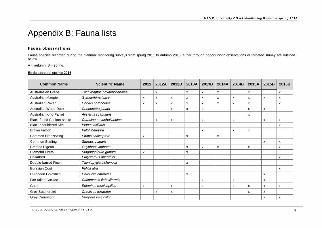
M 2G B i o d i ve r s i t y O f fs e t M o n i t or i n g R e p or t – s pr i n g 2 01 6
© E CO LO G ICA L A U S T RA L IA P T Y LT D 79
Appendix B: Fauna lists
Fauna observations
Fauna species recorded during the biannual monitoring surveys from spring 2011 to autumn 2015, either through opportunistic observations or targeted survey are outlined below.
A = autumn, B = spring.
Birds species, spring 2016
Common Name Scientific Name 2011 2012A 2012B 2013A 2013B 2014A 2014B 2015A 2015B 2016B
Australasian Grebe Tachybaptus novaehollandiae x x x x x x
Australian Magpie Gymnorhina tibicen x x x x x x x x x x
Australian Raven Corvus coronoides x x x x x x x x x
Australian Wood Duck Chenonetta jubata x x x x x
Australian King-Parrot Alisterus scapularis x
Black-faced Cuckoo-shrike Coracina novaehollandiae x x x x x x
Black-shouldered Kite Elanus axillaris x
Brown Falcon Falco berigora x x x
Common Bronzewing Phaps chalcoptera x x x
Common Starling Sturnus vulgaris x x
Crested Pigeon Ocyphaps lophotes x x x x x
Diamond Firetail Stagonopleura guttata x x
Dollarbird Eurystomus orientalis x
Double-barred Finch Taeniopygia bichenovii x
Eurasian Coot Fulica atra x
European Goldfinch Carduelis carduelis x x
Fan-tailed Cuckoo Cacomantis flabelliformis x x x
Galah Eolophus roseicapillus x x x x x x x
Grey Butcherbird Cracticus torquatus x x x x
Grey Currawong Strepera versicolor x x

M 2G B i o d i ve r s i t y O f fs e t M o n i t or i n g R e p or t – s pr i n g 2 01 6
© E CO LO G ICA L A U S T RA L IA P T Y LT D 80
Grey Fantail Rhipidura albiscapa x x x x x x x x x
Grey Shrike-thrush Colluricincla harmonica x x x x x x
Hard Head Aythya australis x x
Honeyeater, White-eared Lichenostomus penicillatus x x x x x
Honeyeater, White-plumed Lichenostomus penicillatus x x x
Honeyeater, Yellow-faced Lichenostomus chrysops x x x x x
Honeyeater, White-naped Melithreptus lunatus x
Horsfield's Bronze-Cuckoo Chrysococcyx basalis x x
Jacky Winter Microeca fascinans x x x x
Kookaburra Dacelo novaeguineae x x x x x
Leaden Flycatcher Myiagra rubecula x
Magpie Lark Grallina cyanoleuca x x x x x x x x x x
Masked Lapwing Vanellus miles x x x
Nankeen Kestral Falco cenchroides x x
Noisy Friarbird Philemon corniculatus x x x x x
Noisy Miner Manorina melanocephala x x x x x x x x x x
Owlet Nightjar Aegotheles cristatus x
Pacific Black Duck Anas superciliosa x x x x x
Pardalote, Spotted Pardalotus punctatus x x x x x x x x x
Pardalote, Striated Pardalotus striatus x x x x x x x x x
Pallid Cuckoo Cuculus pallidus x
Pied Butcherbird Cracticus nigrogularis x x x
Pied Currawong Strepera graculina x x x x x x x x x x
Quail Coturnix sp. x x
Red-browed Finch Neochmia temporalis x x x x
Red Wattlebird Anthochaera carunculata x x x x x
Robin, Eastern Yellow Eopsaltria australis x x x
Robin, Flame Petroica phoenicea x x
Robin, Hooded Melanodryas cucullata cucullata x x
Robin, Scarlet Petroica boodang x x x x
Rosella, Crimson Platycercus elegans x x x x x x x x x x
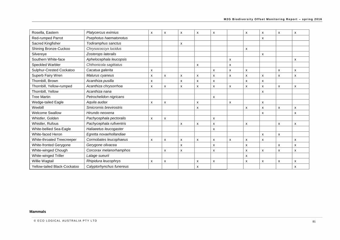
M 2G B i o d i ve r s i t y O f fs e t M o n i t or i n g R e p or t – s pr i n g 2 01 6
© E CO LO G ICA L A U S T RA L IA P T Y LT D 81
Rosella, Eastern Platycercus eximius x x x x x x x x x
Red-rumped Parrot Psephotus haematonotus x
Sacred Kingfisher Todiramphus sanctus x
Shining Bronze-Cuckoo Chrysococcyx lucidus x
Silvereye Zosterops lateralis x
Southern White-face Aphelocephala leucopsis x x
Speckled Warbler Chthonicola sagittatus x x
Sulphur-Crested Cockatoo Cacatua galerita x x x x x x
Superb Fairy Wren Malurus cyaneus x x x x x x x x x x
Thornbill, Brown Acanthiza pusilla x x x x x x
Thornbill, Yellow-rumped Acanthiza chrysorrhoa x x x x x x x x x x
Thornbill, Yellow Acanthiza nana x
Tree Martin Petrochelidon nigricans x
Wedge-tailed Eagle Aquila audax x x x x x
Weebill Smicrornis brevirostris x x x x x
Welcome Swallow Hirundo neoxena x x
Whistler, Golden Pachycephala pectoralis x x x
Whistler, Rufous Pachycephala rufiventris x x x x x x
White-bellied Sea-Eagle Haliaeetus leucogaster x
White-faced Heron Egretta novaehollandiae x x
White-throated Treecreeper Cormobates leucophaeus x x x x x x x x x
White-fronted Gerygone Gerygone olivacea x x x x x
White-winged Chough Corcorax melanorhamphos x x x x x x x
White-winged Triller Lalage sueurii x
Willie Wagtail Rhipidura leucophrys x x x x x x x x
Yellow-tailed Black-Cockatoo Calyptorhynchus funereus x x
Mammals

M 2G B i o d i ve r s i t y O f fs e t M o n i t or i n g R e p or t – s pr i n g 2 01 6
© E CO LO G ICA L A U S T RA L IA P T Y LT D 82
Common Name Latin Name 2011 2012A 2012B 2013A 2013B 2014A 2014B 2015A 2015B 2016B
Brushtail Possum Trichosurus vulpecula x x x x
Cow Bos Taurus x x x x
Echidna Tachyglossus aculeatus x x x
European Rabbit Oryctolagus cuniculus x x x x x x x x x
Feral Goat Capra aegagrus hircus x x x x x x x x
Feral Pig Sus scrofa x x x x
Fox Vulpes vulpes x x x x x x x x x x
Eastern Grey Kangaroo Macropus giganteus x x x x x x x x x x
Red-necked Wallaby Macropus rufogriseus x
Sheep Ovis aries x x
Sugar Glider* Petaurus breviceps x x
Swamp Wallaby Wallabia bicolor x x x x
Wallaroo, Common Macropus robustus x x x
Common Wombat Vombatus ursinus x x x x x x x x x x
Reptiles
Reptiles Latin Name 2011 2012A 2012B 2013A 2013B 2014A 2014B 2015A 2015B 2016B
Delicate Skink Lamphrolis delicata x x
Eastern Bearded Dragon Pogona barbata x x
Eastern Common Froglet Crinia signifera x x x x x x x x x
Eastern Long-necked Tortoise Chelodina longicollis x x x x x x x
Eastern Water Dragon Intellagama lesueurii
Jacky Lizard Amphibolurus muricatus x x x x
Peron's Tree Frog Litoria peronii x x
Pink-tailed Worm Lizard Aprasia parapulchella x
Plains Froglet Crinia parainsignifera x x x x x x
Red-bellied Black Snake Pseudechis porphyriacus x
Rosenberg's Goanna Varanus rosenbergi x
Smooth Toadlet Uperolia laevigata x x x x

M 2G B i o d i ve r s i t y O f fs e t M o n i t or i n g R e p or t – s pr i n g 2 01 6
© E CO LO G ICA L A U S T RA L IA P T Y LT D 83
Southern Rainbow Skink Carlia tetradactyla x
Spotted Marsh Frog Limnodynastes tasmaniensis x x x x x x x
Whistling Tree Frog Litoria verreauxii x x x

HEAD OFFICE
Suite 4, Level 1
2-4 Merton Street
Sutherland NSW 2232
T 02 8536 8600
F 02 9542 5622
SYDNEY
Level 6
299 Sussex Street
Sydney NSW 2000
T 02 8536 8650
F 02 9264 0717
HUSKISSON
1/51 Owen Street
Huskisson NSW 2540
T 02 4443 5555
F 02 4443 6655
CANBERRA
Level 2
11 London Circuit
Canberra ACT 2601
T 02 6103 0145
F 02 6103 0148
NEWCASTLE
Suites 28 & 29, Level 7
19 Bolton Street
Newcastle NSW 2300
T 02 4910 0125
F 02 4910 0126
NAROOMA
5/20 Canty Street
Narooma NSW 2546
T 02 4476 1151
F 02 4476 1161
COFFS HARBOUR
35 Orlando Street
Coffs Harbour Jetty NSW 2450
T 02 6651 5484
F 02 6651 6890
ARMIDALE
92 Taylor Street
Armidale NSW 2350
T 02 8081 2681
F 02 6772 1279
MUDGEE
Unit 1, Level 1
79 Market Street
Mudgee NSW 2850
T 02 4302 1230
F 02 6372 9230
PERTH
Suite 1 & 2
49 Ord Street
West Perth WA 6005
T 08 9227 1070
F 08 9322 1358
WOLLONGONG
Suite 204, Level 2
62 Moore Street
Austinmer NSW 2515
T 02 4201 2200
F 02 4268 4361
GOSFORD
Suite 5, Baker One
1-5 Baker Street
Gosford NSW 2250
T 02 4302 1220
F 02 4322 2897
DARWIN
16/56 Marina Boulevard
Cullen Bay NT 0820
T 08 8989 5601
BRISBANE
PO Box 1422
Fortitude Valley QLD 4006 T 0400 494 366
1300 646 131 www.ecoaus.com.au