m2m enablement in its
TRANSCRIPT

Revision History
Date Release Document No. Description
12/05/2015 R1.0 TEC-TR-S&D-M2M-003-01 Technical Report on M2M enablement in Intelligent
Transport Systems.
Important Notice
Individual copies of the present document can be downloaded from http://www.tec.gov.in
Users of the present document should be aware that the document may be subject to revision or
change of status.
Any comments/suggestions may please be sent to [email protected]
Disclaimer
The information contained is mostly compiled from different sources and no claim is being made for it
being original. Every care has been taken to provide the correct and up to date information along with
references thereof. However, neither TEC nor the authors shall be liable for any loss or damage
whatsoever, including incidental or consequential loss or damage, arising out of, or in connection with
any use of or reliance on the information in this document. In case of any doubt or query, readers are
requested to refer to the detailed relevant documents.


ContentsContentsContentsContents
List of Contributors .................................................................................................................................. i
Executive Summary ................................................................................................................................ iii
1 Introduction .................................................................................................................................... 1
1.1 Surface Transport .................................................................................................................... 2
1.2 Road network in India ............................................................................................................. 3
2 What is M2M Communication? ...................................................................................................... 6
3 Need of M2M Communication in Transport Sector ....................................................................... 7
3.1 Ecosystem & Environmental Factors ...................................................................................... 8
4 Conceptual Description of M2M Communication in ITS ................................................................. 9
Broad overviews of ITS ........................................................................................................................ 9
Layers of Intelligent Transport ............................................................................................. 11
Different Types of Connected Cars ....................................................................................... 11
Connected Car Components ................................................................................................. 12
4.4 Communication Technology of ITS ....................................................................................... 12
GIS for Indian Geography ...................................................................................................... 14
5 Use Cases ...................................................................................................................................... 15
5.1 Municipality .......................................................................................................................... 15
5.2 Traffic Planners ..................................................................................................................... 18
5.3 Commuter – End User ........................................................................................................... 19
5.4 Fleet Managers ..................................................................................................................... 19
5.5 Original Equipment Manufacturer (OEM) ............................................................................ 20
5.6 Car Dealer and Service .......................................................................................................... 20
5.7 Infrastructure / Safety ........................................................................................................... 21
5.8 Logistics ................................................................................................................................. 23
6 ITS Initiatives in India .................................................................................................................... 24
6.1 Pilots & Deployments ............................................................................................................ 24
7 Communication Technologies and Standards in ITS ..................................................................... 28
8 Key Challenges .............................................................................................................................. 30
9 Way Forward ................................................................................................................................. 31
10 References ................................................................................................................................ 33
11 Annexure 1 ................................................................................................................................ 34
12 Abbreviations ............................................................................................................................ 42

Figures
Figure 1: Population Growth of India...................................................................................................... 1
Figure 2: Types of Transport Medium ..................................................................................................... 1
Figure 3: Types of Accident on Indian Roads .......................................................................................... 2
Figure 4: Types of Transport Medium ..................................................................................................... 4
Figure 5: Space Taken by Private vs Public Transport ............................................................................. 5
Figure 6: Conceptual Picture of M2M ..................................................................................................... 6
Figure 7: Ecosystem & Environmental Factors ....................................................................................... 8
Figure 8: Broad Overview of ITS System ................................................................................................. 9
Figure 9: Layers of Intelligent Transport System .................................................................................. 11
Figure 10: GIS Stakeholders .................................................................................................................. 14
Figure 11: ITS Use Cases ........................................................................................................................ 15
Figure 12: eCall Typical Call Flow .......................................................................................................... 16
Figure 13: Block Diagram of OBITS........................................................................................................ 24
Figure 14: Collaborative Effort .............................................................................................................. 31
Figure 15: eCall System Textual Description ......................................................................................... 36
Figure 16: Process Flow Diagram .......................................................................................................... 37
Figure 17: Potential Growth .................................................................................................................. 39

Tables
Table 1: Details of Indian Roads .............................................................................................................. 3
Table 2: Public Transport v/s Private Transport ..................................................................................... 4
Table 3: Some ITS Research Projects .................................................................................................... 26
Table 4: Centre of Excellence in Urban Transportation ........................................................................ 26
Table 5: DIMTS Projects ........................................................................................................................ 27
Table 6: Actors’ Description .................................................................................................................. 36
M2M enablement in Intelligent Transport System Technical Report
Telecommunication Engineering Centre i
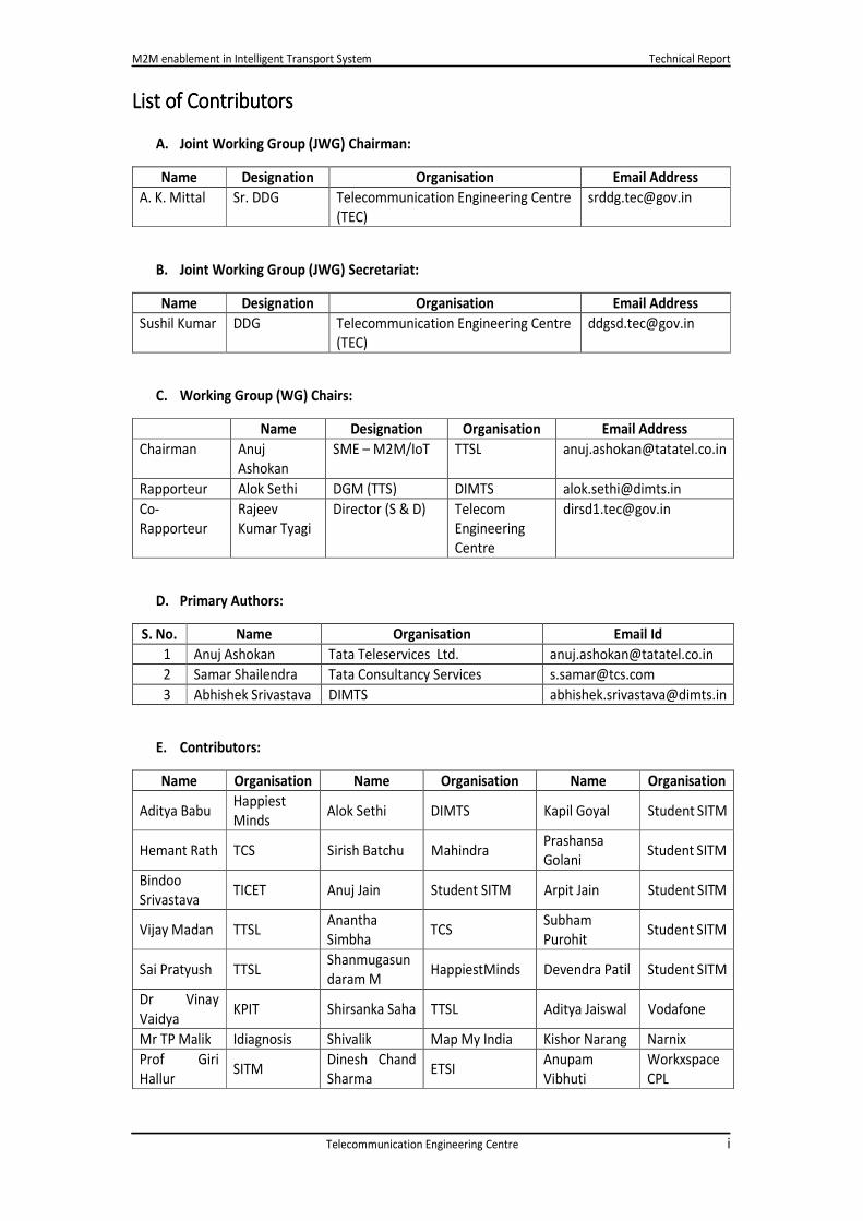
List of ContributorsList of ContributorsList of ContributorsList of Contributors
A. Joint Working Group (JWG) Chairman:
Name Designation Organisation Email Address
A. K. Mittal Sr. DDG Telecommunication Engineering Centre
(TEC)
B. Joint Working Group (JWG) Secretariat:
Name Designation Organisation Email Address
Sushil Kumar DDG Telecommunication Engineering Centre
(TEC)
C. Working Group (WG) Chairs:
Name Designation Organisation Email Address
Chairman Anuj
Ashokan
SME – M2M/IoT TTSL [email protected]
Rapporteur Alok Sethi DGM (TTS) DIMTS [email protected]
Co-
Rapporteur
Rajeev
Kumar Tyagi
Director (S & D) Telecom
Engineering
Centre
D. Primary Authors:
S. No. Name Organisation Email Id
1 Anuj Ashokan Tata Teleservices Ltd. [email protected]
2 Samar Shailendra Tata Consultancy Services [email protected]
3 Abhishek Srivastava DIMTS [email protected]
E. Contributors:
Name Organisation Name Organisation Name Organisation
Aditya Babu Happiest
Minds Alok Sethi DIMTS Kapil Goyal Student SITM
Hemant Rath TCS Sirish Batchu Mahindra Prashansa
Golani Student SITM
Bindoo
Srivastava TICET Anuj Jain Student SITM Arpit Jain Student SITM
Vijay Madan TTSL Anantha
Simbha TCS
Subham
Purohit Student SITM
Sai Pratyush TTSL Shanmugasun
daram M HappiestMinds Devendra Patil Student SITM
Dr Vinay
Vaidya KPIT Shirsanka Saha TTSL Aditya Jaiswal Vodafone
Mr TP Malik Idiagnosis Shivalik Map My India Kishor Narang Narnix
Prof Giri
Hallur SITM
Dinesh Chand
Sharma ETSI
Anupam
Vibhuti
Workxspace
CPL
M2M enablement in Intelligent Transport System Technical Report
Telecommunication Engineering Centre ii
Sushil Kumar TEC Raunaque
Quaiser
STMicroelectron
ics
Asok
Chatterjee TSDSI
Rajeev
Kumar Tyagi TEC Rashmi Chidri HappiestMinds Nanda Kishore Student SITM
Abhijit Mulay
Automotive
Research
Association
of India
Manu Tayal HappiestMinds Darpan Kamat Student SITM
Aditya Babu Happiest
Minds Himani Student SITM Partha Shah Student SITM
Anupam
Vibhuti
Workxspace
CPL Akshay Mishra
Tata IITB Centre
of excellence in
telecommunicat
ion
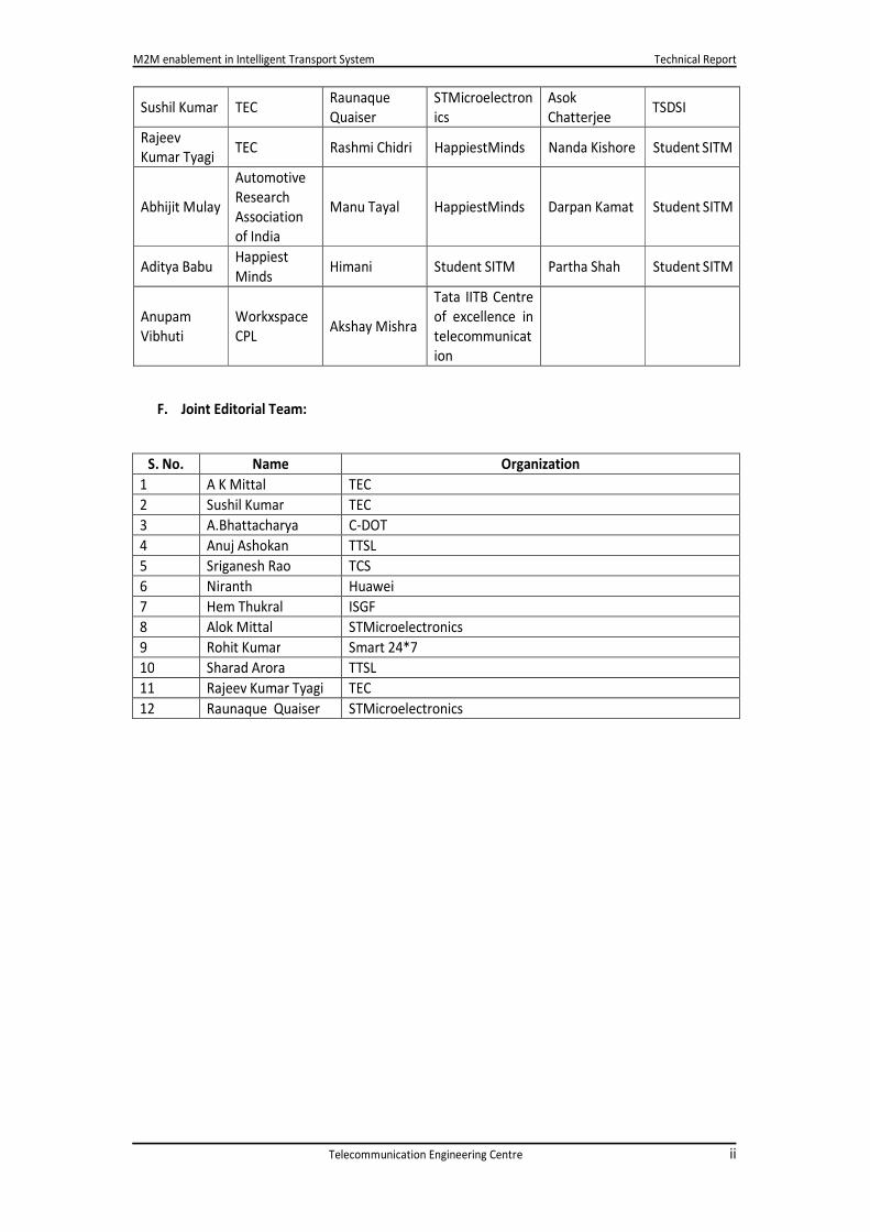
F. Joint Editorial Team:
S. No. Name Organization
1 A K Mittal TEC
2 Sushil Kumar TEC
3 A.Bhattacharya C-DOT
4 Anuj Ashokan TTSL
5 Sriganesh Rao TCS
6 Niranth Huawei
7 Hem Thukral ISGF
8 Alok Mittal STMicroelectronics
9 Rohit Kumar Smart 24*7
10 Sharad Arora TTSL
11 Rajeev Kumar Tyagi TEC
12 Raunaque Quaiser STMicroelectronics

M2M enablement in Intelligent Transport System Technical Report
Telecommunication Engineering Centre iii
Executive SummaryExecutive SummaryExecutive SummaryExecutive Summary
Transportation is backbone of any nation and is considered as major factor that further fuels economic
growth. However, there are serious concerns on the negative impact of transportation on human
health and environment. Three main concerns dominate when we think of innovation in
transportation, namely reduction in commutation time, in accidents and in emissions.
Over the past decades, computer system and advance communication technology has highly
developed and raised hope that ICT can benefit motor vehicle transport by introducing of ITS. ITS
encompasses a wide range of technologies that address concerns related to transportation.
The rapidly increasing vehicle population in India puts a heavy demand on traffic management in
metropolitan cities and other towns. Intelligent Transportation System is an established route to
address this and minimize traffic problems.
This document of Telecom Engineering Centre describes M2M enablement in Intelligent Transport
System. It introduces the subject with brief illustration of M2M communication and its framework for
Intelligent Transport System.
The report has identified 35 use cases in Intelligent Transport System e.g. eCall, Fleet Management,
Ambulance, Public Safety, Pollution under Control Check Automation etc.
The report identifies key challenges: lack of standards and ITS architecture, KYC norms, indigenous
manufacturing etc. Standards will allow for a level playing field for all participants and also for
customers.
The report suggests way forward wherein action points on various aspects such as collaborative
efforts, promotion of entrepreneurship, lack of national data sharing standards and data policy etc.
have been brought out.
With a robust IT and telecom infrastructure in place, India stands to gain from the use of ITS to alleviate
urban transport issues. Use of such technologies can be vehicular or infrastructural. As the Indian
economy progresses and urbanization in India increases, use of ITS and its importance will increase
proportionately. The unique ecosystem and diverse challenges creates plenty of room for R&D for
creation of suitable technologies in India.

M2M enablement in Intelligent Transport System Technical Report
Telecommunication Engineering Centre 1
1111 IntroductionIntroductionIntroductionIntroduction
Transport is an important part of India’s
economy. Since the economic liberalisation of
the 1990s, infrastructure development has
progressed rapidly; today there are a variety of
modes of transportation i.e. by land, water and
air. Since Population of India is rapidly growing
from last few decades so it is demand of hour
is to find out more sophisticated means of
transportation.
Public transport remains the primary mode of
transport for majority of the population, and
India's public transport systems are among the
most widely used transportation system in the
world. India's rail network is the fourth longest and the most heavily used system in the world,
transporting 8,224 million passengers and over 969 million tonnes of freight annually, as of 2012.
There are various medium for transportation as classified below:
0
0.2
0.4
0.6
0.8
1
1.2
1.4
1.6
1.8
2011 2020 2030 2040 2050
• Roadways
• Railways
Surface Transport
• Inland Water Transport
• Sea Transport
Water Transport
• Passenger
• Cargo
Air Transport
F IG UR E 1: PO PUL ATION GROWTH OF IND IA
F IGURE 2: TYPE S OF TR AN SPORT MEDI UM

M2M enablement in Intelligent Transport System Technical Report
Telecommunication Engineering Centre 2
1.11.11.11.1 Surface Surface Surface Surface TransportTransportTransportTransport
1111.1.1 .1.1 .1.1 .1.1 RoadwaysRoadwaysRoadwaysRoadways
Road Transport is one of the most important modes of transport, originating from ancient civilizations.
Gradually it became more and more popular means of transport. Road Transport is further subdivided
into Vehicular Transport (Cars, Trucks, Buses, Lorries, Autoricksaws, two-wheelers, Bullock Carts,
Tongas, Tumtums, and
Hand Carts etc.) and Non-
vehicular Transport
(Pedestrians and Animals)
Indian transport industry
has seen an exponential
growth in the last decade.
Currently, it is estimated
that India is home to more
than 140 million vehicles,
which is also a cause of
some major challenges,
which India is facing.
Figure 3 shows the
categories of commuters who get killed in road accident in India.
1.1.21.1.21.1.21.1.2 RailwaysRailwaysRailwaysRailways
Railways have been the pioneer of modern mechanical transport. It has brought the greatest
revolution in transport. It accelerated commercial and industrial development of various countries.
Until the introduction of Motor Transport, Railway had the monopoly as the Land Transport. In India,
it is the principal means of transport. It carries over 80 per cent of goods traffic and over 70 per cent
of passenger traffic. It spreads for more than 60000 kilometres across the country.
other
4%Bus
8%
trucks
13%
Car, Taxis,
Vans and
Other Light
and Medium
Motor
Vehicles…
Auto-
Rickshaws-
5%
Two-
Wheelers
26%
Bicycles
5%
Pedestrians-
9%
Other Motor
Vehicles
13%
Transport Sector contributes to about 6% of GDP whereas road transportation has share more
than 75%. Roads carry almost 90% of the country’s passenger traffic and 65% of its freight. Total
Road Length 4.32 million km.
Source: - Presentation of CSIR on Issues related to Toll Road in India
F IG UR E 3: TYPES OF ACCIDEN T ON INDIAN ROA DS
M2M enablement in Intelligent Transport System Technical Report
Telecommunication Engineering Centre 3
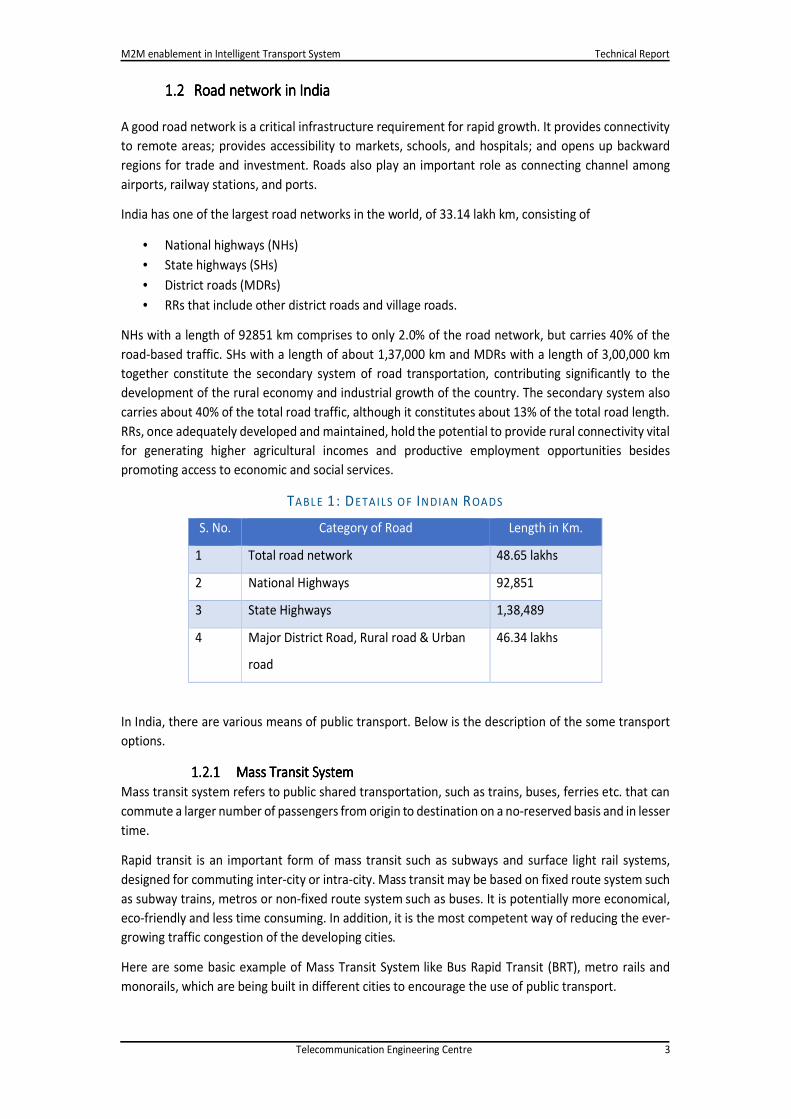
1.21.21.21.2 Road Road Road Road network innetwork innetwork innetwork in IndiaIndiaIndiaIndia
A good road network is a critical infrastructure requirement for rapid growth. It provides connectivity
to remote areas; provides accessibility to markets, schools, and hospitals; and opens up backward
regions for trade and investment. Roads also play an important role as connecting channel among
airports, railway stations, and ports.
India has one of the largest road networks in the world, of 33.14 lakh km, consisting of
• National highways (NHs)
• State highways (SHs)
• District roads (MDRs)
• RRs that include other district roads and village roads.
NHs with a length of 92851 km comprises to only 2.0% of the road network, but carries 40% of the
road-based traffic. SHs with a length of about 1,37,000 km and MDRs with a length of 3,00,000 km
together constitute the secondary system of road transportation, contributing significantly to the
development of the rural economy and industrial growth of the country. The secondary system also
carries about 40% of the total road traffic, although it constitutes about 13% of the total road length.
RRs, once adequately developed and maintained, hold the potential to provide rural connectivity vital
for generating higher agricultural incomes and productive employment opportunities besides
promoting access to economic and social services.
TABL E 1: DETAILS O F IN DIAN ROADS
S. No. Category of Road Length in Km.
1 Total road network 48.65 lakhs
2 National Highways 92,851
3 State Highways 1,38,489
4 Major District Road, Rural road & Urban
road
46.34 lakhs
In India, there are various means of public transport. Below is the description of the some transport
options.
1.2.1 1.2.1 1.2.1 1.2.1 Mass Transit SystemMass Transit SystemMass Transit SystemMass Transit System
Mass transit system refers to public shared transportation, such as trains, buses, ferries etc. that can
commute a larger number of passengers from origin to destination on a no-reserved basis and in lesser
time.
Rapid transit is an important form of mass transit such as subways and surface light rail systems,
designed for commuting inter-city or intra-city. Mass transit may be based on fixed route system such
as subway trains, metros or non-fixed route system such as buses. It is potentially more economical,
eco-friendly and less time consuming. In addition, it is the most competent way of reducing the ever-
growing traffic congestion of the developing cities.
Here are some basic example of Mass Transit System like Bus Rapid Transit (BRT), metro rails and
monorails, which are being built in different cities to encourage the use of public transport.

M2M enablement in Intelligent Transport System Technical Report
Telecommunication Engineering Centre 4
F IGURE 4: TY PES OF TRA NS POR T MED IU M
Major reason for non-adoption of mass transit over private transport is the unorganized last mile
transport and intermediate public transport.
1.2.21.2.21.2.21.2.2 Intermediate Public TransportIntermediate Public TransportIntermediate Public TransportIntermediate Public Transport
Unreliable last mile connectivity affects the overall quality and usage of mass transit system. While
efforts are being carried out to enhance mass public transport. There is a need to introduce new
models of regulation and reforms that can be adopted for a more efficient and safer system that
enables the rickshaw and other para-transit carriers to have an optimal role in the transport mix.
In India, public transport to the last mile remains a challenge to commuters due to the following
reasons.
• Last mile accessibility
• Security
• Convenience and comfort
• Long journey time
• Non-integrated mass transit systems
• Non-regulated expense (approx. 40% of total travel cost)
1.2.31.2.31.2.31.2.3 Private TransportPrivate TransportPrivate TransportPrivate Transport
Private Transport is transportation mode which is generally not used by general public as vehicle is
owned by individuals such as cars, motorcycle, scooters etc.
TABL E 2: PUB LIC TR AN SPOR T V/S PRIVA TE TRA N SPOR T
Parameter Public Transport Private Transport
Travel Cost Low High
Convenience Low High
Pollution & Emissions Low High
Comfort Low High
Capacity High Low

M2M enablement in Intelligent Transport System Technical Report
Telecommunication Engineering Centre 5
F IG UR E 5: SPA CE TA KEN BY PRIV ATE V S PUB LIC TRAN SPOR T
1.2.41.2.41.2.41.2.4 Goods/ Freight transport systemGoods/ Freight transport systemGoods/ Freight transport systemGoods/ Freight transport system
Unbelievable high time to transport good, unexpected delay caused due to road toll, and amount of
fuel wasted, is a major roadblock towards achieving the vision of “Make in India”.
Recent studies shows that India faces a loss of Rs. 600bn ($10.8bn) a year due to congestion, slow
speed of freight and waiting time at toll plazas.

M2M enablement in Intelligent Transport System Technical Report
Telecommunication Engineering Centre 6
2222 What is M2MWhat is M2MWhat is M2MWhat is M2M Communication?Communication?Communication?Communication?
It refers to the technologies that allow wired / wireless system to communicate with the devices of
same ability. M2M uses a device (sensor, meter etc.) to capture an ‘event’ (motion, video, location,
speed etc.), which is relayed through a network (wireless, wired or hybrid) to an application (software
program), that translates the captured event into meaningful information. A conceptual picture of
which is shown below:
What is M2M?
A conceptual picture …
A “DEVICE”, sensor, meter, etc., captures “something”, e.g., location, level, heat, motion, vital sign, usage, etc.
that is transported through a “NETWORK” (wireless, wired or mixed)
to an “APPLICATION”, which makes sense of the captured data, e.g., stolen vehicle is located, etc.
F IGUR E 6: CO NCEPT UAL P ICTUR E O F M2M
The enabling technologies for IoT are sensor networks, RFID, M2M, mobile Internet, wired & wireless
communication network, semantic data integration, semantic search, IPv4 / IPv6, etc. In wireless
communication Wi-Fi, ZigBee, 6LoWPAN, Bluetooth technology may be used for short range
connectivity of devices / devices to the gateway and GSM 2G/ 3G/ 4G or WiMAX for connecting M2M
gateway to server.
IPv4 addresses are going to exhaust. Standardization and adoption of IPv6 in telecom and ICT
organizations will provide an opportunity of having billions of devices which can be IP enabled and
seamlessly addressable through mobile or wired broadband connections.
M2M is a subset of IoT. IoT is a more encompassing phenomenon because it also includes Human-to-
Machine communication (H2M). With IoT, the communication is extended via Internet among all the
things that surround us.
Various sectors such as Power, Automotive, Health, Safety & Surveillance and Agriculture etc. may be
transformed and revolutionized by using M2M / IoT.
GPS/ GPRS

M2M enablement in Intelligent Transport System Technical Report
Telecommunication Engineering Centre 7
3333 Need of M2M Need of M2M Need of M2M Need of M2M Communication in Communication in Communication in Communication in Transport SectorTransport SectorTransport SectorTransport Sector
Due to rapid increment of number of vehicles with respect to existing infrastructure and slow rate of
development in infrastructure sector recent studies show that India faces
• a loss of Rs. 600bn ($10.8bn) a year due to congestion, slow speed of freight and waiting time
at toll plazas,
• an average Indian spends about 90 minutes a day travelling in major cities, with an average
speed of 5km/hr on some major roads,
• in India, around 5 lakhs road accidents happen, causing a loss of around $20 billion, with 6
lakhs people injured and 1.5 lakhs killed,
• every year, nearly 36,000 vehicles are stolen, which amount to Rs. 115 crore with only about
14,500 getting traced, often in un-roadworthy conditions, with many components missing,
• vehicles are the major contributor to AIR pollution.
M2M Communication can leverage sensor ecosystem, communication modules, network channel,
real-time processing, big data and cloud computing to optimize emergency services and save lives,
reduce congestion on roads and generate revenue, provide road safety to commuters and to monitor
and regulate driving behaviour, manage traffic by optimizing route.
Furthermore, M2M adoption results in enhancing convenience to use public transport, connecting
para transit and mass transit modes, monitoring and managing personal car, enabling vehicle
manufacturers to provide VAS to consumers, creating Vehicle to Vehicle and Vehicle to Infrastructure
communication systems, monitoring and reducing traffic violations, enabling parking assistance and
road tolling.
Below are the benefits, which can be realized by using M2M/IoT technologies in transportation system
and the way they can be measured.
• Safety: Measures include reduction in overall number of accidents, and its severity, injury, and
fatality rates. Surrogate measures include monitoring vehicle speed, or accounting to the
number of violations of traffic safety laws.
• Mobility: Measures include the amount of delay (in units of time) and the reduction of travel
time.
• Capacity/Throughput: It is measured by the maximum number of persons or vehicles that can
commute per hour at a point. It will increase making optimum utilization of resources.
• Customer Satisfaction: Measures related to satisfaction include time and convenience of
travel through various modes, mode choices and quality of service as well as volume of
complaints and suggestions.
• Productivity: Measures include operational efficiencies and cost savings.
• Energy and Environment: Measures of effectiveness include changes in emission levels and
energy consumption. Specific measures for fuel use and emission levels include emission
levels (kilograms or tons of pollutants for carbon monoxide (CO), oxides of nitrogen (NOx),
hydrocarbons (HC) and volatile organic compounds (VOC); fuel use (litres or gallons); and fuel
economy.
• Indirectly it will increase national GDP.
• Reduce delay caused by traffic and toll collection,
• Reduce crime; make travel safe, secure and convenient.
• Improve efficiency.

M2M enablement in Intelligent Transport System Technical Report
Telecommunication Engineering Centre 8
3.1 Ecosystem & Environmental Factors
The ecological dissimilarity of India makes its challenges and requirements unique, and interesting to
resolve. All use cases gets influenced by ecosystem & environmental factors shown in the figure below.
F IG UR E 1: ECOSYSTEM & ENVIR ON MEN TAL FA CTOR S
Fast adoption of
technology,
gadgets and Increasing
disposable
income
Exponential increase
in private cars and
first time drivers Exponential increase
in private cars and
first time drivers
Growing use of
software in
vehicles to
control
complex
electronics
Wide spread
coverage of
telecom service
providers. Wide spread
coverage of
telecom service
Companies
getting active
for employee
safety
Companies
Increasing complexities
of Driving: Performance
maintenance, theft,
Navigation, breakdowns
and accidents.
Logistics and
fleet
management
companies
optimizing
Severe traffic
congestion and
poor quality
roads of India
Government &
Regulatory bodies
exploring possibilities
for enhancing Public
security and
convenience.
Vehicle market in
India is dominated
by entry level cars Vehicle market in
India is dominated
by entry level cars
Environmental Factors
influencing Domestic
Connected Vehicle
Market

M2M enablement in Intelligent Transport System Technical Report
Telecommunication Engineering Centre 9
4444 Conceptual Description of Conceptual Description of Conceptual Description of Conceptual Description of M2M M2M M2M M2M Communication in ITSCommunication in ITSCommunication in ITSCommunication in ITS
Broad overviews of ITS
ITS enables elements within the transport system such as commuters, vehicles, roads, traffic lights,
message signs to become intelligent, embedding them with microchips and sensors, empowering
them to communicate with each other.
• People: Commuters & planners via smart phone or computers.
• Environment: Forces of nature, Incidents (Accidents, traffic jams, road conditions etc.)
• Vehicles: Personal & public vehicles through after-market device or embedded modules.
• Transport infrastructure: Petrol pumps, bus stands, traffic signals, digital signage, cameras &
streetlights.
The Intelligent Transport System will use following system:-
1. Telecommunication systems
a. Public access mobile radio networks (GSM, UMTS, etc.)
b. Private mobile networks and network services dedicated to road transport operators
(PMR/PAMR, DSRC, co-operative driving, vehicle to vehicle and vehicle to
infrastructure technologies).
2. Automatic Identification Systems (AIS)
a. Radio frequency identification (RFID); Smart cards; Video identification technology
3. Automatic Vehicle Location Systems (AVLS)
a. GPS based; Cellular networks; Systems based on automatic identification devices, in
case of fixed routes.
4. Traffic data collection and automatic classification systems
a. Video, microwave, magnetic detection
5. Electronic Data Interchange (EDI)
ITS
People
Environment
Vehicle
Transport Infrastructure
F IGURE 8: BR OAD OV ER VIE W OF ITS SY STEM
M2M enablement in Intelligent Transport System Technical Report
Telecommunication Engineering Centre 10
6. Cartographic databases and Geographic Information Systems (GIS). (GIS related information
kindly refer to para 4.5.

M2M enablement in Intelligent Transport System Technical Report
Telecommunication Engineering Centre 11
Layers of Intelligent Transport Layers of Intelligent Transport Layers of Intelligent Transport Layers of Intelligent Transport
Different Types of Connected CarsDifferent Types of Connected CarsDifferent Types of Connected CarsDifferent Types of Connected Cars
On Board Diagnostic (OBD) refers to a vehicle’s self-diagnostics & reporting capability. OBD systems
give access to status of the various vehicle subsystems.
F IG UR E 9: LA YER S OF INTEL LIGENT TRAN SPOR T SYST EM

M2M enablement in Intelligent Transport System Technical Report
Telecommunication Engineering Centre 12
4.2.14.2.14.2.14.2.1 Non OBDNon OBDNon OBDNon OBD
Its contents include non-OBD (On board diagnostic) M2M module with GPS sensor, RFID reader and
surveillance camera externally fitted into the vehicle. The device has both short and long-range
wireless connectivity. As Indian market is dominated by entry-level vehicles, this solution caters to the
immediate demand of track and trace requirements in the Indian market. Vehicles have standard way
to connect with the device without warranty getting void
4.2.24.2.24.2.24.2.2 OBD IIOBD IIOBD IIOBD II
This will cater to the premium vehicles segment compliant with OBDII Standards. The solution will
provide remote diagnostic and performance features in addition to the basic track and trace feature.
4.2.34.2.34.2.34.2.3 EmbeddedEmbeddedEmbeddedEmbedded
The solution is for new Vehicles embedded with factory fitted M2M module. Driven by vehicle
OEMs/manufacturers, the robust solution will cater to all connected vehicle use cases.
Connected Car ComponentsConnected Car ComponentsConnected Car ComponentsConnected Car Components
Apart from the following components required for the connectivity and communication between
vehicles are microcontroller, computing/ data storage hardware components and power management
components.
4.3.1 4.3.1 4.3.1 4.3.1 Sensors & AccessoriesSensors & AccessoriesSensors & AccessoriesSensors & Accessories
These include GPS module, fuel sensors, temperature sensors, door sensors, IP cameras, RFID/Smart
card reader, accelerometer, display, speakers, and panic button and relay to control ignition.
4.3.24.3.24.3.24.3.2 Wireless Communication ModuleWireless Communication ModuleWireless Communication ModuleWireless Communication Module
• Short range includes vehicle-to-vehicle and vehicle-to-infrastructure (DSRC, Bluetooth, Wi-Fi,
and vehicular radar).
• Long range includes GSM/CDMA/3G/Satellite.
• Other components include
4.3.34.3.34.3.34.3.3 SIMSIMSIMSIM
The normal SIM card is not suitable for harsh conditions of vehicles like vibrations, temperature, and
humidity. GSMA has created specifications for embedded M2M SIM, for remote Over-the-Air (OTA)
provisioning, hermetically sealed or installed in hazardous or remote locations. It can withstand
temperature variation for automotive grade temperature range of -40 degree to- +125 degree Celsius.
Embedded SIM technology offers big opportunities for auto manufacturers as the lifecycle of an eSIM
is, on averages, 10-15 years. International standards for eSIM have evolved.
4.44.44.44.4 Communication Technology of ITSCommunication Technology of ITSCommunication Technology of ITSCommunication Technology of ITS
4.4.14.4.14.4.14.4.1 Wireless WANWireless WANWireless WANWireless WAN
Wireless WAN is a wide area network in which separate areas of coverage or cells are connected to
provide service to a large geographic area. WWAN is supported on mobile networks. There are three
families of WWAN technologies, GSM/UMTS, CDMA 1x/CDMA2000, LTE and WiMAX. WWANs
typically incorporate encryption and authentication for secure communication.
4.4.24.4.24.4.24.4.2 Vehicle to InfrastructureVehicle to InfrastructureVehicle to InfrastructureVehicle to Infrastructure
Intelligent Transport System describes communication between Vehicle-to-Infrastructure. The
infrastructure could be as follows:
M2M enablement in Intelligent Transport System Technical Report
Telecommunication Engineering Centre 13
• Road side beacons
• Traffic signals
• Toll collections centres
• Petrol pumps and charging centres (for electric vehicles)
• Digital signage
• Safety applications like red light violation, over-loading or crossing speed limit
One of the primary objectives of V2I is to mitigate vehicle accidents, enable safety applications not
otherwise secured through Vehicle-to-Vehicle communications. With advancements in battery-
operated cars, charging stations would be an additional utility in petrol pumps with the vehicle being
intelligent enough to monitor fuel levels and indicate to users of charging station in the vicinity. RFID,
DSRC, GPRS and GPS are technologies used in all above applications/use cases. Roadside beacon and
traffic signals can manage congestion and diversions during peak traffic time. Digital signage can be
used to highlight safety messages to on-road vehicles.
4.4.34.4.34.4.34.4.3 Vehicle to Vehicle Vehicle to Vehicle Vehicle to Vehicle Vehicle to Vehicle
It provides connected vehicles to communicate with each other. The communication is over Dedicated
Short Range Communications (DSRC). DSRC provides a fast secure and reliable connectivity. V2V
communication provides enhanced awareness to users on roads where natural limitations impair
communication. Connected vehicles provide enhanced awareness at a competitive cost over existing
on-board sensor systems available today in some vehicles. It forewarns of possible hazards, alert
situations on the road, possible diversions, zones, which the user enters which may have restrictions.
Research is continuing on the possible user alerts once the vehicle gets the message of possible
hazards. It could be placed as LED on the vehicle dashboard or as haptics/vibrator on the driver seat
to warn the user to draw attention. The user can get real-time information on traffic congestion,
accidents and arrival of support and substitute commuting modes like taxies and cabs, which can assist
further in smoother commute.
4.4.44.4.44.4.44.4.4 Dedicated Short Range CommunicationDedicated Short Range CommunicationDedicated Short Range CommunicationDedicated Short Range Communication
It is a high speed, low latency and short- range communication, which is gaining popularity in the
design of connected vehicles. FCC has allocated 75 MHz spectrum in the 5.9 GHz band1, European
Telecommunications Standards Institute (ETSI) has identified 30 MHz of spectrum in the 5.9 GHz band
for ITS. It operates in extreme vehicle speed condition and is immune to extreme weather conditions.
Its design can tolerate multi-path transmissions, typical to roadway environments supporting vehicle-
to-vehicle and vehicle-to-infrastructure communication.
4.4.54.4.54.4.54.4.5 Wire line to connect stationary InfrastructureWire line to connect stationary InfrastructureWire line to connect stationary InfrastructureWire line to connect stationary Infrastructure
The connectivity of fixed infrastructure services is mostly on the wire line networks, as they are fixed
and reliable. The infrastructure can also serve as hub for connectivity of vehicle.
4.4.64.4.64.4.64.4.6 AfterAfterAfterAfter----market Black Boxmarket Black Boxmarket Black Boxmarket Black Box----totototo----vehicle vehicle vehicle vehicle
Electronic communication devices are usually not fitted by OEMs at the manufacturing lines. An after-
market V2V communication device provides advisories and warnings to the driver of a vehicle similar
to those provided by an OEM-installed V2V device. Aftermarket V2V devices can be installed from the
open market by automobile technicians, at vehicle dealerships, and at authorized dealers. Some
aftermarket V2V devices such as cell phones with apps are portable, standalone units need to be
installed close to the engine system for desired results.
1http://jwcn.eurasipjournals.com/content/pdf/1687-1499-2014-49.pdf

M2M enablement in Intelligent Transport System Technical Report
Telecommunication Engineering Centre 14
GIS GIS GIS GIS for Indian Gfor Indian Gfor Indian Gfor Indian Geographyeographyeographyeography
A Geographic Information System or GIS is a computer system that allows you to map, model, query,
and analyse large quantities of data within a single database according to their location. GIS gives you
the power to:
• create maps
• integrate information
• visualize scenarios
• present powerful ideas, and
• develop effective solutions
Below figure depicts the GIS stakeholders:
F IGURE 10: GIS STAK EH OLDER S

M2M enablement in Intelligent Transport System Technical Report
Telecommunication Engineering Centre 15
5555 Use CasesUse CasesUse CasesUse Cases
Some of the use cases for ITS are illustrated in figure below
5.15.15.15.1 MunicipalityMunicipalityMunicipalityMunicipality
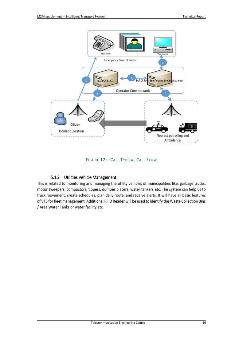
5.1.15.1.15.1.15.1.1 Public SafetyPublic SafetyPublic SafetyPublic Safety
This is a very important use case category, which will enhance the public security and emergency
management system in India. A typical call flow has been shown figure 12. M2M technology will
enable police emergency VAN to respond to citizen’s panic calls efficiently and will reduce the
response time. The framework can enable officials to manage and monitor the incident remotely.
Typical Call Flow
a) A citizen calls the assigned emergency control room number from the incident location.
b) Control Room Application interacts with ITS platform to report the incident with mobile
number of the caller.
c) ITS platform sends the location query request to operators GMLC.
d) GMLC uses network based ECID technology to locate the caller’s Location.
e) The system identifies the closest Fire Brigade and Ambulance to the incident location.
f) It sends the relief to the incident location
ITS Use cases
Municipality
Traffic Planners
Commuter
Logictics & Fleet
ManagersVehicle OEMs
Car Dealer and Service
Transport Infrastructure
F IG UR E 11: ITS USE CAS ES
M2M enablement in Intelligent Transport System Technical Report
Telecommunication Engineering Centre 16
F IGUR E 12: ECALL TYPICAL CAL L FL OW
5.1.25.1.25.1.25.1.2 Utilities Vehicle ManagementUtilities Vehicle ManagementUtilities Vehicle ManagementUtilities Vehicle Management
This is related to monitoring and managing the utility vehicles of municipalities like, garbage trucks,
motor sweepers, compactors, tippers, dumper placers, water tankers etc. The system can help us to
track movement, create schedules, plan daily route, and receive alerts. It will have all basic features
of VTS for fleet management. Additional RFID Reader will be used to identify the Waste Collection Bins
/ Area Water Tanks or water facility etc.

M2M enablement in Intelligent Transport System Technical Report
Telecommunication Engineering Centre 17
5.1.35.1.35.1.35.1.3 Emergency ResponseEmergency ResponseEmergency ResponseEmergency Response SSSSystemystemystemystem
In cases of emergencies police or para-military forces or even in worst situation armed forces need to
take charge. Fire Brigade and lifeguards also take charge in certain conditions. Coordination of the
Teams and Fleet management is very vital to handle such situations. Such a system has to be
trustworthy, and should not be dependent on public communication channels alone. Moreover, it
should be able to use GSM, CDMA, Satellite, or any other dedicated channel for critical
communications.
5.1.45.1.45.1.45.1.4 Waste CollectionWaste CollectionWaste CollectionWaste Collection MMMManagementanagementanagementanagement
This deals with optimizing the waste collection management by connecting utilities vehicles with VTS
device, by geo tagging the waste bins and by using RFIDs and other sensors. The overall waste
collection system components will include.
i. Garbage truck tracking
ii. Time prediction and route designing
iii. Communication with vehicle
iv. Worker tracking
v. Bin tracking and weighing
vi. Real time data transmission
vii. Control centre requirements.
5.1.55.1.55.1.55.1.5 AmbulanceAmbulanceAmbulanceAmbulance
There are three aspects of Ambulance Fleet Management,
1. To locate the nearest ambulance when any patient requisitions for it. For this purpose, basic
fleet management features of VTS may be sufficient.
2. Secondly, the hospital gets an alert when the Ambulance reaches certain distance from the
respective hospital. This time can be utilized by the hospital to get ready to receive the patient.
This will include the arrangements for stretcher, wheel chair and/or the para- medical staff at
the hospital.This can be done by utilizing Geo Fencing feature which is part of the basic feature
of VTS.
3. Third and the most vital requirement is that the treatment of the patient should start
immediately on his arrival at the hospital. If possible, treatment or possible preventive
measures can be started in the ambulance itself.
Normally, when patient reaches hospital some time is consumed in registration process,
getting personal details and details of the problem, allergies, medical history of the patient
and in some case of his family also. Patient’s vital data covering blood pressure, pulse rate,
glucose level etc. depending on the medical problem is also required to be observed and
noted. All these activities if completed in the ambulance itself, while the patient is being
moved to the hospital, can save the precious initial time. This can be achieved by making the
ambulance equipped with the tele-treatment facilities, equipping the ambulance with laptop,
camera, video / communication means (3G/LTE etc), making available medical instruments
for blood pressure measurement, pulse rate measurement, ECG machine etc. and trained para
medical staff to use these equipment and for completing the registration process and initial
information recording. The telemedicine set up will get this information simultaneously
conveyed to the hospital system and getting the expert advice for giving any required first aid.

M2M enablement in Intelligent Transport System Technical Report
Telecommunication Engineering Centre 18
5.1.65.1.65.1.65.1.6 Pollution under Control CheckPollution under Control CheckPollution under Control CheckPollution under Control Check AAAAutomationutomationutomationutomation
This use case describes an automated process for PUC testing, completely eliminating human element
(to prevent fraud certificates). PUC Certificate will be electronically readable (example QR code of
vehicle registration number and PUC certificate validity date).This can be linked to supply of fuel by
fuel station.
Fuel stations will be able to "validate" the electronic PUC certificate through a machine (RFID reader
or QR code reader) before dispensing fuel. The validation result should be printed on the fuel bill and
in the fuel station records (as evidence of PUC validation).
5.25.25.25.2 Traffic PlannersTraffic PlannersTraffic PlannersTraffic Planners
5.2.15.2.15.2.15.2.1 Traffic Management SystemTraffic Management SystemTraffic Management SystemTraffic Management System
Traffic management system integrates various subsystems (CCTV, GPS data, vehicle detection,
messaging, digital signage etc.) into a coherent single interface that provides real time data on traffic
status and predicts traffic congestions for more efficient planning and operations. Dynamic traffic
control systems, freeway operations management system, incident response systems, etc. respond in
real time to changing conditions.
5.2.25.2.25.2.25.2.2 Over SpeedOver SpeedOver SpeedOver Speed MMMMonitoringonitoringonitoringonitoring
It uses Electronic Vehicle Speed Display units as Vehicle infrastructure units. These units has to be
programmed with speed limits by Central Traffic management system based on the type of road,
location of Road and traffic condition.
Infrastructure unit determines traffic condition based on density of vehicles on road and pass on the
density information to Central Traffic management system to determine the speed limit to be
configured for that display board.
Vehicle reads the speed information from such Display Boards using V2I communication and alerts the
driver when he/she is over speeding. Hence, the driver is cautious about his behaviour, resulting in
less traffic violations.
5.2.35.2.35.2.35.2.3 RealRealRealReal----Time Passenger Information SystemsTime Passenger Information SystemsTime Passenger Information SystemsTime Passenger Information Systems (RTPIS)(RTPIS)(RTPIS)(RTPIS)
ITS are gaining recognition in India. The automatic real-time passenger information system has the
potential of making the public transport system an attractive alternative for city-dwellers, thereby
contributing to fewer private vehicles on the road, leading to lower congestion levels and less
pollution.
Novel features may include
i. A route creator utility, which automatically creates new routes from scratch when a bus is
driven along the new route,
ii. Voice tagging of stops and points of interest along any route,
iii. Web-based applications for passengers, providing useful information like a snapshot of
present bus locations on the streets,
iv. Web-based analysis tools for the transport authority, providing information useful for fleet
management, like number of trips undertaken by a specific bus.
5.2.45.2.45.2.45.2.4 Automatic PassengerAutomatic PassengerAutomatic PassengerAutomatic Passenger CCCCountingountingountingounting
For dynamic traffic management, it is important to get rapid feedback from the network and to
understand the entire transit system. Increasing demands on public transport put pressure on transit

M2M enablement in Intelligent Transport System Technical Report
Telecommunication Engineering Centre 19
agencies to improve their operations and services. New information technology such as ITS can be
used to meet higher demands on public transport. One ITS technology with the potential to improve
operations and services within public transport is the Automatic Passenger Counting (APC) system.
The APC system counts passengers alighting and boarding a vehicle, and can be used to get knowledge
about the passengers’ journey [2]. With this knowledge, it may be possible to understand the demands
and make adjustments for the future.
5.2.55.2.55.2.55.2.5 CCTV JunctionCCTV JunctionCCTV JunctionCCTV Junction SurveillanceSurveillanceSurveillanceSurveillance
1) End-to-end solution for CCTV Junction Surveillance within the same Traffic Command
Control Centre
2) Real time streaming video from junctions and strategic locations enables effective traffic &
incident management from remote Traffic Command Control Centre
3) Allows operators to directly observe the traffic conditions at all junctions, verify incidents
and congestion conditions
4) Multiple choices for IP based PTZ/Fixed Cameras with 36X zoom facility that enable capture
of minute details from junction
5) Crime prevention and deterrence
5.35.35.35.3 Commuter Commuter Commuter Commuter –––– End UserEnd UserEnd UserEnd User
5.3.15.3.15.3.15.3.1 Intelligent TIntelligent TIntelligent TIntelligent Transit Trip Planner and Real Time Routeransit Trip Planner and Real Time Routeransit Trip Planner and Real Time Routeransit Trip Planner and Real Time Route IIIInformationnformationnformationnformation
The Personal car user will receive travel related information to assist decision making on route,
estimated travel time, and avoid congestion. This can be enabled by providing different information
using various technologies such as
1) GPS enabled in vehicle navigation system.
2) Dynamic digital signage for real time communication of information on traffic congestions,
bottle necks, accidents and alternate route information during road closure and maintenance.
3) Digital heat map with traffic congestion related information in color-coding.
The public transport user will be able to use his smart phone to check availability, plan their transit,
make booking and pay using electronic mode.
5.45.45.45.4 Fleet ManagersFleet ManagersFleet ManagersFleet Managers
5.4.15.4.15.4.15.4.1 Fleet TrFleet TrFleet TrFleet Tracking, Start / Stopacking, Start / Stopacking, Start / Stopacking, Start / Stop MMMManagementanagementanagementanagement
This use case will enable radio taxi operators to automate their operational process. All the CABs
operating in the field will be embedded or fitted with a M2M gateway device, which would
continuously transmitting the location, status, alerts, driver behaviour. Call Centre Agent can track
any CAB through the GUI and allocate the CAB to the nearest customer. Value Added Services like
maintenance management, Driver behaviour, Security feature for passengers (panic button), in
vehicle surveillance etc.
This use case will enable transportation fleet enterprises to manage their operations more efficiently.
The High Value Asset (fleet) will be connected with a GPS + GSM/CDMA module, and will transmit
location information on a predefined time or on request. The application will utilize the data
transmitted by the device to derive maintenance schedule, route optimization, distance travelled,
speed, driving behaviour, fleet efficiency.

M2M enablement in Intelligent Transport System Technical Report
Telecommunication Engineering Centre 20
5.4.25.4.25.4.25.4.2 Fleet Management by LogisticsFleet Management by LogisticsFleet Management by LogisticsFleet Management by Logistics CCCCompanyompanyompanyompany
Besides all the Basic functionalities of VTS Stated above which are used by the Logistics companies,
fuel is important cost component, which needs monitoring. This is achieved by using Fuel sensor or by
tapping data going to the fuel gauge of the vehicle.
5.4.35.4.35.4.35.4.3 CaptiveCaptiveCaptiveCaptive RailwayRailwayRailwayRailway WWWWagonsagonsagonsagons
Many organizations own Railway wagons and use them for transporting their products. Tracking of
such wagons is very important, as there is no electricity in the wagon, the battery backup becomes
most important and should last the journey which could be more than 15 days.
5.4.45.4.45.4.45.4.4 Fleet Management of Vehicles Carrying Perishable ProductsFleet Management of Vehicles Carrying Perishable ProductsFleet Management of Vehicles Carrying Perishable ProductsFleet Management of Vehicles Carrying Perishable Products
Companies using such vehicles use all basic functionalities of VTS being used by logistics Companies.
In addition, they require Temperature Sensors to monitor the temperature to be maintained. Door
Sensors can be used to monitor and control that the door is opened only when essential to prevent
energy loss.
5.4.55.4.55.4.55.4.5 Heavy Machinery FleetHeavy Machinery FleetHeavy Machinery FleetHeavy Machinery Fleet MMMManagementanagementanagementanagement
Basic features of the VTS for Fleet Management are generally sufficient for such fleet (Cranes, dozers
etc.). Camera can provide better appreciation of the surroundings. These equipments, if OBD-II
compliant, can provide vital information related to performance and maintenance of the equipment.
This is very important for the finance companies to keep track of the location and health of the vehicle
5.4.65.4.65.4.65.4.6 Employee Commutation SafetyEmployee Commutation SafetyEmployee Commutation SafetyEmployee Commutation Safety
This service will enable companies operating in BPO/ITES/IT sector to automate their CAB
Management service for employees and ensure their safety. All the CAB operating for a specific
company will be tracked along with the employees on board. Companies will be able to manage and
monitor their employee commutation policies.
5.4.75.4.75.4.75.4.7 School Bus ManagementSchool Bus ManagementSchool Bus ManagementSchool Bus Management SSSSystemystemystemystem
This use case will ensure safety of children travelling by school’s owned transport services. The users
of this solution would be school administrators, parents of the students who would track and trace
the school bus on real time, receive alerts and notifications. The device installed in the vehicle should
be equipped with GPS for locations tacking, RFID for identifying the students and staff on boarded.
5.55.55.55.5 OOOOriginal Equipment Manufacturer (OEM)riginal Equipment Manufacturer (OEM)riginal Equipment Manufacturer (OEM)riginal Equipment Manufacturer (OEM)
Technology enables the vehicle manufactures to provide VAS services and create new stream of
revenue. OEM can provide services such as stolen vehicle tracking and location based anti-theft
applications. The OEMs can even monitor on field performance of the product after launch.
5.65.65.65.6 Car Dealer Car Dealer Car Dealer Car Dealer andandandand ServiceServiceServiceService
5.6.15.6.15.6.15.6.1 Vehicle DiagnosticVehicle DiagnosticVehicle DiagnosticVehicle Diagnostic &&&& Maintenance ReportMaintenance ReportMaintenance ReportMaintenance Report
For all OBD II complaint vehicles the service centres can provide maintenance report to the consumer
and check the health of the vehicle to take preventive actions. The device will be able to send data
related to health of the vehicle, like oil temperature, coolant temperature, oil level etc.
M2M enablement in Intelligent Transport System Technical Report
Telecommunication Engineering Centre 21
5.6.25.6.25.6.25.6.2 Road Side BreakdownRoad Side BreakdownRoad Side BreakdownRoad Side Breakdown AAAAssistancessistancessistancessistance
The system monitors the critical parameters of the vehicle and in case of any fault; it can locate the
nearest roadside assistance centre. Send an alert to the centre with vehicles issue report along with
location, this will help the service centre to respond effectively and immediately.
5.6.35.6.35.6.35.6.3 ECO DECO DECO DECO Drivingrivingrivingriving
OBD enabled M2M device mounted on the automobiles check the fuel emission (SO2, NO2, etc.) while
on drive and can send an alert to the service station in case if the emissions are alarming. In addition,
this information would be stored on cloud to give a consolidated automobile-health view to the
service centre once the automobile goes for servicing
5.75.75.75.7 Infrastructure / SafetyInfrastructure / SafetyInfrastructure / SafetyInfrastructure / Safety
5.7.15.7.15.7.15.7.1 SmartSmartSmartSmart PPPParkingarkingarkingarking
Smart parking helps one of the biggest problems on driving in urban areas; finding empty parking
spaces and controlling illegal parking. This implies M2M technologies aims rightness/safety as well as
convenience.
It involves using low-cost sensors, real-time data collection, and mobile-phone-enabled automated
payment systems that allow people to reserve parking in advance or very accurately predict where
they will likely find a spot. When deployed as a system, smart parking thus reduces car emissions in
urban centres by reducing the need for people to needlessly circle city blocks searching for parking. It
also permits cities to carefully manage their parking supply.
5.7.25.7.25.7.25.7.2 Road TollRoad TollRoad TollRoad Toll CCCCollection ollection ollection ollection
This use case will enable private car/fleet owners to decide the most economical toll route and pay
the charges automatically through online payment gateway. Using RFID tags telematics box on
vehicles, automated road toll collection can be computed.
Congestion charging is very effective in high-density geography, this will help optimizing the scarce
infrastructure and earn additional revenue. Based on real-time traffic congestion differential charging
may be applied at different time frames.
5.7.35.7.35.7.35.7.3 SmartSmartSmartSmart SSSSignalsignalsignalsignals
This use case is about adjusting the signal timing and priority based upon the priority of the vehicle
like ambulances etc. and provides framework to monitor and control over speeding and traffic
violation centrally.
TSP is a special operational strategy that allows transit vehicles to adjust signal-timing plans on their
respective routes when travelling on signalized roadways. Ultimately, deployment of this technology
is directed toward the reduction of delay on these routes and the improvement of schedule reliability.
Smart signals also include Congestion signalling on the driver dashboard. This can be useful for
congestion control at any place dynamically as well as regulate traffic flow during any contingency.
5.7.45.7.45.7.45.7.4 SmartSmartSmartSmart RRRRoadsoadsoadsoads
Municipalities around the world spend millions of dollars to maintain and repair their roadways.
Despite this investment, very few people are happy with the quality of the roads where they live or
work. The reason is that bad roads damage vehicles. They are sometimes hazardous to drivers and
pedestrians, and, at the very least, are annoying to drive or bike on. In India bad roads is a severe

M2M enablement in Intelligent Transport System Technical Report
Telecommunication Engineering Centre 22
problem and considering that goods roads are essential for fast development of India’s economy, road
condition monitoring becomes an important use case.
In India municipal budgets are generally constrained, determining which roads need fixing becomes
even more challenging. In addition, informing drivers of hazardous road conditions especially at night
or when lighting is poor would be a useful feature for navigation systems. Wireless Sensor Network is
a cost-effective and scalable option for reducing infrastructure maintenance costs and increasing
safety on the road. We can install wireless sensors in vehicles, mainly taxis and buses since these are
the vehicles which remain on road most of the times and daily covers huge area of road network and
hence can provide more suitable information regarding the status of roads in the city. Municipalities
can use this data to determine which roads are in serious bad condition and needs immediate repair
or rebuilding.
5.7.55.7.55.7.55.7.5 Traffic Signal Violation Traffic Signal Violation Traffic Signal Violation Traffic Signal Violation MMMMonitoringonitoringonitoringonitoring
This use case requires RF Transmitter to be used at each of the Traffic Signal to identify traffic violation.
Vehicle must have a unit to detect the RF signal on violation and notify the same to speeding/reckless
driver. A unit software is required to keep the count of the same and once a predefined limit is
approaching, should inform the driver about the legal preceding if continued in the similar fashion.
Once the limit is reached, the system will pass the vehicle information to Central Traffic Management
System along with the reason for logging a complaint. Moreover, such a system must be tamper proof
so that the driver is not able to misuse the same.
Central Traffic Management System to device the necessary action thereafter.
Challenges of this use case are:
i. RF Transmitter at each Signal
ii. Central Traffic Management Centre for devising the speed limit
iii. Traffic Density Calculation
5.7.65.7.65.7.65.7.6 Automated ChallanAutomated ChallanAutomated ChallanAutomated Challan IIIIssuancessuancessuancessuance
The surveillance cameras installed at the signals would have the Number Plate recognition algorithm
hosted on the server. Once an automobile violates the traffic rules, the surveillance cameras would
take the image of the number plate and send it to the central location. At the command and control
centre, the Video Analytics Platform would identify the car registration number from the image sent
and would then map it to the National Car Registration Database. It should be borne in mind that there
could be multi-lingual number that can be embossed on the plate. The video analytics platform should
convert the captured car registration number in unicode and then compare with the pool. Once
identified, the driver is issued a ticket against his/her name through a SMS on his registered number
and the ticket number is stored on the cloud for future reference.
5.7.75.7.75.7.75.7.7 Push Advertising in PublicPush Advertising in PublicPush Advertising in PublicPush Advertising in Public TTTTransportransportransportransport
Location Based Advertising on integrated displays in public transport systems has great potential. The
Passengers are normally bored when they ride with a public transport system (metro, bus, tram etc.)
so they are open to general interest information and location based advertising (push approach).
Therefore, they will receive messages during their ride. Mostly, they get value-added information e.g.
about various events, special activities, opening hours of museums, timetables, delays, city-activities
etc.
Example: When the public transport system passes an electronics store, on the display of the high
resolution screen special offers and saving of the store are displayed. [6] At the next exit, you have

M2M enablement in Intelligent Transport System Technical Report
Telecommunication Engineering Centre 23
the chance to get out of the public transport system and go directly to the store to check the
service/product and buy it directly.
5.85.85.85.8 LogisticsLogisticsLogisticsLogistics
5.8.15.8.15.8.15.8.1 Asset / CargoAsset / CargoAsset / CargoAsset / Cargo TTTTrackingrackingrackingracking
This use case requires a battery powered portable devices, which can track the current location of the
asset/cargo. On demand or periodically the device can upload its location, which would be helpful in
tracking the same. This can be used for tracking wild animals in sanctuaries, domestic animals at large
farms, children’s, pets and disabled people.
This service will enable Logistic companies to track their valuable assets movement, manage schedule
and customer expectation. The asset will be connected to thin client GPS device with GSM/CDMA
module, which will transmit current locations periodically or on request. Due to small packet size both
SMS and Packet core would be used as bearer channel.
5.8.25.8.25.8.25.8.2 Condition CheckCondition CheckCondition CheckCondition Check –––– LargeLargeLargeLarge----Sized ConstructionSized ConstructionSized ConstructionSized Construction MMMMachinesachinesachinesachines
Large-sized construction machines are continuously operated for long hours. Once they break down,
it takes substantial cost to repair them. Besides, since repairing a large-sized construction machine
takes much time, it significantly affects the machine activity rate. Therefore, construction machines,
especially large ones, are required to be free of down time and capable of planned operation without
interruption. In order to secure such machines, it is necessary to early detect any symptoms of
machine trouble by physical examination, etc. and have the maintenance personnel take suitable
measures without delay
5.8.35.8.35.8.35.8.3 Order Fulfilment and RouteOrder Fulfilment and RouteOrder Fulfilment and RouteOrder Fulfilment and Route OOOOptimizationsptimizationsptimizationsptimizations
Assigning tasks online to work force, define beat routes. Moreover, track daily movement with regards
to the schedule and route as well as monitor progress.
5.8.45.8.45.8.45.8.4 Usage BasedUsage BasedUsage BasedUsage Based IIIInsurancensurancensurancensurance
User Based Insurance and PAY as You Drive opportunities and how the industry is leveraging
technology to maximize return on investment through M2M telematics. As many insurers and
consumers now know, telematics technology has changed. Offering a vast range of benefits,
telematics can help insurers grow their businesses, know and support their customers, and deliver a
more profitable future.
Its features include:
1. Real-time feedback on driver behaviour
2. Vehicle diagnostics
3. Parental monitoring of teen driving
4. Increased fuel efficiency
5. Fewer claims and lower costs
6. Better risk mitigation
7. Stolen-vehicle tracking
8. Decrease response time

M2M enablement in Intelligent Transport System Technical Report
Telecommunication Engineering Centre 24
6666 ITS Initiatives in IndiaITS Initiatives in IndiaITS Initiatives in IndiaITS Initiatives in India
6.16.16.16.1 Pilots & DeploymentsPilots & DeploymentsPilots & DeploymentsPilots & Deployments
6.1.16.1.16.1.16.1.1 JNNRUM (Jawaharlal Nehru National JNNRUM (Jawaharlal Nehru National JNNRUM (Jawaharlal Nehru National JNNRUM (Jawaharlal Nehru National Urban Renewal Mission)Urban Renewal Mission)Urban Renewal Mission)Urban Renewal Mission)
Basic Block Diagram of OBITS (On Bus Intelligent Transport System) with key features:-
Features of JNNURM deployments are
• Automatic Vehicle Location (AVL)
• Passenger Information System (PIS)
F IG UR E 14: BUS WITH DEVICES
F IG UR E 13: BLOCK D IAG RAM OF OBITS
M2M enablement in Intelligent Transport System Technical Report
Telecommunication Engineering Centre 25
• Synchronization with Bus Depot
• Continuous/ Schedule based Security Camera Recording on activation of predefined
features
• Emergency Two way Voice Call
• Rear View Camera Display on Enabling Reverse Gear
• GPS Based Navigation and 3G wireless communication
• Supports Communication protocols like CAN 2.0, RS 232, Ethernet and USB
• Vehicle Heath Monitoring and Diagnostics (VHMD)
• Vehicle Tracking System/ Navigation System
• Electronic Toll Collection (ETC) RFID Tag
• Speed Limiters
• Immobilizers
• Collision warning
• Adaptive cruise control
6.1.26.1.26.1.26.1.2 Electronic Toll Collection Electronic Toll Collection Electronic Toll Collection Electronic Toll Collection
Delhi-Mumbai highway – 350 tolls are to be enabled with ETC, GoI mandates installation of RFID tags
on the medium and heavy motor vehicles.
6.1.2.16.1.2.16.1.2.16.1.2.1 Automatic Fare Collection Systems (AFCS)Automatic Fare Collection Systems (AFCS)Automatic Fare Collection Systems (AFCS)Automatic Fare Collection Systems (AFCS)
i. Implemented in Metro systems and Ahmedabad Bus Rapid Transit (BRT)
ii. Bids underway in various BRT systems
6.1.2.26.1.2.26.1.2.26.1.2.2 Location TechnologiesLocation TechnologiesLocation TechnologiesLocation Technologies
i. GPS based tracking for public transport fleet in operation in all major cities,
ii. CBSE, Oil companies, BPOs mandating VTS fitment on vehicles.
6.1.2.36.1.2.36.1.2.36.1.2.3 Intelligent Signalling Intelligent Signalling Intelligent Signalling Intelligent Signalling
i. Implemented in Ahmedabad, Delhi & Mumbai
6.1.36.1.36.1.36.1.3 Research Research Research Research andandandand DevelopmentDevelopmentDevelopmentDevelopment
There are many R&D initiative on the subject of ITS, and certainly we might know what traffic
applications are needed for Indian roads. We might design and implement sensing technologies
needed to handle those applications for Indian chaotic traffic. We might build robust, low-cost
communication models to gather data from sensors and disseminate information to commuters. But
unless we test our solutions in the field in medium to large scales, we will never come to know about
practical issues. Building collaboration with the public sector is an absolute necessity for this domain
to created sustainable output.
And there is a need to get all R&D efforts aligned, some of the projects being undertaken for R&D on
ITS are detailed below.
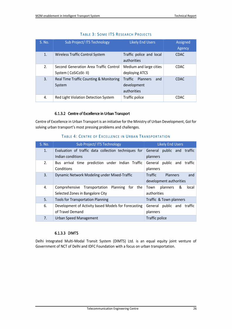
6.1.3.16.1.3.16.1.3.16.1.3.1 Some Some Some Some ITS research ITS research ITS research ITS research ProjectsProjectsProjectsProjects
Below table has mentioned some research projects on ITS sector.
M2M enablement in Intelligent Transport System Technical Report
Telecommunication Engineering Centre 26
TABLE 3: SO ME ITS RESEAR CH PR OJE CTS
S. No. Sub Project/ ITS Technology Likely End Users Assigned
Agency
1. Wireless Traffic Control System Traffic police and local
authorities CDAC
2. Second Generation Area Traffic Control
System ( CoSiCoSt- II) Medium and large cities
deploying ATCS CDAC
3. Real Time Traffic Counting & Monitoring
System Traffic Planners and
development
authorities
CDAC
4. Red Light Violation Detection System Traffic police CDAC
6.1.3.26.1.3.26.1.3.26.1.3.2 Centre of Excellence in Urban TransportCentre of Excellence in Urban TransportCentre of Excellence in Urban TransportCentre of Excellence in Urban Transport
Centre of Excellence in Urban Transport is an initiative for the Ministry of Urban Development, GoI for
solving urban transport’s most pressing problems and challenges.
TABLE 4: CENTR E O F EX CEL LEN CE I N URBA N TR A NSPOR TATIO N
S. No. Sub Project/ ITS Technology Likely End Users 1. Evaluation of traffic data collection techniques for
Indian conditions General public and traffic
planners
2. Bus arrival time prediction under Indian Traffic
Conditions General public and traffic
planners
3. Dynamic Network Modeling under Mixed-Traffic Traffic Planners and
development authorities
4. Comprehensive Transportation Planning for the
Selected Zones in Bangalore City Town planners & local
authorities
5. Tools for Transportation Planning Traffic & Town planners
6. Development of Activity based Models for Forecasting
of Travel Demand General public and traffic
planners
7. Urban Speed Management Traffic police
6.1.3.36.1.3.36.1.3.36.1.3.3 DIMTSDIMTSDIMTSDIMTS
Delhi Integrated Multi-Modal Transit System (DIMTS) Ltd. is an equal equity joint venture of
Government of NCT of Delhi and IDFC Foundation with a focus on urban transportation.

M2M enablement in Intelligent Transport System Technical Report
Telecommunication Engineering Centre 27
TABL E 5: DIMTS PR OJECTS
S. No. Sub Project/ ITS Technology
1. Wireless Traffic Signal Controller (Wi-TraC)
2. Red Light-Stop Line Violation & Detection System (RLSVDS)
3. CCTV Junction Surveillance
4. Variable Message Sign (VMS)
5. Video Incident Detection
6. Control and Command Centre

M2M enablement in Intelligent Transport System Technical Report
Telecommunication Engineering Centre 28
7777 CommunicationCommunicationCommunicationCommunication Technologies and Standards in ITSTechnologies and Standards in ITSTechnologies and Standards in ITSTechnologies and Standards in ITS
There is a need to examine global standards with Indian context in view for implementation of eCall.
It is noted that Working Group 15 of the CEN TC274 has written a set of standards regarding eCall.
Compliance with these standards is required in the General Approach of the Council.
• EN 16062 - eCall high level application requirements (HLAP) defines the high level application
protocols to facilitate eCalls using mobile networks.
• EN 16072 - Pan-European eCall operating requirements specifies the generic operational
requirements and intrinsic procedures for the provision of an eCall service that allows to
transfer an emergency message and to establish a voice channel between IVS and PSAP.
• EN 16102 - eCall - Operating requirements for third party support covers the same scope for
but for third party services in order to allow service providers to offer services handling eCalls.
• EN 15722 - eCall minimum set of data (MSD) specifies the content and format of the data to
be transferred by the IVS to the PSAP during an eCall.
• CEN/TS 16454 - eCall end to end conformance testing sets out test procedures that allow
different actors in the eCall chain (vehicle/IVS, MNO, PSAP, TPSP) to claim conformance to all
above listed EN eCall standards without being able to control the behavior of other actor.
The following ETSI standards have been referenced in the various eCall related documents:
• ETSI TS 102 164 (Version 1.3.1)
• ETSI TS 121 133 (Release 8 or later)
• ETSI TS 122 003 (Release 8 or later)
• ETSI TS 122 011 (Release 8 or later)
• ETSI TS 122 071 (Release 8 or later)
• ETSI TS 122 101 (Release 8)
• ETSI TS 124 008 (Release 8 or later)
• ETSI TS 124 123 (Release 8 or later)
• ETSI TS 126 267 (Release 8 or later)
• ETSI TS 126 268 (Release 8 or later)
• ETSI TS 126 269 (Release 8 or later)
• ETSI TS 127 007 (Release 8 or later)
• ETSI TS 151 010 (Release 8 or later)
• ETSI EN 301 511
• ETSI EN 301 908
Standards around the communication technology domain which need to be considered within the
above ITS services domain
• ISO 21212:2008 Intelligent transport systems -- Communications access for land mobiles
(CALM) -- 2G Cellular systems
• ISO 21213:2008 Intelligent transport systems -- Communications access for land mobiles
(CALM) -- 3G Cellular systems
• ISO/DIS 21214 Intelligent transport systems -- Communications access for land mobiles
(CALM) -- Infra-red systems
• ISO 21214:2006 Intelligent transport systems -- Communications access for land mobiles
(CALM) -- Infra-red systems
• ISO 21215:2010 Intelligent transport systems -- Communications access for land mobiles
(CALM) -- M5

M2M enablement in Intelligent Transport System Technical Report
Telecommunication Engineering Centre 29
• ISO 21216:2012 Intelligent transport systems -- Communication access for land mobiles
(CALM) -- Millimetre wave air interface
• ISO/NP 21217 Intelligent transport systems -- Communications access for land mobiles (CALM)
-- Architecture
• ISO 21217:2010 Intelligent transport systems -- Communications access for land mobiles
(CALM) -- Architecture
• ISO/DIS 21218 Intelligent transport systems -- Communications access for land mobiles
(CALM) -- Access technology support
• ISO 21218:2008 Intelligent transport systems -- Communications access for land mobiles
(CALM) -- Medium service access points.
• ISO/IEC FDIS 14813 -1 :2013 (E) – Intelligent Transport System
• ISO /TR 14813-4: 2008 (E) – Intelligent Transport System
• ISO/ TR 14813 – 3: 2008 (E) – Intelligent Transport System
• ISO/ TR 14813 – 6: 2009 (E) – Intelligent Transport System

M2M enablement in Intelligent Transport System Technical Report
Telecommunication Engineering Centre 30
8888 Key ChallengesKey ChallengesKey ChallengesKey Challenges
• Uncoordinated approach: There is need for enhanced the co-ordination between all the
stakeholders. It will help if all the initiatives are brought under single ITS roadmap.
• Lack of standards and ITS architecture: India does not have an ITS architecture or an ITS
roadmap for the industry to prepare and follow. Standards will allow for a level playing field
for all participants and also for customers
• After market device: There is no provision of connecting after-market device to vehicles
without violating the warranty of the vehicle. Today vehicles do not come with standard
interface to connect the devices. So while connecting the devices the warranty gets void.
• KYC: KYC norms for the SIM being used in ITS Devices (GPS/ GPRS etc.) need to be different
than the KYC norms for SIM being used for mobile phone. Currently, there is no mechanism
to ensure vehicle ownership transfer is in sync the device SIM connection, which needs to be
addressed.
• Indigenous manufacturing: All modern vehicles are equipped with multiple sensors, which are
presently not manufactured in India and are imported.
M2M enablement in Intelligent Transport System Technical Report
Telecommunication Engineering Centre 31
9999 Way ForwardWay ForwardWay ForwardWay Forward
• Collaborative efforts: All stakeholders should join the larger ecosystem, and work toward
single national objective. This will ensure wide acceptability of the technology and economies
of scale. The stakeholders include:
o Vehicle OEMs, Municipalities, Security Agencies
(police), hospitals;
o Associations : Car Manufactures, Associations :
Society of Indian Automobile Manufacturers
(SIAM), Automotive Research Association of India
(ARAI) ;
o Ministry of Road Transport and Highways, Ministry
of Urban Development etc.
It will be helpful if a centralised Nodal Agency is formed which will cater all end to end solutions
for Intelligent Transport Systems and coordinate with all concerned departments,
stakeholders etc. for various implementations.
• Promoting Entrepreneurship: In India there is an abundance of start-ups and SMEs with
dedicated focus on M2M/IoT. As M2M domain has huge potential for India, there is need to
create policies to help them in incubation stage.
Any incentive for R &D and IPR for manufacturers/developers may also be discussed for policy
initiatives in the matter. There is a potential to manufacture the ITS components in India. This
will also result in growth of ITS in India.
• Study of Embedded SIM: - There is need to study the use of embedded SIM simultaneously in
all environments and harmonise the different approaches and move towards embedded SIM.
Embedded SIMs can be built into devices which then can be remotely and securely set up for
an M2M solution.
• Dedicated Spectrum for Transportation: - There is need to study spectrum requirements for
R&D and technology adoption for advanced technologies such as Radar based collision
detection, V2I etc. and identify existing spectrum allocation and additional spectrum
allocation requirements
• Role & Responsibility of Working Group: -ITS technologies for India cannot be entirely
modelled on the existing successful ITS deployment of other countries as the ecosystem in
India is different. The working group in TEC may focus on creating ecosystem for Indian
geography and standardization of protocols/technologies for ITS.
• Lack of National Data Aggregator and Archive: There is need of a National Archival for ITS data,
on which common applications can ride. The data being received on the server of the
authorities can further be used not only for real time location but also for speed control by
getting speed alerts and issuing speed violation challans based on the speed limits prescribed
for various roads. The data can also be used for checking and controlling driving behavior /
pattern. Further this will be useful for checking the road permit requirements for various
states. Even load being carried by these vehicles can be regulated by adding load cells /
sensors to the GPS devices.
F IG UR E 14:
COL LA B ORAT IVE EFFORT

M2M enablement in Intelligent Transport System Technical Report
Telecommunication Engineering Centre 32
• Lack of National Data sharing standards and data policy: There is need to create standards
for sharing of data being generated by various ITS initiatives. The authorities can share this
data and this can be available to multiple users/applications and also for planning and
optimizing the transport infrastructure. A framework needs to be created for developers to
use this data for various applications like congestion maps, accident hotspots etc.

M2M enablement in Intelligent Transport System Technical Report
Telecommunication Engineering Centre 33
10101010 ReferenceReferenceReferenceReferencessss
https://www.usenix.org/system/files/conference/nsdr12/nsdr12-final2.pdf
http://www.kpit.com/engineering/products/on-bus-its
http://www.cmcltd.com/sites/default/files/resourcecentre/CaseStudy_KSRTC.pdf
http://thenih0n.in/sutpp/skin/pdf/event_22.pdf
http://ebtc.eu/pdf/120913_SNA_Snapshot_Intelligent-transport-systems-in-India.pdf
http://www.dimts.in/Services_Transportation_Intelligent_Transport_System.aspx
http://cdac.in/index.aspx?id=pe_its_inteli_transportation
http://deity.gov.in/content/intelligent-transportation-system-its
http://tripp.iitd.ernet.in/course/lecture2010/mohan/module1/ITS%20DM.pdf
http://www.eolss.net/Sample-Chapters/C15/E1-25-02-06.pdf
http://www.currentscience.ac.in/Volumes/100/09/1386.pdf
http://www.currentscience.ac.in/Volumes/100/09/1386.pdf
http://jnnurm.nic.in/wp-content/uploads/2013/01/Chapter-10-ITS.pdf
http://www.itpi.org.in/files/jul1_11.pdf
http://www.vbsoftindia.com/intelligent-transportation-systems.htm
http://www.efkonindia.com/news.php
http://cseindia.org/content/air-pollution-now-fifth-largest-killer-india-says-newly-released-
findings-global-burden-dise
http://www.financialexpress.com/news/commuting-time-in-mumbai-the-maximum-says-
study/210620/2
http://kids.britannica.com/comptons/art-117543/Road-traffic-of-all-kinds-cars-trucks-
mopeds-auto-and
http://www.rtirn.net/docs/Risk%20Factors%20for%20Pedestrian%20Injuries%20in%20India
%20and%20South%20East%20Asian%20Countries-%20Dr.%20Gururaj.pdf
http://www.its.dot.gov/
M2M enablement in Intelligent Transport System Technical Report
Telecommunication Engineering Centre 34
11111111 Annexure 1Annexure 1Annexure 1Annexure 1
1. Use Case Analysis
This chapter explains:
1.0 Use Case Analysis
2. Title
UC automotive road safety in vehicle emergency call system.
3. Objective
This use case deals with providing an infrastructure and corresponding process/infrastructure to
auto-call an emergency number in case of an untoward situation.
4. Background
a. Current Practice
One of the existing implementation can be seen in Ford’s Ecosports. The system is a vehicle-
based, no-cost, non-subscription call-for-help system that delivers a voice message directly to
the emergency operator, indicating that a vehicle has been involved in an accident in which
the airbags have been deployed, or fuel pump shuts-off opening up the line for hands-free
communication.
The emergency assist system works via Ford’s synchronise system, which is a voice-activated,
hands-free communications and entertainment package for mobile phones and digital media
players that allow the driver to make and receive calls and play music.
The system uses the driver’s own mobile phone via Bluetooth and activates the moment the
driver enters the car. In the event of an accident, the system uses its hands-free phone
capabilities to connect the driver directly with India’s emergency service number 108.
Before initiating the emergency call, the system will provide a 10 second window to allow the
driver or passenger to decide whether to cancel the call. If not cancelled within 10 seconds,
system continues with the emergency call.
The call flow is as follows:
1) In event of an accident, the vehicle location is determined by GPS.
2) Sync announces in the cabin that it is placing an emergency call.
3) Dials 108 emergency number for all emergency services.
4) Automatically plays a message, which informs the operator that a crash has occurred
in a Ford vehicle and the location of that vehicle using the most appropriate language.
5) System confirms that the emergency assistance call has been initiated.
6) The user can cancel the call anytime by pressing hang-up.
b. Need for the Use Case
Every year the number of vehicle accidents and death injuries are increasing exponentially.
Had it been that a quality support service is deployed at the accident site in time, number of
such tragedies could be avoided.
Some of the factors affecting the quality service are as follows:
M2M enablement in Intelligent Transport System Technical Report
Telecommunication Engineering Centre 35
1) Delayed alerts at the emergency centre.
2) Delayed arrival of emergency services at the accident scene.
3) Insufficient information during rescue.
4) Inefficient traffic management.
This requires an automated system in the vehicle that can detect and react in case of an
accident or any untoward incident.
5. Description
eCall system is an In-Vehicle Call system, which opens the line for communication over GSM in
case of an accident. eCall System to be positioned in the Vehicular Network.
An accident can be identified based on airbags deployment or triggering of fuel pump shut-off.
All necessary information required for roadside assistance in time is sent over SMS through the
established communication to the Emergency Service Provider. This includes the following:
1) Geo-coordinates
2) Vehicle model
3) Vehicle diagnostics info for crash impact
Before the communication is established, Vehicle Identification Number and Vehicle Diagnostics
information is read from vehicular network using OBD protocol. Geo-coordinates are read using
the embedded GPS module.
A voice call is also placed for the driver to provide additional data to service provider. However,
voice call is hung-up after certain timeout if the driver’s condition is critical.
eCall System also publishes the accident information over V2V network to nearby vehicles and to
nearby infrastructure units over the V2I network using short-range communication protocols.
Emergency service provider receives data from the vehicle over GSM network. Emergency service
provider to have an intelligent system to analyse received data and then determine type of service
to be deployed at the accident site. System automatically places a call to the service provider such
as ambulance, fire station, car service centre and shares vehicle data.
Service vehicle to deploy an intelligent system, which communicates the accident information to
nearby infrastructure units, which further forwards the data to infrastructure unit in the near
vicinity until closer to accident spot.
Infrastructure units could be signal lights, which receive such data to make way for the service
vehicle to reach the accident spot in time, thereby resulting in timely deployment of service
vehicle at the accident spot.
a. Actors
eCall system is an in-vehicle call system, which opens the line for communication over GSM in
case of an accident. eCall system positioned in the vehicular network.

M2M enablement in Intelligent Transport System Technical Report
Telecommunication Engineering Centre 36
b. Contextual Illustration
c. Pre-requisites
The infrastructure through a person or service is expected to route and receive emergency
calls. A system is expected to be in place to act on emergency calls.
d. Triggers
Any vehicle accident or an untoward accident may activate the vehicle emergency call system.
6. Scenario
a. Generally Applicable Scenario
One of the existing implementation is Ford’s implementation in its SUV Ecosport.
F IGUR E 15: ECAL L SYST EM TEXTUAL DESCRIPTION
TABL E 6: ACTORS ’ DESCRIPTION
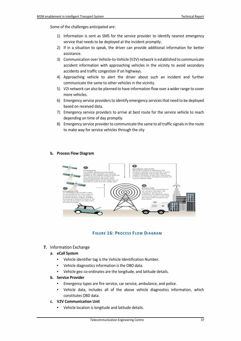
M2M enablement in Intelligent Transport System Technical Report
Telecommunication Engineering Centre 37
Some of the challenges anticipated are:
1) Information is sent as SMS for the service provider to identify nearest emergency
service that needs to be deployed at the incident promptly.
2) If in a situation to speak, the driver can provide additional information for better
assistance.
3) Communication over Vehicle-to-Vehicle (V2V) network is established to communicate
accident information with approaching vehicles in the vicinity to avoid secondary
accidents and traffic congestion if on highways.
4) Approaching vehicle to alert the driver about such an incident and further
communicate the same to other vehicles in the vicinity.
5) V2I network can also be planned to have information flow over a wider range to cover
more vehicles.
6) Emergency service providers to identify emergency services that need to be deployed
based on received data.
7) Emergency service providers to arrive at best route for the service vehicle to reach
depending on time of day promptly.
8) Emergency service provider to communicate the same to all traffic signals in the route
to make way for service vehicles through the city
b. Process Flow Diagram
7. Information Exchange
a. eCall System
• Vehicle identifier tag is the Vehicle Identification Number.
• Vehicle diagnostics information is the OBD data.
• Vehicle geo co-ordinates are the longitude, and latitude details.
b. Service Provider
• Emergency types are fire service, car service, ambulance, and police.
• Vehicle data, includes all of the above vehicle diagnostics information, which
constitutes OBD data.
c. V2V Communication Unit
• Vehicle location is longitude and latitude details.
F IG UR E 16: PR OCESS FLO W D IA GRA M

M2M enablement in Intelligent Transport System Technical Report
Telecommunication Engineering Centre 38
d. V2I Communication Unit
• Vehicle location is longitude and latitude details.
e. Service Vehicle
• Vehicle location is the vehicle’s data.
8. Architectural Considerations
a. Generally Applicable Scenario
The applicable scenario generally describes organizational requirements, quality,
performance, security requirements, user interface requirements, and deployment
infrastructure needs. Several use cases in a domain/sub-domain can have same architectural
requirements.
b. Interface Requirements
Following are the interface requirements:
1) eCall system should be able to receive GPS data from GPS.
2) eCall system should be able to send data over GSM module.
3) eCall system should be able to send data over Short Range communication interface
to approaching vehicle or infrastructure module in the vicinity.
4) Service provider shall be able to receive data over GSM.
5) Service vehicle shall be able to forward the data to nearby infrastructure unit.
c. Performance Criteria
• Vehicle data as described above is transmitted at the instance of accident from eCall
system to the service provider.
• Ideally data to reach the service provider with minimum delay to service the situation
promptly.
• About 100 bytes of data which includes geo co-ordinates, VIN and OBD Data to be
transmitted from vehicle over GSM network at the time of accident to service
provider.
• Service provider to dispatch this information to service vehicle with the problem
description upon receiving data from the vehicle at the crash site.
• V2V and V2I system to send vehicle data over vehicular network (DSRC) at the time of
accident.
• Vehicle data transfer is of highest priority and is the only data transmitted at the time
of accident. In case of network failure, vehicle data sent over SMS will be buffered at
the network provider end, and be made available to the end unit as soon as it
reconnects the network.
d. User Interface
A Graphical User Interface based application will be required at the service provider end and
at the service vehicle to view the vehicle data. No such user interface is required at the eCall
system itself.
e. Communication Infrastructure
eCall system shall use GSM network and V2V network for communication with the outside
world.
f. Deployment Considerations

M2M enablement in Intelligent Transport System Technical Report
Telecommunication Engineering Centre 39
eCall system to be deployed in the region of car which is very less likely to be damaged in the
event of an accident. Device should be to extremely rugged/heat resistant to withstand an
accident impact. Ruggedness and durability should be similar to that of a black box in
aeroplanes.
g. Geographical Considerations
Infrastructure units are placed few hundred meters apart from each other.
h. Security
There are no security threats with eCall system as no critical data is transmitted.
i. Startup Shutdown Process
eCall system to be battery powered. Once the system is up and running, device will be in sleep
state until an accident event occurs, thereby preventing battery from draining during normal
operation of the vehicle.
j. Data Management
Data rate, payload size, frequency of communication, synchronous or asynchronous session
types, request-, request-acknowledge-, handshake-request-, response types, and broadcast
constitute data management in addition to data integrity and payload sizes.
9. Potential Market Growth
a. Growth Forecast
Safety systems in cars will be key growth drivers for the Indian automotive electronics market
in the next few years as it attains Compounded Annual Growth Rate (CAGR) of 21.8% as per
research estimates.
Accelerating growth in embedded, in-car Telematics over the next 15 years will lead to cars
representing over 5% of all connected devices by 2025, compared with just 0.1% today. The
automotive embedded Telematics market will grow at a CAGR of 24.6% over the next 15 years
to reach €20 billion by 2025.
F IG UR E 17: POTENTIA L GRO WTH

M2M enablement in Intelligent Transport System Technical Report
Telecommunication Engineering Centre 40
10. Challenges
Some of the challenges anticipated are as follows:
1) No single Indian emergency service provider.
2) Interoperability of different emergency service provider.
3) Detection of fraudulent calls.
4) Detection of false alarms.
5) Backup procedure to make the call in case of primary call system fails.
11. Available Global Standards
Safety systems in cars will be key growth drivers for the Indian automotive electronics market
the next few years, as it attains a CAGR of 21.8 per cent as per research estimates.
Working Group 15 of the CEN TC274 has written standards on eCall. Compliance with these
standards is required in the general approach of the council.
1) EN 16062 - eCall High Level Application requirements (HLAP) defines the high level
application protocols to facilitate eCalls using mobile networks.
2) EN 16072 - Pan-European eCall operating requirements specifies the generic operational
requirements and intrinsic procedures for the provision of an eCall service that allows
transfer of emergency messages and to establish a voice channel between IVS and PSAP.
3) EN 16102 - eCall - Operating requirements for third party support covers the same scope
for but for third party services in order to allow service providers to offer services handling
eCalls.
4) EN 15722 - eCall minimum set of data (MSD) specifies the content and format of the data
to be transferred by the IVS to the PSAP during an eCall.
5) CEN/TS 16454 - eCall end-to-end conformance testing sets out test procedures that allow
different actors in the eCall chain (vehicle/IVS, MNO, PSAP, TPSP) to claim conformance
to all above listed EN eCall standards.
12. ETSI Standards
The following ETSI standards have been referenced in the various eCall related documents:
• ETSI TS 102 164 (Version 1.3.1)
• ETSI TS 121 133 (Release 8 or later)
• ETSI TS 122 003 (Release 8 or later)
• ETSI TS 122 011 (Release 8 or later)
• ETSI TS 122 071 (Release 8 or later)

M2M enablement in Intelligent Transport System Technical Report
Telecommunication Engineering Centre 41
• ETSI TS 122 101 (Release 8)
• ETSI TS 124 008 (Release 8 or later)
• ETSI TS 124 123 (Release 8 or later)
• ETSI TS 126 267 (Release 8 or later)
• ETSI TS 126 268 (Release 8 or later)
• ETSI TS 126 269 (Release 8 or later)
• ETSI TS 127 007 (Release 8 or later)
• ETSI TS 151 010 (Release 8 or later)
• ETSI EN 301 511
• ETSI EN 301 9

M2M enablement in Intelligent Transport System Technical Report
Telecommunication Engineering Centre 42
12121212 AbbreviationsAbbreviationsAbbreviationsAbbreviations
Abbreviation Full Name
ARAI Automotive Research Association of India
AES Advance Encryption Standard
CDMA Code Division Multiple Access
CAGR Compounded Annual Growth Rate
CAN Car Area Network
CCTV Closed Circuit Television
DES Data Encryption Standard
DIMTS Delhi Integrated Multi-Modal Transport System
EOBR Electronic On-Board Recorder
ETSI European Telecommunications Standards Institute
FCC Federal Communications Commission
GPS Global Positioning System
HLAP High Level Application Requirements
IOT Internet of Things
ITS Intelligent Transport System
MDS Minimum Data Set
M2M Machine to Machine
OBD On-Board Diagnostics
OTA Over the Air
RFID Radio Frequency Identification
RLSVDS Red Light-Stop Line Violation & Detection System
RSA Short for the surnames of its designers Ron Rivest, Adi Shamir and
Leonard Adleman
SIAM Society of Indian Automobile Manufacturers
SIM Subscriber Identification Module
V2V Vehicle to Vehicle
V2I Vehicle to Infrastructure
VMS Variable Message Sign
VTS Vehicle Tracking System
Wi-Trac Wireless Traffic Signal Controller
