macomb hydroelectric project
TRANSCRIPT
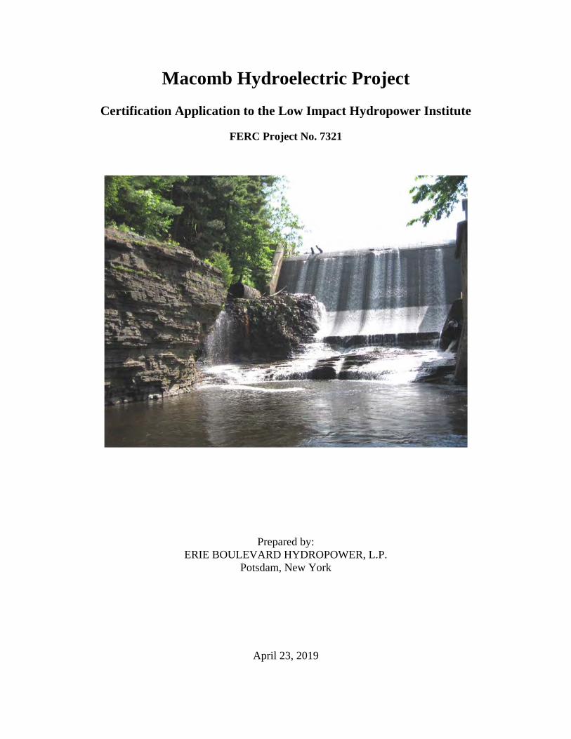
Macomb Hydroelectric Project
Certification Application to the Low Impact Hydropower Institute
FERC Project No. 7321
Prepared by: ERIE BOULEVARD HYDROPOWER, L.P.
Potsdam, New York
April 23, 2019
Macomb Project Certification Application
TABLE OF CONTENTS
INTRODUCTION
PART I. FACILITY DESCRIPTION
PART II. STANDARDS SELECTION
PART III. SUPPORTING INFORMATION
PART IV. SWORN STATEMENT AND WAIVER
PART V. CONTACTS
APPENDICES
APPENDIX A – MACOMB PROJECT ZONES OF EFFECT
APPENDIX B – PHOTOS OF KEY PROJECT FEATURES
APPENDIX C – PROJECT MAPS AND AERIALS
APPENDIX D – CONSULTATION REGARDING 401 WATER QUALITY CERTIFICATE
APPENDIX E – AGENCY CONSULTATION REGARDING RARE, THREATENED AND ENDANGERED SPECIES
Macomb Project Certification Application
Page 1 of 29
INTRODUCTION Erie Boulevard Hydropower, L.P. (Erie), a wholly owned subsidiary of Brookfield Renewable, is providing this application to the Low Impact Hydropower Institute (LIHI) for certification of the Macomb Hydroelectric Project. The Macomb Hydroelectric Project is located on the Salmon River in the Town of Malone in Franklin County. This facility is licensed with the Federal Energy Regulatory Commission (FERC) as the Macomb Hydroelectric Project (FERC No. 7321) (Macomb Project).
Macomb Project Certification Application
Page 2 of 29
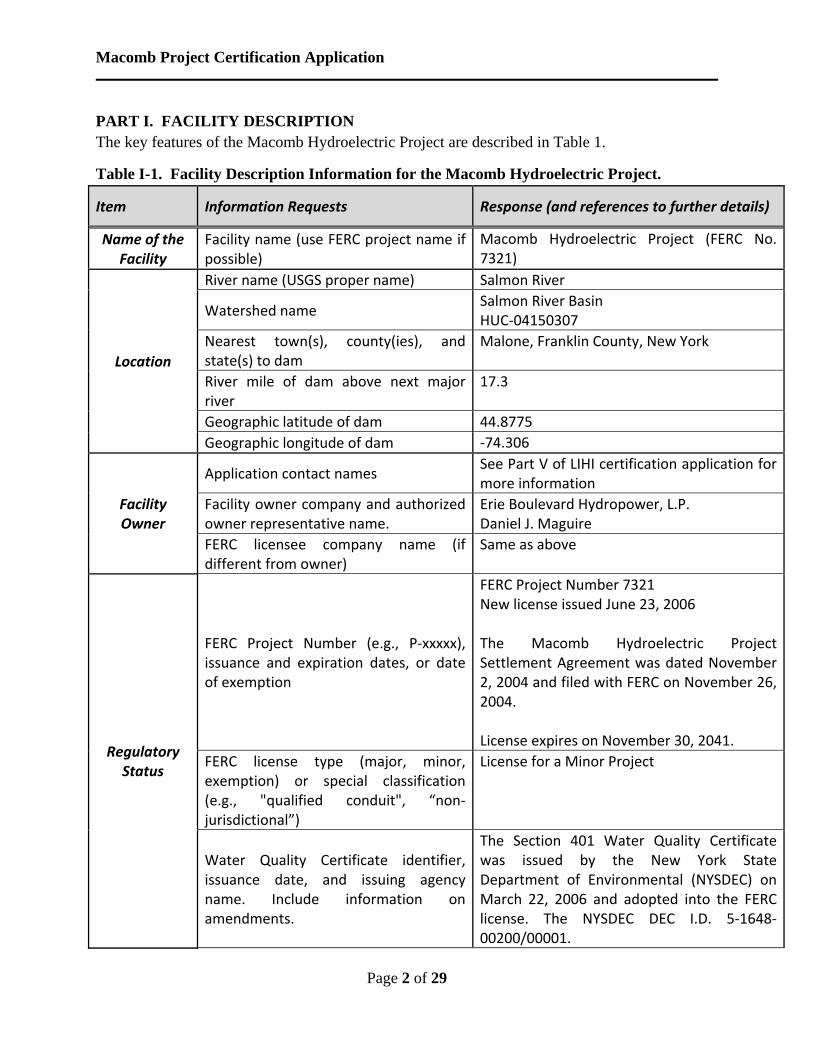
PART I. FACILITY DESCRIPTION The key features of the Macomb Hydroelectric Project are described in Table 1.
Table I-1. Facility Description Information for the Macomb Hydroelectric Project.
Item Information Requests Response (and references to further details)
Name of the Facility
Facility name (use FERC project name if possible)
Macomb Hydroelectric Project (FERC No. 7321)
Location
River name (USGS proper name) Salmon River
Watershed name Salmon River Basin HUC‐04150307
Nearest town(s), county(ies), and state(s) to dam
Malone, Franklin County, New York
River mile of dam above next major river
17.3
Geographic latitude of dam 44.8775
Geographic longitude of dam ‐74.306
Facility Owner
Application contact names See Part V of LIHI certification application for more information
Facility owner company and authorized owner representative name.
Erie Boulevard Hydropower, L.P. Daniel J. Maguire
FERC licensee company name (if different from owner)
Same as above
Regulatory Status
FERC Project Number (e.g., P‐xxxxx), issuance and expiration dates, or date of exemption
FERC Project Number 7321 New license issued June 23, 2006 The Macomb Hydroelectric Project Settlement Agreement was dated November 2, 2004 and filed with FERC on November 26, 2004. License expires on November 30, 2041.
FERC license type (major, minor, exemption) or special classification (e.g., "qualified conduit", “non‐jurisdictional”)
License for a Minor Project
Water Quality Certificate identifier, issuance date, and issuing agency name. Include information on amendments.
The Section 401 Water Quality Certificate was issued by the New York State Department of Environmental (NYSDEC) on March 22, 2006 and adopted into the FERC license. The NYSDEC DEC I.D. 5‐1648‐00200/00001.

Macomb Project Certification Application
Page 3 of 29
Hyperlinks to key electronic records on FERC e‐library website or other publicly accessible data repositories
November 2, 2004 Settlement Agreement (included in License Application): https://elibrary.ferc.gov/IDMWS/common/opennat.asp?fileID=10344117 December 19, 2005 Environmental Assessment: https://elibrary.ferc.gov/IDMWS/common/opennat.asp?fileID=10909304 March 22, 2006 NYSDEC WQC: https://elibrary.ferc.gov/IDMWS/common/opennat.asp?fileID=11004129 June 23, 2006 License Order: https://elibrary.ferc.gov/IDMWS/common/opennat.asp?fileID=11071386
Powerhouse
Date of initial operation (past or future for pre‐operational applications)
1904
Total installed capacity (MW) 1.0 MW
Average annual generation (MWh) and period of record used
6,200 MWh
Mode of operation (run‐of‐river, peaking, pulsing, seasonal storage, diversion, etc.)
The Project is operated in a pulsing mode with a good faith effort (per license order) to maintain impoundment fluctuations within 0.25‐foot when river flow exceeds 125 cfs and a run‐of‐river mode when river flows are 125 cfs or less.
Number, type, and size of turbines, including maximum and minimum hydraulic capacity of each unit
Generating Units 1 Type: S. Morgan Smith horizontal Francis turbine Description: Design capacity of 1,450 HP at design head of 54 feet and a speed of 225 rpm Maximum Capacity: 310 cfs Minimum Capacity: 205 cfs (efficient) Generator: Direct‐connected, General Electric, 3‐phase, 60‐cycle, alternating current.
Macomb Project Certification Application
Page 4 of 29
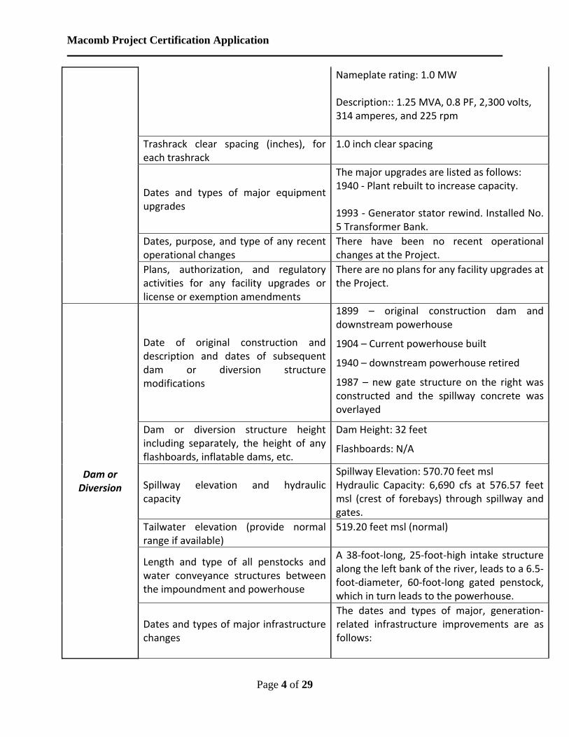
Nameplate rating: 1.0 MW Description:: 1.25 MVA, 0.8 PF, 2,300 volts, 314 amperes, and 225 rpm
Trashrack clear spacing (inches), for each trashrack
1.0 inch clear spacing
Dates and types of major equipment upgrades
The major upgrades are listed as follows: 1940 ‐ Plant rebuilt to increase capacity. 1993 ‐ Generator stator rewind. Installed No. 5 Transformer Bank.
Dates, purpose, and type of any recent operational changes
There have been no recent operational changes at the Project.
Plans, authorization, and regulatory activities for any facility upgrades or license or exemption amendments
There are no plans for any facility upgrades at the Project.
Dam or Diversion
Date of original construction and description and dates of subsequent dam or diversion structure modifications
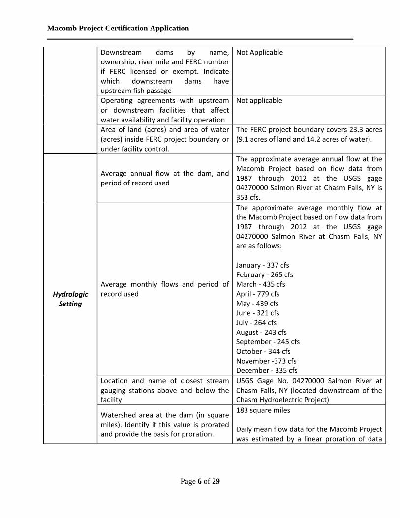
1899 – original construction dam and downstream powerhouse
1904 – Current powerhouse built
1940 – downstream powerhouse retired
1987 – new gate structure on the right was constructed and the spillway concrete was overlayed
Dam or diversion structure height including separately, the height of any flashboards, inflatable dams, etc.
Dam Height: 32 feet
Flashboards: N/A
Spillway elevation and hydraulic capacity
Spillway Elevation: 570.70 feet msl Hydraulic Capacity: 6,690 cfs at 576.57 feet msl (crest of forebays) through spillway and gates.
Tailwater elevation (provide normal range if available)
519.20 feet msl (normal)
Length and type of all penstocks and water conveyance structures between the impoundment and powerhouse
A 38‐foot‐long, 25‐foot‐high intake structure along the left bank of the river, leads to a 6.5‐foot‐diameter, 60‐foot‐long gated penstock, which in turn leads to the powerhouse.
Dates and types of major infrastructure changes
The dates and types of major, generation‐related infrastructure improvements are as follows:

Macomb Project Certification Application
Page 5 of 29
1904 ‐ The High Falls No. 2 (the current Macomb Plant) was constructed 1987 ‐ New trashracks and supporting steel were installed at the intake. 1995 ‐ Installed a PLC for controlling head pond levels and wicket gate openings.
Designated facility purposes (e.g., power, navigation, flood control, water supply, etc.)
The purpose of the Macomb Project is for power production.
Source water Salmon River
Receiving water and location of discharge
Salmon River at RM 17.29
Conduit Date of conduit construction and primary purpose of conduit
Constructed in 1904 to convey water to the original High Falls No. 2 Powerhouse
Impoundment and
Watershed
Authorized maximum and minimum water surface elevations
570.70 ft maximum; 569.70 ft minimum
Normal operating elevations and normal fluctuation range
570.70 ft maximum; 569.70 ft minimum
Gross storage volume and surface area at full pool
Gross Volume: 14 acre‐feet Surface Area: 14 acres
Usable storage volume and surface area Usable Volume: 14 acre‐feet Surface Area: 14 acres
Describe requirements related to impoundment inflow, outflow, up/down ramping and refill rate restrictions.
The Macomb Project operates in a pulsing mode with a good faith effort (per license order) to maintain impoundment fluctuations within 0.25‐foot when river flow exceeds 125 cfs and a run‐of‐river mode when river flows are 125 cfs or less.
Upstream dams by name, ownership and river mile. If FERC licensed or exempt, please provide FERC Project number of these dams. Indicate which upstream dams have downstream fish passage.
Whittelsey Project, Malone’s Next Gen LLC, Inc., P‐10522, RM 19.8 Ballard Mill Project, ECOsponsible, P‐3267, RM 20.5 Chasm Hydroelectric Project, Erie Boulevard Hydropower, P‐7320, RM 28.8 Mountain View Project, Mountain View Association, N/A, RM 35.8 * No dams on the Salmon River provide downstream fish passage.
Macomb Project Certification Application
Page 6 of 29
Downstream dams by name, ownership, river mile and FERC number if FERC licensed or exempt. Indicate which downstream dams have upstream fish passage
Not Applicable
Operating agreements with upstream or downstream facilities that affect water availability and facility operation
Not applicable
Area of land (acres) and area of water (acres) inside FERC project boundary or under facility control.
The FERC project boundary covers 23.3 acres (9.1 acres of land and 14.2 acres of water).
Hydrologic Setting
Average annual flow at the dam, and period of record used
The approximate average annual flow at the Macomb Project based on flow data from 1987 through 2012 at the USGS gage 04270000 Salmon River at Chasm Falls, NY is 353 cfs.
Average monthly flows and period of record used
The approximate average monthly flow at the Macomb Project based on flow data from 1987 through 2012 at the USGS gage 04270000 Salmon River at Chasm Falls, NY are as follows: January ‐ 337 cfs February ‐ 265 cfs March ‐ 435 cfs April ‐ 779 cfs May ‐ 439 cfs June ‐ 321 cfs July ‐ 264 cfs August ‐ 243 cfs September ‐ 245 cfs October ‐ 344 cfs November ‐373 cfs December ‐ 335 cfs
Location and name of closest stream gauging stations above and below the facility
USGS Gage No. 04270000 Salmon River at Chasm Falls, NY (located downstream of the Chasm Hydroelectric Project)
Watershed area at the dam (in square miles). Identify if this value is prorated and provide the basis for proration.
183 square miles Daily mean flow data for the Macomb Project was estimated by a linear proration of data
Macomb Project Certification Application
Page 7 of 29
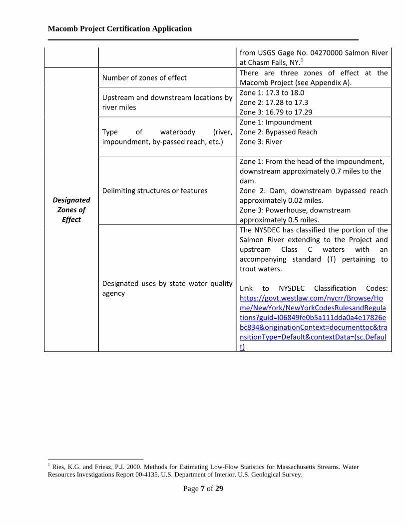
from USGS Gage No. 04270000 Salmon River at Chasm Falls, NY.1
Designated Zones of Effect
Number of zones of effect There are three zones of effect at the Macomb Project (see Appendix A).
Upstream and downstream locations by river miles
Zone 1: 17.3 to 18.0 Zone 2: 17.28 to 17.3 Zone 3: 16.79 to 17.29
Type of waterbody (river, impoundment, by‐passed reach, etc.)
Zone 1: Impoundment Zone 2: Bypassed Reach Zone 3: River
Delimiting structures or features
Zone 1: From the head of the impoundment, downstream approximately 0.7 miles to the dam. Zone 2: Dam, downstream bypassed reach approximately 0.02 miles. Zone 3: Powerhouse, downstream approximately 0.5 miles.
Designated uses by state water quality agency
The NYSDEC has classified the portion of the Salmon River extending to the Project and upstream Class C waters with an accompanying standard (T) pertaining to trout waters. Link to NYSDEC Classification Codes: https://govt.westlaw.com/nycrr/Browse/Home/NewYork/NewYorkCodesRulesandRegulations?guid=I06849fe0b5a111dda0a4e17826ebc834&originationContext=documenttoc&transitionType=Default&contextData=(sc.Default)
1 Ries, K.G. and Friesz, P.J. 2000. Methods for Estimating Low-Flow Statistics for Massachusetts Streams. Water Resources Investigations Report 00-4135. U.S. Department of Interior. U.S. Geological Survey.
Macomb Project Certification Application
Page 8 of 29
PART II. STANDARD MATRICES The Macomb Hydroelectric Project has three zones of effect that are defined as: (1) Zone one, which extends from the head of the impoundment downstream approximately 0.7 miles to the Macomb dam, (2) Zone two, which extends from the Macomb dam, downstream approximately 0.02 miles, and (3) Zone three, which extends from the Macomb powerhouse, downstream approximately 0.5 miles.
The standards selected to satisfy the LIHI certification criteria in each of these zones are identified in the following tables.
Table II-1. LIHI Standards Selected for Zone of Effect No. 1
Criterion
Alternative Standards 1 2 3 4 Plus
A Ecological Flow Regimes X B Water Quality X C Upstream Fish Passage X D Downstream Fish Passage X E Watershed and Shoreline Protection X F Threatened and Endangered Species Protection X G Cultural and Historic Resources Protection X H Recreational Resources X
Table II-2. LIHI Standards Selected for Zone of Effect No. 2
Criterion
Alternative Standards 1 2 3 4 Plus
A Ecological Flow Regimes X B Water Quality X C Upstream Fish Passage X D Downstream Fish Passage X E Watershed and Shoreline Protection X F Threatened and Endangered Species Protection X G Cultural and Historic Resources Protection X H Recreational Resources X
Macomb Project Certification Application
Page 9 of 29
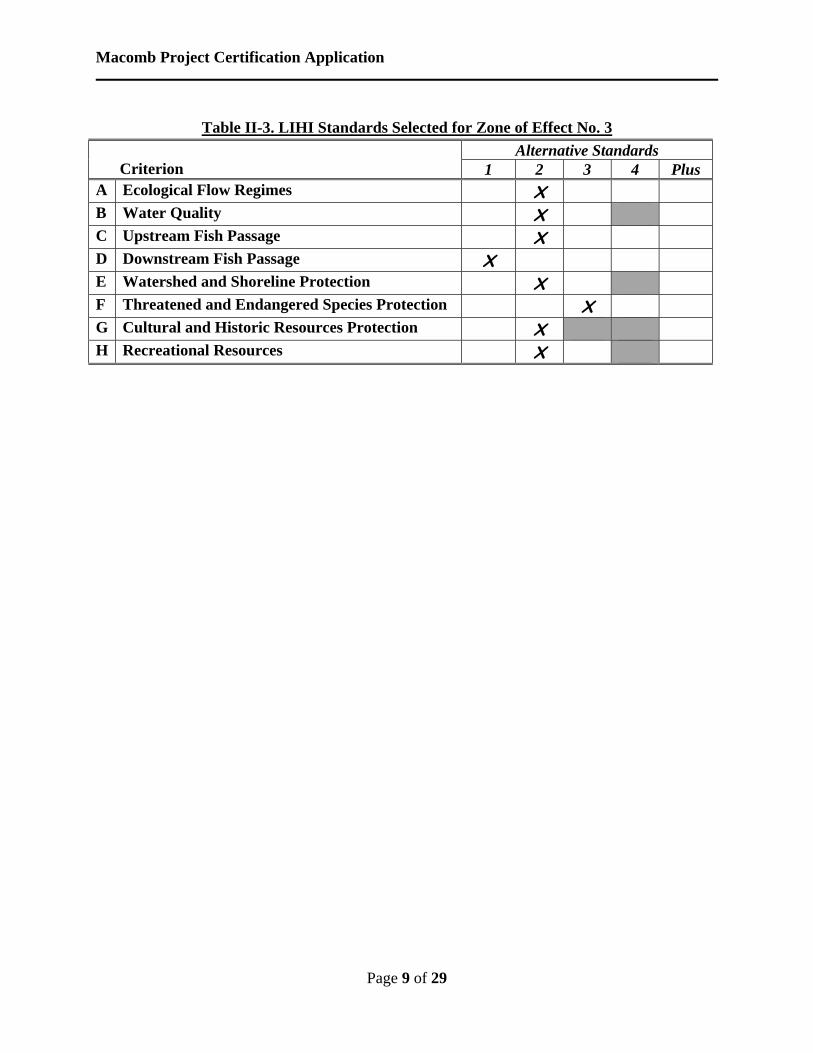
Table II-3. LIHI Standards Selected for Zone of Effect No. 3
Criterion
Alternative Standards 1 2 3 4 Plus
A Ecological Flow Regimes X B Water Quality X C Upstream Fish Passage X D Downstream Fish Passage X E Watershed and Shoreline Protection X F Threatened and Endangered Species Protection X G Cultural and Historic Resources Protection X H Recreational Resources X
Macomb Project Certification Application
Page 10 of 29
PART III. SUPPORTING INFORMATION This section contains information that explains and justifies the standards selected to pass the LIHI certification criteria (see Part II for selections).
Information Required to Support Ecological Flows Standards.
III.A.1 Ecological Flows: Macomb Project Zone 1
Criterion Standard Instructions A 1 Not Applicable / De Minimis Effect:
Confirm the location of the powerhouse relative to dam/diversion structures and demonstrate that there are no bypassed reaches at the facility.
For run-of-river facilities, provide details on operations and demonstrate that flows, water levels, and operation are monitored to ensure such an operational mode is maintained. If deviations from required flows have occurred, discuss them and the measures taken to minimize reoccurrence.
In a conduit facility, identify the source waters, location of discharge points, and receiving waters for the conduit system within which the hydropower facility is located. This standard cannot be used for conduits that discharge to a natural waterbody.
For impoundment zones only, explain water management (e.g., fluctuations, ramping, refill rates) and how fish and wildlife habitat within the zone is evaluated and managed. NOTE: this is required information, but it will not be used to determine whether the Ecological Flows criterion has been satisfied. All impoundment zones can apply Criterion A-1 to pass this criterion.
Zone 1 of the Macomb Project is the Macomb impoundment. The Project operates with a maximum impoundment fluctuation of 0.25 feet (as measured in a downward direction from the spillway crest of the dam) when inflow exceeds 125 cfs, and operates run of-river when inflow is 125 cfs or less.
The FERC license, 2004 Settlement Agreement, and Section 401 Water Quality Certificate (WQC) include the requirements for flow releases and water level control recommended by the NYSDEC and U.S. Fish and Wildlife Service (USFWS). The Salmon River in the Project boundary is managed by the NYSDEC essentially as a coldwater fishery. The FERC license or WQC for the Macomb Project do not contain any specific requirements for fish and wildlife management within the impoundment.
Water Quality Certificate: https://elibrary.ferc.gov/idmws/common/opennat.asp?fileID=11004129
Macomb Project Certification Application
Page 11 of 29
Settlement Agreement (Submitted with the Final License Application): https://elibrary.ferc.gov/idmws/common/opennat.asp?fileID=10344117
Order Issuing License: https://elibrary.ferc.gov/idmws/common/opennat.asp?fileID=11071386
According to the FERC Environmental Assessment (EA), reduced water level fluctuations would reduce the chances of fish stranding and disruption of spawning habitat. The EA also states that limiting the fluctuations of the impoundment to 0.25 feet would reduce the time that downstream habitats could be dewatered if the powerhouse were to trip off-line.
All of the license and settlement requirements pertaining to flow conditions and impoundment levels have been implemented at the Macomb Project. Pursuant to License Article 401, Erie filed a Flow and Water Level Monitoring Plan on May 8, 2007. FERC issued an Order Modifying and Approving the Flow and Water Level Monitoring Plan on September 12, 2007.
Environmental Assessment: https://elibrary.ferc.gov/idmws/common/opennat.asp?fileID=10909304
Final Flow and Water level Monitoring Plan: https://elibrary.ferc.gov/idmws/common/opennat.asp?fileID=11341011
Order Modifying and Approving Flow and Water Level Monitoring Plan https://elibrary.ferc.gov/idmws/common/opennat.asp?fileID=11450642
Erie remains in compliance with the established flow conditions and impoundment levels and maintains records of these conditions at the Project. In the event of a deviation from established minimum flows or impoundment levels, Erie files documentation with FERC detailing the reasons for the deviation.
III.A.2 Ecological Flows: Macomb Project Zone 2
Criterion Standard Instructions A 2 Agency Recommendation:
Identify the proceeding and source, date, and specifics of the agency recommendation applied (NOTE: there may be more than one; identify and explain which is most environmentally protective).
Explain the scientific or technical basis for the agency recommendation, including methods and data used. This is required regardless of whether the recommendation is or is not part of a Settlement Agreement.
Explain how the recommendation relates to agency management goals and objectives for fish and wildlife.
Explain how the recommendation provides fish and wildlife protection, mitigation and enhancement (including in-stream flows,

Macomb Project Certification Application
Page 12 of 29
ramping and peaking rate conditions, and seasonal and episodic instream flow variations).
Zone 2 of the Macomb Project is the limited bypassed reach (approximately 100 feet long) downstream of the dam. The Macomb Project is in compliance with resource agency conditions issued regarding flow conditions. The FERC license, 2004 Settlement Agreement, and WQC include the requirements for flow releases and water level control recommended by the NYSDEC and USFWS.
The Salmon River in the Project boundary is managed by the NYSDEC essentially as a coldwater fishery, and the NYSDEC manages the river immediately downstream of the dam for trout. The FERC license, Settlement Agreement, and WQC require Erie to provide a baseflow of 125 cfs or inflow to the Macomb impoundment, whichever is less, from the Project’s tailrace. The EA states that the Erie’s Baseflow Evaluation provides support for the 125-cfs baseflow provision. The Baseflow Evaluation was conducted on September 17, 2003.
When flows in the Salmon River exceed the powerhouse capacity (305 cfs) excess flow is passed over the spillway. When flows in the Salmon River are less than the minimum capacity of the powerhouse (205 cfs), the powerhouse is taken offline and flow is passed over the spillway. According to the EA, reduced water level fluctuations would reduce the chances of fish stranding and disruption of spawning habitat. The EA also states that limiting the fluctuations of the impoundment reduces the time that downstream habitats could be dewatered if the powerhouse were to trip off-line.
All of the license and settlement requirements pertaining to baseflow conditions have been implemented at the Macomb Project.
Water Quality Certificate: https://elibrary.ferc.gov/idmws/common/opennat.asp?fileID=11004129
Settlement Agreement (Submitted with the Final License Application): https://elibrary.ferc.gov/idmws/common/opennat.asp?fileID=10344117
Order Issuing License: https://elibrary.ferc.gov/idmws/common/opennat.asp?fileID=11071386
III.A.3 Ecological Flows: Macomb Project Zone 3
Criterion Standard Instructions A 2 Agency Recommendation (see Appendix A for definitions):
Identify the proceeding and source, date, and specifics of the agency recommendation applied (NOTE: there may be more than one; identify and explain which is most environmentally protective).
Explain the scientific or technical basis for the agency
Macomb Project Certification Application
Page 13 of 29
recommendation, including methods and data used. This is required regardless of whether the recommendation is or is not part of a Settlement Agreement.
Explain how the recommendation relates to agency management goals and objectives for fish and wildlife.
Explain how the recommendation provides fish and wildlife protection, mitigation and enhancement (including in-stream flows, ramping and peaking rate conditions, and seasonal and episodic instream flow variations).
Zone 3 of the Macomb Project is the tailrace area downstream of the powerhouse and does not include a bypassed reach. The Macomb Project is in compliance with resource agency conditions issued regarding flow conditions. The FERC license, 2004 Settlement Agreement, and WQC include the requirements for flow releases and water level control recommended by the NYSDEC and USFWS.
The Salmon River in the Project boundary is managed by the NYSDEC essentially as a coldwater fishery, and the NYSDEC manages the river immediately downstream of the dam for trout. The FERC license, Settlement Agreement, and WQC require Erie to provide a baseflow of 125 cfs or inflow to the Macomb impoundment, whichever is less, from the Project’s tailrace. The EA states that the Erie’s Baseflow Evaluation provides support for the 125-cfs baseflow provision. The Baseflow Evaluation was conducted on September 17, 2003.
All of the license and settlement requirements pertaining to baseflow conditions have been implemented at the Macomb Project. Minimum baseflows: The Licensee shall maintain a base flow of 125 cfs (or inflow to the Macomb impoundment, whichever is less) from the Project’s tailrace. Erie remains in compliance with the established baseflow conditions and maintains records of these conditions at the Project. In the event of a deviation from established minimum flows, Erie files documentation with FERC detailing the reasons for the deviation.
Baseflow Evaluation https://elibrary.ferc.gov/idmws/common/opennat.asp?fileID=10344117
Water Quality Certificate: https://elibrary.ferc.gov/idmws/common/opennat.asp?fileID=11004129
Settlement Agreement (Submitted with the Final License Application): https://elibrary.ferc.gov/idmws/common/opennat.asp?fileID=10344117
Order Issuing License: https://elibrary.ferc.gov/idmws/common/opennat.asp?fileID=11071386
Macomb Project Certification Application
Page 14 of 29
Information Required to Support Water Quality Standards.
III.B.1 Water Quality: Macomb Project Zone 1
Criterion Standard Instructions B 2 Agency Recommendation:
If facility is located on a Water Quality Limited river reach, provide a link to the state’s most recent impaired waters list and indicate the page(s) therein that apply to facility waters. If possible, provide an agency letter stating that the facility is not a cause of such limitation.
Provide a copy of the most recent Water Quality Certificate and any subsequent amendments, including the date(s) of issuance. If more than 10 years old, provide documentation that the certification terms and conditions remain valid and in effect for the facility (e.g., a letter from the agency).
Identify any other agency recommendations related to water quality and explain their scientific or technical basis.
Describe all compliance activities related to water quality and any agency recommendations for the facility, including on-going monitoring, and how those are integrated into facility operations.
The Macomb Project is in compliance with all conditions issued pursuant to a Clean Water Act – Section 401 WQC. The WQC is conditioned on compliance with the terms of the Settlement Agreement. The WQC for the Project was issued March 22, 2006. On-going water quality monitoring at the Project is not required as part of the WQC or FERC license.
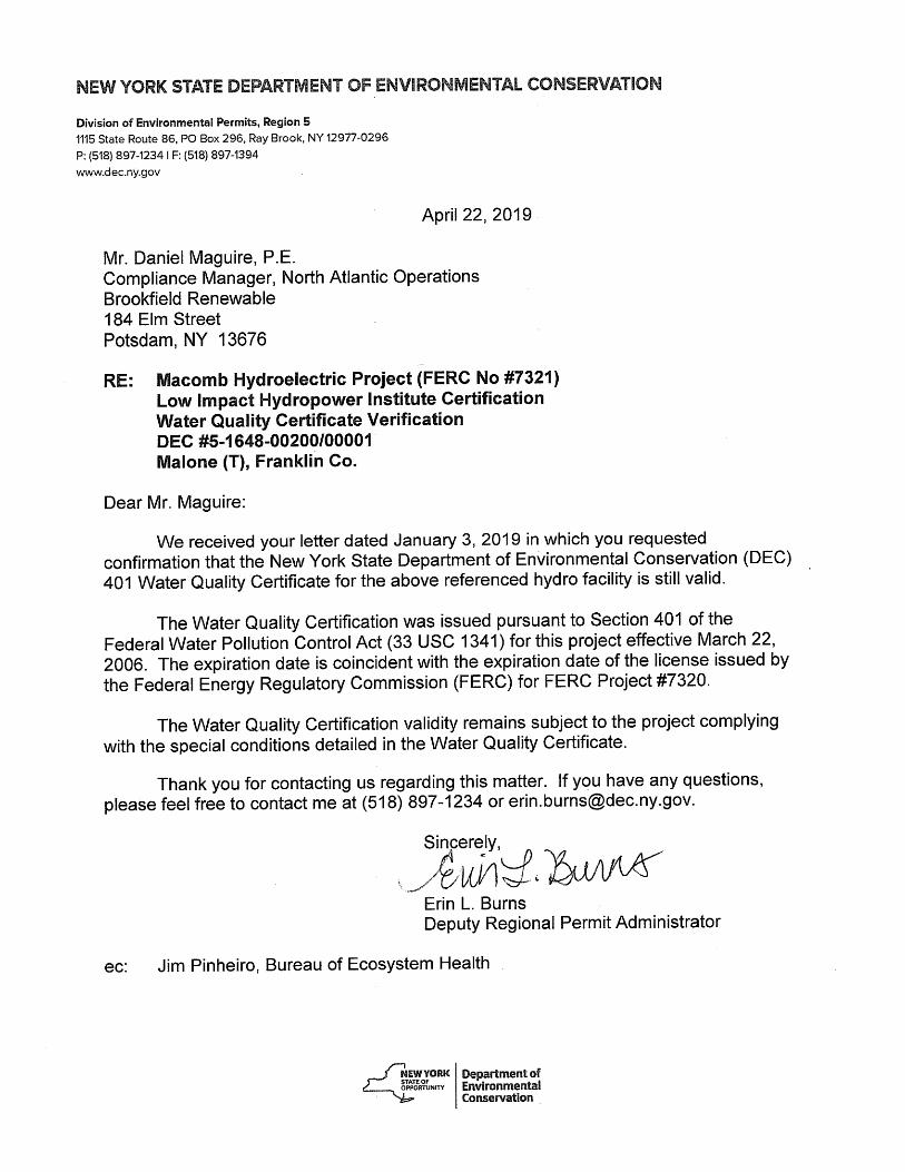
Generally, any changes to the original WQC are necessitated by significant changes in or to the Project environment affecting the Conditions of the original WQC, which culminates in an amendment of the original WQC. This situation has not occurred for the Macomb Project WQC, and the original WQC, issued on March 22, 2006 is still in effect.
Additionally, the Applicant contacted the NYSDEC on January 3, 2019, regarding the current WQC status for the Project. By letter dated April 22, 2019, the NYSDEC indicated that the current 401 WQC is still valid for the Macomb Project. The consultation documentation regarding the 401 WQC is included in Appendix D.
Per review of the November 2016 Section 303(d) list for New York State, no impaired waters in the Project area or downstream reach are listed. A copy of the November 2016 Section 303(d) list for New York State can be viewed at https://www.dec.ny.gov/docs/water_pdf/303dListfinal2016.pdf.
The classification of the Salmon River in the vicinity of the Macomb Project is “C” with an accompanying standard pertaining to trout waters (t). The best usage of Class C waters is fishing,
Macomb Project Certification Application
Page 15 of 29
and they are also suitable for fish propagation and survival, as well as primary and secondary contact recreation, where such use is not limited by other factors.
Water Quality Certificate: https://elibrary.ferc.gov/idmws/common/opennat.asp?fileID=11004129
Settlement Agreement (Submitted with the Final License Application): https://elibrary.ferc.gov/idmws/common/opennat.asp?fileID=10344117
Order Issuing License: https://elibrary.ferc.gov/idmws/common/opennat.asp?fileID=11071386
III.B.2 Water Quality Macomb Project Zone 2
Criterion Standard Instructions B 2 Agency Recommendation:
If facility is located on a Water Quality Limited river reach, provide a link to the state’s most recent impaired waters list and indicate the page(s) therein that apply to facility waters. If possible, provide an agency letter stating that the facility is not a cause of such limitation.
Provide a copy of the most recent Water Quality Certificate and any subsequent amendments, including the date(s) of issuance. If more than 10 years old, provide documentation that the certification terms and conditions remain valid and in effect for the facility (e.g., a letter from the agency).
Identify any other agency recommendations related to water quality and explain their scientific or technical basis.
Describe all compliance activities related to water quality and any agency recommendations for the facility, including on-going monitoring, and how those are integrated into facility operations.
See response above for Zone 1.
III.B.3 Water Quality: Macomb Project Zone 3
Criterion Standard Instructions B 2 Agency Recommendation:
If facility is located on a Water Quality Limited river reach, provide a link to the state’s most recent impaired waters list and indicate the page(s) therein that apply to facility waters. If possible, provide an agency letter stating that the facility is not a cause of such limitation.
Provide a copy of the most recent Water Quality Certificate and any subsequent amendments, including the date(s) of issuance. If more than 10 years old, provide documentation that the certification terms

Macomb Project Certification Application
Page 16 of 29
and conditions remain valid and in effect for the facility (e.g., a letter from the agency).
Identify any other agency recommendations related to water quality and explain their scientific or technical basis.
Describe all compliance activities related to water quality and any agency recommendations for the facility, including on-going monitoring, and how those are integrated into facility operations.
See response above for Zone 1.
Information Required to Support Upstream Fish Passage Standards.
III.C.1 Upstream Fish Passage: Macomb Project Zone 1
Criterion Standard Instructions C 1 Not Applicable / De Minimis Effect:
Explain why the facility does not impose a barrier to upstream fish passage in the designated zone. Typically, impoundment zones will qualify for this standard since once above a dam and in an impoundment, there is no facility barrier to further upstream movement.
Document available fish distribution data and the lack of migratory fish species in the vicinity.
If migratory fish species have been extirpated from the area, explain why the facility is or was not the cause of this.
During the relicensing proceeding for the Macomb Project, neither the Department of Commerce nor the Department of Interior (Interior) prescribed anadromous or catadromous fish passage facilities for the Project. Interior did, however, by letter dated May 20, 2005, request reservation of its authority to prescribe upstream and downstream fish passage devices in the future, which is provided in Article 403 of the 2006 FERC license.
In support of the relicensing of the Macomb Project, Erie conducted an Upstream Fish Passage Barrier Evaluation. The study found the natural falls at the site created a hydraulic barrier that would have prevented anadromous fish from obtaining the height and length to clear the falls for upstream migration, even without hydropower developments. The study found little evidence that the river supported American eel or Atlantic salmon populations. Historically, the Salmon River supported freshwater runs of walleye, muskellunge, and northern pike. Based on fisheries investigations, the present fish community in Lamica Lake consists of the expected warmwater fishes such as bass and bullhead. It is also known to have a healthy population of brown and rainbow trout by stocking.
Upstream Fish Passage Barrier Evaluation: https://elibrary.ferc.gov/idmws/common/opennat.asp?fileID=10344117
Macomb Project Certification Application
Page 17 of 29
Environmental Assessment: https://elibrary.ferc.gov/idmws/common/opennat.asp?fileID=10909304
Order Issuing License: https://elibrary.ferc.gov/idmws/common/opennat.asp?fileID=11071386
III.C.2 Upstream Fish Passage Macomb Project Zone 2
Criterion Standard Instructions C 2 Agency Recommendation:
Identify the proceeding and source, date, and specifics of the agency recommendation applied (NOTE: there may be more than one; identify and explain which is most environmentally protective).
Explain the scientific or technical basis for the agency recommendation, including methods and data used. This is required regardless of whether the recommendation is or is not part of a Settlement Agreement.
Describe any provisions for fish passage monitoring or effectiveness determinations that are part of the agency recommendation, and how these are being implemented.
During the relicensing proceeding for the Macomb Project, neither the Department of Commerce nor the Interior prescribed anadromous or catadromous fish passage facilities for the Project. Interior did, however, by letter dated May 20, 2005, request reservation of its authority to prescribe upstream and downstream fish passage devices in the future, which is provided in Article 403 of the 2006 FERC license.
In support of the relicensing of the Macomb Project, Erie conducted an Upstream Fish Passage Barrier Evaluation. The study found the natural falls at the site created a hydraulic barrier that would have prevented anadromous fish from obtaining the height and length to clear the falls for upstream migration, even without hydropower developments. The study found little evidence that the river supported American eel or Atlantic salmon populations. The Upstream Fish Passage Barrier concluded the limited population of American eel in the Salmon River downstream of the Project, in combination with the very limited eel habitat upstream of the project (the next project upstream is Whittlesey approximately 2.5 river miles), upstream passage of American eel was not proposed in the Settlement Agreement.
Upstream Fish Passage Barrier Evaluation: https://elibrary.ferc.gov/idmws/common/opennat.asp?fileID=10344117
Environmental Assessment: https://elibrary.ferc.gov/idmws/common/opennat.asp?fileID=10909304
Macomb Project Certification Application
Page 18 of 29
III.C.3 Upstream Fish Passage: Macomb Project Zone 3
Criterion Standard Instructions C 2 Agency Recommendation:
Identify the proceeding and source, date, and specifics of the agency recommendation applied (NOTE: there may be more than one; identify and explain which is most environmentally protective).
Explain the scientific or technical basis for the agency recommendation, including methods and data used. This is required regardless of whether the recommendation is or is not part of a Settlement Agreement.
Describe any provisions for fish passage monitoring or effectiveness determinations that are part of the agency recommendation, and how these are being implemented.
See response above for Zone 2.
Information Required to Support Downstream Fish Passage Standards.
III.D.1 Downstream Fish Passage: Macomb Project Zone 1
Criterion Standard Instructions D 2 Agency Recommendation:
Identify the proceeding and source, date, and specifics of the agency recommendation applied (NOTE: there may be more than one; identify and explain which is most environmentally protective).
Explain the scientific or technical basis for the agency recommendation, including methods and data used. This is required regardless of whether the recommendation is part of a Settlement Agreement or not.
Describe any provisions for fish passage monitoring or effectiveness determinations that are part of the agency recommendation, and how these are being implemented.
During the relicensing proceeding for the Macomb Project, neither the Department of Commerce nor the Interior prescribed downstream fish passage facilities for the Project. Interior did, however, by letter dated May 20, 2005, request reservation of its authority to prescribe upstream and downstream fish passage devices in the future, which is provided in Article 403 of the 2006 FERC license.
A Trashrack Replacement Evaluation was conducted by Erie in support of the 2006 FERC license. The study participants (including NYSDEC and USFWS) concluded that fish protection, in the form of trashracks with 1.0-inch clear spacing (or seasonal overlays creating 1.0-inch clear spacing) should be installed at the Project. As required by Section 3.4 of the Settlement Agreement and a condition of the WQC, Erie installed new trashracks with 1.0 inch clear
Macomb Project Certification Application
Page 19 of 29
spacing. The trashracks were replaced according to the requirements in the Settlement Agreement. The as-builts for this facility were submitted to FERC on December 12, 2014. FERC issued an Order Approving As-builts on March 9, 2015. There are no provisions for fish passage monitoring or effectiveness testing.
Based on fisheries investigations completed prior to the 2006 FERC license, the present fish community in Lamica Lake consists of the expected warmwater fishes such as bass and bullhead. It is also known to have a healthy population of brown and rainbow trout by stocking. The EA states that downstream passage of warmwater species residing in Lamica Lake was not desirable by agencies, as the warmwater species might compete with the coldwater species downstream of the dam. There are no provisions for fish passage monitoring or effectiveness determinations.
A Trashrack Replacement Evaluation: https://elibrary.ferc.gov/idmws/common/opennat.asp?fileID=10344117
Order Approving As-builts: https://elibrary.ferc.gov/idmws/common/opennat.asp?fileID=13796654
Environmental Assessment: https://elibrary.ferc.gov/idmws/common/opennat.asp?fileID=10909304
Order Issuing License: https://elibrary.ferc.gov/idmws/common/opennat.asp?fileID=11071386
III.D.2 Downstream Fish Passage: Macomb Project Zone 2
Criterion Standard Instructions D 2 Agency Recommendation:
Identify the proceeding and source, date, and specifics of the agency recommendation applied (NOTE: there may be more than one; identify and explain which is most environmentally protective).
Explain the scientific or technical basis for the agency recommendation, including methods and data used. This is required regardless of whether the recommendation is part of a Settlement Agreement or not.
Describe any provisions for fish passage monitoring or effectiveness determinations that are part of the agency recommendation, and how these are being implemented.
Zone 2 of the Macomb Project is the limited bypassed reach downstream of the dam. During the relicensing proceeding for the Macomb Project, neither the Department of Commerce nor the Interior prescribed downstream fish passage facilities for the Project. Interior did, however, by letter dated May 20, 2005, request reservation of its authority to prescribe upstream and downstream fish passage devices in the future, which is provided in Article 403 of the 2006
Macomb Project Certification Application
Page 20 of 29
FERC license. The EA states that downstream passage of warmwater species residing in Lamica Lake was not desirable, as they might compete with the coldwater species downstream of the dam.
Environmental Assessment: https://elibrary.ferc.gov/idmws/common/opennat.asp?fileID=10909304
Order Issuing License: https://elibrary.ferc.gov/idmws/common/opennat.asp?fileID=11071386
III.D.3 Downstream Fish Passage: Macomb Project Zone 3
Criterion Standard Instructions D 1 Not Applicable / De Minimis Effect:
Explain why the facility does not impose a barrier to downstream fish passage in the designated zone, considering both physical obstruction and increased mortality relative to natural downstream movement (e.g., entrainment into hydropower turbines). Typically, tailwater/downstream zones will qualify for this standard since below a dam and powerhouse there is no facility barrier to further downstream movement. Bypassed reach zones must demonstrate that flows in the reach are adequate to support safe, effective and timely downstream migration.
For riverine fish populations that are known to move downstream, explain why the facility does not contribute adversely to the sustainability of these populations or to their access to habitat necessary for successful completion of their life cycles.
Document available fish distribution data and the lack of migratory fish species in the vicinity.
If migratory fish species have been extirpated from the area, explain why the facility is or was not the cause of this.
There are no downstream fish passage barriers or migratory fish management issues in Zone 3 because it is located below the dam and powerhouse, so there is no facility barrier to further downstream movement. There are no provisions for fish passage monitoring or effectiveness testing.
During the relicensing proceeding for the Macomb Project, neither the Department of Commerce nor the Interior prescribed downstream fish passage facilities for the Project. Interior did, however, by letter dated May 20, 2005, request reservation of its authority to prescribe upstream and downstream fish passage devices in the future, which is provided in Article 403 of the 2006 FERC license. The EA states that downstream passage of warmwater species residing in Lamica Lake was not desirable, as they might compete with the coldwater species downstream of the dam.
Macomb Project Certification Application
Page 21 of 29
A Trashrack Replacement Evaluation: https://elibrary.ferc.gov/idmws/common/opennat.asp?fileID=10344117
Order Approving As-builts: https://elibrary.ferc.gov/idmws/common/opennat.asp?fileID=13796654
Environmental Assessment: https://elibrary.ferc.gov/idmws/common/opennat.asp?fileID=10909304
Information Required to Support Shoreline and Watershed Protection Standards.
III.E.1 Shoreline and Watershed Protection Macomb Project Zone 1
Criterion Standard Instructions E 2 Agency Recommendation:
Provide copies or links to any agency recommendations or management plans that are in effect related to protection, mitigation, or enhancement of shoreline surrounding the facility (e.g., Shoreline Management Plans).
Provide documentation that indicates the facility is in full compliance with any agency recommendations or management plans that are in effect.
The FERC EA for the Project concluded that the limited impoundment fluctuation levels required by the license limits erosion. The river is not currently considered impaired or threatened by the NYSDEC. There is no evidence that Project operation has contributed to existing shoreline erosion. There is no shoreline management plan required for the Project.
Land use in the project vicinity includes low density residential and highway/commercial use, as well as recreation, agriculture, and forestry. Lands in the immediate vicinity of the Project are designated for low intensity and low density development patterns. Development in the area occurs primarily along major roads with a predominance of residential and small commercial uses. The Village of Malone is located some 2½ miles to the southeast (upstream) of the Project.
Article 401 of the Project license and the WQC (Condition 12) require a Sediment Management Plan. Erie submitted the final Sediment Management Plan on October 29, 2012 and FERC approved the plan on December 12, 2012. The plan requires sediment flushing when inflows exceed 700 cfs at the upstream Chasm Project. After sediment flushing is performed, Erie monitors the downstream to determine the depth of sediments. The Sediment Management Plan required Erie to submit an annual report to NYSDEC from 2013-2016 detailing sediment flushing events. On January 12, 2017, Erie submitted the 2016 Sediment Monitoring Report.
Final Sediment Management Plan: https://elibrary.ferc.gov/idmws/common/opennat.asp?fileID=13101035
Macomb Project Certification Application
Page 22 of 29
Order Approving Sediment Management Plan https://elibrary.ferc.gov/idmws/common/opennat.asp?fileID=13130688
2016 Sediment Monitoring Report: https://elibrary.ferc.gov/idmws/common/opennat.asp?fileID=14464858
III.E.2 Shoreline and Watershed Protection: Macomb Project Zone 2
Criterion Standard Instructions E 2 Agency Recommendation:
Provide copies or links to any agency recommendations or management plans that are in effect related to protection, mitigation, or enhancement of shoreline surrounding the facility (e.g., Shoreline Management Plans).
Provide documentation that indicates the facility is in full compliance with any agency recommendations or management plans that are in effect.
See response above for Zone 1.
III.E.3 Shoreline and Watershed Protection: Macomb Project Zone 3
Criterion Standard Instructions E 2 Agency Recommendation:
Provide copies or links to any agency recommendations or management plans that are in effect related to protection, mitigation, or enhancement of shoreline surrounding the facility (e.g., Shoreline Management Plans).
Provide documentation that indicates the facility is in full compliance with any agency recommendations or management plans that are in effect.
See response above for Zone 1.
Information Required to Support Threatened and Endangered Species Standards.
III.F.1 Threatened and Endangered Species: Macomb Project Zone 1
Criterion Standard Instructions F 3 Recovery Planning and Action:
If listed species are present, document that the facility is in compliance with relevant conditions in the species recovery plans, incidental take permits or statements, biological opinions, habitat conservation plans, or similar government documents.
Document that any incidental take permits and/or biological opinions currently in effect were designed as long-term solutions for protection of listed species in the area.
Macomb Project Certification Application
Page 23 of 29
Based on information received from the USFWS’s New York Field Office on January 30, 2019, regarding a request for information on RTE species it appears that the northern long-eared bat (Myotis septentrionalis) may potentially occur within the Project area. There are no critical habitats located within the Macomb Project area.
During preparation of this application, Erie also consulted with NYSDEC’s Natural Heritage Program for a list of threatened and endangered species that may occur in the vicinity of the Macomb Project. Pursuant to a letter dated January 29, 2019, NYSDEC indicated that there are no records of state listed animals or plants, significant natural communities or other significant habitats, on or in the immediate vicinity of the Macomb Project.
The USFWS has not adopted a formal recovery plan for the northern long-eared bat. On January 14, 2016, the USFWS published the final 4(d) rule identifying prohibitions for the protection of northern long-eared bats. Operations of the Macomb Project, especially with regard to tree clearing from June 1 through July 31, adhere to the prohibitions outlined in the final 4(d) rule.
There are no specific requirements for threatened or endangered species protection in the FERC license or WQC for the Macomb Project.
The record of RTE consultation is included in Appendix E.
III.F.2 Threatened and Endangered Species: Macomb Project Zone 2
Criterion Standard Instructions F 3 Recovery Planning and Action:
If listed species are present, document that the facility is in compliance with relevant conditions in the species recovery plans, incidental take permits or statements, biological opinions, habitat conservation plans, or similar government documents.
Document that any incidental take permits and/or biological opinions currently in effect were designed as long-term solutions for protection of listed species in the area.
See response above for Zone 1.
III.F.3 Threatened and Endangered Species: Macomb Project Zone 3
Criterion Standard Instructions F 3 Recovery Planning and Action:
If listed species are present, document that the facility is in compliance with relevant conditions in the species recovery plans, incidental take permits or statements, biological opinions, habitat conservation plans, or similar government documents.
Document that any incidental take permits and/or biological

Macomb Project Certification Application
Page 24 of 29
opinions currently in effect were designed as long-term solutions for protection of listed species in the area.
See response above for Zone 1.
Information Required to Support Cultural and Historic Resources Standards.
III.G.1 Cultural and Historic Resources: Macomb Project Zone 1
Criterion Standard Instructions G 2 Approved Plan:
Provide documentation of all approved state, federal, and recognized tribal plans for the protection, enhancement, and mitigation of impacts to cultural and historic resources affected by the facility.
Document that the facility is in compliance with all such plans. The facilities in the Macomb Project are in compliance with all requirements regarding cultural resource protection, mitigation, or enhancement included in the FERC license. The historical resources for this Project are limited to the dam, powerhouse, gatehouse, and intakes.
On May 5, 2006, FERC, the Advisory Council on Historic Preservation, and the New York State Historic Preservation Officer (SHPO) executed a Programmatic Agreement (PA) for managing historic properties that may be affected by issuing a subsequent license for the Project. The PA stipulates that Erie will conduct surveys in the archaeologically-sensitive areas and prepare a Historic Properties Management Plan (HPMP) that will include measures to protect historical and cultural resources.
Article 405 of the 2006 license requires Erie to implement the PA and file an HPMP. Erie developed the HPMP in consultation with the SHPO and filed the HPMP on August 26, 2009. FERC issued an Order Modifying and Approving the HPMP on August 12, 2010. On December 6, 2011, Erie filed proposed amendments to the HPMP. FERC’s order approving Erie’s amendments to the HPMP was issued on September 11, 2012 (https://elibrary-backup.ferc.gov/idmws/common/opennat.asp?fileID=13111253). In accordance with the FERC Order, Erie is to file a report with FERC on a ten-year cycle regarding archaeological site monitoring performed by a qualified professional.
Programmatic Agreement: https://elibrary-backup.ferc.gov/idmws/common/opennat.asp?fileID=11075688
Order Approving HPMP: https://elibrary-backup.ferc.gov/idmws/common/opennat.asp?fileID=12412730
Macomb Project Certification Application
Page 25 of 29
On March 20, 2017, Erie submitted a request to FERC to remove the requirement in the HPMP to conduct biennial archaeological monitoring of the impoundment’s shoreline (pursuant to Article 405). As required, the Licensee developed the proposed amendment in consultation with the New York SHPO. FERC issued an Order Approving Amended HPMP on April 14, 2017.
Order Approving Amended HPMP: https://elibrary-backup.ferc.gov/idmws/common/opennat.asp?fileID=14560166
III.G.2 Cultural and Historic Resources: Macomb Project Zone 2
Criterion Standard Instructions G 2 Approved Plan:
Provide documentation of all approved state, federal, and recognized tribal plans for the protection, enhancement, and mitigation of impacts to cultural and historic resources affected by the facility.
Document that the facility is in compliance with all such plans. See response above for Zone 1.
III.G.3 Cultural and Historic Resources: Macomb Project Zone 3
Criterion Standard Instructions G 2 Approved Plan:
Provide documentation of all approved state, federal, and recognized tribal plans for the protection, enhancement, and mitigation of impacts to cultural and historic resources affected by the facility.
Document that the facility is in compliance with all such plans. See response above for Zone 1.
Information Required to Support Recreational Resources Standards.
III.H.1 Recreational Resources: Macomb Project Zone 1
Criterion Standard Instructions H 2 Agency Recommendation:
Document any comprehensive resource agency recommendations and enforceable recreation plan that is in place for recreational access or accommodations.
Document that the facility is in compliance with all such recommendations and plans.
The Macomb Project is in compliance with recreational access, accommodation, and facilities conditions in the FERC license. The Macomb Project offers a car-top boat launch to access the
Macomb Project Certification Application
Page 26 of 29
impoundment, a downstream angler access trail and informal parking, and a shoreline fishing area along the Project’s driveway. Included in the Settlement Agreement, but not part of the FERC license, are recreational enhancements including enhancements to the existing car-top boat launch and the development of a recreational trail.
Article 404 of the FERC license requires the Licensee to monitor recreation use at the Project, including those measures described in the Settlement Agreement, to determine whether recreation needs are being met. The Licensee shall file a recreation monitoring report with the Commission every 6 years. The most recent recreation report was filed on April 1, 2015. On April 14, 2015, FERC approved the recreation report.
Recreation Monitoring Report: https://elibrary-backup.ferc.gov/idmws/common/opennat.asp?fileID=13825161
FERC Letter Approving Recreation Report: https://elibrary-backup.ferc.gov/idmws/common/opennat.asp?fileID=13839567
III.H.2 Recreational Resources: Macomb Project Zone 2
Criterion Standard Instructions H 2 Agency Recommendation:
Document any comprehensive resource agency recommendations and enforceable recreation plan that is in place for recreational access or accommodations.
Document that the facility is in compliance with all such recommendations and plans.
See response above for Zone 1.
III.H.3 Recreational Resources: Macomb Project Zone 3
Criterion Standard Instructions H 2 Agency Recommendation:
Document any comprehensive resource agency recommendations and enforceable recreation plan that is in place for recreational access or accommodations.
Document that the facility is in compliance with all such recommendations and plans.
See response above for Zone 1.

Macomb Project Certification Application
Page 27 of 29
PART IV. SWORN STATEMENT AND WAIVER As an Authorized Representative of Erie Boulevard Hydropower, L.P., the Undersigned attests that the material presented in the application is true and complete.
The Undersigned acknowledges that the primary goal of the Low Impact Hydropower Institute’s certification program is public benefit, and that the LIHI Governing Board and its agents are not responsible for financial or other private consequences of its certification decisions.
The Undersigned further acknowledges that if LIHI Certification of the applying facility is granted, the LIHI Certification Mark License Agreement must be executed prior to marketing the electricity product as LIHI Certified®.
The Undersigned further agrees to hold the Low Impact Hydropower Institute, the Governing Board and its agents harmless for any decision rendered on this or other applications, from any consequences of disclosing or publishing any submitted certification application materials to the public, or on any other action pursuant to the Low Impact Hydropower Institute’s certification program.
Company Name: Erie Boulevard Hydropower, L.P.
Authorized Representative
Name: Daniel J. Maguire
Title: Compliance Manager
Authorized Signature: _______________________________
Date: ______________
Macomb Project Certification Application
Page 28 of 29
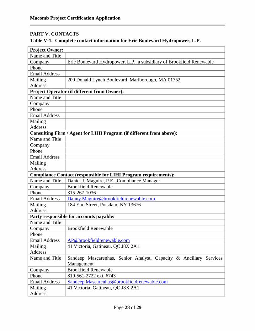
PART V. CONTACTS Table V-1. Complete contact information for Erie Boulevard Hydropower, L.P.
Project Owner: Name and Title Company Erie Boulevard Hydropower, L.P., a subsidiary of Brookfield Renewable Phone Email Address Mailing Address
200 Donald Lynch Boulevard, Marlborough, MA 01752
Project Operator (if different from Owner): Name and Title Company Phone Email Address Mailing Address
Consulting Firm / Agent for LIHI Program (if different from above): Name and Title Company Phone Email Address Mailing Address
Compliance Contact (responsible for LIHI Program requirements): Name and Title Daniel J. Maguire, P.E., Compliance Manager Company Brookfield Renewable Phone 315-267-1036 Email Address [email protected] Mailing Address
184 Elm Street, Potsdam, NY 13676
Party responsible for accounts payable: Name and Title Company Brookfield Renewable Phone Email Address [email protected] Mailing Address
41 Victoria, Gatineau, QC J8X 2A1
Name and Title Sandeep Mascarenhas, Senior Analyst, Capacity & Ancillary Services Management
Company Brookfield Renewable Phone 819-561-2722 ext. 6743 Email Address [email protected] Mailing Address
41 Victoria, Gatineau, QC J8X 2A1
Macomb Project Certification Application
Page 29 of 29
Table V-2. Complete contact information for current and relevant state, federal, provincial, and tribal resource agency contacts.
Agency Contact (Check area of responsibility: Flows_X_, Water Quality _X_, Fish/Wildlife Resources _X_, Watersheds __, T/E Spp. __, Cultural/Historic Resources __, Recreation _X_): Agency Name New York State Department of Environmental Conservation Name and Title Jessica Hart, Environmental Analyst Phone 315-785-2246 Email address [email protected] Mailing Address 317 Washington Street, Watertown, NY 13601
Agency Contact (Check area of responsibility: Flows__, Water Quality __, Fish/Wildlife Resources __, Watersheds __, T/E Spp. _X_, Cultural/Historic Resources __, Recreation __): Agency Name New York State Department of Environmental Conservation Name and Title Nicholas Conrad, Information Resources Coordinator Phone 518-402-8935 Email address [email protected] Mailing Address 625 Broadway, Albany, NY 12233-4757
Agency Contact (Check area of responsibility: Flows__, Water Quality __, Fish/Wildlife Resources __, Watersheds __, T/E Spp. _X_, Cultural/Historic Resources __, Recreation __): Agency Name U.S. Fish and Wildlife Service Name and Title Robyn Niver, Endangered Species Biologist Phone 607-753-9334 Email address [email protected] Mailing Address 3817 Luker Road, Cortland, NY 13045
Agency Contact (Check area of responsibility: Flows_X_, Water Quality _X_, Fish/Wildlife Resources _X_, Watersheds __, T/E Spp. _X_, Cultural/Historic Resources __, Recreation __): Agency Name U.S. Fish and Wildlife Service Name and Title Steve Patch Phone 607-753-9334 Email address [email protected] Mailing Address 3817 Luker Road, Cortland, NY 13045
Agency Contact (Check area of responsibility: Flows__, Water Quality __, Fish/Wildlife Resources __, Watersheds __, T/E Spp. __, Cultural/Historic Resources _X_, Recreation __): Agency Name New York State Division for Historic Preservation Name and Title Michael Lynch, Division Director Phone 518-237-8643 Email address [email protected] Mailing Address Peebles Island State Park, P.O. Box 189, Waterford, NY 12188-0189
APPENDIX A
ZONES OF EFFECT

PATH: C:\USERS\KAUSTIN\BROOKFIELD\MACOMB_LIHI_UPDATES\MACOMB LIHI ZONES OF EFFECT.MXD - USER: KAUSTIN - DATE: 1/25/2019
ZONES OF EFFECT
FIGURE 1MACOMB DEVELOPMENT
O
0 540Feet
LIHI Zone Boundary

APPENDIX B
PHOTOS OF KEY PROJECT FEATURES
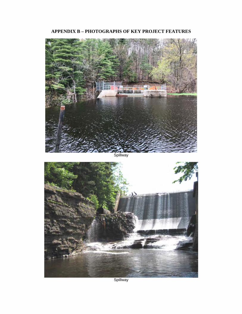
APPENDIX B – PHOTOGRAPHS OF KEY PROJECT FEATURES
Spillway
Spillway
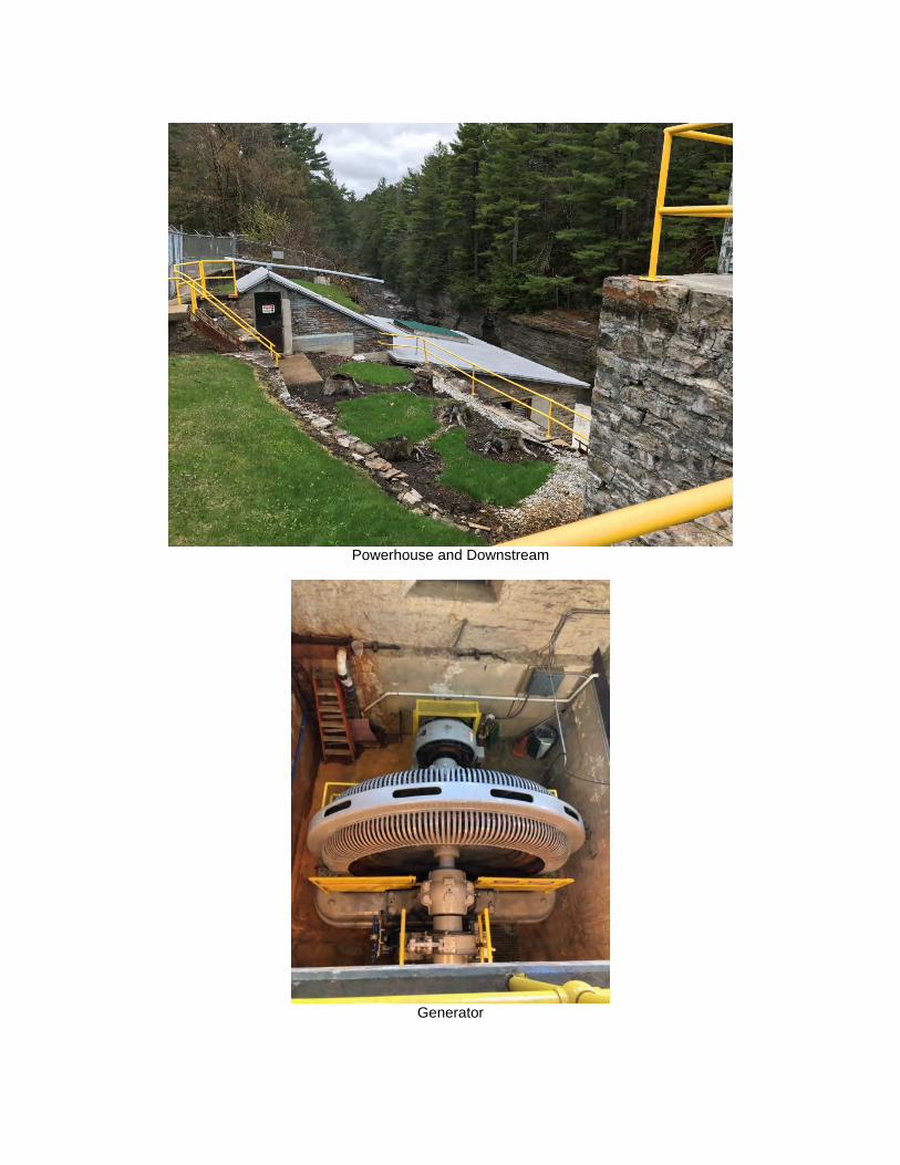
Powerhouse and Downstream
Generator
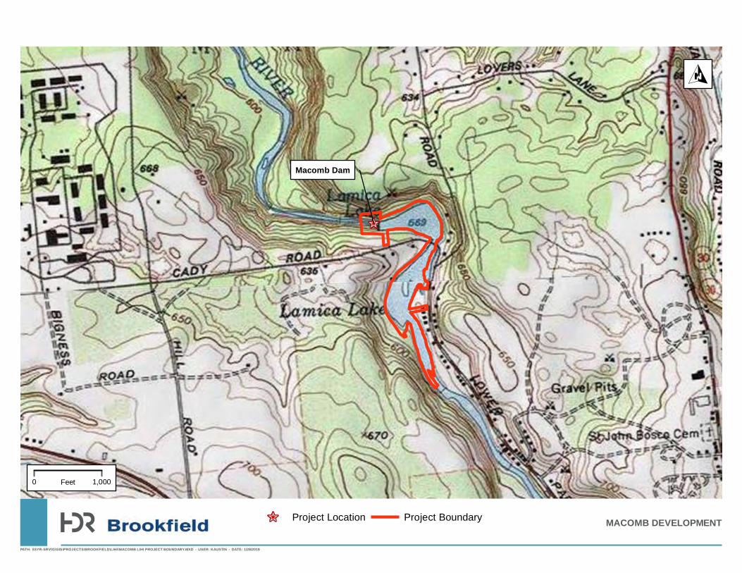
APPENDIX C
PROJECT MAPS AND AERIALS

!(
_̂
!(
!(
_̂
Ballard Mill Project
Chasm Project
Mountain View Dam
Whittelsey Project
Macomb Project
Mouth of North Salmon River
Salmon Riv er
S almon River
Service Layer Credits: Sources: Esri, HERE, DeLorme, Intermap, increment P Corp., GEBCO, USGS, FAO, NPS, NRCAN, GeoBase, IGN, Kadaster NL, Ordnance Survey, Esri Japan, METI, Esri China (HongKong), swisstopo, MapmyIndia, © OpenStreetMap contributors, and the GIS User CommunityEsri, HERE, DeLorme, MapmyIndia, © OpenStreetMap contributors, and the GIS user community
±
0 4 8 12Miles
Legend_̂ Brookfield Dam
!( Non-Brookfield Dam
North Salmon River_̂
Franklin County, New York
_̂
Macomb Dam
PATH: \\SYR-SRV01\GIS\PROJECTS\BROOKFIELD\LIHI\MACOMB LIHI PROJECT BOUNDARY.MXD - USER: KAUSTIN - DATE: 1/28/2019
MACOMB DEVELOPMENT
O
0 1,000Feet
_̂ Project Location Project Boundary
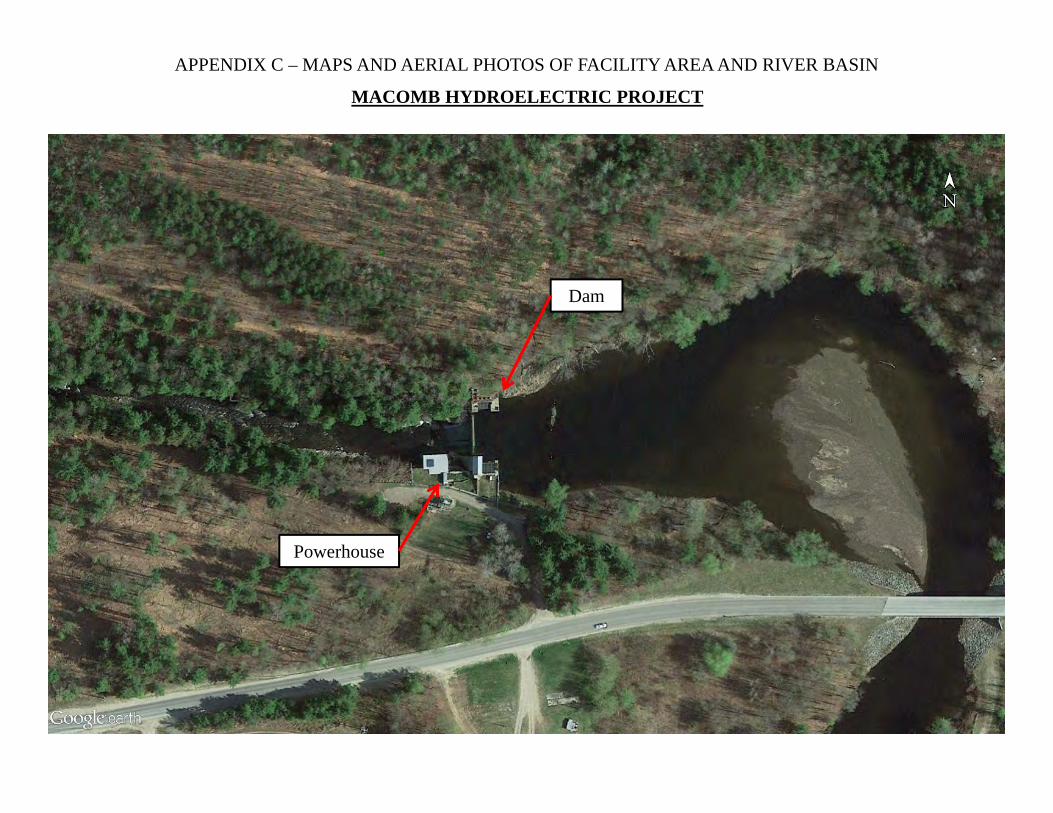
Dam
Powerhouse
APPENDIX C – MAPS AND AERIAL PHOTOS OF FACILITY AREA AND RIVER BASIN
MACOMB HYDROELECTRIC PROJECT
APPENDIX D
401 WATER QUALITY CERTIFICATION CONSULTATION
Submitted Electronically only
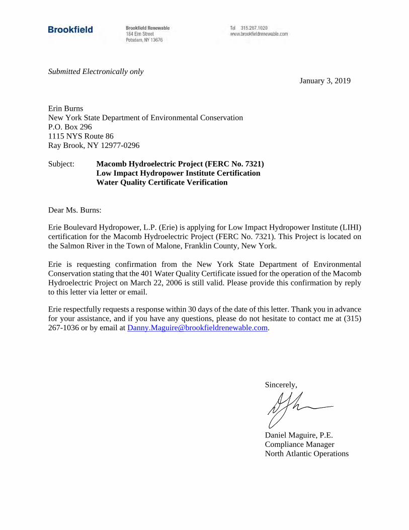
January 3, 2019 Erin Burns New York State Department of Environmental Conservation P.O. Box 296 1115 NYS Route 86 Ray Brook, NY 12977-0296 Subject: Macomb Hydroelectric Project (FERC No. 7321) Low Impact Hydropower Institute Certification Water Quality Certificate Verification Dear Ms. Burns:
Erie Boulevard Hydropower, L.P. (Erie) is applying for Low Impact Hydropower Institute (LIHI) certification for the Macomb Hydroelectric Project (FERC No. 7321). This Project is located on the Salmon River in the Town of Malone, Franklin County, New York. Erie is requesting confirmation from the New York State Department of Environmental Conservation stating that the 401 Water Quality Certificate issued for the operation of the Macomb Hydroelectric Project on March 22, 2006 is still valid. Please provide this confirmation by reply to this letter via letter or email.
Erie respectfully requests a response within 30 days of the date of this letter. Thank you in advance for your assistance, and if you have any questions, please do not hesitate to contact me at (315) 267-1036 or by email at [email protected].
Sincerely,
Daniel Maguire, P.E. Compliance Manager North Atlantic Operations
APPENDIX E
RARE, THREATENED AND ENDANGERED SPECIES CONSULTATION
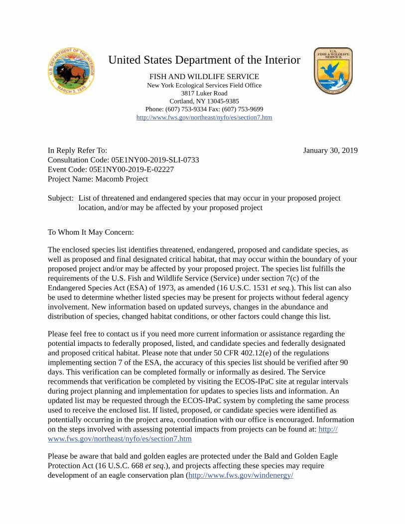
United States Department of the InteriorFISH AND WILDLIFE SERVICE
New York Ecological Services Field Office3817 Luker Road
Cortland, NY 13045-9385Phone: (607) 753-9334 Fax: (607) 753-9699
http://www.fws.gov/northeast/nyfo/es/section7.htm
In Reply Refer To: Consultation Code: 05E1NY00-2019-SLI-0733 Event Code: 05E1NY00-2019-E-02227 Project Name: Macomb Project
Subject: List of threatened and endangered species that may occur in your proposed projectlocation, and/or may be affected by your proposed project
To Whom It May Concern:
The enclosed species list identifies threatened, endangered, proposed and candidate species, as well as proposed and final designated critical habitat, that may occur within the boundary of your proposed project and/or may be affected by your proposed project. The species list fulfills the requirements of the U.S. Fish and Wildlife Service (Service) under section 7(c) of the Endangered Species Act (ESA) of 1973, as amended (16 U.S.C. 1531 et seq.). This list can also be used to determine whether listed species may be present for projects without federal agency involvement. New information based on updated surveys, changes in the abundance and distribution of species, changed habitat conditions, or other factors could change this list.
Please feel free to contact us if you need more current information or assistance regarding the potential impacts to federally proposed, listed, and candidate species and federally designated and proposed critical habitat. Please note that under 50 CFR 402.12(e) of the regulations implementing section 7 of the ESA, the accuracy of this species list should be verified after 90 days. This verification can be completed formally or informally as desired. The Service recommends that verification be completed by visiting the ECOS-IPaC site at regular intervals during project planning and implementation for updates to species lists and information. An updated list may be requested through the ECOS-IPaC system by completing the same process used to receive the enclosed list. If listed, proposed, or candidate species were identified as potentially occurring in the project area, coordination with our office is encouraged. Information on the steps involved with assessing potential impacts from projects can be found at: http:// www.fws.gov/northeast/nyfo/es/section7.htm
Please be aware that bald and golden eagles are protected under the Bald and Golden Eagle Protection Act (16 U.S.C. 668 et seq.), and projects affecting these species may require development of an eagle conservation plan (http://www.fws.gov/windenergy/
January 30, 2019

01/30/2019 Event Code: 05E1NY00-2019-E-02227 2
eagle_guidance.html). Additionally, wind energy projects should follow the Services wind energy guidelines (http://www.fws.gov/windenergy/) for minimizing impacts to migratory birds and bats.
Guidance for minimizing impacts to migratory birds for projects including communications towers (e.g., cellular, digital television, radio, and emergency broadcast) can be found at: http:// www.fws.gov/migratorybirds/CurrentBirdIssues/Hazards/towers/towers.htm; http:// www.towerkill.com; and http://www.fws.gov/migratorybirds/CurrentBirdIssues/Hazards/towers/ comtow.html.
We appreciate your concern for threatened and endangered species. The Service encourages Federal agencies to include conservation of threatened and endangered species into their project planning to further the purposes of the ESA. Please include the Consultation Tracking Number in the header of this letter with any request for consultation or correspondence about your project that you submit to our office.
Attachment(s):
Official Species List
01/30/2019 Event Code: 05E1NY00-2019-E-02227 1
Official Species ListThis list is provided pursuant to Section 7 of the Endangered Species Act, and fulfills the requirement for Federal agencies to "request of the Secretary of the Interior information whether any species which is listed or proposed to be listed may be present in the area of a proposed action".
This species list is provided by:
New York Ecological Services Field Office3817 Luker RoadCortland, NY 13045-9385(607) 753-9334
01/30/2019 Event Code: 05E1NY00-2019-E-02227 2
Project SummaryConsultation Code: 05E1NY00-2019-SLI-0733
Event Code: 05E1NY00-2019-E-02227
Project Name: Macomb Project
Project Type: DAM
Project Description: The Macomb Hydroelectric Project is applying to the Low Impact Hydropower Institute (LIHI) for a certification of their project, and is looking for information regarding rare, threatened or endangered species that may occur in the project area. LIHI requires documentation of a finding of no negative effects or documentation that the facility is in compliance with relevant conditions in the species recovery plans.
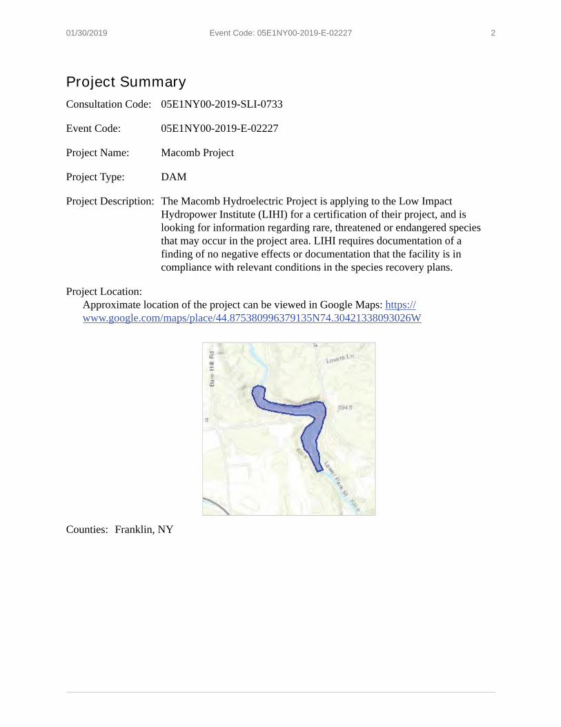
Project Location:Approximate location of the project can be viewed in Google Maps: https:// www.google.com/maps/place/44.875380996379135N74.30421338093026W
Counties: Franklin, NY
01/30/2019 Event Code: 05E1NY00-2019-E-02227 3
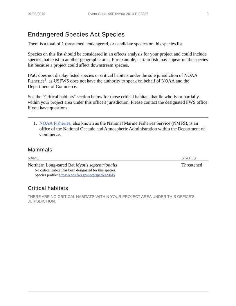
Endangered Species Act SpeciesThere is a total of 1 threatened, endangered, or candidate species on this species list.
Species on this list should be considered in an effects analysis for your project and could include species that exist in another geographic area. For example, certain fish may appear on the species list because a project could affect downstream species.
IPaC does not display listed species or critical habitats under the sole jurisdiction of NOAA Fisheries , as USFWS does not have the authority to speak on behalf of NOAA and the Department of Commerce.
See the "Critical habitats" section below for those critical habitats that lie wholly or partially within your project area under this office's jurisdiction. Please contact the designated FWS office if you have questions.
1. NOAA Fisheries, also known as the National Marine Fisheries Service (NMFS), is an office of the National Oceanic and Atmospheric Administration within the Department of Commerce.
MammalsNAME STATUS
Northern Long-eared Bat Myotis septentrionalisNo critical habitat has been designated for this species.Species profile: https://ecos.fws.gov/ecp/species/9045
Threatened
Critical habitatsTHERE ARE NO CRITICAL HABITATS WITHIN YOUR PROJECT AREA UNDER THIS OFFICE'S JURISDICTION.
1

1
Caley, Katherine
From: [email protected]: Thursday, January 03, 2019 6:33 PMTo: Caley, KatherineSubject: Confirmation of your submitted request to New York Natural Heritage
Submission ID: 2903 Submitted on Thursday, January 3, 2019 - 18:33 Submitted values are: Company, Organization, or Agency: HDR, Inc. Requestor Name: Katherine Caley Requestor Address (Street/PO Box): 1304 Buckley Road, Suite 202 Requestor City: Syracuse Requestor State: New York Requestor Zip Code: 13212 Requestor Telephone #: 315-414-2213 Requestor Email: [email protected] Project Type: hydroelectric facility/project Project Name: Macomb LIHI Consultation Project Applicant: Erie Boulevard Hydropower Project County: Franklin Town (Franklin County): Malone Project Summary: Erie is presently working with the Low Impact Hydropower Institute (LIHI) to certify the Macomb Hydroelectric Project (FERC No. 7321) as a low impact project. In preparing the application for LIHI certification, Erie must update or confirm consultation with resource agencies with respect to the presence of threatened or endangered species within the vicinity of the hydroelectric development. Per the request from LIHI, Erie respectfully requests information on the presence of threatened or endangered species within the vicinity of the above-listed projects. As a matter of background, the license from the Federal Energy Regulatory Commission (FERC) was issued for this Project on June 23, 2006. Project operations and environmental protection measures at this Project have been largely determined by a comprehensive Offer of Settlement that Erie developed in conjunction with the New York State Department of Environmental Conservation and other entities in 2004. The licensing processes for this Project included consultation with resource agencies regarding threatened and endangered species. Current Land Use: The site is currently developed for the primary purpose of hydroelectric energy production on the Salmon River Tax parcel number: Latitude: 44.877 Longitude: -74..306 Street Address of Project: Project Notes:
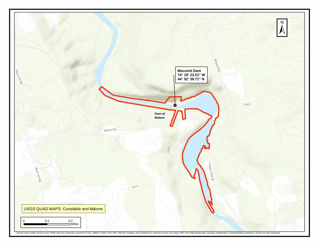
Town ofMalone
Macomb Dam74° 18' 23.01" W44° 52' 38.71" N
±
USGS QUAD MAPS: Constable and Malone
0 0.1 0.2Miles
Service Layer Credits: Sources: Esri, HERE, DeLorme, Intermap, increment P Corp., GEBCO, USGS, FAO, NPS, NRCAN, GeoBase, IGN, Kadaster NL, Ordnance Survey, Esri Japan, METI, Esri China (Hong Kong), swisstopo, MapmyIndia, © OpenStreetMap contributors, and the GIS User Community

Katherine CaleyHDR, Inc.1304 Buckley Road, Suite 202
Syracuse, NY 13212
Macomb LIHI ConsultationRe:County: Franklin Town/City: Malone
Dear Ms. Caley:
11
Heidi KrahlingEnvironmental Review SpecialistNew York Natural Heritage Program
Sincerely,
January 29, 2019
In response to your recent request, we have reviewed the New York Natural Heritage Program database with respect to the above project.
We have no records of rare or state-listed animals or plants, or significant natural communities at the project site or in its immediate vicinity.
The absence of data does not necessarily mean that rare or state-listed species, significant natural communities, or other significant habitats do not exist on or adjacent to the proposed site. Rather, our files currently do not contain information that indicates their presence. For most sites, comprehensive field surveys have not been conducted. We cannot provide a definitive statement on the presence or absence of all rare or state-listed species or significant natural communities. Depending on the nature of the project and the conditions at the project site, further information from on-site surveys or other resources may be required to fully assess impacts on biological resources.
This response applies only to known occurrences of rare or state-listed animals and plants, significant natural communities, and other significant habitats maintained in the Natural Heritage database. Your project may require additional review or permits; for information regarding other permits that may be required under state law for regulated areas or activities (e.g., regulated wetlands), please contact the NYS DEC Region 5 Office, Division of Environmental Permits, as listed at www.dec.ny.gov/about/39381.html.