mag azine of the mc dowell sonoran c onservancy mountain … · nancy howe greg kruzel jane rau...
TRANSCRIPT
Brown’s Ranch TrailheadHonors the landscape through architecture.
Wildlife CorridorsHow they connect significant habitat in the Preserve.
New Trails Open!More than 60 miles of sustainable trails now open.
Vol. 20 • No. 1 • Fall 2013
m a g a z i n e o f t h e m c d o w e l l s o n o r a n c o n s e r v a n c y
Squash = PMS 116 = 0/16/100/0Sage Green = PMS 5767 = 15/0/68/39Blue = PMS 294 = 100/58/0/21
Mountain Lines
About UsThe McDowell Sonoran Conservancy
champions the sustainability of the McDowell Sonoran Preserve for the benefit of this and future
generations. As stewards, we connect the community to the Preserve through education,
research, advocacy, partnerships and safe, respectful access.
Board of directors
tom Headley, chairJack Mcenroe, Vice chair
david Hay, secretaryJohn simpson, treasureroliver smith, Past chair
Mcdowell sonoran conserVancy staff
Jill feinsteinProgram Manager
nancy Heckoffice administrator
Judi ironsnaturalist
Michelle Kass annual Giving Manager
Mike nolanexecutive director
linda raishcommunity development director
Melanie tluczekresearch Program coordinator
Mcdowell sonoran conservancy16435 n. scottsdale road, suite 110
scottsdale, aZ 85254480-998-7971
the Mountain lines is published quarterlyby the Mcdowell sonoran conservancy,
a 501(c)3 nonprofit organization and sent to members and donors.
creative design donated by Mcdowell sonoran conservancy steward,
taffy corbett, taffy corbett design.
Philip Bellcay cowie
leslie dashewrebecca eickley
daniel froetscherdana Garmany
nancy Howe Greg Kruzel
Jane rauPeter rusinKevin tripp
wendy warus
Table of Contentsconservancy Up close ................................................................................................................ 3Brown’s ranch trailhead ............................................................................................................. 5wildlife corridors .........................................................................................................................8Breakfast on Brown’s Mountain .............................................................................................. 12redesigned trails ensure access and sustainability ......................................................... 14the Maricopa trail ..................................................................................................................... 17tour de scottsdale ...................................................................................................................... 18the family Passport .................................................................................................................. 19
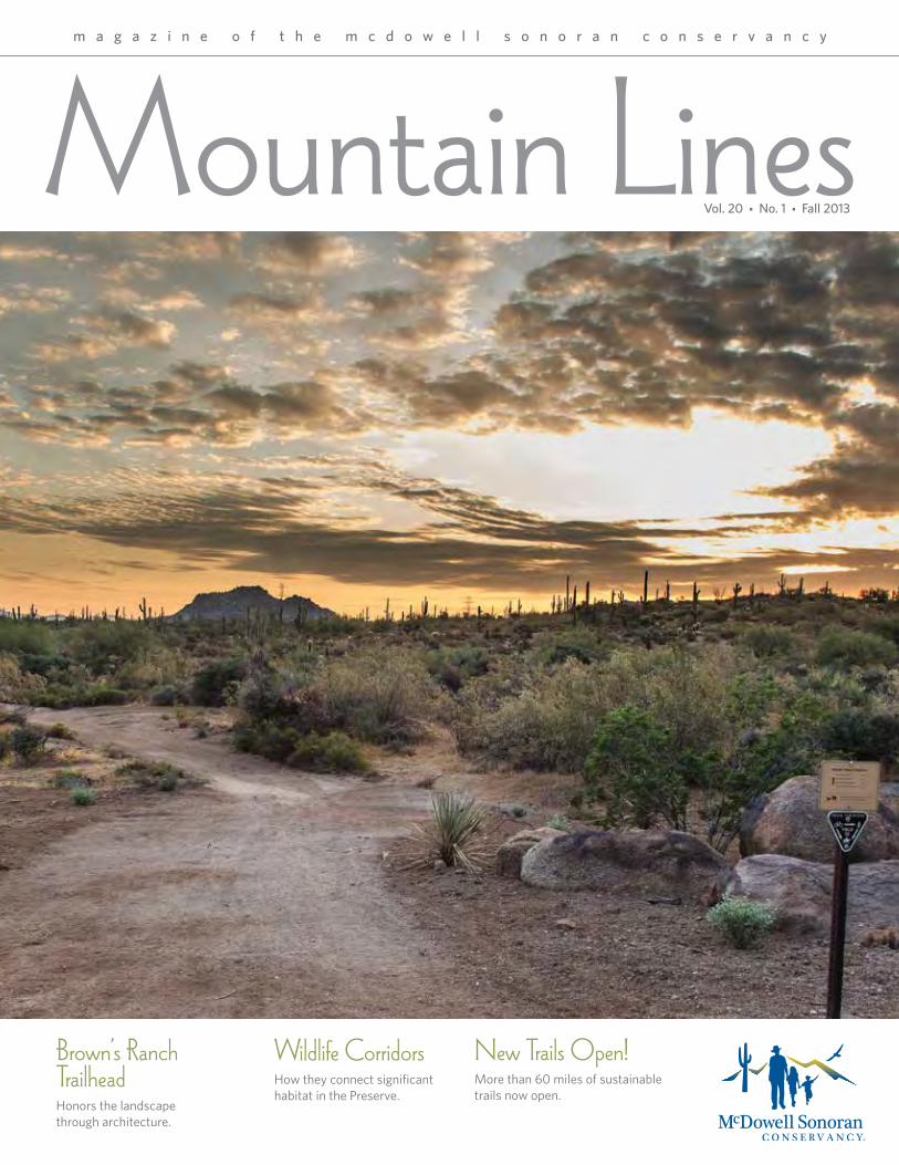
Cover Photo: New Trails are open in the northern region of Scottsdale’s Preserve.Photo by: B. White
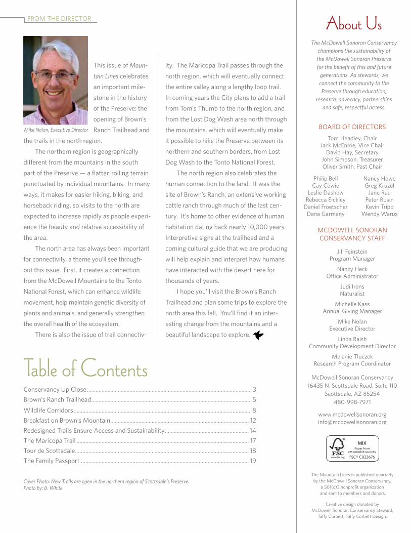
froM tHe director
this issue of Moun-
tain Lines celebrates an important mile-stone in the history of the Preserve: the opening of Brown’s ranch trailhead and
the trails in the north region. the northern region is geographically different from the mountains in the south part of the Preserve — a flatter, rolling terrain punctuated by individual mountains. in many ways, it makes for easier hiking, biking, and horseback riding, so visits to the north are expected to increase rapidly as people experi-ence the beauty and relative accessibility of the area.
the north area has always been important for connectivity, a theme you’ll see through-out this issue. first, it creates a connection from the Mcdowell Mountains to the tonto
national forest, which can enhance wildlife movement, help maintain genetic diversity of plants and animals, and generally strengthen the overall health of the ecosystem.
there is also the issue of trail connectiv-
ity. the Maricopa trail passes through the north region, which will eventually connect the entire valley along a lengthy loop trail. in coming years the city plans to add a trail from tom’s thumb to the north region, and from the lost dog wash area north through the mountains, which will eventually make it possible to hike the Preserve between its northern and southern borders, from lost dog wash to the tonto national forest. the north region also celebrates the human connection to the land. it was the site of Brown’s ranch, an extensive working cattle ranch through much of the last cen-tury. it’s home to other evidence of human habitation dating back nearly 10,000 years.
interpretive signs at the trailhead and a coming cultural guide that we are producing will help explain and interpret how humans have interacted with the desert here for thousands of years.
i hope you’ll visit the Brown’s ranch
trailhead and plan some trips to explore the north area this fall. you’ll find it an inter-esting change from the mountains and a beautiful landscape to explore.
MIX Paper from
responsible sources
fsc® c023676www.fsc.org
Mcdowell sonoran conserVancy UP close
3
E volution is “a gradual process in which something changes into a different and usually more complex or better form.” while we tend to think of this in terms of biology, evolutionary processes take place in many areas, including the design and features of trailheads. changes are now underway at the Gateway trailhead designed both to improve the visitor experience and the physical condition of the trailhead itself. the major change involves creating a new indoor/outdoor space to house more permanent interpretive exhibits in which the Mcdowell sonoran conservancy Pathfinders can operate. Pathfinders are volunteer stewards who staff trailheads and help ensure that visitors have a safe and enjoyable experience in the Mcdowell sonoran Preserve. the space will not increase the physical footprint of the existing structure or in any way modify its leed Platinum certification. leadership in energy and environmental design (leed) is a rating system for the design, construction, and high performance of green buildings. However, the folding door system will allow for a dedicated interactive visitor space that can be secured during off-hour periods.
Changes to the Gateway a similar space exists at the new Brown’s ranch trailhead. once completed, the city of scottsdale, the conservancy and the designers recognized the benefits of such a space, particularly its ability to provide a more in-depth presentation of information. the Gateway trailhead will now evolve to include some of the best new features at Brown’s ranch. in addition, the granite pathway from the parking lot to the trailhead will be replaced by exposed aggregate concrete to reduce wash-outs during heavy rains. completion of the project is scheduled for fall 2013. design services are being provided by Phil weddle of weddle GilMore Black rock studio, a scottsdale architecture firm. weddle has been working on Preserve projects for over a decade and is a leader in arizona for leed Platinum projects. we are excited about these changes and hope that they enhance your experience in scottsdale’s Preserve.
Source: Jace McKeighan, McDowell Sonoran Conservancy steward
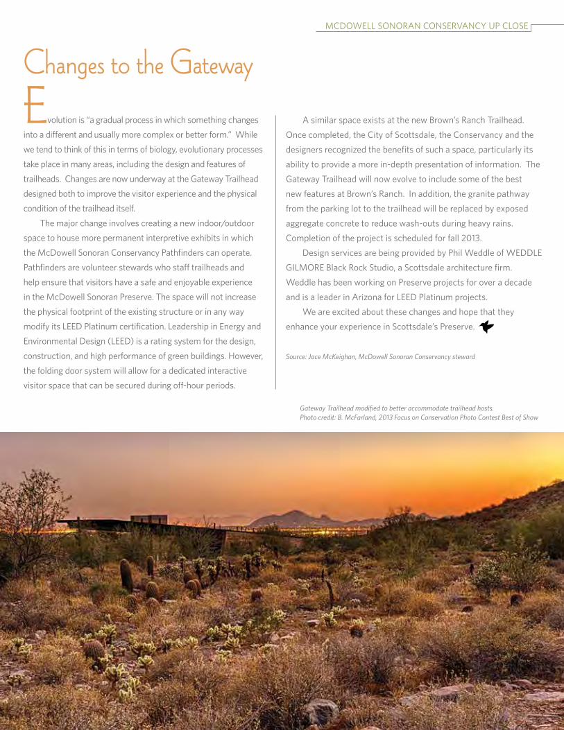
Gateway Trailhead modified to better accommodate trailhead hosts.Photo credit: B. McFarland, 2013 Focus on Conservation Photo Contest Best of Show
4Balanced Rock is known as a Native American ceremonial place. Photo by B. White
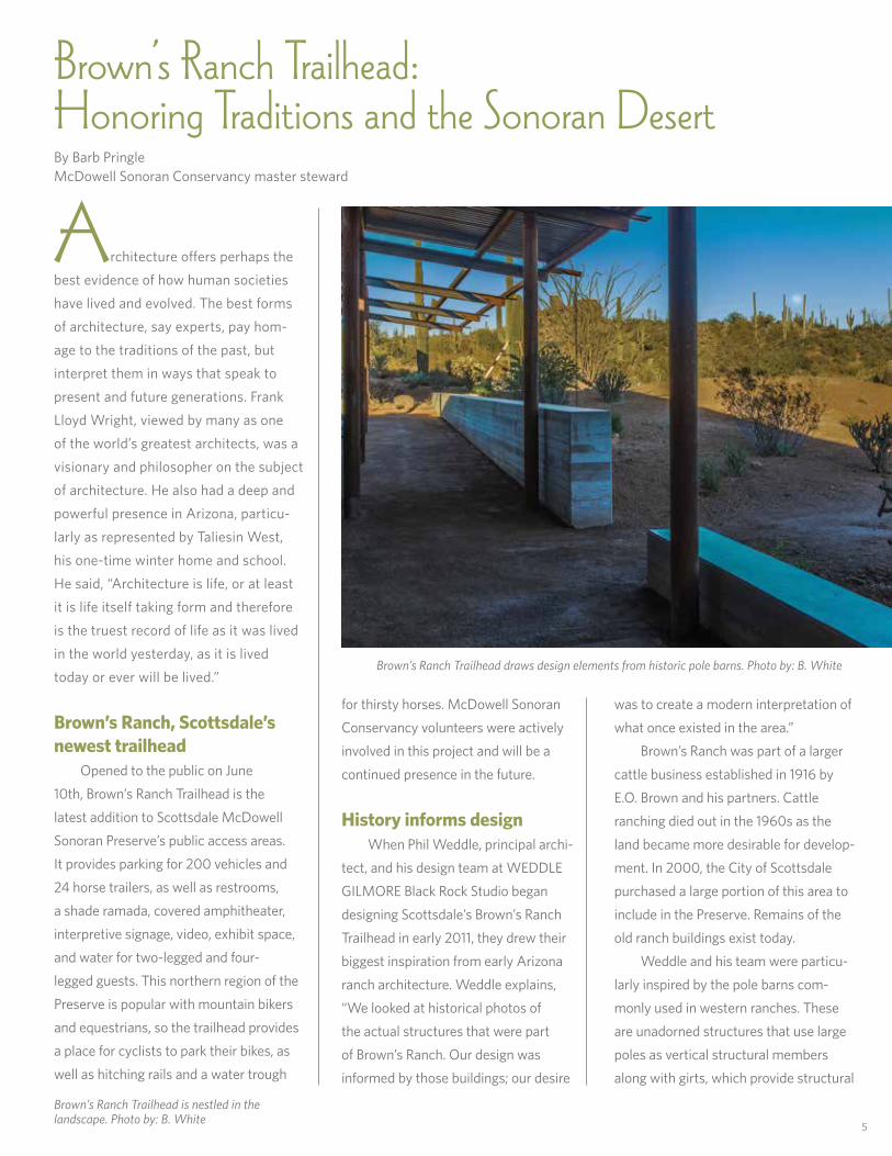
Architecture offers perhaps the best evidence of how human societies have lived and evolved. the best forms of architecture, say experts, pay hom-age to the traditions of the past, but interpret them in ways that speak to present and future generations. frank lloyd wright, viewed by many as one of the world’s greatest architects, was a visionary and philosopher on the subject of architecture. He also had a deep and powerful presence in arizona, particu-larly as represented by taliesin west, his one-time winter home and school. He said, “architecture is life, or at least it is life itself taking form and therefore is the truest record of life as it was lived in the world yesterday, as it is lived today or ever will be lived.”
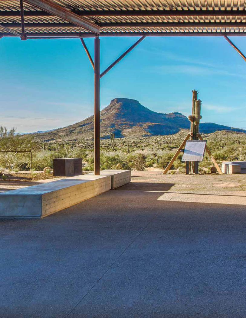
Brown’s Ranch, Scottsdale’s newest trailhead opened to the public on June 10th, Brown’s ranch trailhead is the latest addition to scottsdale Mcdowell sonoran Preserve’s public access areas. it provides parking for 200 vehicles and 24 horse trailers, as well as restrooms, a shade ramada, covered amphitheater, interpretive signage, video, exhibit space, and water for two-legged and four-legged guests. this northern region of the Preserve is popular with mountain bikers and equestrians, so the trailhead provides a place for cyclists to park their bikes, as well as hitching rails and a water trough
for thirsty horses. Mcdowell sonoran
conservancy volunteers were actively involved in this project and will be a continued presence in the future.
History informs design when Phil weddle, principal archi-tect, and his design team at weddle GilMore Black rock studio began designing scottsdale’s Brown’s ranch trailhead in early 2011, they drew their biggest inspiration from early arizona ranch architecture. weddle explains, “we looked at historical photos of the actual structures that were part of Brown’s ranch. our design was informed by those buildings; our desire
5
was to create a modern interpretation of what once existed in the area.”
Brown’s ranch was part of a larger cattle business established in 1916 by e.o. Brown and his partners. cattle ranching died out in the 1960s as the land became more desirable for develop-ment. in 2000, the city of scottsdale purchased a large portion of this area to include in the Preserve. remains of the old ranch buildings exist today. weddle and his team were particu-larly inspired by the pole barns com-monly used in western ranches. these are unadorned structures that use large poles as vertical structural members along with girts, which provide structural
Brown’s Ranch Trailhead: Honoring Traditions and the Sonoran DesertBy Barb PringleMcdowell sonoran conservancy master steward
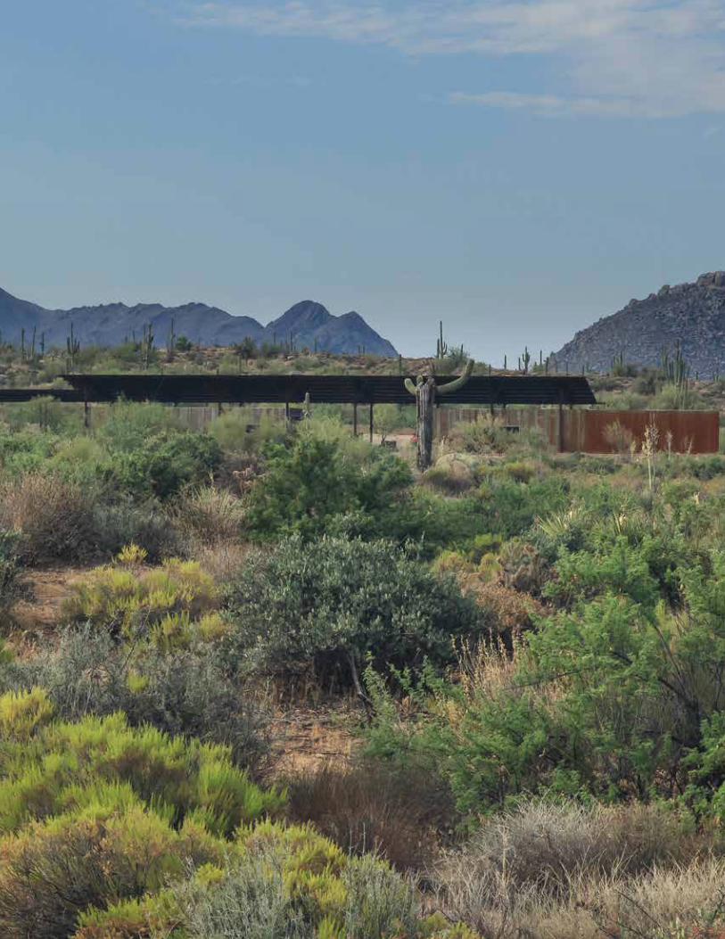
Brown’s Ranch Trailhead draws design elements from historic pole barns. Photo by: B. White
Brown’s Ranch Trailhead is nestled in the landscape. Photo by: B. White
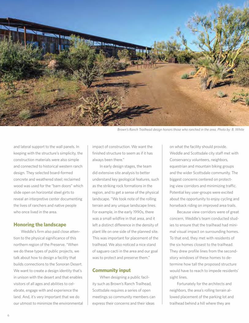
impact of construction. we want the finished structure to seem as if it has always been there.” in early design stages, the team did extensive site analysis to better understand key geological features, such as the striking rock formations in the region, and to get a sense of the physical landscape. “we took note of the rolling terrain and any unique landscape lines. for example, in the early 1990s, there was a small wildfire in that area, and it left a distinct difference in the density of plant life on one side of the planned site. this was important for placement of the trailhead. we also noticed a nice stand of saguaro cacti in the area and our goal was to protect and preserve them.”
Community input when designing a public facil-ity such as Brown’s ranch trailhead, scottsdale requires a series of open meetings so community members can express their concerns and their ideas
on what the facility should provide. weddle and scottsdale city staff met with conservancy volunteers, neighbors, equestrian and mountain biking groups and the wider scottsdale community. the biggest concerns centered on protect-ing view corridors and minimizing traffic. Potential key user-groups were excited about the opportunity to enjoy cycling and horseback riding on improved area trails. Because view corridors were of great concern, weddle’s team conducted stud-ies to ensure that the trailhead had mini-mal visual impact on surrounding homes. to that end, they met with residents of the six homes closest to the trailhead. they drew profile lines from the second-story windows of these homes to de-termine how tall the proposed structure would have to reach to impede residents’ sight lines. fortunately for the architects and neighbors, the area’s rolling terrain al-lowed placement of the parking lot and trailhead behind a hill where they are
6
and lateral support to the wall panels. in keeping with the structure’s simplicity, the construction materials were also simple and connected to historical western ranch design. they selected board-formed concrete and weathered steel; reclaimed wood was used for the “barn doors” which slide open on horizontal steel girts to reveal an interpretive center documenting the lives of ranchers and native people who once lived in the area.
Honoring the landscape weddle’s firm also paid close atten-tion to the physical significance of this northern region of the Preserve. “when we do these types of public projects, we talk about how to design a facility that builds connections to the sonoran desert. we want to create a design identity that’s in unison with the desert and that enables visitors of all ages and abilities to cel-ebrate, engage with and experience the land. and, it’s very important that we do our utmost to minimize the environmental
Brown’s Ranch Trailhead design honors those who ranched in the area. Photo by: B. White

7
utterly invisible to adjacent homes. Visit and watch as the trailhead slowly unfolds and reveals itself; it seems to epitomize the idea that good architecture organi-cally arises from its site and is shaped by its surroundings. neighbors who were once detrac-tors have become proudly invested in their beautiful new amenity. Peggy Mcnamara, a conservancy steward, lives nearby and heard from many neighbors who were initially concerned about this project. “they were worried about trailhead structures being visible from the neighborhood, light pollution, night-time activities in the Preserve, and cars parked on neighborhood streets. scottsdale’s neighborhood meetings were very helpful for airing concerns and developing solutions. the city also hosted a sneak preview just before the trailhead opening. the preview was mobbed! after seeing the finished trail-head, people were very complimentary about how well it turned out. now, my neighbors use the Preserve, instead of the neighborhood, to exercise,” she said.
Sustainability standards Brown’s ranch trailhead is a pilot project for scottsdale’s voluntary, newly-adopted international Green construc-tion code (iGcc), an emerging code for sustainable design and construction. (leeds certification now is available only to buildings of a certain size and this building was too small to meet the standard.)
as with other scottsdale trailheads, a range of sustainable features are incorporated within the project’s design and construction. a 9kw photo-voltaic solar array was included with the goal of equalizing energy production and
consumption to attain a net zero annual energy expenditure.
Graywater and rainwater is harvested at the site. Great sensitivity was used during grading to minimize erosion as well as native plant displacement. Many of the building materials are noncombus-tible, which will aid in fire control. in fact, the presence of the trailhead as a staging area could help firefighters battle future blazes in the area.
a celebration of the opening of the northern lands is set for october 19th at Brown’s ranch trailhead. By then, conservancy trail construction
and maintenance volunteers will have completed the Jane rau interpretive
trail, which winds through a beautiful boulder-lined canyon east of the trailhead. the trail honors Jane rau, co-founder of the Mcdowell sonoran
conservancy and a long-time (and current) volunteer. come join us in october to celebrate a marriage of history, architecture and desert environment, all wrapped up in the gift that is the Brown’s ranch trailhead.
For more information about the grand opening celebration, visit our website at www.mcdowellsonoran.org/opening.
Brown’s Ranch Trailhead ExhibitCattle Track Couture: Fashion by Rachael Ellisin the 1930s, arizona pioneer George ellis purchased a 10-acre property on the arizona canal that grew into a haven for art and artists known as cattle track arts compound. rachael ellis, his wife, was a multi-talented pioneer woman, raising greyhounds with George, running her home, teaching, playing the violin, training horses and raising her children. she also sewed extensively, designing and revamping beautiful clothing for herself, her daughter Janie, as well as costumes for the theater company she ran with Janie until the 2000’s.
Beginning october 19, 2013 and continuing through april 30, 2014, the Mcdowell sonoran conservancy will highlight these masterful pieces in an exhibit at the newly opened Brown’s ranch trailhead in scottsdale. in cattle track couture, Janie will exhibit gorgeous, multihued ensembles, outerwear, dresses, and vests rachael stitched over the years using luxurious fabrics. a coffee-table book authored by family friend lucy diggs, Cattle Track Couture — Fashion by Rachael Ellis, will offer historical family photographs and is possibly one of the best tributes to scottsdale pioneers. come peek into a fascinating slice of arizona history. Source: Janie Ellis
Exhibit sponsored by the Sonoran Desert Women, a women’s group dedicated to supporting the McDowell Sonoran Conservancy. Open Friday, Saturday, Sunday and Monday morning from 8–11 a.m. For more information about joining the Sonoran Desert Women, visit our website at mcdowellsonoran.org/women
8
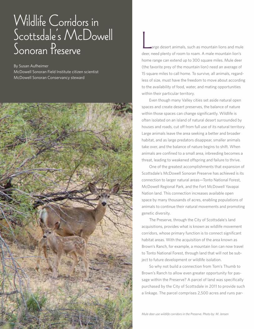
Large desert animals, such as mountain lions and mule deer, need plenty of room to roam. a male mountain lion’s home range can extend up to 300 square miles. Mule deer (the favorite prey of the mountain lion) need an average of 15 square miles to call home. to survive, all animals, regard-less of size, must have the freedom to move about according to the availability of food, water, and mating opportunities within their particular territory. even though many Valley cities set aside natural open spaces and create desert preserves, the balance of nature within those spaces can change significantly. wildlife is often isolated on an island of natural desert surrounded by houses and roads, cut off from full use of its natural territory. large animals leave the area seeking a better and broader habitat, and as large predators disappear, smaller animals take over, and the balance of nature begins to shift. when animals are confined to a small area, inbreeding becomes a threat, leading to weakened offspring and failure to thrive. one of the greatest accomplishments that expansion of scottsdale’s Mcdowell sonoran Preserve has achieved is its connection to larger natural areas—tonto national forest, Mcdowell regional Park, and the fort Mcdowell yavapai nation land. this connection increases available open space by many thousands of acres, enabling populations of animals to continue their natural movements and promoting genetic diversity. the Preserve, through the city of scottsdale’s land acquisitions, provides what is known as wildlife movement corridors, whose primary function is to connect significant habitat areas. with the acquisition of the area known as Brown’s ranch, for example, a mountain lion can now travel to tonto national forest, through land that will not be sub-ject to future development or wildlife isolation. so why not build a connection from tom’s thumb to Brown’s ranch to allow even greater opportunity for pas-sage within the Preserve? a parcel of land was specifically purchased by the city of scottsdale in 2011 to provide such a linkage. the parcel comprises 2,500 acres and runs par-
Wildlife Corridors in Scottsdale’s McDowell Sonoran PreserveBy susan aufheimerMcdowell sonoran field institute citizen scientistMcdowell sonoran conservancy steward
Mule deer use wildlife corridors in the Preserve. Photo by: M. Jensen

9
Mcdowell sonoran field institUte
Preserve corridors run alongside 128th street and cross Dynamite Boulevard. Photo by: B. White
allel to 128th street. while extremely important for free flow of wildlife, this particular corridor presents complica-tions for animal movement because dynamite Boulevard runs through it. according to arizona Game and fish department (aZGf), roads are a ma-jor threat to the long-term existence of wildlife populations. the question becomes, to what extent does dynamite Boulevard impact animal passage and can any negative impacts be mitigated? to answer that question, aZGf conducted road-kill surveys along dynamite Boulevard where it runs through the corridor. their goal was to learn which animals use the corridor now, and to collect enough
data to devise a plan for maximizing the effectiveness of the corridor to increase wildlife connectivity. after analyzing the results, aZGf developed several recommendations for improving corridor management, including long-term monitoring of wildlife movement and outreach ef-forts to inform local residents of the importance of the corridor. in addition, aZGf recommendations for road im-provement included installing multiple wildlife-crossing structures over dyna-mite Boulevard and constructing sev-eral culverts of different sizes beneath the road to accommodate passage of the largest animal down to the small-est lizard. those recommendations
were delivered to the city of scottsdale for its review and pending action. the study of the Brown’s ranch–tom’s thumb corridor is only one example of the efforts being made by the city of scotts-dale, the arizona Game and fish depart-ment, and the Mcdowell sonoran conser-vancy to scientifically research how best to manage wildlife corridors throughout the Preserve. while establishing such corridors does not make up for loss of habitat outside the Preserve, the corridors inside the Pre-serve help reduce the negative effects by allowing animals to move freely in and out of their remaining habitat, keeping open the opportunities for maintaining biodiversity.
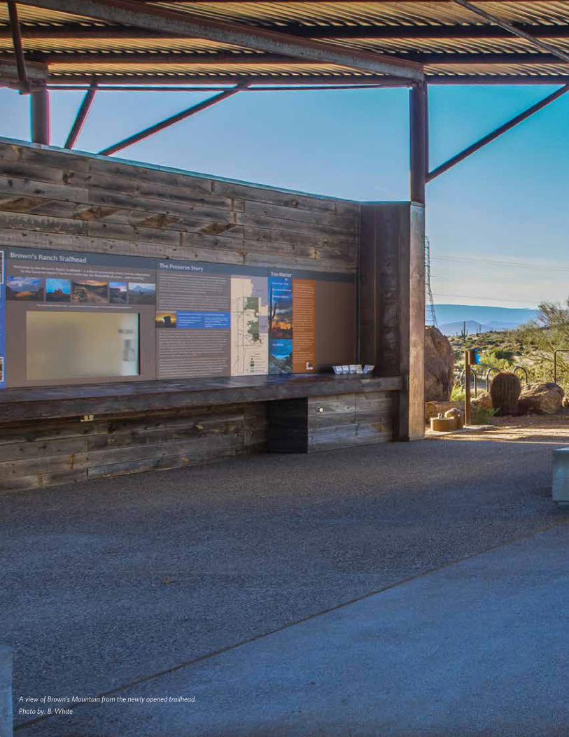
A view of Brown’s Mountain from the newly opened trailhead.
Photo by: B. White
11

12
Breakfast on Brown’s MountainBy Peggy ncnamaraMcdowell sonoran conservancy steward
13
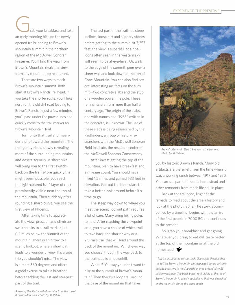
Grab your breakfast and take an early morning hike on the newly opened trails leading to Brown’s Mountain summit in the northern region of the Mcdowell sonoran Preserve. you’ll find the view from Brown’s Mountain rivals the view from any mountaintop restaurant. there are two ways to reach Brown’s Mountain summit. Both start at Brown’s ranch trailhead. if you take the shorter route, you’ll hike north on the old dirt road leading to Brown’s ranch. in just a few minutes, you’ll pass under the power lines and quickly come to the trail marker for Brown’s Mountain trail. turn onto that trail and mean-der along toward the mountain. the trail gently rises, slowly revealing more of the surrounding mountains and desert scenery. a short hike will bring you to the first switch-back on the trail. More quickly than might seem possible, you reach the light-colored tuff* layer of rock prominently visible near the top of the mountain. then suddenly after rounding a sharp curve, you see the first view of Phoenix. after taking time to appreci-ate the view, press on and climb up switchbacks to a trail marker just 0.2 miles below the summit of the mountain. there is an arrow to a scenic lookout, where a short path leads to a wonderful view. it’s a side trip you shouldn’t miss. the view is almost 360 degrees and offers a good excuse to take a breather before tackling the last and steepest part of the trail.
the last part of the trail has steep inclines, loose dirt and slippery stones before getting to the summit. at 3,253 feet, the view is superb! Hot air bal-loons often seen in the western sky will seem to be at eye-level. or, walk to the edge of the summit, peer over a sheer wall and look down at the top of cone Mountain. you can also find sev-eral interesting artifacts on the sum-mit—two concrete slabs and the stub of a wooden power line pole. these remnants are from more than half a century ago. the origin of the slabs, one with names and “1958” written in the concrete, is unknown. the use of these slabs is being researched by the Pastfinders, a group of history re-searchers with the Mcdowell sonoran field institute, the research center of the Mcdowell sonoran conservancy. after investigating the top of the mountain, plan to have breakfast and a mileage count. you should have hiked 1.5 miles and gained 533 feet in elevation. Get out the binoculars to take a better look around before it’s time to go. the steep way down to where you meet the scenic lookout path requires a lot of care. Many bring hiking poles to help. after reaching the viewpoint area, you have a choice of which trail to take back, the shorter way or a 2.5-mile trail that will lead around the back of the mountain. whichever way you choose, though, the way back to the trailhead is all downhill. what!!? you say you don’t want to hike to the summit of Brown’s Moun-tain? then there’s a loop trail around the base of the mountain that takes
you by historic Brown’s ranch. Many old artifacts are there, left from the time when it was a working ranch between 1917 and 1970. you can see parts of the old homestead and other remnants from ranch life still in place. Back at the trailhead, linger at the ramada to read about the area’s history and look at the photographs. the story, accom-panied by a timeline, begins with the arrival of the first people in 7000 Bc and continues to the present. so, grab your breakfast and get going. whatever you bring to eat will taste better at the top of the mountain or at the old homestead.
* Tuff is consolidated volcanic ash. Geologists theorize that
the tuff on Brown’s Mountain was deposited during volcanic
activity occurring in the Superstition area around 15 to 25
million years ago. The black basalt rock visible at the top of
Brown’s Mountain is quickly-cooled lava that was deposited
on the mountain during the same epoch.
eXPerience tHe PreserVe
Brown’s Mountain Trail takes you to the summit. Photo by: B. White
A view of the McDowell Mountains from the top of Brown’s Mountain. Photo by: B. White

14
Redesigned Trails Ensure Access and SustainabilityBy nancy HoweMcdowell sonoran conservancy lead steward
When you read the new map of scottsdale’s Mcdowell sonoran Preserve’s northern region, you’ll discover that the 60 miles of renamed trails and redesigned routes reveal as much about the people and politics that shaped this region as about the landforms themselves. the first trails that criss-crossed the state trust lands north of dynamite road were mostly carved by moto-cross riders. Mountain bikers soon followed in their tracks. Before the internet, these biking-trail maps were intimate bits of knowledge, hand-drawn onto topo maps, photocopied, and passed around within the riding communities. new users added their own discoveries, photo-copied the revised maps, and passed them around, again and again.
about 1996, details from the individual maps reached the
internet, where generous riders like dale wiggins consolidated the information into the “100 miles of single track,” making the spaghetti-like trail maps universally available. over time, maps proliferated, published in blogs and on-line community forums.
trails were identified by the informal names early riders —both moto-cross and mountain bikers — gave them, or by the numbers that appeared on trail signs, or occasionally by both. (numbers came into use starting around 2000 when the land transitioned into the Granite Mountain multi-use area, managed by a consor-tium of government agencies including arizona Game and fish, arizona state land department, the tonto national forest, and the
city of scottsdale.)
as the north became part of the Mcdowell sonoran Preserve, both the land and the trails fell under new management objec-tives. Multi-use recreation gave way to Preserve goals of habitat and cultural resource protection, along with non-motorized public access to popular destinations. “our first task was to learn what the public wanted in the north,” recalls scott Hamilton, senior preserve trail planner. a series of open houses in april 2012 gathered input from citizens: what destinations did trail users seek? what trails
Some trails under the power lines have been redesigned to promote sustainability. Photo by: B. White
fit By natUre
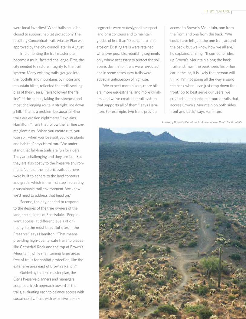
were local favorites? what trails could be closed to support habitat protection? the resulting conceptual trails Master Plan was approved by the city council later in august. implementing the trail master plan became a multi-faceted challenge. first, the city needed to restore integrity to the trail system. Many existing trails, gouged into the foothills and mountains by motor and mountain bikes, reflected the thrill-seeking bias of their users. trails followed the “fall line” of the slopes, taking the steepest and most challenging route, a straight line down a hill. “that is a problem because fall-line trails are erosion nightmares,” explains Hamilton. “trails that follow the fall line cre-ate giant ruts. when you create ruts, you lose soil; when you lose soil, you lose plants and habitat,” says Hamilton. “we under-stand that fall-line trails are fun for riders. they are challenging and they are fast. But they are also costly to the Preserve environ-ment. none of the historic trails out here were built to adhere to the land contours and grade, which is the first step in creating a sustainable trail environment. we knew we’d need to address that head on.” second, the city needed to respond to the desires of the true owners of the land, the citizens of scottsdale. “People want access, at different levels of dif-ficulty, to the most beautiful sites in the Preserve,” says Hamilton. “that means providing high-quality, safe trails to places like cathedral rock and the top of Brown’s Mountain, while maintaining large areas free of trails for habitat protection, like the extensive area east of Brown’s ranch.” Guided by the trail master plan, the city’s Preserve planners and managers adopted a fresh approach toward all the trails, evaluating each to balance access with sustainability. trails with extensive fall-line
segments were re-designed to respect landform contours and to maintain grades of less than 10 percent to limit erosion. existing trails were retained whenever possible, rebuilding segments only where necessary to protect the soil. scenic destination trails were re-routed, and in some cases, new trails were added in anticipation of high use. “we expect more bikers, more hik-ers, more equestrians, and more climb-ers, and we’ve created a trail system that supports all of them,” says Ham-ilton. for example, two trails provide
access to Brown’s Mountain, one from the front and one from the back. “we could have left just the one trail, around the back, but we know how we all are,” he explains, smiling. “if someone rides up Brown’s Mountain along the back trail, and, from the peak, sees his or her car in the lot, it is likely that person will think, ‘i’m not going all the way around the back when i can just drop down the front.’ so to best serve our users, we created sustainable, contoured trails that access Brown’s Mountain on both sides, front and back,” says Hamilton.
A view of Brown’s Mountain Trail from above. Photo by: B. White
16
the third design innovation is the series of ever-expanding loops that the trails create over the nearly 20,000-acre expanse of the new northern region. Just as the Gateway loop trail is the highest-use trail out of the Gateway trailhead, planners anticipate that the Brown’s ranch road / Brown’s Mountain trail and the Granite Mountain loop trail will be the high-use trails out of the Brown’s ranch and Granite Mountain trailheads. Be-yond these two basic loops, all the trails in the north region are being re-conceived and re-named to invite users to build their own loops, either to add distance, difficulty, or more rugged terrain to their outings. trails without well-known destinations or that skirt the outer regions of the Preserve will draw fewer people. the endless loop opportunities invite users to create their own personal experiences in the Preserve. says Hamilton, “what we choose to do in the Preserve reflects our emo-tional connections to nature, how we identify ourselves, what we do for fun, and how we connect with our families. we rebuilt the trails to give each of our users the freedom to create their own, personal routes through the Preserve.” this create-your-own-trail design
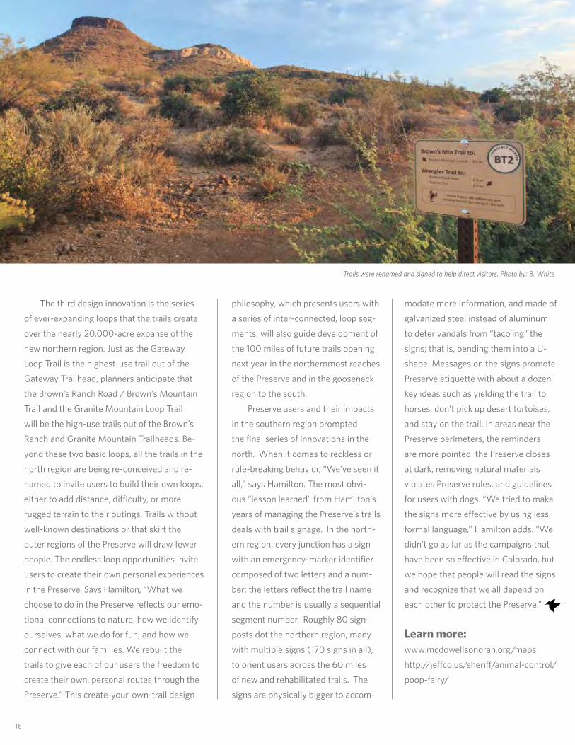
philosophy, which presents users with a series of inter-connected, loop seg-ments, will also guide development of the 100 miles of future trails opening next year in the northernmost reaches of the Preserve and in the gooseneck region to the south. Preserve users and their impacts in the southern region prompted the final series of innovations in the north. when it comes to reckless or rule-breaking behavior, “we’ve seen it all,” says Hamilton. the most obvi-ous “lesson learned” from Hamilton’s years of managing the Preserve’s trails deals with trail signage. in the north-ern region, every junction has a sign with an emergency-marker identifier composed of two letters and a num-ber: the letters reflect the trail name and the number is usually a sequential segment number. roughly 80 sign-posts dot the northern region, many with multiple signs (170 signs in all), to orient users across the 60 miles of new and rehabilitated trails. the signs are physically bigger to accom-
modate more information, and made of galvanized steel instead of aluminum to deter vandals from “taco’ing” the signs; that is, bending them into a U-shape. Messages on the signs promote Preserve etiquette with about a dozen key ideas such as yielding the trail to horses, don’t pick up desert tortoises, and stay on the trail. in areas near the Preserve perimeters, the reminders are more pointed: the Preserve closes at dark, removing natural materials violates Preserve rules, and guidelines for users with dogs. “we tried to make the signs more effective by using less formal language,” Hamilton adds. “we didn’t go as far as the campaigns that have been so effective in colorado, but we hope that people will read the signs and recognize that we all depend on each other to protect the Preserve.”
Learn more:www.mcdowellsonoran.org/mapshttp://jeffco.us/sheriff/animal-control/poop-fairy/
Trails were renamed and signed to help direct visitors. Photo by: B. White
17
faMilies in natUreThe Maricopa Trailby Jace McKeighanMcdowell sonoran conservancy steward
Adobe Dam
Spur CrossRanch
CaveCreek
Usery
BuckeyeHills
San Tan
McDowell
Estrella
LakePleasant
WhiteTank
10
17
10
60
60
202
202
101
101
51303
87
74
60
Tonto
National Forest
Salt RiverIndian Community
Ft. McDowellIndian Community
Gila RiverIndian Community
10
85
34787
Click on calloutsfor close-up maps.
South MountainPark
S I E R R A
ES
TR
EL
LA
H I E R O G L Y P H I C
M O U N T A I N S
G O L D F I E L D
M O U N T A I N S
MA Z A
TZ
AL
MO
UN
TA
I NS
N E W R I V E R
M O U N T A I N S
MacDonald
Agua Fria
EmeryHenderson
BobBentley74
Bla
ckCan
yon
Tr
Guadalupe
Rio Vista
TelegraphPass Buena Vista
PaloVerde
McQueen
FreestoneHarmony
Granada
Cortez
Thunderbird
Soleri
Anthem
Spear SRanch
Overton
Spur CrossJewel of the Creek
Mule Deer
Nature CenterSouth
PimaCanyon
San Juan
Arizona Falls
Arizona
Canal
Consolidated
South Canal
Western Canal
Bajada
Goldmine
HorseshoeDesert Wells
OasisPaseoVista
Los Arboles
Nature Center
SR-51 to Peoria
Anthem - CaveCreek - Spur Cross
Anthem - LakePleasant
East ValleyGuadalupe - SouthMountain - Tres Rios
Scottsdaleto I-17Peoria
Gilbert - Queen Creek -San Tan
NatureCenter
Mule Deer& South Trails
Pemberton& Vicinity
M A R I C O P A
M O U N T A I N S
V U L T U R E
M O U N T A I N S
Gateway
BUCKEYE
GOODYEAR
PEORIA
PHOENIX
SURPRISE
SCOTTSDALE
MESA APACHEJUNCTION
CAVE CREEK
AVONDALE
CHANDLER
FOUNTAINHILLS
GLENDALE
CAREFREE
TEMPE
GILBERT
QUEENCREEK
EL MIRAGE
PARADISEVALLEY
LITCHFIELDPARK
WICKENBURG
YOUNGTOWN
TOLLESONCanal
111°30'0"W111°40'0"W111°50'0"W112°0'0"W112°10'0"W112°20'0"W112°30'0"W112°40'0"W34
°0'0
"N33
°50'
0"N
33°4
0'0"
N33
°30'
0"N
33°2
0'0"
N33
°10'
0"N
Maricopa Trailand
Sun Circle Trail
1:400,000
5 0 5 10 15 Kilometers
5 0 5 10 Miles
Maricopa CountyParks and Recreation
Note: The southern part of the Sun CircleTrail overlaps with the Maricopa Trail.
Regional Trail System
Maricopa Trail - Built
Maricopa Trail - Future
Sun Circle Trail - Built
Sun Circle - Future
Trailhead
3/20/2013
Regional Park
Park Trail
BLM Wilderness
Mountain Preserve
National Monument
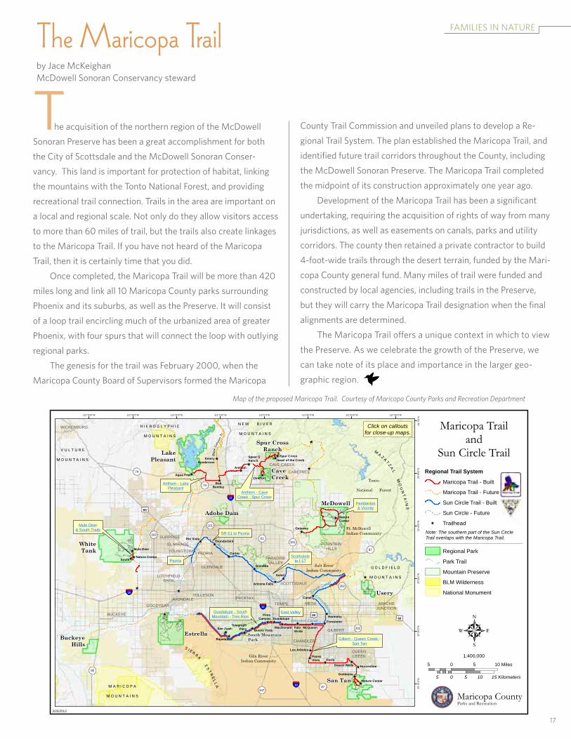
the acquisition of the northern region of the Mcdowell sonoran Preserve has been a great accomplishment for both the city of scottsdale and the Mcdowell sonoran conser-vancy. this land is important for protection of habitat, linking the mountains with the tonto national forest, and providing recreational trail connection. trails in the area are important on a local and regional scale. not only do they allow visitors access to more than 60 miles of trail, but the trails also create linkages to the Maricopa trail. if you have not heard of the Maricopa trail, then it is certainly time that you did. once completed, the Maricopa trail will be more than 420 miles long and link all 10 Maricopa county parks surrounding Phoenix and its suburbs, as well as the Preserve. it will consist of a loop trail encircling much of the urbanized area of greater Phoenix, with four spurs that will connect the loop with outlying regional parks. the genesis for the trail was february 2000, when the Maricopa county Board of supervisors formed the Maricopa
county trail commission and unveiled plans to develop a re-gional trail system. the plan established the Maricopa trail, and identified future trail corridors throughout the county, including the Mcdowell sonoran Preserve. the Maricopa trail completed the midpoint of its construction approximately one year ago.
development of the Maricopa trail has been a significant undertaking, requiring the acquisition of rights of way from many jurisdictions, as well as easements on canals, parks and utility corridors. the county then retained a private contractor to build 4-foot-wide trails through the desert terrain, funded by the Mari-copa county general fund. Many miles of trail were funded and constructed by local agencies, including trails in the Preserve, but they will carry the Maricopa trail designation when the final alignments are determined. the Maricopa trail offers a unique context in which to view the Preserve. as we celebrate the growth of the Preserve, we can take note of its place and importance in the larger geo-graphic region.
Map of the proposed Maricopa Trail. Courtesy of Maricopa County Parks and Recreation Department
18
Thank you to the Valley lexus dealers for their support of the Mcdowell sonoran conservancy! lexus believes that children have the potential, and the desire, to make the world a better place. to encourage children to pursue their dreams, lexus supports organizations like the Mcdowell sonoran conservancy that build, shape and improve children’s lives. Helping to make our community a better place, the focus of lexus de-sign efficiency is to build a vehicle that is exceptionally lean in its use of raw
A Better Tomorrow
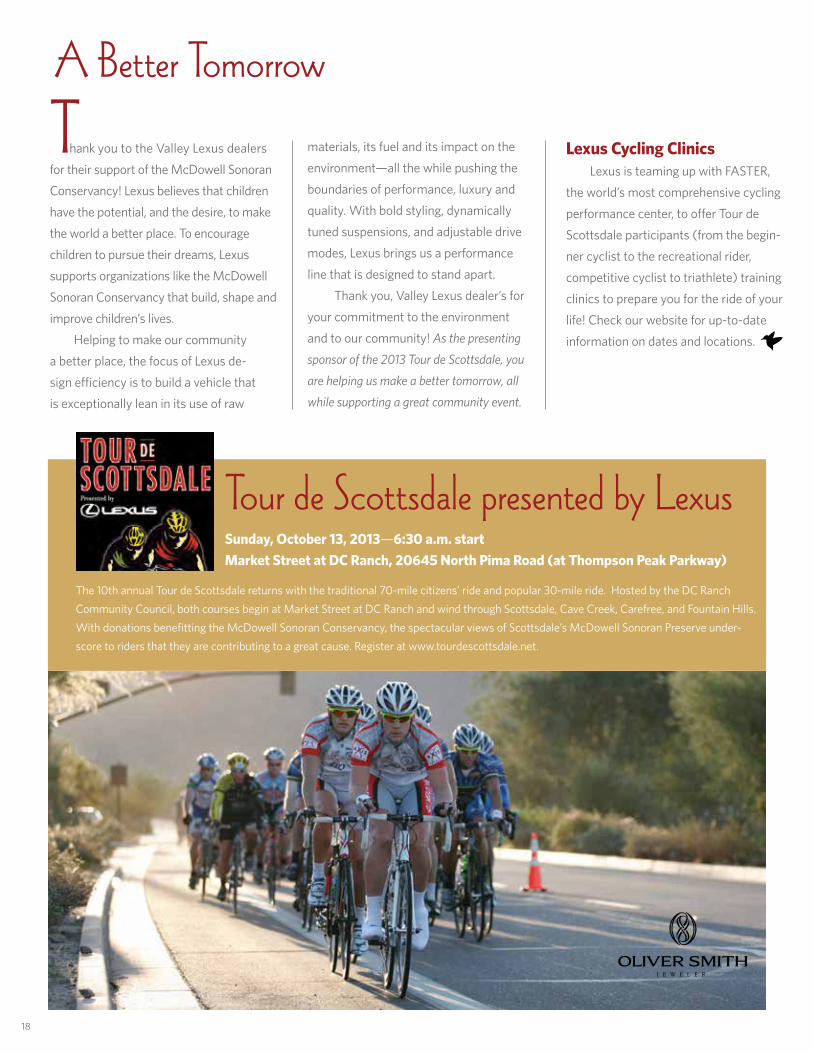
Tour de Scottsdale presented by LexusSunday, October 13, 2013—6:30 a.m. startMarket Street at DC Ranch, 20645 North Pima Road (at Thompson Peak Parkway)
materials, its fuel and its impact on the environment—all the while pushing the boundaries of performance, luxury and quality. with bold styling, dynamically tuned suspensions, and adjustable drive modes, lexus brings us a performance line that is designed to stand apart. thank you, Valley lexus dealer’s for your commitment to the environment and to our community! As the presenting
sponsor of the 2013 Tour de Scottsdale, you
are helping us make a better tomorrow, all
while supporting a great community event.
Lexus Cycling Clinics lexus is teaming up with faster, the world’s most comprehensive cycling performance center, to offer tour de scottsdale participants (from the begin-ner cyclist to the recreational rider, competitive cyclist to triathlete) training clinics to prepare you for the ride of your life! check our website for up-to-date information on dates and locations.
the 10th annual tour de scottsdale returns with the traditional 70-mile citizens’ ride and popular 30-mile ride. Hosted by the dc ranch community council, both courses begin at Market street at dc ranch and wind through scottsdale, cave creek, carefree, and fountain Hills. with donations benefitting the Mcdowell sonoran conservancy, the spectacular views of scottsdale’s Mcdowell sonoran Preserve under-score to riders that they are contributing to a great cause. register at www.tourdescottsdale.net.
PeoPle PreserVinG natUre
credit card #____________________________________________________expiration date: ______________________
name as it appears on the card _________________________________________________________________________
name(s) by which you would like to be acknowledged ____________________________________________________
address _______________________________________________________ email ________________________________
__________________________________________________________ Phone ____________________________________
the Mcdowell sonoran conservancy champions the sustainability of the Mcdowell sonoran Preserve for the benefit of this and future generations. our mission is a promise to our children, and theirs – to protect and promote the Mcdowell sonoran Preserve so that it will flourish for years to come. Help us keep our promise to the future and return this form with your gift today.
Mail to: McDowell Sonoran Conservancy • 16435 N. Scottsdale Rd. • Suite 110 • Scottsdale, AZ 85254
Mcdowell sonoran society ($1,500+)steward circle ($1,000) trailbuilder circle ($500) caretaker circle ($250) Pathfinder circle ($100) Hiker circle ($50) other________________________
Please charge my credit card a check is enclosed
i would prefer that my gift remain anonymous
Join Our Circle of Friends
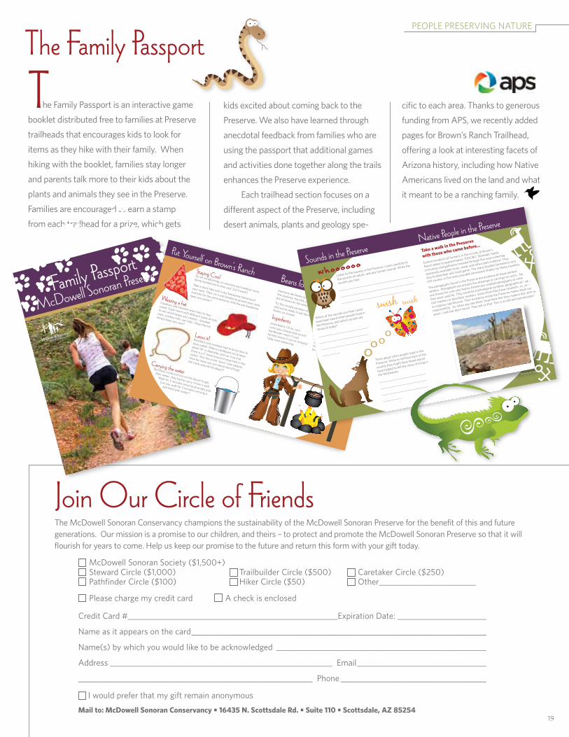
T he family Passport is an interactive game booklet distributed free to families at Preserve trailheads that encourages kids to look for items as they hike with their family. when hiking with the booklet, families stay longer and parents talk more to their kids about the plants and animals they see in the Preserve. families are encouraged to earn a stamp from each trailhead for a prize, which gets
kids excited about coming back to the Preserve. we also have learned through anecdotal feedback from families who are using the passport that additional games and activities done together along the trails enhances the Preserve experience. each trailhead section focuses on a different aspect of the Preserve, including desert animals, plants and geology spe-
cific to each area. thanks to generous funding from aPs, we recently added pages for Brown’s ranch trailhead, offering a look at interesting facets of arizona history, including how native americans lived on the land and what it meant to be a ranching family.
The Family Passport
19
Family Passport
McDowell Sonoran PreservePut Yourself on Brown’s Ranch Beans for Everyone!
everyone ate beans on Brown’s ranch - the ranchers,
the cowboys, the kids, everyone! there was always a
pot of beans on the stove or on the campfire.
try this simple variation of the popular cowboy beans recipe,
and you’re ready to eat like everyone on the ranch! cowboy
beans, so simple!
Lasso it!ranchers and cowboys had to know how to
lasso cattle. Make a cardboard circle lasso
about 18” in diameter, and cut it so that
there is a 2” band around a large hole in the
center. toss the circle “lasso” over objects.
How far away can you stand and still get
the circle around the object?
Staying Coolno air conditioning, so ranchers and cowboys wore
damp bandannas to stay cool. did it work?
take a short hike with a dry bandanna tied around
your neck. then, tie a wet bandanna around your neck,
and hike for the same distance. did the wet bandanna
keep you cooler? Wearing a hatcowboys and ranchers wore hats to stay
cooler. experiment with different types of hats
to see which keeps you coolest - baseball
caps, cowboy hats, sun hats. does the hat
always keep you cool?
Carrying the water ranchers could not turn on the faucet to get
their water...they had to carry it from a well.
walk for 5 minutes carrying an empty pail.
can you walk for 5 minutes carrying a
pail filled with water?
Ingredientspinto beans (15 oz. can)corn (you choose how much)
hamburger meat (1 cup)tomato sauce (1 can or to taste)
1 pkg. taco seasoning.
…and thenBrown meat. drain. combine all ingredients in a pan and
simmer until heated through or you’re
ready to eat. serve over/with cornbread
for a yummy ranching treat!
Sounds in the Preserve Native People in the Preserve
think about when people lived in the
Preserve. write or tell how each of the
sounds they might have heard would
have helped to tell the story of living in
the Mcdowells.
_______________________________
_______________________________
_______________________________
____________
Take a walk in the Preserve
with those who came before…
earliest evidence of humans in the vicinity of Brown’s
ranch dates to approximately 7000 B.c. nomadic bands
of hunters and gatherers traveled through this area collecting
seasonally available fruits, seeds and other plant material. they
also hunted deer and small game. the many boulder formations and
cliff cavities in this area provided convenient shelter for these travelers.
the petroglyphs found in the Preserve are evidence of these earliest
settlers. Petroglyphs are ancient line drawings or carvings on rocks. no
one knows for sure why native americans created petroglyphs or what
they were used for. they could be mythological symbols, geographical maps,
trail markers or boundary markers. some think they have ritualistic, cultural
or religious significance. their existence inside the Preserve makes them our
responsibility. so, when you see them, treat them like their makers did, with re-
spect. look but don’t touch. they tell us that “this is an old and sacred place.”
swish swish
whoooooolisten to the sounds in the Preserve. listen carefully to
the sounds of nature, and any human sounds. write the
sounds you hear.
__________________________________________________
__________________________________________________
__________________________________________________
which of the sounds you hear could
have been heard when people lived in
the Preserve, and which sounds are
those of today?
_________________________________
_________________________________
_________________________________
____________
Photo by: M. Jensen

non-ProfitorGaniZation
U.s. PostaGe Paidscottsdale, aZPERMIT NO. 8O7
Family Fridays and Trailside Naturalist Station added at Brown’s Ranch Trailhead!
16435 north scottsdale roadsuite 110scottsdale, arizona 85254
Get the latest Mcdowell sonoran conservancy info at:
Squash = PMS 116 = 0/16/100/0Sage Green = PMS 5767 = 15/0/68/39Blue = PMS 294 = 100/58/0/21
for all those that love the family friday sunset series held the first friday of every month from november through april at the Gateway trailhead, we have great news! we are offering an additional program each month at the new Brown’s ranch trailhead, located at 30301 north alma school Parkway. on the third friday of every month from october through april, join us from 4:30 to about 5:30 p.m. to learn more about the sonoran desert and all that makes our home unique. Bring your family outdoors for some fresh air and a memorable family experience with the Mcdowell sonoran conservancy. if fridays won’t work for you, stop by the trailside naturalist station every saturday morning from 9:30 to 11:30. Volunteer experts answer questions and share items that al-low Preserve visitors to touch, hear and even taste things that will enhance their outdoor experience. for more information, check our website at mcdowellsonoran.org/freefamilyfun.
Conservancy Naturalist Judi Irons at the Gateway trailside station.Photo by: S. Dodd