maine state legislaturelldc.mainelegislature.org/open/rpts/js451_m25c68_1982.pdfcounties, cities,...
TRANSCRIPT

MAINE STATE LEGISLATURE
The following document is provided by the
LAW AND LEGISLATIVE DIGITAL LIBRARY
at the Maine State Law and Legislative Reference Library http://legislature.maine.gov/lawlib
Reproduced from scanned originals with text recognition applied (searchable text may contain some errors and/or omissions)

MAINE STATE ARCHIVES
COUNTIES, CITIES, TOWNS AND PLANTATIONS OF MAINE: A Handbook of Incorporations, Dissolutions and Boundary Changes
Prepared by
The Maine Historical Records Survey Project Division of Professional and Service Projects
Work Projects Administration
Portland, Maine The Maine Historical Records Survey Project
1940
Maine State Archives
Augusta, Maine

Published under Appropriation No. 04065.1

PREFACE
This Handbook, compiled in the 1930's from extant records and inventories by the Federal Historical Records Survey Project for Maine, contains in one vo1tune data that ~vou1d otherwise require time-cons tuning research.
The Title and Table of Contents are self-explanatory. Helpful to the researcher using the Handbook are the explanatory notes and the listing of abbreviations and symbols. A bibliography cites sources for detailed study. As stated in the first section, Jurisdictions, "the development of government in Maine can be more easily understood by considering the area as three separate geographical units: from St. Croix River to St. Georges River - Acadia; from St. Georges River to Kennebec River - Province of Maine." The second section, Early plantations and Towns, is an "incomplete list ... submitted as a basis for further research."
Editorial work in preparing the manuscript for publication was provided by Miss Susan o. Ostroff of the Maine State Archives staff who was responsible for critically reviewing the text and footnotes and furnishing statutory citations to legislative references which generally omitted them in the original manuscript. Other staff members that assisted in the publication project include Mrs. James A. White, Mrs. Ralph N. Sylvester and Miss Sylvia J. Sherman. The task of final editing of the publication was undertaken by Mrs. Peter A. Isaacson, Chairman of the Archives Advisory Board, and a former associate with the Federal Writers' Project in Maine.
The Handbook which is now offered in published form does not represent a completed work as of this time; and is issued by the Maine State Archives ~vith the expectation that further research will be undertaken to extend its coverage over the approximately forty years that separates the completion of the original manuscript and the present publication. A first step toward this goal has been taken with the replacement of the list Maine counties, cities, towns and plantations existent, July 1, 1940 by current data published in the 1980 Federal Census Report for Maine. The nature of the publication lends itself to the possibility of omissions or errors. Any such errors or omissions called to the attention of the Maine State Archives will be corrected in future revisions of the Handbook.
iii
Samuel S. Silsby, Jr. State Archivist


1.
II.
III.
IV.
V.
VI.
VII.
VIII.
IX.
X.
XI.
TABLE OF CONTENTS
Preface . . . . . . . ........... .
Abbreviations, Symbols and Explanatory Notes
Introduction
Jurisdictions
Early Plantations and Towns
Counties
Androscoggin County Aroostook County Cumberland County Franklin County Hancock County Kennebec County Knox County •• Lincoln County Oxford County . • Penobscot County Piscataquis County Sagadahoc County Somerset County . Waldo County Washington County . York County
Plantations
Districts
The Early Town of Madawaska
Towns .•
Cities
Towns, chronologically
Counties, Cities, Towns and Plantations Existent, 1980
Bi b liogr aphy
v
iii
vii
ix
1
9
21
23 25 27 29 31 33 37 39 43 45 49 51 53 57 59 61
63
111
115
125
197
201
211
219


An Ar B.K.P. B.P.P. C ch(s) compo E.B.K.P. ed. E.D. E.K.R. E.P .R. F H ibid. idem inc. intro. Ke Kn L M.D. n. N .B.K.P. N.B.P.P. N.D. N.P.C. N.W.P. no(s). o org. p., pp. passim Pe Pi Pref. pt. R Rev. ed. Sa So T T.S. vol(s). Wal Was W.B.K.P. W.E.L.S. W.K.R. W.P.R. Y
L_y.
ABBREVIATIONS, SYMBOLS AND EXPLANATORY NOTES
Abbreviations
Androscoggin County Aroostook County Bingham's Kennebec Purchase Bingham's Penobscot Purchase Cumberland County chapter(s) compiled by East of Bingham's Kennebec Purchase edited by, edition East Division East of Kennebec River East of Penobscot River Franklin County Hancock County in the same place the same incorporated introduction Kennebec County Knox County Lincoln County Middle Division note North of Bingham's Kennebec Purchase North of Bingham's Penobscot Purchase North Division North of Plymouth Claim North of Waldo Patent nt.nnber (s) Oxford County organized page, pages in various parts Penobscot County Piscataquis County preface part Range Revised edition Sagadahoc County Somerset County Township Ti tcomb' s Survey volt.nne(s) Waldo County Washington County West of Bingham's Kennebec Purchase West of east line of the state West of Kennebec River West of Penobscot River York County frCYd)C<(.L1 ku;;s cf 1\\.a<,>CtLh\...\.-,et:t~ (-t~( v. \,\d~cQ;it"_5
vii -t\Ic \('';\Ltf1\E- f\-'-U)\~-)

ABBREVIATIONS, SYMBOLS AND EXPLANATORY NOTES
Symbols
Secretary of State MSS, Record of Plantations, 4 vols.
Secretary of State MSS, Miscellaneous Records, 7 vols.
current
Explanatory Notes
All descriptions of area are designated according to present county boundaries.
Province Laws of Massachusetts are designated by chapter number only. All laws later than March 15, 1820 herein cited by chapter number only are Private and Special Laws of Maine. Massachusetts Resolves, prior to 1820, and Maine Public Laws and Resolves following that date, are fully cited.
viii

INTRODUCT ION
By DORRIS A. ISAACSON
Chairman, Archives Advisory Board
A significant body of work of enduring value in the study of the development of government in this Country was produced by the Historical Records Survey, a Federal Relief Program during the disastrous Depression years of the 1930's. In view of Maine's early settlement, important in the research usage of public records in the field is the substantive compilation on Maine's counties, cities, towns and plantations prepared by the Maine Historical Records Survey Project. Completed in 1940, this definitive Handbook encompassing incorporations, dissolutions and boundary changes is published for the first time by the Maine State Archives.
Some 40 years ago, the National Historical Records Survey brought together in integrated listings an enormous quantity of widely scattered public records, with legal and other source references and explanatory notes. Many of these public records had been abandoned to neglect and deterioration in attics, cellars and other nooks and crannies across the land, destined to be lost forever. At many levels, the Survey awakened public awareness of the importance of public records and the need for their preservation and protection. Not until after World War II however, did the states begin to formulate public records programs along the lines of those initiated by the National Archives which had been established in 1934. Maine's public records program got under way in the 1960's when the l02nd Legislature in 1965 enacted the Archives and Records Management Law, which established the institution of the Maine State Archives to carry out the pol icies and princi ples of an integrated public records system.
Since the Historical Records Survey of the 1930's was concerned with official documentation having legal characteristics, and was a source, rather than a resource, in 1936 the Survey program became a nation-wide independent unit as part of so-called Federal One which also included the cultural units of theatre, art, music and writers' projects. Initially, in 1935, the Historical Records Survey had begun under the Federal Writers Project to which the Survey "contributed heavily in the early research for the American Guide Series", according to The Dream and the Deal (1979), an account of the Federal Writers Project by its national editor, Jerre Mangione.
In 1939, the Emergency Relief Act initialed the Congressional death sentence of the Historical Records Survey as well as the cultural projects. Under new pressures in the changing political atmosphere created by the
ix

imminence of the Second World War, the Roosevelt Administration began to de-emphasize its Depression-oriented programs. The independent Historical Records Project, along with the writers, music, and art units were allowed to continue for a time under state sponsorship provided that the states paid twenty-five percent of the cost. They were finally phased out in the early 1940's.
In the aftermath, much valuable research material delineating the character of America and her people was left in limbo, notwithstanding the salvage efforts of the National Archives. For instance, the wealth of unpublished material from the Maine Writers Project was dumped into Casco Bay when no repository could be found.
Fortunately, the Maine His torical Records Survey survived and has been preserved, to become, through publication by the Maine State Archives, a valuable and useful legacy now and for future generations.
x

10 JURISDICT IONS


JURISDICTIONS
After more than 150 years of overlapping and discordant proprietorships and jurisdictions and another 150 years of established government, Maine today has 16 counties, 21 cities, 418 towns, 65 plantations, and hundreds of unsettled townships.
In the Colonial period there were but few towns and these were widely scattered. A number of counties under various jurisdictions flourished for short periods prior to 1716 when York County was enlarged to embrace the entire area of Maine. As the seat of any central government was generally distant and its jurisdiction uncertain, each early settlement organized its own individual form of government. l Later, in several instances the inhabitants called a meeting and elected town officers soon after the township had been laid out in lots by the proprietors or even by the General Court of Massachusetts. These local governments were known as plantations, towns, or townships, interchangeably, although the term "plantation" was also used to describe a single homestead, a province, or an entire colony.2 Because of the lack of extant records it is rarely possible to determine the date of organization or the exact bounds; neither is it possible to be certain that all such towns have been listed. There is also the difficulty of town names, the same area sometimes bearing three or four names. As commissioners from Massachusetts General Court gradually obtained the submission of inhabitants, the old towns were incorporated, beginning in November, 1652.
The development of government in Maine can be more easily understood by considering the area as three separate geographical units: from St. Croix River to St. Georges River - Acadia; from St. Georges River to Kennebec River - Duke of York's property; and between the Kennebec and Piscataqua Rivers- Province of Maine.
In the summer of 1604 a plantation was established in that part of New France which was later to become the State of Maine in the United States of America. 3 Three years later the English set up a town 200 miles farther west. 4 While neither of these settlements endured for more than 15 months, the existence of each gave to its nation a claim to territory in the New World.
lWilliam MacDonald, The Government of Maine (New York: MacMillan, 1902), pp. 53-54; John Fairfield Sly, Town Government in Massachusetts, 1620-1930 (Cambridge: Harvard University Press, 1930), pp. 39, 72n.
2Ibid., po 59. 3Relations des Jesuites ••• dans la Nouvelle-France, I (Quebec: A. Cote,
1858), 2, 37; Charles E. Swain, "Tercentenary of the Landing of De Monts at St. Croix Island"~ Collections of the Maine Historical Society, 3rd ser., II (1906),109.
4Sir Ferdinando Gorges, "A Briefe Narration", Collections of the Maine Historical Society, 1st ser., II (1847), 15-23; William D. Patterson, compo and ed., The Probate Records of Lincoln County, Maine, 1760-1800 (Portland Genealogical Society, 1895), p. ix.
3

The conflicting claims of Great Britain and France to the tract between the St. Croix and St, Georges Rivers ,,'ere not settled until 1713,1 with France holding possession by cession for periods aggregating more than half of the intervening years. 2 The uncertainty of ultimate possession retarded colonization and only a scattering of transient plantations appear to have exisced east of the St, Georges previous to 1713.
Distinctly different conditions affected colonization in the Sagadahoc territory between the St. Georges and Kennebec Rivers, With the exception of the more or less permanent plantations of Pemaquid and Honhegan, Indian warfare limited the spread of colonization previous to 1700 to two short periods - 1660 to 1676 and 1683 to 1688 0 p, fisheries port was set up at Pemaquid (Ne,v Harbor) by merchants of Bristol, England,3 and there was a colony of fishermen on Nonhegan Island probably earlier than 1618.4 Aldworth and Elbridge of Bristol secured the Pemaquid Patent, February 29, 1632.5
Sagadahoc territory, except Pemaquid plantat ~on, became part of Nova Scotia in 1621 by a grant to Sir William Alexander;o in 1636, the country bet\veen the Kennebec and St. Croix Rivers and as far north as the St. Lawrence River became the County of Canada} This countg came into tbe possession of the Duke of York, by purchase, in Harch 1665. Royal commissioners for the Duke of York's property then took jurisdiction, including the Pemaquid Patent, and, on September 5, 1665 erected the County of Cormvall of the Colony of New York; the seat of ~vernment was at Sheepscot, which the commissioners renamed New Dartmouth.9 Justices of the Peace having been appointed to govern in the three small plantations of New Dartmouth, Sagadahoc, and Pemaquid, the commissioners departed)O In 1672, the inhabitants of the plantations, no\V six in number, of Sagadahoc territory petitioned Massachusetts General Court to be taken under its wing of protection. 11 After the government of Ne\v York had fallen to the Dutch in 1673,12 Massachusetts General Court, for the first time claiming jurisdiction east of the Kennebec, sent a
lcyrus Eaton, Annals of the 'fown of Warren, in Knox County, Haine, 2nd ed. (Hallowell: Nasters, Smitb & Co.,1865), p. 33.
2Ibid., pp. 22-23. 3franklin B. Hough, comp., "Papers Relating to Pemiquid and Dependencies",
Collections of the Naine Historical Society, 1st ser., V (1857), 137. Hereafter cited as Hough, Papers.
4J • Wingate Thornton, "Ancient Pemaquid,~n Historical Review", Collections of the Naine Historical Society, 1st ser., V (1857), 163; Eaton, po 19.
5Thornton, V. 207 0
6Hough, Papers, V, 1-2. 7H. W. Richardson, "The Pemiquid Country under the Stuarts", Collections
of the Naine Historical Society, 1st ser., VIII (1881), 184. Hereafter cited as Richardson, Pemaguid.
8Thornton, V, 235; Hough, Papers, V, 5-6. 9Rev. David Cushman, "Ancient Settlement of Sheepscot", Collections of
the Naine Historical Society, 1st ser., IV (1856), 220-21. 10rI. W. Richardson, Introduction, York Deeds, I (1887-88), 62. Hereafter
cited as Richardson, Intro., I. 11 Ib id ., p 0 64 • 12Ib id.
4

commit tee who estab lished Devonshire County, July 22, 1674. 1 This included all the plantations of the territory except Ne\,;? Dartmouth, which was north of the line \,;?rlich Massachusetts claimed as its northern boundary,2 Constables were appointed in all settlements 0
3 i-Iajor Edmund Andros was commissioned Governor of the Sagadahoc territory, July 1, 1674; yet courts were held in the County of Devon in May of 1675 and 1676.4 Although the plantations of Devonshire were rased by the Indians, August 13 and 14, 1676,5 Massachusetts still held jurisdiction in September 1676 when a garrison was ordered for Devon County.6 Upon restoration of New York to England in 1674, a new patent for his property was taken out by the Duke of York.7 In September 1677, the New York Council issued an order that no settlement should be att~~pted in the Pemaquid region because of the danger from Indians. 8 The new fort at Pemaquid was used only as a trading post until November 1, 1683,9 when Cornwall County was again erected and settlement again encouraged o
lO The Duke of York became King James II; he issued an order, September 19, 1686, attaching the Province of Pemaquid to the new New England government ,11 but the settlers were driven out by the Indians in the summer of 168812 and there was no further settlement for 20 years. Sagadahoc territory, as Pemaquid Colony,13 came under the jurisdiction of the Province of Massachusetts Bay, October 7, 1691,14 and was part of York County from 1716 to 1760.
Between the Piscataqua and Kennebec Rivers colonization was also hampered by Indian warfare, but here the chief difficulty was overlapping jurisdictions. The Mason and Gorges Grant of August 10, 1622 extended from the Merrimac River to the Sagadahoc River and 60 miles inland o
15 It was divided, with the Piscataqua River as the dividing line, April 18, 163516
lJames Phinney Baxter, ed., "Baxter Manuscripts", Collections of the Maine Historical Society, 2nd ser., Documentary, IV (1889), 343-48. Hereafter cited as Baxter Manuscripts.
2Richardson, Intro., I, 64. 3Nathaniel B. Shurtleff, ed., Records of the Governor and Company of
the Massachusetts Bay in New England, V (Boston, 1853-54), 18-19. 4Thornton, V, 250. 5Rev • William Hubbard, The History of the Indian Wars in New England, ed.
Samuel G. Drake, rev. ed. (Roxbury, Mass.: W. E. Woodward, 1865), II, 146-65. 6Shurtleff, V; 105. 7Hough, Papers, V, 3. 8Ib id ., p. 18. 9Ibid.
10--Ibid., po 4. llFranklin B. Hough, M.D., "Pemaquid in its Relations to our Colonial
History", Collections of the Maine Historical Society, 1st ser., VII (1857), 158-59. Hereafter cited as Hough, Pemaguid.
l2H• W. Richardson, Preface, York Deeds, IV (1887-88), 8. Hereafter cited as Richardson, Pref., IV.
l3Rufus K. Sewall-:-"Popham' s Town of Fort St. George", Collections of the Maine Historical Society, 1st ser., VII (1876), 309-11.
14Hough, Pemaguid, VII, 160. l5Richardson, Intro., I, 35. l6Ibid., p. 40.
5

and the Gorges goverrunent was established as the Province of New Somersetshire in 1636. 1 Sir Ferdinando Gorges received a new royal charter, April 3, 1659, for his land extending 120 miles inland, to be called the Province of ['laine. 2 Kennebunk (Mousam) River became the eastern boundary of the Province of Maine in 1646; for the ProvincE' of Lygonia, extending from the Kennebunk to the Kennebec,3 erected its own goverrunent, March 27, 1646. 4 Hassachusetts established York County, November 20, 1652,5 and on the 22d, the Province of t>laine became part of Massachusetts by the submission of Governor Edward Godfrey;6 Lygonia Province submitted, July 14, 1658. 7 Royal commissioners for Nelv England on June 23, 1665, took over jurisdiction as far east as St. Georges River.8 They appointed Henry Joccelyn as President of the Province of Maine, \vhich was nmv again extended to the Kennebec River; this goverrunent endured from July 1665 to May 20, 1668 09 On the latter date Massachusetts again acquired jurisdiction with Yorkshire county goverrunent again active,lO Ferdinando Gorges the Younger cleared his title as proprietor of the Province of Maine July 20,1677,11 which i'lassachusetts purchased March 13,1678,12 Magistrates were appointed for York County in May 16790 13 On March 18, 1680, a provincial goverrunent was established with Massachusetts deputy governor, Thomas Danforth, as President. 14 Although the MassachClsettc, charter of 1629 \Vas annulled in 1684,15 the Danforth goverrunent endured until May, 1686. 16
Sir Edmond Andros was Governor of the Dominion of Nev] England, extending to the SL Croix, for the period of its existence from December 19,1686 until April 18, 1689 017 The Danforth goverrunent was restored upon the downfall of
lWilliam WilliS, ed., "The Hi.story of Portland from its First Settlement", Collections of the Maine Historical Society, 1st ser., I (Portland, 1831), 83. Hereafter cited as Willis, Portland.
2Richardson, Intro., I, 43. 3Charles Edlvard Banks, M.D., "Colonel i\lexander Rigby", Haine Historical
and Genealogical Records, II (1885), 65. 4Richardson, Intro., I, 48-49. 5Ebenezer Hazard, ed., Historical Collections; consisting of State Papers,
I (Philadelphia: T. Hobson, 1792-94), 573-74. 6Baxter 1'-lanuscripts, IV, 62.
7Shurtleff, III, 338; IV, pc. 1, p. 359. 8Richardson, Intro., I, 62. 9Baxter Manus~s, IV, 300, 314.
lOIbid., ppo 301-02. llMary Francis Farnham, comp., "The Farnham Papers", Collections of the
Maine Historical Society, 2nd ser., Documentary, VII (1901), 334. Hereafter cited as Farnham Papers.
l2H. W. Richardson, Preface, York Deeds, III (1887-88), 9. Hereafter cited as Richardson, Pref., III.
13Idem. --
l4~er Manuscripts, IV, 391. l5Richardson, Intro., I, 67. l6James Phinney Baxter, ed., Early Records, Maine Historical Society Library
HS., IV, 403. Hereafter cited as-Baxter Papers. l7Richardson, Intro., I, 69; Richardson, Pref., IV, 6-7.
6
Andros;l the eastern settlements having been rased by Indians, there were only three towns in this jurisdiction in 1692, when the province and the territory to the east came under the direct rule of the Province of Massachusetts under its new charter.
Georgetown, the first Massachusetts town east of the Kennebec, was incorporated in 1716. St. Georges, 30 miles farther east, was a plantation as early as 1700. From 1718 to 1720, a number of plantations and towns were settled on the lower Kennebec and on all shores of Merrymeeting Bay, but in July, 1722, these settlements, as well as Georgetown, were destroyed by Indians.
At this time, Nova Scotia claimed all territory east of St. Georges River. Colonel David Dunbar, Surveyor of His Majesty's Woods2 and Surveyor General of the Lands of Nova Scotia,3 arrived at Pemaquid October 20, 1729, with 100 men and was closely followed by groups of sett1ers.4 Colonel Dunbar, having a royal instruction to set off 200,000 acres, in the province of Nova Scotia, of land bearing timber for the use of the Royal Navy,S attempted to set up a separate government for himself to be known as the Province of Georgia,6 He gave the name Fredericksburg to the fort area of Pemaquid7 and established five other towns.8 Although Colonel Dunbar claimed that Nova Scotia extended to the Kennebec,9 upon petition of the Muscongus Proprietors he was ordered August 10, 1732 to quit possession.10
As an act of possession, Governor Thomas Pownall in 1759, buried on the east side of Penobscot River, 3 miles above marine navigation, a leaden plate \vith the inscription: "May 23, 1759. Province of Massachusetts Bay, Penobscot, dominions of Great Britain. Possession confirmed by Thomas Pmvna11, Governor." 11 From this time, the English began settling along the Penobscot and, more gradually, to the east, During the Revolutionary War, tmvns at the mouth of the river were occupied by the British.1 2
In 1780, the Province of Maine became the District of Maine in the Commonwealth of Massachusetts)3 The northern boundary, which had been fixed
of VI
1 Baxter Manuscripts, IX, 23. 2 Ib id ., X, 449. 3--
Ib id ., p. 451. 4--Ibid., pp.458-59. 5--Ib id ., p. 452. 6--Ibid., p. 440. 7--Ib id., p. 459. 8--Ib id ., XI, 184. 9--
10 Ibid., X, 451-56. Ibid., XI, 163.
11 Joseph Williamson, "Governor Pownall's Certificate Taking Possession the Penobscot", Collections of the Maine Historical Society, 1st ser., ( \&,5 9), 336. l/Eaton, pp. 188-90.
Farnham Papers, VIII, 66-68.
7
in 1692 3S 120 miles north of the mouth of t.hc PisC:1t3qua in the arca \Vcst of the Kennebec River and at St, Lmvrence River east of the Kennebec, \Vas fixed at "the Highlands" and the eastern boundary at St 0 Croix River by the treaty of peace bet\veen Great Britain and the United States September 2, 17830 1 From August 1814 to April 1815, during the War of 1812, the British occupied Belfast and Ivlachias, and set up a provincial government bet\vE'('n the Penobscot and St. Croix Rivers \vith Castine as a port of entry.2 Eastport was held by the Britisll from July 11, 1814 to June 30, 1818. 3
~Iaine became a state Narch 15, 18204 and its northeastern boundary \Vas established by the Treaty of Washington August 9, 1842,5
1 Richardson, Intro., I, 73-7/+ 0
~ HacDona1d, p~ j Massachusetts Resolves, 1819, ch, 21l. 4 j\lassachusetts La\vs, 1819, ch, 36, 5 L'Abbe Thomas f\lbert, Histoire du ~lada\vaska (Quebec, 1920), po 2220
8

110 EARLY PLANTATIONS PND TOWNS
This incomplete list is submitted as a basis for further research. Analysis has been made of only the more probable sources o The ancient use of the term "plantation" to describe either a homestead or a form of local government has complicated the situation, making it generally impossible to determine the exact status. There seems to be no published information of the form of government or dates of the early French settlements at Machias, the Lamoine area, Mount Desert, Naskeag, and at the mouth of Sto Georges Rivero Although most records were lost in the English towns destroyed by Indians, it is hoped that future inventories of town records will locate records of the meetings of some of these early towns and establish the date of organization in most cases o


ftB.AGADASSET
ACOt-1ENTICUS
AUGUSTA
BLACK POYNT
BLUE POINT
BROAD BAY
BRUNSWICK
On the west side of Kennebec River and 4 miles inland. Existent as a plantation Apr, 10, 1684;1 destroyed by Indians Sept, 1688,2
Existent as a plantation Har. 25, 1636,3 Apr, 10, 1641.4 Incorporated as a city, Apr, 10, 1641, with mayor and eight aldermen;5 name changed to Gorgeana by the second city charter, which provided for a mayor and twelve aldermen, Mar, 1, 1642. 6
At Small Point Harbor, possibly confined to the east shore of Casco Bay. Laid out by Pejepscot Proprietors May 24, 1716,7 First town meeting Nov. 6, 1717;8 settlement destroyed before Aug, 13, 1721.9
Existent, probably as a plantation, Mar, 25, 1636;10 June 25, 1640,11 Was one of the two towns which in 1658 were incorporated as Scarborough.l 2
Existent, 1646,13 Was one of the two towns \vhich in 1658 were incorporated as Scarborough,12
A plantation existent as early as May 20, 1721 and until incorporated as Wa1doborough,14
Had a town road, Dec. 2, 1718. 15 Was a town in the Pejepscot tract, Dec. 31, 1719,16 still a town July 8, 1729, 17
1York Deeds, XV, 241. 2Baxter Manuscripts, VI, 446-47, 3Maine Historical Society, Province and Court Records of Maine, I
(Portland, 1928-31), 1, Hereafter cited as Province and Court Records, 4York Deeds, VI, 74. 5Hazard, I, 470-74. 6Ibid" pp. 480-86. 7Henry Warren Wheeler, "Ancient Augusta", Collections and Proceedings
of the Maine Historical Society, 2nd ser., III (1892), 235, 8Ibid., p. 236, 9Ibid., p. 238. 1~ vKichardson, Intro., I, 42. llprovince and Court Records, I, 42, l2Shurtleff, IV, pt. 1, p. 359. 13wil1is, Portland, I, 95-97. l4York Deeds, XII, 182, 183; "A Moravian Colony in Maine", Collections
and Proceedings of the Maine Historical Society, 2nd ser., II (1891), 333; Baxter Manuscripts, XI, 269; Patterson, pp. 29, 52.
15York Deeds, IX, 258. l6tbid., XVIII, 543. l7Ibid., XIII, 279, 280.
11

CAPE PORPUS Exis tent, 164601
CAPENAWAGEN Existent, Nay 1672;2 \vas a plantation, Oct. 1673;3 destroyed, August 1676.4
CASCO Was a plantation, June 25, 1640.5 A confederacy government \Vas established, Oct. 21, 1645.6 Was one of the t\Vo to\Vns \Vhich in 1658 \Vere incorporated as Fa1mouth,7
CORK On the southern side of Eastern River. Existent as a plantation, 1720. 8 Rased by Indians, 1722.9
DAHARISCOTTA This was an occasional name for ancient Sheepscot. The plant ati on, \Vhich bore the rame from Oc t. 1730, \Vas kno\Vn as Sheepscot in 1751. 0 After the incorporation of Sheepscot Plantation as Ne\Vcast1e, June 19, 1753 a ne\V plantation of Damariscotta \vas existent, 1758 and Nar. 13, 1778.ll
DAl'lARISCOVE or Darneri11s Cove
A settlement in 1622;12 had a local government about 1630.13 Existent, May 1672;14 \Vas a plantation May 27, 1674;15 \Vas deserted in August 1676.16 Was included \Vithin the bounds of the to\Vn of New Dartmouth, Sept. 18, 1686.17
1Wi11is, Portland, I, 95-97. 2Richardson, Intro., I, 64. 3John Noble, Records of the Court of Assistants of the Colony of the
Massachusetts Bay. 1630-1692, I, II (Boston, 1901-28). 4Hubbard, II, 164. 5Province and Court Records, I, 42. 6 I bid., I, 189. 7--Shurtleff, IV, pt. I, p. 359. 8Henry O. Thayer, "The Transient Town of Cork", Collections and
Proceedings of the Maine Historical Society, 2nd ser., III (1893), 245-46. 9William Willis, "The Scotch-·lrish Immigration to Maine, and Presby
terianism in New England", Collections of the Maine Historical Society, 1st ser., VI (1831), 15. Hereafter cited as Willis, Scotch-Irish.
10York Deeds, passim.; Mass. La\Vs, 1751, ch. 10. llBaxter Manuscripts, XV, 438,. l2William Durkee Williamson, Ihe History of the State of Maine, I
(Hallo\Vell: Glazier, Masters & Co., 1832), ,56. l3Willis, Portland, I, 37; Noble, II,' 27. l4Richardson, Intro., I, 64. l5Shurtleff, V, 17. 16 Hub bard, II, 164. l7York Deeds, IX, 229-30.
12

FORT S'1'o GEORGE
FRlNKFORT
FREDERICKSBURG
FREDERICKSPORT
GORGK,NA
GREENU.ND
HARRINGTON
HARWICH
HYPPOCRAS
- Popham - Was the first English tmvn in Ne\v England, its government inaugurated, ,'lug, 19, 1607, \vith a council of a president and five assistants, \vhich endured until about Oct. 8, 1608,1
A plantation organized in 1752 by Proprietors of Kennebec Purchase,2
- Pemaquid - A tmvn established by Colonel Dunbar, Oc t ., 1729. 3
- Ne\v Harbor - A town established by Colonel Dunbar, Oc t ., 1 72 9 , 4
Name given to the city of i\comenticus, Nar. 1, 1642. 5
Incorporated as tmvn of York, Nov. 22, 1652.
Near Round Pond Falls. "ire going to settle said Township", l\pr. 17, 1718. (See also ~lary Tmvn)
One of the towns es tab lished by David Dunbar, 1730-1732. 7 The name, and presumably its government,8 endured until it was incorporated as Bristol, June 21, 1765. 9
A town ,vest of the Kennebec River and adjoining Winegants on a neck between Wisswell's Cove and the river,lO existent, June 24, 1685. 11 This may be the same area or may overlap that of Augusta, Kennebecke or Northampton.
J\ locality in Boothbay Harbor. 12 Taxed ",ith Damerill' s C ave, 16 74. 13
1corges, II, 20-24; Patterson, p. xi. 2charles E, Allen, "Huguenots in Dresden", Collections and Proceedings
of the Maine Historical Society, 2nd ser., III (1892), 355, 360. 3Baxter Hanuscripts, X, 456. 4York Deeds, XVI, 56. 5Hazard, I, 480-86. 6York Deeds, XI, 195. 7Baxter Hanuscripts, XI, 184. 8William M. Sargent, camp. and ed., Maine Wills, 1640-1760 (Portland:
Brown Thurston, 1887), 556; Baxter Hanuscripts, XXIV, 37, 69-70. 9Hass • Laws, 1765, ch. 8.
10Baxter Hanuscripts, VI, 393. 11Baxter Papers, IV, 49. 12Thornton, V, 250 n. 13Shurtleff, V, 20.
13

JANESTOWN
KENNEBECKE
KITTERY
MARY TOWN
NEDUNCOOK
HONHEGAN
A town 1677.1 1686.2
1689.4
of Cornwall County. Named Pemaquid prior to New Harbor \Vas part of Jamestown, Aug. 5, Town tax dated Oct. 14, 1687.3 Burned, Augus t,
First meeting, apparently as plantation, held Nay 23, 1654.5 At that time it apparently included Sagadahoc (Parker's) Island and also the west shore of Kennebec River south of Winnegance. 6 It was limited to the west side of Kennebec River, Sept. 8,1665.7 Was a tmvn Nov. 7,1665,8 part of Devonshire County, 1674;9 almost totally destroyed by Indians, 1689. 10
Declared to be a town, Oct. 16, 1649. 11
(See also Piscataqua)
Formerly called Muscongus, extended from Round Pond Falls to Pemaquid River. Called Greenland, Apr. 17, 1718. 12 A tmvn, July 7, 1719,13 existent, Aug. 29, 1721. 14
(See also Somerset)
15 A plantation existent, Mar. 10, 1757.
A plapgation existent, 1618; 16 existent, l62l;17~~stent, 1630. Paid largest tax in Devon County, 1674. Was the refl~f of all settlers of Pemaquid territory, Sept. 1676.
4zichardson, Intro., I, 64. 2York Deeds, XVI, 254. 3"Taxes Under Governor Andros", New England Historical and Genealogical
Register, XXXII (1878), 312-17. 4Richardson, Pref., IV, 8. 5Hazard, I, 5~ 6Idem.; York Deeds, IX, 190. 7~ince and Court Records, I, 244. 8Ibid., p. 239. 9Shurtleff, V, 20.
10Gen. Joseph Sewell, "History of Bath", Collections of the Maine Historical Society, 1st ser., II (1876), 195-96.
IIprovince and Court Records, I, 244. 12 . York Deeds, XI, 195. l3 Ibid., IX, 249-50. 14--
Ib id ., X, 207. l5Baxter Nanuscripts, XXIV, 73. l6Richardson, Intra., I, 30. 17Rufus K. Sewall, Ancient Dominions of Maine, p. 104. l8Wi1lis, Portland, I, 37. 19Shurt1eff, V, 20. 20Hubbard, II, 164.
14

NOUNSWEIG
NUSCONGUS
NEGUASSET
NEW CASTLE
NEW DARHIOUTH
NEW HARBOR
NEW MERRYMEETING
A plantation existent, April 1747.1 (See also Neguasset)
A plantation, existent bet1;veen 1652 and 1670. 2 Existent, about 8 miles north of Pemaquid, Sept. 1718;3 alias Nary c1mvn , Dec. 23, 1720. 4
(See also Greenland; Mary Town; Somerset)
Hammond's fort burned by Indians, Aug. 13, 1676. 5 A 6 settlement existent, May 30, 1721.
(See also Mounsweig)
A plantation existent, Mar. 26, 1719;7 alias Sheepscott, formerly called New Dartmouth, July 26, 1736. 8
Plantation name of Sheepscot changed to New Dartmouth in 1665 when it became the seat of Cornwall County.9 Town orgarbzation, by article of agreement, effective JYtY 4, 1683. Included Damerill's Cove, Sept. 18, 1686. Destroyed by Indians, Sept. 25, 1688. 12
A plantation, 1625 by the Indians .14 Cornwall County.15 Oct. 8,1729. 16
to Aug. 1676,13 when it was burned Was called Newtmvn in Jamestmvn in
Became town of Fredericksport,
At Hutchinson's or lhwing's Point, 1 1/3 miles below Swan Island on east side of the Kennebec and extending 2 miles into country. Surveyed, Nov. 13, 1669,17 destroyed by Indians, Sept. 1688. 18 A new plantation existent in 1719 and 1720; rased in 1722. 19
(See also Cork)
lBaxter Manuscripts, XI, 361. 2York Deeds, XII, 323. 3Ibid., XI, 200. 4--
Ib id ., XVII,S. 5Hubbard, II, 157-59. 6York Deeds, X, 188. lIbid., XII, 321-22. 8-'-Ib~d., XVIII, 183-84.
9Richardson, Intro., I, 62. 10Hough, Papers, V, 48-58. 11York Deeds, IX, 229-30. 12Baxter Manuscripts, VI, 447. 13Willis, Portland, I, 36. 14Hubbard, II, 165. 15York Deeds, XVI, 254. 16Ibid., XVI, 56. 17 Ibid., XV, 152. l~er Manuscripts, VI, 446. 19Wi l1is, Scotch-Irish, VI, 14-16.
15

NEW TOWNE
NORTH YARHOUTH
NORTHMlPTON
PAGISCOTf) POGYPSCOTT) PEJEPSCOT
RICHMOND'S ISLAND
A plantation on ,\rrmlsic Island existent, Oct. 22) 1684;1 in Cormva11 County Aug. 5, 1686. 2 Included Sacadahoc
3 Great Island, Feb. 22, 1716.
This is probably the tmvn of Cascoe Bay of !'-lar. 12, 1678. 4
Formerly Westcustogo, \Vas made a plantation and land annexed by tlH~ Danforth government, Sept. 22, 1680. 5
Had selectmen, July 13, 1681. 6 Given full town privileges, June 27, 1683. 7 Deserted in Aug. 1688 and for 19 years there \Vas no sett1ement. 8 Was a tmvn Nov. 14, 1718. 9
Selectmen gave a deed, July 18, 1721. iO Was knmvn as a township, Feb. 8, 1728. 11
(See also Westcustogo)
A tmvn, probably another name for Kennebecke or Augusta, Oc t. 1, 1667 .12
Plantation existent, Har. 25,1636. 13 Existent, ]vIai' 22, 1639. 14 Military officer appointed, July 18, 1665. 5 Destroyed, Sept. 1688. 16 Forty families from Ireland settled at Pejepscot on south shore of i'lerrymeeting Bay in 1718; were driven into garrison, July 1722.17
A plantation, July 30, 1632. 18 Was included in Spunvink plantation, i'lar. 25, 1636. 19
1 Hough, Papers, V, 106. 2York Deeds, XIV, 81. 3 Ibid ., IX, 156-57. 4--
Ib id ., I I I, 53. 5Echvard Russell, "History of North Yarmouth", Collections of the Maine
Historical Society, 1st ser., VIII (1881), 172-73; Richardson, Pref., III, 10. 6Russe11, II, 172-73. 7Baxter Papers, IV, 28, 156. 8Russe11, II, 174. 9York Deeds, X, 219.
10Ibid., XI, 225. 11--
Ib id ., XII, 249. l~ince and Court Records, I, 328. 13Richardson, Intra., I, 42. l~arnham Papers, VII, 243. 15province and Court Records, I, 226. 16Baxter Manuscripts, VI, 446. 1 7Ib id ., X, 163 - 64 . 18James Phinney Baxter, ed., "Tre1mvny Papers", Collections of the Maine
Historical Society, 2nd ser., Documentary, III (1884), 17. Hereafter cited as Tre1awney Papers, III
19province and Court Records, I, 2.
16

SACO Was existent as a town, Mar. 21, 1636,1 in the county of Surrey, 1643. 2 Was to\vn of Saco, I-lar. 28, 1718;3 incorporated as Biddeford later in the same year. (See also Winter Harbor)
SAGADEHOCK On Parker's Island. Sett1e~ent made in 1618;4 was a plantation soon after 1648. Existent as a plantation, Sept. 5,1665. 6 Taxed ,,.lith Kennebec by Devon County, 1674.7 Settlers fled to Damariscove, Aug. 1676. 8 Existent as a plantation, Oct. 22, 1684. 9 Its people all at garrison
i May 1689;10 destruction by Indians~
July 29, 1689. 1 Was again active, July 25, 1718;lL annexed to the town of Georgetown in 1738.
ST. CROIX ISLAND
Was a French plantation from June (about the 26th) to August 1605. 13 Reoccupied the winter of 1611-1612, destroyed by the English, Nov. 1613. 14
ST. GEORGES There was a French settlement at the mouth of St. Georges River in 1686. 15
ST. GEORGES There was redoubt and battery there, Jan. 10, 1700.16 A plantation of 84 families in 1701.17 The proprietors gave the truck house to Massachusetts General Court in 1722. 18 The plantation was existent, June 12, 1734. 19
There was a garrison there, 1743 and 1748. 20
1Wi11is, Portland, I, 83. 2Richardson, Pref., III, 12. 3York Deeds, ~28. 4Richardson, Pref., III, 12. 5 --York Deeds, XI, 28. 6Province and Court Records, I, 246. 7Shurt1eff, V, 20. 8Hubb ard, II, 164. 9Hough, Papers, V, 106.
10Baxter Manuscripts, VI, 481. llIbid., IX, 25. 12~ Deeds, XV, 135. 13Swain, II, 109, 120. 14Richardson, Intro., I, 25. 15Baxter Manuscripts, IV, 428. 16 Ib id ., IX , 87. 11Richardson, Pemaguid, VIII, 185. 18Bax.ter Manuscripts, XI, 159-60. 19York Deeds, XVI, 150. 20Wi11iam Douglass, M.D., A Summary Historical and political of the first
Planting. Progressive Improvements. and Present State of the British Settlements in North America, I (Boston: Rogers and Towle, 1749), 25.
17

ST. SAUVEUR
SHEEPSCOTT
SO.tv1ERSET
SOMERSETT
SPURWINK
SWAN ISLAND
A French plantation on rlount Desert Island from ~1ay to Sept emb er 1613.1
A plantation of 50 families in 1630.2 Plantation name changed to New Dartmouth in 1665.3 Plantation meeting of Sheepscot, Sept. 17, 1666.4 Settlers fled to Damariscove, August 1676.5 The ,vest side of Damariscotta River was in the town of Sheepscot in 1684.6 Destroyed by Indians, Sept. 25, 1688 J Existent as plantation of New Castle, Nar. 26, 1719.8 Sheepscot plantation existent, Nar. 23,1744,9 and in April, 1747.10
(See also New Castle; New Dartmouth)
A towns hip at Muscongus exis tent, Sept. 30, 173411 and Jan. 19, 1736.12 Possibly one of the 6 towns established by Colonel Dunbar. (See also Nary Town; Nuscongus)
A plantation at the mouth of Cathance River on the north shore of Nerrymeeting Bay; destroyed by Indians, Sept. 20, 1688.1 3 A plantation s ett led in 1720 was ras ed in 1722.14
A plantation of 2000 acres, July 21,1632.15 Included Richmond's Island, Nar. 25, 1636.16 Was part of the Province of Lygonia, 1646.17 Was one of the two towns which in 1658 were incorporated as Falmouth.18
In Kennebec River. A plantation in 1720.19
1 Richardson, Intro., I, 25. 2Cushman, IV, 218. 3 Richardson, Intro., I, 62. 4province and~t Records, I, 256. 5 Hub bard, I I , 164. 6 York Deeds, XVI, 112. 7Baxter Nanuscripts, VI, 447. 8 York Deeds, XVI, 112. 9Sargent, p. 556.
10Baxter Manuscripts, XI, 361. 11York Deeds, XVII, 1. 12 Ibid., XVIII, 226-27. 13~er Nanuscripts, VI, 446. 14Massachusetts Archives, XXIX, 57-63; Willis, Scotch-Irish, VI, 15. 15 Province and Court Records, I, 58-60/ 16 Ib id ., I, 2. 17 Wi1lis, Portland, I, 95-97. 18 Shurt1eff, IV, pt. 1, p. 359. 19Massachusetts Archives, XXIX, 57-63.
18

TOPSHAN 1 Had a tmvQ clerk, Sept. 23,1719. Was a tmvnsilip, ')
Apr. 6, 1737.~
TOWNSEND A plantation existent, Har. 25, 1758 and July 19, 1764. 3 Incorporated as Boothbay in 1764.
WALPOLE One of the six towns organized by David Dunbar, was known as a district in 1744 and 1761.4 Incorporated as part of Bristol in 1765.
WELLS Was a town, Oct. 21, 1645 and July 6, 1646. 5
WESTCUSTOGO As plantation or town, submitted to Lygonia Province in 1648;6\vas a tmvn, Nov. 7,1665. 7 (See also North Yarmouth)
WINTER HARBOR A settlement, 1616-1617. 8 Was apparently an alternate name for the to,vn of Saco, June 14, 1662. 9
1York Deeds, XIII, 279. 2Ibid., XVIII, 441-42. 3Patterson, pp. 12-13. 4Ibid., pp. 2, 15. 5province and Court Records, I, 90-93. 6Wil1is, Portland, I, 99. 7Province and Court Records, I, 238. 8Richardson, Intro., I, p. 30. 9York Deeds, XVI, 70.
19


III. COUNTIES


ANDROSCOGGIN COUNTY
The establishment of Androscoggin County, effective Harch 18, 1854 (Public Laws, ch. 60), took from Cumberland County the towns of Auburn, Danville, Durham, Hinot and Poland; from Kennebec County the towns of East Livermore, Greene, Leeds and Wales; from Lincoln County the towns of Le\\lis ton, Lisbon and Webs t er; and from Oxford County the towns of Livermore and Turner.
All boundary changes have been of a minor nature. Land was set off from Leeds to Wayne in Kennebec County in 1859 (ch. 344); from Poland to Otisfield in Cumberland County in 1858 (ch. 220); and from Poland to Casco in Cumberland County in 1858 (ch. 222). All additions to the county area have been from Kennebec County; from Honrnouth to Wales in 1855 (ch. 526); from Litchfield to Wales in 1856 (ch. 592); and from Litchfield to Webster in 1867 (ch. 270). The parcel of land annexed to Webster was so small that it is imperceptible on the accompanying map.
The county has lost one town - Danville, which \\las annexed to Auburn in 1867 (chs. 316, 363); and has gained one town - Hechanic Falls, formed from parts of Hinot and Poland and incorporated, Harch 22, 1893 (ch. 550).
The name of East Livermore was changed to Livermore Falls in 1929 (ch. 47).
Androscoggin County now contains the cities of Auburn and Lewiston and the towns of Durham, Greene, Leeds, Lisbon, Livermore, Livermore Falls, Hechanic Falls, Hinot, Poland, Turner, Wales and Webster.
23


AROOSTOOK COUNTY
All of that part of the state lying north of the north line of the fourth range of townships north of the lottery to\vnships, and east of the dividing line between ranges five and six west of the east line of the state and of a line from l:lle north termination uf said dividing line and running the same course to the north line of the state was constituted a new county by the name of Aroostook,· Hay I, 1839 (Public Laws, ch. 395).
(i\C!.( (. h II St. John River became the northern boundary of both state and county
August 9, 1842. 1
All of the land north of townships, numbered eight in the sixth range, eight in the seventh range, and eight in the eighth range of townships west of the east line of the state, was annexed from Penobscot County, March 21, 1843 (Public Laws, ch. 15).
Aroostook County was extended to the \Vest line of the state, March 12, 1844 (Public Laws, ch. 99), by the annexation of territory from Piscataquis and Somerset Counties; and bounded on the south by a line beginning at the northwest corner of township number eight, in the eighth range of townships west from the east line of the state; thence north to a point due west from the northwest corner of township numbered ten in the seventh range of townships west from the east line of the state; thence west to the west line of the state.
A small tract was set off from the southwest corner of the town of Weston to Danforth in Washington County in 1885 (ch. 499).
All the land in Drew Plantation lying north of Mattawamkeag River was annexed from Penobscot County to Reed Plantation, March 5, 1889 (ch. 514); this land was returned to Drew Plantation, March 28, 1903 (ch. 364).
This large county includes the city of Presque Isle; the towns of Amity, Ashland, Bancroft, Benedicta, Blaine, Bridgewater, Caribou, Castle Hill, Chapman, Connor, Crystal, Dyer Brook, Eagle Lake, Easton, Fort Fairfield, Fort Kent, Frenchville, Grand Isle, Haynesville, Hersey, Hodgdon, Houlton, Island Falls, Limestone, Linneus, Littleton, Ludlow, Madawaska, Mapleton, Mars Hill, Masardis, Merrill, Monticello, New Limerick, New Sweden, Oakfiel d, Orient, Perham, Portage Lake, Saint Agatha, Sherman, Smyrna, Stockholm, Van Buren, Wade, Washburn, Westfield, Weston, and Woodland; the plantations of Allagash, Cary, Caswell, Cyr, E, Garfield, Glenwood, Hamlin, Hammond, Macwahoc, Moro, Nashville, New Canada, Oxbow, Reed, St. Francis, St. John, Silver Ridge, Wallagrass, Westmanland, and Winterville; and more than 100 unorganized townships.
lBurrage, p. 341.
25


CUl'IBERLAND COUNTY
York County \vas divided and the two ne\v counties of Cumberland and Lincoln \vere established in the eastern part, June 21, 1760 (ch. 7). Cumberland County was bounded on the west by a line to run from the sea northwesterly on the easterly line of Biddeford as far as Narragansett number one (Buxton), from thence northeasterly on said Narragansett to the easternmost corner thereof, from thence northwesterly on said Narragansett to the northernmost corner thereof, from thence southwesterly upon said Narragansett to Saco River, from thence up said Saco River as far as Pearsontown extends thereon, and from thence to run north two degrees west on a true course as far as the utmost northern limits of this province. The Cumberland-Lincoln county line extended from the eastern point of Casco Bay, from Small Point the line to run northwesterly upon Casco Bay to New Meadows River and up said river as far as Stevens' carrying place at the head of the river, thence across the carrying place to Merrymeeting Bay and Androscoggin River, thence up said Androscoggin River thirty miles; and from thence north two degrees west on a true course to the northern limits of the province.
Flintstown Plantation (Baldwin), which was crossed by the new CumberlandYork county line, was entirely annexed to Cumberland County March 3, 1786 (ch. 56).
The great northern portion of the county was set off to form part of Oxford County, Mar. 4, 1805 (ch. 70). The new northern boundary extended from the southeast corner of the town of Turner, on the southerly line of Turner to the northwest corner of Minot, thence southwesterly on the line between the towns of Minot and Hebron to the southwest corner of Hebron, thence northwesterly on the line between the towns of Hebron and Otisfield to the town of Norway, thence westerly and northerly on the line between the towns of Otisfield and Norway to the southeast corner of Waterford, thence westerly on the line between Waterford and Otisfield to the northeast corner of Bridgton, thence westerly on the northerly line of Bridgton to the northwest corner thereof, thence southerly on the westerly line of Bridgton to the southwest corner thereof, thence westerly on the north line of the town of Baldwin, and Prescott's Grant to Saco River, and thence down the middle of the river to the mouth of great Ossapee River.
In 1821, a gore was set off to the town of Norway in Oxford County (ch. 26), and a small tract in the northwest corner of Baldwin was set off to Hiram (ch. 47).
The town of Standish was considerably enlarged by the annexation of ten estates from the town of Buxton in York County, February 17, 1824 (ch. 276) .
Two changes in the Cumberland-Oxford county line were made in March 1830: a tract known as "the mile square" was annexed to the town of Sebago from the town of Denmark (ch. 94), and a small tract lying east of Thompson Pond was set off from Otisfield to the town of Oxford (ch. 115).
27

Cumberland County
A narrow strip was set off from the west line of Scarborough to the town of Saco in York County l'1arch 27,1841 (ch. 136).
A small tract on the east shore of r-Ioose Pond was annexed to Bridgton from Denmark in Oxford County in 1842 (ch. 10). In 1844, six lots ,vere set off from Baldwin to Hiram (ch. 156). In 1847, the town of Bridgton was enlarged in its northwestern corner by the annexation of land from the towns of Denmark and Fryeburg in Oxford County (ch. 84).
The tmvns of Auburn, Danville, Durham, Minot, and Poland were set off to form part of the new county of Androscoggin, l'1arch 31, 1854 (Pub lic Laws, ch. 60). In 1858, two very small tracts were annexed from the to,-Jn of Poland to Otisfield (ch. 220) and to Casco (ch. 222).
In 1891, Ragged Is land was annexed to Harps\vell from Phippsburg in Sagadahoc County (ch. 25). The setting off of islands to Phippsburg in 1903 (ch. 415) - repealed in 1905 (ch. 200) and again set off in 1917 (ch. 68) - was merely the establishment of definite town and county lines.
Cumberland County nmv contains the cities of Portland, South Portland, and Westbrook, and the towns of Baldwin, Bridgton, Brunswick, Cape Elizabeth, Casco, Cumberland, Falmouth, Freeport, Gorham, Gray, Harpswell, Harrison, Naples, New Gloucester, North Yarmouth, Otisfield, Pownal, Raymond, Scarborough, Sebago, Standish, Windham, and Yarmouth.
28

FRANKL IN COUNTY
The towns of Nel,v Sharon, Chesterville, Wilton, Temple, and Farmington in Kennebec County; the to,VilS of Jay, Carthage, Weld, Berlin, Hadrid, and the townships number six, Letter E, and D in Oxford County, thence extending northerly from the northwest corner of township D on the line between to\vnships numb ered three and four, through the several ranges of to\vnships to the Canada line, so as to include three tiers of townships west of the \Vest line of the Bingham Purchase in Oxford County; and the tOI,VilS of Industry, Nelv Vineyard, Strong, Avon, Phillips, Freeman, Salem, Kingfield, the townships numbered four in the first range west of Kingfield, three and four in the second range and the south half of township number four in the third range of the Bingham Purchase in Somerset County were grouped to form Franklin County, Nay 9, 1838 (Public Laws, ch. 328; II, 99-100 "H).
TIVO estates were set off from the town of New Vineyard to Anson in Somerset County, ?-larch 18, 1840 (ch. 75).
A small tract from the western corner of Nercer in Somerset County Ivas annexed to the town of Nelv Sharon, April 6, 1841 (ch. 148).
A piece of land, roughly V-shaped and approximating the area of one to\Vilship, was lost by Franklin County when the state boundary was changed by the Treaty of Washington in 1842. 1
Three lots were annexed to Chesterville from Vienna in Kennebec County in 1847 (ch. 93). An exact definition of the Chesterville-Vienna line was made, April 9, 1852 (ch. 566).
Franklin County includes the towns of Avon, Carthage, Chesterville, Eustis, FJrmington, Industry, Jay, Kingfield, r.ladrid, Nelv Sharon, New Vineyard, Phillips, Rangeley, Salem, Strong, Temple, Weld, and Wilton; the plantations of Coplin, Dallas, Rangeley, and Sandy River; and 18 unorganized tOlvnships.
lBurrage, p. 341.
29


HANCOCK COUNTY
Because of the great extent of its area the County of Lincoln \vas divided, June 25, 1789 by the establishment of the ne\v counties of Hancock and Wdshington (ch. 24). The more westerly, Hancock County, \Vas bounded on the west by the boundary line bet\veen the towns of Thomastown and Carnbden, thence running northwesterly by the east line of Thomastmvn, Warren, and Union, to the northeast corner of Union, thence north, 22~ degrees east, until it intersected the north line of the Waldo Patent, and thence north to the Highlands. The northern boundary followed that of the District of Maine. The easterly boundary was a line beginning at the northeast corner of Goldsborough and the southeast corner of Township Number Seven, thence running northerly by the east line of Number Seven, and by the east line of Number Ten, to the southeast corner of Township Number Sixteen, and thence due north to the Highlands.
Exactly one year later the to\vn of Carnbden and t'tlO half-townships were set off to Lincoln County (ch. 24).
Township Number Four in the first range north of the Waldo Patent, now the town of Troy, which had been crossed by the western line of Hancock County, was entirely set off to Kennebec County, February 28, 1799 (ch. 72): The \Vestern boundary was further adjusted by the annexation from Somerset County of Township Number Four in the fifth range north of the Waldo Patent (now Dexter) in 1811 (ch. 36); and Tmvnship Number Four in the sixth range (Sangerville) in 1812 (ch. 4); Tmvnship Number Four in the fourth range was set off to Somerset County in 1813 (ch. 85).
The northern part of Hancock County, lying north of the north line of Waldo Patent on the west side of Penobscot River; and on the east side of said river north of a line beginning at the river at the south\vest corner of Orrington and extending along the south side of Orrington, Brewer and the gore east of Bre\ver to the west line of Bingham's Penobscot Purchase, to the northwest corner thereof; thence easterly on the north line of the Purchase townships to the line of Washington County, was set off to form the ne\v county of Penobscot, April 1,1816 (ch. 121).
T\vo adjustments in this new northern boundary were made the same year: land was set off from Buckstmvn to Orrington (ch. 13), and one estate, from the town of Frankfort: was set off to Hampden (ch. 14).
All of Hancock County lying \Vest of Penobscot River and Bay was set off to form part of the new county of Waldo, July 3, 1827 (Public Laws, chs. 354, 362).
Three townships on the east boundary - number four, North Division, and numbers forty-one and thirty-five of the Middle Division - were annexed from Washington County in 1851 (ch. 154).
A strip 2 miles wide and 6 miles from east to west, lying north of township number two (Grand Falls Plantation) was set off to Burlington in Penobscot County in 1835 (ch. 559).
31

Hancock County
The town of Vinalhaven, which was made up of a group of islands in Penobscot Bay, was set off to Waldo County in 1838 (ch. 451).
Page's Mills Settlement, a strip 2 miles wide lying north of township number one, North Division, was set off to Lowell in Penobscot County, February 20,1841 (ch. 102). A tract was set off from Bucksport and Dedham to the town of Brewer, April 10, 1841 (ch. 161).
Matinicus Island was set off to Lincoln County in 1843 (ch. 118).
The Hancock-Washington line was altered, March 12, 1844, by extending the boundary from the northeast corner of Gou1dsborough southeasterly and southerly by the middle channel of Gou1dsborough Harbor to the ocean (Public Laws, ch. 99).
Land was set off from Bucksport to Orrington in Penobscot County in 1850 (ch. 376).
The remaining islands of the Matinicus group - Hacketosh, Wooden Ball, Nomans1and, Two Bush, Ten Pound, and Matinicus - were set off to Lincoln County in 1852 (ch. 578).
The town of Greenfield and townships number one and two of the North Division were set off to Penobscot County in 1858 (ch. 198).
The town of Isle au Haut was set off to Knox County, March 12, 1913 (ch.83).
The county of Hancock now contains the city of Ellsworth; the towns of Amherst, Aurora, Bar Harbor, B1uehi11, Brooklin, Brooksville, Bucksport, Castine, Cranberry Isles, Dedham, Deer Isle, Eastbrook, Franklin, Gouldsboro, Hancock, Lamoine, Mariavi11e, Mount Desert, Orland, Otis, Penobscot, Sedgewick, Sorrento, Southwest Harbor, Stonington, Sullivan, Surry, Swan's Island, Tremont, Trenton, Verona, Waltham, and Winter Harbor; the plantations of Long Island, Osborn, and Number Thirty-three; 14 townships and 21 islands classed as wild lands.
32

KENNEBEC COUNTY
Kennebec County was formed February 20, 1799 (ch. 56), from the northern part of Lincoln County. Its eastern boundary, formerly that of Lincoln County, extended from a point on the west line of Hancock County lying east southeast of the northeast corner of the town of Harlem, thence north 22~ degrees east to the north line of the Waldo Patent, thence north to the northern boundary of the District of Maine; the southern boundary extended from the first mentioned point by a line running west northwest to the northeasterly corner of the town of Harlem, thence running southwesterly by the easterly line of said town to the southeasterly corner thereof, thence westerly on a straight line to the northeasterly corner of Pittston, thence by the easterly line of said Pittston to the southeasterly corner thereof, thence westerly by the southerly line of said Pittston to the southwesterly corner of said town last mentioned, thence northwesterly by the westerly line of said Pittston to the mouth of Purgatory Stream (so called), which empties itself into Cobbesecontee Stream (so called), thence west northwest to the east line of the town of Monmouth, thence southerly by the east line of said Monmouth to the southeasterly corner thereof, thence westerly by the southerly line of said Monmouth to the westerly corner of said town, thence west to the easterly line of the town of Greene, thence southerly by the easterly line of said Greene to the southeasterly corner thereof, and thence westerly by the southerly line of said Greene to Androscoggin River; the west boundary was formed by Androscoggin River to the northeast corner of the town of Turner and from that point due north to the extreme northern boundary of Maine.
Township number four in the first range north of the Waldo Patent, now the town of Troy, which lay partly in Hancock County, was entirely annexed to Kennebec County, February 28,1799 (ch. 72).
By the act of incorporation of Oxford County in 1805 (ch. 70), the towns of Wilton, Temple, Avon and township number three on Sandy River (Phillips) were declared to be in Kennebec County.
The town of Jay, divided by the western boundary, was declared to be i.n Oxford County, March 8,1808 (ch. 97).
A large part of the county was set off and a definite northern boundary was established when Somerset County was incorporated, June 1, 1809 (ch. 62). The new line extended from the northeasterly corner of township number four in the first range north of the Waldo Patent, thence running westerly, on the northerly line of said township and the town of Unity, to the northwest corner of the town of Unity aforesaid; thence due west to the easterly line of the town of Clinton; thence northerly, by said Clinton, to the northeast corner thereof; thence westerly by the northerly line of Clinton, to Kennebeck River; thence down the middle of said river to the line between Waterville and Fairfield; thence westerly between the towns last mentioned, to the southwesterly corner of said Fairfield; thence westerly on a straight line to the southeasterly corner of the town of Mercer; thence westerly on the southerly line of said town of Mercer, to
33

Kenneb ec County
the easterly line of the town of New Sharon; thence northwesterly on the northeasterly line of the town of New ShaL'on aforesaid, to the easterly line of the town of Farmington; thence northerly and westerly, on the easterly and northerly line of said town of Farmington, to the eastE.rly line of the tmvn of Temple; thence northerly and westerly, on the easterly and northerly line of the town of Temple, to the easterly line of the county of Oxford.
The Lown of Litchfield, a small part of which was in Kennebec County, \vas entirely annexed to Lincoln County, February 25, 1811 (ch. 61). The southern boundary was further corrected, February 29, 1812 (ch. 160) when Nalta (now Windsor) was entirely annexed to Kennebec County, and the town of Whitefield annexed to Lincoln County.
The northern boundary, with Somerset County, was altered, February 26, 1813 (ch. 108): "beginning at the north\vest corner of township number four (now Kingvi11e) and lunning due \vest until it strikes the line of the town of Clinton".
One estate annexed from Whitefield to Gerry (previously Malta and now Windsor) in 1821 (ch. 58) was returned to Whitefield in 1907 (ch. 96) by repeal of the former act.
The southeast corner of Warsaw (Pittsfield) was annexed from Somerset County to Twenty-five Mile Pond rlantation, March 17, 1821 (ch. 76).
Kennebec County was further reduced in size when the towns of Freedom, Unity, Montgomery (Troy), and Burnham were set off to form part of Waldo County, July 3, 1827 (Public Laws, chs. 354, 362).
The Kennebec-Somerset county line was again altered in 1830 when two estates were annexed to Clinton from Pittsfield (ch. 71).
The town of Litchfield was annexed from Lincoln County, March 10, 1835 (ch. 553).
Upon the establishment of Franklin County, May 9, 1838 (Public Laws, ch. 328; II, 99-100 -id~), Kennebec County lost the towns of New Sharon, Chesterville, Wilton, Temple, and Farmington.
Part of the town of Dearborn was set off to form part of the new town of Smithfield in Somerset County, February 29,1840 (ch. 27).
The town of Wales was annexed from Lincoln County, March 6, 1840 (chs. 5,37).
From the date of establishment of Kennebec County, the town of Livermore had been divided by the Kennebec-Oxford county line; when the part of the town lying east of Androscoggin River was incorporated as the town of East Livermore, March 1, 1844, the new town was declared to be in Kennebec County (1843, ch. 97).
34

Kennebec County
Three lots were set off from Vienna to Chesterville in Franklin County, August 2, 1847 (ch. 93).
On July 24, 1849, one estate was set off from Clinton to Canaan in Som.~rset County (ch. 234), but this act was repealed, August 8, 1850 (ch. 351) .
That section of the Kennebec-Franklin county line extending between the towns of Vienna and Chesterville \vas exactly defined, April 9, 1852 (ch. 566).
Part of one lot was set off from Greene to Lewiston in Lincoln County, April 20, 1852 (ch. 617).
Another change in Kenneb ec County boundaries occurred, March 31, 1854, when the towns of East Livermore, Greene, Leeds, and Wales were set off to form part of Androscoggin County (Pub lic Laws, ch. 60).
Land was set off from Monmouth to Wales in 1855 (ch. 526); from Litchfield to Wales in 1856 (ch. 592); and a very small parcel from Litchfield to Webster in 1867 (ch. 270). Land was annexed from Leeds to Wayne in 1859 (ch. 344).
In 1873, part of Clinton Gore Plantation was set off to the town of Burnham in Waldo County (ch. 384), and an island was set off from Benton to Fairfield in Somerset County (ch. 390).
Kennebec County now consists of the cities of Augusta, Gardiner, Hallowell, and Waterville; the towns of Albion, Belgrade, Benton, Chelsea, China, Clinton, Farmingdale, Fayette, Litchfield, Manchester, Monmouth, Mount Vernon, Oakland, Pittston, Randolph, Readfield, Rome, Sidney, Vassalborough, Vienna, Wayne, West Gardiner, Windsor, Winslow, and Winthrop; and Unity Plantation.
35


KNOX COUNTY
The establishment of Knox County, effective April 1, 1860 (Public Laws, ch. 146), took from Lincoln County the city of Rockland; the towns of Cushing, Friendship, St. George, South Thomaston, Thomaston, Union, Warren, and Washington; and the plantations of Matinicus and Muscle Ridge; and from Waldo County the towns of Appleton, Camden, Hope, North Haven, and Vinalhaven.
There has been only one change in county boundaries - the annexation from Hancock County of the town of Isle au Haut, March 12, 1913 (ch. 83).
Since the establishment of the county, three new towns have been incorporated and one of these has been lost; one plantation has been added and two lost. The town of Camden was divided, a new town of Camden incorporated, and the name of the residue changed to Rockport, February 25, 1891 (ch. 102). Owl's Head, formed from part of South Thomaston, was incorporated as a town, July 9,1921 (ch. 147). Hurricane Isle, part of Vinalhaven, was incorporated as a town, February 7, 1878 (ch. 30); its incorporation was repealed, March 29, 1921 (ch. 89), and the area was reannexed to Vinalhaven in 1937 (ch. 36). Ragged Island, part of Matinicus Isle Plantation, was incorporated as Criehaven Plantation, March 3, 1897 (ch. 386) and deorganized, March 9,1925 (ch. 10). Muscle Ridge Plantation was deorganized, December 31, 1916 (1915, ch. 125).
Knox County now consists of the city of Rockland; the towns of Appleton, Camden, Cushing, Friendship, Hope, Isle au Haut, North Haven, Owl's Head, Rockport, St. George, South Thomaston, Thomaston, Union, Vinalhaven, Warren, and Washington; Matinicus Isle Plantation; and 27 unincorporated islands.
37


LINCOLN COUNTY
Lincoln County was the most easterly of the two counties established, June 21, 1760 (ch. 7), when York County was first divided. Its western boundary started at the eastern extremity of Casco Bay or Small Point, followed the shore of Casco Bay to New Meadows River, across the Carrying Place to Merrymeeting Bay and then up Androscoggin River 30 miles and from thence north 2 degrees west to the northern limits of the province. Its eastern boundary was the Province of Nova Scotia and extended from the sea to the unbounded northern limits of the province of Maine.
The southwest part of this new county had once been Cornwall County of the Colony of New York. All of the towns in Cornwall County had been destroyed by the Indians before 1700. The new towns of Georgetown and Pownalborough, and the districts of Newcastle and Woolwich were existent when Lincoln County was established.
This large county, which comprised more than nine tenths of Maine \vas divided and the new counties of Hancock and Washington were set off ~~y 1, 1790 (1789, ch. 24). The town of Machias was lost to Washington County and the towns of Belfast, Penobscot, Orrington, Sedgwick, Islesborough, Bluehill, Deer Isle, Trenton, Gouldsboro, Sullivan, Mount Desert, Vinalhaven, and Frankfort were inc luded in Hancock County.
The new eastern boundary of Lincoln County extended between the towns of Thomaston and Cambden(now the boundary between Rockland and Rockport) thence running northwesterly by the east line of Warren and Union to the northeast corner of Union, then north 22~ degrees east to the north line of the Waldo Patent, then due north.
The town of Cambden and two half-townships were annexed from Hancock County, Mar. 3, 1791 (ch. 24), when a strip approximately 8~ miles wide running parallel \vith the northeast lines of Thomaston, Warren, and Union '(vas added.
Lincoln County was again divided when Kennebec County was established, February 20, 1799 (ch. 56). At that time Lincoln County acquired a definite north boundary: beginning on the westerly line of the County of Hancock at a place from which a line running west northwest was to strike the northeasterly corner of the town of Harlem, thence running southwesterly by the easterly line of said town to the southeasterly corner thereof, thence southwesterly on a straight line to the northeasterly corner of Pittston, thence by the easterly line of said Pittston to the southeasterly corner thereof, thence westerly by the southerly line of said Pittston to the southwesterly corner of said town last mentioned, thence northwesterly by the westerly line of said Pittston to the mouth of Purgatory Stream (so called), which empties itself into Cobbesecontee Stream (so called), thence west northwest to the east line of the town of Monmouth, thence southerly by the east line of said Monmouth to the southeasterly corner thereof, thence westerly by the southerly line of said Monmouth to the \vesterly corner of said town, thence west to the easterly line of the town of Greene,
39

Lincoln County
thence southerly by the easterly line of said Greene to the southeasterly corner thereof, and thence westerly by the southerly line of said Greene to Androscoggin River.
Several adjustments of its northern boundary were necessary because town boundaries had not been exactly followed. All of Litchfield, part of which was in Kennebec County, was annexed to Lincoln County, February 25, 1811 (ch. 61). When the towns of Malta and Whitefield were incorporated in 1809, the area of each was in two counties. This was corrected, February 29,1812 (ch. 160), by changing the line between Kennebec and Lincoln Counties; Malta was declared to be entirely in Kennebec County and Whitefield entirely in Lincoln County.
One estate set off from Whitefield to Gerry (previously named Malta and now Windsor) in 1821 (ch. 58) was reannexed to Whitefield in 1907 (ch. 96).
The county was again divided when the towns of Camden, Hope, Liberty, Montville, and Palermo, and Appleton Plantations were set off to form part of Waldo County, July 3, 1827 (Public Laws, chs. 354, 362).
The town of Litchfield was set off to Kennebec County, March 10, 1835 (ch. 553); the town of Wales was also set off to Kennebec County, March 6, 1840 (chs. 5, 37).
One estate was annexed to Camden from Warren in Lincoln County in 1836 (ch. 17).
Matinicus Island was annexed from Hancock County, March 24, 1843 (ch. 118); and April 9, 1852 (ch. 578); the islands of Hacketosh, Wooden Ball, Nomansland, Two Bush, Ten Pound, and Matinicus Rock were also annexed from Hancock County.
Part of one lot was annexed to Lewiston from Greene in Kennebec County in 1852 (ch. 617).
Three homesteads were annexed to the town of Washington from the town of Palermo in Waldo County, April 11, 1854 (Public Laws, ch. 327).
Three towns, Lewiston, Lisbon and Webster, were set off to form part of Androscoggin County, March 18, 1854 (Public Laws, ch. 60).
One city and ten towns were incorporated as Sagadahoc County, April 4, 1854 (Public Laws, ch. 70).
The final boundary change became effective April 1, 1860 when the establishment of Knox County took from Lincoln County the city of Rockland; the towns of Cushing, Friendship, St. George, South Thomaston, Thomaston, Union, Warren, and washington; and the plantations of Matinicus and Muscle Ridge (Public Laws, ch. 146).
40

Lincoln County
Lincoln County now consists of the towns of Alna, Boothbay, Boothbay Harbor, Bremen, Bristol, Damariscotta, Dresden, Edgecomb, Jefferson, Newcastle, Nobleborough, South Bristol, Southport, Waldoboro, Westport, Whitefield, Wiscasset; Monhegan Plantation, Somerville plantation; and the tracts of wild lands known as Hibbert's Gore, Muscongus Island, Bar Island, Indian Island, and Marsh Island.
41


OXFORD COUNTY
The northern parts of York and Cumberland Counties were incorporated into Oxford County, March 5, 1805 (ch. 70). Its southern boundary extended from the southeast corner of the town of Turner, on the southerly line of Turner to the northwest corner of Minot, thence southwesterly on the line between the towns of Minot and Hebron, to the southwest corner of Hebron, thence northwesterly on the line between the towns of Hebron and Otisfield to the town of Norway, thence westerly and northerly on the line between the towns of Otisfield and Norway to the southeast corner of Waterford, thence westerly on the line between Waterford and Otisfield to the northeast corner of Bridgton, thence westerly on the northerly line of Bridgton to the northwest corner thereof, thence southerly on the westerly line of Bridgton to the southwest corner thereof, thence westerly on the north line of the town of Baldwin, and Prescott's Grant, to Saco River, thence down the middle of the river to the mouth of Great Ossapee River, thence westerly by a line drawn on the middle of the last mentioned river, to the line of the State of New Hampshire. The towns of Wilton, Temple, Avon and township number three on Sandy River (Phillips) were considered to be in Kennebec County.
The town of Jay was declared to be in Oxford County, March 8, 1808 (ch. 97).
The western bounds of Bingham's Kennebec Purchase, from the southwest corner of the present town of Kingfield to the northwest corner of township four in the seventh range of Bingham's Purchase, became part of the east line of Oxford County February 2, 1819 (ch. 41).
A gore of land lying south of Norway was annexed to that town from Cumberland County, February 5,1821 (ch. 26). A small tract lying southwest of Hancock Brook and Pond was annexed to the town of Hiram from Baldwin in Cumberland County, February 28, 1821 (ch. 47).
Land was again set off to Somerset County, January 31, 1823, when the eastern line of Oxford County was altered at its northern extremity to extend from the north line of Bingham's Kennebec Purchase on the westerly line of the townships numbered six to the west boundary of the state (ch. 138) .
Two changes in the Oxford-Cumberland county line were made March 12, 1830: a tract known as "the mile square" was set off from the town of Denmark to Sebago in Cumberland County (ch. 94); and land lying east of Thompson Pond in the east corner of Otisfield, together with a strip of land belonging to the state, was annexed from Cumberland County to the town of Oxford (ch. 115).
The towns of Jay, Carthage, Weld, Berlin, Madrid, and the townships number six, Letter E and D, thence extending northerly from the northwest corner of township D on the line between townships numbered three and four, through the several ranges of townships to the Canada line, were set off
43

Oxford County
May 9, 1838, to form part of the county of Franklin (Public Laws, ch. 328; II, 99-100 **).
In 1842 a very small tract on the east shore of Moose Pond was set off from the town of Denmark to Bridgton in Cumberland County (ch. 16).
By the act of incorporation of East Livermore, this town was set off from Oxford County and became part of Kennebec County, March 1, 1844, (1843, ch. 97).
Six lots were annexed from the northern corner of Baldwin in Cumberland County to the town of Hiram in 1844 (ch. 156).
The tract of land bounded on the northwest by Elkin's Brook, Keizer's Pond and Dock Brook and on the east by Moose Pond was set off from Denmark and Fryeburg to Bridgton in Cumberland County, August 2,1847 (ch. 84).
The towns of Livermore and Turner were set off to form part of the new county of Androscoggin, March 31,1854 (Public Laws, ch. 60).
Oxford County now includes the towns of Andover, Bethel, Brownfield, Buckfield, Byron, Canton, Denmark, Dixfield, Fryeburg, Gilead, Greenwood, Hanover, Hartford, Hebron, Hiram, Lovell, Mexico, Newry, Norway, Oxford, Paris, Peru, Porter, Roxbury, Rumford, Stoneham, Stow, Sumner, Sweden, Upton, Waterford, and Woodstock; the plantations of Lincoln, Maga11oway, and Milton; and approximately 15 unorganized townships.
44

PENOBSCOT COUNTY
Penobscot County was formed, April 1, 1816, from the northern part of Hancock County (ch. 121). The new county was bounded on the north by the international boundary, on the east line by the west line of Washington County south to the north line of Bingham's Penobscot Purchase, thence west along the north line of the Purchase townships to the northwest corner thereof, thence north on the west line of said townships to a point now represented by the northeast corner of the town of Otis, thence westerly to the southwest corner of the present town of Eddington, thence southwesterly to the southwest corner of Orrington, thence northerly by the Penobscot River to the south line of Hampden, thence west along the north line of Waldo Patent to the east line of Joy (now Troy), thence north and west along the bounds of Joy to the east line of Somerset County, thence north on said county line to the northern boundary of the District of Maine.
Immediately, two changes were made in the southern boundary of the new county. On June 17, 1816, acts were passed by the General Court to annex a plot of land from Buckstown (Bucksport) in Hancock County to the town of Orrington (ch. 13) and one estate from Frankfort in Hancock County to the town of Hampden (ch. 14).
The town of Guilford was annexed from Somerset County, June 14, 1817 (ch. 15). The addition automatically included the entire town of Foxcroft in Penobscot County, this town having been previously divided by the county line.
By the act of incorporation of the early town of Madawaska, March 15, 1831 (ch. 151), an addition was made to the northeastern corner of Penobscot County. This tract, which had been part of Washington County, was bounded on the north and east by the northeastern boundary of the state, and on the south by the north line of township F (now Caswell Plantation) and township K (now Connor), thence north by the east line of township sixteen in the third range (now Stockholm), and west on the north line of township sixteen to the original east line of Penobscot County.
The town of Corinna in the county of Somerset was annexed, February 10, 1833 (ch. 314).
A strip 2 miles wide and 6 miles from east to west, part of Bingham's Penobscot Purchase, was annexed from Hancock County to the town of Burlington in 1835 (ch. 559).
With the incorporation of Piscataquis County, March 23, 1838 (Public Laws, ch. 355), the western boundary of Penobscot extended along the north line of Dexter, Garland, Charleston, and Bradford, thence north by the east line of Milton (now Orneville), thence by the south line of Kilmarnock (Medford), thence northerly by the east line of Kilmarnock and townships
45

Penobscot County
number four in the eighthand ninth ranges, thence by a line running north from the northeast corner of township number four in the ninth range to the north line of the state.
The territory of the northern part of the county was further reduced \vhen Aroostook County was established, Harch 16, 1839 (Public Laws, ch. 395). The land north of the fourth range of townships north of the lottery townships and east of the townships in the sixth range west of the east line of the state and a line running the same course to the north line of the state, \Vas set off to the new county.
Two boundary changes with Hancock County were made in 1841. On February 20th (ch. 102), a strip 2 miles wide and 6 miles from east ·to west, known as Page's Mills Settlement, was annexed from the northwest corner of Bingham's Penobscot Purchase, or the loctery townships, to the town of Lowell. On April 10th, a tract from Bucksport and Dedham was annexed to the town of Brewer (ch. 161).
St. John River became the northern boundary of the county \vhen the northern line of the state was altered by the treaty of Washington, August 9, 1842. 1
The present northern boundary of Penobscot County on the north line of townships number eight in the sixth, seventh, and eighth ranges west of the east line of the state was established, March 21, 1843, when all the area north of this line ,vas set off to Aroostook County (Public Laws, ch. 15).
A slight addition of territory on the western boundary was made when the east line of Detroit became part of the county line and the entire town of Plymouth was declared to be in Penobscot County, February 29, 1844 (ch. 148).
By a single act (Public Laws, ch. 99 approved, March 12, 1844) there was a general adjustment of the bounds of Penobscot County with two other counties: the east boundary with Washington County was extended along the north line of Bingham's Penobscot Purchase to the southwest corner of township number six in the first range, thence northerly along the west line of said township six in the first range, of township seven in the second range, township eight in the third range, and township eight in the fourth range to the southerly line of Aroostook County; the adjustment with Piscataquis County is described as '~eginning in the east line of the county of Piscataquis, at the northeast corner of said township (numbered four, in the ninth range north of Waldo Patent); thence westerly on the north line of said township, to the east line of township B, in the tenth range of townships west from the east line of the state; thence north on the line between the ninth and tenth ranges of townships, until it strikes the west line of Indian township number four (or the west upper Indian township); thence along said west line to the northwest corner of said
1Burrage, p. 341. 46

Penobscot County
Indian township, to the southeast corner of township numbered one, in the ninth range; thence north on the line dividing the eighth and ninth
ranges of townships, to the northwest corner of township number eight, range eight."
Land was annexed from Bucksport in Hancock County to the town of Orrington, August 20, 1850 (ch. 376).
A final adjustment of the Penobscot-Hancock county line took place, March 15, 1858, when the town of Greenfield and the townships number one and two were annexed to Penobscot County (ch. 198).
All land in Drew Plantation lying north of Mattawamkeag River was set off to Reed Plantation in Aroostook County, March 5, 1889 (ch. 514), but this act was repealed, March 28,1903 (ch. 364).
Penobscot County now includes the cities of Bangor, Brewer, and Old Town; the towns of Alton, Bradford, Bradley, Burlington, Carmel, Charleston, Chester, Clifton, Corinna, Corinth, Dexter, Dixmont, East Millinocket, Eddington, Edinburg, Enfield, Etna, Exeter, Garland, Glenburn, Greenbush, Greenfield, Hampden, Hermon, Holden, Howland, Hudson, Kenduskeag, Lagrange, Lee, Levant, Lincoln, Lowell, Mattawamkeag, Maxfield, Medway, Milford, Millinocket, Newburgh, Newport, Orono, Orrington, Passadumkeag, Patten, Plymouth, Springfield, Stetson, Veazie, Winn, and Woodville; the plantations of Carroll, Drew, Grand Falls, Kingman, Lakeville, Mount Chase, Prentiss, Seboeis, Stacyville, and Webster; and approximately 30 unorganiz ed townships.
47


PISCATAQUIS COUNTY
Effective April 30, 1838 (Public Laws, ch. 355), the territory lying north of the south lines of Parkman and Wellington was taken from Somerset County, the area north of the north line of the towns of Dexter, Garland, Charleston, Bradford and north of the south line of Kilmarnock (Medford) from Penobscot County and established as Piscataquis County. Its east boundary was the east line of Milton (Orneville), Kilmarnock and townships number four in the eighth and ninth ranges and a line running north from the northeast corner of township number four, range nine, to the north line of the state. It was bounded on the west by the west lines of Wellington, Kingsbury, Shirley, and the township north of Shirley and from the northwest corner of said township to the Kenneb ec River, thence north by the southerly bank of said river and along the west margin of Moosehead Lake to the northwest angle of said lake and by a line running north from said angle to the north line of the state.
The northern boundary of the state was only slightly changed in the Piscataquis County area by the Treaty of Washington in 1842. 1
Part of the eastern boundary, north of township number four in the ninth range north of the Waldo Patent, was altered and the present boundary, as far north as the northeast corner of township number eight in the ninth range west of the east line of the state, was established, March 12, 1844 (Public Laws, ch. 99); this constituted practically an even exchange of territory with Penobscot County. By the same legislative act the county's western boundary was slightly altered by setting off to Somerset County the townships of Seboomook and Little W. At the same time a new northern boundary for Piscataquis County was made, beginning at the northwest corner of township number eight in the eighth range of townships west from the east line of the state, "thence north to a point due west from the northwest corner of township number ten in the seventh range, thence west to the west line" of the county.
March 13, 1883, the boundary between Piscataquis and Somerset Counties was corrected to extend between the fifteenth and sixteenth ranges to the southerly line of Aroostook County (Public Laws, ch. 210).
Two lots were set off from Wellington to Cambridge in Somerset County, February 27, 1885 (ch. 464).
At the time of establishment of the county~ there were twenty-two towns. Two more towns were later incorporated, the towns of Dover and Foxcroft were united into one town, and organization was surrendered in seven towns.
Piscataquis County now contains 17 towns including Abbot, Atkinson, Blanchard, Bowerbank, Brownville, Dover-Foxcroft, Greenville, Guilford, Milo, Monson, Orneville, Parkman, Sangerville, Sebec, Shirley, Wellington, and Willimantic; the plantations of Barnard, Elliotville, Kingsbury, and Lake View; and approximately 80 unorganized townships.
lBurrage, p. 341. 49


SAGADAHOC COUNTY
The city of Bath and the towns of Arrowsic, Bowdoin, Bowdoinham, Georgetown, Perkins, Phippsburg, Richmond, Topsham, West Bath and Woolwich were set off from Lincoln County and established as Sagadahoc County, April 4,1854 (Public Laws, ch. 70). With the exception of Perkins, which is now an unincorporated area (its incorporation repealed, March 1, 1918), these still constitute the county.
The one change in boundaries of the county was the setting off of Ragged Island from Phippsburg to the town of Harpswell in Cumberland County in 1891 (ch. 25). The annexation of islands to Phippsburg in 1903 (ch. 415) - repealed in 1905 (ch. 200) and again annexed in 1917 (ch. 68) - was not an actual change but rather the legal establishment of town and county boundaries.
51


SOMERSET COUNTY
Established March 1, lS09, Somerset County was formed by a division of Kennebec County (ch. 62). The new line separating the two counties extended from the west line of Hancock County at the northeast corner of township number four in the first range north of the Waldo Patent (now the town of Troy), thence westerly on the northern line of said township and the town of Unity to the northwest corner of Unity, thence due west to the easterly line of Clinton, thence northerly by said Clinton to the northeast corner thereof, thence westerly by the north line of Clinton to Kennebec River, then down the middle of the river to the line between Waterville and Fairfield, thence westerly between the towns last mentioned to the southwesterly corner of Fairfield, then westerly on the southerly line of Mercer to the easterly line of the town of New Sharon, thence northwesterly on the northeasterly line of New Sharon to the easterly line of the town of Farmington, thence northerly and westerly on the easterly and northerly line of Farmington to the easterly line of the town of Temple, thence northerly and westerly on the easterly and northerly line of Temple to the east line of Oxford County. The east boundary of Somerset County was a line extended due north from a point approximately midway of the northerly line of township four in the first range north of Waldo Patent to the northern boundary of the District of Maine. The OxfordSomerset county line of that date extended from the northwesterly corner of Temple in a northwesterly direction on the westerly lines of Avon and township number three on Sandy River (Phillips) to the northwesterly corner of said township, thence in a straight line to the southwest corner of township number three in the first range (now Kingfield), thence due north to the northern limits of the District.
A number of adjustments in the eastern boundary were soon made. In lSll township number four in the fifth range north of Waldo Patent (now the town of Dexter) was set off to Hancock County (ch. 36), as was township number four in the sixth range (Sangerville) in lS12 (ch. 4); township number four in the fourth range north of Waldo Patent (Corinna) was annexed from Hancock County February 16, lS13 (ch. S5).
A correction in the Somerset-Kennebec county line, in the area described above as the northern line of the town of Unity, was made, February 26, lS13 (ch. IDS), by extending the line due west from the northwest corner of township number four to the easterly line of Clinton.
The town of Guilford was set off to Penobscot County, June 14, lS17 (ch. 15).
An extensive addition to the western section of the county was made, February 2, lSl9, when the entire block of townships known as Bingham's Kennebec Purchase, was declared to be in Somerset County (ch. 41). The strip which was annexed at this time was bounded by a line extending west southwesterly from the southwest corner of the present town of Kingfield
53

Somerset County
for 6 miles, thence in a straight line to the northwest corner of township six in the seventh range, thence easterly on the northerly line of townships six and five in the seventh range to the northwestern' corner of township four in the seventh range.
The southeast corner of Warsaw (Pittsfield) was set off to Twentyfive Mile Pond Plantation in 1821 (ch. 76).
The western boundary of Somerset County was further altered, January 31, 1823 (ch. 188); the tract beginning on the north line of Bingham's Kennebec Purchase, where the west line of township number six in the first range of townships north of said Purchase strikes the same, thence running northerly on the west line of townships numbered six to the western boundary of the state and along said western boundary to the west line of Somerset County, was annexed from Oxford County.
Two lots were set off from Pittsfield to Clinton in Kennebec County, March 6,1830 (ch. 71).
The town of Corinna was set off to Penobscot County, February 10, 1833 (ch. 314).
The territory lying north of the south lines of Parkman and Wellington and bounded on the west by the west lines of Wellington, Kingsbury, Shirley, and the township north of Shirley 'and from the northwest corner of said township to the Kennebec River, thence north by the southerly bank of the river and along the west margin of Moosehead Lake to the northwest angle of said lake and by a line running north from said angle to the north line of the state, was set off to form part of Piscataquis County, March 23,1838 (Public Laws, ch. 355).
Another large block was set off the same year, March 20, 1838 (Public Laws, ch. 328; II, 99-100 -Jd:) , to form part of the new county of Franklin: the towns of Industry, New Vineyard, Strong, Avon, Phillips, Freeman, Salem, Kingfield, townships number four in the first range west of Kingfield, three and four in the second range and the south half of township number four in the third range of the Bingham Purchase.
Part of the town of Dearborn in Kennebec County was annexed and included in the new town of Smithfield by the act of incorporation of Smithfield, February 29, 1840 (ch. 27). Later the same year two estates were annexed to Anson from New Vineyard in Franklin County (ch. 75).
In 1841, a small tract lying north and west of Sandy River in the town of Mercer was set off to New Sharon in Franklin County (ch. 148).
The change in the northern and western boundary of this county in 1842, effected by the Treaty of Washington, was of minor character. 1
lHenry S. Burrage, D.D., Maine in the Northeastern Boundary Controversy (Portland: Printed for the State, 1919), p. 341.
54

Somerset County
The town of Plymouth was declared to be in Penobscot County, February 29, 1844 (ch. 148).
The townships of Seboomook and Little W were annexed from Piscataquis County, March 12,1844 (Public Laws, ch. 99). By the same act, a new northern boundary was given to Somerset County, when all of the territory north of the extension of a line drawn due west from the northwest corner of township number ten in the seventh range of townships west from the east line of the state was set off to Aroostook County.
One estate was annexed to Canaan from Clinton in Kennebec County, July 24, 1849 (ch. 234); this was repealed the following year (1850, ch. 351).
Bunker's Island was annexed to Fairfield from Benton in Kennebec County in 1873 (ch. 390).
The Piscataquis-Somerset county line was corrected to extend between the fifteenth and sixteenth ranges west of the east line of the state, March 13, 1883 (Public Laws, ch. 210).
Two lots were annexed to Cambridge from Wellington in Piscataquis County in 1885 (ch. 464).
Somerset County now includes the towns of Anson, Athens, Bingham, Cambridge, Canaan, Cornville, Detroit, Embden, Fairfield, Harmony, Hartland, Madison, Mercer, Moscow, New Portland, Norridgewock, Palmyra, Pittsfield, Ripley, St. Albans, Skowhegan, Smithfield, Solon and Starks; the plantations of Brighton, Caratunk, Dead River, Dennistown, Flagstaff, Highland, Jackman, Moose River, Pleasant Ridge, The Forks, and West Forks; and approximately 70 unorganized townships.
55


WALDO COUNTY
Waldo County was erected, July 3, 1827 (Public Laws, chs. 354, 362), by setting off all of Hancock County lying west of Penobscot Bay and River, taking from Lincoln County the towns of Camden, Hope, Liberty, Montville, and Palermo, and Appleton Plantation, and from Kennebec County the towns of Freedom, Unity, Montgomery, and Burnham. The northern boundary of the county was formed by the south lines of Penobscot and Somerset Counties and has remained unaltered.
In 1836, one estate was annexed to Camden from Warren in Lincoln County (ch. 17).
The town of Vinalhaven was annexed from Hancock County, March 15, 1838 (ch. 451).
Three homesteads were set off from the town of Palermo to the town of Washington in Lincoln County, April 11,1854 (Public Laws, ch. 327).
The towns of Appleton, Camden, Hope, North Haven, and Vinalhaven were set off to form part of the new County of Knox, April 1, 1860 (Public Laws, ch. 146).
In 1873, part of Clinton Gore plantation in Kennebec County was annexed to Burnham (ch. 384).
The present boundaries of Waldo County include 26 towns and 1 city: the city of Belfast and the towns of Belmont, Brooks, Burnham, Frankfort, Freedom, Islesborough, Jackson, Knox, Liberty, Lincolnville, Monroe, Montville, Morrill, Northport, Palermo, Prospect, Searsmont, Searsport, Stockton Springs, Swanville, Thorndike, Troy, Unity, Waldo and Winterport.
57


WASHINGTON COUNTY
Washington County, established May 1, 1790 (Public Laws, 1789 ch. 24), comprised all the land within the Commonwealth west from the St. Croix River to the eastern boundary of Hancock County, or "from the northeast corner of Goldsborough and southwest corner of Township number seven, thence running northerly by the east line of Number seven, and by the east line of Number ten, to the southeast corner of Township Number sixteen, from thence due north to the Highlands .... " The west boundary from the northeast corner of Gouldsboro was extended at its southern extremity in 1844 (Public Laws, ch. 99), when the middle channel of Gouldsborough Harbor became part of the boundary between Hancock and Washington Counties.
The northern boundary of Washington County was altered, and for the first time made definite, by the act of incorporation of the town of Madawaska, March 15, 1831 (ch. 151). All of the town's area which had been in Washington County was, by that act, annexed to Penobscot County. The county's northern boundary was thus established, from the northeast corner of township F (now Caswell Plantation), west by the north line of township F and township K (now the town of Connor) to the east line of township number sixteen in the third range (now the town of Stockholm), then by the east line of said township to the northeast corner thereof, then west by the north line of said township to the county's west line.
A block of three townships on the western boundary, - number four, North Division, and numbers forty-one and thirty-five of the Middle Division - were annexed to Hancock County, March 17,1831 (ch. 154).
The county lost more than half of its territory in 1839 when the establishment of Aroostook County fixed the north line of the fourth range of townships north of the Lottery townships - as the north line of Washington County (Public Laws, 1839, ch. 395). The straight line of this northern boundary was slightly notched when a small tract was set off from the southwest corner of the town of Weston in Aroostook County and annexed to the town of Danforth in Washington County in 1885 (ch. 499).
The west line of the county has remained fixed since 1844 (Public Laws, ch. 99), when eight townships were set off to Penobscot County, as the west line of township eight in the fourth range, the west line of township eight in the third range, the west line of township seven in the second range, the west line of township six in the first range, and the north line of township five, North Division.
At the time of its establishment, Washington County contained only one town - Machias. This town and six others have lost their incorporations: Eaton, January 25, 1873 - February 15, 1887; Edmunds, February 7, 1828 - November 27, 1937; Forest City, February 15, 1887 - March 1, 1924;
59

Washington County
Kossuth, February 23, 1876 - February 5, 1895; Machias, June 23, 1784 -January 24, 1826; Marion, January 31, 1834 - March 8, 1939; and Topsfield, February 24, 1838 - October 9, 1939.
Plantation organization has been lost in Lambert Lake and Numbers Eighteen, Nineteen, Twenty-five, and Thirty-one.
Washington County now contains the cities of Calais and Eastport; the towns of Addison, Alexander, Baileyville, Baring, Beals, Beddington, Brookton, Centerville, Charlotte, Cherryfield, Columbia, Columbia Falls, Cooper, Crawford (formerly named Adams), Cutler, Danforth, Deblois, Dennysville, East Machias (for a time named Mechisses), Harrington, Jonesborough, Jonesport, Lubec, Machias (formerly named West Machias), Machiasport, Marshfield, Meddybemps, Milbridge, Northfield, Pembroke, Perry, Princeton, Robbinston, Roque Bluffs, Steuben, Talmadge, Trescott, Vanceboro, Waite, Wesley, Whiting, and Whitneyville; and the plantations of Codyville, Grand Lake Stream, Number Fourteen, Number Twenty-one, and Topsfield.
60

YORK COUNTY
The County of Yorkshire was established, November 20, 1652, by the same act of the Massachusetts General Court by which the town of Kittery was incorporated. l This was the first step by Massachusetts in the acquisition of the Province of Maine. The new county included "the whole tract of land beyond the River Piscataqua northerly", or all of the land claimed by Massachusetts. The northern bound of the county was fixed, July 6, 1653, at 43 degrees, 43 11/12 minutes. 2
Within this same area, Sir Ferdinando Gorges had established 8 bailiwicks or counties within his Province of New Somersetshire in 1639. 3 Only 3 of these early counties have been identified - the early town of Saco was in the County of Surrey in 1643,4 Wells was in the County of Somersett and Gorgeana in the County of Devon. 5
The organization of Yorkshire County was dissolved during the periods from November 1664 to July 1668,6 and from March 18, 1680 to April 18, 1689. 7
In July 1674, the jurisdiction of Massachusetts was extended as far east as Muscongus Bay.8 This claim to territory included the western part of the great tract owned by Sir William Alexander and known as the County of Canada from 1636 to 1663. 9 After the County of Canada had become the property of the Duke of York, Cornwall County of the Colony of New York was established, September 5, 1665, in the southern part of the former county.lO The General Court of Massachusetts sent a committee who erected the County of Devon, July 22, 1674, in the southern part of Cornwall County; Devon County and the jurisdiction of Massachusetts endured until late in 1676. 11 The government of Cornwall County was again active from November 1, 1683 until September 19, 1686. 12 Massachusetts again claimed the territory east to Muscongus Bay and to the St. Croix
lShurtleff, IV, Pt. 1, p. 124. 2Baxter Manuscripts, IV, 92. 3Richardson, Pref., II, 10. 4Richardson, Pref., III, 12. 5 ---Richardson, Pref., II, 10. 6 . ---Ib1d., pp. 5-6. 7Richardson, Intro., I, 69; Richardson, Pref., IV, 6-7. 8Willis, Portland, I, 202-03. 9Richardson, Intro., I, 4, 60-61.
10Cushman, IV, 220-21. 11Richardson, Intro., I, 64. l2Hough, Papers, V, 4; Hough, Pemaquid, VII, 158-59.
61
York County
River in 1716, at the same time extending the jurisdiction of York County to the eastern limits of the province. l
In 1692, the northern limit of Massachusetts had been fixed at a point 100 miles north of the mouth of Piscataqua River, but this can be claimed as a boundary of York County only by inference. By the treaty of peace between Great Britain and the United States, September 2, 1783, the District of Maine was extended north to the Highlands, and the County of York was extended northward to this new boundary at that time. 2
York County, which included all the territory claimed by Massachusetts between the Piscataqua and St. Croix Rivers, was divided and much reduced in size, June 21, 1760, and the counties of Cumberland and Lincoln were erected in the eastern part (ch. 7). The new western boundary of York County was a line to run from the sea northwesterly on the easterly line of Biddeford as far as Narragansett number one (Buxton), from thence northwesterly on said Narragansett to the northernmost corner thereof, from thence southwesterly upon said Narragansett to Saco River, from thence up said Saco River as far as Pearsontown (Standish) extends thereon, and from thence to run north two degrees west on a true course as far as the utmost northern limits of the province.
Flintstown plantation (Baldwin) was entirely set off to Cumberland County, March 3, 1786 (ch. 56).
The northern portion of the county was set off to form part of Oxford County, March 4, 1805 (ch. 70), and the new northern boundary for York County was formed by Great Ossapee River north of the towns of Cornish and Parsonsfield.
Ten estates were set off from Buxton to Standish in Cumberland County, February 17, 1824 (ch. 276). A very narrow strip was annexed to the town of Saco from Scarborough in Cumberland County, March 27, 1841 (ch. 136).
York County now consists of the cities of Biddeford and Saco; and the towns of Acton, Alfred, Berwick, Buxton, Cornish, Dayton, Eliot, Hollis, Kennebunk, Kennebunkport, Kittery, Lebanon, Limerick, Limington, Lyman, Newfield, North Berwick, North Kennebunkport, Old Orchard Beach, Parsonsfield, Sanford, Shapleigh, South Berwick, Waterboro, Wells, and York.
lMacDonald, p. 10. 2Richardson, Intro., I, 73-74.
62

IV. PLANTATIONS


Plantation form of government was at first indistinguishable from that of a town. As Massachusetts gradually gained more jurisdiction in the Province of Maine, the General Court would occasionally place a tax on a new tract and the inhabitants then met and elected plantation officers for the collection of that tax. After Maine became a state in 1820, the plantation status remained generally unchanged for 20 years. At no time in the history of Province, District or State has it been required that a plantation become a town, nor that a town should have a previous existence as a plantation. In 1840, a law provided that plantations could organize themselves "for election purposes", only requiring a return to the Secretary of State of the date of organization and a description of bounds. This act was the impetus for groupings of scattered settlers or, more often, lumbermen, and large areas were often organized into one plantation; there were several - 4 township plantations and two of 8 townships - during this period. Since 1859, a plantation organized for election purposes may comprise not more than one township. State and county taxes are assessed directly on the owners in such organizations, which are now known as "plantations taxed as wild lands". It should be explained that this type of organization has been closely allied with the lumbering industry. The land of these tracts is largely owned or leased by lumbering corporations; often, there is little probability of permanence, for when the cutting of the timber is completed, the workmen move on. A number of plantations have grown larger in population than some towns; when the township acquires a population of 200 or more, a warrant is issued by the county commissioners for organization "for the assessment of taxes". This latter type of plantation has all the powers of towns and differs only slightly in its responsibilities; plantation assessors serve both as selectmen and as assessors and there are fewer minor officers than in towns.
65


ABBOTS TOWN or Number One
ALLAGASH
ALVA
ANDOVER NORTH SURPLUS
ANNSBURG OR ANNSBOROUGH
APPLETON
APPLETON RIDGE
ARGYLE
BACHELDER'S GRANT
BAKERSTOWN
BALLS TOWN
BANCROFT
BARKER
BARNARD
(F)
(Ar)
(Ar)
PLANTATIONS
Inc. as Temple, June 20, 1803 (ch. 20).
- 16R10, 16 R11, 17 RIO, 17 R11 - Org. Sept. 28, 1885 under law of 1875 (ch. 177; IV, 313 *). Taxed as wild lands, 1907, 1908, 1925.
- Letter B R1- Org. for assessment of taxes Apr. 21, 1862 (II, 224 *). State tax 1864-1874. Inc. as Blaine, Feb. 10, 1874 (ch. 452). See also Bridgewater; Letter B
(0) Org. for election purposes, report dated, Oct. 24, 1840 (I, 19; 11,59 *).
(Was) - 17 M.D. - Org. for election purposes, report dated, Sept. 6,1841 (1,12; II, 32 ~\-). Inc. as Deblois, Mar. 4, 1852 (ch. 497).,
(Kn)
(Kn)
(Pe)
(0)
(An)
(L)
(Ar)
(Ar)
(Pi)
State tax, 1821-1828. Inc. as Appleton, June 28, 1829 (ch. 1). See also Appleton Ridge
State tax, 1812, 1814. See also Appleton
East part, inc. as Argyle, Mar. 19, 1839. Set off land to Old Town, Mar. 22, 1843 (ch. 110). Inc. as Alton, Mar. 9, 1844 (ch. 160).
Inc. as part of Stoneham, Jan. 31, 1834 (ch. 405).
- Area of Poland - Existent, Apr. 27, 1779 (L.V, p. 864).
East part, inc. as Jefferson, Feb. 24, 1807 (ch. 62). Inc. as Whitfield, June 19,1809 (ch. 23).
- Baskenhegan Gore, No.1 R2 - Org. Oct. 24, 1840 (I, 54; 11,152 *). State tax 1860-1888. Inc. as Bancroft, Feb. 5, 1889 (ch. 317).
- Part of 1 R3 called Nichols Academy Grant - Org. for election purposes, report dated, June 22, 1853 (II, 187 ~'().
See also Haynesville
- 6R8 - Org. Mar. 4, 1895 (III, 263 *). Taxed as wild lands 1907, 1908, 1910, 1912, 1914, 1916, 1918, 1920, 1922, 1925.
67

BARRETSTOWN
BEAVERHILL
BELFAST ACADEMY GRANT
BENEDICTA
BIG LAKE
BIGELOW
BLAKESBURG
BLOOMFIELD
BLUE HILL BAy
BOSTWICK
BOWERBANK
BRIDGE'S
(Kn) Inc. as Hope, June 23,1804 (ch. 41).
(Wa1) State tax 1812, 1814. Inc. as Freedom June 11, 1813 (ch. 22).
(Ar)
(Ar)
- Half township north of New Limerick - Org. (1840 ?), report undated, (I, 53; II, 149 ';\'). Inc. as Ludlow, Mar. 21, 1864 (ch. 376).
1) - 2 R5, 3 R5, north half of 1 R5 - Org. for election purposes, Oct. 17, 1840 (I, 53; II, 151 ~'~).
See also Golden Ridge; Silver Ridge
2) - West half of 2 R5 - Org. for election purposes Apr. 23,1860 (II, 202 *). State tax 1864-1873. Inc. as Benedicta, Feb. 1, 1873 (ch. 236).
(Was) - 3 and 21 - Org. (1840 or 1841 ?), report und at ed ( I, 12; II , 3 0 ~'~).
See also Grand Lake Stream; Hinkley, Number Three R1; Number Twenty-one
(So) - North half of 4 R3, B.K.P., W.K.R. - Org. for election purposes, Aug. 22, 1870 (IV, 12 *). Org. Dec. 26, 1894 (III, 331 *). Org. successor to former plantation, Mar. 5, 1895 (ch. 123). Taxed as wild lands, 1901-1940. Surrender or organization, Mar. 31, 1940 (1939, ch. 85; VII, 243 ~b'~).
(Pe) - 1 R6 - State tax 1824-1830. Inc. as Bradford, Mar. 12, 1831 (ch. 150).
(F) - 1 R3, 4 R3 - Org. for election purposes, Aug. 28,1841 (1,50; 11,132 *). See also Copelin; Coplin; Jackson
(H) - Number Five - Inc. as Blue Hill, Feb. 2, 1789 (ch. 39).
(0) Inc. as Newry, June 15,1805 (ch. 11).
(Pi) - 7 R8 - Org. for election purposes, Nov. 27, 1888 (IV, 275 ~'~). Org. successor to former plantation, Mar. 5, 1895 (ch. 123). Taxed as wild lands, 1907, 1908. Inc. as Bowerbank, Feb. 28, 1907 (ch. 150).
(Wa1) - 4 R1, N.W.P. - Inc. as Kingvi11e, Feb. 22, 1812 (ch. 125).
68

BRIDGETON
BRIDGEWATER
BR IDG EWATER ACADEMY GRANT
BRIDGTON
BRIGHTON
BROADBAY
BROWNFIELD
BROWNVILLE
BUCHANAN
BUCKSTOWN
BUCKTOWN or Number Five
CAMBDEN
CANAAN
CARATUNK
(Pi)
(Ar)
(Ar)
(C)
(So)
(L)
(0)
(Pi)
(Ar)
(H)
(0)
(Kn)
(So)
State tax, 1812, 1814. See also Number Three R1, B.K.P., E.K.R.
- Portland Academy Grant R1, Bridgewater Academy Grant R1, Letter B R1 - Org. for election purposes, Oct. 12, 1844 (I, 60; II, 163 *). See also Alva; Bridgewater Academy Grant; Letter B; Monticello
Inc. as part of Bridgewater, Mar. 2, 1858 (ch. 171) . See also Bridgewater
Existent (Bridgetown), Apr. 27, 1779 (L. V, p. 864). Inc. as Bridgton, Feb. 7,1794 (ch. 32).
- 2 R1, B.K.P., E.K.R., formerly town of Brighton - Org. Apr. 18, 1895 (111,334 *). Org. for assessment of taxes, Jan. 4, 1904 (III, 298 ·k). Taxed as wild lands 1901-1904; regular taxation, 1905.
State tax, 1772 (ch. 14). Inc. as Wa1doborough, June 29, 1773 (ch. 4). See also Broadbay, p.
Existent, Apr. 27, 1779 (L. V, p. 864). Part set off to Fryeburg and residue inc. as Brownfield, Feb. 20,1802 (ch. 41).
State tax 1821-1823. Settled 1795. Inc. as Brownville, Feb. 3, 1824 (ch. 236). See also Number Five R8 -----
- 12 Rs - Org. for election purposes, June 25, 1860 (II, 208, 211 .,.~) . See also Sheridan -----
Inc. as Buckstown, June 27, 1792 (ch. 15).
Inc. as Buckfield, Mar. 16, 1793 (ch. 60).
Inc. as Cambden, Feb. 17,1791 (ch. 60).
See Duck Trap and Canaan
- 1 R3, E.K.R. - Org. for assessment of taxes, Dec. 21, 1903 (111,338 *). State tax, 1909. See also Carratunk
69

CARRABASSET (F)
CARRATUNK (So)
CARROLL (Pe)
CARRYING PLACE (So)
CARY (Ar)
CASTLE HILL (Ar)
CASWELL (Ar)
CHAPMA.N (Ar)
CHESTER (F)
CHESUNCOOK (Pi)
- 3 R2 - Org. for election purposes, Mar. 31, 1869 (IV, 15 >'<'). See also Jerusalem; Number Three R2, north of Kingfield
- 1 R3, B.K.P., E.K.R. - Org. for election purposes, Dec. 18, 1893 (III, 318*). Taxed as wild lands, 1901-1904; regular taxation, 1905-1908. See also Caratunk; Number One R3, B.K.P., E.K.R.
- 6 R2, N.B.P.P., formerly town of Carroll. Org., Aug. 9, 1937 (III, 235 *). State tax, 1938. See also Number Six R2, N.B.P.P.
- 1 R3, W.K.R. - Org. for election purposes July 20,1871 (IV, 90 *). Org., Mar. 6,1895 (ch.140). State tax, 1881-1892; as wild lands, 1901-1908. See also Number One R3, W.K.R.
- 11 R1, formerly named Number Eleven R1 - Org. successor to former plantation, Mar. 5, 1895 (ch. 123). State tax, 1884. See also Number Eleven R1 ------ 12 R4 - Meetings were held 1869 and 1870 (1871, ch.535). State tax 1868-1904. Inc. as Castle Hill, Feb. 25,1903 (ch. 78).
- F R1 - Org., Apr. 14, 1879 (IV, 251 *). State tax, 1881. See also Granville; Pleasant Ridge (Ar)
- 11 R3 - Org., Apr. 27, 1874 (IV, 128 *; 1879 ch. 133). Org. for assessment of taxes, Feb. 15, 1892 (III, 3 *). Org. for assessment of taxes, Feb. 4, 1896 "about to issue warrant" (III, 18 *). State tax, 1881-1892, 1899-1915. Inc. as Chapman, Mar. 11,1915 (ch. 54).
Inc. as Chesterville, Feb. 20,1802 (ch. 39).
1) - 4 R13, 5 R13 - Org., report dated, June 30, 1859 (II, 26 >'<').
2) - 5 R13 - Org. for assessment of taxes Oct. 8, 1921 (III, 266 >'<"). State tax, 1923, 1924, as wild lands 1922, 1925-1934. Surrender of organization, Mar. 20,1933 (ch. 43).
70

CHINA
CLINTON GORE
CODYVILLE
COLLAMORE RIDGE
CONCORD
CONNOR
COPELIN
COPLIN
COXHALL
CRIEHAVEN
CROOKED BROOK
(Pe)
(Ke)
Inc. as Orrington, Mar. 21, 1788 (ch. 43).
Org. for election purposes, report dated Oct. 26, 1840 (1,3; 11,52 *). State tax, 1841-1873. Annexed to towns of Clinton and Burnham, Feb. 26, 1873 (ch. 384).
(Was) - 9 R2 - Org. for election purposes, Apr. 14, 1845 (1,14; 11,35 *). Organization lost, March 1871, reorg. May 29, 1871 (IV, 87 *). State tax, 1870-1892; as wild lands 1893-1908, 1910, 1912, 1914, 1916, 1918, 1920, 1922, 1925.
(So)
(Ar)
(F)
(F)
(Y)
(Kn)
(Ar)
State tax, 1812, 1814, in Lincoln County.
- 1 R4, B.K.P., W.K.R., formerly town of ConcordOrg., Aug. 26, 1935 (III, 376 'i<). State tax, 1937-1939. Surrender of organization, Mar. 24, 1939 (ch. 48; VII, 220 **).
- Letter K R2 - Org., Apr. 30, 1877 (IV, 137 *). Org. for assessment of taxes, Aug. 13, 1883 (IV, 258, 308 ~'<). Org. for assessment of taxes, Feb. 15, 1892 (III, 5 ~'<). Org. for assessment of taxes, Feb. 4, 1896 "about to issue warrant" (III, 18 ~'<). Annexed land from Caribou, Mar. 18, 1881 (ch. 158). State tax, 1891, 1892, 1899-1913. Inc. as Connor, July 12,1913 (ch. 120). See also Letter K
- 1 R3, W.B.K.P. - Org. for election purposes, July 3, 1866 (IV, 36 *). See also Bloomfield; Coplin; Jackson
- 1 R3, W.B.K.P. - Org. May 10, 1893 (III, 142 *). Org. successor to former plantation, Mar. 5, 1895 (ch. 123). State tax, 1887-1892; as wild lands, 1893-1908, 1910, 1912, 1914, 1916, 1918, 1920, 1922, 1925. See also Bloomfield; Copelin; Jackson
Inc. as Coxha11, Mar. 11, 1778 (ch. 23).
- Formerly part of Matinicus Isle Plantation -Org., Mar. 3, 1897 (ch. 386). State tax, 1899-1926. Surrender of organization, July 11, 1925 (ch. 10).
Inc. as part of Eaton, Jan. 25, 1873 (ch. 210).
71

CRYSTAL
CURVO
CYR
DAIGLE
D'AIGLE
DALLAS
DANFORTH
DAVISTOWN
(Ar)
(E)
(Ar)
(Ar)
(Ar)
(F)
1) - 4 R5, 5 R5 - Org. for election purposes, Oct. 19, 1840 (I, 37; II, 180 *). See also Dayton; Golden Ridge
2) - 4 R5 - Organization legalized, Feb. 21, 1878 (ch. 87). Org. successor to former plantation Mar. 5, 1895 (ch. 123). Set off land to Sherman 1881 (ch. 42). State tax, 1870-1902. Inc. as Crystal, Mar. 21, 1901 (ch. 434). See also Golden Ridge
- Number Three on Sandy River - State tax, 1812, 1814. Inc. as Phillips, Feb. 25, 1812 (ch. 133).
- Letter L R2 - Organization confirmed, Mar. 12, 1870 (ch. 462). Org. for assessment of taxes, Apr. 17, 1871 (IV, 44 ~~). State tax, 1874. See also Van Buren
- 18 R6 - Org. for election purposes, July 9, 1859 (II, 142 ~'~). State tax, 1864-1867. See also D'Aig1e; Hancock
- 18 R6 - Org., Apr. 16, 1866 (IV, 33 *). State tax, 1868, 1869. Inc. as part of Fort Kent, Feb. 23, 1869 (ch. 156). See also Daigle; Hancock
1) Name of plantation Number Two and Three R1 and Two and Three R2 changed to Dallas, Feb. 25, 1845 (ch. 215). Name changed to Rangely Plantation, Mar. 19, 1852 (ch. 511).
2) - 2 R2, W.B.K.P. - Annual meeting in 1884 (1885, ch. 442). Org. successor to former plantation, Mar. 5, 1895 (ch. 123). State tax, 1881-1892; as wild lands, 1893-1908, 1910, 1912, 1914, 1916, 1918, 1920, 1922, 1925.
(Was) 1) - Half township 8 R3, and 8 R4 - Org., Aug. 9, 1847 (I, 15 ~'~).
2) - Half township, 3 miles east to west - Org. for election purposes, Mar. 1, 1851 (I, 93; II,40i~).
(Wa1) Inc. as Montville Feb. 18, 1807 (ch. 50).
72

DAYTON
DEAD RIVER
DEARBORN
DEER ISLAND
DENNISTOWN
DENNYSVILLE
DION
DIONNE
DREW
(Ar) - 5 R5 - Org. for election purposes, July 1, 1848 (I, 67; 11,173 *). State tax, 1870-1873. Inc. as Hersey, Jan. 25, 1873 (ch. 215). See also Crystal
(So) - 3 R3, W.K.R. - Org., Aug. 29, 1856 (II, 84 *). Org. June 3,1865 (IV, 48 ~.~). Org., June 19, 1873 (IV, 115 *). Org. Jan. 14,1874 (IV, 118 *). Org. successor to former plantation, Mar. 5, 1895 (ch. 123). State tax, 1870-1892; as wild lands, 1901-1908, 1910, 1912, 1914, 1916, 1918, 1920, 1922, 1925. See also Number Three R3 -----
(Ke) - Settled 1782, formerly town of Dearborn -Inc. as Dearborn, Feb. 22, 1812 (ch. 124). Org. surrendered, Apr. 20, 1841 (ch. 200). Annexed to waterville, Mar. 17, 1843 (ch. 90).
(H) Inc. as part of Deer Isle, Feb. 2, 1789 (ch. 40).
(So) - 5 R2, N.B.K.P. - Org., Apr. 12, 1873 (IV, 53 *). Org. successor to former plantation, Mar. 5, 1895 (ch. 123). Taxed as wild lands, 1907, 1908, 1910, 1912, 1914, 1916, 1918, 1920, 1922, 1925.
(Was) - 2 E.D. - Inc. as Dennysville, Feb. 13, 1818 (ch.111). See also Number Two (Was)
(Ar) - 18 R5, "part of place previously called Madawaska P1antatiod'- Org., May 30, 1859 (II, 68 ~.~).
See also Dionne; Madawaska
(Ar) State tax, 1864-1869. Inc. as Dickeyville, Feb. 23, 1869 (ch. 154).
(Pe)
See also Dion
- 7 R4, N.B.P.P. - Org., report dated, Sept. 8, 1856 (II, 108 ~.~). Organization legalized, Jan. 25, 1868 (ch. 415). Set off land to Prentiss, 1869 (ch. 193). Set off land to Reed Plantation, 1889 (ch. 514). Annexed land from Reed Plantation, 1903 (ch. 364). State tax 1881-1892; as wild lands 1901-1908, 1910, 1912, 1914, 1916, 1918, 1920. Inc. as Drew Apr. 5, 1921 (ch. 123). Reorg. Mar. 31,1934 (III, 219 *). Taxed as wild lands, 1935.
73

DUCK TRAP (Wa1)
DUCK TRAP AND (Wa1) CANAAN
DYER BROOK (Ar)
E (Ar)
EAGLE ISLAND, (H) military plantation
EAGLE LAKE (Ar)
EAST ANDOVER
EAST BUTTERFIELD
EAST POND
EATON
(0)
(0)
(So)
(Ar)
North part, inc. as Northport, Feb. 13, 1796 (ch. 40).
Inc. as Linco1nvi1, June 23, 1802 (ch. 116).
- 5 R4 - Org. for election purposes, report dated, Sept. 6,1858 (II, 68 ~"'). Org. for election purposes, June 2, (1861 ?) (II, 220 *). Org., July 14,1880 (IV, 302 *). Org. for assessment of taxes, report dated, Jan. 7, 1887 (IV, 274 ~'~). State tax, 1881-1892. Inc. as Dyer Brook, Mar. 21, 1891 (ch. 272).
- E R2 - Org., Sept. 26, 1898 (111,19 *). Taxed as wild lands, 1907, 1908, 1910, 1912, 1914, 1916, 1918, 1920, 1922, 1925.
Resolve in favor of inhabitants of, 1873 (ch. 137).
- 16 R7 - Org. for election purposes, July 11, 1859 (11,55; IV, 51 *). Org. for election purposes, May 30,1868 (IV, 21 *). Org., May 4, 1874 (IV, 124 *). Org., June 14, 1875 (IV, 130 "'~). Org., May 24, 1880 (IV, 299 ~ ... ). Org. for assessment of taxes, report dated, Jan. 7, 1887 (IV, 274 *). Org. successor to former plantation Mar. 5, 1895 (ch. 123). Org. for assessment of taxes, Feb. 4, 1896 "about to issue warrant" (III, 18 ~'~). State tax, 1881-1892, 1899-1911. Inc. as Eagle Lake, June 30, 19l1 (ch. ll5).
Inc. as East Andover, June 23,1804 (ch. 33).
Inc. as Hartford, June 13,1798 (ch. 1).
State tax, 1828-1835. Set off land to Norridgewock, 1836 (ch. 19). Inc. as part of Smithfield, Feb. 29, 1840 (ch. 27).
1) - All of Eaton Grant and west half of Plymouth Grant - Org. for election purposes, Aug. 26, 1854 (II, 1~6 *). Part of, inc. as Lyndon, Apr. 5, 1859 (ch. 367). See also Letter D; Presque Isle; Sarsfield
2) - Eaton Grant - Org. for election purposes, July 11,1859 (II, 138 *). Org. for assessment of taxes Apr. 23, 1862 (IV, 64 *). Annexed to Lyndon, 1869 (ch. 68). See also Eaton Grant -----
74

EATON GRANT (Ar)
EDDINGTON (Pe)
ELLIOTTSVILLE (Pi)
EUSTIS (F)
FAIRFIELD (So)
FIVE ISLANDS (Pe)
FLAG STAFF (So)
FLAGSTAFF (So)
FLINTSTOWN (C)
FORESTVILLE (Ar)
State tax, 1864-1869. See also Eaton -----
Inc. as Eddington, Feb. 22, 1811 (ch. 57).
- 9 R8 and part of 9 R9, formerly town of E11iottsvi11e - Org. for election purposes, July 9, 1860 (II, 218 ~'(). Org., June 21, 1886 (IV, 270 *; 1887 ch. 178). Org. successor to former plantation, Mar. 5, 1895 (ch. 123). State tax, 1891, 1892; as wild lands, 1910, 1912, 1914, 1916, 1918, 1920, 1922, 1925.
- 1 R4, "part of what has formerly been known as Jackson Plantation" - Org., Mar. 30, 1857 (II, 120 ~(). Inc. as Eustis Feb. 18, 1871 (ch.650). See also Jackson; Number One R4
Inc. as Fairfield, June 18, 1788 (ch. 8).
- River township Number Four - Org. for' election purposes, May 22, 1854 (II, 103 ~'().
Inc. as Winn, Mar. 21, 1857 (ch. 41). See also Mattawamkeag
- 4 R4, B.K.P., W.K.R. - Org. for election purposes, Apr. 30, 1851 (1,29; II, 83 *). State tax, 1870-1892; as wild lands, 1901-1908. See also Flagstaff
- 4 R4, B.K.P., W.K.R. - Org. for election purposes, Apr. 15, 1865 (IV, 72 *). Org. for election purposes, Aug. 29, 1870 (IV, 7 ~(). Org. successor to former plantation, Mar. 5, 1895 (ch. 123). Taxed as wild lands, 1910, 1912, 1914, 1916, 1918, 1920, 1922, 1925. See also Flag Staff
Existent, Mar. 4, 1786 (ch. 56). Inc. as Baldwin, June 23, 1802 (ch. 12).
- Letter I R2 - Org., report dated, July 11, 1859 (II, 92 ~'(). Annexed to Lyndon, 1869 (ch.68). See also Letter H
75

FORT KENT
FRAMINGHAM
FRANCISBOROUGH
FRANKFORT
FRANKLIN
FREETOWN
FREETOWN
FREE MONT
FRYEBURG ACADEMY
FRYEBURG ACADEMY GRANT
GARDINERSTOWN
GARFIELD
CAr)
(Ar)
CY)
(L)
(0)
(Ke)
(L)
(Ar)
(0)
(0)
(Ke)
(Ar)
- 18 R7 - Org. for election purposes, July 11, 1859 (II, 89 ~'<). Org. for assessment of taxes, Apr. 21,1862 (IV, 70 *). State tax, 1864-1869. Inc. as part of Fort Kent, Feb. 23, 1869 (ch. 156). See also Hancock
- Framingham Academy Grant (half township south of town of Monticello) - Org. for election purposes, Sept. 1,1852 (11,182 *). See also Monticello; Williams College Grant
Inc. as Cornish, Feb. 27, 1794 (ch. 73).
Inc. as Powna1borough, Feb. 13, 1760 (ch. 23). See also Frankfort, p.
- East part of Number Two - Org., Apr. 26, 1842 (I, 21, 23; II, 63 *). Set off land to Sumner, 1844 (ch. 145), 1863 (ch. 213). State tax, 1845-1892; as wild lands, 1893-1900. Annexed to Rumford and Peru, Feb. 21, 1899 (ch. 32). See also Number Two (0)
Inc. as Fairfax, Mar. 9, 1804 (ch. 142).
Inc. as part of Edgecomb, Mar. 9, 1774 (ch. 21).
- Letter C R1 - argo for election purposes, July 26, 1856 (II, 194 ~'<). State tax, 1864, 1865. Inc. as Easton, Feb. 24, 1865 (ch. 521). See also Letter D -----Inc. as Mason, Feb. 3, 1843 (ch. 63). See also Fryeburg Academy Grant
Org., July 9, 1846 (I, 24; II, 67 *). Part of, inc. as Stoneham, Jan. 31, 1834 (ch. 405). Annexed to Mason, Mar. 25,1911 (ch. 199). See also Fryeburg Academy
State tax, 1772 (ch. 14). Part set off to Bowdoinham and residue inc. as Pittston, Feb. 4, 1779 (ch. 30).
- 11 R6 - Org. / Mar. 26, 1883 (IV, 213 ~'<). Apr. 13, 1885 (IV, 227 *). Org. successor former plantation, Mar. 5, 1895 (ch. 123). tax, 1891, 1892; as wild lands 1901, 1908, 1912, 1914, 1916, 1918, 1920, 1922, 1925.
76
Org. , to State
1910,

GLENWOOD
GOLDEN RIDGE
GOLDSBORO'
GORHAMTOWN
GOSHEN
GRAND FALLS
GRAND ISLE
GRAND LAKE STREAM
(Ar)
(Ar)
(H)
(C)
(Ke)
(Pe)
- 2 R3 - Org. for election purposes, July 27, 1863 (IV, 82 *). This same area was town of Glenwood, 1867-1868. Org. Mar. 15, 1877 (IV, 140 *). State tax, 1870-1890, 1892; as wild lands, 1907, 1908, 1910, 1912, 1914, 1916, 1918, 1920, 1922, 1925. See also Haynesville; Number Two R3; Reed
1) - 3 R5, 4 R4, and "the 2 South Mile blocks in East line of 4 R5" - Org. for election purposes, Aug. 13, 1845 (I, 62; II, 166 *). See also Benedicta; Crystal; Island Falls
2) - 3 R5 - Org. for 1860 (II, 203 *). 1862 (ch. 116). See also Benedicta ---
election purposes, Apr. 23, Inc. as Sherman, Jan. 28,
Inc. as Goldsboro', Feb. 16, 1789 (ch. 71).
State tax, 1761 (ch. 17). Inc. as Gorham, Oct. 30, 1764 (ch. 13).
Set off land to Mount Vernon, 1802 (ch. 40). (Or Wyman's Plantation), inc. as Vienna, Feb. 20, 1802 (ch. 42).
1) - North half of 2 N.D. - Org. for election purposes, Oct. 17, 1840 (I, 5; II, 5 *). Org., May 19,1856 (II, 12 "'~). Org., Sept. 9, 1872 (IV, 100 *).
2) - 2 N.D. - Org., Nov. 16, 1878 (IV, 143 *). Org., July 30, 1884 (IV, 266 ~'~). State tax, 1881-1890; as wild lands, 1901-1908, 1910, 1912, 1914, 1916, 1918, 1920, 1922, 1925.
(Ar) - 18 R3 - Org. for assessment of taxes, Apr. 21, 1862 (IV, 84 ~'~). State tax, 1866, 1873-1875. See also Grant Isle
(Was) - 3 R1 N.D., 8 miles north and south, 6 miles east and west - Org. for assessment of taxes, Jan. 25, 1897 (III, 345 >'~). Taxed as wild lands, 1903-1908, 1910, 1912, 1914, 1916, 1918, 1920, 1922, 1925. See also Big Lake; Hinkley; Number Three R1
77

GRANT ISLE
GRANVILLE
GREAT POND
GREAT POND SETTLEMENT
GREEN
GREENFIELD
GREEN'S
GREENVALE
GREENWOOD
HAMLEN
HAMLIN
(Ar) - 18 R3, previously part of Van Buren Plantation and remainder part of Madawaska plantation -Org., May 30, 1859 (II, 75 ~~). State tax, 1864, 1865, 1867-1872. Inc. as Grant Isle, Mar. 2, 1869 (ch. 81). See also Grand Isle; Madawaska; Van Buren
(Ar) - South half of F R1 or pleasant Ridge plantation - Org., Aug. 6, 1878 (IV, 232 *). See also Caswell; Pleasant Ridge
(H) Taxed as wild lands, 1907, 1908. See also Number Thirty-three
(Wa1) Inc. as Palermo, June 23, 1804 (ch. 30).
(Wa1) East part, inc. as Belmont, Feb. 5, 1814 (ch. 96). See also Green's
(Pe) - 38, B.P.P. - Inc. as Greenfield, Jan. 29, 1834 (ch. 400).
(Wa1) State tax, 1812, 1814.
(F)
CAr)
(Ar)
(Ar)
See also Green
- Strip 2~ miles wide from north side of 2 R1 -Set off from Sandy River Plantation and org. for election purposes, Feb. 28, 1863 (IV, 80 *). Org. successor to former plantation, Mar. 5, 1895 (ch. 123). State tax 1870-1886,1891, 1892; as wild lands, 1893-1906. Surrender of organization, Jan. 30, 1905 (111,148 *).
- West half of Number Nine Greenwood survey, 3 miles east to west; east half of township is town of Orient - Org. for election purposes, June 8,1859 (II, 123 ~"). Inc. as part of Haynesville, Feb. 18,1876 (ch. 293). See also Haynesville
State tax, 1864, 1865. See also Hamlin
- Letter G R1 - Org. for election purposes, July 11,1859 (11,128 *). Org. successor to former plantation, Mar. 5, 1895 (ch. 123). Set off land to Van Buren, Feb. 19, 1907 (ch. 92). State, 1866. See also Hamlen; Van Buren
78

HAML IN'S GRANT (0)
HAMMOND (Ar)
HAMMOND (Pe)
HANCOCK (Ar)
HANCOCK (Ke)
HASKELL (Pi)
HAYNESVILLE (Ar)
HIBBERT (L)
HIGHLAND (So)
HILL (Ar)
Annexed to Woodstock, 1873 (ch. 269).
- Letter B R2 - Org., Nov. 21,1885 (IV, 219 ~"). Org. successor to former plantation, Mar. 5, 1895 (ch. 123). State tax, 1891, 1892; as wild lands, 1907, 1908, 1910, 1912, 1914, 1916, 1918, 1920, 1922, 1925.
Inc. as part of Lagrange, Feb. 11, 1832 (ch. 230).
- Area of present town of Fort Kent and plantations of New Canada, St. Francis, St. John and Wal1agrass - Org. for election purposes, report dated, Oct. 23, 1840 (I, 35; II, 179 ~"). Existent in 1858 (Resolves, ch. 170). See also Daigle; Fort Kent; New Canada; St. Francis; St. John; Walagrass
Inc. as Clinton, Feb. 28, 1795 (ch. 62).
State tax 1834, 1835. Inc. as Greenville, Feb. 6, 1836 (ch. 16).
1) - "Commencing at 1 R3 and 2 R3, Pickering and Morrill Gore, west half of 9 and Mattawamkeag Forks township" - Org. for election purposes, report dated, Sept. 4, 1841 (I, 56; II, 157 i'). See also Barker; Glenwood; Greenwood; Leavitt; Reed
2) - 2 R2 - Org. for election purposes,June 13, 1859 (II, 93 ic). State tax 1870-1875. Inc. as part of Haynesville, Feb. 18, 1876 (ch. 293) .
- Tract between Palermo, Washington, and Patricktown Plantation - Org. for election purposes (1840?), report undated (I, 1 ~·c).
Name of Plantation Number Two changed to Highland Feb. 18, 1871 (ch. 657). Org., Feb. 1886 (1891, ch. 179). State tax, 1881-1892; as wild lands, 1901-1908, 1910, 1912, 1914, 1916, 1918, 1920, 1922, 1925. See also Number Two R2, B.K.P., W.K.R.
Name of Winterville Plantation changed to Hill, Mar. 28, 1903 (ch. 400). Taxed as wild lands, 1907, 1908. Name changed to Winterville, Feb. 22, 1907 (ch. 110). See also Winterville -----
79

HINKLEY
HIRAM
HODGDON
HOG ISLAND
HOLMANS TOWN
HOULTON
HOWARD
HOWARD'S GORE
INDEPENDENCE
INDUSTRY
INGALS
ISLAND FALLS
JACKMAN
(Was) - 3 R1, N.D. - Org. for assessment of taxes, warrant dated, Oct. 9,1893 (111,342 *). See also Big Lake; Grand Lake Stream; Number Three R1
(0)
(Ar)
(H)
(0)
(Ar)
(Pi)
(0)
(Pe)
Inc. as district of Hiram, Feb. 27, 1807 (ch. 84).
State tax, 1829-1833. Inc. as Hodgdon, Feb. 11, 1832 (ch. 229).
- Hog Island, Marshall's Island, Conoways or Black Island - Org. for election purposes, report dated, Oct. 24, 1840 (I, 6; II, 7 '~'<) .
State tax, 1812, 1814. Inc. as Mexico, Feb. 13, 1818 (ch. 106).
State tax, 1821-1833. Inc. as Houlton, Mar. 8, 1831 (ch. 149).
- 8 R8, N.W.P. - Org. for election purposes, Sept. 20, 1860 (II, 213, 219 *). See also Number Eight
State tax, 1812, 1814, 1821-1835, 1840-1842. Inc. as part of Hanover, Feb. 14, 1843 (ch. 72) .
Inc. as Kingman, Jan. 25, 1873 (ch. 204; Resolves, 1874, ch. 232).
(F,So) Part of, inc. as Industry, June 20, 1803 (ch. 21). Inc. as Mercer, June 22, 1804 (ch. 15).
(0)
(Ar)
(So)
- 5 R2 - Org. for election purposes, June 21, 1859 (II, 49 ~'<).
See also Lincoln
- 4 R4 - Org. (1859 7), report undated (II, 142 ~'<). State tax, 1870-1874. Inc. as Island Falls, Feb. 27, 1872 (ch. 160). See also Golden Ridge
- 4 R1, N.B.K.P. - Org. for election purposes, Feb. 17, 1894 (III, 325 7<). Org. successor to former plantation, Mar. 5, 1895 (ch. 123). Taxed as wild lands, 1901-1908, 1910, 1912, 1914; regular taxation, 1915. See also Jackmantown -----
80

JACKMANTOWN
JACKSON
JACKSON
JACKSON BROOK
JERUSALEM
JONES
KATAHDIN IRON WORKS
KENDUSKEE
KINGMAN
KINGSBURY
KNOX
(So)
(F)
- 4 R1, N.B.K.P. - Org. for election purposes, July 9, 1859 (II, 24 *). See also Jackman
1) - 4 R3, B.K.P., 1 R3, W.B.K.P., 2 R3 W.B.K.P., Plantation 1 R4, W.B.K.P. - Org. for election purposes, Aug. 5, 1845 (I, 51; II, 134 *). Having lost its organization, org., Aug. 11, 1855 (II, 134~'<').
See also Bloomfield; Copelin; Coplin; Eustis; Lang; Number One R4
2) - South half of 4 R3, B.K.P., 1 R3, W.B.K.P., 2 R3, W.B.K.P. - Org., July 6, 1857 (II, 86 ~~).
See also Bloomfield; Copelin; Coplin; Lang
(Wal) State tax, 1812, 1814. Inc. as Jackson, June 12, 1818 (ch. 21).
(Was) - 9 R3, N.B.P.P. - Org., report dated, Jan. 10, 1851 (I, 93; II, 39 ~'~). State tax, 1870-1878, 1881, 1882. Inc. as Brookton, Mar. 2, 1883 (ch. 295). See also Number Nine R3, N.B.P.P.
(F) - 3 R2, B.K.P. - Org. for election purposes, Aug. 14, 1855 (11,136 *). Org., Apr. 23, 1881 (IV, 157 ~'<').
See also Carrabasset; Number three R2, north of Kingfield
(Ke) Inc. as Harlem, Feb. 8,1796 (ch. 35).
(Pi) - 6 R9, N.W.P. - Org. for election purposes, Aug. 25, 1856 (II, 119 *). See also Number Six R9
(Pe) Inc. as Bangor, Feb. 25, 1791 (ch. 23).
(Pe) - 6 R4, formerly town of Kingman - Org., July 29, 1935 (III, 226 ~'~). State tax, 1937. See also McCrillis
(Pi) - 3 R2, formerly town of Kingsbury - Org., July 13, 1886 (IV, 134 ~'~). Org. successor to former plantation, Mar. 5, 1895 (ch. 123). State tax 1887-1892; as wild lands, 1893-1908, 1910, 1912, 1914, 1916, 1918, 1920, 1922, 1925.
(Wa1) State tax, 1812. Inc. as Knox, Feb. 12, 1819 (ch. 67). See also Knox's -----
81

KNOX'S
KOSSUTH
LAKE VIEW
LAKEVILLE
LAMBERT'S LAKE
LANG
LEAVITT
LEBANON
(Wa1) State tax, 1814. See also Knox --- ----
(Was) - 7 R2, N.B.P.P., formerly town of Kossuth -Org., June 15, 1895 (III, 343 *). Taxed as wild lands, 1901-1904. See also Number Seven R2, N.B.P.P.
(Pi) - 4 R8, N.W.P. - Org., June 16, 1892 (III, 259 *). Org. Successor to former plantation, Mar. 5, 1895 (ch. 123). Org. for assessment of taxes, May 1, 1922. Taxed as wild lands, 1901-1908, 1910, 1912, 1914, 1916, 1918, 1920 1922, 1925.
(Pe) - Formerly Plantation Number Four R1, N.B.P.P. -Org., Feb. 29,1868 (ch. 599). State tax, 1875-1892; as wild lands, 1901-1908, 1910, 1912, 1914, 1916, 1918, 1920, 1922, 1925. See also Number Four R1, N.B.P.P.
(Was) - 1 R3 - Org., Mar. 1, 1890 (IV, 318 *). Org. successor to former plantation, Mar. 5, 1895 (ch. 123). Taxed as wild lands, 1901-1908. See also Lambert's Lake
(Was) - 1 R1, 1 R2, 1 R3 or Vanceborough, 11 R4 -Org., July 13, 1844 (I, 13; II, 34 *). See also Lambert Lake; Number Nine R3, N.B.P.P.; Number Eleven
(F) - 2 R3, W.B.K.P. - Org. for election purposes, July 6, 1866 (IV, 40 *). Org. for election purposes, June 5, 1894 (III, 139 *). Reorg., Nov. 13, 1894 (III, 145 *). Org. successor to former plantation, Mar. 5, 1895 (ch. 123). Taxed as wild lands, 1910, 1912, 1914, 1916, 1918, 1920, 1922, 1925-1936. Surrender of organization, Mar. 22,1935 (ch. 32). See also Jackson
(Ar) - 3 R2, formerly part of Haynesville Plantation -Org. for election purposes, Aug. 22, 1848 (I, 68; II, 174 *). Org. for election purposes, Mar. 31, 1856 (11, 192 *). Inc. as part of Haynesville, Feb. 18, 1876 (ch. 293). See also Haynesville
(Y) Inc. as Lebanon, June 17, 1767 (ch. 3).
82

LEE
LETTER A
LETTER A NUMBER TWO
LETTER B
LETTER B
LETTER D
LETTER E
LETTER G
LETTER H
LETTER K
LEWISTON
(Wal) Inc. as Monroe, Feb. 12, 1818 (ch. 98).
(Ar) - Letter A R2 - Org., July 20, 1856 (II, 195 i~).
(0) Org. for election purposes (1840 ?), report undated (I, 19; II, 60 *). Inc. as Grafton, Mar. 19, 1852 (ch. 513).
(Ar) - Letter B Rl - Org. for election purposes, June 29, 1859 (II, 12, 201 *). See also Alva -----
(0) Org. for election purposes (1840 ?), report undated (I, 20; II, 62 ~.~).
See also Upton
(Ar) - Letter D Rl, Letter C Rl, Plymouth Grant Rl, Eaton Grant R2, Letter H R2 - Org. for election purposes, Aug. 19, 1841 (I, 56; II, 156 *). Organization legalized, 1854 (Public Laws, ch. 352). Inc. as part of Fort Fairfield, Mar. 11, 1858 (ch. 189).
(F)
(Ar)
(Ar)
(Ar)
(An)
See also Eaton; Fremont; Letter H; Plymouth Grant; Presque Isle; Sarsfield
Org., report dated, Mar. 25, 1861 (II, 144 *). Set off land to Madrid, 1872 (ch. 102). State tax, 1860-1886; as wild lands, 1893-1902.
- Letter G R2 - Set off from Presque Isle plantation and org., June 22,1852 (II, 185 ~.~). Inc. as Maysville, Apr. 4, 1859 (ch. 364). See also Presque Isle
- Letter H R2, Letter I R2 - Org. for election purposes, Apr. 24, 1848 (I, 66; II, 171 *). Existent, 1855 (ch. 534). See also Forestville; Letter D; Presque Isle
- Letter KR2 (equivalent of 15 R2) - Org., July 10, 1872 (IV, 95 ,,~). Existent, 1878 (ch. 71). See also Connor -----Part of, inc. as Greene, June 18,1788 (ch. 6). Inc. as part of Lewiston, Feb. 18, 1795 (ch. 36).
83

LEXINGTON
LIMERICK
LIMESTONE
LIMESTONE RIVER
LINCOLN
LINCOLN
LITTLE FALLS
LITTLE RIVER
LITTLEBOROUGH
LIVERMORE
LONG ISLAND
LONG ISLAND
(So)
(Y)
(Ar)
(Ar)
(0)
- 2 R1, B.K.P., W.K.R., formerly town of Lexington - Org., Apr. 7, 1885 (IV, 309 ~'~).
State tax 1887-1894; 1915-1939; as wild lands, 1901-1908, 1910, 1912, 1914. Surrender of organization, Aug. 8, 1939 (ch. 81; VII, 230 -J~~'~).
See also Number Two R1, W.K.R.
Existent, Apr. 27,1779 (L.V, p. 864). Inc. as Limerick, Mar. 6,1787 (ch. 82).
- Letter E R1, formerly Plantation of Limestone River, which lost its organization -Org., May 19,1855 (II, 190 -J~). Inc. as Limestone, Feb. 26, 1869 (ch. 184). See also Limestone River
- Letter E R1 - Org. for election purposes, Aug. 18, 1849 (I, 70; II, 177 *). See also Limestone
- 5 R2 - Org. for election purposes, July 7, 1860 (II, 218 ~'~). Org., Sept. 15,1875 (IV, 153 *; 1891, ch. 173). State tax, 1870-1885, 1887-1892; as wild lands, 1893-1908, 1910, 1912, 1914, 1916, 1918, 1920, 1922, 1925. See also Inga1s; Number Five (0)
(Wa1) State tax, 1812, 1814. Inc. as Thorndike, Feb. 15, 1819 (ch. 75).
(Y)
(An)
(An)
(An)
(H)
Existent, Apr. 27, 1779 (L.V, p. 864). Bounds defined, Feb. 12, 1785 (ch. 51). Inc. as Phillipsburg, Feb. 27,1798 (ch. 61).
Annexed to Lisbon, Mar. 4,1808 (ch. 80).
Inc. as Leeds, Feb. 16, 1801 (ch. 41).
Inc. as Livermore, Feb. 28, 1795 (ch. 58).
1) - Eight islands - Org. for election purposes, Oct. 24, 1840 (I, 8; II, 9 ~'~). Inc. as Is1andport, Feb. 11, 1857 (ch. 1).
2) - Nine is1ahds, formerly town of Is1andport -Org., report dated, Aug. 28, 1858 (II, 74 *). Set off Calf Island and West Black Island to town of Swan's Island, Feb. 22, 1901 (ch. 282). State tax, 1881.
(Wa1) Inc. as port of Is1esborough, Jan. 28, 1789 (ch.37).
84

LONG POND (So)
LOWER SANDY RIVER (So)
MCCRILLIS (Pe)
MACWAHOC (Ar)
MADAWASKA (Ar)
MAGALLOWAY (0)
MAJORBIGWADUCE (H) or Numb er Three
MAPLETON (Ar)
MARIA VILLE (H) or Numb er Twenty
- 3 R1, N.B.K.P. - Org. for assessment of taxes, Jan. 22, 1912 (III, 23 "~). State tax, 1913-1931. Surrender of organization, Mar. 15, 1929 (ch. 52).
Inc. as Starks, Feb. 28,1795 (ch. 59).
- 6 R4 - Org. for election purposes, July 11, 1859 (II, 126, 210 *). Inc. as Kingman, Jan. 25, 1873 (ch. 204). See also Kingman
1) - South Molunkus so called, 1 R4 - Name of Molunkus Plantation changed to Macwahoc and org. for election purposes, Dec. 24, 1851 (11,181 *). Org. for election purposes, Aug. 28, 1854 (II, 184 *). Org. for election purposes, June 4, 1860 (II, 205 "~). Org. for assessment of taxes, report received, Jan. 7, 1887 (IV, 274 "~).
2) - A R4 - Org., May 4, 1874 (IV, 173 *). State tax, 1870. See also Mo1unkus
1) - 18 R4, 18 R5 - Org. for election purposes, Mar. 25, 1844 (I, 59; II, 160 -J~).
See also Dion; Grant Isle
2) - 18 R4 - Org. for election purposes, June 2, 1859 (II, 139 *). Org. for assessment of taxes, Apr. 21, 1862 (IV, 164 "~). State tax, 1864-1869. Inc. as Madawaska, Feb. 24, 1869.
- 5 Rl, 9 miles square - Org. for election purposes, Mar. 5, 1883 (IV, 304 -J~; 1891, ch. 157). State tax, 1891, 1892; as wild lands, 1894-1908, 1910, 1912, 1914, 1916, 1918, 1920, 1922, 1925. See also Number Five (0)
Inc. as Penobscot, Feb. 23, 1787 (ch. 61).
- 12 R3 - Org. for election purposes, June 30, 1859 (II, 57, 199 "~). State tax, 1864-1880. Inc. as Mapleton, Mar. 5, 1880 (ch. 259).
Annexed land from Plantation Number Fourteen or Mariavi1le South, 1825 (ch. 346). Set off land to plantation Number Fourteen, 1829 (ch. 33). State tax, 1822-1827. Inc. as Mariaville, Feb. 29, 1836 (ch. 57).
85

MARIAVILLE NORTH
MARIAVILLE SOUTH
MARION (Ar)
MARS HILL (Ar)
MASSABESEC (Y)
MATINICUS (Kn)
MATINICUS ISLAND (Kn)
MATINICUS ISLE (Kn)
MA TTAMISCONTIS (Pe)
MATTAWAMKEAG (Pe)
MAYFIELD (So)
MEDUNCOOK (Kn)
see Number Twenty Six
see Number Fourteen
- 3 R6, 3 R7 - Org. for election purposes, June 28, 1845 (I, 38; II, 100 *).
Inc. as Mars Hill, Feb. 21, 1867 (ch. 313).
Existent, Apr. 27, 1779 (L.V, p. 864). Bounds defined, Feb. 12, 1785 (ch. 51). Inc. as Waterborough, Mar. 6,1787 (ch. 83).
State tax, 1861-1872. See also Matinicus Island; Matinicus Isle
- Matinicus, Matinicus Rock, Wooden Ball and Ragged Islands - Org. for election purposes, Oct. 22, 1840 (I, 6; II, 1 *). See also Matinicus; Matinicus Isle
Ragged Island set off and org. as Criehaven Plantation, 1897 (ch. 386). State tax, 1878. See also Matinicus; Matinicus Island
Org., Sept. 6,1870 (IV, 14, 60 *). State tax, 1881, 1882.
1) - Indian township Number One, E.P.R., Indian township Number Two, W.P.R., River township Number Four, E.P.R. - Org. for election purposes, report undated (I, 36; II, 96 ~'<).
See also Five Islands; woodville
2) - Indian township Number One - Org. for election purposes, May 8, 1854 (II, 104 ;'<). Inc. as Mattawamkeag, Feb. 14, 1860 (ch. 384).
- 2 R2, B.K.P., E.K.R., formerly town of Mayfield - Org., July 5,1892 (III, 302 *). Org. successor to former plantation, Mar. 5, 1895 (ch. 127). State tax, 1887-1892; as wild lands 1901-1908, 1910, 1912, 1914, 1916, 1918, 1920, 1922, 1925-1937. Surrender of organization, July 24, 1937 (ch. 65).
Taxed as Medumcook, 1772 (ch. 14). Existent 1775 (1776, ch. 346). Inc. as Friendship, Feb. 25,1807 (ch. 75). See also Medumcook p.
86
MEDWAY
MERRILL
MILTON
MOL UNCUS
MOLUNKUS
MONHEGAN
MONTEREY
MONTICELLO
MONTVILLE
(Pe)
(Ar)
(0)
(Ar)
(Ar)
(L)
(Pe)
(Ar)
- A R6 and Tract 2 or Pattagumpus - Existent, 1860 (Resolves, ch. 374). State tax, 1870-1874. Inc. as part of Medway, Feb. 8, 1875 (ch. 57). See also Pattagumpus
- 6 R4 - Org. for election purposes, report dated, Sept. 6, 1858 (II, 74 *). Org., June 1,1876 (IV, 175 *). Org., Mar. 22, 1880 (IV, 177 .,.:). Org. successor to former plantation, Mar. 5, 1895 (ch. 123). State tax, 1881-1911. Inc. as Merrill, Mar. 4, 1911 (ch. 67).
- West part of Number Two - Org., Apr. 26, 1842 (I, 22; II, 65 ~':). Set off land to Woodstock, 1853 (ch. 126). State tax, 1845. See also Number Two ------ A R5 - Org., Apr. 24, 1883 (IV, 217 *). See also Molunkus
1) - 1 R4, Letter A R5 - Org., report dated, Oct. 17, 1844 (I, 61; II, 164 .,.:). Name changed to Macwahoc Plantation, Dec. 24, 1851 (11,181 *). See also Macwahoc -----
2) - Letter A R5 - Org. for election purposes, June 18,1860 (II, 207 *). See also Moluncus
State tax, 1845-1873; 1887. See also Monhegan p.
- 5 R6 - Organization lost by neglect, reorg. for election purposes, June 9, 1860 (II, 206, 227~':).
See also Mount Chase
1) Monticello, Framingham Academy Grant, Portland Academy Grant, Bridgewater Academy Grant - Org. for election purposes (1840 7), report undated (I, 54; II, 153 .,.:).
2) Inc. as Monticello, July 29,1846 (ch. 355). See also Bridgewater; Framingham; Williams College Grant
(Wal) This is prObably the unnamed plantation to which land was set off from Palermo, Feb. 26, 1813 (ch. 112). State tax, 1812, 1814, 1821-1826. Inc. as Liberty, Jan. 31, 1827 (ch. 344).
87

MOOSE HILL (H)
MOOSE RIVER (So)
MORO (Ar)
MOUNT CHASE (Pe)
MOUNT DESERT (H)
MUSCLE RIDGE (Kn)
MUSCONGUS ISLE (L)
NARRAGANSET NUMBER (Y) ONE
NASHVILLE (Ar)
Taxed as wild lands, 1906-1908.
1) - 4 R1, 4 R2, 5 R3 or Sandy bay town - Org. for election purposes, Oct. 16, 1852 (II, 188 ;'c).
2) - 4 R2, N.B.K.P. - Org. for election purposes July 9,1859 (11,22 *). Reorg. Sept. 25, 1893 (1]1, 309 *). Org. successor to former plantation, Mar. 5, 1895 (ch. 123). Org. for assessment of taxes, Dec. 21, 1903 (II], 294 *). Taxed as wild lands, 1901-1908, 1910, 1912, 1914; regular taxation, 1915.
- 6 R5 - Org. for election purposes, Monday 28th - (1852 ?), report undated (II, 183 ;'c). Org. for assessment of taxes, May 21, 1870 (IV, 55 ;'c). Org. for assessment of taxes, report received, Jan. 7,1887 (IV, 274 *). argo Apr. 29, 1891 OIl, 7 ;'c). State tax, 1870. See also Rockabema
- 5 R6, formerly Monterey Plantation - argo for election purposes, Apr. 28, 1862 (II, 226 ;'c). Inc. as Mount Chase, Mar. 21, 1864 (ch. 373). Org., Apr. 6, 1936 (III, 231 *). State tax, 1937. See also Monterey
Org., Mar. 30, 1776 (Bangor His torica1 Magazine, I, 190). Inc. as Mount Desert, Feb. 17, 1789 (ch. 75).
- Twelve Islands (532 acres), about 3 miles east of South Thomaston and St. George - Org. for election purposes, Aug. 21, 1852 (II, 2 *). Org., Mar. 25, 1878 (IV, 159 *). Org., Oct. 28, 1904 (III, 111 ;'c). State tax, 1860-1876, 1905-1915. Surrender of organization, Dec. 31, 1916 (1915, ch. 125).
Existent, 1870 (Resolves, ch. 162).
State tax, 1761 (ch. 17). Inc. as Buxton, July 14,1772 (ch. 10).
- 12 R6 - argo for election purposes, June 25, 1860 (II, 209 ;'c). Org. May 20, 1873 (IV, 108 ;'c). Org., Apr. 17, 1889 (IV, 316 *). Org. successor to former plantation, Mar. 5, 1895 (ch. 123). State tax, 1881-1892; as wild lands, 1907, 1908, 1910, 1912, 1914, 1916, 1918, 1920, 1922, 1925.
88

NEW BOSTON (C)
NEW CANADA (Ar)
NEW GLOCESTER (C)
NEW LIMERICK (Ar)
NEW MARBLEHEAD (C)
NEW PENNYCOOK (0)
NEW SANDWICH (Ke)
NEW SUNCOOK (0)
NEW SWEDEN (Ar)
NEW WATERFORD (Ke)
NEW WORCESTER (Pe) or Numb er Nine
NICKATOU (Pe)
NORRIDGEWOCK (So)
NUMBER ONE (F) or Abbotstown
NUMBER ONE, east of (H) Union River
State tax, 1772 (ch. 14). Inc. as Gray, June 19,1778 (ch. 7).
- 17 R6 - Org., Nov. 9, 1881 (IV, 209 *). Org. for assessment of taxes, report received, Jan. 7, 1887 (IV, 274 *). Org. for assessment of taxes, Mar. 30, 1892 (III, 9 ~'<). Org. for assessment of taxes, Feb. 4, 1896, "about to issue warrant" (III, 18 ·k). State tax, 1899. See also Hancock
State tax, 1773 (ch. 14). Inc. as New Glocester, Mar. 9,1774 (ch. 22).
Part of, inc. as New Limerick, Mar. 18, 1837 (ch.301).
State tax 1761 (ch. 17). Inc. as Windham, June 12,1762 (ch. 8).
Inc. as Rumford, Feb. 21,1800 (ch. 46).
Inc. as Wayne, Feb. 12, 1798 (ch. 44).
Inc. as Lovell, Nov. 15, 1800 (ch. 36).
- 15 R3 - Org. Apr. 5, 1876 (IV, 181 *). State tax, 1881-1896. Inc. as New Sweden, Jan. 29, 1895 (ch. 7).
Inc. as Malta, Mar. 3, 1809 (ch. 76).
Inc. as Orrington, Mar. 21, 1788 (ch. 43).
1) - Letter A R6, Letter A R7, Hopkins Academy Grant, Indian townships Numbers One and Two - Org. for election purposes, report dated, Oct. 20,1840 (I, 35 *).
2) - Letter A R6, A R7,-org. for election purposes, Aug. 20, 1855 (II, 95 ~'<).
See also Pattagumpus
Inc. as Norridgewock, June 18,1788 (ch. 10).
Inc. as Temple, June 20,1803 (ch. 20).
Inc. as Trenton, Feb. 16, 1789 (ch. 70).
89

NUMBER ONE or Thomsontown
NUMBER ONE, N.D.
NUMBER ONE
NUMBER ONE R1
NUMBER ONE R1, B.K.P., E.K.R.
NUMBER ONE R1, B.K.P., W.K.R.
NUMBER ONE R1
(0)
(Pe)
Part of, annexed to Hartford, June 20, 1807 (ch.15). Inc. as Peru, Feb. 5,1821 (ch. 25) .
Existent, 1864 (Resolves, ch. 294). See also Sunnnit -----
(Was) State tax, 1812, 1814. Inc. as Perry, Feb. 12, 1818 (ch. 104).
(F)
(So)
(So)
Inc. as Madrid, Jan. 29,1836 (ch. 8).
State tax, 1812, 1814. Inc. as Bingham, Feb. 6, 1812 (ch. 94).
State tax, 1812, 1814, 1821. Inc. as Concord, Jan. 25, 1821 (ch. 22).
(Was) State tax, 1824-1830.
NUMBER ONE R2, E.K.R.(So) Inc. as Solon, Feb. 23, 1809 (ch. 38).
NUMBER ONE R2, W.K.R.
NUMBER ONE R3, N.W.P.
NUMBER ONE R3, B.K.P., E.K.R.
NUMB ER ONE R3, W.K.R.
NUMBER ONE R4
NUMB ER ONE R4, N.W.P.
NUMB ER ONE R4, E.K.R. and NUMBER ONE R5, W.K.R.
NUMBER ONE R7, N.W.P.
(So)
(Pe)
(So)
(So)
(F)
(Pe)
(So)
(Pe)
Org. for election purposes, Oct. 17, 1840 (I, 28; II, 81 ~'<').
See also Pleasant Ridge
State tax, 1814, 1821. Inc. as Dutton, Jan. 29,1822, (ch. 105).
Org. for election purposes, Oct. 20, 1840 (I, 27; II, 80 ~'().
See also Carratunk -----Org. for election purposes, Oct. 21, 1840 (I, 27; II, 79 ~'<').
See also Carrying place
Org. for election purposes, Aug. 12, 1841. Later included in Jackson Plantation (I, 49; II, 131 *). See also Eustis; Jackson
State tax, 1821-1824. Inc. as Kirkland, Feb. 25, 1825 (ch. 341).
Org. report dated, Nov. 2, 1840 (I, 28; II, 82 ~~).
See also The Forks; West Forks
State tax, 1821-1825. Inc. as Howland, Feb. 10 1826 (ch. 388).
90

NUMBER TWO, E.P.R.
NUMBER TWO, east of Union River
NUMBER TWO
NUMBER TWO, GRAND FALLS
(H)
(H)
(0)
Existent, June 26,1798 (ch. 38a). Inc. as Orland, Feb. 21,1800 (ch. 47).
Inc. as Sullivan, Feb. 16,1789 (ch. 72).
- A gore between Rumford, Peru, Sumner, and Woodstock - Set off land to Sumner, 1838 (ch. 462). Org. for election purposes, Oct. 23, 1840 (I, 19 ·k).
See Grand Falls
NUMBER TWO (Was) State tax, 1812, 1814. See also Dennysville
NUMBER TWO in (F) Inc. as Avon, Feb. 22, 1802 (ch. 44). Abbot's Purchase R1
NUMBER TWO R1, (F) Inc. as New Vineyard, Feb. 22, 1802 (ch. 45). W.K.R.
NUMBER TWO and THREE R1 and TWO and THREE R2
NUMBER TWO R1, N.W.P.
NUMBER TWO Rl, W.K.R.
NUMBER TWO R2
NUMBER TWO R2
NUMBER TWO R2, B.K.P., W.K.R.
NUMBER TWO R3
NUMBER TWO R3
(F)
(Pe)
(So)
(Pe)
(So)
(Ar)
(Pe)
Name changed to Dallas Plantation, Feb. 25, 1845 (ch. 215). See also Number Three R2, W.B.K.P.; Rangely; Sandy River
State tax, 1814. Inc. as Newburgh, Feb. 15, 1819 (ch. 79).
State tax, 1812, 1814. See also Lexington
See Number Two and Three R1 and Two and Three R2; Dallas
State tax, 1814. Inc. as Hermon, June 13, 1814 (ch. 33).
Org. for election purposes, Oct. 20, 1840 (IV, 148 ~'~). Name changed to Highland Plantation, 1871 (ch. 657). See also Highland
Inc. as Glenwood, Feb. 14, 1867 (ch. 279). See also Glenwood
State tax, 1814. Inc. as Levant, June 14, 1813 (ch. 27).
91

NUMB ER TWO R5, B.K.P., E.K.R.
(Pi) - Little Squaw - Org. for election purposes, report received, Sept. 18, 1841 (I, 45; II, 115 ~'c).
The same area was renumbered in a later survey to become Plantation Number Three R5, B.K.P., E.K.R. See also Number Three R5 -----
NUMBER TWO R7 (Pi) Inc. as Kilmarnock, Jan. 31, 1824 (ch. 235).
NUMBER THREE, (F) Inc. as Strong, Jan. 31, 1801 (ch. 37). W.K.R. or Reedstown
NUMBER THREE (0) State tax, 1812, l811,-.
NUMBER THREE, (Pe) Existent, 1816 (Resolves, ch. 151). See also Sunkhaze E.P.R.
NUMBER THREE, E.D. (Was) State tax, 1824. Inc. as Charlotte, Jan. 19, 1825 (ch. 290).
NUMBER THREE Rl
NUMBER THREE Rl, B.K.P., W.K.R.
NUMB ER THREE Rl, B.K.P., E.K.R.
NUMBER THREE Rl
(F)
See Number Two and Three Rl and Two and Three R2; Rangeley
State tax, 1812, 1814. Inc. as Kingfield, Jan. 24, 1816 (ch. 41).
(Pi) Inc. as Wellington, Feb. 23, 1828 (ch. 556). See also Bridgeton
(Was) State tax, 1824-1830. See also Big Lake; Grand Lake Stream; Hinkley
NUMBER THREE R2, (F) Org., Aug. 30, 1858 (II, 27 *). State tax, 1873. north of Kingfield
NUMBER THREE R2, W.B.K.P.
NUMBER THREE R2
NUMBER THREE R3
NUMBER THREE R3
See also Carrabasset; Jerusalem
(F) - 2 Rl, 3 Rl, 2 R2, 3 R2 - Org. for election purposes, report dated, Oct. 20, 1840 (I, 49; II, 130 ic). See also Dallas; Number Two and Three Rl and Two and Three R2; Rangely; Sandy River
(Was) State tax, 1824-1830. See also Talmadge
(Pe) State tax, 1814, 1821-1825.
(So)
See also Stetson
Meeting of Jan. 14, 1873 legalized (1874, ch. 492) . See also Dead River
92

NUMBER THREE R5
NUMBER THREE R6, N.W.P.
NUMBER THREE R7
NUMBER FOUR
NUMBER FOUR
NUMBER FOUR
NUMBER FOUR, E.P.R., Indian Purchase
NUMBER FOUR
NUMBER FOUR
NUMBER FOUR R1
NUMBER FOUR R1, N.B.P.P.
NUMBER FOUR R6
NUMBER FOUR R7
NUMBER FIVE, W.E.L.S.
(Pi)
(Pi)
(Pi)
(F)
(0)
(0)
Org. for election purposes, report dated, Aug. 13, 1855 (11,118 *). See also Number Two R5, B.K.P., E.K.R.
Annexed land from Foxcroft and Sebec, Feb. 23, 1818 (ch. 174). State tax, 1814, 1821. Inc. as Dover, Jan. 19, 1822 (ch. 92).
Inc. as Milo, Jan. 21, 1823 (ch. 162).
1) Inc. as Carthage, Feb. 20, 1826 (ch. 403).
2) East part of Carthage set off and org., July 17, 1849 (ch. 214). Org. for election purposes, May 7,1855 (II, 135 ~'<). Land set off to form Perkins Plantation, 1858 (II, 93, 137 i<). Name of residue changed to Washington Plantation, July 7, 1860 (II, 216 7<). See also Perkins; Washington
Inc. as Paris, June 20, 1793 (ch. 7).
State tax, 1812, 1814. Inc. as Greenwood, Feb. 2, 1816 (ch. 52).
(Pe) - Area of town of Bradley - Existent, 1814 (Resolves, ch. 62) and 1816 (Resolves, ch. 161) .
(Was) Inc. as Steuben, Feb. 27,1795 (ch. 50).
(was) Existent, 1807 (Resolves, ch. 5). Inc. as Robbinston, Feb. 18, 1811 (ch. 41).
(F) State tax, 1873.
(Pe) Org. for election purposes, report dated, May 3,1848 (1,39; 11,101 *). Org. for election purposes, May 7, 1859 (II, Ill, 196 *). Org. as Lakeville Plantation, Feb. 29,1868 (ch. 599).
(So)
(Pi)
(Ar)
See also Lakeville
State tax, 1812, 1814.
- Area of town of Sebec - State tax, 1814.
- Unidentified - Org. for election purposes, report dated, Nov. 5, 1840 (I, 36; II, 97 *).
93

NUMBER FIVE
NUMBER FIVE or Blue Hill Bay
NUMBER FIVE
NUMBER FIVE
NUMBER FIVE, west of Machias
NUMBER FIVE R2, N.W.P.
NUMBER FIVE R6, N.W.P.
NUMBER FIVE R8
NUMBER SIX
NUMBER SIX, E.D.
(F)
(H)
(0)
First meeting legalized 1814 (Resolves, ch. 84). Inc. as Weld, Feb. 8,1816 (ch. 65).
Inc. as Blue Hill, Feb. 2,1789 (ch. 39).
1) - 5 Rl, 5 R2 - Org. for election purposes, report undated; name changed to Lincoln Plantation, May 14,1855 (I, 20; II, 61 ?'<). See also Lincoln; Magalloway
2) - 5 Rl - Org. for election purposes, June 25,1868 (IV, 192 *). See also Magalloway
(Was) Existent 1807 (Resolves, ch. 5). Inc. as Calais, June 16, 1809 (ch. 2).
(Was) Existent, 1796 (Resolves, ch. 35a). Inc. as Harrington, June 17,1797 (ch. 4).
(Pe, So) Part of, inc. as part. of Plymouth, Feb. 21, 1826 (ch. 405). Residue inc. as Chandlerville, Feb. 19, 1828 (ch. 539).
(Pi)
(Pi)
(F)
See also Sebasticook
Inc. as Parkman, Jan. 29, 1822 (ch. 104). See also Parkman
Inc. as Brownville, Feb. 3, 1824 (ch. 236). See also Brownville -----1) Divided to form town of Berlin, 1824 (ch.
233) .
2) - Part of area formerly town of Berlin -Org. for election purposes, report dated, July 17,1843 (1,50; II, 133 ?~). Surrender of organization, Feb. 13, 1878 (ch. 45).
(Was) State tax, 1824. Inc. as Baring, Jan. 19, 1825 (ch. 289).
NUMBER SIX, west of (Was) Machias
Existent, 1796 (Resolves, ch. 35a). Addison, Feb. 14, 1797 (ch. 41).
Inc. as
NUMBER SIX R2, N.B.P.P.
(Pe) Org. for election purposes, 24, 1844 (I, 38; II, 99 *). Mar. 20, 1845 (ch. 251). See also Carroll
94
report dated, Sept. Inc. as Carroll,

NUMBER SIX R7
NUMBER SIX R9
NUMBER SEVEN
NUMBER SEVEN
NUMBER SEVEN, E.D.
NUMBER SEVEN R2, N.B.P.P.
NUMBER SEVEN R3, N.B.P.P.
NUMBER SEVEN R 7
NUMBER SEVEN R8
NUMBER EIGHT, S.D.
NUMBER EIGHT
NUMBER EIGHT and NINE
NUMBER EIGHT R8, N.W.P.
NUMBER NINE
(Pi) - Area of town of Guilford - State tax, 1812, 1814.
(Pi) State tax, 1821-1825. Org. for election purposes, report received, Sept. 16, 1844 (I, 37; II, 117 i.). See also Katahdin Iron Works -----
(H) Inc. as Ellsworth, Feb. 26, 1800 (ch. 56).
(H) Org. for election purposes (1841-1844 ?), report undated (I, 8; II, 10 *). Set off land to Gouldsboro, 1870 (ch. 359),1905 (ch. 178). State tax, 1873-1886.
(Was) State tax, 1824, 1825, 1827. Inc. as Baileyville, Feb. 19, 1828 (ch. 538).
(Was) Org. for election purposes, June 26, 1848 (I, 16; II, 37 *). State tax, 1871-1875. Inc. as Kossuth, Feb. 23, 1876 (ch. 315). See also Kossuth
(Pe)
(Pi)
Org. for election purposes, report dated, Nov. 12, 1840 (I, 36; II, 98 *). See also Prentiss ----State tax, 1812, 1814, 1821-1823. Inc. as Abbot, Jan. 31, 1827 (ch. 445).
(Pi) - Area of town of Bowerbank - State tax, 1821-1825.
(H) Part of, inc. as part of town of Hancock, Feb. 21, 1828 (ch. 551). Org., June 18, 1877 (IV, 183 *). Org., May 9,1896 (III, 170 *). Taxed as wild lands, 1906-1908. Surrender of organization, Mar. 14, 1913 (ch. 108). See also Number Eight and Nine
(Was) Inc. as Eastport, Feb. 24,1798 (ch. 59).
(H) State tax, 1812, 1814. Major part of, inc. as Franklin, Jan. 24, 1825 (ch. 294). See also Number Eight (H)
(Pi) Org. for election purposes, report undated (I, 45 i').
(H)
See also Howard
Set off land to town of Franklin, Jan. 24, 1825 (ch. 294).
95

NUMBER NINE
NUMBER NINE R3, N.B.P.P.
NUMBER NINE R4
NUMBER NINE R6
NUMBER TEN
NUMBER TEN, E.D.
NUMB ER ELEVEN
NUMBER ELEVEN
NUMBER ELEVEN
NUMBER ELEVEN R1
NUMBER ELEVEN R5
NUMBER TWELVE, E.D. or Orangetown
NUMBER TWELVE AND THIRTEEN, west of Machias
(Was) State tax, 1812, 1814, 1821-1826. Inc. as Trescott, Feb. 7, 1827 (ch. 462).
(Was) Org. for election purposes, report dated, Oct. 24, 1840; bounds included settlement in Number Eleven at Lambert's Lake (I, 11 i~). See also Jackson Brook; Lambert's Lake; Number Eleven
(Was) Org. for election purposes, Aug. 23, 1841 (I, 12; II, 31 ~'~).
(Ar) Org. for election purposes, Aug. 31, 1844 (I, 60; II, 16,2 i~). State tax, 1870-1880. See also Oxbow -----
(H) Org. for election purposes, Aug. 26, 1844 (I, 9; II, 11 *). Set off land to town of Franklin, Mar. 14, 1857 (ch. 32).
(Was) State tax, 1824-1827. Inc. as part of Edmunds, Feb. 7,1828 (ch. 515).
(Was) - Area of town of Cherryfield - Existent, 1814 (ch. 102).
(Was) State tax, 1812, 1814, 1821-1825. Inc. as Cutler, Jan. 26,1826 (ch. 369).
(Was) - No. 11, Vanceborough; No.1 south of Vanceboro; No.1 R2 and No.1 R1 or Fowler and Eli -Org., Apr. 19, 1847 (I, 17 *). See also Lambert's Lake; Number One R1 (Was); Number Nine R3; Vanceborough
(Ar) Org. for election purposes, Jan. 1, 1849 (I, 68; II, 175 ~'~). Existent, 1854 (ch. 387). Org. for election purposes, June 30, 1859 (II, 127 ~'<). State tax, 1870-1882. Name changed to Cary Plantation, Jan. 27,1883 (ch. 172). See also Cary
(Ar) Org. for election purposes, Aug. 16, 1841 (I, 55; II, 155 ~'<). Inc. as Ashland, Feb. 18,1862. (1854, ch. 375; 1862, ch. 133).
(Was) State tax, 1812, 1814, 1821-1824. Inc. as Whiting, Feb. 15, 1825 (ch. 304).
(Was) Inc. as Columbia, Feb. 8, 1796 (ch. 38).
96

NUMBER THIRTEEN, E.n. (Was) State tax, 1824-1833. Inc. as Marion, Jan. 31, 1834 (ch. 404).
NUMBER FOURTEEN or (H) Set off land to Mariavi11e Plantation, 1825 Mariavi11e South (ch.348). Annexed land from Mariavi11e
Plantation, 1829 (ch. 33). Part of, inc. as Waltham, Jan. 29, 1833 (ch. 203).
NUMBER FOURTEEN, E.n. (Was) Permission to reorganize, 1854 (ch. 161). Org., report dated, Sept. 10, 1861 (IV, 187 *). Org. successor to former plantation, Mar. 5, 1895 (ch. 123). Org., Mar. 31, 1919 (111,349 *). State tax, 1824-1835, 1840, 1871-1886; as wild lands, 1893-1907, 1910, 1912, 1914, 1916, 1918, 1920, 1922, 1925. See also Number Fourteen and Eighteen
NUMBER FOURTEEN and (Was) Org. for election purposes, Oct. 22, 1840 EIGHTEEN (I, 11; II, 29 *).
See also Number Fourteen, E.n.; Number Eighteen, E.n.
NUMBER FIFTEEN (Was) Inc. as Cooper, Feb. 6, 1822 (ch. 121).
NUMBER SIXTEEN, E.n. (Was) State tax, 1822-1825. Inc. as Alexander, Jan. 19, 1825 (ch. 288).
NUMBER SEVENTEEN (Was) - Area of town of Princetown - State tax, 1822-1830.
NUMBER EIGHTEEN, E.n. (Was) State tax, 1822-1835, 1840. Org. for election purposes, May 20, 1848 (II, 41 ~'~). Existent, Sept. 1882 (IV, 282 **). See also Number Fourteen and Eighteen
NUMBER NINETEEN, E.n. (Was) Org. for election purposes, Aug. 5, 1848 (I, 18; II, 38 -:~).
NUMBER TWENTY
NUMBER TWENTY-ONE, M.n.
(H)
See Mariaville
Org. for election purposes, Oct. 23, 1840 (I, 5; II, 6 ~'~). Org. successor to former plantation, Mar. 5, 1895 (ch. 123). Taxed as wild lands, 1910, 1912, 1914, 1916, 1918, 1920, 1922. Name changed to Osborn Plantation, Apr. 4, 1923 (ch. 102). See also Osborn
97

NUMBER TWENTY-ONE, (Was) Org. for election purposes, Mar. 19, 1860 (II, E.D. 198 *). Org. successor to former plantation,
Mar. 5, 1895 (ch. 123). State tax, 1871-1886; as wild lands, 1893-1908, 1910, 1912, 1914, 1916, 1918, 1920, 1922, 1925. See also Big Lake
NUMBER TWENTY-THREE (Was) State tax, 1821-1827, 1831-1833. Inc. as Beddington, Jan. 31, 1833 (ch. 298).
NUMBER TWENTY-FIVE (Was) State tax, 1830.
NUMBER TWENTY-SIX (H) Inc. as Amherst, Feb. 5, 1831 (ch. 129). or Mariavi11e North
NUMBER TWENTY-SEVEN (H) or Richards
NUMBER TWENTY-EIGHT (H)
Inc. as Hampton, Feb. 1, 1831 (ch. 127).
Org. for election purposes, Aug. 27, 1860 (II, 214 ·k).
NUMBER THIRTY-ONE, (Was) Org., June 9,1860 (II, 206 ~'().
M.D.
NUMBER THIRTY-THREE, (H) M.D.
OAKFIELD (Ar)
ORANGETOWN
ORIENT (Ar)
OSBORN (H)
Org. for election purposes, Oct. 26, 1840 (I, 7; II, 8 ~'(). Org. sllccessor to former plantation, Mar. 5, 1895 (ch. 123). Also called Great Pond Plantation, 1927 (ch. 28). Taxed as wild lands, 1910, 1912, 1914, 1916, 1918, 1920, 1922, 1925. See also Great Pond
- 5 R3 - Org. for assessment of taxes, Apr. 17, 1866 (IV, 204 ~'(). Organization legalized, 1878 (ch. 87). Org. successor to former plantation, Mar. 5, 1895 (ch. 123). State tax, 1870-1898. Inc. as Oakfield, Feb. 24, 1897 (ch. 379).
See Number Twelve, E.D.
- Orient Gore and east. half of 9 R1 - Org. for election purposes, Aug. 24, 1844 (I, 59; II, 161 ~'(). Annexed Monroe Gore east of Weston, report received, Oct. 7, 1847 (I, 63; II, 167 *). Inc. ~s Orient, Apr. 9, 1856 (ch. 661).
- Formerly Plantation Number Twenty-one - Name changed to Osborn Plantation, Apr. 4, 1923 (eh. 102). Taxed as wild lands, 1925. See also Number Twenty-one, M.D.
98

OSSIPEE
OTISFIELD
OXBOW
OXFORD
OXFORD
PAGE I S MILLS
PARKMAN
PATRICKTOWN
PATTAGUMPUS
PEABODY I S GRANT
PEARSONTOWN
PEJEPSCOT CLAIM
PERHAM
(Y)
(C)
(Ar)
(0)
(Pe)
(Pe)
(Pi)
(L)
(Pe)
(0)
(C)
(An)
(Ar)
Inc. as Limington, Feb. 9, 1792 (ch. 27).
Inc. as Otisfie1d, Feb. 19, 1798 (ch. 54).
- 9 R6 - Org., Aug. 8,1870 (IV, 9 *). Organization legalized, 1873 (Resolves, ch. 166). Org. successor to former plantation, Mar. 5, 1895 (ch. 123). State tax, 1881-1892; as wild lands, 1907, 1908, 1910, 1912, 1914, 1916, 1918, 1920, 1922, 1925. See also Number Nine R6
Inc. as Albany, June 20, 1803 (ch. 22).
Inc. as part of Lagrange, Feb. 11, 1832 (ch. 230).
Org. for election purposes, report dated Oct. 17, 1840 (I, 6 ~'<). Annexed to the town of Lowell, Feb. 20, 1841 (ch. 102).
State tax, 1821. See also Number Five R6, N.W.P.
Existent, 1813 (Resolves, 1814, ch. 171). Set off land to Jefferson, 1829 (ch. 16). State tax, 1814, 1821-1835, 1840-1858. Inc. as Somerville, Mar. 25, 1858 (ch. 235). See also Somerville ----- Township tract Z being part of Nicatou plantation - Org. for election purposes, June 5, 1854 (II, 102 *). Included in Medway plantation, 1874 (ch. 503). Part of area inc. as Medway, Feb. 8, 1875 (ch. 57). See also Nicatou
Inc. as Gilead, June 23, 1804 (ch. 34).
State tax 1763 (ch. 9). Inc. as Standish, Nov. 30, 1785 (ch. 40).
Inc. as Pejepscot, Mar. 6, 1802 (ch. 64).
- 14 R4 - Org. for election purposes, Apr. 22, 1867 (IV, 203 *). Organization legalized, 1878 (ch. 87). State tax 1870-1898. Inc. as Perham, Mar. 26, 1897 (ch. 537).
99

PERKINS
PHILLIPSTOWN
PHIPPS' cANADA
PIERSONTOWN
PLEASANT RIDGE
PLEASANT RIDGE
PLYMOUTH GRANT
PONDS TOWN
PORTAGE LAKE
PORTERFIELD
PORTLAND ACADEMY GRANT
PRENTISS
(F)
(F)
(Ar)
(So)
(Ar)
(Ke)
(Ar)
(0)
(Ar)
(Pe)
Set off from Plantation Number Four and org. for election purposes, report received, Aug. 17, 1858 (II, 93, 137 -J~). State tax, 1870-1892; as wild lands, 1893-1902. Surrender of organization, Mar. 8, 1901 (ch. 332).
See Phi11ipstown p.
Inc. as Jay, Feb. 26, 1795 (ch. 45).
See Pearsontown
- F R1 - Org., Apr. 5, 1875 (IV, 199 *). Org., Apr. 29,1878 (IV, 207 *). See also Caswell; Granville
- 1 R2, W.K.R. - Annexed land from town of Concord, 1860 (ch. 380). Org. successor to former plantation, Mar. 5,1895 (ch. 123). State tax, 1870-1875, 1880; as wild lands, 1901-1908, 1910, 1912, 1914, 1916, 1918, 1920, 1922, 1925. See also Number One R2, W.K.R.
- That portion of east half of 2d township of Plymouth Grant which lies north of Aroostook River, with exception of 5 lots - Org. for election purposes, Mar. 2, 1857 (II, 109, 121 ~'~).
See also Letter D; Presque Isle; Sarsfield
Inc. as Winthrop, Apr. 26, 1771 (ch. 30).
- 13 R6 - Org., Sept. 2, 1850 (I, 70; II, 178 *). Org., Sept. 3, 1872 (IV, 105 *). Org. successor to former plantation, Mar. 5, 1895 (ch. 123). Org., Mar. 7,1905 (ch. 127). State tax, 1881-1892, 1905-1909; as wild lands, 1901-1904. Inc. as Portage Lake, Mar. 24, 1909 (ch.281).
Part of, inc. as Porter, Feb. 20,1807 (ch. 58). Part of, annexed to Brownfield, 1807 (ch. 87).
Inc. as part of Bridgewater, Mar. 2, 1858 (ch. 171) .
- Formerly town of Prentiss - Org., Feb. 5, 1940 (VII, 241 **; III, 242 *). See also Number Seven R3, N.B.P.P.
100

PRESQUE ISLE (Ar)
RANGELEY (F)
RANGELY (F)
RAYMOND (C)
REED (Ar)
RICHARDS
1) - Letter D R1, Plymouth Grant R1, Letter F R2, Letter G R2, Letter H R2, Eaton Grant R2, 12 R3, 13 R3 - Org. for election purposes, Oct. 17,1840 (1,53; 11,150 *). See also Eaton; Letter D; Letter G; Letter H; Plymouth Grant; Salmon Brook; Sarsfield
2) - F R2, G R2, H R2 - Organization of 1840 was lost in 1842; org. for election purposes, Aug. 27, 1842 (I, 58 *). Inc. as Presque Isle, Apr. 4,1859 (ch. 357). See also Letter D; Letter G; Letter H
- 3 R1 - Org. for election purposes, July 2, 1859 (11,17 *). Org. successor to former plantation, Mar. 5, 1895 (ch. 123). State tax, 1860-1862, 1864-1867, 1870, 1871, 1873, 1874, 1881-1892; as wild lands, 1893-1908, 1910, 1912, 1914, 1916, 1918, 1920, 1922, 1925. See also Rangely
- 2 R1, 3 R1, 2 R2, 3 R2 - Name of Dallas Plantation changed to Rangeley, Mar. 18, 1852 (ch. 511). Part of, -3 R2- inc. as Rangeley, Mar. 29,1855 (ch. 479). See also Number Three R2, W.B.K.P.; Rangeley
Existent (Raymondtown), Apr. 27, 1779 (L.V., p. 864). Inc. as Raymond, June 21,1803 (ch. 31).
1) - 1 R3 and 2 R3, formerly part of Haynesville plantation - Org., June 6, 1843 (I, 58 '~).
See also Barker; Glenwood; Haynesville
2) - 1 R3 - Org. for election purposes, June 2,1860 (II, 204, 205 ~'~). Org., Nov. 9, 1876 (IV, 222 *). Annexed land from Drew Plantation, 1889 (ch. 514). Org. for assessment of taxes, Feb. 4, 1896 "about to issue warrant" (III, 18 ~'~). Set off land to Drew Plantation, 1903 (ch. 364). State tax, 1881-1892, 1899-. See also Barker; Haynesville
See Number Twenty-seven
101
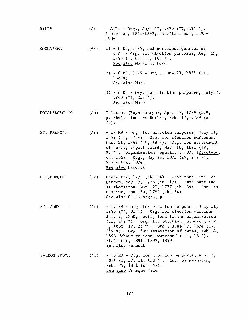
RILEY (0)
ROCKABEMA (Ar)
ROYALSBOROUGH (An)
ST. FRANCIS (Ar)
ST GEORGES (Kn)
ST. JOHN (Ar)
SALMON BROOK (Ar)
- A R1 - Org., Aug. 27,1879 (IV, 254 *). State tax, 1851-1892; as wild lands, 1893-1906.
1) - 6 R5, 7 R5, and northwest quarter of 6 R4 - Org. for election purposes, Aug. 29, 1846 (I, 63; II, 168 *). See also Merrill; Moro
2) - 6 R5, 7 R5 - Org., June 23, 1855 (II, 168 ~'~).
See also Moro
3) - 6 R5 - Org. for election purposes, July 2, 1860 (II, 213 *). See also Moro
Existent (Royalsburgh), Apr. 27, 1779 (L.V, p. 864). Inc. as Durham, Feb. 17, 1789 (ch. 76) .
- 17 R9 - Org. for election purposes, July 11, 1859 (11,47 *). Org. for election purposes, Mar. 31, 1868 (IV, 18 *). Org. for assessment of taxes, report dated, Mar. 10, 1871 (IV, 93 ~'~). Organization 1 egalized, 1873 (Resolves, ch.166). Org., May 29,1875 (IV, 247 ~'~).
State tax, 1874. See also Hancock -----State tax, 1772 (ch. 14). West part, inc. as Warren, Nov. 7,1776 (ch. 17). East part inc. as Thomaston, Mar. 20, 1777 (ch. 34). Inc. as Cushing, Jan. 30, 1789 (ch. 36). See also St. Georges, p.
- 17 R8 - Org. for election purposes, July 11, 1859 (II, 91 ~'~). Org. for election purposes July 7, 1860, having lost former organization (11,212 *). Org. for election purposes, Apr. 1, 1868 (IV, 25 *). Org., June 17, 1874 (IV, 244 ~'<). Org. for assessment of taxes, Feb. 4, 1896 "about to issue warrant" (III, 18 ~'~).
State tax, 1891, 1892, 1899. See also Hancock
- 13 R3 - Org. for election purposes, Aug. 7, 1841 (I, 57; II, 158 >':). Inc. as Washburn, Feb. 25,1861 (ch. 47). See also Presque Isle
102

SANDY RIVER
SANDY RIVER
SARSFIELD
SEARSMONT
SEBASTICOOK
SEBOEIS
SEVEN ISLANDS
SEVEN MILE BROOK
SHAPLEIGH
SHEEPSCOT
SHEPARDSFIELD
SHERIDAN
(F)
(F)
(Ar)
Inc. as Farmington, Feb. 1, 1794 (ch. 28).
- 2 R1 - Org. for election purposes, July 9, 1859 (11,42 *). Land set off to form Greenvale Plantation, 1863 (IV, 80 *). Entire township again org., Mar. 1, 1905 (III, 150 *). Org., Mar. 23, 1905 (ch. 366). State tax, 1881-1892; as wild lands, 1893-1908, 1910, 1912, 1914, 1916, 1918, 1920, 1922, 1925. See also Dallas; Number Three R2, W.B.K.P.; Rangely
- Plymouth Grant R1 - Org. for election purposes, June 30, 1859 (II, 14 *). State tax, 1864-1867. Annexed to Fort Fairfield, 1867 (ch. 262). See also Eaton; Letter D; Plymouth Grant; Presque Isle
(Wa1) Inc. as Searsmont, Feb. 5, 1814 (ch. 92).
(So) - 5 R2, N.W.P. - State tax, 1812, 1814, 1821-1827.
(Pe)
(Ar)
(So)
(Y)
(L)
(0)
(Ar)
See also Number Five R2, N.W.P.
- 3 R8, N.W.P. - Org., Mar. 31, 1890 (IV, 321 *). Org. Successor to former plantation, Mar. 5, 1895 (ch. 123). Taxed as wild lands, 1901-1908, 1910, 1912, 1914, 1916, 1918, 1920, 1922, 1925.
- 13 R15 - Org., Nov. 10, 1873 (IV, 241 *).
- Area of town of New Portland - State tax, 1812.
Inc. as Shapleigh, Mar. 5, 1785 (ch. 47).
State tax, June 21, 1751 (ch. 10). Inc. as district of Newcastle, June 19,1753 (ch. 4). See also Damariscotta, p.; Sheepscott, p.; New Castle, p.; New Dartmouth, p.
Inc. as Hebron, Mar. 6, 1792 (ch. 48).
- 12 R5 - Org., May 21, 1873 (IV, 110 *). Org., June 17, 1878 (IV, 249 *). Org. for assessment of taxes, Feb. 4, 1896 "about to issue warrant" (III, 18 ~'<). Org. for assessment of taxes, May 21, 1900 (III, 21 ~'<).
State tax, 1881-1902. Annexed to Ashland, Mar. 19, 1901 (ch. 420). See also Buchanan -----
103

SILVER RIDGE
SMITHFIELD
SOMERVILLE
SOWERDAESCOOK
STACYVILLE
STERLING
STERLINGTON
STETSON
STILLWATER
STOCKHOLM
SUDBURY CANADA
SUMMIT
SUNKHAZE
(Ar)
(Ke)
(L)
(Pe)
(Pe)
(Ke)
(Kn)
(Pe)
(Pe)
(Ar)
(0)
(Pe)
(Pe)
- East half of 2 R5 - Org., July 20, 1863 (IV, 240 *). Organization ratified, Feb. 24,1868 (ch. 570). Set off l<md to town of Sherman, 1870 (ch. 303). Organization legalized, 1878 (ch. 87). Org., Apr. 17, 1883 (IV, 215 *). State tax, 1881. See also Benedicta
Org., Sept. 24, 1793 (Maine Historical and Genealogical Recorder, 111,14). Inc. as Litchfield, Feb. 18, 1795 (ch. 35).
- Formerly town of Somerville - Org. for election purposes, Mar. 14, 1938 (III, 175 ~':).
See also Patricktown
Inc. as part of Hampden, Feb. 24,1794 (ch. 48).
- 3 R6 - Org., July 21, 1860 (II, 215 *); this organization legalized, 1883 (ch. 326). Org. successor to former plantation, Mar. 5, 1895 (ch.123). State tax, 1875-1892; as wild lands, 1901-1908, 1910, 1912, 1914, 1916, 1918, 1920, 1922, 1925.
Inc. as Fayette, Feb. 28,1795 (ch. 57).
Inc. as Union, Oct. 20, 1786 (ch. 33).
- 3 R3 - Inc. as Stetson, Jan. 28, 1831 (ch. 120). See also Number Three R3
Inc. as Orono, Mar. 12, 1806 (ch. 93).
- 16 R3 - Org., Mar. 4,1895 (111,14 *). Taxed as wild lands, 1907, 1908. Inc. as Stockholm, Feb. 27, 1911 (ch. 41).
Inc. as Bethel, June 10,1796 (ch. 3).
- 1 N.D. - Org., May 7,1892 (III, 215 ~':). Org. succeSsor to former plantation, Mar. 5, 1895 (ch. 123). Taxed as wild lands, 1901-1906. See also Number One, N.D.
- 3 E.P.R., Old Indian Purchase - State tax, 1821-1832. Inc. as Milford, Feb. 28, 1833 (ch. 351) . See also Number Three, E.P.R.
104

SWAN'S ISLAND
SWAN'S TRACT
SYLVESTER
TALMADGE
THE FORKS
THOMPSON POND
THOMPSON TOWN
TOPSFIELD
TOPSHAM
TWENTY-FIVE MILE POND
TYNGTOWN
UNITY
UNITY
(H) State tax, 1878-1898. Inc. as Swan's Island, Mar. 26, 1897 (ch. 538).
(Wa1) State tax, 1812, 1814. Inc. as Swanville, Feb. 19, 1818 (ch. 133).
(An) Existent (Sylvestertown), Apr. 27, 1779 (L.V, p. 864). Inc. as Turner, July 7, 1786 (ch. 23).
(Was) - 3 R2, T.S. - Org. for election purposes, report dated, Apr. 6,1846 (I, 15; II, 36 ~'~).
State tax, 1870-1874. Inc. as Talmadge, Feb. 8, 1875 (ch. 49). See also Number Three R2
(So) - 1 R4, B.K.P., E.K.R. - Org. for election purposes, July 9, 1859 (II, 124 *). Org. successor to former plantation Mar. 20, 1895 (ch. 220). Taxed as wild lands, 1901-1908, 1910, 1912, 1914, 1916, 1918, 1920, 1922, 1925. See also Number One R4, E.K.R. and Number One R5, W.K.R.
(An, C) Southeast part annexed to New Gloucester, Feb. 13, 1816 (ch. 97). State tax, 1814, 1821-1829. Annexed to Otisfie1d and Poland, 1830 (ch. 83).
(0) State tax, 1812, 1814.
(Was) - Formerly town of Topsfield - Org. Apr. 25, 1940 (III, 27 *).
(Sa) State tax 1761 (ch. 17). See also Topsham, p.
(Wa1) Part of, inc. as Unity, June 22,1804 (ch. 17).
(F)
(F)
(Ke)
Set off land to Unity, 1813 (ch. 99); to Joy, 1819 (ch. 63). Annexed land from Warsaw, 1821 (ch. 76). State tax, 1812, 1821-1823. Inc. as Burnham, Feb. 4, 1824 (ch. 245).
Inc. as Wilton, June 22, 1803 (ch. 43).
Inc. as New Sharon, June 20, 1794 (ch. 6) .
Set off land to Albion, Mar. 30, 1853 (ch. 174) . State tax, 1851. See also Unity Gore
105

UNITY GORE
UPTON
VAN BUREN
VANCEBORO
VAUGHANTOWN
WADE
WAITE
WALAGRASS
WALDO
(Ke)
(0)
(Ar)
Org. for election purposes (1840 ?), report undated (I, 3; II, 51 *). See also Unity (Ke)
State tax, 1871, 1872. See also Letter B
1) - 6 miles wide, parallel with St. John River - Org. for election purposes, Aug. 29, 1843 (I, 57; II, 159 *).
2) - Letter G R1, Letter L R2, Letter M R2, and such part of 18 R3 as was in former organization - Org. for election purposes, Aug. 25, 1857 (II, 87 *). See also Cyr; Grant Isle; Hamlin
3) - Letter M R2 - Org. for election purposes, July 9,1859 (11,45 *). Meetings of 1865 and 1866 legalized, 1867 (ch. 272). Organization confirmed 1870 (ch. 462). Meeting of 1873 legalized, 1874 (ch. 484). State tax, 1864-1884. Inc. as Van Buren, Feb. 11, 1881 (ch. 27).
(Was) - Vanceboro township or 1 R4, T.S. - Org., Jan. 28, 1871 (IV, 74 *). Inc. as Vanceborough, Mar. 4,1874 (ch. 619). See also Lambert's Lake; Number Eleven
(So) Inc. as Harmony, June 15,1803 (ch. 6).
(Ar) - 13 R4 - Org. for election purposes, Mar. 4, 1861 (II, 221 '''). Org., May 28, 1874 (IV, 293 '''). Org. successor to former p1antat ion, Mar. 5, 1895 (ch. 123). Org. for assessment of taxes, Feb. 4, 1896 "about to issue warrant" (III, 18 *). State tax, 1881-1892, 1899-1913. Inc. as Wade, Mar. 4, 1913 (ch. 60).
(Was) - 2 R2, T.S. - Org. for election purposes, Aug. 14,1843 (I, 13; 11,33 *). State tax, 1870-1876. Inc. as Waite, Feb. 22, 1876 (ch. 302).
(Ar) - 17 R7 - Org. for election purposes, July 11, 1859. (II, 721'''). See also Hancock; wa11agrass
(Wa1) Annexed land from town of Swanville, 1824 (ch. 260). Annexed unincorporated tract on the north, 1836 (ch. 33). State tax, 1821-1830, 1840-1844. Inc. as Waldo, Mar. 17, 1845 (ch. 241) .
106

WALES
WALLAGRASS
WALPOLE
WASHINGTON
WASHINGTON
WASHINGTON
WASHINGTON
WATERFORD
WEBB'S POND
WEBSTER
WEST BOWDOINHAM
WEST BUTTERFIELD
WEST FORKS
(Ke)
(Ar)
(L)
(F)
(Ke)
Part of, inc. as Monmouth, Jan. 20, 1792 (ch. 18). Inc. as Wales, Feb. 1, 1816 (ch. 48).
- 17 R7 - Org. for election purposes, July 13, 1863 (IV, 290 "<). Organization ratified, Mar. 12,1870 (ch. 462). Org. for assessment of taxes, Apr. 24, 1871 (IV, 93, 296 ~~). State tax, 1873. See also Wa1agrass
Inc. as Nob1eborough, Nov. 20, 1788 (ch. 22). See also Walpole, p.
Name of Plantation Number Four changed to Washington, July 7,1860 (II, 216 *). State tax, 1870-1892; as wild lands, 1893-1906. See also Number Four -----Part of, inc. as Mount Vernon, June 28, 1792 (ch.14). Inc. as Belgrade, Feb. 3, 1796 (ch.31).
(Wa1) State tax, 1812, 1814. Inc. as Brooks, Dec. 10, 1816 (ch. 76).
(Y)
(0)
(F)
(Pe)
(Sa)
(0)
(So)
Inc. as Newfield, Feb. 26, 1794 (ch. 54).
Part of, inc. as Waterford, Mar. 2, 1797 (ch. 83). Residue inc. as Norway, Mar. 9,1797 (ch. 77).
- 5 - State tax, 1812, 1814. Inc. as Weld, Feb. 8, 1816 (ch. 65).
- 6 R3, N.B.P.P. - Org. for election purposes, Sept. 1, 1856 (II, 105 *); this organization legalized 1889 (ch. 293). State tax, 1875-1892; as wild lands 1901-1908, 1910, 1912, 1914, 1916, 1918, 1920, 1922, 1925.
Inc. as Bowdoin, Mar. 21, 1788 (ch. 45).
Inc. as Sumner, June 13, 1798 (ch. 2).
- 1 R5, W.K.R. - Org. for election purposes, July 9, 1859 (II, 20 *). Org., Mar. 31, 1893 (111,305 *). Taxed as wild lands, 1901-1908, 1910, 1912, 1914, 1916, 1918, 1920, 1922, 1925. See also Number One R4, E.K.R. and Number One R5, W.K.R.
107

WEST POND
WESTFIELD
WESTMANLAND
WETMORE ISLE
WHITNEY RIDGE
WILLIAMS COLLEGE GRANT
. WILLIAMSBURG
WINTERVILLE
(Ke)
(Ar)
(Ar)
(H)
(Pe)
(Ar)
(Pi)
(Ar)
l'ilC-:-)
West part inc. as part of Rome, Mar. 7, ~ (ch.124). Inc. as Dearborn, Feb. 22, 1812 (ch.124).
- Two half townships, Deerfield and Westfield Academy Grants - Org. for election purposes, Mar. 5, 1861 (II, 145 ~'~). Meeting of 1892 legalized, 1893 (ch. 535). Org. for assessment of taxes, Feb. 4, 1896, "about to issue a warrant" (III, 18 ~~). State tax, 1870-1886, 1899-1908. Inc. as Westfield, Mar. 7, 1905 (ch.124).
- 15 R4 - Org. May 25, 1892 (III, 11 ~'~). Org. successor to former plantation, Mar. 5, 1895 (ch.123). Taxed as wild lands 1903-1908, 1910, 1912, 1914, 1916, 1918, 1920, 1922, 1925.
Existent, 1847 (ch. 46). Inc. as Verona, Feb. 18,1861 (ch. 25).
- 5 R8 - Org. for election purposes, Aug. 20, 1860 (II, 220 *).
1) Land set off to Houlton and organization repealed, 1834 (ch. 429).
2) - North part of original township granted and all that part of township not inc. with Houlton - Org. for election purposes, Oct. 17, 1840 (1,54; 11,154 *).
3) - Williams College Grant; Framingham Academy Grant - Org., Apr. 7, 1845 (I, 61; II, 165 *). Inc. as Littleton, Mar. 18, 1856 (ch. 615). See also Framingham; Monticello
- 6 R8 - Inc. as Williamsburg, June 21, 1820 (ch. 9).
- 15 R7 - Org., June 9, 1884 (IV, 188 *). Org. successor to former plantation, Mar. 5, 1895 (ch. 123). Name changed to Hill Plantation, Mar. 28, 1903 (ch. 400). Name changed to Winterville, Feb. 22, 1907 (ch. 110). Taxed as wild lands, 1910, 1912, 1914, 1916, 1918, 1920, 1922, 1925. See also Hill
108

WOODLAND (Ar)
WOODVILLE (Pe)
WYMAN'S (Ke)
- 14 R3 - Org., Apr. 25, 1861 (II, 222 *). Organization legalized, 1878 (ch. 87). State tax, 1870-1880. Inc. as Woodland, Mar. 5, 1880 (ch. 261).
- Indian township No.2 - Org. for election purposes, May 22, 1854; org., Mar. 12, 1860 (II, 189 ~':). Inc. as Woodville, Feb. 28, 1895 (ch. 101) . See also Mattawamkeag
Inc. as Vienna, Feb. 20, 1802 (ch. 42). See also Goshen
109


v. DISTRICTS


Massachusetts General Court made prOV1S1on for districts, a form of municipal organization classed between that of plantation and town. A district had all the privileges of a town except that of representation in the state legislature. There were seven districts in the Maine area. All districts were made into towns in 1775, yet Alfred and Hiram were later incorporated as districts.
Newcastle, formerly Sheepscot Plantation, was incorporated as a district, June 19, 1753 (ch. 4). The district was incorporated as the town of Newcastle, August 23, 1775 (ch. 3).
Mericoneag Neck and islands were incorporated as the district of Harpswell, January 26,1758 (ch. 15). Harpswell sent a representative to the General Court, May 22, 1770, but apparently it did not become a town until August 23, 1775, when all districts were given full town privileges (ch. 3).
Woolwich was incorporated as a district, October 20, 1759 (ch. 7), and as a town, August 23, 1775 (ch. 3).
Pepperrellborough was incorporated as a district, June 9, 1762 (ch. 3), and as a town, August 23, 1775 (ch. 3).
Cape Elizabeth was incorporated as a district, November 1, 1765 (ch. 25), and as a town, August 23, 1775 (ch. 3).
Alfred was incorporated as a district, February 4, 1794 (ch. 31); as a town, February 25,1808 (ch. 58).
Hiram was incorporated as a district, February 27, 1807 (ch. 84), and as a town June 14, 1814 (ch. 41).
113


VI. THE EARLY TOWN OF MADAWASKA


THE EARLY TOWN OF :MADAWASKA
In preparing a list of incorporations and changes in boundaries of towns and counties in Maine, one expects to find problems in the early years when Maine was a province under proprietorship, a province and then a district under Massachusetts and also, in the area immediately west of the Penobscot River, ruled at different times as a duchy and by a president. East of the Penobscot, there were scattered settlements for some 130 years previous to 1759 in French Acadia.
After March 15, 1820, the date of separation of Maine from Massachusetts, all enactments incorporating towns were by private and special laws and those of counties were by public laws, thereby simplifying research to the difficulties of volume of research rather than those of variety of sources.
In a few instances, towns were incorporated by law, yet never actually became such, either because the warrant for a town meeting was never issued by a justice, or because the incorporation was not accepted by the inhabitants of the township. Results of this sort are not easily verified or, if so, only in a negative way, from the list of towns in the annual state tax list.
A unique instance that this negative source may prove untrustworthy was recently noted when citations were being rechecked. Maine Resolves, 1820 to 1850, separately bound and not previously examined, brought to light the fact that an early incorporation of the town of Madawaska which had been effective and which had involved international policies was the reason for the town's existence. Undoubtedly, its two town meetings had an influence on national territory unequalled by any town in the nation.
The northern boundary of eastern United States was established by the Treaty of Peace of 1783 as "the highlands which divide those rivers that empty themselves into the St. Lawrence from those which fall into the Atlantic Ocean".l This "divide", continuous and clearly defined to the west of Madawaska, becomes, in this area, a level county characterized by large lakes. At least two of the larger lakes are the sources of the St. Francis and Madawaska Rivers, tributaries of the St. John, which flows into the Bay of Fundy and thence to the ocean.
By 1830 negotiations had progressed by the Treaty of Friendship, Commerce and Navigation of 1794, the Declaration relative to the river St. Croix of 1798, the Treaty of Peace signed at Ghent in 1814, the Convention of the 29th of September 1827, - from a possible solution by interpretation of the original treaty to the probability of a new conventional boundary.2
lMaine Resolves, 1831, pp. 242-43. 2Ibid., pp. 249-59.
117

On February 28, 1831, John G. Deane expressed the general dissatisfaction of Maine citizens over the trend of negotiations in his report of the Committee on Northeastern Boundary to the Maine House of Representatives:
" .. Therefore Resolved, That the convention of September 1827, tended to violate the Constitution of the United States and to impair the sovereign rights and powers of the State of Maine, and that Maine is not bound by the Constitution to submit to the decision, which is or shall be made under that convention.
"Whereas, By the convention of September 1827, an independent sovereign was to be selected by the governments of the United States and Great Britain, to arbitrate and settle such disputes as had arisen, and the King of Netherlands was pursuant to that convention selected the Arbiter, while an independent sovereign, in the plenitude of his power, exercising dominion and authority over more than 6,000,000 of subjects:
"And Whereas, By the force of the prevalence of liberal opinions in Belgium, the Belgians overthrew his power, and deprived him of more than half of his dominions and reduced him to the former dominions of the Stadtho1der leaving him the empty title of the King of the Netherlands while he is only the King of Holland, and thereby increaSing his dependence, upon Great Britain for holding his power even in Holland, which from public appearances, he held by a very doubtful tenure in the affections of the Dutch.
"And Whereas, the King of the Netherlands had not decided before his Kingdom was dismembered and he consented to the division, and his public character had changed, so that he had ceased to be that public character, and occupying that independent station among the Sovereigns of Europe contemplated by the convention of September 1827, and which led to his selection.
"Therefore Resolved in the opinion of this Legislature, That the decision of the King of Netherlands, cannot and ought not to be considered obligatory upon the government of the United States, either on the principles of right and justice, or of honor.
"Resolved Further - for the reasons before stated, That no decision made by any umpire under any circumstances, if the decision dismembers a State, has or can have, any constitutional force or obligation upon the State thus dismembered, unless the State adopt and sanction the decision. ,,1
1Maine Resolves, 1831,pp. 242-46.
118

The same legislature which heard the report by John G. Deane passed an act, March 15, 1831, to incorporate "the territory called and known by the name of Madawaska Settlement" into the town of Madawaska'! In anticipation of the passage of this act, a resolve of March 10, 1831, apportioning representatives to the legislature, apportioned one representative to "Madawaska, including all the territory in the County of Penobscot North of the Monument line.,,2 Another resolve, April 1, 1831, "added three hundred polls and the sum of $5714. to the polls and taxable estate of this State, and the same are hereby set to the town of Madawaska.. "3
A letter from President Martin Van Buren, dated March 18, 1831, was received by Samuel E. Smith, Governor of Maine, informing him that the award by the King of Netherlands had been officially delivered to the Minister of the United States at the Hague, January 10, and had been received at the Executive Department, March 16.4 By the terms of this award, the boundaries of the Treaty of Peace of 1783 were abandoned altogether and a distinct and different line of demarcation was substituted. 5
In a message to the Legislature, March 25, 1831, Governor Smith stated:
" . The President, through the Secretary of State, has expressed his desire, that while this matter is under deliberation, no steps may be taken by the State of Maine, with regard to the disputed territory, which may be calculated to interrupt or embarrass the action of the Executive branch of the Government of the United States upon th ' b' ,,6 ].s su Ject ....
Part of the evidence submitted to the King of Netherlands by Great Britain were claims to Madawaska territory based on the ancient feudal rights 7 of the Fief of Madawaska. 8 This fief was granted in 1683 by the French Governor to Sieur Charles-Aubert de la Chenaye. 9 Joseph Blondeau, Pierre Claverie, and Sieur de Danseville were successive owners until July 1763, when the Sieur de Danseville sold it with other property to General James Murray, Governor of Quebec.1 0 In this transfer from the last French owner, the fief was described as "containing three leagues in front, on each side of the river of the same name, by two leagues in depth, together with adjacent Lake Temiscouata.ll It was owned by Alexander FrasY2 from 1802 to 1835, then sold to Cummings and Smith of Portland, Maine. Commercial ownership gradually dissipated any claims to feudal proprietorship.
lMaine Special Laws, 1831, ch. l5l. 2 Maine Resolves, 1831, ch. 31. 3 Ib id ., ch. 90. 4--Ib id ., p. 247. 5-.-6 Ib].d., pp. 259-60.
Ibid., p. 246. 7Fief: Canadian Law. Real estate held under feudal tenure, carrying
with it the privilege of nobility. Funk & Wagnalls. Maine Resolves, 1831, p. 251.
9 Alb ert, p. 33. 10 Ibid., pp. 242-43. llAlbert Gallatin, The Right of the United States of America to the
Northeastern Boundary (New York: Samuel Adams, 1840), p. 81. 12 Alb ert, pp. 242-43.
119

The Fief of Madawaska, specifically claimed by Great Britain, lies well within the limits of the area incorporated as a town in 1831. John G. Deane, a member of the Maine legislature, was probably the most conspicuous figure in pressing for incorporation of a new town at the extreme northern boundary;l he had visited the area in 1830 with Judge William Pitt Preble, Minister Plenipotentiary, and Envoy Extraordinary of the United States of America, a Maine man who represented this country in the negotiations at The Hague. 2 The acts providing for the town of Madawaska were intended "as a continued assertion of the right of the state to jurisdiction over the territory known to be within the limits of Maine .... ,,3
The area of this early town of Madawaska was approximately 4272 square miles or 3 3/7 times the size of the state of Rhode Island. Its boundaries were described:
"beginning on the boundary line between this State and the province of New Brunswick, at the North East corner of township F on Greenleaf's map, near to and South of the river St. John; thence West by North line of township F and township K to the East line of township numbered sixteen, in the third range of townships West of the East line of the State; thence North by the East line of said townships numbered sixteen, to the North East corner thereof; thence West by the North line of townships numbered sixteen, in the third, fourth, fifth, sixth, and seventh ranges, West of the East line of the State; and thence continuing the same course until it intersects the river St. John; thence North until the line intersects the river St. Francois; thence by the center of said river to the grand portage; thence by the grand portage to the line of Canada and this State; thence by the line of Canada and this State as established by the Proclamation of seventeen hundred and sixty three, the commissions to Governors Murray, Carleton and Haldinand, from seventeen hundred and sixty three to the year seventeen hundred and eighty six; the Act of the British Parliament of seventeen hundred and seventy four, and by the treaty of peace in seventeen hundred and eighty three; to the North West angle of the province of New Brunswick; thence South by the line established by the Commissions to Governors Wilmot, Campbell, Legge, Hughes, Hammond and Parr, from seventeen hundred and sixty three, to seventeen hundred and eighty three, and by the commissions to Sir Thomas Carleton the first Governor of New Brunswick, in seventeen hundred and eighty four, to the first mentioned bounds, being the East line of the State, on the true meridian, North from the monument, at the head of the river St. Croix . . . . "4
lLlewellyn Deane, "John G. Deane", Collections and Proceedings of the Maine Historical Society, 2nd ser., I (1890), 193.
2Maine Resolves, 1831, p. 257. 3Maine Resolves, 1832, p. 233. 4Maine Special Laws, 1831, ch. 151.
120

In 1787, there was a chapel at Madawaska where religious services were held from time to time. l In 1790, fifty-two settlers, probably all French colonists, were given deeds to homesteads. 2 In 1817, Captain Nathan Baker, John Harford, James Harford and Captain Fletcher, citizens of the United States, settled near the confluence of the Meruimticook River (Baker Brook) with the St. John River. 3 Shortly, another group of eleven American settlers, including John Baker (brother of Nathan), Walter Powers, Barnabas Hunnewell, Daniel Savage, and Jesse Wheelock, settled along Baker Brook, the St. Francis and St. John Rivers. 4
John Baker and his wife ~Sophie Rice, widow of his brother Nathan) became leaders of this group. In 1825, he was granted 100 acres, the land which had been owned by his brother. 6 On July 4, 1827, a group of Americans gathered at his home to celebrate Independence Day.7 The American flag was raised during the patriotic celebration. 8 On August 10 of the same year, the date fixed for the proclamation of the Constitution of New Brunswick, Ma§istrate George Morehouse came and aske~ Baker the meaning of the flag. Baker replied, "c' est Ie drapeau Americain, est-ce-
,/
que vous ne l'avez lamais vu? en ce cas vous pouvez l'examiner tout a votre aise . . . ." 0 The flag was taken to Fredericton; Mrs. Baker went twenty miles, to St. Basile, and bought another flag. ll
John Baker and his neighbors were accused of revolt against British law; a sheriff and 14 men arrested Baker, September 25, and started down river to Fredericton. 12 The party was not out of sight when Mrs. Baker raised her new American flar~ saying "Le drapeau etoile"" flottera encore ~a la brise de Meruimticook." John Baker was brought to trial on the charge of conspiracy and sedition, May 8, 1828, when he was sentenced to pay 25 louis and to serve three months in jail. 14
John Baker was known locally as the fierce American, "Ie Washington de la republique americaine du Madawaska"; his wife, Sophie Rice Baker, won the popular appellations, "la vice-presidente de la repub lique, l'heroine de Meruimticook, la Lucre~e du Madawaska, la Barbara Fritchie de 1 'Aroostook. ,,15
you
lAlbert, p. 100. 2 Ib id ., p. 11. 3--Ibid., p. 201. 4I dem. 5--Ib id ., p. 203. 6rdem. 7--Ibid., pp. 203-04. 8rdem. 9--Ib id ., p. 204.
10"This is the American flag, have you never seen it? in that case can take your time and examine it." llAlb ert, p. 204. l2 rbid., pp. 204-05. l3"The star-spangled banner will float again on the breeze of Meruimticook". l4Albert, p. 205. l5Ibid., pp. 211,223.
121

Into this region of active dispute, William D. Williamson, one of the Justices of the Peace throughout the state, directed a warrant to Walter Powers, an inhabitant, for the first town meeting to be held at the dwelling house of Peter Lizotte (Lazart),1 on the south side of the river St. John, August 20, 1831. 2 This meeting of about forty men was held out of doors (en plein air) as Lizotte protested against: the meeting being held in his house. 3 A moderator and other town officers were chosen,4 several French colonists refusing office. 5
A meeting for the election of a representative to the legislature was held, September 12, 1831, at the home of Raphael Martin on the south side of St. John River with about fifty citizens present. Captain Peter Lizotte was elected, winning by a majority of 5 votes over John Baker, who received 16 votes. 6
His Excellency Sir Archibald Campbell, Major General and Lieutenant Governor of the Province of New Brunswick, accompanied by two militia officers, the Attorney General of the province, and the sheriff of York County (N.B.), arrived in Madawaska, September 23, 1831 and issued warrants' against all who had voted at the two meetings. ~ Barnabas Hunnewell (moderator), Jesse Wheelock (town clerk), Daniel Savage (selectman) and Daniel Bean were arrested; 8 the French-speaking voters were excused. 9 The first three named were each fined fifty pounds and imprisonment for three months in jail at Fredericton. lO
When the Legislature of 1832 convene~ Madawaska's representative, Peter Lizotte, wrote to Governor Samuel E. Smith that he had protested, at the time of his election, that he had no intention of taking the oath of allegiance to the United States, that he was a British subject and intended to die so.ll
An extract from Governor Smith's message, January 9, 1832, follows:
" .. But in the present state of the controversy, much difficulty and embarrassment would be the consequence of disregarding the earnest recommendation of the National Executive, and adopting measures to enforce our jurisdiction over the small settlement at
1Maine Resolves, 1832, p. 478. 2Albert, p. 207. 3Idem. 4~e Resolves, 1832, p. 478. 5Albert, p. 207. 6Ibid., p. 208. 1Maine Resolves, 1832, p. 475. 8Ibid., pp. 478-85. 9--Albert, p. 210.
l0Maine Resolves, 1832, pp. 480-85. 11Albert, p. 209.
122

Madawaska. Measures for that purpose, to be effectual, would require a detachment of the militia to be stationed at that place; in which event we should not only be in collision with Great Britain, but acting in opposition to the expressed wishes of the Government of the United States . . .
"At the last session of the Legislature an act was passed to incorporate the town of Madawaska, including territory southward of the river St. John, and the disputed territory northward of that river, By another law, the inhabitants were empowered to elect a representative . . . It was also generally considered that these acts were intended as a continued assertion of the right of the state to jurisdiction over the territory known to be within the limits of Maine; though there was no necessity that they should be forcibly carried into effect, until with the concurrence of the General Government, circumstances should render it proper and expedient. Besides, if a forcible exertion of the authority of the state at Madawaska had been the intention of the Legislature, appropriations would necessarily have been made, for defraying the great expenditures of embodying and sustaining the militia requisite for effecting the intended object.
"In the month of October last, information was received, that a number of the inhabitants of Madawaska had organized themselves into a corporation, chosen municipal officers, and subsequently a representative; and that in consequence of these acts, the lieutenant governor and other authorities of New Brunswick, accompanied with a military force, had proceeded to Madawaska, and arrested a number of American citizens, who were carried to Fredericton, and there imprisoned.
"Though the measures adopted by the inhabitants, voluntarily organizing themselves into a corporation at that place, then claimed to be under the actual jurisdiction of the province of New Brunswick, were unexpected by me, and undertaken without my knowledge; yet, as they acted in territory known to be within the limits of Maine, and in obedience to the laws and constitution, I considered they were entitled to the aid, and protection of their government.
"Inunediately, therefore,. . they were conununicated . . . to the Department of State of the United States, with a request that the proper measures might be adopted .... Upon the receipt of this conununication, - though the proceedings of the inhabitants of Madawaska were considered to be a breach of the arrangement made with the British Minister, for preserving the state of things as it then existed on both sides, till a final disposition of the question, - those measures were promptly adopted by the President, which resulted in the release of our
123

citizens from imprisonment, and rendered further proceedings on the part of this State, in reference to that object, unnecessary. ,,1
The citizens of Madawaska were reimbursed for their service and imprisonment, by the Maine legislature. 2 No further town meetings were held in Madawaska until a n~v town government was set up as Madawaska 38 years later, with the St. John River as its northern boundary. The Treaty of Washington, better known as the Webster-Ashburton Treaty, August 9, 1842, fixed the northern boundary at the St. John River, thus including the scene of the town meetings within the bounds of the United States. 3
John Baker, born in Moscow, a small hamlet in Somerset County, Maine, died on Canadian soil about 1867. He had accommodated himself to the new allegiance without becoming naturalized and became a prosperous and useful resident. In 1895, his remains were transferred to Fort Fairfield where the State of Maine erected a monument to his memory.4
lMaine Resolves, 1832, pp. 332-34. 2Ibid., 1833, ch. 105; 1838, ch. 46. 3--Burrage, p. 34l. 4Albert, p. 223.
124

VII. TOWNS


Name Former Status
ABBOT (Pi) T7 R7
ACTON (Y) Part of Shapleigh
ADAMS (Was) T20, E.D.
ADDISON (Was) Plantation Number Six, west of Machias
AETNA (Pe) A tract
ALBANY (0) Oxford Plantation
ALBION (Ke)
ALEXAND ER (Was) Plantation Number Sixteen, E.D.
ALFRED (Y) Part of Sanford
Former Name
Ligonia
TOWNS
Date of Incorporation
Jan. 31, 1827 (ch. 445) .
Mar. 6, 1830 (ch. 79).
Feb. 11, 1828 (ch. 517). Name changed to Crawford, Feb. 23, 1828 (ch. 561).
Feb. 14, 1797 (ch. 41) .
Feb. 15, 1820 (Mass. Law, ch. 242). Taxed as Etna, 1821. See also Etna
June 20, 1803 (ch. 22). Surrender of organization, Nov. 20, 1937 (ch. 107; VII, 147 ~·~·k).
Name changed to Albion, Feb. 25, 1824 (ch. 285).
Jan. 19, 1825 (ch. 288) .
Inc. as district, Feb. 4, 1794 (ch. 31); as town, Feb. 25, 1808 (ch. 58).
127
Boundary Changes
Set off land to Shapleigh, Mar. 22, 1831 (ch. 166).
Set off land to Waterford, Feb. 18, 1811 (ch. 42).
Annexed unincorporated land, Jan. 31, 1835 (ch. 515). Annexed land from Unity Plantation, Mar. 30, 1853 (ch. 174). Set off land to Benton, Mar. 14, 1863 (ch. 258).
Annexed land from Cooper, Feb. 22, 1838 (ch. 407). Set off land to Crawford, Apr. 2, 1859 (ch. 343).
Set off land to Sanford, Feb. 23, 1828 (ch. 565). Annexed land from Waterborough, July 22, 1847 (ch. 53).

ALMOND (Pi)
ALNA (L)
ALTON (Pe) Argyle Plantation
AMHERST (H) Plantation Number Twenty-six
AMITY (Ar) T10 R1
ANDOVER (0)
ANSON (So) T1 R1, N.P.C. , W.K.R.
Milton
New Milford
East Andover
Name changed to Almond, Feb. 19, 1841 (ch. 98). Name changed to Orneville, Jan. 24,1843 (ch. 60).
Name changed to A1na, Feb. 28, 1811 (ch.125).
Mar. 9, 1844 (ch. 160).
Feb. 5, 1831 (ch. 129).
Mar. 19, 1836 (ch. 138).
Name changed to Andover, June 13, 1820 (ch. 2).
Mar. 1, 1798 (ch. 65) .
128
Annexed land from Jefferson, Feb. 15, 1816 (ch. 126); from Whitefield and Jefferson, Jan. 22, 1824 (ch. 228). Set off land to Wiscasset, Feb. 25, 1839 (ch. 515); to Dresden, Mar. 20, 1841 (ch. 131). Ch. 228, 1824 was repealed by ch. 94, Feb. 19, 1907.
Set off land to Old Town, Feb. 27,1863 (ch. 231), Feb. 1 7, 1871 ( c h. 641).
Set off land to Industry, Feb. 10, 1823 (ch. 217); to New Portland, Mar. 6, 1830 (ch. 72); to form North Anson, Mar. 20, 1845 (ch. 248). Annexed land from Embden, Jan. 28, 1828 (ch. 496); from New Vineyard, Mar. 18, 1840 (ch. 75); to reunite North Anson, Mar. 13, 1855 (ch. 489).

APLEDOORE (Y) Isles of Shoales
APPLETON (Kn) Appleton Plantation
ARGYLE (Pe) East part of Argyle Plantation
ARROWSIC (Sa) Part of Georgetown
ARUNDEL (Y) Tract of Cape Porpus
ASHLAND (Ar) TIl R5
ATHENS (So) T2 R2, N.P.C.
ATKINSON (Pi) T2 R6, N.W.P.
May 22, 1661 (Shurtleff, IV, pt. II, p. 3). This name was apparently soon lost as the area was known as the town of lIes of Shoales in 1665. See also lIes of -----Shoals
Jan. 28, 1829 (ch. 1) .
Mar. 19, 1839 (ch. 546). Surrender of organization, Jan. 1, 1938 (1937 ch. 76; VII, 149 **).
Feb. 17, 1841 (chs. 94,108).
June 10, 1719 (Resolve, ch. 25). Name changed to Kennebunk Port, Feb. 19, 1821 (ch.42).
Feb. 18, 1862 (1854, ch. 375; 1862, ch. 133). Name changed to Dalton, Feb. 19, 1869 (ch. 137); to Ashland, Feb. 19~ 1876 (ch. 237).
Mar. 7, 1804 (ch. 160).
Feb. 12, 1819 (ch. 66) .
129
Annexed land from Hope, Feb. 7,1843 (ch. 68).
Set off land to Old Town, Mar. 22, 1843 (ch. 110). Part set off to form Alton, Mar. 9, 1844 (ch. 160) .
Annexed Sheridan Plantation, Mar. 19, 1901 (ch. 420).
Annexed land from Hartland, Feb. 8, 1821 (ch. 34); from Brighton, Mar. 15, 1838 (ch. 449), Mar. 18,1862 (ch. 184).
Annexed land from Milton, Feb. 21, 1837 (ch. 252).

AUBURN (An) Part of Minot
AUGUSTA (Ke)
AURORA (H)
AVON (F) plantation Number Two in Abbot's Purchase R1
BAILEYVILLE (Was) Plantation Number Seven, E.D.
BALDWIN (C) Flintstown plantation
BANCROFT (Ar) Bancroft plantation
Harrington
Hampton
Feb. 24,1842 (ch. 9). Inc. as city, Feb. 22, 1869 (1868, ch. 471; History of Androscoggin County, p. 611) .
Name changed to Augusta, June 9, 1797 (ch. 1). Inc. as city, Aug. 20, 1849 (ch. 224).
Name changed to Auror-a, Feb. 6, 1833 (ch. 302).
Feb. 22, 1802 (ch. 44).
Feb. 19, 1828 (ch. 538).
June 23, 1802 (ch. 12).
Feb. 5, 1889 (ch. 317) .
l30
Change of line with Minot, Mar. 20, 1844 (ch. 169). Annexed land from Danville, Feb. 19, 1859 (ch. 272); entire town of Danville, Feb. 26, 1867 (chs. 316, 363); land from Minot, Feb. 20, 1873 (ch. 327).
Set off land to Winthrop, Feb. 27,1810 (ch. 67); to Hallowell, Feb. 17, 1812 (ch. 114), Feb. 23, 1813 (ch. 98); to form part of Kennebec, Aug. 12, 1850 (ch. 355); to Hallowell, Aug. 9, 1852 (ch. 573). Annexed land from Manchester, Apr. 9, 1856 (ch. 669).
Set off land to Strong, Mar. 26, 1853 (ch. 135).
Annexed land from Princeton, July 26, 1847 (ch. 61) .
Set off land to Hiram, Feb. 28, 1821 (ch. 47); to form Sebago, Feb. 10, 1826 (ch. 387); to Sebago Feb. 10, 1827 (ch. 440), Mar. 28, 1837 (ch. 359); to Hiram, Mar. 7, 1844 (ch. 156); to Sebago, Feb. 15, 1871 ( c h. 621).
Set off land to Weston, Feb. 26, 1907 (ch. 123).

BANGOR (Pe) Kenduskee plantation
BAR HARBOR (H)
BARING (Was) Plantation Number Six, E.D.
BARNARD (Pi) Part of Williamsburg
BATH (Sa) Part of Georgetown
BEALS (Was) Part of Jonesport
BEDDINGTON (Was) T23, M.D.
BELFAST (Wa1) A tract
BELGRADE (Ke) Washington plantation
Eden
Feb. 25, 1791 (ch. 23). Inc. as city, Feb. 24, 1834 (ch. 436; History of Penobscot County, Maine, p. 667).
Name changed to Bar Harbor, Mar. 5, 1918 (1913, ch. 188; V, 435 ~'o'~).
Jan. 19, 1825 (ch. 289).
Feb. 8, 1834 (ch. 420). Surrender of organization, Feb. 7, 1877 ( c h . 371) .
Feb. 17, 1781 (ch. 11). Inc. as city, June 14, 1847 (ch. 5; Henry W. Owen, History of Bath, Maine, p. 191).
Apr. 7, 1925 (ch. 97) .
Jan. 31, 1833 (ch. 298).
June 29, 1773 (ch. 3). Inc. as city, Apr. 3, 1852 (1850, ch. 363; Joseph Williamson, History of Belfast, p. 149).
Feb. 3, 1796 (ch. 31).
131
Set off land to form Veazie, Mar. 26, 1853 (ch. 134). Annexed land from Veazie, Jan. 29, 1889 (ch. 294).
Set off land to form part of Medyb emps, Feb. 20,1841 (ch. 103).
Set off land to form West Bath, Feb. 14, 1844 (ch. 133). Annexed land from West Bath, Mar. 16, 1855 (ch. 530).
Set off land to form part of Searsport, Feb. 13, 1845 (ch. 199).
Annexed land from Sidney, Feb. 23,1798 (ch. 56); from Dearborn, Jan. 29, 1834 (ch. 397), Mar. 2~ 1839 (ch. 553); from Rome, Feb. 10, 1845 (ch. 194), Mar. 25, 1897 (ch. 512). Set off land to Mount Vernon, July 16, 1846 (ch. 344).
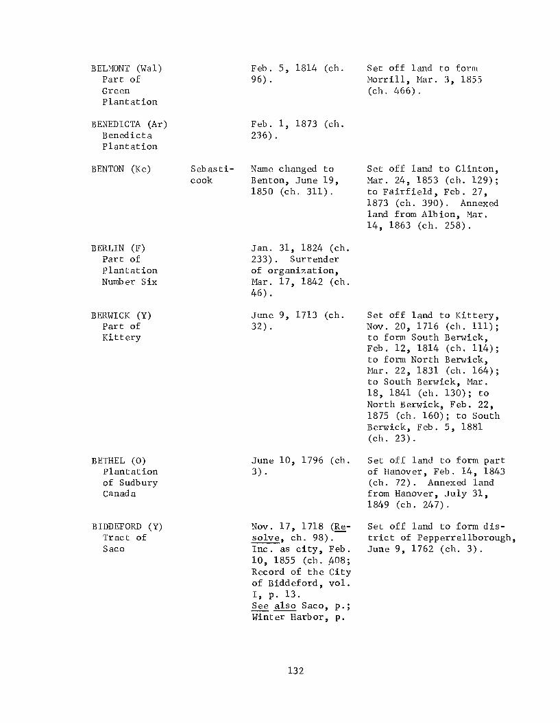
BELMONT (Wa1) Part of Green Plantation
BENEDICTA (Ar) Benedicta plantation
BENTON (Ke)
BERLIN (F) Part of Plantation Number Six
BERWICK (Y) Part of Kittery
BETHEL (0) Plantation of Sudbury Canada
BIDDEFORD (Y) Tract of Saco
Sebasticook
Feb. 5, 1814 (ch. 96).
Feb. 1, 1873 (ch. 236).
Name changed to Benton, June 19, 1850 (ch. 311).
Jan. 31, 1824 (ch. 233). Surrender of organization, Mar. 17, 1842 (ch. 46).
June 9, 1713 (ch. 32).
June 10, 1796 (ch. 3).
Nov. 17, 1718 (Resolve, ch. 98). Inc. as city, Feb. 10, 1855 (ch. A08; Record of the City of Biddeford, vol. I, p. 13. See also Saco, p.; Winter Harbor, p.
132
Set off land to form Morrill, Mar. 3, 1855 (ch.466).
Set off land to Clinton, Mar. 24, 1853 (ch. 129); to Fairfield, Feb. 27, 1873 (ch. 390). Annexed land from Albion, Mar. 14,1863 (ch. 258).
Set off land to Kittery, Nov. 20, 1716 (ch. 111); to form South Berwick, Feb. 12, 1814 (ch. 114); to form North Berwick, Mar. 22, 1831 (ch. 164); to South Berwick, Mar. 18, 1841 (ch. 130); to North Berwick, Feb. 22, 1875 (ch. 160); to South Berwick, Feb. 5, 1881 (ch.23).
Set off land to form part of Hanover, Feb. 14, 1843 (ch. 72). Annexed land from Hanover, July 31, 1849 (ch. 247).
Set off land to form district of Pepperrellborough, June 9,1762 (ch. 3).

BINGHAM (So) T1 R1, B.K.P.
BLAINE (Ar) Alva Plantation
BLANCHARD (Pi) T3 R3, B.K.P.
BLOOMFIELD (So) Part of Canaan
BLUEHILL (H) Plantation of Blue Hill or Number Five
BOOTHBAy (L) Tract called Townsend
BOOTHBAY HARBOR (L) Part of Boothbay
BOWDOIN (Sa) West Bowdoinham plantation
BOWDOINHAM (Sa) A tract
Feb. 6, 1812 (ch. 94) .
Feb. 10, 1874 (ch. 452).
Mar. 17, 1831 (ch. 157).
Feb. 5, 1814 (ch. 94). Town annexed to Skowhegan, Feb. 19,1861 (ch. 34).
Feb. 2, 1789, as Blue Hill (ch. 39).
Nov. 3, 1764 (ch. 15). See also Townsend
Feb. 16, 1889 (ch. 381) . See also Hyppocras, p.
Mar. 21, 1788 (ch. 45).
Sept. 18, 1762 (ch. 14). See also Abagadasset, p.; Somersett, p.
l33
Annexed land from Fairfield Feb. 22, 1858 (ch. 154).
Annexed land from Sedgwick, Feb. 5, 1831 (ch. 130). Set off land to Penobscot, Apr. 7, 1845 (ch. 284).
Set off land to form Townsend, Feb. 12, 1842 (ch. 5); to form Boothbay Harbor, Feb. 16, 1889 (ch. 381).
Set off land to form Thompsonborough, June 22, 1799 (ch. 23); to Lisbon, Jan. 31, 1826 (ch. 372), Mar. 7, 1834 (ch. 485). Ch. 372, 1826 was repealed by ch. 474, Feb. 17, 1827.
Annexed land from Gardinerstown Plantation, Feb. 4, 1779 (ch. 30); from Litc hfield, June 17, 1817 (ch. 48); from Topsham, Mar. 16, 1830 (ch. 111). Set off land to Topsham, Mar. 29, 1788 (ch. 61); to form Richmond, Feb. 10, 1823 (ch. 214).

BOWERBANK (Pi) T7 R8, N.W.P.
BRADFORD (Pe) Blakesburg Plantation
BRADLEY (Pe) T4, Old Indian Purchase, E.P.R.
BREMEN (L) Part of Bristol
BREWER (Pe) Part of Orrington
BRIDGEWATER (Ar) Bridgewater Academy Grant Plantation and Portland Academy Grant plantation
BRIDGTON (C) Bridgton Plantation
Mar. 4, 1839 (ch. 525). Surrender of organization, Feb. 15, 1869 (ch. 74). Feb. 28, 1907 (ch. 133).
Mar. 12, 1831 (ch. 150).
Feb. 3, 1835 (ch. 520).
Feb. 19, 1828 (ch. 537) .
Feb. 22, 1812 (ch. 127). Inc. as city, Mar. 30, 1889 (ch. 328; Brewer Annual Report, 1890, p. 81).
Mar. 2, 1858 (ch. 171) .
Feb. 7, 1794 ( c h . 32).
134
Annexed land from Sebec; Apr. 7, 1927 (ch. 93).
Annexed unincorporated gore, Feb. 10, 1859 (ch. 267).
Annexed island from Wa1doborough, Mar. 6, 1830 (ch. 78); Cow Island, Apr. 3, 1929 (ch. 94). Set off land to Wa1doborough, Mar. 11, 1853 (ch. 55), Mar. 27, 1856 (ch. 634).
Annexed land from Orrington, Dedham and Bucksport, Apr. 10, 1841 (ch. 161). Set off land to Eddington, June 30, 1846 (ch. 324); to form Holden, Apr. 13, 1852 (ch. 580); to Eddington, Mar. 16, 1855 (ch. 522).
Set off land to form part of Harrison, Mar. 8, 1805 (ch. 80); to form part of Naples, Mar. 4, 1834 (ch. 477); to Naples, Feb. 29, 1856 (ch. 573); to Harrison, Feb. 20, 1866 (ch. 124), 1877 (ch. 325). Annexed land from Denmark, Mar. 7, 1842 (ch. 16); from Denmark and Fryeburg, Aug. 2, 1847 (c h . 84).

BRIGHTON (So)
BRISTOL (L) Tract known as Walpole, Herrington, and Pemaquid
BROOKLIN (H)
BROOKS (Wal) Washington plantation
BROOKSVILLE (H) Parts of Castine, Penobscot, and Sedgwick
BROOKTON (Was) Jackson Brook Plantation
North Hill
Port Watson
Name changed to Brighton, Jan. 29, 1827 (ch. 442). Surrender of organization, Apr. 8, 1895 (ch. 138; III, 334 ~"').
June 21, 1765 (ch. 8). Bounds established, June 19, 1766 (ch. 2). See also Frederick------sburg, p.; Fredericksport, p.; Greenland, p.; Harrington, p.; Jamestown, p.; Mary Town, p.; Muscongus, p.; New Harbor, p.; Pemaquid, p.; Somers et, p.; Walpole, p.
Name changed to Brooklin, July 23, 1849 (ch. 225).
Dec. 10, 1816 (ch. 76).
June 13, 1817 (ch. 12).
Mar. 2, 1883 (ch. 295).
135
Set off land to Athens, Mar. 15, 1838 (ch. 449), Mar. 18, 1862 (ch. 184).
Set off land to Nobleborough, June 15, 1815 (ch. 26); to form Bremen, Feb. 14, 1828 (ch.537); to form part of Damariscotta, July 26, 1847 (ch. 55); to form South Bristol, Mar. 26, 1915 (ch. 133).
Annexed land from Monroe, Jan. 23, 1823 (ch. 166). Set off land to Swanville, Mar. 5, 1841 (ch. 116); to Monroe, Mar. 15, 1844 (ch. 166), Feb. 17, 1883 (ch. 242).

BROWNFIELD (0) Part of Brownfield Plantation
BROWNVILLE (Pi) Plantation Number Five R8
BRUNSWICK (C)
BUCKFIELD (0) Bucktown plantation or Number Five
BUCKSPORT (H)
BUCKSTOWN (H) Bucks town Plantation
BURLINGTON (Pe) T2 R1, N.B.P.P., E.P.R.
Feb. 20, 1802 (ch. 41).
Feb. 3, 1824 ( c h . 236).
J(LII
.Jun-e- 26, 1739 (ch. 28). See also Bruns----wick, p. II
-;!.
Mar. 16, l7~' (ch. 60).
Buckstown Name changed to Bucksport, June 12, 1817 (ch. 5).
June 27, 1792 (ch. 15). Name changed to Bucksport, June 12, 1817 (ch. 5).
Mar. 8, 1832 (ch. 275) .
136
Annexed land from Porterfield Plantation, Feb. 27, 1807 (ch. 87); from Porter, Feb. 19, 1831 (c h . 13 7) , Feb. 11, 1832 (ch. 232), Mar. 17, 1855 (ch. 537). Set off land to Denmark, Mar. 2, 1821 (ch. 55); to Hiram, Apr. 23, 1852 (ch. 633); to Denmark, Mar. 13, 1907 (ch. 207).
Annexed land from North Yarmouth, June 23, 1739 (Resolve, ch. 40), Oct. 2, 1739 (Resolve, ch. 89), June 28, 1740 (Resolve, ch. 35), Apr. 3, 1740 (Resolve, ch. 183); from Freeport, Mar. 4, 1790 (ch. 54), Jan. 28, 1833 (ch. 290), Feb. 15, 1839 (ch. 506), Aug. 24, 1850 (ch. 384).
Set off land to Paris, Feb. 19, 1828 (ch. 542). Annexed land from Sumner, Mar. 12, 1856 (ch. 589); from Hartford, Mar. 25, 1856 (ch. 632).
Set off land to Brewer, Apr. 10, 1841 (ch. 161); to Orrington, Aug. 20, 1850 (ch. 376); to Dedham, Mar. 18, 1909 (ch. 230).
Set off land to Orrington, June 17, 1816 (ch. 13).
Annexed 2-mile strip, Mar. 10, 1835 (ch. 559); land from Lowell, July 26, 1847 (ch. 64).

BURNHAM (Wa1) Twenty-Five Mile Pond plantation
BUXTON (Y) Plantation of Narraganset Number One
BYRON (0) T Number 8
CALAIS (Was) Plantation Number Five
CAMBRIDGE (So) Part of Ripley
CAMDEN (Kn) Cambden Plantation
CAMDEN (Kn) Part of Camden
CANAAN (So) A tract
Feb. 4, 1824 (ch. 245) .
July 14, 1772 (ch. 10).
Jan. 24, 1833 (ch. 288) .
June 16, 1809 (ch. 2). Inc. as city, Nov. 18, 1850 (ch. 389; Town Clerk's Records, Book II, p.428). See also St. Croix Island, p.
Feb. 8, 1834 (ch. 425) .
Feb. 17, 1791, as Cambden (ch. 18).
Feb. 25, 1891 (ch. 102).
June 18, 1788 (ch. 9) .
137
Annexed part of Clinton Gore Plantation, Feb. 26, 1873 (ch. 384).
Set off land to Standish, Feb. 17, 1824 (ch. 276).
Annexed land from Wellington, Feb. 27, 1885 (ch. 464) .
Annexed land from Warren, Feb. 10, 1836 (ch. 17). Set off land to form a new town of Camden, and name of residue changed to Rockport, Feb. 25, 1891 (ch. 102).
Set off land to Rockport, Mar. 4, 1891 (ch. 147), Mar. 28, 1893 (ch. 601).
Set off land to form Bloomfield, 1814 (ch. 94); to form Milburn, Feb. 5, 1823 (ch.193). Annexed land from Warsaw, Feb. 9, 1824 (ch. 255); from Pittsfield, Mar. 12, 1830 (ch. 96), 1841 (ch. 104); from Hartland, July 17, 1849 (ch. 213). Act annexing land from Clinton, July 24, 1849 (ch. 234) was repealed, Aug. 8, 1850 (ch. 351).

CANTON (0) Part of Jay
CAPE ELIZABETH (C) Part of Falmouth
CAPE ELIZABETH (C) Part of Cape Elizabeth
CAPE PORPUS (Y)
CARIBOU (Ar)
CARMEL (Pe) T3 R2, N.W.P.
CARROLL (Pe) plantation Number Six R2, N.B.P.P.
Lyndon
Feb. 5, 1821 (ch. 32) .
Inc. as district, Nov. 1, 1765 (ch. 25); as town, Aug. 23,1775 (ch. 3).
Mar. 15, 1895 (ch. 194):
Set off land to Jay, Jan. 27, 1823 (ch. 175), this law was repealed and other land set off to Jay, Feb. 3, 1824 (ch. 242). Land set off to Jay, Feb. 28, 1824 (ch. 281), Mar. 4, 1831 (ch. 144); to Peru, Apr. 2, 1859 (ch. 345). Annexed land from Hartford 1838 (ch. 418), Feb. 25, 1839 (ch. 512), Aug. 8, 1850 (ch. 354).
Set off land to Westbrook, Apr. 19, 1852 (ch. 605). Set off land to form a new town of Cape Elizabeth and name of residue changed to South Portland, Mar. 15, 1895 (ch. 194).
July 5, 1653 (Shurt- Same tract inc. as Arundel, 1eff, III, 338). June 10,1719 (Resolve, Deserted 1690 and ch. 25). resettled before 1719 (Richardson, III, p. 7; Pre£., IV, p. 8). See also Cape Porpus, p.
Name changed to Caribou, Feb. 26, 1869 (ch. 183), to Lyndon, Mar. 9, 1869 (ch. 243), to Caribou, Feb. 8, 1877 (ch. 388).
June 21, 181~ (ch. 27).
Mar. 20, 1845 (ch. 251). Surrender of organization, June 28, 1937 (ch. 42; VII, 106 ~h'c).
138
Set off land to Connor Plantation, Mar. 18, 1881 (ch. 158).
Annexed land from Etna, Feb. 19, 1866 (ch. 112).

CARTHAGE (0) Plantation NlUTIb er Four
CASCO (C) Part of Raymond
CASTINE (H) Part of Penobscot
CASTLE HILL (Ar) Castle Hill Plantation
CENTERVILLE (Was) T23, E.D.
CHANDLERVILLE (So) Plantation NlUTIber Five R2, N.W.P.
CHAPMAN (Ar) Chapman Plantation
CHARLESTON (Pe)
CHARLOTTE (Was) Plantation NlUTIb er Three, E.D.
CHELSEA (Ke) Part of Hallowell
Feb. 20, 1826 (ch. 403).
Mar. 18, 1841 (ch. 126).
Feb. 10, 1796 (ch. 39). See also Penta-goet, p.
Feb. 25, 1903 (ch. 78) .
Mar. 16, 1842, as Centreville (ch. 42).
Feb. 19, 1828 (ch. 539). Name changed to Detroit, Mar. 18, 1841 (ch. 129).
Mar. 11, 1915 (ch. 54).
New Name changed to Charleston Charleston, Feb.
23, 1827 (ch.48l).
Jan. 19, 1825 (ch. 290) .
Mar. 1, 1851 (1850, ch. 364).
139
Set off land to form plantation Number Four, July 17,1849 (ch. 214).
Annexed land from Raymond, Mar. 7, 1842 (ch. 14); from Poland, Mar. 20, 1858 (ch. 222); unincorporated land, Jan. 28, 1876 (ch. 207).
Set off land to form part of Brooksville, June 13, 1817 (ch. 12). Annexed land from Penobscot, June 16, 1817 (ch. 32), Feb. 12, 1839 (ch. 505), Mar. 14, 1927 (ch. 26).
Annexed land from Columbia, Feb. 24, 1859 (ch. 279). Set off land to Northfield, Mar. 11, 1915 (ch. 55).
Set off land to form part of Medybemps, Feb. 20, 1841 (ch. 103).
Set off land to Pittston, Feb. 20, 1855 (ch. 436). Land ceded for National Home for Disabled Volunteer Soldiers, Jan. 28, 1867 (ch. 66), Feb. 20, 1901 (ch. 288).

CHERRYFIELD (Was) Tll, called Cherryfield
CHESTER (Pe) River township Ntunber 1R8, W.P.R.
CHESTERVILLE (F) Chester Plantation
CHINA (Ke) Parts of Harlem, Fairfax, and Winslow
CLIFTON (Pe)
CLINTON (Ke) Hancock Plantation
COLUMB IA (Was) Plantation Number Twelve and Number Thirteen
Maine
Feb. 9, 1816 (ch. 78).
Feb. 26, 1834 (ch. 466).
Feb. 20,1802 (ch. 39).
Feb. 5, 1818 ( c h . 78) .
Name changed to Clifton, June 9, 1849 (ch. 193).
Feb. 28, 1795 (ch. 62) .
Feb. 8, 1796 (c h . 38).
140
Annexed land from Steuben, Feb. 6, 1826 (ch. 377); from Columbia, Feb. 12, 1881 (ch. 37).
Annexed land from Wilton, Feb. 18, 1811 (ch. 44); from Vienna, Aug. 2, 1847 (ch.93).
Annexed town of Harlem, Jan. 15, 1822 (ch. 87). Set off land to Vassalboro, Feb. 18, 1829 (ch. 24).
Set off land to Fairfax, Jan. 31, 1814 (ch. 80); to form Sebasticook, Mar. 16, 1842 (ch. 40); to Canaan, July 24, 1849 (ch. 234), repealed, Aug. 8, 1850 (ch. 351). Annexed land from Pittsfield, Mar. 6, 1830 (ch. 71); from Benton, Mar. 24, 1853 (ch. 129); from Clinton Gore Plantation, Feb. 26, 1873 (ch. 384).
Set off land to Harrington, Feb. 13, 1818 (ch. 107), Feb. 5, 1823 (ch. 196). AnnexedT19,Feb. 17, 1834 (ch. 448); land from Jonesborough, Feb. 8, 1838 (ch. 401). Set off part of Number 19, Mar. 18, 1840 (ch. 76); land to Centerville, Feb. 24, 1859 (ch. 279); to form Columbia Falls, Mar. 25, 1863 (ch. 280); to Cherryfield, Feb. 12, 1881 (ch.37).

COLUMBIA FALLS (Was) Part of Columbia
CONCORD (So) Plantation Number One R1, B.K.P., W.K.R.
CONNOR (Ar) Connor plantation
COOPER (Was) Plantation Number Fifteen
CORINNA (Pe) T4 R4, N.W.P.
CORINTH (Pe) T2 R4, N.W.P.
CORNISH (Y) Francisborough plantation
CORNVILLE (So) T2 R1, N.P.C., E.K.R.
COXHALL (Y) Coxhall plantation
CRANBERRY ISLES (H) Part of Mount Desert
Mar. 25, 1863 (ch. 280) .
Jan. 25, 1821 (ch. 22). Surrender of organization, July 6,1935 (ch. 31).
July 12, 1913 (ch. 120).
Feb. 6, 1822 (ch. 121) .
Dec. 11, 1816 (ch. 80).
June 21, 1811 (ch. 17).
Feb. 27,1794 (ch. 73) .
Feb. 24, 1798 (ch. 58).
Mar. 11, 1778 (ch. 23). Boundaries adjusted, Apr. 24, 1780 (ch. 39). Name changed to Lyman, Feb. 26, 1803 (ch. 88).
Mar. 16, 1830 (ch. 113) .
141
Annexed land from T1 R2, Jan. 28, 1829 (ch. 3). Set off land to pleasant Ridge Plantation, Feb. 9, 1860 (ch. 380).
Set off land to Alexander, Feb. 22, 1838 (ch. 407); to form part of Medybemps, Feb. 20, 1841 (ch. 103).
Boundary between Dexter and, est. Jan. 26, 1852 (ch. 460).
Annexed "Mile and a half Strip", June 20, 1807 (ch. 28). Set off land to Milburn, Feb. 23, 1831 (ch. 139); Jan. 29, 1833 (ch. 295); Mar. 2, 1833 (ch. 374) .
Annexed land from Mount Desert, June 13, 1849 (ch. 198).

CRAWFORD (Was)
CRYSTAL (Ar) Crystal Plantation
CUMBERLAND (C) Part of North Yarmouth
CUSHING (Kn) St. Georges Plantation
CUTLER (Was) Plantation Number Eleven
DALTON
DAMARISCOTTA (L) Parts of Nobleborough and Bristol
DANFORTH (Was) Half township R4, N.B.P.P. and eas t part of T8 R4
DANVILLE (An)
Adams
Pejepscot
Name changed to Crawford, Feb. 23, 1828 (ch. 561).
Mar. 21, 1901 (ch. 434) .
Apr. 2, 1822 (1821, ch. 78).
. 7 ,)'~ ,
Jan. 30, 1789 (ch. 36) .
Jan. 28, 1826 (ch. 369) .
See Ashland
Mar. 15, 1848 (1847, ch. 55).
Mar. 17, 1860 (ch. 440).
Name changed to Danville, Feb. 1, 1819 (ch. 42). Town annexed to Auburn, Feb. 21, 1867 (chs. 316, 363).
142
Annexed land from Alexander, Apr. 2, 1859 (ch. 343) .
Part set off to Sherman, Feb. 17, 1881 (ch. 42).
Set off island to Portland, Feb. 14, 1889 (ch. 355) .
Set off land to form St. George, Feb. 7, 1.803 (ch. 53); to Friendship, Feb. 20, 1839 (ch. 508); to Thomaston, Mar. 19, 1909 (ch. 254). Annexed land from Warren, June 20, 1807 (ch. 30); Crotch Island from Friendship, Feb. 5, 1834 (ch. 413). Land annexed from Warren in 1807 was set off to Thomaston, Feb. 21, 1891 (ch.101).
Annexed land from Weston, Mar. 4, 1885 (ch. 499); from Eaton, Feb. 15, 1887 (ch.103).
Set off land to Durham, Feb. 5, 1821 (ch. 31), 1823 (ch. 227); to Auburn, Feb. 19, 1859 (ch. 272). Annexed land from Poland, Mar. 24,1852 (ch. 524).

DAYTON (Y) Part of Hollis
DEARBORN (Ke) West Pond Plantation
DEBLOIS (Was) Annsburg Plantation
DEDHAM (H) Part of T8
DEER ISLE (H) Deer Island Plantation, Little Deer Island and Isles of Holt
DEERING (C) Part of Westbrook
DENMARK (0)
Apr. 7, 1854 (ch. 310).
Feb. 22, 1812 (ch. 124). Surrender of organization Apr. 20, 1841 (ch. 200).
Mar. 4, 1852 (ch. 497).
Feb. 7, 1837 (ch. 236).
Feb. 2, 1789 (ch. 40).
Mar. 21, 1871 (ch. 628). Inc. as city Oct. 12, 1891 (1889, ch. 506; Deering Annual Report 1892, p.7). Annexed to Portland, Mar. 8, 1899 (ch. 11; Westbrook Globe-Star).
Feb. 20, 1807 (ch. 61) .
143
Set off land to Waterville, Feb. 20, 1815 (ch. 116), Jan. 21, 1822 (ch. 98), Feb. 12, 1826 (ch. 412); to Belgrade, Jan. 29, 1834 (ch. 397), Mar. 22, 1839 (ch. 553); to form part of Smithfield, Feb. 29,1840 (ch. 27).
Set off land to Brewer, Apr. 10, 1841 (ch. 161); to Ellsworth, Apr. 23, 1852 (ch. 634). Annexed land from Bucksport, Mar. 18, 1909 (ch. 230).
Set off land to form Isle au Haut, Feb. 28, 1874 (ch. 583); to form Stonington, Feb. 18, 1897 (ch. 359).
Annexed land from Fryeburgh, Feb. 26, 1813 (ch. 104); from Brownfield, Mar. 2, 1821 (ch. 55), Mar. 2, 1907 (ch. 207). Set off land to Sebago 1830 (ch. 94); to Bridgton 1842 (ch. 16), 1847 (ch. 84).

DENNYSVILLE (Was) Dennysville plantation
DETROIT (So)
DEXTER (Pe) T4 R5, N.W.P.
DICKEYVILLE (Ar) Dionne Plantation and part of T18 R6
DIXFIELD (0) Part of Holman grant
DIXMONT (Pe) T3 R1, N.W.P.
DOVER (Pi) Plantation Number Three R6
Feb. 13, 1818 (ch. 111) .
Chand1er- Name changed to ville Detroit Mar. 18,
1841 (ch. 129).
June 17, 1816 (ch. 18).
Feb. 23, 1869 (ch. 154). Name changed to Frenchville, Jan. 26, 1871 (ch. 520).
June 21, 1803 (ch. 33).
Feb. 28, 1807 (ch. 100).
Jan. 19, 1822 (ch. 92). Union with Foxcroft into town of Dover-Foxcroft Mar. 1, 1922.
DOVER-FOXCROFT (Pi) Dover,
Mar. 1, 1922 (1915, ch. 101; Annual Report of Dover, 1921-22, p. 51).
Foxcroft
DRESDEN (L) Part of Powna1-borough
DREW (Pe) Drew Plantation
June 25, 1794 (ch. 14). See also Cork, p.
Apr. 5, 1921l(ch. 123). Surrender of organization, Mar. 1 1934 (1933 ch. 49).
144
Set off land to form Pembroke, Feb. 4, 1832 (ch. 218).
Set off land to Pittsfield 1855 (ch. 485).
Annexed land from T4, Feb. 6, 1822 (ch. 123), repealed Feb. 1, 1827 (ch. 447).
Annexed land from A1na, Mar. 20, 1841 (ch. 131). Set off land to form Perkins, June 24, 1847 (ch. 18).
Part set off to Prentiss, Mar. 1, 1869 (ch. 193); part set off to Reed, Mar. 5, 1889 (ch. 514); reannexed Mar. 28,1903 (ch. 364).

DURHAM (An) Roya1sborough Plantation
DUTTON (Pe) Plantation Number One R3, N.W.P.
DYER BROOK (Ar) Dyer Brook Plantation
EAGLE LAKE (Ar) Eagle Lake Plantation
EAST ANDOVER (0) East Andover Plantation
EAST LIVERMORE Part of (An) Livermore
EAST MACHIAS (Was) Part of Machias
EAST MILLINOCKET Part of (Pe) T A R7, W.E.L.S.
EAST THOMASTON Part of (Kn) Thomaston
EASTBROOK (H) TIS
Feb. 17, 1789 (ch. 76) .
Jan. 29, 1822 (ch. 105). Name changed to Glenburn, Mar. 18, 1837 (ch. 303).
Mar. 21, 1891 (ch. 272) .
Mar. 16, 1911 (ch. 115) .
June 23, 1804 (ch. 33). Name changed to Andover, June 13, 1820' (ch. 2).
Mar. 1, 1844 (1843, ch. 97). Name changed to Livermore Falls, Mar. 3, 1930 (1929, ch. 47; VI, 400 ~'d:).
Jan. 26, 1826 (ch. 367). Name changed to Mechisses, Feb. 12, 1840 (ch. 12), to East Machias, Apr. 6, 1841 (ch. 150).
Feb. 21, 1907 (ch. 97).
July 28, 1848 (ch. 131). Name changed to Rockland, July 17,1850 (ch. 322).
Feb. 8, 1837 (ch. 237) .
145
Annexed land from Danville, Feb. 5, 1821 (ch. 31), Feb. 11, 1823 (ch. 227).
Annexed land from Thomaston, July 17,1849 (ch. 216).
Annexed land from Waltham, Jan. 27, 1872 (ch. 18).

EASTON (Ar) Fremont plantation
EASTPORT (Was) Plantation Number Eight
EATON (Was) Forest City, Crooked Brook Plantation
EDDINGTON (Pe) Eddington Plantation
EDEN (H) Part of Mount Desert
EDGECOMB (L) Plantation of Freetown and Jeremy Squam Island
EDINBURG (Pe) River township Number 1 R6, Old Indian Purchase, W.P.R.
Feb. 24, 1865 (ch. 521) .
Feb. 24, 1798 (ch. 59). Under Great Britain, July 11, 1814 to June 30, 1818 (Resolves, 1819 ch. 211). Inc. as city of Eastport, Mar. 18, 1893 (ch. 450; The Charter and Ordinances of the City of Eastport, pp. 20-21) .
Jan. 25, 1873 (ch. 210).
Feb. 22, 1811 (ch. 57) .
Feb. 23, 1796 (ch. 52). Name changed to Bar Harbor, 1918 (1913, ch. 188; V, 435 -/d:).
Mar. 9, 1774 (ch. 21).
Jan. 31, 1835 (ch. 513).
146
Set off land to form Lubeck, June 21, 1811 (ch. 30). Annexed land from Lub ec, July 19,1847 (ch. 45).
Set off land to form Forest City, the residue annexed to Danforth, Feb. 15,1887 (ch. 103).
Annexed land from Jarvis t Gore, Jan. 31, 1823 (ch. 187); from Brewer, June 30, 1846 (ch. 324), Mar. 16,1855 (ch. 522).
Set off land to Trenton, June 27, 1849 (ch. 210).
Set off land to form Westport, Feb. 5, 1828 (ch. 511).

EUSTIS (F) Eustis plantation
EXETER (Pe) T3 R4, N.W.P.
FAIRFAX (Ke) Freetown Plantation
FAIRFIELD (So) Fairfield plantation
FALMOUTH (C) Spurwincke and Casco Bay
Area of ancient Falmouth
Feb. 18, 1871 (c h . 650).
Feb. 16, 1811 (ch. 36).
Mar. 9, 1804 (ch. 142). Name changed to Ligonia, Mar. 10,1821 (ch. 62).
June 18, 1788 (ch. 8) .
lolt,1 (c."h, 1(..1)
Annexed land from Winslow, Mar. 1, 1810 (ch. 78); from Clinton, Jan. 31, 1814 (ch. 80). Set off land to Harlem, Feb. 23, 1813 (ch. 87), Feb. la, 1816 (ch. 87); to form part of China, Feb. 5, 1818 (ch. 78).
Set off land to Norridgewock, Feb. 21, 1834 (ch. 454), Apr. 16, 1841 (ch. 177); to Bloomfield, Feb. 22,1858 (ch. 154). Annexed island from Benton, Feb. 27, 1873 (ch. 390).
July 14, 1658 (Shurtleff, IV, pt. 1, p. 359). Destroyed in 1689, after June 12 (Baxter Manuscripts, VI, 493).
Nov. 12, 1718 (ch. 89). See also Casco, p.; Spurwink, p.
148
Set off land to form district of Cape Elizabeth, Nov. 1, 1765 (ch. 25); to form Portland, July 4, 1786 (ch. 14); to form Stroudwater, Feb. 14, 1814 (ch. 119); to Westbrook, Jan. 31,1825 (ch. 297). Annexed land from Westbrook, Feb. 11, 1819 (ch. 49), Feb. 11, 1828 (ch. 519), Mar. 22, 1831 (ch. 165). Set off land to Westbrook, Feb. 24, 1835 (ch. 542), Mar. 21, 1836 (ch. 140), Mar. 25,1853 (ch. 130).

EDMUNDS (Was) Plantation Number Ten, E.D. and part of Trescott
ELIOT (Y) Part of Kittery
ELLIOTTSVILLE (Pi) T 8, R9, N.W.P.
ELLSWORTH (H)
EMBDEN (So) Tl R2, W.K.R.
ENFIELD (Pe) Treat's Tract and remaining part of River township Number 1, E.P.R.
ETNA (Pe) Aetna
Feb. 7, 1828 (ch. 515). Surrender of organization, Nov. 27, 1937 (Special Session, ch. 110; VII, 146 "lc·k).
Mar. 1, 1810, (ch. 74) .
Feb. 19, 1835 (ch. 538). Surrender of organization, Mar. 26, 1858 (ch. 238).
Feb. 26, 1800 (ch. 56). Inc. as city, Feb. 27, 1869 (ch. 29; Albert H. Davis, History of Ellsworth, Maine, p. 103) .
June 22, 1804, as Emd en (c h. 19).
Jan. 31, 1835 (ch. 514).
Inc. as Aetna, Feb. 15, 1820 (Mass. Law, ch.242). The initial "A" was immediately discontinued.
147
Annexed land from Trescott, Mar. 7, 1899 (ch. 98).
Annexed land from Kittery, Feb. 8, 1826 (ch. 386); this was repealed and the same land annexed from Kittery, Feb. 7, 1829 (ch.14).
Annexed land from Wilson, Aug. 10, 1849 (1848, ch. 165) .
Annexed land from Surry and Trenton, Mar. 3, 1809 (ch. 73). Land annexed from Surry, Mar. 3, 1809 set back to Surry, Feb. 28, 1821 (ch. 48). Annexed land from Surry, Feb. 17, 1829 (ch. 21); from Dedham, Apr. 23, 1852 (ch. 634).
Set off land to Anson, Jan. 28,1828 (ch. 496).
Set: off land to form part of Plymouth, Feb. 21, 1826 (ch. 405); to Carmel, Feb. 19, 1866 (ch. 112).

FARMINGDALE (Ke) Parts of Gardiner, Hallowell, and West Gardiner
FARMINGTON (F) Sandy River plantation
FAYETTE (Ke) Sterling Plantation
FOREST CITY (Was) Part of town of Eaton
FORT FAIRFIELD (Ar) Plantation Letter D R1 and all of Plymouth Grant lying southeast of Aroos took River
FORT KENT (Ar) D'Aigle and Fort Kent Plantations
FOX ISLE (Kn) Part of Vinalhaven
FOXCROFT (Pi) T5 R7 N.W.P.
Apr. 3, 1852 (ch. 549).
Feb. 1, 1794 (ch. 28).
Feb. 28, 1795 (ch. 57).
Feb. 15, 1887 (ch. 103). Surrender of organization, Mar. 1, 1924 (1923, ch. 61).
Mar. 11, 1858 (ch. 189).
Feb. 23, 1869 (ch. 156) .
Mar. 1, 1847 (1846, ch. 320). Name changed to North Haven, July 13, 1847 (ch. 36).
Feb. 29, 1812 (ch. 166). Union with Dover into town of Dover-Foxcroft, Mar. 1, 1922 (1915, ch. 101; Annual Report of Dov er, 1921-22, p. 51).
149
Set off land to West Gardiner, Mar. 19, 1853 (ch. 93); to Manchester, Mar. 15,1870 (ch. 469).
Annexed land from Industry, July 29, 1850 (ch. 339); from Strong, Mar. 16, 1853 (ch.83).
Set off land to Mount Vernon, Feb. 20, 1802 (ch. 40).
Annexed Sarsfield Plantation, Feb. 12, 1867 (ch. 262).
Set off land to Plantation Numb er Three R6, Feb. 23, 1818 (ch. 174); to T7 R8, Feb. 23, 1828 (ch. 558).

FRANKFORT (Wal) Plantation from Belfast to Wheeler's Mills
FRANKLIN (H) Major part of plantation Number Eight and Nine, .M.D.
FREEDOM (Wal) Beaver Hill plantation
FREEMAN (F) T3 R2, W.K.R.
FREEPORT (C) Part of North Yarmouth, Prout's Gore
FRENCHVILLE (Ar) Dickeyville
FRIENDSHIP (Kn) Medunkook Plantation
June 25, 1789 (ch. 21) •
Jan. 24, 1825 (ch. 294) .
June 11, 1813 (ch. 22).
Mar. 4, 1808 (ch. 81) . Surrend er of organization, Jan. 1, 1938 (1937 ch. 70).
Feb. 14, 1789 (ch. 62).
Name changed to Frenchville, Jan. 26, 1871 (ch. 520).
Feb. 25, 1807 (ch. 75) .
150
Set off land to form Prospect, Feb. 24, 1794 (ch. 47); to form part of Hampden, Feb. 24, 1794 (ch. 48); to Hampden, June 17, 1816 (ch. 14); to Swanville, Feb. 21, 1832 (ch. 242); to form Winterport, Mar. 12, 1860 (ch. 422); to Monroe, Feb. 21, 1863 (ch. 226); to Winterport, Feb. 18, 1867 (ch. 291) .
Annexed land from Plantation Number Nine, Mar. 14, 1837,(ch. 268); from Hancock, Feb. 18, 1852 (ch. 484); from Plantation Number Ten, Mar. 16, 1857 (ch. 32).
Set off land to form part of North Salem, Jan. 10, 1823 (ch. 151); to New Portland, Feb. 7, 1833 (ch. 306).
Set off land to Brunswick, Mar. 4, 1790 (ch. 54); to form Pownal, Mar. 3, 1808 (ch. 79); to Brunswick, Jan. 28, 1833 (ch. 290), Feb. 15, 1839 (ch. 506), Aug. 24, 1850 (ch. 384).
Set off land to form Saint Agatha, Mar. 17, 1899 (ch. 189); to Saint Agatha, Mar. 14, 1927 (ch. 25).
Set off Crotch Island to Cushing, Feb. 5, 1834 (ch. 413). Annexed land from Cushing, Feb. 20, 1839 (ch. 508); annexed six islands, Feb. 28, 1867 (ch. 371).

FRYEBURG (0) Frye tract
GARDINER (Ke) Part of Pittston
GARLAND (Pe) T3 R5, N.W.P.
GEORGETOWN (Sa) Arowsick Island
GERRY (Ke)
GILEAD (C) plantation of Peabody's Patent
GLENBURN (Pe)
Malta
Dutton
Jan. 11, 1777 (ch. 12) .
Feb. 17, 1803 (ch. 72). Inc. as city, Nov. 26, 1849 (ch. 281; J.W. Hanson, History of Gardiner, Pittston and West Gardiner, p. 213) .
Feb. 16, 1811 (ch. 40).
June 13, 1716 (ch. 29). See also New Towne, p.; Sagadehock, p.
Name changed to Gerry, Mar. 10, 1821 (ch. 63). Name changed to Windsor, Jan. 19, 1822 (ch. 95).
June 23, 1804 (ch. 34).
Name changed to Glenburn, Mar. 18, 1837 (ch. 303).
151
Annexed land from Brownfield Plantation, Feb. 20, 1802 (ch. 41). Set off land to Denmark, Feb. 26, 1813 (ch. 104); to Bridgton, Aug. 2, 1847 (ch. 84).
Annexed land from Hallowell, Feb. 24, 1834 (ch. 458). Set off land to form West Gardiner, Aug. 8, 1850 (ch. 350); to form part of Farmingdale, Apr. 3, 1852 (ch. 549).
Annexed Parker's Island and land west of Kennebec River, June 26, 1738 (ch. 54); annexed Small Point from North Yarmouth, Apr. 3, 1741 (ch. 184). Set off land to form Bath, Feb. 17, 1781 ( c h. ll); to form Phipsburg, Jan. 26, 1814 (ch. 76); to form Arrowsic, Mar. 2, 1841 (chs. 94,108).
Annexed land from Whitefield, Mar. 8, 1821 (ch. 58), repealed, Feb. 21, 1907 (ch. 96).
Set off land to form part of Kenduskeag, Feb. 20, 1852 (ch. 485).

GLENWOOD (Ar) Plantation Number Two R3, W.E.L.S.
GOLDSBORO'
GORHAM (C) Gorhamtown Plantation
GOULDSBORO (H) Goldsboro' Plantation
GRAFTON (0) Plantation Letter A R2
GRAND ISLE (Ar)
GRANT ISLE (Ar) Grant Isle Plantation
GRAY (C) New Boston Plantation
GREENBUSH (Pe) T2, E.P.R.
GREENE (An) Part of Lewistown plantation
Grant Isle
Feb. 14, 1867 (ch. 279). Surrender of organization, Feb. 28, 1868 (ch. 593).
See Gouldsboro
Oct. 30, 1764 (ch. 13).
Feb. 16, 1789 as Goldsboro' (ch. 71). Spelling made Gouldsboro, Feb. 15, 1887 (ch. 99).
Mar. 19, 1852 (ch. 513). Surrender of organization, Feb. 27, 1919 (ch. 10) .
Name changed to Grand Isle, Feb. 9, 1872 (ch. 81).
Mar. 2, 1869 (ch. 196). Name changed to Grand Isle, Feb. 9, 1872 (ch. 81).
June 19, 1778 (ch. 7) .
Feb. 28, 1834 (ch. 470).
June 18, 1788 (ch. 6) .
152
Annexed land from Standish, Feb. 19, 1831 (ch. 136), Mar. 14, 1839 (ch. 538); from Scarborough, Mar. 4, 1864 (ch. 341).
Annexed land from T7, Feb. 28, 1845 (ch. 227); from Plantation Number Seven, Feb. '26, 1870 (ch. 359). Set off land to form Winter Harbor, Feb. 21, 1895 (ch. 71). Annexed land from Plantation Number Seven, Mar. 8, 1905 (ch. 178).
Set off land to Lewiston, Apr. 20, 1852 (ch. 617); to Webster, Feb. 7, 1895 (ch. 18).

GREENFIELD (Pe) Greenfield Plantation
GREENVILLE (Pi) Haskell Plantation
GREENWOOD (0) Plantation Number Four
GUILFORD (Pi) T6 R7, N.W.P.
HALLOWELL (Ke) A tract
HAMPDEN (Pe) Sowerdabscook Plantation and part of Frankfort
Jan. 29, 1834 (ch. 400).
Feb. 6, 1836 (ch. 16).
Feb. 2, 1816 (ch. 52).
Feb. 8, 1816 (ch. 67) .
Apr. 26, 1771 (ch. 27). Inc. as city, Feb. 17, 1852 (1850 ch. 413; Emma Huntington Nason, Old Hallowell on the Kennebec, p. 338).
Feb. 24, 1794 (ch. 48).
153
Annexed land from Wilson, Aug. 10, 1848 (ch. 165).
Set off land to Woodstock, Feb. 17, 1893 (ch. 404).
Annexed land from Parkman, Feb. 15, 1878 (ch. 58); from Sangerville, Feb. 23, 1889 (ch. 426).
Set off land to form Harrington, Feb. 20, 1797 (ch. 49). Annexed land from Augusta, Feb. 17, 1812 (ch. 114), Feb. 23, 1813 (ch. 98); from Winthrop, June 14, 1813 (ch. 39), 1813 (ch. 28). Set off land to Gardiner, Feb. 24, 1834 (ch. 458); to Pittston, Feb. 29, 1844 (ch. 147); to form Chelsea, Aug. 17, 1850 (ch. 364); to form part of Kennebec, Aug. 2, 1850 (ch. 355); to form part of Farmingdale, Apr. 3, 1852 (ch. 549). Annexed land from Augusta, Apr. 9, 1852 (ch. 573); from Manchester, Feb. 24, 1860 (ch. 394), Mar. 22, 1870 (ch. 498). Set off land to Manchester, Mar. 15,1870 (ch. 469).
Annexed land from Frankfort,June 17, 1816 (ch. 14); from Newberg, Jan. 31, 1823 (ch. 191); from Hermon, Feb. 5, 1831 (ch. 128); from Newburg, Feb. 21, 1832 (ch. 243).

HAMPTON (H) Plantation Number Twenty-s even, called Richards
HANCOCK (H) Parts of Sullivan, Trenton and Plantation Number Eight
HANOVER (0) Part of Bethel, and Howards' Gore
HARLEM (Ke) Jones Plantation
HARMONY (So) Vaughantown Plantation
HARPSWELL (C) Mericoneag Neck and islands
HARR ING TON (K e) Part of Hallowell
HARRINGTON (Was) plantation Number Five, west of Machias
Feb. 1, 1831 (ch. 127). Name changed to Aurora, Feb. 6, 1833 (ch. 302).
Feb. 21, 1828 (ch. 551).
Feb. 14, 1843 (ch. 72) .
Feb. 8, 1796 (ch. 35) . Town annexed to China Jan. 15, 1822 (ch. 87).
June 15, 1803 (ch. 6) .
Inc. as district, Jan. 26, 1758 (ch. 15); as town, Aug. 23, 1775 (ch. 3).*
Feb. 20, 1797 (ch. 49). Name changed to Augusta, June 9,1797 (ch. 1).
June 17, 1797 (ch. 4).
154
Set off land to Franklin, Feb. 18, 1852 (ch. 484); to Gouldsboro, Feb. 26, 1870 (ch. 359); to Lamoine, and part of Lamoine annexed Apr. 9,1929 (ch. 109).
Set off land to Bethel, July 31, 1849 (ch. 247).
Annexed land from Winslow and Fairfax, Feb. 23,1813 (ch. 87); from Fairfax, Feb. 10, 1816 (c h. 87). Set off land to form part of China, Feb. 5, 1818 (ch. 78).
Annexed Ragged Island from Phippsburg, Feb. 5, 1891 (ch. 25).
Annexed land from Columbia, Feb. 13, 1818 (ch. 107), Feb. 5, 1823 (ch. 196). Set off land to Steuben, Feb. 5, 1823 (ch. 194); to form Milbridge, July 14, 1848 (ch. 115).

HARRISON (C) Parts of Otisfield and Bridgton
HARTFORD (0) East Butterfield plantation
HARTLAND (So) T3, called Warren Town
HAYNESVILLE (Ar) Haynesville, Leavitt, and Greenwood Plantations
HEBRON (0) Shepardsfield Plantation
HERMON (Pe) T2 R2, N.W.P.
HERSEY (Ar) Dayton Plantation
HIRAM (0) Hiram Plantation
Mar. 8, 1805 (ch. 80) .
June 13, 1798 (ch. 1) .
f'~l. Feb. ;'-1', 1820 (ch. 228).
Feb. 18, 1876 (ch. 293).
Mar. 6, 1792 (ch. 48) . Boundaries corrected, June 21,1804 (ch. 14).
June 13, 1814 (ch. 33).
Jan. 25, 1873 (ch. 215).
Inc. as district, Feb. 27, 1807 (ch. 84); as town, June 14,1814 (ch. 41).
155
Set off land to form part of Naples, Mar. 4, 1834 (ch.477). Annexed land from Bridgton, Feb. 20, 1866 (ch. 124), Jan. 30, 1877 (ch. 325).
Annexed land from plantation Number One, June 20, 1807 (ch. 15); from Chandler's Gore, Mar. 11, 1834 (ch. 502). Set off land to Canton, Feb. 24, 1838 (ch. 418), Feb. 25, 1839 (ch. 512), Aug. 8, 1850 (ch. 354); to Buckfield, Mar. 25, 1856 (ch. 632), Mar. 11,1862 (ch. 185).
Set off land to Athens, Feb. 8, 1821 (ch. 34); to St. Albans, Mar. 15, 1821 (ch. 71); to Canaan, July 17, 1849 (ch. 213); to Pittsfield, Mar. 11, 1852 (ch. 509). Annexed land from St. Albans, Aug. 7, 1846 (ch. 384).
Area formerly Leavitt Plantation was set off Feb. 7, 1877 (ch. 385).
Annexed land from Paris, Feb. 2, 1818 (ch. 72). Set off land to form Oxford, Feb. 27, 1829 (ch.47).
Set off land to Hampden, Feb. 5, 1831 (ch. 128).
Annexed land from Baldwin, Feb. 28, 1821 (ch. 47), Mar. 7, 1844 (ch. 156); from Brownfield, Apr. 23, 1852 (ch. 633).

HODGDON (Ar) Hodgdon Plantation
HOLDEN (Pe) Part of Brewer
HOLLIS (Y)
HOPE (Kn) Barretstown Plantation
HOULTON (Ar) Houlton Plantation
HOWARD (Pi) T8 R8, N.W.P.
HOWLAND (Pe) Plantation Numb er One R7, N.W.P.
HUDSON (Pe)
HUNTRESSVILLE (Pe) Half of T1 _ R1, N.B.P.P.
Phillipsburg
Kirkland
HURRICANE ISLE (Kn) Part of Vinalhaven
ILES OF SHOALES (Y)
Ap1edoore
Feb. 11, 1832 (ch. 229).
Annexed Westfield Academy Grant, Feb. 21, 1833 (ch. 339).
Apr. 13, 1852 (ch. 580).
Name changed to Hollis, Jan. 22, 1812 (ch. 88).
June 23, 1804 (ch. 41).
Set off land to form Dayton, Apr. 7, 1854 (ch. 310).
Set off land to Appleton, Feb. 7,1843 (ch. 68).
Mar. 8, 1831 (ch. 149).
Annexed land from Williams College Grant Plantation, Feb. 11, 1834 (ch. 429).
Feb. 22, 1881 (ch. 54). Name changed to Willimantic, Feb. 3, 1883 (ch. 187).
Feb. 10, 1826 (ch. 388).
Name changed to Hudson, Mar. 17, 1855 (ch. 532).
Feb. 9, 1837 (ch. 242). Name changed to Lowell, Mar. 22, 1838 (ch. 478).
Feb. 7, 1878 ( c h . 30). Surrender of organization, Mar. 29, 1921 (ch. 89).
Name had been changed to I1es of Shoa1es before Nov. 7, 1665 (Provinc e and Court Records, I, 238). Annexed to Kittery, 1696 (chs. 17, 3).
156
Set off land to form Mattamiscontis, Mar. 8, 1839 (ch.529).
Area annexed to Vina1have n, Mar. 19, 1937 (ch. 36).

INDUSTRY (F) Part of Industry Plantation
ISLAND FALLS (Ar) Island Falls Plantation
ISLANDPORT (H) Long Island Plantation
ISLE au HAUT (Kn) Part of Deer Isle
ISLESBOROUGH (Wa1) Long Island Plantation and islands
JACKSON (Wa1) Jackson Plantation
JAY (F) Phipps Canada Plantation
June 20, 1803 (ch. 21) .
Feb. 27, 1872 (ch. 160) .
Feb. 11,1857 (ch. 1). Surrender of organization, Mar. 27,1858 (ch. 243).
Feb. 28, 1874 ( c h . 583).
Jan. 28, 1789 (ch. 37).
June 12, 1818 (ch. 21) .
Feb. 26,1795 (ch. 45).
157
Annexed land from New Sharon, June 16, 1813 (ch. 54); from New Vineyard, Feb. 28, 1815 (ch. 142); from Starks, Jan. 21, 1822 (ch. 97); from Anson, Feb. 10, 1823 (ch. 217); from New Vineyard, Mar. 21, 1844 (ch. 171). Set off land to Farmington, July 29, 1850 (ch. 339); to New Sharon, Mar. 19, 1852 (ch. 512).
Annexed land from Letter A, Mar. 3, 1810 (ch. 88). Set off land to form Canton, Feb. 5, 1821 (ch. 32). Annexed land from Canton, Jan. 27, 1823 (ch. 175), this was repealed and other land annexed, Feb. 3, 1824 (ch. 242); from Canton, Feb. 28, 1824 (ch. 281), Mar. 4, 1831 (ch. 144).

JEFFERSON (L) Part of Ballstown Plantation
JONESBOROUGH (Was) A tract
JONESPORT (Was) Part of J onesb orough
JOY (Wa1)
KENDUSKEAG (Pe) Parts of Levant and Glenburn
KENNEBEC (Ke) Parts of Augusta, Hallowell, Litchfield, Winthrop and Readfield
KENNEBUNK (Y) Part of Wells
KENNEBUNKPORT (Y)
Kingville
Arundel
Feb. 24,1807 (ch. 62).
Mar. 4, 1809 (ch. 82) .
Feb. 3, 1832, as Jones' Port (ch. 213).
Name changed to Joy, Mar. 1, 1815 (ch. 151). Name changed to Montgomery, Jan. 23, 1826 (ch. 363).
Feb. 20, 1852 (ch. 485) .
Aug. 12, 1850 (ch. 355). Name changed to Manchester, Apr. 18, 1854 (ch. 378).
July 31, 1820 (ch. 3).
Name changed to Kennebunk Port, Feb. 19, 1821 (ch. 42).
158
Set off land to A1na, Feb. 15, 1816 (ch. 126), Jan. 22, 1824 (ch. 228); to Newcastle, Mar. 11, 1858 (ch. 192). Annexed land from Patricktown plantation, Feb. 11, 1829 (ch. 16). Ch. 228,1824 was repealed by ch. 94, 1907.
Set off land to form Jones' Port, Feb. 3, 1832 (ch. 213); to Columbia, Feb. 8, 1838 (ch. 401); to Machias, Feb. 22, 1838 (ch. 408); to,form Roque Bluffs, Mar. 12,1891 (ch. 207).
Set off land to form Beals, Apr. 7, 1925 (ch. 97).
Annexed land from Twentyfive Mile Pond Plantation, Feb. 11, 1819 (ch. 63).
Annexed land from Readfield, Feb. 7, 1852 (ch. 472). Set off land to Readfield, Feb. 26, 1852 (ch. 488); to Winthrop, Mar. 30, 1852 (ch. 539); to Readfield, Apr. 1, 1854 (ch. 288).
Set off land to Wells, Feb. 21, 1868 (ch. 563).
Set off land to form North Kennebunkport, Apr. 1, 1915 (ch. 191).

KILMARNOCK (Pi) Plantation Number Two R7
KINGFIELD (F) Plantation Numb er Three R1, B .K.P., W.K.R.
KINGMAN (Pe) McCrillis Plantation and/or Independence Plantation
KINGSBURY (Pi) T3 R2, E.K.R.
KINGVILLE (Wa1) Bridge's Plantation and T4 R1, N.W.P.
KIRKLAND (Pe) Plantation Number One R4, N.W.P.
KITTERY (Y) Piscataqua Plantation
KNOX (Wa1) Knox Plantation
Jan. 31, 1824 (ch. 235). Name changed to Medford, Mar. 21, 1856 (ch. 623).
Jan. 24, 1816 (ch. 41) .
Jan. 25, 1873 (ch. 204; 1874, Resolves ch.232). Surrender of organization, Apr. 13, 1935 (ch. 82; VII, 7, 14 *"").
Mar. 22, 1836 (ch. 146). Surrender of organization, Feb. 24,1885 (ch. 441).
Feb. 22, 1812 (ch. 125). Name changed to Joy, 1814, (ch. 151) .
Feb. 25, 1825 (ch. 341). Name changed to Hudson, Mar. 17, 1855 (ch. 532).
Nov. 20, 1652 (Shurtleff, IV, Pt. 1, p. 124). See also Kittery, p.; Piscataqua, p.
Feb. 12, 1819 (ch. 67) .
159
Annexed lIes of Shoa1es, 1696 (chs. 17, 3). Set off land to form Berwick, June 9,1713 (ch. 32). Annexed land from Berwick, Nov. 20,1716 (ch. Ill) .. Set off land to form Eliot, Mar. 1, 1810 (ch. 74); to Eliot, Feb. 8, 1826 (ch. 386), repealed and same land set off to Eliot, Feb. 7, 1829 (ch. 14) .
Annexed land from Thorndike, Feb. 1, 1831 (ch. 124); from Montville, Feb. 13, 1833 (ch. 316).

KOSSUTH (Was) Plantation Number Seven R2
LAGRANGE (Pe) Oxford and Hammond Plantations
LAMOINE (H) Part of Trenton
LEBANON (Y) Lebanon Plantation
LEE (Pe) T4 R2, N.B.P.P., E.P.R.
LEEDS (An) Litt1eborough Plantation
LEVANT (Pe) Plantation Number Two R3, N.W.P.
LEWISTON (An) Lewistown Plantation and gore
LEXINGTON (So) T2 R1, W.K.R.
Feb. 23, 1876 (ch. 315). Surrend er of organization, Feb. 5,1895 (ch. 14).
Feb. 11, 1832 (ch. 230).
Feb. 11, 1870 (ch. 319).
June 17, 1767 (ch. 3).
Feb. 3, 1832 (ch. 214) .
Feb. 16, 1801 (ch. 41).
June 14, 1813 (ch. 27).
Feb. 18, 1795 (ch. 36). Inc. as city, Nov. 22, 1862 (1861, ch. 105; History of Androscoggin County, p. 352).
Mar. 4, 1833 (ch. 382). Surrender of organization, Feb. 24, 1885 (ch. 432; IV, 309-310 ~'().
160
Part set off to Hancock and part (Marlboro) of Hancock annexed, Apr. 9, 1929 (ch. 109).
Annexed unincorporated land, Mar. 5, 1785 (ch. 47); from Sanford, Feb. 27, 1787 (ch. 64); from Shapleigh, Feb. 23,1825 (ch. 326). Set off land to Shapleigh, Feb. 14, 1793 (ch. 34).
Annexed land from Livermore, Feb. 12, 1802 ( c h . 3 0) . Set off land to Wayne, 1810 (ch. 49); to Wales, Mar. 16, 1855 (ch. 526); to Wayne, Apr. 2, 1859 (ch. 344).
Set off land to form Kenduskeag, Feb. 20, 1852 (ch. 485).
Annexed land from Greene and Webster, Apr. 20, 1852 (ch. 617). Set off land to Webster, Feb. 7,1895 (ch. 18).

LIBERTY (Wal) Montville Plantation
LIGONIA (Ke)
LIMERICK (Y) Limerick Plantation
LIMESTONE (Ar) Limestone Plantation
LIMINGTON (Y) Ossipee Plantation
LINCOLN (Pe) River townships Numb ers 2 and 3, and half township granted to J.E. Foxcroft
LINCOLNVILLE (Wal) Ducktrap and Canaan Plantation
LINNEUS (Ar) Linneus township R2
LISBON (An)
Fairfax
Thompsonborough
Jan. 31, 1827 (ch. 444) .
Name changed to Ligonia, Mar. 10, 1821 (ch. 62). Name changed to Albion, Feb. 25, 1824 (ch. 285).
Mar. 6, 1787 (ch. 82) .
Feb. 26, 1869 (ch. 184).
Feb. 9, 1792 (ch. 27). (\1q \ I T7)
) ('"
Jan. 30, 1829 (ch. 6) .
June 23, 1802, as Lincolnvil (ch. 16).
Mar. 19, 1836 (ch. 137) .
Name changed to Lisbon, Feb. 20, 1802 (ch. 38).
161
Annexed land from Montville, Feb. 21, 1876 (ch. 300).
Annexed land from Limington, Mar. 2, 1870 (ch. 402).
Set off land to Limerick, Mar. 2, 1870 (ch. 402).
Annexed Little River Plantation, Mar. 4, 1808 (ch. 80); land from Bowdoin, Jan. 31, 1826 (ch. 372), repealed Feb. 17, 1827 (ch. 474); from Bowdoinham, Mar. 7, 1834 (ch. 485). Set off land to form Webster, Mar. 7,1840 (ch. 44). Annexed land from Webster, July 26, 1847 (ch. 56). Set off land to Webster, Feb. 19, 1863 (ch.223).

LITCHFIELD (Ke) Smithfield Plantation
LITTLETON (Ar) 2 half townships: Williams College Grant, Framingham Academy Grant
LIVERMORE (An) Livennpre Plantation
LIVERMORE FALLS (An)
LOVELL (0) New Suncook plantation
LOWELL (Pe)
LUBEC (Was) Part of Eastport
LUDLOW (Ar) Plantation of Belfast Academy Grant
East Livermore
Huntressville
Feb. 18, 1795 (ch. 35).
Mar. 18, 1856 (ch. 615).
Feb. 28, 1795 (ch. 58).
Name changed to Livennore Falls, Mar. 3, 1930 (1929, ch. 47; VI, 400 **).
Nov. 15, 1800 (ch. 36).
Name changed to Lowell, Mar. 22, 1838 (ch. 478).
June 21, 1811, as Lubeck (ch. ?O).
Mar. 21, 1864 (ch. 376).
162
Set off land to BowdOinham, June 17, 1817 (ch. 48); to Wales, Jan. 20, 1827 (ch. 437); to fonn part of Kennebec, Aug. 12, 1850 (ch. 355); to Wales, Mar. 12, 1856 (ch. 592); to West Gardiner, Mar. 22, 1856 (ch. 625); to Webster, Feb. 14, 1867 (ch. 270).
Set off land to Leeds, Feb. 12, 1802 (ch. 30); to Wayne, Feb. 8, 1821 (ch. 35); to form East Livermore, Mar. 20, 1843 (ch. 97). Annexed part of Chandler's Gore, Mar. 7,1834 (ch. 488).
Set off land to form Sweden, Feb. 26, 1813 (ch. 111).
Annexed Page's Mills Plantation, Feb. 20, 1841 (ch. 102); land from Passadumkeag, Mar. 17, 1842 (ch. 49). Set off land to Burlington, July 26, 1847 (ch. 64).
Annexed land from Trescott, July 3,1847 (ch. 23). Set off land to Eastport, June 19, 1847 (ch. 45).

LYMAN (Y)
LYNDON (Ar) Part of half township H, and part of Eaton Plantation
MACHIAS (Was) A tract
MACHIAS (Was)
MACHIASPORT (Was) Part of Machias
MADAWASKA (Ar)
MADAWASKA (Ar) Madawaska Plantation
MADISON (So) Barnard's township Number 1 and Mile-and-half strip
Coxhall
West Machias
Name changed to Lyman, Feb. 20, 1803 (ch. 88).
Apr. 5, 1859 (ch. 367). Name changed to Caribou, Feb. 26, 1869 (ch. 183), to Lyndon, Mar. 9, 1869 (ch. 243), to Caribou, Feb. 8, 1877 (ch.388).
June 23, 1784 (ch. 6). Town divided into three parts and inc. as West Machias, East Machias, and Machias Port, June 26, 1826 (ch. 367).
Name changed to Machias, Mar. 12, 1830 (ch. 93).
Jan. 26, 1826, as Machias Port (ch. 367).
Mar. 15, 1831 (ch. 151). See also Early Town of Madawaska, p.
Feb. 24, 1869 (ch. 159).
Mar. 7, 1804 (ch. 129).
163
Annexed Eaton, Sheridan and Forestville Plantations, Feb. 12, 1869 (ch. 68).
Annexed Bucks Harbour Neck, Feb. 25, 1811 (ch. 64).
Annexed land from Jonesborough, Feb. 22, 1838 (ch. 408). Set off land to form Whitneyville, Feb. 10, 1845 (ch. 193); to form Marshfield, June 30, 1846 (ch. 317) .
Set off land to Norridgewock, July 30, 1846 (ch. 366) .

MADRID (F) plantation Numb er One Rl
MAINE (Pe) Jarvis Gor e, a tract
MALTA (Ke) New Waterford plantation
MANCHESTER (Ke)
MANSEL (H) Part of Mount Desert
MAPLETON (Ar) Mapleton plantation
MARIAVILLE (H) Plantation Number Twenty or Mariaville plantation
MARION (Was) plantation Number Thirteen, E.D.
MARS HILL (Ar) Mars Hill Elantation
Kennebec
Jan. 29, 1836 (ch. 8) .
Aug. 7, 1848 (ch. 147). Name changed to Clifton, June 9, 1849 (ch. 193).
Mar. 3, 1809 (ch. 76). Name changed to Gerry, Mar. 10, 1821 (ch. 63).
Name changed to Manchester, Apr. 18, 1854 (ch. 378).
June 3, 1848 (ch. 98). Name changed to Tremont, Aug. 8, 1848 (ch. 160).
Mar. 5, 1880 (ch. 259) .
Feb. 29, 1836 (ch. 57).
Jan. 31, 1834 (ch. 404). Surrender of organization, Mar. 8, 1939 (ch. 11; VII, 218 ~b,().
Feb. 21, 18ci7 (ch. 313) .
164
Annexed land from Letter E Plantation, Feb. 16, 1872 (ch. 102).
Set off land to Augusta, Apr. 9, 1856 (ch. 669); to Hallowell, Feb. 24, 1860 (ch. 394), Mar. 22, 1870 (ch. 498); to Winthrop 1873 (ch. 280). Annexed land from Hallowell and Farmingdale, Mar. 15, 1870 (ch. 469).
Set off land to form Tilden, June 17, 1850 (ch. 323). Annexed Tilden, Mar. 23, 1852 (ch. 523).

MARSHFIELD (Was) Part of Machias
MASARDIS (Ar) T10 R5
MASON (0) Fryeburg Academy Plantation
MATTAMISCONTIS Part of (Pe) Howland
MA TTA WAMKEAG (P e) Mattawamkeag Plantation
MAXFIELD (Pe) Bridgton Academy Grant, a tract
MAYFIELD (So) T2 R2, B.K.P., E.K.R.
MAYSVILLE (Ar) Plantation Letter G R2
MECHANIC FALLS (An) Parts of Poland and Minot
MECHISSES (Was) East Machias
June 30, 1846 (ch. 317) .
Mar. 21, 1839 (ch. 550).
Feb. 3 , 1843 ( c h . 63). Surrender of organization, Apr. 6,1935 (ch. 69).
Mar. 8, 1839 (ch. 529). Surrender of organization, Feb. 21, 1907 (ch. 95).
Feb. 14, 1860 (ch. 384) .
Feb. 6, 1824 (ch. 247).
Mar. 7, 1836 (ch. 79). Surrender of organization, Feb. 25, 1887 (ch. 161).
Apr. 4, 1859 (ch. 364). Annexed to Presque Isle, Feb. 14,1883 (ch. 215).
Mar. 22, 1893 (ch. 550).
Name changed to Mechisses, Feb. 12, 1840 (ch. 12). Name changed to East Machias, Apr. 6, 1841 (ch. 150).
165
Annexed Fryeburg Academy Grant, 1913 (1911, ch. 199).

MEDDYBEMPS (Was) Parts of Baring, Charlotte and Cooper
MEDFORD (Pi)
MEDWAY (Pe) Medway and Pattagumpus Plantations
MERCER (So) Industry Plantation
MERRILL (Ar) Merrill plantation
MEXICO (0) Holmans town Plantation
MILBRIDGE (Was) Part of Harrington
MILBURN (So) Part of Canaan
Kilmarnock
Feb. 20, 1841, as Medybemps (ch. 103).
Name changed to Medford, Mar. 21, 1856 (ch. 623). Surrender of organization, Aug. 25, 1939 (ch. 83; VII, 25 3 ~':"::).
Feb. 8, 1875 (ch. 57) .
June 22, 1804 (ch. 15).
Mar. 4, 1911 (ch. 67).
Feb. 13, 1818 (ch. 106) .
July 14, 1848 (ch. 115) .
Feb. 5, 1823 (ch. 193). Name changed to Skowhegan, Mar. 25,1836 (ch. 162).
166
Annexed land from Starks, Mar. 2, 1835 (ch. 546), Feb. 22, 1865 (ch. 495). Set off land to form part of Smithfield, Feb. 29, 1840 (ch. 27); to New Sharon, Apr. 6, 1840 (ch. 148); to Norridgewock, July 26, 1849 (ch. 236), Jan. 12, 1852 (ch. 457).
Annexed land from Roxbury, Mar. 28,1857 (ch. 46).
Annexed land from Steuben, Feb. 12 , 1876 ( c h. 265), Mar. 18, 1907 (ch. 273).
Annexed land from Norridgewock, Feb. 2, 1828 (ch. 508); from Cornville, Feb. 23, 1831 (ch. 139), Jan. 29, 1833 (ch. 295), Mar. 2, 1833 (ch. 374).

MILFORD (Pe) Sunkhaze Plantation
MILLINOCKET (Pe) Part of Indian township Number 3
MILO (Pi) Plantation Number Three R7
MILTON (Pi) Tl R6
MINOT (An) Part of Poland
MONMOUTH (Ke) Wales Plantation
MONROE (Wal) Lee Plantation
MONSON (Pi) T9 R8, N.W.P.
MONTGOMERY (Wal)
Joy
Feb. 28, 1833 (ch. 351).
Mar. 16, 1901 (ch. 377) .
Jan. 21, 1823 (ch. 162).
Jan. 31, 1832 (ch. 210). Name changed to Almond, Feb. 19, 1841 (ch. 98).
Feb. 18, 1802 (ch. 35).
Jan. 20, 1792 (ch. 18).
Feb. 12, 1818 (ch. 98).
Feb. 8, 1822 (ch. 141).
Name changed to Montgomery, Jan. 23, 1826 (ch. 363). Name changed to Troy, Feb. 10, 1827 (ch. 468).
167
Set off land to Atkinson, Feb. 21, 1837 (ch. 252).
Set off land to form Auburn, Feb. 24,1842 (ch. 9). Altered line with Auburn, Mar. 20,1844 (ch. 169). Set off land to Auburn, Feb. 20, 1873 (ch. 327); to form part of Mechanic Falls, Mar. 22, 1893 (ch. 550).
Set off land to Winthrop, June 11, 1813 (ch. 15); to Wales, Mar. 16, 1855 (ch. 526).
Set off land to Brooks, Jan. 23,1823 (ch. 166). Annexed land from Brooks, Mar. 15, 1844 (ch. 166); from Frankfort, Feb. 21, 1863 (ch. 226); from Brooks, Feb. 17, 1883 (ch. 242).

MONTICELLO (Ar) Monticello Plantation
MONTVILLE (Wa1) Davistown Plantation
MORRILL (Wa1) Part of Belmont
MOSCOW (So) T1 R2, B.K.P., E.K.R.
MOUNT CHASE (Pe) Mount Chase Plantation
MOUNT DESERT (H) Mount Desert Plantation
MOUNT VERNON (Ke) Part of Washington plantation
July 29, 1846 (ch. 355).
Feb. 18, 1807 (ch. 50) .
Mar. 3, 1855 (ch. 466).
Jan. 30, 1816 (ch. 45) .
Mar. 21, 1864 (ch. 373). Surrender of organization, Mar. 1, 1936 (1935, ch. 36; VII, 39 ~b~).
Feb. 17, 1789 (ch. 75) . See also St. -----Sauveur, p. \'8 ~(\re..
June 28, 1792 (ch. 19) .
168
Set off land to Knox, Feb. 13, 1833 (ch. 316); to Liberty, Feb. 21, 1876 (ch. 300).
'f~ Set off 1an4/to form Eden, Feb. 23, 179·(r (ch. 52); to form town of Cranberry Isles, Mar. 16, 1830 (ch. 113); to form Seaville, Mar. 8, 1838 (ch. 440); to form Mansel, June 3, 1848 (ch. 98); set off Bear Island to Cranberry Isles, June 13, 1849 (ch. 198). Annexed part of Seaville, Feb. 24, 1859 (ch. 276).
Annexed land from Fayette and the Plantation of Goshen, Feb. 20, 1802 (ch. 40); from Rome, June 14, 1814 (ch. 30); from Vienna, Jan. 28, 1826 (ch. 370); from Readfield, Feb. 13, 1845 (ch. 198); from Belgrade, July 16, 1846 (ch. 344); from Vienna, Mar. 11, 1853 (ch. 56). Set off land to Readfield, Feb. 25, 1825 (ch. 349), Feb. 13, 1845 (ch. 197).

NAPLES (C) Parts of Otis field , Raymond, Harrison, Sebago, and Bridgton
NEW CHARLESTON (Pe) T2 R5, N.W.P.
NEW GLOUCESTER (C) New Glocester Plantation
NEW LIMERICK (Ar) Part of New Limerick Plantation
NEW MILFORD Part of Powna1-borough
NEW PORTLAND T2 R2, W.K.R.
(L)
(So)
NEW SHARON (F) Unity Plantation
NEW SWEDEN (Ar) New Sweden Plantation
Mar. 4, 1834 (ch. 477) .
Feb. 16, 1811 (ch. 266). Name changed to Charlestown, Feb. 23, 1827 (ch. 481).
Mar. 8, 1774, as New Glocester (ch. 22).
Mar. 18, 1837 (ch. 301).
June 25, 1794 (ch. 15). Name changed to A1na, Feb. 28, 1811 (ch. 125).
Mar. 9, 1808 (ch. 111) .
June 20, 1794 (ch. 6) .
Jan. 29, 1895 (ch. 7) .
169
Annexed land from Sebago, Feb. 20, 1845 (ch. 204); from Otisfie1d, July 27, 1848 (ch. 130); from Sebago, July 17, 1849 (ch. 215), Mar. 27, 1852 (ch. 534); from Bridgton, Feb. 29, 1856 (ch. 573).
Annexed southeast part of Thompson Pond Plantation, 1816 (ch. 97); unorganized land, Mar. 23, 1838 (ch. 499).
Annexed land from Newcastle, Feb. 18, 1795 ( c h. 37).
Annexed land from Anson, Mar. 6,1830 (ch. 72); from Freeman, Feb. 7, 1833 (ch. 306); from New Vineyard, Mar. 4, 1834 (ch. 474), repealed, Mar. 12, 1835 (ch. 565) .
Set off land to Industry, June 16, 1813 (ch. 54). Annexed land from Mercer, Apr. 6, 1841 (ch. 148); from Industry, Mar. 19, 1852 (ch. 512).

NEW VINEYARD (F) plantation Number Two R1, W.K.R.
NEWBURGH (Pe) plantation Number Two R1, N.W.P.
NEWCASTLE (L) Sheepscot plantation
NEWFIELD (Y) Washington Plantation
NEWPORT (Pe) T4 R3, N.W.P.
NEWRY (0) Bostwick plantation
NOBLEBOROUGH (1,) walpole Plantation
NORRIDGEWOCK (So) Norridgewock Plantation
Feb. 22, 1802 (ch. 45) .
Feb. 15, 1819 (ch. 79).
Inc. as district, June 19, 1753 (ch. 4); as town, Aug. 23, 1775 (ch. 3). See also Damaris------cotta, p.
Feb. 25, 1794 (ch. 54).
June 14, 1814 (ch. 45) .
June 15, 1805 (ch. 11) .
Nov. 20, 1788 (ch. 22) .
June 18, 1788 (ch. 10).
170
Set off land to Industry, Feb. 28, 1815 (ch. 142); to New Portland, Mar. 4, 1834 (ch. 474), repealed Mar. 12, 1835 (ch. 565); to Anson, Mar. 18, 1840 (ch. 75); to Industry, Mar. 21, 1844 (ch. 171). Annexed land from Strong, Mar. 28, 1856 (ch. 635).
Set off land to Hampden, Jan. 31, 1823 (ch. 191), Feb. 21, 1832 (ch. 243).
Set off land to New Milford, Feb. 18, 1795 (ch. 37). Annexed land from Jefferson, Mar. 11, 1858 (ch. 192).
Annexed land from Shapleigh, June 30,1846 (ch. 321).
Annexed land from Andover Surplus West and Letter A No.2, Mar. 29, 1837 (ch. 379).
Annexed land from Bristol, 1815 (ch. 26). Set off land to form part of Damariscotta, July 26, 1847 (ch. 55).
Set off land to Milburn, Feb. 2,1828 (ch. 508). Annexed land from Fairfield, Feb. 21, 1834 (ch. 454); from East Pond Plantation, Feb. 11, 1836 (ch. 19); from Fairfield, Apr. 16, 1841 (ch. 177); from Madison, July 30, 1846 (ch. 366);

NORRIDGEWOCK (So) (continued) ,
NORTH ANSON (So) Part of Anson
NORTH BERWICK (Y) Part of Berwick
Mar. 20, 1845 (ch. 248). Reunited with Anson, Mar. 13, 1855 (ch.489).
Mar. 22, 1831 (ch. 164).
NORTH HAVEN (Kn) Fox Isle
Name changed to North Haven, July 13, 1847 (ch. 36).
NORTH HILL (So) T2, B.K.P., E.K.R.
NORTH KENNEBUNKPORT (Y)
Part of Kennebunkport
NORTH SALEM (F) Parts of Freeman and Phillips
June 20, 1816 (ch. 46). Name changed to Brighton, Jan. 29, 1827 (ch. 442).
Apr. 1, 1915 (ch. 191) .
Jan. 10, 1823 (ch. 151). Name changed to Salem, Feb. 28, 1834 (ch. 471).
NORTH YARMOUTH (C) June 27, 1683 (Baxter Papers, IV, 2 8, 15 6) . See also North fYLet-u-~ Oti\d bo\.l.{\ds
ele sc r; be cl :raJ\, ;;l. 6} Yarmouth, p.; Westcustogo, p.
1'731/ 3 2. , ( r< es olve"! c-b. l49)
1\1 ('( <'< <) -het Ie.. L; hre, I'Lj CD It \ cL n "'\
_~ _).-1 I (
to f\ f i r(Ylt-~. i ') t,( eel <L , TV,e I ( :; LCUC,:'VI
fo",b+o 5ctt )1) \l<'60, (\0 e,er (\\fitllut,le,
'jot,II'U " \"iIK! el\'\" NDIH. J,.,fVV1Dldv,
c\'vl(r~ Yi\I'VVILllL-H/I) \lVltL"I(:.j
\v J, le " l Cj '::') L,) (, 1\ ;'S\'i"flj / ~ 1l)
from Mercer, July 26, 1849 (ch. 236), Jan. 12, 1852 (ch. 457); from Smithfield, Mar. 27, 1852 (ch. 538). Set off land to Skowhegan, Apr. 9, 1856 (ch. 671). Annexed land from Starks, F eb. 28, 1 9 07 ( c h . 132).
Annexed land from Berwick, Feb. 22, 1875 (ch. 160).
Annexed unincorporated land, June 22, 1734 (Resolve, ch. 53). Set off land to Brunswick, Oct. 2, 1739 (ch. 89), June 28, 1740 (Resolve, ch. 35). Set off Small Point to Georgetown, Aug. 5, 1741 (ch. 53); land to form Freeport, Feb. 14, 1789 (ch. 62); to Pownal, Feb. 27, 1813 (ch. 120); to form Cumberland, Mar. 19, 1821 (ch. 78); to form Yarmouth, Aug. 8, 1849 (ch. 264). Annexed land from Pownal, Feb. 14, 1816 (ch.l08).

NORTHFIELD (Was) T24, E.D,
NORTHPORT (Wal) Part of Duck Trap Plantation
NORWAY (0) Tracts
OAKFIELD (Ar) Oakfield Plantation
OAKLAND (Ke)
OLD ORCHARD BEACH (Y)
Part of Saco
OLD TOWN (Pe) Part of Orono
ORIENT (Ar) Orient Plantation, Orient gore and eas t half of T9
ORLAND (H) Plantation Nlllllb er Two, E.P.R,
ORNEVILLE (Pi)
Mar. 21, 1838 (ch. 467).
Feb. 13, 1796 (ch. 40).
Mar. 9, 1797 (ch. 77) .
Feb. 24, 1897 (ch. 379).
West Wa- Name changed to terville Oakland, Mar. 10,
1883 (ch. 336).
Feb. 20, 1883 as Old Orchard (ch. 248). Name changed to Old Orchard Beach, Mar. 23,1929 (ch. 60).
Mar. 16, 1840 (ch. 64). Inc. as city, Mar. 30, 1891 (ch. 71; Annual Report of Old Town, 1892, cover) .
Apr. 9, 1856 (ch. 661) .
Feb. 21, 1800 (ch. 47).
Annexed land from Centerville, Mar. 11, 1915 (ch. 55).
Annexed an unincorporated gore, Feb. 5, 1821 (ch. 26); land from Paris, Mar. 18,1859 (ch. 301). Set off land to PariS, Mar. 2, 1861 (ch. 54).
Annexed land from Argyle and Argyle Plantation, Mar. 22, 1843 (ch. 110); from Alton, Feb. 27, 1863 (ch. 231), Feb. 17, 1871 (ch. 641) .
Almond Name changed to Orneville, Jan. 24, 1843 (ch. 60).
172

ORONO (Pe) Stillwater Plantation
ORRINGTON (Pe) New Worcester Plantation or Numb er Nine; also known as China Plantation
OTIS (H) Part of T8
OTISFIELD (C) Otisfield Plantation
OWL'S HEAD (Kn) Part of South Thomaston
OXFORD (0) Part of Hebron
PALERMO (Wa1) Great Pond Plantation
Mar. 12, 1806 (ch. 93) .
Mar. 21, 1788 (ch. 4~;(~esolves, 1797
ch. 26).
Mar. 19, 1835 (ch. 582) .
Feb. 19, 1798 (ch. 54) .
July 9, 1921 (ch. 147).
Feb. 27, 1829 (ch. 47).
June 23, 1804 (ch. 30).
173
Set off land to form Old Town, Mar. 16, 1840 (ch. 64).
Set off land to form Brewer, Feb. 22 , 1812 ( c h. 12 7) . Annexed land from Buckstown, June 17, 1816 (ch: 13); from Bucksport, Aug. 20, 1850 (ch.376). Set off land to Brewer, Apr. 10, 1841 (ch. 161).
Annexed Phillips' Gore, Feb. 9, 1803 (ch. 56); land from Thompson Pond Plantation, Mar. 8, 1830 (ch. 83). Set off land to form part of Harrison, Mar. 8, 1805 (ch. 80); to Oxford, Mar. 17, 1830 (ch. 115); to form part of Naples, Mar.· 4, 1834 (ch. 477); to Naples, July 27, 1848 (ch. 130). Annexed land from Poland, Mar. 20, 1858 (ch. 220); an unincorporated gore, Mar. 20, 1933, (ch. 39).
Annexed land from Otisfield, Mar. 17, 1830 (ch. 115); from Paris, Mar. 8, 1838
• (ch. 439).
Set off land to unnamed (Montville ?) plantation, Feb. 26, 1813 ( c h. 112); Boundary between China and, est. Mar. 15, 1830 (ch. 101); to Washington, Apr. 11,1854 (ch. 327).

PALMYRA (So) T5 R3, N.W.P.
PARIS (0) plantation Number Four
PARKMAN (Pi) Plantation Number Five R6, N.W.P.
PARSONSFIELD (Y) A tract
PASSADUMKEAG (Pe) T1, Old Indian Purchase, E.P.R.
PATTEN (Pe) T4 R6, W.E.L.S.
PEJEPSCOT (An) Plantation of Pejepscot Claim and Little's Gore
PE:MBROKE (Was) Part of Dennysville
June 20, 1807 (ch. 27).
June 20, 1793 (ch. 7).
Jan. 29, 1822 (ch. 104) .
Mar. 9, 1785 (ch. 54).
Jan. 31, 1835 (ch. 518) .
Apr. 16, 1841 (ch. 176).
Mar. 6~ 1802 (ch. 64). Name changed to Danville, Feb. 1, 1819 (ch. 42).
Feb. 4, 1832 (ch. 218).
174
Set off land to Warsaw, Feb. 12, 1824 (ch. 266); to Pittsfield, Feb. 23, 1828 (ch. 564).
Set off land to Hebron, Feb. 2, 1818 (ch. 72); to Oxford, Mar. 8, 1838 (ch. 439); to Woodstock, Mar. 23, 1841 (ch. 134); to Norway, Mar. 18, 1859 (ch. 301). Annexed land from Woodstock, Feb. 10, 1825 (ch. 300); from Buckfield, Feb. 19,1828 (ch. 542); from Norway, Mar. 2, 1861 (ch. 54); from Woodstock, Mar. 9, 1880 (ch. 270).
Annexed land from Wellington, Mar. 23, 1841 (ch. 133), repealed, Mar. 10, 1842 (ch. 24). Set off land to Guilford, Feb. 15, 1878 (ch. 58).
Boundary between Cornish and, est., Feb. 12, 1876 (ch. 266).
Set off land to Lowell, Mar. 17, 1842 (ch. 49).

PENOBSCOT (H) Majorbigwaduce Plantation or Number Three
PEP PERRELLBOROUGH (Y)
Part of Biddeford
PERHAM (Ar) Perham Plantation
PERKINS (S a) 2 islands of Dresden
PERRY (Was) Plantation Number One
PERU (0) Plantation Number One
PHILLIPS (F) Curvo Plantation or Numb er Three on Sandy River
Feb. 23,1787, (ch. 61) .
Inc. as district, June 9, 1762 (ch. 3); as town, Aug. 23, 1775 (ch. 3). Name changed to Saco, Feb. 23, 1805 (ch. 62).
Mar. 26, 1897 (ch. 537) .
June 24, 1847 (ch. 18). Surrender of organization, Mar. 1, 1918 (1917, ch. 106).
Feb. 12, 1818 (ch. 104).
Feb. 5, 1821 ( c h . 25) .
Feb. 25, 1812 (ch. 133) .
175
Set off land to form Castine, F eb. 10 , 1 796 ( c h . 39); to form part of Brooksville, June 13, 1817 (ch. 12); to Castine, June 16, 1817 (ch. 32), Feb. 12, 1839 (ch. 505); to Surry, Jan. 31, 1843 (ch. 61); to Castine, Mar. 14, 1927 (ch. 26). Annexed land from Surry, Feb. 28, 1845 (ch. 230); from Bluehi11, Apr. 7, 1845 (ch. 284); from Sedgwick, Mar. 16, 1857 (ch. 31).
Annexed land for Canton, Apr. 2, 1859 (ch. 345); from Franklin Plantation, Feb. 21, 1899 (ch. 32). Set off land to Rumford, Feb. 21,1895 (ch. 68).
Set off land to form part of North Salem, Jan. 10, 1823 (ch. 151). Annexed land from Berlin, Mar. 17, 1842 (ch. 46).

PHILLIPSBURG (Y) Little Falls Plantation
PHIPPSBURG (Sa) Part of Georgetown
PITTSFIELD (So)
PITTSTON (Ke) Part of Gardinerstown Plantation
PLYMOUTH (Pe) Parts of Etna and Plantation Number Five R2, N.W.P.
POLAND (An) A tract
Warsaw
Feb. 27, 1798 ( c h . 61). Name changed to Hollis, Jan. 22, 1812 (ch. 88).
Jan. 26, 1814, as Phipsburg (ch. 76). See also Augusta, p.; Fort St. George, p.; Harwich, p.; Kennebecke, p.; Northampton, p.; Prospect, p.
Name changed to Pittsfield, Feb. 14,1824 (ch. 273).
Feb. 4, 1779 (ch. 30).
Feb. 21, 1826 (ch. 405).
Feb. 17, 1795 (ch. 34).
176
Set off Ragged Island to Harpswell, Feb. 5, 1891 (ch. 25). Annexed certain islands of Casco Bay, Mar. 28, 1903 (ch. 415), repealed Mar. 15, 1905 (ch. 200); annexed 9 islands of Casco Bay, Mar. 19,1917 (ch. 68).
Annexed land from Palmyra, Feb. 23, 1828 (ch. 564); ftom Hartland, Mar. 11, 1852 (ch. 509); from Detroit, Mar. 12, 1855 (ch. 485). Set off land to Clinton, Mar. 6, 1830 (ch. 71); to Canaan, Mar. 12, 1830 (ch. 96), Feb. 27,1841 (ch. 104).
Set off land to form Gardiner, Feb. 17, 1803 (ch. 72). Annexed land from Hallowell, Feb. 29, 1844 (ch. 147); from Chelsea, Feb. 20, 1855 (ch. 436). ·Set off land to form West Pittston, Mar. 4, 1887 (ch. 202).
Set off land to form Minot, Feb. 18, 1802 (ch. 35); to Danville, Mar. 24, 1852 (ch. 524); to Otisfield, Mar. 20, 1858 (ch. 220); to Casco, Mar. 20, 1858 (ch. 222); to form part of Mechanic Falls, Mar. 22, 1893 (ch. 550).

POLAND (An) (continued)
PORT WATSON (H) Part of Sedgwick
PORTAGE LAKE (Ar) Portage Lake Plantation
PORTER (0) Part of Porterfield Plantation
PORTLAND (C) Part of Falmouth
POWNAL (C) Part of Freeport
POWNALBOROUGH (L) Frankfort Plantation
PRENTISS (Pe) T7 R3, N.B.P.P.
PRESQUE ISLE (Ar) Presque Isle Plantation
June 9, 1849 (ch. 192). Name changed to Brooklin, July 23,1849 (ch. 225).
Mar. 24, 1909 (ch. 281) .
Feb. 20, 1807 (ch. 58) .
July 4, 1786 (ch. 14). Inc. as city, Mar. 26, 1833 (1832, ch. 248; William Willis, History of Portland, Pt. II, p. 279).
Mar. 3, 1808 (ch. 79).
Feb. 13, 1760 (ch. 23). Name changed to Wiscasset, June 10, 1802 (ch. 2).
Feb. 27, 1858 (ch. 168). Surrender of organization, Oct. 30, 1939 (ch. 4; VII, 241 -{d~).
Apr. 4, 1859 (ch. 357). Inc. as city, Jan. 1, 1940 (1939, ch. 29; Presque Isle Star-Herald) .
177
Annexed land from Thompson Pond Plantation, Mar. 8, 1830 (ch. 83); from 80-rod strip, Mar. 20, 1838 (ch. 461).
Set off land to Brownfield, Feb. 19, 1831 (ch. 137), Feb. 11, 1832 (ch. 232), Mar. 17, 1855 (ch. 537).
Annexed land from Westbrook, Apr. 3, 1845 (ch. 279); annexed Crotch Island from Cumberland, Feb. 14, 1889 (ch. 355); annexed city of Deering, Feb. 6, 1899 (ch. 11; Westbrook Globe-Star).
Annexed land from North Yarmouth, Feb. 27, 1813 (ch. 120). Set off land to North Yarmouth, Feb. 14, 1816 (ch. 108).
Set off land to form Dresden, June 25, 1794 (ch. 14); to form A1na, June 25, 1794 (ch. 15).
Annexed land from Drew Plantation, Mar. 1, 1869 (ch. 193).
Annexed town of Maysville, Feb. 14, 1883 (ch. 215).

PRINCETON (Was) T17, E.D.
PROSPECT (Wa1) Part of Frankfort
PUTNAM (Kn) Tracts
RANDOLPH (Ke)
RANGELEY (F) Part of Rangely Plantation
RAYMOND (C) Raymond Plantation
READFIELD (Ke) Part of Winthrop
Feb. 3, 1832 (ch. 212).
Feb. 24, 1794 (ch. 47).
Feb. 27, 1811 (ch. 104). Name changed to Washington, Jan. 31, 1823 (ch. 183).
West Name changed to Pittston Randolph, Mar. 17,
1887 (ch. 279).
Mar. 29, 1855 (ch. 479).
June 21, 1803 (ch. 31) .
1711.; Mar. 11, ,1791 (ch. 46).
178
Set off land to Baileyville, July 26, 1847 (ch. 61).
Set off land to form part of Searsport, Feb. 13, 1845 (ch. 199); to form Stockton, Mar. 13, 1857 (ch. 24).
Set off land to form part of Naples, Mar. 4, 1834 (ch. 477). Annexed unincorporated land, Jan. 31, 1835 (ch. 517), repealed, Mar. 15, 1838 (ch. 452); annexed part of 80-rod strip, Mar. 20, 1838 (ch. 461); part of a gore, Mar. 4, 1839 (ch. 521). Set off land to form Casco, Mar. 18, 1841 (ch. 126); to Casco, Mar. 7, 1842 (ch. 14). Annexed Gray surplus and gore on cape, Mar. 22, 1859 (ch. 314); land from Standish, Feb. 24, 1869 (ch. 171).
Annexed land from 30-mi1e strip, June 16, 1809 (ch. 7). Set off land to Winthrop, Feb. 24, 1810 (ch. 57). Annexed land from Wayne, Jan. 25, 1821 (ch. 23); from Mount Vernon,

READFIELD (Ke) Part of Winthrop (continued)
RICHMOND (Sa) Part of Bowdoinham
RIPLEY (So) T5 R5, N.W.P.
ROBBINSTON (Was) Plantation Number Four
ROCKLAND (Kn)
ROCKPORT (Kn)
ROME (Ke) Part of West Pond Plantation and gore
Mar. 11, 1791 (ch. 46) .
Feb. 10, 1823 (ch. 214). See also Richmond, p.; Swan Island, p.
Dec. 11, 1816 (ch. 81) .
Feb. 18, 1811 (ch. 41).
Feb. 25, 1825 (ch. 349), Feb. 13, 1845 (ch. 197). Set off land to Mount Vernon, Feb. 13, 1845 (ch. 198); to form part of Kennebec, Aug. 12, 1850 (ch. 355); to Kennebec, Feb. 7, 1852 (ch. 472). Annexed land from Kennebec, Feb. 26, 1852 (ch. 488), Apr. 1, 1854 (ch. 288).
Set off land to form Cambridge 1834 (ch.425); to St. Albans 1862 (ch. 181) .
East Name changed to Set off land to Thomaston, Apr. 5, 1852 (ch. 554). Thomaston Rockland, July 17,
1850 (ch. 322). Inc. as city, June
Camden
3, 1854 (ch. 360; Cyrus Eaton, History of Thomaston, Rockland and South Thomaston. Maine, II, 21).
Name changed to Rock- Annexed land from Camden, port, Feb. 25, 1891 Mar. 4, 1891 (ch. 147), (ch. 102). Mar. 28, 1893 (ch. 601).
\~l\7J Mar. 7, !~ (ch. 124).
179
Set off land to Mount Vernon, June 14, 1814 (ch. 30); to Vienna, Feb. 18, 1815 (ch. 112), Jan. 25, 1840 (ch. 4); to Belgrade, Feb. 10, 1845 (ch. 194), Mar. 25, 1897 (ch. 512).
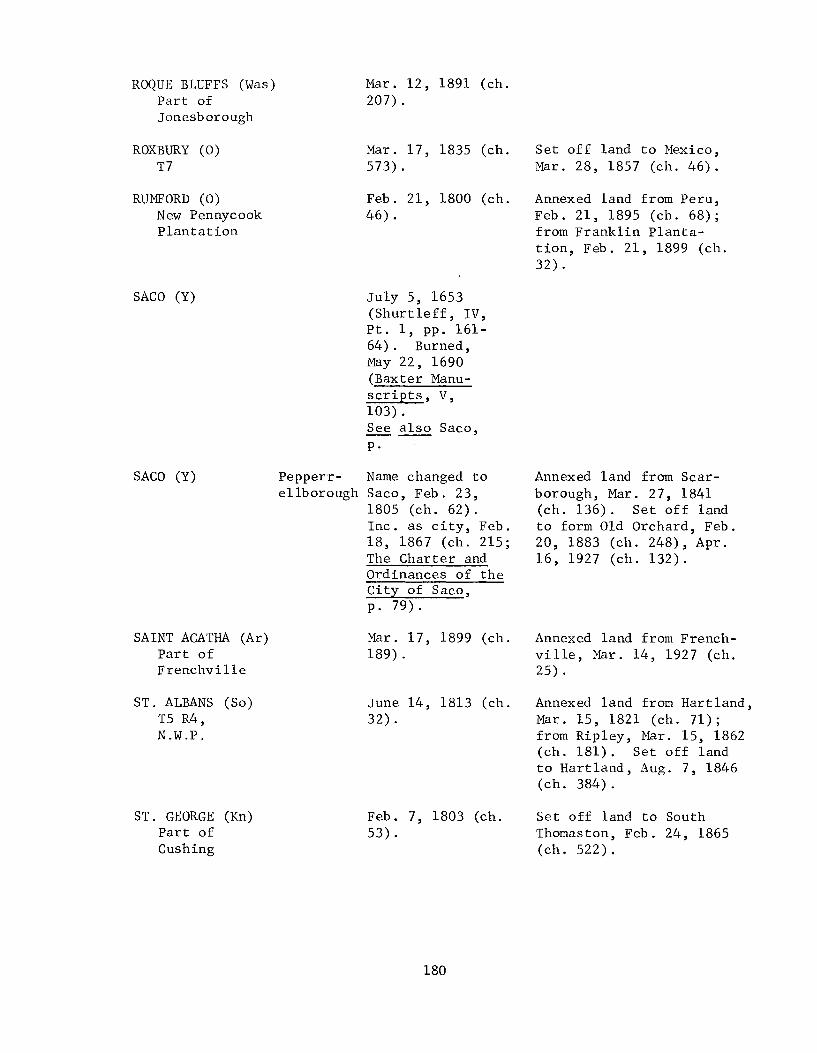
ROQUE BLUFFS (Was) Part of Jonesborough
ROXBURY (0) T7
RUMFORD (0) New Pennycook Plantation
SACO (Y)
SACO (Y)
SAINT AGATHA (Ar) Part of Frenchville
ST. ALBANS (So) T5 R4, N.W.P.
ST. GEORGE (Kn) Part of Cushing
Mar. 12, 1891 (ch. 207).
Mar. 17, 1835 (ch. 573) .
Feb. 21, 1800 (ch. 46) .
July 5, 1653 (Shurtleff, IV, Pt. 1, pp. 161-64). Burned, May 22, 1690 (Baxter Manuscripts, V, 103). See also Saco, p.
Pepperr- Name changed to e11borough Saco, Feb. 23,
1805 (ch. 62). Inc. as city, Feb. 18, 1867 (ch. 215; The Charter and Ordinances of the City of Saco, p. 79).
Mar. 17, 1899 (ch. 189) .
June 14, 1813 (ch. 32) .
Feb. 7, 1803 (ch. 53) .
180
Set off land to Mexico, Mar. 28, 1857 (ch. 46).
Annexed land from Peru, Feb. 21, 1895 (ch. 68); from Franklin Plantation, Feb. 21, 1899 (ch. 32) .
Annexed land from Scarborough, Mar. 27, 1841 (ch. 136). Set off land to form Old Orchard, Feb. 20, 1883 (ch. 248), Apr. 16, 1927 (ch. 132).
Annexed land from Frenchville, Mar. 14, 1927 (ch. 25).
Annexed land from Hartland, Mar. 15, 1821 (ch. 71); from Ripley, Mar. 15, 1862 (ch. 181). Set off land to Hart land, Aug. 7, 1846 (ch. 384).
Set off land to South Thomaston, Feb. 24, 1865 (ch.522).

SALEM (F)
SANFORD (Y) Tract called Phillips town
SANGERVILLE (Pi) T4 R6, N.W.P.
SCARBOROUGH (C) Towns of Black Point and Blue Point, and islands
SEARSMONT (Wal) Searsmont Plantation
SEARSPORT (Wal) Parts of Prospect and Belfast
SEAVILLE (H) Part of Mount Desert
North Salem
Name changed to Salem, Feb. 28, 1834 (ch. 471).
Feb. 27, 1768 (ch. 21) .
June 13, 1814 (ch. 25).
July 14, 1658, as Scarborow (Shurtleff, IV, Pt. 1, p. 359). Deserted in 1690 (Richardson, Preface IV, p.9). Town meeting, May 8, 1718 (York Deeds, XI, 27).
Feb. 5, 1814 (ch. 92) .
Feb. 13, 1845 (ch. 199) .
Mar. 8, 1838 (ch. 440). Surrender of organization, Feb. 24, 1859 (ch. 276) .
181
Annexed unincorporated land, Feb. 27, 1786 (ch. 64). Set off land to Lebanon and Shapleigh, Feb. 27, 1787 (ch. 64); to form district of Alfred, Feb. 4, 1794 (ch.3l). Annexed land from Shapleigh, Feb. 10, 1820 (Mass. Law, ch. 234); from Alfred, Feb. 28, 1828 (ch. 565).
Set off land to Guilford, Feb. 23, 1889 (ch. 426).
Set off land to Saco, Mar. 27, 1841 (ch. 136); to Gorham, Mar. 4, 1864 (ch. 341).
Area annexed to Mount Desert and Tremont, Feb. 24, 1859 (ch. 276).

SEBAGO (C) Part of Baldwin
SEBASTICOOK (Ke) Part of Clinton
SEBEC (Pi) T4 R7, N.W.P.
SEDGWICK (H) T4, E.P.R. or Naskeeg
SHAPLEIGH (Y) Shapleigh plantation
Feb. 10, 1826 (ch. 387).
Mar. 16, 1842 (ch. 40). Name changed to Benton, June 19, 1850 (ch. 311).
Feb. 28, 1812 (ch. 149).
Jan. 14, 1789 (ch. 31).
Mar. 5, 1785 (ch. 47).
182
Annexed land from Baldwin, Jan. 26, 1827 (ch. 440); from Denmark, Mar. 12, 1830 (ch. 94); from Baldwin, Mar. 28, 1837 (ch. 359), Feb. 15, 1871 (ch. 621). Set off land to form part of Naples, Mar. 4, 1834 (ch. 477); to Naples, Feb. 20, 1845 (ch. 204), July 17, 1849 (ch. 215), Mar. 27, 1852 (ch. 534).
Annexed land from Unity Gore, July 26, 1847 (ch. 59).
Set off land to Plantation Number Three R6, Feb. 23, 1818 (ch. 174); to Bowerbank, Apr. 7, 1927 (ch. 93).
Set off land to form part of Brooksville, June 13, 1817 (ch. 12); to B1uehi11, Feb. 5, 1831 (ch. 130); to form Port Watson, June 9, 1849 (ch. 192); to Penobscot, Mar. 16, 1857 (ch. 31).
Annexed land from Sanford, Feb. 27, 1787 ( c h. 64); from Lebanon, Feb. 14, 1793 (ch. 34). Set off land to Sanford, Feb. 10, 1820 (ch. 234); to Lebanon, Feb. 23, 1825 (ch. 326); to form Acton, Mar. 6, 1830 (ch. 79); to Newfield, June 30, 1846 (ch. 321). Annexed land from Acton, Mar. 22, 1831 (ch. 166); from waterborough, Mar. 14, 1854 (ch. 214).

SHERMAN (Ar) Golden Ridge plantation
SHIRLEY (Pi) T3 R4, B .K.P., E.K.R.
SIDNEY (Ke) Part of Vassa1borough
SKOWHEGAN (So) Milburn
SMITHFIELD (So) Parts of Mercer, Dearborn, and East Pond Plantation
SMYRNA (Ar) T6 R3
SOLON (So) Plantation Number One R2, N.P.C., E.K.R.
SOMERVILLE (L) Patricktown Plantation
SORRENTO (H) Part of Sullivan
Jan. 28, 1862 (ch. 116) .
Mar. 4, 1834 (ch. 476).
Jan. 30, 1792 (ch. 20).
Name changed to Skowhegan, Mar. 25, 1836 (ch. 162).
Feb. 29, 1840 (ch. 27).
Mar. 7, 1839 (ch. 527).
Feb. 23, 1809 (ch. 38).
Mar. 25, 1858 (ch. 235). Surrender of organization, Feb. 1, 1938 (1937, ch. ~; VII, 124**).
-;3'(1
Mar. 8, 1895 (ch. 149).
183
Annexed land from Silver Ridge Plantation, Feb. 4, 1870 (ch. 303); from Crystal Plantation, Feb. 17, 1881 (ch. 42).
Annexed part of Wilson, 1849 (1848, ch. 165).
Set off land to Belgrade, Feb. 23, 1798 (ch. 56).
Annexed land from Norridgewock, Apr. 9, 1856 (ch. 671). Annexed town of Bloomfield, Feb. 19, 1861 (ch. 34).
Set off land to Norridgewock, Mar. 27, 1852 (ch. 538) .

SOUTH BERWICK (Y) Part of Berwick
SOUTH BRISTOL (L) Part of Bristol
SOUTH PORTLAND (C)
SOUTH THOMASTON Part of (Kn) Thomaston
SOUTHPORT (L)
SOUTHWEST HARBOR Part of (H) Tremont
SPRINGFIELD (pe) T5 R2, N.B.P.P.
STANDISH (C) Pearsontown Plantation
Feb. 12, 1814 (ch. 114) .
Mar. 26, 1915 (ch. 133).
Annexed land from York, Feb. 15, 1834 (ch. 443); from Berwick, Mar. 18, 1841 (ch. 130), Feb. 5, 1881 (ch. 23).
Cape Name changed to South Elizabeth Portland, Mar. 15,
1895 (ch. 194). Inc. as city, Dec. 5, 1898 (1895, ch. 194; First Annual Report of City of South Portland, 1899-1900, p. 8).
July 28, 1848 (ch. 131).
Townsend Name changed to Southport, June 12, 1850 (ch. 305). See also Capenawagen, p.; Damariscove, p.
Feb. 21, 1905 (ch. 71) .
Feb. 12, 1834 (ch. 434).
Nov. 30, 1785 (ch. 40).
184
Annexed land from St. George, Feb. 24, 1865 (ch. 522). Set off land to form Owl's Head, Apr. 9, 1921 (ch. 147).
Annexed land from Buxton, Feb. 17, 1824 (ch. 276). Set off land to Gorham, Feb. 19,1831 (ch. 136), Mar. 14, 1839 (ch. 538); to Raymond, Feb. 24, 1869 (ch. 171).

STARKS (So) Lower Sandy River Plantation
STETSON (Pe) Stetson Plantation
STEUBEN (Was) Plantation Number Four
STOCKHOLM (Ar) Stockholm Plantation
STOCKTON SPRINGS Part of (Wal) Prospect
STONEHAM (0) Parts of Plantation of Fryeburg Academy Grant, and Plantation of Bachelder's Grant
STONINGTON (H) Part of Deer Isle
STOW (0) Tract including Bradley and Eastman's Grant, and Fryeburg Addition
Feb. 28, 1795 (ch. 59).
Jan. 28, 1831 (ch. 120).
Feb. 27, 1795 (ch. 50) .
Feb. 27, 1911 (ch. 41) .
Mar. 13, 1857, as Stockton (ch. 24). Name changed to Stockton Springs, Feb. 5, 1889 (ch. 318) .
Jan. 31, 1834 (ch. 405). Name changed to Usher, Feb. 19, 1841 (ch. 99); changed to Stoneham, Mar. 11, 1843 (ch. 86).
Feb. 18, 1897 (ch. 359).
Jan. 28, 1833 (ch. 292) .
185
Set off land to Industry, Jan. 21, 1822 (ch. 97); to Mercer, Mar. 2, 1835 (ch. 546), Feb. 22, 1865 (ch. 495); to Norridgewock, Feb. 28, 1907 (ch. 132).
Annexed land from Harrington, Feb. 5, 1823 (ch. 194). Set off land to Cherryfield, Feb. 26, 1826 (ch. 377); to Milbridge, Feb. 12, 1876 (ch. 265), Mar. 18, 1907 (ch. 273).

STRONG (F) Reedstown Plantation or Plantation Number Three, W.K.R.
STROUDWATER (C) Part of Falmouth
SULLIVAN (H) Plantation Number Two, east of Union River
SUMNER (0) West Butter-field Plantation
SURRY (H) T6, E.P.R.
SWAN'S ISLAND (H) Swan's Island Plantation and islands
SWANVILLE (Wal) Swan's Tract Plantation
Jan. 31, 1801 (ch. 37) .
Feb. 14, 1814 (ch. 119). Name changed to Westbrook, June 9, 1814 (ch. 15).
Feb. 16, 1789 (ch. 72) .
June 13, 1798 (ch. 2) .
June 21, 1803 (ch. 25).
Mar. 26, 1897 (ch. 538).
Feb. 19, 1818 (ch. 133).
186
Set off land to Farmington, Mar. 16, 1853 (ch. 83); to New Vineyard, Mar. 28, 1856 (ch. 635). Annexed land from Avon, Mar. 26, 1853 (ch. 135).
Set off land to form part of Hancock, Feb. 21, 1828 (ch. 551); to form Sorrento, Mar. 8, 1895 (ch. 149). Annexed land from T7, Mar. 11, 1899 (ch. 128).
Annexed land from Plantation Number Two, Mar. 20, 1838 (ch. 462); from Franklin Plantation, Feb. 22, 1844 (ch. 145), Feb. 12, 1863 (ch. 213). Set off land to Buckfield, Mar. 12, 1856 (ch. 589).
Set off land to Ellsworth, Mar. 3, 1809 (ch. 73), Feb. 17, 1829 (ch. 21); to Penobscot, Feb. 28, 1845 (ch. 230). The land set off to Ellsworth in 1809 was re-annexed, Feb. 28, 1821 (ch. 48). Annexed land from Penobscot, Jan. 31, 1843 (ch. 61).
Annexed 2 islands from Long Island Plantation, Feb. 22, 1901 (ch. 282).
Set off land to Waldo Plantation, Feb. 10, 1824 (ch. 260). Annexed land from Frankfort, Feb. 21, 1832 (ch. 242); from Brooks, Mar. 5, 1841 (ch. 116) .
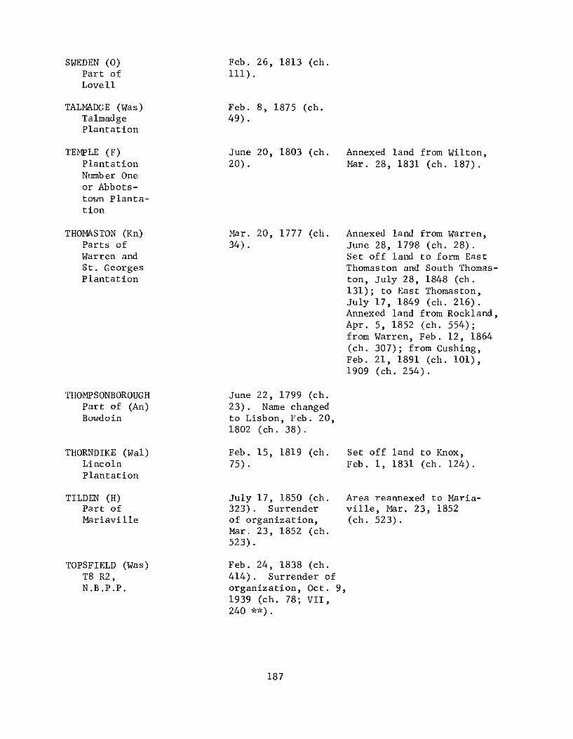
SWEDEN (0) Part of Lovell
TALMADGE (Was) Talmadge Plantation
TEMPLE (F) Plantation Number One or Abbotstown plantation
THOMASTON (Kn) Parts of Warren and St. Georges Plantation
THOMPSONBOROUGH Part of (An) Bowdoin
THORNDIKE (Wal) Lincoln Plantation
TILDEN (H) Part of Mariavil1e
TOPSFIELD (Was) T8 R2, N.B.P.P.
Feb. 26, 1813 (ch. lll) .
Feb. 8, 1875 (ch. 49).
June 20, 1803 (ch. 20).
Mar. 20, 1777 (ch. 34).
June 22, 1799 (ch. 23). Name changed to Lisbon, Feb. 20, 1802 (ch. 38).
Feb. 15, 1819 (ch. 75).
July 17, 1850 (ch. 323). Surrender of organization, Mar. 23, 1852 (ch. 523).
Feb. 24, 1838 (ch. 414). Surrender of organization, Oct. 9, 1939 (ch. 78; VII, 240 **).
187
Annexed land from Wilton, Mar. 28,1831 (ch. 187).
Annexed land from Warren, June 28, 1798 (ch. 28). Set off land to form East Thomaston and South Thomaston, July 28, 1848 (ch. 131); to East Thomaston, July 17,1849 (ch. 216). Annexed land from Rockland, Apr. 5, 1852 (ch. 554); from Warren, Feb. 12, 1864 (ch. 307); from Cushing, Feb. 21, 1891 (ch. 101), 1909 (ch. 254).
Set off land to Knox, Feb. 1, 1831 (ch. 124).
Area reannexed to Mariaville, Mar. 23, 1852 (ch. 523).

TOPSHAM (Sa) A tract
TOWNSEND (L) Part of Boothbay
TREMONT (H)
TRENTON (H) Plantation Number One, east of Union River
TRESCOTT (was) Plantation Number Nine
TROY (Wal)
TURNER (An) Sylvester Plantation
UNION (Kn) Sterlington Plantation
UNITY (Wal) Part of Twenty-five Mile Pond Plantation
Mansel
Montgomery
Jan. 31, 1764 (ch. 26). See also Pagi-scott, p.; Topsham, p.
Feb. 12, 1842 (ch. 5). Name changed to Southport, June 12, 1850 (ch. 305).
Name changed to Tremont, Aug. 8, 1848 (ch. 160).
Feb. 16, 1789 (ch. 70) .
Feb. 7, 1827 (ch. 462) .
Name changed to Troy, Feb. 10, 1827 (ch. 468).
July 7, 1786 (ch. 23) .
Oct. 20, 1786 (ch. 33).
June 22, 1804 (ch. 17) .
188
Annexed Patten's Point from Bowdoinham, Mar. 29,1788 (ch. 61). Set off land to Bowdoinham, Mar. 16, 1830 (ch. 111) .
Annexed part of Seaville, Feb. 24, 1859 (ch. 276). Set off land to form Southwest Harbor, Feb. 21, 1905 (ch. 71).
Set off land to Ellsworth, Mar. 3, 1809 (ch. 73); to form part of Hancock, Feb. 21, 1828 (ch. 551); to form Lamoine, Feb. 11, 1870 (ch. 319). Annexed land from Eden, June 27, 1849 (ch. 210).
Set off land to form part of Edmunds, Feb. 7, 1828 (ch. 515); to Lubec, July 3, 1847 (ch. 23); to Edmunds, Mar. 7, 1899 (ch. 98).
Annexed unincorporated land, June 16, 1817 (ch. 27) .
Annexed land from Twentyfive Mile Pond Plantation, Feb. 23, 1813 (ch. 99).

UPTON (0) T Letter B
USHER
VAN BUREN (Ar) Van Buren plantation
VANCEBOROUGH (Was) V anc eb orough plantation
VASSALBOROUGH (Ke) A tract
VEAZIE (Pe) Part of Bangor
VERONA (H) Wetmore Isle plantation
VIENNA (Ke) Goshen Plantation or Wyman's plantation
VINALHAVEN (Kn) North and South Fox Islands
WADE (Ar) Wade plantation
Feb. 9, 1860 (ch. 379) .
See Stoneham
Feb. 11, 1881 (ch. 27).
Mar. 4, 1874 (ch. 619).
Apr. 26, 1771 (ch. 33).
Mar. 26, 1853 (ch. 134).
Feb. 18, 1861 (ch. 25).
Feb. 20, 1802 (ch. 42).
June 25, 1789 (ch. 22).
Mar. 4, 1913 (ch. 60).
189
Annexed land from Hamlin Plantation, Feb. 19, 1907 (ch. 92).
Set off land to form Sidney, Jan. 30, 1792 (ch.20). Annexed land from China, Feb. 18, 1829 (ch. 24).
Set off land to Bangor, Jan. 29, 1889 (ch. 294).
Annexed land from Rome, Feb. 18, 1815 (ch. 112), Jan. 25, 1840 (ch.4). Set off land to Mount Vernon, Jan. 28, 1826 (ch. 370); to Chesterville, Aug. 2, 1847 (ch. 93); to Mount Vernon, Mar. 11, 1853 (ch. 56).
Set off land to form town of Fox Isle, June 30, 1846 (ch. 320); to form town of Hurricane Isle, Feb. 7, 1878 (ch. 30). Annexed Hurricane Island, Mar. 19, 1937 (ch. 36).

WAITE (Was) Waite Plantation
WALDO (wa1) Waldo Plantation
WALDOBOROUGH (L) Broadbay Plantation
WALES (An) Part of wales Plantation
WALTHAM (H) Part of plantation Number Fourteen
WARREN (Kn) Part of St. Georges plantation
WARSAW (So) A tract
Feb. 22, 1876 (ch. 302).
Mar. 17, 1845 (ch. 241).
June 29, 1773 (ch. 4).
Feb. 1, 1816 (ch. 48).
Jan. 29, 1833 (ch. 293).
Nov. 7, 1776 (ch. 17) .
June 19, 1819 (ch. 179). Name changed to Pittsfield, Feb. 14, 1824 (ch. 273).
190
Set off island to Bremen, Mar. 6, 1830 (ch. 78). Annexed land from Bremen, Mar. 11, 1853 (ch. 55), Mar. 27, 1856 (ch. 634).
Annexed land from Litchfield, Jan. 20, 1827 (ch. 437); 'from Leeds and Monmouth, Mar. 16, 1855 (ch. 526); from Litchfield, Mar. 12, 1856 (ch. 592). Set off land to Webster, Feb. 14, 1867 (ch.270).
Set off land to Eastbrook, Jan. 27, 1872 (ch. 18).
Set off land to form part of Thomaston, Mar. 20, 1777 (ch. 34); to Thomaston, June 28, 1798 (ch. 28); to Cushing, Feb. 6, 1807 (ch. 30); to Camden, Feb. 10, 1836 (ch. 17); to Thomaston, Feb. 12, 1864 (ch. 307).
Set off land to Twenty-five Mile Pond Plantation, Mar. 17, 1821 (ch. 76); to Canaan, Feb. 9, 1824 (ch. 255). Annexed land from Palmyra, Feb. 12, 1824 (ch. 266).

WASHBURN (Ar) Salmon Brook Plantation
WASHINGTON (Kn)
WATERBORO (Y) Massabesec Plantation
WATERFORD (0) Part of Waterford plantation
WATERVILLE (Ke) Part of Winslow
WAYNE (Ke) New Sandwich Plantation
Putnam
Feb. 25, 1861 (ch. 47).
Name changed to Washington, Jan. 31, 1823 (ch. 183).
Mar. 6, 1787, as Waterborough (ch. 83). Name changed to Waterboro, Mar. 20, 1895 (ch. 214).
Mar. 2, 1797 (ch. 63).
June 23, 1802 (ch. 23). Inc. as city, Jan. 23, 1888 (1883, ch. 281; Rev. E. C. Whittemore, ed., The Centennial History of Waterville, p. 88).
Feb. 12, 1798 (ch. 44).
191
Annexed land from Palermo, Apr. 11, 1854 (ch. 327).
Set off land to Alfred, July 22, 1847 (ch. 53); to Shapleigh, May 14, 1854 (ch. 214).
Annexed land from Albany, Feb. 18, 1811 (ch. 42).
Annexed land from Dearborn, Feb. 20, 1815 (ch. 116), Jan. 21, 1822 (ch. 98), Feb. 28, 1826 (ch. 412); annexed Dearborn Plantation, Mar. 17, 1843 (ch. 90). Set off land to form West Waterville, Feb. 26, 1873 (ch. 382).
Annexed a gore, June 21, 1804 (ch. 9); land from Leeds, Feb. 16, 1810 (ch. 49); from Livermore, Feb. 8, 1821 (ch. 35); from Leeds, Apr. 2, 1859 (ch. 344). Set off land to Winthrop, Mar. 13, 1816 (ch. 58); to Readfield, Jan. 25, 1821 (ch. 23); to Winthrop, Mar. 13, 1839 (ch. 535), Apr. 19, 1852 (ch. 606).

WEBSTER (An) Part of Lisbon
Mar. 7, 1840 (ch. 44) .
Rrs:c\-c(){S \,toted at -61.U/) vvu:et: ll j ~"i\ Ct~ t --) / lelll -k. C hc-t,1 9 c. I\OctYIt: -In
51': 'bD-l-tu"). - l.--ej;s I~eco:d/ 11 11 /, f' 'TlcCj
WELD (F) Webbs Pond plantation
WELLINGTON (Pi) Plantation Numb er Three R1, B.K.P., E.K.R.
WELLS (Y)
WESLEY (Was) T25, E.D. and part of T26, E.D.
WEST BATH (Sa) Part of Bath
WEST GARDINER (Ke) Part of Gardiner
WEST MACHIAS (Was) Part of Machias
Feb. 8, 1816 (ch. 65).
Feb. 23, 1828 (ch. 556).
July 5, 1653 (Shurtleff, III, 335). See also Wells, p.
Jan. 24, 1833 (ch. 287).
Feb. 14, 1844 (ch. 133).
Aug. 8, 1850 (ch. 350).
Jan. 26, 1826 (ch. 367). Name changed to Machias, Mar. 12, 1830 (ch. 93).
192
Set off land to Lisbon, July 26, 1847 (ch. 56); to Lewiston, Apr. 20, 1852 (ch. 617). Annexed land from Lisbon, Feb. 19, 1863 (ch. 223); from Litchfield and Wales, Feb. 14, 1867 (ch. 270); from Lewiston and Greene, Feb. 7, 1895 (ch. 18).
Set off land to Parkman, Mar. 23, 1841 (ch. 133), repealed Mar. 10, 1842 (ch. 24); to Cambridge, Feb. 27, 1885 (ch. 464).
Set off land to form Kennebunk, June 14, 1820 (ch. 3). Annexed land from Kennebunk, Feb. 21, 1868 (ch. 563).
Set off land to Bath, Mar. 16, 1855 (ch. 530).
Set off land to form part of Farmingdale, Apr. 3, 1852 (ch. 549). Annexed land from Farmingdale, Mar. 19, 1853 (ch. 93); from Litchfield, Mar. 22, 1856 (ch. 625).

WEST PITTSTON (Ke) Part of Pittston
WEST WATERVILLE (Ke) Part of Waterville
WESTBROOK (C)
WESTFIELD (Ar) Westfield Plantation
WESTON (Ar) Half township of Hampden Academy Grant
WESTPORT (L) Part of Edgecomb
WHITEFIELD (L) Ballstown Plantation
Stroudwater
Mar. 4, 1887 (ch. 202). Name changed to Randolph, Mar. 17, 1887 (ch. 279).
Feb. 26, 1873 (ch. 382). Name changed to Oakland, Mar. 10, 1883 (ch. 336).
Name changed to Westbrook, June 9, 1814 (ch. 15). Inc. as city, Feb. 24, 1891 (1889, ch. 486; Records of City of Westbrook, Vol. 1, p. 3).
Mar. 7, 1905 (ch. 124) .
Mar. 17, 1835 (ch. 572) .
Feb. 5, 1828 (ch. 511) .
June 19, 1809, as Whitfield (ch. 23).
193
Set off land to Falmouth, Feb. 4, 1819 (ch. 49), Feb. 11, 1828 (ch. 519), Mar. 22, 1831 (ch. 165). Annexed land from Falmouth, Jan. 31, 1825 (ch. 297), Feb. 24, 1835 (ch. 542), Mar. 21, 1836 (ch. 140); from Cape Elizabeth, Apr. 19, 1852 (ch. 605); from Falmouth, Mar. 25, 1853 (ch.130). Set off land to Portland, Apr. 3, 1845 (ch. 279); to form Deering, Feb. 16, 1871 (ch. 628).
Annexed unincorporated land, Mar. 15, 1921 (ch. 39).
Annexed unincorporated land, Feb. 19, 1855 (ch. 431); land from Bancroft, Feb. 26, 1907 (ch. 123). Set off land to Danforth, Mar. 4, 1885 (ch. 499).
Set off land to Gerry, Mar. 8, 1821 (ch. 58), repealed Feb. 21, 1907 (ch. 96); to Alna, Jan. 22, 1824 (ch. 228), repealed, Feb. 19, 1907 (ch. 94).

WHITING (Was) Plantation Number Twelve, E.D.
WHITNEYVILLE (Was) Part of Machias
WILLIAMSBURG (Pi) Williamsburg plantation
WILLIMANTIC (Pi) Howard
WILSON (Pi) T9 R9, N.W.P.
WILTON (F) Tyngtown Plantation
WINDHAM (C) New Marblehead Plantation
WINDSOR (Ke)
WINN (Pe) Five Is lands Plantation
WINSLOW (Ke) A tract
Gerry
Feb. 15, 1825 (ch. 304).
Feb. 10, 1845 (ch. 193).
June 21, 1820 (ch. 9). Surrender of organization, Oct. 30, 1939 (ch. 84; VII, 252 'b~).
Name changed to Willimantic, Feb. 3, 1883 (ch. 187).
Mar. 29, 1836 (ch. 176). Surrender of organization, Mar. 1, 1849 (1848, ch. 165).
June 22, 1803 (ch. 43).
June 12, 1762 (ch. 8) .
Name changed to Windsor, Jan. 19, 1822 (ch. 95).
Mar. 21, 1857 (ch. 41).
Apr. 26, 1771 (ch. 34).
194
Set off land to form Barnard, Feb. 8, 1834 (ch.420).
Area divided to Greenville, Shirley, and Elliottsville, 1849 (1848, ch. 165).
Set off land to Chesterville, Feb. 18, 1811 (ch. 44); to Temple, Mar. 28, 1831 (ch. 187).
Returned land to Whitefield by repeal of 1821, Ch. 58, on Feb. 21, 1907 (ch. 96).
Set off land to form Waterville, June 23, 1802 (ch. 23); to Fairfax, Mar. 1, 1810 (ch. 78); to Harlem, Feb.23, 1813 (ch. 87); to form part of China, Feb. 5, 1818 (ch. 78).

WINTER HARBOR (H) Part of Gouldsboro
WINTERPORT (Wa1) Part of Frankfort
WINTHROP (Ke) Ponds town Plantation
WISCASSET (L)
WOODLAND (Ar) Woodland plantation
powna1-borough
WOODSTOCK (0) Half township granted to Dummer Academy and half township granted to Gorham Academy
Feb. 21, 1895 (ch. 71) .
Mar. 12, 1860 (ch. 422).
Apr. 26, 1771 (ch. 30).
Name changed to Wiscasset, June 10,1802 (ch. 2).
Mar. 5, 1880 (ch. 261).
Feb. 7, 1815 (ch. 88).
195
Annexed land from Frankfort, Feb. 18, 1867 (ch. 291).
Set off land to form Readfield, Mar. 11, 1791 (ch. 46); to Hallowell, June 14, 1813 (ch. 39), June 13, 1814 (ch. 28). Annexed land from Readfield, Feb. 24,1810 (ch. 57); from Augusta, Feb. 27, 1810 (ch. 67); from Monmouth, June 11, 1813 (ch. 15); from Wayne, Dec. 4, 1816 (ch. 58), Mar. 13, 1839 (ch. 535) . Set off land to form part of Kennebec, Aug. 12, 1850 (ch. 355). Annexed land from Kennebec, Mar. 30, 1852 (ch. 539); from Wayne, Apr. 19, 1852 (ch. 606); from Manchester, Feb. 14, 1873 (ch. 280).
Annexed land from A1na, Feb. 25, 1839 (ch. 515).
Set off land to Paris, Feb. 10, 1825 (ch. 300), Mar. 9, 1880 (ch. 270). Annexed land from Paris, Mar. 23, 1841 (ch. 134); from Milton Plantation, Mar. 24, 1853 (ch. 126); entire Hamlin's Grant Plantation, Feb. 13, 1873 (ch. 269); land from Greenwood, Feb. 17, 1893 (ch. 404) .

WOODVILLE (Pe) Woodville Plantation
WOOLWICH (Sa) Tract called Neguasset
YARMOUTH (C) Part of North Yarmouth
YORK (Y) Accom.enticus or Gorgeana
Feb. 28, 1895 (ch. 101).
Inc. as district Oct. 20, 1759 (ch. 7); as town Aug. 23, 1775 (ch. 3). See also Mounsweig, p.; Neguasset, p.; New Merrymeeting, p.
Aug. 8, 1849 (ch. 264) .
Nov. 22, 1652 (Shurt 1eff, IV, Pt. 1, p. 128). See also Acomen-ticus, p.; Gorgeana, p.
196
Set off land to South Berwick, Feb. 15, 1834 (ch. 443).

VIII. CITIES


CITIES
Auburn was established as a city, February 22, 1869 (1868, ch. 471; History of Androscoggin County, p. 611).
Augusta was established as a city, August 20,1849 (ch. 224).
Bangor was established as a city, February 24, 1834 (ch. 436; History of Penobscot County, Maine, p. 667).
Bath was established as a city, June 14, 1847 (ch. 5; Henry W. Owen, History of Bath, Maine, p. 191).
Belfast was established as a city, April 3, 1852 (1850, ch. 363; Joseph Williamson, History of Belfast, p. 149).
Biddeford was established as a city, February 10, 1855 (ch. 408; Record of the City of Biddeford, I, 13).
Brewer was established as a city, March 30, 1889 (ch. 328; Brewer Annual Report, 1890, p. 81).
Calais was established as a city, November 18, 1850 (ch. 389; Town Clerk's Records, Book II, p. 428).
Deering was established as a city, October 12, 1891 (1889, ch. 506; Deering Annual Report. 1892, p. 7). The entire city was annexed to the city of Portland, March 8, 1889 (ch. 11; Westbrook Globe-Star).
Eastport was established as a city, March 18, 1893 (ch. 450; The Charter and Ordinances of the City of Eastport, pp. 20-21).
Ellsworth was established as a city, February 27, 1869 (ch. 29; Albert H. Davis, History of Ellsworth. Maine, p. 103).
Gardiner was established as a city, November 26, 1849 (ch. 281; J. W. Hanson, History of Gardiner. Pittston and West Gardiner, p. 213).
Hallowell was established as a city, February 17, 1852 (1850, ch. 413; Emma Huntington Nason, Old Hallowell on the Kennebec, p. 338).
Lewiston was established as a city, November 22, 1862 (1861, ch. 105; History of Androscoggin County, p. 352).
Old Town was established as a city, March 30, 1891 (ch. 71; Annual Report of Old Town, 1892, cover).
Portland was established as a city, March 26, 1833 (1832, ch. 248; William Willis, History of Portland, Pt. II, p. 279).
199

Presque Isle was established as a city, January 1, 1940 (1939, ch. 29; Presque Isle Star-Herald).
Rockland was established as a city, June 3, 1854 (ch. 360; Cyrus Eaton, History of Thomaston, Rockland and South Thomaston, Maine, II, 21).
Saco was established as a city, February 18, 1867 (ch. 215; The Charter and Ordinances of the City of Saco, p. 79).
South Portland was established as a city, December 5, 1898 (1895, ch. 194; First Annual Report of City of South Portland, 1899-1900, p. 8).
waterville was established as a city, January 23, 1888 (1883, ch. 281; Rev. E. C. Whittemore, ed., The Centennial History of Waterville, p. 88).
Westbrook was established as a city, February 24, 1891 (1889, ch. 486; Records of City of Westbrook, I, 3).
200

IX. TOWNS, CHRONOLOGICALLY


TOWNS, CHRONOLOGICALLY
The following towns listed were incorporated by Massachusetts General Court prior to March 15, 1820 and from that date by the Maine Legislature.
A true chronology would include the early non-corporate towns and begin: St. Croix Island, June 1604; Fort Sc George, August 1607. Although self-organized towns continued to be formed until nearly 1760, there are not sufficient records available to fix even an approximate chronology of their organizations.
The first town incorporation by Massachusetts, Nov. 20, 1652, does not establish a date after which all towns in the Province of Maine were incorporated by the mother colony. From 1680, there were 12 years of provincial government with power to set up towns and "peculiars". Even after the acceptance of its new charter in 1692, by which the Province of Massachusetts Bay acquired jurisdiction over a much enlarged Province of Maine, new towns were organized east of Falmouth by groups of land proprietors and by Col. David Dunbar, while the General Court was gradually incorporating towns as far east as the Kennebec. It was not until 1760 and the establishment of the two new counties of Cumberland and Lincoln that the practice of self organization ceased.
203


Kittery Nov. 20, 1652 Turner July 7, 1786 York Nov. 22, 1652 Union Oct. 20, 1786 Wells July 5, 1653 penobscot Feb. 23, 1787 Cape Porpus July 5, 1653 Limerick Mar. 6, 1787 Saco July 5,t 1653 Wa terb orough Mar. 6, 1787 Scarborough July 14, 1658 Orrington Mar. 21, 1788 Falmouth July 14, 1658 Bowdoin Mar. 21, 1788 Ap1edoore May 22, 1661 Greene June 18, 1788 North Yarmouth June 27, 1683 Fairfield June 18, 1788 Berwick June 9, 1713 Canaan June 18, 1788 Georgetown June 13, 1716 Norridgewock June 18, 1788 Falmouth Nov. 12, 1718 Nob 1eborough Nov. 20, 1788 Biddeford Nov. 17, 1718 Sedgwick Jan. 14, 1789 Arundel June 10, 1719 Is1esborough Jan. 28, 1789 Brunswick Jan. 26, 1739 Cushing Jan. 3O, 1789 Powna 1b orough Feb. 13, 1760 Blue Hill Feb. 2, 1789 Windham June 12, 1762 Deer Isle Feb. 2, 1789 Bowdoinham Sept.18, 1762 Freeport Feb. 14, 1789 Topsham Jan. 31, 1764 Trenton Feb. 16, 1789 Gorham Oct. 30, 1764 Goldsboro
, Feb. 16, 1789
Boothbay Nov. 3, 1764 Sullivan Feb. 16, 1789 Bristol June 21, 1765 Mount Desert Feb. 17, 1789 Lebanon June 17, 1767 Durham Feb. 17, 1789 Sanford Feb. 27, 1768 Frankfort June 25, 1789 Hallowell Apr. 26, 1771 Vinalhaven June 25, 1789 Winthrop Apr. 26, 1771 Cambden Feb. 17, 1791 Vassallborough Apr. 26, 1771 Bangor Feb. 25, 1791 Winslow Apr. 26, 1771 Readfield Mar. 11, 1791 Buxton July 14, 1772 Monmouth Jan. 20, 1792 Belfast June 29, 1773 Sidney Jan. 30, 1792 Wa1doborough June 29, 1773 Limington Feb. 9, 1792 Edgecomb Mar. 9, 1774 Hebron Mar. 6, 1792 New Glocester Mar. 9, 1774 Buckstown June 27, 1792 Newcastle Aug. 23, 1775 Mount Vernon June 28, 1792 Harpswell Aug. 23, 1775 Buckfield Mar. 16, 1793 Woolwich Aug. 23, 1775 Paris June 20, 1793 Pepperre11boro' Aug. 23, 1775 Farmington Feb. 1, 1794 Cape Elizabeth Aug. 23, 1775 Bridgton Feb. 7, 1794 Warren Nov. 7, 1776 Prospect Feb. 24, 1794 Fryeburg Jan. 11, 1777 Hampden Feb. 24, 1794 Thomaston Mar. 20, 1777 Newfield Feb. 25, 1794 Coxha11 Mar. 11, 1778 Cornish Feb. 27, 1794 Gray June 19, 1778 New Sharon June 20, 1794 Pittston Feb. 4, 1779 Dresden June 25, 1794 Bath Feb. 17, 1781 New Milford June 25, 1794 Machias June 23, 1784 Poland Feb. 17, 1795 Shapleigh Mar. 5, 1785 Litchfield Feb. 18, 1795 Parsonsfield Mar. 9, 1785 Lewiston Feb. 18, 1795 Standish Nov. 30, 1785 Jay Feb. 26, 1795 Portland July 4, 1786 Steuben Feb. 27, 1795
205

Fayette Feb. 28, 1795 Wilton June 22, 1803 Livermore Feb. 28, 1795 Rome Mar. 7, 1804 Starks Feb. 28, 1795 Madison Mar. 7, 1804 Clinton Feb. 28, 1795 Athens Mar. 7, 1804 Belgrade Feb. 3, 1796 Fairfax Mar. 9, 1804 Harlem Feb. 8, 1796 Mercer June 22, 1804 Columbia Feb. 8, 1796 Unity June 22, 1804 Castine Feb. 10, 1796 Emden June 22, 1804 Northport Feb. 13, 1796 Palermo June 23, 1804 Eden Feb. 23, 1796 East Andover June 23, 1804 Bethel June 10, 1796 Gilead June 23, 1804 Addison Feb. 14, 1797 Hope June 23, 1804 Harrington Feb. 20, 1797 Harrison Mar. 8, 1805 Waterford Mar. 2, 1797 Newry June 15, 1805 Norway Mar. 9, 1797 Orono Mar. 12, 1806 Harrington June 17, 1797 Montville Feb. 18, 1807 wayne Feb. 12, 1798 Porter Feb. 20, 1807 Otisfie1d Feb. 19, 1798 Denmark Feb. 20, 1807 Cornville Feb. 24, 1798 Jefferson Feb. 24, 1807 Eastport Feb. 24, 1798 Friendship Feb. 25, 1807 Phillipsburg Feb. 27, 1798 Dixmont Feb. 28, 1807 Anson Mar. 1, 1798 Palmyra June 20, 1807 Hartford June 13, 1798 Alfred Feb. 25, 1808 Sumner June 13, 1798 Pownal Mar .. 3, 1808 Thomps onb orough June 22, 1799 Freeman Mar. 4, 1808 Rumford Feb. 21, 1800 New Portland Mar. 9, 1808 Orland Feb. 21, 1800 Solon Feb. 23, 1809 Ellsworth Feb. 26, 1800 Malta Mar. 3, 1809 Lovell Nov. 15, 1800 Jonesborough Mar. 4, 1809 Strong Jan. 31, 1801 Calais June 16, 1809 Leeds Feb. 16, 1801 Whi tfie1d June 19, 1809 Minot Feb. 18, 1802 Eliot Mar. 1, 1810 Chesterville Feb. 20, 1802 Exeter Feb. 16, 1811 Brownfield Feb. 20, 1802 New Charleston Feb. 16, 1811 Vienna Feb. 20, 1802 Garland Feb. 16, 1811 Avon Feb. 22, 1802 Robbinston Feb. 18, 1811 New Vineyard Feb. 22, 1802 Eddington Feb. 22, 1811 Pejepscot Mar. 6, 1802 Putnam Feb. 27, 1811 Baldwin June 23, 1802 Corinth June 21, 1811 Lincolnville June 23, 1802 Carmel June 21, 1811 Waterville June 23, 1802 Lubeck June 21, 1811 St. George Feb. 7, 1803 Bingham Feb. 6, 1812 Gardiner Feb. 17, 1803 Dearborn Feb. 22, 1812 Harmony June 15, 1803 Kingville Feb. 22, 1812 Temple June 20, 1803 Brewer Feb. 22, 1812 Industry June 20, 1803 PhiUips Feb. 25, 1812 Albany June 20, 1803 Sebec Feb. 28, 1812 Surry June 21, 1803 Foxcroft Feb. 29, 1812 Raymond June 21, 1803 Sweden Feb. 26, 1813 Dixfield June 21, 1803 Freedom June 11, 1813
206

Levant June 14, 1813 Cumberland Apr. 2, 1822 St. Albans June 14, 1813 North Salem Jan. 10, 1823 Phipsburg Jan. 26, 1814 Milo Jan. 21, 1823 Searsmont Feb. 5, 1814 Milburn Feb. 5, 1823 Bloomfield Feb. 5, 1814 Richmond Feb. 10, 1823 Belmont Feb. 5, 1814 Berlin Jan. 31, 1824 South Berwick Feb. 12, 1814 Kilmarnock Jan. 31, 1824 Stroudwater Feb. 14, 1814 Brownville Feb. 3, 1824 Sangerville June 13, 1814 Burnham Feb. 4, 1824 Hermon June 13, 1814 Maxfield Feb. 6, 1824 Hiram June 14, 1814 Alexander Jan. 19, 1825 Newport June 14, 1814 Baring Jan. 19, 1825 Woodstock Feb. 7, 1815 Charlotte Jan. 19, 1825 Kingfield Jan. 24, 1816 Franklin Jan. 24, 1825 Moscow Jan. 30, 1816 Whiting Feb. 15, 1825 Wales Feb. 1, 1816 Kirkland Feb. 25, 1825 Greenwood Feb. 2, 1816 Machiasport Jan. 26, 1826 Weld Feb. 8, 1816 Eas t Machias Jan. 26, 1826 Guilford Feb. 8, 1816 West Machias Jan. 26, 1826 Cherryfie 1d Feb. 9, 1816 Cutler Jan. 26, 1826 Dexter June 17, 1816 Sebago Feb. 10, 1826 North Hill June 20, 1816 Howland Feb. 10, 1826 Brooks Dec. 10, 1816 Carthage Feb. 20, 1826 Corinna Dec. 11, 1816 Plymouth Feb. 21, 1826 Ripley Dec. 11, 1816 Liberty Jan. 31, 1827 Brooksvi lle June 13, 1817 Abbot Jan. 31, 1827 China Feb-. 5, 1818 Trescott Feb. 7, 1827 Monroe Feb. 12, 1818 Westport Feb. 5, 1828 Perry Feb. 12, 1818 Edmunds Feb. 7, 1828 Mexico Feb. 13, 1818 Adams Feb. 11, 1828 Dennysville Feb. 13, 1818 Bremen Feb. 19, 1828 Swanville Feb. 19, 1818 Baileyville Feb. 19, 1828 Jackson June 12, 1818 Chand 1ervi lle Feb. 19, 1828 Atkinson Feb. 12, 1819 Hancock Feb. 21, 1828 Knox Feb. 12, 1819 Wellington Feb. 23, 1828 Thorndike Feb. 15, 1819 Lincoln Jan. 30, 1829 Newburgh Feb. 15, 1819 Oxford Feb. 27, 1829 Warsaw June 19, 1819 Appleton June 28, 1829 Aetna Feb. 15, 1820 Acton Mar. 6, 1830 Hartland Feb. 17, 1820 Cranberry Isles Mar. 16, 1830 Williamsburg June 21, 1820 Stetson Jan. 28, 1831 Kennebunk July 31, 1820 Hampton Feb. 1, 1831 Concord Jan. 25, 1821 Amherst Feb. 5, 1831 Peru Feb. 5, 1821 Houlton Mar. 8, 1831 Canton Feb. 5, 1821 Bradford Mar. 12, 1831 Dover Jan. 19, 1822 Madawaska Mar. 15, 1831 Parkman Jan. 29, 1822 Blanchard Mar. 17, 1831 Dutton Jan. 29, 1822 North Berwick Mar. 22, 1831 Cooper Feb. 6, 1822 Milton Jan. 31, 1832 Monson Feb. 8, 1822 Princeton Feb. 3, 1832
207

Jones' Port Feb. 3, 1832 Masardis Mar. 21, 1839 Lee Feb. 3, 1832 Smithfield Feb. 29, 1840 Pembroke Feb. 4, 1832 Webster Mar. 7, 1840 Hodgdon Feb. 11, 1832 Old Town Mar. 16, 1840 Lagrange Feb. 11, 1832 Medybemps Feb. 20, 1841 Burlington Mar. 8, 1832 Arrowsic Mar. 2, 1841 Wesley Jan. 24, 1833 Casco Mar. 18, 1841 Byron Jan. 24, 1833 Patten Apr. 16, 1841 Stow Jan. 28, 1833 Townsend Feb. 12, 1842 Waltham Jan. 29, 1833 Auburn Feb. 24, 1842 Beddington Jan. 31, 1833 Sebasticook Mar. 16, 1842 Milford Feb. 28, 1833 Centreville Mar. 16, 1842 Lexington Mar. 4, 1833 Mason Feb. 3, 1843 Greenfield Jan. 29, 1834 Hanover Feb. 14, 1843 Marion Jan. 31, 1834 West Bath Feb. 14, 1844 Stoneham Jan. 31, 1834 East Livermore Mar. 1, 1844 Barnard Feb. 8, 1834 Alton Mar. 9, 1844 Cambridge Feb. 8, 1834 Whitneyville Feb. 10, 1845 S pringf.i.e 1d Feb. 12, 1834 Searsport Feb. 13, 1845 Chester Feb. 26, 1834 Waldo Mar. 17, 1845 Greenbush Feb. 28, 1834 North Anson Mar. 20, 1845 Shirley Mar. 4, 1834 Carroll Mar. 20, 1845 Naples Mar. 4, 1834 Marshfield June 30, 1846 Edinburg Jan. 31, 1835 Monticello July 29, 1846 Enfield Jan. 31, 1835 Fox Isle Mar. 1, 1847 Passadumkeag Jan. 31, 1835 Perkins June 24, 1847 Bradley Feb. 3, 1835 Damariscotta Mar. 15, 1848 Elliottsville Feb. 19, 1835 Mansel June 3, 1848 Weston Mar. 17, 1835 Milbridge July 14, 1848 Roxbury Mar. 17, 1835 East Thomaston July 28, 1848 Otis Mar. 19, 1835 South Thomaston July 28, 1848 Madrid Jan. 29, 1836 Maine Aug. 7, 1848 Greenville Feb. 6, 1836 Port Watson June 9, 1849 Mariaville Feb. 29, 1836 Yarmouth Aug. 8, 1849 Mayfield Mar. 7, 1836 Tilden July 17, 1850 Linneus Mar. 19, 1836 West Gardiner Aug. 8, 1850 Amity Mar. 19, 1836 Kennebec Aug. 12, 1850 Kingsbury Mar. 22, 1836 Chelsea Mar. 1, 1851 Wilson Mar. 29, 1836 Kenduskeag Feb. 20, 1852 Dedham Feb. 7, 1837 Deblois Mar. 4, 1852 Eastbrook Feb. 8, 1837 Grafton Mar. 19, 1852 Huntressvi11e Feb. 9, 1837 Farmingdale Apr. 3, 1852 New Limerick Mar. 18, 1837 Holden Apr. 13, 1852 Topsfield Feb. 24, 1838 Veazie Mar. 26, 1853 Seaville Mar. 8, 1838 Davton Apr. 7, 1854 Northfield Mar. 21, 1838 Morrill Mar. 3, 1855 Bowerbank Mar. 4, 1839 Rangeley Mar. 29, 1855 Smyrna Mar. 7, 1839 Littleton Mar. 18, 1856 Mattamiscontis Mar. 8, 1839 Orient Apr. 9, 1856 Argyle Mar. 19, 1839 Is 1andport Feb. 11, 1857
208

Stockton Mar. 13, 1857 Mapleton Mar. 5, 1880 Winn Mar. 21, 1857 Woodland Mar. 5, 1880 Prentiss Feb. 27, 1858 Van Buren Feb. 11, 1881 Bridgewater Mar. 2, 1858 Howard Feb. 22, 1881 Fort Fairfield Mar. 11, ~858 Old Orchard Feb. 20, 1883 Somerville Mar. 25, 1858 Brookton Mar. 2, 1883 Presque Isle Apr. 4, 1859 Forest City Feb. 15, 1887 Maysville Apr. 4, 1859 West Pittston Mar. 4, 1887 Lyndon Apr. 5, 1859 Bancroft Feb. 5, 1889 Upton Feb. 9, 1860 Boothbay Harbor Feb. 16, 1889 Mattawamkeag Feb. 14, 1860 Camden Feb. 25, 1891 Winterport Mar. 12, 1860 Rockport Feb. 25, 1891 Danforth Mar. 17, 1860 Roque Bluffs Mar. 12, 1891 Verona Feb. 18, 1861 Dyer Brook Mar. 21, 1891 Washburn Feb. 25, 1861 Mechanic Falls Mar. 22, 1893 Sherman Jan. 28, 1862 New Sweden Jan. 29, 1895 Ashland Feb. 18, 1862 Winter Harbor Feb. 21, 1895 Columbia Falls Mar. 25, 1863 Woodville Feb. 28, 1895 Mount Chase Mar. 21, 1864 Sorrento Mar. 8, 1895 Ludlow Mar. 21, 1864 Cape Elizabeth Mar. 15, 1895 Easton Feb. 24, 1865 South Portland Mar. 15, 1895 Glenwood Feb. 14, 1867 Stonington Feb. 18, 1897 Mars Hill Feb. 21, 1867 Oakfield Feb. 24, 1897 DickeYVille Feb. 23, 1869 Perham Mar. 26, 1897 Fort Kent Feb. 23, 1869 Swan's Island Mar. 26, 1897 Madawaska Feb. 24, 1869 Saint Agatha Mar. 17, 1899 Limestone Feb. 26, 1869 Millinocket Mar. 16, 1901 Grand Isle Mar. 2, 1869 Crystal Mar. 21, 1901 Lamoine Feb. 11, 1870 Castle Hill Feb. 25, 1903 Eustis Feb. 18, 1871 Sou 'west Harbor Feb. 21, 1905 Deering Mar. 21, 1871 Westfield Mar. 7, 1905 Island Falls Feb. 27, 1872 East Millinocket Feb. 21, 1907 Kingman Jan. 25, 1873 Bowerbank Feb. 28, 1907 Eaton Jan. 25, 1873 Portage Lake Mar. 24, 1909 Hersey Jan. 25, 1873 Stockholm Feb. 27, 1911 Benedicta Feb. 1, 1873 Merrill Mar. 4, 1911 West Waterville Feb. 26, 1873 Eagle Lake Mar. 16, 1911 Blaine Feb. 10, 1874 Wade Mar. 4, 1913 Isle au Haut Feb. 28, 1874 Connor July 12, 1913 Vanceborough Mar. 4, 1874 Chapman Mar. 11, 1915 Talmadge Feb. 8, 1875 South Bristol Mar. 26, 1915 Medway Feb. 8, 1875 North Kennebunkport Apr. 1, 1915 Haynesville Feb. 18, 1876 Drew Apr. 5, 1921 Waite Feb. 22, 1876 Owl's Head July 9, 1921 Kossuth Feb. 23, 1876 Dover-Foxcroft Mar. 1, 1922 Hurricane Isle Feb. 7, 1878 Beals Apr. 7, 1925
209


X. MAINE COUNTIES, CITIES, TOWNS AND PLANTATIONS EXISTENT, 1980


COUNTIES
Androscog~inl Aroostook Cumberla~d3 Franklin Hancock5
Kenn~bec Knox Lincoln 7
Oxford 8
Penobscot 9
Piscataquis 10 Sagadahoc 11 Somerset 12 Waldo 13 waShtngton14 York 5
CITIES
Auburn Augusta Bangor Bath Belfast Biddeford Brewer Calais Caribou Eastport Ellsworth Gardiner Hallowell Lewiston Old Town Portland Presque Isle Rockhnd Saco South Portland Waterville Westbrook
213

TOWNS
Abbot Bristol Cutler Acton Brooklin Damariscotta Addison Brooks Danforth Albion Brooksvi lle Dayton Alexander Brownfield Deblois Alfred Brownville Dedham .Allagash Brunswick Deer Isle Alna Buckfield Derunark Alton Bucksport Dennysville Amherst Burlington Detroit Amity Burnham Dexter Andover Buxton Dixfield Anson Byron Dixmont Appleton Cambridge Ddver-Foxcroft Arrowsic Camden Dresden Arundel: Canaan Durham Ashland Canton Dyer Brook Athens Cape Elizabeth Eagle Lake Atkinson Carmel
4 East Machias
Aurora Carrabassett Valley East Millinocket Avon Carthage Eastbrook Baileyville Casco Easton Baldwin Castine Eddington Bancroft Castle Hill Edgecomb Bar Harbor Centerville Edinburg Beals Chapman Eliot Beaver Cove 10 Charleston Embden Beddington Charlotte Enfield Belgrade Chelsea Etna Belmont Cherry fie ld Eustis Benedicta Chester Exeter Benton Ches tervi lle Fairfield Berwick China Falmouth Bethel Clifton Farmingdale Bingham Clinton Farmington Blaine Columbia Fayette Blue Hill Columbia Falls Fort Fairfield Boothbay Cooper Fort Kent Boothbay Harbor Corinna Frankfort Bowdoin Corinth Franklin Bowdoinham Cornish Freedom Bowerbank Cornville Freeport Bradford Cranberry Isles FrenchboroS
Bradley Crawford Frenchville Bremen Crystal Friendship Bridgewater Cumberland Fryeburg Bridgton Cushing Garland
214

Georgetown Gilead Glenburn Gorham Gouldsboro Grand Isle Gray Greenbush Greene Greenfield Greenville Greenwood Guilford Hamlin Hampden Hancock Hanover Harmony Harpswell Harrington Harrison Hartford Hartland Haynesville Hebron Hermon Hersey Hiram Hodgdon Holden Hollis Hope Houlton Howland Hudson Industry Island Falls Isle au H'lut Islesboro 3 Jackman Jackson Jay Jefferson Jonesboro Jonesport Kenduskeag Kennebunk Kennebunkport Kingfield Kittery
Knox Lagrange Lamoine Lebanon Lee Leeds Levant Liberty Limerick Limestone Limington Lincoln Lincolnville Linneus Lisbon Litchfield Littleton Livermore Livermore Falls Lovell Lowell Lubec Ludlow Lyman Machias Machiasport Madawaska Madison Madrid Manchester Mapleton Mariaville Mars Hill Marshfield Masardis Mattawamkeag Maxfield Mechanic Falls Meddybemps Medford Medway Mercer Merrill Mexico Milbridge Milford Mi llinocket Milo Minot Monmouth
215
Monroe Monson Monticello Montville Moose River Morrill Moscow Mount Chase Mount Desert Mount Vernon Naples New Canada New Gloucester New Limerick New Portland New Sharon New Sweden New Vineyard Newburgh Newcastle Newfield Newport Newry Nobleboro Norridgewock North Berwick North Haven North Yarmouth Northfield Northport Norway Oakfield Oakland Old Orchard Beach 15 Orient Orland Orono Orrington Osborn Otis Otis field Owl's Head Oxford Palermo Palmyra Paris Parkman Parsonsfield 15 Pas s ad tnnke ag Patten

Pembroke Smi thfie1d Verona Penobscot Smyrna Vienna Perham Solon Vinalhaven Perry Somerville Wade Peru Sorrento Waite Phillips South Berwick Waldo Phippsburg South Bristol Waldoboro Pittsfield South Thomaston Wales Pittston Southport Waltham Plymouth Southwest Harbor Warren Poland Springfield Washburn Portage Lake Stacyville Washington Porter Standish waterboro Pownal Starks Waterford Princeton Stetson wayne Prospect Steuben Weld Randolph Stockholm Wellington Rangeley Stockton Springs Wells Raymond Stoneham Wesley Readfield Stonington West Bath Richmond Stow West Gardiner Ripley Strong Westfield Robbinston Sullivan Westman1and Rockport Sumner Weston Rome Surry West Paris Roque Bluffs Swan's Is land Westport Roxbury Swanville Whitefield Rumford Sweden Whiting Sabattus 1 Talmadge Whitneyville Saint Agatha Temple Willimantic St. Albans Thomaston Wilton St. George Thorndike Windham Sanford Topsfie1d14 Windsor Sangerville Topsham Winn Scarborough Tremont Winslow Searsmont Trenton Winter Harbor Searsport Troy Winterport Sebago Turner Winthrop Sebec Union Wiscasset Sedgwick Unity Woodland Shapleigh Upton Woodstock Sherman Van Buren Woodville Shirley Vanceboro Woolwich Sidney Vassalboro Yarmouth Skowhegan Veazie York
216

PLANTATIONS
Organized for the assessment of taxes
Baring 14 Lakeville Barnard Lincoln Blanchard Macwahoc Brighton Magalloway Caratunk Matinicus Isle Carroll Monhegan Cary Moro Caswell Nashville codyville Oxbow Coplin Plantation No. 14 Cyr Plantation No. 21 Dallas Pleasant Ridge Dennis town Prentiss Drew Rangeley E Reed Elliottsville St. Francis Garfield St. John Glenwood Sandy River Grand Falls Seboeis Grand Lake Stream The Forks Great PondS Wallagrass Hammond Webster Highland West Forks Kingsbury Winterville Lake View
217

lANDROSCOGGIN COUNTY. Webster town was renamed Sabattus town. 2AROOSTOOK COUNTY. Northwest Aroostook and Square Lake unorgan
ized territories were defined from the Unorganized Territory of North Aroostook.
3CUMBERLAND COUNTY. The county boundary was changed through the transfer of Otisfield town to Oxford County.
~NKLIN COUNTY. Carrabassett Valley town was organized from the Unorganized Territory of East Central Franklin, Wyman and East Central Franklin Unorganized Territories were defined from the Unorganized Territory of East Central Franklin.
~ANCOCK COUNTY. Plantation No. 33 waS renamed Great Pond plantation. Long Island plantation was renamed Frenchboro town.
9KNOX COUNTY. Criehaven unorganized territory was returned in 1970 as unnamed unorganized territory.
7LINCOLN COUNTY. Westport town was returned in 1970 as Westport Island town.
80XFORD COUNTY. The county boundary was changed through the transf9r of Otisfield town from Cumberland County.
PENOBSCOT COUNTY. Penobscot Indian Island Indian Reservation was returned in 1970 as Penobscot Indian Reservation.
10pISCATAQUIS COUNTY. Beaver Cove town was organized from part of the Unorganized Territory of North Piscataquis. Northeast and Northwest Piscataquis unorganized territories were defined from the Unorg~nized Territory of North Piscataquis.
IlSAGADAHOC COUNTY. Perkins unorganized territory was returned in 19iO as unnamed unorganized territory.
2S0MERSET COUNTY. Seboomook Lake, Northeast Somerset and Northwest Somerset unorganized territories were defined from former the unorglnized Territory of North Somerset.
3WALDO COUNTY. Islesboro town waS returned in 1970 as Islesborouth town.
4wASHINGTON COUNTY. Topsfield town was reorganized. Baring plantation was returned in 1970 as the Unorganized Territory of Baring. Passamaquoddy Indian Township Indian Reservation was erroneously returned as part of the Unorganized Territory of North washington. The Passamaquoddy Pleasant Point Indian Reservation was erroneously returned as part of Perry town.
l5YORK COUNTY. Saco city detached area to Old Orchard Beach town. Parsonsfield town was returned in 1970 as Parsonfield town. Ogunquit village was not returned separately in 1970.
218

XI. BIBLIOGRAPHY


BIBLIOGRAPHY
I. Primary Sources
Baxter, James Phinney, ed. "Baxter Manuscripts." Collections of the Maine Historical Society, 2nd ser. Documentary, IV-XXIV (1889-l9l6) .
Baxter, James Phinney, ed. Early Records. MSS. 4 vols.
Baxter, James Phinney, ed. "Trelawney Papers." Collections of the Maine Historical Society, 2nd ser. Documentary, III (1884).
Records of the City of Biddeford. I.
Brewer Annual Report (1890).
Town Clerk's Records. Calais. II.
Deering Annual Report (1892).
Annual Report of Dover (1921-22).
The Charter and Ordinances of the City of Eastport (1893).
Farnham, Mary Frances, compo "The Farnham Papers, 1603-1688." Collections of the Maine Historical Society, 2nd ser. Documentary, VII-VIII (1901-1902).
Gallatin, Albert. The Right of the United States of America to the Northeastern Boundary. New York: Samuel Adams, 1840.
Gorges, Sir Ferdinando. "A Briefe Narration." Collections of the Maine Historical Society, 1st ser., II (1847), xi~iv, 15-71.
Hazard, Ebenezer, ed. Historical Collections. 2 vols. Philadelphia: T. Hobson, 1792-94.
Hough, Franklin B., compo "Papers Relating to Pernaquid and Its Dependencies." Collections of the Maine Historical Society, 1st ser., V (1857), 1-138.
Maine Legislature. Public Laws (1820--).
Maine Legislature. Private and Special Laws (1820--).
Maine Legislature. Resolves (1820--).
Maine Secretary of State MSS. Miscellaneous Records. 7 vols.
221

Maine Secretary of State MSS. Record of Plantations. 4 vols.
Massachusetts General Court. Acts and Resolves (--1820).
Noble, John. Records of the Court of Assistants of the Colony of the Massachusetts Bay, 1630-1692. 3 vols. Boston, 1901-28.
Annual Report of Old Town (1892).
Patterson, William D., compo Records of Lincoln County, Maine, 1760-1800. Portland: The Maine Historical Society, 1928-31.
Relations des Jesuites ... dans la Nouvelle France. 3 vols. Quebec: A. Cote, 1858.
The Charter and Ordinances of the City of Saco (1~67).
Sainsbury, William Noel, ed. Calendar of State Papers, Colonial Series. 3 vols. London, 1860-80.
Sargent, William, compo Maine Wills, 1640-1760. Portland: Brown Thurston, 1887.
Shurtleff, Nathaniel, ed. Records of the Governor and Company of the Massachusetts Bay in New England. 5 vols. (Vol. IV in 2 pts.) Boston, 1853-54.
First Annual Report of City of South Portland (1899-1900).
Records of City of Westbrook. I.
Williamson, Joseph. "Governor Pownall's Certificate Taking Possession of the penobscot." Collections of the Maine Historical Society, 1st ser., VI (1859), 333-38.
York Deeds, 1642-1737. 18 vols. Portland,1887. (imprint varies).
::1. Secondary Sources
Albert, L'abbe Thomas. Histoire du Madawaska. Quebec, 1920.
Allen, Charles E. "Huguenots in Dresden." Collections and Proceedings of the Maine Historical Society, 2nd ser., II (1892),351-79.
1
Banks, Charles Edward. "Colonel Alexander Rigby." Maine Historical and Genealogical Recorder, II (1885), 1-23, 65-77, 145-162.
Burrage, Henry Sweetser. Maine in the Northeastern Boundary Controversy. Portland: Printed for the State, 1919.
222

Cushman, Rev. DaVid. "Ancient Settlement of the Sheepscot." Collections of the Maine Historical Society, 1st ser., IV (1856), 207-28.
Davis, Albert H. History of Ellsworth. Maine. Lewiston: Lewiston Journal Printshop, 1927.
Deane, Llewellyn. "John G. Deane." Collections and Proceedings of the Maine Historical Society, 2nd ser., I (1890), 179-96.
Douglass, William. A Summary Historical and political of the first Planting. Progressive Improvements. and Present State of the British Settlements in North America. 2 vo1s. Boston: Rogers and Towle, 1749.
Eaton, Cyrus. 2nd ed.
Annals of the Town of Warren in Knox County. Maine. Hallowell: Masters & Livermore, 1877.
Eaton, Cyrus. History of Thomaston. Rockland. and South Thomaston. Maine. 2 vo1s. Hallowell: Masters, Smith & Co., 1865.
Fairlie, John A. Local Government in Counties. Towns and Villages. New York: The Century Co., 1906. (The American State Series.)
Hanson, J. Wesley. History of Gardiner, Pittston, and West Gardiner. Gardiner: William Palmer, 1852.
History of Penobscot County. Maine. Cleveland: Williams, Chase & Co., 1882.
Hough, Franklin B. "Pemaquid in its Relations to our Colonial History." Collections of the Maine Historical Society, 1st ser., VII (1876), 127-64.
Hubbard, Rev. William. The History of the Indian Wars in New England. Rev. ed. by Samuel G. Drake. 2 vo1s. Roxbury, Mass.: W. E. woodward, 1865.
MacDonald, William. The Government of Maine. New York: Macmillan, 1902. (Handbooks of American Government Series.)
Merrill, G. D.,ed. History of Androscoggin County. Boston, 1891.
"Mount Desert Is land." Bangor Historical Magazine, I, No. 11 (1886), pp. 179-192.
"A Moravian Colony in Maine." Collections and Proceedings of the Maine Historical Society, 2nd ser., II (1891), 333.
Nason, Emma Huntington. Old Hallowell on the Kennebec. Augusta, 1909.
223

Owen, Henry W. History of Bath, Maine. Bath: The Times Co., 1936.
Presque Isle Star Herald.
Richardson, H. W. "The Pemaquid Country under the Stuarts." Collections of the Maine Historical Society, 1st ser., VIII (1881), 181-95.
Richardson, H. W. Introduction and Preface. York Deeds. I, III, IV. Portland, 1887-88.
Russell, Edward. "History of North Yarmouth." Collections of the Maine Historical Society, 1st ser., II (1847), 165-88.
Sewall, Gen. Joseph. "History of Bath." Collections of the Maine Historical Society, 1st ser., II (1847), 189-228.
Sewall, Rufus K. "Popham's Town of Fort St. George." Collections of the Maine Historical Society, 1st ser., VII (1876), 291-322.
Sly, John Fairfield. Town Government in Massachusetts, 1620-1930. Cambridge: Harvard University Press, 1930.
Swain, Charles E. "Tercentenary of the Landing of De Monts at St. Croix Island." Collections of the Maine Historical Society, 3rd ser., II (1906), 74-151.
"Taxes under Gov. Andros." New England Historical and Genealogical Register, XXXII (1878), 312-17.
Thayer, Henry O. "The Transient Town of Cork." Collections and Proceedings of the Maine Historical Society, 2nd ser., IV (1893), 240-65.
Thornton, J. Wingate. "Ancient Pemaquid, and Historical Review." Collections of the Maine Historical Society, 1st ser., V (1857), 139-304.
Westbrook Globe Star.
Wheeler, Henry Warren. "Ancient Augusta." Collections and Proceedings of the Maine Historical Society, 2nd ser., III (1892), 233-63.
Whittemore, Rev. Edwin Carey, ed. The Centennial History of Waterville. Waterville: For the Committee, 1902.
Williamson, Joseph. History of the City of Belfast from its First Settlement in 1773 to 1875. Portland: Loring, Short and Harmon, 1877 .
224

Williamson, William Durkee. The History of the State of Maine. 2 vo1s. Hallowell: Glazier, Masters & Co., 1832.
Willis, William. The History of Portland from its First Settlement. 2 vo1s. Portland, 1831-33. (First volume is Collections of the Maine Historical Society, 1st sE:r., I (1831).)
Willis, William. "The Scotch-Irish Immigration to Maine, and Presbyterianism in New England." Collections of the Maine Historical Society, 1st ser., VI (1859), 1-37.
225
