mainstreaming conservation in infrastructure...
TRANSCRIPT

Mainstreaming Conservation in Infrastructure ProjectsCase Studies from Latin America
Juan D. QuinteroSenior Environmental Specialist
The World Bank
SDN Vice-Presidency SDN Vice-Presidency LCR Vice-PresidencyEnergy, Transport & Water Environment Sustainable Development

Mainstreaming Conservation in Infrastructure ProjectsCase Studies from Latin America
Juan D. QuinteroSenior Environmental Specialist
The World Bank
SDN Vice-Presidency SDN Vice-Presidency LCR Vice-PresidencyEnergy, Transport & Water Environment Sustainable Development

The International Bank for Reconstructionand Development / THE WORLD BANK1818 H Street, N.W.Washington, D.C. 20433, U.S.A.
Manufactured in the United States of AmericaFirst Printing June 2007
The findings, interpretations, and conclusions expressed in this report are entirely those of the author and should not be attributed in any manner to the World Bank, to its affiliated organizations or to members of its Board of Executive Directors or the countries they represent. The World Bank does not guarantee the accuracy of the data included in this publication and accepts no responsibility for any consequences of their use.
Photos courtesy of: Juan David Quintero, George Ledec, Paul House, Claudia Sobrevila, and the World Bank Photo Library.

iii
Contents
Foreword v
Acknowledgements vii
Summary ix
Introduction 1
The importance of incorporating conservation into the design of infrastructure projects 3
Mainstreaming conservation into infrastructure projects 7
Maximizing benefits for natural habitats 15
Successful strategies 21
References 25
Annexes 27
1
2
3
4
5
6
7


v
Foreword
Biodiversity, defined as the variety of life on earth in terms of ecosys-tems, species, and genes, plays an essential role in sustaining economic sectors such as forestry, fisheries, agriculture, tourism, and industry.
Biodiversity is the foundation of livelihoods and well-being, particularly for some whose geography and economic status make them directly dependent upon it. Moreover, biodiversity forms an important part of spiritual and cultural traditions. In a similar vein, it would be hard to overstate the impor-tance of infrastructure investments for human well-being, poverty reduction, and social and economic growth and development. Both play an essential role in human development, and it requires attention and continued learn-ing to perceive their optimal complementarities in different situations and contexts.
In 2006, the World Bank underwent a reorganization to “integrate units responsible for meeting basic human needs and infrastructure ser-vices with environmental and social units that guide our actions.” The integration has produced new opportunities to see synergies and collabo-rate across traditional sectoral boundaries to mitigate adverse impacts and maximize benefits. In the context of the Sustainable Development Network integration, transport and environment staff developed a joint initiative to increase knowledge and stimulate discussion on the opportunities, risks, and linkages associated with transport infrastructure projects, biodiversity, and forests. The initiative is supporting publication of this report as one of its activities. The report highlights the Latin America and Caribbean Region Safeguard Unit’s leading and cutting edge work in mainstreaming biodiversity and environmental management in large transport, energy, and water-related infrastructure projects. In these eight cases, project resourc-es were mobilized to carry out habitat restoration projects, endangered

vi
Forward
species conservation action plans, environ-mental education and awareness programs, identification of non-catalogued sensitive areas, establishment of new protected areas or strengthening of existing ones, manage-ment plans, and comanagement agreements, among others.
The author notes that sometimes the con-servation measures and actions described were embedded within wider changes that involved raising institutional environmental standards, revising legal frameworks, and creating new divisions to address environmental issues. Such changes represent significant accomplishments likely to produce positive results over time. It should also be observed that in most cases, conservation efforts within these infrastruc-ture projects had further profound spillover effects. These effects included building citizen responsibility, making environments more beautiful and healthy, and fostering pride in the surroundings and natural and cultural heritage to such an extent that complementary
investments were made. Effects also included introducing innovative engineering ideas ap-plicable in other contexts, increasing land values in previously dilapidated areas, and cre-ating more skilled, informed, and confident government officials, engineers, contractors, and civil society. The cases in this report il-lustrate clearly that development effectiveness does not only come from direct sectoral invest-ment. It arises also from wider ripple and even intangible effects that result from awareness of our reliance on the natural environment and application of sound principles.
This report exemplifies the kinds of win-wins that can be devised in large infrastructure projects when accounting for both direct and induced impacts on biodiversity, natural habi-tats, and ecosystem functions. We earnestly hope this publication will inspire new ideas, dialogue, and action and be of assistance to those who are interested and involved in mak-ing environment- and biodiversity-friendly infrastructure investments a reality.
James Warren Evans Laura Tuck Jamal SaghirDirector, Environment Director, SDN Department Director, Energy, Transport,
Department Latin America and Caribbean and Water DepartmentWorld Bank World Bank World Bank
vii
Acknowledgements
This report was prepared by Juan D. Quintero, Senior Environmental Specialist in the World Bank’s East Asia Rural Development, Natu-ral Resources, and Environment Department with the assistance of
Ivonne Ortiz, consultant, as part of the strategy for disseminating good Safe-guard practices in World Bank-financed projects in the Latin America and Caribbean Region.
The report benefited from the inputs of technical staff from the World Bank and from several institutions and agencies that worked in the construc-tion and supervision of these challenging and innovative projects. The author would like to highlight the task team leaders of the projects profiled and rec-ognize their support of environmental good practice and conservation. They are Nelson de Franco, Menahem Libhaber, Jose Simas, Aymeric-Albin Meyer, Flavio Chavez and Guillermo Ruan. The author worked on their teams to provide environmental operational support for most of the case studies. Fla-vio Chavez was the environmental specialist in the Brazil Tocantins project. Special thanks and acknowledgment are due to George Ledec, Lead Ecolo-gist, who also worked on many of these teams, for his inspiration, expertise, and guidance on addressing biodiversity and natural habitat issues.
The author is grateful for information provided and helpful comments on the report made by George Ledec, Douglas Graham, Ann Jeannette Glau-ber, and Leanne Farrell of the Safeguards Team in the Latin America and Caribbean Region of the World Bank.
The printing of the report is being co-funded by the World Bank’s Environment Department through the Biodiversity and Transport Infra-structure Initiative and the Regional Safeguard Team in the Latin America and Caribbean Region. In this context, special thanks are due to Laura Tlaiye, Kathy MacKinnon, Claudia Sobrevila, Karen Luz, Paula Posas, Marc

viiiviii
Acknowledgments
Juhel, John Hine, Reidar Kvam, and Ann Jean-nette Glauber for the support provided for this publication.
This report was ably edited by Janice M. Molina and Jane Whitten, and pictures and
other graphic materials were provided by mul-tiple sources.
This report is dedicated to the memory of Guillermo Ruan, a great task team leader and a transport engineer with a green heart.

ix
Summary
Eight infrastructure projects with outstanding natural habitat conser-vation practices were examined in depth to evaluate the mechanisms and approaches responsible for their environmental successes. The
wide range of World Bank-financed projects included a hydroelectric dam, a gas pipeline, flood protection works, roads and drainage works, as well as wa-ter supply and sewerage investments, in both urban and rural settings across seven countries in the Latin America and Caribbean Region (LCR).1
Results from this review show that integrating natural habitat issues into the design and operation of infrastructure projects can both substan-tially reduce the associated environmental costs and create win-win results for conservation and development. Specifically, infrastructure projects can provide and/or leverage important resources that might not be available for strictly “green” projects, resulting in a significant conservation gain.
Breaking common perceptions, these projects redefine the role of infra-structure development with regard to conservation. Good design, as well as innovative engineering construction and operational techniques, were de-vised specifically to avoid natural habitats, reduce the area of the disturbed sites, minimize the magnitude and extent of unavoidable impacts, and miti-gate all remaining impacts. Project resources were mobilized to carry out restoration projects, endangered species conservation action plans, environ-mental education and awareness programs, identification of non-catalogued sensitive areas, establishment of new protected areas along with the provi-sion of their management plans, comanagement agreements, recurrent costs
1 Case study projects were implemented in Argentina, Paraguay, Bolivia, Brazil, Honduras, Belize, and Colombia.

x
Summary
financing, personnel training, and provision of initial funds. In many cases these actions were embedded within more profound changes that involved raising institutional environmental standards, revising legal frameworks and cre-ating new divisions to address environmental issues. These case studies demonstrate that leveraging funds from infrastructure projects can be highly effective in benefiting conserva-tion efforts. Successful strategies used by the projects can be summarized as follows:
1. Promoting development through well-de-signed infrastructure projects can freeze and even reverse degradation of natural habitats and the loss of biodiversity;
2. Thorough Environmental Assessments are the foundation of successful environmental outcomes;
3. Early involvement of stakeholders improves project design, operation, and manage-ment;
4. Timing is crucial: the nature of key actions may be ineffective if they are not carried out at given times during the project;
5. Compensation and restoration measures with successful outcomes can be achieved even when impacts are identified during project implementation;
6. Efforts to establish new protected areas need to be started during project prepara-tion;
7. Large-scale projects facilitate institutional strengthening and restructuring; and,
8. Localized projects enable more in-depth, site-specific actions.
1
Introduction
Mainstreaming conservation into infrastructure projects requires an appreciation for the extent of services they can provide to the envi-ronment and local communities. Although infrastructure projects
comprise a trade-off between service benefits and environmental costs, the final balance need not be one of environmental losses. On the contrary, in-frastructure projects can be vehicles for improving institutional and legal frameworks for natural resource conservation, identifying new high-priority habitats, improving and expanding protected areas, securing state-of-the-art advice for specific conservation issues, and even leveraging important funds for conserving otherwise unprotected habitats. The high visibility and politi-cal significance of typical large infrastructure projects can act as a catalyst for advancing conservation actions that might not otherwise be a country priority.
Given the large number and broad distribution of infrastructure projects in the LCR region—with more than US$15 billion in over 250 investment projects across 28 countries—the potential environmental benefits derived from infrastructure projects in the region are quite substantial.
This paper summarizes the results of an in-depth analysis of eight case study projects (see Table 1) from the LCR region that demonstrate the sig-nificant potential for achieving substantial environmental benefit through infrastructure investments. Close evaluation of these successful experiences reveals that win-win outcomes can be achieved by carefully planning and executing conservation actions throughout the project’s lifetime. The evalu-ation also highlights the need to identify natural habitat issues early on in project development, because projects that overlook or underestimate these issues often face costly construction delays and increased environment-re-lated economic losses.

2
Introduction
Table 1. Case studies selected for review:
Sectors and projects Countries
TransportationRoads and Municipal Drainage BelizeRoad Reconstruction and Improvement HondurasTocantins Sustainable Regional Development Brazil
Water Supply, Sewerage, and Flood ProtectionSanta Fe Bogotá Water Supply and Sewerage Rehabilitation ColombiaCartagena Water Supply, Sewerage, and Environmental Management ColombiaArgentina Flood Protection Project Argentina
EnergyBolivia–Brazil Gas Pipeline (Gasbol) Brazil and BoliviaYacyretá Hydroelectric Dam Argentina

3
The importance of incorporating conservation into the design of infrastructure projects
The conservation of natural habitats can help ensure the long-term resilience of ecological systems and their main properties. Among them, biodiversity—the diversity of plant and animal life or ecosys-
tems2—has made the Earth a uniquely habitable place for humans. Healthy ecosystems carry out a diverse array of processes that provide humanity with both goods, such as food, construction materials, medicinal plants, and tourism/recreation opportunities, and services, such as hydrological cycle maintenance, climate regulation, soil generation and maintenance, nutrient storage and cycling, and cleansing of air and water.
It is cheaper and easier to retain biodiversity and ecosystem goods and services by preserving natural habitats than it is to recreate or replace them elsewhere. Because infrastructure projects often comprise large-scale civil works, they are likely to impact natural habitats directly through construc-tion, or indirectly through induced development. Thus, accurate and early identification of natural habitats during project preparation is critical to ensuring that timely actions are implemented to minimize those impacts, improve management of natural resources, and facilitate conservation.
2 A more rigorous definition of biodiversity is: “the variety of organisms at all levels, from genetic variants belonging to the same species through arrays of species to arrays of genera, families, and still higher taxo-nomic levels; includes the variety of ecosystems, which comprise both the communities of organisms within particular habitats and the physical conditions under which they live” (Wilson 1992).

4
Mainstreaming Conservation in Infrastructure Project: Case Studies from Latin America
By looking at the experiences of various in-frastructure projects, this exercise has identified numerous opportunities throughout the proj-ect cycle for incorporating natural habitat issues into the planning, construction, and operation phases. In the long term, improving project en-vironmental sustainability is both good practice and the most efficient and cost-effective way to maintain the important benefits we derive from the biodiversity and ecosystem goods and ser-vices provided by natural habitats.
RANGE OF IMPACTS ONNATURAL HABITATS
The human impact on the natural environ-ment may affect to a greater or lesser degree different levels of ecological organization: a given species’ population, biotic communities, ecosystems (and their services and processes), or any combination of these. The type and na-ture of the impact is often a function of the type, scale, magnitude, and location of works. Regardless of scale, impacts may be direct or indirect, short or long term. Direct impacts are caused by the construction itself; induced im-pacts are those caused by a given action related to the project and occur later in time or further
in distance; short-term impacts refer to those occurring during or shortly after construction; and long-term impacts are generally linked to the operational phase and last several years or decades. Finally, cumulative impacts are the combined additive, multiplicative, or synerget-ic effects of several changes.
A FRAMEWORK FOR THE PROTECTION OFNATURAL HABITATS
Given the importance of accurate impact eval-uation to sound project design, World Bank policies call for an Environmental Assessment (EA; OP/BP 4.01) during the preparation of all projects. The EA assesses project environmen-tal feasibility, reviews alternative designs and construction engineering, potential impacts and mitigation measures, prioritizes potential conservation opportunities and challenges, and serves as the mechanism for addressing many other Bank “safeguard” issues, including Natural Habitats (OP 4.04).
The Bank’s OP 4.04 outlines the require-ments for projects regarding natural habitats, a definition which refers to both the physical features and resident species (see Box 1). Al-though all natural habitats are included in OP
Box 1. What are Natural Habitats according to OP 4.04?
The World Bank defines Natural Habitats as land and water areas where (i) the ecosystem’s biologi-cal communities are formed largely by native plant and animal species, and (ii) human activity has not essentially modified the area’s primary ecological functions. By definition, ecosystems include both the physical features and resident species. Although all natural habitats are included in OP 4.04, priority is given to those especially high-quality areas known as “Critical Natural Habitats”, which include existing and proposed protected areas, and other areas of high conservation significance.Critical Natural Habitats are: (i) existing protected areas and areas officially proposed by governments as protected areas; (ii) areas initially recognized as protected by traditional local communities; (iii) sites that maintain conditions vital for the viability of these protected areas; or (iv) sites identified on supplementary lists prepared by the Bank or an authoritative source determined by the Regional environment sector unit. Such sites may include areas recognized by traditional local communities, areas with known high suitability for biodiversity conservation, and sites that are critical for rare, vulnerable, migratory, or endangered species.
Noncritical Habitats are those that are not legally protected or proposed for protection and do not have as high a conservation value.

5
The importance of incorporating conservation into the design of infrastructure projects
4.04, prioritization is given to those especially high-quality areas known as “Critical Natural Habitats” (see Box 1).
As the definitions in Box 1 imply, not all Critical Natural Habitats will be catalogued when project preparation begins. Rather; it is through the EA and on-site field work that natural habitats will be assessed as critical or noncritical. It should be noted that a habitat may be critical in spite of not being in pris-tine condition. In accordance with OP 4.04, any World Bank-financed project must avoid the significant modification of Critical Natural Habitats.
Specifically, projects must avoid (if a Criti-cal Natural Habitat) or minimize or compensate for (if a Noncritical Natural Habitat): 1) any ma-jor long-term change in land or water use that will eliminate or severely decrease the habitat’s integrity (conversion) and/or 2) any action that will substantially reduce the habitat’s ability to support and maintain viable populations of its native species—that is, any action that will sub-stantially decrease the long term survival of a native species (degradation). Examples of con-version, or changes in land or water use, include canalization of wetlands, flooding, drainage, filling, land clearing, or replacement of natural vegetation. A project may also cause indirect changes in land or water use such as induced settlement or high levels of pollution.3
Although avoidance of these habitats is still recommended, and the Bank encourages use of sites on land that has already been con-verted, their modification may be allowed if
no feasible alternatives are available. An ex-haustive analysis of alternative project siting, design, and engineering must back up this resolution and demonstrate that the benefits derived far outweigh the costs on natural habi-tats in the short and long terms. It should also be accompanied by adequate mitigating mea-sures, which often provide the opportunity for furthering conservation. Conservation actions go beyond impact amelioration and serve as a step toward ensuring the long-term protection of the natural habitats in question.
When natural habitats are affected through World Bank-funded projects, adequate mitiga-tion/ conservation measures typically require that: 1) protected areas be established or strengthened as part of and funded by the proj-ect; and 2) the new or strengthened protected area is commensurate with the impacted area both in terms of ecological value and size. The result is significant long-term benefits, particu-larly when areas not previously acknowledged for their conservation value become new pro-tected areas.
Within LCR, the main infrastructure sec-tors are Energy and Mining (24 percent of total projects), Transportation (43 percent), and Water and Flood Related (33 percent).4 Each sector has a suite of specific associated impacts. (Table 2 shows a summarized list.)
3 As defined in OP 4.04–Annex A.4 From WB Project Database. Projects included were active and fell into one or more of these sectors.
6
Mainstreaming Conservation in Infrastructure Project: Case Studies from Latin America
Table 2: Typical impacts by sector
Sectors: Energy, Hydropower
Environmental impactsFlooding of natural habitats near reservoirs;displacement/loss of wildlife; loss of biodiversity;deterioration of water quality; accumulation ofvegetation before reservoir filling; upstream anddownstream hydrological changes; alteration offish communities and other aquatic life; invasion ofaquatic vegetation and its associated disease vectorspecies; sedimentation of reservoirs; generation ofquarries and borrow pits; construction of multipledams in one river; human resettlement; changes inhydrodynamics
Mitigation/compensation/conservation actionsCreation of compensatory protected areas; speciesconservation in situ and ex situ; minimization offlooded habitats; water pollution control/vegetationremoval; water release management; minimum(ecological) stream flow maintenance year round;construction of fish passages and hatcheryfacilities; application of fishing regulations; physicalremoval of containments; biological and mechanicalpest control; draw-down of reservoir water levels;watershed management; sediment managementtechniques; landscape treatment; environmentalassessment of cumulative impacts
Sectors: Energy–Gas/Oil Pipelines; Transportation–Roads; Telecommunications–Access Corridors (Linear Projects)
Environmental impactsBarriers to species dispersal; habitat loss,fragmentation, and simplification; spread of treediseases: insect infestation; introduction of invasivespecies; human and domestic animal intrusions;runoff, erosion, and landslides; fire generationand/or natural fire frequency alteration; land usechanges; wetlands and stream deterioration; waterquality alterations; modifications of indigenouspeoples’ and local communities’ ways of life
Mitigation/compensation/conservation actionsGeneration of wildlife corridors and of connectionsbetween habitats; minimization of road/corridor/project footprint width; creation of compensatoryprotected areas; management plans; use ofnative plant species as barriers to avoid or reduceundesirable intrusions; minimization of accessroads and right of way (ROW) width for pipelines;minimization of forest edges; implementationof management and maintenance plans forroads/corridors/ROWs; revegetation alongroads/corridors/ ROWs; ROW maintenance;improvement of land use management; elaborationand implementation of zoning plans; environmentaleducation and awareness programs
Sector: Water and Sanitation/Flood Protection
Environmental impactsCoastal erosion downstream from riverbreakwaters; pollutant removal by dredgingbottom sediment; pollution of water supplysources; deterioration of wetlands; loss ofconnectivity between rivers/wetlands/riparianzones; displacement/loss of wildlife; generation ofartificial wetlands; invasions of aquatic weeds anddisease vectors; worsening of water quality due tosewage disposal water bodies; encroachment; landuse changes; storm-induced floods within enclosedareas protected by dikes
Mitigation/compensation/conservation actionsLand use management; implementation of zoningplans; execution of pollution controls and waterquality monitoring; elaboration and implementationof environmental education and awarenessprograms; implementation of management plansfor wetland areas; establishment/maintenanceof wildlife corridors, channels, and flooded areas;mechanical control of aquatic weeds; biologicalcontrol of disease vectors; adequate site selectionand engineering design; establishment of physicalbarriers; adoption of design criteria aimed atdiscouraging encroachment into natural habitats

7
Mainstreaming conservation into infrastructure projects
The net outcome of the projects under revision proves that environ-mental costs can be kept to a minimum, so that upon completion of construction and the start of the operational phase, the results are a
series of conservation actions and measures on a par with separate conser-vation and restoration projects. The roadmap is quite simple: first reduce environmental costs to a minimum, then maximize benefits to natural habi-tats. The following section outlines specific mechanisms or tools used during each step. Table 3 presents a summary of the major conservation/ mitigation actions implemented in each project.
REDUCING ENVIRONMENTAL COSTS
The identification of potential impacts on natural habitats is key to reduc-ing environmental damages. The EAs of the projects evaluated, although of very different natures, shared some common qualities: 1) thoroughness; 2) evaluation of alternative sites,5 designs, and techniques; and 3) adoption of a precautionary approach. These features must be eagerly pursued, as illus-trated by the Gasbol project, where quality screening prompted new, revised EAs. Taking the time to revise this initial step proved fruitful: the project was subsequently awarded the World Bank Green Award for outstanding envi-ronmental management.
5 With the exception of the Yacyretá Dam, which was started prior to Bank involvement.
8
Mainstreaming Conservation in Infrastructure Project: Case Studies from Latin America
The EA should also match the scale and type of the project: The Argentina Flood Pro-tection Program conducted a Regional EA, followed by standard EAs for each site. The Re-gional EA addressed the potential cumulative impacts of all the civil works within the basins (SUCCE-World Bank 1995a); site-specific EAs addressed local impacts and mitigation (SUC-CE-World Bank 1995b). Cumulative impacts were also assessed for the Cartagena Water Supply Project where tourism, agriculture, transportation corridors, and other activities had to be considered in aggregate.
The timely recognition of non-catalogued critical natural habitats was key to minimizing costs. In terms of timing environmental cost-re-ducing actions and in order of preference, it is best to 1) avoid natural habitats, 2) reduce the
area of the disturbed sites, 3) minimize the ex-tent, duration, and magnitude of unavoidable impacts, and 4) mitigate for all remaining ones.
AVOIDANCE OF NATURAL HABITATS
Avoiding natural habitats may sound trivial, but the action itself sets an important prece-dent because it is a reflection of the ecological relevance of specific regions or sites. Three ways of achieving this goal arise from the proj-ects examined:
The first option is to set strict criteria for the characteristics of the civil works and their location. This was the approach of the Argen-tina Flood Protection Program, for which sites were only selected if: 1) the civil works did not
Table 3. Conservation/mitigation actions implemented in infrastructure projects in LCR
Avoi
danc
e of
nat
ural
hab
itats
Inno
vativ
e en
gine
erin
g/de
sign
Rura
l/urb
an la
ndsc
apin
g
Envi
ronm
enta
lly o
rien
ted
oper
atio
n
New
pro
tect
ed a
reas
(PA
s)
Stre
ngth
enin
g es
tabl
ishe
d PA
s
Rest
orat
ion
of h
abita
ts
Enda
nger
ed s
peci
es p
rogr
ams
Envi
ronm
enta
l aw
aren
ess/
educ
atio
n
Furt
heri
ng k
now
ledg
e
Inst
itutio
nal s
tren
gthe
ning
NG
O s
tren
gthe
ning
/com
mun
ity in
volv
emen
t
Honduras Roads ¸ ¸ ¸ ¸
Belize Roads and Drainage ¸ ¸ ¸ ¸
Tocantins Development ¸ ¸ ¸ ¸ ¸ ¸
Cartagena Water Supply ¸ ¸ ¸ ¸ ¸ ¸ ¸ ¸ ¸
Santa Fe Water Supply ¸ ¸ ¸ ¸ ¸ ¸ ¸ ¸
Argentina Flood Protection ¸ ¸ ¸ ¸ ¸ ¸ ¸ ¸
Yacyretá Hydroelectric Dam ¸ ¸ ¸ ¸ ¸ ¸ ¸ ¸ ¸ ¸
Bolivia-Brazil Gas Pipeline ¸ ¸ ¸ ¸ ¸ ¸ ¸ ¸ ¸ ¸

9
Mainstreaming conservation into infrastructure projects
alter the structure and functioning of flood-plain habitats and surrounding wild lands, and 2) there was an economic rate of return of at least 12 percent in the area. The latter econom-ic criterion gave preference to converted lands.
The second option is to map out the loca-tion of natural habitats within a project’s area of influence. Consequent prioritization of the habitats guides the decision-making process during the design and consideration of alter-natives. The Cartagena Water Supply Project illustrates this approach. During project prep-aration, the EA evaluated several sites for final sewerage disposal (Cartagena Bay, Ciénaga de la Virgen, Caribbean Sea, reuse for irrigation) and once it was decided that a submarine out-fall in the Caribbean Sea would be best, four locations were considered: off Ciénaga de la Virgen, La Boquilla, Punta Canoas, and Tierra Bomba Island (Figure 1). In both cases the po-tential environmental effects were involved in the final selection of the site; avoidance of high biodiversity and multiple habitats as well as disruption of ecosystem functions were among the main environmental concerns. Projects such as these, where routing is involved, allow in situ readjustment of the final route when not all sensitive areas were mapped in advance. This is exemplified during the execution of Gasbol (an over 3,000 km gas pipeline), where environmentally sensitive areas were avoided for the pipeline’s ROW, despite additional costs. (See World Bank 2003a and 2003b for more details.)
A third innovative approach is that taken for Tocantins, Brazil. The network of roads is embedded in a zoning plan for the entire prov-ince, so that sensitive areas for conservation will be mapped out and economic activities matched to the resources available in the nonsensitive areas. The roads are therefore not planned on an individual basis but as a network, where conservation priority areas are considered all at once. This is by far one of the best examples of outstanding land-use planning, where conser-vation areas are identified as a desirable asset within a zoning plan from the start.
REDUCING AREA OF DISTURBED SITES
The size of the impacted areas is usually set by construction and operation requirements. These requirements can be reduced with ad-equate planning. For example, because existing roads in Brazil were able to facilitate truck pas-sage to most places along Gasbol’s pipeline route, the width of the ROW was narrowed from 30 to 20 meters, bringing down the im-pacted area within Brazil by one third.
During construction in Bogotá, works included the incorporation of sheet-piling, 15 m in depth, along construction sites of in-terceptors in order to protect the drainage of neighboring wetlands, restricting the area impacted to that where the works were spe-cifically located.
A mathematical approach was used to evaluate the technical merits of the alternative sites for the submarine outfall in Cartagena. A hydrodynamics model incorporated the direc-tion and velocity of ocean currents to estimate dilution and dispersal rates of the different ef-fluent components. One of the reasons the site was chosen was the resulting combination of high dilution rates and smaller size of the max-imum dispersal area.
Figure 1. Alternative sites for submarine outfall, Cartagena Colombia

10
Mainstreaming Conservation in Infrastructure Project: Case Studies from Latin America
MINIMIZING IMPACTS ON NATURALHABITATS
Indeed, it is hard for infrastructure projects to avoid some overlap with natural habitats. Thus, the next step becomes crucial: to devise ways in which the magnitude, extent, and du-ration of the impacts can be minimized. This can be achieved by a combination of project design and engineering techniques. In other words, the design of the project can minimize the area required for the infrastructure itself, while engineering techniques can minimize the area needed to carry out projects works and their footprint.
Half of the described projects devised engineering techniques or designs that mini-mized impacts:
Gasbol
Manual tree removal along ROW: trees were manually removed with chain saws to ensure that they were felled within the ROW, avoiding damage to surrounding vegetation.
Pushing and pulling method for wetlands: State-of-the-art techniques were used to install the pipeline across the wetlands. The pushing and pulling method is used during the rainy season. It uses a preassembled section of pipe which is floated into position over an inun-dated trench. The buoys are removed and the pipe, coated with concrete jackets, sinks into the ditch. This method requires less clear-ing than conventional methods, because the construction space is limited to that required to allow the backhoe to cross the wetland to stockpile excavated soil. On the other hand, under conventional methods the entire area is usually cleared during the dry season in order to set the pipe.
Drilling under river beds: Similar special works were commissioned for the crossing of 13 riv-ers to avoid negative impacts on vegetation
and water quality. Horizontal drilling tech-niques were used to tunnel under river beds, minimizing disturbance to riparian vegeta-tion and protecting the pipe from pipeline scouring.
Tunneling in steep terrains: to protect the Apara-dos da Serra region in Brazil, an L-shaped tunnel, 780 m horizontal and 320 m vertical, was built. In so doing, the project avoided the erosion, sediment accumulation, slope in-stability, and landscape alterations typically associated with pipeline construction in steep terrain (Figure 2).
Cartagena water supply
Water treatment prior to disposal: The engi-neering design of the submarine outfall in Cartagena, Colombia managed to both avoid sensitive marine environments and create the least disturbance in the surrounding wa-ter quality by adequately locating and using a water treatment prior to disposal into the sea. The treatment plant will remove 99 percent of suspended solids, 30 percent of oil and grease, and 75 percent of nonsuspended particles.
Figure 2. Aparados da Serra, general view and diagram showing the tunnel which was built to avoid major landscape alterations.

11
Mainstreaming conservation into infrastructure projects
Treating the water will abate localized direct pollution in the marine environment, mini-mizing the footprint of the project during its operational stage.
Submarine outfall: The submarine outfall runs for 20.85 km on land and 2.85 km in the sea, to a depth of 20 m below sea level. The effluent is let out through a diffuser 500 m long with 27 double-mouthed elevated pipes. This again reduces the intensity of local direct pollution. One of the major benefits of the outfall toward the Caribbean Sea is that the effluent disposed of in Ciénega de la Virgen and Bahía de Carta-gena can be transferred, preventing further degradation of both areas and allowing resto-ration programs to take place.
Argentina flood protection
Environmental criteria for civil works: the flood protection program in Argentina opted to ensure that civil works would maintain the integrity of specific ecosystem characteris-tics and functions. The same environmental criteria of avoiding high-priority habitats ensures minimum impact: throughout the 40 sites chosen, the works are designed not to interfere with the natural processes in the floodplains.
Bogotá water supply
Tree inventory: Because the wetlands in Bogotá harbor a large number of both resident and migratory birds, an inventory of all large trees to be removed was kept so that bird eggs and nests could be identified, moved if needed, and monitored.
Ad hoc construction scheduling: time manage-ment and scheduling of construction activities were the key to avoid impacts during nesting or breeding seasons, migration and/or feeding times. This prevented a potentially significant
decrease in the breeding success and survival of chicks of the bird populations, which would have had an adverse effect on their population growth rates. Adequate timing of construction and operation activities is one of the most ef-fective good practices.
MITIGATING IMPACTS ON NATURAL HABITATS
Mitigation involves the amelioration of im-pacts during and after project construction as well as operational activities, so that eco-systems will be disrupted as little as possible. Mitigation measures can be taken throughout the construction, operation, and maintenance of a project, as indicated in the examples below. In all these cases, solid design techniques fa-cilitated infrastructure works to blend into the existing landscape, whether rural or urban.
Revegetation and geomorphologic reconstruc-tion in rural sites goes a long way against erosion and turns areas into usable spaces by local flora and fauna. Two projects are notable for their implementation of these methods: Gasbol and Yacyretá. In the former, a 13-me-ter-wide strip along the ROW of the pipeline was revegetated and the trenches were refilled after construction. A recent environmental survey of the entire 3,150 km along the pipe-line, including aerial views, shows little or no trace of ecological footprints from con-struction activities. In Bolivia, traces of the pipeline’s ROW still exist in the Gran Chaco dry forest area. Despite a slower rate of reveg-etation due to a hostile climate and natural environment, the affected area has decreased considerably and continues to do so. At Ya-cyretá, borrow pits were reconformed to allow for natural flora to revegetate the area, which is now within the new network of protected areas stemming from the construction of the dam. The footprint of the borrow pits is now minimal and the areas can be used by local fauna.

12
Mainstreaming Conservation in Infrastructure Project: Case Studies from Latin America
Urban landscaping for the water supply and sewerage projects in Cartagena and Bogotá, Colombia, reincorporated the waterways, wa-ter bodies, and storage tanks into parks and recreational areas. The storage tanks in Bogotá were transformed into structural components of sports areas: the tops of the tanks were used as courts for basketball and other sports, their height conveniently allowing for a scenic view of the newly constructed park and gardens be-low, which are accessible by a road that goes around the tanks. The extensive river network in Bogotá is now bordered by 40 km of linear parks which provide roads for biking, skat-ing, and strolling along the water and adjacent parks. The parks themselves were strategically located in flood-prone high- and medium-den-sity areas so that when flows exceed the design capacity, the parks become active as natural permeable areas, preventing flooding of resi-dential areas. The concept of linear parks was also applied at particular sites of the Flood Protection Project in Argentina.
Disposal of sludge, sanitation waste, and ex-cavated materials: During the Bogotá water supply project a detailed management plan to control sludge and sanitation waste was drawn to guarantee that they would be disposed of in adequately protected tank sites. The exca-vated materials were disposed of on secured lands. Some of the materials were recycled within project works, such as at the canal dam at Tintal. Proper disposal of both sludge and excavation material prevented impacts on the water quality and terrain characteristics in wetlands and rivers.
Water quality-related monitoring/maintenance programs have been set in place in Yacyretá, Bogotá, and Cartagena to control and keep track of water quality and invasive species throughout the numerous water bodies and waterways. Particularly for Bogotá and Carta-gena, the monitoring is essential to keep track of the amount of nutrients and pollutants en-
tering the system, and the system’s ability to recycle them. This is important: even though sewerage inputs have ceased or been con-trolled, nonpoint sources still prevail within the various watersheds. Surface runoff from agricultural lands and urban areas still ends up in the rivers and wetlands. At Cartagena, wa-ter samples from around the submarine outfall are constantly monitored and tested to ensure not only that the level of total coliforms and overall water quality stay within designed low levels, but also that high coliform levels do not spread beyond predicted areas. Keeping close track of the marine environment enables time-ly response should ocean conditions change.
The Yacyretá monitoring program, on the other hand, ensures that the new lake does not turn into an anoxic environment which would have an adverse impact on aquatic life. Controlled water releases ensure proper circu-lation in the lake and also keep seasonal stream flow variation downriver. The maintenance program also controls the density of invasive aquatic plants in order to prevent the coloniza-tion of disease vector species in the area (e.g., planorbid snails and insects), poor circulation, and other problems.
Fish passages, habitat, and regulations: As part of its operational program, the dam at Yacyretá left a minimum flow of 1,500 m3/s along the Aña Cua branch to prevent this section from drying. This is a significant flow, equivalent to that generated by two turbines. Addition-ally, a fish elevator was installed to compensate for the disrupted access to upstream areas. The elevator is not designed to maintain high numbers of fish, but rather to conserve the genetic biodiversity of the area (De Francesco and Schnack 2003). To protect the fish stocks concentrating just below the dam, a no-fishing zone was declared within the area located 1 km downriver from the dam.
Monitoring of steep terrains involves keeping track of landmass movements in the Aparados

13
Mainstreaming conservation into infrastructure projects
da Serra region of Brazil, a region crossed by the Gasbol pipeline.
As part of the tunnel’s maintenance program, the aggregate loss of hill mass is monitored during operation by checking the inclination angle of strategically placed stakes, as well as indirectly by strain gages monitored by the Operation Center in Rio de Janeiro. This allows prompt action to prevent landslides or other threats.
Preventing urban sprawl can be one of the most challenging issues in urban settings. Unregulat-ed settlement into adjacent areas which usually lack basic infrastructure and services poses a serious threat to natural habitats. Most proj-ects which were located in urban areas set aside funds and resources to prevent urban sprawl. In Bogotá, the parks and corridors create a physical barrier between residential areas and wetlands; in Belize, the creation of the Gra-Gra
National Park secured the boundaries of the mangroves and wetlands; and in Argentina, civil works were designed to encourage settle-ment out of the floodplains and into planned development areas. At the same time, new reg-ulations discourage construction in high flood risk areas.
Operating and maintenance programs: Gas-bol constantly monitors the ROWs to ensure that pipeline operation is environmentally and socially sustainable. The program cov-ers environmentally sensitive areas, including approximately 300 critical areas such as river crossings, wetlands, areas with steep slopes, and trash disposal sites. This routine monitoring allows prompt action to prevent degradation of surrounding habitat, unwanted land use, and illegal exploitation of resources around the ROWs.

15
Maximizing benefits for natural habitats
To have a net gain in terms of conservation benefits, each of the proj-ects reviewed not only matched the environmental costs but sought to exceed them by ensuring that long-term benefits were of equal or
greater magnitude. One immediate benefit stemming from infrastructure projects was the identification of new high-priority areas for conservation yet to be catalogued. However, finding a critical habitat, a biodiversity hot-spot, or avoiding pristine habitat is not a lasting benefit unless some form of protection is guaranteed for the long term. Six of the eight projects analyzed identified and secured legal protection for conservation priority areas that were either not previously catalogued or recognized.
New protected areas include:
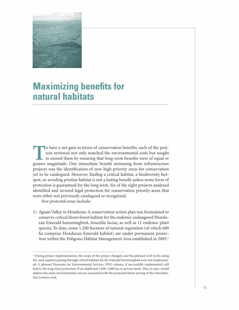
1) Aguan Valley in Honduras: A conservation action plan was formulated to conserve critical thorn forest habitat for the endemic endangered Hondu-ran Emerald hummingbird, Amazilia luciae, as well as 11 endemic plant species. To date, some 1,200 hectares of natural vegetation (of which 600 ha comprise Honduran Emerald habitat) are under permanent protec-tion within the Poligono Habitat Management Area established in 2005.6
6 During project implementation, the scope of the project changed, and the planned civil works along the road segment passing through critical habitats for the Emerald hummingbird were not implement-ed. A planned Payments for Environmental Services (PES) scheme, if successfully implemented, will lead to the long-term protection of an additional 1,000–2,000 ha on private lands. This, in turn, would address the main environmental concern associated with the proposed future paving of the Olanchito-San Lorenzo road.

16
Mainstreaming Conservation in Infrastructure Project: Case Studies from Latin America
2) Gra-Gra Lagoon in Belize: 484 ha were pro-tected by establishing the Gra-Gra Lagoon National Park, which aims at the con-servation of the lagoon and neighboring mangrove areas.
3) Biodiversity hotspots throughout the Paraná, Paraguay, and Uruguay river basins in Argentina will be protected once layered digital maps of flora and fauna identify best locations and required size.
4) Yacyretá Protected Areas Network: Legal protection has been secured for 58,000 ha. Once the dam operates at full capacity, the total network system will be 187,000 ha in 11 protected sites. The habitats include river islands and riparian habitats similar to those lost after flooding. These lands neigh-boring the dam harbor threatened and/or endemic species (Figure 3).
5) Tocantins conservation units: Six of eleven identified conservation areas will be estab-lished as part of the project. The eleven areas amount to 917,000 ha, six of them encom-passing a minimum of 214,000 ha up to a maximum of 762,000 ha. The conservation units are part of the state’s goal to secure 10 percent of its total area for conservation purposes.
6) Ciénaga de la Virgen: Long neglected in spite of being widely recognized as an im-portant area for endangered species and of great esthetic value for Cartagena, Cié-naga de La Virgen was legally established as a protected area. The accompanying Re-covery, Conservation and Environmental Management Plan (RCEMP) is now under implementation through an arrangement with the regional environmental agency and Conservation International.
Establishing these areas brought both re-sources and awareness to specific sites that had been neglected or whose attributes had re-mained unknown. It is also worth noting that in the case of Belize, Argentina (Flood Protec-tion), and Tocantins, the protected areas were not needed as compensatory or mandatory measures according to Bank policies. Hence, the projects went beyond what was required by local laws and Bank policies.
Strengthening existing protected areas: Where protected areas were already in place or had long been recognized, strengthening estab-lished ones was a viable option. This was the case for Gasbol, where 12 conservation units, mostly national parks and biological re-serves covering over 218,000 ha, were chosen throughout the five provinces affected by the project. Brazilian law requires that 0.5 percent of project funds be allocated for ecological compensation. As a result, US$7.5 million were disbursed equally among the five provinces. The areas benefited include: 1) Parque Nacional da Serra da Bodoquena; 2) Floresta Nacional de Ipanema; 3) Centro de Manejo, Reabilitação e Triagem de Animais Silvestres do Parque Es-tadual Alberto Loefgreen; 4) Parque Nacional Superagüi; 5) Parque Estadual do Cerrado; 6) Parque Estadual de Guartelá; 7) Parque Estadual de Campinhos; 8) Parque Estadual da Serra do Tabuleiro; 9) Parque Botânico de Morro Baú; 10) Parque Nacional de São Joa-quim; 11) Parque Nacional Aparados da Serra; and 12) Reserva Biológica Estadual Mata Palu-
Figure 3. Yacyretá Island Reserve (8,365 ha), one of eleven within the Yacyretá Protected Areas Network which will be completed once the dam operates at full capacity.

17
Maximizing benefits for natural habitats
dosa. The funds disbursed have been/will be used for land acquisition, maps, equipment, vehicles, education programs, and buildings, among other uses.
Restoration: The wetlands both at Cartagena and Bogotá were at varying degrees of degra-dation prior to the initiation of the respective Bank-financed projects. In Bogotá, this hap-pened despite their protected status. The main problems affecting the wetlands around Carta-gena and Bogotá involved: 1) illegal occupation of urban spaces; 2) loss of biodiversity; 3) de-struction of mangroves; 4) filling of wetland ecosystems; and 5) public health issues. Both for Cartagena and Bogotá, a wetland restora-tion program is now being set in place. The civil works themselves helped stop and revert some of the damage because they: 1) ceased disposal of effluents directly into the wetlands; 2) improved or re-established flow among wa-ter bodies and waterways, thus avoiding the isolation of particular areas and restoring pre-viously fragmented habitats; and 3) constitute physical barriers that will prevent future urban sprawl into the wetlands.
The restoration plans identify and priori-tize related actions needed to further stop the degradation of the wetlands, such as: identify-ing areas with high rates of urban sprawl, as well as those where solid waste is being dis-posed directly into the waterways; identifying the magnitude of nonpoint sources of pollu-tion; locating and controlling invasive species and stopping overfishing, among others. Once again, the variety of issues tackled as well as the wide range of agencies involved in the res-toration plan goes well beyond the scope of direct project impact. The civil works brought benefits to the wetlands, but Bank funds and resources are being channeled into a far-reach-ing program that goes well beyond project participants and actively involves other parties who have contributed historically to the degra-dation of the wetlands.
The success of legally protected areas is largely dependent on their long-term mainte-
nance and adequate management. Management plans are an indispensable tool, because they provide the guidelines for the location, magni-tude, and level of intensity of future activities permitted within the protected area. Most proj-ects funded and facilitated the elaboration of management plans. However, the stakeholders involved and specific mechanisms employed differed among them, as exemplified below.
Management Plans: The management plan for the Gra-Gra Lagoon National Park has been drafted by a consulting firm; it was reviewed by the Forest Department and the commu-nity-based NGO Friends of Gra-Gra, both of which are responsible for the Park under a comanagement agreement. Because Friends of Gra-Gra is a recently formed organization, the management plan package 1) specifically addresses its capacity building needs by pro-viding workshops related to ecotourism and other activities of interest, 2) supervises the initial acquisition of equipment to fulfill its managerial responsibilities, and 3) provides training on the responsibilities of park rangers. The plan also contains a detailed section on the immediate actions that need to take place, such as demarcation, setting up signs, building the main trail, and equipment acquisition to en-sure that short-term goals are met.
The Santa Fe I Project in Bogotá provides another example of establishing management plans. Here, the main challenge was to include in one plan multiple wetlands with varying degrees of ecological value. The Management Plan was prepared mainly by Conservation International, a well-established internation-al NGO with past experience in management and restoration plans. The plan has a re-gional approach, setting the framework for individual plans to address the specific needs of the 13 wetlands in the city. Once again, the project’s civil works affected only seven wet-lands, but Bank funds were set aside for the management plans of all 13. The individual management plans take into account the ecological value of each wetland, local biodi-

18
Mainstreaming Conservation in Infrastructure Project: Case Studies from Latin America
versity, water quality issues, and other factors to determine zoning, suitable activities, den-sity of visitors, etc.
Comanagement Agreements: Among the man-agement schemes set up by the projects for the protected areas, comanagement is the most favored form. This is a win-win situation for government agencies and NGOs alike. There are multiple advantages to this approach. First, it circumvents the lack of government human resources assigned to administer the park, in-cluding park rangers, financial administrators, and clerical personnel. It incorporates an in-dependent organization into activities such as fund-raising, environmental educational and awareness programs, tour guiding, public re-lations, and preventing new settlements. It is also a management scheme that is self-critical and self-policing, because each party oversees the other one. In the case of community-based NGOs, comanagement empowers local com-munities and brings their goals and concerns into view. Where large and well-established NGOs are involved, they are usually able to leverage national and international resources, to provide expertise, human resources, and financial funds in the protected area. These well-established NGOs are usually able to provide training to local people and set up large-scale environmental and educational programs.
In all cases where comanagement agree-ments were set up, project funds and resources were allocated to strengthen the NGOs. These funds were used for training, equipment ac-quisition, and other activities.
Other comanagement agreements within the projects include that of the community-based Fundación Bertoni and the Entidad Binacional Yacyretá (EBY), which are jointly responsible for the Yacyretá Island Reserve. The agreement, which was finalized in June 2000, stipulates that all costs related to managing the protected area be incorporated in the operating costs of reser-voir and dam maintenance, thus guaranteeing a source of funding for the Reserve’s recurrent costs throughout the project’s lifetime. EBY also
finances the off-site conservation of endangered endemic snails (which are bred in laboratories and slowly reintroduced) until new populations take hold of other areas downstream from the dam. Finally, a comanagement scheme was con-templated in Honduras once the protected area for the Honduran Emerald hummingbird was to be established. Management would be a joint effort of the government (DAPVS) and the Pico Bonito Foundation.
Securing traditional land for indigenous people: The Kaa-Iya National Park in Bolivia (Gasbol) is an example of how all the elements described above were incorporated in an innovative man-ner that benefited not only natural habitats, but indigenous communities as well. Kaa-Iya was established in 1995 and consists of the best conserved tropical dry forest of the boreal Chaco, covering 3,441,115 ha. The area houses a high number of plants and animals species; it is one of the largest legally protected areas in Latin America. It was also considered one of the most sensitive ecosystems within the pipeline’s area of influence, which extends 140 kilometers within the park. To implement Gasbol’s Envi-ronmental Management Plan within the park, an Executive Committee was formed by both Gas Trans Boliviano and the area’s indigenous peoples. Management of the park is carried out by the indigenous organization Capitanía del Alto y Bajo Izozog (CABI), the Wildlife Conservation Society, and Bolivia’s National Protected Areas Agency (SERNAP). A total of US$456,000 from the project’s funds were allo-cated for the Environmental Management Plan of the park itself (CABI and WCS 2001) and an additional US$1 million was established as a Trust Fund to assist in the management of the Kaa-Iya National Park. The Bank’s involve-ment was crucial in setting the high social and ecological standards that have characterized subsequent negotiations between Kaa-Iya and other energy companies.
Environmental education and awareness pro-grams: All projects included environmental

19
Maximizing benefits for natural habitats
education and awareness programs to raise local and national appreciation of important natural habitats within the area of influence of the projects. For the Argentina Flood Protec-tion Project, local programs were set up in each of the 40 sites where civil works were located as well as throughout the provinces involved, extending the educational program outside the immediate area of influence of the works. The environmental education programs were aimed at informing people of the importance of maintaining floodplains and the conse-quences of creating impervious areas (mainly paving and house building). Another example is the Bogotá Water Supply and Sewerage Proj-ect, where signs along the parks and wetlands describe the site-specific fauna and flora, in-form about migratory routes and ecosystem services, and provide other ecological infor-mation relevant to the wetlands. A collection of papers contributed by agencies, academic institutions, and NGOs were bound in a two-volume special edition that is to date the most thorough compilation of information avail-able about the wetlands of Bogotá. The papers treat all aspects related to the wetlands, from their ecology to their historical exploitation, relevance to city services, and social and eco-nomic importance. They have become a vital tool for informing agencies and the public and well as for shaping the reconstruction plan for the wetlands.
Endangered species and special studies are often the focus of conservation-oriented grants and projects. But infrastructure projects can iden-tify high-priority needs and provide the funds to address them. Multiple projects exemplify this approach: 1) the Honduras Road Improve-ment Project financed a habitat study for the Honduran Emerald hummingbird. The study indicated that there are only two sites where it can be currently found. The study also mapped and characterized this bird’s habitat, identified other endemic and threatened species located in the area, and estimated the rate of deforesta-tion in the area where the hummingbird lives.
This study portrayed the urgent need for a con-servation action plan. 2) The Belize Roads and Drainage Project launched a nationwide study to map and assess the population of threatened cycads. Such a large plant biodiversity study stands out even among others financed by the Bank. 3) At Yacyretá, the environmental studies of endemic snails from the Apipé rapids were carried out by the Museo de Ciencias Naturales of Buenos Aires and a local university (Univer-sidad Nacional de Misiones). Together, they have been in charge of increasing public aware-ness of this species and managing the off-site conservation program, for which the develop-ment of new laboratory breeding and species conservation techniques has been required.
Archeological findings are particularly relevant when civil works related to Bank-financed proj-ects are nearby or in areas known to have been inhabited during pre-Hispanic times. This was the case for the Belize Roads and Drainage Proj-ects and for Gasbol. In Belize, one of the towns where civil works were required had been built atop an ancient pre-Hispanic city. Because there was no prior set of protocols for dealing with chance finds in the town of Corozal, the project undertook the task of establishing ad-equate procedures. The project also conducted and financed excavations in search of artifacts or historically important remains. In Gasbol, there were no pre-identified sensitive areas in terms of archeological importance. Rather, the magnitude and expanse of the works required for the pipeline provided a rare opportunity for chance finds along the route which went through largely uninhabited areas. A compi-lation of the archeological findings in Bolivia during the project was published in the book: Al Este de los Andes, al Sur del Amazonas. Des-cubrimientos Arqueológicos en los Bosques Secos de los Llanos de Bolivia (Dames and More 2001). The amount and quality of the findings changed the perception of human settlements throughout the region, but particularly in the area of the Bañados del Izozog. The recovered artifacts increased scientific knowledge of the
20
Mainstreaming Conservation in Infrastructure Project: Case Studies from Latin America
area and this cultural heritage was displayed in local museums including the Museo Arque-ológico de Santa Cruz de la Sierra in Bolivia and the Universidade de Campo Grande in Brazil.
Institutional strengthening often involves not only the acquisition of equipment and train-ing, but also changes within the organizational structure of the agencies involved. The re-quired changes can be of varying degrees but they always aim at enhancing or improving environmental standards. For example, a new environmental department was established in the Bogotá water management agency. Prior to the project, the agency had no specific person-nel assigned to deal with environmental issues related to the wetlands and rivers within the city. The new office is of a higher level, and is charged with ensuring that environmental standards are met, answering environmental concerns from the public, and serving as a li-aison between the agency and NGOs in charge of comanagement.
One of the most profound impacts a proj-ect can have is on reforming the regulations and laws of a country to mandate higher en-vironmental safeguards and standards. For the Argentina Flood Protection Program, multiple regulations at national, state, and municipal
levels were changed to ensure, among other things, that: 1) the flood risk of an area is as-sessed prior to construction; 2) environmental assessments explicitly address impacts on floodplains; 3) urbanization of floodplains is avoided; and 4) protected areas where fauna can go in case of flooding are created. It is significant to note that municipalities other than those where project civil works were lo-cated have taken the initiative of implementing similar regulations and steps toward improv-ing flood protection. A different legal change is exemplified in the case of Tocantins, where the province is setting forth a zoning plan that will guide future developments in terms of economic activities and land use. The proac-tive nature of this framework sets it apart from all the other projects.
Preventing adverse economic activities: In rural areas, the threat to neighboring habitats is land-use changes. As mentioned above, the Tocantins project is a unique example of an integral statewide assessment of preferred economic activities and financial needs. But small-scale projects can also have a strong impact. In Hon-duras, the project allocated financial and other resources to create a Conservation Action Plan for regulating future activities and develop-ment in the area of Olanchito.

21
Successful strategies
The mechanisms and actions described above had such positive results because they were part of well-thought-out strategies to approach en-vironmental challenges. The collective review of the projects shows
that the following approaches smoothed project advancement.
Well-designed infrastructure projects can freeze and even reverse degradation of natural habitats and biodiversity loss. Communicating this vision creates a much more receptive environment, where government agencies and the pub-lic are aware that infrastructure projects can simultaneously provide services and support conservation efforts. While individual population settlements creating their own service network to alleviate immediate needs may have insufficient resources to ensure environmental conservation, a well-designed infrastructure project can control encroachment into natural habitats, im-prove makeshift engineering solutions, and improve inadequate use and disposal of water resources.
Thorough Environmental Assessments are the foundation of successful environ-mental outcomes. Because an EA is the first line of identification of potential challenges and their magnitude, the thoroughness with which it is carried out will prevent surprises further into the project. Where environmentally sensitive areas are concerned, an EA should explore multiple routings, site locations, and nonstandard engineering techniques. An EA will also identify where the complexity of social and environmental issues should require a supervisory or executive committee to follow and keep track of impacts or programs that fall outside the scope of the direct civil works. Making the EA publicly available also allows stakeholders to voice concerns early on and cre-ates an opportunity for greater participation throughout the project.

22
Mainstreaming Conservation in Infrastructure Project: Case Studies from Latin America
Early involvement of stakeholders improves project design, operation, and management. Generalizing from these projects, it is clear that conflicts commonly arise among mul-tiple stakeholders, due to diverging interests as well as scales of perception. Communities are usually more concerned about local costs and benefits, while sectoral agencies often have a regional focus. By bringing all stakeholders together early in the project, selecting jointly from alternatives, and clearly assigning respon-sibilities, the risk of failure to achieve project goals or of poor project performance can be minimized. This collaborative approach also ensures that all issues within the project’s area of influence are addressed, promotes studies and data collection, improves awareness of the ecological value of the project site, and often leads to improved long-term comanagement schemes. When stakeholders were involved early in the project, they were able to provide input that improved the project design. Such was the case in the Argentina Flood Protection Project, where input from the communities helped change the engineering design to im-prove protection against floods. The early involvement of Conservation International in Colombia’s water supply projects improved the environmental management of local institu-tions and promoted environmental awareness among public and institutional stakeholders. A well-established and experienced local NGO will be able to provide highly specialized in-put. Newer, inexperienced NGOs will require capacity building; however, they can provide human resources to carry out specific conser-vation actions or to manage protected areas. This can be a real asset when agencies have limited personnel.
Timing is crucial: the nature of certain actions deems them ineffective if they are not carried out at given times during the project. The de-termination of routes, alternative designs, and engineering techniques should be carried out in the initial stages of a project. Construction schedules should take into consideration the
natural life cycles of the impacted area to mini-mize disturbance. Other types of conservation actions should utilize the leverage in timing given by the project itself. For example, the implementation of the conservation plan for the Emerald hummingbird in Honduras was a requirement for initiation of the bidding of the works. In contrast to specific timing, there are continuous and routine actions to ensure that environmental actions are kept on schedule all along. The magnitude of Gasbol required routine weekly progress reports on all envi-ronmental issues; parallel conservation actions were instituted from design to project imple-mentation and operation.
Compensation and restoration measures with successful outcomes can be achieved even when impacts are identified later on. Even when the Bank becomes involved at an advanced stage of the project, conservation measures can still be put in place, because many of them are not time-dependent. In addition, those that are specific to the later project phases can still be applied. The best example is the hydroelectric project at Yacyretá. The Bank became involved when the site had already been selected and construction was well underway. However, it was still possible to carry out operational adjustments, reconformation of landscapes, establishment of compensatory protected areas and biodiversity programs, among other mea-sures (Quintero and Ronderos 1992, Quintero et al. 1997). While a best-case scenario can-not be achieved, much was done to avoid the worst-case scenario of no conservation actions being set in place at all.
Efforts to establish new protected areas need to be started early on. Across projects, this was the slowest and most time-consuming process. Common factors that extend timelines are: land tenure use and occupation; national time-lines for laws or decrees to be issued; and a lack of human resources to carry out procedures. The easiest challenge to address is the latter, by identifying a local NGO and assigning it the

23
Successful strategies
task of monitoring progress, as in the case of the Gra-Gra Lagoon in Belize. Even with adequate human resources, however, land tenure and le-gal timelines still must be dealt with. Thus, the earlier the procedures are started, the better the chances are to ensure the participation of all stakeholders within the project’s schedule.
Large-scale projects facilitate institutional strengthening and restructuring. Among the projects reviewed, three were large scale: 1) Gasbol, the Bolivia-Brazil gas pipeline; 2) Ar-gentina Flood Protection; and 3) Tocantins Sustainable Development. These three projects developed new institutional frameworks or le-gal regulations that set improved environmental standards. The impact of these innovations within the national context depends on the scale of the project, with large projects hav-ing more leverage to ensure that agencies and institutional stakeholders incorporate these frameworks and guidelines into their regular operations, thus benefiting future projects and institutional environmental management.
Localized projects enable more in-depth, site-spe-cific actions. Because resources are concentrated in a smaller area, programs that address local biodiversity can be centered around individual species that may be threatened or have a partic-ular interest. Such was the case in the Honduras Roads Project which developed a conserva-
tion plan for the Emerald hummingbird; the Yacyretá dam in Argentina where off-site con-servation is being carried out for endemic snail populations of Aylacostoma spp. previously monitored in situ (Quintana and Mercado 1997), and protected areas were ensured for the threatened Saffron-cowled blackbird, Xan-thopsar flavus (Clay, Madroño and Villanueva 1999); and in Belize, where the discovery of a threatened cycad within the project’s area of influence prompted a nationwide program to assess the status of related cycads. Resources can be concentrated on the restoration of local habitats, landscapes, and ecosystem functions. In Colombia, water supply and sewerage proj-ects addressed the deterioration of wetlands within or near the city.
As exemplified by the projects showcased in this review, it is possible to change wide-spread perceptions that infrastructure projects will necessarily have a negative impact on nat-ural habitats. The technology and knowledge is available to enjoy the benefits of infrastructure services and conserve natural environments. By providing funds and expertise, and by le-veraging conservation actions, infrastructure projects can redefine their role within society and play an important new role in ensuring the conservation of the Earth’s ecosystems and the diversity of species that make them unique.

25
References
CABI and WCS 2001. Parque Nacional y Área de Manejo Integrado. Kaa-Iya del Gran Chaco. Plan de Manejo. Ministerio de Desarrollo Sostenible y Planificación. Vice Ministerio de Medio Ambiente, Recursos Naturales y Desarrollo Forestal. Servicio Nacional de Áreas Protegidas. Sistema Na-cional de Áreas Protegidas, 123 pp.
Clay, R, A. Madroño and S. Villanueva. 1999. Distribución, estatus y necesi-dades de manejo del globalmente amenazado Chopi Say´ju (Xanthopsar flavus) en el sur de Paraguay. IV. Congreso Internacional sobre Manejo de Fauna Silvestre en Amazonia y Latinoamérica. 4–8 de octubre de 1999, Asunción, Paraguay. Libro de Resúmenes: 57–58.
Dames and More. 1996. Environmental Impact Study for Bolivia-Brazil Pipe-line Project (Bolivian Portion). Final Report. Prepared for: YPFB, Enron Corp., Petrobrás and BTB, August 30, 1996.
De Francesco, F.O. and J. A. Schnack. 2003. El Proyecto Hidroeléctrico Yacyretá. Evaluación Ambiental Ex Post del Préstamo 2854-AR (SEGBA V). World Bank, 111 pp. + Anexo I
Petrobrás. 1996. Environmental Impact Study. 1996. Consolidated Report. Bolivia-Brazil Gas Pipeline.
PRIME Enghenaria. 1997. Avialação Ambiental Estratégica do Projeto. Relatório Final. Volume I. PRIME Enghenaria.
Dames and More. 2001. Al Oeste de Los Andes al Sur del Amazonas. Gas Trans-boliviano. Dames and More Inc., 446 pp.
Quintana, M.G. and A.C. Mercado. 1997. Biodiversidad en peligro. Caracoles de los rápidos en Yacyretá. Ciencia Hoy 7 (41): 23–31.
Quintero, J.D. and R.A. Ronderos. 1992. Plan de Manejo Ambiental. Proyecto Hidroeléctrico Yacyretá. EBY-Banco Mundial, 159 pp.
26
Mainstreaming Conservation in Infrastructure Project: Case Studies from Latin America
Quintero, J.D., C.E. Menem, E. Sánchez-Triana and L.C. García Lozano. 1997. Environmen-tal Impact Assessment. A Plea for an Adaptive Tool for Environmental Assessment Manage-ment: the Case of the Yacyretá Binational Project. IAIA, 1997.
SUCCE-Banco Mundial. 1995a. Estudios Am-bientales Regionales para el Proyecto de Control de Inundaciones. SUCCE-Banco Mundial, 149 pp.
SUCCE-Banco Mundial 1995b. Estudios Am-bientales Regionales para el Proyecto de Control de Inundaciones. Evaluación de Impactos Ambientales de Proyectos Específi-cos. SUCCE, Ministerio del Interior-Banco Mundial, 104 pp.
Wilson, E.O. 1992. The Diversity of Life. W.W. Norton and Company, Inc., New York, N.Y., 424 pp.
World Bank 2003a. Good Practice Case Study in Integrating Environment into Gas Pipeline Projects. Experiences Based on Bolivia-Brazil Pipeline Project. World Bank, May 2003, 47 pp + Annex I and II.
World Bank 2003b. Manual Ambiental para el Diseño, Construcción y Operación de Gaso-ductos. Normas Genéricas. World Bank, May 2003, 89 pp.
27
Annexes


29
Yacyretá Hydroelectric Project II:raising environmental standards in started projects
SUMMARY
The Bank has been involved in the Yacyretá hydroelectric complex since the late 1970s. Since then, the Bank has adopted new policies, most notably the Environmental Assessment and Natural Habitats Safeguard policies. Despite its early involvement, by the time the Bank began financing the project the site had already been selected and the design was well advanced. A revision of the project’s environmental management to finally fill and operate the dam at partial capacity resulted in new and extended compensating measures to ensure adequate environmental standards. The measures were extensive, and comprised:
a network of 12 new compensatory protected areas; landscape reconfiguration of borrow pits; increased water flow on the Aña Cuá branch to maintain a nearly natu-ral state year-round; a fish elevator to maintain the gene pool in upstream fish populations; ex situ conservation of endemic snails; fish regulations to avoid overexploitation of stock aggregations below the dam; water monitoring to ensure good water quality in the lake; and a program to find, protect, and maintain suitable habitats for the endangered saffron-cowled blackbird. The project shows that even interventions at an advanced stage can contribute substantially to the conservation of natural habitats.
•••
•••
••

30
Mainstreaming Conservation in Infrastructure Project: Case Studies from Latin America
BACKGROUND
The Yacyretá hydroelectric facility is a joint venture between Argentina and Paraguay. It is also among the largest dams in Latin Ameri-ca. The project is based on the exploitation of the hydroelectric potential of the portion of the Paraná River that runs along the border between these countries. At full capacity, the reservoir level will be 83 masl, generating 3,100 MW of electricity.
The civil works include two concrete clo-sure dams, each 40 m high and 5 km long, 60 km of embankment dam, a 56 km trench to cut off foundation seepage, a powerhouse, spillways, and a navigation lock. At 83 masl, the reservoir will cover 1,663 km2, inundating 574 km2 of existing river as well as 1,076 km2
of land, 73% of which will be in Paraguay. The flooded areas include 1,500 ha of cultivated land and 500 ha of urban land.
Over two decades have passed since the project’s conception; it has seen not only several sources of financing7 and a multibil-lion-dollar budget, but also a change in Bank policies: most importantly, the adoption of OP 4.01 (Environmental Assessment), and OP 4.04 (Natural Habitats), which require an environmental assessment and protection of natural habitats, respectively. When the Bank first became involved, the site of the princi-pal structure had already been selected and established by the Yacyretá Binational Treaty.
Experts later considered this site a poor choice. Among other things, it is located on the flood plain of a major river, and it has a high ratio of people displaced and inundated area per Mw produced (19 people and 53 Ha/Mw, respec-tively). The project objectives were extended to bring it into compliance with the new policies as much as possible, and to offset the impacts caused by the poor site selection. The project’s natural habitats and social component took on primary importance.
The aim of this project, Yacyretá II, was specifically to finance the civil works needed to complete the basic permanent structures and the first six generating units, as well as technical assistance for the Resettlement and Environmental Management Plan for opera-tion at 76 masl, a 500 Kv transmission link, and an assessment of private capital participation in EBY. The US$300 million loan became ef-fective on January 13, 1993 and was closed on December 31, 2000.
Operation at full capacity is contingent upon additional infrastructure work and an updated Environmental Management Plan and Resettlement Program.
NATURAL HABITAT ISSUES
A tributary of the Río de la Plata, the Paraná River is the world’s tenth largest river and drains Southern Brazil, Paraguay, Uruguay, and Argentina. The Yacyretá complex is the second hydroelectric project on the Paraná, the first being Itaipu, a joint venture by Brazil and Paraguay. The Yacyretá Dam is located about 400 km downstream from Posadas, Argentina and Encarnación, Paraguay. This portion of the river runs along the border between Ar-gentina and Paraguay, an area where the river branches out, forming a series of three large
7 World Bank (WB), Inter-American Development Bank (IDB), Entidad Binacional Yacyretá (EBY), Government of Argentina (GOA), and private investors.Aerial view of the main spillway at Yacyretá

31
Yacyretá Hydroelectric Project II: raising environmental standards in started projects
islands (Yacyretá, Talavera, Apipe) and several smaller ones (up to 300 total) characterized by white waters. The power plant is on Yacyretá Island which divides the river into two chan-nels, the Aña Cuá and the principal branches where two closure dams and spillways have also been built.
Local flora is associated with the island ecosystems, mainly those of Talavera and Ya-cyretá Islands. The area flooded so far includes eight habitats types: wetlands, riverine islands, riverine forests, forested savanna, arary forests in flooded areas, dunes, the Apipe rapids, and the river itself. These habitats foster high faunal diversity: 121 bird species, 18 large mammals, and 8 reptile species. Several species with vary-ing degrees of protection are located in the area: 5 species of flora, 17 birds, 12 large mam-mals, 3 reptiles, and 1 endemic snail. High fish diversity and abundance are also characteristic of the area.
Some 240 km of riparian habitat along the principal branches will be permanently lost, along with some 107,600 ha of terres-trial habitat, mostly forested savanna and wetlands. The western side of Yacyretá Is-land is of particular concern because it is a high-priority ecoregional area where several endangered species are found, such as arary trees (Calophyllum brasiliense). Flooding of the area will clearly permanently displace ter-restrial fauna.
The dam precludes fish migrations for the most part and upstream populations are expect-ed to become severely depleted. Downstream, the main concern was the seasonal desiccation of some 22 km of the Aña Cuá branch, which would have a devastating impact on the river and on island wetland ecosystems below the dam. Fisheries would also be impacted.
The hydrological characteristics of the riv-er itself are completely transformed in the area. Essentially, the system is turned into a lake and the flow regime, without adequate measures, is completely modified downstream with the magnitude of peak flows being substantially reduced. Stagnant water and increased aquatic
vegetation, especially in the marginal areas of the newly-formed lake, could foster an increase in mosquitoes.
Specific concerns that triggered the Natu-ral Habitats Policy were
loss of riparian habitats, notably the ara-ry forests; loss of riverine habitats, particularly the disappearance of the river islands and rapids; the desiccation of the Aña Cuá branch, which would further threaten the re-maining river island ecosystems and riparian areas; the effects on several endemic and endan-gered species, such as the saffron-cowled blackbird and the Aylacostoma snail; and the interruption of fish migrations.
Addressing lost habitat
The major distinction between the types of habitat affected was whether they were lo-cated on land or in the river. This guided the approach to deal with the major issues: loss of habitat and threats to populations of special concern.
On landBecause the site had already been selected, the ecological compensation program was designed to match the inundated area with similar protected habitats. It also became criti-cal to improve the environmental conditions of surrounding terrestrial areas that were not flooded, so that they would be suitable for local flora and fauna.
A network of protected areas covering 161,000 ha will be implemented when the dam op-erates at full capacity (83 masl). The area protected surpasses that of the inundated lands. The network will comprise nine pro-tected areas located in Argentina, and three
•
•
•
•
•

32
Mainstreaming Conservation in Infrastructure Project: Case Studies from Latin America
in Paraguay (see Table 1 and figure below). The process was speedier and easier in Argen-tina, because the land was already owned by the government. In Paraguay the land can be managed as a protected area in cooperation with landowners.
Four protected areas have already been estab-lished for the conservation of 62,000 ha. This is more than the inundated area at 76 masl. The protected areas include Yacyretá Island in Paraguay; Apipe Island, Galarza, and Santa María Reserve in Argentina. The Yacyretá Is-land Reserve includes the unflooded portion of Yacyretá Island and Aña Cuá. Preference was given to river island habitats because they are considered high-priority ecoregional areas.
A comanagement agreement between the com-munity-based Fundación Bertoni and the Entidad Binacional Yacyretá assigns respon-sibilities for the proper management of the Yacyretá Island Reserve. The agreement was finalized in June 2000 and is based on two zones: a restricted use zone that includes arary forests, dunes, and wetlands, and a buffer zone for community use.
Management plans and funding for recur-rent costs have been provided for all four of the implemented protected areas. Resources
amounting to US$300,000 annually will cover management expenses. These costs have been incorporated into the operating costs of the dam, so that funds remain available through-out the project’s lifetime. EBY is likely to contract qualified NGOs to carry out the long-term management of these areas.
Table 1. Protected areas
HA
ArgentinaApipe Island* 30,000Galarza* 20,000Santa María Reserve* **3,075Iberá 10,000Itatí 30,000Yaguareté Corá 13,000Camby Retá 10,000Teyú Cuaré 78Campo San Juan 5,700
ParaguayYacyretá Island* 9,000Refugio Atinguy 100Yabebyry 30,000
Total 160,953
* implemented; ** increased from 2,500 Ha
Major Protected Areas in Argentina and Paraguay, shown in pink and denoted with an “R” (not all PAs in network are shown).

33
Yacyretá Hydroelectric Project II: raising environmental standards in started projects
A portion of the revenues earned from electric-ity sales goes to a special allocation set by EBY. These funds support the protected areas and finance biodiversity programs such as the ex situ conservation of the endangered endemic snail Aylacostoma sp.
Borrow pits were restored by softening slopes, creating small reservoirs, reestablishing proper drainage, and using local flora to re-forest the area; the footprint of the borrow pits is now minimal. This enabled flora and fauna to eventually recover the use of some 600 ha which would otherwise have been lost (ecologically), despite not being inundated. Recovering these areas was particularly im-portant for bird populations. The restored grounds were incorporated in the network of protected areas.
In riverThe hydrological compensation program was designed to minimize changes in the hydro-logical regime and characteristics of the area. This ensured long-term conservation of river habitat and wetland areas dependent on sea-sonal flow fluctuations.
A separate spillway on the Aña Cuá branch pro-vides a minimum flow of 1,500 m3/s year-round. The flow is key to productivity in the area; the amount needed to maintain a near-natural state was based on hydrological and ecological stud-ies. It is worth noting that this flow is equivalent to that of two turbines. Maintaining the Aña Cuá with a nearly natural flow will benefit fish and other aquatic species, as well as riparian habitats.
Water releases through the main and Aña Cuá spillways will be used to maintain seasonal stream flow variation downriver, protect water quality, promote circulation in the lake, control aquatic weeds, avoid fish kills, prevent urban flooding, and facilitate downstream fish passage.
A permanent monitoring program at Yacyretá ensures that the new lake does not turn into an anoxic environment, killing aquatic life. The maintenance program also controls in-vasive aquatic plants, prevents increases of insects, and monitors water quality. Expenses to prevent pollution from domestic sewerage, industrial waste, and other sources would be financed by future projects through EBY.
Addressing populations of concern
Several endangered species are found in the vicinity of Yacyretá. Moreover, the construc-tion of the dam posed new risks to numerous non-threatened species. These issues called for specific measures.
A fish elevator was installed to compensate for disrupted access to upstream areas. The eleva-tor is not designed to maintain high numbers of fish, but rather to conserve the genetic bio-diversity of the area.
A no-fishing zone was declared within the areas located 1 km downriver from the dam to pro-tect the fish stocks concentrating just below it. The unusually high aggregation had made the fish an easy target and vulnerable to overfishing. The regulations still allow for fishing, but not where the fish are concentrated.
A program for the ex situ conservation of an endemic snail is supported by EBY. The snail lived in the rapids and is a previously unknown species, discovered as a result of the environ-mental studies associated with the project. A local university has been in charge of increas-ing public awareness of this species as well as the ex situ conservation program. New tech-niques developed specifically as part of the program have resulted in the successful repro-duction of snails in captivity. The program will keep a breeding population until these snails are successfully established in new areas, pos-

sibly downriver where a smaller population of this species is found.
The program for the saffron-cowled blackbird identifies suitable habitats to create a network of protected areas that guarantees the long-term conservation of the bird and its habitat, both in Argentina and Paraguay.
SUCCESSFUL STRATEGIES
Using the shortcomings of the site as leverage to push forward an aggressive, comprehensive, ecological compensation program enabled the project team to carry out more extensive operational adjustments, landscape reconfor-mations, and biodiversity programs, among other measures. Most significantly, they es-tablished protected areas which encompass an area larger than that lost to inundation. The project actively involved the community in the management and conservation of these areas.
Prioritization of the protected areas expedited the protection of those habitats considered particularly fragile and unique, in this case, the river islands of Yacyretá and Apipe.
The incorporation of expenses related to conser-vation in the fixed costs of operating the dam secured funds for the entire lifetime of the project. This provided a long-term solution to one of the most prevalent challenges in con-servation: ongoing, sufficient funding. This set an important precedent toward making insti-tutions financially responsible for recurrent environmental costs deriving from services they provide.
The compensation and restoration measures carried out in Yacyretá show that successful outcomes can be achieved even in an adverse situation. Clearly, later interven-tions in started projects can have substantial positive impacts and generate long-lasting en-vironmental benefits.

35
Bolivia-Brazil Gas Pipeline Project(GASBOL)Minimizing project footprint
SUMMARY
Extending over 3,000 Km through largely unpopulated areas between Bo-livia and Brazil, Gasbol is among the largest gas pipelines in South America. Despite its extension, and overcoming differences between the countries’ infrastructure networks, legal structures, and stakeholder agreements, the project’s overall footprint is minimal. Because of its length, the route would inevitably traverse sensitive areas. The crossing of natural ecosystems was designed with three criteria in mind: avoiding sensitive ecosystems when possible, reducing the size of impacted areas, and devising techniques that caused minimum disturbances to the landscape and ecosystem functions. This approach set forth numerous innovative measures:
the pipeline was deviated to avoid sensitive ecosystems, the width of the right of way (ROW) was reduced in many transects, trees were removed manually, 13 rivers were crossed by drilling under the river beds and by other special works, wetlands were crossed using a pushing and pulling method during the rainy season; steep terrains were avoided by tunneling; extensive revegetation was carried out along ROWs, and funds were provided by a comprehensive ecological compensation plan to support a total of 13 protected areas.
••••
•
•••

36
Mainstreaming Conservation in Infrastructure Project: Case Studies from Latin America
The project set high social standards for negotiations with indigenous communities and served as the single most important arche-ological survey in recent years both in Bolivia and Brazil. The pipeline was built in a year and a half; this short timeline was achieved by outstanding management. Gasbol had its own environmental committee, environ-mental supervision unit, and environmental inspection team. The project had an exempla-ry environmental assessment (EA) and earned several international awards for its environ-mental achievements.
BACKGROUND
A new market for Bolivia’s reserves of natural gas and an additional source of power for Bra-zil were the main drivers of what is now the Bolivia–Brazil gas pipeline (GASBOL), one of the most complex projects of its kind in South America. The pipeline extends 3,150 km: 557 km lie in Bolivia, owned by Gas TransBolivi-ano (GTB), and 2,600 km run through Brazil, managed by Transportadora Brasileira Gaso-ducto Bolivia–Brasil S.A. (TBG). The pipeline starts in central Bolivia, at Río Grande, run-ning west and then south to Porto Alegre, Brazil. The project includes 18 compression
stations and 35 city gates, distributed along 5 states in Brazil: Mato Grosso do Sul, São Paulo, Paraná, Santa Catarina, and Rio Grande do Sul. It has a capacity of 30 million cubic meters per day (MMm3/d) with an agreed delivery of 16 MMm3/d.
The project’s binational nature required the team to reconcile different regulatory and legal structures in each country, accommo-date to disparate infrastructures, and comply with prior country-specific multistakeholder agreements. The first EA was rejected during routine quality screening, and the environmen-tal achievements detailed in the next sections stem from the efficient and exhaustive nature of the second EA. This investment of time and finance paid off; the new, revised EA subse-quently earned the project the International Association of Impact Assessments’ Environ-mental Award (IAIA) in 2001 and the 2001 World Bank Green Award, among others. The project became effective in mid-May 1999 and closed at the end of December 2000. The to-tal project budget was approximately US$2.1 billion, of which the Bank financed US$130 million. The pipeline was inaugurated in Feb-ruary 1999.
NATURAL HABITAT ISSUES
Two-thirds of the pipeline route runs through uninhabited areas and encounters several sen-sitive ecosystems between Río Grande, Bolivia and Porto Alegre, Brazil. Several national parks, reserves, and ecosystems with legally protected status, as well as high biodiversity hotspots, triggered the Bank’s Critical Natural Habitat policy. Aside from the route itself, the ROW had the potential to provide undesired open access to unexploited areas, facilitating illegal activities such as logging and hunting.
Some of the areas to be crossed had tradi-tionally being used by indigenous communities and they were concerned that the gas company would not take full responsibility for the en-vironmental impacts caused by the project, Gasbol route across Bolivia and Brazil.

37
Bolivia-Brazil Gas Pipeline Project (GASBOL) Minimizing project footprint
particularly impacts on sensitive ecosystems. The project would directly impact indigenous lands in Bolivia, because the route went through the Kaa-Iya del Gran Chaco National Park. The Izoceña people, organized as the “Capitania del Alto y Bajo Izozog” (or CABI), were the driv-ing force in creating the Park which is adjacent to their ancestral territory. In Brazil the project affected fewer communities and impacted in-digenous lands.
The most sensitive ecosystems crossed by the pipeline were the Gran Chaco forest, Pan-tanal, Mata Atlântica, and the Aparados da Serra include.
Gran Chaco Forest. Also known as the Chaco, this is an extensive 647,500 km2 lowland alluvi-al plain divided among Bolivia, Paraguay, and Argentina. The vegetation is predominantly xerophytic deciduous forests, but also includes semi-evergreen riverine forests, palm wood-lands, savannas, halophytic shrubby steppes, grassy steppes, and wetlands. The area is esti-mated to harbor over 2,300 plant species, 300 birds, and 89 reptiles and amphibians. The more than 100 mammal species include the endangered tapirs, peccaries, guanacos, and jaguars. Within this ecosystem the pipeline crosses the protected areas of Bañados del Izo-zog and the Kaa-Iya del Gran Chaco.
The Kaa-Iya del Gran Chaco National Park and Integrated Management Areacovers 3.4 million hectares. It is one of the largest legally protected national parks in Latin America. About 140 km of pipeline cross the northern portion of the park.These lands are traditionally used by sev-eral indigenous communities.The Bañados del Izozog and the Para-petí River encompasses 615,882 ha with one-third of the site lying within the Kaa-lya del Gran Chaco National Park. They form the largest and most impor-tant wetland in the Santa Cruz Chaco and sustain several riverine communities characteristic of this biogeographic re-
•
•
gion. Approximately 110 km of pipeline cross this area.
The Pantanal is the world’s largest wetland (100,000–175,000 km2 depending on the sea-son) and is shared by Brazil, Paraguay, and Bolivia. Its size is similar to that of Greece. The Bolivian Pantanal covers about 10 percent of the total area, and comprises several zones, two of which, Otuquis and San Matías, became part of the National System of Protected Areas in 1997. Within Bolivia, the pipeline crosses the Pantanal region known as Otuquis. The Bra-zilian Pantanal is approximately 145,000 km2
or 80 percent of the Pantanal area; the pipeline passes through the Mato Grosso area.
The Otuquis Pantanal Reserve in Bolivia comprises 1,005,950 ha, of which 903,350 ha are a national park and 102,600 an in-tegrated management area. The pipeline crosses the northern part of the Otuquis Pantanal; the ROW is 30 m wide, in-cluding the working space. The area is inhabited by six endangered and nine threatened species, according to IUCN classification.The Mato Grosso Pantanal Reserve in Brazil comprises 150,000 ha, and is one of the richest wildlife sanctuaries. The vegetation is an exclusively grassy forma-tion, interspersed with brittle ligneous plants and small acaulescent palm trees. It is generally found in the lower areas, which are periodically flooded. Seventy kilometers of pipeline run through this reserve.
The Mata Atlântica (Atlantic Forest) is char-acterized by dense ombrophyle forest and associated with mixed ombrophyle forest. Bra-zil’s most urbanized and industrialized areas are located within this biome, and thus only about seven percent of the original forest remains in fragmented portions. The Mata Atlântica holds the world record for the greatest diversity of tree species per hectare. The high level of endemism
•
•

38
Mainstreaming Conservation in Infrastructure Project: Case Studies from Latin America
is partly because the area is isolated from the major South American forest blocks by the sa-vannas and woodlands of the Cerrado region. Forty percent of the 20,000 plant species are en-demic; 60 of the 190 reptile species are endemic and 3 threatened with extinction; 55 of the 250 mammal species are endemic. Two-thirds of the primate species are endemic, including the black lion tamarin, one of the world’s most highly endangered primates. In all, 29 verte-brate species are critically endangered. Other vulnerable species include tapirs, ocelots, pu-mas, and the locally endangered blue and yellow macaw. The pipeline crosses isolated patches in four states, affecting around 124 ha, and the Bo-nito National Park which has elements of Mata Atlântica and lies in the Bodoquena mountain range contiguous to the Pantanal.
The Bonito National Park is located in the southwest of State of Mato Grosso do Sul. Most of the region’s rivers spring from the Bodoquenas mountain range. This is a limestone area which contains a system of waterfalls, rivers and caves. The dominant vegetation is the Cerrado asso-ciated with gallery forests and elements of the Mata Atlântica.
The Aparados da Serra is located within the Mata Atlântica biome, but has varied flo-ristic formations. There is an area of rocky formations where canyons and cliffs dominate the landscape. Rivers drop into gorges or can-yons, many over 700 m high, arriving at the bottom as moist mist. Steep terrains are prone to erosion and unstable slopes, hence their environmental sensitivity. The route passes through the Aparados da Serra National Park. The section affected by the pipeline is charac-terized predominantly by high-altitude fields with rocky outcrops (campos de altitude) and woody savanna (cerrado gramíneo-lenhoso). In the Mata Atlântica (Atlantic Forest) and Aparados da Serra, the pipeline crosses four sections encompassing 32 hectares of affected vegetation.
•
Minimizing project footprint
Although one plausible scenario was for the route to avoid all sensitive areas, there is a trade-off between a longer route that required more hectares of ROW and a shorter one that minimized the ROW area but traversed sen-sitive ecosystems. Despite modifications the route would have to pass through challenging landscapes: large rivers, steep terrains, and wet-lands. The design team followed three criteria: 1) avoiding sensitive ecosystems when possi-ble, 2) reducing the size of impacted areas, and 3) devising innovative techniques that caused minimum disturbances to the landscape and ecosystem functions.
1) Deviations to avoid natural habitats: The general guidelines of the route for cross-ing vegetated areas, whether protected or not, specified: i) going around, next to the edge, and avoiding fragmentation, ii) run-ning through the most degraded sections, and iii) crossing parts of lesser extension. For example, in Bolivia the pipeline avoid-ed the Cañón de la Victoria, a hydrological and biological connection between the wet-land systems of Otuquis and the Brazilian Pantanal. In Brazil the route went around Tabuleiro National Park. Within the Bra-zilian Pantanal region, deviations totaled nearly 30 km.; deviations in the State of Santa Catarina to preserve the Mata Atlântica also totaled 30 km. In addition, modifications to the route were made for high-visibility archeological sites.
2) Reducing ROW width: In Bolivia, there were almost no access roads to the pipeline so the ROW width was set to 30 meters to allow equipment movement, instead of open-ing additional, new access roads. In Brazil, however, there were roads near the remain-ing 2,600 km of the route, so the ROW did not have to double as a road. The ROW was reduced to 20 m, significantly reducing the total area impacted.

39
Bolivia-Brazil Gas Pipeline Project (GASBOL) Minimizing project footprint
3) Felling trees manually, with chainsaws, reduced the impact during vegetation re-moval. Trees were felled within the ROW to avoid damage to surrounding vegetation, thus preventing the “domino effect.”
River crossings were achieved by drilling (direc-tional boring) under the beds of two rivers: the Paraguay and the Itajaí-Açu. The drill hole was enlarged to accomodate the 32” dimension of the Gasbol pipeline. An underwater crossing was effected in 11 other cases. Such subfluvial crossings do not interfere with river flows, and have a reduced impact on the environment and on aquatic vegetation and fauna. The “push-pull” technique was used. For this a floating a preassembled section of pipe is pushed and pulled over a flooded ditch in the river bed. Then the buoys are removed and the concrete-coated
pipe sinks into position in the ditch. Temporary mounting platforms are later removed. This technique is very low impact and construction leaves no visible footprint. Of these 13 major crossings of rivers/dams three were located in Bolivia and 10 in Brazil. All smaller cross-ings were performed with more conventional techniques, but with mitigating action taken to protect waterways from increased sediment load stemming from the civil works.
Protecting steep terrain: To avoid erosion, sediment accumulation, slope instability, and landscape alteration in the steep terrain of the Aparados da Serra in Brazil, it was decided to drill horizontally into the base of the hill for 780 m and then vertically down from the top of the hill 320 m to meet the horizontal tun-nel, thus retaining the slopes’ integrity with minimal visual impact. The ongoing monitor-ing program screens for aggregate loss of hill mass by checking the inclination angle of stra-tegically placed stakes. Slope status is checked indirectly by strain gages that are monitored by the Operations Center in Rio de Janeiro.
Sheet piling in conventional river crossings
Crossing the Aparados da Serra, Brazil. The diagram shows the tunnel, measuring 780m in length and 320 in height, which was built to avoid major landscape alterations

40
Mainstreaming Conservation in Infrastructure Project: Case Studies from Latin America
Crossing the Pantanal was accomplished by a “push-pull” technique. A preassembled float-ing section of pipe was pushed and pulled over a flooded ditch. Once in place, the buoys were removed and the concrete-coated pipe sank into position in the ditch. The temporary mounting platforms were removed later. This technique has fewer impacts than conventional ones: it requires less clearing/removal because the only construction space is that needed for the dragshovel to cross the tract of land and that needed for storage of excavated soil. The pipe was assembled off site, so there was no need for working space adjacent to the ditch. With the push and pull technique, construc-tion activities left no visible footprint.
Restoration of impacted areas: In Bolivia, a 13 m strip of the ROW was restored by planting new vegetation once the construction phase was completed. In so doing the effective ROW was narrowed from 30 to 17 m. Reforestation was also carried out in areas designated for sup-
port activities and in the affected sections of the Mata Atlântica. In the Pantanal, wetlands were restored to their original configuration and contours.
Special rules for ROWs: To discourage illegal ac-tivities and further impacts, the management of ROWs stipulates that they must not be used as roads, even in Bolivia. Maintenance works must be carried out using helicopters, all-ter-rain vehicles, existing roads, etc.
Monitoring: Environmentally sensitive areas, in-cluding approximately 300 critical areas (river crossings, wetlands, areas with steep slopes, trash disposal sites) are monitored regularly to ensure proper functioning and management. Aerial reconnaissance of the ROW is also conducted. The monitoring includes checking the need for occasional revegetation along the route.
Ecological Compensation Plan
The project provided funds for a total of 13 protected areas, 12 in Brazil and 1 in Bolivia (see Box 2). In Brazil, 0.5 percent of project funds had to be designated for conservation units by law. The 12 protected areas supported by the project in Brazil total over 250,000 ha, are distributed among all 5 states crossed by the pipeline, and were chosen in collaboration with IBAMA (Instituto Brasileiro do Meio Am-biente e dos Recursos Naturais Renováveis). Within Bolivia, the Kaa-Iya del Gran Chaco totals 3.4 million ha. The funds were used for demarcation and signposting, maps, building restoration, construction of support buildings (visitors, research, administrative), Manage-ment Plans and the acquisition of land, vehicles, and equipment.
A trust fund for Kaa-Iya del Gran Chaco was established to pay for recurrent costs in per-petuity. The US$1 million fund will provide incremental annual revenues to improve the protection and management of the park.
Shown in sequence, from left to right, top to bottom: the excavated trenches, platforms, pipe sections with floaters, pipes placed in trench, flooded trench, and current view of the ROW in the Pantanal.

41
Bolivia-Brazil Gas Pipeline Project (GASBOL) Minimizing project footprint
Box 2 Protected areas supported by Gasbol in Brazil and Bolivia
Ha
Parque Nacional da Serra da Bodoquena 77,232Floresta Nacional de Ipanema 5,397Parque Estadual Albert Loefgreen 174Parque Nacional Superagui 33,928Parque Estadual do Cerrado 420Parque Estadual do Guartelá 799Parque Estadual de Campinhos 204Parque Estadual da Serra do Tabuleiro 87,405Parque Botânico de Morro Baú 750Parque Nacional de São Joaquim 42,838Parque Nacional de Aparados da Serra 13,081Reserva Biológica Estadual
Mata Paludosa 113Parque Nacional Kaa-Iya del Gran Chaco
y Area Natural de Manejo Integrado(Bolivia) 3,441,115
Working with indigenous communities
Compensation programs were implemented for indigenous peoples both in Bolivia and Brazil. The Bank’s Indigenous Peoples safeguard pol-icy (OD 4.20) was triggered because the route would either cross indigenous lands (in Bo-livia) or impact them indirectly (in Brazil the lands would be in the area of influence of the ROW, i.e., 30 km from the ROW). Once again, the project team took up the challenge. They held extensive consultations with the indige-nous communities and put together a plan that satisfied the communities’ expressed needs.
BoliviaThe Kaa-Iya National Park was established in 1995 and with its Integrated Management Area (IMA) includes the Izoceña, Ayoreode, and Chiquitana indigenous communities as well as part of the Charagua, Pailón, San José de Chiq-uitos, and Roboré townships in the provinces
of Cordillera and Chiquitos, Department of Santa Cruz. One hundred and forty kilometers of the pipeline crosses the park.
Securing traditional land for indigenous people: A land titling program allowed local indigenous peoples to secure title to their lands adjacent to the park. Approximately 1.5 million ha were titled and demarcated. Funds were also pro-vided in Otuqui to facilitate the consolidation of native territories, and in particular provided support for their land claims. The Land Titling Program is the first in Latin America to pro-vide legal title to indigenous peoples’ lands.
Coordinated supervision and management plan:To implement Gasbol’s Environmental Man-agement Plan within the park an Executive Committee formed by both Gas TransBoliviano and indigenous peoples from the area was cre-ated. Management of the park is carried out by the Capitanía del Alto y Bajo Izozog (CABI), an indigenous organization, The Wildlife Conser-vation Society, and Bolivia’s National Protected Areas Agency (SERNAP). A total of US$456,000 from the project’s funds were allocated for the Environmental Management Plan of the park itself (published in 2001) and an additional US$1 million was established as a Trust Fund to assist in the management of the park.
Benefits for indigenous communities: The total budget for the Indigenous Peoples Develop-ment Plan for Bolivia was US$3.7 million. The benefits included (but were not restricted to) building wells, installing solar panels and radio communications, and the construction/repair of houses and other buildings. The Bank’s in-volvement was crucial in setting the high social and ecological standards that have character-ized subsequent negotiations between Kaa-Iya and the energy companies thereafter.
BrazilA multistakeholder collaborative process was responsible for the Indigenous Peoples
42
Mainstreaming Conservation in Infrastructure Project: Case Studies from Latin America
Development Plan (IPDP) in Brazil. The IPDP held consultations in local communi-ties to assess their needs. The result was the investment of US$1 million in land acquisi-tion, ambulances, buses, and construction materials. Facilities such as houses, schools, hospitals, and energy networks were con-structed. Agreements were signed with local authorities to ensure the project’s sustain-ability during its operation. While the project constructed the schools and hospitals, the authorities were responsible for finding the teachers and physicians and for replacing materials. Additionally, a total of 22 indig-enous towns received 50,000 reais each.
Showing remarkable solidarity, the Terena groups decided to shared their funds with oth-er groups such as the Moreira and Passarinho. Other indigenous groups, such as the Guarani, also shared their funds to help acquire lands for the Morro dos Cavalos and Massiambu aldeias(villages). Together, PETROBRAS and TBG bought the first land titled by FUNAI (Funda-ção Nacional do Indio) in Santa Catarina for the Guarani groups.
The project as an archeological expedition and survey
During preconstruction activities, several significant sites were discovered and multi-ple artifacts were rescued.. Because the route would run along previously unexplored areas known to have been inhabited by pre-Hispanic cultures, these findings meant there was a high probability of encountering more sites and material of archeological importance once the actual construction began. Both Bolivia and Brazil showed a great interest in the project’s archeological potential. In accordance with the Bank’s Cultural Property policy (OP 11.03), a full Archeological Heritage Evaluation and Rescue Program was implemented. Taking the route as an archeological transect, and with the joint participation of local universities and project funds, the construction of the pipeline
may be considered one of the major archeo-logical surveys of the area.
The archeological activities were divided in two phases: those prior to soil alteration, dealing mainly with prospecting aspects; and those conducted during soil alteration, deal-ing mostly with the recovery of materials. The evaluation of each site either resulted in a diversion of the pipeline route (and subse-quent recovery) for highly significant areas or recovery of materials for those of low signifi-cance. The archeological wealth of the area traversed by the pipeline route could not have been foreseen by the development team. Over 16,000 artifacts were recovered and more than 300 sites identified. Local museums, the Museo Arqueológico de Santa Cruz de la Sier-ra in Bolivia, and the Museu da Universidade de Campo Grande in Brazil exhibit some of the materials recovered and provide informa-tion about the cultures and sites identified. A compilation of the archeological findings in Bolivia was published in the book, Al Este de los Andes, al Sur del Amazonas. Descubrimien-tos Arquelógicos en los Bosques Secos de los Llanos de Bolivia. The quantity and quality of the findings changed the perception of hu-man settlements throughout the region, but particularly in the area of the Bañados del Izozog.
SUCCESSFUL STRATEGIES
The following are some of the key elements set forth by the project team that made Gas-bol exemplary in its social and environmental achievements:
An environmental management institutional structure of its own meant that Gasbol had its own environmental committee, environ-mental supervision unit, and environmental inspection team. The large scale of the project required ongoing, accurate monitoring of envi-ronmental issues, their follow-up and progress reports. The complexity of this management

43
Bolivia-Brazil Gas Pipeline Project (GASBOL) Minimizing project footprint
need prompted the development of an insti-tutional framework capable of meeting the needs for availability of information and fast response to conflicts. This framework enabled the project to keep actual timelines very close to those scheduled.
The feedback thus facilitated greatly en-hanced collaboration and information exchange among stakeholders. This in turn improved the decision-making process between competing alternatives during the design, engineering, implementation, and operational stages.
Taking time for a high-quality EA was a bold de-cision, because discarding the first EA brought new expenses and cost more time (over a year). The investment in these first stages paid off substantially. It not only proved to be an envi-ronmentally successful project, but also set new environmental standards for the whole energy sector in Brazil . The EA also allowed for a bet-ter use of engineering resources, because it identified and classified ecosystems according to their need for special construction works. A Strategic Environmental Assessment (SEA)8 to understand possible synergies with other proj-ects was carried out. The study examined the upstream impacts of oil and gas extraction in Bolivia and the downstream impact of fuel re-placement in Brazil.
Fostering the use of innovative techniques to protect the integrity of fragile ecosystems was crucial throughout design and construction. The techniques called for specific timing dur-ing the year, highly specialized contractors, and a commitment to keep ecosystem functions unaltered.
Open dialogue with indigenous communities required frequent consultations and flexibil-ity by all parties. The indigenous communities showed great flexibility in terms of their com-pensation while the project team ensured that those actions were sustainable and long term. The Bank also played a central role in obtaining greater recognition of indigenous communi-ties by local and federal authorities.
Granting civil works and cultural heritage equal priority allowed the project team to transform policy compliance into a full archeological ex-pedition and recovery mission. Prospecting and recovery activities were scheduled side by side with civil works, ensuring that time and resources were evaluated and allocated in an efficient and coordinated manner.
Gasbol is evidence that a complex project can be carried out with high environmental and social standards. It is proof that the technology is available to provide basic infrastructure with minimal costs to natural habitats and that, if the political will exists, harmonious and mutu-ally beneficial relationships can be established with indigenous communities.
8 An SEA is a study requested by multilateral organizations financing programs involving multipurpose work or large proj-ects with important structural components and their associated projects. The importance that the WB assigns to the SEA lies in its longer-term advantages. This approach surpasses the limi-tations of the EIAs which are more project specific. The SEA analyses aspects such as implied policies, induced development, cumulative impacts, management capacity, and institutional framework in order to provide a broader context to the envi-ronmental assessment process as applied to single projects.


45
Argentina Flood Protection Projectminimizing interference, maximizing benefits
SUMMARY
Crossed by three large rivers, the northeast portion of Argentina is repeat-edly flooded. Rather than try to control river flows, the project’s approach was to finance improvements to flood defense and preparedness in the entire region. The selection of flood defense structural subprojects was ex-pedited by the regional environmental assessment (REA) which screened and prioritized all alternatives based on strong environmental and eco-nomic criteria. Fifty-one subprojects were chosen, all featuring civil works designed for minimum interference with natural flooding processes while still defending economically important infrastructure. The accompanying regional action plan comprised four programs aimed at improving the envi-ronmental assessment, management, education, and protection capacities of various institutions in the area. The programs stemmed from the assessment of both cumulative and subproject-specific environmental impacts during the REA. Because water resources are managed mostly by the provinces, the nonstructural components of the project were aimed at strengthening the provinces’ role at the national level and achieving the same degree of pre-paredness among them. Particular areas of focus included: the development and enforcement of flood defense strategies, the maintenance of flood de-fense installations, early flood warning systems, environmental guidelines for flood-prone areas, and flood emergency plans.

46
Mainstreaming Conservation in Infrastructure Project: Case Studies from Latin America
BACKGROUND
The irregular rainfall patterns prevailing in Argentina cause floods and droughts. About one-fourth of the country is repeatedly flood-ed. This is particularly true for northeastern Argentina, which has three rivers and extensive, low-lying plains. The seven provinces of this area (Entre Ríos, Formosa, Chaco, Corrientes, Misiones, Buenos Aires, and Santa Fe) make up nearly 30 percent of the country. Nearly half of Argentina’s population inhabit the latter two provinces, and an additional 12 percent live in the remaining five.
The project is the first phase of a two-stage Flood Protection Program aimed at providing cost-effective flood protection cov-erage for the most important economic areas, and developing a strategy to cope with recur-rent floods. It is based on a river basin-wide assessment carried out with financing from the Flood Rehabilitation Project. As a result of this study each participating province de-veloped a Provincial Master Plan that made recommendations for reducing the effects of recurrent floods.
The structural component of the proj-ect supports the priority civil works included in the Master Plans, such as building bridges, drainage channels, embankments, and small flood control works. Secondary civil works will be considered in a future project. The non-structural components target:
the development of a new institutional framework, an early flood warning system with a new hydrometering network,the upgrading of flood preparedness, andcapacity building.
These components particularly support the preparation and implementation of master plans for flood defense systems in areas where flood protection works are not economically or environmentally justified.
•
•
•
•
The Bank provided US$200 million of the total project costs of US$488 million, 76 per-cent for structural measures and 24 percent for the remainder, including US$3.6 million exclusively for environmental programs. Ap-proved in December 1996, the project closed in December 2005.
NATURAL HABITAT ISSUES
Three major rivers cross the project area: the Paraná, the Paraguay, and the Uruguay. Flooding is the major regulating force in the ecosystems around these rivers; virtually all ecological events in the floodplains are either positively or negatively related to its extent and regularity. Typical habitats include the Pampas grasslands, Mesopotamia savannah, Paraná forests, Chaco estuaries and forests, and the Paraná River islands and delta.
The Paraná forests in the province of Misiones have the highest level of faunal bio-diversity, followed by the Chaco estuaries and forests. Overall, 60 percent of Argentina’s birds and more than 50 percent of its amphibians, reptiles, and mammals are found in the flood-plains. Floods play a fundamental role in the dispersion of these species along the floodplain corridor. Some 26 percent of mammals, 28 percent of birds, 18 percent of reptiles, and 43 percent of amphibians in the floodplains are considered to be either threatened or subject to some conservation risk.
The Natural Habitats safeguard policy (OP 4.04) applies because the productivity of the entire region is linked to the flood re-gime, and potentially adverse impacts could result from the number and nature of the civil works proposed throughout the large expanse of territory covered by the project. The proj-ect team realized early on that success could only be achieved by carefully selecting the na-ture and location of the civil works. To both expedite and carry out a thorough evaluation, a Regional Environmental Assessment was conducted.

47
Argentina Flood Protection Project minimizing interference, maximizing benefits
A Regional Environmental Assessment (REA) for northeast Argentina
The aim of the REA was to protect the integrity of the wetlands and floodplains by minimizing human interference. Its main objectives were to identify the most relevant environmental fea-tures of the river basins in order to understand the interaction between natural and manmade systems, and to assess a cumulative impact of the flood protection works. Thus, the REA had three major components:
an assessment to characterize the region; a regional, integrated analysis of the cumulative impacts of the civil works, based on the standard environmental as-sessments for each subproject; and a regional action plan composed of environmental programs that address re-gion-wide weaknesses.
Regional environmental conditions
The regional assessment improved the baseline knowledge of the ecology and dynamics of the riverine and floodplain ecosystems. The fol-lowing conditions prevail across the region:
system stability depends on preserving natural interactions between floods and habitats;threats to biodiversity include encroach-ment, illegal hunting, clearing, urban sprawl and infrastructure interfering with natural flood processes, and pol-lution of small rivers from untreated sewage/industrial effluents;populations in riverine areas have adapt-ed to floods; urban and periurban areas are ill-prepared;there is deficient water supply, sanitation, and solid waste management;there are poor coordination and het-erogeneous environmental criteria throughout region;
••
•
•
•
•
•
•
there is a lack of systematic procedures.
This characterization of the environ-mental conditions was used in the selection of environmental criteria for both site selec-tion and site-specific engineering works. A strong participatory approach was promoted throughout the project, with individual project designs being modified after suggestions from local communities and NGOs.
Environmental criteria for civil works
The REA screened subprojects for works that protected economically important infrastruc-ture from floods, did not promote urban expansion in areas of high flood risk, had minimum interference with natural flood pro-cesses and had minimum effects on sensitive ecosystems. Wetlands were specifically avoided and no projects were located within critical habitats. The 51 subprojects chosen were those where the civil works did not alter the struc-ture and functioning of floodplain habitats and surrounding wild lands and there was an economic growth rate of at least 12 percent in the area. This economic criterion gave prefer-ence to converted lands. Finally, to allow all provinces to participate, the investment in each province was set according to its counterpart funding capacity.
Standard environmental assessments were conducted for each subproject, although their scope was narrow due to the prescreening. Based on the level of their impacts, the indi-vidual projects were categorized both before and after mitigation measures, as critical, im-portant, moderate, or minimal. For the most part, only projects with minimal impacts were selected, although some with moderate im-pacts were included. This in itself was a built-in safeguard that considerably reduced impacts throughout the basin.
The individual projects, although en-gineered as flood defense works, were incorporated into the urban landscape to
•

48
Mainstreaming Conservation in Infrastructure Project: Case Studies from Latin America
provide open spaces for recreation. For ex-ample, the linear park in Concordia along Arroyo Concordia and the squares in the city of Concepción del Uruguay along Las Animas Creek are the result of recovering areas previ-ously lost because of poor drainage in urban creeks.
Cumulative impact issues
Several issues were identified by the REA when the cumulative impacts of all 51 subprojects were assessed:
works could cause imbalances in water dynamics, and affect community compo-sition, although these impacts are highly localized;changes in water residence time will af-fect productivity, energy transfer and accumulation, but not significantly;roads and dikes will alter natural flows;considerable deforestation and soil ero-sion is being caused by unplanned urban development, livestock raising, and agri-culture;loss of biodiversity in rivers and other water bodies results from effluent dis-charge;existing flood defense works are under-mined by poor waste disposal/sanitation services;the ecological needs of vertebrate fauna are not met by the current extension of the protected areas;there is a lack of awareness of the envi-ronment and the consequences of floods throughout the region.
The environmental assessment also rec-ognized the probability that the construction of hydroelectric projects in the upper basins of the rivers has significantly impaired natural ecological resources and processes. However, the REA concluded that, with appropriate mitigating measures, the project would have no regional environmental impacts because of
•
•
••
•
•
•
•
the localized nature of the works which were mostly limited to urban and suburban areas where natural habitats had already been either converted or degraded.
Environmental Programs:In response to the environmental issues raised by the regional assessment, the REA included a regional action plan. The plan comprises four environmental programs designed to ad-dress institutional weaknesses in communities affected by recurrent flooding, further sup-porting the new institutional framework set forth as part of the project. A total of US$3.6 million was allocated for these programs to improve environmental assessment, manage-ment, protection, and education.
The Program to Strengthen Environmen-tal Assessment Procedures in Key Institutionsis aimed at emergency response coordination subunits, provincial environmental agencies
Clorinda, flood risk zoning map

49
Argentina Flood Protection Project minimizing interference, maximizing benefits
and natural resource agencies. Its purpose is to improve their environmental capacity for flood protection works and to ensure that environ-mental assessments explicitly address impacts on floodplains.
The Program of Technical Assistance for Urban Environmental Management involves municipalities and NGOs, and addresses the lack of sufficient urban environmental in-frastructure and technical solutions to deal specifically with flood-related problems. De-creasing flood impacts in urban settings is a challenging task. All participating localities will develop Urban Area Management Plans which will encourage settlement out of the floodplains and into planned development ar-eas. Flood risk zoning maps are being prepared for all urban sites; new regulations will restrict settlement in flood-prone areas.
For example, the flood risk and land-use maps for the city of Clorinda, Formosa were the basis for determining the urban zoning plan. The plan defines, among others, areas for future development, the route for the Zanjón linear park, and the Itororó natural reserve. The urban management plans show how the environmental programs are tied together to produce the best possible outcome. A further example is the support of this program for pilot projects such as the environmental resto-ration/improvement of the Avalos-Prosperidad and Rissione lagoons, located in Resistencia, Chaco (under implementation). These natu-ral reservoirs receive the urban drainage of a large watershed with high-density urban areas. Laguna Seca in Corrientes is another urban la-goon targeted for recovery.
Environmental Education and Awareness Pro-grams were established at each of the 51 sites where civil works were located, as well as throughout the provinces involved. This ex-tended the educational program outside the immediate area of influence of the works. The environmental education programs informed people about the importance of floods in natural habitats, the importance of maintain-ing flood plains, the consequences of creating
impervious areas (mainly paving and house building), and better land-use practices. For example, in Santa Fe there is a four-stage pro-gram called “Guarding Our Stream” to raise awareness about the ecological role of the Ca-ñada de Gómez creek and the consequences of polluting its waters. The program started with a study to determine the public percep-tion of environmental problems affecting the stream. It then developed interactive work-shops to teach residents how to take care of and maintain the stream, and then distributed manuals and videos explaining the canaliza-tion that was to be carried out and important environmental features. The final stage was a 20-hour course aimed at teachers in the area. The course highlights the stream as an envi-ronmental asset, its importance within the city and its ecological role, as well as guidelines to incorporating this information into natural science classes.
Wetland Protection and Management Program. The region had few protected areas and a lack of effective protection systems. The degrada-tion of wetlands and floodplain ecosystems was extensive, especially around urban areas. At regional level, the project included digi-tal mapping of fauna and flora species which, when layered, will identify critical areas with high biodiversity and areas with populations of species of concern. This mapping provides baseline information for the prioritization of future projects and establishment of conserva-tion areas.
At local level, the program supports ini-tiatives for protection and management of wetlands and other ecosystems. Participat-ing institutions include provincial natural resources agencies, research institutions, mu-nicipalities, and NGOs.
Protected areas will be the result of new legislation, not of mandatory mitigation measures. For example, the pilot plan for the Lagunas del Sur Coastal Park in the city of For-mosa aims to prevent further degradation of the creeks and lagoons within the Biosphere Reserve of the Paraguay River’s Oca Lagoon.

50
Mainstreaming Conservation in Infrastructure Project: Case Studies from Latin America
For this purpose the city has designed a coastal area that will serve as a transition/buffer be-tween urbanized zones and the natural system of lagoons and creeks.
Perhaps one of the most beneficial institu-tional outcomes of the project are the regional meetings held to show how the environmental programs have been applied across the prov-inces. These not only promote communication between the different state agencies but also illustrate the different approaches and solu-tions used to tackle similar problems. In 2002, the First Meeting for Regional Environmental Programs showcased 17 projects from all par-ticipating provinces. Similar encounters have taken place since then.
SUCCESSFUL STRATEGIES
A regional approach provided sufficient back-ground information to develop general environmental criteria that would allow an expedient classification and prioritization of potential sites for the project. This approach al-lowed for site-specific works and an evaluation of their cumulative impact at regional level. It also allowed the identification of areas of high biodiversity, and the distribution of species of concern and habitat types. This is a significant contribution toward increasing the current
low percentage of habitat types included in protected areas throughout the country.
Minimum interference and effects as a goaltranslated into strong environmental criteria for civil works. This proved to be a cost-effec-tive way to screen projects and also acted as a safeguard to minimize cumulative impacts on river basins.
Consultations with communities on the planned civil works provided input that resulted in the improvement of individual project designs.
Coordinated environmental programs allowed a multidisciplinary approach to improving ex-isting conditions at the project sites. The works provided immediate defenses against floods; improved conditions, urban plans, environ-mental assessment, and education will prevent conditions from deteriorating.
One of the most profound changes a project can produce is within a country’s regulations and laws that mandate higher en-vironmental safeguards and standards. Within this project regulations and programs at the state and municipal levels ensure, among other things, that:
the flood risk of an area is assessed prior to construction; environmental assessments explicitly ad-dress impacts on floodplains; urbanization of floodplains is avoided; andprotected areas where fauna can go in case of flooding are created.
It is significant to note that 15 municipali-ties in four provinces have taken the initiative to implement regulations and take steps to-ward flood protection similar to those set forth by the project. This shows that infrastructure projects that are planned to protect natural habitats are an attractive, feasible option, and that well implemented projects can serve as catalysts for new reforms.
•
•
•
•
Recovery of the Laguna Seca urban lagoon, Corrientes

51
Belize Roads and Municipal Drainage Project:protecting mangroves, fostering biodiversity
SUMMARY
Drainage improvement works were needed throughout six cities in Belize. Three important issues stood out during the Environmental Assessment (EA):
protection of endangered flora;
A small population of cycads was found at one of the sites. Further con-cerns expressed by the local academic community regarding other related rare plants in the area prompted the project team to launch a nationwide study to assess the distribution and status of all Zamia cycad species. When complet-ed, it will constitute a major data base, providing baseline studies and digital maps as a first step toward the long-term conservation of these plants.
conservation of a lagoon surrounded by mangroves;
At another site, the EA perceived urban sprawl as a major threat to near-by mangroves and a coastal lagoon in nearly pristine condition. The project served as a catalyst for the area’s legally protected status which had been pursued by a local NGO and also mediated a co-management agreement be-tween the Forest Department and the NGO. To strengthen the new park the
•
•
52
Mainstreaming Conservation in Infrastructure Project: Case Studies from Latin America
project provided environmental management and ample technical support to the NGO in the form of training and funds for equipment.
protocols for chance archeological find-ings.
Archeological findings were frequently made in towns where no protocols had been defined. The project team included an ar-cheological survey prior to and along with the civil works, and developed protocols and procedures to be used for future archeological findings and monitoring.
BACKGROUND
Heavy rainstorms and low-lying lands make all-weather roads and efficient storm water drainage a priority within Belize’s urban infra-structure network. The roads component of the project posed no threats to the environment. It involved improvement of the Burrel Boom Road bypass which connects two highways and reduces travel time to reach the airport from the western region of the country by up to 30 min-utes. Traffic can now skirt the city year-round.
The project also aimed to expand the storm-water drainage network to several urban areas that suffer from inadequate land-use planning, which in turn has led to rapid growth and occupation of marginal lands that lack proper infrastructure. The works are mostly remedial actions that will expand and improve existing drainage conveyance sys-tems along waterways and main roads. Six main cities across Belize will benefit: Corozal, Dangriga, and Punta Gorda along the coast; Orange Walk, San Ignacio–Santa Elena, and Benque Viejo del Carmen located inland. An estimated 55,000 inhabitants (ca. 1999) will ultimately benefit from the works to be per-formed in 27 sites.
Total required funds amount to US$18.4 million, of which 47 percent are for roads and 32 percent for drainage. The remainder
•
supports a road maintenance pilot project (6 percent) and institutional strengthening (15 percent). The US$13 million Bank loan be-came effective in September 2000 and closed in March 2005.
NATURAL HABITAT ISSUES
Most project cities lie in expanding agricul-tural areas amidst seasonal swamp forests, lowland moist evergreen seasonal forests, and broadleaf hill forests where project impacts on natural habitats are considered to be low; the works will take place either in land that has been converted to agricultural use or in de-graded habitats.
However, two of the cities are located near sensitive areas. Dangriga lies north of mangrove forest (threatened worldwide and protected within Belize under the 1999 Forest Regula-tion) and a lagoon in nearly pristine condition. Punta Gorda harbors various specimens of the critically endangered cycad, Zamia picta. These two circumstances triggered the World Bank safeguard policy on Natural Habitats (OP 4.04).
It was also important to maintain adequate procedures to deal with archeological findings because it was highly likely that these would be encountered in several cities.
Protecting mangroves
The city of Dangriga (pop. 7,390) has wide-spread drainage problems and nine of the 27 project sites are located here. The improve-ments to one creek and two canals resulted in the loss of a small area of mangrove forest (along the lower 590 m of John Creek and 3 ha of basin mangrove), with potential indirect impacts on the remaining habitat through in-duced development. Two canals that drain onto the Gra-Gra Lagoon’s banks transport storm-water runoff and untreated sewage into the mangroves. Nevertheless, the Gra-Gra La-goon has remained a large, nearly pristine

53
Belize Roads and Municipal Drainage Project: protecting mangroves, fostering biodiversity
wetland where urban expansion is actually recognized as the greatest threat to its eco-logical integrity. Because of their nutrient and pollution management capabilities, the eco-logical functions of wetlands and mangroves are of extreme importance to withstand the current disposal of sewage effluents. Thus, it became clear that in order to preserve their ecosystem functions, it would be highly de-sirable to protect the mangroves and lagoon; although this was not mandatory according to Bank policies.
Other factors directly impacting the la-goon’s functions and its biodiversity include a marina currently being developed within the lagoon itself. Out of concern for the con-servation of the lagoon and wetlands, a local community-based NGO, Friends of Gra-Gra, had expressed interest in its management and potential for ecotourism. The NGO was also trying to secure legal recognition for the site as a protected area. This recently-created or-ganization was seeking training and capacity building in order to implement sustainable ecological management techniques.
A new National Park. The Bank’s involvement expedited the process of attaining legal protec-tion for the Gra-Gra Lagoon and neighboring wetlands, and sought to have 484 ha declared a National Park. This implies management primarily for ecosystem protection and recre-ation.9 The declaration of the Gra-Gra National Park in July 2002 prevents further degrada-tion and encroachment of the mangrove and lagoons, protects a threatened habitat, and se-cures a safe haven for Morelet’s crocodile. The latter is a species of special concern which was being perceived increasingly as a pest, because encroachment into the wetlands made chance encounters more likely.
Co-management of the new national park. Although the land remained government prop-erty, the project mediated a Co-management Agreement that involves the local commu-nity-based NGO Friends of Gra-Gra and the
government, through the Forest Department (Ministry of Natural Resources and the Envi-ronment, Commerce and Industry).
An environmental management plan for the new park Protection of the lagoon and wet-lands is further upheld by the funding of an Environmental Management Plan which will include zoning maps with permitted activities and restricted uses, management objectives, and strategy. The Environmental Management Plan is a collaborative effort between Friends of Gra-Gra, the Forest Department, and a con-sulting team. Within the budget for the EMP, $15,000 were allocated for an Action Plan that will detail immediate infrastructure needs within the park and institutional strengthening for Friends of Gra-Gra. Based on the recom-mendations in the Action Plan, the project may extend financing to cover demarcation of the park and a trail to facilitate ecotourism activi-ties. The Environmental Management Plan for the Gra-Gra Lagoon National Park will contain a special section on ways to cover recurrent costs, potential threats to the protected area, and the corresponding primary stakeholders involved. This enables the co-managing insti-
Mangroves near Gra-Gra Lagoon
9 Gra-Gra Lagoon National Park is classified under the IUCN Protected Area Management Category II.

54
Mainstreaming Conservation in Infrastructure Project: Case Studies from Latin America
tutions to devise strategies for the future that will decrease financial stress and the likelihood of conflict between stakeholders.
Strengthening Friends of Gra-Gra. Considerable effort has gone into building the capacity of Friends of Gra-Gra as co-managers of the Gra-Gra Lagoon National Park. The project team is ensuring that sufficient resources, training, and a solid strategy are available to support them in their new role. $15,000 from the proj-ect has been set aside to purchase equipment for the NGO. The “Friends of Gra-Gra Insti-tutional Strengthening Action Plan,” designed by the consulting team, will oversee this initial expenditure to ensure that the NGO has all the required equipment to meet its responsi-bilities, as detailed in the EMP. Through funds and resources facilitated by the project, Friends of Gra-Gra will also receive specific training in areas of their choice, such as ecotourism. The training is provided by the same consulting team that is developing the EMP, so that guide-lines and practices are developed within the Park’s operational context. Additional funding ($5,000) for Friends of Gra-Gra is in the form of an award granted by the Global Greengrants Fund to train newly appointed park rangers and to purchase basic equipment.
Supporting biodiversity
In Punta Gorda (pop. 5,010), the seasonal swamp forest around the lower course of the South West Lagoon Drain is home to a rare and critically endangered cycad, Zamia picta.10
Cycads overall are one of the world’s most threatened groups of plants, largely due to habitat destruction. The area is also home to threatened11 species of mammals including the Mexican Black Howler monkey, Alouatta pigra. The improvements to the lower channel would result in a net clearance of about a hectare of swamp forest, representing approximately sev-en percent of the 14 ha of forest in the vicinity. The loss of a local swamp forest corridor could
pose a significant threat to the population of Zamia picta.
A countrywide biodiversity study was initi-ated following the identification of this small population of an endangered cycad species within the project’s area of influence. This discovery initially warned only of potential detrimental effects to the population’s long-term survival, but provided no information to quantify the threat. To rectify this, the proj-ect team requested a study to assess the status of Zamia picta. However, during subsequent
The endangered cycad, Zamia picta
10 As classified by CITES (Convention on International Trade in Endangered Species of Wild Fauna and Flora ) and IUCN (The World Conservation Union).11 As classified by IUCN

55
Belize Roads and Municipal Drainage Project: protecting mangroves, fostering biodiversity
meetings with stakeholders, the academic community called the team’s attention to other endangered plants near the project area. Acting on this expert advice, the project team expanded the scope of the original assessment and set aside $25,000 to launch a countrywide detailed baseline and distribution study for all Zamia species. This is one of the first times the Bank has been directly involved as a ma-jor proponent of a countrywide assessment for plant species of special concern. The base-line study of Zamia will be followed up by the State Forestry Agency which has experience in recruiting foreign universities to further pur-sue scientific studies. Works at Punta Gorda continued once expert consultation deemed that the area impacted by the project was not critical to the long-term survival of the Za-mia picta population.
Archeological recovery
Corozal was built atop an important Mayan settlement and the likelihood of encountering archeological artifacts was very high. Moni-toring was deemed necessary in Orange Walk, Benque, and San Ignacio because of the exis-tence of archeological material, and in Santa Elena, Dangriga, and Punta Gorda because of the possibility of encountering such remains.
An archeological team in each city ensured ad-equate supervision during the beginning of the excavations and/or the cleaning of drains. The teams were each composed of an archeologist and several workers.
Additional surveys were performed in Corozal, the city with the highest likelihood of chance findings. Here the archeological team also stayed the longest (30 days) to conduct test pits, make sketches, take photographs, and document findings.
A protocol for chance findings in Corozal was nonexistent prior to the project, despite their
high likelihood throughout the city. In the past, whenever archeological material sur-faced, the site would lose its archeological content and documentary value because of inadequate procedures. The new protocol im-plemented by the project makes an important contribution toward preserving the area’s cul-tural heritage.
SUCCESSFUL STRATEGIES
This project is notable for the team’s effort to make valuable, long-lasting contributions when challenges were encountered. Rather than merely solving the presenting problem, the project team addressed the underlying issues. Thus, the flora study was expanded from one species to all those in the genus Za-mia, and the archeological findings were not only properly documented, but lasting pro-tocols were also established. These actions exemplify the willingness of the project team to provide sound foundations for future fol-low-up actions.
Stakeholders were involved early in the project..During joint discussions of the Environmental Assessment and the Environmental Manage-ment Plan, the project team:
identified individual concerns of the par-ticipants; assessed their existing capacity to deal with environmental management and conservation issues; and established collaboration teams with stakeholders to address specific issues.
The project team also remained open to concerns emerging later in the project, as in the case of threatened flora or the need to increase the NGO’s management capacity.
Taking advantage of local interest paid off in at least two critical aspects. It involved the
•
•
•
56
Mainstreaming Conservation in Infrastructure Project: Case Studies from Latin America
academic community, resulting in a better informed decision-making process; and it in-volved and strengthened a local NGO to take an active role in the new park’s management. Thus, the project gained access to expert advice and facilitated the human resources which the State Forestry Agency lacked.
The three net contributions of the proj-ect—the new national park, the nationwide
biodiversity study, and the archeological findings protocol—are usually the subjects of conserva-tion or cultural grants. In this case, they were the outcome of drainage works, an unusual source of funding which shows the versatility of infra-structure projects and their potential to have a positive impact on the environment.

57
Cartagena Water Supply, Sewerage and EnvironmentalClean-Up Project:Reclaiming Ciénaga de La Virgen
SUMMARY
The rehabilitation and expansion of the water supply and sewerage network of the city of Cartagena implied selecting a site for the final disposal of the city’s wastewaters, and restoring Ciénaga12 de La Virgen. Strict environmen-tal criteria combined with hydrological models and high-end technology demonstrated that the best option was to transfer wastewater discharges from Ciénaga de La Virgen and Cartagena Bay to a submarine outfall. This choice not only served infrastructure needs; it also lowered pollution within the ciénaga; the first of a series of actions geared toward its restoration and conservation.
Site selection covered four main areas: i) it was first decided that city sewage should receive preliminary treatment instead of raw disposal; ii) dis-posal would be transferred from semi-closed water bodies (Ciénaga de la Virgen and Cartagena Bay) to the open Caribbean coast; iii) hydrological models were used to select the best location for the submarine outfall off the coast; and iv) a close monitoring system was devised for the operational phase. An expert panel guided the feasibility studies and selection process. Environmental impacts were assessed for all alternatives during each step of the process, thus ensuring high environmental standards throughout the design phase.
12 A coastal lagoon surrounded by mangroves and wetlands.

58
Mainstreaming Conservation in Infrastructure Project: Case Studies from Latin America
The Environmental Assessment re-quired a cumulative impact assessment which showed that the main threats and problems in the ciénaga were: a) illegal occupation of urban spaces; b) loss of biodiversity; c) de-struction of mangroves; d) filling of wetland ecosystems; and e) unsanitary conditions. To address these issues, in addition to clean-up activities, the ciénaga was legally established as a protected area and a Recovery, Conser-vation and Environmental Management Plan (RCEMP) has been prepared and is currently under implementation. The legal framework and recommendations must include financial instruments to guarantee the funds to oper-ate, manage, and guard the protected area, an ecological restoration plan, a zoning plan, an environmental education program, and guidelines for sustainable use of the ciénaga’s resources which include fisheries and man-groves.
BACKGROUND
The current state of the Ciénaga de La Virgen–Juan Polo system in Cartagena is the cumulative result of high population densities, land filling activities along the margins, resource overex-ploitation, and an apathetic community. The ciénagas, Cartagena Bay, and the city canals have been highly polluted by the direct dis-charge of up to 145,000 m3/day of wastewater, of which 60 percent was directed to Ciénaga de La Virgen (also called de Tesca), 30 percent to Cartagena Bay, and 10 percent to the city wa-ter courses. The natural assimilation capacity of these water bodies had been largely overrun and their degradation had been a long-stand-ing problem.
The main components of the Cartagena Water Supply, Sewerage and Environmental Clean-up Project include: 1) expansion of the water supply system; 2) expansion of the sewer-age system in the ciénaga basin; 3) construction of the main wastewater conveyance system; 4) construction of wastewater treatment instal-
lation; 5) construction of a submarine outfall; and 6) industrial wastewater discharge con-trol. These activities will improve sanitary conditions in the poorest neighborhoods by expanding coverage to some of these areas, directly benefiting about 80,000 people and bringing the total coverage to about 90 per-cent.
It should be noted that the submarine outfall will be implemented in two phases, the first extending from 2005 to 2015 and the sec-ond from 2015 to 2025. The first phase is to be constructed under the project, as described above. The second phase, not included in the present case study, comprises the addition of an aerated flow-equalization basin at the Paraí-so pumping station site, an additional transfer pumping station to convey wastewater to the equalization basin.
The funds needed totaled US$117 million, US$85 million of was provided by the Bank. A total of US$3.3 million were allocated for the Environmental and Social Component. The project started in July 1999 and closed in June 2005.
The Environmental Assessment for the project was innovative. It incorporated cu-mulative impacts, the first time an analysis of this type was performed in Colombia. The analysis included all ongoing and planned projects related to the city’s sanitation condi-tions, the conservation of wetlands and other ecosystems, and the expansion of the urban perimeter. Thus, a number of important proj-ects were included: 1) sewerage expansion and improvement in the Cartagena Bay sew-erage network; 2) a new outlet (Bocana) for Ciénaga de La Virgen; 3) a national highway around the southern perimeter of Ciénaga de La Virgen; 4) an expansion of the city airport which would directly impact some wetland ar-eas; and 5) private tourism development plans in the northern area of Cartagena. The social dynamics in and around the ciénaga were also included.
The EA was carried out in close interac-tion with the municipality of Cartagena, which

59
Cartagena Water Supply, Sewerage and Environmental Clean-Up Project: Reclaiming Ciénaga de La Virgen
was preparing a new land-use plan. Such col-laboration was crucial, because this allowed the outfall site, treatment facility, conveyance systems, and protected areas to be included in preliminary versions of the new land-use plan. The broad-view approach of the EA optimized resource allocation and prevented future conflicts by identifying key stakeholders and bringing together not only those directly involved with the project but those involved with the Ciénaga de la Virgen as a whole. This established the conditions for a much more comprehensive approach to the recovery por-tion of the ciénaga.
NATURAL HABITAT ISSUES
The EA identified the potential for the sub-marine outfall to have numerous negative environmental impacts, if handled inadequate-ly. The impacts could be extensive, because the area of influence extends to Ciénaga de la Vir-gen, the coastal plains, and the coastal marine environment. The cumulative impact assess-ment identified the following main threats and problems to the ciénaga: a) illegal occu-pation of urban spaces; b) loss of biodiversity; c) destruction of mangroves; d) filling of wet-land ecosystems; and e) public health issues. Throughout the wetlands, mangroves consti-tute the dominant type of vegetation; they are considered endangered worldwide. The ciénaga also provides an essential habitat for migratory and resident birds, fish, and other fauna, thus playing an important role in local biodiversity.
The potential negative impacts of the subma-rine outfall and the threat to mangroves and biodiversity in Ciénaga de la Virgen triggered the Natural Habitats safeguard policy.
SELECTING THE SITE FOR FINAL DISPOSAL
Recognizing the potential for adverse impacts on the neighboring aquatic environments, the District of Cartagena called on the Bank’s ex-perience for technical guidance. The Bank put together a panel of five experts in wastewater management, design and construction of ocean outfalls, water quality and oceanographic mod-eling, environmental impact assessment, and private sector participation. The panel over-saw the feasibility studies and design process; it provided advice, reviewed technical reports, and participated in public consultation meet-ings. Multiple alternatives were evaluated in each step of the process, from a technical, eco-nomic, environmental, and social perspective.
Water treatment prior to disposal was selected instead of the current practice of discharging raw sewage. The options examined included preliminary, primary, secondary, and advanced water treatments. Preliminary treatment was selected for the initial phase until 2015, when the water treatment plant will be upgraded. The treatment plant will remove 99 percent of suspended solids, 30 percent of oil and greases, and 75 percent of nonsuspended particles. The facilities include six rotary screens (1.5 mm clearance) followed by two vortex-type grit chambers. Treating the water will abate direct fecal pollution in the marine environment, thereby minimizing the footprint of the proj-ect during its operational stage.
Four main final disposal sites were assessed in combination with different levels of water treatment. The sites were a) Cartagena Bay, b) Ciénaga de la Virgen, c) the Caribbean Sea, and d) reuse and irrigation. The Caribbean Sea was the best option because current efforts are
Aerial view of Ciénaga de la Virgen and Juan Polo.
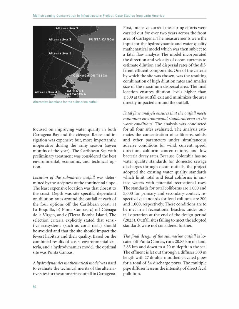
60
Mainstreaming Conservation in Infrastructure Project: Case Studies from Latin America
focused on improving water quality in both Cartagena Bay and the ciénaga. Reuse and ir-rigation was expensive but, more importantly, inoperative during the rainy season (seven months of the year). The Caribbean Sea with preliminary treatment was considered the best environmental, economic, and technical op-tion.
Location of the submarine outfall was deter-mined by the steepness of the continental slope. The least expensive location was that closest to the coast. Depth was site specific, dependant on dilution rates around the outfall at each of the four options off the Caribbean coast: a) La Boquilla, b) Punta Canoas, c) off Ciénaga de la Virgen, and d)Tierra Bomba Island. The selection criteria explicitly stated that sensi-tive ecosystems (such as coral reefs) should be avoided and that the site should impact the fewest habitats and their quality. Based on the combined results of costs, environmental cri-teria, and a hydrodynamics model, the optimal site was Punta Canoas.
A hydrodynamics mathematical model was used to evaluate the technical merits of the alterna-tive sites for the submarine outfall in Cartagena.
First, intensive current measuring efforts were carried out for over two years across the front area of Cartagena. The measurements were the input for the hydrodynamic and water quality mathematical model which was then subject to a fatal flaw analysis The model incorporated the direction and velocity of ocean currents to estimate dilution and dispersal rates of the dif-ferent effluent components. One of the criteria by which the site was chosen, was the resulting combination of high dilution rates and smaller size of the maximum dispersal area. The final location ensures dilution levels higher than 1:300 at the outfall exit and minimizes the area directly impacted around the outfall.
Fatal flaw analysis ensures that the outfall meets minimum environmental standards even in the worst conditions. The analysis was conducted for all four sites evaluated. The analysis esti-mates the concentration of coliforms, solids, and other parameters under simultaneous adverse conditions for wind, current, speed, direction, coliform concentrations, and low bacteria decay rates. Because Colombia has no water quality standards for domestic sewage discharges through ocean outfalls, the project adopted the existing water quality standards which limit total and fecal coliforms in sur-face waters with potential recreational uses. The standards for total coliforms are 1,000 and 5,000 for primary and secondary contact, re-spectively; standards for fecal colifoms are 200 and 1,000, respectively. These conditions are to be met in all recreational beaches under out-fall operation at the end of the design period (2025). Outfall sites failing to meet the adopted standards were not considered further.
The final design of the submarine outfall is lo-cated off Punta Canoas, runs 20.85 km on land, 2.85 km and down to a 20 m depth in the sea. The effluent is let out through a diffuser 500 m length with 27 double-mouthed elevated pipes for a total of 54 discharge ports. The multiple pipe diffuser lessens the intensity of direct fecal pollution.
Alternative locations for the submarine outfall.
61
Cartagena Water Supply, Sewerage and Environmental Clean-Up Project: Reclaiming Ciénaga de La Virgen
Water quality-related monitoring/maintenance programs have been implemented to control and keep track of water quality. The moni-toring is essential to monitor the quantity of nutrients and pollutants entering the system, and the system’s ability to recycle them. Water samples from around the submarine outfall are constantly monitored and tested to ensure not only that the level of total coliforms and overall water quality stays within designed low levels but also that coliform exceedence does not spread beyond predicted areas. Close mon-itoring of the marine environment enables a timely response if ocean conditions change.
Improved water and wastewater managementwill be achieved by developing an Unaccount-ed-for Water Reduction Plan and an Industrial Wastewater Discharge Control Program. The latter will have a considerable positive impact on the water quality of the receiving bodies. The program will:
identify key sources of industrial pollu-tion; establish a system to regulate and audit the discharge of industrial waters; define strategies to control small dis-persed sources (such as gas stations); andprovide technical assistance in the se-lection and design of pretreatment processes.
The engineering design of the submarine outfall in Cartagena, Colombia avoided sensi-tive marine environments and caused the least disturbance in the surrounding water quality through adequate location and use of water treatment prior to disposal into the sea. The selection of the outfall toward the Caribbean Sea allows the effluent disposed of in Ciéna-ga de la Virgen and Bahía de Cartagena to be transferred, thus preventing further degrada-tion of both areas and allowing restoration programs to take place while still ensuring that minimum water quality standards are met and
•
•
•
•
environmental and health risks are kept low. In all, the project represents an enormous and successful effort to improve the sanitary condi-tions and water quality of city and surrounding water bodies, as well as improved management of both water and wastewater with higher en-vironmental standards.
Rescuing Ciénaga de La Virgen
Despite its degraded state, the ciénaga is still an important ecosystem for local biodiversity and small-scale fisheries. The ciénaga itself, which received the majority of the raw sewage, is composed of 2,250 ha of water and 950 ha of wetlands; Juan Polo, a smaller ciénaga of 80 ha, lies to the north. The cumulative impact assessment identified the main threats to the ecosystem and the results were incorporated in the Recovery, Conservation and Environmen-tal Management Plan (RCEMP) for Ciénaga de La Virgen.
Reversing degradation. The civil works of the project itself and others planned (such as Bo-cana) helped to stop and reverse some of the damage by:
stopping the disposal of effluents directly into the wetlands, improving or re-establishing flow among water bodies and waterways, thereby avoiding the isolation of particular areas and restoring past habitat fragmentation; andconstituting physical barriers that will prevent future urban sprawl into the wet-lands.
The transfer of the wastewater discharge from Ciénaga de la Virgen to the submarine outfall, along with an environmental man-agement plan to restore and conserve this ecosystem, constitute the first steps toward re-claiming the ciénaga as a unique asset within the urban landscape of Cartagena.
•
•
•

62
Mainstreaming Conservation in Infrastructure Project: Case Studies from Latin America
Protecting the ciénaga: Despite its importance, and because of its degraded condition, the ciénaga was perceived as a neglected, bad-smelling area, with several sites posing sanitary concerns. It had not been legally established as a protected area and also lacked a restoration or environmental management plan. The latter was needed to complement the clean-up ben-efits of removing the discharges to the lagoon. The Bank served as a catalyst for protecting this area. The legal establishment of Ciénaga de La Virgen as a protected area includes a Recovery, Conservation and Environmental Management Plan (RCEMP) as part of the same package. Recommendations to secure funds that will finance the operation and man-agement of the protected area will be included as part of its legal framework.
The Recovery, Conservation and Environmental Management Plan (RCEMP) for Ciénaga de La Virgen ensures restoration and sustainable use after the project is completed. The RCEMP is based on the results of the cumulative im-pact assessment and covers five main areas: (i) ecological restoration, (ii) environmen-tal education, (iii) zoning and management, (iv) sustainable use of mangroves, and (v) institutional strengthening. The RCEMP is being drafted by Conservation International, a renowned NGO with ample experience in projects related to the ciénaga.
The ecological restoration plan starts with the identification and prioritization of actions needed to further halt the degradation of wet-lands, such as: mapping areas with high rates of urban sprawl or where solid waste is being dumped directly into waterways, identifying the magnitude of nonpoint sources, locating and controlling invasive species, and stopping overfishing. The variety of issues and the wide range of agencies involved in these activities go beyond those affected by the project directly. To address this, the project team has channeled Bank funds and resources into a far-reaching
program that concerns project participants and actively involves other parties who have either contributed historically to the degrada-tion of the wetland or will carry out activities related to the ciénaga.
Environmental education program developmentis included in the RCEMP. The program would target schools around the ciénaga, promote awareness and a participatory approach to wetland management, and increase awareness of problems affecting the ciénaga.
One of the most beneficial aspects of the RCEMP is that it provides a framework for environmental activities deriving from other projects to be incorporated in a coordinated plan for the ciénaga, so that human, financial, and logistical resources are optimized by avoid-ing redundant tasks and interference between various activities.
SUCCESSFUL STRATEGIES
The establishment of a multidisciplinary expert panel to oversee the entire design and site selec-tion process ensured high standards throughout the process. In response to the District of Cartagena’s request for technical guidance the project team not only included engineering
An urban asset: high potential for tourism, increased land value, increased water quality, decreased health issues.

63
Cartagena Water Supply, Sewerage and Environmental Clean-Up Project: Reclaiming Ciénaga de La Virgen
and modeling experts but extended the expert advice to areas such as environmental impacts and private sector participation, providing a well-rounded approach throughout the feasi-bility and design phases.
An integral approach to the ciénaga incorpo-rated the concerns of all stakeholders from the city to the surrounding neighborhoods: fishermen, tourists, and conservation groups. The project successfully addressed issues such as health problems, and environmental and engineering challenges. More importantly, its modular design allows different phases to be added as demands on the system increase.
Evaluation of the ciénaga across projectsmeant going from a project-based impacts and potential benefits perspective to an in-clusive all-projects approach. This ensured that past, current, and future activities were considered, and provided a better view of threats to the ciénaga and needs for its man-agement and restoration. It also drastically increased local and government awareness. It changed the perception that the wetland was a detrimental landscape feature with low
esthetic value that posed a sanitary risk, to a new view of the wetland as an environmental asset with high ecological and aesthetic val-ue that can provide multiple amenities. The project’s direct benefits include higher land values due to the expansion of water services, improved sanitary conditions as a result of the clean-up activities, and incorporation of the protected areas into the city’s new zon-ing plan. For the other projects, the wetland will now represent a scenic road, a tourist attraction, and a source of economically sus-tainable activities.
The Cartagena Water Supply, Sewerage and Environmental Clean-Up Project dem-onstrates that making habitat restoration part of the project’s ultimate goals puts forward a strong statement about the level of com-mitment to and importance of restoring a degraded ecosystem. The project shows that the cascading effect of changing the perception of a previously degraded landscape to an eco-nomic, aesthetic and ecological asset can result in improved practices and higher standards across sectors and stakeholders.


65
Honduras Road Reconstruction and Improvement Project:safeguarding an endemic biodiversity hotspot
SUMMARY
The project sought to rehabilitate or upgrade main and rural roads through-out Honduras. Because all works were to be within the existing roads’ right-of-way, environmental impacts were expected to be minimal. How-ever, standard environmental screening of the project found that one of the roads to be upgraded ran through the Aguan Valley, a known habitat of the endangered, endemic Honduran emerald hummingbird, Amazilia luciae. A subsequent study to assess the hummingbird’s habitat showed that dry thorn forest was essential not only for the hummingbird’s survival but also for at least 11 endemic plant species, all either threatened or endangered; this fact placed the dry thorn forest at the top of Honduran ecosystems with high endemic biodiversity. The 3,300 ha of remaining thorn forest lies mostly within privately owned lands. Interviews showed that landholders intended to convert the rest of their land to cattle ranching as soon as it was finan-cially possible. Upgrading the road would increase land values, consequently favoring an increase in the deforestation rate upon road completion. The impending land conversion and the rich endemic biodiversity called for an Action Plan to conserve the dry thorn forest in the Aguan Valley. The Con-servation Action Plan was designed to ensure that adequate environmental measures were in place before road construction began. Some of the plan’s key components include securing habitat, development guidelines, environ-mental education, and endangered species monitoring.

66
Mainstreaming Conservation in Infrastructure Project: Case Studies from Latin America
Much progress was made in increas-ing government and local awareness of the uniqueness of this area and the Honduran Government ultimately transferred the funds to upgrade a different road.. Bank efforts re-sulted in the much needed CAP for this area and in the inclusion of the dry thorn forest in the Biodiversity in Priority Areas Project (funded by GEF), thereby making its con-servation a national priority. The project set aside US$200,000 to support CAP-related activities and played a vital role in raising na-tional awareness of this previously-neglected area.
BACKGROUND
The goal of the project was the reconstruction of 262 km of main roads, the replacement of bridges, and the improvement of 100 km of ru-ral roads. The population at large and some of the country’s poorest rural communities will benefit.
The total cost of the project is US$106.8 million, of which the Bank is lending US$66.5 million, with 19 percent of the project finances allocated to rural roads, bridges, and a pilot project for road maintenance. The remaining budget (81 percent) is allocated to the recon-struction of five main roads:
Tegucigalpa–Danli: rehabilitation of 84 km with an average daily traffic (adt) of 2,500 vehicles;Jícaro Galán–El Amatillo: rehabilitation of 40.2 km with an adt of 2,600 vehicles;Santa Rita–Yoro (El Negrito–Portillo de Chancaya section): reconstruction of 46.5 km with an adt of 1,734 vehicles.Río Dulce–El Porvenir: improvement (upgrading from gravel to asphalt) of 46.5 km. with an adt of 624 vehicles.San Lorenzo–Olanchito: upgrading and widening of an unpaved section of 45 km of the main road, with an adt of 456 vehicles.
•
•
•
•
•
The project started in November 2000 and is scheduled to close in March 2006.
NATURAL HABITAT ISSUES
The majority of the roads traverse pine and other forested areas as well as agricultural areas along their routes, but the works are within the existing roads’ right-of-way, and the average daily traffic on most roads is already around 2,000 vehicles. The ecological impacts stem-ming from the works on the first four main roads are minimal and they have only a small resettlement component.
However, the San Lorenzo–Olanchito road is an unpaved section of 45 km that runs through the upper Aguan River Valley. The road has an approximate area of influence of 150 km2, and within it lie several patches of dry thorn forest. The Aguan Valley, particularly the thorn forest patches upriver from Olanchito, are the only areas known to harbor the endemic, critically endangered Honduran emerald hummingbird, Amazilia luciae. In fact, the emerald humming-bird is the only bird endemic to Honduras and the most endangered bird in Central America. Field visits confirmed that most of the thorn forest lies within private lands; the main land uses in the area are cattle ranching and agricul-ture. Although trees are usually not cut down, the understory is either heavily grazed or con-verted to more productive pastures and/or crops. Road improvements would increase land values, thereby facilitating and encouraging land clearance in the area. The main concern was the risk that the remaining dry thorn for-est would be cleared, thus directly affecting the Honduran emerald hummingbird.
Through the use of a precautionary ap-proach, provisions were made in the Credit Agreement to ensure that adequate studies were carried out and conservation measures were implemented as needed. A Habitat Study was required. If supported by the study’s find-ings, a Conservation Action Plan would also be required.

67
Honduras Road Reconstruction and Improvement Project: safeguarding an endemic biodiversity hot spot
Honduran Emerald Hummingbird Habitat Study
The participating federal agencies, academic institutions, NGOs, and consultants designed a comprehensive habitat study with three ma-jor components. The first would fill biological information gaps; the second would target so-cioeconomically driven land-use changes; and the third would identify and prioritize subse-quent conservation actions. Specifically, the objectives of the study were to:
determine the status of the Honduran emerald hummingbird and its habitat, and especially the relevance of the San Lorenzo–Olanchito portion of the Aguan River Valley as natural habitat for the hummingbird and/or other threatened biodiversity; assess the likely indirect impacts of the proposed road upgrade, with emphasis on potential land-use changes and habi-tat loss; and identify proper follow-up conservation measures to ensure the survival of the Honduran emerald hummingbird and/or other threatened flora or fauna in the Aguan River Valley and/or other valleys with suitable habitat.
Because there was no consulting firm in Honduras with the expertise needed, project participants put together a multidisciplinary
•
•
•
expert team to carry out the study. The team, which included a botanist, ornithologist, environmental lawyer, economist, and field as-sistants, surveyed the Aguan Valley and other dry Atlantic slope valleys (around Santa Bar-bara, Cofradía, and Cortes). The results of the study were conclusive:
Only two areas harbor the Honduran emerald hummingbird: the San Lorenzo–Olanchito portion of the Aguan Valley, and San Esteban, Olancho.
The San Lorenzo–Olanchito area is critical to the survival of endemic species. The study noted at least 11 endemic plant species, 9 of them ex-clusive to the Aguan Valley, all threatened or endangered. This makes the Aguan Valley the region with the highest endemism in Honduras and the only viable habitat for all these endem-ic species. Furthermore, this specific portion of the Aguan River Valley, which comprises 96 percent of the habitat of the Honduran em-erald hummingbird, is essential for this bird’s long-term survival.
The understory of the dry thorn forest is a year-round food resource for the hummingbird. Particularly in undisturbed areas, there are al-ways flowers within the thorn forest understory. The flowers of the pie de niño are a staple food year-round; the more abundant they are, the higher hummingbird densities are. Through-out cattle forest areas the pie de niño has been replaced by pasture.
Land conversion throughout the valley was fa-vored by local landholders. Interviews revealed that financial constraints restricted efforts to clear dry thorn forest and replace it with pas-ture.
Road improvement would encourage and fa-cilitate deforestation throughout the area. The available remaining habitat was estimated at 3,300 ha, only 11 percent of that existing in 1938. It was estimated that deforestation rates
Aguan Valley in Honduras
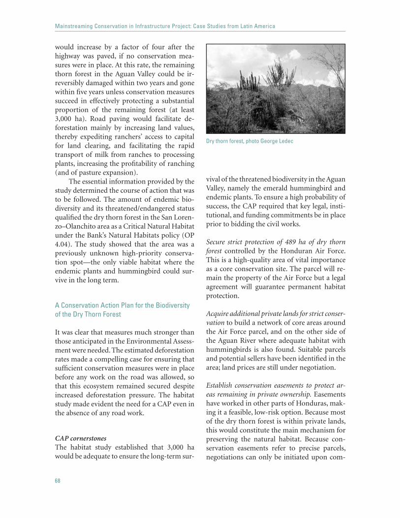
68
Mainstreaming Conservation in Infrastructure Project: Case Studies from Latin America
would increase by a factor of four after the highway was paved, if no conservation mea-sures were in place. At this rate, the remaining thorn forest in the Aguan Valley could be ir-reversibly damaged within two years and gone within five years unless conservation measures succeed in effectively protecting a substantial proportion of the remaining forest (at least 3,000 ha). Road paving would facilitate de-forestation mainly by increasing land values, thereby expediting ranchers’ access to capital for land clearing, and facilitating the rapid transport of milk from ranches to processing plants, increasing the profitability of ranching (and of pasture expansion).
The essential information provided by the study determined the course of action that was to be followed. The amount of endemic bio-diversity and its threatened/endangered status qualified the dry thorn forest in the San Loren-zo–Olanchito area as a Critical Natural Habitat under the Bank’s Natural Habitats policy (OP 4.04). The study showed that the area was a previously unknown high-priority conserva-tion spot—the only viable habitat where the endemic plants and hummingbird could sur-vive in the long term.
A Conservation Action Plan for the Biodiversityof the Dry Thorn Forest
It was clear that measures much stronger than those anticipated in the Environmental Assess-ment were needed. The estimated deforestation rates made a compelling case for ensuring that sufficient conservation measures were in place before any work on the road was allowed, so that this ecosystem remained secured despite increased deforestation pressure. The habitat study made evident the need for a CAP even in the absence of any road work.
CAP cornerstonesThe habitat study established that 3,000 ha would be adequate to ensure the long-term sur-
vival of the threatened biodiversity in the Aguan Valley, namely the emerald hummingbird and endemic plants. To ensure a high probability of success, the CAP required that key legal, insti-tutional, and funding commitments be in place prior to bidding the civil works.
Secure strict protection of 489 ha of dry thorn forest controlled by the Honduran Air Force. This is a high-quality area of vital importance as a core conservation site. The parcel will re-main the property of the Air Force but a legal agreement will guarantee permanent habitat protection.
Acquire additional private lands for strict conser-vation to build a network of core areas around the Air Force parcel, and on the other side of the Aguan River where adequate habitat with hummingbirds is also found. Suitable parcels and potential sellers have been identified in the area; land prices are still under negotiation.
Establish conservation easements to protect ar-eas remaining in private ownership. Easementshave worked in other parts of Honduras, mak-ing it a feasible, low-risk option. Because most of the dry thorn forest is within private lands, this would constitute the main mechanism for preserving the natural habitat. Because con-servation easements refer to precise parcels, negotiations can only be initiated upon com-
Dry thorn forest, photo George Ledec
69
Honduras Road Reconstruction and Improvement Project: safeguarding an endemic biodiversity hot spot
pletion of the land tenure cadastral study for the Aguan Valley.
Conservation incentives for landholders such as assistance with demarcation and other protec-tion management costs, registered secured land titles, and protection against squatters must be in place in order to make easements an at-tractive offer. Meetings with landowners have taken place to consider the type of benefits that could be granted in exchange for designating a portion of their land for conservation.
Establish an ecological and compliance moni-toring program. This would include routine verification of monitoring indicators and targets, mapping and census of species popula-tions, periodic habitat quality evaluations, and monitoring of the extent of landholder com-pliance with easement agreements.
Expanding the boundaries of the Pico Bonito National Park to incorporate most or all of the remaining thorn forest in the Aguan Valley, with the Air Force and acquired parcels among the park’s strict protection core zone and the re-maining private lands within the buffer zone.
The CAP also included other supporting measures which did not have to be fully im-plemented before bidding began on the civil works for the road. These activities included:
A two-year environmental education pro-gram, with a total cost of approximately US$34,000. The focus of the program is on the biodiversity of the Aguan Valley and oth-er CAP components such as advantages of conservation easements, and elements of eco-tourism.
Promoting ecotourism as a complemen-tary economic activity in the Aguan Valley. Sustainable alternative economic activities such as ecotourism are part of the develop-ment guidelines for the area. These guidelines will prevent detrimental land uses or levels of intensity that pose a threat to the dry thorn forest. Ecotourism in particular could further encourage conservation of this habitat and
residents of the San Lorenzo–Olanchito area could provide accommodations for visitors and/or guided tours.
CAP implementationUltimately, the preparation of an adequate CAP took longer than was estimated and the Honduran Government decided to transfer the funds allocated for the San Lorenzo–Olanchito road, to another road located in a nonsensitive area (San Pedro Sula–Tegucigalpa). The gov-ernment made a commitment to continue the conservation efforts in the Aguan Valley and set aside US$200,000 for this purpose from the credit. Despite the complexity of the CAP and the transfer of funds to a different road, there has been considerable good will to implement it on the part of SOPTRAVI,13 other Honduran Government agencies, and NGOs. Progress in CAP implementation is evidenced by these lat-est achievements:
The Air Force parcel has been secured. The legal agreement has been negotiated, the Air Force has relocated its personnel to a different site, and a small building within the parcel has been demolished. The Air Force remains in charge of this area and actively enforces both its boundaries and use for conservation. The legal agreement is in the process of being passed by the Honduran Congress.
The Honduran Emerald Reserve project led by the American Bird Conservancy is raising funds for a locally owned and managed reserve. Partners include the World Bank, Fundación Pico Bonito, SOPTRAVI, and Conservation International.
Conservation easements are being negotiated to secure land to the south of the Air Force parcel. This comprises the best preserved area around
13 Secretaría de Obras Públicas, Transporte y Vivienda (Hondu-ran Ministry of Housing, Transport and Public Works)
70
Mainstreaming Conservation in Infrastructure Project: Case Studies from Latin America
the Air Force parcel and would help secure a large, continuous patch of dry thorn forest.
An environmental education program in Are-nal is being implemented to raise awareness among the community and help secure land on the opposite side of the river. The environ-mental education and conservation efforts are led by the Programa Hondureño de Educación Comunitaria (Honduran Program for Com-munity Education).
The Bank played a pivotal role by raising awareness about this habitat, putting together a detailed habitat study and a conservation ac-tion plan, and including the dry thorn forest in the gap analysis of the project for the Ra-tionalization of the Protected Areas System of Honduras, part of the Biodiversity in Priority Areas Project (PROBAP), funded by the GEF. As a result, conservation of this ecosystem is now a national high priority. PROBAP financ-es, among other things:
management plans for the globally im-portant protected areas; demarcation of core and buffer zones; construction of visitors' centers in the Atlantic zone; staff recruitment; and construction of park ranger facilities.
SUCCESSFUL STRATEGIES
Following the precautionary approach paid off in the short term, because the Habitat Study showed the dry thorn ecosystem to be a unique stronghold of endemic biodiversity.
Binding studies to the Credit Agreement enabled the World Bank’s Natural Habitats policy to act
•
••
••
as the de facto conservation statute, overriding national environmental standards that would have allowed road paving without adequate studies and measures in place.
Structuring a multidisciplinary approach ad-dressed ecological concerns and the socio-economic response of the local community. Furthermore, putting together a group of ex-perts started a collaboration process among the stakeholders. The Bank’s ability to act as a facilitator among stakeholders, other resource management projects, and international orga-nizations demonstrates the wealth of resources it can bring into a project, whether financial, human, or logistical.
Ensuring timely conservation measures was essential throughout the project. The site was promptly recognized as a potential critical habitat, the habitat study and CAP were aptly timed prior to bidding the civil works, and when improvement works were transferred to an alternative road, funds were set aside to support CAP implementation. Moreover, to ensure continuing support by the government, the project team enabled the inclusion of the dry thorn forest in PROBAP’s priority biodi-versity areas.
The project exemplifies how the Bank can successfully act as a catalyst for conservation actions that benefit previously unknown high biodiversity areas. Although the population status of endemic species in the Aguan Valley remains precarious, the Bank’s involvement opened a window of opportunity to safeguard the dry thorn forest. Opening these windows of conservation opportunities and securing conservation measures can help redefine the relationship between infrastructure projects and natural habitats today.

71
Bogotá, Colombia: Santa Fe I Water and Sewerage Project:restoring ecosystem services in an urban landscape
SUMMARY
To rehabilitate and expand the water supply and sewerage network of Bo-gotá and surrounding municipalities, the city undertook the restoration of wetlands, waterways, and ecosystem services. Innovative architectural and engineering designs were used to improve water quality and reconnect pre-viously isolated water bodies while blending project works into the urban landscape. The water supply network was both rehabilitated and expanded. Civil works were shaped into recreational/educational areas: linear parks border canals, playgrounds contain canal overflows, and community spaces camouflage storage tanks. Environmental displays were placed throughout these public areas. This urban landscaping approach completely overturned the public perception of canals and wetlands from one of dumps overrun by raw sewerage to one of environmental assets. The public’s awareness of the benefits and importance of conserving wetlands was dramatically improved. Institutional reforms included:
establishing a new environmental department within Bogotá’s public Aqueduct and Sewer Company (EAAB), acquiring new equipment and software that will keep track of neigh-boring water sources; and developing a water quality monitoring system.
•
•
•
72
Mainstreaming Conservation in Infrastructure Project: Case Studies from Latin America
The combined effects of civil works, insti-tutional restructuring, and public awareness have thus resulted in a renewed drive to con-serve and restore the approximately 500 ha of urban wetlands remaining in the city. The Bank recognized the project’s collective en-vironmental achievements by granting it the 2003 Green Award.
BACKGROUND
The city of Bogotá and surrounding mu-nicipalities hold one-third of the nation’s industries. According to estimates, the popu-lation within the city will reach 10 million by 2010. Accordingly, EEAB’s goals are to increase water supply from 91 percent to 94 percent and sanitation service levels from 83 percent to 90 percent by 2010. The city’s water net-work was in pressing need of rehabilitation and expansion: the water production capacity was limited to about 65 percent of the nomi-nal capacity. The main constraints were in the Tibito system: the Tibito treatment plant had a capacity of 11 m3/s but supplied only 4 m3/s. Civil works included—but were not limited to—the rehabilitation and/or construction of 2,220 km of sewage interceptors, sewage col-lectors, distribution mains, and storm-water drains, ultimately supplying 180,000 con-nections for water service and 200,000 for sewerage service.
Besides civil works, the project anticipated the implementation of the Unaccounted-For Water (UFW) reduction program, as well as the establishment and maintenance of an Environmental Department within EAAB. The project’s environmental component, 1.6 percent of project cost, had a specific bud-get line item for wetland conservation in the Bogotá area. Upon project completion, water quality was expected to improve significantly (although still below proposed levels) in sev-eral sections of the Bogotá River. The project was approved in November 1995 and is ex-pected to be closed by December 2004. The total project cost was US$414.2 million, of
which the Bank provided 35 percent (US$145 million).
NATURAL HABITAT ISSUES
Bogotá is located in central Colombia, within the upper basin of the Bogotá River. The river receives all of the city’s sewage and storm water and carries them down to its confluence with the Magdalena River. Other rivers also cross the city: the Torca, Salitre, Fucha, and Tunjue-lo. Thirteen wetlands within the capital district are associated with these rivers. However, the project works are located in the lower areas of the north and west of the city, and thus influ-ence only seven wetlands: La Conejera, Juan Amarillo, Torca, Jaboque, Santa María del Lago, El Burro, and La Vaca. Despite the lower number of wetlands affected by the project, they encompass 84 percent of the 530 ha of re-maining urban wetlands in Bogotá. Several of the wetlands harbor threatened and endemic species.
Since 1994 all wetlands within the capi-tal have been considered natural reserves. The project works involved 7 of the 13 urban wetlands, several of which are the habitat of endemic and threatened species. These facts triggered the Critical Natural Habitats policy. Although these wetlands are protected, they have been degraded by illegal settlement, ex-traction of resources, wastewater disposal, and lost connectivity between water bodies. The environmental agency (DAMA) and the re-gional agency (CAR) were key in establishing the strategy that guided the entire project, the focus for civil works and restoration measures was to reestablish ecosystem functions and maintain the existing biodiversity.
Restoring Habitats
Environmental screening identified the lack of treatment of storm water and sanitary sewage prior to their discharge into the river, urban canals, and adjacent wetlands. This had signifi-

73
Bogotá, Colombia: Santa Fe I Water and Sewerage Project:restoring ecosystem services in an urban landscape
cantly lowered the water quality throughout surface waters, creating sanitary and flooding risks as well as poor environmental condi-tions. Nutrient and waste input had exceeded the recycling capacity of river beds and wet-lands; eutrophication prevailed in most areas. Furthermore, while some areas had increased flood risk, others were desiccating. Lower ca-nals drained neighboring wetlands, and land refilling had isolated some wetlands from the rivers and canals. To restore the rivers and wetlands, the civil works needed a design that would improve water quality and reestablish lost connectivity by improving flow through-out water bodies and waterways.
Water quality: The new Torca sewage system carries wastewaters past the confluence of the Salitre and Bogotá Rivers, effectively improv-ing sanitary conditions and water quality on the first 32 km of the latter. This measure also benefited those wetlands affected by raw sew-age: Los Cementerios, Torca, Juan Amarillo, Jaboque, El Burro, and La Vaca. Interceptors strategically located throughout the city also separated storm water and sewage, improv-ing the water quality on the Torca, Guaymaral, Salitre, Jaboque, and Tintal canals. The Tibito treatment plant was brought to full capacity, which translated into a nearly threefold in-crease in the volume of treated water; capacity
increased from 4 m3/s to 11 m3/s. The above actions will lower pollutants discharged to the water bodies, decrease nutrient loads, and low-er the biological oxygen demand in the system. Water and sediment quality will improve and bioaccumulation of pollutants will decrease. The improvement of sanitation levels has also had a beneficial effect on storm-water canals throughout the city. Currently, improvements in the operation of the Salitre water treatment plant are being sought; these would make a significant difference to the quality of the ef-fluent.
Reestablishing connectivity: Extensive excava-tion was needed to restore lost flow capacity in canals and rivers. Bottom deposits originated from surface runoff, domestic and industrial sewerage, and soil in the river bed. Toxic sludge was removed from the Torca, Guaymaral, Salitre, and Jaboque canals. Additional exca-vation was needed for multiple water canals throughout the city and in specific wetlands to reconform lost or deteriorated water bodies. This was the case in the Juan Amarillo wetland where the reconformation of one of the la-goons (35 ha) required dredging over 2 million m3 of sediments. Overall, the works improved the canals and lakes within the Chicid-La Ra-mada irrigation district which provides water to 60 percent of the aquatic ecosystems located
A typical canal, prior to the project, that posed a high sanitary risk, had poor environmental conditions and low aesthetic value.
Torca Canal, after improvement of flow capacity and landscaping. Green slopes and fences around paths and bike trails on both sides of the canal significantly increased adjacent property values.
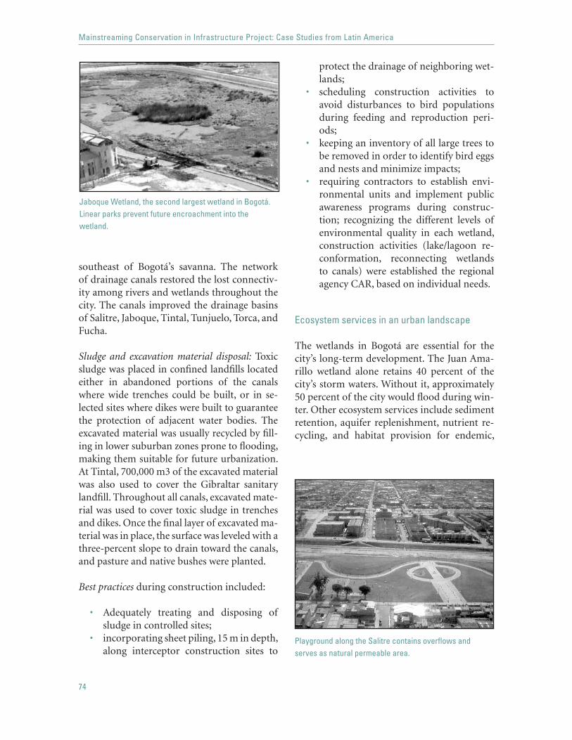
74
Mainstreaming Conservation in Infrastructure Project: Case Studies from Latin America
southeast of Bogotá’s savanna. The network of drainage canals restored the lost connectiv-ity among rivers and wetlands throughout the city. The canals improved the drainage basins of Salitre, Jaboque, Tintal, Tunjuelo, Torca, and Fucha.
Sludge and excavation material disposal: Toxic sludge was placed in confined landfills located either in abandoned portions of the canals where wide trenches could be built, or in se-lected sites where dikes were built to guarantee the protection of adjacent water bodies. The excavated material was usually recycled by fill-ing in lower suburban zones prone to flooding, making them suitable for future urbanization. At Tintal, 700,000 m3 of the excavated material was also used to cover the Gibraltar sanitary landfill. Throughout all canals, excavated mate-rial was used to cover toxic sludge in trenches and dikes. Once the final layer of excavated ma-terial was in place, the surface was leveled with a three-percent slope to drain toward the canals, and pasture and native bushes were planted.
Best practices during construction included:
Adequately treating and disposing of sludge in controlled sites; incorporating sheet piling, 15 m in depth, along interceptor construction sites to
•
•
protect the drainage of neighboring wet-lands; scheduling construction activities to avoid disturbances to bird populations during feeding and reproduction peri-ods; keeping an inventory of all large trees to be removed in order to identify bird eggs and nests and minimize impacts; requiring contractors to establish envi-ronmental units and implement public awareness programs during construc-tion; recognizing the different levels of environmental quality in each wetland, construction activities (lake/lagoon re-conformation, reconnecting wetlands to canals) were established the regional agency CAR, based on individual needs.
Ecosystem services in an urban landscape
The wetlands in Bogotá are essential for the city’s long-term development. The Juan Ama-rillo wetland alone retains 40 percent of the city’s storm waters. Without it, approximately 50 percent of the city would flood during win-ter. Other ecosystem services include sediment retention, aquifer replenishment, nutrient re-cycling, and habitat provision for endemic,
•
•
•
Jaboque Wetland, the second largest wetland in Bogotá. Linear parks prevent future encroachment into the wetland.
Playground along the Salitre contains overflows and serves as natural permeable area.

75
Bogotá, Colombia: Santa Fe I Water and Sewerage Project:restoring ecosystem services in an urban landscape
resident, and migratory species. It was there-fore important that the transition between natural and urban landscapes be functional while maintaining wetlands’ integrity. Innova-tive architectural design was key to achieving this goal.
Wetlands and rivers were delimited by border-ing these areas with linear parks. Bike routes, walking trails, and passive recreational areas run along rivers and canals, serving multiple functions. The canals and paths serve as physi-cal barriers that prevent encroachment into the wetlands and serve as urban spaces where the public can enjoy the aesthetic values of the land-scape. Live barriers in the form of bushes and trees, as well as fences, also serve to maintain the paths for pedestrian, cycling, and skating use only. The Paseo Río Salitre is the largest ur-ban environmental corridor in Latin America, providing a continuous public space that con-nects the Cerros Orientales (eastern hills in the San Rafael Ecological Park), where the water drains from the mountains, to the rivers, canals, and wetlands that cross the city. The Paseo con-sists of 43 km of trails, 37 km of cycling routes, and 228 ha of recovered wetlands in Juan Ama-rillo. It is the single most important landscape component that has helped change public per-ception of the sewerage system.
Protection against floods is provided by playgrounds strategically located in lower, flood-prone areas of high and medium den-sity. If flows exceed the design capacity of the canals, the parks become active as natural permeable areas, preventing the flooding of residential areas
Community parks disguise structural compo-nents, such as the water storage tanks. El Volador tank has a key technical function within the water supply network, yet it also serves a social function as a community space. The site, for-merly an abandoned quarry, was subjected to geomorphological stabilization techniques; the volume and height of the tank provide struc-
ture to the park: sport courts with a scenic view of the park and city were built on the top of the tank, its outside walls showcase a mural, and the lower grounds house a playground, walking trails, an open air auditorium, green areas, and an environmental management public area.
Converting slopes along rivers and canals to pasture land and using native species for re-forestation, turned formerly unused, unsafe muddy edges into visually appealing green areas. The green cover makes the borders less vulnerable to erosion caused by flooding and surface runoff, and it reduces the sediment load on the waterways.
The series of urban recreational areas as-sociated with the drainage canals and wetlands effectively protect sensitive ecosystems against illegal settlement and resource exploitation. They do so while increasing the aesthetic value of the sewage system and changing the percep-tion of adjacent canals from a nuisance and sanitary risk to a recreational and environmen-tal asset that has increased property values.
Conservation of wetlands and water sources
The wetlands spread across the city and are highly visible, making it relatively easy to raise public awareness about their status or con-servation needs. Water sources, although they
Side and top view of the Tanque El Volador Community Park. The water storage tank is a key structure in the water supply network.

76
Mainstreaming Conservation in Infrastructure Project: Case Studies from Latin America
surround the city, are out of public view so the public are less aware of their status so dif-ferent strategies are needed to keep track of these natural habitats. The Bank ensured that financial resources were allocated separately for the conservation and management of wet-lands and water sources. Despite the water supply and sewerage network’s wide range of environmental impacts on the surrounding natural resources, EAAB—the management agency—lacked an environmental department to address and assess these problems. The project team helped the agency restructure its internal organization to add an Environmen-tal Department to address and follow up on all pertinent issues.
WetlandsDemarcation of wetlands does not, in itself, ensure the proper conservation of these ecosys-tems in the future. In fact, the different wetlands have varying ecological values. La Conejera, Juan Amarillo, Torca, Jaboque, and Santa María del Lago still support a high biodiversity of vertebrates (98 species in Conejera), partic-ularly birds (42 species in Juan Amarillo), and invertebrates (26 species in Conejera). Several species are endemic, and some are threatened (e.g., a threatened mouse in Jaboque). Of all the wetlands, the Santa María del Lago wetland has the best water quality and La Vaca is rated with the lowest ecological value . with only a few remnant populations of birds, being most-ly grassland. This heterogeneity throughout the systems called for specific studies on wet-lands and management needs.
The ecological value of the different wetlandswas assessed with the help of Conservation International (CI), a well-established NGO in the area with broad experience in conser-vation and management. With project funds, CI carried out the most extensive compilation to date of information and research specific to the wetlands of Bogotá. The result was a large-format book coordinated by CI and
Bogotá’s public Aqueduct and Sewer Com-pany (EAAB) and funded by the Bank and other agencies. The book, “Los Humedales de Bogotá y la Sabana” (The Wetlands of Bogotá and the Savanna), includes the best collection of social and biological scientific knowledge as well as environmental management regarding these wetlands. The publication also serves as an assessment of cumulative impacts, and has become an invaluable reference tool for the public, management agencies, and NGOs.
Management Plans financed by project funds are being developed for Jaboque and La Cone-jera. NGOs play an important role in this process, coordinating efforts with EAAB. The Association for Social and Environmental Development (Asociación para el Desarrollo Social y Ambiental, ADESSA) is being funded to produce an Integrated Community Manage-ment Plan for the Recovery and Protection of the Jaboque Wetland, and the Fundación Hu-medal La Conejera was granted project funds to develop a plan to rehabilitate aquatic habitats within La Conejera wetland, protect endan-gered species, and strengthen the rational use of the wetland by the local community. The implementation of the environmental manage-ment plans for La Conejera and Jaboque will strengthen the protected areas and improve the health of the ecosystems associated with high mountain wetlands.
Public education and environmental awareness campaigns were carried out by EEAB during the project to increase the public’s acceptance and appreciation of the importance of restor-ing ecosystem services as part of the city’s water supply and sewage network. The proj-ect team also funded Fundación Alma, which is carrying out a 15-month-long participatory environmental and educational program for the Juan Amarillo wetland. In addition, edu-cational displays explaining the recreational, economic, and ecological value of the wetlands have been posted at different sites throughout the linear parks and playgrounds.

77
Bogotá, Colombia: Santa Fe I Water and Sewerage Project:restoring ecosystem services in an urban landscape
Assigning the management plans and public education campaigns to different NGOs distributes the workload between different or-ganizations, ensures that the wetlands receive adequate attention, makes better use of hu-man resources, and creates a network of NGOs that can support and assist one another during document preparation.
Water sourcesThe low water quality in rivers and canals placed a higher demand on water sources, because 70 percent of the water consumed in the city must be of high quality for residential use. Addition-al threats to water sources were posed by illegal connections to the water supply system and by undetected leaks that increased demand.
Institutional strengthening: As part of this com-ponent the project team helped EAAB develop a comprehensive permanent program to re-duce Unaccounted-for-Water (UFW) from 42 percent to 25 percent. The main causes were il-legal connections, inaccurate consumer records, software tampering, and faulty meters. The rest was primarily caused by leaks in the distribu-tion system and residential connections.
Capacity building: Although the project’s en-gineering works were aimed at restoring the ecosystem functions of urban wetlands and bringing the water supply and sewerage net-work to full capacity, the project’s institutional capacity building portion focused on the long-term strategic incorporation of ecosystems that provide water to the city (such as moorlands, wetlands, and mountain lakes). The water com-pany will optimize the usage of water resources and infrastructure by enhancing its capability to assess and project the status of water sources for the city. These studies will provide reference points to keep city water usage within the limits of adjoining ecosystems’ carrying capacity.
The water quality monitoring program has not yet been developed, although its goal is the de-
sign and implementation of an IT management system to monitor and verify organic matter and suspended solids entering and leaving the city’s wastewater system. This would greatly enhance the water company’s ability to track and manage water quality.
SUCCESSFUL STRATEGIES
The following strategies were key to maintain-ing high environmental standards throughout the project:
Architectural and engineering designs were aimed at restoring ecosystem services and re-versing the degradation of natural habitats. By reestablishing lost connectivity among the vari-ous waterways and wetlands, reducing nutrient loads, and reconforming lost lakes and lagoons, the civil works greatly restored the ecosystems’ flow capacity, as well as their capacity for nu-trient assimilation and flood protection.
Involving NGOs throughout project: Differ-ent NGOs made important contributions at different project stages: CI compiled the lat-est information available on the wetlands; Fundación Alma launched an educational campaign; and ADESSA and Fundación La Conejera are currently developing management plans. This has fostered community involve-ment and leveraged resources in addition to those of EAAB and government agencies.
Scheduling construction activities according to natural population activities proved vital to protect the bird population from the harm-ful effects of disturbing the nesting season and nesting habitat.
Using urban landscaping for technical, ecological, recreational, and economic purposes. The case of Bogotá is unique in the extent to which land-scaping was incorporated into project works. Going beyond requirements mandated by Bank policies or national guidelines, the proj-

78
Mainstreaming Conservation in Infrastructure Project: Case Studies from Latin America
ect funds and resources were used in a highly efficient manner to make the project footprint nonexistent. The project team made sure that no area used by the project was left without a landscape designed for specific activities. This included reforestation, recreational areas, play-grounds, and community spaces, and resulted in increased aesthetic value, public apprecia-tion, and property values.
The environmental achievements of the Santa Fe I Water Supply and Sewerage Project were recognized by the Bank, which granted the 2003 Green Award to the project. This recogni-tion demonstrates that infrastructure projects in Latin America can provide services and serve social functions while restoring natural habi-tats and increasing public appreciation for the services and goods that ecosystems provide.
79
Tocantins Sustainable Regional Development Project:conservation as desired land use
SUMMARY
This statewide project for sustainable development builds on a thorough as-sessment and mapping of natural resources, followed by strict zoning based on resource availability and the communities’ interests, to select the 6,000 km of municipal roads to be improved. A key difference of the approach is the primary designation of conservation areas at state level as part of the zoning scheme. Roads are selected as a network, taking into account conservation priority areas. This is radically different from the classic road-by-road ap-proach to environmental assessments and conservation. The project takes the best examples of outstanding land-use planning and includes large conserva-tion areas as a desirable asset within the zoning plan. From a socioeconomic planning standpoint, innovation lies in strong community involvement; land use is matched with existing natural resources as well as the economic inter-ests of communities and of local and state governments. In its final form, the road network will foster suitable economic activities and avoid conservation areas. The baseline studies will provide essential reference data to evaluate goals in the future and monitor resources.
BACKGROUND
The state of Tocantins, Brazil, has included the road network in a regional development project based on land management and ecological-econom-ic zoning (EEZ) Recognizing that it is more than just a road improvement

80
Mainstreaming Conservation in Infrastructure Project: Case Studies from Latin America
project, Under the road portion of this proj-ect, about 6,000 km of municipal roads will be selected in a participatory manner and improved to all-weather conditions. Bridges and culverts will be (re)constructed and 120 km of high priority state feeder roads linking the main municipal networks to the state’s primary transport network will be improved. More importantly, the environmental manage-ment portion will strengthen the state’s land management by financing regional ecological-economic zoning, specific studies on sensitive ecosystems and biomes in need of protection, surface and ground water resources, and soil characteristics. The information provided by these studies will help match land use to ex-isting resources. In turn, to match economic interests to resources, an extensive participa-tory process will involve the local civil society in the definition and monitoring of municipal and regional development agendas.
The project’s EEZ relies on the recently completed agroecological zoning (AEZ), car-ried out under the State Highway Management Project. The AEZ consists of a set of maps that characterize the existing potential and restric-tions for the use of the land. It represents an invaluable tool to carry out the EEZ, which seeks to reconcile the demands of economic development with the requirements for eco-logical conservation and optimal resource use. Table 1 below lists various examples of the the-matic maps that are part of the agroecological and ecological-economic zoning.
The project’s total required financing is US$100 million, of which the Bank is pro-viding US$60 million. The ratio of works to environmental budgets is among the highest within the transport sector, with US$12.7 mil-lion devoted to environmental management, US$7.7 million to participatory planning and development, and the rest to rural transport improvement. The project has been active since December 2003 and is scheduled to close by the end of December 2009. The entire pack-age will ultimately benefit the nearly 400,000 people living in the eastern half of the state of
Tocantins (130,000 km2), equivalent to one-third of the state’s total population.
The sustainable regional development project was conceived in coordination with the Natural Resources Policy Project under the Pilot Program to Conserve the Brazilian Rain-forest and a proposed Rural Poverty Reduction Project.
NATURAL HABITAT ISSUES
The project benefits four regions in the eastern half of the state: Bico de Papagaio to the North, Goiatins-Pedro Afonso to the Northeast, Jalapão to the East, and Arrais, Dianópolis, Natividade, and Taguatinga to the Southeast. There are three dominant biomes, each facing different threats from inadequate land-use practices:
The tropical rain forest (floresta om-brofila aberta), located in the transition zone between the humid plains of east-ern Amazonia and the high plains of the Center-West cerrados.
•
Table 1. Maps within the AEZ and EEZ
Agroecological Ecological-EconomicZoning Zoning
Geological State map
Geomorphological Administrative regions
Pedology Hydroelectric potential
Climate Road network
Annual precipitation Potential land use
Annual temperature Conservation/limited use
Soil erosion Tourist attractions
Topography Digital atlas
Watersheds and basins Geographical database
Potential flora Ecological-economic
Land use/Land cover
Agroecological

81
Tocantins Sustainable Regional Development Project: conservation as desired land use
Threats: The forest has been cleared in many areas and faces intense land conflicts. A key con-cern is soil degradation caused by unsustainable production, alteration of hydrological regimes, and clearing of remaining forests, including gallery forests. Despite this, it is still a source of extractive products such as babaçu nuts.
The cerrado (particularly the cerrado savanna) dominates most of the central-eastern half of the state.
Threats: It used mostly for ranching. Late-ly it is also being used for agriculture, although this usually requires soil correction, suitable land forms, and sometimes irrigation.
The gallery forests are found within the cerrados and isolated deciduous forest areas throughout the southeast. Threats: Clearing of the remaining patch-es of gallery forests is the most pressing threat.
Just as the degraded areas are of concern, so are the unique ecosystems found in the state. Several protected areas and indigenous lands are located in the project area. Eleven more conservation units have been proposed, six of which will be part of this project. Although there are no foreseen road improvement activi-ties in these areas, some paving activities may occur in other potentially sensitive areas (as defined by the zoning) and thus the Natural Habitats Safeguard Policy (OP 4.04) applies to the project.
Matching land use and natural resources to local interests
Further degradation of natural habitats and unsustainable production are expected to halt through the improved land-use management. The project’s ecological-economic zones are supported by a road network selected through a participatory process.
•
•
The road network in context: Continuing its re-gional approach, the state will prioritize areas and select where road improvement is needed the most. The EEZ process has been designed around five goals:
avoid critical habitats;match type and amount of natural re-sources to economic activities and levels of use;improve land-use and water resources management and monitoring;improve the institutional framework for environmental conservation; andprioritize municipal agendas, taking into consideration the communities’ expecta-tions.
The following are key actions related to these goals.
Avoiding critical habitats: The chapadas in Jalapão are a sand-dune landscape unique in the Brazilian cerrado which is home to rare and threatened Brazilian fauna. There are two integrated protection areas in the Jalapão re-gion: the Ecological Station and Jalapão Park (875,000 ha total), and one restricted use area, the APA14 do Jalapão (300,000 ha). No road improvement activities can take place in the
••
•
•
•
14 APA: Environmentally Protected Areas
State road in Tocantins

82
Mainstreaming Conservation in Infrastructure Project: Case Studies from Latin America
integrated protection areas and no activities are foreseen within the restricted use area. To-gether, these areas contain all environmentally sensitive habitats within the Jalapão region and protect about 30 percent of it. The road im-provement activities also avoid all indigenous lands.
Safeguarding natural habitats: If a road sec-tion to be improved is located close to or through an area with a potentially fragile eco-system, additional studies will be carried out so that the indirect impacts can be estimated and appropriate mitigation measures can be defined. These measures may involve land- and water-use restrictions, establishment of additional protected areas or modification of the project design and/or alignment, among others. The studies must be reviewed and ap-proved by the Bank before the bidding of the corresponding road improvement activities is launched.
Matching resources to economic activities issimilar to an auditing exercise on a region’s natural resources, where the type of economic activities are matched to the type and quality of the resources available and to the intensity of development that a given area can sustain. This is particularly important with respect to hydrological resources, which often determine the sustainability of the level at which develop-ment (e.g., agriculture or population density) should be set. The EEZ for Tocantins is inno-vative because it incorporates hydrological and geological resources; it strengthens land-use and water resources monitoring, and guides future development programs.
Improved land-use and water management will result from compliance with the zoning scheme by ensuring that development will remain in accordance with the carrying capacity of local resources. Unplanned development can cause habitat fragmentation or increased settlement in wildlands. A poor choice of the sites to be developed would translate into a high environ-
mental cost for a short-lived production area. For example, the northern region of Tocan-tins, at the point of transition to the Amazon biome and denser rain forest, is better suited to perennial crops. The sandy and dry region of Jalapão is thinly populated and has low po-tential for ranching or agriculture, making it more suitable for fruit production, ecosystem protection, and tourism. The southeast por-tion of the state is prone to soil erosion and the soil is not very fertile; thus, the area is better suited for ranching and limited agriculture in short rotations.
Incorporating communities’ expectations into municipal agendas turns a traditionally top-down decision-making process into a grassroots process, greatly increasing the acceptance and chances of success. Highlights of this process are detailed below.
Roads with a plan: to serve local interestsSocial data compiled for the EEZ will include location of human activities and living areas, heritage, cultural and archeological resources, and existing infrastructure.
The selection of state roads will be based on those that the municipalities and local communities perceive as the most important socially and economically. Other criteria are:
the number of municipal roads connect-ed to the regional road; the economic potential of adjacent zones; andthe potential to attract traffic from other parts of the road network.
Public hearings will be held after the selec-tion of each road section to address impacts on daily life and discuss measures to mitigate the potential adverse effects.
The main municipal networks will be defined by local development forums and the state
•
•
•

83
Tocantins Sustainable Regional Development Project: conservation as desired land use
road administration in accordance with en-vironmental criteria and socioeconomic relevance. When reviewed by the correspond-ing agencies, roads providing access to areas unsuitable for sustainable development will be eliminated.
Small-scale zoning will follow the municipal agendas drawn up in conjunction with the communities, ensuring that land management and economic development follow the interests of the local population as well. By involving the community, the state hopes to avoid land-use conflicts and illegal activities within conserva-tion areas in the future.
Conservation as a specific land use
The current land-related conflicts in the state stem from inadequate use of natural habitats: unsustainable production, soil erosion, un-planned clearing and limited supervision of conservation areas with subsequent illegal set-tlement, hunting, and fishing. Recognizing the need to secure land unaffected by clearing and other land-use changes, the state government set a short-term goal of protecting at least 10 percent of the state territory to preserve bio-diversity, protect ecosystems, and promote the conservation of natural resources. Currently the state as a whole has 2,750,000 ha within 11 conservation units and an additional 857,000 ha under federal jurisdiction.
The regional approach of the AEZ and the EEZ facilitated the identification of further areas that need protection, with the added ad-vantage that it allowed for larger expanses of land to be considered for conservation pur-poses rather than what would be typical under a road-by-road approach.
Conservation as a primary land use: Within the EEZ, areas devoted to economic growth lie outside critical habitats. A set of criteria to ensure that the decision-making process will comply with the recommended land use, is be-
ing developed. The system of protected areas is aimed at rehabilitating and preserving sensi-tive ecosystems.
Increasing protected areas: One of the outcomes of the AEZ was the identification of areas that should be protected. Eleven potential new conservation units totaling 917,000 ha are currently under evaluation (see Table 2); the six deemed most urgent will be implemented under the project, adding some 214,000 to 762,000 ha (5–20 percent) to the current sys-tem. This portion of the project is carried out in coordination with the Programa Nacional de Biodiversidade funded by the GEF. It is also worth noting that in this case the conserva-tion units are desirable, not a compensatory or mandatory measure according to Bank poli-cies.
Conserving biodiversity hotspots Despite the cerrados’ importance for biodiversity con-servation, few existing conservation units are located within this biome. Several of the largest conservation units proposed are located in the cerrados as well as within the gallery forests, another biome in great need of protection.
Table 2. Proposed Conservation Units
Conservation Units HA
Encontro das Águas 2,700Barreira Branca 10,000Serra do Bom Despacho 34,000Serra das Caldas 52,000Rio Palmeiras 56,000Serra da Cangalha 59,000Serra Grande 62,000Ribeirão Tranqueira 71,000Serra dos Arraios 102,000Serra do Mumbuca 146,000Água Morna 322,000Total 916,700

84
Mainstreaming Conservation in Infrastructure Project: Case Studies from Latin America
Increasing community and government aware-ness of conservation areas: Although the project does not have a public education campaign, it draws the attention of state and federal agen-cies to those areas deemed important for conservation. At the community level, the hearings and forums will raise awareness with-in the community not only of those areas that the community wants to conserve, but also of those that other communities want to protect and those identified as important during the zoning.
SUCCESSFUL STRATEGIES
The regional approach was essential to the project. Many of its components, although de-sirable and positive at a smaller scale, would not show the same results if carried out in an isolated manner. The regional approach is vital to homogenize the zoning methodology, data collection, and road selection process that will ultimately still allow small-scale dynamics to guide local actions throughout the entire state.
The project is proactive in nature. It has three levels of protection against unwanted changes in land use within natural habitats. The first two are the zoning plan, and the enforcement of boundaries in the protected areas, and the third level of protection is that offered by the community. Since the municipal agendas and preferred economic activities will be drawn up in conjunction with the communities, zone uses are expected to enjoy strong local sup-port.
Optimal improvement of the road network. Des-ignating areas in advance for specific economic activities means that financial and infrastruc-ture resources can be allocated to best serve current needs. The road network thus becomes the backbone to support state and municipal agendas.
Steering municipal agendas through local fo-rums guarantees an open dialogue between government agencies and the communities. The transparency and participatory nature of the process will minimize future conflicts among users regarding the nature of projects or development of economic activities with-in each zone. This promotes urban growth toward areas that will have a complete infra-structure network and reduces illegal resource exploitation within the designated conserva-tion areas.
Map of current and potential conservation areas in Tocantins
Birds in Tocantins, Photo: Tocantins Government

85
Tocantins Sustainable Regional Development Project: conservation as desired land use
The Tocantins Sustainable Regional De-velopment Project is one of the best examples of how lessons learned in other projects can be successfully applied to best address infra-structure and natural habitat conservation needs. It goes beyond compliance with local environmental laws and Bank policies, creat-
ing new regulations and bringing net benefits to the natural habitats. Its statewide approach allows for optimal allocation of resources to foster economic growth. Equally important, it allows statewide identification and prioritiza-tion of those natural resources that need to be protected.


THE WORLD BANK
1818 H Street, NWWashington, DC 20433 USATelephone: 202-473-1000Facsimile: 202-477-6391Internet: www.worldbank.orgE-mail: [email protected]
25%
Cert no. SW-COC-1530