man, ° of - bsee data center · respectfully submits for approval, a plan of exploration for lease...
TRANSCRIPT

4 I
!
In Aei ly Refer To: RP-2-1 *
Total Petroleum, Inc. A t ten t ion : Mr. Ward M. Clark One Allen Center, Suite 2950 Houston, Texas 77002
Gentlemen:
Reference 1s made to your I n i t i a l Plan of Explorat ion and fnvironmental ? a ' t received October 27, 1083, f o r Lease OCS-G 560?, Rlock Main Pass Areo. This plan includes the d r i l l i n g oT seven w e l l s .
Tn accordance w i t h 30 CFR 2S0.34, revised December 13, 1970, and our l e t t e r dated January 20, 1979, t h i s plan has been determined to be complete as of November 10, 1983, and 1s now bemg considered f o r approval .
Your plan con t ro l number Is N-1392 and should be referenced 1n your communicat i on and correspondence concerning t h i s p lan .
Sincerely yours ,
(Orjg. Sgd./D W.Sjianas
0, W. Solanas Regional Supervisor Rules and Production
bcc: Lease OCS-G 5692 (OPS-^) OPS-f w/Pubi ic I n fo . Copy of the plan and ER (Publ ic Records)
"no-5
HHekmatdoost:gtj:10/28/83 nisk 3b
Man, ° f f , c e of
Noted D. Arcana

TOTAL T o t a ! Pot t -o leum, Inc .
S U I T E 2 9 E O . O N E A L L E N C E N T E R H O U S T O N . T E X A S 7 7 0 0 2 T F L E P H O N C 7 1 3 6 S 8 Q 9 7 2 T W X - T O T A L ; x H O U I* 1 0 - 8 8 * - 1 1 6 3
Octobe- 20, 1983
Department of the I n t e r i o r Minera ls Management Service P. 0. Box 7944 M e t a i r i e , Louisiana 70010
A t t e n t i o n : Mr. D. W. Solanas Regional Manager
RF- 9 r ' i -G-5692, Block 65 Main Pass Area I n i t i a l Plan of Exp lo ra t ion
Gentlemen:
In accordance w i t h 30 CFR 250.34, as amended, Total Petroleum, Inc . herein r e s p e c t f u l l y submits for approval , a Plan of Exp lo ra t ion f o r lease 0CS-G-5692, Block 65, Main Pass Arca, Offshore Louisiana and M i s s i s s i p p i .
Lease OCS-G-5692 was e f f e c t i v e Ju ly 1 , 1983. Tota l Petroleum, Inc . has been designated Operator of th i s b lock .
Total Petroleum, Inc. submits eleven (11) copies of the proposed Plan of Exp lo ra t ion . Five (5) copies are considered Propr ie ta ry In format ion and are exempt from d i sc losu re as allowed f o r in subsection ( b ) , paragraph (9) of the Freedom of In fc . mation Act (81 S t a t . 54; 5 U.S.C. 552) as amended by Publ ic Law 93-502, November 2 1 , 1974, (88 S t a t . 1561). Six (6) copies are considered "Pub l i c In fo rmat ion" . The in format ion bel ieved to be exempt i s geo log ica l and/or geophysical. As Operator o f t h i s lease, Total Petroleum, Inc . requests t h a t th is in fo rmat ion and data considered exempt be dispensed f o r use only by the U. S. Government.
We an t i c i pa te a can t i lever type jack-up r i g to be ava i lab le to d r i l l approximately December 1, 1983.
S incere ly ,
Ward M. Clark
WMC:tao enclosures
Records Management

.* ' r I *' ; I ' •! ' i
, i
• I •
TOTAL PETROLEUM, INC.
PLAN OE EXPLORATION
OCS-G 5692
MAIN PASS AREA BLOCK 65
SECTION ITEM
1 Introductory Letter
2 Proposed Type and Sequence of Exploration
Activities and Timetable
3 Description of Drilling Vessel
4 Safety and Environmental Safeguards, including Oil Spill Contingency Plan
5 Approximate Location of Proposed Wells and Plat
6 Structural Interpretation and Shallow
Drilling Hazards Report
7 Onshore Support Base Facilities
8 Mud Components
9 Environmental Report
10 Air Quality Review

• ! • PLAN OF EXPLORATION OCS-G 5692
PROPOSED TYPE AND SEQUENCE OF EXPLORATION ACTIVITIES AND TIMETABLE •
*• , Section 2
Total*-Petroleum proposes to d r i l l seven (7) we l l s on Main Pass Block 65 to eva lua te the subject lease to determine the p o t e n t i a l f o r f u tu re development.
Exp lo ra to ry d r i l l i n g o f the f i r s t wel l is scheduled to begin approx imate ly December 1 , 19J3, subject to the approval of t h i s Plan of Exp lo ra t ion and issuance of the requi red Permi t to D r i 1 1 .
The proposed d r i l l i n g schedule is as f o l l o w s :
Location Ho. Approximate Days to D r i l l
A. 30
B. 30
C. 30
D. 30
E. 30
F. 30
G. 30
Exp lo ra to ry a c t i v i t y should be comnleted June 30, 1984.
I t shou ld be emphasized *hat t h i s schedule is t e n t a t i v e in the meaning of 30 CFR 250.34-1 ( a ) . Add i t i ona l exp lo ra to ry d r i l l i n g must be pred ica ted upon the need to def ine s t ruc tu res and/or r e s e r v o i r l i m i t s . The f a b r i c a t i o n and i n s t a l l a t i o n of p la t f o rms , producing f a c i l i t i e s and p ipe l i nes are cont ingent upon, the success o f these w e l l s . In add i t i on to the d r i l l i n g of w e l l s , other a c t i v i t i e s which may be conducted under t h i s plan would be the se t t i ng o f a seaf loor template so as to minimize d i s r u p t i o n of the sea f loo r , a v e l o c i t y survey i n a wel lbore and s o i l bor ings .

PLAN OF EXPLORATION OCS-G 5692
DESCRIPTION OF DRILLING VESSEL
Sect ion 3
The water depth i n Block 65, Main Pass Area, ranges from approximately 28 f e e t to 37 f e e t .
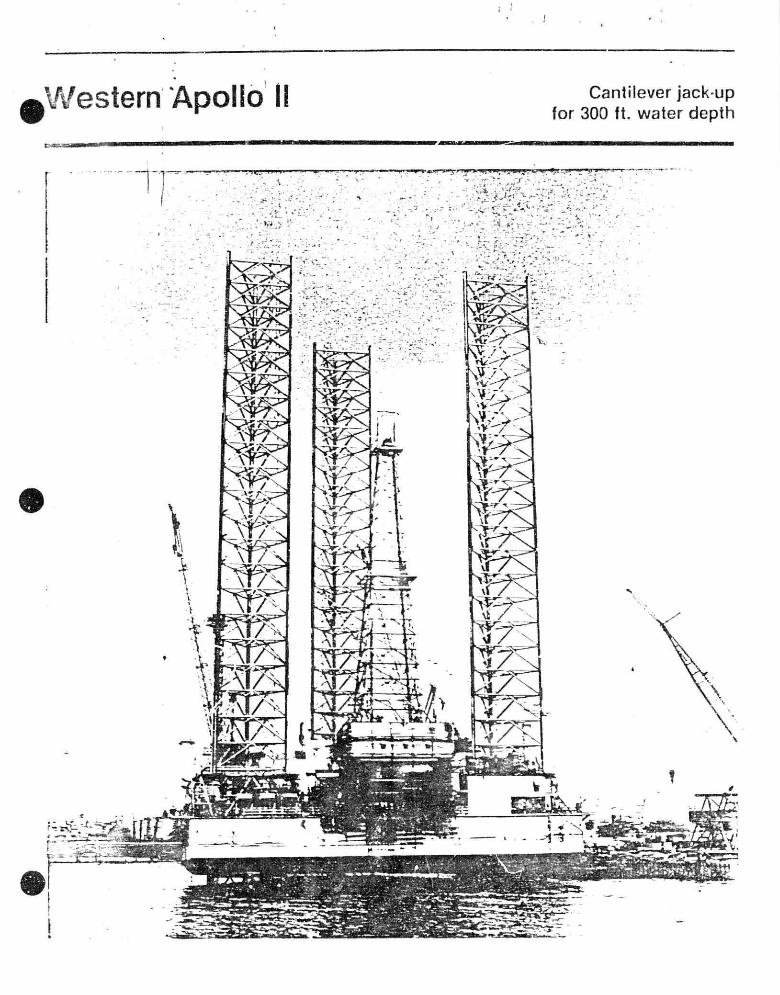
A c a n t i l e v e r j ack -up s i m i l a r to Western Apol lo I I w i l l be u t i l i z e d f o r Exp lo ra to ry d r i l l i n g . A desc r i p t i on of the r i g , i nc lud ing blowout preventers i s inc luded in t h i s sec t i on .
I
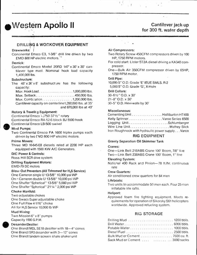
Western Apollo II Cantilever jack up for 300 ft. water depth
m
DRILLINQ & WORKOVER EOUIPMENT Drawworks: \ Coniinental Emsco C3, 1-3/8" drill line driven by two
EMD 800 HP electric motors / ' '
Derrick: Continental Emsco Model 20RD 147* x 30' x 30' can
tilever type mast. Nominal hook load capacity 1,400,000 Ibs.
Substructure: The 48 'x36 'x6 ' substruct j re has the following
capacity: Max. Hook Load 1,000,000 Ibs. Max. Setback 450,000 Ibs. Max. Combination 1,200,000 Ibs. Cantilever capacity on centerlinel,200,000 Ibs. at 35'
and 870,000 Ibs at 40'
Rotary & Traveling Equipment: Continental Emsco i J750 37Vz n rotary Continental Emsco RA 52-6 block BJ 5500 hook Continental Emsco LB-500 swivel Mud Pumps:
Two Continental Emsco FA 1600 triplex pumps each
driven by two TMD 800 HP electric motors.
Prime Movers: Three MD 16-645-E8 diesels rated at 2200 HP each
equipped with 1500 KW A/C Generators. D/C Power & Controls: Ross Hill SCR drive system Dril l ing Equipment Motors: EM D-79 DC motors Blow Out Preventers (All Tr immed for HjS Service) One Cameron single U 13-5/8" 10,000 psi WP On » Cameron double U 13-5/8" 10,000 psi WP One Shaffer "Spherical" 13-5/8" 5,000 psi WP One Shaffer "Spharical" 21 VA " 2,000 psi WP
Choke Manifold: Two adjustable chokes One Swaco Super adjustable choke One Full Flow 4-1/16" choke Al l for HpS Service 10,000 Ib WP
Mud Mixing: Two Mission 6" x 8" pumps Capacity 1000 G.P.M. Dcsander/Desilter One Brandt MDL SE18 desilter v/ith 18—4" cones One Brandt SR3 desander wi th 3—12" cones One Brandt tandem screen shale shaker unit
Air Compressors: Two Rotary Screw 450CFM compressors driven by 100
HP, 1750 RPM motors. For cold start: Lister ST2A diesel driving a KA340 com
pressor. One—Bulk Air 350CFM compressor driven by 65HP,
1750 RPM motor.
Drill Pipe: 10,000 5" O.D. Grade 'E' IEUE SMLS. R-2 5,000 5" O.D. Grade 'G', X-Hole
Drill Collars: 30-6Vz" O.D. x 30' 21-8" O.D. x 30' 30-5" O.D. Hevi-wate by 30'
Miscellaneous: Cementing Unit Halliburton HT400 Kelly Spinner Varco Series 6500 Logging Unit Schlumberger Wire Line Unit Mathey Slick Iron Roughneck wiih hydraulic power supply. . .Varco
RIG EOUIPMENT Gravity Separation Oil Skimmer Tank
Cranes: One—Link Belt 218ABS Crane 100' Boom, 7/8" line Two—Link Belt 238ABS Crane 100' Boom, 1" line Elevating System:
National 400 Rack and Pinion—78 ft./hr. continuous rate
Crew Quarters: Air conditioned crew Quarters for 84 men
Lifeboats: Two units to accommodate 50 men each. Four 25-man
inflatable life rafts.
Heliport: Approved foam fire fighting equipment. Meets re
quirements for operation of Sikorsky S61 helicopters worldwide. Approved refueling system.
RIG STORAGE
Drilling Mud 1200 bbls. Drill Water 6000 bbls. Potable Water 1000 bbls. Diesel Fuel 2500 bbls. Bulk Mud or Cement 7600 cu. ft. Sack Mud or Cement 3000 sacks

Western Apollo II Cantilever jack up for 300 ft. water depth
RIG DESCRIPTION Barge Dimensions: Length 180' Width 175' Depth of Hull 25' Length of Legs 416' Spud Tank Diameter 40'
Operating Water Depth: Maximum 300' Minimum 13' Humcane (Gulf of Mexico) 203'
Drilling Depth: 20,000'
Cantilever: Rotary can be located from 7' 6" to 40' out from end of
the barge and 10' on either side of center line for a a 20' x 32'-6" drilling pattern area.
* MOST EFFECTIVE OCEAN TOW 9 - 3 "
4i6'-7"

PLAN OF EXPLORATION OCS-G 5692
SAFETY AND ENVIRONMENTAL SAFEGUARDS
Section 4
Safety features during d r i l l i n g operations w i l l include well control and blowout prevention equipment that meets or exceeds tho requirements of OCS Order No. 2.
Oil in any form shall not be disposed of into the water of the Gulf.
Liquid waste materials containing substances which may be harmful to aquatic l i f e or w i l d l i f e , or injurious in any manner to l i f e or property shall be treated to avoid disposal of harmful substances into the waters of the Gulf.
Drilling muds containing o i l are not disposed of into the Gulf. This type of material is loaded and barged to shore for proper disposal. Drilling mud containing toxic substances are neutralized prior to disp" i l .
Drilling cuttings, sand, and solids containing o i l are not disposed of into the Gulf, unless the o i l has been removed.
The subject offshore mobile d r i l l i n g unit is equipped with drip pans under the rig floor. All o i l from diesel engines is pumped to a sump and then pumped into barrels for return to an onshore site.
Operator personnel are instructed in the techniques and methods necessary to prevent pollution. Non-operator personnel are instructed and supervised to insure that non-pollution practices are adhered to.
The f a c i l i t i e s are inspected daily.

OIL SPILL CONTINGENCY PLAN
Total Petroleum, Inc.'s Oil Spill Contingency Plan has been approved by the Minerals Management Service. This plan designates an Oil Spill Team consisting of Total Petroleum personnel and contract personnel. This team's duties are to eliminate the sources of the o i l s p i l l , remove all sources of possible ignition, deploy the most viable means of available transportation to monitor the movement of the slick, ar.d contain and remove the slick i f possible. Total Petroleum, Inc. is a member of Clean Gulf Associates (CGA). The CGA has four permanent bases in Louisiana; at Venice, Grand Isle, Intracoastal City and Cameron, and two bases in Texas; at Galveston and Rockport. Each base is equipped with fast response skimmers and there is a barge mounted high volume open sea skimmer based at Grand Isle. In addition to providing equipment, the CGA also supplies advisors for clean up operations. Response time for a spi l l in Main Pass Block 65 could vary from 4 to 8 hours depending upon the location of company operated workboats or workboats available for Charter.

PLAN OF EXPLORATION CCS-G 5692
APPROXIMATE LOCATION OK PROPOSED - .. WELLS AND PLAT
Section 5
*'ain Pass Area Block 65 is located some four miles from the nearest shoreline off the Louisiana coast. A vicinity plat is shown in this section.
Wells A, B, C, D, E, F, and G will be drilled from a surface location at 550' FEL & 6900' FNL.
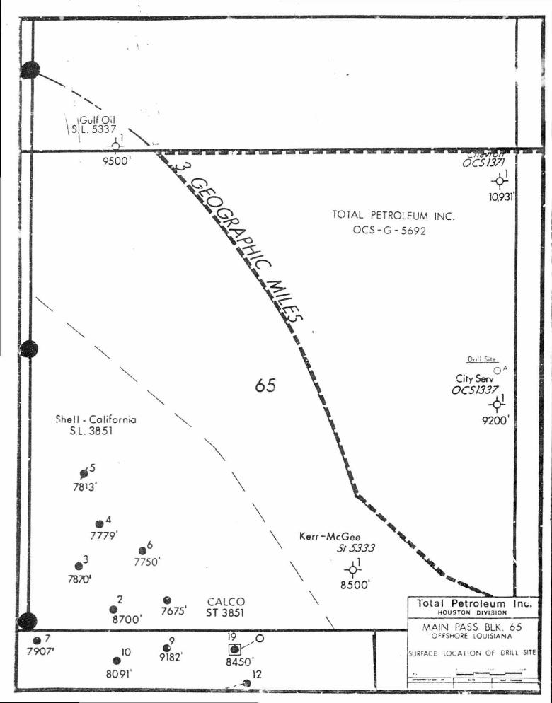
\Gulf Oil S L.5337
9500* OCS1371
4 10.931
TOTAL PETROLEUM INC.
OC5-G-5692
Shell - California S.L. 3851
# 5
7813*
• 4
7779'
7 8 ^
• 6
7750'
2
8700"
Dnll Site
o A
dry Serv OCS 1337
4 9200'
Kerr-McGee Si 5333
1
7675' CALCO ST 3851
\
4 8500'
7907* 10
8091'
• 9
9182
"15 O
8450' 12
Total Petroleum HOUSTON DIVISION
nc.
MAIN PASS BLK. 65
OFFSHORE LOUISIANA
SURFACE LOCATION OF DRILL SITE

LOUISIANA \ UlSSlSSl PPI
:i Mi l i T.'.r'MAIJY
MOMLE I
/
SCALE IN MiLES 0 10 20
0 10 20 10 SCALE IN Kl TM C TC " S
/ CHANOCLEUft I 1 'CHANDELEUR CAST ADo,hm~\ [ _ ] : ^; s
s;;;; ( ^ ZONL
SOUTH AND EAST ADDITION
• SOUIH-PASS
EAST,—
FIOURE 1. LOCATION OF MAIN PASS DLOCK 65 RELATIVE TO THU LOUISIANA AND MISSISSIPPI COASTAL ZONES.
*k _M

PLAN OF EXPLORATION OCS-G 5692
STRUCTURAL INTERPRETATIONS AND. SHALLOW HAZARDS REPORT
Section 6
PLAN OF EXPLORATION OCS-G 5692
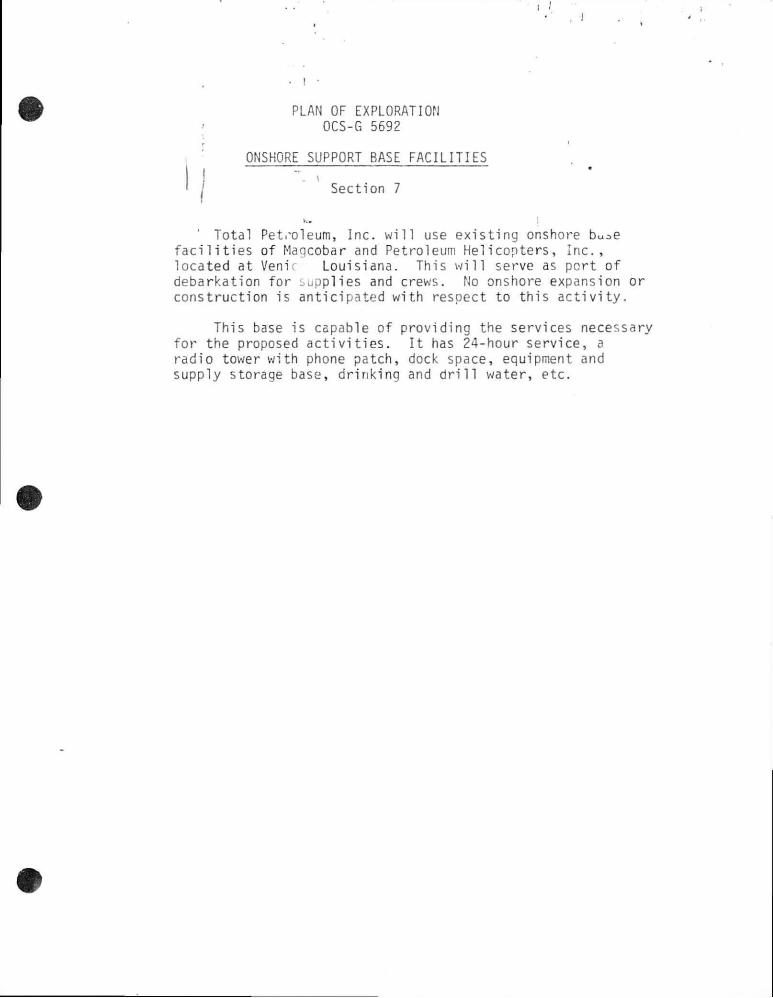
ONSHORE SUPPORT BASE FACILITIES
Section 7
Total Pet.-oleum, Inc. wil l use existing onshore buc.e f a c i l i t i e s of Magcobar and Petroleum Helicopters, Inc., located at Veni Louisiana. This w i l l serve as port of debarkation for Supplies and crews. No onshore expansion or construction is anticipated with respect to this activity.
This base is capable of providing the services necessary for the proposed activities. I t has 24-hour service, a radio tower with phone patch, dock space, equipment and supply storage base, drinking and d r i l l water, etc.

PLAN OF EXPLORATION OCS-G 5692
MUD COMPONENTS
Section 8
J
MUD & COMPLETION FLUID COMPONENTS &
ADDITIVES
1 . ITEMS USED ON A ROUTINE BASIS:
T R A D E N A M E S
IMCO BAROID MILCHEM MAGCOBAR
Imco Ear Imco Gel Imco L i g RD-111 C a u s t i c Soda
.Aluminum Steara te
Lime Imco Thin
'a Ash jcarb
PoTy Rx Imco KD Foamban
fiarite/Baroid Aquagel Carbonox Q-Erox in Caus t ic Soda A3 UTO.' num
S tea ra t e Lime CC-16 Soda Ash
B i c a r b Durenex Con Det . Defoamer
B a r i t e / M i l b a r Milgel L i g c o Uni Cal Caus t i c Soda Aluminum
Stearate Lime Ligcon Soda Ash
Bicarb Chemtrol-X M.D. LD- 8
Bar i t e/Magcobar MagcogeJ Tanna t h i n Spercene Caustic Soda Aluminum
S t e a r a t e Lime XP-20 Soda Ash
Bi c a r b Resinex D-D Magc^nol
1 1 . ITEMS USED LESS FREQUENTLY:
DMS Imco Loid CMC
Cyp.Tin Per mal o id Dr i spac Cyp HME/Supp.r d r i l
A k t a f l o s ImperToex C e l l e x
Cypan D e x t r i d Drispac Gyp
HME/Superdril
DMS M i l s t a r c h CMC
Cypan Perma-Lose Drispac Gyp HME/Superdril
DMS My Lo Gel CMC •
Cypan Poly Sal Drispac Gyp HME/Superdril
Black Magic Supermix
L u b r i k l e e n
WSto y,y' ^ F o Plug
1 r o n i t e
Black Magic Supermix
Torq T r i m Mica Tex W a l l - N u t
I r o n i t e
B lack Magic • Supermix
L u b r i s a l M i l - M i c a M i l P lug
I r o n i t e
M i l Card
B l a c k Magic Supermix
Magolube Mago-Mica • Nut P lug
I r o n i t e
DESCRIPTION
B a r i t e (Barium S u l f a t e ) Bentoni te L i g n i t e Blended L i g n o s u l f o n a t e Sodium Hydroxide Aluminum
Stearate Calcium Hydroxide M o d i f i e d L i g n i t e
Sodium Carbonate Bicarbonate o f Soda
Selected Polymer Bl.- nd Detergent Defoamer ( U s u a l l y a l c o h o l
based)
Nonionic Mud S u r f a c t a n t P r e g e l a t i n i z e d S t a r c h Sodium Carbo--y Methyl
C e l l u l o s e Sodium P o l y a c r y l a t e Organic Polymer P o l y a n i o n i c C e l l u l o s e Gypsum ( P l a s t e r o f P a r i s G i l s o n i t e ( t r e a t e d ) -
N a t u r a l Hyorocarbon + We t t i n g Agent
Mud Concentrate f o r s p o t t i n g f l u i d
Organic L u b r i c a n t Mica-Flakes Ground Walnut o r ot h e r
nut h u l l s S y n t h e t i c I r o n Oxide, H
Scavenger H2S Scavenger (Zinc
Carbonate) T> i 1 - u „ pf l v m e r

I I . ITEMS USED LESS FREQUENTLY: (CONTINUED)
S a l t SAPP
Sa l t SAPP
KCL KCL
I I . C I L BASE MUD:
S a l t -SAP P Shale T r o l KCL Ka
S a l t SAPP
KCL
Sodium C h l o r i d e Sodium A c i d Pyrophosphat Organo/Aluminum Compouru Potassium C h l o r i d e
IMCO BAROID
Imco Spot
/venol -S
Ken-Gel
Kan- Cal-L
VR
Skot Free
I n v e r m u l
Geltone
D r i l l t reat
Duratone
MILCHEM
M i l - F r e e
Carbo-Tec
Carbo-Gel
Carbo-Mul
Carbo-Trol
IV. PUMP-DOWN & INHIBITOR FLUID:
MAGCOBAR
Pipe Lax
Oi.faze & Vertoll
VG-69
OIL BASE DESCRIPTION
DV-33
DV-22
srr & Supermix
OB Gel
SA-47
Chem W
E ^ u l s i f i e r s f o r spot t i n g f l u i d s
E r c u l s i f i e r s , g e l l i n g agents and f l u i d lc agents f o r o i l muds
Or g a n i p h i l l i c clays for v i s c o s i f y i n g
Asphaltic V i s c o s i f i e r
Organic v e t t i n g agent
Fluid loss agents
Norco No. 6 Refined O i l & No. 2 Diesel + 1Z-3Z Corrosion I n h i b i t o r s .
V. METHOD OF DISPOSAL:
A l l mud additives v i l l be disposed of overboard i n to the Gulf of Mexico a f t e r d i l u t of fresh or seawater. Any f l u i d containing free o i l v i l l be transported to land fo: disposal.

SECTION 9
PLAN OF EXPLORATION OCS-G 5692
ENVIRONMENTAL REPORT

ENVIRONMENTAL REPORT
PLAN OF EXPLORATION
MAIN PASS AREA, BLOCK 65 OCS-G 5692
OFFSHORE LOUISIANA & MISSISSIPPI
TOTAL PETROLEUM, INC.
Houston, Texas
October 19, 1983
Contact Person:
Ward M. Clark Manager, Production
One Allen Center, Suite 2950 Houston, Texas 77002
(713)658-0972
Prepared by: J. Connor Consulting P. 0. Box 218753
Houston, Texas 77218 (713)558-0607

• I •
2. DESCRIPTION OF PROPOSED ACTION
Total Petroleum, Inc. plans to conduct exploration
activities on Main Pass Area Block 65 (OCS-G 5692).
As proposed, the Plan of Exploration for Main Pass
Block 65 consists of d r i l l i n g 7 wells.
At this time, the planned commencement date for
Well "A" and all associated activities in Block 65 is on
or about December 1, 1983.
(a) TRAVEL MODES AND ROUTES
Helicopters, crewboats, and workboats w i l l be operated
from Venice.. Louisiana. Helicopters are expected to make
10.5 round trips per week to the Block. Crewboats and
workboats are expected to make 7 round trips per week to the
Block. I t is anticipated that the transportation vessels w i l l
u t i l i z e the most direct route to the lease site which is
located approximately 17 statute miles east of Venice, Louisiana.
(b) SUPPORT BASE
The support base w i l l be Baroid's f a c i l i t y at Venice,
Louisiana. This base provides 24-hour service, a radio tower
with phone Pitch, dock space, office space, a parking loc,
equipment and supply storage space, drinking and d r i l l water,
etc. These proposed exploration activities w i l l help to
maintain this base at its present levels of activity.

, J . * ,, I I
• ! • Wo* expansion o f the physical f a c i l i t i e s or the c rea t i on o '
new jobs is expected to resu l t from the work planned in
• conjunction with Block 65.
(c) NEW SUPPORT FACILITIES
No new onshore support f a c i l i t i e s such as new land bases,
refineries, storage f a c i l i t i e s , pumping stations, boat docks,
helicopter pads, or fueling f a c i l i t i e s are likely to be
required because of the activities planned for Block 65.
Any newly discovered deposits of hydrocarbons should help to
maintain onshore facilities and activities at or near their
present levels rather than result in some type of expansion.
(d) NEW TECHNIQUES OR UNUSUAL TECHNOLOGY
No new techniques or unusual technology vn'11 be required
for this operation. (e) MAPS OF PROPOSED ACTIVITY A map showing the relation of Block 65 to affected states is included at the end of this report. ( f ) TRANSPORTATION OF OIL AND/OR GAS If producible hydrocarbons are found they are likely to be transported to shore through connections with the pipelines already in place near Block 65.

3. DESCRIPTION OF THE AFFECTED ENVIRONMENT
(a) PHYSICAL AND ENVIRONMENTAL
(1) Commercial Fishing
The Golf fishery is dominated by the shell fisheries;
shrimp, crabs, and oysters (with smaller amounts of clam and
scallops), usually worth three or four times more than the
much greater volume of fin-fish. The shrimp fishery in the
Gulf area includes brown, white, and pink shrimp. These are
taken almost exclusively by trawl fishing, i r depths ranging
from approximately 6 to 240 feet. Other shrimp taken
commercially are the sea bobs and royal reds.
Gunter (1967) indicated chat 97.5% of the total
commercial fisheries catch of the Gulf stales is made of
estuarine species, that i s , of fish or shell fishes that
spend all or part of their lives in estuaries. A few species,
such as the commercial oyster, live their live^ in estuarine
waters.
On the Gulf coast as a whole, the usual ranking of the
most important commercial fishes is as shown below:
By Volume By Value:
Menhaden Menhaden Mullet Red Snapper Croaker Mullet Groupers Croaker Spanish Mackeral Groupers Spotted Seatrout Pompano Red Drum Spanish Mackeral Flounders Red Drum Black Drum Flounders King Whiting King Mackeral White Seatrout Black Drum Sheepshead White Seatrout
Sheepshead

•' •J
Placement of a d r i l l i n g rig in the Block wil l
temporarily remove a portion of the seafloor from the
commercial fishing interests. Drilling probably w i l l
temporarily degrade the water quality in the immediate
vicinity of the d r i l l s i t e . This nay cause certain species
to avoid the area. The situation, however, should revert
to normal as soon as the d r i l l i n g is completed.
(2) Shipping
Block 65 does not lie in or adjacent to any fairways,
tr i i t zones or anchorage areas.
(3) Recreation
Sport fishing is the primary recreational pursuit in the
waters off the Louisiana coast. Sport anglers have learned
to successfully utilize the good fishing provided by offshore
petroleum production platforms, which function as a r t i f i c i a l
reefs and attract an abundance and diversity of gamefishes.
Species commonly taken include red snapper, vermilion snapper,
king mackeral, cobia, and greater amberjack as well as grouper.
Scuba divers also frequent offshore platforms for spear fishing
and photography of the diverse marine l i f e that these
structures attract.
Installation of a rig in the block w i l l enhance the
potential for sport fishing and recreational diving in this
area.

(4) C u l t u r a l Resources
Main Pass Block 65 l i e s i ns ide the Cu l tu ra l Resource
S e n s i t i v i t y Demarcation Line (USDI. 1 9 7 9 V i s u a l 1)
and, t h e r e f o r e , f a l l s i n an area where c u l t u r a l resources v..
ere l i k e l y to be found. An archaeologica l survey was
required f o r Main Pass Block 65. Results of the
a r c h a e o l r g i c a l survey f o r Main Pass Block 65 i nd i ca te no
areas o f p o s s i b l e drowned p r e h i s t o r i c s i t e s or shipwrecks.
Total Pet ro leum, Inc. agrees chat i f any s i t e , s t r u c t ' - r e ,
or ob jec t o f h i s t o r i c a l or archaeolog ica l s i g n i f i c a n c e
should be d iscovered dur ing opera t i ons , the f i nd i ngs w i l l
be immediately reported to the Supervisor and every
reasonable e f f o r t w i l l be made to preserve and p ro tec t the
c u l t u r a l resource from damage u n t i l the Supervisor has given
d i r e c t i o n as to i t s p r e s e r v a t i o n .
(5) E c o l o g i c a l l y S e n s i t i v e Features
There are no e c o l o g i c a l l y sens i t i ve features in or near
Biock 65.
(6) E x i s t i n q P ipe l ines and Cables
Gulf O i l has an 18- inch o i l and gas p i p e l i n e which crosses
the nor theas t corner of the block as f o l l o w s :
- Crosses the east l i n e approximately 2275' from the
no r theas t corner.
- Crosses the north l i n e approximately 4000' from the
no r theas t corner.

•* , J . ' ,.
. I •
Howell Petroleum Corporation has a 6-inch o i l
pipeline that runs east to west through the center of
-the block as follows: ' •
- Crosses the east line approximately 4900' from
the southeast corner.
- Crosses the west line approximately 6150' from the
northwest corner.
(Mr. Autry Britton, MMS, New Orleans, LA.)
All pipeline?- w i l l be avoided during the proposed
acti vities.
(7) Other Minerals
There are no known plans at this time for the production
of minerals other than o i l and gas on Block 65.

I
(8) Ocean Dumping
Ocean dumping is prohibited in this area.
a
(9) Endangered or Threatened Species
The Endangered Species Act o f 1973 provides f o r the
conservat ion of endangered and threatened species of p l a n t s ,
animals, and t h e i r h a b i t a t . Species which are cu r ren t l y
l i s t e d as endangered, and which are known to occur i n the
Gulf o f Mexico, inc lude the blue whale, f inback whale, r i g h t
whale, humpback whale, se i wha le , sperm whale, A t l a n t i c Ridley
t u r t l e , hawksb i l l t u r t l e , and l ea the r back t u r t l e . In a d d i t i o n ,
two threatened species, the green sea t u r t l e and loggerhead
t u r t l e , are a lso l i s t e d under p rov is ions of the Act and are
known to occur in the Gu l f .
Of the whale spec ies , the sperm whale i s perhaps the
most common and the blue whale the lease common w i th only two
s ight ings having been r e p o r t e d . The other species of whales
may be considered uncommon i n t. id Gu i f , a l though the humpback
was once hunted commercial ly i n Lhe cen t ra l Gu l f dur ing the
19th Century (Schmidly, 1981) .
The environmental impact o f t r a n s p o r t a t i o n accidents on
endangered species can be summarized as f o l l o w s :
In the Gul f o f Mexico se fe t y fa i rways have been es tab l ished
for the safe passage of vessels enroute to or from U.S. p o r t s .
Consequently, placement o f r i g s o r p la t forms are p roh ib i t ed

w i t h i n these fa i rways , and prudent seamanship suggests
tha t vesse l s , p a r t i c u l a r l y those w i th deep d r a f t s , remain
-in ^the fa i rways and t h i s increases the p o s s i b i l i t y of a
c o l l i s i o n w i th d r i l l i n g r i g s , permanent p la t fo rms or
vessels a t tend ing these p l a t f o r m s . On the o ther hand,
r e s t r i c t i n g vessels to char ted fa i rways increases the
p o s s i b i l i t y of s h i r / s h i p c o l l i s i o n s at the same time as i t
reduces the p o s s i b i l i t y o f s h i p / r i g c o l l i s i o n s . Impacts
which could resu l t inc lude loss of human l i f e , s p i l l a g e
of o i l , release of d e b r i s , i nc lud ing pa r t o f c the e n t i r e
d r i l l i n g r i g and sh ip . The contents of the s h i p ' s cargo
could pose a serious t h r e a t to the environment i f i t
inc ludes t ox i c mater ia ls such as chemica ls , crude o i l or
r e f i ned products.
The most serious environmental hazard to endangered
species would occur i n cases o f o i l s p i l l s . Impact on b i rds
is coa t i ng w i th o i l r e s u l t i n g i n death. Data on impacts on
marine mammals and marine t u r t l e s i s not ava i l ab l e (FEIS
s i l e 4 5 ) .
The major impact on endangered species as a r e s u l t o f
t r a n s p o r t a t i o n accidents w i l l be two pronged. An i n d i r e c t
adverse impact to species popula t ions as a r e s u l t o f poss ib le
hab i t a t and food loss and a d i r e c t impact to i n d i v i d u a l s
which succumb as r e s u l t o f i nges t i ng a being coated w i t h
petroleum hydrocarbons or o ther t ox i c m a t e r i a l .

I I
• ! •
(b) SOCIO-ECONOMIC
(~i) Related New Employment
- Mot app l i cab le a t t h i s t ime.
4 . UNAVOIDABLE ADVERSE IMPACTS
A number of s tud ies have been conducted on the e f f e c t s
of o f f s h o r e o i l and gas exp lo ra t i on and development on the
marine environment. These studies have not revealed any major
impacts t h a t r e s u l t from normal o i l and ga^ a c t i v i t i e s .
f!cwever, several minur impacts, p r i m a r i l y those associated w i t h
the discharge of d r i l l i n g f l u i d s and c u t t i n g s , have been
i d e n t i f i e d . Upon en te r i ng the water column, the d r i l l i n g
f l u i d s usua l l y form a t u r b i d area which may i n t e r f e r e w i t h the
photosynthet ic a b i l i t y , and thus the pr imary p r o d u c t i v i t y ,
of phytoplankton w i t h i n t h i s t u r b i d zone. The d r i l l c u t t i n g s ,
which are a c t u a l l y pieces of rock , sha le , and o ther
subs t ra te , o f ten accumulate i n p i l es on the sea f loo r when
they are released overboard. These p i l e s o f c u t t i n g s w i l l smother
any immobile benthic organism located on the sea f loo r . In
add i t i on to these impacts on the physical environment, the
presence o f the d r i l i i n g r i g i t s e l f w i l l remove a po r t i on of the
seaf loor from e x p l o i t a t i o n by commercial f ishermen and shr impers.
The impacts discussed in the preceeding paragraph are a l l
considered to be minor , l o c a l i z e d , and sho r t - t e rm Implementation
of the proposed p r o j e c t , the placement of a movible d r i l l i n g r i g
and the d r i l l i n g of e i g h t we l l s should not cause i r r e v e r s i b l e
damage to the environment.
(5) REFERENCES
Bright, T.J., and R. Rezak 1976 'Tishing Banks of the Texas Continental Shelf", i n : Bullis,
H.R., Jr., and A.C. Imes, eds. Proceedings: Colloquim on Snapper-Grouper Fishery Resources of the Western Centrai "Atlantic Ocean. Texas A & M University Sea Grant College, Mi ssissippi-Alabama Sea Grant Consortium, and Florida Sea Grant College Program. College Station, Texas; B i l o x i , Mississippi; and Gainesville, Florida.
Christmas, J. Y., and D. J. Etzold 1977 "the Mendaden Fishery of the Gulf of Mexico, United States:
A Regional Management Plan". Gulf Coast Research Lab. , Ocean Springs, Miss.
Conant, R. 1975 A Field Guide to Reptiles and Amphibians of Eastern and Central
North America. Houghton M i f f l i n Company, Boston
Fritts, T. H., & R. P. Reynolds 1981 "Pilot Study of the Marine Mammals, Birds, & Turtles in OCS
Areas of the i f of Mexico", US Fish & Wildlife Ser., Office of Biological Serv s, Washington, D.C. FWS/OBS-81/36. , 139ppg.
Gallaway, Benny J. 1981 An Ecosystem Analysis of Oil and Gas Development on the Texas-
Louisiana Continental Shelf. U.S. Fish and Wildlife Service, Office of Biological Services, Washington, D.C. FWS/OBS-81/27. 89pp.
Lowery, G.H., Jr. 1974 The Mammals of Louisiar • and i t s Adjacent Waters.Louisiana State
University Press, Bator. Rouge, 651 pp.
Humphrey, A. J., Jr., and G. D. Carlucci, Jr. 1978 "Environn.ental Planning for Offshore Oil and Gas". Volume V:
Regional Status Reports. Part 3: Gulf Coast Region. The Conservation Foundation, Washington, D.C, U. S. Fish and Wildl i f e Service, Biological Services Program, FWS/OBS-77/61.3, 158pp.
Schmidly, David J. 1931 "Marine Mammals of the Southeastern Unites States Coast arid che
Gulf of Mexico"'. U.S. Fish and Wildlife Service, Office of Bilogical Services, Washington, O.C. FWS/OBS-80/41, "i63pp.
Sea Grant College 1980 Draft Environmental Impact Statement and Fishery Management
Plan and Regulatory Analysis and Proposed Regulations, Reef Fish Resources of the Gulf of Mexico. Gainesville, Florida.
South Atlantic Fishery Management Council 1979 Fi shery Management Plan for the Atlantic Billfishes: White
Marlin, Blue Marlin, Sailfish, and Spearfish. Miami, Florida.

Southeast F isher ies Center •* , I , 1978 Fishery Management Plan f o r Ground F ish (Gu l f o f Mexico)
Pre l im. D r a f t , Nat. Mar ine F i s h e r i e s S e r v i c e , Miami, F l o r i d a .
U.S., Department-of -Commerce 1980 Final Environmental Impact Statement f o r the Louis iana Coastal
Resources Program. O f f i c e of Coastal Zone Mgt. Washington" D.C.
U.S.•Department o f Commerce 1980 Fishery S t a t i s t i c s o f the Un i ted S t a t e s 1 9 7 6 . NOAA, S t a t i s t i c a l
j j D i g e s f Nou 70. Washington D.C.
U.S. Department o f Commerce 1980 Marine Recreat ional F i s h e r y S t a t i s t i c s Survey, A t l a n t i c and
Gulf Coasts, 1979. NOAA, Cur rent Cur ren t F ishery S t a t i s t i c s , No. 8063, Washington, D.C.
van Lopik, J . R., K. H. Drummond, and R. E. Condrey 1979 Dra f t Environmental Impact Statement and F ishery Management
Plan f o r the Shrimp F i s h e r y of the Gul f o f Mexico, Un i ted "States Waters. Center t o r Wetlands Resources, Louis iana Sta te U n i v e r s i t y , Baton Rouge, LA.
Ward, C. H., M. E. Bender, and D. J . Re ish , eds. 1979 The Of fshore Ecology I n v e s t i g a t i o n , E f f e c t s o f O i l D r i l l i n g
and Product ion i n a Coasta l Environment. Rice U n i v e r s i t y S tud ies , Vo l . 65, No. 4 and 5.
(6 ) STATEMENT
The proposed a c t i v i t y w i l l be c a r r i e d out and completed w i t h the guarantee
o f the f o l l ow ing i t ems :
(a) The best and sa fes t techn iques w i l l be u t i l i z e d throughout the
p ro jec t . This inc ludes meet ing a l l a p p l i c a b l e requirements f o r equi,,ment
types, general p r o j e c t l a y o u t , sa fe t y systems and equipment and mon i to r ing
systems.
(b) A l l opera t ions w i l l be covered by a M.M.S. approved o i l s p i l l
contingency p l a n .
(c) A l l a p p l i c a b l e F e d e r a l , s t a t e , and l o c a l requirements rega rd ing a i r
emission and water- q u a l i t y 'nd d ischarge f o r the proposed a c t i v i t i e s .
as v/ell as any other pe rmi t c o n d i t i o n , v / i l l be coniDlied w i t n .

FIGURE 1. LOCATION OF MAIN PASS ULOCK 65 RELATIVE TO THE LOUISIANA AND MISSISSIPPI COASTAL ZONES.

COASTAL ZONE MANAGEMENT
CONSISTENCY CERTIFICATION
Plan of Exploration Type of Plan
Main Pass Area, Block 65 Area and Block
OCS-G 5692 Lease Number
The proposed a c t i v i t i e s descr ibed i n d e t a i l i n t h i s Plan comply w i t h
Louis iana ' & Miss . ' s approved Coastal Management Program(s) and v / i l l be
conducted i n a manner c o n s i s t e n t w i t h such Program(s) .
Arrangements fvwe been made w i t h the State-Times i n Baton Rouge,
Louisiana to pub l ish a pub l i c n o t i c e o f the proposed a c t i v i t i e s no
l a t e r than November 1 , 1983 .
Total Petroleum, Inc. Lessee or Operator
q Official Ward M. Clark
Manager, Production
9-27-83 Dete

SECTION 10
PLAN OF EXPLORATION OCS-G 5692
AIR QUALITY REVIEW

General Information
Location of Facility: Distance Offshore: Namc of Rig/Platform: Operator:
Contact Person: Total Well Footage to be Drilled: Date Drilling vn* 11 Begin: Date Drilling wi l l End: Wel 1 Footage to be Drilled in 1983: Well Footage to be Drilled in 1984:
Main Pass 31ock 65 4 miles Western Apollo I I Total Petroleum, Inc. One Allen Center, Suite 2950 Houston, Texas 77002 Ward M. Clark 68,850' December 1 , 1983 June 30, 1984 10,000' 53,850'
MAJOR SOURCE (OFFSHORE)
Power used aboard d r i l l i n g vessel ; approximate footage d r i l l e d 68 ,850 ' . *
Emitted Substance
CO VOC TSP S09
NOX
Pro jec ted Emissions ( l b s / d a y ) * * t o n s / y e a r
1983
(113) 2.50 (43) .96 (38) .84 (36) .81 (529)11.M
Projected Emissions (lbs/day)**tons/year
1984
(135)14.2 (51) 5.4 (45) 4.1 (43) 4.f ,.o33)67.0
Based on 50 h p h r / f t . from Table 4 - 3 , "Atmospheric Emissions from Offshore Oi l And Gas Development and P roduc t i on " , EPA No. 450/3-77-026, June, 1977.
Emission fac to rs from Table 3 . 3 . 3 - 1 , "Compi lat ion o f A i r P o l l u t a n t Emission Fac to rs " , Th i rd E d i t i o n , EPA Report AP-42, August 1977.
#
• • . J Pro jec ted A i r Emissions Main Pass 65 ' To ta l Petroleum, Inc . Page 2 . , .
MINOR SOURCE (OFFSHORE)*
I nc lud ing h e l i c o p t e r Idnding and t a k e - o f f (10.5 t r i p s / w e e k ) ; supply and crew •oa ts (1 t / i p / d a y j ; loading and unloading ope ra t i ons ; and i n c i n e r a t i o n o f waste paper (average 750 pounds of waste per month).
v..
Projected Emissions Projected Emissions Emitted (Tons/year) (Tons/year)
Substance 1983 1984
CO VOC TSP SO.. N0£
.43
.04
.02
.01
.08
1.82 .17 .03 .06 .35
* Tables 3.2.1-3, 3.2.3-1 and 2.1-1, "Compilation of Air Pollutant Emission Factors", Third Edition, EPA Report AP-42, August 1977.
TOTAL ALL SOURCES (Tons/year)
1983 CO S02 TSP VOC NOX
Major 2.50 .81 .84 .96 11.90 Minor .43 .01 .02 .04 .08
Total 2.93 .82 .8<*. 1.00 11.98
1934
Major 14.20 4.50 4.80 5.40 67.00 Minor 1.82 .06 .08 .17 .35
Total 16.02 4.56 4.88 5.57 67.35
ONSHORE SOURCES:
These should be about the same as minor sources unless new f a c i l i t i e s are i n s t a l l e d a t the onshore base. No add i t i ona l f a c i l i t i e s are requi red or planned a t t h i s t ime.
EMISSION EXEMDTI0N DETERMINATION:
For CG: E=3400 D 2 / 3 = 3400(4)= 8,567 tons /year For NOX, VOC, TSP & S 0 2 : E=33.3D -• 33.3(4) = i33.2 tons/year
As per DOI/MMS r e g u l a t i o n s , t h i s f a c i l i t y i s exempt from f u r t h e r a i r q u a l i t y review as i t has been determined that i t s operat ions w i l l not have ? s i g n i f i c a n t adverse environmental impact on a i r q u a l i t y .

I
PLAN OF EXPLORATION OCS-G 5692
v..
SHALLOW DRILLING HAZARDS Main Pass Area, Block 65
Total Pet ro leum, Inc. has reviewed the geohpysical data pe r t i nen t to Block 65, Main Pass Area. This data obtained by Trabant & Associates inc luded
Echo-Sounder Magnetometer Side-Scan Sona Sub Bottom P r o f i l e r Sparker System
Total Pet ro leum, Inc . has reviewed a l l a v a i l a b l e data over and proximal to the proposed surface l o c a t i o n 550' FEL and 6900' FNL. These data i n d i c a t e no v a l i d anomalies and/or shallow d r i l l i n g hazards a t t h i ; l o c a t i o n .
These w e l l s w i l l be d r i l l e d i n a safe and workmanlike manner.
Office of .Management Support.
NOV 1 4 Web
Records Management