management direction and implementation - u.s. … · management direction and implementation ......
TRANSCRIPT

Chapter 4.
Management Direction and Implementation
4.1 Introduction
4.2 Formulating the Management Direction
4.3 General Refuge Management
4.4 Refuge Goals, Objectives, and Strategies
Ailanthus Webworm Moth
US
FW
S


Chapter 4. Management Direction and Implementation
4-1
4.1 Introduction This chapter begins with a description of the process we used to formulate the management direction for Patuxent Research Refuge. Next, we present the management direction for the refuge, including the goals, objectives, and strategies for managing the refuge. The array of management action described here are those that, in our professional judgment, will best achieve the refuge’s purposes, vision, and goals, and best respond to public issues. Unless otherwise noted, refuge staff will implement all actions. 4.2 Formulating the Management Direction Relating Goals, Objectives, and Strategies The management direction we describe in this chapter includes a set of refuge goals, objectives to achieve those goals, and a series of strategies to implement them.
The refuge goals developed are intentionally broad, descriptive statements of the desired future condition of refuge resources. Goals articulate the principal elements of the refuge purposes and our vision statement, and provide a foundation for developing specific management objectives and strategies. The objectives are essentially incremental steps toward achieving a goal; they further define management targets in measurable terms. Typically, they vary among the alternatives, and provide the basis for determining strategies that are more detailed, monitor refuge accomplishments, and evaluate our successes. “Writing Refuge Management Goals and Objectives: A Handbook” (USFWS 2004) recommends writing SMART objectives that possess five characteristics: specific, measurable, achievable, results-oriented, and time/fixed. A rationale accompanies each objective to explain its context and importance. The objectives outlined in this chapter will guide the future development of refuge step-down plans. Strategies are the specific or combined actions, tools, or techniques we may use to achieve the objectives. The list of strategies under each objective represents the potential suite of actions we may implement. We will evaluate most of them further as to how, when, and where we should implement them when we write our refuge step-down plans. We will measure our successes by how well our strategies achieve our objectives and goals. Developing Management Alternatives Over the course of several months, the core planning team, refuge staff, and partners held meetings and conference calls to identify a wide range of possible management objectives and strategies that could achieve our goals. After these were initially developed, the process of designing detailed management alternatives began. Each management alternative was intended as an alignment of complementary objectives and strategies designed to meet refuge purposes, vision, and goals, and the Refuge System mission and goals, while responding to the issues and opportunities that arose during the planning process.

Patuxent Research Refuge Comprehensive Conservation Plan
4-2
Beginning in 2010, we gathered information about refuge habitats and species, and refuge, State, regional and national priorities. We used that information to develop lists of priority resources of concern to help guide our alternatives development. The resources of concern are described in the rationales for each of the objectives. By identifying the resources of concern, we were able to develop the three management alternatives (A, B, and C) that were presented and analyzed in the draft CCP/EA. We chose alternative B as the management direction for the refuge since we believe it combined the actions that would most effectively achieve the refuge purposes, vision, and goals, and respond to public issues. It is presented in this chapter as the management direction that the refuge will implement over the next 15 years.
4.3 General Refuge Management There are some actions we will take in managing the refuge over the next 15 years that are required by law or policy, or represent actions that have undergone previous NEPA analysis, public review, agency review, and approval. Others may be administrative actions that do not necessarily require public review, but that we want to highlight in this public document.
All of the following actions, which we discuss in more detail below, are current practices or policies that will continue:
Coordinate with USGS to house and support research efforts and encourage basic and applied scientific work on the refuge that furthers the goals of Service and USGS in coordination with refuge management (e.g., propagation of endangered species).
Use an adaptive management approach where appropriate.
Develop a separate land protection plan with public and agency involvement in compliance with Service policy and NEPA.
Monitor and control invasive species.
Monitor and abate diseases affecting wildlife and plant health.
Continue existing projects managed by outside programs.
Protect cultural resources, including National Register of Historic Places-eligible buildings and historic districts.
Complete findings of appropriate use and compatibility determinations.
Provide quality wildlife-dependent recreation programs.
Provide non-wildlife-dependent activities.
Provide refuge staffing and administration.
Conduct Wild and Scenic Rivers and Wilderness Reviews.
Chapter 4. Management Direction and Implementation
4-3
Manage firing ranges.
Manage impoundments.
Biological and Ecological Research and Investigations In establishing the refuge in 1936, EO 7514 stipulated: “….in order to effectuate further the purposes of the Migratory Bird Conservation Act, it is ordered that all lands acquired….are hereby reserved and set apart….as a wildlife experiment and research refuge.” While research has evolved through the years, it inherently remains of a nature that addresses national and international questions about wildlife conservation. In addition, much of the research has direct application to the Refuge System and other land management and conservation agencies.
The refuge works under a memorandum of agreement (MOA) with USGS PWRC that identifies the coordination of priority research between the two agencies. The MOA specifically defines priority research as, “Those projects that are considered important to: Agencies of the Department of the Interior, the U.S. Fish and Wildlife Service, the National Wildlife Refuge System, and State Fish and Game Agencies, and that address important management issues or demonstrate techniques for management of species and/or habitats” (MOA July 28, 2000/FWS Agreement No 1448-50181-97-H-006). In addition, the Refuge Manual and the Service Manual both contain guidance on conducting and facilitating biological and ecological research and investigations on refuges. In 1982, the Service published three objectives in the Refuge Manual for supporting research on units of the Refuge System (4 RM 6.2):
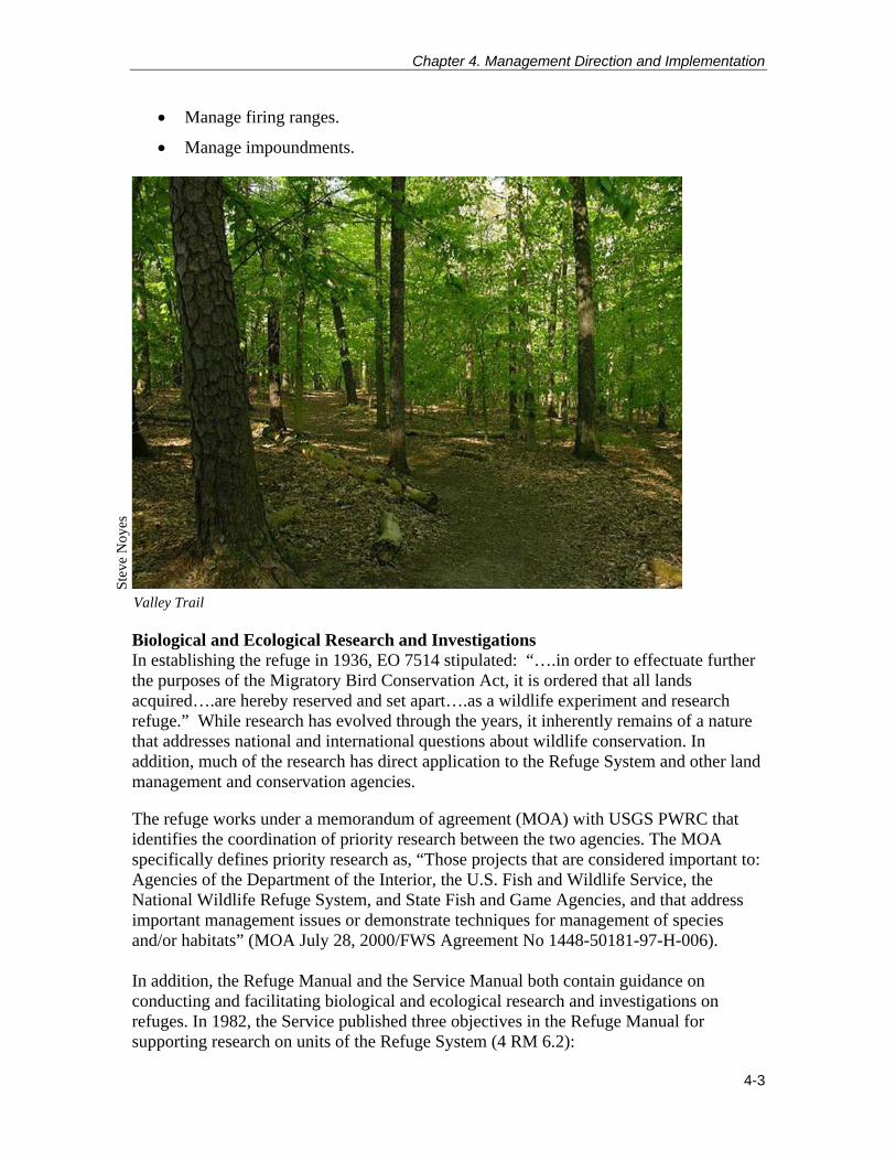
Valley Trail
Ste
ve N
oyes

Patuxent Research Refuge Comprehensive Conservation Plan
4-4
1) Promote new information and improve the basis for, and quality of, refuge and other Service management decisions.
2) Expand the body of scientific knowledge about fish and wildlife, their habitats, the use of these resources, appropriate resource management, and the environment in general.
3) Provide the opportunity for students and others to learn the principles of field research.
In 2006, the Service Manual provided supplemental guidance on the appropriateness of research on refuges: “We actively encourage cooperative natural and cultural research activities that address our management needs. We also encourage research related to the management of priority general public uses. Such research activities are generally appropriate. However, we must review all research activities to decide if they are appropriate or not as defined in section 1.11. Research that directly benefits refuge management has priority over other research” (603 FW 1.10D (4)). Just as all refuge management activities on the refuge should be compatible with its primary purpose, which is to conduct research, all research projects should be consistent with an approved finding of appropriateness and compatibility determination. Research projects may also contribute to a specific need identified by the refuge or the Service. As we note in chapter 3, we have allowed many research projects that meet these criteria. We expect additional opportunities to arise under this CCP. Special use permits will be issued for all research projects we allow. In addition, we will employ the following general strategies to further activities under this goal:
Encourage and support the use of Patuxent Research Refuge lands for the purpose of conducting wildlife research that addresses important questions of a national and international nature.
Seek qualified researchers and funding to help answer refuge-specific management questions.
Participate in appropriate multi-refuge studies conducted in partnership with the USGS or other research entities.
Facilitate appropriate and compatible research by providing access and utilization of the refuge as a location for ongoing research.
Promote the refuge as a stable area where long-term studies have thrived, and where opportunities for additional long-term studies that address emerging environmental and conservation issues can be accommodated.
Provide an outlet for dissemination of biological and ecological scientific information through use of the NWVC as a site for symposia, conferences, and open houses.
Chapter 4. Management Direction and Implementation
4-5
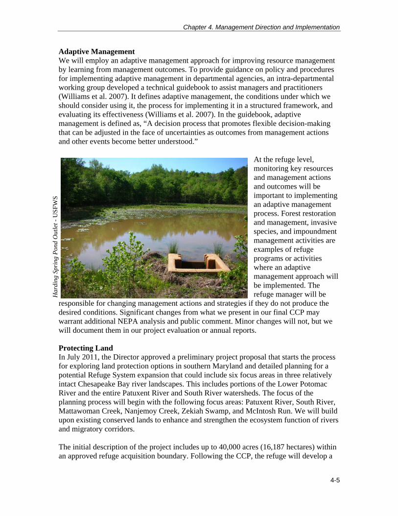
Adaptive Management We will employ an adaptive management approach for improving resource management by learning from management outcomes. To provide guidance on policy and procedures for implementing adaptive management in departmental agencies, an intra-departmental working group developed a technical guidebook to assist managers and practitioners (Williams et al. 2007). It defines adaptive management, the conditions under which we should consider using it, the process for implementing it in a structured framework, and evaluating its effectiveness (Williams et al. 2007). In the guidebook, adaptive management is defined as, “A decision process that promotes flexible decision-making that can be adjusted in the face of uncertainties as outcomes from management actions and other events become better understood.”
At the refuge level, monitoring key resources and management actions and outcomes will be important to implementing an adaptive management process. Forest restoration and management, invasive species, and impoundment management activities are examples of refuge programs or activities where an adaptive management approach will be implemented. The refuge manager will be
responsible for changing management actions and strategies if they do not produce the desired conditions. Significant changes from what we present in our final CCP may warrant additional NEPA analysis and public comment. Minor changes will not, but we will document them in our project evaluation or annual reports.
Protecting Land In July 2011, the Director approved a preliminary project proposal that starts the process for exploring land protection options in southern Maryland and detailed planning for a potential Refuge System expansion that could include six focus areas in three relatively intact Chesapeake Bay river landscapes. This includes portions of the Lower Potomac River and the entire Patuxent River and South River watersheds. The focus of the planning process will begin with the following focus areas: Patuxent River, South River, Mattawoman Creek, Nanjemoy Creek, Zekiah Swamp, and McIntosh Run. We will build upon existing conserved lands to enhance and strengthen the ecosystem function of rivers and migratory corridors. The initial description of the project includes up to 40,000 acres (16,187 hectares) within an approved refuge acquisition boundary. Following the CCP, the refuge will develop a
Har
ding
Spr
ing
Pon
d O
utle
t - U
SFW
S

Patuxent Research Refuge Comprehensive Conservation Plan
4-6
separate land protection plan (LPP) with public and agency involvement in compliance with Service policy and NEPA. The Service’s role will involve working with the Chesapeake Bay Field Office and other Federal, State, local, and nongovernmental organization partners to target conservation efforts, and acquire conservation easements and property. If we decide to increase the lands of the refuge we will amend the CCP to guide the management of these new lands. The ultimate objective is to employ the combined land conservation and management strength of all partners to conserve and link the exceptional wildlife and public use values in the internationally recognized Chesapeake Bay watershed. The permanent protection of land is the keystone of wildlife and habitat conservation. Land protected by the Refuge System will be available forever to support fish, wildlife, and plants. We can restore, enhance, or maintain the land we own to provide optimal conditions for Federal trust resources such as threatened or endangered species and those species whose populations are in decline.
Managing Invasive Species The establishment and spread of invasive species, particularly invasive plants, is a significant problem that reaches across all habitat types. For the purposes of this discussion, we use the definition of invasive species contained in the Service Manual (620 FW 1.4E), “Invasive species are alien species whose introduction does or is likely to cause economic or environmental harm, or harm to human health. Alien species, or non-indigenous species, are species that are not native to a particular ecosystem. We are prohibited by Executive Order, law, and policy from authorizing, funding, or carrying out actions that are likely to cause or promote the introduction or spread of invasive species in the United States or elsewhere.” Guidance on managing invasive species on refuges appears in the Service Manual (620 FW 1.7G). The following actions, define our general strategies on the refuge:
Manage invasive species to improve or stabilize biotic communities to minimize unacceptable change to ecosystem structure and function and to prevent new and expanded infestations of invasive species.
Conduct refuge habitat management to prevent, control, or eradicate invasive species using techniques described through an integrated pest management plan, or other similar management plan. The plan will comprehensively evaluate all potential integrated management options, including defining threshold of risk levels that will initiate the implementation of management actions.
Evaluate native habitat management activities with respect to their potential to accidentally introduce or increase the spread of invasive species and modify our habitat management operations to prevent increasing invasive species populations.
Refuge integrated pest management planning addresses the abilities and limitations of potential techniques including chemical, biological, mechanical, and cultural techniques.

Chapter 4. Management Direction and Implementation
4-7
Manage invasive species on refuges under the guidance of the National Strategy for Invasive Species Management (USFWS 2003) and within the context of applicable policy.
The following actions define our specific strategies for the refuge:
Continue to promote research into biological control alternatives.
Continue the treatment of the most problematic species ranked in management priority based on the extent to which the species is established on the refuge, their potential to negatively impact sensitive or priority refuge plant communities by virtue of their proximity to these resources, and the degree of management difficulty involved in controlling the species.
Maintain early-detection and rapid-response readiness regarding new invasions.
Maintain accessibility to affected areas for control and monitoring.
Continue and increase efforts to involve the community in promoting awareness of invasive species issues and seek assistance for control programs on- and off-refuge.
Monitoring and Abating Wildlife and Plant Diseases The Service has not yet published its manual chapter on disease prevention and control. In the meantime, we derive guidance on this topic from the Refuge Manual and specific directives from the Director of the Fish and Wildlife Service or the Secretary of the Interior. The Refuge Manual (7 RM 17.3) lists three objectives for the prevention and control of disease:
1) Provide for the early detection and identification of disease mortality when it occurs.
2) Manage wildlife populations and habitats to minimize the likelihood of the contraction and contagion of disease.
3) Minimize the losses of wildlife from outbreaks of disease. Currently, the refuge partners with MD DNR for deer disease monitoring. Samples from deer harvested on the refuge are taken for chronic wasting disease and epizootic hemorrhagic disease. Aerial pellet drops for raccoon rabies control is also conducted on the refuge in conjunction with the State. Emerald ash borer traps are distributed throughout the refuge and monitored by MD DNR’s forestry division. USGS also conducts monitoring and research on the refuge related to a variety of wildlife and plant diseases. Recent onsite studies conducted by USGS include Cache Valley disease as related to mosquitoes and a recent die-off of wood frogs related to chytrid fungus.

Patuxent Research Refuge Comprehensive Conservation Plan
4-8
Other efforts include monitoring for Rana virus, avian influenza, West Nile virus, and a variety of oak diseases (bacterial leaf scorch, sudden oak death, gypsy moth, and oak wilt) and other tree-related diseases.
Continuing Existing Projects Managed by Outside Programs Fort Meade Groundwater Monitoring A number of hazardous substances, unexploded ordnance, and munitions have been associated with the former military training grounds (North Tract’s 8,100 acres/3,278 hectares) transferred from Fort Meade through the Base Realignment and Closure Act. Hazardous substances include, but are not limited to, lead, petroleum-based waste, and unexploded ordnance. The refuge has cooperated with DOD in establishing monitoring wells at several locations on the North Tract for continuous long-term monitoring of ordnance and demolition-related compounds such as cadmium and volatile organic compounds. Groundwater monitoring wells have also been established to monitor contaminants moving from Fort Meade sites through underground aquifers underlying refuge property, including trichloroethylene and perchloroethylene (URS 2010). In total, 19 groundwater monitoring wells have been installed on North Tract by Fort Meade. Unexploded Ordnance Sweeps and Removal An abandoned trap and skeet range may undergo a soil removal action to eliminate lead-contaminated soil. Ordnance is removed as it is encountered in the field by ordnance demolition teams supplied by Fort Meade or other nearby military bases (URS 2010). Cemetery Maintenance The North Tract includes 10 Fort Meade inholdings that are historic cemeteries, totaling approximately 3.4 acres. These have headstones dating back to the 1700s, with some in use as recently as 1969 (Hileman 1998). They include graves and headstones of former landowners and their extended families. Fort Meade manages these cemeteries and they are responsible for management and preservation, although the refuge does minimal cosmetic maintenance such as fence repair, tree removal, etc., as the public’s perception is that the refuge owns these plots. Four of the 10 cemeteries were part of the former Fort Meade lands transferred to the refuge in 1991 and 1992. These are the John Penn Cemetery, and three others that are unmarked. The refuge performs minimal custodial work at the John Penn site.

Chapter 4. Management Direction and Implementation
4-9
Baltimore Gas and Electric (BG&E) and Potomac Electric Power Company (Pepco) Right-of-Ways BG&E manages 5.5 miles (9 kilometers) of powerline right-of-ways through the refuge’s North Tract. Pepco manages 3.5 miles (6 kilometers) of powerline right-of-way on the refuge, which crosses the Central and South Tracts. The refuge has completed a compatibility determinations for the BG&E right-of-way, which is included in appendix C. PEPCO applied to renew the right-of-way prior its expiration in 2010; however, the application is still pending. As a part of the permitting process, we will issue a new compatibility determination that will include any needed environmental and policy compliance measures. Protecting Cultural Resources As a Federal land management agency, we are responsible for locating and protecting all historic resources, specifically, archaeological sites and historic structures eligible for listing or already listed on the National Register of Historic Places. That applies not only to refuge land, but to land affected by refuge activities, and to any museum properties. The refuge contains archaeological resources that have and may contribute to the understanding of State, regional, and national prehistory and history. A total of 41 archaeological sites registered with the Maryland Historical Trust and the Service are present within the refuge boundary (Grubb 2011). Additionally, three registered historic districts are contained within the refuge boundary. See chapter 3 for more information. In July 2011, a MOA was signed between the Service, USGS, and the Maryland Historical Trust to facilitate treatment of 51 previously identified, historic-eligible structures on the Central and South Tracts. The MOA allowed for the retention or adaptive reuse of 16 of those structures and the demolition of 35 of those structures. Eleven of the demolition-ready assets were removed in 2011. The MOA also mandated a series of actions to mitigate the impact of demolition of the structures, and included commitments by the Service to develop a short documentary film, an interactive display, and brochure that interpret the importance of their cumulative history at Patuxent Research Refuge. These mitigating efforts were completed in September 2011.
North Tract Cemetery
US
FWS

Patuxent Research Refuge Comprehensive Conservation Plan
4-10
We will evaluate the potential for our management activities to impact archaeological and historical resources, and will consult with the Service’s regional archaeologists and the State Historic Preservation Office to ensure compliance with Section 106 of the National Historic Preservation Act and any other applicable laws and regulations. That compliance may require any or all of the following: a State historic preservation records survey, literature survey, or field survey. Appropriateness and Compatibility Determinations Chapter 1 describes the requirements for determinations of appropriateness and compatibility. Appendix C includes the appropriateness and compatibility determinations consistent with implementing the management direction described in this chapter. These activities were evaluated based on whether or not they contribute to meeting or facilitating refuge purposes, goals, and objectives. As noted above, hunting, fishing, wildlife observation and photography, and environmental education and interpretation, when compatible, are the priority wildlife-dependent, public uses of the Refuge System. According to Service Manual 605 FW 1, these uses should receive preferential consideration in refuge planning and management before the refuge manager analyzes other public uses for appropriateness and compatibility. Wildlife-dependent Recreation The Refuge System Improvement Act of 1997 designated six priority public uses on national wildlife refuges: hunting, fishing, wildlife observation, photography, environmental education, and interpretation. Per the general guidelines for wildlife-dependent recreation (Fish and Wildlife Service Manual 605 FW 1), we will continue to use the following criteria for quality, wildlife-dependent recreation in developing refuge programs. According to Service policy, a quality and wildlife-dependent recreation opportunity:
Promotes safety of participants, other visitors, and facilities.
Promotes compliance with applicable laws and regulations and responsible behavior.
Minimizes or eliminates conflict with fish and wildlife population or habitat goals or objectives in an approved plan.
Minimizes or eliminates conflicts with other compatible wildlife-dependent recreation.
Minimizes conflicts with neighboring landowners.
Promotes accessibility and availability to a broad spectrum of the American people.
Promotes resource stewardship and conservation.
Promotes public understanding and increases public appreciation of America’s natural resources and our role in managing and conserving these resources.
Provides reliable and reasonable opportunities to experience wildlife.
Chapter 4. Management Direction and Implementation
4-11
Uses facilities that are accessible to people and blend into the natural setting.
Uses visitor satisfaction to help to define and evaluate programs. The refuge supports all of the six priority public uses. In 2006, the Region 5 visitor services program assessed all of the refuges to determine what the most appropriate areas of emphasis for wildlife dependent public uses should be. That team identified environmental education and interpretation for Patuxent Research Refuge. A formal visitor survey in conjunction with USGS was conducted from 2010 to 2011 to analyze visitor use in relation to local economic benefits. The results of this survey have not yet been compiled. However, staff and volunteer observations indicate that most visitors to the refuge engage in some form of wildlife-dependent recreation. As with many refuge programs, our partners, Friends of Patuxent, and volunteers will continue to help us expand these priority public use programs.
The refuge will continue to allow deer, turkey, and waterfowl hunting according to refuge and State regulations because the hunt program has been effective at providing quality hunting opportunities and maintaining healthy populations of hunted species. Minor changes to hunt areas, days, and small game species will be pursued under the management direction, but the refuge will continue to work with the Meade Natural Heritage Association (MNHA) to manage hunting on the refuge. Non-wildlife-dependent Activities Some activities have been ongoing and have been reviewed under previous appropriateness findings and compatibility determinations. The CCP policy requires that we reevaluate all uses during the CCP process. The ongoing uses include research and monitoring, jogging, hiking, dog walking, cross country skiing, horseback riding, search and rescue, dog training, secret service training, and bicycling. Other non-wildlife-dependent uses include softball fields, primitive scout camping, and shooting ranges. Current compatibility determinations for non-wildlife-dependent activities have been completed as necessary, and can be found in appendix C.
Non-wildlife-dependent Activities Some activities have been ongoing and have been reviewed under previous appropriateness findings and compatibility determinations. The CCP policy requires that we reevaluate all uses during the CCP process. The ongoing uses include research and monitoring, jogging, hiking, dog walking, cross country skiing, horseback riding, search and rescue, dog training, secret service training, and bicycling. Other non-wildlife-dependent uses include softball fields, primitive scout camping, and shooting ranges. Current compatibility determinations for non-wildlife-dependent activities have been completed as necessary, and can be found in appendix C.
Shooting Range Management The refuge will continue its efforts to minimize impacts from the ten active shooting ranges located on the North Tract. These ranges are on the property the Service received

Patuxent Research Refuge Comprehensive Conservation Plan
4-12
management control of from the DOD in 1991 and 1992, as part of the Base Realignment and Closure Act of 1988, and we provide for continued use of each range, to the extent that certain Federal agencies used it, when this use is consistent with the paramount purposes of the refuge for wildlife conservation (Pub. L. 101-519, Sec. 126(b) (Nov. 5, 1990):
“The Secretary of the Interior shall administer the property transferred pursuant to subsection (a) consistent with wildlife conservation purposes and shall provide for the continued use of the property by Federal agencies to the extent such agencies are using it on the date of the enactment of this Act, including activities of the Department of Defense that are consistent with the recommendations of the Base Realignment and Closure Commission.”
In 1990, PWRC Director, Harold O’Connor issued a memo with a statement that ongoing uses by other Federal agencies were compatible with ongoing and proposed research at the PWRC. Since this statement addressed only research, we have never made a determination regarding the consistency or compatibility of any of the federal uses with the wildlife conservation purposes of the refuge. In the time since the initial statement was made, the process for conducting compatibility determinations has changed. The statement of consistency referenced above did not include any analysis, is out of date, requires site investigations, and public input to comply with existing Service policy regarding compatibility determinations. The compatibility policy requires that we assess the impacts of the use on refuge resources, analyze our ability to manage the use, determine impacts to the refuge purpose, and consider impacts to wildlife dependent public uses. Some of the concerns that we have involve the size of the impact zone and required closure of the area to other users, lead deposition and contamination, disturbance to wildlife, and impacts to research projects. The shooting ranges are maintained for use by FWS officers; in addition use by other agencies is managed by the National Security Agency (NSA), through a special use permit issued by the refuge. At the time the land was transferred to the Service, there were a variety of agencies using the ranges. Records from 2000 through 2012 vary from year to year, at approximately 18,000 to 25,000 users annually, with the exception of 2009 where usage spiked to 27,000 users. However the overall trend demonstrates that usage has increased over time. Users include non-federal law enforcement agencies, and four civilian shooting clubs that were using the ranges at the time of the transfer. In addition, the U.S. Secret Service uses a 1,000 yard range under a separate special use permit, and is responsible for day-to-day maintenance of range facilities. The trap and skeet range that was in use at the time of the transfer was closed in the late nineties because of lead contamination and impacts to migratory birds. The refuge performs limited road maintenance within the range area for cemetery and wildlife survey access. There are multiple issues with the ranges, especially the impact zones, including the negative impact on other refuge operations and public use, reducing opportunities for

Chapter 4. Management Direction and Implementation
4-13
wildlife research, and potential contamination from the deposition of lead and other heavy metals. Since the transfer of the North Tract to the Service, we have been issuing special use permits that are renewed on a 5-year interval. Beginning in 2013, we will begin issuing the permits on a 2-year interval with the intent of completing a compatibility determination for non-Service use of the shooting ranges, including any necessary stipulations to maintain compatibility within 5 years of completion of the CCP. We anticipate that information about direct and indirect impacts to wildlife, habitat, contamination, and other refuge uses will need to be gathered during that time.
As of June of 2013, an initial contaminant study was conducted, and the analysis of that study is currently pending. Due to the expansive area of the ranges, and the complexity of determining the extent of lead contamination from 100 years of use, in addition to expense, an attempt was made to select one priority range and focus efforts on that range. For the 2013 study, Range 8 was selected because it was identified as a “lead ammo” range and because of its heavy usage. The purpose of the study is to estimate the extent of lead contamination, potential risks from spent lead ammo and lead in soil and the aquatic habitats, and to recommend ways to reduce the risk at this site (e.g. BMPs, range improvements, consolidation/closure of ranges, cleanup options, etc.).
To begin analyzing potential lead contamination impacts Ecological Services obtained $47,000, which was primarily funded through the DOI Central Hazmat Fund. The projected study cost for 2014 is $71,425 for additional analysis. This projected cost will support the study of lead contamination at Range 1, which is of particular concern because of its location and the position of the targets. The targets “pop-up” above the berm and spent round goes through the target and continues its trajectory into the area behind the berm which includes Lake Allen, a favorite fishing area on the refuge. However, there is also ample evidence that the berm supporting the target captures spent rounds as well. The refuge will continue to seek funding from the Federal agencies using the range to support required contaminant studies. The refuge has worked with the NSA, the U.S. Secret Service and many of the other range users to coordinate schedules, and reduce impacts to refuge operations. This coordination will continue, and we plan to increase analysis and implementation of options that may help minimize or eliminate some of the management issues; such as public use restrictions, research limitations, and lead and contaminant accumulation An example of a public use issue is demonstrated with Lake Allen. Lake Allen is a prime fishing area situated in the impact zone of the ranges so it is not available for public use at least 80% of the year due to range use. These strategies may include bullet traps, field-of-fire shutters, bullet recycling rules, reconfiguration of active ranges, decontamination of closed ranges and possible range relocation (on or off refuge). The expectation is that the costs associated with any strategies that are implemented will be borne by the primary users.
Ballfields on the North Tract The NSA operates four softball fields at the entrance to the North Tract. The fields are

Patuxent Research Refuge Comprehensive Conservation Plan
4-14
located on refuge land and were in operation at the time that the land was transferred to the Service. The NSA manages employee softball leagues, comprised of 36 teams, that occur from April through August. We have never issued a compatibility determination for the softball fields, but have previously issued a special use permit to the NSA for the leagues. When the lands were transferred, Congress expected that Federal uses of the land would be allowed to continue as long as they are consistent with wildlife conservation. As a part of our review of all refuge uses as required in our CCP process, we have determined that the use of ballfields is not compatible with the purposes for which the refuge was established. We recognize that it will not be easy to relocate the league and find facilities that will accommodate the number of teams that the league supports. We will allow the league to use the fields through the 2016 season. After the 2016 league season, we will require the NSA to relocate the fields, remove the associated infrastructure and restore the land to natural conditions (16 U.S.C. 668dd(d)(3)(B)(vi)). Refuge Staffing and Administration Our proposals in this document do not constitute a commitment for staffing increases or funding for operations, maintenance, or future land acquisition. Congress determines our annual budgets, which our headquarters and regional offices distribute to the field stations. Chapter 3 presents our levels of staffing, operating, and maintenance funds for the refuge over the last 5 years.
Permanent Staffing and Operational Budgets Our aim is to sustain levels of annual funding and staffing that allow us to achieve refuge purposes, as interpreted by the goals, objectives, and strategies established in the CCP. In 2007, our Regional Directorate completed the “Strategic Workforce Plan for the National Wildlife Refuge System in Region 5” (Phase 2; January 16, 2007) to support a new base budget approach. Its goal is a maximum of 75 percent of a refuge station budget to cover salaries and fixed costs, while the remaining 25 percent or more would be operating and maintenance funds. Our strategy is to improve the capability of each refuge manager to do the highest priority work, and not to have most of a refuge budget tied up in inflexible fixed costs. This strategy was successful for a few fiscal years; however, we now anticipate a level or declining budget environment, which will impact flexibility in managing financial resources and may have implications for the level of permanent staffing. A new round of workforce planning began in 2013 in response to the sequester and anticipated future budget reductions. Within the constraints or opportunities of our budget and in conformance with future workforce plans, we would seek to fill any currently approved but vacant positions. In the event that the Refuge System budget increases in the future, we would expand refuge staff to support habitat management efforts, facilities maintenance, and visitor use. As identified in the 2009 Refuge System staffing model, we propose to fill five positions, which include two maintenance workers (grounds and buildings), one contracting officer, one law enforcement officer, and one visitor services park ranger. There is some degree of flexibility to alter these proposed positions as priorities and/or needs change. In order to fill the positions identified, permanent sources of funding would need to exist. We identify our recommended priority order for new staffing in the RONS tables in appendix D.
Chapter 4. Management Direction and Implementation
4-15
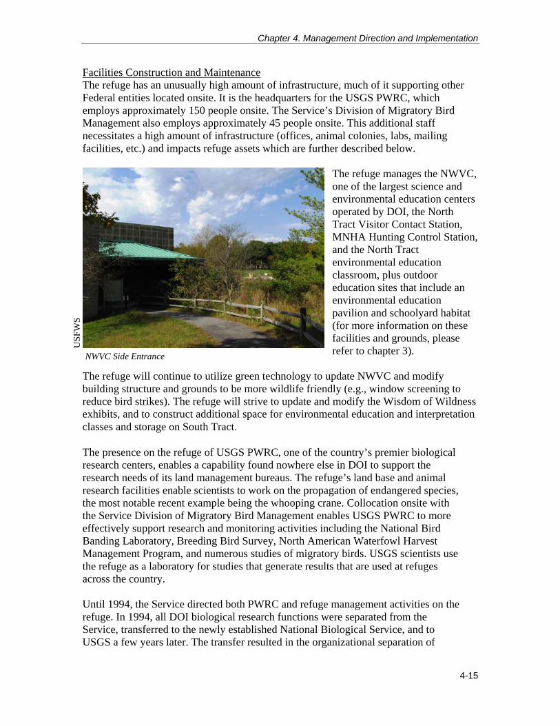
Facilities Construction and Maintenance The refuge has an unusually high amount of infrastructure, much of it supporting other Federal entities located onsite. It is the headquarters for the USGS PWRC, which employs approximately 150 people onsite. The Service’s Division of Migratory Bird Management also employs approximately 45 people onsite. This additional staff necessitates a high amount of infrastructure (offices, animal colonies, labs, mailing facilities, etc.) and impacts refuge assets which are further described below.
The refuge manages the NWVC, one of the largest science and environmental education centers operated by DOI, the North Tract Visitor Contact Station, MNHA Hunting Control Station, and the North Tract environmental education classroom, plus outdoor education sites that include an environmental education pavilion and schoolyard habitat (for more information on these facilities and grounds, please refer to chapter 3).
The refuge will continue to utilize green technology to update NWVC and modify building structure and grounds to be more wildlife friendly (e.g., window screening to reduce bird strikes). The refuge will strive to update and modify the Wisdom of Wildness exhibits, and to construct additional space for environmental education and interpretation classes and storage on South Tract. The presence on the refuge of USGS PWRC, one of the country’s premier biological research centers, enables a capability found nowhere else in DOI to support the research needs of its land management bureaus. The refuge’s land base and animal research facilities enable scientists to work on the propagation of endangered species, the most notable recent example being the whooping crane. Collocation onsite with the Service Division of Migratory Bird Management enables USGS PWRC to more effectively support research and monitoring activities including the National Bird Banding Laboratory, Breeding Bird Survey, North American Waterfowl Harvest Management Program, and numerous studies of migratory birds. USGS scientists use the refuge as a laboratory for studies that generate results that are used at refuges across the country. Until 1994, the Service directed both PWRC and refuge management activities on the refuge. In 1994, all DOI biological research functions were separated from the Service, transferred to the newly established National Biological Service, and to USGS a few years later. The transfer resulted in the organizational separation of
NWVC Side Entrance
US
FWS

Patuxent Research Refuge Comprehensive Conservation Plan
4-16
PWRC and the refuge. The biological research functions are now administered by USGS, which is headquartered in Reston, Virginia. The refuge management functions remain the responsibility of the Service. The lands, buildings, and infrastructure are the sole property of the Service. A MOA between the Service and USGS, established and signed in 2000, outlines the administration, operations, and maintenance of facilities of the refuge and of PWRC (MOA July 2000). The MOA also includes a list of all of the buildings on the refuge and designates which are proposed for demolition or retention (appendix E).
In addition to facilities, the refuge has 13.68 miles (22 kilometers) of paved public roads, 3.97 miles (6 kilometers) of gravel public roads, and 6.38 miles (10 kilometers) of administrative roads. Safety and maintenance requirements for paved roads may differ from unpaved road. Paved roads should be maintained at widths that ensure safe passage for vehicles at posted speeds. Roadside vegetation management should facilitate water flow from road surface to drainage facilities where they exist, and protect paved surfaces from tree root damage. Trees should not impinge upon drainage ditches or culvert flow. To minimize forest fragmentation from roads, unpaved road widths should be maintained at no more than 30 feet in deep forest (widths greater than this cause fragmentation) (MD DNR 1999) and should not be daylighted, graveled, or paved.
The activities at the refuge and PWRC require state-of-the-art laboratory space, animal handling facilities, and staff quarters. The separate but interrelated needs lead to complex facility issues, largely as the result of the number and age of the facilities (many of the facilities were constructed in the late 1930s, and most of the newer assets were constructed prior to the mid-1960s), and the collocated functions. Facility issues include facility operations and maintenance, many historic and cultural resource considerations (refuge facilities encompass three historic districts), highly specific and technical research facilities requirements, and complex coordination of activities between the two agencies. Given the many facilities and infrastructure challenges facing the refuge, a facilities modernization program has been developed to ensure that renovation, construction, demolition, and other proposed activities and priorities fit appropriately within the bureaus’ missions and DOI asset management principles. To address these requirements, the bureaus developed strategic priorities for the modernization of DOI assets on the refuge. These include:
Consolidation of resources and facilities on to the Central Tract of the refuge, resulting in an overall reduced and more economical footprint.
Conversion to publicly owned and maintained utility services.
Reforestation of a portion of the South Tract.
Relocation to the refuge of USGS staff currently housed in offices on the Beltsville Agricultural Research Center.

Chapter 4. Management Direction and Implementation
4-17
Collocation of Service and USGS.
Improvement of the work environment for DOI workforce.
Renovation of animal research assets.
Energy efficiency and sustainable building design (Dyrland et al. 2009). Hours of Operation The refuge will continue NWVC hours of operation from 9 a.m. to 4:30 p.m. daily, including most Federal holidays (except Thanksgiving, Christmas, and New Year’s Day). When feasible, South Tract trails and grounds will operate from dawn to dusk. The refuge will continue to allow scientific, education, and agency partners to use conference facilities for information exchange.
Wild and Scenic River Review As discussed in chapter 1, we are required to review river segments that cross the refuge as to their potential for inclusion in the National Wild and Scenic River System. As a first step, we reviewed the National Rivers Inventory. The inventory is a listing of more than 3,400 free-flowing river segments in the U.S. that are believed to possess one or more “outstandingly remarkable” natural or cultural values judged to be of more than local or regional significance. Patuxent Research Refuge does not include any river segments that are on the inventory and the nearest river segment is a section of the Patuxent River approximately 20 miles downstream. As stated earlier, the refuge includes sections of the Patuxent and Little Patuxent Rivers. The sections of river through the refuge are impacted by former military operations, management access roads, and altered hydrology from on and off stream impoundments. In addition, the river segments are too short in length to effectively manage for wild and scenic characteristics. Therefore, we do not recommend that these sections of the Patuxent and Little Patuxent Rivers be included in the National Wild and Scenic River System. Wilderness Review As discussed in chapter 1, we are also required to review refuge lands and waters for inclusion in the National Wilderness Preservation System. The Wilderness Review is included as appendix B. The CCP planning team found that each of the three Wilderness Inventory Areas that were examined and therefore, the entire Patuxent Research Refuge, do not meet the minimum criteria for wilderness as identified in Section 2(c) of the Wilderness Act. While there are ecological and historic values on the refuge, these do not, in and of themselves, warrant wilderness recommendation. In summary, Patuxent Research Refuge does not qualify as a Wilderness Study Area, and will not be considered further for wilderness designation in this CCP.
Managing Firing Ranges We have identified specific actions that will improve management of the firing ranges in order to protect the health of wildlife and the safety of users:

Patuxent Research Refuge Comprehensive Conservation Plan
4-18
Collaborate with Fort Meade and other stakeholders on a comprehensive redesign of the shooting ranges on the North Tract, including design and operational protocols to reduce the deposition and accumulations of lead ammunition into areas D, E, and F, and to protect the health of wildlife and safety of users of those areas; assess the quantity and distribution of lead deposition; study the feasibility and implementation of cleanup; and consider range by range renovations (bullet traps, berm enhancement, “no-sky” shooting stations, etc.) if a comprehensive rehabilitation is not possible. In addition, pursue range renovations to reduce impact zone, recycle spent ammunition, clean up lead, and further implement EPA’s best management practices for outdoor ranges. We will revise the current 5-year special use permits to 2-year special use permits. If necessary, we will perform additional NEPA analysis and public involvement to implement any changes in range operation.
Obtain funding from the DOD for all needed remediation (such as soil sifting, phyto-remediation, phosphate immobilization) excavation of hot spots, and disposal of accumulated lead-based ammunition on soils and streams in areas D, E, F, G, H, I, and J on the North Tract.
Assess the cause of poor revegetation in former firing range area NT-7 (e.g., result of soil type and soil contamination).
Managing Impoundments Patuxent Research Refuge currently has over 500 acres of impoundments, some of which are pseudo-impoundments (i.e., water bodies unintentionally created by other activities that affect flow, yet lack structures for manipulating water levels). A number of these impoundments, particularly on Central Tract, straddle feeder streams making their way through floodplain forest toward the Patuxent River. The Central Tract impoundments were originally created decades ago for research on impoundment management techniques for waterfowl and shorebirds, but research of this type has not occurred for years. The management and maintenance of these aging impoundments has been a challenge to budgets and staff, and questions have been raised about their relative contribution to breeding or wintering waterbirds, as they lie outside of the core Atlantic Flyway, versus their potential to contribute to forest ecosystems, particularly floodplain forest, and to the health of the Patuxent River and the Chesapeake Bay. Refuge staff, along with partners within the Service, MD DNR, and PWRC, examined the management of impoundments across the refuge and through a Structured Decision Making (SDM) process, to obtain informed guidance on the future management of these impoundments. The SDM process evaluated and provided scores or rankings for the costs and benefits to wildlife and the environment for each impoundment under different scenarios, such as: continuing to manage as is (dynamic or static levels), restoring to either natural hydrology, or converting to green-tree reservoir. The process generated portfolios listing the impoundments’ the total maximum benefit scores. Generally, portfolios which contained the most conversions to green-tree reservoir or floodplain forest and swamp

Chapter 4. Management Direction and Implementation
4-19
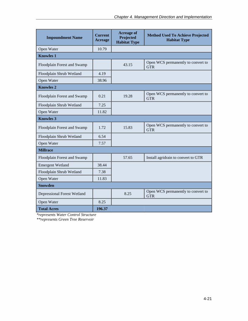
scored highest in wildlife value and benefits. One of the benefits included in the process was reduction in forest fragmentation. None of the portfolios, including the final chosen portfolio, resulted in actual loss of wetlands, just changes in wetland types. Some wetlands were deliberately excluded from the SDM process because of the cost of deconstruction, their value to the refuge for visitor services for recreation or education, their value to the scientific community for future research, or because they were naturally occurring, pseudo-impoundments. Most gravel pits were eliminated from the SDM process as they would require an extensive permit process, filling and land alterations, and associated costs. They would also incur considerable collateral damage from equipment access. However, to ascertain that the costs of retaining the gravel pits would truly be greater than the gain in resource benefit, and to compare the cost and benefit analysis of gravel pits against other impoundment types, we ran the SDM model for the three gravel pits of the Gravel Pit Pond series which are of varying sizes. Impoundments such as Cash Lake and Lake Allen, were not considered in the SDM process because they serve too important a role in our support of the priority public uses. Naturally occurring wetlands, such as Shangri-la or other ox-bows found on the North Tract and most pseudo-impounded wetlands (created by beaver dams, or unintentional result of a road or some alteration to flow, yet have no means of manipulating the water level), were also excluded from the SDM process. The SDM process is described in greater detail in Appendix G. Appendix J contains the master list of impoundments and wetlands throughout the refuge, and includes acreage figures, and habitat descriptions for each. The SDM process resulted in 14 impoundments listed for either restoration to natural hydrology or conversion to green-tree reservoir. Their total acreage is approximately 197 acres (89.5 hectares). Most of that acreage is open water (about 125 acres), but nearly 42 acres of emergent wetlands and nearly 30 acres of floodplain shrub wetlands within the impoundment boundaries will be affected or potentially converted to floodplain forest-swamp or depressional forest wetland types. We anticipate that there may also be gains in emergent, shrub wetlands, or floodplain forest and swamp where low lying areas surrounding the impoundments experience new hydrological regimes. Table 4-1 below displays the 14 impoundments and wetlands that were finally selected for restoration or conversion, their individual acreages, the habitat types we anticipate they will transition to, and the method used. Most impoundments already have a water control structure, which allows for manipulation, but a few are pseudo-impoundments. For any restoration or amendment, we will acquire necessary approvals and permits and consult with appropriate agencies or partners before beginning work to alter impoundments (such as analyzing residual legacy soils for some impoundments). The goal of restoration or impoundment amendment is to change the type of wetland found in the impoundment’s footprint, and will not result in an overall loss of wetlands (e.g., emergent wetland to forested wetland). A variety of management techniques may be utilized to convert impoundments, depending on immediate and neighboring site conditions. Management techniques used to accomplish impoundment conversion might include opening water control structures, replacing culverts, or installing agri-drains to aid in restoring natural hydrologic condition.

Patuxent Research Refuge Comprehensive Conservation Plan
4-20
Table 4-1 Impoundments and Wetlands Being Conserved or Restored – Methods and Resulting Habitat Types
Impoundment Name Current Acreage
Acreage of Projected
Habitat Type
Method Used To Achieve Projected Habitat Type
Baileys Bridge
Floodplain Forest and Swamp 0.73 Open WCS* permanently to achieve natural hydrology
Open Water 0.73
Blue Gill
Deciduous Pine and Mixed Forest
1.42 Open WCS permanently to achieve natural hydrology
Open Water 1.42
Duvall 1
Floodplain Forest and Swamp 14.98 Install agridrain to convert to GTR**
Open Water 14.98
Duvall 2
Floodplain Forest and Swamp 1 7.68 Install agridrain to convert to GTR
Floodplain Shrub Wetland 0.25
Open Water 6.43
Goose
Deciduous, Pine and Mixed Forest
1.24 Install agridrain to achieve natural hydrology
Open Water 1.24
Hance 1
Floodplain Forest and Swamp 7.45 Open WCS permanently to achieve natural hydrology
Floodplain Shrub Wetland 2.74
Open Water 4.72
Hance 2
Floodplain Forest and Swamp 6.22 Open WCS permanently to achieve natural hydrology
Emergent Wetland 1.54
Floodplain Shrub Wetland 1.48
Open Water 3.2
Harding Spring
Depressional Forest Wetland 1.71 Install agridrain to achieve natural hydrology
Open Water 1.71
Hobbs
Floodplain Forest and Swamp 10.79 Install agridrain to convert to GTR
Chapter 4. Management Direction and Implementation
4-21
Impoundment Name Current Acreage
Acreage of Projected
Habitat Type
Method Used To Achieve Projected Habitat Type
Open Water 10.79
Knowles 1
Floodplain Forest and Swamp 43.15 Open WCS permanently to convert to GTR
Floodplain Shrub Wetland 4.19
Open Water 38.96
Knowles 2
Floodplain Forest and Swamp 0.21 19.28 Open WCS permanently to convert to GTR
Floodplain Shrub Wetland 7.25
Open Water 11.82
Knowles 3
Floodplain Forest and Swamp 1.72 15.83 Open WCS permanently to convert to GTR
Floodplain Shrub Wetland 6.54
Open Water 7.57
Millrace
Floodplain Forest and Swamp 57.65 Install agridrain to convert to GTR
Emergent Wetland 38.44
Floodplain Shrub Wetland 7.38
Open Water 11.83
Snowden
Depressional Forest Wetland 8.25 Open WCS permanently to convert to GTR
Open Water 8.25
Total Acres 196.37
*represents Water Control Structure **represents Green Tree Reservoir

Patuxent Research Refuge Comprehensive Conservation Plan
4-22
4.4 Refuge Management Goals, Objectives, and Strategies The management direction chosen for the refuge combines the actions we believe most effectively achieve the refuge purposes, vision, and goals, and respond to public issues. It emphasizes the management of specific refuge habitats to support focal species whose habitat needs benefit other species of conservation concern in the Chesapeake Bay region. In particular, we emphasize increasing forest acreage by allowing smaller fields and openings to reforest and promoting a mix of forest restoration in conjunction with active management of diverse habitat types. This includes the restoration of a number of impoundments and grasslands to forested areas to support forest interior dwelling bird species. In addition, we will enhance our present visitor services programs in a manner that addresses the national and regional Service policies and the mandates of the refuge. We strive to strike a balance between wildlife-dependent and non-wildlife-dependent uses found to be compatible on the refuge.
Habitat Management Habitat management will expand forested areas throughout the refuge. This includes a gain of approximately 275 acres in additional floodplain forest derived from restoring or converting 14 impoundments to the natural hydrology or green tree reservoirs; or from managed grassland or scrub-shrub habitat that will be allowed to revert to floodplain forest. Upland forest will also increase by about 190 acres by allowing a number of small patches of grasslands throughout the refuge to revert to forest. We will reduce the amount of managed grassland habitat by about 263 acres, resulting in approximately 255 acres of high quality habitats with respect to configuration, context, and avoidance of forest fragmentation. Grasslands of suitable size, configuration, and context (approximately 50 acres, block shapes, closer to other open lands) for obligate grassland nesting birds and open-field generalist will be provided. Reforesting impoundments and grassland areas will benefit forest interior dwelling species by increasing the acreage of interior, contiguous forest surrounded by highly urbanized areas. It will also improve water quality as related to the Patuxent and Little Patuxent Rivers, and ultimately the Chesapeake Bay watershed.
An oak-pine savannah of about 132 acres, indicated by soil type and an assemblage of rare fauna, will be maintained to promote this rare, native habitat type and support species such as the darkling beetle, tiger beetle, native bees and other pollinators. Impoundments that support fishing or important amphibian breeding areas will also be maintained. Habitat types and management are displayed in map 4-1. Inventory and Monitoring We will improve and tailor our monitoring and inventory efforts to better inform and support these goals, the effectiveness of habitat management, habitat adaptation to climate change, and to ensure we have the necessary resources to accomplish them. We will target any alterations or additions to these ongoing surveys that will help us better understand the implications of our management actions and ways to improve our efficiency and effectiveness. We will also continue to seek ways to reduce our management costs for establishing and maintaining monitoring protocols.

Chapter 4. Management Direction and Implementation
4-23
We will strengthen partnerships with USGS and other agencies, State partners, academic institutions, nonprofit organizations, and volunteers in the conservation community to obtain needed information on habitat quality, wildlife use, and impacts relevant to CCP goals and objectives and for more current baseline data. Through these
endeavors we will be able to expand our biological inventories and monitoring projects to better understand species composition and utilization of the refuge, particularly in response to reforestation efforts. Visitor Services We will strive to increase wildlife-dependent public use opportunities and allow for appropriate, compatible non-wildlife-dependent uses (maps 4-2 and 4-3). We will promote high-quality hunting and fishing programs through improved habitat management strategies. In addition, we will expand wildlife observation, viewing, and photography opportunities and initiate new interpretive programs and environmental education opportunities both on and offsite. Refuge Administration We will expand refuge staff to support habitat management efforts, facilities maintenance, and visitor use. As identified in the 2009 Refuge System staffing model, we propose to fill five positions, which include two maintenance workers (grounds and buildings), one contracting officer, one law enforcement officer, and one visitor services park ranger. There is some degree of flexibility to alter these proposed positions as priorities and/or needs change. In order to fill the positions identified, permanent sources of funding will need to exist.
US
FWS

Patuxent Research Refuge Comprehensive Conservation Plan
4-24
Goals, Objectives, and Strategies Goal 1: Maintain and actively promote Patuxent Research Refuge as an “outdoor laboratory,” providing a diversity of wildlife and natural resource research opportunities on the refuge in such areas as landscape conservation, habitat fragmentation, climate change, and other emerging issues, as well as the more traditional types of wildlife research, including inventory and monitoring techniques, land management, and understanding ecological processes. Research that supports the overall Service mission, and evaluates the best methods for protecting natural resources throughout the Refuge System and other land management agencies will be a priority. Objective 1.1 Inventory and Monitoring Conduct high-priority inventory and monitoring (survey) activities that evaluate resource management and public use activities to facilitate adaptive management. See Table 4-2 for a list of surveys and inventories necessary to evaluate the success of management strategies for priority biological objectives. Strategies
Develop and implement an inventory and monitoring plan for the refuge. Monitoring Elements
Track the number of inventory and monitoring surveys conducted annually.
Update the inventory and monitoring plan as additional resources of concern may be identified.
Rationale Inventorying and monitoring of refuge resources will allow us to know if key wildlife and habitat objectives are being met. Data derived from inventory and monitoring efforts will be used to assess past management actions and potentially drive management actions to be taken in both the short and the long-term. Inventory and monitoring efforts may change, as the need to know about certain species may change. Some long-term inventory and monitoring activities may be continued to provide a continuity of data on various species (e.g., waterfowl, waterbirds, etc.) over time, particularly as the data may pertain to climate change and other landscape-scale impacts.

Chapter 4. Management Direction and Implementation
4-25
Map 4-1. Anticipated Habitat Types and Management

Patuxent Research Refuge Comprehensive Conservation Plan
4-26
Chapter 4. Management Direction and Implementation
4-27
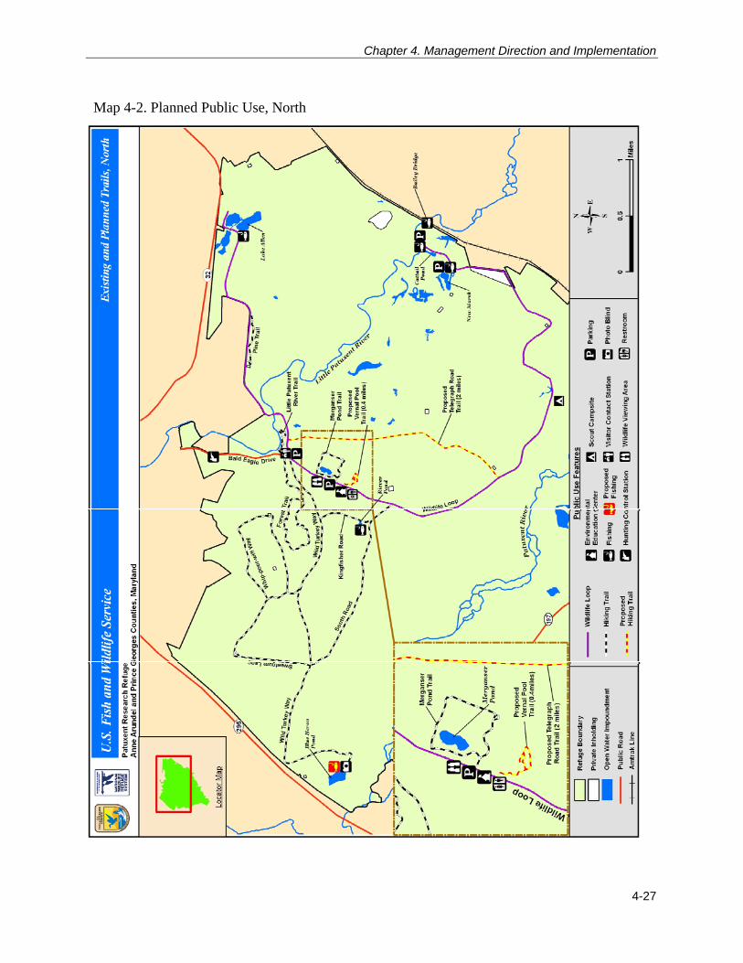
Map 4-2. Planned Public Use, North

Patuxent Research Refuge Comprehensive Conservation Plan
4-28
Map 4-3. Planned Public Use, South

Chapter 4. Management Direction and Implementation
4-29
Table 4-2 List of Surveys and Inventories Necessary to Evaluate Success of Management Strategies for Priority Biological Objectives Obj. 2.1
Floodplain Forest
Obj. 2.2 Upland Mixed Forest
Obj. 2.3 Oak-Pine Savannah
Obj. 3.1 Coastal
Plain River/ Stream
Obj. 3.2 Impoundment
Wetlands
Obj. 3.3 Non-
Impounded Wetlands
Obj. 4.1 Shrub-Early
Succession Forest
Obj. 4.2 Grassland/Old Fields
1 Timber cruise for forest health and diseases, age structure, species composition
X X X
2 Invasive species mapping, control and monitoring
X X X X X X X X
3 Rare plant community inventory X X X X X X 4 Stream physical and biological condition
assessment and remediation X X X
5 Acoustical bat survey; roosting bat survey X X X X X X X 6 Amphibian monitoring X X X X X 7 Priority birds survey by habitat and season X X X X X X X 8 Box turtle population survey X X 9 Native pollinator (bee, lepidopteran, beetle)
survey X X X
10 Passage and presence of priority fish, other priority aquatic species
X
11 Percent canopy of oak, pine, grassland (response to fire/mechanical treatments for restoration)
X X
12 Conversion to natural hydrology, greentree reservoir, functionality & capacity
X
13 Deer population survey X X X X

Patuxent Research Refuge Comprehensive Conservation Plan
4-30
Objective 1.2 Research and Scientific Assessments (Local, National, and International) Facilitate research of a local, national, and international nature that benefits wildlife on refuge lands as well as all other natural areas. Facilitate scientific assessments to provide baseline information to expand knowledge regarding landscape-scale natural resource issues and to determine the status of onsite refuge resources to better inform resource management decisions. Strategies
Continue to implement, conduct, and support wildlife/natural resource-related research projects from a broad range of researchers including USGS, other Federal agencies, universities, agencies of the State of Maryland, and independent researchers (33 studies in fiscal year 2011).
Continue to provide a secure land base for captive animal colonies, endangered species propagation, contaminant studies, etc.
Work with PWRC and partners to facilitate long-term research studies focused on landscape-scale issues such as climate change, habitat fragmentation, urban impacts to wildlife, and ecosystem services derived from the refuge and surrounding natural lands.
Continue to provide gate keys or cards to researchers who need to access refuge field sites outside of refuge daily open hours.
Reduce hunting hours during some week day mornings (except during the deer firearms season) to encourage and allow researcher access to the North Tract during the hunting season.
Work with PWRC to develop refuge-based collaborative research opportunities. Examples may include:
o Assess lead deposition and other impacts to forest and wildlife beyond firing ranges.
o Assess threats to the population size, density, and predation upon ground-nesting birds, turtles.
o Assess bat breeding, migrating, and wintering diversity, distribution, seasonal hibernating, and maternal roosting and foraging habitats.
o Assess the effects of right-of-way management on priority species of birds dependent on shrub habitat, important pollinators, and deer foraging response.
o Assess refuge fish population and fish passage for migratory fish.
o Monitor amphibian disease, such as ranavirus chytrid fungus impacts on wood frog populations.
Develop and strengthen partnerships with USGS and other agencies, State partners, academic institutions, nonprofit organizations, and volunteers in the
Chapter 4. Management Direction and Implementation
4-31
conservation community to obtain needed information on habitat quality, wildlife use, and impacts relevant to CCP goals and objectives. Examples may include:
o Conduct feasibility study and options and identify sections for floodplain stream restoration.
o Understand the contribution and importance of refuge forests to pollinator species (their contribution to forest health on the refuge and Mid-Atlantic Coastal Plain).
Monitoring Elements
Track the number of special use permits issued annually for research purposes.
Track the number of multi-year research projects authorized over time.
Track the number of reports, proceedings, and results published annually. Rationale This objective goes to the heart of why the refuge exists. The refuge was initially established in 1936 to serve as a wildlife experiment station and has since served as the site of multiple nationally and internationally significant breakthroughs in wildlife science. The PWRC has been a leading international research institution for wildlife and applied environmental research located on the refuge since its inception. The partnership, with the refuge providing the “outdoor lab” and secure locations for research and PWRC providing the research capability has been recognized internationally for its contributions to wildlife science. The synergy achieved by allowing multiple partners and multiple entities and agencies to conduct their research essentially side by side is immeasurable. Facilitating multiple research opportunities for a variety of parties should remain paramount at Patuxent Research Refuge for the foreseeable future. Goal 2: Protect, maintain, and restore, where practicable, the biological integrity, diversity, and environmental health of forested ecological communities to provide habitat for species of conservation concern, including migratory birds, mammals, amphibians, reptiles, and invertebrates. Objective 2.1 Floodplain Forest and Swamp, to also include Depressional Forests and Shrub Wetlands Maintain the biological integrity of the current 2,018 acres (917.4 hectares) of native floodplain forest and shrub and 757.8 acres (344 hectares) of depressional forest and shrub with 80 percent closed canopy and less than 10 percent invasive, nonnative species along the Patuxent and Little Patuxent Rivers. We will also promote natural succession to floodplain forest and related communities of potentially 275 additional acres (125 hectares). Floodplain and depressional forest communities should be dominated by native riparian species common for this area, possess a well-developed under- and mid-story of native shrubs or recruiting trees, and provide functioning ecosystems and high water quality for breeding, migratory, and wintering habitat for bird species of conservation concern, including prothonotary warbler, Kentucky warbler, Louisiana

Patuxent Research Refuge Comprehensive Conservation Plan
4-32
waterthrush, rusty blackbird, and other forest-dependent species such as wood frog, spotted turtle, eastern forest bats, and native insects. Strategies
Restore the natural hydrology or convert to green-tree reservoir 14 impoundments: Bluegill, Duvall 1 and 2; Goose Pond; Hance 1 and 2; Harding Spring Pond; Hobbs; Knowles 1, 2, and 3; Millrace; Snowden; and Baileys Bridge Marsh. We project that the open water, emergent, shrub wetlands portions of these impoundments will provide most of the approximately 197 acres additional acreage for floodplain forest and swamp or depressional forest swamp. Another 72-80 acres lying just outside some of the impoundments are also expected to become floodplain forest or shrub. See Table 4-1 for more details on acreages, landcover types and actions considered for each impoundment.
Control and reduce nonnative invasive species annually by using chemical, biological, or mechanical methods to increase native plant species diversity and richness.
Prevent new invasive species from becoming established by utilizing early detection rapid response techniques to address invasive species populations through the appropriate control measures.
Restore forests through natural succession, whenever possible, primarily from conversion of scattered pockets of small, wet meadows, including meadows around Uhler marshes (approximately 34 acres or 14 hectares) and similar areas.
Maximize forest interior, which is the forested area greater than 300 feet (91 meters) from the forest edge. Restore forests into large contiguous forested polygons, 500 acres or more (202 hectares) when possible, and in shapes that maximize forest interior habitat. Restore gaps, openings, and peninsulas in existing forested areas to decrease forest edge and maximize forest interior.
Consider a range of active forest management when objectives cannot be achieved through natural processes, such as uneven-age forest management (single tree and group selection) to create a multi-structured, multi-aged forest, and mechanical and herbicidal treatments to reduce undesirable species and create snag and cavity trees. Plant desirable flora on sites as needed.
Reduce white-tailed deer population to encourage natural redevelopment of mid- and understory vegetation where depleted due to herbivory or intense scouring from flooding. Evaluate and adjust the white-tailed deer hunt program as necessary to meet native vegetation objectives. Coordinate management efforts with the MD DNR deer management program.
Explore remediation for steeply down-cut streambanks.
Review and evaluate transportation needs for management purposes and public access. Close and restore unnecessary roads and adjacent berms/ditches to forested habitat.

Chapter 4. Management Direction and Implementation
4-33
To minimize forest fragmentation, constrain road widths to the minimum needed for vehicle passage, avoid “daylighting,” graveling, and paving where possible.
Ensure all stream crossings do not impact stream hydrology or aquatic resources.
Conduct a timber cruise and forest health assessment with special attention to indications of forest pests and disease, and ability to regenerate.
Support ongoing big-tree surveys, native plant surveys, and plant mapping on the refuge.
Protect areas containing rare native plant communities. Monitoring Elements
Monitor invasive species prevention and control efforts through a combination of plant identification, inventories, and mapping.
Continue landbird surveys and migration counts to evaluate achievement of the objective for breeding and migrating birds.
Develop long-term forest monitoring surveys to evaluate species, community, and structure changes from various environmental stressors, including air and water quality and climate change.
Conduct acoustical bat monitoring surveys to determine species diversity and composition during breeding and migration.
Determine the effectiveness of the white-tailed deer management program by evaluating species composition, abundance, diversity, and regeneration of native shrubs and forbs. Adjust harvest rates as needed.
Inventory and map floodplain forest communities and forested wetlands and incorporate the maps and data sets into the Patuxent Research Refuge Geographic Information System.
Identify and map areas of concentration of amphibians of concern, such as wood frog, salamanders, and vernal pools to ensure their conservation and protection. Maintain vigilance for chytrid fungus and ranavirus, and enact measurements to prevent spread between vernal pools.
Some metrics to consider for management or evaluation of floodplain forest habitat for priority species:
White-tailed Deer
US
FWS

Patuxent Research Refuge Comprehensive Conservation Plan
4-34
Dense underbrush along streams and nesting snags (average height of 3 to 6 feet and a diameter at breast height of at least 6 inches) for prothonotary warbler.
Closed forest canopy (greater than 80 percent), sparse herbaceous canopy cover (less than 25 percent), and sparse to moderate shrub canopy cover (75 percent) for Louisiana waterthrush.
A slightly open canopy, dense understory, and well-developed ground cover for Kentucky warbler.
Canopies 5 to 20 feet (1.5 to 6 meters) above the ground and open underneath for summer roosting of eastern red bats.
Rationale This habitat supports the greatest diversity of species within the refuge. Fifty-four species of invertebrates, birds, reptiles, and amphibians listed as species of greatest conservation need in the Maryland Wildlife Diversity Conservation Plan are found in the refuge’s floodplain forests. Twenty-eight are priority bird species listed in either the BCR 30 or PIF 44 implementation plans. These floodplain forests provide both nesting and migration habitat for bird species listed by regional conservation plans, including BCR 30 Implementation Plan, PIF 44 Bird Conservation Plan, the Maryland Wildlife Diversity Conservation Plan, and international plans like Saving Our Shared Birds and PIF Tri-National Vision for Landbird Conservation. High-priority nesting passerine birds common to these plans includes Acadian flycatcher, cerulean warbler, Kentucky warbler, Louisiana waterthrush, and prothonotary warbler. Other bird species benefiting from provision of this habitat type include migrating and nesting passerines such as Bicknell’s thrush (Catharus bicknelli), black-and-white warbler (Mniotilta varia), black-billed cuckoo (Coccyzus erythropthalmus), blackburnian warbler (Dendroica fusca), black-throated blue warbler (Dendroica caerulescens), black-throated green warbler (Dendroica virens), blue-headed vireo (Vireo solitaries), broad-winged hawk (Buteo platypterus), brown creeper (Certhia americana), Canada warbler (Wilsonia canadensis), golden-crowned kinglet (Regulus satrapa), hairy woodpecker (Picoides villosus), hermit thrush (Catharus guttatus), hooded warbler (Wilsonia citrine), magnolia warbler (Dendroica magnolia), northern parula (Parula americana), pileated woodpecker (Dryocopus pileatus), red-eyed vireo (Vireo olivaceus), red-headed woodpecker (Melanerpes erythrocephalus), red-shouldered hawk (Buteo lineatus), scarlet tanager, veery (Catharus fuscescens), wood thrush, worm-eating warbler, and yellow-throated vireo. The refuge contains the largest forested block in Maryland’s Western Coastal Plain, and the Washington-Baltimore Corridor and is surrounded by a heavily urbanized landscape. Floodplain forest communities have a well-developed and variable forest composition and structure with canopy and sub-canopy trees, understory shrubs, and a diverse ground cover. Frequency, duration, and severity of flooding vary seasonally and yearly, contributing to a rich diversity of species, vertical and horizontal structure, and ground cover, along with forest age, soils, elevation, slope, and disturbance frequency. Isolated
Chapter 4. Management Direction and Implementation
4-35
local weather events impact small areas or individual trees and result in downed trees, snags, and broken branches. Within this forest, several important small forested wetlands are found. Located on the broad flats between drainage streams, these wetlands are small, mostly closed canopy upland depression swamps. Magnolia bogs, a unique seepage wetland complex, are one example of the scattered, small (less than 25 acres), nontidal shrub wetlands found on the refuge. Small (less than 0.5 acre) vernal pools occur in low areas or as depressions or isolated floodwaters, backwaters of old beaver impoundments, old sinkholes, depressions created by military activity, or as perched spring or seep-fed basins. Objective 2.2 Upland Deciduous, Pine, and Mixed Forest and Associated Wetlands Maintain the biological integrity of the current 8,242 acres (3,335 hectares) of native, mature upland forest communities with 80 percent closed canopy and less than 10 percent invasive species. Expand upland forest acres by about 190 acres (86.3 hectares) to increase forest interior and reduce fragmentation. Upland forest should contain a diverse age structure and well-developed understory and midstory to provide breeding, migration, and winter habitat for whip-poor-will, scarlet tanager, cerulean warbler, eastern wood-pewee, wood thrush, worm-eating warbler, and yellow-throated vireo, and to benefit other forest-dependent species such as eastern forest bats, wood frog, forest salamanders, eastern box turtle, hog-nosed snake, and native insects. Upland forest communities should be dominated by native tree species common to this area, such as American beech, hickories, tulip poplar, dogwood, persimmon (Diospyros virginiana), and upland oaks (northern and southern red oak, white oak, blackjack, post oak), and possess diverse shrub and herbaceous plant associations. Strategies
Control and reduce nonnative invasive species annually by using chemical, biological, or mechanical methods to increase native plant species diversity and richness.
Prevent new invasive species from becoming established by utilizing early detection rapid response techniques to address invasive species populations through the appropriate control measure.
Maximize forest interior (forested areas which are greater than 300 feet or 91 meters, from the forest edge) by connecting fragmented tracts and small openings with large contiguous forested polygons. Strive for blocks as close to 500 acres (202 hectares) as possible, and in shapes that maximize forest interior habitat. Reforest through natural succession or restoration plantings.
Allow 262 acres (119 hectares) of grasslands to undergo succession. These additional acres of upland forest would come mostly from the conversion of scattered grassy areas that were administratively managed or early successional old fields that are shrubby and too small to manage. Due to hydrology or proximity to wetlands, we anticipate that only 190 acres (86.3 hectares) will become upland mixed forest. This includes 8.5 acres gained from impoundment

Patuxent Research Refuge Comprehensive Conservation Plan
4-36
restoration. Approximately 72 acres (32.7 hectares) will become wet meadow, depressional shrub habitat.
Restore gaps, openings, and peninsulas in existing forested areas to decrease forest edge and maximize forest interior.
Consider a range of active forest management when objectives cannot be achieved through natural processes, such as uneven-age forest management (single tree and group selection), to create a multi-structured, multi-aged forest and mechanical and herbicidal treatments to reduce undesirable species and create snag and cavity trees. Plant desirable flora onsite as needed.
Avoid dense, monoculture pine forests, as the distribution of breeding cerulean warblers has been negatively correlated with percent canopy cover by coniferous trees (Robbins et al. 1989).
Reduce white-tailed deer population to encourage natural redevelopment of mid and understory vegetation where depleted due to herbivory or intense scouring from flooding.
Explore remediation for steeply down-cut streambanks.
Scout for and control stand-replacing invasive plant species that threaten to overtake intact healthy forest communities.
To minimize forest fragmentation, constrain road widths to the minimum needed for vehicle passage, avoid “daylighting,” graveling, and paving where possible.
Ensure all stream crossings do not impact stream hydrology or aquatic resources.
Conduct a timber cruise and forest health assessment with special attention to indications of forest pests and disease, and ability to regenerate.
Support ongoing big tree surveys and conduct native plant surveys and plant mapping on the refuge.
Protect areas containing rare native plant communities. Monitoring Elements
Monitor invasive species prevention and control efforts through a combination of plant identification, inventories and mapping.
Continue landbird surveys and migration counts to evaluate achievement of the objective for breeding and migrating birds.
Develop long-term forest monitoring surveys to evaluate species, community, and structure changes from various environmental stressors, including air and water quality and climate change.
Conduct acoustical bat monitoring surveys to determine species diversity and composition during breeding and migration.

Chapter 4. Management Direction and Implementation
4-37
Determine the effectiveness of the white-tail deer management program by evaluating species composition, abundance, diversity, and regeneration of native shrubs and forbs. Develop an improved deer population assessment and monitoring technique.
Evaluate and adjust the white-tailed deer hunt program as necessary to meet native vegetation objectives. Coordinate management efforts with the MD DNR deer management program.
Inventory and map forest communities and forested wetlands and incorporate the maps and data sets into the Patuxent Research Refuge Geographic Information System.
Identify and map areas of concentration of amphibians and reptiles of conservation concern, particularly wood frogs, spotted turtle, eastern box turtle, and vernal pools to ensure their conservation and protection. Maintain vigilance for chytrid fungus and ranavirus, and implement measures to prevent spread of fungus between vernal pools.
Monitor for gypsy moth and other oak diseases.
Some metrics to consider for management or evaluation of upland forest habitat for priority species:
Closed canopy and dense understory.
Forest canopy cover (greater than 85 to 90 percent, not less than 65 percent), large trees (greater than 12 inches diameter at breast height) and subcanopy cover (65 to 70 percent, not less than 45 percent) for cerulean warblers.
Incomplete or sparse canopy layer with understories to 15 to 20.5 feet (5 to 6 meters) height.
Minimum snag densities of 8 per acre for silver-haired bat roosts. Rationale This habitat supports the second highest diversity of species within the refuge. Fifty species of mammals, birds, reptiles, and amphibians listed as species of greatest conservation need in the Maryland Wildlife Diversity Conservation Plan are found in the refuge’s upland forests. Forty-one are priority bird species listed by regional conservation plans, including the BCR 30 Implementation Plan, PIF 44 Bird Conservation Plan, and the Maryland Wildlife Diversity Conservation Plan, as well as international plans like Saving Our Shared Birds and Partners in Flight Tri-National Vision for Landbird Conservation. In addition to the priority nesting birds, other species that will benefit from the preservation of large blocks of such forest include migrating or nesting birds such as American redstart (Setophaga ruticilla), barred owl (Strix varia), Bicknell's thrush, black-and-white warbler, black-billed cuckoo, black-throated blue warbler, black-throated green warbler, broad-winged hawk, brown creeper, Canada warbler, dark-eyed junco (Junco hyemalis), eastern towhee, hairy woodpecker, hooded warbler, Kentucky warbler, least flycatcher (Empidonax minimus), northern parula, ovenbird (Seiurus aurocapillus),

Patuxent Research Refuge Comprehensive Conservation Plan
4-38
pileated woodpecker, red-eyed vireo, red-headed woodpecker, red-shouldered hawk, sharp-shinned hawk (Accipiter striatus), summer tanager (Piranga rubra), and veery. Refuge upland forests are comprised of mesic deciduous and dry oak-pine forests. Mesic deciduous forests typically are an assortment of hardwoods in moist habitats, while dry oak-pine forests typically are found on more droughty, infertile soils. Most of the refuge’s upland forests are mesic deciduous and many of the current pine forests are early successional mesic deciduous forests and reflect past timber management practices. Upland forest communities have a well-developed and variable forest composition and structure with canopy and sub-canopy trees, understory shrubs, and a diverse ground cover. A rich diversity of species, vertical and horizontal structure, and ground cover result from age, soils, elevation, and slope. Isolated local weather events impact small areas or individual trees and result in downed trees, snags, and broken branches. Within this forest, several important small forested wetlands are found. Located on the broad flats between drainage streams, these wetlands are small, mostly closed canopy upland depression swamps. Magnolia bogs, a unique seepage wetland complex, are one example of the scattered, small (less than 25 acre), nontidal shrub wetlands found on the refuge. Small (less than 0.5 acre) vernal pools and sphagnum bogs occur in low areas or as depressions or as isolated floodwaters, backwaters of old beaver impoundments, old sinkholes, depressions created by military activity, or as perched spring or seep-fed basins. Objective 2.3 Oak Pine Savannah Continue the restoration of approximately 132 acres (60 hectares) of savannah habitat consisting of an open canopy dominated by native hardwoods (primarily oaks), and an understory dominated by native grasses such as broom sedge (Carex scoparia), little bluestem, and forbs such as asters and other composites to benefit rare darkling and tiger beetle species, upland chorus frog, native bees, Indian skipper (Hesperia sassacus) and other pollinators, and sandy barren plant communities. Strategies
The acres to be restored to oak-pine savannah largely comes from the NT-8 (Drop Zone), approximately 40 acres (16 hectares), and areas along Sweetgum Road in the northwest section of North Tract consisting of dense, monocultures of Virginia pine on sandy soils that have been identified as potentially rare habitat.
Mechanically thin dense and stagnating pine stands and monocultures of sweetgum to open up the understory and permit light penetration for germination of understory species associated with this habitat type and to release residual trees.
Conduct prescribed fires to reduce accumulated debris from thinning operations, maintain the open understory, and promote a fire-adapted native woodland community. Provide a permanent firebreak around restoration units to facilitate maintenance by fire.

Chapter 4. Management Direction and Implementation
4-39
Conduct a soil survey (at finer resolution than that provided by the USDA Soil Survey) to delineate the extent of the deep sandy soils formations associated with the savannah habitats along the Patuxent River. Savannah restoration and maintenance should be confined to appropriate soil types.
Prevent invasive plant species such mile-a-minute weed, Chinese lespedeza, Japanese honeysuckle, sweetgum, tulip poplar, red maple, and black locust that are poised to overtake newly opened areas. Scout for, and eradicate, parent trees of such species along perimeter.
Monitoring Elements
Conduct visual assessments annually to determine extent of invasion of deciduous, stand-replacing pioneer species such as sweetgum and black locust.
Conduct bee, beetle, and other pollinator/insect surveys.
Conduct vegetation surveys that measure percent canopy cover of upper canopy species such as oaks and pines and understory cover such as grasses and forbs and heath shrubs.
Rationale In 1995, Warren E. Steiner, Jr., an entomologist with the Smithsonian Institution’s Museum of Natural History, discovered sandy barrens on the North Tract. These small narrow barrens or deserts are located on deep sandy soils primarily on the northeastern side of the Patuxent River where the prevailing winds have deposited sand from marine and alluvial deposits exposed and reworked by the river (Droege et al. 2009). Since 1995, Steiner has identified 64 species of rare darkling beetles in the family Trenebrionidae in these sandy barrens. This diversity of species represents a distinct assemblage not found in any other habitat. In some cases, Patuxent Research Refuge represents the only known areas where some of these species can be found between the New Jersey pine barrens and the Carolina sandhills. In fact, these North Tract pine and oak communities associated with sandy soils may indeed be a remnant of what ecologists refer to as the pine barrens pine-oak plant community, closely related to the pitch-pine and oak barrens of New Jersey (Riordan 2006). The area also contains rare plants associated with this community type. In 1996, USGS biologist Sam Droege also identified one of the few populations of chorus frog in this area, and has recently documented a list of native bee species in the adjacent powerline right of way which contains the same soils. This species also depends on open, early succession habitat. In 2001, Steiner, Droege and biologist Holly Obrecht, became concerned that increasing dominance of Virginia pine would shade out the sandy dry openings and threaten the survival of these specialized plants and insects unless action was taken to substantially reduce the pine canopy (Obrecht 2005 unpublished and Droege 1996 unpublished). An east-west orientation is recommended to capture the maximum amount of sunshine hours with least amount of shading cast by adjacent tall forest. A narrow, north-south orientation would result in long shadows cast by rising and setting sun angles for extended periods of time onto the savannah restoration acres, creating favorable growing

Patuxent Research Refuge Comprehensive Conservation Plan
4-40
conditions for competing forb and tree species, such as sweetgum, tulip poplar, and red maple. Goal 3: Protect, maintain, and restore, where practicable, the biological integrity, diversity, and environmental health of refuge aquatic habitats, including the Patuxent, Little Patuxent, and Anacostia River Watersheds, and impoundments, to provide habitat for species of conservation concern, including fish, invertebrates, and plants. Objective 3.1 Coastal Plain River and Coastal Plain Stream Habitats Restore and protect the biological integrity of the aquatic habitats of the approximately 68 riparian miles (109 kilometers) of Patuxent, Little Patuxent, and Anacostia River watersheds within the refuge, as well as their associated perennial streams, to provide spawning, nursery, foraging, and cover habitat for aquatic resources of conservation concern such as American brook lamprey, American eel, American and hickory shad, alewife, blueback herring, comely shiner, glassy darter, stripeback darter, and the State-endangered triangle floater. Provide quality foraging habitat for eastern forest bats, spotted turtle, and insectivorous birds such as prothonotary warbler and Louisiana waterthrush. Restore the biological integrity and water quality of impaired stream segments. Strategies
Provide a variety of substrates including: o Pea gravel for spawning American brook lamprey o Fine sand and muck for American brook lamprey larvae o Stony riffles for spawning stripeback darter o Gravel, sand, and detritus for spawning alewife o Streams with a pH greater than 6.4, turbidity less than 15 nephelometric
turbidity units (NTU, units established by EPA to measure suspended solids), and depths less than 20 inches for glassy darter
o Stream reaches with stable banks and substrates for triangle floater
Coordinate with MD DNR and utilize MD DNR Index of Biological Integrity to assess and inventory biological, chemical, and physical parameters affecting riverine and stream habitat on the refuge. Identify stream reaches to conduct abiotic stream quality measurements such as pH, NTU, and water depths, for sensitive anadromous species such as darters.
Develop a long-term database to identify environmental stressors, including climate change, to assess the efficacy of habitat restoration; evaluate stressors to floodplain function, including roads and impoundments; and evaluate stressors to stream water quality, flows, and fish passage from refuge structures, including buildings, culverts, impoundments, parking lots, roads, and runoff waters. Restore or mitigate where possible.
Participate in local, county, State, and Federal partnerships in the Patuxent, Little Patuxent, and Anacostia River watersheds to improve biological, chemical, and physical components of stream and river health.

Chapter 4. Management Direction and Implementation
4-41
Prevent new invasive species from becoming established by utilizing early detection rapid response techniques to address invasive species populations through the appropriate control measure.
Restore floodplain function where possible.
Coordinate with MD DNR to evaluate options to provide fish passage at Cash Lake. Cash Lake has been identified by MD DNR as the 135th most important blockage of over 800 blockages within Maryland. Assess fish passage capability of permanent streams leading to river and prioritize areas for removal of obstruction and restoration for passage.
Identify and restore impaired reaches of streams degraded by cutbank erosion, downcutting, turbidity, biodegradation, pollution, and detachment from groundwater table; restore floodplain function where possible. Conduct stream walks to identify problem areas, accessibility issues, and threatened plant communities or other threatened resources. Collaborate with State partners, the Chesapeake Bay Field Office, and stream restoration professionals to target priority areas (locations where corrective measures will yield the most benefit). Identify worst affected reaches with highest potential for benthic recovery.
Identify and retrofit any undersize culverts on the refuge. Replace culverts with bottomless arches where feasible and affordable.
Widen vegetation buffers where necessary and reduce impervious surfaces near heavily impacted areas through natural establishment or plantings.
Continue water quality assessments for physical and chemical properties (heavy metals, oxygen, turbidity, and pH) to determine suitability for passage and nursery habitat for interjurisdictional and trust fish species.
Monitoring Elements
Conduct periodic surveys along appropriate reaches for A. lamprey, darters, triangle floater, and anadromous migratory fish such as river herring.
Investigate contamination from lead deposition.
Bai
ley
Bri
dge
- U
SFW
S

Patuxent Research Refuge Comprehensive Conservation Plan
4-42
Establish long-term monitoring stations for biotic and abiotic water quality parameters at refuge inflow and outflow points on Patuxent and Little Patuxent Rivers.
Conduct stream walks to identify new sources of degradation and to check function of remediating structures or devices such as replaced culverts, bottomless arches, and bank stabilization works. Conduct periodic aquatic invertebrate surveys.
Monitor and control invasive exotic plants along streams such as lesser celandine and Japanese knotweed (Polygonum cuspidatum).
Rationale Both stream and river habitat provides spawning, nursery, migration, and year-round habitat to many fish species that are rare, threatened, or endangered in Maryland or important economically and recreationally. Thirteen species of fish and four mussels listed as species of greatest conservation need in the Maryland Wildlife Diversity Conservation Plan are found in the refuge’s coastal plain river and stream habitat. Two species are classified as endangered, three as threatened, and one as rare by Maryland. Five fish species are interjurisdictional or trust species. High-priority fish include American brook lamprey, American eel, American and hickory shad, blueback herring, comely shiner, glassy darter, and stripeback darter. An overall stream health assessment for the refuge has not been completed. Assessments of the refuge’s stream health surveys conducted on the North Tract found the benthic index of biological integrity moderately to severely impaired. Forty-seven percent of the sites sampled have pH levels associated with fish stress and one-third had stream stability issues (Anne Arundel County 2009). The environmental quality of coastal plain streams in Maryland is fair, based on a combined biotic index utilizing fish and benthic macroinvertebrate communities as indicators (MD DNR 2005c). Forty-eight percent were severely degraded and only twenty percent were considered minimally impaired. Fifty-four percent of fish species are estimated to be lost from Maryland’s coastal plain stream habitats (MD DNR 2005b). Coastal plain rivers are impacted by the degradation of streams and sedimentation and nitrogen enrichment from agriculture and urbanization. Dams and other stream blockages reduce upstream access to spawning habitats by migratory fishes. Other studies have shown degraded water quality from agriculture and urbanization in the Little Patuxent and Patuxent River watersheds (MD DNR 2001, Howard County 2002). Neither the Little Patuxent or Patuxent River meets water quality or other natural resource goals and both are classified as priority 1 systems (Howard County 2002). The National Fish Habitat Action Plan outlines management strategies to guide aquatic habitat management on the refuge. Restoration efforts by local, county, State, and regional organizations within the Little Patuxent and Patuxent River watersheds support components of strategy 2 (restoring natural flow and habitat variability to streams and rivers). Removal of impoundments and other fish barriers along the refuge’s tributary

Chapter 4. Management Direction and Implementation
4-43
streams supports strategy 3 (reconnecting fragmented river systems and spawning/nursery habitats). The refuge must embrace an active role in coordination and technical assistance of watershed efforts to improve aquatic health and fisheries on the refuge and within the watersheds. The geographic location midway between the Piedmont and Coastal Plain Provinces and the refuge’s wildlife and research mission are ideal for this role. Coastal plain rivers and streams are low gradient (less than one percent). Streams contain runs, glides, pools, and gravel riffles with silt, sand, gravel, and small cobble substrates. Rivers are pool/glide systems with sand and silt substrates. Woody debris and aquatic vegetation provide habitat for fishes and stream insects, and control stream bank erosion. Exchange of organic material and refuge for aquatic species during periods of high flows is provided by river connectivity to the adjacent floodplain (MDNR 2005). In the spring of 2011, biological stream monitoring was conducted on some streams on the refuge within Anne Arundel County. This included sampling of the benthic invertebrates and physical attributes and water chemistry of the streams and abiotic parameters of catchment areas in 16 random sites of two primary sampling units of the Big and Little Patuxent Rivers on the refuge. Interestingly, seven sites had depressed biological stream communities relative to available habitat quality and the least impaired communities were found in stream types typically associated with unstable bank conditions. This suggests that there are point source inputs being channeled to the streams. Over one-third of the sites had instability problems associated with their stream type, and this could be significantly larger since extensive portions of the North Tract were not sampled at all. All sites sampled showed some pH depression. The refuge needs to identify sources of impairment and investigate upstream drainage areas contributing contaminants from agricultural and landscaping activities. Heavy metal detection would also be an important investigation for North Tract streams within the surface danger and impacts zones of the firing ranges. Biological communities may still be trying to recover and reestablish from past military and past agricultural practices, as these have been shown to have severe impacts on benthic macroinvertebrates elsewhere (Victoria 2009). Objective 3.2 Impoundments of Open Water, Emergent, Shrub, and Forested Wetlands Continue to protect and maintain the biological integrity of approximately 353 acres (160 hectares) of impounded wetlands, while restoring approximately 197 acres (90 hectares) to floodplain forest and swamp, green tree reservoirs, or floodplain shrub wetland. Remaining impoundments will continue to benefit American black duck, wood duck, green heron, and other species of conservation concern such as least bittern, elfin skimmer, aquatic reptiles and amphibians. Anticipated gains in floodplain forest and swamp acres will benefit species described above in objective 2.1. Strategies
Fourteen impoundments are slated to be discontinued with management as dynamic wetlands. We will either permanently open their water control structures,

Patuxent Research Refuge Comprehensive Conservation Plan
4-44
or if no water control structure exits, install agridrains, in order to permit return of natural hydrological flow or green tree reservoir management. The 14 impoundments are Millrace; Baileys Bridge Marsh; Blue Gill; Duval 1 and 2; Hance 1 and 2; Hobbs; Knowles 1, 2, and 3; Snowden Pond; Goose Pond; and Harding Spring Pond. Under this objective, 123 acres (52 hectares) of open water, and about 40 acres (18 hectares) of emergent wetlands are expected to succeed into floodplain forest or swamp, or depressional swamp. Nine impounded acres within uplands may revert to upland forest types. About 72-80 additional acres of low-lying areas adjacent to targeted impoundments are also expected to be influenced by this change in hydrology toward floodplain forest and swamp. See Table 4-1 for more details on acreages, landcover types and actions considered for each impoundment.
Of the 197 acres that will be restored, we project that 184.7 acres will become floodplain forest-swamp, 9.96 acres will become depressional forest (from Snowden at 8.25 and Harding Spring at 1.71), and 2.65 acres will become deciduous pine and mixed forest.
Continue managing Uhler 1, 2, Patuxent Marsh, Mallard, Green Tree Reservoir (at North Tract Wildlife Viewing Area), and Mabbott Pond as dynamic wetlands.
Continue managing the primary public use ponds such as Cash and Redington Lake, Lake Allen, Blue Goose Pond, Merganser Pond, Rieves Pond.
Allow natural succession, or do supplemental plantings of native trees to restore impoundments and proposed new green tree reservoirs to natural vegetation
Install agridrains to create eight new green tree reservoirs, reduce management issues resulting from beaver debris, and to provide for needs of waterfowl, turtles, and amphibians through manipulation of the annual hydrological cycle.
Identify problem areas, accessibility issues, and threatened plant communities or other threatened resources associated with impoundments. Widen vegetation buffers where necessary and reduce impervious surfaces near heavily impacted areas through natural establishment or plantings.
For remaining impoundments: o Provide a mix of shallow water (less than 6 inches water depth) with
mudflats to provide foraging habitat from mid-April to mid-May for migrating shorebirds and wading birds
o Maintain approximately 50 percent open water and floating vegetation coverage; initiate draw down by June 21 when floating vegetation coverage of pond lily, water shield, and spatter dock exceeds 50 percent, then re-flood to 6 to 12 inches depth immediately after first frost or by the end of October
o Provide seeds and roots of red-rooted sedge (Cyperus erythrorhizos), barnyard grass (Echinochloa spp.), and smartweed (Polygonum lapathifolium) for waterfowl during peak migration in mid-November by

Chapter 4. Management Direction and Implementation
4-45
re-flooding to 6 to 12 inches of water depth immediately after first frost or by the end of October
Provide forested wetlands with a mostly closed to semi-open canopy along the reaches of gently sloping streams with a vegetation mosaic of small shrubs and trees including black gum, swamp azalea (Rhododendron viscosum), sweetbay magnolia, highbush blueberry (Vaccinium corymbosum), and dwarf huckleberry (Gaylussacia dumosa) with open, sedge, and graminoid-dominated patches.
Manage existing green tree reservoirs (Patuxent Pond and Wildlife Viewing Area’s Green Tree Reservoir), and future green tree reservoirs by initiating draw down annually from leaf out in April to full leaf drop in November, then allowing refill to provide wintering waterfowl habitat.
Control and reduce nonnative invasive species annually using chemical, biological, or mechanical methods to increase native plant species diversity and richness.
Prevent new invasive species from becoming established by utilizing early detection rapid response techniques to address invasive species populations through the appropriate control measure.
Monitoring Elements
Ensure functionality and capacity of water control structures to drain impoundments and serve as conduit to natural streams and floodplain.
Monitor for invasive wetland species such as phragmites, Japanese knotweed, and rusty crayfish.
Conduct benthic soil sampling prior to drainage to learn composition of potentially toxic substances sequestered from previous land uses.
Monitor success of conversion to green tree reservoir or floodplain forest on targeted impoundments.
Rationale Although creating habitat for research and wildlife purposes was the original objective for many of the impoundments, impacts to hydrology, stream flow, floodplain function, fisheries, forested wetlands, and other resources were not envisioned or assessed in the past. The biological contribution of these impoundments to the refuge’s goals and objectives is unclear. The Refuge Improvement Act and the Biological Integrity Policy requires the Service to evaluate impoundment management and its contribution toward achieving the refuge’s goals and objectives. Waterbird-use data indicate that the refuge’s impoundments provide limited migration and nesting habitat, although they receive regular use during winter by ring-necked ducks (Aythya collaris), hooded mergansers (Lophodytes cucullatus), and occasional other species. Some bird species listed as species of greatest conservation need in the Maryland

Patuxent Research Refuge Comprehensive Conservation Plan
4-46
Wildlife Diversity Conservation Plan or as priority bird species in the BCR 30 and PIF 44 implementation plans do occur but in small numbers. Canada geese comprised 54 percent of the mean 249,233 annual waterfowl-use days during 2007 to 2009; wood duck (Aix sponsa), ring-necked duck, and mallard were 39 percent and American black duck was 3 percent. In the same period, an average of 245 Canada geese and 393 wood ducks were produced annually. Production by other species was negligible. Canada geese production days, and probably a significant portion of the use days, consist of nuisance, resident Canada geese flocks and not the migrating Atlantic coast population of management concern. Shorebird and wading bird-use days were low during the same period (3,455 and 5,202, respectively). Killdeer comprised 68 percent and common snipe (Gallinago delicata), solitary sandpiper (Tringa solitaria), and spotted sandpipers (Actitis macularius) were 24 percent of the shorebird use. Great blue heron (Ardea herodias) comprised 62 percent and green heron and great egret (Ardea alba) accounted for 37 percent of the wading bird-use days. Use by other species was negligible. The restoration of impoundments to forest would move the refuge closer to achieving ecological integrity. Ecological integrity has been defined as allowing natural processes that shape ecosystems to occur, along with provision of the biological communities that should normally be found within a site. To achieve greater ecological integrity of the refuge landscape, each artificial wetland was evaluated as to its deviation from a natural hydrological regime and vegetation communities that are not a part of the North Atlantic Coastal Plain Stream and River Ecological System (CES 203.070). See the discussion on impoundment management in the General Refuge Management section, or in appendix G. The refuge’s draft habitat management plan has identified that the refuge can make a significant contribution toward supporting forest interior dwelling species. The draft plan also identified that many of the refuge’s artificial wetlands are contributing to forest fragmentation that adversely impacts forest interior dwelling species (Haglan 2010), while at the same time they provide little contribution to waterfowl and waterbirds on a regional or landscape scale (see Appendix G, Patuxent Research Refuge Impoundment Structured Decision-Making Summary Report) Objective 3.3 Unimpounded Emergent and Open Wetlands (Freshwater, Nontidal) Maintain the biological integrity of approximately 55.5 acres (22.5 hectares) of unimpounded wetlands, primarily emergent, bog, depressional shrub, and open water types, to benefit priority wetland bird species of concern, such as American black duck and least bittern, and other species groups such as amphibians, and insect pollinators. They are characterized with such native plant species as sphagnum moss, sundew, narrowleaf cattail (Typha angustifolia), sedges, wetland grasses, pipeworts, arrow arum, pickerelweed, bur-reeds, arrowheads, smartweeds, spike-rushes (Elocharis obicis), asters

Chapter 4. Management Direction and Implementation
4-47
and composites, and more persistent species such as swamp rose (Hibiscus moscheutos), hibiscus, alder, and magnolia. Strategies
Safeguard the water source for naturally occurring, unimpounded wetlands. These wetlands are not manipulated, may be naturally occurring or unintentionally created by a road, or some other alteration affecting flow, yet have otherwise stabilized into an established wetland over the decades.
Observe best management practices for riparian zones to enhance water quality and flood management, such as maintaining at least 300 feet (91 meters) of forested buffer for soil erosion prevention measures.
Promote and encourage growth of native tree and shrub species along riparian zone of emergent wetlands.
Monitoring Elements
Monitor and control invasive wetland species, particularly those that are stand-replacing and have the potential to alter hydrology, such as phragmites, Japanese knotweed, and rusty crayfish.
Monitor and address deficiencies in stream integrity leading to siltation, erosion which may affect water quality of wetlands.
Rationale There are currently approximately 481 acres (128.6 hectares) of open wetland types (e.g., open water, depressional shrub wetland, emergent wetland) that have been delineated in GIS. However, only about 55 of those acres are unimpounded, naturally occurring, or otherwise unintentionally created by a road or some alteration affecting flow. These wetlands are scattered throughout the refuge along drainages and depressions. Other than removing beaver debris that may block culverts, they are not manipulated through water control structures as are the impoundments described in objective 3.2. Emergent freshwater wetlands are the most productive habitat types, the source of the most abundant primary production, where plants convert energy into biomass that can be consumed or used by animals and other life supporting functions. Primary production in inland marshes is estimated conservatively at about 1,000 grams per square meter per year (Mitch and Gosselink 1993). Relatively few plants are adapted to complete submersion of their root systems in water, yet the high conversion rate by these plants contributes to important ecosystem functions such as filtering nutrients, providing clean water, and taking up carbon. The interspersion of emergent plant communities and small pockets of open water is prime habitat for spawning fish, ephemeral insects, breeding, migrating, and wintering waterfowl and wading birds, aquatic turtles, and insects with close associations with their host plants. The plankton and submerged phyto-plankton are important food sources for small minnows and other organisms, which in turn are prey for larger fish. The varying depths in such wetlands provide a diversity of annual and perennial seed producing plants

Patuxent Research Refuge Comprehensive Conservation Plan
4-48
such as wild rice, water millet, duckweed, duck potato, arrow arum, pickerel weed, hibiscus, buttonbush, marsh marigold (Caltha palustris), marsh milkweed (Asclepias incarnata), and polygonum species. These are essential food sources for many species of wetland birds. Emergent wetlands, when juxtaposed with forest habitats, are vital foraging grounds for native bats and aerial-foraging insectivorous birds (Mitch and Gosselink 1993). Goal 4: Manage refuge non-forested upland communities to provide ecological structure, composition, and function to support native plants and wildlife, including species of conservation concern. Where appropriate, restore the biological integrity and diversity of these habitats. Objective 4.1 Shrub/Early Succession Forest Habitat Continue to provide up to 190 acres (86 hectares) currently in shrub and early succession forest habitat in the 5.5-mile (9-kilometer) BG&E powerline right-of-way, and up to 70 acres (28 hectares) in the 3.5-mile (6-kilometer) Pepco powerline right-of-way, totaling approximately 260 acres. There may also be up to 25 additional acres in scattered pockets and small fields throughout the refuge that will not be actively managed or will be transitional during the term of this document. Shrub habitat will be maintained in short-stature (less than 10 feet), moderate-density (50 to 75 percent) woody shrub and early succession herbaceous cover comprised of berry, seed, nectar-producing native species for breeding bird species of conservation concern, such as brown thrasher, field sparrow (Spizella pusilla), prairie warbler, eastern towhee, yellow-breasted chat (Icteria virens), and gray catbird; migratory and wintering habitat for a variety of bird species; and foraging habitat for eastern forest bats, whip-poor-will, native pollinators and other insects. Strategies
Maintain vegetation to heights less than 10 feet above ground level in the area of maximum conductor sag between towers. Prune vegetation and apply herbicides to tall-growing tree species encroaching in the right-of-way.
Provide berry-producing trees, shrubs, and vines, such as dogwood, viburnums, Amelanchier, hollies, blueberry, sumac, and grape for migrating birds, nectaries, and overwintering cover for pollinators, especially lepidopterans (moth and butterfly species) for whip-poor-will and bats.
Encourage native herbaceous species such as milkweeds, asters and other composites, and broomsedge and other native grasses.
On moist soils, encourage early succession trees and shrubs such as alder, dogwood, spicebush, sassafrass, and viburnums for feeding, daytime cover, and nesting for American woodcock.
Control and reduce nonnative invasive species by at least 10 percent utilizing chemical, biological, or mechanical methods to increase native plant species diversity and richness. Prevent new invasive species from becoming established

Chapter 4. Management Direction and Implementation
4-49
by utilizing early detection rapid response techniques to address invasive species populations through the appropriate control measure.
Continue the successful partnership with BG&E and Pepco and encourage similar management by other landowners.
Identify suitable smaller fields (less than 25 acres) next to forest, where shrub management would be compatible and feasible. Existing early succession or shrub habitats that are very small (less than 20 acres/8 hectares) and surrounded by forest will be allowed to undergo natural succession.
Monitoring Elements Monitor and control invasive plant species, over-dominance of vines and tall-
stature trees.
Promote conversion to relatively stable shrub habitat dominated by native shrubs and small-stature trees (such as dogwood, persimmon, holly). Include metrics that measure plant response to management, such as percent cover of native shrub or small tree species, vegetation height-density, and dominant species composition.
Conduct landbird surveys to evaluate achievement of the objective for breeding and migrating shrub birds.
Conduct surveys for forest edge species such as whip-poor-will, woodcock, and bats to evaluate contribution of edge habitat in supporting these species.
Conduct lepidopteran, bee, and other insect surveys to evaluate contribution of native shrub habitat in supporting these species.
Rationale Nine species of birds listed as species of greatest conservation need in the Maryland Wildlife Diversity Conservation Plan are found in the refuge’s shrub habitats. Six are priority bird species listed in either the BCR 30 or PIF 44 implementation plans. Bats and whip-poor-will are forest edge-dependent species, relying on increased aerial insect abundance afforded by a diverse shrub, herbaceous, and grass community. Such areas also provide foraging habitat for migrating swallows and purple martins, and foraging and resting habitat for thousands of migrating songbirds. The refuge possesses a significant population of whip-poor-will. The American woodcock also benefits from early succession habitat, particularly in the form of early succession forest on moist soils where there is a higher abundance of food (primarily earthworms) in close proximity to forest cover. Historically, early successional forest was estimated to be 5 percent of the land area in Maryland (Frieswyk 2001). The refuge’s scrub-shrub habitat is early successional forest dominated by shrubs and small trees. Shrub occurs as managed powerline right-of-ways, succession on lands cleared of timber, and natural forest canopy openings from natural

Patuxent Research Refuge Comprehensive Conservation Plan
4-50
disturbances. Natural disturbances vary over time and result from wind, ice storms, fire, beavers, tree senescence, insect outbreaks, and pathogens. Objective 4.2 Grasslands/Old Fields Reduce the 517 acres (209 hectares) currently managed as grassland and early succession habitat to 255 acres (103 hectares) and allow balance to revert to forest or shrub habitat. Of these 255 acres, approximately 205 acres (83 hectares) of selected fields will be managed as priority grassland habitat for 80 percent use by priority breeding species such as field sparrow, eastern meadowlark, eastern kingbird, and monarch butterfly, and to provide migrating and wintering cover and food for bobolink, savannah and swamp sparrow, overwintering insects, and foraging bats. Potentially 50 acres (20 hectares) of mowed areas around buildings and facilities will be maintained for administrative purposes, environmental education, public use, or public viewing in a less-intensive management regime. Strategies
Priority grasslands were identified based on size and configuration. The 205 acres (83 hectares) of priority grassland habitats is comprised of the powerline right-of-way near duck pens at 25 acres (10 hectares), Range 1 at 67 acres (27 hectares), NT-10 (field by Blue Heron Pond) at 28 acres (11 hectares), and the retiring crop fields on South Tract at 85 acres (34 hectares).
Consolidate North Tract grassland management to a limited number of larger fields (greater than 25 acres) in close proximity to already open land and with minimal forest fragmentation.
Wherever possible, permit native grasses, forbs, and some shrubs to establish and provide food and cover throughout the year. Priority grasslands shall be maintained in short- to medium-stature in large, nonlinear blocks greater than 25 acres (10 hectares), dominated by 70 percent native cool and warm season grasses, up to 25 percent native forbs such as milkweeds and asters, and up to five percent shrub cover.
Allow small fields (less than 25 acres) to revert to forest habitat, unless mowing is required for administrative purposes, environmental education, public use, or public viewing. Grassland blocks, less than 25 acres (10 hectares), are subject to intense edge effects and are difficult to maintain. Small, scattered pockets of grassy areas and fields that are too small to manage, which include NT-1, Range 9 and Range 10, grasslands around wildlife viewing area, horse stable, and dog training fields are among those that will be allowed to revert to forest.
Use prescribed fire, selective herbicide, selective mowing, and planting to set back succession, and to improve dominance of short- to medium-height bunch grasses interspersed with patches of bare ground, shallow litter layer, scattered forbs, and few shrubs for foraging, nesting, and winter cover.
Plant and encourage a mix of flowering native species for pollinating insects.
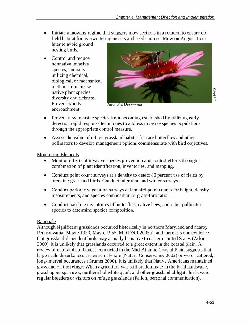
Chapter 4. Management Direction and Implementation
4-51
Initiate a mowing regime that staggers mow sections in a rotation to ensure old field habitat for overwintering insects and seed sources. Mow on August 15 or later to avoid ground nesting birds.
Control and reduce nonnative invasive species, annually utilizing chemical, biological, or mechanical methods to increase native plant species diversity and richness. Prevent woody encroachment.
Prevent new invasive species from becoming established by utilizing early detection rapid response techniques to address invasive species populations through the appropriate control measure.
Assess the value of refuge grassland habitat for rare butterflies and other pollinators to develop management options commensurate with bird objectives.
Monitoring Elements
Monitor effects of invasive species prevention and control efforts through a combination of plant identification, inventories, and mapping.
Conduct point count surveys at a density to detect 80 percent use of fields by breeding grassland birds. Conduct migration and winter surveys.
Conduct periodic vegetation surveys at landbird point counts for height, density measurements, and species composition or grass-forb ratio.
Conduct baseline inventories of butterflies, native bees, and other pollinator species to determine species composition.
Rationale Although significant grasslands occurred historically in northern Maryland and nearby Pennsylvania (Mayre 1920, Mayre 1955, MD DNR 2005a), and there is some evidence that grassland-dependent birds may actually be native to eastern United States (Askins 2000), it is unlikely that grasslands occurred to a great extent in the coastal plain. A review of natural disturbances conducted in the Mid-Atlantic Coastal Plain suggests that large-scale disturbances are extremely rare (Nature Conservancy 2002) or were scattered, long-interval occurances (Grumet 2000). It is unlikely that Native Americans maintained grassland on the refuge. When agriculture was still predominate in the local landscape, grasshopper sparrows, northern bobwhite quail, and other grassland obligate birds were regular breeders or visitors on refuge grasslands (Fallon, personal communication).
Juvenal’s Duskywing
US
FWS

Patuxent Research Refuge Comprehensive Conservation Plan
4-52
The refuge’s current grasslands consist of 95 parcels totaling 515 to 535 acres (208 to 217 hectares) of mowed agricultural fields and abandoned military ranges/administrative areas that would become forested habitat, if not mowed. Only 6 mowed fields are greater than 25 acres (10 hectares), and 49 parcels are less than 5 acres. Twenty-five acres is the minimum size recommended for nesting obligate grassland birds, such as the grasshopper sparrow, an area- and configuration-sensitive species that requires parcels large enough to accommodate a nesting population with 2 to 4 acres per pair, well away from forest edges, and dominated by short stature bunch grasses with minimal shrubby invasion (Vickery 1996, Watts et al. 1997, Jones and Vickery 1999, Schroeder and Askerooth 1999, Vickery et al.1999, Watts 1999, Watts 2000). Many of the smaller fields on the refuge are linear in shape, greatly reducing their value to breeding obligate grasslands birds because of the increased edge-to-interior ratio, which is the length of the edge of a patch divided by the area of the patch (Helzer and Jelenski 1999, Bakker et al. 2002). Linear or small patches have higher edge to interior ratios, which makes the interior more accessible to predators, invasive plants, woody encroachment and thus diminishes its quality as a breeding habitat. Block or circular shapes, with less than 1,640 feet of edge per 2.5 acres provides more interior that is distant from edges (Maryland PIF1997, Watts 2000). An ideal patch of grassland would be ample enough to accommodate a buffer zone of approximately 300 feet (91 meters) around the edge and provide an effective interior for the target species’ nesting territories. Vickery et al. (1999) recommends conserving patches of 250 acres or more to benefit more area sensitive species, and Watts et al. (1997) determined that patches less than 25 acres (10 hectares) are better suited for shrub-dependent birds. The small, linear grassland parcels also increase forest hard edge, reduce the value of adjacent forests to forest dwelling birds by fragmenting the forest. Small openings in proximity to forest are valuable for whip-poor-will, woodcock, bats, and box turtles, and for wintering or migrating birds and pollinators. We used the above metrics for patch size, configuration, and minimal forest fragmentation as part of a decision tool to determine where to focus grassland management for the future. Other factors we took into consideration include the soil type (capacity for drainage) and the orientation of a field to sunlight. Because agricultural land uses in the vicinity of the refuge have increasingly converted to development and related infrastructure or to forested habitats; grassland obligate species, such as grasshopper sparrow, that require large blocks of short-stature grasslands situated where agriculture predominates on a regional scale (mirroring the ‘prairie’ setting), have all but disappeared from refuge grasslands. The refuge’s grassland habitat will benefit breeding species that are more tolerant of old field succession, such as field sparrow, yellow-breasted chat, indigo bunting, eastern kingbird, orchard oriole, blue grosbeak, and non-migratory northern bobwhite and wild turkey, and migratory wintering bird species such as savannah sparrow, swamp sparrow, American woodcock, and short-term migratory visitors such as bobolink. Some bird species listed as species of greatest conservation need in the Maryland Wildlife Diversity Conservation Plan or as priority bird species in the BCR 30 and PIF 44 implementation plans may occur in small numbers but specific, intensive surveys to detect these species suites have been limited in recent decades.

Chapter 4. Management Direction and Implementation
4-53
Goal 5: Provide high-quality recreation, environmental education, and interpretive programs to enhance refuge visitors’ understanding and appreciation of fish and wildlife conservation. Objective 5.1 Wildlife Observation and Photography Provide high-quality opportunities for wildlife observation and photography on the refuge by expanding facilities. Strategies
Maintain observation towers and areas, trails (25 miles/40 kilometers), wildlife drive, viewing blinds, and wildlife and nature photo gallery.
Create two additional trails at North Tract (Telegraph Road 2.5 miles/ 4km and Vernal Pool Trail 1.25 miles/ 2km).
Create opportunities for photo exhibits with local photo clubs.
Construct new observation tower at the wildlife viewing area on the North Tract and remove existing tower.
Designate and develop an additional outdoor nature exploration area for visitors on the South Tract.
Monitoring Elements
Complete annual evaluation that summarizes wildlife observation and photography opportunities provided on the refuge (number of opportunities, events) and document their utilization (number of visits, type of activity, and number of participants engaged).
Solicit informal participant feedback and take note of repeat visitors. Rationale Wildlife observation and photography are two of the six priority public uses required by the Refuge Improvement Act to receive enhanced consideration on refuges. The refuge provides opportunities to view and photograph wildlife in natural settings on trails and at overlooks (map 3-5). The refuge has historically been a popular birding site and has been recognized as an Important Bird Area by the National Audubon Society. The refuge is a stopover point for migratory waterfowl and attracts hundreds of thousands of birds during migration. The refuge’s diverse habitat also attracts songbirds, shorebirds, raptors, marsh birds, reptiles, amphibians, mammals, and insects. Providing a high-quality wildlife observation and photography on the refuge promotes visitor appreciation and support for refuge programs. According to Service policy (605 FW 4 and 5; USFWS 2011), the guiding principles for these two programs include:
Provide safe, enjoyable, and accessible wildlife viewing opportunities and facilities.
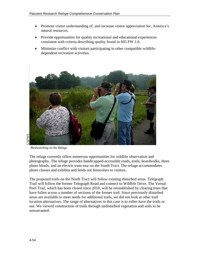
Patuxent Research Refuge Comprehensive Conservation Plan
4-54
Promote visitor understanding of, and increase visitor appreciation for, America’s natural resources.
Provide opportunities for quality recreational and educational experiences consistent with criteria describing quality found in 605 FW 1.6.
Minimize conflict with visitors participating in other compatible wildlife-dependent recreation activities.
The refuge currently offers numerous opportunities for wildlife observation and photography. The refuge provides handicapped-accessible roads, trails, boardwalks, three photo blinds, and an electric tram tour on the South Tract. The refuge accommodates photo classes and exhibits and lends out binoculars to visitors. The proposed trails on the North Tract will follow existing disturbed areas. Telegraph Trail will follow the former Telegraph Road and connect to Wildlife Drive. The Vernal Pool Trail, which has been closed since 2010, will be reestablished by clearing trees that have fallen across a number of sections of the former trail. Since previously disturbed areas are available to meet needs for additional trails, we did not look at other trail location alternatives. The range of alternatives in this case is to either have the trails or not. We viewed construction of trails through undisturbed vegetation and soils to be unwarranted.
Birdwatching on the Refuge
US
FWS

Chapter 4. Management Direction and Implementation
4-55
Objective 5.2 Interpretation Promote a stewardship ethic and instill a sense of wonder and appreciation of natural resources, wildlife, and research in visitors by providing engaging interpretive programs and activities for visitors of all abilities, ages, and community groups. Strategies
Continue to offer a variety of seasonally related monthly interpretive programs year-round by reservation. These programs are offered free of charge with the exception of tram tours or when otherwise stated. (The refuge offered 353 interpretive programs with 9,761 total participants in fiscal year 2010 – this total includes tram tours.)
Continue to offer interpreter-led tram tours from mid-March through mid-November, with increased hours of operation during the summer months.
Continue to charge a nominal fee for tram tours for the general public tours; reserved tours can be arranged for a group fee and accommodate schools and other organized groups. Tram tours operated by the Friends of Patuxent.
Continue to utilize outreach tools to enhance visitation and participation at interpretive programs and special events.
Continue to offer current opportunities for interpretive programs, updating them as demand dictates.
Continue to maintain and utilize outdoor exploration areas, such as schoolyard habitat.
Continue to offer major special events (seven offered in fiscal year 2010).
Continue to offer summer series of five to six multi-day youth camps, including one-week day camp for underserved youth.
Continue to offer periodic, guided tours to the Central Tract and the Whooping Crane Observatory.
Increase the quality and diversity of interpretive monthly program opportunities by developing four to six new or revised interpretive programs every 2 years.
Create and offer limited historical/interpretive guided tours on the Central and North Tracts.
Promote more hands-on, physically active outdoor activities. Monitoring Elements
Complete an annual evaluation that summarizes interpretive opportunities provided both on and offsite (number of opportunities and events) and document their utilization (number of visits, type of activity, and number of participants engaged).
Solicit informal participant feedback and take note of repeat visitors.

Patuxent Research Refuge Comprehensive Conservation Plan
4-56
Rationale The Refuge Improvement Act identifies environmental interpretation as one of the six priority public uses. Environmental interpretation includes activities, talks, publications, events, programs, audio-visual media, signs, and exhibits that convey key messages about natural and cultural resources to visitors, but that do not address a specific educational curriculum requirement. It provides opportunities for visitors to make their own connections to nature and wildlife, which invites participation in resource stewardship and helps refuge visitors understand their relationships to, and impacts on, those resources. Interpretation has been identified as an area of emphasis for the refuge. Interpretation of natural resources creates an opportunity to connect the hearts and minds of visitors with places, objects, and resources that refuges strive to protect. Interpretive programs provide visitors with intellectual and emotional opportunities to connect with natural and cultural resources. Interpretive programs at the refuge include, but are not limited to, interactive tram tours, monthly interpretive programs, special events, publications, audio-visual media, signs, and exhibits. Through participation in the refuge’s interpretive programs, we hope that visitors will understand their relationships to and impacts on our natural resources, and will join us as stewards of the land. Objective 5.3 Environmental Education Promote a stewardship ethic through environmental education with students, teachers, scout leaders, and organized community groups to understand and appreciate ecological relationships and the role of refuges Nationwide, and to understand the role of Patuxent Research Refuge. Strategies
Continue to offer naturalist-led and self-guided programs for school and scout groups year-round.
Continue to offer teacher workshops year-round, designed to meet Maryland State outcomes and with opportunities for Maryland State Department of Education credits.
Continue to accommodate requests from neighboring school communities and other organizations to participate in onsite environmental education program.
Continue to offer current environmental education opportunities both onsite and offsite (approximately ten per year offsite).
Continue to maintain and utilize outdoor exploration areas such as schoolyard habitat.
Continue to provide workshop opportunities for scouts and scout leaders to meet advancement requirements.
Continue to provide scout program links to scout leaders.

Chapter 4. Management Direction and Implementation
4-57
Continue to support Federal Junior Duck Stamp Program administered by the MD DNR.
Offer a schoolyard habitat-related teacher workshop series in accordance with local and State education standards.
Increase refuge staff/volunteer involvement by 10 percent over 15 years by providing offsite conservation-related programs to local schools with emphasis on Jr. Duck Stamp curricula.
Increase refuge staff/volunteer led scout workshop opportunities by 10 percent over 15 years.
Incorporate additional climate change and research related information into workshops/programs particularly by partnering with other educational facilities/programs.
Explore grant and sponsorship opportunities for transportation to public programs (with focus on transportation for underserved audiences).
Increase number of visiting school groups by 10 percent over 15 years.
Increase number of teacher workshops offered by 20 percent over 15 years.
Expand teacher workshop programs and curricula in accordance with Washington, DC and Virginia learning outcomes.
Explore credit opportunities for Washington, DC and Virginia schools. Monitoring Elements
Complete annual evaluation that summarizes environmental education opportunities provided both on and offsite (number of opportunities and events) and document their utilization (number of visits, type of activity, and number of participants engaged).
Solicit informal participant feedback and take note of repeat visitors. Rationale The Refuge Improvement Act also identifies environmental education as a priority public use on refuges. Environmental education teaches students the history and importance of conservation and ecological principles, and scientific knowledge of our nation’s natural resources. In doing so, we can help develop a citizen base that has the awareness, knowledge, attitudes, skills, motivation, and commitment to work cooperatively toward the conservation of our Nation’s environmental resources. Environmental education has been identified as an area of emphasis for the refuge. As one of the largest science and environmental education centers in DOI, NWVC offers unique educational opportunities for school groups, scouts, youth groups, etc. NWVC exhibits are designed to provide visitors with greater knowledge and appreciation of the environmental problems affecting our planet and the role wildlife research plays in

Patuxent Research Refuge Comprehensive Conservation Plan
4-58
preserving the earth’s natural resources. The environmental education program is also designed with that thought in mind. Programs strive to instill a general appreciation and understanding of natural resources and environmental concepts, with the ultimate goal of environmental stewardship. By using both indoor and outdoor resources, the environmental education team is able to provide opportunities and curriculum designed to meet the needs of the diverse ethnic and multi-cultural youth population that visit the refuge. Objective 5.4 Non-wildlife-dependent Public Uses Support non-wildlife-dependent uses when deemed to be an appropriate use and compatible with the refuge purpose and mission of the Refuge System. Strategies
Continue to allow jogging on North and South Tracts.
Continue to allow bicycling on the North Tract.
Continue to allow cross-country skiing on North and South Tracts.
Continue to allow hiking on North and South Tracts.
Continue to allow dog walking with current stipulations on North and South Tracts.
Continue to allow search and rescue training via special use permit on the North and South Tracts.
Continue to provide primitive camping opportunities for scout and 4H groups on the North Tract pursuant to Nationwide memoranda of agreement with those organizations.
Continue to allow limited dog training in designated areas on the North Tract.
Continue to allow horseback riding at the North Tract.
Allow limited virtual and no-impact geocaching along designated trails at the North and South Tracts.
Allow waterfowl related dog training with hunting permit in designated areas at North Tract (Cattail Pond and New Marsh), while prohibiting all dog training that is not hunting related.
Discontinue maintenance and use of softball fields Monitoring Elements
Continue to track other visitor uses through Visitor Contact Station check-in/access pass.
Solicit informal participant feedback and take note of repeat visitors.

Chapter 4. Management Direction and Implementation
4-59
Rationale The refuge manages firing range and softball field use through special use permits in which the daily oversight and maintenance is delegated to National Security Agency for the ranges and the Civilian Welfare Fund for the softball fields. Due to these agreements, no additional staff or costs are incurred by the refuge. We propose to continue to allow jogging, bicycling, cross-country skiing, horseback riding, and dog walking to provide compatible recreational opportunities for visitors to enjoy the refuge and to gain a better understanding and appreciation for fish and wildlife, ecology and the relationships of plant and animal populations within various ecosystems, wildlife management, the refuge, and the Refuge System. Although these uses are not priority public uses, they do support wildlife observation which is a priority public use. Goal 6: Provide high-quality hunting and fishing experiences for hunters and anglers. Objective 6.1 Hunting Provide robust and diverse, quality hunting opportunities to hunters of all ages while promoting hunter and visitor safety and wildlife health, and accommodating other public use opportunities.
Strategies Continue to provide hunting opportunities for upland game, migratory game birds,
and white-tailed deer from September through January, and select days in April and May for wild turkey hunt (Obrecht 1992).
Within 3 years, complete a new refuge hunt plan along with any necessary associated NEPA compliance.
Assess effectiveness of quality deer management for hunting and maintaining healthy deer populations and revise regulations as needed.
Area X on the North Tract is currently open with a 50-yard (150-foot) buffer and the wildlife viewing area is currently open except during firearms season. Close Area X on the North Tract to hunting every other week and allow wildlife observation and photography on Forest Trail at those times.
Increase specialty hunts/organized hunts for youth and persons with disabilities.
Assess effectiveness of quality deer management for hunting and maintaining healthy deer populations and revise regulations as needed.
Monitoring Elements Complete annual evaluation that summarizes hunting opportunities (types of
hunts and seasons) and documents their utilization (number of visits, type of activity, and number of participants engaged).
Compile and analyze harvest data to document trends in use and variations in hunt seasons, and to better understand impacts to wildlife and habitats.

Patuxent Research Refuge Comprehensive Conservation Plan
4-60
Solicit informal participant feedback and take note of repeat visitors. Rationale Hunting is one of the six priority public uses required by the Refuge Improvement Act to receive enhanced consideration on refuges. Hunting is a popular and traditional activity in the area and a management tool to keep wildlife populations at healthy numbers to maintain healthy habitats. Hunting can instill a unique understanding and appreciation of wildlife, their behavior, and their habitat needs. Providing a high-quality hunt on the refuge promotes visitor appreciation and support for refuge programs. The Service defines a quality hunting experience as one that achieves the following (605 FW 2; USFWS 2011):
Manage wildlife populations consistent with the Refuge System, specific management plans approved after 1997, and to the extent practicable, State fish and wildlife conservation plans.
Promote visitor understanding of, and increase visitor appreciation for, America’s natural resources.
Provide opportunities for quality recreation and interpretive experiences consistent with criteria describing quality found in 605 FW 1.6 (USFWS 2011).
Encourage participation in hunting to help preserve it as a tradition deeply rooted in America’s natural heritage and conservation history.
Minimize conflicts with visitors participating in other compatible wildlife-dependent recreational activities.
Hunting on the refuge is guided by hunting guidelines that are updated annually. The hunt program is administered in conjunction with MNHA. Guidelines are jointly reviewed annually by MNHA and refuge staff, and clarified as needed. Hunting is typically permitted only during established Maryland hunting seasons (typically September through January). Current hunting includes opportunities for upland game, waterfowl, and white-tailed deer (bow, muzzleloader, and shotgun).
The majority of the hunting occurs on North Tract. MNHA conducts daily hunt control operations, including permit sales, daily sign-ins, and harvest recording. The majority of North Tract will remain closed to general public use during firearms and shotgun seasons. There are also hunting opportunities on the South U
SFW
S
North Tract Hunter Contact Station

Chapter 4. Management Direction and Implementation
4-61
Tract for white-tailed deer and lottery style hunt opportunities on the Central Tract for white-tailed deer. The refuge’s hunt program has the distinction of being one of the largest Federal public use hunting programs in terms of season length, variety of hunts, and numbers of hunters use days. Objective 6.2 Fishing Provide additional fishing opportunities to anglers of all ages while promoting angler and visitor safety, and wildlife health. Strategies
Continue to provide year-round fishing opportunities at North Tract, which includes Lake Allen, New Marsh, Cattail Pond, Rieve’s Pond, Bailey Bridge Marsh, and the Little Patuxent River areas.
Continue to provide fishing opportunities seasonally on the South Tract at Cash Lake (June to October).
Continue to improve quality of fishing through vegetation management, which may include temporary impoundment draw-downs and herbicide treatments.
Open Blue Heron Pond to fishing access via hiking and biking. Allow vehicular access to Blue Heron Pond for visitors with impaired mobility.
Expand calendar days for fishing on the South Tract at Cash Lake to start in mid-March (contingent on harvest population surveys).
Expand fishing hours at North Tract (contingent on operating hours changing).
Evaluate potential new fishing areas at North Tract (upstream of Bailey Bridge and Wood duck Pond).
Assess fish populations refugewide to ensure biological integrity and health in accordance with providing a quality fishing experience.
Expand North Tract events to include youth fishing activities. Monitoring Elements
Complete annual evaluation that summarizes fishing opportunities (through seasonal permits issued and special use/group permits issued).
Collect and analyze creel reports that are voluntarily contributed by anglers.
Collect angler data through check-in and staff/volunteer observation.
Solicit informal participant feedback and take note of repeat visitors. Rationale The Refuge Improvement Act identifies fishing as one of the six priority, wildlife-dependent public uses. It states, “Compatible wildlife-dependent recreation is a legitimate and appropriate general public use of the [Refuge] System.”
Patuxent Research Refuge Comprehensive Conservation Plan
4-62
Providing high-quality fishing opportunities on the refuge promotes visitor appreciation and support for refuge programs. According to Service policy (605 FW 3; USFWS 2011), the guiding principles for our fishing program include the following:
Effectively maintain healthy and diverse fish communities and aquatic ecosystems through the use of scientific management techniques.
Promote visitor understanding of, and increase visitor appreciation for, America’s natural resources.
Provide opportunities for quality recreational and educational experiences consistent with criteria describing quality found in 605 FW 1.6 (USFWS 2011).
Encourage participation in this tradition deeply rooted in America’s natural heritage and conservation history.
Minimize conflicts with visitors participating in other compatible, wildlife-dependent recreational activities.
As with hunting, we recognize fishing as a healthy, traditional outdoor pastime. It, too, promotes public understanding and appreciation of natural resources and their management on all lands and waters in the Refuge System. The refuge provides opportunities for fishing on both the North and South Tracts. However, fishing is limited on North Tract due to closures during the hunting season and when firing ranges are active. A kids’ fishing day is offered annually on the South Tract. Kids’ fishing day allows not only for youth to experience a traditional recreational activity, but also for the public to engage with refuge staff and volunteers while participating in a priority public use. Goal 7: Enhance partnerships with local communities and various organizations to garner support and promote refuge programs and resources. Objective 7.1 Volunteer Opportunities Provide a wide variety of high-quality volunteer opportunities to support Patuxent Research Refuge and PWRC and to encourage community involvement and support of refuges and natural resources. Strategies
Continue to maintain the current volunteer program to assist the refuge in all aspects of day-to-day operations (28, 140 total volunteer hours for fiscal year 2010).
Continue to maintain quality internship program (currently 12 to 15 interns annually).
Continue to promote organized group participation (e.g., Scout groups) for one-time volunteer projects.
Continue to maintain coordination between PWRC, MNHA, and the refuge.

Chapter 4. Management Direction and Implementation
4-63
Continue to provide volunteer award and recognition programs/events.
Increase participation with youth volunteers and youth community service organizations by 10 percent over 15 years.
Accommodate two to four service-related organizations per year for work projects.
Organize/implement a refugewide project database outlining possible volunteer projects (identify seasonality of work, age appropriateness, etc.).
Better integrate volunteer opportunities with PWRC, MNHA, and Friends of Patuxent.
Encourage/recruit diverse volunteer workforce.
Increase volunteer recognition, award, social, and interactive opportunities. Monitoring Elements
Maintain volunteer hours through online program which documents volunteer activities that occurred, location, and duration.
Continue to solicit feedback from volunteers regarding refuge programs. Rationale The refuge’s volunteer program delivers a significant contribution of over 30,000 hours through the participation of 250 volunteers. The refuge’s active volunteer numbers remain fairly consistent at around 120. The volunteers help run NWVC and the Visitor Contact Station, maintain refuge grounds, and support wildlife management. On-the-job training is provided until volunteers feel comfortable operating the information desks on their own. Volunteers receive a half hour customer service training during volunteer orientation. The majority of the volunteers are age 55 or above. Internship opportunities for environmental education/interpretation and wildlife biology positions are available through the majority of the year. The volunteers sign in and out themselves and keep a log of their hours via an online program. Volunteers are recognized at an awards event and are also thanked at an annual picnic. Objective 7.2 Outreach Continue to foster community relations and recruit visitors through outreach and community involvement. Strategies
Send notices and press releases to local media and partners about upcoming events and programs.
Participate with an information table and/or activities at community events such as Bowiefest, Montpelier festivals, and others.
Participate in events/programs of neighboring county conference and visitors’ bureaus.

Patuxent Research Refuge Comprehensive Conservation Plan
4-64
Participate in tourism and educational events of the Maryland Tourism Council.
Participate in meetings/events of local chambers of commerce.
Participate in events/promotions sponsored by the Maryland Tourism industry, such as the annual calendar of events, marketing opportunities, etc.
Participate in events/promotions of other community organizations, such as the Prince George’s History Consortium, Anacostia Trails Heritage Area, etc.
Allow above partners to utilize meeting space for events/meetings.
Continue to publicize NWVC through rack card distribution service to motels and attractions.
Continue to fund attraction signs on nearby highways (through the State Highway Administration).
Continue to maintain and update the Web site.
Encourage Friends and staff to utilize social media to publicize refuge events and programs.
Continue to maintain email listserv (3,828 members in 2010).
Increase outreach referenced above by at least ten percent per category.
Reactivate speakers’ bureau.
Investigate highway radio announcement opportunities (on special frequency).
Reorganize refuge Web site to make site more user-friendly and be in accordance with Service guidelines.
Increase media partner mailings and communications for events and develop target mailing lists for events.
Actively participate in social media. Monitoring Elements
Track number of outreach contacts.
Solicit informal feedback from partners. Rationale Outreach is two-way communication between the Service and the public to establish mutual understanding, promote involvement, and influence attitudes and actions, with the goal of improving joint stewardship of our natural resources. Outreach includes, but is not limited to:

Chapter 4. Management Direction and Implementation
4-65
Congressional relations
Corporate relations
News media relations
Relations with constituent groups
Community relations
State and local government relations
Relations with State wildlife agencies
Environmental education and interpretive activities
Public involvement
Traditional public information such as speeches, open houses, etc.
Information products, such as brochures, leaflets, exhibits, slide shows, videos, public service announcements, etc. U
SFW
S