mangrove damage, delayed mortality, and early recovery ...€¦ · basins). major historical...
TRANSCRIPT

SPECIAL ISSUE: IMPACT OF 2017 HURRICANES
Mangrove Damage, Delayed Mortality, and Early Recovery FollowingHurricane Irma at Two Landfall Sites in Southwest Florida, USA
Kara R. Radabaugh1& Ryan P. Moyer1 & Amanda R. Chappel1 & Emma E. Dontis1 & Christine E. Russo1
&
Kristen M. Joyse2& Melissa W. Bownik3 & Audrey H. Goeckner3,4 & Nicole S. Khan5
Received: 14 January 2019 /Revised: 3 April 2019 /Accepted: 9 April 2019# Coastal and Estuarine Research Federation 2019
AbstractMangrove forests along the coastlines of the tropical and sub-tropical western Atlantic are intermittently impacted by hurricanesand can be damaged by high-speed winds, high-energy storm surges, and storm surge sediment deposits that suffocate tree roots.This study quantified trends in damage, delayed mortality, and early signs of below- and aboveground recovery in mangroveforests in the Lower Florida Keys and Ten Thousand Islands following direct hits by Hurricane Irma in September 2017.Mangrove trees suffered 19% mortality at sites in the Lower Florida Keys and 11% in the Ten Thousand Islands 2–3 monthspost-storm; 9 months post-storm, mortality in these locations increased to 36% and 20%, respectively. Delayed mortality ofmangrove trees was associated with the presence of a carbonate mud storm surge deposit on the forest floor. Mortality and severebranch damage were more common for mangrove trees than for mangrove saplings. Canopy coverage increased from 40% cover1–2 months post-storm to 60% cover 3–6 months post-storm. Canopy coverage remained the same 9 months post-storm,providing light to an understory of predominantly Rhizophora mangle (red mangrove) seedlings. Soil shear strength was higherin the Lower Florida Keys and varied with depth; no significant trends were found in shear strength between fringe or basin plots.Rates of root growth, as assessed using root in-growth bags, were relatively low at 0.01–11.0 g m−2 month−1 and were higher inthe Ten Thousand Islands. This study demonstrated that significant delayed mangrove mortality can occur 3–9 months after ahurricane has passed, with some mortality attributable to smothering by storm surge deposits.
Keywords Hurricane .Mangrove . Storm deposit . Shear strength . Root growth
Introduction
Mangrove forests grow along coastal zones with temperate totropical climates, and many of these areas are subject to peri-odic damage caused by tropical cyclone winds and stormsurges (Sippo et al. 2018; Simard et al. 2019). These severeecosystem disturbances can defoliate the canopy, snapbranches and trunks, damage bark, and uproot trees, resultingin the destruction of the predominant canopy in a mangroveforest (Everham and Brokaw 1996; Zhang et al. 2008; SmithIII et al. 2009; Villamayor et al. 2016; Han et al. 2018). Theextent of major damage to the canopy, but not necessarily totalmortality, is largely dependent on wind speed, gustiness, andwind direction (Everham and Brokaw 1996; Han et al. 2018;Imbert 2018). The degree of damage during a tropical cycloneand subsequent recovery of mangrove forests vary widely byspecies (Roth 1992; Baldwin et al. 1995, 2001; Imbert et al.1996; McCoy et al. 1996; Feller et al. 2015; Villamayor et al.2016; Imbert 2018), hydrogeomorphic forest type (Craighead
Communicated by Dan Friess
* Kara R. [email protected]
1 Florida Fish and Wildlife Conservation Commission, Fish andWildlife Research Institute, 100 Eighth Avenue Southeast, SaintPetersburg, FL 33701, USA
2 Department of Earth and Planetary Sciences, Rutgers University, 610Taylor Road, Piscataway, NJ 08854, USA
3 University of South Florida, 4202 East Fowler Ave,Tampa, FL 33620, USA
4 Gulf Coast Research and Education Center, University of Florida,14625 County Road 672, Wimauma, FL 33598, USA
5 Asian School of the Environment, Nanyang TechnologicalUniversity, 50 Nanyang Avenue, N1.3 B1-15, Singapore 639798,Singapore
Estuaries and Coastshttps://doi.org/10.1007/s12237-019-00564-8
and Gilbert 1962; Cahoon et al. 2003; Smith III et al. 2009;Han et al. 2018; Imbert 2018), forest age structure (Smith IIIet al. 1994; Sherman et al. 2001; Villamayor et al. 2016), andthickness of deposits left by the storm surge (Craighead andGilbert 1962; Risi et al. 1995; Ellison 1998).
Mangroves exhibit species-specific responses to the dam-age caused by tropical cyclones. Species in the generaAvicennia and Laguncularia grow epicormic sprouts in re-sponse to canopy damage and therefore tend to have lowermortality following storm damage (Tomlinson 1980; Baldwinet al. 1995, 2001; Imbert et al. 1996; McCoy et al. 1996;Imbert 2018). Species belonging to the genus Rhizophora donot exhibit epicormic growth following tropical cyclone dam-age because they lack viable dormant buds in mature trunksand branches and are thus highly susceptible to mortality post-cyclone (Tomlinson 1980; Baldwin et al. 1995, 2001; Imbertet al. 1996; Villamayor et al. 2016; Imbert 2018). However,Rhizophora mangle (red mangrove) seedlings in Florida andthe Caribbean are often present in relatively high densities inthe forest understory and therefore poised for rapid growthwhen gaps are created by canopy disturbance (Walker et al.1991; Everham and Brokaw 1996; Baldwin et al. 2001; Rosset al. 2006; Imbert 2018).
Storm surges have varying impacts on mangrove forests.Powerful wave energy can erode the shoreline or uproot trees,yet submergence by storm surge can protect smaller saplingsagainst defoliation by high-speed winds (Smith III et al.1994). Allochthonous sediment, composed of a mixture ofgrain sizes (sand–mud) and mineral compositions (carbonateand siliciclastic), is carried in by storm surges and depositedon the forest floor as the water recedes (Risi et al. 1995). Thesestorm deposits are important contributors of nutrient resourcesand substrate elevation in mangrove forests (Castañeda-Moyaet al. 2010), which can help forests keep pace with sea-levelrise (Krauss et al. 2014; Breithaupt et al. 2017). However,thick storm deposits can also be detrimental to the mangrovetrees themselves as these sediments can interfere with the gasexchange of roots and soil, smother roots, and result in de-layed tree mortality (Craighead and Gilbert 1962; Ellison1998). Silt and clay deposits result in higher mortality com-pared with sand, presumably because soil aeration declineswith decreasing grain size (Ellison 1998). Stagnant water,which may occur following a tropical cyclone due to alteredhydrology, can similarly interfere with gas exchange, smotherroots, and cause delayed mortality (Allingham and Neil 1996;Lewis III et al. 2016). Thus, initial estimates of tree mortalityoften underestimate the full impact of a storm event becausemangrove trees that initially survive the storm may later diefrom lack of oxygen uptake by their roots (Craighead andGilbert 1962).
Forests can follow four recovery trajectories followinga severe wind event: regrowth (surviving trees begin togrow again) , recrui tment (new growth of ear ly
successional species), release (rapid growth of the existingunderstory), or repression (invasion of herbaceous plants)(Everham and Brokaw 1996). With the exception of pos-sible adjacent salt marshes, mangrove forests generallylack herbaceous plants or early successional species; thus,they primarily recover following the trajectories of re-growth or release. Florida and Caribbean mangrove for-ests have low species diversity and are dominated by onlythree mangrove species: R. mangle, Avicennia germinans(black mangrove), and Laguncularia racemosa (whitemangrove); however, recovery into a comparable man-grove forest is not guaranteed (Craighead 1971; SmithIII et al. 1994; Imbert et al. 1996; Baldwin et al. 2001).Species composition of recovering mangrove forests maytherefore largely depend upon the Breleased^ growth ofthe understory, including small, yet established, saplingsgrowing in canopy gaps prior to the tropical cyclone(Smith III et al. 1994) as well as seedlings that survivethe storm (Baldwin et al. 2001).
The objective of this study was to quantify trends in dam-age, delayed mortality, and below- and aboveground signs ofrecovery of mangrove forests following direct hits byHurricane Irma in the Lower Florida Keys and TenThousand Islands. While numerous studies have examinedmangrove forest damage and recovery following tropical cy-clones, this study adds to a small body of literature quantifyingthe degree of delayed mortality that can occur in the monthsfollowing a major storm (Smith III et al. 1994; Sherman et al.2001; Barr et al. 2012), particularly when associated withstorm surge deposits (Craighead and Gilbert 1962; Ellison1998; Smith III et al. 2009).
Methods
Study Sites
Study sites in the Lower Florida Keys (Fig. 1a) werelocated on uninhabited mangrove islands within theGreat White Heron National Wildlife Refuge. The sub-strate on these mangrove islands included a layer of man-grove peat mixed with calcareous mud on a bedrock ofMiami limestone (Ross et al. 1992). The fringes of themangrove forests were dominated by R. mangle, withscattered A. germinans and L. racemosa intermixed withR. mangle in the forest basins. Study sites were tall man-grove forests with the exception of the forest basins atUpper Saddlebunch Key and Mud Key, which containedsmaller scrub mangroves.
Located on the coast of Collier County, the Ten ThousandIslands region is largely undeveloped with the exception ofMarco Island (Fig. 1b). The coast is protected by an assort-ment of public lands, including the Rookery Bay Aquatic
Estuaries and Coasts

Preserve, Rookery Bay National Estuarine Research Reserve,Cape Romano-Ten Thousand Islands Aquatic Preserve, TenThousand Islands National Wildlife Refuge, and EvergladesNational Park. The many coastal islands which give the TenThousand Islands its name originated as reefs of oysters andvermetid gastropods, which were later colonized by man-groves (Shier 1969). The substrate of mangrove forests locat-ed in southwest Florida consists of a layer of mangrove peaton top of shell hash, quartz sand, and limestone. Species com-position at the Ten Thousand Islands sites was similar to thatof the Lower Florida Keys, with R. mangle dominating thefringe, and A. germinans and L. racemosa intermixed withR. mangle in forest basins.
Both the Florida Keys and southwest Florida frequent-ly experience powerful tropical cyclones (referred to asBhurricanes^ in the western North Atlantic and sub-basins). Major historical hurricanes include the 1935
Labor Day hurricane, a category 5 on the Saffir–Simpson hurricane wind scale that crossed the LowerFlorida Keys and traveled up the west coast of Florida.Hurricane Donna also crossed the Keys as a category 4hurricane in 1960 and made landfall on southwestFlorida (Craighead and Gilbert 1962; NOAA 2019).Hurricane Andrew made landfall in 1992 in southeastFlorida as a category 5 hurricane and crossed over tosouthwest Florida as a category 4 (NOAA 2019).Hurricane Wilma made landfall in 2005 near MarcoIsland and the Ten Thousand Islands as a category 3hurricane (NOAA 2019). Many of the mangrove forestsin south Florida are second-growth forests as a result ofthe loss of large, mature mangroves due to these repeti-tive hurricanes (Craighead and Gilbert 1962; Smith IIIet al. 1994; McCoy et al. 1996; Zhang et al. 2008; Hanet al. 2018; Sippo et al. 2018).
Fig. 1 Study sites, mangroveextent (FNAI and FWC 2016),and path of Hurricane Irma(NOAA 2017) as it made landfallas a category 4 hurricane in theLower Florida Keys (a) and acategory 3 hurricane in the TenThousand Islands (b) in the stateof Florida, USA (inset panels).The nine study sites included 18fringe or basin plots (see Table 1)
Estuaries and Coasts

Hurricane Irma
Hurricane Irma originated on the west coast of Africa on 27August 2017. It grew into a category 5 hurricane as it crossedthe Atlantic Ocean and, at its most intense, had a maximumwind speed of 287 km h−1 (Cangialosi et al. 2018). Irma in-termittently weakened as it passed over the Caribbean islandsand was particularly weakened by Cuba, but it strengthenedback into a category 4 storm over the warm waters of theFlorida Straits (Cangialosi et al. 2018; Wachnicka et al., inreview). Irma made landfall at Cudjoe Key in the LowerFlorida Keys (Fig. 1a) on the morning of 10 September2017 with maximum winds of 213 km h−1. Combined stormsurge and tide resulted in maximum inundation levels of 1.5–2.4 m for the Lower Florida Keys. The highest recorded high-water mark was surveyed at 1.66 m above ground level(2.05 m NAVD88/2.07 m mean higher high water(MHHW); Cangialosi et al. 2018).
Within five hours, Irma weakened to a category 3 hur-ricane and made landfall in southwest Florida near MarcoIsland in the afternoon of the same day (Fig. 1b).Maximum wind speeds were 185 km h−1 (Cangialosiet al. 2018). Strong offshore winds initially blew wateraway from the shore and caused water levels to drop to1.46 m below MHHW. Following landfall, inundation insouthwest Florida was 1.8–3.0 m above ground levelwithin Everglades National Park and the Ten ThousandIslands National Wildlife Refuge. A storm tide sensor inEverglades City recorded a water level of 2.53 m(NAVD88/2.29 m MHHW). Irma moved north-northwestacross southwest Florida but weakened quickly to a cate-gory 2 hurricane as it passed by Naples and Fort Myersand became a category 1 hurricane as the center of thestorm passed between Tampa and Orlando. The hurricanebrought heavy rainfall, with 25–38 cm precipitation re-corded in the Keys and peninsular Florida (Cangialosiet al. 2018).
The eye of Hurricane Irma was 28–37 km in diameterhours prior to landfall in the Florida Keys (NWS 2017a,b). The center of Hurricane Irma’s path was within20.5 km of the Lower Florida Keys sites in this studyand within 19.3 km of the Ten Thousand Islands sites.Most Lower Florida Keys sites, with the exception ofMud Key, were within the eyewall of Hurricane Irmaand were likely subjected to maximum wind speeds fromthe hurricane (Willoughby and Rahn 2004; Zhang et al.2008). The exact eyewall diameter prior to making land-fall in the Ten Thousand Islands was not similarly report-ed, but given the tendency for larger eyewall diameters instorms of decreasing intensity (Willoughby and Rahn2004; Zhang et al. 2008), it is likely that all sites in theTen Thousand Islands also experienced the maximumwind speeds of the eyewall.
Sampling Design
A total of 18 permanent monitoring plots (10 × 10 m) werecreated following the hurricane to monitor above- and below-ground indicators of mangrove mortality and early recovery.Plots were placed adjacent to previously established stratigra-phy transects in both fringe and basin mangrove forests. Thisprevious stratigraphy study did not focus on vegetation char-acteristics; therefore, pre-storm data are not available for com-parison. Fringe plots were placed approximately 15 m fromthe water’s edge and basin plots were located 50–100 m fromthe water’s edge adjacent to the transect in the basin forest.
Eleven monitoring plots were established on five islands inthe Lower Florida Keys. These included one basin and onefringe plot at Lower Snipe Key, Mud Key, and UpperSaddlebunch Key (Fig. 1a). Two fringe plots were establishedonWaltz Key (no basin plot due to the lack of a basin forest onthe narrow island). Three plots were established on MiddleSnipe Key (two fringe and one basin) due to widely variablehurricane damage on either side of the island. Lower FloridaKeys vegetation monitoring was conducted in November2017, March 2018, and June 2018 (2, 6, and 9 months post-storm).
Seven monitoring plots were established at four study sitesin the Ten Thousand Islands (Fig. 1b). One basin and onefringe plot were established at Fakahatchee Bay and theFaka Union Canal. Blackwater Bay included a fringe plot ona small overwash island and a basin plot on a nearby largerisland. Cat’s Claw Basin included only a basin plot, as therewas no fringe forest due to a pre-existing overwash berm. TenThousand Islands vegetation monitoring was conducted inOctober 2017 (tree height and canopy measurements only),December 2017, January 2018, and June 2018 (1, 3, 4, and9 months post-storm).
Field Monitoring
The 10 × 10-m monitoring plots were outlined with a transecttape; trees at the four corners of the plot were flagged to enableplot identification during follow-upmonitoring. Canopy coverwas determined using a convex spherical densiometer (ForestDensiometers, Rapid City, SD) at the four corners of the plot.Tree height was calculated for ten canopy trees or saplingswithin or near the plot using a tape measure and clinometer(Suunto, Vantaa, Finland).
Mangroves were classified as trees if the stem diameter at130 cm above the ground (D130) exceeded 5 cm. Remainingmangroves were classified as saplings (D130 < 5 cm andheight ≥ 1 m) or seedlings (height < 1 m). Mangrove species,D130, and status were recorded for all trees in the 10 × 10-mplots. Status included the condition (live, recently dead, ordecayed) and state of the trunk and branches using categoriesderived from Baldwin et al. (1995). Trees, saplings, and
Estuaries and Coasts

seedlings were classified as Blive^ if they had any green fo-liage (including epicormic growth); dead mangroves had nolive foliage. Trunk damage categories included: snap (trunkbroken above ground level), tip-up (roots pulled up), lean (<45° from vertical, natural growth patterns excluded), severelean (> 45° from vertical, natural growth patterns excluded),or no impact (Baldwin et al. 1995). Branch damage was clas-sified as low, moderate, or severe. If trees had multiple trunksthat diverged below 130 cm, each trunk was treated as anindividual tree and separate measurements were made. Treeswere measured during November/December 2017 andJune 2018 monitoring.
Within each 10 × 10-m plot, a nested 5 × 5-m subplot wascreated in the corner that was most representative of the plot asa whole for sapling and seedling distribution. The same sub-plot was monitored in each follow-up survey. For all saplingswithin the 5 × 5-m subplot, the species, condition, trunk status,and branch status were determined following the same cate-gories as trees. The total numbers of live and dead mangroveseedlings were recorded, as well as approximate percent spe-cies composition. The tree, sapling, and seedling surveys thatwere conducted during the initial monitoring (2–3 monthspost-storm) are assumed to account for all mangroves thatwere present prior to the storm.
Percent cover of downed wood was estimated using apoint-transect method. A 10-m transect was extended in fiverandom compass headings from the center of the 10 × 10-mplot. The type of substrate or organic material (including re-cent or decayed wood debris) was recorded every meter,resulting in a survey of 50 points within and around the plot.
A shear vane kit was used to determine soil shear strength (theamount of torque required to shear or break apart soil; Poulos1981). A 5-cm shear vane attached to a direct-reading torquegauge (H-4227, Humboldt Manufacturing, Elgin, IL) was usedto measure soil strength in five haphazard locations within the10 × 10-m plot. At each location, soil strength was measured atthe surface and at depths of 25 cm and 50 cm. Measurementswere taken by inserting the shear vane into the soil to the desireddepth, twisting the vane until soil failure, and reading the torquegauge. Calibration for the friction of the rod without the shearvane was conducted once per site for the 25- and 50-cm depths.
Carbonate mud thickness was measured during each mon-itoring visit by removing a sediment sample with a thin gougeauger or knife in 2–3 locations, either along the adjacent stra-tigraphy transect or directly outside the vegetation plots. Thecarbonate mud thickness exhibited wide variability both with-in plots and among sites; in addition, mud thicknesses wereobserved to change in the same location on repeated visits.However, the range of the mud thicknesses at each of the plotscould consistently be generalized into three arbitrary catego-ries: minimal to none (no visible deposit or only a veneer <2 mm in thickness), moderate (0.2–1-cm deposit), or thick (1–9-cm deposit).
To estimate belowground root production, pairs of root in-growth bags were installed adjacent to permanent monitoringplots. Cylindrical root bags (30 cm height × 5 cm diameter)were constructed from nylon mesh (with expandable 3-mm2
apertures) sewn with nylon upholstery thread. Root bags werefilled with sphagnum peat moss (Lambert Canadian peatmoss, Québec, Canada) that had been passed through a 5-mm sieve. The use of root-free soil allows for any root growthwithin the root bag to be considered new production (Symbulaand Day Jr. 1988; Sánchez 2005). To deploy root bags, aBRussian-type^ half cylinder peat corer (Eijkelkamp USA,Morrisville, NC) was used to remove a volume of sedimentthat matched root bag dimensions. Bags were inserted in thehole and held in place with surveyor flags. After retrieval, itwas determined that root bags were compressed to an averagelength of 24 cmwhen they were inserted into the ground. Rootbags were deployed in November 2017 and retrieved inMarch 2018 at the Lower Florida Keys sites (4-month incu-bation time); bags were deployed in December 2017 and re-trieved in June 2018 at the Ten Thousand Island sites (6-month incubation). Bags were extracted by carefully cuttinga wide-diameter circle around the root bag with a hand saw.The root bag was then removed from the ground using ashovel with surrounding soil intact, then carefully separatedfrom the soil using scissors to trim penetrating roots. Rootbags were refrigerated upon return to the lab until analyzed.
Laboratory Analysis of Root Bags
Root material and peat were trimmed from the outside of theroot bags. Peat was removed from the root bag in subsections,and roots were extracted from the soil with forceps and placedin water to rinse them free of soil and test for flotation (McKee2001). New root growth was identified by their light color,smooth texture, turgid or elastic structure, or ability to float(Symbula and Day Jr. 1988; McKee 2001; Sánchez 2005).Once all visible roots were removed, the remaining peat wasplaced in a 2-mm sieve and rinsed to identify additional roots.Floating roots were removed from the sieve catch pan.Cleaned roots were placed in a pre-weighed petri dish andexamined under a microscope to verify all roots were newgrowth rather than peat moss material. Roots were placed inthe drying oven at 60 °C until they no longer lost water weight(1–5 days), then weighed to determine dry mass.
Data Analysis
Statistical analyses were conducted using Version 7.15 of theSAS System for Windows (Copyright © 2017, SAS InstituteInc., Cary, NC, USA); a p value less than or equal to an alphaof 0.05 was considered significant. Data were examined fornormality using a combination of Shapiro–Wilk tests, proba-bility plots, and quantile plots. Non-normal datasets were
Estuaries and Coasts

transformed or assessed with non-parametric analyses. A two-tailed t test was used to compare tree height across the tworegions. Linear regression analyses were used to examine therelationship between woody debris and tree height. Pearson’sChi-Square tests were used to assess branch damage and mor-tality distributions between trees vs. saplings and among treesin various diameter categories. The Likelihood Ratio Chi-Square test was used instead of the Pearson’s Chi-Square ifover 50% of the categorical cells had frequency counts lessthan five.
Multilevel-mixed models with type II hypotheses wereused to analyze the impacts of the region, forest type (fringevs. basin), and storm deposit category on initial tree mortalityand delayed tree mortality. The proportion of trees killed wastransformed via an arcsine transformation; changes in mortal-ity data over time were not transformed. Basal area, treeheight, the proportion of trees with severe branch damage(arcsine transformed), and seedling density were comparedacross the sediment deposition categories using Fisher’s clas-sic one-way ANOVA. A Kruskal-Wallis test was used to as-sess delayed mortality in saplings across storm deposit cate-gories. Multilevel-mixed models with type II hypotheses wereused to analyze the impacts of the region, forest type, moni-toring round, soil depth, and/or storm deposit category on soilshear strength and root growth rates, which were both log-transformed (log10). Pearson’s correlation coefficient wasused to assess the relationship between root growth rate andmangrove height as well as percent species composition (arc-sine transformed). Regional data parameters are generallydepicted separately if there were significant regional differ-ences and together if there were no significant differences.
Results
Damage was extensive in the monitored mangrove sites inboth the Lower Florida Keys and the Ten Thousand Islands(Fig. 2, Table 1), although the severity of damage and depthsof storm deposits varied greatly among islands as well asacross plots on the same island. In the Lower Florida Keys,12% of trees snapped, while 4% exhibited a lean or tip-up2 months post-storm. Tree impacts were similar in the TenThousand Islands (14% snapped, 3% lean or tip-up). Manyof the trees that initially survived, including some with exten-sive epicormic growth, died in the months following the hur-ricane. Unless otherwise noted, all mortality metrics refer torecent mortality (presumably due to the hurricane or its after-effects) and exclude decaying trees. Two months afterHurricane Irma, average tree mortality in the Lower FloridaKeys was 18.6% (range 0–75% mortality across plots);9 months post-storm, tree mortality increased to 36.6% (13–100% range; Table 1). Three months following the storm,average tree mortality in the Ten Thousand Islands was
11.2% (0–35% range); 9 months post-storm, tree mortalityincreased to 19.8% (6–35% range; Table 1). This equates toa loss of 40.8% of basal area in the Lower Florida Keys and17.5% in the Ten Thousand Islands 9 months after the storm.There were no significant differences in initial tree mortalitybetween the two regions, nor between the fringe and basinsites (Table 2). A total of 493 trees were measured 2–3 months post-storm, and 416 trees were measured 9 monthspost-storm. Variability in tree number was due to loss of trees(only standing trees measured), growth of saplings, and sam-pling variability when extending transect tapes to outline plotsduring repeated monitoring efforts.
Extensive epicormic growth was noted on A. germinansand L. racemosa trees across both regions (Fig. 2). Canopycoverage was near 40% 1–2 months after the storm, thenincreased and plateaued at approximately 60% 3–6 monthspost-storm (Fig. 3). Mangroves were significantly taller atsites in the Ten Thousand Islands than the Lower FloridaKeys (t2 test value = 3.18, p = 0.006, df = 16). Average treeheight ranged from 1.5–8.5 m at sites in the Lower FloridaKeys and 5.4–10.6 m at sites in the Ten Thousand Islands(Table 1). Percent cover of new woody debris on the forestfloor had a significant positive relationship with tree height(Fig. 4); this relationship was not significant for decayedwoody debris (linear regression R2 = 0.129, slope p = 0.144,n = 18).
Forests were dominated by R. mangle and by trees with aD130 less than 10 cm (Fig. 5a). While most sites were domi-nated by trees, two basin sites (Upper Saddlebunch Key andMud Key) were dominated by scrub mangroves ≤ 2.2 m inheight. The proportion of severe branch damage among stand-ing trees was not evenly distributed among size classes, andtrees with a D130 ≤ 10 cm had less branch damage than wouldbe expected by chance (Fig. 5b; Likelihood Ratio χ2 (10, n =327) = 36.3, p < 0.0001). Initial mortality (2–3 months post-storm) was evenly distributed among the size classes (Fig. 5c;Likelihood Ratio χ2 (5, n = 327) = 0.986, p = 0.964).Mortality continued to increase several months following thestorm (Fig. 5c). Although smaller tree classes (5–10 cm) hadlower mortality, the mortality distribution was not significant-ly different among size classes in June 2018, 9 months post-storm (Fig. 5c; Likelihood Ratio χ2 (5, n = 309) = 5.710, p =0.336). In the initial monitoring surveys 2–3 months post-storm, mortality was significantly higher for trees comparedwith saplings (Pearson’s χ2 (1, n = 673) = 9.33, p = 0.002).Severe branch damage was also significantly higher for trees(Pearson’s χ2 (2, n = 673) = 172.8, p < 0.0001); 50% of stand-ing trees had severe branch damage compared with 10% ofsaplings.
The storm surge deposited a layer of marine carbonate mudof varying thickness at most of the sites (Table 1, Fig. 2b). Thefringe plot on Mud Key had a drastically different substratethan the other plots (substrate was eroding and composed of
Estuaries and Coasts

an overwash berm of coral fragments and loose carbonatesand, with no visible peat or mud storm deposit) and thuswas excluded frommud storm deposit analyses. The thicknessof the carbonate mud storm deposit was examined to deter-mine its impact on delayed mangrove mortality (defined hereas an increase in percent tree mortality from November/December 2017 to June 2018). Although storm deposit depthhad no significant influence on the initial mortality of thetrees, it was significantly related to delayed tree mortality(Table 2, Fig. 6a). There were no significant differences inbasal area, tree height, or proportion of trees with severebranch damage among the plots in the three storm depositcategories (ANOVA p values > 0.05). The saplings did nothave a significant trend in delayed mortality with relation tostorm deposit categories (Fig. 6b; Kruskal–Wallis χ2 (2) =5.5840, p = 0.061). Seedling density also did not vary signif-icantly between the storm deposit categories during any mon-itoring effort (ANOVA p values > 0.05).
Average soil shear strength was 24.7 ± 10.2 kPa in theLower Florida Keys and 16.9 ± 3.8 kPa in the TenThousand Islands. Region and soil depth had a significanteffect on soil shear strength (Table 3, Fig. 7a), although foresttype (fringe vs. basin) had no significant effect. Subterraneanroots grew at an average rate of 0.16 g m−2 month−1 in theLower Florida Keys (range 0.01–0.45 g m−2 month−1), and
4.37gm−2month−1 in theTenThousand Islands (range0.76–11.02 gm−2month−1). Root growth rates varied significantlyby region, but not by forest type or by storm deposit depth(Table 3, Fig. 7b). There were no significant correlationsbetween root growth rate and mangrove height (Pearson’scorrelation coefficient = 0.45, p = 0.090, n = 15), nor be-tween root growth rate and abundance of the threemangrovespecies (Pearson’s correlation p values > 0.05, n = 14).
Discussion
Trends in Initial Damage and Delayed Mortality
Larger trees are often more susceptible to damage than smallertrees during wind events (Roth 1992; Doyle et al. 1995;Imbert et al. 1996; Kovacs et al. 2001; Feller et al. 2015;Villamayor et al. 2016), although some studies have foundthat mangrove trees in the largest diameter classes have highersurvival than moderately sized trees (Smith III et al. 1994;McCoy et al. 1996). This study found that trees with a D130
from 5 to 10 cm suffered less severe branch damage thanlarger trees, and saplings (D130 < 5 cm) had lower rates ofmortality and severe branch damage than trees. The degreeof extensive branch damage in trees likely contributed to
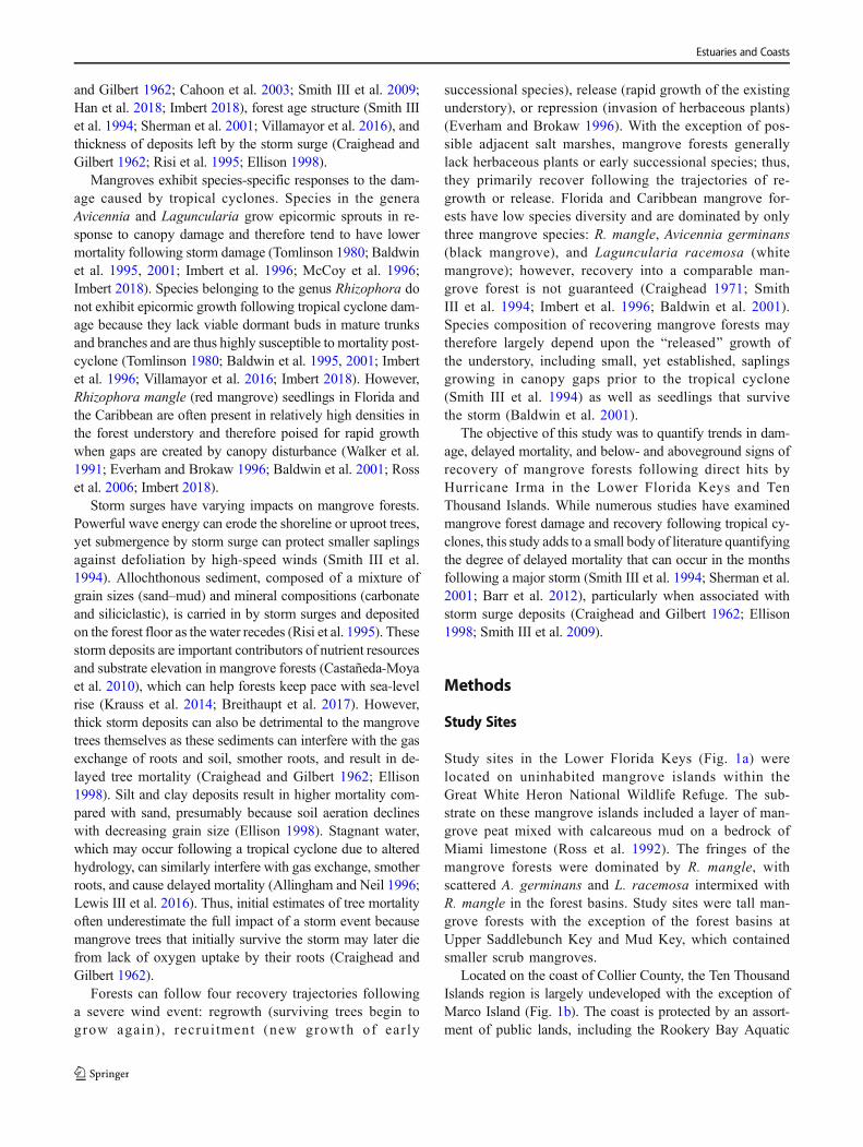
Fig. 2 Example of a heavily damaged forest onWaltz Key in the Lower Florida Keys, 6 months post-storm (a), carbonate mud storm surge deposit (b),and Avicennia germinans epicormic growth at Fakahatchee Bay in the Ten Thousand Islands, 9 months post-storm (c)
Estuaries and Coasts

Table1
Summaryof
18vegetatio
nplots.Dataarereported
asaveragevalues
foreach
plot,±
SDifapplicable,asdeterm
ined
from
monito
ring
datainJune
2018
(9monthspost-storm
).Treemortalityis
presum
ably
attributableto
thehurricaneor
itsaftereffects(decayingtreesareexcluded)
Location
Latitu
deand
longitu
deFo
rest
type
Carbonatemud
storm
deposit1
Mangrove
height
(m)
Soilstrength
(kPa,25
cmdepth)
%tree
mortality
Rootg
rowth
rate4
(gm
−2month−1)
%canopy
coverage
Low
erFlorida
Keys
Upper
Saddlebunch
Key
24.65060
–81.59628
Basin
Minim
alto
none
1.5±0.2
15.8
±13.2
N/A
30.40
±0.50
24±25
Upper
Saddlebunch
Key
24.64996
–81.59640
Fringe
Minim
alto
none
3.7±0.6
66.4
±10.8
13.3
0.01
±0.00
93±7
Low
erSnipe
Key
24.66221
–81.61012
Basin
Thick
8.5±3.2
11.4
±7.7
54.8
0.04
±0.04
75±8
Low
erSnipe
Key
24.66247
–81.60942
Fringe
Moderate
6.4±1.1
14.8
±8.3
26.9
0.32
±0.01
76±16
Mud
Key
24.67688
–81.70148
Basin
Moderate
2.2±0.3
26.4
±13.7
20.0
0.01
±0.01
48±16
Mud
Key
24.67726
–81.70131
Fringe
N/A
26.1±0.9
41.2
±24.8
16.0
N/A
42±24
MiddleSnipe
Key
24.67851
–81.65391
Basin
Thick
7.8±3.1
43.4
±7.3
56.5
N/A
81±23
MiddleSnipe
Key
24.67903
–81.65326
Fringe
Moderate
5.7±1.0
20±13.4
25.0
0.13
±0.01
44±20
MiddleSnipe
Key
24.67766
–81.65486
Fringe
Thick
5.8±0.9
20.6
±13.9
100.0
0.03
±0.01
22±12
WaltzKey
24.64777
–81.65367
Fringe
Moderate
5.5±1.4
17.2
±13.9
22.6
0.45
±0.60
90±7
WaltzKey
24.64764
–81.65342
Fringe
Thick
7.8±1.2
15.8
±12.3
30.3
0.08
±0.07
42±26
TenThousandIslands
Blackwater
Bay
25.92503
–81.60809
Fringe
Thick
8.1±2.0
11.2
±8.5
35.0
0.76
±0.87
32±7
Blackwater
Bay
25.92356
–81.61274
Basin
Thick
5.4±1.7
23.2
±7.2
10.5
3.14
±3.14
70±17
Cat’sClawBasin
26.02173
–81.73376
Basin
Minim
alto
none
8.6±2.5
29.6
±9.3
6.1
11.0±12.6
77±10
FakahatcheeBay
25.88797
–81.50747
Fringe
Minim
alto
none
9.0±2.1
27.4
±11.1
31.3
2.68
±3.43
48±17
FakahatcheeBay
25.88798
–81.50507
Basin
Moderate
9.6±1.1
28.0
±18.2
13.2
0.80
±0.30
62±8
Faka
Union
Canal
25.90194
–81.51102
Fringe
Minim
alto
none
10.6
±2.7
18.2
±5.6
22.7
N/A
73±10
Faka
Union
Canal
25.90186
–81.51057
Basin
Thick
9.9±3.3
13.4
±7.1
19.6
7.84
±2.91
52±13
1Minim
alto
none
(0–0.2cm
),moderate(0.2–1
cm),or
thick(1–9
cm)
2Overw
ashof
coraland
othercarbonatefragments
3Scrubmangrovesite,notrees(D
130>5cm
)presentinplot
4Rootin-grow
thbags
incubatedfor4monthsin
theLow
erFloridaKeysand6monthsin
TenThousandIslands.Not
allp
lotsincluded
root
in-growth
bags
Estuaries and Coasts

delayed mortality (Fig. 5c). Bruising and damage to the vas-cular system, defoliation, and loss of branches can all causestress and eventual mortality to trees months after a severewind event (Craighead and Gilbert 1962; Shaw 1983;Everham and Brokaw 1996). Large trees can shield understo-ry trees from the strongest winds and protect them from dam-age (Imbert et al. 1996; Zhang et al. 2008). Trees with smallerstem sizes (and smaller canopy) are alsomore likely to bend inthe wind rather than break (Cremer et al. 1982; Doyle et al.1995; Everham and Brokaw 1996; Swiadek 1997). The fre-quency of tropical cyclones has also been found to be one ofthe factors limiting mangrove growth and contributing toglobal trends in mangrove canopy height (Simard et al. 2019).
Although the degree of branch damage was greater in larg-er trees (Fig. 5b), this study did not find a significant trend inmortality across tree size classes (Fig. 5c). This may be attrib-utable to the relatively small size of the mangrove forests inthis study (Simard et al. 2019). Average mangrove heightacross the plots ranged from 1.5–10.6 m (Table 1), and themajority of trees within these plots had stem diameters <10 cm (Fig. 5a). The two basin plots in our study (UpperSaddlebunch Key and Mud Key) that were dominated byscrub mangroves with average heights < 2.2 m had low man-grove mortality and low branch damage, similar to previousstudies which have found that the low stature of scrub man-groves helps to protect the vegetation from wind exposure(Smith III et al. 1994; Doyle et al. 2009). Small mangrovesnear the shore may also have been partially submerged bystorm surge and protected from wind damage during the hur-ricane (Smith III et al. 1994).
If large trees topple during a storm, they can cause indirectdamage by falling on adjacent trees and crushing the under-story. The direction of treefall can provide an indication of thewind direction and thus time during the hurricane when themajority of the damage occurred (Doyle et al. 1995, 2009;Everham and Brokaw 1996). Assessment of treefall directionwas initially attempted in this study, but the severity of dam-age and occurrence of treefall due to secondary damage
hindered accurate directional determination. It was also notpossible to gauge the severity of damage with respect to dis-tance from the hurricane eyewall (Smith III et al. 1994;Milbrandt et al. 2006) as nearly all sites were within theeyewall radius of Hurricane Irma.
Trees in this study also suffered delayed mortality as aresult of the smothering of their root system by the carbonatemud storm deposit (Fig. 6a). Mortality of Avicennia spp. canoccur when their pneumatophores are partially or entirely cov-ered by sediment (Allingham and Neil 1996; Lee et al. 1996;Ellison 1998). While Rhizophora spp. have extensive aerialprop roots that extend high above the surface of the soil, thelenticels (respiratory pores) on these roots are clustered inhighest densities near the soil surface (Gill and Tomlinson1977). Thus, excess sedimentation, including storm surge de-position, can also cause mortality in the Rhizophora genuswhen these lenticels are buried (Terrados et al. 1997; Ellison1998). The thickness of the storm deposit did not have a sig-nificant impact on delayed mortality in saplings (Fig. 6b). Thismay be the result of the growth of seedlings into saplingsduring the duration of the study, adding to the pool of saplings.Saplings also had less branch damage than trees and thereforedid not have to copewith asmany compounding stress factors.The impacted sites may continue to see delayed mortality forseveral years, as mortality in Florida mangroves has beenfound to increase for up to 3 years following a hurricane(Barr et al. 2012).
Soil Strength and Root Growth
Although Cahoon et al. (2003) noted significantly higher soilshear strength in fringe mangroves compared with basin for-ests, this study did not find any significant differences byforest type (Fig. 7a, Table 3). However, the four greatest shearstrengths observed at any of the sites were at Lower FloridaKeys fringe forests. The lack of a significant difference be-tween fringe and basin forests may, in part, be due to theconfounding influence of soft surficial storm deposits. These
Table 2 Effects of region (Lower Florida Keys or Ten ThousandIslands), forest type (fringe or basin), and storm deposit category(minimal to none 0–0.2 cm, moderate 0.2–1 cm, or thick 1–9 cm) on
initial tree mortality (proportion of trees initially killed 2–3 monthspost-storm) and delayed tree mortality (percent increase in mortality from2 to 3 months post-storm to 9 months post-storm)
Effect Initial tree mortality Delayed tree mortality
df F p df F p
Region 1,6 0.07 0.804 1,6 8.48 0.027
Forest type 1,6 0.53 0.495 1,6 0.01 0.929
Storm deposit 2,6 0.02 0.977 2,6 11.66 0.009
Region × forest type 1,6 0.25 0.637 1,6 8.73 0.026
Forest type × storm deposit 2,6 0.38 0.699 2,6 0.76 0.509
Region × storm deposit 2,6 2.06 0.209 2,6 1.56 0.285
Estuaries and Coasts

surface values should not be considered representative ofmangrove peat due to the presence of these soft storm de-posits. Soil shear strength varied with depth (Table 3). Mostsites had lower shear strength at 50-cm depth; this presumablyreflects the contribution of root density to soil strength, asmost mangrove roots are found in the top 30 cm of soil(Komiyama et al. 2000).
Root growth rates in this study varied from 0.01–11.0 g m−2 month−1, with an average of 0.16 g m−2 month−1
in the Lower Florida Keys and 4.37 g m−2 month−1 in the TenThousand Islands. It should be noted that root growth into rootbags may not necessarily reflect natural growth rates, becauseroot growth may increase as roots propagate into the unoccu-pied soil in the root bags or may be slower as a result ofdisturbance from the coring process necessary for bag
insertion (Vogt et al. 1998; McKee and Faulkner 2000). Thismethod does, however, allow for comparison among siteswhere similar root in-growth bag methods have been applied.The growth rates in this study are low compared with previousstudies from Florida mangroves. McKee and Faulkner (2000)found that root production in the top 30 cm of soil in
Fig. 5 Species composition of all mangrove trees (live and dead) by stemdiameter (D130) (a), live tree branch damage, as determined 2–3 monthspost-storm (b), and initial mortality and delayed mortality in the LowerFlorida Keys and Ten Thousand Islands following Hurricane Irma (c)
Fig. 4 Percent cover on the forest floor of newly felled and decayedwoody debris as a function of tree height. Data are from November andDecember 2017 in the Lower Florida Keys and Ten Thousand Islands,respectively
Fig. 3 Canopy coverage in the Lower Florida Keys and Ten ThousandIslands following Hurricane Irma. Values are means across all vegetationplots; error bars denote standard error of the mean (SEM)
Estuaries and Coasts

southwest Florida mangroves varied from 0.05–3.14 g m−2 d−1 (equivalent of 1.5–94.2 g m−2 month−1).Sánchez (2005) used similar methods in the Ten ThousandIslands region and documented rates of root growth of 106–842 g m−2 yr.−1 (8.8–70 g m−2 month−1). Cahoon et al. (2003)found that root growth rates varied from 0 to 656 g m−2 yr−1
(0–54.6 g m−2 month−1) in hurricane-impacted mangrove for-ests in Honduras; in that study, sites with the most severehurricane impacts had no root growth. The low rates of rootgrowth seen in this study were likely a consequence of bothtree mortality and reduced oxygen exchange as a result of thesurficial storm deposit. Root growth may be limited if roots donot have sufficient oxygen for respiration or if soil is exces-sively water-logged (Gregory 1987; Sorrell and Armstrong1994). This study did not find a significant difference betweenroot production at the fringe and basin forests, similar to the
findings of Cahoon et al. (2003) on root growth in hurricane-impacted mangroves. Higher root growth rates in the TenThousand Islands compared with the Lower Florida Keysmay partly be due to the longer incubation time (6 monthsvs. 4 months) as well as the fact that the incubation time inthe Ten Thousand Islands included some warmer summermonths when mangroves have the highest growth rate (Lugoand Snedaker 1974). It also may reflect lower mangrove mor-tality in the Ten Thousand Islands (20% vs. 36% mortality inthe Lower Florida Keys).
Should trends in delayed mortality and low root growthcontinue, some of the mangrove forests in this study may beat risk of peat collapse. Mangrove peat is primarily producedthrough the accumulation of subterranean roots, with smallercontributions from the deposition of aboveground biomass(McKee and Faulkner 2000; Middleton and McKee 2001;Chmura et al. 2003). Vertical accumulation of peat dependsupon the rate of peat production exceeding the rate of organicmatter decomposition (Macintyre et al. 1995; Cahoon et al.2003; McCloskey and Liu 2013). Mangrove forests with hightree mortality following a hurricane may face peat collapse asa result of compaction and continued decomposition of deadroots and organic matter without concurrent root growth(Cahoon et al. 2003; Barr et al. 2012). Barr et al. (2012) foundthat loss of elevation in a south Florida mangrove forest wasstrongly correlated with tree mortality following HurricaneWilma; forest elevation declined by more than two centime-ters over 3 years in sites with the highest rates of tree mortality.Peat collapse following hurricane-induced mortality has beenhypothesized to be the cause of elevation loss and the conver-sion of mangrove forests to mud flats in southwest Florida(Wanless et al. 1995; Swiadek 1997; Smith III et al. 2009).
Early Signs of Recovery
After an initial increase from 40% canopy cover 1–2 monthspost-storm to 60% cover 3–6 months post-storm, canopy re-growth stagnated and canopy cover failed to increase in thefollowing months (Fig. 3). For comparison, canopy coveragein an undisturbed south Florida mangrove forest is typically90–95% (Milbrandt et al. 2006). The increase and plateau ofcanopy coverage in this study reflected initial regrowth(including epicormic growth, Fig. 2), but widespread branchdamage and delayed tree mortality prevented more extensivegrowth 9 months post-storm.
Long-term recovery of the forest canopy will depend onregrowth of canopy branches as well as the Brelease^ ofestablished seedlings and saplings in the understory that growrapidly in response to increased light levels below gaps in thecanopy (Everham and Brokaw 1996; Sherman et al. 2001).Although they provide ample light, canopy gaps can alsomake survival more challenging for seedlings as they resultin low-humidity and high-temperature conditions (Smith III
Fig. 6 Tree mortality (a) and sapling mortality (b) at plots with a differingthickness of storm deposits in the Lower Florida Keys and Ten ThousandIslands following Hurricane Irma. Carbonate mud storm depositthickness classified as minimal to none (0–0.2 cm, n = 4 plots for trees,5 for saplings), moderate (0.2–1 cm, n = 5 plots), or thick (1–9 cm, n = 7plots). Error bars denote SEM
Estuaries and Coasts

et al. 1994; Swiadek 1997; Barr et al. 2012). If mortality isextensive and there are no longer livemangrove roots to aeratethe soil, this can result in decreased redox potential and in-creased sulfide concentration, which may slow recolonizationby seedlings (Smith III et al. 1994; Swiadek 1997).
The species composition of a forest following a disturbanceevent will largely depend upon the species composition of theunderstory (Everham and Brokaw 1996). The recovery ofmangrove forests is also impacted by the density and speciescomposition of available propagules, which largely depend onforest fragmentation and degree of hydrologic connectivitywith live mangrove forests (Milbrandt et al. 2006). The rela-tive abundance of the three dominant mangrove species mayshift during the recovery process as a result of variable under-story composition and propagule availability (Craighead1971; Smith III et al. 1994; Imbert et al. 1996; Baldwinet al. 2001). In this study, R. mangle dominated the exposedunderstory and comprised 90% of all seedlings. By compari-son, 79% of saplings and 75% of all live trees were R. mangle.L. racemosa seedlings require high amounts of light and thusare generally not found in great abundance in the mangroveunderstory (Wadsworth and Englerth 1959; Ball 1980).A. germinans and L. racemosa propagules mature in the latesummer and early fall (Rabinowitz 1978; Tomlinson 1994).The occurrence of a hurricane in mid-September strippedaway both leaves and propagules from the mangrove canopyand the storm surge presumably washed away unattachedpropagules. The lack of A. germinans and L. racemosa prop-agules was noted during field efforts, but not directly quanti-fied. It is possible that hurricanes, including Irma, may con-tribute to a shift in species composition toward R. mangle dueto their dominance in the understory and removal of propa-gules of other mangrove species (Swiadek 1997; Piou et al.2006). Species shifts toward Rhizophora have also been notedas a result of variable species tolerances of sediment deposits.Lee et al. (1996) found that Rhizophora spp. overtook a
Table 3 Effects of region (Lower Florida Keys or Ten ThousandIslands), forest type (fringe or basin), soil depth (0, 25, and 50 cm), andmonitoring round (2–3, 4–6, or 9 months post-storm) on soil shear
strength. Effects of region, forest type, and storm deposit category(minimal to none 0–0.2 cm, moderate 0.2–1 cm, or thick 1–9 cm) onsubterranean root growth rate
Soil shear strength Root growth rate
Effect df F p Effect df F p
Region 1,147 6.35 0.013 Region 1,5 55.23 <0.001
Forest type 1,147 0.05 0.830 Forest type 1,5 0.37 0.567
Soil depth 2,147 4.85 0.009 Storm deposit 2,5 0.74 0.521
Monitoring round 2,147 1.22 0.300 Region × forest type 1,5 0.12 0.744
Region × forest type 1,147 0.76 0.383 Forest type × storm deposit 2,5 6.37 0.042
Region × soil depth 2,147 2.86 0.061 Region × storm deposit 2,5 0.09 0.912Forest type × soil depth 2,147 0.24 0.785
Fig. 7 Soil shear strength (grand mean of all measurements) (a) andsubterranean root growth rates (b) in fringe and basin plots in theLower Florida Keys and Ten Thousand Islands. Error bars denote SEM
Estuaries and Coasts

mangrove forest of Avicennia spp. after sediment depositssmothered pneumatophores. However, other studies havefound L. racemosa experienced lower mortality than othermangrove species following a hurricane (Sherman et al.2001). Long-term monitoring of the recovery process is need-ed to determine if species composition will truly shift or ifthinning of the R. mangle understory, regrowth of establishedL. racemosa and A. germinans trees, and subsequent propa-gule dispersal during future years will be sufficient tomaintaincurrent species diversity.
In conclusion, this study has demonstrated that significantdelayed tree mortality can occur months after a hurricane haspassed. Further mortality may continue to occur as a result ofongoing root smothering by storm deposits and stress due toloss of canopy. Yet, signs of recovery were evident in theproliferation of R. mangle seedlings and partial regrowth ofthe forest canopy. Forest recovery trajectories will depend onregrowth of the surviving canopy, development of the existingunderstory, and recruitment and survival of new propagules.Not all sites may recover into a similar mangrove forest, andlocations with high tree mortality and limited root growth areat risk of peat collapse if mortality trends persist. Continuedmonitoring is necessary to determine the full impacts of thishurricane and the resulting species composition of the recov-ering forest.
Acknowledgments Field assistance and laboratory support were provid-ed by B Halavik, J Jacobs, B Rosenheim, C Schafer, JM Smoak, SSnader, J Walker, and E Wennick. Site access and research permissionwere provided by B Jessen for the Rookery Bay National EstuarineResearch Reserve, M Danaher for the Ten Thousand Islands NationalWildlife Refuge (Special Use Permit 41555-2017-R2), and K Watts forthe Florida KeysNationalWildlife Refuges Complex (Special Use Permit#FFO4RFKD-2015-020). We are grateful for assistance with study de-sign and logistical support provided by SE Engelhart, BP Horton, and ACKemp, as well as the helpful reviews and comments provided by theEstuaries and Coasts special issue editors and two anonymous reviewers.N.S.K. is supported by Singapore Ministry of Education AcademicResearch Fund Tier 2 MOE 2018-T2-1-030.
Funding Information Funding was provided through grants to RPMoyerby the National Fish & Wildlife Foundation (Grant ID: 2320.17.059025)and BP Horton by the National Science Foundation (OCE-1458903) andin-kind services by the US Geological Survey St. Petersburg Coastal andMarine Science Center.
References
Allingham, D.P., and D.T. Neil. 1996. The supratidal deposits and effectsof coral dredging on Mud Island, Moreton Bay, SoutheastQueensland. Oceanographic Literature Review 4 (43): 411.
Baldwin, A.H., W.J. Platt, K.L. Gathen, J.M. Lessmann, and T.J. Rauch.1995. Hurricane damage and regeneration in fringe mangrove for-ests of Southeast Florida, USA. Journal of Coastal Research SI(21): 169–183.
Baldwin, A., M. Egnotovich, M. Ford, and W. Platt. 2001. Regenerationin fringe mangrove forests damaged by hurricane Andrew. PlantEcology 157 (2): 151–164.
Ball, M.C. 1980. Patterns of secondary succession in a mangrove forest ofsouthern Florida. Oecologia 44 (2): 226–235.
Barr, J.G., V. Engel, T.J. Smith, and J.D. Fuentes. 2012. Hurricane dis-turbance and recovery of energy balance, CO2 fluxes and canopystructure in a mangrove forest of the Florida Everglades.Agricultural and Forest Meteorology 153: 54–66.
Breithaupt, J.L., J.M. Smoak, V.H. Rivera-Monroy, E. Castañeda-Moya,R.P. Moyer, M. Simard, and C.J. Sanders. 2017. Partitioning therelative contributions of organic matter and mineral sediment toaccretion rates in carbonate platform mangrove soils. MarineGeology 390: 170–180.
Cahoon, D.R., P. Hensel, J. Rybczyk, K.L.McKee, C.E. Proffitt, and B.C.Perez. 2003. Mass tree mortality leads to mangrove peat collapse atBay Islands, Honduras after HurricaneMitch. Journal of Ecology 91(6): 1093–1105.
Cangialosi, J.P., A.S. Latto, and R. Berg. 2018. National Hurricane CenterTropical Cyclone Report. Hurricane Irma (AL 112017) 30 August –12 September 2017. National Hurricane Center. https://www.nhc.noaa.gov/data/tcr/AL112017_Irma.pdf. Accessed 15 March 2019
Castañeda-Moya, E., R.R. Twilley, V.H. Rivera-Monroy, K. Zhang, S.E.Davis, and M. Ross. 2010. Sediment and nutrient deposition asso-ciated with Hurricane Wilma in mangroves of the Florida CoastalEverglades. Estuaries and Coasts 33 (1): 45–58.
Chmura, G.L., S.C. Anisfeld, D.R. Cahoon, and J.C. Lynch. 2003. Globalcarbon sequestration in tidal, saline wetland soils. GlobalBiogeochemical Cycles 17 (4): 22 1–12. https://doi.org/10.1029/2002GB001917.
Craighead, F.C. 1971. The trees of south florida. Vol. Vol. 1. CoralGables, FL: University of Miami Press.
Craighead, F.C., and V.C. Gilbert. 1962. The effects of Hurricane Donnaon the vegetation of southern Florida. Quarterly Journal of theFlorida Academy of Sciences 25 (1): 1–28.
Cremer, K.W., C.J. Borough, F.H. McKinnell, and P.R. Carter. 1982.Effects of stocking and thinning on wind damage in plantations.New Zealand Journal of Forestry Science 12 (2): 244–268.
Doyle, T.W., T.J. Smith III, and M.B. Robblee. 1995. Wind damageeffects of Hurricane Andrew on mangrove communities along thesouthwest coast of Florida, USA. Journal of Coastal Research SI(21): 159–168.
Doyle, T.W., K.W. Krauss, and C.J. Wells. 2009. Landscape analysis andpattern of hurricane impact and circulation on mangrove forests ofthe Everglades. Wetlands 29 (1): 44–53.
Ellison, J.C. 1998. Impacts of sediment burial on mangroves. MarinePollution Bulletin 37 (8–12): 420–426.
Everham, E.M., and N.V. Brokaw. 1996. Forest damage and recoveryfrom catastrophic wind. The Botanical Review 62 (2): 113–185.
Feller, I.C., E.M. Dangremond, D.J. Devlin, C.E. Lovelock, C.E. Proffitt,and W. Rodriguez. 2015. Nutrient enrichment intensifies hurricaneimpact in scrub mangrove ecosystems in the Indian River Lagoon,Florida, USA. Ecology 96 (11): 2960–2972.
FNAI and FWC 2016. Cooperative land cover map. Florida NaturalAreas Inventory and Florida Fish and Wildlife ConservationCommission. http://www.fnai.org/landcover.cfm . Accessed 15March 2019.
Gill, A.M., and P.B. Tomlinson. 1977. Studies on the growth of redmangrove (Rhizophora mangle L.) 4. The adult root system.Biotropica 9 (3): 145–155.
Gregory, P.J. 1987. Development and growth of root systems in plantcommunities. In Root development and function, ed. P.J. Gregoryand D.A. Rose, 147–166. Cambridge: Cambridge University Press.
Estuaries and Coasts

Han, X., L. Feng, C. Hu, and P. Kramer. 2018. Hurricane-induced chang-es in the Everglades National Park mangrove forest: Landsat obser-vations between 1985 and 2017. Journal of Geophysical Research:Biogeosciences 123 (11): 3470–3488. https://doi.org/10.1029/2018JG004501.
Imbert, D. 2018. Hurricane disturbance and forest dynamics in eastCaribbean mangroves. Ecosphere 9 (7): e02231. https://doi.org/10.1002/ecs2.2231.
Imbert, D., P. Labbe, and A. Rousteau. 1996. Hurricane damage andforest structure in Guadeloupe, French West Indies. Journal ofTropical Ecology 12 (5): 663–680.
Komiyama, A., S. Havanond, W. Srisawatt, Y. Mochida, K. Fujimoto, T.Ohnishi, S. Ishihara, and T. Miyagi. 2000. Top/root biomass ratio ofa secondary mangrove (Ceriops tagal (Perr.) CBRob.) forest. ForestEcology and Management 139 (1–3): 127–134.
Kovacs, J.M., M. Blanco-Correa, and F. Flores-Verdugo. 2001. A logisticregression model of hurricane impacts in a mangrove forest of theMexican Pacific. Journal of Coastal Research 17 (1): 30–37.
Krauss, K.W., K.L. McKee, C.E. Lovelock, D.R. Cahoon, N. Saintilan,R. Reef, and L. Chen. 2014. How mangrove forests adjust to risingsea level. New Phytologist 202 (1): 19–34.
Lee, S.K., W.H. Tan, and S. Havanond. 1996. Regeneration and coloni-sation of mangrove on clay-filled reclaimed land in Singapore.Hydrobiologia 319 (1): 23–35.
Lewis, R.R., III, E.C. Milbrandt, B. Brown, K.W. Krauss, A.S. Rovai,J.W. Beever III, and L.L. Flynn. 2016. Stress in mangrove forests:Early detection and preemptive rehabilitation are essential for futuresuccessful worldwide mangrove forest management. MarinePollution Bulletin 109 (2): 764–771.
Lugo, A.E., and S.C. Snedaker. 1974. The ecology of mangroves. AnnualReview of Ecology and Systematics 5 (1): 39–64.
Macintyre, I.G., M.M. Littler, and D.S. Littler. 1995. Holocene history ofTobacco Range, Belize, Central America. Atoll Research Bulletin430: 1–18.
McCloskey, T.A., and K.B. Liu. 2013. Sedimentary history of mangrovecays in Turneffe Islands, Belize: Evidence for sudden environmentalreversals. Journal of Coastal Research 29 (4): 971–983.
McCoy, E.D., H.R. Mushinsky, D. Johnson, and W.E. Meshaka Jr. 1996.Mangrove damage caused by Hurricane Andrew on the southwest-ern coast of Florida. Bulletin of Marine Science 59 (1): 1–8.
McKee, K.L. 2001. Root proliferation in decaying roots and old rootchannels: A nutrient conservation mechanism in oligotrophic man-grove forests? Journal of Ecology 89 (5): 876–887.
McKee, K.L., and P.L. Faulkner. 2000. Restoration of biogeochemicalfunction in mangrove forests. Restoration Ecology 8 (3): 247–259.
Middleton, B.A., and K.L. McKee. 2001. Degradation of mangrove tis-sues and implications for peat formation in Belizean island forests.Journal of Ecology 89 (5): 818–828.
Milbrandt, E.C., J.M. Greenawalt-Boswell, P.D. Sokoloff, and S.A.Bortone. 2006. Impact and response of Southwest Florida man-groves to the 2004 hurricane season. Estuaries and Coasts 29 (6):979–984.
NOAA 2017. National Hurricane Center GIS Archive - Tropical CycloneBest Track for AL112017. National Oceanic and AtmosphericAdministration. https://www.nhc.noaa.gov/gis/archive_besttrack_results.php?id=al11&year=2017&name=Hurricane. Accessed 15March 2019.
NOAA. 2019. Historical hurricane tracks. National Oceanic andAtmospheric Administration. https://coast.noaa.gov/hurricanes/ .Accessed 8 March 2019.
NWS. 2017a. Hurricane Irma Forecast/Advisory 44. Miami, FL:National Weather Service National Hurricane Center https://www.
nhc.noaa.gov/archive/2017/al11/al112017.fstadv.044.shtml ?Accessed 15 March 2019.
NWS. 2017b. Hurricane Irma Forecast/Advisory 45. National WeatherService National Hurricane Center. FL: Miami https://www.nhc.noaa.gov/archive/2017/al11/al112017.fstadv.045.shtml ? Accessed15 March 2019.
Piou, C., I.C. Feller, U. Berger, and F. Chi. 2006. Zonation patterns ofBelizean offshore mangrove forests 41 years after a catastrophichurricane. Biotropica: The Journal of Biology and Conservation38 (3): 365–374.
Poulos, S.J. 1981. The steady state of deformation. Journal ofGeotechnical and Geoenvironmental Engineering 107 (ASCE16241 Proceeding).
Rabinowitz, D. 1978. Dispersal properties of mangrove propagules.Biotropica 10 (1): 47–57.
Risi, J.A., H.R. Wanless, L.P. Tedesco, and S. Gelsanliter. 1995.Catastrophic sedimentation from Hurricane Andrew along thesouthwest Florida coast. Journal of Coastal Research SI (21): 83–102.
Ross, M.S., J.J. O’Brien, and L.J. Flynn. 1992. Ecological site classifica-tion of Florida Keys terrestrial habitats. Biotropica 24 (4): 488–502.
Ross, M.S., P.L. Ruiz, J.P. Sah, D.L. Reed, J. Walters, and J.F. Meeder.2006. Early post-hurricane stand development in fringe mangroveforests of contrasting productivity. Plant Ecology 185: 283–297.
Roth, L.C. 1992. Hurricanes and mangrove regeneration: Effects ofHurricane Joan, October 1988, on the vegetation of Isla delVenado, Bluefields, Nicaragua. Biotropica 24 (3): 375–384.
Sánchez, B.G. 2005. Belowground productivity of mangrove forests insouthwest Florida. PhD Dissertation, Louisiana StateUniversity. https://digitalcommons.lsu.edu/gradschool_dissertations/1652.
Shaw, W.B. 1983. Tropical cyclones: Determinants of pattern and struc-ture in New Zealand’s indigenous forests. Pacific Science 37: 405–414.
Sherman, R.E., T.J. Fahey, and P. Martinez. 2001. Hurricane impacts on amangrove forest in the Dominican Republic: Damage patterns andearly recovery. Biotropica 33 (3): 393–408.
Shier, D.E. 1969. Vermetid reefs and coastal development in the TenThousand Islands, southwest Florida. Geological Society ofAmerica Bulletin 80 (3): 485–508.
Simard, M., L. Fatoyinbo, C. Smetanka, V.H. Rivera-Monroy, E.Castañeda-Moya, N. Thomas, and T. Van der Stocken. 2019.Mangrove canopy height globally related to precipitation, tempera-ture and cyclone frequency. Nature Geoscience 12: 40–45. https://doi.org/10.1038/s41561-018-0279-1.
Sippo, J.Z., C.E. Lovelock, I.R. Santos, C.J. Sanders, and D.T. Maher.2018. Mangrove mortality in a changing climate: An overview.Estuarine, Coastal and Shelf Science 215: 241–249. https://doi.org/10.1016/j.ecss.2018.10.011.
Smith, T.J., III, M.B. Robblee, H.R. Wanless, and T.W. Doyle. 1994.Mangroves, hurricanes, and lightning strikes. BioScience 44 (4):256–262.
Smith, T.J., III, G.H. Anderson, K. Balentine, G. Tiling, G.A. Ward, andK.R. Whelan. 2009. Cumulative impacts of hurricanes on Floridamangrove ecosystems: Sediment deposition, storm surges and veg-etation. Wetlands 29 (1): 24–34.
Sorrell, B.K., and W. Armstrong. 1994. On the difficulties of measuringoxygen release by root systems of wetland plants. Journal ofEcology 82 (1): 177–183.
Swiadek, J.W. 1997. The impacts of Hurricane Andrew on mangrovecoasts in southern Florida: A review. Journal of Coastal Research13 (1): 242–245.
Estuaries and Coasts

Symbula, M., and F.P. Day Jr. 1988. Evaluation of two methods forestimating belowground production in a freshwater swamp forest.American Midland Naturalist 120 (2): 405–415.
Terrados, J., U. Thampanya, N. Srichai, P. Kheowvongsri, O. Geertz-Hansen, S. Boromthanarath, N. Panapitukkul, and C.M. Duarte.1997. The effect of increased sediment accretion on the survivaland growth of Rhizophora apiculate seedlings. Estuarine, Coastaland Shelf Science 45 (5): 697–701.
Tomlinson, P.B. 1980. The biology of trees native to tropical Florida.Allston, Massachusetts: Harvard University Printing Office.
Tomlinson, P.B. 1994. The botany of mangroves. Cambridge: Universityof Cambridge Press.
Villamayor, B.M.R., R.N. Rollon, M.S. Samson, G.M.G. Albano, andJ.H. Primavera. 2016. Impact of Haiyan on Phillipine mangroves:Implications to the fate of the widespread monospecific Rhizophoraplantations against strong typhoons.Ocean & Coastal Management132: 1–14. https://doi.org/10.1016/j.ocecoaman.2016.07.011.
Vogt, K.A., D.J. Vogt, and J. Bloomfield. 1998. Analysis of some directand indirect methods for estimating root biomass and production offorests at an ecosystem level. Plant and Soil 200: 71–89.
Wadsworth, F.H., and G.H. Englerth. 1959. Effects of the 1956 hurricaneon forests in Puerto Rico. Caribbean Forester 20: 38–51.
Walker, L.R., D.J. Lodge, and R.B. Waide. 1991. An introduction tohurricanes in the Caribbean. Biotropica 23 (4): 313–316.
Wanless, H.R., L.P. Tedesco, J.A. Risi, B.G. Bischof, and S. Gelsanliter.1995. The role of storm processes on the growth and evolution ofcoastal and shallow marine sedimentary environments in SouthFlorida. Pre-Congress Field Trip Guidebook. The 1st SEPMCongress on Sedimentary Geology, August 13–16, 1995, St. PeteBeach, Florida, USA. Society for Sedimentary Geology, St.Petersburg, Florida, USA.
Willoughby, H.E., andM.E. Rahn. 2004. Parametric representation of theprimary hurricane vortex. Part I: Observations and evaluation of theHolland (1980) model. Monthly Weather Review 132 (12): 3033–3048.
Zhang, K., M. Simard, M. Ross, V.H. Rivera-Monroy, P. Houle, P. Ruiz,R.R. Twilley, and K. Whelan. 2008. Airborne laser scanning quan-tification of disturbances from hurricanes and lightning strikes tomangrove forests in Everglades National Park, USA. Sensors 8(4): 2262–2292.
Estuaries and Coasts