manual on coordination between air traffic services ... · air traffic services, aeronautical...
TRANSCRIPT


�������

Doc 9377 AN/915
Manual on Coordination between Air Traffic Services, Aeronautical Information Services and Aeronautical Meteorological Services
________________________________
Approved by the Secretary Generaland published under his authority Sixth Edition — 2014
International Civil Aviation Organization

Published in separate English, French, Russian and Spanish editions by the INTERNATIONAL CIVIL AVIATION ORGANIZATION 999 University Street, Montréal, Quebec, Canada H3C 5H7 For ordering information and for a complete listing of sales agents and booksellers, please go to the ICAO website at www.icao.int Fourth edition 2008 Fifth edition 2010 Sixth edition 2014 Doc 9377, Manual on Coordination between Air Traffic Services, Aeronautical Information Services and Aeronautical Meteorological Services Order Number: 9377 ISBN 978-92-9249-698-2 © ICAO 2014 All rights reserved. No part of this publication may be reproduced, stored in a retrieval system or transmitted in any form or by any means, without prior permission in writing from the International Civil Aviation Organization.

(iii)
AMENDMENTS
Amendments are announced in the supplements to the Publications Catalogue; the Catalogue and its supplements are available on the ICAO website at www.icao.int. The space below is provided to keep a record of such amendments.
RECORD OF AMENDMENTS AND CORRIGENDA
AMENDMENTS CORRIGENDA
No. Date Entered by No. Date Entered by


(v)
TABLE OF CONTENTS
Page Glossary ........................................................................................................................................................... (vii) Chapter 1. Introduction ................................................................................................................................ 1-1 Chapter 2. Air traffic and meteorological services organizations ............................................................ 2-1 2.1 Units providing air traffic and search and rescue services ................................................................ 2-1 2.2 Centres, offices and stations providing meteorological information to aeronautical users, including ATS units and search and rescue services centres ........................ 2-2 2.3 Links between ATS units, RCCs/RSCs and aerodrome meteorological offices, meteorological watch offices (MWOs) and aeronautical meteorological stations .............................. 2-5 Chapter 3. Meteorological information for ATS and search and rescue services units ......................... 3-1 3.1 Introduction ....................................................................................................................................... 3-1 3.2 Displays/instruments in ATS units .................................................................................................... 3-1 3.3 Information for TWRs and ATS units providing approach control service ......................................... 3-2 3.4 Information for ACCs or FICs ............................................................................................................ 3-3 3.5 Information for ATS units providing service for low-level flights ........................................................ 3-6 3.6 Information for air-ground control radio stations, VOLMET broadcasts and uplink of OPMET data to aircraft in flight ..................................................................................................... 3-8 3.7 Information for RCCs and RSCs ....................................................................................................... 3-9 3.8 Format of information ........................................................................................................................ 3-9 3.9 Emergencies ..................................................................................................................................... 3-10 3.10 Communication between ATS units and meteorological centres, offices and stations ..................... 3-10 Chapter 4. Meteorological information received by ATS units from sources other than the associated meteorological offices and stations ........................................................................ 4-1 4.1 Observing and reporting of meteorological information by ATS units ............................................... 4-1 4.2 Reports of aircraft observations received in ATS units ..................................................................... 4-1 Chapter 5. Coordination between ATS units and meteorological offices and stations ......................... 5-1 5.1 General ............................................................................................................................................. 5-1 5.2 Coordination between TWRs and APPs and their associated meteorological offices and stations ........................................................................................................................... 5-4 5.3 Coordination between ACCs/FICs and the associated MWOs ......................................................... 5-6 Chapter 6. Coordination between aeronautical information services and aeronautical meteorological services ........................................................................................................ 6-1

Manual on Coordination between Air Traffic Services, (vi) Aeronautical Information Services and Aeronautical Meteorological Services
Page
Chapter 7. Meteorological support to the ATM system ............................................................................. 7-1 7.1 Introduction ....................................................................................................................................... 7-1 7.2 Overview of the MET information required under the ATM operational concept ............................... 7-1 7.3 Meteorological support to international air navigation in accordance with the Global Plan ................................................................................................................................. 7- Appendix 1. Standard radiotelephony phraseologies to be used in VOLMET broadcasts ....................................................................................................................................................... A1-1 Appendix 2. Sample letter of agreement between the ATS and meteorological authorities ........................................................................................................................................................ A2-1 Appendix 3. Information on the meteorological authority and meteorological services to be included in the aeronautical information publication (AIP) ................................................ A3-1 Appendix 4. Procedures used in France to provide meteorological service to ATS units .......................................................................................................................................................... A4-1 Appendix 5. Procedures used in the United States to provide meteorological service to ATS units ........................................................................................................................................ A5-1
______________________

___________________
* Abbreviations not included in the Procedures for Air Navigation Services — ICAO Abbreviations and Codes (PANS-ABC, Doc 8400).
(vii)
GLOSSARY
A ACARS Aircraft communication addressing and reporting system ACC Area control centre or area control ADS Automatic dependent surveillance AFTN Aeronautical fixed telecommunication network AIC Aeronautical information circular AIP Aeronautical information publication AIRAC Aeronautical information regulation and control AIREP Air-report (routine or special) AIRMET Information concerning en-route weather phenomena which may affect the safety of low-level
aircraft operations AIS Aeronautical information services AMBEX* Africa-Indian Ocean Region MET Bulletin Exchange (Scheme) AMD Amend or amended (used to indicate amended meteorological message; message type
designator) AMDAR* Aircraft meteorological data relay (system) (WMO) APP Approach control unit ASHTAM Special series NOTAM notifying, by means of a specific format, change in activity of a volcano, a
volcanic eruption and/or volcanic ash cloud that is of significance to aircraft operations ATFM Air traffic flow management ATFMC* Air traffic flow management centre ATIS Automatic terminal information service ATM Air traffic management ATS Air traffic services C CB Cumulonimbus CNS Communications, navigation and surveillance CPDLC Controller-pilot data link communications CTA Control area D D-ATIS Data link automatic terminal information service D-FIS* Data link flight information service D-VOLMET Data link VOLMET

Manual on Coordination between Air Traffic Services, (viii) Aeronautical Information Services and Aeronautical Meteorological Services
___________________
* Abbreviations not included in the Procedures for Air Navigation Services — ICAO Abbreviations and Codes (PANS-ABC, Doc 8400).
E ECMWF* European Centre for Medium Range Forecasts F FIC Flight information centre FIR Flight information region FIS Flight information service FL Flight level G GAMET Area forecast for low-level flights GRIB Processed meteorological data in the form of grid point values expressed in binary form GTS* Global telecommunication system (WMO) H HF High frequency (3 000 to 30 000 kHz) I IAEA* International Atomic Energy Agency IAIP* Integrated aeronautical information package IAVW* International airways volcano watch M MET Meteorological or meteorology METAR Aerodrome routine meteorological report (in meteorological code) MET REPORT Local routine meteorological report (in abbreviated plain language) MWO Meteorological watch office N NIL None or I have nothing to send to you NM Nautical miles NOTAM A notice distributed by means of telecommunication containing information concerning the
establishment, condition or change in any aeronautical facility, service, procedure or hazard, the timely knowledge of which is essential to personnel concerned with flight operations

Glossary (ix)
___________________
* Abbreviations not included in the Procedures for Air Navigation Services — ICAO Abbreviations and Codes (PANS-ABC, Doc 8400).
O OPMET Operational meteorological (information) P PANS-ABC Procedures for Air Navigation Services — ICAO Abbreviations and Codes (PANS-ABC,
Doc 8400) PANS-ATM Procedures for Air Navigation Services — Air Traffic Management (PANS-ATM, Doc 4444) PIB Pre-flight information bulletin Q QFE Atmospheric pressure at aerodrome elevation (or at runway threshold) QNH Altimeter sub-scale setting to obtain elevation when on the ground R RCC Rescue coordination centre ROBEX Regional OPMET Bulletin Exchange (within the Middle East, Asia and Pacific Regions) RODEX* Regional OPMET Data Exchange (within EUR Region) RSC Rescue sub-centre RVR Runway visual range RSMC* Regional specialized meteorological centre (WMO) S SADIS Distribution system for information relating to air navigation SARPs Standards and Recommended Practices SIGMET Information concerning en-route weather phenomena which may affect the safety of aircraft
operations SIGWX Significant weather SNOWTAM Special series NOTAM notifying the presence or removal of hazardous conditions due to snow,
ice, slush or standing water associated with snow, slush and ice on the movement area, by means of a specific format
SPECI Aerodrome special meteorological report (in meteorological code) SPECIAL Local special meteorological report (in abbreviated plain language) SSR Secondary surveillance radar SUPPS Regional supplementary procedures

Manual on Coordination between Air Traffic Services, (x) Aeronautical Information Services and Aeronautical Meteorological Services
___________________
* Abbreviations not included in the Procedures for Air Navigation Services — ICAO Abbreviations and Codes (PANS-ABC, Doc 8400).
T TAF Aerodrome forecast (in meteorological code) TCAC Tropical cyclone advisory centre TCU Towering cumulus TDWR* Terminal Doppler weather radar TREND Trend forecast TWR Aerodrome control tower or aerodrome control U UIR Upper flight information region V VAAC Volcanic ash advisory centre VDU* Visual display unit VFR Visual flight rules VHF Very high frequency (30 to 300 MHz) VOLMET Meteorological information for aircraft in flight W WAFC World area forecast centre WAFS* World area forecast system WIFS* WAFS Internet File Service WMO* World Meteorological Organization
______________________

1-1
Chapter 1
INTRODUCTION
Note.— There is a close operational affinity in many States between air traffic services (ATS) and search and rescue services. Both services are often provided by the same department responsible for civil aviation. Substantial parts of this manual are therefore applicable to the coordination between search and rescue services and meteorological services, even in cases where specific reference to search and rescue services is not made. 1.1 The objectives of ATS are to: a) prevent collisions between aircraft in the air or on the manoeuvring area of an aerodrome; b) prevent collisions between aircraft on the manoeuvring area and obstructions on that area; c) expedite and maintain an orderly flow of air traffic; d) provide advice and information useful for the safe and efficient conduct of flights; and e) notify appropriate organizations regarding aircraft in need of search and rescue aid and assist such
organizations as required. 1.2 It is clear that in order to achieve these objectives effectively, ATS units require a great deal of meteorological information and service. This has been recognized in the specifications for the meteorological service to be provided for international air navigation, which describe how operators, flight crew members, ATS units, search and rescue services centres, airport management and others concerned with the conduct of international air navigation are to be supplied with the meteorological information necessary for the performance of their respective functions. 1.3 The meteorological information required by ATS units can be divided into two kinds: a) that needed to carry out air traffic control functions (e.g. surface wind data for establishing runways in
use, weather radar data for guiding aircraft, and upper-air forecasts for tactical decision-making); and b) that needed to provide information to aircraft in flight (en route, landing or taking off). 1.4 The meteorological data required by ATS units to carry out these two functions have grown over the years in number and complexity. With the use of voice communications (HF and VHF) and the implementation of data link communications, ATS units have become an important intermediary for the transmission of meteorological data to aircraft. Even when information is broadcast to aircraft, ATS units are usually responsible for some of these broadcasts (e.g. routine broadcasts of meteorological information for aircraft in flight (VOLMET broadcasts), and automatic terminal information service (ATIS) broadcasts) and also for receiving meteorological information from aircraft through air-reports (AIREPs). The latter are very important since the occurrence of certain weather phenomena, such as turbulence, icing and low-level wind shear, can, to a large extent, only be diagnosed and confirmed in this manner. 1.5 The lowering of aerodrome operating minima and the implementation of all-weather operations have increased the need for accurate and timely information on local weather conditions at aerodromes for which modern, automated meteorological instrumentation and observation systems are used. The exclusion of weather echoes from

Manual on Coordination between Air Traffic Services, 1-2 Aeronautical Information Services and Aeronautical Meteorological Services
many ATS radar systems has made it necessary to provide information to controllers from weather radar and weather radar networks. Much of this information has been integrated with processed meteorological satellite data. In order for centralized ATS units to achieve efficient air traffic flow management (ATFM) and track selection, digital grid point upper wind and upper-air temperature forecasts from the world area forecast system (WAFS) have become necessary input for air traffic control computers. 1.6 To ensure that exchanges of meteorological information take place speedily and effectively, there is a need for efficient coordination between air traffic and meteorological services and their respective authorities. Requirements for such coordination are stated or implied in many parts of Annex 3 — Meteorological Service for International Air Navigation, Annex 11 — Air Traffic Services, Annex 12 — Search and Rescue and the Procedures for Air Navigation Services — Air Traffic Management (PANS-ATM, Doc 4444). 1.7 The Ninth Air Navigation Conference (1976) considered that there was a need for a manual on modern methods for the provision of meteorological information to ATS units and the use of that information by those units. It was intended that the manual should make available to States information and guidance based on practical experience concerning ways and means of improving the coordination between ATS and meteorological offices and stations serving the same aerodrome and between area control centres/flight information centres (ACCs/FICs) and their associated meteorological watch offices (MWOs). The manual was also to contain information on relevant modern methods employed by States, particularly in respect of the provision to ATS units of weather radar data and weather information required by flights operating below flight level 100. 1.8 The primary aim of this manual is to meet the general intent of the requirements expressed by the Ninth Air Navigation Conference. It also provides information regarding the coordination between search and rescue and meteorological services. 1.9 The manual does not define in detail each function of the offices, stations, units and centres concerned since that information is already provided in Annexes 3, 11, 12 and the PANS-ATM; it only gives a general idea of those functions in order to ensure mutual understanding and the provision of the necessary information to aeronautical users. 1.10 In order to discuss the coordination between air traffic and meteorological services, it is necessary to provide adequate background information concerning: a) the organization of air traffic and meteorological services; b) the meteorological information to be provided to ATS units and search and rescue services centres by
meteorological offices and stations (i.e. by aerodrome meteorological offices, MWOs and aeronautical meteorological stations); and
c) the meteorological information obtained by ATS units from sources other than the aerodrome
meteorological offices, MWOs and aeronautical meteorological stations (e.g. air-reports from various phases of flight).
This background information is given in Chapters 2 to 4. It should be noted that the words “shall” and “should” are not used in this document with the same regulatory meaning as in the Annexes to the Convention, which should be consulted for the status of the provisions concerned. 1.11 This sixth edition of the manual updates the existing chapters and appendices to reflect the relevant amendments that have been made to the ICAO Annexes and includes material important to the coordination between air traffic and meteorological services. This edition preserves the manual’s compatibility with Amendment 75 to Annex 3 and includes material related to the Global Air Traffic Management Operational Concept (Doc 9854) and the Global Air Navigation Plan (Doc 9750), in response to ASIA/PAC Air Navigation Planning and Implementation Regional Group (APANPIRG) Conclusion 18/49.

Chapter 1. Introduction 1-3
1.12 All aspects of the progress that has been made in the provision of meteorological service to international air navigation and in the development of contemporary meteorological techniques and modern information and communications technologies to supply meteorological information to ATS units are duly reflected in this edition. Also, contributions from two States describing the methods, arrangements and technologies currently applied in those States to achieve coordination between ATS units and meteorological offices and stations are reproduced in Appendices 4 and 5. 1.13 A chapter concerning the coordination between aeronautical information services (AIS) units and meteorological authorities and their meteorological offices and stations has been included to reflect the increasing interaction between these parties. In this context, it may be recalled that, for example, the timely provision of information and warnings to aircraft regarding volcanic eruptions, pre-eruption volcanic activity, volcanic ash, and radioactive and hazardous chemical substances "clouds" cannot be achieved without close coordination between AIS units, meteorological offices and stations, and ATS units. 1.14 It is envisaged that the current ATS system will be fundamentally improved through extensive implementation of communications, navigation and surveillance (CNS) technologies to accommodate the expected increase in flight operations in all regions. In view of the implementation of air traffic management (ATM), the manual contains a chapter which outlines the sources of, and the plans and future requirements for, meteorological support to the ATM system.
______________________


2-1
Chapter 2
AIR TRAFFIC AND METEOROLOGICAL SERVICES ORGANIZATIONS
2.1 UNITS PROVIDING AIR TRAFFIC AND SEARCH AND RESCUE SERVICES The following units provide air traffic and search and rescue services: a) Aerodrome control tower (TWR). A unit established to provide air traffic control service to
aerodrome traffic. Provides aerodrome control service which includes, in particular, the control of aircraft arriving at or
departing from the aerodromes concerned. In most cases TWRs provide this service to aircraft on the manoeuvring area (runways and taxiways) of the aerodrome and in the vicinity of the aerodrome (i.e. during actual take-off and landing and upon entering or leaving the traffic circuit, taking into consideration the dimensions of the circuit).
b) Approach control unit (APP). A unit established to provide air traffic control service to controlled
flights arriving at or departing from one or more aerodromes. Established at certain aerodromes when it is necessary or desirable to create a separate unit, it
provides approach control service to controlled aircraft approaching or departing an aerodrome under instrument flight rules.
c) Area control centre (ACC). A unit established to provide air traffic control service to controlled flights
in control areas under its jurisdiction. Note.— The ATS units in a), b) and c) also provide flight information and alerting services. d) Flight information centre (FIC). A unit established to provide flight information service and alerting
service. Note 1.— As indicated by its title, the function of an FIC is to provide “information” useful for the
safe and efficient conduct of flights; this is different from the function of units that carry out “control” service (e.g. ACCs), which provide a service aimed at the prevention of collisions as well as the maintenance of an orderly flow of air traffic.
Note 2.— Air traffic flow management (ATFM) is being implemented as a sub-element of the air
traffic management (ATM) system (see also Chapter 7). It is a tool to support ATS in ensuring an optimum flow of air traffic in areas and at times when demand may exceed the available capacity of the air traffic control system. Specialized regional ATFM centres/units are being established to provide for relevant strategic, tactical and real-time ATFM functions. The tactical and real-time functions of the specialized ATFM centres may be supported by ATFM positions at ACCs. It is envisaged that global ATFM centres may be required in the future.

Manual on Coordination between Air Traffic Services, 2-2 Aeronautical Information Services and Aeronautical Meteorological Services
e) ATS reporting office. A unit established for the purpose of receiving reports concerning ATS and flight plans submitted before departure.
Note.— An ATS reporting office may be established as a separate unit or combined with an
existing unit, such as another ATS unit, or a unit of the AIS (see Chapter 6). f) Air-ground control radio station. An aeronautical telecommunication station having primary
responsibility for handling communications pertaining to the operation and control of aircraft in a given area.
The station may supply to aircraft, in coordination with the ATS unit concerned, meteorological
information for flight information purposes. The station may also be involved in transmitting air-reports received from aircraft to the ATS units and meteorological watch offices (MWOs) concerned.
g) Rescue coordination centre (RCC). A unit responsible for promoting efficient organization of search
and rescue services and for coordinating the conduct of search and rescue operations within a search and rescue region.
RCC and rescue sub-centres (RSCs) promote the efficient organization of search and rescue, prepare
plans for the conduct of search and rescue operations within their search and rescue regions and, when necessary, initiate and coordinate action by search and rescue units in accordance with these plans.
2.2 CENTRES, OFFICES AND STATIONS PROVIDING METEOROLOGICAL INFORMATION TO AERONAUTICAL USERS,
INCLUDING ATS UNITS AND SEARCH AND RESCUE SERVICES CENTRES 2.2.1 It may be recalled that it is the responsibility of each State to determine, in accordance with Annex 3, Chapter 2, 2.1.3, and with due regard to regional air navigation agreements, the meteorological service which would meet the needs of international air navigation in that State. Furthermore, each State should designate the meteorological authority to provide or arrange for the provision of this meteorological service to international air navigation. In discharging its responsibilities, the meteorological authority may arrange for the provision of all or certain portions of that meteorological service by other professional entities on its behalf. Information regarding the designation of the meteorological authority and details relating to the provision of meteorological service to international air navigation by the meteorological authority are required to be included in the aeronautical information publication (AIP), in compliance with Annex 15 — Aeronautical Information Services, Appendix 1, GEN 1.1 (Annex 3, Chapter 2, 2.1.4 refers; see also Appendix 3 to this manual). 2.2.2 Meteorological service is provided by the following centres, offices and stations: a) Aerodrome meteorological office. An office designated to provide meteorological service for
aerodromes serving international air navigation. An aerodrome meteorological office may be located at an aerodrome or at another location as determined by the State concerned. An aerodrome meteorological office carries out all or some of the following functions to meet the needs of flight operations at aerodromes:
— prepare and/or obtain forecasts and other relevant information (e.g. aerodrome warnings and
wind shear warnings and alerts) for flights with which it is concerned; the extent of its responsibilities to prepare forecasts are to be related to the local availability and use of en-route and aerodrome forecast material received from other offices;

Chapter 2. Air Traffic and Meteorological Services Organizations 2-3
— prepare and/or obtain forecasts of local meteorological conditions (e.g. aerodrome forecasts (TAF));
— maintain a continuous survey of meteorological conditions over the aerodromes for which it is
designated to prepare forecasts; — provide briefing, consultation and flight documentation to flight crew members and/or other flight
operations personnel; — supply other meteorological information to aeronautical users, including associated ATS units
(usually TWRs and APPs); — display the available meteorological information; — exchange meteorological information with other aerodrome meteorological offices; and — supply information received on pre-eruption volcanic activity, a volcanic eruption and volcanic ash
cloud to its associated ATS unit, AIS unit and MWO as agreed between the meteorological, AIS and ATS authorities concerned.
Note.— For an aerodrome without an aerodrome meteorological office located at the
aerodrome, the meteorological authority concerned designates one or more aerodrome meteorological office(s) which are to supply the required information.
b) Meteorological watch office (MWO). A meteorological office designated, on the basis of regional air
navigation agreement, to: — maintain continuous watch over meteorological conditions affecting flight operations within its
area of responsibility (a flight information region (FIR) or a control area or combinations thereof); — prepare SIGMET and other information related to its area of responsibility; — supply SIGMET information and, as required, other meteorological information to associated ATS
units (i.e. ACC or FIC); — disseminate SIGMET information; — when required by regional air navigation agreement: 1) prepare AIRMET information related to its area of responsibility; 2) supply AIRMET information to associated ATS units; and 3) disseminate AIRMET information; — supply information received on pre-eruption volcanic activity, a volcanic eruption and volcanic ash
cloud for which a SIGMET has not already been issued, to its associated ACC/FIC, as agreed between the meteorological and ATS authorities concerned, and to its associated volcanic ash advisory centre (VAAC) as determined by regional air navigation agreement; and
— supply information received concerning the release of radioactive materials into the atmosphere,
in the area for which it maintains watch or adjacent areas, to its associated ACC/FIC, as agreed

Manual on Coordination between Air Traffic Services, 2-4 Aeronautical Information Services and Aeronautical Meteorological Services
between the meteorological and ATS authorities concerned, and to AIS units, as agreed between the meteorological and appropriate civil aviation authorities concerned. The information comprises location, date and time of the release, and forecast trajectories of the radioactive materials.
Note 1.— MWOs are established by the States that accepted responsibility for providing ATS
within an FIR or a control area. Note 2.— In many cases, for efficiency, MWOs are collocated with an aerodrome meteorological
office. Note 3.— The information concerning the release of radioactive materials is provided by World
Meteorological Organization (WMO) regional specialized meteorological centres (RSMCs) for the provision of dispersion model products for radiological environmental emergency response, at the request of the delegated authority of the State in which the radioactive material was released into the atmosphere, or the International Atomic Energy Agency (IAEA). This information is sent to a single contact point of the national meteorological service in each State. The contact point has the responsibility of redistributing the RSMC products within the State concerned. Furthermore, the information is provided by IAEA to the RSMC collocated with VAAC London (designated as the focal point) which in turn notifies the ACCs concerned about the release.
c) Aeronautical meteorological station. A station designated to make observations and issue
meteorological reports for use in international air navigation. These observations are used in the issuance of reports which the station disseminates locally at the
aerodrome and beyond the aerodrome. Aeronautical meteorological stations make routine observations at fixed intervals. At aerodromes, the routine observations are to be supplemented by special observations whenever specified changes occur in respect of surface wind, visibility, runway visual range, present weather, clouds and/or air temperature.
Note 1.— Local routine and special reports (MET REPORT and SPECIAL), disseminated locally
at the aerodrome, are intended for arriving and departing aircraft. Aerodrome routine and special meteorological reports (METAR and SPECI) issued for dissemination to aerodromes beyond the aerodrome of origin are mainly intended for flight planning, D-VOLMET and VOLMET broadcasts (see 3.6), etc. Trend forecasts are often attached to both types of reports.
Note 2.— In addition, an aeronautical meteorological station issues, as necessary, volcanic
activity reports on the occurrence of pre-eruption volcanic activity, volcanic eruptions and volcanic ash cloud and disseminates them to the associated ATS unit, MWO and AIS unit concerned.
Note 3.— The local aeronautical meteorological station often provides its reports direct to the
TWR and/or APP, i.e. not necessarily via the aerodrome meteorological office associated with these ATS units.
d) World area forecast centre (WAFC). A meteorological centre designated to prepare and issue
significant weather forecasts and upper-air forecasts in digital form on a global basis direct to States by appropriate means as part of the aeronautical fixed service.
e) Tropical cyclone advisory centre (TCAC). A meteorological centre designated by regional air
navigation agreement to provide advisory information to MWOs, WAFCs and international operational meteorological (OPMET) data banks regarding the position, forecast direction and speed of movement, central pressure and maximum surface wind of tropical cyclones.

Chapter 2. Air Traffic and Meteorological Services Organizations 2-5
Note.— The advisory information is prepared a) in support of the issuance of SIGMET information for tropical cyclones by MWOs; and b) for direct use by operators and flight crew members in flight planning.
f) Volcanic ash advisory centre (VAAC). A meteorological centre designated by regional air navigation
agreement to provide advisory information to MWOs, ACCs, FICs, WAFCs and international OPMET data banks regarding the lateral and vertical extent and forecast movement of volcanic ash in the atmosphere following volcanic eruptions.
Note.— The advisory information is prepared in support of the issuance of SIGMET information
for volcanic ash cloud by MWOs and b) for direct use by operators and flight crew members in flight planning. Each VAAC is a part of the ICAO International Airways Volcano Watch (IAVW). In the ACCs and AIS units, the advisory information is used in the issuance of NOTAM or ASHTAM concerning volcanic ash activity.
2.2.3 While the meteorological offices and stations listed in 2.2.2 a) to c) form part of the national aeronautical meteorological infrastructure, the meteorological centres listed in 2.2.2 d) to f) represent international facilities organized under the auspices of ICAO.
2.3 LINKS BETWEEN ATS UNITS, RCCs/RSCs AND AERODROME METEOROLOGICAL OFFICES, METEOROLOGICAL WATCH OFFICES (MWOs) AND AERONAUTICAL METEOROLOGICAL STATIONS
2.3.1 In order to achieve close and effective coordination between ATS units, RCCs/RSCs and aerodrome meteorological offices, MWOs and aeronautical meteorological stations, the meteorological authority in each State is required to designate aerodrome meteorological offices, MWOs and aeronautical meteorological stations to be associated with individual ATS units and RCCs/RSCs. 2.3.2 Aerodrome meteorological offices located at aerodromes are normally associated with local ATS units, i.e. TWRs and APPs. There are, however, many aerodromes where there is no aerodrome meteorological office located at the aerodrome. In such cases, the functions of the aerodrome meteorological office associated with the local ATS units at that aerodrome may be delegated to an aerodrome meteorological office located elsewhere (including at another aerodrome). These functions may be shared by two or more aerodrome meteorological offices. 2.3.3 MWOs are associated with an ACC and an FIC. The responsibilities of an MWO may be shared between two or more MWOs. 2.3.4 Aerodrome meteorological offices and MWOs are associated with RCCs/RSCs. Note.— Information on aerodrome meteorological offices and MWOs established by States to meet the requirements of international air navigation is published in the facilities and services implementation document (FASID) of the regional air navigation plans. 2.3.5 The unavoidably close interrelationship between the local aeronautical meteorological station and the TWR and APP defines the link between the three parties. This link is often referred to as an aeronautical meteorological station being “associated” with the TWR and/or the APP.

Manual on Coordination between Air Traffic Services, 2-6 Aeronautical Information Services and Aeronautical Meteorological Services
2.3.6 The ATS units and the corresponding meteorological offices are summarized in Table 2-1.
Table 2-1. ATS units and associated meteorological offices
ATS unit Associated meteorological office
Aerodrome control tower (TWR) Aerodrome meteorological office
Approach control unit (APP) Aerodrome meteorological office
Area control centre (ACC) Meteorological watch office (MWO)
Flight information centre (FIC) Meteorological watch office (MWO)
______________________

3-1
Chapter 3
METEOROLOGICAL INFORMATION FOR ATS AND SEARCH AND RESCUE SERVICES UNITS
3.1 INTRODUCTION 3.1.1 The meteorological information required by an ATS unit and provided by their associated aerodrome meteorological offices, MWOs and/or aeronautical meteorological stations includes nearly all types of aeronautical meteorological information. Detailed listings of this information are contained in this chapter. A summary of the types of information most frequently supplied to ATS units and to air-ground control radio stations (if established to serve associated ACCs/FICs), the meteorological offices and stations responsible for providing the information, the frequency with which it is usually provided and the communications means normally used for this purpose are given in Table 3-1. 3.1.2 In view of the importance of the meteorological information supplied to ATS units for the safety and efficiency of aviation, it is essential that the information is always kept up to date, accurate and provided in a timely manner. Of particular importance in this connection is information on significant changes in the meteorological conditions. Such changes include not only changes requiring the issuance of SPECI but may also include, as agreed, changes in wind, temperature, pressure and other elements that may require ATS units to take action (e.g. for change of the runway-in-use).
3.2 DISPLAYS/INSTRUMENTS IN ATS UNITS 3.2.1 It is essential that TWRs and APPs be equipped, as a minimum, with surface wind displays and, where such values are measured by instrumented means, runway visual range (RVR) values and displays providing current pressure data for the altimeter setting for the aerodrome, corresponding to those of the meteorological station at the local aerodrome. The displays in TWRs and APPs must provide the same information, and both must derive that information from the same sensors as the displays in the meteorological station at the aerodrome. Each display should be clearly labelled to show the location of the sensor to which it refers. This applies also to multiple anemometers used at many aerodromes. In those cases, it is usually arranged that ATS units need not be provided with local special reports (SPECIAL) indicating significant changes in elements which have displays in TWRs and APPs. 3.2.2 It is highly desirable that TWRs and APPs be equipped with remote displays providing: a) visibility; b) the height of the cloud base; and c) temperature and dew-point temperature. 3.2.3 It is important that the displays mentioned in 3.2.2 a) and b) be related to the same locations and fed from the same sensors as the corresponding displays in the aerodrome meteorological office and/or aeronautical meteorological station.

Manual on Coordination between Air Traffic Services, 3-2 Aeronautical Information Services and Aeronautical Meteorological Services
3.2.4 Integrated automatic systems for the acquisition, processing, dissemination and display, in real time, of the meteorological parameters affecting landing and take-off operations must be deployed at aerodromes with Category II, III A and III B instrument approach and landing operations. These systems are also desirable for Category I approach and landing operations. Information concerning meteorological elements and phenomena indicated on remote displays of such systems in ATS units should also comply with the principles given in 3.2.1 and 3.2.3.
3.3 INFORMATION FOR TWRs AND ATS UNITS PROVIDING APPROACH CONTROL SERVICE
3.3.1 The following meteorological information is required to be supplied to a TWR, or ATS unit providing approach control service, by its associated aerodrome meteorological office and aeronautical meteorological station(s): a) local routine and special reports (MET REPORT and SPECIAL), including trend forecasts, METAR
and SPECI, TAF and amendments thereto, for the aerodrome concerned; b) SIGMET and AIRMET information (if appropriate), wind shear warnings and alerts, and aerodrome
warnings and, in the case of an approach control unit, also appropriate special air-reports for the airspace with which it is concerned;
c) any additional meteorological information as agreed upon locally (such as forecasts of surface wind for
the determination of possible runway changes in the case of TWRs); d) information received on volcanic ash cloud, for which a SIGMET message has not already been
issued, as agreed between the meteorological and ATS authorities concerned; and e) information received on pre-eruption volcanic activity and/or volcanic eruption and volcanic ash cloud
as agreed between the meteorological and ATS authorities concerned. 3.3.2 If agreed between the meteorological authority and the appropriate ATS authority, local special reports in respect of surface wind and other elements are not issued and supplied to a TWR, or an APP, if the TWR, or APP, has displays for these elements corresponding to the displays in the aeronautical meteorological station concerned. Similarly, local special reports in respect of RVR are not issued and supplied to a TWR, or an APP, if the TWR, or APP, and the aeronautical meteorological station concerned are equipped with corresponding RVR displays or if changes in RVR are continuously reported to the TWR, or APP, by an observer at the aerodrome concerned. It is important that the appropriate meteorological and ATS authorities develop an agreement on all aspects of this practice for inclusion in the Letter of Agreement referred to in 5.1.3. 3.3.3 Particular emphasis should be given to the occurrence or expected occurrence of a weather deterioration as soon as this can be determined. It should be noted that certain changes in the weather are regarded as “weather deteriorations”, although they may not ordinarily be considered as such. An increase in temperature may, for example, adversely affect aircraft performance. 3.3.4 Special emphasis on the observing and reporting of significant meteorological conditions in the vicinity of the aerodrome is also required, particularly in the climb-out and approach areas. These conditions include: a) cumulonimbus or thunderstorms; b) moderate or severe turbulence; c) wind shear, including microbursts;

Chapter 3. Meteorological Information for ATS and Search and Rescue Services Units 3-3
d) hail; e) severe squall line; f) moderate or severe icing; g) freezing precipitation; h) severe mountain waves; i) sandstorm; j) duststorm; k) blowing snow; l) funnel cloud (tornado or waterspout); and m) volcanic ash. Where practicable, the information should identify the location of the phenomenon. The area to be covered by these observations normally extends to approximately 16 km from the aerodrome reference point. Some of this information can best be provided by relaying to TWRs, or APPs, relevant weather radar data, data from ground-based wind shear detection and remote-sensing equipment and data from automatic meteorological observing stations deployed in the vicinity of the aerodrome. Aircraft observations made during the climb-out or approach phases of flight represent an important source of information on significant weather phenomena in the vicinity of the aerodrome. This applies, in particular, to icing, turbulence and wind shear, including microbursts. 3.3.5 A TWR, or APP, receives information from its associated aerodrome meteorological office on pre-eruption volcanic activity, volcanic eruptions and volcanic ash cloud in accordance with 3.3.1 e). This vital information should be passed on, as necessary, to aircraft likely to be affected by these events, until the corresponding SIGMET and/or NOTAM/ASHTAM are issued by the MWO and/or ACC/AIS unit concerned.
3.4 INFORMATION FOR ACCs OR FICs 3.4.1 The following meteorological information is required to be supplied to an ACC or FIC by its associated MWO: a) METAR and SPECI, including current pressure data, trend forecasts and TAF (and amendments
thereto) covering the FIR or the control area and, if required by the FICs or ACCs, covering aerodromes in neighbouring FIRs, as determined by regional air navigation agreement;
b) forecasts of upper winds, upper-air temperatures and significant en-route weather phenomena and
amendments thereto (particularly those which are likely to render operations under visual flight rules impracticable), SIGMET and AIRMET information and appropriate special air-reports1 covering the FIR or control area concerned and, if required, covering neighbouring FIRs/control areas;
1. Appropriate special air-reports are those which have not been incorporated in a SIGMET message.

Manual on Coordination between Air Traffic Services, 3-4 Aeronautical Information Services and Aeronautical Meteorological Services
c) any other meteorological information required by the ACC/FIC to meet requests from aircraft in flight. If the information requested is not available in the associated MWO, another meteorological office will be requested to supply it;
d) information received on volcanic ash cloud, for which a SIGMET message has not already been
issued, as agreed between the meteorological and ATS authorities concerned; e) tropical cyclone advisory information issued by a TCAC for its area of responsibility; f) volcanic ash advisory information issued by a VAAC for its area of responsibility; g) information received concerning the release of radioactive materials into the atmosphere, as agreed
between the meteorological and ATS authorities concerned; and h) information received on pre-eruption volcanic activity and/or volcanic eruption as agreed between the
meteorological and ATS authorities concerned. 3.4.2 The METAR and SPECI, TAF for other aerodromes and the SIGMET and AIRMET information for other FIRs that are to be provided to the ACC/FIC are determined by regional air navigation agreement. They are normally those aerodromes and FIRs located within two hours’ flying time of the border of the local FIR to which there is traffic, including overflying traffic. It should be noted, however, that in order to meet the requirements for extended range operations and flights conducted under centralized operational control, the exchange of OPMET messages determined by regional air navigation agreement may also include additional reports from aerodromes beyond the two hours’ flying time. Furthermore, in view of the importance of SIGMET information concerning volcanic ash and tropical cyclones for long-haul flights, the dissemination of this information and appropriate special air-reports for volcanic ash cloud (see 4.2) should be extended beyond the two hours’ flying time to cover the whole of the routes to be flown. The messages resulting from such exchanges of OPMET information should be made available to the ACCs and FICs as agreed between the meteorological and ATS authorities concerned. 3.4.3 Regional supplementary procedures governing the transmission of SIGMET to aircraft are given, for certain regions, in Doc 7030 — Regional Supplementary Procedures. 3.4.4 Special emphasis is required on the following significant en-route meteorological phenomena that warrant the issuance of SIGMET and AIRMET: a) SIGMET for flights at cruising levels (irrespective of altitude): • thunderstorm — obscured, embedded, frequent or in a squall line — with or without heavy hail • tropical cyclone • severe turbulence • severe icing • severe icing due to freezing rain • severe mountain wave • heavy duststorm

Chapter 3. Meteorological Information for ATS and Search and Rescue Services Units 3-5
• heavy sandstorm • volcanic ash (irrespective of altitude) • radioactive clouds b) AIRMET for flights below flight level 100 or flight level 150 in mountainous areas: • surface wind speed — widespread mean wind speed above 15 m/s (30 kt) • surface visibility — widespread areas of visibility less than 5 000 m, including the weather phenomenon causing
the reduction of visibility • isolated and occasional thunderstorms — with or without hail • mountain obscuration • cloud — widespread areas of broken or overcast cloud with height of base less than 300 m (1 000 ft)
above ground level — isolated, occasional and frequent cumulonimbus clouds — isolated, occasional and frequent towering cumulus clouds • moderate turbulence (except for turbulence in convective clouds) • moderate icing (except for icing in convective clouds) • moderate mountain wave. Special air-reports, and meteorological satellite and weather radar data can be used to detect many of these phenomena and will assist the MWO in the issuance of the corresponding SIGMET and AIRMET. 3.4.5 Any information concerning volcanic activity and volcanic ash in the atmosphere is very important for the safety of flights. MWOs should therefore pass on any available information regarding pre-eruption volcanic activity, volcanic eruptions and volcanic ash cloud that they receive to the associated ACCs/FICs and the AIS unit concerned so that this vital information can be passed on to aircraft likely to be affected, and a NOTAM, preferably in the ASHTAM format, can be issued. Wherever possible, the information should include date and time of message; location of volcano and name if known; concise description of event including level of intensity of volcanic activity, occurrence of an eruption and its date and time and the existence of a volcanic ash cloud in the area together with direction of ash cloud movement and height. Note 1.— The level of intensity of volcanic activity may be indicated in plain language or in the colour code for levels of alert given in Annex 15, Appendix 3. Note 2.— Aeronautical meteorological stations observing volcanic ash or volcanic activity issue such information as a VOLCANIC ACTIVITY REPORT (Annex 3, Chapter 4, 4.8 refers). Note 3.— Close coordination is required between the MWO, ACC/FIC and AIS units to ensure that information on volcanic ash provided in SIGMET and ASHTAM/NOTAM is consistent. In particular, information received
Manual on Coordination between Air Traffic Services, 3-6 Aeronautical Information Services and Aeronautical Meteorological Services
from national vulcanological agencies (e.g. using the volcanic activity colour code in Annex 15, Appendix 3, 3.5) should be exchanged between the MWO, ACC/FIC and AIS units. 3.4.6 As was mentioned in 2.2.2 f), VAACs, designated within the international airways volcano watch (IAVW), issue volcanic ash advisory information regarding the lateral and vertical extent and forecast movement of volcanic ash in the atmosphere following volcanic eruptions. The advisory information provides forecast extent and movement of the volcanic ash for a period of eighteen hours. The volcanic ash advisory information issued by a VAAC is required to be supplied by the VAAC to those MWOs, ACCs, FICs and other VAACs whose area of responsibility may be affected, and to WAFCs, international OPMET data banks, international NOTAM offices, and centres designated by regional air navigation agreement for the operation of AFS satellite distribution system and Internet-based services. 3.4.7 States which deal with large amounts of traffic sometimes have found it expedient to station meteorologists in the ACC or ATFMC. Apart from ensuring that the unit is supplied with all the necessary meteorological information, the duty of the meteorologist is mainly to advise controllers on meteorological conditions that could influence the progress of traffic in their areas of responsibility, such as widespread thunderstorms, changes in jetstream configuration or heavy snowfalls over large areas. This advice is of particular importance where quick decisions are needed in the face of rapid weather developments or in cases of in-flight emergencies.
3.5 INFORMATION FOR ATS UNITS PROVIDING SERVICE FOR LOW-LEVEL FLIGHTS
Meteorological information required by the ATS units for low-level flights 3.5.1 Information on en-route meteorological conditions for low-level flights, including flights under visual flight rules (VFR), should cover the layer between the ground and flight level 100 (or up to flight level 150 in mountainous areas, or higher, where necessary). Owing to the variability of meteorological conditions, which may be markedly affected by the surrounding topography, information on actual en-route weather conditions and the relevant forecasts to be supplied to ACCs/FICs and/or to respective VFR positions in the centres are usually specified for smaller topographically homogenous geographical sub-areas of the FIR/control area concerned. Such sub-areas are defined by the meteorological authority in coordination with users and the ATS authority. 3.5.2 In view of the higher sensitivity of low-level flights and, in particular, VFR operations, to some weather conditions and phenomena, the information supplied to the ATS units concerned should include detailed specifications regarding the horizontal and vertical distribution of these conditions and phenomena and their intensity. Low cloud base and visibility conditions represent limiting factors for low-level flights, particularly VFR flights. It is clear that the meteorological phenomena that may affect the safety of flight operations at cruising levels and are subject to the issuance of SIGMET information also affect the safety of low-level operations. In addition, there are other weather phenomena (such as moderate icing, moderate turbulence, isolated thunderstorms, cumulonimbus (CB) and towering cumulus (TCU) clouds, mountain obscuration, moderate mountain wave, and areas with widespread strong surface wind) that are of significance to the safety of low-level flight operations (see 3.4.4 a) and b)). Information concerning all of these phenomena should be supplied to the ATS units concerned. 3.5.3 The processed data from ground-based weather radar and meteorological satellites may complement the information on actual weather conditions obtained from meteorological stations and aircraft in flight. These data are important for the issuance of forecasts and advisories prepared to support low-level operations. 3.5.4 The meteorological information to be supplied to ACCs/FICs, as outlined in 3.4.1, constitutes the basis for the information to be supplied to the ATS units providing the service for low-level operations. Nevertheless, it is important that all available information on weather conditions which are likely to render low-level operations en route

Chapter 3. Meteorological Information for ATS and Search and Rescue Services Units 3-7
impracticable, including VFR flights, is made available to the ATS units concerned. All special and non-routine aircraft observations and reports received (or obtained), together with the relevant SIGMET in force, should be closely watched and employed by personnel. The role and purpose of AIRMET information are discussed below. 3.5.5 Pressure data for altimeter settings throughout the FIR/control area concerned should be available in the ATS units concerned. The lowest QNH forecast values for the FIR/control area or their sub-areas should be made available to the ACCs/FICs (and their VFR positions) concerned. 3.5.6 Upper wind and upper-air temperature forecasts supplied to the ATS units should relate to the layer up to flight level 100, or 150 or higher in mountainous terrain, and should be presented at least for the altitudes of 600, 1 500 and 3 000 m (2 000, 5 000 and 10 000 ft) and 4 500 m (15 000 ft) in mountainous areas and for points separated by no more than 500 km (300 NM). The height indications of freezing level(s) for the layer should also be included, if applicable. 3.5.7 TAF, trend forecasts (where required), aerodrome warnings, wind shear warnings and alerts should be available in the ATS units concerned to be used in support of the approach, landing, take-off and climb-out phases of low-level flights.
Format of area forecasts for low-level flights 3.5.8 Forecasts for low-level flights are routinely issued only when the density of traffic operating below flight level 100 (or up to flight level 150 in mountainous areas, or higher, where necessary) warrants their issue and dissemination for such operations. If that is the case, the meteorological authority has to determine, in consultation with the users and the ATS authority, the following aspects of such forecasts: a) frequency of issue; b) format; c) fixed time or period of validity; and d) criteria for amendments. 3.5.9 Where warranted by the density of low-level traffic and, subject to regional air navigation agreement, AIRMET information is issued by appropriate MWOs. This information gives a concise description in abbreviated plain language concerning the occurrence and/or expected occurrence of specified en-route weather phenomena that were not forecast in the area forecast for low-level flights issued by the designated aerodrome meteorological office or MWO and provided to pilots. The criteria for the issuance of AIRMET information are given in 3.4.4 b). The format of area forecasts issued in support of the issuance of AIRMET information has to be agreed upon between the meteorological authorities concerned (i.e. the meteorological authorities which are parties to the regional air navigation agreement concerning the issuance of AIRMET information) and should be selected from the following two options: a) GAMET area forecasts if abbreviated plain language is used; or b) combination of upper wind and upper-air temperature and low-level significant weather (SIGWX)
forecasts if chart form is used. GAMET forecasts are issued in two sections with the first produced primarily to support the AIRMET information and the second to provide supplementary information required by low-level flights. Complete GAMET forecasts may be used at ATS units, together with relevant AIRMET, as complete area forecasts for low-level flights. 3.5.10 Detailed provisions concerning the content and format of area forecasts for low-level flights including the GAMET message format are given in Annex 3, Appendix 5.

Manual on Coordination between Air Traffic Services, 3-8 Aeronautical Information Services and Aeronautical Meteorological Services
3.5.11 Area forecasts for low-level flights (including GAMET area forecasts), prepared to support the issuance of AIRMET information, are issued every six hours for a period of validity of six hours.
Information to be supplied to low-level flights by the ATS units 3.5.12 It should be noted that the meteorological information dealt with in 3.5.1 to 3.5.11 is used by ATS units mostly for flight information service purposes. ATS units providing service for low-level operations must also ensure that: a) SIGMET messages are relayed, as appropriate, to aircraft in flight; b) special air-reports are relayed, as appropriate, to aircraft in flight until such time as a corresponding
SIGMET is issued; and c) where AIRMET information is issued in accordance with regional air navigation agreement, this
information is relayed, as appropriate, to aircraft in flight.
3.6 INFORMATION FOR AIR-GROUND CONTROL RADIO STATIONS, VOLMET BROADCASTS AND UPLINK OF OPMET DATA TO AIRCRAFT IN FLIGHT
3.6.1 Where necessary for flight information purposes, METAR and SPECI, and TAF can be supplied to air-ground control radio stations. A copy of such information is to be forwarded to the ACC or FIC concerned. 3.6.2 The ATS unit designated to provide VHF or HF VOLMET broadcasts, in accordance with the relevant requirement in the regional air navigation plan, will be supplied with the necessary METAR/SPECI and, if required, associated trend forecasts, SIGMET messages and TAF, from a meteorological office or a communications centre designated by the meteorological authority. Guidance on the phraseologies to be used when compiling VOLMET broadcast transmissions is given in Appendix 1. 3.6.3 In the CNS/ATM environment, many of the flight information services carried out at present using continuous broadcasts, general calls or directed transmissions from the appropriate ATS unit will be replaced by data link services. Two specific data link services have already been developed for meteorological information, which will require coordination between the ATS and meteorological authorities concerned: a) data link VOLMET service (D-VOLMET); and b) data link automatic terminal information service (D-ATIS). The D-VOLMET and D-ATIS will replace the corresponding VOLMET and ATIS broadcasts. The D-VOLMET service will include the data link flight information service (D-FIS), including METAR/SPECI, SIGMET and TAF applications. 3.6.4 Particular attention should be drawn to the specifications for the meteorological parameters to be included in the data link services applications. In principle, they should be similar to the corresponding existing broadcasts. When arranging for the uplink of meteorological information to aircraft in flight, the ATS and meteorological authorities concerned should ensure that: a) in the D-VOLMET data link service (and in VOLMET broadcasts), the meteorological information
included should be in accordance with the respective regional air navigation agreement and have the format and content of a meteorological report disseminated beyond the aerodrome (e.g. METAR); and

Chapter 3. Meteorological Information for ATS and Search and Rescue Services Units 3-9
b) in the D-ATIS data link service (as in the existing ATIS broadcast), the meteorological information included should be in accordance with the meteorological reports disseminated locally at the aerodrome (i.e. local routine and special reports).
In practice, the ATS and meteorological authorities concerned must ensure that the appropriate sensors and averaging periods are used in each data link service. For example, in the D-VOLMET, the wind information should be averaged over ten minutes and be representative of the conditions above the whole runway complex, while in the D-ATIS it should be averaged over two minutes and be representative of the conditions along the runway and at the touchdown zone. Note.— Detailed specifications for the meteorological reports (i.e. MET REPORT and SPECIAL, and METAR and SPECI) can be found in Annex 3, Chapter 4 and Attachment D. Provisions related to VOLMET are included in Annex 3, Chapter 11, 11.5 and 11.6 and provisions concerning ATIS are included in Annex 11, Chapter 4, 4.3.4 to 4.3.9.
3.7 INFORMATION FOR RCCs AND RSCs 3.7.1 Information to be supplied on request to RCCs and RSCs should include the meteorological conditions that existed in the last known position of a missing aircraft and along the intended route of that aircraft with particular reference to: a) significant en-route weather phenomena; b) cloud amount and type (particularly cumulonimbus), and height indications of bases and tops; c) visibility and phenomena reducing visibility; d) surface wind and upper wind; e) state of ground, in particular, any snow cover or flooding; f) sea-surface temperature, state of the sea or significant wave height, ice cover if any and ocean
currents, if relevant to the search area; and g) sea-level pressure data. 3.7.2 On request from the RCC, the designated meteorological office (usually the associated MWO) should arrange to obtain for the RCC and RSC details of the meteorological forecast given in the flight documentation supplied to the missing aircraft and any amendments subsequently issued. It should also supply to aircraft and/or ships undertaking search and rescue operations information on current and expected meteorological conditions en route to and in the search area or at the scene of the accident.
3.8 FORMAT OF INFORMATION 3.8.1 The meteorological information supplied to ATS units should be in a form, as agreed locally, enabling easy interpretation (i.e. direct reading as much as possible). 3.8.2 Existing aeronautical meteorological alphanumeric codes are generally accepted by flight crews and ATS personnel as requiring a minimum of interpretation. Local routine and special reports (MET REPORT and SPECIAL),

Manual on Coordination between Air Traffic Services, 3-10 Aeronautical Information Services and Aeronautical Meteorological Services
and SIGMET and AIRMET messages must be in accordance with the templates included in Annex 3, Appendices 3 and 6, respectively. 3.8.3 When upper wind, upper-air temperature and humidity information is supplied to ATS units in digital form for use by ATS computers and automatic information systems, the contents, format and transmission arrangements are to be as agreed between the meteorological and ATS authorities. Where the data are supplied in a code form prescribed by WMO, use is to be made of the GRIB code form which is applied to upper wind, upper-air temperature and humidity forecasts issued by WAFCs of the WAFS. Note.— The GRIB code form is contained in WMO Publication No. 306 — Manual on Codes, Volume I.2, Part B — Binary Codes. 3.8.4 Some meteorological information, such as processed weather radar and satellite data, tropical cyclone and volcanic ash advisory information, and wind shear warnings and alerts, may be supplied to ATS units in graphical format, as agreed between the meteorological and ATS authorities concerned. Such information may be supplied for display at various ATS units as separate meteorological information or jointly with ATS information. In this regard, it should be reiterated that such meteorological information is intended to assist ATS personnel in discharging their responsibilities with minimum additional workload. For this reason, it needs to be user-friendly and easy to read and interpret.
3.9 EMERGENCIES 3.9.1 Any meteorological information requested by an ATS unit or an RCC or RSC in connection with an aircraft emergency is to be supplied as rapidly as possible. Following notification by the ATS unit in charge that an aircraft accident/incident has occurred in the vicinity of an airport, aeronautical meteorological stations should: a) make a special accident/incident observation, either manually or prompted through the automated
observing system in use; b) mark the time on all instrument recordings; and c) ensure that all pertinent meteorological observation and forecast data are retained for at least 30 days. 3.9.2 Copies of the flight documentation that was supplied to flight crew members and which, in accordance with Annex 3, Chapter 9, 9.3.4, is to be retained or stored in computer memory for a period of at least 30 days, should be made available on request for aircraft accident/incident inquiries. The flight documentation produced by the relevant WAFC (significant weather forecasts, upper-air forecasts, etc.) and supplied to the personnel involved in the accident/incident investigation should, if necessary, be validated by the WAFC concerned.
3.10 COMMUNICATION BETWEEN ATS UNITS AND METEOROLOGICAL CENTRES, OFFICES AND STATIONS
3.10.1 Suitable telecommunications facilities should be provided to permit meteorological offices and aeronautical meteorological stations to supply the necessary meteorological information to ATS units and to respond quickly to requests for non-routine information. The telecommunications facilities should also permit the transmission of meteorological information and requests for information from ATS units to meteorological offices and stations. It is particularly important that the telecommunications facilities permit the rapid and reliable exchange of information between aerodrome meteorological offices and search and rescue services units.

Chapter 3. Meteorological Information for ATS and Search and Rescue Services Units 3-11
3.10.2 Telecommunications facilities between aerodrome meteorological offices and/or aeronautical meteorological stations, and TWRs and/or APPs should permit communications by direct speech, the speed with which such communications can be established being approximately 15 seconds. (This requirement can be met if switchboards are used.) 3.10.3 Telecommunications facilities between aerodrome meteorological offices or MWOs and ACCs, FICs and/or RCCs/RSCs should permit contacts between the respective offices and centres to be established within approximately 15 seconds. In addition, for printed communications, when a record is required, the transit time should not exceed 5 minutes 3.10.4 The telecommunications facilities mentioned in 3.10.1 to 3.10.3 may be supplemented by other forms of communications (e.g. data, visual and audio). 3.10.5 Although computerized automated information systems, automatic meteorological observing stations, automatic data transfer using keyboard input and video display units (VDUs) are employed for transmitting information from meteorological offices and stations to ATS units, this does not remove the need for efficient speech circuits. 3.10.6 Where non-routine data (special reports, SIGMET and AIRMET information, warnings, etc.) are transmitted in addition to routine data via methods such as automated information systems, automatic meteorological observing stations, VDUs and audio communications, aural and visual arrangements are needed to draw attention to this information (e.g. by means of a cueing feature). If such messages are supplied by direct-speech communications, a confirmatory hard copy of these messages may also be required. 3.10.7 In an increasing number of cases, information is supplied to certain ATS units (particularly ACCs/FICs) by more than one meteorological office, using various sources of information and methods of communication. In such cases, an agreement should be developed between the meteorological and ATS authorities concerned regarding the supply of necessary OPMET messages to ACCs and FICs direct from international sources of OPMET information (e.g. AFS satellite broadcast and Internet-based services and ICAO regional schemes for OPMET data exchange, such as the Africa-Indian Ocean Region MET Bulletin Exchange (AMBEX), European regional OPMET data exchange (EUR RODEX) and Regional OPMET Bulletin Exchange (ROBEX)). Similarly, ACCs and FICs may be offered access to the communications systems/networks of the meteorological authority of the State concerned and to international OPMET data banks. 3.10.8 Finally, it should be noted that suitable means of communication should be agreed upon for the transmission of tropical cyclone and volcanic ash advisories from TCACs and VAACs to the ACCs and FICs concerned.

Manual on Coordination between Air Traffic Services, 3-12 Aeronautical Information Services and Aeronautical Meteorological Services
Table 3-1. Aeronautical meteorological information supplied to ATS units
Information Distributor Destination Frequency Communications
means
METAR and local routine reports with trend forecast*, as required
Aeronautical MET station [trend forecast prepared by aerodrome MET office]
TWR APP ACC FIC COM station
Hourly** See Note 1 See Note 1 See Note 1 See Note 1 See Note 2
SPECI and local special reports with trend forecast*, as required
Aeronautical MET station [trend forecast prepared by aerodrome MET office]
TWR APP ACC FIC COM station
When warranted
See Note 1 See Note 1 See Note 2 See Note 2 See Note 2
TAF Aerodrome MET office TWR APP ACC FIC COM station
Every 3 or 6 hours
See Note 1 See Note 1 See Note 1 or 2 See Note 1 or 2 See Note 2
Aerodrome warnings Aerodrome MET office TWR APP COM station Aerodrome services
When warranted
See Note 1 See Note 1 or 2 See Note 2
Upper-wind and temperature forecasts
Aerodrome MET office and/or MWO (data to be obtained through the WAFS)
ACC FIC
Every 6 hours (if required)
See Note 2 See Note 2
Significant en-route weather forecast Aerodrome MET office and/or MWO (data to be obtained through the WAFS)
ACC FIC
Every 6 hours See Note 2
SIGMET and AIRMET MWO TWR APP ACC FIC COM station
When warranted
See Note 1 See Notes 1 and 2See Notes 1 and 2See Notes 1 and 2See Note 2
Wind shear warnings and alerts Aerodrome MET office TWR APP
When warranted
See Note 1 See Note 1
Tropical cyclone advisory TCAC/MWO ACC FIC
When warranted
See Notes 1 and 2
Volcanic ash advisory VAAC/MWO ACC FIC
When warranted
See Notes 1 and 2

Chapter 3. Meteorological Information for ATS and Search and Rescue Services Units 3-13
Information Distributor Destination Frequency Communications
means
Information on release of radioactive material, i.e. location of the release and forecast trajectories of the radioactive material Information on volcanic eruptions and volcanic ash for which a SIGMET has not yet been issued.
MWO (normally, the information obtained from the WMO RSMC concerned) VAAC London (focal point) MWO VAAC
ACC FIC TWR APP ACC FIC
When warranted When warranted
See Notes 1 and 2
* Trend forecasts to be added to local reports and METAR/SPECI for those stations so identified in the air navigation plan. ** Or half-hourly if so decided by regional air navigation agreement. Note 1.— Communications by intranet, video display unit or similar. If none of these are available, or during unserviceability periods, communications by phone, followed if possible by confirmation by other means. Note 2.— Communications by teleprinter or by Internet for non-time-critical operational meteorological information.
______________________


4-1
Chapter 4
METEOROLOGICAL INFORMATION RECEIVED BY ATS UNITS FROM SOURCES OTHER THAN THE ASSOCIATED
METEOROLOGICAL OFFICES AND STATIONS
4.1 OBSERVING AND REPORTING OF METEOROLOGICAL INFORMATION BY ATS UNITS
4.1.1 As ATS units may have to provide information to aircraft at very short notice, and as even the best observation methods and the fastest communication means between aerodrome meteorological offices and ATS units cause some time lag between the occurrence of a change in the meteorological conditions and the transmission of relevant information to aircraft, arrangements often exist whereby ATS personnel are given sufficient training to allow them to update routine observations provided by meteorological stations so as to reflect the changed conditions. Such arrangements, of course, require close coordination between the ATS unit and the meteorological office or station, and the type of information to be observed and reported is subject to specific local agreements between MET and ATS authorities. 4.1.2 In view of their location on high towers, aerodrome controllers can often observe certain meteorological features of operational significance better than meteorological personnel. Such observations, which may include, for example, meteorological conditions in approach and climb-out directions, would not only be used by controllers to update or amplify observations provided by the meteorological station (where such actions are agreed), but would also normally be provided to the meteorological station or office. 4.1.3 Adequate basic training in meteorological observations is to be provided to the ATS personnel concerned. In some States, ATS personnel are given training in meteorology to a level commensurate with their responsibilities in making these supplementary meteorological observations at aerodromes. These States may also issue specific “meteorological validations” to the air traffic controller licence on the basis of successful completion of concentrated meteorological-observing courses. This has the advantage of satisfying all concerned of their proficiency in this field. Note 1.— The required qualifications for air traffic controllers making the meteorological observations described in 4.1.1 to 4.1.3 are specified by WMO (Annex 1 — Personnel Licensing, Note to 4.5.1 refers). Note 2.— In some States, selected ATS personnel may also assume responsibility for the manual insertion into automatic meteorological observing stations/systems at aerodromes of data and phenomena that cannot be observed satisfactorily by the automatic system in use. Such activity by ATS personnel must be based on an agreement between the meteorological and ATS authorities. A syllabus for training courses in this respect can be found in the ICAO Training Manual (Doc 7192).
4.2 REPORTS OF AIRCRAFT OBSERVATIONS RECEIVED IN ATS UNITS 4.2.1 Detailed provisions for air-reporting, including those concerning automated air-reporting using data link in the CNS/ATM systems environment, are included in Annex 3, Chapter 5 and Appendix 4, and in Chapter 4 of the PANS-ATM. Specific instructions for air-reporting using voice communications are spelled out in Appendix 1 to the PANS-ATM.

Manual on Coordination between Air Traffic Services, 4-2 Aeronautical Information Services and Aeronautical Meteorological Services
Procedures in the SUPPS-Air Traffic Services part of Doc 7030 provide the specifications applicable to individual ICAO Regions. 4.2.2 The responsibilities of pilots and ATS and meteorological authorities in ensuring the efficient implementation of the air-reporting procedures are outlined below. It should be stressed that the implementation of these procedures is of vital importance and that all parties involved should do their utmost to adhere to the procedures to ensure the timely issuance of safety-related SIGMET which is largely dependent on the prompt receipt by MWOs of special air-reports from ATS units.
Air-reporting: action required by the parties involved Pilots: CNS/ATM systems environment 4.2.3 When automatic dependent surveillance (ADS) or secondary surveillance radar (SSR) Mode S is being applied, routine air-reports are part of the reporting contract which is controlled by the ATS. 4.2.4 With regard to special air-reports, it is essential that pilots initiate a special air-report when any of the following conditions are encountered or observed: a) severe turbulence; b) severe icing; c) severe mountain wave; d) thunderstorms, without hail, which are obscured, embedded, widespread or in squall lines; e) thunderstorms, with hail, which are obscured, embedded, widespread or in squall lines; f) heavy duststorm or heavy sandstorm; g) volcanic ash cloud; or h) pre-eruption volcanic activity or volcanic eruption. Note.— Pre-eruption volcanic activity in this context means unusual and/or increasing volcanic activity which could presage a volcanic eruption. In spite of the fact that special air-reports will be included in the D-FIS applications in the future, it is worth emphasizing that these special air-reports will still have to be initiated by the pilot by selecting (e.g. from a menu displayed in the cockpit) the appropriate condition (e.g. heavy sandstorm). The additional information required by the MWOs (e.g. latitude, longitude, altitude, time, wind and temperature) is automatically included in the special air-report, without any pilot intervention. Note.— Detailed information concerning D-FIS is provided in the ICAO Manual of Air Traffic Services Data Link Applications (Doc 9694).

Chapter 4. Meteorological Information Received by ATS Units from Sources other than the Associated Meteorological Offices and Stations 4-3
Pilots: voice communications environment 4.2.5 Aircraft not equipped with air-ground data link are altogether exempted from making routine aircraft observations. This exemption was introduced in view of the availability of a large number of routine aircraft observations through the WMO aircraft meteorological data relay (AMDAR) system. 4.2.6 Special voice reports, however, will continue to be required whenever the D-FIS application is not available and whenever conditions listed under 4.2.4 are encountered. Detailed instructions for reporting are included in the MODEL AIREP SPECIAL form in Appendix 1 to the PANS-ATM. 4.2.7 Finally, it should be noted that the requirement for written post-flight reports continues for volcanic ash but has been deleted for all other phenomena. ATS personnel: CNS/ATM systems environment 4.2.8 In the CNS/ATM systems environment, the requirement to make routine air-reports will be met by sending ADS or SSR Mode S reports with the basic ADS/SSR Mode S data block combined with the meteorological information data block. The appropriate ATS authority must ensure that the ADS/SSR Mode S contract is such that the meteorological information is provided every 15 minutes during the en-route phase and every 30 seconds during the climb-out phase for the first 10 minutes of the flight. 4.2.9 There will be no exemptions in the CNS/ATM systems environment. However, designation procedures may be prescribed in individual regions by regional air navigation agreement for flights on routes with high-density air traffic (e.g. organized tracks). Such designation procedures to be applied by ACCs, i.e. the FIRs and times for which the term “high-density air routes” is applicable, must be identified by the ICAO regional planning and implementation groups concerned and included in the SUPPS-Air Traffic Services and SUPPS-Meteorology parts of Doc 7030. It is envisaged that one aircraft per air route and per flight level from among those aircraft operating on these high-density air routes will be designated, at approximately hourly intervals, to report to the ACC concerned. 4.2.10 In addition to the requirement to establish an ADS/SSR Mode S contract with the appropriate reporting frequency, the ATS authority concerned is obliged to route the relevant blocks of the ADS/SSR Mode S message (i.e. the basic ADS/SSR Mode S data block and the meteorological information data block) automatically to WAFCs London and Washington and to their associated MWOs. Since the routing and processing of messages will be carried out by automated computerized communications systems, the ATS authority concerned need only ensure that the addresses of the WAFCs and the associated MWOs are included in the software and that the computer programme strips off the unnecessary blocks of the full ADS/SSR Mode S message (leaving only the basic ADS/SSR Mode S and meteorological information data blocks) before transmitting it to the WAFCs and MWOs. On receipt of the air-reports, the WAFCs will make them available to States, as necessary, through the WMO global telecommunication system (GTS), as basic data. It may also be noted that routine air-reports are increasingly being used in automated ATM systems (i.e. for accurate flight trajectory forecast purposes). 4.2.11 With regard to special air-reports in the CNS/ATM systems environment, ATS personnel have a two-fold responsibility: a) to pass on the information to other aircraft concerned (for details on the methods to be used in the
CNS/ATM systems environment, see 4.2.13); and b) to route the information to the associated MWO and to WAFCs London and Washington. It is essential that, in addition to the WAFCs, the associated MWO be included as an addressee in the telecommunications software since the issuance of SIGMET is largely based on the timely receipt of special air-reports.

Manual on Coordination between Air Traffic Services, 4-4 Aeronautical Information Services and Aeronautical Meteorological Services
ATS personnel: voice communications environment 4.2.12 On receipt of special air-reports through voice communications, ATS personnel should compile a message and send it without delay to their associated MWO. To assist in the compilation of this message and to ensure a standard structure, instructions have been included in Appendix 1 to the PANS-ATM. 4.2.13 ATS personnel must ensure that special air-reports are passed on to all aircraft concerned without delay. Special air-reports should be treated as the equivalent of SIGMET until such time that a corresponding SIGMET, superseding the special air-report, is received from the associated MWO. MET personnel: CNS/ATM systems environment 4.2.14 MWOs and aerodrome meteorological offices receiving routine air-reports use them as any other basic meteorological data (e.g. upper-air soundings); no ICAO provisions exist concerning their use. The aeronautical requirement to use routine air-reports as briefing material has been deleted from Annex 3. 4.2.15 On receipt of special air-reports, the MWO has two options: a) to issue corresponding SIGMET information; or b) to decide that the issuance of SIGMET information is not warranted and to so inform the ACC/FIC
(e.g. the phenomenon concerned is of a transient nature). In the former case, no further distribution of the underlying air-report is required; in the latter case, the MWO has to disseminate the special air-report in the same way as a SIGMET for a period of sixty minutes after its issuance to ensure that recipients, including the ACCs/FICs concerned, are aware that the phenomenon has been reported by an aircraft. MET personnel: voice communications environment Note.— No routine air-reports by voice communications are issued. 4.2.16 Special air-reports received by the MWO through voice communications must be routed without delay to WAFCs London and Washington. Furthermore, as in the case of special air-reports received through data link, the MWO must decide whether or not the special air-report warrants the issuance of SIGMET information. If it does not, the special air-report itself must be distributed in the same manner as SIGMET information and the ACC/FIC informed accordingly. 4.2.17 Finally, if the MWO receives a special air-report related to pre-eruption volcanic activity, volcanic eruptions or volcanic ash cloud, it has the additional obligation to transmit that message without delay to the associated VAAC. 4.2.18 Table 4-1 summarizes the action to be taken on air-reports received by ATS units. 4.2.19 In addition to the requirements for aircraft observations and air-reports discussed in the previous paragraphs, a requirement also exists for non-routine aircraft observations. These are prompted when meteorological conditions are encountered that are not on the list of criteria for special aircraft observations and special air-reports (see 4.2.4) and which, in the opinion of the pilot-in-command, may markedly affect the safety or efficiency of other aircraft operations (e.g. wind shear). Reports of these meteorological conditions should, on their receipt in ATS units, be transmitted without delay to all aircraft concerned and to associated meteorological offices and stations (as agreed locally).

Chapter 4. Meteorological Information Received by ATS Units from Sources other than the Associated Meteorological Offices and Stations 4-5
Table 4-1. Action to be taken on air-reports received by ATS units
Air-reports
Action Via data link
(CNS/ATM environment) Via voice communications
Routine Special Special
Received in: ATS data link centre ATS data link centre ACC/FIC APP/TWR
ACC/FIC1)
APP/TWR
Used by: —2) ACC/FIC3)
APP/TWR4) ACC/FIC3)
APP/TWR4)
Relayed to: MWO5) WAFCs5)
MWO5)
WAFCs5) MWO
WAFCs6)
Notes: 1) Special air-reports may be received by an air-ground control radio station related, in particular, to certain
ACCs/FICs. All the special air-reports received by such a station must be transmitted without delay to the ACC/FIC concerned and to the MWO associated with the ACC/FIC.
2) Air-reports (e.g. winds reported from the climb-out phase of flight) could be used in ATM automated systems for the sequencing of aircraft approaches.
3) Pass on all special air-reports received to all aircraft concerned until the ACC/FIC receives the corresponding SIGMET superseding the special air-reports, or for a period of 60 minutes.
4) Pass on all special air-reports received (including non-routine reports) to all aircraft concerned, for a period of 60 minutes.
5) Automatic relay by the ATS data link centre. 6) The MWO or the meteorological authority arranges for the transmission of the air-reports to WAFCs.
______________________


5-1
Chapter 5
COORDINATION BETWEEN ATS UNITS AND METEOROLOGICAL OFFICES AND STATIONS
5.1 GENERAL 5.1.1 As shown in the preceding chapters, both ATS units and meteorological offices and stations provide meteorological information for aviation. In many cases, the ATS units and the meteorological offices and stations are at the same aerodrome and serve the same aircraft, air routes and/or areas. To achieve the best service for aviation, close coordination of their efforts is necessary, and there is therefore an important need for continuing consultation and coordination between these units, offices and stations at the local level, and for an efficient exchange of information between them. 5.1.2 The following information and guidance is aimed at improving the coordination between ATS units and meteorological offices and stations, both at the administrative level (i.e. between the ATS authority and the meteorological authority) and at the operational level (i.e. between the ATS units and aerodrome meteorological offices and aeronautical meteorological stations serving the same aerodrome and the ACCs/FICs and MWOs concerned). 5.1.3 At the administrative level, proper coordination can best be achieved by concluding a written Letter of Agreement between the ATS authority and the meteorological authority (see Annex 3, Chapter 4, 4.2). Such agreements are especially necessary where the provision of ATS and aeronautical meteorological services are not the responsibility of the same government department. An agreement is a very desirable instrument because: a) it provides a systematic listing of services and responsibilities which, taking into account the
complexity of the subject, can assist greatly in ensuring a complete and efficient meteorological service to air navigation;
b) the meteorological service is often provided by offices and stations of the meteorological authority
different from that responsible for the ATS; the preparation of the agreement assists in bringing about a better understanding of the needs and capabilities of the parties involved; and
c) the provision of meteorological service to air navigation may at times involve legal aspects (e.g. during
inquiries into incidents or accidents) for which clear and unambiguous allocation of responsibilities is essential.
5.1.4 In fact, agreements between the ATS and meteorological authorities concerned are not only desirable and useful but are also explicitly called for in the various Standards and Recommended Practices (SARPs) and Procedures of Annexes 3, 11 and 12 and the PANS-ATM (see Annex 11, 2.20, 4.2.3 and 7.1.1.3, and the PANS-ATM, Chapter 11). In other cases, the need for agreements is strongly justified, i.e. where services or the methods with which they are to be rendered are to be carried out “in consultation”. 5.1.5 The Letter of Agreement should normally specify the following: a) arrangements for meetings, at operational and administrative levels, between the heads of ATS units
and meteorological offices and stations to discuss requirements for meteorological information,
Manual on Coordination between Air Traffic Services, 5-2 Aeronautical Information Services and Aeronautical Meteorological Services
methods of meeting these requirements and changes in local procedures necessitated by changes in operations. The arrangements should also provide for the involvement, as necessary, of AIS, communications, airport management and operator representatives for coordination purposes;
b) in broad terms, the: 1) requirements for meteorological information; 2) means to be used for exchanging/supplying that information; 3) responsibilities and functions of the ATS units and meteorological offices and stations involved;
and 4) designation of the meteorological offices associated with individual ATS units and search and
rescue services centres; c) arrangements for automatic air-reporting (i.e. routine and special air-reports via data link) and manual
air-reporting (i.e. special air-reports via voice communications) in the FIRs/control areas concerned, including:
1) arrangements for automatic air-reporting, including the climb-out phase of flight (i.e. contracts for
ADS/SSR Mode S reports containing meteorological information) and relevant automated dissemination procedures; and
2) if applicable, designation procedures for air-reporting on air routes with high-density traffic; taking into consideration the relevant provisions in Annex 3, Chapter 5 and Appendix 4, described in
4.2 of this manual; Note.— Doc 7030 should be also consulted for the procedures regarding air-reporting. d) where necessary, arrangements regarding the dissemination of information received and/or obtained
on pre-eruption volcanic activity, volcanic eruptions and volcanic ash cloud, with special emphasis given to information/notifications of these events from non-aeronautical sources and, in the case of FIRs and control areas having active or potentially active volcanoes, to the arrangements for information from the State vulcanological agency;
Note.— Further guidance is provided in the Handbook on the International Airways Volcano
Watch (IAVW) — Operational Procedures and Contact List (Doc 9766) and the Manual on Volcanic Ash, Radioactive Material and Toxic Chemical Clouds (Doc 9691). These documents also apply to e) below.
e) arrangements between the ATS and meteorological authorities regarding the dissemination of
information on the release into the atmosphere of radioactive materials and toxic chemicals; f) arrangements for the periodic familiarization of ATS, search and rescue, and meteorological personnel
with each other’s facilities, functions and procedures; g) where necessary, arrangements for meteorological training of ATS personnel; and h) arrangements for the provision of aeronautical climatological information to support ATS activities,
e.g. development of ATS procedures.

Chapter 5. Coordination between ATS Units and Meteorological Offices and Stations 5-3
5.1.6 Details concerning 5.1.5 b) to e) should be discussed, in terms of individual aerodromes or the ATS units and the aerodrome meteorological offices not located at aerodromes, by representatives of the ATS units and the aerodrome meteorological offices concerned. Separate agreements should be drawn up as annexes to the overall Letter of Agreement (5.1.3 and 5.1.5 refer). 5.1.7 The following items should be covered by these agreements, i.e. annexes to the Letter of Agreement: a) the information to be supplied routinely by meteorological offices and stations to ATS units, including
the format and frequency of the information; b) the information to be supplied non-routinely by meteorological offices and stations to ATS units
(e.g. local special reports, SPECI, SIGMET and AIRMET information, and aerodrome and wind shear warnings and alerts), including criteria and local arrangements for the preparation of local special reports, and aerodrome and wind shear warnings and alerts;
c) the transmission of meteorological information in the form of digital data, including WAFS digital grid
point data from MET to ATS computers (and vice versa) specifying the sources, formats and volume of the data, transmission protocols, interfaces, etc.;
d) the provision in ATS units of displays related to integrated automatic systems and the circumstances
under which certain meteorological information need not be supplied by the meteorological offices or stations to ATS units (i.e. when the information is independently available at ATS units);
e) instruments/displays connected to the same sensors (e.g. of automatic meteorological observing
stations, and RVR systems at ATS units), their use, calibration and maintenance; f) the making of supplementary (visual) observations by ATS personnel in accordance with the
provisions of Annex 3, 4.2 d) (discussed in 4.1.1 and 4.1.2 of this manual) and their supply to meteorological offices and stations;
g) meteorological information obtained in ATS units from aircraft taking off, landing and en route, via
voice communications (i.e. special air-reports and non routine aircraft observations), and relayed to aerodrome meteorological offices, aeronautical meteorological stations and MWOs;
Note.— Similar arrangements regarding the automatic dissemination of air-reports by data link
are dealt with in the agreement between the ATS and MET authorities (5.1.5 c) 1) refers). h) provision and use of meteorological information obtained from ground weather radar or from radar
used by ATS (if applicable) and from meteorological satellites; i) dissemination of information obtained on pre-eruption volcanic activity, volcanic eruptions and volcanic
ash cloud, including volcanic ash advisories; j) dissemination of tropical cyclone advisories; k) dissemination and use of information concerning the release into the atmosphere of radioactive
materials and toxic chemicals; l) means to be used for the supply, exchange and dissemination of information under a) and b) and f)
to k); and

Manual on Coordination between Air Traffic Services, 5-4 Aeronautical Information Services and Aeronautical Meteorological Services
m) detailed allocation of responsibilities to designated associated meteorological offices and stations for the supply of information to the ATS units concerned.
5.1.8 Experience has also shown that the development of additional national guidance material on the coordination between air traffic and meteorological services can help to keep all concerned currently informed of the various procedures and their application. 5.1.9 A sample Letter of Agreement between an ATS authority and a meteorological authority is given in Appendix 2.
5.2 COORDINATION BETWEEN TWRs AND APPs AND THEIR ASSOCIATED METEOROLOGICAL OFFICES AND STATIONS
5.2.1 The aerodrome meteorological office(s) and aeronautical meteorological station(s) associated with a TWR or an APP are responsible for the supply of required meteorological information to these ATS units. The ATS units are responsible for determining what meteorological information is to be transmitted to an aircraft, when and by what means. 5.2.2 To meet the needs of arriving and departing aircraft, the information given in Chapter 3, 3.2 and, in particular, in 3.2.1 is to be supplied to TWRs and APPs. If available, weather radar information is also required, particularly when towering cumulus, cumulonimbus and thunderstorms are frequent. 5.2.3 Coordination between the ATS units and the aerodrome meteorological offices and aeronautical meteorological stations concerned should take into account the type of air traffic, as well as the availability and use of duplicate meteorological-observing instruments and displays of automated meteorological observing stations in these units. Also, agreement should be reached on: a) the use by ATS personnel of the information obtained from such instruments and displays; b) the reporting of meteorological phenomena of operational significance, if observed by ATS personnel; c) the use of reports of non-routine aircraft observations (e.g. on turbulence or wind shear; 4.2.19 refers)
received from aircraft landing or taking off; and d) the calibration and maintenance of the meteorological instruments and displays used at these ATS
units. 5.2.4 The meteorological reports required from the relevant aerodrome meteorological office or aeronautical meteorological station should be supplied promptly. This requires at least a direct telephone line and a direct teleprinter. At many aerodromes use is made of more rapid and automatic means of supplying the information, such as local aeronautical computer systems and local area networks. Depending on the size of the aerodrome, the volume of air traffic and the technical means available, much of the information can also be supplied by the use of surface wind, visibility, RVR, cloud base, air temperature, dew-point temperature and atmospheric pressure displays in the ATS units. At aerodromes where traffic levels are high or where there are precision approach operations, use is made of automatic observing stations or integrated automatic information systems that display, in real time, measured meteorological elements as well as manually inserted meteorological elements which cannot be observed by automatic means. Transmitting local reports from the meteorological station by switchboard telephone often proves to be unsatisfactory and even direct telephone lines involve time consuming copying of messages and the risk of errors. Special arrangements should be made to ensure the prompt transmission of available weather radar and, if agreed, meteorological satellite information to controller positions, preferably in a format already processed and interpreted, e.g. in chart form. Such information can be displayed at the ATS units separately or on the ATS display at controller positions.

Chapter 5. Coordination between ATS Units and Meteorological Offices and Stations 5-5
5.2.5 In cases where an air traffic control unit operates a primary radar but the associated aerodrome meteorological office does not operate a weather radar, consideration should be given to installing a monitor display in the aerodrome meteorological office which, preferably, taps the radar signals direct from the antenna prior to their subsequent modification for use in radar control (e.g. modification by moving target indicator circuits). When an independent weather radar in the aerodrome meteorological office or a parallel monitor with the air traffic control radar in the aerodrome meteorological office is unserviceable, arrangements should be made for the aerodrome meteorological office to be informed when significant weather echoes are observed on air traffic control radar so that a meteorologist can access this information. 5.2.6 Even the fastest method of transmitting meteorological information to the ATS units may at times be too slow to permit this information to be kept up to date during rapidly changing weather situations. For these and other reasons (such as the fact that controllers have an unobstructed view of the aerodrome from the control tower), it is essential that appropriate ATS units, in particular TWRs, be able and authorized to carry out the supplementary observing and reporting of meteorological phenomena of operational significance, such as a sudden deterioration in visibility due to the onset of precipitation. The occurrence of low level wind shear and other significant meteorological phenomena reported by aircraft taking off and landing should also be closely followed by ATS personnel. In addition to transmitting this information immediately to aircraft likely to be affected by it, the ATS unit should also transmit it as soon as possible to its associated aerodrome meteorological office(s) and aeronautical meteorological station(s). 5.2.7 It has already been mentioned that instrument displays for surface wind are required to be available in the appropriate ATS units (Annex 3, Appendix 3, 4.1.2.1). As regards RVR and pressure values, Annex 3, Appendix 3, 4.3.3.1 and Annex 3, Appendix 3, 4.7.1 specify that when these elements are determined by instrumental means, displays are required to be located in the appropriate ATS units. Displays of visibility, height of cloud base, and air temperature and dew-point temperature (Annex 3, Appendix 3, 4.2.2, 4.5.2 and 4.6.1) are also desirable. 5.2.8 Where more than one sensor is used to obtain representative observations of an element (e.g. in the case of multiple-instrument RVR, visibility or anemometer systems), displays deriving data from these sensors, appropriately labelled to identify the sensors to which they relate, should be located in the appropriate ATS unit. The same applies to the information on the remote displays of automatic meteorological observing stations. In addition, the information on controller displays derived from automatic meteorological observing stations should be the full information available as displayed in the local meteorological station or an agreed subset thereof. 5.2.9 The surface wind display at the local ATS unit must show wind direction in degrees magnetic and the mean wind speed and direction averaged over two minutes as well as the wind speed variations indicated during the previous ten minutes. For wind observations reported by the aeronautical meteorological station at the aerodrome, it should be noted that the wind direction is given in degrees true and must therefore be converted at the ATS unit into degrees magnetic before transmission to departing and arriving aircraft. In METAR and SPECI, including those for VOLMET broadcast, the surface wind observations are averaged over ten minutes, except when the ten minute period includes a marked discontinuity in the wind direction and/or speed. Note.— For details concerning surface wind reporting, see Annex 3, Chapter 4, 4.6.1 and Appendix 3, 4.1. 5.2.10 At many aerodromes, meteorological information for aircraft approaching and landing is transmitted, together with operational data, by means of D-ATIS or ATIS broadcasts. The specifications for such services are contained in Annex 11, 4.3.4 to 4.3.9. Agreements between the local meteorological stations and the ATS units should, in those cases, deal also with the provision of the meteorological information required for these services and the methods of keeping it up to date. In the case of ATIS, information from the local meteorological report is used; hence, the surface wind observations contained in these broadcasts are averaged over two minutes. The surface wind direction values broadcast through ATIS should be given in degrees magnetic.

Manual on Coordination between Air Traffic Services, 5-6 Aeronautical Information Services and Aeronautical Meteorological Services
5.3 COORDINATION BETWEEN ACCs/FICs AND THE ASSOCIATED MWOs 5.3.1 The meteorological information required by ACCs/FICs from the associated MWOs normally comprises the information given in Chapter 3, 3.4 and, in particular, 3.4.1. Where available, weather radar or composite weather radar and, if agreed, meteorological satellite information should also be supplied to ACCs/FICs. 5.3.2 Reliable telecommunications facilities between ACCs/FICs and the associated MWOs are essential. The facilities required comprise a direct telephone line and printed and/or video display communications. Depending on the volume of traffic, the needs of the ACCs/FICs concerned and the technical means available, meteorological information can also be supplied to the ACCs/FICs through: a) exchanges between national ATS and meteorological computerized information systems, including
national OPMET data banks; b) local aeronautical computer systems using local area networks; c) facsimile transmission; or d) direct access through AFTN to international OPMET data exchange systems, or international OPMET
data banks. Weather radar and meteorological satellite information is relayed, as necessary, to ACCs/FICs as outlined in 5.2.4 and 5.2.5. 5.3.3 Difficulties sometimes arise when an aircraft requests non-routine information, e.g. concerning a distant aerodrome. The MWO concerned should be on the alert for such non-outine requests and take action with the aerodrome meteorological office concerned as necessary to provide a timely reply. 5.3.4 Proper coordination between ACCs/FICs and the associated MWOs should also include clearly stated and agreed upon procedures for the handling of air-reports. Note.— Actions by ATS units, including ACCs/FICs and MWOs, concerning the handling of all types of air-reports are described in Chapter 4, 4.2. 5.3.5 Close coordination is also required between the associated MWOs and ACCs/FICs and the AIS units concerned to ensure that information on volcanic ash provided in SIGMET and ASHTAM/NOTAM is consistent. In particular, information received from vulcanological agencies should be exchanged without delay between the MWOs, ACCs/FICs and AIS units. 5.3.6 If the MWOs associated with the ACCs/FICs concerned are required to be involved in the exchange/dissemination of information concerning a release into the atmosphere of radioactive materials or toxic chemicals following a nuclear or chemical accident, the necessary coordination measures should be developed to cover these emergencies. 5.3.7 It is not uncommon to assign meteorologists to work in ATS units handling large numbers of aircraft movements or to be available at certain meteorological centres as coordinators for such ATS units (e.g. ACCs, FICs and ATFMCs) and the associated MWOs. These meteorologists have immediate access to up-to-date meteorological information in the area for which the ATS unit is responsible, particularly weather radar data, satellite data, actual and forecast meteorological charts and all relevant air-reports. This information enables them to provide instantaneous advice and warnings to controllers, permitting the latter to make maximum use of meteorological data in controlling/informing aircraft or assisting in traffic flow management, with the minimum of distraction from their tasks.

Chapter 5. Coordination between ATS Units and Meteorological Offices and Stations 5-7
Note.— In order to illustrate methods used by States for the effective provision of meteorological information to ATS units, material received from two States is reproduced in Appendices 4 and 5 to this manual. It should be noted that this material is not necessarily suitable for application in all States, and procedures will need to be used in individual States corresponding to the conditions prevailing in that State. In addition, the terminology and abbreviations contained therein may not precisely conform to those prescribed by ICAO.
______________________


6-1
Chapter 6
COORDINATION BETWEEN AERONAUTICAL INFORMATION SERVICES
AND AERONAUTICAL METEOROLOGICAL SERVICES
6.1 General information on the meteorological service provided to aeronautical users in a State, including the ATS authorities and their operational units, is promulgated through the aeronautical information services (AIS). Changes in the provision of the service, changes in meteorological procedures and even new information concerning the impact of significant weather on flight operations are notified to aeronautical users through the AIS. The requirement for relevant notifications to be made to the AIS by the meteorological authority is given in Annex 3, Chapter 10, 10.3 and Appendix 9, 3.1. Also, certain information (e.g. concerning the occurrence of volcanic activity hazardous to flight operations or the release of radioactive materials into the atmosphere) is obtained and disseminated to the users concerned and to aircraft in flight through the coordinated efforts of the aerodrome meteorological offices, meteorological watch offices and aeronautical meteorological stations, ATS and AIS units. 6.2 It is recommended in Annex 3, Chapter 9, 9.4.2 that automated pre-flight information systems providing self-briefing using harmonized, common point of access to meteorological and AIS information by operators, flight crew members and other aeronautical personnel concerned be established by agreement between the meteorological authority and the relevant civil aviation authority. Implementation of the provisions and day-to-day operation of relevant facilities for the harmonized access to meteorological and AIS information will also require coordination between the meteorological and AIS authorities and their personnel, although quality assurance and quality management of the meteorological information would be the responsibility of the meteorological authority concerned. 6.3 In view of the above and in order to supplement the guidance regarding coordination between ATS units and meteorological offices and stations provided in Chapters 3 to 5 and Appendix 2 of this manual, the following outlines the extent of the coordination required between the AIS and meteorological authorities in each State. 6.4 It should be noted that continuous liaison should be maintained between the meteorological authority and AIS offices and units in each State. As a result of such liaison, the meteorological authority submits direct to the AIS authority, or through its aerodrome meteorological offices, MWOs and/or aeronautical meteorological stations, certain information to be included in the integrated aeronautical information package (IAIP) of the State concerned. That package includes, in particular: a) the Aeronautical Information Publication (AIP), including the amendment service; b) supplements to the AIP; c) NOTAM and pre-flight information bulletins (PIBs); d) aeronautical information circulars (AICs); and e) checklists and summaries. 6.5 AIPs are issued by States in accordance with Annex 15 — Aeronautical Information Services. These AIPs contain current information on aerodromes, communication facilities, navigation aids, meteorological services, ATS and

Manual on Coordination between Air Traffic Services, 6-2 Aeronautical Information Services and Aeronautical Meteorological Services
other essential air navigation services. The information contained in AIPs is of a permanent nature, i.e. not expected to change frequently or at short notice, and is kept up to date by an amendment service. Information on sudden or temporary changes is promulgated in the form of NOTAM or AIP Supplements depending on the nature and urgency. Changes to facilities, services or procedures which can be foreseen well in advance and which require corresponding changes in airline manuals, etc., are issued on predetermined dates each month under the aeronautical information regulation and control (AIRAC) system. In addition to the foregoing, long-term changes to procedures or facilities, providing information such as the effect of certain meteorological phenomena on aircraft operations, are issued as AICs. 6.6 In order to assist users, who are mainly operators and flight crew members, to obtain the necessary information from AIPs quickly and without risk of misunderstanding, AIPs must be constructed uniformly and according to the pattern prescribed by ICAO. The information contained in the AIP must be accurate and up to date and follow the prescribed layout and order. 6.7 The AIS authority designated by the State concerned to collect information for the preparation of relevant elements of the IAIP, the international NOTAM office and the aerodrome aeronautical information service units should be supplied with the necessary information, as agreed by the meteorological and AIS authorities concerned. 6.8 The following information relating to the aeronautical meteorological service is required to be supplied to the AIS authority and its offices and units concerned: a) information on the meteorological authority and meteorological service and facilities provided to
international air navigation for inclusion in the AIP; Note 1.— Details of this information are given in Annex 15, Appendix 1, Part 1, GEN 3.5 and
Part 3, AD 2.3, AD 2.11, AD 3.3 and AD 3.11 and in the Aeronautical Information Services Manual (Doc 8126), Chapter 5 and related Appendix.
Note 2.— Information on the meteorological authorities and meteorological service for
international air navigation to be included in a State’s AIP is given in Appendix 3. b) information concerning the establishment, withdrawal and significant changes in operation of the
aeronautical meteorological service and facilities. This information is required to be submitted to the AIS authority concerned sufficiently in advance of the effective date so that the respective information can be issued in compliance with Annex 15, 5.1.1, 5.1.1.1 b) and Appendix 4, 1.4;
Note.— In some States input may be required from the meteorological authority, its aerodrome
meteorological offices, MWOs and/or aeronautical meteorological stations for the preparation of NOTAM concerning a release into the atmosphere of radioactive materials or toxic chemicals following a nuclear or chemical incident (Annex 15, 5.1.1 and 5.1.1.1 v) refer) or for the preparation of SNOWTAM, i.e. a special series of NOTAM notifying the presence or removal of hazardous conditions due to snow, ice, slush or standing water on the movement area of aerodromes (Annex 15, 5.1.1 and 5.1.1.1 r) refer).
c) information for the preparation of NOTAM or ASHTAM concerning an operationally significant change
of volcanic activity, the location, date and time of volcanic eruptions and/or horizontal and vertical extent of volcanic ash cloud, including direction of movement, flight levels and routes or portions of routes which could be affected (Annex 15, 5.1.1 and 5.1.1.1 u) refer); and
Note 1.— An ASHTAM is a special series NOTAM notifying, by means of a specific format,
changes in activity of a volcano, a volcanic ash eruption and/or volcanic ash cloud that is of significance to aircraft operations. Details of the ASHTAM format are given in Annex 15, Appendix 3.

Chapter 6. Coordination between Aeronautical Information Services and Aeronautical Meteorological Services 6-3
Note 2.— The Manual on Volcanic Ash, Radioactive Material and Toxic Chemical Clouds (Doc 9691) also refers to the NOTAM/ASHTAM mentioned in b) and c).
Note 3.— Close coordination is required between the MWO, ACCs/FICs and AIS units to ensure
that information on volcanic ash provided in SIGMET and ASHTAM/NOTAM is consistent. In particular, information received from national vulcanological agencies (e.g. using the volcanic activity colour code in Annex 15, Appendix 3, 3.5) should be exchanged between the MWO, ACCs/FICs and AIS units.
d) information necessary for the development of an AIC, in compliance with Annex 15, 7.1, regarding
expected long-term major changes in legislation, regulations, procedures or facilities relating to the provision of meteorological service to international air navigation. This may also include information on the effect of certain weather phenomena on aircraft operations (for example, local wind shear conditions).
Note.— Information which qualifies for promulgation in an AIP or a NOTAM or ASHTAM should
not be promulgated in an AIC. 6.9 The AIRAC system should be used for distributing to users information concerning anticipated changes to facilities, services and procedures in accordance with a predetermined schedule of effective dates (Annex 15, 6.1 refers). The premeditated significant changes (e.g. establishment, withdrawal and operational trials) to meteorological facilities and procedures are to be notified by AIRAC. 6.10 Plain-language text and abbreviated plain-language message format should be used for information supplied by the meteorological authority, its aerodrome meteorological offices, MWOs and/or aeronautical meteorological stations to the AIS authority and its offices and units concerned. In the case of a request for the issuance of an ASHTAM or NOTAM in accordance with 6.8 c), the relevant information will be sent in plain-language text or in abbreviated plain-language message format to the international NOTAM office and/or ACC concerned. 6.11 Suitable modes and channels of communication to be used for the submission of information to AIS offices and units should be agreed upon between the meteorological authority and the AIS offices and units concerned, including messenger service, postal service, aeronautical fixed service, telefax, computer networks and electronic mail. The telephone is to be used only in an emergency and the information so provided must be confirmed in written form.
______________________


7-1
Chapter 7
METEOROLOGICAL SUPPORT TO THE ATM SYSTEM
7.1 INTRODUCTION The development of new technologies to be applied to both the ATS system and aircraft will facilitate a substantial improvement to, and extension of, the ATS currently provided to aircraft operators. This process will require additional meteorological support to ATS and affect the coordination between the ATS and meteorological authorities and their respective operational units. Although the progress that has been made in planning for the ATM system does not yet provide for a detailed analysis and guidance regarding the coordination between individual elements and units of the ATM system and the aerodrome meteorological offices, MWOs and aeronautical meteorological stations, the following material is intended to describe trends in the provision of meteorological service to international air navigation, including ATS, and in the context of these trends, to outline the envisaged meteorological support to the ATM system. The material related to the ATM operational concept is based on the Global Air Traffic Management Operational Concept (Doc 9854) and that related to the global air navigation plan in the Global Air Navigation Plan (Doc 9750).
7.2 OVERVIEW OF THE MET INFORMATION REQUIRED UNDER THE ATM OPERATIONAL CONCEPT
7.2.1 The global ATM operational concept presents the ICAO vision of an integrated, harmonized and globally interoperable ATM system. The purpose of the ATM operational concept is to achieve an interoperable global ATM system, for all users during all phases of flight, that meets agreed levels of safety, provides for optimum economic operations, is environmentally sustainable and meets national security requirements. The ATM operational concept describes the services that will be required to operate the global air traffic system up to and beyond 2025. The operational concept addresses what is needed to increase user flexibility and maximize operating efficiencies in order to increase system capacity and improve safety levels in the future ATM. 7.2.2 The ATM operational concept defines seven interdependent concept components that will be integrated to form the future ATM system. They comprise: ― airspace organization and management (AOM) ― aerodrome operations (AO) ― demand and capacity balancing (DCB) ― traffic synchronization (TS) ― conflict management (CM) ― airspace user operations (AUO); and ― ATM service delivery management (ATMSDM).

Manual on Coordination between Air Traffic Services, 7-2 Aeronautical Information Services and Aeronautical Meteorological Services
The order of these components implies no priority. The management, utilization and transmission of data and information are vital to the proper functioning of these components. 7.2.3 The provision of meteorological information will be an integrated function of the ATM system. The information will be tailored to meet ATM requirements in terms of content, format and timeliness. 7.2.4 The main benefits of meteorological information for the ATM system will be related to the following: a) the improved accuracy and timeliness of meteorological information will be used to optimize flight
trajectory planning and prediction, thus improving the safety and efficiency of the ATM system; b) the increased availability of shared meteorological information on board the aircraft will allow the
preferred trajectory to be refined in real time; c) better identification, prediction and presentation of adverse weather will allow the management of its
effects more efficiently, thereby improving safety and flexibility, for example, by providing accurate and timely information on the need for diversion or re-routing;
d) improved aerodrome reports and forecasts will facilitate the optimum use of available aerodrome
capacity; e) increased availability of meteorological information (air-reports) from on-board meteorological sensors
will contribute to improving forecast meteorological information and the display of real-time information; and
f) meteorological information will contribute to minimizing the environmental impact of air traffic. Performance management will be an important part of the quality assurance of meteorological information.
7.3 METEOROLOGICAL SUPPORT TO INTERNATIONAL AIR NAVIGATION IN ACCORDANCE WITH THE GLOBAL PLAN
7.3.1 While the ATM operational concept presents a long-term future vision, the Global Plan describes a strategy aimed at achieving near- and medium-term ATM benefits on the basis of available and foreseen aircraft capabilities and ATM infrastructure. It contains guidance on ATM improvements necessary to support a uniform transition to the ATM system envisioned in the Global Air Traffic Management Operational Concept (Doc 9854). The planning focuses on specific performance objectives, supported by a set of “Global Plan Initiatives” which are designed to support the planning and implementation of performance objectives in the regions. Planning and implementation of performance objectives should be started in the near term and progress in an evolutionary manner. 7.3.2 The objective of the Global Plan Initiative related to aeronautical meteorology is to improve the availability of meteorological information in support of a seamless global ATM system. It is related to the following operational concept components: AOM, DCB, AO and AUO (7.2.2 refers). The strategy described in the Global Plan requires that the following developments be completed and implemented during the next few years:

Chapter 7. Meteorological Support to the ATM System 7-3
a) Immediate access to real-time, global OPMET information is required to assist ATM in tactical decision-making for aircraft surveillance, ATFM and flexible/dynamic aircraft routing, which will contribute to the optimization of the use of airspace. Such stringent requirements will imply that most meteorological systems be automated and that meteorological service for international air navigation be provided in an integrated and comprehensive manner through global systems such as the WAFS, the IAVW and the international tropical cyclone watch (ITCW);
b) Enhancements to WAFS, IAVW and Tropical Cyclone Watch to improve the accuracy, timeliness and
usefulness of the forecasts issued will be required to facilitate the optimization of the use of airspace; and
c) Increasing use of data link to downlink and uplink meteorological information (through such systems
as D-ATIS and D-VOLMET) will assist in the automatic sequencing of aircraft on approach and will contribute to the maximization of capacity. The development of automated ground-based meteorological systems in support of operations in the terminal area will provide OPMET information (such as automated low-level wind shear alerts) and automated runway wake vortex reports. OPMET information from the automated systems also assists in the timely provision of forecasts and warnings of hazardous weather phenomena. These forecasts and warnings, together with automated OPMET information, contribute to maximizing runway capacity.
______________________


A1-1
Appendix 1
STANDARD RADIOTELEPHONY PHRASEOLOGIES TO BE USED IN VOLMET BROADCASTS
1. INTRODUCTION 1.1 VHF and/or HF VOLMET broadcasts, established by regional air navigation agreement, are widely used in various regions to provide, in an efficient manner, meteorological advice of concern to aircraft en route. 1.2 As determined by relevant regional air navigation agreement, VHF and HF VOLMET broadcasts may contain current aerodrome meteorological reports, i.e. METAR, SPECI and trend forecasts, where available. Furthermore, if determined by regional air navigation agreement, HF VOLMET broadcasts may also contain TAF. In addition to this, subject to regional air navigation agreement, SIGMET information may also be included in VHF and HF VOLMET broadcasts. Note 1.— Only one TAF can be valid at an aerodrome at any given time. In most ICAO regions all TAF issued have a validity period of 24 or 30 hours. The inclusion of such TAF in the scheduled HF VOLMET broadcasts may not be practicable in view of the length of TAF. In order to address this issue, the aerodrome meteorological office concerned may issue an aerodrome forecast for VOLMET with a shorter period of validity by extracting the information pertaining to the first 9 to 12 hours from the 24- or 30-hour TAF. The following principles should be applied to the aerodrome forecast extracted from the 24- or 30-hour TAF: a) its period of validity is to be determined by local agreement with the operators concerned; b) it must not be exchanged/disseminated internationally, nor should it be distributed through the satellite
distribution system for information relating to air navigation (SADIS), including the Secure SADIS FTP Service, or the WAFS Internet File Service (WIFS);
c) it will be issued simultaneously with the TAF that it is extracted from; and d) TEMPO groups included in the original 24- or 30-hour TAF are to be truncated at the end of the
validity period while BECMG groups crossing the end of the validity period are to be included in full. (The inclusion of the BECMG group in full may extend, on some occasions, the period of validity of the extracted aerodrome forecast by 3 hours.)
Note 2.— Where D-VOLMET is used, the inclusion of 24- or 30-hour TAF therein will not pose any problems. 1.3 The aerodromes for which METAR, SPECI and trend forecasts as well as TAF and SIGMET are to be broadcast are also subject to relevant regional air navigation agreements. The same applies to the sequence in which individual messages should be broadcast.

Manual on Coordination between Air Traffic Services, A1-2 Aeronautical Information Services and Aeronautical Meteorological Services
1.4 It should be noted that the provisions concerning radiotelephony given in Annex 10 — Aeronautical Telecommunications, Volume II — Communications Procedures including those with PANS status, Chapter 5, and relevant guidance contained in the Manual of Radiotelephony (Doc 9432) apply, among others, to the transmission of information on meteorological conditions by radiotelephony, i.e. also to VOLMET broadcasts. The phraseologies to be used by ATS personnel and other ground personnel in transmitting information on meteorological conditions, in particular from the content of local routine and special reports, are given in the Procedures for Air Navigation Services — Air Traffic Management (PANS-ATM, Doc 4444), Chapter 12. 1.5 As a consequence of the introduction of the new generation of aeronautical meteorological codes (METAR, SPECI and TAF codes refer) in Amendment 69 to Annex 3 (1993), a need was identified in the European (EUR) Region for a study regarding the phraseology for voice communication of meteorological conditions (European Air Navigation Planning Group (EANPG) Decision 36/16 refers). In view of this and the global rather than the regional character of the matter, the guidance material presented below was developed for implementation in all regions. The material takes account of the work accomplished in this area in the EUR Region. 1.6 Although the guidance material primarily focuses on VOLMET broadcasts, the meteorological phraseology contained therein should also be used by ATS personnel in transmitting information on meteorological conditions from METAR, SPECI, trend forecast, TAF and SIGMET to aircraft en route. In view of the many similarities between METAR and SPECI and local reports issued in abbreviated plain language, the guidance material may also be applied, with minor exceptions and taking full account of the phraseologies given in the PANS-ATM, Chapter 12, to the transmission of meteorological information contained in local weather reports, e.g. in ATIS broadcasts. 1.7 The phraseologies presented in the guidance material were derived, with a few exceptions, from the decode/encode of relevant abbreviations given in the Procedures for Air Navigation Services — ICAO Abbreviations and Codes (PANS-ABC, Doc 8400). 1.8 Details of the input data from METAR and SPECI, including trend forecasts as well as TAF, are contained in Annex 3, Appendix 3, Table A3-2 and Appendix 5, Table A5-1. They fully reflect relevant operational requirements. Details concerning the input data from SIGMET presented in section 4 below comply with Annex 3, Appendix 6, Table A6-1. 1.9 The standard meteorological phraseologies recommended in the guidance material are presented in two columns. The left-hand column gives details and appropriate examples concerning the coding of individual groups in METAR, SPECI, trend forecast and TAF, as well as the abbreviated plain language used in SIGMET. The right-hand column gives the phraseology for the examples in the left-hand column. 1.10 Words in parentheses indicate that specific information such as time, name of aerodrome, or values or details pertaining to wind, visibility, runway visual range, present weather, etc., have to be inserted to complete the phrase. Words in square brackets indicate optional words or information that may be necessary in specific circumstances. 1.11 Annex 10, Volume II, 5.2.1.4.1.1 is relevant to the transmission of numbers in radiotelephony. It stipulates that all numbers, except as prescribed in 5.2.1.4.1.2 of the Annex, be transmitted by pronouncing each digit separately. Paragraph 5.2.1.4.1.2 of the Annex is reproduced below: “5.2.1.4.1.2 All numbers used in the transmission of altitude, cloud height, visibility and runway visual
range (RVR) information, which contain whole hundreds and whole thousands, shall be transmitted by pronouncing each digit in the number of hundreds or thousands followed by the word HUNDRED or THOUSAND as appropriate. Combinations of thousands and whole hundreds shall be transmitted by pronouncing each digit in the number of thousands followed by the word THOUSAND followed by the number of hundreds followed by the word HUNDRED.”

Appendix 1 A1-3
The following examples illustrate the application of this procedure (see 5.2.1.4.3.1 of Annex 10, Volume II, for pronunciation).
altitude 800 3 400 12 000
transmitted as eight hundred three thousand four hundred one two thousand
cloud height 2 200 4 300
transmitted as two thousand two hundred four thousand three hundred
visibility 1 000 700
transmitted as visibility one thousand visibility seven hundred
runway visual range 600 1 700
transmitted as RVR six hundred RVR one thousand seven hundred
1.12 Time. Annex 3 provisions stipulate that coordinated universal time (UTC) shall be used in METAR, SPECI, trend forecast, TAF and SIGMET. The procedure for transmitting time in radiotelephony is given in Annex 10, Volume II, 5.2.1.4.1.4. It stems from the procedure that time, in hours and minutes, should be transmitted by pronouncing each digit separately (e.g. 0735 UTC should be pronounced as ZERO SEVEN THREE FIVE). It may be noted that in some of the meteorological messages referred to above, time may be given only in hours. In such cases, time should be converted for transmission in VOLMET broadcasts in the format given above by adding “ZERO ZERO” for minutes to the hours indicated in the message (e.g. time indicated in a message as 14Z or 14 should be transmitted as ONE FOUR ZERO ZERO). 1.13 The same Annex 10, Volume II procedure does not address using the UTC indicator together with time. It may be argued that there is no need to use the indicator in phraseologies related to METAR, SPECI and trend forecast. However, in order to avoid confusion and to facilitate reading the messages broadcast by flight crew members, in some circumstances the use of the UTC indicator cannot be avoided. This may concern the transmission of certain complex groups of data, e.g. in TAF and, in particular, in SIGMET for tropical cyclones and volcanic ash cloud. In such cases, UTC in square brackets may appear in phraseology, and individual letters of the indicator should be pronounced in non-phonetic form. Finally, it is important to emphasize that the application of this practice in VOLMET broadcasts should be kept to a minimum. 1.14 The use of language in air-ground radiotelephony communications is dealt with in Annex 10, Volume II, 5.2.1.2. In respect of the VOLMET broadcast, unless the language to be used for a broadcast is determined by relevant regional air navigation agreement, the provisions of Annex 10, 5.2.1.2, should be applied.
2. METAR, SPECI AND TREND FORECASTS Note 1.— METAR and SPECI are issued for dissemination and use beyond the aerodrome of origin, e.g. for the transmission of relevant information on meteorological conditions to aircraft en route and also for use in VOLMET broadcasts.

Manual on Coordination between Air Traffic Services, A1-4 Aeronautical Information Services and Aeronautical Meteorological Services
Note 2.— Subject to air navigation agreement relating to meteorological forecasts and VOLMET broadcasts, a trend forecast may be attached to individual METAR and/or SPECI. A trend forecast is issued as a concise statement of the expected trend of the meteorological conditions in the course of two hours from the time of the report, i.e. the time of observation indicated in the report, which forms a part of the trend forecast. In view of this, a trend forecast should be transmitted as an integral part of the METAR or SPECI concerned. Note 3.— Individual METAR in VHF VOLMET broadcasts should not be introduced by the code name METAR. This, however, does not apply to the METAR broadcast in HF VOLMET where each METAR should be introduced by the phrase METAR1. Each SPECI broadcast, both in VHF and HF VOLMET broadcasts, should be introduced by the phrase SPECI1. Note 4.— When a required METAR is not available for the relevant VOLMET transmission, the latest available message should be included in the transmission. The phrase NIL REPORT should be used when the required message is not available for VOLMET transmissions for a longer time period (e.g. of two hours or more). Note 5.— If a METAR or SPECI contains substantial errors in its content and/or form, the phrase NIL REPORT should replace the message.
1. To be pronounced as a spoken word.

Appendix 1 A1-5
Input data from METAR or SPECI Phraseologies
1. Aerodrome CCCC
1. Aerodrome (name) Note.— The name of the aerodrome should be as indicated in the relevant VOLMET broadcast table of the regional air navigation plan concerned. AOP Table, column 1 of the same publication includes names of aerodromes together with relevant location indicators CCCC.
Example: YUDO* *Fictitious location
Example: DONLON*
2. Time of observation YYGGggZ
2. Time of observation (hours minutes) Note.— Each METAR and SPECI to be broadcast should include the time of observation. The day of the month (YY) should not be broadcast.
Example: 261530Z
Example: ONE FIVE THREE ZERO
3. Automatic observation indicator and missing report indicator
AUTO or NIL
3. Automatic observation indicator and missing report indicator
AUTOMATIC or NIL REPORT
Example: AUTO NIL
Example: AUTOMATIC NIL REPORT
4. Surface wind dddffGfmfmKT or MPS dndndnVdxdxdx
Note.— The maximum surface wind speed values to be reported for ff and fmfm are 100 kt or more and 50 mps or more. P99 kt and P49 mps, respectively, indicate these values in both METAR and SPECI.
4. Surface wind Note.— Knots (kt) or metres per second (mps) should be used for wind speed in VOLMET transmissions.

Manual on Coordination between Air Traffic Services, A1-6 Aeronautical Information Services and Aeronautical Meteorological Services
Input data from METAR or SPECI Phraseologies
4.1 Wind direction, speed dddffKT or MPS
4.1 Wind direction, speed WIND (number) DEGREES (number) (units) Note.— The true wind direction values are reported and broadcast in METAR and SPECI.
Example: 01015KT 330P49MPS
Example: WIND ZERO ONE ZERO DEGREES ONE FIVE KNOTS WIND THREE THREE ZERO DEGREES ABOVE FOUR NINE METRES PER SECOND
4.2 Wind direction, speed and maximum speed dddffGfmfm KT or MPS
4.2 Wind direction, speed and maximum speed WIND (number) DEGREES (number) [units] GUSTING
TO (number) (units)
Example: 26006G10MPS 12050G70KT 14075GP99KT
Example: WIND TWO SIX ZERO DEGREES ZERO SIX METRES PER SECOND GUSTING TO ONE ZERO METRES PER SECOND WIND ONE TWO ZERO DEGREES FIVE ZERO GUSTING TO SEVEN ZERO KNOTS WIND ONE FOUR ZERO DEGREES SEVEN FIVE GUSTING TO ABOVE NINE NINE KNOTS
4.3 Light wind direction variations dddffKT or MPS dndndnVdxdxdx
4.3 Light wind direction variations WIND (number) DEGREES (number) (units) VARYING
BETWEEN (number) AND (number) DEGREES
Example: 13007KT 090V170
Example: WIND ONE THREE ZERO DEGREES SEVEN KNOTS VARYING BETWEEN ZERO NINE ZERO AND ONE SEVEN ZERO DEGREES
4.4 Variable wind VRBffKT or MPS
4.4 Variable wind WIND VARIABLE (number) (units)
Example: VRB03KT
Example: WIND VARIABLE THREE KNOTS

Appendix 1 A1-7
Input data from METAR or SPECI Phraseologies
4.5 Calm 00000KT or MPS
4.5 Calm WIND CALM Note.— To be pronounced as spoken words.
Example: 00000MPS
Example: WIND CALM
5. Visibility VVVVVxVxVxVxDv
Note.— Several States have notified a difference from the relevant provisions of Annex 5 and report visibility in statute miles.
5. Visibility
5.1 Visibility, no significant directional variation VVVV Note.— Prevailing visibility values are reported in most cases.
5.1 Visibility, no significant directional variation VISIBILITY (distance) (units) Note.— The procedure in 5.2.1.4.1.2 of Annex 10, Volume II, applies to the distance.
Examples: 0 100 450 4900 5000 9000 9999
Examples: VISIBILITY BELOW FIVE ZERO METRES VISIBILITY ONE HUNDRED METRES VISIBILITY FOUR FIVE ZERO METRES VISIBILITY FOUR THOUSAND NINE HUNDRED METRES VISIBILITY FIVE KILOMETRES VISIBILITY NINE KILOMETRES VISIBILITY ONE ZERO KILOMETRES OR MORE
5.2 Visibility, a significant directional variation VVVVDv
5.2 Visibility, a significant directional variation MINIMUM VISIBILITY (distance) (units) TO (direction)
Example: 0900NE
Example: MINIMUM VISIBILITY NINE HUNDRED METRES TO NORTHEAST

Manual on Coordination between Air Traffic Services, A1-8 Aeronautical Information Services and Aeronautical Meteorological Services
Input data from METAR or SPECI Phraseologies
6. Runway visual range RDRDR/VRVRVRVRi Note 1.— At aerodromes where RVR observations are required, the inclusion of these data in relevant reports is limited to the periods when either the visibility or RVR for one or more active runways is observed to be less than 1 500 m. Note 2.— RVR reported is representative of the touchdown zone of the active landing runways. Note 3.— Several States have notified a difference from the relevant provisions of Annex 5 by indicating that they report RVR in statute miles or feet.
6. Runway visual range Note 1.— Metres (m) should be used for RVR in VOLMET transmissions. Note 2.— In the absence of relevant input data in a report, no information on RVR is broadcast.
6.1 Runway visual range and tendency RDRDR/VRVRVRVRi
6.1 Runway visual range and tendency RVR RUNWAY (number) (distance) (units) [tendency] Note 1.— RVR should be pronounced using individual letters in non-phonetic form. The RUNWAY VISUAL RANGE phrase may also be used in VOLMET transmissions. Note 2.— The procedure in 5.2.1.4.1.2 of Annex 10, Volume II, applies to the distance.
Examples: R25/0400N R18L/0650U R18C/0800D R18R/M0050 R18R/P2000 R32/0200
Examples: RVR RUNWAY TWO FIVE FOUR HUNDRED METRES NO DISTINCT TENDENCY RVR RUNWAY ONE EIGHT LEFT SIX FIVE ZERO METRES UPWARD TENDENCY RVR RUNWAY ONE EIGHT CENTRE EIGHT HUNDRED METRES DOWNWARD TENDENCY RVR RUNWAY ONE EIGHT RIGHT BELOW FIVE ZERO METRES RVR RUNWAY ONE EIGHT RIGHT ABOVE TWO THOUSAND METRES RVR RUNWAY THREE TWO TWO HUNDRED METRES

Appendix 1 A1-9
Input data from METAR or SPECI Phraseologies
6.2 Runway visual range observations for more runways Note.— Up to a maximum of four groups may be reported in a METAR or SPECI.
6.2 Runway visual range observations for more runways Note.— The phraseologies in 6.1 apply to RVR observations relevant to individual, up to four, runways.
Example: R25R/0150U R25L/0300U
Example: RVR RUNWAY TWO FIVE RIGHT ONE FIVE ZERO METRES UPWARD TENDENCY, RVR RUNWAY TWO FIVE LEFT THREE HUNDRED METRES UPWARD TENDENCY, RVR RUNWAY THREE ONE VARYING BETWEEN FIVE HUNDRED AND EIGHT HUNDRED METRES NO DISTINCT TENDENCY
7. Present weather w'w' Note.— Table A1-1, Present weather (w'w') decoding and phraseology, applies.
7. Present weather (detail) Note.— Table A1-1, Present weather (w'w') decoding and phraseology, applies to the details.
7.1 One group of w'w' includes: 7.1 The relevant set of the present weather (w'w') includes the following details:
a) a present weather phenomenon or a combination of present weather phenomena (in terms of various types of precipitation) from column 4 of the table;
a) to c) [intensity] [characteristic] (w'w' phenomena) Note.— Columns 1, 3 and 4 of Table A1-1 apply to
the decode and phraseologies for the intensity, characteristics and w'w' phenomena. b) a characteristic of a relevant present weather
phenomena, as appropriate, from column 3 of the table; and

Manual on Coordination between Air Traffic Services, A1-10 Aeronautical Information Services and Aeronautical Meteorological Services
Input data from METAR or SPECI Phraseologies
c) an intensity, if appropriate, from column 1 of the table.
Examples: a) SQ a), b) FZFG PRFG a), c) RA –RADZ –PL DS +FC a) to c) +SHRASN +TSGRRA FZDZ UP //
Examples: SQUALL a), b) FREEZING FOG AERODROME PARTIALLY COVERED BY FOG a), c) MODERATE RAIN LIGHT RAIN AND DRIZZLE LIGHT ICE PELLETS MODERATE DUSTSTORM WELL-DEVELOPED FUNNEL CLOUD a) to c) HEAVY RAIN AND SNOW SHOWERS or HEAVY SHOWERS OF RAIN AND SNOW or SHOWERS OF HEAVY RAIN AND SNOW THUNDERSTORM WITH HEAVY HAIL AND RAIN MODERATE FREEZING DRIZZLE UNIDENTIFIED PRECIPITATION PRESENT WEATHER NOT AVAILABLE
or or
d) indication by the abbreviation VC of the occurrence of selected present weather conditions in the proximity of the aerodrome. Columns 2, 3 and 4 of Table A1-1 apply.
Note.— No intensity is applied to weather
phenomena reported in the vicinity of the aerodrome.
d) (characteristic) and/or (w'w' phenomena) IN VICINITY Note.— Columns 2, 3 and 4 of Table A1-1 apply to
the decode and phraseologies.

Appendix 1 A1-11
Input data from METAR or SPECI Phraseologies
Examples: d), a) VCFG d), b) VCSH d), b), a) VCBLDU
Examples: d), a) FOG IN VICINITY d), b) SHOWERS IN VICINITY d), b), a) BLOWING DUST IN VICINITY
7.2 Up to three groups of w'w' may be reported in a METAR or SPECI.
7.2 Up to three sets of the present weather details may be transmitted related to one aerodrome, as necessary.
Note.— The phraseologies in 7.1 a) to d) apply to individual sets of the present weather details.
Example: –RADZ BR VCTS
Example: LIGHT RAIN AND DRIZZLE, MIST, THUNDERSTORM IN VICINITY
8. Cloud, vertical visibility NsNsNshshshs(cc) VVhshshs NSC Note.— hshshs reported in increments of 100 ft (30 m).
8. Cloud, vertical visibility Note.— Feet (ft) or metres (m) should be used for height of cloud base and vertical visibility in VOLMET transmissions.
8.1 Cloud NsNsNshshshs and/or NsNsNshshshs(cc) Note.— Up to a maximum of three layers of clouds of operational significance, i.e. below 1 500 m (5 000 ft) or below the highest minimum altitude, whichever is greater, and/or one “layer” of cumulonimbus (CB for cc) or towering cumulus (TCU for cc) clouds may be reported in a METAR or SPECI.
8.1 Cloud CLOUD (amount) (height) (units) and/or (amount) [CB] or
[TOWERING CUMULUS] (height) (units) Note 1.— Up to a maximum of three layers of clouds and/or one “layer” of CB or TCU may be transmitted related to one aerodrome. Note 2.— The procedure in 5.2.1.4.1.2 of Annex 10, Volume II, applies to the height.

Manual on Coordination between Air Traffic Services, A1-12 Aeronautical Information Services and Aeronautical Meteorological Services
Input data from METAR or SPECI Phraseologies
Examples: SCT010 OVC020 FEW005 FEW010CB SCT018 BKN025 BKN/// ///012
Examples: CLOUD SCATTERED THREE HUNDRED METRES, OVERCAST SIX HUNDRED METRES CLOUD FEW FIVE HUNDRED FEET, FEW CB ONE THOUSAND FEET, SCATTERED ONE THOUSAND EIGHT HUNDRED FEET, BROKEN TWO THOUSAND FIVE HUNDRED FEET CLOUD BROKEN HEIGHT OF CLOUD BASE NOT AVAILABLE CLOUD ONE THOUSAND TWO HUNDRED FEET CLOUD AMOUNT NOT AVAILABLE
FEW020/// SCT///CB ///020TCU //////CB
CLOUD FEW TWO THOUSAND FEET CLOUD TYPE NOT AVAILABLE CLOUD SCATTERED CB HEIGHT OF CLOUD BASE NOT AVAILABLE CLOUD TCU TWO THOUSAND FEET CLOUD AMOUNT NOT AVAILABLE CLOUD CB CLOUD AMOUNT AND HEIGHT OF CLOUD BASE NOT AVAILABLE
or or
8.2 Vertical visibility VVhshshs
8.2 Vertical visibility VERTICAL VISIBILITY (distance) (units) Note.— The procedure in 5.2.1.4.1.2 of Annex 10, Volume II, applies to the distance.
Examples: VV003 VV004 VV///
Examples: VERTICAL VISIBILITY THREE HUNDRED FEET VERTICAL VISIBILITY ONE TWO ZERO METRES VERTICAL VISIBILITY NOT AVAILABLE
or or

Appendix 1 A1-13
Input data from METAR or SPECI Phraseologies
8.3 No clouds detected NCD
8.3 No clouds detected NO CLOUDS DETECTED
or or
8.4 No significant cloud NSC Note.— Reported when no clouds of operational significance occur (i.e. no clouds occur below 1 500 m (5 000 ft) or below the highest/minimum sector altitude, whichever is greater, or no CB or TCU occurs at any height), there is no restriction on vertical visibility and CAVOK does not apply.
8.4 No significant cloud NIL SIGNIFICANT CLOUD
9. CAVOK statement CAVOK Note.— CAVOK may be reported to replace information on meteorological conditions given in 5 to 8.
9. CAVOK statement CAVOK Note.— To be pronounced as a spoken word KAV-OH-KAY.
10. Temperature and dew-point temperature T'T'/T'dT'd
10. Temperature and dew-point temperature TEMPERATURE [MINUS] (number) DEW POINT
[MINUS] (number) Note.— Degrees Celsius should be used.
Example: 04/M02
Example: TEMPERATURE FOUR DEW POINT MINUS TWO
11. Pressure QPHPHPHPH
Note.— Several States have notified a difference from the relevant provisions of Annex 5 and report the pressure in inches of mercury as APHPHPHPH.
11. Pressure QNH (number) [units] Note 1.— QNH should be pronounced using individual letters in non-phonetic form. Note 2.— For QNH below 1 000 hPa, the number is preceded by ZERO. Note 3.— If the units are transmitted in hectopascal (hPa), HECTOPASCAL should be pronounced as a spoken word.

Manual on Coordination between Air Traffic Services, A1-14 Aeronautical Information Services and Aeronautical Meteorological Services
Input data from METAR or SPECI Phraseologies
Examples: Q1026 Q0987
Examples: QNH ONE ZERO TWO SIX QNH ZERO NINE EIGHT SEVEN HECTOPASCALS
12. Supplementary information REw'w' WS ...
12. Supplementary information
12.1 Recent weather of operational significance REw'w' Note.1.— Columns 3 and 4 of Table A1-1 apply. Note 2.— No intensity is applied to recent weather of operational significance.
12.1 Recent weather of operational significance RECENT WEATHER (detail) Note.— Columns 3 and 4 of Table A1-1 apply to the phraseologies.
Examples: REFZDZ REBLSN RERA RETS RESS REVA
Examples: RECENT WEATHER FREEZING DRIZZLE RECENT WEATHER BLOWING SNOW RECENT WEATHER RAIN RECENT WEATHER THUNDERSTORM WITH HAIL AND RAIN RECENT WEATHER SANDSTORM RECENT WEATHER VOLCANIC ASH
12.2 Up to three groups of RE w'w' may be reported in a METAR or SPECI.
12.2 Up to three sets of recent weather details may be transmitted related to one aerodrome, as necessary.
Note.— Single words RECENT WEATHER precede up to three sets of recent weather details. The phraseologies in 12.1 apply to individual sets of recent weather details.
12.3 Wind shear WS RWYDRDR
or WS ALLRWY
12.3 Wind shear WIND SHEAR RUNWAY (number) or WIND SHEAR ALL RUNWAYS

Appendix 1 A1-15
Input data from METAR or SPECI Phraseologies
12.4 Sea-surface temperature and state of the sea or significant wave height
WTsTs/SS' or HHsHsHs Note.— These data may be reported, subject to regional air navigation agreement, from offshore structures to support international helicopter operations. No VOLMET broadcast currently contained in the regional air navigation plans includes METAR and SPECI from such offshore structures.
12.4 Sea-surface temperature and state of the sea or the significant wave height
SEA SURFACE TEMPERATURE [MINUS] (number) STATE OF THE SEA (number)
or SEA SURFACE TEMPERATURE [MINUS] (number)
SIGNIFICANT WAVE HEIGHT (number) DECIMETERS Note.— Degrees Celsius should be used for sea surface temperature.
12.5 State of the runway DRDRERCReReRBRBR
Note 1.— These data may be appended to the METAR, subject to regional air navigation agreement, primarily for flight dispatch purposes. Note 2.— Up to a maximum of four state of the runway groups may be reported in a METAR or SPECI.
12.5 State of the runway STATE OF RUNWAY (number)(detail)
13. Trend forecast NOSIG or TTTT TTGGgg + dddffGfmfm VVVV w'w' NSW
NsNsNshshshs(cc) VVhshshs NSC CAVOK, as appropriate Note.— The period of validity of a trend forecast is two hours from the time of observation given in 2.
13. Trend forecast
13.1 NOSIG statement NOSIG
13.1 NOSIG statement NOSIG Note.— To be pronounced as spoken word (meaning no significant change in weather conditions).
or or

Manual on Coordination between Air Traffic Services, A1-16 Aeronautical Information Services and Aeronautical Meteorological Services
Input data from METAR or SPECI Phraseologies
13.2 Expected trend of meteorological conditions TTTT TTGGgg + dddffGfmfm VVVV w'w' NSW
NsNsNshshshs(cc) VVhshshs NSC CAVOK, as appropriate
13.2 Expected trend of meteorological conditions Note.— Relevant phraseologies given in 4, 5, 7, 8 and 9 apply to the details of meteorological conditions to be transmitted.
a) Becoming BECMG TTGGgg + ... (see above)
a) Becoming TREND BECOMING FROM (hours minutes) (detail) or TREND BECOMING TILL (hours minutes) (detail) or TREND BECOMING FROM (hours minutes) TILL
(hours minutes) (detail) or TREND BECOMING AT (hours minutes) (detail) or TREND BECOMING (detail)
and/or and/or
b) Temporary TEMPO TTGGgg + ... (see above)
b) Temporary TREND TEMPORARY FROM (hours minutes)
(detail) or TREND TEMPORARY TILL (hours minutes) (detail) or TREND TEMPORARY FROM (hours minutes) TILL
(hours minutes) (detail) or TREND TEMPORARY (detail)
Examples: BECMG FM1700 0800 FG BECMG TL0730 9999 NSW TEMPO FM1130 TL1300 +SHRA BKN008CB TEMPO 25020G35KT BECMG AT1800 NSC
Examples: TREND, BECOMING FROM ONE SEVEN ZERO ZERO VISIBILITY EIGHT HUNDRED METRES FOG TREND, BECOMING TILL ZERO SEVEN THREE ZERO VISIBILITY ONE ZERO KILOMETRES OR MORE, NIL SIGNIFICANT WEATHER TREND, TEMPORARY FROM ONE ONE THREE ZERO TILL ONE THREE ZERO ZERO HEAVY RAIN SHOWER, BROKEN CB EIGHT HUNDRED FEET TREND, TEMPORARY WIND TWO FIVE ZERO DEGREES TWO ZERO KNOTS GUSTING TO THREE FIVE KNOTS, BECOMING AT ONE EIGHT ZERO ZERO NIL SIGNIFICANT CLOUD

Appendix 1 A1-17
Input data from METAR or SPECI Phraseologies
14. Remarks RMK Note.— Some messages may also include a remark by a national decision. Such a remark should not be included in any international VOLMET broadcast.
14. Remarks Not applicable
3. TAF Note 1.— Subject to air navigation agreement, HF VOLMET broadcasts may be used for the transmission of aerodrome forecasts to aircraft en route. TAF are used for these VOLMET transmissions. Amendments to the forecasts should be issued, as necessary, between the routine issues of the forecasts. Note 2.— Each TAF to be broadcast should be introduced by the code name TAF2. If a TAF is not available for the VOLMET broadcast concerned, or contains substantial errors in its content and/or form, the phrase NIL FORECAST should replace the message. Note 3.— Each TAF AMD, i.e. an amended TAF that ensures the forecast reflects the latest opinion of the aerodrome meteorological office concerned (if available to be broadcast), should be introduced by the phrase TAF AMENDED. As soon as such a message is introduced in a VOLMET transmission, the relevant original TAF should be withdrawn from the transmission.
Input data from TAF and amendments to the TAF Phraseologies
1. Aerodrome CCCC
1. Aerodrome (name) Note.— The name of the aerodrome should be as indicated in the relevant VOLMET broadcast table of the regional air navigation plan concerned. AOP Table, column 1 of the same publication includes names of aerodromes together with relevant location indicators CCCC.
Example: YUDO* *Fictitious location
Example: DONLON*
2. Day and time of origin of the forecast YYGGggZ
2. Day and time of origin of the forecast Note.— This information is required primarily for data processing purposes and need not be broadcast.
2. To be pronounced as a spoken word.

Manual on Coordination between Air Traffic Services, A1-18 Aeronautical Information Services and Aeronautical Meteorological Services
Input data from TAF and amendments to the TAF Phraseologies
3. Period of validity of the forecast Y1Y1G1G1 Y2Y2G2G2
Note.— Y1Y1G1G1 indicates a day of the month and the time of the beginning of the forecast period. G2G2 indicates the end of the period of validity.
3. Period of validity of the forecast VALID FROM (day hours minutes) TILL (day hours minutes) Note.— Each TAF or TAF AMD to be transmitted should include its period of validity.
Examples: 16121621 31003109
Examples: VALID FROM ONE SIX ONE TWO ZERO ZERO TILL ONE SIX TWO ONE ZERO ZERO VALID FROM THREE ONE ZERO ZERO ZERO ZERO TILL THREE ONE ZERO NINE ZERO ZERO
4. Forecast of surface wind dddffGfmfmKT or MPS Note.— The maximum surface wind speed values to be forecast are 100 kt or more and 50 mps or more. PP99 kt and 49 mps respectively indicate these values in TAF and TAF AMD.
4. Forecast of surface wind Note 1.— Knots (kt) or metres per second (mps) should be used for wind speed in VOLMET transmissions. Note 2.— True wind direction values are forecast and broadcast in TAF.
4.1 Wind direction, speed dddffKT or MPS
4.1 Wind direction, speed WIND (number) DEGREES (number) (units)
Examples: 01015KT 330P49MPS
Examples: WIND ZERO ONE ZERO DEGREES ONE FIVE KNOTS WIND THREE THREE ZERO DEGREES ABOVE FOUR NINE METRES PER SECOND
4.2 Wind direction, speed and maximum speed dddffGfmfmKT or MPS
4.2 Wind direction, speed and maximum speed WIND (number) DEGREES (number) [units] GUSTING TO
(number) (units)
Examples: 26006G10MPS 06045G60KT 14075GP99KT
Examples: WIND TWO SIX ZERO DEGREES ZERO SIX GUSTING TO ONE ZERO METRES PER SECOND WIND ZERO SIX ZERO DEGREES FOUR FIVE GUSTING TO SIX ZERO KNOTS WIND ONE FOUR ZERO DEGREES SEVEN FIVE KNOTS GUSTING TO ABOVE NINE NINE KNOTS

Appendix 1 A1-19
Input data from TAF and amendments to the TAF Phraseologies
4.3 Variable wind VRBffKT or MPS
4.3 Variable wind WIND VARIABLE (number) (units)
Example: VRB03KT
Example: WIND VARIABLE THREE KNOTS
4.4 Calm 00000KT or MPS
4.4 Calm WIND CALM Note.— To be pronounced as spoken words.
Example: 00000MPS
Example: WIND CALM
5. Visibility forecast VVVV Note 1.— Prevailing visibility values are forecast. Note 2.— Several States have notified a difference from the relevant provisions of Annex 5 by indicating that they forecast visibility in statute miles.
5. Visibility forecast VISIBILITY (distance) (units) Note.— The procedure in 5.2.1.4.1.2 of Annex 10, Volume II, applies to the distance.
Examples: 0 100 450 4900 5000 9000 9999
Examples: VISIBILITY BELOW FIVE ZERO METRES VISIBILITY ONE HUNDRED METRES VISIBILITY FOUR FIVE ZERO METRES VISIBILITY FOUR THOUSAND NINE HUNDRED METRES VISIBILITY FIVE KILOMETRES VISIBILITY NINE KILOMETRES VISIBILITY ONE ZERO KILOMETRES OR MORE

Manual on Coordination between Air Traffic Services, A1-20 Aeronautical Information Services and Aeronautical Meteorological Services
Input data from TAF and amendments to the TAF Phraseologies
6. Forecast weather w'w' or NSW
6. Forecast weather
6.1 Forecast weather w'w' Note 1.— Table A1-2, Forecast weather (w'w') decoding and phraseology, applies. Note 2.— Up to a maximum of three groups of forecast weather from the table, or suitable combinations thereof, including relevant characteristics and intensities may be forecast. One group of w'w' includes: • a forecast weather phenomenon or a suitable combination
of weather phenomena in terms of types of precipitation; • a characteristic of a relevant forecast weather
phenomena, as appropriate; and • an intensity, if appropriate.
6.1 Forecast weather (detail) Note 1.— Table A1-2, Forecast weather (w'w') decoding and phraseology, applies to the details. Note 2.— Up to a maximum of three groups of forecast weather phraseologies from the table, or combinations thereof, including relevant characteristics and intensities may be broadcast.
Examples: SQ FZFG PRFG RA RADZ DS +FC +SHRASN +TSGRRA FZDZ DZFG
Examples: SQUALL FREEZING FOG AERODROME PARTIALLY COVERED BY FOG MODERATE RAIN MODERATE RAIN AND DRIZZLE MODERATE DUSTSTORM WELL-DEVELOPED FUNNEL CLOUD HEAVY RAIN AND SNOW SHOWERS or HEAVY SHOWERS OF RAIN AND SNOW or SHOWERS OF HEAVY RAIN AND SNOW THUNDERSTORM WITH HEAVY HAIL AND RAIN MODERATE FREEZING DRIZZLE MODERATE DRIZZLE, FOG

Appendix 1 A1-21
Input data from TAF and amendments to the TAF Phraseologies
6.2 Forecast of no significant weather NSW Note.— Used to indicate the expected end of occurrence of a specific forecast weather when CAVOK forecast conditions do not apply (8 below refers).
6.2 Forecast of no significant weather NIL SIGNIFICANT WEATHER
7. Cloud, vertical visibility, sky clear and no significant cloud forecasts
NsNsNshshshs(cc) or VVhshshs or NSC Note.— hshshs forecast in increments of 100 ft (30 m).
7. Cloud, vertical visibility, sky clear and no significant cloud forecasts
Note.— Feet (ft) or metres (m) should be used for height of cloud base and vertical visibility in VOLMET transmissions.
7.1 Cloud forecast NsNsNshshshs and/or NsNsNshshshs(cc) Note.1.— Up to a maximum of three layers of clouds and/or one “layer” of cumulonimbus (CB for cc) clouds may be forecast in a TAF. Note 2.— The cloud information should be limited to clouds of operational significance, i.e. the clouds below 1 500 m (5 000 ft) or the highest minimum sector altitude, whichever is greater and CB.
7.1 Cloud forecast CLOUD (amount) (height) (units) and/or (amount) [CB]
(height) (units) Note 1.— Up to a maximum of three layers of clouds and/or one “layer” of CB may be transmitted related to one aerodrome. Note 2.—The procedure in 5.2.1.4.1.2 of Annex 10, Volume II, applies to the height.
Examples: SCT010 OVC020 FEW005 FEW010CB SCT018 BKN025
Examples: CLOUD SCATTERED THREE HUNDRED METRES, OVERCAST SIX HUNDRED METRES CLOUD FEW FIVE HUNDRED FEET, FEW CB ONE THOUSAND FEET, SCATTERED ONE THOUSAND EIGHT HUNDRED FEET, BROKEN TWO THOUSAND FIVE HUNDRED FEET
or or
7.2 Vertical visibility VVhshshs
7.2 Vertical visibility VERTICAL VISIBILITY (distance) (units) Note.— The procedure in 5.2.1.4.1.2 of Annex 10, Volume II, applies to the distance.

Manual on Coordination between Air Traffic Services, A1-22 Aeronautical Information Services and Aeronautical Meteorological Services
Input data from TAF and amendments to the TAF Phraseologies
Examples: VV004 VV005 VV///
Examples: VERTICAL VISIBILITY ONE TWO ZERO METRES VERTICAL VISIBILITY FIVE HUNDRED FEET VERTICAL VISIBILITY NOT AVAILABLE
or or
7.3 Forecast of no significant cloud NSC Note.— To be forecast when clouds of operational significance are not forecast and CAVOK does not apply.
7.3 Forecast of no significant cloud NIL SIGNIFICANT CLOUD
8. CAVOK forecast CAVOK Note.— CAVOK forecast may replace information on meteorological conditions given in 5 to 7.
8. CAVOK forecast CAVOK Note.— To be pronounced as a spoken word KAV-OH-KAY.
9. Additional information included in the aerodrome forecasts
Note.— A current requirement calls for the provision, in accordance with regional air navigation agreement, of the maximum and minimum temperatures expected to occur during the period of validity of the forecast.
9. Additional information included in the aerodrome forecasts
9.1 Maximum and minimum temperature forecast TXTFTF/YfYfGFGFZ TNTFTF/YfYfGFGFZ Note.— Two maximum or minimum temperatures may be given as necessary.
9.1 Maximum and minimum temperature forecast MAXIMUM TEMPERATURE (number) AT (day hours
minutes) MINIMUM TEMPERATURE [MINUS] (number) AT (day hours minutes)
Note.— Degrees Celsius should be used.
Example: TX34/2516Z TN20/2604Z
Example: MAXIMUM TEMPERATURE THREE FOUR AT TWO FIVE ONE SIX ZERO ZERO, MINIMUM TEMPERATURE TWO ZERO AT TWO SIX ZERO FOUR ZERO ZERO

Appendix 1 A1-23
Input data from TAF and amendments to the TAF Phraseologies
10. Indicators for changes in forecast conditions and probability of occurrence of alternative conditions or temporary fluctuations
BECMG YYGGYeYeGeGe or FMYYGGgg or TEMPO YYGGYeYeGeGe
or PROBC2C2 YYGGYeYe GeGe or PROBC2C2
TEMPO YYGGYeYeGeGe
10. Indicators for changes in forecast conditions and probability of occurrence of alternative conditions or temporary fluctuations
Note.— Relevant phraseologies given in 4 to 8 apply to the details of forecast conditions to be broadcast.
10.1 Change indicators BECMG YYGGGeGe } or } FMYYGGgg } or } TEMPO
YYGGYeYeGeGe }
dddff Gfmfm VVVV w'w' NSW NsNsNshshshs(cc) VVhshshs
+ NSC CAVOK, as appropriate
10.1 Change indicators BECOMING FROM (day hours minutes) TILL (day hours
minutes) (detail) or FROM (day hours minutes) (detail) or TEMPORARY BETWEEN (day hours minutes) AND (day
hours minutes) (detail)
Examples: Examples:
BECMG 14101411 00000 1200 BR OVC010
BECOMING FROM ONE FOUR ONE ZERO ZERO ZERO TILL ONE FOUR ONE ONE ZERO ZERO CALM, VISIBILITY ONE THOUSAND TWO HUNDRED METRES MIST, CLOUD OVERCAST THREE HUNDRED METRES
BECMG 27122714 RA BECOMING FROM TWO SEVEN ONE TWO ZERO ZERO TILL TWO SEVEN ONE FOUR ZERO ZERO MODERATE RAIN
FM091030 8000 NSW NSC FROM ZERO NINE ONE ZERO THREE ZERO VISIBILITY EIGHT KILOMETRES NIL SIGNIFICANT WEATHER, NIL SIGNIFICANT CLOUD
FM181800 +SNSH FEW008CB FROM ONE EIGHT ONE EIGHT ZERO ZERO HEAVY SNOW SHOWERS, CLOUD FEW EIGHT HUNDRED FEET
TEMPO 21152118 25035G45KT TEMPORARY BETWEEN TWO ONE ONE FIVE ZERO ZERO AND TWO ONE ONE EIGHT ZERO ZERO WIND TWO FIVE ZERO DEGREES THREE FIVE KNOTS GUSTING TO FOUR FIVE KNOTS
TEMPO 05180520 0400 BLSN TEMPORARY BETWEEN ZERO FIVE ONE EIGHT ZERO ZERO AND ZERO FIVE TWO ZERO ZERO ZERO VISIBILITY FOUR HUNDRED METRES, MODERATE BLOWING SNOW
or or

Manual on Coordination between Air Traffic Services, A1-24 Aeronautical Information Services and Aeronautical Meteorological Services
Input data from TAF and amendments to the TAF Phraseologies
10.2 Probability of occurrence of alternative conditions or temporary fluctuations
PROB30 TEMPO YYGGYeYeGeGe } or } + dddfff Gfmfm PROB40 TEMPO YYGGYeYeGeGe } + VVVV w'w' NSW or } + NsNsNs hshshscc VVhshshs
PROB30 YYGGYeYeGeGe } + NSC CAVOK or } + as appropriate PROB40 YYGGYeYeGeGe }
10.2 Probability of occurrence of alternative conditions or temporary fluctuations
PROBABILITY THREE ZERO or FOUR ZERO TEMPORARY BETWEEN (day hours minutes) AND (day
hours minutes) (detail) or PROBABILITY THREE ZERO or FOUR ZERO BETWEEN
(day hours minutes) AND (day hours minutes) (detail)
Examples: PROB40 TEMPO 09060908 0500 FG 00000 1200 FZDZ OVC005 PROB30 0507 0400 FZFG OVC002 TEMPO 12151217 TSRA SCT010CB PROB40 12161217 +TSGRRA
Examples: PROBABILITY FOUR ZERO TEMPORARY BETWEEN ZERO NINE ZERO SIX ZERO ZERO AND ZERO NINE ZERO EIGHT ZERO ZERO VISIBILITY FIVE HUNDRED METRES FOG CALM, VISIBILITY ONE THOUSAND TWO HUNDRED METRES MODERATE FREEZING DRIZZLE, CLOUD OVERCAST ONE FIVE ZERO METRES, PROBABILITY THREE ZERO BETWEEN ZERO FIVE ZERO ZERO AND ZERO SEVEN ZERO ZERO VISIBILITY FOUR HUNDRED METRES, FREEZING FOG, CLOUD OVERCAST SIX ZERO METRES TEMPORARY BETWEEN ONE TWO ONE FIVE ZERO ZERO AND ONE TWO ONE SEVEN ZERO ZERO THUNDERSTORM WITH MODERATE RAIN, CLOUD SCATTERED ONE THOUSAND FEET, PROBABILITY FOUR ZERO BETWEEN ONE TWO ONE SIX ZERO ZERO AND ONE TWO ONE SEVEN ZERO ZERO THUNDERSTORM WITH HEAVY HAIL AND RAIN
4. SIGMET INFORMATION Note 1.— In cases when, in accordance with regional air navigation agreement, SIGMET are required to be included in HF or VHF VOLMET broadcasts, every transmission of the relevant VOLMET broadcast should include the SIGMET issued for the FIR concerned and whose period of validity did not expire before the beginning of the time established for the VOLMET transmission concerned. In the case of SIGMET for tropical cyclones and volcanic ash

Appendix 1 A1-25
cloud, the respective messages should be replaced in the transmission by notifications at least indicating that SIGMET are in force and their respective number and period of validity3. The phraseologies for such notifications are presented below. If no SIGMET is in force for the FIR concerned at the time of the beginning of the VOLMET transmission concerned, “NIL SIGMET”4 is to be included in the transmission. Note 2.— SIGMET cancellation (CNL SIGMET) should not be transmitted through relevant VOLMET broadcasts. Note 3.— Available special air-reports, on the basis of which relevant SIGMET were not issued by the MWO concerned, should also not be transmitted through relevant VOLMET broadcasts. Note 4.— If a SIGMET contains substantial errors in its contents and/or format, this message should not be transmitted through the relevant VOLMET broadcast. If, however, there are sufficient data available, a notification in accordance with Note 1 should be composed to replace the SIGMET in the VOLMET transmission concerned. Note 5.— It has already been mentioned that the full content of SIGMET for tropical cyclones and volcanic ash should not be transmitted through VOLMET broadcasts. The relatively high volume of data contained in these messages and the short time periods allocated to VOLMET broadcasts should be considered as overriding reasons for this practice. It may, however, be envisaged that these messages will be transmitted to aircraft in flight in radiotelephony on the initiative of ATS personnel or in response to a request from aircraft. Section 4.1 includes formats and selected phraseologies specific to these messages which could be used to serve the purpose.
4.1 SIGMET Note.— This part does not deal with SIGMET for tropical cyclones and volcanic ash clouds. These are dealt with in 4.2. Message format First line of the message
1 2 3 4 5 6
ATS unit FIR
Message indicator Sequence number
Period of validity Originating MWO Hyphen
YCCC* SIGMET 5 VALID 221215/221600 YUDO* —
*Fictitious location
Second line of the message
7 8 9 10 11 12
FIR/UIR or CTA concerned
Phenomenon, description
Observed or forecast
Location, FL Expected movement Intensity change
YUCC AMSWELL* FIR
SEV TURB OBS AT 1210Z YUSB* FL250 MOV E 40 KMH WKN
*Fictitious location
3. In some States this practice is also used for the other SIGMET messages to be included in relevant VOLMET broadcasts. 4. To be pronounced as spoken words.

Manual on Coordination between Air Traffic Services, A1-26 Aeronautical Information Services and Aeronautical Meteorological Services
13
Forecast position of the phenomenon (excluding tropical cyclone and volcanic ash cloud) at the end of the period of validity
Time Position
FCST 1700Z N OF S15 AND W OF E010
Input data from the SIGMET Phraseologies
First line 1. ATS unit serving the FIR concerned location indicator
1. ATS unit serving the FIR concerned not applicable Note.— This information is required primarily for data processing purposes and need not be broadcast.
2. Message indicator SIGMET
2. Message indicator SIGMET Note.— SIGMET should be pronounced as a spoken word.
3. Sequence number of the message a number of the message of the day, since 0000 UTC Note 1.— A sequence number may also be presented by indicating a combination of figures and letters. Note 2.— It is preferable to use separate series of sequence numbers and letters for SIGMET relating to various phenomena (since a new SIGMET often automatically cancels the previous SIGMET).
3. Sequence number of the message (number) or letter(s) (number)
Examples (2 and 3): SIGMET 5 SIGMET A3
Examples (2 and 3): SIGMET FIVE SIGMET ALPHA THREE
4. Period of validity VALID day time/day time Note.— “Day” indicates a day of the month concerned.
4. Period of validity VALID FROM (hours minutes) TILL (hours minutes) Note.— This information is required primarily for data processing purposes and need not be broadcast.
5. MWO originating the SIGMET location indicator
5. MWO originating the SIGMET not applicable Note.— This information is required primarily for data processing purposes and need not be broadcast.

Appendix 1 A1-27
Input data from the SIGMET Phraseologies
6. Hyphen Note.— The hyphen indicates the end of the first line of the message.
6. Hyphen not applicable Note.— For communications purposes only. Need not be transmitted.
Examples (1 to 6): YUCC* SIGMET 5 VALID 101520/101800 YUSO*– YUCE* SIGMET 3 VALID 251600/252200 YUSS* *Fictitious location
Examples (1 to 6): SIGMET FIVE VALID FROM ONE ZERO ONE FIVE TWO ZERO TILL ONE ZERO ONE EIGHT ZERO ZERO SIGMET THREE VALID FROM TWO FIVE ONE SIX ZERO ZERO TILL TWO FIVE TWO TWO ZERO ZERO
Second line 7. FIR/UIR or CTA for which the SIGMET is issued location indicator and name in plain language FIR or
FIR/UIR or CTA
7. FIR/UIR or CTA for which the SIGMET is issued (name) FIR or FIR/UIR or CTA Note.— The abbreviations should be pronounced using the individual letters in non-phonetic form.
Examples (7): YUCC AMSWELL* FIR YUCD SHANLON* FIR/UIR YUCE DONLON* CTA *Fictitious location
Examples (7): AMSWELL* FIR SHANLON* FIR UIR DONLON* CTA
8. Phenomenon and its description abbreviations Note.— Table A1-3, SIGMET phenomena — abbreviations and phraseology, applies to the abbreviations.
8. Phenomenon and its description (details) Note.— Table A1-3, SIGMET phenomena — abbreviations and phraseology, applies to the details.
9. Phenomenon “observed” or “forecast” OBS + AT time Z, where relevant or FCST + AT time Z, where relevant
9. Phenomenon “observed” or “forecast” OBSERVED [AT] [hours minutes] or FORECAST [AT] [hours minutes]

Manual on Coordination between Air Traffic Services, A1-28 Aeronautical Information Services and Aeronautical Meteorological Services
Input data from the SIGMET Phraseologies
10. Location and flight level of the phenomenon 10. Location and flight level of the phenomenon
10.1 Location 10.1 Location
a) Location specified by latitude and longitude: N or S latitude E or W longitude
a) Location specified by latitude and longitude: [AT] (degrees) [minutes] NORTH or SOUTH (degrees)
[minutes] EAST or WEST
or or
direction OF N or S latitude E or W longitude (direction) OF (degrees) [minutes] NORTH or SOUTH (degrees) [minutes] EAST or WEST
or or
direction OF LINE N or S latitude E or W longitude - N or S latitude E or W longitude
(direction) OF LINE (degrees) [minutes] NORTH or SOUTH (degrees) [minutes] EAST or WEST TO (degrees) [minutes] NORTH or SOUTH (degrees) [minutes] EAST or WEST
or or
WI N or S latitude E or W longitude
WITHIN (degrees) [minutes] NORTH or SOUTH (degrees) [minutes] EAST or WEST
Note 1.— Latitudes and longitudes may be indicated in degrees or degrees and minutes.
Note 2.— The direction should be indicated in one of
the eight points of the compass (N, NE, E, SE, etc.). Note 3.— Multiple points are given to describe enclosed
area using WI.
Note 1.— Two or four figures should be transmitted for latitudes, and three or five figures should be transmitted for longitudes.
Note 2.— The eight points of the compass to be
transmitted for the direction should be pronounced as spoken words, i.e. NORTH, NORTH-EAST, etc.
b) Location specified by entire flight information region or entire control area
ENTIRE FIR
b) Location specified by entire flight information region or entire control area
ENTIRE FIR
or or
ENTIRE CTA ENTIRE CTA
Note .— Only to be used for SIGMET for volcanic ash cloud.

Appendix 1 A1-29
Input data from the SIGMET Phraseologies
10.2 Flight level of the phenomenon FL number
10.2 Flight level of the phenomenon FLIGHT LEVEL (number)
or or
ABV or BLW FL number ABOVE or BELOW FLIGHT LEVEL (number)
or or
TOP FL number TOP FLIGHT LEVEL (number)
or or
TOP ABV or BLW FL number TOP ABV or BLW FLIGHT LEVEL (number)
or or
FL number/number BETWEEN FLIGHT LEVEL (number) AND [FLIGHT LEVEL] (number)
11. Expected movement of the phenomenon MOV direction speed KMH or KTS
11. Expected movement of the phenomenon MOVING TO (direction) (number) (units)
or or
MOV direction MOVING TO (direction)
or or
STNR STATIONARY
Note 1.— The direction should be as indicated in one of the eight points of the compass (N, NE, E, SE, etc.). Note 2.— These data may be omitted from a message indicating that the relevant phenomenon was observed and not forecast (see 9).
Note 1.— The eight points of the compass to be transmitted for the direction should be pronounced as spoken words, i.e., NORTH, NORTH-EAST, etc. Note 2.— Knots (kt) or metres per second (mps) should be used for speed.

Manual on Coordination between Air Traffic Services, A1-30 Aeronautical Information Services and Aeronautical Meteorological Services
Input data from the SIGMET Phraseologies
12. Change in the intensity of the phenomenon INTSF or WKN or NC Note.— These data may be omitted from a message indicating that the relevant phenomenon was observed and not forecast (see 9).
12. Change in the intensity of the phenomenon INTENSIFYING or WEAKENING or INTENSITY NO
CHANGE
Examples (8 to 12): SQL TS GR OBS S OF N54 E010 TOP FL300 MOV SW WKN SEV TURB FCST E OF S4230 W01530 FL280/320 STNR INTSF SEV MTW OBS AT 1645 SE OF MT ASHVAL* BLW FL100 STNR WKN SEV ICE FZRA FCST W OF N48 W075 BLW FL080 MOV E 20KT NC EMBD TS OBS AT 1230Z N OF DONLON* TOP FL310 *Fictitious location
Examples (8 to 12): SQUALL LINE THUNDERSTORMS WITH HAIL OBSERVED SOUTH OF FIVE FOUR NORTH ZERO ONE ZERO EAST TOPS FLIGHT LEVEL THREE ZERO ZERO MOVING TO SOUTH WEST WEAKENING SEVERE TURBULENCE FORECAST EAST OF FOUR TWO THREE ZERO SOUTH ZERO ONE FIVE THREE ZERO WEST BETWEEN FLIGHT LEVEL TWO EIGHT ZERO AND THREE TWO ZERO STATIONARY INTENSIFYING SEVERE MOUNTAIN WAVE OBSERVED AT ONE SIX FOUR FIVE SOUTH EAST OF ASHVAL* MOUNTAIN BELOW FLIGHT LEVEL ONE ZERO ZERO STATIONARY WEAKENING SEVERE ICING IN FREEZING RAIN FORECAST WEST OF FOUR EIGHT NORTH ZERO SEVEN FIVE WEST BELOW FLIGHT LEVEL ZERO EIGHT ZERO MOVING TO EAST TWO ZERO KNOTS INTENSITY NO CHANGE EMBEDDED THUNDERSTORMS OBSERVED AT ONE TWO THREE ZERO [UTC] NORTH OF DONLON* TOPS FLIGHT LEVEL THREE ONE ZERO
13. Forecast position of phenomenon (excluding tropical cyclone and volcanic ash cloud) at end of period of validity
Note.— For forecast position of tropical cyclone and volcanic ash cloud see 4.2 below.
13. Forecast position of phenomenon (excluding tropical cyclone and volcanic ash cloud) at end of period of validity
Location specified by latitude and longitude: FCST time Z N or S latitude E or W longitude
Location specified by latitude and longitude: FORECAST (hours minutes) [UTC] [AT] (degrees)
[minutes] NORTH or SOUTH (degrees) [minutes] EAST or WEST
or or

Appendix 1 A1-31
Input data from the SIGMET Phraseologies
FCST time Z direction OF N or S latitude E or W longitude
FORECAST (hours minutes) [UTC] (direction) OF (degrees) [minutes] NORTH or SOUTH (degrees) [minutes] EAST or WEST
or or
FCST time Z direction OF LINE N or S latitude E or W longitude - N or S latitude E or W longitude
FORECAST (hours minutes) [UTC] WITHIN (degrees) [minutes] NORTH or SOUTH (degrees) [minutes] EAST or WEST
or
FCST time Z WI N or S latitude E or W longitude
Note 1.— Latitudes and longitudes may be indicated in degrees or degrees and minutes.
Note 2.— The direction should be indicated in one of
the eight points of the compass (N, NE, E, SE, etc.). Note 3.— Multiple points are given to describe enclosed
area using WI.
Note 1.— Two or four figures should be transmitted for latitudes, and three or five figures should be transmitted for longitudes.
Note 2.— The eight points of the compass to be
transmitted for the direction should be pronounced as spoken words, i.e. NORTH, NORTH-EAST, etc.
Examples: FCST 0200Z N5045 W04015 FCST 1600Z W OF E01230 FCST 1030Z SE OF LINE N70 E110 – N75 E120 FCST 2300Z WI N60 W160 – N60 W140 – N50 W140 – N50 W160
Examples: FORECAST ZERO TWO ZERO ZERO [UTC] FIVE ZERO FOUR FIVE NORTH ZERO FOUR ZERO ONE FIVE WEST FORECAST ONE SIX ZERO ZERO [UTC] WEST OF ZERO ONE TWO THREE ZERO EAST FORECAST ONE ZERO THREE ZERO [UTC] SOUTH EAST OF LINE SEVEN ZERO NORTH ONE ONE ZERO EAST TO SEVEN FIVE NORTH ONE TWO ZERO EAST FORECAST TWO THREE ZERO ZERO [UTC] WITHIN SIX ZERO NORTH ONE SIX ZERO WEST TO SIX ZERO NORTH ONE FOUR ZERO WEST TO FIVE ZERO NORTH ONE FOUR ZERO WEST TO FIVE ZERO NORTH ONE SIX ZERO WEST

Manual on Coordination between Air Traffic Services, A1-32 Aeronautical Information Services and Aeronautical Meteorological Services
Notification of a SIGMET message
Phraseologies SIGMET (sequence number) (name) FIR or FIR/UIR or CTA VALID FROM (hours minutes) TILL (hours minutes) [FOR] [details]. Note 1.— Items 2, 3 and 4 above apply to the phraseologies in the initial part of the notification. Note 2.— [TROPICAL CYCLONE + name] and [VOLCANIC ASH CLOUD], respectively, should be included for the details in the notifications concerning SIGMET for tropical cyclones and volcanic ash cloud (dealt with in 4.2). If the notifications are used to replace other SIGMET in relevant VOLMET transmissions, Table A1-3 applies to the details.
Examples: SIGMET 5 SHANLON* FIR UIR VALID FROM TWO THREE FOUR FIVE TILL ZERO THREE FOUR FIVE SIGMET 2 AMSWELL FIR* VALID FROM ONE EIGHT ONE FIVE TILL TWO TWO ZERO ZERO FOR SEVERE TURBULENCE SIGMET 1 AMSWELL FIR* VALID FROM ZERO ZERO THREE ZERO TILL ONE SIX ZERO ZERO FOR [VOLCANIC] ASH CLOUD SIGMET 3 DONLON FIR* VALID FROM ZERO SIX ZERO ZERO TILL ONE TWO ZERO ZERO FOR TROPICAL CYCLONE GLORIA *Fictitious location
4.2 SIGMET for tropical cyclones and volcanic ash cloud Note 1.— The structure and content (input data) of SIGMET for tropical cyclones and volcanic ash cloud differ slightly from the SIGMET dealt with in 4.1. Both SIGMET for tropical cyclones and SIGMET for volcanic ash cloud comprise two sections. The first section of the messages is identical to the same section in the SIGMET dealt with in 4.1. A second section of the messages, beginning on the second line of the SIGMET for tropical cyclones and volcanic ash is modified for the specific purposes of these SIGMET. Note 2.— In view of the fact that the full text of these messages cannot be broadcast by means of VOLMET, the following examples of phraseologies are intended for use whenever these messages, or portions thereof, are to be transmitted in radiotelephony to aircraft in flight.
SIGMET for tropical cyclones Message format First line of the message
1 2 3 4 5 6
ATS/MET unit FIR
Message indicator
Sequence number
Period of validity Originating MWO Hyphen
YYCC* SIGMET 3 VALID 251600/252200 YUDO* —
*Fictitious location

Appendix 1 A1-33
Second line of the message
7 8 9 10 11
FIR/UIR or CTA Phenomenon
+ name
Observed Extent
Time Location
YYCC AMSWELL FIR* TC GLORIA OBS AT 1600Z N2706 W07306 CB TOP FL500 WI 280KM OF CENTRE
*Fictitious location
12 13 14
Expected movement Intensity change Forecast of the centre position at the end of the validity period
MOV NW 10KT NC FCST 2200Z TC CENTRE N2750 W07400
Example (7 to 14): AMSWELL* FIR TROPICAL CYCLONE GLORIA OBSERVED AT ONE SIX ZERO ZERO [UTC] TWO SEVEN ZERO SIX NORTH ZERO SEVEN THREE ZERO SIX WEST, CB TOPS FLIGHT LEVEL FIVE ZERO ZERO WITHIN TWO EIGHT ZERO KILOMETRES OF CENTRE, MOVING [TO] NORTHWEST ONE ZERO KNOTS, NO CHANGE IN INTENSITY, CENTRE POSITION AT TWO TWO ZERO ZERO [UTC] TWO SEVEN FIVE ZERO NORTH ZERO SEVEN FOUR ZERO ZERO WEST *Fictitious location
Note 1.— It may be noted that every SIGMET for a tropical cyclone should include two positions of the tropical cyclone centre: at the beginning of the period of validity (items 9 and 10), and at the end of the period of validity, i.e. normally six hours later (item 14). Note 2.— Depending on the input data, the phraseologies for latitudes and longitudes may include two or four figures for latitudes and three or five figures for longitudes. Note 3.— For phraseologies relating to items 1 to 6, see 4.1.
SIGMET for volcanic ash cloud Message format First line of the message
1 2 3 4 5 6
ATS unit FIR
Message indicator
Sequence number
Period of validity Originating MWO Hyphen
YYDD* SIGMET 2 VALID 211100/211700 YOSO* —
*Fictitious location

Manual on Coordination between Air Traffic Services, A1-34 Aeronautical Information Services and Aeronautical Meteorological Services
Second line of the message
7 8 9
FIR/UIR or CTA Volcano
Volcanic ash cloud observed Phenomenon Name Location
YYDD AMSWELL FIR* VA ERUPTION MT ASHVAL LOC S1500 E07348 VA CLD OBS AT 1100Z
*Fictitious location
10 11
Extent of the cloud Expected movement
Vertical Horizontal Position
FL 310/450 APRX 220 KM by 35 KM S1500 E07348 — S1530 E07642 — S1600 E07530 MOV ESE 65 KMH
12
Volcanic ash cloud forecast at the end of the period of validity
Time Position
FCST 1700Z VA CLD APRX S1506 E07500 — S1518 E08112 — S1712 E08330 — S1824 E07836
or
ENTIRE FIR
or
ENTIRE CTA
or
NO VA EXP
Example (7 to 11): AMSWELL* FIR VOLCANIC ERUPTION MOUNT ASHVAL ONE FIVE ZERO ZERO SOUTH ZERO SEVEN THREE FOUR EIGHT EAST, ASH CLOUD OBSERVED AT ONE ONE ZERO ZERO [UTC] BETWEEN FLIGHT LEVEL THREE ONE ZERO AND FOUR FIVE ZERO, EXTENT TWO TWO ZERO [KILOMETRES] BY THREE FIVE KILOMETRES, POSITION ONE FIVE ZERO ZERO SOUTH ZERO SEVEN THREE FOUR EIGHT EAST TO ... see Note 1 ..., MOVING [TO] EAST SOUTH EAST SIX FIVE KILOMETRES PER HOUR
*Fictitious location
Examples (12): FORECAST ONE SEVEN ZERO ZERO [UTC] ASH CLOUD POSITION ONE FIVE ZERO SIX SOUTH ZERO SEVEN FIVE ZERO ZERO EAST TO ... see Note 1 ... FORECAST ONE SEVEN ZERO ZERO [UTC] ENTIRE FIR FORECAST ONE SEVEN ZERO ZERO [UTC] ENTIRE CTA FORECAST ONE SEVEN ZERO ZERO [UTC] NO VOLCANIC ASH EXPECTED

Appendix 1 A1-35
Note 1.— Up to five points specified by a latitude and a longitude delineate the horizontal extent, i.e. “POSITION” of a volcanic ash cloud. “—” separates the individual points. Note 2.— Depending on the input data, the phraseologies for latitudes and longitudes may include two or four figures for latitudes and three or five figures for longitudes. Note 3.— It may be noted that every SIGMET for volcanic ash cloud should include two positions of the volcanic ash cloud concerned: at the beginning of the period of validity (items 9 and 10), and at the end of the period of validity, i.e. normally six hours later (item 12). Note 4.— If the name and location of the volcano are not known, items 8 and 9 may read VOLCANIC ASH CLOUD OBSERVED AT ... . Note 5.— For phraseologies relating to items 1 to 6, see 4.1.
Table A1-1. Present weather (w'w') decoding and phraseology
w'w' abbreviations, indicators and phraseology
Intensity (1)
Proximity (2)
Characteristic (3)
w'w' phenomena (4)
– (no indicator) +
LIGHT* MODERATE* HEAVY* or WELL DEVELOPED**
VC IN VICINITY*** BC FOG PATCHES BL BLOWING DR LOW DRIFTING FZ FREEZING MI SHALLOW FOG PR PARTIALLY — AERODROME PARTIALLY
COVERED BY FOG SH SHOWERS TS THUNDERSTORM WITH ...
BR MIST DS DUST STORM DU DUST DZ DRIZZLE FC FUNNEL CLOUD FG FOG FU SMOKE GR HAIL GS SMALL HAIL HZ HAZE PL ICE PELLETS PO DUST WHIRLS RA RAIN SA SAND SG SNOW GRAINS SN SNOW SQ SQUALL SS SANDSTORM UP UNIDENTIFIED
PRECIPITATION VA VOLCANIC ASH Note.— Bold denotes precipitation.
* Used with precipitation (see column 4) DS, SS, SH, TS. ** Applies to +FC +PO. *** Used with BLDU, BLSA, BLSN, DS, FG, FC, PO, SS, SH, TS, VA. No intensity is reported or transmitted in these cases, and no
precipitation is reported or transmitted for SH, TS.

Manual on Coordination between Air Traffic Services, A1-36 Aeronautical Information Services and Aeronautical Meteorological Services
Table A1-2. Forecast weather (w'w') decoding and phraseology
[intensity] [characteristics] w'w' phenomena Phraseology
+ or no indication [characteristic] w'w' phenomena
HEAVY or MODERATE [characteristic] w'w' phenomena
DZ; RA; SN; SG; PL; and suitable combinations thereof
DRIZZLE; RAIN; SNOW; SNOW GRAINS; ICE PELLETS; and suitable combinations thereof
SHRA; SHSN; SHGR; SHGS; and suitable combinations thereof
RAIN SHOWERS; SNOW SHOWERS; HAIL SHOWERS; SMALL HAIL SHOWERS; and suitable combinations thereof
+ or no indication or – [characteristic] w'w' phenomena
HEAVY or MODERATE or LIGHT [characteristic] w'w' phenomena
TSRA TSSN; TSGR; TSGS; and suitable combinations thereof
THUNDERSTORM WITH RAIN; THUNDERSTORM WITH SNOW; THUNDERSTORM WITH HAIL; THUNDERSTORM WITH SMALL HAIL; and suitable combinations thereof
FZRA; FZDZ; and suitable combinations thereof
FREEZING RAIN; FREEZING DRIZZLE; and suitable combinations thereof
DS; SS DUSTSTORM; SANDSTORM
[characteristic] w'w' phenomena [characteristic] w'w' phenomena
TS; SQ FG; FZFG MIFG; BCFG PRFG BLSN; BLDU; BLSA FC; PO
THUNDERSTORM WITHOUT PRECIPITATION; SQUALL FOG; FREEZING FOG SHALLOW FOG; FOG PATCHES AERODROME PARTIALLY COVERED BY FOG BLOWING SNOW; BLOWING DUST; BLOWING SAND FUNNEL CLOUD*; DUST WHIRLS*
BR HZ**; DU**, SA**, FU**; VA**
MIST HAZE; DUST; SAND; SMOKE; VOLCANIC ASH
DRSN; DRDU; DRSA LOW DRIFTING SNOW; LOW DRIFTING DUST; LOW DRIFTING SAND
* +FC and +PO should be broadcast as WELL-DEVELOPED FUNNEL CLOUD and WELL-DEVELOPED DUST WHIRLS.
** These phenomena are forecast if they are expected to significantly affect visibility.

Appendix 1 A1-37
Table A1-3. SIGMET phenomena — abbreviations and phraseology
Phenomena in SIGMET
Abbreviations (phenomena, description) Phraseology
OBS TS EMBD TS FRQ TS SQL TS OBS TSGR EMBD TSGR FRQ TSGR SQL TSGR TC + cyclone name SEV TURB SEV ICE SEV ICE FZRA SEV MTW HVY DS HVY SS VA CLD RDOACT CLD
OBSCURED THUNDERSTORMS EMBEDDED THUNDERSTORMS FREQUENT THUNDERSTORMS SQUALL LINE THUNDERSTORMS OBSCURED THUNDERSTORMS WITH HAIL EMBEDDED THUNDERSTORMS WITH HAIL FREQUENT THUNDERSTORMS WITH HAIL SQUALL LINE THUNDERSTORMS WITH HAIL TROPICAL CYCLONE (name) SEVERE TURBULENCE SEVERE ICING SEVERE ICING IN FREEZING RAIN SEVERE MOUNTAIN WAVE HEAVY DUSTSTORM HEAVY SANDSTORM VOLCANIC ASH CLOUD RADIOACTIVE CLOUD
Note 1.— SIGMET information concerning thunderstorms and tropical cyclones should not include reference to associated turbulence and icing. Note 2.— Only one of the phenomena shown in the table is to be indicated in a SIGMET.
______________________


A2-1
Appendix 2
SAMPLE LETTER OF AGREEMENT BETWEEN THE ATS AND METEOROLOGICAL AUTHORITIES
Directives for the coordination between ATS and the meteorological offices and stations and responsibility for the provision of meteorological
service for international and national air navigation
Effective date: . . . . . . . . . . . . . . . . . . . . . . .
1. OBJECTIVE 1.1 The objective of this Letter of Agreement between [the ATS authority]1 and [the meteorological authority]2 is to establish the directives for the necessary coordination between ATS units and meteorological offices and stations to ensure the provision of the meteorological service required for civil (international and national) air navigation, in accordance with international agreements (see 1.4) and [national air navigation regulatory documents]. 1.2 This Letter of Agreement also specifies the responsibility of ATS units in relation to the transmission to meteorological offices and stations of air-reports and other meteorological information obtained from aircraft in flight or resulting from observations made by ATS personnel at aerodromes. 1.3 This Letter of Agreement also includes the responsibilities of ATS units and meteorological offices and stations in relation to the mutual exchange of information on pre-eruption volcanic activity, volcanic eruptions and volcanic ash cloud, and information on the release into the atmosphere of radioactive materials and toxic chemicals [if applicable]. 1.4 The directives detailed in this Letter of Agreement are in accordance with the Standards and Recommended Practices and Procedures of ICAO, contained in Annex 3 — Meteorological Service for International Air Navigation, Annex 11 — Air Traffic Services, Annex 12 — Search and Rescue, Annex 15 — Aeronautical Information Services and the Procedures for Air Navigation Services — Air Traffic Management (PANS-ATM, Doc 4444), as well as the provisions contained in the Regional Supplementary Procedures (Doc 7030), relevant regional air navigation plans and in the aeronautical information publication of [name of State] (AIP-[name of State]). These directives are also based on the guidance material in the Manual on Coordination between Air Traffic Services, Aeronautical Information Services and Aeronautical Meteorological Services (Doc 9377), the Aeronautical Information Services Manual (Doc 8126) and the Handbook on the International Airways Volcano Watch (IAVW) — Operational Procedures and Contact List (Doc 9766). 1.5 This Letter of Agreement includes ..................3annexes, including detailed directives and arrangements pertaining to individual aerodromes and to ATS units and meteorological offices not located at aerodromes.
1. Name of the ATS authority. 2. Name of the meteorological authority. 3. Number of annexes agreed upon by the two parties to the Letter of Agreement.

Manual on Coordination between Air Traffic Services, A2-2 Aeronautical Information Services and Aeronautical Meteorological Services
2. REVISIONS 2.1 When, for special or unforeseen reasons, a significant change in the coordination between the two parties involved or the services mentioned in this Letter of Agreement becomes necessary, the respective officers-in-charge, through mutual agreement, may effect temporary changes or amendments, provided that these changes are not intended to last more than .................. 4 days. 2.2 Permanent revisions to this Letter of Agreement may be made by the authorities who approve and sign this agreement. A complete cancellation of this Letter of Agreement may be made, in writing, by the parties to the agreement within a notice period of .................. 5 days.
3. GENERAL 3.1 The objective of meteorological service is to contribute to the safety, regularity and efficiency of civil air navigation. 3.2 [The meteorological authority] has responsibility for executing and coordinating activities to meet the meteorological requirements necessary for civil air navigation in [the State concerned]. 3.3 On the basis of the decision [reference] by [the State concerned], [the meteorological authority] establishes an adequate number of meteorological offices and stations to meet the relevant requirements for the provision of meteorological service for civil air navigation. 3.4 The aeronautical meteorological service provided by these offices and stations to ATS units comprises: a) aeronautical meteorological stations making routine and special observations and issuing local routine
and special reports and METAR and SPECI. In addition, these stations make non-routine observations and prepare volcanic activity reports [if applicable];
b) aerodrome meteorological offices and/or aeronautical meteorological stations providing forecasts for
aerodromes (such as TAF and trend forecasts, relevant warnings for aerodromes and their vicinity), as well as forecasts of en-route weather conditions, meteorological consultation, flight briefings and documentation; and
c) a meteorological watch office (the .................. MWO), providing meteorological watch for the
.................. FIR/UIR established in [the State concerned], including the preparation, issuance and dissemination of SIGMET information and AIRMET information [if applicable] concerning specified en-route weather phenomena which may affect the safety of aircraft operations.
3.5 The objectives of ATS are to: a) prevent collisions between aircraft in the air or on the manoeuvring area of an aerodrome; b) prevent collisions between aircraft on the manoeuvring area and obstructions on that area; c) expedite and maintain an orderly flow of air traffic;
4. Figure to be agreed upon locally; six days appears to be a suitable period. 5. Figure to be agreed locally; 180 days appears to be a suitable period.

Appendix 2 A2-3
d) provide advice and information useful for the safe and efficient conduct of flights; and e) notify appropriate organizations regarding aircraft in need of search and rescue aid and assist such
organizations as required. 3.6 ATS comprises three services, as follows: a) air traffic control service; b) flight information service; and c) alerting service. 3.7 The air traffic control service includes the provision of: a) air traffic control service for controlled flights, except for those parts of such flights provided within the
approach control service and the aerodrome control service; b) approach control service to that portion of controlled flights associated with the arrival of an aircraft at,
or its departure from, the various controlled aerodromes; and c) aerodrome control service for aerodrome traffic, except for those parts of flights provided within
approach control service. 3.8 The flight information service provides advice and information useful for the safe and efficient conduct of flights. 3.9 The alerting service notifies the appropriate organizations regarding aircraft in need of search and rescue aid and assists such organizations as required. Note.— The established FIR/UIR and control area6 and the related ACC/FIC, as well as the established TWRs and APPs, are given in the AIP, GEN 3.3, of [the State concerned].
4. RESPONSIBILITIES
4.1 General In order to provide an efficient air traffic service and in view of the fact that the ATS units are an important factor in the liaison between aircraft in flight and the meteorological offices and stations, [the meteorological authority] and [the ATS authority] will collaborate to ensure fast and efficient coordination.
6. It is assumed that the State concerned has established in its airspace one FIR/UIR and one control area within the FIR/UIR. The
required ATS is provided from one ACC/FIC which is served by one MWO.

Manual on Coordination between Air Traffic Services, A2-4 Aeronautical Information Services and Aeronautical Meteorological Services
4.2 Responsibilities of [the meteorological authority] and the meteorological offices and stations
General 4.2.1 [The meteorological authority], through the meteorological offices and stations listed in Table A2-1, is responsible for the provision of up-to-date information on existing and forecast meteorological conditions to those ATS units that need it in order to carry out their functions. The necessary meteorological information will be supplied to individual ATS units from the associated meteorological offices and relevant aeronautical meteorological stations at aerodromes. Table A2-2 provides a list of the associated meteorological offices designated by [the meteorological authority] to serve individual ATS units and rescue coordination centres and sub-centres. 4.2.2 Aerodrome meteorological offices will be located, or suitable arrangements will be made, so that meteorological briefings for ATS personnel, as well as consultations between meteorological and ATS personnel, are facilitated and fast and reliable communications are established in order to effect coordination in the most efficient manner possible. 4.2.3 The meteorological information provided will, as far as possible, be in a format that facilitates easy interpretation by ATS personnel, and the frequency of meteorological reports, forecasts, warnings, etc., will cover the needs of each of the ATS units. Table A2-3 provides a list of meteorological information to be supplied to ATS units, its format and the frequency with which it is to be supplied to individual ATS units. 4.2.4 In providing local reports and current altimeter setting information to ATS units at aerodromes, consideration will be given to the type and volume of air traffic and the availability of meteorological instruments/displays and/or automated observing system displays in the units concerned.
Table A2-1. List of meteorological offices and aeronautical meteorological stations providing meteorological service to civil aviation
Office Located at Location indicator
Aerodrome meteorological office Donlon International Aerodrome YUDL
Aerodrome meteorological office Kental Aerodrome YUDK
Meteorological watch office Donlon (City) YUDD
Aeronautical meteorological station at Location indicator
Donlon International YUDL
Donlon West YUDW
Biggin YUDB
Gales YUDG
Kental YUDK
Tursa YUDT
Note.— All names, locations and location indicators are fictitious.

Appendix 2 A2-5
Table A2-2. Designation of meteorological offices associated with individual ATS units and search and rescue services centres
Aerodrome ATS unit Meteorological office associated with the ATS unit
Donlon International TWR Donlon International
Donlon International APP Donlon International
Donlon West TWR Donlon International
Biggin TWR Donlon International
Biggin APP Donlon International
Gales TWR Donlon International
Kental TWR Kental
Kental APP Kental
Tursa TWR Kental
— ACC/FIC Donlon MWO Donlon
— RCC/RCS Donlon MWO Donlon
Note.— All locations are fictitious.
4.2.5 Detailed information on the location, vertical extent, direction and speed of movement of significant meteorological phenomena in the proximity of aerodromes, which may present a danger to aircraft operations, particularly in the areas of the initial climb-out and approach, will be provided to the appropriate ATS units with the utmost speed. This information will be derived from weather radar observations, remote-sensing equipment and meteorological satellite data available in [the meteorological authority]. 4.2.6 Meteorological offices and/or aeronautical meteorological stations will provide other information as agreed locally concerning, for example, surface wind, rapid deterioration of weather conditions or sudden fluctuations of temperatures that could adversely affect the operation of certain types of aircraft, either en route or on take-off and landing. 4.2.7 Aerodrome meteorological offices will provide the meteorological information needed to meet non-routine requests from aircraft in flight (e.g. requests from distant aerodromes for meteorological reports). 4.2.8 Computer-processed meteorological information in digital form will be provided to ATS computerized centres in accordance with the arrangements agreed between [the meteorological authority] and [the ATS authority] concerning its content, format and transmission. Details of these arrangements are specified in [relevant annexes to this Letter of Agreement]. 4.2.9 Copies of meteorological flight documentation supplied to flight crews will be kept for a period of at least 30 days (i.e. stored as hard copies or in computer memory), from the date of issue and will be made available on request for inquiries or investigations and, for these purposes, will be retained until the inquiry or investigation is completed.

Manual on Coordination between Air Traffic Services, A2-6 Aeronautical Information Services and Aeronautical Meteorological Services
Table A2-3. Aeronautical meteorological information supplied to ATS units
Information Distributor Destination Frequency Communications
means
METAR and local routine reports with trend forecast*, as required
Aeronautical MET station [trend forecast prepared by MET office]
TWR APP ACC FIC COM station
Hourly** See Note 1 See Note 1 See Note 1 See Note 1 See Note 2
SPECI and local special reports with trend forecast*, as required
Aeronautical MET station [trend forecast prepared by MET office]
TWR APP ACC FIC COM station
When warranted
See Note 1 See Note 1 See Note 2 See Note 2 See Note 2
TAF Aerodrome MET office TWR APP ACC FIC COM station
Every 3 or 6 hours
See Note 1 See Note 1 See Note 1 or 2 See Note 1 or 2 See Note 2
Aerodrome warnings Aerodrome MET office TWR APP COM station Aerodrome services
When warranted
See Note 1 See Note 1 or 2 See Note 2
Upper wind and temperature forecasts Aerodrome MET office and/or MWO (data to be obtained through the WAFS)
ACC FIC
Every 6 hours (if required)
See Note 2 See Note 2
Significant en-route weather forecast Aerodrome MET office and/or MWO (data to be obtained through the WAFS)
ACC FIC
Every 6 hours See Note 2
SIGMET and AIRMET MWO TWR APP ACC FIC COM station
When warranted
See Note 1 See Notes 1 and 2See Notes 1 and 2See Notes 1 and 2See Note 2
Wind shear warnings and alerts Aerodrome MET office TWR APP
When warranted
See Note 1 See Note 1
Tropical cyclone advisory TCAC/MWO ACC FIC
When warranted
See Notes 1 and 2
Volcanic ash advisory VAAC/MWO ACC FIC
When warranted
See Notes 1 and 2
Information on release of radioactive material, i.e. location of the release and forecast trajectories of the radioactive material
MWO (normally, the information obtained from the WMO RSMC concerned) VAAC London (focal point)
ACC FIC
When warranted
See Notes 1 and 2
Information on volcanic eruptions and volcanic ash for which a SIGMET has not yet been issued.
MWO VAAC
TWR APP ACC FIC
When warranted
* Trends to be added to local reports and METAR/SPECI for those stations so identified in the air navigation plan. ** Or half-hourly if so decided by regional air navigation agreement. Note 1.— Communications by intranet, video display unit or similar. If none of these are available, or during unserviceabilityperiods, communications by phone, followed if possible by confirmation by other means. Note 2.— Communications by teleprinter or by Internet for non-time-critical operational meteorological information.
Appendix 2 A2-7
4.2.10 Aeronautical climatological information (i.e. in particular, aerodrome climatological tables and summaries) will be provided to [the ATS authority] as agreed between the two parties to this Letter of Agreement. Information for aerodrome control towers (TWRs) 4.2.11 Up-to-date local reports with trend forecasts, including current pressure data for the setting of altimeters, and TAF, related to the aerodrome concerned, will be provided to the aerodrome control tower of each aerodrome. 4.2.12 Local special reports with trend forecasts, including current pressure data for the setting of altimeters, issued in accordance with Annex 3, Chapter 4, 4.4, and the list of criteria for special observations referred to in Annex 3, Appendix 3, 2.3, and amendments to TAF will be communicated to the TWR in accordance with locally established procedures as soon as they are issued, i.e. without waiting for the next local routine report or forecast. 4.2.13 Aerodrome warnings issued in accordance with Annex 3, Chapter 7, 7.3 and Appendix 6, 5 and 6, and the list of criteria for the issuance of these warnings in Annex 3, Appendix 6, 5.2, wind shear warnings and alerts and relevant SIGMET information and AIRMET information [if appropriate] will be communicated to the TWR without delay. 4.2.14 TWRs will be equipped with displays for surface wind and runway visual range (RVR), [other meteorological elements/phenomena, as appropriate]. The displays will relate to the same points of observation and will obtain data from the same sensors as those to which the corresponding displays in the aeronautical meteorological station are connected. 4.2.15 Local special reports will not be issued for changes in values of meteorological elements displayed continuously at TWRs (as per 4.2.14). 4.2.16 Information received on pre-eruption volcanic activity, volcanic eruptions and volcanic ash cloud, for which SIGMET information has not been issued, will be communicated to individual TWRs by their associated meteorological watch offices [if applicable]. Note.— Annexes .................. to this Letter of Agreement include detailed arrangements relating to TWRs at [list of aerodromes]. Information for APPs 4.2.17 Up-to-date local reports with trend forecasts, including current pressure data for the setting of altimeters, and TAF related to the aerodromes concerned will be provided to the ATS units that provide approach control services. 4.2.18 Local special reports with trend forecasts, including current pressure data for the setting of altimeters, and amendments to TAF will be communicated to APPs, in accordance with locally established procedures, as soon as they are issued (i.e. without waiting for the next local routine report or forecast). 4.2.19 Relevant SIGMET information and appropriate special air-reports, AIRMET information [if appropriate], aerodrome warnings and wind shear warnings and alerts will be provided to APPs without delay. 4.2.20 APPs providing the service for final approach, landing and take-off will be equipped with displays for surface wind, RVR and atmospheric pressure, [other meteorological elements/phenomena, as appropriate]. The displays will relate to the same points of observation and will obtain data from the same sensors as those to which the corresponding displays in the meteorological station are connected.

Manual on Coordination between Air Traffic Services, A2-8 Aeronautical Information Services and Aeronautical Meteorological Services
4.2.21 Local special reports will not be issued for changes in values of meteorological elements displayed continuously at APPs (as per 4.2.20). 4.2.22 Information received on pre-eruption volcanic activity, volcanic eruptions and volcanic ash cloud, for which SIGMET information has not been issued, will be communicated to individual APPs by their associated meteorological offices [if applicable]. Note.— Annexes .................. to this Letter of Agreement include detailed arrangements relating to APPs at [APP’s location or location indicators]. Information for the [location or location indicators] area control centre/flight information centre (ACC/FIC) 4.2.23 Up-to-date routine and special reports (METAR and SPECI with trend forecasts) and TAF related to aerodromes located within the .................. FIR/UIR, as well as other forecasts for the airspace for which the .................. ACCs/FICs are responsible, will be provided to these centres, giving special emphasis to significant meteorological conditions and weather deterioration occurring, as soon as it can be determined. Such reports and forecasts will also relate to all other areas that may be determined on the basis of regional air navigation agreement. 4.2.24 SIGMET information and appropriate special air-reports and AIRMET information [if appropriate] pertaining to the .................. FIR/UIR, and also to those FIRs/UIRs or portions of FIRs/UIRs which lie within two hours’ flying time from the boundaries of the .................. FIR/UIR, will be provided to the .................. ACC/FIC. 4.2.25 Current pressure data for setting altimeters [e.g. the lowest QNH in the FIR/control area specified by the ACC/FIC] will be provided to the .................. ACC/FIC to be available for low-level flight operations. 4.2.26 Information received on pre-eruption volcanic activity, volcanic eruptions and volcanic ash cloud, for which SIGMET information has not been issued, will be communicated to the .................. ACC/FIC by the .................. MWO [if applicable]. 4.2.27 Volcanic ash advisories will be communicated to the .................. ACC/FIC in accordance with regional air navigation agreement. 4.2.28 Information received from [the designated national and/or international sources] concerning the release into the atmosphere of radioactive materials and toxic chemicals will be communicated to the .................. ACC/FIC by the .................. MWO. Note.— Annex .................. to this Letter of Agreement includes detailed arrangements relating to the .................. ACC/FIC.
4.3 Responsibilities of [the ATS authority] and ATS units 4.3.1 [The ATS authority] makes the necessary arrangements for ATS units to: a) transmit special air-reports received by voice communications to the .................. MWO; b) automatically transmit routine air-reports by data link communications to WAFCs London and
Washington and …….. MWO;

Appendix 2 A2-9
c) automatically transmit special air-reports received by data link communications to the .................. MWO, and WAFCs London and Washington.
The special air-reports will be transmitted without delay and the routine air-reports will be transmitted as soon as practicable. 4.3.2 Reports of non-routine observations from aircraft in flight (Annex 3, 5.6 refers) will be transmitted without delay to the .................. MWO and meteorological offices and stations concerned. (Annex 11, 2.20.1 a) and b) refer.) 4.3.3 Supplementary meteorological observations made by personnel in local ATS units, as well as the meteorological information that the meteorological offices and stations have requested them to obtain will be supplied without delay to the meteorological offices and stations concerned. 4.3.4 Meteorological information obtained from ATS radar will be provided to meteorological offices and stations whenever necessary and feasible and, in particular, when information from weather radar is not available. This information should be relayed to the associated meteorological offices and stations as soon as possible and should contain the time of observation, location, extent, distance and intensity of the identified significant weather areas. In this regard, it is recognized that it is not mandatory for radar controllers to maintain watch over significant weather areas [if applicable]. 4.3.5 ATS units will transmit to the associated aerodrome meteorological offices and to the .................. MWO, as appropriate (and to the .................. VAAC [if so agreed with the VAAC]), without delay, information received on pre-eruption volcanic activity, volcanic eruptions and volcanic ash cloud for which SIGMET information has not been issued. (Annex 11, 2.20.1 c) refers) [if applicable.] 4.3.6 Within the frame of the flight information service (FIS), relevant ATS units will transmit to aircraft pertinent: a) SIGMET information up to a distance normally corresponding to two hours’ flying time and appropriate
special air-reports for which SIGMET information has not been issued. The transmission to aircraft of such air-reports will continue for .................. from the time of issuance of the respective air-reports;
b) AIRMET information [if appropriate] up to a distance of .................. hours’ flying time; c) information concerning pre-eruption volcanic activity, volcanic eruptions and volcanic ash cloud
received from [the sources specified in arrangements developed by the ATS, AIS, vulcanological and meteorological authorities in the State concerned] until the respective SIGMET and/or ASHTAM or NOTAM are issued [if applicable];
d) information received from [the source designated in the State concerned] concerning the release into
the atmosphere of radioactive materials or toxic chemicals, in accordance with arrangements developed by [the ATS and AIS authorities] in coordination with the meteorological authority [if applicable]; and
e) as necessary, weather conditions at departure, destination and alternate aerodromes reported in
relevant METAR and SPECI, with trend forecasts and TAF.
5. DISSEMINATION OF METEOROLOGICAL INFORMATION Bearing in mind that meteorological information is of vital importance to the safety of aircraft in flight, it is necessary that the units providing ATS always keep aircraft informed of the current weather conditions. Table A2-3 outlines the

Manual on Coordination between Air Traffic Services, A2-10 Aeronautical Information Services and Aeronautical Meteorological Services
requirements for supplying aeronautical meteorological information to the various ATS units as well as the means of communication to be utilized so that this information reaches the ATS units in good time.
6. ATS UNITS AND METEOROLOGICAL OFFICES AND STATIONS — COORDINATION MEETINGS Regular and/or ad hoc coordination meetings between the chiefs of the ATS units and chiefs of meteorological offices and stations, and other interested parties, aimed at improving the services provided to aircraft, will be convened as appropriate and at least every .................. months.
7. COURSES FOR METEOROLOGISTS AND AIR TRAFFIC CONTROLLERS 7.1 Courses or on-the-job training for meteorological and ATS personnel will be organized periodically with the objective of familiarizing them with the activities performed by both services. 7.2 Periods and dates for these courses will be agreed by [the ATS authority] and [the meteorological authority] taking into account the availability of personnel and the necessary equipment.
______________________

A3-1
Appendix 3
INFORMATION ON THE METEOROLOGICAL AUTHORITY AND METEOROLOGICAL SERVICES TO BE INCLUDED IN THE
AERONAUTICAL INFORMATION PUBLICATION (AIP)
1. It may be recalled that the aeronautical information publication (AIP) consists of: Part 1 — GENERAL (GEN); Part 2 — EN-ROUTE (ENR); and Part 3 — AERODROMES (AD). A major portion of the information related to the meteorological authority and meteorological service for international air navigation in the State concerned is presented in Part 1. The meteorological service provided at individual aerodromes and heliports can be found in Part 3. No information on meteorological service is contained in Part 2. 2. The following is a summary of the structure and content of the information on the meteorological authority and meteorological service for international air navigation to be presented in various sections of the AIP. The summary and numbering shown below fully reflect Annex 15, Appendix 1 and the guidance given in the Aeronautical Information Services Manual (Doc 8126), Chapter 5 and related Appendix.
PART 1 GENERAL (GEN)
GEN 1. NATIONAL REGULATIONS AND REQUIREMENTS
GEN 1.1 DESIGNATED AUTHORITIES
2. Meteorology The full address of the meteorological authority designated by the State concerned, including telephone, telefax and e-mail addresses as well as an AFS address, are given in this section of the AIP.

Manual on Coordination between Air Traffic Services, A3-2 Aeronautical Information Services and Aeronautical Meteorological Services
GEN 1.7 DIFFERENCES FROM ICAO STANDARDS, RECOMMENDED PRACTICES AND PROCEDURES
3. Annex 3 — Meteorological Service for International Air Navigation Differences from Annex 3 Standards filed with ICAO by the State concerned, which form part of the complete list of differences with respect to all other ICAO Annex Standards and other relevant ICAO documents.
GEN 2. TABLES AND CODES
GEN 2.1 MEASURING SYSTEM, AIRCRAFT MARKINGS, HOLIDAYS
1. Units of measurement Units of measurement used in meteorological observations, reports, forecasts, warnings and other types of meteorological information are incorporated in a table of units of measurement used in civil aviation in the State concerned or in individual FIRs therein.
GEN 3. SERVICES
GEN 3.5 METEOROLOGICAL SERVICES
1. Responsible service This section includes the full address of the meteorological authority that is responsible for the provision of meteorological service for international air navigation in the State concerned. It should, however, be noted that the meteorological authority designated by the State concerned may arrange for a number of other entities to be involved in the provision of meteorological service for international air navigation on its behalf.
2. Area of responsibility The geographical area within which the meteorological authority provides or arranges for the provision of meteorological service in the State concerned is normally defined by a list of FIRs/control areas to be served.
3. Meteorological observations and reports Table GEN 3.5.3 lists the meteorological observations and reports provided, including: — name of the aeronautical meteorological station and respective location indicator; — type and frequency of observation (routine, special);

Appendix 3 A3-3
— types of meteorological reports and messages issued (MET REPORT, SPECIAL, METAR and SPECI) and supplementary information included in the reports and messages (e.g. trend forecasts);
— observation instruments, automatic systems in use, observation sites; — hours of operation (of individual aeronautical meteorological stations); and — availability (or otherwise) of aerodrome climatological tables and/or summaries derived from
observation data from the aeronautical meteorological stations listed in the table.
4. Types of services This section provides general information regarding meteorological service provided to users (i.e. operators, flight crew members and ATS units) by aerodrome meteorological offices. The information may describe the following types/aspects of meteorological service: — issuance of • local forecasts (TAF, trend forecasts); • aerodrome warnings; • wind shear warnings (if applicable); • en-route forecasts (in particular forecasts for low-level flights that cannot be obtained from WAFS
centres); and — availability of • meteorological products, such as charts, weather radar information/data, meteorological satellite
data; • meteorological information for pre-flight planning by operators and flight crew members, including
information on volcanic activity and volcanic ash clouds, both for flights above FL 100 or 150 and for low-level flights;
• WAFS products used for pre-flight planning, flight documentation and briefing; • briefing and consultation facilities. Note.— More detailed information concerning these types of services and facilities is specified in 8.3 and 9 below.

Manual on Coordination between Air Traffic Services, A3-4 Aeronautical Information Services and Aeronautical Meteorological Services
5. Notification required from operators This section contains, in particular, requirements for timely notification of flights (individual flights or flights in accordance with individual operators’ regular flight schedules, repetitive flight plans, etc.) to be submitted by operators or flight crew members to the aerodrome meteorological office concerned. (The content of such notifications can be found in Annex 3, Chapter 2, 2.3.4.) This section may also include the requirements of the meteorological authority concerning notification of new routes, new types of operations, changes of a lasting character in scheduled operations and other changes affecting the provision of meteorological service to individual operators.
6. Aircraft reports Requirements regarding air-reporting are given in Annex 3, Chapter 5. It may be recalled that in addition to air-reporting by voice communications, automated air-reporting by data link has been implemented (Chapter 4, 4.2 of this manual refers). In view of this, information presented in this section should summarize the requirements for and procedures related to both modes of air-reporting. In respect of air-reports by voice communications, the following should be included: — designation procedures for air-reporting on routes with high-density air traffic; Note.— Designation procedures should reflect respective regional air navigation agreements. — requirements for the delivery of post-flight reports of aircraft observations of volcanic activity (on the
special air-report of volcanic activity form) to aerodrome meteorological offices. Similar aspects should also be dealt with in terms of air-reporting by data link. In such cases, particular attention is to be paid to the identification of data link applications used for routine and special air-reports. If ADS is applied to routine air-reports, procedures concerning the establishment of respective ADS contracts should be specified.
7. VOLMET service VOLMET broadcasts provided in the State concerned are described in Table GEN 3.5.7 containing the following specifications relating to individual broadcasts: — name of station; — call sign and identification; — frequency of broadcast (VHF or HF); — hours of service; — aerodromes/heliports included; — content and format of the reports and/or forecasts (METAR + trend forecast (if applicable), and
SIGMET and TAF broadcast through various VOLMET broadcasts in compliance with relevant regional air navigation agreements) and remarks.
Note.— In many States the VOLMET service is provided by the ATS authority. This authority will therefore also originate specifications to be incorporated in the AIP regarding the service.

Appendix 3 A3-5
8. SIGMET and AIRMET service The necessary information regarding this service is provided in Table GEN 3.5.8, SIGMET service, and in the explanatory text relating to the table. The table includes: — name of the meteorological watch office issuing SIGMET, location indicator; — hours of service; — SIGMET validity periods (i.e. SIGMET — validity 4 hours, and SIGMET for volcanic ash or tropical
cyclones — validity up to 6 hours); — specific procedures that may apply in the State concerned; — ATS units served (ACCs and FICs with which the MWO is associated); — additional information. Note.— If AIRMET information is issued by an MWO in accordance with regional air navigation agreement to support low-level flight operations, Table GEN 3.5.8 should be extended to include similar specifications related to AIRMET information. These specifications should be supplemented by the following information: 8.1 General — description of the meteorological watch maintained in the State concerned; — MWOs maintaining the watch and their functions; — detailed specifications concerning the area over which the watch is maintained and within which
individual types of SIGMET are issued (FIRs/control areas and/or their sub-areas, both in terms of horizontal and vertical limits);
— the VAAC (if applicable) and TCAC (if applicable) associated with the MWOs. 8.2 Area meteorological watch — types of SIGMET issued; — specific procedures applied to the issuance of SIGMET (e.g. validity period, numbering,
description/definition/indication of required weather phenomena in SIGMET); Note.— It should be noted that the relevant procedures in Annex 3, 7.1 and 7.2 should be adhered to,
to the maximum possible extent. — dissemination of SIGMET, special and non-routine air-reports to aircraft by ATS units; — dissemination to aircraft of volcanic ash advisories by ACCs/FICs (if applicable).

Manual on Coordination between Air Traffic Services, A3-6 Aeronautical Information Services and Aeronautical Meteorological Services
Note.— Similar material concerning AIRMET information should be incorporated in this section if these messages are issued in accordance with regional air navigation agreement. 8.3 Warning service This section contains detailed specifications and procedures concerning aerodrome warnings and wind shear warnings: — aerodromes for which aerodrome and/or wind shear warnings are issued; — criteria for the issuance of aerodrome warnings (at individual aerodromes); — procedures for the issuance of aerodrome and wind shear warnings; — dissemination procedures.
9. Other automated meteorological services Table GEN 3.5.9, Other automated meteorological services, includes specifications concerning, for example, automated information systems established in the State concerned to provide OPMET information to aeronautical users. Information concerning self-briefing systems, systems through which flight documentation can be obtained and systems providing OPMET information to support low-level flights, including VFR flights, may be also presented in the table. Specifications to be included in the table are as follows: — service name; — information available; — areas, routes and aerodromes covered; — telephone, facsimile numbers (email addresses to access the systems) and remarks.
PART 3 AERODROMES (AD)
AD 2. AERODROMES
Note.— ****is to be replaced by the relevant ICAO location indicator.
****AD 2.3 OPERATIONAL HOURS 6. MET Briefing Office Provides the hours of operation of the MET Briefing Office.

Appendix 3 A3-7
****AD 2.11 METEOROLOGICAL INFORMATION PROVIDED
Provides a detailed description of the meteorological information provided at the aerodrome, including: — name of the associated MET office (to the aerodrome concerned); — hours of service (of the associated office), the aerodrome meteorological office providing the service
outside the hours of service of the associated aerodrome meteorological office; — office responsible for TAF preparation, periods of validity (of the TAF issued); — trend forecast issued, interval of issuance; — briefing/consultation provided; — flight documentation, languages used; — charts and other information available for briefing or consultation; — supplementary equipment available for providing information (e.g. facsimile, self-briefing terminals); — ATS units provided with information (TWR, APP); — additional information (limitation of service, etc.).
AD 3. HELIPORTS
Note.— ****is to be replaced by the relevant ICAO location indicator.
****AD 3.3 OPERATIONAL HOURS 6. MET Briefing Office Provides the hours of operation of the MET Briefing Office.
****AD 3.11 METEOROLOGICAL INFORMATION PROVIDED Provides a detailed description of the meteorological information provided at the heliport, including: — name of the associated MET office (to the heliport concerned); — hours of service (of the associated office), the aerodrome meteorological office providing the service
outside the hours of service of the associated aerodrome meteorological office; — office responsible for TAF preparation, periods of validity (of the TAF issued);

Manual on Coordination between Air Traffic Services, A3-8 Aeronautical Information Services and Aeronautical Meteorological Services
— trend forecast issued, interval of issuance; — briefing/consultation provided; — flight documentation, languages used; — charts and other information available for briefing or consultation; — supplementary equipment available for providing information (e.g. facsimile, self-briefing terminals); — ATS units provided with information (TWR, APP); — additional information (limitation of service, etc.).
______________________
A4-1
Appendix 4
PROCEDURES USED IN FRANCE TO PROVIDE METEOROLOGICAL SERVICE TO ATS UNITS
1. ATS AND METEOROLOGICAL AGENCIES AND UNITS INVOLVED
1.1 ATS agencies, centres and units General 1.1.1 As a part of the Directorate of Air Navigation (la Direction de la Navigation Aérienne (DNA)) of the French Civil Aviation Administration (la Direction Générale de l’Aviation civile (DGAC)), the Air Traffic Control Service (le Service du Contrôle du Trafic Aérienne (SCTA)) is operationally responsible for the ATS system, whose functioning it coordinates through five area control centres/flight information centres (les Centres en Route de la Navigation Aérienne (CRNAs)) in metropolitan France. ATS centres providing service en route 1.1.2 The French airspace of metropolitan France is divided into five flight information regions (Paris, Reims, Brest, Bordeaux and Marseille) in lower airspace (below FL 195) and one upper flight information region (UIR) (France) in upper airspace (above FL 195). 1.1.3 In each FIR, air traffic services are provided by: a) an area control centre (ACC); and b) a flight information centre (FIC). 1.1.4 Each ACC provides ATS also in the portion of the France UIR situated above its airspace. 1.1.5 The French administration also provides ATS in French Polynesia, in the Tahiti FIR (from surface to unlimited FLs) and in French Guyana, in the Rochambeau FIR (from surface to FL 245) and in the Rochambeau UIR, above FL 245. ATS units relating to aerodromes 1.1.6 Air traffic services at aerodromes are provided, depending on the circumstances, by the following units: a) approach control unit (APP);

Manual on Coordination between Air Traffic Services, A4-2 Aeronautical Information Services and Aeronautical Meteorological Services
b) aerodrome control tower (TWR); and c) aerodrome flight information service (AFIS). 1.1.7 Some APPs provide approach control service also for satellite aerodromes; these offices are called “central approach”. 1.1.8 Other APPs provide ATS in airspace called “flight information sector” (FISECT) within the FIR concerned.
1.2 Meteorological authority, centres, offices and stations
Introduction 1.2.1 Under the Single European Sky Regulation, Météo-France is the meteorological authority designated by the French State to provide, or arrange for the provision of, meteorological service for air navigation and, in that capacity, to contribute towards the safety, regularity and efficiency of air navigation. Note.— The use of the wording “meteorological authority” is made according to the English version of Annex 3; in the French version of Annex 3, the wording used is “Administration Météorologique”, which is compatible with the concept of “service provider”, but may have a different meaning, in particular if the MET Authority has the meaning of “Regulator”. At the time this appendix was reviewed, no information was available yet on the designated MET Regulator in France, while the existing French legal texts designate without ambiguity that Météo-France is l’Administration Météorologique according to the French version of ICAO Annex 3. 1.2.2 The services provided by Météo-France to users of French airspace are defined in the French Civil Aviation Code and in a regulatory text (the Decree) which applies to the Code. 1.2.3 Although they are not mentioned in the following paragraphs, products of WAFS, and particularly those of WAFC London, form a part of the meteorological service provided by Météo-France to operators as well as ATS units concerned. Météo-France agencies and centres involved in the provision of meteorological service to air navigation in France and overseas 1.2.4 The Directorate General of Météo-France (la Direction Générale de Météo-France), located in Paris, includes an office which is responsible for coordination with aviation. This office represents the direct link between the DNA, airlines and aeronautical federations. It contributes to define the meteorological service to be provided to aeronautical users as well as the necessary facilities (such as aerodrome meteorological offices, aeronautical meteorological stations, systems and instrumentation) and manage the corresponding budget. In doing so, due account is taken of ICAO Standards and Recommended Practices as well as the procedures in regional air navigation plans and the French Civil Aviation Code requirements and specifications. National or local needs and constraints are also fully respected in this process, in particular the Single European Sky Regulations for the MET service delivery. 1.2.5 Based in Toulouse, the Central Meteorological Operational Service is equipped with powerful computing facilities and runs global and regional numerical weather prediction models. It is responsible for the production of large-scale and regional weather forecasts (covering at least metropolitan France). It is also responsible for providing guidance (in the form of “directives”) to the other Météo-France offices in terms of main weather features forecast in metropolitan France. This guidance must also be applied to regional and local forecasts, including those prepared for

Appendix 4 A4-3
aviation purposes. The numerical weather forecasts produced in this centre are disseminated to meteorological centres and offices in metropolitan France and overseas. 1.2.6 Many functions of this meteorological centre are directly related to the provision of meteorological service for aviation in metropolitan France and overseas and to international air navigation worldwide. 1.2.7 In respect of aeronautical meteorological information, the centre: a) produces and issues, every three hours, SIGWX prognostic charts for the EUROC area, covering
western Europe and northern Africa and the layer between the surface and FL 450; b) prepares and issues upper wind and upper-air temperature prognostic charts for various pressure
levels/FLs covering France and the EUROC area; c) coordinates with relevant Météo-France offices the preparation of SIGWX low-level prognostic charts
for metropolitan France. The charts are issued for the layer between the surface and 12 500 ft every three hours during the daytime; and
d) prepares and issues SIGMET information for the France UIR. 1.2.8 In respect of meteorological communication systems designed to be used by aeronautical users, including ATS and meteorological personnel engaged in the provision of meteorological service to aviation, the centre develops, implements and operates: a) an OPMET data bank called the Aeronautical Request/Reply (Interrogation Réponse Aéronautique
(IRA)) Data Bank which contains the global (worldwide) set of alphanumeric OPMET messages (METAR, SPECI, TAF, SIGMET); and
b) various systems for the dissemination of aeronautical meteorological information to aeronautical
users, such as: 1) AEROCARTE server designed for facsimile use by airlines; 2) AEROFAX server designed for facsimile use by general aviation pilots; 3) RETIM/AEROMET satellite broadcast supplying meteorological charts and messages which are
intended to be processed on aeronautical workstations with an appropriate software; 4) METEO+ making available to users information from meteorological satellites and radar in
pictorial form; 5) METAR magazine via the Minitel; and 6) Aeroweb, making use of the public Internet. 1.2.9 Finally, in accordance with a regional air navigation agreement, France accepted the responsibility for providing a volcanic ash advisory centre (VAAC), a part of the ICAO International Airways Volcano Watch (IAVW). The responsibility for the establishment and operations of the Toulouse VAAC was entrusted to the Toulouse centre (for details see 3.1). 1.2.10 The Inter-regional Departments (les Directions Inter-Régionales (DIR)) of Météo-France. There are seven DIRs in metropolitan France and four DIRs overseas (in Antilles-Guyana, French Polynesia, La Réunion (also includes

Manual on Coordination between Air Traffic Services, A4-4 Aeronautical Information Services and Aeronautical Meteorological Services
Mayotte) and New Caledonia). They are administratively responsible for meteorological stations and offices at aerodromes as well as MWOs located in their territories. In this regard, the DIRs issue necessary formal administrative provisions (directives). In respect of forecasting, they represent an obligatory coordination link between the central office in Toulouse and meteorological offices and stations under their responsibility. The DIRs may also have to perform the functions of their meteorological offices at aerodromes during the hours when these are closed. 1.2.11 The DIRs supply required meteorological information to the telephone answering system providing meteorological service for general aviation and to the Minitel service (METAR magazine). 1.2.12 In metropolitan France, the DIRs actively participate in preparing SIGWX forecasts (le TEMSI France), which leads to a very detailed description of the weather conditions relevant for aviation. Input from individual DIRs is developed on the basis of guidance from Toulouse and covers their respective areas of responsibility. The central office in Toulouse is in charge of the coordination, synthesis and issuance of the final product. 1.2.13 In the regions of Antilles-Guyana, New Caledonia and La Réunion, the DIRs prepare low-level SIGWX charts for their individual regions. (The charts may occasionally be extended to upper flight levels.) Météo-France centre and offices providing meteorological service for aviation within FIRs 1.2.14 There are five MWOs in metropolitan France located in: Aix-en-Provence (associated with Marseille FIR), Paris (associated with Paris FIR), Bordeaux (associated with Bordeaux FIR), Strasbourg (associated with Reims FIR) and Rennes (associated with Brest FIR). The Toulouse forecasting centre is designated to exercise the responsibilities of the MWO within the France UIR and to ensure the backup procedures in case of metropolitan MWO incapacity. Overseas, there are MWOs established at Tahiti (Tahiti FIR) and Rochambeau (Rochambeau FIR). 1.2.15 The role of these MWOs is as defined in Annex 3, Chapter 3, 3.4. It consists, in particular, of maintaining watch over meteorological conditions affecting flight operations within the FIRs for which they are responsible and issuing SIGMET information. 1.2.16 The MWOs exercise their functions in close collaboration with the CRNAs. Memoranda of understanding formalize the relationship between the two parties. Météo-France offices and stations providing meteorological service for aviation at aerodromes 1.2.17 Aeronautical meteorological stations at aerodromes make routine and special observations and issue routine, special and selected special reports. In addition, take-off and landing forecasts are also issued by these stations. At some aerodromes at some period of time, there is no meteorological staff; in such cases, in coordination with the aerodrome users and with the Air Navigation Administration DGAC, observations are made automatically, even during opening hours (accordingly, France has officially notified differences to Annex 3). The consistency of the observations is watched by the corresponding MWO or a designated aerodrome meteorological office. 1.2.18 Meteorological offices at aerodromes provide meteorological information to aeronautical users, including ATS personnel, supply flight documentation to flight crew members and operators (in some cases through autobriefing systems, but users always have the possibility to contact an aeronautical MET forecaster) and prepare, issue and monitor TAF. At aerodromes without meteorological staff, TAF are prepared, issued and monitored by the corresponding MWO or a designated aerodrome meteorological office. 1.2.19 Meteorological offices and aeronautical meteorological stations at aerodromes are associated with local ATS units (TWRs and APPs concerned).

Appendix 4 A4-5
2. COORDINATION
2.1 Meteorological information supplied to ATS units En-route ATS units 2.1.1 The CAUTRA computer. Products of the French (Méteo-France) global forecast model are fed in real time to the air navigation CAUTRA computer. The CAUTRA computer prepares integrated information to be used by air traffic controllers in exercising their duties. Currently, in particular, upper wind and upper-air temperature data are employed in the preparation of the integrated information. 2.1.2 Meteorological information supplied to the CRNA control positions. The following meteorological information is supplied to these control positions: a) the ASPOC system (l’Application de Signalisation et Prévision des Orages pour le Contrôle
Aérienne). The system was developed by Météo-France. The product is aimed at providing controllers with a tool for improving the real-time awareness of the thunderstorm cells that might affect aircraft manoeuvres. Such information helps in planning aircraft diversion avoidance movements. Ultimately, it is envisaged that CRNA controllers will be supplied with images combining both the information on the air traffic situation and the graphic information on convective systems derived from the national network of meteorological radars, HF and VHF lightning position and tracking systems and the METEOSAT geostationary satellites. The real-time images of convective cells and thunderstorms displayed by the system are updated at five-minute intervals. Taking into account the time needed to process the input observations, the real-time information displayed by the system effectively represents a five-minute nowcast. This can be further extrapolated for T + 5 minutes, T + 10 minutes, etc. The initial version of the system was designed as an independent system. The visualization of information on separate screens at CRNAs is, however, similar to that used on the CRNA controllers’ screens, in particular in terms of scales used (see Figure A4-1). This project was conducted in close collaboration with ATS experts, and its concept and specifications are now approved by the Air Navigation Authority;
b) images from meteorological satellites and radar (see Figure A4-2), including information from lightning
position and tracking systems; these images are available in the en-route French control centres. The information is displayed on a dedicated workstation developed by Météo-France named Météo+, the data being acquired through the French satellite dissemination system RETIM2000;
c) aerodrome forecasts and aviation routine weather reports (METAR and TAF) from principal
aerodromes in the FIR concerned (see Figures A4-3 and A4-4); additional METAR and TAF can be obtained on request by accessing the IRA database; various bulletins containing required METAR and TAF are communicated to the control positions via the AFTN;
d) SIGMET relating to the FIR concerned and adjacent FIRs; e) upper wind forecasts for specified points in the FIR concerned at five different flight levels; f) the CIGALE system (le Chaîne d’information Générale). Through this system developed by the
DNA, CRNA personnel are supplied with, among other things, upgraded meteorological information.

A4-6
ATS units a 2.1.3 protocole decontrollers thretrieved at a 2.1.4 in the form oreports inclu
at aerodromes
Météo-Francee DIFfusion vehrough their wany time by co
Meteorologicof local routine de:
a) current runways availableare autom
Figure A4-1
s
e supplies metrs la Navigatioorkstations. It ntrollers on the
al observationsreports (OBSM
(latest) valuesor at aerodro
e to controllersmatically introd
Aeronautic
1. ASPOC sc
teorological infon Aérienne) dis compiled int
eir workstation
s and reports fMET (observat
s of meteorolomes. The repo through their
duced into the v
Macal Information
creen (convec
ormation to ATdissemination pto one or moredisplays (see F
for use at the aion météorolog
ogical elementorts, composedworkstations invalid data as so
anual on CoordServices and A
ctive cells disp
TS units at aerprotocol. The re pages that aFigures A4-5 a
aerodrome of ogique)) and loc
ts measured bd automaticallyn one-minute ioon as they are
dination betweeAeronautical M
played)
rodromes accorequired informre continuously
and A4-6).
origin are suppcal special repo
by respective y of these meaintervals. The e indicated by
en Air Traffic SMeteorological S
rding to the DImation is accesy updated and
plied to local ATorts (SPECIAL)
sensors deploasurements, arnecessary corthe system;
Services, Services
IFNA (le ssible to d can be
TS units ). These
oyed at re made rrections

Appendix 4
Figure A4
Fi
4-2. Process
gure A4-3. P
sed weather ra
Presentation o
adar informati
of a METAR at
ion available i
t CRNA contro
in selected CR
ol positions
RNAs
A4-7

A4-8
2.1.5 without the aerodromes aerodromes 2.1.6 (Prévision de 2.1.7 in the form oand internatthe DIFNA p
b) current oobservatfor routinrequired observataerodrom
c) supplemobservatcontentsspecial o
Specific Métpresence of Mis supplied t
. The equipme
Local forecase décollage (P
Meteorologiof METAR mesional operation
protocol. This p
Figure A4-4.
observations (tions, represenne reports (i.e.
for special tions cannot mes without a h
entary observtions has been of OBSMET a
observations an
éo-France arrMétéo-France to the local Ant produces, in
sts are preparREDEC)) mess
cal observatiossages, and senal meteorologiprocedure may
Aeronautic
Presentation
as required fontative of the a. in half-hourlyreports madebe made avahuman observe
vations agree formulated. Th
and SPECIAL rnd reports.
angements appersonnel. M
ATS personneln particular, vis
red and issuesages with the
ons and reporelected specialical data exchaaccelerate the
Macal Information
n of a TAF at C
or routine repoerodrome and
y or hourly intee according toailable for DIer; and
ed locally. Nhe supplementreports designe
pply to the proeteorological il from Météo-ibility observat
ed by local forfrequency req
rts for use be reports, in the
ange. A part ofsupply of mes
anual on CoordServices and A
CRNA control
orts) made by its vicinity and
ervals), are supo the criteriaFNA dissemin
o national retary observatioed to meet ICA
ovision of meinformation req-France automtions represent
recasters in thuired by the DI
eyond the aeroe form of SPECf these messagssages to certa
dination betweeAeronautical M
positions
a human obsd issued with tpplemented by
a for special nation or sup
ecommendatioons are supposAO provisions
eteorological sequired for fligh
matic equipmentative of the ae
he form of theIFNA protocol.
odromes of oCI messages, ages may also bain local ATS un
en Air Traffic SMeteorological S
server. These the frequency ry special obse
observations. pply to contro
on concerningsed to complemrelating to rout
ervice at aeroht operations nt deployed arodrome.
e forecast for
rigin. Routine are subject to be disseminatenits (e.g. ACCs
Services, Services
manual required rvations
These ollers at
g these ment the tine and
odromes at such
at these
take-off
reports, national
ed under s).

Appendix 4
Automatic d 2.1.8 Marseille annavigation pthe METAR systems. 2.1.9 operated at concerned iscan be obtai 2.1.10 and periodic
Fig
dissemination
VOLMET brond Paris, respplan for Europeand SIGMET m
The STAP certain aerodros used for the Sined by pilots th
The automatically inspected
gure A4-5. Pcont
n of meteorolo
oadcasts. Thepectively) are e. Automaticallmessages spec
system (le Somes that are STAP service. hrough the sys
ic meteorologicby Météo-Fran
Presentation orol positions i
ogical informa
e VHF VOLMEoperated in ay generated racified in the reg
Système de Tnot served by Routine report
stem on reques
cal stations pronce.
of local meteorin ATS units a
tion
ET broadcasts accordance witadiotelephony gional air navig
Transmission local ATS unit
ts derived fromst.
oducing meteor
rological obseat aerodromes
Bordeaux, Math the relevanbroadcast serv
gation plan, aut
Automatiquets. The ATS fr
m automatic ob
rological report
ervations at s
arseille and Pant requirementvices in Englistomatically sup
e de Paramèrequency allocabserving station
ts for the STAP
aris (Radio Bots in the regiosh and French pplied to the br
ètres). The syated to the aerns at such aero
P system are ap
A4-9
ordeaux, onal air include
roadcast
ystem is rodrome odromes
pproved
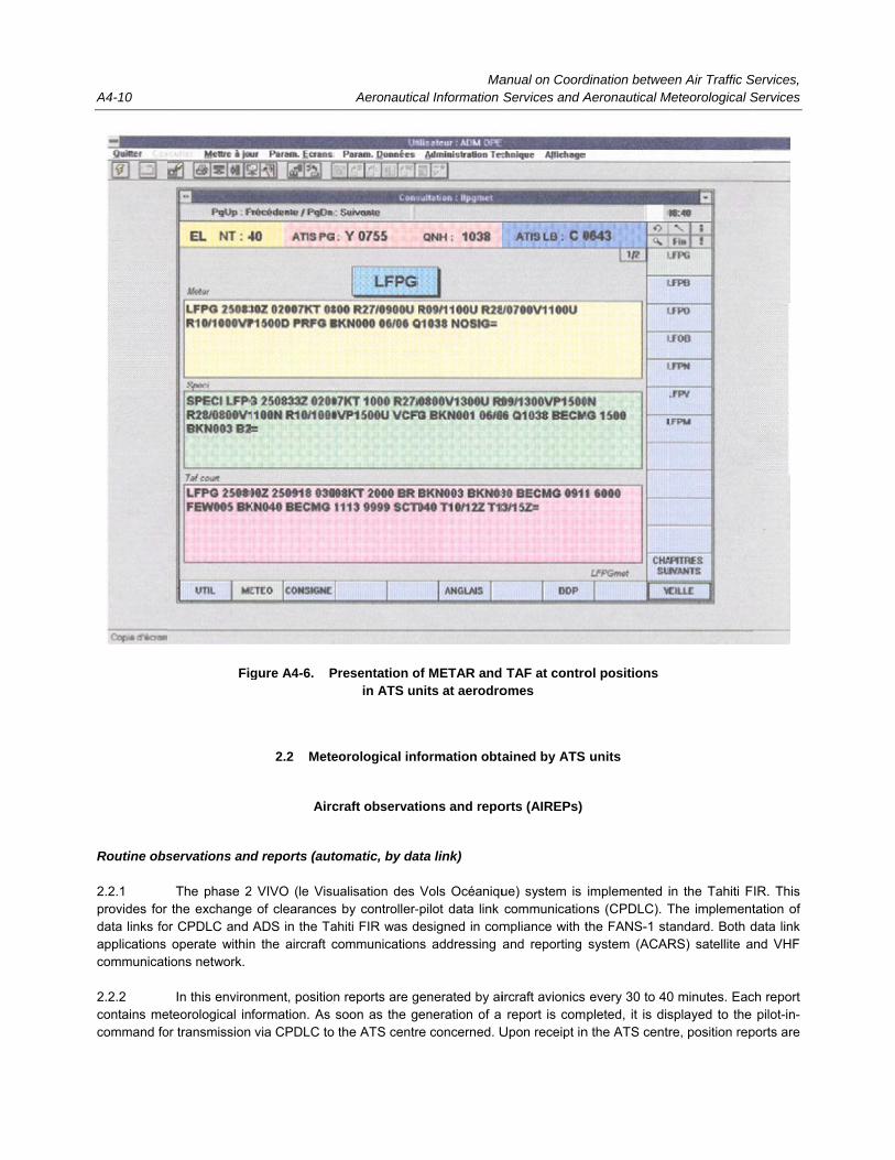
A4-10
Routine obs 2.2.1 provides for data links foapplications communicat 2.2.2 contains mecommand fo
Fig
servations and
The phase 2the exchange
or CPDLC and operate within
tions network.
In this enviroeteorological inor transmission
gure A4-6. P
2.2 Mete
Airc
d reports (aut
2 VIVO (le Visue of clearances
ADS in the Tan the aircraft c
nment, positionformation. As via CPDLC to
Aeronautic
Presentation oin ATS un
eorological inf
craft observat
tomatic, by da
ualisation des s by controller-ahiti FIR was dcommunication
n reports are gsoon as the gthe ATS centr
Macal Information
of METAR and nits at aerodro
formation obta
ions and repo
ata link)
Vols Océaniqu-pilot data link esigned in com
ns addressing
enerated by aieneration of a
re concerned. U
anual on CoordServices and A
TAF at controomes
ained by ATS
orts (AIREPs)
ue) system is communicatio
mpliance with tand reporting
ircraft avionics report is com
Upon receipt in
dination betweeAeronautical M
ol positions
units
implemented ins (CPDLC). Tthe FANS-1 stasystem (ACAR
every 30 to 40pleted, it is dis
n the ATS centr
en Air Traffic SMeteorological S
in the Tahiti FThe implementandard. Both dRS) satellite a
0 minutes. Eacsplayed to the re, position rep
Services, Services
IR. This tation of data link nd VHF
ch report pilot-in-
ports are

Appendix 4 A4-11
automatically transmitted from the VIVO system to the local flight plan database of the SIGMA (le Système Informatique de Gestion des Mouvements d’aérodrome) where the meteorological information is extracted and issued in the form of an AIREP for further automatic transmission via the AFTN. 2.2.3 The ADS corresponding to the phase 3 VIVO system was scheduled for implementation at the beginning of 1999. The technical capabilities of this upgraded system were developed to provide for the periodic automatic transmission of on-board data, including meteorological data, to the air traffic control centres concerned. 2.2.4 In contrast to the use of CPDLC, the phase 3 VIVO data transmission is fully transparent for pilots. The position reports are transmitted to the SIGMA and meteorological data are extracted for further automatic transmission in the form of AIREPs, without any action by controllers. 2.2.5 In the phase 3 VIVO environment, one of four ADS position reports contains a meteorological data block. Given that the frequency for position reports is 15 minutes, automatic AIREPs are issued only once in an hour. The relatively high cost of the air-ground communications and the SIGMA computer capacity, which does not allow for rather extensive AIREPs processing, are the reasons for this limitation. Special observations and reports (manual, by voice communications) 2.2.6 Special observations are made whenever the following conditions are encountered: a) severe icing or severe turbulence; and b) other meteorological conditions, e.g. phenomena en route that would justify the issuance of SIGMET
messages and which may markedly compromise the efficiency of other aircraft operations. Observations and reports during initial climb and approach 2.2.7 During initial climb and approach, observations may be made when the following conditions are encountered and which, in the pilot’s opinion, may affect the safety of other aircraft operations: a) moderate turbulence; b) moderate icing; c) wind shear; d) hail; and e) freezing rain. Additional observations 2.2.8 Additional observations can also be made at the request of an aerodrome meteorological office or on the basis of agreements between Météo-France and operators.

Manual on Coordination between Air Traffic Services, A4-12 Aeronautical Information Services and Aeronautical Meteorological Services
Dangerous weather-phenomena warnings transmitted by an aircraft 2.2.9 Information concerning dangerous weather phenomena, particularly icing and turbulence, received in ATS units from aircraft are transmitted by ACCs to MWOs and by local ATS units to meteorological stations; this information is analysed and, if necessary, a SIGMET is issued by the MWOs concerned. Meteorological information obtained from Air France aircraft 2.2.10 Météo-France is a partner of the WMO aircraft meteorological data relay (AMDAR) project for collecting automated real-time on-board meteorological observations. In this context, observations by Air France aircraft are made on the basis of a bilateral agreement between Air France and Météo-France. Upper wind, upper-air temperature and turbulence data obtained from aircraft are transmitted by Air France direct to the Météo-France Central Meteorological Operational Service, Toulouse. The cost of covering the data acquisition is financed by Météo-France. Information on runway surface conditions 2.2.11 Information on runway surface conditions for inclusion in SNOWTAM is derived from measurements made on runways by ATS units at aerodromes. Results of the measurements are transmitted, uncoded, to meteorological stations at aerodromes. On the basis of these measurements, the aeronautical meteorological stations develop one or more runway state groups required to be added to METAR messages. The runway state groups issued are updated or withdrawn from METAR upon the receipt of new input from the ATS unit concerned.
2.3 Coordination bodies 2.3.1 The national level. According to the European Single Sky Regulation, Météo-France is the provider of the meteorological service to air navigation. In this context, a board composed of the Regulator and the supervising authority of this service meets twice a year with Météo-France representatives to establish a list of priorities to be pursued, to discuss specific technical issues, to develop an equipment implementation plan and to analyse the regulatory, technical and financial implications relating to the provision of meteorological service to aviation. 2.3.2 The regional level. Representatives of regional departments of the DGAC and Météo-France meet as necessary to deal with equipment implementation in the region (within the framework of the implementation plan developed by the national board), common infrastructures, common master plans and common ownership of properties aspects. 2.3.3 Representatives of the associated MWOs and CRNAs meet in working groups. As mentioned in 1.2.16, bilateral memoranda of understanding are established and signed between individual associated MWOs and CRNAs. 2.3.4 Finally, the High Council for Meteorology provides a forum for users to formally express their requirements for meteorological service and for Météo-France to present information on its activities. The Council is chaired by the Minister of Transportation. Two commissions of the Council, one specialized in general aviation (l’aviation légère) and the other in commercial air transport (l’aviation de transport) allow for fruitful discussion among airlines, aeronautical federations, the DNA and Météo-France. In the context of the quality management system of the air navigation meteorological service provision, this High Council is an important structure where the users’ needs are recorded.

Appendix 4 A4-13
3. MÉTÉO-FRANCE COMMITMENTS IN THE PROVISION OF METEOROLOGICAL SERVICE FOR INTERNATIONAL AIR NAVIGATION
3.1 France accepted, by regional air navigation agreement, responsibility for providing a Volcanic Ash Advisory Centre (VAAC) within the ICAO IAVW, and a Tropical Cyclone Advisory Centre (TCAC).
3.2 VAAC Toulouse 3.2.1 Météo-France was designated to establish and operate VAAC Toulouse. 3.2.2 On receipt of information on new volcanic activity and/or a new occurrence of volcanic ash cloud in the VAAC area of responsibility, the following actions are taken by the centre: a) contact of the source of information if possible for confirmation; b) establishment of operational contacts among the ATS units, MWOs and vulcanological agencies and
observatories concerned (as per the ICAO list of operational contacts points). Information concerning the event obtained from these parties is useful to accurately initialize the volcanic ash trajectory/dispersion model;
c) preparation and issuance of the first volcanic ash advisory information including: name of the erupting
volcano, its identification number and location, source of information on the event and expected time of the next advisory;
d) a VOLCAN model run, satellite monitoring, evaluation of dispersion charts and issuance of volcanic
ash advisory information according to the ICAO format described in Table A2-1 of Appendix 2 of Annex 3 to the Chicago Convention, Meteorological Service for International Air Navigation and/or graphical format;
e) continuing satellite monitoring and reruns of the VOLCAN model employing updated data from the
Météo-France global model; and f) issuance of volcanic ash advisory information every six hours until the volcanic ash cloud can no
longer be identified and is therefore considered to have disappeared. 3.2.3 The centre maintains regular liaison with other VAACs as well as with the Smithsonian Institution’s Global Volcano Logical Network to maintain currency of information on volcanic activity within the centre’s area of responsibility. 3.2.4 VAAC Toulouse volcanic ash advisory information is prepared in compliance with relevant ICAO provisions. Individual volcanic ash advisory messages are communicated to MWOs, ACCs and users through the AFTN and the WMO GTS. The messages can be also retrieved from the Météo-France IRA data bank. 3.2.5 The AFTN dissemination pattern for VAAC Toulouse volcanic ash advisory messages is as follows: a) MWOs and ACCs/FICs in the AFI, EUR and MID/ASIA Regions, in accordance with requirements in
the regional air navigation plans concerned; b) WAFC London; and c) all other VAACs.

Manual on Coordination between Air Traffic Services, A4-14 Aeronautical Information Services and Aeronautical Meteorological Services
3.2.6 Volcanic ash trajectories and dispersion charts issued by VAAC Toulouse comprise: a) volcanic ash trajectory forecasts for different flight levels, valid for the time period up to 36 hours from
the time of eruption, divided into six-hour time periods; b) dispersion forecasts from 0 to 18-hour time periods depicted by the ash cloud outline integrated for
several standard layers and over the entire atmosphere. 3.2.7 These charts are transmitted to the SADIS provider State (United Kingdom) for dissemination via this system. They are also disseminated through the French RETIM2000 satellite distribution system and are available on the Météo-France aeronautical workstations system.
3.3 TCAC La Réunion The TCAC’s area of responsibility and facilities 3.3.1 Météo-France was also designated to establish and operate TCAC La Réunion. The TCAC area of responsibility extends between the parallels 05°S and 30°S and the meridians 30°E and 90°E and more or less corresponds to the centre’s area of responsibility as the WMO RSMC La Réunion. 3.3.2 In the capacity of RSMC for the south-western Indian Ocean, TCAC La Réunion is supposed to become the regional focal point for all tropical cyclone-related tasks, particularly tropical cyclone watch and forecasting, and research, development and training. In the operational field, by disseminating technical bulletins concerning tropical cyclone occurrences and forecasts, the centre facilitates activities related to tropical cyclones in the national meteorological services in Africa. 3.3.3 The principal mission of TCAC La Réunion is to provide relevant MWOs, in accordance with the Africa-Indian Ocean (AFI) Regional Air Navigation Plan, with tropical cyclone advisory information to support the issuance of SIGMET information for tropical cyclones by these offices. 3.3.4 TCAC La Réunion is equipped with modern and powerful weather monitoring, data processing and telecommunications systems and instrumentation. 3.3.5 A fully automated telecommunications system in the centre forms a part of the WMO GTS through which it communicates with a number of national meteorological services’ communications centres in the region, increasingly using satellite communications and X25 protocol. An X25 at a 64k bits/s channel links the system with Météo-France central computers and databases. Via this channel, the TCAC and RSMC La Réunion are supplied with the Météo-France global model data and European Centre for Medium Range Forecasts (ECMWF) forecasts. Tropical cyclone watch 3.3.6 The lack of aerial reconnaissance and very limited number of conventional observations make satellite imagery the basic tropical cyclone watch tool in the south-western Indian Ocean. 3.3.7 Due to the lack of access to data from a geostationary satellite above the Indian Ocean, the tropical cyclone watch in the area east of the 65°E longitude depends solely on the use of images from nearby polar-orbiting satellites of the U.S. TIROS series. The imagery from the METEOSAT geostationary satellite substantially improves the tropical cyclone watch in all inhabited areas west of the 65°E longitude.

Appendix 4 A4-15
3.3.8 Two “high-end” satellite data receiving stations, a primary data user station to receive the METEOSAT imagery and a high-resolution picture transmission station to receive the TIROS imagery, are available in TCAC La Réunion to acquire the essential information for the tropical cyclone watch. Two automatic picture transmission/weather fax stations can be used for back-up purposes. Apart from the location of tropical cyclone centres and assessment of the direction and speed of their movement, the maximum wind speed in tropical cyclone centres can be derived by analysing satellite data and images. The universally recognized DVORAK technique, based on the analysis of tropical cyclone cloud structure, is used for assessment of the tropical cyclone intensity. 3.3.9 In addition, the centre routinely receives the sea-surface temperature data derived from the European experimental satellite ERS2 (previously ERS1). These data represent another piece of valuable and objective information on tropical cyclone centres and the extent of associated gale and gust areas. Forecasts relating to the tropical cyclones with wind shear, in particular in the initial phase of their development, can also be improved by the use of these data. 3.3.10 Data from a last-generation (10 cm) Doppler weather radar in St-Denis, La Réunion cover an area within a 400-km radius and complement satellite data and imagery. Tropical cyclone forecasting 3.3.11 The trajectory and intensity forecasts prepared by TCAC La Réunion are based on: a) output from the Météo-France global model and ECMWF numerical weather prediction models. In
addition to the direct use of output from these models, a number of derived fields, e.g. the steering flow (flux direct) and wind shear fields, are calculated locally in the centre;
b) output from the application of a number of operational and experimental tools developed locally, such
as climatological and statistico-dynamic trajectory forecast models and the global barotropic and variable grid-sized spectral model, which is initialized by the ECMWF model and boguissing techniques; and
c) analysis of various other input (satellite images, sea-surface temperature fields, etc.). Tropical cyclone advisory information 3.3.12 When a tropical cyclone with a ten-minute mean surface wind speed of 17 m/s (34 kt) or more in its centre is observed in the area of responsibility of TCAC La Réunion, the centre initiates the preparation of tropical cyclone advisory information (tropical cyclone advisory messages) required to be issued every six hours (00, 06, 12 and 18 UTC). The messages are disseminated in accordance with the AFI Regional Air Navigation Plan to the following 15 MWOs: Antananarivo, Bloemfontein, Bombay, Dar-es-Salaam, Durban, Gaborone, Harare, Johannesburg,
Lilongwe, Mahe, Male, Maputo, Mauritius, Nairobi and Perth. 3.3.13 These tropical cyclone advisory messages are transmitted to the MWOs listed above using the AFTN. However, they are also disseminated regionally on the WMO GTS (FKI020 heading). 3.3.14 The tropical cyclone advisory information contains information on the position of the centre of the tropical cyclone, direction and speed of its movement, central pressure, maximum surface wind near the centre, and forecasts of the position of the centre of the cyclone and maximum surface wind for 12 and 24 hours.

Manual on Coordination between Air Traffic Services, A4-16 Aeronautical Information Services and Aeronautical Meteorological Services
TCAC La Réunion development projects 3.3.15 The continuous consolidation of the existing operational experience and the application of new scientific developments are intended to be used to further improve the centre and its professional functions. In view of this, research and development activities as well as the training activities of the centre are ongoing.
______________________

A5-1
Appendix 5
PROCEDURES USED IN THE UNITED STATES TO PROVIDE METEOROLOGICAL SERVICE TO ATS UNITS
1. NATIONAL AIRSPACE SYSTEM (NAS) 1.1 To identify and understand the specific aviation meteorological needs of air traffic managers, controllers and specialists, it is necessary to understand the structure and operation of the United States National Airspace System (NAS). Because of the system’s complexity, it is not possible to provide an in-depth description of the NAS and its operations in this appendix. However, meteorological information services are critical to the NAS’ safety and efficiency. Therefore, it is the purpose of this appendix to describe how air traffic control (ATC) personnel utilize meteorological information provided to them by the national weather service (NWS) in support of ATS in the United States. 1.2. Of utmost importance is that all users of the NAS receive the same hazardous meteorological information simultaneously in order to facilitate coordinated decision-making between air traffic flow managers, controllers, flight service specialists and pilots. Recent organizational changes in the FAA have defined ATS as being en-route oceanic services, terminal services and flight services. 1.3 The primary function of automated flight service stations (AFSS) is to provide pilots with a variety of information and assistance necessary for planning a safe flight within the NAS and along certain overseas and international routes. While primary emphasis is on weather briefings, flight service specialists also originate and disseminate NOTAM pertaining to the status of navigation aids, runway conditions, etc. They brief pilots on current and forecast meteorological conditions along the planned route of flight and at the point of intended landing. 1.4 While there are many requirements for the provision of meteorological information by ATC personnel, such as aerodrome meteorological conditions for instrument approaches, the provision of weather-related services is contingent upon the controller’s capability to respond with regard to other duties that may have a higher priority. It is the controller’s sole responsibility to determine if he or she is able to provide this service in each particular case. It should be noted, however, that severe weather which would result in a safety hazard is generally handled on a priority basis. 1.5 One of the functions requiring meteorological information is an emergency situation where a pilot who is only qualified for VFR operations encounters IFR conditions. Radar vectors to avoid hazardous weather or to provide guidance to the closest suitable landing area are common procedure.
2. NATIONAL WEATHER SERVICE (NWS) 2.1 NWS is responsible for preparing TAF, SIGMET, AIRMET, volcanic ash advisories and tropical cyclone advisories. The issuance of forecasts, hazardous weather statements and advisories follow the prescribed format of ICAO Annex 3. In addition to these international products, the NWS also provides area forecasts, aviation weather watches, aviation weather warnings, and convective SIGMET to meet specific requirements established by the Federal Aviation Administration (FAA) for national practices.
Manual on Coordination between Air Traffic Services, A5-2 Aeronautical Information Services and Aeronautical Meteorological Services
2.2 Specifically, NWS forecast offices (WFO) issue TAF, whereas SIGMET and AIRMET are issued by NWS MWOs. Volcanic ash advisories are issued by VAACs Anchorage and Washington and tropical cyclone advisories are issued by TCAC Miami and Honolulu. All of these weather advisories and forecasts are available to users of the NAS via the national airspace data interchange network (NADIN). 2.3 Fulfilling the role of one of the two WAFCs, the National Centre for Environmental Prediction provides meteorological data and products to support flight planning for global aeronautical operations. These products are made available on the WAFS Internet File Service (WIFS). Products provided by the WAFCs are in compliance with Annex 3, Appendix 2. 2.4 In-flight advisories are issued for potentially hazardous meteorological conditions that may not have been forecast. They are also issued to update en-route forecasts for aircraft that may not have had a pre-flight briefing. SIGMET are issued for the severest meteorological conditions that affect all types of aircraft and follow the SARPs of Annex 3. AIRMET are directed to light aircraft that are less equipped and less able to cope with less severe weather that is of little or no concern to large heavy aircraft.
3. DISSEMINATION OF AVIATION METEOROLOGICAL DATA 3.1 The principal method for disseminating aviation meteorological information and products is the FAA weather message switching centre replacement (WMSCR). The WMSCR serves as a repository of the most current aviation weather products in an alphanumeric text format. The WMSCR interfaces direct with the NWS telecommunication gateway allowing users of the NAS to access the most recent and current meteorological information from the NWS. Information is routed automatically to all users over dedicated circuits on a routine scheduled basis and also on an unscheduled basis as a function of the urgency of the message. If need be, users can access aviation meteorological information on a request reply basis. In short, as soon as a meteorological message is received in the WMSCR, it is routed automatically to those users who have requested the information. The system operates on a store and forward basis. 3.2 There are two WMSCR systems that serve all users of the NAS. For efficiency of operation, each system serves half the country; however, if there were a failure in one of the systems, the other system has the capability to serve all the users of the NAS. 3.3 WMSCR creates a database of all the METAR, TAF, SIGMET, AIRMET, volcanic ash advisories and tropical cyclone advisories for distribution to all ATC facilities and airline operations centres. Not only is it a domestic products database, but international products as well are available to users of the NAS via this network. 3.4 Depending upon the type of message and its level of priority, information is routinely forwarded to the appropriate facility for utilization in decision-making for controlling airspace and flight planning. 3.5 In addition to WMSCR, as mentioned above, the FAA makes aviation meteorological products available on the WIFS in accordance with regional air navigation plans. The alphanumeric text products that are available from WMSCR are also made available on the WIFS. The WIFS also has the capability to make available graphical products in addition to the alphanumeric products, such as graphical depiction of volcanic ash clouds and high-level SIGWX charts.
4. AIR TRAFFIC SERVICES (ATS) ATS is a complex organization that involves thousands of individuals who are responsible for managing the NAS. This includes regulating the flow and movement of aircraft throughout the NAS, training controllers and specialists, providing

Appendix 5 A5-3
meteorological briefings, managing traffic flow, controlling terminal airspace, etc. Services that pertain to coordination efforts between ATS and MET can be described as those services provided at: the ATC system command centre (ATCSCC), air route traffic control centres (ARTCCs), air traffic control towers (ATCTs), terminal radar approach controls (TRACONs), automated flight service stations (AFSS), centre weather service units (CWSUs) that are housed in the ARTCC, and at the MWOs in Anchorage, Kansas City and Honolulu. The following sections describe in detail the aviation weather services provided to users of the NAS.
5. AIR ROUTE TRAFFIC CONTROL CENTRES (ARTCCs) 5.1 The primary function of the ARTCCs is to control and separate air traffic within designated airspace along defined airways and over certain designated oceanic routes. This ATC service is provided to aircraft operating on IFR flight plans principally during the en-route phase of flight. Additionally, ARTCCs provide services for IFR aircraft operating to and from non-approach control airports. 5.2 When equipment capabilities and controller workload permit, certain advisory services, such as meteorological and airport conditions and radar vectoring service, may be provided to VFR aircraft. 5.3 The airspace under the jurisdiction of an ARTCC covers thousands of square miles that can cross over several states and altitudes up to 60 000 ft. To accommodate this vast amount of airspace, ARTCCs customarily divide their airspace into three to five areas of specialization, and each area is then subdivided into as many as ten sectors. Also, the airspace is stratified into low, high and super-high altitude sectors. 5.4 En-route controllers become familiar with pertinent meteorological information and maintain an awareness of current meteorological information needed to perform ATC duties. En-route controllers advise pilots of hazardous weather that may impact operations within 150 NM of the controller’s assigned sector or area of jurisdiction. 5.5 Collocated in each ARTCC is a CWSU. The principal function of the CWSU is to advise the air traffic management unit in the ARTCC of hazardous weather within its airspace.
6. CENTRE WEATHER SERVICE UNITS (CWSUs) 6.1 The CWSU functions within the ARTCC. The purpose of the CWSU is to gather meteorological data, assimilate and analyse it and filter out the pertinent data. The meteorological information disseminated from the CWSU is data pertinent to ATC operations and air safety. 6.2 CWSU meteorologists brief the ARTCC supervisors on present and forecast weather. They also provide support to supervisory and operational personnel at major hub airport towers, approach controls, en-route flight advisory service (EFAS) and other FAA facilities on meteorological conditions impacting or expected to impact the ARTCC area. 6.3 Meteorological briefings, both scheduled and on-demand, are given by the meteorologist at all centres. They may be of a general overview content for planning purposes or may be of a tactical nature depending on the immediacy of the meteorological impact. 6.4 CWSU meteorologists generate weather advisories known as centre weather advisories (CWAs) valid for up to two hours. These advisories are directed at the most significant or potentially hazardous type weather that may impact air traffic and are distributed within the ARTCC to those controllers and managers who need to be made aware of existing meteorological conditions and changes.

Manual on Coordination between Air Traffic Services, A5-4 Aeronautical Information Services and Aeronautical Meteorological Services
6.5 CWSUs at the centres currently have access to the following data and/or products to aid them in their mission to support ATC personnel: a) radar summary chart; b) observed winds aloft chart; c) upper wind forecasts; d) surface weather depiction analysis; e) surface pressure and frontal analysis and forecasts; f) low-level significant weather forecasts; g) significant weather outlook; h) upper air standard pressure level analysis and forecasts; i) tropopause/vertical wind shear forecasts; j) thunderstorm/severe weather probabilities; and k) probability of precipitation/conditional probability of frozen precipitation. 6.6 CWSUs have drop-on special NWS circuits that are dedicated to the collection and dissemination of observations, forecasts and warnings of severe weather in connection with thunderstorms, hurricanes and heavy snow forecasts.
7. TERMINAL RADAR APPROACH CONTROLS (TRACONs) 7.1 TRACONs utilize radar and air-to-ground communications to provide specific ATC services to aircraft arriving at, departing from or transiting airspace controlled by the facility. 7.2 Because the TRACON may include several major ATCTs and non-tower (satellite) facilities, meteorological data, when available, are utilized in operational decision-making by controllers. The TRACON also has a need for additional meteorological data such as those obtained from radar systems and pilot reports. The primary source of real-time hazardous meteorological information is pilot weather reports (PIREPs)1, which usually inform users of the NAS about the occurrence of turbulence, icing, volcanic ash, etc. 7.3 Although ATC radar units are not optimized for meteorological detection, there is a capability to obtain some useful information regarding convective cells. ATC radar is designed for surveillance purposes; however, research has shown that some useful meteorological information can be obtained from these systems. 7.4 Other sources of meteorological data that are of use to controllers in the TRACONs include RVR, low-level wind shear (LLWS) and digital altimeter setting indicator.
1. Referred to in ICAO documentation as AIREPs.
Appendix 5 A5-5
7.5 Controllers in the TRACONs usually receive daily telephone briefings from the CWSU meteorologist. As required, the CWSU meteorologist also provides information concerning hazardous weather in the area. 7.6 PIREPs and other information, such as SIGMET, CWAs, radar interpretations, surface observations and other data obtained from various readout devices, are available to controllers in the TRACON for dissemination to pilots via air-to-ground radio. 7.7 Future architectural design of the NAS envisions the ability to provide these products and others direct to the pilot via data link, without human intervention. In a similar manner, automation will allow PIREPs to be downlinked to earth-receiving stations so current wind, temperature, humidity and turbulence information can be ingested into the NAS for processing by numerical models for enhanced forecasts. The FAA flight information services policy ensures that pilots have access to basic meteorological data to operate safely and efficiently. Commercial services are encouraged to provide value-added information to the pilot for better and more informed decision-making.
8. AIR TRAFFIC CONTROL TOWERS (ATCTs) 8.1 An ATCT is a terminal facility that uses air-to-ground communications, visual signalling and other devices to provide ATC services to aircraft operating in the vicinity of an airport or in the movement area. Controllers working in the ATCT authorize aircraft to land or take off at the airport. In some circumstances, a tower may have the responsibility to provide approach control services. ATCTs provide ATC services to all aircraft operating on the surface movement area or to all aircraft that are airborne and operating in the control zone of the airport. 8.2 Terminal controllers become familiar with pertinent meteorological information and maintain an awareness of current meteorological information needed to perform their duties. Terminal controllers advise pilots of hazardous weather that may impact operations within 150 NM of the controllers’ assigned sectors or areas of jurisdiction. Tower controllers may opt to broadcast hazardous meteorological information alerts for airspace under the ATCT’s jurisdiction. 8.3 At many airports, ATIS provides continuous broadcast of recorded information. Its purpose is to improve controller effectiveness and to relieve frequency congestion by automating the repetitive transmission of non-control airport/terminal area and meteorological information. In the future, these systems will be replaced with more advanced equipment that can take advantage of digitized information. Eventually, all this information will be provided by data link, a more advanced type of communication. 8.4 The aviation meteorological data requirements are generally restricted to the confined area under the jurisdiction of the airport traffic control tower. Typically, the tower requires meteorological information in an area of about 15 NM around the airport with emphasis on meteorological conditions existing in the operating corridors and over the runway complex. Airport meteorological data are obtained from a suite of meteorological sensors located on the airport in an area considered representative of the runway landing zone. Through automation, real-time one-minute observations are provided to the tower controller for operational use. At the same time, hourly METAR messages are issued for transmission beyond the aerodrome for flight planning purposes. SPECI messages are issued according to prescribed procedures that signify a significant change in meteorological conditions for operational purposes. 8.5 Because of the vast number of airports within the United States, not all airports can receive the same level of meteorological service. To provide meteorological service at as many airports as possible in the NAS, the FAA is using automated surface observing systems (ASOS) to provide service where hitherto there was limited or no meteorological service. Automated stations cannot provide a complete METAR message; however, it has been determined that the basic meteorological elements can be provided to ensure safe operations at the airport. At key selected airports, such as international airports, the FAA has contract observers to augment the automated meteorological reports to ensure that the METAR and SPECI messages meet the SARPs of Annex 3. Automated stations provide basic meteorological information to allow for safe operations at those airports. All METAR and SPECI are made available to both ATCT and TRACON facilities as required.

Manual on Coordination between Air Traffic Services, A5-6 Aeronautical Information Services and Aeronautical Meteorological Services
8.6 A centre-field wind speed and direction sensor provides wind speed direction and gust information. A barometric pressure sensor provides the certified altimeter setting pressure for the airport. A transmissometer or a forward-scatter meter provides the RVR. On instrumented runways, RVR is measured at three points (touchdown, midpoint and roll-out). The FAA has installed LLWS at well over a hundred airports for the purpose of advising ATC and pilots of wind shear conditions at the airport. At key airports, terminal Doppler weather radar (TDWR) has been installed. This radar system detects wind shear, including microburst phenomena, within the airspace of the aerodrome. The TDWR is programmed to advise ATC of microbursts that are about to affect the runway or are within the approach or departure paths. Upon notification of a microburst, tower controllers immediately alert pilots of the hazard. 8.7 In addition to TDWR, an integrated terminal weather information system (ITWS) is being installed at selected ATCTs. This system has the ability to display the most current meteorological information within the aerodrome and to provide guidance to controllers on changing meteorological conditions. ITWS provides information on significant weather associated with severe storms and facilitates routing of aircraft around hazardous weather by processing information from LLWs, TDWR and airport surveillance radar and NWS next-generation weather radar (NEXRAD). Also available to ITWS is lightning data. 8.8 PIREPs requested from or reported by pilots provide the controllers with detailed information on meteorological conditions that exist and have possibly not been observed by meteorological instruments. These PIREPS are passed along to other aircraft en route and are entered into the NADIN for dissemination to all users of the NAS. 8.9 The tower controllers provide METAR/SPECI messages for the airport to the pilots via a recorded message on the ATIS. At airports where there is an automated interface with the ATIS, the ASOS provides a direct report for broadcast. Tower controllers also have the option to report unusual conditions, such as wind shear and runway braking conditions, on the ATIS messages.
9. AUTOMATED FLIGHT SERVICE STATIONS (AFSS) 9.1 Within the United States, the FAA has established AFSS to support the aviation community. 9.2 AFSS have the prime responsibility for pre-flight pilot briefings, en-route communications with VFR flights, assisting lost VFR aircraft, originating NOTAM, broadcasting aviation meteorological information, accepting and closing flight plans, monitoring radio NAVAIDs and assisting search and rescue units in locating missing VFR aircraft. The largest single user of these services is the general aviation pilot. 9.3 AFSS specialists brief pilots on current or forecast aviation meteorological conditions along their intended route of flight and at the point of intended landing. A pre-flight briefing includes the location of potentially hazardous conditions and alternate routes or a recommendation, when appropriate, that a flight not be conducted. Current and forecast meteorological data and PIREPs are also available to aircraft in flight. 9.4 Within the AFSS, there exists an en-route flight advisory service (EFAS) to aircraft operating in their assigned areas. EFAS collects/disseminates PIREPs and other real-time meteorological information to en-route aircraft. EFAS also has the meteorological expertise support of the CWSU meteorologist if required. 9.5 PIREPs are received via direct radio contact with pilots from centres and, less frequently, from towers. They are considered a major source of real-time weather and of utmost importance to stations providing en-route flight advisory service. The AFSS or EFAS specialist eliminates duplicated information and enters the most recent reports into NADIN for further dissemination to all users of the NAS.

Appendix 5 A5-7
10. EN-ROUTE FLIGHT ADVISORY SERVICE (EFAS) 10.1 The primary objective of EFAS (also known as flight watch) is to enhance aviation safety by providing en-route aircraft with timely and relevant weather advisories. This objective is met by providing complete and accurate information on weather as it exists along a route pertinent to a specific flight. The aim is not only to provide information in a timely manner so that unnecessary changes to a flight plan are not required, but also to provide the pilot with the opportunity to make a decision to terminate the flight or alter course before adverse conditions are encountered. 10.2 Flight watch serves as a common collector for receiving and disseminating in-flight meteorological reports. Flight watch specialists are cognizant of the latest available meteorological information covering their area. Specialists watch for and review subsequent forecasts, charts and observations, including radar and pilot reports, in order to keep abreast of meteorological trends and developments. 10.3 Regardless of meteorological conditions, flight watch specialists continually solicit pilot reports regarding upper winds and temperature, wind shear turbulence and icing. Such reports are disseminated to those needing them, both within the facility and to external offices. 10.4 EFAS specialists interpret and summarize weather radar video displays and issue pertinent information on observed/reported meteorological conditions.
11. FUTURE DEVELOPMENTS IN METEOROLOGICAL PROGRAMMES
11.1 With the advent of Doppler radar and the implementation and operation of NEXRAD, great strides have been made in the development of algorithms that allow for the detection of significant weather, especially convective meteorological activity. The NEXRAD data that are available to the WFO are also made available to the CWSU meteorologist and to the controller displays. The aim is to provide the most current meteorological information to controllers so they can advise pilots on hazardous weather situations within their controlled airspace. How the information is to be displayed both to meteorologists and controllers involves human factors considerations that are still being developed as new information is ingested into the system for further analysis and evaluation. The overall goal is to develop a capability to detect, measure and track severe weather so that controllers will have the ability to re-route aircraft in a timely manner to avoid hazardous weather and to establish an orderly flow of traffic to and from high-density airports. 11.2 Figures A5-1 and A5-2 illustrate some of the research and development activities being pursued in the United States to achieve this goal. In parallel, separate projects are also being undertaken to further develop the turbulence and icing forecasts. Two products in these fields are shown in Figures A5-3 and A5-4.

Manual on Coordination between Air Traffic Services, A5-8 Aeronautical Information Services and Aeronautical Meteorological Services
Fig
ure
A5-
1.
Reg
ion
al c
on
vect
ive
wea
ther
fo
reca
st(E
xper
imen
tal p
rodu
ct b
eing
dev
elop
ed a
t Lin
coln
Lab
orat
ory,
Mas
sach
uset
ts In
stitu
te o
f Tec
hnol
ogy,
Lex
ingt
on, M
assa
chus
etts
)

Appendix 5 A5-9
-30
-20
+10
+20
+40
+50
+60
min
For
ecas
t
+30
-10
Cur
rent
wea
ther
• Lan
d ad
ditio
nal a
ircr
aft (
that
wou
ld h
ave
dive
rted
)
• Hav
e ar
riva
ls r
eady
whe
n w
eath
er c
lear
s
Fig
ure
A5-
2.
Ter
min
al c
on
vec
tive
wea
ther
fo
reca
st p
rod
uct
(Exp
erim
enta
l pro
duct
bei
ng d
evel
oped
at t
heN
atio
nal C
ente
r fo
r Atm
osph
eric
Res
earc
h, B
ould
er, C
olor
ado)
Not
e.—
The
pro
cess
ed w
eat
her
radar
dat
a ar
e su
pple
men
ted
by
info
rmatio
n on
pre
cipi
tatio
n, te
mpe
ratu
re a
nd
dew
-poin
tte
mpe
ratu
re o
bser
ved a
nd fo
reca
st fo
r a p
erio
d of 4
up
to 1
2 ho
urs.

Manual on Coordination between Air Traffic Services, A5-10 Aeronautical Information Services and Aeronautical Meteorological Services
Figure A5-3. Turbulence forecast — integrated turbulence forecast algorithm(Experimental product being developed at the
National Center for Atmospheric Research, Boulder, Colorado and theNational Oceanic and Atmospheric Administration, Forecast Systems Laboratory)
Note.— The algorithm integrates turbulence data from automated aircraft observations, expressed in terms of the eddydissipation rate and relevant remote sensing and diagnostic data.

Appendix 5 A5-11
— END —
IIFA
03 H
R F
OR
ECA
ST V
ALI
D A
T 04
/11
— 9
ZPO
TEN
TIA
L FO
R IC
ING
AT
12 0
00 F
TEX
TER
NA
L PR
OD
UC
T –
RES
EAR
CH
US
E O
NLY
!
EXPE
RIM
ENTA
L IC
ING
PR
OD
UC
TFO
R D
E-IC
ING
DEC
ISIO
N-M
AK
ING
IIFA
03 H
R F
OR
ECA
ST V
ALI
D A
T 04
/11
— 9
Z
IND
HLB
DAY
LHQ
PKB
EKN
OKV
IND
HLB
DAY
LHQ
PKB
EKN
OKV
IADIAD
ICING POTENTIAL SLD POTENTIAL
100
90 80 70 60 50 40 30 20 10 0 UK
N
30 25 20 15 10 5 0 30 25 20 15 10 5 0
HEIGHT (KFT)HEIGHT (KFT)
Fig
ure
A5-
4.
Tw
o e
xam
ple
s o
f ex
per
imen
tal i
nte
gra
ted
icin
gfo
reca
st a
lgo
rith
m (
IIFA
) p
rod
uct
s(E
xper
imen
tal p
rodu
cts
bein
g de
velo
ped
at the
Nat
iona
l Cen
ter
for A
tmos
pher
ic R
ese
arch
, Bou
lder,
Col
ora
do)
60
70
80
90
100

�������

�������
