map compiling, map reading, and cartographic design...
TRANSCRIPT
QUAESTIONES GEOGRAPHICAE 29/1 • 2010
MAP COMPILING, MAP READING, AND CARTOGRAPHIC DESIGN IN “PRAGMATIC PYRAMID OF THEMATIC MAPPING”
BEATA MEDYŃSKA-GULIJ
Adam Mickiewicz University, Institute of Physical Geography and Environmental Planning, Department of Cartography and Geomatics, Poznań, Poland
Manuscript received January 21, 2010Revised version March 12, 2010
MEDYŃSKA-GULIJ B., 2010. Map compiling, map reading and cartographic design in “Pragmatic pyramid of thematic mapping”. Quaestiones Geographicae 29(1), Adam Mickiewicz University Press, Poznań 2010, pp. 57-63, Figs 5. ISBN 978-83-232-2136. ISSN 0137-477X. DOI: 10.2478/v10117-010-0006-5.
ABSTRACT. This paper concerns the dependent relationships between map compilation, map reading, and carto-graphic design with special regard to thematic mapping. The fi rst step is to measure the simple relationship be-tween cartographic practice and map design and present a pyramid of pragmatic thematic mapping. The model contains various types of maps, a range of cartographic principles, and sources of knowledge for map design. When presented as a pyramid, these functional dependencies can refer to a series of pragmatic criteria which relate to the use of thematic maps.
KEYWORDS: pragmatic cartography, thematic mapping, cartographic design.
Beata Medyńska-Gulij, Institute of Physical Geography and Environmental Planning, Adam Mickiewicz University, Dzięgielowa 27, 61-680 Poznań, Poland, e-mail: [email protected]
Introdution
Pragmatic cartography may be understood both in the sense of practical and in a more lim-ited way pertaining to semiotics. According to Morris (1971), the pragmatic is the relationship between the sign and the interpreter, and, in par-ticular, the problem of how the intended desig-nation is understood by the perceiver. Freitag (1971) associates the research area of pragmatic cartography with the map’s function as a vehicle of information.
Pragmatic cartography is connected fi rst and foremost with map reading. With various meth-ods of using digital maps, the relationship be-tween map and user has broadened its scope, for
example by cartographic compilation. Most often, map compilation results in the creation of themat-ic maps. These represent the distribution of one particular phenomenon, though a thematic map needs topographic information as a basis (Kraak & Ormeling, 2003). Thematic maps have topi-cal contents which are graphically-emphasized or highlighted over a basis which has a status of ‘ground’. According to Dent (1990), thematic map compilation refers to the construction of a special-purpose map from a variety of previously exist-ing sources: base maps, other thematic maps, or both, and it involves numerous steps.
This paper on thematic mapping concerns the inter-relationship between map compila-tion, map reading, and cartographic design. It

BEATA MEDYŃSKA-GULIJ58
presents a measurement of the relationship be-tween pragmatic cartography and map design, resulting in a pyramid of pragmatic cartography for thematic mapping. The model contains many types of maps, a range cartographic principles, and sources of knowledge for map design. The functional dependencies in these inter-relation-ships will reveal pragmatic criteria for the use of thematic maps.
Methodology
The study was carried out in the following stages.
Thematic mapping includes the following:a choice of two aspects of pragmatic car-•
tography: map compilation and map readinga choice two measurable parameters on •
the thematic map: the number of designed sym-bols on the map and theme:base ratio on the the-matic map
include the dependence in the graphic • model – the main wall of pyramid
refer these dependences to types of maps, • adaptation of cartographic principles, and sourc-es of knowledge for map design
refer pyramid dependences to the prag-• matic criteria of thematic map use.
Vector databases allow the GIS-user to make maps individually, which in fact constitutes car-tographic compilation. Compilation relates to the connection of vectors in a layered structure, with the subsequent subjection of elements (point, line and area) to the process of graphical design. In this study the fi rst aspect of pragmatic cartogra-phy will be connected with cartographic compi-lation: the limit of preparation of cartographic compilation by the GIS-user (non-cartographer). The second aspect of pragmatic cartography will be connected with comprehension, i.e. map read-ing. In this case, it will concern the limit of map reading without specialized training, namely, maps designed for the general user versus those designed for specialists.
Pragmatic cartography is dependent, in part, on effective cartographic design comprised of many aspects, e.g. appropriate choice and imple-mentation of map elements, visual hierarchy, con-trast, and balance (Slocum et al., 2005). According
to Dent (1999), no one best way to a design so-lution can be predetermined for all maps – only principles and general approaches can guide the cartographer. Design characteristics of successful maps include clear, legible, attractive, easy to use, accurate (Southworth & Southworth, 1982) are in-exact and therefore inexplicable and unclear for map-makers such GIS users.
The measurable parameter of map design is the number of designed symbols on the map. The number of symbols directly infl uences the ease of preparation of an effective map and also map reading. The greater the number of symbols, the more diffi cult it becomes to organize them visually in the reading process. The number of designed symbols determines the method and number of graphical variables used (Bertin, 1983) and so the more symbols there are to be defi ned, the more complicated the graphic design stage becomes.
The second measurable parameter on the thematic map is theme-base proportions. Fol-lowing Slocum et al. (2005), thematic symbols directly represent a map’s theme, and should stand out. They are often used in conjunction with base information in the mapped area. One of the basic parameters adopted for developing thematic maps is the proportion between the the-matic content and the base content. Three main variants of the relationship exist: the predomi-nance of thematic content over base content, a state of equilibrium between thematic and base contents, and the predominance of base content (Fig. 1).
Fig. 1. Proportions of the thematic content to base content on a thematic map
The division into more and less important as-pects streamlines the method of graphical design of thematic maps. A visual reinforcement of the theme with respect to the base gains key impor-tance in the cartographic design of thematic maps. The topical contents contain the main elements
MAP COMPILING, MAP READING, AND CARTOGRAPHIC DESIGN IM “PRAGMATIC PYRAMID OF THEMATIC MAPPING” 59
which form the basic contents of the map and should be located at the highest (fi rst) reading lev-el. The base contents, considered as supplemen-tary (referential), should be visually weakened to such an extent that their elements ought to be situ-ated at the lower (second) level of map reading.
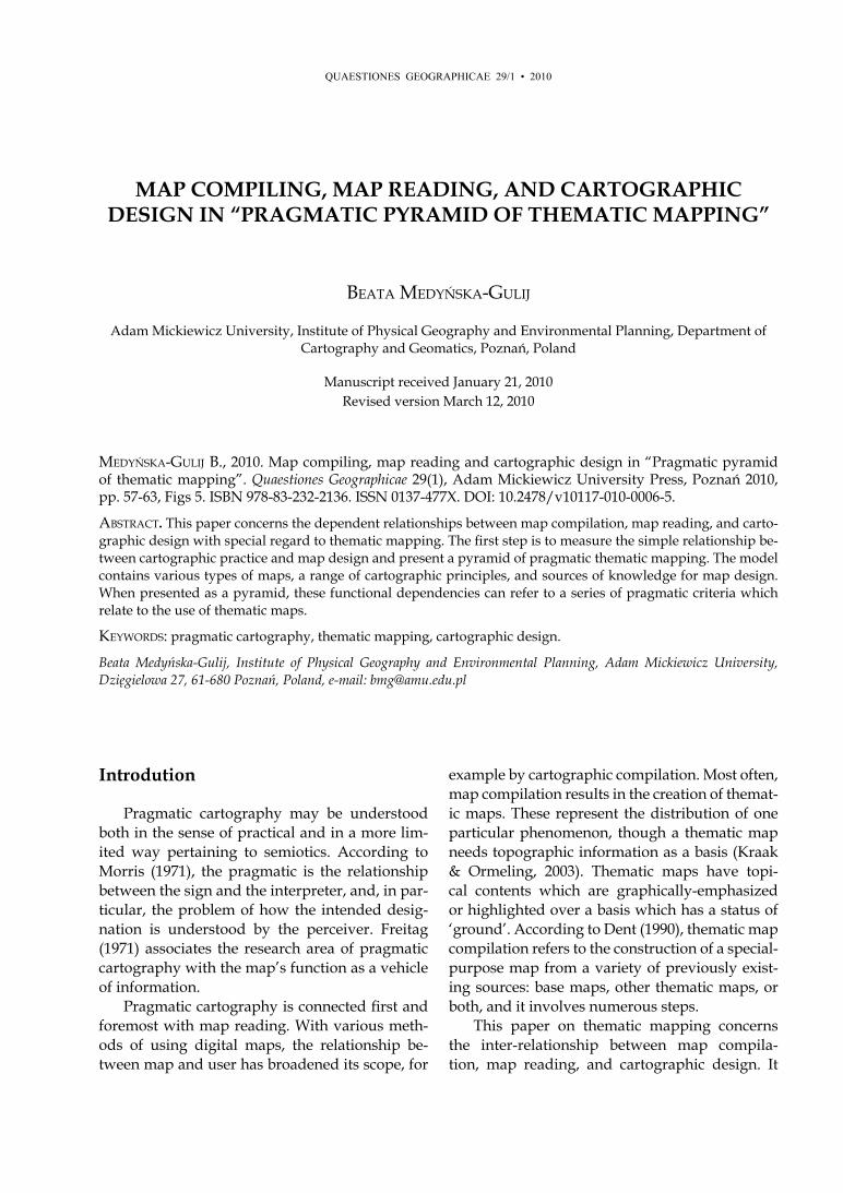
Fig. 2. Legend of the thematic map in three variants of pro-portions of the theme to the base
In the vertical legend of the map in Fig. 2, symbols are placed in accordance with their hi-erarchy: symbols related to the theme are located higher, while those related to the base are lower. In the fi rst column, one can see the predominance of the theme (9>5); in the second a state of equilib-rium (9=9); while in the third, the predominance of signature numbers in the base (9<14). On the map containing symbols on the left of the legend (Fig. 2), the theme is highlighted in relation to the smaller number of symbols in the base. In turn, in the right legend there are fewer symbols con-nected with the theme, but it is possible to refer-ence their location to the topographical contents with greater precision.
Results
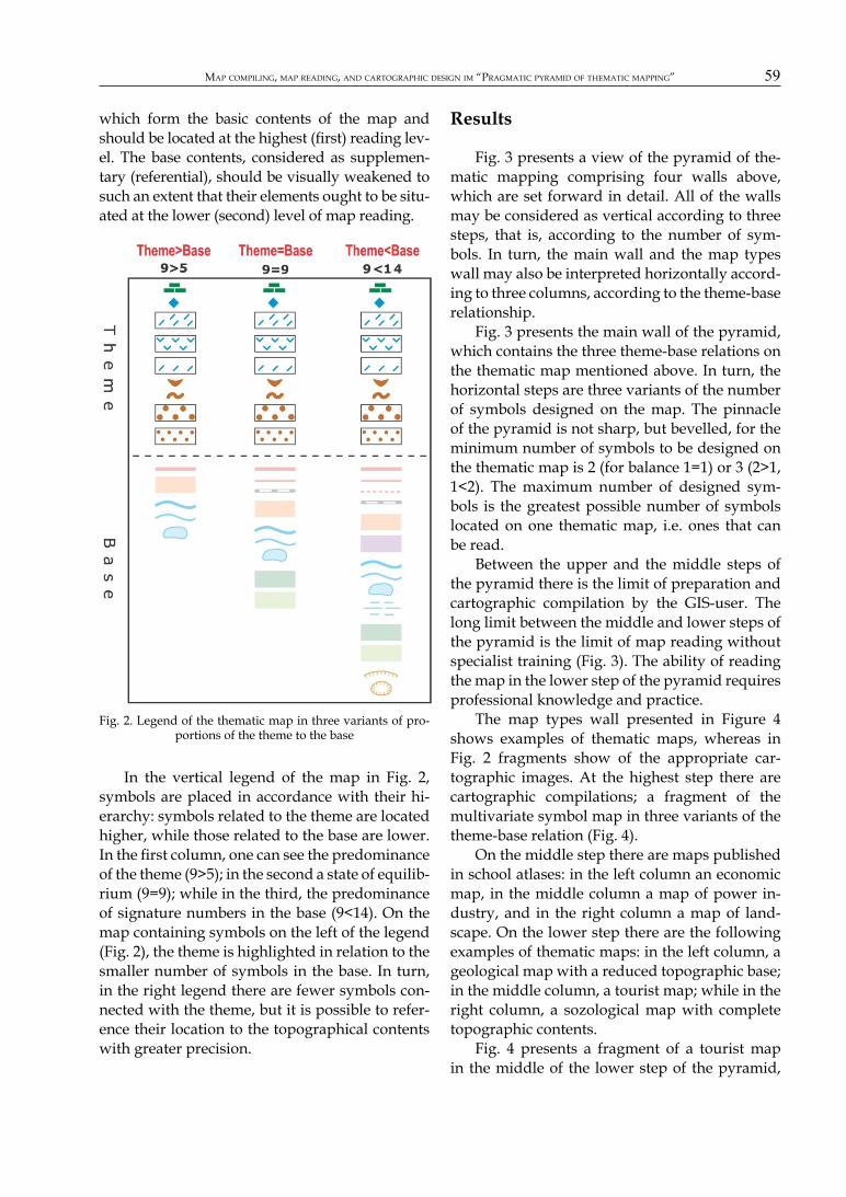
Fig. 3 presents a view of the pyramid of the-matic mapping comprising four walls above, which are set forward in detail. All of the walls may be considered as vertical according to three steps, that is, according to the number of sym-bols. In turn, the main wall and the map types wall may also be interpreted horizontally accord-ing to three columns, according to the theme-base relationship.
Fig. 3 presents the main wall of the pyramid, which contains the three theme-base relations on the thematic map mentioned above. In turn, the horizontal steps are three variants of the number of symbols designed on the map. The pinnacle of the pyramid is not sharp, but bevelled, for the minimum number of symbols to be designed on the thematic map is 2 (for balance 1=1) or 3 (2>1, 1<2). The maximum number of designed sym-bols is the greatest possible number of symbols located on one thematic map, i.e. ones that can be read.
Between the upper and the middle steps of the pyramid there is the limit of preparation and cartographic compilation by the GIS-user. The long limit between the middle and lower steps of the pyramid is the limit of map reading without specialist training (Fig. 3). The ability of reading the map in the lower step of the pyramid requires professional knowledge and practice.
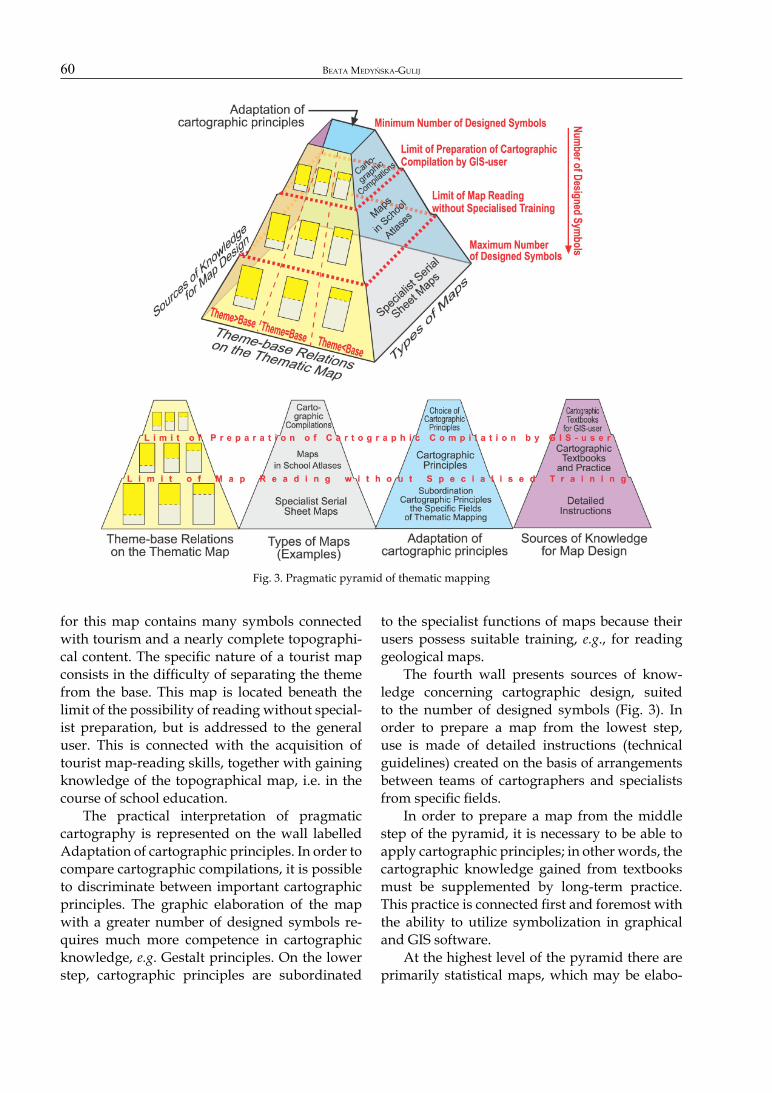
The map types wall presented in Figure 4 shows examples of thematic maps, whereas in Fig. 2 fragments show of the appropriate car-tographic images. At the highest step there are cartographic compilations; a fragment of the multivariate symbol map in three variants of the theme-base relation (Fig. 4).
On the middle step there are maps published in school atlases: in the left column an economic map, in the middle column a map of power in-dustry, and in the right column a map of land-scape. On the lower step there are the following examples of thematic maps: in the left column, a geological map with a reduced topographic base; in the middle column, a tourist map; while in the right column, a sozological map with complete topographic contents.
Fig. 4 presents a fragment of a tourist map in the middle of the lower step of the pyramid,
BEATA MEDYŃSKA-GULIJ60
for this map contains many symbols connected with tourism and a nearly complete topographi-cal content. The specifi c nature of a tourist map consists in the diffi culty of separating the theme from the base. This map is located beneath the limit of the possibility of reading without special-ist preparation, but is addressed to the general user. This is connected with the acquisition of tourist map-reading skills, together with gaining knowledge of the topographical map, i.e. in the course of school education.
The practical interpretation of pragmatic cartography is represented on the wall labelled Adaptation of cartographic principles. In order to compare cartographic compilations, it is possible to discriminate between important cartographic principles. The graphic elaboration of the map with a greater number of designed symbols re-quires much more competence in cartographic knowledge, e.g. Gestalt principles. On the lower step, cartographic principles are subordinated
to the specialist functions of maps because their users possess suitable training, e.g., for reading geological maps.
The fourth wall presents sources of know-ledge concerning cartographic design, suited to the number of designed symbols (Fig. 3). In order to prepare a map from the lowest step, use is made of detailed instructions (technical guidelines) created on the basis of arrangements between teams of cartographers and specialists from specifi c fi elds.
In order to prepare a map from the middle step of the pyramid, it is necessary to be able to apply cartographic principles; in other words, the cartographic knowledge gained from textbooks must be supplemented by long-term practice. This practice is connected fi rst and foremost with the ability to utilize symbolization in graphical and GIS software.
At the highest level of the pyramid there are primarily statistical maps, which may be elabo-
Fig. 3. Pragmatic pyramid of thematic mapping
MAP COMPILING, MAP READING, AND CARTOGRAPHIC DESIGN IM “PRAGMATIC PYRAMID OF THEMATIC MAPPING” 61
rated by each and every user of spatial data by selecting the mapping technique, e.g. choropleth mapping, dot mapping, and proportional symbol mapping in geoinformational programmes. The GIS user participating in the automated map-de-sign process uses the development of an expert system, in which a suitable program automati-cally makes decisions concerning symbolization (Forest, 1999). In order to undertake cartographic compilations, it is suffi cient to possess a general knowledge of cartographic principles. The qua-lity of a map design elaborated by the non-car-tographer depends not only on the knowledge of cartographic design and the source of such knowledge, but also on numerous other factors, e.g. on the graphical intuition of the map-maker (Medynska-Gulij, 2008).
In our discussion, a correctly designed map is one with a ‘good’ design. The problem is the lack of any defi nition of ‘good’ design, as well as the lack of a specifi cation of the methods that should be used to achieve it (Wood & Gilhooly, 1996). Dent (1999) and Robinson et al. (1995) connected the design process with creativity. It is possible to
agree with Robinson et al. (1995) that ‘Good de-sign simply “looks” right - it is simple (clear and uncomplicated)’. Good design determines the ef-fectiveness of the cartographic communication process, which Kraak (2001) phrased thus: ‘HOW (cartographic sign system) do I (cartographer) say WHAT (information) to WHOM (user), and is it EFFECTIVE (info-retrieved)?’
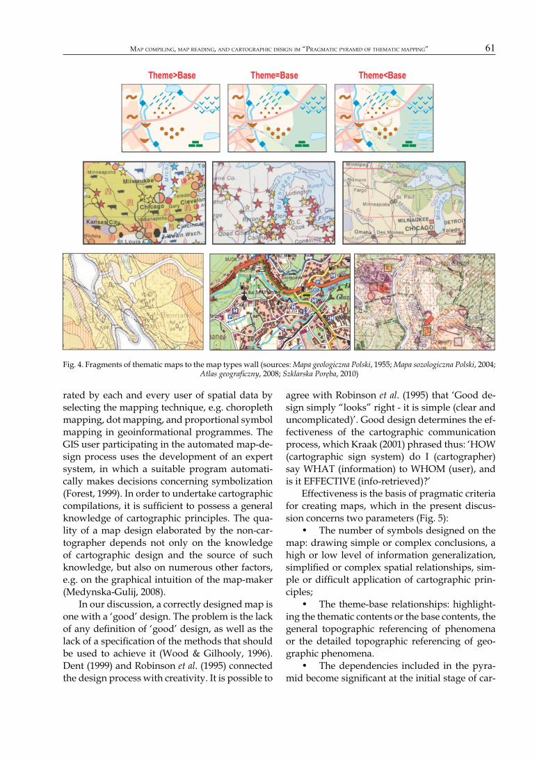
Effectiveness is the basis of pragmatic criteria for creating maps, which in the present discus-sion concerns two parameters (Fig. 5):
The number of symbols designed on the • map: drawing simple or complex conclusions, a high or low level of information generalization, simplifi ed or complex spatial relationships, sim-ple or diffi cult application of cartographic prin-ciples;
The theme-base relationships: highlight-• ing the thematic contents or the base contents, the general topographic referencing of phenomena or the detailed topographic referencing of geo-graphic phenomena.
The dependencies included in the pyra-• mid become signifi cant at the initial stage of car-
Fig. 4. Fragments of thematic maps to the map types wall (sources: Mapa geologiczna Polski, 1955; Mapa sozologiczna Polski, 2004; Atlas geografi czny, 2008; Szklarska Poręba, 2010)

BEATA MEDYŃSKA-GULIJ62
tographic design. The map-maker may specify pragmatic criteria (Fig. 3), which will help them to select the number of symbols and effect their division between the theme and base of the map. Fig. 4 presents the way of reducing contents by ‘passing’ from the right to the left block on the example of a map from the highest step of the pyramid (compare with the three legends of this map in Fig. 2). Reduction consists in changing the proportions of contents from the predominance of the base over the theme through equilibrium to the predominance of the theme over the base, while maintaining a constant number of designed symbols in the thematic contents of the map.
Conclusions
The aim of this study is was to present the functional relationships existing between map compilation, map reading, and cartographic design. The result of simplifying these was the graphical model of pragmatic thematic mapping, expressed as a pyramid.
From the extremely complex process of carto-graphic design, two measurable parameters were adopted for discussion: the number of designed symbols and the relationships between the number of designed symbols in the thematic con-tent and the number of designed symbols in the base on the thematic map. Such a selection made it possible to visualize the basic relationship be-tween cartographic compilation and cartographic design. The advantages of the proposed graphi-
cal model of the pragmatic pyramid of thematic mapping include the following:
determining pragmatic cartography and • the limits of map reading without specialized training and cartographic compilation and the limit of preparation in undertaking cartographic compilation by the GIS-user (non-cartographer);
visually presenting a basic – yet measura-• ble – relationship between pragmatic cartography and map-design into the semiotic: the number of designed symbols on the map divided into theme symbols and base symbols thus providing three variants of the thematic map;
referring these dependencies in a practi-• cal sense to types of maps, the adaptation of car-tographic principles, and sources of knowledge for map design;
indicating effectiveness as the basis for • pragmatic criteria governing map preparation with reference to two mapping parameters.
The weak points of the model of pragmatic de-pendences in the pyramid include the following:
the simplifi cation of the extremely com-• plex process of thematic map design into two pa-rameters;
it is diffi cult to specify limits for the prep-• aration the map and limits for map reading with-out specialized training;
it is diffi cult to determine the location of • the map type on a given step of the pyramid with scientifi c rigour;
judgments concerning differences be-• tween a base layer versus a theme layer may not be repeatable.
Fig. 5. Criteria of use thematic map in relation to the pragmatic pyramid
MAP COMPILING, MAP READING, AND CARTOGRAPHIC DESIGN IM “PRAGMATIC PYRAMID OF THEMATIC MAPPING” 63
This pragmatic pyramid of thematic map-ping nonetheless provides insights into the map design process and indicates crucial changes in map-making and map-use. Nowadays, non-car-tographers, through cartographic compilation, create more maps than cartographers. The pyra-mid shows that changing the number of designed symbols has important pragmatic consequences for map-design, namely in achieving the balance between the two indicated limits. Consequently, non-cartographers should be wary of the ease of compounding many layers from vector databases and cartographers should continue to uphold cartographic principles.
References
Atlas geografi czny: Polska, kontynenty, świat. 2008. Wydaw-nictwo PPWK, Nowa Era, Wrocław.
BERTIN J., 1983. Semiology of Graphics: Diagrams, Network, Maps. Madison, University of Wisconsin Press.
DENT B.D., 1990. Cartography: Thematic Map Design. 2nd ed., Wm. C. Brown Publishers, Dubuque.
DENT B.D., 1999. Cartography: Thematic Map Design. 5th ed. McGraw-Hill, Boston.
FORREST D., 1999. Developing Rules for Map Design: A Func-tional Specifi cation for a Cartographic-design Expert System. Cartographica 36(3): 31-52.
FREITAG U., 1971. Semiotik und Kartographie. Kartographische Nachrichten 5: 171-182.
KEATES J.S., 1982. Understanding maps. New York: Halsted Press.
KRAAK M.-J. & ORMELING F., 2003. Cartography: Visualization of Geospatial Data. Pearson Education Limited.
KRAAK, M.-J., & A. BROWN 2001. Web Cartography: Develop-ments and Prospects. Taylors & Francis, London.
Mapa geologiczna Polski 1:200,000, arkusz Poznań. 1955. Pań-stwowy Instytut Geologiczny, Warszawa.
Mapa sozologiczma Polski 1:50,000, arkusz Mosina. 2004. Główny Urząd Geodezji i Kartografi i, Warszawa.
MEDYNSKA-GULIJ B., 2008. Point Symbols: Investigating Prin-ciples and Originality. Cartographic Journal 45(1): 62-67. DOI: 10.1179/000870408X276602.
MORRIS C.W., 1971. Sign, language, and behavior. In: C. Morris (ed.), Writings on the General Theory of Signs. Mou-ton, The Hague: 73-398.
ROBINSON A.H., MORRISON J.L., MUEHRCKE P.C., KIMERLING A.J. & GUPTILL S.C., 1995. Elements of Cartography. 6th ed., Wiley, New York.
SLOCUM, T.A., R.B. MCMASTER, F.C. KESSLER, AND H.H. HOWARD. 2005. Thematic Cartography and Geographic Vi-sualization, 2nd ed. Pearson Prentice Hall.
SOUTHWORTH M. & SOUTHWORTH S., 1982. Maps: A Visual Sur-vey and Design Guide. A New Your Graphic Society Book, Little, Brown, Boston: 16-17.
Szklarska Poręba, plan miasta 1:9000. 2010. Wydawnictwo PLAN, Jelenia Góra.
WOOD, M., & GILHOOLY K.J., 1996. The Practitioner’s View? A Pilot study into Empirical Knowledge About Carto-graphic Design. In: C.H. Wood & C.P. Keller (eds.), Cartographic Design: Theoretical and Practical Perspectives. Wiley, Chicherster: 67-76.