mapping & land title document preparation manual
TRANSCRIPT

Printed on
recycled paper
City of San Diego
Mapping & Land Title Document Preparation Manual
January 14, 2013 This information, or this document (or portions thereof), will be made available in alternative formats upon request.


i
Preface
The previous City of San Diego Subdivision Manual was written in 1967 and has undergone many revisions over the years. However, the revisions were page changes or paragraph changes issued by memos. A comprehensive, complete revision has not been done until now. There have been many changes to City policies and the subdivision process. In 1972, the Subdivision Map Act went through a major revision, including the addition of Parcel Maps as a document for subdividing land. This updated manual reflects the changes and is consistent with state law.
The 1967 manual gave little guidance to the applicant regarding the preparation of a map or any other land title document. This updated manual is the guide to preparing and processing maps and other land title documents within the City of San Diego. It includes current State, County and City requirements via hyperlinks to referenced sections of the Subdivision Map Act (SMA), Professional Land Surveyor's Act (LSA), Streets and Highway Code, California Civil Code, and the San Diego Land Development Code (LDC).
This manual was prepared and/or reviewed by a committee comprised of members of the California Land Surveyors Association, San Diego Chapter, city staff, and others in the professional community. The committee members and city staff spent numerous hours writing and evaluating the content of this manual in order to provide a valuable tool for land surveyors employed by the City of San Diego and private the land surveying community as well. Anne Hoppe and Lee Hennes devoted countless hours to the initial creation of this manual and deserve huge thanks for their efforts!
A special thank you to all who participated in this effort, including, but not limited to:
Adolfo Aguilar, PLS, Dave Ambler, PLS, Tony Arcillas, PLS, Mike Butcher, PLS, Lonie Cyr, PLS, Sean Englert, PLS, Daniel Hall, PLS, Don Harris, PE, Lee Hennes, PLS, retired, Anne Hoppe, PLS, Greg Hopkins, PLS, Gary Hus, PLS, Casey Lynch, PLS, Patrick McMichael, PLS, John Montes de Oca, PLS, DK Nasland, PLS, Tony Nothdurft, PLS, Evan Page, PLS, Michael J. Pallamary, PLS, Ron Roth, PLS, Larry Stevens, PLS, Jeffrey Strohminger, PE, Jim Taylor, PLS, Ian Wilson, PLS, and Dave Woolley, PLS.

ii MAPPING AND LAND TITLE DOCUMENT PREPARATION MANUAL
LIST OF FIGURES………………………………………………………………………...….….X
CHAPTER 1 GENERAL PROCEDURES ......................................................................................... 1
STATUTES AND REQUIREMENTS ..................................................................................... 1
SUBMITTING DOCUMENTS FOR REVIEW ......................................................................... 2
Document Review ............................................................................................. 2
Reducing the Number of Review Cycles .......................................................... 3
Mark-up Procedures .......................................................................................... 4
CHAPTER 2 SUBDIVISION APPROVALS ...................................................................................... 5
PURPOSE ........................................................................................................................ 5
WHICH MAP IS REQUIRED? ............................................................................................ 5
Exclusions from the SMA ................................................................................. 5
Exceptions to Normal Subdivision Processing ................................................. 6
Condominiums .................................................................................................. 7
Condominium Conversions .............................................................................. 7
THE DISCRETIONARY DECISION PROCESS ...................................................................... 7
Tentative Map ................................................................................................... 8
Staff Review and Public Hearing ...................................................................... 8
Vesting Rights ................................................................................................... 9
Term of a Tentative Map .................................................................................. 9
Subdivision Map Waivers ................................................................................. 9
THE MINISTERIAL REVIEW PROCESS ........................................................................... 10
Substantial Conformance ................................................................................ 10
Final Processing .............................................................................................. 11

iii
CHAPTER 3 SURVEYING PROCEDURES .................................................................................... 13
PURPOSE ...................................................................................................................... 13
STANDARD OF CARE AND PRACTICES .......................................................................... 13
Junior/Senior Rights........................................................................................ 14
Gaps and Overlaps .......................................................................................... 14
Reversion Rights ............................................................................................. 15
Discrepancies with Record Data ..................................................................... 16
When a Problem is Identified ......................................................................... 16
Monument Control .......................................................................................... 17
Specific Problem Areas................................................................................... 20
BASIS OF BEARINGS ..................................................................................................... 20
BASIS OF ELEVATIONS ................................................................................................. 25
PROCEDURE OF SURVEY .............................................................................................. 25
CHAPTER 4 DOCUMENT PREPARATION STANDARDS .............................................................. 27
PURPOSE ...................................................................................................................... 27
PRINCIPAL DRAFTING STANDARDS .............................................................................. 27
Lettering .......................................................................................................... 27
Scale ................................................................................................................ 27
Details ............................................................................................................. 28
Shading ........................................................................................................... 28
SURVEYING DRAFTING STANDARDS ............................................................................ 28
Sheet orientation ............................................................................................. 28
Line Work ....................................................................................................... 28
Adjoining Maps .............................................................................................. 30
iv MAPPING AND LAND TITLE DOCUMENT PREPARATION MANUAL
Streets .............................................................................................................. 30
Monuments ..................................................................................................... 30
Legend............................................................................................................. 31
Dimensions ..................................................................................................... 33
Traverses ......................................................................................................... 33
Lots ................................................................................................................. 34
REQUIREMENTS SPECIFIC TO EASEMENTS .................................................................... 34
NON-TITLE SHEET STANDARDS .................................................................................... 36
REQUIREMENTS SPECIFIC TO DRAWINGS ..................................................................... 38
Drawing Titles ................................................................................................ 38
REQUIREMENTS SPECIFIC TO TENTATIVE MAPS ........................................................... 39
Existing Conditions ......................................................................................... 39
Proposed Development ................................................................................... 40
Notes and Information .................................................................................... 40
CHAPTER 5 SUBDIVISION MAPS.............................................................................................. 41
PARCEL MAPS .............................................................................................................. 41
Map Requirements per the SMA .................................................................... 41
Preliminary Title Report and Map Guarantee ................................................. 41
Certificates (See Appendix A) ........................................................................ 42
Owners’ Certificate ......................................................................................... 45
Dedications and Granting of Easements on maps........................................... 45
Reversion Rights ............................................................................................. 46
Owner’s Signature .......................................................................................... 47
Other Interested Parties’ Signatures ................................................................ 48
Signature Omission Statement ........................................................................ 48
v
Vesting Tentative Map .................................................................................... 50
City Clerk’s Certificate ................................................................................... 50
Clerk of the Board of Supervisors Certificate................................................. 51
Legal Description ............................................................................................ 52
Planned Development Statement .................................................................... 53
Parcel Map Guarantee ..................................................................................... 54
Land Surveyor’s Statement ............................................................................. 54
City Land Surveyor’s Statement ..................................................................... 56
County Recorder’s Certificate ........................................................................ 58
Joint Use Agreement ....................................................................................... 59
Notary Acknowledgments .............................................................................. 59
FINAL MAPS ................................................................................................................. 61
Preliminary Report and Subdivision Guarantee ............................................. 61
Certificates ...................................................................................................... 61
Owners’ Certificate ......................................................................................... 64
Dedications and Granting of Easements ......................................................... 64
Owner’s Signature .......................................................................................... 64
Other Interested Parties’ Signatures ................................................................ 65
Signature Omission Statement ........................................................................ 65
Vesting Tentative Map (VTM) ....................................................................... 65
Subdivision Name ........................................................................................... 65
Legal Description ............................................................................................ 66
Planned Development Statement .................................................................... 66
Condominium Statement ............................................................................... 67
Subdivision Guarantee .................................................................................... 67
vi MAPPING AND LAND TITLE DOCUMENT PREPARATION MANUAL
City Clerk’s Certificate ................................................................................... 67
Land Surveyor’s Statement ............................................................................. 68
City Land Surveyor’s Statement ..................................................................... 69
Clerk of the Board of Supervisors Certificate................................................. 70
County Recorder’s Certificate ........................................................................ 70
Joint Use Agreement ....................................................................................... 70
Notary Acknowledgments .............................................................................. 70
CORRECTION AND AMENDMENT OF MAPS ................................................................... 71
CERTIFICATE OF CORRECTION ..................................................................................... 71
AMENDED MAPS .......................................................................................................... 72
Certificates ...................................................................................................... 72
Subdivision Name ........................................................................................... 72
Owners and Title Interest Certificate .............................................................. 73
Vested Development Rights ........................................................................... 73
Legal Description ............................................................................................ 73
Planned Development Statement .................................................................... 74
Subdivision Guarantee .................................................................................... 74
City Clerk’s Certificate ................................................................................... 74
Land Surveyor’s Statement ............................................................................. 74
City Land Surveyor’s Certificate .................................................................... 75
Clerk of the Board of Supervisor’s Certificate ............................................... 75
County Recorder’s Certificate ........................................................................ 75
Corrections ...................................................................................................... 76
CHAPTER 6 EASEMENTS ......................................................................................................... 78
GRANTING OF EASEMENTS ........................................................................................... 78

vii
EASEMENT GRANTS AND DEDICATIONS ....................................................................... 79
DOCUMENTS AND DEEDS ............................................................................................. 80
Review and Approval ..................................................................................... 80
Legal Descriptions .......................................................................................... 80
Drawing Requirements ................................................................................... 81
Additional Issues ............................................................................................. 81
EXTINGUISHMENT OF EASEMENTS ............................................................................... 82
UNACCEPTED IRREVOCABLE OFFERS OF DEDICATION OR STREET RESERVATIONS ...... 82
RIGHTS OF ACCESS ...................................................................................................... 83
CHAPTER 7 OTHER LAND TITLE DOCUMENTS ........................................................................ 84
LOT LINE ADJUSTMENTS ............................................................................................. 84
Purpose ............................................................................................................ 84
Eligibility ........................................................................................................ 84
Process ............................................................................................................ 84
Requirements .................................................................................................. 84
Lot Line Adjustment Plats .............................................................................. 85
Lot Line Adjustment Parcel Maps .................................................................. 85
CERTIFICATES OF COMPLIANCE FOR THE VALIDATION OF LEGAL LOTS ........................ 86
Purpose ............................................................................................................ 86
Eligibility ........................................................................................................ 86
Special Issues .................................................................................................. 87
COVENANT TO HOLD AS ONE PARCEL ........................................................................... 87
Purpose ............................................................................................................ 87
Eligibility ........................................................................................................ 87
Release of a Covenant to hold as one parcel................................................... 88
viii MAPPING AND LAND TITLE DOCUMENT PREPARATION MANUAL
REVERSION TO ACREAGE ............................................................................................. 88
Purpose ............................................................................................................ 88
Procedure ........................................................................................................ 88
Preparation ...................................................................................................... 89
Map Title ......................................................................................................... 89
Legal Description ............................................................................................ 89
Owner’s Certificate ......................................................................................... 90
City Land Surveyor’s Certificate .................................................................... 91
APPENDIX A MAP CERTIFICATES ........................................................................................... 93
ACCESS EASEMENTS FOR A UTILITY ............................................................................. 93
ARCHAEOLOGICAL PROTECTION EASEMENT ................................................................ 93
AVIGATION APPROACH EASEMENT FOR BROWN FIELD ............................................... 93
AVIGATION EASEMENT AND RIGHT-OF-WAY FOR BROWN FIELD ................................ 95
BUILDING RESTRICTED EASEMENT .............................................................................. 96
BUILDING RESTRICTED EASEMENT FOR SEISMIC HAZARD ........................................... 96
CLEAR ZONE EASEMENT FOR BROWN FIELD ............................................................... 96
COVENANT AGREEMENT .............................................................................................. 97
DRAINAGE EASEMENT ................................................................................................. 97
ELECTRICAL EASEMENT .............................................................................................. 98
EMERGENCY ACCESS EASEMENT ................................................................................. 98
FLOOD WATER STORAGE EASEMENT ........................................................................... 98
FLOWAGE EASEMENT .................................................................................................. 98
GENERAL UTILITY EASEMENT ..................................................................................... 99
JOINT USE AGREEMENT ............................................................................................... 99
LANDSCAPE EASEMENT ............................................................................................. 100
ix
OPEN SPACE EASEMENT ............................................................................................ 101
PUBLIC UTILITY AS OWNER ....................................................................................... 101
RECLAIMED WATER EASEMENT ................................................................................ 102
RECREATION EASEMENT (FOR PRIVATE USE) ............................................................. 102
RECREATION EASEMENT (FOR PUBLIC USE) ............................................................... 102
RELINQUISHMENT OF ACCESS RIGHTS ....................................................................... 103
SEWER EASEMENT ..................................................................................................... 103
SIGHT VISIBILITY EASEMENT ..................................................................................... 103
SLOPE EASEMENTS .................................................................................................... 104
TEMPORARY CONSTRUCTION EASEMENT................................................................... 104
WATER EASEMENT .................................................................................................... 105
APPENDIX B RELEVANT CASE LAW ....................................................................................... 106
ANTIQUATED SUBDIVISIONS & GRANDFATHER CLAUSES .......................................... 107
DEDICATIONS (PRE-1893) ......................................................................................... 107
GIFTS ......................................................................................................................... 107
LEASES ...................................................................................................................... 107
LOT LINE ADJUSTMENTS ........................................................................................... 107
MISCELLANEOUS ....................................................................................................... 107
QUARTERING ............................................................................................................. 107
REVERSION RIGHTS ................................................................................................... 108
TAKINGS .................................................................................................................... 108
REFERENCES ........................................................................................................ 109
INDEX ....................................................... ERROR! BOOKMARK NOT DEFINED.
x MAPPING AND LAND TITLE DOCUMENT PREPARATION MANUAL
LIST OF FIGURES
Figure Page
1. Basis of Bearings using conventional field survey………………………..
22 2. Basis of Bearings using G.P.S.
measurements…………………………… 23
3. Legend of line weights and line styles…………………………………….
29 4. Standard legend for a
map……………………………………………....... 31
5. Parcel Map title sheet (3 columns)………………………………………..
43 6. Parcel Map title sheet (4
columns)……………………………………….. 44
7. Subdivision Map title sheet (3 columns)………………………………….
62 8. Subdivision Map title sheet (4
columns)…………………………………. 63

CHAPTER 1 GENERAL PROCEDURES 1
CHAPTER 1 GENERAL PROCEDURES
A land survey document such as a map or a legal description is often related to a development permit allowing an owner to improve and possibly sell real property. A survey document may also be part of a stand-alone request from a property owner to, as an example, adjust the boundary line between two or more parcels. This chapter will discuss general procedures that, if used, will facilitate the approval of survey documents. There are no specifics on how to prepare the document in this chapter. There are, however, procedures that the document preparer and the reviewer can follow that will speed the approval process without sacrificing the quality of the finished document.
STATUTES AND REQUIREMENTS
The City of San Diego Land Development Code (LDC) provides the regulatory framework for land development within the City of San Diego. The LDC is contained in the following four chapters of the Municipal Code:
1. Chapter 11 defines the five processes used to approve permits and entitlements.
2. Chapter 12 specifies the requirements for the approval of permits and entitlements (Article 5 is Subdivision Approvals).
3. Chapter 13 defines the City’s Zoning Ordinance.
4. Chapter 14 contains miscellaneous regulations related to the development of land (Article 4 is Subdivision Regulations).
The Professional Land Surveyors Act, beginning at Section 8700 of the California Business and Professions Code, regulates the preparation of survey documents and who may prepare them. Survey documents must be prepared by or under the direction of a Professional Land Surveyor (PLS) or Professional Engineer (PE), who is authorized to practice land surveying. A Professional Engineer registered prior to January 1, 1982 (registration number 33965 and below) may practice land surveying and may prepare survey documents. For simplicity, any person qualified to practice land surveying is referred to as ‘the surveyor’ throughout this manual.
All subdivision maps are prepared in accordance with the Subdivision Map Act (SMA) (beginning at Section 66410 of the California Government Code), the Professional Land Surveyors Act, and the City of San Diego Land Development Code (LDC).
This manual is part of the City of San Diego Land Development Manual and is the approved source for requirements established by state law and local ordinance. It sets reasonable technical standards for document preparation and professional practice. The requirements and guidelines as specified in this manual should be followed as closely as possible. The City Land Surveyor must give prior approval for any substantive deviations.
2 MAPPING AND LAND TITLE DOCUMENT PREPARATION MANUAL
SUBMITTING DOCUMENTS FOR REVIEW
The City of San Diego has established procedures to submit documents for staff review and approval. The submittal requirements for most survey documents can be found in Section 5, Subdivision Approvals and the corresponding required fees or deposits are shown in Information Bulletin 504, ‘Fee/Deposit Schedule for Subdivision Approvals.’ A typical project submittal package will consist of the required applications, fees, copies of the survey document to be reviewed, a copy of any entitlement authorizing or requiring the preparation of the survey document and the reference materials upon which the survey document was based. The reviewer will keep all reference materials until the document is finally approved. The applicant/surveyor should keep duplicate copies for his/her use.
The project submittal package will be reviewed for completeness. A project file will be set-up and packages routed to all City staff required to review and approve the document. A submittal package not meeting the published minimum submittal standards will not be accepted for review.
DOCUMENT REVIEW State law and City Ordinance require that the City Land Surveyor review and approve survey documents related to development projects. City staff reviews a survey document to determine its conformity to law (such as zoning), its satisfaction of a development condition of approval, and its technical adequacy. Much of the time spent on a review is devoted to ensuring the technical adequacy of a document. The standards for the technical review are contained in this manual and are based upon commonly accepted professional surveying practice. City review staff and surveyors should use the manual as a guide and work together to come up with mutually agreeable solutions to the issues that may not be covered in this manual.
The review process starts when an applicant submits a document for review by City staff. City staff will clearly mark revisions and issues of concern on the draft document being reviewed and enter these comments into the City’s Project Tracking System (PTS). This review along with comments from all requisite disciplines will be tracked in a review cycle within PTS. The reviewer will send back the marked-up draft, together with the comments entered in the PTS to the applicant/surveyor; after which the reviewer will close the review cycle.
The applicant/surveyor must address every comment before a document can be approved. The comments or issues will not be resolved by simply re-submitting a document for review. An applicant/surveyor should contact the reviewer if they disagree with a comment or find it beneficial to discuss. Reviewers and their supervisors are always available by appointment to meet with the applicant/surveyor to help resolve differences.
Once all corrections have been made and the issues are resolved, the entire revised package, including previous check print, new sets of revised prints and any additional information requested by the reviewer is submitted for further review and to clear prior comments and issues. The reviewer will still have the reference material and information submitted for the

CHAPTER 1 GENERAL PROCEDURES 3
first review. This begins a new review cycle, which will be repeated until all revisions, conditions, and issues are resolved.
REDUCING THE NUMBER OF REVIEW CYCLES Ideally, it should take no more than two or three reviews to complete a document review with the last review cycle being the submittal of the final document, i.e. Mylar, executed deeds, agreements, etc. This is only possible if reviewers are comprehensive in their review and the customer is responsive to the reviewer’s comments between review cycles. There are many factors that can cause a project to go through additional review cycles. We cannot control what our customers choose to do, but customers should be aware that their business practices affect our review time. Some of those factors are:
Following the rules – Understand the review process time line and adopted document preparation standards.
Assuming responsibility for your document – Don’t expect City staff to be your quality control – carefully review documents before they are submitted to the City for review.
Acting on all review comments – It is not expected that an applicant/surveyor will always agree with review comments, but it is expected that they will address them before resubmitting the project. If necessary, a conflict resolution meeting should be requested.
Controlling your turn-around time after reviews –Projects may fall behind schedule because the applicant/surveyor is slow to make the required changes and resubmit a project after a review in a timely manner.
Providing all requested information – Reviewers cannot review information that the customer fails to provide.
Planning your project – Some projects go through several major revisions during the review process before a final version is submitted for review. This wastes the time of all concerned. Applicants/surveyors should do their project planning up front, not during the review process.
Managing permit conditions – Applicant/surveyors must satisfy the conditions of approval placed on a tentative map or other permit. Some conditions of approval require a long time to complete. Projects are often delayed at the last minute because the applicant/surveyor failed to satisfy a permit condition. Applicant and their surveying professionals are responsible for monitoring or knowing the expiration dates of the tentative map and any associated permits.
Surveyors can adopt business practices that largely eliminate most of the problems that negatively impact the review process and in doing so, will find that their projects get

4 MAPPING AND LAND TITLE DOCUMENT PREPARATION MANUAL
approved more quickly with fewer review cycles. The reviewer and the applicant/surveyor need to work as a team to reduce processing time.
MARK-UP PROCEDURES The following conventions will improve communications between the surveyor and the reviewer and will reduce redundant checks. City staff and the surveyor should use the following conventions during the review of a document:
1. The reviewer will request changes and make comments in red on the check print. Suggestions will be so labeled.
2. Items that have been reviewed and approved by the reviewer will be marked in yellow highlighter on the check print.
3. The surveyor should mark changes that were made on the check print with a green highlighter and return it to the reviewer in the next review cycle.
4. To alert the reviewer, changes in a document that were not requested by the reviewer should be “bubbled” or otherwise noted on the new print.
City staff will be concentrating on the legal requirements, clarity and technical adequacy of the document. Sometimes, items may be missed in the first review; however, it is still the responsibility of the private surveyor to produce a technically correct document that can be certified by the City Land Surveyor. All substantive issues must be addressed, even if they were inadvertently overlooked on the first and/or subsequent reviews. The applicant/surveyor is responsible for the technical quality of a document and for complying with all the requirements of a discretionary approval, the Subdivision Map Act and local ordinance.
CHAPTER 3 SURVEYING PROCEDURES 5
CHAPTER 2 SUBDIVISION APPROVALS
PURPOSE
Any division of land into additional parcels or separate ownership interests for sale, lease, or financing is a subdivision. Subdivisions are regulated under the Subdivision Map Act (SMA) beginning at Section 66410 of the California Government Code. The creation of a condominium, community apartment project, or stock cooperative is also a subdivision of land. The normal process requires the discretionary approval of a tentative map and the ministerial approval of either a parcel map or final map.
WHICH MAP IS REQUIRED?
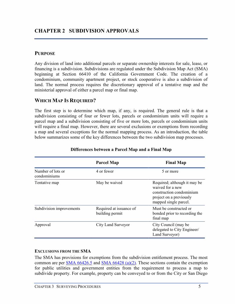
The first step is to determine which map, if any, is required. The general rule is that a subdivision consisting of four or fewer lots, parcels or condominium units will require a parcel map and a subdivision consisting of five or more lots, parcels or condominium units will require a final map. However, there are several exclusions or exemptions from recording a map and several exceptions for the normal mapping process. As an introduction, the table below summarizes some of the key differences between the two subdivision map processes.
Differences between a Parcel Map and a Final Map
Parcel Map Final Map
Number of lots or condominiums
4 or fewer 5 or more
Tentative map May be waived Required; although it may be waived for a new construction condominium project on a previously mapped single parcel.
Subdivision improvements Required at issuance of building permit
Must be constructed or bonded prior to recording the final map
Approval City Land Surveyor City Council (may be delegated to City Engineer/ Land Surveyor)
EXCLUSIONS FROM THE SMA The SMA has provisions for exemptions from the subdivision entitlement process. The most common are per SMA 66426.5 and SMA 66428 (a)(2). These sections contain the exemption for public utilities and government entities from the requirement to process a map to subdivide property. For example, property can be conveyed to or from the City or San Diego

6 MAPPING AND LAND TITLE DOCUMENT PREPARATION MANUAL
Gas and Electric (SDG&E) by deed without recording a map to legally create the parcel. Any parcel created in this manner is a legal lot, which may or may not have development rights.
A government entity or utility loses this exemption when the subdivision is for the commercial sale of property as in normal land development. In other words, the City loses its exemption when it behaves like a developer and there is not a governmental purpose for the subdivision.
Another exemption is a lot line adjustment, which is not a subdivision of land per section SMA 66412(d). The lot lines between four or fewer existing adjoining legal parcels may be adjusted so long as no additional parcels are created. The adjusted parcels must conform to building and zoning regulations, be consistent with the general or specific plan, and are subject to the Coastal Act. A parcel map is not required, but one may be used to effectuate the adjustment. Please refer to Chapter 7, Other Land Title Documents; Lot Line Adjustments for more details.
EXCEPTIONS TO NORMAL SUBDIVISION PROCESSING The Subdivision Map Act has five exceptions to the rule that a final map is required for a subdivision of five or more lots or condominium units. These exceptions are contained in SMA 66426:
1. The land before division contains less than five acres, each parcel created by the division abuts upon a maintained public street or highway, and no dedications or improvements are required by the governing body.
2. Each parcel created by the division has a gross area of 20 acres or more and has an approved access to a maintained public street or highway. (Note here that there is no need to abut a dedicated street. Access via a private easement is permissible. Also, there is no requirement that the site be developed.)
3. The land consists of a parcel or parcels of land having approved access to a public street or highway, which comprises part of a tract of land zoned for industrial or commercial development, and which has the approval of the governing body as to street alignments and widths. (This section can greatly simplify the mapping of commercial and industrial developments.)
4. Each parcel created by the division has a gross area of not less than 40 acres or is not less than a quarter of a quarter section. (This exception is wide open and is often used to subdivide ranches for deeding to family members or other large parcels for financing purposes. Note that there is no requirement for access to a dedicated public street.)
5. The land being subdivided is solely for the creation of an environmental subdivision pursuant to SMA 66418.2. (Environmental subdivisions are for land banking and restrict all development of the parcels that are created. They do, however, allow a land owner to create and “sell” mitigation parcels that can then be used to mitigate the environmental impacts of an offsite project.)
CHAPTER 3 SURVEYING PROCEDURES 7
A tentative map and parcel map are required for the subdivisions listed above but all of them are also eligible to be considered for a map waiver, which will be discussed later.
CONDOMINIUMS A condominium, as defined in Section 1350, et seq. of the Civil Code, is a form of real property ownership and requires some specific comments. A condominium consists of an undivided fractional interest in a single lot called the common area coupled with a separate fee interest in a three-dimensional space within a building called a unit, the boundaries of which are shown on a recorded subdivision map and, more specifically, the condominium plan. Condominiums come in many forms and all are not discussed here. Condominiums are a form of cooperative ownership of property which avoids some of the pitfalls of older conventional cooperatives and enables a purchaser to own his/her unit rather than own it indirectly through purchase of stock or other means. The mutual ownership rights and responsibilities are spelled out in the Covenants, Conditions, and Restrictions (CC&Rs), to which each owner must subscribe. Condominiums may consist of residential units, commercial units or industrial units.
The creation of condominium units is a subdivision, just as the more familiar mapped parcel or lot is a subdivision of land and with some exceptions follows the same process as other subdivisions, depending upon the number of condominium units being created. However, the construction of any number of new condominiums on a single, existing, fully developed parcel may be eligible for a map waiver. Multiple lots must be consolidated into a single lot prior to the public hearing to be eligible for a map waiver. Also SMA Section 66426(c) allows a special processing exception for some industrial and commercial condominium projects.
CONDOMINIUM CONVERSIONS Existing apartment buildings may be converted to condominium ownership. SMA 66427.1 and LDC 144.0501 et. seq. have special regulations for condominium conversions to protect the interests of the existing renters or leaseholders. The protections include specific noticing requirements, and in some cases, the payment of relocation expenses by the applicant. Four or fewer apartment units may be converted by going through the tentative map and parcel map process. Four or fewer units may also be converted by going through the waiver process if the project qualifies. The conversion of five or more existing apartment units to condominiums will always require a tentative map and final map. A public hearing before the Planning Commission is required and no prior consolidation of lots is necessary. Information Bulletin 539 provides additional details on condominium conversions.
THE DISCRETIONARY DECISION PROCESS
Once it is determined which subdivision map is required, the subdivision entitlement must be approved, conditionally approved or denied at a noticed public hearing. The basis for the approval or denial of a subdivision is the tentative map. A tentative map is a conceptual exhibit for a proposed subdivision. It depicts the design and improvement of a proposed subdivision and the existing conditions in and around the project area.
8 MAPPING AND LAND TITLE DOCUMENT PREPARATION MANUAL
Depending upon the size and complexity of a project, the public hearing may be conducted before a Hearing Officer (Process Three), the Planning Commission (Process Four), or the City Council (Process Five). These bodies are called collectively the designated decision maker. Projects requiring a zone change, community plan amendment, public right-of way vacation, easement vacation, or certain conditional use permits are Process Five and must be heard by the City Council.
Anyone supporting or opposing the proposed subdivision will be given an opportunity to be heard at the public hearing. The designated decision maker will take all evidence into account, including staff recommendations, and make a decision approving or denying the project. All decisions of a lower body may be appealed once to a higher body, i.e.: Process 2 can be appealed to Process 3. Environmental determinations are appealed to the City Council. The City Council’s decision is final and is subject to judicial review only under limited circumstances.
TENTATIVE MAP A tentative map is always required for a final map (with the exception of new construction condominium projects on a previously mapped and monumented single parcel (See 125.0120(b)(1))) and may be required for a parcel map. City staff reviews and conditions the tentative map which helps form the basis of approval or denial of the subdivision by a Hearing Officer, the Planning Commission, or the City Council. For specific information on the content and format of a tentative map, see Chapter 4.
STAFF REVIEW AND PUBLIC HEARING Staff will review a tentative map to ensure the project complies with all ordinances and regulations relating to land development, including the general and community plan. Staff will also study the impact of the project on the surrounding areas, public facilities, and the environment. A California Environmental Quality Act (CEQA) environmental determination must be made.
Based on its review, staff makes a recommendation to the designated decision maker to approve the project, deny the project, or approve the project with conditions. The designated decision maker will consider the staff report, together with the oral and written testimony before making the decision for the project. Specific findings required pursuant to SMA 66474 and the Land Development Code 125.0440 must be made to approve a tentative map.
Most often staff will recommend approval of the project subject to a list of conditions in the form of a Resolution of Approval. The conditions of approval ensure the necessary infrastructure is constructed to support the subdivision, environmental impacts are mitigated, and adequate public facilities such as school or park sites are provided.
The Resolution of Approval and the Tentative Map, taken together, establish what must be done by the applicant to get the parcel map or final map approved and recorded. The parcel or final map must be in “substantial conformance” with the approved tentative map and all conditions of approval listed in the Resolution of Approval must be satisfied before the map is recorded. The recording of the parcel map or final map completes the land subdivision.

CHAPTER 3 SURVEYING PROCEDURES 9
VESTING RIGHTS A tentative map must be reviewed and approved under the ordinances, policies and standards that exist at the time the tentative map application is deemed complete by City staff. However, the subdivider is provided only limited enduring protection against changes in land use regulations or standards controlled by the City after the tentative map is approved. For example, the Permit Streamlining Act (Section 65961 of the Government Code) forbids the imposition of new conditions on the approval of the final map, parcel map, or building permit that could have been imposed at the time the tentative map was approved. The commencement of construction under a building permit will vest the subdivider in the regulations that existed at the time the permit was issued, until the permit expires.
To provide more certainty, the subdivider may opt to request a vesting tentative map, which will “vest” the project in the same ordinances, policies, and standards that existed at the time the tentative map was deemed complete and continue for two years after a final or parcel map records. A vesting tentative map bridges the gap between the approvals of the tentative map, recordation of the final or parcel map, and commencement of construction. There is, however, still no protection from changes based upon health and safety issues or changes mandated by state and federal laws, over which the City has no control.
TERM OF A TENTATIVE MAP A tentative map is approved in the City of San Diego for an initial term of three years. A tentative map approved under a development agreement will have the same term as the agreement. All conditions of approval must be satisfied and the parcel or final map recorded before the tentative map expires. Once a tentative map expires, no parcel or final map may be recorded until a new tentative map is approved.
An applicant may apply for an extension of time before the tentative map expires pursuant to SMA 66452.6. The designated decision maker can approve one or more discretionary tentative map term extensions for up to a total of five years, which is added to the original three-year term.
A tentative map may also be extended by phasing the project into multiple final maps. Phasing must be approved at the same time the tentative map is approved to ensure the orderly development of the community. There must be offsite improvements required for the development to qualify for phasing. Every time one of the phased maps is recorded, the tentative map is automatically extended three years, up to a total of ten years, including the initial three-year approval. Therefore, a tentative map that was phased and received all discretionary extensions could have a term of up to 15 years.
SUBDIVISION MAP WAIVERS A map waiver is intended for simple subdivisions having few, if any, development issues. The approval of a map waiver is a discretionary decision made at a noticed public hearing in accordance with Chapter 12, Article 5, Division 1 of the Municipal Code. Depending on circumstances, one of three actions may be taken at the hearing: (1) approve the map waiver and waive all mapping requirements or, (2) conditionally approve the map waiver and/or partially waive the mapping requirements or, (3) deny the request for a map waiver.

10 MAPPING AND LAND TITLE DOCUMENT PREPARATION MANUAL
Map waivers are authorized under Section 66428(b) of the Subdivision Map Act and under Chapter 12, Article 5 of the City of San Diego Land Development Code. A project may be considered for a map waiver if:
1. There are no requirements for approval of another major discretionary action such as a Planned Development Permit, or all such approvals have been acquired. In some cases a map waiver application may be consolidated and decided with the other actions.
2. There are no requirements for the construction of major public facilities, engineering studies, or environmental issues, which essentially mean the project is a subdivision of previously developed land.
3. All proposed parcels (or condominiums) meet current zoning and building regulations or have rights as an “existing non-conforming use,” fully permitted under previous regulations or by a variance.
As noted, a map waiver may also be used to subdivide a newly constructed condominium project of any size on a single parcel or to convert an existing apartment complex of four or fewer units to condominiums. A conversion of five or more existing apartment units into condominiums requires the approval of a tentative map and a final map.
Again, the map waiver process is intended for simple projects, with no other significant discretionary approvals and no other outstanding issues. More complex projects should use a tentative map. Refer to LDC 125.0120 for specifics.
THE MINISTERIAL REVIEW PROCESS
The discretionary approval discussed above gives an applicant the conditional right to subdivide their property, that is, an entitlement to subdivide. To complete the process the applicant must have a final or parcel map prepared by a professional land surveyor and submitted to the City for review and processing. The format, content, and technical requirements for maps will be discussed more fully in Chapters 3-7.
The City Land Surveyor is responsible for the review of the map and must ensure that the map is technically correct, that it substantially conforms to the approved tentative map, and all conditions of approval have been satisfied. To satisfy these conditions, the applicant and /or surveyor may need to prepare and submit other documents and engineering plans for review and approval.
SUBSTANTIAL CONFORMANCE A final map or parcel map can only be approved if it “substantially conforms” to its approved tentative map and resolution of approval. Substantial conformance is a judgment call by the City Land Surveyor when certifying a final or parcel map. Substantial conformance does not mean the final or parcel map is exactly the same as the tentative map. It means rather that the final or parcel map meets the expectations and assumptions of the decision maker when it approved the tentative map. Staff may proceed in three ways to determine compliance:

CHAPTER 3 SURVEYING PROCEDURES 11
1. The City Land Surveyor may determine that the differences between the tentative map and the final map are minor and do not “substantially” affect the project as it was approved.
2. The City Land Surveyor may determine that the changes do not conform to the approved tentative map because they are significant and affect multiple disciplines. However, the applicant may still request a formal Substantial Conformance Review by all affected staff disciplines. The final map may be approved with the requested changes if all disciplines determine the changes “substantially conform” to the approved tentative map.
3. If one of the above two scenarios do not apply, the applicant may always request discretionary amendment of the tentative map and its associated permits for any major changes that do not conform to the existing tentative map.
In making a substantial conformance determination, the City Land Surveyor and staff will ask questions like these:
Is there an increase in development rights or density?
Are new environmental impacts or community based concerns impacted by the change?
Are the proposed changes inconsistent with issues raised at the public hearing?
Do the proposed changes require additional approvals or amendments to permits?
Are the design changes substantive and beyond being purely technical in nature?
If the answer to one or more of these questions is yes, the tentative map will usually need to be formally amended at a noticed public hearing before the body that originally approved the tentative map.
FINAL PROCESSING Final processing to recording is initiated once the City Land Surveyor can certify on the face of the map that:
1. The map substantially conforms to the approved tentative map and all conditions contained in the resolution of approval have been satisfied.
2. The map complies with the Subdivision Map Act and local ordinances.
3. The map is technically correct.
Final processing may include signing improvement plans and entering into a bonded agreement for the construction of the improvements. Other documents such as offsite easements and agreements may also need to be executed and/or recorded. The process may include the payment of outstanding review and impact fees, such as for park development or assessment districts, as required. If all is in order, a parcel map may be recorded without further processing. An approved final map must be noticed in the City Council Docket to give public notice that the City Land Surveyor has made the above findings. An interested

12 MAPPING AND LAND TITLE DOCUMENT PREPARATION MANUAL
party has ten calendar days from the date of the Council meeting to appeal the City Land Surveyor’s findings to the City Council. If there is no appeal filed, the final map may be recorded.
Recording a map with the County Recorder involves several steps. All subdivision maps must have a tax certificate from the County Assessor and Subdivision Guarantee from a title company. The tax certificate certifies that all taxes are paid or bonded for and the Subdivision Guarantee informs the County Recorder who must sign the map as owner. Some separate easement deeds or agreements affecting the map may need to be recorded before the map to allow the recording information to be noted on the parcel or final map. An example of such a document is an offsite easement grant required as a condition of map approval. The map is then recorded. The map’s recording information may then be added to other deeds or agreements that depend on the recorded map and then, in turn, can be recorded. An example of such a document is a grant deed in fee to the City of San Diego for an open space lot created on the map.
Recording a subdivision map completes the final step in the land subdivision process. In accordance with an approved tentative map and resolution, the filing of a map may indicate an acceptance or rejections of dedications indicated on the map, and vacate any designated streets or public service easements.

CHAPTER 4 DOCUMENT PREPARATION STANDARDS 13
CHAPTER 3 SURVEYING PROCEDURES
PURPOSE
The Subdivision Map Act (SMA 66442 & 66450) requires that all subdivision maps be reviewed by the local governmental agency under the direction of a Professional Land Surveyor. This peer review examines the map for its format, conformance to legal requirements, and technical correctness. The City Land Surveyor is responsible for protecting the interests of the public, adjoiners and the applicant.
The reviewer is concerned about the map’s clarity, completeness, and agreement with public records. The surveyor must clearly explain and illustrate the process by which the boundary shown on the map was determined so that another surveyor can clearly understand the procedure and follow in the footsteps of the earlier surveyor. The map can be considered complete only if all factors affecting the location of the subdivision boundary are considered including other recorded maps, surrounding surveys, and the rights of adjoiners; also taking into account that proper technical procedures and legal principles were applied to the analysis of the evidence. Finally, agreement means the degree that the procedure of survey is consistent with the public record and the surveys of others, whether of public record or not.
This chapter is intended to assist the surveyor with the technical preparation of the Procedure of Survey Sheet of a final or parcel map. The Procedure of Survey Sheet illustrates how the surveyor located the exterior boundary of the subdivision and shows existing conditions. The Procedure of Survey Sheet is critical because the exterior boundary location affects the rights of adjoining property owners, which must be defined and protected.
STANDARD OF CARE AND PRACTICES
Professional land surveyors often has commonly accepted set of professional practices used to locate property boundaries. These practices are referred to as the “standard of care,” which is usually the standard a court of law would apply to a professional land surveyor when assessing negligence. For a defined geographic area, the local standard of care may occasionally differ from the “text book” solution. The local standard of care is not absolute and must yield to statutory law, applicable court decisions, and the legitimate rights of adjoiners. There are specific areas in the City of San Diego where the concept of a “local standard of care” applies such as Mission Beach, La Jolla, downtown San Diego, and some areas of sectionalized lands in the northern area as well as the Pueblo Lots in the City of San Diego.
The importance of thorough research cannot be over emphasized. Office and field research are the only way you can assure yourself that you are in the footsteps of the earlier surveyors.
Seek the advice of other surveyors who may have performed surveys in the vicinity of your survey and respect the work of your fellow surveying professionals. As an example,

14 MAPPING AND LAND TITLE DOCUMENT PREPARATION MANUAL
do not assume that your measurements are so superior to those of another surveyor that you must set your monument right next to theirs.
You should survey within your block; however, check other monuments in the surrounding area to verify your results.
Carefully evaluate older surveys, as older surveys may provide evidence of the location of original monuments or the intent of the original owner.
Pay attention to occupation. Occupation and improvements can reveal the results of earlier surveys long after the monuments were lost.
The following sections will discuss some typical boundary location problems that commonly occur in subdivision surveying and mapping within the City of San Diego.
JUNIOR/SENIOR RIGHTS A deed transfer that conveys only a portion of a parcel of land normally establishes senior title rights. The grantee acquires a senior right to all of the land described in their deed and the grantor will retain all that remains, a junior right. The order that the deeds were recorded normally determines who has the senior right when several portions of the same parcel are conveyed. Generally, the oldest deed is senior to subsequent deeds. Determining junior/senior rights can be very complex and often a chain of title is required. If a portion of a lot is part of the subject subdivision, the deeds that originally subdivided the lot must be included in the initial submittal. Irrespective of the legal description included in the title report, the surveyor is ultimately responsible for determining junior/senior rights and correctly showing them on the map.
Senior rights are not created when land is conveyed by a lot and block description based on a recorded map. All lots within a subdivision are created simultaneously when the subdivision map is recorded. It should be noted that senior rights can exist between two adjoining subdivisions. When future development occurs that cross the original subdivision boundaries, senior rights must then be considered when locating the subdivision boundary common to the two developments with the first map recorded being senior to the second. As a general rule the first map recorded in a phased development is senior to the second, and so on for subsequent maps. Senior rights are not relevant when the developer uses a preliminary ‘master map’ to first establish the unit boundaries because all units would have been created simultaneously.
GAPS AND OVERLAPS A gap is created when a grantor uses a legal description method that fails to convey all of the land that the grantor intended. An overlap is the opposite and is created when an owner includes land within a legal description that is outside of their ownership. For example, suppose Smith first conveys the east fifty feet of their lot to Jones and sometime later, the west fifty feet to Brown. If the lot has 100 feet exactly, there is no problem. However, if the lot dimension is actually 101 feet, a one-foot gap is created between the two parcels. The one-foot strip still belongs to Smith. If the lot was actually only 99 feet, Brown would overlap Jones by one foot. Recognizing senior rights would grant the full 50 feet to Jones and
CHAPTER 4 DOCUMENT PREPARATION STANDARDS 15
the remainder of the property to Brown. No gap or overlap would be created if the owner had used the proper method of describing the land. In this case, the owner could have conveyed the east and the west one half of the property to Jones and Brown, thus avoiding any conflict.
Subdivision mapping may in and of itself create a gap or overlap. A gap may be created when an owner fails to subdivide and map their entire ownership. Likewise, an overlap may be created when the subdivider includes land in the map belonging to someone else. The legal description of the adjoining parcels could be the problem as discussed above. However, a faulty field survey that inadvertently omits a portion of the subdivider’s ownership from the subdivision map or alternatively encroaches onto a neighboring parcel can result in the same problem; also, utilizing control monuments improperly may create gaps or overlaps.
The City’s map review staff will bring to the attention of the surveyor any possible conflicts with the legal description or map, but it is always the responsibility of the surveyor preparing the legal description or map to identify problems in those documents and interpret them correctly.
REVERSION RIGHTS A reversion right is the assumed right of the owner of a parcel to a portion of the underlying fee interest within an adjoining public street. Sections 831 and 1112 of the California Civil Code and Section 2077(4) of the Code of Civil Procedures create a rebuttable legal presumption that title to a parcel includes title to the center line of an adjoining public street. It is called “a reversion right” or a “reversionary interest” because, when the street easement is vacated, the now unencumbered land is returned to the adjoining owner, if it is the successor in interest to the person that originally dedicated the street for public use. This is not a new fee interest. The adjoiner has always owned the land encumbered by the street easement. There are rules to construe the limits of the reversion area contained in books written by Curtis M. Brown and William M. Wattles and Gurdon Wattles, although these rules are not all inclusive.
In some cases, reversion rights may have been severed by a poorly written legal description in a past conveyance of the property or the acceptance of unproven monuments. Only a court can conclusively determine that an earlier conveyance of real property severed reversion rights. Unless there is a definite statement in a deed such as “Excepting therefrom all rights of reversion within the adjoining public streets”, it is best to consider the reversion rights intact. Several court cases support the contention or understanding that a grantor usually intends to convey their total interest in a land parcel, including rights of reversion in an adjoining street. (See Appendix B for related case law.) It was the practice of early deed writers to use a metes and bounds description where a lot and block description was more appropriate. This practice can leave the status of reversion rights unclear. Again, only a court can make the final determination in such cases.
In order to provide notice that indicates the intent of the map is not to sever any legitimate reversionary interest in the property, the following note shall be shown on all final and parcel maps above the owners signature.

16 MAPPING AND LAND TITLE DOCUMENT PREPARATION MANUAL
IT IS OUR INTENT TO SUBDIVIDE OUR ENTIRE INTEREST IN THE REAL PROPERTY SHOWN ON THIS MAP WITHIN THE HEAVY BORDER, INCLUDING ANY REVERSION RIGHTS THAT MAY EXIST WITHIN THE ADJOINING PUBLIC RIGHTS-OF-WAY. IT IS NOT OUR INTENT TO ALTER OR SEVER THE LEGITIMATE RIGHTS OF OTHERS WHO MAY HAVE A CLAIM ON THOSE REVERSION RIGHTS THROUGH PRIOR CONVEYANCES.
If the land surveyor wants to show the reversionary interest on the maps, they may do so. If they choose to do so, they must include the streets within the legal description on their map (i.e. together with x, y, and z streets as dedicated to public use) and include it in the title report, and include the reversion note shown above on their map. This statement is not a guarantee that reversion rights exist within the mapped area, but it does clearly show that the intent of the subdivider is to include any reversion rights that may exist within the adjoining rights-of-way.
DISCREPANCIES WITH RECORD DATA All monument locations have positional error largely due to the procedures and equipment used by the surveyor who set them. Likewise, there is error in the measurements made by any subsequent surveyor retracing the work of the first surveyor. Measurement errors can be controlled by good field procedure, but they cannot be eliminated. An estimate of error magnitude and its location should be included in any analysis of field survey data. Because there are measurement errors, a minor discrepancy of a few hundredths of a foot between a field measurement and the record information shown on a map should be looked upon as proof of the record value, not grounds to change the record from its long held value.
However, a surveyor must always take notice of significant variations from record data or other evidence indicating a boundary problem or a mapping error. All evidence, including lines of possession, must be evaluated. One of the surveyor’s tasks is to restore a property boundary to where it was intended to be by the original parties. The public always has a stake in the results of a land survey. C.A. Mulford, a well-known surveyor who practiced around 1910, summed up the importance of field measurements nicely:
“It is far better to have somewhat faulty measurements to where the line actually is, than an accurate measurement to where the line does not exist at all.”
WHEN A PROBLEM IS IDENTIFIED No subdivision map or deed can be recorded without first resolving conflicts affecting the mapped or described boundary lines. There are a number of possible remedies available to correct a problem such as those that were discussed above. The remedy applied would depend on the problem and when it was identified:
Use a lot line adjustment to fix a disputed boundary line position. A lot line adjustment is particularly useful to convert encroachments into undisputed ownership or to solve zoning compliance problems.

CHAPTER 4 DOCUMENT PREPARATION STANDARDS 17
An error in the legal description between adjoiners can often be corrected by recording a quitclaim deed between the parties. Each party quitclaims their interest in the parcel on the opposite side of an agreed line. This results in an agreed boundary line location when there is ambiguity.
When a gap or overlap is significant, senior rights should be honored. Proration is not an appropriate procedure to locate the position of a line where a senior right exists. However, minor discrepancies can often be absorbed by the adjoining lots in equity where there is no evidence of a counter intention by the parties in the deeds creating the gap or overlap, and the gap or overlap is non-marketable and insignificant. This is a judgment call. Always evaluate occupation when making your decision and consider third party interest such as lenders and easement holders as their interest can be affected.
The disputed area can be included in the subdivision map with all owners signing the map. The affected area is remapped which will eliminate the problem. After the map records, the owners must exchange quitclaim deeds to effectuate their new ownerships.
The City’s map review staff will bring possible conflicts to the attention of the surveyor, but it is always the responsibility of the surveyor to identify and correct problems. As long as a surveyor has employed generally accepted land surveying principles and decisions comport with applicable legal requirements, city staff will support the work. A solution must make sense after reviewing all factors affecting the problem situation. Academic concepts are good, but common sense is better. Above all, don’t leave a new problem for the next surveyor. Document the problem and the choice of solution with a note on the map.
MONUMENT CONTROL The exterior boundary of subdivision maps are established by measurements from existing monuments set by previous surveyors and resolving those measurements to the record description of the property being subdivided, and of its adjoiners. Many of these monuments may not be original and may have been set and re-set several times. It is prudent for a surveyor to verify a monument’s position in terms of other monuments, occupation, or other intrinsic boundary evidence.
The surveyor should carefully assign the weight to be placed on each found monument by employing recognized legal principles and the local standard of practice while protecting the legitimate rights of adjoiners. Some of the generally-accepted rules for the hierarchy in the acceptance of controlling survey monuments include:
1. Original called for monument of the same character as described in the source document
2. Position of the original monument established by successive controlling survey monuments described in the record
3. Position of the original monument established by ties to local points of reference described in the record
4. Position of the original monument established by the preponderance of local points of reference in general agreement with the record

18 MAPPING AND LAND TITLE DOCUMENT PREPARATION MANUAL
5. Position of the original monument or land corner established by record calls in the senior description
6. Position of the original monument or land corner established by authoritative and independently-confirmed testimony
7. Position of the original monument or land corner established by proportionate adjustment of the record calls in the senior description
Historic lead and tack monuments, as best evidence of original block corners and lines, long acquiesced to by the City and private owners, should be considered as offsets to block corners and should be used to establish public right-of-way lines.
Historic lead and tacks were set by the City and typically shown on historic tie point sheets which are available at City Records. However, they must be evaluated with other survey evidence to ensure each monument’s validity and the degree of control to be assigned to it.
Public right-of-way lines are fixed by original evidence and may be more or less than the record distance shown on a map and may not be parallel.
In subdivisions where centerlines of streets were not mapped or monumented in the original survey but block corners were originally surveyed, then the original block corner monuments, or the best evidence perpetuating their original locations prevail, and the street right-of-way lines may be more or less than record distance and may not be parallel. San Diego is somewhat unique in the regard as other cities may weight controlling monuments differently. Private owners occupying land have the right to rely on original surveys and city tie point sheets. These maps are mostly the older maps in the downtown areas, such as Horton’s Addition, Middletown, etc. However, when street centerlines are mapped and original monuments were set on centerline, then those lines normally prevail, the streets get their full measure, and the sidelines are parallel. In this case, all original monuments to the street sidelines and lot lines control partition lines between lots and will not usually prevail over the centerline monuments and the public’s full measure of right-of-way.
Consistent with the statement above, the centerline monuments set in the downtown area during the 1950s, 1960s and 1970s by City field crews are not original monuments, and typically therefore do not prevail over the position of original block corners. The methods for setting centerline monuments were not consistent and always do not present a good solution, nor will they always represent the centerline intersections. These monuments may be of value in helping to reestablish the original block corner locations from record ties, and in some cases may be the best or only evidence available. One should prove the centerline monuments location in relation to the original survey before accepting the centerline monument as a good position for the street centerline for block boundary establishment and subdivision mapping purposes in the downtown area.
Sections 66434(c) and 66434 (e) of the Subdivision Map Act require ties to adjoining subdivisions. How is this to be applied in the downtown block surveys where the original block corners can be reestablished from evidence within the block itself and no other monuments are required to establish a procedure of survey? A reasonable and valuable
CHAPTER 4 DOCUMENT PREPARATION STANDARDS 19
solution is to tie monuments across the street in adjoining blocks. These ties can be shown as tie lines if not required in the procedure for the block survey being performed. This will produce the practical effect of preserving valuable evidence and it will tie your block procedure to other monuments outside your block.
City Engineer/City Land Surveyor centerline monuments only have weight when they are in agreement with other field measurements or are utilized as accessories or reference monuments to original or historic corners. They represent a good faith effort on the part of the City Engineer/City Land Surveyor to establish a useful centerline but should be given no more status than their agreement which other evidence allows. The methods used vary and in some cases may not represent sound professional judgment. However, the monuments should be included and located in any survey to document their position. This will give notice to future surveyors on how to “follow in your footsteps” when they attempt to retrace your work.
Experience has shown that incomplete records research is one of the most common causes of inferior or faulty boundary determination surveys. The Land Surveyor in responsible charge is wise to use all available sources of survey and land title records, and to afford careful consideration and analysis of each prior to rendering their final professional opinion.
Questions to consider when conducting a survey:
Was all relevant record information considered?
Were ties made to adjoining maps and surveys?
Were all monuments within the subject parcel’s sphere of influence tied? The sphere of influence includes all monuments between the chosen control monument and the mapped parcel.
What weight was assigned to the various control monuments? Record vs. non-record?
Was proration properly used?
Was proration the correct solution?
Were the rules for dealing with sectionalized and rancho lands followed?
Does the procedure of survey agree with other record (and unrecorded) documents?
When there is a difference with other record data, is the measured and record data shown?
Was the Basis of Bearings established properly?
Were bearings rotated and distances reduced properly to or from grid?
Are surrounding parcels and maps correctly identified and deed information included for an unmapped parcel?
Has adequate research been conducted or considered in obtaining copies of unrecorded surveys?

20 MAPPING AND LAND TITLE DOCUMENT PREPARATION MANUAL
Was the surveyor contacted that set unrecorded survey monuments?
Has adequate research been conducted or considered when dealing with the adjudicated MHTL around the Harbor and Coastline
SPECIFIC PROBLEM AREAS There are certain areas of the City that have well recognized survey issues. The surveyor is well advised to thoroughly research these areas and to consult local surveyors having knowledge of the specific problems. Downtown San Diego – conflicting monuments Mission Beach (occupation) – conflicting monuments North San Diego Sectionalized Lands – conflicting section corners Pueblo Lands - Shaw/Williams line La Jolla – absence of mathematical data on original map
Adjudicated MHTL around the Harbor and Coastline
BASIS OF BEARINGS
All subdivision maps in the City of San Diego are required to be tied to the California Coordinate System of 1983 (CCS83), Zone 6. Establishment of the Basis of Bearings may be by using existing California Spatial Reference Network (CSRN) or equivalent stations or by astronomic observations. Use the CCS83, Zone 6 for the Basis of Bearings and express all measured and calculated bearing values in terms of said system.
In accordance with the State of California’s Public Resources Code, Sec. 8801 et seq, a map that has a Basis of Bearings using state plane coordinates must show field ties from two control stations to at least two monuments in the subdivision. This requires that two statistically-independent ties be established between two existing project monuments and CSRN or equivalent control stations in accordance with the State of California’s Public Resources Code, Sec. 8850 et seq, of two centimeter network accuracy or better, or first order relative accuracy or better. Control points of a lesser order that are deemed acceptable to the City Land Surveyor will be accepted in lieu of first order points.
The monuments that are tied to control shall have grid coordinates, with ties in terms of grid bearings and distances shown. Subdivision projects located within the City of San Diego are to be computed in terms of ground equivalent distance. Mixing of grid and ground measurements requires the application of an appropriate convergence angle and a carefully-analyzed combination scale factor (i.e. grid distance ÷ ground distance = combination factor). The map must include a north arrow on each sheet that reflects grid north, geodetic north, the convergence angle and the project point upon which it is based. The combination factor accounting for grid scale and ellipsoid height scale should be computed to reflect the average combination scale over the project. A statement must appear with the Basis of Bearings statement that defines the combination factor used, and the northings, eastings and ellipsoid upon which it is based.

CHAPTER 4 DOCUMENT PREPARATION STANDARDS 21
Calculations needed to support the Basis of Bearing, survey procedure, and the traverse of the ties, shall be furnished with the first submittal for map check. The traverse for the CCS83 ties should use the exact coordinates as shown on the map. This is required to substantiate the data on the map.
One of the following statements shall appear on the map. The sketch depicts the proper scenario for each type of Basis of Bearing tie.
If the Basis of Bearings is CCS83 is based on a conventional field survey, use the following statement. The established tie is required to be shown on the map from the CCS83 control to the new points A & B.
THE BASIS OF BEARINGS FOR THIS SURVEY IS THE CALIFORNIA COORDINATE SYSTEM, CCS83, ZONE 6, EPOCH XXXX.XX. TRAVERSE MEASUREMENTS TO POINTS ‘A’ AND ‘B’ ARE SHOWN HEREON. THE CCS83 COORDINATES OF POINTS ‘A’ AND ‘B’ ARE ESTABLISHED FROM G.P.S. STATION (name) AND G.P.S. STATION (name) PER (record document). THE BEARING FROM POINT ‘A’ TO POINT ‘B’ IS (bearing).
QUOTED BEARINGS FROM REFERENCE MAPS OR DEEDS MAY OR MAY NOT BE IN TERMS OF SAID SYSTEM.
THE COMBINED GRID FACTOR AT POINT ‘A’ IS #.#######. (7 places) GRID DISTANCE = GROUND DISTANCE X COMBINED GRID FACTOR. ELEVATION AT POINT ‘A’ IS ####.## (datum used to determine CGF).
Show the coordinates of points ‘A’ and ‘B’, the convergence angle, elevation and the combined grid factor at the point that the project is rotated to. Public Resources Code 8815.5. Use the City Vertical Control, NGVD 29 as your elevation.
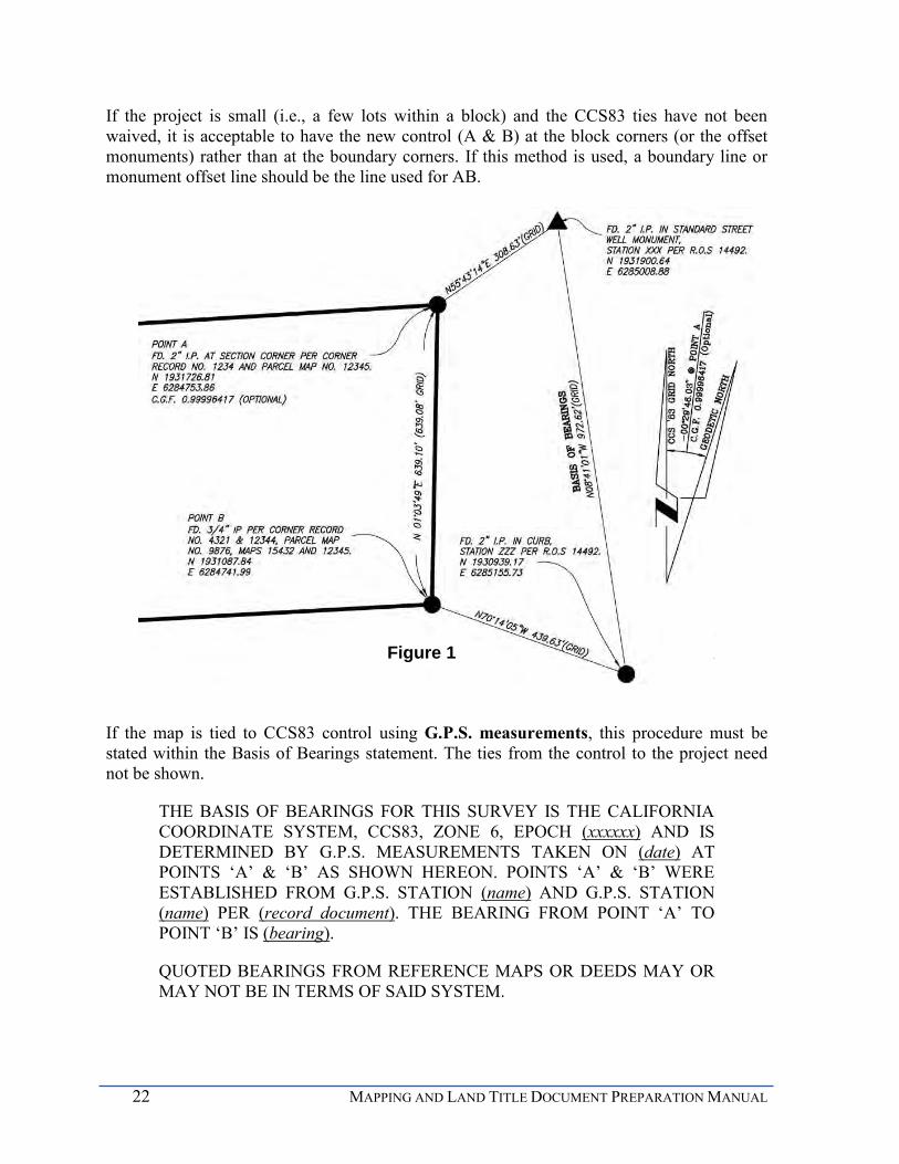
22 MAPPING AND LAND TITLE DOCUMENT PREPARATION MANUAL
If the project is small (i.e., a few lots within a block) and the CCS83 ties have not been waived, it is acceptable to have the new control (A & B) at the block corners (or the offset monuments) rather than at the boundary corners. If this method is used, a boundary line or monument offset line should be the line used for AB.
If the map is tied to CCS83 control using G.P.S. measurements, this procedure must be stated within the Basis of Bearings statement. The ties from the control to the project need not be shown.
THE BASIS OF BEARINGS FOR THIS SURVEY IS THE CALIFORNIA COORDINATE SYSTEM, CCS83, ZONE 6, EPOCH (xxxxxx) AND IS DETERMINED BY G.P.S. MEASUREMENTS TAKEN ON (date) AT POINTS ‘A’ & ‘B’ AS SHOWN HEREON. POINTS ‘A’ & ‘B’ WERE ESTABLISHED FROM G.P.S. STATION (name) AND G.P.S. STATION (name) PER (record document). THE BEARING FROM POINT ‘A’ TO POINT ‘B’ IS (bearing).
QUOTED BEARINGS FROM REFERENCE MAPS OR DEEDS MAY OR MAY NOT BE IN TERMS OF SAID SYSTEM.
Figure 1

CHAPTER 4 DOCUMENT PREPARATION STANDARDS 23
THE COMBINED GRID FACTOR AT POINT ‘A’ IS #.#######. (7 places) GRID DISTANCE = GROUND DISTANCE X COMBINED GRID FACTOR. ELEVATION AT POINT ‘A’ IS ####.## (datum used to determine CGF).
Show the coordinates of point ‘A’, the convergence angle, the elevation and the combined factor at the point that the project is rotated. If the project is small (i.e., a few lots within a block) and the CCS83 ties have not been waived, it is acceptable to have point ‘A’ at a block corners (or the offset monuments) rather than at the boundary corners.
If the map is tied to CCS83 control using CORS (Continuously Operating Reference Stations), this procedure must be stated within the Basis of Bearings statement. The ties from the control to the project need not be shown but if the inclusion of this information is deemed beneficial, it is encouraged to be shown.
THE BASIS OF BEARING FOR THIS SURVEY IS THE CALIFORNIA COORDINATE SYSTEM 1983 (CCS83), ZONE 6, XXXX.XX EPOCH, AND IS DETERMINED BY G.P.S. MEASUREMENTS TAKEN ON (date) AT POINTS A & B SHOWN HEREON. POINTS A & B WERE ESTABLISHED FROM CONTINUOUSLY OPERATING REFERENCE STATIONS (CORS) XXXX AND XXXX DERIVED FROM GEODETIC VALUES PUBLISHED BY THE CALIFORNIA SPATIAL REFERENCE CENTER (CSRC) AND/OR NATIONAL GEODETIC SURVEY (NGS), RESPECTIVELY. BEARING A-B: XXXXXX
Figure 2

24 MAPPING AND LAND TITLE DOCUMENT PREPARATION MANUAL
QUOTED BEARINGS FROM REFERENCE MAPS OR DEEDS MAY OR MAY NOT BE IN TERMS OF SAID SYSTEM.
THE COMBINED GRID FACTOR AT POINT ‘A’ IS #.#######. (7 places) GRID DISTANCE = GROUND DISTANCE X COMBINED GRID FACTOR. ELEVATION AT POINT ‘A’ IS ####.## (datum used to determine CGF ).
Approved NGS sanctioned CORS and California Spatial Reference Network stations are available at http://csrc.ucsd.edu/.
Show the coordinates of point ‘A’, the convergence angle, the elevation and the combined grid factor at the point that the project is rotated. (Public Resources Code 8815.5)
If there is no discretionary approval for a map such as a lot line adjustment or lot consolidation, and if the underlying map was recently recorded and has boundary tied to existing CCS83 control, the Basis of Bearings may be based upon a record bearing, (not a calculated bearing) from a record map. In this case, use the following statement. A record bearing is defined as the bearing between two found monuments on a record line shown on a record map.
THE BASIS OF BEARINGS FOR THIS MAP IS THE (describe line) LINE OF (lot, centerline of street) AS SHOWN ON MAP NO. #####
BEARING N 01° 23' 45"E
If the basis of bearings is based upon an astronomic observation, use the following statement.
THE BASIS OF BEARINGS FOR THIS SURVEY IS THE (describe line sighted, ex. ‘THE NORTH LINE OF THE NORTH HALF OF SECTION 1, T11S, R3E, SBM, AS SHOWN HEREON’), THE DIRECTION OF WHICH WAS DETERMINED BY OBSERVATION OF (Polaris or the sun), AND WAS CONVERTED TO A CALIFORNIA COORDINATE SYSTEM NAD83, ZONE 6, GRID BEARING OF (bearing).
QUOTED BEARINGS FROM REFERENCE MAPS OR DEEDS MAY OR MAY NOT BE IN TERMS OF SAID SYSTEM.
THE COMBINED GRID FACTOR AT STATION ‘A’ IS #.########. ELEVATION AT POINT ‘A’ IS ####.## (datum used to determine CGF).
Typically, it is not preferable to use the following as a basis of bearing when:
1. No record bearing is shown on the line
2. No monuments of record are found on the line
3. The bearing on the line is assumed, unless approved by the City Land Surveyor
CHAPTER 4 DOCUMENT PREPARATION STANDARDS 25
4. It is a line on a City tie point sheet, improvement drawing, division plat or any other drawing or plat not recorded in the Office of the County Recorder
Typically, a corner record should not be used for a basis of bearing because it does not provide a procedure of survey, unless it’s indicative of the perpetuation of original monuments.
If the requirement to make measured ties from two control monuments to the project was waived by the City Land Surveyor, add the following note after the Basis of Bearing statement as a separate paragraph.
THE PROJECT TIES TO THE CALIFORNIA COORDINATE SYSTEM (CCS83) WERE WAIVED BY THE CITY LAND SURVEYOR ON (date).
6. Drawings should use the underlying map for the basis of bearings. CCS83 ties can be used with the approval of the City Land Surveyor.
BASIS OF ELEVATIONS
A map may be three dimensional and is commonly known as a 3D map. The third dimension, elevation, requires a basis of elevation. The basis of elevation for the map may be a monument within the map. There will be one monument that has x, y, & z values. For instance, if the map encompasses a block, one of the block corner monuments will have an elevation established on it and it will be referenced on the map. The elevation must be established on it and it will be referenced on the map. The elevation must be established from a benchmark per the City of San Diego Vertical Control Book.
THE BASIS OF ELEVATIONS FOR THIS SURVEY IS [THE NATIONAL GEODETIC VERTICAL DATUM OF 1929 (NGVD29)] [CALIFORNIA ORTHOMETRIC HEIGHTS OF 1988 (COH88) AS DEFINED BY THE CALIFORNIA PUBLIC RESOURCES CODE SEC 8890 ET SEQ] [OTHER APPROVED DATUM, E.G. MLLW], BASED LOCALLY UPON THE FOLLOWING VERTICAL CONTROL STATION(S):
STATION ELEVATION PUBLISHING REFERENCE
PROCEDURE OF SURVEY
The first map sheet after the title sheet(s) is the Procedure of Survey and it is labeled as such. By using all of the information mentioned in this chapter, a thorough procedure of survey is required. Any surveyor should be able to review the map and determine how the boundary was established. It is best to have too much information rather than not enough. If the surveyor’s procedure used is not obvious as shown, a surveyor’s note will be required to explain the procedure. The procedure sheet may be combined with the index sheet, only if all of the necessary depicted information is clear and concise, and therefore labeled PROCEDURE OF SURVEY and INDEX.

26 MAPPING AND LAND TITLE DOCUMENT PREPARATION MANUAL
In cases where there are questions surrounding the procedure of survey, the map reviewer may ask for any or all of the following:
1. Raw data files
2. Field survey notes
3. GPS data
4. .dxf files
5. Other pertinent files deemed necessary for clarification
As surveyors, we are bound to follow in the footsteps of those who have gone before us in properly locating boundaries. The corollary to this is that we should leave well defined footsteps/records for those who will follow after us. In some cases, the use of a Surveyor’s Narrative will greatly improve future understanding of your work and methods used.
The procedure clearly depicts the land as it exists prior to the proposed subdivision. The procedure must show the boundary of the subdivision and its location relative to surrounding surveys, city boundaries, section lines, rancho lines and corners, streets, highways, county roads and major easements. All streets and easements vacated upon the recordation of the map must be shown on the procedure sheet. This is the only pictorial representation of the vacated easements. Simply not showing a street or public service easement on a map does not vacate it. Additionally, legal access must be shown to the subdivision from the nearest dedicated public right-of-way. A small vicinity map showing the geographic location of the subdivision must be shown at a large enough scale, with sufficient detail, on the procedure of survey sheet to clearly locate the subdivision relative to existing streets or roads.
The procedure of survey must show how the subdivision boundary was established. Each boundary line must be shown to establish junior/senior rights as appropriate. For instance, if the north line of the subject map is the south line of MAP 12345, the boundary line should be labeled as such. Each boundary line should be clearly defined and annotation placed on the map indicating how each lines of the boundary are being established.

CHAPTER 4 DOCUMENT PREPARATION STANDARDS 27
CHAPTER 4 DOCUMENT PREPARATION STANDARDS
PURPOSE
The intent of drafting standards is to ensure that a map or drawing is clear, concise, and easily interpreted/read by any practicing professional. The standards are typical of what has been published in Survey Drafting, by Wattles and the San Diego Regional Standards. When it is necessary, additional information not covered in this manual may be required in order to obtain a clear, complete, and legible map.
PRINCIPAL DRAFTING STANDARDS
Clarity is important! Once the map is filed with the County Recorder, it will be scanned and become a public record. Therefore, maps need to be suitable for scanning purposes. This requires that the map be legibly drawn and then printed, or reproduced by a process guaranteeing a permanent record (such as black ink on polyester base film). Ink used on polyester base film shall be coated with a suitable substance to assure permanent legibility. Ammonia or ‘Xerox’ type process is not permitted. Electrostatic mylars will not be acceptable by the City or the County of San Diego. The standards discussed below will assure clarity.
LETTERING Lettering should also be oriented toward the top or left of each sheet, or somewhere in between. (Wattles, 1981) Lettering shall be no smaller than 1/10 inch; otherwise it will not be legible when reduced. Arrows and leaders should be used to clearly show limits of bearing and distance if required. Leaders should be of simple design.
SCALE The scale of the map or drawing should be of an appropriate scale to show the required information without the excessive use of details or tables. Generally, a minimum scale of one-inch equals 40 feet can be used when lot sizes are one acre or less. For maps with lot sizes larger than one acre, a scale of one-inch equals 100 feet may be more appropriate. It is preferable to use the same scale throughout all map sheets except for the procedure of survey sheet, details, or large lots. All courses must be shown on the map along the appropriate line work, making it easy to read and use. Leader lines are preferred to point to a line rather than show the data in a table. If a table is necessary, it will be on the sheet in which the courses are shown.
A numeric scale and a graphic scale need to be shown on each map sheet with the exception of the title sheet or drawing. The numeric scale and the graphic scale (three to four inches is appropriate) must be consistent with each other. It should be clear at a glance, which scale is being used, and the major increments on the graphic scale are to be the same as the numeric scale. Only typical engineering scales will be accepted. They include: 1" = 10’, 20’, 30’, 40’, 50’, 60’ or 100'.
28 MAPPING AND LAND TITLE DOCUMENT PREPARATION MANUAL
DETAILS When lines and figures crowd the map or drawing, a detail should be drawn at an appropriate scale to clearly show all dimensions, names, etc., and to avoid misinterpretation. If more than one detail is used, each should be identified, i.e., Detail "A". It is best if the detail is on the same sheet as the area that requires it. It becomes very cumbersome flipping map pages back and forth when trying to read or compare the information on a different sheet. Each detail should use a different and consecutive letter throughout the map. If a detail is not to scale, it must be indicated as such. The use of tables for details is discouraged; that is why a detail is drawn. Enlarged details will be required where crowding of data might cause misinterpretation; the scale is not required but ‘NOT TO SCALE’ must be noted.
SHADING Shading is not permitted on maps or drawings. Crosshatching is only permitted on Non-Title sheets on maps but is permitted on drawings. This is a requirement because of problems with reproduction and microfilming/scanning when the map is reduced significantly. Crosshatching is permitted on drawings because the reduction of the scale is minimal.
SURVEYING DRAFTING STANDARDS
The principal drafting standards as described previously establish the drafting standards for maps and drawings submitted through the City. Though not inclusive, additional requirements of SMA 66434 and SMA 66445 require that each sheet must be numbered, each parcel must be lettered or numbered, the map shall show the definite location of its relation to surrounding surveys, and all streets need to be shown. Also, map sheets shall be 18 x 26 inches. The top of the map shall be on the 26-inch dimension, or landscape orientation. A heavy margin line shall be drawn completely around each sheet leaving an entirely blank one-inch margin. Sheet sizes for easement drawings and other types of acquisitions are typically on B sheets (11” x 17”) or C sheets (17” x 22”).
SHEET ORIENTATION Each sheet should be oriented with North toward the top, left or somewhere in between. The north arrow may be simple or ornate but should be of sufficient size and bold enough to be easily seen and should be combined with the graphic scale. The map must include a north arrow on each sheet that reflects grid north, geodetic north, the convergence angle and the project point upon which it is based.
LINE WORK
As noted in principal drafting standards, the use of various line types and widths are essential for a clear and concise map or drawing. For example, the boundary of the subdivision should be a heavy double-dashed black line. Easement lines should be light dashed lines. By using these simple standards, one can look at the map and determine which line work represents what. The following sketch depicts suggested line weights to assure a legible map or drawing.

CHAPTER 4 DOCUMENT PREPARATION STANDARDS 29
Figure 3

30 MAPPING AND LAND TITLE DOCUMENT PREPARATION MANUAL
ADJOINING MAPS Adjoining maps, record subdivision lots or parcels, records of survey and other maps and records need to be shown. The lettering of subdivision names and map numbers, parcel maps, records of surveys, miscellaneous surveys, and miscellaneous maps surrounding the project need to be shown in dashed, or dark shadowed letters.
STREETS All streets, alleys, road surveys, and state highways depicted on the map need to show how the rights of ways were dedicated or created. If a right of way was dedicated in portions, depict all portions of the dedicated right of way. Recording information must be shown for all dedications. Designate as (street name) DEDICATED PER MAP XXXX or (street name) DEDICATED PER DOC. XXXX RECORDED ON (date).
If full width rights of way are being dedicated, proposed street names must be submitted and approved by the City Street Name Coordinator prior to the time the map or deed that dedicates the rights-of-way are recorded
Any dedications must be clearly depicted. If a full width of a street is being dedicated, designate as (street name) DEDICATED HEREON. If a portion of a street is being dedicated, designate as PORTION OF (street name) DEDICATED HEREON. Alleys that are unnamed should be designated as UNNAMED ALLEY.
The full width and half width must be shown, including the centerline of the street, if established. If the width varies, state that the width varies and include leader lines to show the extents of the varying width. The limits of each street should be shown as a light dashed line and labeled STREET LIMITS.
If a street or portion of a street has been vacated, show the vacated area on your map or drawing. Designate the area with leaders and the notation “VACATED PER DOC # ____ RECORDED ON __________________.” The drawing number may be included as information; however, the drawing in itself does not vacate the street. The recorded document evidences the vacation of the street.
MONUMENTS Show and describe found monuments used to establish the boundary of the subdivision. Bearing and distance ties between monuments must be shown. Found monuments must be described on the map sheet or in the legend. The previous record which includes the original map that set the monument and subsequent maps that found the monument and the character of the monument must be called out. All survey monuments within the vicinity must be shown on the map and tied to the boundary, even if their positions are rejected. If the monuments are noted on a private survey record or on unrecorded City Land Surveyor notes or maps, provide the appropriate reference so subsequent surveyors can locate and review that evidence.
If found monuments are of no record, label them as to type, size, disc and surveyor/engineer number, if any. Such monuments should be labeled "NO RECORD" and "ACCEPTED AS" (describe call out location) (Use "as shown in Field Book No. _____" or "as shown on Survey Plat of (name) LS. _______" (if such records are available). For instance, if a lead
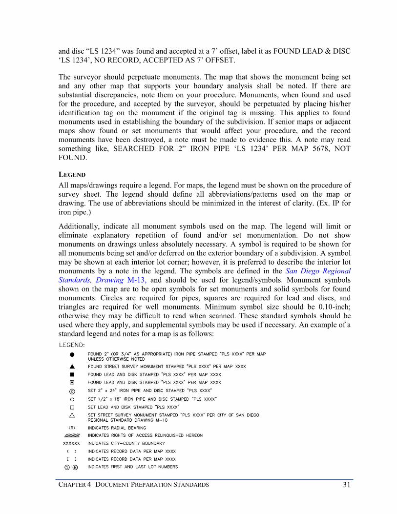
CHAPTER 4 DOCUMENT PREPARATION STANDARDS 31
and disc “LS 1234” was found and accepted at a 7’ offset, label it as FOUND LEAD & DISC ‘LS 1234’, NO RECORD, ACCEPTED AS 7’ OFFSET.
The surveyor should perpetuate monuments. The map that shows the monument being set and any other map that supports your boundary analysis shall be noted. If there are substantial discrepancies, note them on your procedure. Monuments, when found and used for the procedure, and accepted by the surveyor, should be perpetuated by placing his/her identification tag on the monument if the original tag is missing. This applies to found monuments used in establishing the boundary of the subdivision. If senior maps or adjacent maps show found or set monuments that would affect your procedure, and the record monuments have been destroyed, a note must be made to evidence this. A note may read something like, SEARCHED FOR 2” IRON PIPE ‘LS 1234’ PER MAP 5678, NOT FOUND.
LEGEND All maps/drawings require a legend. For maps, the legend must be shown on the procedure of survey sheet. The legend should define all abbreviations/patterns used on the map or drawing. The use of abbreviations should be minimized in the interest of clarity. (Ex. IP for iron pipe.)
Additionally, indicate all monument symbols used on the map. The legend will limit or eliminate explanatory repetition of found and/or set monumentation. Do not show monuments on drawings unless absolutely necessary. A symbol is required to be shown for all monuments being set and/or deferred on the exterior boundary of a subdivision. A symbol may be shown at each interior lot corner; however, it is preferred to describe the interior lot monuments by a note in the legend. The symbols are defined in the San Diego Regional Standards, Drawing M-13, and should be used for legend/symbols. Monument symbols shown on the map are to be open symbols for set monuments and solid symbols for found monuments. Circles are required for pipes, squares are required for lead and discs, and triangles are required for well monuments. Minimum symbol size should be 0.10-inch; otherwise they may be difficult to read when scanned. These standard symbols should be used where they apply, and supplemental symbols may be used if necessary. An example of a standard legend and notes for a map is as follows:

32 MAPPING AND LAND TITLE DOCUMENT PREPARATION MANUAL
The following are standard notes for monumentation on a map that may be applicable and symbols do not need to be shown for the locations of the following monuments.
NOTES:
1. UNLESS OTHERWISE SHOWN ON THIS MAP:
a. ALL LOT CORNERS EXCEPT AS DESCRIBED BELOW WILL BE MONUMENTED BY A 3/4-INCH X 18-INCH IRON PIPE (or steel pin) WITH DISC STAMPED PLS XXXX (or RCE XXXXX)
b. LOT CORNERS ALONG THE SIDELINES OF DEDICATED STREET RIGHTS OF WAY (will be, are) MONUMENTED BY A DISC STAMPED PLS XXXX, SET ALONG AN EXTENSION OF THE LOT LINE AT AN OFFSET OF FEET IN THE (curb, sidewalk); THE OFFSET SHALL BE MEASURED RADIALLY, OR AT RIGHT ANGLES, TO THE RIGHT OF WAY LINE.
c. ALL POINTS OF CURVE OF THE SIDELINES OF DEDICATED STREET RIGHTS-OF-WAY (will be, are) MONUMENTED BY A DISC STAMPED PLS XXXX SET AT AN OFFSET OF FEET IN THE (curb, sidewalk); THE OFFSET SHALL BE MEASURED RADIALLY, OR AT RIGHT ANGLES, TO THE RIGHT-OF-WAY LINE.
It should be emphasized that in each of the above cases, the surveyor must be certain that the disc to be set in the curb or sidewalk can be offset as shown on the map. If, after the map records, the disc cannot be placed in the sidewalk or curb at the specified offset a Certificate of Correction will be necessary to correct the character or location of the monument.
The practice of using plastic caps in iron pipes or on rebar is no longer permitted in the City of San Diego by the City Land Surveyor, as they are not considered durable monuments pursuant to §66495 of the Subdivision Map Act and §8771 and §8772 of the Professional Land Surveyors Act. When you set any size pipe, a nail and disc placed in concrete is now required.
A legend for a drawing is required. One major item in the legend would be showing the pattern for the area that is either being granted or vacated.
An example would be
INDICATES BUILDING RESTRICTION EASEMENT; ACQUIRED AREA: 1.234 ACRES
INDICATES FIRST AVENUE DEDICATED PER DOCUMENT NUMBER 2013-0000000, RECORDED 1/1/13; VACATED AREA: 1.234 ACRES

CHAPTER 4 DOCUMENT PREPARATION STANDARDS 33
DIMENSIONS The dimensions depicted on a map/drawing must be legible and complete.
The bearing and total distance along all lot lines, each sideline and center line of every street should be fully shown (ex: N 25º10' 02" E 152.00').
At a minimum, the length, radius and total delta of each curve must be indicated. If a line is non-tangent to a curve, the bearing of each radial line needs to be shown and labeled “non-tangent.” If lines are tangent, radial bearings are not required. (This also alleviates crowding.) The delta and length of each segment of a curve shall be shown. The sum of the parts on any line must equal the total. When the bearing, length, or delta of the sideline of a road is the same as the centerline, it does not need to be repeated. The direction of the radial bearing shown shall originate from the radius point to the curve.
Record data is to be shown if there is a variance of record and measured courses between monuments. The record data should be shown in parentheses and indicated in the legend. If there is no variance, record data does not need to be shown since it is understood to be the same.
All dimensions on the map must be shown to the nearest hundredths of a foot, i.e. 0.01 or (1/100). Map dimensions must be ground distances, except for mapping ties to California Coordinate System (CCS83) control monuments, which must be grid distances. All angular measurements must be expressed to the nearest second of arc. The following are exceptions where whole numbers may be used:
Nominal or half widths of streets, rights of ways or easements when the sidelines are parallel and concentric with the centerline.
Radius of curves ex: R=1000’
In addition, sometimes a curve will intersect the right-of-way line at a point close to a lot line causing a very short distance between the P.C. and the lot corner; this should be avoided if possible.
TRAVERSES All of the dimensions on the map or drawing are reviewed and compared against the traverses that are submitted with the project. (See Submittal Guidelines.) The traverses are required to verify that the data shown on the map or drawing is mathematically correct with an acceptable error of closure. For a map, traverses must be submitted for the boundary, procedure of survey, each lot, each easement being granted on the map and the centerlines of the streets. All curves in a traverse must include the radial bearing, length, delta and radius as depicted. In other words, all dimensions shown on the map must be able to be mathematically verified with the traverses. Therefore, the data on the map and the traverses need to match. The traverse data must be rounded to two decimal places to coincide with the map data. Keep in mind, mathematically, it is not correct to begin with two decimal places, such as the coordinates of GPS control, and calculate to more than two decimal places.
34 MAPPING AND LAND TITLE DOCUMENT PREPARATION MANUAL
LOTS Lots on a map must be numbered or lettered. They should be numbered and lettered consecutively throughout the subdivision. The consecutive numbering may be carried over to the following unit maps. Buildable lots will be numbered and non-buildable lots will be lettered. Non-buildable lots include sub-standard lots for the zone, open space lots, HOA (Home Owner Association) lots, private driveways, etc. The first and last lot numbers in major subdivisions must have a circle around them as shown in the example legend. No other lot number should have circles or designs around them.
Each lot must be shown in its entirety on one sheet. Lots that are greater than a half-acre should show the acreage within the lot and out to three decimal places and placed within the lot on the map.. This requirement is for the county assessor. Additionally, a lot area tabulation sheet is required, which shows the area of each lot. See website for a sample.
A ‘remainder lot’ is owned by the subdivider but not intended to be subdivided by the subject map, as defined by SMA 66424.6. The lot may be sold, leased or financed without any further requirements for filing a map. All lands that have been included within the tentative map boundary but which are not subject to the subdivision need to be shown on the map and designated as REMAINDER LOT. Where the remainder lot/parcel has a gross area of five acres or more, the location and configuration of the lot may be indicated by deed reference and only record bearings and distances need to be shown. A Certificate of Compliance may be applied for through the City if a third party, such as a title company, requires the owner to obtain one.
A ‘not a part’ lot is owned by another entity and not subject to subdividing by the subject map. This lot should be indicated as NOT A PART, meaning it is not a part of the subdivision.
REQUIREMENTS SPECIFIC TO EASEMENTS
Chapter 6 addresses easements in detail, but not the drafting standards. Whether easements are included on a map or on a drawing, the drafting requirements are basically the same. Easement lines are light dashed lines. The line weights and types are shown on Figure 3.
There are several depiction scenarios for easements. They may be shown as being granted on a map, they may be existing, private or public, and need to be shown on a map or drawing. They may be shown as being acquired on a drawing. The location of an easement must be evident. On both maps and drawings, ties to a record lot/parcel corner must be shown to definitively locate the easement. Drawings are exhibits accompanying a legal description of a deed. The legal description will definitively locate the specific piece of land and it cannot apply to any other piece of land. The drawing must depict the intent of the legal description.
A map must clearly show all easements, existing ones as called out in the title report and proposed ones that are granted on the map. The easements must be delineated showing bearings, distances, widths, and ties to lot corners and boundary corners unless the entire easement shown is being proposed to be vacated. Traverses must be submitted for the proposed easements in order to substantiate the courses shown on the map or drawing. On a

CHAPTER 4 DOCUMENT PREPARATION STANDARDS 35
drawing, show all easements that conflict or are in close proximity to the proposed easement. Show ties between the existing easement and the proposed easement where necessary.
If the easement is being granted on a map, label it as being granted hereon. An example would be WATER EASEMENT GRANTED HEREON. Where such easements involve more than one lot, indicate by adding IN LOTS ______, citing the exact lots in which the easement is to be granted.
If the easement is being shown as acquired on a drawing, the easement area that is being granted may be depicted with a pattern that will be discernible once scanned. The pattern must be shown in the legend and labeled as ‘acquired.’ An example would be:
WATER EASEMENT ACQUIRED
If the easement exists, either public or private, on either a map or drawing, label the easement with the record information. The format in which the County Recorder has recorded documents has changed over the years. Label the easements as such:
EXISTING (type, width, centerline, etc) EASEMENT GRANTED TO (entity)…
Instruments recorded from 1850 to June 30, 1931, should be referred to as follows:
RECORDED (day month), 18(xx), DOCUMENT NO. (xxxx), BOOK (xxx), PAGE (xx), DEEDS, PATENTS, LIS PENDENS AND OTHERS, IN THE OFFICE OF THE COUNTY RECORDER OF SAN DIEGO COUNTY, STATE OF CALIFORNIA.
Instruments recorded from July 1, 1931 through December 31, 1959 should be referred to as follows:
RECORDED (day month), 19(xx), DOCUMENT NO. (xxxx), BOOK (xx), PAGE (xxx), O.R.
Instruments recorded from January 1, 1960 through December 31, 1969, should be referred to as follows:
RECORDED (day month), 19(xx), FILE/PAGE NO. (xxxx), SERIES (xxx), BOOK (xxxx), O.R.
Instruments recorded from January 1, 1970 through the late 1980s should be referred to as follows:
RECORDED (day month), 19(xx), FILE/PAGE NO. (xxx), BOOK (xxx), O.R.
Instruments recorded recently should be referred to as follows:
RECORDED (day month), (xxx), DOCUMENT NO. (xxxx), O.R.

36 MAPPING AND LAND TITLE DOCUMENT PREPARATION MANUAL
All existing easements appearing in the title report are to be accounted for on the map or drawing. A blanket easement is an easement without a specific location set forth in the deed or the location is not discernible. This type of easement must also be accounted for; however it can only be accounted for with a note. Please use the following note for blanket easements.
EXISTING (type) EASEMENT GRANTED TO (entity) PER DOC. NO. (xxxx), RECORDED (day month year). HAS NO SPECIFIC LOCATION SET FORTH IN THE DEED AND CANNOT BE PLOTTED ON MAP.
Many SDG&E easements grant dimension specific areas around all their installed facilities within a certain time period. In these cases, the following note should be used.
EXISTING UTILITY EASEMENT GRANTED TO SAN DIEGO GAS AND ELECTRIC CO. PER DOC. NO. (xxxx) RECORDED (month day year) IS DEPENDENT UPON PHYSICAL LOCATION OF FACILITIES AND IS NOT PLOTTED HEREON.
NON-TITLE SHEET STANDARDS
Non-title information, if needed, is shown on the last sheet of the map. Typically, drawings do not have non-title requirements. Non- title information indicates information defined and described as additional survey and map information per the Subdivision Map Act (SMA), which is required to be placed on the map and not intended to affect record title interest. The sheet must show the areas of concern in regards to the lot lines, rights of way, etc.
Dimensions usually are not required. The areas should be hatched and shown in the legend on this sheet. The scale and north arrow should be shown. Additional survey and map information, with their respective symbols, may include but not be limited to:
Fire Hazard Reduction Zones
Proposed Caltrans Right-of-Way
100-year Flood Area
Geologic Faults
Building Restricted Areas
A legend may be shown on the NON-TITLE SHEET to clarify information. An example would be:
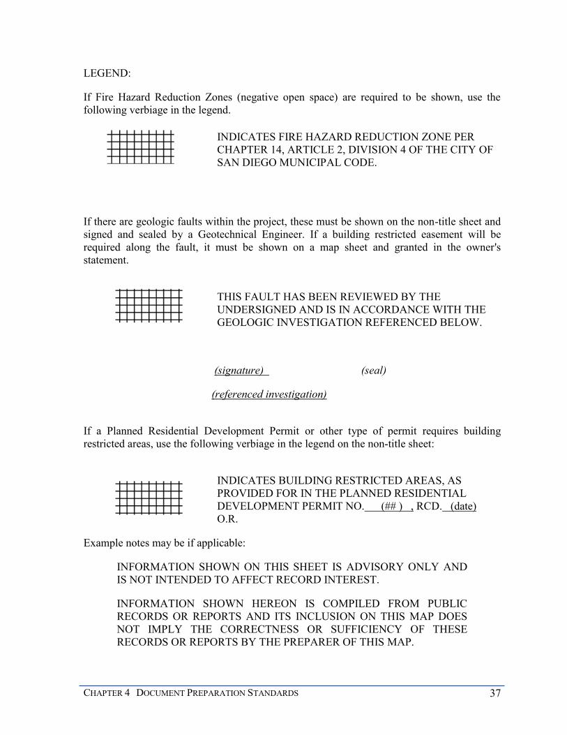
CHAPTER 4 DOCUMENT PREPARATION STANDARDS 37
LEGEND:
If Fire Hazard Reduction Zones (negative open space) are required to be shown, use the following verbiage in the legend.
INDICATES FIRE HAZARD REDUCTION ZONE PER CHAPTER 14, ARTICLE 2, DIVISION 4 OF THE CITY OF SAN DIEGO MUNICIPAL CODE.
If there are geologic faults within the project, these must be shown on the non-title sheet and signed and sealed by a Geotechnical Engineer. If a building restricted easement will be required along the fault, it must be shown on a map sheet and granted in the owner's statement.
THIS FAULT HAS BEEN REVIEWED BY THE UNDERSIGNED AND IS IN ACCORDANCE WITH THE GEOLOGIC INVESTIGATION REFERENCED BELOW.
(signature) (seal)
(referenced investigation)
If a Planned Residential Development Permit or other type of permit requires building restricted areas, use the following verbiage in the legend on the non-title sheet:
INDICATES BUILDING RESTRICTED AREAS, AS PROVIDED FOR IN THE PLANNED RESIDENTIAL DEVELOPMENT PERMIT NO. (## ) , RCD. (date) O.R.
Example notes may be if applicable:
INFORMATION SHOWN ON THIS SHEET IS ADVISORY ONLY AND IS NOT INTENDED TO AFFECT RECORD INTEREST.
INFORMATION SHOWN HEREON IS COMPILED FROM PUBLIC RECORDS OR REPORTS AND ITS INCLUSION ON THIS MAP DOES NOT IMPLY THE CORRECTNESS OR SUFFICIENCY OF THESE RECORDS OR REPORTS BY THE PREPARER OF THIS MAP.

38 MAPPING AND LAND TITLE DOCUMENT PREPARATION MANUAL
REQUIREMENTS SPECIFIC TO DRAWINGS
If the easement or dedication is granted per a separate document, the depiction of the easement is typically drawn on a standard City “B” sheet; “C” sheets are also acceptable. The drawing must include all information needed to completely illustrate the legal description. The following items should be included on most drawings, but only to the extent they are relevant to illustrating the legal description:
Vicinity map showing the location of the affected property
North arrow
Scale
Basis of Bearings (if the B of B is necessary, use the same as the underlying parcel)
Legend of symbols used
Area in acres x.xxx (used by County Assessor)
Assessor Parcel Number(s)
Title (see below) with an abbreviated legal description of the underlying fee (ie: Lot 1, Map 2324)
Surveyor’s seal and signature
Point of Beginning (or Point of Commencement and True Point of Beginning)
Deed courses - bearing & distance for lines, delta, radius & length for curves with radial bearings of non-tangent lines and at changes in curvature or direction
Underlying document and map references
Streets and adjoining parcels
Other easements that are in the vicinity of the proposed easement (these are required to verify that there are no conflicts)
All bearings and distances shown on the drawing should follow the legal description
DRAWING TITLES The title block must contain a descriptive title such as those listed below. Please consult your reviewer if you are uncertain of the proper title. A grant in fee requires a specific statement of intent. The title for drawing is the same as for a deed. Some examples include:
STREET DEDICATION - (name of street) in (legal description) BETWEEN (street names)
OPEN SPACE GRANT IN FEE in (legal description)

CHAPTER 4 DOCUMENT PREPARATION STANDARDS 39
IRREVOCABLE OFFER TO DEDICATE (type of easement or grant) in (legal description)
SEWER EASEMENT in (legal description)
BUILDING RESTRICTED EASEMENT in (legal description)
SLOPE EASEMENT in (legal description)
STREET VACATION - (name of street) - between (street names)
(type) EASEMENT VACATION in (legal description)
REQUIREMENTS SPECIFIC TO TENTATIVE MAPS
A copy of the preliminary title report must be submitted. Additionally, the minimum items listed below must be shown on the tentative map exhibit.
EXISTING CONDITIONS Sheet size used must be no greater than 36” x 48” (Architectural E sheet).
First sheet shows overall view of development and an index to other sheets.
Each sheet must have the title of development name, and the tentative map number, City Job Order Number and the Project Tracking System number (assigned upon submittal).
Topographic survey is at a suitable scale to reveal the needed detail for review. Min. 2’ contours on flat ground and Max. 10’ contours on steep ground. The survey must map conditions beyond the boundary of the tentative map as far as it affects the proposed subdivision. Note the source, date and vertical datum of the survey.
Spot elevations are shown as needed.
Scale, north arrow, legend, vicinity map.
Existing street and alley width, pavement, curbs, gutter, and sidewalk.
Full width cross-section for streets within the subdivision that will remain as well as all adjacent streets and alleys as appropriate.
Utilities: water and sewer mains (location, size and service lines), street lights, electrical, gas, cable lines.
Collection and discharge points of onsite and offsite storm drains.
Specify all sewer, water, drainage, public and private improvements, and show City drawing numbers.
Show the existing parcel boundaries and legal description. Also show adjacent properties and their legal description. (Map, block and lot numbers, or a deed reference is usually enough).
All public and private easements that encumber the property are shown or noted on the map.

40 MAPPING AND LAND TITLE DOCUMENT PREPARATION MANUAL
Known archeological sites, sensitive habitat, and geological hazards such as an earthquake fault or unstable hillsides affecting the development.
Existing zoning, overlay zones, development permits.
Any other information deemed important by the preparer of the map.
PROPOSED DEVELOPMENT Clearly show the subdivision boundary and all proposed lots including open space lots or
lots for reserved public facilities. Indicate the approximate area of all lots.
For a condominium development note the number of proposed condominiums, their type (residential or commercial), and their location if the units are to be built on multiple lots.
Show proposed grading contours.
Show proposed street and sidewalk alignment. At this point, only approximate location and dimensions are needed.
Provide street and driveway cross sections for new streets.
Show location of all proposed utilities including sewer, water, electrical, gas, cable, telephone and street lighting.
Show proposed drainage pattern including the location of proposed structures and pipes.
Show all proposed public service, open space and access easements.
Clearly show and identify all easements to be vacated on the Tentative Map exhibit.
NOTES AND INFORMATION Provide the names of the Property Owner, Developer (if different) and the Engineer of
work.
Summarize the number of lots or condominium units with their designated use and the area within the proposed subdivision boundary. Indicate the existing and proposed parking spaces and location.
Provide existing zoning and development permit information and list any proposed changes.
Provide earthwork quantities, including cut/fill and import/export, as applicable.
Provide the existing Assessor Parcel Number(s) and the CCS 27 and CCS 83 coordinates of the project.
CHAPTER 5 SUBDIVISION MAPS 41
CHAPTER 5 SUBDIVISION MAPS
This chapter will discuss the legal and technical requirements for maps. The parcel map will be discussed first. A final map is prepared in the same manner as a parcel map, with a few exceptions. These exceptions are discussed in the final map section. Amended maps will be discussed last. They are prepared the same as the map that is being amended however, the verbiage of the certificates call out the changes.
PARCEL MAPS
Parcel maps are defined in SMA 66426(f). Typically, a parcel map is used to create four or fewer parcels or condominium units. Chapter 2 explains other circumstances that require a parcel map. In addition to the creation of four parcels, the map may also include one parcel which is designated a remainder parcel per SMA 66424.6. A parcel map may also be used for a lot line adjustment. The lot line adjustment is not a subdivision, but using a parcel map to facilitate a lot line adjustment is generally superior to a lot line adjustment plat, which shall be discussed in Chapter 7.
A parcel map must be based upon a field survey in accordance with the LDC 144.0311(d) and SMA 66448. If you believe it may be necessary to waive a field survey, the City Land Surveyor must approve the waiver. This should be done early in the process, preferably prior to any actual field work, or prior to or during the first submittal. If there was a tentative parcel map, the map must substantially conform to the approved tentative parcel map, the conditions as set forth in the tentative parcel map’s resolution and the conditions of all discretionary approvals associated with the project.
MAP REQUIREMENTS PER THE SMA A map is required to be prepared for the purpose of selling a parcel of land. The first legislation, the predecessor to the Subdivision Map Act of today, was the Act of 1893 and it explicitly enacted this law and was specific to when cities or towns were first established. A map has been required to sell, lease or finance a parcel of land in California since then. The requirement for a parcel map, for the creation of four or fewer lots, was enacted in 1972. In order for a person to sell, lease or finance a parcel of land today, the parcel must be created in accordance with the SMA.
PRELIMINARY TITLE REPORT AND MAP GUARANTEE A preliminary report (PR) prepared by a title company is required for all subdivision maps. The PR must encompass all the property within the subdivision. It must describe the property as it exists prior to the parcel map recording and reference all items that encumber the property. Items in the PR, such as easements, planned development permits, options to purchase, and deeds of trust necessitate reference on the parcel map. In addition, if tax liens or delinquent taxes appear in the PR, it will be required that they are satisfied prior to the map recording pursuant to SMA 66492. An updated PR may be required to correct errors/revisions during the map check process.

42 MAPPING AND LAND TITLE DOCUMENT PREPARATION MANUAL
The title company also prepares the parcel map guarantee. The guarantee is required to ensure that the owners or interested parties have not changed during the review process, taxes are paid and no new encumbrances have appeared. The owners, trustees, optionees, and easement holders shown on the map must match exactly, in name, number and type with the owners, trustees or beneficiaries and easement holders as shown in the map guarantee. Prior to the recordation of the map, a tax certificate, an updated PR and parcel map guarantee will be required.
CERTIFICATES (SEE APPENDIX A) The title sheet satisfies the legal requirements of a mapped subdivision. It includes the legal description of the map, owner’s certificate, and the surveyor’s certificate, along with all other certificates and statements as required by the Subdivision Map Act and the City’s Land Development Code. Certificates must be shown on title sheets only. If needed, there may be an additional title sheet included, but only notary acknowledgments and joint use certificates may appear on a second title sheet. In order to simplify the title sheet, lengthy certificates such as avigation easements or joint use agreements may be granted per a separate document, however the document must be referred to on the map. The layout of the certificates on the title sheet is important and has been standardized. The sheet can be laid out with either three or four columns, but the certificates must be in the same order as explained in this manual. Some parcel maps are very simple and may be prepared on a single sheet. However, the location of the certificates should still be in accordance with this manual, leaving area for the map near the center of the sheet.
The next two sheets (Figures 5 and 6) depict the layout of parcel map title sheets in three columns and four columns. Note that SHEET 1 OF ___ SHEETS must appear in the upper right hand corner. Each subsequent sheet shall have the appropriate number. This is required for all maps. Additionally, the words PARCEL MAP shall be in bold letters outside the heavy border on the upper right hand corners. Parcel maps do not have names.

CHAPTER 5 SUBDIVISION MAPS 43
Figure 5

44 MAPPING AND LAND TITLE DOCUMENT PREPARATION MANUAL
Figure 6
CHAPTER 5 SUBDIVISION MAPS 45
OWNERS’ CERTIFICATE The owners’ certificate is the statement by the owner and all parties having any record title interest and consents to the preparation and recordation of the parcel map. The following certificate is to start in the upper left hand corner of the title sheet. If there are no easements being granted, the signatures follow the statement.
WE (I) THE OWNER(S) OF OR HAVE AN INTEREST IN THE PROPERTY COVERED BY THIS MAP HEREBY APPROVE SAID MAP AND THE FILING THEREOF.
DEDICATIONS AND GRANTING OF EASEMENTS ON MAPS It may be required for the owner to dedicate right-of-way or grant easements. The dedications or easements may be required per the Resolution of Approval of the tentative map.
There are many types of easements, which are described in greater detail in Chapter 6. An easement ‘granted’ to the City is for the use of the City, such as a drainage easement. An easement that is granted to the City for public use is a ‘dedication.’ Since the owner is granting these rights to the City, all of these statements appear before the owner’s signature.
Pursuant to SMA 66447(c) the following shall be placed on the map as applicable:
If a subdivider is required to make a dedication for a specified public purpose on a parcel map, it must be noted on the map whether or not the dedication is to be in fee for public purposes or an easement for public purposes.
If the dedication is required to be in fee for public purposes, the subdivider shall include the following language in the dedication clause above the dedication statement on the parcel map: “The real property described below is dedicated in fee for public purposes: (follow this statement with the dedication statement).
If the dedication is required to be an easement for public purposes, the subdivider shall include the following language directly above dedication clause on the parcel map stating: The real property described below is dedicated as an easement for public purposes: (follow this statement with the dedication statement).
To dedicate a public street or alley, the following paragraph must follow the owner’s statement and above the signature. List the full width streets first, followed by streets not having full widths.
WE (I) HEREBY DEDICATE TO PUBLIC USE (street names) THE ALLEY(S), AND PORTIONS OF (street names) FOR USE AS PUBLIC STREETS AND APPURTENANCES THERETO, ALL AS SHOWN ON THIS MAP WITHIN THIS SUBDIVISION.
Easements that are dedicated to public use may also include a park or pedestrian right-of-way. Add the following dedication statement as applicable.

46 MAPPING AND LAND TITLE DOCUMENT PREPARATION MANUAL
WE (I) HEREBY DEDICATE TO PUBLIC USE THE PEDESTRIAN RIGHT-OF-WAY, AND PARK(S) ALL AS SHOWN ON THIS MAP WITHIN THIS SUBDIVISION.
If an irrevocable offer of dedication is to be granted, include
WE HEREBY GRANT AN IRREVOCABLE OFFER OF DEDICATION OVER THAT (THOSE) PORTION(S) OF PARCEL(S) MARKED ‘IRREVOCABLE OFFER TO DEDICATE PUBLIC STREET’ ALL AS SHOWN ON THIS MAP WITHIN THIS SUBDIVISION.
If it is required that an easement be granted, the easement statement follows the right of way and/or park dedication statement. If there is no dedication, it simply follows the owner’s certificate. Easements that may be required include:
Access to a public street
Sewer, water or drainage and access to these facilities
Slope
General utility and access
Emergency access
Open space
Building restricted
Landscaping
Flowage
Floodwater storage
Relinquishment of access rights
The granting language for the easements can be found in Appendix A.
REVERSION RIGHTS Fee title typically goes to the centerline of the street unless the contrary can be shown per Civil Code §831. Sometimes the extent of the reversion rights is not clear and may be ambiguous. In order to provide notice that the intent of the subdivider is not to sever any legitimate reversionary interest in the property, the following note shall be shown on all final and parcel maps above the owners signature:
IT IS OUR INTENT TO SUBDIVIDE OUR ENTIRE INTEREST IN THE REAL PROPERTY SHOWN ON THIS MAP WITHIN THE HEAVY BORDER, INCLUDING ANY REVERSION RIGHTS THAT MAY EXIST WITHIN THE ADJOINING PUBLIC RIGHTS-OF-WAY. IT IS NOT OUR INTENT TO ALTER

CHAPTER 5 SUBDIVISION MAPS 47
OR SEVER THE LEGITIMATE RIGHTS OF OTHERS WHO MAY HAVE A CLAIM ON THOSE REVERSION RIGHTS THROUGH PRIOR CONVEYANCES.
In certain areas of the city it may make sense to show the reversionary rights within the heavy border of the map. If the land surveyor wants to show the reversionary interest on their map, they may do so. If they choose to do this they must include the streets within their legal description on the map, as an item within the title report in Schedule B and shown in the legal description within the title report. The land surveyor must also include the reversionary note as shown above.
OWNER’S SIGNATURE The parcel map must be signed by all owners pursuant to the SMA 66445(e). The owners as listed in the map guarantee must sign the map. The signatures must immediately follow the owner’s certificate, dedications and grant of easements. All signatures shall be signed in black permanent opaque ink. The name and the interest of the individual/entity subdividing the property must be printed below the signature.
________________________________
JANE SMITH, OWNER
On maps, the signature statements for partnerships, joint ventures and limited liability companies (LLC), etc. are often more complex. The statement insures that, in fact, an authorized person is signing the map. A recorded copy of the agreement is to be provided to the map reviewer. The example below illustrates the proper format.
IMA SURVEYOR, LLC, A DELAWARE LIMITED LIABILITY COMPANY, AS OWNER.
BY: OUTSTANDING INFIELD, INC., A CALIFORNIA CORPORATION, AS MANAGING MEMBER.
BY: _______________ BY: _________________
(print name and title) (print name and title)
All corporation signature blocks must be executed by a minimum of two officers of the corporation, unless a copy of the resolution passed by its board of directors authorizing a designated officer to sign on behalf of the corporation is furnished to the map reviewer. (See Corporations Code Section 313.)
A parcel map for the division of land into four or fewer parcels, when no dedications or offers of dedications are required, shall be signed and acknowledged by the subdivider only pursuant to Government Code Section 66445(e) and the LDC 144.0350, however; concurrent with the recordation of a parcel map for the division of land into four of fewer parcels, an

48 MAPPING AND LAND TITLE DOCUMENT PREPARATION MANUAL
applicant shall record a Statement of Ownership Interest to the satisfaction of the City Land Surveyor indicating that any persons or entities having record title interest in the property, including but not limited to trustees and beneficiaries, consent to the proposed subdivision. Recordation of a Statement of Ownership Interest in accordance with Section 144.0350(b) shall not be required where dedications or offers of dedications are required.
OTHER INTERESTED PARTIES’ SIGNATURES The map must also be signed by other interested parties identified in the Subdivision Guarantee as having an interest as noted above. Interested parties may be beneficiaries, trustees of deeds, lessees, optionees, etc. Include the parties’ interest and the recording date of the document establishing such interest. The example below illustrates the proper format.
MOUNTAIN HIGH FINANCIAL CORPORATION, TRUSTEE UNDER DEED OF TRUST RECORDED (date), AS (recording information), O.R.
BY__________________________
(print name and title)
SIGNATURE OMISSION STATEMENT SMA 66436 requires a signature omission statement(s). Interested parties need to be notified and a letter needs to be provided to the City that they do not object to the map recording without their signatures. Otherwise provide evidence that the public entity has been notified in accordance with SMA 66436(a)(3)(A)(iv). If the interested parties do not object to the map recording without their signatures, a statement stating their respective interests must be shown on the title sheet immediately following the owner and trustee signatures. Refer to SMA 66436 for all other interested parties to be listed on the signature omission statement (i.e., the City for easements and dedications and SDG&E for utility easements). Three forms of omission statements are provided depending upon the reason the signature is not required:

CHAPTER 5 SUBDIVISION MAPS 49
Typical Utility Company Statement
THE SIGNATURE(S) OF (easement holder), OWNER(S) OF (type of easement), AS DISCLOSED BY DEED RECORDED (date) AS (document number) OF O.R., OF SAN DIEGO COUNTY HAS (HAVE) BEEN OMITTED UNDER THE PROVISIONS OF SECTION 66436, SUBSECTION (a) (3) (A) (i) OF THE SUBDIVISION MAP ACT, SINCE THEIR INTEREST IS SUCH THAT IT CANNOT RIPEN INTO A FEE TITLE AND SAID SIGNATURE(S) IS (ARE) NOT REQUIRED BY THE GOVERNING BODY.
Typical Street Interest Statement
THE SIGNATURE(S) OF THE CITY OF SAN DIEGO, OWNER(S) OF A RIGHT-OF-WAY FOR STREET PURPOSES AS DEDICATED PER MAP _______, OF SAN DIEGO COUNTY HAS (HAVE) BEEN OMITTED UNDER THE PROVISIONS OF SECTION 66436, SUBSECTION (a) (3) (A) (i) OF THE SUBDIVISION MAP ACT, SINCE THEIR INTEREST IS SUCH THAT IT CANNOT RIPEN INTO A FEE TITLE AND SAID SIGNATURE(S) IS (ARE) NOT REQUIRED BY THE GOVERNING BODY.
Long Disuse Statement
THE SIGNATURE(S) OF________________________, OWNER(S) OF __________________, AS DISCLOSED BY DEED RECORDED ________________ IN _________________________ O.R., OF SAN DIEGO COUNTY HAS (HAVE) BEEN OMITTED UNDER THE PROVISIONS OF SECTION 66436, SUBSECTION (a) (3) (B) OF THE SUBDIVISION MAP ACT, SINCE BY REASON OF CHANGED CONDITION, LONG DISUSE, OR LACHES, APPEAR TO BE NO LONGER OF PRACTICAL USE OR VALUE AND SAID SIGNATURE(S) IS (ARE) IMPOSSIBLE OR IMPRACTICAL TO OBTAIN.
Mineral Interest Statement
THE SIGNATURE(S) OF ___________________, OWNER(S) OF _________________, AS DISCLOSED BY DEED RECORDED IN __________________ O.R., OF SAN DIEGO COUNTY HAS (HAVE) BEEN OMITTED UNDER THE PROVISIONS OF SECTION 66436, SUBSECTION (a) (3) (C) OF THE SUBDIVISION MAP ACT, IN AS MUCH AS THE USE OF THE SURFACE OF THE LAND AND SAID SIGNATURE(S) IS (ARE) NOT REQUIRED BY THE GOVERNING BODY.
50 MAPPING AND LAND TITLE DOCUMENT PREPARATION MANUAL
VESTING TENTATIVE MAP If the tentative parcel map is a vesting tentative map (VTM), SMA 66498.1, a statement must appear on the map. The following statement must be placed at the bottom left corner of the first title sheet. A vesting tentative map confers the right to proceed with development in substantial compliance in effect at the time the VTM was approved.
THIS MAP SECURES VESTED DEVELOPMENT RIGHTS AND THE RIGHTS THUS VESTED SHALL REMAIN IN EFFECT FOR TWO YEARS FROM THE DATE OF RECORDATION. (See Municipal Code Sec. 125.0131)
CITY CLERK’S CERTIFICATE Typically a parcel map does not have to be signed by the City Clerk. However, if the map is approved by City Council, the City Clerk must sign the map on behalf of the City Council. An example of a parcel map being approved by Council would be if there is an easement vacation or if there is City-owned property involved. In these cases, the City Clerk will accept easements and dedications rather than the City Land Surveyor, if being granted on the map. If the City Clerk needs to sign the parcel map because there is City-owned property involved, use the following language.
I, CITY CLERK OF THE CITY OF SAN DIEGO, CALIFORNIA, HEREBY CERTIFY THAT BY RESOLUTION NO. (minimum 1-inch blank) THE COUNCIL OF SAID CITY HAS APPROVED THIS MAP AND HAS ACCEPTED THOSE ITEMS LISTED IN THE CERTIFICATE SIGNED BY THE OWNERS UNDER THE CONDITIONS EXPRESSED THEREIN. IN WITNESS WHEREOF, SAID COUNCIL HAS CAUSED THESE PRESENTS TO BE EXECUTED BY THE CITY CLERK AND ATTESTED BY ITS SEAL THIS DAY OF 20(xx).
XXXXXXXXXXXXXXXXXXX BY: __________________________
CITY CLERK DEPUTY
(leave 2-inch x 2-inch space for seal)

CHAPTER 5 SUBDIVISION MAPS 51
If the map contains a vacation, use the following language. If there are no easements being granted, remove the acceptance language from the certificate.
I, CITY CLERK OF THE CITY OF SAN DIEGO, CALIFORNIA, HEREBY CERTIFY THAT, BY RESOLUTION NO. THE COUNCIL OF SAID CITY HAS APPROVED THIS MAP, INCLUDING THE VACATION OF (street name) AND THE ABANDONMENT OF THE EASEMENT AS INDICATED HEREON PURSUANT TO THE PROVISIONS OF SECTION 66445 (j) OF THE STATE SUBDIVISION MAP ACT, AND HAS ACCEPTED THOSE ITEMS LISTED IN THE CERTIFICATE SIGNED BY THE OWNERS UNDER THE CONDITIONS EXPRESSED THEREIN. IN WITNESS WHEREOF, SAID COUNCIL HAS CAUSED THESE PRESENTS TO BE EXECUTED BY THE CITY CLERK AND ATTESTED BY ITS SEAL THIS DAY OF 20(xx).
XXXXXXXXXXXXXXXXXXX BY: _________________________
CITY CLERK DEPUTY
(leave 2-inch x 2-inch space for seal)
CLERK OF THE BOARD OF SUPERVISORS CERTIFICATE This certificate must be located on the first title sheet and will be signed by the Clerk of the Board of Supervisors after the map has been submitted to the County Clerk's office. (SMA 66492; SMA 66412(d), Revenue and Taxation Code Section 2192) All Parcel and Final maps which are subdividing land or ownership interests will require this statement. This requirement also includes maps with lots owned by government agencies. When using a parcel map to adjust lot lines and/or consolidate parcels, this certificate will not be necessary unless there are unpaid state or local taxes due and a bond posted to cover those unpaid taxes.
I, CLERK OF THE BOARD OF SUPERVISORS, HEREBY CERTIFY THAT THE PROVISIONS OF THE SUBDIVISION MAP ACT (DIVISION 2 OF TITLE 7 OF THE GOVERNMENT CODE) REGARDING (A) DEPOSITS FOR TAXES, AND (B) CERTIFICATION OF THE ABSENCE OF LIENS FOR UNPAID STATE, COUNTY, MUNICIPAL OR LOCAL TAXES OR SPECIAL ASSESSMENTS COLLECTED AS TAXES EXCEPT THOSE NOT YET PAYABLE, HAVE BEEN COMPLIED WITH.
XXXXXXXXXXXXXXXXXXX BY: _________________________
CLERK OF THE BOARD OF SUPERVISORS DEPUTY
DATE: _________________________
A copy of the recorded Tax Certificate Letter must be submitted prior to the recordation of the map. It usually takes about four weeks to obtain a tax certificate. Please see the San Diego County Treasurer's website for instructions on obtaining one. A tax certificate is

52 MAPPING AND LAND TITLE DOCUMENT PREPARATION MANUAL
required at all times throughout the year. It is still required, even if the bond amount is zero. Government agencies are not exempt from this requirement.
LEGAL DESCRIPTION The legal description of land being subdivided must appear on the map per SMA 66445(c) and should read similar to and describe the same land as is described in the title report. For example, a metes and bounds description will be an abbreviated version, such as A PORTION OF LOT 1 OF MAP 12345, or a reference to a deed. On a parcel map, the legal description will be placed on the title sheet in the upper right hand corner. The placement differs for a final map.
If the map is a typical subdivision, the first words in the legal description must be BEING A SUBDIVISION OF (Describe land being subdivided). If the map is for condominiums, and the underlying lots are being consolidated, the first words in the legal description must be BEING A CONSOLIDATION AND SUBDIVISION OF (Describe land being subdivided).
The legal description must also include all previously vacated streets, dedicated streets, or portions thereof, and streets/easements to be vacated included within the subdivision boundary. Add the following to the basic description as applicable.
TOGETHER WITH (portions of) (street name/unnamed alley) AS CLOSED AND VACATED TO PUBLIC USE and/or TOGETHER WITH (portions of) (street name/unnamed alley) AS DEDICATED TO PUBLIC USE.
The legal description must be the property as it exists prior to the map recording. If a tentative map has been prepared showing the easement being vacated and the tentative map was approved by the City Council, a parcel map may be used to vacate the easement per SMA 66445(j). When this occurs, the following statement must follow and be included at the end of the description.
THE (sewer, water, etc.) EASEMENT GRANTED TO THE CITY OF SAN DIEGO PER (document, file/page, map), RECORDED (date), OF OFFICIAL RECORDS IS NOT SHOWN WITHIN THIS MAP BECAUSE IT HAS BEEN VACATED PURSUANT TO SECTION 66445 (j) OF THE SUBDIVISION MAP ACT.
CHAPTER 5 SUBDIVISION MAPS 53
An example of a legal description with all of the above information is:
BEING A SUBDIVISION OF LOT 5 OF BLOCK 5 OF THE HENNESVILLE TRACT ACCORDING TO MAP THEREOF NO. 12345, FILED IN THE OFFICE OF THE COUNTY RECORDER OF SAN DIEGO COUNTY ON AUGUST 5, 1945, AND A PORTION OF LOT 43 OF THE HOPPEVILLE TRACT ACCORDING TO MAP THEREOF NO.12434, FILED IN THE OFFICE OF THE COUNTY RECORDER OF SAN DIEGO COUNTY ON MAY 3, 1963, ALL IN THE CITY OF SAN DIEGO, COUNTY OF SAN DIEGO, STATE OF CALIFORNIA; TOGETHER WITH THAT PORTION OF SAN BERNARDINO AVENUE AS CLOSED AND VACATED TO PUBLIC USE.
THE WATER EASEMENT GRANTED TO THE CITY OF SAN DIEGO RECORDED MAY 3, 2006, PER DOC. 2006-12345678, OF OFFICIAL RECORDS IS NOT SHOWN WITHIN THIS MAP BECAUSE IT HAS BEEN VACATED PURSUANT TO SECTION 66445(j) OF THE SUBDIVISION MAP ACT.
If the map is for condominium purposes, the following statement must be included below the legal description.
THIS IS A MAP OF A CONDOMINIUM PROJECT AS DEFINED IN SECTION 1350 ET SEQ. OF THE CIVIL CODE OF THE STATE OF CALIFORNIA AND IS FILED PURSUANT TO THE SUBDIVISION MAP ACT. THE (approving authority) RESOLUTION NO. DATED , APPROVES (number) (type) CONDOMINIUMS.
If there is more than one lot, the statement must reflect the number and type of condominiums approved for each lot.
PLANNED DEVELOPMENT STATEMENT If a planned development permit appears in the PTR or as an item of the resolution, this must be noted on the map. The following statement goes directly under the legal description if applicable.
THIS IS A MAP OF A PLANNED (RESIDENTIAL, INFILL RESIDENTIAL, COMMERCIAL, DISTRICT OR INDUSTRIAL) DEVELOPMENT PROJECT AS DEFINED IN THE SAN DIEGO LAND DEVELOPMENT CODE.

54 MAPPING AND LAND TITLE DOCUMENT PREPARATION MANUAL
PARCEL MAP GUARANTEE The parcel map guarantee information shall be noted on the map. The guarantee is the evidence for the county recorder of all record title interests per SMA 66445(e). Place the following note on the title sheet below the legal description.
PARCEL MAP GUARANTEE BY: (title company)
ORDER NO: _______ DATED:______________
LAND SURVEYOR’S STATEMENT A parcel map must be prepared by a land surveyor or a civil engineer authorized to practice land surveying per the Professional Land Surveyors Act, §8731. The surveyor must include on the title sheet of the map, a statement that the map was prepared in accordance with sections 66445(i) and 66449 of the SMA. The statement should appear in the column on the right side directly beneath the legal description. A 2” x 2” space must be available for the surveyor’s seal. Monuments should be set prior to the map recording unless approved in writing by the City Land Surveyor. If the monuments are set prior to the map recording, use the following statement:
THIS MAP WAS PREPARED BY ME OR UNDER MY DIRECTION AND IS BASED UPON A FIELD SURVEY IN CONFORMANCE WITH THE REQUIREMENTS OF THE SUBDIVISION MAP ACT AND LOCAL ORDINANCE AT THE REQUEST OF (name of owner/person authorizing map) ON (date). I STATE THAT ALL MONUMENTS ARE OF THE CHARACTER AND OCCUPY THE POSITIONS INDICATED AND THAT THE MONUMENTS ARE SUFFICIENT TO ENABLE THE SURVEY TO BE RETRACED. I HEREBY STATE THAT THIS PARCEL MAP SUBSTANTIALLY CONFORMS TO THE APPROVED OR CONDITIONALLY APPROVED TENTATIVE MAP, IF ANY.
(SEE LEGEND ON SHEET ___).
(signed)__________________________ (seal)
PLS _____ Date_____________
CHAPTER 5 SUBDIVISION MAPS 55
If exterior boundary monuments are set prior to the map recording but the interior monuments are not set prior to the map recording, add the following paragraph to the paragraph above:
I WILL SET ALL OTHER MONUMENTS OF THE CHARACTER AND AT POSITIONS INDICATED BY THE LEGEND IN THIS MAP (prior to a specific date or *see below) AND ALL SUCH MONUMENTS ARE OR WILL BE SUFFICIENT TO ENABLE THE SURVEY TO BE RETRACED (SEE LEGEND ON SHEET NO. __)
(signed)______________________
(seal)
PLS Date
* Lot line adjustment parcel maps of recently mapped, unimproved subdivisions: WITHIN 2 YEARS OF RECORDATION OF MAP (xxxxx) (underlying map).
* Parcel map with a tentative map: WITHIN 90 DAYS OF RECORDATION OF THIS MAP UNLESS EXTENDED BY THE CITY LAND SURVEYOR
When monumentation is delayed, a delayed monument cost estimate and cash bond will be necessary to cover the costs of setting the monuments in accordance with LDC 144.0130.
In order to release the cash bond once the delayed monuments are set, the land surveyor must send two copies of the map and a memo stating that the land surveyor was paid in full and request that the City perform a field inspection of the monuments set. The request is to be sent to the Senior Land Surveyor.
In situations where changes on the map occur, a certificate of correction must be submitted for review during the inspection of the monuments. If a certificate of correction is being used for a change of the land surveyor, the City requires a letter from the original land surveyor releasing his/her obligation per SMA 66498.
The inspection will be scheduled, performed and a notification letter will be sent to the land surveyor. If monuments that were set per the map being corrected are found to be missing or not as shown on the map, and /or if other found monuments are not shown in the correct location or are not correctly described, a copy of the map with the discrepancies noted, will be sent to the land surveyor to address. Upon addressing all the discrepancies, the map must be returned to the City’s field survey section for a re-inspection. If a certificate of correction is necessary, it will be reviewed and ultimately approved for recordation.
56 MAPPING AND LAND TITLE DOCUMENT PREPARATION MANUAL
Once this process has been completed, the Senior Land Surveyor will request that the monument bond be released pursuant to section 66497 of the SMA.
In accordance with the LDC 144.0311(d), a parcel map must be based upon a field survey; however, in accordance with section 144.0330, if pre-approved by the City Land Surveyor a parcel map that is proposing to consolidate or adjust lot lines may be prepared using record data only. In this case, the following Certificate must be used:
THIS MAP WAS PREPARED BY ME OR UNDER MY DIRECTION AND WAS COMPILED FROM RECORD DATA IN CONFORMANCE WITH THE REQUIREMENTS OF THE SUBDIVISION MAP ACT AND LOCAL ORDINANCE AT THE REQUEST OF (name of person authorizing map) ON (date). I HEREBY STATE THAT THIS PARCEL MAP SUBSTANTIALLY CONFORMS TO THE APPROVED OR CONDITIONALLY APPROVED TENTATIVE MAP, IF ANY.
(signed)__________________________ (seal)
PLS_________ Date_____________
If the map is prepared using record data, a field inspection of existing monumentation will be made prior to completion of the first review to ensure proposed map is in compliance with SMA 66448. The monumentation should be shown and perpetuated with record information. The following note may be added:
ALL EXISTING MONUMENTS SHOWN HEREON ARE BASED ON RECORD DATA AND SHOWN FOR THE PURPOSE OF PERPETUATION. NO MEASUREMENTS HAVE BEEN VERIFIED.
CITY LAND SURVEYOR’S STATEMENT The City Land Surveyor statement must be located directly below the surveyor's statement and will be signed when all map corrections are made, resolution conditions satisfied, improvement plans approved, all fees posted and the necessary security and agreement forms executed as applicable.
The statement may require up to three paragraphs. The first paragraph is a requirement of the SMA and states that the map has been examined in accordance with the SMA. The City Treasurer requires the second paragraph. The third paragraph is required if easements are being accepted by the City Land Surveyor.
I HEREBY STATE THAT THIS MAP WAS EXAMINED BY ME OR UNDER MY DIRECT SUPERVISION; THAT IT SUBSTANTIALLY CONFORMS TO THE TENTATIVE MAP, IF ANY, AND ANY APPROVED ALTERATIONS THEREOF; THAT IT COMPLIES WITH THE SUBDIVISION MAP ACT AND ANY LOCAL ORDINANCES APPLICABLE AT THE TIME OF APPROVAL OF THE TENTATIVE MAP AND THAT IT IS TECHNICALLY CORRECT.

CHAPTER 5 SUBDIVISION MAPS 57
The second paragraph must be one of the following paragraphs. This paragraph is required to insure delinquent assessments are paid before a map is recorded. The paragraph will be determined by the City Treasurer’s office in accordance with SMA 66493. They will review the map and the title report to make their determination.
The 1911 Act Assessment or no assessment is the most common. Include the following:
I ALSO CERTIFY THAT THERE ARE NO UNPAID BONDS ISSUED UNDER THE STREET IMPROVEMENT ACTS OF THE STATE OF CALIFORNIA AGAINST THIS SUBDIVISION.
1915 Act Assessment:
I ALSO CERTIFY THAT THE SUBDIVISION, OR PART THEREOF, SHOWN ON THE ANNEXED MAP AND DESCRIBED IN THE CAPTION THEREOF, IS SUBJECT TO A LIEN FOR A SPECIAL ASSESSMENT IMPOSED PURSUANT TO THE PROVISIONS OF DIVISION 10 OF THE CALIFORNIA STREET AND HIGHWAYS CODE (IMPROVEMENT BOND ACT OF 1915). I FURTHER CERTIFY THAT THERE ARE NO LIENS AGAINST THE SUBDIVISION, OR ANY PART THEREOF, FOR UNPAID SPECIAL ASSESSMENTS COLLECTED AS TAXES, EXCEPT FOR SPECIAL ASSESSMENTS NOT YET PAYABLE.
Refunding Act of 1984 for 1915 Improvement Act Bonds:
I ALSO CERTIFY THAT THE MAP IS SUBJECT TO A LIEN FOR A REASSESSMENT IMPOSED PURSUANT TO THE PROVISIONS OF DIVISION 11.5 OF THE CALIFORNIA STREET AND HIGHWAYS CODE (REFUNDING ACT OF 1984 FOR 1915 IMPROVEMENT ACT BONDS). I FURTHER CERTIFY THAT THERE ARE NO LIENS AGAINST THE SUBDIVISION, OR ANY PART THEREOF, FOR UNPAID REASSESSMENTS COLLECTED AS TAXES, EXCEPT FOR REASSESSMENTS NOT YET PAYABLE.
Mello-Roos Community Facilities Act of 1982:
I ALSO CERTIFY THAT THE SUBDIVISION, OR PART THEREOF, SHOWN ON THE ANNEXED MAP AND DESCRIBED IN THE CAPTION THEREOF, IS SUBJECT TO A CONTINUING LIEN SECURING THE ANNUAL LEVY OF A SPECIAL TAX LEVIED PURSUANT TO THE PROVISIONS OF THE MELLO-ROOS COMMUNITY ACT OF 1982, AS AMENDED, BEING CHAPTER 2.5, PART 1, DIVISION 2, TITLE 5 OF THE GOVERNMENT CODE OF THE STATE OF CALIFORNIA. I FURTHER CERTIFY THAT THERE ARE NO LIENS AGAINST THE SUBDIVISION, OR ANY PART THEREOF, FOR UNPAID SPECIAL TAXES, EXCEPT SPECIAL TAXES NOT YET PAYABLE.

58 MAPPING AND LAND TITLE DOCUMENT PREPARATION MANUAL
If easements are granted on the map, and the map does not go to City Council, add the following paragraph to the statement.
I ACCEPT THOSE ITEMS LISTED IN THE CERTIFICATE SIGNED BY THE OWNERS UNDER THE CONDITIONS EXPRESSED THEREIN.
If there is an irrevocable offer to dedicate (I.O.D.) granted on the map, use the following statement rather than the previous statement.
BY THE AUTHORITY GRANTED TO ME BY CITY ORDINANCE, I REJECT ON BEHALF OF THE CITY COUNCIL, THOSE PORTIONS OF PARCELS MARKED ‘IRREVOCABLE OFFER TO DEDICATE PUBLIC STREET’. SAID OFFER WILL REMAIN OPEN AND SUBJECT TO FUTURE ACCEPTANCE BY THE CITY. ALSO, I ACCEPT THOSE ITEMS LISTED IN THE CERTIFICATE SIGNED BY THE OWNERS UNDER THE CONDITIONS EXPRESSED THEREIN.
Note: A separate slope easement may be required by the City Land Surveyor for the ultimate development of the right-of-way per LDC 144.0233.
To all of the above listed statements, conclude with the following:
(name of current City Land Surveyor)
CITY LAND SURVEYOR
(leave 2.5” diameter for seal)
BY: __________________________________ (name of Deputy) DEPUTY, PLS XXXX
DATE: _________________
COUNTY RECORDER’S CERTIFICATE This certificate, SMA 66449, must be located at the lower right corner of sheet one and is the last certificate to be executed. The filing of the map for record by the County Recorder shall impart constructive notice thereof. (LDC 125.0550 and SMA 66412.7).
FILE NO. ________________________
FILED THIS ____ DAY OF ____________, 20(xx), AT __.M. IN BOOK OF PARCEL MAPS, AT PAGE , AT THE REQUEST OF (surveyor).
XXXXXXXXXXXXXX, BY: __________________________________ COUNTY RECORDER DEPUTY
CHAPTER 5 SUBDIVISION MAPS 59
FEE $ _______
Please check the County website for current fees.
JOINT USE AGREEMENT If a street is to be dedicated or offered for dedication on the map and it crosses an existing easement of a public utility company’s facilities, a Joint Use Agreement (JUA) is required. Some easements are not plottable. If the easement is not plottable, and you are dedicating right-of-way, a JUA must be included on the map.
The agreement should be shown on the first title sheet if there is room, otherwise it may be shown on the second title sheet. Additionally, the agreement may be made by a separate document and must be referred to on the map pursuant to SMA 66445(h).
The verbiage for the map JUA certificate is in Appendix A. The separate JUA document is found on the website.
NOTARY ACKNOWLEDGMENTS The proper notary certificate shall acknowledge all signatures on maps and separate documents per SMA 66436(a)(4)(c). The signature must be in black, indelible ink with the name printed below the signature. The acknowledgment does not require the notary’s seal and the use of the seal is discouraged. In most cases, the seal gets smeared and becomes illegible causing the map to be rejected for recordation. The principal place of business must be stated and the commission expiration date must be shown. There may be room in the first and second columns, but do not put them in the final column on the right. If there are numerous acknowledgments, it may be desirable to put all of them on the second title sheet. Be certain to instruct the notary to line out and initial inapplicable words. Civil Code 1189(a)(1) is the law for proof of acknowledgments.
STATE OF CALIFORNIA ) ss. COUNTY OF SAN DIEGO)
ON (date) BEFORE ME, (notary’s name), A NOTARY PUBLIC PERSONALLY APPEARED (name of signer(s)), WHO PROVED TO ME ON THE BASIS OF SATISFACTORY EVIDENCE TO BE THE PERSON(S) WHOSE NAME(S) IS/ARE SUBSCRIBED TO THE WITHIN INSTRUMENT AND ACKNOWLEDGED TO ME THAT HE/SHE/THEY EXECUTED THE SAME IN HIS/HER/THEIR AUTHORIZED CAPACITY(IES), AND THAT BY HIS/HER/THEIR SIGNATURE(S) ON THE INSTRUMENT THE PERSON(S) OR THE ENTITY UPON BEHALF OF WHICH THE PERSON(S) ACTED, EXECUTED THE INSTRUMENT.

60 MAPPING AND LAND TITLE DOCUMENT PREPARATION MANUAL
I CERTIFY UNDER PENALTY OF PERJURY UNDER THE LAWS OF THE STATE OF CALIFORNIA THAT THE FOREGOING PARAGRAPH IS TRUE AND CORRECT.
WITNESS MY HAND
SIGNATURE: ________________________________________________
PRINT NAME: _______________________________________________
MY COMMISSION EXPIRES ON ________________________, 20(xx)
My Commission number is: _____________________________________
PRINCIPAL PLACE OF BUSINESS IS IN _________________ COUNTY
CHAPTER 5 SUBDIVISION MAPS 61
FINAL MAPS
A final map is used to create five or more lots or condominium units. A final map must be based upon a field survey and it must substantially conform to the approved tentative map, the conditions as set forth in the tentative map resolution and the conditions of all discretionary approvals associated with the project. The map must also be compatible with the subdivision improvement plans. A final map is prepared similarly to a parcel map with a few differences. The differences are explained below. (See section 66426 of the SMA)
PRELIMINARY REPORT AND SUBDIVISION GUARANTEE A preliminary report is required for the review of a final map and a Subdivision Guarantee will be required at the time of map recordation.
CERTIFICATES The certificates for final maps are similar to those of parcel maps. There are few small differences and they will be explained. The location of the certificates varies. The certificates will be explained in the order they are to appear on the map. The next two sheets (Figures 7 and 8) depict the layout of title sheets in three columns and four columns.

62 MAPPING AND LAND TITLE DOCUMENT PREPARATION MANUAL
Figure 7
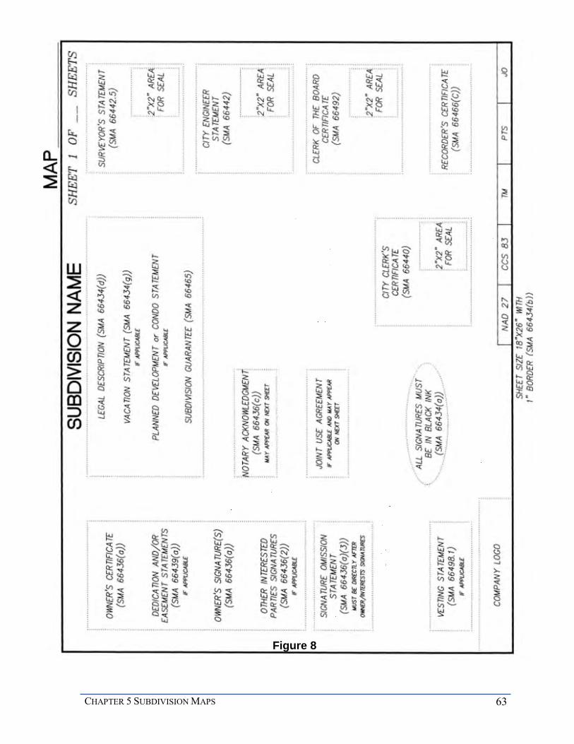
CHAPTER 5 SUBDIVISION MAPS 63
Figure 8

64 MAPPING AND LAND TITLE DOCUMENT PREPARATION MANUAL
OWNERS’ CERTIFICATE The owners’ certificate is the statement by the owner(s) and all parties having any record title interest and consent(s) to the preparation and recordation of the map. The following certificate is to be placed in the upper left hand corner of the title sheet. It is slightly different than the certificate for a parcel map. If there are no easements being granted, the signatures follow the statement.
WE (I) HEREBY CERTIFY THAT (WE ARE) (I AM) THE OWNER(S) OF OR HAVE AN INTEREST IN THE LAND EMBRACED WITHIN THE SUBDIVISION TO BE KNOWN AS (name of subdivision), AND (WE) (I) HEREBY CONSENT TO THE PREPARATION AND RECORDATION OF THIS MAP CONSISTING OF (x) SHEETS AND DESCRIBED IN THE CAPTION THEREOF.
DEDICATIONS AND GRANTING OF EASEMENTS It may be required for the owner to dedicate right-of-way or grant easements. The dedications or easements may be required per the Resolution of Approval of the tentative map. Offsite easements may also be required which must be done by a separate document. The requirements for dedicating rights-of-way and granting easements on final maps are exactly the same as for parcel maps.
Pursuant to SMA 66439(d) the following shall be placed on the map as applicable:
If a subdivider is required to make a dedication for a specified public purpose on a final map, it must be noted on the map whether or not the dedication is to be in fee for public purposes or an easement for public purposes.
If the dedication is required to be in fee for public purposes, the subdivider shall include the following language in the dedication clause above the dedication statement on the final map: “The real property described below is dedicated in fee for public purposes: (follow this statement with the dedication statement).
If the dedication is required to be an easement for public purposes, the subdivider shall include the following language directly above dedication clause on the final map stating: The real property described below is dedicated as an easement for public purposes: (follow this statement with the dedication statement).
OWNER’S SIGNATURE The map must be signed by all owners pursuant to SMA 66436(a). The owners as listed in
the map guarantee shall sign the map. The signatures must immediately follow the owner’s certificate, dedications and grant of easements. All signatures must be signed in black permanent opaque ink. The name and the interest of the subdivider must be printed below the signature.
________________________________
JANE SMITH, OWNER

CHAPTER 5 SUBDIVISION MAPS 65
OTHER INTERESTED PARTIES’ SIGNATURES The map must also be signed by other interested parties identified in the Subdivision Guarantee per SMA 66436(a). Interested parties may be beneficiaries, trustees of deeds, lessees, optionees, etc. Include the parties’ interest and the recording date of the document establishing such interest. The example below illustrates the proper format.
MOUNTAIN HIGH FINANCIAL CORPORATION, TRUSTEE UNDER DEED OF TRUST RECORDED (date), AS (recording information), O.R.
BY__________________________
(print name and title)
SIGNATURE OMISSION STATEMENT SMA 66436(a)(3) requires a signature omission statement(s). The subdivider is required to notify all interested parties and provide a letter(s) to the City that all interested parties do not object to the map recording without their signatures. If the interested parties do not object to the map recording without their signatures, a statement stating their respective interests must be shown on the title sheet immediately following the owner and trustee signatures. The requirements for parcel maps and final maps are exactly the same.
VESTING TENTATIVE MAP (VTM) A vesting tentative map confers the right to proceed with development in substantial compliance in effect at the time the VTM was approved. If the tentative map is a vested tentative map, SMA 66498.1, a statement must appear on the map. The following statement must be placed at the bottom left corner of the first title sheet.
THIS MAP SECURES VESTED DEVELOPMENT RIGHTS AND THE RIGHTS THUS VESTED SHALL REMAIN IN EFFECT FOR TWO YEARS FROM THE DATE OF RECORDATION. (See Municipal Code Sec. 125.0131)
SUBDIVISION NAME The City has a practice of naming subdivisions. For final maps, the subdivision name must be shown on each sheet in bold lettering, centered at the very top of the sheet below the margin line. If the map is to be filed as units, include the appropriate unit designation following the subdivision name. Example: STONECREST VILLAGE - UNIT NO. 2. Units of the same subdivision must be numbered consecutively, starting with Unit No. 1, and all consecutive units of the subdivisions must be recorded in the same order unless otherwise approved by the tentative map resolution or the City Land Surveyor, i.e. Unit No. 2 must not be recorded before Unit No. 1. The name of the subdivision must be the same name that appears in the owner’s statement.

66 MAPPING AND LAND TITLE DOCUMENT PREPARATION MANUAL
LEGAL DESCRIPTION The legal description of land being subdivided shall appear on the map, SMA 66434(d), and should read similar to and describe the same land that is described in the preliminary report. For example, a metes and bounds description, will be an abbreviated version, such as A PORTION OF LOT 1 OF MAP 12345 or a reference to a deed. On a map, the legal description will be placed on the title sheet directly beneath the subdivision name.
If the map is a typical subdivision, the first words in the legal description must be BEING A SUBDIVISION OF (describe land being subdivided). If the map is for condominiums, and the underlying lots are being consolidated, the first words in the legal description must be BEING A CONSOLIDATION AND SUBDIVISION OF (describe land being subdivided).
The legal description must also include all vacated streets, dedicated streets or portions thereof, and streets/easements to be vacated included within the subdivision boundary. Add the following to the basic description as applicable.
TOGETHER WITH (portions of) (street name/unnamed alley) AS CLOSED AND VACATED TO PUBLIC USE and/or TOGETHER WITH (portions of) (street name/unnamed alley) AS DEDICATED TO PUBLIC USE.
The legal description must be the property as it exists prior to the map recording. If an easement is being vacated per SMA 66434(g), the following statement should be added as a separate paragraph and must follow the legal description.
THE (sewer, water, etc.) EASEMENT GRANTED TO THE CITY OF SAN DIEGO PER (document, file/page, map), RECORDED (date), OF OFFICIAL RECORDS IS NOT SHOWN WITHIN THIS MAP BECAUSE IT HAS BEEN VACATED PURSUANT TO SECTION 66434(g) OF THE SUBDIVISION MAP ACT.
The preliminary report (PR) must have verbiage stating that the easement will be vacated upon the recordation of the map.
PLANNED DEVELOPMENT STATEMENT If a Planned Development Permit appears in the PR or as an item of the resolution this must be noted on the map. The following statement goes under the legal description if applicable.
THIS IS A MAP OF A PLANNED (RESIDENTIAL, INFILL RESIDENTIAL, COMMERCIAL, DISTRICT OR INDUSTRIAL) DEVELOPMENT PROJECT AS DEFINED IN THE SAN DIEGO LAND DEVELOPMENT CODE.
CHAPTER 5 SUBDIVISION MAPS 67
CONDOMINIUM STATEMENT If the map is for condominium purposes, the following statement must be included below the legal description.
THIS IS A MAP OF A CONDOMINIUM PROJECT AS DEFINED IN SECTION 1350, ET SEQ. OF THE CIVIL CODE OF THE STATE OF CALIFORNIA AND IS FILED PURSUANT TO THE SUBDIVISION MAP ACT. THE (approving authority) RESOLUTION NO. DATED , APPROVES (number) (type) CONDOMINIUMS.
If there is more than one lot, the statement must reflect the number and type of condominiums approved for each lot.
SUBDIVISION GUARANTEE The subdivision guarantee needs to be noted on the map. The guarantee is the evidence for the County Recorder of all record title interests per SMA 66436(a). Place the following on the title sheet below the legal description (and the above statements if applicable).
SUBDIVISION GUARANTEE BY: (title company)
ORDER NO: _______
CITY CLERK’S CERTIFICATE The final map shall contain a certificate for execution by the City Clerk stating the City approved the map per SMA 66440. The Clerk’s statement must be at the bottom of the sheet in the middle column if three columns are used and the third column if four are used.
Final Maps are approved by the City Land Surveyor. The tentative map or tentative map waiver has already been approved by City Council, Planning Commission or a Hearing Officer and only needs to go before the City Council as public notice, therefore, the final map must include the following City Clerk statement:
I, CITY CLERK OF THE CITY OF SAN DIEGO, CALIFORNIA, HEREBY CERTIFY THAT THE CITY LAND SURVEYOR HAS APPROVED THIS SUBDIVISION MAP. I ALSO CERTIFY THAT PROPER PUBLIC NOTICE HAS BEEN GIVEN OF THAT APPROVAL ON 20(xx), AND THAT THE LEGAL APPEAL PERIOD HAS EXPIRED.
If a vacation was approved by the City Council at the tentative map approval stage insert this paragraph:
I FURTHER CERTIFY THAT THOSE PUBLIC STREETS AND EASEMENTS LISTED HEREON AS BEING VACATED OR ABANDONED PURSUANT TO SECTION 66434(g) OF THE SUBDIVISION MAP ACT ARE HEREBY VACATED OR ABANDONED
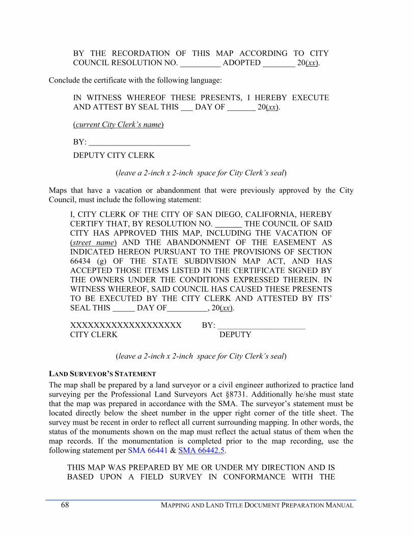
68 MAPPING AND LAND TITLE DOCUMENT PREPARATION MANUAL
BY THE RECORDATION OF THIS MAP ACCORDING TO CITY COUNCIL RESOLUTION NO. __________ ADOPTED ________ 20(xx).
Conclude the certificate with the following language:
IN WITNESS WHEREOF THESE PRESENTS, I HEREBY EXECUTE AND ATTEST BY SEAL THIS DAY OF 20(xx).
(current City Clerk’s name)
BY: DEPUTY CITY CLERK
(leave a 2-inch x 2-inch space for City Clerk’s seal)
Maps that have a vacation or abandonment that were previously approved by the City Council, must include the following statement:
I, CITY CLERK OF THE CITY OF SAN DIEGO, CALIFORNIA, HEREBY CERTIFY THAT, BY RESOLUTION NO. THE COUNCIL OF SAID CITY HAS APPROVED THIS MAP, INCLUDING THE VACATION OF (street name) AND THE ABANDONMENT OF THE EASEMENT AS INDICATED HEREON PURSUANT TO THE PROVISIONS OF SECTION 66434 (g) OF THE STATE SUBDIVISION MAP ACT, AND HAS ACCEPTED THOSE ITEMS LISTED IN THE CERTIFICATE SIGNED BY THE OWNERS UNDER THE CONDITIONS EXPRESSED THEREIN. IN WITNESS WHEREOF, SAID COUNCIL HAS CAUSED THESE PRESENTS TO BE EXECUTED BY THE CITY CLERK AND ATTESTED BY ITS’ SEAL THIS DAY OF , 20(xx).
XXXXXXXXXXXXXXXXXXX BY: __________________________ CITY CLERK DEPUTY
(leave a 2-inch x 2-inch space for City Clerk’s seal)
LAND SURVEYOR’S STATEMENT The map shall be prepared by a land surveyor or a civil engineer authorized to practice land surveying per the Professional Land Surveyors Act §8731. Additionally he/she must state that the map was prepared in accordance with the SMA. The surveyor’s statement must be located directly below the sheet number in the upper right corner of the title sheet. The survey must be recent in order to reflect all current surrounding mapping. In other words, the status of the monuments shown on the map must reflect the actual status of them when the map records. If the monumentation is completed prior to the map recording, use the following statement per SMA 66441 & SMA 66442.5.
THIS MAP WAS PREPARED BY ME OR UNDER MY DIRECTION AND IS BASED UPON A FIELD SURVEY IN CONFORMANCE WITH THE
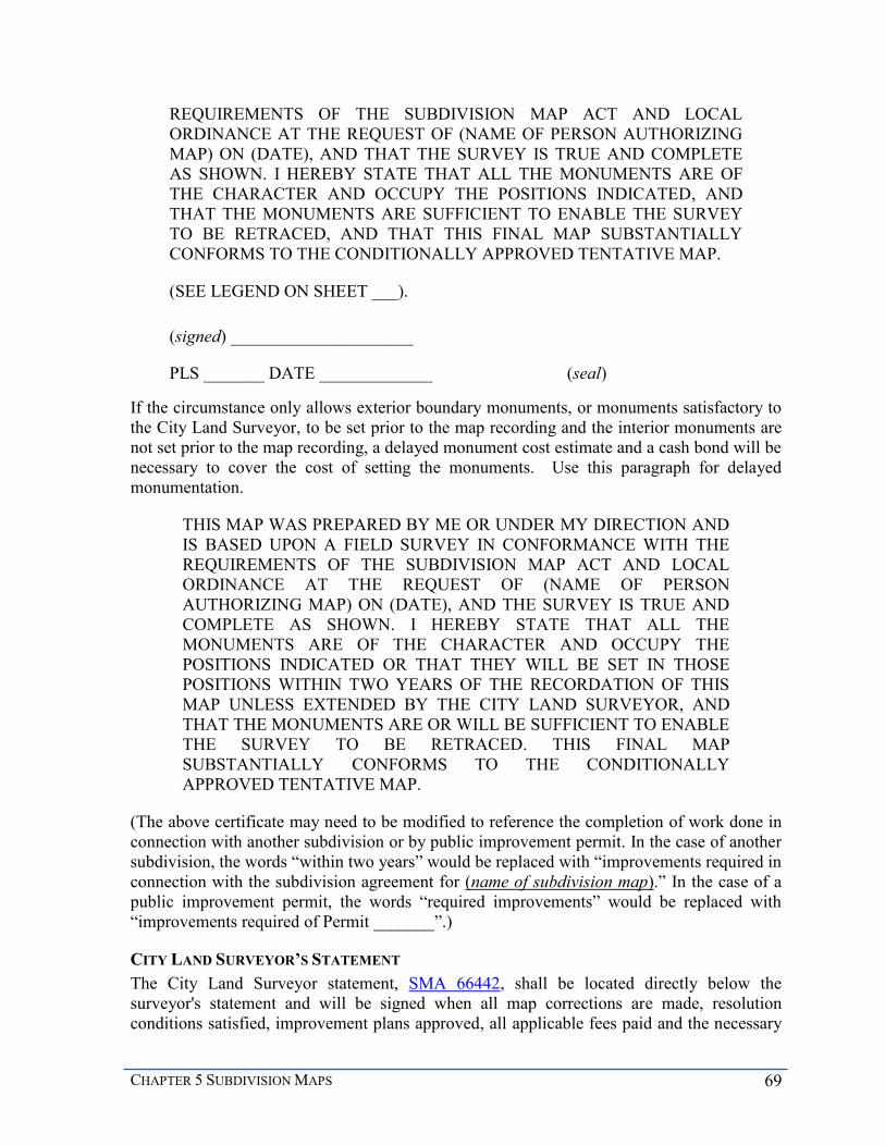
CHAPTER 5 SUBDIVISION MAPS 69
REQUIREMENTS OF THE SUBDIVISION MAP ACT AND LOCAL ORDINANCE AT THE REQUEST OF (NAME OF PERSON AUTHORIZING MAP) ON (DATE), AND THAT THE SURVEY IS TRUE AND COMPLETE AS SHOWN. I HEREBY STATE THAT ALL THE MONUMENTS ARE OF THE CHARACTER AND OCCUPY THE POSITIONS INDICATED, AND THAT THE MONUMENTS ARE SUFFICIENT TO ENABLE THE SURVEY TO BE RETRACED, AND THAT THIS FINAL MAP SUBSTANTIALLY CONFORMS TO THE CONDITIONALLY APPROVED TENTATIVE MAP.
(SEE LEGEND ON SHEET ___).
(signed) _____________________ PLS _______ DATE _____________ (seal)
If the circumstance only allows exterior boundary monuments, or monuments satisfactory to the City Land Surveyor, to be set prior to the map recording and the interior monuments are not set prior to the map recording, a delayed monument cost estimate and a cash bond will be necessary to cover the cost of setting the monuments. Use this paragraph for delayed monumentation.
THIS MAP WAS PREPARED BY ME OR UNDER MY DIRECTION AND IS BASED UPON A FIELD SURVEY IN CONFORMANCE WITH THE REQUIREMENTS OF THE SUBDIVISION MAP ACT AND LOCAL ORDINANCE AT THE REQUEST OF (NAME OF PERSON AUTHORIZING MAP) ON (DATE), AND THE SURVEY IS TRUE AND COMPLETE AS SHOWN. I HEREBY STATE THAT ALL THE MONUMENTS ARE OF THE CHARACTER AND OCCUPY THE POSITIONS INDICATED OR THAT THEY WILL BE SET IN THOSE POSITIONS WITHIN TWO YEARS OF THE RECORDATION OF THIS MAP UNLESS EXTENDED BY THE CITY LAND SURVEYOR, AND THAT THE MONUMENTS ARE OR WILL BE SUFFICIENT TO ENABLE THE SURVEY TO BE RETRACED. THIS FINAL MAP SUBSTANTIALLY CONFORMS TO THE CONDITIONALLY APPROVED TENTATIVE MAP.
(The above certificate may need to be modified to reference the completion of work done in connection with another subdivision or by public improvement permit. In the case of another subdivision, the words “within two years” would be replaced with “improvements required in connection with the subdivision agreement for (name of subdivision map).” In the case of a public improvement permit, the words “required improvements” would be replaced with “improvements required of Permit _______”.)
CITY LAND SURVEYOR’S STATEMENT The City Land Surveyor statement, SMA 66442, shall be located directly below the surveyor's statement and will be signed when all map corrections are made, resolution conditions satisfied, improvement plans approved, all applicable fees paid and the necessary

70 MAPPING AND LAND TITLE DOCUMENT PREPARATION MANUAL
security and agreement forms executed. The statement is the same for parcel maps and final maps. The only difference is in the IOD paragraph; substitute PARCEL with LOT.
CLERK OF THE BOARD OF SUPERVISORS CERTIFICATE The Clerk of the Board of Supervisors certificate should be located beneath the City Land Surveyor statement. It will be signed by the Clerk of the Board of Supervisors prior to the map being submitted to the County Clerk's office for recordation. (SMA 66492; SMA 66412 (d), Revenue and Taxation Code Section 2192) This requirement also includes maps having lots owned by government agencies. The statement is the same for final maps and parcel maps and further clarification on its application, together with a sample of the certificate can be found in the Parcel Map section of this manual.
COUNTY RECORDER’S CERTIFICATE The County Recorder certificate, SMA 66442.5, shall be located at the lower right corner of sheet one and is the last certificate to be executed. The filing of the map for record by the County Recorder shall impart constructive notice thereof. (LDC 125.0550 and SMA 66412.7).
FILE NO._________________________
FILED THIS_____ DAY OF ____________, 20____, AT __.M. IN
BOOK OF , AT PAGE , AT THE REQUEST OF (surveyor).
XXXXXXXXXXXXXX, BY:__________________________________
COUNTY RECORDER DEPUTY
FEE $ _______
Please check the County website for current fees.
JOINT USE AGREEMENT If a street is to be dedicated on the map and it crosses an existing easement used or intended to be used for public utility company facilities, a joint use agreement (JUA) is required. If the easement is not plottable, a joint use agreement must be included on the map.
The agreement may be shown on the first title sheet if there is room, otherwise it may be shown on the second title sheet. Additionally, the agreement may be made by a separate document. It must then be referred to on the map pursuant to SMA 66435.2.
The verbiage for the JUA map certificate is in Appendix A. The separate JUA document can be obtained by contacting a reviewer in the mapping section. The language and document are the same for final maps and parcel maps.
NOTARY ACKNOWLEDGMENTS The proper notary certificate must acknowledge all signatures on maps and separate documents per SMA 66436(a). The requirements are the same for final maps and parcel maps.

CHAPTER 5 SUBDIVISION MAPS 71
CORRECTION AND AMENDMENT OF MAPS
Once a map records, there are methods available to modify or correct the data on the recorded map per SMA 66469. Normally, a Certificate of Correction is a means to make minor corrections; and an amended map may be required for major corrections. Corrections may only be made if no additional burden is made upon the real property owners and there is no alteration to rights, title or interest in the real property. A reversion to acreage map may be used to revert a subdivision back to acreage per SMA 66499.11.
CERTIFICATE OF CORRECTION
A Certificate of Correction is to be used to correct errors or omissions on a recorded parcel map or final map as described in SMA 66469. Typical errors include misspelling a street name, a change in the type of corner monument set, and an incorrect dimension. Omissions include an omitted signature, parcel number, incorrect legal description or dimension. A certificate of correction is ministerial and requires only the City Land Surveyor’s approval. If the certificate is used to change the surveyor charged with the responsibility of setting monuments, it must be done in accordance with SMA 66498.
A certificate of correction must be formatted per the County of San Diego requirements on a standard 8” X 11” sheet (see example) that includes the following data:
a. RECORDING REQUESTED BY XXXXXXXXXXX, Director
b. WHEN RECORDED MAIL TO City of San Diego 1222 First Avenue, MS 301 San Diego, CA 92101
Items a & b must appear in the upper left corner of the sheet, above a line which is 2.5" from the top edge of the sheet. The upper right hand corner is for the County Recorder’s use.
Items c & d are informational. Items e through h must be included in the body.
c. Assessor’s Parcel number
d. PTS number
e. Final Map name and number or Parcel Map number.
f. LIST OF CORRECTIONS
g. Certificate of Surveyor, which also must include all the fee owners of the map at the time of recordation of the original map.
h. Certificate of the City Land Surveyor
It is recommended to delay the filing of a Certificate of Correction for a recently recorded map until any delayed monuments have been set and verified by the City Land Surveyor, and then include any and all errors and omissions in the certificate at the same time.

72 MAPPING AND LAND TITLE DOCUMENT PREPARATION MANUAL
AMENDED MAPS
An amended subdivision map is used to correct errors or omissions that are more extensive than could be easily handled with a Certificate of Correction. They are not subject to the tentative map process; however the underlying tentative map must still be active. An amended map may also be used to modify a recently recorded map, to adjust lot lines or make other changes that still substantially conform to the existing approved tentative map. Map modifications of this kind can only be made to a recorded map when the tentative map is still valid and usually only when the modified area is still owned by the subdivider. Modifications after the tentative map expires or after the affected area has been sold to third parties require a different process such as a new subdivision map, or a lot line adjustment.
An amended map may be used to correct or modify an entire subdivision map or just a portion of it. An amended map must clearly show the boundary of the area or areas being corrected or modified. Unique features of this type of map include the following:
The amended map replaces the original map or parts of it. There is no extension of the tentative map expiration date or any vested rights running with it.
There is no need to re-dedicate easements granted on the original map.
There is no need for a new construction bond.
There is not a requirement for a Clerk of the Board of Supervisor's certificate per SMA 66492.
All property conveyances within the amended map boundary must reference the amended map in legal descriptions.
Assessment District boundaries may need to be adjusted, if applicable.
CERTIFICATES The format and content of an amended map are the same as a parcel map or final map except for the differences noted below. The certificates reflect the amendments.
SUBDIVISION NAME If the map is a final map, the subdivision name must be worded the same as it appeared on the recorded map, except that it must be preceded with:
AMENDED MAP OF ALL OF (original subdivision name)
or
AMENDED MAP OF LOTS ___ THROUGH ___ OF (original subdivision name)
This title is shown on each sheet of the amended map. There is no title for an amended parcel map.

CHAPTER 5 SUBDIVISION MAPS 73
OWNERS AND TITLE INTEREST CERTIFICATE The owner's certificate must be placed in the upper left-hand corner of the title sheet and is to be signed by all owners, trustees and other interested parties of the property contained within the amended portions, except for those owners of interest which cannot ripen into fee title and whose signatures are not required by the City. An example of this certificate is as follows:
WE HEREBY CERTIFY THAT WE ARE THE OWNERS OF OR ARE INTERESTED IN THE LANDS EMBRACED WITHIN THE SUBDIVISION SHOWN ON (map or parcel map number) FILED (recording date) IN THE OFFICE OF THE COUNTY RECORDER OF SAN DIEGO COUNTY. AS SUCH OWNERS OR INTERESTED PARTIES, WE DO HEREBY CONSENT TO THE PREPARATION AND RECORDATION OF THIS AMENDED VERSION OF SAID MAP CONSISTING OF __ SHEETS AND DESCRIBED IN THE CAPTION THEREOF.
This certificate must also acknowledge all new dedications and easements being granted on the amended map and existing dedications and easements that were granted on the original map; therefore add the following as applicable.
WE HEREBY ACKNOWLEDGE THE DEDICATION OF (Name of streets), AND THE GRANTING OF THE (list easement(s)) ALL AS SHOWN ON SAID (PARCEL) MAP NO. __.
or
WE HEREBY ACKNOWLEDGE THE GRANTING OF THE FLOWAGE EASEMENT PER SAID (PARCEL) MAP NO. , AS SHOWN ON THIS MAP.
VESTED DEVELOPMENT RIGHTS The following statement must be added to the lower left hand corner of the title sheet if the original map was a vested map.
THIS MAP HAS SECURED VESTED DEVELOPMENT RIGHTS ASSOCIATED WITH THE RECORDATION OF (map or parcel map number) AND THE RIGHTS THUS VESTED SHALL REMAIN IN EFFECT FOR TWO YEARS FROM DATE OF RECORDATION OF SAID MAP.
LEGAL DESCRIPTION The legal description must include the following
BEING AN AMENDED (PARCEL) MAP (OF) (subdivision name), IN THE CITY OF SAN DIEGO, COUNTY OF SAN DIEGO, STATE OF CALIFORNIA, THE ORIGINAL MAP OF SAID SUBDIVISION HAVING

74 MAPPING AND LAND TITLE DOCUMENT PREPARATION MANUAL
BEEN FILED AS (PARCEL) MAP NO. IN THE OFFICE OF THE RECORDER OF SAID COUNTY ON (recording date).
Beneath the legal description, a complete list of amendments must follow. The following is sample wording of such a list that would appear below the preamble:
THIS AMENDED MAP CORRECTS ERRORS GENERATED FROM MISCALCULATIONS OF THE EXISTING EASEMENTS IN LOTS 1 AND 3 ALONG THE RIGHT OF WAY OF (street name) AND RECONFIGURES LOTS 1 THROUGH 3 INCLUSIVE.
PLANNED DEVELOPMENT STATEMENT If the original map is a planned development, the statement as shown on the original map must appear on the amended map directly below the legal description.
SUBDIVISION GUARANTEE The Subdivision Guarantee statement is required just as per a final map and a parcel map; however a new Subdivision Guarantee is required for the amended map.
CITY CLERK’S CERTIFICATE If the amended map has made modifications of the original map that are not in substantial conformance with the tentative map, it will require City Council approval and the following City Clerk Certificate shall be used:
I, CITY CLERK OF THE CITY OF SAN DIEGO, CALIFORNIA, HEREBY CERTIFY THAT, BY RESOLUTION NO. THE COUNCIL OF SAID CITY HAS APPROVED THIS AMENDED MAP AND HAS ACCEPTED THOSE ITEMS LISTED IN THE CERTIFICATE SIGNED BY THE OWNERS UNDER THE CONDITIONS EXPRESSED THEREIN. IN WITNESS WHEREOF, SAID COUNCIL HAS CAUSED THESE PRESENTS TO BE EXECUTED BY THE CITY CLERK AND ATTESTED BY ITS SEAL THIS DAY OF 20(xx).
XXXXXXXXXXXXXXXXXXX BY: _________________________
CITY CLERK DEPUTY
(leave 2-inch x 2-inch space for seal)
LAND SURVEYOR’S STATEMENT Use the same land surveyor statement as the original map, but add the following paragraph to the statement, and above the land surveyor's signature:
I FURTHER STATE THAT ALL STREETS, EASEMENTS AND OTHER MATTERS OF RECORD WITHIN OR ASSOCIATED WITH (subdivision name) (PARCEL) MAP NO. REMAIN UNCHANGED UNLESS SPECIFICALLY AMENDED OR CORRECTED BY THIS MAP.

CHAPTER 5 SUBDIVISION MAPS 75
CITY LAND SURVEYOR’S CERTIFICATE The City Land Surveyor certificate is different than the map that is being amended. The certificate must read as follows:
I, CITY LAND SURVEYOR OF THE CITY OF SAN DIEGO, HEREBY CERTIFY THAT I HAVE EXAMINED THIS AMENDED MAP OF (subdivision name) CONSISTING OF ____ SHEETS, AND THE ONLY CHANGES MADE TO THE ORIGINAL MAP THEREOF NO. ARE THOSE PROVIDED IN SECTIONS 66469 AND 66470 OF THE SUBDIVISION MAP ACT. I HEREBY APPROVE THIS MAP.
XXXXXXXXXXXXXXX,
CITY LAND SURVEYOR
BY:_______________________________ DATED: _______________
XXXXXXXXXX, P.L.S. XXXX ,DEPUTY
CLERK OF THE BOARD OF SUPERVISOR’S CERTIFICATE The Clerk of the Board Certificate is not required for amended maps per SMA 66492.
COUNTY RECORDER’S CERTIFICATE This certificate, SMA 66442.5, shall be located at the lower right corner of sheet one and is the last certificate to be executed. The filing of the map for record by the County Recorder shall impart constructive notice of the corrections. (SMA 66472)
FILE NO. ________________________
FILED THIS_____ DAY OF ____________, 20(xx), AT __.M. IN
BOOK OF , AT PAGE , AT THE REQUEST OF (surveyor) .
XXXXXXXXXXXXXX, BY:_________________
COUNTY RECORDER DEPUTY
FEE $ _______
Please check the County website for current fees.
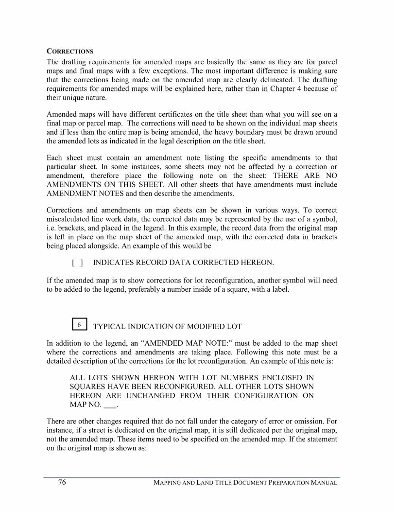
76 MAPPING AND LAND TITLE DOCUMENT PREPARATION MANUAL
CORRECTIONS The drafting requirements for amended maps are basically the same as they are for parcel maps and final maps with a few exceptions. The most important difference is making sure that the corrections being made on the amended map are clearly delineated. The drafting requirements for amended maps will be explained here, rather than in Chapter 4 because of their unique nature.
Amended maps will have different certificates on the title sheet than what you will see on a final map or parcel map. The corrections will need to be shown on the individual map sheets and if less than the entire map is being amended, the heavy boundary must be drawn around the amended lots as indicated in the legal description on the title sheet.
Each sheet must contain an amendment note listing the specific amendments to that particular sheet. In some instances, some sheets may not be affected by a correction or amendment, therefore place the following note on the sheet: THERE ARE NO AMENDMENTS ON THIS SHEET. All other sheets that have amendments must include AMENDMENT NOTES and then describe the amendments.
Corrections and amendments on map sheets can be shown in various ways. To correct miscalculated line work data, the corrected data may be represented by the use of a symbol, i.e. brackets, and placed in the legend. In this example, the record data from the original map is left in place on the map sheet of the amended map, with the corrected data in brackets being placed alongside. An example of this would be
[ ] INDICATES RECORD DATA CORRECTED HEREON.
If the amended map is to show corrections for lot reconfiguration, another symbol will need to be added to the legend, preferably a number inside of a square, with a label.
TYPICAL INDICATION OF MODIFIED LOT
In addition to the legend, an “AMENDED MAP NOTE:” must be added to the map sheet where the corrections and amendments are taking place. Following this note must be a detailed description of the corrections for the lot reconfiguration. An example of this note is:
ALL LOTS SHOWN HEREON WITH LOT NUMBERS ENCLOSED IN SQUARES HAVE BEEN RECONFIGURED. ALL OTHER LOTS SHOWN HEREON ARE UNCHANGED FROM THEIR CONFIGURATION ON MAP NO. .
There are other changes required that do not fall under the category of error or omission. For instance, if a street is dedicated on the original map, it is still dedicated per the original map, not the amended map. These items need to be specified on the amended map. If the statement on the original map is shown as:
6

CHAPTER 5 SUBDIVISION MAPS 77
20-FOOT WIDE DRAINAGE EASEMENT GRANTED HEREON.
PORTION OF (street name) DEDICATED HEREON.
OPEN SPACE EASEMENT OVER ALL OF LOT 21 GRANTED HEREON.
show these on the amended map as:,
20-FOOT WIDE DRAINAGE EASEMENT GRANTED TO THE CITY OF SAN DIEGO PER MAP NO. XXXXX
PORTION OF (street name) DEDICATED ON MAP NO. XXXXX
OPEN SPACE EASEMENT OVER ALL OF LOT 21 GRANTED TO THE CITY OF SAN DIEGO PER MAP NO. XXXXX
.

78 MAPPING AND LAND TITLE DOCUMENT PREPARATION MANUAL
CHAPTER 6 EASEMENTS
An easement allows a person or entity to use a portion of land owned by another person or entity for some specific purpose. Easements typically create a non-ownership interest in real property. They can be appurtenant, in gross, negative, exclusive, permanent, or temporary. Each will be discussed in more detail below. All easements produce an encumbrance on the property burdened by the easement and, most often, a benefit to the person or entity holding the easement right. Easements usually “run with the land,” that is, they remain a burden or a benefit regardless of who owns the land.. The discussion below is technical, but these concepts are necessary to fully understand the role of easements in land development.
An easement that benefits an adjoining parcel is said to be appurtenant to, or attached to, that parcel. An access easement across the land of a neighbor is a good example of an appurtenant easement. The parcel having the easement across it is called the servient tenement or “serving” parcel. The parcel benefited by the easement is called the dominant tenement or “benefitted” parcel. The easement is appurtenant to the “benefitted” parcel and a burden on the “serving” parcel.
An “in gross” easement has no dominant tenement. Therefore, no adjacent parcel is benefitted by the easement. An example of an easement “in gross” is a utility easement, such as an easement for a gas line to SDG&E. The servient tenement is burdened by the easement with the gas line running within it. There is no specific benefit to another parcel. The easement is a grant of permission for SDG&E to construct and maintain their facilities within the easement area.
The above two examples are positive easements, a specific right is granted to one party to do something across the lands of another owner. A negative easement is different and provides no direct benefit to a person or adjoining parcel, but rather it restricts the owner of a parcel from doing something within the easement area. An example of a negative easement is a “Building Restricted Easement,” which prohibits the owner from constructing structures within the easement area. Again, there is no dominant tenement or benefitted parcel or person. There is only a restriction on what the owner of the encumbered parcel can do with their land. The City uses negative easements to create restrictions on real property.
GRANTING OF EASEMENTS
An easement must be in writing and recorded against the title of the burdened parcel. It can only be granted by the owner of that parcel. Easements may be explicitly granted in a deed, on a recorded map, or as part of a recorded agreement. The granting document must be specific as to who is granting the easement and who is to benefit from the easement.
The language of the easement grant must also specifically define the rights being granted, such as the right to construct, use, and maintain a water line across the lands of the burdened parcel. The easement normally cannot be used for any purpose not stated in the easement grant or otherwise assumed in common usage. For example, a water line easement cannot be
CHAPTER 6 EASEMENTS 79
used for a sewer line or for public access. However, a water line easement typically allows the inclusion of valves and other appurtenances (structures) directly related to the water line.
The defined purpose for some easements has by use and legal interpretation become quite broad. An important example is a public street easement that allows the right of ingress and egress (coming and going) to the general public for motor vehicles, bicycles, pedestrians and horses. In addition, a public street easement allows the construction, use, and maintenance of public utilities such as water and sewer pipes, electric and communication lines, and drainage facilities together with any appurtenances connected with those uses. By common usage, an easement granted to the City for street purposes includes all of these auxiliary uses common to a public street, even though they are not specifically mentioned in the language of the easement grant. However, even an easement that is as broadly construed as a public street easement does not carry the right to use the encumbered area for completely unrelated uses such as a park or open space.
Another requirement for an easement to be valid is that its location must be defined. The easement’s location is determined by its legal description and may be accompanied by a drawing that helps illustrate the intent of the legal description. If the easement is being granted on a Final or Parcel Map, it will be graphically shown with bearings and distances along with ties to pertinent corners. In either case, the location must be definitive, with all ties, calls, and dimensions shown or given in order to describe or display the easement in an unambiguous location.
Easements may also be created by unwritten means such as by prescription. A prescriptive easement is created by use of the lands of another for a specific purpose for the statutory time. An example is taking access to your property across the land of an adjoining owner without permission. In California, the statutory time period is five years of continuous uninterrupted and hostile use. (Code of Civil Procedure, Section 325) The City of San Diego will not issue a permit or approve a development that uses an unwritten easement for a required function. A prescriptive easement may be valid, but it must first be perfected by a court of law before it can be used for development purposes.
EASEMENT GRANTS AND DEDICATIONS
The City of San Diego is a municipal corporation which holds thousands of easements for many different purposes as a corporate body. These easements are similar to corresponding easements held by any private landowner and can be held in gross, such as a utility easement, or as an easement appurtenant to City-owned property. The City, as a municipal corporation, can also grant easements to other parties.
A dedication is an easement granted to the City of San Diego, as the custodian of the public interest. A dedication to public use, grants an in- gross easement to the general public. An easement intended for public use, such as a street dedication, must clearly be dedicated to public use within the language of the dedication document. However, a dedication to public use does not grant rights to the public in and of itself; the owner must offer them to the public via a valid document and the City must accept the dedication on behalf of the public.
80 MAPPING AND LAND TITLE DOCUMENT PREPARATION MANUAL
An irrevocable offer of dedication (IOD) is the same as a dedication, except with an IOD, the City does not accept the dedication at the time it is offered; therefore, the dedication process is not complete. An IOD remains open for a statutory amount of time for future acceptance by the City. The owner may still use the land encumbered by an IOD for any desired purpose until the City accepts the dedication.
DOCUMENTS AND DEEDS
A legal description and its associated drawing are usually exhibits attached to another document. For example, the associated document could be a deed conveying an interest in real property, an agreement, or a City Council Resolution. The legal description defines the limits of the property interest conveyed or affected by an action or agreement. The drawing is used to illustrate the legal description.
The City of San Diego requires the applicant to use one of its standard forms for deeds and agreements. Typical deed templates are available on the Mapping and Land Title Document Review website. The City Land Surveyor may provide a custom deed or agreement form when project circumstances require one. Any significant modification of a standard deed or agreement will require the approval of the City Attorney. The deed or other document customarily references the legal description as Exhibit A and the drawing as Exhibit B.
REVIEW AND APPROVAL The City Land Surveyor reviews legal descriptions for conformance to the standards discussed in this section and those published in “Writing Legal Descriptions” by Gurdon Wattles. Likewise, drawings will be reviewed under the standards contained in this manual and as published in “Survey Drafting,” also by Gurdon Wattles.
LEGAL DESCRIPTIONS The description should be written in the simplest form possible for the purpose of the document. As an example, if the intent is to dedicate the north ten feet of a lot for a public street, the simplest description would be ‘the northerly ten feet of Lot 5, Block 3, Map 1963’ rather than a metes and bounds description going around the dedicated area. If an entire easement is to be vacated, it can be described as ‘that certain water easement granted to the City of San Diego by deed recorded March 23, 2003 as Document 2003-123456’. Other acceptable forms include strip, aliquot part, bounds, and lot and block. The choice of form should match the intent and purpose of the legal description. Keep in mind; you need to be certain that no gaps or overlaps are created by the way your legal description is scribed. To ensure that no gaps or overlaps are created, adjoiners/senior deeds must be called to.
A metes and bounds description must include all courses and calls needed to fully describe the subject area. Typically, bearings traverse around the parcel in a clockwise direction. The Basis of Bearings for the description should generally be the same as the underlying map. The traverse verifies the courses within the legal description, so therefore it may not close perfectly. A traverse that is provided that utilizes a point to point inverse methodology is not acceptable.

CHAPTER 6 EASEMENTS 81
DRAWING REQUIREMENTS Drawings must include all information needed to completely illustrate the legal description and must be prepared on a City of San Diego standard sheet. Drawings are to be prepared on a standard ‘B’ (11” x 17’) or ‘C’ (17” x 22”) sized sheet. Avoid showing information that is not directly related to the legal description. All of the bearings, distances, calls, and dimensions must be in complete agreement with the legal description. Drafting standards are the same as for a map. See Chapter 4 for drafting standards. The B & C sheet exhibits are reduced to fit on an 8.5" x 11" sheet. D Sheets are not suitable for drawings because they require an extreme reduction to fit into a recordable document. The lettering on reduced drawings must be legible. This requires B sheets to have lettering no less than 1/8" and C sheets to have lettering no less than 1/4".
Most easements are intended to be a permanent encumbrance on the burdened property and a permanent benefit to the holder of the easement. Occasionally, an easement is only needed temporarily. A temporary easement must clearly state the period during which it is valid and by what means it is to be released. For example, a temporary construction easement may be valid for a period of two years after which time it will be become null and void without further action.
ADDITIONAL ISSUES A Subordination Agreement is required for all deeds of trust affecting the underlying fee
of an easement or dedication. This agreement protects the easement grant from a possible foreclosure of the lien.
A Joint Use Agreement is required for a Street Dedication or an Irrevocable Offer of Dedication (IOD) for Road Purposes when there is an existing public utility easement(s) granted to Pacific Bell, SDG&E, or other public utility within the area of the proposed dedication. An agreement is also required if the utility easement cannot be plotted. The drawing must show the location of existing public utility easements that are pertinent to, and fall within, the dedicated area. This agreement provides for the joint use and mutual maintenance of the subject area.
An Irrevocable Offer of Dedication for a public street may also require a slope easement for construction per LDC 144.0233 unless waived by the City Land Surveyor.
All grants of land in fee to the City of San Diego must be free of encumbrances such as liens and trust deeds.
Land title documents must be executed and notarized by all record title owners.
The approved document is signed by the City Land Surveyor or other official as appropriate and recorded in the Office of the San Diego County Recorder by City staff.
82 MAPPING AND LAND TITLE DOCUMENT PREPARATION MANUAL
EXTINGUISHMENT OF EASEMENTS
Land use changes and new development goals often require that easements be eliminated or relocated. Easements between private parties are easy to extinguish. The holder of the easement (dominant tenement) simply releases its interest in the easement by recording a quitclaim deed to the owner of the burdened parcel (servient tenement). A quitclaim deed releases whatever interest a party may have in a parcel to the grantee. It is an ideal document to clear any title from an encumbrance or when there is a cloud on the title.
Easements held by the City can only be eliminated by a vacation action of the City Council. A vacation action is a legislative act and cannot be delegated to a lower body such as the Planning Commission. The vacation process terminates the public’s right to use an easement that the City has accepted on behalf of the public; i.e., a street, alley, or a public service easement. Vacations are generally requested by property owners to acquire legal use of the area that is encumbered by the easement. The proposed use of the area must be allowed under existing zoning and building regulations. Vacations may increase acreage and existing development entitlements. For instance, a street vacation may increase the floor area ratio of a lot.
The City must be compensated if it paid money to acquire the right-of-way or easement. The need for compensation is determined during the review process. The city’s Real Estate Assets Department will handle any compensation issues pertaining to a vacation.
You may review LDC 125.0900 regarding street vacations for further information. Street Vacations are also regulated by the State of California Streets and Highways Code beginning at Section 8300. In order to vacate a street, the City of San Diego must make certain findings, one of which is that there is no present or future need for the street. City staff conducts a thorough review of any vacation request to determine if the required findings can be made. During the review process, staff may identify public needs such as pedestrian access, emergency access and maintenance access. Easements can then be reserved to allow for these functions after the street is vacated.
All street vacations are routed to the local community planning group for their comments and recommendation. If the street vacation has significant issues, a noticed public hearing is held before the Planning Commission to make their recommendation to the City Council. In all cases, a noticed public hearing before the City Council is required. Only the City Council may approve or deny a vacation request. The applicant will be notified of any scheduled public hearing and will have the right to attend and voice concerns.
UNACCEPTED IRREVOCABLE OFFERS OF DEDICATION OR STREET RESERVATIONS
As noted previously, an irrevocable offer of dedication (IOD) is the same as a dedication, except the City does not accept the dedication at the time it is offered. Therefore, the dedication process is not complete. An irrevocable offer of dedication remains open for

CHAPTER 6 EASEMENTS 83
future acceptance by the City. Prior to the 1990s, IODs were referred to as street reservations. In accordance with the Subdivision Map Act, a reservation indicates that costs are incurred by the City. Offers of dedication, which were incorrectly called street reservations, do not incur costs to the City, and the terminology was corrected.
In accordance with California Code of Civil Procedure 771.010, if a street reservation or irrevocable offer of dedication is granted on a map, and has not been accepted by the City within 25 years of the map recording, the offer may no longer be valid.
RIGHTS OF ACCESS
Rights of access may be required to be relinquished during the discretionary permit process or ministerial approval process. A lot or parcel that is bounded by two dedicated streets may have access rights relinquished to the primary thoroughfare in accordance with the City’s Street Design Manual and/or LDC 144.0230. Or, access may be required to be relinquished along a certain street because of safety issues. The access rights may be relinquished on a map, or by a separate document.
If the document to relinquish the access is a map, simply add the statement on the map, the same way an easement would be granted. The verbiage is found in Appendix A. If the relinquishment is accomplished by a separate document, prepare a typical B sheet easement drawing, legal description and deed, just as you would for any other easement.
See deed template entitled RELINQUISHMENT OF RIGHTS OF ACCESS.
The City Land Surveyor is authorized via the LDC to revest all or part of access rights that have been relinquished if there is a change in circumstances making access necessary and safe. If a project requires that a portion or all of the access rights that were relinquished be revested, this can be accomplished ministerially. As mentioned above, for relinquishments, either show on a map or prepare a drawing for a revestment. See the deed template entitled REVESTMENT OF RIGHTS OF ACCESS.

84 MAPPING AND LAND TITLE DOCUMENT PREPARATION MANUAL
CHAPTER 7 OTHER LAND TITLE DOCUMENTS
LOT LINE ADJUSTMENTS
PURPOSE A lot line adjustment provides a process by which adjoining property owners can change their shared ownership boundary, or an owner of multiple adjoining parcels can rearrange boundary lines to better accommodate a proposed development project. A lot line adjustment is not a subdivision of land because no additional parcels are created. The lot line adjustment is authorized by SMA 66412(d) and by the Land Development Code beginning with LDC 125.0301.
ELIGIBILITY Owners of real property may adjust their shared boundary lines if all lots being adjusted are legal, conforming lots. A lot line adjustment cannot increase development rights unless additional approvals are obtained. All resulting parcels must conform to current zoning regulations. No more than four adjoining lots can be adjusted and there can be no net gain in the number of lots or parcels. A Coastal Development Permit is also required if the lots being adjusted are in the Coastal Zone. (La Fe, Inc. v. County of Los Angeles, 73 Cal. App. 4th 231, see_Appendix_B)
PROCESS Lot line adjustments are processed and approved by city staff under the Land Development Code as a Process One which is a ministerial process. No public hearing or noticing is required. After the submittal package is deemed complete, it is routed to appropriate city staff for review. Staff will examine the adjustment application to insure that it meets the previously listed eligibility requirements and that the adjusted lots satisfy current zoning and building regulations. If your application is approved, the surveyor prepares and submits the final lot line adjustment plat, with its associated deeds and legal descriptions, or the parcel map for technical review. Staff will review the final documents for form and content and to identify encumbrances such as easements, tax liens, assessment district boundaries, and trust deeds that may require adjustment or removal to convey clear title. The Parcel Map or Certificate of Compliance together with the tax certificate is recorded at the County Recorder’s Office once all documents are technically correct and any encumbrances removed. The owner’s are responsible for recording the appropriate deeds associated with Parcel Maps.
REQUIREMENTS An applicant/surveyor may choose either a Lot Line Adjustment Plat or a Parcel Map to facilitate the lot line adjustment. Both options will be discussed in detail below so the most appropriate instrument can be chosen. In either case, there is no requirement for a field survey or a requirement to set monuments. However, it is always recommended that a field survey be performed, including the setting of new lot corner monuments. The requirements,
CHAPTER 7 OTHER LAND TITLE DOCUMENTS 85
format and content of the plat or parcel map are the same as described previously in this manual for maps.
The surveyor must submit an exhibit with the project application showing the existing lots, the proposed new ownership lines and the location of all existing structures, dimensioned to the adjusted lines. This exhibit is reviewed by planning to determine whether or not the proposed adjustment is in accordance with zoning, setbacks, etc. The exhibit is usually a copy of the lot line adjustment plat or parcel map. A title report with associated reference documents must also be provided. Please see Section 5 of the Project Submittal Manual for the complete submittal details.
LOT LINE ADJUSTMENT PLATS A lot line adjustment plat is an exhibit of the requested boundary adjustment. The plat must show the location of all existing lots or parcels and the proposed new ownership lines that will result from the adjustment. Additionally, a copy of the exhibit with existing structures must be submitted to and reviewed by the planning and structural disciplines. The surveyor must prepare a legal description for each parcel being adjusted, and they may be based upon record information. Only ownership lines are being adjusted so record lots and parcels will remain as they were after the adjustment. This can occasionally make the legal description very complex.
If a field survey is performed, a separate Record of Survey may need to be filed with the County Recorder if required under the provisions of the Professional Land Surveyors Act. A lot line adjustment does not give constructive notice of the adjustment. As part of the review process, the owners of the separate parcels must provide city staff the original executed and notarized grant deeds which will be recorded by staff after the approval of the lot line adjustment. The recordation of the deeds will perfect the lot line adjustment and give constructive notice of its completion. After the recordation of the deeds, the City Land Surveyor will issue a separate Certificate of Compliance for each parcel affected by the adjustment to document the City’s official approval.
If there are deeds of trust over any of the parcels being adjusted, a partial reconveyance will need to be executed and notarized by both the trustees and beneficiaries and recorded concurrently with the grant deeds associated with the lot line adjustment.
LOT LINE ADJUSTMENT PARCEL MAPS A Parcel Map is a superior title instrument to the Lot Line Adjustment Plat described above. A Lot Line Adjustment Parcel Map requires no tentative map and may be prepared from record information if previously approved by the City Land Surveyor prior to the initial submittal; however, a field survey is highly recommended. A separate Record of Survey will not be required if the parcel map is based on a field survey. A Lot Line Adjustment Parcel Map re-maps the existing lots or parcels into the new adjusted parcels and when recorded, gives constructive notice with no need to record separate Certificates of Compliance. Deeds, based upon the new mapped parcels, must be exchanged between owners to complete the adjustment. A Lot Line Adjustment Parcel Map may also be used to grant public easements, revest and relinquish abutter’s rights of access and dedicate streets.
86 MAPPING AND LAND TITLE DOCUMENT PREPARATION MANUAL
CERTIFICATES OF COMPLIANCE FOR THE VALIDATION OF LEGAL LOTS
PURPOSE An owner or perspective buyer of real estate may request a Certificate of Compliance to determine if a subdivision of land (or condominium unit) was created legally in accordance with the SMA 66499.35 and the LDC 125.0201. If granted, a Certificate of Compliance is recorded against title and provides conclusive, constructive notice that a subdivision of land was legally created. A recorded Certificate of Compliance allows a parcel to be sold, leased or financed without further proceedings. No development rights are granted unless such rights are specifically stated in the Certificate of Compliance.
Buyers and sellers of real property must be aware that in accordance with SMA 66499.31 it is a felony to illegally subdivide land, and that an illegally created parcel may not be sold, leased, or used as security for a loan. A development permit may not be issued for an illegally created parcel per SMA 66499.34 and title companies will generally not insure title to such a parcel. A Certificate of Compliance provides assurance that a parcel was legally created.
ELIGIBILITY State law prescribes the method by which property may be subdivided and sold as separate parcels (or condominium units). A parcel or parcels of land are presumed to have been legally created if one or more of the following conditions apply:
1. The parcel was shown on a recorded subdivision map.
2. The parcel was an approved remainder parcel of a recorded subdivision map.
3. The parcel was shown on a Division Plat.
4. The parcel was shown on a Record of Survey that was approved by the City Council prior to March 4, 1972.
5. The parcel was conveyed by a deed and held separately as a conforming parcel prior to March 4, 1972. Non-conforming parcels conveyed between adjoining owners do not create a new parcel and should be considered a lot line adjustment.
6. The parcel was patented by the United States Government. All of the land described in the patent is considered one parcel, no matter how many aliquot parts are included in the patent. Sectionalization is a descriptive form to convey land and does not constitute a subdivision of land.
7. The parcel was approved by the City as part of a Lot Line Adjustment between adjoining owners.
8. The parcel was created pursuant to a Court Order in Partition.
9. The parcel was created as a conveyance to or from a government entity or public utility.
10. The parcel was issued a qualifying development permit and the owner relied on the permit by commencing construction per SMA 66499.35(c)

CHAPTER 7 OTHER LAND TITLE DOCUMENTS 87
When requesting a Certificate of Compliance, a copy of the deed by which the parcel is currently held (vesting deed) and satisfactory evidence that one or more of the conditions listed above that apply to the parcel must be included in the submittal. The City Land Surveyor may consider other circumstances when determining the legality of a parcel such as the chain of title and conformance to zoning or other City regulations. The City Land Surveyor may also use a Certificate of Compliance to memorialize a development approval granted by the City such as the approval of a condominium development on a single parcel or the approval of a lot line adjustment. Certificates of Compliance are decided by the City Land Surveyor. The City Land Surveyor will examine the documents provided by the applicant supporting the contention that a parcel was legally created. If the parcel or parcels are determined to be legally created, a Certificate of Compliance will be prepared and recorded by the City.
SPECIAL ISSUES Notwithstanding the above, certain parcels may not be considered legal for development purposes. Some examples include portions of parcels conveyed between adjoiners in a lot line adjustment that are not separate legal parcels, but are merged with the adjoining ownerships. Likewise, reversion areas from vacated streets are merged with the adjoining ownership and cannot be conveyed separately.
Similarly, while it is perfectly legal for a government entity to receive and convey small land parcels, a non-conforming, remnant government parcel conveyed to a private adjoining owner does not create a separate, developable parcel. Also, problems often occur in the interpretation of sectionalized land descriptions. The land parcel as described in the original patent is typically the controlling factor. The Courts have stated that aliquot parts of the parcel described in the patent are not in themselves separate parcels. The City Land Surveyor must include the context under which a parcel was created, not just the fact that a parcel was conveyed in determining the legality of that parcel and the conveyance. If the City Land Surveyor determines that the parcels were created illegally, a Conditional Certificate of Compliance may be recorded. A Conditional Certificate of Compliance per SMA 66499.35(b) will clearly state the conditions that an owner must satisfy to legalize the parcel or parcels of land for conveyance and /or development.
COVENANT TO HOLD AS ONE PARCEL
PURPOSE A Covenant to hold as One Parcel is a recorded document that ties lots together so that the lots may not be sold separately. The ‘Covenant to Hold as One Parcel’ is a temporary restriction put upon the property per LDC 125.0760. The reason the lots may not be sold is that they are dependent upon each other in order to be in compliance with regulations.
ELIGIBILITY The type of project typically determines the requirement for a Covenant to Hold as One Parcel (Covenant). Once a development project is submitted for review by the City, a

88 MAPPING AND LAND TITLE DOCUMENT PREPARATION MANUAL
reviewing discipline may require the covenant as an adequate means to meet requirements of the project.
An example of a typical project that requires a Covenant may be a retail store. The store may occupy one lot, yet the required parking occupies the adjacent lot. The Covenant eliminates the possibility of selling the parking lot, therefore leaving the store with inadequate parking. This requirement is usually requested from a planner or a traffic engineer in order for the applicant to proceed with their project.
Another typical reason a Covenant is utilized is to meet the requirements of the California Building Code (CBC). An engineer will make this request during the plan review of the buildings. Situations that may require a Covenant might be for fire-protection of exterior walls, protection of openings located on building exteriors or disabled access or means of egress. A Senior Structural Engineer will process the Covenant for these types of situations which will then be approved by the Senior Land Surveyor.
RELEASE OF A COVENANT TO HOLD AS ONE PARCEL The Covenant may be released and terminated if the reason the lots were tied together no longer exists. In order for the Covenant to be released, the property owner must submit evidence showing that the reason for the Covenant no longer exists. The Covenant that was recorded for satisfaction of a CBC requirement will need to be submitted through structural plan check. A Senior Structural Engineer will prepare the release document which will then be approved and recorded by the Senior Land Surveyor on behalf of the Chief Building Official.
The release of Covenants that are not CBC related must be submitted to map check and also to the discipline that initially required it. Map check staff will require evidence that the reason no longer exists from the appropriate discipline. Map check will prepare the release of the Covenant and record it.
Once the release is recorded against title, the lots may be sold as separate parcels.
REVERSION TO ACREAGE
PURPOSE Reversion to acreage is a procedure authorized by the provisions of SMA 66499.11 through SMA 66499.20.3. This allows previously subdivided land to be reverted to unsubdivided acreage. Proceedings for reversion to acreage may be initiated by either the City Council on its own motion or by petition of all the owners of record of the real property within the subdivision. The formal reversion process is typically initiated by the City to eliminate a previously approved subdivision when the improvements required as map conditions have not been constructed within the designated time limits or when no lots have been sold.
PROCEDURE The procedure for preparing a map for reversion to acreage is the same as filing any other subdivision map. If any streets or easements are to remain, they must be clearly shown on the map. Unneeded streets and easements may be vacated along with the consolidation of
CHAPTER 7 OTHER LAND TITLE DOCUMENTS 89
subdivided lots. Only easements dedicated to the public or the City may be vacated on the map.
PREPARATION Specific differences between a Reversion to Acreage map and a typical subdivision map are defined within the certificates on the title sheet of the map. If the certificate is not mentioned below, the requirement is the same as for a typical map.
MAP TITLE If the map is a final map, the title will be REVERSION TO ACREAGE MAP OF (subdivision name), otherwise parcel maps do not have titles.
LEGAL DESCRIPTION The legal description of a final map must be shown as:
BEING A REVERSION TO ACREAGE OF LOTS _________ OF (subdivision name), ACCORDING TO THE MAP THEREOF NO. _____ FILED IN THE OFFICE OF THE COUNTY RECORDER OF SAN DIEGO COUNTY ON (recording date), TOGETHER WITH (List street names and/or portions thereof dedicated on original map) AS VACATED AND CLOSED TO PUBLIC USE BY FILING OF THE REVERSION MAP AS PROVIDED IN SECTION 66499.18 OF THE SUBDIVISION MAP ACT, IN THE CITY OF SAN DIEGO, STATE OF CALIFORNIA.
If any dedicated roads or portions thereof per the original map remain dedicated to public use add this statement to the above paragraph: INCLUDING A PORTION OF (street name) WHICH REMAINS DEDICATED TO PUBLIC USE, IN THE CITY OF SAN DIEGO.
If any easements per the original map are to remain, add the following statement to the above paragraph:
INCLUDING THE (easement type) GRANTED TO THE CITY OF SAN DIEGO WHICH WILL REMAIN.
If the reversion is of a parcel map, the legal description must be:
BEING A REVERSION TO ACREAGE OF PARCEL(S) _____________OF PARCEL MAP NO. _________ IN THE CITY OF SAN DIEGO, STATE OF CALIFORNIA, AS FILED IN THE OFFICE OF THE COUNTY RECORDER OF SAN DIEGO COUNTY ON (recording date) AS FILE/ PAGE (or document) NO. OF OFFICIAL RECORDS. TOGETHER WITH (List street names and/or portions thereof dedicated on original map) AS VACATED AND CLOSED TO PUBLIC USE BY FILING OF THE REVERSION MAP AS PROVIDED IN SECTION 66499.18 OF THE SUBDIVISION MAP ACT.
90 MAPPING AND LAND TITLE DOCUMENT PREPARATION MANUAL
If any dedicated roads or portions thereof per the original map remain dedicated to public use add this statement to the above paragraph:
INCLUDING A PORTION OF (street name) WHICH REMAINS DEDICATED TO PUBLIC USE, IN THE CITY OF SAN DIEGO.
If any easements per the original map are to remain, add the following statement to the above paragraph:
INCLUDING THE (easement type) GRANTED TO THE CITY OF SAN DIEGO WHICH WILL REMAIN.
OWNER’S CERTIFICATE The owner's certificate must be worded as follows:
WE HEREBY CERTIFY THAT WE ARE THE OWNERS OF, OR ARE INTERESTED IN, THE LAND EMBRACED WITHIN THE SUBDIVISION KNOWN AS (subdivision name and number or parcel map number), SAID MAP HAVING BEEN FILED IN THE OFFICE OF THE COUNTY RECORDER OF SAN DIEGO COUNTY ON (recording date) OF OFFICIAL RECORDS, AND WE HEREBY CONSENT TO THE PREPARATION AND RECORDATION OF THIS REVERSION TO ACREAGE MAP, CONSISTING OF ___ SHEETS AND DESCRIBED IN THE CAPTION THEREOF.
If the City initiates the reversion process, use the following statement instead of the owner's statement:
PURSUANT TO THE SUBDIVISION MAP ACT AND APPROVED BY THE CITY COUNCIL BY RESOLUTION NO. THE CITY CLERK AUTHORIZES THE PREPARATION AND RECORDATION OF THIS REVERSION TO ACREAGE MAP.
BY: _____________________
XXXXXXXXXXXXXXXX
CITY CLERK
CHAPTER 7 OTHER LAND TITLE DOCUMENTS 91
CITY LAND SURVEYOR’S CERTIFICATE
The City Land Surveyor certificate changes slightly to reflect the reversion.
I, CITY LAND SURVEYOR OF THE CITY OF SAN DIEGO, CALIFORNIA, HEREBY CERTIFY THAT I HAVE EXAMINED THIS MAP, AND HAVE FOUND THAT ALL THE PROVISIONS OF THE SUBDIVISION MAP ACT OF THE STATE OF CALIFORNIA, AS AMENDED, AND OF ANY LOCAL ORDINANCE OF SAID CITY APPLICABLE TO THE FILING OF THE REVERSION TO ACREAGE MAP HAVE BEEN COMPLIED WITH, AND I AM SATISFIED THAT THIS MAP IS TECHNICALLY CORRECT.
(current City Land Surveyor)
BY:
___________________, DEPUTY P.L.S. XXXX
DATED: ________
CITY CLERK’S STATEMENT The City Clerk's Statement also changes slightly reflecting the reversion:
I, CITY CLERK OF THE CITY OF SAN DIEGO, CALIFORNIA, HEREBY CERTIFY THAT BY RESOLUTION NO. _______ , THE COUNCIL OF SAID CITY HAS APPROVED THIS REVERSION TO ACREAGE MAP OF (subdivision name), AND HAS ACCEPTED THOSE ITEMS LISTED IN THE CERTIFICATE SIGNED BY THE OWNERS UNDER THE CONDITIONS EXPRESSED THEREIN.
IN WITNESS WHEREOF, SAID COUNCIL HAS CAUSED THESE PRESENTS TO BE EXECUTED BY THE CITY CLERK AND ATTESTED BY ITS SEAL THIS ___ DAY OF 20(xx).
(current City Clerk) CITY CLERK
BY: _______________
DEPUTY
92 MAPPING AND LAND TITLE DOCUMENT PREPARATION MANUAL
The above statement will also need to be modified slightly to add any dedications or easements that are being vacated.
The map sheet requirements and drafting standards are the same as for a typical map. However, any easements or dedications not being vacated with the reversion must be labeled specifically. Here are some examples:
EXISTING 20-FOOT WIDE SEWER EASEMENT GRANTED PER MAP NO. TO REMAIN.
-or-
PORTION OF (street name) DEDICATED PER MAP NO. (xxx) TO REMAIN.
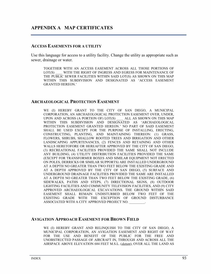
INDEX 93
APPENDIX A MAP CERTIFICATES
ACCESS EASEMENTS FOR A UTILITY
Use this language for access to a utility facility. Change the utility as appropriate such as sewer, drainage or water.
TOGETHER WITH AN ACCESS EASEMENT ACROSS ALL THOSE PORTIONS OF LOT(S) ____ WITH THE RIGHT OF INGRESS AND EGRESS FOR MAINTENANCE OF THE PUBLIC SEWER FACILITIES WITHIN SAID LOT(S) AS SHOWN ON THIS MAP WITHIN THIS SUBDIVISION AND DESIGNATED AS ‘ACCESS EASEMENT GRANTED HEREON.’
ARCHAEOLOGICAL PROTECTION EASEMENT
WE (I) HEREBY GRANT TO THE CITY OF SAN DIEGO, A MUNICIPAL CORPORATION, AN ARCHAEOLOGICAL PROTECTION EASEMENT OVER, UNDER, UPON AND ACROSS (A PORTION OF) LOT(S) ____ ALL AS SHOWN ON THIS MAP WITHIN THIS SUBDIVISION AND DESIGNATED AS ‘ARCHAEOLOGICAL PROTECTION EASEMENT GRANTED HEREON.’ NO PART OF SAID EASEMENT SHALL BE USED EXCEPT FOR THE PURPOSE OF INSTALLING, ERECTING, CONSTRUCTING, PLANTING, AND MAINTAINING THEREON: (1) GRASS, FLOWERS, SHRUBS, SHALLOW ROOTED TREES AND IRRIGATION AND OTHER LANDSCAPING APPURTENANCES, (2) FENCES AND RETAINING AND OTHER WALLS HERETOFORE OR HEREAFTER APPROVED BY THE CITY OF SAN DIEGO, (3) RECREATIONAL FACILITIES PROVIDED THE SAME SHALL NOT INCLUDE ANY BUILDING, (4) UTILITY DISTRIBUTION FACILITIES PROVIDED THE SAME (EXCEPT FOR TRANSFORMER BOXES AND SIMILAR EQUIPMENT NOT ERECTED ON POLES, DERRICKS OR SIMILAR SUPPORTS) ARE INSTALLED UNDERGROUND AT A DEPTH NO GREATER THAN TWO FEET BELOW THE EXISTING GRADE AND AT A DEPTH APPROVED BY THE CITY OF SAN DIEGO, (5) SURFACE AND UNDERGROUND DRAINAGE FACILITIES PROVIDED THE SAME ARE INSTALLED AT A DEPTH NO GREATER THAN TWO FEET BELOW THE EXISTING GRADE, (6) SIDEWALKS, PATHS AND STEPS, (7) DIRECTIONAL SIGNS, (8) OUTDOOR LIGHTING FACILITIES AND COMMUNITY TELEVISION FACILITIES, AND (9) CITY APPROVED ARCHAEOLOGICAL EXCAVATIONS. THE GROUND WITHIN SAID EASEMENT SHALL REMAIN UNDISTURBED BELOW TWO FEET OF THE EXISTING GRADE WITH THE EXCEPTION OF GROUND DISTURBANCE ASSOCIATED WITH A CITY APPROVED PROJECT NO. _________.
AVIGATION APPROACH EASEMENT FOR BROWN FIELD
WE (I) HEREBY GRANT AND RELINQUISH TO THE CITY OF SAN DIEGO, A MUNICIPAL CORPORATION, AN AVIGATION EASEMENT AND RIGHT OF WAY FOR THE USE AND BENEFIT OF THE PUBLIC FOR THE FREE AND UNOBSTRUCTED PASSAGE OF AIRCRAFT IN, THROUGH AND ACROSS ALL THE AIRSPACE ABOVE ELEVATION 684 FEET M.S.L. (datum), OVER ALL THE LAND AS

94 MAPPING AND LAND TITLE DOCUMENT PREPARATION MANUAL
SHOWN ON THIS MAP WITHIN THIS SUBDIVISION; AND ALSO WITHIN THAT AIRSPACE WITHIN THE AREA DESIGNATED ‘AVIGATION APPROACH EASEMENT’ AS SHOWN ON THIS MAP, ABOVE A PLANE SURFACE SLOPING UPWARD AT A 50:1 RATIO IN A DIRECTION AWAY FROM THE AIRPORT AND PARALLEL TO THE CENTERLINE OF THE AVIGATION APPROACH EASEMENT, PASSING THROUGH A REFERENCE ELEVATION OF 584 FEET M.S.L. AT THE LOCATION OF THE ‘ELEVATION REFERENCE LINE’ SHOWN ON THIS MAP; AND ALSO ABOVE A PLANE SURFACE SLOPING UPWARD AND OUTWARD AT A 7:1 RATIO, IN A DIRECTION PERPENDICULAR TO THE CENTERLINE OF THE AVIGATION APPROACH EASEMENT, FROM THE NORTHEASTERLY AND SOUTHWESTERLY LINES OF THE AVIGATION APPROACH EASEMENT; TOGETHER WITH THE CONTINUING RIGHT OF THE GRANTEE, ITS SUCCESSORS IN INTEREST AND ASSIGNS, TO CLEAR AND KEEP CLEAR ANY AND ALL OBSTRUCTIONS WHICH ENCROACH OR EXTEND INTO THE HEREINBEFORE DESCRIBED EASEMENT AND RIGHT OF WAY, AND FOR SUCH PURPOSE TO ENTER UPON THE SURFACE OF GRANTOR’S PROPERTY AND LOWER OR REMOVE THOSE PORTIONS OF BUILDINGS OR ANY OTHER STRUCTURE, OR TREES OR OTHER VEGETATION, WHICH EXTEND INTO THE EASEMENT AND RIGHT OF WAY HEREIN GRANTED, AND TOGETHER WITH THE RIGHT OF INGRESS TO, EGRESS FROM, AND PASSAGE OVER GRANTOR’S PROPERTY FOR THE PURPOSE OF EFFECTING AND MAINTAINING SUCH CLEARANCE AS AFORESAID. RESERVING UNTO GRANTOR, ITS SUCCESSORS IN INTEREST AND ASSIGNS, THE RIGHT TO USE AND OCCUPY GRANTOR’S PROPERTY FOR ALL PURPOSES WHICH DO NOT INTERFERE WITH OR ABRIDGE THE RIGHTS HEREBY GRANTED. GRANTOR, FOR GRANTOR AND SUCCESSORS IN INTEREST AND ASSIGNS OF GRANTOR, COVENANTS AND AGREES THAT NEITHER THEY NOR ANY OF THEM WILL ERECT, OR PERMIT THE ERECTION OF, ANY STRUCTURE OR OBJECT, OR PERMIT THE GROWTH OF ANY TREE OR VEGETATION, OR ALLOW ANY STRUCTURE, OBJECT, TREE, OR OTHER VEGETATION TO ENCROACH UPON OR EXTEND INTO SAID EASEMENT AND RIGHT OF WAY, AND THAT NEITHER THEY OR ANY OF THEM WILL HEREAFTER USE, OR PERMIT OR SUFFER THE USE OF GRANTOR’S PROPERTY IN SUCH MANNER AS TO CREATE ELECTRICAL INTERFERENCE WITH RADIO COMMUNICATION TO OR FROM ANY AIRCRAFT, OR AS TO MAKE IT DIFFICULT FOR AIRCRAFT PILOTS TO DISTINGUISH BETWEEN AIRPORT LIGHTS AND OTHER LIGHTS OR AS TO IMPAIR VISIBILITY IN THE VICINITY OF THE AIRPORT, OR AS TO OTHERWISE ENDANGER THE LANDING, TAKING OFF, OR MANEUVERING OF AIRCRAFT. ALSO, TOGETHER WITH THE CONTINUING RIGHT OF THE PUBLIC TO CAUSE OR ALLOW IN ALL THE AIRSPACE ABOVE THE SURFACE OF GRANTOR’S PROPERTY SUCH NOISE AS MAY BE CAUSED BY, OR RESULT FROM, THE OPERATION OF AIRCRAFT; IT BEING UNDERSTOOD AND AGREED THAT GRANTEE INTENDS TO MAINTAIN AND DEVELOP THE ADJACENT AIRPORT, AND THAT THE EASEMENT GRANTED HEREIN WILL BE USED AT ALL TIMES AND BY EVERY TYPE OF AIRCRAFT WHICH IS NOW IN EXISTENCE OR WHICH MAY BE DEVELOPED IN THE FUTURE FOR BOTH COMMERCIAL AND NONCOMMERCIAL FLIGHTS; AND GRANTOR, FOR GRANTOR AND THE SUCCESSORS IN INTEREST AND ASSIGNS OF GRANTOR, DOES HEREBY FULLY WAIVE AND RELEASE ANY RIGHT OR CAUSE OF ACTION WHICH THEY OR ANY OF THEM NOW HAVE OR MAY HAVE IN THE FUTURE AGAINST GRANTEE, ITS SUCCESSORS AND ASSIGNS ON ACCOUNT OF OR ARISING OUT OF SUCH NOISE HERETOFORE AND HEREAFTER CAUSED BY THE OPERATION OF AIRCRAFT IN SAID AIRSPACE, IT BEING UNDERSTOOD AND AGREED THAT THE AFORESAID COVENANTS AND AGREEMENTS SHALL RUN WITH THE LAND.
INDEX 95
AVIGATION EASEMENT AND RIGHT-OF-WAY FOR BROWN FIELD
WE (I) HEREBY GRANT AND RELINQUISH TO THE CITY OF SAN DIEGO, A MUNICIPAL CORPORATION, AN AVIGATION EASEMENT AND RIGHT-OF-WAY FOR THE USE AND BENEFIT OF THE PUBLIC FOR THE FREE AND UNOBSTRUCTED PASSAGE OF AIRCRAFT IN, THROUGH AND ACROSS ALL THE AIRSPACE ABOVE ELEVATION 684 FEET M.S.L. (datum), OVER ALL THE LAND AS SHOWN ON THIS MAP WITHIN THIS SUBDIVISION; TOGETHER WITH THE CONTINUING RIGHT OF THE GRANTEE, ITS SUCCESSORS IN INTEREST AND ASSIGNS, TO CLEAR AND KEEP CLEAR ANY AND ALL OBSTRUCTIONS WHICH ENCROACH OR EXTEND INTO THE HEREINBEFORE DESCRIBED EASEMENT AND RIGHT-OF-WAY, AND FOR SUCH PURPOSE TO ENTER UPON THE SURFACE OF GRANTOR’S PROPERTY AND LOWER OR REMOVE THOSE PORTIONS OF BUILDINGS OR ANY OTHER STRUCTURE, OR TREES OR OTHER VEGETATION, WHICH EXTEND INTO THE EASEMENT AND RIGHT-OF-WAY HEREIN GRANTED, AND TOGETHER WITH THE RIGHT OF INGRESS TO, EGRESS FROM, AND PASSAGE OVER GRANTOR’S PROPERTY FOR THE PURPOSE OF EFFECTING AND MAINTAINING SUCH CLEARANCE AS AFORESAID. RESERVING UNTO GRANTOR, ITS SUCCESSORS IN INTEREST AND ASSIGNS, THE RIGHT TO USE AND OCCUPY GRANTOR’S PROPERTY FOR ALL PURPOSES WHICH DO NOT INTERFERE WITH OR ABRIDGE THE RIGHTS HEREBY GRANTED. GRANTOR, FOR GRANTOR AND SUCCESSORS IN INTEREST AND ASSIGNS OF GRANTOR, COVENANTS AND AGREES THAT NEITHER THEY NOR ANY OF THEM WILL ERECT, OR PERMIT THE ERECTION OF, ANY STRUCTURE OR OBJECT, OR PERMIT THE GROWTH OF ANY TREE OR VEGETATION, OR ALLOW ANY STRUCTURE, OBJECT, TREE, OR OTHER VEGETATION TO ENCROACH UPON OR EXTEND INTO SAID EASEMENT AND RIGHT OF WAY, AND THAT NEITHER THEY OR ANY OF THEM WILL HEREAFTER USE, OR PERMIT OR SUFFER THE USE OF GRANTOR’S PROPERTY IN SUCH MANNER AS TO CREATE ELECTRICAL INTERFERENCE WITH RADIO COMMUNICATION TO OR FROM ANY AIRCRAFT, OR AS TO MAKE IT DIFFICULT FOR AIRCRAFT PILOTS TO DISTINGUISH BETWEEN AIRPORT LIGHTS AND OTHER LIGHTS OR AS TO IMPAIR VISIBILITY IN THE VICINITY OF THE AIRPORT, OR AS TO OTHERWISE ENDANGER THE LANDING, TAKING OFF, OR MANEUVERING OF AIRCRAFT. ALSO, TOGETHER WITH THE CONTINUING RIGHT OF THE PUBLIC TO CAUSE OR ALLOW IN ALL THE AIRSPACE ABOVE THE SURFACE OF GRANTOR’S PROPERTY SUCH NOISE AS MAY BE CAUSED BY, OR RESULT FROM, THE OPERATION OF AIRCRAFT; IT BEING UNDERSTOOD AND AGREED THAT GRANTEE INTENDS TO MAINTAIN AND DEVELOP THE ADJACENT AIRPORT, AND THAT THE EASEMENT GRANTED HEREIN WILL BE USED AT ALL TIMES AND BY EVERY TYPE OF AIRCRAFT WHICH IS NOW IN EXISTENCE OR WHICH MAY BE DEVELOPED IN THE FUTURE FOR BOTH COMMERCIAL AND NONCOMMERCIAL FLIGHTS; AND GRANTOR, FOR GRANTOR AND THE SUCCESSORS IN INTEREST AND ASSIGNS OF GRANTOR, DOES HEREBY FULLY WAIVE AND RELEASE ANY RIGHT OR CAUSE OF ACTION WHICH THEY OR ANY OF THEM NOW HAVE OR MAY HAVE IN THE FUTURE AGAINST GRANTEE, ITS SUCCESSORS AND ASSIGNS ON ACCOUNT OF OR ARISING OUT OF SUCH NOISE HERETOFORE AND HEREAFTER CAUSED BY THE OPERATION OF AIRCRAFT IN SAID AIRSPACE, IT BEING UNDERSTOOD AND AGREED THAT THE AFORESAID COVENANTS AND AGREEMENTS SHALL RUN WITH THE LAND.
96 MAPPING AND LAND TITLE DOCUMENT PREPARATION MANUAL
BUILDING RESTRICTED EASEMENT
WE HEREBY GRANT AND RELINQUISH TO THE CITY OF SAN DIEGO, A MUNICIPAL CORPORATION, ANY AND ALL RIGHT TO CONSTRUCT, ERECT OR MAINTAIN ANY ABOVEGROUND ROOFED BUILDING OR COVERED STRUCTURE, EXCEPT AS PROVIDED FOR IN (PLANNED RESIDENTIAL, INFILL RESIDENTIAL, COMMERCIAL, INDUSTRIAL OR DISTRICT) DEVELOPMENT PERMIT NO. , OVER, UPON AND ACROSS ALL THOSE PORTIONS OF LOT(S) WITH THE EXCEPTION OF THOSE PORTIONS OF SAID LOT(S) AS ARE SHOWN AND DESIGNATED AS BUILDING SITES, AS SHOWN ON THIS MAP WITHIN THIS SUBDIVISION AND DESIGNATED AS ‘BUILDING RESTRICTED EASEMENT GRANTED HEREON’, RESERVING TO THE OWNER OF THE FEE TITLE UNDERLYING SAID EASEMENT(S) HEREIN GRANTED THE CONTINUED USE OF SAID REAL PROPERTY FOR ANY PURPOSE EXCEPT AS HEREIN PROVIDED AND THE RIGHT TO GRANT EASEMENTS TO ANY PUBLIC UTILITY COMPANY FOR DISTRIBUTION FACILITIES PROVIDED THE SAME ARE INSTALLED UNDERGROUND. RESPONSIBILITY FOR MAINTENANCE OF SAID REAL PROPERTY SHALL REMAIN WITH THE OWNER OF THE UNDERLYING FEE TITLE OF SAID REAL PROPERTY. NOTHING CONTAINED HEREIN SHALL BE CONSTRUED TO ASSIGN ANY MAINTENANCE RESPONSIBILITY TO THE CITY OF SAN DIEGO, NOR SHALL ANYTHING CONTAINED HEREIN BE CONSTRUED TO CONFER ANY RIGHTS TO THE GENERAL PUBLIC.
BUILDING RESTRICTED EASEMENT FOR SEISMIC HAZARD
WE HEREBY GRANT AND RELINQUISH TO THE CITY OF SAN DIEGO, A MUNICIPAL CORPORATION, IN THE COUNTY OF SAN DIEGO, STATE OF CALIFORNIA, ANY RIGHT TO CONSTRUCT, ERECT, OR MAINTAIN ANY HABITABLE STRUCTURE AS DEFINED IN THE UNIFORM BUILDING CODE BECAUSE OF THE EXISTENCE OF A POSSIBLE SEISMIC HAZARD OVER, UPON AND ACROSS ALL THOSE PORTIONS OF LOT(S) , AS SHOWN ON THIS MAP WITHIN THIS SUBDIVISION AND DESIGNATED AS 'BUILDING RESTRICTED EASEMENT GRANTED HEREON'. RESERVING TO THE OWNER OF THE FEE TITLE UNDERLYING SAID EASEMENT(S) HEREIN GRANTED THE CONTINUED USE OF SAID REAL PROPERTY FOR ANY PURPOSE EXCEPT AS HEREIN PROVIDED AND THE RIGHT TO GRANT EASEMENTS TO ANY PUBLIC UTILITY COMPANY FOR DISTRIBUTION FACILITIES PROVIDED THE SAME ARE INSTALLED UNDERGROUND. RESPONSIBILITY FOR MAINTENANCE OF SAID REAL PROPERTY SHALL REMAIN WITH THE OWNER OF THE UNDERLYING FEE TITLE OF SAID REAL PROPERTY. NOTHING CONTAINED HEREIN SHALL BE CONSTRUED TO ASSIGN ANY MAINTENANCE RESPONSIBILITY TO THE CITY OF SAN DIEGO, NOR SHALL ANYTHING CONTAINED HEREIN BE CONSTRUED TO CONFER ANY RIGHTS TO THE GENERAL PUBLIC.
CLEAR ZONE EASEMENT FOR BROWN FIELD
All maps that require a clear zone area for Brown Field must be submitted to the airport for review.
WE (I) HEREBY GRANT AND RELINQUISH TO THE CITY OF SAN DIEGO, A MUNICIPAL CORPORATION, ANY AND ALL RIGHT TO CONSTRUCT, ERECT, OR

INDEX 97
MAINTAIN ANY ABOVEGROUND ROOFED BUILDING OR COVERED STRUCTURE, EXCEPT STRUCTURES FOR THE WAREHOUSING OR STORAGE OF PRODUCTS OTHER THAN FLAMMABLES, EXPLOSIVES AND CORROSIVES, OVER, UPON AND ACROSS ALL THOSE PORTIONS OF LOT(S) _____, AS SHOWN ON THIS MAP WITHIN THIS SUBDIVISION AND DESIGNATED AS ‘CLEAR ZONE EASEMENT GRANTED HEREON’, RESERVING TO THE OWNER OF THE FEE TITLE UNDERLYING SAID EASEMENT(S) HEREIN GRANTED THE CONTINUED USE OF SAID REAL PROPERTY FOR ANY PURPOSE EXCEPT AS HEREIN PROVIDED AND THE RIGHT TO GRANT EASEMENTS TO ANY PUBLIC UTILITY COMPANY FOR DISTRIBUTION FACILITIES PROVIDED THE SAME ARE INSTALLED UNDERGROUND. RESPONSIBILITY FOR MAINTENANCE OF SAID LANDS SHALL REMAIN WITH THE OWNER OF THE FEE TITLE OF SAID LAND AND NOTHING CONTAINED HEREIN SHALL BE CONSTRUED TO ASSIGN ANY MAINTENANCE RESPONSIBILITY TO THE CITY OF SAN DIEGO, NOR SHALL ANYTHING CONTAINED HEREIN BE CONSTRUED TO CONFER ANY RIGHTS TO THE GENERAL PUBLIC.
COVENANT AGREEMENT
A covenant agreement may be required per the resolution for access. If reciprocal access and/or parking rights are required, use this statement. The proposed easements must be shown and tied on the map and labeled ACCESS EASEMENT.
WE HEREBY DECLARE THAT LOT (PARCEL)(S) __________ COVERED BY THIS MAP SHALL BE HELD, SOLD AND CONVEYED, SUBJECT TO THE FOLLOWING INTEREST WHICH SHALL BECOME AN EASEMENT AS PROVIDED HEREIN, WHICH IS CREATED FOR THE PURPOSE OF PROTECTING THE VALUE AND DESIRABILITY OF, AND WHICH SHALL RUN WITH, THE REAL PROPERTY AND BE BINDING ON ALL PARTIES HAVING ANY RIGHT, TITLE OR INTEREST IN THE DESCRIBED PROPERTIES OR ANY PART THEREOF, THEIR HEIRS, SUCCESSORS AND ASSIGNS, AND SHALL INURE TO THE BENEFIT OF EACH OWNER THEREOF. LOT (PARCEL) ______ OF THIS (PARCEL) MAP IS HEREBY GRANTED AN ACCESS EASEMENT OVER LOT (PARCEL) _____, AND LOT (PARCEL) _____ IS HEREBY GRANTED AN ACCESS EASEMENT OVER LOT (PARCEL) _____, AS SHOWN HEREON AND DESIGNATED ‘ACCESS EASEMENT’, WHICH GRANT OF EASEMENT SHALL ATTACH AND BECOME EFFECTIVE UPON TRANSFER BY OWNER OF TITLE TO EACH LOT (PARCEL).
DRAINAGE EASEMENT
WE (I) HEREBY GRANT TO THE CITY OF SAN DIEGO, A MUNICIPAL CORPORATION, THE EASEMENT(S) WITH THE RIGHT OF INGRESS AND EGRESS FOR THE CONSTRUCTION AND MAINTENANCE OF DRAINAGE FACILITIES, OVER, UPON, AND ACROSS ALL THOSE PORTIONS OF LOT(S) ____, AS SHOWN ON THIS MAP WITHIN THIS SUBDIVISION AND DESIGNATED AS ‘DRAINAGE EASEMENT GRANTED HEREON,’ RESERVING TO THE OWNER OF THE FEE TITLE UNDERLYING SAID EASEMENT HEREIN GRANTED THE CONTINUED USE OF THE SURFACE OF SAID REAL PROPERTY; AND SUBJECT TO THE FOLLOWING CONDITIONS: THE ERECTING OF BUILDINGS, MASONRY WALLS, MASONRY FENCES AND OTHER STRUCTURES; OR THE PLANTING OR GROWING OF TREES

98 MAPPING AND LAND TITLE DOCUMENT PREPARATION MANUAL
OR SHRUBS; OR CHANGING THE SURFACE GRADE; OR THE INSTALLATION OF PRIVATELY OWNED PIPELINES SHALL BE PROHIBITED UNLESS AN ENCROACHMENT MAINTENANCE REMOVAL AGREEMENT IS FIRST REVIEWED AND APPROVED BY THE CITY LAND SURVEYOR PURSUANT TO THE MUNICIPAL CODE.
ELECTRICAL EASEMENT
WE (I) HEREBY GRANT TO THE CITY OF SAN DIEGO, A MUNICIPAL CORPORATION, THE EASEMENT(S) WITH THE RIGHT OF INGRESS AND EGRESS FOR THE CONSTRUCTION AND MAINTENANCE OF ELECTRICAL FACILITIES, OVER, UPON, AND ACROSS ALL THOSE PORTIONS OF LOT(S) ____, AS SHOWN ON THIS MAP WITHIN THIS SUBDIVISION AND DESIGNATED AS ‘ELECTRICAL EASEMENT GRANTED HEREON,’ RESERVING TO THE OWNER OF THE FEE TITLE UNDERLYING SAID EASEMENT HEREIN GRANTED THE CONTINUED USE OF THE SURFACE OF SAID REAL PROPERTY; AND SUBJECT TO THE FOLLOWING CONDITIONS: THE ERECTING OF BUILDINGS, MASONRY WALLS, MASONRY FENCES AND OTHER STRUCTURES; OR THE PLANTING OR GROWING OF TREES OR SHRUBS; OR CHANGING THE SURFACE GRADE; OR THE INSTALLATION OF PRIVATELY OWNED PIPELINES SHALL BE PROHIBITED UNLESS AN ENCROACHMENT MAINTENANCE REMOVAL AGREEMENT IS FIRST REVIEWED AND APPROVED BY THE CITY LAND SURVEYOR PURSUANT TO THE MUNICIPAL CODE.
EMERGENCY ACCESS EASEMENT
WE (I) HEREBY GRANT TO THE CITY OF SAN DIEGO, A MUNICIPAL CORPORATION, AN EASEMENT FOR INGRESS AND EGRESS OF EMERGENCY VEHICLES FOR ACCESS TO THE PROPERTIES WITHIN THIS SUBDIVISION OR TO OTHER ADJACENT OR NEARBY LANDS FOR EMERGENCY PURPOSES, OVER, UPON AND ACROSS ALL THOSE PORTIONS OF LOT(S) ______ AS SHOWN ON THIS MAP WITHIN THIS SUBDIVISION AND DESIGNATED AS ‘EMERGENCY ACCESS EASEMENT GRANTED HEREON’.
FLOOD WATER STORAGE EASEMENT
WE (I) HEREBY GRANT TO THE CITY OF SAN DIEGO, A MUNICIPAL CORPORATION, AN EASEMENT AND RIGHT-OF-WAY FOR THE STORAGE OF FLOOD WATERS OVER, UPON AND ACROSS ALL THOSE PORTIONS OF LOT(S) ______ AS SHOWN ON THIS MAP WITHIN THIS SUBDIVISION AND DESIGNATED AS ‘FLOOD WATER STORAGE EASEMENT GRANTED HEREON’ RESERVING TO THE OWNER OF THE FEE TITLE UNDERLYING SAID EASEMENT HEREIN GRANTED THE CONTINUED USE OF THE SURFACE OF SAID REAL PROPERTY, SUBJECT TO THE FOLLOWING CONDITIONS: THE ERECTING OF BUILDINGS, WALLS, FENCES OR OTHER STRUCTURES, OR CHANGING THE SURFACE GRADE SHALL BE PROHIBITED. NOTHING CONTAINED HEREIN SHALL BE CONSTRUED TO ASSIGN ANY MAINTENANCE RESPONSIBILITIES TO THE CITY OF SAN DIEGO.
FLOWAGE EASEMENT
WE (I) HEREBY GRANT TO THE CITY OF SAN DIEGO, A MUNICIPAL CORPORATION, AN EASEMENT AND RIGHT-OF-WAY FOR THE NATURAL

INDEX 99
FLOWAGE OF WATERS OVER, UPON AND ACROSS ALL THOSE PORTIONS OF LOT(S) ____ AS SHOWN ON THIS MAP WITHIN THIS SUBDIVISION AND DESIGNATED AS ‘FLOWAGE EASEMENT GRANTED HEREON’ RESERVING TO THE OWNER OF THE FEE TITLE UNDERLYING SAID EASEMENT HEREIN GRANTED THE CONTINUED USE OF THE SURFACE OF SAID REAL PROPERTY, AND SUBJECT TO THE FOLLOWING CONDITIONS: THE ERECTING OF BUILDINGS, WALLS, FENCES OR OTHER STRUCTURES, OR THE PLANTING OR GROWING OF TREES OR SHRUBS, OR CHANGING THE SURFACE GRADE, SHALL BE PROHIBITED. NOTHING CONTAINED HEREIN SHALL BE CONSTRUED TO ASSIGN FLOWAGE MAINTENANCE RESPONSIBILITIES TO THE CITY OF SAN DIEGO.
GENERAL UTILITY EASEMENT
WE (I) HEREBY GRANT TO THE CITY OF SAN DIEGO, A MUNICIPAL CORPORATION, THE EASEMENT FOR GENERAL UTILITY AND ACCESS PURPOSES, INCLUDING THE RIGHT OF INGRESS AND EGRESS FOR THE REPAIR, MAINTENANCE, AND ALTERATION OF ANY UTILITY EQUIPMENT OR FACILITY SITUATED IN OR ON SAID EASEMENT; AND ALSO THE RIGHT OF INGRESS AND EGRESS OF EMERGENCY VEHICLES FOR ACCESS TO THE PROPERTIES WITHIN THIS SUBDIVISION OR THE OTHER ADJACENT LANDS FOR EMERGENCY PURPOSES OVER, UNDER, UPON, AND ACROSS ALL THOSE PORTIONS OF LOT(S) ______, AS SHOWN ON THIS MAP WITHIN THIS SUBDIVISION AND DESIGNATED AS ‘GENERAL UTILITY EASEMENT GRANTED HEREON’, RESERVING TO THE OWNER OF THE FEE TITLE UNDERLYING SAID EASEMENT HEREIN GRANTED, (1) THE CONTINUED USE OF THE SURFACE OF SAID REAL PROPERTY SUBJECT TO THE FOLLOWING CONDITIONS: THE CHANGING OF THE SURFACE GRADE AND THE INSTALLATION OF PRIVATELY OWNED UTILITIES, WHICH MAY INCLUDE SEWER AND WATER MAINS, WATER SERVICES AND SEWER LATERALS, CONDUITS, STORM DRAINS, FIRE HYDRANTS, ELECTRICAL WIRING ETC. SHALL BE PROHIBITED UNLESS AN ENCROACHMENT MAINTENANCE REMOVAL AGREEMENT IS FIRST REVIEWED AND APPROVED BY THE CITY LAND SURVEYOR PURSUANT TO THE MUNICIPAL CODE, AND (2) THE RIGHT TO GRANT EASEMENTS TO SAN DIEGO GAS AND ELECTRIC COMPANY, PACIFIC BELL, A COMMUNITY TELEVISION ANTENNA COMPANY, OR OTHER PUBLICLY FRANCHISED ENTITY PROVIDING A MASTER TELEVISION ANTENNA SYSTEM, PROVIDED THE LOCATION OF SUCH UTILITIES CONFORM TO THE LOCATION OF SIMILAR UTILITIES IN DEDICATED STREETS.
JOINT USE AGREEMENT
IN LIEU OF DEDICATION, (name of company) HEREBY CONSENTS THAT PUBLIC STREETS MAY BE CONSTRUCTED AND MAINTAINED OVER, UPON AND ACROSS PORTIONS OF ITS EASEMENTS AND RIGHT OF WAY RECORDED OF OFFICIAL RECORDS OF THE COUNTY RECORDER, COUNTY OF SAN DIEGO, LYING WITHIN THE BOUNDARIES OF THE FOLLOWING: (names of streets) HEREINAFTER REFERRED TO AS AREAS, SUBJECT TO THE FOLLOWING:
(A) IN THE EVENT THAT THE FUTURE USE OR ALTERATION OF SAID AREAS BY CITY FOR STREETS OR PUBLIC IMPROVEMENTS INCIDENTAL THERETO OR SHALL AT ANY TIME OR TIMES NECESSITATE A REARRANGEMENT, RELOCATION OR RECONSTRUCTION OF ANY OF THE COMPANY’S

100 MAPPING AND LAND TITLE DOCUMENT PREPARATION MANUAL
FACILITIES OR THE ACQUISITION OF ADDITIONAL PROPERTY EASEMENTS, OR BOTH; PURSUANT THERETO, THE SAME SHALL BE PERFORMED BY COMPANY, OR BY ANOTHER PARTY WITH THE CONSENT OF COMPANY, AT THE COST OF THE CITY PROVIDED, HOWEVER, IN THE EVENT THAT ACQUISITIONS OF ADDITIONAL EASEMENTS OR PROPERTY IS REQUIRED, THE SAME SHALL BE OBTAINED BY THE CITY IN FORM SATISFACTORY TO COMPANY, OR BY COMPANY WITH THE WRITTEN CONSENT OF THE CITY AT THE COST OF THE CITY.
(B) IN THE EVENT THAT THE FUTURE USE OF SAID EASEMENTS OR PROPERTIES BY COMPANY SHALL AT ANY TIME OR TIMES NECESSITATE A REARRANGEMENT, RELOCATION OR RECONSTRUCTION OF THE SAID PUBLIC IMPROVEMENTS INCIDENTAL THERETO, THE SAME SHALL BE PERFORMED AT THE COST OF COMPANY.
(C) ALL USES OF SAID AREAS BY EITHER PARTY SHALL BE SUCH AS WILL NOT PERMANENTLY INTERRUPT THE USE OR OPERATION OF THE FACILITIES THEREIN OF THE PARTY; USES OF SAID AREAS BY EITHER PARTY WHICH TEMPORARILY INTERFERE WITH THE USE OF THE OTHER PARTY, WILL BE MADE ONLY WHEN REASONABLY NECESSARY AND WILL BE PROMPTLY TERMINATED AS SOON AS THE NECESSITY THEREFORE NO LONGER EXISTS.
(D) (name of company) RETAINS THE RIGHT TO REVIEW AND APPROVE OF SPECIFIC LOCATIONS OF ALL FACILITIES WITHIN ITS EASEMENT TO AVOID CONFLICT WITH EXISTING AND FUTURE COMPANY FACILITIES. SUCH APPROVALS SHALL BE GRANTED BY (name of company). LETTER OF PERMISSION FOR GRADING AND CONSTRUCTION OF IMPROVEMENTS AND APPROVALS SHALL NOT BE UNREASONABLY WITHHELD.
(E) IF THE CITY SHALL HEREAFTER VACATE OR ABANDON, IN WHOLE OR IN PART, THE STREETS WHICH ARE OCCUPIED BY ____________________ EASEMENTS OR PROPERTIES, THE CITY SHALL IN THE VACATION ABANDONMENT PROCEEDINGS, RESERVE THE COMPANY ALL RIGHTS OWNED BY COMPANY PRIOR TO THE EXECUTION OF THIS CERTIFICATE.
(F) EXCEPT AS EXPRESSLY HEREIN SET FORTH, THIS AGREEMENT SHALL NOT IN ANY WAY ALTER, MODIFY OR TERMINATE ANY OF COMPANY’S PRIOR RIGHTS IN SAID AREA.
IN WITNESS THEREOF, (name of company) HAS CAUSED THIS INSTRUMENT TO BE EXECUTED UNDER ITS CORPORATE NAME AND BY ITS PROPER OFFICER THEREUNTO DULY AUTHORIZED, THIS _____ DAY OF _____________, 20(xx).
BY: _________________________________ TITLE
LANDSCAPE EASEMENT
WE (I) HEREBY GRANT TO THE CITY OF SAN DIEGO, A MUNICIPAL CORPORATION, A LANDSCAPE EASEMENT WITH THE RIGHT OF INGRESS AND EGRESS, TO CONSTRUCT, RECONSTRUCT, PLANT AND MAINTAIN TURF, GRASSES, GROUNDCOVERS, FLOWERS, SHRUBS, TREES, ASSOCIATED IRRIGATION AND OTHER LANDSCAPING APPURTENANCES IN ACCORDANCE WITH THE LANDSCAPE REGULATIONS OF THE SAN DIEGO LAND

INDEX 101
DEVELOPMENT CODE OVER, UNDER, UPON AND ACROSS ALL THOSE PORTIONS OF LOT(S) ______ AS SHOWN ON THIS MAP WITHIN THIS SUBDIVISION AND DESIGNATED AS ‘LANDSCAPE EASEMENT GRANTED HEREON’. THE CONSTRUCTION OF FENCES, WALLS, PATHS, STEPS, BUILDINGS OR OTHER STRUCTURES OR ANY USE NOT CONSISTENT WITH THE CITY’S USE THEREOF SHALL BE PROHIBITED UNLESS AN ENCROACHMENT MAINTENANCE REMOVAL AGREEMENT IS FIRST REVIEWED AND APPROVED BY THE CITY LAND SURVEYOR PURSUANT TO THE MUNICIPAL CODE.
OPEN SPACE EASEMENT
WE (I) HEREBY GRANT AND RELINQUISH TO THE CITY OF SAN DIEGO, A MUNICIPAL CORPORATION, ANY AND ALL RIGHT TO CONSTRUCT, ERECT OR MAINTAIN ANY STRUCTURE; TO CONSTRUCT, ERECT OR MAINTAIN FENCES; TO REMOVE LIVE TREES, SHRUBS AND GROUNDCOVERS; TO CHANGE THE GRADE; OR TO OTHERWISE CHANGE THE OPEN SPACE CHARACTER OF THE LAND, UNLESS APPROVED BY THE CITY, OVER, UNDER, UPON AND ACROSS ALL THOSE PORTIONS OF LOT(S) ____, AS SHOWN ON THIS MAP WITHIN THIS SUBDIVISION AND DESIGNATED AS ‘OPEN SPACE EASEMENT GRANTED HEREON’, RESERVING TO THE OWNER OF THE FEE TITLE UNDERLYING SAID EASEMENT(S) HEREIN GRANTED THE RIGHT TO GRANT EASEMENTS TO ANY PUBLIC UTILITY COMPANY FOR DISTRIBUTION FACILITIES PROVIDED THE SAME ARE INSTALLED UNDERGROUND; AND THE RIGHT TO MAINTAIN FIREBREAKS, TRIM OR REMOVE BRUSH AND OTHERWISE PERFORM PREVENTIVE MEASURES REQUIRED BY THE FIRE DEPARTMENT TO PROTECT STRUCTURES AND OTHER IMPROVEMENTS FROM POTENTIAL FIRES. RESPONSIBILITY FOR MAINTENANCE OF SAID REAL PROPERTY SHALL REMAIN WITH THE OWNER OF THE FEE TITLE OF UNDERLYING SAID EASEMENT(S) HEREIN GRANTED AND NOTHING CONTAINED HEREIN SHALL BE CONSTRUED TO ASSIGN ANY MAINTENANCE RESPONSIBILITY TO THE CITY OF SAN DIEGO, NOR SHALL ANYTHING CONTAINED HEREIN BE CONSTRUED TO CONFER ANY RIGHTS TO THE GENERAL PUBLIC.
PUBLIC UTILITY AS OWNER
WE, THE UNDERSIGNED, (name of corporation), HEREBY CERTIFY THAT WE ARE INTERESTED IN THE LAND EMBRACED WITHIN THE SUBDIVISION TO BE KNOWN AS _________________, BY VIRTUE OF A (AN) EASEMENT(S) RECORDED __________________ AND WE HEREBY CONSENT TO THE PREPARATION AND RECORDATION OF THIS MAP CONSISTING OF ____ SHEETS AND DESCRIBED IN THE CAPTION THEREOF, AND WE HEREBY DEDICATE TO THE PUBLIC USE (names of streets) SHOWN HEREON AND NO OTHERS.
BY: _____________________ BY: _____________________
(TITLE) (TITLE)

102 MAPPING AND LAND TITLE DOCUMENT PREPARATION MANUAL
RECLAIMED WATER EASEMENT
WE (I) HEREBY GRANT TO THE CITY OF SAN DIEGO, A MUNICIPAL CORPORATION, THE EASEMENT(S) WITH THE RIGHT OF INGRESS AND EGRESS FOR THE CONSTRUCTION AND MAINTENANCE OF RECLAIMED WATER FACILITIES, OVER, UNDER, UPON, AND ACROSS ALL THOSE PORTIONS OF LOT(S) ____, AS SHOWN ON THIS MAP WITHIN THIS SUBDIVISION AND DESIGNATED AS ‘RECLAIMED WATER EASEMENT GRANTED HEREON,’ RESERVING TO THE OWNER OF THE FEE TITLE UNDERLYING SAID EASEMENT HEREIN GRANTED THE CONTINUED USE OF THE SURFACE OF SAID REAL PROPERTY; AND SUBJECT TO THE FOLLOWING CONDITIONS: THE ERECTING OF BUILDINGS, MASONRY WALLS, MASONRY FENCES AND OTHER STRUCTURES; OR THE PLANTING OR GROWING OF TREES OR SHRUBS; OR CHANGING THE SURFACE GRADE; OR THE INSTALLATION OF PRIVATELY OWNED PIPELINES SHALL BE PROHIBITED UNLESS AN ENCROACHMENT MAINTENANCE REMOVAL AGREEMENT IS FIRST REVIEWED AND APPROVED BY THE CITY LAND SURVEYOR PURSUANT TO THE MUNICIPAL CODE.
RECREATION EASEMENT (FOR PRIVATE USE)
WE (I) HEREBY GRANT TO THE CITY OF SAN DIEGO, A MUNICIPAL CORPORATION, A PERMANENT EASEMENT FOR THE CONSTRUCTION AND MAINTENANCE OF RECREATIONAL FACILITIES, INCLUDING, BUT NOT LIMITED TO LANDSCAPING, IRRIGATION SYSTEMS, EROSION CONTROL FACILITIES, HIKING TRAILS, EQUESTRIAN TRAILS, BIKEWAYS, AND RELINQUISH ANY AND ALL RIGHT TO CONSTRUCT, ERECT, OR MAINTAIN ANY ABOVEGROUND ROOFED BUILDING OR COVERED STRUCTURE EXCEPT FOR RECREATIONAL BUILDING AND ASSOCIATED FACILITIES, OVER, UPON, AND ACROSS ALL THOSE PORTIONS OF LOT(S) ____, AS SHOWN ON THIS MAP WITHIN THIS SUBDIVISION AND DESIGNATED AS ‘RECREATION EASEMENT GRANTED HEREON’, ALSO GRANTING TO THE CITY OF SAN DIEGO THE RIGHT TO PERMIT ANY PUBLIC UTILITY COMPANY TO CONSTRUCT DISTRIBUTION FACILITIES, PROVIDED SUCH FACILITIES ARE CONSTRUCTED UNDERGROUND. RESPONSIBILITY FOR MAINTENANCE OF SAID REAL PROPERTY SHALL REMAIN WITH THE OWNER OF THE FEE TITLE UNDERLYING SAID EASEMENT(S) HEREIN GRANTED AND NOTHING CONTAINED HEREIN SHALL BE CONSTRUED TO ASSIGN ANY MAINTENANCE RESPONSIBILITY TO THE CITY OF SAN DIEGO, NOR SHALL ANYTHING CONTAINED HEREIN BE CONSTRUED TO CONFER ANY RIGHTS TO THE GENERAL PUBLIC.
RECREATION EASEMENT (FOR PUBLIC USE)
WE (I) HEREBY GRANT TO THE CITY OF SAN DIEGO, A MUNICIPAL CORPORATION, A PERMANENT EASEMENT FOR THE CONSTRUCTION AND MAINTENANCE OF RECREATIONAL FACILITIES, INCLUDING, BUT NOT LIMITED TO, LANDSCAPING, IRRIGATION SYSTEMS, EROSION CONTROL FACILITIES, HIKING TRAILS, EQUESTRIAN TRAILS, BIKEWAYS, AND RELINQUISH ANY AND ALL RIGHT TO CONSTRUCT, ERECT, OR MAINTAIN ANY ABOVEGROUND

INDEX 103
ROOFED BUILDING OR COVERED STRUCTURE EXCEPT FOR RECREATIONAL BUILDING AND ASSOCIATED FACILITIES, TOGETHER WITH THE RIGHT OF INGRESS AND EGRESS TO THE GENERAL PUBLIC, OVER, UPON, AND ACROSS ALL THOSE PORTIONS OF LOT(S) ____, AS SHOWN ON THIS MAP WITHIN THIS SUBDIVISION AND DESIGNATED AS ‘RECREATION EASEMENT GRANTED HEREON’, ALSO GRANTING TO THE CITY OF SAN DIEGO THE RIGHT TO PERMIT ANY PUBLIC UTILITY COMPANY TO CONSTRUCT DISTRIBUTION FACILITIES, PROVIDED SUCH FACILITIES ARE CONSTRUCTED UNDERGROUND.RESPONSIBILITY FOR MAINTENANCE OF SAID REAL PROPERTY SHALL REMAIN WITH THE OWNER OF THE FEE TITLE UNDERLYING SAID EASEMENT(S) HEREIN GRANTED AND NOTHING CONTAINED HEREIN SHALL BE CONSTRUED TO ASSIGN ANY MAINTENANCE RESPONSIBILITY TO THE CITY OF SAN DIEGO.
RELINQUISHMENT OF ACCESS RIGHTS
WE HEREBY RELINQUISH TO THE CITY OF SAN DIEGO, A MUNICIPAL CORPORATION, ANY AND ALL RIGHTS OF ACCESS IN AND TO (street name), ADJACENT AND CONTIGUOUS TO LOTS ____ THROUGH ____ INCLUSIVE, ALL AS SHOWN ON THIS MAP WITHIN THIS SUBDIVISION. THE CITY LAND SURVEYOR IS AUTHORIZED TO REVEST ALL OR PART OF SAID ACCESS RIGHTS IF THERE IS A CHANGE IN CIRCUMSTANCES MAKING ACCESS NECESSARY AND SAFE.
SEWER EASEMENT
WE (I) HEREBY GRANT TO THE CITY OF SAN DIEGO, A MUNICIPAL CORPORATION, THE EASEMENT(S) WITH THE RIGHT OF INGRESS AND EGRESS FOR THE CONSTRUCTION AND MAINTENANCE OF SEWER FACILITIES, OVER, UPON, AND ACROSS ALL THOSE PORTIONS OF LOT(S) ____, AS SHOWN ON THIS MAP WITHIN THIS SUBDIVISION AND DESIGNATED AS ‘SEWER EASEMENT GRANTED HEREON,’ RESERVING TO THE OWNER OF THE FEE TITLE UNDERLYING SAID EASEMENT HEREIN GRANTED THE CONTINUED USE OF THE SURFACE OF SAID REAL PROPERTY; AND SUBJECT TO THE FOLLOWING CONDITIONS: THE ERECTING OF BUILDINGS, MASONRY WALLS, MASONRY FENCES AND OTHER STRUCTURES; OR THE PLANTING OR GROWING OF TREES OR SHRUBS; OR CHANGING THE SURFACE GRADE; OR THE INSTALLATION OF PRIVATELY OWNED PIPELINES SHALL BE PROHIBITED UNLESS AN ENCROACHMENT MAINTENANCE REMOVAL AGREEMENT IS FIRST REVIEWED AND APPROVED BY THE CITY LAND SURVEYOR PURSUANT TO THE MUNICIPAL CODE.
SIGHT VISIBILITY EASEMENT
WE (I) HEREBY GRANT AND RELINQUISH TO THE CITY OF SAN DIEGO, A MUNICIPAL CORPORATION, ANY AND ALL RIGHT TO CONSTRUCT, ERECT OR MAINTAIN ANY STRUCTURES, MASONRY WALLS, MONUMENT SIGNS; PLANT AND MAINTAIN SHRUBBERY OR HEDGES; RAISE THE GRADE; OR DO ANYTHING THAT WOULD CAUSE AN OBSTRUCTION TO A CLEAR VIEW FROM ADJACENT

104 MAPPING AND LAND TITLE DOCUMENT PREPARATION MANUAL
STREETS OVER, UPON AND ACROSS ALL THOSE PORTIONS OF LOT(S) ____, AS SHOWN ON THIS MAP WITHIN THIS SUBDIVISION AND DESIGNATED AS ‘SIGHT VISIBILITY EASEMENT GRANTED HEREON’, RESERVING TO THE OWNER OF THE FEE TITLE UNDERLYING SAID EASEMENT(S) HEREIN GRANTED THE CONTINUED USE OF REAL PROPERTY FOR ANY PURPOSE EXCEPT AS HEREIN PROVIDED, AND SUBJECT TO THE FOLLOWING CONDITIONS: THE CONSTRUCTION OF WIRE FENCES, PLANTING AND MAINTAINING TREES, AND INSTALLATION OF POLE MOUNTED SIGNS MAY BE PERMITTED, PROVIDED THEY DO NOT OBSTRUCT THE VIEW FROM ADJACENT STREETS AND AN ENCROACHMENT PERMIT IS FIRST REVIEWED AND APPROVED BY THE CITY LAND SURVEYOR. RESPONSIBILITY FOR MAINTENANCE OF SAID LANDS SHALL REMAIN WITH THE OWNER OF THE FEE TITLE OF SAID LAND AND NOTHING CONTAINED HEREIN SHALL BE CONSTRUED TO ASSIGN ANY MAINTENANCE RESPONSIBILITY TO THE CITY OF SAN DIEGO, NOR SHALL ANYTHING CONTAINED HEREIN BE CONSTRUED TO CONFER ANY RIGHTS TO THE GENERAL PUBLIC.
SLOPE EASEMENTS
WE (I) HEREBY GRANT TO THE CITY OF SAN DIEGO, A MUNICIPAL CORPORATION, AN EASEMENT AND RIGHT-OF- WAY FOR EARTH EMBANKMENT SLOPES, TOGETHER WITH THE RIGHT TO CONSTRUCT SUCH SLOPES AND EMBANKMENTS AND FACILITIES INCIDENTAL THERETO, OVER, UPON, AND ACROSS ALL THOSE PORTIONS OF LOT(S) ____, AS SHOWN ON THIS MAP WITHIN THIS SUBDIVISION AND DESIGNATED AS ‘SLOPE EASEMENT GRANTED HEREON,’ RESERVING TO THE OWNER OF THE FEE TITLE UNDERLYING SAID EASEMENT(S) HEREIN GRANTED THE CONTINUED USE OF THE SURFACE OF SAID REAL PROPERTY; AND SUBJECT TO THE FOLLOWING CONDITIONS: THE ERECTING OF BUILDINGS, MASONRY WALLS, MASONRY FENCES AND OTHER STRUCTURES; OR THE PLANTING OR GROWING OF TREES OR SHRUBS; OR CHANGING THE SURFACE GRADE; OR THE INSTALLATION OF PRIVATELY OWNED PIPELINES SHALL BE PROHIBITED UNLESS AN ENCROACHMENT MAINTENANCE REMOVAL AGREEMENT IS FIRST REVIEWED AND APPROVED BY THE CITY LAND SURVEYOR PURSUANT TO THE MUNICIPAL CODE.
TEMPORARY CONSTRUCTION EASEMENT
WE (I) HEREBY GRANT TO THE CITY OF SAN DIEGO, A MUNICIPAL CORPORATION, A TEMPORARY EASEMENT AND RIGHT- OF-WAY TO CONSTRUCT SLOPES AND INCIDENTS APPURTENANT TO STREET IMPROVEMENTS THERETO, OVER, UPON, AND ACROSS ALL THOSE PORTIONS OF LOT(S) ____, AS SHOWN ON THIS MAP WITHIN THIS SUBDIVISION AND DESIGNATED AS ‘TEMPORARY CONSTRUCTION EASEMENT GRANTED HEREON,’ RESERVING TO THE OWNER OF THE FEE TITLE UNDERLYING SAID EASEMENT HEREIN GRANTED THE CONTINUED USE OF THE SURFACE OF SAID REAL PROPERTY; AND SUBJECT TO THE FOLLOWING CONDITIONS: THE ERECTING OF BUILDINGS, MASONRY WALLS, MASONRY FENCES AND OTHER STRUCTURES; OR THE PLANTING OR GROWING OF TREES OR SHRUBS; OR CHANGING THE SURFACE GRADE; OR THE INSTALLATION OF PRIVATELY OWNED PIPELINES SHALL BE PROHIBITED UNLESS AN ENCROACHMENT MAINTENANCE REMOVAL AGREEMENT IS FIRST REVIEWED AND APPROVED BY THE CITY LAND SURVEYOR PURSUANT TO THE MUNICIPAL CODE. THIS EASEMENT SHALL TERMINATE AND CEASE TO EXIST

INDEX 105
UPON COMPLETION AND ACCEPTANCE BY THE CITY OF SAN DIEGO OF THE APPURTENANT STREET IMPROVEMENTS.
WATER EASEMENT
WE (I) HEREBY GRANT TO THE CITY OF SAN DIEGO, A MUNICIPAL CORPORATION, THE EASEMENT(S) WITH THE RIGHT OF INGRESS AND EGRESS FOR THE CONSTRUCTION AND MAINTENANCE OF WATER FACILITIES, OVER, UPON, AND ACROSS ALL THOSE PORTIONS OF LOT(S) ____, AS SHOWN ON THIS MAP WITHIN THIS SUBDIVISION AND DESIGNATED AS ‘WATER EASEMENT GRANTED HEREON,’ RESERVING TO THE OWNER OF THE FEE TITLE UNDERLYING SAID EASEMENT HEREIN GRANTED THE CONTINUED USE OF THE SURFACE OF SAID REAL PROPERTY; AND SUBJECT TO THE FOLLOWING CONDITIONS: THE ERECTING OF BUILDINGS, MASONRY WALLS, MASONRY FENCES AND OTHER STRUCTURES; OR THE PLANTING OR GROWING OF TREES OR SHRUBS; OR CHANGING THE SURFACE GRADE; OR THE INSTALLATION OF PRIVATELY OWNED PIPELINES SHALL BE PROHIBITED UNLESS AN ENCROACHMENT MAINTENANCE REMOVAL AGREEMENT IS FIRST REVIEWED AND APPROVED BY THE CITY LAND SURVEYOR PURSUANT TO THE MUNICIPAL CODE.

106 MAPPING AND LAND TITLE DOCUMENT PREPARATION MANUAL
APPENDIX B RELEVANT CASE LAW
To access California Court Cases:
Click on the link below:
http://www.lexisnexis.com/clients/CACourts/
Posted with the permission of LexisNexis.
LexisNexis reserves the right to rescind this permission at any time.
Read and check the Terms and Conditions
Click on “VIEW OPINIONS”
Under “Search California Opinions” click on
“CA Published Cases, Combined”
Under “Get Opinion by Cite”, fill required information
Enter Volume
Select Reporter
Enter Page Number
(Note: Page # must be first page of document)
Click “GO” to access case.

INDEX 107
ANTIQUATED SUBDIVISIONS & GRANDFATHER CLAUSES
Gardner v. County of Sonoma (2001) 92 Cal. App. 4th 1055
Hays v. Vanek (1989) 217 Cal. App. 3d 271
John Taft Corp. v. County of Ventura (1984) 161 Cal. App. 3d 749
Lakeview Meadows Ranch v. County of Santa Clara (1994) 27 Cal. App. 4th 593
Morehart v. County of Santa Barbara (1994) 7 Cal. 4th 725
DEDICATIONS (PRE-1893)
Archer v. Salinas City (1892) 93 Cal. 43
Forsyth v. D.C. Dunagan (1892) 94 Cal. 438
Hayward v. Manzer (1886) 70 Cal. 476
Kittle v. Pfeiffer (1863) 22 Cal. 485
People v. Reed (1889) 81 Cal. 70
Phillips v. Day (1889) 82 Cal. 24
San Leandro v. Le Breton (1887) 72 Cal. 170
Stone v. Brooks (1868) 35 Cal. 489
GIFTS
Pescolido v. Smith, Planning Director (1983) 142 Cal. App. 3d 964
LEASES
Robinson v. City of Alameda (1987) 194 Cal. App. 3d 1286
LOT LINE ADJUSTMENTS
La Fe Inc v. County of Los Angeles (1999) 73 Cal. App. 4th 231
Loewenstein v. City of Lafayette (2002) 103 Cal. App. 4th 718
San Dieguito Partnership v. City of San Diego (1992) 7 Cal. App. 4th 748
MISCELLANEOUS
Wells Fargo Bank v. Town of Woodside (1983) 33 Cal. 3d 379
Mikels v. Rager (1991) 232 Cal. App. 3d 334
QUARTERING
Bright v. Board of Supervisors (1977) 66 Cal. App. 3d 191
108 MAPPING AND LAND TITLE DOCUMENT PREPARATION MANUAL
Pratt v. Adams (1964) 229 Cal. App. 2d 603
REVERSION RIGHTS
Anderson v. Citizens Savings and Trust Co. (1921) 185 Cal. 386
Besneatte v. Gourdin (1993) 16 Cal. App. 4th 1277
Brown v. Bachelder (1932) 214 Cal 753
City of Redlands v. Nickerson (1961) 188 Cal. App. 2d 118
Merchant v. Grant (1915) 26 Cal. App. 485
Murray v. Title Insurance and Trust Co. (1967) 250 Cal. App. 2d 248
Norcross v. Adams (1968) 263 Cal. App. 2d 362
Wagner v. Chambers (1965) 232 Cal. App. 2d 14
TAKINGS
Nollan v. Calif. Coastal Commission (1986) 177 Cal. App. 3d 719
INDEX 109
REFERENCES
Brown, C., Robillard, W., and Wilson, D. (1981). Evidence and Procedures for
Boundary Location, 2nd Ed., Wiley, New York.
City of San Diego Land Development Code:
http://www.sandiego.gov/development-services/industry/landdevcode/index.shtml
California Subdivision Map Act, Gov’t. Code 66410, Et. Seq.
http://www.leginfo.ca.gov/calaw.html
City of San Diego Standard Drawings
http://www.sandiego.gov/engineering-cip/pdf/standarddraw/standarddrawingscomplete2012.pdf
County of San Diego Map Processing Manual
http://www.sdcounty.ca.gov/dpw/permitsforms/manuals.html
Robillard, W., and Wilson, D. (2003). Boundary Control and Legal Principles, 5th
Ed., Wiley, Hoboken, New Jersey
Wattles, Gurdon. (1981). Survey Drafting: Drafting Practices in Surveying & Engineering Offices. 2nd Ed., Gurdon H. Wattles Publications, Orange, California.
Wattles, Gurdon. (1979). Writing Legal Description in Conjunction with Survey Boundary Control. Gurdon H. Wattles Publications, Orange, California.
Pallamary, Michael J. (2003) Lay of the Land: The History of Land Surveying in San Diego County, Authorhouse Publications, Bloomington, Indiana
110 MAPPING AND LAND TITLE DOCUMENT PREPARATION MANUAL
INDEX
1911 Act Assessment…………………. 57
1915 Act Assessment…………………. 57
Amended Map……...…………...…71- 77
Basis of Bearing
Astronomical…….…….……….24
CCS 83 Waiver……………..… 25
conventional field survey………21
CORS………………………..…23
GPS…………………………….23
Misc B.O.B. References .19, 38, 80
Basis of Elevation…………..………….25
CA Business and Professions Code……..1
Certificate of Compliance………34, 84-87
Certificate of Correction……32, 55, 71-72
Certificates on Map
City Clerk…….…50, 67, 68 74, 91
Clerk of the Board……….…51,70
County Recorder ………58, 70, 75
other interested parties…48, 65, 73
owner…………….…47, 64, 73, 90
Condominium
conversions………………...……7
definition…………...……………7
statement on map……...……….67
Dedications………………….…45, 64, 79
Details……………………….…………28
Dimensions………………….…………33
Drafting standards…………….……27, 28
Drawings…………………….…..…38, 81
Easements
drawing requirements…………81
existing….…..…34, 39, 59, 70, 73
granted on map……………45, 64
vacated………….……….…52, 66
vacation of…………50, 52, 67, 82
unaccepted IOD/ st. res…..……82
Exclusions from the SMA…………….…5
Final Maps………………………..…5, 61
Guarantee………….. … 41, 54, 61, 67, 74
Irrevocable Offer of Dedication..46, 80, 81
Joint Use Agreement...…43, 59, 70, 81, 99
Land Development Code….….....1, 8, 109
Legal description…..…..52, 66, 73, 80, 89
Legal lots…..………………………86, 87
Legend………..……………31, 32, 37, 76
Lettering…..………………………...…27
Line types…...……………...………27, 28
Lot line adjustments……...….....41, 84, 85

INDEX 111
Lot Tie
agreement………….………...…87
release………………….………88
Lots………………………………….…34
Map waiver………………….……......5, 9
Mello-Roos Community Facilities Act...57
Ministerial review process…...…..…… 10
Monuments
control…………………….……17
found…………………….…30, 31
notes………………………...… 32
set………………………..…31, 32
Non-title sheet...……………………36, 37
North arrow………………...…………..28
Not a part……………………………… 34
Notary acknowledgments………..…59, 70
Parcel maps….………………. 5, 6, 41, 85
Planned development…………. 53, 66, 74
Preliminary title report…..... 39, 41, 61, 66
Procedure of survey………...…….. 25, 26
Processing
discretionary………….…………6
final………...……………….....11
ministerial.………………...…..10
Professional Land Surveyors Act………..1
Public hearing………...……………... 7, 8
Public resources code…...…….. 20, 21, 24
Record data…..………………….……..56
Refunding Act of 1984…………………57
Reversion rights…........…...…….... 15, 46
Reversion to acreage……...……..…88, 89
Scale………...…………………..… 27, 28
Senior rights…...……………………… 14
Statements onMaps
city land surveyor…...…59, 73, 78
condominium…………...…53, 67
land surveyor……..…..54, 68, 74
planned development.....53, 66,74
signature omission………..48, 65
guarantee…………54, 61, 67, 74
vacation………………….52, 67
vesting map…….….…50, 65, 73
Street reservations…..……….…….…...82
Subordination agreement……….…….. 81
Substantial conformance…..……….… 10
Tentative map ..……………. 5, 7, 8, 9, 39
Title sheet………...…….42, 43, 44, 62, 63
Traverses…...……………………..…... 33
Vesting map…...…...……..…9, 50, 65, 73

112 MAPPING AND LAND TITLE DOCUMENT PREPARATION MANUAL