mapping india~ - rhino resource · pdf filed-78, okhla industrial area, phase-i new delhi-110...
TRANSCRIPT

MAPPING INDIA~
Manosi Lahiri
NIYOGI BOOI<S

Published by
NIYOGI BOOKS D-78, Okhla Industrial Area, Phase-I New Delhi-110 020, INDIA Tel.: 91-11-26816301,4932 7000
Fax: 91-11-2681 0483, 2681 3830 email: [email protected] website: www.niyogibooks.com
Text © Manosi Lahiri, 2012 Visuals © Respective sources acknowledged in the captions
Editor: Dipa Chaudhuri Design: Arrt Creations
ISBN: 978-81-89738-98-3 Publication: 2012
All rights are reserved. No part of this publication may be reproduced or transmitted in any form or by any means, electronic or mechanical, including photocopying, recording or by any information storage and retrieval system without prior written permission and consent of the publisher.
Printed at Niyogi Offset Pvt Ltd, New Delhi, India.
ENDPAPER: A ILHA E CIDADE DE GOA METROPOLITANA DA INDIA E PAR.TES OIVENTALIS Q_UE ESTA EN 15 GR.AOS DA BANDA DO NORTE, 1596.
PAGE ii: C1LCU1TA, Socie9'Jor the D!lfusion oJUn!flcd Knowled9e, Chapman and Hall, London, 1841.
PAGE vi: Improved MAP OF INDIA Compiled.from all tbe Latest and most Authentic Materials, Aaron Arrowsmitb, East India Company, l..onclon, I 8 l 2.

Many travelogues and maps were published by otht;r trav~llers to India, but the emphasis remained on the coasts. Atlases published in the. 17th and l 8th centuries uften repeated and copied infonnation from the earlier· ones. Amsterdam was an important centre of cartographic publishing.'
A popular map of the Mughal Empi~e came from cartographer Hcnricum Hon<lium ( 1597-1651 ). He based his map on Baffin's and published it in Amsterdam in 1630. T~e map was widely distributed from the family's flourishing map publishing businesses in Amsterdam and London. Due to its
wide circulation, and the fact that it was copied by several other map publishers, its distinctive lake, Chiamay lacus, remained part of the India legend.
In this map, Henricum Hondium also replaced the cow's head by a lake at Haridwar: 9aumukh is then replaced by gaurikund, a mythical lake often associated with pilgrim destinations in the high mountains. Perhaps Hondium had become aware that both were features of the Ganges. The title cartouche was built around Baffin's Mughal insignia with some changes. The lion in front of the blazing sun takes centrestage with the nine emperors' names surrounding it. Figures of two noble men holding ceremonial staffs, possibly Emperor Jehangir and General Mohabet Khan, stand erect on either side of the tid~GN/ MOGOLJS '1J1PEPJUM (Fig. 3.7). Animals native to India--camel, tiger, lion and elephant-are dra,,n on the map to fill up the blank parts. Agra is the capital and Lahore an important city. Many towns arc marked on the routes radiating from Agra. Roads link Agra to Surat, Cabull and Jaisalmer; while Liliore is connected to Multan. It can be assumed that these routes were often used by officials and traders.
A few years earlier, Lake Sin,qapamor was mentioned in Portuguese explorer Femao Mendes Pinto's book Pere9rinac;a11, published posthumously in 1614 in Spanish. He had visited India in 157 3 and spoke of a lake from whkh issued forth four rivers southward, one being the Ganges. which tl1en flowed into the Bay of Bengal. As mentioned earlier, Flemish cartographer Abraham Ortelius had shown
this lake in his 1571 map INDIA£ ORIENTALIS and called it Chyamai. This uncharted and unseen lake fired the imagination of European cartographers and it appeared in many maps through the 17th century.
One may conjecture that the gem1 of this idea was picked up from the Hindu and Buddhist view of the mythical Mount Sumeru being the centre of the universe, identified with Mount Kailash on earth. At the foot of this mountain is the holy Lake Manasarovar. Indians and Tibetans were aware that four major rivers, the lndus, Sutlej, Karnali and T sangpo (Brahmaputra) originate from this region. European travellers had probably heard of this but were not aware of where Sumeru could have been. With their difficulties in pronouncing Asian names, it is likely that Sumeru became Chyamai and the four rivers were sh0\\11 on maps rising out of the lake at Chyamai lacus. For decades to come, these two features, the cow's head and the phantom lake, appeared in maps of India, even while more cities and rivers were added and named.
The Dutch were dominant in the Indian Ocean in the early 17th century. In 1633, Willem Janszoon Blaeu (1571-1638), an eminent and successful map-maker, was appointed cartographer of the Dutch East India Company. Based on Hondium's map of India. he copied 1JIAGNI 1~IOGOLIS
MIPERIUM (Fig 3.8), which appeared in the world
The Mughal Empire
Facing page: Fig. 3.6 REGN/ KACHEMIRE Nova et Accurata descriptio. The map shown here is from Travels in the Mogul Empire AO 1656-1668, Francois Bernier, 1672, Amsterdam.
81

82

atlas Atlas No~w, published in 1635. After his death, his sons Johannes and Comclis Blaeu, continued their father's mapping and publishing business. As the inscription on the bottom left sho\'.'S, this copy was commissioned by Johanni Huydckoper and
· published by Johannes and Comelis Blaeu. Blaeu's if/AGNI JIOGOLIS !JfPEP.JUM map is the
same as Hondium's map. Cartographers in those days often bought off engravings from successful publishers and printed them after changing the title an<l cartouche. As was the custom among Dutch cartographers of the time, Blaeu's map is decorated with a Baroque title cartouche showing a cherub
The Mughal Empire
Left: Fig. 3.7 MAGNf MOGOLfS fMPERfUM, 1630, Henricum Hondlum. Prime meridian: Isle de Ferro. Size: 49 cm x 37 cm. Private collection, Sanjeev SanyaL
Below: Fig. 3.8 An early edition of MAGNf MOGOLIS fMPERIUM, 1670, J & C Blaeu, Theatrum Orbls Terrarum sive Atlas novus; in qua tabulae et descriptiones omnium regionum edltae a Guiljel: et loonne Bloeu. Maps K Top 115.23. The British Library, St Pancras, London.
83

MAPPING INDIA
84
Fig.3.9 MAGNI MOGOL/S /MPERIUM, de Novo Correcrum et Dlvlsum, 171 O, Frederik de Witt. Size: 52 cm x 41 .5 cm. Maps K Top 115.24, The British Library, St Pancras, London.

shooting arrows towards India. Cherubs were nol arbitrarily featured on maps. This was a recurring image of an angd gifted with knowledge for conquering heathens. Another popular copy wao; published by Frederik de Witt in 1647. He showed the title cartouche in the form of two cherubs holding a sheet ,,;th the words MAGNI MOGOLIS IMPERIUM clc Nol'O Corrccwm et Dfri.mm (Fig. 3.9). This
map emphasised the provinces within the empire. A Latin map of India, Peninsula INDl.1£,
citra Gcm9em, hoe est Orae cclebcrrimae ,HAUBAR
&. COROMANDEL Cum adjaccnte lnsula non minus
cclcbralissima CEYLON was engraved in 17 3 3 (Fig. 3.10). It was included in Matthaeus Seutter's
1ltlantis Geo9raphicus Maior, under the publisher's L1tin name /-lomannianorum Heredum (the Homann Heirs). The famous cartographer Johann Baptist Homann had founded the company bearing hi~
name in 1702 in Nuremberg in Germany. This map is an important historical document
as it shows the English, Danish, French, Dutch and Portuguese establishments in the Deccan in the early 1730s. The major kingdoms of the time, trade
routes, cities, ports and rocky coasts an~ marked.
The Ganges River, however, is misplaced. The cartouche paints a recurring exotic image
of India in the early l 8th century. It shows Arab traders and their African sla\'es inspecting ivory, fruit, jewels and coir ropes. A rich merchant smokes his pipe 'vith his pet cheetalis by his side, while an armed soldier on an elephant guards the wares.
In the Mughal period, a Persian world atlas was made in the indigenous style. It showed the Inhabited Quarter (world) in brilliantly coloured maps. These maps were included in the Mughal administrator
Sadiq Isfahani's em-Jdopaedic work, Slwhicl-i-Sadiq,
The- Mughal Empire
85

~ .:m -W:i
. /~"t/6~· 4:: ·~::' .7?~.:~ ~·rJ? :e-··/p.:~:~7i;(·
0~~ P 4' ;i::;~fl1
/:#. . -. - .
. . a\ .. '.' ·_ ·.,J.p.. ~-
- - •_. •• I
completed in 1647. Isfahani's maps of India show several place names written along the edge.s at appropriate latitudes, but they are not marked on the map itself. The manuscript of the Shahid-i-Sadiq lies in the British Library,. An examination of the Inhabited Q!wrcer by Irfan Habib suggests that these maps are based on earlier ones by Islamic cartographers. The maps were made in Jaunpur, in the Doab of the Ganges and Jamurta Rivers, very close to where a century later Jean-Baptiste-Joseph
Gentil had his maps painted. A very interesting Persian Mughal military map
is in the repository of the National Archives of India. This map is in very poor condition, with parts missing. A photograph of the manuscript which is owned by the SOI, reduced by halt: is available at the British Library. The Mu9hal Map of Northwest India (Fig. 3.11) was probably made around 1780 for the use of the EiC army. It is a copy of an original Mughal map dated between 1650 and 17 30. The names are in Persian script with ·English transliteration added later. The map shows distances between towns, river crossings, mountain passes: in short, information required for the movement of troops. It extends from the Jamuna River in the east to Helmund in the west, Kruihmir in the north to the Arabian Sea in the south. The island of Bukhur in the Indus River, a strategic crossing point, is marked conspkuously. This map points to the fact that maps were in use by the Mughals. There are many examples of long and narrow route maps, but this map demonstrates the ability to represent large areas in one rectangular map sheet.
In the waning years of Mughal rule, several provincial governors of the Mughal Empire became regionally important. The Nawabs of Awadh (Oudh)
completed in 1647. Isfahani's maps of India show several place names written along the edges at appropriate latitudes, but they are not marked on the map itself. The manuscript of the Shahid-i-Sadiq lies in the British Library,. An examination of the Inhabited Quarter by Irfan Habib suggests that these maps are based on earlier ones by Islamic cartographers. The maps were made in Jaunpur, in the Doab of the Ganges and Jamuna Rivers, very close to where a century later Jean-Baptiste-Joseph Gentil had his maps pai~ted.
A very interesting Persian Mughal military map is in the repository of the National Archives of India. This map is in very poor condition, with parts missing. A photograph of the manuscript which is owned by the SOI, reduced by half, is available at the British Ubrary. The tf1u9hal ,Jlap ef Nonhwcst
India (Fig. 3 .11) was probably made around 17 80 for the use of the EiC army. It is a copy of an original Mughal map dated between 1650 and 1730. The names are in Persian script \\ith English transliteration added later. The map shO\\'S distances between to\\11s, river crossings, mountain passes: in short, information required for the movement of troops. It extends from the Jamuna River in the east to Helmund in the west, Kashmir in the north to the Arabian Sea in the south. The island of Bukhur in the lndus River, a strategic crossing point, is marked conspicuously. This map points to the fact that maps were in use by the Mughals. There are many examples of long and narrow route maps, but this map demonstrates the ability to represent large areas in one rectangular map sheet.
In the waning years of Mughal rule, several provincial governors of the Mughal Empire became regionally important. The Nawabs of Awadh (Oudh)
and Bengal and the Ni1.am of Hyderabad, for instance, were given large tracts to govern in recognition of their loyalty and services to the Emperor. They were known to employ foreign engineers, soldiers, tutors and administrators. Since wars were common, as were uprisings and feuds within a governor's own subjects, large armies were maintained and foreign soldiers often employed. At the same time, wars between the Western nations at different times in Europe, Asia and the Americas, poverty at home and the yen for travel to distant lands brought young foreign men in search of work to India. Several adopted Indian habits and settled in the country.
One such Frenchman was Colonel JeanBaptiste-Joseph Gentil, who lived in India for 2 5 years. Circumstances led to him living in the court of Shuja-ud-Daula of Awadh (Amd) for seven years as the Agent of the French Government from 17 67 to early 177 5. When he finally returned to France in October 1777, he had an enormous collection of Indian cultural artifacts, books, musical instruments, tapestry and even animals.
While in India, Gentil had undertaken an unusual enterprise. He had employed the court artists to draw maps of the Mughal Empire and the Deccan. His maps were collated as all other Indian maps of the time, from personal experience of places, information gathered from other sources, and hearsay. Like William Baffin before him, Gentil referred to Abul Fazl's Ain-c Akbari, which had a list of the subas ruled by the Mughals. Since these were lists and not mapped, Gentil located all places listed under a suba to delineate the province. So, as may be expected, the one he lived in, Awadh, was quite detailed and well executed. Deccan, which
The Mughal Empire
Facfng page: Fig. 3.10 Peninsula INDIAE, cftra Gangem, hoe est Orae celeberrimae MALABAR & COROMANDEL Cum adjacente lnsula non minus celebratlssima CEYLON, Homannianorum Heredum, 1733. As in Ortellus' 1571 map, the cartouche emphasises the exotic elephant and busy merchant Size: 48 cm x 54.5 cm. Maps K Top 115.64, The British Library, St Pancras, London.
87
MAPPING INDIA

was not a suba but a region the f rench were familiar with, since they had set up factories along the coasts and had dose friendly relations ,,;th their neighbouring governments, was also well executed. A<1 one moved to the far extremities of the Empire, fewer sources of information were available, so the maps were less informative. Such was true of the provinces of Caboul and Thatta. The Aurangabad suba under the governorship of the Nawab-e-Mulk
was near to his home in Awadh, and so perhaps was remarkably well rcpresenkd.
Gentil's maps of India were made to give the outside world a complete picture and experience of India. Not only did each suba have a page to itsclt: but the important characteristics of the region were artistically sketched in. This was done in the Indian miniature painting style and sketches occupied all
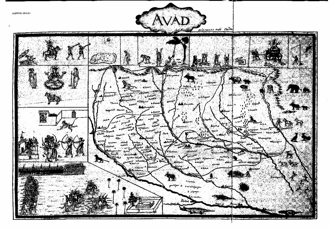
the empty spaces surrounding the mapped area. The colours were always pastel and each map was made lively \\ith paintings of local animals, dancers and common people at their daily activities. In the maps shown here, 11 l'AD (Fig. 3.12) is decorated with scenes from the R.amayana: King R.wan with his ten
heads and ten arms battles with the two brothers Ram and Lakshman, who have gone to rescue incarcerated Sita. The scene includes the monkey
Hanuman S\\inging across to Sita in her prison, \\ith word from husband Ram. Another vignette is from a local Muslim folklore: the king's cavalary of elephants and horses stand guard while he approaches a saint's mazhar (tomb) to pay respect, hut is attacked by a lion which is put down by his soldiers. Ascetics in various ritual poses arc drawn on the top border of the map. All forms of combat between \\Testling
men, dephant'I, camds, rams and roosters are shown in CABOUL (Fig. 3.13). lnAURENGAB.1D (Fig. 3.14),
The Mughal Empire
Fig.3.12 AVAD, where Gentil lived for several years. ESSAI SUR t:INDOUSTAN OU EMPIRE MOGOL, Jean·Baptlste·Joseph Gentll, Paris, 1785. Size: 34 cm x 22 cm. Maps 195.b.18, The British Library, St Pancras, London.
91

MAPPING INDIA
92
Fig. 3.13 CABOUL, the farthest western extent of the Mughal Empire. ESSA/ SUR t:INDOUSTAN OU EMPIRE MOGOL, Jean-BaptisteJoseph Gentil, Paris, 1785. Size: 35.5 cm x 23.5 cm. Maps 195.b.18, The British Library, St Pancras, London.
Following pages 94-95: Fig. 3.14 AURENGABAD, showing sculptures in the Ellora caves, Maratha soldiers and a mendicant with herbs. ESSA/ SUR t:INDOUSTAN OU EMPIRE MOGOL, Jean-Baptiste-Joseph Gentil, Paris, 1785. Size: 37 cm x 16.S cm. Maps 195.b.18, The British Library, St Pancras, London.
the famous carvings of the Ellora caves are shown in relief within the mountain ranges. And ilnally,
axes, daggers, S\vords, spears an<l knives arc shown in JIALl'A, that was a famous centre for making these implements (Fig. 3 .15). The cartouchcs and compass ro'!ics, commonly seen in European style maps of the time, arc all missing. Regrettably, the men who drafted these maps rcmaine<l unnamed. However, in another similar unpublished manuscript, Gentil
acknowledged the 'peintres indiens Ncvasilal and
J/ounsin[JUC etc., au sen"icc du Nabob Visio Soudjaadaula . .. '.
In "iC\V of the similarities in the paintings included
in the two manuscripts, it is possible that the
paintings were the work of the same artists. Gentil's maps of India represented more
information than others of the time. On his return to France, he gifted a c·opy of this bt!autifully designed an<l bound atlas to King Louis XVI. Unfortunately, as his atlas of India was not published, it remained unknO\m to the world till after his death, when
his son published it. Although the atlas had been executed in 1770, it was published in 1785, when
the world came to know of this collection of maps made by a person who had lived in India for a quarter century and actually visited several places sho\'vn in them. Gentil's maps had many more
names of places than other maps of the same period, .1lthough his maps were not surveyed.
An original of Gentil's Atlas is in the Bibliothcque Nationale de Paris, France. By the time Gentil's published 1\tlas was known to cartographers, the first of James Rennell's surveyed maps of India in the fom1 of A Bcn9al 11tlas and the ,J-fop qf Himloustan
were already \"i<lely distributed. In independent India, Gcntil's original contribution to the
cartography of India was almost completely ignored
.,..,,,.,.,._. ~
i • -/;;lft mtli..tA4

r,,.,.,., :
/ . . ' .. _,. .. /flt>tJ11a.

~L.\PPING INDIA
Fig. 3.15 MALVA, famous for the manufacture of knives and other implements. ESSAI SUR t.:INDOUSTAN OU EMPIRE MOGOL. Jean·Saptiste-Joseph Gentil, Paris, 1785. Size: 27 cm x 20 cm. Maps 195.b.18, The British Library, St Pancras, London.
till Susan Gole published il-laps ef 1'11u9hal India, an English version of the Adas in 1988. Interestingly, Irfan Habib, in his book An Atlas ef the Mughal Empire, like Gentil, shows the Mughal subas based on the Ain-e-Akbari, but identifies the positions of the places on the basis of modem surveyed maps. His maps are, therefore, easily understood by contemporary readers.
These imaginatively designed maps of India, from Baffin to Gentil, added a great deal of information to the knowledge of the Mughal
Empire. Yet, we know that these maps of the Mughal Empire were mere sketches filled in with informaton gathered from hearsay and observation. They were drawings of places represented by symbols of mountains, rivers, roads and approximate boundaries. But along the coasts and over the seas, in this same period, the first charts ·were being made by hydrographcrs. And they used scientific means and applied principles of astronomy, geodesy, instrumentation and carto&>raphy to <:reate the first reliable modern maps of India.