mapping prejudice: social justice mapping
TRANSCRIPT
Mapping Prejudice:Social Justice Mapping
Understanding Inequality Through Place and SpaceMarguerite Mills ● MappingPrejudice.org ● [email protected]
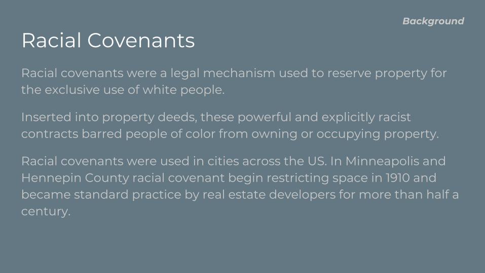
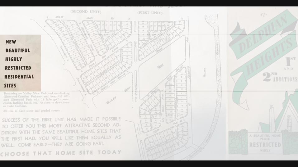
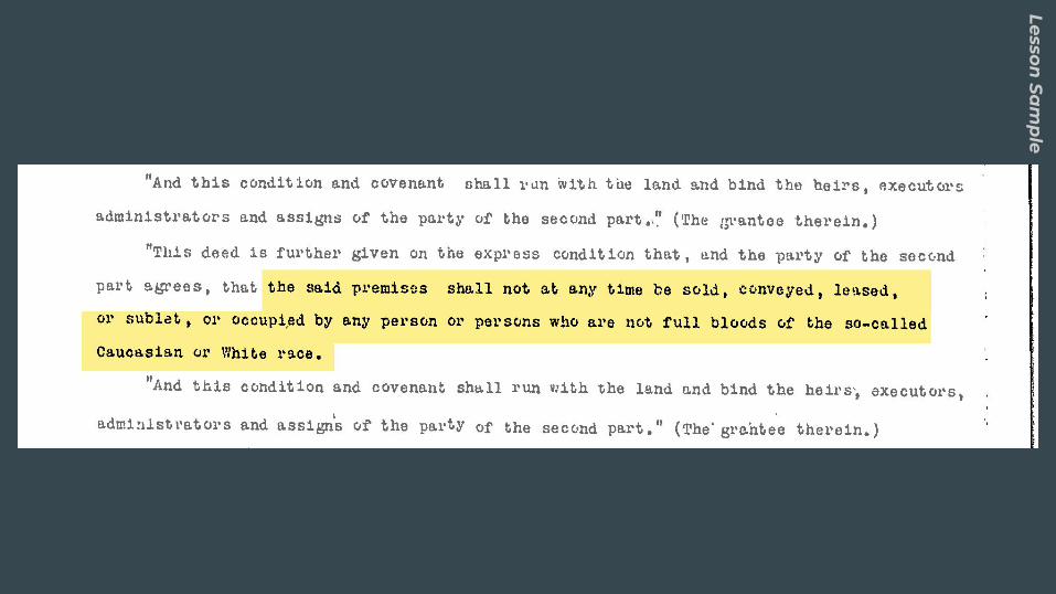
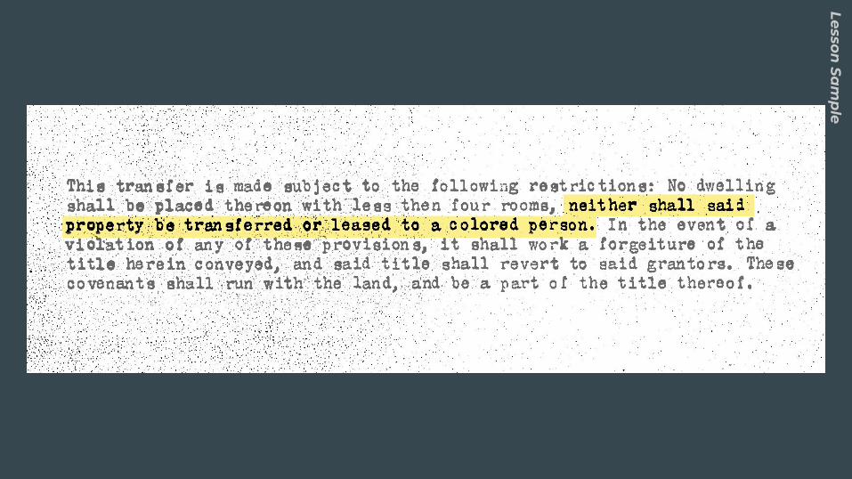
Racial CovenantsRacial covenants were a legal mechanism used to reserve property for the exclusive use of white people.
Inserted into property deeds, these powerful and explicitly racist contracts barred people of color from owning or occupying property.
Racial covenants were used in cities across the US. In Minneapolis and Hennepin County racial covenant begin restricting space in 1910 and became standard practice by real estate developers for more than half a century.
Background
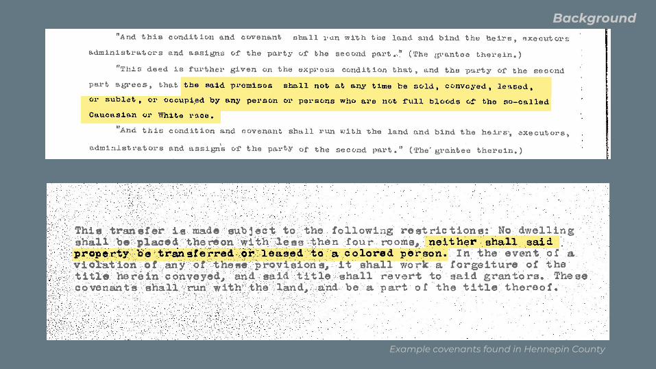
Example covenants found in Hennepin County
Background

Map
http://historyapolis.com/mapping-prejudice/
Background
Racial CovenantsRacial covenants were finally made unenforceable locally in 1953 and nationally by the Fair Housing Act of 1968, but the damage they inflicted on communities of color are reflected in contemporary inequality.
Racial covenants have remained an open secret in the decades since their legal use. Despite the collective knowledge of communities they affected, their impact has been widely unacknowledged. Popular consciousness has not reflected lived experiences of individuals and families of color who were intentionally shut out of vast areas of our city based on race.
Background
Mapping PrejudiceMapping Prejudice is a community facing project at the University of Minnesota working to uncover the history of racially restrictive covenants in Hennepin County.
This curriculum aims to give students knowledge in 3 key areas:
● Structural and Systemic Racism
● Understanding the Historical Context of Contemporary Inequality
● Using Spatial Research Tools and Methods for Social Justice
Pedagogy
Curriculum Mapping Prejudice is a research project at the University of Minnesota working to create the first comprehensive map of racial covenants in an American city.
This research is a powerful classroom tool.
The history of racial covenants and the covenant map are powerful demonstrations of using historical context to understand structural racism and contemporary inequality.
Exploring Mapping Prejudice’s research methodology offers an opportunity to show students a path for promoting social justice social science and geospatial research.
Pedagogy
Warm Up
1. What makes an area a ‘neighborhood?’
2. How do we distinguish one neighborhood from another?
Lesson Sa
mp
le
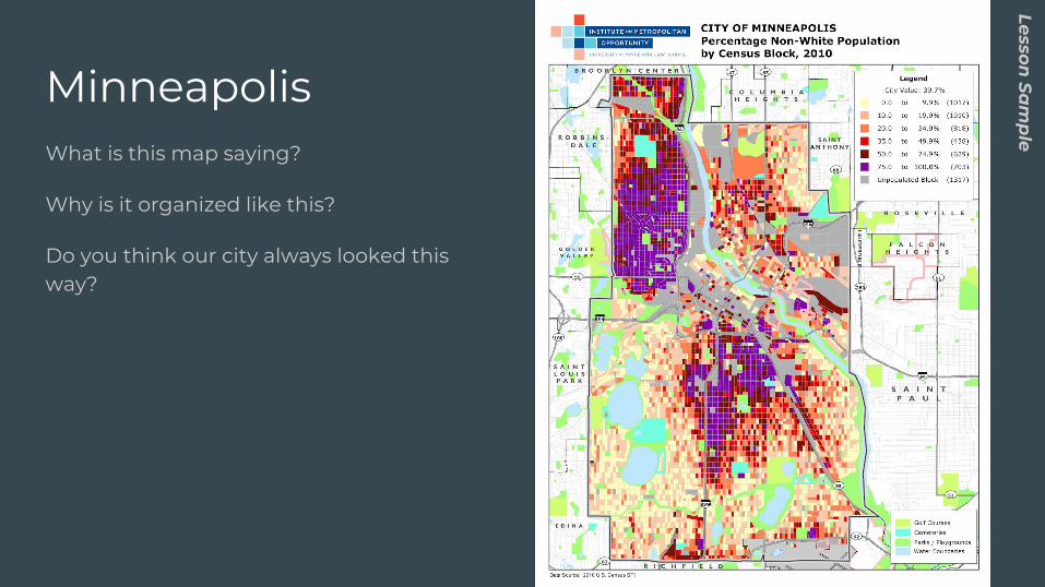
MinneapolisWhat is this map saying?
Why is it organized like this?
Do you think our city always looked this way?
Lesson Sa
mp
le
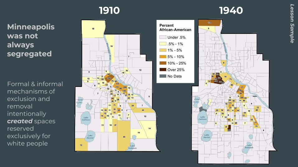
Minneapolis was not always segregated
Formal & informal mechanisms of exclusion and removal intentionally created spaces reserved exclusively for white people
Lesson Sa
mp
le1910 1940
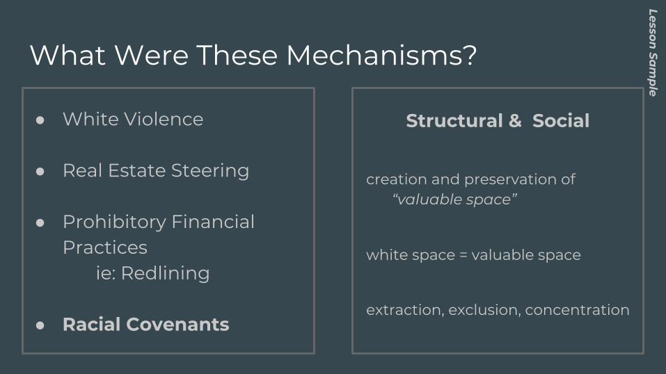
What Were These Mechanisms?
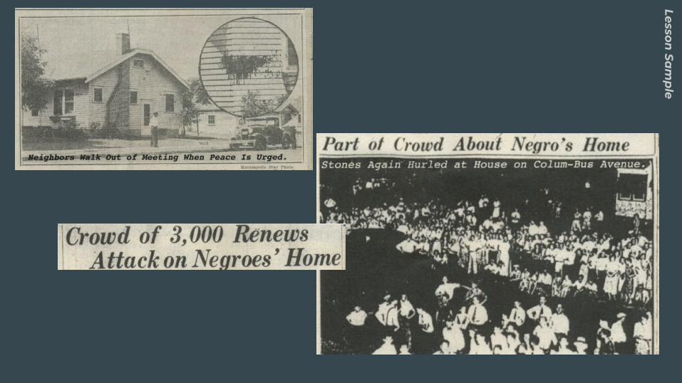
● White Violence
● Real Estate Steering
● Prohibitory Financial Practices
ie: Redlining
● Racial Covenants
Structural & Social
creation and preservation of “valuable space”
white space = valuable space
extraction, exclusion, concentration
Lesson Sa
mp
le
Lesson Sa
mp
le
What Are Racial Covenants?
Lesson Sa
mp
le
Lesson Sa
mp
le
Lesson Sa
mp
le

Map
http://historyapolis.com/mapping-prejudice/
Lesson Sa
mp
le
Mapping Covenants ● Finding and mapping racial covenants has been challenging.
Getting the data for every racial covenant in a city is only the first challenge, researchers must then be able to find and show where they were.
● You are going to learn to use spatial and historical research methods to uncover these documents and map them in the city.
Lesson Sa
mp
le

You Are The Researcher
Lesson Sa
mp
le - Critica
l Ca
rtogra
ph
y Resea
rch
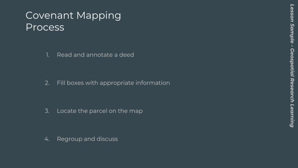
Covenant Mapping Process
1. Read and annotate a deed
2. Fill boxes with appropriate information
3. Locate the parcel on the map
4. Regroup and discuss
Lesson Sa
mp
le - Geosp
atia
l Resea
rch Lea
rnin
g
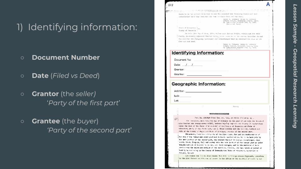
1) Identifying information:
○ Document Number
○ Date (Filed vs Deed)
○ Grantor (the seller)‘Party of the first part’
○ Grantee (the buyer)‘Party of the second part’
Lesson Sa
mp
le - Geosp
atia
l Resea
rch Lea
rnin
g
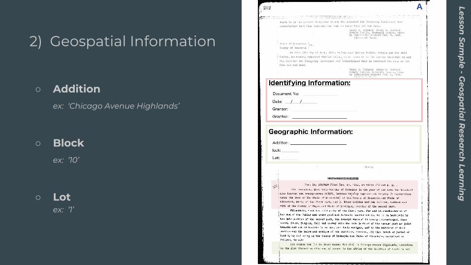
2) Geospatial Information
○ Addition ex: ‘Chicago Avenue Highlands’
○ Block ex: ‘10’
○ Lot ex: ‘1’
Lesson Sa
mp
le - Geosp
atia
l Resea
rch Lea
rnin
g
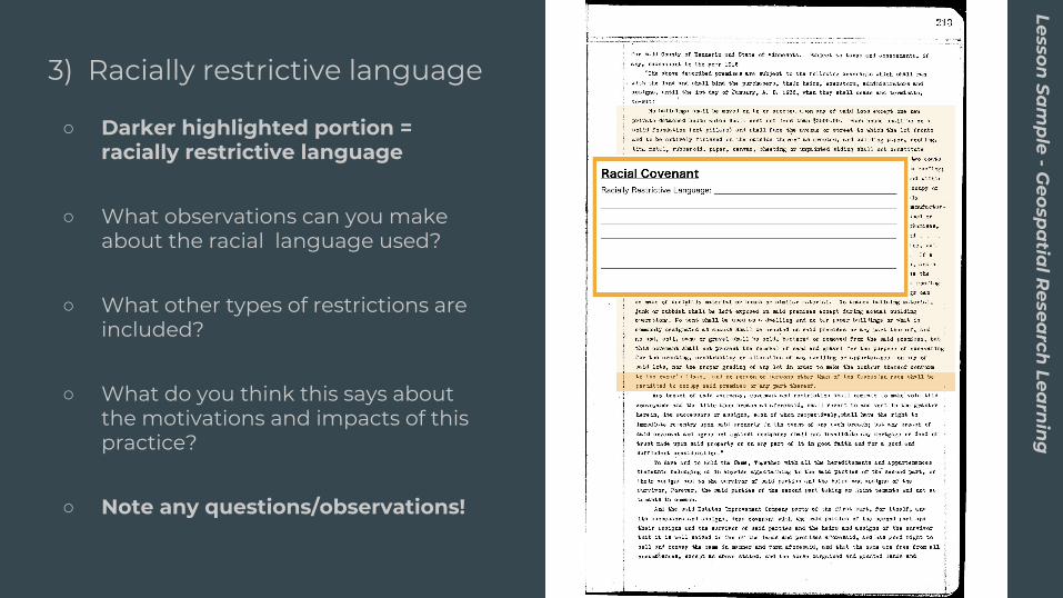
3) Racially restrictive language
○ Darker highlighted portion = racially restrictive language
○ What observations can you make about the racial language used?
○ What other types of restrictions are included?
○ What do you think this says about the motivations and impacts of this practice?
○ Note any questions/observations!
Lesson Sa
mp
le - Geosp
atia
l Resea
rch Lea
rnin
g
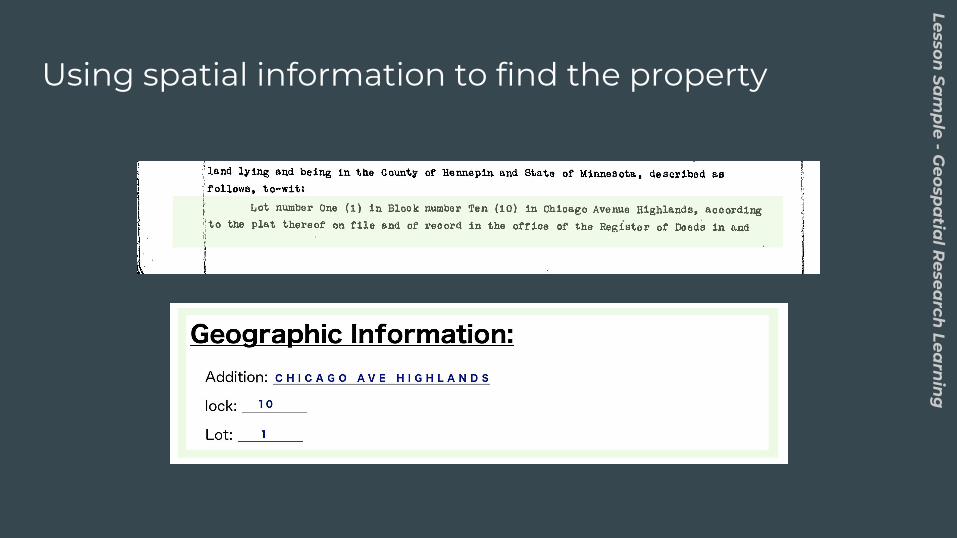
Using spatial information to find the property
Lesson Sa
mp
le - Geosp
atia
l Resea
rch Lea
rnin
g
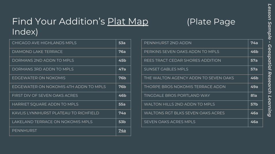
Find Your Addition’s Plat Map (Plate Page Index)CHICAGO AVE HIGHLANDS MPLS 53a
DIAMOND LAKE TERRACE 76a
DORMANS 2ND ADDN TO MPLS 45b
DORMANS 3RD ADDN TO MPLS 47a
EDGEWATER ON NOKOMIS 76b
EDGEWATER ON NOKOMIS 4TH ADDN TO MPLS 76b
FIRST DIV OF SEVEN OAKS ACRES 46b
HARRIET SQUARE ADDN TO MPLS 55a
KAVLIS LYNNHURST PLATEAU TO RICHFIELD 74a
LAKELAND TERRACE ON NOKOMIS MPLS 53b
PENNHURST 74a
PENNHURST 2ND ADDN 74a
PERKINS SEVEN OAKS ADDN TO MPLS 46b
REES TRACT CEDAR SHORES ADDITION 57a
SUNSET GABLES MPLS 57a
THE WALTON AGENCY ADDN TO SEVEN OAKS 46b
THORPE BROS NOKOMIS TERRACE ADDN 49a
TINGDALE BROS PORTLAND WAY 81a
WALTON HILLS 2ND ADDN TO MPLS 57b
WALTONS RGT BLKS SEVEN OAKS ACRES 46a
SEVEN OAKS ACRES MPLS 46a
Lesson Sa
mp
le - Geosp
atia
l Resea
rch Lea
rnin
g
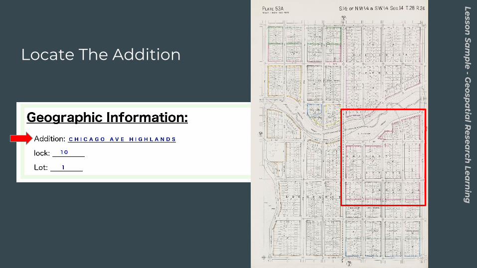
Locate The Addition
Lesson Sa
mp
le - Geosp
atia
l Resea
rch Lea
rnin
g
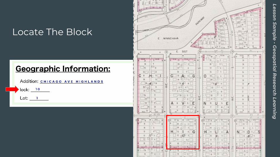
Locate The Block
Lesson Sa
mp
le - Geosp
atia
l Resea
rch Lea
rnin
g
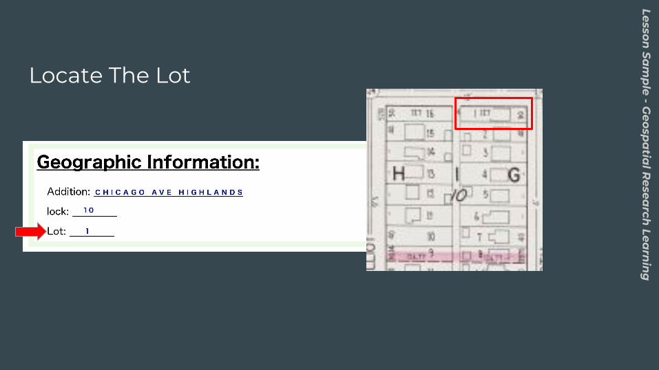
Locate The Lot
Lesson Sa
mp
le - Geosp
atia
l Resea
rch Lea
rnin
g
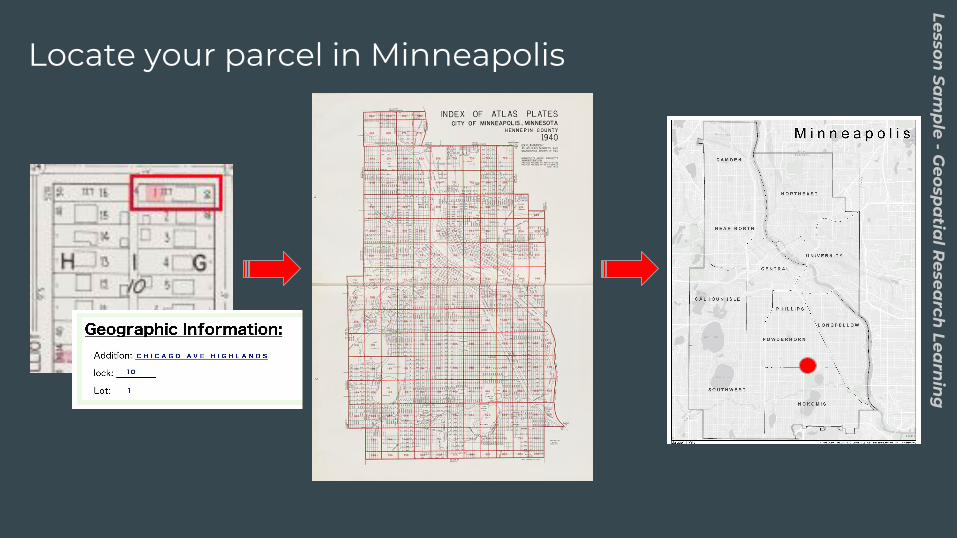
Locate your parcel in MinneapolisLesson
Sam
ple - G
eospa
tial R
esearch
Learn
ing
Lesson Sa
mp
le - Geosp
atia
l Resea
rch Lea
rnin
g
Why Does This Matter?
Lesson Sa
mp
le - Critica
l Ca
rtogra
ph
y Ap
plica
tions
Primary Sources and Maps● Reading racial covenant language reveals the the explicit racism
behind these practices.
● How does the map change or add to what you the covenants can tell us on their own?
● Covenants did not live on pieces of paper. They were experienced by people. How these on a map tell us more about their experience?
○ This is not something we can fully grasp by simply knowing they existed somewhere in space. We are missing the critical relationship to place that helps us to understand how they impacted people over time.
Lesson Sa
mp
le - Critica
l Ca
rtogra
ph
y Ap
plica
tions
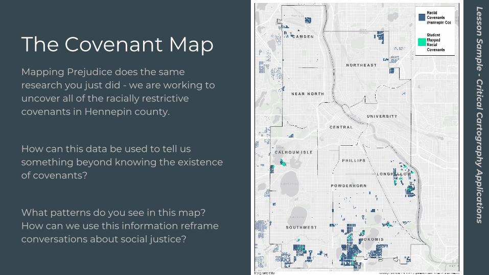
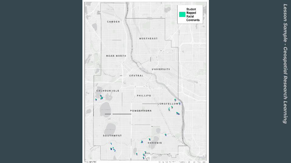
The Covenant MapMapping Prejudice does the same research you just did - we are working to uncover all of the racially restrictive covenants in Hennepin county.
How can this data be used to tell us something beyond knowing the existence of covenants?
What patterns do you see in this map? How can we use this information reframe conversations about social justice?
Lesson Sa
mp
le - Critica
l Ca
rtogra
ph
y Ap
plica
tions
Lesson Sa
mp
le - Critica
l Ca
rtogra
ph
y Ap
plica
tions
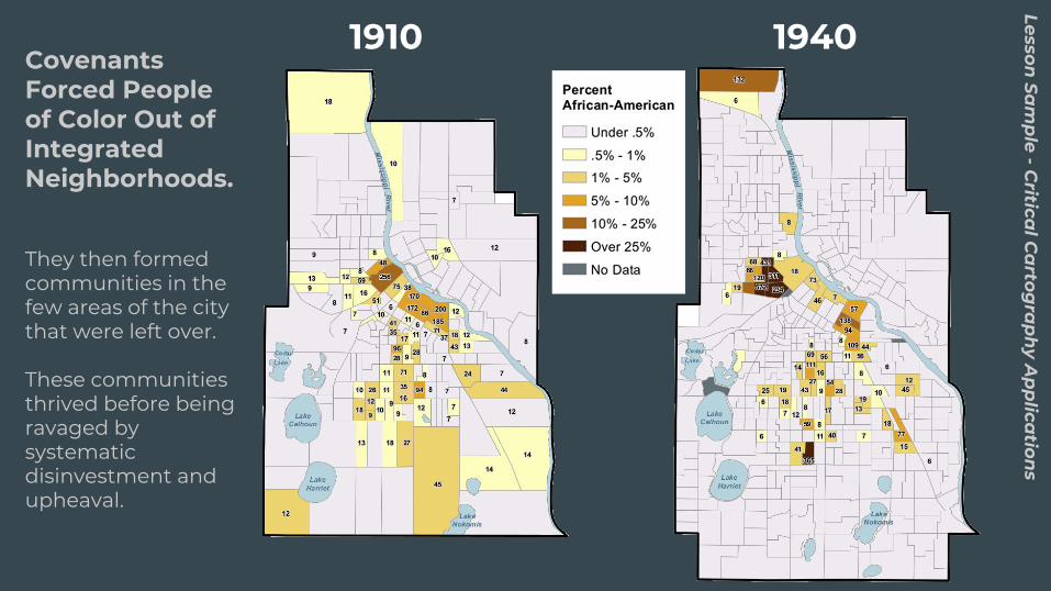
Covenants Forced People of Color Out of Integrated Neighborhoods.
They then formed communities in the few areas of the city that were left over.
These communities thrived before being ravaged by systematic disinvestment and upheaval.
1910 1940
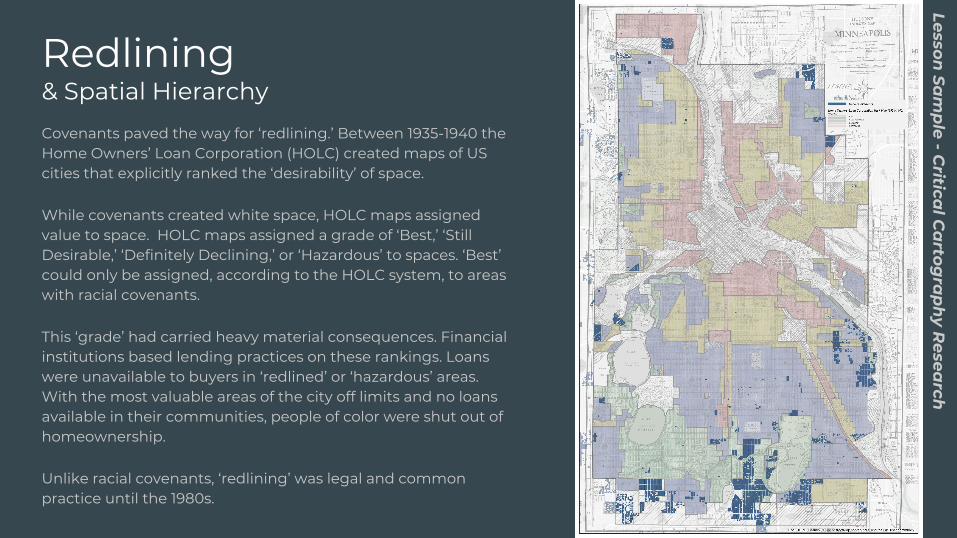
Redlining& Spatial HierarchyCovenants paved the way for ‘redlining.’ Between 1935-1940 the Home Owners’ Loan Corporation (HOLC) created maps of US cities that explicitly ranked the ‘desirability’ of space.
While covenants created white space, HOLC maps assigned value to space. HOLC maps assigned a grade of ‘Best,’ ‘Still Desirable,’ ‘Definitely Declining,’ or ‘Hazardous’ to spaces. ‘Best’ could only be assigned, according to the HOLC system, to areas with racial covenants.
This ‘grade’ had carried heavy material consequences. Financial institutions based lending practices on these rankings. Loans were unavailable to buyers in ‘redlined’ or ‘hazardous’ areas. With the most valuable areas of the city off limits and no loans available in their communities, people of color were shut out of homeownership.
Unlike racial covenants, ‘redlining’ was legal and common practice until the 1980s.
Lesson Sa
mp
le - Critica
l Ca
rtogra
ph
y Resea
rch
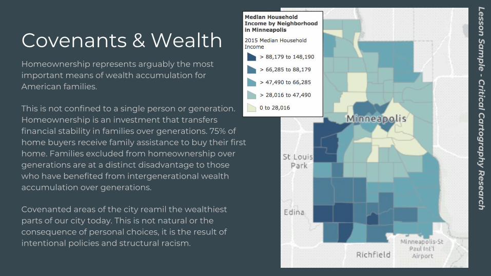
Covenants & WealthHomeownership represents arguably the most important means of wealth accumulation for American families.
This is not confined to a single person or generation. Homeownership is an investment that transfers financial stability in families over generations. 75% of home buyers receive family assistance to buy their first home. Families excluded from homeownership over generations are at a distinct disadvantage to those who have benefited from intergenerational wealth accumulation over generations.
Covenanted areas of the city reamil the wealthiest parts of our city today. This is not natural or the consequence of personal choices, it is the result of intentional policies and structural racism.
Lesson Sa
mp
le - Critica
l Ca
rtogra
ph
y Resea
rch
Lesson Sa
mp
le - Critica
l Ca
rtogra
ph
y Resea
rch
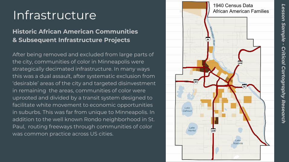
InfrastructureHistoric African American Communities& Subsequent Infrastructure Projects
After being removed and excluded from large parts of the city, communities of color in Minneapolis were strategically decimated infrastructure. In many ways this was a dual assault, after systematic exclusion from ‘desirable’ areas of the city and targeted disinvestment in remaining the areas, communities of color were uprooted and divided by a transit system designed to facilitate white movement to economic opportunities in suburbs. This was far from unique to Minneapolis. In addition to the well known Rondo neighborhood in St. Paul, routing freeways through communities of color was common practice across US cities.
1940 Census Data African American Families
Lesson Sa
mp
le - Critica
l Ca
rtogra
ph
y Resea
rch
Covenants & Contemporary Demographics
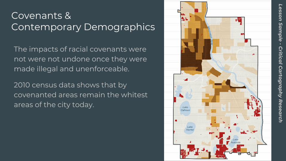
The impacts of racial covenants were not were not undone once they were made illegal and unenforceable.
2010 census data shows that by covenanted areas remain the whitest areas of the city today.
Lesson Sa
mp
le - Critica
l Ca
rtogra
ph
y Resea
rch
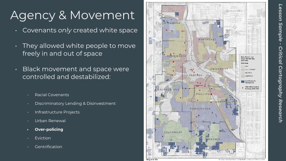
• Covenants only created white space
• They allowed white people to move freely in and out of space
• Black movement and space were controlled and destabilized:
• Racial Covenants
• Discriminatory Lending & Disinvestment
• Infrastructure Projects
• Urban Renewal
• Over-policing
• Eviction
• Gentrification
Agency & Movement
● Why is it important to take historical context into account to understand contemporary inequality?
● How spatial research give us insight into current circumstances in relation to historical practices?
Lesson Sa
mp
le - Critica
l Ca
rtogra
ph
y Resea
rch

Learn more at
mappingprejudice.org