maps and photographs - lrh.usace.army.mil · zoar levee & diversion dam are located in the...
TRANSCRIPT
Huntington District
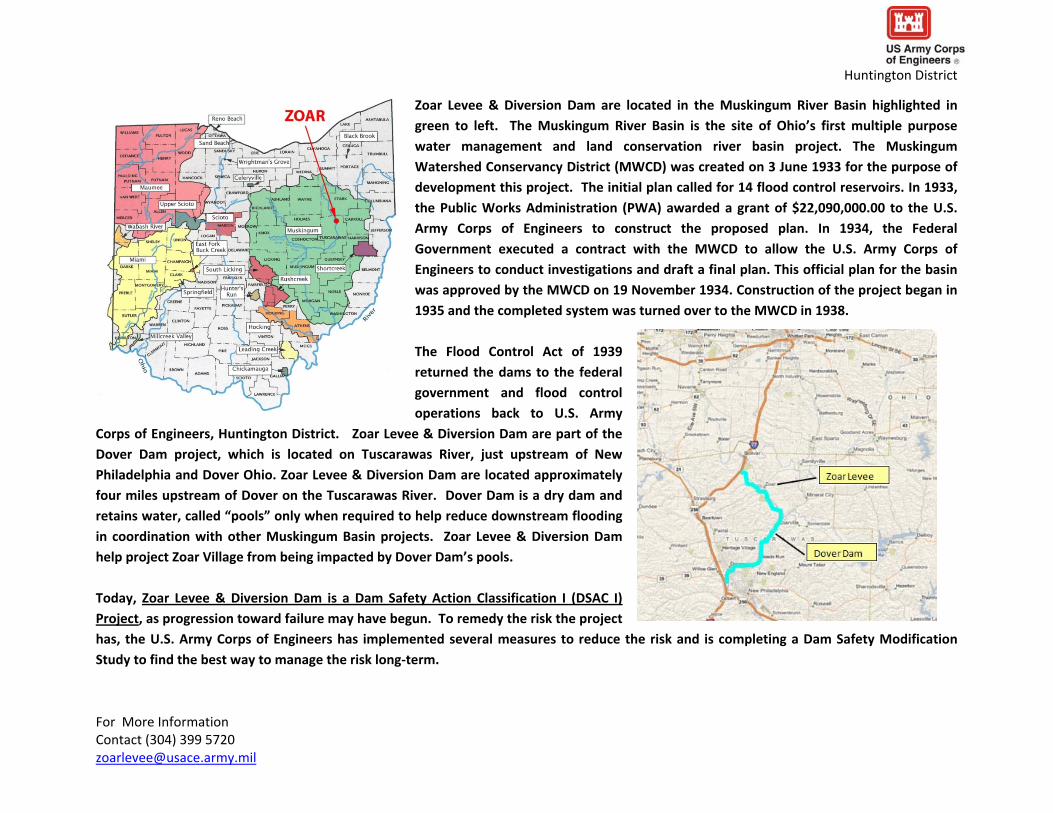
Zoar Levee amp Diversion Dam are located in the Muskingum River Basin highlighted in
green to left The Muskingum River Basin is the site of Ohiorsquos first multiple purpose
water management and land conservation river basin project The Muskingum
Watershed Conservancy District (MWCD) was created on 3 June 1933 for the purpose of development this project The initial plan called for 14 flood control reservoirs In 1933 the Public Works Administration (PWA) awarded a grant of $2209000000 to the US Army Corps of Engineers to construct the proposed plan In 1934 the Federal Government executed a contract with the MWCD to allow the US Army Corps of Engineers to conduct investigations and draft a final plan This official plan for the basin
was approved by the MWCD on 19 November 1934 Construction of the project began in
1935 and the completed system was turned over to the MWCD in 1938
The Flood Control Act of 1939
returned the dams to the federal government and flood control operations back to US Army
Corps of Engineers Huntington District Zoar Levee amp Diversion Dam are part of the
Dover Dam project which is located on Tuscarawas River just upstream of New
Philadelphia and Dover Ohio Zoar Levee amp Diversion Dam are located approximately
four miles upstream of Dover on the Tuscarawas River Dover Dam is a dry dam and
retains water called ldquopoolsrdquo only when required to help reduce downstream flooding
in coordination with other Muskingum Basin projects Zoar Levee amp Diversion Dam
help project Zoar Village from being impacted by Dover Damrsquos pools
Today Zoar Levee amp Diversion Dam is a Dam Safety Action Classification I (DSAC I) Project as progression toward failure may have begun To remedy the risk the project has the US Army Corps of Engineers has implemented several measures to reduce the risk and is completing a Dam Safety Modification
Study to find the best way to manage the risk long‐term
For More Information Contact (304) 399 5720 zoarleveeusacearmymil
Huntington District
To the right is a picture of water impounded to elevation 9074 feet in January 2005 behind
Dover Dam This represents the highest water has ever been held behind Dover Dam and is referred to as the ldquoPool of Recordrdquo The middle part of the dam is called the spillway or the
portion of the dam that is designed to be overtopped The spillway is located at elevation
916 feet
The federal Government restricts development below
elevation 916 feet upstream of Dover Dam so that water can be impounded without damaging property This is accomplished by a ldquoflowage easementrdquo which is charted in
blue on the map to the left
Zoar Levee amp Diversion Dam were built to help protect Zoar Village
from waters being held behind Dover Dam along the Tuscarawas River Under normal conditions this river passes through Dover Dam
and there is not a lake behind the dam However when the gates at Dover are closed water impounds behind it If it were not for Zoar Levee amp Diversion Dam much of Zoar Village would have been
purchased as it is located below elevation 916 feet Another US Army
Corps of Engineers project Bolivar Dam is located upstream of Zoar Levee Like Dover Dam it only retains water when required When
filled to its spillway hieght of elevation 962 feet the areas in green
above are also under water Dover Damrsquos flowage easement backs up
to the downstream toe of Bolivar Dam which displays how these
projects work together to help relieve flooding downsteam
Huntington District
This an aerial photograph of Zoar Levee amp Diversion Dam The levee is generally divided into two reaches The ldquoBall Fieldrdquo side is located on the west side of Route 212 and is named for the little league baseball field located here This portion of the levee is founded on approximately 130
feet of sands and gravels that allow water to move under the levee which can cause concern about the long‐term
stability of the project The ldquoRock Knollrdquo side is located on
the east side of Route 212 and is named for a localized
bedrock high point that extends upward to near the base
of the levee However this bedrock has several voids that allow water to seep through it and can also cause stability
problems
The diversion dam is located on Goose Run and was built to help control interior flooding in Zoar Village The
diversion dam is founded on and next to the same type of bedrock as the Rock Knoll
It once impounded a permanent lake but now it only impounds water behind it when required to The diversion channel is for overflow
water to keep the diversion dam from being overtopped Other features of the project include a pump station located where Goose Run
meets Zoar Levee Under normal circumstances Goose Run flows underneath the levee before joining an old mill race and proceeding to the
Tuscarawas River However when Zoar Levee is holding back water being retained by Dover Dam the tunnel that Goose Run flows through
must be closed Once that tunnel is closed the pump station pumps Goose Runrsquos water up and over the levee in three pipes It works much
like a sump pump Evidence of two stone blankets installed by the US Army Corps of Engineers Huntington District can also be seen The
1993 blanket is located downstream of the diversion dam and was constructed in 1993 to help control water leaking through bedrock in the
damrsquos abutment This is called ldquoabutment seepagerdquo The same year impervious soil and fabric was also placed on the upstream side of the
diversion dam to cover holes where water was leaking The 2008 blanket is located on the interior side of the Rock Knoll The 2008 blanket was constructed in March 2008 when large holes called ldquoboilsrdquo opened up These boils caused concern that the levee could have lost some
structural stability due to potential erosion of foundation materials For More Information Contact (304) 399 5720 zoarleveeusacearmymil
Huntington District
This map demonstrates the amount of Zoar Village that would be
located within Dover Damrsquos flowage easement (elevation 916 feet) if it were not for Zoar Levee
amp Diversion Dam To put it another way all portions of Zoar Village
located in the areas highlighted in blue would
have likely been
purchased and torn
down when Dover Dam
was constructed if it were not for Zoar Levee
amp Diversion Dam
In some instances communities were
purchased when the US Army Corps of Engineers and MWCD constructed Dover Dam as well as other dams in the Muskingum Water Basin For example the community of Zoarville was purchased for Dover Dam and the community of Sandyville was purchased for Bolivar Dam In
both instances these communities re‐established themselves on higher ground Other levees were also constructed upstream of Dover Dam
to protect several factories as well as the community of Somerdale
For More Information Contact (304) 399 5720 zoarleveeusacearmymil
Huntington District
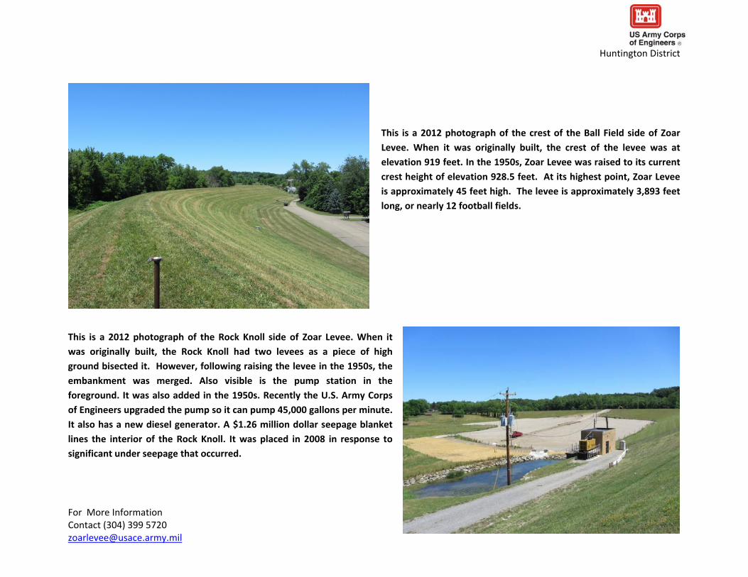
This is a 2012 photograph of the crest of the Ball Field side of Zoar Levee When it was originally built the crest of the levee was at elevation 919 feet In the 1950s Zoar Levee was raised to its current crest height of elevation 9285 feet At its highest point Zoar Levee
is approximately 45 feet high The levee is approximately 3893 feet long or nearly 12 football fields
This is a 2012 photograph of the Rock Knoll side of Zoar Levee When it was originally built the Rock Knoll had two levees as a piece of high
ground bisected it However following raising the levee in the 1950s the
embankment was merged Also visible is the pump station in the
foreground It was also added in the 1950s Recently the US Army Corps of Engineers upgraded the pump so it can pump 45000 gallons per minute It also has a new diesel generator A $126 million dollar seepage blanket lines the interior of the Rock Knoll It was placed in 2008 in response to
significant under seepage that occurred
For More Information Contact (304) 399 5720 zoarleveeusacearmymil
Huntington District
This is a 2012 photograph of the downstream face of Zoar Diversion Dam Zoar Diversion Dam is located on Goose Run about 1000 feet upstream from Zoar Levee It is approximately
500 feet long and 35 feet high In the foreground is a 1993
Seepage Blanket placed to help capture and control seepage that occurred through the abutment of the dam
This is a 2012 photograph of the control tower for Zoar Diversion Dam It is located on
the upstream toe of the dam and it has a single sluice gate that can cover the 3‐x‐3 foot tunnel that carries Goose Run through the dam Until the early 1990rsquos a permanent lake was impounded behind Zoar Diversion Dam This lake partially drained itself through seepage on one of the abutments Following some remedial actions including
the installation of the gravel blanket pictured above it was recommended that the lake
be permanently drained
For More Information Contact (304) 399 5720 zoarleveeusacearmymil
Zoar Levee has recently handled two loadings from which significant performance issues were observed
Huntington District
Below is a cross section of Zoar Levee demonstrating
how water being
impounded on the outside
of the levee (right side) moves underneath the
levee This is called ldquounder seepagerdquo Because Zoar Levee is founded on sands gravels and fractured
bedrock this under seepage can lead to
erosion of foundation
materials if the right conditions exist
The level of water displayed above (elevation 9074 feet) corresponds to the highest amount of water Zoar Levee has had to hold back to
date This was the ldquoPool of Recordrdquo for Dover Dam This event occurred in January of 2005 and caused under seepage The US Army Corps of Engineers Huntington District was able to manage this seepage using sandbags
In March of 2008 Dover Dam held a pool of water to elevation 9046 feet which caused under seepage at Zoar Levee that led to much larger boils opening up The largest boils occurred on the Rock Knoll which continued to grow in size despite placing sandbags around them In
response to this event the US Army Corps of Engineers Huntington District took emergency action by adding a large stone blanket that could help stabilize any eroding foundation material that might have been exiting the boils
For More Information Contact (304) 399 5720 zoarleveeusacearmymil
Huntington District
This a photograph of standing water on interior side of the Ball Field at Zoar Levee January 2005 This was evidence of under seepage occurring
This is a photograph of standing water on interior side of the Ball Field at Zoar Levee January 2005 This was evidence of under seepage occurring
For More Information Contact (304) 399 5720 zoarleveeusacearmymil
Huntington District
This is a picture of a small boil forming on the interior side of Zoar Levee in
January of 2005 This is called a ldquopin boilrdquo These pin boils showed that seeping water was moving a small amount of soil
Portions of the Ball Field side at Zoar Levee are paved with asphalt for parking This is a picture of that pavement failing due saturated
soil conditions and vehicular traffic in 2005
For More Information Contact (304) 399 5720 zoarleveeusacearmymil
Huntington District
This is a photograph of water seeping on the interior side of the Rock Knoll at Zoar Levee in
January 2005 At this location water exited directly from the ground in large volumes
This is a photograph of mechanical equipment stuck in the saturated ground on the interior side of the Rock Knoll at Zoar Levee in January
2005
For More Information Contact (304) 399 5720 zoarleveeusacearmymil
feet lower than what occurred in January of 2005 The performance of Zoar Levee decreased significantly and the US Army Corps of Engineers Huntington District took emergency action
For More Information Contact (304) 399 5720 zoarleveeusacearmymil
Huntington District
This is an oblique view of Zoar Levee graphically
demonstrating the
locations of area seepage pin boils and large boils on the interior of Zoar Levee in March of 2008 This photograph was taken at the peak
elevation (9046 feet) of the Tuscarawas River during this event
As noted the most significant problems occurred along the Rock
Knoll at the same location
and elevation where
water was seen
significantly seeping in
January 2005
The March 2008 event resulted in a pool of water that was approximately 3
Huntington District
This is a photograph of standing water on interior side of the Ball Field at Zoar Levee March 2008 This was evidence of under seepage occurring This condition was very similar to that observed in January of 2005
This is a photograph of water seeping on the interior side of the Rock
Knoll at Zoar Levee in March 2008 Like in January 2005 water exited directly from the ground at this location in high volumes Unlike January 2005 large boils formed in 2008 These boils are
marked by the white rings of sandbags These sandbag rings are
deployed to stabilize the boils and keep them from increasing in size
This picture was taken on March 18 2012
For More Information Contact (304) 399 5720 zoarleveeusacearmymil
Huntington District
This is a photograph of another boil on the interior side of the Rock
Knoll at Zoar Levee in March 2008 The amount of sandbagging
employed was increased as boils continued to grow in diameter
This photo was taken on March 20 2012
This is a photograph of boils on the interior side of the Rock Knoll at Zoar Levee in March 2008 Despite attempts to control the growing
size of boils with sandbag rings boils continued to expand rapidly eventually coalescing into one another forming a large seepage exit point
This photo was taken on March 21 2012
For More Information Contact (304) 399 5720 zoarleveeusacearmymil
Huntington District
In response to the growing boils on the Rock Knoll at Zoar Levee in
March of 2008 the US Army Corps of Engineers took emergency
action It quickly designed and placed a $126 million dollar gravel blanket over these boils This is called a seepage blanket in that it tries to block any soil moving from the boils while distributing the water This photograph shows the beginning the placement of this blanket at night
This is a photograph showing the seepage blanket being placed
directly over the boils on the Rock Knoll at Zoar Levee in March of 2008 At first the placed gravel was blown out by the boils but ultimately gravel was successfully placed
For More Information Contact (304) 399 5720 zoarleveeusacearmymil
Huntington District
This is a photograph of the completed gravel seepage blanket placed in
March 2008 Ultimately approximately 6 feet of gravel was placed over the
interior of the Rock Knoll at Zoar Levee
Following the March 2008 event the US Army Corps of Engineers Huntington District took several measures to help reduce the risk
under seepage might be causing This is a photograph of the
installation of a $18 million seepage and drainage collection
system which was installed to collect under seepage and drain it to
the pump station where it can be pumped back out to the
Tuscarawas River Other measures included rehabilitating existing
relief wells or wells that relieve seepage stock piling gravel and
sandbags for future events upgrading and automating the pump
station and establishing evaluation and surveillance pools
For More Information Contact (304) 399 5720 zoarleveeusacearmymil
Zoar Diversion Dam has also had past performance issues
Huntington District
This is a photograph looking from the diversion dam toward the downstream
area during remedial work in 1978 A drainage system was added to safely
control seepage exiting the face of the dam Several other repairs were
performed including cutting a new outlet channel
This is a photograph of Zoar Diversion Dam in 1991 when it still impounded a permanent lake
This lake was commonly referred to as Lime Kiln or Goose Run Lake The lake was permanently impounded to elevation 916rsquo The control tower can be seen in the middle ground
For More Information Contact (304) 399 5720 zoarleveeusacearmymil
Huntington District
This is a photograph of a boil located downstream of Zoar Diversion
Dam that was resulting from the seepage This seepage was traveling
through the bedrock that the diversion dam abuts This is referred to as ldquoabutment seepagerdquo This abutment seepage partially drained the
permanent impoundment from elevation 916rsquo to elevation 906rsquo
This is a photograph from the crest of the Zoar Diversion Dam
looking downstream Goose Run can be seen exiting at the toe of the dam The black arrow is highlighting the location were seepage
was occurring
For More Information Contact (304) 399 5720 zoarleveeusacearmymil
Huntington District
A seepage blanket was placed on downstream of the Zoar Diversion
Dam to collect and manage the seepage that was occurring This is a
photograph of a geo‐textile filter fabric being placed before gravel blanket was placed on top of it
This is another photograph of the construction of the
downstream seepage blanket on the Zoar Diversion Dam
For More Information Contact (304) 399 5720 zoarleveeusacearmymil
Huntington District
This is photograph looking downstream from the crest of Zoar Diversion Dam in 2012 showing the completed downstream
seepage blanket
In addition to downstream treatment in 1993 Lime Kiln or Goose Run
Lake was drained Zoar Diversion Dam can be seen in the background
For More Information Contact (304) 399 5720 zoarleveeusacearmymil
Huntington District
In 1993 a portion of the upstream abutment of the dam was covered
with an impervious surface This is a photograph of that installation It is taken from the crest of the diversion dam looking upstream
Today Lime Kiln or Goose Run Lake remains dry However flashy storm
events have impounded the lake without warning and with the control gate
open This is a photograph of the dry bed of Lime Kiln or Goose Run Lake in
2012 The photograph is taken from the crest of Zoar Diversion Dam
For More Information Contact (304) 399 5720 zoarleveeusacearmymil
Huntington District
In 2012 the US Army Corps of Engineers Huntington District installed a data logger to alert Government staff is water is impounded behind the Zoar Diversion Dam so its performance can be monitored
For More Information Contact (304) 399 5720 zoarleveeusacearmymil

Huntington District
To the right is a picture of water impounded to elevation 9074 feet in January 2005 behind
Dover Dam This represents the highest water has ever been held behind Dover Dam and is referred to as the ldquoPool of Recordrdquo The middle part of the dam is called the spillway or the
portion of the dam that is designed to be overtopped The spillway is located at elevation
916 feet
The federal Government restricts development below
elevation 916 feet upstream of Dover Dam so that water can be impounded without damaging property This is accomplished by a ldquoflowage easementrdquo which is charted in
blue on the map to the left
Zoar Levee amp Diversion Dam were built to help protect Zoar Village
from waters being held behind Dover Dam along the Tuscarawas River Under normal conditions this river passes through Dover Dam
and there is not a lake behind the dam However when the gates at Dover are closed water impounds behind it If it were not for Zoar Levee amp Diversion Dam much of Zoar Village would have been
purchased as it is located below elevation 916 feet Another US Army
Corps of Engineers project Bolivar Dam is located upstream of Zoar Levee Like Dover Dam it only retains water when required When
filled to its spillway hieght of elevation 962 feet the areas in green
above are also under water Dover Damrsquos flowage easement backs up
to the downstream toe of Bolivar Dam which displays how these
projects work together to help relieve flooding downsteam
Huntington District
This an aerial photograph of Zoar Levee amp Diversion Dam The levee is generally divided into two reaches The ldquoBall Fieldrdquo side is located on the west side of Route 212 and is named for the little league baseball field located here This portion of the levee is founded on approximately 130
feet of sands and gravels that allow water to move under the levee which can cause concern about the long‐term
stability of the project The ldquoRock Knollrdquo side is located on
the east side of Route 212 and is named for a localized
bedrock high point that extends upward to near the base
of the levee However this bedrock has several voids that allow water to seep through it and can also cause stability
problems
The diversion dam is located on Goose Run and was built to help control interior flooding in Zoar Village The
diversion dam is founded on and next to the same type of bedrock as the Rock Knoll
It once impounded a permanent lake but now it only impounds water behind it when required to The diversion channel is for overflow
water to keep the diversion dam from being overtopped Other features of the project include a pump station located where Goose Run
meets Zoar Levee Under normal circumstances Goose Run flows underneath the levee before joining an old mill race and proceeding to the
Tuscarawas River However when Zoar Levee is holding back water being retained by Dover Dam the tunnel that Goose Run flows through
must be closed Once that tunnel is closed the pump station pumps Goose Runrsquos water up and over the levee in three pipes It works much
like a sump pump Evidence of two stone blankets installed by the US Army Corps of Engineers Huntington District can also be seen The
1993 blanket is located downstream of the diversion dam and was constructed in 1993 to help control water leaking through bedrock in the
damrsquos abutment This is called ldquoabutment seepagerdquo The same year impervious soil and fabric was also placed on the upstream side of the
diversion dam to cover holes where water was leaking The 2008 blanket is located on the interior side of the Rock Knoll The 2008 blanket was constructed in March 2008 when large holes called ldquoboilsrdquo opened up These boils caused concern that the levee could have lost some
structural stability due to potential erosion of foundation materials For More Information Contact (304) 399 5720 zoarleveeusacearmymil
Huntington District
This map demonstrates the amount of Zoar Village that would be
located within Dover Damrsquos flowage easement (elevation 916 feet) if it were not for Zoar Levee
amp Diversion Dam To put it another way all portions of Zoar Village
located in the areas highlighted in blue would
have likely been
purchased and torn
down when Dover Dam
was constructed if it were not for Zoar Levee
amp Diversion Dam
In some instances communities were
purchased when the US Army Corps of Engineers and MWCD constructed Dover Dam as well as other dams in the Muskingum Water Basin For example the community of Zoarville was purchased for Dover Dam and the community of Sandyville was purchased for Bolivar Dam In
both instances these communities re‐established themselves on higher ground Other levees were also constructed upstream of Dover Dam
to protect several factories as well as the community of Somerdale
For More Information Contact (304) 399 5720 zoarleveeusacearmymil
Huntington District
This is a 2012 photograph of the crest of the Ball Field side of Zoar Levee When it was originally built the crest of the levee was at elevation 919 feet In the 1950s Zoar Levee was raised to its current crest height of elevation 9285 feet At its highest point Zoar Levee
is approximately 45 feet high The levee is approximately 3893 feet long or nearly 12 football fields
This is a 2012 photograph of the Rock Knoll side of Zoar Levee When it was originally built the Rock Knoll had two levees as a piece of high
ground bisected it However following raising the levee in the 1950s the
embankment was merged Also visible is the pump station in the
foreground It was also added in the 1950s Recently the US Army Corps of Engineers upgraded the pump so it can pump 45000 gallons per minute It also has a new diesel generator A $126 million dollar seepage blanket lines the interior of the Rock Knoll It was placed in 2008 in response to
significant under seepage that occurred
For More Information Contact (304) 399 5720 zoarleveeusacearmymil
Huntington District
This is a 2012 photograph of the downstream face of Zoar Diversion Dam Zoar Diversion Dam is located on Goose Run about 1000 feet upstream from Zoar Levee It is approximately
500 feet long and 35 feet high In the foreground is a 1993
Seepage Blanket placed to help capture and control seepage that occurred through the abutment of the dam
This is a 2012 photograph of the control tower for Zoar Diversion Dam It is located on
the upstream toe of the dam and it has a single sluice gate that can cover the 3‐x‐3 foot tunnel that carries Goose Run through the dam Until the early 1990rsquos a permanent lake was impounded behind Zoar Diversion Dam This lake partially drained itself through seepage on one of the abutments Following some remedial actions including
the installation of the gravel blanket pictured above it was recommended that the lake
be permanently drained
For More Information Contact (304) 399 5720 zoarleveeusacearmymil
Zoar Levee has recently handled two loadings from which significant performance issues were observed
Huntington District
Below is a cross section of Zoar Levee demonstrating
how water being
impounded on the outside
of the levee (right side) moves underneath the
levee This is called ldquounder seepagerdquo Because Zoar Levee is founded on sands gravels and fractured
bedrock this under seepage can lead to
erosion of foundation
materials if the right conditions exist
The level of water displayed above (elevation 9074 feet) corresponds to the highest amount of water Zoar Levee has had to hold back to
date This was the ldquoPool of Recordrdquo for Dover Dam This event occurred in January of 2005 and caused under seepage The US Army Corps of Engineers Huntington District was able to manage this seepage using sandbags
In March of 2008 Dover Dam held a pool of water to elevation 9046 feet which caused under seepage at Zoar Levee that led to much larger boils opening up The largest boils occurred on the Rock Knoll which continued to grow in size despite placing sandbags around them In
response to this event the US Army Corps of Engineers Huntington District took emergency action by adding a large stone blanket that could help stabilize any eroding foundation material that might have been exiting the boils
For More Information Contact (304) 399 5720 zoarleveeusacearmymil
Huntington District
This a photograph of standing water on interior side of the Ball Field at Zoar Levee January 2005 This was evidence of under seepage occurring
This is a photograph of standing water on interior side of the Ball Field at Zoar Levee January 2005 This was evidence of under seepage occurring
For More Information Contact (304) 399 5720 zoarleveeusacearmymil
Huntington District
This is a picture of a small boil forming on the interior side of Zoar Levee in
January of 2005 This is called a ldquopin boilrdquo These pin boils showed that seeping water was moving a small amount of soil
Portions of the Ball Field side at Zoar Levee are paved with asphalt for parking This is a picture of that pavement failing due saturated
soil conditions and vehicular traffic in 2005
For More Information Contact (304) 399 5720 zoarleveeusacearmymil
Huntington District
This is a photograph of water seeping on the interior side of the Rock Knoll at Zoar Levee in
January 2005 At this location water exited directly from the ground in large volumes
This is a photograph of mechanical equipment stuck in the saturated ground on the interior side of the Rock Knoll at Zoar Levee in January
2005
For More Information Contact (304) 399 5720 zoarleveeusacearmymil
feet lower than what occurred in January of 2005 The performance of Zoar Levee decreased significantly and the US Army Corps of Engineers Huntington District took emergency action
For More Information Contact (304) 399 5720 zoarleveeusacearmymil
Huntington District
This is an oblique view of Zoar Levee graphically
demonstrating the
locations of area seepage pin boils and large boils on the interior of Zoar Levee in March of 2008 This photograph was taken at the peak
elevation (9046 feet) of the Tuscarawas River during this event
As noted the most significant problems occurred along the Rock
Knoll at the same location
and elevation where
water was seen
significantly seeping in
January 2005
The March 2008 event resulted in a pool of water that was approximately 3
Huntington District
This is a photograph of standing water on interior side of the Ball Field at Zoar Levee March 2008 This was evidence of under seepage occurring This condition was very similar to that observed in January of 2005
This is a photograph of water seeping on the interior side of the Rock
Knoll at Zoar Levee in March 2008 Like in January 2005 water exited directly from the ground at this location in high volumes Unlike January 2005 large boils formed in 2008 These boils are
marked by the white rings of sandbags These sandbag rings are
deployed to stabilize the boils and keep them from increasing in size
This picture was taken on March 18 2012
For More Information Contact (304) 399 5720 zoarleveeusacearmymil
Huntington District
This is a photograph of another boil on the interior side of the Rock
Knoll at Zoar Levee in March 2008 The amount of sandbagging
employed was increased as boils continued to grow in diameter
This photo was taken on March 20 2012
This is a photograph of boils on the interior side of the Rock Knoll at Zoar Levee in March 2008 Despite attempts to control the growing
size of boils with sandbag rings boils continued to expand rapidly eventually coalescing into one another forming a large seepage exit point
This photo was taken on March 21 2012
For More Information Contact (304) 399 5720 zoarleveeusacearmymil
Huntington District
In response to the growing boils on the Rock Knoll at Zoar Levee in
March of 2008 the US Army Corps of Engineers took emergency
action It quickly designed and placed a $126 million dollar gravel blanket over these boils This is called a seepage blanket in that it tries to block any soil moving from the boils while distributing the water This photograph shows the beginning the placement of this blanket at night
This is a photograph showing the seepage blanket being placed
directly over the boils on the Rock Knoll at Zoar Levee in March of 2008 At first the placed gravel was blown out by the boils but ultimately gravel was successfully placed
For More Information Contact (304) 399 5720 zoarleveeusacearmymil
Huntington District
This is a photograph of the completed gravel seepage blanket placed in
March 2008 Ultimately approximately 6 feet of gravel was placed over the
interior of the Rock Knoll at Zoar Levee
Following the March 2008 event the US Army Corps of Engineers Huntington District took several measures to help reduce the risk
under seepage might be causing This is a photograph of the
installation of a $18 million seepage and drainage collection
system which was installed to collect under seepage and drain it to
the pump station where it can be pumped back out to the
Tuscarawas River Other measures included rehabilitating existing
relief wells or wells that relieve seepage stock piling gravel and
sandbags for future events upgrading and automating the pump
station and establishing evaluation and surveillance pools
For More Information Contact (304) 399 5720 zoarleveeusacearmymil
Zoar Diversion Dam has also had past performance issues
Huntington District
This is a photograph looking from the diversion dam toward the downstream
area during remedial work in 1978 A drainage system was added to safely
control seepage exiting the face of the dam Several other repairs were
performed including cutting a new outlet channel
This is a photograph of Zoar Diversion Dam in 1991 when it still impounded a permanent lake
This lake was commonly referred to as Lime Kiln or Goose Run Lake The lake was permanently impounded to elevation 916rsquo The control tower can be seen in the middle ground
For More Information Contact (304) 399 5720 zoarleveeusacearmymil
Huntington District
This is a photograph of a boil located downstream of Zoar Diversion
Dam that was resulting from the seepage This seepage was traveling
through the bedrock that the diversion dam abuts This is referred to as ldquoabutment seepagerdquo This abutment seepage partially drained the
permanent impoundment from elevation 916rsquo to elevation 906rsquo
This is a photograph from the crest of the Zoar Diversion Dam
looking downstream Goose Run can be seen exiting at the toe of the dam The black arrow is highlighting the location were seepage
was occurring
For More Information Contact (304) 399 5720 zoarleveeusacearmymil
Huntington District
A seepage blanket was placed on downstream of the Zoar Diversion
Dam to collect and manage the seepage that was occurring This is a
photograph of a geo‐textile filter fabric being placed before gravel blanket was placed on top of it
This is another photograph of the construction of the
downstream seepage blanket on the Zoar Diversion Dam
For More Information Contact (304) 399 5720 zoarleveeusacearmymil
Huntington District
This is photograph looking downstream from the crest of Zoar Diversion Dam in 2012 showing the completed downstream
seepage blanket
In addition to downstream treatment in 1993 Lime Kiln or Goose Run
Lake was drained Zoar Diversion Dam can be seen in the background
For More Information Contact (304) 399 5720 zoarleveeusacearmymil
Huntington District
In 1993 a portion of the upstream abutment of the dam was covered
with an impervious surface This is a photograph of that installation It is taken from the crest of the diversion dam looking upstream
Today Lime Kiln or Goose Run Lake remains dry However flashy storm
events have impounded the lake without warning and with the control gate
open This is a photograph of the dry bed of Lime Kiln or Goose Run Lake in
2012 The photograph is taken from the crest of Zoar Diversion Dam
For More Information Contact (304) 399 5720 zoarleveeusacearmymil
Huntington District
In 2012 the US Army Corps of Engineers Huntington District installed a data logger to alert Government staff is water is impounded behind the Zoar Diversion Dam so its performance can be monitored
For More Information Contact (304) 399 5720 zoarleveeusacearmymil

Huntington District
This map demonstrates the amount of Zoar Village that would be
located within Dover Damrsquos flowage easement (elevation 916 feet) if it were not for Zoar Levee
amp Diversion Dam To put it another way all portions of Zoar Village
located in the areas highlighted in blue would
have likely been
purchased and torn
down when Dover Dam
was constructed if it were not for Zoar Levee
amp Diversion Dam
In some instances communities were
purchased when the US Army Corps of Engineers and MWCD constructed Dover Dam as well as other dams in the Muskingum Water Basin For example the community of Zoarville was purchased for Dover Dam and the community of Sandyville was purchased for Bolivar Dam In
both instances these communities re‐established themselves on higher ground Other levees were also constructed upstream of Dover Dam
to protect several factories as well as the community of Somerdale
For More Information Contact (304) 399 5720 zoarleveeusacearmymil
Huntington District
This is a 2012 photograph of the crest of the Ball Field side of Zoar Levee When it was originally built the crest of the levee was at elevation 919 feet In the 1950s Zoar Levee was raised to its current crest height of elevation 9285 feet At its highest point Zoar Levee
is approximately 45 feet high The levee is approximately 3893 feet long or nearly 12 football fields
This is a 2012 photograph of the Rock Knoll side of Zoar Levee When it was originally built the Rock Knoll had two levees as a piece of high
ground bisected it However following raising the levee in the 1950s the
embankment was merged Also visible is the pump station in the
foreground It was also added in the 1950s Recently the US Army Corps of Engineers upgraded the pump so it can pump 45000 gallons per minute It also has a new diesel generator A $126 million dollar seepage blanket lines the interior of the Rock Knoll It was placed in 2008 in response to
significant under seepage that occurred
For More Information Contact (304) 399 5720 zoarleveeusacearmymil
Huntington District
This is a 2012 photograph of the downstream face of Zoar Diversion Dam Zoar Diversion Dam is located on Goose Run about 1000 feet upstream from Zoar Levee It is approximately
500 feet long and 35 feet high In the foreground is a 1993
Seepage Blanket placed to help capture and control seepage that occurred through the abutment of the dam
This is a 2012 photograph of the control tower for Zoar Diversion Dam It is located on
the upstream toe of the dam and it has a single sluice gate that can cover the 3‐x‐3 foot tunnel that carries Goose Run through the dam Until the early 1990rsquos a permanent lake was impounded behind Zoar Diversion Dam This lake partially drained itself through seepage on one of the abutments Following some remedial actions including
the installation of the gravel blanket pictured above it was recommended that the lake
be permanently drained
For More Information Contact (304) 399 5720 zoarleveeusacearmymil
Zoar Levee has recently handled two loadings from which significant performance issues were observed
Huntington District
Below is a cross section of Zoar Levee demonstrating
how water being
impounded on the outside
of the levee (right side) moves underneath the
levee This is called ldquounder seepagerdquo Because Zoar Levee is founded on sands gravels and fractured
bedrock this under seepage can lead to
erosion of foundation
materials if the right conditions exist
The level of water displayed above (elevation 9074 feet) corresponds to the highest amount of water Zoar Levee has had to hold back to
date This was the ldquoPool of Recordrdquo for Dover Dam This event occurred in January of 2005 and caused under seepage The US Army Corps of Engineers Huntington District was able to manage this seepage using sandbags
In March of 2008 Dover Dam held a pool of water to elevation 9046 feet which caused under seepage at Zoar Levee that led to much larger boils opening up The largest boils occurred on the Rock Knoll which continued to grow in size despite placing sandbags around them In
response to this event the US Army Corps of Engineers Huntington District took emergency action by adding a large stone blanket that could help stabilize any eroding foundation material that might have been exiting the boils
For More Information Contact (304) 399 5720 zoarleveeusacearmymil
Huntington District
This a photograph of standing water on interior side of the Ball Field at Zoar Levee January 2005 This was evidence of under seepage occurring
This is a photograph of standing water on interior side of the Ball Field at Zoar Levee January 2005 This was evidence of under seepage occurring
For More Information Contact (304) 399 5720 zoarleveeusacearmymil
Huntington District
This is a picture of a small boil forming on the interior side of Zoar Levee in
January of 2005 This is called a ldquopin boilrdquo These pin boils showed that seeping water was moving a small amount of soil
Portions of the Ball Field side at Zoar Levee are paved with asphalt for parking This is a picture of that pavement failing due saturated
soil conditions and vehicular traffic in 2005
For More Information Contact (304) 399 5720 zoarleveeusacearmymil
Huntington District
This is a photograph of water seeping on the interior side of the Rock Knoll at Zoar Levee in
January 2005 At this location water exited directly from the ground in large volumes
This is a photograph of mechanical equipment stuck in the saturated ground on the interior side of the Rock Knoll at Zoar Levee in January
2005
For More Information Contact (304) 399 5720 zoarleveeusacearmymil
feet lower than what occurred in January of 2005 The performance of Zoar Levee decreased significantly and the US Army Corps of Engineers Huntington District took emergency action
For More Information Contact (304) 399 5720 zoarleveeusacearmymil
Huntington District
This is an oblique view of Zoar Levee graphically
demonstrating the
locations of area seepage pin boils and large boils on the interior of Zoar Levee in March of 2008 This photograph was taken at the peak
elevation (9046 feet) of the Tuscarawas River during this event
As noted the most significant problems occurred along the Rock
Knoll at the same location
and elevation where
water was seen
significantly seeping in
January 2005
The March 2008 event resulted in a pool of water that was approximately 3
Huntington District
This is a photograph of standing water on interior side of the Ball Field at Zoar Levee March 2008 This was evidence of under seepage occurring This condition was very similar to that observed in January of 2005
This is a photograph of water seeping on the interior side of the Rock
Knoll at Zoar Levee in March 2008 Like in January 2005 water exited directly from the ground at this location in high volumes Unlike January 2005 large boils formed in 2008 These boils are
marked by the white rings of sandbags These sandbag rings are
deployed to stabilize the boils and keep them from increasing in size
This picture was taken on March 18 2012
For More Information Contact (304) 399 5720 zoarleveeusacearmymil
Huntington District
This is a photograph of another boil on the interior side of the Rock
Knoll at Zoar Levee in March 2008 The amount of sandbagging
employed was increased as boils continued to grow in diameter
This photo was taken on March 20 2012
This is a photograph of boils on the interior side of the Rock Knoll at Zoar Levee in March 2008 Despite attempts to control the growing
size of boils with sandbag rings boils continued to expand rapidly eventually coalescing into one another forming a large seepage exit point
This photo was taken on March 21 2012
For More Information Contact (304) 399 5720 zoarleveeusacearmymil
Huntington District
In response to the growing boils on the Rock Knoll at Zoar Levee in
March of 2008 the US Army Corps of Engineers took emergency
action It quickly designed and placed a $126 million dollar gravel blanket over these boils This is called a seepage blanket in that it tries to block any soil moving from the boils while distributing the water This photograph shows the beginning the placement of this blanket at night
This is a photograph showing the seepage blanket being placed
directly over the boils on the Rock Knoll at Zoar Levee in March of 2008 At first the placed gravel was blown out by the boils but ultimately gravel was successfully placed
For More Information Contact (304) 399 5720 zoarleveeusacearmymil
Huntington District
This is a photograph of the completed gravel seepage blanket placed in
March 2008 Ultimately approximately 6 feet of gravel was placed over the
interior of the Rock Knoll at Zoar Levee
Following the March 2008 event the US Army Corps of Engineers Huntington District took several measures to help reduce the risk
under seepage might be causing This is a photograph of the
installation of a $18 million seepage and drainage collection
system which was installed to collect under seepage and drain it to
the pump station where it can be pumped back out to the
Tuscarawas River Other measures included rehabilitating existing
relief wells or wells that relieve seepage stock piling gravel and
sandbags for future events upgrading and automating the pump
station and establishing evaluation and surveillance pools
For More Information Contact (304) 399 5720 zoarleveeusacearmymil
Zoar Diversion Dam has also had past performance issues
Huntington District
This is a photograph looking from the diversion dam toward the downstream
area during remedial work in 1978 A drainage system was added to safely
control seepage exiting the face of the dam Several other repairs were
performed including cutting a new outlet channel
This is a photograph of Zoar Diversion Dam in 1991 when it still impounded a permanent lake
This lake was commonly referred to as Lime Kiln or Goose Run Lake The lake was permanently impounded to elevation 916rsquo The control tower can be seen in the middle ground
For More Information Contact (304) 399 5720 zoarleveeusacearmymil
Huntington District
This is a photograph of a boil located downstream of Zoar Diversion
Dam that was resulting from the seepage This seepage was traveling
through the bedrock that the diversion dam abuts This is referred to as ldquoabutment seepagerdquo This abutment seepage partially drained the
permanent impoundment from elevation 916rsquo to elevation 906rsquo
This is a photograph from the crest of the Zoar Diversion Dam
looking downstream Goose Run can be seen exiting at the toe of the dam The black arrow is highlighting the location were seepage
was occurring
For More Information Contact (304) 399 5720 zoarleveeusacearmymil
Huntington District
A seepage blanket was placed on downstream of the Zoar Diversion
Dam to collect and manage the seepage that was occurring This is a
photograph of a geo‐textile filter fabric being placed before gravel blanket was placed on top of it
This is another photograph of the construction of the
downstream seepage blanket on the Zoar Diversion Dam
For More Information Contact (304) 399 5720 zoarleveeusacearmymil
Huntington District
This is photograph looking downstream from the crest of Zoar Diversion Dam in 2012 showing the completed downstream
seepage blanket
In addition to downstream treatment in 1993 Lime Kiln or Goose Run
Lake was drained Zoar Diversion Dam can be seen in the background
For More Information Contact (304) 399 5720 zoarleveeusacearmymil
Huntington District
In 1993 a portion of the upstream abutment of the dam was covered
with an impervious surface This is a photograph of that installation It is taken from the crest of the diversion dam looking upstream
Today Lime Kiln or Goose Run Lake remains dry However flashy storm
events have impounded the lake without warning and with the control gate
open This is a photograph of the dry bed of Lime Kiln or Goose Run Lake in
2012 The photograph is taken from the crest of Zoar Diversion Dam
For More Information Contact (304) 399 5720 zoarleveeusacearmymil
Huntington District
In 2012 the US Army Corps of Engineers Huntington District installed a data logger to alert Government staff is water is impounded behind the Zoar Diversion Dam so its performance can be monitored
For More Information Contact (304) 399 5720 zoarleveeusacearmymil
Huntington District
This is a 2012 photograph of the crest of the Ball Field side of Zoar Levee When it was originally built the crest of the levee was at elevation 919 feet In the 1950s Zoar Levee was raised to its current crest height of elevation 9285 feet At its highest point Zoar Levee
is approximately 45 feet high The levee is approximately 3893 feet long or nearly 12 football fields
This is a 2012 photograph of the Rock Knoll side of Zoar Levee When it was originally built the Rock Knoll had two levees as a piece of high
ground bisected it However following raising the levee in the 1950s the
embankment was merged Also visible is the pump station in the
foreground It was also added in the 1950s Recently the US Army Corps of Engineers upgraded the pump so it can pump 45000 gallons per minute It also has a new diesel generator A $126 million dollar seepage blanket lines the interior of the Rock Knoll It was placed in 2008 in response to
significant under seepage that occurred
For More Information Contact (304) 399 5720 zoarleveeusacearmymil
Huntington District
This is a 2012 photograph of the downstream face of Zoar Diversion Dam Zoar Diversion Dam is located on Goose Run about 1000 feet upstream from Zoar Levee It is approximately
500 feet long and 35 feet high In the foreground is a 1993
Seepage Blanket placed to help capture and control seepage that occurred through the abutment of the dam
This is a 2012 photograph of the control tower for Zoar Diversion Dam It is located on
the upstream toe of the dam and it has a single sluice gate that can cover the 3‐x‐3 foot tunnel that carries Goose Run through the dam Until the early 1990rsquos a permanent lake was impounded behind Zoar Diversion Dam This lake partially drained itself through seepage on one of the abutments Following some remedial actions including
the installation of the gravel blanket pictured above it was recommended that the lake
be permanently drained
For More Information Contact (304) 399 5720 zoarleveeusacearmymil
Zoar Levee has recently handled two loadings from which significant performance issues were observed
Huntington District
Below is a cross section of Zoar Levee demonstrating
how water being
impounded on the outside
of the levee (right side) moves underneath the
levee This is called ldquounder seepagerdquo Because Zoar Levee is founded on sands gravels and fractured
bedrock this under seepage can lead to
erosion of foundation
materials if the right conditions exist
The level of water displayed above (elevation 9074 feet) corresponds to the highest amount of water Zoar Levee has had to hold back to
date This was the ldquoPool of Recordrdquo for Dover Dam This event occurred in January of 2005 and caused under seepage The US Army Corps of Engineers Huntington District was able to manage this seepage using sandbags
In March of 2008 Dover Dam held a pool of water to elevation 9046 feet which caused under seepage at Zoar Levee that led to much larger boils opening up The largest boils occurred on the Rock Knoll which continued to grow in size despite placing sandbags around them In
response to this event the US Army Corps of Engineers Huntington District took emergency action by adding a large stone blanket that could help stabilize any eroding foundation material that might have been exiting the boils
For More Information Contact (304) 399 5720 zoarleveeusacearmymil
Huntington District
This a photograph of standing water on interior side of the Ball Field at Zoar Levee January 2005 This was evidence of under seepage occurring
This is a photograph of standing water on interior side of the Ball Field at Zoar Levee January 2005 This was evidence of under seepage occurring
For More Information Contact (304) 399 5720 zoarleveeusacearmymil
Huntington District
This is a picture of a small boil forming on the interior side of Zoar Levee in
January of 2005 This is called a ldquopin boilrdquo These pin boils showed that seeping water was moving a small amount of soil
Portions of the Ball Field side at Zoar Levee are paved with asphalt for parking This is a picture of that pavement failing due saturated
soil conditions and vehicular traffic in 2005
For More Information Contact (304) 399 5720 zoarleveeusacearmymil
Huntington District
This is a photograph of water seeping on the interior side of the Rock Knoll at Zoar Levee in
January 2005 At this location water exited directly from the ground in large volumes
This is a photograph of mechanical equipment stuck in the saturated ground on the interior side of the Rock Knoll at Zoar Levee in January
2005
For More Information Contact (304) 399 5720 zoarleveeusacearmymil
feet lower than what occurred in January of 2005 The performance of Zoar Levee decreased significantly and the US Army Corps of Engineers Huntington District took emergency action
For More Information Contact (304) 399 5720 zoarleveeusacearmymil
Huntington District
This is an oblique view of Zoar Levee graphically
demonstrating the
locations of area seepage pin boils and large boils on the interior of Zoar Levee in March of 2008 This photograph was taken at the peak
elevation (9046 feet) of the Tuscarawas River during this event
As noted the most significant problems occurred along the Rock
Knoll at the same location
and elevation where
water was seen
significantly seeping in
January 2005
The March 2008 event resulted in a pool of water that was approximately 3
Huntington District
This is a photograph of standing water on interior side of the Ball Field at Zoar Levee March 2008 This was evidence of under seepage occurring This condition was very similar to that observed in January of 2005
This is a photograph of water seeping on the interior side of the Rock
Knoll at Zoar Levee in March 2008 Like in January 2005 water exited directly from the ground at this location in high volumes Unlike January 2005 large boils formed in 2008 These boils are
marked by the white rings of sandbags These sandbag rings are
deployed to stabilize the boils and keep them from increasing in size
This picture was taken on March 18 2012
For More Information Contact (304) 399 5720 zoarleveeusacearmymil
Huntington District
This is a photograph of another boil on the interior side of the Rock
Knoll at Zoar Levee in March 2008 The amount of sandbagging
employed was increased as boils continued to grow in diameter
This photo was taken on March 20 2012
This is a photograph of boils on the interior side of the Rock Knoll at Zoar Levee in March 2008 Despite attempts to control the growing
size of boils with sandbag rings boils continued to expand rapidly eventually coalescing into one another forming a large seepage exit point
This photo was taken on March 21 2012
For More Information Contact (304) 399 5720 zoarleveeusacearmymil
Huntington District
In response to the growing boils on the Rock Knoll at Zoar Levee in
March of 2008 the US Army Corps of Engineers took emergency
action It quickly designed and placed a $126 million dollar gravel blanket over these boils This is called a seepage blanket in that it tries to block any soil moving from the boils while distributing the water This photograph shows the beginning the placement of this blanket at night
This is a photograph showing the seepage blanket being placed
directly over the boils on the Rock Knoll at Zoar Levee in March of 2008 At first the placed gravel was blown out by the boils but ultimately gravel was successfully placed
For More Information Contact (304) 399 5720 zoarleveeusacearmymil
Huntington District
This is a photograph of the completed gravel seepage blanket placed in
March 2008 Ultimately approximately 6 feet of gravel was placed over the
interior of the Rock Knoll at Zoar Levee
Following the March 2008 event the US Army Corps of Engineers Huntington District took several measures to help reduce the risk
under seepage might be causing This is a photograph of the
installation of a $18 million seepage and drainage collection
system which was installed to collect under seepage and drain it to
the pump station where it can be pumped back out to the
Tuscarawas River Other measures included rehabilitating existing
relief wells or wells that relieve seepage stock piling gravel and
sandbags for future events upgrading and automating the pump
station and establishing evaluation and surveillance pools
For More Information Contact (304) 399 5720 zoarleveeusacearmymil
Zoar Diversion Dam has also had past performance issues
Huntington District
This is a photograph looking from the diversion dam toward the downstream
area during remedial work in 1978 A drainage system was added to safely
control seepage exiting the face of the dam Several other repairs were
performed including cutting a new outlet channel
This is a photograph of Zoar Diversion Dam in 1991 when it still impounded a permanent lake
This lake was commonly referred to as Lime Kiln or Goose Run Lake The lake was permanently impounded to elevation 916rsquo The control tower can be seen in the middle ground
For More Information Contact (304) 399 5720 zoarleveeusacearmymil
Huntington District
This is a photograph of a boil located downstream of Zoar Diversion
Dam that was resulting from the seepage This seepage was traveling
through the bedrock that the diversion dam abuts This is referred to as ldquoabutment seepagerdquo This abutment seepage partially drained the
permanent impoundment from elevation 916rsquo to elevation 906rsquo
This is a photograph from the crest of the Zoar Diversion Dam
looking downstream Goose Run can be seen exiting at the toe of the dam The black arrow is highlighting the location were seepage
was occurring
For More Information Contact (304) 399 5720 zoarleveeusacearmymil
Huntington District
A seepage blanket was placed on downstream of the Zoar Diversion
Dam to collect and manage the seepage that was occurring This is a
photograph of a geo‐textile filter fabric being placed before gravel blanket was placed on top of it
This is another photograph of the construction of the
downstream seepage blanket on the Zoar Diversion Dam
For More Information Contact (304) 399 5720 zoarleveeusacearmymil
Huntington District
This is photograph looking downstream from the crest of Zoar Diversion Dam in 2012 showing the completed downstream
seepage blanket
In addition to downstream treatment in 1993 Lime Kiln or Goose Run
Lake was drained Zoar Diversion Dam can be seen in the background
For More Information Contact (304) 399 5720 zoarleveeusacearmymil
Huntington District
In 1993 a portion of the upstream abutment of the dam was covered
with an impervious surface This is a photograph of that installation It is taken from the crest of the diversion dam looking upstream
Today Lime Kiln or Goose Run Lake remains dry However flashy storm
events have impounded the lake without warning and with the control gate
open This is a photograph of the dry bed of Lime Kiln or Goose Run Lake in
2012 The photograph is taken from the crest of Zoar Diversion Dam
For More Information Contact (304) 399 5720 zoarleveeusacearmymil
Huntington District
In 2012 the US Army Corps of Engineers Huntington District installed a data logger to alert Government staff is water is impounded behind the Zoar Diversion Dam so its performance can be monitored
For More Information Contact (304) 399 5720 zoarleveeusacearmymil

Huntington District
This is a 2012 photograph of the downstream face of Zoar Diversion Dam Zoar Diversion Dam is located on Goose Run about 1000 feet upstream from Zoar Levee It is approximately
500 feet long and 35 feet high In the foreground is a 1993
Seepage Blanket placed to help capture and control seepage that occurred through the abutment of the dam
This is a 2012 photograph of the control tower for Zoar Diversion Dam It is located on
the upstream toe of the dam and it has a single sluice gate that can cover the 3‐x‐3 foot tunnel that carries Goose Run through the dam Until the early 1990rsquos a permanent lake was impounded behind Zoar Diversion Dam This lake partially drained itself through seepage on one of the abutments Following some remedial actions including
the installation of the gravel blanket pictured above it was recommended that the lake
be permanently drained
For More Information Contact (304) 399 5720 zoarleveeusacearmymil
Zoar Levee has recently handled two loadings from which significant performance issues were observed
Huntington District
Below is a cross section of Zoar Levee demonstrating
how water being
impounded on the outside
of the levee (right side) moves underneath the
levee This is called ldquounder seepagerdquo Because Zoar Levee is founded on sands gravels and fractured
bedrock this under seepage can lead to
erosion of foundation
materials if the right conditions exist
The level of water displayed above (elevation 9074 feet) corresponds to the highest amount of water Zoar Levee has had to hold back to
date This was the ldquoPool of Recordrdquo for Dover Dam This event occurred in January of 2005 and caused under seepage The US Army Corps of Engineers Huntington District was able to manage this seepage using sandbags
In March of 2008 Dover Dam held a pool of water to elevation 9046 feet which caused under seepage at Zoar Levee that led to much larger boils opening up The largest boils occurred on the Rock Knoll which continued to grow in size despite placing sandbags around them In
response to this event the US Army Corps of Engineers Huntington District took emergency action by adding a large stone blanket that could help stabilize any eroding foundation material that might have been exiting the boils
For More Information Contact (304) 399 5720 zoarleveeusacearmymil
Huntington District
This a photograph of standing water on interior side of the Ball Field at Zoar Levee January 2005 This was evidence of under seepage occurring
This is a photograph of standing water on interior side of the Ball Field at Zoar Levee January 2005 This was evidence of under seepage occurring
For More Information Contact (304) 399 5720 zoarleveeusacearmymil
Huntington District
This is a picture of a small boil forming on the interior side of Zoar Levee in
January of 2005 This is called a ldquopin boilrdquo These pin boils showed that seeping water was moving a small amount of soil
Portions of the Ball Field side at Zoar Levee are paved with asphalt for parking This is a picture of that pavement failing due saturated
soil conditions and vehicular traffic in 2005
For More Information Contact (304) 399 5720 zoarleveeusacearmymil
Huntington District
This is a photograph of water seeping on the interior side of the Rock Knoll at Zoar Levee in
January 2005 At this location water exited directly from the ground in large volumes
This is a photograph of mechanical equipment stuck in the saturated ground on the interior side of the Rock Knoll at Zoar Levee in January
2005
For More Information Contact (304) 399 5720 zoarleveeusacearmymil
feet lower than what occurred in January of 2005 The performance of Zoar Levee decreased significantly and the US Army Corps of Engineers Huntington District took emergency action
For More Information Contact (304) 399 5720 zoarleveeusacearmymil
Huntington District
This is an oblique view of Zoar Levee graphically
demonstrating the
locations of area seepage pin boils and large boils on the interior of Zoar Levee in March of 2008 This photograph was taken at the peak
elevation (9046 feet) of the Tuscarawas River during this event
As noted the most significant problems occurred along the Rock
Knoll at the same location
and elevation where
water was seen
significantly seeping in
January 2005
The March 2008 event resulted in a pool of water that was approximately 3
Huntington District
This is a photograph of standing water on interior side of the Ball Field at Zoar Levee March 2008 This was evidence of under seepage occurring This condition was very similar to that observed in January of 2005
This is a photograph of water seeping on the interior side of the Rock
Knoll at Zoar Levee in March 2008 Like in January 2005 water exited directly from the ground at this location in high volumes Unlike January 2005 large boils formed in 2008 These boils are
marked by the white rings of sandbags These sandbag rings are
deployed to stabilize the boils and keep them from increasing in size
This picture was taken on March 18 2012
For More Information Contact (304) 399 5720 zoarleveeusacearmymil
Huntington District
This is a photograph of another boil on the interior side of the Rock
Knoll at Zoar Levee in March 2008 The amount of sandbagging
employed was increased as boils continued to grow in diameter
This photo was taken on March 20 2012
This is a photograph of boils on the interior side of the Rock Knoll at Zoar Levee in March 2008 Despite attempts to control the growing
size of boils with sandbag rings boils continued to expand rapidly eventually coalescing into one another forming a large seepage exit point
This photo was taken on March 21 2012
For More Information Contact (304) 399 5720 zoarleveeusacearmymil
Huntington District
In response to the growing boils on the Rock Knoll at Zoar Levee in
March of 2008 the US Army Corps of Engineers took emergency
action It quickly designed and placed a $126 million dollar gravel blanket over these boils This is called a seepage blanket in that it tries to block any soil moving from the boils while distributing the water This photograph shows the beginning the placement of this blanket at night
This is a photograph showing the seepage blanket being placed
directly over the boils on the Rock Knoll at Zoar Levee in March of 2008 At first the placed gravel was blown out by the boils but ultimately gravel was successfully placed
For More Information Contact (304) 399 5720 zoarleveeusacearmymil
Huntington District
This is a photograph of the completed gravel seepage blanket placed in
March 2008 Ultimately approximately 6 feet of gravel was placed over the
interior of the Rock Knoll at Zoar Levee
Following the March 2008 event the US Army Corps of Engineers Huntington District took several measures to help reduce the risk
under seepage might be causing This is a photograph of the
installation of a $18 million seepage and drainage collection
system which was installed to collect under seepage and drain it to
the pump station where it can be pumped back out to the
Tuscarawas River Other measures included rehabilitating existing
relief wells or wells that relieve seepage stock piling gravel and
sandbags for future events upgrading and automating the pump
station and establishing evaluation and surveillance pools
For More Information Contact (304) 399 5720 zoarleveeusacearmymil
Zoar Diversion Dam has also had past performance issues
Huntington District
This is a photograph looking from the diversion dam toward the downstream
area during remedial work in 1978 A drainage system was added to safely
control seepage exiting the face of the dam Several other repairs were
performed including cutting a new outlet channel
This is a photograph of Zoar Diversion Dam in 1991 when it still impounded a permanent lake
This lake was commonly referred to as Lime Kiln or Goose Run Lake The lake was permanently impounded to elevation 916rsquo The control tower can be seen in the middle ground
For More Information Contact (304) 399 5720 zoarleveeusacearmymil
Huntington District
This is a photograph of a boil located downstream of Zoar Diversion
Dam that was resulting from the seepage This seepage was traveling
through the bedrock that the diversion dam abuts This is referred to as ldquoabutment seepagerdquo This abutment seepage partially drained the
permanent impoundment from elevation 916rsquo to elevation 906rsquo
This is a photograph from the crest of the Zoar Diversion Dam
looking downstream Goose Run can be seen exiting at the toe of the dam The black arrow is highlighting the location were seepage
was occurring
For More Information Contact (304) 399 5720 zoarleveeusacearmymil
Huntington District
A seepage blanket was placed on downstream of the Zoar Diversion
Dam to collect and manage the seepage that was occurring This is a
photograph of a geo‐textile filter fabric being placed before gravel blanket was placed on top of it
This is another photograph of the construction of the
downstream seepage blanket on the Zoar Diversion Dam
For More Information Contact (304) 399 5720 zoarleveeusacearmymil
Huntington District
This is photograph looking downstream from the crest of Zoar Diversion Dam in 2012 showing the completed downstream
seepage blanket
In addition to downstream treatment in 1993 Lime Kiln or Goose Run
Lake was drained Zoar Diversion Dam can be seen in the background
For More Information Contact (304) 399 5720 zoarleveeusacearmymil
Huntington District
In 1993 a portion of the upstream abutment of the dam was covered
with an impervious surface This is a photograph of that installation It is taken from the crest of the diversion dam looking upstream
Today Lime Kiln or Goose Run Lake remains dry However flashy storm
events have impounded the lake without warning and with the control gate
open This is a photograph of the dry bed of Lime Kiln or Goose Run Lake in
2012 The photograph is taken from the crest of Zoar Diversion Dam
For More Information Contact (304) 399 5720 zoarleveeusacearmymil
Huntington District
In 2012 the US Army Corps of Engineers Huntington District installed a data logger to alert Government staff is water is impounded behind the Zoar Diversion Dam so its performance can be monitored
For More Information Contact (304) 399 5720 zoarleveeusacearmymil
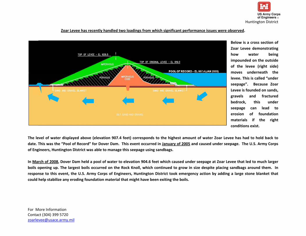
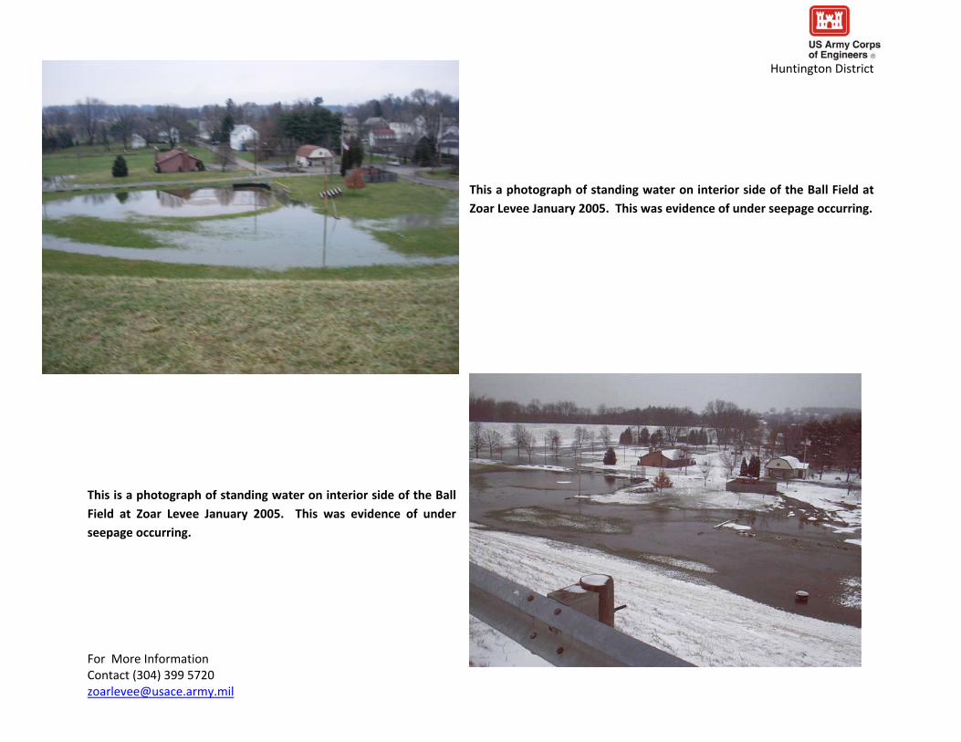
Huntington District
This is a picture of a small boil forming on the interior side of Zoar Levee in
January of 2005 This is called a ldquopin boilrdquo These pin boils showed that seeping water was moving a small amount of soil
Portions of the Ball Field side at Zoar Levee are paved with asphalt for parking This is a picture of that pavement failing due saturated
soil conditions and vehicular traffic in 2005
For More Information Contact (304) 399 5720 zoarleveeusacearmymil
Huntington District
This is a photograph of water seeping on the interior side of the Rock Knoll at Zoar Levee in
January 2005 At this location water exited directly from the ground in large volumes
This is a photograph of mechanical equipment stuck in the saturated ground on the interior side of the Rock Knoll at Zoar Levee in January
2005
For More Information Contact (304) 399 5720 zoarleveeusacearmymil
feet lower than what occurred in January of 2005 The performance of Zoar Levee decreased significantly and the US Army Corps of Engineers Huntington District took emergency action
For More Information Contact (304) 399 5720 zoarleveeusacearmymil
Huntington District
This is an oblique view of Zoar Levee graphically
demonstrating the
locations of area seepage pin boils and large boils on the interior of Zoar Levee in March of 2008 This photograph was taken at the peak
elevation (9046 feet) of the Tuscarawas River during this event
As noted the most significant problems occurred along the Rock
Knoll at the same location
and elevation where
water was seen
significantly seeping in
January 2005
The March 2008 event resulted in a pool of water that was approximately 3
Huntington District
This is a photograph of standing water on interior side of the Ball Field at Zoar Levee March 2008 This was evidence of under seepage occurring This condition was very similar to that observed in January of 2005
This is a photograph of water seeping on the interior side of the Rock
Knoll at Zoar Levee in March 2008 Like in January 2005 water exited directly from the ground at this location in high volumes Unlike January 2005 large boils formed in 2008 These boils are
marked by the white rings of sandbags These sandbag rings are
deployed to stabilize the boils and keep them from increasing in size
This picture was taken on March 18 2012
For More Information Contact (304) 399 5720 zoarleveeusacearmymil
Huntington District
This is a photograph of another boil on the interior side of the Rock
Knoll at Zoar Levee in March 2008 The amount of sandbagging
employed was increased as boils continued to grow in diameter
This photo was taken on March 20 2012
This is a photograph of boils on the interior side of the Rock Knoll at Zoar Levee in March 2008 Despite attempts to control the growing
size of boils with sandbag rings boils continued to expand rapidly eventually coalescing into one another forming a large seepage exit point
This photo was taken on March 21 2012
For More Information Contact (304) 399 5720 zoarleveeusacearmymil
Huntington District
In response to the growing boils on the Rock Knoll at Zoar Levee in
March of 2008 the US Army Corps of Engineers took emergency
action It quickly designed and placed a $126 million dollar gravel blanket over these boils This is called a seepage blanket in that it tries to block any soil moving from the boils while distributing the water This photograph shows the beginning the placement of this blanket at night
This is a photograph showing the seepage blanket being placed
directly over the boils on the Rock Knoll at Zoar Levee in March of 2008 At first the placed gravel was blown out by the boils but ultimately gravel was successfully placed
For More Information Contact (304) 399 5720 zoarleveeusacearmymil
Huntington District
This is a photograph of the completed gravel seepage blanket placed in
March 2008 Ultimately approximately 6 feet of gravel was placed over the
interior of the Rock Knoll at Zoar Levee
Following the March 2008 event the US Army Corps of Engineers Huntington District took several measures to help reduce the risk
under seepage might be causing This is a photograph of the
installation of a $18 million seepage and drainage collection
system which was installed to collect under seepage and drain it to
the pump station where it can be pumped back out to the
Tuscarawas River Other measures included rehabilitating existing
relief wells or wells that relieve seepage stock piling gravel and
sandbags for future events upgrading and automating the pump
station and establishing evaluation and surveillance pools
For More Information Contact (304) 399 5720 zoarleveeusacearmymil
Zoar Diversion Dam has also had past performance issues
Huntington District
This is a photograph looking from the diversion dam toward the downstream
area during remedial work in 1978 A drainage system was added to safely
control seepage exiting the face of the dam Several other repairs were
performed including cutting a new outlet channel
This is a photograph of Zoar Diversion Dam in 1991 when it still impounded a permanent lake
This lake was commonly referred to as Lime Kiln or Goose Run Lake The lake was permanently impounded to elevation 916rsquo The control tower can be seen in the middle ground
For More Information Contact (304) 399 5720 zoarleveeusacearmymil
Huntington District
This is a photograph of a boil located downstream of Zoar Diversion
Dam that was resulting from the seepage This seepage was traveling
through the bedrock that the diversion dam abuts This is referred to as ldquoabutment seepagerdquo This abutment seepage partially drained the
permanent impoundment from elevation 916rsquo to elevation 906rsquo
This is a photograph from the crest of the Zoar Diversion Dam
looking downstream Goose Run can be seen exiting at the toe of the dam The black arrow is highlighting the location were seepage
was occurring
For More Information Contact (304) 399 5720 zoarleveeusacearmymil
Huntington District
A seepage blanket was placed on downstream of the Zoar Diversion
Dam to collect and manage the seepage that was occurring This is a
photograph of a geo‐textile filter fabric being placed before gravel blanket was placed on top of it
This is another photograph of the construction of the
downstream seepage blanket on the Zoar Diversion Dam
For More Information Contact (304) 399 5720 zoarleveeusacearmymil
Huntington District
This is photograph looking downstream from the crest of Zoar Diversion Dam in 2012 showing the completed downstream
seepage blanket
In addition to downstream treatment in 1993 Lime Kiln or Goose Run
Lake was drained Zoar Diversion Dam can be seen in the background
For More Information Contact (304) 399 5720 zoarleveeusacearmymil
Huntington District
In 1993 a portion of the upstream abutment of the dam was covered
with an impervious surface This is a photograph of that installation It is taken from the crest of the diversion dam looking upstream
Today Lime Kiln or Goose Run Lake remains dry However flashy storm
events have impounded the lake without warning and with the control gate
open This is a photograph of the dry bed of Lime Kiln or Goose Run Lake in
2012 The photograph is taken from the crest of Zoar Diversion Dam
For More Information Contact (304) 399 5720 zoarleveeusacearmymil
Huntington District
In 2012 the US Army Corps of Engineers Huntington District installed a data logger to alert Government staff is water is impounded behind the Zoar Diversion Dam so its performance can be monitored
For More Information Contact (304) 399 5720 zoarleveeusacearmymil
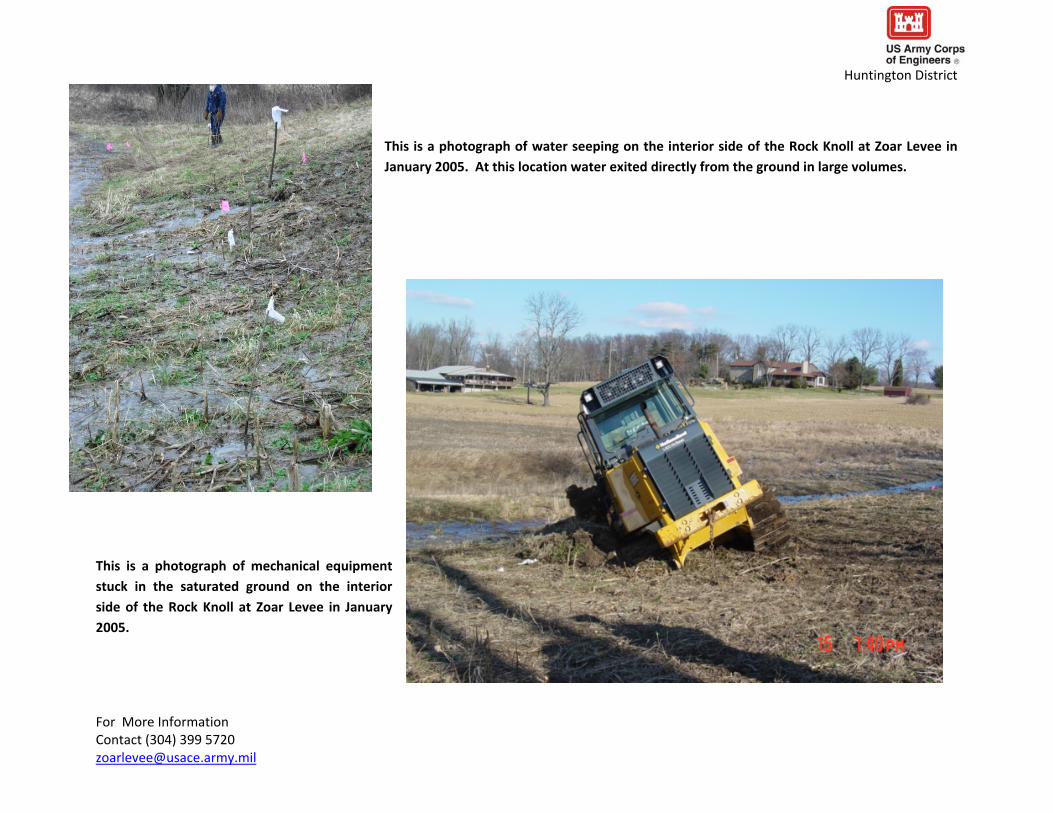
Huntington District
This is a photograph of water seeping on the interior side of the Rock Knoll at Zoar Levee in
January 2005 At this location water exited directly from the ground in large volumes
This is a photograph of mechanical equipment stuck in the saturated ground on the interior side of the Rock Knoll at Zoar Levee in January
2005
For More Information Contact (304) 399 5720 zoarleveeusacearmymil
feet lower than what occurred in January of 2005 The performance of Zoar Levee decreased significantly and the US Army Corps of Engineers Huntington District took emergency action
For More Information Contact (304) 399 5720 zoarleveeusacearmymil
Huntington District
This is an oblique view of Zoar Levee graphically
demonstrating the
locations of area seepage pin boils and large boils on the interior of Zoar Levee in March of 2008 This photograph was taken at the peak
elevation (9046 feet) of the Tuscarawas River during this event
As noted the most significant problems occurred along the Rock
Knoll at the same location
and elevation where
water was seen
significantly seeping in
January 2005
The March 2008 event resulted in a pool of water that was approximately 3
Huntington District
This is a photograph of standing water on interior side of the Ball Field at Zoar Levee March 2008 This was evidence of under seepage occurring This condition was very similar to that observed in January of 2005
This is a photograph of water seeping on the interior side of the Rock
Knoll at Zoar Levee in March 2008 Like in January 2005 water exited directly from the ground at this location in high volumes Unlike January 2005 large boils formed in 2008 These boils are
marked by the white rings of sandbags These sandbag rings are
deployed to stabilize the boils and keep them from increasing in size
This picture was taken on March 18 2012
For More Information Contact (304) 399 5720 zoarleveeusacearmymil
Huntington District
This is a photograph of another boil on the interior side of the Rock
Knoll at Zoar Levee in March 2008 The amount of sandbagging
employed was increased as boils continued to grow in diameter
This photo was taken on March 20 2012
This is a photograph of boils on the interior side of the Rock Knoll at Zoar Levee in March 2008 Despite attempts to control the growing
size of boils with sandbag rings boils continued to expand rapidly eventually coalescing into one another forming a large seepage exit point
This photo was taken on March 21 2012
For More Information Contact (304) 399 5720 zoarleveeusacearmymil
Huntington District
In response to the growing boils on the Rock Knoll at Zoar Levee in
March of 2008 the US Army Corps of Engineers took emergency
action It quickly designed and placed a $126 million dollar gravel blanket over these boils This is called a seepage blanket in that it tries to block any soil moving from the boils while distributing the water This photograph shows the beginning the placement of this blanket at night
This is a photograph showing the seepage blanket being placed
directly over the boils on the Rock Knoll at Zoar Levee in March of 2008 At first the placed gravel was blown out by the boils but ultimately gravel was successfully placed
For More Information Contact (304) 399 5720 zoarleveeusacearmymil
Huntington District
This is a photograph of the completed gravel seepage blanket placed in
March 2008 Ultimately approximately 6 feet of gravel was placed over the
interior of the Rock Knoll at Zoar Levee
Following the March 2008 event the US Army Corps of Engineers Huntington District took several measures to help reduce the risk
under seepage might be causing This is a photograph of the
installation of a $18 million seepage and drainage collection
system which was installed to collect under seepage and drain it to
the pump station where it can be pumped back out to the
Tuscarawas River Other measures included rehabilitating existing
relief wells or wells that relieve seepage stock piling gravel and
sandbags for future events upgrading and automating the pump
station and establishing evaluation and surveillance pools
For More Information Contact (304) 399 5720 zoarleveeusacearmymil
Zoar Diversion Dam has also had past performance issues
Huntington District
This is a photograph looking from the diversion dam toward the downstream
area during remedial work in 1978 A drainage system was added to safely
control seepage exiting the face of the dam Several other repairs were
performed including cutting a new outlet channel
This is a photograph of Zoar Diversion Dam in 1991 when it still impounded a permanent lake
This lake was commonly referred to as Lime Kiln or Goose Run Lake The lake was permanently impounded to elevation 916rsquo The control tower can be seen in the middle ground
For More Information Contact (304) 399 5720 zoarleveeusacearmymil
Huntington District
This is a photograph of a boil located downstream of Zoar Diversion
Dam that was resulting from the seepage This seepage was traveling
through the bedrock that the diversion dam abuts This is referred to as ldquoabutment seepagerdquo This abutment seepage partially drained the
permanent impoundment from elevation 916rsquo to elevation 906rsquo
This is a photograph from the crest of the Zoar Diversion Dam
looking downstream Goose Run can be seen exiting at the toe of the dam The black arrow is highlighting the location were seepage
was occurring
For More Information Contact (304) 399 5720 zoarleveeusacearmymil
Huntington District
A seepage blanket was placed on downstream of the Zoar Diversion
Dam to collect and manage the seepage that was occurring This is a
photograph of a geo‐textile filter fabric being placed before gravel blanket was placed on top of it
This is another photograph of the construction of the
downstream seepage blanket on the Zoar Diversion Dam
For More Information Contact (304) 399 5720 zoarleveeusacearmymil
Huntington District
This is photograph looking downstream from the crest of Zoar Diversion Dam in 2012 showing the completed downstream
seepage blanket
In addition to downstream treatment in 1993 Lime Kiln or Goose Run
Lake was drained Zoar Diversion Dam can be seen in the background
For More Information Contact (304) 399 5720 zoarleveeusacearmymil
Huntington District
In 1993 a portion of the upstream abutment of the dam was covered
with an impervious surface This is a photograph of that installation It is taken from the crest of the diversion dam looking upstream
Today Lime Kiln or Goose Run Lake remains dry However flashy storm
events have impounded the lake without warning and with the control gate
open This is a photograph of the dry bed of Lime Kiln or Goose Run Lake in
2012 The photograph is taken from the crest of Zoar Diversion Dam
For More Information Contact (304) 399 5720 zoarleveeusacearmymil
Huntington District
In 2012 the US Army Corps of Engineers Huntington District installed a data logger to alert Government staff is water is impounded behind the Zoar Diversion Dam so its performance can be monitored
For More Information Contact (304) 399 5720 zoarleveeusacearmymil

Huntington District
This is a photograph of another boil on the interior side of the Rock
Knoll at Zoar Levee in March 2008 The amount of sandbagging
employed was increased as boils continued to grow in diameter
This photo was taken on March 20 2012
This is a photograph of boils on the interior side of the Rock Knoll at Zoar Levee in March 2008 Despite attempts to control the growing
size of boils with sandbag rings boils continued to expand rapidly eventually coalescing into one another forming a large seepage exit point
This photo was taken on March 21 2012
For More Information Contact (304) 399 5720 zoarleveeusacearmymil
Huntington District
In response to the growing boils on the Rock Knoll at Zoar Levee in
March of 2008 the US Army Corps of Engineers took emergency
action It quickly designed and placed a $126 million dollar gravel blanket over these boils This is called a seepage blanket in that it tries to block any soil moving from the boils while distributing the water This photograph shows the beginning the placement of this blanket at night
This is a photograph showing the seepage blanket being placed
directly over the boils on the Rock Knoll at Zoar Levee in March of 2008 At first the placed gravel was blown out by the boils but ultimately gravel was successfully placed
For More Information Contact (304) 399 5720 zoarleveeusacearmymil
Huntington District
This is a photograph of the completed gravel seepage blanket placed in
March 2008 Ultimately approximately 6 feet of gravel was placed over the
interior of the Rock Knoll at Zoar Levee
Following the March 2008 event the US Army Corps of Engineers Huntington District took several measures to help reduce the risk
under seepage might be causing This is a photograph of the
installation of a $18 million seepage and drainage collection
system which was installed to collect under seepage and drain it to
the pump station where it can be pumped back out to the
Tuscarawas River Other measures included rehabilitating existing
relief wells or wells that relieve seepage stock piling gravel and
sandbags for future events upgrading and automating the pump
station and establishing evaluation and surveillance pools
For More Information Contact (304) 399 5720 zoarleveeusacearmymil
Zoar Diversion Dam has also had past performance issues
Huntington District
This is a photograph looking from the diversion dam toward the downstream
area during remedial work in 1978 A drainage system was added to safely
control seepage exiting the face of the dam Several other repairs were
performed including cutting a new outlet channel
This is a photograph of Zoar Diversion Dam in 1991 when it still impounded a permanent lake
This lake was commonly referred to as Lime Kiln or Goose Run Lake The lake was permanently impounded to elevation 916rsquo The control tower can be seen in the middle ground
For More Information Contact (304) 399 5720 zoarleveeusacearmymil
Huntington District
This is a photograph of a boil located downstream of Zoar Diversion
Dam that was resulting from the seepage This seepage was traveling
through the bedrock that the diversion dam abuts This is referred to as ldquoabutment seepagerdquo This abutment seepage partially drained the
permanent impoundment from elevation 916rsquo to elevation 906rsquo
This is a photograph from the crest of the Zoar Diversion Dam
looking downstream Goose Run can be seen exiting at the toe of the dam The black arrow is highlighting the location were seepage
was occurring
For More Information Contact (304) 399 5720 zoarleveeusacearmymil
Huntington District
A seepage blanket was placed on downstream of the Zoar Diversion
Dam to collect and manage the seepage that was occurring This is a
photograph of a geo‐textile filter fabric being placed before gravel blanket was placed on top of it
This is another photograph of the construction of the
downstream seepage blanket on the Zoar Diversion Dam
For More Information Contact (304) 399 5720 zoarleveeusacearmymil
Huntington District
This is photograph looking downstream from the crest of Zoar Diversion Dam in 2012 showing the completed downstream
seepage blanket
In addition to downstream treatment in 1993 Lime Kiln or Goose Run
Lake was drained Zoar Diversion Dam can be seen in the background
For More Information Contact (304) 399 5720 zoarleveeusacearmymil
Huntington District
In 1993 a portion of the upstream abutment of the dam was covered
with an impervious surface This is a photograph of that installation It is taken from the crest of the diversion dam looking upstream
Today Lime Kiln or Goose Run Lake remains dry However flashy storm
events have impounded the lake without warning and with the control gate
open This is a photograph of the dry bed of Lime Kiln or Goose Run Lake in
2012 The photograph is taken from the crest of Zoar Diversion Dam
For More Information Contact (304) 399 5720 zoarleveeusacearmymil
Huntington District
In 2012 the US Army Corps of Engineers Huntington District installed a data logger to alert Government staff is water is impounded behind the Zoar Diversion Dam so its performance can be monitored
For More Information Contact (304) 399 5720 zoarleveeusacearmymil
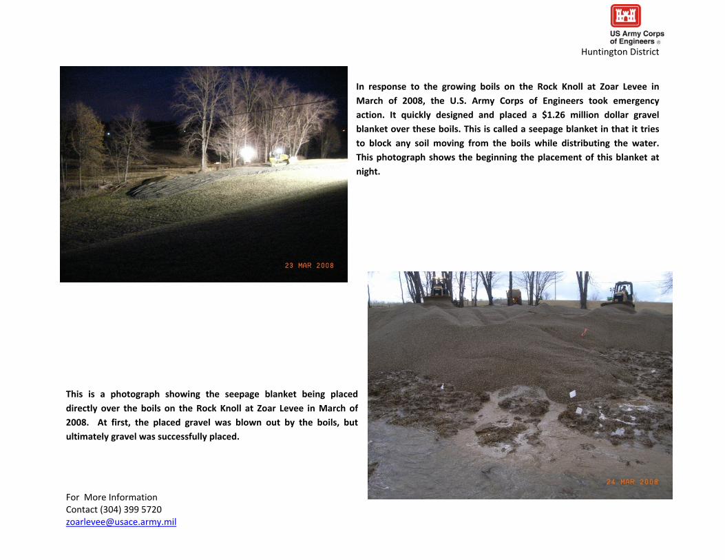
Huntington District
This is a photograph of the completed gravel seepage blanket placed in
March 2008 Ultimately approximately 6 feet of gravel was placed over the
interior of the Rock Knoll at Zoar Levee
Following the March 2008 event the US Army Corps of Engineers Huntington District took several measures to help reduce the risk
under seepage might be causing This is a photograph of the
installation of a $18 million seepage and drainage collection
system which was installed to collect under seepage and drain it to
the pump station where it can be pumped back out to the
Tuscarawas River Other measures included rehabilitating existing
relief wells or wells that relieve seepage stock piling gravel and
sandbags for future events upgrading and automating the pump
station and establishing evaluation and surveillance pools
For More Information Contact (304) 399 5720 zoarleveeusacearmymil
Zoar Diversion Dam has also had past performance issues
Huntington District
This is a photograph looking from the diversion dam toward the downstream
area during remedial work in 1978 A drainage system was added to safely
control seepage exiting the face of the dam Several other repairs were
performed including cutting a new outlet channel
This is a photograph of Zoar Diversion Dam in 1991 when it still impounded a permanent lake
This lake was commonly referred to as Lime Kiln or Goose Run Lake The lake was permanently impounded to elevation 916rsquo The control tower can be seen in the middle ground
For More Information Contact (304) 399 5720 zoarleveeusacearmymil
Huntington District
This is a photograph of a boil located downstream of Zoar Diversion
Dam that was resulting from the seepage This seepage was traveling
through the bedrock that the diversion dam abuts This is referred to as ldquoabutment seepagerdquo This abutment seepage partially drained the
permanent impoundment from elevation 916rsquo to elevation 906rsquo
This is a photograph from the crest of the Zoar Diversion Dam
looking downstream Goose Run can be seen exiting at the toe of the dam The black arrow is highlighting the location were seepage
was occurring
For More Information Contact (304) 399 5720 zoarleveeusacearmymil
Huntington District
A seepage blanket was placed on downstream of the Zoar Diversion
Dam to collect and manage the seepage that was occurring This is a
photograph of a geo‐textile filter fabric being placed before gravel blanket was placed on top of it
This is another photograph of the construction of the
downstream seepage blanket on the Zoar Diversion Dam
For More Information Contact (304) 399 5720 zoarleveeusacearmymil
Huntington District
This is photograph looking downstream from the crest of Zoar Diversion Dam in 2012 showing the completed downstream
seepage blanket
In addition to downstream treatment in 1993 Lime Kiln or Goose Run
Lake was drained Zoar Diversion Dam can be seen in the background
For More Information Contact (304) 399 5720 zoarleveeusacearmymil
Huntington District
In 1993 a portion of the upstream abutment of the dam was covered
with an impervious surface This is a photograph of that installation It is taken from the crest of the diversion dam looking upstream
Today Lime Kiln or Goose Run Lake remains dry However flashy storm
events have impounded the lake without warning and with the control gate
open This is a photograph of the dry bed of Lime Kiln or Goose Run Lake in
2012 The photograph is taken from the crest of Zoar Diversion Dam
For More Information Contact (304) 399 5720 zoarleveeusacearmymil
Huntington District
In 2012 the US Army Corps of Engineers Huntington District installed a data logger to alert Government staff is water is impounded behind the Zoar Diversion Dam so its performance can be monitored
For More Information Contact (304) 399 5720 zoarleveeusacearmymil

Huntington District
This is a photograph of a boil located downstream of Zoar Diversion
Dam that was resulting from the seepage This seepage was traveling
through the bedrock that the diversion dam abuts This is referred to as ldquoabutment seepagerdquo This abutment seepage partially drained the
permanent impoundment from elevation 916rsquo to elevation 906rsquo
This is a photograph from the crest of the Zoar Diversion Dam
looking downstream Goose Run can be seen exiting at the toe of the dam The black arrow is highlighting the location were seepage
was occurring
For More Information Contact (304) 399 5720 zoarleveeusacearmymil
Huntington District
A seepage blanket was placed on downstream of the Zoar Diversion
Dam to collect and manage the seepage that was occurring This is a
photograph of a geo‐textile filter fabric being placed before gravel blanket was placed on top of it
This is another photograph of the construction of the
downstream seepage blanket on the Zoar Diversion Dam
For More Information Contact (304) 399 5720 zoarleveeusacearmymil
Huntington District
This is photograph looking downstream from the crest of Zoar Diversion Dam in 2012 showing the completed downstream
seepage blanket
In addition to downstream treatment in 1993 Lime Kiln or Goose Run
Lake was drained Zoar Diversion Dam can be seen in the background
For More Information Contact (304) 399 5720 zoarleveeusacearmymil
Huntington District
In 1993 a portion of the upstream abutment of the dam was covered
with an impervious surface This is a photograph of that installation It is taken from the crest of the diversion dam looking upstream
Today Lime Kiln or Goose Run Lake remains dry However flashy storm
events have impounded the lake without warning and with the control gate
open This is a photograph of the dry bed of Lime Kiln or Goose Run Lake in
2012 The photograph is taken from the crest of Zoar Diversion Dam
For More Information Contact (304) 399 5720 zoarleveeusacearmymil
Huntington District
In 2012 the US Army Corps of Engineers Huntington District installed a data logger to alert Government staff is water is impounded behind the Zoar Diversion Dam so its performance can be monitored
For More Information Contact (304) 399 5720 zoarleveeusacearmymil
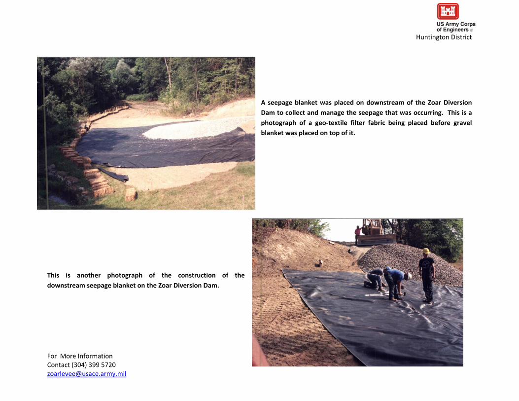
Huntington District
A seepage blanket was placed on downstream of the Zoar Diversion
Dam to collect and manage the seepage that was occurring This is a
photograph of a geo‐textile filter fabric being placed before gravel blanket was placed on top of it
This is another photograph of the construction of the
downstream seepage blanket on the Zoar Diversion Dam
For More Information Contact (304) 399 5720 zoarleveeusacearmymil
Huntington District
This is photograph looking downstream from the crest of Zoar Diversion Dam in 2012 showing the completed downstream
seepage blanket
In addition to downstream treatment in 1993 Lime Kiln or Goose Run
Lake was drained Zoar Diversion Dam can be seen in the background
For More Information Contact (304) 399 5720 zoarleveeusacearmymil
Huntington District
In 1993 a portion of the upstream abutment of the dam was covered
with an impervious surface This is a photograph of that installation It is taken from the crest of the diversion dam looking upstream
Today Lime Kiln or Goose Run Lake remains dry However flashy storm
events have impounded the lake without warning and with the control gate
open This is a photograph of the dry bed of Lime Kiln or Goose Run Lake in
2012 The photograph is taken from the crest of Zoar Diversion Dam
For More Information Contact (304) 399 5720 zoarleveeusacearmymil
Huntington District
In 2012 the US Army Corps of Engineers Huntington District installed a data logger to alert Government staff is water is impounded behind the Zoar Diversion Dam so its performance can be monitored
For More Information Contact (304) 399 5720 zoarleveeusacearmymil
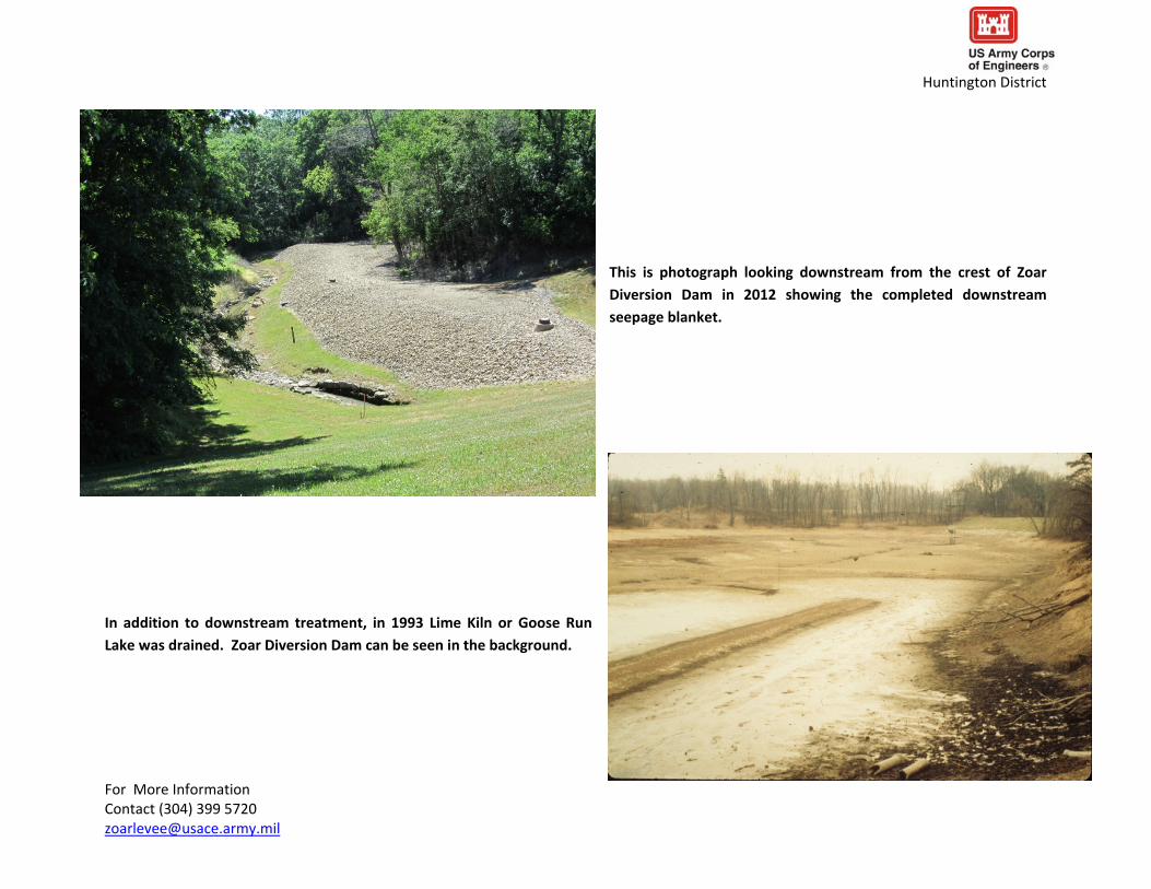
Huntington District
In 2012 the US Army Corps of Engineers Huntington District installed a data logger to alert Government staff is water is impounded behind the Zoar Diversion Dam so its performance can be monitored
For More Information Contact (304) 399 5720 zoarleveeusacearmymil