march 2007 oracle spatial user conference · 2007-04-03 · polymorphism toplink mapping data model...
TRANSCRIPT

March 2007Oracle Spatial User Conference
Robert P. LaudatiMarketing Program ManagerGE Energy
March 2007Oracle Spatial User Conference
Advances in UtilityNetwork Managementwith Oracle Spatial
March 2007Oracle Spatial User Conference

Introduction
• GE Energy’s “Smallworld” geospatial productline provides asset management solutionsfocused on the unique aspects of modelingutility networks
• In 2006, the company began an initiative todevelop utility applications completely basedon Oracle Spatial• No proprietary abstraction layers
• Supports the Oracle Spatial product direction

Development Scope
• Design & Maintain the Electric Network• Design
• Easy to use graphic layout tools• Workflow management
• Maintain• Query/report on assets• Manage change-outs/repairs
• Deliverables• Built “100%” on Oracle Spatial• Productized interfaces to WMS• Re-usable/extensible geospatial
base platform Utility Asset Lifecycle

Application Technology
• Major subsystems• Oracle database server, with utility-specific
database schemas and configuration
• Java desktop client application to provide highperformance, geospatial applications for the enduser, presented in a 2-tier framework
• Middle tier J2EE application server to provideintegration services with external systems or‘lightweight’ clients

Architecture
Architecture based on Oracle and Java, utilizing standard Javaarchitectural patterns for heavyweight clients, lightweight clientsand integration services
Current development

Desktop Client
• Java Swing clientapplication connected toOracle database viapersistent LANconnection
• Includes user interfaceand application logic inthe same ‘tier’
• Provides highlyinteractive andresponsive graphicalapplications

Key Oracle Modules
• Network data model• Network connectivity - tracing
• Workspace Manager• Manage engineering design projects
• Toplink• Object-oriented representation of facilities
• MapViewer• “Out-of-the-box” lightweight client
• JDeveloper• Java development environment

Network Data Model (NDM)
• Based on standard Oracle NDM and API - networkconnectivity data is open for reading by other clients
• Trigger-based mechanism maintains network datamodel in line with physical geometry
• Configurable rules to control network connectivity
• Standard Oracle analysis engines extended via APIhooks to consult Java 'business logic' to meetcomplex network analysis requirements
• Working with Oracle Spatial team on enhancements
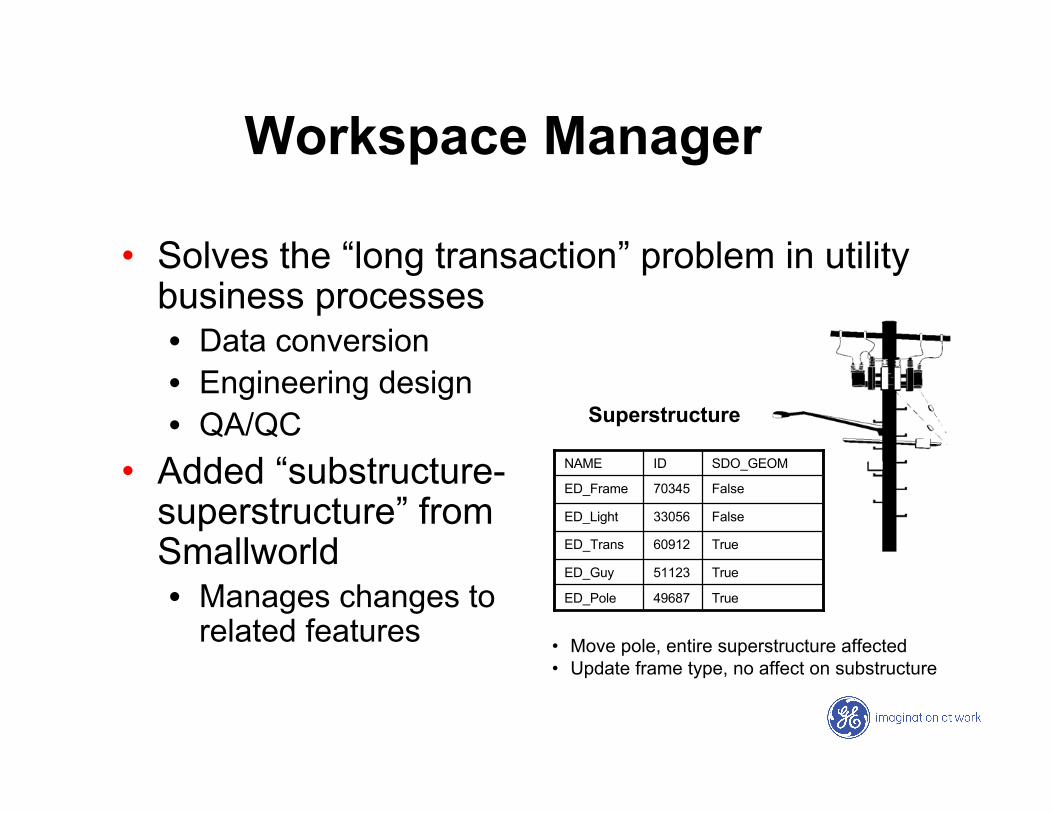
Workspace Manager
• Solves the “long transaction” problem in utilitybusiness processes• Data conversion• Engineering design• QA/QC
• Added “substructure-superstructure” fromSmallworld• Manages changes to
related featuresTrue49687ED_Pole
True51123ED_Guy
True60912ED_Trans
False33056ED_Light
False70345ED_Frame
SDO_GEOMIDNAME
Superstructure
• Move pole, entire superstructure affected• Update frame type, no affect on substructure

Toplink
• Toplink supports one to many mappings betweendomain classes and database tables
• Design to keep Toplink mappings as simple aspossible and to use 1:1 mappings as a rule
• If needed, Toplink mappings will be set up ondatabase views
Object ModelJava classes,
objects,methods,
inheritance,polymorphism
ToplinkMapping
Data ModelTablesViewsRows
ColumnsProcedures
SQL

MapViewer
• A lightweight client for browsing network data• Thematic maps
• Asset Queries
• Developing rich webclient• Dashboards
• Decision Support
• Lifecycle Management
• Web publish and edit
• Schematic drawings

JDeveloper
• Standard development environment for GE
• Currently using version 10.1.3.1
• Integrated with ClearCase
• Used to create/edit Toplink mappings

Development Challenges
• Managing multiple database connections
• Working with large networks
• Undo/Redo mechanism
• Multiple internal “worlds” of geometry
• Underground trench/duct modeling

Internal Worlds
• Implemented using 100%standard Oracle SQL byextending standard OracleSpatial data types
• Consistent geometry modelfor geographic and non-geographic data
• Indexing of geographic dataunaffected
• Fully compatible with allOracle Spatial tools - 'world'data can be selected usingOracle views

Underground Model
• Manage complexunderground networks
• Non-network “container”geometries such astrenches, ducts,manholes with their ownNDM
• Actual network facilitiesrelated to containerobjects

Future Development
• Near term development• Advanced design tools• Transmission & substation database schemas and
applications• Additional
integration APIs
• Future markets• Leverage base
layer for gas,water, comms
ElectricDist
Whole Product
Solutions
CustomerReferences
ElectricTrans
GasDist
WaterDist
TelcoOSS
GasTrans

Summary
• Oracle Spatial 10g has the critical features fordeploying advanced network applications forutilities – we’re looking forward to 11g!
• Leveraging NDM, Workspace Manager,Toplink, MapViewer to develop applications
• Working with Oracle on enhancements for theutility industry

AQ&