march 2016 riverside revitalization plan
TRANSCRIPT

March 2016 These documents were prepared for the Town of Southampton and the New York State Department of State in part
with funds provided through the Brownfield Opportunity Areas Program.
Riverside Revitalization Plan Brownfield Opportunity Area Step II Nomination Study Riverside Revitalization Action Plan
Hamlet of Riverside, Town of Southampton, Suffolk County, New York

Riverside Revitalization Plan Hamlet of Riverside, Town of Southampton, NY
March 2016
These documents were prepared for the Town of Southampton and the New York State Department of State in part with funds provided through the Brownfield Opportunity Areas Program.

Hamlet of Riverside BOA Step II Nomination Study
HAMLET OF RIVERSIDE Brownfield Opportunity Areas (BOA)
Step II – Nomination Study
Town of Southampton Suffolk County, New York
Prepared by: Nelson, Pope & Voorhis, LLC 572 Walt Whitman Road Melville, NY 11747 Phone: 631.427.5665 Contact: Kathryn J. Eiseman, AICP www.nelsonpopevoorhis.com
In association with: Nelson & Pope Urbanomics 572 Walt Whitman Road 115 Fifth Avenue Melville, NY 11747 New York, NY 10003 Phone: 631.427.5665 212.353.7464 Contact: Joseph Pecora Contact: Tina Lund
March 2016
This document was prepared for the Town of Southampton and the New York State Department of State with state funds provided through the Brownfield Opportunity Areas Program.
Hamlet of Riverside BOA Step II Nomination Study
Page i
TABLE OF CONTENTS Page
Executive Summary………………………………………………………………………………….iv
1.0 Description of the Proposed Project and Boundary ............................................................................. 2
1.1 Lead Project Sponsors ............................................................................................................. 2
1.2 Project Overview and Description ........................................................................................... 5
1.2.1 Previous Planning Studies ........................................................................................................ 9
1.2.2 Brownfield Sites ..................................................................................................................... 14
1.3 Community Vision and Goals and Objectives ...................................................................... 17
1.4 Brownfield Opportunity Area Boundary Description and Justification ................................ 19
2.0 Community Participation Plan AND Techniques to Enlist Partners .................................................. 20
2.1 Community Outreach Plan .................................................................................................... 20
2.2 Techniques to Enlist Partners ................................................................................................ 22
3.0 Analysis of the Proposed Brownfield Opportunity Area ................................................................... 27
3.1 Community and Regional Setting ......................................................................................... 27
3.2 Inventory and Analysis .......................................................................................................... 28
3.2.1 Introduction ............................................................................................................................ 28
3.2.2 Land Use and Zoning ............................................................................................................. 29
3.2.3 Brownfield, Abandoned, and Vacant Sites ............................................................................ 35
3.2.4 Zoning Districts...................................................................................................................... 54
3.2.5 Strategic Sites ......................................................................................................................... 56
3.2.6 Land Ownership Pattern ......................................................................................................... 61
3.2.7 Parks and Open Space ............................................................................................................ 63
3.2.8 Building Inventory ................................................................................................................. 67
3.2.9 Historic and Archeologically Significant Areas .................................................................... 69
3.2.10 Transportation Systems .......................................................................................................... 75
3.2.11 Natural Resources and Environmental Features .................................................................... 80
3.3 Economic and Market Trends Analysis................................................................................. 97
3.3.1 National Market Trends……………………………………………………………………97 3.3.2 Regional (Long Island/Suffolk County) Market Trends…………………………………...99 3.3.3 Riverside Market Trends…………………………………………………………………104
3.4 Infrastructure Analysis ........................................................................................................ 111
3.4.2 Water Analysis ..................................................................................................................... 111
3.4.3 Sanitary Sewer ..................................................................................................................... 114
3.4.4 Stormwater and Surface/Groundwater Analysis .................................................................. 116

Hamlet of Riverside BOA Step II Nomination Study
Page ii
3.4.5 Other Infrastructure and Community Services .................................................................... 119
4.0 Summary analysis, findings & rECOMMENDATIONS ................................................................. 125
4.1 Economic and Market Trends ............................................................................................. 125
4.2 Existing and Future Land Use and Zoning .......................................................................... 127
4.2.1 Existing Land Use and Zoning ............................................................................................. 127
4.2.2 Existing Sites of Environmental Concern ............................................................................ 128
4.2.3 Potential Future Land Uses .................................................................................................. 133
4.4 Environmental Considerations ............................................................................................ 145
4.5 Key Recommendations ........................................................................................................ 145
4.5.1 Adoption of Zoning Recommendations (Completed) .......................................................... 145
4.5.2 Wastewater Treatment and Stormwater Treatment .............................................................. 149
4.5.3 Traffic Circle and other Road and Streetscape Improvements ............................................ 151
4.5.4 Recreational Amenity Improvements .................................................................................. 153
4.5.5 Pedestrian Bridge ................................................................................................................. 153
4.5.6 Children’s Museum .............................................................................................................. 153
4.5.7 WaterFire on the Peconic River ........................................................................................... 153
4.5.8 Strategic Sites – Environmental Site Assessments .............................................................. 154
4.5.9 Historic Resources and Cultural Resource Investigations ................................................... 154
4.5.10 Leveraging Environmental Restoration Projects Through an Environmental Protection and Enhancement Fund ............................................................................................................................... 155
LIST OF TABLES Page
1-1 Excerpt of Economic Distress Indicators, 2008-2012, Suffolk County ......................................... 9 1-2 Study Area Sites of Environmental Concern ................................................................................. 16 2-2 Advisory Committee Members ...................................................................................................... 23 2-3 Riverside BOA/RRAP Advisory Committee Meeting ................................................................. 24 3-1 Existing Land Use .......................................................................................................................... 34 3-2 Existing Zoning ............................................................................................................................ 54 3-3 Strategic Sites ............................................................................................................................... 57 3-4 Lands in Public Ownership ........................................................................................................... 63 3-5 Existing Building and Property Inventory .................................................................................... 67 3-6 Potential Historic Buildings .......................................................................................................... 70 3-7 Bureau of Labor Statistics National New Job Projections, 2012-2022 ......................................... 98 3-8 Suffolk County Housing by Bedrooms, 2009-201 ........................................................................ 99 3-9 Suffolk County Household Size, 2009-2013 .............................................................................. 100 3-10 Change in Business Establishments in Suffolk County, 2005-2013 ........................................... 101 3-11 Change in Paid Employees Suffolk County, 2005 – 2013 ........................................................... 101 3-12 Fastest Growth Occupations by Percentage ................................................................................. 103 3-13 Fastest Growth Occupations by Increase in Number of Jobs ...................................................... 104 3-14 Study Area Retail Opportunities .................................................................................................. 107 3-15 Riverhead Fire District Companies, Facilities and Equipment .................................................... 126 4-1 Study Area Preliminary Market Demand ................................................................................... 126

Hamlet of Riverside BOA Step II Nomination Study
Page iii
4-2 Study Area Sites of Environmental Concern .............................................................................. 129 4-3 Theoretical Development Program .............................................................................................. 134 4-4 Strategic Sites .............................................................................................................................. 141 4-5 Proposed Schedule of Uses for Riverside Overlay District ......................................................... 148
LIST OF FIGURES Page
1-1 Community Context ..................................................................................................................... 6 1-2 Study Area Location 7 1-3 Proposed BOA Boundary/Study Area .......................................................................................... 8 1-4 Sites of Environmental Concern .................................................................................................. 15 3-1 Generalized Land Use ................................................................................................................... 32 3-2 Public Ownership .......................................................................................................................... 33 3-3 Theoretical Development Plan and Sites of Environmental Concern ........................................... 53 3-4 Existing Base Zoning Districts ..................................................................................................... 55 3-5 Strategic Sites ............................................................................................................................... 60 3-6 Parks, Open Space and Preserves ................................................................................................. 65 3-7 Cultural Resources ........................................................................................................................ 74 3-8 Local Transportation Systems ....................................................................................................... 78 3-9 WSRR .......................................................................................................................................... 83 3-10 NYS Wetlands .............................................................................................................................. 84 3-11 National Wetland Inventory Freshwater Wetlands ....................................................................... 85 3-12 Subwatersheds .............................................................................................................................. 86 3-13 Flood Insurance Rate Zones (FEMA) ........................................................................................... 87 3-14 Groundwater Travel Time ............................................................................................................. 89 3-15 Depth to Groundwater................................................................................................................... 90 3-16 Habitat Map .................................................................................................................................. 92 3-17 Significant Coastal Fish & Wildlife Habitats ............................................................................... 94 3-18 Central Pine Barrens ..................................................................................................................... 95 3-19 Suffolk County Water Authority Distribution System ................................................................ 112 3-20 Potential STP Locations ............................................................................................................... 117 3-21 Stormwater Infrastructure ............................................................................................................ 118 3-22 Riverhead Central School District ............................................................................................... 120 3-23 Southampton Police District ........................................................................................................ 121 3-24 Riverhead and Southampton Fire Districts .................................................................................. 122 3-25 Northampton Ambulance District ................................................................................................ 123
Appendices Appendix A: Sites of Environmental Concern Also included with this document:
• Riverside Revitalization Action Plan• Riverside Overlay District Zoning• GIS Riverside BOA Shapefile (zip file)

Hamlet of Riverside BOA Step II Nomination Study
Page iv
EXECUTIVE SUMMARY
Introduction
On October 17, 2013, Governor Cuomo announced to the Town of Southampton Department of Land Management (DLM) that it had been awarded a grant administered through the New York State Department of State (NYSDOS) for the preparation of a Brownfield Opportunity Area (BOA) Step II Nomination Study and area Revitalization Plan. In March of 2015, the Town Board circulated a Request for Proposal to conduct the work, and in June of 2015 hired Nelson, Pope & Voorhis, LLC (NP&V) to prepare the BOA Nomination Study and Generic Environmental Impact Statement (GEIS) for the BOA Study, Riverside Revitalization Action Plan (RRAP), and associated zone changes and code amendments known collectively as the Riverside Overlay District or “ROD”. These planning and implementation efforts – the BOA Study, RRAP, and ROD – are interconnected in that they share common goals, are based on a comprehensive community participation process, and the RRAP informs, and the zoning amendments implement, various revitalization recommendations that came from the BOA Study.
This BOA Study is specifically designed to:
• Identify and describe the reuse, development opportunities and needs in the proposedBOA with an emphasis on the identification, description, and recommendations forpreliminary reuse opportunities for identified brownfield sites and other actions torevitalize the area.
• Include a description of anticipated end land uses including residential, commercial,industrial, or recreational and describe the anticipated future conditions and use ofgroundwater.
• Identify and describe any other public and private measures needed to stimulateinvestment, promote revitalization and enhance community health and environmentalconditions in the proposed BOA.1
The primary purpose of New York State’s BOA Program is to facilitate area-wide community-supported planning processes that lead to the redevelopment of brownfields, particularly in highly impacted and economically distressed areas that are in need of revitalization. A “brownfield” or “brownfield site” is defined by New York State Environmental Conservation Law Article 27, Title 14, as: “any real property where a contaminant is present at levels exceeding the soil cleanup objectives or other health-based or environmental standards, criteria or guidance adopted by DEC that are applicable based on the reasonably anticipated use of the property, in accordance with applicable regulations.” The BOA program therefore enables Towns and associated stakeholders to establish a clear vision for revitalizing areas so they can become economically and environmentally sustainable.
1 NYSDOS, NYSDEC Brownfield Opportunities Area Program, Guidance for Applicants, October 2008.
A Master Developer, Renaissance Downtowns (RD) was selected by the Town in April 2014 to work with the community and its many stakeholders to implement proven planning strategies and placemaking techniques. Through the use of its proprietary Unified Development Approach, RD has created a platform whereby community driven ideas for revitalization can be properly analyzed and vetted. This process has culminated in the creation of the RRAP and BOA Study.

Hamlet of Riverside BOA Step II Nomination Study
Page v
As part of the Master Developer agreement between the Town and Renaissance Downtowns (RD), RD committed to working closely with the Riverside community and employing crowd-source placemaking methods utilized successfully in other communities. Consistent with the Master Developer agreement, RD is permitted to redevelop certain Town-owned properties in Riverside consistent with the BOA Study, RRAP and ROD zoning amendments. In addition, RD will seek partnerships with owners of private properties to achieve the “critical mass” development and redevelopment necessary to overcome the documented barriers and economically reinvigorate the hamlet and enhance the quality of life of its residents. RD’s proprietary “Unified Development Approach” model for community revitalization has worked successfully in other communities and the Town of Southampton has expressed confidence that this approach is the best course of action to achieve revitalization of the Riverside hamlet. While many planning efforts have been initiated previously by the Town for the Riverside and nearby Flanders communities, only nominal portions of these plans have been implemented - and none have achieved the momentum required to overcome significant obstacles and successfully revitalize the area. The goals and recommendations of past planning efforts have nevertheless set the stage for area redevelopment through the establishment of new zoning and community and agency support for infrastructure improvements; however, due to the economic recession and the absence of a responsible master developer to invest in and champion coordinated redevelopment, Riverside has continued to struggle. This inaction has left many in the community feeling frustrated and doubtful that effective change is really possible. The BOA Study, RRAP, and ROD were reviewed and approved by the Southampton Town Board in December of 2015 after the GEIS process concluded there would be no significant adverse impacts on the environment from the implementation of the plan and zoning map and code amendments if a series of targeted impact avoidance and mitigation strategies were implemented to ensure suitable redevelopment and revitalization of the Riverside community. The NYSDOS subsequently reviewed the BOA Study Report to ensure that the program met its strict standards of quality and provided additional valuable input to further improve the Study and make certain that it is an effective instrument for fulfilling State and local goals. The work program for preparation of this BOA Step II Nomination Study has been adapted to allow the Town to build upon the work already completed by the Master Developer, and provides focus on the evaluation of the barriers to redevelopment through agency coordination; refinement of a development program; and analysis of impacts through preparation of a GEIS. BOA Project Location, Overview and Description The hamlet of Riverside is located in the northwestern portion of the Town of Southampton, Suffolk County, New York. Figure 1-1, Community Context Map provided in Section 1 of this BOA Study Report, shows the geographic location of the BOA Study Area within the Town and County. Figure 1-2, Study Area Location Map, illustrates the location of the BOA in relation to surrounding municipalities (i.e., the Towns of Southampton, Riverhead and Brookhaven). Figure 1-3 provides a map of the BOA Boundary/Study Area including local street network and major water bodies. The 468-acre BOA/Study Area is more specifically located:

Hamlet of Riverside BOA Step II Nomination Study
Page vi
• north of New York State’s 2,700-acre David A. Sarnoff Preserve; • south of Downtown Riverhead, the Peconic River, and the Southampton/Riverhead municipal
boundary which follows the centerline of the river; • east of the Suffolk County office complex (Evan K. Griffing Center), County courthouse (Arthur
M. Cromarty Court Complex), County prison facilities (Suffolk County Jail), County Road 51 (Center Drive South), and a tributary of the Peconic River known as “Little Peconic River”; and
• west of White Brook Drive and Black Creek Pond. Community Background Riverside is an older, moderately dense suburban community consisting primarily of single-family neighborhoods, three separate mobile home parks, a scattered mix of mostly small one- to two-story commercial and industrial buildings, several dispersed institutional uses (churches, an elementary school, state police barracks, and a Head Start facility), and parklands and nature preserves. Most of the commercial/business uses in the Study Area are located along SR 24 (also named Flanders Road) or Riverleigh Avenue, especially near the Riverside/Riverhead traffic circle where five State and County arterial roads and one local residential street intersect. The Riverside BOA Study Area is within the US Census Bureau’s Riverside Census Designated Place (CDP), which has been documented as the most economically distressed community in both Suffolk and Nassau County.2 Economic distress indicators include data on poverty level, educational achievement, unemployment, median income and median housing values. In Suffolk County, Riverside has the lowest median housing value and median household income of the 157 communities (CDPs), the second lowest percentage of high school graduates, and the third highest number of families living below the poverty level. Table 1-1 of this BOA Study provides a summary of economic distress indicators for Riverside as compared with two other distressed communities in Suffolk County (Gordon Heights and Wyandanch) which are ranked as second and third, respectively. Riverside has significantly higher unemployment (nearly 4 percent higher than Gordon Heights) and a substantially lower median income (over $20,000 less than Wyandanch), but comparatively fewer residents receive public assistance income. The Riverside CDP is the only community within Suffolk County with a median home value below $200,000. In fact, the median home value reported by the economic distress indicator data was $73,900. By comparison, the community with the second lowest median housing value in Suffolk County was Mastic Beach, which at the time had a median home value of $224,900, or more than three times that of Riverside. The RRAP cites the lack of long term solutions to support community revitalization which has resulted in a general disinterest on the part of the business community to invest in Riverside. In addition, the RRAP notes deficiencies in essential infrastructure, availability of housing options, community services, and easy access to food and other essential goods. The end result is a struggling local economy, unemployment and few opportunities for upward social mobility. The RRAP also indicates that investment in the community is significantly hampered by zoning and infrastructure deficiencies that limit the ability of land to be used to its highest and best use. 2 Suffolk County Planning Economic Distress Indicators for 2008-2012
Hamlet of Riverside BOA Step II Nomination Study
Page vii
Community Participation Past Planning Efforts A number of planning studies have been prepared for the Riverside community over the past several decades and all recognize the need for redevelopment and revitalization. In general, recommendations for redevelopment have emphasized a more compact, physically integrated, economically sustainable and centralized mixed-use hamlet center. The following is a chronological outline of previous plans and land use studies that include or directly target all or part of the Riverside community. These plans identify historic issues and concerns, many of have yet to be resolved, and serve as a guide to identifing the community’s most pressing needs:
• 1970 Town of Southampton Master Plan; • 1999 Comprehensive Plan Update (“Southampton Tomorrow”); • 2004 Flanders/Riverside/Northampton Revitalization Study; • 2006 Riverside Blight Study; • 2008 Riverside Hamlet Plan; • 2009 Riverside Urban Renewal Plan (including input from the 2006 Blight Study).
Following the preparation of the Urban Renewal Plan, the Town rezoned several areas to promote redevelopment of key sites. Nevertheless, there has been little change in the area in recent years. BOA Study, RRAP and ROD Planning Process In regard to the subject BOA, RRAP and ROD, the Town established an Advisory Committee early on in the current process to provide essential baseline input. In addition to the Advisory Committee, continuous coordination between the Town, Master Developer, and the local representative to lead the Crowd Source Place Making (CSPM) effort occurred. The CSPM process was guided by the principles of Social, Environmental, and Economic responsibility which were emphasized to community members that participated in the process. CSPM utilizes in-person meetings and internet-based tools to allow community members to upload and vote on ideas, uses, retail concepts, types of commercial/retail tenants, and amenities. RD hired a full-time outreach coordinator to work with the community on the revitalization project in the summer of 2014. A community based office was established to encourage community participation and provide a base for the crowd sourced placemaking efforts. During the process, a number of outreach methods were utilized to reach as many people within the community as possible, including population segments that normally do not participate in official meetings. RD employed social media and networking tools that included proprietary web-based applications designed to engage the community in meaningful dialogue, which was essential to the planning and implementation process. Because the community provided so much valuable input to develop the vision for the community - this process served as the basis for community outreach for the BOA Study. In coordination with RD and the Advisory Committee, additional outreach occurred following the preparation of the RRAP.

Hamlet of Riverside BOA Step II Nomination Study
Page viii
The key to implementation of the recommendations of the BOA Nomination Study - and specifically in this case, the RRAP and Zoning Map and Code Amendments to support redevelopment - was intensive outreach to build commitment from agencies and community service providers and thereby enlisting partners for the actual revitalization to occur following adoption of the new zoning regulations. Early in the process, letters were sent to community service providers and agencies with permitting authority over future planning actions. The letters included a description of the revitalization program and a request to meet for question and answer sessions to gather agency input and guidance. Outreach also included presentations to each of the involved Town departments and discretionary boards to maximize awareness, coordination and an understanding of the importance of the revitalization efforts to the future of the community. The results of these agency discussions are reflected in the community participation section (Section 2) and inventory and analysis section (Section 3) of this BOA Study Report and throughout the DGEIS and FGEIS. The Advisory Committee that was established to assist in the preparation and review of the BOA and RRAP also included numerous representatives from the Town, as well as NP&V and RD personnel. The individual members on the Advisory Committee are listed in Table 2-2 of this BOA Study Report and Section 2 provides extensive detail about various CSPM efforts that were undertaken by the Advisory Committee since the summer of 2014. The CSPM process used in the development of the RRAP recommended that the Top Ideas be analyzed to determine if the project is socially, economically and environmentally feasible. After the feasibility studies, it was recommended that an Implementation Team be established consisting of community supporters and representatives of both public and private sectors. Techniques to Enlist Partners The key to implementation of the recommendations of the BOA Nomination Study - and specifically in this case, adoption of the RRAP and Zoning Amendments to support redevelopment - was intensive outreach to build commitment from agencies and community service providers and thereby enlisting partners for the actual revitalization to occur following adoption of the new zoning regulations. Early in the planning process, letters were sent to community service providers and agencies with permitting authority. The letters included a description of the revitalization program and a request to meet for agency input. Outreach also included presentations to each of the involved Town departments and boards to maximize awareness and a full understanding of the importance of successful revitalization of Riverside. The results of these agency discussions are reflected in the community participation section (Section 2) and inventory and analysis section (Section 3) of this BOA Study and throughout the previous DGEIS and FGEIS.

Hamlet of Riverside BOA Step II Nomination Study
Page ix
Community Vision and Goals and Objectives This BOA in conjunction with the approved RRAP and adopted ROD Zoning Map and Code amendments, provide a blueprint for addressing various revitalization challenges, while capitalizing upon the community’s strong desire to foster a mix of retail stores, service-related businesses, restaurants and diverse housing opportunities, along with improved transportation, capital infrastructure, pedestrian pathways, public green spaces and enhanced access to the Peconic River waterfront. The overall vision for the RRAP based on community, stakeholder and agency outreach is to:
• Position Riverside as a Gateway of the Town, retain and attract a diverse and multicultural
population that includes young professionals and members of the innovation and knowledge economies to promote the Town as a preeminent regional destination.
• Create a true sense of place, utilizing smart growth and sustainable development principles that meet the needs of current residents and attract future residents and businesses.
• Facilitate the creation of a mixed use and walkable Gateway Center to enhance the vibrancy of the Riverside Hamlet Center and create a diversity of uses (to live, work, shop, learn, and play).
• Complement Riverhead’s downtown area and leverage the proximity of the Long Island Rail Road station and availability of bus service.
• Reinforce a sense of community and neighborhood identity.
• Enhance the character and overall visual environment of the Project Area.
• Promote housing choices with a broad range of housing types and price points including attainable and market-rate housing options.
• Expand the property tax base and provide additional employment opportunities.
• Incorporate municipally owned property located within the Project Area to achieve an effective redevelopment strategy; and provide an avenue for private property owners to partner with the public sector and RD to foster the redevelopment of underutilized assets for the benefit of both themselves and the community.
• Leverage existing assets and proximity to maritime resources along the Peconic waterfront, natural assets, recreation areas, preserved open spaces of the Pine Barrens region, and proximity to Riverhead’s downtown area.
• Attract business, residents and visitors to stimulate the local economy and position Riverside as a tourist destination with access to both the north and south forks and the many assets they possess.
The RRAP describes in detail the implementation methods to achieve the goals expressed above. The BOA Study has not only informed and will facilitate the achievement of the above vision but is also informed by and facilitated by the RRAP. The BOA Study, however, provides particular emphasis on the identification and cleanup of brownfield sites and determining which sites are most suited for redevelopment to catalyze economic growth and revitalization. Specific goals and objectives of this BOA Study are to:

Hamlet of Riverside BOA Step II Nomination Study
Page x
• Delineate the boundaries of the BOA based on a rational examination of existing conditions, natural and man-made boundaries, and community issues, assets, opportunities and needs;
• Inventory existing land uses, development patterns, capital infrastructure and environmental conditions within the BOA, and along with information from past studies and community visioning processes, identify existing brownfield sites, blighted or abandoned buildings, long-term vacant and underutilized properties, and other issues and obstacles that discourage economic development, contribute to poverty and inadequate housing, support or promote illegal activity and other negative social conditions, create an undesirable sense of place and community, and impede proper functioning of the hamlet as a whole;
• Determine priority sites for remediation and redevelopment based on past community visioning and planning studies, existing zoning standards, theoretical development programming, lot size(s), property ownership (i.e., public or private), access, site visibility, environmental conditions, and other factors;
• Identify the specific issues of concerns relating to strategic sites, and determine opportunities for redevelopment of key properties in order to stimulate and support positive change and achieve the goals and objectives of the RRAP, ROD and this BOA Study.
• Summarize key findings and implementation strategies in a logical and concise manner to facilitate plan implementation.
Brownfield Opportunity Area Boundary Description and Justification The Riverside BOA Study Area encompasses a portion of the Riverside Census Designated Place and is bounded by the Little Peconic River to the west, a portion of the David A. Sarnoff Preserve to the south, the Peconic River to the north and Whitebrook Drive to the east. Figure 1-3 in the main body of this report, contains a map of the BOA Study Area which coincides with the study area boundaries established for the RRAP. The boundaries of the BOA Study Area contain certain Town of Southampton lands which were identified for redevelopment as well as 20 known or potential brownfield sites, referred to herein as “Sites of Environmental Concern”. The proposed BOA Boundary, as noted, has been delineated largely by existing natural features (i.e., the Peconic River, Little Peconic River, Black Creek Pond), the boundary of the Central Pine Barrens Core Preservation Area, the Town of Southampton/Town of Riverhead municipal boundary, and the locations of sites of environmental concern, identified in Table 1-2, which are located throughout the Riverside hamlet, but more specifically along Peconic Avenue, Flanders Road, Riverleigh Avenue, Old Quogue Road, and Ludlam Avenue. The BOA includes the residential neighborhoods which are affected by their adjacency to these sites, as well as the Riverside traffic circle, where five major roadways and one secondary residential street converge (Flanders Road (SR 24)/Center Drive (CR 94), Lake Avenue (CR 63), Riverhead Quogue Road (CR 104), Peconic Avenue, and Woodhull Avenue). The implications of having abandoned, vacant and underutilized properties within the community are expressed in the indicators of economic distress identified in Table 1-1 and Section 1.2 found in Section 1. Inventory and Analysis All planning studies include an inventory and analysis of existing conditions and natural and man-made resources to assist in determining the challenges confronting the community or area.

Hamlet of Riverside BOA Step II Nomination Study
Page xi
For the current project, this step included undertaking a field inventory, reviewing pertinent materials (e.g., maps, plans, studies, and databases), and gaining an understanding of local issues, opportunities, and constraints. Goals and objectives were then developed to address the challenges identified, all in accordance with an overall vision for future redevelopment as expressed by the community. The Riverside hamlet is surrounded by significant natural resources including the Peconic River and protected open space contained in the nearby Central Pine Barrens. Much of the land surrounding the hamlet is protected open space, including lands held by the Town of Southampton, Suffolk County and the State of New York. These natural assets provide various benefits but can also present constraints to redevelopment due to their unique qualities, importance to the community, and vulnerability to impacts. Much of the land within the BOA is within the Central Pine Barrens Compatible Growth Area, while regulations and conditions related to development in proximity to wetlands and surface water bodies present other limitations. Development in and around the BOA is also complicated by the goals and regulations of special overlay districts and general restrictions related to wastewater treatment, aquifer protection and Wild, Scenic and Recreational River Corridors. Each of these programs or special districts and the related implications for future redevelopment are described in this Study and are discussed in even greater detail throughout the DGEIS. The lack of sufficient infrastructure for treating wastewater in Riverside is perhaps the greatest obstacle to redevelopment and economic growth. Currently, wastewater is collected, treated and disposed through individual on-site septic systems or outdated cesspools. In order to prevent or reduce potential adverse effects of wastewater discharge on the underlying Sole Source Aquifer and the Peconic River and Estuary, limits have been placed on the amount of untreated wastewater that can be generated on individual sites. These limits, imposed by the Suffolk County Sanitary Code, are necessary to protect communities and their environmental resources; however, they also limit the development potential of properties in the Study Area. The creation of a sewage treatment plant or “STP” would benefit the Riverside community in numerous ways. An STP would be capable of collectively processing larger volumes of sewage than individual on-site septic systems so that development would not be limited based on wastewater generation, but a new state of the art treatment plant would also be expected to have long-term economic benefits as it would allow more development and local investment, as well as provide environmental benefits by reducing the concentration of certain contaminants such as nitrogen that would otherwise be released into ground and surface waters. The Central Pine Barrens has a significant presence in the hamlet and other area communities and represents the last significant wilderness area on Long Island. It is an important resource that must be protected as it provides many benefits including the recharge of the sole source aquifer which is used as Long Island’s exclusive drinking water supply. The “Central Pine Barrens Comprehensive Land Use Plan” outlines numerous techniques to protect and preserve this important natural resource. The construction of an STP would reduce possible sources of contamination and help to preserve the integrity of the Central Pine Barrens and its many natural functions and resources.

Hamlet of Riverside BOA Step II Nomination Study
Page xii
There has already been considerable investment in the area and a commitment to revitalization by the Town which has culminated in the current partnership with RD, preparation of the RRAP and ROD to entice redevelopment of the area, and support for redevelopment through interagency coordination to achieve partnerships and buy-in that is necessary to achieve the level of redevelopment appropriate for ensuring future success. Potential Brownfield Sites The primary community revitalization objectives to be achieved by the BOA program include cleanup of properties compromised by hazardous materials, blight removal, property upgrades through investment, infrastructure improvements and redevelopment, and the attraction of new commercial uses to the area that will provide needed goods, services and jobs to the community, along with tax ratables to alleviate the hamlet’s heavy school tax burden. Potential brownfield sites believed to be contributing to hazardous and/or blighted conditions within the Riverside community were identified as part of the grant application and land use inventory described above. During these activities, land uses with existing and abandoned automotive uses, as well as vacant sites where illegal dumping activity had been observed or documented were identified. As described in detail in Section 3.2.2 of this Study, a preliminary inventory and assessment identifying properties that may have been adversely affected by past land use activities or that may currently pose risks to the environment due to site uses or known handling, storage, or disposal of hazardous materials was conducted. Based on this evaluation, 17 sites were identified as having past or present environmental issues. An additional three (3) sites were identified as potential brownfield sites based on observations or information provided by other agencies (including poorly maintained tax delinquent properties, condemned buildings and land uses with potential for contamination). Figure 3-3 provided in the Study report shows the locations of these sites based on the Map ID number provided with each description. The table below lists what this Study refers to as “strategic sites”. Of the 20 sites of environmental concern, Sites EC-1 through EC-11, EC-17 and EC-18 are considered strategic, in that these properties not only have environmental issues but are situated in areas that are programmed for and would benefit from redevelopment activities as per the RRAP. The proposed BOA Boundary has been selected in part based on the locations of sites of environmental concern, which are scattered throughout the Riverside hamlet, but specifically found along Peconic Avenue, Flanders Road, Riverleigh Avenue, Old Quogue Road, and Ludlam Avenue. The BOA Boundary also includes the residential neighborhoods which are geographically associated with and affected by their adjacency to these sites. The implications of having abandoned, vacant and underutilized properties within the community are expressed in the previously discussed indicators of economic distress.

Hamlet of Riverside BOA Step II Nomination Study
Page xiii
STUDY AREA SITES OF ENVIRONMENTAL CONCERN
Economic and Market Trends A major part of the planning process for the creation of the RRAP was the preparation of a preliminary market study which identified the amount of floor space and number of dwelling units that could reasonably be accommodated within a properly planned and revitalized Riverside community. The preliminary market study was reviewed separately by Urbanomics, Inc., during preparation of the BOA Nomination Study. Economic and market trends inform and assist in determining future uses which could be accommodated in the Study Area; uses were identified that also had community support. Retail demand was determined based on an examination of sales leakage - economic activity that should remain within a community’s local economy, but occurs elsewhere due to factors such as a void within a certain business type, lack of capital infrastructure to support development, or a lack of an attractive retail environment that captures interest and market demand. Riverside exhibits significant leakage due to the relative lack of places for residents to shop, dine and play. Accounting for the combined existing incomes of Riverside, Flanders and Northampton, there is a substantial opportunity for local entrepreneurs to capture spending that currently takes place outside of these communities, bringing in additional income and creating jobs. The table below summarizes the amount of nonresidential floor space and residential dwelling units that could be supported in Riverside, based on the market analysis conducted for the RRAP.
Site ID Address Acres Risk Tax Map ID EC-1 89 Peconic Ave 0.7 M 900-118-2-2 EC-2 7 Peconic Ave 0.4 H 900-118-2-4 EC-3 8 Lake Ave 0.3 H 900-138-1-104.001 EC-4 30 East Moriches Rd 0.9 L-M 900-138-2-30 EC-5 11 Flanders Rd 0.8 H 900-138-2-32 EC-6 35 Flanders Rd 0.3 M 900-138-2-33 EC-7 104 Flanders Rd 0.1 M 900-118-2-10 EC-8 113 Flanders Rd 0.2 M 900-139-1-72 EC-9 308 Riverleigh Ave 0.5 M 900-139-1-48.001 EC-10 454 Riverleigh Ave 1.9 M-H 900-139-2-54.001 EC-11 500 Riverleigh Ave 2.5 M 900-139-2-050.002 EC-12 568 Riverleigh Ave 0.3 M 900-140-1-10 EC-13 182 Old Quogue Rd 0.6 H 900-140-2-71.001 EC-14 219-223 Flanders Rd 1.3 M-H 900-139-3-52 EC-15 301 Flanders Rd 0.5 H 900-141-2-2 EC-16 415 Flanders Rd 0.6 H 900-141-2-3 EC-17 117 Ludlam Ave 1.4 M-H 900-141-2-36.003 EC-18 97 Old Quogue Rd 0.3 --- 900-139-2-45 EC-19 48 Old Quogue Rd 0.2 --- 900-139-3-20.002 EC-20 98 Quogue Rd 0.5 M-H 900-139-3-37 Risk – L-Low; M-Medium; H-High.

Hamlet of Riverside BOA Step II Nomination Study
Page xiv
STUDY AREA PRELIMINARY MARKET DEMAND
Store Type Floor space Demand (SF)
Dwelling Units
Full Service Restaurant 7,897 Grocery Store 10-12,000 Hobby, Sport Goods, Music Instruments 5,451 Clothing and Shoes 14,797 Electronics and Appliances 1,948 Health and Personal Care 6,870 Office 80,796 Hotel Space --- Light Industry --- Rental Dwelling Units 3,115 Assisted Living 600 beds
Sources: RRAP Appendix 3. A summary of market analysis findings are as follows:
• A food market needs assessment concluded that there is a need for a medium sized supermarket to serve the Riverside community.
• The most untapped retail opportunities include: full service restaurants, furniture and home furnishings, clothing and shoe stores, health and personal care stores, sporting goods, hobby and musical instrument stores, and electronics and appliance stores.
• Based on employment estimates projected to the year 2030, and using a 10 percent capture rate for the Riverside market, approximately 81,000 square feet of office space could be supported. The fastest growing sectors include “health care and social assistance” and “educational services”.
• If planned amenities, including construction of a boardwalk and new bridge come to fruition, market demand would support a waterfront-oriented hotel.
• Between the Towns of Southampton and Riverhead there are approximately 3,000 seniors classified as having a “self-care” or “independent living” difficulty. A conservative estimate of 20% of this population yields a demand for approximately 600 beds.
• Artisan production facilities for local artists and craftsmen can be supported.
• In terms of residential dwellings, an age cohort analysis estimates that there will be new demand for 3,115 dwelling units by 2030 within the Towns of Southampton and Riverhead. This estimate does not account for demand within the Towns of Southold, East Hampton or Shelter Island all of which are experiencing the same general trends.
Potential Future Land Uses Based on public input, the economic and market analysis and other input, a theoretical development program and Riverside Overlay District Zoning Code Amendments were developed to identify the intended future land uses for select Study Area parcels and zoning districts (see also RRAP, p. 70). A concept plan illustrating the future land use pattern based upon the Theoretical Development Program is provided in Section 4.2.3. This image shows the primary

Hamlet of Riverside BOA Step II Nomination Study
Page xv
redevelopment area centered and concentrated around the Riverside traffic circle, and extending outward from this location. The majority of the development would occur along Flanders Road (SR 24) and Riverleigh Avenue, especially in the area generally north of Pine Street. Development is also anticipated within the Enterprise Zone Drive area and other locations as shown in the concept plan. The RRAP projected a theoretical development program that would consist of the following future land uses.
THEORETICAL DEVELOPMENT PROGRAM
Land Use Additional Square Feet,
Rooms, and Dwelling Units Retail 133,517 Square Feet Office 62,000 Square Feet Hotel 97 Hotel Rooms Apartments 2,267 Dwelling Units Adult Care/Nursing Home 63,910 Square Feet Artisan Lofts/Production 30,900 Square Feet Cultural 11,032 Square Feet Parking Garage 550 Spaces Surface Parking Lots 1,602 Spaces On-Street Parking Spaces 1,107 Spaces Indoor Ice Skating/Hockey Rink 100,000 SF, plus parking
Source: RD, 2015. A minimum of 20 percent of the residential units would be marketed toward working class individuals and households. Fifty percent of the apartments would be one-bedroom and 50 percent would be two-bedroom units. Also, 50 percent of the units would be renter-occupied and 50 percent would be owner-occupied. Workforce housing would be marketed toward households having an annual income ranging between $40,000 and $96,000 based on 37% to 88% of the median Suffolk County household income determined by HUD to be $109,000/year. The land use pattern (and subsequent zoning intended to implement the RRAP and redevelopment of strategic sites) is described in accordance with a series of overlay zones. Recommended projects and improvements for each overlay zone are described in the RRAP and in Section 4 of this BOA Study Report. These projects and the theoretical development program are also identified according to “blocks” set forth in the approved zoning amendments. Key Recommendations of the BOA Based on current conditions and community issues, assets and opportunities, key recommendations were developed that set the stage for an implementation strategy and transformative implementation projects necessary to effectuate the vision for the Riverside hamlet which was described by community members and stakeholders during the community participation process. The key recommendations, in addition to the remediation of strategic sites include other public and private improvements and the implementation of land use regulations intended to achieve the outcomes described in the RRAP.

Hamlet of Riverside BOA Step II Nomination Study
Page xvi
Adoption of Zoning Recommendations (Completed): It was a recommendation of the Draft BOA Study that zoning be enacted which is consistent with and will implement the goals and objectives of the RRAP, the most recent planning process that draws from previous land use studies and conceptualizes a land use and building pattern in line with preferences identified during the community participation process. To that end, the Draft BOA Study recommended that the proposed zoning revisions included within the RRAP be adopted by the Southampton Town Board and at a Town Board Public Hearing held on December 22, 2015, this recommendation was fulfilled. The following represents a summary of the newly adopted zoning provisions. Development under the overlay zones may be pursued at the option of a property owner but the underlying existing base zoning districts remain in place should the land owner choose to develop under the current zoning. A summary of the recently approved zoning districts and adopted zoning amendments is provided in Section 4.4.1. The full ROD Code is available for review in Appendix A-1 of the DGEIS. In addition to typical land use and dimensional standards, the new zoning amendments also contain a variety of form-based design standards. The form-based design standards consist of “Building Form Standards” and “Public Space Standards” that correspond to a Regulating Plan (map) which graphically depicts each of the Overlay Zone boundaries, parcel lot lines, block lines, block numbers, street types, and applicable zoning standards for development design which are keyed to various explanatory text and diagrams in the law (see Riverside Overlay District element of the RRAP provided in Appendix A-1 of the Draft GEIS). Wastewater Treatment and Stormwater Treatment Sewage disposal in Riverside involves the use of individual on-site cesspools and septic systems. The lack of centralized wastewater treatment is a primary barrier to redevelopment within the Study Area. In 2013, the Suffolk County Department of Public Works commissioned a study to explore the feasibility of providing sanitary sewer service along the Flanders-Riverside Corridor including the subject Study Area south of SR 24 in order to advance prospects for business development and improvement of the local economy, expand housing opportunities and protect the environment. This Sewer Feasibility Study addressed sewage collection, treatment and effluent discharge requirements, associated capital and operational costs, as well as the economic and environmental benefits associated with sewering the Flanders-Riverside Corridor. The Study did not identify any existing STPs within a mile of the Study Area that had the additional capacity to serve the Hamlet and instead suggested that a new facility with advanced nitrogen removal capability be constructed. The following provides an analysis of potential sites for sewage treatment locations in the Study Area. Several potential sites were identified; however, other locations may be appropriate and could be further explored in the future. The Theoretical Development Scenario that could be accommodated as per the RRAP would generate an estimated 538,065 gpd of sanitary wastewater. This flow needs to be collected and piped to one or more existing or newly constructed STPs for tertiary level treatment. The new STP locations must be capable of accommodating the over 500,000 gpd of sewage projected for the Theoretical Development Scenario and comply with Suffolk County siting, design operation, and all applicable public health standards and environmental regulations. Similarly, an existing

Hamlet of Riverside BOA Step II Nomination Study
Page xvii
STP would have to have the capacity to accommodate an additional approximately 500,000 gpd or enough land and suitable environmental conditions to expand to meet the additional projected flow. Based on the anticipated flow requirements a new plant would require a footprint of 120 feet by 120 feet (i.e., 14,400 SF or 0.33 of an acre) and approximately two acres of leaching field based on properly spaced 10-foot diameter pools with 10 feet of effective leaching depth. The site must also contain enough area to allow for a 100 percent expansion (plant and leaching area). The County requires a minimum setback of 200 feet around the plant to protect adjacent habitable space, 150 feet to the nearest property boundary and a minimum 25-foot setback between leaching pools and property lines. Total land area needed for a new STP is expected to be six to seven acres. STP and leaching areas would ideally, be contiguous; however, separate sites for the plant and leaching area(s) are also possible and could provide environmental benefits. Figure 3-20 provided in Section 3.4 shows an existing County STP and four possible locations for new STPs and leaching areas in the Study Area, as well as 200-foot buffers, wetlands buffers, and groundwater time of travel isolines. Nitrogen treatment at existing or proposed facilities must comply with all SPDES discharge permit requirements, Central Pine Barrens, and Peconic Estuary total maximum daily load (TMDL) standards unless variances are granted and any associated mitigations are implemented. If STPs are not constructed or not available for service or have the capacity to serve future development, this would scale down development density to ensure that projected wastewater density loads do not exceed SCDHS flow standards for on-site septic systems (300 gpd/acre south of SR 24 and 600 gpd/acre north of SR 24). Section 4.4.2 provides additional details regarding wastewater treatment recommendations. The BOA Study recommends, as an Implementation Strategy, that the Town: obtain funding to further pursue connection to an existing wastewater treatment system; study the feasibility of constructing a treatment plant that can treat wastewater generated in the Study Area; and, potentially fund acquisition of a treatment plant site, if necessary. One potential option would be to seek funding for an update to the 2003 Sewer Feasibility Study which provides a foundation for additional review and examination. The updated Study could consider the additional level of development under the newly adopted Overlay Districts as well as the additional locations studied as part of the BOA Nomination Study in order to expand upon and refine its conclusions and recommendations. Implementation of the proposed development program will introduce additional impervious surfaces. A comprehensive stormwater system needs to be designed to ensure there is no direct point stormwater discharges to the River or any natural wetland or surface water. Stormwater runoff from the Town’s required design storm must be captured and recharge on site and where practical, rain gardens, green roofs, vegetated swales, and other green infrastructure should be considered to augment the stormwater control system, provide stormwater pretreatment, and integrate “natural systems” and aesthetic resources and amenities into community design. Parcels zoned RO-7 provide unique opportunities for green infrastructure while requirements by the ROD for civic space such as pocket parks, greens, piazzas, and plazas and the establishment

Hamlet of Riverside BOA Step II Nomination Study
Page xviii
of landscaping and street furnishing zones, provide other opportunities. Consider capturing rainwater and using for irrigation. Traffic Circle and other Road Improvements Roadway improvements, including the construction of the roundabout are required to support the increased development in the hamlet of Riverside. Nelson & Pope has been retained by the County of Suffolk to design a reconfigured two lane roundabout, to replace the Riverside traffic circle. The Town of Southampton has been working towards this goal and on November 4, 2014, the Town held and passed a referendum to swap the 3,000 square feet of town parkland in the northwest corner of the intersection to elongate the circle, with 8,000 square feet of county land just to the west of the town’s property, backing up to the Peconic River behind the Peconic Paddler’s shop. The county has allocated about $500,000 in design money for the project, and is planning to allocate $4 million in construction funds for the project in Suffolk’s 2016 capital budget. The redesign will elongate the circle into an oval with two lanes of travel ways around it to allow for more movement. The design will include pedestrian crosswalks and include landscaped pedestrian refuge islands and seamless connections to sidewalks. Section 4.4.3 provides a conceptual image of the redesigned roundabout. Recreational Amenity Improvements The RRAP envisions the construction of a waterfront promenade as a revitalization project for Riverside and this is a key strategy for connecting the community to the river. The waterfront promenade would be elevated above the boardwalk, and new development would create a protection wall for the rest of the neighborhood. New storefronts on Peconic Avenue and NY24 can be raised in the back and treated differently from the street frontage. The Summerwind development, a successful project widely loved by the community, is just steps away on the east side of Peconic Avenue in Riverhead, and has a floor plate raised above the sidewalk. The Town also envisions construction of a one mile long waterfront boardwalk loop (including Riverhead's existing boardwalk) in addition to the area's miles of easily connected nature trails to create recreational opportunities. The RO-7 Zoning District was created to protect existing open space recreational resources within the Study Area and the approved ROD allows recreation businesses in all districts except the RO-5 and RO-7 zones. Pedestrian Bridge A pedestrian bridge is another implementation project envisioned for the Study Area. In May 2014, the Town of Southampton issued a request for proposal to obtain a consultant to evaluate the feasibility and develop a concept plan for a pedestrian bridge over the Peconic River. The concept of a pedestrian bridge to provide a walkable link between downtown Riverhead and the primary commercial corridor of NYS Route 24 in Riverside has the support of both municipalities. The scenic views from atop the bridge can attract tourists to the region to visit the Riverhead/Riverside area. Additional foot traffic would spur economic activity on both sides of the river. The bridge promotes physical activity and environmental appreciation, and would offer access from the Long Island Aquarium and other major downtown Riverhead businesses and institutions to Riverside through a natural trail setting along the Peconic River waterfront.

Hamlet of Riverside BOA Step II Nomination Study
Page xix
Children’s Museum The Town seeks to develop a children’s museum as a destination for the hamlet. The community has been collaborating with Children's Museum for East End (CMEE) and tested the community by opening the Museum without Walls program in March 2015. CMEE, located in Bridgehampton is the most visited museum in Eastern Long Island. CMEE's mission is “to spark imagination and foster learning for children of all backgrounds and abilities and to build strong connections within the East End community by providing playful experiences” by presenting educational exhibits and programs and by partnering with other arts and social service organizations to address issues that concern families in the community. The CMEE has recently approached Riverside Rediscovered with news that they have funding to offer the program again this year. With continued interest in the arts, momentum to create a permanent museum in the hamlet could be gained. WaterFire on the Peconic River WaterFire is a public art installation and transformative project that incorporates a body of water, a series of floating bonfires, music, dance and visual art created by Providence artist Barnaby Evans. Evans has brought WaterFire to a number of other cities around the world. The Riverhead Town Board has supported this endeavor in the past year through authorization of a grant application to ArtPlace America at the suggestion of WaterFire founder Barnaby Evans. It has also authorized an application for a Bloomberg foundation public art installation grant and a grant application to the Bloomberg foundation, which offers $1 million per year for two years to three communities for a public art installation. Being that there is an unprecedented collaboration and support given by all government agencies, private organizations, community members and nonprofit organizations, there is an increased chance that the event will be fully funded. WaterFire is supported by the Town as key implementation strategy and recently FRNCA has approved a resolution to become the fiscal sponsor to WaterFire on the Peconic, a new non-profit organization with the State of New York. The sponsorship allows tax deductible charitable donations to be made to WaterFire through FRNCA. Strategic Sites – Environmental Site Assessments Several properties that have been identified as strategic sites may require environmental investigations, testing and possibly remediation to advance proposed development that is envisioned in accordance with the RRAP and its implementing land use regulations. To that end, the Nomination Study includes, as an implementation strategy, a recommendation that environmental site assessments be funded and prepared to ensure that sites are “clean” and can be used for their intended use in order to ensure a successful revitalization program. Phase I Environmental Site Assessments (and Phase II ESAs if determined necessary by the Phase I) shall be conducted to identify any existing recognized environmental conditions (RECs) or potential concerns relating to demolition and site preparation prior to demolition and development. A Phase I ESA will identify the need for testing to determine if RECs are present which require further testing, remediation, abatement, regulatory oversight or other appropriate action. Any redevelopment or property transfer is subject to the necessary regulatory steps and agency oversight to properly investigate, and remediate if necessary, recognized environmental conditions warranting such action. Issues that must be considered include the presence of asbestos containing materials (ACM) or soil contamination that contains elevated concentrations

Hamlet of Riverside BOA Step II Nomination Study
Page xx
of contaminants in excess of regulatory agency standards. Issues of concern shall include identification of potential issues associated with from floor drains, above- and below-ground fuel storage tanks, drywells, stormwater leaching pools, septic systems and cesspools, and past hazardous materials releases from storage, leaks, spills, mishandling of materials, intentional discharges, or other hazardous materials releases that have resulted in or may cause hazardous conditions. If hazardous conditions are identified, a plan to rectify these concerns will be developed and implemented. Historic Resources and Cultural Resource Investigations Several sites within the Study Area are identified on the Town of Southampton Historic Resource Survey. Where development is proposed on these sites, further study will be required to determine historic value and eligibility for landmark, or other historic register status. This Nomination Study recommends that these sites be evaluated by a comprehensive Phase IA Cultural Resource Survey in advance of site-specific development applications to determine the extent to which any existing buildings will be preserved and accommodated within the proposed development program for Riverside’s revitalization. In addition a referral to the OPRHP’s State Historic Preservation Office (SHPO) will be required to identify impacts related to future redevelopments.

Hamlet of Riverside BOA Step II Nomination Study
Page 2 of 155
1.0 DESCRIPTION OF THE PROPOSED PROJECT AND BOUNDARY
1.1 Lead Project Sponsors On October 17, 2013, Governor Cuomo announced that the Town of Southampton Department of Land Management (DLM) had been awarded a grant through the New York State Department of State (NYSDOS) for the preparation of a Brownfield Opportunity Area (BOA) Step II Nomination Study and an area Revitalization Plan. On March 4, 2015, the Town of Southampton Town Board (Town Board) issued a Request for Proposals and on June 9, 2015, the Board resolved to authorize the Supervisor to sign a contract with Nelson, Pope & Voorhis, LLC (NP&V) to prepare the BOA Nomination Study and a Generic Environmental Impact Statement (GEIS) to evaluate potential environmental impacts from the BOA document, Riverside Revitalization Action Plan (RRAP), and implementing zoning regulations (Residential Overlay District or ROD). These two planning efforts – BOA and RRAP in conjunction with the ROD code amendments – are intertwined in that the community participation process provided the basis for the formulation of each of these documents, the RRAP details various revitalization recommendations which are also the product of the Step II Study, and the code amendments provide the standards and mechanisms to achieve the goals and recommendations of the studies. Specifically, this BOA Study is intended to:
• Identify and describe the reuse, development opportunities, and needs in the proposed BOA with an emphasis on the identification, description, and recommendations for preliminary reuse opportunities for identified brownfield sites and other actions to revitalize the area.
• Include a description of anticipated end land uses including residential, commercial, industrial, or recreational and describe the anticipated future conditions and use of groundwater.
• Identify and describe any other public and private measures needed to stimulate investment, promote revitalization and enhance community health and environmental conditions in the proposed BOA.1
The primary purpose of the New York State BOA Program is to conduct an area-wide and community-supported planning process for brownfield redevelopment. A “brownfield” or “brownfield site” is defined in New York State as “any real property where a contaminant is present at levels exceeding the soil cleanup objectives or other health-based or environmental standards, criteria or guidance adopted by DEC that are applicable based on the reasonably anticipated use of the property, in accordance with applicable regulations.” The BOA program enables the Town and stakeholders to establish a clear vision to revitalize and improve areas that encompass brownfield sites so they may become economically and environmentally sustainable. The Town submitted the BOA grant application to the NYSDOS prior to its decision to enter into an agreement with Renaissance Downtowns (RD) as the Master Developer tasked with preparing
1 NYSDOS, NYSDEC Brownfield Opportunities Area Program, Guidance for Applicants, October 2008.
A Master Developer, Renaissance Downtowns (RD) was selected by the Town in April 2014 to work with the community and its many stakeholders to implement proven planning strategies and placemaking techniques. Through the use of its proprietary Unified Development Approach, RD has created a platform whereby community driven ideas for revitalization can be analyzed and properly vetted. This process has culminated in the creation of the Riverside Revitalization Action Plan.

Hamlet of Riverside BOA Step II Nomination Study
Page 3 of 155
the RRAP and zoning amendments necessary to effectuate many of the recommendations of the RRAP. As part of the Master Developer agreement between the Town and RD, RD committed to working closely with the community by employing crowd-source placemaking methods utilized successfully in other communities. Consistent with the Master Developer agreement, RD will be permitted to redevelop certain Town-owned properties in Riverside consistent with the RRAP and zoning amendments. In addition, RD will seek partnerships with owners of private properties to achieve the “critical mass” needed to overcome the documented barriers and redevelop the hamlet. RD’s proprietary “Unified Development Approach” model for community revitalization has worked successfully in other communities and the Town of Southampton is confident that this is the best course of action to achieve revitalization of the Riverside hamlet. While many planning efforts have been initiated previously by the Town of Southampton for the Riverside and nearby Flanders communities, only nominal portions of these plans have been implemented - and none have achieved the momentum required to stimulate revitalization. The Riverside community has been frustrated with this lack of action. Under the recommendations of past planning efforts, the Town has set the stage for redevelopment through establishment of new zoning and support for infrastructure improvements. However, in the absence of a responsible entity to champion redevelopment, Riverside has languished regardless of Town planning initiatives. In recognition that a unified approach to redevelopment was required, the Town Board resolved to partner with a Master Developer to ensure success. The unified development approach (UDA) ensures that:
• the community is engaged in the process and ultimately takes ownership of the plan and supports redevelopment; and
• the developer benefits financially only once development occurs (which incentivizes the Master Developer to bring all of the parties together in a way that works for the community).
Participants in the development of the BOA Step II Study are identified in Section 2.0 of this Study.
Source: RRAP, July 2015, Page 9

Hamlet of Riverside BOA Step II Nomination Study
Page 4 of 155
The RRAP was delivered to the Town in June of 2015, and following minor modifications and the incorporation of the ROD zoning amendments, was revised in July 2015 and accepted by the Town Board in August 2015 as complete for purposes of releasing the document for public review, and commencing a State Environmental Quality Review Act (SEQRA) evaluation of same. The work program for preparation of this Step II Nomination Study was adapted to allow the Town to build upon the work already completed by the Master Developer, and focuses on: further evaluation of the barriers to redevelopment through agency coordination; refinement of a development program to be evaluated by outside agencies; and analysis of impacts through preparation of a Long Environmental Assessment Form (Long EAF) and/or a GEIS. There were several steps in the State Environmental Quality Review Act (SEQRA) process that allowed for a thorough evaluation and vetting of potential environmental issues, concerns and impacts relating to the BOA, RRAP, Zoning Map and Zoning Code Amendments. The following is a brief overview of the SEQRA process. A detailed description of this process, including key dates and verification of compliance to requisite timelines and required noticing is provided in the SEQRA Findings Statement for the Subject Action.
• The Town of Southampton Town Board determined that the subject action was a Type I Action under SEQRA, coordinated with other involved agencies to determine a lead agency in the process, and ultimately assumed led agency status for the Subject Action.
• Long EAF Forms Parts I, II and III were then prepared by the Town’s consultants. The Town Board evaluated the content of these documents and issued a Determination of Significance, finding that there was the potential for one or more significant impacts from the Subject Action. The Board adopted a Positive Declaration and directed its consultants to prepare a Draft GEIS (DGEIS) to further examine the potential for and significance of environmental impacts from the Action.
• The DGEIS was prepared and submitted to the Town Board and the Board found the document to be complete in terms of its scope and content and scheduled a public hearing. The public hearing was noticed and held and after the close of the public hearing, a Final GEIS (FGEIS) was prepared to address all written and verbal comments entered into the record during the public hearing component of the process. Based on the input received during the public and agency comment period additional consideration was given to the Subject Action and necessary modifications to improve the Subject Action were identified.
• After the requisite time period for agency and public review of the FGEIS had lapsed, a SEQRA Findings Statement was prepared. The Findings Statement contained the necessary information to complete the SEQRA process including a summary of the process, identified impacts, available mitigations, and future actions for projects proposed under the new zoning. The Findings Statement considered the relevant environmental impacts presented in the GEIS, weighed and balanced identified impacts with social, economic and other essential considerations, provided a rationale for the Town Board’s decision, and certified that the SEQRA requirements had been met.
• Ultimately the Town Board issued a “Positive Finding” pursuant to SEQRA, indicating that the Subject Action, as proposed, could be approved and that the action chosen is the one that minimizes or avoids environmental impacts to the maximum extent practicable. The Town ultimately approved the Subject Action.

Hamlet of Riverside BOA Step II Nomination Study
Page 5 of 155
1.2 Project Overview and Description The hamlet of Riverside is located in the northwestern portion of the Town of Southampton, in Suffolk County, New York. Figure 1-1, Community Context Map, shows the location and relationship of the BOA Study Area to the surrounding municipality, county and region. Figure 1-2, Study Area Location Map, illustrates the location of the BOA Study Area in relation to surrounding municipalities. Figure 1-3 provides a more detailed map of the proposed BOA Boundaries and Study Area. The 468-acre Study Area is specifically located:
• north of New York State’s 2,700-acre David A. Sarnoff Preserve; • south of Downtown Riverhead, the Peconic River, and the Towns of Southampton/Riverhead
municipal boundary; • east of the Suffolk County office complex (Evan K. Griffing Center), County courthouse (Arthur
M. Cromarty Court Complex), County prison facilities (Suffolk County Jail), County Road 51 (Center Drive South), and the Little Peconic River; and
• west of White Brook Drive and Black Creek Pond. Riverside is an older, moderately dense suburban community consisting primarily of single-family neighborhoods, three mobile home parks, a scattered mix of mostly small one- to two-story commercial and industrial buildings, several scattered institutional uses (churches, police barracks, an elementary school, and a head start facility), and parklands and nature preserves. Most of the commercial/business uses in the Study Area are located along SR 24 (also known as Flanders Road) or near the Riverside/Riverhead traffic circle where five State and County arterial roads and one local residential street intersect. The Riverside BOA Study Area is within the US Census Bureau’s Riverside Census Designated Place (CDP), which has been documented as the most economically distressed community in both Suffolk and Nassau counties.2 Economic distress indicators include data on poverty level, educational achievement, unemployment, median income and median housing values. In Suffolk County, Riverside has the lowest median home value and median household income of the 157 communities (census places), has the 2nd lowest percentage of high school graduates, and the 3rd highest number of families living below the poverty level.
2 Suffolk County Planning Economic Distress Indicators for 2008-2012

BOA Study AreaBOA Study Area
Brookhaven
Islip
Southold
Southampton
Riverhead
Babylon
Huntington
SmithtownS u f f o l kS u f f o l k
Sources: Esri, HERE, DeLorme, USGS, Intermap, increment P Corp., NRCAN, EsriJapan, METI, Esri China (Hong Kong), Esri (Thailand), TomTom, MapmyIndia, ©OpenStreetMap contributors, and the GIS User Community
Town of Southamptonand
New York Department of State
Riverside Hamlet Revitalization
μ
Legend
Study AreaTown BoundaryCounty Boundary
Source: ESRI Base Map Tiger Boundary Files
1 inch = 40,000 feet
BOA Figure 1-1Community Context
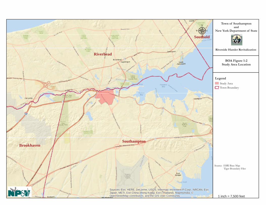
Southampton
Riverhead
Brookhaven
Southold
Sources: Esri, HERE, DeLorme, USGS, Intermap, increment P Corp., NRCAN, EsriJapan, METI, Esri China (Hong Kong), Esri (Thailand), MapmyIndia, ©OpenStreetMap contributors, and the GIS User Community
Town of Southamptonand
New York Department of State
Riverside Hamlet Revitalization
μ
Legend
Study AreaTown Boundary
Source: ESRI Base Map Tiger Boundary Files
1 inch = 7,500 feet
BOA Figure 1-2Study Area Location

Southampton
Riverhead
Sources: Esri, HERE, DeLorme, USGS, Intermap, increment P Corp., NRCAN, EsriJapan, METI, Esri China (Hong Kong), Esri (Thailand), TomTom, MapmyIndia, ©OpenStreetMap contributors, and the GIS User Community
Town of Southamptonand
New York Department of State
Riverside Hamlet Revitalization
μ
Legend
Study AreaTown Boundary
Source: ESRI Base Map Tiger Boundary Files
1 inch = 800 feet
BOA Figure 1-3Proposed BOA Boundary/
Study Area

Hamlet of Riverside BOA Step II Nomination Study
Page 9 of 155
Table 1-1 provides a summary of economic distress indicators for Riverside as compared with two other distressed communities in Suffolk County (Gordon Heights and Wyandanch) which are ranked as the 2nd and 3rd most distressed, respectively.
Table 1-1
EXCERPT OF ECONOMIC DISTRESS INDICATORS, 2008-2012, SUFFOLK COUNTY
Economically Distressed
Communities
% w/public Assistance
Income
% High School
Graduates
% Below Poverty Level
Median Household
Income
% Unemployment
Median Housing
Value
Overall Rank
Riverside 7.05% 63.34% 24.59% $33,308 18.39% $73,900 1 Gordon Heights 8.65% 85.17% 22.18% $56,157 14.46% $281,600 2 Wyandanch 11.78% 75.75% 13.99% $53,948 9.93% $270,000 3 Source: U. S. Census Bureau (2008-2012 American Community Survey) and Suffolk County Planning Based upon these data, Riverside has significantly higher unemployment (nearly 4% higher than Gordon Heights) and a substantially lower median income (over $20,000 less than Wyandanch), but comparatively fewer residents receive public assistance income. The Riverside CDP is the only community within Suffolk County with a median home value below $200,000. The median home value reported in the economic distress indicators data was $73,900. The community with the second lowest median housing value in Suffolk County was Mastic Beach, which at the time had a median home value of $224,900, or more than three times that of Riverside. In addition to the data that document the socioeconomic distress of its residents, 15 potential brownfield sites had been identified within the Riverside community at the time the BOA grant application was submitted to the NYSDOS, and many underutilized and vacant properties exist presently that contribute to disinvestment in the community and blight conditions. As per the results of this Study, 20 sites of environmental concern have now been documented. The RRAP cites the lack of long term solutions to support community revitalization which has resulted in a general disinterest on the part of the business community to invest in Riverside. In addition, the RRAP alludes to the lack of essential infrastructure, housing options, community services, and easy access to food and goods. The end result is a struggling local economy, lack of jobs and few opportunities for upward social mobility. The RRAP also notes that investment in the community is significantly hampered by zoning and infrastructure deficiencies that limit the ability of land to be used to its highest and best use. 1.2.1 Previous Planning Studies A number of planning studies relevant to the Riverside community have been prepared over the past several decades and all recognize the need for redevelopment and revitalization. In general, recommendations for redevelopment emphasize a more compact, physically integrated, economically sustainable centralized mixed use hamlet center. The following is a chronological outline of previous Town sponsored plans and land use studies that include or directly target all or part of the Riverside community:

Hamlet of Riverside BOA Step II Nomination Study
Page 10 of 155
• 1970 Town of Southampton Master Plan; • 1999 Comprehensive Plan Update (“Southampton Tomorrow”); • 2004 Flanders/Riverside/Northampton Revitalization Study; • 2006 Riverside Blight Study; • 2008 Riverside Hamlet Plan; and • 2009 Riverside Urban Renewal Plan (including input from the 2006 Blight Study).
Town of Southampton Master Plan (McCrosky-Reuter, 1970) The 1970 Master Plan established long-range Town-wide planning recommendations. The following provides excerpts from the Master Plan recommendations related to Riverside:
• The Future Land Use Plan depicts the area as largely residential. • Residential development near [Riverhead’s] downtown will be the densest in order to establish a
cohesive neighborhood offering various housing types and accessibility to shopping, business, transportation and jobs, and nearby utility services.
• In the case of the Riverside business district, there is need for a major land use redevelopment to improve the traffic circulation [most specifically, the traffic circle], off-street parking, and the general quality of the district. This redevelopment should also include programs for housing and neighborhood improvements.
• Since [the existing and future hamlet business districts, including Riverside] are centrally located with respect to the principal centers of residential development, existing and proposed, the Master Plan emphasizes their expansion rather than the creation of major new centers. As a result of the smaller parcels in these older Village Business areas, increased off-street parking facilities and truck loading areas will be needed to meet future demands. It was anticipated that in the unincorporated areas the town would need to take the initiative due to the limited size and poor arrangement of land parcels in order to make it possible to provide coordination of layout, access points and overall design of improvements and landscaping.
• The area of blight has a fairly extensive spread and will require concerted effort by several levels of government and private owners together with support from the community at large.
The 1970 Master Plan also recommended expanding and/or preserving open space in the area for the creation of parks as well as groundwater protection and suggested various roadway improvements including modifications to the traffic circle. Comprehensive Plan Update (“Southampton Tomorrow”) (Land Ethics, 1999) The Comprehensive Plan Update recommended that a major hamlet center similar to, but smaller than, existing village/town centers, with shopping centers and retail corridors be created in Riverside using PDD zoning. The Update indicated that hamlet centers should:
• Combine convenience, destination, and specialty shopping, and therefore serve larger portions of the town;
• Promote streetscape improvements unique to each hamlet/village center’s themes and assets, through zoning guidelines, Planned Development District (PDD) guidelines, design guidelines, Capital Improvement Projects (CIP), etc.;
• Focus landscape and other improvements on critical vistas which shape the image of hamlet/village centers;
• Retain or promote train stations, bus and jitney stops, beach shuttles, and other public transportation elements in the hamlet/village centers;

Hamlet of Riverside BOA Step II Nomination Study
Page 11 of 155
• Carefully consider how arterial access to hamlet/village centers can be improved without compromising on-street parking, the tranquility of adjoining neighborhoods, and pedestrian ambiance;
• Provide parking waiver fees in order to keep pace with inflation; • Pursue on-street parking, sidewalk extensions, pedestrian-oriented lighting, street trees, traffic
lights, and consistent building setbacks so as to create a pedestrian ambiance in hamlet/village centers;
• Target hamlet/village centers for TDR, PDD, MX zoning, and infill zoning (zero-lot line and 100 percent coverage) so as to promote concentration of uses in these centers;
• Target hamlet/village centers for civic and Town facilities and amenities, including “greens” and pocket parks;
• Explore the options of establishing Business Improvement Districts in one or several of the hamlet/village centers.
The 1999 Update recommended that the following land use action items be applied to the center of the Study Area (which was the former drive-in movie theater and is identified as the Southampton Enterprise Zone property).
• Promote commercial/industrial development at the former drive-in site, ideally incorporating adjoining vacant and underutilized property.
• Consider a supermarket (but not a conventional shopping center) as one of the uses. • The development should place priority on landscaping and buffers, especially proximate to an
adjoining school, which might benefit from expansion in this direction. The Comprehensive Plan Update also stated that low density residential development should be established within the Aquifer Protection Overlay District. In addition, the Plan noted that 47.5 acres of land within the Study Area had been designated as Central Pine Barrens transfer of development rights (TDR) receiving areas, indicating that additional development density can and should be provided in the area. The Flanders/Riverside/Northampton Revitalization Study (Ferrandino & Associates, et al, 2004) This study addressed a wide variety of issues relating to land development, community growth and revitalization, and resource protection. It also provided some specific guidelines for the future development of the central portion of the Study Area as the Riverside Hamlet Center. Recommendations focus on creating a hamlet center that would host local level retail and commercial uses with pedestrian connections, as well as second story residential components to create a 24-hour vibrant space. The Blight Study for the Riverside Study Area (Saccardi & Schiff, Inc., 2006) A Blight Study was prepared by Saccardi and Schiff, Inc. for the Town of Southampton Department of Housing regarding the Riverside Study Area in November of 2006. The purpose of the study was to analyze the existing conditions by utilizing field inspections, aerial photographs, and Town building safety data. The Blight Study included a review of 157 lots including 86 residential, 1 public land use, 17 commercial, 46 vacant, 4 rights of way, and 2 religious uses. During the survey, numerous conditions indicating blight were observed including deteriorated private properties, inadequate maintenance of buildings and surrounding yards, vacant buildings, over-crowded housing, non-conforming uses, and lots of irregular shape

Hamlet of Riverside BOA Step II Nomination Study
Page 12 of 155
and inadequate size. The study concluded that there is significant blight which warranted the preparation of a redevelopment plan in Riverside. A number of sites that were identified by NP&V as Sites of Environmental Concern (discussed in Section 3.0 of this Nomination) were also identified in the Blight Study. Descriptions of the sites identified in the Blight Study that are relevant to this BOA are included in Section 3.2.2 Brownfield, Abandoned, and Vacant Sites. Draft Riverside Hamlet Center Plan: A Vision for the Future (Hutton Associates, 2008) The draft Riverside Hamlet Center Plan was a follow-up to the Flanders/Riverside/Northampton Revitalization Study. The Hamlet Plan recommended the creation of a “Riverside Hamlet Center Mixed-Use Planned Development District” (MUPDD) at the center of the current Study Area on the Southampton Enterprise Zone industrial subdivision property and the 12.5-acre woodlands that is adjacent to the west of the subdivision. The MUPDD was to involve a change of zone on a total of 32 separate but contiguous Suffolk County tax lots totaling 53.3 acres from Highway Business (HB), R-15, and LI-40 to a unified MUPDD. The MUPDD was to consist of three separate blocks or zoning district subsections (Blocks, I, II, and III) and a fourth optional overlay block (Block IIa) which was to be governed by specific land management regulations and design guidelines that were specifically tailored toward each block. Types of land uses that had been contemplated for the MUPDD included a mix of multi-family residences, commercial retail, personal services, restaurants, offices, community facilities, warehouses, light industry, and open space in the form of two plazas and/or small Hamlet greens, again suggesting the need to establish a more vibrant mixed use hamlet business district. Consideration of safe and convenient public access and circulation were also significant components of the plan, and included the development of new and modified road improvements and other public infrastructure, services and facilities to serve a more dense mixed use community. The Riverside Hamlet Center Plan and associated zoning amendments were not adopted by the Town. Riverside Urban Renewal Plan (Saccardi & Schiff, Inc., 2009) The Study Area for this plan involved approximately 93 acres extending from the rear lot lines of parcels fronting on the south side of SR 24 to the intersection of Riverleigh Avenue and Old Quogue Road and included properties fronting on the east side of Old Quogue Road to Brown Street and Ludlam Avenue Park, as well as properties fronting on the west side of Riverleigh Avenue from the traffic circle south to the church and MacLeod Mobile Home Park (see image below). The purpose and objectives of the Urban Renewal Plan (URP) was to provide a strategy for:
• reinforcing a sense of community and neighborhood identity; • eliminating blight conditions defined in the 2006 Blight Study; • rehabilitating certain residential properties; • redeveloping vacant, deteriorating or deteriorated buildings, incompatible land uses or
underutilized properties with residential, community and commercial uses consistent with the area’s desired neighborhood character;
• providing local commercial uses to meet resident’s needs;

Hamlet of Riverside BOA Step II Nomination Study
Page 13 of 155
• expanding the property tax base and providing additional employment opportunities; • developing land uses within the project area that can complement and benefit from the proposed
Riverside Hamlet Center, which is adjacent to the project area; • improving vehicle and pedestrian circulation and safety within the project area and creating
connections to the adjacent proposed Riverside Hamlet Center; and • facilitating the creation of a Gateway Center that concentrates residential and nonresidential
development and brings a focal point to the project area.
Source: Riverside Urban Renewal Plan
General recommendations of the URP included:
• acquiring and assembling blighted properties for redevelopment; • rezoning certain parcels; • securing funding and providing certain capital improvements such as extensions and realignments
of streets, new sidewalks, curbing, crosswalks, lighting, and other streetscape features in selected locations in the project area. This included construction of a road from Old Quogue Road into the

Hamlet of Riverside BOA Step II Nomination Study
Page 14 of 155
Hamlet Center, realigning Old Quogue Road and Riverleigh Avenue, and incorporating the southern end of the Old Quogue Road right-of-way into Ludlam Avenue Park; and
• establishing site-specific design and performance standards for the two large commercial uses in the area – the former auto dealer site, and the existing motel and diner site.
Following the preparation of the URP, the Town rezoned several areas to promote redevelopment of key sites. However, there has been little change in the area in recent years. 1.2.2 Brownfield Sites The primary community revitalization objectives to be achieved by this project include identification and remediation of brownfield sites, identification of strategic sites (i.e., sites in most need of and most suited for initial development/redevelopment to catalyze revitalization), blight removal, infrastructure upgrades, and the attraction of new commercial uses to the area that will provide needed goods, services and jobs to the community, along with tax ratables to alleviate the hamlet’s heavy school tax burden. Sites believed to be contributing to the blighted conditions or that are known to or may be environmentally impacted within the Riverside community were identified as part of the grant application based upon prior land use, such as those with existing and abandoned automotive uses, vacant sites where illegal dumping activity had been observed. As described in detail in Section 3.2.2 of this Study, a preliminary inventory and assessment of properties that may have been adversely affected by past land use activities or that may currently pose risks to the environment due to site uses or known handling, storage, spills, leaks or disposal of hazardous materials was conducted. Based on the evaluation, seventeen (17) sites were identified as having past or present environmental issues. In addition, three (3) sites have been identified as potential brownfield sites based on observations or information provided by other agencies (including tax delinquent properties, condemned buildings and land uses with potential for contamination). Figure 1-4 shows the locations of these sites based on the Map ID number provided with each description and Table 1-2 provides a summary of the sites, area, expected level of environmental concern/risk based upon the past land use and review of available resources. The BOA Boundary has been selected based on the location of the sites of environmental concern, which are located throughout the Riverside hamlet, and specifically found along Peconic Avenue, Flanders Road, Riverleigh Avenue, Old Quogue Road, and Ludlam Avenue. The BOA Boundary includes the residential neighborhoods which are affected by their adjacency to these sites, and the boundary is also defined in major part by natural features including the Peconic River, Little Peconic River, and Black Creek Pond; the Central Pine Barrens Core Preservation Area/Compatible growth Area boundary; the Southampton/Riverhead municipal border; and Whitebrook Drive. The implications of having abandoned, vacant and underutilized properties within the community are expressed in the indicators of economic distress identified in Section 1.2 above.

Flanders Rd
Riverleigh AveLu
dlam
Ave
Old Q
uogue Rd
Park Pl
Lake
Ave
Vail
Ave
Pond DrR
oad
D
Woo
dhul
l Ave
Brown St
Phill
ips A
ve
Pond
Ln
Pebb
le W
ay
Road
B
Woodland Dr
Pine St
Elm StBirch St
Roa
d H
Cedar St
Goodridge Ave
Pegs Ln
Oak St
Randall St
Kirk
Ave
Pine Grove StDogwood St Maple P
l
Northwoods Ln
Ente
rpris
e Zon
e D
r
Maynard Ave
Don
ald
Ave
Van Houten St
Peco
nic A
ve
Oak Ct
Whi
te B
rook
Dr
TEC-9
TEC-8
TEC-7
TEC-6TEC-5
TEC-4TEC-3
TEC-2
TEC-1
TEC-20
TEC-19
TEC-18
TEC-16
TEC-14
TEC-13TEC-12
TEC-11
TEC-10
Source: Esri, DigitalGlobe, GeoEye, Earthstar Geographics, CNES/Airbus DS, USDA, USGS, AEX, Getmapping, Aerogrid, IGN, IGP,swisstopo, and the GIS User Community, Esri, HERE, DeLorme, MapmyIndia, © OpenStreetMap contributors, and the GIS usercommunity
Town of Southamptonand
New York State Department of State
Riverside Hamlet Revitalization
8
Legend
StudyArea
Sites of Environmental Concern
Tax Parcels
Source: SC Real Property; NYS GIS, 2013 Aerial
1 inch = 500 feet
BOA Figure 1-4Sites of
Environmental Concern

Hamlet of Riverside BOA Step II Nomination Study
Page 16 of 155
Table 1-2 STUDY AREA SITES OF ENVIRONMENTAL CONCERN
Site ID Address Acres Risk Tax Map ID EC-1 89 Peconic Ave 0.7 M 900-118-2-2 EC-2 7 Peconic Ave 0.4 H 900-118-2-4 EC-3 8 Lake Ave 0.3 H 900-138-1-104.001 EC-4 30 East Moriches Rd 0.9 L-M 900-138-2-30 EC-5 11 Flanders Rd 0.8 H 900-138-2-32 EC-6 35 Flanders Rd 0.3 M 900-138-2-33 EC-7 104 Flanders Rd 0.1 M 900-118-2-10 EC-8 113 Flanders Rd 0.2 M 900-139-1-72 EC-9 308 Riverleigh Ave 0.5 M 900-139-1-48.001 EC-10 454 Riverleigh Ave 1.9 M-H 900-139-2-54.001 EC-11 500 Riverleigh Ave 2.5 M 900-139-2-050.002 EC-12 568 Riverleigh Ave 0.3 M 900-140-1-10 EC-13 182 Old Quogue Rd 0.6 H 900-140-2-71.001 EC-14 219-223 Flanders Rd 1.3 M-H 900-139-3-52 EC-15 301 Flanders Rd 0.5 H 900-141-2-2 EC-16 415 Flanders Rd 0.6 H 900-141-2-3 EC-17 117 Ludlam Ave 1.4 M-H 900-141-2-36.003 EC-18 97 Old Quogue Rd 0.3 --- 900-139-2-45 EC-19 48 Old Quogue Rd 0.2 --- 900-139-3-20.002 EC-20 98 Quogue Rd 0.5 M-H 900-139-3-37 Risk – L-Low; M-Medium; H-High.

Hamlet of Riverside BOA Step II Nomination Study
Page 17 of 155
1.3 Community Vision and Goals and Objectives Renaissance Downtown has worked collaboratively with the Town DLM to oversee the community participation process for the preparation of this BOA Study and the RRAP with the assistance of a community liaison, Ms. Siris Barrios. Ms. Barrios and members of RD and the Town DLM have worked continuously with the community since the summer of 2014 in the development of the RRAP. The outreach that has occurred to obtain the community input has informed the preparation of this BOA Study, and resulted in an expression of the community’s vision for the future. The RRAP, in conjunction with the adopted ROD Zoning and this BOA, seek to provide a blueprint for addressing various challenges, while capitalizing upon the community’s strong desire to include a mix of retail stores, service-related businesses, restaurants and diverse housing options, along with improved transportation, infrastructure, pedestrian pathways, public green spaces and access to the Peconic River throughout the Riverside hamlet area. The overall Vision Statement for the Riverside Revitalization Plan is to:
• Position Riverside as a Gateway of the Town, retain and attract a diverse and multicultural
population that includes young professionals and members of the innovation and knowledge economies to promote the Town as a preeminent regional destination.
• Create a true sense of place, utilizing smart growth and sustainable development principles that meet the needs of current residents and attract future residents and businesses.
• Facilitate the creation of a mixed use and walkable Gateway Center to enhance the vibrancy of the Riverside Hamlet Center and create a diversity of uses (to live, work, shop, learn, and play).
• Complement Riverhead’s downtown area and leverage the proximity of the Long Island Rail Road station and availability of bus service.
• Reinforce a sense of community and neighborhood identity.
• Enhance the character and overall visual environment of the Project Area.

Hamlet of Riverside BOA Step II Nomination Study
Page 18 of 155
• Promote housing choices with a broad range of housing types and price points including attainable and market-rate housing options.
• Expand the property tax base and provide additional employment opportunities.
• Incorporate municipally owned property located within the Project Area to achieve an effective redevelopment strategy; and provide an avenue for private property owners to partner with the public sector and RD to foster the redevelopment of underutilized assets for the benefit of both themselves and the community.
• Leverage existing assets and proximity to maritime resources along the Peconic waterfront, natural assets, recreation areas, preserved open spaces of the Pine Barrens region, and proximity to Riverhead’s downtown area.
• Attract business, residents and visitors to stimulate the local economy and position Riverside as a tourist destination with access to both the north and south forks and the many assets they possess.
(RRAP, July 2015, Page 15) The RRAP describes in detail the implementation methods to achieve the goals expressed above. The BOA Step II Nomination Study informs and facilitates achievement of the above vision statement, as well as the goals and objectives expressed in the RRAP. The BOA Study and the Generic Environmental Impact Statement supplement the RRAP by focusing on specific land use issues, regulatory constraints, and development opportunities; and provides initial steps and implementation measures towards actualization of the above goals and objectives. Specific goals and objectives of the BOA Study are to:
• Delineate the boundaries of the BOA based on a rational examination of existing conditions, natural and man-made boundaries, and community issues, assets, opportunities and needs;
• Inventory existing land uses, development patterns, capital infrastructure and environmental conditions within the BOA, and along with information from past studies and community visioning processes, identify existing brownfield sites, blighted or abandoned buildings, long-term vacant and underutilized properties, and other issues and obstacles that discourage economic development, contribute to poverty and inadequate housing, may support or promote illegal activity and other negative social conditions, create an undesirable sense of place and community, and impede proper functioning of the hamlet as a whole;
• Determine priority sites for remediation and redevelopment based on past community visioning and planning studies, existing zoning standards, theoretical development programming, lot size(s), property ownership (i.e., public or private), access, site visibility, environmental conditions, and other factors;
• Identify the specific issues of concerns relating to strategic sites, and determine opportunities for redevelopment of key properties in order to stimulate and support positive change and achieve the goals and objectives of the RRAP, ROD and this BOA Study.
• Summarize key findings and implementation strategies in a logical and concise manner to facilitate plan implementation.
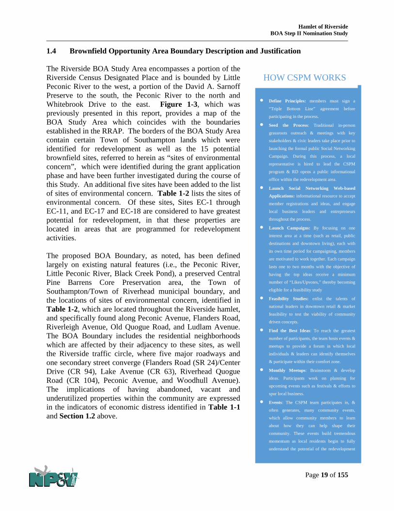
Hamlet of Riverside BOA Step II Nomination Study
Page 19 of 155
• Define Principles: members must sign a
“Triple Bottom Line” agreement before
participating in the process.
• Seed the Process: Traditional in-person
grassroots outreach & meetings with key
stakeholders & civic leaders take place prior to
launching the formal public Social Networking
Campaign. During this process, a local
representative is hired to lead the CSPM
program & RD opens a public informational
office within the redevelopment area.
• Launch Social Networking Web-based
Applications: informational resource to accept
member registrations and ideas, and engage
local business leaders and entrepreneurs
throughout the process.
• Launch Campaigns: By focusing on one
interest area at a time (such as retail, public
destinations and downtown living), each with
its own time period for campaigning, members
are motivated to work together. Each campaign
lasts one to two months with the objective of
having the top ideas receive a minimum
number of “Likes/Upvotes,” thereby becoming
eligible for a feasibility study
• Feasibility Studies: enlist the talents of
national leaders in downtown retail & market
feasibility to test the viability of community
driven concepts.
• Find the Best Ideas: To reach the greatest
number of participants, the team hosts events &
meetups to provide a forum in which local
individuals & leaders can identify themselves
& participate within their comfort zone.
• Monthly Meetups: Brainstorm & develop
ideas. Participants work on planning for
upcoming events such as festivals & efforts to
spur local business.
• Events: The CSPM team participates in, &
often generates, many community events,
which allow community members to learn
about how they can help shape their
community. These events build tremendous
momentum as local residents begin to fully
understand the potential of the redevelopment
HOW CSPM WORKS
1.4 Brownfield Opportunity Area Boundary Description and Justification The Riverside BOA Study Area encompasses a portion of the Riverside Census Designated Place and is bounded by Little Peconic River to the west, a portion of the David A. Sarnoff Preserve to the south, the Peconic River to the north and Whitebrook Drive to the east. Figure 1-3, which was previously presented in this report, provides a map of the BOA Study Area which coincides with the boundaries established in the RRAP. The borders of the BOA Study Area contain certain Town of Southampton lands which were identified for redevelopment as well as the 15 potential brownfield sites, referred to herein as “sites of environmental concern”, which were identified during the grant application phase and have been further investigated during the course of this Study. An additional five sites have been added to the list of sites of environmental concern. Table 1-2 lists the sites of environmental concern. Of these sites, Sites EC-1 through EC-11, and EC-17 and EC-18 are considered to have greatest potential for redevelopment, in that these properties are located in areas that are programmed for redevelopment activities. The proposed BOA Boundary, as noted, has been defined largely on existing natural features (i.e., the Peconic River, Little Peconic River, Black Creek Pond), a preserved Central Pine Barrens Core Preservation area, the Town of Southampton/Town of Riverhead municipal boundary, and the locations of sites of environmental concern, identified in Table 1-2, which are located throughout the Riverside hamlet, and specifically found along Peconic Avenue, Flanders Road, Riverleigh Avenue, Old Quogue Road, and Ludlam Avenue. The BOA Boundary includes the residential neighborhoods which are affected by their adjacency to these sites, as well the Riverside traffic circle, where five major roadways and one secondary street converge (Flanders Road (SR 24)/Center Drive (CR 94), Lake Avenue (CR 63), Riverhead Quogue Road (CR 104), Peconic Avenue, and Woodhull Avenue). The implications of having abandoned, vacant and underutilized properties within the community are expressed in the indicators of economic distress identified in Table 1-1 and Section 1.2 above.

Hamlet of Riverside BOA Step II Nomination Study
Page 20 of 155
2.0 COMMUNITY PARTICIPATION PLAN AND TECHNIQUES TO ENLIST PARTNERS
2.1 Community Outreach Plan This section provides a summary of the community outreach, techniques, input and results that were employed in the development of the RRAP and this BOA Step II Study. The Town established an Advisory Committee made up of staff from various Town departments to provide input on the BOA Nomination Study. In addition to the Advisory Committee, continuous coordination between the Town, Master Developer, and the local representative to lead the Crowd Source Place Making (CSPM) effort occurred. The CSPM process is guided by the principles of Social, Environmental, and Economic responsibility which are emphasized to community members that participate in the process. CSPM utilizes in-person meetings and internet-based tools to allow community members to upload and vote on ideas, uses, retail concepts, types of commercial/retail tenants, and amenities. Since the summer of 2014, RD has employed a full time outreach coordinator to work with the community on this project. A community based office was established to encourage community participation and provide a base for the CSPM efforts. During the process, a number of methods were utilized to reach as many people within the community as possible, including population segments that normally do not participate in official meetings. RD employs social media and networking tools that include proprietary web-based applications designed to engage the community in meaningful dialogue, which is essential to the planning and implementation process. The sidebar provides an overview of how CSPM is conducted by RD. Because the community provided so much valuable input to develop the vision for the community - this process served as the basis for community outreach for the BOA Study. In coordination with RD and the Advisory Committee, additional outreach occurred following the preparation of the Action Plan. Because of the overlapping and complementary purposes of the BOA program and revitalization action process, this BOA Study relies on the community participation process held to develop the RRAP. The following provides an overview of the CSPM that has occurred in Riverside since the summer of 2014.
• In the summer of 2014 Renaissance Downtowns opened a CSPM Community Office at 108 Peconic Avenue and hired a community liaison to better understand the collective values and vision of residents for the redevelopment plans. Riverside Rediscovered (RR) officially began in August 2014 at a kick-off community meeting in the presence of Town officials, by a vote of about 50 residents in attendance.
• Hosting the monthly meet-ups exclusively in Riverside has significantly increased resident participation. During this period, RD talked to over 500 residents face-to-face and conducted special outreach with local pastors and congregations in order to reach a wide audience.

Hamlet of Riverside BOA Step II Nomination Study
Page 21 of 155
• Door knocking: A major component of the outreach effort included walking the community and literally going door to door to speak to residents of Riverside. During this process, RD witnessed firsthand the living conditions of residents and the existing range of housing types and conditions.
• The Riverside Rediscovered website (http://riversiderediscovered.com/) was launched in August 2014 and quickly revealed the digital divide in the community. As a result of a significant amount of face-to-face outreach, the website has achieved 150 registered users online. During this period, RD also launched a Riverside Rediscovered Facebook Page (with 207 “likes”), a Riverside Rediscovered Community Liaison personal page (583 “friends”) and a twitter account (40 followers).
• Schedule: o Riverside Rediscovered Monthly Meetups: October 2014 – April 2015 At the first monthly meetup in October of 2014, residents came together to state their
concerns and desire to make Riverside a socioeconomically vibrant place to live, work, and play. Round table discussions revealed that residents want to preserve the natural beauty of the area, while also encouraging businesses and services to meet the needs of residents.
Community Asset Mapping: At the second monthly meetup, members engaged in a community asset mapping exercise. Participants were asked to answer twelve key questions that identified the places they go to for groceries, dining out, socializing, health care, arts and recreation. The results are clear: Riverside residents are forced to travel, often far, to fulfill their wants and needs. This clearly demonstrates the near total lack of assets and amenities within the community and the need for an injection of new activity.
At the second monthly meetup, members engaged in a crime and safety mapping exercise. Residents identified issues in the built environment such as poor lighting, unsafe crosswalks, dilapidated buildings and unkempt properties as well as social issues such as homelessness, crime, prostitution and drug use that will be addressed through the revitalization of the community.
During the third monthly meetup, the “Ideas” campaign was launched and the concept of WaterFire on the Peconic was presented. Residents were asked to post their ideas online or visit the Community Office to document their ideas with the Community Liaison.
At the fourth meetup, Riverside Rediscovered presented a summary of the outreach efforts conducted so far and updated residents on the ideas that had been presented. Residents expressed their concern for affordability and desire for development that considers economic realities in Riverside.
The fifth meetup featured a presentation regarding architectural styles which made residents enthusiastic about creating an aesthetic downtown to promote Riverside as a unique destination. The “Idea” Action Plan Campaign was also launched at this meeting.
The sixth meetup provided residents with an update on the Idea Action Plan Campaign and encouraged residents to help their family, friends, and neighbors cast their “Like Ideas” with paper ballots (see more below).
o Door Knocking: September 2014 - November 2014, and March 2015 – April 2015 o One on One Meetings: August 2014 – August 2015 o CSPM Online Campaigns: November 2014 – August 2015
• In March 2015 the Children's Museum of the East End (CMEE) began an eight (8) week pilot program for children between the ages of 2 and 5. The sessions were filled within 24 hours of the announcement, with children from Riverside, Flanders, Northampton, Hampton Bay, Tuckahoe and Westhampton all taking part. The “Museum without Walls” Riverside experiment has proven without a doubt that the community and the rest of the Town of Southampton can and will come together in Riverside if quality programming and quality space is offered. The program was such a success that the CMEE recently approached Riverside Rediscovered about offering

Hamlet of Riverside BOA Step II Nomination Study
Page 22 of 155
the program again in the Riverside community and with the offer to fund the program. If there is continued interest and participation, a permanent home for a children’s museum in the community can be explored.
Top Ideas from the ‘Liking’ System on Facebook and paper ballots were defined as ideas with at least 100 “Likes” at the completion of the RRAP and are listed below (these tallies were as of completion of the RRAP in July 2015 - visitors to the website continue to provide input)3:
• Shuttle Bus Service – Downtown Riverhead (157 Likes), • Southampton Boardwalk (157 Likes), • Water Fire (151 Likes), • Water Fountain/Ice Rink (147 Likes), • Indoor Recreation Center (131 Likes), • Modern Movie Theater (130 Likes), • Riverside Row Restaurants (119 Likes), • Waterfront Green Spaces (110 Likes), • Riverside Park Maritime Trail (109 Likes), • Quality and Affordable Supermarket (108 Likes), • Healthy Village (107 Likes), • Farmers Market Food Mart (103 Likes), • Zip Code for Riverside, Flanders, and Northampton (103 Likes), • Children’s Museum (101 Likes).
The CSPM process utilized in development of the RRAP recommends that the Top Ideas be analyzed to determine if the project is socially, economically, and environmentally feasible. After the feasibility studies, it is recommended that an Implementation Team be established consisting of community supporters and representatives of both public and private sectors. There are examples of how these initiatives have already begun (including the CMEE initiative discussed above). WaterFire International is exploring the feasibility of a WaterFire installation on the Peconic River and is actively preparing a Creative Placemaking Plan utilizing funds provided through the BOA Program that will help inform decision-making and provide supporting analysis for the area as a whole to support large scale community events. A new organization, Waterfire Peconic, is now a registered non-profit organization with New York State and has applied for federal 501(c) nonprofit status to allow tax deductible contributions. In the meantime, the Flanders, Riverside, and Northampton Community Association (FRNCA) has approved a resolution to act as the financial sponsor so that tax deductible contributions to WaterFire may be collected through FRNCA. 2.2 Techniques to Enlist Partners The key to implementation of the recommendations of the BOA Nomination Study - and specifically in this case, adoption of the RRAP and Zoning Amendments to support redevelopment - was intensive outreach to build commitment from agencies and community 3 As of September 29, 2015, the Riverside Rediscovered Liaison’s Facebook Community is at 609 people and the Riverside Facebook Page has 260 ‘likes’.

Hamlet of Riverside BOA Step II Nomination Study
Page 23 of 155
service providers and thereby enlisting partners for the actual revitalization to occur following adoption of the new zoning regulations. Early in the process, letters were sent to community service providers and agencies with permitting authority. The letters included a description of the revitalization program and a request to meet for agency input. Outreach also included presentations to each of the involved Town departments and Boards to maximize awareness and understanding of the importance of success of the revitalization of Riverside. The results of these agency discussions are reflected in the inventory and analysis section of this Step II BOA Study. An Advisory Committee was established to assist in the preparation and review of the RRAP and BOA. The Committee included numerous representatives from the Town, NP&V, and Renaissance Downtowns. The individual members on the Advisory Committee as well as their titles are listed in Table 2-2.
Table 2-2 ADVISORY COMMITTEE MEMBERS
Town Working Group
Christine Scalera Councilperson
Bradley Bender Councilperson
Frank Zappone Deputy Town Supervisor
Kyle Collins Planning & Development Administrator
David Wilcox Director of Planning
Town Sub Group
Kathleen Murray Deputy Town Attorney
Christine Fetten Director of Municipal Works
John LaRosa Assistant Town Engineer
Janice Scherer Principal Planner
Tom Neely Director of Public Transportation & Traffic Safety
Janice Wilson Chief Legislative Aide
Colleen Jones Graphic Supervisor
Nelson, Pope and Voorhis
Carrie O’Farrell Senior Partner
Kathryn Eiseman Partner
Renaissance Working Group
Sean McLean VP Planning and Development
Ela Dokonal Director of Planning
Brandon Palanker Marketing and PR
Darren Monti Project Manager
Siris Barrios Community Liaison

Hamlet of Riverside BOA Step II Nomination Study
Page 24 of 155
The Advisory Committee conducted numerous meetings, including outreach meetings, community and community services meetings, and committee meetings, throughout the planning process. The details of each meeting are described in the table below.
Table 2-3
RIVERSIDE BOA/RRAP ADVISORY COMMITTEE MEETINGS
Date Meeting Purpose and Attendees Location
Oct. 17, 2014 BOA/RRAP Steering Committee Meeting Kyle, Dave, Frank, Kathleen, Janice W., Sean, Ela
Town Hall
Oct. 22, 2014
BOA / RRAP Steering Committee Meeting Kick Off Meeting with DOS David A., Kyle, Dave, Frank, Kathleen, Janice W., Sean, Ela, Darren M., Brian P
Riverside Rediscovered
Oct 27, 2014
Meeting with community resident Discussion about traffic circle modifications and pedestrian bridge Kyle, Dave, Chris Sheldon
Town Hall
Dec 12, 2014 BOA / RRAP Steering Committee Meeting Kyle, Dave, Frank, Kathleen, Janice W., Sean, Ela
Town Hall
Feb. 27, 2015 BOA / RRAP Steering Committee Meeting Review draft zoning proposals Kyle, Dave, Janice S., Kathleen
Town Hall
March 13, 2015 BOA / RRAP Steering Committee Meeting Kyle, Dave, Frank, Janice S., Kathleen, Janice W., Christine, Tom, Sean, Ela
Town Hall
March 20, 2015 BOA / RRAP Steering Committee Meeting Kyle, Dave, Janice S., Tom N.
Town Hall
March 26, 2015 BOA / RRAP Steering Committee Meeting Review proposed zoning proposals Kyle, Dave, Janice S., Sean, Ela, Steve
Renaissance Downtown’s Office
April 3, 2015 BOA / RRAP Steering Committee Meeting Interview of respondents to BOA RFP Kyle, Dave, Sean
Town Hall
April 7, 2015
BOA / RRAP Steering Committee Meeting Review and discuss proposals from BOA RFP respondents Kyle, Dave, Janice S., Kathleen M., Sean
Town Hall Conference Call
April 21, 2015 BOA / RRAP Steering Committee Meeting Review and Discuss Draft RRAP Kyle, Dave, Janice S., Janice W.
Town Hall
July 1, 2015
BOA / RRAP Steering Committee Meeting Review and Discuss Draft RRAP Kyle, Dave, Janice S., Kathleen M., Sean, Ela, Kathy E., Carrie, Chic & 2 traffic consultants from N&P (Osman Barrie and Matthew Mattera)
Renaissance Downtown’s Office

Hamlet of Riverside BOA Step II Nomination Study
Page 25 of 155
Date Meeting Purpose and Attendees Location
July 17, 2015 BOA / RRAP Steering Committee Meeting Review and Discuss Draft RRAP Kyle, Dave, Kathleen M., Ela, Steve, Ryan P.
Town Hall Conference Call
August 24, 2015 BOA / RRAP Steering Committee Meeting Update meeting with NYS Department of State Dave A., Kyle, Dave, Sean, Kathy E., Carrie O.
Town Hall
August 28, 2015
BOA / RRAP Outreach Meeting Riverhead School District Kyle, Dave, Sean, Carrie O., School Superintendent and 2 others
Riverhead School District
August 28, 2015 BOA / RRAP Outreach Meeting Riverhead Fire District Kyle, Dave, Sean, Carrie O., 3 Fire District Reps
Riverhead Fire Department
Sept 10, 2015
BOA / RRAP Steering Committee Meeting Discuss scheduling Town Board meetings and time for completion of BOA/RRAP and SEQRA Kyle, Dave, Kathleen, Janice W.
Town Hall
Sept 15, 2015 5:00 pm
BOA / RRAP Outreach Meeting Presentation and Update on Plan at regular meeting of Riverside Economic Development Council
Crohan Center
Sept 15, 2015 7:00 pm
BOA / RRAP Outreach Meeting Presentation and Update on Plan at regular meeting of FRNCA (40 attendees)
Crohan Center
Sept 17, 2015
BOA / RRAP Outreach Meeting Presentation of Plan at a regular meeting of the NYS Pine Barrens Commission Kyle, Dave, Sean, Carrie, Siris
Town Hall
Sept 18, 2015
BOA/RRAP Outreach Meeting Town of Southampton Housing Authority Outreach Meeting Kyle, Dave, Sean, Kathy, Housing Authority Reps
Town Hall
Sept 18, 2015
BOA/RRAP Outreach Meeting Town of Southampton Municipal Works Kyle, Sean, Carrie, Christine Fetten, Director of Municipal Works
Town Hall
Sept 18, 2015
BOA/RRAP Outreach Meeting Town of Southampton Police Kyle, Dave, Sean, Carrie, Kathy, Chief Pearce, Captain Schurek
Town Hall
Sept 22, 2015
BOA/RRAP Outreach Meeting Flanders-Northampton Volunteer Ambulance Dave, Sean, Mike, Chief Ehlers, R. Hintze, FNVA Board of Directors
FNVA Headquarters

Hamlet of Riverside BOA Step II Nomination Study
Page 26 of 155
Date Meeting Purpose and Attendees Location
Oct 7, 2015 BOA/RRAP Outreach Meeting Suffolk County Water Authority Kyle, Dave, Sean, Charles, SCWA Reps
SCWA Oakdale Office
Oct 8, 2015 Oct 22, 2015
BOA/RRAP Outreach Meeting Southampton Planning Board Kyle, Sean, Carrie, Planning Board
Town Hall

Hamlet of Riverside BOA Step II Nomination Study
Page 27 of 155
3.0 ANALYSIS OF THE PROPOSED BROWNFIELD OPPORTUNITY AREA 3.1 Community and Regional Setting This section provides a summary and description of the contextual relationship of the BOA Study Area as it relates to the community, the towns of Southampton and Riverhead, and the region. This section will set the stage for the analysis of the BOA Study Area which follows. The Study Area is located south of the Peconic River, east of Little Peconic River, and north of the David A. Sarnoff Preserve - a designated Bird Conservation Area which is one of the largest undisturbed Pine Barrens on Long Island. To the southwest of the Study Area is the Cranberry Bog Nature Preserve, a wooded area with trails surrounding Swezey Pond and a former cranberry bog. All of these nearby resources suggest an environmentally complex and beautiful natural setting. The setting that surrounds the community is idyllic and yet, the community of Riverside is economically depressed, blighted, and home to a community that is dealing with a variety of negative social issues. While some members of the community work hard to maintain their properties, many homes and businesses are in disrepair and yards and vacant properties are strewn with debris and refuse. Numerous buildings are boarded up and some have been vacant for many years. As was summarized in Section 1.0, the Town has been involved in several planning initiatives over the years, some of which resulted in zone changes intended to encourage new development and revitalization. However, little changed in the community through these past efforts and the Town recognized a need for an alternative approach. The Riverside Study Area is home to a total of 1,711 people living in 706 households. As noted, the Riverside CDP area is the most economically distressed community according to the Suffolk County Department of Economic Development and Planning analysis presented in Section 1.0. According to the American Community Survey 5-year estimates, the median home value within the Study Area is just $79,740 (as compared to the median of $383,400 for all of Suffolk County). The population is generally less educated than the residents of the County, with 36.7 percent not having graduated from High School or received an equivalency degree and relatively few (4.5 percent) having a Bachelor’s degree. In comparison, 10.2 percent of Suffolk County’s 25+ population does not have a High School diploma. The median income of the Study Area, at $38,640 is significantly lower than that of Suffolk County at $87,763. In 2013, Riverside had an unemployment rate of 14.6% which was much greater than the County (at 7.4% during that period). Riverside also has a very low labor force participation rate. Labor force participants are classified as individuals who are either working or looking for work. Those who are not participating in the labor force may be retired, or prevented from doing so by disability or school attendance, or they may have been out of work for so long that they have given up on seeking regular employment. In 2013, the labor force participation rate was 25.7% (as compared to 66.1% in Suffolk County). This speaks not only the need for jobs, but also a diversification of the area to revitalize existing commercial markets. All of these factors provide indicators of an economically distressed community, where availability of community benefits related to the revitalization of the area will provide significant tangible benefits to elevate the community as a whole.

Hamlet of Riverside BOA Step II Nomination Study
Page 28 of 155
3.2 Inventory and Analysis 3.2.1 Introduction All planning studies include an inventory and analysis of existing conditions and natural and man-made resources to assist in determining the challenges confronting the community or area. For the current project, this step included undertaking a field inventory, reviewing pertinent materials (e.g., maps, plans, studies, and databases), and gaining an understanding of local issues, opportunities, and constraints. Goals and objectives were then developed to address the challenges identified, all in accordance with an overall vision for future redevelopment as expressed by the community. The Riverside hamlet is surrounded by significant natural resources including the Peconic River and protected open space contained in the nearby Central Pine Barrens. Much of the land surrounding the hamlet is protected open space, including lands held by the Town of Southampton, Suffolk County and the State of New York. These natural assets provide various benefits but can also present constraints to redevelopment due to their unique qualities, importance to the community, and vulnerability to impacts. Much of the land within the BOA is within the Central Pine Barrens Compatible Growth Area, while regulations and conditions related to development in proximity to wetlands and surface water bodies present other limitations. Development in and around the BOA is also complicated by the goals and regulations of special overlay districts and general restrictions related to wastewater treatment, aquifer protection and Wild, Scenic and Recreational River Corridors. Each of these programs or special districts and the related implications for future redevelopment are described in this Study and are discussed in even greater detail throughout the DGEIS. The lack of sufficient infrastructure for treating wastewater in Riverside is perhaps the greatest obstacle to redevelopment and economic growth. Currently, wastewater is collected, treated and disposed through individual on-site septic systems or outdated cesspools. In order to prevent or reduce potential adverse effects of wastewater discharge on the underlying Sole Source Aquifer and the Peconic River and Estuary, limits have been placed on the amount of untreated wastewater that can be generated on individual sites. These limits, imposed by the Suffolk County Sanitary Code (SCSC), are necessary to protect communities and their environmental resources; however, they also limit the development potential of properties in the Study Area. The creation of a sewage treatment plant or “STP” would benefit the Riverside community in numerous ways. An STP would be capable of collectively processing larger volumes of sewage than individual on-site septic systems so that development would not be limited based on wastewater generation, but a new state of the art treatment plant would also be expected to have long-term economic benefits as it would allow more development and local investment, as well as provide environmental benefits by reducing the concentration of certain contaminants such as nitrogen that would otherwise be released into ground and surface waters. The Central Pine Barrens has a significant presence in the hamlet and other area communities and represents the last significant wilderness area on Long Island. It is an important resource that must be protected as it provides many benefits including the recharge of the sole source aquifer which is used as Long Island’s exclusive drinking water supply. The “Central Pine

Hamlet of Riverside BOA Step II Nomination Study
Page 29 of 155
Barrens Comprehensive Land Use Plan” outlines numerous techniques to protect and preserve this important natural resource. The construction of an STP would reduce possible sources of contamination and help to preserve the integrity of the Central Pine Barrens and its many natural functions and resources. There has already been considerable investment in the area and a commitment to revitalization by the Town which has culminated in the current partnership with RD, preparation of the RRAP and ROD to entice redevelopment of the area, and support for redevelopment through interagency coordination to achieve partnerships and buy-in that is necessary to achieve the level of redevelopment appropriate for ensuring future success. 3.2.2 Land Use and Zoning Introduction Land use and zoning are core issues that must be thoroughly analyzed and addressed in order to achieve Riverside’s redevelopment and revitalization goals. There are several basic characteristics that define land use conditions in the Riverside community. These include:
• the hamlet’s close association with downtown Riverhead; the clear and present need to eliminate poverty, vacant and boarded-up buildings, and widespread blight through local investment, economic development, job creation, and area revitalization;
• the area’s abundant and critically important natural resources and preserved open spaces; • existing haphazard development patterns, the overall poor condition of the man-made
environment, and limited aesthetic character; • the multitude of zoning districts and the ineffective mix of land uses and conditions they
have fostered; and • a general inability for the physical community to function as a cohesive, successful and
sustainable community. Brownfield sites or “sites of environmental concern” are especially noteworthy as they provide opportunities for cleaning up hazardous sites, restoring natural conditions and/or reclaiming land for productive use that can spur further investment and community revitalization. Inventory and Analysis of Land Use The Riverside hamlet (i.e., Riverside Census Designated Place or “CDP”) encompasses a total land area of 5.2 square miles of which 5.1 square miles is uplands and 0.1 square miles is underwater land and a significant portion of its area is preserved open space. The Riverside BOA, itself, consists of 467.6 acres or about 0.73 square miles. The communities of Riverside and downtown Riverhead are closely related by several factors that go beyond their obvious geographic proximity and sharing of the Peconic River and associated resources. For example, Riverside is served by the Riverhead School District, Riverhead Library District and Riverhead Fire District, and falls within the Riverhead postal district, and residents of the two communities commonly work, shop, recreate, and seek entertainment at the same places. In fact, many

Hamlet of Riverside BOA Step II Nomination Study
Page 30 of 155
facilities or landmarks within Riverside, such as the Suffolk County Jail, Suffolk County office facility, and traffic circle are routinely mistaken as and referred to as being within the Town of Riverhead. The effect of this association, therefore, is arguably, the absence of Riverside’s own unique identity and sense of place. Moreover, both Riverside and Riverhead are currently undertaking BOA Studies, which are being prepared by the same consulting firm (Nelson, Pope and Voorhis (“NPV”)). The histories, close geographic association, shared natural resources, and significant social and economic interaction between the two communities, in conjunction with the community planning initiatives that are currently underway, offer great opportunity for cooperation and cumulative benefits that should be greater than their individual parts. Examples include the potential for the construction of a pedestrian bridge over the Peconic River to connect the two communities, traffic circle improvements that will benefit both, shared social events such as WaterFire, and enhanced business activity and additional residents to create more vibrant communities. Development along SR 24 (Flanders Road) and portions of several other major roads that merge at the traffic circle in Riverside include mixed commercial, industrial, residential, and institutional land uses, vacant land, and vacant/boarded-up buildings. Since development along the SR 24 corridor is scattered rather than compact, is inconsistent in terms of use (e.g., commercial building next to a single-family home, next to a vacant lot, next to a vacant building, etc.), consists of single-story rather than two, three or multiple-story structures, and does not have a major business anchor, the business district does not function as a dense, walkable, vibrant and successful downtown or mixed use hamlet center. Developed land outside the immediate corridor area consists primarily of a dispersed mix of medium to high density/small lot single-family residential neighborhoods and mobile home parks, vacant lots or buildings, light industrial development, and scattered institutional or community service facilities. The general land use and development pattern in the Study Area is shown in Figure 3-1 and is summarized as follows: Single-family residential neighborhoods are present primarily south of SR 24 along the eastern and western boundaries of the Study Area as well as some areas adjacent to the southern boundary. Specifically, these areas include land along:
• Woodhull Avenue, Pegs Lane, Lake Avenue (CR 63), and Maynard Street to the west; • Ludlam Avenue, Pebble Way, Phillips Avenue, White Brook Drive, Brown Street, and Goodridge
Avenue, to the east. • Old Quogue Road, Vail Avenue and Pine Street. • Small pockets of single-family development or individual isolated residential lots are otherwise
scattered throughout the Study Area. Manufactured home parks are found at the south end of the Study Area off of Riverleigh Avenue (CR 104) and on the north side of SR 24 along the Peconic River, opposite Enterprise Zone Drive and the Peconic Mini Storage facility. In total, there are three mobile home parks in the Study Area. The largest is the Riverwoods/MacLeod community located at the south end of the Study Area on the west side of Riverleigh Avenue. The two smaller mobile home parks are located adjacent to one another along the Peconic River, one of which has been identified as the Parkview community.

Hamlet of Riverside BOA Step II Nomination Study
Page 31 of 155
Commercial development exists primarily around the traffic circle, along Riverleigh Avenue and Lake Avenue (near the traffic circle) and at intermittent sites along SR 24. Commercial uses include but are not limited to several gasoline filling stations, convenience stores, a beverage distributor, hotel, credit union, a fast food restaurant, deli, a graphics business, billiard table sales and service business, antique shop, hair salon, barber shop, scuba diving equipment retailer, auto sales, auto repair, and other small miscellaneous retail and personal services businesses. A few vacant commercial buildings were also noted. Industrial land uses are very limited and are relatively dispersed in the Study Area. The three largest developed industrial sites in the Study Area are located within or adjacent to the Southampton Enterprise Zone subdivision, the largest of which is used as a mini storage facility, and the other two are undetermined industrial uses. Other industrial uses in the Study Area include a glass and mirror shop (south side of SR 24), an auto salvage yard and junk yard (along Old Quogue Road) and a few small sites that now contain vacant buildings. Several industrial lots remain undeveloped. Auto repair is also sometimes considered an industrial use. Institutional land uses are widely dispersed throughout the Study Area and include: Phillips Avenue Elementary School (off of Phillips Avenue south of the Southampton Enterprise Zone subdivision) which is the largest institutional use in the Study Area; Southampton Head Start (off of SR 24, west of Suffolk Federal Credit Union); several places of worship (one on the west side of Riverleigh Avenue, one on the west side of Old Quogue Road, and another on the north side of SR 24); a social/fraternal lodge (Masonic Temple) (on the north side of SR 24 and west side of the State recharge basin), and a State Police barracks (Riverleigh Avenue, approximately 500 feet southeast of the traffic circle). Vacant land is located primarily north of SR 24 and adjacent to the river, within the Southampton Enterprise Zone industrial subdivision, on a long wooded parcel (SCTM: 900-139-3-10.2) adjacent to the west of the subdivision which extends between SR 24 and Old Quogue Road, and within an undeveloped six-lot residential subdivision. In addition, there are a number of small vacant lots scattered throughout the single-family residential neighborhood at the center of the Study Area. Vacant lots are publicly or privately-owned and several appear to be owned by the same property owner of adjacent residential lots to make a larger usable lot. The current and future disposition of some of the vacant publicly-owned land in the Study Area is unknown or not currently available and therefore is not classified as parks or open space (see Public Ownership Map Figure 3-2). Vacant buildings are also present in the Study Area, including but not limited to, a former gasoline station, what appears to have been a warehouse, and miscellaneous former commercial uses.
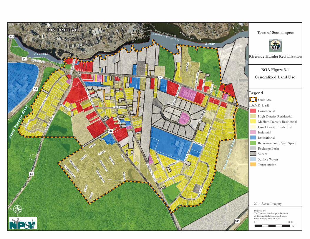
TOWN OF SOUTHAMPTON
TOWN OF RIVERHEAD
R I V E R H E A D
Bl a
c kC
r ee k
Po
nd
R i v e r
Li t
t le
Pe c
o ni c
Ri v
e r
P e c o n i c
UV24
³ ±63
³ ±104
³ ±105
³ ±94
³ ±94A³ ±51
OLD
QU
OG
UE R D
LUDL
AMAV
E
VA I LAVE
PINE STWOO
DHUL
LAV
E
BROW N ST
PEBB
LEW
AY
PHI L
LIP S
AVE
PEGS
LN
GOODRIDGEAVE
RANDALL ST
MAYNARD ST
ENTE
RPRI
SEZO
NEDR
VAN HOUTON ST
PA RK PL
RIVE
RRD
P HI L
LIP S
AVE
BIRCHST
PONDDRWOODLAND
DR
OAK ST
PINE ST
PINEGROVE
ST
DOGWOOD
ST
KIR K
AVE
NOR THWOODS DR
DONA
LDAV
E
OAK
CT
ELM
CT
P ON D
L N
MO
BIL E
HOM
EPA
RK
RIVER LE IG
H AV
E
LAKE
AV
E CR
63
NU GE NT DR
PECO
NIC
AV
E
μ
Town of Southampton
Riverside Hamlet Revitalization
10 ,000Feet
BOA Figure 3-1
Generalized Land Use
Prepared By:The Town of Southampton Divisionof Geographic Information SystemsDate: Tuesday, May 10, 2016
Legend
Study Area
LAND USE
CommercialHigh Density ResidentialMedium Density ResidentialLow Density ResidentialIndustrialInstitutionalRecreation and Open SpaceRecharge BasinVacantSurface WatersTransportation
2014 Aerial Imagery

R i v e rR i v e r
TOWN OF RIVERHEADTOWN OF SOUTHAMPTON
MO
BILE
HO
ME
PARK
PHIL
LIPS
AVE
GOODRIDGE AVE
RANDALL ST
VAN HOUTON ST
Bl a
c k C
r ee k
Bl a
c k C
r ee k
P
on
dP
on
d
L i tt l
e Pe c o n i c
Ri v
e r
L i tt l
e Pe c o n i c
Ri v
e r
P e c o n i cP e c o n i c
UV24
³ ±63
³ ±104
³ ±105
³ ±94
³ ±94A³ ±51
PARK PL
POND DR
PHIL
LIPS
AVE
WOODLAND DR
ELM ST
OAK ST
CEDAR ST
PINE ST
PINE GROVE ST
KIRK
AVE
DONA
LD A
VE
NORTHWOODS RD
MO
BILE
HOM
EPA
RK
OAK
CT
ELM
CT
RIVERLEIG
H AV
E
LAKE
AV
E CR
63
NUGENT DR
PECO
NIC
AV
E
LUDL
AM A
VE
VAIL AVE
PINE STWOO
DHUL
L AV
E
BROWN ST
PEBB
LE W
AY
PEGS
LN
MAYNARD ST
ENTE
RPRI
SE Z
ONE
DR
QU
OG
UE
RIVERHEA
D RD
CEN
TER D
R
CROSS RIV
ER DR
CENTER DR
SOUTH
POND
DR
CEDAR ST
DOGWOOD CT
POND
LN
POND LN
MAPLE ST
DOGWOOD ST
NYS
CONS
ERVA
TIO
N AR
EA R
D
WH I
TEBR
OO
K DR
BIRCH ST
R I V E R H E A DTown of Southampton
Riverside Hamlet Revitalization
μ0 1,000
Feet
Public Ownership
Prepared By:The Town of Southampton Divisionof Geographic Information SystemsDate: Friday, June 03, 2016
BOA Figure 3-2
Legend
Study Area
Public LandsSOUTHAMPTON TOWN
SOUTHAMPTON TOWNHOUSING AUTHORITYSTATE OF NEW YORKDEPT OFTRANSPORTATIONSUFFOLK COUNTY
SUFFOLK COUNTY DIVOF RP ACQUISITION &MGMTSUFFOLK COUNTYTREASURER

Hamlet of Riverside BOA Step II Nomination Study
Page 34 of 155
Parks, open space, and wildlife preserves are prevalent throughout the Riverside community, especially outside and adjacent to the Study Area and serve to create well-defined boundaries for the hamlet. Several properties within the Study Area comprising an estimated 57.64 acres have been preserved for one or more of these purposes. Preserved land within the Study Area includes two large Town-owned parcels located north of SR 24 on the east side of the Study Area; Town-owned land at the northeast corner of the intersection of Ludlam Avenue and Old Quogue Road (Ludlam Avenue Park); County-owned land situated southeast of the intersection of Maynard Street and Lake Avenue (CR 63) which contains a freshwater pond and is contiguous to the David A. Sarnoff Pine Barrens Preserve; and Town-owned land located at the northeast corner of the traffic circle between Peconic Avenue and Nugent Drive (CR 94). Transportation land uses include State and County arterial highways and Town streets as well as three lots containing or designated as stormwater recharge basins, including two Town-owned lots, one located on the west side of the Southampton Enterprise Zone Subdivision and one located off of Pebble Way, and a NYSDOT recharge basin on the north side of SR 24, adjacent to the Masonic Temple. The Riverside portion of SR 24 is an important multifunctional roadway. The road is a regional arterial serving the area’s local commercial and residential uses and facilitates waterfront access. Development along this road has faced many challenges, particularly in light of the recent recession, which in turn has resulted in a high number of vacant and derelict buildings throughout the corridor and surrounding area. Table 3-1 summarizes the total number of lots and total acreage for each general land use classification.
Table 3-1
EXISTING LAND USE
Land Use Number of Parcels
Total Acres
Proportion of Study Area
(%) Residential 364 211.7 45.28 Commercial 40 37.3 7.98 Industrial 10 8.0 1.71 Institutional 15 28.8 6.16 Transportation 9 7.7 1.65 Streets and Rights-of-Way --- 49.0 10.48 Dedicated Parks and Recreation 7 38.7 8.28 Vacant Land 95 86.3 18.46 Surface Waters(1) 2 (1)0.0028 (1)0 Total 542 467.5 100%
Source: Town of Southampton Division of Geographic Information Systems and New York State Department of State
Notes: 1. These figures represent surface water features that are “parcelized.” Small ponds that are located on a larger parcel would be classified according to the primary use of the parcel (e.g., vacant). In total, there are 6.5 acres of open surface waters within the ROD boundaries. Any differences in total acreage are due to rounding.

Hamlet of Riverside BOA Step II Nomination Study
Page 35 of 155
Development patterns in Riverside have remained relatively stagnant with the exception of the construction of the Suffolk Federal Credit Union at the corner of SR 24 and Enterprise Zone Drive approximately seven or eight years ago, a redevelopment that involved the construction of a convenience store along Flanders Road near the east end of the BOA, and more recent development on two lots within the Southampton Enterprise Zone industrial subdivision that are now developed with light industrial uses. Several other lots within the Enterprise Zone subdivision remain vacant, which may be due in part to the recent recession and a general decline in industrial development in the Town and throughout the northeastern United States. The State Police barracks at 234 Riverleigh Avenue is also a relatively recent addition to the area and provides a greater police presence in the community. Many lots in the Study Area remain vacant, some of which are publicly owned as described previously. The State acquired land on the north side of SR 24 approximately 10 years ago for use as a stormwater recharge basin and the County acquired other nearby land along the river for parkland or open space preservation. The more recent County land acquisitions along the river were once part of a proposal for a large hotel, catering facility and restaurant which never came to fruition. 3.2.3 Brownfield, Abandoned, and Vacant Sites The following section provides the findings from an area-wide environmental assessment conducted in July and August of 2015. A preliminary inventory and assessment of properties that may have been adversely affected by past land use activities or that may currently pose risks to the environment due to site uses or known handling, storage, spills, leaks or disposal of hazardous materials was conducted by NP&V’s Division of Phase I/II Assessments & Remediation. This investigation included a review of a comprehensive 2015 environmental database report prepared by Toxics Targeting, Inc. for the Study Area, as well as a follow-up preliminary site identification and land use inventory performed by NP&V. The Toxics Targeting database includes information from 21 different environmental databases which identify past and present environmental issues and the current cleanup status of known materials releases. Issues considered by the report include but are not limited to hazardous materials spills, leaking above- and below-ground fuel storage tanks, known brownfield sites, waste disposal treatment sites, toxic materials storage and discharge areas, hazardous conditions cleanup locations, air pollutant dischargers, and past environmental violations. Based on a review of the Toxics Targeting database report and a subsequent field inventory, the first seventeen (17) of the following sites were identified as having past or present environmental issues. In addition, three (3) sites have been identified as potential brownfield sites based on observations or information provided by other agencies (including tax delinquent properties, condemned buildings and land uses with potential for contamination). Figure 1-4, presented earlier, shows the locations of these sites based on the Map ID number provided with each description. 89 Peconic Avenue (Map ID EC-1) The property located at 89 Peconic Avenue is listed as a Petroleum Bulk Storage (PBS) facility and as being the subject of a closed spill incident that affected groundwater. The property appears on the historical Sanborn Maps as a filling station with four tanks on-site. NP&V has assigned a Moderate Risk to this site based upon the spill incident and previous site use as a gas

Hamlet of Riverside BOA Step II Nomination Study
Page 36 of 155
station and thus would recommend that a full Phase I ESA be prepared. A Phase II ESA may also be necessary based on past history, depending on the results of the Phase I ESA. Based upon the previous use, it is expected that soil and groundwater testing would be appropriate to ensure that there are no remaining impacts from prior use. This property is currently a business known as the Peconic Paddler that provides kayak and paddle board rentals and sales. The property is 0.7 acre in size and has frontage on Peconic Avenue; it faces Grangebel Park and the Peconic River to the north. The SC Tax Map number is District 0900 - Section 118.00 - Block 02.00 - Lot No. 02.000. This is a highly visible property at the roundabout and a high priority site for redevelopment.
Photo of 89 Peconic Avenue Source: NP&V Photo (September 30, 2015) 7 Peconic Avenue (Map ID EC-2) The property located at 7 Peconic Avenue (SCTM Number 900 - 118 - 2 - 4) is a half-acre active Valero Service Station today. The record search found that this site is listed as a PBS facility, a RCRA Generator and has been the subject of now closed spill incidents that previously impacted groundwater. The property appears on Sanborn Maps as a filling station with tanks present (1969). NP&V classifies this property as a High Risk due to its current and historical use and recorded spill incidents that impacted groundwater. The gas station is in a highly visible location at the gateway to Riverside, located on the traffic circle (in the northeast quadrant) and is a high priority for redevelopment in the future. Prior to redevelopment, a full Phase I ESA would need to be prepared and it is expected that Phase II Testing of groundwater and soils would be appropriate to determine whether soil and or groundwater contamination from petroleum products exist on the property.

Hamlet of Riverside BOA Step II Nomination Study
Page 37 of 155
Photo of 7 Peconic Avenue Source: NP&V Photo (August 28, 2015) 8 Lake Avenue (Map ID EC-3) The Shell Service Station located at 8 Lake Avenue faces the traffic circle in the southwest quadrant. The site consists of 3 SC Tax Map parcels: 900 – 138 – 1 - 104.1, 102, and 101. The property is currently used as a gas station with convenience market. The property is listed as a PBS facility and as being the subject of several closed spill incidents, some of which have impacted groundwater. The property appears on Sanborn Maps as a filling station with tanks present (1969). NP&V classifies this property as a High Risk due to its current and historical use and recorded spill incidents that impacted groundwater. Prior to redevelopment, a full Phase I ESA would need to be prepared and it is expected that Phase II Testing of groundwater and soils would be appropriate to determine whether soil and or groundwater contamination from petroleum products exist on the property.

Hamlet of Riverside BOA Step II Nomination Study
Page 38 of 155
Photo of 8 Lake Avenue Source: NP&V Photo (September 30, 2015) 30 East Moriches Road (Map ID EC-4) The almost 1 acre property located at 30 East Moriches Road (SCTM Number 900 - 138 - 2 - 30) is the former Riverboat Diner. The property is listed as having been the subject of a closed spill incident. The property appears on Sanborn Maps as a restaurant (1969). NP&V classifies this property as Low to Moderate Risk for redevelopment due to former property use as a food preparation establishment and discharges to the sanitary system could present an issue. The property is currently vacant and a highly visible property in the southern section of the traffic circle which makes it a high priority for redevelopment. It is believed that redevelopment of this site would act as a catalyst for other redevelopment in the area.
Photo of 30 East Moriches Road Source: NP&V Photo (August 28, 2015)

Hamlet of Riverside BOA Step II Nomination Study
Page 39 of 155
Photo of 30 East Moriches Road Source: NP&V Photo (September 30, 2015) 11 Flanders Road (Map ID EC-5) The property located at 11 Flanders Road is 0.82 acres and situated on the south side of Flanders Road and east of the traffic circle. The SC Tax Map number is District 0900 - Section 138.00 - Block 02.00 - Lot No. 32.000. The site is listed as a Petroleum Bulk Storage (PBS) facility and a USEPA RCRA Generator as well as being the subject of several spill incidents reported on 05/15/2002, 01/14/2003, 09/04/2003, 10/15/2003, and 11/23/2004, as well as one major spill (05/27/2010 tank broke - equipment failure), for which the files have been closed. The site is a former Getty fuel station. An earlier cleanup from a 1990 site investigation by Tyree resulted in approximately 9.5 tons of soil being removed from the site. This property is listed in the 2006 Blight Study as 0.82 acres and used as a commercial Gas and Service Station in good condition. The Blight Study also concluded that the shape of the lot is satisfactory but the property was determined to be under-utilized and under sized. Data were found in the database that waste oil had been discovered in a monitoring well. There are no activities occurring on the site at present. At least 9 tanks have been documented to have been removed but one tank may remain. The property appears on Sanborn Maps as a filling station and auto repair with tanks present (1969). NP&V classifies this property as a High Risk due to its current and historical use and recorded spill incidents that impacted groundwater. Prior to redevelopment, a full Phase I ESA would need to be prepared and it is expected that Phase II Testing of groundwater and soils would be appropriate to determine whether soil and or groundwater contamination from petroleum products exist on the property. Since the property is located in a highly visible site close to the traffic circle, it has a high priority for redevelopment.

Hamlet of Riverside BOA Step II Nomination Study
Page 40 of 155
Photo of 11 Flanders Road Source: NP&V Photo (August 28, 2015)
Photo of 11 Flanders Road Source: NP&V Photo (September 30, 2015) 35 Flanders Road (Map ID EC-6) The nearly 0.4 acre property located at 35 Flanders Road (SCTM Number 900 - 138 - 2 - 33) is known as the Slepboy Property and is located on the southern side of Flanders Road adjacent to EC-5. The property is the subject of a closed spill incident that occurred in 1990 that affected groundwater. The property is listed as a PBS facility and a RCRA Generator. The property appears on Sanborn Maps as a dwelling unit (1969). NP&V has classified the property as having Moderate Risk with respect to development even though spill was closed due to issues related to the adjacent vacant Getty gas station which may present other issues including soil vapor intrusion. Prior to redevelopment, a limited Phase II with testing of groundwater and soils would

Hamlet of Riverside BOA Step II Nomination Study
Page 41 of 155
be appropriate to determine whether soil and or groundwater contamination from petroleum products still exist on the property.
Photo of 35 Flanders Road (note, see 11 Flanders Road to west) Source: NP&V Photo (August 28, 2015) 104 Flanders Road (Map ID EC-7) The 0.11 acre property located at 104 Flanders Road is still an active spill according to DEC records, though the incident occurred in 2006. The spill was of unknown quantity. The property appears as a dwelling on Sanborn Maps. NP&V has classified the property as having Moderate Risk since it is still an active spill site. The property is located on the north side of Flanders Road, south of the Peconic River, and east of the traffic circle. The SC Tax Map number is District 0900 - Section 118.00 - Block 02.00 - Lot No. 10.000.
Photo of 104 Flanders Road Source: Google Street view (accessed August 10, 2015)

Hamlet of Riverside BOA Step II Nomination Study
Page 42 of 155
113 Flanders Road (Map ID EC-8) The 0.24 acre property located at 113 Flanders Road (SCTM Number 900 - 139 - 1 – 72) is developed with Riverhead Precision Auto Collision. The site is on the southern side of Flanders Road and east of the traffic circle. The property is listed as a PBS facility and a RCRA Generator. The property appears on Sanborn Maps and historically appears as an auto repair facility. NP&V has classified the property as having Moderate Risk for redevelopment due to the property use and would recommend the preparation of a Phase I ESA.
Photo of 113 Flanders Road Source: NP&V Photo (September 30, 2015) 308/310 Riverleigh Avenue (Map ID EC-9) This ½ acre property is located on the east side of Riverleigh Avenue (#308/310) and was known formerly as Riverhead Auto Supply & Universal Service of America. The SC Tax Map number is District 0900 - Section 139.00 - Block 01.00 - Lot No. 048.001. In the 2006 Blight Study, this 0.58 acre property was listed as a vacant property in poor condition. The property is now owned by the Town of Southampton and is one of the properties that will be available for redevelopment by the Master Developer. The property is now vacant with only a concrete slab foundation of the prior building present towards the roadway (building was demolished between 2004 and 2006) and asphalt in the rear. During site inspections, it was observed that this property is used for dumping of trash. Regardless of its vacant status, the site is listed as a RCRA Generator. The property appears to have been developed since at least 1903, based upon historical mapping. The property appears on Sanborn Maps and historically appears as an auto sales and service facility. A Phase II ESA was prepared for the Southampton Community Housing and Development Corporation/Southampton Housing Authority which included a geophysical survey, cesspool bottom sediment sampling, underground storage tank (UST)/suspect underground storage tank soil sampling, and groundwater sampling. The results of the cesspool evaluation did not indicate the presence of impacted sediment; however it was recommended that the cesspool be backfilled with clean fill during any development of the site. Soil samples were collected near a confirmed underground storage tank near the northern property line and two suspect underground storage tanks. The analysis of the soil samples did not indicate petroleum-related compounds. Recommendations included further analysis of suspect USTs and the abandonment and removal of all confirmed tanks. The groundwater

Hamlet of Riverside BOA Step II Nomination Study
Page 43 of 155
evaluation revealed concentrations of two TCL VOCs and total PCBS above the NYSDEC TOGS standard. The two VOCs were chlorobenzene, commonly found in pesticides, and MTBE, a gasoline-related compound. The elevated concentrations of the VOCs and PCBs was not found in the soil samples or all of the groundwater tests, therefore the contamination was deemed likely from an off-site source and no recommendations were given. In order for redevelopment to occur, it was recommended that a sub-slab vapor barrier be installed beneath any future building foundation in order to ensure satisfactory indoor air quality. NP&V has classified the property as having Moderate Risk due to former property use. Development may be hindered due to soil vapor resulting from off-gassing in a shallow water table so mitigation measures for future development may be warranted.
Photo of former building at 308 Riverleigh Avenue (since demolished) Source: Southampton Town building records
Photo of 308 Riverleigh Avenue Source: Google Street view (accessed August 10, 2015)
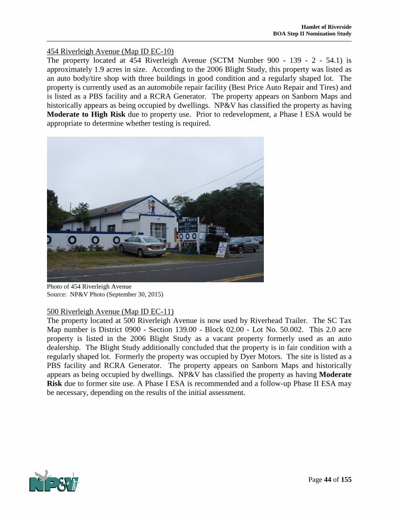
Hamlet of Riverside BOA Step II Nomination Study
Page 44 of 155
454 Riverleigh Avenue (Map ID EC-10) The property located at 454 Riverleigh Avenue (SCTM Number 900 - 139 - 2 - 54.1) is approximately 1.9 acres in size. According to the 2006 Blight Study, this property was listed as an auto body/tire shop with three buildings in good condition and a regularly shaped lot. The property is currently used as an automobile repair facility (Best Price Auto Repair and Tires) and is listed as a PBS facility and a RCRA Generator. The property appears on Sanborn Maps and historically appears as being occupied by dwellings. NP&V has classified the property as having Moderate to High Risk due to property use. Prior to redevelopment, a Phase I ESA would be appropriate to determine whether testing is required.
Photo of 454 Riverleigh Avenue Source: NP&V Photo (September 30, 2015) 500 Riverleigh Avenue (Map ID EC-11) The property located at 500 Riverleigh Avenue is now used by Riverhead Trailer. The SC Tax Map number is District 0900 - Section 139.00 - Block 02.00 - Lot No. 50.002. This 2.0 acre property is listed in the 2006 Blight Study as a vacant property formerly used as an auto dealership. The Blight Study additionally concluded that the property is in fair condition with a regularly shaped lot. Formerly the property was occupied by Dyer Motors. The site is listed as a PBS facility and RCRA Generator. The property appears on Sanborn Maps and historically appears as being occupied by dwellings. NP&V has classified the property as having Moderate Risk due to former site use. A Phase I ESA is recommended and a follow-up Phase II ESA may be necessary, depending on the results of the initial assessment.

Hamlet of Riverside BOA Step II Nomination Study
Page 45 of 155
Photo of 500 Riverleigh Avenue Source: Google Street view (accessed August 10, 2015)
Photo of 500 Riverleigh Avenue Source: NP&V Photo (September 30, 2015) 568 Riverleigh Avenue (Map ID EC-12) The property located at 568 Riverleigh Avenue is listed as an active spill incident that occurred in 1999. The property has a size of 0.35 acres and the SC Tax Map number is District 0900 - Section 140.00 - Block 01.00 - Lot No. 10.000. According to database records the spill resulted in the release of 250 gallons of fuel oil that impacted soil. The property appears on Sanborn Maps and historically appears as occupied by dwellings. NP&V classified the property as

Hamlet of Riverside BOA Step II Nomination Study
Page 46 of 155
Moderate Risk due to the active spill incident and quantity of product released. However, since it is an older spill the contamination may now be limited.
Photo of 568 Riverleigh Avenue Source: NP&V Photo (September 30, 2015) 182 Old Quogue Road (Map ID EC-13) The property located at 182 Old Quogue Road is now occupied by Juniors Auto Salvage. The property has a size of 0.62 acres and a SC Tax Map number of 900 – 140 - 2 -71.1. The property is an active junk yard that was previously the subject of a closed spill incident. No Sanborn Map provided. NP&V has classified the property as having High Risk due to property use and poor housekeeping practices. Prior to redevelopment, a full Phase I ESA would need to be prepared and it is expected that Phase II Testing of soils would be appropriate to determine whether soil and or groundwater contamination from petroleum products exist on the property.

Hamlet of Riverside BOA Step II Nomination Study
Page 47 of 155
Photo of 182 Old Quogue Road Source: Google Street view (accessed August 10, 2015) 219-223 Flanders Road (Map ID EC-14) The property located at 219-223 Flanders Road is developed with multifamily housing. The 0.88 acre property is situated on the southern side of Flanders Road and has a SC Tax Map number of District 0900 - Section 139.00 - Block 03.00 - Lot No. 54.003. The site is reported to have an Active Spill on file for an incident that occurred in 2007 of unknown quantity. The property was classified as having Moderate to High Risk since the spill is still active but seems to be limited to soil. However, the soil was excavated to 12 feet and strong odor is reported to still be present. This issue should be resolved and further investigation may be necessary.
Photo of 219-223 Flanders Road Source: Google Street view (accessed August 10, 2015) 301 Flanders Road (Map ID EC-15) The 0.53 acre property located at 301 Flanders Road (SCTM Number 900 - 141 - 2 – 2) is the Shamrock Gas Station. The site is situated on the southwest corner of Flanders Road and Ludlam Avenue. The site is listed as a PBS facility and having been the subject of a closed spill incident. While no active spills, NP&V has classified the property as having a High Risk due to its use as a gas station. A Phase I ESA should be prepared for this site. Due to the history of the

Hamlet of Riverside BOA Step II Nomination Study
Page 48 of 155
site, a Phase II ESA may also be warranted prior to any redevelopment to determine if soil or groundwater has been adversely affected.
Photo of 301 Flanders Road Source: NP&V Photo (August 28, 2015)
Photo of 301 Flanders Road Source: Google Street view (accessed August 10, 2015) Intersection of Ludlam Avenue and Flanders Road (Map ID EC-16) The 0.63 acre property located at the southeast corner of Ludlam Avenue and Flanders Road (SCTM Number 900 - 141 - 2 – 3) was previously an Ocean Gas Station and is now a Valero Gas Station. An active spill that occurred in 1998 is listed. In addition, the site was the subject of several closed spills and is listed as a RCRA Generator as well as a PBS facility. Groundwater has been reported to have been affected and elevated levels of MTBE in groundwater were extracted from on-site monitoring wells. The site is also a risk site due to property use. The use and spills may have resulted in a soil vapor intrusion issue at the home located at 404 Flanders Road. NP&V has classified the property as having High Risk due to use as a fuel station as well as active incidents that affected groundwater and possibly air quality at a

Hamlet of Riverside BOA Step II Nomination Study
Page 49 of 155
nearby home. Due to the history of the site and nature of use a Phase I ESA should be prepared. A Phase II ESA may also be warranted prior to any future redevelopment to determine if soils and/or groundwater have not been adversely affected.
Photo of southeast corner of Flanders Road and Ludlam Avenue Source: NP&V Photo (August 28, 2015)
Photo of southeast corner of Flanders Road and Ludlam Avenue Source: Google Street view (accessed August 10, 2015) 117 Ludlam Avenue (Map ID EC-17) The 1.43 acre property located at 117 Ludlam Avenue (SCTM Number 900 - 141 - 2 – 36.3) was formerly occupied by Cedar Graphics, Inc. The site fronts Ludlam Avenue to the east, Van Houten Street to the north, and Phillips Avenue to the west. The property is listed as a PBS facility and as a RCRA Generator. The building has been abandoned, but appears to have been recently used as a church. NP&V has classified the property as having Moderate to High Risk

Hamlet of Riverside BOA Step II Nomination Study
Page 50 of 155
due to former use as a printing facility and regulatory listings. Any future redevelopment of this site should be preceded by a Phase I ESA.
Photos of 117 Ludlam Avenue Source: NP&V Photos (August 28, 2015) 97 Old Quogue Road (Map ID EC-18) This 0.3 acre property is developed with a single family home that faces the street, and a fence which partially obstructs views into the yard. The SC Tax Map number is District 0900 - Section 139.00 - Block 02.00 - Lot No. 45.000. The 2006 Blight Study identified this property as a one family residence in poor condition that appears to be utilized as a dumping site. The study also

Hamlet of Riverside BOA Step II Nomination Study
Page 51 of 155
determined that the lot has a regular shape but it is under the minimum size and may not have the proper Certificates of Occupancy. The front of the lot is paved and during inspections was used by several cars. In the rear yard area multiple vehicles are stored. Redevelopment of this site may be delayed due to a need for environmental remediation from past land uses.
Sources: Bing map birds-eye view and Google Street View accessed September 25, 2015. 48 Old Quogue Road (Map ID EC-19) This 0.2 acre property is developed with a two and a half story building that was reportedly used for auto repair with double garage doors on the ground level and reported to have multifamily housing above. There is a small boarded up building towards the street as well. The large building is currently boarded up and according to SC Department of Economic Development and Planning has been condemned by the Town of Southampton and is tax delinquent and being considered under their TDR program. The program seeks to transfer properties that have become tax delinquent for redevelopment and has Phase I ESA and if necessary Phase II Testing completed in order to make properties more palatable for the development community to purchase, clean up and redevelop. However, funds have yet to be made available for a Phase I ESA for this particular site. The 2006 Blight Study identified this property as containing two buildings used for residential apartments in poor condition on an under sized but regularly shaped lot. The SC Tax Map number is District 0900 - Section 139.00 - Block 03.00 - Lot No. 02.002.
Photo of 48 Old Quogue Road Source: NP&V Photo (September 30, 2015)

Hamlet of Riverside BOA Step II Nomination Study
Page 52 of 155
98 Old Quogue Road (Map ID EC-20) This ½ acre property is developed with three one story buildings and the remainder of the site is generally paved for outdoor storage of vehicles and equipment. The property is currently used as an automobile towing facility. NP&V has classified the property as having Moderate to High Risk due to property use. Prior to redevelopment, a Phase I ESA would be appropriate to determine whether testing is required. The SC Tax Map number is 900 - 139 - 3-37.
Photo of 98 Old Quogue Road Source: NP&V Photo (September 30, 2015) Summary profile sheets have been prepared for a number of the properties identified herein as having greatest potential to act as catalysts for revitalization of the area as a whole. These sites are generally those within areas programmed for redevelopment, highly visible along the corridor and whose current state is impacting the community. The information provided on the summary sheets includes the following details and are found in Appendix A of this document:
• Location, SCTM Number • Ownership • Size and improvements/condition of improvements • Potential contamination issues • Known or suspected contaminants, and the media which are known or suspected to have
been affected (soil groundwater, surface water, sediment, soil gas) • Notes regarding redevelopment potential • Walkscore, access to transit and sidewalk accessibility
The potential reuse of the properties identified herein is discussed in Section 4.0 of this BOA Nomination Study. Figure 3-3 illustrates the Sites of Environmental Concern and the Theoretical Development Program prepared by the Master Developer.

Flanders Rd
Riverleigh AveLu
dlam
Ave
Old Q
uogue Rd
Park Pl
Lake
Ave
Vail
Ave
Pond DrR
oad
D
Woo
dhul
l Ave
Brown St
Phill
ips A
ve
Pond
Ln
Pebb
le W
ay
Road
B
Woodland Dr
Pine St
Elm StBirch St
Roa
d H
Cedar St
Goodridge Ave
Pegs Ln
Oak St
Randall St
Kirk
Ave
Pine Grove StDogwood St Maple P
l
Northwoods Ln
Ente
rpris
e Zon
e D
r
Maynard Ave
Don
ald
Ave
Van Houten St
Peco
nic A
ve
Oak Ct
Whi
te B
rook
Dr
TEC-9
TEC-8
TEC-7
TEC-6TEC-5
TEC-4TEC-3
TEC-2
TEC-1
TEC-20
TEC-19
TEC-18
TEC-17
TEC-16
TEC-15
TEC-14
TEC-13TEC-12
TEC-11
TEC-10
Source: Esri, DigitalGlobe, GeoEye, Earthstar Geographics, CNES/Airbus DS, USDA, USGS, AEX, Getmapping, Aerogrid, IGN, IGP,swisstopo, and the GIS User Community, Esri, HERE, DeLorme, MapmyIndia, © OpenStreetMap contributors, and the GIS usercommunity
Town of Southamptonand
New York State Department of State
Riverside Hamlet Revitalization
8
0 500 1,000Feet
Legend
StudyArea
Sites of Environmental Concern
Town Development Properties
Tax Parcels
Source: Renissance Downtown; NYS GIS, 2013 Aerial
1 inch = 500 feet
BOA Figure 3-3Theoretical Development
Plan and Sites of Environmental Concern

Hamlet of Riverside BOA Step II Nomination Study
Page 54 of 155
3.2.4 Zoning Districts Introduction Zoning provides the primary means for directing land development and plays a major role in determining land use and density, development patterns and site and community form and is therefore is essential to the revitalization process. Current zoning includes the pre-existing “underlying” zoning which preceded the BOA Study and RRAP and the recently adopted ROD zoning which may be invoked at the property owner’s discretion. Inventory and Analysis of Existing Zoning Figure 3-4 presents the existing underlying zoning districts that regulate land use in the Riverside Study Area. Currently, there are 13 zoning districts, including five single-family residence districts, six commercial, one light industry, and one open space conservation district, as well as the 7 recently approved ROD Overlay Zones. Table 3-2 lists the existing zoning districts, the total number of lots in each zone and total acreage by zone. The new Overlay Zones are discussed in Section 4.0.
Table 3-2 EXISTING ZONING
Zoning Number of Parcels Total Acres1 Residential Districts
Residence-15 (R-15) 365 203.8 Residence-20 (R-20) 43 24.9 Country Residence 40 (CR-40) 1 11.2 Mobile Home Subdivision (MHS-40) 2 57.3 Residence-80 (R-80) 18 30.6
Business Districts Highway Business (HB) 47 30.1 Village Business (VB) 55 28.2 Shopping Center Business (SCB) 6 6.2 Resort Waterfront Business (RWB) 7 19 Office Business (OD) 1 1.5 Motel Business (MTL) 1 4.9
Industrial Districts Light Industry (LI-40) 29 45
Parks, Open Space and Conservation Districts Open Space and Conservation (OSC) 4 4.8 Total 579
(542 tax lots, 37 of which are split zoned)(2)
467.5
Source: Town of Southampton Division of Geographic Information Systems and New York State Department of State
Notes: 1 - Includes abutting streets and ROWs 2 - The total number of tax lots in the Study Area is 542; however, 37 of these lots are split zoned and are
double counted, thereby making the total lots by zoning district artificially high. Differences in total acreage are due to rounding.

R i v e rR i v e r
TOWN OF RIVERHEADTOWN OF SOUTHAMPTON
MO
BILE
HO
ME
PARK
PHIL
LIPS
AVE
GOODRIDGE AVE
RANDALL ST
VAN HOUTON ST
Bl a
c k C
r ee k
Bl a
c k C
r ee k
P
on
dP
on
d
L i tt l
e Pe c o n i c
Ri v
e r
L i tt l
e Pe c o n i c
Ri v
e r
P e c o n i cP e c o n i c
UV24
³ ±63
³ ±104
³ ±105
³ ±94
³ ±94A³ ±51
PARK PL
POND DR
PHIL
LIPS
AVE
WOODLAND DR
ELM ST
OAK ST
CEDAR ST
PINE ST
PINE GROVE ST
KIRK
AVE
DONA
LD A
VE
NORTHWOODS RD
MO
BILE
HOM
EPA
RK
OAK
CT
ELM
CT
RIVERLEIG
H AV
E
LAKE
AV
E CR
63
NUGENT DR
PECO
NIC
AV
E
LUDL
AM A
VE
VAIL AVE
PINE STWOO
DHUL
L AV
E
BROWN ST
PEBB
LE W
AY
PEGS
LN
MAYNARD ST
ENTE
RPRI
SE Z
ONE
DR
QU
OG
UE
RIVERHEA
D RD
CEN
TER D
R
CROSS RIV
ER DR
CENTER DR
SOUTH
POND
DR
CEDAR ST
DOGWOOD CT
POND
LN
POND LN
MAPLE ST
DOGWOOD ST
NYS
CONS
ERVA
TIO
N AR
EA R
D
WH I
TEBR
OO
K DR
BIRCH ST
OSC
R15
R20
R80
R15
OSC
LI40
VBCR200 R15
HB
RWB
R80
CR40
HB
MTL
OSC
MHS40
HB
HB
SCB
OD
R I V E R H E A DTown of Southampton
Riverside Hamlet Revitalization
μ0 1,000
Feet
Existing Base Zoning Districts
Prepared By:The Town of Southampton Divisionof Geographic Information SystemsDate: Friday, June 03, 2016
CR200 - Country Residence 200,000 sq ftCR40 - Country Residence 40,000 sq ftHB - Highway BusinessLI40 - Light Industrial 40,000 sq ftMHS40 - Mobile Home Subdivision ResidenceMTL - MotelOD - Office DistrictOSC - Open Space ConservationR15 - Residence 15,000 sq ftR20 - Residence 20,000 sq ftR80 - Residence 80,000 sq ftRWB - Resort Waterfront BusinessSCB - Shopping Center BusinessVB - Village Business
BOA Figure 3-4
Legend
Study AreaCurrent Zoning

Hamlet of Riverside BOA Step II Nomination Study
Page 56 of 155
3.2.5 Strategic Sites Introduction Fourteen “Strategic Sites” were identified during the BOA planning process, which, for the purposes of this Study, are considered key lots or assemblages of adjacent properties which have significant potential for development or redevelopment and whose redevelopment would be most likely to serve as catalysts of area revitalization and enhancement. Selection of Strategic Sites was based on a variety of considerations including one or more of the following:
• Frontage along a major roadway, development center (such as the Riverside Hamlet Center (RO-1)), or the traffic circle
• Site visibility
• Status as a vacant or underutilized site, boarded-up or blighted building, or site of environmental concern
• Identification as a possible community benefits or essential infrastructure site
• Property ownership (e.g., land owned by the Town of Southampton but not dedicated for open space or parklands, developer owned properties)
• Potential for development or redevelopment
Some sites may require additional testing and/or remediation, depending upon past use and presence of recognized environmental conditions. Table 3-3 identifies the properties considered to be Strategic Sites. Figure 3-5 shows the locations of strategic sites that are underutilized or represent important opportunities for development or redevelopment that will most benefit the redevelopment of the community and promote positive change. Inventory and Analysis of Strategic Sites Locations, sizes, current zoning and types of uses envisioned for strategic sites are summarized below in Table 3-3.

Hamlet of Riverside BOA Step II Nomination Study
Page 57 of 155
Table 3-3 STRATEGIC SITES
Site ID
Address Tax Map Acres Strategic Site Current Use, Characteristics and Potential Benefits of Development or Redevelopment
SS-1 89 Peconic Ave
118-2-2 0.8 0.8
(Peconic Paddler). This property is located in the RO-1 Overlay District (“OD”) at the gateway to the hamlet from downtown Riverhead and would accommodate redevelopment, including the waterfront promenade. It adjoins and could provide a connection with a town-owned parcel to the south which is programmed for parkland. Located in Block 1, SS-1 is programmed for residential and retail uses.
SS-2 100A Peconic Ave 120 Peconic Ave
118-2-3.1 118-2-29
0.21 0.21 0.42
(Small 1 and 2-story retail, personal service and office building with second floor apartment(s)). This property is located along Peconic Road at the gateway to both Riverside and Riverhead. It is within the RO-1 OD, has frontage on the Peconic River and consists of a privately owned parcel and Town owned property. Located in Block 2, this area is programmed for residential and retail uses.
SS-3 20 Riverleigh Ave 138-2-30 0.99 0.99
(Former Riverboat Diner Site). This building is currently vacant and boarded-up and is identified as EC-4. SS-3 has frontage on the traffic circle, Lake Avenue and Riverleigh Avenue and is in in the RO-1 OD. The site provides an opportunity for highly visible redevelopment that can catalyze additional growth and redevelopment. Located in Block 8, SS-3 is programmed for residential, retail and hotel uses.
SS-4 30 Lake Ave
138-2-29.1 5.81 5.81
(Budget Host Inn). SS-4 is located in the RO-1 OD and currently contains a motel. This site has been known to support illicit activity which has required increased police activity. The property has frontage on both Lake Avenue and Riverleigh Avenue and is a key redevelopment site due to its prime location near the traffic circle and its large lot size. Located in Block 8, this area is programmed for residential, retail and hotel uses.
SS-5 9 Flanders Rd 11 Flanders Rd
138-2-31 138-2-32
0.10 0.82 0.92
(Vacant Getty Station and small adjacent vacant parcel). SS-5 (also identified as EC-5) has frontage on the traffic circle, Flanders Road and Riverleigh Avenue, and is located in the RO-1 OD. This site is also a prime location as a gateway into the Riverside community. A portion of its frontage may be needed to accommodate a reconfigured traffic oval. Located in Block 6, the area is programmed for retail and residential uses.

Hamlet of Riverside BOA Step II Nomination Study
Page 58 of 155
Site ID
Address Tax Map Acres Strategic Site Current Use, Characteristics and Potential Benefits of Development or Redevelopment
SS-6 39 Flanders Rd 43 Flanders Rd 47 Flanders Rd 53 Flanders Rd 57 Flanders Rd
138-2-33 139-1-67 139-1-68 139-1-69 139-1-70
0.38 0.15 0.26 0.24 0.47 1.49
(Slepboy Property and others). SS-6 is located in the RO-1 OD, is adjacent to SS-5, has frontage on Flanders Road and is located across the street from a bus stop and bus shelter. The lots contain both active/open and vacant/boarded-up single-family homes and small businesses. SS-6 provides an opportunity to assemble several small lots to create a large development site. The westernmost lot (Slepboy Property) is identified as EC-6. Located in Block 6, this site is programmed for retail and residential uses.
SS-7 40 Pine St 36 Private Rd 32 Private Rd
Private Rd Private Rd
21 Private Rd 308 Riverleigh Ave 254 Riverleigh Ave
139-1-27 139-1-28 139-1-29
139-1-40.2 139-1-40.4 139-1-44.1 139-1-48.1 139-1-62.4
0.27 0.30 0.34 0.59 0.25 1.01 0.58 1.11 4.45
(Riverhead Auto Supply & Universal Service of America, two private unopened ROWs, and other privately owned lots). SS-7 consists of both private and Town owned land and one lot is identified as EC-9. This Site is zoned RO-1 and RO-2 ODs and is a priority as it is programmed for development and includes land owned by the Town that may be developed by the Master Developer. Located in Blocks 7 and 28, this Site is programmed for residential, office and retail uses.
SS-8 112 Vail Ave 116 Vail Ave
97 Old Quogue Rd 117 Old Quogue Rd 113 Old Quogue Rd 500 Riverleigh Ave 131 Old Quogue Rd
139-2-43 139-2-44 139-2-45 139-2-48
139-2-49.1 139-2-50.2 140-1-14
0.15 0.28 0.35 0.14 2.91 2.54 2.47 8.84
(Riverhead Trailer/former Dyer Motors, junk yard and vacant land). This site, portions of which are identified as EC-11 and EC-18, has frontage on Riverleigh Avenue and Old Quogue Road and is in the RO-3 OD. SS-8 contains two adjacent lots that are centrally located within the Study Area and would provide a large development site. Located in Blocks 26 and 32, this Strategic Site is programmed for residential purposes. Lot 140-1-14, which is in Block 24, is identified for possible apartments and/or as a possible sewage treatment plant (STP) location.
SS-9 40 Donald Ave Landlocked
118.01-1-20.1 118.01-1-31.1
0.17 15.45 15.62
(Town owned land and former dredge spoil disposal site). This property has not been targeted as a development site but does provide an opportunity for partial use as a wastewater treatment facility/constructed wetland area which is a critical component required for redevelopment.
SS-10 28 Enterprise Zone 26 Enterprise Zone
24 Enterprise Zone 22 Enterprise Zone 20
Enterprise Zone
141-1-9.6 141-1-9.7 141-1-9.8 141-1-9.9 141-1-9.10
1.98 1.45 1.46 1.98 1.33 8.21
(Portion of Enterprise Zone Light Industry Subdivision). This part of the Enterprise Zone property is located within Block 41, which is programmed for residential development. SS-10 also provides opportunities for the construction of a STP to serve the hamlet, which is a key component of the RRAP.
SS-11 140 Phillips Ave 117 Ludlam Ave
141-2-36.1 141-2-36.3
1.05 1.43 2.48
(Cedar Graphics, Inc.). A portion of this site, which is located in Block 59, is envisioned as an education center, community center, indoor recreation, or other amenity for the hamlet. The southern parcel contains a small recharge basin; however, the footprint of the basin can be adjusted on the lot to provide additional space for coordinated development.

Hamlet of Riverside BOA Step II Nomination Study
Page 59 of 155
Site ID
Address Tax Map Acres Strategic Site Current Use, Characteristics and Potential Benefits of Development or Redevelopment
SS-12 223 Flanders Rd 139-3-52 1.32 1.32
(Residential uses and vacant building) This property is not located within a Theoretical Development Program area but has frontage on Flanders Road, is highly visible, contains a vacant boarded-up building considered to be an eye sore, is adjacent to a Town Community Preservation Fund (CPF) property, and has exhibited conditions that have triggered repeated violations.
SS-13 98 Old Quogue Rd 139-3-37 0.56 0.56
(Three-story building and outdoor vehicle and equipment storage area). This property, located in the RO-3 OD has frontage on Old Quogue Road and is located opposite SS-8. The site is also identified as EC-20 and redevelopment would provide an opportunity to clean-up the property. SS-13 is located within Block 36 which is programmed for residential development.
SS-14 9 Enterprise Zone Dr 11 Enterprise Zone Dr
141-1-9.29 141-1-9.30
0.92 0.92 1.84
Vacant Town owned property within an industrial subdivision that has remained mostly vacant for an extended period of time. These lots could be used for a variety of land uses such as community services, recreational facilities, utilities or for other development pursuant to the Theoretical Development Program. Stimulating growth at this site could help promote spin-off development in the Hamlet.
TOTAL ACRES (SS-1 thru SS-14) 53.75
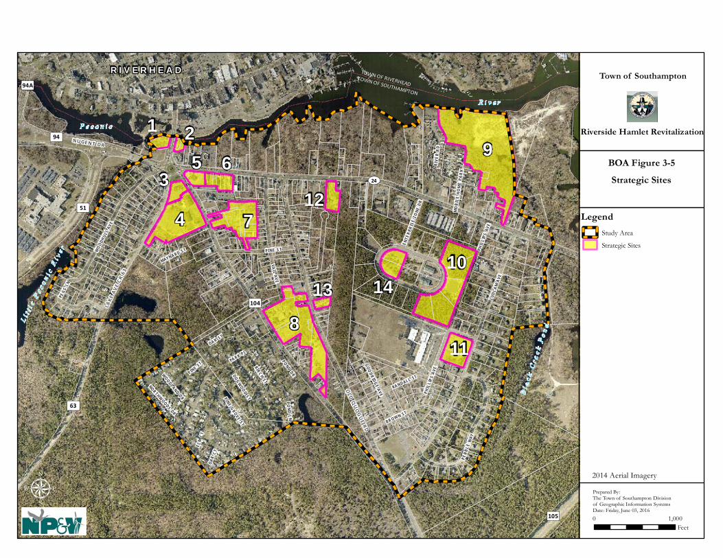
TOWN OF SOUTHAMPTON
TOWN OF RIVERHEAD
R I V E R H E A D
Bl a
c k C
r ee k
Po
nd
R i v e r
Li t
t le
Pe c
o ni c
Ri v
e r
P e c o n i c
9
4
8
10
7
6
11
35
1 2
13
12
14
UV24
³ ±63
³ ±104
³ ±105
³ ±94
³ ±94A³ ±51
OLD
QU
OG
UE RD
LUDL
AM A
VE
VA I L AVE
PI NE STWOODH
ULL A
VE
BR OW N ST
PEBB
LE W
AY
PHI L
LIP S
AVE
PEGS
LN
GOODRIDGE AVE
RANDALL ST
MAYN A RD ST
ENTE
RPRI
SE Z
O NE
DR
PA RK PL
RIVE
R RD
PHI L
LIP S
AV E
BIRCH ST
POND DRWOODLAND DR
OAK ST
PINE ST
PINE GROVE ST
DOGWOOD ST
NORTHWOODS DR
OAK
CT
ELM
C T
P ON D L N
MO
BIL E
HO
ME
PARK
LAKE
AV
E CR
63
NU GE NT DR
μ
Town of Southampton
Riverside Hamlet Revitalization
0 1,000Feet
Strategic Sites
Prepared By:The Town of Southampton Divisionof Geographic Information SystemsDate: Friday, June 03, 2016
BOA Figure 3-5
Legend
Study Area
Strategic Sites
2014 Aerial Imagery

Hamlet of Riverside BOA Step II Nomination Study
Page 61 of 155
3.2.6 Land Ownership Pattern Introduction Land ownership is an important consideration when contemplating potential redevelopment in a community, as there can be individuals who own numerous sites and can be partners in the implementation of redevelopment plans. In the case of the Riverside community, the Town of Southampton has entered into an agreement with RD as Master Developer. Now that the RRAP and Zoning Amendments to support development have been adopted by the Town, the Master Developer may redevelop certain parcels of land owned by the Town of Southampton. Inventory and Analysis of Ownership Patterns A map of publicly-owned lands was previously provided as Figure 3-2. Included on this map are the Town-owned lands set aside for development under the Master Developer Agreement. When compared with Figure 3-3, it becomes evident that the Master Developer will either need to work collaboratively with numerous private property owners (or property owners will need to work collaboratively with other partners) to accomplish the redevelopment objectives for the Riverside community. In addition, as the proposed zoning amendments apply to the entire Study Area, private property owners can pursue development and redevelopment at their own option, consistent with the regulations. This provides an opportunity for private property owners to work with the Master Developer, other developers, or independently, to aggregate parcels to create development sites that are:
• large enough to be eligible for density bonuses under ROD zoning; • provide economies of scale that incentivize private investment; • attract a high level of interest and activity; • allow coordinated site planning and development; • revitalize the community; and • catalyze secondary growth and business development.
The image provided below identifies the land ownership patterns as illustrated in the RRAP.

Hamlet of Riverside BOA Step II Nomination Study
Page 62 of 155
Source: RRAP, July 2015, Page 46 Table 3-4 provides the acreage of the publicly owned properties identified previously in Figure 3-2 by ownership category.

Hamlet of Riverside BOA Step II Nomination Study
Page 63 of 155
Table 3-4 LANDS IN PUBLIC OWNERSHIP
Owner Number of
Parcels Total Acres
New York State Department of Transportation 1 2.4 Suffolk County Treasurer 1 10.4 Suffolk County Division of Real Property Acquisition & Management 3 8.4 Suffolk County 7 7.2 Town of Southampton 27 40.3 Southampton Housing Authority 6 0.9 Total 45 69.6 Source: Town of Southampton Division of Geographic Information Systems. Notes: Number of parcels includes those which are also partly in the Study Area. Acreage reflects land within the
Study Area only. The Riverhead Central School District controls approximately 16.5 acres of land associated with the elementary school complex in Riverside. 3.2.7 Parks and Open Space Introduction Parks and open space help to enhance the function, sense of place and quality of life of a community. In Riverside there are a variety of open spaces and public amenities including hiking, education and nature observation in the Central Pine Barrens, access to the Peconic River for fishing or kayaking, and active recreational facilities for children. These essential spaces and facilities can provide a variety of benefits such as:
• Opportunities for active or passive recreation, relaxation, and/or social interaction; • Promotion of tourism or more frequent visitation by locals; • Control of stormwater and flooding; • Purification of runoff before entering groundwater supplies, surface waters or wetlands; • Mitigation of the urban heat island effect by reducing the proportion of paved areas and
planting or maintenance of vegetation that provides shade and cooling; • Protection of natural areas for wildlife such as birds; • Beautification of urban spaces; • Diversification of local living and shopping experiences; • Enhancement of property values.
This BOA Study, along with the RRAP and ROD seek to enhance and promote the use, protection and further enhancement of parks and open spaces which are necessary for ensuring the success of community revitalization.
Hamlet of Riverside BOA Step II Nomination Study
Page 64 of 155
Inventory and Analysis of Parks and Open Space Parks with active recreational opportunities include the Ludlam Avenue Park which is a 4.5 acre parcel located at Ludlam Avenue and Old Quogue Road where there is new playground equipment, gazebo and restrooms, a ballfield and sports courts (see aerial view of Ludlam Park below). Playground equipment and ballfields are also available for use at the Phillips Avenue Elementary School complex along Ludlam Avenue. Ammermann Riverfront Park and Grangebel Park are nearby parks along the banks of the Peconic River in nearby Riverhead, just one minute’s walk from the traffic circle. These parks provide passive recreation such as walking and enjoying views of the river. Indian Island County Park is also nearby in the Town of Riverhead (just 2 or 3 minutes’ drive from the Study Area). Indian Island provides opportunities for hiking, swimming, camping, golfing, birdwatching, kayaking, and sight-seeing. As mentioned previously, parks, open space, and wildlife preserves are available and abundant throughout the Riverside community, especially outside and adjacent to the Study Area and serve to create well-defined boundaries for the hamlet. Preserved open space within the Study Area includes two large Town-owned parcels located north of SR 24 on the east side of the Study Area; and County-owned land situated southeast of the intersection of Maynard Street and Lake Avenue (CR 63) which contains a freshwater pond and is contiguous to the David A. Sarnoff Pine Barrens Preserve. Water recreation is also readily available in the area, including fresh and saltwater fishing and canoeing and kayaking on the Peconic River and Peconic Estuary. The “Peconic Paddler”, located off of Peconic Avenue, within the Study area, rents kayaks and canoes and a launch area is provided on Town land on the east side of Peconic Road within the Study Area. Other recreational opportunities, such as gym membership clubs (i.e., “Planet Fitness”) are also available within a five minute drive indicating a wide variety of recreational opportunities for local residents. Figure 3-6 shows the locations of parks, open space, and preserves in the area.

R i v e rR i v e r
TOWN OF RIVERHEADTOWN OF SOUTHAMPTON
MO
BILE
HO
ME
PARK
PHIL
LIPS
AVE
GOODRIDGE AVE
RANDALL ST
VAN HOUTON ST
Bl a
c k C
r ee k
Bl a
c k C
r ee k
P
on
dP
on
d
L i tt l
e Pe c o n i c
Ri v
e r
L i tt l
e Pe c o n i c
Ri v
e r
P e c o n i cP e c o n i c
UV24
³ ±63
³ ±104
³ ±105
³ ±94
³ ±94A³ ±51
PARK PL
POND DR
PHIL
LIPS
AVE
WOODLAND DR
ELM ST
OAK ST
CEDAR ST
PINE ST
PINE GROVE ST
KIRK
AVE
DONA
LD A
VE
NORTHWOODS RD
MO
BILE
HOM
EPA
RK
OAK
CT
ELM
CT
RIVERLEIG
H AV
E
LAKE
AV
E CR
63
NUGENT DR
PECO
NIC
AV
E
LUDL
AM A
VE
VAIL AVE
PINE STWOO
DHUL
L AV
E
BROWN ST
PEBB
LE W
AY
PEGS
LN
MAYNARD ST
ENTE
RPRI
SE Z
ONE
DR
QU
OG
UE
RIVERHEA
D RD
CEN
TER D
R
CROSS RIV
ER DR
CENTER DR
SOUTH
POND
DR
CEDAR ST
DOGWOOD CT
POND
LN
POND LN
MAPLE ST
DOGWOOD ST
NYS
CONS
ERVA
TIO
N AR
EA R
D
WH I
TEBR
OO
K DR
BIRCH ST
Cranberry Bog Park (SC)
David A. Sarnoff State Pine Barrens Park Preserve
(NYS DEC)
Ludlam Avenue Park (TOS)
Peconic River Park (TOS / CPF) Open Space
(TOS)
Open Space(TOS / CPF)
Open Space(TOS / CPF)
Open Space(TOS / CPF)
Open Space(SC)
David A. Sarnoff State Pine Barrens Park Preserve
(NYS DEC)
(SC)
(SC)
(TOS)
Conservation Easement (PLT)
R I V E R H E A DTown of Southampton
Riverside Hamlet Revitalization
μ0 1,000
Feet
Parks, Open Space & Preserves
Prepared By:The Town of Southampton Divisionof Geographic Information SystemsDate: Friday, June 03, 2016
BOA Figure 3-6
Legend
Study Area
Parks, Open Space, &Preserves
NEW YORK STATE
SOUTHAMPTON TOWN
SUFFOLK COUNTY
PECONIC LAND TRUST
TOS - Town of SouthamptonCPF - Community PreservationNYSDEC - New York State Department ofEnvironemtnal ConservationSC - Suffolk CountyPLT - Peconic Land Trust
Abbreviations

Hamlet of Riverside BOA Step II Nomination Study
Page 66 of 155
View looking in a northerly direction of Ludlam Avenue Town Park Source: Bing maps birds-eye view, accessed September 26, 2015 A major aspiration for the future of the Riverside community is to develop additional active parkland and access adjacent to the Peconic River waterfront. Town and County owned properties already exist along the Peconic River and provide opportunities for such recreational use. Peconic River Park is an approximately 0.2 acre parcel which provides access to the river for paddlers. The only other access to the river is via dead-end roads and from private property - including the McDonalds parking lot.
Views of the Peconic River from McDonald’s parking lot (left) and from the end of River Drive in a mobile home park (right). NP&V photos were taken in August 2015.

Hamlet of Riverside BOA Step II Nomination Study
Page 67 of 155
The Town of Southampton has made recent efforts to clean up the parkland located to the west of the traffic circle leading to the freshwater portion of the Peconic River and connecting to Riverhead’s Grangebel Park. In addition, the Town is introducing legislation which would allow the Town to work with other agencies to clean up parklands that are not under its ownership. 3.2.8 Building Inventory Introduction Determining the stock of existing buildings in the BOA and their general sizes and conditions is an important component of this Study and helps to identify building vacancies and blight. It also helped to provide a greater understanding of the types and proportions of land uses in the Hamlet, existing nonconformities, and enhanced the understanding of what needed to be accomplished to transition the community into a vibrant and successful community. An evaluation of the property data available from property cards and field surveys allowed for the documentation of buildings (described below and in the historic resources section) and an inventory of existing residences and commercial floor area. These data were used in the GEIS to evaluate the transformation from existing to build-out conditions and the effects of the BOA designation, and adoption of the RRAP and associated zoning amendments. Inventory and Analysis of Buildings Within the Study Area, there are 395 single-family dwellings and 449 mobile homes. In addition, it is estimated that there are approximately 188,680 square feet of commercial space and 14,025 square feet of restaurant space. Hotel space totals 30,226 square feet. The elementary school is approximately 71,632 square feet and other cultural/institutional uses total 27,081 square feet of floor area. Notably, office space is not present within the Study Area. Table 3-5 provides a summary of the inventory.
Table 3-5 EXISTING BUILDING AND PROPERTY INVENTORY
Parameter Existing Condition
Coverages Acres Impervious 116.13 Landscaped 167.31 Unvegetated/bare ground 22.67 Wooded 141.85 Wetlands 19.60 Total Study Area 467.56 Land Uses Residential Dwelling Units Mobile Homes 449 Single Family Homes 395 Business SF Commercial (including industrial) 188,680

Hamlet of Riverside BOA Step II Nomination Study
Page 68 of 155
Parameter Existing Condition
Restaurant 14,025 Wet Retail 6,588 Professional Office 0 Medical Office 0 Hotel 30,226 (81 rooms) Total Study Area 239,519 Other SF Cultural/Institutional (excluding school)
27,081
School 71,632 Total 98,713
The Study Area was inventoried to identify significant buildings. Development in the area consists presently of one- and two-story buildings and structures that are spread out along SR 24 but mostly concentrated in the vicinity of the traffic circle. This development pattern has been largely influenced, for better or worse, by the presence of the traffic circle itself and the five State or County roadways and one residential street that merge at this location. Vacant lots in Riverside, in addition to buildings and structures that are vacant, boarded-up, poorly maintained and in disrepair, have degraded the overall appearance and character of the built environment in the Study Area, leading to what has been characterized as blight. A need has existed for some time for a viable well-coordinated plan for redevelopment, economic revitalization and community investment to be implemented to reverse blight conditions. A few of the many examples of residential and commercial blight in Riverside are depicted in the photographs below.
There are also several locally significant/important buildings in the community which are identified below in Section 3.2.8.

Hamlet of Riverside BOA Step II Nomination Study
Page 69 of 155
3.2.9 Historic and Archeologically Significant Areas Introduction Identification and evaluation of historic resources and archaeologically sensitive areas are integral components of any redevelopment project. Cultural resources enhance community character and provide a sense of history, identity and place that many cherish and want to preserve and protect for future generations. Determining the type, location, and quality of local cultural resources and evaluating potential impacts and opportunities for their protection, are therefore a necessary step to the BOA process. Inventory and Analysis of Historic and Archaeological Resources Historic Resources NP&V reviewed the New York State Office of Parks, Recreation and Historic Preservation’s (OPRHP) Cultural Resource Information System (CRIS) database to determine the presence of any Federal and/or State listed historic landmarks, districts or areas of archaeological sensitivity in or adjacent to the boundaries of the Study Area. Based on this review, it was determined that there are no National or State listed historic buildings, structures or historic districts in the Study Area. The closest listed landmark is Vail-Leavitt Music Hall which is located at 18-24 Peconic Avenue in the Town of Riverhead and the closest historic district is the Riverhead Main Street Historic District in downtown Riverhead; the historic buildings front to Main Street, and the rear facades are directed toward adjoining parking lots, Heidi Behr Way (i.e., the Riverhead municipal parking lot access road), and the Peconic riverfront. A Town of Southampton historic marker is located on Peconic Avenue at the entrance to the Town (see inset photograph). Town of Southampton Historic Resources Survey The Town of Southampton completed a Historic Resources Survey in April of 2014 which identified 14 properties in Riverside with the potential to be historically significant, all which are located within the Study Area (see Figure 3-7). At this time, the Town has not designated any of the 14 properties as local landmarks. Note that of the 14 surveyed properties, six are located within areas of potential redevelopment envisioned under the RRAP development program (see Figure 3-3 provided previously for illustration of the development program). Descriptions of the properties within the Study Area are described in Table 3-6, as summarized from the Town’s Historic Resources Survey. Of these, RV-2, RV-3, RV-4, RV-5, RV-7, and RV-144 would be within the areas identified for redevelopment in the RRAP.
4 Identification numbers as designated in the Town Historic Resources Survey.

Hamlet of Riverside BOA Step II Nomination Study
Page 70 of 155
Table 3-6 POTENTIAL HISTORIC BUILDINGS
Photo of Potentially Historically Significant Property
Description
Source: Town of Southampton Historic Resources Survey, 2014
RV-1, located at 437 Flanders Road, is a late 18th or early 19th century residence, two stories in height, with a front-gable roof, and is four bays wide with an off-center entrance. It is clad in wood clapboard. Its original entrance door has been replaced with a multi-light wood and glass door. A gable-roofed porch is located at the entrance. The fenestration of the house is asymmetrical and features two-over-two-light double-hung sash windows, and four-light fixed-sash windows, which may date to the late 19th century. Its broad roof is sheathed in rubberized slate shingle, and is punctuated by one center chimney. It has later additions at the rear, including a projecting bay at the ground floor. Despite its alterations, it is a largely intact example of early settlement houses on Long Island. The 1916 Belcher Hyde map shows a house in this location belonged to L. Fanning.
Source: NP&V Photos (September 30, 2015)
RV-2 is located at 43 Flanders Road (SCTM # 900–139–1–67) is adjacent to EC-6 and east of the traffic circle. The property contains a one and one half story, three-bay frame house with a shed-roofed porch supported by turned posts. The house appears to date to the late 19th Century and appears to be one of the buildings on the 1916 Belcher Hyde map as a building on the N. Downs Estate. Currently the building is abandoned and appears to have been boarded for some time.
Source: NP&V Photo (September 30, 2015)
RV-3 is located at 10 Flanders Road (SCTM # 900–118–2–5) and is a two-story gable-roof house with wood shingle siding located on the north side of Flanders Road, adjacent to EC-2, and in the northeast quadrant of the traffic circle. The house was likely constructed in the early 20th Century and appears on the 1916 E. Belcher Hyde map with the name R. Jennings. Alterations made to the house include the replacement of a door, roof cladding, and some windows, as well as the removal of the chimney. This property is included in an area that is envisioned for redevelopment; however, as envisioned, the front portion of the house would be restored (and the rear of the building, which does not have the historic and architectural quality of the main house) would be removed under the Theoretical Development Plan.

Hamlet of Riverside BOA Step II Nomination Study
Page 71 of 155
Source: Google Street Map View (accessed October 5, 2015)
RV-4 is located at 119 Flanders Road (SCTM # 900–139–1–11.2) on the south side of the street. The property is developed with a two-story front-gable house with wood clapboard siding, two-over-two-light windows, brick chimney, and a small rear wing. The house appears on the 1916 map and is expected to have been constructed in the first decade of the 20th Century. The historic integrity of the property has been partially compromised and the front porch appears to have been altered with replacement posts and railings.
Source: Town of Southampton Historic Resources Survey, 2014
RV-5 is located at 131 Flanders Road (SCTM # 900 – 139 – 1 – 13.2) and is setback from the south side of Flanders Road. The property contains a 1.5 story side-gable home and a central brick chimney. Town information dates the house to 1910, where significant alterations may have occurred. The house appears on the 1916 map and additional alterations appear to have occurred in the late 20th Century, including additions and a porch.
Source: Town of Southampton Historic Resources Survey, 2014
RV-6, at 157 Woodhull Avenue, is a ca. 1920 single-story brick house, the design of which draws from the Tudor Revival and Colonial Revival styles. The house has a relatively steeply pitched roof, irregular stones interspersed with its brick facing to create a rusticated effect, and small paired two-over-two-light would windows, the arrangement of which appears to evoke casement sash. The house has hipped dormers and a Colonial Revival-style entry with sidelights. The house does not appear to be shown on the 1916 map. Although the house appears to have some more modern alterations, overall (based on limited views), its integrity appears high. Although it may not possess individual significance, it may be eligible as part of a grouping.
Source: Town of Southampton Historic Resources Survey, 2014
RV-7 is located at 320 Riverleigh Avenue (SCTM # 900–139–1-50) and is a two-story gable house with wood shingle cladding and windows expected to have been built in the early 20th Century, however; it is not clear if the home appears on the 1916 E. Belcher Hyde map. It is unknown if the single story addition was original or added later and it is noted that the house may lack individual significance, but could be eligible as part of a grouping.
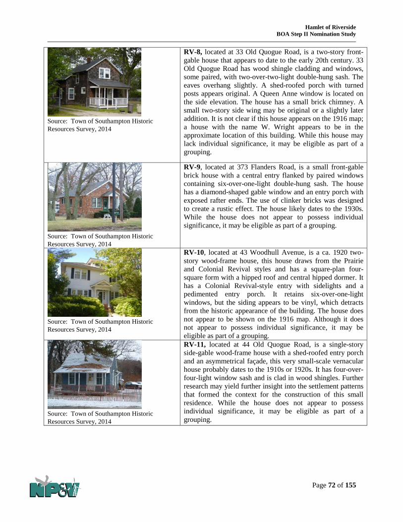
Hamlet of Riverside BOA Step II Nomination Study
Page 72 of 155
Source: Town of Southampton Historic Resources Survey, 2014
RV-8, located at 33 Old Quogue Road, is a two-story front-gable house that appears to date to the early 20th century. 33 Old Quogue Road has wood shingle cladding and windows, some paired, with two-over-two-light double-hung sash. The eaves overhang slightly. A shed-roofed porch with turned posts appears original. A Queen Anne window is located on the side elevation. The house has a small brick chimney. A small two-story side wing may be original or a slightly later addition. It is not clear if this house appears on the 1916 map; a house with the name W. Wright appears to be in the approximate location of this building. While this house may lack individual significance, it may be eligible as part of a grouping.
Source: Town of Southampton Historic Resources Survey, 2014
RV-9, located at 373 Flanders Road, is a small front-gable brick house with a central entry flanked by paired windows containing six-over-one-light double-hung sash. The house has a diamond-shaped gable window and an entry porch with exposed rafter ends. The use of clinker bricks was designed to create a rustic effect. The house likely dates to the 1930s. While the house does not appear to possess individual significance, it may be eligible as part of a grouping.
Source: Town of Southampton Historic Resources Survey, 2014
RV-10, located at 43 Woodhull Avenue, is a ca. 1920 two-story wood-frame house, this house draws from the Prairie and Colonial Revival styles and has a square-plan four-square form with a hipped roof and central hipped dormer. It has a Colonial Revival-style entry with sidelights and a pedimented entry porch. It retains six-over-one-light windows, but the siding appears to be vinyl, which detracts from the historic appearance of the building. The house does not appear to be shown on the 1916 map. Although it does not appear to possess individual significance, it may be eligible as part of a grouping.
Source: Town of Southampton Historic Resources Survey, 2014
RV-11, located at 44 Old Quogue Road, is a single-story side-gable wood-frame house with a shed-roofed entry porch and an asymmetrical façade, this very small-scale vernacular house probably dates to the 1910s or 1920s. It has four-over-four-light window sash and is clad in wood shingles. Further research may yield further insight into the settlement patterns that formed the context for the construction of this small residence. While the house does not appear to possess individual significance, it may be eligible as part of a grouping.

Hamlet of Riverside BOA Step II Nomination Study
Page 73 of 155
Source: Town of Southampton Historic Resources Survey, 2014
RV-12, located at 48 Old Quogue Road, is a large front-gable structure bearing a sign that reads “Nelbro Trucking,” this trucking company building is believed to date to ca. 1930. It is two stories in height with four large truck bays on the front façade with garage doors. Pedestrian entries are located on the ends. Asymmetrically placed windows in a variety of sizes are located at upper story level; they contain six-over-one-light wood sash. Four windows are located above this level. The building appears to be sided in wood shingles. Some recent alterations are evident, including replacement doors, however, overall the building appears to retain historic integrity. According to an online obituary for Frank Wilhelm Nelson (1914-1999), the trucking company was run by Nelson and his brothers for over 50 years. The Nelsons were natives of Riverhead and members of the Montaukett Indian Nation.
Source: Town of Southampton Historic Resources Survey, 2014
RV-13, located at 568 Riverleigh Avenue, is a very small single-story square-plan building with a pyramidal roof and a brick chimney, likely built in the 1920s or 1930s. The four-bay façade includes a door in the end bay and three windows containing two-over-two-light double-hung sash. The building is sided in wood shingles. Further research may yield further insight into the settlement patterns that formed the context for the construction of this small-scale residence. While the house does not appear to possess individual significance, it may be eligible as part of a grouping.
Source: Town of Southampton Historic Resources Survey, 2014
RV-14 is located on 411 Riverleigh Avenue (SCTM # 900–139–2–75) and contains a small single story building with a brick chimney and wood shingles. The building was likely constructed in the 1920s or 1930s and although it does not appear to be significant individually, it may be an eligible landmark as part of a group.

_̂
_̂
_̂
_̂̂__̂
_̂_̂
_̂
_̂
_̂
_̂_̂
_̂
_̂
TOWN OF SOUTHAMPTON
TOWN OF RIVERHEAD
R I V E R H E A D
Bl a
c k C
r ee k
Po
nd
R i v e r
Li t
t le
Pe c
o ni c
Ri v
e r
P e c o n i c
RV-9RV-8
RV-7
RV-6RV-5RV-4
RV-3
RV-2
RV-1
RV-13
RV-12RV-11
RV-10
RV-14
UV24
³ ±63
³ ±104
³ ±105
³ ±94
³ ±94A³ ±51
OLD
QU
OG
UE RD
LUDL
AM A
VE
VA I L AVE
PI NE STWOODH
ULL A
VE
BR OW N ST
PEBB
LE W
AY
PHI L
LIP S
AVE
PEGS
LN
GOODRIDGE AVE
RANDALL ST
MAYNARD ST
ENTE
RPRI
SE Z
O NE
DR
VAN HOUTON ST
PA RK PL
RIVE
R RD
P HI L
LIP S
AVE
BIRCH ST
POND DRWOODLAND DR
OAK ST
PINE ST
PINE GROVE ST
DOGWOOD ST
KIR K
AVE
NOR THWOODS DR
DONA
LD A
VE
OAK
CT
ELM
C T
P ON D L N
MO
BIL E
HO
ME
PARK
RIVER LE IG
H AV
E
LAKE
AV
E CR
63
NU GE NT DR
Town of Southampton Marker
μ
Town of Southampton
Riverside Hamlet Revitalization
0 1,000Feet
Cultural Resources
Prepared By:The Town of Southampton Divisionof Geographic Information SystemsDate: Friday, June 03, 2016
BOA Figure 3-7
Legend
Study Area
_̂ NYS Historic Site Markers
_̂2014 Historic Resources Survey(Compiled By AKRF) -Potentially ContributingPropertiesNYS Archeological SensitiveSites (NYS OPRHP)
Riverhead Histric District
2014 Aerial Imagery
No Buldings on the National or State Register within study area
Hamlet of Riverside BOA Step II Nomination Study
Page 75 of 155
Archaeological Resources Parts of the Study Area are located within areas identified by the NYS OPRHP as archaeologically sensitive, which in this instance is any area within a half-mile of a known resource location (see Figure 3-7). The areas identified as archaeologically sensitive include land in the northwestern quadrant of the Study Area, including land around the traffic circle and along most of that area north of SR 24 along the Peconic River, the existing single-family residential neighborhood along the western boundary of the Study Area, and land that is situated north of the Riverwoods/MacLeod Community. The other archaeologically sensitive location is a small area in the northeastern corner of the Study Area which contains land that has been acquired and preserved by the Town, wetlands that cannot be developed, an area of dredge spoil deposits, a commercial property and some developed single-family residential properties. 3.2.10 Transportation Systems Introduction Riverside is often referred to as “the gateway to the Hamptons”, as it lies between the terminus of the Long Island Expressway (I-495) and the more affluent communities on Long Island’s south fork. The proposed Brownfields Opportunity Area is bound by a state road (SR 24) and two County Roads (104 and 105). Although served by major State and County roads, the internal street circulation in the Riverside neighborhood is poor, with some streets little more than dirt paths. Riverside is served by Suffolk County Transit’s most heavily used bus route, and is within half of a mile of the terminus of the Long Island Rail Road’s Riverhead line. The success of the Town’s redevelopment and revitalization efforts is closely associated with the quality, efficiency, effectiveness, safety and convenience of its transportation systems. Without proper access and circulation the success of future businesses activity and the desirability of the hamlet as a place to live, will be limited. Inventory and Analysis of Transportation Systems
Motor Vehicle Activity and Roadway Conditions A Traffic Impact Study (TIS) was prepared by Nelson & Pope to assess existing traffic conditions in and around the Study Area. The TIS specifically included a detailed examination of existing roadway characteristics, circulation patterns and traffic conditions; availability of transit and pedestrian facilities; and accident histories at key intersections. The following is a brief description of the road network in the area. Figure 3-8 shows the local street network and the locations of major intersections within the Study Area that were evaluated. Flanders Road (NYS 24) is an east/west NYSDOT roadway within the Study Area and extends from the five-leg roundabout in Southampton to Montauk Highway in Hampton Bays. Within the Study area, Flanders Road provides one lane per travel direction with a center two-way left turn lane. The posted speed limit on Flanders Road is 40 MPH within the Riverside area. The section of Flanders Road in Riverside has an average annual daily traffic (AADT) volume of approximately 17,444 vehicles per day. Sidewalks are provided on both sides of Flanders Road within the Study Area.

Hamlet of Riverside BOA Step II Nomination Study
Page 76 of 155
Nugent Drive (CR 94) is an east/west Suffolk County roadway within the Study Area and extends from the five-leg roundabout in Southampton to the Long Island Expressway. CR 94 provides two lanes per travel direction with turn lanes at major intersections. The posted speed limit on CR 94 is 40 MPH. Lake Avenue (CR 63) is a north/south Suffolk County roadway within the Study Area and extends from the five-leg roundabout to CR 51. CR 63 provides one lane per travel direction. The posted speed limit on CR 63 is 55 MPH. CR 63 has an AADT volume of approximately 6,692 vehicles per day. CR 104 is a north/south Suffolk County roadway within the Study Area and extends from the five-leg roundabout to CR 80. CR 104 within the Study Area provides one lane per travel direction. The posted speed limit on CR 104 is 40 MPH. CR 104 has an AADT volume of approximately 8,443 vehicles per day. Old Quogue Road is a north/south local roadway within the Study Area and extends from Flanders Road (NYS Route 24) to CR 104. Old Quogue Road provides one lane per travel direction. The posted speed limit on Old Quogue Road is 30 MPH. Old Quogue Road has an AADT volume of approximately 813 vehicles per day. Ludlam Avenue is a north/south local roadway within the Study Area and extends from the Flanders Road (NYS Route 24) to CR 104. Ludlam Avenue provides one lane per travel direction. The posted speed limit on Ludlam Avenue is 30 MPH. Ludlam Avenue has an AADT volume of approximately 802 vehicles per day. Transit and Pedestrian Facilities Transit services within the Study Area include commuter rail and public bus. Also in the Study Area are pedestrian facilities i.e. sidewalks, crosswalks, pedestrian signals and push buttons at traffic lights.
Commuter Rail - The Riverhead Long Island Railroad (LIRR) station is located in downtown Riverhead. The station is situated on the north side of Railroad Street between Osborn Avenue and Griffing Avenue and is estimated to be a 0.48-mile (10-15 minute) walk by sidewalk from the traffic circle (Figure 3-8). It is also conveniently accessible by bicycle or is just a minute or two drive by car or taxi from the BOA and parking is available at the train station. Several bicycle racks are also provided at this location. The ridership on this eastern section of the LIRR is low. There are five trains per day, per direction that stop at this station. Riverhead station is also a stop for Suffolk County Transit (SCT) Bus routes S58, S62, S90, S92 and 8A and serves as a transfer location. Weekend and holiday service is even more limited with just two trains per direction, per day. Train arrivals and departures, however, are not coordinated with the SCT bus schedule and vice versa. The infrequent train service leaves commuters with few options when travelling to/from work. According to the most recent ridership data available from the LIRR, at the Riverhead station, during the weekday AM peak, 16 patrons boarded the westbound train and no one boarded the eastbound train. During the weekday midday peak, 16 patrons boarded the westbound train and 14 patrons exited the eastbound train. During the weekday PM peak no one boarded the westbound train and six patrons exited the eastbound train. The overall ridership for an entire day is 52 patrons entering/exiting the train at the

Hamlet of Riverside BOA Step II Nomination Study
Page 77 of 155
Riverhead station. For comparison purposes, the Ronkonkoma train station services 17,278 patrons, in one day. The infrequent service, arrival/departure times and distance from other stations does not appeal to long distance commuters. The Sustainable East End Development Strategies plan (SEEDs) recommends this station be developed into a regional hub for multimodal transportation. Bus Routes - Riverside is served by Suffolk County Transit’s most heavily used bus route, and includes a bus stop and bus shelter along Flanders Road near the traffic circle in downtown Riverside, along Riverleigh Avenue near the traffic circle, at the Riverwoods/MacLeod community, and at Ludlam Park, and along Flanders Road near Ludlam Avenue (Figure 3-8). This route runs between the Orient Point Ferry through Riverhead and then to the East Hampton Railroad. This route makes several stops along the north and south fork of Long Island as well as one stop in Riverside. The bus operates approximately every half hour or hour depending on the time of day and runs from 5:15 am to 8:45 pm. Full service is available on Saturdays and Sunday service is provided from May to October. During the public outreach phase of project planning, the community expressed great interest in increasing bus and transit opportunities. As a result, the Town and Master Developer have been working with Suffolk County to determine if increasing bus service along the existing bus route is possible. Bus and transit to, from and between Riverside, downtown Riverhead (which is also slated for revitalization in the near future), the Riverhead Train Station, and shopping centers along CR 58 are being evaluated. Connecting Riverside/Riverhead to EPCAL in nearby Calverton may be another option as development occurs and demand warrants.
Pedestrian and Bicycle Facilities - Sidewalks are provided on Flanders Road and the northbound approach at the signalized intersection of CR 105 and Flanders Road (NYS Route 24) is equipped with pedestrian push buttons and/or pedestrian signals and crosswalks to provide adequate crossing time and guidance to pedestrians. Sidewalks have also been installed on both sides of the road along Riverleigh Avenue and Lake Avenue for some distance extending south from Flanders Road. Sidewalks on the east side of Riverleigh Avenue end just before Pine Street, and on the west side at the entry to the Riverwoods community. Along Lake Avenue, the sidewalks extend until the vicinity of the southerly property line of the hotel along this road. Sidewalks are also present within the Woodhull Avenue neighborhood and are also present along the Ludlam Avenue frontage at the elementary school property. However, it is evident that there is not an interconnected system of sidewalks linking the Riverside neighborhoods. Bike lanes are provided along the shoulders of Flanders Road and bike racks are available at Riverhead Station.
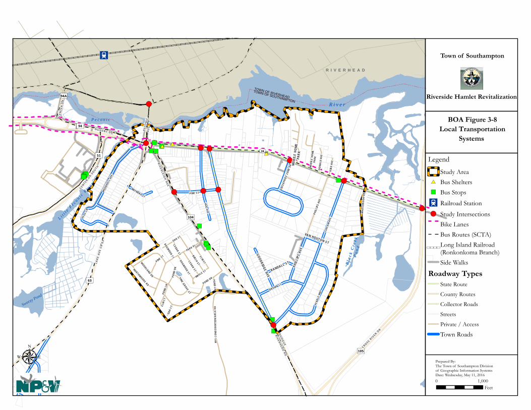
")")")")")")
")
")
")
")")
")
")
")
")")
")
")
")
")")
")")
#*#*
#*
!(
!(
!( !(
!( !(
!(
!(
!(
!(
!(
R i v e rR i v e r
TOWN OF RIVERHEADTOWN OF SOUTHAMPTON
MOB
ILE
HOM
EPA
RKPH
ILLI
PS A
VE
GOODRIDGE AVE
RANDALL ST
VAN HOUTON ST
I2
Sweezy Pond
Bl a
c k C
r ee k
Bl a
c k C
r ee k
Po
nd
Po
nd
L i tt l
e Pe c o n i c
Ri v
e r
L i tt l
e Pe c o n i c
Ri v
e r
P e c o n i cP e c o n i c
UV24
³ ±63
³ ±104
³ ±105
³ ±94
³ ±94A³ ±51
PARK PL
POND DR
PHIL
LIPS
AVE
WOODLAND DR
ELM ST
OAK ST
CEDAR ST
PINE ST
PINE GROVE ST
KIRK
AVE
DONA
LD A
VE
NORTHWOODS RD
MO
BILE
HO
ME
PARK
OAK
CT
ELM
CT
RIVERLEIG
H AV
E
LAKE
AV
E CR
63
NUGENT DR
PECO
NIC
AV
E
LUDL
AM A
VEVAIL AVE
PINE STWOO
DHUL
L AV
E
BROWN ST
PEBB
LE W
AY
PEGS
LN
MAYNARD ST
ENTE
RPRI
SE Z
ONE
DR
QU
OG
UE
RIVERHEA
D RD
CEN
TER D
R
CROSS RIV
ER DR
CENTER DR
SOUTH
POND
DR
CEDAR ST
DOGWOOD CT
POND
LN
POND LN
MAPLE ST
DOGWOOD ST
NYS
CONS
ERVA
TIO
N AR
EA R
D
WHI
TEBR
OOK
DR
BIRCH ST
R I V E R H E A D
Town of Southampton
Riverside Hamlet Revitalization
μ0 1,000
Feet
BOA Figure 3-8 Local Transportation
Systems
Prepared By:The Town of Southampton Divisionof Geographic Information SystemsDate: Wednesday, May 11, 2016
Legend
Study Area#* Bus Shelters") Bus Stops
I2 Railroad Station
!( Study IntersectionsBike LanesBus Routes (SCTA)
\\\\\\\\Long Island Railroad(Ronkonkoma Branch)Side Walks
Roadway TypesState Route
County Routes
Collector Roads
Streets
Private / Access
Town Roads

Hamlet of Riverside BOA Step II Nomination Study
Page 79 of 155
Traffic Impact Study Appendix K of the October 8, 2015 DGEIS contains a Traffic Impact Study (TIS) which provides in-depth analyses of existing traffic conditions in the Study Area, as well as future conditions based on the Theoretical Development Scenario envisioned by the RRAP under the ROD zoning amendments. The TIS methodology involved an analysis of existing traffic conditions including an assessment of the roadway characteristics, an inventory of existing transit and pedestrian facilities, review of available accident data, and compilation and evaluation of current levels of service. Future conditions were than projected for “no-build” and “build” conditions 5 and future trip generation was estimated. Modal split, trip distribution and assignment, and pass-by credits were also factored into the estimates. The TIS concluded that additional traffic can be expected and that level of service changes should be expected at many of the study intersections. Traffic mitigations were proposed based on identified impacts and are summarized below:
Increases in traffic from the proposed project can be accommodated at some study intersections without any mitigation. Some locations will require mitigation ranging from adjustments to the signal timings, additional lanes and installation of a traffic signal. Although there will be changes in the LOS at some intersections, they will continue to operate at acceptable levels of service. Fair Share mitigation contributions should allow for the implementation of the following: o Optimize and adjust the splits at the signalized intersection of Flanders Road (NYS
Route 24) and CR 105. o Redesign the northbound Old Quogue Road approach at its intersection with Flanders
Road (NYS Route 24) to provide one right turn lane and one left turn lane. o Redesign the northbound Vail Avenue approach at the intersection of Flanders Road
(NYS Route 24) at Vail Avenue to provide one right turn lane and one left turn lane. In addition to the redesign of the northbound approach, re-stripe the painted median on Flanders Road just west of Vail Avenue as a center two-way left turn lane consistent with the rest of Flanders Road.
o Redesign and install a traffic signal at the intersection of CR 104 at Old Quogue Road and Ludlam Avenue.
It should be noted that the introduction of mixed uses in the Hamlet offsets the need for vehicle use, as it places residential uses walking distance to the goods and services to be provided by the nonresidential uses contemplated in the ROD, as well as to those provided in Riverhead’s Central Business District. In addition, the entire area contained in the ROD is within biking distance to the Riverhead Train Station or by a short cab drive as well as to a variety of jobs, goods and services. Portions of the ROD are also located in walking distance to the Riverhead Train Station and bus service is provided near the traffic circle and throughout the study area. New Streets are encouraged and incentivized by the ROD to disperse local traffic alleviate the pressure on SR 24. 5 Build condition based on the RRAD’s Theoretical Development Scenario, other planned projects in the area, and background growth factors.
Hamlet of Riverside BOA Step II Nomination Study
Page 80 of 155
The traffic impact analysis demonstrates that the roadway network serving the Study Area will require improvements and modifications to improve levels of service that are projected as the result of traffic that may be generated by projects pursued in accordance with the ROD Amendments. At the time a site-and project-specific development application is submitted, further evaluation of traffic, site access, bicycle and pedestrian facilities, and parking will be performed pursuant to site plan protocols, SEQRA and consistency with the standards outlined under the Findings Statement. This information will serve as the basis to determine if additional traffic analysis is warranted for individual development projects and will also be used to establish fair share traffic mitigation for each individual project. The need for additional traffic investigations and any required mitigation will be determined by the Planning Board during site plan review in conjunction with future site-specific SEQR (6 NYCRR Part 617) analysis. Anticipated improvements to the traffic circle by Suffolk County Department of Public Works, which includes the construction of a second lane within the circle also helps to offset impacts. Construction of cross-streets to create blocks, enhance access, reduce traffic congestion and provide various other benefits is possible. Streetscape enhancements and promoting the use of transit (bus and rail), walking, bicycling, and other modes of transportation would facilitate activity in the Hamlet. 3.2.11 Natural Resources and Environmental Features Introduction This section includes a brief discussion of natural resources and environmental features in and around the Study Area and identifies some of the plans and regulatory restrictions in place to protect them. See the DGEIS for an extensive inventory and analyses of natural resources and significant features in and adjacent to the Study Area. Among the most significant and sensitive environmental resources in the Study Area are:
• surface waters (i.e., lakes, ponds, creeks, streams, and rivers); • tidal and freshwater wetlands; • Federal Emergency Management Agency (FEMA) floodplains, including “Special Flood Hazard
Areas”; • groundwater resources; and • ecological habitat.
Inventory and Analysis of Natural Resources and Environmental Features Surface Waters The Study Area is bordered by the Peconic River, Little Peconic River, and Black Creek Pond and contains three small freshwater ponds, as well as several small freshwater and tidal wetlands (Figure 3-9 depicts designated New York State Wild, Scenic and Recreational Rivers Areas and Figure 3-10 shows NYSDEC designated wetlands and Figure 3-11 shows National Wetland Inventory wetlands). These features are important natural resources that are or may be vulnerable to contamination from brownfield sites or other unresolved environmental conditions. Surface waters and wetlands and their adjacent areas are regulated by federal, state and local

Hamlet of Riverside BOA Step II Nomination Study
Page 81 of 155
laws administered by the US Army Corps of Engineers (Section 10 of the Rivers and Harbors Act), NYSDEC (Articles 24 and 25 of the Environmental Conservation Law and NYS Wild, Scenic and Recreational Rivers Act), and/or the Town of Southampton (Chapter 325 of the Town Code). Various policies, guidelines, and consistency reviews are also required pursuant to the Central Pine Barrens Comprehensive Land Use Plan, Peconic Estuary Comprehensive Conservation and Management Plan, and other resource protection plans and policies to protect these resources from degradation to support their many important functions and uses. (See also DGEIS, October 8, 2015, Pages 4-1 thru 4-19.). The protection, mitigation of impacts, and/or restoration of valued natural resources will help to ensure a healthy, well balanced and sustainable community. Study Area Drainage and FEMA Flood Zones Natural drainage, including overland runoff and underflow from natural infiltration or by direct recharge of water through dry wells and leaching pools, is expected to flow in a north to north-northeasterly direction toward the Peconic River. Drainage is an important factor in protecting surface waters and wetlands as well as in the prevention of flooding. Drainage issues are regulated by the Town through State and local laws and Site Plan, SEQRA, and Town Engineering review processes. Subwatersheds are shown in Figure 3-12. Based on a review of Federal Emergency Management Agency (FEMA) Flood Insurance Rate Maps (FIRMs), approximately 44 acres of the Study Area are located along the south bank of the Peconic River, north of SR 24, are within a FEMA-designated AE (100-year) Special Flood Hazard Area (SFHA).6 A narrow band of X5007 (500-year flood zone) is also present adjacent and to the south and inland of the AE zone including near the traffic circle, around the Suffolk Federal Credit Union and in the area containing old dredge spoil deposits (FEMA flood zones are depicted in Figure 3-13). The X500 zones comprise areas that are at minimal risk due to flooding from a principal water body in the area (i.e., the Peconic River). Nevertheless, land and structures at these locations can be affected by rare but extremely severe storms, particularly if the area is poorly drained and stormwater controls, building siting, and other factors are inadequate. A narrow “A” Flood Zone exists along the Little Peconic River. This zone generally follows the western boundary of the Study Area and affects only a very small portion of the Study Area within the rear setback of a few of the existing developed single-family lots and poses no significant issues or concerns. All other land within the Study Area is within FEMA’s X (upland or non-flood zones) and is therefore very unlikely to ever be affected by surface water flooding. The DGEIS notes that stormwater best management practices (BMPs) such as green infrastructure (landscaped buffers, rain gardens, green roofs, vegetated swales, etc.) should be utilized on future development sites that are adjacent to surface waters and 100-year flood zones where practicable to help reduce impervious surfaces, provide a level of flood storage, buffer and protect development from flooding, and provide a degree of community resiliency. Zoning several properties along the river bank as RO-7 (“Parkland”) pursuant to the ROD zone changes
6 A 100-year storm is defined as a storm with a magnitude having a one percent chance of occurring during the course of any given year. 7 The X500 zone is defined as the area located between the 100-year flood zone and the 500-year flood zone. The DGEIS FEMA map identifies this as the X-0.2% annual chance of flood hazard.
Hamlet of Riverside BOA Step II Nomination Study
Page 82 of 155
also helps to ensure that construction on land having the potential for flooding is properly sited. Moreover, future buildings and other impervious structures, as indicated in the DGEIS, should be located upland of the 100-year flood zone where possible, be properly constructed or on land that has already been filled, to avoid flooding and/or any significant loss of flood storage capacity. Stormwater best management practices (BMPs) such as green infrastructure (landscaped buffers, rain gardens, green roofs, vegetated swales, etc.) should be also considered in areas that may flood during a major storm. Some of the shoreline in the Study Area adjacent to the River is currently bulkheaded, thereby, providing some protection to these existing developed sites. Additional bulkheading and use of pervious surfaces are other strategies that may be employed where practicable to address flooding concerns in accordance with any required Town, NYSDEC or US Army Corp of Engineers permits. The DGEIS for the BOA Study, RRAP and ROD Code Amendments provides extensive information and analyses on stormwater and flood control (DGEIS, October 8, 2015, Pages 4-14 thru 4-18 and 15-2).

TOWN OF SOUTHAMPTON
TOWN OF RIVERHEAD
R I V E R H E A D
Bl a
c k C
r ee k
Po
nd
R i v e r
Li t
t le
Pe c
o ni c
Ri v
e r
P e c o n i c
UV24
³ ±63
³ ±104
³ ±105
³ ±94
³ ±94A³ ±51
OLD
QU
OG
UE RD
LUDL
AM A
VE
VA I L AVE
PI NE STWOODH
ULL A
VE
BR OW N ST
PEBB
LE W
AY
PHI L
LIP S
AVE
PEGS
LN
GOODRIDGE AVE
RANDALL ST
MAYNARD ST
ENTE
RPRI
SE Z
O NE
DR
VAN HOUTON ST
PA RK PL
RIVE
R RD
P HI L
LIP S
AVE
BIRCH ST
POND DRWOODLAND DR
OAK ST
PINE ST
PINE GROVE ST
DOGWOOD ST
KIR K
AVE
NOR THWOODS DR
DONA
LD A
VE
OAK
CT
ELM
C T
P ON D L N
MO
BIL E
HO
ME
PARK
RIVER LE IG
H AV
E
LAKE
AV
E CR
63
NU GE NT DR
PECO
NIC A
VE
μ
Town of Southampton
Riverside Hamlet Revitalization
0 1,000Feet
New York StateWild, Scenic and
Recreational Rivers
Prepared By:The Town of Southampton Divisionof Geographic Information SystemsDate: Friday, June 03, 2016
BOA Figure 3-9
Legend
Study Area
New York State Wild, Scenic andRecreational Rivers
Community
Recreational
2014 Aerial Imagery

TOWN OF SOUTHAMPTON
TOWN OF RIVERHEAD
R I V E R H E A D
Bl a
c k C
r ee k
Po
nd
R i v e r
Li t
t le
Pe c
o ni c
Ri v
e r
P e c o n i c
LZ
DSLZ
DS
HM
HMHM
IM
HM
HM
SM
IM
HMHM
FM
HM
IM
SMIM HM
HMIM
IM
R-5
R-5
R-72
R-11R-5
R-71
R-5
R-11
R-5R-81
R-5
R-11
R-70
R-71R-71
R-5
UV24
³ ±63
³ ±104
³ ±105
³ ±94
³ ±94A³ ±51
OLD
QU
OG
UE RD
LUDL
AM A
VE
VA I L AVE
PI NE STWOODH
ULL A
VE
BR OW N ST
PEBB
LE W
AY
PHI L
LIP S
AVE
PEGS
LN
GOODRIDGE AVE
RANDALL ST
MAYNARD ST
ENTE
RPRI
SE Z
O NE
DR
VAN HOUTON ST
PA RK PL
RIVE
R RD
P HI L
LIP S
AVE
BIRCH ST
POND DRWOODLAND DR
OAK ST
PINE ST
PINE GROVE ST
DOGWOOD ST
KIR K
AVE
NOR THWOODS DR
DONA
LD A
VE
OAK
CT
ELM
C T
P ON D L N
MO
BIL E
HO
ME
PARK
RIVER LE IG
H AV
E
LAKE
AV
E CR
63
NU GE NT DR
PECO
NIC A
VE
μ
Town of Southampton
Riverside Hamlet Revitalization
0 1,000Feet
New York State Wetlands
Prepared By:The Town of Southampton Divisionof Geographic Information SystemsDate: Friday, June 03, 2016
BOA Figure 3-10
Legend
Study Area
Fresh Water Wetlands (NYS DEC)
Tidal Wetlands (NYS DEC)Coastal Shoals Bars and Mudflats(SM)
Dredged Spoil (DS)
Fresh Marsh (FM)
High Marsh (HM)
Intertidal Marsh (IM)
Littoral Zone (LZ)
2014 Aerial Imagery

TOWN OF SOUTHAMPTON
TOWN OF RIVERHEAD
R I V E R H E A D
Bl a
c k C
r ee k
Po
nd
R i v e r
Li t
t le
Pe c
o ni c
Ri v
e r
P e c o n i c
E1UBL
E1UBL
E2EM1P
E2SS1PE2EM5Ps
E2EM1PdE2EM1P E2EM1P
E2SS1PE2SS1P
PEM5EPSS4Ed
PFO4/1Eg
PFO1R
PFO1Rd
PFO1C
PSS1F
PSS1F
PSS1Fx
PFO1C
PFO1C
PSS1E
PSS1E
PSS1F
PUBHx
PUBHh
PUBHh
PUBHh
PUBHh
PUBHh
PUBHh
PUBHh
PUBHh
PUBHh
PUBHh
PUBHh
PFO4Sd
PEM5E
E2
UV24
³ ±63
³ ±104
³ ±105
³ ±94
³ ±94A³ ±51
OLD
QU
OG
UE RD
LUDL
AM A
VE
VA I L AVE
PI NE STWOODH
ULL A
VE
BR OW N ST
PEBB
LE W
AY
PHI L
LIP S
AVE
PEGS
LN
GOODRIDGE AVE
RANDALL ST
MAYNARD ST
ENTE
RPRI
SE Z
O NE
DR
VAN HOUTON ST
PA RK PL
RIVE
R RD
P HI L
LIP S
AVE
BIRCH ST
POND DRWOODLAND DR
OAK ST
PINE ST
PI N E G R OV E ST
DOGWOOD ST
KIR K
AVE
NOR THWOODS DR
DONA
LD A
VE
OAK
CT
ELM
C T
MO
BIL E
HO
ME
PARK
RIVER LE IG
H AV
E
LAKE
AV
E CR
63
NU GE NT DR
μ
Town of Southampton
Riverside Hamlet Revitalization
0 1,000Feet
National Wetlands Inventory
Prepared By:The Town of Southampton Divisionof Geographic Information SystemsDate: Friday, June 03, 2016
BOA Figure 3-11
Legend
Study Area
National Wetlands Inventory(USFWS)
Estuarine and Marine Deepwater
Estuarine and Marine Wetland
Freshwater Emergent Wetland
Freshwater Forested/ShrubWetland
Freshwater Pond
2014 Aerial Imagery

66
11
33
99
7755
441 91 9
1 01 0
1 21 2
2 22 2
222 32 3
1 81 8
88
1 41 4
1 11 1
1 71 7
1 61 61 31 3
2 02 0 2 12 1
1 51 5
Flanders Rd
Riverleigh Ave
Ludl
am A
ve
Old Quogue Rd
Park Pl
Lake
Ave
Vail
Ave
Pond Dr
Roa
d D
Woodhull Ave
Brown StPh
illip
s Ave
Pond
Ln
Roa
d B
Woodland Dr
Pine St
Elm St
Birch St
Roa
d H
Cedar St
Goodridge Ave
Pegs
Ln
Oak St
Randall St
Kirk
Ave
Dogwood St
Maple Pl
Northwoods Ln
Ente
rpris
e Zon
e D
r
Don
ald
Ave
Peco
nic A
ve
Oak Ct
Whi
te B
rook
Dr
Town of Southamptonand
New York Department of State
Riverside Hamlet Revitalization
μ
0 800Feet
LegendStudy AreaWatersheds
Source: Town of SouthamptonOrthoimagery, 2014; Suffolk CountyLiDAR, 2006
1 inch = 800 feet
BOA Figure 3-12Subwatersheds

TOWN OF SOUTHAMPTON
TOWN OF RIVERHEAD
R I V E R H E A D
Bl a
c k C
r ee k
Po
nd
R i v e r
Li t
t le
Pe c
o ni c
Ri v
e r
P e c o n i c
AE (7)AE (8)
AE (7)AE (7)
AE (8)% AE (7)
AE (8)
AE (7)
AE (7)
UV24
³ ±63
³ ±104
³ ±105
³ ±94
³ ±94A³ ±51
OLD
QU
OG
UE RD
LUDL
AM A
VE
VA I L AVE
PI NE STWOODH
ULL A
VE
BR OW N ST
PEBB
LE W
AY
PHI L
LIP S
AVE
PEGS
LN
GOODRIDGE AVE
RANDALL ST
MAYNARD ST
ENTE
RPRI
SE Z
O NE
DR
VAN HOUTON ST
PA RK PL
RIVE
R RD
P HI L
LIP S
AVE
BIRCH ST
POND DRWOODLAND DR
OAK ST
PINE ST
PINE GROVE ST
DOGWOOD ST
KIR K
AVE
NOR THWOODS DR
DONA
LD A
VE
OAK
CT
ELM
C T
P ON D L N
MO
BIL E
HO
ME
PARK
RIVER LE IG
H AV
E
LAKE
AV
E CR
63
NU GE NT DR
μ
Town of Southampton
Riverside Hamlet Revitalization
0 1,000Feet
Flood Insurance Rate Zones (FEMA)
Prepared By:The Town of Southampton Divisionof Geographic Information SystemsDate: Friday, June 03, 2016
BOA Figure 3-13
Legend
Study Area
Flood Insurance Rate Zones (FEMA)
A - 1% ANNUAL CHANCEFLOOD HAZARDAE - 1% ANNUAL CHANCEFLOOD HAZARD (*BFE)X - AREAS OF MINIMALFLOOD HAZARDX - 0.2% ANNUAL CHANCEFLOOD HAZARD
2014 Aerial Imagery

Hamlet of Riverside BOA Step II Nomination Study
Page 88 of 155
Groundwater Near the Peconic River, groundwater flow is generally north toward the river; therefore, on the south side of the river within the Study Area, flow is generally to the north or north-northeast and the time of travel of groundwater to the Peconic River ranges between days in areas immediately adjacent to the river to as much as 10 to 25 years at the south end of the Study Area near the intersection of Ludlam Avenue and Pebble Way (Figure 3-14). Depth to groundwater from the ground surface is variable within the Study Area depending on surface elevations and how near or far from the river depth to water is measured due to increased ground surface elevations to the south with distance from the river. Based on available water table data compiled by the County, depth to groundwater in the Study Area ranges from near zero at a few locations near the river to approximately 35 feet at the south end of the Study Area between Oak Court and Elm Court in the Riverwoods Community. General depth to groundwater zones are shown in Figure 3-15 and are discussed in greater detail in the GEIS. Long Island’s freshwater aquifers (primarily the Upper and Magothy Aquifers) are generally considered to contain a significant volume of potable water, especially within deep recharge areas in the Central Pine Barrens, the Town’s Aquifer Protection Overlay District (APOD) and the region’s Special Groundwater Protection Area (SGPA), where the underlying groundwater reservoirs are very thick and contain considerable uncompacted coarse grained sand and gravel with significant storage capacity. All of Nassau and Suffolk Counties’ businesses and residents rely on groundwater for potable water. Since groundwater is the only source of potable water on Long Island, the EPA has designated the Island’s groundwater supply as a “sole source aquifer” pursuant to the Federal Safe Drinking Water Act. This designation, along with burgeoning population growth, increasing water demands, and threats to groundwater quality from land activities, all point to the need to protect this vital resource for future generations. For these reasons, various state, regional, and county agencies have expended considerable effort in identifying the best ways to protect groundwater resources, and in so doing have commissioned numerous studies that have culminated in a variety of plans, policies, laws and standards for regulating activities that may jeopardize groundwater quality (CPBJPPC, 1995; Long Island Regional Planning Board (LIRPB), 1992; Nassau-Suffolk Regional Planning Board (NSRPB), 1978; and SCDHS, 2008, 2004 and 1987.). Substantial planning and regulatory efforts have also been undertaken by the Town of Southampton to ensure the protection of groundwater resources. Land located south of the SR 24 (with the exception of a small area of land located north of SR 24 and west of Peconic Avenue) in the Study Area is within several groundwater management areas:
• Central Pine Barrens Compatible Growth Area (CPBJPPC, 1996); • Town of Southampton Aquifer Protection Overlay District (APOD); • Town of Southampton Central Pine Barrens Overlay District (CPBOD) (which serves to
implement the regional Central Pine Barrens Plan in the Town of Southampton); • Central Suffolk Special Groundwater Protection Area (South) (LIRPB, 1992); and • Suffolk County Groundwater Management Zone III (SCDHS, 2004).
Land located north of SR 24 is within Groundwater Management Zone IV and is not within any special groundwater protection areas. (See also DGEIS, October 8, 2015, Pages 4-1 thru 4-19.)

TOWN OF SOUTHAMPTON
TOWN OF RIVERHEAD
R I V E R H E A D
Bl a
c k C
r ee k
Po
nd
R i v e r
Li t
t le
Pe c
o ni c
Ri v
e r
P e c o n i c
0-2
2-5
5-10
10-25 25-50
2-5
UV24
³ ±63
³ ±104
³ ±105
³ ±94
³ ±94A³ ±51
OLD
QU
OG
UE RD
LUDL
AM A
VE
VA I L AVE
PI NE STWOODH
ULL A
VE
BR OW N ST
PEBB
LE W
AY
PHI L
LIP S
AVE
PEGS
LN
GOODRIDGE AVE
RANDALL ST
MAYNARD ST
ENTE
RPRI
SE Z
O NE
DR
VAN HOUTON ST
PA RK PL
RIVE
R RD
P HI L
LIP S
AVE
BIRCH ST
POND DRWOODLAND DR
OAK ST
PINE ST
KIR K
AVE
NOR THWOODS DR
DONA
LD A
VE
OAK
CT
ELM
C T
MO
BIL E
HO
ME
PARK
RIVER LE IG
H AV
E
LAKE
AV
E CR
63
NU GE NT DR
PECO
NIC A
VE
μ
Town of Southampton
Riverside Hamlet Revitalization
0 1,000Feet
GroundwaterTravel Time
Prepared By:The Town of Southampton Divisionof Geographic Information SystemsDate: Friday, June 03, 2016
BOA Figure 3-14
Legend
Study Area
2014 Aerial Imagery
Source: Suffolk County via CDM
Groundwater Contributing Areas - Estimated Time of Travel (Years)
0-2
2-5
5-10
10-25
25-50

R i v e rR i v e r
TOWN OF RIVERHEADTOWN OF SOUTHAMPTON
MO
BILE
HO
ME
PARK
PHIL
LIPS
AVE
GOODRIDGE AVE
RANDALL ST
VAN HOUTON ST
Bl a
c k C
r ee k
Bl a
c k C
r ee k
P
on
dP
on
d
L i tt l
e Pe c o n i c
Ri v
e r
L i tt l
e Pe c o n i c
Ri v
e r
P e c o n i cP e c o n i c
UV24
³ ±63
³ ±104
³ ±105
³ ±94
³ ±94A³ ±51
PARK PL
POND DR
PHIL
LIPS
AVE
WOODLAND DR
ELM ST
OAK ST
CEDAR ST
PINE ST
PINE GROVE ST
KIRK
AVE
DONA
LD A
VE
NORTHWOODS RD
MO
BILE
HOM
EPA
RK
OAK
CT
ELM
CT
RIVERLEIG
H AV
E
LAKE
AV
E CR
63
NUGENT DR
PECO
NIC
AV
E
LUDL
AM A
VE
VAIL AVE
PINE ST
WOOD
HULL
AVE
BROWN ST
PEBB
LE W
AY
PEGS
LN
MAYNARD ST
ENTE
RPRI
SE Z
ONE
DR
QU
OG
UE
RIVERHEA
D RD
CEN
TER D
R
CROSS RIV
ER DR
CENTER DR
SOUTH
POND
DR
CEDAR ST
DOGWOOD CT
POND
LN
POND LN
MAPLE ST
DOGWOOD ST
NYS
CONS
ERVA
TIO
N AR
EA R
D
WH I
TEBR
OO
K DR
BIRCH ST
R I V E R H E A DTown of Southampton
Riverside Hamlet Revitalization
μ0 1,000
Feet
Depth to Groundwater
Prepared By:The Town of Southampton Divisionof Geographic Information SystemsDate: Friday, June 03, 2016
BOA Figure 3-15
Legend
Study AreaGround Water Depth (USGS)
< 1 Ft1 Ft - 8 Ft> 8Ft

Hamlet of Riverside BOA Step II Nomination Study
Page 91 of 155
Vegetation, Wildlife & Habitats The Riverside Study Area is mostly comprised of suburban and commercial development but some vacant and undisturbed lands remain. Lands that are vacant fall into one of four categories: freshwater wetlands, tidal wetlands, preserved lands, or vacant lands (many of which are publically owned) surrounded by development. A general map of natural habitats located within the Study Area is provided in Figure 3-16. Upland communities are generally comprised of Pitch Pine-Oak forest, Successional Southern Hardwood forest, Maritime Oak Forest, Successional Shrubland, Maritime Heathland and Successional Old Field (Edinger et al, 2014). The Sarnoff Preserve, located in the southwest portion of the Study Area is comprised of Pitch Pine-Oak forest, Successional Old Field, and freshwater wetlands habitats. The preserve adjoins a vacant parcel of land that is comprised of Pitch Pine-Oak forest. Two other large parcels of Pitch Pine-Oak forest remain which consist of a narrow parcel of vacant woodland located in the central portion of the Study Area and portions of the industrial subdivision that remain undeveloped. Deciduous forest is the primary community located in the upland portion of the area north of Flanders Road. It is surmised that this forested area is a remnant of a Maritime Oak forest. Maritime Oak forests are defined as “an oak-dominated forest that borders salt marshes or occurs on exposed bluffs and sand spits within about 200 meters of the seacoast” (Edinger, et al., 2014). Areas where inspection was possible revealed highly disturbed woodland which is primarily comprised of invasive species (Norway maple, tree of heaven), however, remnant oaks were visible within the forested area. Due to access limitations, the area depicted as Maritime Heathland is surmised from aerial photography; field inspection of this area was not completed. All other upland habitats within the Study Area are either successional in nature or are landscaped and impervious areas associated with suburban development. Freshwater wetlands are important ecological communities. These habitats are generally more productive than upland habitats, and are typically high in both plant and animal diversity. NYSDEC tidal wetlands located along the shoreline of the Study Area east of the Peconic Avenue bridge, include High Marsh (HM), Intertidal Marsh (IM), Dredge Spoil (DS) and Littoral Zone (LZ). The tidal wetlands within the Study Area are located where the shoreline intersects and interfaces with tidal waters. These wetlands contain saline waters, which originate from the ocean-fed surface waters associated with Peconic Bay. These features are formed by coastal processes and, with the exception of formerly connected tidal wetlands, are subject to tidal influence. These areas are not only vital to the ecological systems to which they serve, but also function to control storm surges during flood and major storm events which may impact sensitive watershed areas. Tidal wetlands within the Study Area were presented earlier in Figure 3-10. The National Wetlands Inventory categorizes wetlands regardless of their size and regulatory status. As illustrated on Figure 3-11, the wetlands within the Study Area are characterized as “Estuarine” (where fresh and saline waters mix) north of CR 24, indicating that these wetlands are tidally influenced, while wetlands south of CR 24 are characterized as “Palustrine,” indicating these wetlands are freshwater in nature. Vegetation within Estuarine wetlands would consist of that adapted to tidal wetland environments, while freshwater wetland vegetation would generally be comprised of plants that have a lower salt tolerance.
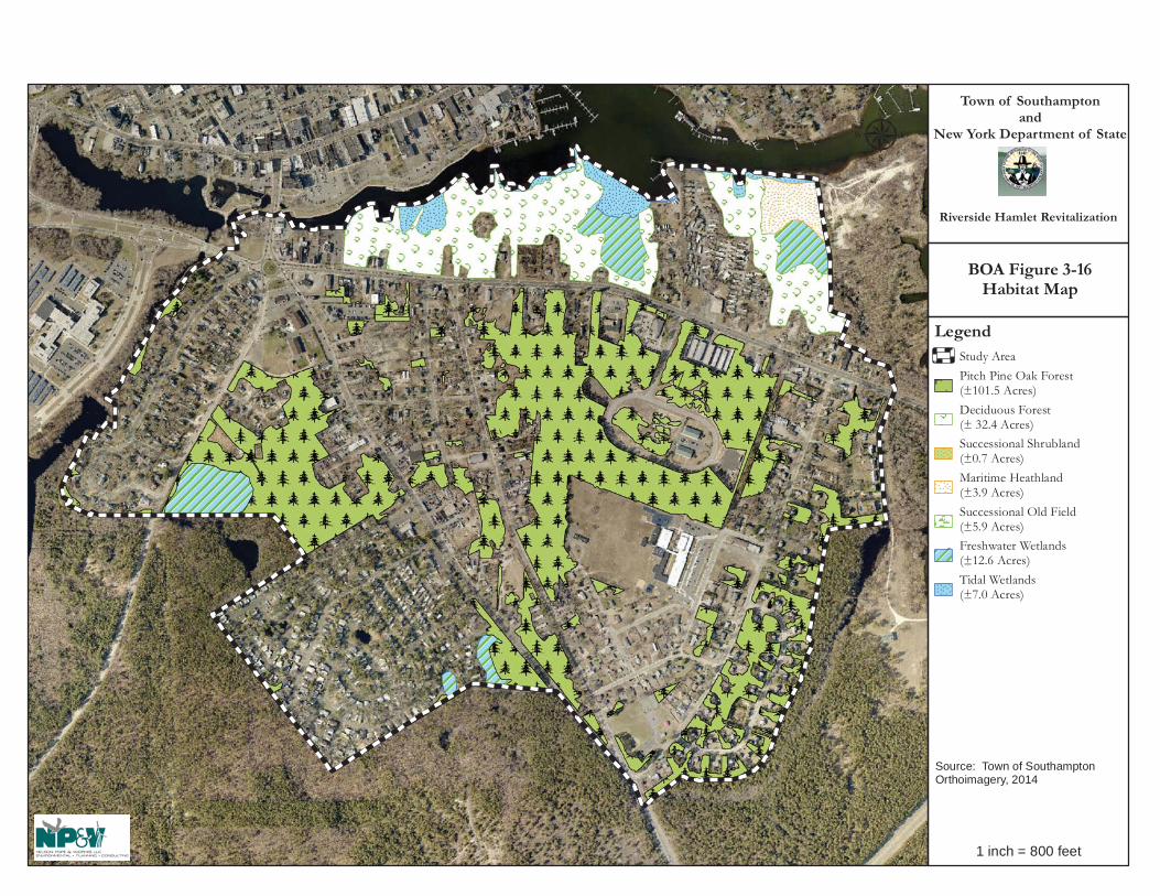
Town of Southamptonand
New York Department of State
Riverside Hamlet Revitalization
μ
LegendStudy AreaPitch Pine Oak Forest (±101.5 Acres)Deciduous Forest(± 32.4 Acres)Successional Shrubland(±0.7 Acres)Maritime Heathland(±3.9 Acres)Successional Old Field(±5.9 Acres)Freshwater Wetlands(±12.6 Acres)Tidal Wetlands(±7.0 Acres)
Source: Town of SouthamptonOrthoimagery, 2014
1 inch = 800 feet
BOA Figure 3-16Habitat Map

Hamlet of Riverside BOA Step II Nomination Study
Page 93 of 155
Wildlife within the majority of the Study Area is anticipated to consist of species that are adapted to suburban habitats, such as raccoons, squirrels, deer, rabbits, robins, mocking birds, grackles and starlings. The exception to this assumption is areas of forested upland, vegetated tidal wetlands, and freshwater wetlands, where a greater diversity of wildlife may inhabit, including interior forest birds, salamanders, shore birds, turtles, bivalves, and reptiles adapted for living in wetland habitats. The New York Natural Heritage Program (NYNHP) was contacted to determine the presence/absence of rare, threatened endangered species or significant natural communities within the Study Area. Six significant natural communities are located within or adjacent to the Study Area and are:
• Red Maple-Blackgum Swamp • Coastal Plain Atlantic White Cedar Swamp • Coastal Plain Poor Fen • Coastal Plain Pond Shore • Pitch Pine-Oak-Heath Woodland • Pitch Pine-Oak Forest
The NYNHP has also identified a number of rare, threatened or endangered plants and wildlife within or in the vicinity of the Study Area. Species identified include one endangered amphibian, one endangered butterfly, one threatened damselfly, one threatened fish, two special concern damselflies, two special concern moths, two unlisted damselflies, six unlisted moths, fifteen endangered plants, and fifteen threatened plants. It is also noted that the eastern tiger salamander has been identified as occurring within a half mile of the Study Area. Correspondence with the NYSDEC indicates that there are no documented breeding ponds within 1,000 feet of the Study Area, however, there are ponds in proximity to the Study Area that represent suitable habitat that have not been surveyed. Figure 3-17 also depicts NYS Significant Coastal Fish & Wildlife Habitats (SCF&WH) located in the vicinity of the Study Area. The Peconic River and Cranberry Bog County Park SCF&WH are the only ones located along the Study Area shoreline. As previously mentioned, the Town, Army Corps and NYSDEC regulate activities in and/or adjacent to wetlands. NYSDEC also regulates rare, threatened and endangered wildlife through Article 11 of the ECL as implemented under 6 NYCRR Part 182. As indicated by the NYNHP, several threatened and endangered wildlife species are located in the vicinity of the Study Area. As a result, disturbance to sites that contain or may affect habitat of the endangered or threatened wildlife species would be subject to regulation under Article 11 of the ECL. The GEIS contains additional information about ecological issues and conditions. (See also DGEIS, October 8, 2015, Pages 5-1 thru 5-14.) Critical Environmental Areas The portion of the Study Area located south of SR 24 is situated within a Central Pine Barrens Compatible Growth Area (CGA) and development under the subject zoning amendments will be assessed as a “Development of Regional Significance” in order to provide a comprehensive review of the project in consideration of the Central Pine Barrens CLUP (see Figure 3-18).

Town of Southamptonand
New York State Department of State
Riverside Hamlet Revitalization
8
0 600 1,200Feet
Legend
Study Area
NYS Significant Coastal Fish and Wildlife Habitats
Source: Town of Southampton, 2014;NYSDEC; USGS, 2010
1 inch = 600 feet
BOA Figure 3-17Significant Coastal
Fish & Wildlife Habitats

R i v e rR i v e r
TOWN OF RIVERHEADTOWN OF SOUTHAMPTON
MO
BILE
HO
ME
PARK
PHIL
LIPS
AVE
GOODRIDGE AVE
RANDALL ST
VAN HOUTON ST
Bl a
c k C
r ee k
Bl a
c k C
r ee k
P
on
dP
on
d
L i tt l
e Pe c o n i c
Ri v
e r
L i tt l
e Pe c o n i c
Ri v
e r
P e c o n i cP e c o n i c
UV24
³ ±63
³ ±104
³ ±105
³ ±94
³ ±94A³ ±51
PARK PL
POND DR
PHIL
LIPS
AVE
WOODLAND DR
ELM ST
OAK ST
CEDAR ST
PINE ST
PINE GROVE ST
KIRK
AVE
DONA
LD A
VE
NORTHWOODS RD
MO
BILE
HOM
EPA
RK
OAK
CT
ELM
CT
RIVERLEIG
H AV
E
LAKE
AV
E CR
63
NUGENT DR
PECO
NIC
AV
E
LUDL
AM A
VE
VAIL AVE
PINE STWOO
DHUL
L AV
E
BROWN ST
PEBB
LE W
AY
PEGS
LN
MAYNARD ST
ENTE
RPRI
SE Z
ONE
DR
QU
OG
UE
RIVERHEA
D RD
CEN
TER D
R
CROSS RIV
ER DR
CENTER DR
SOUTH
POND
DR
CEDAR ST
DOGWOOD CT
POND
LN
POND LN
MAPLE ST
DOGWOOD ST
NYS
CONS
ERVA
TIO
N AR
EA R
D
WH I
TEBR
OO
K DR
BIRCH ST
Flanders Ponds
R I V E R H E A DTown of Southampton
Riverside Hamlet Revitalization
μ0 1,000
Feet
Central PineBarrens
Prepared By:The Town of Southampton Divisionof Geographic Information SystemsDate: Friday, June 03, 2016
BOA Figure 3-18
Legend
Study Area
Pine Barrens PlanCompatible Growth Area
Core Preservation Area
Critical Resource Area
Development Rights ReceivingArea

Hamlet of Riverside BOA Step II Nomination Study
Page 96 of 155
Parts of the Study Area are also located within the Town’s Aquifer Protection Overlay District (APOD) and/or contain freshwater wetlands and associated upland adjacent areas 8 that are currently subject to regulatory review by the Town pursuant to Chapter 157 of the Town Code as well as the NYSDEC per Article 24 of the Environmental Conservation Law of the State of New York. The Central Pine Barrens CGA, APOD, and NYSDEC designated freshwater wetlands and adjacent areas are considered “critical areas” under Section 157-10, “Critical areas,” of the Southampton Town Code. The groundwater underlying much of Long Island has been federally-designated as a sole source aquifer, and is essential to the potable public water resources serving much of Long Island. The area of Long Island under which the largest volume and highest quality of such groundwater is found is the pine barrens area, which occupies much of the east-central portion of Suffolk County, an area dominated by lesser amounts of development and extensive tracts of natural forest. The forest composition of the area which has adapted to the unique soil properties of the area provides treatment of water entering the aquifer. The Long Island Pine Barrens Protection Act (the Act), signed into New York State law in 1993, established a State-assisted process to preserve those portions of the pine barrens so that the public potable water supply and overlying natural areas would be protected. Pursuant to the Act, the CPB Joint Planning & Policy Commission (the Commission) was established, to prepare and administer the Comprehensive Land Use Plan (CLUP) to regulate future growth in the CPB. This plan was prepared and adopted in 1995, and was added to the NYS Environmental Conservation Law as Article 57. As intended by the Act, the CLUP provides procedures for the review of development applications in the CGA, based on a set of specific guidelines and standards. It is noted that, with few exceptions, development opportunities in the CPA are limited. Standards and guidelines for compatible development were established for areas located in the CGA in order to sustain habitat and unique ecosystems and preserve the quality of groundwater recharge in the region. In addition to setting the standards and guidelines by which the Commission would review development applications, the CLUP allows for local municipalities to administer and conduct review of applications in the CPB. Such review must be performed under a locally-enacted ordinance that would be subject to the review and approval of the Commission. For applications undergoing local review, the CLUP standards are required to be incorporated into local land use and development procedures and ordinances, whereas the CLUP guidelines could be utilized by municipalities on a discretionary basis. The Town of Southampton adopted the standards of the CLUP into Article XXIV, Chapter 330 of its Town Code, and established Overlay Districts to implement many of the guidelines suggested in the CLUP. The area located south of SR 24 is also located within the Long Island Regional Planning Board’s Central Suffolk Special Groundwater Protection Area (SGPA) (South), and borders the County’s “Peconic Bay and Environs” CEA which includes the lower Peconic River, Flanders
8 “Adjacent area” means those areas of land or water that are outside a wetland and within 100 feet (approximately 30 meters), measured horizontally, of the boundary of the wetland. The Department may establish an adjacent area broader than 100 feet (approximately 30 meters) where necessary to protect and preserve a wetland, as set forth in subdivision 24-0701.2 of the Act and pursuant to Part 664.

Hamlet of Riverside BOA Step II Nomination Study
Page 97 of 155
Bay and the greater Peconic Estuary, which are County designated “Critical Environmental Areas.” Like the Town, the County also considers the Long Island Central Pine Barrens to be a CEA. CEAs are discussed in detail in the GEIS. (See also DGEIS, October 8, 2015, Pages 6-1 thru 6-28.)
3.3 Economic and Market Trends Analysis This section summarizes the preliminary market trends analysis that was prepared in connection with the RRAP. As part of this BOA process, Urbanomics was retained to review the analysis and assess the methodologies and findings regarding the recommended land use mix which could be supported from a market perspective. This section summarizes the results of this analysis. In addition, this section provides national market trends to supplement the market analysis included in the RRAP. 3.3.1 National Market Trends Throughout the country Millennials, the age group born between 1978 and 1994, are reshaping every market, from housing to retail to industry. Born with access to computers and the internet, they are much more technologically proficient than any other generation. In addition, they have redefined the American Dream to suit their own needs—it has become finding the balance of what makes the individual happy, rather than working in order to acquire traditional status symbols of success. They work at what they love or if they cannot do that, work sufficiently to support the activities that they do enjoy. To achieve this balance, they often choose to live near social and recreational activities they enjoy, e.g., walkable downtowns with nightlife and shopping, beaches with surfing, mountains and parks with hiking, or ideally in proximity to many of these. Housing Trends In the housing market, this translates as demand for studio and one-bedroom units, because the units are affordable with first jobs and because young adults are choosing to have families later, if at all, there is rarely need for extra bedrooms. Interestingly, this corresponds with demand from aging Baby Boomers, many of whom are downsizing their housing due to difficulties with care or limited and/or retirement finances and choosing to live in 1 and 2-bedroom condos closer to convenience goods and services. Retail Trends Online shopping is the first option for a generation that came of age with access to the internet, but that does not mean that brick and mortar businesses are a thing of the past. Local retail needs to be about convenience and experience. When almost anything can be delivered by Amazon within two days, local retail must either cater to the necessities that shoppers cannot or do not want to wait for, or stock items that require hands-on appraisal. Prices for convenience items must be competitive as well—online shoppers are inveterate comparison shoppers and high prices will not be accepted if there are other options—something that can be done if retail space and stock are limited. Retailers are also
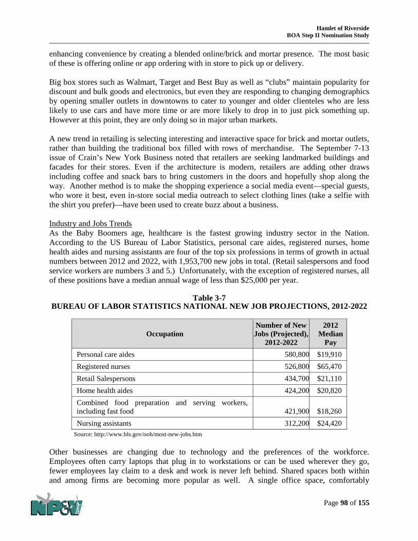
Hamlet of Riverside BOA Step II Nomination Study
Page 98 of 155
enhancing convenience by creating a blended online/brick and mortar presence. The most basic of these is offering online or app ordering with in store to pick up or delivery. Big box stores such as Walmart, Target and Best Buy as well as “clubs” maintain popularity for discount and bulk goods and electronics, but even they are responding to changing demographics by opening smaller outlets in downtowns to cater to younger and older clienteles who are less likely to use cars and have more time or are more likely to drop in to just pick something up. However at this point, they are only doing so in major urban markets. A new trend in retailing is selecting interesting and interactive space for brick and mortar outlets, rather than building the traditional box filled with rows of merchandise. The September 7-13 issue of Crain’s New York Business noted that retailers are seeking landmarked buildings and facades for their stores. Even if the architecture is modern, retailers are adding other draws including coffee and snack bars to bring customers in the doors and hopefully shop along the way. Another method is to make the shopping experience a social media event—special guests, who wore it best, even in-store social media outreach to select clothing lines (take a selfie with the shirt you prefer)—have been used to create buzz about a business. Industry and Jobs Trends As the Baby Boomers age, healthcare is the fastest growing industry sector in the Nation. According to the US Bureau of Labor Statistics, personal care aides, registered nurses, home health aides and nursing assistants are four of the top six professions in terms of growth in actual numbers between 2012 and 2022, with 1,953,700 new jobs in total. (Retail salespersons and food service workers are numbers 3 and 5.) Unfortunately, with the exception of registered nurses, all of these positions have a median annual wage of less than $25,000 per year.
Table 3-7 BUREAU OF LABOR STATISTICS NATIONAL NEW JOB PROJECTIONS, 2012-2022
Occupation Number of New Jobs (Projected),
2012-2022
2012 Median
Pay Personal care aides 580,800 $19,910 Registered nurses 526,800 $65,470 Retail Salespersons 434,700 $21,110 Home health aides 424,200 $20,820 Combined food preparation and serving workers, including fast food 421,900 $18,260 Nursing assistants 312,200 $24,420
Source: http://www.bls.gov/ooh/most-new-jobs.htm Other businesses are changing due to technology and the preferences of the workforce. Employees often carry laptops that plug in to workstations or can be used wherever they go, fewer employees lay claim to a desk and work is never left behind. Shared spaces both within and among firms are becoming more popular as well. A single office space, comfortably

Hamlet of Riverside BOA Step II Nomination Study
Page 99 of 155
furnished with basic assets such as wifi, printers and conference rooms can be shared by numerous individuals and companies for monthly fees, cutting down on overhead and allowing professional and social interaction and networking. Even manufacturing in the United States is changing—no longer able to compete in bulk offerings with places like China, the manufacturing industry has shifted to a more artisanal/value-added approach, responding to the question, what is best NOT done in bulk. These shops, like new offices, are smaller in scale and run to extremes, either creating goods by hand, or being largely technologically driven using robotics and 3-D printers. The workforce required for these endeavors includes craftsmen, designers, programmers, and engineers. Not only is the workplace starting to change, but so is firm location. Employers, especially tech employers, are returning to urban downtowns from suburban campuses to meet the demands of a younger workforce that wants to be near social and recreational activity as demonstrated by the locational choices of tech firms in Manhattan, Brooklyn and downtown Seattle. 3.3.2 Regional (Long Island/Suffolk County) Market Trends Housing Trends According to the American Community Survey 2009-2013, there are 569,196 housing units in Suffolk County, of which 87.4 percent are occupied. The vast majority (84.8%) are single family units, with fewer than 1 in 10 units located in buildings with 5 or more units. The housing stock also tends to be older (three out of every four units were constructed before 1980). In addition, as shown in the table below, unit sizes are quite large: 73.3 percent of units have 3 or more bedrooms, while less than one in every ten units is a studio or 1-bedroom.
Table 3-8 SUFFOLK COUNTY HOUSING BY BEDROOMS, 2009-2013
Housing Units Percent of Total Total 569,196 100% Studio 6,308 1.1% 1-Bedroom 49,651 8.7% 2-Bedrooms 95,919 16.9% 3 Bedrooms 218,082 38.3% 4-Bedrooms 146,200 25.7% 5+ Bedrooms 53,036 9.3%
Source: American Community Survey 2009-2013, DP04 There is a disparity between the existing housing stock in terms of size and the actual number of persons in households. Table 3-13 shows the number of households in Suffolk County by household size (occupancy). As shown, there are just over 100,000 single person households, however there are only half that many studio and one-bedroom housing units.

Hamlet of Riverside BOA Step II Nomination Study
Page 100 of 155
Table 3-9 SUFFOLK COUNTY HOUSEHOLD SIZE, 2009-2013
Households Percent of Total Total 497,347 100% 1 person 101,459 20.4% 2-person 148,209 29.8% 3-person 84,549 17.0% 4+-person 163,130 32.8%
Source: American Community Survey 2009-2013, S2501 This disparity indicates that many Suffolk County households are paying for more real estate than is needed. This is born out in an analysis of affordability. According to the Census Bureau, in Suffolk County 58.5 percent of renters, 49.6 percent of owners with a mortgage, and 31.1 percent of owners without a mortgage pay more than is considered affordable (30% of household income) on housing costs9. Industry and Job Trends An analysis of industry trends seeks to identify the clusters that may be established or emerging in the local economy, as well as those that may serve to support stronger industries in the region. For the purpose of this analysis, industry trends – with regard to both the number of employees and the number of establishments – within the boundaries of Suffolk County were examined over eight years (between 2005 and 2013). The values shown in Table 3-10 compare the businesses in Suffolk County in 2005 to those in 201310 based upon the NAICS code and highlight significant changes in the overall number of business establishments during this period. The highest growth was in accommodation and food services, Administrative and Support and Waste Management and Remediation Services, and Health care/social assistance, and high growth occurred in professional, scientific and technical services, and other services. The biggest loss for the county was in construction, manufacturing and retail businesses, which declined by a total of 245, 311 and 234 businesses respectively. The values shown in Table 3-11 compare the change in the number of paid employees in Suffolk County in 2005 as compared to 2013 based upon the NAICS code of the company and highlights significant changes in overall employment during this period.
9 Housing costs include, rent, mortgage, condo fees, property taxes, property insurance, utilities, etc. 10 Source: http://censtats.census.gov

Hamlet of Riverside BOA Step II Nomination Study
Page 101 of 155
Table 3-10 CHANGE IN BUSINESS ESTABLISHMENTS IN SUFFOLK COUNTY, 2005-2013
NAICS
code NAICS code description 2005 Total
establishments 2013 Total
establishments Change in
Total establishments
------ Total 47,611 48,689 1,078 11---- Forestry, Fishing, Hunting, and Agriculture
Support 64 76 12
21---- Mining 21 15 (6) 22---- Utilities 85 81 (4) 23---- Construction 7,133 6,888 (245) 31---- Manufacturing 2,324 2,013 (311) 42---- Wholesale Trade 3,343 3,218 (125) 44---- Retail Trade 6,783 6,549 (234) 48---- Transportation and Warehousing 1,081 1,205 124 51---- Information 708 606 (102) 52---- Finance and Insurance 2,307 2,492 185 53---- Real Estate and Rental and Leasing 1,797 1,663 (134) 54---- Professional, Scientific, and Technical
Services 5,437 5,722 285
55---- Management of Companies and Enterprises 142 175 33 56---- Administrative and Support and Waste
Management and Remediation Services 3,160 3,488 328
61---- Educational Services 493 611 118 62---- Health Care and Social Assistance 4,356 4,711 355 71---- Arts, Entertainment, and Recreation 812 884 72 72---- Accommodation and Food Services 3,150 3,666 516 81---- Other Services (except Public
Administration) 4,295 4,585 290
99---- Unclassified 120 41 (79)
Table 3-11 CHANGE IN PAID EMPLOYEES SUFFOLK COUNTY, 2005 – 2013
NAICS
code NAICS code description 2005 2013 Change between 2005 and 2013
Percent change
------ Total 555,718 557,995 2,277 0.4% 21---- Mining 228 137 (91) -39.9% 23---- Construction 38,152 41,018 2,866 7.5% 31---- Manufacturing 60,840 53,039 (7,801) -12.8% 42---- Wholesale Trade 54,243 42,906 (11,337) -20.9% 44---- Retail Trade 79,815 78,845 (970) -1.2% 48---- Transportation and Warehousing 19,031 17,492 (1,539) -8.1% 51---- Information 18,318 13,836 (4,482) -24.5% 52---- Finance and Insurance 24,077 22,175 (1,902) -7.9%

Hamlet of Riverside BOA Step II Nomination Study
Page 102 of 155
NAICS code NAICS code description 2005 2013
Change between 2005 and 2013
Percent change
53---- Real Estate and Rental and Leasing 7,687 6,483 (1,204) -15.7%
54---- Professional, Scientific, and Technical Services 42,841 47,076 4,235 9.9%
55---- Management of Companies and Enterprises 10,030 11,039 1,009 10.1%
56----
Administrative and Support and Waste Management and Remediation Services 35,670 38,333 2,663 7.5%
61---- Educational Services 11,281 9,476 (1,805) -16.0%
62---- Health Care and Social Assistance 84,588 95,503 10,915 12.9%
71---- Arts, Entertainment, and Recreation 7,477 9,781 2,304 30.8%
72---- Accommodation and Food Services 36,136 44,989 8,853 24.5%
81---- Other Services (except Public Administration) 23,182 24,317 1,135 4.9%
Source: Census; 2005 and 2013 County Business Patterns (NAICS) with analysis by NP&V. Shades of red identify relative levels of loss, while shades of green indicate relative growth.
Several industries witnessed considerable growth, both in terms of the number of employees and the number of establishments within the county. An analysis of the industry data reveals several strong clusters in the regional economy with respect to job growth. This includes services pertaining to health care and social assistance, accommodation and food services, professional, scientific and technical services, and arts, entertainment and recreation, and construction. There was a significant decline in wholesale trade and manufacturing jobs in Suffolk County during this period, and to a lesser degree (though significant), job declines in information services, finance and insurance, educational services and real estate and leasing and management, transportation and warehousing and retail. The office vacancy rate for Suffolk County is 17.1 percent according to first quarter 2015 real estate statistics prepared by CBRE. However, it should be noted that the area of assessment includes only western and central Suffolk and does not extend east beyond Highway 83 due to the limited amount of stock. Based upon the areas of growth, it appears that there may be opportunities for some local office space within the county – especially for medical uses. Growth Areas for Long Island Riverside has the lowest median income of any community on Long Island and thus, job creation in the area would be a tremendous asset for the population. The following graphics provided in the July 2015 RRAP illustrate the income levels by household, median income at $36,781 and employment by sector (for the residents of the hamlet of Riverside) and the job market for 2011 (excluding the County Center).

Hamlet of Riverside BOA Step II Nomination Study
Page 103 of 155
The New York State Department of Labor has created a list of the fastest growing occupations on Long Island, projected between 2010 and 2020. The top twelve occupations with the fastest growth (percentage wise) are shown in Table 3-12.
Table 3-12
FASTEST GROWTH OCCUPATIONS BY PERCENTAGE
Title Percent Employment Increase
in jobs Change 2010 2020 Personal Care Aides 53.3% 12,210 18,720 6,510 Home Health Aides 46.9% 13,150 19,320 6,170 Medical Assistants 25.6% 5,770 7,250 1,480 Coaches and Scouts 36.2% 2,710 3,690 980 Physical Therapists 33.7% 2,730 3,650 920 Market Research Analysts and Marketing Specialists 27.0% 3,180 4,040 860 Pharmacy Technicians 25.2% 2,620 3,280 660 Medical Secretaries 33.9% 1,920 2,570 650 Food Servers, Non restaurant 26.7% 2,210 2,800 590 Personal Financial Advisors 28.3% 2,050 2,630 580 Software Developers, Systems Software 25.4% 2,130 2,670 540 Dental Hygienists 28.5% 1,790 2,300 510
Source: NYSDOL with analysis by NP&V. Shades of red identify relatively small percent of increase, while shades of green indicate relatively high percent of increases in jobs.

Hamlet of Riverside BOA Step II Nomination Study
Page 104 of 155
It is also important to view the actual increase in employment opportunities (rather than a percent change) for the fastest growing occupations, to view the bigger picture. For example, while athletic trainers and audiologists are the top five and six growth occupations based upon the percent increase of 38.5%, this is somewhat misleading in considering the actual number of jobs that are expected to become available (which are quite low comparatively with only 50 new jobs projected). Table 3-13 illustrates the top twelve growth occupations based upon the expected increase in the number of jobs. In this case, there are a number of occupations with a percent change in the lower values, but which overall will provide more opportunities, such as medical assistants, pharmacy technicians and medical secretaries (all within the larger health care industry).
Table 3-13 FASTEST GROWTH OCCUPATIONS BY INCREASE IN NUMBER OF JOBS
Title Percent Employment Increase
in jobs Change 2010 2020 Personal Care Aides 53.3% 12,210 18,720 6,510 Physical Therapist Aides 47.8% 690 1,020 330 Home Health Aides 46.9% 13,150 19,320 6,170 Veterinary Technologists and Technicians 41.5% 940 1,330 390 Athletic Trainers 38.5% 130 180 50 Audiologists 36.8% 190 260 70
Helpers--Brickmasons, Blockmasons, Stonemasons, and Tile and Marble Setters 36.5% 520 710 190 Helpers--Carpenters 36.5% 850 1,160 310 Coaches and Scouts 36.2% 2,710 3,690 980 Diagnostic Medical Sonographers 34.5% 550 740 190 Medical Secretaries 33.9% 1,920 2,570 650 Physical Therapists 33.7% 2,730 3,650 920
Source: NYSDOL with analysis by NP&V. Shades of red identify relatively small increases, while shades of green indicate relatively high increases in jobs.
While many of the fastest growing occupations are centered on medical/health-care industry, other fast-growing occupations projected to occur throughout the Long Island region include those centered on recreation and fitness; food service; tourism; restaurants and entertainment; personal services; construction; and a variety of scientific, technical and professional occupations.11 3.3.3 Riverside Market Trends The Economic Market Study identifies numerous challenges under current conditions and opportunities in the redevelopment of Riverside. There are several potential challenges for retail 11 New York State Department of Labor, Fastest Growing Occupations, Long-Term Occupational Projections, Long Island Region, 2010-2020. Accessed via http://labor.ny.gov/stats/lsproj.shtm.

Hamlet of Riverside BOA Step II Nomination Study
Page 105 of 155
development in Riverside including the lack of on-street and off-street public parking options for through traffic on NY SR24, the current socioeconomic climate and high crime rate in Riverside, and a lack of diverse offerings. Additionally, there are many opportunities for retail development in Riverside including but not limited to Riverside’s location as a gateway area for the East End, cultural diversity which can differentiate the available retail offerings, history of locally owned businesses that suggests a healthy foundation for entrepreneurship, the need for a fresh start and will for a new identity, County Center, and strong mass transit bus connections. Housing Trends Current trends among the Millennial and baby boomer generations have demonstrated a growing demand for rental units in recent years. At its current rate of growth the Towns of Southampton and Riverhead are likely to add a demand of over 3,100 new rental units between 2010 and 2030. Given the growing propensity of Millennials and boomers to rent and the smaller household sizes of Millennials, this number could be even greater. The demand for rental housing is quickly growing and is not likely to stop soon. More rental units, and more types of rental units beyond single family homes, are a must if the Riverside community is to meet the challenges of the next generation.

Hamlet of Riverside BOA Step II Nomination Study
Page 106 of 155
Retail Trends To best understand the commercial uses that are viable in Riverside, Renaissance Downtowns prepared a retail gap analysis study in order to determine which uses are likely to have sufficient market demand necessary to be viable. The focus has been on market niches that might complement, rather than compete with, independently owned businesses in Riverhead Downtown, the extent to which existing businesses in the project area might absorb additional sales, and the tools and resources that might be helpful in stimulating new business development and growth of existing businesses. The potential for local retail sales is determined through the estimation of potential consumer expenditures (purchasing power) of resident households based upon their income, which is then compared to local retail sales. If local retail sales are less than the aggregate buying power of local households, there is “leakage” (i.e., local residents are spending money outside of the local area). If local sales are greater than local spending potential, there is an “injection” of spending from other areas. Retail Sales Leakage The economy of Riverside currently suffers from a retail sales leakage, that is, local residents are spending their money outside of Riverside. This loss to a community’s local economy may occur due to factors such as a void within a certain business type or a lack of an attractive retail
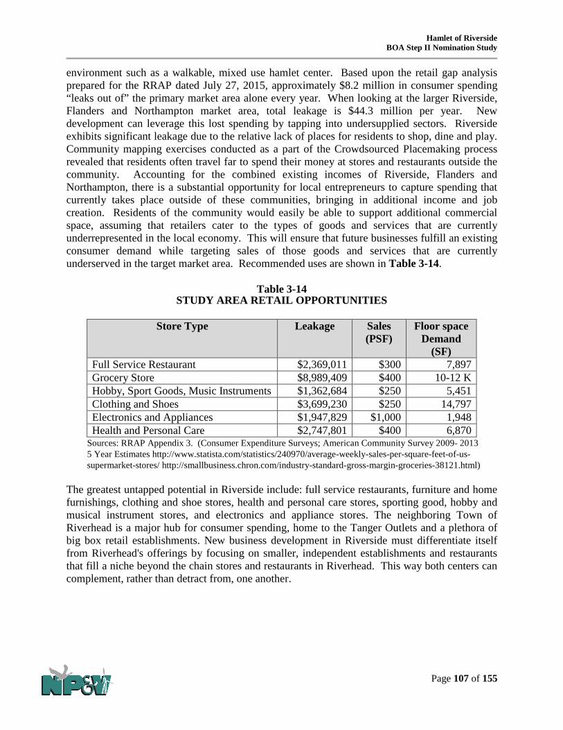
Hamlet of Riverside BOA Step II Nomination Study
Page 107 of 155
environment such as a walkable, mixed use hamlet center. Based upon the retail gap analysis prepared for the RRAP dated July 27, 2015, approximately $8.2 million in consumer spending “leaks out of” the primary market area alone every year. When looking at the larger Riverside, Flanders and Northampton market area, total leakage is $44.3 million per year. New development can leverage this lost spending by tapping into undersupplied sectors. Riverside exhibits significant leakage due to the relative lack of places for residents to shop, dine and play. Community mapping exercises conducted as a part of the Crowdsourced Placemaking process revealed that residents often travel far to spend their money at stores and restaurants outside the community. Accounting for the combined existing incomes of Riverside, Flanders and Northampton, there is a substantial opportunity for local entrepreneurs to capture spending that currently takes place outside of these communities, bringing in additional income and job creation. Residents of the community would easily be able to support additional commercial space, assuming that retailers cater to the types of goods and services that are currently underrepresented in the local economy. This will ensure that future businesses fulfill an existing consumer demand while targeting sales of those goods and services that are currently underserved in the target market area. Recommended uses are shown in Table 3-14.
Table 3-14
STUDY AREA RETAIL OPPORTUNITIES
Store Type Leakage Sales (PSF)
Floor space Demand
(SF) Full Service Restaurant $2,369,011 $300 7,897 Grocery Store $8,989,409 $400 10-12 K Hobby, Sport Goods, Music Instruments $1,362,684 $250 5,451 Clothing and Shoes $3,699,230 $250 14,797 Electronics and Appliances $1,947,829 $1,000 1,948 Health and Personal Care $2,747,801 $400 6,870
Sources: RRAP Appendix 3. (Consumer Expenditure Surveys; American Community Survey 2009- 2013 5 Year Estimates http://www.statista.com/statistics/240970/average-weekly-sales-per-square-feet-of-us-supermarket-stores/ http://smallbusiness.chron.com/industry-standard-gross-margin-groceries-38121.html)
The greatest untapped potential in Riverside include: full service restaurants, furniture and home furnishings, clothing and shoe stores, health and personal care stores, sporting good, hobby and musical instrument stores, and electronics and appliance stores. The neighboring Town of Riverhead is a major hub for consumer spending, home to the Tanger Outlets and a plethora of big box retail establishments. New business development in Riverside must differentiate itself from Riverhead's offerings by focusing on smaller, independent establishments and restaurants that fill a niche beyond the chain stores and restaurants in Riverhead. This way both centers can complement, rather than detract from, one another.
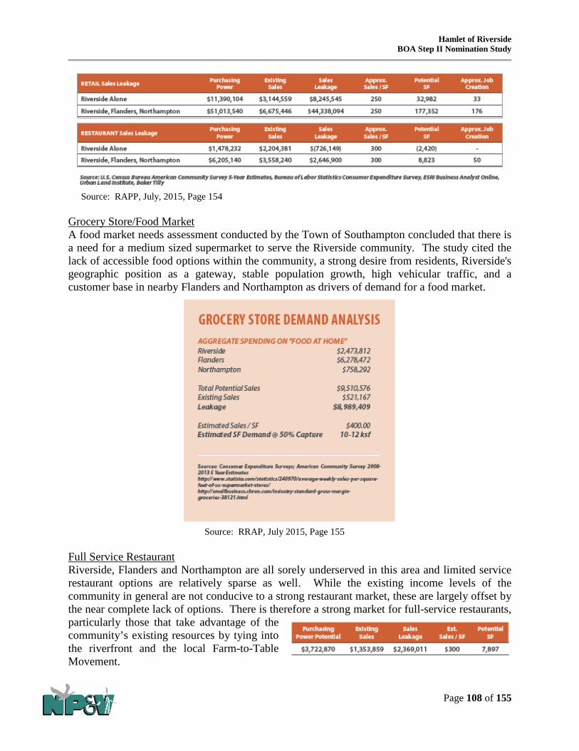
Hamlet of Riverside BOA Step II Nomination Study
Page 108 of 155
Source: RAPP, July, 2015, Page 154
Grocery Store/Food Market A food market needs assessment conducted by the Town of Southampton concluded that there is a need for a medium sized supermarket to serve the Riverside community. The study cited the lack of accessible food options within the community, a strong desire from residents, Riverside's geographic position as a gateway, stable population growth, high vehicular traffic, and a customer base in nearby Flanders and Northampton as drivers of demand for a food market.
Source: RRAP, July 2015, Page 155
Full Service Restaurant Riverside, Flanders and Northampton are all sorely underserved in this area and limited service restaurant options are relatively sparse as well. While the existing income levels of the community in general are not conducive to a strong restaurant market, these are largely offset by the near complete lack of options. There is therefore a strong market for full-service restaurants, particularly those that take advantage of the community’s existing resources by tying into the riverfront and the local Farm-to-Table Movement.

Hamlet of Riverside BOA Step II Nomination Study
Page 109 of 155
Hobby, Sporting Goods, Music Instruments There is a demand for nearly 5,500 square feet of retail space in this category such as a fishing establishment that could offer both fresh and salt water same day guided tours, lunch provided at on-site restaurant, shore, kayak and motorboat fishing, gear rental and sales. Electronics and Appliances The Riverside-Flanders-Northampton area has a sales gap of nearly $2 million on electronics and appliances which could yield a roughly 2,000 square foot small format retailer such as a small computer, camera, cell phone, video game or accessories store. Clothing and Shoes Demand for nearly 15,000 square feet of retail space for apparel could be filled by a variety of vendors including shoe stores, clothing boutiques and other retailers. Given the proximity to the Tanger Outlets in Riverhead, a smaller footprint, niche product would serve to differentiate the Riverside market from nearby competition.
Health and Personal Care A sales leakage of over $2.7 million reveals the opportunity for a small health and personal care store. This could be an opportunity for a small format pharmacy, beauty supply store, or health products store. Additionally, the community involvement process demonstrated community support for these types of health and personal care establishments.
Office It is imperative that Riverside be positioned to tap into the employment growth occurring in the region. An analysis of the projected need for office space in the future reveals an opportunity to bring employment centers to Riverside, providing much needed economic development, commercial activity and job opportunities to the community, particularly for those residents who lack access to reliable transportation. The analysis projects the growth of office users in a 10 mile radius of Riverside in each industry sector. Assuming each worker occupies 150 SF of space, this analysis yields a total demand for nearly 810,000 SF of office space. Among the fastest growing sectors in this region (in terms of absolute number of jobs) are “Health Care and Social Assistance” and “Educational Services”. Attracting employers in these industries would be particularly feasible.

Hamlet of Riverside BOA Step II Nomination Study
Page 110 of 155
Hotel Riverside’s scenic natural amenities and strategic position as the gateway to tourist attractions on both forks make it a prime location for a hotel. A hotel that ties into the existing waterfront, planned boardwalk and proposed new bridge could capitalize on the community’s local assets and proximity to regional destinations as well as increase job opportunities for Riverside residents. Community support for a "Hotel Hospitality Center" and "The Gateway Center", which includes visitor and tourist services could successfully be integrated with the hotel. Assisted Living There is a significant market opportunity for an assisted living or similar facility. The closest assisted living facility to Riverside is over 10 miles away in Center Moriches. Between the Towns of Southampton and Riverhead there are approximately 3,000 seniors classified as having a “self-care” or “independent living” difficulty. Assuming that many of these people do and will continue to reside outside of assisted care facilities, a conservative estimate that 20% of this population can be tapped into yields a demand for roughly 600 beds. Such establishments would provide an important service for a growing demographic in the region and provide significant well-paying career opportunities to local residents.

Hamlet of Riverside BOA Step II Nomination Study
Page 111 of 155
Light Industrial/Production Space A measure of job creation and economic development can be attained though certain light industrial uses. Artisan production facilities for local artists and craftsmen to create specialty items to sell online or locally, for example, could generate opportunities for entrepreneurial ventures and local employment while attracting creative and artistic people to live and work in Riverside.
Branding Strategies As the geographic gateway to the North and South Forks of Long Island, Riverside is well positioned to take advantage of the many attractions of the East End. Riverside has numerous natural resource assets. The local beaches promote Riverside as a place for beachgoers to shop, dine, stay, and play while the access to the Riverfront and planned boardwalk provide an excellent venue for water-based recreation. Trails offer opportunities for hiking, nature walks, exercise and exploration which makes Riverside an incredible prospect for ecotourism and nature-based recreation. Local food growing would provide economic, social and health benefits to Riverside while shaping its unique identity as a place where food, community, nature and culture intersect. Riverside’s proximity to wineries on the North and South Forks offers excellent opportunities to tap into viniculture and viticulture for tourism, recreation and education. Riverside can also utilize nearby East End Arts to act as a powerful catalyst for economic and cultural revitalizations. There is significant community support for a Riverside Children’s Museum which would make Riverside a unique place to visit while also providing an important educational opportunity for underprivileged children who typically lack access to quality educational offerings. Another attraction to promote Riverside as a unique destination is WaterFire, a public art installation and community arts event that could bring new interest and investment to Riverside By leveraging its existing assets and potential opportunities, Riverside can brand itself as a unique and attractive destination. A wealth of natural resources as well as community inspired events and establishments can make Riverside a truly incredible place to be. Renaissance Downtowns and Riverside Rediscovered have been working with art organizations and local artists to leverage on existing creating powers and initiatives, community location and waterfront amenity.
3.4 Infrastructure Analysis
3.4.1 Water Analysis The area is served by the Riverside Water District, which is operated by the Suffolk County Water Authority (SCWA) and according to the 2015 SCWA budget, 588 customers are currently served through operating agreements in the district. Figure 3-19 shows the SCWA water distribution system in the area including water mains, pipe diameters and hydrant locations.

!( !( !( !( !(
!(
!(
!(
!(
!(
!(
!(
!(
!(
!(
!(
!(
!(
!(!(
!(
!(
!(
!(
!(!(
!(
!(
!(
!(
!(
!(
!(
!(
!(
!(
!(
!(
!(
!(
!(
!(
!(
!(
!(
!(
!(
!(
!(
!(
!(
!(
!(
!(
!( !(
!(
!(
!(
!(
!(
!(
!(
!(
#*
#*
#*
R i v e rR i v e r
TOWN OF RIVERHEADTOWN OF SOUTHAMPTON
MO
BILE
HO
ME
PARK
PHIL
LIPS
AVE
GOODRIDGE AVE
RANDALL ST
VAN HOUTON ST
Bl a
c k C
r ee k
Bl a
c k C
r ee k
P
on
dP
on
d
L i tt l
e Pe c o n i c
Ri v
e r
L i tt l
e Pe c o n i c
Ri v
e r
P e c o n i cP e c o n i c
UV24
³ ±63
³ ±104
³ ±105
³ ±94
³ ±94A³ ±51
PARK PL
POND DR
PHIL
LIPS
AVE
WOODLAND DR
ELM ST
OAK ST
CEDAR ST
PINE ST
PINE GROVE ST
KIRK
AVE
DONA
LD A
VE
NORTHWOODS RD
MO
BILE
HOM
EPA
RK
OAK
CT
ELM
CT
RIVERLEIG
H AV
E
LAKE
AV
E CR
63
NUGENT DR
PECO
NIC
AV
E
LUDL
AM A
VE
VAIL AVE
PINE ST
WOOD
HULL
AVE
BROWN ST
PEBB
LE W
AY
PEGS
LN
MAYNARD ST
ENTE
RPRI
SE Z
ONE
DR
QU
OG
UE
RIVERHEA
D RD
CEN
TER D
R
CROSS RIV
ER DR
CENTER DR
SOUTH
POND
DR
CEDAR ST
DOGWOOD CT
POND
LN
POND LN
MAPLE ST
DOGWOOD ST
NYS
CONS
ERVA
TIO
N AR
EA R
D
WH I
TEBR
OO
K DR
BIRCH ST
RIVERSIDE WATER DISTRICT
Northampton/Riverside/Westhampton
R I V E R H E A DTown of Southampton
Riverside Hamlet Revitalization
μ0 1,000
Feet
Suffolk County Water Authority
Distribution System
Prepared By:The Town of Southampton Divisionof Geographic Information SystemsDate: Friday, June 03, 2016
BOA Figure 3-19
The map indicates the SCWA infrastructure installed in the depicted area as of the date listed thereon. The map does not indicate the presence of easements, occupied or unoccupied, or facilities owned by SCWA customers.
It is the responsibility of an operator to arrange to have services “marked-out” before commencing excavation.
Public and private hydrant data should be field or survey verified.
Legend
Study Area#* Private Hydrants!( Hydrants
Water Mains
Diameter (inches)468101216Distribution Areas

Hamlet of Riverside BOA Step II Nomination Study
Page 113 of 155
Input was sought during an interview with representatives of the SCWA regarding this area and no indications were made that water capacity would be a barrier to redevelopment within the BOA Study Area. The following facts were provided:
• The SCWA does not have any wellfields within a 1,500 foot radius of the subject project area (i.e., they are outside of designated water supply sensitive areas);
• The project area is outside of any SCWA well capture zones; • SCWA’s Oak Avenue wellfield is the closest to the project at 1.6 miles south/east and has one
active well. As noted above, the SCWA does not have any well fields within a 1,500 foot radius of the Study Area. The nearest SCWA facility is the Oak Avenue well field located approximately 1.6 miles southeast of the Study Area. This wellfield contains one active well completed to a depth of 118 feet below grade and the screened portion of the well is between elevations -1.23 to -31.23 feet below msl. Public supply wells are routinely monitored by SCWA in accordance with federal, state and local standards and requirements. The 2015 SCWA Water Quality Report (for calendar year 2014) was reviewed for the most recent available summary of monitoring results for water quality in Distribution Area No. 39. A total of 96 separate water quality parameters were tested for in 2014, including a variety of inorganic constituents (e.g., metals), volatile organic compounds (VOCs), synthetic organic compounds (SOCs), and water disinfectants and disinfectant byproducts from chlorination. In total, 1,471 individual tests were performed in the district in 2014. Not one of the test results for this distribution area exceeded established maximum contaminant levels (MCLs) (SCWA, 2015). Nitrate is an inorganic compound of local concern as it can cause health problems in infants.12 Nitrate was not detected in any of the ten samples taken in 2014. Sources of nitrate primarily include fertilizers, sanitary system discharge, animal wastes and atmospheric deposition. A lack of any nitrate in concentrations above the minimum detection limit is quite unusual and suggests a relatively pristine and well protected groundwater resource in the well field contributing areas. Of the 21 types of SOCs and 23 types of VOCs that were monitored for in Distribution Area 39 throughout 2014, not one was detected. The absence of even a trace of SOCs and VOCs is further evidence that the water supply serving the Riverside community is of a very high quality. Disinfection and disinfection/chlorination by products were also well below the applicable standards for the eight parameters tested for (one of the parameters, chlorate, does not have an MCL). Based on a review of the 2014 groundwater quality data for SCWA Distribution Area No. 39, the groundwater quality within the groundwater contributing area of the wells during 2014 was excellent. The Study Area is outside of any of SCWA public water supply capture zones and approximately 4,300 feet from the nearest Riverhead municipal water district supply well, which is located near the southwest corner of the intersection of Pulaski Street and Raynor Avenue on the opposite side of the Peconic River from the Study Area. Water mains exist on all major roadways within the Study Area.
12 High concentrations of nitrogen can also cause water quality and environmental issues in coastal waters including increases in algae production and reductions in dissolved oxygen concentrations in tidal waters that may lead to hypoxia (low oxygen) or anoxia (no oxygen) causing fish kills.

Hamlet of Riverside BOA Step II Nomination Study
Page 114 of 155
Any redevelopment would require connection to the existing SCWA water supply and developers would be required to install laterals between proposed buildings and the street to allow connection to existing mains. New projects are required to receive approvals for water connections and the availability of service and any need for additional infrastructural improvements will be determined at that time. 3.4.2 Sanitary Sewer One role of a BOA Nomination Study is to identify obstacles to redevelopment and identify means of overcoming these challenges. The lack of sufficient infrastructure for treating wastewater in Riverside is a major obstacle to redevelopment since the level of development permitted is dramatically limited without advanced wastewater treatment. Constraints relate to the required sanitary design flow limitations of the Suffolk County Sanitary Code (SCSC) as well as the physical and environmental constraints in this area. In order to prevent and reduce adverse effects of wastewater on the underlying aquifer and nearby Peconic River Estuary, limits have been placed on the amount of untreated wastewater that can be contributed by development. Within Groundwater Management Zone III (located east of Peconic Avenue and north of SR 24/Flanders Road), parcels are limited to 600 gallons per day (gpd) of sanitary effluent per acre and within Groundwater Management Zone IV (the remainder of the Study Area), parcels are limited to 300 gpd per acre. Currently, wastewater disposal occurs via on-site sanitary systems, many of which consist merely of cesspools. The level of existing development is not in conformance with SCSC and there are areas of high density homes whose sanitary systems may consist of cesspools within a groundwater contributing area (where groundwater discharges to surface water of the Peconic Estuary). Based upon the results from NP&V’s copyrighted model for predicting both the water budget of a site and the concentration of nitrogen in recharge, the Study Area currently has a recharge of 474.07 million gallons per year (MGY) (399.48 MGY in the portion of the Study Area within the Central Pine Barrens) and an estimated nitrogen concentration in recharge of 4.58 milligrams per liter (mg/l) (within the Central Pine Barrens, 4.83 mg/l). The concentration of nitrogen emanating from the existing Study Area is relatively high for an aquifer that discharges to a sensitive surface water body such as the Peconic River. In addition, the portion of the site within the Central Pine Barrens was analyzed separately in order to compare the concentration of nitrate-nitrogen in recharge for comparison to the Pine Barrens guideline of 2.5 mg/l (Guideline 5.3.3.1.3) used for evaluating a Development of Regional Significance (DRS). The portion of the Study Area within the Central Pine Barrens currently has a concentration of nitrogen in recharge of 4.83 mg/l which exceeds the nitrate-nitrogen goal of 2.5 mg/l. As a result, the goal of redevelopment within the Central Pine Barrens portion of the Study Area is to not cause an increase in the concentration of nitrate-nitrogen as compared with existing conditions and to try to reduce actually reduce the concentration to the maximum extent possible. The creation of a wastewater treatment plant would benefit the Riverside community in numerous ways. The wastewater treatment plant would be able to process larger capacities of wastewater than septic systems so development would not be limited because of wastewater.

Hamlet of Riverside BOA Step II Nomination Study
Page 115 of 155
The addition of a treatment plant is expected to have economic benefits by allowing more development and environmental benefits by reducing the amount of contaminants and nitrogen released into groundwater. Following adoption of the 2004 Flanders/Northampton/Riverside Revitalization Study, Suffolk County Department of Public Works commissioned a study to explore the feasibility of providing sanitary sewer service along the Flanders-Riverside Corridor including the subject Study Area south of SR 24 in order to advance prospects for business development and improvement of the local economy, expand housing opportunities and protect the environment. A draft of this study was completed in 2013. The Flanders Riverside Corridor Sewer Feasibility Study (Sewer Feasibility Study) addressed sewage collection, treatment and effluent discharge requirements, associated capital and operational costs, as well as the economic and environmental benefits associated with sewering the Flanders Riverside Corridor (CDM Smith; H2M; and Bowne AE&T Group, 2013). The Sewer Feasibility Study, which evaluated scenarios involving flows of 100,000 gpd and 160,000 gpd, did not identify any existing sewage treatment plants (STPs) within a mile of the Study Area that had the additional capacity to serve the area and instead suggested that a new facility with advanced nitrogen removal capability be constructed. An alternative involved the identification and evaluation of several new and one existing location for the treatment and disposal of sewage generated under the development scenario envisioned at that time. Specifically, this alternative considers the best location(s) in or near the Study Area to site a new STP(s) and associated leaching field(s) and/or possible connection to and expansion of a currently operating STP to ensure the level of treatment necessary to continue to protect human and natural environments under the Proposed Action. The Sewer Feasibility Study preliminarily identified three possible locations for a new STP to serve the existing community and redevelopment planned in 2013 prior to the involvement of a Master Developer and preparation of the RRAP. Based on Article 6 of the Suffolk County Sanitary Code, new conventional septic systems may be installed on sites if not more than 300 gpd of sewage density load is discharged per acre on that land in the Study Area south of SR 24, while 600 gpd/acre is the threshold in the Study Area north of SR 24. The ability to treat sanitary effluent is clearly a primary factor limiting redevelopment in the hamlet and this need has been highlighted in the RRAP. There are numerous constraints regarding provision of sewage treatment, in addition to the enormous cost commitment. Siting a facility in this area is constrained by numerous factors; high groundwater; groundwater contributing areas to surface waters (with associated travel times); Pine Barrens Compatible Growth Area regulations; and general site needs (minimum area requirements, setbacks). Riverside has no community wastewater collection and STP to address its sewer flow and therefore relies solely on individual on-site cesspools and septic systems for wastewater disposal. Clearly there is enormous environmental benefit that could be achieved through the provision for sewage treatment in this area, even under current conditions. The design flow limits imposed by the Suffolk County Sanitary Code are necessary to protect environmental resources; however, they limit the development potential of the land and thus are believed to be one of the factors hindering redevelopment within the Riverside community. The redevelopment of this area consistent with the goals of the RRAP will require the construction of one or more sewage

Hamlet of Riverside BOA Step II Nomination Study
Page 116 of 155
treatment plants and potential locations for siting one or more plants was analyzed as part of the GEIS (see also Section 4.4.2 of this BOA document). Potential wastewater treatment plant locations are shown in Figure 3-20. 3.4.3 Stormwater and Surface/Groundwater Analysis Existing stormwater infrastructure is illustrated on Figure 3-21. Drainage patterns in the area are generally natural drainage, including overland runoff and underflow from natural infiltration or by direct recharge of water through dry wells and leaching pools. Once in the ground, water generally flows in a north to north-northeasterly direction toward the Peconic River. Existing development, including streets, highways and parking lots, utilize stormwater catch basins, leaching pools, drywells or natural infiltration processes on pervious surfaces to handle drainage. The State also owns and operates a stormwater recharge basin on the north side of SR 24 across from Suffolk Community Credit Union which serves this highway. Other designated recharge areas in the Study Area include Town-owned land identified as SCTM # 900-141-1-9.25 located within the Southampton Enterprise Zone industrial subdivision, where currently, no recharge basin exists, and land located along the west side of Pebble Way identified as SCTM # 900-142-1-1.41, as well as a lot owned by the school district which is located between Phillips Avenue and Ludlam Avenue which is identified as SCTM # 900-141-2-36.1. The Study Area contains a number of stormwater catch basins, drainage leaching pools, outfalls, and piping that serve the area streets and highways and mitigate existing stormwater impacts.
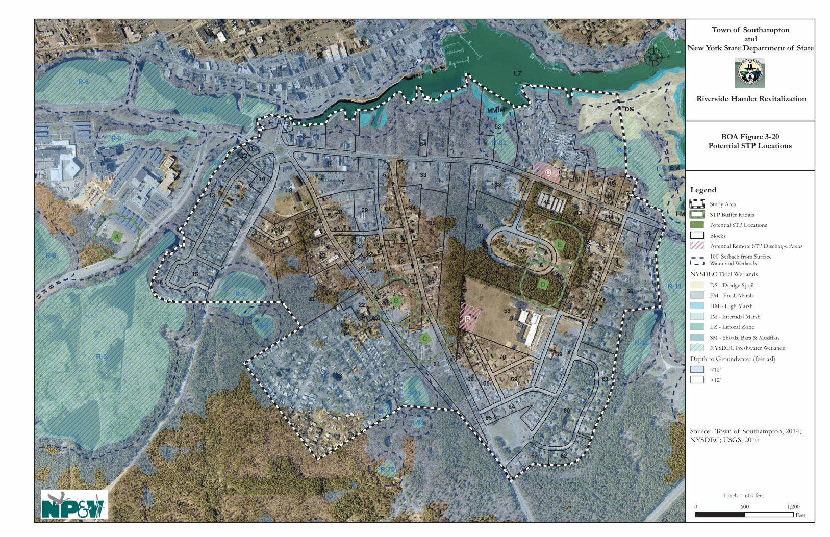
AA
LZ
DSHMIM
SM
FM
F
G
EA
D
B
C
R-5
R-5
R-5
R-72
R-11R-5
R-8
R-11
R-5 R-81
R-71
R-5
R-70
R-5
R-71R-71
23
58
56
51
41
21
37
87
24
14
53
60
57
4
39
6
52
59
38
3
13
35
25
61
40
33
16
2842
64
20
3615
69
3226
18
29
27
70
66
4334
63
30
95
62
22
1945
68
46
17
49
1
67
47
31
10
44
50
2
54
65
11
48
12
48
Town of Southamptonand
New York State Department of State
Riverside Hamlet Revitalization
8
0 600 1,200Feet
Legend
Study Area
STP Buffer Radius
Potential STP Locations
Blocks
Potential Remote STP Discharge Areas
100' Setback from Surface Water and Wetlands
NYSDEC Tidal Wetlands
DS - Dredge Spoil
FM - Fresh Marsh
HM - High Marsh
IM - Intertidal Marsh
LZ - Littoral Zone
SM - Shoals, Bars & Mudflats
NYSDEC Freshwater Wetlands
Depth to Groundwater (feet asl)
<12'
>12'
Source: Town of Southampton, 2014;NYSDEC; USGS, 2010
1 inch = 600 feet
BOA Figure 3-20Potential STP Locations
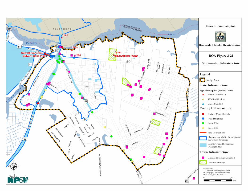
!(
!(
!(
!(
!(
!(
!(
!(
!(
!(!(
!(!(
!(
!(
!(!(
!(
!(
!(
!(
!(
!(!(
!(
!(!( !(!(!(!(
!(!(
!(
!(
!(!(!(
!(!(!(!(
!(
!(
!(
")")")
")
")")
")
")")
")
")
")
")
")")
")")
")
")")")
")")")")")
")")")") ")")")")
")")
")")
")")
")
")") ")
")
")
#*#*
#*
#* #*
#*
#*R i v e rR i v e r
TOWN OF RIVERHEADTOWN OF SOUTHAMPTON
MO
BILE
HO
ME
PARK
PHIL
LIPS
AVE
GOODRIDGE AVE
RANDALL ST
VAN HOUTON ST
Bl a
c k C
r ee k
Bl a
c k C
r ee k
P
on
dP
on
d
L i tt l
e Pe c o n i c
Ri v
e r
L i tt l
e Pe c o n i c
Ri v
e r
P e c o n i cP e c o n i c
UV24
³ ±63
³ ±104
³ ±105
³ ±94
³ ±94A³ ±51
PARK PL
POND DR
PHIL
LIPS
AVE
WOODLAND DR
ELM ST
OAK ST
CEDAR ST
PINE ST
PINE GROVE ST
KIRK
AVE
DONA
LD A
VE
NORTHWOODS RD
MO
BILE
HOM
EPA
RK
OAK
CT
ELM
CT
RIVERLEIG
H AV
E
LAKE
AV
E CR
63
NUGENT DR PECO
NIC
AV
E
LUDL
AM A
VE
VAIL AVE
PINE STWOO
DHUL
L AV
E
BROWN ST
PEBB
LE W
AY
PEGS
LN
MAYNARD ST
ENTE
RPRI
SE Z
ONE
DR
QU
OG
UE
RIVERHEA
D RD
CEN
TER D
R
CROSS RIV
ER DR
CENTER DR
SOUTH
POND
DR
CEDAR ST
DOGWOOD CT
POND
LN
POND LN
MAPLE ST
DOGWOOD ST
NYS
CONS
ERVA
TIO
N AR
EA R
D
WH I
TEBR
OO
K DR
BIRCH ST
Pipe
V2B1
Pipe
OtherRETENTION POND
Culvert: Conc BoxCulvert: Conc Pipe
R I V E R H E A DTown of Southampton
Riverside Hamlet Revitalization
μ0 1,000
Feet
Stormwater Infrastructure
Prepared By:The Town of Southampton Divisionof Geographic Information SystemsDate: Friday, June 03, 2016
BOA Figure 3-21
Legend
Study Area
State Infrastructure
Type - Description (See Red Label)
#* SPDES Outfalls R10
#* SWM Facilities R10
#* Vortex Units R10
Town Infrastructure
") Drainage Structures (unverified)
Dedicated Drainage
County Infrastructure
!( Surface Water Outfalls
!( Joint Structures
!( Inlets 2008
!( Inlets 2005
Pipe Connections
Flanders bay Multi - JurisdictionalSewarshed Boundary
County Owned Sewarshed(Flanders Bay)

Hamlet of Riverside BOA Step II Nomination Study
Page 119 of 155
3.4.4 Other Infrastructure and Community Services Community services are publicly funded agencies, organizations and facilities that provide essential services to the community. Provision of adequate public services and facilities is essential for ensuring the health, safety, welfare and coordinated growth of a community and promoting its cohesiveness, functionality, and sustainability. The various community services and facilities that are relevant to the Study Area include public schools, emergency services (i.e., police, fire, and ambulance), sewer, water, electric, natural gas utilities, and parks and recreation. Each service provider was contacted by letter and individual follow up meetings were arranged with major local service providers to inform them of the Proposed Action and to solicit input with respect to their service capacities and capabilities. Public Schools The community of Riverside is served by the Riverhead Central School District (RCSD) which contains seven public schools.
Children living in Riverside who are enrolled in public schools would attend Phillips Avenue Elementary, Riverhead Middle School and Riverhead High School. In addition, there is also a New York State Charter School (i.e., the “Riverhead Charter School”) in nearby Calverton. The Southampton Head Start (SHS) is also located in the Study Area at 271 Flanders Road (SR 24). SHS provides important educational services to area preschool children to prepare them for secondary school. The boundaries of the Riverhead CSD and the locations of its schools are shown on Figure 3-22.

Hamlet of Riverside BOA Step II Nomination Study
Page 120 of 155
Figure 3-22 RIVERHEAD CENTRAL SCHOOL DISTRICT
The GEIS provides additional information pertaining to area schools and potential impacts, issues, concerns and project mitigations. Town of Southampton Police Department The Town of Southampton’s Police Department (SHPD) provides traffic control and policing services to the community of Riverside and the rest of the unincorporated Town. The Department’s headquarters are centrally located at the Town’s Jackson Avenue Complex at the corner of Jackson Avenue and Old Riverhead Road in Hampton Bays. The GEIS provides additional information about the police force and its anticipated capability to serve the Study Area at build out. The Southampton Police District is shown in Figure 3-23.

Hamlet of Riverside BOA Step II Nomination Study
Page 121 of 155
Figure 3-23 SOUTHAMPTON POLICE DISTRICT
New York State Police The New York State Police operates a barracks located off of Riverleigh Avenue in Riverside. This barracks (Troop “L”) is relatively new to this location but replaces another local barracks that had previously operated several miles to the south in the Flanders/Hampton Bays area. Troop L serves the entire East End of Long Island, which includes the five towns of the Peconic Region: East Hampton, Southampton, Riverhead, Southold and Shelter Island, as well as residents of the Shinnecock Nation.

Hamlet of Riverside BOA Step II Nomination Study
Page 122 of 155
Fire Protection The Riverhead Fire District/Riverhead Volunteer Fire Department (RVFD) provides fire protection services to the community of Riverside. The District covers approximately 48 square miles stretching across the Town of Riverhead and into parts of the Southampton and Brookhaven. Currently, the Department has approximately 175 volunteer firefighters. The GEIS provides additional information about the Fire District and Fire Department. Figure 3-24 depicts the Riverhead and Southampton Fire Districts.
Figure 3-24 RIVERHEAD AND SOUTHAMPTON FIRE DISTRICTS

Hamlet of Riverside BOA Step II Nomination Study
Page 123 of 155
Ambulance Service Ambulance service in Riverside is provided by the Flanders-Northampton Ambulance Company (FNAC) headquartered at 641 Flanders Road, approximately 0.6 of a mile east of the Study Area. According to the Town of Southampton Division of GIS, FNVA’s taxing district covers 29.6 square miles which includes the communities of Riverside, Northampton, and Flanders. (See Figure 3-25).
Figure 3-25
NORTHAMPTON AMBULANCE DISTRICT
The FNAC currently has a staff of between 25 and 32 volunteers plus two per diem Advanced Life Support (ALS) paramedic first responders who assist volunteers during the day.

Hamlet of Riverside BOA Step II Nomination Study
Page 124 of 155
The ambulance company has through the years, expressed financial concerns due to the fact that Suffolk County owns approximately 80 percent of the land in the Flanders-Northampton district leaving just 16 percent of the land area to pay 100 percent of the taxes (Merrill, 2006) not to mention the significant demands of serving the nearby County facilities. In order to alleviate this burden, service reimbursement strategies have been considered in recent years but have not been instituted (Merrill, 2006 and Moran, 2012). The GEIS provides additional information about FNAC, its capabilities for serving the Study Area and recommendations to ensure continued coverage.

Hamlet of Riverside BOA Step II Nomination Study
Page 125 of 155
4.0 SUMMARY ANALYSIS, FINDINGS & RECOMMENDATIONS This section documents the key findings and recommendations of the evaluations provided in Section 3.0 of this Step II BOA Study. It includes an identification of the key strategic sites that present the best opportunities for redevelopment which in turn will serve as catalysts for revitalization of the Riverside hamlet as a whole. Preparation of the BOA Study was conducted concurrently with the preparation and completion of the Riverside Revitalization Action Plan (RRAP) and the analyses and findings of each study informed the other. The future end uses are based on findings of the market analyses conducted specifically for the BOA and the RRAP, and the land use preferences of the community as determined through the community participation planning process that was an integral component in the RRAP process. This BOA Study focuses on those properties whose redevelopment would be expected to serve as catalysts for revitalization of the community as a whole, including sites which may have environmental impediments to redevelopment as a result of past activities where there is a potential need for remediation in order to assure that the redevelopment process not be unnecessarily delayed. 4.1 Economic and Market Trends A component aspect of the planning process that was conducted in the creation of the RRAP was the preparation of a preliminary market study which identified the amount of floor space and dwelling units that could reasonably be accommodated within the reclaimed brownfield sites and revitalized Riverside community. The preliminary market study was reviewed separately by Urbanomics, Inc., during preparation of the BOA Nomination Study. Economic and market trends inform and assist in determining future uses which could be accommodated in the Study Area; uses were identified that also had community support. Retail demand was based on an examination of sales leakage - economic activity that should remain within a community’s local economy, but occurs elsewhere due to factors such as a void within a certain business type, lack of infrastructure to support development, or a lack of an attractive retail environment that captures interest and market demand. Riverside exhibits significant leakage due to the relative lack of places for residents to shop, dine and play. Accounting for the combined existing incomes of Riverside, Flanders and Northampton, there is a substantial opportunity for local entrepreneurs to capture spending that currently takes place outside of these communities, bringing in additional income and job creation. Table 4-1 summarizes the amount of nonresidential floor space and residential dwelling units that could be supported in Riverside, based on the market analysis conducted for the RRAP.

Hamlet of Riverside BOA Step II Nomination Study
Page 126 of 155
Table 4-1 STUDY AREA PRELIMINARY MARKET DEMAND
Store Type Floor Space
Demand (SF) Dwelling
Units Full Service Restaurant 7,897 Grocery Store 10-12,000 Hobby, Sport Goods, Music Instruments 5,451 Clothing and Shoes 14,797 Electronics and Appliances 1,948 Health and Personal Care 6,870 Office 80,796 Hotel Space --- Light Industry --- Rental Dwelling Units 3,115 Assisted Living 600 beds
Sources: RRAP Appendix 3. Specific findings are as follows:
• A food market needs assessment concluded that there is a need for a medium sized supermarket to serve the Riverside community.
• The most untapped retail opportunities include: full service restaurants, furniture and home furnishings, clothing and shoe stores, health and personal care stores, sporting good, hobby and musical instrument stores, and electronics and appliance stores.
• Based on employment estimates projected to the year 2030, and using a 10 percent capture rate for the Riverside market, approximately 81,000 square feet of office space could be supported. The fastest growing sectors include “health care and social assistance” and “educational services”.
• If planned amenities, including construction of a boardwalk and new bridge come to fruition, market demand would support a waterfront-oriented hotel.
• Between the Towns of Southampton and Riverhead there are approximately 3,000 seniors classified as having a “self-care” or “independent living” difficulty. A conservative estimate of 20% of this population yields a demand for approximately 600 beds.
• Artisan production facilities for local artists and craftsmen can be supported.
• In terms of residential dwellings, an age cohort analysis estimates that there will be new demand for 3,115 dwelling units by 2030 within the Towns of Southampton and Riverhead. This estimate does not account for demand within the Towns of Southold, East Hampton or Shelter Island all of which are experiencing the same general trends.
While there is market demand for the uses identified above, the Town must pursue implementation strategies that provide the regulatory framework and infrastructure support to capture same. These are described below.

Hamlet of Riverside BOA Step II Nomination Study
Page 127 of 155
4.2 Existing and Future Land Use and Zoning Numerous public policy planning documents have been commissioned by the Town and other agencies, and all identify the various challenges confronting the hamlet and suggested means by which to confront them. These planning studies include but are not limited to: the Town of Southampton 1999 Comprehensive Plan Update; the 2004 Flanders/ Riverside/ Northampton Revitalization Study; the 2006 Blight Study; the 2008 Riverside Hamlet Plan; the 2008 Draft GEIS for the Riverside Hamlet Plan; the 2009 Riverside Urban Renewal Plan; the 2013 Flanders Riverside Corridor Sewer Feasibility Study; and a Suffolk County Department of Public Works traffic circle assessment and redesign study. The overall goal of all of these studies has been to revitalize the Study Area with uses that would restore the character and functionality of the hamlet, promote economic development, provide housing and employment opportunities, and ensure adequate capital infrastructure, in order to revitalize the hamlet center. 4.2.1 Existing Land Use and Zoning Approximately 212 acres of the Study Area is in residential use. An additional 19 percent of the Study Area is vacant. Eight percent (8%) consists of commercial uses, and the remainder of the Study Area consists of streets and rights-of-way, industrial, institutional, parks and recreation, and surface waters. Development patterns in Riverside have remained relatively stagnant with the exception of the construction of the Suffolk Federal Credit Union at the corner of SR 24 and Enterprise Zone Drive approximately seven or eight years ago, a redevelopment that involved the construction of a new convenience store, and more recent development on two lots within the Southampton Enterprise Zone industrial subdivision that are now developed with light industrial uses. Several other lots within this subdivision remain vacant, which may be due in part to the recent recession and a general decline in industrial development in the Town and throughout the northeastern United States. The State Police barracks at 234 Riverleigh Avenue is also a recent addition and provides a greater police presence in the community. Many lots in the Study Area remain vacant, some of which are publicly owned. The State acquired land on the north side of SR 24 approximately 10 years ago for use as a stormwater recharge basin and the Town and County have acquired other nearby land along the river for parkland or open space preservation. More recent County land acquisitions along the river were once part of a proposal for a large hotel, catering facility and restaurant which never came to fruition. Thirteen “base” zoning districts regulate land use within the Study Area, including five single-family residence, six commercial, one light industry, and one open space conservation district as follows:
Residential and Open Space Zoning Districts Residence-15 (R-15) Residence-20 (R-20) Country Residence 40 (CR-40) Mobile Home Subdivision (MHS-40) Residence-80 (R-80) Open Space and Conservation (OSC)

Hamlet of Riverside BOA Step II Nomination Study
Page 128 of 155
Business and Industrial Zoning Districts Highway Business (HB) Village Business (VB) Shopping Center Business (SCB) Resort Waterfront Business (RWB) Office Business (OD) Motel Business (MTL) Light Industry (LI-40)
Single-family residential zoning districts regulate more land than any other zoning classification in the Study Area and are found along the eastern (R-15), western (R-20 and R-15), and southern (MHS-40 & R-15) Study Area boundaries, as well as near the center of the Study Area (R-15), and in the northeastern corner of the Study Area (R-80 along the river and R-15 along SR 24). The R-15 and R-20 zoning districts allow lots as small as 15,000 and 20,000 square feet, respectively, and are the highest density single-family residential density zones in the Town, while the CR-40 requires lots to be 40,000 square feet. The MHS-40 district requires a minimum lot size for a manufactured home park of 40,000 square feet, but the zoning regulations require only that the units be separated a distance of 15 feet, therefore resulting in a higher density of residential units than other zoning districts. The area zoned CR-40 has been acquired by the State and preserved as open space and wildlife habitat. Commercial zones in the Study Area are found near the traffic circle, along the north ends of Lake Avenue and Riverleigh Avenue, and along SR 24. The RWB zone is located on the north side of SR 24 along the Peconic River. Land within the Study Area that is within the RWB is owned by Suffolk County. Industrially zoned land (LI-40, Light Industry) is found along Enterprise Zone Drive and the south side of SR 24 near the center of the Study Area and includes land occupied by the Southampton Enterprise Zone industrial subdivision, Peconic Mini Storage, Suffolk Federal Credit Union (SFCU) and Southampton Head Start. Open Space Conservation (OSC) zoned land is located at the south end of the Study Area, north of the intersection of Ludlam Avenue and Old Quogue Road at the site of Ludlam Avenue Park. The recently approved ROD zones are discussed in Section 4.0. Land located south of SR 24 is also within two Town overlay districts: the “Aquifer Protection Overlay District” (APOD) and the “Central Pine Barrens Overlay District” (CPBOD). The overlay zoning district superimposes an additional “layer” of standards or regulations in addition to the existing “underlying” zoning requirements. These districts are defined geographic areas shown on a zoning map and are commonly applied to locations that need an additional measure of protection, such as areas containing important environmental resources (e.g., groundwater supplies, wetlands, agricultural soils), or in areas that compel additional consideration due to potential development issues (e.g., steep slopes, wetlands, etc.). A third overlay district, the Tidal Wetlands and Ocean Beach Overlay District (TWOBOD), regulates activities that may occur within or adjacent to the tidal wetlands on the north side of SR 24 along the tidal portion of the Peconic River (see “high marsh,” “intertidal marsh,” and “littoral zone”). (See also DGEIS, October 8, 2015, Pages 7-1 thru 7-37.) 4.2.2 Existing Sites of Environmental Concern Throughout the Study Area, properties exist that were or are developed with land uses that may have resulted in soil or groundwater contamination. A preliminary inventory and assessment of these properties was conducted which included a review of a comprehensive 2015 environmental

Hamlet of Riverside BOA Step II Nomination Study
Page 129 of 155
database report prepared by Toxics Targeting, Inc., subsequent preliminary site identification and land use inventories, and a review of records requested through the Freedom of Information Law (FOIL) from Suffolk County’s Offices of Pollution Control and Wastewater Management. Potential issues which were evaluated include hazardous materials spills, leaking above- and below-ground fuel storage tanks, known brownfield sites, waste disposal treatment sites, toxic materials storage and discharge areas, hazardous conditions cleanup locations, air pollutant dischargers, and past environmental violations Table 4-2 lists 20 sites of environmental concern (and shown in Figure 1-4) which may require further environmental site assessment. Furthermore, the sites were evaluated in relation to the RRAP concept plan, which presents the preferred building and land use pattern, in order to determine which of the 20 sites are considered “strategic”, discussed in detail below.
Table 4-2 STUDY AREA SITES OF ENVIRONMENTAL CONCERN
Site ID
Address Acres Risk Zoning Description FOIL Records Review
EC-1 89 Peconic Ave
(118-2-2)
0.7 M HB (Peconic Paddler). Listed as a petroleum bulk storage (PBS) facility and as being the subject of a closed spill incident that affected groundwater. Listed on Sanborn Maps as a filling station with four tanks on-site. Moderate Risk due to spill incident and previous site use as a gas station.
Records reviewed show that property formerly utilized two 6,000-gallon and one 3,000-gallon underground tanks for the storage of gasoline. One of the 6,000 gallon tanks was removed and the remaining tanks were abandoned in place. Abandonment and removal occurred in 1982.
EC-2 7 Peconic Ave
(118-2-4)
0.4 H VB (Valero Service Station). Listed as a PBS facility, a Resource Conservation Recovery Act (RCRA) Generator and being subject to closed spill incidents that impacted groundwater. Listed on Sanborn Maps as a filling station with tanks present (1969). Property has a High Risk due to historical use and recorded spill incidents that impacted groundwater.
Records reviewed provided information that confirms the presence of underground storage tanks on the property.
EC-3 8 Lake Ave (138-1-
104.001)
0.3 H HB (Shell Service Station). Listed as a PBS facility and being the subject of several closed spill incidents, some of which have impacted groundwater. Listed on Sanborn Maps as a filling station with tanks present (1969). High Risk due to history of spills and property use.
Records reviewed provided previously identified information that confirms the presence and removal of underground storage tanks on the property. Also provided information related to closed spill incident.

Hamlet of Riverside BOA Step II Nomination Study
Page 130 of 155
Site ID
Address Acres Risk Zoning Description FOIL Records Review
EC-4 30 East Moriches Rd (138-2-30)
0.9 L-M OD (Former Riverboat Diner). Listed as being the subject of a closed spill incident. Listed on Sanborn Maps as a Restaurant (1969). Property has a Low to Moderate Risk due to former property use as a food preparation establishment. Sanitary discharges could present an issue.
Records reviewed provided information related to the presence of three underground fuel oil storage tanks and the removal of one of the tanks in 2011.
EC-5 11 Flanders Rd
(138-2-32)
0.8 H HB (Vacant Getty Station). Listed as being a PBS facility and RCRA Generator as well as being the subject of several closed spill incidents. Several tanks reported to have been removed but one tank may remain. Listed on Sanborn Maps as a filling station and auto repair with tanks present (1969). High Risk due to former use and impacts to groundwater reported.
Records reviewed provided information regarding the presence and removal of the on-site underground storage tanks. Reporting also provided information on environmental investigation and remediation of the subject property.
EC-6 35 Flanders Rd
(138-2-33)
0.3 M VB (Slepboy Property). Subject of a closed spill incident that occurred in 1990 that affected groundwater and listed as a PBS facility and RCRA Generator. Formerly listed on Sanborn Maps as a dwelling (1969). Moderate Risk event though spill closed issues related to adjacent vacant Getty gas station may present other issues including soil vapor intrusion.
Records reviewed provided information confirming the removal of the underground storage tank formerly located on the subject property.
EC-7 104 Flanders Rd
(118-2-10)
0.1 M VB (Mildred Thomas Residence) – Active Spill for incident that occurred in 2006. Unknown quantity. Historically listed as a dwelling on Sanborn Maps. Moderate Risk since still an active spill but limited to soil.
No further information available through FOIL.
EC-8 113 Flanders Rd
(139-1-72)
0.2 M VB (Riverhead Precision Auto Collision). Listed as a PBS facility and RCRA Generator. Historically listed as an auto repair facility on Sanborn Maps. Moderate Risk due to property use.
Records reviewed provided information confirming the remediation of the on-site sanitary system.

Hamlet of Riverside BOA Step II Nomination Study
Page 131 of 155
Site ID
Address Acres Risk Zoning Description FOIL Records Review
EC-9 308 Riverleigh
Ave (139-1-48.001)
0.5 M VB (Riverhead Auto Supply & Universal Service of America). Listed as a RCRA Generator. Property is now vacant with only concrete slab foundation of the building present. Historically listed as an auto sales and service facility on Sanborn Maps. This property is owned by Town of Southampton. Moderate Risk due to former property use.
Records reviewed provided information related to a violation regarding the improper storage of toxic materials at the site. County records also confirmed the satisfactory remediation of a floor drain and leaching pool formerly located on the property.
EC-10
454 Riverleigh
Ave (139-2-54.001)
1.9 M-H SCB, R-15
(Best Price Auto Repair and Tires). Listed as a PBS facility and RCRA Generator. Listed on Sanborn Maps as previously being occupied by dwellings. Moderate to High Risk due to property use.
No further information available through FOIL.
EC-11
500 Riverleigh
Ave (139-2-
050.002)
2.5 M SCB, R-15
(Riverhead Trailer). Formerly Dyer Motors. Listed as a PBS facility and RCRA Generator. Listed on Sanborn Maps as being occupied by dwellings. Moderate Risk due to former site use
Records reviewed provided information confirming the presence and removal of storage tanks on the property. In addition, information was provided regarding the investigation and satisfactory remediation of a leaching pool on the subject property.
EC-12
568 Riverleigh
Ave (140-1-10)
0.3 M R-15 (Woodward Residence). Listed as an active spill incident that occurred in 1999. Resulted in the release of 250 gallons of fuel oil that impacted soil. Listed on Sanborn Maps as historically being occupied by dwellings. Moderate Risk due to active spill incident and quantity of product released. However, older spill and may be limited. Now owned by Ortega.
No further information available through FOIL.
EC-13
182 Old Quogue Rd
(140-2-71.001)
0.6 H R-15 (Juniors Auto Salvage). Active junk yard that was the subject of a closed spill incident. No Sanborn Map provided. High Risk due to property use and poor housekeeping practices.
No further information available through FOIL.

Hamlet of Riverside BOA Step II Nomination Study
Page 132 of 155
Site ID
Address Acres Risk Zoning Description FOIL Records Review
EC-14
219-223 Flanders Rd (139-3-52)
1.3 M-H HB (Apartment Complex) – Active Spill that occurred in 2007. Unknown quantity. No Sanborn Map provided. Moderate to High Risk since spill still active but seems to be limited to soil. However soil excavated to 12 feet and strong odor reported to still be present.
No further information available through FOIL.
EC-15
301 Flanders Rd
(141-2-2)
0.5 H HB (Shamrock Gas Station). Listed as a PBS facility and being the subject of a closed spill incident. No Sanborn Map provided. High Risk due to use.
No further information available through FOIL.
EC-16
Intersection of Ludlam Ave. and
Flanders Rd – 415 Flanders
Road (141-2-3)
0.6 H HB (Formerly an Ocean Gas Station, now is a Valero Gas Station). Active spill that occurred in 1998. Also the subject of several closed spills and listed as a RCRA Generator as well as PBS facility. Groundwater reported to have been affected and elevated levels of MTBE in on-site monitoring wells. Site also a risk due to property use. May have resulted in a soil vapor intrusion issue at home located at 404 Flanders Road. No Sanborn Map provided. High Risk due to use and active incidents that affected groundwater.
No further information available through FOIL.
EC-17
117 Ludlam Ave
(141-2-36.003)
1.4 M-H R-15 (Cedar Graphics, Inc.). Listed as a PBS facility and a RCRA Generator. Property currently vacant but appears to have been recently used as a church. No Sanborn Map provided. Moderate to High Risk due to former use and regulatory listings.
No further information available through FOIL.
EC-18
97 Old Quogue Rd (139-2-45)
0.3 --- R-15 This property is developed with a single family home that faces the street, and a fence which partially obstructs views into the yard. The front of the lot is paved and during inspections was used by several cars. In the rear yard area multiple vehicles are stored. While there are no records of environmental contamination, redevelopment of this site may be delayed due to a need for environmental remediation from past land uses. 2015 Town records indicate the property is a junkyard.
No further information available through FOIL.

Hamlet of Riverside BOA Step II Nomination Study
Page 133 of 155
Site ID
Address Acres Risk Zoning Description FOIL Records Review
EC-19
48 Old Quogue Rd
(139-3-20.002)
0.2 --- R-15 This property is developed with a two and a half story building that was reportedly used for auto repair with double garage doors on the ground level and reported to have multifamily housing above. There is a small boarded up building towards the street as well. The large building is currently boarded up and according to SC Department of Economic Development and Planning has been condemned by the Town of Southampton and is tax delinquent and being considered under their TDR program. The program seeks to transfer properties that have become tax delinquent for redevelopment and has Phase I ESA and if necessary Phase II Testing completed make properties more palatable for the development community to purchase, clean up and redevelop. However, funds have yet to be made available for a Phase I ESA for this particular site.
No further information available through FOIL.
EC-20
98 Quogue Rd (139-3-
37)
0.5 M-H R-15 This ½ acre property is developed with three 1-story buildings and the remainder of the site is generally paved for outdoor storage of vehicles and equipment. The property is currently used as an automobile towing facility. NP&V has classified the property as having Moderate to High Risk due to property use. Prior to redevelopment, a Phase I ESA would be appropriate to determine whether testing is required.
No further information available through FOIL.
4.2.3 Potential Future Land Uses The recently adopted Riverside Overlay District (ROD) Zoning identifies the permitted land uses within the Study Area. The GEIS analyzed the potential for environmental impacts of a theoretical development program which was created for the Study Area. Tables 4-4 and 4-5 below summarize the permissible uses for each strategic site. The concept plan shown below illustrates a possible future land use pattern as envisioned based upon the Theoretical Development Program, assuming an STP is constructed or an existing nearby facility is expanded to serve the Study Area. Figure 3-20 in Section 3.4.2 shows possible STP locations.

Hamlet of Riverside BOA Step II Nomination Study
Page 134 of 155
Source: Renaissance Downtowns, 2015 As shown in the image above, the primary redevelopment area is concentrated around the Riverside traffic circle, and extends outward from this location. The majority of the development would occur along Flanders Road and Riverleigh Avenue, especially in the area generally north of Pine Street. Development is also anticipated within the Enterprise Zone Drive area and other locations. The RRAP estimates a theoretical development program that would consist of the following future land uses (refer to Table 4-3).
Table 4-3 THEORETICAL DEVELOPMENT PROGRAM
Land Use Additional Square Feet,
Rooms, and Dwelling Units Retail 133,517 Square Feet Office 62,000 Square Feet Hotel 97 Hotel Rooms Apartments 2,267 Dwelling Units Adult Care/Nursing Home 63,910 Square Feet Artisan Lofts/Production 30,900 Square Feet Cultural 11,032 Square Feet
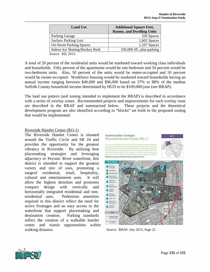
Hamlet of Riverside BOA Step II Nomination Study
Page 135 of 155
Land Use Additional Square Feet, Rooms, and Dwelling Units
Parking Garage 550 Spaces Surface Parking Lots 1,602 Spaces On-Street Parking Spaces 1,107 Spaces Indoor Ice Skating/Hockey Rink 100,000 SF, plus parking
Source: RD, 2015. A total of 20 percent of the residential units would be marketed toward working class individuals and households. Fifty percent of the apartments would be one-bedroom and 50 percent would be two-bedroom units. Also, 50 percent of the units would be renter-occupied and 50 percent would be owner-occupied. Workforce housing would be marketed toward households having an annual income ranging between $40,000 and $96,000 based on 37% to 88% of the median Suffolk County household income determined by HUD to be $109,000/year (see RRAP). The land use pattern (and zoning intended to implement the RRAP) is described in accordance with a series of overlay zones. Recommended projects and improvements for each overlay zone are described in the RRAP and summarized below. These projects and the theoretical development program are also identified according to “blocks” set forth in the proposed zoning that would be implemented. Riverside Hamlet Center (RO-1) The Riverside Hamlet Center is situated around the Traffic Circle and SR 24 and provides the opportunity for the greatest vibrancy in Riverside. By utilizing best placemaking strategies and leveraging adjacency to Peconic River waterfront, this district is intended to support the greatest variety and mix of uses, promoting a rangeof residential, retail, hospitality, cultural and entertainment uses. It will allow the highest densities and promotes compact design with vertically and horizontally integrated residential and non-residential uses. Pedestrian amenities required in this district reflect the need for active frontages and an easy access to the waterfront that support placemaking and destination creation. Parking standards reflect the creation of a walkable hamlet center and transit opportunities within walking distance.
Source: RRAP, July 2015, Page 22

Hamlet of Riverside BOA Step II Nomination Study
Page 136 of 155
Riverside Hamlet Neighborhood (RO-2) The Riverside Hamlet Neighborhood is located within walking distance of the Hamlet Center and Downtown Riverhead, and is a mixed use hamlet neighborhood that includes restaurants with outdoor seating, shopping, offices, hospitality uses, upper floor apartments, and community utility and food production areas, up to 4 stories in height. The purpose of this zone is to support a compact mix of uses with significant residential development, including a range of residential, retail, hospitality, and entertainment uses. It promotes compact design with vertically and horizontally integrated residential and non-residential uses. Parking standards and pedestrian amenities in this zone reflect its access to the existing walkable downtown and non-automotive transportation options. Riverside Special District (RO-3) The Riverside Special District is located mostly between ½-mile and ¾ mile of Downtown Riverhead and Riverside traffic circle, and is intended to support a variety of uses with employment in focus and variety of housing choices. It will be a place of living and working - residential neighborhoods provide a place to live without the hustle and bustle of the Hamlet center while still retaining easy access to places to eat, work and play. Artisan production spaces will provide an interesting mix and well-paying careers for residents. It promotes a lower intensity of uses while continuing to promote compact design with vertically and horizontally integrated residential and non-residential uses. Parking standards and pedestrian amenities support proximity of the Hamlet Center.
Source: RRAP, July 2015, Page 26
Source: RRAP, July 2015, Page 24

Hamlet of Riverside BOA Step II Nomination Study
Page 137 of 155
Riverside Gateway (RO-4) The intent of the Riverside Gateway is to create a transition in vehicular approach to Riverside along major routes, with a wider range of uses than the preceding districts. A local shuttle with connections to the Hamlet Center, Riverhead Downtown, LIRR, Suffolk Community College, and other local and regional destinations would enter the community on main routes through this district. Apartments above stores, and assisted living could be accommodated in the Gateway locations. Landscaped, architectural or artistic gateway features, e.g., sculptures, would be incorporated to provide a sense of entering the Riverside hamlet along the primary transportation corridors into and out of the hamlet.
Riverside Suburban District (RO-5) The intent of the Riverside Suburban district is to maintain the suburban character of existing neighborhoods while allowing higher densities than the underlying zoning districts permit. The intent is to introduce new connector streets to link the various residential neighborhoods with the intended hamlet center. Public improvements would include sidewalks, greenways and pedestrian ways to connect with other areas of the hamlet. Indoor recreation, a community resource center, and daycare services should be programmed for this area. The Riverside Suburban district would allow granny flats.
Source: RRAP, July 2015, Page 28
Source: RRAP, July 2015, Page 30

Hamlet of Riverside BOA Step II Nomination Study
Page 138 of 155
Riverside Waterfront District (RO-6) The intent of this district is to accentuate Riverside’s maritime character while allowing a greater mix of uses and waterfront related businesses than the underlying zoning districts permit. This district would allow a hotel, residences, marina, and other retail and service uses. Properties are privately-owned, and the intent is to create public access to the waterfront through these parcels and create a waterfront promenade and boardwalk connections.
Riverside Parkland (RO-7) The Riverside Parkland district is to accentuate Riverside’s maritime character while allowing a greater mix of uses and waterfront related businesses than the underlying zoning districts permit. Much of the land identified as Riverside parkland is Pine Barrens, Suffolk County, or Town of Southampton lands. Tourism related uses will be promoted or will otherwise benefit from public improvements within these parcels. Improvements would include: a waterfront promenade and boardwalk, pedestrian trails and greenways, active parks with supporting facilities, including educational uses. A marina is contemplated.
Source: RRAP, July 2015, Page 34
Source: RRAP, July 2015, Page 32

Hamlet of Riverside BOA Step II Nomination Study
Page 139 of 155
Density/Incentives Bonuses Development under the proposed overlay zones would be at the landowner’s option; however, density bonuses will be offered pursuant to the ROD Code amendments to encourage landowners to explore redevelopment options under the standards of the proposed Overlay Zones which are more consistent with the long-term vision and planning for area redevelopment and revitalization, rather than the underlying zoning which to date has not achieved this vision. The intent of the Overlay Zones, therefore, is to address the various challenges in the Riverside community identified by past plans and studies (including the clean-up of blighted or brownfield sites) and encourage development through the creation of a mixed use, comprehensively planned, form-based revitalization district (See Tables 4-4 and 4-5 for permissible land uses by zone).
The additional building height and other incentives provide mechanisms for owners of small or substandard-sized lots, including brownfield sites that would otherwise be unable to meet the necessary development thresholds of the proposed zoning, to join forces and participate in property owner alliances that encourage land assembly to create the land area necessary to ensure suitable development conditions, form and proportion. Other incentives include:
• Expanding the range of uses allowed; • Reducing parking requirements; • Allowing payments in lieu of required on-site parking spaces; • Providing shared parking opportunities; • Allowing payments in lieu of parks and open space requirements; • Providing for shared parks and open space opportunities; and • Providing an expedited review and approval process.
The standards and general appearance of buildings and streetscapes created by the newly adopted Form Based zoning are summarized in the following graphic prepared by RD and provided in the RRAP. The corresponding color coded zoning map showing the locations and areal extent of the overlay zones are provided in the following exhibit.

RIVERSIDE LAND USE PLANPROPOSED DOWNTOWN OVERLAY FORM BASED CODE DEVELOPMENT BULK STANDARDS
70
Riverside Overlay District
Requirements
Riverside Overlay
Development Incentive
Bonus 1
Riverside Overlay
Development Incentive
Bonus 2
Minimum Site & Building Height Requirements
Min. Frontage: 75 FTMin. Site Area: 7,500 SFHeight: 2 stories min, 3 stories max 35 feet max& 30 feet Streetwall min
Min. Frontage: 150 FTMin. Site Area: 15,000 SFHeight: 3.5 stories max45 feet max
Min. Frontage: 300 FTMin. Site Area: 60,000 SFHeight: 4 .5 stories max55 feet max
Create a walkable, vibrant mixed-use Hamlet Center, with compact development and a vibrant publicly accessible Peconic River Waterfront Promenade.
Leverage proximity to natural areas & open spaces. Create lovable spaces with high standards of aesthetic design, walkable streets
with active frontages and on-street parking; create street enclosure.Leverage proximity to Riverhead Downtown and Riverhead transit center, and
strengthen the connections by creating a pedestrian bridge and boardwalk loop.
Min. Frontage: 75 FTMin. Site Area: 7,500 SFHeight: 2 stories min, 3 stories max 35 feet max
Min. Frontage: 150 FTMin. Site Area: 15,000 SFHeight: 3.5 stories max45 feet max
Min. Frontage: 300 FTMin. Site Area: 60,000 SFHeight: 4 stories max50 feet max
Provide a range of housing options in walking distance from Hamlet Center.Increase permeability of blocks for pedestrian traffi c and increased connectivity
for car traffi c.Allow increased density to support commercial vitality and satisfy desire to live
in walking distance to Hamlet Center.Regulate frontages to activate streets.Create safer streets by increasing street enclosure, providing on-street parking,
visible crosswalks with pulled-in pedestrian refuge islands.
Min. Frontage: 75 FTMin. Site Area: 7,500 SFHeight: 2.5 stories max 35 feet max& 16 feet Streetwall min
Min. Frontage: 150 FTMin. Site Area: 15,000 SFHeight: 3 stories max40 feet max
Min. Frontage: 300 FTMin. Site Area: 60,000 SFHeight: 3.5 stories max45 feet max
Provide diversity of housing options and building typologies.Increase permeability of blocks for pedestrian traffi c and increased connectivity
for car traffi c.Regulate frontages to activate streets.Allow artisan production in mixed use and live-work environments.Provide diversity of private and public open spaces.Provide access to fresh food, encourage and allow food production.
Min. Frontage: 75 FTMin. Site Area: 7,500 SFHeight: 2 stories max32 feet max& 16 feet Streetwall min
Min. Frontage: 150 FTMin. Site Area: 15,000 SFHeight: 2.5 stories max35 feet max
No bonus available
Create landscaped, architectural or artistic gateway features to announce arrival to Riverside.
Allow cross-access or new streets.Create safe and walkable connections to natural areas.
Min. Frontage: 75 FTMin. Site Area: 7,500 SFHeight: 2 stories max32 feet max
Min. Frontage: 150 FTMin. Site Area: 15,000 SFHeight: 2.5 stories max35 feet max
No bonus available
Create interconnected community to increase walkability.Create greenways and pedestrian ways. Leverage proximity to educational assets and provide variety of resources.Allow granny-fl ats.Minimize potable water use.Landscape with native or edible plants.Minimize energy use.Downplay and/or screen presence of parking within the private frontage.
Min. Frontage: 75 FtMin. Site Area: 7,500 SFHeight: 2 stories max32 feet max& 16 feet Streetwall min
Min. Frontage: 150 FTMin. Site Area: 15,000 SFHeight: 2.5 stories max35 feet max
Min. Frontage: 300 FTMin. Site Area: 60,000 SFHeight: 3.5 stories max40 feet mx
Leverage maritime resources and proximity to natural areas and Peconic River.Create public access to waterfront.Connect to boardwalk and trails.Create economic value by leveraging on waterfront assets.Include waterfront and hospitality related uses.
No development No bonus available No bonus available
Leverage maritime resources and proximity to natural areas and Peconic River.Create a Greenways Plan that connects all waterfront with pedestrian ways,
greenways, parks and open spaces.Create waterfront promenade and boardwalk.Create pedestrian trails and greenways.Provide parking for large parkland areas and share with adjacent Hamlet uses
to minimize cost for maintenance and security, and help increase the use of parks.
71
RPL
Rive
rsid
e Pa
rkla
nd
Rive
rsid
e W
ater
fron
t D
istr
ict
RO-6
Rive
rsid
e Su
burb
an
Dis
tric
t
RO-5Ri
vers
ide
Gat
eway
Dis
tric
t
RO-4
Rive
rsid
e Sp
ecia
lD
istr
ict
RO-3
Rive
rsid
e H
amle
tN
eigh
borh
ood
RO-2
Rive
rsid
e H
amle
tCe
nter
RO-1
RO-7
Executive Summary Riverside Land Use Plan (RLP) The proposed Riverside Overlay Districts (ROD) Map depicts the strategy for Riverside's redevelopment and revitalization utilizing the Transect, where the densest area is concentrated 1/4 mile (5 min walk) from the traffi c circle on NY24, and scales down in density as it radiates away. This plan and corresponding key represent the planning principles detailed within the Revitalization Toolkit. Specifi cally, they list which principles are appropriate to be incorporated into the revitalization plan. A comprehensive approach with a singular Master Developer is recommended for the area's revitalization and redevelopment is with a singular Master Developer, as this enables the proper placement of complementary uses to best meet the principles of responsible economic development and placemaking. Section 1 describes in detail all of those areas, and lists which principles are appropriate to be incorporated into the revitalization plan. Specifi c zoning changes are described in Section 3.
RO-1
RO-6RO-7
RO-7
RO-7
RO-7RO-6
RO-2
RO-3
RO-4
Flanders Rd (SR24)
Riverleigh Ave (CR 104)O
ld Quogue Rd
Mor
iches
-Riv
erhe
ad R
d. (C
R 63
)
RO-4
RO-4
RO-5
RO-5
RO-5
LEGEND
Pine St.
Enterprise Zone Dr
Ludl
am A
ve
Pebb
le W
ay
Phill
ips A
ve
Goodridge Rd
Woo
dhul
l Ave
RO-1
Riverside Overlay District Boundary
1/4 mile radius (5 min walk)
1/2 mile radius (10 min walk)
3/4 mile radius (15 min walk)

Hamlet of Riverside BOA Step II Nomination Study
Page 141 of 155
4.3 Strategic Sites
The sites of environmental concern, vacant and underutilized properties, and properties in most need of or having the most potential for redevelopment or to catalyze redevelopment were reviewed to consider their location within the landscape relative to proposed future uses and the intended land use pattern embodied in the concept plan for Riverside. It is acknowledged that all sites of environmental concern should be addressed to the extent that they could potentially post health hazards to the community-at-large. However, within the context of the RRAP, 14 “Strategic Sites” were identified, some of which must further evaluated and cleaned up as applicable (although not all strategic sites have known or potential environmental issues) prior to site disturbance and development/redevelopment. Strategic Sites were selected based on a variety of factors such as the need and potential for development or redevelopment and the benefits or their anticipated roles as catalysts for revitalization of the Riverside community due to site location, visibility, frontage and access from major streets, ownership, and environmental and site development conditions or status. Table 4-4 lists the Strategic Sites as determined by the Town, its consultants and RD. These sites should be prioritized for site assessment should the landowner desire to participate in the redevelopment process. Note that development in accordance with the proposed zoning is at the option of a landowner.
Table 4-4 STRATEGIC SITES
Site ID
Address Tax Map Acres New Zone
Strategic Site Characteristics
SS-1 89 Peconic Ave
118-2-2 0.8 0.8
RO-1 (Peconic Paddler). This property is located in the RO-1 Overlay District (“OD”) at the gateway to the hamlet from downtown Riverhead and would accommodate redevelopment, including the waterfront promenade. It adjoins and could provide a connection with a town-owned parcel to the south which is programmed for parkland. Located in Block 1, SS-1 is programmed for residential and retail uses.
SS-2 100A Peconic Ave 120 Peconic Ave
118-2-3.1 118-2-29
0.21 0.21 0.42
RO-1 RO-1
(Small 1 and 2-story retail, personal service and office building with second floor apartment(s)). This property is located along Peconic Road at the gateway to both Riverside and Riverhead. It is within the RO-1 OD, has frontage on the Peconic River and consists of a privately owned parcel and Town owned property. Located in Block 2, this area is programmed for residential and retail uses.
SS-3 20 Riverleigh Ave 138-2-30 0.99 0.99
RO-1 (Former Riverboat Diner Site). This building is currently vacant and boarded-up and is identified as EC-4. SS-3 has frontage on the traffic circle, Lake Avenue and Riverleigh Avenue and is in in the RO-1 OD. The site provides an opportunity for highly visible redevelopment that can catalyze additional growth and redevelopment. Located in Block 8, SS-3 is programmed for residential, retail and hotel uses.

Hamlet of Riverside BOA Step II Nomination Study
Page 142 of 155
Site ID
Address Tax Map Acres New Zone
Strategic Site Characteristics
SS-4 30 Lake Ave
138-2-29.1 5.81 5.81
RO-1 (Budget Host Inn). SS-4 is located in the RO-1 OD and currently contains a motel. This site has been known to support illicit activity which has required increased police activity. The property has frontage on both Lake Avenue and Riverleigh Avenue and is a key redevelopment site due to its prime location near the traffic circle and its large lot size. Located in Block 8, this area is programmed for residential, retail and hotel uses.
SS-5 9 Flanders Rd 11 Flanders Rd
138-2-31 138-2-32
0.10 0.82 0.92
RO-1 RO-1
(Vacant Getty Station and small adjacent vacant parcel). SS-5 (also identified as EC-5) has frontage on the traffic circle, Flanders Road and Riverleigh Avenue, and is located in the RO-1 OD. This site is also a prime location as a gateway into the Riverside community. A portion of its frontage may be needed to accommodate a reconfigured traffic oval. Located in Block 6, the area is programmed for retail and residential uses.
SS-6 39 Flanders Rd 43 Flanders Rd 47 Flanders Rd 53 Flanders Rd 57 Flanders Rd
138-2-33 139-1-67 139-1-68 139-1-69 139-1-70
0.38 0.15 0.26 0.24 0.47 1.49
RO-1 RO-1 RO-1 RO-1 RO-1
(Slepboy Property and others). SS-6 is located in the RO-1 OD, is adjacent to SS-5, has frontage on Flanders Road and is located across the street from a bus stop and bus shelter. The lots contain both active/open and vacant/boarded-up single-family homes and small businesses. SS-6 provides an opportunity to assemble several small lots to create a large development site. The westernmost lot (Slepboy Property) is identified as EC-6. Located in Block 6, this site is programmed for retail and residential uses.
SS-7 40 Pine St 36 Private Rd 32 Private Rd
Private Rd Private Rd
21 Private Rd 308 Riverleigh Ave 254 Riverleigh Ave
139-1-27 139-1-28 139-1-29
139-1-40.2 139-1-40.4 139-1-44.1 139-1-48.1 139-1-62.4
0.27 0.30 0.34 0.59 0.25 1.01 0.58 1.11 4.45
RO-2 RO-2 RO-2 RO-2 RO-1 RO-2 RO-2 RO-1/ RO-2
(Riverhead Auto Supply & Universal Service of America, two private unopened ROWs, and other privately owned lots). SS-7 consists of both private and Town owned land and one lot is identified as EC-9. This Site is zoned RO-1 and RO-2 ODs and is a priority as it is programmed for development and includes land owned by the Town that may be developed by the Master Developer. Located in Blocks 7 and 28, this Site is programmed for residential, office and retail uses.

Hamlet of Riverside BOA Step II Nomination Study
Page 143 of 155
Site ID
Address Tax Map Acres New Zone
Strategic Site Characteristics
SS-8 112 Vail Ave 116 Vail Ave
97 Old Quogue Rd 117 Old Quogue Rd 113 Old Quogue Rd 500 Riverleigh Ave 131 Old Quogue Rd
139-2-43 139-2-44 139-2-45 139-2-48
139-2-49.1 139-2-50.2 140-1-14
0.15 0.28 0.35 0.14 2.91 2.54 2.47 8.84
RO-3 RO-3 RO-3 RO-3 RO-3 RO-3 RO-4
(Riverhead Trailer/former Dyer Motors, junk yard and vacant land). This site, portions of which are identified as EC-11 and EC-18, has frontage on Riverleigh Avenue and Old Quogue Road and is in the RO-3 OD. SS-8 contains two adjacent lots that are centrally located within the Study Area and would provide a large development site. Located in Blocks 26 and 32, this Strategic Site is programmed for residential purposes. Lot 140-1-14, which is in Block 24, is relatively large and mostly vacant with the exception of one small residence at its north end. This site was identified for possible apartments but could also be used as a possible STP site.
SS-9 40 Donald Ave Landlocked
118.01-1-20.1
118.01-1-31.1
0.17 15.45 15.62
RO-7 RO-7
(Town owned land and former dredge spoil disposal site). This property has not been targeted as a development site but does provide an opportunity for partial use as a wastewater treatment facility/constructed wetland area.
SS-10
28 Enterprise Zone 26 Enterprise Zone
24 Enterprise Zone 22 Enterprise Zone 20
Enterprise Zone
141-1-9.6 141-1-9.7 141-1-9.8 141-1-9.9 141-1-9.10
1.98 1.45 1.46 1.98 1.33 8.21
RO-3 RO-3 RO-3 RO-3 RO-3
(Portion of Enterprise Zone Light Industry Subdivision). This part of the Enterprise Zone property is located within Block 41, which is programmed for residential development. SS-10 also provides opportunities for the construction of an STP to serve the hamlet, which is a key component of the RRAP.
SS-11
140 Phillips Ave 117 Ludlam Ave
141-2-36.1 141-2-36.3
1.05 1.43 2.48
RO-5 RO-5
(Cedar Graphics, Inc.). A portion of this site, which is located in Block 59, is envisioned as an education center, community center, indoor recreation, or other amenity for the hamlet. The southern parcel contains a small recharge basin; however, the footprint of the basin can be adjusted on the lot to provide additional space for coordinated development.
SS-12
223 Flanders Rd 139-3-52 1.32 1.32
RO-2 (Residential uses and vacant building) This property is not located within a Theoretical Development Program area but has frontage on Flanders Road, is highly visible, contains a vacant boarded-up building considered to be an eye sore, is adjacent to a Town Community Preservation Fund (CPF) property, and has exhibited conditions that have triggered repeated violations.

Hamlet of Riverside BOA Step II Nomination Study
Page 144 of 155
Site ID
Address Tax Map Acres New Zone
Strategic Site Characteristics
SS-13
98 Old Quogue Rd 139-3-37 0.56 0.56
RO-3 (Three-story building and outdoor vehicle and equipment storage area). This property, located in the RO-3 OD has frontage on Old Quogue Road and is located opposite SS-8. The site is also identified as EC-20 and redevelopment would provide an opportunity to clean-up the property. SS-13 is located within Block 36 which is programmed for residential development.
SS-14
9 Enterprise Zone Dr 11 Enterprise Zone Dr
141-1-9.29 141-1-9.30
0.92 0.92 1.84
RO-3 RO-3
Vacant Town owned property within an industrial subdivision that has remained mostly vacant for an extended period of time. These lots could be used for a variety of land uses such as community services, recreational facilities, utilities or for other development pursuant to the Theoretical Development Program. Stimulating growth at this site could help promote spin-off development in the Hamlet.
TOTAL ACRES (SS-1 thru SS-14) 53.75 In summary, specific findings for land use and zoning are as follows:
• A total of 20 Sites of Environmental Concern and 14 Strategic Sites have been identified
by this BOA Study. • The address, size and level of risk from past, present, or possible activities and land use
associated with each Site of Environmental Concern and Strategic Site have been identified.
• A comprehensive land use, development and redevelopment plan (i.e. the RRAP) has been prepared for the BOA Study Area to guide future redevelopment and the development of Code amendments to fulfill community goals.
• A new overlay district (ROD), which will contain 7 separate overlay zones (RO-1 – RO-7) has been geographically delineated and the permissible land uses and required dimensional zoning standards (minimum lot size, lot width, yard setbacks, maximum building height, and design criteria) are identified for each zone in the ROD Code Amendments.
• Land owners may develop under the standard zoning district that is currently in place but may choose to develop in accordance with the applicable ROD Overlay Zone.
• Density bonuses and other incentives will be offered to incentivize development in accordance with the Overlay Zone standards and guidelines.
• A GEIS was prepared to assess potential impacts from the BOA Study, RRAP and ROD and based on the level of impacts identified, thresholds and impact avoidance and mitigation strategies to be implemented, and in consideration of the many benefits anticipated by the implementation of the BOA Study, RRAP, and Code Amendments, it was determined that the plans and Code may be approved from a SEQRA perspective, subject to the standards and requirements of the Findings Statement, and the Code was ultimately approved.

Hamlet of Riverside BOA Step II Nomination Study
Page 145 of 155
• Once Sites of Environmental Concern and Strategic Sites are fully assessed in terms of adverse environmental conditions and remediated pursuant to applicable standards and protocols, these sites may be redeveloped in accordance with the underlying or the recently adopted overlay zoning.
• Redevelopment of the strategic sites will support the overall vision of the Riverside community and provide numerous social, economic, environmental, public health, and land use and aesthetic benefits.
4.4 Environmental Considerations The GEIS was prepared to assess the potential for environmental impacts of the BOA Study, RRAP and ROD Code Amendments, the level of significance or intensity of impacts, and viable impact avoidance and mitigation strategies which culminated in the identification of an array of impact thresholds, mitigation strategies, techniques, standards and procedures to ensure that future impacts from site disturbances, demolition, environmental conditions, remediation, and redevelopment are avoided or reduced to the maximum extent possible (see GEIS for additional details regarding potential impacts, mitigations, and alternatives considered). The GEIS also provides input relating to the need for certain essential infrastructure. For example, future development and redevelopment projects will be required to connect to an approved STP to ensure suitable levels of wastewater treatment before discharge. Additional planning, siting, engineering approvals and permitting is required before an STP can be constructed and operated in the area and written confirmation must be obtained from the SCWA, its successors or other public water provider demonstrating that an adequate supply of water is available to satisfy both the “domestic” (drinking water) and “non-domestic”(non-drinking water) needs of the project prior to issuance of a building permit (see GEIS for additional details relating to essential infrastructure). 4.5 Key Recommendations Based on the foregoing summary of findings, this Section of the BOA Study lists key recommendations that set the stage for an implementation strategy and transformative implementation projects necessary to effectuate the vision for the Riverside hamlet which has been expressed by the community members and stakeholders during the community participation process for the RRAP. The key recommendations, in addition to the remediation of strategic sites, include other public and private improvements, and the implementation of land use regulations, intended to achieve the outcomes described in the RRAP. 4.5.1 Adoption of Zoning Recommendations (Completed) It was a recommendation of the Draft BOA Study that zoning be enacted which is consistent with and will implement the goals and objectives of the RRAP, the most recent planning process that draws from previous land use studies and conceptualizes a land use and building pattern in line with preferences identified during the community participation process. To that end, the Draft BOA Nomination Study recommended that the proposed zoning revisions included within the RRAP be adopted by the Southampton Town Board and this was completed at the Town

Hamlet of Riverside BOA Step II Nomination Study
Page 146 of 155
Board Public Hearing on December 22, 2015. The following represents a summary of the newly adopted zoning provisions. The overlay zones could be pursued at the option of a property owner; the underlying existing base zoning districts will remain.
RO-1: Riverside Hamlet Center Overlay Zone: The intent of this zone, located within ¼-mile of Downtown Riverhead and Riverside traffic circle, is to encourage public activities and the greatest variety and mix of uses, including a range of residential, retail, hospitality, cultural and entertainment uses. The RO-1 zone permits the highest densities and requires compact design with vertically and horizontally integrated residential and non-residential uses. Parking standards and pedestrian amenities required in this zone reflect its pedestrian access to waterfront and existing walkable downtown with commuter rail, and other transit options. Specific goals for the RO-1 Zone include:
• Creating a walkable mixed use Hamlet Center with compact development and a vibrant publicly accessible Peconic River Waterfront Promenade;
• Leveraging the area’s proximity to natural areas and open spaces to provide a healthy, attractive, and economically viable community;
• Developing lovable spaces with high standards of aesthetic design, walkable streets with active frontages and on-street parking;
• Create greater street enclosure; and • Leveraging proximity to Riverhead Downtown and Riverhead transit center, and strengthening the
connections by creating a pedestrian bridge and boardwalk loop. RO-2: Riverside Hamlet Neighborhood Overlay Zone: The intent of this district, located within ½-mile of Downtown Riverhead and Riverside traffic circle, is to support, similarly to the RO-1 zone, a wide variety and mix of uses, promoting a range of retail choices and commercial uses as well as a variety of residential options. The RO-2 zone also permits the highest densities and promotes compact design with vertically and horizontally integrated residential and non-residential uses. Parking standards and pedestrian amenities required in this district also reflect its immediate access to Hamlet Center and Downtown Riverhead with commuter rail and other transit options. Goals for the RO2 include:
• Provide a range of housing options in walking distance from Hamlet Center; • Increase permeability of blocks for pedestrian traffic and increased connectivity for car traffic; • Allow increased density to support commercial vitality and satisfy desire to live in walking distance to
Hamlet Center; • Regulate frontages to activate streets; and • Create safer streets by increasing street enclosure, providing on-street parking, visible crosswalks with
pulled-in pedestrian refuge islands. RO-3: Riverside Special District Overlay Zone: The intent of this zone, located mostly between ½-mile and ¾ mile of Downtown Riverhead and Riverside traffic circle, is to support a variety of uses with employment in focus and high concentration of housing choices. The RO-3 district promotes lower intensity of uses while it continues to promote compact design with vertically and horizontally integrated residential and non-residential uses. Parking standards and pedestrian amenities support proximity Hamlet Center. Goals for the RO3 include:
• Provide diversity of housing options and building typologies; • Increase permeability of blocks for pedestrian traffic and increased connectivity for car traffic; • Regulate frontages to activate streets;

Hamlet of Riverside BOA Step II Nomination Study
Page 147 of 155
• Allow artisan production in mixed use and live-work environments; • Provide diversity of private and public open spaces; and • Provide access to fresh food, encourage and allow food production.
RO-4: Riverside Gateway District Overlay Zone: The intent of this zone is to create a transition in vehicular approach to Riverside along major routes, with a wider range of uses than the underlying zoning districts permits, and lower densities than the other RO districts. Goals for the RO4 include:
• Create landscaped, architectural or artistic gateway features to announce arrival to Riverside; • Allow cross-access or new streets; and • Create safe and walkable connections to natural areas.
RO-5: Riverside Suburban District Overlay Zone: The intent of this zone is to maintain the suburban character of existing neighborhoods while allowing higher densities than the underlying zoning districts permit. Goals for the RO5 include:
• Create interconnected community to increase walkability; • Create greenways and pedestrian ways; • Leverage proximity to educational assets and provide variety of resources; • Allow granny-flats; • Minimize potable water use; • Landscape with native or edible plants; • Minimize energy use; and • Downplay and/or screen presence of parking within the private frontage.
RO-6: Riverside Waterfront Center Overlay Zone: The intent of this zone is to accentuate Riverside’s maritime character while allowing greater mix of uses and waterfront related businesses than the underlying zoning districts permit. Goals for the RO6 include:
• Leverage maritime resources and proximity to natural areas and Peconic River; • Create public access to waterfront; • Connect to boardwalk and trails; • Create economic value by leveraging on waterfront assets; and • Include waterfront and hospitality related uses
RO-7: RPL Riverside Parkland Overlay Zone: The intent of this zone is to remain as natural open
space or parklands. Development would not occur in this zone. Goals for the RO7 include:
• Leverage maritime resources and proximity to natural areas and Peconic River; • Create a Greenways Plan that connects all waterfront with pedestrian ways, greenways, parks and open
spaces; • Create waterfront promenade and boardwalk; • Create pedestrian trails and greenways; and • Provide parking for large parkland areas and share with adjacent Hamlet uses to minimize cost for
maintenance and security, and help increase the use of parks. An incentive bonus program (RIB) would offer bonuses in the form of additional development density and building height, thereby providing a mechanism for owners of small properties who are otherwise unable to meet the required development thresholds and participate in the area

Hamlet of Riverside BOA Step II Nomination Study
Page 148 of 155
redevelopment and revitalization by joining forces through the formation of property owner alliances. The RIB also allows for an expansion of the range of uses permitted, parking requirement waivers, payments in-lieu of required on-site parking, shared parking arrangements, payments in-lieu of parks and open space, the sharing of parks and open spaces, and expedited reviews and approvals. Two types of Riverside Incentive Bonus are available to applicants, RIB-1 and RIB-2. The RIB-2 bonus provides a higher level of yield than the RIB-1 bonus but contains more restrictive requirements. In order to achieve an RIB, a landowner must control the minimum lot size, additional site frontage, and meet stricter sustainable development standards. Allowable uses are proposed as follows:
Table 4-5
PROPOSED SCHEDULE OF USES FOR RIVERSIDE OVERLAY DISTRICT
Use RO-1 RO-2 RO-3 RO-4 RO-5 RO-6 RO-7 Mixed-Use Mixed-Use Building P P P P X P X Live-Work Unit P P P X X X X Retail Retail P P P X X P X Restaurant P P P X X P X Drive-through X X X X X X X Office Office P P P P X X X Medical Office P P P P X X X Professional Service P P P P X X X Business Incubators P P P X X X X Residential1 Home Occupation/ Home Professional Office
P P P P P P X
Single Family X X X X P X X Two-family Residence P P P P P P X Granny-Flat2 X X X X X X X Multiple Dwelling P P P P X P X Multifamily Residence P P P P X X X Town Home P P P P X P X Cultural Theater P P P X X X X Museum P P P P X P X Hospitality Hotel P P P X X P X Bed and Breakfast P P P P P P X Residential Care Facility P P P P X P X Recreation/Education Recreational Business P P P P X P P Educational Use P P P P P P X Camping Grounds X X X X X X P Religious/Civic Houses of Worship P P P P X P X Library P P P P X X X Special Waterfront

Hamlet of Riverside BOA Step II Nomination Study
Page 149 of 155
Use RO-1 RO-2 RO-3 RO-4 RO-5 RO-6 RO-7 Marina P X X X X P X Light Industry Artisan Production Facilities
P P P P X P X
Research & Development Facility
P P P P X X X
Data Information Center P P P P X X X Document/Misc. Storage P P P P X X X Renewable Energy Facilities
P P P P X P X
Agricultural Use P P P P P P X Animal Husbandry X X X X X X X Parking Facilities Parking Structure P P P P X P X Parking Lot P P P P X P P Adult Entertainment3 Adult Entertainment Use X X X X X X X Infrastructure Utilities P P P P P P X Wastewater Treatment Facility
P P P P P P X
Notes: P = Permitted; X = Prohibited 1= Private dwelling units are prohibited within the Private Frontage area on the first floor of Storefront frontages 2=Only permitted as an accessory addition to existing single-family home 3=As defined in §330-162.17 of the Town of Southampton Zoning Ordinance
The proposed zoning amendments also contain a variety of form-based design standards. The form-based design standards consist of “Building Form Standards” and “Public Space Standards” that correspond to a Regulating Plan (map) which graphically depicts each of the Overlay Zone boundaries, parcel lot lines, block lines, block numbers, street types, and applicable zoning standards for development design which are keyed to various explanatory diagrams and text in the proposed law (see Riverside Overlay District element of the RRAP provided in Appendix A-1 of the Draft GEIS). Building Form Standards regulate how far buildings are from sidewalks, the minimum window area or glazing a building must have, how tall the building is in proportion to the width of the street, how accessible and welcoming front entrances will be, where a building’s parking will be, etc. Public Space Standards regulate the form and pattern of streets and squares to provide guidelines that create comfortable and useful spaces for a variety of activities, including walking, bicycling, driving, shopping, access to public transit, and social interaction. These standards help to ensure that public space works for everyone, not just for the movement and storage of vehicles.
4.5.2 Wastewater Treatment and Stormwater Treatment Sewage disposal in Riverside involves the use of individual on-site cesspools and septic systems. The lack of centralized wastewater treatment is a primary barrier to redevelopment within the Study Area. In 2013, the Suffolk County Department of Public Works commissioned a study to explore the feasibility of providing sanitary sewer service along the Flanders-Riverside Corridor including the subject Study Area south of SR 24 in order to advance prospects for business development

Hamlet of Riverside BOA Step II Nomination Study
Page 150 of 155
and improvement of the local economy, expand housing opportunities and protect the environment. This Sewer Feasibility Study addressed sewage collection, treatment and effluent discharge requirements, associated capital and operational costs, as well as the economic and environmental benefits associated with sewering the Flanders-Riverside Corridor. The Study did not identify any existing STPs within a mile of the Study Area that had the additional capacity to serve the Hamlet and instead suggested that a new facility with advanced nitrogen removal capability be constructed. The following provides an analysis of potential sites for sewage treatment locations in the Study Area. Several potential sites were identified; however, other locations may be appropriate and could be further explored in the future. The Theoretical Development Scenario that could be accommodated as per the RRAP would generate an estimated 538,065 gpd of sanitary wastewater. This flow needs to be collected and piped to one or more existing or newly constructed STPs for tertiary level treatment. The new STP locations must be capable of accommodating the estimated 500,000 gpd of sewage projected for the Theoretical Development Scenario and comply with Suffolk County siting, design operation, and all applicable public health standards and environmental regulations. Similarly, an existing STP would have to have the capacity to accommodate an additional approximately 500,000 gpd or enough land and suitable environmental conditions to expand to meet the additional projected flow. Based on the anticipated flow requirements a new plant would require a footprint of 120 feet by 120 feet (i.e., 14,400 SF or 0.33 of an acre) and approximately two acres of leaching field based on properly spaced 10-foot diameter pools with 10 feet of effective leaching depth. The site must also contain enough area to allow for a 100 percent expansion (plant and leaching area). The County requires a minimum setback of 200 feet around the plant to protect adjacent habitable space, 150 feet to the nearest property boundary and a minimum 25-foot setback between leaching pools and property lines. Total land area needed for a new STP is expected to be six to seven acres. STP and leaching areas would ideally, be contiguous; however, separate sites for the plant and leaching area(s) are also possible and could provide environmental benefits. Figure 3-20 shows an existing County STP (A) and four possible locations for new STPs and leaching areas in the Study Area (B, C, D, and E). The STPs each have 200-foot buffers around the STPs. In addition, two possible remote leaching field locations are shown (F and G). Plant locations include the existing Evan K. Griffing County Center/Suffolk County Prison Facility (A); land between Riverhead-Quogue Road and Old Quogue Road (B & C); and the Enterprise Zone industrial subdivision site (D and E). Possible remote leaching areas include property that was formerly the Riverhead Head Start, which is located west of Phillips Avenue Elementary School at the terminus of Goodridge Avenue (F) and on the north side of SR 24 across from the existing mini storage facility (G). STP sites could include one or multiple sites and could include connection to existing and proposed facilities. Figure 3-15 also depicts areas with a depth to groundwater of less than or more than 12 feet. Sites B, D, and E and remote leaching area F and part of G are in areas where depth to groundwater is greater than 12 feet. Actual depths to groundwater and soil analyses would have to be determined to further identify the locations that are most suited for sewage disposal. Locations where the depth to groundwater ranges between 12 to 14 feet may require up to two feet of mounding to assure adequate
Hamlet of Riverside BOA Step II Nomination Study
Page 151 of 155
groundwater separation and leaching capacity. None of the locations are within wetlands or surface water buffers; however, two of the plant sites (E and D) are in undisturbed pine barrens which would necessitate additional clearing that may need to be offset. Figure 3-20 shows the possible STP locations, remote leaching areas, 200-foot buffers, wetlands buffers, and groundwater time of travel isolines. The time of travel areas which are broken out into 0-2 year, 2-5 year, 5-10 year and 10-25 year travel times. Sites A, G and part of (p/o) E are within the 0-2 year zone; D, (p/o) B, and p/o C are in the 2-5 year zone; and p/o C and p/o B are in the 5-10 year travel time zone. Nitrogen treatment at existing or proposed facilities must comply with all SPDES discharge permit requirements, Central Pine Barrens, and Peconic Estuary TMDL standards unless variances are granted and any associated mitigations are implemented. If STPs are not constructed or not available for service or have the capacity to serve future development, this would scale down development density to ensure that projected wastewater density loads do not exceed SCDHS flow standards for on-site septic systems (300 gpd/acre south of SR 24 and 600 gpd/acre north of SR 24). The Nomination Study recommends, as an Implementation Strategy, that the Town obtain funding to further pursue connection to an existing wastewater treatment system; study the feasibility of constructing a treatment plant that can treat wastewater generated in the Study Area; and, potentially fund acquisition of a treatment plant site, if necessary. One potential option would be to seek funding for an update to the 2003 Sewer Feasibility Study which provides a foundation for additional review and examination. The updated Study could consider the additional level of development under the newly adopted Overlay Districts as well as the additional locations studied as part of the BOA Nomination Study in order to expand upon and refine its conclusions and recommendations. Implementation of the proposed development program will introduce additional impervious surfaces. A comprehensive stormwater system needs to be designed to ensure there is no direct point stormwater discharges to the River or any natural wetland or surface water. Stormwater runoff from the Town’s required design storm must be captured and recharge on site and where practical, rain gardens, green roofs, vegetated swales, and other green infrastructure should be considered to augment the stormwater control system, provide stormwater pretreatment, and integrate “natural systems” and aesthetic resources and amenities into community design. Parcels zoned RO-7 provide unique opportunities for green infrastructure while requirements by the ROD for civic space such as pocket parks, greens, piazzas, and plazas and the establishment of landscaping and street furnishing zones, provide other opportunities. Consider capturing rainwater and using for irrigation. 4.5.3 Traffic Circle and other Road and Streetscape Improvements Roadway improvements, including the construction of the roundabout are required to support the increased development in the hamlet of Riverside. Nelson & Pope has been retained by the County of Suffolk to design a reconfigured two lane roundabout, to replace the Riverside traffic circle. The Town of Southampton has been working towards this goal and on November 4, 2014, the Town held and passed a referendum to swap the 3,000 square feet of town parkland in

Hamlet of Riverside BOA Step II Nomination Study
Page 152 of 155
the northwest corner of the intersection to elongate the circle, with 8,000 square feet of county land just to the west of the town’s property, backing up to the Peconic River behind the Peconic Paddler’s shop. The county has allocated about $500,000 in design money for the project, and is planning to allocate $4 million in construction funds for the project in Suffolk’s 2016 capital budget. The redesign will elongate the circle into an oval with two lanes of travel ways around it to allow for more movement. The design will include pedestrian crosswalks and include landscaped pedestrian refuge islands and seamless connections to sidewalks. The following image shows a conceptual illustration of the redesigned roundabout.
Greater street and site connectivity should be also sought where possible as redevelopment occurs in the Hamlet. An example would be to construct one or more through streets between Riverleigh Avenue and Old Quogue Road as part of coordinated development projects. Such side streets, walkways, promenades and rights-of-way facilitate pedestrian activity and provide greater traffic distribution thereby improving access and enhancing business visibility, while easing congestion. They can also be shared with essential utilities (drinking water, hydrants, sewer, electric, phone, cable), may be used for on-street parking, depending on width to maximize land use efficiency, and promote greater street vitality and social interaction. This approach also helps to create more manageable rectilinear grid-iron patterned blocks which are typically preferred by planners and developers and are commonly found in successful downtowns. Streetscape enhancements such as sidewalks, bike lanes, bus stops and shelters, decorative streetlighting pedestrian benches, trash receptacles, planting of street/shade trees, and green stormwater infrastructure are options that that also enhance street activity and community function. These rights-of-way and enhanced streetscapes can also connect to plazas, piazzas, pocket parks, green spaces, and other public and semi-public spaces and destinations.

Hamlet of Riverside BOA Step II Nomination Study
Page 153 of 155
4.5.4 Recreational Amenity Improvements The RRAP envisions the construction of a waterfront promenade as a revitalization project for Riverside and this is a key strategy for connecting the community to the river. The waterfront promenade would be elevated above the boardwalk, and new development would create a protection wall for the rest of the neighborhood. New storefronts on Peconic Avenue and NY24 can be raised in the back and treated differently from the street frontage. The Summerwind development, a successful project widely loved by the community, is just steps away on the east side of Peconic Avenue in Riverhead, and has a floor plate raised above the sidewalk. The Town also envisions construction of a one mile long waterfront boardwalk loop (including Riverhead's existing boardwalk) in addition to the area's miles of easily connected nature trails to create recreational opportunities. The RO-7 Zoning District was created to protect existing open space recreational resources within the Study Area and the approved ROD allows recreation businesses in all districts except the RO-5 and RO-7 zones. 4.5.5 Pedestrian Bridge A pedestrian bridge is another implementation project envisioned for the Study Area. In May 2014, the Town of Southampton issued a request for proposal to obtain a consultant to evaluate the feasibility and develop a concept plan for a pedestrian bridge over the Peconic River. The concept of a pedestrian bridge to provide a walkable link between downtown Riverhead and the primary commercial corridor of NYS Route 24 in Riverside has the support of both municipalities. The scenic views from atop the bridge can attract tourists to the region to visit the Riverhead/Riverside area. Additional foot traffic would spur economic activity on both sides of the river. The bridge promotes physical activity and environmental appreciation, and would offer access from the Long Island Aquarium and other major downtown Riverhead businesses and institutions to Riverside through a natural trail setting along the Peconic River waterfront. 4.5.6 Children’s Museum The Town seeks to develop a children’s museum as a destination for the hamlet. The community has been collaborating with Children's Museum for East End (CMEE) and tested the community by opening the Museum without Walls program in March 2015. CMEE, located in Bridgehampton is the most visited museum in Eastern Long Island. CMEE's mission is “to spark imagination and foster learning for children of all backgrounds and abilities and to build strong connections within the East End community by providing playful experiences” by presenting educational exhibits and programs and by partnering with other arts and social service organizations to address issues that concern families in the community. The CMEE has recently approached Riverside Rediscovered with news that they have funding to offer the program again this year. With continued interest in the arts, momentum to create a permanent museum in the hamlet could be gained. 4.5.7 WaterFire on the Peconic River WaterFire is a public art installation and transformative project that incorporates a body of water, a series of floating bonfires, music, dance and visual art created by Providence artist Barnaby Evans. Evans has brought WaterFire to a number of other cities around the world. The Riverhead Town Board has supported this endeavor in the past year through authorization of a grant application to ArtPlace America at the suggestion of WaterFire founder Barnaby Evans. It has also authorized an application for a Bloomberg foundation public art installation grant and a

Hamlet of Riverside BOA Step II Nomination Study
Page 154 of 155
grant application to the Bloomberg foundation, which offers $1 million per year for two years to three communities for a public art installation. Being that there is an unprecedented collaboration and support given by all government agencies, private organizations, community members and nonprofit organizations, there is an increased chance that the event will be fully funded. WaterFire is supported by the Town as key implementation strategy and recently FRNCA has approved a resolution to become the fiscal sponsor to WaterFire on the Peconic, a new non-profit organization with the State of New York. The sponsorship allows tax deductible charitable donations to be made to WaterFire through FRNCA. 4.5.8 Strategic Sites – Environmental Site Assessments Several properties that have been identified as strategic sites may require environmental investigations, testing and possibly remediation to advance proposed development that is envisioned in accordance with the RRAP and its implementing land use regulations. To that end, the Nomination Study includes, as an implementation strategy, a recommendation that environmental site assessments be funded and prepared to ensure that sites are “clean” and can be used for their intended use in order to ensure a successful revitalization program. Phase I Environmental Site Assessments (and Phase II ESAs if determined necessary by the Phase I) shall be conducted to identify any existing recognized environmental conditions (RECs) or potential concerns relating to demolition and site preparation prior to demolition and development. A Phase I ESA will identify the need for testing to determine if RECs are present which require further testing, remediation, abatement, regulatory oversight or other appropriate action. Any redevelopment or property transfer is subject to the necessary regulatory steps and agency oversight to properly investigate, and remediate if necessary, recognized environmental conditions warranting such action. Issues that must be considered include the presence of asbestos containing materials (ACM) or soil contamination that contains elevated concentrations of contaminants in excess of regulatory agency standards. Issues of concern shall include identification of potential issues associated with from floor drains, above- and below-ground fuel storage tanks, drywells, stormwater leaching pools, septic systems and cesspools, and past hazardous materials releases from storage, leaks, spills, mishandling of materials, intentional discharges, or other hazardous materials releases that have resulted in or may cause hazardous conditions. If hazardous conditions are identified, a plan to rectify these concerns will be developed and implemented. 4.5.9 Historic Resources and Cultural Resource Investigations Several sites within the Study Area are identified on the Town of Southampton Historic Resource Survey. Where development is proposed on these sites, further study will be required to determine historic value and eligibility for landmark, or other historic register status. This Nomination Study recommends that these sites be evaluated by a comprehensive Phase IA Cultural Resource Survey in advance of site-specific development applications to determine the extent to which any existing buildings will be preserved and accommodated within the proposed development program for Riverside’s revitalization. In addition a referral to the OPRHP’s State Historic Preservation Office (SHPO) will be required to identify impacts related to future redevelopments.

Hamlet of Riverside BOA Step II Nomination Study
Page 155 of 155
4.5.10 Leveraging Environmental Restoration Projects Through an Environmental Protection and Enhancement Fund The SEQRA Findings Statement for the project indicates that a Fair Share Environmental Mitigation Fund would be created to proactively mitigate potential impacts in the Central Pine Barrens and protect or generally improve important ground and surface water resources (Findings Statement, December 22, 2015, Page 41). In total, approximately $4.6 million is estimated to be allocated to the improvement of these resources based on the full Theoretical Development Scenario over the 10-year projection period. The Town will allocate funding where appropriate over time, however, it is anticipated that 50 percent will be used in support of the Pine Barrens and 50 percent toward projects in support of the health of the Peconic Estuary, including but not limited to wetlands restoration projects. Additional benefits (not mitigation) may include a public recreation fee that is dedicated for construction of the promenade access to the Riverfront and support for the maritime trail program on public lands. These funds, collected as part of future development fees, should be used not only to finance but also to leverage future environmental restoration projects. One example of a project that could be leveraged by the Fair Share Environmental Mitigation Fund, is the restoration of wetlands at the dredge spoil disposal site located at the east end of the Study Area along the along the Peconic River. Restoration of this area could help to create a more natural wetlands system that would provide the many natural benefits that these systems offer including but not limited to a more diverse and higher quality wildlife habitat for both rare and common fish and wildlife, groundwater recharge and surface water and groundwater purification, flood and stormwater control, natural aesthetic qualities, recreation and education.

Hamlet of Riverside BOA Step II Nomination Study
APPENDIX A
SITES OF ENVIRONMENTAL CONCERN

Site Photograph 3
Property Inventory Form
Project Name: Riverside Hamlet Revitalization
Identification No.
EC-1
Street Address: 89 Peconic Avenue Tax Map Number(s):
900-118-2-2
PROPERTY INFORMATION Owner: James Dreeben Property Size (SF):
34,811.24 SF
Property Size (ac):
0.799 acres
Existing Land Use:
Commercial
Zoning: HB Parking: Yes Public Water Available:
Yes
Size of Water Main:
10”
Notes: (redevelopment potential, whether it could be a strategic site, access issues, noise/air issues).
This site is located on Peconic Avenue just south of the Peconic River and the Peconic Avenue Bridge and in the northwest quadrant of the roundabout. The property is highly visible and a high priority site for redevelopment in the future. The site in included in the Development Program created by the Master Developer. The site is within the state coastal zone management area.
BUILDING DESCRIPTION
Year Built: Unknown Building Size: 1,125.23 SF # of Stories: 1 Condition: Fair condition Building Description:
One story concrete building with commercial space and garage doors, fences, and kayak stands.
Accessory Building:
None
ADJACENT LAND USES:
North: Peconic River, Grangebel Park South: Open space East: Peconic Avenue, commercial West: Peconic River TRANSPORTATION ENVIRONMENT:
Walk Score: 75 – Very walkable *See www.walkscore.com for more information
Bus Stop within Yes
Aerial Photograph
Site Photograph 1
Site Photograph 2
Site Photograph 4

ENVIRONMENTAL RESOURCES: (copy checkmark to use in boxes: þ) YES NO Environmental Justice Area þ Central Suffolk SGPA þ Area of Potential Archaeological Sensitivity þ Within 300’ of Tidal Wetlands þ Within 300’ of Freshwater Wetlands þ Pine Barrens CGA þ Aquifer Protection Overlay District þ WSRR þ
Groundwater Management Zone (circle one): III Soil Type: Urban land Depth to Groundwater: 1-8 ft Groundwater Contributing Area (travel time in surface water: 0-2 (Years)
HISTORY OF ENVIRONMENTAL CONTAMINATION: (copy checkmark to use in boxes: þ) YES NO CERCLA (Superfund) Site RCRA Generator Hazardous Materials Storage Site BCP Site VCP Site Previous Spill Site þ If Yes, was the spill closed? þ Local Contamination (based upon available info from EPA or NYSDEC) Include links to any documentation of prior environmental contamination. Evidence of contamination (Observations)
¼ mile? Sidewalks: Yes Historic Land Use (note sources):
The property appears on the historical Sanborn Maps as a filling station with four tanks on-site. According to a CO, the property was utilized as a gas station and minor automobile repairs since the 1950s. Currently the property is used for a business known as the Peconic Paddler that provides kayak and paddle board rentals and sales.
The property is listed as a Petroleum Bulk Storage (PBS) facility and as being the subject of a closed spill incident that affected groundwater. NP&V has assigned a Moderate Risk to this site based upon the spill incident and previous site use as a gas station and thus would recommend that a full Phase I ESA be prepared. Based upon the previous use, it is expected that soil and groundwater testing would be appropriate to ensure that there are no remaining impacts from prior use.

Property Inventory Form
Project Name: Riverside Hamlet Revitalization
Identification No.
EC-2
Street Address: 7 Peconic Avenue Tax Map Number(s):
900-118-2-4
PROPERTY INFORMATION Owner: U & A Riverhead Realty LLC. Property Size (SF):
21,516.98 SF
Property Size (ac):
0.49 acres
Existing Land Use:
Commercial
Zoning: VB Parking: Site is paved for use as gas station and parking. Public Water Available:
Yes
Size of Water Main:
10”
Notes: (redevelopment potential, whether it could be a strategic site, access issues, noise/air issues).
The gas station is in a highly visible location at the gateway to Riverside, located on the traffic circle (in the northeast quadrant) and is a high priority for redevelopment. The site is within the state coastal zone management area.
BUILDING DESCRIPTION
Year Built: 2001-present Building Size: 2,886.21 SF # of Stories: 1 Condition: Good, currently in use Building Description:
Gasoline service station with one story convenience store/food mart.
Accessory Building:
none
ADJACENT LAND USES:
North: Institutional South: Commercial, Vacant East: Commercial West: Recreation/Open Space TRANSPORTATION ENVIRONMENT:
Walk Score: 75 – Very walkable *See www.walkscore.com for more information
Bus Stop within Yes
Aerial Photograph
Site Photograph 1
Site Photograph 2
Site Photograph 3
Site Photograph4

¼ mile? Sidewalks: Yes Historic Land Use (note sources):
Listed on Sanborn Maps as a filling station with tanks present (1969). COs list the site as a gas station since the 1950s. Currently utilized as a Valero Gas Station.
ENVIRONMENTAL RESOURCES: (copy checkmark to use in boxes: þ) YES NO Environmental Justice Area þ Central Suffolk SGPA þ Area of Potential Archaeological Sensitivity þ Within 300’ of Tidal Wetlands þ Within 300’ of Freshwater Wetlands þ Pine Barrens CGA þ Aquifer Protection Overlay District þ WSRR þ
Groundwater Management Zone (circle one): IV Soil Type: Urban land Depth to Groundwater: 1-8 ft Groundwater Contributing Area (travel time in surface water): 0-2 (Years)
HISTORY OF ENVIRONMENTAL CONTAMINATION: (copy checkmark to use in boxes: þ) YES NO CERCLA (Superfund) Site RCRA Generator þ Hazardous Materials Storage Site BCP Site VCP Site Previous Spill Site þ If Yes, was the spill closed? þ Local Contamination (based upon available info from EPA or NYSDEC) Include links to any documentation of prior environmental contamination. Evidence of contamination (Observations)
Listed as a PBS facility, a RCRA Generator and being subject to closed spill incidents that impacted groundwater. Property has a High Risk due to historical use and recorded spill incidents that impacted groundwater.

Property Inventory Form
Project Name: Riverside Hamlet Revitalization
Identification No.
EC-3
Street Address: 8 Lake Avenue Tax Map Number(s):
900-138-1-104.1, 900-138-1-102, 900-138-1-101
PROPERTY INFORMATION Owner: Sarah Karlin, Suffolk Realty and Management LLC. Property Size (SF):
25,093.46 SF
Property Size (ac):
0.58 acres
Existing Land Use:
Commercial, Medium Density Residential, Small vacant parcel
Zoning: HB Parking: The site is paved for use as a gas station and parking. Public Water Available:
Yes
Size of Water Main:
10”
Notes: (redevelopment potential, whether it could be a strategic site, access issues, noise/air issues).
This site contains 3 parcels, a gas station, small vacant lot, and residential use. The property is in a highly visible site facing the traffic circle in the southwest quadrant.
BUILDING DESCRIPTION
Year Built: Commercial: 1976-2000, Residential: 1926-1950 Building Size: 2,314.32 SF Commercial, 1,506.42 SF Residential # of Stories: 1 Condition: Good, currently in use Building Description:
One story convenience story and associated gas station.
Accessory Building:
none
ADJACENT LAND USES:
North: Traffic Circle, Open Space South: Residential, Industrial East: Commercial West: Residential TRANSPORTATION ENVIRONMENT:
Walk Score: 71 – Very walkable *See www.walkscore.com for more information
Bus Stop within Yes
Aerial Photograph
Site Photograph 1
Site Photograph 2
Site Photograph 3
Site Photograph 4

¼ mile? Sidewalks: Yes Historic Land Use (note sources):
The property appears on Sanborn Maps as a filling station with tanks present (1969). Underground storage tanks were removed and replaced in the 1990s according to COs. The property is currently used as a Shell gas station with convenience market.
ENVIRONMENTAL RESOURCES: (copy checkmark to use in boxes: þ) YES NO Environmental Justice Area þ Central Suffolk SGPA þ Area of Potential Archaeological Sensitivity þ Within 300’ of Tidal Wetlands þ Within 300’ of Freshwater Wetlands þ Pine Barrens CGA þ Aquifer Protection Overlay District þ WSRR (Recreational) þ
Groundwater Management Zone (circle one): III Soil Type: Urban land, cut and fill land Depth to Groundwater: 1-8 ft Groundwater Contributing Area (travel time in surface water): 0-2(Years)
HISTORY OF ENVIRONMENTAL CONTAMINATION: (copy checkmark to use in boxes: þ) YES NO CERCLA (Superfund) Site RCRA Generator Hazardous Materials Storage Site BCP Site VCP Site Previous Spill Site þ If Yes, was the spill closed? þ Local Contamination (based upon available info from EPA or NYSDEC) Include links to any documentation of prior environmental contamination. Evidence of contamination (Observations)
The property is listed as a PBS facility and as being the subject of several closed spill incidents, some of which have impacted groundwater. NP&V classifies this property as a High Risk due to its current and historical use and recorded spill incidents that impacted groundwater.

Property Inventory Form
Project Name: Riverside Hamlet Revitalization
Identification No.
EC-4
Street Address: 30 East Moriches Road Tax Map Number(s):
900-138-2-30
PROPERTY INFORMATION Owner: Henry Scheinberg Property Size (SF):
43,228.69 SF
Property Size (ac):
0.99 acres
Existing Land Use:
Commercial
Zoning: OD Parking: Large private parking lot. Public Water Available:
Yes
Size of Water Main:
8”
Notes: (redevelopment potential, whether it could be a strategic site, access issues, noise/air issues).
The property is a highly visible property on the southern end of the traffic circle which makes it a high priority for redevelopment. It is believed that redevelopment of this site would act as a catalyst for other redevelopment in the area.
BUILDING DESCRIPTION
Year Built: Between 1976 and 2000 Building Size: 4,839.8 SF # of Stories: 1 Condition: Poor, currently vacant Building Description:
One story frame and masonry building formerly used as a diner and currently vacant.
Accessory Building:
None
ADJACENT LAND USES:
North: Traffic circle South: Commercial East: Commercial, Institutional West: Industrial, Residential TRANSPORTATION ENVIRONMENT:
Walk Score: 70 – Very walkable *See www.walkscore.com for more information
Bus Stop within Yes
Aerial Photograph
Site Photograph 1
Site Photograph 2
Site Photograph 3
Site Photograph 4

¼ mile? Sidewalks: Yes Historic Land Use (note sources):
The property appears on Sanborn Maps as a Restaurant (1969). It is the location of the former Riverboat Diner, but currently the property is vacant.
ENVIRONMENTAL RESOURCES: (copy checkmark to use in boxes: þ) YES NO Environmental Justice Area þ Central Suffolk SGPA þ Area of Potential Archaeological Sensitivity þ Within 300’ of Tidal Wetlands þ Within 300’ of Freshwater Wetlands þ Pine Barrens CGA þ Aquifer Protection Overlay District þ WSRR þ
Groundwater Management Zone (circle one): III Soil Type: Urban land Depth to Groundwater: 1-8ft and over 8ft Groundwater Contributing Area (travel time in surface water): 0-2 (Years)
HISTORY OF ENVIRONMENTAL CONTAMINATION: (copy checkmark to use in boxes: þ) YES NO CERCLA (Superfund) Site RCRA Generator Hazardous Materials Storage Site BCP Site VCP Site Previous Spill Site þ If Yes, was the spill closed? þ Local Contamination (based upon available info from EPA or NYSDEC) Include links to any documentation of prior environmental contamination. Evidence of contamination (Observations)
The property is listed as having been the subject of a closed spill incident. NP&V classifies this property as a Low to Moderate Risk for redevelopment due to former property use as a food preparation establishment and discharges to the sanitary system could present an issue.

Property Inventory Form
Project Name: Riverside Hamlet Revitalization
Identification No.
EC-5
Street Address: 11 Flanders Road Tax Map Number(s):
900-138-2-32
PROPERTY INFORMATION Owner: 9-11 Flanders Rd, LLC. Property Size (SF):
35595.35 SF
Property Size (ac):
0.82 acres
Existing Land Use:
Commercial
Zoning: HB Parking: The site is paved for use as a gas station and parking. Public Water Available:
Yes
Size of Water Main:
16”
Notes: (redevelopment potential, whether it could be a strategic site, access issues, noise/air issues).
The site is located in the southeast quadrant of the traffic circle in a highly visible location. The building is currently vacant which makes it a high priority for redevelopment. However, the prior uses and numerous spill incidents may require additional environmental testing prior to redevelopment.
BUILDING DESCRIPTION
Year Built: Between 1976 and 2000 Building Size: 4,422.28 SF # of Stories: 1 Condition: Poor, currently vacant Building Description:
Currently vacant, 1-story masonry auto service station with concrete slab and canopy.
Accessory Building:
None
ADJACENT LAND USES:
North: Commercial South: Commercial East: Commercial West: Vacant, Traffic Circle TRANSPORTATION ENVIRONMENT:
Walk Score: 69 – Somewhat Walkable *See www.walkscore.com for more information
Bus Stop within Yes
Aerial Photograph
Site Photograph 1
Site Photograph 2
Site Photograph 3
Site Photograph 4

¼ mile? Sidewalks: Yes Historic Land Use (note sources):
The property appears on Sanborn Maps as a filling station and auto repair with tanks present (1969). The site is a former Getty fuel station. At least three 8,000 gal underground tanks were removed but some may remain (CO).
ENVIRONMENTAL RESOURCES: (copy checkmark to use in boxes: þ) YES NO Environmental Justice Area þ Central Suffolk SGPA þ Area of Potential Archaeological Sensitivity þ Within 300’ of Tidal Wetlands þ Within 300’ of Freshwater Wetlands þ Pine Barrens CGA þ Aquifer Protection Overlay District þ WSRR þ
Groundwater Management Zone (circle one): III Soil Type: Urban land Depth to Groundwater: 1-8 ft Groundwater Contributing Area (travel time in surface water): 0-2(Years)
HISTORY OF ENVIRONMENTAL CONTAMINATION: (copy checkmark to use in boxes: þ) YES NO CERCLA (Superfund) Site RCRA Generator þ Hazardous Materials Storage Site BCP Site VCP Site Previous Spill Site þ If Yes, was the spill closed? þ Local Contamination (based upon available info from EPA or NYSDEC) Include links to any documentation of prior environmental contamination. Evidence of contamination (Observations)
The property located at 11 Flanders Road is listed as a Petroleum Bulk Storage (PBS) facility and a USEPA RCRA Generator as well as being the subject of several spill incidents reported on 05/15/2002, 01/14/2003, 09/04/2003, 10/15/2003, and 11/23/2004, as well as one major (05/27/2010 tank broke - equipment failure), for which the files have been closed. Reference to earlier cleanup from 1990 site investigation by Tyree and reference to approximately 9.5 tons of soil having been removed from the site. References were found in the database of waste oil having been discovered in monitoring well. There are no activities occurring on the site at present. At least 9 tanks have been documented to have been removed but one tank may remain. NP&V classifies this property as a High Risk due to its current and historical use and recorded spill incidents that impacted groundwater.

Property Inventory Form
Project Name: Riverside Hamlet Revitalization
Identification No.
EC-6
Street Address: 35 Flanders Road Tax Map Number(s):
900-138-2-33
PROPERTY INFORMATION Owner: Bramloy Associates, LLC. Property Size (SF):
16,653.51 SF
Property Size (ac):
0.38 acres
Existing Land Use:
Commercial
Zoning: VB Parking: Adjacent parking lot Public Water Available:
Yes
Size of Water Main:
16”
Notes: (redevelopment potential, whether it could be a strategic site, access issues, noise/air issues).
The property is in a highly visible area because it is located on Flanders Avenue just east of the traffic circle. Since the site is currently vacant and in a centrally located area, it is a high priority for redevelopment.
BUILDING DESCRIPTION
Year Built: Unknown Building Size: 3,612.55 SF # of Stories: 1 Condition: Poor, currently vacant Building Description:
Vacant 1 story commercial building.
Accessory Building:
None
ADJACENT LAND USES:
North: Commercial South: Commercial East: Medium Density Residential West: Commercial TRANSPORTATION ENVIRONMENT:
Walk Score: 69 – Somewhat walkable *See www.walkscore.com for more information
Bus Stop within Yes
Aerial Photograph
Site Photograph 1
Site Photograph 2
Site Photograph 3
Site Photograph 4
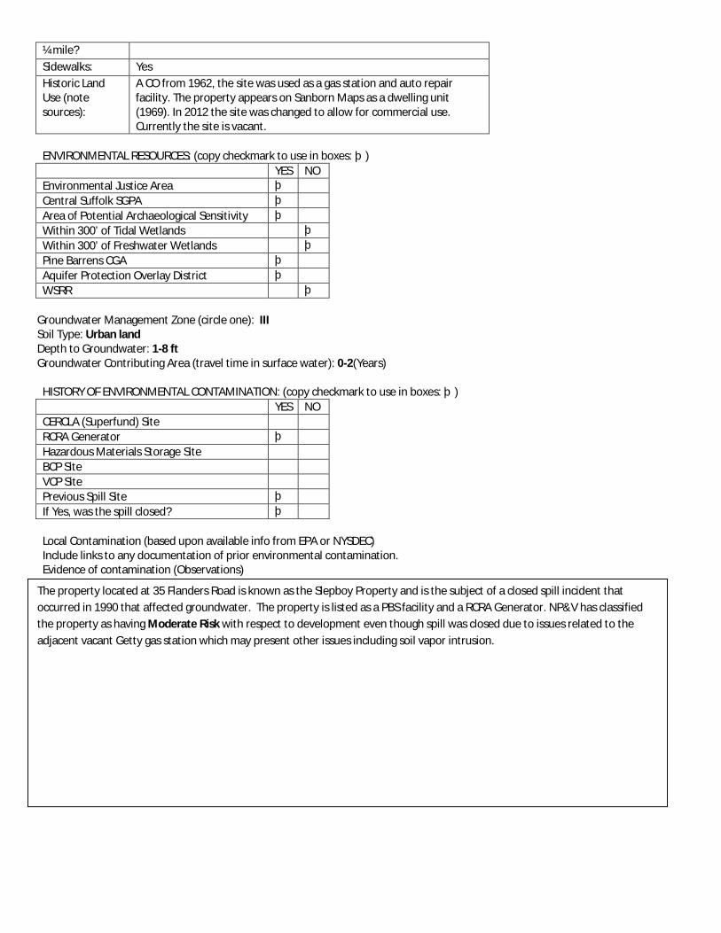
¼ mile? Sidewalks: Yes Historic Land Use (note sources):
A CO from 1962, the site was used as a gas station and auto repair facility. The property appears on Sanborn Maps as a dwelling unit (1969). In 2012 the site was changed to allow for commercial use. Currently the site is vacant.
ENVIRONMENTAL RESOURCES: (copy checkmark to use in boxes: þ) YES NO Environmental Justice Area þ Central Suffolk SGPA þ Area of Potential Archaeological Sensitivity þ Within 300’ of Tidal Wetlands þ Within 300’ of Freshwater Wetlands þ Pine Barrens CGA þ Aquifer Protection Overlay District þ WSRR þ
Groundwater Management Zone (circle one): III Soil Type: Urban land Depth to Groundwater: 1-8 ft Groundwater Contributing Area (travel time in surface water): 0-2(Years)
HISTORY OF ENVIRONMENTAL CONTAMINATION: (copy checkmark to use in boxes: þ) YES NO CERCLA (Superfund) Site RCRA Generator þ Hazardous Materials Storage Site BCP Site VCP Site Previous Spill Site þ If Yes, was the spill closed? þ Local Contamination (based upon available info from EPA or NYSDEC) Include links to any documentation of prior environmental contamination. Evidence of contamination (Observations)
The property located at 35 Flanders Road is known as the Slepboy Property and is the subject of a closed spill incident that occurred in 1990 that affected groundwater. The property is listed as a PBS facility and a RCRA Generator. NP&V has classified the property as having Moderate Risk with respect to development even though spill was closed due to issues related to the adjacent vacant Getty gas station which may present other issues including soil vapor intrusion.

Property Inventory Form
Project Name: Riverside Hamlet Revitalization
Identification No.
EC-7
Street Address: 104 Flanders Road Tax Map Number(s):
900-118-2-10
PROPERTY INFORMATION Owner: Berta Camey Property Size (SF):
4,598.86 SF
Property Size (ac):
0.11 acres
Existing Land Use:
Residential
Zoning: VB Parking: Private driveway with parking Public Water Available:
Yes
Size of Water Main:
16”
Notes: (redevelopment potential, whether it could be a strategic site, access issues, noise/air issues).
The site is located on the north side of Flanders Road, east of the traffic circle, and south of the Peconic River. The site is in a highly visible area but currently utilized as a private residence. The site is within the state coastal zone management area.
BUILDING DESCRIPTION
Year Built: Between 1951 and 2000 Building Size: 893.67 SF # of Stories: 2 Condition: Good Building Description:
2 story, single family dwelling with fence and dirt driveway.
Accessory Building:
None
ADJACENT LAND USES:
North: Vacant South: Industrial East: Residential West: Vacant TRANSPORTATION ENVIRONMENT:
Walk Score: 53 – Somewhat walkable *See www.walkscore.com for more information
Bus Stop within Yes
Aerial Photograph
Site Photograph 1
Site Photograph 2
Site Photograph 3
Site Photograph 4

¼ mile? Sidewalks: Yes Historic Land Use (note sources):
The property appears as a dwelling on Sanborn Maps and is currently used as a single family residence.
ENVIRONMENTAL RESOURCES: (copy checkmark to use in boxes: þ) YES NO Environmental Justice Area þ Central Suffolk SGPA þ Area of Potential Archaeological Sensitivity þ Within 300’ of Tidal Wetlands þ Within 300’ of Freshwater Wetlands þ Pine Barrens CGA þ Aquifer Protection Overlay District þ WSRR þ
Groundwater Management Zone (circle one): IV Soil Type: Urban land, Cut and Fill land gently sloping Depth to Groundwater: 1-8 ft Groundwater Contributing Area (travel time in surface water): 0-2 (Years)
HISTORY OF ENVIRONMENTAL CONTAMINATION: (copy checkmark to use in boxes: þ) YES NO CERCLA (Superfund) Site RCRA Generator Hazardous Materials Storage Site BCP Site VCP Site Previous Spill Site þ If Yes, was the spill closed? þ Local Contamination (based upon available info from EPA or NYSDEC) Include links to any documentation of prior environmental contamination. Evidence of contamination (Observations)
The property located at 104 Flanders Road is still an active spill of unknown quantity according to DEC records, though the incident occurred in 2006. NP&V has classified the property as having Moderate Risk since still an active spill.

Property Inventory Form
Project Name: Riverside Hamlet Revitalization
Identification No.
EC-8
Street Address: 113 Flanders Road Tax Map Number(s):
900-139-1-72
PROPERTY INFORMATION Owner: Riverhead Precision Collision, Inc. Property Size (SF):
10,442.07 SF
Property Size (ac):
0.2 acres
Existing Land Use:
Industrial
Zoning: VB Parking: Large private parking area in front of building. Public Water Available:
Yes
Size of Water Main:
16”
Notes: (redevelopment potential, whether it could be a strategic site, access issues, noise/air issues).
The site is located on the south side of Flanders Road and east of the traffic circle. Flanders Road is a major road in the redevelopment area and the site is included in the proposed redevelopment scenario.
BUILDING DESCRIPTION
Year Built: Between 1976 and 2000 Building Size: 3,636.51 SF # of Stories: 1 Condition: Fair Building Description:
One story concrete block with brick face building.
Accessory Building:
None
ADJACENT LAND USES:
North: Vacant, Residential South: Institutional East: Industrial West: Residential TRANSPORTATION ENVIRONMENT:
Walk Score: 60 – Somewhat walkable *See www.walkscore.com for more information
Bus Stop within Yes
Aerial Photograph
Site Photograph 1
Site Photograph 2
Site Photograph 3
Site Photograph 4

¼ mile? Sidewalks: Yes Historic Land Use (note sources):
The property appears on Sanborn Maps and historically appears as an auto repair facility (CO 1987) and is currently developed with Riverhead Precision Auto Collision.
ENVIRONMENTAL RESOURCES: (copy checkmark to use in boxes: þ) YES NO Environmental Justice Area þ Central Suffolk SGPA þ Area of Potential Archaeological Sensitivity þ Within 300’ of Tidal Wetlands þ Within 300’ of Freshwater Wetlands þ Pine Barrens CGA þ Aquifer Protection Overlay District þ WSRR þ
Groundwater Management Zone (circle one): III Soil Type: Urban land, Cut and fill gently sloping Depth to Groundwater: 1-8 ft Groundwater Contributing Area (travel time in surface water): 0-2 (Years)
HISTORY OF ENVIRONMENTAL CONTAMINATION: (copy checkmark to use in boxes: þ) YES NO CERCLA (Superfund) Site RCRA Generator þ Hazardous Materials Storage Site BCP Site VCP Site Previous Spill Site If Yes, was the spill closed? Local Contamination (based upon available info from EPA or NYSDEC) Include links to any documentation of prior environmental contamination. Evidence of contamination (Observations)
The property is listed as a PBS facility and a RCRA Generator. NP&V has classified the property as having Moderate Risk for redevelopment due to the property use.

Property Inventory Form
Project Name: Riverside Hamlet Revitalization
Identification No.
EC-9
Street Address: 310 Riverleigh Avenue Tax Map Number(s):
900-139-1-48.1
PROPERTY INFORMATION Owner: Southampton Town Property Size (SF):
25,202.55 SF
Property Size (ac):
0.58 acres
Existing Land Use:
Currently vacant
Zoning: VB Parking: No Public Water Available:
Yes
Size of Water Main:
8”
Notes: (redevelopment potential, whether it could be a strategic site, access issues, noise/air issues).
The property is southeast of the traffic circle on Riverleigh Avenue. The site is in a highly visible area and is available for redevelopment since it owned by the Town of Southampton.
BUILDING DESCRIPTION
Year Built: Currently vacant Building Size: N/A # of Stories: N/A Condition: N/A Building Description:
Property is now vacant with only concrete slab foundation of the building present.
Accessory Building:
None
ADJACENT LAND USES:
North: Commercial South: Residential East: Vacant West: Commercial TRANSPORTATION ENVIRONMENT:
Walk Score: 59 – Somewhat walkable *See www.walkscore.com for more information
Bus Stop within Yes
Aerial Photograph
Site Photograph 1
Site Photograph 2 Former Building
Site Photograph 3
Site Photograph 4

¼ mile? Sidewalks: Yes Historic Land Use (note sources):
The property is now vacant with only a concrete slab foundation of the prior building present towards the roadway (building was demolished between 2004 and 2006) and asphalt in the rear. Prior to demolition the site was used for auto repairs and office space. During site inspections, it was observed that this property is used for dumping of trash.
ENVIRONMENTAL RESOURCES: (copy checkmark to use in boxes: þ) YES NO Environmental Justice Area þ Central Suffolk SGPA þ Area of Potential Archaeological Sensitivity þ Within 300’ of Tidal Wetlands þ Within 300’ of Freshwater Wetlands þ Pine Barrens CGA þ Aquifer Protection Overlay District þ WSRR þ
Groundwater Management Zone (circle one): III Soil Type: Urban land Depth to Groundwater: Over 8 ft Groundwater Contributing Area (travel time in surface water): 0-2 (Years)
HISTORY OF ENVIRONMENTAL CONTAMINATION: (copy checkmark to use in boxes: þ) YES NO CERCLA (Superfund) Site RCRA Generator þ Hazardous Materials Storage Site BCP Site VCP Site Previous Spill Site If Yes, was the spill closed? Local Contamination (based upon available info from EPA or NYSDEC) Include links to any documentation of prior environmental contamination. Evidence of contamination (Observations)
Regardless of its vacant status, the site is listed as a RCRA Generator. The property appears to have been developed since at least 1903, based upon historical mapping. NP&V has classified the property as having Moderate Risk due to former property use. Development may be hindered due to soil vapor resulting from off-gassing in a shallow water table so mitigation measures for future development may be warranted.

Property Inventory Form
Project Name: Riverside Hamlet Revitalization
Identification No.
EC-10
Street Address: 454 Riverleigh Avenue Tax Map Number(s):
900-139-2-69
PROPERTY INFORMATION Owner: Continental Industrial Center, LLC. Property Size (SF):
8,658.33 SF
Property Size (ac):
0.199 acres
Existing Land Use:
Commercial
Zoning: SCB Parking: Large private parking area. Public Water Available:
Yes
Size of Water Main:
8”
Notes: (redevelopment potential, whether it could be a strategic site, access issues, noise/air issues).
The property is located on Riverleigh Avenue which is a main road where revitalization efforts are focused and the site is included in the plan proposed by the Master Developer.
BUILDING DESCRIPTION
Year Built: Unknown Building Size: 1,287.25 SF, 7,455.26 SF, 2,264.67 SF, 10,007.18 SF total # of Stories: 1 Condition: Good Building Description:
Historically the property consisted of 3 parcels: one vacant lot, one story concrete block garage and one story warehouse/showroom (which has been demolished), and one story residence with detached garage.
Accessory Building:
Detached garage
ADJACENT LAND USES:
North: Residential, Vacant South: Residential, Commercial East: Vacant, Residential, Commercial West: Commercial, Residential TRANSPORTATION ENVIRONMENT:
Walk Score: 42 – Car dependent
Aerial Photograph
Site Photograph 1
Site Photograph 2
Site Photograph 3
Site Photograph 4

*See www.walkscore.com for more information Bus Stop within ¼ mile?
Yes
Sidewalks: Across the street only Historic Land Use (note sources):
The property appears on Sanborn Maps and historically appears as being occupied by dwellings. is currently used as an automobile repair facility (Best Price Auto Repair and Tires)
ENVIRONMENTAL RESOURCES: (copy checkmark to use in boxes: þ)
YES NO Environmental Justice Area þ Central Suffolk SGPA þ Area of Potential Archaeological Sensitivity þ Within 300’ of Tidal Wetlands þ Within 300’ of Freshwater Wetlands þ Pine Barrens CGA þ Aquifer Protection Overlay District þ WSRR þ
Groundwater Management Zone (circle one): III Soil Type: Cut and fill land gently sloping, Carver and Plymouth sands 0-3% slope Depth to Groundwater: Over 8 ft Groundwater Contributing Area (travel time in surface water): 5-10 (Years)
HISTORY OF ENVIRONMENTAL CONTAMINATION: (copy checkmark to use in boxes: þ)
YES NO CERCLA (Superfund) Site RCRA Generator þ Hazardous Materials Storage Site BCP Site VCP Site Previous Spill Site If Yes, was the spill closed?
Local Contamination (based upon available info from EPA or NYSDEC) Include links to any documentation of prior environmental contamination. Evidence of contamination (Observations)
The property is listed as a PBS facility and a RCRA Generator. NP&V has classified the property as having Moderate to High Risk due to property use.

Property Inventory Form
Project Name: Riverside Hamlet Revitalization
Identification No.
EC-11
Street Address: 500 Riverleigh Avenue Tax Map Number(s):
900-139-2-50.2
PROPERTY INFORMATION Owner: Dealer Subprime Solutions, LLC. Property Size (SF):
110,851.44 SF
Property Size (ac):
2.54 acres
Existing Land Use:
Commercial
Zoning: SCB Parking: Large parking area. Public Water Available:
Yes
Size of Water Main:
8”
Notes: (redevelopment potential, whether it could be a strategic site, access issues, noise/air issues).
The site is located south of the traffic circle on Riverleigh Avenue which is a major road in the revitalization area. The property is closer to the outskirts of the revitalization area but is still included in the redevelopment plan.
BUILDING DESCRIPTION
Year Built: Unknown Building Size: 13,501.9 SF # of Stories: 2 Condition: Good Building Description:
2 story cement block building
Accessory Building:
10 ft x 20 ft accessory building
ADJACENT LAND USES:
North: Commercial, Vacant South: Vacant East: Vacant, Residential, Industrial West: Institutional, Residential TRANSPORTATION ENVIRONMENT:
Walk Score: 39 – Car dependent *See www.walkscore.com for more information
Aerial Photograph
Site Photograph 1
Site Photograph 2
Site Photograph 3
Site Photograph 4

Bus Stop within ¼ mile?
Yes
Sidewalks: Only on opposite side of street Historic Land Use (note sources):
The property appears on Sanborn Maps and historically appears as being occupied by dwellings. Formerly the property was occupied by Dyer Motors and currently is used by Riverhead Trailer.
ENVIRONMENTAL RESOURCES: (copy checkmark to use in boxes: þ)
YES NO Environmental Justice Area þ Central Suffolk SGPA þ Area of Potential Archaeological Sensitivity þ Within 300’ of Tidal Wetlands þ Within 300’ of Freshwater Wetlands þ Pine Barrens CGA þ Aquifer Protection Overlay District þ WSRR þ
Groundwater Management Zone (circle one): III Soil Type: Cut and fill land gently sloping Depth to Groundwater: Over 8 ft Groundwater Contributing Area (travel time in surface water): 2-5 (Years)
HISTORY OF ENVIRONMENTAL CONTAMINATION: (copy checkmark to use in boxes: þ)
YES NO CERCLA (Superfund) Site RCRA Generator þ Hazardous Materials Storage Site BCP Site VCP Site Previous Spill Site If Yes, was the spill closed?
Local Contamination (based upon available info from EPA or NYSDEC) Include links to any documentation of prior environmental contamination. Evidence of contamination (Observations)
The site is listed as a PBS facility and RCRA Generator. NP&V has classified the property as having Moderate Risk due to former site use.

Property Inventory Form
Project Name: Riverside Hamlet Revitalization
Identification No.
EC-12
Street Address: 568 Riverleigh Avenue Tax Map Number(s):
900-140-1-10
PROPERTY INFORMATION Owner: Jose Ortega Property Size (SF):
15,433.28 SF
Property Size (ac):
0.35 acres
Existing Land Use:
Residential
Zoning: R15 Parking: Private driveway/parking for residence Public Water Available:
Yes
Size of Water Main:
8”
Notes: (redevelopment potential, whether it could be a strategic site, access issues, noise/air issues).
The site is located on Riverleigh Avenue south of the traffic circle. It is privately owned and utilized as a single family residence. It is located on a main road in the redevelopment area.
BUILDING DESCRIPTION
Year Built: Between 1926 and 1950 Building Size: 1,093.83 SF # of Stories: 1 Condition: Good Building Description:
1 story single family residence
Accessory Building:
1 story shed for residence
ADJACENT LAND USES:
North: Residential, Vacant South: Residential East: Residential West: Residential TRANSPORTATION ENVIRONMENT:
Walk Score: 26 – Car dependent *See www.walkscore.com for more information
Bus Stop within Yes
Aerial Photograph
Site Photograph 1
Site Photograph 2
Site Photograph 3
Site Photograph 4

¼ mile? Sidewalks: No Historic Land Use (note sources):
Listed on Sanborn Maps and Town of Southampton Building Permit 1977 CO as historically being occupied by dwellings. Currently, the property is a single family residence.
ENVIRONMENTAL RESOURCES: (copy checkmark to use in boxes: þ) YES NO Environmental Justice Area þ Central Suffolk SGPA þ Area of Potential Archaeological Sensitivity þ Within 300’ of Tidal Wetlands þ Within 300’ of Freshwater Wetlands þ Pine Barrens CGA þ Aquifer Protection Overlay District þ WSRR þ
Groundwater Management Zone (circle one): III Soil Type: Carver and Plymouth sands 0-3% slope, Cut and fill land gently sloping Depth to Groundwater: Over 8 ft Groundwater Contributing Area (travel time in surface water): 5-10 (Years)
HISTORY OF ENVIRONMENTAL CONTAMINATION: (copy checkmark to use in boxes: þ) YES NO CERCLA (Superfund) Site RCRA Generator Hazardous Materials Storage Site BCP Site VCP Site Previous Spill Site þ If Yes, was the spill closed? þ Local Contamination (based upon available info from EPA or NYSDEC) Include links to any documentation of prior environmental contamination. Evidence of contamination (Observations)
The property located at 568 Riverleigh Avenue is listed as an active spill incident that occurred in 1999. According to database records the spill resulted in the release of 250 gallons of fuel oil that impacted soil. Moderate Risk due to active spill incident and quantity of product released. However, since it is an older spill the contaminated may now be limited.

Property Inventory Form
Project Name: Riverside Hamlet Revitalization
Identification No.
EC-13
Street Address: 182 Old Quogue Road Tax Map Number(s):
900-140-2-71.1
PROPERTY INFORMATION Owner: Juniors Auto Salvage Property Size (SF):
27,068.27 SF
Property Size (ac):
0.62 acres
Existing Land Use:
Industrial
Zoning: R15 Parking: Parking area for current use as junkyard. Public Water Available:
Yes
Size of Water Main:
8”
Notes: (redevelopment potential, whether it could be a strategic site, access issues, noise/air issues).
This property is located on Old Quogue Road and is currently not included in the redevelopment plan proposed by the Master Developer. The property is not as highly visible as other Sites of Environmental Concern however; current uses may require environmental testing before any redevelopment.
BUILDING DESCRIPTION
Year Built: Unknown Building Size: 594.74 SF # of Stories: 1 Condition: Poor Building Description:
Small 1-story structure
Accessory Building:
1-story shed. Current status unknown.
ADJACENT LAND USES:
North: Residential, Vacant South: Residential East: Residential West: Vacant TRANSPORTATION ENVIRONMENT:
Walk Score: 51 – Somewhat walkable *See www.walkscore.com for more information
Bus Stop within Yes
Aerial Photograph
Site Photograph 1
Site Photograph 2
Site Photograph 3
Site Photograph 4

¼ mile? Sidewalks: No Historic Land Use (note sources):
There is no Sanborn Map provided for this property. CO from 1993 claims 2 sheds and junkyard were pre-existing as of 1957.The property located at 182 Old Quogue Road is now occupied by Juniors Auto Salvage.
ENVIRONMENTAL RESOURCES: (copy checkmark to use in boxes: þ) YES NO Environmental Justice Area þ Central Suffolk SGPA þ Area of Potential Archaeological Sensitivity þ Within 300’ of Tidal Wetlands þ Within 300’ of Freshwater Wetlands þ Pine Barrens CGA þ Aquifer Protection Overlay District þ WSRR þ
Groundwater Management Zone (circle one): III Soil Type: Carver and Plymouth sands 0-3% slope, Cut and fill land gently sloping Depth to Groundwater: Over 8 ft Groundwater Contributing Area (travel time in surface water): 5-10 (Years)
HISTORY OF ENVIRONMENTAL CONTAMINATION: (copy checkmark to use in boxes: þ) YES NO CERCLA (Superfund) Site RCRA Generator Hazardous Materials Storage Site BCP Site VCP Site Previous Spill Site þ If Yes, was the spill closed? þ Local Contamination (based upon available info from EPA or NYSDEC) Include links to any documentation of prior environmental contamination. Evidence of contamination (Observations)
The property is an active junk yard that was previously the subject of a closed spill incident. NP&V has classified the property as having High Risk due to property use and poor housekeeping practices.
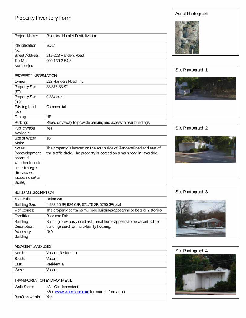
Property Inventory Form
Project Name: Riverside Hamlet Revitalization
Identification No.
EC-14
Street Address: 219-223 Flanders Road Tax Map Number(s):
900-139-3-54.3
PROPERTY INFORMATION Owner: 223 Flanders Road, Inc. Property Size (SF):
38,376.88 SF
Property Size (ac):
0.88 acres
Existing Land Use:
Commercial
Zoning: HB Parking: Paved driveway to provide parking and access to rear buildings. Public Water Available:
Yes
Size of Water Main:
16”
Notes: (redevelopment potential, whether it could be a strategic site, access issues, noise/air issues).
The property is located on the south side of Flanders Road and east of the traffic circle. The property is located on a main road in Riverside.
BUILDING DESCRIPTION
Year Built: Unknown Building Size: 4,283.65 SF, 934.6SF, 571.75 SF, 5790 SF total # of Stories: The property contains multiple buildings appearing to be 1 or 2 stories. Condition: Poor and Fair Building Description:
Building previously used as funeral home appears to be vacant. Other buildings used for multi-family housing.
Accessory Building:
N/A
ADJACENT LAND USES:
North: Vacant, Residential South: Vacant East: Residential West: Vacant TRANSPORTATION ENVIRONMENT:
Walk Score: 43 – Car dependent *See www.walkscore.com for more information
Bus Stop within Yes
Aerial Photograph
Site Photograph 1
Site Photograph 2
Site Photograph 3
Site Photograph 4

¼ mile? Sidewalks: Yes Historic Land Use (note sources):
Town of Southampton Building Department 1962 CO indicates the property was utilized as a motel and owner’s apartment. A CO from 1975 indicated that a building constructed prior to 1957 that was previously utilized as a restaurant and bar was converted to Arbordale Funeral Home. Currently the property is developed with multi-family housing.
ENVIRONMENTAL RESOURCES: (copy checkmark to use in boxes: þ) YES NO Environmental Justice Area þ Central Suffolk SGPA þ Area of Potential Archaeological Sensitivity þ Within 300’ of Tidal Wetlands þ Within 300’ of Freshwater Wetlands þ Pine Barrens CGA þ Aquifer Protection Overlay District þ WSRR þ
Groundwater Management Zone (circle one): III Soil Type: Cut and fill land gently sloping, Deerfield sand Depth to Groundwater: 1-8 ft Groundwater Contributing Area (travel time in surface water): 0-2 (Years)
HISTORY OF ENVIRONMENTAL CONTAMINATION: (copy checkmark to use in boxes: þ) YES NO CERCLA (Superfund) Site RCRA Generator Hazardous Materials Storage Site BCP Site VCP Site Previous Spill Site þ If Yes, was the spill closed? þ Local Contamination (based upon available info from EPA or NYSDEC) Include links to any documentation of prior environmental contamination. Evidence of contamination (Observations)
The site is reported to have an Active Spill on file for an incident that occurred in 2007 of unknown quantity. Moderate to High Risk since the spill is still active but the spill appears to be limited to the soil. The soil was excavated to 12 feet and a strong odor is reported to still be present.

Property Inventory Form
Project Name: Riverside Hamlet Revitalization
Identification No.
EC-15
Street Address: 301 Flanders Road Tax Map Number(s):
900-141-2-2
PROPERTY INFORMATION Owner: 301 Flanders Realty LLC. Property Size (SF):
22,911.39 SF
Property Size (ac):
0.53 acres
Existing Land Use:
Commercial
Zoning: HB Parking: The property is paved for use as gas station and parking. Public Water Available:
Yes
Size of Water Main:
16”
Notes: (redevelopment potential, whether it could be a strategic site, access issues, noise/air issues).
The site is situated on the southwest corner of Flanders Road and Ludlam Avenue and east of the traffic circle. The property is located on a main road in Riverside however this property is currently outside of the proposed development scenario.
BUILDING DESCRIPTION
Year Built: Between 2001 and present Building Size: 1,144 SF # of Stories: 1 or 2 stories Condition: Good Building Description:
Gasoline service station with convenience store.
Accessory Building:
N/A
ADJACENT LAND USES:
North: Residential, Recreation/Open Space South: Residential East: Commercial West: Commercial TRANSPORTATION ENVIRONMENT:
Walk Score: 7 – Car Dependent *See www.walkscore.com for more information
Bus Stop within Yes
Aerial Photograph
Site Photograph 1
Site Photograph 2
Site Photograph 3
Site Photograph 4

¼ mile? Sidewalks: Yes Historic Land Use (note sources):
The Town of Southampton Building Department CO from 1968 indicated the property has been used as a gas station since 1968. The property is currently the Shamrock Gas Station.
ENVIRONMENTAL RESOURCES: (copy checkmark to use in boxes: þ) YES NO Environmental Justice Area þ Central Suffolk SGPA þ Area of Potential Archaeological Sensitivity þ Within 300’ of Tidal Wetlands þ Within 300’ of Freshwater Wetlands þ Pine Barrens CGA þ Aquifer Protection Overlay District þ WSRR þ
Groundwater Management Zone (circle one): III Soil Type: Cut and fill land gently sloping Depth to Groundwater: Over 8 ft Groundwater Contributing Area (travel time in surface water): 2-5 (Years)
HISTORY OF ENVIRONMENTAL CONTAMINATION: (copy checkmark to use in boxes: þ) YES NO CERCLA (Superfund) Site RCRA Generator Hazardous Materials Storage Site BCP Site VCP Site Previous Spill Site þ If Yes, was the spill closed? þ Local Contamination (based upon available info from EPA or NYSDEC) Include links to any documentation of prior environmental contamination. Evidence of contamination (Observations)
The site is listed as a PBS facility and having been the subject of a closed spill incident. While no active spills, NP&V has classified the property as having a High Risk due to its use as a gas station.

Property Inventory Form
Project Name: Riverside Hamlet Revitalization
Identification No.
EC-16
Street Address: Intersection of Ludlam Avenue and Flanders Road Tax Map Number(s):
900-141-2-3
PROPERTY INFORMATION Owner: BCB Properties LLC. Property Size (SF):
27,403.92 SF
Property Size (ac):
0.63 acres
Existing Land Use:
Commercial
Zoning: HB Parking: The property is paved for parking and use as a gasoline service station. Public Water Available:
Yes
Size of Water Main:
16”
Notes: (redevelopment potential, whether it could be a strategic site, access issues, noise/air issues).
The property is located on the south side of Flanders Road east of the traffic circle. The property is located near the eastern boundary of the study area and is currently not included in the proposed redevelopment scenario.
BUILDING DESCRIPTION
Year Built: Between 1951 and 2000 Building Size: 1,038.55 SF # of Stories: 1 Condition: Good Building Description:
Property mostly consists of covered fueling stations with a small structure convenience store.
Accessory Building:
Small shed appears to be located in rear of property.
ADJACENT LAND USES:
North: Commercial, Industrial, Residential South: Residential East: Commercial West: Residential TRANSPORTATION ENVIRONMENT:
Walk Score: 12 – Car dependent *See www.walkscore.com for more information
Bus Stop within Yes
Aerial Photograph
Site Photograph 1
Site Photograph 2
Site Photograph 3
Site Photograpraph 4

¼ mile? Sidewalks: Yes Historic Land Use (note sources):
Town of Southampton Building Department CO indicated the property was used as a service station since 1972. Previously used as an Ocean Gas Station and currently a Valero Gas Station.
ENVIRONMENTAL RESOURCES: (copy checkmark to use in boxes: þ) YES NO Environmental Justice Area þ Central Suffolk SGPA þ Area of Potential Archaeological Sensitivity þ Within 300’ of Tidal Wetlands þ Within 300’ of Freshwater Wetlands þ Pine Barrens CGA þ Aquifer Protection Overlay District þ WSRR þ
Groundwater Management Zone (circle one): III Soil Type: Carver and Plymouth sands 0-3% slope, Cut and fill land gently sloping Depth to Groundwater: 1-8 ft Groundwater Contributing Area (travel time in surface water): 2-5 (Years)
HISTORY OF ENVIRONMENTAL CONTAMINATION: (copy checkmark to use in boxes: þ) YES NO CERCLA (Superfund) Site RCRA Generator þ Hazardous Materials Storage Site BCP Site VCP Site Previous Spill Site þ If Yes, was the spill closed? þ Local Contamination (based upon available info from EPA or NYSDEC) Include links to any documentation of prior environmental contamination. Evidence of contamination (Observations)
The property contains an active spill that occurred in 1998. Also, it is the subject of several closed spills and listed as a RCRA Generator as well as PBS facility. The groundwater is reported to have been affected because of elevated levels of MTBE in on-site monitoring wells. Site is also at risk site due to property use which may have resulted in a soil vapor intrusion issue at the home located at 404 Flanders Road. NP&V has classified the property as having High Risk due to use as a fuel station as well as active incidents that affected groundwater and possibly air quality at a nearby home.

Property Inventory Form
Project Name: Riverside Hamlet Revitalization
Identification No.
EC-17
Street Address: 117 Ludlam Avenue Tax Map Number(s):
900-141-2-36.3
PROPERTY INFORMATION Owner: Greater NY Corp of Seven Day Adventists Property Size (SF):
62,423.82 SF
Property Size (ac):
1.43 acres
Existing Land Use:
Institutional
Zoning: R15 Parking: There appears to be a paved driveway. Public Water Available:
Yes
Size of Water Main:
8”
Notes: (redevelopment potential, whether it could be a strategic site, access issues, noise/air issues).
The property is located near the eastern boundary of the study area. The site is not currently included in the proposed redevelopment scenario.
BUILDING DESCRIPTION
Year Built: Between 1926 and 1950 Building Size: 10,002.5 SF # of Stories: 1 Condition: Poor Building Description:
1 story masonry building.
Accessory Building:
There appears to be only 1 structure.
ADJACENT LAND USES:
North: Residential South: Institutional East: Residential West: Institutional TRANSPORTATION ENVIRONMENT:
Walk Score: 8 – Car dependent *See www.walkscore.com for more information
Bus Stop within No
Aerial Photograph
Site Photograph 1
Site Photograph 2
Site Photograph 3
Site Photograph 4

¼ mile? Sidewalks: No Historic Land Use (note sources):
The property was formerly occupied by Cedar Graphics, Inc. The building has been abandoned, but appears to have been recently used as a church.
ENVIRONMENTAL RESOURCES: (copy checkmark to use in boxes: þ) YES NO Environmental Justice Area þ Central Suffolk SGPA þ Area of Potential Archaeological Sensitivity þ Within 300’ of Tidal Wetlands þ Within 300’ of Freshwater Wetlands þ Pine Barrens CGA þ Aquifer Protection Overlay District þ WSRR þ
Groundwater Management Zone (circle one): III Soil Type: Cut and fill land gently sloping Depth to Groundwater: Over 8 ft Groundwater Contributing Area (travel time in surface water): 5-10 (Years)
HISTORY OF ENVIRONMENTAL CONTAMINATION: (copy checkmark to use in boxes:) YES NO CERCLA (Superfund) Site RCRA Generator þ Hazardous Materials Storage Site BCP Site VCP Site Previous Spill Site If Yes, was the spill closed? Local Contamination (based upon available info from EPA or NYSDEC) Include links to any documentation of prior environmental contamination. Evidence of contamination (Observations)
The property is listed as a PBS facility and as a RCRA Generator. NP&V has classified the property as having Moderate to High Risk due to former use as a printing facility and regulatory listings.

Property Inventory Form
Project Name: Riverside Hamlet Revitalization
Identification No.
EC-18
Street Address: 97 Old Quogue Road Tax Map Number(s):
900-139-2-45
PROPERTY INFORMATION Owner: Alexander and Salome Fleming Property Size (SF):
15,079.06 SF
Property Size (ac):
0.3 acres
Existing Land Use:
Industrial
Zoning: R15 Parking: Front of lot is paved and rear of lot also stores vehicles. Public Water Available:
Yes
Size of Water Main:
8”
Notes: (redevelopment potential, whether it could be a strategic site, access issues, noise/air issues).
This property is located on Old Quogue Road which is one of the main roads in the Riverside area. This site is included in the redevelopment scenario proposed by the Master Developer.
BUILDING DESCRIPTION
Year Built: Between 1926 and 1950 Building Size: 795.86 SF # of Stories: 1 Condition: Fair Building Description:
1 story single family home situated in the front of the lot
Accessory Building:
None
ADJACENT LAND USES:
North: Institutional South: Residential East: Residential, Commercial West: Vacant, Commercial
TRANSPORTATION ENVIRONMENT:
Walk Score: 19 – Car Dependent *See www.walkscore.com for more information
Bus Stop within Yes
Aerial Photograph
Site Photograph 1
Site Photograph 2
Site Photograph 3
Site Photograph 4
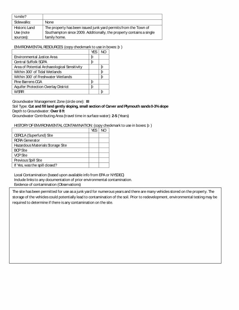
¼ mile? Sidewalks: None Historic Land Use (note sources):
The property has been issued junk yard permits from the Town of Southampton since 2009. Additionally, the property contains a single family home.
ENVIRONMENTAL RESOURCES: (copy checkmark to use in boxes: þ) YES NO Environmental Justice Area þ Central Suffolk SGPA þ Area of Potential Archaeological Sensitivity þ Within 300’ of Tidal Wetlands þ Within 300’ of Freshwater Wetlands þ Pine Barrens CGA þ Aquifer Protection Overlay District þ WSRR þ
Groundwater Management Zone (circle one): III Soil Type: Cut and fill land gently sloping, small section of Carver and Plymouth sands 0-3% slope Depth to Groundwater: Over 8 ft Groundwater Contributing Area (travel time in surface water): 2-5 (Years)
HISTORY OF ENVIRONMENTAL CONTAMINATION: (copy checkmark to use in boxes: þ) YES NO CERCLA (Superfund) Site RCRA Generator Hazardous Materials Storage Site BCP Site VCP Site Previous Spill Site If Yes, was the spill closed? Local Contamination (based upon available info from EPA or NYSDEC) Include links to any documentation of prior environmental contamination. Evidence of contamination (Observations)
The site has been permitted for use as a junk yard for numerous years and there are many vehicles stored on the property. The storage of the vehicles could potentially lead to contamination of the soil. Prior to redevelopment, environmental testing may be required to determine if there is any contamination on the site.

Property Inventory Form
Project Name: Riverside Hamlet Revitalization
Identification No.
EC-19
Street Address: 48 Old Quogue Road Tax Map Number(s):
900-139-3-2.2
PROPERTY INFORMATION Owner: Helen Goff Property Size (SF):
11,897.6 SF
Property Size (ac):
0.2 acres
Existing Land Use:
Residential
Zoning: R15 Parking: Property contains large paved area for parking. Public Water Available:
Yes
Size of Water Main:
8”
Notes: (redevelopment potential, whether it could be a strategic site, access issues, noise/air issues).
The property has been condemned by the Town of Southampton and is currently tax delinquent. The property is under consideration for a TDR Program. Environmental testing may be required before development.
BUILDING DESCRIPTION
Year Built: Unknown Building Size: 2598.66 SF # of Stories: 2.5 stories Condition: Poor Building Description:
Large vacant building that is currently vacant and boarded up.
Accessory Building:
301 SF vacant and boarded up building near the street
ADJACENT LAND USES:
North: Residential South: Residential, Vacant East: Residential, Vacant West: Residential, Vacant TRANSPORTATION ENVIRONMENT:
Walk Score: 40 – Car dependent *See www.walkscore.com for more information
Bus Stop within No
Aerial Photograph
Site Photograph 1
Site Photograph 2
Site Photograph 3
Site Photograph 4

¼ mile? Sidewalks: None Historic Land Use (note sources):
This property is reported to have been used as ground floor auto repair with multifamily housing above. A Town of Southampton CO from 2005 indicates the property contained an automotive repair garage and 1 apartment on the first floor, 3 apartments on the 2nd floor, and a detached 1 story cottage.
ENVIRONMENTAL RESOURCES: (copy checkmark to use in boxes: þ) YES NO Environmental Justice Area þ Central Suffolk SGPA þ Area of Potential Archaeological Sensitivity þ Within 300’ of Tidal Wetlands þ Within 300’ of Freshwater Wetlands þ Pine Barrens CGA þ Aquifer Protection Overlay District þ WSRR þ
Groundwater Management Zone (circle one): III Soil Type: Cut and fill land gently sloping Depth to Groundwater: Over 8 ft Groundwater Contributing Area (travel time in surface water): 0-2 and 2-5 (Years)
HISTORY OF ENVIRONMENTAL CONTAMINATION: (copy checkmark to use in boxes: þ) YES NO CERCLA (Superfund) Site RCRA Generator Hazardous Materials Storage Site BCP Site VCP Site Previous Spill Site If Yes, was the spill closed? Local Contamination (based upon available info from EPA or NYSDEC) Include links to any documentation of prior environmental contamination. Evidence of contamination (Observations)
The large building is currently boarded up and according to SC Department of Economic Development and Planning has been condemned by the Town of Southampton and is tax delinquent and being considered under their TDR program. The program seeks to transfer properties that have become tax delinquent for redevelopment and has Phase I ESA and if necessary Phase II Testing completed make properties more palatable for the development community to purchase, clean up and redevelop. However, funds have yet to be made available for a Phase I ESA for this particular site.

Property Inventory Form
Project Name: Riverside Hamlet Revitalization
Identification No.
EC-20
Street Address: 98 Old Quogue Road Tax Map Number(s):
900 - 139 - 3-37
PROPERTY INFORMATION Owner: Matthew and Anastasia Alfaro Property Size (SF):
24,418 SF
Property Size (ac):
0.5 acres
Existing Land Use:
Commercial
Zoning: R15 Parking: Site contains large paved area for use as junkyard. Public Water Available:
Yes
Size of Water Main:
8”
Notes: (redevelopment potential, whether it could be a strategic site, access issues, noise/air issues).
This site is located on Old Quogue Road and across the street from EC-18. The property is not located in an area with as high visibility as some of the other Sites of Environmental Concern. The site is not currently included in the proposed redevelopment scenario and environmental testing may be required before any development.
BUILDING DESCRIPTION
Year Built: Between 1926 and 1950 Building Size: 1,154 SF, 604 SF, 1,843 SF # of Stories: 1 Condition: Good Building Description:
The site contains 3 buildings for use of automobile towing facility.
Accessory Building:
N/A
ADJACENT LAND USES:
North: Residential South: Vacant East: Vacant West: Residential, Vacant, Industrial TRANSPORTATION ENVIRONMENT:
Walk Score: 24 – Car dependent *See www.walkscore.com for more information
Bus Stop within No
Aerial Photograph
Site Photograph 1
Site Photograph 2
Site Photograph 3
Site Photograph 4

¼ mile? Sidewalks: None Historic Land Use (note sources):
Town of Southampton COs indicated the property was used for automobile repairs in 1962 and a body shop with office space in 1966. A 1977 CO indicates the property was used as a junk yard with 4 buildings for various automobile repairs and storage. Currently the site is used as an automobile towing facility.
ENVIRONMENTAL RESOURCES: (copy checkmark to use in boxes: þ) YES NO
Environmental Justice Area þ Central Suffolk SGPA þ Area of Potential Archaeological Sensitivity þ Within 300’ of Tidal Wetlands þ Within 300’ of Freshwater Wetlands þ Pine Barrens CGA þ Aquifer Protection Overlay District þ WSRR þ
Groundwater Monitoring Zone (circle one): III Soil Type: Cut and fill land gently sloping, small section of Carver and Plymouth sands 0-3% slopes Depth to Groundwater: Over 8 ft Groundwater Contributing Area (travel time in surface water): 2-5 (Years)
HISTORY OF ENVIRONMENTAL CONTAMINATION: (copy checkmark to use in boxes: þ) YES NO
CERCLA (Superfund) Site RCRA Generator Hazardous Materials Storage Site BCP Site VCP Site Previous Spill Site If Yes, was the spill closed?
Local Contamination (based upon available info from EPA or NYSDEC) Include links to any documentation of prior environmental contamination. Evidence of contamination (Observations)
NP&V has classified the property as having Moderate to High Risk due to property use. Prior to redevelopment, a Phase I ESA would be appropriate to determine whether testing is required.

HAMLET OF RIVERSIDE
Town of Southampton
Riverside Revitalization Action Plan JULY2015
TOWN OF SOUTHAMPTON

To me, revitalization of Riverside means that the Town is doing something to address the residents in the poorest section of the town and that the town is looking out for its residents most in economic despair. Revitalizing Riverside will raise the quality of life for so many people. -RON FISHER
The revitalization of Riverside is the top priority of me and the entire board of the Flanders, Riverside and Northampton Community Association. We have been working for many years to see the existing blighted commercial properties replaced by a vibrant, economically successful business center - a center that brings new business and job opportunities to local residents and businesses. And, we have long sought to see substandard housing eliminated with new housing options for our hard working residents. And finally, we feel that the overall redevelopment initiative by the town will generate increased safety, beautification and important new recreational facilities with the planned Riverside Park bringing resident to the riverfront to enjoy their natural treasures.
My vision of the revitalized Riverside is a beautiful, transit oriented, walkable community with new recreational opportunities and activities for families. I see housing alternatives for young, old and new families combined with affordable options for the hard working and retired members of the community and region. That vision includes many new businesses to provide needed services to residents and visitors and, very importantly, adds commercial tax base that will help fund our schools.
The Children's Museum is a wonderful asset to any community and will well serve the residents and visitors to the Riverside and downtown Riverhead community. Riverside has been underserved for too many years and I think that bringing such terrific institutions of learning to the local residents is of particular importance.
Embrace the Peconic Riverfront – and you lift up all of Riverside. Period.
-VINCE TALDONE, PRESIDENT OF FRNCA
-TANYA COLLINS
The efforts of the Riverside Revitalization Committee have been outstanding. I am truly grateful to have them revitalize our community…Things certainly have changed and I am looking forward to being part of the new community that awaits us.
There is nothing here to stay for…we need vibrancy that will improve the quality of life of all residents.
I want a cozy and comfortable community where residents work together for the betterment of the neighborhood.
-STEVEN SCHREIBER
I want property value to increase for homeowners in proximity to the project.
-CHRIS SHELDON
Town Supervisor Anna Throne-HolstDeputy Supervisor Frank Zappone
Councilperson Bradley Bender Councilperson Bridget Fleming
Councilperson Stan GlinkaCouncilperson Christine P. Scalera
Town Planning / Development Administrator, Kyle Collins, AICPTown Planning Director, David Wilcox
Principal Planner, Janice Scherer
President & CEO, Don MontiVP Planning & Development, Sean McLean
Director of Planning & Development, Ela Dokonal, AICP CUD, LEED APPlanners, James Vayo & Steve Lubrano
Community Liaison, Siris Barrios
IN PARTNERSHIP WITH
MASTER DEVELOPER
&THE RIVERSIDE COMMUNITY
TOWN OF SOUTHAMPTON
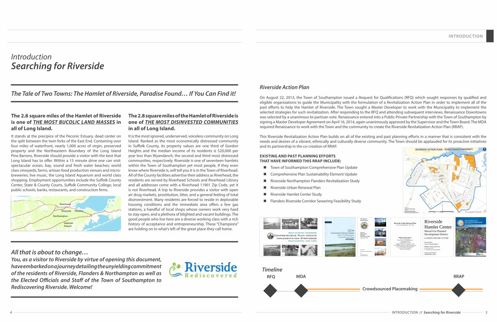
4 5
INTRODUCTION
Riverside Action Plan
On August 22, 2013, the Town of Southampton issued a Request for Qualifications (RFQ) which sought responses by qualified and eligible organizations to guide the Municipality with the formulation of a Revitalization Action Plan in order to implement all of the past efforts to help the Hamlet of Riverside. The Town sought a Master Developer to work with the Municipality to implement the selected strategies for such revitalization. After responding to the RFQ and attending subsequent interviews, Renaissance Downtowns was selected by a unanimous bi-partisan vote. Renaissance entered into a Public-Private Partnership with the Town of Southampton by signing a Master Developer Agreement on April 16, 2014, again unanimously approved by the Supervisor and the Town Board. The MDA required Renaissance to work with the Town and the community to create the Riverside Revitalization Action Plan (RRAP).
This Riverside Revitalization Action Plan builds on all of the existing and past planning efforts in a manner that is consistent with the needs and desires of a vibrant, ethnically and culturally diverse community. The Town should be applauded for its proactive initiatives and its partnership in the co-creation of RRAP.
EXISTING AND PAST PLANNING EFFORTS THAT HAVE INFORMED THIS RRAP INCLUDE:
n Town of Southampton Comprehensive Plan Update
n Comprehensive Plan Sustainability Element Update
n Riverside Northampton Flanders Revitalization Study
n Riverside Urban Renewal Plan
n Riverside Hamlet Center Study
n Flanders Riverside Corridor Sewering Feasibility Study
MDARFQ RRAP
INTRODUCTION // Searching for Riverside
The Tale of Two Towns: The Hamlet of Riverside, Paradise Found… If You Can Find it!
All that is about to change… You, as a visitor to Riverside by virtue of opening this document, have embarked on a journey detailing the unyielding commitment of the residents of Riverside, Flanders & Northampton as well as the Elected Officials and Staff of the Town of Southampton to Rediscovering Riverside. Welcome!
The 2.8 square miles of the Hamlet of Riverside is one of THE MOST BUCOLIC LAND MASSES in all of Long Island. It stands at the precipice of the Peconic Estuary, dead center on the split between the twin forks of the East End. Containing over four miles of waterfront, nearly 1,000 acres of virgin, preserved property and the Northeastern Boundary of the Long Island Pine Barrens, Riverside should provide a visitor with the best that Long Island has to offer. Within a 15 minute drive one can visit: spectacular ocean, bay, sound and fresh water beaches; world class vineyards, farms, artisan food production venues and micro-breweries; live music, the Long Island Aquarium and world class shopping. Employment opportunities include the Suffolk County Center, State & County Courts, Suffolk Community College, local public schools, banks, restaurants, and construction firms.
The 2.8 square miles of the Hamlet of Riverside is one of THE MOST DISINVESTED COMMUNITIES in all of Long Island. It is the most ignored, underserved, voiceless community on Long Island. Ranked as the most economically distressed community in Suffolk County, its property values are one third of Gordon Heights and the median income of its residents is $20,000 per year less than Wyandanch, the second and third most distressed communities, respectively. Riverside is one of seventeen hamlets within the Town of Southampton yet most people, if they even know where Riverside is, will tell you it is in the Town of Riverhead. All of the County facilities advertise their address as Riverhead, the residents are served by Riverhead Schools and Riverhead Library and all addresses come with a Riverhead 11901 Zip Code, yet it is not Riverhead. A trip to Riverside provides a visitor with open air drug markets, prostitution, litter, and a general feeling of total disinvestment. Many residents are forced to reside in deplorable housing conditions and the immediate area offers a few gas stations, a handful of local shops whose owners work very hard to stay open, and a plethora of blighted and vacant buildings. The good people who live here are a diverse working class with a rich history of acceptance and entrepreneurship. These “Champions” are holding on to what’s left of the great place they call home.
Riverside
Riverhead
Flanders
Northampton
GabreskiAirport
Timeline
1
Sustainability Element Update Town of Southampton Comprehensive Plan
APPENDIX
Prepared by Perkins+Will
November 2012
Southampton TomorrowComprehensive Plan Update
Implementation StrategiesSouthampton, New York
The Town of Southampton
FlandersNorthamptonRiversideRevitalization Study(Draft)
May 2003
Prepared by:
Ferrandino and Associates Inc.
With
Dvirka & Bartilucci, P.C.GreenWoods Associates
Adopted March 2004
Riverside Urban Renewal Plan
Town of Southampton, New York
Applicant/Project Sponsor:
Town of Southampton
Department of Land Management
116 Hampton Road
Southampton NY 11968
Contact: Jefferson V. Murphree, AICP
Town Planning and Development Administrator
Town of Southampton Housing Office
Telephone: (631) 702-1801
Fax: (631) 287-0262
Preliminary Submittal: November 19, 2008
Revised: December 30, 2008
Revised: March 5, 2009
Revised: May 22, 2009
Revised: June 1, 2009
Date of Acceptance: ____, 2009
Date of Public Hearing: ____, 2009
Closing Date of Comment Period: ____, 2009
Riverside Hamlet Center Mixed-Use Planned Development District A VISION FOR THE FUTURE
Prepared for
Town of Southampton
Hutton Associates Inc. in association with
L. K. McLean Associates PC FINAL DRAFT REPORT
FEBRUARY 2008
DRAFT FEASIBILITY STUDY MAP & PLAN FOR: Flanders RiversideSuffolk County, New York
Flanders Riverside Corridor Sewering Feasibility Study, CP 8192July 2013, Revised August 2013
Crowdsourced Placemaking
IntroductionSearching for Riverside

6 7
INTRODUCTION
INTRODUCTION // RRAP Consistency Previous Town and Regional Plans
Improve vehicle and pedestrian circulation and safety within the Project Area and create connections to the adjacent proposed Riverside Hamlet Center
Facilitate the creation of a Gateway Center that concentrates residential and nonresidential development and brings a focal point to the Project Area
Replace deteriorated and/or substandard housing with new housing units
Improve public facilities such as sidewalks and crosswalks that enhance pedestrian safety, Project Area appearance, and strengthen the proposed Gateway
Enhance the overall visual environment of the Project Area
Riverside Hamlet Center MUPDD Vision Study
Direct development to strengthen existing communities
Encourage mixed land uses and mixed-use buildings
Encourage consultation between communities
Take advantage of compact building sizes and crate a range of housing opportunities
Provide a variety of transportation choices
Create pleasant environments and attractive communities
Preserve open space and natural resources
Additional Socially, Economically, Environmentally "Smart Growth" Principles and Goals
Engage all parts of the community in the process of creating the vision, concepts and strategy for implementation of the RAP
To incorporate municipal owned property located within the Project Area to achieve a holistic and comprehensive redevelopment strategy
Provide an avenue for private property owners to partner with the public sector and RD to foster the redevelopment of underutilized assets for the benefit of both themselves and the community
Create economic value for the Project Area by focusing on the existing downtown core and the redevelopment of underutilized sites to achieve the adaptive reuse of vacant buildings where appropriate
Create jobs and career opportunities for Municipality residents
Enhance the vibrancy of downtown Riverside and create a diversity of uses (to live, work, shop, learn, and play
Promote the Municipality as a preeminent regional destination
Benefit from the proximity and accessibility of the Long Island Rail Road station within Riverside to foster the development of the Project Elements
Provide a mixed-use downtown setting which includes residential, commercial, retail, office, hospitality, parks, open space, cultural and civic uses
Create and enhance Municipality gateways
Improve streetscapes and create a pedestrian friendly “walkable” environment
Provide a broad range of housing types and price points
Create a sustainable development by implementing smart growth and green building design elements in an economically viable plan
Central Pine BarrensProtect, preserve and enhance the functional integrity of the Pine Barrens ecosystem and the significant natural resources, including plant and animal populations and communities thereof
Protect the quality of surface water and groundwater
Discourage piecemeal and scattered development
Promote active and passive recreational and environmental educational uses that are consistent with the land use plan
Accommodate development, in a manner consistent with the long term integrity of the Pine Barrens ecosystem and to ensure that the pattern of development is compact, efficient and orderly
Encourage appropriate patterns of compatible residential, commercial, agricultural, and industrial development in order to accommodate regional growth influences in an orderly way while protecting the Pine Barrens environment for the individual and cumulative adverse impacts thereof
Accommodate a portion of development redirected from the preservation area
Comprehensive Plan Update
Enhance hamlet character/ identity
Leverage maritime resources and proximity to natural areas
Leverage proximity to Riverhead town center
Encourage tax ratable development
Promote market-rate housing options
Encourage neighborhood enhancements
Create a joint Flanders-Riverside hamlet center at the traffic circle
Treat Route 24 as a scenic Maritime Corridor, not just as a highway
Sustainability Element of Comprehensive Plan
Increase affordable housing in town
Increase work base (no brain drain) allow young people to stay
Retain rural character & clean air/natural resources to be happy & healthy
Walkable communities/compact development
Increase farmers markets and opportunities for local business/food
Ensure sustainable land use
Create a better sense of identity for the Riverside, Flanders and Northampton hamlets
Preserve maritime resources and the Peconic Estuary
Utilize proximity to adjoining areas, the Peconic Estuary and Central Pine Barrens as a revitalization theme
Promote mixed-use residential and low-scale commercial development with a recreational/maritime theme along the Peconic River subject to sound controls to preserve the estuary and eliminate wastewater, runoff, etc.
Flanders/Riverside/Northampton Revitalization Study
Repair, maintain, and clean up local properties; inventory incompatible uses; evaluate impacts of boundaries
Create a Riverside hamlet center at the west end of the light industrial park located at the site of the former drive-in movie theater
Create Waterfront Recreation Areas in Riverside and Flanders
Develop a plan for the area immediately adjacent to the Traffic Circle area
Riverside Urban Renewal Plan
Reinforce a sense of community and neighborhood identity;
Eliminate blight conditions within the Project Area as defined in the Blight Study
Rehabilitate certain residential properties within the Project Area
Redevelop vacant, deteriorating or deteriorated buildings, incompatible land uses or underutilized properties with residential, community and commercial uses consistent with the area’s desired neighborhood character
Provide local commercial uses to meet resident needs
Expand the property tax base and provide additional employment opportunities
Develop land uses within the Project Area that can complement and benefit from the proposed Riverside Hamlet Center which is adjacent to the Project Area
RRAP Consistency Previous Town and Regional Plans

8 9
INTRODUCTION
INTRODUCTION // Best Practices for Implementation
IMPLEMENTATION OVERVIEW CHART
RENAISSANCE DOWNTOWNS+
TOWN OF SOUTHAMPTONFORM A PUBLIC-PRIVATE PARTNERSHIP
RIVERSIDE REVITALIZATION ACTION PLAN(RRAP)
ZONING (FORM BASED CODE) OVERLAY + SEQRA
DEVELOPMENT PLANS &IMPLEMENTATION
UNIFIED DEVELOPMENT
APPROACH™(UDA)
CROWDSOURCEDPLACEMAKING
(CSPM)
UNIFIED DEVELOPMENT APPROACH™ (UDA)RD reaches out to Private Property owners, Key Community Stakeholders and Other Agencies.
CROWDSOURCED PLACEMAKING (CSPM)RD initiates CSPM process of Community input.
RRAP This document describes the development strategies that will achieve the goals and objectives of the Community and the Public-Private Partnership for a sustainable revitalization of Riverside. In addition, it provides the outline of next steps to effectuate development strategies including necessary entitlements.
SEQRA & ZONING OVERLAY (COORDINATE WITH BOA)BOA Step II study, zoning recommendations and SEQRA process all work together in order to streamline the process and resources
DEVELOPMENT PLANS & IMPLEMENTATIONIf the recommendations and strategies contained in the RRAP are adopted by the Town, immediate development opportunities will be created and development will begin.
The public-private partnership utilized in the preparation of this plan enabled the organic co-creation of a shared development vision resulting from a partnership between the Town, Master Developer and, most importantly, the community.
There are Five Key Practices needed to succeed at “Implementation” of sustainable, innovative and exciting development that garners broad community support.
UNIFIED DEVELOPMENT APPROACH™ (UDA) In order to successfully implement mixed-use downtown revitalization, it is essential to take into account the context of the entire area, rather than seeking to improve separate small areas, possibly to the detriment of the whole. Riverside Hamlet must be a woven neighborhood fabric of distinct districts, each with a unique character that, together, work in harmony to create a true sense of place while fostering economic development. The UDA creates a framework that engages all key stakeholders, including private property owners, to help streamline the approval and implementation processes.
CROWDSOURCED PLACEMAKING PROGRAM (CSPM) Proactive and inclusive public outreach and engagement are necessary components of creating and implementing community redevelopment efforts. CSPM, a proprietary
grassroots social networking program, results in a better understanding of the local market while simultaneously creating an upswell of support for redevelopment efforts by garnering ideas and insight from local residents, businesses and stakeholders. CSPM represents the Public Outreach Process.
MARKET OPPORTUNITIES Utilizing specific information about Riverside, market and feasibility studies are applied to evaluate the public desire for uses and amenities in the new development. These studies are performed by Master Developer's consultant team members who advise them about economic opportunities that present themselves during the revitalization effort.
REVITALIZATION TOOLKIT The Master Developer utilizes the best planning practices for quality downtown revitalization. Our team is well versed in planning and urban design and understands how to transform a community's vision and existing context into great places that drive economic development and improved quality of life.
SEQRA & ZONINGOnce a final vision is articulated with full support from the Town and community, that vision must be properly represented in entitlements and zoning.
Diagram of Master Developer's approach to Riverside's Redevelopment
= IMPLEMENTATION+
Unified Development
Approach™(UDA)
Crowdsourced Placemaking
(CSPM)
MarketOpportunities
RevitalizationToolkit &
Strategies
SEQRA & Zoning
+ + + +
Public-Private Partnership:Best Practices for Implementation
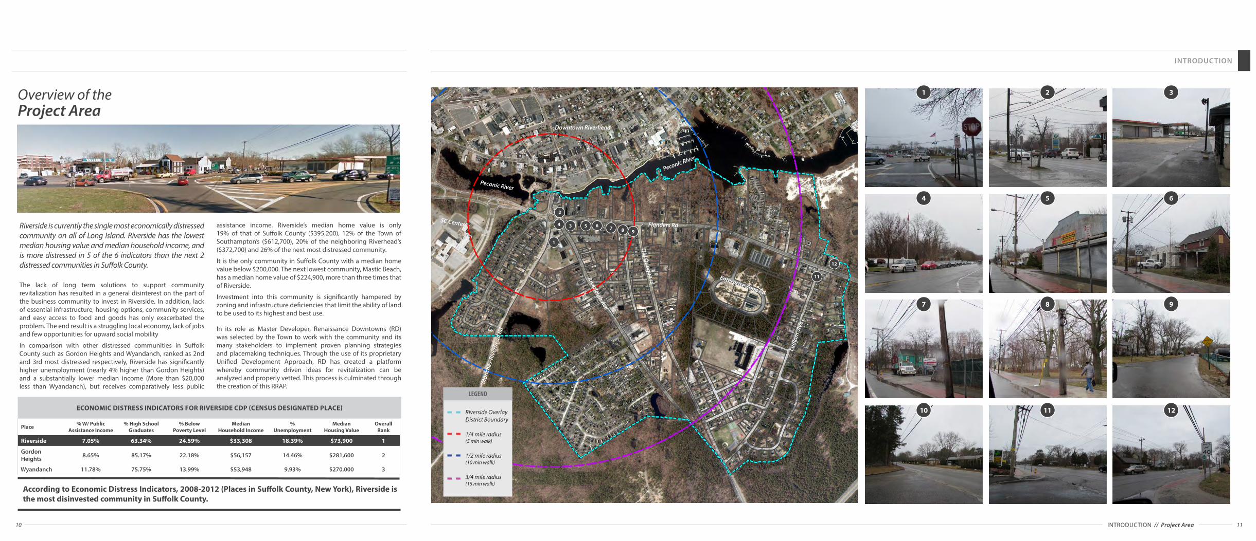
11INTRODUCTION // Project Area
2
4
1
3 5 6 7 8 9
11
12
1
4
7
10
2
5
8
11
3
6
9
12
INTRODUCTION
10
Overview of the Project Area
According to Economic Distress Indicators, 2008-2012 (Places in Suffolk County, New York), Riverside is the most disinvested community in Suffolk County.
Place % W/ Public Assistance Income
% High School Graduates
% Below Poverty Level
Median Household Income
% Unemployment
Median Housing Value
Overall Rank
Riverside 7.05% 63.34% 24.59% $33,308 18.39% $73,900 1
Gordon Heights 8.65% 85.17% 22.18% $56,157 14.46% $281,600 2
Wyandanch 11.78% 75.75% 13.99% $53,948 9.93% $270,000 3
ECONOMIC DISTRESS INDICATORS FOR RIVERSIDE CDP (CENSUS DESIGNATED PLACE)
Riverside is currently the single most economically distressed community on all of Long Island. Riverside has the lowest median housing value and median household income, and is more distressed in 5 of the 6 indicators than the next 2 distressed communities in Suffolk County.
The lack of long term solutions to support community revitalization has resulted in a general disinterest on the part of the business community to invest in Riverside. In addition, lack of essential infrastructure, housing options, community services, and easy access to food and goods has only exacerbated the problem. The end result is a struggling local economy, lack of jobs and few opportunities for upward social mobility
In comparison with other distressed communities in Suffolk County such as Gordon Heights and Wyandanch, ranked as 2nd and 3rd most distressed respectively, Riverside has significantly higher unemployment (nearly 4% higher than Gordon Heights) and a substantially lower median income (More than $20,000 less than Wyandanch), but receives comparatively less public
assistance income. Riverside’s median home value is only 19% of that of Suffolk County ($395,200), 12% of the Town of Southampton’s ($612,700), 20% of the neighboring Riverhead’s ($372,700) and 26% of the next most distressed community.
It is the only community in Suffolk County with a median home value below $200,000. The next lowest community, Mastic Beach, has a median home value of $224,900, more than three times that of Riverside.
Investment into this community is significantly hampered by zoning and infrastructure deficiencies that limit the ability of land to be used to its highest and best use.
In its role as Master Developer, Renaissance Downtowns (RD) was selected by the Town to work with the community and its many stakeholders to implement proven planning strategies and placemaking techniques. Through the use of its proprietary Unified Development Approach, RD has created a platform whereby community driven ideas for revitalization can be analyzed and properly vetted. This process is culminated through the creation of this RRAP.
Downtown Riverhead
Flanders Rd
Ludl
am A
ve
Peconic River
Peconic River
SC Center
Enterprise Zone Rd
Old Q
uogue rdRiverleigh Ave
Mor
iche
s-Ri
verh
ead
Rd
Riverside Overlay District Boundary
1/4 mile radius (5 min walk)
1/2 mile radius (10 min walk)
3/4 mile radius (15 min walk)
LEGEND
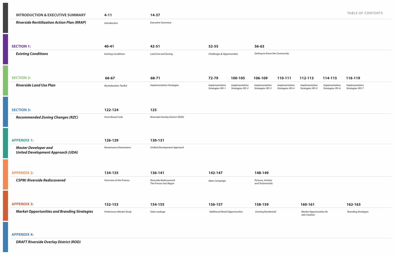
Challenges & Opportunities Getting to Know the Community
Implementation Strategies: RO-6
Implementation Strategies: RO-7
Additional Retail Opportunities Existing Residential Market Opportunities for Job Creation
Branding Strategies
TABLE OF CONTENTS
SECTION 1:
Existing Conditions
INTRODUCTION & EXECUTIVE SUMMARY
Riverside Revitilization Action Plan (RRAP)
SECTION 3:
Recommended Zoning Changes (RZC)
APPENDIX 1:
Master Developer and United Development Approach (UDA)
APPENDIX 2:
CSPM: Riverside Rediscovered
APPENDIX 3:
Market Opportunities and Branding Strategies
APPENDIX 4:
DRAFT Riverside Overlay District (ROD)
SECTION 2:
Riverside Land Use Plan
52-55 56-63
Implementation Strategies: RO-1
Implementation Strategies: RO-2
Implementation Strategies: RO-3
Implementation Strategies: RO-4
Implementation Strategies: RO-5
Ideas Campaign Pictures, Articles and Testimonials
142-147 148-149
156-157 158-159 160-161 162-163
Existing Conditions Land Use and Zoning
Revitalization Toolkit Implementation Strategies
Introduction Executive Summary
Form Based Code Riverside Overlay District (ROD)
Renaissance Downtowns Unified Development Approach
Overview of the Process Riverside Rediscovered: The Process has Begun
Preliminary Market Study Sales Leakage
40-41 42-51
4-11 14-37
122-124 125
126-129 130-131
134-135 136-141
152-153 154-155
66-67 68-71 72-79 100-105 106-109 110-111 112-113 114-115 116-119

14 15
EXECUTIVE SUMMARY
n POSITION... Riverside as a Gateway of the Town, retain and attract a diverse
and multicultural population that includes young professionals and members of the innovation and knowledge economies to promote the Town as a preeminent regional destination.
n CREATE... a true sense of place, utilizing smart growth and sustainable
development principles that meet the needs of current residents and attract future residents and businesses.
n FACILITATE... the creation of a mixed-use and walkable Gateway Center
to enhance the vibrancy of the Riverside Hamlet Center and create a diversity of uses (to live, work, shop, learn, and play).
n COMPLEMENT... Riverhead's downtown area and leverage the proximity
of the Long Island Rail Road station and availability of bus service.
n REINFORCE... a sense of community and neighborhood identity.
n ENHANCE... the character and overall visual environment of the Project
Area.
n PROMOTE... housing choices with a broad range of housing types and
price points including attainable and market-rate housing options.
n EXPAND... the property tax base and provide additional employment
opportunities.
n INCORPORATE... municipally owned property located within the Project
Area to achieve an effective redevelopment strategy; and provide an avenue for private property owners to partner with the public sector and RD to foster the redevelopment of underutilized assets for the benefit of both themselves and the community.
n LEVERAGE... Existing assets and proximity to maritime resources along
the Peconinc Waterfront, natural assets, recreation areas, preserved open spaces of the Pine Barrens region, and proximity to Riverhead's downtown area.
n ATTRACT... business, residents and visitors to stimulate the local
economy and position Riverside as a tourist destination with access to both the north and south forks and the many assets they possess.
The Town of Southampton, the Community and the Master Developer have worked together to co-create the Action Plan for the Riverside Project Area, with the strong desire to implement meaningful change building upon the goals outlined by the numerous previous Planning Studies, and the Town’s Comprehensive Plan.
EXECUTIVE SUMMARY // Establishing Parameters
Over the past decade the Town and County prepared numerous plans and studies to prime Riverside for redevelopment. They recognize that the existing land use, socio-economic, natural environment and infrastructure conditions of the Project Area offer many opportunities but also pose many challenges. Accordingly, while building upon previous efforts, this Plan seeks
to provide a blueprint for dealing with the various challenges, while capitalizing upon the community's strong desire to include a mix of retail stores, service-related businesses, restaurants and diverse housing options, along with improved transportation infrastructure, pedestrian pathways, public green spaces and access to the Peconic River throughout the Riverside hamlet area.
GOALS:
Reaching the Community GoalsEstablishing Parameters

16 17
Riverside Rediscovered has continually worked with residents to identify the most popular triple bottom line compliant ideas through in-person outreach and online social media. Below are the most popular of the 38 community chosen ideas. Each of the following has received 100 or more "likes" indicating support from fellow community members. Several of these are now being considered or implemented in the revitalization plan.
CROWDSOURCED PLACEMAKING PROCESS1. Seed Inspiring Ideas 2. Identify Top Ideas 3. Analyze Feasibility
of Top Ideas4. Implement the Ideas
INDOOR RECREATION CENTER Like (131)
RIVERSIDE PARK MARITIME TRAIL Like (109)
WATERFRONT GREEN SPACES Like (110)
RIVERSIDE ROW RESTAURANTS Like (119)
HEALTHY VILLAGE Like (107)
FARMERS MARKET FOOD MART Like (103)
MODERN MOVIE THEATER Like (130)
SUPERMARKET (Quality / Affordable) Like (108)
SOUTHAMPTON BOARDWALK Like (157)
SHUTTLE BUS SERVICE Like (157)
WATERFIRE ON THE PECONIC Like (151)
WATER FOUNTAIN ICE SKATING Like (147)
EXECUTIVE SUMMARY // Crowdsourced Placemaking
EXECUTIVE SUMMARY
CSPM ONLINE CAMPAIGNS ONE-ON-ONE MEETINGS
FEBRUARY 2015JANUARY 2015 MARCH 2015 APRIL 2015
CSPM provides more than public engagement. It creates a community of local residents and stakeholders that are active participants in the planning and implementation of a development vision, including population segments that are often left out of, or do not feel invited into, the public process. The process helps the Master Developer and the Town to best meet the needs of its residents today and into the future; with a focus on arts, culture, the innovation sector; and to retain the millennial generation, young professionals and retirees in the Town of Southampton.
Executive SummaryCrowdsourced Placemarking (CSPM)
One of the challenges that has historically prevented the large scale development of mixed-use projects has been the failure to ensure community involvement and acceptance of the development vision. To address this issue, RD strongly believes in a “process before plan” approach, which mirrors the Town's desire to have grassroots outreach conducted throughout the redevelopment process, rather than after the project’s parameters are set.
Utilizing its innovative Crowdsourced Placemaking program, RD employs social media and networking tools that include proprietary web-based applications designed to engage the community in meaningful dialogue, which is essential to the planning and implementation process. Crowdsourced Placemaking has become a nationally recognized “best practice” for community engagement:
n Helps define the Community's visionn Helps refine and improve the Town's vision in a manner
that is consistent with its goals and objectives n Creates a framework to identify key market drivers and
market opportunities, especially within the innovation, knowledge and cultural arenas
n Fosters the inclusion of local stakeholders, including entrepreneurs, artists and students, throughout the process
n Helps identify and launch new retail and commercial businesses that will enhance daytime and evening vitality throughout the downtown
n Shortens the development timeline by ensuring community input and buy-in from the outset in a manner consistent with both the Town's vision and market realities
How CSPM WorksUtilizing both in-person meetings and internet-based tools, the patent pending CSPM process allows community members to upload and vote on ideas, uses, retail concepts, types of commercial/retail tenants and amenities they would like to see within a redevelopment plan. CSPM participants are able to utilize online forums, and web-based and paper voting applications to create tremendous support for a redevelopment vision that the community wishes to see move forward.
RIVERSIDE ROW RESTAURANTS
WATERFIRE ON THE PECONIC
CHILDREN'S MUSEUM
Like (151) Like (119) Like (101)
DOOR KNOCKING RIVERSIDE REDISCOVERED MEET-UPS
AUGUST 2014 DECEMBER 2014OCTOBER 2014SEPTEMBER 2014 NOVEMBER 2014
THE CSPM PROCESS IS DETAILED IN GREATER DEPTH IN APPENDIX 2.
RRA
P

18 19
*This number is a relatively conservative estimate as it assumes a well below-average space per worker, and assumes that 100% of vacated office space can be refilled, regardless of the sector.
AREA WIDE RENTAL HOUSING DEMAND PROJECTION (2010-2030)
Age Cohort 2000 Population
2010 Population
2020 Population
2030 Population
Population Change*
2010-2030
Rental Headship
Rate**
New Rental UnitsDemanded
15 - 19 years 4,625 5,532 6,664 8.088 2,556 5.4% 138
20 - 24 years 4,048 4,963 6,201 7,904 2,941 5.4% 159
25 - 34 years 9,670 10,353 11,084 11,867 1,514 20.0% 303
35 - 44 years 13,762 11,961 10,445 9,167 (2,794) 14.8% (414)***
45 - 54 years 12,233 14,065 16,312 19,089 5,024 12.8% 642
55 - 59 years 4,701 6,277 8,495 11,660 5,383 12.9% 696
60 - 64 years 3,982 6,108 9,568 15,317 9,209 13.3% 1,226
65 - 74 years 7,223 8,286 9,683 11,531 3,245 6.2% 202
75 - 84 years 5,110 5,165 5,260 5,398 233 10.0% 23
85 years & Over 1,857 2,282 2,824 3,521 1,239 11.3% 140
TOTAL 3,115 Units
OFFICE DEMAND PROJECTION
Projected Growth in Office Jobs (10 Mile Radius) 5,386
SF / Worker 150
Total SF 807,957
Assuming only 10% Capture of the Office market in Riverside* 80,796*
Market Opportunities for Job Creation
Office
Assisted Living
Light Industrial / Production Space
Hotel
Need for Rental Housing
Current trends among the Millennial and baby boomer generations have demonstrated a growing demand for rental units in recent years. At its current rate of growth the Towns of Southampton and Riverhead are likely to add a demand of over 3,100 new rental units between 2010-2030. Given the growing propensity of Millennials and boomers to rent and the smaller household sizes of Millennials, this number could be even greater.
Market Opportunities for Residential Options
EXECUTIVE SUMMARY // Market Opportunities
EXECUTIVE SUMMARY
Source: U.S. Census Bureau American Community Survey 5-Year Estimates, Bureau of Labor Statistics Consumer Expenditure Survey, ESRI Business Analyst Online, Urban Land Institute, Baker Tilly
RETAIL Sales Leakage Purchasing Power
Existing Sales
Sales Leakage
Approx. Sales / SF
Potential SF
Approx. Job Creation
Riverside Alone $11,390,104 $3,144,559 $8,245,545 250 32,982 33
Riverside, Flanders, Northampton $51,013,540 $6,675,446 $44,338,094 250 177,352 176
RESTAURANT Sales Leakage Purchasing Power
Existing Sales
Sales Leakage
Approx. Sales / SF
Potential SF
Approx. Job Creation
Riverside Alone $1,478,232 $2,204,381 $(726,149) 300 (2,420) -
Riverside, Flanders, Northampton $6,205,140 $3,558,240 $2,646,900 300 8,823 50
Hobby, Sporting Goods,
Music Instruments Clothing and Shoes
Health and Personal Care
Electronics and Appliances
Full Service Restaurant
Grocery Store
Executive Summary Market OpportunitiesTo best understand the commercial uses that are viable in Riverside, Renaissance Downtowns prepared a preliminary market study. By combining the preferred uses identified by the Riverside Rediscovered community and this market study, Renaissance Downtowns can determine which uses are likely to have sufficient market demand necessary to be viable. The following tables summarize the market study results and highlight strong market opporrtunities.
Purchasing Power Potential
Existing Sales
Sales Leakage
Est. Sales / SF
Potential SF
$2,428,526 $480,697 $1,947,829 $1,000 1,948
Purchasing Power Potential
Existing Sales
Sales Leakage
Est. Sales / SF
Potential SF
$2,747,801 - $2,747,801 $400 6,870
Purchasing Power Potential
Existing Sales
Sales Leakage
Est. Sales / SF
Potential SF
$4,189,267 $490,037 $3,699,230 $250 14,797
Purchasing Power Potential
Existing Sales
Sales Leakage
Est. Sales / SF
Potential SF
$1,362,684 - $1,362,684 $250 5,451
Purchasing Power Potential
Existing Sales
Sales Leakage
Est. Sales / SF
Potential SF
$9,510,576 $521,167 $8,989,409 $400 10-12k
Purchasing Power Potential
Existing Sales
Sales Leakage
Est. Sales / SF
Potential SF
$3,722,870 $1,353,859 $2,369,011 $300 7,897
Market Opportunities for Retail & Service
THE MARKET STUDY AND BRANDING STRATEGIES ARE DETAILED IN GREATER DEPTH IN APPENDIX 3.

EXECUTIVE SUMMARYPROPOSED DOWNTOWN OVERLAY FORM BASED CODE DEVELOPMENT BULK STANDARDS
20
Riverside Overlay District Requirements
Riverside Overlay Development Incentive
Bonus 1
Riverside Overlay Development Incentive
Bonus 2
Minimum Site & Building Height Requirements
Min. Frontage: 75 FT
Min. Site Area: 7,500 SF
Height: Stories- 2 min, 3 max & 30 feet Streetwall min
Min. Frontage: 150 FT
Min. Site Area: 15,000 SF
Height: Stories - 3.5 max
Min. Frontage: 300 FT
Min. Site Area: 60,000 SF
Height: Stories - 4 .5 max
n Create a walkable, vibrant mixed-use Hamlet Center, with compact development and a vibrant publicly accessible Peconic River Waterfront Promenade.
n Leverage proximity to natural areas & open spaces. n Create lovable spaces with high standards of aesthetic design, walkable streets
with active frontages and on-street parking; create street enclosure.n Leverage proximity to Riverhead Downtown and Riverhead transit center, and
strengthen the connections by creating a pedestrian bridge and boardwalk loop.
Min. Frontage: 75 FT
Min. Site Area: 7,500 SF
Height: Stories- 2 min, 3 max
Min. Frontage: 150 FT
Min. Site Area: 15,000 SF
Height: Stories - 3.5 max
Min. Frontage: 300 FT
Min. Site Area: 60,000 SF
Height: Stories - 4 max
n Provide a range of housing options in walking distance from Hamlet Center.n Increase permeability of blocks for pedestrian traffic and increased connectivity
for car traffic.n Allow increased density to support commercial vitality and satisfy desire to live
in walking distance to Hamlet Center.n Regulate frontages to activate streets.n Create safer streets by increasing street enclosure, providing on-street parking,
visible crosswalks with pulled-in pedestrian refuge islands.
Min. Frontage: 75 FT
Min. Site Area: 7,500 SF
Height: Stories- 2 min, 2 max
Min. Frontage: 150 FT
Min. Site Area: 15,000 SF
Height: Stories - 3.5 max
Min. Frontage: 300 FT
Min. Site Area: 60,000 SF
Height: Stories - 4 max
n Provide diversity of housing options and building typologies.n Increase permeability of blocks for pedestrian traffic and increased connectivity
for car traffic.n Regulate frontages to activate streets.n Allow artisan production in mixed use and live-work environments.n Provide diversity of private and public open spaces.n Provide access to fresh food, encourage and allow food production.
Min. Frontage: 75 FT
Min. Site Area: 7,500 SF
Height: Stories- 1 min, 2 max
Min. Frontage: 150 FT
Min. Site Area: 15,000 SF
Height: Stories - 2.5 maxor 35 feet max
Min. Frontage: 300 FT
Min. Site Area: 60,000 SF
Height: Stories - 3.5 max
n Create landscaped, architectural or artistic gateway features to announce arrival to Riverside.
n Allow cross-access or new streets.n Create safe and walkable connections to natural areas.
Min. Frontage: 75 FT
Min. Site Area: 7,500 SF
Height: Stories- 1 min, 2 max
Min. Frontage: 150 FT
Min. Site Area: 15,000 SF
Height: Stories - 2.5 maxor 35 feet max
No bonus available
n Create interconnected community to increase walkability.n Create greenways and pedestrian ways. n Leverage proximity to educational assets and provide variety of resources.n Allow granny-flats.n Minimize potable water use.n Landscape with native or edible plants.n Minimize energy use.n Downplay and/or screen presence of parking within the private frontage.
Min. Frontage: 75 FT
Min. Site Area: 7,500 SF
Height: Stories- 1 min, 2 max
Min. Frontage: 150 FT
Min. Site Area: 15,000 SF
Height: Stories - 2.5 maxor 35 feet max
Min. Frontage: 300 FT
Min. Site Area: 60,000 SF
Height: Stories - 3.5 max
n Leverage maritime resources and proximity to natural areas and Peconic River.n Create public access to waterfront.n Connect to boardwalk and trails.n Create economic value by leveraging on waterfront assets.n Include waterfront and hospitality related uses.
No development No bonus available No bonus available
n Leverage maritime resources and proximity to natural areas and Peconic River.n Create a Greenways Plan that connects all waterfront with pedestrian ways,
greenways, parks and open spaces.n Create waterfront promenade and boardwalk.n Create pedestrian trails and greenways.n Provide parking for large parkland areas and share with adjacent Hamlet uses
to minimize cost for maintenance and security, and help increase the use of parks.
21
RPL
Rive
rsid
e Pa
rkla
nd
Rive
rsid
e W
ater
fron
t D
istr
ict
RO-6
Rive
rsid
e Su
burb
an
Dis
tric
t
RO-5Ri
vers
ide
Gat
eway
Dis
tric
t
RO-4
Rive
rsid
e Sp
ecia
lD
istr
ict
RO-3
Rive
rsid
e H
amle
tN
eigh
borh
ood
RO-2
Rive
rsid
e H
amle
tCe
nter
RO-1
RO-7
Executive Summary Riverside Land Use Plan (RLP) The proposed Riverside Overlay Districts (ROD) Map depicts the strategy for Riverside's redevelopment and revitalization utilizing the Transect, where the densest area is concentrated 1/4 mile (5 min walk) from the traffic circle on NY24, and scales down in density as it radiates away. This plan and corresponding key represent the planning principles detailed within the Revitalization Toolkit. Specifically, they list which principles are appropriate to be incorporated into the revitalization plan. A comprehensive approach with a singular Master Developer is recommended for the area's revitalization and redevelopment is with a singular Master Developer, as this enables the proper placement of complementary uses to best meet the principles of responsible economic development and placemaking. Section 1 describes in detail all of those areas, and lists which principles are appropriate to be incorporated into the revitalization plan. Specific zoning changes are described in Section 3.
RO-1
RO-6RO-7
RO-7
RO-7
RO-7RO-6
RO-2
RO-3
RO-4
Flanders Rd (SR24)
Riverleigh Ave (CR 104)O
ld Quogue Rd
Mor
iches
-Riv
erhe
ad R
d. (C
R 63
)
RO-4
RO-4
RO-5RO-5
RO-5
LEGEND
Pine St.
Enterprise Zone Dr
Ludl
am A
ve
Pebb
le W
ay
Phill
ips A
ve
Goodridge Rd
Woo
dhul
l Ave
RO-1
Riverside Overlay District Boundary
1/4 mile radius (5 min walk)
1/2 mile radius (10 min walk)
3/4 mile radius (15 min walk)

22 23
EXECUTIVE SUMMARY
This District, situated around the Traffic Circle and Rt. 24 corridor provides the opportunity for the greatest vibrancy in Riverside. By utilizing best placemaking strategies and leveraging adjacency to Peconic River waterfront, this district should support the greatest variety and mix of uses, promoting a range of residential, retail, hospitality, cultural and entertainment uses.
The RO-1 district permits the highest densities and promotes compact design with vertically and horizontally integrated residential and non-residential uses. Pedestrian amenities required in this district reflect the need for active frontages and an easy access to the waterfront that support placemaking and destination creation. Parking standards should reflect the creation of a walkable hamlet center and transit opportunities within walking distance.
Grocery Store / Food Market
Other Retail and Services
Restaurant Row
Apartments above Stores
Office, Health and Personal Care
Hospitality
n Create a walkable, vibrant mixed-use Hamlet Center, with compact development and a vibrant publicly accessible Peconic River Waterfront Promenade.
n Leverage proximity to natural areas & open spaces.
n Create lovable spaces with high standards of aesthetic design, walkable streets with active frontages and on-street parking; create street enclosure.
n Leverage proximity to Riverhead Downtown and Riverhead transit center, and strengthen the connections by creating a pedestrian bridge and boardwalk loop.
n Create programs to enrich experience and create a draw for residents and visitors; and create environment for regionally significant WaterFire on Peconic program.
n Create a Live, Work & Play environment with large mix of uses and promote market-rate housing options.
n Support cultural programs (CMEE).
n Create programmed public spaces for year-round activities.
n Implement Traffic Circle redesign, ensure creation of pedestrian friendly features.
n Create a Slip Street on Flanders Road, to allow on-street parking and pedestrian friendly mixed-use development.
n Create a Slip Street on CR-63, to create a buffer for single family homes within a wider ROW.
(R0-1) REVITALIZATION STRATEGIES
(RO-1) MARKET DRIVEN ECONOMIC DEVELOPMENT STRATEGY
COMMUNITY DRIVEN REVITALIZATION STRATEGIES
BOARDWALK / WATERFRONT GREEN SPACE 1 WATERFIRE 5 MIXED-USE
EXECUTIVE SUMMARY // Riverside Hamlet Center (RO-1)
Precedent image of the Hamlet Center
1
2
3
4
5
6
7
8
9
10
11
1/4 MILE
RADIUS
1/2 MILE
RADIUS
3/4 MILE
RADIUS
Riverside Overlay District RO-1 Aerial MapSouthampton, NY
SCALE
0'200' 200' 400' 600' 800' 1,000'
NO
RT
H
Executive Summary Riverside Hamlet Center (RO-1)"Let's meet at the Nugent's Clock Tower, stroll the promenade, experience Waterfire! Maybe we can have a dinner outdoors overlooking river, cross over to Riverhead for the opening of the new show, walk over the bridge and stroll along the park while listening to music along the way. Walking home is nice, it's just down the block. Tomorrow morning the business meting is starting early, but it is at the Innovation Center, and luckily, since it is here in Riverside, I can do the gym and get a coffee on my way in!" Potential conversation with Riverside resident a few years from now.
RO-1
Waterfront Promenade
Open Spaces
Street Enclosure
Peconic River Pedestrian Bridge
WaterFire on the Peconic
Riverside Restaurant Row
Childrens' Museum
Fountain / Skating Rink
Traffic Circle
Slip Street on Flanders Road
Slip Street on CR-63
1
2
4
3
5
6
7
8
9
10
11
Flanders Rd (SR24)
Flanders Rd (SR24)
RIVERLEIGH AVE (CR 104)
OLD
QU
OG
UE RD
CR 6
3
CR 6
3
1/4 M
ILE
5 MIN
WALK
STRATEGY LOCATIONS
Riverside Overlay District Boundary
1/4 mile radius (5 min walk)
LEGEND
1
111
5
5
5
109
11
4
2
33
2
2
5
2
6
7
6
6 8

24 25EXECUTIVE SUMMARY // Riverside Hamlet Neighborhood (RO-2)
The RO-2 Overlay District is located within walking distance of the Hamlet Center and Downtown Riverhead, and is a mixed-use hamlet neighborhood that includes restaurants with outdoor seating, shopping, offices, hospitality uses, upper floor apartments, and community utility and food production areas, up to 4 stories in height. The purpose of this zone is to support a compact mix of uses with significant residential development, including a range of residential, retail, hospitality, and entertainment uses.
The RO-2 zone promotes compact design with vertically and horizontally integrated residential and non-residential uses. Parking standards and pedestrian amenities in this zone reflect its access to the existing walkable downtown and non-automotive transportation options.
n Provide a range of housing options in walking distance from Hamlet Center.
n Create a slip street within a wide ROW on CR-63 to create a buffer for the residential homes.
n Increase permeability of blocks for pedestrian traffic and increased connectivity for car traffic.
n Allow increased density to support commercial vitality and satisfy desire to live in walking distance to where the "action" is.
n Regulate frontages to activate streets.
n Create safer streets by increasing street enclosure, providing on-street parking, visible crosswalks with pulled-in pedestrian refuge islands.
n Parking should be screened and placed in the back whenever possible.
(R0-2) REVITALIZATION STRATEGIES
11
Assisted Living
Other Retail and Services
Restaurant Row
Apartments above Stores
Office, Health and Personal Care
ATTAINABLY PRICED HOUSING HEALTHY VILLAGEBOARDWALK / WATERFRONT GREEN SPACE MIXED-USE15
Precedent image of the Riverside Hamlet Neighborhood
(RO-2) MARKET DRIVEN ECONOMIC DEVELOPMENT STRATEGY
EXECUTIVE SUMMARY
1/4 MILE
RADIUS
1/2 MILE
RADIUS
3/4 MILE
RADIUS
Riverside Overlay District RO-2 Aerial MapSouthampton, NY
SCALE
0'200' 200' 400' 600' 800' 1,000'
NO
RT
H
RO-2
RIVERLEIGH AVE (CR 104)
11
Flanders Rd (SR24)
OLD
QU
OG
UE RD
CR 63
Slip Street on CR-63
11
STRATEGY LOCATIONS
Riverside Overlay District Boundary
1/4 mile radius (5 min walk)
1/2 mile radius (10 min walk)
LEGEND
Executive Summary Riverside Hamlet Neighborhood (RO-2)"Substandard housing should be replaced with new, reasonably priced townhouses or other residential units. The new residences should be offered to existing residents and workers. New dwellings bring investment, customers for businesses and an overall more vibrant downtown or Hamlet Center community. The new condos will add life to the streets and much needed tax revenues for our schools and municipalities." Vincent Taldone, President, Flanders Riverside, Northampton Civic Association
Flanders Rd (SR24)
COMMUNITY DRIVEN REVITALIZATION STRATEGIES

26 27EXECUTIVE SUMMARY // Riverside Special District (RO-3)
The intent of RO-3 district, located mostly between ½-mile and ¾ mile of Downtown Riverhead and Riverside traffic circle, is to support a variety of uses with employment in focus and variety of housing choices.
The RO-3 district promotes a lower intensity of uses while continuing to promote compact design with vertically and horizontally integrated residential and non-residential uses. Parking standards and pedestrian amenities support proximity of the Hamlet Center.
Other Retail and services
n Provide diversity of housing options and building typologies.
n Increase permeability of blocks for pedestrian traffic and car traffic.
n Provide access to fresh food, encourage and allow food production.
n Regulate frontages to activate streets.
n Allow artisan production in mixed-use and live-work environments.
n Provide diversity of private and public open spaces.
(R0-3) REVITALIZATION STRATEGIES
(RO-3) MARKET DRIVEN ECONOMIC DEVELOPMENT STRATEGY
15
DAYCARE (EARLY & LATE HOURS) MEDICAL ASSISTED CAREBOARDWALK / WATERFRONT GREEN SPACE SUPERMARKET (QUALITY & AFFORDABLE)
Apartments above Stores
Assisted Living
Precedent image for residential frontages Precedent image for mixed-use
Precedent image for Artisan Production space
16
EXECUTIVE SUMMARY
1/4 MILE
RADIUS
1/2 MILE
RADIUS
3/4 MILE
RADIUS
Riverside Overlay District RO-3 Aerial MapSouthampton, NY
SCALE
0'200' 200' 400' 600' 800' 1,000'
NO
RT
H
RO-3
STRATEGY LOCATIONS
Riverside Overlay District Boundary
1/4 mile radius (5 min walk)
1/2 mile radius (10 min walk)
3/4 mile radius (15 min walk)
LEGEND
Executive Summary Riverside Special District (RO-3)The RO-3 Special district is a place of living and working. Residential neighborhoods provide a place to live without the hustle and bustle of the Hamlet center while still retaining easy access to places to eat, work and play. Artisan production spaces provide an interesting mix and well paying careers for residents.
Farmers Market & Fresh Food
Artisan Production
15
16
16
15
15
COMMUNITY DRIVEN REVITALIZATION STRATEGIES
FLANDERS RD (SR24)
FLANDERS RD (SR24)
RIVERLEIGH AVE (CR 104)
OLD
QU
OG
UE RD
LUD
LAM
AVE
PHIL
LIPS
AVE
BROWN ST
PEBB
LE W
AY
CR 6
3

28 29EXECUTIVE SUMMARY // Riverside Gateway District (RO-4)
There is dignity in the ability to greet people to your home, to your neighborhood, to your community.The intent of this district is to create a transition in vehicular approach to Riverside along major routes, with a wider range of uses than the underlying zoning districts permits, and lower densities than the other RO districts.
This RRAP uses the principles of nationally recognized transect-based planning based on environmental analysis to address all scales of planning, from the community to the block and building. The Riverside Overlay District has been created with a vision to keep the development compact to literally reform the sprawling patterns of existing euclidean separated-use zoning. Accordingly, this transect based Overlay District amplifies the benefits of the areas in the outskirts of this Overlay District to the community as a whole.
A local shuttle with connections to the Hamlet Center, Riverhead Downtown, LIRR, Suffolk Community College, and other local and regional destinations would enter the community on main routes through this district.
"So leave your cars at home and come enjoy a hassle free downtown experience!"
Signage and landscaping announcing arrival to Riverside
Artistic Gateway Element
n Create landscaped, architectural or artistic gateway features to announce arrival to Riverside.
n Allow cross-access or new streets.
n Create safe and walkable connections to natural areas.
(R0-4) REVITALIZATION STRATEGIES
16
BOARDWALK / WATERFRONT GREEN SPACE SHUTTLE BUS SERVICE RIVERSIDE – DOWNTOWN RIVERHEAD
(RO-4) MARKET DRIVEN ECONOMIC DEVELOPMENT STRATEGY
Apartments above Stores
Assisted Living
EXECUTIVE SUMMARY
1/4 MILE
RADIUS
1/2 MILE
RADIUS
3/4 MILE
RADIUS
Riverside Overlay District RO-4 Aerial MapSouthampton, NY
SCALE
0'200' 200' 400' 600' 800' 1,000'
NO
RT
H
16
16
16
Gateway Feature16
STRATEGY LOCATIONS
Riverside Overlay District Boundary
1/4 mile radius (5 min walk)
1/2 mile radius (10 min walk)
3/4 mile radius (15 min walk)
LEGEND
Executive Summary Riverside Gateway District (RO-4)
RO-4
COMMUNITY DRIVEN REVITALIZATION STRATEGIES
FLANDERS RD (SR24)
FLANDERS RD (SR24)
RIVERLEIGH AVE (CR 104)
OLD
QU
OG
UE RD
LUD
LAM
AVE
PHIL
LIPS
AVE
BROWN ST
PEBB
LE W
AY
CR 6
3
"Create a high frequency local shuttle bus service to connect all the various business, entertainment, recreation and residential places in Riverside and Downtown Riverhead. In addition to a standard route or loop through Downtown Riverhead and Riverside’s hamlet center, the shuttle should offer flexible route service to ensure safe and convenient trips between the central business district and local residential and hospitality centers." Vincent Taldone, member of Riverside Rediscovered, December 9, 2014 (President FRNCA)
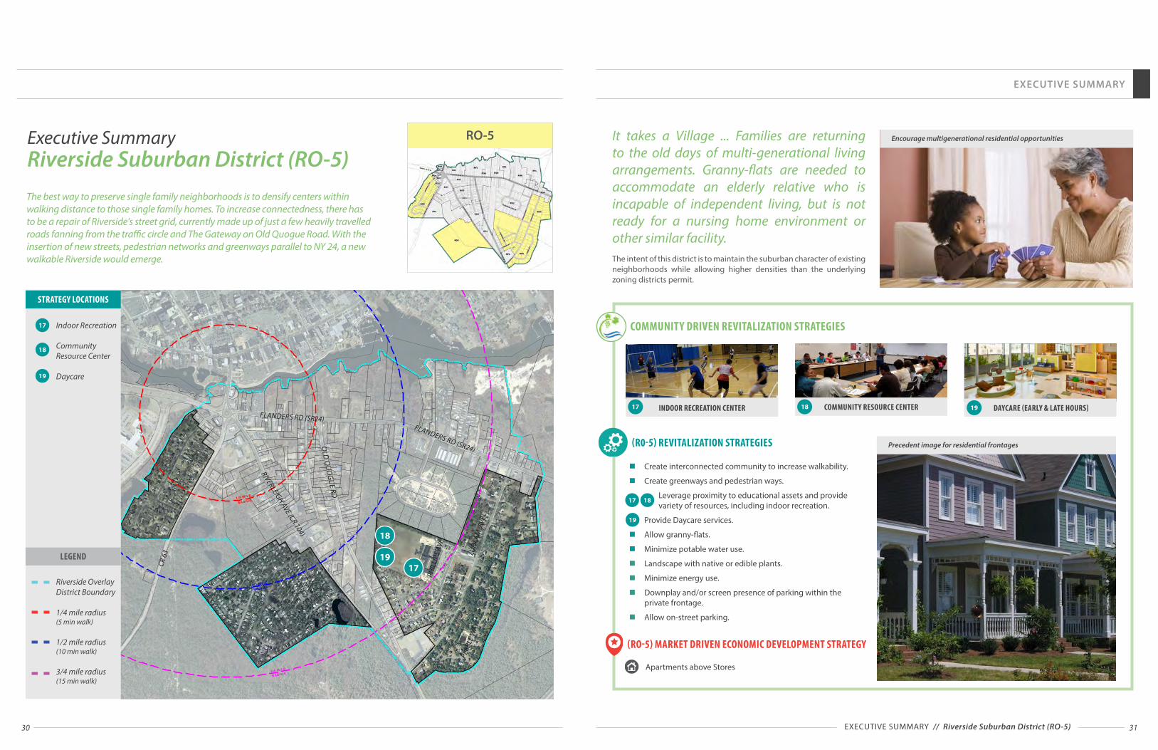
30 31
EXECUTIVE SUMMARY
EXECUTIVE SUMMARY // Riverside Suburban District (RO-5)
It takes a Village ... Families are returning to the old days of multi-generational living arrangements. Granny-flats are needed to accommodate an elderly relative who is incapable of independent living, but is not ready for a nursing home environment or other similar facility.The intent of this district is to maintain the suburban character of existing neighborhoods while allowing higher densities than the underlying zoning districts permit.
n Create interconnected community to increase walkability.
n Create greenways and pedestrian ways.
Leverage proximity to educational assets and provide variety of resources, including indoor recreation.
n Provide Daycare services.
n Allow granny-flats.
n Minimize potable water use.
n Landscape with native or edible plants.
n Minimize energy use.
n Downplay and/or screen presence of parking within the private frontage.
n Allow on-street parking.
(R0-5) REVITALIZATION STRATEGIES
17 18
19
COMMUNITY RESOURCE CENTER DAYCARE (EARLY & LATE HOURS)BOARDWALK / WATERFRONT GREEN SPACE INDOOR RECREATION CENTER
Encourage multigenerational residential opportunities
Precedent image for residential frontages
17 18 19
(RO-5) MARKET DRIVEN ECONOMIC DEVELOPMENT STRATEGY
Apartments above Stores
1/4 MILE
RADIUS
1/2 MILE
RADIUS
3/4 MILE
RADIUS
Riverside Overlay District RO-5 Aerial MapSouthampton, NY
SCALE
0'200' 200' 400' 600' 800' 1,000'
NO
RT
H
1719
18
Indoor Recreation
Community Resource Center
Daycare
17
18
19
STRATEGY LOCATIONS
Riverside Overlay District Boundary
1/4 mile radius (5 min walk)
1/2 mile radius (10 min walk)
3/4 mile radius (15 min walk)
LEGEND
Executive Summary Riverside Suburban District (RO-5)The best way to preserve single family neighborhoods is to densify centers within walking distance to those single family homes. To increase connectedness, there has to be a repair of Riverside's street grid, currently made up of just a few heavily travelled roads fanning from the traffic circle and The Gateway on Old Quogue Road. With the insertion of new streets, pedestrian networks and greenways parallel to NY 24, a new walkable Riverside would emerge.
RO-5
COMMUNITY DRIVEN REVITALIZATION STRATEGIES
FLANDERS RD (SR24)
FLANDERS RD (SR24)
RIVERLEIGH AVE (CR 104)
OLD
QU
OG
UE RD
LUD
LAM
AVE
PHIL
LIPS
AVE
PEBB
LE W
AY
CR 6
3

32 33EXECUTIVE SUMMARY // Riverside Waterfront District (RO-6)
n Create public access to waterfront.
n Leverage maritime resources and proximity to natural areas and Peconic River.
n Connect to boardwalk and trails.
n Create economic value by leveraging on waterfront assets.
n Include waterfront and hospitality related uses.
(R0-6) REVITALIZATION STRATEGIES
HOOKED UP NOW- BAIT & TACKLE SHOP RIVERSIDE PARK & PECONIC RIVER MARITIME TRAIL
River sports opportunities
Public access to Peconic river
Precedent image of desirable architecture
2
1
2
SOUTHAMPTON BOARDWALK1
(RO-6) MARKET DRIVEN ECONOMIC DEVELOPMENT STRATEGY
Other Retail and Services
Hospitality
Residential Opportunities
Marina
"Hooked Up Now is your one stop bait and tackle shop. In here you will be able to “Hook up” to NY State Fishing Licenses, rods, reels, lures, line, free advice, live bait and everything you need for a great fishing trip." Angela, Riverside Rediscovered member, January 19, 2015
The intent of this district is to accentuate Riverside’s maritime character while allowing a greater mix of uses and waterfront related businesses than the underlying zoning districts permit.
EXECUTIVE SUMMARY
1/4 MILE
RADIUS
1/2 MILE
RADIUS
3/4 MILE
RADIUS
Riverside Overlay District RO-6 Aerial MapSouthampton, NY
SCALE
0'200' 200' 400' 600' 800' 1,000'
NO
RT
H
11
2
Riverside Waterfront
Open Space with Maritime Trail
1
2
STRATEGY LOCATIONS
Riverside Overlay District Boundary
1/2 mile radius (10 min walk)
3/4 mile radius (15 min walk)
LEGEND
RO-6Executive Summary Riverside Waterfront District (RO-6)
One advantage of living on Long Island is the presence of large bodies of water open to fishing, watersports, boating, kayaking and canoeing. Besides the obvious Long Island Sound and the Great Sound Bay, there are several rivers that can be explored. One such river is the Peconic River. It is one of Riverside's natural treasures.
COMMUNITY DRIVEN REVITALIZATION STRATEGIES
FLANDERS RD (SR24)
CR 6
3

34 35
RIVERSIDE PARK & PECONIC RIVER MARITIME TRAIL
EXECUTIVE SUMMARY
n Leverage maritime resources and proximity to natural areas and Peconic River.
n Create a Greenways Plan that connects all waterfront with pedestrian ways, greenways, parks and open spaces.
n Create waterfront promenade and boardwalk.
n Create pedestrian trails and greenways.
n Provide parking for large parkland areas and share with adjacent Hamlet uses to minimize cost for maintenance and security, and help increase the use of parks.
n Activate parks with appropriate uses and supporting facilities, create educational opportunities for agriculture and wetland preservation.
n Create a Riverside Branding Plan and advertising strategies to promote Riverside Parkland and Riverside Hamlet as Long Island regional destination.
EXECUTIVE SUMMARY // Riverside Parkland (RPL)
Precedent image for RPL District(RPL) REVITALIZATION STRATEGIES
COMMUNITY DRIVEN REVITALIZATION STRATEGIES
SOUTHAMPTON BOARDWALK1 2 WATERFRONT GREEN SPACE
(RPL) MARKET DRIVEN ECONOMIC DEVELOPMENT STRATEGY
Tourism
Marina
1
21
Create educational opportunities for agriculture, fishery and wetland restoration and preservation.
1/4 MILE
RADIUS
1/2 MILE
RADIUS
3/4 MILE
RADIUS
Riverside Hamlet Regulating PlanRPL: Parkland
SCALE
0'200' 200' 400' 600' 800' 1,000'
NO
RT
H
25
24
20 21 22 23
1
1
1
RPLExecutive Summary Riverside Parkland (RPL)"A [raised] boardwalk alongside the Peconic River that mirrors the walk on the Riverhead side. It would begin at the Peconic Avenue bridge area, perhaps fronting a restaurant row while also allowing WaterFire viewing, and continue East along the river, through the wetlands and future park areas."Terri H., member of Riverside Rediscovered, January 15, 2015
54
1
4
2
5
20
21
22
23
24
25
STRATEGY LOCATIONS
Waterfront Promenade
Open Space with Maritime Trail
Peconic River Pedestrian Bridge & Amphitheater
WaterFire on the Peconic
Riverside Gateway Park
Suffolk County Parkland
Town of Southampton Open Space
Ludlam Avenue Active Park
Pine Barrens Open Space
Riverside Overlay District Boundary
1/4 mile radius (5 min walk)
1/2 mile radius (10 min walk)
3/4 mile radius (15 min walk)
LEGEND
2
FLANDERS RD (SR24)
FLANDERS RD (SR24)
RIVERLEIGH AVE (CR 104)O
LD Q
UO
GU
E RD
LUD
LAM
AVE
PHIL
LIPS
AVE
BROWN ST
PEBB
LE W
AY
CR 6
3"Create a park along the river on the county’s 14 acre parcel of land. The park should remain mostly woodland with walkways, benches and some picnic tables. Local residents and visitors will be able to stroll casually through the park under the shade of the existing large trees and also walk along a boardwalk trail, proximate to the river, which will provide educational information/displays about the waterfront ecosystem and history of the river."Vincent Taldone, member of Riverside Rediscovered, December 9, 2014 (President FRNCA)
Riverside Parkland areas within the Riverside Overlay District are collective assets to this community. Those municipally owned areas (Southampton Town, Suffolk County) have a different purpose and abilities for inclusion into the overall plan. They can support passive or active recreation.

36 37
Mix of Incomes
Intergenerational
Accessibility to Range of Uses
Millennials and Boomers Near where Action is
Car Independence for Millennials and Boomers
Successful Commercial Activity
Safety / Eyes on the Street
Active Frontages/Public Realm
Transit Accessibility
Shuttle to LIRR
Walkability
Bikability
Local Job Creation
Lovable Place
Branding Opportunities
| Attainable Housing Affordable to Households making 80%-130% of Area Median Income
| Compact Unit Design to Provide more Total Housing & Smaller Units that are "Affordable by Design"
| Mix of Complementary Commercial & Residential Uses
| Range of Housing Typologies including Studio, 1 & 2 Bedroom Apartments, Live-Work Units, Townhouses, etc.
| Increased Densities for Large Sites Meeting Certain Conditions
| Increased Height Limits
| Active Frontages Instead of Front Yards
| Parking Placement behind Buildings and On-Street
| Minimal or No Side Yards
| Shared Parking for Complementary Uses
| Reduced Parking Ratios in Walkable Environments
| Complete Streets
| Pedestrian Streetscape Design
| Bus Shelters Accessible by Walking & Biking
| Permeability of Blocks
| Connected Street Network
| Accessible Public Spaces
| Provision of Public & Civic Spaces
| High-Quality Architecture & Landscaping
IMPLEMENTATION TOOLSCOMMUNITY GOALS
DIVERSITY
DESIGN
FORM BASED CODEDISTANCE TO
TRANSIT & MULTIMODAL
TRANSPORTATION
DESTINATION ACCESSIBILITY
DENSITY OF POPULATION & ACTIVITY
EXECUTIVE SUMMARY
EXECUTIVE SUMMARY // Form Based Code
"A form-based code is a land development regulation that fosters predictable built results and a high-quality public realm by using physical form (rather than separation of uses) as the organizing principle for the code. A form-based code is a regulation, not a mere guideline, adopted into city, town, or county law. A form-based code offers a powerful alternative to conventional zoning regulation."
"Form-based codes address the relationship between building facades and the public realm, the form and mass of buildings in relation to one another, and the scale and types of streets and blocks. The regulations and standards in form-based codes are presented in both words and clearly drawn diagrams and other visuals. They are keyed to a regulating plan that designates the appropriate form and scale (and therefore, character) of development, rather than only distinctions in land-use types.
This approach contrasts with conventional zoning’s focus on the micromanagement and segregation of land uses, and the control of development intensity through abstract and uncoordinated parameters (e.g., FAR, dwellings per acre, setbacks, parking ratios, traffic LOS), to the neglect of an integrated built form. Not to be confused with design guidelines or general statements of policy, form-based codes are regulatory, not advisory. They are drafted to implement a community plan. Ultimately, a form-based code is a tool; the quality of development outcomes depends on the quality and objectives of the community plan that a code implements."-Form Based Code Institute.
Optional Nature of the Form Based Overlay
The Zoning proposed for consideration and future study, contained herein, is designed to be available to a property owner for use as an alternative to their existing underlying zoning. The presently existing zoning will remain in place until, and if, a property owner decides to redevelop their property under the new Overlay District. The Overlay zoning option, if adopted, in no way limits the rights of the owner to develop their property under the rules, regulations, conditions and rights of the property as it is zoned as of the submission of this Action Plan. We believe that, even with the considerable conditions for economic, social and environmental protection contained in the proposed Zoning, property owners will choose over time to opt in because it will provide them the most sustainable and profitable path to development for them and the community.
Form-Based Codes are composed of Building Form Standards and Public Space Standards mapped to a Regulating Plan.
Building Form Standards regulate simple things like: how far buildings are from sidewalks, how much window area at minimum a building must have, how tall the building is in relation to the width of the street, how accessible and welcoming front entrances and where a building's parking goes, etc.
Public Space Standards regulate the form of streets and squares. Effective standards create comfortable and useful spaces for many activities, including walking, bicycling, driving, public transit, and a community's social life. They ensure that public space works for everyone, not just for the movement and storage of cars.
The different Building Form Standards and Public Space Standards are assigned to streets and blocks in a Regulating Plan. A Regulating Plan plays a key role in a Form-Based Code.
Storefront
A B
Traveled Way Public Frontage Build-to-Zone
C
D
Bui
ld-to
-Lin
e
Prop
erty
Lin
e
E
Min
. 12'
-0"
0'2.5' 2.5' 5' 7.5' 10'
SCALE
Executive Summary What is a Form Based Code?
HOW FORM BASED CODES WORK
Storefront Frontage - Street Section

SECTION 1:
EXISTING CONDITIONS
The Town of Southampton has laid out a forward looking set of goals and objectives designed to propel the redevelopment and revitalization of Riverside and to enable the creation of a Hamlet that will become a model throughout the region and beyond.
The Master Developer's Riverside Revitalization Action Plan (RRAP) is embraced by the Town of Southampton and will be adopted and implemented as a Land Use Plan

40 41
300 200 100 0 100 200 300
Under 5 years 5 to 9 years 10 to 14 years 15 to 19 years 20 to 24 years 25 to 29 years 30 to 34 years 35 to 39 years 40 to 44 years 45 to 49 years 50 to 54 years 55 to 59 years 60 to 64 years 65 to 69 years 70 to 74 years 75 to 79 years 80 to 84 years 85 years and over
2010 Population Pyramid
Female Male
0
50
100
150
200
250
300
350
$0 to$24,999
$25,000to
$49,999
$50,000to
$74,999
$75,000to
$99,999
$100,000to
$124,999
$125,000to
$149,999
$150,000to
$174,999
$175,000to
$199,999
$200,000or More
Income Breakdown
0
20
40
60
80
100
120
140
160
15 to 24years
25 to 34years
35 to 44years
45 to 54years
55 to 64years
65 to 74years
75 to 84years
85 yearsand over
Householders by Age and Tenure
Owners Renters
Population by Occupation
Management, business,science, and artsoccupations
Service occupations
Sales and officeoccupations
Natural resources,construction, andmaintenance occupations
Production, transportation,and material movingoccupations
The above table depicts the breakdown of the Riverside community by age and sex. Visibly, the largest age cohorts are those between 20 and 44 years old. Additionally, the population, particularly at those age groups, is predominately male.
This table depicts the breakdown of households by income. Most households are clustered at the lower end of the spectrum while a smaller but significant number fall on the upper end.
The above table represents the distribution of householders by age and tenure. As shown, most householders fall in the older age groups with the number of householders increasing with each progressive age cohort before dropping at the 75 to 84 year old group. Moreover, younger householders are more likely to be renters while older householders tend to be owners.
This table breaks down the working population by occupation. The majority of residents are employed in service occupations. Natural resources, construction & maintenance occupations; management, business, science, and arts occupations; and sales and office occupations are the second, third and fourth most common occupations respectively. The very small remainder of residents are employed in production, transportation, and material moving occupations.
EXISTING CONDITIONS
EXISTING CONDITIONS // Demographic Profile
Demographic ProfileRiverside at a Glance
COMMUNITY FACTS (2010):
POPULATION:Population: 2,911Over 18: 2,521Over 65: 400K-12 Students: 143Median Age: 34.9Total Households: 716Avg. Household Size 2.6
INCOME:Median Household Income: $35,175Mean HouseholdIncome: $54,879Per Capita Income: $13,498Poverty Rate: 17.4%
HOUSING:Housing Units: 840Median HomeValue: $78,500Median Rent: $1,348Vacancy Rate: 15%
EMPLOYMENT:Population Employed: 630Unemployment Rate: 25.8%Average Commute Time (Minutes): 20.3
EDUCATION:High School Degree: 65.3%Bachelor's Degree: 10.4%Master's Degree: 3.3%

42 43
Land Use and ZoningBrownfield Opportunity AreaThe Brownfield Opportunity Areas Program, made possible by the Superfund / Brownfield law in October 2003, provides municipalities and community based organizations with assistance of up to 90 percent of the eligible project costs to complete revitalization plans and implementation strategies for areas or communities affected by the presence of brownfield sites, and site assessments for strategic brownfield sites.
Prior efforts have identified five prospective Brownfield Opportunity Area Strategic Sites as well as a number of additional brownfields. These potentially contaminated sites are prime candidates for redevelopment and could be catalysts for the entire community's revitalization.
In March 2015 the Town of Southampton issued an Request for Proposals for preparation of a Brownfield Opportunity Area Program Step 2 Nomination Strategy and revitalization plan for the hamlet of Riverside. Nelson, Pope & Voorhis was selected to prepare this plan.
A grant application submitted by the Town in cooperation with FRNCA in 2010 was successful in obtaining grants from New York State for use in revitalization efforts that will prove vital in analyzing the social, economic and environmental impacts of redevelopment.
1
2
3
5
4
EXISTING CONDITIONS
1.
3.
5.
4.
2.
Brownfield Opportunity Area Strategic Sites
Lake Ave
Woodhull Ave
Fland
ers R
d
Peconic Ave
Flan
ders
Rd
Riverleigh Ave
Riverleigh Ave
Flanders Rd
Enterprise Zone
Flanders Rd
Riverleigh AveRiverleigh Ave
EXISTING CONDITIONS // Land Use and Zoning

44 45
EXISTING LAND USE Existing land use patterns in the community reveal the lack of development activity. Large portions of the community are vacant or undeveloped and many occupied lots have relatively little development. These patterns do however demonstrate that there is ample opportunity for new development. Moreover, commercial uses are generally well located where mixed-use activity is most appropriate.
EXISTING CONDITIONS
1/4 Mile
1/2 Mile
3/4 Mile
Precedent Imager for RPL District
EXISTING CONDITIONS // Land Use and Zoning
0 250 500 1,000 1,500 2,000Feet
LAND USE
Commercial
High Density Residential
Institutional
Recreation / Open Space
Transportation
Vacant
Protected
Industrial
Medium Density Residential
Low Density Residential
Land Use and ZoningProject Area MapsThe following maps document existing land use and zoning conditions in the project area. These maps demonstrate both the significant opportunity for development as well as the serious obstacles in the way. Much of the land in the community is largely underutilized. While stable residential communities anchor the East and West ends, a great deal of land in the middle is vacant or otherwise underperforming. Previous studies have identified numerous sites in the area as potential candidates for redevelopment. Unfortunately, a number of issues impede revitalization. While zoning regulations alone permit significant development, use and dimensional standards prevent a walkable mixed-use environment. As depicted in the chart on page 50 of this plan, the existing zoning allows for nearly 5,500,000 square feet of development, however, other land use restrictions, including the Suffolk County Sanitary Code and the Central Pine Barrens Area, in which much of the project area falls, have made this development commercially untenable.
View of Traffic Circle from Flanders Rd / Rt. 24

46 47
LAND USE AND ZONING PROJECT AREA MAPS
1/4 Mile
1/2 Mile
3/4 Mile
EXISTING CONDITIONS
1/4 Mile
1/2 Mile
3/4 Mile
EXISTING CONDITIONS // Land Use and Zoning
LAND OWNERSHIPA great deal of land in the Riverside community is privately owned, either by individual home and business owners or by firms and organizations. This underscores the need for collaboration as well as zoning changes necessary to empower private property owners. Town owned land in proximity to the traffic circle represents a critical opportunity for a mixed-use hamlet center.
0 250 500 1,000 1,500 2,000Feet
PUBLIC PRIVATE
Town of Southampton
Southampton Housing Authority
Private Citizen
Private Company /Organization
Suffolk County
Other Public Owner
EXISTING ZONINGRestrictions imposed by zoning regulations present a substantial deterrent to reinvestment and development. Much of the project area is currently zoned to prevent a sufficient level of diversity and vibrancy. Eculidean zoning policies break communities apart into single use districts, placing different land uses into separate areas. This is suited for spread out suburbs but obstructs the development of a vibrant hamlet center.
0 250 500 1,000 1,500 2,000Feet
ZONING
CR40 MTL R20 VB
HB OD R80 Protected
LI40 OSC RWB
MHS40 R15 SCB
1/4 Mile
1/2 Mile
3/4 Mile
1/4 Mile
1/2 Mile
3/4 Mile

48 49
1/4 Mile
1/2 Mile
3/4 Mile
EXISTING CONDITIONS
1/4 Mile
1/2 Mile
3/4 Mile
EXISTING CONDITIONS // Land Use and Zoning
URBAN RENEWAL PLANThe Urban Renewal Plan identifies a number of parcels which it designates as "properties to be assembled" and "rehabilitation candidates." These properties are particularly suited for redevelopment.
0 250 500 1,000 1,500 2,000Feet
Properties to be Assembled
Rehabilitation Candidates
Protected
Urban RenewalPlan Area
PARCELS OF CONTIGUOUS OWNERSHIP LARGER THAN 1 ACRELarge parcels and conglomerations of adjacent parcels under the same ownership are key opportunity sites for redevelopment. There are a number of such opportunities, larger than 1 acre, throughout the community.
0 250 500 1,000 1,500 2,000Feet
Public Parcel
Public Group of Contiguous Ownership
Private Parcel
Private Group
1/4 Mile
1/2 Mile
3/4 Mile
1/4 Mile
1/2 Mile
3/4 Mile
LAND USE AND ZONING PROJECT AREA MAPS

50 51
A buildout analysis based on existing land use and zoning regulations, of each parcel in the area depicted to the right found that accounting for zoning, parking, clearing and Suffolk County Sanitary Code related density and intensity controls, a total buildout of 1,229,958 gross square feet is permitted.
The table below documents the impact of each layer of constraint on the potential buildout of the project area. While typical bulk and area restrictions found in the zoning code would allow for 5.47 million square feet of development, after accounting for parking, clearing and Suffolk County Sanitary Code related limitations, only a fraction of that potential remains. This leaves little room for any new development, preventing the investment needed to revitalize the community.
0 500 1,000 1,500 2,000250Feet
Zoning Analysis Area
Land Use and ZoningScenarios Under Existing Zoning
POTENTIAL EXISTING BUILDOUT ANALYSIS: TOTAL SF % REDUCTION COMMERCIAL SF RESIDENTIAL SF
Dimensional Regulations 5,470,895 - 4,458,639 1,012,256
Parking 2,368,941 -57% 1,374,526 994,415
Clearing 1,689,659 -12% 843,307 846,352
Suffolk County Sanitary Code 1,229,958 -8% 789,509 440,449
Dimensional Regulations Dimensional regulations restrict the mass and bulk of
development. Setbacks prevent buildings from encroaching on lot lines, height maximums limit how many stories can be built and lot coverage prevents too much land from being occupied by structures. A parcel in the Village Business district, for example, can have a maximum lot coverage of 70%, a maximum height of two stories or 35 feet, and has front, side and rear yard setbacks of 10', 15' and 35' respectively.
Parking Off-Street parking ratios restrict the amount of development
by requiring an adequate supply of on-site parking for each use. Commercial uses permitted in the Village Business district such as retail and office, for example, require 1 parking space for every 180 square feet of development.
Clearing The amount of natural vegetation that can be disturbed in the
Pine Barrens Compatible Growth Area is regulated by clearing restrictions pursuant to the Town's Aquifer Protection Overlay requirements. Non-residential parcels are subject to a 50% clearing restriction. Residential parcels are subject to a variable clearing restriction based on lot size, ranging from 20% to 75%
Suffolk County Sanitary Code Riverside has no wastewater collection or treatment within
the Hamlet and therefore relies solely on Septic Systems for disposal. The Suffolk County Department of Health Services Division of Environmental Quality regulates development through wastewater capacity. Article 6 of the Suffolk County Sanitary Code allots an amount of septic flow, in gallons per day (gpd), produced by each use and how much can be supported based on the size of a property. In Riverside, approximately 300 gallons per day per acre are permitted. Most retail uses, for example, produce .03 gpd per square foot while a typical single family home produces 300 gpd/unit/ These standards limit development by how many gpd are produced compared to the capacity of the land. Providing wastewater treatment facilities would greatly increase the development potential of the community.
EXISTING CONDITIONS
Existing Land Use Condition Under Present Zoning
Potential Land Use Condition with Overlay District
Zoning Analysis Study Area
Land Use Constraints Land use controls imposed by current zoning present an additional impediment to development. Traditional zoning aims to separate land uses into distinct categories and market limitations. Multifamily apartments, for example, are expressly permitted in only two residential districts, neither of which exist in the project area and are permitted only as a special exception in the VB and OD districts, which make up only a small portion of the project area. The result is a lack of diversity of uses and an absence of a mixed-use hamlet center.
The strict restrictions on uses and their enforced separation removes the flexibility necessary to address evolving market, housing and socioeconomic conditions and promote vibrancy in the retail & restaurant markets. Many uses that would be catalytic in revitalizing the community are outright prohibited or extremely limited.
THE RIVERSIDE OVERLAY DISTRICT IS DETAILED FURTHER IN SECTION 3
Riverside Overlay DistrictThe implications of this analysis demonstrate the dire need for an alternative option to the existing zoning. Current zoning standards make meaningful growth all but impossible and lock the community into an unsuccessful development environment that cannot adequately respond to the market. This renders the community unable to take advantage of its myriad opportunities to tap into regional economic growth and prosperity.
Revitalization efforts must encourage a zoning system that empowers the community to reach its full potential. A truly successful approach to zoning must account for all of the elements of a thriving neighborhood. Density, Diversity, Destination Accessibility, Distance to Transit and Design are all critical components of the built environment that must be addressed to create vibrancy. Adopting an optional form based code that prioritizes effective placemaking will foster a more vibrant and active hamlet center in Riverside
Section 6 of this document outlines the Riverside Overlay District, a form based code that would provide needed development potential to property owners while ensuring a successful mixed-use walkable environment. The proposal of this code would leave all property owners' existing rights intact but offer an alternative to their existing conditions.
EXISTING CONDITIONS // Land Use and Zoning

52 53
Currently, on-site septic systems and cesspools provide sanitary wastewater disposal for approximately 70 percent of Suffolk County. To protect the underlying sole source aquifer, the only source of potable water for the County’s nearly 1.5 million residents, and the Peconic Estuary, an extraordinarily important saltwater habitat, untreated wastewater must be limited to prevent excessive nitrogen loads & pollutions to the groundwater supply.
In order to allow for the type of responsible development that will support the revitalization of the Riverside community, wastewater treatment infrastructure in whatever form must be constructed. New development cannot jeopardize the sustainability of groundwater and surface water resources. Sanitary wastewater must be collected and treated before discharge to the environment.
A recent study has evaluated existing conditions and proposed several solutions based on existing conditions, previous studies and technologies that have been approved by Suffolk county. The study highlighted that there is an obvious challenge of removing existing inadequate systems that are contributing significant amounts of nitrogen into the Peconic River.
To mitigate this condition the Study has identified a Membrane Biological Reactor (MBR) as the most appropriate technology to aid in the removal of nitrogen from existing sources. In addition, the study found that up to 15,000 gallons of existing flow could be diverted to Riverhead's existing treatment facility, which would alleviate the nitrogen burden of an additional 50 homes.
The study indicated that a long term solution requires the construction of a new sewage treatment facility in Riverside. The size of the plant and the technology that should be used were evaluated in three possible locations.
SOCIAL BENEFITS OF WASTEWATER TREATMENT - The Town’s ability to implement the goals of a mixed-use walkable community supported by previous studies and the comprehensive plan is constrained by the lack of sanitary wastewater infrastructure. Provision of sanitary wastewater treatment infrasstructure would allow a comprehensive mix of much needed community supported uses to be developed.
ECONOMIC BENEFITS OF SANITARY WASTEWATER TREATMENT - would include increased income resulting from construction, business establishment and property redevelopment that would be permitted if sanitary wastewater treatment were
present in addition to increased tax ratable, and increased employment and indirect economic activity resulting from the multiplier effect.
ENVIRONMENTAL BENEFITS OF SANITARY WASTEWATER TREATMENT - Wastewater generated by existing developed properties is currently discharged to groundwater either through a septic tank and leaching pools, or directly through leaching pools. These discharges include a variety of contaminants contained in sanitary wastewater, including nitrogen, which can affect the quality of the underlying groundwater and downgradient surface water bodies. Discharges from sewage treatment facilities are treated to reduce the levels of the contaminants found in sanitary wastewater to permissible levels identified in State Permit Discharge Elimination System (SPDES) permits. Construction and operation of a sanitary wastewater treatment system would help to protect groundwater quality and downgradient surface water quality by reducing the concentrations of contaminants of concern, such as nitrate, that are discharged to the environment.
Wastewater treatment infrastructure will be the catalyst for redevelopment. Other waste water policies and water use reduction strategies can support the goal of sustainable development.
“Recognizing that business development in the Flanders Riverside Corridor could benefit from the provision of sanitary sewer service, Suffolk County commissioned a study to explore the costs associated with sanitary sewer system implementation in the Corridor. It was anticipated that the provision of sanitary sewers could improve the local economy, housing opportunities and the environment, based on the Corridor’s proximity to the Peconic River and Flanders Bay and the Pine Barrens.”
Sources: Flanders Riverside Corridor Sewering Feasibility Study, August 2013
Flanders/Riverside Study AreaRt. 24 Corridor
Police Barracks
MUPDD Phase 2
Redevelopment Area
Suffolk County Center
)Potential STP Site (#1
)Potential STP Site (#2
)Potential STP Site (#3
River Catwalk Development
Proposed Urban Renewal Housing
Mixed Use Planned Development District
Riverhead
Riverside
Figure 1-1
July 2013
Suffolk County Department of Public WorksFlanders/Riverside CorridorSewering Feasibility Study
CP 8192
Flanders/Riverside Study Area
0 0.1 0.20.05Miles
´
Suffolk County Center
PotentialSTP Site
(#3)
RedevelopmentArea
RedevelopmentArea
PotentialSTP Site
(#2)
PotentialSTP Site (#1)
RedevelopmentArea
Rt. 24 Corridor
Police Barracks
ProposedUrban Renewal
Housing
Mixed Use Planned Development District
Light Industrial ParkMainStreetArea
LI 40 Area
MUPDDPhase 2
RiverCatwalk
Development
Challenges and OpportunitiesInfrastructureAs previously identified, the lack of wastewater treatment infrastructure is one of the primary barriers to the redevelopment of Riverside. Further, due to the fact that the density associated with the existing development within Riverside is non-conforming in terms of the requirements of Article 6 of the Suffolk County Sanitary Code, combined with the fact all of this development is served by individual septic systems, the lack of wastewater treatment infrastructure has a negative environmental impact on the Peconic River Estuary. Therefore, the consideration of providing some form of wastewater treatment infrastructure will
not only assist in mitigating the environmental impacts of existing development but also eliminate this barrier to redevelopment of Riverside. This study will be used as a base to expand on the information and ideas previously forwarded by the County. No decisions have been made with respect to the wastewater solutions. During the State Environmental Quality Review process, it is recommended that alternate solutions be seriously considered for the treatment of existing wastewater conditions while new waste water generation is treated through the most efficient technologies available.
Flanders Riverside Corridor Sewering Feasibility Study, August 2013
EXISTING CONDITIONS
EXISTING CONDITIONS // Challenges and Opportunities
The above map is taken from the 2013 Flanders Riverside Corridor Sewer Feasibility Study which will be utilized to assist in analyzing alternative wastewater treatment options.
Flanders / Riverside Study Area
Rt. 24 Corridor Police Barracks
MUPDD Phase 2 Redevelopment Area
Suffolk County Center Potential STP Site (#1) Potential STP Site (#2) Potential STP Site (#3)
River Catwalk Development Proposed Urban Renewal Housing
Mixed-use Planned Development District

5554
The Pine Barrens Comprehensive Plan outlines the strategies of protection, preservation and enhancement of functional integrity of Pine Barrens’ ecosystem and the significant natural resources, and specifically the quality of surface water and groundwater.
The Riverside Hamlet area situated south of Rt 24 is in the Pine Barrens’ Compatible Growth Area while land North of Rt 24 is outside of Pine Barrens region. Riverside residents, the Town of Southampton, its Comprehensive Plan and decades of planning studies have identified the critics need for revitalization of this disinvested community through redevelopment using best-practice planning strategies. The recommended Form Based Zoning Code is designed to follow the Pine Barrens Comprehensive Plan goals:
n Discourage piecemeal and scattered developmentn Promote active and passive recreational and
environmental educational uses n Accommodate development, in a manner consistent
with long term integrity of Pine Barrens ecosystem to ensure that the pattern of development is compact, efficient and orderly
n Encourage appropriate patterns of compatible residential, commercial, agricultural and industrial development in order to accommodate regional growth influences while protecting Pine Barrens environment from individual and cumulative adverse impacts
n Accommodate a portion of development redirected from the preservation area
n Allow appropriate growth consistent with natural resource goals
The revitalization of the Hamlet of Riverside will have a significant impact on the quality of life in the region. Benefits include economic development, employment opportunities, new housing choices, improved access to goods and services, improved transportation, educational opportunities, and social and economic equity.
Covering more than 100,000 acres, the Pine Barrens is Long Island's largest natural area and its last remaining wilderness The region contains a remnant of the Atlantic coastal pine barrens ecoregion, whose forests once covered a quarter million acres (1,000 km²) on Long Island. Pine Barrens overlays and recharges a portion of a federally designated sole source aquifer for Long Island's drinking water. Protecting the Pine Barrens means protecting our drinking water.
Challenges and OpportunitiesLong Island Pine Barrens
EXISTING CONDITIONS
This RRAP will be submitted to the Long Island Regional Planning Council for consideration as a Project of Regional Significance. The intent herein is:
n Economic Development – This project is projected to be in excess of $100M in Capital Costs. (STPs, circle, bridge, waterfront, parks).
n Housing – This project will produce more than a minimum of 50 units of next generation/work force or affordable housing units.
n Transportation – This project will significantly alleviate traffic on a multi-town basis by expanding the street network, addressing existing traffic patterns and encouraging multi-modal transportation and easier connections to mass-transit.
n Energy – This project can significantly reduce Long Island's dependence upon foreign oil by proposing walkable mixed-use redevelopment and a true live/work/entertain environment.
n Environment – This project can significantly reduce the environmental impact of a source of pollution on a multi-town basis, by removing existing and providing
long term solutions for nitrogen pollutants removal from Peconic River.
n Education – This project proposes to provide significant opportunities to educate the youth of Suffolk County on the importance of the Salt Water Estuary, sustainable growth for long island and Social Equity.
n Public Health – This project, by proposing a Healthy Villages plan, would significantly improve the quality of health or health care for a significant percentage of the Island's poor or underinsured population.
n Emergency Preparedness – This project can significantly improve the overall safety of Long Island's population and its communication capability for responsiveness to events which can endanger a significant percentage of Long Island's population.
n Economic Equity - This project can significantly improve the economic standing of Long Island's poor or underserved population.
n Social Equity - This project can significantly improve social equity and support social diversity of Long Island’s population.Pine Barrens Region in Riverside.
Pine Barrens Protected Land
EXISTING CONDITIONS // Challenges and Opportunities

56 57
Ø×ÍÌÑÎ×Ý ÍËÎÊÛÇ Ú·¹«®» èóï
窻®·¼» Ø·¬±®·½ Ó¿°
Þò ̸» ¸¿³´»¬ ±º 窻®·¼»ô ¸±©² ±² ¬¸» ïçïê Ûò Þ»´½¸»® ا¼» ³¿° ±º ͱ«¬¸¿³°¬±²
ßò ̸» ¸¿³´»¬ ±º 窻®·¼»ô ¸±©² ±² ¬¸» ïèéí ÚòÉò Þ»»® ³¿° ±º ͱ«¬¸¿³°¬±²
Ø×ÍÌÑÎ×Ý ÍËÎÊÛÇ Ú·¹«®» èóï
窻®·¼» Ø·¬±®·½ Ó¿°
Þò ̸» ¸¿³´»¬ ±º 窻®·¼»ô ¸±©² ±² ¬¸» ïçïê Ûò Þ»´½¸»® ا¼» ³¿° ±º ͱ«¬¸¿³°¬±²
ßò ̸» ¸¿³´»¬ ±º 窻®·¼»ô ¸±©² ±² ¬¸» ïèéí ÚòÉò Þ»»® ³¿° ±º ͱ«¬¸¿³°¬±²
"Historic maps indicate that Riverside was sparsely settled throughout the historic period, though bridges connected the settlement to Riverhead to the north. The 1873 Beers map shows that development was principally located along Route 24....More structures are shown on the 1915 Belcher Hyde Map, along Moriches Road, Quogue Road, and New Quoge Road." Town of Southampton Draft Historic Resources Study
Riverside Historical MapsWith the exception of a traffic circle around which several homes and businesses are clustered, Riverside does not have a central area of concentrated development (Hutton Associates 2008). Historic maps indicate that Riverside was sparsely settled throughout the historic period, though bridges connected the settlement to Riverhead to the north. The 1873 Beers map shows that development was principally located along Route 24 (also known as Nugent Drive or Peconic Avenue and Flanders Road). The map does not name the small settlement, but simply illustrates a cluster of development adjacent to Riverhead.
Getting to Know the CommunityHistoric Maps
1904 Topographic Map1873 Beers Map
1915 Belcher Hyde Map
1994
1957 1980
EXISTING CONDITIONS
EXISTING CONDITIONS // Getting to Know the Community
Properties "where natural vegetation on a lot or tract was substantially disturbed" before 1984 and have not been left to "revert to natural vegetation" for 20 years or more are not subject to clearing restrictions. These maps depicting the historic evolution of the Riverside community reveal that much of the project area has been disturbed since the 1950s.
Source: USGS
Source: USGSSource: USGSThe Hamlet of Riverside, shown on the 1873 F.W. Beers map of Southampton.
Riverside, shown on the 1916 E. Belcher Hyde map.
Source: USGS

58 59
Getting to Know the CommunityHistoric Images
Image Courtesy of David A. Wilcox, Jr.
The Masonic Lodge on Flanders Road is a community hall on the East End in which members and community people hold meeting and social functions. It is used by youth and elders as a center for organizing weddings, parties, and other ceremonies. A handsome brick building, it is open to the public with the permission of the lodge leaders. (Author's collection.)
Source: Dr. Jerry Komia Domatob, "African-Americans of Eastern Long Island"
EXISTING CONDITIONS
Image Courtesy of David A. Wilcox, Jr.
Image Courtesy of David A. Wilcox, Jr. Image Courtesy of David A. Wilcox, Jr.
1
2 5
3 4
1
2
5
4
3
EXISTING CONDITIONS // Getting to Know the Community

6160
̸»§ ´·ª»¼ ±² Ñ´¼ Ï«±¹«» α¿¼ò λ´¿¬»¼ ¬± ÎÎ ³»³¾»®ò
Picture of the Nelson Family. Source: Dr. Jerry Komia Domatob, "African-Americans of Eastern Long Island"
Community Character throughout HistoryIt is obvious that Riverside's position close to Riverhead's downtown, the Peconic River and its seamless connectedness to natural trails and Pine Barrens, are invaluable asset. By leveraging those assets and helping to preserve them by carefully creating new opportunities, Riverside will be able to turn the page and start anew.
The oldest structures found in the project area are existing residences likely dating to the late 19th century and first half of the 20th century, which collectively reflect Riverside’s development as a residential area during that era. These structures are in different stages of disrepair and must be further studied to determine historic value.
EXISTING CONDITIONS
Ø×ÍÌÑÎ×Ý ÍËÎÊÛÇ Ú·¹«®» èóí
窻®·¼» Ó«´¬·°´» 뱫®½» Ü·¬®·½¬Ð¸±¬±¹®¿°¸
ß ¬±®§ó¿²¼ó¿ó¸¿´º ¬¸®»»ó¾¿§ º®¿³» ¸±«» ©·¬¸ ¿ ·¼» ¹¿¾´» ®±±ºô ìí Ú´¿²¼»® α¿¼ ¿°°»¿® ¬± ¼¿¬» ¬± ¬¸» ´¿¬» ï笸 ½»²¬«®§ò ̸» ¸±«» º»¿¬«®» · ó̈±ª»®ó· ó̈´·¹¸¬ ©·²¼±©ò
̸» ¸»¼ó®±±º»¼ °±®½¸ · «°°±®¬»¼ ¾§ ¬«®²»¼ °±¬ò ̸» ·¼·²¹ ¿°°»¿® ¬± ¾» ³±¼»®² ¿¾»¬± ¸·²¹´»ò ̸· ¿°°»¿® ¬± ¾» ±²» ±º ¬¸» ¾«·´¼·²¹ ¸±©² ±² ¬¸» Òò ܱ©²
»¬¿¬»ô ½±³°±»¼ ±º ³«´¬·°´» °¿®½»´ô ±² ¬¸» ïçïê ³¿°ò ø̸· °®±°»®¬§ · °±¬»²¬·¿´´§ ´¿²¼³¿®µ »´·¹·¾´» «²¼»® ̱©² Ý®·¬»®·¿ ß ¿²¼ Ý÷ò
ìí Ú´¿²¼»® α¿¼
ß ´¿¬» ï謸 ±® »¿®´§ ï笸 ½»²¬«®§ ®»·¼»²½»ô ¬©± ¬±®·» ·² ¸»·¹¸¬ô ©·¬¸ ¿ º®±²¬ó¹¿¾´» ®±±ºô ìíé Ú´¿²¼»® α¿¼ · º±«® ¾¿§ ©·¼» ©·¬¸ ¿² ±ººó½»²¬»® »²¬®¿²½»ò ׬ · ½´¿¼ ·² ©±±¼
½´¿°¾±¿®¼ò ׬ ±®·¹·²¿´ »²¬®¿²½» ¼±±® ¸¿ ¾»»² ®»°´¿½»¼ ©·¬¸ ¿ ³«´¬·ó´·¹¸¬ ©±±¼ ¿²¼ ¹´¿ ¼±±®ò ß ¹¿¾´»ó®±±º»¼ °±®½¸ · ´±½¿¬»¼ ¿¬ ¬¸» »²¬®¿²½»ò ̸» º»²»¬®¿¬·±² ±º ¬¸»
¸±«» · ¿§³³»¬®·½¿´ ¿²¼ º»¿¬«®» ¬©±ó±ª»®ó¬©±ó´·¹¸¬ ¼±«¾´»ó¸«²¹ ¿¸ ©·²¼±©ô ¿²¼ º±«®ó´·¹¸¬ ÿ¨»¼ó¿¸ ©·²¼±©ô ©¸·½¸ ³¿§ ¼¿¬» ¬± ¬¸» ´¿¬» ï笸 ½»²¬«®§ò ׬ ¾®±¿¼ ®±±º
· ¸»¿¬¸»¼ ·² ®«¾¾»®·¦»¼ ´¿¬» ¸·²¹´»ô ¿²¼ · °«²½¬«¿¬»¼ ¾§ ±²» ½»²¬»® ½¸·³²»§ò ׬ ¸¿ ´¿¬»® ¿¼¼·¬·±² ¿¬ ¬¸» ®»¿®ô ·²½´«¼·²¹ ¿ °®±¶»½¬·²¹ ¾¿§ ¿¬ ¬¸» ¹®±«²¼ þ±±®ò Ü»°·¬»
·¬ ¿´¬»®¿¬·±²ô ·¬ · ¿ ´¿®¹»´§ ·²¬¿½¬ »¨¿³°´» ±º »¿®´§ »¬¬´»³»²¬ ¸±«» ±² Ô±²¹ ×´¿²¼ò ̸» ïçïê Þ»´½¸»® ا¼» ³¿° ¸±© ¿ ¸±«» ·² ¬¸· ´±½¿¬·±² ¾»´±²¹»¼ ¬± Ôò Ú¿²²·²¹ò
ø̸· °®±°»®¬§ · °±¬»²¬·¿´´§ Ô¿²¼³¿®µ »´·¹·¾´» «²¼»® ̱©² Ý®·¬»®·¿ ß ¿²¼ Ý÷ò
ìíé Ú´¿²¼»® α¿¼
Ø×ÍÌÑÎ×Ý ÍËÎÊÛÇ Ú·¹«®» èóë
窻®·¼» Ó«´¬·°´» 뱫®½» Ü·¬®·½¬Ð¸±¬±¹®¿°¸
ß ½¿ò ïçîð ·²¹´»ó¬±®§ ¾®·½µ ¸±«»ô ¬¸» ¼»·¹² ±º ©¸·½¸ ¼®¿© º®±³ ¬¸» Ì«¼±® λª·ª¿´ ¿²¼ ݱ´±²·¿´ λª·ª¿´ ¬§´»ò ̸±«¹¸ ±²´§ ´·³·¬»¼ ª·»© ©»®» ¿½½»»¼ ¼«®·²¹ ¬¸»
«®ª»§ô ¬¸» ¸±«» ¸¿ ¿ ®»´¿¬·ª»´§ ¬»»°´§ °·¬½¸»¼ ®±±ºô ·®®»¹«´¿® ¬±²» ·²¬»®°»®»¼ ©·¬¸ ·¬ ¾®·½µ º¿½·²¹ ¬± ½®»¿¬» ¿ ®«¬·½¿¬»¼ »ºº»½¬ô ¿²¼ ³¿´´ °¿·®»¼ ¬©±ó±ª»®ó¬©±ó´·¹¸¬
©±«´¼ ©·²¼±©ô ¬¸» ¿®®¿²¹»³»²¬ ±º ©¸·½¸ ¿°°»¿® ¬± »ª±µ» ½¿»³»²¬ ¿¸ò ̸» ¸±«» ¸¿ ¸·°°»¼ ¼±®³»® ¿²¼ ¿ ݱ´±²·¿´ λª·ª¿´ó¬§´» »²¬®§ ©·¬¸ ·¼»´·¹¸¬ò ̸»
¸±«» ¼±» ²±¬ ¿°°»¿® ¬± ¾» ¸±©² ±² ¬¸» ïçïê ³¿°ò ß´¬¸±«¹¸ ¬¸» ¸±«» ¿°°»¿® ¬± ¸¿ª» ±³» ³±®» ³±¼»®² ¿´¬»®¿¬·±²ô ±ª»®¿´´ ø¾¿»¼ ±² ´·³·¬»¼ ª·»©÷ô ·¬ ·²¬»¹®·¬§
¿°°»¿® ¸·¹¸ò ß´¬¸±«¹¸ ·¬ ³¿§ ²±¬ °±» ·²¼·ª·¼«¿´ ·¹²·ÿ½¿²½»ô ·¬ ³¿§ ¾» »´·¹·¾´» ¿ °¿®¬ ±º ¿ ¹®±«°·²¹ò ø̸· °®±°»®¬§ ³¿§ ¾» °±¬»²¬·¿´´§ ´¿²¼³¿®µ »´·¹·¾´» «²¼»®
̱©² Ý®·¬»®·±² Ý÷ò
ïëé ɱ±¼¸«´´ ߪ»²«»
̸· ±²»ó¿²¼ó¿ó¸¿´ºó¬±®§ ·¼»ó¹¿¾´» ¸±«» ¸¿ ¿ ¬¸®»»ó¾¿§ º¿ý¿¼» ©·¬¸ ¬¸» »²¬®§ ·² ¬¸» »²¼ ¾¿§ ¿²¼ ¿ ½»²¬®¿´ ¾®·½µ ½¸·³²»§ò ̸» º±®³ ¿²¼ ¬¸®»»ó´·¹¸¬ À»§»¾®±©ù ©·²¼±©
¿®» «¹¹»¬·ª» ±º ¿ ³·¼óï笸 ½»²¬«®§ ½±²¬®«½¬·±² °»®·±¼ò ײº±®³¿¬·±² °®±ª·¼»¼ ¾§ ¬¸» ̱©² ¼¿¬» ¬¸» ¸±«» ¬± ½¿ò ïçïðò ̸» ¸±«» ³¿§ ¸¿ª» ¾»»² »¨¬»²·ª»´§ ¿´¬»®»¼
¿®±«²¼ ¬¸· ¼¿¬»ò Ô¿¬»® î𬸠½»²¬«®§ ¿´¬»®¿¬·±² ¿´± ¿°°»¿® ¬± ¸¿ª» ¾»»² »¨¬»²·ª»æ ¬¸» ¸±«» ¸¿ ¿ ³¿´´ ·²¹´»ó¬±®§ ©·²¹ ©·¬¸ ³±¼»®² ©·²¼±© ¿²¼ ¸«¬¬»®ô ¿
½±²½®»¬» ¾´±½µ ©·²¹ ©¿´´ô ¿²¼ ¿ ¸»¼ó®±±º»¼ °±®½¸ ¬¸¿¬ ¼±» ²±¬ ¿°°»¿® ±®·¹·²¿´ò ̸» ¸±«» ¿°°»¿® ¬± ®»¬¿·² ©±±¼ ½´¿°¾±¿®¼ ·¼·²¹ô ¾«¬ ·³°®±ª»¼ ª·»© ©±«´¼ ¾»
²»½»¿®§ ¬± ½±²ÿ®³ ¬¸·ò ̸· ¿°°»¿® ¬± ¾» ¬¸» vØ»´³f ¸±«» ¸±©² ±² ¬¸» ïçïê ³¿°ò ß´¬¸±«¹¸ ¬¸» ·²¬»¹®·¬§ ±º ¬¸» ¸±«» ¸¿ ¾»»² ½±³°®±³·»¼ô ¾»½¿«» ¬¸»
½±²¬®«½¬·±² ¼¿¬» ±º ¬¸» ¸±«» ³¿§ ¾» ®»´¿¬·ª»´§ »¿®´§ô ·¬ ¿°°»¿® ¬± ³»®·¬ º«®¬¸»® ®»»¿®½¸ ¿²¼ »ª¿´«¿¬·±²ò ø̸· °®±°»®¬§ ³¿§ ¾» °±¬»²¬·¿´´§ ´¿²¼³¿®µ »´·¹·¾´» «²¼»® ̱©²
Ý®·¬»®·¿ ß ¿²¼ Ý÷ò
ïíï Ú´¿²¼»® α¿¼
Ø×ÍÌÑÎ×Ý ÍËÎÊÛÇ Ú·¹«®» èóì
窻®·¼» Ó«´¬·°´» 뱫®½» Ü·¬®·½¬Ð¸±¬±¹®¿°¸
ß ¬©±ó¬±®§ º®±²¬ó¹¿¾´» ¸±«» ¬¸¿¬ ©¿ ´·µ»´§ ½±²¬®«½¬»¼ ·² ¬¸» ÿ®¬ ¼»½¿¼» ±º ¬¸» î𬸠½»²¬«®§ô ïïç Ú´¿²¼»® α¿¼ ¿°°»¿® ¬± ®»¬¿·² ©±±¼ ½´¿°¾±¿®¼ ·¼·²¹ ¿²¼ ¬©±ó
±ª»®ó¬©±ó´·¹¸¬ ©·²¼±©ò ׬ ¸¿ ¿ ¸·°ó®±±º»¼ º®±²¬ °±®½¸ ¬¸¿¬ ¿°°»¿® ¬± ¸¿ª» ¾»»² ¿´¬»®»¼ ©·¬¸ ®»°´¿½»³»²¬ °±¬ ¿²¼ ®¿·´·²¹ò ׬ ¸¿ ¿ ¾®·½µ ½¸·³²»§ ¿²¼ ¿ ³¿´´ ®»¿® ©·²¹ò
׬ ¿°°»¿® ¬± ¾» ¸±©² ±² ¬¸» ïçïê ³¿° ©·¬¸ ¬¸» ²¿³» vÝ´¿®ò Þ«²½»òf Ü»°·¬» °¿®¬·¿´´§ ½±³°®±³·»¼ ¸·¬±®·½ ·²¬»¹®·¬§ô ¬¸· ¸±«» ¿°°»¿® ¬± ³»®·¬ º«®¬¸»® ½±²·¼»®¿¬·±²ò
ø̸· °®±°»®¬§ ³¿§ ¾» °±¬»²¬·¿´´§ ´¿²¼³¿®µ »´·¹·¾´» «²¼»® ̱©² Ý®·¬»®·¿ ß ¿²¼ Ý÷ò
ïïç Ú´¿²¼»® α¿¼
ß ¬©±ó¬±®§ ¹¿¾´»ó®±±º»¼ ¸±«» ·² ¿ ª·´´¿¹» »¬¬·²¹ô ¬¸· ¾«·´¼·²¹ ©¿ ´·µ»´§ ½±²¬®«½¬»¼ ©·¬¸·² ¬¸» ÿ®¬ ¼»½¿¼» ±º ¬¸» î𬸠½»²¬«®§ò ׬ · ¼»°·½¬»¼ ±² ¬¸» ïçïê ³¿° ©·¬¸ ¬¸»
²¿³» Îò Ö»²²·²¹ò ̸» ·¼»ó¹¿¾´» º¿ý¿¼» º®±²¬·²¹ ±² Ú´¿²¼»® α¿¼ · ¬¸®»» ¾¿§ ©·¼» ©·¬¸ ¿² ±ººó»¬ ¼±±®©¿§ò ß² ¿¼¼·¬·±²¿´ ¼±±®©¿§ · ´±½¿¬»¼ ·² ¿ ³¿´´ ¸·°ó®±±º»¼
¿¼¼·¬·±² ±² ¬¸» ·¼» »´»ª¿¬·±²ô ©¸·½¸ ¿´± ¿°°»¿® ¬± ¼¿¬» »¿®´§ ·² ¬¸» î𬸠½»²¬«®§ò ̸» ¸±«» ¸¿ ¾»»² ¿´¬»®»¼ ©·¬¸ ¿ ®»°´¿½»³»²¬ ¼±±®ô ®»°´¿½»³»²¬ ®±±º ½´¿¼¼·²¹ô
¿²¼ ®»³±ª¿´ ±º ¬¸» ½¸·³²»§ò ɸ·´» ±³» ±º ¬¸» ©·²¼±© ®»¬¿·² ¬©±ó±ª»®ó¬©±ó´·¹¸¬ ¼±«¾´»ó¸«²¹ ¿¸ô ±¬¸»® ¸¿ª» ¾»»² ®»°´¿½»¼ ©·¬¸ ±²»ó±ª»®ó±²»ó´·¹¸¬ ¿¸ò ̸»
¸±«» ®»¬¿·² ·¬ º±®³ô º»²»¬®¿¬·±²ô ¿²¼ ©±±¼ ¸·²¹´» ·¼·²¹ò Ü»°·¬» ±³» ·²¬»¹®·¬§ ·«»ô ¬¸» ¸±«» ³¿§ ³»®·¬ º«®¬¸»® ®»»¿®½¸ ¿²¼ »ª¿´«¿¬·±²ò ø̸· °®±°»®¬§ ³¿§ ¾»
°±¬»²¬·¿´´§ ´¿²¼³¿®µ »´·¹·¾´» «²¼»® ̱©² Ý®·¬»®·¿ ß ¿²¼ Ý÷ò
ïð Ú´¿²¼»® α¿¼
Ø×ÍÌÑÎ×Ý ÍËÎÊÛÇ Ú·¹«®» èóê
窻®·¼» Ó«´¬·°´» 뱫®½» Ü·¬®·½¬Ð¸±¬±¹®¿°¸
ß ¬©±ó¬±®§ º®±²¬ó¹¿¾´» ¸±«» ¬¸¿¬ ¿°°»¿® ¬± ¼¿¬» ¬± ¬¸» »¿®´§ î𬸠½»²¬«®§ô íí Ñ´¼ Ï«±¹«» α¿¼ ¸¿ ©±±¼ ¸·²¹´» ½´¿¼¼·²¹ ¿²¼ ©·²¼±©ô ±³» °¿·®»¼ô ©·¬¸ ¬©±ó±ª»®ó
¬©±ó´·¹¸¬ ¼±«¾´»ó¸«²¹ ¿¸ò ̸» »¿ª» ±ª»®¸¿²¹ ´·¹¸¬´§ò ß ¸»¼ó®±±º»¼ °±®½¸ ©·¬¸ ¬«®²»¼ °±¬ ¿°°»¿® ±®·¹·²¿´ò ß Ï«»»² ß²²» ©·²¼±© · ´±½¿¬»¼ ±² ¬¸» ·¼» »´»ª¿¬·±²ò
̸» ¸±«» ¸¿ ¿ ³¿´´ ¾®·½µ ½¸·³²»§ò ß ³¿´´ ¬©±ó¬±®§ ·¼» ©·²¹ ³¿§ ¾» ±®·¹·²¿´ ±® ¿ ´·¹¸¬´§ ´¿¬»® ¿¼¼·¬·±²ò ׬ · ²±¬ ½´»¿® ·º ¬¸· ¸±«» ¿°°»¿® ±² ¬¸» ïçïê ³¿°å ¿
¸±«» ©·¬¸ ¬¸» ²¿³» Éò É®·¹¸¬ ¿°°»¿® ¬± ¾» ·² ¬¸» ¿°°®±¨·³¿¬» ´±½¿¬·±² ±º ¬¸· ¾«·´¼·²¹ò ɸ·´» ¬¸· ¸±«» ³¿§ ´¿½µ ·²¼·ª·¼«¿´ ·¹²·ÿ½¿²½»ô ·¬ ³¿§ ¾» »´·¹·¾´» ¿ °¿®¬ ±º ¿
¹®±«°·²¹ò ø̸· °®±°»®¬§ ³¿§ ¾» °±¬»²¬·¿´´§ ´¿²¼³¿®µ »´·¹·¾´» «²¼»® ̱©² Ý®·¬»®·±² Ý÷ò
íí Ñ´¼ Ï«±¹«» α¿¼
ß ¬©±ó¬±®§ º®±²¬ó¹¿¾´» ¸±«» ¬¸¿¬ ¿°°»¿® ¬± ¼¿¬» ¬± ¬¸» »¿®´§ î𬸠½»²¬«®§ô íîð 窻®´»·¹¸ ߪ»²«» ¸¿ ©±±¼ ¸·²¹´» ½´¿¼¼·²¹ ¿²¼ ©·²¼±©ô ±³» °¿·®»¼ô ©·¬¸ ¬©±ó±ª»®ó
¬©±ó´·¹¸¬ ¼±«¾´»ó¸«²¹ ¿¸ò ̸» »¿ª» ±ª»®¸¿²¹ ´·¹¸¬´§ ¿²¼ ¬¸» ®¿º¬»® »²¼ ¿®» »¨°±»¼ò Í·²¹´»ó¬±®§ ¿¼¼·¬·±² ³¿§ ¾» ±®·¹·²¿´ ±® ´·¹¸¬´§ ´¿¬»® º»¿¬«®»ò ׬ · ²±¬ ½´»¿® ·º
¬¸» ¸±«» · ¸±©² ±² ¬¸» ïçïê ³¿°å ¾«·´¼·²¹ ¿°°»¿® ·² ¬¸· ¿°°®±¨·³¿¬» ´±½¿¬·±² ©·¬¸ ¬¸» ²¿³» vÍ¿³ Þ¿®¾»®òf ɸ·´» ¬¸· ¸±«» ³¿§ ´¿½µ ·²¼·ª·¼«¿´ ·¹²·ÿ½¿²½»ô ·¬ ³¿§
¾» »´·¹·¾´» ¿ °¿®¬ ±º ¿ ¹®±«°·²¹ò ø̸· °®±°»®¬§ ³¿§ ¾» °±¬»²¬·¿´´§ ´¿²¼³¿®µ »´·¹·¾´» «²¼»® ̱©² Ý®·¬»®·±² Ý÷ò
íîð 窻®´»·¹¸ ߪ»²«»
Ø×ÍÌÑÎ×Ý ÍËÎÊÛÇ Ú·¹«®» èóë
窻®·¼» Ó«´¬·°´» 뱫®½» Ü·¬®·½¬Ð¸±¬±¹®¿°¸
ß ½¿ò ïçîð ·²¹´»ó¬±®§ ¾®·½µ ¸±«»ô ¬¸» ¼»·¹² ±º ©¸·½¸ ¼®¿© º®±³ ¬¸» Ì«¼±® λª·ª¿´ ¿²¼ ݱ´±²·¿´ λª·ª¿´ ¬§´»ò ̸±«¹¸ ±²´§ ´·³·¬»¼ ª·»© ©»®» ¿½½»»¼ ¼«®·²¹ ¬¸»
«®ª»§ô ¬¸» ¸±«» ¸¿ ¿ ®»´¿¬·ª»´§ ¬»»°´§ °·¬½¸»¼ ®±±ºô ·®®»¹«´¿® ¬±²» ·²¬»®°»®»¼ ©·¬¸ ·¬ ¾®·½µ º¿½·²¹ ¬± ½®»¿¬» ¿ ®«¬·½¿¬»¼ »ºº»½¬ô ¿²¼ ³¿´´ °¿·®»¼ ¬©±ó±ª»®ó¬©±ó´·¹¸¬
©±«´¼ ©·²¼±©ô ¬¸» ¿®®¿²¹»³»²¬ ±º ©¸·½¸ ¿°°»¿® ¬± »ª±µ» ½¿»³»²¬ ¿¸ò ̸» ¸±«» ¸¿ ¸·°°»¼ ¼±®³»® ¿²¼ ¿ ݱ´±²·¿´ λª·ª¿´ó¬§´» »²¬®§ ©·¬¸ ·¼»´·¹¸¬ò ̸»
¸±«» ¼±» ²±¬ ¿°°»¿® ¬± ¾» ¸±©² ±² ¬¸» ïçïê ³¿°ò ß´¬¸±«¹¸ ¬¸» ¸±«» ¿°°»¿® ¬± ¸¿ª» ±³» ³±®» ³±¼»®² ¿´¬»®¿¬·±²ô ±ª»®¿´´ ø¾¿»¼ ±² ´·³·¬»¼ ª·»©÷ô ·¬ ·²¬»¹®·¬§
¿°°»¿® ¸·¹¸ò ß´¬¸±«¹¸ ·¬ ³¿§ ²±¬ °±» ·²¼·ª·¼«¿´ ·¹²·ÿ½¿²½»ô ·¬ ³¿§ ¾» »´·¹·¾´» ¿ °¿®¬ ±º ¿ ¹®±«°·²¹ò ø̸· °®±°»®¬§ ³¿§ ¾» °±¬»²¬·¿´´§ ´¿²¼³¿®µ »´·¹·¾´» «²¼»®
̱©² Ý®·¬»®·±² Ý÷ò
ïëé ɱ±¼¸«´´ ߪ»²«»
̸· ±²»ó¿²¼ó¿ó¸¿´ºó¬±®§ ·¼»ó¹¿¾´» ¸±«» ¸¿ ¿ ¬¸®»»ó¾¿§ º¿ý¿¼» ©·¬¸ ¬¸» »²¬®§ ·² ¬¸» »²¼ ¾¿§ ¿²¼ ¿ ½»²¬®¿´ ¾®·½µ ½¸·³²»§ò ̸» º±®³ ¿²¼ ¬¸®»»ó´·¹¸¬ À»§»¾®±©ù ©·²¼±©
¿®» «¹¹»¬·ª» ±º ¿ ³·¼óï笸 ½»²¬«®§ ½±²¬®«½¬·±² °»®·±¼ò ײº±®³¿¬·±² °®±ª·¼»¼ ¾§ ¬¸» ̱©² ¼¿¬» ¬¸» ¸±«» ¬± ½¿ò ïçïðò ̸» ¸±«» ³¿§ ¸¿ª» ¾»»² »¨¬»²·ª»´§ ¿´¬»®»¼
¿®±«²¼ ¬¸· ¼¿¬»ò Ô¿¬»® î𬸠½»²¬«®§ ¿´¬»®¿¬·±² ¿´± ¿°°»¿® ¬± ¸¿ª» ¾»»² »¨¬»²·ª»æ ¬¸» ¸±«» ¸¿ ¿ ³¿´´ ·²¹´»ó¬±®§ ©·²¹ ©·¬¸ ³±¼»®² ©·²¼±© ¿²¼ ¸«¬¬»®ô ¿
½±²½®»¬» ¾´±½µ ©·²¹ ©¿´´ô ¿²¼ ¿ ¸»¼ó®±±º»¼ °±®½¸ ¬¸¿¬ ¼±» ²±¬ ¿°°»¿® ±®·¹·²¿´ò ̸» ¸±«» ¿°°»¿® ¬± ®»¬¿·² ©±±¼ ½´¿°¾±¿®¼ ·¼·²¹ô ¾«¬ ·³°®±ª»¼ ª·»© ©±«´¼ ¾»
²»½»¿®§ ¬± ½±²ÿ®³ ¬¸·ò ̸· ¿°°»¿® ¬± ¾» ¬¸» vØ»´³f ¸±«» ¸±©² ±² ¬¸» ïçïê ³¿°ò ß´¬¸±«¹¸ ¬¸» ·²¬»¹®·¬§ ±º ¬¸» ¸±«» ¸¿ ¾»»² ½±³°®±³·»¼ô ¾»½¿«» ¬¸»
½±²¬®«½¬·±² ¼¿¬» ±º ¬¸» ¸±«» ³¿§ ¾» ®»´¿¬·ª»´§ »¿®´§ô ·¬ ¿°°»¿® ¬± ³»®·¬ º«®¬¸»® ®»»¿®½¸ ¿²¼ »ª¿´«¿¬·±²ò ø̸· °®±°»®¬§ ³¿§ ¾» °±¬»²¬·¿´´§ ´¿²¼³¿®µ »´·¹·¾´» «²¼»® ̱©²
Ý®·¬»®·¿ ß ¿²¼ Ý÷ò
ïíï Ú´¿²¼»® α¿¼ Ø×ÍÌÑÎ×Ý ÍËÎÊÛÇ Ú·¹«®» èóí
窻®·¼» Ó«´¬·°´» 뱫®½» Ü·¬®·½¬Ð¸±¬±¹®¿°¸
ß ¬±®§ó¿²¼ó¿ó¸¿´º ¬¸®»»ó¾¿§ º®¿³» ¸±«» ©·¬¸ ¿ ·¼» ¹¿¾´» ®±±ºô ìí Ú´¿²¼»® α¿¼ ¿°°»¿® ¬± ¼¿¬» ¬± ¬¸» ´¿¬» ï笸 ½»²¬«®§ò ̸» ¸±«» º»¿¬«®» · ó̈±ª»®ó· ó̈´·¹¸¬ ©·²¼±©ò
̸» ¸»¼ó®±±º»¼ °±®½¸ · «°°±®¬»¼ ¾§ ¬«®²»¼ °±¬ò ̸» ·¼·²¹ ¿°°»¿® ¬± ¾» ³±¼»®² ¿¾»¬± ¸·²¹´»ò ̸· ¿°°»¿® ¬± ¾» ±²» ±º ¬¸» ¾«·´¼·²¹ ¸±©² ±² ¬¸» Òò ܱ©²
»¬¿¬»ô ½±³°±»¼ ±º ³«´¬·°´» °¿®½»´ô ±² ¬¸» ïçïê ³¿°ò ø̸· °®±°»®¬§ · °±¬»²¬·¿´´§ ´¿²¼³¿®µ »´·¹·¾´» «²¼»® ̱©² Ý®·¬»®·¿ ß ¿²¼ Ý÷ò
ìí Ú´¿²¼»® α¿¼
ß ´¿¬» ï謸 ±® »¿®´§ ï笸 ½»²¬«®§ ®»·¼»²½»ô ¬©± ¬±®·» ·² ¸»·¹¸¬ô ©·¬¸ ¿ º®±²¬ó¹¿¾´» ®±±ºô ìíé Ú´¿²¼»® α¿¼ · º±«® ¾¿§ ©·¼» ©·¬¸ ¿² ±ººó½»²¬»® »²¬®¿²½»ò ׬ · ½´¿¼ ·² ©±±¼
½´¿°¾±¿®¼ò ׬ ±®·¹·²¿´ »²¬®¿²½» ¼±±® ¸¿ ¾»»² ®»°´¿½»¼ ©·¬¸ ¿ ³«´¬·ó´·¹¸¬ ©±±¼ ¿²¼ ¹´¿ ¼±±®ò ß ¹¿¾´»ó®±±º»¼ °±®½¸ · ´±½¿¬»¼ ¿¬ ¬¸» »²¬®¿²½»ò ̸» º»²»¬®¿¬·±² ±º ¬¸»
¸±«» · ¿§³³»¬®·½¿´ ¿²¼ º»¿¬«®» ¬©±ó±ª»®ó¬©±ó´·¹¸¬ ¼±«¾´»ó¸«²¹ ¿¸ ©·²¼±©ô ¿²¼ º±«®ó´·¹¸¬ ÿ¨»¼ó¿¸ ©·²¼±©ô ©¸·½¸ ³¿§ ¼¿¬» ¬± ¬¸» ´¿¬» ï笸 ½»²¬«®§ò ׬ ¾®±¿¼ ®±±º
· ¸»¿¬¸»¼ ·² ®«¾¾»®·¦»¼ ´¿¬» ¸·²¹´»ô ¿²¼ · °«²½¬«¿¬»¼ ¾§ ±²» ½»²¬»® ½¸·³²»§ò ׬ ¸¿ ´¿¬»® ¿¼¼·¬·±² ¿¬ ¬¸» ®»¿®ô ·²½´«¼·²¹ ¿ °®±¶»½¬·²¹ ¾¿§ ¿¬ ¬¸» ¹®±«²¼ þ±±®ò Ü»°·¬»
·¬ ¿´¬»®¿¬·±²ô ·¬ · ¿ ´¿®¹»´§ ·²¬¿½¬ »¨¿³°´» ±º »¿®´§ »¬¬´»³»²¬ ¸±«» ±² Ô±²¹ ×´¿²¼ò ̸» ïçïê Þ»´½¸»® ا¼» ³¿° ¸±© ¿ ¸±«» ·² ¬¸· ´±½¿¬·±² ¾»´±²¹»¼ ¬± Ôò Ú¿²²·²¹ò
ø̸· °®±°»®¬§ · °±¬»²¬·¿´´§ Ô¿²¼³¿®µ »´·¹·¾´» «²¼»® ̱©² Ý®·¬»®·¿ ß ¿²¼ Ý÷ò
ìíé Ú´¿²¼»® α¿¼
Ø×ÍÌÑÎ×Ý ÍËÎÊÛÇ Ú·¹«®» èóì
窻®·¼» Ó«´¬·°´» 뱫®½» Ü·¬®·½¬Ð¸±¬±¹®¿°¸
ß ¬©±ó¬±®§ º®±²¬ó¹¿¾´» ¸±«» ¬¸¿¬ ©¿ ´·µ»´§ ½±²¬®«½¬»¼ ·² ¬¸» ÿ®¬ ¼»½¿¼» ±º ¬¸» î𬸠½»²¬«®§ô ïïç Ú´¿²¼»® α¿¼ ¿°°»¿® ¬± ®»¬¿·² ©±±¼ ½´¿°¾±¿®¼ ·¼·²¹ ¿²¼ ¬©±ó
±ª»®ó¬©±ó´·¹¸¬ ©·²¼±©ò ׬ ¸¿ ¿ ¸·°ó®±±º»¼ º®±²¬ °±®½¸ ¬¸¿¬ ¿°°»¿® ¬± ¸¿ª» ¾»»² ¿´¬»®»¼ ©·¬¸ ®»°´¿½»³»²¬ °±¬ ¿²¼ ®¿·´·²¹ò ׬ ¸¿ ¿ ¾®·½µ ½¸·³²»§ ¿²¼ ¿ ³¿´´ ®»¿® ©·²¹ò
׬ ¿°°»¿® ¬± ¾» ¸±©² ±² ¬¸» ïçïê ³¿° ©·¬¸ ¬¸» ²¿³» vÝ´¿®ò Þ«²½»òf Ü»°·¬» °¿®¬·¿´´§ ½±³°®±³·»¼ ¸·¬±®·½ ·²¬»¹®·¬§ô ¬¸· ¸±«» ¿°°»¿® ¬± ³»®·¬ º«®¬¸»® ½±²·¼»®¿¬·±²ò
ø̸· °®±°»®¬§ ³¿§ ¾» °±¬»²¬·¿´´§ ´¿²¼³¿®µ »´·¹·¾´» «²¼»® ̱©² Ý®·¬»®·¿ ß ¿²¼ Ý÷ò
ïïç Ú´¿²¼»® α¿¼
ß ¬©±ó¬±®§ ¹¿¾´»ó®±±º»¼ ¸±«» ·² ¿ ª·´´¿¹» »¬¬·²¹ô ¬¸· ¾«·´¼·²¹ ©¿ ´·µ»´§ ½±²¬®«½¬»¼ ©·¬¸·² ¬¸» ÿ®¬ ¼»½¿¼» ±º ¬¸» î𬸠½»²¬«®§ò ׬ · ¼»°·½¬»¼ ±² ¬¸» ïçïê ³¿° ©·¬¸ ¬¸»
²¿³» Îò Ö»²²·²¹ò ̸» ·¼»ó¹¿¾´» º¿ý¿¼» º®±²¬·²¹ ±² Ú´¿²¼»® α¿¼ · ¬¸®»» ¾¿§ ©·¼» ©·¬¸ ¿² ±ººó»¬ ¼±±®©¿§ò ß² ¿¼¼·¬·±²¿´ ¼±±®©¿§ · ´±½¿¬»¼ ·² ¿ ³¿´´ ¸·°ó®±±º»¼
¿¼¼·¬·±² ±² ¬¸» ·¼» »´»ª¿¬·±²ô ©¸·½¸ ¿´± ¿°°»¿® ¬± ¼¿¬» »¿®´§ ·² ¬¸» î𬸠½»²¬«®§ò ̸» ¸±«» ¸¿ ¾»»² ¿´¬»®»¼ ©·¬¸ ¿ ®»°´¿½»³»²¬ ¼±±®ô ®»°´¿½»³»²¬ ®±±º ½´¿¼¼·²¹ô
¿²¼ ®»³±ª¿´ ±º ¬¸» ½¸·³²»§ò ɸ·´» ±³» ±º ¬¸» ©·²¼±© ®»¬¿·² ¬©±ó±ª»®ó¬©±ó´·¹¸¬ ¼±«¾´»ó¸«²¹ ¿¸ô ±¬¸»® ¸¿ª» ¾»»² ®»°´¿½»¼ ©·¬¸ ±²»ó±ª»®ó±²»ó´·¹¸¬ ¿¸ò ̸»
¸±«» ®»¬¿·² ·¬ º±®³ô º»²»¬®¿¬·±²ô ¿²¼ ©±±¼ ¸·²¹´» ·¼·²¹ò Ü»°·¬» ±³» ·²¬»¹®·¬§ ·«»ô ¬¸» ¸±«» ³¿§ ³»®·¬ º«®¬¸»® ®»»¿®½¸ ¿²¼ »ª¿´«¿¬·±²ò ø̸· °®±°»®¬§ ³¿§ ¾»
°±¬»²¬·¿´´§ ´¿²¼³¿®µ »´·¹·¾´» «²¼»® ̱©² Ý®·¬»®·¿ ß ¿²¼ Ý÷ò
ïð Ú´¿²¼»® α¿¼
Ø×ÍÌÑÎ×Ý ÍËÎÊÛÇ Ú·¹«®» èóê
窻®·¼» Ó«´¬·°´» 뱫®½» Ü·¬®·½¬Ð¸±¬±¹®¿°¸
ß ¬©±ó¬±®§ º®±²¬ó¹¿¾´» ¸±«» ¬¸¿¬ ¿°°»¿® ¬± ¼¿¬» ¬± ¬¸» »¿®´§ î𬸠½»²¬«®§ô íí Ñ´¼ Ï«±¹«» α¿¼ ¸¿ ©±±¼ ¸·²¹´» ½´¿¼¼·²¹ ¿²¼ ©·²¼±©ô ±³» °¿·®»¼ô ©·¬¸ ¬©±ó±ª»®ó
¬©±ó´·¹¸¬ ¼±«¾´»ó¸«²¹ ¿¸ò ̸» »¿ª» ±ª»®¸¿²¹ ´·¹¸¬´§ò ß ¸»¼ó®±±º»¼ °±®½¸ ©·¬¸ ¬«®²»¼ °±¬ ¿°°»¿® ±®·¹·²¿´ò ß Ï«»»² ß²²» ©·²¼±© · ´±½¿¬»¼ ±² ¬¸» ·¼» »´»ª¿¬·±²ò
̸» ¸±«» ¸¿ ¿ ³¿´´ ¾®·½µ ½¸·³²»§ò ß ³¿´´ ¬©±ó¬±®§ ·¼» ©·²¹ ³¿§ ¾» ±®·¹·²¿´ ±® ¿ ´·¹¸¬´§ ´¿¬»® ¿¼¼·¬·±²ò ׬ · ²±¬ ½´»¿® ·º ¬¸· ¸±«» ¿°°»¿® ±² ¬¸» ïçïê ³¿°å ¿
¸±«» ©·¬¸ ¬¸» ²¿³» Éò É®·¹¸¬ ¿°°»¿® ¬± ¾» ·² ¬¸» ¿°°®±¨·³¿¬» ´±½¿¬·±² ±º ¬¸· ¾«·´¼·²¹ò ɸ·´» ¬¸· ¸±«» ³¿§ ´¿½µ ·²¼·ª·¼«¿´ ·¹²·ÿ½¿²½»ô ·¬ ³¿§ ¾» »´·¹·¾´» ¿ °¿®¬ ±º ¿
¹®±«°·²¹ò ø̸· °®±°»®¬§ ³¿§ ¾» °±¬»²¬·¿´´§ ´¿²¼³¿®µ »´·¹·¾´» «²¼»® ̱©² Ý®·¬»®·±² Ý÷ò
íí Ñ´¼ Ï«±¹«» α¿¼
ß ¬©±ó¬±®§ º®±²¬ó¹¿¾´» ¸±«» ¬¸¿¬ ¿°°»¿® ¬± ¼¿¬» ¬± ¬¸» »¿®´§ î𬸠½»²¬«®§ô íîð 窻®´»·¹¸ ߪ»²«» ¸¿ ©±±¼ ¸·²¹´» ½´¿¼¼·²¹ ¿²¼ ©·²¼±©ô ±³» °¿·®»¼ô ©·¬¸ ¬©±ó±ª»®ó
¬©±ó´·¹¸¬ ¼±«¾´»ó¸«²¹ ¿¸ò ̸» »¿ª» ±ª»®¸¿²¹ ´·¹¸¬´§ ¿²¼ ¬¸» ®¿º¬»® »²¼ ¿®» »¨°±»¼ò Í·²¹´»ó¬±®§ ¿¼¼·¬·±² ³¿§ ¾» ±®·¹·²¿´ ±® ´·¹¸¬´§ ´¿¬»® º»¿¬«®»ò ׬ · ²±¬ ½´»¿® ·º
¬¸» ¸±«» · ¸±©² ±² ¬¸» ïçïê ³¿°å ¾«·´¼·²¹ ¿°°»¿® ·² ¬¸· ¿°°®±¨·³¿¬» ´±½¿¬·±² ©·¬¸ ¬¸» ²¿³» vÍ¿³ Þ¿®¾»®òf ɸ·´» ¬¸· ¸±«» ³¿§ ´¿½µ ·²¼·ª·¼«¿´ ·¹²·ÿ½¿²½»ô ·¬ ³¿§
¾» »´·¹·¾´» ¿ °¿®¬ ±º ¿ ¹®±«°·²¹ò ø̸· °®±°»®¬§ ³¿§ ¾» °±¬»²¬·¿´´§ ´¿²¼³¿®µ »´·¹·¾´» «²¼»® ̱©² Ý®·¬»®·±² Ý÷ò
íîð 窻®´»·¹¸ ߪ»²«»
Ø×ÍÌÑÎ×Ý ÍËÎÊÛÇ Ú·¹«®» èóé
窻®·¼» Ó«´¬·°´» 뱫®½» Ü·¬®·½¬Ð¸±¬±¹®¿°¸
ß ½¿ò ïçî𠬩±ó¬±®§ ©±±¼óº®¿³» ¸±«»ô ¬¸· ¸±«» ¼®¿© º®±³ ¬¸» Ю¿·®·» ¿²¼ ݱ´±²·¿´ λª·ª¿´ ¬§´» ¿²¼ ¸¿ ¿ ¯«¿®»ó°´¿² vº±«®ó¯«¿®» º±®³ ©·¬¸ ¿ ¸·°°»¼ ®±±º ¿²¼
½»²¬®¿´ ¸·°°»¼ ¼±®³»®ò ׬ ¸¿ ¿ ݱ´±²·¿´ λª·ª¿´ó¬§´» »²¬®§ ©·¬¸ ·¼»´·¹¸¬ ¿²¼ ¿ °»¼·³»²¬»¼ »²¬®§ °±®½¸ò ׬ ®»¬¿·² · ó̈±ª»®ó±²»ó´·¹¸¬ ©·²¼±©ô ¾«¬ ¬¸» ·¼·²¹ ¿°°»¿® ¬±
¾» ª·²§´ô ©¸·½¸ ¼»¬®¿½¬ º®±³ ¬¸» ¸·¬±®·½ ¿°°»¿®¿²½» ±º ¬¸» ¾«·´¼·²¹ò ̸» ¸±«» ¼±» ²±¬ ¿°°»¿® ¬± ¾» ¸±©² ±² ¬¸» ïçïê ³¿°ò ß´¬¸±«¹¸ ·¬ ¼±» ²±¬ ¿°°»¿® ¬± °±»
·²¼·ª·¼«¿´ ·¹²·ÿ½¿²½»ô ·¬ ³¿§ ¾» »´·¹·¾´» ¿ °¿®¬ ±º ¿ ¹®±«°·²¹ò ø̸· °®±°»®¬§ ³¿§ ¾» °±¬»²¬·¿´´§ ´¿²¼³¿®µ »´·¹·¾´» «²¼»® ̱©² Ý®·¬»®·±² Ý÷ò
ìí ɱ±¼¸«´´ ߪ»²«»
íéí Ú´¿²¼»® α¿¼ · ¿ ³¿´´ º®±²¬ó¹¿¾´» ¾®·½µ ¸±«» ©·¬¸ ¿ ½»²¬®¿´ »²¬®§ þ¿²µ»¼ ¾§ °¿·®»¼ ©·²¼±© ½±²¬¿·²·²¹ · ó̈±ª»®ó±²»ó´·¹¸¬ ¼±«¾´»ó¸«²¹ ¿¸ò ̸» ¸±«» ¸¿ ¿
¼·¿³±²¼ó¸¿°»¼ ¹¿¾´» ©·²¼±© ¿²¼ ¿² »²¬®§ °±®½¸ ©·¬¸ »¨°±»¼ ®¿º¬»® »²¼ò ̸» «» ±º ½´·²µ»® ¾®·½µ ©¿ ¼»·¹²»¼ ¬± ½®»¿¬» ¿ ®«¬·½ »ºº»½¬ò ̸» ¸±«» ´·µ»´§ ¼¿¬» ¬± ¬¸»
ïçíðò ɸ·´» ¬¸» ¸±«» ¼±» ²±¬ ¿°°»¿® ¬± °±» ·²¼·ª·¼«¿´ ·¹²·ÿ½¿²½»ô ·¬ ³¿§ ¾» »´·¹·¾´» ¿ °¿®¬ ±º ¿ ¹®±«°·²¹ò ø̸· °®±°»®¬§ ³¿§ ¾» °±¬»²¬·¿´´§ ´¿²¼³¿®µ »´·¹·¾´»
«²¼»® ̱©² Ý®·¬»®·±² Ý÷ò
íéí Ú´¿²¼»® α¿¼
Ø×ÍÌÑÎ×Ý ÍËÎÊÛÇ Ú·¹«®» èóè
窻®·¼» Ó«´¬·°´» 뱫®½» Ü·¬®·½¬Ð¸±¬±¹®¿°¸
ß ´¿®¹» º®±²¬ó¹¿¾´» ¬®«½¬«®» ¾»¿®·²¹ ¿ ·¹² ¬¸¿¬ ®»¿¼ vÒ»´¾®± Ì®«½µ·²¹ôf ¬¸· ¬®«½µ·²¹ ½±³°¿²§ ¾«·´¼·²¹ · ¾»´·»ª»¼ ¬± ¼¿¬» ¬± ½¿ò ïçíðò ׬ · ¬©± ¬±®·» ·² ¸»·¹¸¬ ©·¬¸ º±«®
´¿®¹» ¬®«½µ ¾¿§ ±² ¬¸» º®±²¬ º¿ý¿¼» ©·¬¸ ¹¿®¿¹» ¼±±®ò л¼»¬®·¿² »²¬®·» ¿®» ´±½¿¬»¼ ±² ¬¸» »²¼ò ߧ³³»¬®·½¿´´§ °´¿½»¼ ©·²¼±© ·² ¿ ª¿®·»¬§ ±º ·¦» ¿®» ´±½¿¬»¼ ¿¬
«°°»® ¬±®§ ´»ª»´å ¬¸»§ ½±²¬¿·² · ó̈±ª»®ó±²»ó´·¹¸¬ ©±±¼ ¿¸ò Ú±«® ©·²¼±© ¿®» ´±½¿¬»¼ ¿¾±ª» ¬¸· ´»ª»´ò ̸» ¾«·´¼·²¹ ¿°°»¿® ¬± ¾» ·¼»¼ ·² ©±±¼ ¸·²¹´»ò ͱ³» ®»½»²¬
¿´¬»®¿¬·±² ¿®» »ª·¼»²¬ô ·²½´«¼·²¹ ®»°´¿½»³»²¬ ¼±±®ô ¸±©»ª»®ô ±ª»®¿´´ ¬¸» ¾«·´¼·²¹ ¿°°»¿® ¬± ®»¬¿·² ¸·¬±®·½ ·²¬»¹®·¬§ò ß½½±®¼·²¹ ¬± ¿² ±²´·²» ±¾·¬«¿®§ º±® Ú®¿²µ É·´¸»´³
Ò»´±² øïçïìóïççç÷ô ¬¸» ¬®«½µ·²¹ ½±³°¿²§ ©¿ ®«² ¾§ Ò»´±² ¿²¼ ¸· ¾®±¬¸»® º±® ±ª»® ë𠧻¿®ò ̸» Ò»´±² ©»®» ²¿¬·ª» ±º 窻®¸»¿¼ ¿²¼ ³»³¾»® ±º ¬¸» Ó±²¬¿«µ»¬¬
ײ¼·¿² Ò¿¬·±²ò ø̸· °®±°»®¬§ ³¿§ ¾» °±¬»²¬·¿´´§ ´¿²¼³¿®µ »´·¹·¾´» «²¼»® ̱©² Ý®·¬»®·¿ ßô Þô ¿²¼ Û÷ò
ìè Ñ´¼ Ï«±¹«» α¿¼
ß ·²¹´»ó¬±®§ ·¼»ó¹¿¾´» ©±±¼óº®¿³» ¸±«» ©·¬¸ ¿ ¸»¼ó®±±º»¼ »²¬®§ °±®½¸ ¿²¼ ¿² ¿§³³»¬®·½¿´ º¿ý¿¼»ô ¬¸· ª»®§ ³¿´´ó½¿´» ª»®²¿½«´¿® ¸±«» °®±¾¿¾´§ ¼¿¬» ¬± ¬¸»
ïçïð ±® ïçîðò ׬ ¸¿ º±«®ó±ª»®óº±«®ó´·¹¸¬ ©·²¼±© ¿¸ ¿²¼ · ½´¿¼ ·² ©±±¼ ¸·²¹´»ò Ú«®¬¸»® ®»»¿®½¸ ³¿§ §·»´¼ º«®¬¸»® ·²·¹¸¬ ·²¬± ¬¸» »¬¬´»³»²¬ °¿¬¬»®² ¬¸¿¬ º±®³»¼
¬¸» ½±²¬»¨¬ º±® ¬¸» ½±²¬®«½¬·±² ±º ¬¸· ³¿´´ ®»·¼»²½»ò ɸ·´» ¬¸» ¸±«» ¼±» ²±¬ ¿°°»¿® ¬± °±» ·²¼·ª·¼«¿´ ·¹²·ÿ½¿²½»ô ·¬ ³¿§ ¾» »´·¹·¾´» ¿ °¿®¬ ±º ¿ ¹®±«°·²¹ò ø̸·
°®±°»®¬§ ³¿§ ¾» °±¬»²¬·¿´´§ ´¿²¼³¿®µ »´·¹·¾´» «²¼»® ̱©² Ý®·¬»®·±² Ý÷ò
ìì Ñ´¼ Ï«±¹«» α¿¼
RV-1
RV-3
RV-5
RV-7 RV-8
RV-6
RV-4
RV-2
RV-9
RV-11 RV-12
RV-10
The above map is excerpted from the April 2014 Town of Southampton Historic Resources Survey. The map refers to potentially historically significant structures depicted on the right.
EXISTING CONDITIONS // Getting to Know the Community
The history of Riverside has not been officially synthesized into one document. However, as the residents' ancestors worked in the nearby Hollis Warner Duck Farm, dairy farms (Danny Point Farm and Parkview Dairy), and potato farms; the collective memory paints the community history book. The farms initially attracted African-American seasonal migrant workers who eventually became permanent residents; the majority came from Virginia.
Getting to Know the CommunityLearning About the Past and Present
The African-American CommunityA portion of the African-American community was highly educated and had a strong business spirit. A number of families who owned businesses for generations still have descendants in the community, and some of them are actively involved in Riverside Rediscovered outreach efforts:
n Fitzgerald family owned Bluebird Inn and Bar.n Nelson family (see bottom right) owned Nelboro
Trucking.n Helms family had the first African American doctor in
the area and established the existing Goodwill AMC Zion Church & The Church Hall restaurant across the street.
n Brown family helped established First Baptist Church in Riverhead; Brown St in Riverside is named after the Brown family.
Some African-American migrant workers lived in deplorable living conditions. As time progressed the agricultural jobs disappeared (1955 to 1960s) the African-American businesses closed down and the area became economically depressed.
The Latino CommunityThe majority of Latino residents come from Mexico (indigenous regions), Guatemala (indigenous regions), and El Salvador (Union and Morzan, poor regions of the country). The living conditions of Latino residents range from excellent to deplorable. Other community groups don’t have a positive view of this population, which makes the community less likely to engage in meetings and events organized by Riverside Rediscovered, and churches are the only place where they congregate in large numbers (Evangelist and Catholic Churches). Like other Latino communities in the Hamptons, the Riverside Latino community tries to stay invisible.Understanding that the local churches are the link to this community, Riverside Rediscovered is working closely to include them in the process, trying to break a strong language barrier, to make them feel less intimidated to participate. A slow process of building trust has begun and a good relationship with three Latino owned local businesses has been established.
Community in NeedAccording to local residents drugs started to enter the community in 1970s. Residents recall drugs coming from Brooklyn and Queens as an entry point to the Hamptons. Drugs and prostitution have negatively impacted the community, and have affected many local families, regardless of race, class or religion.
Over the years, Riverside residents developed a complex of inferiority and felt disassociated with the rest of the Town. A small percentage of the Riverside residents participated in the Southampton hamlet studies that failed to yield the desired change, which had left the community with a dosage of skepticism towards the ability to revitalize the area. Consequently, property owners have seriously considered selling their properties in order to move out of the community. The lack of opportunities for upward economic and social mobility, cobbled with racial tension and lack of identity, as well as disinvestment, issues with crime and lack of safety with little hope in change, had created distrust and suspicion towards any positive movement.
However, with persistence, hard work and an inclusionary approach, the residents have been able to come together under the Riverside Rediscovered umbrella to set their “ism” aside. They are committed to being the voice and vehicle that will revitalize Riverside. Renaissance’s work and CSPM is very important to this community: “...this process is our last and only hope to turn tide”
Chest donated to SCHS by Geraldine Nugent Balsbalg Suffolk County Historical Society has items that have been donated by the estate of Geraldine Nugent Balsbalg, the daughter of W. Arthur Nugent, the local landowner. Mr. Nugent owned the land where the Suffolk County Center buildings were constructed in 1956-1957. He
operated a stable “Dandy Point Farm” and a dairy farm from the property.

62 63
RRAP Area Riverside Hamlet 11901 Zip Code
Riverside / Flanders / Northampton: Land 25.7 sq. miles / Population: 7,953Riverside: Land 2.7 sq. miles /Population: 2,911Flanders: Land 11.5 sq. miles /Population: 4,472Northampton: Land 11.5 sq. miles /Population: 570
A Number of Smaller Communities in the area have their own Zip Code:Quogue: Land: 4.2 sq. miles / Population: 967East Quogue: Land: 8.9 sq. miles / Population: 4,757Calverton: Land: 28.0 sq. miles / Population: 6,510Jamesport: 4.5 sq miles / Population: 1,710Laurel: Land: 3.0 sq. miles / Population: 1,394Baiting Hollow: 3.2 sq. miles / Population: 1,642
We have major institutions that support the argument for our own Post Office or Zip Code including:
n Flanders Fire Departmentn State Troopersn County Jailn Suffolk County Policen Clinicn Community Centern Suffolk County Community Collegen Court
Getting to Know the CommunityZip Code - Adding to Riverside's Identity Confusion
"Riverside, Flanders and Northampton are currently associated with the Riverhead Zip code 11901. We desire a geographic identity in order to avoid township confusion. Outsiders and locals often think that we are part of the township of Riverhead. Having a zip code will help shape our geographic identity and sense of place." Terri H., Riverside Rediscovered Member
This 165 acre preserve is part of the drainage system of the Peconic River and serves as a natural reservoir for our fresh water supply. It allows for hiking that includes sights of the Little Peconic River, various plants, birds, reptiles, and other wildlife creatures. Within the preserve lies Sweezy Pond and Cheney Pond, which is surrounded by a White-Cedar swamp with trees as large as 16" in diameter. It is a haven of natural, unspoiled beauty on the edge of a rapidly growing urban center.
The Cranberry Bog Preserve County Park has a mile-long trail that loops around Sweezy Pond. The Little Peconic River, the outlet of Wildwood Lake, runs through this 165-acre park and feeds Sweezy Pond. The pond was formed in the late 1800’s to flood a cranberry bog. John Sweezy, who operated a gristmill powered by the Little Peconic River (and owned the surrounding land) sold the property to the Woodhull brothers for their cranberry growing venture. It became one of the biggest cranberry growing operations on Long Island. At one time, Suffolk County was the third largest producer of cranberries in the United States.
Riverside's ForgottenCranberry Bogs
EXISTING CONDITIONS
Project (RRAP) AREA Riverside Hamlet 11901 Zip Code
EXISTING CONDITIONS // Getting to Know the Community
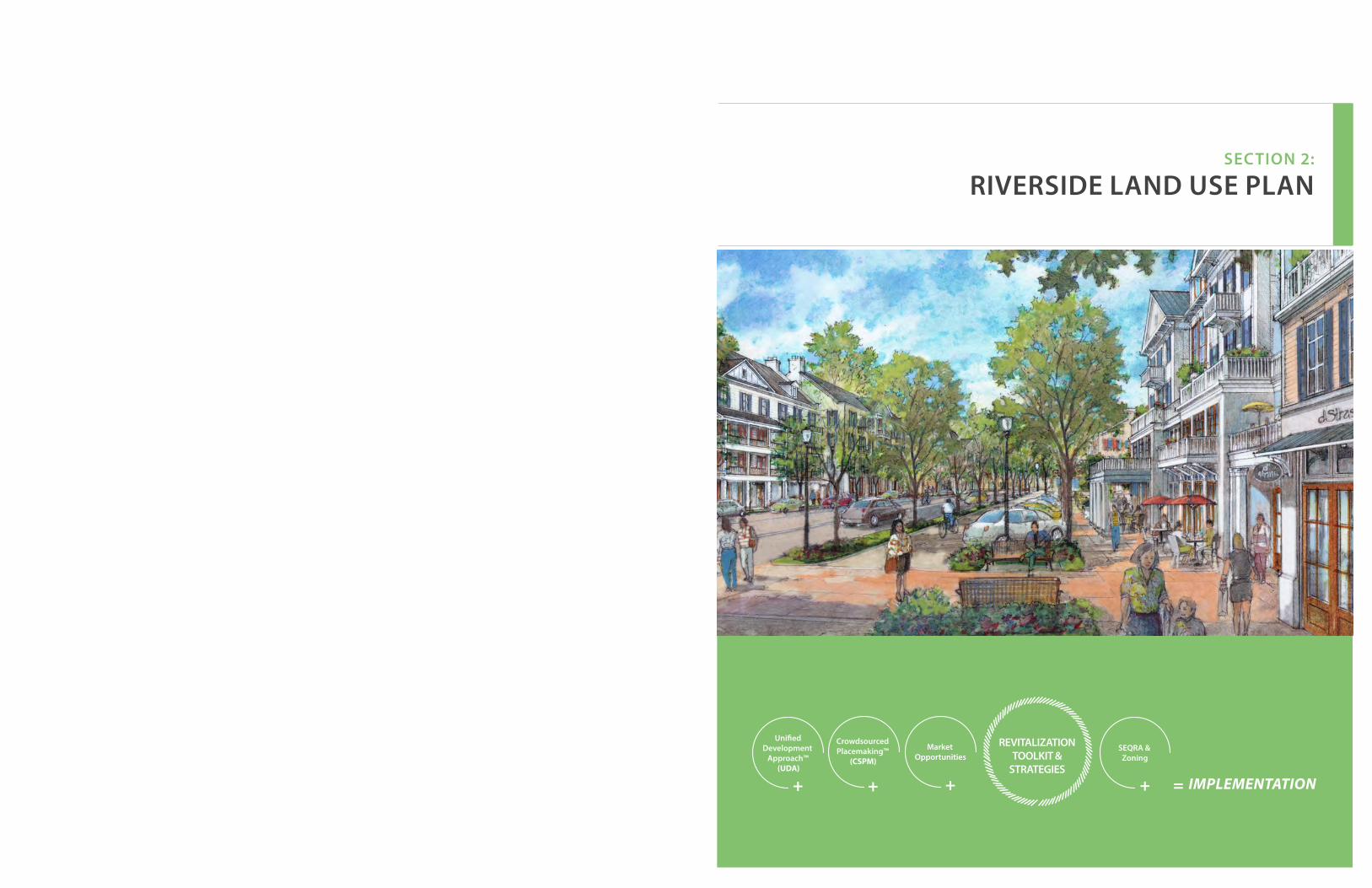
SECTION 2:
RIVERSIDE LAND USE PLAN
=+ +
REVITALIZATION TOOLKIT &
STRATEGIES
+ + IMPLEMENTATION
Unified Development
Approach™(UDA)
CrowdsourcedPlacemaking™
(CSPM)
MarketOpportunities
SEQRA & Zoning

66 67
Revitalization Toolkit A Proven Approach to Revitalization
This Toolkit demonstrates how great community ideas, market demand and RD's development experience all come together to form the Revitalization Strategies:
Unified Development Approach™ (UDA)Our unique approach to engaging public & private property owners.
Crowdsourced Placemaking (CSPM)Thousands of local voices and their socially, economically, environmentally responsible ideas.
Market OpportunitiesMarket experts determine the underlying economics on which ideas are likely to succeed.
REVITALIZATION TOOLKIT& STRATEGIES Our national toolbox of time-tested revitalization tools that have proven successful in other downtowns.
SEQRA & Zoning Strategies specifically crafted for for rapid adoption of Zoning & SEQRA will be employed in the Public Private Partnership.
Establish neighborhood mixed-use centers within a five minute walk from each other, promoting economic vitality & pedestrian walkability.
PROMOTE CENTERS
Enhance transit connectivity between commuter rail, buses and compact, walkable neighborhood centers.
TRANSIT FRIENDLY
Consolidate lots and incentivize development of anchor uses that will generate pedestrian activity, commerce and employment.
PROMOTE ANCHOR USES
Incentivize mixed-use buildings within neighborhood centers to promote economic sustainability.
MIXED-USE BUILDINGS
DIVERSITYDENSITY OF
POPULATION & ACTIVITY
Line commercial streets with storefronts and frequently spaced doors and windows to promote pedestrian activity, commerce and a safe, walkable environment.
ACTIVE FRONTAGES
Establish street design standards that embrace the needs of pedestrians, vehicles, safety, emergency services and the environment.
COMPLETE STREETS
Locate off-street parking at the rear and side of buildings to maintain continuity of the sidewalk and storefront experience.
PARKING PLACEMENT
PARKING LOT IN REAR
Street
Create civic spaces that encourage walking, gathering and community engagement andwalkability.
CIVIC SPACES
Set clear design guidelines to set high standard for sites, civic spaces, green design, building and storefronts.
QUALITY & SUSTAINABLE DESIGN
Promote a connected street and pedestrian network to achieve healthy walkable communities & reduce traffic congestion.
CONNECTED NETWORKS
REVITALIZATIONTOOLKIT &
STRATEGIES
+
Unified Development
Approach™(UDA)
+
Crowdsourced Placemaking
(CSPM)
+
MarketOpportunities
+
SEQRA & Zoning
= IMPLEMENTATION
Street
RIVERSIDE LAND USE PLAN
RIVERSIDE LAND USE PLAN // Revitalization Toolkit
DESIGN
DISTANCE TO TRANSIT AND MULTIMODAL
TRANSPORTATION
DESTINATION ACCESSIBILITY

68 69
1/4 MILE
RADIUS
1/2 MILE
RADIUS
3/4 MILE
RADIUS
Riverside Overlay District RO-1 Aerial MapSouthampton, NY
SCALE
0'200' 200' 400' 600' 800' 1,000'
NO
RT
H
VISUAL GUIDE FOR RLP MAPS AND STRATEGIES
Section 5 illustrates, graphically maps and identifies community driven ideas, provides precedent images, identifying best planning tool-box strategies, strong market opportunities, and identifying the Recommended Action Plan's proposed strategies and recommendations. Together, they form the basis for a Land Use Plan. Feasibility market studies, specific zoning overlay recommendations and a detailed SEQRA study of the Plan will further guide the implementation of this plan.
The following is a visual guide and explanation of graphics used to identify elements of the Land Use Plan:
Implementation StrategiesVisual Guide for RLP
REVITALIZATION STRATEGIESn (Strategy Listed)
MARKET DRIVEN ECONOMIC DEVELOPMENT STRATEGY
COMMUNITY DRIVEN REVITALIZATION STRATEGIES(Riverside Rediscovered)
Approximate Location of a particular Revitalization Strategy
1/4 Mile, 1/2 Mile & 3/4 Mile Radii(5, 10 & 15 min walk)
123
Hamlet Center
Dow
ntow
n Di
stric
tHa
mle
t Ce
nter
Groce
ry Store
Full Serv
ice Resta
urant
Health / P
ersonal C
are
Hobby / Sporti
ng Goods
Clothing / S
hoesElectro
nics / Applia
nce
Housing
Artisa
n Productio
n
Assiste
d LivingHotelOfficeMarin
aTo
urist
RIVERSIDE LAND USE PLAN
Recommended Revitalization Strategy described for this area in detail within the District section
1/4 mile radius (5 min walk from the center of the circle positioned on the traffic circle, identified as a heart of the hamlet center)
District Edge
Study Area Edge
COMMUNITY CENTER
NEIGHBORHOOD CENTER
RAIN GARDENS
BUS LINESBUS STOP
BUS STOP
PLAYGROUNDS
POCKET PARK
COMMUTER RAIL & STATION
BOULEVARD
WORKSHOPS AND OFFICES ALONG BOULEVARD
MIXED-USE BUILDINGS
1/8 MILE RADIUS, 2.5 MIN WALK
1/8 MILE RADIUS, 2.5 MIN WALK
1/4 MILE RADIUS, 5 MIN WALK
1/4 MILE RADIUS, 5 MIN WALK
MIXED-USE BUILDINGS
BUS STOP
Creation of walkable neighborhood areas are proven strategies for Revitalization
Neighborhood Connectivity
The Neighborhood Center diagram (below) is based upon Clarence Perry’s “Neighborhood Unit” from the 1930s and the nationally recognized planning principle that walkable communities typically occur within 1/4 mile & a 5 minute walk of a neighborhood center. The core of these neighborhood areas is 1/8 mile in radius. At downtown areas with welcoming architecture, storefronts and pedestrian amenities, this distance can increase to 1/2 mile and a 10 minute walk.
Principles for Walkable Places
3
RIVERSIDE LAND USE PLAN // Implementation Strategies

RIVERSIDE LAND USE PLANPROPOSED DOWNTOWN OVERLAY FORM BASED CODE DEVELOPMENT BULK STANDARDS
70
Riverside Overlay District Requirements
Riverside Overlay Development Incentive
Bonus 1
Riverside Overlay Development Incentive
Bonus 2
Minimum Site & Building Height Requirements
Min. Frontage: 75 FT
Min. Site Area: 7,500 SF
Height: Stories- 2 min, 3 max & 30 feet Streetwall min
Min. Frontage: 150 FT
Min. Site Area: 15,000 SF
Height: Stories - 3.5 max
Min. Frontage: 300 FT
Min. Site Area: 60,000 SF
Height: Stories - 4 .5 max
n Create a walkable, vibrant mixed-use Hamlet Center, with compact development and a vibrant publicly accessible Peconic River Waterfront Promenade.
n Leverage proximity to natural areas & open spaces. n Create lovable spaces with high standards of aesthetic design, walkable streets
with active frontages and on-street parking; create street enclosure.n Leverage proximity to Riverhead Downtown and Riverhead transit center, and
strengthen the connections by creating a pedestrian bridge and boardwalk loop.
Min. Frontage: 75 FT
Min. Site Area: 7,500 SF
Height: Stories- 2 min, 3 max
Min. Frontage: 150 FT
Min. Site Area: 15,000 SF
Height: Stories - 3.5 max
Min. Frontage: 300 FT
Min. Site Area: 60,000 SF
Height: Stories - 4 max
n Provide a range of housing options in walking distance from Hamlet Center.n Increase permeability of blocks for pedestrian traffic and increased connectivity
for car traffic.n Allow increased density to support commercial vitality and satisfy desire to live
in walking distance to Hamlet Center.n Regulate frontages to activate streets.n Create safer streets by increasing street enclosure, providing on-street parking,
visible crosswalks with pulled-in pedestrian refuge islands.
Min. Frontage: 75 FT
Min. Site Area: 7,500 SF
Height: Stories- 2 min, 2 max
Min. Frontage: 150 FT
Min. Site Area: 15,000 SF
Height: Stories - 3.5 max
Min. Frontage: 300 FT
Min. Site Area: 60,000 SF
Height: Stories - 4 max
n Provide diversity of housing options and building typologies.n Increase permeability of blocks for pedestrian traffic and increased connectivity
for car traffic.n Regulate frontages to activate streets.n Allow artisan production in mixed use and live-work environments.n Provide diversity of private and public open spaces.n Provide access to fresh food, encourage and allow food production.
Min. Frontage: 75 FT
Min. Site Area: 7,500 SF
Height: Stories- 1 min, 2 max
Min. Frontage: 150 FT
Min. Site Area: 15,000 SF
Height: Stories - 2.5 maxor 35 feet max
Min. Frontage: 300 FT
Min. Site Area: 60,000 SF
Height: Stories - 3.5 max
n Create landscaped, architectural or artistic gateway features to announce arrival to Riverside.
n Allow cross-access or new streets.n Create safe and walkable connections to natural areas.
Min. Frontage: 75 FT
Min. Site Area: 7,500 SF
Height: Stories- 1 min, 2 max
Min. Frontage: 150 FT
Min. Site Area: 15,000 SF
Height: Stories - 2.5 maxor 35 feet max
No bonus available
n Create interconnected community to increase walkability.n Create greenways and pedestrian ways. n Leverage proximity to educational assets and provide variety of resources.n Allow granny-flats.n Minimize potable water use.n Landscape with native or edible plants.n Minimize energy use.n Downplay and/or screen presence of parking within the private frontage.
Min. Frontage: 75 FT
Min. Site Area: 7,500 SF
Height: Stories- 1 min, 2 max
Min. Frontage: 150 FT
Min. Site Area: 15,000 SF
Height: Stories - 2.5 maxor 35 feet max
Min. Frontage: 300 FT
Min. Site Area: 60,000 SF
Height: Stories - 3.5 max
n Leverage maritime resources and proximity to natural areas and Peconic River.n Create public access to waterfront.n Connect to boardwalk and trails.n Create economic value by leveraging on waterfront assets.n Include waterfront and hospitality related uses.
No development No bonus available No bonus available
n Leverage maritime resources and proximity to natural areas and Peconic River.n Create a Greenways Plan that connects all waterfront with pedestrian ways,
greenways, parks and open spaces.n Create waterfront promenade and boardwalk.n Create pedestrian trails and greenways.n Provide parking for large parkland areas and share with adjacent Hamlet uses
to minimize cost for maintenance and security, and help increase the use of parks.
71
RPL
Rive
rsid
e Pa
rkla
nd
Rive
rsid
e W
ater
fron
t D
istr
ict
RO-6
Rive
rsid
e Su
burb
an
Dis
tric
t
RO-5Ri
vers
ide
Gat
eway
Dis
tric
t
RO-4
Rive
rsid
e Sp
ecia
lD
istr
ict
RO-3
Rive
rsid
e H
amle
tN
eigh
borh
ood
RO-2
Rive
rsid
e H
amle
tCe
nter
RO-1
RO-7
Executive Summary Riverside Land Use Plan (RLP) The proposed Riverside Overlay Districts (ROD) Map depicts the strategy for Riverside's redevelopment and revitalization utilizing the Transect, where the densest area is concentrated 1/4 mile (5 min walk) from the traffic circle on NY24, and scales down in density as it radiates away. This plan and corresponding key represent the planning principles detailed within the Revitalization Toolkit. Specifically, they list which principles are appropriate to be incorporated into the revitalization plan. A comprehensive approach with a singular Master Developer is recommended for the area's revitalization and redevelopment is with a singular Master Developer, as this enables the proper placement of complementary uses to best meet the principles of responsible economic development and placemaking. Section 1 describes in detail all of those areas, and lists which principles are appropriate to be incorporated into the revitalization plan. Specific zoning changes are described in Section 3.
RO-1
RO-6RO-7
RO-7
RO-7
RO-7RO-6
RO-2
RO-3
RO-4
Flanders Rd (SR24)
Riverleigh Ave (CR 104)O
ld Quogue Rd
Mor
iches
-Riv
erhe
ad R
d. (C
R 63
)
RO-4
RO-4
RO-5RO-5
RO-5
LEGEND
Pine St.
Enterprise Zone Dr
Ludl
am A
ve
Pebb
le W
ay
Phill
ips A
ve
Goodridge Rd
Woo
dhul
l Ave
RO-1
Riverside Overlay District Boundary
1/4 mile radius (5 min walk)
1/2 mile radius (10 min walk)
3/4 mile radius (15 min walk)

72 73
RIVERSIDE LAND USE PLAN
This District, situated around the Traffic Circle and Rt. 24 corridor provides the opportunity for the greatest vibrancy in Riverside. By utilizing best placemaking strategies and leveraging adjacency to Peconic River waterfront, this district should support the greatest variety and mix of uses, promoting a range of residential, retail, hospitality, cultural and entertainment uses.
The RO-1 district permits the highest densities and promotes compact design with vertically and horizontally integrated residential and non-residential uses. Pedestrian amenities required in this district reflect the need for active frontages and an easy access to the waterfront that support placemaking and destination creation. Parking standards should reflect the creation of a walkable hamlet center and transit opportunities within walking distance.
Grocery Store / Food Market
Other Retail and Services
Restaurant Row
Apartments above Stores
Office, Health and Personal Care
Hospitality
n Create a walkable, vibrant mixed-use Hamlet Center, with compact development and a vibrant publicly accessible Peconic River Waterfront Promenade.
n Leverage proximity to natural areas & open spaces.
n Create lovable spaces with high standards of aesthetic design, walkable streets with active frontages and on-street parking; create street enclosure.
n Leverage proximity to Riverhead Downtown and Riverhead transit center, and strengthen the connections by creating a pedestrian bridge and boardwalk loop.
n Create programs to enrich experience and create a draw for residents and visitors; and create environment for regionally significant WaterFire on Peconic program.
n Create a Live, Work & Play environment with large mix of uses and promote market-rate housing options.
n Support cultural programs (CMEE).
n Create programmed public spaces for year-round activities.
n Implement Traffic Circle redesign, ensure creation of pedestrian friendly features.
n Create a Slip Street on Flanders Road, to allow on-street parking and pedestrian friendly mixed-use development.
n Create a Slip Street on CR-63, to create a buffer for single family homes within a wider ROW.
(R0-1) REVITALIZATION STRATEGIES
(RO-1) MARKET DRIVEN ECONOMIC DEVELOPMENT STRATEGY
BOARDWALK / WATERFRONT GREEN SPACE 1 WATERFIRE 5 MIXED-USE
Precedent image of the Hamlet Center
1
2
3
4
5
6
7
8
9
10
11
COMMUNITY DRIVEN REVITALIZATION STRATEGIES
1/4 MILE
RADIUS
1/2 MILE
RADIUS
3/4 MILE
RADIUS
Riverside Overlay District RO-1 Aerial MapSouthampton, NY
SCALE
0'200' 200' 400' 600' 800' 1,000'
NO
RT
H
Implementation StrategiesRiverside Hamlet Center (RO-1)"Let's meet at the Nugent's Clock Tower, stroll the promenade, experience Waterfire! Maybe we can have a dinner outdoors overlooking river, cross over to Riverhead for the opening of the new show, walk over the bridge and stroll along the park while listening to music along the way. Walking home is nice, it's just down the block. Tomorrow morning the business meting is starting early, but it is at the Innovation Center, and luckily, since it is here in Riverside, I can do the gym and get a coffee on my way in!" Potential conversation with Riverside resident a few years from now.
RO-1
Waterfront Promenade
Open Spaces
Street Enclosure
Peconic River Pedestrian Bridge
WaterFire on the Peconic
Riverside Restaurant Row
Childrens' Museum
Fountain / Skating Rink
Traffic Circle
Slip Street on Flanders Road
Slip Street on CR-63
1
2
4
3
5
6
7
8
9
10
11
Flanders Rd (SR24)
Flanders Rd (SR24)
RIVERLEIGH AVE (CR 104)
OLD
QU
OG
UE RD
CR 6
3
CR 6
3
1/4 M
ILE
5 MIN
WALK
STRATEGY LOCATIONS
Riverside Overlay District Boundary
1/4 mile radius (5 min walk)
LEGEND
1
111
5
5
5
109
11
4
2
33
2
2
5
2
6
7
6
6 8
RIVERSIDE LAND USE PLAN // Riverside Hamlet Center (RO-1)

74 75
Waterfront PromenadeResilient waterfront communities provide protection strategies for ground floor commercial spaces from flooding using individual or neighborhood level protection measures. By elevating the waterfront promenade above the boardwalk, new development would create a protection wall for the rest of the neighborhood. New storefronts on Peconic Avenue and NY24 can be raised in the back and treated differently from the street frontage. The Summerwind development, a successful project widely loved by the community, just steps away, on 57 Peconic Avenue in Riverhead, has a floor plate raised above the sidewalk.
"Riverside Row Restaurants will have several restaurants along the water. Patrons will have access by boat, car, bike and foot. There will be a walk / bike path between restaurants and river. If flooding is an issue then restaurants can be elevated one floor with outdoor decking. Delicious food, music and dancing along the river will make this the place everyone wants to visit. The restaurants will aim to buy from local farms and wineries. Riverside Row Restaurants will be the place to promote Southampton Farms and Wines!" Riverside Rediscovered member Terri H.
THE POWER OF 10 The "Power of 10" originated by the Project for Public Spaces is the idea that any great place itself needs to offer at least 10 things to do or 10 reasons to be there. These could include a place to sit, playgrounds to enjoy, art to touch, music to hear, food to eat, history to experience, and people to meet. Ideally, some of these activities are unique to that particular spot and are interesting enough to keep people coming back. The local folks who use the space most regularly are the best source of ideas for what uses will work best.
The Power of 10 offers an easy framework that motivates residents and stakeholders to revitalize urban life, and shows that by starting efforts at the smallest scale you can accomplish big things. The concept also provides people with something tangible to strive for and helps them visualize what it takes to make their community great
PLACES + EXPERIENCE
BOARDWALK WATERFIRE
RESTAURANT ROW ART
CHILDREN'S MUSEUM MUSIC
FARMERS MARKETWATER FOUNTAIN / SKATING RINK
COFFEE HOUSE / CAFE MARITIME TRAIL
IMPLEMENTATION STRATEGIES RIVERSIDE HAMLET CENTER (RO-1)
1 Waterfront Promenade
Precedent Image of potential waterfront development character.
RIVERSIDE LAND USE PLAN
These precedent images of water adjacent development are not meant to recommend bulkheading of the Peconic River. Rather, they are used to suggest the type of development that may occur after careful study of the protection of the natural river conditions with the intent of increasing the public access, use and enjoyment of this great resource
Precedent image of potential waterfront development character
Precedent image of potential waterfront development character
RIVERSIDE LAND USE PLAN // Riverside Hamlet Center (RO-1)

76 77
Community redevelopment and conservation need to go hand in hand, and the improved Hamlet of Riverside should become a regional example of responsible redevelopment and revitalization. A nearly 1 mile long waterfront boardwalk loop (including Riverhead's existing boardwalk) in addition to the area's miles of easily connected nature trails would create enormous recreational opportunities.
The Town of Southampton owned park at the circle is currently not used for recreational purposes by residents as it is not tied to other uses. It has become a garbage dumping ground in the most western section, hidden from the public view closest to the river. Development frontages framing the park would bring "eyes on the park" to increase safety, this park would make this park an asset to the neighborhood.
2 Open Spaces
IMPLEMENTATION STRATEGIES RIVERSIDE HAMLET CENTER (RO-1)
Private / Public Open Spaces enrich every community
Riverside Boardwalk: Public Access to Peconic waterfront connected via proposed pedestrian bridge into a mile long loop
Pocket Park at traffic circle
Teaching Opportunities along the Peconic Estuary
Boaters access waterfront destinations
High standards of aesthetic design and execution can create the sense of pride that Riverside was deprived of for a long time are a major priority.
Creation of street enclosure with active frontages and eyes on the street should be regulated. Architectural and landscaping design standards will be developed to ensure the quality and character building in perpetuity. A healthy mix of different building typologies with a mix of uses and densities, as well as a balanced mix of rental and ownership levels would ensure this community’s economic resilience.
The most resilient way to develop is to allow flexibility to meet changing market demands for more or less residential, more or less commercial activity, and to build typologies that adapt more easily to such flexibility. At the same time it is important to stay cognitive of the challenges that climate change brings to all waterfront communities.
RIVERSIDE LAND USE PLAN
3 Creating Lovable Places
RIVERSIDE LAND USE PLAN // Riverside Hamlet Center (RO-1)
Buildings position, activity of frontages and height create street enclosure, tree canopies create protection and a sense of coziness, on-street parking creates protection of pedestrians on sidewalks. The form acts as traffic calming measure.
A one way access street with on-street parking would create a walkable section of NY24 without impacting walkability or the existing traffic flow
Precedent images of potential character (above and below)

78 79
In May 2014, the Town of Southampton issued a Request For Proposals for a Feasibility and Concept Plan for a Pedestrian Bridge over the Peconic River. The concept of a pedestrian bridge over the Peconic River linking Riverside and downtown Riverhead, intended to provide a walkable link between downtown Riverhead and the primary commercial corridor of NYS Route 24 in Riverside, had the support of both municipalities. The extraordinary scenic views from atop the bridge will attract tourists to the region to visit the Riverhead/Riverside area. Additional foot traffic will spur economic activity on both sides of the river. The bridge promotes physical activity and environmental appreciation, and will offer access from the Long Island Aquarium and other major downtown Riverhead businesses and institutions to Riverside through a natural trail setting along the Peconic River waterfront.
The RFP was awarded to AECOM by a selection committee made up of Renaissance Downtowns along with representatives from the Towns of Southampton and Riverhead, and the area's Civic Association. The intent of the RFP was to determine the feasibility of the preferred location, determine structure type, necessary bridge clearance, potential utility issues and/or conflicts, accessibility and layout in accordance with guidelines set forth in the Americans with Disability Act (ADA), identify required
environmental and regulatory permits, assess environmental impacts, prepare a preliminary concept, implementation and execution plan for the bridge and estimate construction costs. AECOM had public presentations of conceivable options that accounted for different challenges of the best positions and the bridge height and length.
The effort is still in the process, and additional grant submission has been made to NYS for future financing of the bridge.
4 Peconic River Pedestrian Bridge
IMPLEMENTATION STRATEGIES RIVERSIDE HAMLET CENTER (RO-1)
A POTENTIAL LOCATION AREA FOR PEDESTRIAN BRIDGE AND AMPHITHEATER
Possible locations of the bridge
ALTERNATIVE POSITION 1 WITH DIFFERENT BRIDGE LENGTHS ALTERNATIVE POSITION 2 WITH DIFFERENT BRIDGE LENGTHS
RIVERSIDE LAND USE PLAN
WIDTH EXAMPLES
LOOK & FEEL
Painted Metal
Federal Minimum
Steel Cable + Metal
Concrete + Metal + Decking
Truss + Decking
Pre-Fab Truss
Recommended Minimum
Designed Truss
Recommended Minimum + Seating
RIVERSIDE LAND USE PLAN // Riverside Hamlet Center (RO-1)
Frank Zappone, Town of Southampton Deputy Supervisor
Aecom's designers explaining the bridge design
Rendering of potential pedestrian bridge

80 81
“It’s very exciting and plays in very well with the vision of all the things we’re trying to accomplish. We’re more than prepared to make that commitment to a partnership with Riverhead.” Southampton Deputy Supervisor Frank Zappone at the Riverhead Town Board meeting on October 30th, after presentation by WaterFire representative Lisa Lowenstein
A resolution by the Southampton Town Board received unanimous support in December to bring WaterFire to the Peconic River with decision to work corroboratively on the project with the Town of Riverhead. The board noted that the proposal has earned broad support from community members in both towns, from Renaissance Downtowns, from the Suffolk County Office of Economic Development, as well as from civic and not-for-profit organizations in both communities, including the Peconic Land Trust and East End Arts. Riverside Rediscovered community liaision Siris Barrios has been gathering input from the Riverside residents who overwhelmingly support the project, and has been part of the steering committee organized by the Town of Riverhead.
A close working relationship between two Towns is essential to the success of the efforts to revitalize Riverside. WaterFire is a public art installation that incorporates a body of water, a series of floating bonfires, music, dance and visual art created by Providence artist Barnaby Evans. He originated the event in Providence in 1994 and it has been credited at a key factor in the city’s revitalization and renewal. Evans has brought WaterFire to a number of other cities around the world, including the small city of Sharon, Pennsylvania, located about 70 miles outside of Pittsburgh. WaterFire — held three times a year — has been a boon to the local economy and helped transform its lagging downtown business district into an up-and-coming arts district. The Riverhead Town Board has authorized a $350,000 grant application to ArtPlace America at
5 WaterFire on the Peconic
IMPLEMENTATION STRATEGIES RIVERSIDE HAMLET CENTER (RO-1)
Existing Riverhead Boardwalk
A POTENTIAL MILE LONG PEDESTRIAN CONNECTION WITH WATERFIRE VIEWING FROM BOTH BANKS OF PECONIC RIVER
Proposed Boardwalk Possible location of Peconic Pedestrian Bridge
WaterFire Potential Area Trail Connections
Boardwalk Connections Open Possibility for Recreational & Educational Opportunities
RIVERSIDE LAND USE PLAN
the suggestion of WaterFire founder Barnaby Evans. It has also authorized an application for a Bloomberg foundation public art installation grant and a grant application to the Bloomberg foundation, which is offering $1 million per year for two years to three communities for a public art installation. Being that there is an unprecedented collaboration and support given by all government agencies, private organizations, community members and nonprofit organizations, there is an increased chance that the event will be fully funded.
WaterFire Creates a Regional Destination
RIVERSIDE LAND USE PLAN // Riverside Hamlet Center (RO-1)
Past WaterFire Events
Educational opportunities
Precedent image of boardwalk
Kayak launch close to the bridge

82 83
Live, Work, Play
“Delicious food, music and dancing along the river will make this the place everyone wants to visit. The restaurants will aim to buy from local farms and wineries. Riverside Row Restaurants will be the place to promote Southampton Farms and Wines!” Riverside Rediscovered member Terri H., October 27, 2014
6 Riverside Restaurant Row
"Riverside is one of the most under-resourced communities in the East End. By providing an educational environment for children, we will be directly impacting their life learning outcomes. The museum will bring valuable learning through play activities that otherwise the children would not be able to access." Riverside Rediscovered member Francisca, January 15, 2015
“This elegant dancing water fountain that would be used as an ice skating rink in the winter months.” Riverside Rediscovered member Angela H., January 20, 2015
The Riverside community is very excited about the prospect of bringing Children's Museum for East End (CMEE) to Riverside, and has been collaborating and testing the community by opening the Museum Without Walls program in March 2015. CMEE, located in Bridgehampton is the most visited museum in Eastern Long Island. CMEE's mission is “to spark imagination and foster learning for children of all backgrounds and abilities and to build strong connections within the East End community by providing playful experiences” by presenting educational exhibits and programs and by partnering with other arts and social service organizations to address issues that concern families in the community.
The Riverside Hamlet Center could become a home to an outdoor ice skating rink. During the holiday season, the rink could incorporate a traditional tree, and a fountain and waterspray playground could replace the ice in the spring.
RIVERSIDE LAND USE PLAN
7 Children's Museum 8 Fountain / Skating Rink
RIVERSIDE LAND USE PLAN // Riverside Hamlet Center (RO-1)
RIVERSIDE RESTAURANT ROW
WATER FOUNTAIN/ICE SKATING RINK
CHILDREN'S MUSEUM
REVITALIZATION STRATEGIES
n Create public waterfront opportunitiesn Create regional destination in co-
opetition with Riverhead downtown.n Create multiple opportunities for
recreation and entertainment.n Support economic development and
job creation.n Protect, regulate and incorporate
public open spaces, regulate private open spaces.
n Create raised promenade to protect center from raising water.
IMPLEMENTATION STRATEGIES RIVERSIDE HAMLET CENTER (RO-1)
6
7
8Precedent image of a restaurant row
COMMUNITY DRIVENREVITALIZATION STRATEGIES
Children's Museum for East End (CMEE) in Bridgehampton
Precedent image of ice skating rink

84 85REVISIONNo. DATE BY:
CONSULTANT: DRAWING TITLE:CLIENT:
SCALE: AS SHOWN
RJJ
DATE:
JOB No.:
CADD:
CHK'D BY:
DWN. BY:
RJJ
DRAWING NUMBER:
SHEET: 1 OF 1
THIS DOCUMENT IS THE SOLEPROPERTY OF N&P ENGINEERS &SURVEYORS, PLLC, AND HAS BEENPREPARED AND DISSEMINATEDFOR THE SOLE USE OF OURCLIENT. THIS DOCUMENT AND ANYDATA, CALCULATIONS, ESTIMATESOR DEPICTIONS CONTAINEDHEREIN, MAY NOT BE UTILIZED BYANY THIRD-PARTY WITHOUT PRIORWRITTEN CONSENT OF N&PENGINEERS & SURVEYORS, PLLC,WHICH ASSUMES NO RISK OF LOSSOR LIABILITY RESULTING FROMANY UNAUTHORIZED USE ORRELIANCE BY ANY THIRD-PARTY.
SUFFOLK COUNTYDEPARTMENT OF PUBLIC WORKS
335 YAPHANK AVENUEYAPHANK, NY 11980
9/9/13
2 LANE ROUNDABOUT
10126
ALIENATION AREA: 4,000±SF
5 LEG 2 LANE ROUNDABOUT
PARK LAND ALIENATION
RIVERHEAD, NEW YORK
8,500±SF
17,000±SF
CONCEPTUAL PLAN
The Town of Southampton and Suffolk County are looking to rework the traffic pattern at the Riverside traffic circle. On November 4th, 2014, the Town of Southampton held and passed a referendum to swap the 3,000 square feet of town parkland in the northwest corner of the intersection to elongate the circle, with 8,000 square feet of county land just to the west of the town’s property, backing up to the Peconic River behind the Peconic Paddler’s shop. After Southampton Town residents agreed to a land swap in a referendum, the county allocated about $500,000 in design money for the project, and is planning to allocate $4 million in construction funds for the project in Suffolk’s 2016 capital budget. If the county is at least able to start on the project next year, he said, funding would be secured for the following year as well.
The redesign would elongate the circle into an oval with two lanes of travel ways around it to allow for more movement. The design
would include pedestrian crosswalks. The inclusion of landscaped pedestrian refuge islands and seamless connections to sidewalks which was the biggest residents' concern.
Aerial: Tile ASouthampton, NY
SCALE 05.01.14
0'80' 80' 160' 240' 320'
NO
RT
H
9 Traffic Circle
IMPLEMENTATION STRATEGIES RIVERSIDE HAMLET CENTER (RO-1) RIVERSIDE LAND USE PLAN
RIVERSIDE LAND USE PLAN // Riverside Hamlet Center (RO-1)
Strategies for Increasing Pedestrian Friendliness
Pedestrian friendly environment benefits any community. Landscaped islands provide pedestrian refuge in the middle of the street without additional traffic slowing. By landscaping the islands, the amount of permeable surface is increased with better stormwater drainage and diminished heat island effect. The placemaking difference between a blacktop paved 5 lanes and landscaped islands is tremendous.
The middle of the proposed circle is 54,223 SF in size, and there is an opportunity to include gateway feature to visually "pull" the circle closer. Local artists' proposals could bring local flair to a permanent or seasonal feature. If any activity is proposed in that area, protective bollards and lighting at strategic places would increase safety.
REVITALIZATION STRATEGIES
n Form a Riverside Beautification Committee that includes Master Developer and Riverside residents, who will work with the Town, the County and NYS on the design and maintenance of parks, landscaping islands and medians within the ROW.
n Include landscaped islands for pedestrian refuge in the new circle design.
n Crowdsource ideas for art, lighting and landscaping of the traffic circle, park and other public spaces.
Riverside Community, Town, County and Master Developer are working together to get closer to implementation. Above from left: Councilwoman Christine Scalera, Councilman Bradley Bender , Sean McLean (Renaissance Downtowns, Master Developer), Suffolk County Executive Steve Bellone and Town of Southampton Supervisor Anna Throne-Holst

86 87
Walkability offers surprising benefits to our health, the environment, our finances, and our communities. Walkability depends on scale, pattern, design, the mix of sustainability and resources, and most of all, it leads to more social interaction, physical fitness, diminished crime, increased wellness and increased property values.
HEALTH BENEFITSPeople living in "sprawling" non-walkable areas are more likely to be obese and suffer from associated illnesses such as high blood pressure, diabetes and heart disease. Living in a mixed-use community with the option to walk to all necessities complements a healthy, active lifestyle.
ENVIRONMENTALLY FRIENDLYThe ability to walk within a community or development is also important from an environmental perspective. When destinations such as work, home, shopping, restaurants and transit are within a quarter-mile to half-mile of each other, community members are more likely to walk instead of drive, according to information from the Urban Land Institute. Less air pollution from less driving is not only correlated with cleaner air to breathe in, but also a healthier environment.
TIME AND COST EFFICIENTResidents of mixed-use, walkable communities spend less time commuting when they have the option of walking wherever they need to go. Lower transportation costs mean that a lower combined cost of living.
DIVERSITYMixed-use communities tend to include a mix of generations, incomes and housing types, leading to a more interesting area with character and charm.
WALKABLE COMMUNITIES FOR BOOMER AND MILLENNIALSAccording to many studies, miles driven per person has been flat or dropping since the early 2000s, as the baby boomer generation is starting to phase out of their peak driving years. Millennials – who are in or entering their peak driving years are driving about one third less than baby boomers did at their age. With less interest in owning and driving cars, it’s easy to see why walkable communities have become so popular among this generation.
10 Addressing Walkability
IMPLEMENTATION STRATEGIES RIVERSIDE HAMLET CENTER (RO-1)
EXISTING VIEW OF MORICHES - RIVERHEAD RD (CR63) Existing Right of Way is very wide and could allow for a slip road and a buffer to protect adjacent homes
EXISTING VIEW OF FLANDERS ROAD RIVERHEAD HAMPTON BAYS ROAD, a local example of the existing road which serves as a slip road and creates a green space and a buffer for existing homes from the Flanders Road with more traffic.
One of the Strategies to Address Walkability The Right of Way at this portion of the CR63 (photo above), less than 1/4 mile from the traffic circle is over 120 feet in width. Single family homes would benefit from a new one way road with on-street parking for visitors, where a sidewalk would be protected from heavy traffic, and the landscaped median separating the road from CR63 could create a park-like feel for the adjacent properties (photo to left).
RIVERSIDE LAND USE PLAN
RIVERSIDE LAND USE PLAN // Riverside Hamlet Center (RO-1)
Precedent image of a walkable neighborhood (above and to the left)

11 Addressing Walkability on NY24
89RIVERSIDE LAND USE PLAN // Riverside Hamlet Center (RO-1)
Illustration of potential Riverside Hamlet Center, view from NY24
TENTATIVE LAND USE PLAN
REVITALIZATION STRATEGIES
nCreate vibrant spaces with mix of uses and building typologies.
nAllow increased density to support commercial vitality & satisfy desire to live in walking distance to where the "action" is.
nAllow on-street parking, shared parking and off-site parking within walking distance to maximize buildout where it belongs.
nRegulate frontages to activate streets.nWork with transit agencies to maximize
transit options.nCreate new streets to maximize
walkability and adjust travel speeds. nCreate safer streets by increasing
enclosure (providing a better building-height-to-street ratio to minimize perception of allowed speed).
SHUTTLE BUS SERVICE RIVERSIDE – DOWNTOWN RIVERHEAD
COFFEEHOUSE/CAFÉ
DELI COUNTRY EXISTING VIEW: Creation of a new slip street on private property adjacent to NY24 with on-street parking sidewalks with storefronts and outdoor dining, along with street enclosure created by new mixed-use development creates safe pedestrian environment (RENDERING TO THE RIGHT).
IMPLEMENTATION STRATEGIES RIVERSIDE HAMLET CENTER (RO-1)
A one way access street with on-street parking would create a walkable section of NY24 without impacting walkability or the existing traffic flow (below).
MIxed-Use and Active frontages in walkable environment encourage pedestrian and viable commercial activity.
88
COMMUNITY DRIVENREVITALIZATION STRATEGIES

90 91
Responsible Wastewater Treatment would allow for community revitalization.
There is a need to develop a sustainable water quality protection plan to reverse current trends and provide for maintainable drinking water and surface water quality. Nitrogen and pathogens are contributing to increasingly degraded water bodies across Long Island, and nitrogen loads to surface waters promote and sustain harmful algae that impede recovery of Suffolk's once world renowned shellfisheries. Currently, the clam fishery is operating at one percent of its peak potential. Sustainable concentrations of nitrogen in estuarine waters are more than 20 times lower than the drinking water standard; the Peconic Estuary Program has identified a goal of 0.45 mg/L of total nitrogen in surface waters to ensure adequate dissolved oxygen levels are continuously maintained to minimize the potential impacts to aquatic life.
While referring to the Suffolk County financed “Flanders-Riverside Corridor Sewering Feasibility Study”, Renaissance team is proposing potential alternate solutions that would require further in-depth studies. There are several solutions communities around the country are using, which gives us the market tested cases to examine for the best possible solution for Riverside. These solutions, outlined below, are only a sample of a number of possibilities that will be explored and analyzed.
LIVING MACHINE® - AN ENGINEERED WETLAND SOLUTIONIt is hard to think of wastewater treatment system as a thriving ecology, but that's what Living Machine® technology claims to produce. Their award-winning projects are treated to a lush cascade of water features, hydroponic plants, and engineered wetlands, all of which are constantly working to cleanse wastewater and rainwater for re-use. Living Machine® Technology blends science and engineering with plants and beneficial bacteria to efficiently treat and reuse wastewater to provide lasting water solutions. Based on the principles of wetland ecology, their tidal process cleans water, and it’s an energy-efficient system with high quality reuse standards.
The Tidal Flow Wetland Living Machine® incorporates a series of wetland cells, or basins, filled with special gravel that promotes the development of micro-ecosystems. These highly flexible cells may be integrated into exterior landscaping or built into a building or greenhouse. As water moves through the system, the cells are alternately flooded and drained to create multiple tidal cycles each day, much like natural wetlands, resulting in high quality reusable water. The micro-ecosystems within the cells efficiently remove nutrients and solids from the wastewater, resulting in high quality effluent. The final
polishing stage, which involves filtration and disinfection, leaves water crystal clear and ready for reuse. Online sensors continuously monitor water quality and chlorine residuals to ensure that reclaimed water is completely safe.
Although a typical Living Machine® system recycles thousands of gallons of water a day, everything occurs below the wetland surface. All the casual observer sees are lush, vibrant plantings. The final polishing stage, which involves filtration and disinfection, leaves water crystal clear and ready for reuse. Online sensors continuously monitor water quality and chlorine residuals to ensure that reclaimed water is completely safe.
The projects achieved with Living Machine technology embody Renaissance’s low impact philosophy where "infrastructure as architecture" finds ways to make essential systems both environmentally sustainable and aesthetically pleasing. Residents and guests could swim in natural ponds fed with rainwater, and stroll or lounge beside a working ecological wastewater treatment system. The possibility of artful blending of architecture, infrastructure, and ecology poses a profound challenge to the idea that human habitation and support systems must be divorced from our natural environment.
OMNI PROCESSOR- DISTRICT ENERGY, HEAT AND POTABLE WATER PRODUCTIONThe Omni Processor is a trade name for a sewage sludge treatment system that produces purified drinking water and electrical energy as end products from sewage sludge. Manufactured by Janicki Bioenergy, the proof of concept model was funded by the Bill and Melinda Gates Foundation. The S100 model costs about $1.5 million, can produce 2,853 gal of drinking water per day and 100 kW net electrical, with a planned larger model S200 designed to handle the waste from 100,000 people, produce 22,700 gal per day and 250 kW net output electrical energy, being a "self-sustaining bioenergy" process.
The treatment process first involves boiling the sewage sludge, during which water vapor is boiled off and recovered, leaving a dry sludge which is then combusted as fuel to heat a boiler that in turn produces steam and the heat necessary for the boiling off process. The steam is then used to generate electrical energy. Some of this electrical energy is used for the final water reverse osmosis purification stages to produce safe drinking water, and to power ancillary pumps, fans and motors.
IMPLEMENTATION STRATEGIES RIVERSIDE HAMLET CENTER (RO-1)
Providing Necessary Infrastructure to Support Redevelopment
13
Living Machine® Tidal wetland diagram (above). Based on the principles of wetland ecology, Living Machine Systems’ patented tidal process cleans water, making the Living Machine® the most energy-efficient system to meet high quality reuse standards.
RIVERSIDE LAND USE PLAN
RIVERSIDE LAND USE PLAN // Riverside Hamlet Center (RO-1)
Precedent image of a boardwalk.
Living Machine simulates wetlands and produces a thriving ecology
Omni Processor Plant (above and to the right)

92 93
The water demand in Suffolk is sharply rising mostly due to irrigation demand for both residential and commercial lawns and landscapes.
RESIDENTIAL AVERAGE WATER USE
IMPLEMENTATION STRATEGIES RIVERSIDE HAMLET CENTER (RO-1)
Source: American Water Works Association Research Foundation, End Uses of Water
REVITALIZATION STRATEGIES
n Indoor water use efficiency - lowering water consumption reduces potable water consumption and unnecessary wastewater treatment.n Low flow fixtures, fittings.n Low flow appliances.
n Outdoor potable water reduction.n Responsible planting.n Requiring devices that automatically
shut down irrigation systems during rain. n Implementing Conservation Pricing
in which the cost of a gallon of water increases with the quantity consumed.
n Use of secondary water sources for non-potable use.n Use of captured rainwater.n Recycled wastewater – graywater. n Use of stormwater, foundation drain water
& AC condensate.
Recycled water for toilet flushing, washing machine and car washing
Recycled water for irrigation
Overflow to sewer
Holding tank
Gray water from shower, vanity and bath
Gray water from washing machine
LIVING MACHINE® TIDAL WETLAND - IRRIGATION WITHOUT POTABLE WATER USE
While focusing on community revitalization through redevelopment, Renaissance’s triple bottom line approach keeps the focus on low impact development and mitigation of existing development’s problems.
n Preserve natural spaces and restore wetlands.n Reduce heat-island effect of
parking lots and streets.n Reduce heat island effect of roofs.n Reduce runoff.
n Reduce impervious pavement.n Install raingardens and
bioretention infrastructure.
REVITALIZATION STRATEGIESStormwater DrainageLow impact development as proposed throughout this RRAP would be regulated through zoning, allowing increased stormwater infiltration through a variety of biophilic design standards and impervious surfaces. Biophilia is not just about plants, sensible biophilic design creates healthy, happy live/work environments and positively affects community resilience. As humans, we have a need to be part of nature; light is part of our rhythm and the presence of water appeals to our senses. Multiple studies by ULI, APA, Smart Growth Network, and others, have proven that balanced centers with green aspects are viewed as community assets, and that the real estate values rise with inclusion of biophilic designs and open spaces.
Renaissance’s Action Plan provides a direction of Riverside redevelopment through regulated measures for greening of the environment by populating with street trees, including raingardens and bioretention infrastructure, providing multiple types of public and private open spaces; and incorporating food production into built environment.
To mimic the natural occurrence, found in undeveloped watersheds, rain and melting snow are intercepted by the leaves of trees and other vegetation; while what does not evaporate is absorbed into the soil. The rate of absorption of stormwater and its ability to filter impuritied is very important for the health of the river and the underground water sources. In watersheds of existing development with over-paved environments, precipitation hits hard impervious surfaces, such as roofs, roads, and parking lots, and rushes into storm sewers without being absorbed, thereby short-circuiting natural hydrologic processes. As a result, larger amounts of water surge through streams and rivers in shorter periods of time. Studies have repeatedly shown that the percentage of impervious cover in a watershed has a direct impact on the physical integrity and aquatic life of rivers and streams.
Landscaping with bioretention (bioswales, cells or planters) and raingardens is a great way to incorporate natural storm water filtration systems into development. They function like a colander, by trapping the contaminants and debris at the top and letting the safe water run through. A rain garden, usually near a source of water runoff, often looks like a very beautiful garden but serves the purpose of slowing down the momentum of storm water runoff and gives the storm water more time to infiltrate, which stops or slows down erosion and provides a safeguard from flooding. A rain garden consists of compost-amended native soils or designed soil mixes. They usually have a simple inflow wherein rainwater enters the garden, and an above-ground overflow where excess water exits, with carefully chosen variety of plants with deep root system that absorb and slow down the filtration.
RIVERSIDE LAND USE PLAN
RIVERSIDE LAND USE PLAN // Riverside Hamlet Center (RO-1)
Bioswales and raingardens as filtration systems
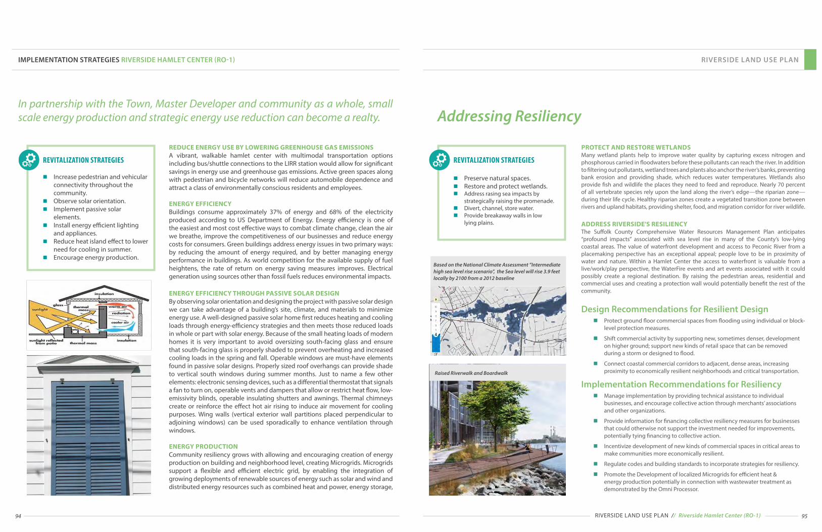
94 95
In partnership with the Town, Master Developer and community as a whole, small scale energy production and strategic energy use reduction can become a realty.
n Increase pedestrian and vehicular connectivity throughout the community.
n Observe solar orientation. n Implement passive solar
elements.n Install energy efficient lighting
and appliances.n Reduce heat island effect to lower
need for cooling in summer.n Encourage energy production.
REVITALIZATION STRATEGIES
REDUCE ENERGY USE BY LOWERING GREENHOUSE GAS EMISSIONS A vibrant, walkable hamlet center with multimodal transportation options including bus/shuttle connections to the LIRR station would allow for significant savings in energy use and greenhouse gas emissions. Active green spaces along with pedestrian and bicycle networks will reduce automobile dependence and attract a class of environmentally conscious residents and employees.
ENERGY EFFICIENCY Buildings consume approximately 37% of energy and 68% of the electricity produced according to US Department of Energy. Energy efficiency is one of the easiest and most cost effective ways to combat climate change, clean the air we breathe, improve the competitiveness of our businesses and reduce energy costs for consumers. Green buildings address energy issues in two primary ways: by reducing the amount of energy required, and by better managing energy performance in buildings. As world competition for the available supply of fuel heightens, the rate of return on energy saving measures improves. Electrical generation using sources other than fossil fuels reduces environmental impacts.
ENERGY EFFICIENCY THROUGH PASSIVE SOLAR DESIGNBy observing solar orientation and designing the project with passive solar design we can take advantage of a building’s site, climate, and materials to minimize energy use. A well-designed passive solar home first reduces heating and cooling loads through energy-efficiency strategies and then meets those reduced loads in whole or part with solar energy. Because of the small heating loads of modern homes it is very important to avoid oversizing south-facing glass and ensure that south-facing glass is properly shaded to prevent overheating and increased cooling loads in the spring and fall. Operable windows are must-have elements found in passive solar designs. Properly sized roof overhangs can provide shade to vertical south windows during summer months. Just to name a few other elements: electronic sensing devices, such as a differential thermostat that signals a fan to turn on, operable vents and dampers that allow or restrict heat flow, low-emissivity blinds, operable insulating shutters and awnings. Thermal chimneys create or reinforce the effect hot air rising to induce air movement for cooling purposes. Wing walls (vertical exterior wall partitions placed perpendicular to adjoining windows) can be used sporadically to enhance ventilation through windows.
ENERGY PRODUCTION Community resiliency grows with allowing and encouraging creation of energy production on building and neighborhood level, creating Microgrids. Microgrids support a flexible and efficient electric grid, by enabling the integration of growing deployments of renewable sources of energy such as solar and wind and distributed energy resources such as combined heat and power, energy storage,
IMPLEMENTATION STRATEGIES RIVERSIDE HAMLET CENTER (RO-1)
Addressing Resiliency
n Preserve natural spaces. n Restore and protect wetlands.n Address rasing sea impacts by
strategically raising the promenade.n Divert, channel, store water.n Provide breakaway walls in low lying plains.
REVITALIZATION STRATEGIES
PROTECT AND RESTORE WETLANDS Many wetland plants help to improve water quality by capturing excess nitrogen and phosphorous carried in floodwaters before these pollutants can reach the river. In addition to filtering out pollutants, wetland trees and plants also anchor the river’s banks, preventing bank erosion and providing shade, which reduces water temperatures. Wetlands also provide fish and wildlife the places they need to feed and reproduce. Nearly 70 percent of all vertebrate species rely upon the land along the river’s edge—the riparian zone—during their life cycle. Healthy riparian zones create a vegetated transition zone between rivers and upland habitats, providing shelter, food, and migration corridor for river wildlife.
ADDRESS RIVERSIDE'S RESILIENCYThe Suffolk County Comprehensive Water Resources Management Plan anticipates “profound impacts” associated with sea level rise in many of the County’s low-lying coastal areas. The value of waterfront development and access to Peconic River from a placemaking perspective has an exceptional appeal; people love to be in proximity of water and nature. Within a Hamlet Center the access to waterfront is valuable from a live/work/play perspective, the WaterFire events and art events associated with it could possibly create a regional destination. By raising the pedestrian areas, residential and commercial uses and creating a protection wall would potentially benefit the rest of the community.
Design Recommendations for Resilient Designn Protect ground floor commercial spaces from flooding using individual or block-
level protection measures.
n Shift commercial activity by supporting new, sometimes denser, development on higher ground; support new kinds of retail space that can be removed during a storm or designed to flood.
n Connect coastal commercial corridors to adjacent, dense areas, increasing proximity to economically resilient neighborhoods and critical transportation.
Implementation Recommendations for Resiliencyn Manage implementation by providing technical assistance to individual
businesses, and encourage collective action through merchants’ associations and other organizations.
n Provide information for financing collective resiliency measures for businesses that could otherwise not support the investment needed for improvements, potentially tying financing to collective action.
n Incentivize development of new kinds of commercial spaces in critical areas to make communities more economically resilient.
n Regulate codes and building standards to incorporate strategies for resiliency.
n Promote the Development of localized Microgrids for efficient heat & energy production potentially in connection with wastewater treatment as demonstrated by the Omni Processor.
Based on the National Climate Assessment ”Intermediate high sea level rise scenario”, the Sea level will rise 3.9 feet locally by 2100 from a 2012 baseline
RIVERSIDE LAND USE PLAN
RIVERSIDE LAND USE PLAN // Riverside Hamlet Center (RO-1)
Raised Riverwalk and Boardwalk

96 97
n Regulate uses and their location to better reflect the community and market needs.
n Provide architectural elements and civic spaces that create/add to community character.
n Create significant corners.n Create terminated vistas.n Regulate street typologies to
support walkable environment.n Regulate frontages.n Regulate civic spaces.
REVITALIZATION STRATEGIES
Significant CornersCorner locations, typically at intersections, require a distinctive architectural element or a civic space, and buildings located at those corners should address the corner to enrich the community character.
SIGNIFICANT CORNERS SHOULD:n Project higher than the surrounding buildings and may be manifested
in a “tower” element or similar treatment.n Have distinctive character from block to block to help with orientation
throughout the neighborhood.n Aspire to a higher level of detail than that of typical corners.
Terminated VistasTerminated vistas are considered an important method of adding aesthetic appeal to a community, and to emphasize important structures or monuments. They are typically located at the axial conclusion of a street or exposed viewshed to provide that distinctive architectural element.
13 Terminated Vistas and Significant Corners
IMPLEMENTATION STRATEGIES RIVERSIDE HAMLET CENTER (RO-1)
Examples of buildings creating a terminated vista.
A
A
A
B
B
B
B
RO-1
RO-2
RO-1
RO-2
RO-1
RO-2
RO-1
RO-2
RO-1RO-2
RO-4RO-5
RO-2RO-5
RPLRO-4
RPL
RO
-1
RO-5
RO-1
RO-5
RPL
RO-1RPL
RP
L
RO
-2
MO
RICH
ES -
RIVE
RHEA
D RO
AD
WO
ODH
ULL
AVE
NU
E
PEGGS LN
RIVERLEIGH AVENUE
PE
CO
NIC
FLANDERS ROAD / SR 24
PINE ST
MAYNARD ST.
A
B
B
12
3
4
28
27
15
17
18 19
20
21
1112
13
14
9
10
6
78
RIVERSIDE LAND USE PLAN
1
RIVERSIDE LAND USE PLAN // Riverside Hamlet Center (RO-1)
Locations of terminated vistas and significant corners can be regulated (example of a regulating plan page).
STOREFRONT REQUIRED
RIVERSIDE PROMENADE
SIGNIFICANT CORNER
TERMINATING VISTA
STREET TYPE
BLOCK NUMBER
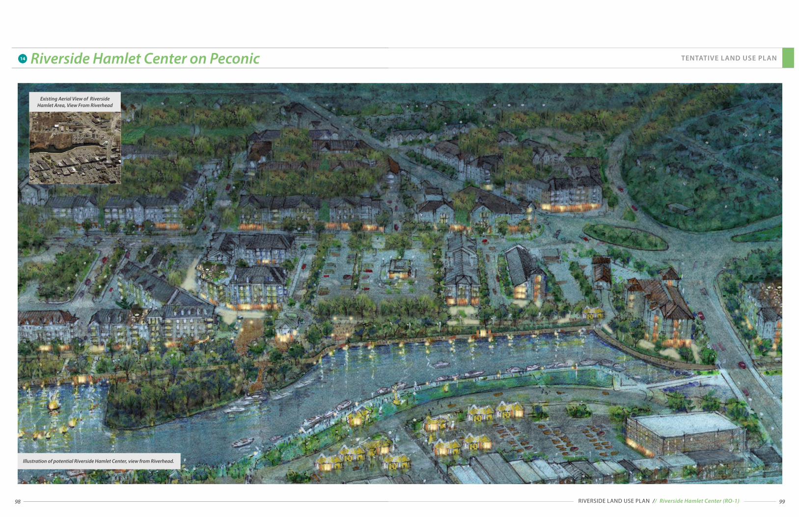
98
14 Riverside Hamlet Center on Peconic
99RIVERSIDE LAND USE PLAN // Riverside Hamlet Center (RO-1)
Existing Aerial View of Riverside Hamlet Area, View From Riverhead
Illustration of potential Riverside Hamlet Center, view from Riverhead.
TENTATIVE LAND USE PLAN

100 101RIVERSIDE LAND USE PLAN // Riverside Hamlet Neighborhood (RO-2)
RIVERSIDE LAND USE PLAN
The RO-2 Overlay District is located within walking distance of the Hamlet Center and Downtown Riverhead, and is a mixed-use hamlet neighborhood that includes restaurants with outdoor seating, shopping, offices, hospitality uses, upper floor apartments, and community utility and food production areas, up to 4 stories in height. The purpose of this zone is to support a compact mix of uses with significant residential development, including a range of residential, retail, hospitality, and entertainment uses.
The RO-2 zone promotes compact design with vertically and horizontally integrated residential and non-residential uses. Parking standards and pedestrian amenities in this zone reflect its access to the existing walkable downtown and non-automotive transportation options.
n Provide a range of housing options in walking distance from Hamlet Center.
n Create a slip street within a wide ROW on CR-63 to create a buffer for the residential homes.
n Increase permeability of blocks for pedestrian traffic and increased connectivity for car traffic.
n Allow increased density to support commercial vitality and satisfy desire to live in walking distance to where the "action" is.
n Regulate frontages to activate streets.
n Create safer streets by increasing street enclosure, providing on-street parking, visible crosswalks with pulled-in pedestrian refuge islands.
n Parking should be screened and placed in the back whenever possible.
(R0-2) REVITALIZATION STRATEGIES
11
Assisted Living
Other Retail and Services
Restaurant Row
Apartments above Stores
Office, Health and Personal Care
ATTAINABLY PRICED HOUSING HEALTHY VILLAGEBOARDWALK / WATERFRONT GREEN SPACE MIXED-USE15
Precedent image of the Riverside Hamlet Neighborhood
(RO-2) MARKET DRIVEN ECONOMIC DEVELOPMENT STRATEGY
COMMUNITY DRIVEN REVITALIZATION STRATEGIES
1/4 MILE
RADIUS
1/2 MILE
RADIUS
3/4 MILE
RADIUS
Riverside Overlay District RO-2 Aerial MapSouthampton, NY
SCALE
0'200' 200' 400' 600' 800' 1,000'
NO
RT
H
RO-2
RIVERLEIGH AVE (CR 104)
11
Flanders Rd (SR24)
OLD
QU
OG
UE RD
CR 63
Slip Street on CR-63
11
STRATEGY LOCATIONS
Riverside Overlay District Boundary
1/4 mile radius (5 min walk)
1/2 mile radius (10 min walk)
LEGEND
Implementation StrategiesRiverside Hamlet Neighborhood (RO-2)"Substandard housing should be replaced with new, reasonably priced townhouses or other residential units. The new residences should be offered to existing residents and workers. New dwellings bring investment, customers for businesses and an overall more vibrant downtown or Hamlet Center community. The new condos will add life to the streets and much needed tax revenues for our schools and municipalities." Vincent Taldone, President, Flanders Riverside, Northampton Civic Association
Flanders Rd (SR24)

102 103
Healthy CommunityResearch indicates that health access contributes significantly to positive lifelong outcomes. For this reason, it is important to identify the best health models and practices that contribute to building healthy communities.
ATTAINABLY PRICED HOUSING
MIXED-USE
REVITALIZATION STRATEGIES
n Provide diversity of housing options and building typologies.
n Increase permeability of blocks for pedestrian traffic and increased connectivity for car traffic.
n Regulate frontages to activate streets.
n Parking should be screened and placed in the back whenever possible.
n Encourage preventive care.
n Create recreational opportunities.
n Provide access to fresh food.
HEALTHY VILLAGE
IMPLEMENTATION STRATEGIES RIVERSIDE HAMLET CENTER (RO-2)
Examples of walkable, healthy communities.
COMMUNITY DRIVENREVITALIZATION STRATEGIES
Provision of single point of contact outside the traditional sick care environment to assist in management, coordination and monitoring of healthcare and overall wellness is extremely important. Mixed use provides a physical framework in which resources are located within a walkable distance. By focusing on preventive care, community residents could translate savings into access to education and skills leading to upward economic mobility and neighborhood revitalization.
n Health Coordinatorsn Health Promoter/Educator n Primary Care Servicesn Vision Servicesn Dental Servicesn Mental Health Servicesn Pharmacy Servicesn Nutrition Services
n Physical Therapy Servicesn Exercisen Wellness Classesn Mommy & Baby Classesn Senior Citizen Recreation Spacen Adult Classes that promote
Physical and Mental Healthn Assisted Living
RIVERSIDE LAND USE PLAN
RIVERSIDE LAND USE PLAN // Riverside Hamlet Neighborhood (RO-2)
NURSING ACADEMY ASSISTED LIVING
PHARMACY
PERSONAL SERVICE
DAYCARE FACILITY
ACCESS TO OPEN SPACE & WATERFRONT
PLAZA & URBAN PLAYGROUND
RESTAURANT W/OUTDOOR DINING
MEDICALRETAIL
FITNESS CENTER POOL IN THE BACK
RENTAL APARTMENTS

104 105
Community Benefit UnitsOne way to build residents’ wealth is through education and training, and through job and entrepreneurial opportunities. The synergies between increased housing demand and economic options for neighborhood residents, such as the job and business opportunities opened up by increased construction and home-improvement activity, and the business opportunities arising from the growth in the neighborhood’s disposable income will assure the revitalization of the community.
Provision of workforce housing is important for any Long Island community. Attainability by design is a valuable strategy for ability to provide diversity of housing for different incomes. It focuses on living in smaller spaces but provides amenities outside the residential unit. Rooftop gardens, courtyard gardens, playgrounds, lobbies with fireplaces and amenities, shared office spaces, and the whole hamlet and waterfront promenade in the backyard. The existing single family home supply will remain valuable for growing families, and by providing options for other demographics thirsty for other kinds of living, the market will finally be able to satisfy the need.
Building incomes and assets through jobs and business opportunities should be part of any strategy to improve the lives of lower-income households, although, by virtue of redevelopment pace, they will take some years to have a substantial impact. From a revitalization standpoint, these strategies are complementary to strategies that seek to influence housing costs and availability directly.
ATTAINABLY PRICED HOUSING
MIXED-USE
REVITALIZATION STRATEGIES
n Provide diversity of housing options and building typologies.
n Provide incentives for provision of workforce housing.
n Support education , training, and entrepreneurial opportunities.
IMPLEMENTATION STRATEGIES RIVERSIDE HAMLET CENTER (RO-2)
Precedent Image of mixed income communities.
MARKET DRIVEN ECONOMIC DEVELOPMENT STRATEGY
Apartments above Stores
Assisted Living
77%of Millenials
VS.
DEMAND VS. SUPPLY FOR DOWNTOWN LIVING AMONG MILLENIALS
WALKING VS. CAR OWNERSHIP PREFERENCE AMONG MILLENIALS
30% Demand2% Supply
COMMUNITY DRIVENREVITALIZATION STRATEGIES
Satisfying the Creative Class
RIVERSIDE LAND USE PLAN
RIVERSIDE LAND USE PLAN // Riverside Hamlet Neighborhood (RO-2)
Precedent images of buildings allowing co-working and creative class space without compromising quality of a street experience and walkability.
Creative Class Workspace.
The Creative Class, a socioeconomic class identified by American economist and social scientist Richard Florida, a professor and head of the Martin Prosperity Institute at the Rotman School of Management at the University of Toronto, are a key driving force for economic development.
Richard Florida describes the Creative Class as 30% of the U.S. workforce, broken into two broad sections, derived from Standard Occupational Classification System codes:
The first group, the Super-Creative Core comprises of about 12% of all jobs. It includes a wide range of occupations (e.g. science, engineering, education, computer programming, research), with arts, design, and media workers forming a small subset. They “fully engage in the creative process”, they are considered innovative, creating commercial products and consumer goods. Second group consists of Creative Professionals, classic knowledge-based workers including those working in healthcare, business and finance, the legal sector, and education. They “draw on complex bodies of knowledge to solve specific problems” using higher degrees of education to do so. In addition to these two main groups of creative people, the usually much smaller group of Bohemians, who are engaged in other musical, artistic, or literary pursuits.
The Creative Class will be the leading force of growth in the economy expected to grow by over 10 million jobs in the next decade.
Shared Coworking is a way of building a community centered around a creative class. They will not only need the physical place, but housing, exhibition space, other services and support in establishing their coworking community.
ATTAINABLY PRICED HOUSING
MIXED-USE
REVITALIZATION STRATEGIES
n Provide a mix of uses.n Provide professional offices
and Shared Co-working spaces.n Provide artist lofts.n Provide gallery and art
production space.
MARKET DRIVEN ECONOMIC DEVELOPMENT STRATEGY
Apartments above Stores
Office
COMMUNITY DRIVENREVITALIZATION STRATEGIES

106 107RIVERSIDE LAND USE PLAN // Riverside Special District (RO-3)
RIVERSIDE LAND USE PLAN
The intent of RO-3 district, located mostly between ½-mile and ¾ mile of Downtown Riverhead and Riverside traffic circle, is to support a variety of uses with employment in focus and variety of housing choices.
The RO-3 district promotes a lower intensity of uses while continuing to promote compact design with vertically and horizontally integrated residential and non-residential uses. Parking standards and pedestrian amenities support proximity of the Hamlet Center.
Other Retail and services
n Provide diversity of housing options and building typologies.
n Increase permeability of blocks for pedestrian traffic and car traffic.
n Provide access to fresh food, encourage and allow food production.
n Regulate frontages to activate streets.
n Allow artisan production in mixed-use and live-work environments.
n Provide diversity of private and public open spaces.
(R0-3) REVITALIZATION STRATEGIES
(RO-3) MARKET DRIVEN ECONOMIC DEVELOPMENT STRATEGY
15
DAYCARE (EARLY & LATE HOURS)BOARDWALK / WATERFRONT GREEN SPACE SUPERMARKET (QUALITY & AFFORDABLE)
Apartments above Stores
Assisted Living
Precedent image for residential frontages Precedent image for mixed-use
Precedent image for Artisan Production space
16
MEDICAL ASSISTED CARE
COMMUNITY DRIVEN REVITALIZATION STRATEGIES
1/4 MILE
RADIUS
1/2 MILE
RADIUS
3/4 MILE
RADIUS
Riverside Overlay District RO-3 Aerial MapSouthampton, NY
SCALE
0'200' 200' 400' 600' 800' 1,000'
NO
RT
H
RO-3
STRATEGY LOCATIONS
Riverside Overlay District Boundary
1/4 mile radius (5 min walk)
1/2 mile radius (10 min walk)
3/4 mile radius (15 min walk)
LEGEND
Implementation StrategiesRiverside Special District (RO-3)The RO-3 Special district is a place of living and working. Residential neighborhoods provide a place to live without the hustle and bustle of the Hamlet center while still retaining easy access to places to eat, work and play. Artisan production spaces provide an interesting mix and well paying careers for residents.
Farmers Market & Fresh Food
Artisan Production
15
16
16
15
15
FLANDERS RD (SR24)
FLANDERS RD (SR24)
RIVERLEIGH AVE (CR 104)
OLD
QU
OG
UE RD
LUD
LAM
AVE
PHIL
LIPS
AVE
BROWN ST
PEBB
LE W
AY
CR 6
3

108 109
Creative placemaking seeks to help communities develop a stronger sense of identity, building on native cultural assets to create more cohesive, healthy, and resilient places. The deliberate integration of arts and culture into community development work brings arts organizations and artists to the table by using artistic interventions and new perspectives (beyond just aesthetics), sparking vitality and creating an environment conducive to new ideas, creativity, and social engagement. Successful use of creative placemaking requires making the PEOPLE (Riverside residents), part of the resilience equation work.
IMPLEMENTATION STRATEGIES RIVERSIDE HAMLET CENTER (RO-3)
REVITALIZATION STRATEGIES
n Provide diversity of housing options and building typologies.
n Increase permeability of blocks for pedestrian traffic and increased connectivity for car traffic.
n Regulate frontages to activate streetsn Parking should be screened and
placed in the back whenever possible.
n Allow artisan production in mixed use and live-work environments.
n Encourage Community Benefit Policies with work preference for community and Town residents.
16 Artisan Production
Artisan Production Space
MIXED-USE
COMMUNITY DRIVENREVITALIZATION STRATEGIES
RIVERSIDE LAND USE PLAN // Riverside Special District (RO-3)
RIVERSIDE LAND USE PLAN
Research indicates that availability of fresh food is crucial for a community's resiliency, well being. The ability to grow food has implications for communities on multiple levels: from food security and health issues, to supporting a local economy, to the vast environmental benefits of local farming, and the social benefits of a productive activity in which all members of a community can engage. Food production may include farming in different spaces, integrated both vertically and horizontally. Different forms of cultivation are suitable for different areas of community character, and building typologies. These may range from privately owned yard gardens to shared Community or Allotment Gardens which may be publicly managed spaces, gardens within buildings, on rooftop areas, balconies and window boxes.
REVITALIZATION STRATEGIES
n Provide diversity of private and public open spaces.
n Encourage and allow food production.
n Provide access to fresh food.
15 Availability of Fresh Food
Potential Opportunities for Local Food Growing and Selling
BOARDWALK / WATERFRONT GREEN SPACE SUPERMARKET (QUALITY & AFFORDABLE)
BOARDWALK / WATERFRONT GREEN SPACE FARMERS MARKET
HEALTHY VILLAGE
COMMUNITY DRIVENREVITALIZATION STRATEGIES
15
15

110 111
RIVERSIDE LAND USE PLAN
RIVERSIDE LAND USE PLAN // Riverside Gateway District (RO-4)
There is dignity in the ability to greet people to your home, to your neighborhood, to your community.The intent of this district is to create a transition in vehicular approach to Riverside along major routes, with a wider range of uses than the underlying zoning districts permits, and lower densities than the other RO districts.
This RRAP uses the principles of nationally recognized transect-based planning based on environmental analysis to address all scales of planning, from the community to the block and building. The Riverside Overlay District has been created with a vision to keep the development compact to literally reform the sprawling patterns of existing euclidean separated-use zoning. Accordingly, this transect based Overlay District amplifies the benefits of the areas in the outskirts of this Overlay District to the community as a whole.
A local shuttle with connections to the Hamlet Center, Riverhead Downtown, LIRR, Suffolk Community College, and other local and regional destinations would enter the community on main routes through this district.
"So leave your cars at home and come enjoy a hassle free downtown experience!"
Signage and landscaping announcing arrival to Riverside
Artistic Gateway Element
n Create landscaped, architectural or artistic gateway features to announce arrival to Riverside.
n Allow cross-access or new streets.
n Create safe and walkable connections to natural areas.
(R0-4) REVITALIZATION STRATEGIES
16
BOARDWALK / WATERFRONT GREEN SPACE SHUTTLE BUS SERVICE RIVERSIDE – DOWNTOWN RIVERHEAD
(RO-4) MARKET DRIVEN ECONOMIC DEVELOPMENT STRATEGY
Apartments above Stores
Assisted Living
COMMUNITY DRIVEN REVITALIZATION STRATEGIES
1/4 MILE
RADIUS
1/2 MILE
RADIUS
3/4 MILE
RADIUS
Riverside Overlay District RO-4 Aerial MapSouthampton, NY
SCALE
0'200' 200' 400' 600' 800' 1,000'
NO
RT
H
16
16
16
Gateway Feature16
STRATEGY LOCATIONS
Riverside Overlay District Boundary
1/4 mile radius (5 min walk)
1/2 mile radius (10 min walk)
3/4 mile radius (15 min walk)
LEGEND
Implementation StrategiesRiverside Gateway District (RO-4)
RO-4
FLANDERS RD (SR24)
FLANDERS RD (SR24)
RIVERLEIGH AVE (CR 104)
OLD
QU
OG
UE RD
LUD
LAM
AVE
PHIL
LIPS
AVE
BROWN ST
PEBB
LE W
AY
CR 6
3
"Create a high frequency local shuttle bus service to connect all the various business, entertainment, recreation and residential places in Riverside and Downtown Riverhead. In addition to a standard route or loop through Downtown Riverhead and Riverside’s hamlet center, the shuttle should offer flexible route service to ensure safe and convenient trips between the central business district and local residential and hospitality centers." Vincent Taldone, member of Riverside Rediscovered, December 9, 2014 (President FRNCA)

112 113RIVERSIDE LAND USE PLAN // Riverside Suburban District (RO-5)
RIVERSIDE LAND USE PLAN
It takes a Village ... Families are returning to the old days of multi-generational living arrangements. Granny-flats are needed to accommodate an elderly relative who is incapable of independent living, but is not ready for a nursing home environment or other similar facility.The intent of this district is to maintain the suburban character of existing neighborhoods while allowing higher densities than the underlying zoning districts permit.
n Create interconnected community to increase walkability.
n Create greenways and pedestrian ways.
Leverage proximity to educational assets and provide variety of resources, including indoor recreation.
n Provide Daycare services.
n Allow granny-flats.
n Minimize potable water use.
n Landscape with native or edible plants.
n Minimize energy use.
n Downplay and/or screen presence of parking within the private frontage.
n Allow on-street parking.
(R0-5) REVITALIZATION STRATEGIES
17 18
19
COMMUNITY RESOURCE CENTER DAYCARE (EARLY & LATE HOURS)BOARDWALK / WATERFRONT GREEN SPACE INDOOR RECREATION CENTER
Encourage multigenerational residential opportunities
Precedent image for residential frontages
17 18 19
(RO-5) MARKET DRIVEN ECONOMIC DEVELOPMENT STRATEGY
Apartments above Stores
COMMUNITY DRIVEN REVITALIZATION STRATEGIES
1/4 MILE
RADIUS
1/2 MILE
RADIUS
3/4 MILE
RADIUS
Riverside Overlay District RO-5 Aerial MapSouthampton, NY
SCALE
0'200' 200' 400' 600' 800' 1,000'
NO
RT
H
1719
18
Indoor Recreation
Community Resource Center
Daycare
17
18
19
STRATEGY LOCATIONS
Riverside Overlay District Boundary
1/4 mile radius (5 min walk)
1/2 mile radius (10 min walk)
3/4 mile radius (15 min walk)
LEGEND
Implementation StrategiesRiverside Suburban District (RO-5)The best way to preserve single family neighborhoods is to densify centers within walking distance to those single family homes. To increase connectedness, there has to be a repair of Riverside's street grid, currently made up of just a few heavily travelled roads fanning from the traffic circle and The Gateway on Old Quogue Road. With the insertion of new streets, pedestrian networks and greenways parallel to NY 24, a new walkable Riverside would emerge.
RO-5
FLANDERS RD (SR24)
FLANDERS RD (SR24)
RIVERLEIGH AVE (CR 104)
OLD
QU
OG
UE RD
LUD
LAM
AVE
PHIL
LIPS
AVE
PEBB
LE W
AY
CR 6
3

114 115
RIVERSIDE LAND USE PLAN
RIVERSIDE LAND USE PLAN // Riverside Waterfront District (RO-6)
n Create public access to waterfront.
n Leverage maritime resources and proximity to natural areas and Peconic River.
n Connect to boardwalk and trails.
n Create economic value by leveraging on waterfront assets.
n Include waterfront and hospitality related uses.
(R0-6) REVITALIZATION STRATEGIES
River sports opportunities
Public access to Peconic river
Precedent image of desirable architecture
1
2
SOUTHAMPTON BOARDWALK1
(RO-6) MARKET DRIVEN ECONOMIC DEVELOPMENT STRATEGY
Other Retail and Services
Hospitality
Residential Opportunities
Marina
"Hooked Up Now is your one stop bait and tackle shop. In here you will be able to “Hook up” to NY State Fishing Licenses, rods, reels, lures, line, free advice, live bait and everything you need for a great fishing trip." Angela, Riverside Rediscovered member, January 19, 2015
The intent of this district is to accentuate Riverside’s maritime character while allowing a greater mix of uses and waterfront related businesses than the underlying zoning districts permit.
COMMUNITY DRIVEN REVITALIZATION STRATEGIES
HOOKED UP NOW- BAIT & TACKLE SHOP RIVERSIDE PARK & PECONIC RIVER MARITIME TRAIL
2
1/4 MILE
RADIUS
1/2 MILE
RADIUS
3/4 MILE
RADIUS
Riverside Overlay District RO-6 Aerial MapSouthampton, NY
SCALE
0'200' 200' 400' 600' 800' 1,000'
NO
RT
H
11
2
Riverside Waterfront
Open Space with Maritime Trail
1
2
STRATEGY LOCATIONS
Riverside Overlay District Boundary
1/2 mile radius (10 min walk)
3/4 mile radius (15 min walk)
LEGEND
RO-6Implementation StrategiesRiverside Waterfront District (RO-6)
One advantage of living on Long Island is the presence of large bodies of water open to fishing, watersports, boating, kayaking and canoeing. Besides the obvious Long Island Sound and the Great Sound Bay, there are several rivers that can be explored. One such river is the Peconic River. It is one of Riverside's natural treasures.
FLANDERS RD (SR24)
CR 6
3

116 117
RIVERSIDE LAND USE PLAN
RIVERSIDE LAND USE PLAN // Riverside Parkland (RPL)
RIVERSIDE PARK & PECONIC RIVER MARITIME TRAIL
n Leverage maritime resources and proximity to natural areas and Peconic River.
n Create a Greenways Plan that connects all waterfront with pedestrian ways, greenways, parks and open spaces.
n Create waterfront promenade and boardwalk.
n Create pedestrian trails and greenways.
n Provide parking for large parkland areas and share with adjacent Hamlet uses to minimize cost for maintenance and security, and help increase the use of parks.
n Activate parks with appropriate uses and supporting facilities, create educational opportunities for agriculture and wetland preservation.
n Create a Riverside Branding Plan and advertising strategies to promote Riverside Parkland and Riverside Hamlet as Long Island regional destination.
"Create a park along the river on the county’s 14 acre parcel of land. The park should remain mostly woodland with walkways, benches and some picnic tables. Local residents and visitors will be able to stroll casually through the park under the shade of the existing large trees and also walk along a boardwalk trail, proximate to the river, which will provide educational information/displays about the waterfront ecosystem and history of the river."Vincent Taldone, member of Riverside Rediscovered, December 9, 2014 (President FRNCA)
Riverside Parkland areas within the Riverside Overlay District are collective assets to this community. Those municipally owned areas (Southampton Town, Suffolk County) have a different purpose and abilities for inclusion into the overall plan. They can support passive or active recreation.
Precedent image for RPL District(RPL) REVITALIZATION STRATEGIES
SOUTHAMPTON BOARDWALK1 2 WATERFRONT GREEN SPACE
(RPL) MARKET DRIVEN ECONOMIC DEVELOPMENT STRATEGY
Tourism
Marina
1
21
Create educational opportunities for agriculture, fishery and wetland restoration and preservation.
2
COMMUNITY DRIVEN REVITALIZATION STRATEGIES
1/4 MILE
RADIUS
1/2 MILE
RADIUS
3/4 MILE
RADIUS
Riverside Hamlet Regulating PlanRPL: Parkland
SCALE
0'200' 200' 400' 600' 800' 1,000'
NO
RT
H
25
24
20 21 22 23
1
1
1
RPLImplementation StrategiesRiverside Parkland (RPL)"A [raised] boardwalk alongside the Peconic River that mirrors the walk on the Riverhead side. It would begin at the Peconic Avenue bridge area, perhaps fronting a restaurant row while also allowing WaterFire viewing, and continue East along the river, through the wetlands and future park areas."Terri H., member of Riverside Rediscovered, January 15, 2015
54
1
4
2
5
20
21
22
23
24
25
STRATEGY LOCATIONS
Waterfront Promenade
Open Space with Maritime Trail
Peconic River Pedestrian Bridge & Amphitheater
WaterFire on the Peconic
Riverside Gateway Park
Suffolk County Parkland
Town of Southampton Open Space
Ludlam Avenue Active Park
Pine Barrens Open Space
Riverside Overlay District Boundary
1/4 mile radius (5 min walk)
1/2 mile radius (10 min walk)
3/4 mile radius (15 min walk)
LEGEND
FLANDERS RD (SR24)
FLANDERS RD (SR24)
RIVERLEIGH AVE (CR 104)O
LD Q
UO
GU
E RD
LUD
LAM
AVE
PHIL
LIPS
AVE
BROWN ST
PEBB
LE W
AY
CR 6
3

118 119
REVITALIZATION STRATEGIES
REVITALIZATION STRATEGIES
n Activate the park frontage.n Provide benches, lighting, landscaping, walkways.n Connect all greenways and waterfront.n Provide parking for large parkland areas.n Activate park with appropriate uses
and connect to pedestrian network.
n Encourage use of the park with connected trails and passive
recreation opportunities.n Formalize park areas to serve as Village Green.n Provide public waterfront amphitheater
close to the pedestrian bridge landing.n Connect all trails with boardwalk and
waterfront.n Provide kayak concession stand,
renting and launch areas.n Provide parking for shared uses.n Provide comfort station.n Allow marina.
20 Town of Southampton Riverside Gateway Park
21 Suffolk County Park
IMPLEMENTATION STRATEGIES RIVERSIDE HAMLET CENTER (RPL) RIVERSIDE LAND USE PLAN
REVITALIZATION STRATEGIES
REVITALIZATION STRATEGIES
n Encourage use by providing trails, boardwalk and resting stations.
n Connect all greenways and waterfront, create a maritime heritage trail.
n Allow limited hike-in camp sites.n Organize programs for birdwatching
and interpreted education.n Provide parking for visitors.n Promote parks for use by Town
residents and visitors.
n Maintain park as Active Park. n Improve and activate with range of
active recreation opportunities. n Expand playground areas with
equipment for all age groups.n Work with community groups and
sports clubs to encourage use.n Maintain safety.
RIVERSIDE LAND USE PLAN // Riverside Parkland (RPL)
22 23 Town of Southampton Open Space
24 Town of Southampton Ludlam Avenue Park
Public Open Space with active frontage required
Activated public space with trails and resting areas (above); educational activities tied to agriculture, environmental sciences, or wetland restoration (top)
Public Open Space with walking and biking trails (above, upper right), and access to waterfront for fishing and kayaking (right)
Further activate existing park (above) by expanding the program and playground areas

SECTION 3:
RECOMMENDED ZONING CHANGES (RZC)
=++
Crowdsourced Placemaking
(CSPM)
+
MarketOpportunities
+
RevitalizationToolkit & Strategies
SEQRA & ZONING
IMPLEMENTATION
Unified Development
Approach™(UDA)

122 123
RECOMMENDED ZONING CHANGES (RZC)
RECOMMENDED ZONING CHANGES (ROZ) // Overlay Zoning District
New York has one of the most rigorous environmental review processes in the country.
This review (SEQRA) examines all possible impacts from the implementation of land-use policies. Such studies include many of the items discussed in the RRAP such as wastewater, traffic and parking but also addresses many other social, environmental and economic conditions. Topics include: Land, Air, Water, Flora, Fauna, Noise, Air Quality, Minerals, Historic, Archeological Features, Community Character, Agricultural Resources, Aesthetic Resources, Community Resources such as emergency response, police capacity & school district impacts, economic analysis and cultural resources among others. If the recommended actions contained in this document result in the Town considering the implementation of the proposed Zoning amendments then a full SEQR analysis will be performed by the Town in partnership with the Master Developer. This analysis will result in a full Environmental Impact Statement (EIS). The results of the SEQR analysis will then be used to further advise the revision of the proposed Zoning to ensure the best reasonable mitigation of any identified adverse environmental impacts.
This process is the most critical implementation step recommended in this Riverside Revitalization Action Plan. This is
the step that will determine what actually gets approved to be built throughout the Hamlet. The results of the studies performed will be based upon densities and uses described throughout this book which the Zoning Overlay may be likely to cause to be developed over time. The total amount of development to be studied has not been calculated yet, but must be, before the analysis can commence. It is important to point out that this process, as in all of the processes used by Renaissance Downtowns, is advisory to the process and intended to produce the best overall results for the community and the redevelopment area. We will work with the Town to choose a program appropriate for the long term growth and sustainability of the nearly 500 acre study area in alignment with the proposed six Overlay Districts described above. An anticipated time frame and development phasing will be used to further define the study. The study will be advising a Zoning Code, not a site plan or Planned Development District. This Zoning Code, which would be available to all property owners throughout the district, it is not limited to those properties controlled by Renaissance Downtowns or our local partners. This will ensure that all those property owners who wish to participate in the redevelopment, now or in the future, will realize the increased opportunity that comes with the Zoning.
State Environmental Quality Review Act (SEQRA)
Optional Nature of the Form Based Overlay
The Zoning proposed for consideration and future study, contained herein, is designed to be available to a property owner for use as an alternative to their existing underlying zoning.
The presently existing zoning will remain in place until, and if, a property owner decides to redevelop their property under the new Overlay District. The Overlay zoning option, if adopted, in no way limits the rights of the owner to develop their property under the rules, regulations, conditions and rights of the property as it is zoned as of the submission of this Action Plan. We believe that, even with the considerable conditions for economic, social and environmental protection contained in the proposed Zoning, property owners will choose over time to opt in because it will provide them the most sustainable and profitable path to development for them and the community.
Mix of Incomes
Intergenerational
Accessibility to Range of Uses
Millennials and Boomers Near where Action is
Car Independence for Millennials and Boomers
Successful Commercial Activity
Safety / Eyes on the Street
Active Frontages/Public Realm
Transit Accessibility
Shuttle to LIRR
Walkability
Bikability
Local Job Creation
Lovable Place
Branding Opportunities
| Attainable Housing Affordable to Households making 80%-130% of Area Median Income
| Compact Unit Design to Provide more Total Housing & Smaller Units that are "Affordable by Design"
| Mix of Complementary Commercial & Residential Uses
| Range of Housing Typologies including Studio, 1 & 2 Bedroom Apartments, Live-Work Units, Townhouses, etc.
| Increased Densities for Large Sites Meeting Certain Conditions
| Increased Height Limits
| Active Frontages Instead of Front Yards
| Parking Placement behind Buildings and On-Street
| Minimal or No Side Yards
| Shared Parking for Complementary Uses
| Reduced Parking Ratios in Walkable Environments
| Complete Streets
| Pedestrian Streetscape Design
| Bus Shelters Accessible by Walking & Biking
| Permeability of Blocks
| Connected Street Network
| Accessible Public Spaces
| Provision of Public & Civic Spaces
| High-Quality Architecture & Landscaping
IMPLEMENTATION TOOLSCOMMUNITY GOALS
DIVERSITY
DESIGN
FORM BASED CODEDISTANCE TO
TRANSIT & MULTIMODAL
TRANSPORTATION
DESTINATION ACCESSIBILITY
DENSITY OF POPULATION & ACTIVITY
Form Based CodeOverlay Zoning District
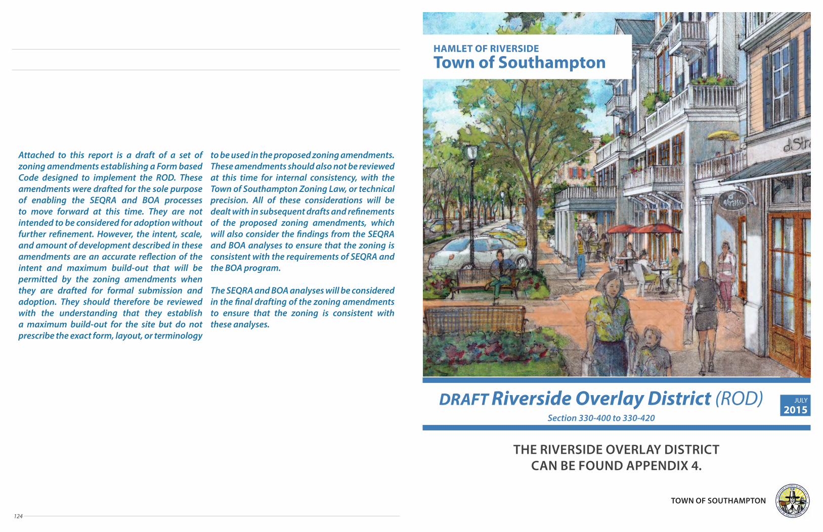
124
Attached to this report is a draft of a set of zoning amendments establishing a Form based Code designed to implement the ROD. These amendments were drafted for the sole purpose of enabling the SEQRA and BOA processes to move forward at this time. They are not intended to be considered for adoption without further refinement. However, the intent, scale, and amount of development described in these amendments are an accurate reflection of the intent and maximum build-out that will be permitted by the zoning amendments when they are drafted for formal submission and adoption. They should therefore be reviewed with the understanding that they establish a maximum build-out for the site but do not prescribe the exact form, layout, or terminology
to be used in the proposed zoning amendments. These amendments should also not be reviewed at this time for internal consistency, with the Town of Southampton Zoning Law, or technical precision. All of these considerations will be dealt with in subsequent drafts and refinements of the proposed zoning amendments, which will also consider the findings from the SEQRA and BOA analyses to ensure that the zoning is consistent with the requirements of SEQRA and the BOA program.
The SEQRA and BOA analyses will be considered in the final drafting of the zoning amendments to ensure that the zoning is consistent with these analyses.
HAMLET OF RIVERSIDE
Town of Southampton
DRAFT Riverside Overlay District (ROD)Section 330-400 to 330-420
THE RIVERSIDE OVERLAY DISTRICT CAN BE FOUND APPENDIX 4.
JULY
2015
TOWN OF SOUTHAMPTON

126
APPENDIX 1:
MASTER DEVELOPER & UNIFIED DEVELOPMENT APPROACH (UDA)
=+
Crowdsourced Placemaking
(CSPM)
+
MarketOpportunities
+
RevitalizationToolkit & Strategies
+
SEQRA & Zoning
UNIFIED DEVELOPMENT
APPROACH™(UDA) IMPLEMENTATION

128 129
RD team members are thought-leaders in the fields of urban revitalization, transit-oriented development & economic development; participate as Council Members for the Urban Land Institute, members of the Real Estate Roundtable, Steering Committee and Policy members of LOCUS; and are active participants in CNU, and other leading industry organizations. RD understands the municipal perspective with team members having served in key government positions.
Renaissance DowntownsRenaissance Downtowns is the branded leader in the comprehensive and holistic redevelopment of transit oriented downtowns. Led by Donald Monti, the Renaissance Team has over 35 years of development experience with 80+ completed projects. Renaissance adheres to a “Triple Bottom Line” development approach centered on social, environmental and economic responsibility that includes significant public engagement throughout the planning and development process. Hallmarks of the Renaissance approach are the Company’s ability to work within sensitive community contexts and its proven success at establishing collaborative relationships within those communities, as well as successfully navigating the complexities associated with Public-Private Partnership structures.
Master DeveloperRenaissance Downtowns
MASTER DEVELOPER
RD
RD REDEVELOPMENT APPROACH
Residential Strategies
Retail Market Strategies
Market Analysis
Residential Market Strategies
Destination & Entertainment Strategies
Public & Civic PlacemakingCommunity Outreach - Crowdsourced Placemaking
Architecture & Planning
Community Outreach - Crowdsourced Placemaking
Taking a Comprehensive Approach to Development Assures a Greater Likelihood of Lasting Success and Economic Sustainability.
A Comprehensive Approach will Enable the Town to Achieve a number of its stated Goals and Objectives, including:
Creation of a Mixed-use & Walkable Gateway Center to enhance vibrancy and create a diversity of uses (to live, work, shop, learn, and play)
Regeneration of cross connections to sew Riverside's disconnected environments
Enhanced community cohesion by acknowledging the great potential of Riverside's natural features while looking forward to improved livelihoods, public realms, and enhanced social cohesion
Incentivized redevelopment of vacant, deteriorating or deteriorated buildings, incompatible land uses and underutilized properties
Incentivized collaboration amongst multiple property owners for rapid development of the critical mass needed for economic sustainability
Renaissance Downtowns Projects
MASTER DEVELOPER & UNIFIED DEVELOPMENT APPROACH (UDA)
Hempstead, Long Island represents one of Nassau County's most exciting transit oriented redevelopments and will serve as a model for the holistic and comprehensive redevelopment of suburban downtowns for the entire nation.
The ethnically diverse Hempstead community is located in the geographic center of Nassau County and anchored by exceptional transit, including one of the nation’s largest suburban bus hubs, along with a LIRR station. The Village of Hempstead downtown redevelopment will epitomize smart growth, triple bottom line friendly redevelopment. The project will provide mixed-income residential options that meet the needs of the young workforce on Long Island, which seeks an amenity-driven, transit oriented walkable setting that provides live, work, learn, shop and play options.
A number of innovative methodologies were employed during the redevelopment efforts, including Renaissance’s community-centric Crowdsourced Placemaking program and the adoption of an opt-in, Form Based overlay zone that is one of the most progressive in the nation. A key component of the zoning is the inclusion of Community Benefits Policies, to ensure local job creation both during construction and on a permanent basis.
The Town of Huntington sought a Master Developer with experience in visioning and community outreach within sensitive communities. Renaissance’s Crowdsourced Placemaking program provided the perfect platform to implement a transformative vision for the Station area, having formally signed their Master Developer Agreement in 2012.
In a year's time, Renaissance garnered enough public support to receive a 5-0, bi-partisan approval for its Development Strategy. Renaissance has already held a very well received Grand Opening for its community informational office and subsequent events, in-cluding the first annual Huntington Station Street Festival this past summer, the largest ever for the community. At the Street Festival, it was estimated that over 8,000 participants enjoyed a renewed sense of hope for their downtown.
The “Source the Station” crowdsourcing community has been a driving force that has provided momentum to this regionally significant project. This emphasis on community input and participation has been critical in garnering ongoing, bi-partisan support for the revitalization. The Source the Station community has also provided significant market insight, leading to the decision to commence with a Hotel as part of the early phases of construction.
MASTER DEVELOPER & UDA // Renaissance Downtowns

130 131
The Unified Development Approach provides a framework that facilitates a comprehensive mixed-use redevelopment strategy that brings together community stakeholders to collectively create and implement a shared redevelopment vision and helps to ensure project sustainability, thereby maximizing social, environmental and economic benefits.
PARTNER WITH MUNICIPALITYThrough a Public-Private Partnership between the Master Developer and the Town of Southampton, a collaborative framework is created that takes into account past and ongoing planning efforts of the Town while providing a clear path toward implementation. This Partnership then builds upon the extensive planning and public engagement efforts already completed by the Town.
Renaissance Downtowns has coordinated with the Town of Southampton throughout the process through regular meetings with Town officials and employees. This strong working relationship has informed the planning effort every step of the way.
Renaissance & The Town are also working with Suffolk County on numerous initiatives including the proposed bridge, the waterfront park, the traffic circle redesign and infrastructure improvements.
Renaissance has become engaged with the neighboring Town of Riverhead on several efforts such as WaterFire, the bridge and the Business Improvement District.
PARTNER W/ PRIVATE PROPERTY OWNERS (PPO'S)
RD utilizes a collaborative approach to maximize property values for PPO's by either partnering with them or helping to create a path for them to redevelop on their own. This partnership approach streamlines the land assemblage process by providing economic incentives that encourage property owners to collaborate in the overall Master Development process.
Renaissance Downtowns has reached out to private property owners throughout the development area. Through its Crowdsourced Placemaking program, Renaissance has been successful in engaging and working with property owners.
Diagram of Renaissance Downtowns' Unified Development Approach™ (UDA)
MASTER DEVELOPER
Unified Development ApproachPaving the way for Revitalization
ENGAGE KEY COMMUNITY STAKEHOLDERSMeaningful public outreach and engagement are essential to creating a vision that will gain the support of the municipality and community alike. By utilizing Renaissance's proprietary (patent pending) Crowdsourced Placemaking program, RD not only helps co-create a shared final development vision, but will also spurs entrepreneurial activity and the inclusion of members of the public (i.e. artists and young professionals) who are often left out of traditional outreach programs.
Renaissance has been very active in working with key community stakeholders as well as the general community at large. Renaissance has involved residents, business owners and nonprofit organizations through its Crowdsourced Placemaking program.
ENGAGE OTHER AGENCIES
The involvement of agencies is critical in ensuring community connectivity and sustainable development. As such, transit agencies will be included in the visioning process to ensure a positive outcome and buy-in from all parties.
Renaissance Downtowns has been involved with a variety of state and local agencies including the DEC.
Editorials Editorial: A welcome show of support in Riverside by Riverhead News-Review | 05/09/2014 8:00 AM
County Executive Steve Bellone, second from right, discusses Southampton Town’s Riverside plans with, from left, Councilwoman Christine Scalera, Councilman Brad Benter, Sean McLean of Renaissance Downtowns, and Southampton Supervisor Anna Throne-Holst. (Credit: Tim Gannon) How refreshing it was to see the county executive touring Riverside last week, a place many elected leaders have long avoided lest they have to confront firsthand the harsh realities that exist there: unpaved roads, long-abandoned stores, boarded-up shacks, drugs, crime. And this just a few miles from — and in the same town as — some of the wealthiest Zip codes in Suffolk County and the entire country.
Riverside’s sorry state is a reflection, in part, of policy made in Suffolk County and Southampton Town going back decades. The area deserves better. Yet former county executive Steve Levy contributed to a drastic decline in Riverside’s reputation and its residents’ quality of life with the 2007 placement of a construction trailer housing homeless sex offenders outside the county jail. The trailer sat there for years; it wasn’t until Mr. Levy was forced out of office and his successor — current county exec Steve Bellone — took over in 2012 that the hamlet saw any relief. Mr. Bellone oversaw its removal last May. And now he’s willing to lend his name, reputation and, hopefully, a fair amount of county funds to support local efforts to redevelop the depressed hamlet.
County Executive Steve Bellone, second from the right, discusses Southampton Town's Riverside plans with, from left, Councilwoman Christine Scalera, Councilman Brad Benter, Sean McLean of Renaissance Downtowns, and Southampton Supervisor Anna Throne-Holst. (Credit: Tim Gannon)
=+
Crowdsourced Placemaking
(CSPM)
+
MarketOpportunities
+
RevitalizationToolkit & Strategies
+
SEQRA & Zoning
UNIFIED DEVELOPMENT
APPROACH™(UDA) IMPLEMENTATION
MASTER DEVELOPER & UNIFIED DEVELOPMENT APPROACH (UDA)
MASTER DEVELOPER & UDA // Unified Development Approach
Creating Opportunities for Local Contracting, Employment and Construction Jobs
One of the key aspects of the UDA is the creation of a Community Benefits Agreement (CBA) to ensure that the primary beneficiaries of economic development will be local residents and businesses. RD will look to participate in a CBA with the Town to ensure that local job seekers and companies are first at the table in regard to career and contracting opportunities that will arise from these redevelopment efforts.
The best way to accomplish these goals is to create provisions for the CBA within the new zoning code that apply not only to municipal parcels, but privately owned land that may be redeveloped under this new zone. The CBA would prioritize:
nConstruction Jobs for Local Residents nContracting Jobs for Local Companies nPermanent Jobs for Local Residents

APPENDIX 2:
CSPM: RIVERSIDE REDISCOVERED
Engaging the Community
=+ + +
CROWDSOURCEDPLACEMAKING
(CSPM)+ IMPLEMENTATION
Unified Development
Approach™(UDA)
MarketOpportunities
RevitalizationToolkit & Strategies
SEQRA & Zoning

134 135
CSPM provides more than public engagement. It creates a community of local residents and stakeholders that are active participants in the planning and implementation of a development vision, including population segments that are often left out of, or do not feel invited into, the public process. The process helps the Master Developer and the Town to best meet the needs of its residents today and into the future, with a focus on arts, culture, the innovation sector, and to retain the millennial generation, young professionals and retirees in the Town of Southampton.
Crowdsourced Placemaking (CSPM) Overview of the Process RD requires that ideas posted through the
Crowdsourcing process adhere to THE TRIPLE BOTTOM LINE philosophy of Social, Environmental & Economic responsibility.
3. LAUNCH SOCIAL NETWORKING WEBSITE / WEB-BASED APPLICATIONS
RD launches a social networking website as an informational resource to accept member registrations and ideas, and engage local business leaders and entrepreneurs throughout the process.
4. LAUNCH CAMPAIGNSCampaigns lie at the heart of CSPM activities, allowing residents and entrepreneurs to collaborate and build a critical mass of support for their ideas – ideas that help refine the vision while identifying potential market drivers and entrepreneurial opportunities that will arise from the development activity. By focusing on one interest area at a time (such as retail, public destinations and downtown living), each with its own time period for campaigning, members are motivated to work together. Each campaign lasts one to two months with the objective of having the top ideas receive a minimum number of “Likes/Upvotes,” thereby becoming eligible for a feasibility study to allow for the future implementation of ideas that prove feasible.
5. FEASIBILITY STUDIESOnce ideas have enough Likes / Upvotes to warrant feasibility studies, RD enlists the talents of national leaders in downtown retail and market feasibility to test the viability of community driven concepts.
6. FIND THE BEST IDEASIdentification of small business, entrepreneurial and cultural ideas are fundamental to the Crowdsourced Placemaking process as they are critical to both the economic vitality of Riverside and the Town's desire to create more daytime activity within the area. To reach the greatest number of participants, the CSPM team hosts events and meetups to provide a forum in which local individuals and leaders can identify themselves and participate within their comfort zone.
7. MONTHLY MEETUPS Every month, the local CSPM community hosts a ‘meetup’, providing the best opportunity for members and interested residents to meet other Triple Bottom Line supporters face-to-face. Attendees brainstorm and develop ideas with the goal of building a market and support for them. Participants also work on the planning for upcoming programs and events such as community festivals and efforts to spur local business. Meetups also help inform the community via webpage and RD updates.
8. EVENTSThe CSPM team participates in, and often generates, many community events, which allows community members to learn about how they can help shape their community. These events build tremendous momentum as local residents begin to fully understand the potential of the downtown redevelopment vision that has been forwarded by the municipality and refined through the CSPM process. The end result is a shortened time frame to secure approvals and begin implementation of the plan.
CSPM: RIVERSIDE REDISCOVERED
SOCIAL
ENVIRONMENTAL
ECONOMIC
CSPM: RIVERSIDE REDISCOVERED // Overview of the Process
One of the challenges that has historically prevented the large scale development of mixed-use projects has been the failure to ensure community involvement and acceptance of the development vision. To address this issue, RD strongly believes in a “process before plan” approach, which mirrors the Town's desire to have grassroots outreach conducted throughout the redevelopment process, rather than after the project’s parameters are set.
Utilizing its innovative Crowdsourced Placemaking program, RD employs social media and networking tools that include proprietary web-based applications designed to engage the community in meaningful dialogue, which is essential to the planning and implementation process. Crowdsourced Placemaking has become a nationally recognized “best practice” for community engagement:
n Helps define the Community's visionn Helps refine and improve the Town's vision in a manner
that is consistent with its goals and objectives n Creates a framework to identify key market drivers and
market opportunities, especially within the innovation, knowledge and cultural arenas
n Fosters the inclusion of local stakeholders, including entrepreneurs, artists and students, throughout the process
n Helps identify and launch new retail and commercial
businesses that will enhance daytime and evening vitality throughout the downtown
n Shortens the development timeline by ensuring community input and buy-in from the outset in a manner consistent with both the Town's vision and market realities
How CSPM WorksUtilizing both in-person meetings and internet-based tools, the patent pending CSPM process allows community members to upload and vote on ideas, uses, retail concepts, types of commercial/retail tenants and amenities they would like to see within a redevelopment plan. CSPM participants are able to utilize online forums, and web-based and paper voting applications to create tremendous support for a redevelopment vision that the community wishes to see move forward.
1. DEFINE PRINCIPLES
The CSPM process is guided by the principles of Social, Environmental and Economic responsibility. To ensure adherence to these principles, members must sign a “Triple Bottom Line” agreement before participating in the process.
2. SEED THE PROCESS
Traditional, in-person grassroots outreach and meetings with key stakeholders and civic leaders take place prior to launching the formal, public Social Networking Campaign. This creates a base of support with constituents who understand the Community's vision and the benefits of responsible, Triple Bottom Line development before the public at-large becomes engaged in the process. During this process, a local representative is hired to lead the CSPM program and RD opens a public informational office within the redevelopment area.
RIVERSIDE ROW RESTAURANTS
WATERFIRE ON THE PECONIC
CHILDREN'S MUSEUM
Like (151) Like (119) Like (101)

136 137
Riverside RediscoveredImmediately after signing the Master Developer Agreement with the Town of Southampton, Renaissance Downtowns conducted an extensive search for a community liaison to help facilitate the online and face-to-face community engagement process. in August, Siris Barrios, the community liaison began stewarding Riverside Rediscovered, meeting with community leaders and local residents to better understand their collective values and visions for the future of Riverside.
In the summer of 2014 Renaissance Downtowns opened a CSPM Community Office on 108 Peconic Avenue. Riverside Rediscovered was born in August 2014 at the kick-off community meeting in the presence of Town officials, by a vote of about 50 residents in attendance.
Siris, a resident of Hampton Bays, with experience in community organizing, has been reaching out to all community residents, businesses, and other stakeholders.
The Communities of RiversideThe mobile home communities (Riverwoods, Parkview and Peconic Bay Mobile Homes) represent the largest population in Riverside, and their respective associations have been involved in the CSPM process.
Riverwoods (formerly known as MacLeod’s) was established by war veteran Andrew J. MacLeod who, unable to find housing on Long Island (at the time, the housing market was flooded with returning veterans), invested in land in Riverside and parked a trailer on it for his family to live in, with other service families joining them. Today, Riverwoods is a senior mobile park community. The community represents about 50% of the units in Riverside, and the Riverwoods Civic Association has been very active with Riverside Rediscovered.
Parkview is a 60 unit co-op mobile home community whose residents are very involved and supportive of the project.
Crowdsourced Placemaking (CSPM) Riverside Rediscovered: the Process Has Begun
The Civic AssociationsIn the last few years the Flanders, Riverside, and Northampton Community Association (FRNCA) has been the strongest and most consistent advocate for revitalization. FRNCA has taken the lead in advocating for the reconfiguration of the traffic circle, a sewage system, the bridge, county park use and revitalization. The majority of the FRNCA members represent Flanders residents. In 2010, most Riverside members split with FRNCA to start the Riverside Revitalization Community Corporation (RRCC). RRCC existed only for a short period of time, leaving the Riverside community without a civic group to advocate for its residents.
The CSPM Process in RiversideIt was only appropriate to launch the CSPM process at a Flanders, Riverside, and Northampton Community Association (FRNCA) meeting where the membership named the revitalization project Riverside Rediscovered.
The Community Liaison immediately began meeting with civic, religious, non-profit and business groups in the immediate vicinity of Riverside, most of which are located in Flanders. Local residents expressed the desire to have meetings hosted in Riverside, as in the past they felt voiceless and disempowered by the lack of community engagement in Riverside. The Community asked if Riverside Rediscovered (RR) would host a Monthly Meet-Up at the local elementary school and Riverside Rediscovered office to involve as many residents as possible, many of whom lack access to transportation. Hosting the monthly meet-ups exclusively in Riverside has significantly increased resident
participation. Riverside Rediscovered has continued to meet formally and informally with organized groups and individuals. Riverside Rediscovered has also fostered key relationships with representatives of each organized group. During this period RR talked to over 500 residents face-to-face and conducted special outreach with local pastors and congregations in order to reach a wide audience..
Door KnockingRiverside Rediscovered spent time door knocking through the Hamlet. During this process RR witnessed the living conditions of residents first-hand and saw a range of housing types and conditions spanning from mansions to nicely manicured homes to slum housing. Residents engaged in this effort wholly welcomed the idea of developing the area.
CSPM OnlineThe Riverside Rediscovered website launched in August 2014 and quickly revealed the digital divide in the community. After a lot of face-to-face work, the website now has 150 registered users online. RR also launched a Riverside Rediscovered Facebook Page (162 likes), a Riverside Rediscovered Community Liaison personal page (453 friends) and a twitter account (40 followers).
CSPM: RIVERSIDE REDISCOVERED
CSPM: RIVERSIDE REDISCOVERED // The Process has Begun
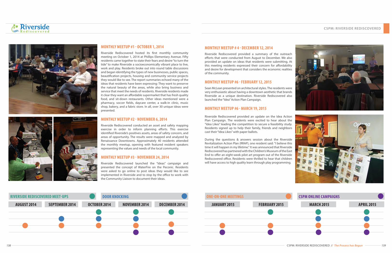
138 139
DOOR KNOCKING RIVERSIDE REDISCOVERED MEET-UPS
AUGUST 2014 DECEMBER 2014OCTOBER 2014SEPTEMBER 2014 NOVEMBER 2014
MONTHLY MEETUP #1 - OCTOBER 1, 2014 Riverside Rediscovered hosted its first monthly community meeting on October 1, 2014 at Phillips Elementary Avenue. Fifty residents came together to state their fears and desire “to turn the tide” to make Riverside a socioeconomically vibrant place to live, work and play. Residents broke out into round table discussions and began identifying the types of new businesses, public spaces, beautification projects, housing and community service projects they would like to see. The report summaries echoed many of the ideas that residents have been expressing: They want to preserve the natural beauty of the areas, while also bring business and service that meet the needs of residents. Riverside residents made it clear they want an affordable supermarket that has fresh quality food, and sit-down restaurants. Other ideas mentioned were a pharmacy, soccer fields, daycare center, a walk-in clinic, music shop, bakery, and a fabric store. In all, over 30 unique ideas were presented.
MONTHLY MEETUP #2 - NOVEMBER 6, 2014 Riverside Rediscovered conducted an asset and safety mapping exercise in order to inform planning efforts. This exercise identified Riverside’s positives assets, areas of safety concern, and areas of opportunity. The results were mapped and analyzed by Renaissance Downtowns. Approximately 40 residents attended the monthly meetup, opening with featured resident speakers representing the values and needs of the local community.
MONTHLY MEETUP #3 - NOVEMBER 24, 2014Riverside Rediscovered launched the “Ideas” campaign and presented the concept of WaterFire on the Peconic. Residents were asked to go online to post ideas they would like to see implemented in Riverside and to stop by the office to work with the Community Liaison to document their ideas.
CSPM ONLINE CAMPAIGNS ONE-ON-ONE MEETINGS
FEBRUARY 2015JANUARY 2015 MARCH 2015 APRIL 2015
MONTHLY MEETUP # 4 - DECEMBER 12, 2014Riverside Rediscovered provided a summary of the outreach efforts that were conducted from August to December. We also provided an update on ideas that residents were submitting. At this meeting residents expressed their concern for affordability and desire for development that considers the economic realities of the community.
MONTHLY MEETUP #6 - FEBRUARY 12, 2015Sean McLean presented on architectural styles. The residents were very enthusiastic about having a downtown aesthetic that brands Riverside as a unique destination. Riverside Rediscovered also launched the “Idea” Action Plan Campaign.
MONTHLY MEETUP #6 - MARCH 19, 2015
Riverside Rediscovered provided an update on the Idea Action Plan Campaign. The residents were excited to hear about the “Idea Likes” leading the competition to secure a feasibility study. Residents signed up to help their family, friends and neighbors cast their “Idea Likes” with paper ballots.
During the questions & answers session about the Riverside Revitalization Action Plan (RRAP), one resident said: "I believe this time it will happen in my lifetime." It was announced that Riverside Rediscovered has partnered with the Children’s Museum of the East End to offer an eight-week pilot art program out of the Riverside Rediscovered office. Residents were thrilled to hear that children will have access to high quality learn through play programming.
CSPM: RIVERSIDE REDISCOVERED // The Process has Begun
CSPM: RIVERSIDE REDISCOVERED

140 141
0 500 1,000 1,500 2,000250Feet
Text
Text
Total: 352 Entries% in Riverside: 5%Average Distance from Circle: 3.8 Miles
Community Assets
¯
0 500 1,000 1,500 2,000250Feet
Text
Text
Total: 352 Entries% in Riverside: 5%Average Distance from Circle: 3.8 Miles
Community Assets
¯
0 500 1,000 1,500 2,000250Feet
Text
Text
Total: 352 Entries% in Riverside: 5%Average Distance from Circle: 3.8 Miles
Community Assets
¯
0 500 1,000 1,500 2,000250Feet
Text
Text
Total: 352 Entries% in Riverside: 5%Average Distance from Circle: 3.8 Miles
Community Assets
¯
0 500 1,000 1,500 2,000250Feet
Text
Text
Total: 352 Entries% in Riverside: 5%Average Distance from Circle: 3.8 Miles
Community Assets
¯
Community Asset MappingAt the second monthly meetup, members engaged in a community asset mapping exercise. The participants broke out into six worktables and began identifying community assets and deficits. They were asked to answer twelve key questions that identified the places they go to for groceries, dining out, socializing, health care, arts and recreation. The results are clear: Riverside residents are forced to travel, often far, to fulfill their wants and needs. This clearly demonstrates the near total lack of assets and amenities within the community and the need for an injection of new activity.
Residents Were Asked Where They Go for the Following:
n Workn Schooln Shoppingn Out to Eatn To Socialize / Get
Together with Friends
n To Get Involved in Community Issues
n Arts and Recreationn Healthcaren Worshipn Other Services / Resources
Community Assets in Riverside:n Phillips Avenue Schooln Local Churchesn Gas Stationsn Riverside Rediscovered Community Officen McDonaldsn Riverwoods Community Center
Crime and Safety MappingAt the second monthly meetup, members engaged in a crime and safety mapping exercise. Residents identified issues in the built environment such as poor lighting, unsafe crosswalks, dilapidated buildings and unkempt properties as well as social issues such as homelessness, crime, prostitution and drug use The results show that crime and safety issues occur throughout the community but are largely clustered in the area most in need of revitalization.
Crime and Safety Issues Raised by Residents:
n Break-insn Drugsn Prostitutionn Homelessnessn Don't Feel Safen People Hanging Outn Trafficn Loiteringn Poor Lightingn Squattingn Poor Housingn Deplorable Conditionsn Shootingn Dangerous to Walkn Unsafen Illegal Dumpingn Unauthorized Activitiesn Unsafe Crossingn Dirty Roadn Robberyn Speeding
CSPM: RIVERSIDE REDISCOVERED
CSPM: RIVERSIDE REDISCOVERED // The Process has Begun

142 143
Riverside Rediscovered has continually worked with residents to identify the most popular triple bottom line compliant ideas through in person outreach and online social media. On the next page are the most popular of the 38 community chosen ideas. Each of the following has received 100 or more "likes" indicating support from fellow community members. Several of these are now being considered or implemented in the revitalization plan.
Crowdsourced Placemaking (CSPM) Ideas Campaign
CROWDSOURCED PLACEMAKING PROCESS1. Seed Inspiring Ideas 2. Identify Top Ideas 3. Analyze Feasibility
of Top Ideas4. Implement the Ideas
RRA
P
INDOOR RECREATION CENTER Like (131)
RIVERSIDE PARK MARITIME TRAIL Like (109)
ZIP CODE FOR Riverside, Flanders & Northampton
Like (103)
WATERFRONT GREEN SPACES Like (110)
RIVERSIDE ROW RESTAURANTS Like (119)
HEALTHY VILLAGE Like (107)
FARMERS MARKET FOOD MART Like (103)
MODERN MOVIE THEATER Like (130)
SUPERMARKET (Quality / Affordable) Like (108)
CHILDREN'S MUSEUM Like (101)
SOUTHAMPTON BOARDWALK Like (157)
SHUTTLE BUS SERVICE Like (157)
WATERFIRE ON THE PECONIC Like (151)
WATER FOUNTAIN ICE SKATING Like (147)
1. Seed Inspiring IdeasPost ideas through images and descriptions that inspire the desired future vision of your community.
Riverside Rediscovered members posted their ideas after signing a Tripple-Bottom-Line contract.
"LIKED" IDEAS
CSPM: RIVERSIDE REDISCOVERED
CSPM: RIVERSIDE REDISCOVERED // Ideas Campaign

144 145
2. Identify Top IdeasAllow the crowd to campaign for their favorite ideas through a simple 'Liking' system.
157 Likes
147 Likes
157 Likes
131 Likes
151 Likes
130 Likes
Shuttle Bus Service – Downtown Riverhead
Water Fountain / Ice Rink
Southampton Boardwalk
Indoor Recreation Center
WaterFire on the Peconic River
Modern MovieTheater
Create a high frequency local shuttle bus service to connect all the various business, entertainment, recreation and residential places in Riverside and Downtown Riverhead.
The community recreation center will provide residents a place to relax, exercise and place to interact with their neighbors. It would be like the Flanders Community Center, but a little larger.This is a separate idea from a regional recreation center that would house a swimming pool and multiple playing courts. An Olympic pool is under construction at Suffolk County Community College four miles away, and will be open to the surrounding community
A boardwalk alongside the Peconic River that mirrors the walk on the Riverhead side. It would begin at the Peconic Avenue bridge area, perhaps fronting a restaurant row while also allowing WaterFire viewing, and continue East along the river, through the wetlands and future park areas.
This elegant dancing water fountain that would be used as an ice skating rink in the winter months.
This idea has been submitted to help explore the type of programming, festivals, and activities that should take place on the south side of the Peconic River (Riverside). We should think of Riverside as a blank canvass where we can imagine the type of WaterFire that our community would enjoy.
This will not be your traditional movie theater. The theater will become a major entertainment anchor for the East End. Offering a number of movie theater experiences for customers; stadium seating, parlor/living room seating, complete immersion seating.
Digital divide is an economic and social inequality of a given population in their access to, use of, or knowledge of information and communication technologies. The Riverside community is experiencing a digital divide, and although CSPM utilizes online technological tools, special paper ballots were created to allow community members to sign up, suggest ideas or comment, and "like" already posted ideas. There were over 200 paper ballots collected and recorded online for up-to-date website information.
4. Implement the IdeasEstablish an implementation team with ideas' supporters and both public and private sectors.
3. Analyze Feasibility of Top IdeasComplete studies to understand how they can be economically, socially and environmentally feasible.
Paper BallotsEither "like" online or in person, using ballots.
CSPM: RIVERSIDE REDISCOVERED // Ideas Campaign
CSPM: RIVERSIDE REDISCOVERED

146 147
Children's Museum
Early in the CSPM process many residents related stories about the need for youth based activities in the area. However, they felt that community serving groups would never come to Riverside to offer services and that Southampton residents from outside the Hamlet would never bring their children to Riverside for programing. Riverside Rediscovered set out to prove that this perception was not the reality.
In March 2015 the Children's Museum of the East End (CMEE) began an 8 week pilot program for children between the ages of 2 and 5. The sessions were over-subscribed within 24 hours of the announcement , with families from Riverside, Flanders, Northampton, Hampton Bay, Tuckahoe and Westhampton, all taking part. There was additional interest from communities throughout the Town of Riverhead.
The "Museum Without Walls" Riverside experiment has proven without a doubt that the community and the rest of the Town of Southampton can and will come together in Riverside if quality programing of quality space is offered.
Community Events and Meetings
CSPM: RIVERSIDE REDISCOVERED
CSPM: RIVERSIDE REDISCOVERED // Ideas Campaign

148 149
Pictures, Articles and TestimonialsRiverside Residents
I’ve lived in this community since I was a little girl. When I was a child, we were able to leave our doors unlocked, and we knew everyone that lived on the street. Now, we no longer leave our doors unlocked, and we no longer know everyone that lives on the street. - Tanya Collins
It's happening quickly, I'm accustomed to things taking decades, with 400 volumes of studies on the shelves before anything happens. - Vince Taldone, President of FRNCA
There are currently no medical doctors or facilities in Riverside. The Healthy Village is an excellent idea. - Art Bridenstine
RIVERSIDE REDISCOVERED
The goal is to have beautiful stores, a beautiful water walk, to have safe places and not to feel fearful. That is a good vision. If it does not happen is will be a very sad thing for us. - Terri Holtgrewe
I would like to walk to the waterfront and cross over the river to the other side without the long walk, to enjoy events.
I am crossing my fingers that this works, I can’t tell you how many times I have heard that they are going to fix Riverside, and it has not happened. I am crossing my figures and saying a prayer for this time to really work.
- Linda Testagrose
I want to stay here; I plan to spend the rest of my life here. I prefer to spend what income I do have on this side of the river.
CSPM: RIVERSIDE REDISCOVERED // Pictures, Articles and Testimonials

APPENDIX 3:
MARKET OPPORTUNITIES AND BRANDING STRATEGIES
+ + + +
Unified Development
Approach (UDA)
Crowdsourced Placemaking
(CSPM)
RevitalizationToolkit & Strategies
SEQRA & Zoning
MARKET OPPORTUNITIES
IMPLEMENTATION=

152 153
A point of emphasis that runs throughout all of Renaissance Downtowns’ projects is the need to ensure that a redevelopment vision is fully attuned to market realities. To this end, Crowdsourced Placemaking fosters community involvement that is guided by a Triple Bottom Line that includes economic responsibility, while the Unified Development Approach™ provides a collaborative framework whereby local property owners and stakeholders share in the upside of targeted redevelopment activity.
Market Opportunities Create SoundRevitalization Strategies
+
Crowdsourced Placemaking
(CSPM)
=+
RevitalizationToolkit & Strategies
+
SEQRA & Zoning
+
Unified Development
Approach™(UDA)
IMPLEMENTATION
MARKET OPPORTUNITIES
Preliminary Market StudyTo best understand the commercial uses that are viable in Riverside, Renaissance Downtowns prepared a preliminary market study. By combining the preferred uses identified by the Riverside Rediscovered community and this market study, Renaissance Downtowns can determine which uses are likely to have sufficient market demand necessary to be viable. The focus has been on:nMarket niches that might complement, rather than
compete with independently owned businesses in Riverhead Downtown
nThe extent to which existing businesses in the project area might absorb additional sales, either by adjustments in marketing or merchandising or by opening an additional location or relocating to new space in the project area.
nTools and resources that might be helpful in stimulating new business development and growth of existing businesses.
Market WeaknessesThere are several potential challenges for retail development in Riverside:nThrough traffic on NY24 with no options for on-street or off-street public parkingnCurrent socioeconomic climate and high crime ratenLack of diverse offerings
Market StrengthsThere are many opportunities for retail development in Riverside, below are just a few:nGateway area for the East EndnCultural diversity can be a powerful tool in differentiating
its retail offerings nHistory of locally owned businesses, suggesting a healthy
foundation for entrepreneurshipnThe need for a fresh start and will for new identitynCounty CenternStrong Mass Transit Bus Connections
MARKET OPPORTUNITIES AND BRANDING STRATEGIES
MARKET OPPORTUNITIES AND BRANDING STRATEGIES // Preliminary Market Study
RIVERSIDE ECONOMIC PROFILE (2013)
TOTAL HOUSEHOLDS: 803
INCOME:Less than $10,000 1.9%$10,000 to 14,999 5.7%$15,000 to $24,999 22.3%$25,000 to $34,999 16.6%$35,000 to $49,999 23.0%$50,000 to $74,999 21.4%$75,000 to $99,999 5.4%$100,000 to $149,999 0.0%$150,000 to $199,999 0.0%$200,000 or More 3.7%
Median Household Income: $36,781Aggregate Household Income: $39 Million
EMPLOYMENT:Management, Business, Science & Arts Occupations 10.7%Service Occupations 30.8%Sales and Office Occupations 16.3%Natural Resources, Construction, and Maintenance Occupations 32.0% Production, Transportation, and Material Moving Occupations 10.1%Unemployment Rate 14.6%
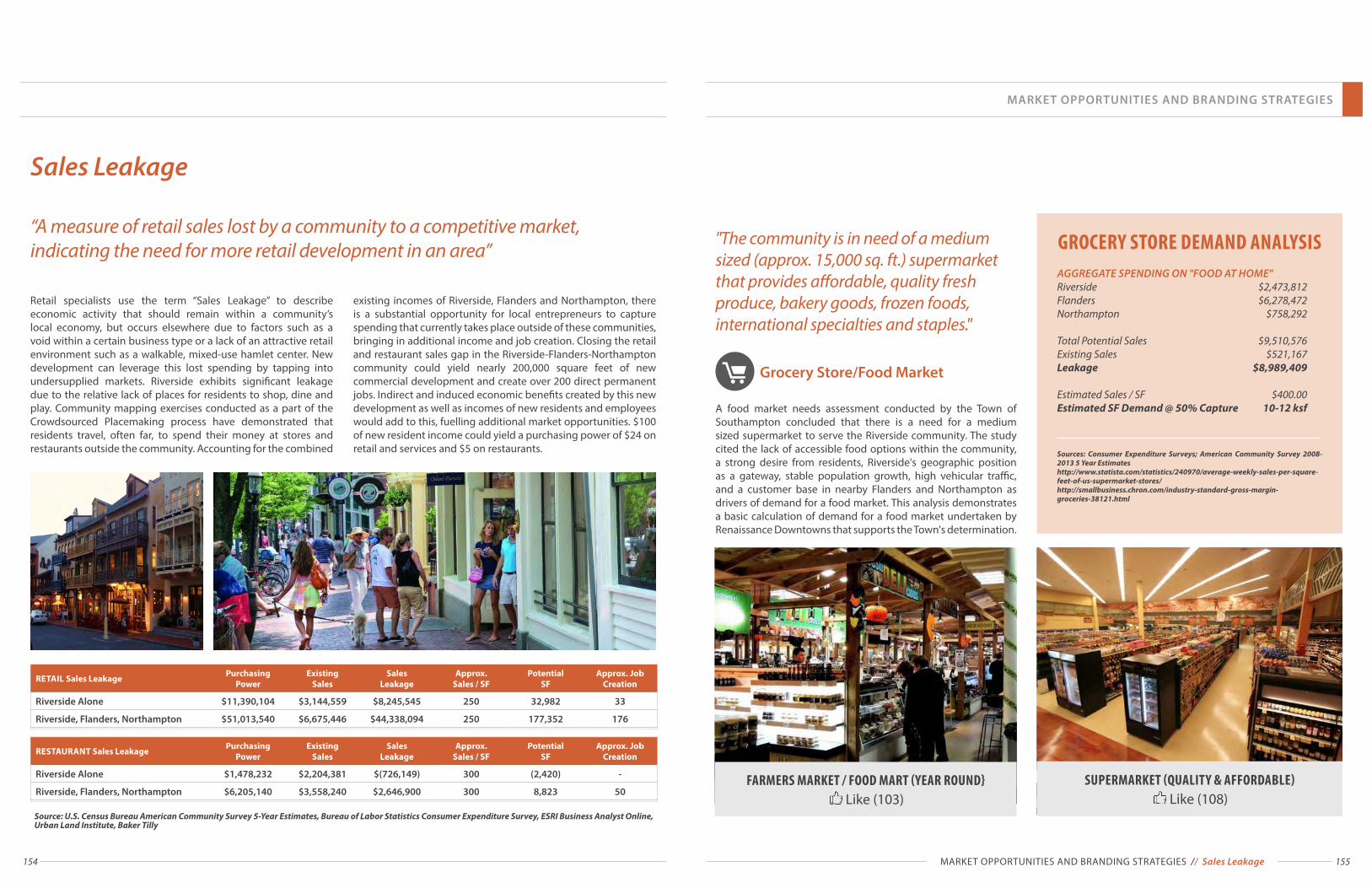
154 155
“A measure of retail sales lost by a community to a competitive market, indicating the need for more retail development in an area”
Source: U.S. Census Bureau American Community Survey 5-Year Estimates, Bureau of Labor Statistics Consumer Expenditure Survey, ESRI Business Analyst Online, Urban Land Institute, Baker Tilly
Sales Leakage
Retail specialists use the term “Sales Leakage” to describe economic activity that should remain within a community’s local economy, but occurs elsewhere due to factors such as a void within a certain business type or a lack of an attractive retail environment such as a walkable, mixed-use hamlet center. New development can leverage this lost spending by tapping into undersupplied markets. Riverside exhibits significant leakage due to the relative lack of places for residents to shop, dine and play. Community mapping exercises conducted as a part of the Crowdsourced Placemaking process have demonstrated that residents travel, often far, to spend their money at stores and restaurants outside the community. Accounting for the combined
existing incomes of Riverside, Flanders and Northampton, there is a substantial opportunity for local entrepreneurs to capture spending that currently takes place outside of these communities, bringing in additional income and job creation. Closing the retail and restaurant sales gap in the Riverside-Flanders-Northampton community could yield nearly 200,000 square feet of new commercial development and create over 200 direct permanent jobs. Indirect and induced economic benefits created by this new development as well as incomes of new residents and employees would add to this, fuelling additional market opportunities. $100 of new resident income could yield a purchasing power of $24 on retail and services and $5 on restaurants.
RETAIL Sales Leakage Purchasing Power
Existing Sales
Sales Leakage
Approx. Sales / SF
Potential SF
Approx. Job Creation
Riverside Alone $11,390,104 $3,144,559 $8,245,545 250 32,982 33
Riverside, Flanders, Northampton $51,013,540 $6,675,446 $44,338,094 250 177,352 176
RESTAURANT Sales Leakage Purchasing Power
Existing Sales
Sales Leakage
Approx. Sales / SF
Potential SF
Approx. Job Creation
Riverside Alone $1,478,232 $2,204,381 $(726,149) 300 (2,420) -
Riverside, Flanders, Northampton $6,205,140 $3,558,240 $2,646,900 300 8,823 50
"The community is in need of a medium sized (approx. 15,000 sq. ft.) supermarket that provides affordable, quality fresh produce, bakery goods, frozen foods, international specialties and staples."
Grocery Store/Food Market
A food market needs assessment conducted by the Town of Southampton concluded that there is a need for a medium sized supermarket to serve the Riverside community. The study cited the lack of accessible food options within the community, a strong desire from residents, Riverside's geographic position as a gateway, stable population growth, high vehicular traffic, and a customer base in nearby Flanders and Northampton as drivers of demand for a food market. This analysis demonstrates a basic calculation of demand for a food market undertaken by Renaissance Downtowns that supports the Town's determination.
GROCERY STORE DEMAND ANALYSISAGGREGATE SPENDING ON "FOOD AT HOME"Riverside $2,473,812 Flanders $6,278,472 Northampton $758,292
Total Potential Sales $9,510,576 Existing Sales $521,167 Leakage $8,989,409 Estimated Sales / SF $400.00 Estimated SF Demand @ 50% Capture 10-12 ksf
Sources: Consumer Expenditure Surveys; American Community Survey 2008-2013 5 Year Estimates http://www.statista.com/statistics/240970/average-weekly-sales-per-square-feet-of-us-supermarket-stores/http://smallbusiness.chron.com/industry-standard-gross-margin-groceries-38121.html
FARMERS MARKET / FOOD MART (YEAR ROUND} Like (103)
SUPERMARKET (QUALITY & AFFORDABLE) Like (108)
MARKET OPPORTUNITIES AND BRANDING STRATEGIES
MARKET OPPORTUNITIES AND BRANDING STRATEGIES // Sales Leakage

156 157
Additional Retail Opportunities
Additional analysis of sales leakage in the Riverside-Flanders-Northampon area reveals a number of opportunities for new businesses. The most untapped opportunities include: full service restaurants, furniture and home furnishings, clothing and shoe stores, health and personal care stores, sporting good, hobby and musical instrument stores, and electronics and appliance stores. The neighboring Town of Riverhead is a major hub for consumer spending, home to the Tanger Outlets and a plethora of big box retail establishments. New business development in Riverside must differentiate itself from Riverhead's offerings. Key to this is focusing on smaller, independent establishments and restaurants that fill a niche beyond the chain stores and restaurants in Riverhead. This way both centers can complement, rather than detract from, one another. These analyses represent a preliminary demand study based on the untapped purchasing power of the Riverside-Flanders-Northampton area alone, they do not take into account potential patronage from members of Riverhead or other communities, nor do they account for the impacts of new development and regional attractions such as WaterFire™, which would generate additional demand for these uses.Sources: U.S. Bureau of Labor Statistics, Consumer Expenditure Survey; U.S. Census Bureau, American Community Survey; ESRI Business Analyst Online
Full Service Restaurant
RIVERSIDE ROW RESTAURANTS Like (119)
RIVERSIDE ROW RESTAURANTS Like (119)
Purchasing Power Potential
Existing Sales
Sales Leakage
Est. Sales / SF
Potential SF
$3,722,870 $1,353,859 $2,369,011 $300 7,897
There is a severe lack of full service dining establishments in the Riverside area. Riverside-Flanders-Northampton are all sorely underserved in this area and limited service options are relatively sparse as well. While the existing income levels of the community in general is not conducive to a strong restaurant market, these are largely offset by the near complete lack of options. There is therefore a strong market for full-service restaurants, particularly those that take advantage of the community’ existing resources by tying into the Riverfront and the local Farm to Table Movement.
Health and Personal Care
HEALTHY VILLAGE Like (107)
COMMUNITY WELLNESS Like (64)
Purchasing Power Potential
Existing Sales
Sales Leakage
Est. Sales / SF
Potential SF
$2,747,801 - $2,747,801 $400 6,870
A sales leakage of over $2.7 million reveals the opportunity for a small health and personal care store. This could be an opportunity for a small format pharmacy a beauty supply store, or a health products store. Two of the most "liked" ideas on the Riverside Rediscovered site are "Healthy Village" and Community Wellness Pharmacy" demonstrating community support for this type of establishment.
Electronics and Appliances
Purchasing Power Potential
Existing Sales
Sales Leakage
Est. Sales / SF
Potential SF
$2,428,526 $480,697 $1,947,829 $1,000 1,948
The Riverside-Flanders-Northampton area has a sales gap of nearly $2 million on electronics and appliances. This could yield a roughly 2,000 square foot small format retailer. A small computer, camera, cell phone, video game or accessories store could fill this gap.
Hobby, Sporting Goods,
Music Instruments
HOOKED UP NOW FISHING Like (34)
HOOKED UP NOW FISHING Like (34)
Purchasing Power Potential
Existing Sales
Sales Leakage
Est. Sales / SF
Potential SF
$1,362,684 - $1,362,684 $250 5,451
There is a demand for nearly 5.5 thousand square feet of retail space in the Sporting Goods/Hobby/Musical Instrument Stores category. A fishing establishment, for example, could offer both fresh and salt water same day guided tours, lunch provided at on-site restaurant, shore, kayak and motorboat fishing, gear rental and sale, etc.
Clothing and Shoes
FABRIC STORE / WORKSHOP STUDIO Like (36)
Purchasing Power Potential
Existing Sales
Sales Leakage
Est. Sales / SF
Potential SF
$4,189,267 $490,037 $3,699,230 $250 14,797
Demand for nearly 15,000 square feet of retail space for apparel could be filled be a variety of vendors. Potential tenants could include shoe stores, clothing boutiques and other retailers. Given the proximity to the Tanger Outlets in Riverhead, a smaller footprint, niche product would serve to differentiate the Riverside market from nearby competition.
MARKET OPPORTUNITIES AND BRANDING STRATEGIES
MARKET OPPORTUNITIES AND BRANDING STRATEGIES // Additional Retail Opportunities
RIVERSIDE RETAIL INVENTORYTOTAL ESTABLISHMENTS: 22
SECTOR:Motor Vehicle & Parts Dealers 5Furniture & Home Furnishings Stores 1Electronics & Appliance Stores 2Bldg Materials, Garden Equip. & Supply Stores 0Food & Beverage Stores 3Health & Personal Care Stores 0Gasoline Stations 2Clothing & Accessory Stores 3Sporting Goods, Hobby, Book & Music Stores 1General Merchandise Stores 0Miscellaneous Store Retailers 1Food Services & Drinking Places 3
Source: ESRI Business Analyst Online

158 159
Existing Residential Trends
LOCAL HOUSING MARKET (2010): # OF UNITS
Riverside Southampton Riverhead
TENURE Renter-Occupied 229 5,704 10,271Owner-Occupied 579 21,913 2,572Seasonal 0 17,399 1,528Vacant 232 3,167 919GROSS RENT< $500 0% 3% 14%$500-$999 11% 18% 26%$1000-$1499 73% 27% 39%$1500-$1999 0% 30% 13%> $2000 16% 22% 8%HOME VALUE< $50,000 20% 3% 6%$50k - $99,999 42% 3% 4%$100k - $200k 14% 3% 7%$200k - $300k 9% 6% 14%$300k - $500k 15% 28% 50%$500k - $750k 0% 22% 13%$750k - $1mil 0% 13% 4%> $1,000,000 0% 22% 2%UNIT SIZEStudio 3% 1% 0%1 Bed 13% 6% 10%2 Bed 54% 21% 31%3 Bed 27% 40% 36%4 Bed 1% 21% 20%5 Bed or more 2% 11% 3%
Sources: U.S. Census Bureau, American Community Survey 5-year estimates.
Need for Rental Housing
MIXED-USE DEVELOPMENT Like (81)
ATTAINABLY-PRICED RESIDENCES Like (68)
Current trends among the Millennial and baby boomer generations have demonstrated a growing demand for rental units in recent years. At its current rate of growth the Towns of Southampton and Riverhead are likely to add a demand of over 3,100 new rental units between 2010-2030. Given the growing propensity of Millennials and boomers to rent and the smaller household sizes of Millennials, this number could be even greater. This trend speaks for itself. The demand for rental housing is quickly growing and is not likely to stop soon. More rental units, and more types of rental units beyond single family homes, are a must if the Riverside community is to meet the challenges of the next generation.
This analysis of existing trends and conditions does not account for additional pressures for the Towns of Southold, East Hampton or Shelter Isalnd all of which are experiencing the same general trends. The sustainability of the entire East End Economy will require all of the 5 Towns to address these needs.
Long Island’s lack of attainably priced downtown living choices has had serious consequences for its residents. A significant portion of Long Island’s young population is leaving for good. Therefore, it is not surprising that some of the most supported ideas on the Riverside Rediscovered site were “Attainably Priced Residences” and "Mixed-Use Development in the Hamlet Center." The changing composition of American households and their changing housing preferences are both shaped by the two largest generations in the history of America: Baby Boomers and Millennials; Baby Boomers (born between 1946 and 1964) are currently estimated at 77 million and Millennials (born between 1977 and 1996) are estimated at 78 million, having surpassed the Baby Boomer generation in size in 2010. Regardless of the difference in their ages, many Boomers and Millenials have remarkably similar living preferences. In addition to a shared preference for downtown living, they are changing housing markets in multiple ways. In contrast to the traditional family (married couples with children) that comprised the typical post-war American household, Boomers and Millennials are households of predominantly singles and couples. As a result, walkable mixed-use neighborhoods are now more likely to succeed.
MARKET OPPORTUNITIES AND BRANDING STRATEGIES
MARKET OPPORTUNITIES AND BRANDING STRATEGIES // Existing Residential Trends
AREA WIDE RENTAL HOUSING DEMAND PROJECTION (2010-2030)
Age Cohort 2000 Population
2010 Population
2020 Population
2030 Population
Population Change*
2010-2030
Rental Headship
Rate**
New Rental UnitsDemanded
Under 5 years 4,810 4,794 4,781 4,771 (23) 0.0% 0
5 - 9 years 5,311 5,527 5,209 5,167 (90) 0.0% 0
10 - 14 years 5,060 5,253 5,453 5,661 408 0.0% 0
15 - 19 years 4,625 5,532 6,664 8.088 2,556 5.4% 138
20 - 24 years 4,048 4,963 6,201 7,904 2,941 5.4% 159
25 - 34 years 9,670 10,353 11,084 11,867 1,514 20.0% 303
35 - 44 years 13,762 11,961 10,445 9,167 (2,794) 14.8% (414)***
45 - 54 years 12,233 14,065 16,312 19,089 5,024 12.8% 642
55 - 59 years 4,701 6,277 8,495 11,660 5,383 12.9% 696
60 - 64 years 3,982 6,108 9,568 15,317 9,209 13.3% 1,226
65 - 74 years 7,223 8,286 9,683 11,531 3,245 6.2% 202
75 - 84 years 5,110 5,165 5,260 5,398 233 10.0% 23
85 years & Over 1,857 2,282 2,824 3,521 1,239 11.3% 140
TOTAL 3,115 UnitsSource: U.S. Census Bureau 2000 & 2010 Decennial Censuses; US Census Bureau American Community Survey 2010 5-Year Estimates* Numbers in parenthesis indicate population loss** Age group rental households

160 161
It is imperative that Riverside be positioned to tap into the employment growth occurring in the region. An analysis of the projected need for office space in the future reveals an opportunity to bring employment centers to Riverside, providing much needed economic development, commercial activity and job opportunities to the community, particularly for those residents who lack access to reliable transportation. The analysis projects the growth of office users in a 10 mile radius of Riverside in each industry sector. Employment growth projections (published by the Bureau of Labor Statistics) were applied to determine the future job growth
of the area. Estimates of the percent of employees working in offices for each sector (found in "Market Analysis for Real Estate" by Rena Mourouzi-Sivitanidou, a very conservative estimate of 20% was used where data was not available) were used to extrapolate how many office jobs would be created by 2030. Assuming each worker occupies 150 SF of space, this yields a total demand for nearly 810,000 SF of office. Among the fastest growing sectors in this region (in terms of absolute number of jobs) are “Health Care and Social Assistance” and “Educational Services”. Attracting employers in these industries would be particularly feasible.
Industry Sector 2011 JobsAnnual
Projected Growth
Estimated2015 Jobs
Projected 2030 Jobs
% Work in Office
Projected 2015-2030 Office Job
Growth
Agriculture, Forestry, Fishing and Hunting 1258 -1.10% 1,189 993 83% -163
Utilities 131 -1.10% 124 103 20% -4
Construction 3066 2.60% 3,465 4,816 91% 1230
Manufacturing 1461 -0.50% 1,424 1,318 82% -88
Wholesale Trade 1018 0.80% 1,059 1,186 58% 73
Retail Trade 6582 0.70% 6,812 7,528 58% 415
Transportation and Warehousing 936 0.70% 969 1,070 20% 20
Information 673 -0.20% 666 646 78% -16
Finance and Insurance 802 0.90% 838 951 78% 88
Real Estate and Rental and Leasing 314 1.10% 331 386 78% 43
Professional, Scientific, and Technical Services 4584 1.80% 4,997 6,346 70% 944
Management of Companies and Enterprises 571 1.10% 602 702 78% 78
Administration & Support, Waste Management and Remediation 1654 1.00% 1,737 1,997 81% 211
Educational Services 4721 1.90% 5,169 6,643 58% 855
Health Care and Social Assistance 5613 2.60% 6,343 8,816 58% 1435
Arts, Entertainment, and Recreation 856 1.10% 903 1,052 20% 30
Accommodation and Food Service 2448 0.90% 2,558 2,904 20% 69
Other Services (excluding Public Administration) 1400 1.00% 1,470 1,691 58% 128
Public Administration 1595 0.20% 1,611 1,659 81% 39
Market Opportunities for Job Creation
TOTALS
New Jobs 5,386
SF / Worker 150
Total SF 807,957
Assuming only 10% Capture of the Office market in Riverside* 80,796**This number is a relatively conservative estimate as it assumes a well below-average space per worker, and assumes that 100% of vacated office space can be re-filled, regardless of the sector.
Sources: U.S. Census Bureau Center for Economic Studies Longitudinal Employer Household Dynamics Origin-Destination Employment Statistics; Bureau of Labor Statistics Employment Growth Projections; Rena Mourouzi-Sivitanidou "Market Analysis for Real Estate"
Office Assisted Living
HEALTHY VILLAGE Like (107)
MEDICAID ASSISTED LIVING CARE Like (31)
There is a significant market opportunity for an assisted living or similar facility. The closest assisted living facility to Riverside is over 10 miles away in Center Moriches. Between the Towns of Southampton and Riverhead there are approximately 3,000 seniors classified as having a “self-care” or “independent living” difficulty. Assuming that many of these people do and will continue to reside outside of assisted care facilities, a conservative estimate that 20% of this population can be tapped into yields a demand for roughly 600 beds. Such establishments would provide an important service for a growing demographic in the region and provide significant well paying career opportunities to local residents.
Light Industrial / Production Space
FABRIC STORE / WORKSHOP STUDIO Like (36)
FABRIC STORE / WORKSHOP STUDIO Like (36)
A measure of job creation and economic development can be attained though certain light industrial uses. Artisan production facilities for local artists and craftsmen to create specialty items to sell online or locally, for example, could generate opportunities for entrepreneurial ventures and local employment while attracting creative and artistic people to live and work in Riverside.
Hotel
HOTEL HOSPITALITY CENTER Like (40)
THE GATEWAY CENTER Like (86)
Riverside’s scenic natural amenities and strategic position as the gateway to tourist attractions on both forks make it a prime location for a hotel. A hotel that ties into the existing waterfront, planned boardwalk and proposed new bridge could capitalize on the community’s local assets and proximity to regional destinations. Community support for this is manifested in "likes" on the Riverside Rediscovered website for a "Hotel Hospitality Center" as well as "The Gateway Center", an idea for a center that includes visitor and tourist services which could successfully be integrated with the hotel. Needless to say, a hotel would also bring about increased job opportunities for residents.
RIVERSIDE JOB MARKET (2011)*TOTAL JOBS: 162 # OF JOBS
EARNINGS $1,250 / month or less 52$1,251 - $3,333 / month 73> $3,333 / month 37INDUSTRYConstruction 8Manufacturing 5Wholesale Trade 4Retail Trade 17Information 6Real Estate & Rental & Leasing 14Professional, Scientific & Technical Services 9Waste Management & Remediation 17Healthcare & Social Assistance 27Accommodation & Food Service 42Other Services 12Public Administration 1
*EXCLUSIVE OF COUNTY CENTER
Sources: U.S. Census Bureau Center for Economic Studies Longitudinal Employer Household Dynamics Origin-Destination Employment Statistics.
MARKET OPPORTUNITIES AND BRANDING STRATEGIES
MARKET OPPORTUNITIES AND BRANDING STRATEGIES // Market Opportunities for Job Creation

162 163
East End Arts
"East End Arts is a multi-award winning 501(c)3 not-for-profit arts organization serving the five East End towns of Long Island, NY since 1972. East End Arts is committed to building and enriching community through the arts by way of education, support, advocacy and inspiration.
As a regional multi-arts center recognized as an “outstanding organization focused on local neighborhood priorities”, East End Arts acts as a powerful catalyst for economic and cultural revitalization in Riverhead its home base, and for the surrounding villages and towns."
Leveraging East End Arts and other art based entities can support creative placemaking efforts and opportunities for cultural activity.
Children's Museum
CHILDREN'S MUSEUM Like (101)
The Children's Museum of the East End is a 7,000+ square foot facility in Bridgehampton that conducts educational exhibits and programs for children of all backgrounds. On March 31, the CMEE began a pilot series of free art classes at the Riverside Rediscovered office in Riverside. Efforts to bring a children's museum to Riverside are popular among community members. Having a Riverside Children's Museum would make Riverside a unique place to visit while also providing an important educational opportunity for underprivileged children who typically lack access to quality educational offerings.
Beaches
Riverside is fortunate to be located in close proximity to the world renowned beaches of the Hamptons. As the gateway to the south fork, Riverside is perfectly poised to brand itself as a place for beachgoers to shop, dine, stay and play.
As the geographic gateway to the North and South Forks of Long Island, Riverside is well positioned to take advantage of the many attractions of the East End. People going to the Hamptons, North Fork wine trails, local farms or other destinations can easily stop by Riverside as well. A well appointed hamlet center could be a vibrant way-stop for families seeking an East End experience. By leveraging its existing assets and potential opportunities, Riverside can brand itself as a unique and attractive destination. A wealth of natural resources as well as community inspired events and establishments can make Riverside a truly incredible place to be.
Creative placemaking seeks to help communities develop a stronger sense of identity, building on native cultural assets to create more cohesive, healthy, and resilient places. The deliberate integration of arts and culture into community development brings arts organizations and artists to the table by using artistic interventions and new perspectives, sparking vitality and creating an environment conducive to new ideas, creativity, and social engagement. Successful use of creative placemaking requires making the people part of the resilience equation work.
Renaissance Downtowns and Riverside Rediscovered have been working with art organizations and local artists to leverage on existing creating powers and initiatives, community location and waterfront amenity.
Branding Strategies:Gateway to the East End
Wine Industry
WINE EMPORIUM Like (14)
New York is the 3rd largest wine growing region in America, and East End, the wine region of Long Island, is considered the premier region in the state for the production of Vinifera wines, due to its long growing season, maritime climate, moderate temperatures, and good soil conditions. Long Island is the youngest and fastest growing wine region in New York, with over 50 wine producers, most of which are offering tours and tasting, resulting in over 1,200,000 visitors annually. East End vineyards are planted on over 3,000 acres and produce over 500,000 cases of wine annually.
Riverside's proximity to wineries on the North and South Forks offers excellent opportunities to tap into viniculture and viticulture for tourism, recreation and education.
Food Industry
FARMERS MARKET / FOOD MART Like (103)
The ability to grow food has implications for communities on multiple levels: from food security and health issues, to ensuring a local economy, to the vast environmental benefits of local farming, and the social benefits of a productive activity in which all members of a community can engage. Food production may occur both vertically (living walls, hydroponics), and horizontally (fields, gardens, community gardens, yards), and within both the public and private realms. Different forms of cultivation are suitable to the character of the Hamlet Center and adjacent neighborhood areas. These may range from privately owned yard gardens to shared community gardens, which may be publicly managed spaces. They may occur within buildings, for example, in window boxes or on rooftop areas. Local food growing would provide economic, social and health benefits to Riverside while shaping its unique identity as a place where food, community, nature and culture intersect.
WaterFire
WATERFIRE ON THE PECONIC RIVER Like (151)
Waterfire is a public art installation and community arts event that started in Downtown Providence, Rhode Island in 1994. It has evolved into an annual event there, drawing an average of 40,000 people each night. WaterFire has since expanded to reach cities throughout the country and world. Plans to bring WaterFire to the Peconic River are in the works and the idea is one of the most "liked" on the Riverside Rediscovered website. WaterFire is an internationally recognized and renowned event that could bring new interest and investment to both communities on the Peconic.
Ecotourism
RIVERSIDE PARK & PECONIC RIVER Like (109)
Riverside offers an abundance of natural resource based destinations and activities. The Riverfront and planned boardwalk provide an excellent venue for water-based recreation while a number of trails offer opportunities for hiking, nature walks, exercise and exploration. Additionally, the range of natural assets in Riverside presents an opportunity for nature based education programs for children and families. Access to numerous parks, preserved lands and wetlands makes Riverside an incredible prospect for ecotourism and nature-based recreation.
MARKET OPPORTUNITIES AND BRANDING STRATEGIES
MARKET OPPORTUNITIES AND BRANDING STRATEGIES // Branding Strategies