mare tranquillitatis: basalt emplacement history and relation to
TRANSCRIPT

JOURNAL OF GEOPHYSICAL RESEARCH, VOL. 101, NO. El0, PAGES 23,213-23,228, OCTOBER 25, 1996
Mare Tranquillitatis: Basalt emplacement history and relation to lunar samples
Matthew I. Staid, Carl6 M. Pieters, and James W. Head III Department of Geological Sciences, Brown University, Providence, Rhode Island
Abstract. Galileo and Clementine multispectral data of the Mare Tranquillitatis region have been analyzed to investigate the stratigraphy of basaltic units and the effects of lateral and vertical mix- ing processes within the mare. The distribution of compositionally distinct mare units is observed to be correlated with previous UV/VIS ratio images, although estimates of soil titanium contents are low in some areas as a result of mixing of local basalts with nonmare feldspathic materials. Basalt units identified by their spectral properties and spectral mixture analysis are compared with groups of Apollo 11 samples deftned by previous workers on the basis of age and chemistry. Spectral studies presented here indicate that the Apollo 11 site lies at the edge of a localized western mare unit which includes the youngest and most titanium-rich basalts in Tran- quillitatis (Apollo 11 high-K, high-Ti samples). In southern Tranquillitatis, these basalts have been contaminated by a large degree of mixing with nonmare feldspathic materials. Nonmare materials near the Apollo 11 site are attributed largely to crater rays from Theophilus (100 km in diameter), which is located approximately 300 km to the south. A more extensive and strati- graphically older unit exposed near Apollo 11 is related to the low-K, high-Ti Apollo 11 samples and appears to extend as a coherent surface unit as far north as the Apollo 17 site in southern Ser- enitatis. The distribution of this spectrally identified basalt unit supports petrologic and geo- chemical evidence for the grouping of the high-Ti, low-K Apollo 11 and 17 basalt samples into the same regional volcanic events. Multispectral analysis of Tranquillitatis deposits also identify low-titanium basalts in the northeastern and southeastern portions of the basin that are older than the high-Ti basalts and are believed to be unsampled by Apollo 11. Several lines of evidence sug- gest that the Cayley Formation along the western Tranquillitatis margin may indeed lie on top of an ancient mare deposit buried by Imbrium basin ejecta (e.g., a cryptomare deposit). The distribu- tion of vertically excavated feldspathic premare material within the mare provides information on the depth of the mare units and the proximity of the underlying basin topography. Compositional stratigraphy observed in both sets of multispectral data supports an asymmetric premare-fill basin topography containing thicker basalts in the northwestern portion of the basin than previously predicted by crater flooding data.
1. Introduction
Understanding the emplacement history of mare basalts and their relation to returned lunar samples is an important step in interpreting the igneous and thermal history of the Moon. Since lunar samples were collected from a limited number of sites, much of the existing knowledge about the diversity and distribution of lunar basalts has relied on re- mote studies of unsampled regions. Remote analysis of the lunar mare includes photogeologic observations, Apollo X- ray and 7 ray data and broader studies relating the spectral character of lunar soils to remotely acquired imagery [,,Idams et al., 1981]. Earth-based telescopic studies have provided important information on the compositional diversity of lu- nar basalts through classification of mare units based on al- bedo and visible to near-infrared absorption features [Pieters and McCord, 1976; Johnson et at., 1977a, b; Matson et at., 1977; Pieters, 1978, 1993]. Such Earth-based observations
Copyright 1997 by the American Geophysical Union.
Paper number 96JE02436. 0148-0227/97/96JE-02436509.00
also provide information about the abundance and distribu- tion of resources within the lunar maria, such as titanium-rich ilmenite [Hawke, 1989; Johnson et at., 1991; Metendrez et at., 1994]. Most recently, classification and analysis of lunar maria have been extended to limb and farside basalts through studies of Mariner 10 multispectral images [Robinson et at., 1992] and the interpretation of Galileo solid-state imaging (SSI) multispectral data [Greetey et at., 1993; Pieters et at., 1993]. The spectral diversity of unsampled mare units sug- gests that the lunar basalts, and potentially their source re- gions, are more heterogeneous than returned samples imply. Lunar volcanism appears to have been complex and mul- tiphased with basin-scale magmatism evolving independently within neighboring regions [Pieters, 1993].
The mare deposits of the Tranquillitatis and Serenitatis basins are of unique importance to studies of lunar basalts, as they display a compositionally complex sequence of regional volcanism with distinct stratigraphic relationships and sig- nificant spectral variation. These volcanics also include the only two Apollo sites which sampled high-titanium basalts, Apollo 11 and 17. Though unsampled by other lunar mis- sions, high-titanium basalts appear to be relatively common in other areas of the Moon [Pieters, 1978; Metzget and
23,213

23,214 STAID ET AL.: BASALT EMPLACEMENT HISTORY OF MARE TRANQUILLITATIS
Parker, 1979; Pieters et al., 1980] and provide important .con- straints on the nature of lunar volcanism and the composition of the lunar mantle. Galileo SSI multispectral imagery of Mare Tranquillitatis acquired during a lunar flyby in 1992 is exam- ined here using quantitative techniques to separate bulk re- flectance properties into distinct spectral components [Adams et al., 1993]. In order to interpret the distribution and strati- graphy of emplaced mare units at the basin scale, geological and geochemical units are separated from the effects of lateral and vertical impact mixing of mare and highland materials. Higher resolution Clementine multispectral data acquired dur- ing lunar mapping in 1994 are then analyzed to confirm stratigraphic and mixing relationships for key sites within the Galileo regional analysis. Together the two data sets provide insight into the stratigraphy of mare units, lateral and vertical mixing processes within and across the mare, and the underly- ing structure of the Tranquillitatis basin.
Mare Tranquillitatis is a nonmascon basin [Muller and Sjogren, 1968] on the eastern limb of the Moon extending about 800 km in diameter at its longest dimension from east to west. The Imbrian-age basalts in the southwestern portion of this basin were the site of the first manned landing, Apollo 1 l's Tranquillity Base. Extensive areas of mare within other parts of the basin are similar to the region sampled by Apollo 11 in both spectral character [Pieters, 1978; Johnson et al., 1991; Melendrez et al., 1994] and crater age [Boyce, 1976].
The northernmost odcurrence of such spectrally characterized basalts lie within the southern border of Serenitatis, adjacent to the last Apollo landing site in the Taurus-Littrow valley, Apollo 17. The relation of Mare Tranquillitatis to surround- ing mare regions and Apollo landing sites is shown in a Galileo SSI image of the basin in Figure 1. Together, the sam- ples returned by Apollo 11 and 17 include the oldest and highest titanium basalts collected directly by any lunar mis- sion [Papike et al., 1976; Beaty and Albee, 1978; Nyquist and Shih, 1992]. Similar age dates and compositions for some ba- salt samples from the Apollo 11 and the Apollo 17 sites may be evidence that the older Ti-rich Serenitatis basalts resulted
from the same period of early high-titanium volcanism as in Tranquillitatis [Wilhelms, 1987; derde et al., 1994; Snyder et al., 1994]. However, the voluminous younger volcanics which fill most of the Serenitatis basin exhibit spectral prop- erties indicative of a very different low titanium composition. These low-titanium flows appear to have buried the older high-titanium basalts north of Tranquillitatis [Cart, 1966; Pieters, 1978; Wilhelms, 1987], and as a result, the extent of the older titanium-rich basalts within Serenitatis is unknown.
Telescopic studies have characterized the mare units within Tranquillitatis as some of the darkest and "bluest" basalts on the Moon [Pieters, 1978]. These spectral properties are thought to be a direct result of a high abundance of TiO2 which has been empirically related to the ultraviolet to visible
Sereilatis
M S2 r•xl "lu.are
mare
ß Tran. q u il I. i I.a.t..is
blue mare
Figure 1. Galileo SSI 660-nm image of the Tranquillitatis study region (LUNMOS06 S0165042100). The lo- cations of image end-members used in the spectral mixing analysis are shown by the labeled boxes.
STAID ET AL.: BASALT EMPLACEMENT HISTORY OF MARE TRANQUILLITATIS 23,215
reflectance ratio (UV/VIS) or "blueness" of lunar basaltic soils [Charette et al., 1974; Pieters, 1978]. Maps of soil titanium content derived from this empirical relation suggest that soils within Tranquillitatis contain some of the highest titanium abundances within lunar nearside mare [e.g., Pieters, 1978; Johnson et al., 1991; Melendrez et al., 1994]. Furthermore, extended UV/VIS reflectance studies indicate the presence of at least two compositionally distinct mare units within Tran- quillitatis [Melendrez et al., 1994]. However, spectrally clas- sified soil units may not be directly comparable to the com- position of emplaced basalts. For many areas of the lunar sur- face the spectral character of mare soils has been significantly affected by mixing processes, producing differences in meas- ured optical properties which do not reflect inherent differ- ences in basalt types. In order to map compositional units stratigraphically and link their properties to the returned lu- nar samples, it is important to distinguish emplaced composi- tional units from units containing laterally and vertically mixed nonmare materials on their surface.
2. Regional Analysis of Mare Tranqui!!itatis: Galileo EM2 Data
Galileo's lunar flybys in 1990 and 1992 produced mul- tispectral images of the Moon over a wide range of viewing and lighting conditions with the SSI system [Belton et al., 1992, 1994]. A small phase angle (-25 ø) image sequence taken during Galileo's second Earth-Moon encounter (EM2) was selected for the analysis of the Tranquillitatis region. The spatial extent of the image sequence used in this study is shown in Figure 1. The study area encompasses all of Mare Tranquillitatis and its neighboring regions; including the Apollo 11 landing site in southwestern Tranquillitatis and the Apollo 17 landing site and MS2 telescopic standard [McCord et al., 1972] in southern Serenitatis. The image sequence used includes six of the SSI filters (0.4 - 1.0 gm) sensitive to com- positional and maturity variations within the lunar maria. The bandpasses of these filters are centered at 0.41, 0.56, 0.66, 0.76, 0.89, and 0.99 gm. When these image data are coregis- tered, a low spectral resolution image cube is formed in which there are two dimensions of spatial information and one di- mension of spectral information. The spatial resolution of the SSI data is comparable to Earth-based telescopic data (1.5-2 km/pixel), but the Galileo measurements do not experience the atmospheric complications of telescopic measurements. Additionally, the large size of the SSI CCD array (800 x 800 pixels) allows for regional-scale studies within a single image cube, minimizing the optical effects of lighting and viewing geometry. An overview of the SSI observations and calibra- tions can be found in the work by Belton et al. [ 1992].
A set of compositionally sensitive ratio images were cre- ated from the visible to near-infrared channels of the SSI de-
tector and adopted for a first-order characterization of surface units within Tranquillitatis. These ratios have been used in previous Galileo analyses [Belton et al., 1992] and consist of UV/VIS ratio (0.41/0.76 •m) and a 0.76/0.99 •m ratio. Both ratios are sensitive to the composition and freshness of the lunar surface materials [Pieters et al., 1993]. While such corn- positionally sensitive ratio images are fairly homogeneous across central Mare Serenitatis (excluding craters), Mare Tran- quillitatis shows significant spectral variations within the ba- sin. This heterogeneity has also been documented in high spatial resolution Earth-based mapping of mare UVœVIS ratios
in Tranquillitatis [Johnson et al., 1991; Melendrez et al., 1994]. As discussed below, these measured variations result from the combination of compositionally distinct units as well as the mixing of different highland and mare lithologies.
2.1. Spectral Mixing Analysis: Data and Procedure
In the present study, a linear spectral mixing analysis [Adams et al., 1993] has been applied to provide a more quan- titative assessment of albedo and color information in terms
of mixtures of discrete spectral components. In this approach, a group of end-members with distinct spectral properties is identified, and the reflectance signal of each pixel within the image is decomposed into fractions of the individual end- member components. A number of fraction images equal to the number of end-members in the analysis is created from the least squares solution to this mixing problem. Each fraction image displays the relative abundance of one end-member for each pixel in the image scene [Adams et al., 1993]. Preproc- essing of the data was utilized to simplify the mixing problem by eliminating areas of relatively pure highland materials from the study. Mature highlands were masked by eliminat- ing bright pixels that did not exhibit a strong 1-gm feature indicative of maflc (mare)materials, while immature high- lands were masked based on their high albedo. This masking procedure removed only portions of the image previously mapped as highlands on the basis of morphology [Cart, 1966; Morris and Wilhelms, 1967; Wilhelms, 1972] except for a small portion of the image along the western border of Tran- quillitatis, which has previously been mapped as Imbrium Cayley Formation deposits [Wilhelms, 1987] and may include cryptomare [Head and Wilson, 1992; Head et al., 1993]. Sources of spectral variation within the mare, such as bright mare craters and mixtures of highland materials within the ba- sin, were preserved in the preprocessed image.
End-member selection. Initial end-members for the
Galileo mixing analysis were selected from within the study image after a detailed analysis of the spectral characteristics of the mare and surrounding regions. The goal of this selection was to find the fewest number of spectral components (end- members) which could be mixed linearly to explain all of the observed heterogeneity within the mare while maintaining spatial coherence as meaningful geologic materials and units. The number of end-members that can be used in a mixing analysis of an image is primarily a function of the signal-to- noise characteristics of the data and the number and appropri- ateness of filters used to characterize spectral diversity [e.g., Sabol et al., 1992]. The positions of the six Galileo SSI in- strument bandpasses used in the Tranquillitatis mixing analysis are very good for spectral characterization of lunar surface materials [Belton et al., 1994]. The SSI data also have extremely good signal-to-noise due to the instrument design and lack of atmospheric interference [Belton et al., 1994].
The most appropriate solution to the spectral mixture analysis required the use of four end-members: a very blue (high-titanium) mare basalt, a relatively red (low-titanium) basalt, mature highland, and material rich in freshly exposed iron-bearing minerals associated with a bright and relatively young mare crater. These image end-members are discussed in more detail in the subsequent section. The maria and crater end-members were selected directly from the image guided by multispectral data. Selection of an appropriate highland end- member to represent mare-highland mixtures was complicated by the significant spectral variations observed within the

23,216 STAID ET AL.: BASALT EMPLACEMENT HISTORY OF MARE TRANQUILLITATIS
highlands surrounding Tranquillitatis. An inverse modeling technique [Tompkins et al., 1996] was applied to the preproc- essed image (pure highlands removed) to optimize the high- land end-member representing nonmare feldspathic materials within mare soils. This model solved for the best set of spec- tral end-members which describe contaminated mare soils by allowing the highland end-member to vary and keeping the mare and fresh crater end-members constrained in iterative
mixing analyses. The optical properties of the best highland end-member solution obtained from the inverse modeling was then compared to the spectral properties of the highlands around Tranquillitatis in the Galileo data, and a comparable highland image end-member was chosen as the end-member used in the Galileo mixing analysis.
The average root-mean-square (RMS) error of the fit for the four image end-members used was 0.8 data number (DN) (<1% of the image mean). Uniformly low values and a lack of structure in the RMS image area criteria used to indicate a good fit to the data. The largest errors in the RMS image cen- ter inside several mare craters and may result from the large range of optical maturity of these materials and the inability of the mixing model to treat optical maturity (a process) as a linear combination of end-members. Attempts to use greater than four end-members resulted in poor spatial coherence of end-member fractions, indicating that the mixing analysis. has begun to model noise in its fraction images. On the other hand, removal of any one of the four end-members increased the error of the fit significantly (to >5% RMS error of the im- age mean) and produced residual errors that have spatial co- herence and geologic significance. Although the use of a "shade" end-member is important in many terrestrial applica- tions [Adams et al., 1993], this end-member was not necessary in the high-Sun lunar imagery used here because of the lack of shading and textural information within the image. Topo- graphic slopes within the mare study region are extremely small. Shading effects are thus only expected to be important for small areas along crater walls, but such areas are not in- cluded in the interpretation of the Galileo data.
Galileo image end-members. The locations of the 'four image end-members are indicated with boxes in Figure 1, and their reflectance spectra are shown in Figure 2. The blue mare end-member was selected from the spectrally darkest and blu- est soils from the center of the Tranquiltitatis basin where Earth-based UV/VIS maps indicate the highest soil Ti concen- trations [Melendrez et al., 1994; Johnson et al., 1991]. This image end-member is thought to represent the purest and most titanium-rich basaltic soils within Tranquillitatis resolvable at the Galileo SSI resolution. The redder mare end-member
was selected to be the MS2 telescopic standard [McCord et al., 1972] within the low-titanium basalts of Serenitatis [Carr, 1966]. Since the entire image cube is calibrated to this tele- scopic standard, the red mare end-member is spectrally flat relative to MS2. An area in the bright mare crater Dawes (26.5øE, 27øN)interpreted to be Copernican in age [Wilhelms and McCauley, 1971] was selected to represent freshly ex- posed (unweathered) mare basalt. The fresh material from within this crater exhibits the high albedo and strong 1-!,tm absorption characteristic of fresh mare soils, and telescopic studies indicate that no feldspathic component has been ex- cavated at this site [Bell and Hawke, 1992]. The last end- member, a mature highland area south of the Tranquillitatis basin, maps variations of nonmare feldspathic contamination within the mare resulting from impact excavation and deposi- tion of highland lithologies.
0.8
, s ! ! ! i i ! ! ! i ! I ! ! ! ! ] ! ! • , ,
,
,
,,
i "
mature highland , ,
,
,
,,
freshi mare erhter
red mare ,
i •e mare i i -
,
, • , • I , • , • I ............ I ....
0.4 0.$ 0.6 0.7 0.8 o.g 1
Wavelength (gm)
Figure 2. Relative reflectance spectra of image end-members used in Galileo mixing analysis. These six-color spectra are relative to the telescopic standard MS2.
Fraction images, which indicate the abundance and dis- tribution of the four end-members resulting from the mixing analysis, are shown in Figure 3. The spatial variations of the two mare end-members reflect compositional differences in the emplaced basaltic units. The remaining two end-members, highland and fresh mare crater, account for feldspathic con- tamination and optical effects resulting from differences in soil maturity within and around impact craters. Discrete mix- tures of these four endmembers describe the spectral varia- tions within the mare in terms of physically meaningful com- ponents which can be used to provide a regional geologic framework.
2.2. Mare Basalt Units
The Galileo mixing analysis identifies four spectrally distinct mare types within Tranquillitatis based on the frac- tional abundances of the red and blue mare end-members
shown in Figures 3a and 3b. The regional distributions of these spectrally distinct basalt units (Tvh. A, Tvh. B, Th, T1) are illustrated in Figure 4a and are the units characterized below.
The first basalt unit, an area in the western-most portion of Tranquillitatis contains the highest fractional abundances of the blue mare end-member and a corresponding lack of the red mare end-member. These basalts extend continuously from the northwestern part of Tranquillitatis around the west- em side of the Lamont feature and as far south as the Apollo 11 landing site in southwestern Tranquillitatis. This unit is interpreted to contain the highest abundances of titanium and is designated as the Tvh-A (very high titanium - A) unit. A more extensive basalt unit in the north, south, and central- eastern portions of the basin also contains large, but slightly lower, fractions of the blue mare end-member. This more ex-
tensive spectrally blue unit is designated as the Tvh. B (very high titanium - B) unit. Both Tvh units appear to be spatially continuous and are only interrupted by patches of less blue basalts and impact crater ejecta.
A less blue mare unit (T h in Figure 4a) is mapped by in- termediate fractions of the red and blue mare end-members and
occurs as small patches within the two bluer units. These dis-

STAID ET AL.' BASALT EMPLACEMENT HISTORY OF MARE TRANQUILLITATIS 23,217
.
a) blue mare 0 - 1 O0 %
d) highlands 0 - 50 % ..... :'";/s,:.,. • •..
.... ,:.,..,•7-;:;:55;•.. -..?½::.-;•:..•: :..::..... .... ,:. ...... •::•}:,:. • .... • ...:..
Figure 3. Fraction images for each end-member as derived from the spectral mixing analysis. These images show the spatial distribution and relative abundance of each end-member component. Derived end-member abundances within the Tranquillitatis basin are scaled such that black equals a lack of the end-member and white equals the maximum percent abundance for the range listed.
continuous less blue basalts are interpreted to have lower (but still relatively high) titanium abundance and are designated as the T h (high titanium) unit. The fourth basalt unit defined in this study coincides with areas exhibiting large fractions of the red mare end-member. These basalts, which occur in the northeastern and southeastern corner of Tranquillitatis, are the spectrally reddest basalts within the basin and are interpreted to have low-titanium contents. They are referred to as the T l (low-titanium) basalts. These T l basalts are spectrally similar to the low-titanium Serenitatis basalts (MS2)but are much more heterogeneous. It is thought that these basalts are older and predate the high-titanium basalts within Tranquillitatis (as discussed in subsequent sections).
Representative Galileo relative reflectance spectra of the units defined above are shown in Figure 4b, and the locations are indicated by boxes on Figure 4a. The distinctive charac- teristics of the six-band spectra for these selected areas within
Tranquillitatis are fully consistent with the unit distinctions derived from the spectral mixing analysis described above. The Galileo relative reflectance spectra document a character- istic UV/VIS slope which is diagnostic of each unit at differ- ent locations within the mare where the basalts are exposed. Where units are uncontaminated by nonmare feldspathic mate- rials there is an anticorrelation between albedo and UV/VIS
slope. Mare units display higher albedos toward lower tita- nium compositions along with a decrease in UV/VIS slope. Within a given unit, however, a higher albedo is observed where nonmare feldspathic contamination has lightened the mare surface, as is the case for the brightest four spectra shown in Figure 4b. Despite their higher albedo, these materials .still display diagnostic spectral features which are consistent with their primary units.
The Tranquillitatis units defined here by mixing analyses are consistent with trends observed in telescopically derived

23,218 STAID ET AL.: BASALT EMPLACEMENT HISTORY OF MARE TRANQUILLITATIS
Tvh-A
..
Figure 4a. Schematic distributions of basalt units. Tranquil- litatis units (Ti,Th,Tvh_A, Tvh_B)have been distinguished on the basis of the relative abundance and spatial distributions of "red" and "blue" mare end-members. The locations of the rep- resentative Galileo SSI spectra of these units presented in Figure 4b are indicated by black boxes. Additional units in this region include Cayley plains material (Cf) and the Sereni- tatis border basalts (Sb). The deposits of Ritter and Sabine are labeled separately (R, S). Pyroclastic deposits (Py) are not analyzed here.
soil titanium maps [Melendrez et aL, 1994; Johnson et al., 1991] for regions where contamination has not occurred (as indicated by no significant highland or fresh crater compo- nent). Estimated bulk soil titanium abundances (wt % TiO2) obtained from these comparisons for uncontaminated areas of the mare are as follows: Tvh_ A = 8-10%, Tvh_ B = 5-8%, T h =3- 5%, T l = <3%. These telescopically derived estimates of wt % TiO2 for bulk soils would be expected to be lower than actual values measured for the individual basalt fragments of flows from which these soils are derived because all lunar soils con- tain a fraction of foreign materials [Laul and Papike, 1980] which contributes to the bulk analyses.
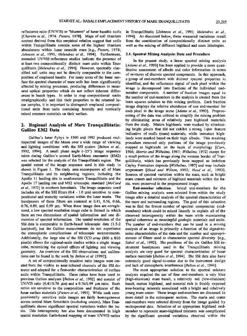
Stratigraphy of mare units. The spatial distribution of each end-member has been registered to low illumination an- gle telescopic images [Kuiper et al., 1967] and geologic maps [Wilhelms, 1972; Morris and Wilhelms, 1967; Cart, 1966] for comparison of end-member abundance with geologic features. Low illumination angle photographs allow evaluation of morphologic features which are not easily observed in the Galileo images which were acquired at higher Sun. These combined data allow end-member abundance and spectral variance to be placed in the general context of the regional to- pography of the basin. The locations of topographic features and craters discussed in the text are shown on the low illumi-
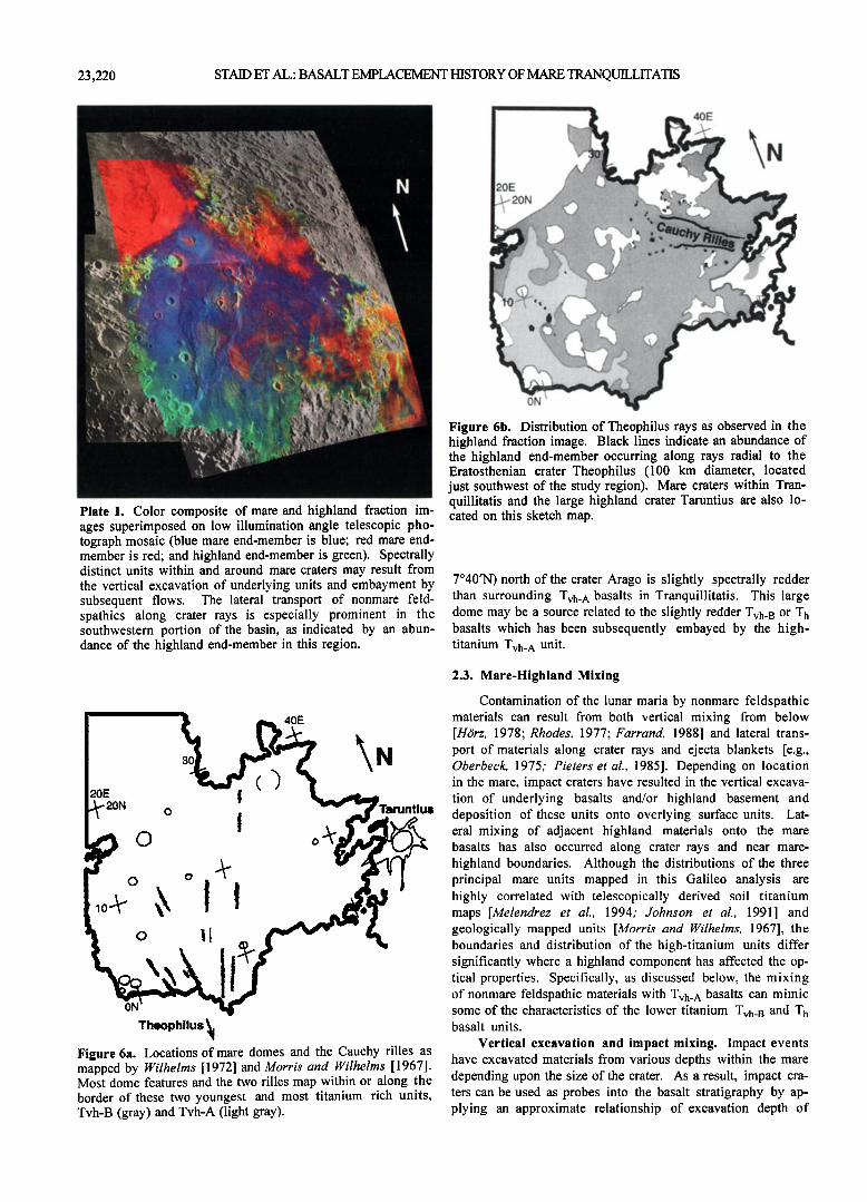
nation angle photograph of Figure 5 [Kuiper et al., 1967]. A color composite overlay is shown in Plate 1 in which three of the fraction images are superimposed on the telescopic mosaic
(red is red mare 0-100%, blue is blue mare 0-100%, green i s highlands 0-50%). Lunar Orbiter and Apollo images, as well as topographic maps derived from Apollo data were also ex- tensively utilized in this study. Of particular interest in the discussion below are relationships between end-member mate- rials and geologic features such as mare-highland contacts, craters, wrinkle ridges, and potential mare source regions such as domes.
Comparison of the distribution of mare units from the Galileo analysis with previously prepared geologic maps and with large-scale topography demonstrates that the spectrally mapped basalt units are more well-defined, but generally con- sistent with previous data. Geologic maps of western Tran- quillitatis are based primarily on albedo, stratigraphic rela- tionships, and crater frequency [Morris and Wilhelms, 1967], and maps of eastern Tranquillitatis include relative color in- formation as well [Wilhelms, 1972]. The low-titanium Ti unit corresponds with the oldest and most heavily cratered mare within Tranquillitatis predating adjacent regions containing the Tvh_ B basalts [Wilhelms, 1972]. The location of Th basalts corresponds directly to the brightest and most heavily cratered mare unit in western Tranquillitatis [Morris and Wil- helms, 1967; unit Ipm 1] and the relationship of this unit to other mapped units suggests that it is stratigraphically younger than the T• unit in eastern Tranquillitatis. The Tvh units corresponds with darker, less cratered and stratigraphi- cally younger units of western Tranquillitatis [Morris and Wilhelms, 1967; Ipm 2 and 3 units]. In many areas of the ba- sin the younger Tvh flows have flooded low areas but not cov- ered topographic highs which coincide with either the older and spectrally redder T h mare unit or highland kipukas within the basin. Such relationships between basaltic units and mor- phologic features can be observed in Plate 1.
The stratigraphy for the spectrally mapped basalt units appears to be consistent on the basin scale: younger titanium- rich Tvh units overlying the older less titanium-rich T h and Ti units. This stratigraphy of deposits is also generally consis-
1.2
0.9
0.8 0.4 0.5 0.6 0.7 0.8 0.9 I
Wavelength (pm)
Figure 4b. Representative relative reflectance spectra of the four mare units identified within Tranquillitatis. The image locations from which these spectra derive are indicated by the black boxes in Figure 4a. Consistent spectral characteristics distinguish the units which are mapped spatially by the mix- ing analysis (see text).
STAID ET AL.' BASALT EMPLACEMENT HISTORY OF MARE TRANQUILLITATIS
..... iiii31•iiiiiiiii..... ':':':':'i•i•i•i•i•i•i• iilL:!:iiiiiiiiiiiiiiiJ':":"iiii•11ii•!!!ii!i!ili!i•ii!11 '!
....
Figure 5. Low illumination angle telescopic photographic mosaic showing major morphologic features within the Tranquillitatis basin (images from Kuiper et al. [1967]).
23,219
tent with crater data across the basin [Boyce, 1976]. Spatial re- lationships and correlation with geologic maps suggest that the highest titanium Tvh_ A unit overlies the Tvh_ B unit. This stratigraphic trend of higher titanium basalts over somewhat lower titanium basalts has also been suggested in more local- ized telescopic studies of the Lamont and Tranquillita- tis/Serenitatis border region [Melendrez et al., 1994; Bell and Hawke, 1995] and appears to exist on a basin scale between all units discussed here.
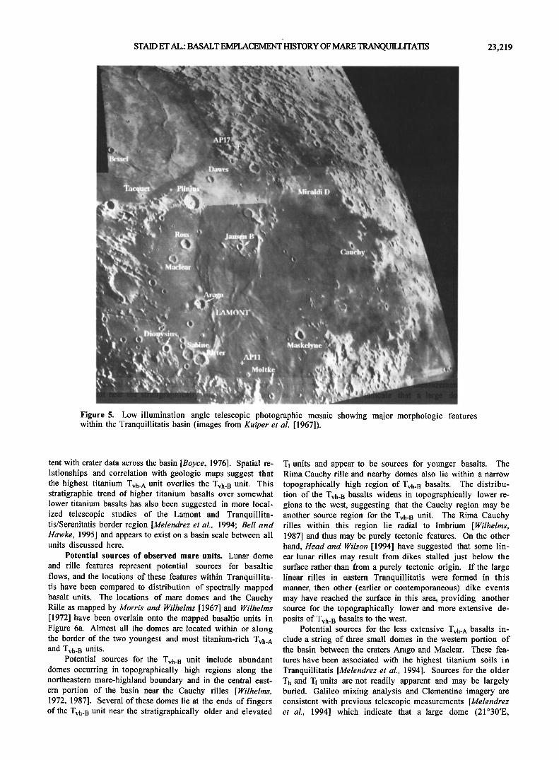
Potential sources of observed mare units. Lunar dome
and rille features represent potential sources for basaltic flows, and the locations of these features within Tranquillita- tis have been compared to distribution of spectrally mapped basalt units. The locations of mare domes and the Cauchy Rille as mapped by Morris and Wilhelms [1967] and Wilhelms [1972] have been overlain onto the mapped basaltic units in Figure 6a. Almost all the domes are located within or along the border of the two youngest and most titanium-rich Tvh_ A and Tvh_ B units.
Potential sources for the Tvh_ B unit include abundant domes occurring in topographically high regions along the northeastern mare-highland boundary and in the central east- ern portion of the basin near the Cauchy rilles [Wilhelms, 1972, 1987]. Several of these domes lie at the ends of fingers of the Tvh43 unit near the stratigraphically older and elevated
T 1 units and appear to be sources for younger basalts. The Rima Cauchy rille and nearby domes also lie within a narrow topographically high region of Tvh_ B basalts. The distribu- tion of the Tvh_ B basalts widens in topographically lower re- gions to the west, suggesting that the Cauchy region may be another source region for the Tvh_ B unit. The Rima Cauchy rilles within this region lie radial to Imbrium [Wilhelms, 1987] and thus may be purely tectonic features. On the other hand, Head and Wilson [1994] have suggested that some lin- ear lunar rilles may result from dikes stalled just below the surface rather than from a purely tectonic origin. If the large linear rilles in eastern Tranquillitatis were formed in this manner, then other (earlier or contemporaneous) dike events may have reached the surface in this area, providing another source for the topographically lower and more extensive de- posits of Tvh_ B basalts to the west.
Potential sources for the less extensive Tvh_ ^ basalts in- clude a string of three small domes in the western portion of the basin between the craters Arago and Maclear. These fea- tures have been associated with the highest titanium soils in Tranquillitatis [Melendrez et al., 1994]. Sources for the older Th and T1 units are not readily apparent and may be largely buried. Galileo mixing analysis and Clementine imagery are consistent with previous telescopic measurements [Melendrez et al., 1994] which indicate that a large dome (21ø30'E,
23,220 STAID ET AL.: BASALT EMPLACEMENT HISTORY OF MARE TRANQUILLITATIS
Plate 1. Color composite of mare and highland fraction im- ages superimposed on low illumination angle telescopic pho- tograph mosaic (blue mare end-member is blue; red mare end- member is red; and highland end-member is green). Spectrally distinct units within and around mare craters may result from the vertical excavation of underlying units and embayment by subsequent flows. The lateral transport of nonmare feld- spathies along crater rays is especially prominent in the southwestern portion of the basin, as indicated by an abun- dance of the highland end-member in this region.
ON
40E
Figure 6b. Distribution of Theophilus rays as observed in the highland fraction image. Black lines indicate an abundance of the highland end-member occurring along rays radial to the Eratosthenian crater Theophilus (100 km diameter, located just southwest of the study region). Mare craters within Tran- quillitatis and the large highland crater Taruntius are also lo- cated on this sketch map.
7ø40'N) north of the crater Arago is slightly spectrally redder than surrounding Tvh. A basalts in Tranquillitatis. This large dome may be a source related to the slightly redder Tvh. B or T h basalts which has been subsequently embayed by the high- titanium Tvh. A unit.
o o
o
ON
Theophllus • Figure 6a. Locations of mare domes and the Cauchy rilles as mapped by Wilhelms [1972] and Morris and Wilhelms [1967]. Most dome features and the two rilles map within or along the border of these two youngest and most titanium rich units, Tvh-B (gray) and Tvh-A (light gray).
2.3. Mare-Highland Mixing
Contamination of the lunar maria by nonmare feldspathic materials can result from both vertical mixing from below [Hdirz, 1978; Rhodes, 1977; Farrand, 1988] and lateral trans- port of materials along crater rays and ejecta blankets [e.g., Oberbeck, 1975; Pieters et al., 1985]. Depending on location in the mare, impact craters have resulted in the vertical excava- tion of underlying basalts and/or highland basement and deposition of these units onto overlying surface units. Lat- eral mixing of adjacent highland materials onto the mare basalts has also occurred along crater rays and near mare- highland boundaries. Although the distributions of the three principal mare units mapped in this Galileo analysis are highly correlated with telescopically derived soil titanium maps [Melendrez et al., 1994: Johnson et al., 1991 ] and geologically mapped units [Morris and Wilhelms, 1967], the boundaries and distribution of the high-titanium units differ significantly where a highland component has affected the op- tical properties. Specifically, as discussed below, the mixing of nonmare feldspathic materials with Tvh. A basalts can mimic some of the characteristics of the lower titanium Tvh. B and Th basalt units.
Vertical excavation and impact mixing. Impact events have excavated materials from various depths within the mare depending upon the size of the crater. As a result, impact cra- ters can be used as probes into the basalt stratigraphy by ap- plying an approximate relationship of excavation depth of

STAID ET AL.: BASALT EMPLACEMENT HISTORY OF MARE TRANQUILLITATIS 23,221
-1/10 the crater diameter [Stoffier et al., 1975; Dence et al., 1977; Grieve et al., 1981; Melosh, 1989]. Stratigraphic com- positional variations are implied when optically mature exca- vated materials are different from surrounding basaltic soils. Characterizing such crater ejecta provides information on ba- salt stratigraphy, unit thickness, and the depth of the submare basement. This method has been successfully used in Mare Crisium, for example, where a regional stratigraphy was con- structed and information on basalt thickness was derived
through observations of spectrally distinct deposits associ- ated with large impact craters within the mare [Head et al., 1978]. Implications for basin stratigraphy and basalt thick- ness from the deposits of several impact craters within Tran- quillitatis are discussed below. The location of these craters are shown in Figure 5 and the relation of end-member abun- dances with these features can be seen in Plate 1.
Regionally high abundances of the red mare end-member occur around the impact craters Arago, Maclear, and Maske- lyne within otherwise continuous regions of bluer mare. These impact craters appear to have excavated and redeposited the stratigraphically older Th unit onto the younger Tvh basalts. In other locations not necessarily associated with an impact crater, the same spatial relationship of the younger Tvh basalts surrounding older T h basalts appears to have resulted from embayment. For example, in the Lamont region, islands of the older T h unit are surrounded by younger Tvh_^ basalts to the north and west and Tvh_ B basalts to the east (red "islands" in Figure Plate 1). The contacts between these units exhibit sharp boundaries which coincide with geologic boundaries based on crater count and albedo data [Morris and Wilhelms, 1967]. In the Jansen B region, topographically high islands of the T h unit and highland kipukas are also sur- rounded by younger Tvh. B basalts.
A different type of compositional contrast occurs at the crater Ross (25 km in diameter). Slightly lower fraction abun- dances of the blue mare end-member can be seen in the depos- its around this large crater. The spectral character of the de- posits around Ross suggests that theTvh_B unit underlies the Tvh. A basalts in western Tranquillitatis and was excavated by this large impact event. The spatial distribution of highland materials and red mare basalts (seen in the fraction images of Figure 3) suggests that this crater has not excavated any sig- nificant portion of highland materials or T h basalts. The lack of highland or low-titanium basalts associated with Ross suggests the superposition of the Tvh_ A and Tvh_ B units in this region of the basin resulted in basaltic deposits which are more than 2.5 km thick.
On the other hand, the presence of highland end-member materials within some large mare craters indicates that the cra- ter penetrated the mare cover into the underlying feldspathic basement or an ancient feldspathic ejecta layer. The distribu- tion of such highland components allows evaluation of the depth of the mare units and the proximity of the underlying basin highland topography. The presence of the highland end-member observed within Plinius (Figure 3d) is consistent with high spectral resolution telescopic spectra [Bell and Hawke, 1995] which have detected feldspathic materials within Plinius' central peaks. A highland component within the crater Plinius (43 km diameter) suggests the excavation of either Serenitatis basin deposits or the feldspathic basement. In central Tranquillitatis, an increased abundance of the high- land end-member occurs within and directly around the large
crater Arago (26 km) and the crater Jansen B (18 km). The highland end-member is also abundant along protruding peaks of highland kipukas in the Jansen B region, indicating regionally thin basalts in the center of Tranquillitatis along the central ridges. Highland kipukas also occur in the south- ern and eastern portions of the basin and suggest that the basalts are also very thin in these areas. Furthermore, high- land materials have been excavated by small craters (e.g., the 11-km Cauchy and Tauruntillus F craters)along these mare- highland boundaries, implying mare thickness of less than 1 km. Excavation of nonmare feldspathic materials also occurs near the southwestern edge of Tranquillitatis by the small cra- ter Moltke (6 km) and is discussed further with Clementine imagery in a subsequent section.
The unusual crater pair Ritter and Sabine (29 and 30 km) also occurs along a Tranquillitatis basin boundary in south- western Tranquillitatis. On the basis of surface morphology of the crater rim and floor, De Hon [1971] originally inter- preted Sabine and Ritter to be volcanic calderas. More recent work [Head and Wilson, 1992, 1994] suggests that shallow magma reservoirs, and thus large calderas and large shield volcanoes, should be very rare on the Moon because of the density trap at the base of the anorthositic crust and the diffi- culty of stalling abundant dikes in one place in the shallow lunar crust. Our multispectral analysis of Sabine and Ritter shows a significant highland component along the rim and in- terior (Figure 3d and Plate 1), which strongly suggests that these structures are impact craters penetrating through shal- low mare material at the southwestern edge of Mare Tranquilli- tatis, and not endogenic volcanic craters.
Vertical excavation of submare feldspathic materials ob- served at the craters Arago (26 km), Maskelyne (22 km), and Jansen B (18 km) and lack of similar deposits at Ross (25 km) or Dawes (18 km) indicates that basalts may be thickest, more than 2 km, in the northwestern portion of the basin (Tvh. A unit). These estimates of basalt thickness are considerably greater than those made by extrapolation of contours through the very limited crater flooding data within this region: De Hon [1974] predicted that the basalts were 750 m to 1 km thick, and HOrz [1978] predicted a thickness of about 400- 500 m based on a reinterpretation of De Hon's data.
Lateral mixing of nonmare materials. Rays of the high- land end-member stretch across much of the basin but are
most significant in the southwestern portion of Tranqui!lita- tis. The radial distribution of these rays with respect to the highland crater Theophilus (100 km in diameter) is sketched in Figure 6b. The prominent rays of this crater observed with Earth-based telescopes led to early estimates of a Copernican age for Theophilus [Wilhelms and McCauley, 1971]. More de- tailed considerations of crater densities, however, have led to the assignment of an older, Eratosthenian age for the Theophi- lus event [Wilhelms, 1987]. Theophilus rays are distinguish- able in the highland fraction image (Figure 3d) as far as north- ern Tranquillitatis (as much as 600 km from Theophilus), which is comparable to the extent of the more prominent Co- pemicus rays observed in small phase angle telescopic im- agery [e.g., Kuiper et al., 1967]. On the basis of our analysis, portions of Theophilus' rays clearly contain a significant component of primary feldspathic material. This interpreta- tion for the Theophilus rays is very similar to spectral studies of Copernican rays, which showed that the rays' higher albedo results from a component of bright primary material

23,222 STAID ET AL.: BASALT EMPLACEMENT HISTORY OF MARE TRANQUILLITATIS
(feldspathic highlands) in the well-developed soils of the cra- ter ray rather than from freshly excavated local mare materials [Pieters et al., 1985].
The rays of Theophilus are a likely source for much of the nonmare material near the Apollo 11 landing site. Ray cluster craters within a few kilometers of the Apollo 11 site have been identified through telescopic mapping and have been inter- preted to result from the Theophilus event [Grolier, 1970; Wilhelrns, 1987]. Some of the rays observed in the Galileo im- agery pass very close to the landing site and are examined in more detail below with higher resolution Clementine imagery.
Nonmare feldpathic mixing has significantly affected the spectral character of mare soils in the southwestern portion of the basin. When mixing is not taken into account, interpreta- tions of telescopic UV/VIS data of the southwestern mare sug- gest a compositional gradient between higher and lower tita- nium mare units [Johnson et al., 1991]. Similarly, albedo- based geologic maps [Morris and Wilhelrns, 1967] assign the Apollo 11 region to a slightly brighter Ipm 2 unit rather than the darkest Ipm 3 unit with an "uncertain" contact. However, mixing analyses of the Galileo data demonstrate that this re- gion instead contains an extension of the stratigraphically youngest and very high titanium Tvh_ ^ basalts, similar to those in northwestern Tranquillitatis. These Tvh_ ^ basaltic soils in the Apollo 11 area appear to have been spectrally red- dened by mixing of feldspathic materials. We interpret the feldspathic component to be associated with lateral transport by crater rays and possibly with vertical excavation of sub- mare highland materials by smaller craters like Moltke near the mare-highland border (Figure 3d, Plate 1).
The western boundary of Tranquillitatis also contains a significant amount of the highland end-member which does not occur as discrete rays radial to Theophilus and is not di- rectly associated with craters Ritter and Sabine. By compari- son, the eastern margin of the Tranquillitatis basin exhibits a much sharper mare-highland contact where basalts directly embay against highlands. The relationships between mare units and mare-highland contacts can be easily seen in Figure 3d and Plate 1. The youngest western basalts (Tvh basalts) embay light plains on the western edge of Mare Tranquillitatis that have been mapped as the Imbrium Cayley Formation [Wilhelrns, 1987]. The extent of Cayley plains included in the Galileo analyses is shown in Figure 4a.
The Galileo mixing analysis suggests these Cayley plains are a mixture of abundant highland and basaltic materi- als. One possible explanation for this high degree of mare- highland mixing is that the Cayley plains in this region .may result from the emplacement of Imbrium basin ejecta onto early Tranquillitatis basalts. This is supported by the proxim- ity of these plains along the western edge of Tranquillitatis to the Imbrium basin, by the presence in the Apollo 11 mare ba- salt suite of samples that predate the Imbrium basin event, and by the subsequent impact excavation of sub-Cayley basalts. The excavation of basalts from beneath the Cayley plains in this region is suggested by the dark rays of the crater Dionysius [Schultz, 1976].
A small component of highland material is also some- times observed associated with older T h basalts in areas across the central part of the basin where the T h unit was embayed but not covered by younger basalts. It is possible that the em- placement of some of the Tranquillitatis T h basalts predate and were contaminated by the Imbrium event before being par- tially covered by younger more titanium-rich Tvh flows. This
scenario would explain the significant amounts of highland materials and lack of uncontaminated T h basalts associated with impact craters in western Tranquillitatis (e.g., Arago, Rit- ter, and Sabine). Perhaps some of the large western craters which exhibit a nonmare feldspathic component excavated Imbrium ejecta and underlying basalts rather than highland basement.
In summary, there is evidence that the Cayley Formation along the western margin may indeed lie on top of an ancient mare deposit buried by Imbrium basin ejecta (e.g., cryptomare [Head and Wilson, 1992]), and that portions of central Tran- quillitatis might have similar characteristics. This adds fur- ther evidence to an increasingly widespread documentation of cryptomaria on the Moon [Head et al., 1993; Greeley et al., 1993; Antonenko et al., 1995; Mustard and Head, 1996].
3. A Closer Look With High-Resolution Clementine UVVIS Data
High spatial resolution Clementine multispectral data have been analyzed to assess stratigraphic and mixing rela- tionships for key areas identified in the Galileo synoptic analyses. Clementine multispectral cameras include an ultra- violet-visible imaging system (UVVIS)with five filters be- tween 0.4 and 1.0 gm [Nozette et al., 1994] coinciding with the spectral range of the Galileo SSI camera. These higher resolution data have spatial resolutions of about 150-300 m/pixel compared to 1.5-2 km/pixel in the Galileo EM2 data. Initial calibration and mosaicking procedures for the applica- tion of this data are discussed by Pieters et al. [1994, 1995]. The higher spatial resolution of these data provides a means to clarify lateral and vertical mixing processes. Sites chosen for examination with Clementine UVVIS data include mosaics
of the mare crater Arago (in central Tranquillitatis) as well as the Apollo 11 landing site and the nearby crater Moltke (see Figure 5 for locations). Clementine data of these sites confirm the stratigraphic relations between the Tvh and T h basaltic units and help place the Apollo 11 basalt samples within the context of these units.
3.1. Central Tranqui!!itatis and Arago Crater
The central western portion of Tranquillitatis is one of the most spectrally heterogeneous areas in the entire basin. The Galileo mixing analysis attributes this spectral complex- ity to the surface expression of both of the younger bluer Tvh units as well as islands of the older redder T h unit. Addition- ally, highland mixing appears to have occurred associated with material excavated by the crater Arago (26 km in diame- ter) and material transported laterally along rays of Theophi- lus.
Previous telescopic studies of the central Tranquillita- tis/Lamont region have noted that the soils within and sur- rounding the Eratosthenian crater Arago are spectrally redder than adjacent mare soils [Melendrez et al., 1994]. Clementine imagery centered on Arago (Figures 7a and 7b) also indicates regionally redder deposits around Arago with lower UV/VIS ratio values. A small impact crater that occurs within these deposits can be seen in Figure 7a. This crater exhibits a dis- tinct dark halo (arrows in Figure 7) similar in albedo to the Tvh basalts in the northern portion of the image beyond the Arago anomaly. This small crater indicates that the spectral anomaly around Arago is only a thin surface veneer corre-

STAID ET AL.: BASALT EMPLACEMENT HISTORY OF MARE TRANQUILLITATIS 23,223
:.::11; '"'"'•?•,!!i •i•;X•i•."':'::: ;•i•?•.;•;• ::
...... . ........ ..................
.
............. .
.... ':•4,:*" '"'"**":*' ..........
................... ß .::3:;.,..
•;,•:. ........
. . .. ...........
Figure 7a. Clementinc 750-nm image mosaic centered on the mare crater Arago.
sponding to the ejecta deposits of Arago. The blue spectral character of the dark halo also corresponds to the spectral properties of the emplaced Tvh_ A mare unit north of the Arago's ejecta blanket. This small dark haloed crater is inter- preted to have re-exposed the Tvh_ ^ surface basalts from just below Arago's ejecta deposit. The high albedo red spectral character of the Arago ejecta is attributed to the excavation of underlying and less titanium-rich T h basalts and nonmare feldspathics. This example confirms the stratigraphic relation of Tvh •,•.s•.l•s overlying the Ti• unit within the Lamont regi,,,, The excavation of the Tvh unit by the small crater also demon- strates that the Arago event could not have been older than the emplacement of Tvh mare. This new evidence argues against the interpretation of an embayment relationship between the younger bluer mare against Arago's raised rim as suggested by Melendrez et al. [1994]. Continuing studies of Clementinc imagery of the mare crater Dawes [Staid et al., 1995; Staid and Pieters, 1996] in the northernmost region of Tranquillitatis suggest a similar stratigraphy for Dawes, an optically fresh mare crater, namely, that a lower titanium unit has been exca- vated from beneath spectrally bluer surface units. Such a rela- tion was initially hypothesized at Dawes based on lower reso- lution telescopic data [Melendrez et al., 1994].
High-albedo floor hummocks within Arago can be seen in Figure 7a and exhibit spectral properties characteristic of nonmare feldspathic materials. The occurrence of the high- albedo floor hummocks within Arago is consistent with the excavation of highland materials as predicted in the Galileo spectral mixture analysis of this crater. If the nonmare feld- spathic materials define the base of the mare basalts, then ex-
cavation-depth-to-diameter relationships predict basalts within this region are less than 2.5 km thick.
that the
3.2. Southwestern Tranquiilitatis: Apollo 11 Landing Site
Tho (-'.nlilor• •nnl•c•c nq hnc•lt •nltc clict-,,cc,•rl above in•
dieate that the Apollo 11 site lies within the darkest and 'blu- est basalts within Tranquillitatis (Tvh_^ unit), but soils have been contaminated by significant mixing of bright nonmare feldspathic material that is spectrally red. A mosaic of Cle- mentinc data over the Apollo ll landing site was prepared from imagery taken at high Sun (close to zero phase angle) and is shown in Figure 8a. This low phase angle lighting condition enhances the optical contrasts between surface ma- terials of different albedos and allows a more detailed exami-
nation of the sources of nonmare feldspathic contamination within this region.
Bright crater rays from Theophilus extend from the south to the north and are easily identified in Figure 8a. One ray visibly passes within a kilometer or two of the Apollo 1 1 landing site. The spectral characteristics of the ray materials (e.g., the strength of the 1 •tm absorption band approximated by a 0.95/0.75-•tm ratio in Clementinc imagery) indicate that the rays are no different from surroundings and are thus opti- cally mature. A large zone of relatively low-albedo materials is apparent around the nearby 6-km crater Moltke out to 8 cra- ter radii. The southernmost portions of the Theophilus rays, south of the Apollo 11 landing site, disappear within this dark area.
':-'11:• •:'!;:' ;"•" ............. ,•s •'•.
........ a* ....... '.**;,•:;•.. . .................
-;•;.. ..........
•}}• *:• ::•f352• • -:-•5•5•**•3•g•-•:;•3.::•, ::•:::::,:•::•,:*.;}:..• •.•:•:
•;:;....:.:.•:::• :...:.::•:.:•:.
Figure 7b. Clementinc 415/750-nm UV/VIS ratio image for the same region. Note the spectrally blue (high 415/750 nm) dark haloed crater just above the north rim (arrow). This crater indicates exposure from beneath Arago ejecta deposits and subsequent maturation of material that is comparable to the relatively blue unit to the north (Tvh-A basalts).

23,224 STAID ET AL.: BASALT EMPLACEMENT HISTORY OF MARE TRANQUILLITATIS
l'l'•'illlllii;l•l]•i{;lt::l'l•li li{'li•ll• l li I +l
Figure 8a. Clementine mosaic of the Apollo 11 landing site taken at high Sun. Arrows indicate dark haloed craters. Ray materials (labeled r) are distinguishable by their high albedo.
High-albedo materials are also observed in and directly around the crater Moltke (6 km in diameter). Subsequent small impacts into the bright Moltke ejecta, however, have formed small dark halo craters (Figure 8a). The bright Moltke ejecta deposits (1 to 2 crater radii) appear to be optically ma- ture based on the superimposed dark halo craters, the low al- bedo of which indicates significant maturation and darkening of these younger deposits. The relatively high albedo of Moltke ejecta is thus a compositional distinction and indi- cates Moltke has excavated nonmare feldspathic material.
The Galileo observation of a significant amount of non- mare feldspathic surface contamination of the basalts em- placed within the proximity of the Apollo 11 landing site is consistent with the nature of the Apollo 11 soil samples which contain a large feldspathic component, -14% of soils [Rhodes, 1977] and 20% of breccias [Wood et al., 1970; Laul
and Papike, 1980]. A lateral mixing mechanism, rather than vertical migration from below [e.g., HOrz, 1978], seems the likely mechanism of nonmare feldspathic contamination in this region because the inherent properties of the local basalts are optically much darker than the uppermost veneer of con- taminated material. Much of this mixing appears to have oc- curred laterally along the rays which lie radial to the Theophi- lus (100 km) impact crater. The spectrally mature nature of these rays is consistent with this crater's Eratosthenian age. The close proximity of these rays to the Apollo 11 site and the nonmare feldspathic material excavated by nearby Moltke provide likely sources for feldspathic contamination in the Apollo 11 soil samples.
A schematic cross section through the crater Moltke pre- sented in Figure 8b describes the interpreted sequence of feld- spathic contamination across the Apollo 11 and Moltke re- gion. High-titanium basalts (Tvh_^) were emplaced over a feldspathic crust and Imbrium basin ejecta. The feldspathic rays from Theophilus deposited a thin high-albedo veneer onto the surface of the very low-albedo surface Tvh-^ basalts in this region. Subsequently, the Moltke event is interpreted to have excavated underlying nonmare feldspathic materials from beneath the low-albedo basalts producing the bright de- posits around this crater to -2 radii. More recently, small im- pacts into Moltke ejecta deposits produced dark haloed cra- ters by exposing the Tvh_ ̂ surface unit from below the veneer of Moltke ejecta that contains nonmare feldspathic materials.
The excavation of highlands materials by Moltke (6 km) and estimates of the depth of excavation suggest that the low- albedo basalts in this region, about 30 km to the south of the Apollo 11, are likely to be less than 600 m thick. On the other hand, the approximate diameter (1 km) of the dark haloed cra- ters in Moltke ejecta indicates a minimum basalt thickness of 100 m. The larger circular dark zone around Moltke to the north (8 crater radii) has no obvious cause. One hypothesis is that this dark zone with no Theophilus rays might result from the disturbance of surface materials associated with the
Moltke impact event. Within this zone, the thin veneer of high-albedo surface materials may have been mixed more ex- tensively with the darker underlying Tvh_ ^ soils, diluting the feldspathic component and erasing the Theophilus rays in this area.
The spectral analyses presented above distinguishes the character and distributions of basaltic units emplaced in Mare Tranquillitatis by considering the optical effects of mixing processes within the mare. The resulting information about basalt types and stratigraphy across Mare Tranquillitatis al- lows associations to be made to the returned Apollo samples. Recent geochemical studies by Jerde et al. [1994] have as- signed the five Apollo 11 basalt types observed in returned samples [Papike et al., 1976] to three principal magmatic groups: A, B3-B1, and B2-D. In this interpretation, the earli- est volcanic activity sampled at the Apollo 11 site produced the low-K Group B2 and D basalts (TiO2 content 8.4-8.9 wt %) at about 3.85 Ga. The activity producing the B3-B1 basalts took place-150 m.y. later and display a continuum of compo- sitions consistent with the fractionation of a magma of Group B3 composition. These basalts have an average TiO2 content of 10.2 wt %. The youngest volcanic activity sampled at the Apollo 11 site was the eruption of the higher-K group A basalts with an average TiO2 wt % of 11.0. There is a remarka- bly good correspondence between the remote observations and the sample studies. Provided in Table 1 are the inferred

STAID ET AL.: BASALT EMPLACEMENT HISTORY OF MARE TRANQUILLITATIS 23,225
NW
3 Rays 4 Moltke dh dh
SE
Figure 8b. Schematic cross section through the crater Moltke including local stratigraphy and interpreted history of vertical and lateral nonmare feldspathic contamination at this site. (1) underlying feldspathic crust or basin ejecta layer in Moltke region, (2) basalt fill, most recent of which are Tvh_ A basalts, (3) nonmare feldspathic contamination of the surface from the crater Theophilus, (4) 6-km impact crater Moltke excavates feldspathic crust; more distal ejecta mixes southern portions of Theophilus rays with underlying low albedo basalts, and (5) small craters excavate basalt onto the ibldspathic deposits of Moltke; with time these basalt deposits have darkened to form dark haloed craters.
assignments of the basalt units derived from spectral analyses to these volcanic events identified at Apollo 11 with returned samples. The abundant younger high-titanium basalts at Apollo 11 are associated with the two Tvh units. The less abundant lower titanium basalts (B2-D)may be associated with the T h unit.
4. Overview of the Tranquillitatis Region
4.1. Tranqui!!itatis: An Asymmetric Structure
Estimates of crater excavation depths for craters inter- preted to have excavated nonmare feldspathic materials pro- vide constraints on the depth of the mare units and the prox- imity of the underlying basin topography. The spectral stud- ies of crater deposits presented above indicate that the Tran- quillitatis' basalt fill (and thus the premare basin topography) may be much more asymmetric than initially suggested by crater flooding data [De Hon, 1974]. Evidence for thick basalts in the northwest includes the lack of nonmare feld-
spathic excavation at Ross (25 km) or Dawes (18 km) leading to estimates of basalt thickness in excess of 2 km for this por- tion of the basin. Thinner predictions of basalt thickness by De Hon [1974] are likely to be the result of a lack of available flooded craters in the regions north and west of the central ridge system. The original estimates of shallow deposits may thus be an artifact of contouring the very sparse data in these areas. It is instead suggested that the lack of flooded craters in these regions results from the complete burial of most fea-
Table 1. Assignments of Observed Spectral Units to Apollo 11 Basalt Types
Event* Age, -TiO2 Mare Spectral Ga wt % Samples% Unit
A 3.59 11.0 60 Tvh_ A B1-B3 3.67-3.71 10.3 30 Tvh. B B2-D 3.85 8.6 10 T h or laterally
mixed material
*
derde eta/. [ 1994].
tures by relatively thick basalts, the youngest of which are Tvh_ A basalt flows. On the other hand, vertical excavation of highland material at the mare craters Arago (26 km) and Jan- sen B (16 km) indicates that the basalts are less thick in the Lamont region and central portions of the basin than in the north and northwest portions of the basin.
A west to east topographic rise is apparent in the Cle- mentine LIDAR data of Mare Tranquillitatis [Zuber et al., 1994] and is shown in Figure 9. A corresponding gravity anomaly is seen only in the west [Zuber et al., 1994]. This change in topography occurs primarily across the numerous mare wrinkle ridges which extend from the southwestern to the northeastern mare-highland boundary, as can be seen in Figure 5. The combined spectral and geophysical data sug- gest that instead of being a circular basin, Tranquillitatis may be part of a larger asymmetric structure associated with early impact and tectonic events with the thickest deposits of basalts located in the northwestern portion of the basin. A strongly asymmetric model for the basin structure is consis- tent with interpretations of a Procellarum ring through central Tranquillitatis [Whitaker, 1981] but does not exclude other structural interpretations of the basin and its ridges [Dvorak and Phillips, 1979; Spudis, 1993].
4.2 The Eraplacement and Evolution of Mare Basalts in Tranqui!!itatis
These analyses of Clementine and Galileo imagery iden- tify at least four basalt types in Mare Tranquillitatis and pro- vide concrete examples of basalt stratigraphy for the Tvh, T h, and T 1 units defined in Galileo mixing analysis. Excavation and embayment relationships in the north (e.g., Dawes, Plinius), central (e.g., Arago), and southern (Maskelyne) re- gions of the basin indicate that the T h unit is stratigraphically older than the overlying Tvh basalts. Similarly, embayment re- lationships and crater frequency estimates in eastern Tranquil- litatis [Wilhelms, 1972; Morris and Wilhelms, 1967] indicate that the lowest titanium T 1 basalts also underlie the Tvh units. The overall stratigraphic sequence appears to be (oldest to youngest) T 1, T h ,Tvh_ B, Tvh_ ^.

23,226 STAID ET AL.: BASALT EMPLACEMENT HISTORY OF MARE TRANQUILLITATIS
Figure 9. Topography of the Tranquillitatis basin as derived from Clementine LIDAR measurements [Zuber et al., 1994]. The eastern portion of the basin lies significantly higher than the west. The analyses presented here indicate the western part of the basin contains deeper basaltic deposits. Many mare domes exist in the topographically elevated eastern portion of the basin, some of which may be sources for the Tvh-B basalts in the east and in topographically lower areas to the west.
Spectral analyses of mare basalts and comparison with the ages and compositions of returned samples suggest that the Apollo 11 site is dominated by the youngest Tvh_ ^ unit, whose bulk soil properties have been affected by laterally mixed feldspathic materials. These spectral analyses associate the stratigraphically youngest Tvh_^ spectral unit in western Tranquillitatis with the Apollo 11 sample group A [Jerde et al., 1994]. The distribution of these high-Ti, high-K flows is mapped across the western basin. The slightly less titanium- rich and more extensive Tvh_ B basalts occur abundantly in topographic lows throughout the central portion of the basin and appear to have been buried only by the youngest Tvh_ ^ in the western portion of the basin. Stratigraphically older Tvh_ B basalts are exposed just north of the Apollo 11 site (Figure 4a) and occur throughout the central portions of the basin and as far north as southern Serenitatis. This basalt unit is associ-
ated with the older B1-B3 [derde et al., 1994] low-potassium, high-titanium volcanics sampled at Apollo 11. The spectrally redder and stratigraphically earlier Th unit may be related to the older B2-D event [derde et al., 1994], but it is not clear whether this unit was sampled at the Apollo 11 site. The stratigraphy of the three high-Ti spectral units, from the
stratigraphically older Th basalts to the younger Tvh_ B and youngest Tvh_ A unit, agrees with the relative ages and strati- graphic origin of the associated basalt samples.
Spectral mapping of the Tvh_ A unit thought to be associ- ated with the bulk of the Apollo 11 basalt samples (Group A: high-Ti, high-K) indicates that this unit is contiguous at the basin scale, extending throughout topographically low areas of the basin as far north as Plinius. The Tvh_ B basalts are ex- posed just north of the Apollo 11 site and extend as a spa- tially contiguous units as far north as southern Serenitatis near the Apollo 17 site and in the central-eastern portion of Tranquillitatis. These basalts are thought to be sampled by the B1-B3 Apollo 11 basalts fragments (high-Ti, low-K), per- haps excavated by West crater (30 m deep [Wilhelrns, 1987]). The spatial continuity and stratigraphic consistency of the Tvh_ B unit suggest that the mare unit observed in northern Tranquillitatis and adjacent to the Apollo 17 site is the same or a very similar unit from which the Apollo 11 high-titanium, low-potassium Group B basalts are derived. The proximity of this unit to the Apollo 17 site suggests that it may also have been sampled by the high-Ti, low-K basalts collected from the edge of Serenitatis. This spectral link between the Apollo 1 1


23,228 STAID ET AL.: BASALT EMPLACEMENT HISTORY OF MARE TRANQUiLLITATIS
McCord, T.B., M.P. Charette, T.V., Johnson, L.A. Lebofsky, C.M. Pieters, and J.B. Adams, Lunar spectra, J. Geophys. Res., 77, 1349- 1359, 1972.
Melendrez, D. E., J. Johnson, S. Larson, and R. Singer, Remote sensing of potential lunar resources, 2, High spatial resolution mapping of spectral reflectance ratios and implications for near side mare TiO2 content, J. Geophys. Res., 99, 5601-5620, 1994.
Melosh, H.J., Impact Cratering, 245 pp., Oxford Univ. Press, New York, 1989.
Metzger A. E., and R.E. Parker, The distribution of titanium on the lunar surface, Earth Planet. Sci. Lett., 45, 155-171, 1979.
Morris, E.C., and D.E. Wilhelms, Geologic map of the Julius Ceaser quadrangle, U.S. Geol. Surv. Map, 1-510 (LAC-60), 1967.
Muller, P.M., and W.L. Sjogren, Mascons: Lunar mass concentrations, Science, 161, (3842), 680-684, 1968.
Mustard, J.F., and J.W. Head, Buried stratigraphic relationships along the southwestern shores of Oceanus Procellarum: Implications for early lunar volcanism, J. Geophys. Res., 101, 18,913, 1996.
Nozette, S., et al., The Clementine mission to the Moon: Scientific over- view, Science, 266, 1835-1839, 1994.
Nyquist, L. E., and C.-Y. Shih, The isotopic record of lunar volcanism, Geochim. Cosmochim. Acta, 56, 2213-2234, 1992.
Oberbeck, V.R., The role of ballistic erosion and sedimentation in lunar stratigraphy, Rev. Geophys., 13, 337-362, 1975.
Papike, J., F. Hodges, A. Bence, M. Cameron, and J.M. Rhodes, Mare basalts: Crystal chemistry, mineralogy, and petrology, Rev. Geophys., 14 (4), 475-540, 1976.
Pieters, C.M., Mare basalt types on the front side of the moon: a'sum- mary of spectral reflectance data, Proc. Lunar Planet. Sci. Conf, 9th, 2825-2849, 1978.
Pieters, C.M., Compositional diversity and stratigraphy of the lunar crust derived from reflectance spectroscopy, in Remote Geochemical Analysis: Elemental and Mineralogical Composition, edited by C.M. Pieters and P.A.J. Englert, pp. 309-339, Cambridge Univ. Press, New York, 1993.
Pieters, C.M., and T.M. McCord, Characterization of lunar mare basalt types: I. A remote sensing study using reflection spectroscopy of sur- face soils, Proc. Lunar Sci. Conf 7th, 2677-2690, 1976.
Pieters, C.M., J.W. Head, J.B. Adams, T.B. McCord, S. Zisk, and J. Whitford-Stark, Late high titanium basalts of the western Maria: Ge- ology of the Flaresteed region of Oceanus Procellarum, J. Geophys. Res., 85, 3913-3938, 1980.
Pieters, C.M., J. Adams, P. Mouginis-Mark, S. Zisk, M. Smith, J. Head, and T. McCord, The nature of Crater Rays: The Copernicus example, J. Geophys. Res., 90 (B14), 12,393-12,413, 1985.
Pieters, C.M., et al., Crustal diversity of the Moon: Compositional analy- sis of Galileo solid state imaging data, J. Geophys. Res., 98 (E9), 17,127-17,148, 1993.
Pieters, C.M., M.I. Staid, E.M. Fischer, and G. He, A sharper view of impact craters from Clementine data, Science, 266, 1844-1848, 1994.
Pieters, C.M., G. He, S. Tompkins, M.I. Staid, and E.M. Fischer, The 1ow-Ti basalts of Tsiolkovsky as seen by Clementine, Lunar Planet. Sci. XXVI, 1121-1122, 1995.
Rhodes, J.M., Some compositional aspects of lunar regolith evolution, Philos. Trans. R. Soc. London A, 285, 293-301, 1977.
Robinson, M.S., B.R. Hawke, P.G. Lucey, and G.A. Smith, Mariner 10 multispectral images of the eastern limb and farside of the Moon, J. Geophys. Res., 97 (11), 18,265-18,274, 1992.
Sabol, D.E., J.B. Adams, and M.O. Smith, Quantitative subpixel spectral detection of targets in multispectral images, J. Geophys. Res., 97 (2), 2659-2672, 1992.
Schultz, P.H., Moon Morphology, 626 pp., Univ. of Texas Press, Austin, 1976.
Snyder, G.A., L.A. Taylor, and C.R. Neal, A chemical model for gener- ating the sources of mare basalts: Combined equilibrium and frac- tional crystallization of the lunar magmasphere, Geochim. Cosmo- chim. Acta, 56, 3809-3823, 1992.
Snyder, G.A., D. Lee, L.A. Taylor, A. Halliday, and A. Jerde, Evolution of the upper mantle of the Earth's Moon: Nd and Sr isotopic con- straints from high-Ti mare basalts, Geochim. Cosmochim. Acta, 58, 21, 4795-4808, 1994.
Spudis, P.D., Geology of Multi-Ring Impact Basins, 263 pp., Cambridge Univ. Press, New York, 1993.
Staid, M.I., and C.M. Pieters, Craters as indicators of basalt stratigraphy in Mare Tranquillitatis and Serenitatis, Lunar Planet. Sci. XXVII, 1259-1260, 1996.
Staid, M.I., C.M.Pieters, and J.W. Head, A multispectral view of strati- graphy in Mare Tranquillitatis, Lunar Planet. Sci. XXVI, 1345-1346, 1995.
Stoffier, D., D.E. Gault, J. Wedekind, and G. Polkowski, Experimental hypervelocity impact into quartz sand: Distribution and shock meta- morphism of ejecta, J. Geophys. Res., 80, 4062-4077, 1975.
Tompkins, S., J.F. Mustard, C.M. Pieters, and D.W. Forsyth, Optimization of end-members for spectral mixture analysis, Remote Sens. Environ., in press, 1996.
Whitaker, E.A, The lunar Procellarum basin, in Multi-Ring basins, edited by R.B. Merrill and P.H. Schultz, Proc. Lunar and Planet. Sci. Conf, 12A, 105-111, 1981.
Wilhelms, D.E., Geologic Map of the Taruntius quadrangle of the Moon, U.S. Geol. Surv. Map I- 722 (LAC-61), scale 1:100,000, 1972.
Wilhelms, D.E., The geologic history of the moon, U.S. Geol. Surv. Prof Pap., 1348, pp. 302, 1987.
Wilhelms, D.E., and J.F. McCauley, Geologic map of the near side of the Moon, U.S. Geol. Surv. Map, 1-703, scale 1:5,000,000, 1971.
Wood, J. A., J.S. Dickey, U.B. Marvin, and B.N. Powell, Lunar anor- thosites and a geophysical model of the Moon, Geochim. Cosmochim. Acta, no.1, suppl., 965-988, 1970.
Zuber, M.T., D.E. Smith, F.G. Lemoine, and G.A. Neumann, The shape and internal structure of the moon from the Clementine Mission, Sci- ence, 266, 1839-1843, 1994.
J.W. Head III, C.M. Pieters, and M.I. Staid, Department of Geo- logical Sciences, Box 1846, Brown University, Providence, RI 02912. (e-mail: pieters•pds.geo.brown.edu)
(Received July 17, 1995; revised July 22, 1996; accepted July 31, 1996.)