maría paz cigarán national environmental council presidency of the ministerial cabinet - peru
DESCRIPTION
Towards a National Adaptation Strategy in Peru: Climate Change into Development. Paris, March 21 2005. María Paz Cigarán National Environmental Council Presidency of the Ministerial Cabinet - PERU. Pisco - Paracas. THIS IS PERU. INCREASING TREND OF ANNUAL EMERGENCIES 1995-2001. - PowerPoint PPT PresentationTRANSCRIPT
María Paz CigaránNational Environmental CouncilPresidency of the Ministerial Cabinet - PERU
Towards a National Adaptation Strategy in Peru:
Climate Change into Development Paris, March 21 2005

THIS IS THIS IS PERUPERU
Pisco - Paracas

Nùmero de Emergencias entre 1995-2001
0
100
200
300
400
500
600
700
800
A 1995 A 1996 A 1997 A 1998 A 1999 A 2000 A 2001
INCREASING TREND OF ANNUAL EMERGENCIES
1995-2001
Growing trendGrowing trend
FEN 98FEN 98 South South EarthquakeEarthquake
Number of emergencies
Source: Historical Data Bank
National System of Civil Defense

EMERGENCIES RELATED TO NATURAL HAZARDS 1995-2001
ALUD
ALUVIONDERRUMBE DE CERRODESLIZAMIENTOGRANIZADAHELADAHUAYCO (LLOCLLA)INUNDACIONLLUVIA INTENSAMARETAZO (MAREJADA)NEVADASISMOSISMO (EPICENTRO)(vacías)
Floods 47% intense rains 15%, Huaycos (landslides) 13%, landslides 9% Source
Multisectoral Commission of Risk Reduction for Development
At least 84 % of declared emergencies due to climate risks
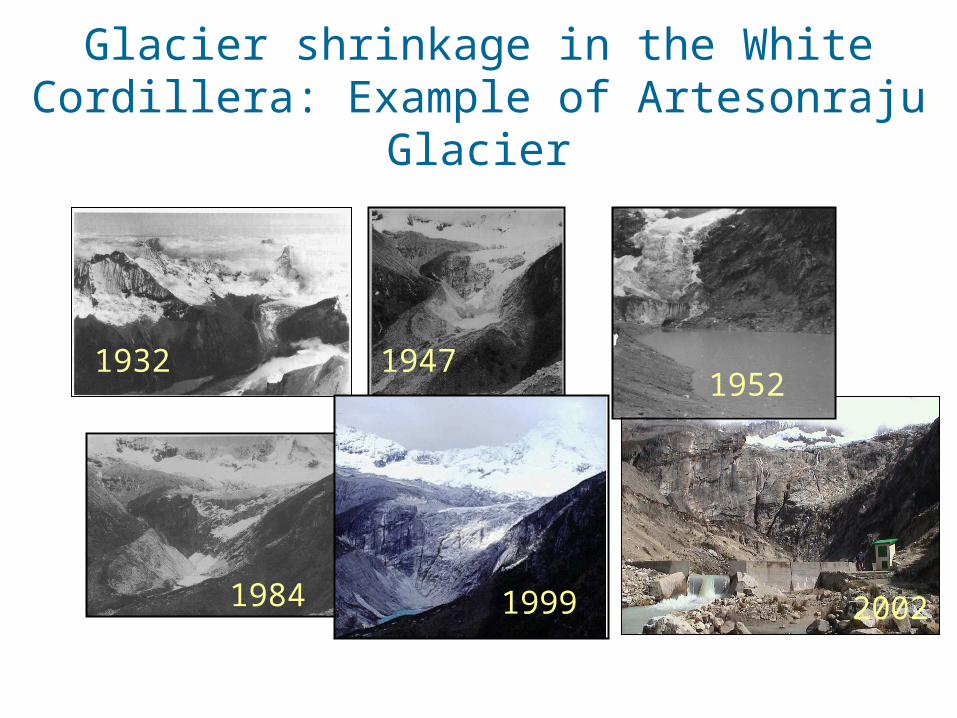
Glacier shrinkage in the White Cordillera: Example of Artesonraju Glacier
1932 19471952
1984 1999 2002

COUNTRY POLICY Nº 10Poverty Reduction
COUNTRY POLICY Nº 19Sustainable Development and
Environmental Management
NATIONAL AGREEMENT
FOR GOVERNABILITY AND DEVELOPMENT
PROCLIM
NATIONAL STRATEGY
ON CLIMATE CHANGE
LET’S CLEAN THE AIR
By supreme decree
By supreme decree
EmissionInfo and control
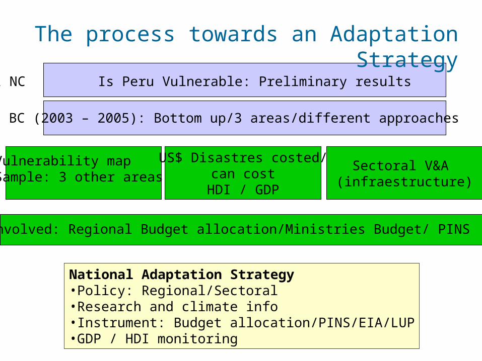
The process towards an Adaptation Strategy
1 NC Is Peru Vulnerable: Preliminary results
BC (2003 – 2005): Bottom up/3 areas/different approaches
Vulnerability mapSample: 3 other areas
US$ Disastres costed/can cost
HDI / GDP
Sectoral V&A (infraestructure)
MEF involved: Regional Budget allocation/Ministries Budget/ PINS
National Adaptation Strategy•Policy: Regional/Sectoral•Research and climate info•Instrument: Budget allocation/PINS/EIA/LUP•GDP / HDI monitoring

Integrated Vulnerability Integrated Vulnerability Assessment in PiuraAssessment in Piura
Regional climate scenarios: • El Niño Event• Change in average intensity of rains
Analysis on 5 crops:Lemon, rice, cotton, corn, vulnerable to intense rains and incrase in temperature
#Y #Y
#Y
#Y
#Y
#Y
#Y
#Y#Y
#Y
#Y
#Y #Y
#Y
#Y
#Y
#Y
#Y#Y
#Y
#Y#Y
#Y
#Y
#Y
#Y
#Y
#Y
#Y
#
#
#
#
#
#
#
#
#
#
#
#
#
#
#
##
#
#
#
#
#
#
#
#
#
##
#
##
##
#
# ##
# #
#
#
#
####
# # #
#
##
##
#
##
#
##
#
#
## #
##
##
#
##
#
#
#
#
#
#
#
##
#
#
## #
#
# #
#
#
#
#
#
#
#
#
#
#
# #
#
##
#
#
#
#
# #
# ##
#
#
#
#
# #
# ## #
## #
#
#
#
#
#
#
#
#
#
#
#
#
##
#
#
#
#
#
#
# #
#
#
#
#
#
#
#
#
#
#
#
#
#
#
#
#
###
#
## #
##
## # ### ### #
###
## # #
##
##
####
#
#
##
### #
### ## # ##
## #
## #
#
###
#
##
###
## ##
# #
# ##
#
#### # ####
###
### #
#
##
#
#
#
#
##
####
#
# #
#
#
# ##
##
#
#
##
# ##
##
# ##
### #
###
## ###
#
#
#
###
#
#
#
#
#
#
#
# #
##
#
##
#
### #
#
# ##
#
#
#
##
# # ### #
##
##
###
#
#
#
###
#
#
##
##
###
# #
#
### # #
#
#
##
#
##
#
# ##
##
#####
## #
##
##
#
# #
##
#
##
# #
#
#
#
#
#
# ##
#
#
# #
#
#
#
#
#
#
#
#
# #
##
# #
#
#
##
##
##
#
## #
# # #
# # ## #
#
##
#
###
#
#
#
# #
# #
#
#
#
# ###
##
###
#
##
#
##
#
#
#
#
#
#
#
#
#
#
#
#
#
#
#
#
#
#
#
##
#
#
##
# #
#
#
#
#
#
#
#
#
## #
#
##
##
#
### # # # # #
## #
##
##
#
##
#
#
#
##
## ##
#
#
#
##
#
# #
#
##
# #
### #
#
#
#
# # ## #
#
# #
#
###
#
#
## #
# ### #
#
##
# #
#
#
#
#
#
#
## #
#
##
# #
#
#
# ##
##
#
# ##
#
###
#
##
##
##
#
#
#
#
#
#
#
# #
#
#
#
#
# #
##
#
#
#
#
##
#
#
##
###
#
#
##
###
#
#
###
#
# # ##
##
###
##
#
###
###
#
#
#
#
#
####
#
###
##
#
###
###
##
# #
#
##
##
#
#
#
#
##
# #
#
#
##
##
#
#
##
##
####
##
###
#
##
#
#
##
### #
#
#
#
#
#
#
# #
#
##
#
#
#
##
##
#
## #
#
#
##
#
#
##
#
#
#
#
##
#
#
#
#
#
#
#
#
#
#
#
#
#
#
##
#
#
#
# #
# ##
## #
#
##
#
##
#
# ##
# ##
# ##
#
#
### # #
#
## ##
#
#
#
#
#
# # #
#
#
#
##
#
#
#
#
#
#
##
#
#
#
#
#
#
#
#
#
#
#
#
#
##
##
##
#
#
#
# #
#
#
## #
### #
# #
#
#
#
# ####
## # #
#
## #
# ### #
#
##
##
# #
# #
# ## # # #
### #
##
# #
##
# ##
###
# #
##
##
#
###
#
#
# #
# ## # #
# ##
#
##
#
#
#
#
#
#
#
#
#
#
#
#
#
#
#
#
#
# #
##
#
#
#
##
## #
#
#
#
#
# ## #
#
# ##
#
#
#
#
#
#
# #
# #
#
#
#
##
##
###
#
# ##
##
#
##
# #
#
##
#
##
##
#
##
#
##
##
###
###
##
##
#
##
#
#
#
#
##
#
##
#
##
# #
##
####
#
#
#
#
#
#
#
#
##
###
##
##
#
###
#
#
##
##
#
# #
#
#
#
#
##
#
##
#
#
#
###
#
#
##
#
#
#
#
#
#
#
#
#
#
##
#
#
#
#
#
#
#
##
#
#
#
#
#
#
#
# #
#
#
#
#
#
#
## #
#
#
#
#
#
#
#
#
#
#
#
#
#
#
#
#
#
#
#
#
#
#
#
#
#
#
#
#
#
##
#
#
#
#
##
#
#
#
#
#
#
##
#
#
#
#
#
#
#
# #
#
#
#
#
#
#
#
#
#
#
#
#
#
#
#
#
#
#
#
#
#
#
#
#
#
#
#
#
#
#
#
#
#
#
#
#
#
#
#
#
#
#
#
#
#
#
#
##
# # #
#
#
#
#
#
#
#
#
#
#
#
#
#
#
#
#
#
#
#
#
#
#
#
#
#
#
#
#
#
#
#
#
#
#
#
#
#
#
#
#
#
#
#
#
#
#
#
#
#
#
#
#
#
#
#
#
#
#
#
#
#
#
#
#
#
#
#
#
#
#
#
#
#
#
#
#
#
#
#
#
#
#
#
#
#
#
#
#
#
#
#
#
#
#
#
#
#
#
#
#
#
##
#
##
#
#
##
#
#
#
#
#
#
#
#
#
#
#
#
#
#
#
#
#
#
#
#
#
#
#
#
#
#
PAITA
AYABACA
PACAIPAMPA
LA BREA
LA HUACA
SULLANA
SONDOR
MARCAVELICA
LAS LOMAS
MIGUEL CHECA
HUANCABAMBA
SAPILLICA LAGUNAS
SONDORILLO
COLAN
VICHAYAL
QUERECOTILLO
PAIMAS
IGNACIO ESCUDEROAMOTAPE
TAMARINDO
ARENAL BELLAVISTA
VICE
FRIAS
PIURA
BERNAL
SECHURA
CHALACO
YAMANGO
CASTILLA
CATACAOS
LA ARENA
LA UNION
MORROPON
LALAQUIZ
SALITRAL
HUARMACA
CURA MORI
EL TALLAN
CANCHAQUE
CHULUCANAS
LA MATANZA
TAMBO GRANDE
BUENOS AIRES
SANTO DOMINGO
CRISTO NOS VALGA
SAN JUAN DE BIGOTE
BELLAVISTA DE LA UNION
SANTA CATALINA DE MOSSA
SAN MIGUEL DE EL FAIQUE
SALITRAL
ECUAD
OR
LAMBAYEQUE
OCEANO PACIFIC
O
RINCONADA DE LLICUAR
N
EW
S
520000
520000
560000
560000
600000
600000
640000
640000
680000
680000
9360
000 9360000
9400
000 9400000
9440
000 9440000
9480
000 9480000
Incidencia de Deslizamientos y Huaycos en la decada 1990-1999
1 evento
LEYENDA
Capital de distrito#Y
Centros poblados#
Límite Departamental
Límite Distrital
Límite de Cuenca
Límite de Zonas de Interés
Hidrografía
Lagunas
SIGNOS CONVENCIONALES
PATRONES DE RIESGOS DE DESASTRE ASOCIADOS CON LOS EFECTOS LOCALESDEL CAMBIO CLIMATICO GLOBAL EN LA REGION DE PIURA:
PROCESOS SOCIALES, VULNERABILIDAD Y ADAPTACION
INCIDENCIA ESPACIAL DE DESLIZAMIENTOS Y HUAYCOS EN LA DECADA 1990-1999 EN LA CUENCA DEL RIO PIURA
SEGUN REGISTROS DEL DESINVENTAR
Elaboración:
ITDG LAOficina Regional para América LatinaPrograma de Desastres yGobernabilidad LocalPDGL-SIG
Fuente:
Mapa Base de la Cuenca del Río PiuraINRENABase de Datos DesInventarITDG
Fecha: 27/08/2004
Escala: 1:550,000
Mapa N°
28(La incidencia de eventos se basa en eventos extremos registrados por el DesInventar)
02/04/1992
04/02/1994
07/02/1994
04/02/1994
Impact on population:• Disaster analysis• Land use• Extreme weather events
• Low part of the river basin: Increment in floods (Piura city, Catacaos)
e avance: Piura (1)
Impact on fisheries/coast:• Impacted species
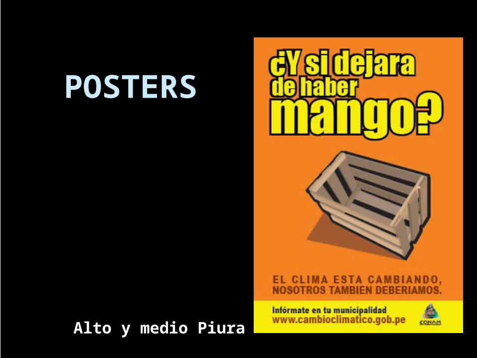
POSTERS
Alto y medio Piura

POSTERS
Litoral

POSTERS
Piura Ciudad

The process towards an Adaptation Strategy
1 NC Is Peru Vulnerable: Preliminary results
BC (2003 – 2005): Bottom up/3 areas/different approaches
Vulnerability mapSample: 3 other areas
US$ Disastres costed/can cost
HDI / GDP
Sectoral V&A (infraestructure)
MEF involved: Regional Budget allocation/Ministries Budget/ PINS
National Adaptation Strategy•Policy: Regional/Sectoral•Research and climate info•Instrument: Budget allocation/PINS/EIA/LUP•GDP / HDI monitoring

Selva Alta, Alto Mayo basin
Sierra Cordillera Blanca, glacier zone, coastal area
Sierra of Cusco, glacier zone
Highlands, Titicaca Lake basin
Approach to Priority Approach to Priority Areas for V&A Areas for V&A
assessment assessment
Integrated map of climate risks (including droughts),
agrobiodiversity and human development
index
Piura: El Niño
Mantaro Basin, Hydro and agriculture

Socioeconomic conditions - poverty
Vulnerable to climate variability: no prevention
culture
Insufficient information and management
Climate Change – still in the environmental
comunity
Law = Budget allocation
V& As: sample of regions and sectors
Tools and info to convince/ to decide qnd
prioritize
Capacity building: equipment/ human resources
Barriers and needs