marine 2018 - garmin.com · new marine products and features striker™ plus series ... navigation...
TRANSCRIPT

INLAND FISHING
MARINE
2018
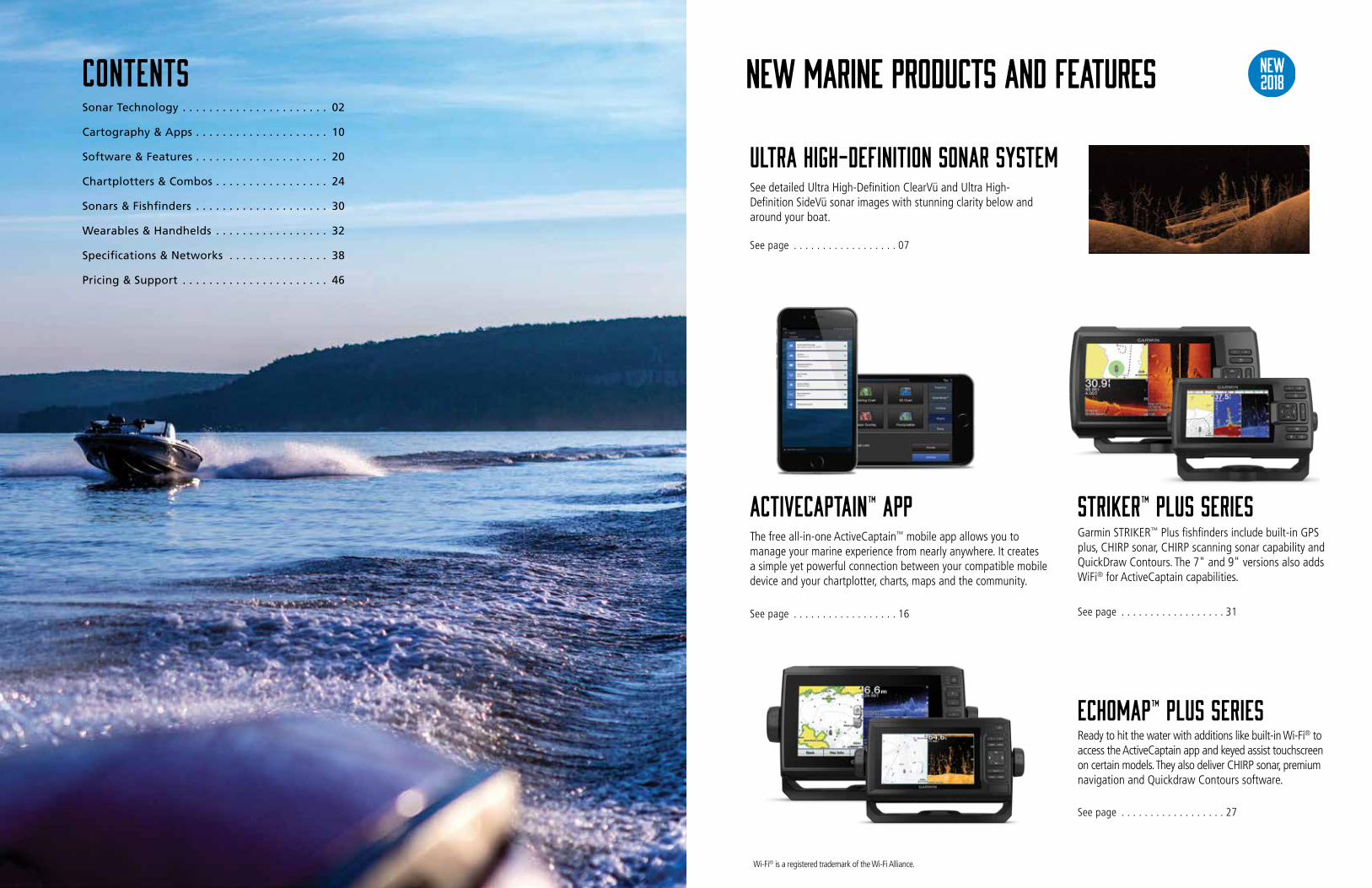
New marine products and features
STRIKER™ Plus SeriesGarmin STRIKER™ Plus fishfinders include built-in GPS plus, CHIRP sonar, CHIRP scanning sonar capability and QuickDraw Contours. The 7" and 9" versions also adds WiFi® for ActiveCaptain capabilities.
See page . . . . . . . . . . . . . . . . . . 31
ActiveCaptain™ AppThe free all-in-one ActiveCaptain™ mobile app allows you to manage your marine experience from nearly anywhere. It creates a simple yet powerful connection between your compatible mobile device and your chartplotter, charts, maps and the community.
See page . . . . . . . . . . . . . . . . . . 16
ECHOMAP™ Plus SeriesReady to hit the water with additions like built-in Wi-Fi® to access the ActiveCaptain app and keyed assist touchscreen on certain models. They also deliver CHIRP sonar, premium navigation and Quickdraw Contours software.
See page . . . . . . . . . . . . . . . . . . 27
new2018
Wi-Fi® is a registered trademark of the Wi-Fi Alliance.
ContentsSonar Technology . . . . . . . . . . . . . . . . . . . . . . 02
Cartography & Apps . . . . . . . . . . . . . . . . . . . . 10
Software & Features . . . . . . . . . . . . . . . . . . . . 20
Chartplotters & Combos . . . . . . . . . . . . . . . . . 24
Sonars & Fishfinders . . . . . . . . . . . . . . . . . . . . 30
Wearables & Handhelds . . . . . . . . . . . . . . . . . 32
Specifications & Networks . . . . . . . . . . . . . . . 38
Pricing & Support . . . . . . . . . . . . . . . . . . . . . . 46
ULTRA HIGH-DEFINITION SONAR SYSTEMSee detailed Ultra High-Definition ClearVü and Ultra High-Definition SideVü sonar images with stunning clarity below and around your boat.
See page . . . . . . . . . . . . . . . . . . 07

Sonar Technology
02

Panoptix Down With Panoptix Down you can search three ways: RealVü 3D Histo- rical setting is used for finding fish while your boat is moving. It shows the entire water column in 3D from the bottom to the surface. With RealVü 3D Down, your boat can be stationary and you still see things in 3D around your boat. LiveVü Down is used to see fish coming toward the boat or moving away from it.
Panoptix Forward With Panoptix Forward, you can search three ways: using RealVü 3D Forward, you will see 3D views of fish and structure in the water column in front of your boat. LiveVü Forward shows fish swimming, moving toward or away from your boat. For collision avoidance, FrontVü provides a look forward that shows under-water obstructions as you approach them in real time.
Panoptix™ Panoptix™
Panoptix features
RealVü 3D DownAllows your boat to be stationary yet still see things around your boat in 3D.
RealVü 3D HistoricalUsed for finding fish located throughout the entire water column, in 3D, from bottom to surface.
LiveVü DownShows fish swimming, moving toward or away from your boat – even your lure – in real time.
LiveVü ForwardHas a more live video look, showing fish swimming – even your lure, moving toward or away from your boat.
RealVü 3D ForwardSweeps forward to show you 3D views of the bottom, structure and fish in the water column in front of the boat.
The forward-facing transom mount transducer should be mounted in a location that is out of the water at speeds over 17 Kn. If located below the water line, cruising speeds over 21 Kn should be avoided.
Transducer PS21-TM PS21-TR PS22-TR PS30 PS31 PS51 PS60RealVü 3D Down ✔ ✔
RealVü 3D Historical ✔ ✔
LiveVü Down ✔ ✔ ✔
RealVü 3D Forward ✔
LiveVü Forward ✔ ✔ ✔ ✔ ✔
FrontVü Forward ✔ ✔ ✔ ✔ ✔
Garmin Marine Network Compatible ✔ ✔ ✔ ✔ ✔ ✔ ✔
Independent Power Connection ✔ ✔ ✔ ✔ ✔ ✔ ✔
Transom Mount Included ✔2 ✔ ✔2
Trolling Motor Mount Included ✔ ✔ ✔
Thru-Hull Mount and Fairing Block ✔ ✔
FrontVüProvides a look forward that shows underwater obstructions as you approach them in real time.
FrontVüPanoptix FrontVü sonar displays bottom up to 300 feet ahead of the boat (at 8 to 10 times the current depth) and delivers nearly instant feedback to give you more time to react. You can be more confident when navigating unfamiliar water because Panoptix FrontVü has a narrow beam, forward-looking sonar (20 degrees). This allows you to focus on the bottom in front of your boat and not be confused with what is off to each side. It also includes an AHRS sensor for motion stabilization that allows you to see what is in front of your boat even in rough water conditions.
Panoptix sonar – all seeing is believingPanoptix will open up a new world for serious fishermen. You can actually see fish and bait swimming around under or in front of your boat, even your lure – in real time. Panoptix is available in two versions, Panoptix Down and Panoptix Forward. See page 69 for compatible transducers.
04 GARMIN.COM
Prici
ng &
Sup
port
Spec
s &
Net
wor
ksW
eara
bles
& H
andh
elds
Fish
finde
rsCh
artp
lotte
rs &
Com
bos
Softw
are
& Fe
atur
esCa
rtogr
aphy
& A
pps
Sona
r Tec
hnol
ogy

Panoptix All-seeing sonar transducersREDEFINE SCANNING SONAR WITHULTRA HIGH-DEFINITION SONAR SYSTEM
ULTRA HIGH-DEFINITION SONAR SYSTEM
PS51-Th with FrontVüPS22-TR transducer
PS30 down
PS31 forward
PS21-TR & PS21-TM FORWARD
Multibeam thru-hull transducer with premium FrontVü forward-looking sonar. Helps you avoid running aground by displaying the bottom ahead of your boat in real time on your compatible chartplotter.
Panoptix™ PS22-TR transducer lets you see all around your boat and below it — in real time — with LiveVü Forward and LiveVü Down. Just mount it to the shaft or motor barrel of your trolling motor.
PS30 Down allows you to see baitfish and large target fish swimming around under your boat – in real time; even while stationary. You get three different views, LiveVü Down, RealVü 3D Down and RealVü 3D Historical.
PS31 Forward allows you to see the bottom, structure and fish in front of your boat – in real time; even while stationary. You get three impressive views, LiveVü-, FrontVü- and RealVü 3D Forward. Both transom and trolling motor mount is included.
The PS21 transducers allows you to see fish swimming and attacking your lure with LiveVü Forward and to see obstructions for collision avoidance with FrontVü – up to 100 feet away. The compact and light PS21 comes with a trolling motor (TR) or a transom mount (TM).
PS60 thru-hull downWith the PS60 thru-hull Down transducer, you get three remarkable views, LiveVü Down, RealVü 3D Down and RealVü 3D Historical. The unique thru-hull installation is ideal for coastal or offshore fishermen with larger boats.
PS60 Down Part no.: 010-01406-00
PS51-TH Part no.: 010-01753-00PS22-TR Part no.: 010-01945-00
PS30 Down Part no.: 010-01284-00
PS31 Forward Part no.: 010-01284-01
PS21-TR Forward Part no.: 010-01588-00PS21-TM Forward Part no.: 010-01588-01
Whichever transducer you choose, Panoptix will certainly open up a new world for you. The comparison table will help you select the model that best suits your needs. Take scanning sonar clarity and detail to the next level with our Ultra High-Definition scanning sonar system. This system includes an
easy-to-install, networkable, powerful GCV™ 20 sonar black box with GT34UHD transducer. Now you will see incredibly detailed Ultra High-Definition ClearVü and Ultra High-Definition SideVü sonar images of structure and fish below and to the sides of your boat. Sonar images displayed on your chartplotter appear with stunning clarity.
GPSMAP 1042/1242 Series
GPSMAP 1042/1242 Series
GPSMAP 1242 Touch Series
GPSMAP 1242 Touch Series
GPSMAP 742 Series
GPSMAP 742 Series
ECHOMAP Plus7sv/7cv
ECHOMAP Plus7sv/7cv
ECHOMAP Plus9sv
ECHOMAP Plus9sv
GPSMAP 942 Series
GPSMAP 942 Series
GPSMAP 7600 Series
GPSMAP 7600 Series
Panoptix Sonar capable products ULTRA HIGH-DEFINITION Sonar capable products
GPSMAP 8600 Series
GPSMAP 8600 Series
Panoptix™ Transducers
Stunning ClarityYou not only see structure, you see trees and brush down to individual branches and twigs. You can differentiate between sizes of fishand sometimes even identify species. You can even see a fish’s shadow on the bottom.
Share On Your Network And one of the greatest features of our Ultra High-Definition scanning sonar system is that you can share it seamlessly across multiple networked chartplotters, as well as networking Panoptix™ all-seeing sonar.
Standard scanning sonar Ultra High-Definition Scanning Sonar
Ultra High-Definition GT34UHD-TM (12-pin) Transom Mount Transducer Part no.: 010-12776-00
Ultra High-Definition GCV™ 20 scanning sonar black box Part no.: 010-02055-00
06 GARMIN.COM
Prici
ng &
Sup
port
Spec
s &
Net
wor
ksW
eara
bles
& H
andh
elds
Fish
finde
rsCh
artp
lotte
rs &
Com
bos
Softw
are
& Fe
atur
esCa
rtogr
aphy
& A
pps
Sona
r Tec
hnol
ogy

Scanning Sonar Technology CHIRP Sonar Technology
Scanning sonar technology that offers high-resolution, true-life imaging of the underwater structure and fish, providing a detailed view of both what is below and to the sides of your vessel. You can use this technology to search for and confirm ideal fishing spots.
Clearvü and sidevü technology offers stunning image quality with superior clarity and details
Advantages of scanning Sonar
Superior resolutionEnhanced resolution for greater target separation and stunning details.
Clearer pictureNoise suppression allows for a much clearer picture – a real feast for your eyes.
More dynamicWide dynamic range for small target detection, making sure you see more than ever.
ClearVü This high-frequency sonar gives you a clearer picture of what's under the water beneath your boat, by producing a more detailed representation of objects, structure and fish. ClearVü with CHIRP technology takes it one step further, producing an ultra-clear page with even more detail.
SideVüSideVü shows you what is happening to the sides of your boat. An excellent way of finding structures and fish. SideVü with CHIRP technology provides an even more detailed and higher resolution image of what is beneath the surface.
Standard SonarStandard sonar sends a single frequency at a time. Since the only feedback is from this one single frequency, there is little information to work with, limiting the clarity and resolution available with standard sonar.
CHIRP SonarInstead of sending just a single frequency, CHIRP sends a continuous sweep of frequencies ranging from low to high. CHIRP sonar technology then interprets frequencies individually upon their return. Since this continuous sweep of frequencies provides CHIRP with a much wider range of information, CHIRP sonar is able to create a much clearer, higher resolution image.
Why Garmin CHIRP?The key to CHIRP sonar is the interpretation of the data retrieved. The better the data interpretation, the better the screen image.
Compare un-doctored screen images provided by actual Garmin sonar owners to any other CHIRP sonar images you have seen. We think you’ll agree that when it comes to CHIRP sonar technology, Garmin is creating products that interpret CHIRP sonar data the best. Especially when paired with a Garmin CHRIP transducer.
CHIRP is the most sophisticated sonar technology available for use by the fishing and boating public. The word itself is an acronym for Compressed High-Intensity Radiated Pulse.
What is CHIRP?
08 GARMIN.COM
Prici
ng &
Sup
port
Spec
s &
Net
wor
ksW
eara
bles
& H
andh
elds
Fish
finde
rsCh
artp
lotte
rs &
Com
bos
Softw
are
& Fe
atur
esCa
rtogr
aphy
& A
pps
Sona
r Tec
hnol
ogy

Cartography & Apps
10

Auto Guidance directs you to your hot spots by creating a suggested route on screen for your boat that seeks to avoid shallow water and other charted obstructions.
MarinersEye View provides a 3D representation of the surrounding area both above and below the waterline. FishEye View shows 3D representation of lake bottom and contours as seen from below the waterline.
Surface and Side Scan Photos give you a clear visual reference of notable spots above and structure below the surface of the water.
High Resolution Satellite Imagery provides superior situational awareness.
Shallow Water Shading lets you input and shade a minimum depth to help you avoid running aground.
Displays campgrounds, highways and roads and underwater features like fish attractors and potential hazards.
Fishing Hot Spots® allows you to quickly spot submerged structures, vegetation and weed coverage, artificial habitat locations, submerged road beds and more.
Depth Range Shading displays high-resolution shading for up to 10 depth ranges so you can view your designated target depth.
Sonar Imagery shows a nearly photographic view of the bottom, as if all the water had been drained away.
1’ Contours provide a detailed and clear view of the the lake floor so you can catch more fish and navigate with confidence.
High Resolution Relief Shading adds visual depth to the 2D map making it easier to interpret contours and find fish holding structure.
Dynamic Lake Level allows you to adjust your maps to the lake’s current water levels giving you a better idea of spots that are either accessible or too shallow to explore.
LakeVü HD Ultra1
LakeVü HD Ultra1
LakeVü HD Ultra3
LakeVü HD Ultra1LakeVü HD Ultra3
LakeVü HD Ultra1
LakeVü HD Ultra2 LakeVü HD Ultra1
LakeVü HD Ultra3LakeVü HD Ultra1LakeVü HD Ultra3
LakeVü HD Ultra1
LakeVü HD1
LakeVü HD1 LakeVü HD3
LakeVü HD1
With mapping detail so precise - down to 1’ contours, it gives you valuable insight into bottom structure, helping you pinpoint exactly where to drop your
line. Find submerged riverbeds, bridges and other fish attractors as well as potential hazards. You’ll also have shoreline features like dock outlines,
campgrounds, boat ramps, marinas and much more. Coverage of over 17,000 lakes and waterways in the US and over 13,500 in Canada, you’re sure to
have what you need at your fingertips for a successful day on the water.
LakeVü HD US and LakeVü HD Canada are Garmin’s advanced freshwater map offerings, covering US and Canada, providing precise detail and features that
are reliable and easy to use.
LakeVü HD Ultra US and LakeVü HD Ultra Canada are Garmin’s premium freshwater map offerings, covering US and Canada, bringing in all the reliability
and features of LakeVü HD while adding industry leading features like AutoGuidance and Fishing Hot Spots Pro.
DETAILED MAPS THAT HELP FIND FISH
LAKEVÜ HD US AND LAKEVÜ HD CANADA
LAKEVÜ HD ULTRA US AND LAKEVÜ HD ULTRA CANADA
LAKEVÜ FEATURES
1 Included on 13,000 U.S. lakes and 4,800 Canadian lakes 2 Only available on 700 US lakes 3 Only available on LakeVü HD Ultra US
LakeVü HD Series
12 GARMIN.COM
Prici
ng &
Sup
port
Spec
s &
Net
wor
ksW
eara
bles
& H
andh
elds
Fish
finde
rsCh
artp
lotte
rs &
Com
bos
Softw
are
& Fe
atur
esCa
rtogr
aphy
& A
pps
Sona
r Tec
hnol
ogy

BlueChart® g2 Vision® HDUp to 1-foot contours provide a more accurate depiction of bottom structure for improved fishing charts and navigation in swamps, canals and marinas
Navigational aids, spot soundings, depth con-tours, tides and currents and detailed harbors and marinas
High-resolution satellite imagery of ports, marinas, bridges and navigational landmarks for superior situational awareness
Depth Range Shading for up to 10 depth ranges enables you to view your target depth at a glance
Garmin AutoGuidance technology shows a suggested route to a destination¹
Aerial Photography shows exceptional detail of many ports, harbors and marinas and is ideal when entering unfamiliar ports
Shallow Water Shading feature allows for depth shading at a userdefined level to aid in navigation
Unique 3D views like MarinerEye and FishEye provide additional perspective both above and below the water line
Detailed coastal roads up to 5 miles inland
BlueChart® g2 HD
g2 HD
g2 HD
g2 HD g2 HDg2 Vision HD
g2 Vision HD
g2 Vision HD g2 Vision HD g2 Vision HD
g2 Vision HD
g2 Vision HD g2 Vision HD
g2 Vision HD
Our exclusive marine cartography includes detailed nautical charts derived from government charts and private sources. They will
enable you to see your vessel’s precise position, on-chart, in relation to navaids, spot soundings, coastal features, anchorages, port plans, water-
ways, obstructions, restricted areas and more, in a seamless chart presentation. Coverage is available worldwide, in regional offerings, for Garmin
handhelds and chartplotters.
Know The Oceans Below YouBlueChart® Features
BlueChart g2 HD is Garmin’s advanced chart offering, providing worldwide cartography information and features that are reliable and easy to use.
BlueChart g2 Vision HD is Garmin’s premium chart offering, bringing all the reliability and features of BlueChart g2 HD while adding in industry leading
features, like AutoGuidance.
1Auto Guidance is for planning purposes only and does not replace safe navigation practices.
BlueChart® g2 HD BlueChart® g2 Vision® HD Series
Prici
ng &
Sup
port
Spec
s &
Net
wor
ksW
eara
bles
& H
andh
elds
Fish
finde
rsCh
artp
lotte
rs &
Com
bos
Softw
are
& Fe
atur
esCa
rtogr
aphy
& A
pps
Sona
r Tec
hnol
ogy

ActiveCaptain™ App
• OneChart™ lets you access all your charts and maps from your mobile device and purchase new ones
• Get smart notifications, such as calls and texts, on your chartplotter display when paired with the app
• Download software updates and notifications from the app to your Garmin devices
• Connect to fellow boaters with the ActiveCaptain™ community for up-to-date feedback on marinas and other points of interest
• Make, save and transfer routes and waypoints between the app and chartplotter — with zero button presses1
• Easily upload and download the latest Garmin Quickdraw™ Contours content from the community — with zero button presses
• View and control your chartplotter from your smartphone or tablet
Main functions
1 Zero button presses applies to GPSMAP® chartplotters only
the ultimate connected boating experiencE The free all-in-one ActiveCaptain™ app provides a powerful connection to your Garmin chartplotter, charts, maps and the com-munity for the ultimate connected boating experience. Wherever you are, you’ll have unlimited access to your cartography, the ability to purchase new maps and charts and access to the Garmin Quickdraw™ Contours Community.
Connect to the ActiveCaptain community for up-to-date feedback on marinas and other points of interest. Smart notifications on
your chartplotter screen keep you connected with everyone else. Plan a trip or pre-fish a lake, and ActiveCaptain will automatically sync with your chartplotter.
Even view and control your chartplotter from your smartphone or tablet while you’re on the water.
new2018
16 GARMIN.COM
Prici
ng &
Sup
port
Spec
s &
Net
wor
ksW
eara
bles
& H
andh
elds
Fish
finde
rsCh
artp
lotte
rs &
Com
bos
Softw
are
& Fe
atur
esCa
rtogr
aphy
& A
pps
Sona
r Tec
hnol
ogy

Patented Garmin Auto Guidance was the first automatic guidance navigation aid of its kind, and Auto Guidance is even more unique to boating. Available when you are using optional BlueChart® g2 Vision® HD, Auto Guidance creates a visible path you can follow, designed for your boat’s specification helping you avoid charted hazards and obstructions right to your destination. Auto Guidance even provides point-to-point guidance and navigational solutions, such as entering and exiting marinas – regardless of the depth of the water – with a path indicating where guidance is not conforming to user settings. The free, easy-to-use Quickdraw Contours features instantly creates personalized HD maps with 1 ft contours. No
training required; you just fish, and the maps are created. The maps are all yours – tailor them to fit your needs. Keep the data for yourself, or share it with the QuickDraw Community on Garmin Connect™.
Auto Guidance1 – an instant path to your desired destination
quickdraw contours1 – Create your own maps in High Definition on-screen in real-time
What you need
Arrival times
Enter your location, and Auto Guidance instantly searches through relevant charts to create a safe path specifically designed for the dimensions of your boat.
"Via" pointsAdjust the calculated Auto Guidance pathway by inserting “Via” points at interim stops or landmarks along your desired route.
Autopilot support
Save your paths
Engage your compatible Garmin autopilot to follow the Auto Guidance route, and it will automatically keep you on track.
Allows you to save your plotted Auto Guidance paths for future navigation, by backing them up on an SD card with your BlueChart® g2 Vision® HD.
1 Available with BlueChart g2 Vision HD (sold separately). Please note that Auto Guidance might have limited functionality for inland waters.
1 Compatible with all STRIKER Plus, ECHOMAP Plus products and GPSMAP 742/942/1042/1242/7600/8600 chartplotter/sonar combo series (some devices require a free software update).
Now you can calculate arrival times at any point of your route – great for timing your arrival to correspond with bridge openings or other time-critical events.
Avoid stranding
Mark up locations
Highlighted areas show shallow water based on your settings.
Uncover unknown areas
Expand your maps
Screen shows maps being created instantly in real-time. No detailed mapping existed in this area before.
Continue to explore and improve existing maps next time you are out on the water.
Clear overview
Share locations
Green shading shows areas where mapping has been created and white spaces indicate gaps.
User-created points stay with the map so you can share them with friends or keep them private.
Add labels for stumps and other locations.
Creates a pathAlso provides navigational solutions, such as entering and exiting marinas regardless of water depth, with a path indicating where guidance is not conforming to user settings.
Auto Guidance Quickdraw Contours
18 GARMIN.COM
Prici
ng &
Sup
port
Spec
s &
Net
wor
ksW
eara
bles
& H
andh
elds
Fish
finde
rsCh
artp
lotte
rs &
Com
bos
Softw
are
& Fe
atur
esCa
rtogr
aphy
& A
pps
Sona
r Tec
hnol
ogy

Software & Features
20

VIRB® Integration FUSION-Link™
FUSION-Link™ integrationFUSION-Link allows your compatible Garmin chartplotter or combo the ability to integrate with, and use FUSION's special entertainment functionality, creating a centralized control station for the entire vessel, and a more user-friendly experience.
Garmin Marine Network & NMEA 2000®
Garmin makes it easy to connect multiple devices and instruments in your boat. Simply combine the Garmin Marine Network with the NMEA 2000 to view multiple functions, such as chartplotter, radar, sonar, AIS, on one or more displays.
All Garmin Marine Network and NMEA 2000 devices come with an easy plug-and-play setup. The system automatically detects the devices in the network and makes them ready to use.All connectors are waterproof and the speed of the network is an impressive 100 Mbit. This means you can simultaneously view radar images, charts, soundings and other information on one or more displays in real time without any delay.
With an almost endless number of options, you can make your on-board network as advanced as you like.
Main functions
• Volume separation with FUSION’s Multi-Zone™ control available at the helm, right from your MFD
• For absolute convenience: install a FUSION Wired Remote Control in each listening zone
• Add media bar to stay informed and in control of your MFD and your entertainment experience at the same time
• Recreate your iPod/iPhone interface and get access to your favorite music with ease
• Control FUSION-Link capable marine stereos directly from your MFD
• Compatible with GPSMAP 700, 900, 1000, 1200, 7600, 8000, 8600 series and ECHOMAP Plus series
iPhone and iPad are trademarks of Apple Inc., registered in the U.S. and other countries.
Garmin Marine Network
View network examples on pages 84-87
For the first time ever, your chartplotter has the ability to control and stream video from your action camera. In return, your plotter can send G-Metrix™ data2 such as boat speed, water depth and temperature directly to your VIRB Ultra 30 or XE/X – creating unique and interesting videos.
innovative real-time integration between VIRB® action cameras and your compatible chartplotter1
G-Metrix systemSend boat data to your VIRB Ultra 30 or XE/X which can be overlaid on the video – or use the information with our free VIRB Edit Tool2.
Wireless3 video streaming
Perfect for fishing
Available marine G-Metrix™ data
The chartplotter can display up to four video streams at one time, which gives you endless possibillities. Each VIRB can also be named for easy identification.
Panoptix™ shows on the upper half, VIRB and chart on the other. You can now watch the fish eat your lure LIVE at the exact moment as you’re setting the hook.4
VIRB control bar
VIRB Mobile App
A control bar can be overlaid on the plotter display to provide quick access to settings and offer a video preview without changing screens.
Free app that turns your compatible smartphone or tablet into a wireless3 remote control for your VIRB Ultra 30, or VIRB XE/X action camera.
ActiveCaptain™ compatibleFree all-in-one app provides a powerful connection to your Garmin chartplotter, charts, maps and the community for the ultimate connected boating experience.
GPS navigation Water2 Sailing2 Engine2
Course Over Ground (COG) Boat Speed True and apparent wind angle RPM
Speed Over Ground (SOG) Water depth True and apparent wind speed
Latitude and longitude Water temperature
Heading
1 Compatible with GPSMAP 722/922/1022/1222/7400/8400 Series.2 Optional NMEA 2000 accessories are required to provide certain marine G-Metrix data.3 Each VIRB, Ultra 30 or XE/X has the capability to create its own Wi-Fi network. 4 Requires compatible transducer (sold separately).
iPhone and iPad are trademarks of Apple Inc., registered in the U.S. and other countries. App Store is a service mark of Apple Inc. Android and Google Play are trademarks of Google Inc. Wi-Fi is a registered trademark of the Wi-Fi Alliance.
22 GARMIN.COM
Prici
ng &
Sup
port
Spec
s &
Net
wor
ksW
eara
bles
& H
andh
elds
Fish
finde
rsCh
artp
lotte
rs &
Com
bos
Softw
are
& Fe
atur
esCa
rtogr
aphy
& A
pps
Sona
r Tec
hnol
ogy

Chartplotters & Combos
24

GPSMAP® 1002/1202 Series
The GPSMAP 7600 Series has beautiful widescreen multitouch fully networked displays with premium mapping designed for fishermen, cruisers, sailors or anyone else who desires high performance and ease of operation.
EXPERIENCE THE POWER OF TOTAL INTEGRATION
• Multitouch 7", 8",10", 12" and 16" widescreen displays
• Built in high-sensitivity 10Hz GPS/GLONASS receiver
• Wireless communication via Wi-Fi®, connect with ActiveCaptain mobile app
• SmartMode™ control quickly changes all screens at a helm in sync
• Radar compatible
• Autopilot integration
• J1939 support for engines and generators
• FLIR® Thermal Camera and IP Camera support
• Composite video input
• DVI-D output (7410, 7412 and 7416 only)
• VIRB® Integration compatible
• FUSION-Link™ support
• NMEA® 0183 and 2000 compatible
• BlueChart® g2 HD & g2 Vision HD compatible
• Quickdraw Contours compatible
• Installation options – bracket, flush or flat
Sonar features 7600xsv Series
• Built-in Garmin HD-ID™ sonar, true dual-channel CHIRP sonar and both ClearVü and SideVü scanning sonar with CHIRP technology
• Supports a wide range of compatible Garmin transducers, including 50/200 kHz, 77/200 kHz, CHIRP Traditional, CHIRP ClearVü and SideVü
• Supports Ultra High-Definition Scanning Sonar System
• Supports Panoptix™ All-Seeing sonar
• Supports premium GSD™ 26 sonar module
• Transmit power: 1 kW RMS (8000 W peak-to-peak); CHIRP: 1 kW RMS (8000 W peak-to-peak)
• Graphic logging of water temperature and sonar recording
• All-in-one transducer options
Main Functions
7612xsv Part No: 010-01307-137612 Part No: 010-01307-11
7616xsv Part No: 010-01402-137616 Part No: 010-01402-11
Marine RF Wireless RemotePart No: 010-10878-10
7610xsv Part No: 010-01306-137610 Part No: 010-01306-11
7608xsv Part No: 010-01305-137608 Part No: 010-01305-11
7607xsv Part No: 010-01379-137607 Part No: 010-01379-11
Wi-Fi is a registered trademark of the Wi-Fi Alliance.
GPSMAP® 7600 Series
1242xsv Part No: 010-01741-11
1042xsv Part No: 010-01740-11
Experience advanced all-in-one solutions with these keyed combos. Large, bright 10” or 12” screens coupled with quick and easy-to-use keypad interface with user-progammable keys and a multifunction control knob. Available with built-in Garmin CHIRP sonar and CHIRP ClearVü scanning sonar (transducers sold separately). Also available with both U.S. LakeVü HD maps and BlueChart® g2 HD charts.
Keyed Networking Chartplotters and Combos
• Large, bright 10” or 12” screens with keypad interface and multifunction control knob
• Built-in high-sensitivity 10Hz GPS/GLONASS receiver
• Include both U.S. LakeVü HD maps and BlueChart® g2 charts
• Include Quickdraw Contours map drawing software
• Support Garmin Marine Network; allows sharing of sonar, radar, maps, user data, NMEA 2000® and NMEA 0183 support for network connectivity, including autopilots, digital switching, weather, media, VHF, AIS and other sensors
• Built-in wireless capabilities for ActiveCaptain app and VIRB® action camera integration
• Integrated ANT® support for use with quatix® 3 and quatix 5 marine watch, Garmin Nautix™ in-view display, gWind™ Wireless 2 transducer, GNX Wind marine instrument and wireless remote controls
• Supports optional U.S. LakeVü HD Ultra maps and BlueChart® g2 Vision® HD charts with Auto Guidance, satellite imagery, 3-D perspectives and more
• Garmin single channel CHIRP sonar, CHIRP ClearVü and CHIRP SideVü scanning sonar (transducers sold separately)
• Supports Ultra High-Definition Scanning Sonar System
• Supports Panoptix™ all-seeing sonar and premium Garmin sonar modules
Main Functions
Sonar Features
26 GARMIN.COM
Prici
ng &
Sup
port
Spec
s &
Net
wor
ksW
eara
bles
& H
andh
elds
Fish
finde
rsCh
artp
lotte
rs &
Com
bos
Softw
are
& Fe
atur
esCa
rtogr
aphy
& A
pps
Sona
r Tec
hnol
ogy

ECHOMAP™ Plus Series
These 7”, 9” and 12” touchscreen chartplotters and combos prove that advanced navigation does come in a compact package. The 7” and 9” models are available with built-in Garmin CHIRP sonar and CHIRP ClearVü scanning sonar. The 12” Touch is available with 1 kW single-channel CHIRP, ClearVü/SideVü scanning sonars (transducers sold separately). Also available with both U.S. LakeVü HD maps and BlueChart® g2 charts.
Advanced Navigation in Compact Chartplotters and Combos
942xs Part No: 010-01739-03942 Part No: 010-01739-01
1242xsv Touch Part No: 010-01917-131242 Touch Part No: 010-01917-11
742xs Part No: 010-01738-03 742 Part No: 010-01738-01
GPSMAP® 902 / 702 / 1202 Touch Series
• 7”, 9” or 12” high-resolution intuitive touchscreens
• Built-in high-sensitivity 10Hz GPS/GLONASS receiver
• Include both U.S. LakeVü HD maps and BlueChart® g2 charts
• Include Quickdraw Contours map drawing software
• Supports Garmin Marine Network; allows sharing of sonar, maps, user data, radar, IP cameras and Panoptix™ sonar among multiple units
• Built-in wireless capabilities for ActiveCaptain app and VIRB® action camera integration
• NMEA 2000® and NMEA 0183 support for network connectivity, including autopilots, digital switching, weather, FUSION-Link, VHF, AIS and other sensors
• Integrated ANT® support for use with quatix® 3 and quatix 5 marine watch, Garmin Nautix™ in-view display, gWind™ Wireless 2 transducer, GNX™ Wind marine instrument and wireless remote controls
• Supports optional U.S. LakeVü HD Ultra maps and BlueChart® g2 Vision® HD charts with Auto Guidance, satellite imagery, 3-D perspectives and more
Sonar Features• 7” and 9” with Garmin 1 kW single-channel CHIRP and CHIRP ClearVü scanning
sonars (transducer sold separately)
• 12” Touch with Garmin 1 kW single-channel CHIRP, ClearVü/SideVü scanning sonars (transducer sold separately)
• Supports Ultra High-Definition Scanning Sonar System
• Supports Panoptix™ all-seeing sonar
Main Functions Main functions
73cv US LakeVu HD, w/CV22 Part no.: 010-01893-0174cv US Offshore g2, w/CV23 Part no.: 010-01894-0175cv Canada LakeVu HD w/CV22 Part no.: 010-01895-0073sv US LakeVu HD, w/o XDCR Part no.: 010-01897-0073sv US LakeVu HD, w/CV52 Part no.: 010-01897-0174sv US Offshore g2, w/o XDCR Part no.: 010-01898-0074sv US Offshore g2, w/CV51 Part no.: 010-01898-01 75sv Canada LakeVu HD w/CV52 Part no.: 010-01899-00
43cv US LakeVü HD, w/CV20 Part no.: 010-01885-0144cv US Offshore g2, w/CV20 Part no.: 010-01886-0145cv Canada LakeVu HD, w/CV20 Part no.: 010-01887-00
63cv US LakeVu HD, w/CV20 Part no.: 010-01889-0164cv US Offshore g2 w/o XDCR Part no.: 010-01890-0064cv US Offshore g2 w/CV23 Part no.: 010-01890-01
93sv US LakeVu HD, w/o XDCR Part no.: 010-01901-0093sv US LakeVu HD, w/CV52 Part no.: 010-01901-0194sv US Offshore g2, w/o XDCR Part no.: 010-01902-0094sv US Offshore g2, w/CV51 Part no.: 010-01902-0195sv Canada LakeVu HD w/CV52 Part no.: 010-01903-00
• Available in 4”, 6”, 7”, 9” display sizes• Keyed assist touchscreen (7" and 9")• Built-in 5Hz GPS receiver• Built-in Wi-Fi® to pair with the free
ActiveCaptain app (6", 7" and 9")• Quick-Release mount• User data sharing• Network sonar sharing between the
ECHOMAP Plus 7" and 9" models.• AIS and DSC Support• NMEA® 0183 and 2000. (not incl on 4")• Receive data from autopilots, engines, sensors,
VHF and much more1 microSD™ card slot• BlueChart® g2 HD, BlueChart g2 Vision HD
and LakeVu Ultra compatible• Built in Quickdraw Contours• SailAssist sailing features• Installation options – bracket or flushmounted
Sonar features• All models come with built-in HD-ID™,
Traditional and ClearVü scanning sonar with CHIRP technology
• The sv Series also adds SideVü scanning sonar with CHIRP technology
• Supports a wide range of compatible Garmin transducers, including 50/200 kHz, 77/200 kHz, CHIRP Traditional and Garmin CHIRP ClearVü™ and more
• Supports Ultra High-Definition Scanning Sonar System
• Supports Panoptix™ sonar1
• Transmit power: 500 W (RMS), 4,000 W (peak-to-peak)
• Sonar recording
• Sonar history rewind
Easy-to-use, easy-to-setup chartplotter/sonar combos with keyed-assist touchscreens1, incredibly clear CHIRP traditional sonar, CHIRP ClearVü and CHIRP SideVü scanning sonar. Offers premium navigation plus built-in Wi-Fi® to pair with the free ActiveCaptain app.
echoMAP Plus Series – unparalleled innovation
The mounts feature both tilt and swivel capabilities to provide an optimum viewing angle. Cables plug directly into the mount, allowing quick installation and removal.
Wi-Fi is a registered trademark of the Wi-Fi Alliance
Quick-Release mount example
new2018
28 GARMIN.COM
Prici
ng &
Sup
port
Spec
s &
Net
wor
ksW
eara
bles
& H
andh
elds
Fish
finde
rsCh
artp
lotte
rs &
Com
bos
Softw
are
& Fe
atur
esCa
rtogr
aphy
& A
pps
Sona
r Tec
hnol
ogy

STRIKER Plus™ Series
Main functions
Striker Plus 5cv Ice Part no.: 010-01782-20Striker Plus 5cv Part no.: 010-01782-00
Striker Plus 4 Part no.: 010-01780-00Striker Plus 4cv Part no.: 010-01781-00
STRIKER™ Plus 7sv Part no.: 010-01784-00STRIKER™ Plus 7cv Part no.: 010-01783-00
1 When paired with a compatible smartphoneWi-Fi® is a registered trademark of the Wi-Fi Alliance.
Striker Plus 9sv Part no.: 010-01785-00
• Available in 4”, 5”, 7” or 9” bright sunlight-readable displays
• Built-in Garmin CHIRP ClearVü™ (cv models) and CHIRP SideVü (sv models) scanning sonars for nearly photographic images of what passes below and beside your boat
• Built-in Garmin CHIRP traditional sonar for crystal-clear images and remarkable target separation
• Built-in Quickdraw Contours mapping software that lets you create and store up to 2 million acres of maps with 1’ contours
• Built-in Wi-Fi® (7” & 9” models) for access to ActiveCaptain™ app so you can receive smart notifications1, access Garmin Quickdraw™ Community, transfer waypoints and software update notifications
• Built-in GPS lets you mark waypoints, create routes and view boat’s speed
• Rugged design for every fishing environment
• Transom and trolling motor mounts included
STRIKER PLUS - THE FISHFINDER WITH GPS THAT LETS YOU CREATE YOUR OWN FISHING MAPSThe industry’s leading fishfinder series with built-in GPS and CHIRP traditional and CHIRP scanning sonar now adds Quickdraw Contours map drawing and built-in Wi-Fi on 7” & 9” models to access free ActiveCaptain mobile app.
The rugged STRIKER PLUS Series is designed to not only see fish and structure below the boat, but also to mark your favorite fishing spots and easily navigate back to them. With GPS on board, you also have access to accurate speed over the ground (SOG) data.
Nobody knows the waters you fish better than you and your fellow
fishermen. While you are trolling the shorelines and the depths, Quickdraw Contours mapping software creates HD fishing maps of the places you’ve been with 1’ contours.
Get nearly photographic images of what passes below and beside your boat with CHIRP ClearVü and CHIRP SideVü scanning sonars.
Use built-in Wi-Fi to pair with the ActiveCaptain app for smart notifications, access to Quickdraw Contours Community data and more.
Portable kit Part no.: 010-12462-01
new2018
Fishfinders
30 GARMIN.COM
Prici
ng &
Sup
port
Spec
s &
Net
wor
ksW
eara
bles
& H
andh
elds
Fish
finde
rsCh
artp
lotte
rs &
Com
bos
Softw
are
& Fe
atur
esCa
rtogr
aphy
& A
pps
Sona
r Tec
hnol
ogy

Wearables & Handhelds
32

1 1See Garmin.com/ataccuracy2 When paired with compatible smartphone; see Garmin.com/BLE 3 See Garmin.com/waterrating
Wi-Fi® is a registered trademark of the Wi-Fi Alliance.
¹ On-device stitching only up to 4K/30 FPS.2 Stabilization requires mobile or desktop VIRB® app before sharing.3 Augmented reality overlays require mobile or desktop VIRB® app before sharing.
4 See Garmin.com/waterrating5 Livestreaming only available on compatible Apple® devices.6 Voice control available for English (U.S., U.K.), French, Italian, German, Spanish, Swedish, Japanese and Mandarin.
VIRB® Action Cameras
• Provides comprehensive connectivity with compatible Garmin chartplotters and other devices to offer autopilot control, remote waypoint marking and data streaming, which includes speed, depth, temperature and wind
• Sail racing assistance includes virtual starting line, distance to start line, race countdown timer and tack assist
• Built-in FUSION-Link™ Lite app controls connected StereoActive™ stereo products as well as other ANT®-enabled stereo models (RA70/BB100)
• Connected features2 include smart notifications, automatic uploads to Garmin Connect™ online fitness community and personalization through free watch faces and apps from our Connect IQ™ store
• Includes Elevate™ wrist-based heart rate1 and built-in GPS; features QuickFit™ band system, stainless steel bezel, buttons and rear case
• Water-rated to 10 ATM (100 meters)3
• Preloaded activity profiles for all your sports and adventures, including paddle boarding, kayaking and canoeing
• Get key stats at your fingertips with the performance widget that shows your training status, training load and more
• Battery performance: up to 2 weeks in smartwatch mode (depending on settings), up to 24 hours in GPS mode and up to 60 hours in UltraTrac™ battery saver mode
quatix 5 Sapphire
• Includes both silicone and stainless steel QuickFit™ bands
• Wi-Fi®-enabled for automatic activity uploads directly to Garmin Connect™ when connected to wireless networks
• Scratch resistant sapphire lens
Main functions
quatix 5 – has you covered on land and waterSpecifically designed for the water, the quatix® 5 multisport GPS smartwatch offers comprehensive connectivity with compatible Garmin chartplotters and other devices to provide autopilot control, remote waypoint marking, sail racing assistance, data streaming — including speed, depth, temperature and wind — and much more.
Compact and stylish with the QuickFit™ band system, it also sports advanced fitness features and wrist-based heart rate monitoring.
With built-in activity profiles and performance metrics for paddle boarding, kayaking and canoeing, quatix 5 has you covered for whatever sport you want to track. Satellite navigation and tracking functions combine with a 3-axis compass, gyroscope and barome-tric altimeter to guide you with confidence, on and off the water. Also includes connected features2 such as smart notifications, automatic uploads to Garmin Connect™ online fitness community and personalization through free watch faces and apps from our Connect IQ™ store.
If it’s worth remembering, it’s worth a VIRB® 360. With one touch or a voice command, this rugged, waterproof4 camera captures 360-degree video in up to 5.7K resolution with 360-degree audio, and it includes built-in sensors for augmented reality G-Metrix™ data overlays. Advanced image stabilization2 ensures a smooth video regardless of camera movement. Videos and photos are automatically stitched1 in camera, enabling fast sharing as well as instant livestreaming5 with the free, easy-to-use VIRB® Mobile app.
Get spectacular footage with the ultra HD action camera for your active lifestyle. Compact, lightweight, waterproof4 and easy to use, VIRB Ultra 30 captures 4K/30fps video and features G-Metrix™ technology, which adds to the experience by letting you overlay gauges and graphs with action data. Built-in image stabilization2 makes for crisp, steady footage. The touchscreen display and high-sensitivity microphone are fully functional through the waterproof case. With one touch, you can even live-stream5 in HD on YouTube® to share your footage with the world.
quatix® 5
VIRB action cameras capture your adventures with proof of how far, how fast and how high you went. These waterproof1 and rugged compact cameras fit every activity and all conditions with no additional case needed.
Can Your Action Camera Do This?
vIRB 360 vIRB Ultra 30
Main functions
Main functions
Virb 360
• Resolution up to 5.7K or 5K unstitched and 4K with in-camera stitching1
• Up to 15-megapixel resolution providing high-quality, 360-degree images
• 4 built-in microphones capture 360-degree audio
• Advanced image stabilization2 ensures a smooth video regardless of camera movement
• Built-in sensors provide G-Metrix™ data overlays in 360-degree augmented reality3
• Rugged camera is waterproof to 10 meters4, small and lightweight
• Livestream to YouTube® or Facebook® Live with compatible smartphone or tablet
• Start and stop recording with simple 1-touch buttons
• Easy-to-use, free VIRB® Mobile app and desktop software let you edit, stabilize, share and add data overlays to videos
• Use the free VIRB® Mobile app to preview your shot live, and control your camera from a compatible smartphone or tablet
• Use voice control6 to start and stop recording, take photos and more
• Record videos in modes such as slow motion, time lapse, manual and more
• Sunlight-readable display shows battery, storage, mode and connectivity status
Virb Ultra
• VIRB Ultra 30 enables hands free shooting by using voice commands to start/stop recording, take a photo or tag footage
• 3-axis image stabilization captures steady footage up to 1080p/60fps
• Ultra HD 4K/30fps footage with 1.75-inch touchscreen display that lets you see what is being recorded
• Shoot hands-free using voice control¹ to start/stop recording, take photos or remember moments
• Built-in sensors and GPS capture G-Metrix™ data to prove how far, how high and how fast you went
• High-sensitivity microphone captures clear audio in and out of the waterproof case
Main functions
VIRB MOBILE APPVIRB EDIT
quatix 5 Part no.: 010-01688-40
quatix 5 Sapphire Part no.: 010-01688-42
34 GARMIN.COM
Prici
ng &
Sup
port
Spec
s &
Net
wor
ksW
eara
bles
& H
andh
elds
Fish
finde
rsCh
artp
lotte
rs &
Com
bos
Softw
are
& Fe
atur
esCa
rtogr
aphy
& A
pps
Sona
r Tec
hnol
ogy

Top choice handhelds for all mariners
2-WAY SATELLITE COMMUNICATORS
Boaters and watersport enthusiasts everywhere swear by the GPSMAP 78 handhelds. They feature a bright 2.6" LCD color display with built-in worldwide basemap and a special MOB (man overboard) button. What's more, these waterproof devices are designed to float. SailAssist for GPS 73 include virtual starting line, heading line, countdown timers and tack assist.
inReach SE®+ is the satellite communicator that uses 100% global Iridium satellite coverage for 2-way messaging anywhere in the world. In case of emergency, the interactive SOS allows you to communicate back and forth and receive confirmation that help is on the way. Navigate with detailed, preloaded. inReach Explorer®+ has TOPO maps1, follow routes, mark waypoints and finds your way back.
Main functions
Main functions
• 2.6" LCD color display (78/78s), 2,6" 4 level gray LCD (73)
• Highly sensitive GPS receiver for optimum reception and performance
• Slot for microSD™ card and USB interface
• Sunrise/sunset, estimated time of arrival, other calculations and marine data
• MOB (man overboard) button: shows distance and bearing to the position where the button was pressed
• Satellite communicator and GPS navigator with 100% global Iridium satellite coverage
• View preloaded DeLorme TOPO maps1 overlaid with GPS waypoints and routes, right on the full-color display
• Built-in, high-sensitivity GPS provides robust navigation with TOPO, location and tracking data within 5 meters and better accuracy than a paired/companion mobile device; follow routes, drop waypoints and find your way back with a high-detail bread crumb trail
• Can be enhanced with BlueChart® g2 HD charts
• NMEA 0183 support
• Wireless data transfers
• SailAssist™ for GPS 73 include virtual starting line, heading line, countdown timers and tack assist
• Marine alarms (including off course, anchor drag and more)
• Send and receive text messages while beyond cell phone range
• Use the MapShare site to track and share your location online with family and friends, so they can ping your device and send you messages
• Pair with mobile devices2 using the free Earthmate® app for access to TOPO maps and U.S. NOAA charts, color aerial imagery and more. Additional data for hunters, such as game
GPSMAP® 78s, 78 & GPS 73
inReach SE®+ & inReach Explorer®+
78 Part no.: 010-00864-00
inReach SE®+ Part no.: 010-01735-00inReach Explorer®+ Part no.: 010-01735-11
78s Part no.: 010-00864-01
GPS 73 Part no.: 010-01504-00
GPSMAP® 276Cx
versatile GPS for both land and seaVersatile GPSMAP® 276Cx all-terrain navigator with advanced GPS and GLONASS reception tracks your position in challenging environments. It has a large, sunlight-readable 5" screen plus built-in barometric altimeter and 3-axis compass. It is preloaded with a worldwide basemap and free 1-year BirdsEye Satellite Imagery subscription. Advanced mapping, connectivity and flexible mounting options are available; water-rated to IPX7.
Main functions
• Internal antenna with GPS and GLONASS satellite reception
• Supports optional external antenna (sold separately)
• Worldwide basemap with free 1-year BirdsEye Satellite Imagery subscription
• Supports Garmin TOPO maps and HuntView, BlueChart® g2 HD marine charts, turn by turn directions on City Navigator®, Custom Maps, raster maps and vector maps
• Supports Active Weather forecasts and animated weather tracking1
• Pairs with your compatible mobile device2 for automatic uploads, smart notifications and more; also compatible with Wi-Fi® and ANT+® technology for integration of external sensors
• Powered by AA battery or optional rechargeable battery pack
GPSMAP 276Cx Part no.: 010-01607-00
1 Weather tracking not available in all areas. 2 See Garmin.com/ble.Wi-Fi® is a registered trademark of the Wi-Fi Alliance.
1 Preloaded DeLorme TOPO maps are not compatible with other Garmin devices. Other Garmin maps not compatible with this device.2See Garmin.com/inreachfaq for compatibility.
36 GARMIN.COM
Prici
ng &
Sup
port
Spec
s &
Net
wor
ksW
eara
bles
& H
andh
elds
Fish
finde
rsCh
artp
lotte
rs &
Com
bos
Softw
are
& Fe
atur
esCa
rtogr
aphy
& A
pps
Sona
r Tec
hnol
ogy

Specifications & Networks
38

Chartplotters & Combos Chartplotters & Combos
1 Included in all xsv-models, the non xsv-models needs to be connected to another compatible sonar device to gain these features.
Chartplotters & Combos
GPSMAP 7616xsv/7616 GPSMAP 7612xsv/7612 GPSMAP 7610xsv/7610 GPSMAP 7608xsv/7608 GPSMAP 7607xsv/7607
Display size (diagonal) 16" 12" 10" 8" 7"
Display type and resolution (pixels) WXGA - 1280 x 800 WXGA - 1280 x 800 WXGA - 1280 x 800 WSVGA - 1024 x 600 WVGA - 800 x 480
Touch- or keyed panel Multitouch widescreen Multitouch widescreen Multitouch widescreen Multitouch widescreen Multitouch widescreen
GPS receiver 10 Hz GPS/GLONASS, internal 10 Hz GPS/GLONASS, internal 10 Hz GPS/GLONASS, internal 10 Hz GPS/GLONASS, internal 10 Hz GPS/GLONASS, internal
Standard GPS antenna Internal (input for external) Internal (input for external) Internal (input for external) Internal (input for external) Internal (input for external)
Number of waypoints 5000 5000 5000 5000 5000
Number of routes 100 100 100 100 100
J1939 Support Yes Yes Yes Yes Yes
NMEA 2000 compatible Yes Yes Yes Yes Yes
NMEA 0183 compatible Yes Yes Yes Yes Yes
Garmin Marine Network compatible Yes Yes Yes Yes Yes
Preloaded map BlueChart® g2 & LakeVü HD BlueChart® g2 & LakeVü HD BlueChart® g2 & LakeVü HD BlueChart® g2 & LakeVü HD BlueChart® g2 & LakeVü HD
Auto Guidance 3.0 (req. g2 Vision HD) Yes Yes Yes Yes Yes
ActiveCaptain™ support Yes Yes Yes Yes Yes
Sailing Features Yes Yes Yes Yes Yes
Compatible with gWind™ Transducers Yes Yes Yes Yes Yes
Wi-Fi® and ANT™ wireless connectivity Yes, built-in Yes, built-in Yes, built-in No No
GRID™ (Garmin Remote Input Device) compatible Yes Yes Yes Yes Yes
Wireless remote compatible Yes Yes Yes Yes Yes
FLIR® camera support Yes Yes Yes Yes Yes
FUSION-Link™ support Yes Yes Yes Yes Yes
Video input 2 composite 2 composite 2 composite 1 composite 1 composite
Video output 1 DVI-D 1 DVI-D 1 DVI-D N/A N/A
AIS and DSC support Yes Yes Yes Yes Yes
Sonar module support Yes Yes Yes Yes Yes
Supported frequency (sonar)150/77/200 kHz, CHIRP (low, medium, high),
CHIRP ClearVü, CHIRP SideVü
50/77/200 kHz, CHIRP (low, medium, high),
CHIRP ClearVü, CHIRP SideVü
50/77/200 kHz, CHIRP (low, medium, high),
CHIRP ClearVü, CHIRP SideVü
50/77/200 kHz, CHIRP (low, medium, high),
CHIRP ClearVü, CHIRP SideVü
50/77/200 kHz, CHIRP (low, medium, high),
CHIRP ClearVü, CHIRP SideVü
Transmit power1 kW traditional, 1 kW CHIRP
(xsv-model)1 kW traditional, 1 kW CHIRP
(xsv-model)1 kW traditional, 1 kW CHIRP
(xsv-model)Up to 1 kW (xsv-model) Up to 1 kW (xsv-model)
Ultra High-Definition Scanning Sonar System Compatible
Yes Yes Yes Yes Yes
Panoptix™ support Yes Yes Yes Yes Yes
Preloaded Quickdraw Contours software Yes Yes Yes Yes Yes
Data card slots 2 SD™ cards 2 SD™ cards 2 SD™ cards 2 SD™ cards 2 microSD™ cards
Water rating IPX 7 IPX 7 IPX 7 IPX 7 IPX 7
Mounting options Bail, Flush or Flat Bail, Flush or Flat Bail, Flush or Flat Bail, Flush or Flat Bail, Flush or Flat
Power supply 10-32 V 10-32 V 10-32 V 10-32 V 10-32 V
Typical current draw at 12 Vdc: 3.8 A 2.5 A 1.95 A 1.8 A 1.5 A
Connections
Built-in wireless connectivity, NMEA 2000: 2 ports,
NMEA 0183: 2 in and 2 out, Marine Network: 2 ports
Video in: 2 composite, Video out: 1 DVI-D, J1939: 1 port
Built-in wireless connectivity, NMEA 2000: 1 port,
NMEA 0183: 2 in and 2 out, Marine Network: 2 ports
Video in: 2 composite, Video out: 1 DVI-D, J1939: 1 port
Built-in wireless connectivity, NMEA 2000: 1 port,
NMEA 0183: 2 in and 2 out, Marine Network: 2 portsVideo in: 2 composite,
J1939: 1 port
NMEA 2000: 1 port, NMEA 0183: 2 in and 2 out,
Marine Network: 2 ports,Video in: 1 composite,
J1939: 1 port
NMEA 2000: 1 port, NMEA 0183: 2 in and 2 out,
Marine Network: 2 ports,Video in: 1 composite,
J1939: 1 port
Combos
GPSMAP 1242xsv/1242 & GPSMAP 1042xsv/1042
GPSMAP 1242xsv Touch/1242 Touch &
GPSMAP 942xs/942 &GPSMAP 742xs/742
ECHOMAP Plus 94sv/93sv
ECHOMAP Plus 74sv/73sv and
74cv/73cv
ECHOMAP Plus 64cv/63cv and
44cv/43cv
Display size (diagonal)12" (1242xsv/1242)10" (1042xsv/1042)
12" (1242xsv Touch/1242 Touch)9" (942xs/942) 7" (742xs/742)
9" 7"6,2" (64cv/63cv)4,3" (44cv/43cv)
Display type and resolution (pixels)
WXGA - 1280 x 800 (1242xsv/1242)
WSVGA - 1024 x 600 (1042xsv/1042)
WSVGA - 1280 x 800 (1242xsv Touch/1242 Touch)
WSVGA - 1024 x 600 (942xs/942)
WVGA - 800 x 480 (742xs/742)
WVGA - 800 x 480 WVGA - 800 x 480WVGA - 800 x 480 (64cv/63cv)QVGA - 272 x 480 (44cv/43cv)
Touch- or keyed panel Keyed Multitouch Keyed Assist Multotouch Keyed Assist Multotouch Keyed
GPS receiver 10 Hz GPS/GLONASS, internal 10 Hz GPS/GLONASS, internal 5 Hz GPS/GLONASS, internal 5 Hz GPS/GLONASS, internal 5 Hz GPS/GLONASS, internal
Standard GPS antenna Internal (input for external) Internal (input for external) Internal (input for external) Internal (input for external) Internal (input for external)
Number of waypoints 5000 5000 3000 3000 3000
Number of routes 100 100 100 100 100
NMEA 2000 compatible Yes Yes Yes Yes Yes (64cv/63cv)
NMEA 0183 compatible Yes Yes Yes Yes Yes
Garmin Marine Network compatible Yes Yes No No No
Preloaded map BlueChart® g2 & LakeVü HD BlueChart® g2 & LakeVü HDBlueChart® g2 (94sv)
LakeVü HD (93sv)BlueChart® g2 (74sv, 74cv)
LakeVü HD (73sv, 73cv)BlueChart® g2 (64cv, 44cv)
LakeVü HD (63cv, 43cv)
BlueChart® g2 HD compatible Yes Yes Yes Yes Yes
BlueChart® g2 Vision® HD compatible Yes Yes Yes Yes Yes
Auto Guidance (req. g2 Vision HD) Yes Yes Yes Yes Yes
ActiveCaptain™ support Yes Yes No No No
SailAssist Yes Yes Yes Yes Yes (64cv/63cv only)
Wi-Fi® and ANT™ wireless connectivity Yes Yes Yes (WiFi only) Yes (WiFi only)Yes (WiFi only 64cv/63cv)
No (44cv/43cv)
GRID™ (Garmin Remote Input Device) compatible Yes Yes No No No
Wireless remote compatible Yes Yes No No No
FLIR® camera support Yes Yes No No No
FUSION-Link™ support Yes Yes Yes YesYes (64cv)
No (44cv/43cv/63cv)
Video input 1 BNC1 BNC
Video Output: 1 HDMI (1242 Touch / 1242xsv Touch)
No No No
AIS and DSC support Yes Yes Yes Yes Yes
Traditional HD ID 77/200 Yes (xsv) Yes (xs and xsv) Yes Yes Yes
Traditional HD ID 50/200 Yes (xsv) Yes (xs and xsv) Yes Yes Yes
Traditional CHIRP Yes (xsv) Yes (xs and xsv) Yes Yes Yes
CHIRP ClearVü Yes (xsv) Yes (xs and xsv) Yes Yes Yes
CHIRP SIdeVü Yes (xsv) No Yes Yes (72sv) No
Dual Channel CHIRP No No No No No
Optional sonar support Yes Yes No No No
Internal Sonar Sharing Yes (xsv) Yes (xs and xsv)Yes, with other 7" and 9"
ECHOMAP Plus models onlyYes, with other 7" and 9"
ECHOMAP Plus models onlyNo
Transmit power 1 kW traditional, 1 kW CHIRP (xsv) 1 kW traditional, 1 kW CHIRP (xs) Up to 500 W (RMS) Up to 500 W (RMS) Up to 500 W (RMS)
Ultra High-Definition Scanning Sonar System Compatible
Yes Yes Yes Yes No
Panoptix™ support Yes Yes Yes Yes No
Preloaded Quickdraw Contours software Yes Yes Yes Yes Yes
Data card slots 2 SD™ cards 2 MicroSD™ cards 1 MicroSD™ card 1 MicroSD™ card 1 MicroSD™ card
Water rating IPX 7 IPX 7 IPX 7 IPX 7 IPX 7
Mounting options Bail or Flush Bail, Flush or Flat Bail or Flush Bail or Flush Bail or Flush
Power supply 10-32 V 10-32 V 10-20 V 10-20 V 10-20 V
Typical current draw at 12 Vdc: 2.5 A1.9 A
2.5 A (1242 Touch / 1242xsv Touch)
1.95 A 1.8 A 1.5 A
Connections
Built-in wireless connectivity, NMEA 2000: 1 port, NMEA 0183: 1 port,
Marine Network: 2 ports,Video in:1 BNC
Built-in wireless connectivity, NMEA 2000: 1 port, NMEA 0183: 1 port,
Marine Network: 1 port,Video in:1 BNC
J1939 (1242 Touch / 1242xsv Touch)
NMEA 2000: 1 port, NMEA 0183: 1 in and 1 outMarine Network: 1 port (for
Panoptix)
NMEA 2000: 1 port, NMEA 0183: 1 in and 1 outMarine Network: 1 port (for
Panoptix)
NMEA 2000: 1 port (64cv/63cv), NMEA 0183: 1 in and 1 out
40 GARMIN.COM
Prici
ng &
Sup
port
Spec
s &
Net
wor
ksW
eara
bles
& H
andh
elds
Fish
finde
rsCh
artp
lotte
rs &
Com
bos
Softw
are
& Fe
atur
esCa
rtogr
aphy
& A
pps
Sona
r Tec
hnol
ogy

GPSMAP 1242 Touch Series
13"329.7
OVERALL WIDTH
8 1516 "
227.3OVERALL HEIGHT
3 116 "
77.2OVERALL DEPTH12 .98"
8 .93"
Chartplotters & Combos
GPSMAP 7616
425.6
274.6
86.9
16 .75"
10 .8"
425.6
274.6
86.9
3 .4" 13"
329.7OVERALL WIDTH
8 1516 "
227.3OVERALL HEIGHT
3 116 "
77.2OVERALL DEPTH3 .6"
GPSMAP 761213"
329.7OVERALL WIDTH
8 1516 "
227.3OVERALL HEIGHT
3 116 "
77.2OVERALL DEPTH12 .98"
8 .93"
75,8mm
GPSMAP 7610
11 38 "
288.9OVERALL WIDTH
8 116 "
204.3OVERALL HEIGHT
9
3"75.8
OVERALL DEPTH
11 .37"
8"
11 38 "
288.9OVERALL WIDTH
8 116 "
204.3OVERALL HEIGHT
9
3"75.8
OVERALL DEPTH2 .98"
9 58 "
244.2OVERALL WIDTH
6 14 "
158.2OVERALL
HEIGHT
3"76.3
OVERALL DEPTH
GPSMAP 7608
9 58 "
244.2OVERALL WIDTH
6 14 "
158.2OVERALL
HEIGHT
3"76.3
OVERALL DEPTH
9 .6"
6 .23"
3"
ECHOMAP Plus 44cv/43cv
102.3
95.0
53.9
203.9 168.4
26.4
52.9
79.3
3 .14"
8 .03"
2 .16"
4 .03"
3 .79"
ECHOMAP PLUS 74sv/73sv & 74cv/73cv
8 3
4 "222.3
5 9
16 "141
3 7
16 "86.9
6 1
8 "155.1
2 1
2 "63.3
2"50
4 1
2 "114.7
5 3
4 "145.9
9 7
16 "239.4
CLEARANCE TO NEAREST OBSTRUCTION
echoMap Plus 7"010-01892-XXGARMIN Int'l1200 E. 151st STREETOLATHE, KS 66062U.S.A.
2 .49"
1 .97"
8 3
4 "222.3
5 9
16 "141
3 7
16 "86.9
6 1
8 "155.1
2 1
2 "63.3
2"50
4 1
2 "114.7
5 3
4 "145.9
9 7
16 "239.4
CLEARANCE TO NEAREST OBSTRUCTION
echoMap Plus 7"010-01892-XXGARMIN Int'l1200 E. 151st STREETOLATHE, KS 66062U.S.A.
5 .55"
3 .42"
6 .11"
8 .75"
GPSMAP 7607
8 .8"
5 .6"
2 .6"
ECHOMAP Plus 94sv/93sv
10 3
8 "263.3
7 13
16 "199.0
4 7
16 "112.7
6 1
2 "164.8
4 1
2 "114.7
2 1
16 "52.4
2 9
16 "65.1
6 11
16 "169.8
11 1
16 "280.5
echoMap Plus 9"010-01900-xxGARMIN Int'l1200 E. 151st STREETOLATHE, KS 66062U.S.A.
CLEARANCE TO NEAREST OBSTRUCTION
10 3
8 "263.3
7 13
16 "199.0
4 7
16 "112.7
6 1
2 "164.8
4 1
2 "114.7
2 1
16 "52.4
2 9
16 "65.1
6 11
16 "169.8
11 1
16 "280.5
echoMap Plus 9"010-01900-xxGARMIN Int'l1200 E. 151st STREETOLATHE, KS 66062U.S.A.
CLEARANCE TO NEAREST OBSTRUCTION
6 .49"
4 .44"
7 .84"
10 .37"
2 .56"
2 .14"
ECHOMAP Plus 64cv/63cv
5 7
16 "137.4
3 1
16 "77.3
10 316 "
259.2
6 5
16 "160.8
5 15
16 "150.8
8 5
8 "218.5
5 1
8 "130.0
2 916 "
65.2
1 1316 "
45.3
3 18 "
80.0
8"
203.9
4 1
4 "108.5
5 7
8 "150.0
4 11
16 "118.5
SUN COVER OUTLINE
CUT OUT TEMPLATE
UNIT OUTLINE
ECHOMAP PLUS 6XGARMIN Int'l1200 E. 151st STREETOLATHE, KS 66062U.S.A.
5 7
16 "137.4
3 1
16 "77.3
10 316 "
259.2
6 5
16 "160.8
5 15
16 "150.8
8 5
8 "218.5
5 1
8 "130.0
2 916 "
65.2
1 1316 "
45.3
3 18 "
80.0
8"
203.9
4 1
4 "108.5
5 7
8 "150.0
4 11
16 "118.5
SUN COVER OUTLINE
CUT OUT TEMPLATE
UNIT OUTLINE
ECHOMAP PLUS 6XGARMIN Int'l1200 E. 151st STREETOLATHE, KS 66062U.S.A.
10 .21"
8 .60"
5 .12"
5 .94"
6 .33"
5 .41"
2 .57"1 .78"
3 .04"
GPSMAP 1242 Series
14 .1"
8 .9"
2 .6"
GPSMAP 1042 Series
185 mm7 .3"
12 .5"
2 .6"
GPSMAP 742 Series
8 .3"
2 .1"
5 .6"6 .1"
3 .4"
GPSMAP 942 Series
10 .1"
6 .4"
2 .6"
7 .8"
4 .5"
13"329.7
OVERALL WIDTH
8 1516 "
227.3OVERALL HEIGHT
3 116 "
77.2OVERALL DEPTH3 .6"
42 GARMIN.COM
Prici
ng &
Sup
port
Spec
s &
Net
wor
ksW
eara
bles
& H
andh
elds
Fish
finde
rsCh
artp
lotte
rs &
Com
bos
Softw
are
& Fe
atur
esCa
rtogr
aphy
& A
pps
Sona
r Tec
hnol
ogy

5.0”
7.4” 2.1”
2.6”
4.5”
0.94”
7 9
16 "191.6
3 3
8 "85
11 3
8 "288.2
2 7
16 "61.9
GARMIN CONFIDENTIAL010-01875-XXGARMIN Int'l1200 E. 151st STREETOLATHE, KS 66062U.S.A.
7 .40"3 .10"
2 .60"
5" 4 .5"
5.5”
9.3” 2.3”
7.0”
1.1”
9 .30"
7" 5 .5"
2 .30"
1 .10"
0 .94"
quatix 5 GPSMAP 276Cx GPS 73 GPSMAP 78s/78 InReach SE+ & InReach Explorer+
Receiver Highly sensitive Highly sensitive Highly sensitive Highly sensitive Highly sensitive
Number of waypoints 1,000 10,000 1,000 2,000 500
Internal map memory 64 MB 8.0 GB No 1.7 GB No
Number of routes 30 250 50 200 20
Basemap, preprogrammed map No Worldwide basemap No Worldwide basemap Worldwide basemap
Additional map options NoBlueChart g2, City Navigator,
topo, topo 24kNo
BlueChart g2, City Navigator, Pro-, Pro v2- and Prime outdoor maps
No
Battery lifeup to 50 hours (UltraTrac mode),
up to 20 hours (GPS training mode),up to 6 weeks (watch mode)
up to 16 hours (lithium-ion); up to 8 hours (AA batteries)
18+ hours on 2 AA batteries
(not included)20 hours (2 AA)
3 years in standby mode, 30 days at the 30 minute interval power save mode,
100 hours at 10 minute tracking mode, 75 hours with 10 minute tracking and 1
second routing
Display size 1.2” (30.4 mm) diameter 5" diagonal 2.6" diagonal 2.6" diagonal1.4"W x 1.9"H (3.5 x 4.7 cm);
2.31" diag (5.9 cm)
Display type Transflective MIP color TFT (Transflective) TFT (Transflective) TFT (Transflective) TFT (transflective)
Area calculation Yes Yes Yes Yes No
Display resolution pixels (HxW) 240 x 240 800 x 480 160 x 128 240 x 160 200 x 265 pixels
Standard GPS antenna EXO™ antenna Internal Internal Integral quad helix Integral quad helix
Bluetooth® Yes Bluetooth / WiFi No No Yes
TracBack function Yes Yes Yes Yes Yes
Number of track points 10,000 20,000 10,000 10,000 10,000
WeightSilicone band: 85 gMetal band: 156 g
450 g (litium), 415 g (AA) 232,4 g 218 g 7.5 oz (213.0 g)
Alarm Yes Yes Yes Yes No
Waterproof according to standard 10 ATM IPX7 IPX7 IPX7 IPX7–submersible
Physical size in mm (HxWxD) 47 x 47 x 15,5 19,5 x 94,5 x 44,0 157 x 69 x 30 152 x 66 x 30 2.7" x 6.5" x 1.5" (6.8 x 16.4 x 3.8 cm) with keypad and SOS door bump
Separate Serial & USB interfaces No Yes Yes Yes Yes
Storage of cartography No microSD memory card No microSD memory card No
Backlit display Yes Yes Yes Yes Yes
Input for external antenna No Yes No Yes No
WAAS/EGNOS compatible Yes Yes Yes Yes No
Integral electronic compass Yes Yes No Yes (78s) Yes
Integral barometric altimeter Yes Yes No Yes (78s) Yes, Explorer+ only
Automatic route calculation No Yes, with City Navigator No Yes, with City Navigator No
Calendar for hunting/fishing times No Yes Yes Yes No
Solar & lunar calendar Yes Yes Yes Yes No
Area waypoints Yes Yes Yes Yes Yes
Tidal information Yes Yes No Yes No
Power supply (external) No 8-36 V 8-36 V 8-36 V 8-36 V
Waypoint icons No Yes Yes Yes Yes
NMEA compatible No Yes (NMEA 0183) Yes Yes (NMEA 0183) No
Camera No No No No No
Picture viewer No No No Yes No
Floats No Yes Yes Yes No
Handhelds &WearablesFishfinders
STRIKER Plus 9sv STRIKER Plus 7sv STRIKER Plus 7cv STRIKER Plus 5cv STRIKER Plus 4cv STRIKER 4
Display size (diagonal) 9.0" 7.0" 7.0" 5.0" 4.3" 3.5"
Display resolution 800 x 480 WVGA 800 x 480 WVGA 800 x 480 WVGA 800 x 480 WVGA 480 x 320 HVGA 480 x 320 HVGA
Internal high-sensitivity GPS Yes Yes Yes Yes Yes Yes
Built in Quickdraw Yes Yes Yes Yes Yes No
Built in WiFi Yes Yes Yes No No No
CHIRP traditional sonar Yes Yes Yes Yes Yes Yes
Dual frequency (50/200 kHz) Yes Yes Yes Yes Yes Yes
Dual beam (77/200 kHz) Yes Yes Yes Yes Yes Yes
CHIRP ClearVü Yes Yes Yes Yes Yes N/A
CHIRP SideVü Yes Yes N/A N/A N/A N/A
Included transducerCV52HW-TM
(High Wide CHIRP/ ClearVü/SideVü)
CV52HW-TM (High Wide CHIRP/
ClearVü/SideVü)
CV20-TM(CHIRP/ClearVu)
CV20-TM(CHIRP/ClearVu)
CV20-TM(CHIRP/ClearVu)
Dual Beam(77/200 kHz)
Transmit power250 W Trad
350 W ClearVu/SideVu250 W Trad
350 W ClearVu/SideVu500W Trad
500W ClearVu500W Trad
500W ClearVu300W Trad
300W ClearVu200 W (RMS)
1,600 W (peak-to-peak)
Frequencies supported (kHz)
High-Wide CHIRP (150-240 kHz)ClearVu/SideVu (455/800 kHz)
High-Wide CHIRP (150-240 kHz)
ClearVu/SideVu (455/800 kHz)
CHIRP (77/200 kHz)ClearVu (455/800 kHz)
CHIRP (77/200 kHz)ClearVu (455/800 kHz)
CHIRP 77/200 kHzClearVu (455/800 kHz)
Traditional: 50/77/200CHIRP (Low, Mid, High)
Maximum depth capabilities with included transducer1
800 ft (traditional)250 ft (ClearVü)
500 ft Left/Right (SideVü)
800 ft (traditional)250 ft (ClearVü)
500 ft Left/Right (SideVü)
2,300 ft (traditional)250 ft (ClearVü)
2,300 ft (traditional)250 ft (ClearVü)
1,750 ft (traditional)250 ft (ClearVü)
1,600 ft (traditional)
Waypoints 5,000 5,000 5,000 5,000 5,000 5,000
Audible alarms Yes Yes Yes Yes Yes Yes
User Data Sharing Cable compatible Yes Yes Yes Yes Yes Yes
Water temperature log/graph Yes Yes Yes Yes Yes Yes
GPS speed Yes Yes Yes Yes Yes Yes
Flasher Yes Yes Yes Yes Yes Yes
Fishfinders & Sonar Handhelds & Wearables
3.5”
3.6”
5.9”
1.6”
2.5”
3.5”
3.6”
5.9”
1.6”
2.5”
3 .5" 5 .9"
3 .60" 1 .60"
2 .5"
STRIKER 4STRIKER Plus 5cv
1 Maximum depth capacity is dependent on water salinity, bottom type and other water conditions.
STRIKER Plus 7sv/7cvSTRIKER Plus 9sv/9cv
7 9
16 "191.6
3 3
8 "85
11 3
8 "288.2
2 7
16 "61.9
GARMIN CONFIDENTIAL010-01875-XXGARMIN Int'l1200 E. 151st STREETOLATHE, KS 66062U.S.A.
11 .35"
9" 6 .48" 7 .54"
3 .35"
3 9
16 "91.0
3 1
8 "79.9
5 11
16 "145.0
3"
76.5
Striker Plus 4011-04398-00GARMIN Int'l1200 E. 151st STREETOLATHE, KS 66062U.S.A.
3 9
16 "91.0
3 1
8 "79.9
5 11
16 "145.0
3"
76.5
Striker Plus 4011-04398-00GARMIN Int'l1200 E. 151st STREETOLATHE, KS 66062U.S.A.
6 .9"
3 .9"1 .74"
STRIKER Plus 4cv
44 GARMIN.COM
Prici
ng &
Sup
port
Spec
s &
Net
wor
ksW
eara
bles
& H
andh
elds
Fish
finde
rsCh
artp
lotte
rs &
Com
bos
Softw
are
& Fe
atur
esCa
rtogr
aphy
& A
pps
Sona
r Tec
hnol
ogy

PricingPRODUCT PART NUMBER LIST PRICEGPSMAP COMBO’S & STANDALONES
GPSMAP 742, U.S. LakeVü HD and U.S. BlueChart g2 010-01738-01 $899.99
GPSMAP 742xs, U.S. LakeVü HD and U.S. BlueChart g2 010-01738-03 $999.99
GPSMAP 942, U.S. LakeVü HD and U.S. BlueChart g2 010-01739-01 $1,199.99
GPSMAP 942xs, U.S. LakeVü HD and U.S. BlueChart g2 010-01739-03 $1,299.99
GPSMAP 1242 Touch, U.S. LakeVü HD and U.S. BlueChart g2 010-01917-11 $2,599.99
GPSMAP 1242xsv Touch, U.S. LakeVü HD and U.S. BlueChart g2 010-01917-13 $2,799.99
GPSMAP 1042xsv with transducer, U.S. LakeVü HD and U.S. BlueChart g2 010-01740-11 $2,099.99
GPSMAP 1242xsv with transducer, U.S. LakeVü HD and U.S. BlueChart g2 010-01741-11 $2,799.99
GPSMAP 7607 J1939, US LakeVü HD & US BlueChart g2 010-01379-11 $1,099.99
GPSMAP 7607xsv J1939, US LakeVü HD & US BlueChart g2 010-01379-13 $1,299.99
GPSMAP 7608 J1939, US LakeVü HD & US BlueChart g2 010-01305-11 $1,799.99
GPSMAP 7608xsv J1939, US LakeVü HD & US BlueChart g2 010-01305-13 $1,999.99
GPSMAP 7610 J1939, US LakeVü HD & US BlueChart g2 010-01306-11 $2,299.99
GPSMAP 7610xsv J1939, US LakeVü HD & US BlueChart g2 010-01306-13 $2,499.99
GPSMAP 7612 J1939, US LakeVü HD & US BlueChart g2 010-01307-11 $3,199.99
GPSMAP 7612xsv J1939, US LakeVü HD & US BlueChart g2 010-01307-13 $3,699.99
GPSMAP 7616 J1939, US LakeVü HD & US BlueChart g2 010-01402-11 $5,199.99
GPSMAP 7616xsv J1939, US LakeVü HD & US BlueChart g2 010-01402-13 $5,699.99
ECHOMAP PLUS COMBO’S
ECHOMAP Plus 43cv, US LakeVü HD & CHIRP Traditional and CHIRP ClearVü transducer 010-01885-01 $299.99
ECHOMAP Plus 44cv, US BlueChart g2 & CHIRP Traditional and CHIRP ClearVü transducer 010-01886-01 $349.99
ECHOMAP Plus 63cv, US LakeVü HD & CHIRP Traditional and CHIRP ClearVü transducer 010-01889-01 $449.99
ECHOMAP Plus 64cv, US BlueChart g2 & CHIRP Traditional and CHIRP ClearVü transducer 010-01890-01 $549.99
ECHOMAP Plus 64cv, US BlueChart - w/o transducer 010-01890-00 $449.99
ECHOMAP Plus 73cv, US LakeVü HD & CHIRP Traditional and CHIRP ClearVü transducer 010-01893-01 $599.99
ECHOMAP Plus 74cv, US BlueChart g2 & CHIRP Traditional and CHIRP ClearVü transducer 010-01894-01 $699.99
ECHOMAP Plus 73sv, US LakeVü HD & CHIRP traditional, CHIRP ClearVü and CHIRP SideVü transducer 010-01897-01 $749.99
ECHOMAP Plus 74sv, US BlueChart g2 & CHIRP traditional, CHIRP ClearVü and CHIRP SideVü transducer 010-01898-01 $899.99
ECHOMAP Plus 74sv, US BlueChart g2 - w/o transducer 010-01898-00 $749.99
ECHOMAP Plus 93sv, US LakeVü HD & CHIRP traditional, CHIRP ClearVü and CHIRP SideVü transducer 010-01901-01 $999.99
ECHOMAP Plus 94sv, US BlueChart g2 & CHIRP traditional, CHIRP ClearVü and CHIRP SideVü transducer 010-01902-01 $1,099.99
ECHOMAP Plus 94sv, US BlueChart g2 - w/o transducer 010-01902-00 $849.99
STRIKER
STRIKER 4 010-01550-00 $119.99
STRIKER PLUS
STRIKER Plus 4, US with dual-beam transducer 010-01780-00 $139.99
STRIKER Plus 4cv, US with CHIRP Traditional and CHIRP ClearVü transducer 010-01781-00 $179.99
STRIKER Plus 5cv, US with CHIRP Traditional and CHIRP ClearVü transducer 010-01782-00 $299.99
STRIKER Plus 7cv, US with CHIRP Traditional and CHIRP ClearVü transducer 010-01783-00 $399.99
STRIKER Plus 7sv, US with CHIRP Traditional, CHIRP ClearVü and CHIRP SideVü transducer 010-01784-00 $499.99
STRIKER Plus 9sv, US with CHIRP Traditional, CHIRP ClearVü and CHIRP SideVü transducer 010-01785-00 $699.99
STRIKER Plus 5cv Ice Bundle, US with CHIRP Traditional and CHIRP ClearVü transducer 010-01782-20 $399.99
PANOPTIX
PS31 Forward 010-01284-01 $1499.99
PS30 Down 010-01284-00 $1499.99
PS21-TR Forward 010-01588-00 $799.99
PS21-TM Forward 010-01588-01 $799.99
PS22-TR 010-01945-00 $999.99
ULTRA-HIGH DEFINITION SCANNING SONAR
Ultra-High Definition Scanning Sonar System 010-02055-00 $599.99
HANDHELDS
GPSMAP 276CX 010-01607-00 $899.99
GPSMAP 78S 010-00864-01 $299.99
GPSMAP 78 010-00864-00 $199.99
GPSMAP 73 010-01504-00 $169.99
inReach SE+ 010-01735-00 $399.99
inReach Explorer 010-01735-10 $449.99
QUATIX
quatix 5, marine watch 010-01688-40 $549.99
quatix 5 sapphire, marine watch 010-01688-41 $799.99
OTHER
VIRB Ultra 30 010-01529-03 $399.99
VIRB 360 010-01743-00 $799.99
SteadyCast Heading Sensor 010-11417-10 $149.99
9-axis Heading Sensor 010-11417-20 $649.99
Pricing & Support
46 GARMIN.COM
Prici
ng &
Sup
port
Spec
s &
Net
wor
ksW
eara
bles
& H
andh
elds
Fish
finde
rsCh
artp
lotte
rs &
Com
bos
Softw
are
& Fe
atur
esCa
rtogr
aphy
& A
pps
Sona
r Tec
hnol
ogy

U.S. 913-397-8200 • U.S. Toll-free: 800-800-1020 • Canada: 866-429-9296
support.garmin.com
Mon–Thurs: 8am –6pm (CST) • Fri: 8am – 5pm (CST) • Closed Holidays
SUPPORT / serviceTo make using and understanding your Garmin electronics as easy as possible, we offer several online resources
where you can watch informative videos that show our newest products in action. You can find videos that
clearly explain and demonstrate everything from installation and set up to step-by-step “How To Use” guidance
that will help you get the most enjoyment and best performance from your Garmin electronics.
Of course, if you don’t find the answers or help you need from our video resources we also provide a quick link
to an extensive list of Frequently Asked Questions on a variety of topics that have been brought up by other
Garmin Owners.
If you still haven’t received the answer or explanation you need, then you can always contact one of our
knowledgeable representatives by email or phone.
Time to Use Your Garmin Marine Electronics
More Service
Questions?
U.S. 913-397-8200 • U.S. Toll-free: 800-800-1020
support.garmin.com
Garmin International, Inc. - 1200 East 151st Street, Olathe, KS 66062
facebook.com/Garmin twitter.com (@garmin) youtube.com/garmin
Prici
ng &
Sup
port
Spec
s &
Net
wor
ksW
eara
bles
& H
andh
elds
Fish
finde
rsCh
artp
lotte
rs &
Com
bos
Softw
are
& Fe
atur
esCa
rtogr
aphy
& A
pps
Sona
r Tec
hnol
ogy

GARMIN.COM
©2018 Garmin Ltd. or its subsidiaries. All rights reserved.Please note that Garmin Ltd. or its subsidiaries reserves the right to modify the information in this catalogue as it sees fit without prior notice.
M01-00422-00 0318