marine activities and delineation zones: in the context of ... · marine activities and delineation...
TRANSCRIPT

Marine activities and Delineation Zones: In the context of Marine Geospatial Data Infrastructure (MGDI) decision, (6890) Isa Hamid-Mosaku, Mohd Razali Mahmud and Mohd Safie Mohd (Malaysia) FIG Congress 2014 Engaging the Challenges – Enhancing the Relevance Kuala Lumpur, Malaysia 16-21 June 2014
1/17 Marine
Marine activities and Delineation Zones: In the context of Malaysia Marine Geospatial Data Infrastructure (MGDI) decision
Isa Adekunle HAMID-MOSAKU, Mohd Razali MAHMUD and Mohd Safie MOHD,
Malaysia
Key words: MGDI decision, Marine activities, Multiple alternative solutions, Dynamic analytic network process (D_ANP), marine cadastre. SUMMARY Malaysia waters within her maritime areas are endowed with a number of natural and anthropogenic resources that span from the shorelines to the boundaries of her maritime zones with other neighbouring countries. It is a marine environment that is characteristised with complex and multi-dimensional marine activities, particularly in the context of marine geospatial data infrastructure (MGDI). Decision making in such complex environment requires multiple alternative solutions for a number of diversified evaluation criteria that are suited for effective, efficient, and informed decisions for these activities. The objective of this paper are to highlight the efficacy of the ‘MGDI decision’ concept in assessing marine activities that are general to marine environment and peculiar to Malaysia waters as well as within which of the maritime delineation zones (MDZs) these activities predominate. The activities are reviewed, categorised into two (traditional and non-traditional) and ranked by marine experts according to their importance. Further evaluations of these characterisations of marine environment based on MGDI initiative were assessed by importance weights criteria through implementation of dynamic network process (DNP) model wherein five of the MDZs were used as the alternatives. Results revealed the relative level of significance or weight of 180 variables that optimally showed Malaysia Territorial water to be the most viable MDZ for the marine activities.

Marine activities and Delineation Zones: In the context of Marine Geospatial Data Infrastructure (MGDI) decision, (6890) Isa Hamid-Mosaku, Mohd Razali Mahmud and Mohd Safie Mohd (Malaysia) FIG Congress 2014 Engaging the Challenges – Enhancing the Relevance Kuala Lumpur, Malaysia 16-21 June 2014
2/17 Marine
Marine activities and Delineation Zones: In the context of Malaysia Marine Geospatial Data Infrastructure (MGDI) decision
Adekunle Isa HAMID-MOSAKU, Mohd Razali MAHMUD and Mohd Safie MOHD,
Malaysia
1. INTRODUCTION Human environment, according to Ndukwe (1997) is made up of four categories, which are: aquatic environment (oceans, sea bodies, lakes and rivers and their inhabitants), urban environment (human activities and construction), vegetal environment and atmospheric environment (air or gas layer, close to the earth). Consequently, the aquatic environment constitutes the marine environment; which Naeve and Garcia (1995:23) argued that: ‘… the marine environment - including the oceans and all seas and adjacent coastal areas-forms an integrated whole that is an essential component of the global life-support system and a positive asset that presents opportunities for sustainable development’. This argument is in line with sustainability drive from the United Nations declarations (Hamid-Mosaku and Mahmud, 2010; Hamid-Mosaku et al., 2011; UNCED, 1992; United Nations, 2001; UNSD, 2009). Furthermore, it is an environment that is characterized with both abundant natural and anthropogenic activities; and ample living and non-living marine resources. In addition, there are numbers of different stakeholders and policy makers with conflicting worldviews, constituting the players and drivers that shape the administration, management and governance decisions of the marine environment. The simultaneous interplay of all these factors result in complex nature of marine environment. Consequently, decisions about these marine activities are frequently taken at one point or the other, thus, making the search for alternative solutions with evaluation criteria inevitable. In terms of distance demarcation, there are different aspects of this environment, having different requirements and drivers. The United Nations Convention on the Law of the Sea (UNCLOS, 2012) is an international instrument for governance, management and usage of the seas in relation to different maritime delineation zones (MDZs). The MDZs are majorly seven: Baseline, Internal Waters (3nm) or as appropriate for any coastal state, Territorial Sea (12nm), Contiguous Zones (24nm), Archipelagic Water, Exclusive Economic Zones (200nm), Continental Shelf and High Seas Zones (>=350nm) from the shoreline with reference to Mean Lowest Low Water (MLLW) mark, and in nautical miles (nm). The list of abbreviations used is shown in Appendix A. The MDZs are usually accompanied with acquisition and accessibilities to voluminous information from multiple marine sources and organisations. The collection and maintenance of these large volumes of marine data, availability, cost for hardware and software, marine experts and implementation issues are some of the challenges being faced. As a result, these challenges according to Philpott (2007), are within the concept and initiative of Marine Geospatial Data Infrastructure (MGDI). The MGDI is a subset of Spatial Data Infrastructure
Marine activities and Delineation Zones: In the context of Marine Geospatial Data Infrastructure (MGDI) decision, (6890) Isa Hamid-Mosaku, Mohd Razali Mahmud and Mohd Safie Mohd (Malaysia) FIG Congress 2014 Engaging the Challenges – Enhancing the Relevance Kuala Lumpur, Malaysia 16-21 June 2014
3/17 Marine
(SDI) (Mahmud, 2010; Pepper, 2009; Philpott, 2007; Rajabifard et al., 2005). In Canada, according to GeoConnection (2009), MGDI is part of the Canadian Geospatial Data Infrastructure (CGDI) and the goal of the MGDI is to satisfy the geographic data needs of water-oriented stakeholders. The distribution of the marine activities and peculiarities of factors in each of the MDZs are different, as such, they are geospatial entities, with abundant geospatial data, information and derived products forming geospatial solutions to emerging challenges that are being engaged continuously within the MDZs. The importance of these factors can be assessed by the weights attached to them through a number of analytic methods of multi-criteria evaluation: such as analytic hierarchy process (AHP) when these factors are arranged in hierarchy and / or analytic network process (ANP) when arranged in network, in each case with multiple alternative scenarios. An extension of the ANP when time element is used is termed as dynamic network process (Blair et al., 2010; Blair et al., 2002; Saaty, 2007; Saaty and Vargas, 2006) or dynamic analytic network process (D_ANP) (Sabri, 2012; Sabri and Yakuup, 2008a, 2008b). In this study, the MDZs are considered as alternatives for the dynamic analytic network process (D_ANP) model and used as follow: ALT1_Internal Waters (3nm) or as appropriate for any coastal state; ALT2_Territorial Sea (12nm); ALT3_Contiguous Zones (24nm), ALT4_Exclusive Economic Zones (200nm); ALT5_Continental Shelf and High Seas (>=350nm). Marine resources in Malaysian waters vary according to the geospatial locations of their exploitations, ranging from the inshore resources (within 30nm) to the deep-sea resources (outside 30nm). For instance, according to DOFM (2011) this classification is in line with those adopted for Malaysia fisheries resources. Therefore, the objectives of this paper are identifying and ranking marine activities; assessment of factors for MGDI development and MGDI decisions according to their importance criteria weights; and finally determination of the most viable MDZ(s) for these marine activities. The remaining part of this paper is organized as follows: review of related studies is presented in section 2 comprising MGDI, MGDI hierarchies, and MGDI decision. Multiple alternative solutions and MGDI decision are presented in section 3. The methodology adopted is covered in section 4 by subjecting the factors to multi-criteria evaluation model using D-ANP to MDZs; while results and discussion are covered in section 5 and conclusions is presented in section 6. 2. MARINE GEOSPATIAL DATA INFRASTRUCTURE (MGDI) International Hydrographic Organization (IHO) desisgnates issues relating to MGDI to Marine Spatial Data Infrastructure Working Group (MSDIWG) which is a subsidiary of Hydrographic Services and Standards Committee (HSSC) (MSDIWG TOR, 2009, p.1). Some of these issues are participations and contributions of hydrographic community and

Marine activities and Delineation Zones: In the context of Marine Geospatial Data Infrastructure (MGDI) decision, (6890) Isa Hamid-Mosaku, Mohd Razali Mahmud and Mohd Safie Mohd (Malaysia) FIG Congress 2014 Engaging the Challenges – Enhancing the Relevance Kuala Lumpur, Malaysia 16-21 June 2014
4/17 Marine
hydrographic offices (HO) to National Spatial Data Infrastructures (NSDI). At the national level, the role of spatial information in decision making has led to the development of a national SDI, to effectively manage and share spatial data, as far back as in 1990’s (Crompvoets et al., 2004). Other terminology of MGDI in literature are: Marine Spatial Data Infrastructure (MSDI), Marine Cadastre (MC); it is a subset of the SDI of any coastal country (Hamid-Mosaku et al., 2011; Mahmud, 2010; MSDIWG, 2009; Pepper, 2009; Philpott, 2007; Rajabifard et al., 2005; Russell, 2008). It is made up of both marine geographic and business information (Mahmud, 2010; MSDIWG, 2009; Pepper, 2009; Russell, 2008). Case study examples abound in literature (Mahmud, 2010; MSDIWG, 2009; Pepper, 2009; Russell, 2008; Vaez, 2007a, 2007b; Vaez, 2010). One of the operational definition of MGDI in MSDIWG (2009); and Russell (2008) that is used in this study is:
‘Marine Spatial Data Infrastructure (MSDI) is the component of NSDI that encompasses marine geographic and business information in its widest sense. This would typically include seabed topography, geology, marine infrastructure (e.g. wrecks, offshore installations, pipelines and cables etc); administrative and legal boundaries, areas of conservation and marine habitats and oceanography’.
Consequently, Longhorn and Celliers (2007) highlighted the complexities in marine environment in terms of the following: (i) the overlapping of offshore, near-shore, shoreline and inshore physical geography, hydrography and bathymetry, as well as jurisdictional and organizational overlaps; (ii) wide variety of local, national and regional agencies that are responsible for the different physical areas and uses of the coastal zone, e.g. fisheries, environment, agriculture, transport (inland and marine), urban planning, national mapping and the hydrographic service; (iii) high economic value of coastal and marine activities, and (iv) social value of coastal zones for quality of life, since managing the coastal zone is a key component of the socio-economic framework in most nations with coastlines. In addition, the SDI development hierarchy model (Rajabifard et al., 2000; Rajabifard et al., 2003) is adaptable for MGDI hierarchy model, as shown in Fig. 1. This new model of MGDI hierarchy represent complex MGDI relationship involving various inter- and intra- connected complexities, vertically and horizontally with different marine agencies and stakeholders having different worldviews within the marine environment, as well as within and between one another at different marine delineation zones (MDZs) for effective marine spatial planning (MSP) at either corporate, local, state/provincial, national and regional (multi-national), or global MSP of marine activities for better management and accessibilities to marine geospatial datasets and information, in order to enhance the multiple and alternative solutions for MGDI decision. The decision making capabilities for MGDI decisions are therefore tailored through these zones. Examples of initiatives at global level are United Nations – Global Oceans Observing System (GOOS), International Oceanographic Data and Information Exchange (IODE) projects. Also inclusive is the Oceans 21 – GIS for Coastal Management and Coastal Education (Celliers et

Marine activities and Delineation Zones: In the context of Marine Geospatial Data Infrastructure (MGDI) decision, (6890) Isa Hamid-Mosaku, Mohd Razali Mahmud and Mohd Safie Mohd (Malaysia) FIG Congress 2014 Engaging the Challenges – Enhancing the Relevance Kuala Lumpur, Malaysia 16-21 June 2014
5/17 Marine
al., 2006; Green et al., 2004; IOC-IGU, 2004; Strain, 2006). At the regional levels are Europe’s INSPIRE (INfrastructure for SPatial InfoRmation in Europe) project (Latre et al., 2013; Longhorn, 2006) and MOTIIVE (Marine Overlays on Topography for Annex II Valuation and Exploitation) project. Canada: (Ng'ang'a et al., 2004; Pepper, 2009); Germany (MDI-DE) (Rüh et al., 2012); Coastal SDI initiative for USA, and EMODNet (European Marine Observation and Data Network) projects; Ocean Data and Information Network for Africa (ODINAFRICA), Transboundary Networks of Marine Protected Areas (TRANSMAP) for East Africa, and Western Indian Ocean Fisheries Database (WIOFISH). Furthermore, examples of national MGDI initiatives are Australian Spatial Data Infrastructure (ASDI), Brittany Region in France has the GeoBretagne SDI and geoportal for Coasts and Oceans (Gourmelon et al., 2012) and Marine Irish Data Atlas (MIDA).
There are dearth of researches directly centred on MGDI in supporting decision making for various maritime stakeholders’ decision makers, thus warranting ’MGDI decision’ (Hamid-Mosaku, 2014). For instance, some previous researches at state / provincial levels in Malaysia are: examination of seaport growth in Peninsular Malaysia (Soon and Lam, 2013); assessment of Malaysian maritime cluster strength in relation to maritime policy development (Othman et al., 2011). Similarly, other investigations such as marine cadastre (Abdullah et al., 2009); integrated coastal management (Abadi, 2007); and ocean policies analysis for the actualization of Vision 2020 of Malaysia (Saharuddin, 2001).
Fig. 1. Complex Inter-relationship of MGDI Hierarchy, Data detail, and MSP (adapted from Rajabifard, Feeney and Williamson, 2003, p33)
Global MSP Regional MSP State/provincial MSP National MSP Local MSP Corporate MSP
Global MGDI Regional MGDI State/provincial MGDI National MGDI Local MGDI Corporate MGDI
MGDI Information and Services to support strategic decision-‐making (detailed)
MGDI Information and Services to support strategic decision-‐making (less detailed)

Marine activities and Delineation Zones: In the context of Marine Geospatial Data Infrastructure (MGDI) decision, (6890) Isa Hamid-Mosaku, Mohd Razali Mahmud and Mohd Safie Mohd (Malaysia) FIG Congress 2014 Engaging the Challenges – Enhancing the Relevance Kuala Lumpur, Malaysia 16-21 June 2014
6/17 Marine
3. MULTIPLE ALTERNATIVE SOLUTIONS AND MGDI DECISION Over the years, there have been sustained calls for MGDI initiative and developments to support decision making. This domain has not received adequate research attention in the past. The drive towards access to geospatial data in most SDI and MGDI campaigns will be inappropriate without subjecting them to decision making paradigms outside the usual traditional GIS and statistical considerations. For instance, Feeney (2003) argued that one of the key motivations of SDI and / or MGDI, is access to geospatial data that should support decision-making. Feeney (2003), reiterated the dearth of geospatial decision support (GDS) publications, SDI decision making capability, and the modus-operandi for evaluations of SDI decision support capacity and attendant improvements. In addition, Scott (2010), argued that, ‘geospatial data users need more than acquired and available data; they need more accountability and evidence-based decisions and probity. Based on these perceived gaps in knowledge, multiple participants and the complex nature of the marine environment necessitate the need for multiple alternative solutions (MASs) and evaluation criteria for MGDI and MGDI decisions having capability for geospatial analysis and modeling. Furthermore, the solutions offer assessment of the criteria that are suited for the consideration of the design and implementation of MGDI. Consequently, in Hamid-Mosaku (2014); Hamid-Mosaku, Mahmud and Mohd (2012), MGDI decision (likened to Purchasing decision (Bayazit et al., 2006) was introduced as ‘a new concept in cognisance with MGDI initiative and development based on the understanding that there exists a multi-conceptual nature of stakeholders, characterised with different worldviews, and in the realms of decision making in relation to marine environmental needs, hydrographical services, marine surveys services, and various applications that are being explored’. The concept of MGDI decision therefore involves evaluation of importance weight criteria for MGDI design and implementation for effective, efficient, and informed decision about the different aspects of marine activities within the MDZs. The quests for MASs necessitate the search of algorithms that can handle the multiplicities of participants and complexities of the marine environment for MGDI considerations. These are achievable through the multi-criteria evaluation (MCE) procedures. Thus, MASs model link the multiplicities of stakeholders with different worldviews with the complexities of marine environment on MDZs, so that the resulting MGDI decision can be properly optimized through the use of multi criteria decision-making (MCDM) model of MCE. As such, through MAS, adequate comparisons of potential criteria, sub-criteria and parameters are ensured under wide range of sustainable marine activities. These exist within different ocean policies, governance, management and environmental conditions. At the same time, the factors are used to evaluate marine activities are tailored through the concept of MGDI concerning various criteria, sub-criteria and parameters for effective, and informed MGDI decisions. 4. METHODOLOGY The methodology adopted involves a designed survey for data collection using D_ANP model. A brief discussion of the study area is also provided.

Marine activities and Delineation Zones: In the context of Marine Geospatial Data Infrastructure (MGDI) decision, (6890) Isa Hamid-Mosaku, Mohd Razali Mahmud and Mohd Safie Mohd (Malaysia) FIG Congress 2014 Engaging the Challenges – Enhancing the Relevance Kuala Lumpur, Malaysia 16-21 June 2014
7/17 Marine
4.1 STUDY AREA Malaysia waters represent the study area for this research, separated from the peninsular and states of Sabah and Sarawak by South China Sea; surrounded by a number of other states likes Thailand to the north, Singapore to the south, Sabah and Sarawak share border with Indonesia while Sarawak also shares border with Brunei (see Figure 2). Being a ratified signatory member to United Nation Convention on the Law of the Sea, the country controls a continental shelf of 373,500km2, Exclusive Economic Zone (EEZ) of 475,600km2 and territorial water (MTW) of 148,307 km². The total maritime extent and total coastline are respectively 623,907 km², and 4490 km² as compared with that of land area at 332,800 km² (Table 1), having a number of sea lanes based resources that run through the peninsular.
Table 1 : Malaysia maritime areas (Saharuddin, 2001) Total land area 332,800 km² Maritime areas
EEZ 475,600 km² MTW 148,307 km² Total 623,907 km² Length of coastline
Peninsular Malaysia 1737 km Sabah/Sarawak 2753 km Total 4490 km
Fig. 2. Malaysia and some of her neighbouring countries

Marine activities and Delineation Zones: In the context of Marine Geospatial Data Infrastructure (MGDI) decision, (6890) Isa Hamid-Mosaku, Mohd Razali Mahmud and Mohd Safie Mohd (Malaysia) FIG Congress 2014 Engaging the Challenges – Enhancing the Relevance Kuala Lumpur, Malaysia 16-21 June 2014
8/17 Marine
4.2 INSTRUMENTATION AND DATA COLLECTION Thus far, the marine activities in the context of MGDI and the maritime zones are presented in the previous sections; these activities were reviewed and classified into two: traditional (T) and non-traditional / new-marine based (NT), based on the initial categorization in Saharuddin (2001) wherein traditional represent the common marine activities, while the non-traditional and new marine-based activities are related activities that are peculiar to recently emerging marine activities. These activities are further ranked according to their importance by experts through questionnaire survey, and as they are suited with number of variables for MGDI and MGDI decisions within the MDZs. The average values from the respondents for this survey are shown in Table 2. Furthermore, the various factors that these marine activities are generally subjected to within the concept of MGDI were sourced through extensive literature review and interactions with marine experts and stakeholders.
Table 2 : Ranking of Malaysian Marine Activities (Hamid-Mosaku, 2014)
The first part of the outcomes of these extensive literature review exercise resulted in the identification of an initial ten (10) main decision variables that were later re-arranged and structured to a seven (7) point decision variables (Economic, Social, Environmental, Resources and Management, Data and Information, Technology, and People) through three rounds of Delphi evaluations by marine experts till consensus was reached for the main
S/N Traditional Marine-Based Rank
S/N Non-Traditional and New Marine-Based Rank
Ranked value
Final selection
Ranked value
Final selection
T1. Non-renewable resources
10.33 a NT1. Integrated coastal zone management
10.00 a
T2.
Naval Administration, Sovereignty and Defence
9.33 b
NT2.
Disaster management and emergency response
9.67 b
T3. Telecommunication 7.67 c NT3. Marine engineering works and services.
8.33 c
T4. Marine Fishing 7.00 d NT4. Fresh water resource management
6.00 d
T5. Sea Transport Services
6.00 e NT5. Renewable resources 5.67 e
T6. Cable Laying 6.00 e NT6. Ocean Research and Development
5.33 f
T7. Marine Biotechnology
5.67 f NT7. Manufacture of Seafood
5.00 g
T8. Aquaculture 4.00 g NT8. Marine Education 5.00 g
T9. Industrial Discharge of Waste
4.00 g NT9. Sports and Recreation 3.67 h
T10 Conservation 3.67 h NT10 Marine Eco-tourism 3.67 h T11 Marine Heritage 2.33 i NT11 Habitat management 3.67 h

Marine activities and Delineation Zones: In the context of Marine Geospatial Data Infrastructure (MGDI) decision, (6890) Isa Hamid-Mosaku, Mohd Razali Mahmud and Mohd Safie Mohd (Malaysia) FIG Congress 2014 Engaging the Challenges – Enhancing the Relevance Kuala Lumpur, Malaysia 16-21 June 2014
9/17 Marine
criteria for MGDI and MGDI decision. Furthermore, the second part of these outcomes produced another output of: 28 sub-criteria and 145 performance indicators that were later collated and structured. Table 3 shows the case for the criteria and the sub-criteria A survey was later designed and adjudged by the experts for data collection for the purpose of determining the degree of importance of the weights of these criteria, sub-criteria, and performance indicators, using the DNP / D_ANP model of MCE, due to interdependences of the whole 180 variables, part of which are shown in Table 3. Table 3 : Seven main criteria for MGDI and MGDI decision (Hamid-Mosaku, 2014)
The motivation for the DNP / D_ANP is based on the pioneered researches in Blair et al. (2010); (2002) and others (Sabri, 2012; Sabri and Yakuup, 2008a) wherein time element was used to denote the dynamic aspect of ANP. In this study, distances in nautical miles (nm) were used. These questionnaires were later distributed to experts and their feedbacks processed and analyzed.
4.3 THE DNP / D_ANP MODEL
The network for the DNP / D_ANP model, shown in Figure 3 was implemented due to interdependencies among the identified 180 (7+28+145) variables, using SuperDecisions software for AHP and ANP compuattions and analysis of complex decisions, named after on of the featured matrices called supermatrix. The first layer of this figure shows the seven main criteria that influence MGDI initiaive.
s/n Main Criteria Sub-criteria i. Economic Marine Economic Activities, Marine Environmental Total Cost, Marine
Economic Qualities and Benefits, Economics Externalities, Financial Capacity
ii. Social Marine Social Quality Measures, Marine Social Benefits (Socio-Technical), Marine Social Externalities
iii. Environmental Marine Geographical Features , Marine Envt.al Quality & Changes, Marine Policies, Marine Environmental Benefits, Marine Environmental Externalitis
iv. Resources and Management
Human Resources, Natural / Mineral Resources, Marine Management Benefits
v. Data and Information
MGDI Components, Marine Digital Fundamental Datasets, Technical Issues and Custodianship
vi. Technology Technological Innovations & Supports, Marine Technological Quality & Changes, Capacity Building, Research & Development, Marine Technological Benefits
vii. People Marine Stakeholders / Policies makers / DM, Marine Peoples’ Quality & Benefits

Marine activities and Delineation Zones: In the context of Marine Geospatial Data Infrastructure (MGDI) decision, (6890) Isa Hamid-Mosaku, Mohd Razali Mahmud and Mohd Safie Mohd (Malaysia) FIG Congress 2014 Engaging the Challenges – Enhancing the Relevance Kuala Lumpur, Malaysia 16-21 June 2014
10/17
This is followed by the factors that each of these criteria depend on, thus representing the sub-criteria level. The next layers also depict the performance indicators that each of the sub-criteeria depended on, and finally, the last layer represents the MDZs that are used as the
Fig. 3 Part of the D-ANP Structure (Hamid-Mosaku, 2014)
Marine activities and Delineation Zones: In the context of Marine Geospatial Data Infrastructure (MGDI) decision, (6890) Isa Hamid-Mosaku, Mohd Razali Mahmud and Mohd Safie Mohd (Malaysia) FIG Congress 2014 Engaging the Challenges – Enhancing the Relevance Kuala Lumpur, Malaysia 16-21 June 2014
11/17
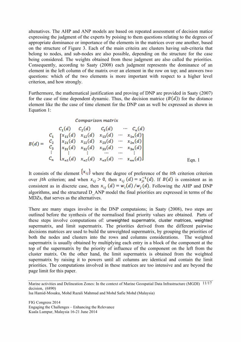
altenatives. The AHP and ANP models are based on repeated assessment of decision matice expressing the judgment of the experts by poising to them questions relating to the degrees of appropriate dominance or importance of the elements in the matrices over one another, based on the structure of Figure 3. Each of the main criteira are clusters having sub-criteria that belong to nodes, and sub-nodes are also possible, depending on the structure for the case being considered. The weights obtained from these judgment are also called the priorities. Consequently, according to Saaty (2008) each judgment represents the dominance of an element in the left column of the matrix over an element in the row on top; and answers two questions: which of the two elements is more important with respect to a higher level criterion, and how strongly. Furthermore, the mathematical justification and proving of DNP are provided in Saaty (2007) for the case of time dependent dynamic. Thus, the decision matrice ( ) for the distance element like the the case of time element for the DNP can as well be expressed as shown in Equation 1:
Eqn. 1 It consists of the element where the degree of preference of the criterion criterion over criterion; and when , then . If is consistent as in consistent as in discrete case, then . Following the AHP and DNP algorithms, and the structured D_ANP model the final priorities are expressed in terms of the MDZs, that serves as the alternatives. There are many stages involve in the DNP computaions; in Saaty (2008), two steps are outlined before the synthesis of the normalised final priority values are obtained. Parts of these steps involve computations of: unweighted supermatrix, cluster matrices, weighted supermatrix, and limit supermatrix. The priorities derived from the different pairwise decisions matrices are used to build the unweighted supermatrix, by grouping the priorities of both the nodes and clusters into the rows and columns considerations. The weighted supermatrix is usually obtained by multiplying each entry in a block of the component at the top of the supermatrix by the priority of influence of the component on the left from the cluster matrix. On the other hand, the limit supermatrix is obtained from the weighted supermatrix by raising it to powers until all columns are identical and contain the limit priorities. The computations involved in these matrices are too intensive and are beyond the page limit for this paper.

Marine activities and Delineation Zones: In the context of Marine Geospatial Data Infrastructure (MGDI) decision, (6890) Isa Hamid-Mosaku, Mohd Razali Mahmud and Mohd Safie Mohd (Malaysia) FIG Congress 2014 Engaging the Challenges – Enhancing the Relevance Kuala Lumpur, Malaysia 16-21 June 2014
12/17
5. RESULTS AND DISCUSSION The degree of importance of the reviewed marine activities is expressed through the ranking of these activities as shown in Table 2, which revealed non-renewable resources and naval administration, sovereignty and defence to be the highly ranked traditional marine activities, with average values of 10.33 and 9.33 respectively. This is the usual trends for all coastal states, as the issues relating both activities are usually accompanied with great national interest. Conservation (average ranked value of 3.67) and marine heritage (average ranked value of 2.33) were the least ranked activities. On the other hand, integrated coastal zone management with an average ranked value of 10.00 and disaster management and emergency response (average ranked value of 9.67) were the highly ranked activities for the non-traditional category, while the least values are from both marine eco-tourism and habitat management, with the same average ranked value of 3.67. The final priorities for the alternatives are obtained from the limit supermatrix before being normalised by cluster to get the final values (Normal in bold) shown in Table 4; thus, the final order of ranking of MDZs, expressed as alternatives based on the D_ANP model are also shown. Usually, the Idealized values (Ideal in bold) are obtained from the Normalized values by dividing each value by the largest value in that column. The total (in bold) represents the dominance of each element of the decision matrix obtained as the normalized sum of its rows. The values under ‘Normal’ in Table 4 are the final priorities that are used for further analysis and interpretations. The results indicate the marine activities are predominantly active in ALT.2_Territorial Sea area (12nm) from the shore with a value of 0.2617. This is closely followed by ALT.1_Internal Waters (3nm) with a priority value of 0.2615; then ALT.4_Exclusive Economic Zones (200 nm) with a value of 0.2268. Next is ALT.5_Continental Shelf and High Seas (>=350 nm) with a priority value of 0.1717, and finally ALT.3_Contiguous Zones (24 nm) with a priority value of 0.0783.
Table 4 : Alternative Rankings from D-ANP model (Hamid-Mosaku, 2014)
Graphic Alternatives Total Normal Ideal Ranking ALT.1_Internal Waters (3nm) 0.0930 0.2615 0.9995 2
ALT.2_Territorial Sea (12nm) 0.0931 0.2617 1.0000 1
ALT.3_Contiguous Zones (24nm) 0.0278 0.0783 0.2992 5
ALT.4_Exclusive Economic Zones (200nm) 0.0807 0.2268 0.8669 3
ALT.5_Continental Shelf and High Seas (>=350nm) 0.0611 0.1717 0.6562 4
6. CONCLUSION In this research, the AHP and ANP general models were extended to the DNP / D_ANP format using distance element to denote the dynamics unlike previous studies that time element were used. This new model was implemented to determine the viabilities of Malaysian waters and maritime delineation zones for marine activities. The activities were

Marine activities and Delineation Zones: In the context of Marine Geospatial Data Infrastructure (MGDI) decision, (6890) Isa Hamid-Mosaku, Mohd Razali Mahmud and Mohd Safie Mohd (Malaysia) FIG Congress 2014 Engaging the Challenges – Enhancing the Relevance Kuala Lumpur, Malaysia 16-21 June 2014
13/17
reviewed, and adjudged through experts’ views for the context of MGDI initiative. The most highly ranked traditional marine activities were non-renewable resources (10.33) and naval administration, sovereignty and defence (9.33) while the least ranked is marine heritage (2.33). On the other hand, the most highly ranked non-traditional and new marine-based activities are: integrated coastal zone management (10.00) while the least values of 3.67 are from both marine eco-tourism and habitat management. The outcome of the review resulted in elucidation of 180 variables for MGDI and MGDI decisions after being adjudged by experts and structured for D_ANP model, in order to assess the most viable zone of marine activities and resources that are abundant in Malaysian waters. Furthermore, the final priorities obtained from DNP model for the alternative MDZs revealed the Malaysia Territorial Waters to be the most highly ranked MDZ / alternative; with predominating marine activities. REFERENCES Abadi, S. P. (2007). Integrated Coastal Land Use Development using Analytical Network Process and GIS: case
of Kuala Langat District, Malaysia. Unpublished December, Universiti Putra Malaysia, Malaysia. Abdullah, N. M., Omar, A. H. and Yahaya, N. A. Z. (2009). New Approach of Marine Cadastre in Peninsular
Malaysia. Paper presented at the 2009 East Asia Hydrographic Symposium and Exhibition, Kuala Lumpur, Malaysia.
Bayazit, O., Karpak, B. and Yagci, A. (2006). A purchasing decision: Selecting a supplier for a construction company. Journal of Systems Science and Systems Engineering, 15(2), 217-231.
Blair, A. R., Mandelker, G. N., Saaty, T. L. and Whitaker, R. (2010). Forecasting the resurgence of the U.S. economy in 2010: An expert judgment approach. Socio-Economic Planning Sciences, 44(3), 114-121.
Blair, A. R., Nachtmann, R., Saaty, T. L. and Whitaker, R. (2002). Forecasting the resurgence of the US economy in 2001: an expert judgment approach. Socio-Economic Planning Sciences, 36(2), 77-91.
Celliers, L., Longhorn, R. A., Lance, K. and Odido, M. (2006). Coastal Spatial Data Infrasturcture (CSDI): African requirements and Responses. GISDevelopment.
Crompvoets, J., Bregt, A., Rajabifard, A. and Williamson, I. (2004). Assessing the worldwide developments of national spatial data clearinghouses. International Journal of Geographical Information Science, 18, 665-689.
DOFM, D. O. F. M. (2011). Perangkaan Tahunan Perikanan 2011 (Annual Fisheries Statistics 2011). Putrajaya, Kuala Lumpur, Malaysia: Department of Fisheries Malaysia.
Feeney, M. (2003). SDIs and Decision Support, Chapter 12. In Williamson, I., Rajabifard, A. and Feeney, M. (Ed.), Developing Spatial Data Infrastructures - From Concept to Reality: CRC Press, Florida, USA.
GeoConnections. (2009). GeoConnections Annual Report 2007-2008. Ottawa, Canada. Gourmelon, F., Georis-Creuseveau, J., Le Tixerant, M. and Rouan, M. (2012). Towards a Coastal Spatial Data
Infrastructure (CSDI) responsive to the needs of Integrated Coastal Zone Management: The GeoBretagne Experience (France). Paper presented at the Global Geospatial Conference 2012 Conference: Spatially Enabling Government, Industry and Citizens, Québec, Canada.
Green, D., Longhorn, R., Bartlett, D. and Roccatagliata, E. (2004). Oceans 21: GIS for Coastal Management and Coastal Education – Framework Science Plan. Retrieved from http://www.iccops.it/oceans21/documents/Oceans_21_Framework_Science_Plan_Finale.pdf
Hamid-Mosaku, A. I. and Mahmud, M. R. (2010). Marine Geospatial Data Infrastructure and Ubiquitous GIS. Paper presented at the MapAsia 2010 and ISG 2010. Retrieved from http://www.mapasia.org/2010/proceeding/pdf/Hamid.pdf
Hamid-Mosaku, A. I., Mahmud, M. R. and Mohd, M. S. (2011). Assessing the Innovative Geospatial Solution to Marine Geospatial Data Infrastructure (MGDI) Development. Paper presented at the International Symposium & Exhibition on Geoinformation (ISG 2011) & ISPRS Commission II/5 (Multidimensional GIS & Mobile Data Models) and ISPRS Commission II/7 (Decision Support Systems and LBS), Shah Alam Convention Centre (SACC), Selangor, Malaysia.

Marine activities and Delineation Zones: In the context of Marine Geospatial Data Infrastructure (MGDI) decision, (6890) Isa Hamid-Mosaku, Mohd Razali Mahmud and Mohd Safie Mohd (Malaysia) FIG Congress 2014 Engaging the Challenges – Enhancing the Relevance Kuala Lumpur, Malaysia 16-21 June 2014
14/17
Hamid-Mosaku, A. I., Mahmud, M. R. and Mohd, M. S. (2012). Marine Geospatial Data Infrastructure (MGDI) Decisions: A sine qua non to Ubiquitous Geospatial Solutions to Marine Applications. Paper presented at the 11th International Symposium & Exhibition on Geoinformation (ISG 2012) Sympossium, Hotel Istana, Kuala Lumpur, Malaysia.
Hamid-Mosaku, I. A. (2014). Intelligent Geospatial Decision Support System for Malaysian Marine Geospatial Data Infrastructure. Unpublished PhD Research, Universiti Teknologi Malaysia, UTM, Johor Bahru, Johor, Malaysia.
IOC-IGU. (2004). Oceans 21 Science Plan. International Oceans Committee, International Geography Union. Latre, M. Á., Lopez-Pellicer, F. J., Nogueras-Iso, J., Béjar, R., Zarazaga-Soria, F. J. and Muro-Medrano, P. R.
(2013). Spatial Data Infrastructures for environmental e-government services: The case of water abstractions authorisations. Environmental Modelling & Software, 48(0), 81-92.
Longhorn, R. (2006). Coastal/Marine Spatial Data Infrastructure – Benefits and Responsibilities of Stakeholders. Paper presented at the LITTORAL 2006 Workshop, Poland.
Longhorn, R. and Celliers, L. (2007). Coastal Spatial Data Infrastructure (CSDI): African Requirements and Responses. Paper presented at the 8th International Symposium on GIS and Computer Mapping for Coastal Zone Management (CoastGIS 2007).
Mahmud, M. R. (2010). In Pursuit of Marine Geospatial Data Infrastructure. Hydro International, 14(2). Retrieved from http://www.hydro-international.com/issues/articles/id1173-In_Pursuit_of_Marine__Geospatial_Data_Infrastructure.html
MSDIWG. (2009). Report of the Marine Spatial Data Infrastructure Working Group (MSDIWG). Monaco. MSDIWG TOR. (2009, p.1). Marine Spatial Data Infrastructures W.G. (MSDIWG), Terms of Reference. IHB,
Monaco. Naeve, H. and Garcia, S. M. (1995). The United Nations system responds to Agenda 21.17: Oceans. Ocean &
Coastal Management, 29(1–3), 23-33. Ndukwe, K. N. (1997). Principles of Environmental Remote Sensing and Photo Interpretation. Enugu, Nigeria.:
New Concept Publishers. Ng'ang'a, S., Sutherland, M., Cockburn, S. and Nichols, S. (2004). Toward a 3D marine cadastre in support of
good ocean governance: a review of the technical framework requirements. Computers, Environment and Urban Systems, 28(5), 443-470.
Othman, M. R., Bruce, G. J. and Hamid, S. A. (2011). The strength of Malaysian maritime cluster: The development of maritime policy. Ocean & Coastal Management, 54(8), 557-568.
Pepper, J. (2009). SDI–The Hydrographic Dimension. IHO MSDI Working Group. Paper presented at the Hydrographic Society Symposium , UK, Oct 2009.
Philpott, D. (2007). Geospatial Information Systems and Scalable Solutions. Homeland Defense Journal, 5(1), 44 - 48.
Rajabifard, A., Binns, A. and Williamson, I. (2005). Administering the Marine Environment – The Spatial Dimension. Journal of Spatial Science, 50(2).
Rajabifard, A., Escobar, F. J. and Williamson, I. P. (2000). Hierarchical Spatial Reasoning Applied to Spatial Data Infrastructures. Cartography Journal, 29(2).
Rajabifard, A., Feeney, M. and Williamson, I. P. (2003). Spatial Data Infrastructures:Concept, Nature and SDI Hierarchy, Chapter 2. In Williamson, I., Rajabifard, A. and Feeney, M. (Ed.), Developing Spatial Data Infrastructures - From Concept to Reality. Florida: CRC Press, Florida, USA.
Rüh, C., Korduan, P. and Bill, R. (2012). A framework for the evaluation of marine spatial data infrastructures to assist the development of the marine spatial data infrastructure in Germany (MDI-DE) - Accompanied by international case-studies. Paper presented at the Global Geospatial Conference 2012 Conference: Spatially Enabling Government, Industry and Citizens, Québec, Canada.
Russell, I. (2008). What is Marine SDI? IHO Publication M-13 - Manual on Hydrography. Saaty, T. L. (2007). Time dependent decision-making; dynamic priorities in the AHP/ANP: Generalizing from
points to functions and from real to complex variables. Mathematical and Computer Modelling, 46(7–8), 860-891.
Saaty, T. L. (2008). Relative Measurement and Its Generalization in Decision Making Why Pairwise Comparisons are Central in Mathematics for the Measurement of Intangible Factors The Analytic Hierarchy/Network Process (To the Memory of my Beloved Friend Professor Sixto Rios Garcia)”.

Marine activities and Delineation Zones: In the context of Marine Geospatial Data Infrastructure (MGDI) decision, (6890) Isa Hamid-Mosaku, Mohd Razali Mahmud and Mohd Safie Mohd (Malaysia) FIG Congress 2014 Engaging the Challenges – Enhancing the Relevance Kuala Lumpur, Malaysia 16-21 June 2014
15/17
Estadística e Investigación Operativa / Statistics and Operations Research Artículo panorámico / Survey. RACSAM-Rev. R. Acad. Cien. Serie A. Mat., 102(2), 251-318.
Saaty, T. L. and Vargas, L. G. (2006). Decision Making with the Analytic Network Process: Economic, Political, Social and Technological Applications with Benefits, Opportunities, Costs and Risks: Springer's International Series.
Sabri, S. (2012). A Framework for Geosimulation of Gentrification in Kuala Lumpur. Unpublished PhD Universiti Teknologi Malaysia, Johor Bahru.
Sabri, S. and Yakuup, A. (2008a). Integrating Dynamic Network Process (DNP) analysis and Geographical Information System (GIS) to Introduce the Components of Urban Gentrification in Developing Countries. Paper presented at the Asia GIS 2008, Busan, Korea.
Sabri, S. and Yakuup, A. (2008b). Multi-Criteria Decision Making for Urban Sprawl, using Analytic Network Process and GIS, Case of Iskandar Malaysia Region. Paper presented at the Map Asia 2008, Kuala Lumpur.
Saharuddin, A. H. (2001). National ocean policy—new opportunities for Malaysian ocean development. Marine Policy, 25(6), 427-436.
Scott, G. (2010). The GSDI vision is location, innovation and collaboration Geospatial World Weekly Soon, C. and Lam, W.-H. (2013). The growth of seaports in Peninsular Malaysia and East Malaysia for 2007–
2011. Ocean & Coastal Management, 78(0), 70-76. Strain, L. (2006). An SDI Model to Include the Marine Environment. Unpublished Master's Thesis, The
University of Melbourne, Victoria, Australia. UNCED. (1992, ). United Nations Conference on Environment & Development, AGENDA 21. Paper presented at
the Earth Summit, Rio de Janerio, Brazil. UNCLOS. (2012). United Nations Convention on the Law of the Sea of 10 December 1982 Overview and full
text. Paper presented at the United Nation Convention on the Laws of the Sea (UNCLOS). United Nations. (2001). Gothenburg Agenda 2001. UNSD. (2009). Agenda 21, Chapter 8: Integrated Decision-Making. from
http://sustainabledevelopment.un.org/index.php?menu=226 Vaez, S., Rajabifard, A., Binns, A., and Williamson, I. (2007a). Seamless SDI Model to Facilitate Spatially
Enabled Land Sea Interface. Paper presented at the The National Biennial Conference of the Spatial Sciences Institute, Proceedings of SSC 2007, Hobart, Australia.
Vaez, S., Rajabifard, A.,and Williamson, I. (2007b). Facilitating Land-Sea Interface through Seamless SDI Volume III. Coordinates, III, 14-18.
Vaez, S. S. (2010). Building a Seamless SDI Model for Land and Marine Environments. Unpublished PhD Thesis, The University of Melbourne, Victoria, Australia.
APPENDIX A: LIST OF ABBREVIATIONS USED

Marine activities and Delineation Zones: In the context of Marine Geospatial Data Infrastructure (MGDI) decision, (6890) Isa Hamid-Mosaku, Mohd Razali Mahmud and Mohd Safie Mohd (Malaysia) FIG Congress 2014 Engaging the Challenges – Enhancing the Relevance Kuala Lumpur, Malaysia 16-21 June 2014
16/17
BIOGRAPHICAL NOTES Isa Adekunle, Hamid-Mosaku obtained his PhD titled “Intelligent Geospatial Decision Support System for Malaysian Marine Geospatial Data Infrastructure” at the Department of Geoinformation in 2013/2014 session, from Faculty of Geoinformation and Real Estate, Universiti Teknologi Malaysia, Johor, Malaysia. An Academic Staff with the Department of Surveying and Geoinformatics, Faculty of Engineering, University of Lagos, Lagos, Nigeria. Had both Master and Bachelor degrees in Surveying and Geoinformatics & Surveying in 2002 and 1997 respectively from the same university. He is involved in teaching courses in Surveying, GIS, Remote Sensing and Hydrography; supervising students’ theses, participating in projects and other research activities. Dr. Mohd Razali Mahmud is a Professor at Faculty of Geoinformation and Real Estate, Universiti Teknologi Malaysia. He obtained his B.Sc (Hons.) Surveying and Mapping Sciences from North East London Polytechnic in 1986, M.Phil in Surveying Science from University of Newcastle upon Tyne in 1992 and Ph.D in Surveying from University College London in 1999. He is a Board Member of FIG/IHO/ICA International Board on Standards of Competence for Hydrographic Surveyors and Nautical Cartographers. He is also Associate Editor of Marine Geodesy and Editorial Advisory Board Member of Hydro International. His area of interest is hydrography and offshore surveying. Mohd Safie Mohd is currently Associate Professor at the Department of Geoinformation, Faculty of Geoinformation and Real Estate, Universiti Teknologi Malaysia. He obtained his B.Sc (Land Surveying and Mapping Sciences) from the North East London Polytechnic, United Kingdom in. 1982, Postgrad Diploma (Cartography) from the International Institute for Aerospace Survey and Earth Sciences (ITC), Netherlands in 1986, M.Sc (Cartography) from the International Institute for Aerospace Survey and Earth Sciences (ITC), Netherlands in 1987. Associate Professor Mohd Safie Mohd is an experienced lecturer in cartography. He is actively involved in research and consultancy work related to Geographic Information System (GIS).
ALT.1 - Internal Waters ALT.2 - Territorial Sea ALT.3 - Contiguous Zone ALT.4 - Exclusive Economic Zone ALT.5 - Continental Shelf and High Seas MC - Marine Cadastre MASs - Multiple Alternative Solutions MDZs - Maritime Delineation Zones MGDI - Marine Geospatial Data Infrastructure MGDI decision - A new concept in cognisance with MGDI initiative and development
based on the understanding that there exists a multi-conceptual nature of stakeholders, characterised with different worldviews, and in the realms of decision making in relation to marine environmental needs, hydrographical services, marine surveys services, and various applications that are being explored
MSDI - Marine Spatial Data Infrastructure MTW - Malaysia Territorial water

Marine activities and Delineation Zones: In the context of Marine Geospatial Data Infrastructure (MGDI) decision, (6890) Isa Hamid-Mosaku, Mohd Razali Mahmud and Mohd Safie Mohd (Malaysia) FIG Congress 2014 Engaging the Challenges – Enhancing the Relevance Kuala Lumpur, Malaysia 16-21 June 2014
17/17
CONTACTS Title Given name and family name: Dr. Isa Adekunle HAMID-MOSAKU Institution: Universiti Teknologi Malaysia (UTM) Address: Department of Geoinformation Faculty of Geoinformation and Real Estate 81310 Johor Bahru, Johor City: Johor Bahru COUNTRY: MALAYSIA Tel.: +6013-2552896 Fax: +607-5530827 Email: [email protected]; [email protected] Web site: www.fght.utm.my Title Given name and family name: Professor Mohd Razali Mahmud Institution: Universiti Teknologi Malaysia (UTM) Address: Department of Geoinformation, Faculty of
Geoinformation and Real Estate, 81310 Johor Bahru, Johor
City: UTM Johor Bahru COUNTRY: MALAYSIA Tel.: +6019-7291109 Fax: +607-5530827 Email: [email protected] Web site: www.fght.utm.my Title Given name and family name: Associate Professor Mohd Safie MOHD Institution: Universiti Teknologi Malaysia (UTM) Address: Department of Geoinformation, Faculty of
Geoinformation and Real Estate, 81310 Johor Bahru, Johor
City: UTM Johor Bahru COUNTRY: MALAYSIA Tel.: +6019-7114488 Fax: +607-5566163 Email: [email protected] Web site: www.fght.utm.my