marine farm guidelines: navigational safety · 2019-01-10 · draft marine farm guidelines for...
TRANSCRIPT

DRAFT Marine farm guidelines for discussion - not government policy – 10/09/18 Page 1 of 27
Marine farm guidelines:
navigational safety This guideline is for those involved in marine farms, particularly regarding
aids to navigation and associated matters of navigational safety

Marine farm guideline: navigational safety Page 1 of 27
Marine farm guidelines: navigational safety Last updated: December 2018
This document is uncontrolled if printed. Please refer to the Maritime New Zealand website for the latest version.
In this guide
1. Overview 2
2. New Zealand’s international obligations 3
3. Legislative framework 4
4. Marine farm location 6
5. Design and placement of aids to navigation 7
5.1 Daymarks and floats 9
5.2 Lighting 13
5.3 Technical specifications 14
6. Resource consent conditions 17
6.1 Application information 17
6.2 Resource consent conditions for aids to navigation 17
7. Appendices 19
Appendix 1 – Definitions and acronyms 19
Appendix 2 – Placement of aids to navigation 21
Appendix 3 – Navigation related matters 25
Appendix 4 – References 27

Marine farm guideline: navigational safety Page 2 of 27
1. Overview Scope of guidelines
This document is designed to assist people involved in marine farms. It is relevant to those establishing/managing marine farms, harbourmasters, local authorities and other interested parties.
The document provides recommendations and good practice examples on matters of navigational safety, particularly for aids to navigation on marine farms.
It is relevant to all types of marine farms: fin fish (e.g. salmon), and bivalves (e.g. mussels, oysters), although marine farms in intertidal areas may have less navigational safety issues. It may also be
applicable to future operations e.g. seaweed farms and/or freshwater farming in lakes and rivers.
It covers positioning, type of marks and lights, ongoing maintenance of aids to navigation and other matters relevant to navigational safety. Local conditions and other water users must be considered so
that decisions on aids to navigation are proportionate to the navigational safety risk.
Development of these guidelines This document replaces Aquaculture Management Areas & Marine Farm guidelines produced by Maritime New Zealand (Maritime NZ) in December 2005. This guideline was developed with input from
harbourmasters from around New Zealand and also representatives from the industry: Aquaculture New Zealand, the Marine Farming Association and the Coromandel Marine Farmers Association. The Ministry
for the Environment, Ministry for Primary Industries and Department of Conservation were also consulted.
Marine farms in New Zealand Marine farms involve the farming of living resources of the sea within the marine environment. The main
species farmed in New Zealand are King (Chinook) salmon, New Zealand’s native Greenshell mussel and Pacific oysters. The primary marine farming areas are Northland harbours, Hauraki Gulf, eastern Bay of
Plenty, Tasman and Golden Bays, the Marlborough Sounds, Banks Peninsula and Stewart Island. In 2017 the industry harvested 99,716 tonnes of mussels, 14,890 tonnes of salmon and 1,834 tonnes of
oysters with a total sales value of $538 million.
Aids to navigation An aid to navigation is any mark, sign, device or system external to vessels that is designed and operated to enhance the safe and efficient navigation of vessels and/or vessel traffic. See Appendix 1 for
definitions.
This guideline provides information about the requirements set out in the Maritime Transport Act 1994 and makes reference to external delegation of the power to approve aids to navigation under
section 200(7) of that Act. Any references to Maritime NZ relating to a decision about aids to navigations are references to the Director or a person within Maritime NZ acting under the Director’s
delegated authority.

Marine farm guideline: navigational safety Page 3 of 27
2. New Zealand’s international obligations There is a global system of marks and lights to guide the navigation of vessels. The system has been standardised to cater for international movement of vessels and crew. New Zealand has agreed to abide by the international system, including keeping pace with changes.
International agreement regarding aids to navigation
When New Zealand signed the SOLAS (International Convention on the Safety of Life at Sea) Convention
in 2002 it agreed it would, as a contracting government, ‘take into account the international
recommendations and guidelines when establishing such aids’ (Chapter V, Regulation 13 - Establishment
and operation of aids to navigation).
Maritime NZ is the authority responsible for giving effect to this international obligation. Its role is to:
• ensure consistency with international guidance on aids to navigation
• adjust the recommended approaches for aids to navigation based on risk assessment.
Buoyage System A
New Zealand has agreed to adhere to Buoyage System A, which is an international standard. This means
that the direction of buoyage in New Zealand is such that a vessel in the designated channel must keep the port mark on the port side when entering a harbour. There are agreed design standards for Cardinal,
Lateral, Special, Safe Water and Isolated Danger Marks. Refer to IALA Maritime Buoyage System (June 2017) and Maritime NZ publication New Zealand’s System of Buoys and Beacons (2008).
International guidance
International guidance on aids to navigation comes from the International Association of Marine Aids to Navigation and Lighthouse Authorities (IALA). This association provides nautical expertise and advice,
including on best practice and harmonisation of navigation systems. Sometimes precise recommendations are provided (e.g. light sequence for Cardinal Marks), and in other situations it provides
options, or lists matters to be considered (e.g. as part of risk assessment). The recommendations and guidance produced by IALA are publically available and used by Maritime NZ to inform its decisions and
practice.
Maritime NZ guidelines
This is a good practice document intended to support decision making about aids to navigation. This guideline helps to ensure that NZ gives effect to international obligations.

Marine farm guideline: navigational safety Page 4 of 27
3. Legislative framework This section covers the Maritime Transport Act 1994 (MTA) and the Resource Management Act 1991 (RMA) as they relate to navigational safety.
Maritime Transport Act 1994
Maritime NZ ensures international obligations are met through a specific approval process for aids to navigation.
Under section 200(7) of the Maritime Transport Act 1994 (MTA), no person may erect, place, alter or remove a ‘navigational aid’1 without the approval of the Director of Maritime NZ (the Director). This applies
irrespective of the owner (e.g. even Maritime NZ officials seek approval to place, alter or remove aids to navigation operated by Maritime NZ). As part of the approval process, IALA guidance will be considered
and recommendations may be incorporated into any conditions.
In some parts of New Zealand the MTA section 200(7) power to approve aids to navigation has been
delegated to named harbourmasters in relation to aids to navigation for marine farms.
Delegates must consider guidelines
When the MTA section 200(7) power to approve aids to navigation has been delegated to
harbourmasters, the delegation includes a condition that the delegate ‘must have regard to’ relevant guidance from Maritime NZ. This guidance must be given due weight and consideration when exercising
the delegated power. Applicants for aids to navigation should be mindful of this expectation on the local harbourmaster when they are the delegated decision maker. Harbourmasters should seek advice from
Maritime NZ regarding unusual or unfamiliar situations. The Director remains responsible for decisions made under delegation and can withdraw the delegation at any time, if necessary.
Responsibility of marine farm operators
Section 200(2) of the MTA provides that the operator of any marine farm is responsible for providing and maintaining aids to navigation for the facility. It is recommended that you engage with your local
harbourmaster when establishing marine farms and associated aids to navigation.
1 Refer to definition of ‘aid to navigation’ in Appendix 1.

Marine farm guideline: navigational safety Page 5 of 27
3. Legislative framework (continued)
Resource Management Act 1991
Marine farms require a coastal permit under the RMA. Navigational safety should be considered during the resource consent process. This includes consideration of farm location, relationship to surrounding
features, communities and navigational routes, and an appropriate lighting and maintenance plan for aids to navigation. The harbourmaster is likely to be asked for comment during this process. This still applies if
the harbourmaster has delegated approval powers for aids to navigation.
As part of the consent process, under section 89A of the RMA the local authority must send Maritime NZ a copy of each new application. Maritime NZ has 15 days to provide a report on navigation related
matters and any recommended consent conditions. It can charge for time spent on considering the application. Refer to Appendix 3 for information on navigational safety issues to consider as part of the
consent process.
Council bylaws
Regional councils can make navigation bylaws which affect aids to navigation and marine farms generally.
Section 33M (1) of the MTA provides for a regional council to make bylaws for the purpose of ensuring maritime safety. This may include prohibiting the installation of something that could be mistaken for an
aid to navigation. Bylaws may also specifically cover marine farm lights.

Marine farm guideline: navigational safety Page 6 of 27
4. Marine farm location This section outlines key factors that should be taken into account when considering marine farm location. Further matters to considering regarding placement of marine farms are outlined in Appendix 3.
Proximity to headlands
In general, marine farms should be kept clear of headlands because:
• by their nature, headlands extend to seaward more than any other point of land and may extend close to navigational routes
• headlands are commonly used for ‘point to point’ navigation
• vessel traffic tends to converge at headlands, pass close to headlands and operate in multiple
directions near headlands, and
• prominent headlands are often marked by charted aids to navigation
In some circumstances, positioning a marine farm near a headland may create navigational complexity in an area and introduce navigational safety risks
Offshore marine farms
There is no precise definition of an offshore marine farm, but those not within enclosed or sheltered waters are generally considered offshore. The size and openness of a bay in which a marine farm is
located are also determining factors. For example, marine farms located within Tasman Bay and Golden Bay are described as offshore, while those within the Marlborough Sounds are not. Offshore marine
farms are more likely to use Cardinal Marks and have lights with a range of 5 nm or more.

Marine farm guideline: navigational safety Page 7 of 27
5. Design and placement of aids to navigation The design and placement of individual or grouped aids to navigation needs to be appropriate for the circumstances. This section gives guidance on appropriate characteristics.
Benefit of consistency
It is important to have national consistency in design and operation of aids to navigation to ensure that they are recognised by water users. For example, aids to navigation marking coastal marine farms in
Opotiki and Pegasus Bay need to look similar to the skipper of a coastal operating ship so that they can safely navigate around them. Skippers of visiting vessels such as yachts also benefit from being able to
recognise marine farms and the associated navigational hazards.
However, the characteristics of different areas in New Zealand may affect use of aids to navigation,
requiring region specific responses. For example, Marlborough has responded to large numbers of adjacent marine farms developing which have separate ownership.
Marking a group of marine farms
Individual marking of marine farms may not be appropriate for adjacent farms, farms in enclosed bays or
along the coast. The cumulative effect of the lights may create unnecessary complexity and confusion for navigators. In such cases, it may be more appropriate to mark the marine farms as a group. The most
appropriate lighting solution will aid safe navigation in close proximity to the farm, and also safe navigation within the broader environment i.e. the bay or area within which the farm is located.
See Appendix 2 for an example of a lighting approach for adjacent farms in a sheltered area.
Local conditions and individual farm characteristics
Consideration of local circumstances should include the following:
• background lights - marine farms may be in areas where there is a high-density of background
lighting or other lighting that may cause confusion. Synchronised lights, different light characteristics and varied light ranges can be used to optimise safety.2
• relationship to surrounding features, natural or constructed
• local traffic – this includes considering the type of vessel traffic in the area, and proximity of the
farm to navigation routes.
• placement on landward /seaward side - depending on the type and amount of vessel traffic, aids
to navigation may be more important for the landward side or the seaward side of a marine farm.
Appendix 3 provides a check list of other local factors to consider.
2 Refer to IALA guideline 1051 Provision of aids to navigation in built up areas.

Marine farm guideline: navigational safety Page 8 of 27
5. Design and placement of aids to navigation (continued)
Temporary use of aids to navigation on marine farms
When marine farms are in a temporary position e.g. seasonal spat catching operations, approval for aids
to navigation is still required. Approval may include conditions related to moving aids to navigation. Applicants should speak to their local harbourmaster in the first instance.
Sufficient autonomy
Where aids to navigation are located close to maritime activity/areas of high vessel traffic, it is important
that chances of failure such as power outage are minimised.
The risk assessment associated with a marine farm application, in conjunction with the harbour risk
assessment, will determine whether there is a need for autonomous systems and what the level of resilience should be. Generally, aids to navigation lights on marine farms are considered Category 2 by
the person responsible for approving the light. They should be capable of operating 99.0% of the time and repaired within 24 hours. It is recognised, however, that some marine farms are in areas of low traffic
and a lower risk environment. In contrast, offshore marine farms are more likely to be in areas of high risk and assigning Category 1 may be appropriate. Further information regarding different categories is
outlined in the table below.
Table 1 IALA availability categories
Category
Type of aid to navigation
Availability target
Recommended
response time Example of use Relevance to
marine farms
1 Considered to be of primary navigational significance
99.8% Immediately Used to mark primary routes, channels, waterways or dangers.
Likely category for offshore marine farms
2 Considered to be of navigational significance
99.0% 24 hours Used to mark secondary routes and to supplement marking of primary routes
Default for marine farm aids to navigation
3 Considered to be of necessary navigational significance
97.0% Next working day
May be suitable in areas of low traffic/lower risk environments
Note: availability target calculated over a continuous three year period.

Marine farm guideline: navigational safety Page 9 of 27
5. Design and placement of aids to navigation (continued)
5.1 Daymarks and floats This section gives guidance on types of aids to navigation commonly used on marine farms. These include specifically coloured buoys/day marks (e.g. Cardinal and Special Marks), reflective material, radar reflectors and coloured floats. Technical specifications are set out in section 5.3.
Daymarks
Consistent with international guidance, Special Marks are standard for marking the extremities of marine
farms. The examples pictured below demonstrate options for inshore marine farms.
Example of a Special mark without a
topmark, designed to go on a marine
farm float (photo Sabik).
Small Special Mark (without
light), topmark is an ‘X’
(photo Luke Grogan).
Special Marks should be the default unless circumstances dictate a better option – noting that:
• if there is vessel traffic between farms then red and green Lateral Marks, rather than yellow Special Marks, may be more appropriate, or
• if the situation warrants (particularly on offshore farms), just Cardinal Marks may be used. Cardinal
Marks would generally be necessary for offshore farms and in areas where SOLAS ships3 might operate
• when a decision is made to position a Cardinal Mark at the corner of a site, then it should replace the Special Mark required for that corner
• when considering use of Cardinal Marks, Maritime NZ should be consulted on the need and
positioning
3 SOLAS ships are as defined in SOLAS – typically, passenger ships or ships of 300 gross tonnage or more on an international voyage, or ships of 500 gross tonnage or more.

Marine farm guideline: navigational safety Page 10 of 27
5. Design and placement of aids to navigation (continued)
Positioning of marks
Marks and associated lights may be fixed to farm structures so that they move with them. In some cases, standalone marks anchored directly to the seabed may be more effective (e.g. marking the boundary of
the consented area). Subsurface marine farms would need standalone aids to navigation due to the nature of the structures.
Aids to navigation might also be placed at a distance from a group of marine farms to indicate their
presence as a navigational hazard. This might be in addition to, or instead of, aids to navigation on the farm structure or marking the boundary of the consented area. It is standard to mark corners and long
sides to show the extent of the farm structure.
IALA has produced guidance on positioning and distance between Special Marks. See examples in
Appendix 2 of this document – note that these are primarily applicable to offshore marine farms in open waters or to single isolated marine farms in a large bay. For conditions in New Zealand, it is
recommended that intermediary marks are used on long boundaries e.g. 500 metres or more.
Visibility of marks
The size of the marks should be appropriate for the circumstances to ensure visibility.4 The decision
maker may prescribe specific dimensions as part of the approval process.
Key principles include:
• visibility should be appropriate for local conditions and navigational safety risk
• the design should keep the mark vertical
• for offshore marine farms a height of around 3-4 m is likely to be appropriate
• Special Marks should have topmarks.
Examples demonstrating how characteristics can affect visibility:
Special mark with a topmark. This Special Mark would be more visible
with a topmark (photo Luke Grogan)
4 Refer to IALA guideline 1094 Daymarks for aids to navigation.

Marine farm guideline: navigational safety Page 11 of 27
5. Design and placement of aids to navigation (continued)
Coloured floats
Orange floats are commonly used to mark the corners and long edges of marine farms in addition to day
marks and lights. Decision makers may require them to be used to aid navigational safety. Good practice for orange floats includes:
• attaching them to black floats to help buoyancy
• regular placement on the outer edges of a marine farm:
o on the ends of lines, as appropriate, and
o where the backbone length is significant, orange floats should also be placed in the
middle of the length, or throughout so that there is not more than 100 m between floats (e.g. to increase visibility on landward and seaward sides of a marine farm running
parallel to the shore)
• use a bright colour
• use in association with retro-reflecting devices
Photo: Marine Farming Association
Retro reflective material
Use of retro reflective material is highly recommended. This
is a cost effective way to highlight the structures position (as long as they are kept clean) e.g. cats eyes attached to
daymarks and/or floats have been used successfully in Marlborough.
Reflective devices should be positioned clearly above the
waterline. Tape should generally be 5 cm or more in width and extend around the circumference of vertical structures. Photo: Marine Farming Association
Visibility should be fit for purpose, in all weather conditions reasonably anticipated at the site. Reflective tape should be the same colour as the light if it is an IALA mark – i.e. a Special Mark or Cardinal Mark.
Note IALA guidance states that there should just be one yellow strip on a Special Mark5.
5 IALA guideline R0106 (E-106) Retroreflecting material on aids to navigation marks.

Marine farm guideline: navigational safety Page 12 of 27
5. Design and placement of aids to navigation (continued)
Radar reflectors Generally, radar reflectors on marine farms should be detectable at a minimum of 2 nm in all sea conditions reasonably anticipated at the site. Such radar reflectors should be at least 1 m above the
water level.
For offshore marine farms, the radar reflector, active or passive (on Cardinal, Lateral or Special Marks),
should be positioned at least 2 metres above water level and detectable by radar for a minimum of 4 nm in all sea conditions reasonably anticipated at the site.
Note that some modern Special Marks can have internal radar reflectors (e.g. see photo of special mark without a topmark on page 9).
Intertidal oyster farms Oysters are often farmed in the intertidal zone where vessel access can be limited, depending on the tide. Marking of the boundary by yellow poles (consistent with Special Mark colours) may be sufficient to
address the risk. If the risk assessment concludes further aids to navigation are required, some of the poles may be lit e.g. if vessels are likely to be navigating in the vicinity at night.
Generally, intertidal oyster farms are considered low risk – however a risk assessment should be undertaken to determine what aids to navigation are needed to appropriately mark any hazards. It is
recommended that you engage with your local harbourmaster to discuss this.

Marine farm guideline: navigational safety Page 13 of 27
5. Design and placement of aids to navigation (continued)
5.2 Lighting This section describes good practice principles for lighting aids to navigation. Further technical information is outlined in section 5.3.
As noted above, Special Marks should be used to mark the extremities of marine farms unless
circumstances dictate a better choice. These have yellow lights with a group flash. In sheltered waters, Special Mark lights may be used without the Special Mark structure.
Consideration should be given to how light pollution affecting local residents can be minimised, if
appropriate for the level of vessel traffic and risk in the area. Synchronised flashing lights are strongly encouraged where possible.
Design features to consider include:
• Special Marks – associated lights need to be yellow with a recommended minimum flash length of
0.5 seconds
• Special Mark flash sequence – in New Zealand, the commonly used sequence for lights on marine
farms has been a group of 5 flashes over 20 seconds (Fl (5) Y 20s). However, international guidance states that a range of group flash numbers and timings are acceptable. It is
recommended that when new Special Marks are being installed (or existing ones replaced), a different flash sequence is used to avoid confusion with Ocean Data Acquisition Systems (ODAS)
buoys. The flash sequence selected should be as clear as possible in the specific circumstances. Decision makers have flexibility as to the actual light sequence on the Special Mark (although
some sequences need to be avoided – particularly groups of 2 and 3).
• Cardinal Marks - lights associated with Cardinal Marks must meet international standards (refer to
Table 1 in section 5.3).
• synchronising – using synchronised lights and different characteristics may help to differentiate a
marine farm when background lighting is an issue
• range - the minimum nominal range should take into account background lighting and the specific
risk assessment. General guidelines include:
o for offshore marine farms a range of 4-8 nm is recommended
o in enclosed, sheltered areas such as the Marlborough Sounds, a range of 1 nm may be appropriate.
Marine farm guideline: navigational safety Page 14 of 27
5. Design and placement of aids to navigation (continued)
5.3 Technical specifications This section describes technical elements of aids to navigation. It does not cover all technical matters. Manufacturers of aids to navigation should be familiar with the relevant standards.
Relevant IALA guidance on design includes: 1094 for Daymarks, E-110 for light sequences and R0106 (E-106) for reflective tape. See Appendix 4 for details and hyperlinks.
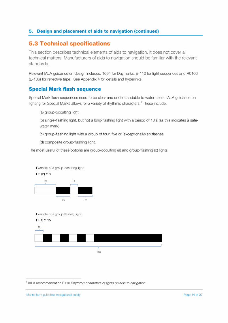
Special Mark flash sequence
Special Mark flash sequences need to be clear and understandable to water users. IALA guidance on
lighting for Special Marks allows for a variety of rhythmic characters.6 These include:
(a) group-occulting light
(b) single-flashing light, but not a long-flashing light with a period of 10 s (as this indicates a safe-
water mark)
(c) group-flashing light with a group of four, five or (exceptionally) six flashes
(d) composite group-flashing light.
The most useful of these options are group-occulting (a) and group-flashing (c) lights.
6 IALA recommendation E110 Rhythmic characters of lights on aids to navigation

Marine farm guideline: navigational safety Page 15 of 27
5. Design and placement of aids to navigation (continued)
Importantly:
• when new Special Marks are being installed (or existing ones replaced), avoid Fl (5) Y 20s to avoid
confusion
• avoid group flashing of 2 and 3 as these are too similar to the Isolated Danger Mark and East
Cardinal Mark respectively
• the time that the light is off between group flash sequences (eclipse period) needs to be an
appropriate length. Not too long, otherwise local traffic may miss seeing the light. Also not too short: not less than 2 seconds and not less than three times the duration of the eclipse within each
flash of the group.
• A minimum flash length 0.5 seconds assists light range.
Note: existing marine farms commonly have an approved lighting sequence of 5 flashes within 20 seconds, with 10 seconds gap between sequences (Fl (5) Y 20s). The similarity to ODAS buoy light
sequences and the long eclipse period might be confusing to a mariner.
Cardinal Mark flash sequence
The following characteristics apply (based on international agreed standards).
Table 2 Cardinal light characteristics
Type Light characteristic7
North Cardinal white Very quick (VQ) or quick (Q) flash
East Cardinal white VQ(3) every 5 sec or Q(3) every 10 sec
South Cardinal white VQ(6) + long flash every 10 sec or Q(6) + long flash every 15 sec
West Cardinal white VQ(9) every 10 sec or Q(9) every 15 sec
Light Range
The range at which a light can be seen is determined by height above sea level and the intensity of the
light. Range will need to be appropriate for the environmental conditions. The modified Allard method is
recommended to calculate required intensity.8 Some manufacturers provide an online tool to do this by
simply entering the colour, character and desired range of the light – online tools can also confirm
autonomy to ensure sufficient power.
7 VQ = Very quick flashing, a rate of either 100 or 120 flashes per minute Q = Quick flashing, either 5 flashes per minute. 8 IALA guideline G1135 Determination and calculation of effective intensity

Marine farm guideline: navigational safety Page 16 of 27
5. Design and placement of aids to navigation (continued)
The following table from IALA Recommendation R0202 (E200-2) can be used as a guide to ensure the intensity will achieve the desired range, but will differ slightly depending on the character.
Table 3
Range of visibility (nominal range) of light in nautical miles
Intensity in candelas, with no background lighting
1 1-2
2 3-9
3 10-23
4 24-53
5 54-107
6 108-203
7 204-364
8 365-632
Note: Table based on atmospheric transmissivity value of 0.74.
The visible range in Table 2 does not allow for background glare. Lighting from street lights, signs,
houses etc. can make an aid to navigation light less effective and potentially indistinguishable from background lights. Intensity or character may need to vary to ensure the navigation light is visible.
Vertical divergence
It is recommended that the manufacturer’s light information is checked for the appropriate vertical
divergence, particularly when the light is fitted to a buoy that may heel. Lights should have a vertical divergence of the projected beam so that the light will be visible from the immediate vicinity of the
structure to the maximum luminous range of the light. A common figure used is 8°- 10° at 50% of the peak intensity.
AIS aids to navigation
Automatic Identification System (AIS) aids to navigation are not commonly used on marine farms, as
most of the vessels around marine farms in sheltered waters do not have AIS capability. In some circumstances, depending on vessel traffic, they may be an effective way of providing additional
marking marine for farms. Installation of all AIS aids to navigation requires the involvement of Maritime NZ.

Marine farm guideline: navigational safety Page 17 of 27
6. Resource consent conditions This section provides some examples of information that should be considered when developing a resource consent application and also examples of consent conditions. It is recommended that local harbourmasters are involved early in applicant discussions on navigational safety issues.
6.1 Application information
Council plans under the RMA set out information required to enable assessment and decisions on strategies to ensure navigational safety, of which aids to navigations are a part. Matters that might be
relevant, depending on circumstances, are listed in Appendix 3.
6.2 Resource consent conditions for aids to navigation
Regional councils are responsible for granting of resource consents for activities within their regions.
However, section 200(7) of the MTA provides that no person may erect or place a navigational aid, alter the character of a navigational aid, or alter or remove the position of a navigational aid, without the
approval of the Director. When considering appropriate consent conditions, councils should be mindful of the requirements of section 200(7). For example, while a lighting plan may be appropriate as a consent
condition, the Director’s approval (or that of his or her delegate) would be required for the placement, alteration or removal of an aid to navigation in accordance with section 200(7).
The reason for taking care with consent conditions is that the type, number and position of aids to
navigations in a lighting plan may need to change due to:
• seasonal changes
• accumulation of farms or other facilities
• a need to implement a single combined lighting plan for farms in close proximity, or
• changing local conditions (including traffic movement).
Other matters for consent conditions that may be appropriate include:
• whole of life - requirements that aids to navigation are installed to cover the construction and
decommissioning stages (as well as general operations)
• design standards – any lights, buoys and radar reflectors are fit-for-purpose and meet
appropriate recognised manufacturing standards
• construction - any aids to navigation must be constructed to remain substantially upright and
withstand and remain operational in all sea conditions reasonably anticipated at the site
• maintenance/management plans – requirement of a maintenance programme and routine
checks to keep aids to navigation at a satisfactory standard, including visibility of colours during the day and lights at night.
Marine farm guideline: navigational safety Page 18 of 27
6. Resource consent applications (continued)
Maritime NZ comment on consent applications
When Maritime NZ reports on a coastal permit application (RMA section 89A) it may recommend conditions to the council covering such things as:
• maintenance and structural integrity of the marine farm
• decommissioning - requiring the operator (permit holder) to remove the marine farm at the end of its life
• if a marine farm is removed, that aids to navigation remain until there is no navigational hazard
• financial security.
It is the council (or appointed resource consent commissioner) that will make decisions on these matters.
The scope of a financial security condition might cover requiring funds for the following activities:
• for removal of the structure in the event of abandonment, and/or
• to cover cost in the event of emergency repairs and/or
• responding to a structure breaking loose or otherwise causing a hazard to navigation.
Council policy will vary as to whether this is appropriate or not, based on their assessment of risk.

Marine farm guideline: navigational safety Page 19 of 27
Appendix 1 – Definitions and acronyms Aid to navigation – any mark, sign, device or system external to vessels that is designed and operated
to enhance the safe and efficient navigation of vessels and/or vessel traffic. The Maritime Transport Act 1994 uses the term ‘navigational aid’ which in effect has the same meaning – see below. In this
document the international term ‘aid to navigation’ is used unless quoting the Act directly.
Navigation’ or AtoN is used unless quoting the Act directly.
AIS aid to navigation – Automatic Identification System aid to navigation, of which there are three types:
• real AIS aid to navigation is attached to a physical mark such as a lighthouse or buoy.
• synthetic AIS aid to navigation is also associated with a physical mark, but the actual AIS
transmitter is in another location.
• virtual AIS aid to navigation marks the hazard with the hazard’s coordinates, but there is no physical light, buoy or daymark.
Cardinal Mark – an aid to navigation with four quadrant marks (north, east, south and west) that indicates the mariner should pass to the named side of the mark (e.g. pass north of a north mark) For
the internationally agreed design standards refer to IALA Daymarks For Aids To Navigation 1094, Rhythmic characters of lights on aids to navigation E-110, and Maritime NZ’s publication New Zealand’s
System of Buoys and Beacons”.
Daymark – the daytime character of an aid to navigation, as defined by colour shape of topmark
Director – Director of Maritime New Zealand
IALA – the International Association of Marine Aids to Navigation and Lighthouse Authorities
Maritime Transport Act 1994
navigational aid includes—
(a) any lightship and any floating or other light exhibited for the guidance of ships:
(b) any description of a fog signal not carried on a ship:
(c) all marks and signs in aid of marine navigation:
(d) any electronic, radio, or other aid to marine navigation not carried on board any ship
And ship means every description of boat or craft used in navigation, whether or not it has any
means of propulsion; and includes—
(a) a barge, lighter, or other like vessel:
(b) a hovercraft or other thing deriving full or partial support in the atmosphere from the
reaction of air against the surface of the water over which it operates:
(c) a submarine or other submersible
Marine farm guideline: navigational safety Page 20 of 27
Appendix 1 – Definitions and acronyms (continued)
Lateral Marks – an aid to navigation marking port and starboard sides of a navigable channel. For the internationally agreed design standards refer to IALA Daymarks for Aids to Navigation 1094, Rhythmic
characters of lights on aids to navigation E-110, and Maritime NZ’s publication New Zealand’s System of
Buoys and Beacons.
Luminous range – means maximum distance at which a given light signal can be seen by the eye of the observer at a given time, as determined by the meteorological visibility prevailing at that time. It does not
take into account the height of the light, observer’s height of eye, or curvature of the earth.
Marine farm – all that part of the consented area that is being or has been developed into a farm for the farming of living resources of the sea; and includes all structures, whether floating or submerged,
associated equipment, rafts used in the area in connection with the farm, and all boundary markings.
Maritime NZ – Maritime New Zealand
Nm – nautical mile
Nominal range – means the luminous range when the meteorological visibility is 10 nautical miles, which
is equivalent to a transmission factor of T = 0.74. Nominal range is generally the figure used in official documentation such as nautical charts, lists of lights, etc. Nominal range assumes that the light is
observed against a dark background, free of background lighting.
ODAS buoy – Ocean Data Acquisition Systems buoy - means a buoy intended for the collection of data on properties of the ocean and may be moored or free-floating.
Offshore marine farm – refer to comment in section 4 (page 7).
Radar reflector – means a device affixed to a vessel, buoy etc. designed to reflect radar energy from incoming radar (i.e. from a vessel) so that the vessel or buoy shows up as a larger and more consistent
‘target’ (more accurately called a radar target enhancer).
SOLAS – the International Convention for the Safety of Life at Sea, 1974
Special Mark – an aid to navigation indicating a special area or feature. It is yellow and its topmark is an
‘X’. For the internationally agreed design standards refer to IALA Daymarks For Aids To Navigation 1094, Rhythmic characters of lights on aids to navigation E-110, and Maritime NZ’s publication New Zealand’s
System of Buoys and Beacons.

Marine farm guideline: navigational safety Page 21 of 27
Appendix 2 – Placement of aids to navigation The following is provided to assist placement and design of aids to navigation. IALA guidelines for offshore marine farms are followed by examples of practice in New Zealand.
IALA guidelines
Below are some recommendations about placement of aids to navigation. These have been taken from the IALA guidelines9 (as applicable in New Zealand) and are primarily applicable to offshore marine farms
in open waters, or to single or isolated farms in a large bay.
Rectangular marine farms are marked by aids to navigation according to the length of the boundary lines.
Example X Axis (m)
Y Axis (m)
Area (m²) Minimum marking requirements
A ≤ 2 500 ≤ 500 n/a One light on each sea corner; one daymark on each coast corner (consider radar reflector)
B ≤ 500 ≤ 2 500 n/a One light on one sea corner; one light on the diagonally opposite coast corner; one daymark on one sea corner and one daymark on the diagonally opposite corner (consider radar reflector)
C > 500 ≤ 2 500 ≤ 1 250 000 One light on diagonally opposite corners; daymark on diagonally opposite corners (consider radar reflector)
D > 900 ≤ 2 500 > 1 250 000 One light on each corner (consider radar reflector)
9 Recommended minimum clearance distances from IALA recommendation O-139 The marking of man-made offshore structures.

Marine farm guideline: navigational safety Page 22 of 27
Appendix 2 – Placement of aids to navigation (continued)

Marine farm guideline: navigational safety Page 23 of 27
Appendix 2 – Placement of aids to navigation (continued)
Example Minimum
diameter (m)
Maximum diameter (m)
Minimum marking requirements
E > 500 ≤ 1 000 Two lights 180° apart on the circumference; two daymarks positioned 90° to the lights (consider radar reflector)
F > 1 000 ≤ 2 000 Three lights 120° apart on the circumference (consider radar reflector)
G > 2 000 Three lights 120° apart on the circumference, three daymarks positions 60° to the lights (consider radar reflector)

Marine farm guideline: navigational safety Page 24 of 27
Appendix 2 – Placement of aids to navigation (continued)
Marking marine farms in close proximity In the example below the change in aids to navigation was appropriate because the priority was making the seaward side visible to water users at night and not the landward side. It is in an enclosed sheltered bay. Note: it is good practice to consult affected marine farmers before any amended lighting plan is adopted, particularly regarding costs and responsibilities. Figure 1: Initial lighting plan Figure 2: Amended lighting plan
200m 200m
Key: = light, radar reflector and colour/reflective
= radar and colour/reflective
= colour/reflective

Marine farm guideline: navigational safety Page 25 of 27
Appendix 3 – Navigation related matters Under section 89A of the RMA, Maritime NZ is required to report on any navigation related matters that it considers relevant to an application, including any conditions that it considers should be included in the consent for the purpose of ensuring navigational safety. Navigation related matters should be considered in the context of a risk assessment and associated navigation related consent conditions may apply to one or more of the following.
Local conditions to consider
1. Water depth, tides, currents and seabed composition
2. Headlands – see the discussion in section 4.
3. Prevailing weather, sea state and swell conditions
4. Safe havens and recognised or recommended anchorages
A recognised anchorage is one that is referred to in a cruising guide, pilot book or similar
publications as being suitable shelter for small/larger craft in adverse weather. A
recommended anchorage is an anchorage marked on a nautical chart.
5. Navigational routes and vessel traffic
Routes to consider include ones used by commercial vessels to and from ports, but also
pleasure craft routes normally used to navigate between popular destinations.
There should be sufficient clearance from any recognised navigational route, based on a
navigational risk assessment.
6. Narrow channels
Marine farms should keep clear of narrow channels, navigational bottlenecks and port
approaches (although it is recognised that some narrow channels - e.g. Tory Channel contains
marine farms).
Other water and neighbouring users
7. Use of bays
It is important not to impede access to bays, or navigation within the bay.
Keeping a clearance between the mean low water mark and the landward side of the marine
farms may be required to allow for access to the bay by other users (excepting intertidal
marine farms)
8. Existing marine farms
9. Fishing activities
10. Recreational activities
Keeping at least 200 metres from water ski lanes or similar activity areas may be appropriate

Marine farm guideline: navigational safety Page 26 of 27
Appendix 3 – Navigation related matters (continued)
11. Working traffic and access to shore
12. Dwellings – access and amenity values
13. Other uses generally
Keep appropriate clearances from jetties and other points of regular use not associated with
the marine farm
Marine farm design and structure
14. Design plan for the layout and structures, including navigational aids
15. Construction and removal phases
16. Anchorages, moorings
17. Access for small craft between and around marine farms
18. Marine farms arranged in blocks or simple shapes
19. Manoeuvring area
20. Seasonal changes in shape and location
21. Maintenance plan for the moorings, navigational lighting and associated equipment
22. Design and manufacturing standards of the structure and aids to navigation
Other
23. Vessel traffic generated by the marine farm itself
24. Existing aids to navigation
25. Responding to emergency events.

Marine farm guideline: navigational safety Page 27 of 27
Appendix 4 – References Note: click on underlined text to access links
Daymarks for aids to navigation IALA guideline 1094 (Edition 2, June 2016)
Determination and calculation of effective intensity IALA guideline G1135 (Edition 1, December 2017) Marine radar beacons (racons) IALA recommendation R-101 (Edition 2, December 2004) Marine signal lights - calculation, definition and notation of luminous range IALA recommendation R0202 (E-200-2) (Edition 2, December 2017)
Marine signal lights – determination and calculation of effective intensity IALA recommendation R0204 (E-200-4) (Edition 2, December 2008)
New Zealand’s system of buoys and beacons Maritime NZ (2008)
Provision of aids to navigation in built up areas IALA guideline 1051 (Edition 1.0 December 2005) – provides suggestions about how to make aids to navigation more distinguishable when there are street lights and other urban distractions.
Recording of aids to navigation positions IALA recommendation O-118 (Edition 1.1, revised December 2005) – includes e.g. recording each position to three decimal places of a minute and include the time, date and details of the measuring equipment.
Retroreflecting material on aids to navigation marks IALA recommendation R0106 (E-106) (Edition 2, June 2017)
Rhythmic characters of lights on aids to navigation IALA recommendation E-110 (Edition 4, revised December 2016) – provides technical details on time between flashes
The marking of man-made offshore structures IALA Recommendation O-139 (Edition 2, revised December 2013) – includes marine farms The IALA maritime buoyage system IALA Recommendation R1001 (Edition 1, revised January 2018)