marine scotland: improving protection given to pmfs ... · any other available evidence to he lp...
TRANSCRIPT

Consultation on the Allocationof Scottish Fish Quotas
Marine ScotlandImproving protection given to PMFs outside the MPA network

1
Improving protection given to PMFs outside the MPA network
The purpose of the consultation is to seek views on the scope of the project to improve protection given to PMFs outside the MPA network. It seeks views on the following:
• The Scoping Report, as required under the Environmental Assessment (Scotland) Act 2005, which sets the scope for the Strategic Environmental Assessment
• The methodology to be used in the Socio-economic Assessment • The 11 Priority Marine Feature advice documents produced by Scottish
Natural Heritage • Data and evidence sources to be used in the assessment • A management approach that will be assessed • Potential reasonable alternative management approaches.
This consultation is not asking whether measures should be implemented. Another consultation will follow where measures will be proposed and it will be accompanied by a Sustainability Appraisal.
Responding to this Consultation
We are inviting responses to this consultation by 31 August 2018, please ensure you submit your response by then. Please respond to this consultation using the Scottish Government’s consultation hub, Citizen Space (http://consult.gov.scot). Access and respond to this consultation online at https://consult.gov.scot/marine-scotland/priority-marine-features
You can save and return to your responses while the consultation is still open.
If you are unable to respond using our consultation hub, please complete the Respondent Information Form (as shown in Annex A) to:
Marine Conservation Scottish Government Area 1A South Victoria Quay Edinburgh EH6 6QQ Handling your response
If you respond using the consultation hub, you will be directed to the About You page before submitting your response. Please indicate how you wish your response to be handled and, in particular, whether you are content for your response to published. If you ask for your response not to be published, we will regard it as confidential, and we will treat it accordingly.

2
All respondents should be aware that the Scottish Government is subject to the provisions of the Freedom of Information (Scotland) Act 2002 and would therefore have to consider any request made to it under the Act for information relating to responses made to this consultation exercise.
To find out how we handle your personal data, please see our privacy policy: https://beta.gov.scot/privacy/
Next steps in the process
Where respondents have given permission for their response to be made public, and after we have checked that they contain no potentially defamatory material, responses will be made available to the public at http://consult.gov.scot. If you use the consultation hub to respond, you will receive a copy of your response via email.
Following the closing date, all responses will be analysed and considered along with any other available evidence to help us. Responses will be published where we have been given permission to do so. An analysis report will also be made available.
Comments and complaints
If you have any comments about how this consultation exercise has been conducted, please send them to the contact address above or at [email protected]
Scottish Government consultation process
Consultation is an essential part of the policymaking process. It gives us the opportunity to consider your opinion and expertise on a proposed area of work.
You can find all our consultations online: http://consult.gov.scot. Each consultation details the issues under consideration, as well as a way for you to give us your views, either online, by email or by post.
Responses will be analysed and used as part of the decision making process, along with a range of other available information and evidence. We will publish a report of this analysis for every consultation. Depending on the nature of the consultation exercise the responses received may:
● indicate the need for policy development or review ● inform the development of a particular policy ● help decisions to be made between alternative policy proposals ● be used to finalise legislation before it is implemented
While details of particular circumstances described in a response to a consultation exercise may usefully inform the policy process, consultation exercises cannot address individual concerns and comments, which should be directed to the relevant public body.

3
Introduction
The project to improve protection given to PMFs outside the MPA network was initiated in May 2017. This followed an incident in Loch Carron in April 2017 when a flame shell bed was damaged by scallop dredging activity, and resulted in the designation of the Loch Carron MPA. The Cabinet Secretary for Environment, Climate Change, and Land Reform also requested that necessary steps were taken to ensure that Priority Marine Features (PMFs) were being protected in accordance with the National Marine Plan.
The National Marine Plan states that “Development and use of the marine environment must not result in significant impact on the national status of Priority Marine Features”. Furthermore the Marine (Scotland) Act 2010 requires that decision makers should act in the way best calculated to further the achievement of sustainable development and use, including the protection and, where appropriate, enhancement of the health of the Scottish marine area.
Most industries have to go through a licensing process, with many required to undertake environmental impact assessments to enable the regulator to determine whether a project will have a significant impact. PMFs are considered in this process, and SNH provide advice to regulators based on published guidance1. All regulators should continue to make decisions in accordance with the policies set out in the National Marine Plan.
There is no equivalent mechanism for fisheries. Therefore Marine Scotland commissioned SNH to identify locations where there is a need to consider additional management for bottom contacting mobile fishing gears to ensure there is no significant impact on the national status of PMFs within the 6 nautical mile (NM) limit. The rest of this document sets out the process for determining these areas.
The principal aim of the project is to ensure that the necessary fisheries management measures are in place to ensure protection of PMFs, and comply with the relevant policy in the National Marine Plan. The current PMF list2 has 81 habitats and species and therefore a prioritisation exercise was undertaken. Through this process Marine Scotland and Scottish Natural Heritage (SNH) identified 11 habitats which are particularly sensitive to impact from bottom contacting mobile fishing gears.
1 https://www.nature.scot/sites/default/files/2017-11/Priority-Marine-Features-Guidance-May-2016.pdf 2 https://www.nature.scot/sites/default/files/2018-05/Priority%20Marine%20Features%20in%20Scotlands%20seas.pdf

4
The 11 Priority Marine Features are:
• Blue mussel beds • Cold water coral reefs • Fan mussel aggregations • Flame shell beds • Horse mussel beds • Maerl beds • Maerl or coarse shell gravel with burrowing sea cucumbers • Native oysters • Northern sea fan and sponge communities • Seagrass beds • Serpulid aggregations
The 11 habitats and species are a very important part of the marine ecosystem. They provide a range of natural goods and services from which we all benefit. Further information on these processes are in Annex C.
Whilst the focus in this project is on managing fisheries to ensure the conservation of these important habitats and species, it is anticipated that the SNH advice documents form part of a wider context. It is expected that the advice in the assessment of each PMF will have relevance to all industries and regulators. Separately, SNH is also developing more detailed guidance on those habitats and species which are regularly assessed in relation to development proposals.

5
Sustainability Appraisal
A Sustainability Appraisal considers the potential social, economic and environmental effects of the draft proposals, and reasonable alternatives. To do this it draws upon information contained in the Strategic Environmental Assessment (SEA) and the Socio-Economic Impact Assessment in a holistic manner. This ensures that decision-making is informed by relevant environmental and socio-economic information. It enables the public to consider this information and use it to inform their views on the draft proposals.
Following this scoping consultation the next step for this project will be to undertake the Sustainability Appraisal. This process will take account of views received through this consultation.
Socio-Economic Impact Assessment
A key source of information for the Sustainability Appraisal is the Socio-Economic Impact Assessment. This aims to identify and assess the potential economic and social effects of a proposed development or policy on the lives and circumstances of people, their families and their communities. The proposed methodology for this assessment is shown in Annex B, along with the data sources being used.
Strategic Environmental Assessment
The Environmental Assessment (Scotland) Act 2005 (“the 2005 Act”) requires that certain public plans, programmes and strategies be assessed for their potential effects on the environment. This assessment is used to determine any positive and negative effects on the environment as a consequence of the proposed development or policy.
The 2005 Act defines a multi-step process to deliver this assessment. The first step is Screening which determines whether a SEA is required. The second step is Scoping which determines the scope of what should be considered in the SEA. In the case of this project these steps have been combined into a Screening and Scoping Report. The 2005 Act requires that you consult certain public bodies at this stage. However for this project we have decided to seek wider public views at this stage. The Screening and Scoping is attached separately on the Citizen Space page and a key part of this consultation is to seek your views on this as outlined in the questions below.
Following completion of the Screening and Scoping stage the Environmental Report will be produced. This is based on the scope that has been determined at the previous stage. The Environmental Report for this process will be subject of a further consultation. The Environmental Report is a key part of the process and the evidence within it is fundamental to the Sustainability Appraisal.

6
The final stage is the Post Adoption Statement. This outlines how the assessment findings and the comments received at the main consultation, both on the proposed measures and the Environmental Report, have been taken into account. The statement is designed to improve the transparency of the decision making process within plans. There is no specific timescale for preparing a Post Adoption Statement. The 2005 Act states should be published ‘as soon as reasonably practicable’ after the adoption of a qualifying plan.
Questions
1. Do you have any comments on the economic assessment methodology? 2. Do you have any comments on the Screening / Scoping Report for the
Strategic Environmental Assessment?

7
SNH advice
Scottish Natural Heritage has provided advice documents for each of the 11 habitats and species. These are published on the Citizen Space page and provide a range of information about each of the habitats and species:
• Ecology, distribution, status and sensitivity - what the feature is, where it occurs and the case for protection
• Ecosystem Services – The benefits they provide to society. There is further information on this in Annex C.
• Existing protection – The MPA network and the extent to which existing and proposed fisheries management measures protect the habitat or species in question.
• Assessment against NMP General Policy 9 – general advice and recommendations on whether additional fisheries management should be considered to ensure there is no significant impact on national status of the PMF. This includes a description of areas for management consideration.
• Knowledge-gap areas –Areas where some evidence exists regarding presence of the habitat or species, but is insufficient to determine whether fisheries management is necessary.
• Data confidence and reference – details of the underpinning evidence-base
• Overview map – showing the distribution of managed and unmanaged records, and areas for management consideration.
The evidence and advice in these documents are fundamental to the Sustainability Appraisal. Therefore this consultation seeks views on these advice documents.
Areas for management consideration
Areas for management consideration represent advice from SNH that indicates where attention should be focused to ensure that a significant impact on the national status of these PMFs is avoided, as a result of the use of bottom contacting mobile fishing gear. However, SNH is not recommending that the entirety of these areas be closed to bottom contacting mobile fishing gear. These areas will be used as a basis for discussion on management. A series of steps were undertaken to identify areas for management consideration.
Firstly, the PMF records were sorted into three categories as described below.

8
No possible overlap with bottom-contacting fishing gear - intertidal records and records in subtidal areas where it would not be possible to use bottom contacting fishing gear (e.g. due to shallow water depth, narrow channel access etc.). These PMF records are shown in the advice documents. These records comprise seagrass beds, blue mussel beds, native oysters and a small number of maerl bed records. Risk to these features from other activities will continue to be managed through existing licensing processes.
Managed - subtidal PMF records within the MPA network and/or fisheries management areas where bottom contacting mobile fishing gears currently are, or are proposed to be, prohibited year round.
Unmanaged - subtidal PMF records not within the MPA network and/or fisheries management areas where bottom contacting mobile fishing gears currently are, or are not proposed to be, prohibited year round.
The overall distribution of the managed and unmanaged records of the 11 habitats and species used in this review is shown in figure 1.
The next step was to consider whether the protection afforded by existing management would ensure no significant impact on national status for each of the habitats and species. This involved assessing the distribution and extent of the managed and unmanaged records against information on the ecology, distribution, status and sensitivity of each of the habitats and species. Where SNH considered that additional management might be required the habitats and species records in proximity to each other were grouped and described as areas for management consideration. Table 1 and figure 2 show that there is considerable overlap in areas identified for the different habitats and species for management consideration.
Questions
3. Do you have any comments on the approach taken by SNH to develop the advice?
4. Do you have any comments on the specific advice for any of the PMFs? 5. Do you have any comments in the identification of areas for management
consideration?

9
Figure 1. Distribution of managed and unmanaged records used in this review

10
Figure 2. Areas for management consideration

11
Table 1. Advice from SNH on areas for management consideration
PMF Areas for management consideration Blue mussel beds 2 Solway Firth - BMB02; Dornoch Firth - BMB03 Cold-water coral reefs - Fan mussel aggregations 1 South-east of Muck - FMA01 Flame shell beds 2 Scapa Flow - FSB01; Port Appin - FSB02 Horse mussel beds 7 Orkney - HMB01; Shetland - HMB02; Lochs
Linnhe, Leven and Eil - HMB03; Craignish to Gigha - HMB04; Loch Long (Upper) - HMB05; Dornoch Firth - HMB08; Gourock - HMB09
Maerl beds & Maerl or coarse shell gravel with burrowing sea cucumbers#
13 Clyde# - MBC01; Islay and Jura - MBC02; Skye# - MBC03; Uists# - MBC04; Lewis & Harris# - MBC05; Inner Sound# - MBC06; Orkney# - MBC07; Mallaig to Mull# - MBC08; Kylesku to Eriboll# - MBC09; North-west Mull# - MBC10; Shetland (Lunning Sound) - MBC11; Shetland (Wadbister) - MBC12; Shetland (Papa (North)) - MBC13
Native oysters 1 West coast of Mull and Ulva - OST01 Northern sea fan and sponge communities
4 Shiant East Bank - NSF01; Little Minch - NSF02; Sea of Hebrides (Mingulay 4) - NSF03; South of Eigg - NSF04
Seagrass beds 8 Orkney - SGB01; Sound of Harris - SGB02; South Skye - SGB03; SW Shetland - SGB04; Loch Indaal (Islay) - SGB05; Gairloch - SGB06; Enard Bay and Edrachillis Bay - SGB07; Ulva - SGB08
Serpulid aggregations 1 Loch Ailort - SAG01

12
Knowledge gaps SNH has also identified knowledge gaps. These are areas with PMF records (or potentially suitable habitat from modelling studies) in which additional survey work would be required to confirm the current presence and/or status of the feature. This would be necessary before determining whether further discussion on management is required. Within the PMF advice a description of these knowledge gap areas is provided. For convenience they are listed in Table 2 and shown in the map in Figure 3. These areas may help target future survey and monitoring activity.
Table 2. Advice from SNH on knowledge gaps
PMF Knowledge gap areas identified
Blue mussel beds 2 Inverkip and Loch Long - BMB01; Whiteness Voe - BMB04
Cold-water coral reefs 3 NW Skye - Coral - CWC01; South of Rum - FMA04; East of Barra - FMA06
Fan mussel aggregations 8 Scapa Flow & Copinsay - FMA02; Small Isles - FMA03; South of Rum - FMA04; Southern Inner Sound - FMA05; East of Barra - FMA06; NW Tiree - FMA07; South of Islay - FMA08; Off Clyde Sea Sill - FMA09
Flame shell beds 3 Inchmarnock - FSB03; Inner Sound - FSB04; Loch Leven - FSB05
Horse mussel beds 3 Islay - HMB06; East Skye - HMB07; Firth of Forth - HMB10
Maerl beds & Maerl or coarse shell gravel with burrowing sea cucumbers#
-
Native oysters REDACTED - 5 areas identified but not mapped - in accordance with SNH sensitive species policy (areas are finer resolution than permissible 20 km grid).
Northern sea fan and sponge communities
7 East of Uists - NSF05; West of Tiree - NSF06; West of the Hebrides - NSF07; NW Skye - NSF08; West of Skye - NSF09; SW Barra Head - NSF10; Sound of Jura - NSF11
Seagrass beds - Serpulid aggregations 1 West Loch Tarbert - SAG02

13
Figure 3. Knowledge gap areas

14
The Fishing Footprint
In order to assess the potential interaction between bottom contacting mobile fishing gear and the PMFs it is important to establish the footprint of these activities. To do this we are using a product prepared by ICES for the OSPAR intermediate assessment. This uses Vessel Monitoring System (VMS) data to provide an annual output made up of grid cells (like pixels). The gridded data estimates the number of fishing hours per method per year in each cell for the years 2009-2016.
For our purposes we have merged the 8 annual layers into a single average layer – one for trawl and seines, and the other for dredges. Within each layer we have then identified the cells in which there are 12 or more hours fishing effort by the whole UK fishing fleet using that method. In 2016 inshore MPA management measures were introduced which affected this footprint, and therefore areas where fishing can no longer take place have been erased.
There are also further inshore measures to be consulted on later this year. Therefore a further indicative version of the footprint has been produced to take account of these. For the purpose of this exercise it assumes that the proposed measures will take effect and therefore any affected parts of the fishing foot print are shown in a darker colour. Clearly should these proposed measures change before implementation then the footprint will be adjusted accordingly.
The VMS data used in this exercise has its limitations. The smallest vessels required to have a VMS system are 12 metres overall length. It is recognised that there are vessels smaller than this using mobile gear in coastal waters. Assistance to identify any areas of missing footprint for these smaller vessels is a key part of this consultation. We would very much like to hear from stakeholders who can provide evidence that can fill any gaps in the footprints. Having a clearly defined footprint will enable comparison between the approaches which are assessed in the Sustainability Appraisal. Figures 4 (seine / trawl) and 5 (dredge) show the average footprints for 2009-2016.
Questions
6. Do you agree that 12 hours per year is a suitable level to define the fishing footprint?
7. Do you have any evidence of fishing activity outwith the footprint, in particular for vessels under 12m in length?

15
Figure 4. Foot print of bottom contacting trawl gear use 2009-2016.

16
Figure 5. Foot print of dredge gear use 2009-2016.

17
Potential management approaches
In order to undertake the Sustainability Appraisal there needs to be a range of potential management approaches that can be assessed to determine potential environmental and economic effects. Testing more than one approach allows the range of potential effects to be identified. For this purpose one management approach has been identified, and the consultation seeks views on reasonable alternatives.
At this point in time we have only devised this approach to be tested in the Sustainability Appraisal. We are not consulting, at this point, on whether this management approach should be implemented. A further consultation will be undertaken for this purpose once the Sustainability Appraisal is completed, and that evidence is available for consideration.
Identified management approach for appraisal
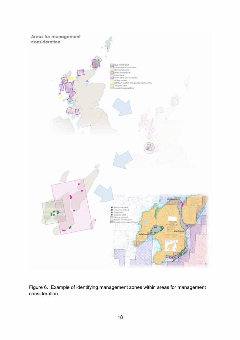
This would adopt a standard approach to defining the extent of potential management measures. This would be done by identifying the areas requiring protection and create zones around them where certain activities would be prohibited. This starts by looking within the areas for management consideration identified in the SNH advice. Zones are then drawn around the records of habitats and species using activity data, environmental factors, and where necessary geographic points of interest. The precautionary principle is applied by zoning off PMFs even where they are not subject to current fishing pressure.
An example of this is shown in Figure 6 using areas for management consideration around Islay and Jura. All examples are shown on Marine Scotland Maps National Marine Plan Interactive (NMPi). At this stage this is for illustrative purposes only.
Questions
8. Do you have any views on the management approach identified for the appraisal?
9. Are there any other reasonable alternative approaches to management that could be tested in the Sustainability Appraisal?
18
Figure 6. Example of identifying management zones within areas for management consideration.

19
Annex A – Respondents Information Form
Improving protection given to PMFs outside the MPA network
RESPONDENT INFORMATION FORM Please Note this form must be completed and returned with your response.
Are you responding as an individual or an organisation?
Individual
Organisation
Full name or organisation’s name
Phone number
Address
Postcode
The Scottish Government would like your permission to publish your consultation response. Please indicate your publishing preference:
Publish response with name
Publish response only (without name)
Do not publish response
We will share your response internally with other Scottish Government policy teams who may be addressing the issues you discuss. They may wish to contact you again in the future, but we require your permission to do so. Are you content for Scottish Government to contact you again in relation to this consultation exercise?
Yes
No
Information for organisations:
The option 'Publish response only (without name)’ is available for individual respondents only. If this option is selected, the organisation name will still be published.
If you choose the option 'Do not publish response', your organisation name may still be listed as having responded to the consultation in, for example, the analysis report.

20
ANNEX B – Summary of socio-economic impact assessment methodology
The proposed methodology builds on previous marine socio-economic assessments undertaken for Marine Protected Areas. It takes account of Better Regulation Executive guidance on impact assessment, the Green Book methodology for economic assessment (HM Treasury, 2011) and Scottish Government guidance on Business and Regulatory Impact Assessment (BRIA).
Figure 7 shows the process for economic analysis that has been used for assessments of Marine Protected Areas. As this project is expected to result in proposals for spatial measures then a very similar approach will be adopted. Some refinement may be required once the reasonable alternatives are identified.
Figure 7. Process for Economic and Social Analysis (from Marine Scotland, 2013a)
Cumulative impacts
Benefits
Site Analysis
Analysed by Sector*...
Activities Present & Baselines (to 2034)
Management: Impacts to Activities Measures Required (2014—2034)
Costs ECONOMIC costs to Public sector
Upper & lower
bounds
Public Sector Actions (e.g. survey)
* FISHERIES: sector divided into min-sectors by gear type and vessel size.
Process for economic analysis
Site Features and Status
ECONOMIC
• GVA • Turnover • Industry
costs • Indirect &
induced impacts
Check baseline
assumptions Public Sector Actions (for industry)
SOCIAL IMPACT • Local
expenditure • Employment
Total Economic Impacts • 1-off • Annual
Pressures
Changes to Pressures - Benefits to features & network
Changes to Ecosystem Services
Welfare impacts Monetary values where possible**
TOTAL SITE SOCIO-ECONOMIC IMPACTS • Discounted economic
costs • Social Impacts • Total Benefits
From all sites
• Discounted economic costs
• Social impacts
Scottish economic strategy
CONTEXT INFORMATION
TOTAL NETWORK SOCIO-ECONOMIC
IMPACTS
• Benefits Network effects
** Value evidence used (in order of pref-erence): market, surrogate market, revealed preference, stated preference. Transfer of values dependent on rele-vance to environmental change, benefici-ary population, etc

21
For the purposes of this assessment a number of assumptions have been made:
• Any management measures will be implemented during 2019 and costs will be first experienced in 2019. Costs and GVA impacts will be expressed in 2018 prices.
• An assessment period of 20 years following implementation of management measures has been selected as providing a reasonable time period within which the main impacts are likely to occur. The assessment period therefore runs from 2019 to 2038.
• Selected scenarios will be used to assess the potential range of impacts, which reflect a range of possible management options that may be applied and the potential for displacement of fishing effort to result in landings that compensate for the landings affected (see Section 3.4). Any scenario assessed may not reflect the final measures implemented by the Scottish Government.
Baseline information is compared against intervention options. Requirements for the baseline include:
• Information on the current spatial distribution of fishing in the marine environment, its intensity and economic value (turnover, GVA);
• Information on how the spatial distribution of activities in the marine environment and their intensity and economic value may change over the time period of the assessment (in the absence of the intervention), in response to existing drivers including current policy drivers;
• Information on ecosystem service values associated with the marine environment and how these may change over time (in the absence of the intervention);
• Processed Vessel Monitoring System (VMS) data for fishing vessels over 12m in length, by gear type (demersal and shellfish landings only) for the period 2012–2016;
• ICES rectangle landings data for fishing vessels under 12m in length for the period 2012–2016;
• Scotmap data for fishing vessels under 15m in length.

22
Assessing the potential impacts of the different scenarios follows a systematic process. The following steps to assess the potential impacts on commercial fisheries are envisaged:
• Estimating the costs arising from the different scenarios. Due to the differences in data availability, this will be carried out separately for under-12m and over-12m vessels. o For under-12m vessels, the value of landings affected would be calculated
from the value of landings reported at ICES rectangle level, pro-rated based on Scotmap. From Scotmap, for each ICES rectangle, the value of landings from within potential management area will be calculated, as well as the value of landings from the ICES rectangle. The ratio between the two will be used to pro-rata the baseline ICES rectangle landings data.
o For over-12m vessels, Vessel Monitoring System (VMS) ping data linked to landings records will be used. Recorded landings in a day will be allocated across all VMS fishing pings on that day, where a ‘fishing ping’ has been defined as one where the average speed since the previous ping is greater than zero and up to 5 knots for all gear types. The ping data will be then intersected with the management areas to calculate the value affected for each gear type.
• For both under-12m and over-12m vessels, landings values will be uprated to 2018 values using GDP deflators and averaged over five years (2012-2016) to provide annual average values over the period.
• These results will then be converted into Gross Value Added (GVA) using fleet-segment specific ratios calculated from Seafish economic data. Further analysis will also assess effects on the supply chain, household consumption and effects on employment.
• The present value of impacts over the assessment period will be calculated. The average annual value of landings affected is assumed to be constant throughout the 20-year period of the assessment. Costs are calculated in 2018 prices, discounted over the assessment period at a rate of 3.5%.
• Finally other non-quantified costs and benefits will be documented, along with social impact and distributional analysis, and any Public Sector costs.
23
ANNEX C – Ecosystem Services
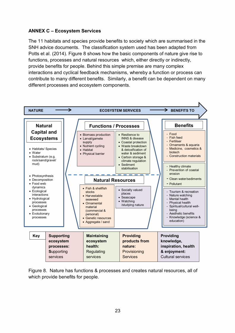
The 11 habitats and species provide benefits to society which are summarised in the SNH advice documents. The classification system used has been adapted from Potts et al. (2014). Figure 8 shows how the basic components of nature give rise to functions, processes and natural resources which, either directly or indirectly, provide benefits for people. Behind this simple premise are many complex interactions and cyclical feedback mechanisms, whereby a function or process can contribute to many different benefits. Similarly, a benefit can be dependent on many different processes and ecosystem components.
Figure 8. Nature has functions & processes and creates natural resources, all of which provide benefits for people.
• Habitats/ Species • Water • Substratum (e.g.
rock/sand/gravel/mud)
• Photosynthesis • Decomposition • Food web
dynamics • Ecological
interactions • Hydrological
processes • Geological
processes • Evolutionary
processes • …etc…
• Biomass production • Larval/gamete
supply • Nutrient cycling • Habitat • Physical barrier
• Resilience to INNS & disease
• Coastal protection • Waste breakdown
& detoxification of water & sediment
• Carbon storage & climate regulation
• Sediment stabilisation
• Fish & shellfish stocks
• Harvestable seaweed
• Ornamental material (commercial & personal)
• Genetic resources • Aggregate / sand
• Socially valued places
• Seascape • Watching
/studying nature
Functions / Processes
Natural Resources
Natural Capital and Ecosystems
Benefits
- Healthy climate - Prevention of coastal
erosion - Clean water/sediments - Pollutant
immobilisation - Tourism & recreation - Nature watching - Mental health - Physical health - Spiritual/cultural well-
being - Aesthetic benefits - Knowledge (science &
education)
- Food - Fish feed - Fertiliser - Ornaments & aquaria - Medicine, cosmetics &
biotech - Construction materials
Supporting ecosystem processes: Supporting services
Maintaining ecosystem health: Regulating services
Providing products from nature: Provisioning Services
Providing knowledge, inspiration, health & enjoyment: Cultural services
Key
NATURE ECOSYSTEM SERVICES BENEFITS TO PEOPLE

24
Linking a function / process or natural resource with a feature does not necessarily mean that the end benefit is realised. Ensuring that benefits are realised often requires people to do something. For example, delivering food will require some kind of fishing or harvesting activity, or ensuring enjoyment of marine nature may require work to provide access to and along the coastline. In some cases, we may be able to identify opportunities to increase the flow of benefits from nature through intervention. However, there may be situations where human pressure prevents an ecosystem from sustaining itself. In such cases reduction in benefits to people is likely to occur.
Glossary of ecosystem service terms
Biomass production - the formation of biological material through photosynthesis or consumption of organic matter.
Larval/gamete supply - quantity, quality & dispersal potential of larva/gametes. This supply may positively affect the production area, but can also affect a much wider area depending on the environmental variables affecting that location. Nutrient cycling - movement or exchange of nutrients such as nitrates and phosphates back in to the production of matter.
Habitat for other species - geological or biological material providing a habitat for other species. Physical barriers - natural barriers to the movement of water or solid matter. Resilience to INNS & disease – Healthy habitats/populations are likely to make a greater contribution to the ability of an ecosystem to resist, recover from or adapt to the introduction of a non-native or disease/pathogen. Natural coastal protection - habitats and geomorphology which attenuate or block wave energy from reaching parts of the coast and foreshore with sensitive natural or built assets. Waste breakdown & detoxification - physical or chemical change to contamination levels by species/habitats removing contaminants through consumption or filtering, or otherwise help lock contaminants in to substrate. Carbon storage & climate regulation - storage or sequestration of organic or inorganic carbon within biomass or sediment or geological material. Stabilisation of sediment - transfer of sediment from water column to seabed caused by the physical structure of habitats changing water movement that would otherwise keep sediment suspended. Fish & shellfish stocks - harvestable wild fish and shellfish for commercial market or personal use / recreational fishing. Harvestable seaweed - seaweed collectable for commercial or personal use. Ornamental material - shells or other natural material collected for display or as trinkets/memorabilia, whether for commercial sale or personal use.

25
Genetic resources - species with potential use in, for example, biomedicine, food/nutrition or cosmetics, whether as raw material or isolation of genetic properties. Aggregate / sand - sediment and rock resources identified for potential extraction and use in construction. Socially valued places - Locations which someone places non-monetary value upon, regardless of whether or not they actively use or enjoy the natural assets at that location. Seascape - the aesthetic qualities and character (visual and sense of place) of areas of sea or coast with which human society has a connection. Watching/studying nature - species and habitats which people enjoy, study or observe.
w w w . g o v . s c o t
© Crown copyright 2018
This publication is licensed under the terms of the Open Government Licence v3.0 except where otherwise stated. To view this licence, visit nationalarchives.gov.uk/doc/open-government-licence/version/3 or write to the Information Policy Team, The National Archives, Kew, London TW9 4DU, or email: [email protected]
Where we have identified any third party copyright information you will need to obtain permission from the copyright holders concerned.
This publication is available at www.gov.scot
Any enquiries regarding this publication should be sent to us at The Scottish GovernmentSt Andrew’s HouseEdinburghEH1 3DG
ISBN: 978-1-78781-019-8 (web only)
Published by The Scottish Government, July 2018
Produced for The Scottish Government by APS Group Scotland, 21 Tennant Street, Edinburgh EH6 5NAPPDAS433266 (07/18)