mars as viewed by mariner 9
TRANSCRIPT
8/8/2019 MARS as Viewed by Mariner 9
http://slidepdf.com/reader/full/mars-as-viewed-by-mariner-9 1/222
I - i A S A - S P -329)
A ) 279 pB Y
C S C L
9
TION
8/8/2019 MARS as Viewed by Mariner 9
http://slidepdf.com/reader/full/mars-as-viewed-by-mariner-9 2/222
NASA SP-3
AS VIEWED BYMARINER 9
A Pictorial Presentation bythe Mariner 9 Television Teamand the Planetology Program
Principal Investigators
Scientific an d Technical I n f o r m a t i o n Office 1974
N A T I O N A L A E R O N A U T I C S A N D S P A CE A D M I N I S T R A T I O N
W a s h i n g t o n , D.C.
8/8/2019 MARS as Viewed by Mariner 9
http://slidepdf.com/reader/full/mars-as-viewed-by-mariner-9 3/222
L i b r a r y of Congress Catalog Card No. 73-600151
Fo r sale by the Su p e r in te nd e n t of D o c u m e n t s
U.S. Government Pr in t ing Office, W as hing ton , B.C.20402
Price $8.15/Stock No. 3300-00522
•fr U.S. G O V E R N M E N T P R I N T I N G O F T i C E : 1974 O—508-064
8/8/2019 MARS as Viewed by Mariner 9
http://slidepdf.com/reader/full/mars-as-viewed-by-mariner-9 4/222
Foreword
In t h e a n n a l s o f space explora t ion , a very pa r t i cula r
place mus t be reserved for a 546-kg metal objec t tha t ,t u m b l i n g an d s i l en t now, is enc i rc l ing an alien planet
h u n d r e d s o f m i l l i o n s o f k i l o m e t e r s f r o m it s n a t i v e Earth.
It wil l remain , we th ink , in th i s remote o rb i t fo r a t l eas t
hal f a c e n t u r y — u n l e s s perhaps s o m e e a r t h b o u n d c a r a v e l
of the fa r f u t u r e picks i t up fo r re turn to a place o f
hono r in the l and of i t s o r ig in . Th is m eta l objec t i s the
M a r i n e r 9 spacecra f t , a s ing ula r ly respons ive mechan ism
at the end of an ex iguous e lec t romagne t ic l ink that per-
f o r m e d one of the most remarkable miss ions in the h is -
to ry o f plane ta ry exp lora t ion .
From the beg inn ing— before , in fac t—it was an ex-
c e p t i o n a l m i s s i o n . A t w i n s p a c e c r a f t , p r o g r am m e d t o d o
ha l f the m app ing and sc ien t i f i c reconna issance o f thep l a n e t Mars , d ied a t b i r th , a v ic t im of l aunch-veh ic le
f a i l u re . T h e M a r i n e r t e a m , w o r k i n g c o o l l y u n d e r difficult
c o n s t r a i n t s , r e b u i l t th e f l ight plan an d orbi t o f M a r i n e r 9
to accompl i sh a s many as possible of the sc ien t i f i c objec -
t ives of both missions. Then, a f te r 157 days o f in te r -
p l a n e t a r y f l igh t , the spacecra f t a r r ived a t M a r s a n d suc-
cess ful ly e n t e r e d o r b i t — b e c o m i n g the f i r s t h u m a n a r t i f ac t
ever to o r b i t a n o t h e r p l a n e t — o n l y to e n c o u n t e r a p l a n e t -wide dus t s to rm th a t was ve i l in g the sur face o f M ars .
A l t h o u g h t h i s f o r c e d p o s t p o n e m e n t of the m a p p i n g m i s -
s ion fo r many weeks , i t d id provide an exce l len t oppor tu-
n i ty to s tudy the s to rm benea th . A f t e r t h e s to r m a b a t e d ,
M a r i n e r 9 set a b o u t a mapping and sc ien t i f i c reconna is -
sance o f e x c e p t i o n a l q u a l i t y a n d v a l u e . I t p h o t o g r a p h e d
v i r t u a l l y the whole sur face o f the plane t , sent m o r e t h a n
7000 images back to E a r t h , an d re layed a t o t a l o f m o r e
t h a n 3 0 b i l li o n b i t s o f i n f o r m a t i o n , a n a m o u n t e q u i v a l e n t
to 36 t i m e s th e en t i re t ex t of the Encyclopaedia B r i t a n -
nica. This is i n c o m p a r a b l y m o r e t h a n had been received
f r o m all ea r l ie r p la ne ta ry miss ions together. T h e p i c t u r e s
in t h i s v o l u m e , w h i c h i s but one o f many sc ien t i f i c re -ports to der ive f r o m the miss ion , provide in the i r v iew
of canyons and g ian t c revasses , c ra te r s and volcanoes , a
n e w a n d e x c i t i n g u n d e r s t a n d i n g o f t h e r e d p l a n e t .
James C. F l et c he r , A d m i n i s t r a t o r
N a t i o n a l A e r o n a u t i c s a n d S p ac e A d m i n i s t r a t i o n
8/8/2019 MARS as Viewed by Mariner 9
http://slidepdf.com/reader/full/mars-as-viewed-by-mariner-9 5/222
Preface
M a r i n e r 9 was l a u n c h e d f r o m K e n n e d y Space Center
on Ma y 30 . 1971. A m i d r o u r s e m a n e u v e r on J un e 5placed i ts a iming poin t so c lose to Mars that no addi-
t i o n a l course cor rec t ion was necessary . The spacecraf t
was success ful ly inse r ted i n t o Mars orbi t on N o ve mb e r 14
at 00:15:29 GMT,becoming the f irst t n amn ad e o b j e c t to
o r b i t an o th e r p lan e t .
I n i t i a t e d in 1968, th e M a r i n e r M a r s 1971 P r o g r am
h ad called f o r t w o spacecraf t to o r b i t Mar s d ur in g th e
1971 o pp o r tu n i ty , o n e in a h ig h i n c l i n a t i o n orbi t and the
o th e r in a l o w in c l in a t io n o r b i t . A f t e r Mar in e r 8 was lo s t
d u r i n g launch on May 9. the operat ional s t rategy was
changed to an in te rme diate inc l ina t ion orbi t to ach ieve
m a x i m u m scientif ic re turn f rom a s ingle orbi te r . T h e
object ive of the miss ion was to explore Mars f rom orbi tfo r a per iod o f t ime sufficient to observe a large f rac t ion
of th e s u r f ac e and to exam ine se lec ted areas fo r d y n a m i c
changes . Imagery of the s u r f ac e was to be obtained as
wel l as s ig n i f i c an t d a ta on the a tmo s ph e r e an d s u r f ac e
charac te r is t ics .
Eleven Pr inc ipal Inves t igator s were concerned w i t h
th e s ix exper iments car r ied by M a r i n e r 9 :
Televis ion—H. Masursky I team leader ) , U.S. Geological
Survey. Flags ta f f ; G. B r iggs, Je t Propuls ion Labora-
to r y ; G . D e V auc o u le ur s . U n ive r s i ty o f Texas; J. Led-
e r be r g , S tan f o r d U n ive r s i ty ; B . S mi th , N e w M e x ic o
State Univers i ty .
Ultraviolet spect roscopy—C. B ar th , Univers i ty of Colo-r ad o .
Inf rared spec troscopy—R. Hanel , NA SA Goddard Space
Flight Center .Inf rared rad iometry— G. Neugebauer , Cal i forn ia Ins t i tu te
of Technology.
S-band occul tat ion—A. Kl iore . Je t Propuls ion Laboratory .
Celestial mechanics—J. Lore l l I t e am l e ad e r ! , Je t P r o pu l -
s io n Lab o r a to r y ; I. Shapiro , Massachuse t ts Ins t i tute o f
Technology.
The spacecraf t was approaching Mars , when te le -
scopes o n Ear th revealed that a plane t wide dus t s to rm h ad
broken out and was t o t a l l y obscur ing i ts sur face . From
N o v e m b e r t o mid - D e c e mb e r o n ly f a i n t mar k in g s appeared
on the sur face o f M a r s an d sometimes a diffuse f e a tu r e
w i t h a series of b i l l o w i n g dust waves on its lee s ide. The
last pic ture taken before orbi tal inse r t ion h ad s h o wn f o ur
c u r i o u s dark spots al igned in a T-shaped pat te rn , and i t
wa s theor ized t h a t t h e y mig h t be h ig h - s tan d in g pa r t s o f
an otherw ise obscured plane t . This a r e a w as mo n i to r e d
repeatedly during the course of the s torm, and as succes-
sive pictures showed more and more detail it became
clear to the science team t h a t these were th e s u m m i t areas
of e n o r mo us vo lc an o e s p r o t r ud in g th r o ug h the top of the
dust c loud . B y the end of December it appeared that th e
dust storm w as d i m i n i s h i n g an d t h a t th e p lan e ta r y map-
ping sequences could soon begin.
F r o m J a n u a r y 1972 onward , every week was punc-
tua ted by new and s ta r t l in g d iscover ies . Firs t the re were
th e enormous volcanoes s tand ing as muc h as 15 milesabove th e average sur face , each one ab o u t th e size of

8/8/2019 MARS as Viewed by Mariner 9
http://slidepdf.com/reader/full/mars-as-viewed-by-mariner-9 6/222
A r i z o n a . T h e n , to ta l ly u n a n t i c i p a t e d , i m m e n s e c a n y o n s
a p p e a r e d , i n c l u d i n g a g r e a t e q u a t o r i a l c h a sm m o r e t h a nte n t imes the s ize o f the U.S. Grand Canyon. The canyons
proved to have e roded w al l s , and in add i t ion nu me rous
d e n d r i t i c t r i b u t a r i e s e x t e n d e d b ac k f r o m t h e canyon wal l s ,
s u g g e s t i n g tha t wa te r e ros ion m a y have played a role in
s c u l p t u r i n g the sur face o f Mars some t ime in i t s past. Y et
it was known f rom previous f lyby miss ions tha t a tmos-
p h e r i c and s u r f a c e t e m p e r a t u r e c o n d i t i o n s are such as to
p r e v e n t l i q u i d w a t e r f r o m e x i st in g i n a d e q u a t e q u a n t i t y a t
the presen t t ime . For this reason the science team was
a s t o u n d e d by the a p p a r e n t e v i d e n c e s o f eros ion , a n d t h e n
by the d i scovery of non-canyon-re la ted s inuous channel s
tha t had a l l the ea rmarks o f d ry r iver va l leys . Eroded
cli ffs appeared , as w e l l a s w i n d - e r o s i o n f e a t u r e s a n d larged u n e masses. It is d i f f i c u l t to c o n v e y th e sense o f high
exc i tement tha t pervaded the sc ien t i f i c inves t iga tors a s
the newly perce ived ch a rac te r o f our s i s te r p lane t began
t o u n f o l d .
Soon i t became appare n t tha t a lmos t a l l genera l iza -
t i o n s a b o u t M a r s d e r i v e d f r o m M a r i n e r s 4, 6. and 7
w o u l d h a v e t o b e m o d i f i e d o r a b a n d o n e d . T h e p a r t i c i -
p a n t s in ea r l ie r f ly b y miss ions h ad been vic t ims of an
u n f o r t u n a t e h a p p e n s t a n c e o f t iming. Each earl ier space-
c r a f t ( e x c e p t i n p a r t f o r M a r i n e r 7 . w h i c h h a d r e t u r n e d
s t a r t l i n g pic tures of the south po la r reg ions I had chanced
to f ly by the m o s t l u n a r - l i k e p a r ts of the s u r f a c e , r e t u r n -
in g pic tures o f w h a t w e n o w believe to be p r i m i t i v e ,
cratered a reas . Given a d if fe rence of as l i t t l e as s ix h o u r s
in a r r i v a l t i m e s of any of these ea r l ie r spacecra f t i each o fw h i c h h a d s p e n t m a n y m o n t h s i n t r a n s i t ) , a n e n t i r e l y
d i f f e r e n t view o f M a r s w o u l d h a v e r e s u l t e d . I t was a l m o s t
as i f s p a c e c r a f t f r o m some o ther c ivi l iza t ion had f l own by
E a r t h a n d c h a n c e d to re turn pic tures on ly of i ts oceans.
M ars moved beh in d the Sun in ea r ly A ugus t 1972,
an d the spacecra f t could no longer be commanded f rom
K a r t h . A t t h i s p o i n t i n the m i s s i o n n e a r l y al l t he p l a n e t
had been mapped w i t h the low reso lut ion camera, an d
about 2 percen t o f i t s sur face covered by the h igh reso lu-
t ion camera , spec ia l ly ta rge ted over po in t s o f h igh sc ien-
t i f ic in te res t . In a d d i t i o n , th e w a n i n g of the south po la r
cap had been examined in de ta i l , and the l ayered and
pi t t e d depos i t s in these reg ions ex tens ive ly pic tured . A t a na l t i t u d e of 1650 km the reso lut ion of the TV camera sys -
te m was about 1 km for the low reso lut ion camera and
a b o u t 100 m for the h i g h r e s o l u t i o n c a m e r a .
W h e n M a r s c a m e o u t f r o m b e h i n d th e so la r corona
on O c tober 12 , so tha t sc ien t i f i c opera t ion s w i th the
orbi te r could be r e s u m e d , m a p p i n g c o v e r a g e of the n o r t h -
e rn l a t i tudes w a s c o m p l e t e d a n d t h e n o r t h e r n p o l a r re -
g i o n s e x a m i n e d in deta i l . A f t e r a l i f e t i m e in space o f
51 6 days , th e M a r i n e r 9 spacecra f t ran out o f a t t i t u d e -
c o n t r o l gas and t u m b l e d out o f c o n t r o l o n O c t o b e r 2 7,
1972, almost one year a f t e r i t had been inse r ted in to Mars
orbi t .—J. F. M c C a u l e y , H. F. H i p s h e r . and R. H. Ste in -
bacher.

8/8/2019 MARS as Viewed by Mariner 9
http://slidepdf.com/reader/full/mars-as-viewed-by-mariner-9 7/222
Page Intentionally Left Blank
8/8/2019 MARS as Viewed by Mariner 9
http://slidepdf.com/reader/full/mars-as-viewed-by-mariner-9 8/222

8/8/2019 MARS as Viewed by Mariner 9
http://slidepdf.com/reader/full/mars-as-viewed-by-mariner-9 9/222
Contents
Page
1
5
27
41
57
71
83
91
101
113
125
133
149
163169
185
221
223
1
2
3
4
5
6
7
«
9
10
11
12
13
1415
16
Introduction
Giant Volcanoes of Mars
Mysterious Canyons
Channels
Fractures and Faults
Escarpments
Fretted and Chaotic Terrains
Craters
Wind-Shaped Features
Changing Features
Extensive Plains
Polar Regions
Clouds of Mars
Natural SatellitesMartian Enigmas
Similarities: Mars, Earth, and Moon
Availability of Photographic Prints
Shaded Relief Map of Mars

8/8/2019 MARS as Viewed by Mariner 9
http://slidepdf.com/reader/full/mars-as-viewed-by-mariner-9 10/222
1Introduction
Al t h o u g h the dust s torm delayed the s tar t of system-
at ic mapping , i t afforded an unparal le led oppor tuni ty toexamine i t s effects on the sur face an d a tmo s ph e r e of M a r s .
P ic tures of the l imb were taken showin g that dus t r eached
th e enormous e levat ion o f ab o u t 70 km (43 mi . ) - Gr ad -
ually features emerged th rough the haze . At f i r s t on ly the
dimly sh in ing south polar cap and f o u r d a r k spots could
be seen. On e of the dark spots had been noted du ring the
dus t s to rms o f 1924 an d 1956by as tronomers . Under nor -
m al condi t ions th is f eature appears as a br igh t white spo t ,
O l y m p u s Mo n s . T he other three spots lay in the area
where per iod ic br igh ten ings cal led th e "W-cloud" h ave
of t e n appeared . As the s to rm gradual ly subs ided and the
atmosphere c leared , the f o u r spots turned out to be high
m o u n t a i n s with c rate r s a t the ir summits . O lympus Monsappeared as an immense sh ie ld volcano 24 km high with
long f inger-shaped lava f lows on its f lanks — the largest
volcanic pile ever photographed. Later a great plateau
became visible, s loping to the east f rom the volcanoes .
O n it appeared a br igh t s t r ipe that la te r turned out to be
a great equator ial chasm.
T h e mo r e th an 7300 pic tures acquired f r o m M a r i n e r
9 ind icate that Mars is more var ied and d y n amic th an
previously in fe r red . Al though impac t c rate r s are common,
only a f ew small c rate rs show cont in uous e jec ta b lanke ts
and well developed rays. Most small cra ters , h o w e v e r ,
e x h i b i t degraded , i r r egular e jec ta blanke ts . About half
the surface consists of ancient cratered te r rain s u r r o un d -in g large impac t bas ins . The larges t c i r cular f eature , Hel-
las Planitia, is almost twice the s ize of the largest basin
on the Moon. Mare Imbr ium. Argyre Plan i t ia is r inged
by rad ial ly an d c o n c e n t r i c a l ly t e x t u r e d m o u n t a i n o u ster-r a i n , s imi la r to th e lun ar m u l t i - r i n g e d impact basins such
as Imbr ium and O r ien tale . The rema inder o f the sur face
is covered by younger volcanic rocks and volcanoes. These
rise as muc h as 25 km above th e mean level of extensive
lava plains deposits , some o f which contain w i n d b l o w n
or possibly f luviatile deposits that are sedimentary in
o r ig in . Th e single volcanic edif ice of O ly mpus Mo n s .
which rises high above the f loor o f Amazonis Plan i t ia , is
almost th ree t imes th e w i d t h an d he ight of the largest o f
th e Hawaiian volcanoes . Mauna Loa. Three other large
volcanoes lie along the Tha rsis r idge. Th e volcano es wi th
s u m m i t calderas have fresh f lows on their s lopes and ap-
pear to be relatively young. These volcanic vents providea plaus ible source fo r m u c h of the carbon d iox ide an d
water in the a tmo s ph e r e . T h e great equator ial chasm o r
c a n y o n sys tem. V al les M ar ine r is , com parable in s ize to
the East Afr ican R i f t Val ley system, is as much as 6 km
deep and greater than 5000 km long , the d is tance f r o m
Lo s Angeles to N e w Y o r k City. It t e r m i n a t e s in a c o m-
plexly f au l t e d plateau to the west, and in l a rge patches o f
chaot ic te r rain to the east.
E me r g in g f rom the nor thern plateau lands , a com-
plex array of broad sinuous channels descends into a
regional ly depressed area. Large f luvial channels beg in in
th is chaot ic te r rain — possibly f rom episod ic mel t ing o f
p e r m a f r o s t — and seem to f low nor t hw ard in to the ChryseP l a n i t i a lowland . The channels merge on the bor d e r o f
th e f lat, low Chryse area; here the c h an n e l f loors show

8/8/2019 MARS as Viewed by Mariner 9
http://slidepdf.com/reader/full/mars-as-viewed-by-mariner-9 11/222
mult ip le braided features and streamlined islands. I t has
been proposed that the collapse of these rocks and f o r m a -
tion of large-scale landslides may be caused by melting
of pe r maf r o s t .
O ther large s inuous channels with man y t r ibutar ies
have no obvious sources. Small dendritic channel net-
works abound in the equator ial r eg ions and imply pos -
sible rainfal l . Many of the basin floors are underlain by
lava f lows having lobate f ron ts , and are in fe r red to be
basaltic f rom the form of the f lows, r idges, and b ro ad ,
low mare- type domes that charac te r ize the ir sur face .
T h e polar r eg ions are covered by glacio-eolian lay-
ered rocks that appear to be s t i l l fo rming under th e pres-
en t climatic regime. Older massive deposits ar e being
eroded , pit ted , and e tched in to t roughs around the mar -gins of the poles. Y oung layered deposits resembling th in
l a m i n a e over l ie the e tch-pi t ted uni t . The ind ividual th in
layers appear to be cyclical deposits . High velocity wind
is s t r ipping th e sur face an d f o r m i n g deflat ion hollows . A
m a n t l e o f w i n d b l o w n debr is , presumably der ived f rom
these c ircumpolar zones , th ins toward th e equator. These
depos i ts smooth ly blanke t a subdued c rate red te r rain an d
p a r t i a l l y f ill its craters . T h e south an d nor th polar r eg ions
have apparen t ly ac ted as sed iment o r dus t t r aps th rough-
o ut m u c h o f Mar s h i s to r y .
Both eo l ian e ros ional f eatures such as y ar d an g s
( w i n d eroded r idges ) and depos i t io nal f eatu res such as
dunes have been iden t i f ied in the equa tor ial r eg ion . O ned un e field, ab o u t 130 km long, lies on the floor of a
crate r . Wind e ros ional an d d e po s i t io n a l processes are ac -
t ive , as seen by numerous changes in the albedo pat te rns
th a t we r e mo n i to r e d af t e r th e clearing of the p lan e twid e
d us t s to r m. R e d i s t r ib u t io n of deposits o f silt an d clay
par t ic les reveals dark , i r r egular mark ings and l igh t and
d ar k tai ls e m a n a t i n g f rom topographic obstacles. T h e
l i g h t ta i ls appear to be w ind-depo s i ted ma te r ial : the dark
tails appear to be mos t ly wind-scoured zones . Throughout
th e mission clouds of various patterns composed of C02
ic e crys tals , wate r ic e crys tals , and local wTi n d raised dust
clouds were observed.
T h e t e mpe r a tu r e me as ur e me n t s an d c lo ud pa t t e r n s
le d to i n t e r p r e ta t io n s of the plane tw ide atmospher ic c i r
cula t ion pat te rn , which in tu r n c o u ld be c o mpar e d wi th
th e br igh t and dark sur fa ce mark ings that also ind icate
w i n d direc t ions . Changes in the sur face pat te rns werem o n i t o r e d o n a per iod ic basis. Dur ing th is t ime th e dark
m a r k i n g s that had been observed f rom Ear t h telescopes
fo r more than a hundred years g radual ly reappeared
af t e r having been obscured by the storm deposits .
The re treats o f bo th the nor th and south polar ic e
caps were observed closely. The carbon dioxide an d pos
sibly some wate r ice r e t reated by subl imation , r eveal ing
layered deposits fo rm ed by glacial-like processes, an d a
belt of e tched pi t ted te r rain sur rounding th e polar ice-cap
reg ion . The hol lows may be formed by w ind e ros ion , fo r
the winds at the marg ins of the polar caps have a very
high ve loc i ty on Mars , as they do on Ear th in A ntarc t ica
and near the Greenland ice cap.T h e spacecraf t ceased f u n c t i o n i n g wh e n i t ran out of
a t t i t u d e - c o n t r o l g as af t e r 349 days in orbi tal operat ion

8/8/2019 MARS as Viewed by Mariner 9
http://slidepdf.com/reader/full/mars-as-viewed-by-mariner-9 12/222
It succeeded it s design l i f e t i m e b y al mos t a f a c t o r o f f o u r . M a r s in 1975-76 t ha t i nvol ve l anding s pac e c raf t on the
an d it s observations exceeded all science goals. M a r i n e r 9 s ur fac e o f Mars to search fo r l ife. — H . M a s u r s k y an d
d a t a wil l g r e a t l y assist p l a n n i n g fo r the V i k i n g f l igh ts to B . A. S m i t h

8/8/2019 MARS as Viewed by Mariner 9
http://slidepdf.com/reader/full/mars-as-viewed-by-mariner-9 13/222
2Giant Volcanoes of Mars
R e c o g n i t i o n o f pr o m in e n t vo lc an ic f e a tu re s o n M a r s
was one of the first and mo s t s ign i f ican t resul ts of thef l ight o f M a r i n e r 9. D u r i n g th e fu l ly developed dus t s to rm,
the only sur face features c lear ly vis ib le outs ide the polar
areas were f o u r dark spots in the Amazonis -Thars is r e -
g io n . As the atmosphere cleared, those spots were seen
to be the cen tral calderas of f o u r enormous sh ie ld vol-
canoes . Subsequent photography of o ther par ts o f the
p l a n e t revealed more volcanic f eatures , ind icat ing that
volcanism played a major role in the evolut ion of M ars .
Past volcanic ac t ivi ty inc ludes formation of ex tens ive
p l a i n s un i t s , an d b u i ld in g of the t r emendous sh ie ld vol-
canoes and num ero us smalle r dome -l ike s t ruc tures .
Most of the volcanic f eatures except th e p la in s ar e
in th e reg ions of h i g h e le va t io n . T he three shield volca-noes, th e Thars is Monies , l ie on a broad r idge which is
3 to 5 km above th e mean level of the mar t i an s u r f ac e .
O l y m p u s Mons, the largest of the volcanic shields, lies
on the weste rn f lank of this r idge. O lym pus is 500 km
wide an d rises 29 km above th e s u r r o un d in g p la in . T he
Tharsis Monies. Ascraeus. Pavo n i s , an d A r s ia Mo n s are
each about 400 km across and. al though smalle r than
O l y m p u s Mons . m ay reach ih e same elevalion above ih e
me an level of Mars because of iheir localion on a r idge.
In c o mpar i s o n , ih e largesl volcano on E ar lh , Maun a Loa
in Hawaii , i s approximale ly 200 km wide and r ises aboul
9 km above ihe sea floor.
A ll shield volcanoes have roughly circular oullines
and cen tral summit depress ions . Ars ia Mons , Pavonis
Mo n s , and an Elysium shield, Albor Tholus, have s implecrate r s al i h e ir s umm i t s . O ly mpus Mo n s and Ascraeus
Mons have complex cralers as a resull of successive col-
lapses around di f fe ren l cenlers . Olher volcanoes, d i f f e r i n g
f rom shield volcanoes in lhal they are smalle r an d s imple ,
ar e proper ly le rmed domes o r thol i .
T he shields an d domes are the most spectacular
aspec ts o f mar t ian volcanism, but the plains on Mars
may be volumetric-al ly more s ign if ican t . High reso lut ion
pic tures o f ihe plains commonly show long , low, lobale
scarps (possible f low f r o n l s ) lhat strongly resemble fea-
lures in Mare Imbr ium on the Moon. By analogy wilh ihe
lunar mar ia an d lerreslr ial f low f ronls , th e plains are
probably large ly volcanic in o r i g i n .In many places th e cralered surface appears lo be
par l ly or whol ly covered by y o un g e r p la in s - f o r min g mate-
r ials . In some areas only ih e small cralers ar e b ur ie d , in
olhers even ih e largesl craters ar e bur ied en t i r e ly or show
only subdued impress ions . Such effects could result f rom
eol ian depos i l ion , but volcanic activily also appears to
have been widespread and producls of this aclivily also
m ay cover par t of ihe crate red sur face . B o th volcan ic
plains and c ircular const ruct ional fea tures are f o u n d
w i t h i n the densely cratered province. Thus, although the
most spectacular volcanic fealures occur in sparsely
crate red reg ions , the en l i r e plane l may have been affected
by volcanism. — M . H . Carr
8/8/2019 MARS as Viewed by Mariner 9
http://slidepdf.com/reader/full/mars-as-viewed-by-mariner-9 14/222
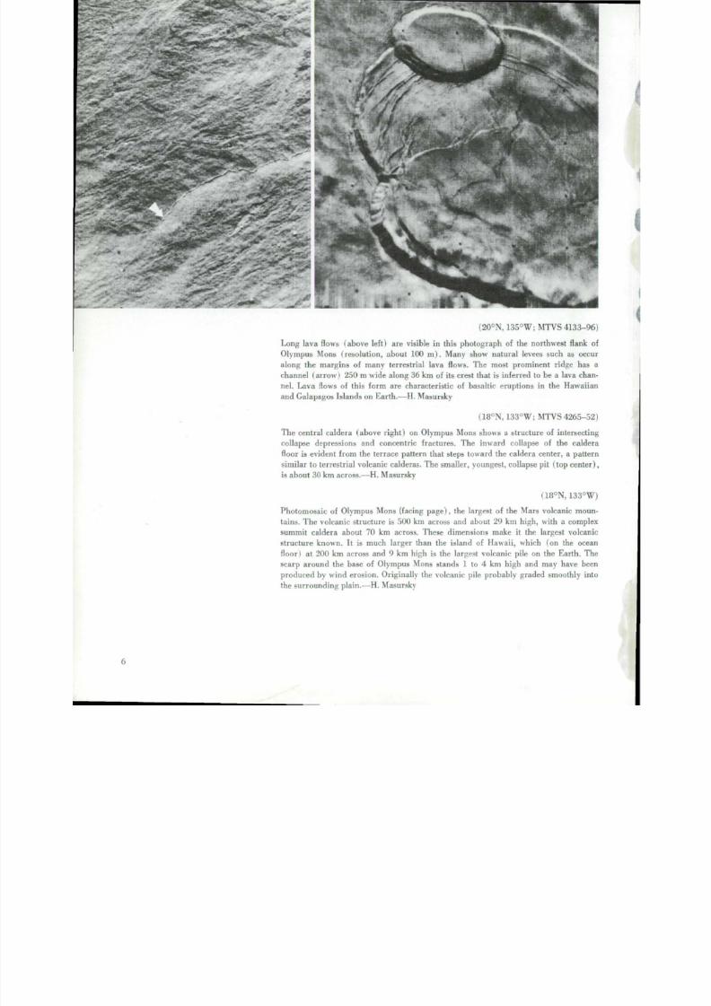
( 2 0 °N , 135°W; M T V S 4133-96
Long lava flows (above left) ar e visible in this photograph of the nor t hwe s t flank o
O lympus M ons (re solutio n, about 100 m). M any show nat ura l levees such as occu
along the margins of many terrestrial lava flows. The most prominent r idge has a
chan nel (arr ow ) 250 m wide along 36 km of its crest that is inferr ed to be a lava chan
nel. Lava flows of this form are ch aracterist ic of basal t ic erupti on s in the Hawa iian
and Galapagos Islands on E a r th .—H. Masursky
(18°N, 133°W; M T V S 4265-52
The cent ra l ca ldera (above r ight ) on Olym pus Mons shows a s t ructure of in tersect in
collapse depressions and concentric fractures. The inward collapse of the calder
floor is evident f r o m the terrace pattern that steps toward the caldera center, a patter
similar to terrestria l volcan ic calderas. T he smaller, youngest, collapse p it ( top center
is about 30 km across.—H. Masursky
(18°N, 133°W
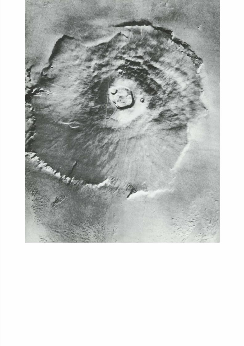
Photomosaic of O lympus Mons (facing page). the largest of the Mars volcanic moun
tains. T he volcanic s t ructure is 500 km across an d about 29 km high, with a comple
summit caldera about 70 km across. These dimensions make it the largest volcani
structure k no wn . I t is much larger than the island of Hawaii , which (on the ocean
floor) at 200 km across and 9 km high is the largest volcanic pile on the Earth. Thscarp around th e base of Ol ym p u s Mons s t a nd s 1 to 4 km high and may have bee
produc ed by wind erosion. O rigin ally the volcanic pile probably graded smo othly int
the sur rounding p la in.—H. Masursky

8/8/2019 MARS as Viewed by Mariner 9
http://slidepdf.com/reader/full/mars-as-viewed-by-mariner-9 15/222
.
.

8/8/2019 MARS as Viewed by Mariner 9
http://slidepdf.com/reader/full/mars-as-viewed-by-mariner-9 16/222

8/8/2019 MARS as Viewed by Mariner 9
http://slidepdf.com/reader/full/mars-as-viewed-by-mariner-9 17/222
(1°N. 113°W; M T V S 4142-93)
P a r t of the summit caldera of Pavonis Mons is shown here. The caldera-wall f lut ing is
pro bably caused by debris avalanch es cutt ing large groove s down the steep slope.
Talus debris m ay over l ie nar row ter race benches . Th e smooth caldera floor, which
abruptly meets the steep walls, may represent the surface of a former lava lake. Well-
defined impact cra ters with sharp r ims ranging f r o m !/2 to 2 km are visible on the
flanks of th e volcano.—M. H . Carr

8/8/2019 MARS as Viewed by Mariner 9
http://slidepdf.com/reader/full/mars-as-viewed-by-mariner-9 18/222
( a b o v e ) . T h e smooth crater-free floor and t a lus on the walls oi the s u m m i t pit, and a
series of collapse terraces at the sides, are clearly visible. Radial r idges, similar to lunar
mare r idges , connect th e cent ra l pit to the r i ng s t r u c t u r e of grabens an d hors t ridges.
T he dark patches formed d u r i ng th e mission an d were almost certainly produced by
eolian processes.—M. H . Carr
(1°N. 112°W; IPL 1699/125324)
The shield volcano at P a v on i s Mons (lef t I is about 400 km across an d rises more than
20 km above the surrounding plains. Concentric graben occur on the flanks of the
shield and in the s u r r ou nd i n g p l a i ns. T he caldera consists of a single large circular
depression. 55 km in d i a m e t e r . —M. H . Carr

8/8/2019 MARS as Viewed by Mariner 9
http://slidepdf.com/reader/full/mars-as-viewed-by-mariner-9 19/222

8/8/2019 MARS as Viewed by Mariner 9
http://slidepdf.com/reader/full/mars-as-viewed-by-mariner-9 20/222
\
-V
'•V

8/8/2019 MARS as Viewed by Mariner 9
http://slidepdf.com/reader/full/mars-as-viewed-by-mariner-9 21/222
(13°N, 89°W; M T V S 4189-72)
Tharis Tholus (a bo ve ). 170 km in diameter , is one of several s imi lar volcanic domes
n e ar th e Thars is Monies . T he central crater is mul t ip l e , has a flat floor and steep walls
with several terraces. The flanks of the dome appear to have been faulted (upper right).
Domes m ay f o r m instead of the larger an d more gentle shield s tructures when only
small volumes of lava are available. Alterna t ively , they may ind icate more viscous and
possibly more s iliceous lava.—M. H . Carr
(13°N, 106°W; M T V S 4184-84)
Ascraeus Mons ( l e f t ) , the nor thernmos t large volcano along the c res t o f Th ar i s r idge,
shows a complex summ it caldera about 60 km across, th e mult iple over lapping c rate r s
and prominent te r races ind icate the volcanic nature of the large mountains . Ascraeus
Mons protruded through th e planetwide dust storm as a dark spot, and in December
1972 it became the first clearly identified volcanic s t ruc ture on Mars . The reve lat ion
of volcanoes on Mars thus over turned th e M a r i n e r 4, 6. and 7 thesis that Mars was a
dead plane t .—H . Masursky
13

8/8/2019 MARS as Viewed by Mariner 9
http://slidepdf.com/reader/full/mars-as-viewed-by-mariner-9 22/222
• :
8/8/2019 MARS as Viewed by Mariner 9
http://slidepdf.com/reader/full/mars-as-viewed-by-mariner-9 23/222
I
I
\

8/8/2019 MARS as Viewed by Mariner 9
http://slidepdf.com/reader/full/mars-as-viewed-by-mariner-9 24/222
(9°S ; 12 0 CW : IP L 1633/004631. 492 I I
A T M U M o n s i p r e c e d i n g p a g e ) : a s hie l d vo lc an o in th e T h a r s i s M o n i e s . A c e nt ra l
s mooth- f l oore d c a l de ra 130 km in d iam ete r i? s u r r o u n d e d 1>\ a z one of c o n c e n t r i c
grabe n. Out s ide th e f a u l t e d z o n e a re n u m e r o u s superimposed l a v a - f lo w lobes an d
s i n u o u s c h a n n e l s w i t h i s ol a t e d grabe n are as . The f l anks a re p a r t l y e mbaye d by the
s u r r o u n d i n g p l a i n s m a t e r i a l s . T h e s t r u c t u r e is bel ieved to be similar to O l y m p u s Mons
b u t s o m e w h a t o l d e r . T h e f l o w s a r c s h o r t e r a n d t h i c k e r t h a n those o n O l y m p u s M o n s .
perhaps be c aus e of c he mic al di f fe re n c e s , a l o w e r g as c o n t e n t , o r e r u p t i o n a t l o w e r
t e mpe ra ture s . The s e f l ows are more s imi l ar t o thos e on the f l anks of M o u n t R a i n i e r a n d
M o u n t Hood i n the Pac i f i c N o r t h w e s t of the U n i t e d Sta te s tha t a r e ande s i t i c i n c om po-
s i t i o n . M . H . Car r a n d H . M a s u r s k \

8/8/2019 MARS as Viewed by Mariner 9
http://slidepdf.com/reader/full/mars-as-viewed-by-mariner-9 25/222
(10°S, 124°W: M T V S 4182-42)
The southwest flank of the large volcanic shield Arsia Mons shows a rough, slightly
cratered terrain with large lobate lava flows trending downslope. Wind erosion has
e tched th e older f low f r o n t s into a rougher terrain. T h e picture is about 32 km across.—
T. R.McGetchin

8/8/2019 MARS as Viewed by Mariner 9
http://slidepdf.com/reader/full/mars-as-viewed-by-mariner-9 26/222

8/8/2019 MARS as Viewed by Mariner 9
http://slidepdf.com/reader/full/mars-as-viewed-by-mariner-9 27/222

8/8/2019 MARS as Viewed by Mariner 9
http://slidepdf.com/reader/full/mars-as-viewed-by-mariner-9 28/222

8/8/2019 MARS as Viewed by Mariner 9
http://slidepdf.com/reader/full/mars-as-viewed-by-mariner-9 29/222
( 22°N , 9 7 ° W ; M T V S 4187-90)
Three v o l c a n i c d o m e s ( l e f t ) near Al b a Patera. The d o m e of U r a n i u s P a t e r a ( u p p e r
l e f t ) has col lapsed, crea t ing a l a r g e c o m p l e x c a l d e r a . C e r a u n i u s Th o l u s has a s inuous
c h a n n e l l e a d in g d o w n f r o m the ca ldera to a c losed depress ion a t the base o f t h e d o m e .
A t h i r d dome. U r a n i u s Th o l u s . is seen at left c e n t e r . N o t e th e series o f parallel , closely
spaced faul t v a l le y s i n t h e b o t t o m o f t h e p h o t o .— D . B . Potter
(24°N, 98 °W; M T V S 4271-51)
A s i n u o u s c h a n n e l , a b o u t 1 k m w i d e , o c c u r s o n t h e f l an k o f t h e v o l c a n i c c o n e C e r a u n i s
Th o l u s . Th e s u m m i t c a l d e r a wal l w a s b r e ac h e d a n d t h e c h a n n e l e r o d e d w h e n f l u id s
d r a i n e d f r o m th e c a l d e r a b a s in ( o f f r i g h t ) to the closed depression at the f o o t of the
cone. T h e m o u t h of the 40-km s inuous channel seems to g r a d e i n t o a del ta l ike deposi t .
M a n y s m a l l e r s i n u o u s c h a n n e l s cross the f lanks of the d o m e , an d severa l channels show
d i s t r i b u t a r y d e p o s i t s a t t h e i r l o w e r ends. P re sum ably , the chann els a re re la ted to vol -
canic act iv i ty , but thei r overa l l character is t ics are also s imi lar to fluvial c h a n n e l s .—
H. E. H o l t
I

8/8/2019 MARS as Viewed by Mariner 9
http://slidepdf.com/reader/full/mars-as-viewed-by-mariner-9 30/222
(25°N, 213°W; M T V S 4298-44
Elysium Mons i s a symmetr ica l shie ld volcano (above) approximately 225 km acros
with a small central caldera and numerous f r a c t u r e s radia l and concentr ic to the shieldSeveral channels an d lines of craters in the f lanks of the shield appear in high resolu
t ion photographs . Two incomplete concent r ic f racture r ings sur round the shield, on
at a radius of 175 km and one at 320 km. Simi lar concent r ic f racture sys tems occu
aro un d other Mars shield volcanoes .—M . H . Carr
( 2 5 °N , 213°W; IPL 7386/014900, 7386/020050
The summit a rea of the Elys ium volcanic cone ( r ight ) shows a well defined radi
pattern o f mate rial on the slopes surr ou nd in g the central crater. Several small chain
of rimless pits are on the r ight flank of the cone. The cra ter rim is broken by sever
sinuous lava channels. The fea tures in l ine with the lava channels in the lower part o
the photo are possibly collapsed lava tubes. The flat f loor of the crater suggests tha
i t contained a lava lake.—J. W . All ingham

8/8/2019 MARS as Viewed by Mariner 9
http://slidepdf.com/reader/full/mars-as-viewed-by-mariner-9 31/222
m
8/8/2019 MARS as Viewed by Mariner 9
http://slidepdf.com/reader/full/mars-as-viewed-by-mariner-9 32/222

8/8/2019 MARS as Viewed by Mariner 9
http://slidepdf.com/reader/full/mars-as-viewed-by-mariner-9 33/222
(31°N, 210°W: M T V S 4298-47)
A smal l ca ldera ( l e f t ) 10 km w i d e on the f lanks of E l y s i u m M o n s . T h e caldera shows
m u l t i p l e col lapse depress ions an d seve ra l f ine chan nels . L ines of smal l volcanic cra tersar e a r r a n g e d a l o n g r a d i a t i n g f r a c t u r e s I l o w e r r i g h t I. Like th e s inuous r i l les on the
M o o n , these lava channels s ta r t in a source cra ter an d b e c o m e n a r r o w e r an d shal lower
d o w n s l o p e . Terrestrial l a va l c h a n n e l s h a v e s i m i l a r f o r m s .— H . M a s u r s k y
( 3 2°N , 211°W: IP L 7386/023416)
T h e edge of the E l y s i u m d o m e s h o w s r .« la t ionships tha t ty p i fy th e c o n t a c t s o f v o l c a n i cd o m e s w i t h t h e s u r r o u n d i n g p la i n s . A lo w e s ca r p m e n t m a y o c c u r a s in t h e b o t t o m o f
t h e f r a m e , o r t h e r a d i a l c h a n n e l s o n t h e f l a n k s m a y b e t r u n c a t e d w h e n t h e y d i p b e -
n e a t h t h e s u r r o u n d i n g m a t e r i a l s a s i n t h e u p p e r c e n t e r o f t h e p i c t u r e . L o w e s c a r p -
m e n t s o u t l i n e a series of lobate f low sheets extending f r o m a c r a t e r ( p r o b a b l y v o lc a n i c )
a b o u t 9 km across. The lobate flows are very s imi lar to basaltic lava flows on the Ea r t h
a n d M o o n .— M . H. Carr
2

8/8/2019 MARS as Viewed by Mariner 9
http://slidepdf.com/reader/full/mars-as-viewed-by-mariner-9 34/222
8/8/2019 MARS as Viewed by Mariner 9
http://slidepdf.com/reader/full/mars-as-viewed-by-mariner-9 35/222
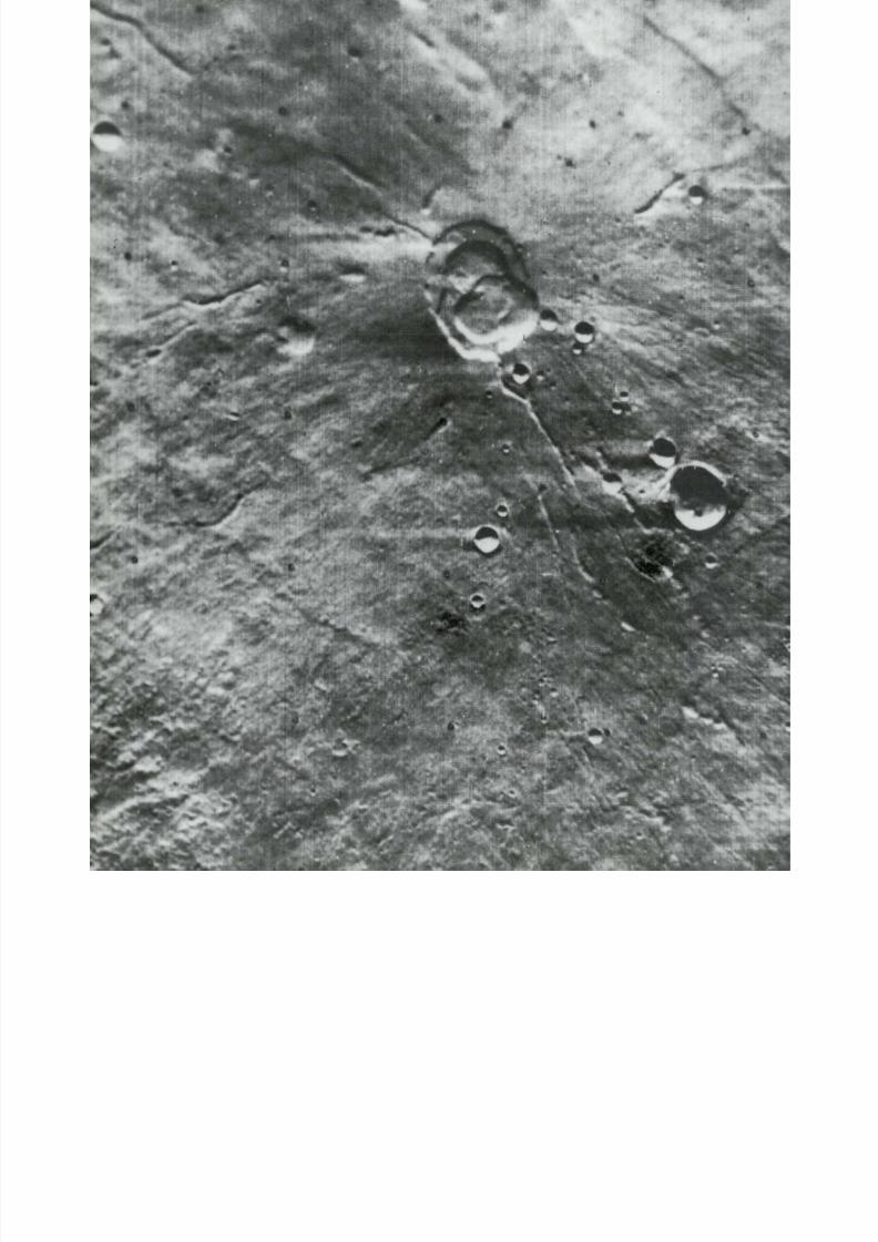
3Mysterious Canyons
One of the mos t spec tacular r eve lat ions of Mar iner 9
was th e system of h ug e c an y o n s in the equator ial r eg ion
of Mars . These e x t r ao r d in a r y f e a tu r e s , up to 200 k m
wide , thousands of k i lomete r s long , and poss ibly as much
as 6 km deep, represent a signif icant phase in the planet's
evolut ion .
The sys tem of canyons . Val les Mar iner is , ex tends
5000 km a lo n g th e equator ial be l t . Some of the d ar k
m a r k i n g s that have been mapped for a cen tury f rom
te r res tr ial telescopes coincide with the floors and walls
of these huge canyons . T he n a tu r e of these mark ings re -
main e d h id d e n un t i l t h e y we r e p ic tu r e d b y Mar in e r 9 .
The canyons cons is t o f a series of paral le l depres -
s ions charac te r ized by steep gullied walls and a sharp
br ink at the l ip o f each canyon. The e longat ion of ind i-
v i d u a l depress ions is paral le l to the t r end of the en t i r e
belt. Walls o f the can yons are rare ly sm ooth . M os t o f
th e m e x h ib i t f e a tu r e s r an g in g f r o m broad open embay-
men ts to complex branc hing ravines and gul l ies . Some of
these gullies h ave d e n d r i t i c d r a in ag e pa t t e r n s an d extend
back i n t o th e s u r r o u n d i n g u p l a n d s fo r d is tances of up to
150 km. K n o b s , spurs , an d other ir regular ities suggest,
along w i t h di f f e re nt degrees of dissection, some degree o f
inhomogene i ty in the m a t e r i a l f o r m i n g th e c a n y o n walls
themselves . The canyon f loors general ly lack c rate r s , sug-
ges t ing e i ther r e lat ive youth of the floors, or the effects
of some erosional process that obliterates all traces of
c rate r s .
A moderate spr inkl ing of c rate r s appe ar s on the up-
l an d s s u r r o un d in g th e c an y o n s ; s o me of these craters
have broken , jumbled , an d appar e n t ly d o wn d r o ppe d
f loors . Another canyon-re lated feature is the presence of
l inear chains of rimless pits, probably of collapse orig in .
I t seems that craters an d pits predat ing th e c an y o n s h ave
served at least partly as sites fo r downward co l lapse that
lead to the formation of the small paral le l canyons .
What c reated the canyons? The paral le l ism of ind i-
v i d u a l c a n y o n s and the paral le l t r ends of pi t chains an d
smalle r fault valleys or graben implies a strong degree of
contro l by reg ional s t ruc tural pat te rns . The blunt ends of
th e canyons sugges t that th e w i d e n i n g and l e n g th e n in g
of them by wall recession m u s t have been a fac tor in the ir
f o r m a t i o n . Jumbled masses of rocky debris piled on
c an y o n floors at the bases of numerous U-shaped gul l ies
ind icate that m ass slides, s lumps, and debr is avalanches
mus t have been a factor in shaping the canyon walls .
T he m a j o r obstacle to any convinc ing explanat ion of
th e or ig in of the canyons is : How was the bulk of the
mater ial o r ig inal ly presen t in these enormous chasms
r e mo ve d ? There i s no obvious way to t r anspor t debr is
out except by w i n d . Yet the a m o u n t of mater ial to be
t r anspor ted is so great as to cast doubt on the effective-
ness of this mechanism operat ing by itself. T he disposal
of such vas t amounts o f mate r ial r emains a problem. —
J. F. McCauley
27
8/8/2019 MARS as Viewed by Mariner 9
http://slidepdf.com/reader/full/mars-as-viewed-by-mariner-9 36/222
StV
*?
yi
> ^,\ \ *'
/vV\>\ \ r*~
G R A N D C A N Y O N O F A R I Z O N A
•t
^A
1<

8/8/2019 MARS as Viewed by Mariner 9
http://slidepdf.com/reader/full/mars-as-viewed-by-mariner-9 37/222
V
> • ». 5
-•/
I
/ r *1""
< .,
< » '
u *•
r'• -,
(
I
^ % f
•y
\
w y
' ' '» > * ..
K
* > .
'- t.
• ' v
'•H<H
>i
. v
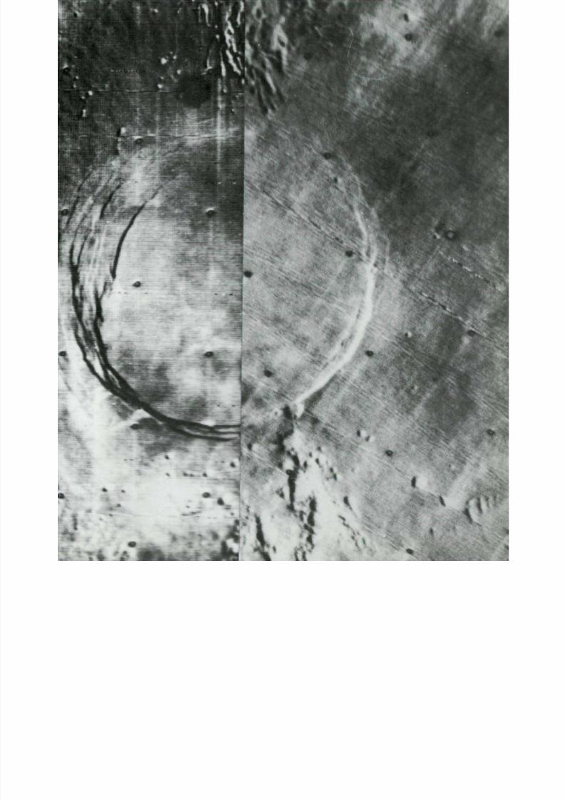
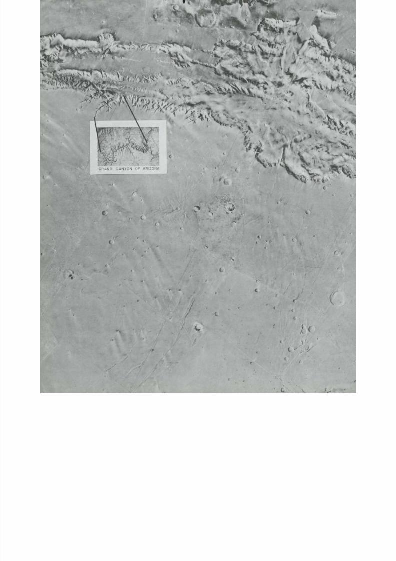
The great c anyon s ys t e m, V al l e s Marineris. m o r e t h a n 5000 km l o n g and at least 6 km
deep, d w a r f s any stream valleys on the c o n t i n e n t s of E a r t h . A minor side canyon is
s i m i l a r i n l e n g t h a n d d e p t h t o t h e G r a n d C a n y o n o f A r i z o n a ( i n s e t ) . F e a t u r e s o n E a r t h
most c l os e l y c om parab l e in s iz e to V al l e s M ar in e r i s a r e the R i f t V a l l e y s ys t e m of Af r i c a
an d related r i f t valleys on ocean f loors . As \v i th Earth's r i f t val l e ys . V al l e s Marineris
may have be e n forme d whe re th e c rus t of the pl ane t h as pul l e d apar t . Pieces of the
c rus t t ha t form the f loor of the c anyon probab l y have subsided al ong fau l t s . Subse-
^ u e n t l y the r im of the val ley h as be e n s c u l p ture d by m y s t e r i o u s processes o f erosion.
T h e i n t r i c a t e s ys t em o f c a n y o n s e x t e n d i n g back f r o m the r im may h a v e been developed
'uring me l t ing and evaporation of subsurface ice.—E. M. Shoemaker
i
I.4 '«
8/8/2019 MARS as Viewed by Mariner 9
http://slidepdf.com/reader/full/mars-as-viewed-by-mariner-9 38/222
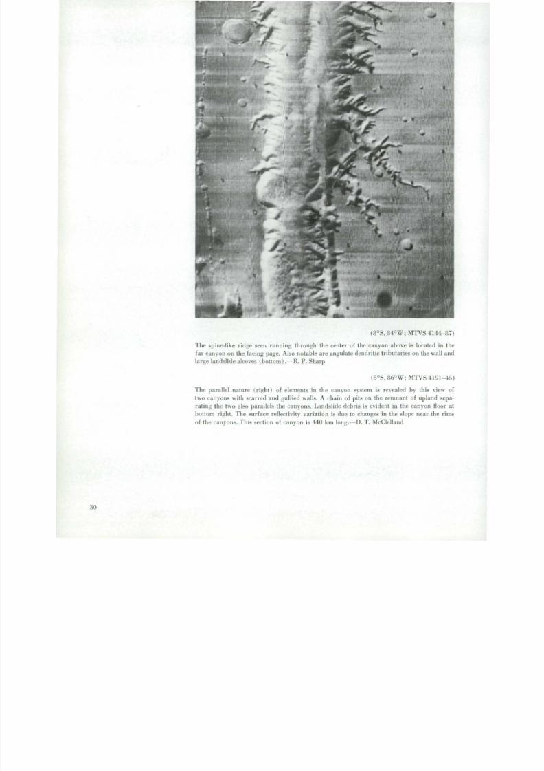
(8°S, 84°W; M T V S 4144-87)
T he spine- l ike r idge seen running th rough th e cente r of the canyon above is located in the
fa r c an y o n on the fac ing page . Also notable ar e angulate dendr i t ic t r ibutar ies on the wall an d
large lands l ide alcoves (bo t tom) .—R. P . Sharp
(5°S, 86°W; M T V S 4191-15)
The paral le l nature ( r ig ht I of elements in the canyon system is revealed by this view of
tw o canyons with scarred and gullied walls . A chain of pits on the remnant of upland sepa-
r a t in g the two also parallels th e canyons . Lands l ide debr is is e v id e n t in the c an y o n floor at
bottom r igh t . T he sur face reflect ivi ty var ia t io n is due to changes in the s lope near th e r ims
of th e c an y o n s . This section of c an y o n is 440 km l o n g . —D . T . McClel land
30
8/8/2019 MARS as Viewed by Mariner 9
http://slidepdf.com/reader/full/mars-as-viewed-by-mariner-9 39/222
o
8/8/2019 MARS as Viewed by Mariner 9
http://slidepdf.com/reader/full/mars-as-viewed-by-mariner-9 40/222
8/8/2019 MARS as Viewed by Mariner 9
http://slidepdf.com/reader/full/mars-as-viewed-by-mariner-9 41/222
.
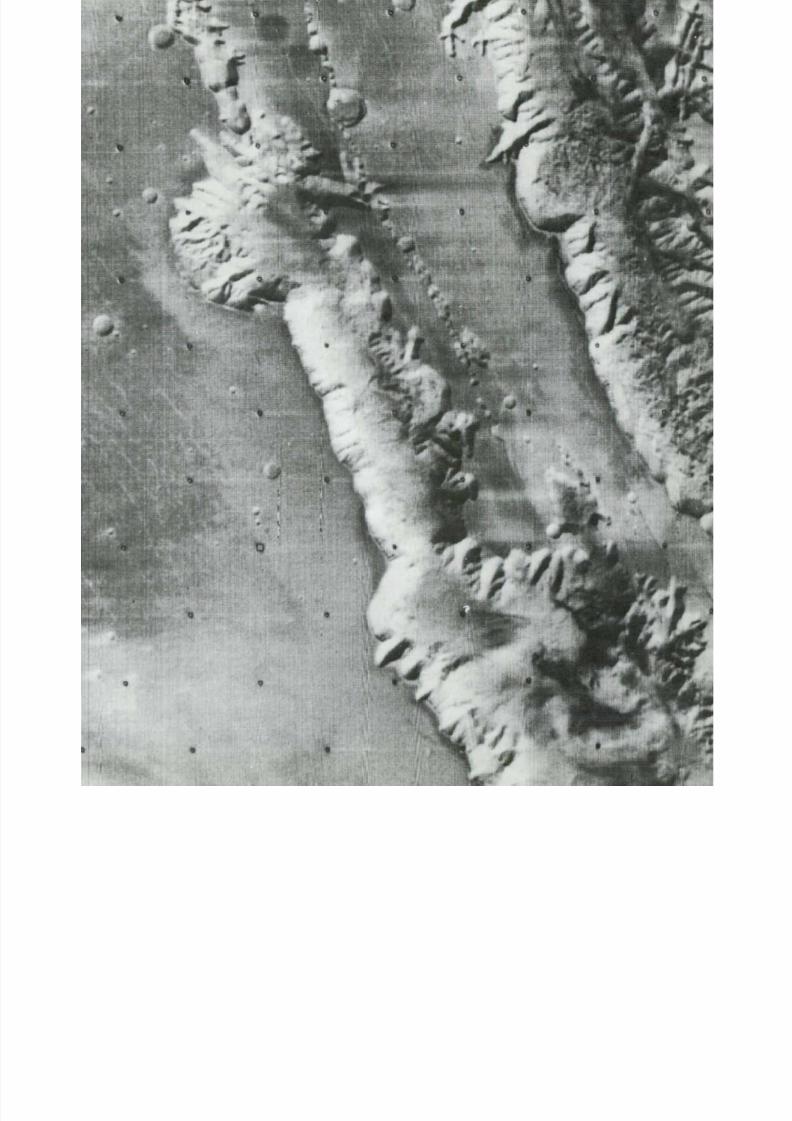
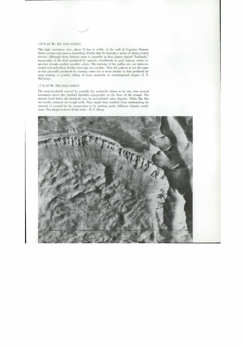
(13°S,61°W: IPL 1616/212555)
'ITiis high resolution view, about 35 km in w i d t h , of the wall of Coprates Chasma
shows ravines and narrow branching divides that l ie beneath a series of sharp crested
alcoves. Although these features seem to resemble at first glance typical "badlands,"
topography of the kind produced by episodic c loudbursts in arid regions, closer in -
spection reveals another possible origin. The bottoms of the gullies are not intercon-
nected and ind ividual d ivides i n t e r r up t one another. Thus the pattern is not the same
as that genera l ly produced by running water but is more similar to that produced by
mass wasting or gravi ty s l id ing of loose materials on oversteepened slopes.—J. F.
McCauley
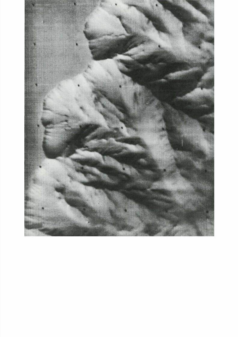
(7°S, 85°W; IPL 1354/184219)
T he steep headwall, scarred by possible dr y avalanche chutes at its rim, rises several
ki lometers above the jumbled landslide topography on the floor of the trough. Thesmooth band below the headwall may be accumulated talus deposits. Slides l ike this
ar e locally common on trough walls. They might have resulted from un d e rm i n i n g by
removal of ground ice by evaporation or by melting under different climatic condi-
tions. This image is ab o ut 42 km wide.—R. P . Sharp
8/8/2019 MARS as Viewed by Mariner 9
http://slidepdf.com/reader/full/mars-as-viewed-by-mariner-9 42/222
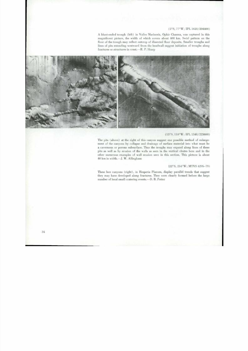
(5°S, 77°W: IPL 1628/20440
A blunt-ended t rough ( l e f t ) in V al les Mariner is . O phir Chasma, was captured in th
m a g n i f i c e n t picture, the width of which covers about 400 km. Swirl pattern on th
floor of th e t rough m ay reflect outc rop of dissected floor deposits. Smaller troughs an
lines of pi ts ex tending w estward f rom th e headwall suggest init iation of troughs alon
f ractures or s t ruc tures in c rust .—R. P . Sharp
(13°S, 110°W; IPL 1348/22360
The p i t s ( ab o ve ) at the r igh t of this canyon suggest one possible method of enlarg
m e n t of the c an y o n s by collapse an d d ra i n ag e of surface mate r ial in to what must ba cavernous or porous subsurface. Thus the troughs may expand along lines of thes
pits as well as by erosion of the walls as seen in the verti cal chutes here and in th
other nu m ero us examples of wa ll erosion seen in this section. This picture is abo
40 km in width.--]. W . A l li n g h a m
(22°S, 254°W; M T V S 4295-7
These box canyo ns (r ig ht ), in Hesperia Planu m. display parallel tren ds that sugge
they may have developed along fractures. They were clearly formed before the larg
n um b e r of local small cratering events.—D. B . Pot te r
; I

8/8/2019 MARS as Viewed by Mariner 9
http://slidepdf.com/reader/full/mars-as-viewed-by-mariner-9 43/222
8/8/2019 MARS as Viewed by Mariner 9
http://slidepdf.com/reader/full/mars-as-viewed-by-mariner-9 44/222
8/8/2019 MARS as Viewed by Mariner 9
http://slidepdf.com/reader/full/mars-as-viewed-by-mariner-9 45/222
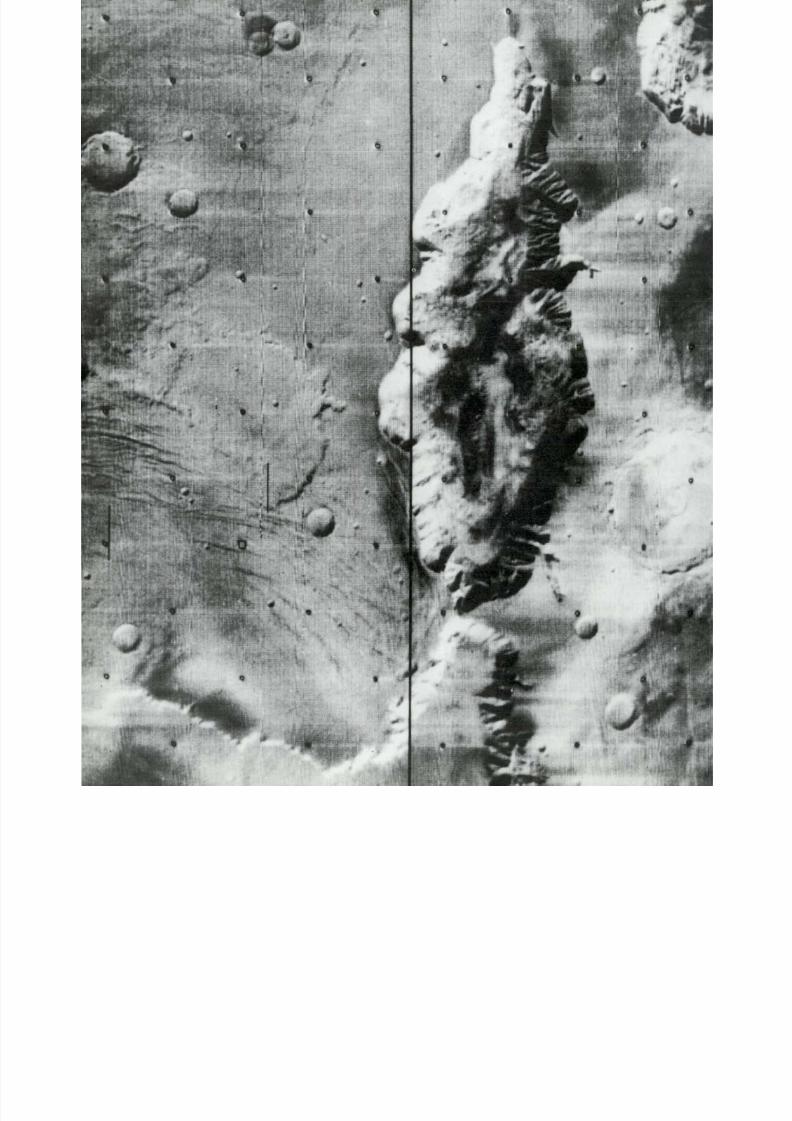
(6°S, 105°W; M T V S 4187^5)
This " labyr in th" occurs at the western end or or ig in of V al le s Mar in e r i s as seen in th is lo w
resolution frame some 400 km across. It is character ized by smooth-walled gaping depres-
sions an d chain c rate r s that par t ly sur round large flat- topped mesas. Long, n ar r o w l in e a r
graben also lace th e area; man y of these are cut by the steep depressions. The grossly polyg-
onal pat te rn of the chain c rate r s an d elongate depressions is very remin iscen t of t h a t pro-
duced by d o min g on E ar th but it is very much larger in scale. Th i s region is n e ar ly c o in c id e n t
with a broad swell ing of the Mar s s u r f a c e that appears to be several k i lomete r s h igher than
th e sur rounding plains .—J. F. McCauley
(1°S, 7 6 ° W ; IPL 1628/210149)
Dead end:This 300-km-long canyon ( l e f t ) is completely enclosed. It l ie s somewhat to the
nor th of Coprates Chasma. Ravines an d gullies mark th e wall on the right while th e left wall
has shal low alcoves with hummocky lands l ide mate r ial at the base. T he upland s show a range
of crater size and a set of parallel fractures.—J. W . A l l in g h am -
37

8/8/2019 MARS as Viewed by Mariner 9
http://slidepdf.com/reader/full/mars-as-viewed-by-mariner-9 46/222

8/8/2019 MARS as Viewed by Mariner 9
http://slidepdf.com/reader/full/mars-as-viewed-by-mariner-9 47/222
( 24°N , 62°W; IPL 1356/120125)
A mesa-like plateau occurs in the Liinae P lanum region. P rom inent scarps separate i t
f rom adjoining lowlands, which are shown in regional pictures as an extensive valley
complex. The regular scalloping; along the upper edge of the scarps suggests headwardmass wast ing an d eolian fluting. The plateau section shown here is about 60 km in
length.—T. A . Mut c h
39

8/8/2019 MARS as Viewed by Mariner 9
http://slidepdf.com/reader/full/mars-as-viewed-by-mariner-9 48/222
4Channels
N u m e r o u s channels , ranging f rom b ro ad s inuous
channels near ly 60 km wide to small (less than 100 m
wide) nar row dendr i t i c channel networks , occur over
local and widespread mar t ian regions . Many of the chan-
nels appe ar remarkab ly s imi lar to s t ream chann els on
Ear th. S inuous channels conta ining di sco nt inuous ma r-
g in a l t e r races , t eardrop-shaped i s lands , and bra ided
s t ream channels and ba rs , must have been eroded by
fluids.
The channels of M a r s have been grouped into f o u r
genera l types . Three types have character i s t i cs tha t imply
a f luvial or igin: broad an d s inuous channels , nar row
channels wi th t r ibutar ies and bra ided s t reambeds , and
closely spaced coalescent channels. A fourth variety has
charac te r is t ics tha t imply mol ten lava channels .
Some of the largest channels, which are 30 to 60 km
wide and up to 1200 km long, appear to or igina te in the
nor th ern p la teau lands an d f low nor thw ard into the Chryse
region. As the complex ar ray of the broad, s inuous chan-
nel s empt ies in to the f la t low Chryse area , the channel
f loors show characteri s t ics tha t conf i rm the no r thw ard
direction of flow consistent with the regional slope of the
surface. These channels resemble fea tures produced by
episodic f loods on E a r t h . T he large Ch ryse channels have
potent ia l sources of fluids in the chaotic terrain, and the
t r ib u ta r i e s are propor t ional in s ize to the area of chaot ic
ter ra in they dra in. Catas t rophic mel t ing of ground ice
could f o r m both the chaot ic t er ra in and the g iant f lood
channels in a single event.
Narro w, s inuous valleys , some wi th ma ny t r ibuta r ies
f o r m i n g dend r i t i c - l ike pa t terns , l i e on h igh level p la teau
surfaces such as Lunae P lanum and Memnonia in the
m a r t i a n equator ia l region. The f luvia l character of these
channels, combined with the lack of apparent source
areas , requi res th e surface col lec t ion of f luids in to in te-
gra ted channels a long wi th sur face eros ion and subse-
quent deposi t ion in a l luvia l bas ins . An intermi t tent a t -
mospher ic source for channel eros ion appears logica l and
is suppor ted by the presence of channels which head very
close to ridge crests.
Local networks of very small coalescent channels are
widely spaced across the e quato r ia l region. N or thwest of
Hel las P lani t ia , ne tworks o f coalescent channels ru n d o w n
th e sides o f many cra ters . T he i r form again sugges t s a
precip i ta t ion collect ion system and such an origin re-
qui res widespread in term i t tent p recip i ta t ion across th e
e q u a t o r i a l z one .
A n o t h e r type of channe l , associa ted wi th volcanic
centers , is the l ava channel or collapsed lava tube. These
c h an n e l s start on the flanks of volcanic domes and shield
volcanoes but become less def ined d owns l op e . This rela-
t ionship is the opposite of that generally observed in
s t ream channels .
Most m ar t ian chann els a re indica t ive of pas t eros ion,
t r an s po r t , an d deposi t ion o f surface mater ia l s tha t only
r u n n i n g water could produce. Under present mar t ian a t -
mospher ic condi t ion s , l iqu ids would not exis t on the sur -
face except during rare c ond i t i ons . — H . E . Hol t and
M. A. Sheldon
4

8/8/2019 MARS as Viewed by Mariner 9
http://slidepdf.com/reader/full/mars-as-viewed-by-mariner-9 49/222
\

8/8/2019 MARS as Viewed by Mariner 9
http://slidepdf.com/reader/full/mars-as-viewed-by-mariner-9 50/222
8/8/2019 MARS as Viewed by Mariner 9
http://slidepdf.com/reader/full/mars-as-viewed-by-mariner-9 51/222
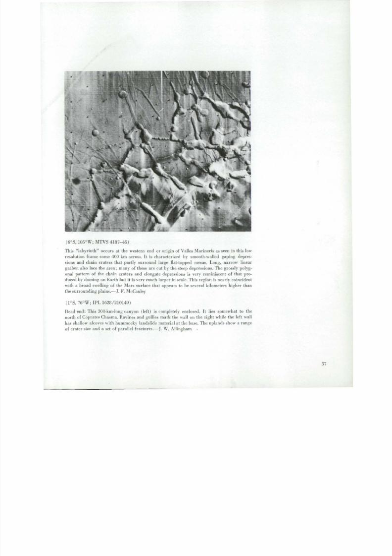
( 23 °N , 68°W; IPL 1628 143620
(22°N, 73°W; MT V S 4297-7, 4297-1A 700 km l ength of a southern channel in the Kasei Val l i s is seen below. The flow d i r e c t i o
of t h i s c ha nne l is eas tward into th e Chr ys e P l a n i t i a . A n area in the lower par t of the pho
(pa r t ly concealed by a dark c i rc le produced in the M ar in er t e levis ion sys tem ) i s shown
th e high resolu t ion mosaic at r i gh t I a p p r ox i m a t e l y 75 km wi d e I. A d e nd r i t i c c a nyon sy
te m appears to have developed along an a ngu l a r f r a c t u r e set by he a d wa r d g r owt h . N o t e th
smooth-f loored channels . Wind scour has etched re l ief fea tures across th e upper platea
level. T he ejecta f rom th e large crater form a dist inct bench and are believed to be accent
a ted by the grea ter res i s tance of the e jec ta blanket to wind eros ion.—H. E . Hol t

8/8/2019 MARS as Viewed by Mariner 9
http://slidepdf.com/reader/full/mars-as-viewed-by-mariner-9 52/222

8/8/2019 MARS as Viewed by Mariner 9
http://slidepdf.com/reader/full/mars-as-viewed-by-mariner-9 53/222
4*1
->v

8/8/2019 MARS as Viewed by Mariner 9
http://slidepdf.com/reader/full/mars-as-viewed-by-mariner-9 54/222
(29°S, 40°W; IPL 434/211030, 7462/40724, M T V S 4158-87)
The channel above is a bou t 600 km long and 5 to 6 km wi d e . T h e lower reaches (top
left) resemble the s inuous r i l l es of the Moon; the upper por t ion (topr ight ) i s more
reminiscent o f ent renched deser t ar ro y o s on E a r th . T he m e a nd e r i ng an d d e nd r i t i c
f o r m of th i s channel i s convin cing evidence tha t a f lu id once f lowed on and eroded
the p lanet ' s sur face.—H. Masursky
(20°S, 184°W; IPL 454/200454, 454/203110)
This p a i r of low resolu t ion photographs I lef t ) shows a s inuous val ley, M a 'adim V al l i s .about 700 km long. The valley resembles shorter sinuous ri l les on the M o o n . The pre-
vious existence of fluids is s t rongly impl ied by the wi d e n i ng an d deepening toward
the mouth of the chan nel and the mul t ip le branche d t r ibutar ies towa rd i t s head. Water
could not exist in the present cl imate of Mars, so a dif ferent climate in the past is
sugges ted.—H. Masursky
47

8/8/2019 MARS as Viewed by Mariner 9
http://slidepdf.com/reader/full/mars-as-viewed-by-mariner-9 55/222
(7°S, 151°W; M T V S 4294-20, 4294-16, 4294-1
Middle section of the Am az o n i s c h an n e l in Mangala Val l i s where d i rec t ion of flow
f rom right to left (south to nor th) . The braided channel a t r igh t converges in to
slightly sinuous main channel, 2 to 3 km wide , contain ing large bars and st reamlin
islands along th e st reambanks. Several levels of stream terraces occur along th e e
bank (top side of cha nnel ) which ind icate several stages of stream erosion. The streterraces, bars, and braided channels suggest that the streambed was eroded by ru
ning wate r where th e q uan t i ty of stream f l o w f luc tuated , perhaps becoming an in t
mit tent st ream. T he i n d i v i d ua l f r am e s cover an area about 30 by 40 k m . — H . E . H
(45°N, 116°W; M T V S 4182-9
T he f r a m e at right, about 60 km across, shows th e e ro d e d , un d ul a t i n g sur fac e on
flank of Alba Patera. The fine textured dendri t ic pattern of deep gullies sugge
erosion in uncon solidated m ateri al. An atm osph eric source of water is suggested
th e closeness of the channel heads to hil l crests and by the presence of channels
both sides of e longated h i l l s . Spot ty d is t r ibu t ion of such channels on the ma rt i
surface may have a c l imat ic basis or mere ly be ascr ibable to obscurat ion of ma
gullies by wind erosion.—H. Masursky

8/8/2019 MARS as Viewed by Mariner 9
http://slidepdf.com/reader/full/mars-as-viewed-by-mariner-9 56/222

8/8/2019 MARS as Viewed by Mariner 9
http://slidepdf.com/reader/full/mars-as-viewed-by-mariner-9 57/222
8/8/2019 MARS as Viewed by Mariner 9
http://slidepdf.com/reader/full/mars-as-viewed-by-mariner-9 58/222
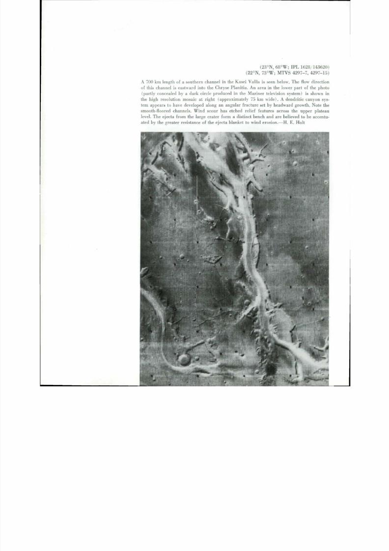
(36°S, 248°W; M T V S 4244-27, 4244-31)
T he gullies on the inner wall of a 35 km wide impac t c rate r , nor theas t of Hellas Pla-
nitia, suggest erosion by f luids. The origin of the gullies near the summit of the inner
wall does not exc lude mel t ing ground ice as a source of fluid. T he spur lead ing f rom
th e r ight r im may be of volcanic origin, as suggested by the multiple s inuous linear
fea tures and by the conical peak ( a r r o w ) at the junc t ion of the r im and spur . In the
bot tom r igh t of the pic ture , a small s teep volcanic cone (ar row) having a bare ly
discernible summit crater is vis ible. I t is part of an east-west array of s imilar small
conical hills , that is perhaps a volcanic chain. T he c h an n e l n e a r b y is a t r ibutary to a
maj o r 1300 km long channel which dra ins southwestward into Hellas.—D. B . Pot te r
(9°S, 330°W; IPL 7243/111916)
Gullies have eroded into th e r ims of old impact craters ( b e l o w ) . Pic ture wid th is
about 330 km. The pat te rns r esemble gul ly sys tems on moderate s lopes in te r res tr ial
deserts, and may have been formed by runoff of p r e c ip i t a t io n . —M. A . Sheldon

8/8/2019 MARS as Viewed by Mariner 9
http://slidepdf.com/reader/full/mars-as-viewed-by-mariner-9 59/222
•
(38°N, 330°W
This mosaic of low resolution photog raphs (ab ov e) shows the marg in of a heav
cra tered upland and the nor t he r n l owl a nd t ha t at the t ime was par t ia l ly covered b
clouds of the martian north polar hood. The edge of the highland is dissected by ma
sinuous and a na s t om os i ng c ha nne l s t hat a p p a r e n t l y are eroded into th e highland. T
channels shown here and those near Alba are a t 4 5 °N, th e far thes t nor th tha t channe
have been perceived on the planet . T he m os t a bu nd a n t c ha nne l s on M a r s li e abo
10 ° south of the equator .—H. Masursky
(6°N, 22°
The channel in th i s mosaic ( r i g h t ) of an area associated with collapsed terr
descends nor th in to the Chryse P lani t ia . The Chryse lowland is a low part of
mart ian surface and a part of the lowland that girdles th e planet. The channel slop
nor thwar d abo ut 5 meters per ki lome ter for 1200 km and i s about 30 km wide.
may have been produced by release of water f r o m chaot ic t er ra in near i t s head
me l t in g of perm afros t . The chan nel i s degraded ( tha t i s , some bra ided form s are v
ible) and s om e w ha t c r a t e re d . i nd i c a t i ng an intermedia te geologic age.—H. Masurs
52

8/8/2019 MARS as Viewed by Mariner 9
http://slidepdf.com/reader/full/mars-as-viewed-by-mariner-9 60/222
m
V
Vf

8/8/2019 MARS as Viewed by Mariner 9
http://slidepdf.com/reader/full/mars-as-viewed-by-mariner-9 61/222Vi •m .

8/8/2019 MARS as Viewed by Mariner 9
http://slidepdf.com/reader/full/mars-as-viewed-by-mariner-9 62/222
(8°S, 151°W; IPL 1691/160649)
A complex o f m e a nd e r i ng v a l l e ys ( l e f t ) cut through cra tered ter ra in an d debouch
o n to smooth p la ins in the upper par t of the p ic ture . As the val leys are t raced d o w n -
slope, i r regular dendr i t i c f u r r o w s coalesce to f o r m a few m a jor c ha nne l s. —T . A . M u t c h
( 7 °N , 45°W; IPL 1634-134231)
On the edge of the Chryse Plani t ia . c a nyone d te r rain (below) shows prominent chan-
nels an d rilles. T he conspicuous l ight -dark boundary div ides areas of unequal cra ter
dens i ty. T he l ighter area has fewer cra ters ; hence, it is probably a younger sur face
and i t may be composed of a surface covering of f ine part iculate material that is being
redeposited after erosion by the channels .—E. A . K i ng , Jr .

8/8/2019 MARS as Viewed by Mariner 9
http://slidepdf.com/reader/full/mars-as-viewed-by-mariner-9 63/222
5Fractures and Faults
Fractures and faults a r e a bu nd a n t on t he m a r t i a n
sur face . Faul t s extending radia l ly f rom cra ters and iso-
l a ted f ractures thousands o f ki lometers long indica te th e
response of the mar t ian crus t to changing stress c ond i -
tions.
Sur face fractures associated with large shield vol-
canoes an d d om e s m ay result f r o m th e u p w a r p i n g of the
crust; possible later withdrawal o f s u bs u r f a c e m a gm a an d
c o n c o mi tan t collapse may produce faults. Radial and con-
centr ic fractures are also present in crater f ields, and are
du e presumably to the t r e m e nd ou s s hoc k of impact an d
subsequent r e a d j u s t m e n t of the crus t .
The most common f racture-re la ted fea ture i s the
graben: a val ley formed when the area between two
appr o x imate ly parallel faul t s drops down rela t ive to the
areas o n each side. Many grabens are radia l to the T ha r -
sis volcanic f ield, suggesting that the b ro ad upl i f t of the
volcanic f ie ld and the a t t e nd a n t s t r e t c h i ng p r od u c e d m a ny
sets of faults and, subsequent ly, grabens .
Fractures in volcanic regions commonly serve as
weak or di la tant zones through which lava can escape to
th e surface, giving rise to an al ignment of volcanoes or
flow features. These al ignments serve as an indication of
n o w obscure f ractures . Fractur ing an d faul t ing of the sur-
face m ay also determine th e t rend of an escarpment of
c a n y o n . Such s t ructura l cont rol i s indica ted by the occur-
rence of l i ne a r e s c a rp m e n t s , wh ic h c om m onl y f o r m in ter -
sect ions wi th other escarpments . — J . W . A l l i ngha m and
J. S. K i n g
57

8/8/2019 MARS as Viewed by Mariner 9
http://slidepdf.com/reader/full/mars-as-viewed-by-mariner-9 64/222
8/8/2019 MARS as Viewed by Mariner 9
http://slidepdf.com/reader/full/mars-as-viewed-by-mariner-9 65/222

8/8/2019 MARS as Viewed by Mariner 9
http://slidepdf.com/reader/full/mars-as-viewed-by-mariner-9 66/222^ At.

8/8/2019 MARS as Viewed by Mariner 9
http://slidepdf.com/reader/full/mars-as-viewed-by-mariner-9 67/222
8/8/2019 MARS as Viewed by Mariner 9
http://slidepdf.com/reader/full/mars-as-viewed-by-mariner-9 68/222
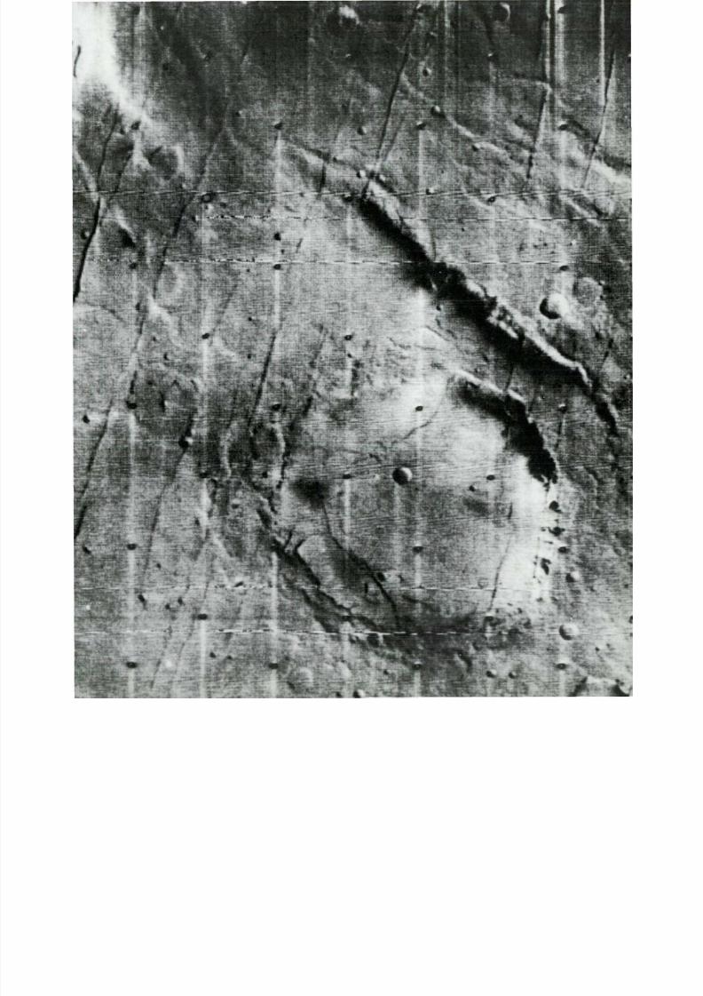
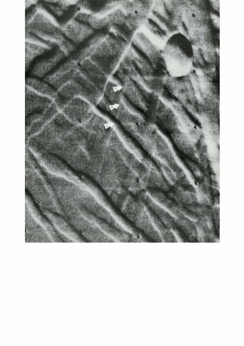
(17°S, 110°W; IPL 1563/13061
T h e intersect ing an d offse t t ing re la t ionships between faul ts ( r i g h t ) in this high reso
t ion v iew o f part of the area s h o w n b e lo w i n d i c a t e th e rela t ive t imes an d direct ions
m o v e m e n t o f t h e faul ts . F o r e x a m p l e , graben A is offset by f au l t B . w h i c h is in t u r n
by graben C. Thus A m u s t be the oldest of the three, and C is the youngest . Faul t B i
strike-slip f au l t (a f a u l t w h i c h h a s l a t e r a l r a t h e r t h a n v e r t ic a l d i s p l a c e m e n t ) . T
crater is 7 km in d i a m e t e r .— J . E. Peterson and H. M a s u r s k y
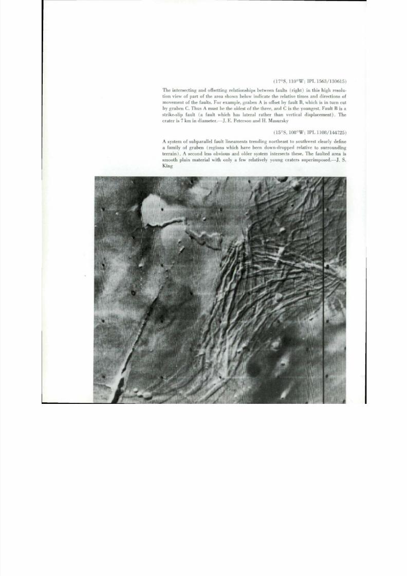
(15°S, 108°W; IPL 1108/14472
A system o f s u b p a r a l l e l f a u l t l i n e a m e n t s t r e n d i n g n o r t h e a s t to southwest c lear ly de f
a f a m i l y o f g r a b e n ( r e g i o n s w h i c h have been down-dropped re la t ive to s u r r o u n d
terra in I . A second less obvious and older sys tem intersects these . The f au l t e d area
s m o o t h p l a i n m a t e r i a l w i t h o n l y a few rela t ively young craters s u p e r i m p o s e d .— J .
King
8/8/2019 MARS as Viewed by Mariner 9
http://slidepdf.com/reader/full/mars-as-viewed-by-mariner-9 69/222

8/8/2019 MARS as Viewed by Mariner 9
http://slidepdf.com/reader/full/mars-as-viewed-by-mariner-9 70/222

8/8/2019 MARS as Viewed by Mariner 9
http://slidepdf.com/reader/full/mars-as-viewed-by-mariner-9 71/222
(31°N, 81°W; IPL 1434/180111)
Complex sys tem of graben near the Tharsis M o n i e s ( l e f t ) showing some graben offse t t ing
older graben. The ejecta b lankets of la rge cra ters par t ia l ly cover some graben in the
l o w e r r ight of th is p ic ture , in dica t ing an ear ly age for much of the f rac tur ing . F lu id f low
in larger flat-bottomed graben may have modif ied walls and deepened valleys. N o t e the
hang ing val leys (a r r ow s) on the s ides of the deepest graben , which i s 2 km wide.—J. W.
Al l i n g h a m
(38°N, 140°W; M T V S 4256-60)
A h i g h r e s o l ut i o n v i e w ( b e l o w ) s h o w s th e g r a d u a l f a d i n g of the g r a b e n i n t o th e pla in
an d poss ib le ev idence of fluvial m o d i f i c a t i o n of the g r a b e n . A second set of f a i n t g r a b e n
crosses the m o r e p r o m i n e n t s e t . N o t e the t i n y c o n i c a l v o l c a n o e s ( c e n t e r ) a d j a c e n t to
the faul ts b o u n d i n g the grabens. The area is a b o u t 45 km w i d e .— J . W. All ingham
65

8/8/2019 MARS as Viewed by Mariner 9
http://slidepdf.com/reader/full/mars-as-viewed-by-mariner-9 72/222
(21°S, 106°W; M T V S 4184-90
This f racture d p la in i s loca ted eas t of O lymp us Mon s and n or th of Ascraeus M on
The pa t tern i s a lmost cer ta inly cont rol led by a major se t of nor th-south t rending fra
tures, Clari tas Fossae. T he impact cra ter in the f ractured p la in is about 20 km
d i a m e t e r . —J . E . Peterson
(16°N, 142°W; IPL497/191619
Grooved ter ra in form s a di sco nt inuo us aureole a round O lympus Mons ( r ig ht ) . I t co
sists large ly of closely spaced low ridges and in terv en ing linear troug hs that in hig
resolution pictures appear to have been wind scoured. T he t roughs almost surely repr
sent a complex array of fracture zones that are less resistant than th e surrounding mat
rials to w i n d eros ion. T he origin of thi s t er ra in and i ts relat ion to O l y m p u s M o n s r
m a i n s a puzzle . Some inves t iga tors have sugges ted tha t it represents an ear ly outpour in
of lava or ash f rom O lympus Mons tha t have s ince eroded back to the pronounced scathat now s u r r ou nd s this enormous volcanic edi f ice . T he picture is about 365 km wid
— J. F . McCauley

8/8/2019 MARS as Viewed by Mariner 9
http://slidepdf.com/reader/full/mars-as-viewed-by-mariner-9 73/222
:•

8/8/2019 MARS as Viewed by Mariner 9
http://slidepdf.com/reader/full/mars-as-viewed-by-mariner-9 74/222

8/8/2019 MARS as Viewed by Mariner 9
http://slidepdf.com/reader/full/mars-as-viewed-by-mariner-9 75/222

8/8/2019 MARS as Viewed by Mariner 9
http://slidepdf.com/reader/full/mars-as-viewed-by-mariner-9 76/222
6Escarpments
Long, s teep cliffs oc c u r on the s u r f a c e o f Mars . They
are f r o m 1 to 4 km high, and r a nge up to severa lhun-dred ki lom eters in l ength.
M a n y e s c a r pm e n t s ha v e c om p l e x c onf i gu r a t i ons a nd
scars tha t suggest tha t some form of eros ion has caused
the scarp face to recede at the expense of the uplands .
N u m e r o u s U-shaped chutes in the upper reaches of escarp-
m e n t s are similar to the scars left by debr i s avalanches
on steep ter res t r ia l s lopes . Lumpy mounds of m a t e r i a l
below alcoves or gull ies are indicative of debris sl ides
or slow d o wn h i l l m ov e m e nt . I n r e g i ons bou n d i ng c ha o t i c
terrain, huge blocks that of ten retain their original flat
t op s ha v e s lu m p e d d ow nw a r d and o u t w a r d f r o m th e edges
of escarpments .
In cont ras t to the deeply embayed and scar red cliffs,
there are also long escarpments wi th s t ra ight , sharpbr inks and few scars. Be c a u s e of t h i s c onf i g u r a t i on , t h is
form of s t r u c t u r e is t h o u g h t to fol low faul t s o r f r a c t u r e s .
and to h ave undergon e l i t t l e recession of the face .
In the p o l a r an d near -polar regions some scarps seem
to be a p r o d u c t o f eros ion of layered mater ia l tha t mant le
older , c ra tered ter ra in beneath. This observat ion sugges t s
t ha t M a r s m ay have undergone a l terna t ing cycles of d e p -
osi t ion and eros ion, th e l a t ter a t tended by the develop-
in g of re t rea t ing scarps . — R. P . S ha r p
71
8/8/2019 MARS as Viewed by Mariner 9
http://slidepdf.com/reader/full/mars-as-viewed-by-mariner-9 77/222

8/8/2019 MARS as Viewed by Mariner 9
http://slidepdf.com/reader/full/mars-as-viewed-by-mariner-9 78/222
(15°N, 130°W; M T V S 4265-48)
The southeaste rn por t ion of the O lympus Mons escarpment (above) shows a wel l de -
fined base and generally a sharp rim with apparent slump scarps and terraces. The
fluted, steep, upper part is partially covered by huge landslides or lava flows. The
escarpment varies f rom 1 to 3 km in height. Residual block-like mesas indicate th e
remnants of a higher terraced surface on the flank of the volcano.—D. B. Potter
( 18 °N , 134°W)
The great escarpment ( l e f t ) aroun d the base of Olym pus Mons, approxim ate ly 1500
km long , resembles a wave-eroded seacliff on a terrestrial volcanic island, but is not so
easi ly explained as the re are no m a r t i a n seas. T he escarpment appears sharp over
more than half of i ts length; the remainder appears subdued. In a few places thescarp is abse nt, pro bab ly covered by lava flows or huge landslides. The origin of the
escarpment is un c e r t a i n , bu t probably involves a c o m b i n a t i o n of such processes as
mass wast in g and eol ian e rosion .—J. E . Pe te rson
7
8/8/2019 MARS as Viewed by Mariner 9
http://slidepdf.com/reader/full/mars-as-viewed-by-mariner-9 79/222
( 2 ° N , 111°W; M T V S 4229-5
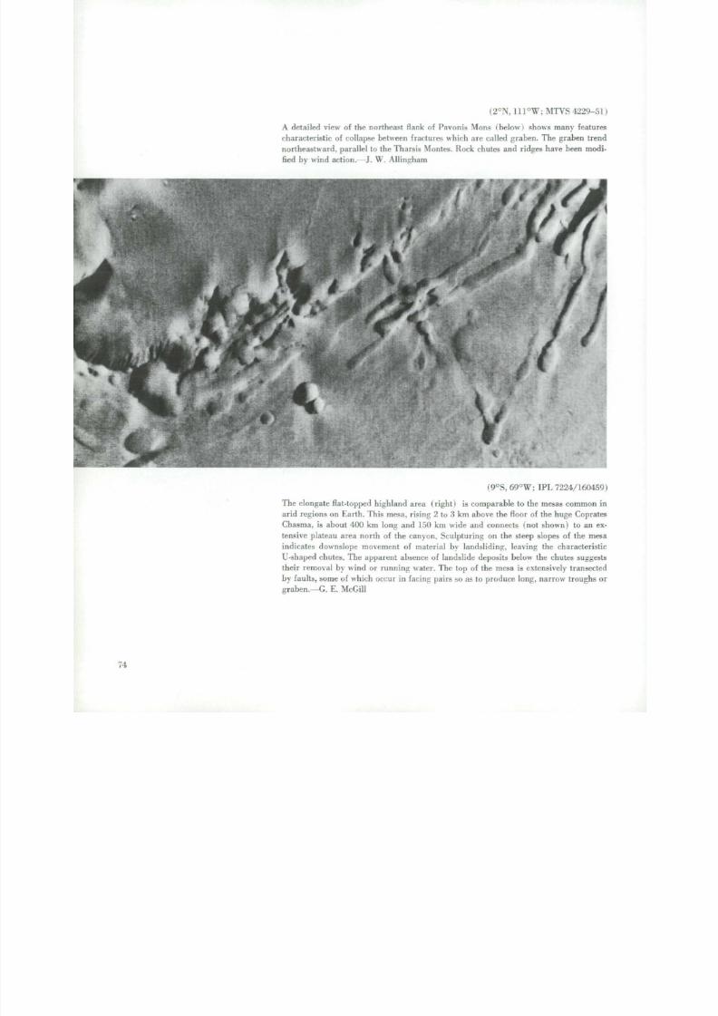
A detailed view of the northeast flank of Pavonis Mons (below I shows many fea tur
characteristic o f collapse between f r a c t u r e s which are called graben. T h e graben trenn o r t h e a s t w a r d , parallel to the Tharsis Monies. Rock chutes and ridges have been mod
fied by wind action.—J. W . Allingham
(9°S, 69°W; IPL 7224/16045
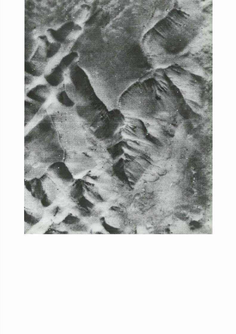
The elongate flat-topped highland area (right) is comparable to the mesas common
arid regions on Earth. This mesa, rising 2 to 3 km above the floor of the huge Coprat
Chasma, is about 400 km long and 150 km wide and connects (not shown) to an e
tens ive plateau area north of the canyon. Sculpturing on the steep slopes of the me
indicates downslope movement o f material by landsliding, leaving th e characterist
U-shaped chutes. T h e apparent absence o f landslide deposits below th e chutes sugges
their removal by wind or running water. The top of the mesa is extensively transecte
by faults, some of which occur in f a c i n g pairs so as to produce long, narrow troughs
graben.—G. E. McGill
7 1

8/8/2019 MARS as Viewed by Mariner 9
http://slidepdf.com/reader/full/mars-as-viewed-by-mariner-9 80/222

8/8/2019 MARS as Viewed by Mariner 9
http://slidepdf.com/reader/full/mars-as-viewed-by-mariner-9 81/222

8/8/2019 MARS as Viewed by Mariner 9
http://slidepdf.com/reader/full/mars-as-viewed-by-mariner-9 82/222
(13°S, 71° W; MTVS 4195-33)
This arcuate escarpment , several k i lomete rs h igh , is a port ion of the south wal l of
Valles M ariner is a t one of i t s widest po in ts , Melas Chasma. E rosion by mass wast ing
appears to be the dominant process involved in the escarpment retreat. Debris ava-
lanche chutes are abundant along most of the scarp. Note the long ridge extending
about 80 km into the c an y o n .—J. E. Peterson

8/8/2019 MARS as Viewed by Mariner 9
http://slidepdf.com/reader/full/mars-as-viewed-by-mariner-9 83/222
M
(12°S, 50°W;IPL 7464/23590
T h e sharp ri m edge along th e northern edge of the e q ua t o r i a l plateau (above) ind icates th
resistant rocks underlie the plateau. The escarpment is 1 to 2 km high and alternating resis
ant and nonresistant rock layers ar e exposed on the cliff faces. These may be al te rnat i
lava flows and pyroclastic rocks as these exposures are not too far from the great volcano
that m ay have acted as the source for the rocks. T he rock layers may be f rom 100 to 200
thick. The few impact craters on the surface of the plateau imply that it is geologically
y o un g surface .—H. Masursky
(5°S, 85°W; M T V S 4275-3
Detail of Val les Mariner is wal l an d edges of the plateau. Note th e apparent ra ised rim of t
p la teau and occurrence of bedded outcrops just below the rim. The picture is about 63 k
wid e and the escarpment i s several k i lomete rs h igh .—D. B . Pot te r
78
8/8/2019 MARS as Viewed by Mariner 9
http://slidepdf.com/reader/full/mars-as-viewed-by-mariner-9 84/222
8/8/2019 MARS as Viewed by Mariner 9
http://slidepdf.com/reader/full/mars-as-viewed-by-mariner-9 85/222

8/8/2019 MARS as Viewed by Mariner 9
http://slidepdf.com/reader/full/mars-as-viewed-by-mariner-9 86/222
(41°S, 258°W; IPL 1445/105008)
This isolated bold mountain remnant on the plains at the east edge of Hellas Planitia
is approximately 35 km wide. I ts sharp r idges and spurs have a branching pattern
indicating equal erosive at tack f rom all sides. The steep upper slopes show mass wast-
in g chutes an d n ar r o w to n g ues of material suggest some form of mass movement.
Broader tongues of mater ial occur along the western base. Around the base of the
mountain is a wide apron s loping gently away f rom the m oun tain . This suggests slow
mass movement of gran ular mater ial over a long per iod of t ime.—D . B . Potter

8/8/2019 MARS as Viewed by Mariner 9
http://slidepdf.com/reader/full/mars-as-viewed-by-mariner-9 87/222
7Fretted and
Chaotic Terrains
Fret ted an d chaot ic t er ra ins are l owl a nd t op ogr a p h i c
f o r m s on the mar t ian sur face which may be in par t the
p r od u c t of related genetic agents. Fret ted terrain is c ha r -
acterized by smooth, f lat lowland areas with many f la t -
topped but tes an d mesas resembl ing those in the western
Uni ted S ta tes . Chaot ic t er ra in exhibi t s rough f loor topog-
raphy of jumbled la rge , angular blocks . Both ter ra ins are
separated f r o m cra tered upland areas by escarpments
having complex conf igura t ions .
A s t r ik ing character i s t i c of f re t ted terrain is i ts i r-
regular bord er pa t tern. The s teep escarpm ent i s smoo thly
s loping and free of slump blocks and typically traces a
ragged course with d e e p e m ba ym e nt s , p r o je c t i ng he a d -
lands , and n um erou s shal low scal lops . The lowland f loor
of th e f re t ted t e r ra in i s genera l ly smooth, showing only
a few scattered craters and low swells and swales.
So m e areas of chaot ic t er ra in are sharply bou nd e d
by an a br u p t e s c a r p m e n t o f i r r e g u l a r c onf i gu r a t i on , wh i l e
other boundar ies exhibi t a t rans i t ion f rom s l ight ly f rac-
tured upland through a highly f r a c t u r e d z one t o a ju m b l e
of i r regular blocks . T he vert ical rel ief of e s c a r p m e n t s
seems to r an g e between 1 km and 3 km. They are h i ghe r
t ha n m os t e s c a r p m e n t s bou nd i ng areas o f f re t ted t e r r a i n .
The m ost d i s t inc t ive fea ture of chaot ic t er ra in i s the
rough- f loor t op ogr a p hy c ons i s t i ng of an i r r e gul a r ju m b l e
of angular blocks up to severa l k i lometers wide and tens
of ki lometers long, many bear ing remnants of the rela-
t ively s m oot h u p l a nd s u r f a c e on thei r tops . At some sites,
the shape of the blocks appears to be cont rol led by inter -
secting sets of fractures result ing in blocks of almost
equal d imensions . A f t e r form at ion , the blocks appear to
u nd e r go c o n t i nu i ng br e akd own a nd r e d u c t i on i n size,
eventual ly being co mpletely destroye d and leaving a flat ,
s m oo t h floor s imi lar to tha t o f f re t ted t e r r a i n .
Fretted terrain, clearly developed at the expense of
older cra tered uplands , appears t o be a m ong t he younge s t
of th e m a r t i a n l a n d f o r m s . T he smooth floors of most areas
of f re t ted t e r r a i n ar e only sparsely cratered, mostly by
smal l , new cra ters . Chaot ic t er ra in i s judged to be equal ly
y o u t h f u l on essential ly th e same basis. Closely adjacent
areas of f re t ted an d chaot ic t er ra in cannot be too differ-
ent in age.H owe v e r , th e seeming pauci ty of cra ters wi thin
areas of chaot ic t er ra in may be a result of difficulty in
recogniz ing smal l crate rs within the chaos o f j u m b l e d
blocks .
Subsidence and s lumpin g having p layed a par t in the
development of chaot ic t er ra in. S ince these are usually
in i t ia ted by the removal of subsurface mater ia l , the prob-
lem of the or igin of chaot ic t er ra in becomes one of ident i -
f y i n g the mater ia l removed and the process, or processes,
which accompl i shed the removal .
The development of f re t ted t e r ra in i s thought to be
in i t ia ted by some s t ructura l break in the old cra tered
uplands . Once an escarpment i s form ed, it recedes by
some t yp e o f u nd e r m i n i ng o r sapp i n g mechanism. The
eros ional removal o f debr i s , perhaps by the w i n d , leaves
a smooth, f lat f loor and isolates island-l ike buttes and
mesas. The bounding slopes of these outl iers also recede,
reducing them in size u n t i l they disappear ent i re ly. —
R . P . S ha rp
83
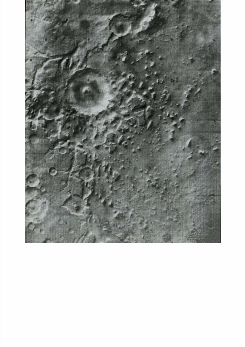
8/8/2019 MARS as Viewed by Mariner 9
http://slidepdf.com/reader/full/mars-as-viewed-by-mariner-9 88/222
f7
I

8/8/2019 MARS as Viewed by Mariner 9
http://slidepdf.com/reader/full/mars-as-viewed-by-mariner-9 89/222
(44°N, 330°W; IPL 1417/224259)
A close-up view of erosional outliers in an area of f re t ted te rrain . The height of the
prominent features is at least 1 to 1.5 km. The undulating plain shows numerous
swells an d swales. T he young, ra ised ri m crate r is about 3 km across.—R. P . Sharp
(43°N, 313°W; IPL 1651/154245)
In this fretted te r rain ( l e f t ) at mid-lati tud e in the north ern hem isphere, a relatively
smooth lowland is separated f rom the old crate red upland by ab rup t cliffs at least 1 to
2 km high. Mesa-like remnants and flat-floored chasms penetrating fa r into th e upland
are characteristic . This te r rain i s regarded to be a produc t of cliff recession caused byan undermining process operat ing at the c l i f f base. Material shed by the cliffs has
been removed, probably either by fluvial transport, under different climatic condi-
tions, or by eol ian def lat ion .—R. P . Sh arp
85
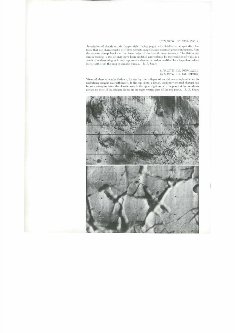
8/8/2019 MARS as Viewed by Mariner 9
http://slidepdf.com/reader/full/mars-as-viewed-by-mariner-9 90/222
(3°N,37°W; IPL 7350/16531
Associa t ion of chaotic t er ra in (upper r ight , fac ing page! with flat-floored steep-walled fe
tures tha t a re ch aracter i s ti c of f re t ted te r ra in sugges ts some comm on genetic inf luences . No
th e arcuate slump blocks at the lower edge of the chaotic area ( a r r o w ) . The flat-floor
c ha s m l e a d i ng to the left m ay have been modif ied an d widened by the recession of walls as
result of un der m inin g or i t may represent a chan nel carved or modi f ied by a huge f lood whi
burs t for th f rom th e area of chaot ic t er ra in.—R. P . Sharp
(1°S, 20°W; IPL 7059/16291
(4°S,20°W; IPL 1411/21210
V i e w s of chaot ic t er ra in (below) , formed by the collapse of an old cra ter upland when
underlying support w as withdrawn. In the top photo, a broad, seemingly scoured channel ca
be seen emerging f r o m the chao t ic a rea in the upp er r ight cor ner ; the photo a t bot to m show
a close-up view of the broken blocks in the r ight cent ra l par t of the top photo.—R. P . S ha
/J

8/8/2019 MARS as Viewed by Mariner 9
http://slidepdf.com/reader/full/mars-as-viewed-by-mariner-9 91/222
,*;
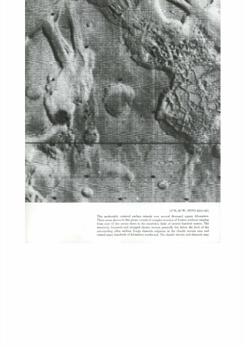
8/8/2019 MARS as Viewed by Mariner 9
http://slidepdf.com/reader/full/mars-as-viewed-by-mariner-9 92/222
(3°N, 28°W; M T V S 4203-6
This mod erately cratered surface extends over several thou sand squ are kilomet
Three areas shown in this photo consist of complex mosaics of broken surfaces rang
f rom over 15 km across down to the resolution l imit of several hundred meters . T
massively fractured an d slumped chaotic terrain generally lies below th e level of
surrounding older surface. Large channels originate in the chaotic terrain area a
extend many hundreds of ki lometers nor thward . T he chaotic te r rain an d channels m

8/8/2019 MARS as Viewed by Mariner 9
http://slidepdf.com/reader/full/mars-as-viewed-by-mariner-9 93/222
h ave resulted f rom removal of materials in the subsurface wi th consequent col lapse
of over lying s t ra ta . Perhaps some f o r m o f g r o u n d ic e mel ted, and the result ing liquid
dra ined aw ay form ing the la rge channels . Ho wever , physica l/chemical processes
needed to produce such large quanti t ies of ground ice, and later to supply large
a m ou nt s o f local heat to mel t the ice in a very short t ime span, are not recognized
topographic /geologic processes.—H. E . Hol t
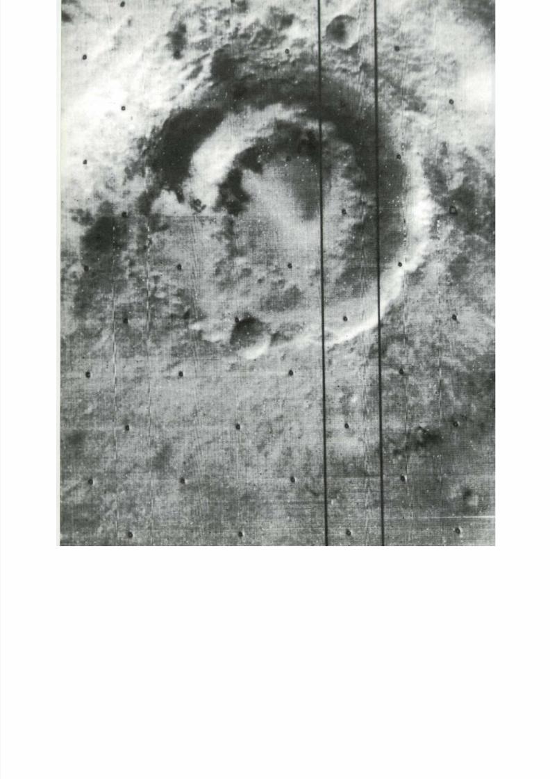
8/8/2019 MARS as Viewed by Mariner 9
http://slidepdf.com/reader/full/mars-as-viewed-by-mariner-9 94/222

8/8/2019 MARS as Viewed by Mariner 9
http://slidepdf.com/reader/full/mars-as-viewed-by-mariner-9 95/222
(53°S,81°W; IPL 406/1927722
The double-ringed basin Lowell ( lef t ) , 200 km in diameter, is most probably of impact
origin. Sharp-textured ejecta attest to its relatively recent formation. In comparison to
craters having single ri m crests an d multiringed circular basins, this crater is inter-
mediate in diameter and in number of rings. It shows w h at m a n y older, degradedfeatures once looked like.-—D. E. Wilhelms
I
7*9
(46°S,44°W;
M T V S 4139-9)This smooth plains area is the northern half of Argyre Planitia and is about 800 km
across. Careful study of this an d a d jo i n i ng photographs reveals concentric rings of
high, rugged terra in around th e plains, similar to the multiringed circular basins seen
on th e M oon.—D . E. Wilhelms

8/8/2019 MARS as Viewed by Mariner 9
http://slidepdf.com/reader/full/mars-as-viewed-by-mariner-9 96/222
(16°S, 350°W; M T V S 4287-24
Typical cratered terrain (right) has both old, smooth-rimmed craters, and younge
sharp- r immed ones. T he large one at the top is 165 km across, with a conspicuous
flat floor and slumped walls. Note the small doublet craters at lower left with centr
peaks.—M . Gipson , J r .
(5°N, 250°W; M T V S 4194-60
This cratered terrain (below) also shows lineated features made up of plateaus an
troughs. They align radially with th e Isidis basin, which is outside this image towar
the nor thwest .—D. E . Wilhelms
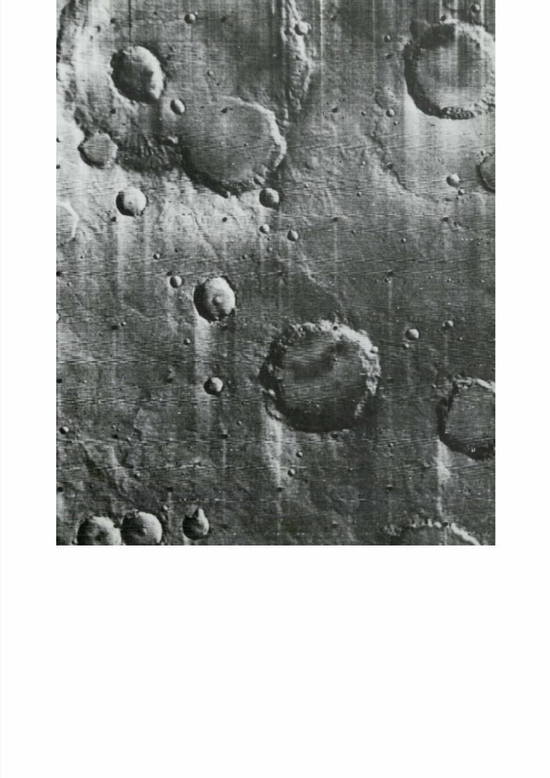
8/8/2019 MARS as Viewed by Mariner 9
http://slidepdf.com/reader/full/mars-as-viewed-by-mariner-9 97/222
/

8/8/2019 MARS as Viewed by Mariner 9
http://slidepdf.com/reader/full/mars-as-viewed-by-mariner-9 98/222
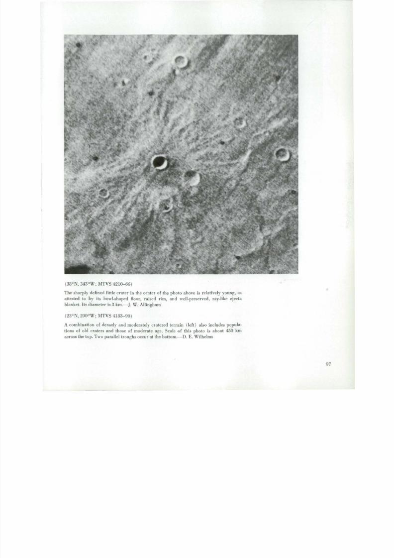
8/8/2019 MARS as Viewed by Mariner 9
http://slidepdf.com/reader/full/mars-as-viewed-by-mariner-9 99/222
i'
*.-..."
(38°N, 343°W; M T V S 4210-66)
T h e sharply de f ine d l i t t le crater in the center of the photo above is relatively young, as
attested to by its bowl-shaped floor, raised rim, and well-preserved, ray-like ejecta
blanket. Its diameter is 3 km.—J. W.Allingham
( 23 °N , 290°W; M T V S 4183-90)
A combination o f densely an d moderately cratered terrain ( l e f t ) also includes popula-
tions of old craters an d those o f moderate age. Scale o f this photo is about 450 km
across the top. Two parallel troughs occur at the bottom.—D. E. Wilhelms
97

8/8/2019 MARS as Viewed by Mariner 9
http://slidepdf.com/reader/full/mars-as-viewed-by-mariner-9 100/222

8/8/2019 MARS as Viewed by Mariner 9
http://slidepdf.com/reader/full/mars-as-viewed-by-mariner-9 101/222

8/8/2019 MARS as Viewed by Mariner 9
http://slidepdf.com/reader/full/mars-as-viewed-by-mariner-9 102/222
9Wind-Shaped Features
M a r i n e r 9 c onv i n c i ng l y d e m o ns t r a t e d t ha t w i n d i s
t he d om i na n t a ge n t o f eros ion an d sedimenta t ion on
Ma r s . In a d d i t i on to the great dust storm o f 1971, a wi d e
var ie ty of f e a t u r e s t ha t can be ascr ibed to wind act iv i ty
were f o u n d . Un l ike cra ters on the Mo on (which lacks an
a t m os p he r e ) t he cra ters on Mars show the effects of both
eol ian eros ion and deposi t ion. Most cra ters t end to have
f la t ter f loors and less d i s t in guish able sur r oun din g e jecta
blankets . O t he r s a p p e a r to have been once bur ied and are
now be i ng e xhu m e d by wi nd a c t i on . T he e q u a t o r i a l r e -
g i ons of Mars appear to be areas where wind eros ion
predominates over deposi t ion. This can be seen in nu-
merous examples of s t reaml ined canoe-shaped hi l l s , f lu ted
c l i f f faces , a long w i th mul t i tud ino us para l le l grooves o n
th e s u r f a c e of the flat p l a i ns . S i m i l a r a p p e a r i ng f e a t u r e s
ar e f o u n d only in the most rainless an d w i n d - s w e p t
deser t s of the Ear th. (See "S imi lar i t i es : Mars , Ear th , and
M o o n . " ) T h e m i d l a t i t u d e an d polar regions appear o n
th e other hand to be areas where deposi t ion of f ine w i n d -
blown mater ia l p redominates . These deposi t s p roduce
vast almost fea tureless p la ins tha t bury ear l ier cra ters
and volcanic f lows.
The changes in the sur face markings of Mars have
been a puzz le to telescopic observers for gene rations.
M a n y elabora te hypotheses have been invented to e xp l a i n
these in t erms of vegeta t ion, volcanic ac t iv i ty, or chemi-
cal c ha nge s . Ma r i ne r 9 has shown tha t a lmost all the
s u r f a c e m a r k i ngs c a n be e xp la i ne d by wi nd a c t i v i t y .M a n y of the ab un dan t l ight and dark s t reaks are asso-
ciated with cra ters and other topographic fea tures . These
f r e q u e n t l y merg e into broader m ot t l ed pa t tern s tha t a t the
telescope would ha v e a p p e a re d t o be c o n t i nu o u s d a r k
patches.
D u r i n g the Mar iner 9 miss ion some of the s t reaks
ac tua l ly c ha nge d shape an d p os i ti on i nd i c a t i ng t ha t t he y
are superf ic ia l . (See " Cha ng i ng Features.") O ne e xp l a na -
t ion is that the l ight areas are zones of deposit ion of re-
cent d u s t and fine s a nd . T he dark areas ar e zones of
s om e wha t coarser and darker mater ia l where dus t and
sand have been removed or were s imply not deposi ted.
T he s a m e s i t u a t i o n prevails in terrestrial deserts in thelees of topographic obstacles. S o m e of the dark areas in
th e f loors of cra ters , on the other hand, proved to be
l a r ge d u ne f ie lds , f u r t h e r c o n v i n c i n g e v id e n c e for the
d y n a m i c role of the w i n d on Ma r s . We now k n o w t h a t
th e w i n d is c u r r e n t l y s c u l p t u r i ng th e s u r f a c e of Ma r s , re -
m o v i n g si l t and clay f r om s om e areas and redeposi t ing it
in others. As will be seen in other sections of this book,
fluvial and glacial act ivi ty also have taken place. T hu s
pr imar i ly because of its a t m os p he r e , howe v e r t e nu ou s ,
M a r s as had been surmised f rom th e early telescopic
observat ions to more c losely resemble the Ear th than
does th e M o o n . — J . F . Mc Ca u l e y
101

8/8/2019 MARS as Viewed by Mariner 9
http://slidepdf.com/reader/full/mars-as-viewed-by-mariner-9 103/222
(11°N, 283°W; M T V S 4186-Dark and whi te streaks on the slopes of Syrtis M a j o r Planitia. Viewed telescopica
the surface of Syrtis Major Planitia is dark, and has an eastern variable edge, wh
late ral var iat ion is enhanced by seasonal albedo changes. O n Mar i n e r 9 images,
dark region is resolved into a series of sub-parallel dark and w hite streaks, which
tend several hun dred kilom eters. In this high resolution picture (40 km wi de) ta
by th e M a r i n e r 9 camera on Jan uary 30 , 1972, a few weeks after the end of the
dust storm, dark streaks extend from craters and unresolved point obstacles wh
prot rude above an otherwise smooth surface. T he small streaks extend as m an y as
crater diameters beyond th e crater obstacle, an d invar iably flare in an easterly di
t ion . The wider and nearly cont inuous dark streaks in the right of the picture ext
f rom a large crater located outside th e image. These dark streaks resemble th e d
w i n d shadow s formed in the lee of obstacles, pa rticularly d ownwi nd from the
face of transverse dunes (bar cha ns) in terrestr ial deserts, where turbulent eddies
back-sweeping motion remove light- toned eolian sand f r o m a darker (and coars
desert pavement. At the same time, sand saltates and creeps away downwind f rom
barchan h o r n s . B o t h processes ar e c o n c o m i t an t on the Earth , and so they are on M
In suppo r t of this assertion is the d ig i ta te or serrated outline along th e edge of
widest white streak in the image . T he white "teeth" along this irregular contact betw
white an d dark streaks po i n t th e same way as the flares in the dark streaks. They
semble the f r o n t of a sand sheet advancing over a barren ter res tr ial surface. The o
al l pattern of light an d dark markings is confidently ascribed to the w o rk of unidi
t ional , weste rly winds.—M . J . Grolier
102

8/8/2019 MARS as Viewed by Mariner 9
http://slidepdf.com/reader/full/mars-as-viewed-by-mariner-9 104/222
*
*
:
C '~ -
-

8/8/2019 MARS as Viewed by Mariner 9
http://slidepdf.com/reader/full/mars-as-viewed-by-mariner-9 105/222

8/8/2019 MARS as Viewed by Mariner 9
http://slidepdf.com/reader/full/mars-as-viewed-by-mariner-9 106/222
(47°S, 330°W; IPL 267/220940)
(47°S, 330°W; M T V S 4228-15,4264-15,4264-19)
A da rk zone in the floor of a crater near Hellespont! Monies is seen in the low resolution
photo above. Similar appearing dark splotches appear in the floors of many Mars craters. The
high resolut ion photomosaic a t left reveals that the dar k zone is an elliptical du ne field
about 130 by 65 km in size. T he du ne field consists of series of subparallel ridges, 1 to 2
km apart, tha t closely resemble terrestrial transve rse dunes. M any of the ridges appear to
have rounded crests with s imilar slopes on either side. This suggests that although the wind
here generally blows at right angles to the transverse ridges i t may in te rmi t t e n t ly reverse it s
direction so as to even out the slopes on the w i n d w a r d and lee sides of the dunes. Th e un-
usually dark appearance on what appears to be the m ore win dw ard s ide of the dunes m ay beconcentra t ions of dark heavy minera ls such as i lmeni te and small dark l i thic fragments . On
Mars, c on cen tratio ns of such h eavy m inerals may have become prefe rentially trapped in
crater floors because of wind action.—J. F. McCauley

8/8/2019 MARS as Viewed by Mariner 9
http://slidepdf.com/reader/full/mars-as-viewed-by-mariner-9 107/222
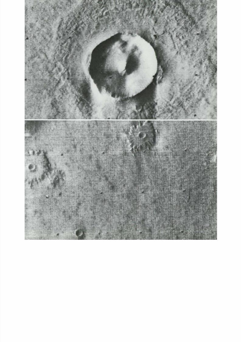
8/8/2019 MARS as Viewed by Mariner 9
http://slidepdf.com/reader/full/mars-as-viewed-by-mariner-9 108/222

8/8/2019 MARS as Viewed by Mariner 9
http://slidepdf.com/reader/full/mars-as-viewed-by-mariner-9 109/222
(87°S, 273°W; M T V S 4248-
Flutes and linear grooves (righ t) in the layered terrain exposed near Au stralis Chas
south polar region. There is no polar cap shown here. B edding is enhanced by
contrast be tween th e l ight an d dark layers exposed in steep bluffs, and the sides of
p r om i ne n t ridge in the eastern part of the area. The short, finely structured striati
in the bluffs stand out in contrast against th e smooth surfaces of terraces an d hollo
which ar e pe rh aps m an t l e d w i t h wind-b lown mater ial . S t r ia t ions in the bluffs
wi d e r flutes on gentler slopes are parallel , and best developed on south-fac ing slo
A hill in the center of the image is grooved at one end,and beveled at the other e
much l ike some te rrest r ial yardangs are.The e rosional pat te rn suggests that wind e
sion, together with possible me lting and sublim ation of the un der lyin g material ,
the processes mo d i f y in g this polar landscape. Scouring here is accomplished by wi
or ig inat ing near the South Pole (outs ide the imaged are a) .— M . J . Grol ie r
(74°S, 7°W; M T V S 4270-
I r regular pits an d depressions near th e south polar region ar e shown below in t
high resolution photo. These depressions ar e generally characterized by flat floors a
rather smooth walls. They are very similar to terrestrial deflation hollows formed
the plucking and scouring action of the wind. These landforms, l ike the otprobable martian wind features described in this section, ar e many times lar
than their terrestrial counterparts, th e largest known of which are in the desert
north central China. Picture width is about 75 k m .—J. W . Allingham

8/8/2019 MARS as Viewed by Mariner 9
http://slidepdf.com/reader/full/mars-as-viewed-by-mariner-9 110/222

8/8/2019 MARS as Viewed by Mariner 9
http://slidepdf.com/reader/full/mars-as-viewed-by-mariner-9 111/222
•'•f

8/8/2019 MARS as Viewed by Mariner 9
http://slidepdf.com/reader/full/mars-as-viewed-by-mariner-9 112/222
(5°N, 146°W; IPL 1596/212535)
Wi nd etched semi-parallel grooves occur on probable bedrock in the relat ively smooth,
uncra tered p lains of southern A mazon is . The w idth of the p ic ture i s about 40 km so
t h a t th e al terna t ing, s t reaml ined ridges an d grooves ar e typically about 200 m in width
an d tens of kilometers long. This patter n is probably controlled in part by bedrock
f rac tures . Similar parallel scouring of homogeneous materials does occur, however , in
th e flat open parts of terrestrial deserts that are characterized by strong, almost uni-
di rect ional prevai l ing wind s . O n Ear th s im i lar appear ing wind scour fea tures are,
however, many t imes smaller in size. Although th e mar t ian a tmosphere i s one hun-dred t im es less dense than that of the Earth , the wi nd velocit ies may be on the order
of 200 to 300 km per hour. Thus the kinetic energies of part icles moved by the wind
will be many t imes grea ter and the eros ional effect of sand blast ing a far m o r e im -
portant geologic process than on Ear th.—J. F. McCauley
111

8/8/2019 MARS as Viewed by Mariner 9
http://slidepdf.com/reader/full/mars-as-viewed-by-mariner-9 113/222
(70°S, 259°W; M T V S 4211-
A low reso lut ion view of Promethe i S inus (abo ve) shows an ex tens ive ly splo tched , c rate r
region near th e south pole of Mars. This pic ture is about 450 km across. Var iat ions in t
appe ar an c e of this region have been reported by telescopic observers. Note that th e d a
crate r splotches tend to l ie on the do wn win d s ide of c rate r floors. A small c rate r near upp
cente r is shown at h igh reso lut ion on the fac ing page .—C. Sagan
(70°S, 253°W; IPL 1418/14301
This high reso lut ion view of a reg ion in Pro meth e i S inus was s tud ied for su r face var iat io
d ur in g th e M a r i n e r 9 miss ion . T he scalloped appearance of the albedo boundar ies is chara
te r is t ic o f eo l ian phenomena—the in fe r red wind d irec t ion be ing at r igh t angles to the sca
loped edg' - . V ari atio ns in the crater splotch an d in the leaf-shaped a lb ed o m ar k in g j us t l
of crate r , mos t likely due to the removal o f mobile mate r ial by winds , are shown on the fo
l o w i n g pages. -C . Sagan
114

8/8/2019 MARS as Viewed by Mariner 9
http://slidepdf.com/reader/full/mars-as-viewed-by-mariner-9 114/222

8/8/2019 MARS as Viewed by Mariner 9
http://slidepdf.com/reader/full/mars-as-viewed-by-mariner-9 115/222
-• • • • *
*
•*»
(70°S, 2 5 3 °
The dark pat te rn changed f rom rev 99 (top left) to rev 126 (topcente r) ; rev 126
rev 179 (middle row) ; and rev 179 to rev 181 ( b o tt o m r o w ) . Afte r th e images from e
se t ( left and center) were sim ilarly scaled and proje cted, then the two pictures w
differenced, picture element by picture element. Images on the right show the dif
ences (Stanford A IL Picture Produc t S TN 9167:050609, 10 , 11). Thus, it is possi
to see the changes that had occurred between successive revolutions over th e sa
area. Each f r ame is about 30 km across.—C. Sagan
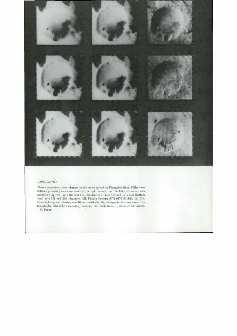
8/8/2019 MARS as Viewed by Mariner 9
http://slidepdf.com/reader/full/mars-as-viewed-by-mariner-9 116/222
1
(70°S, 253°W)
These comparisons show changes in the crater splotch in Promethei Sinus. Differencesbetween preceding views are shown at the right in each row; the left and center views
are from (top row) revs 126 and 179: ( m i d d l e ro w ) revs 179 and 181; and (bottom
row) revs 181 and 220 (Stanford AIL Pic ture Pr o duc t STN 0173:061109, 10, 11).
Since lighting an d view ing conditio ns varied slightly, changes in shadows caused by
topography cannot be successfully canceled out. Each f r ame is about 30 km across.
— C. Sagan

8/8/2019 MARS as Viewed by Mariner 9
http://slidepdf.com/reader/full/mars-as-viewed-by-mariner-9 117/222
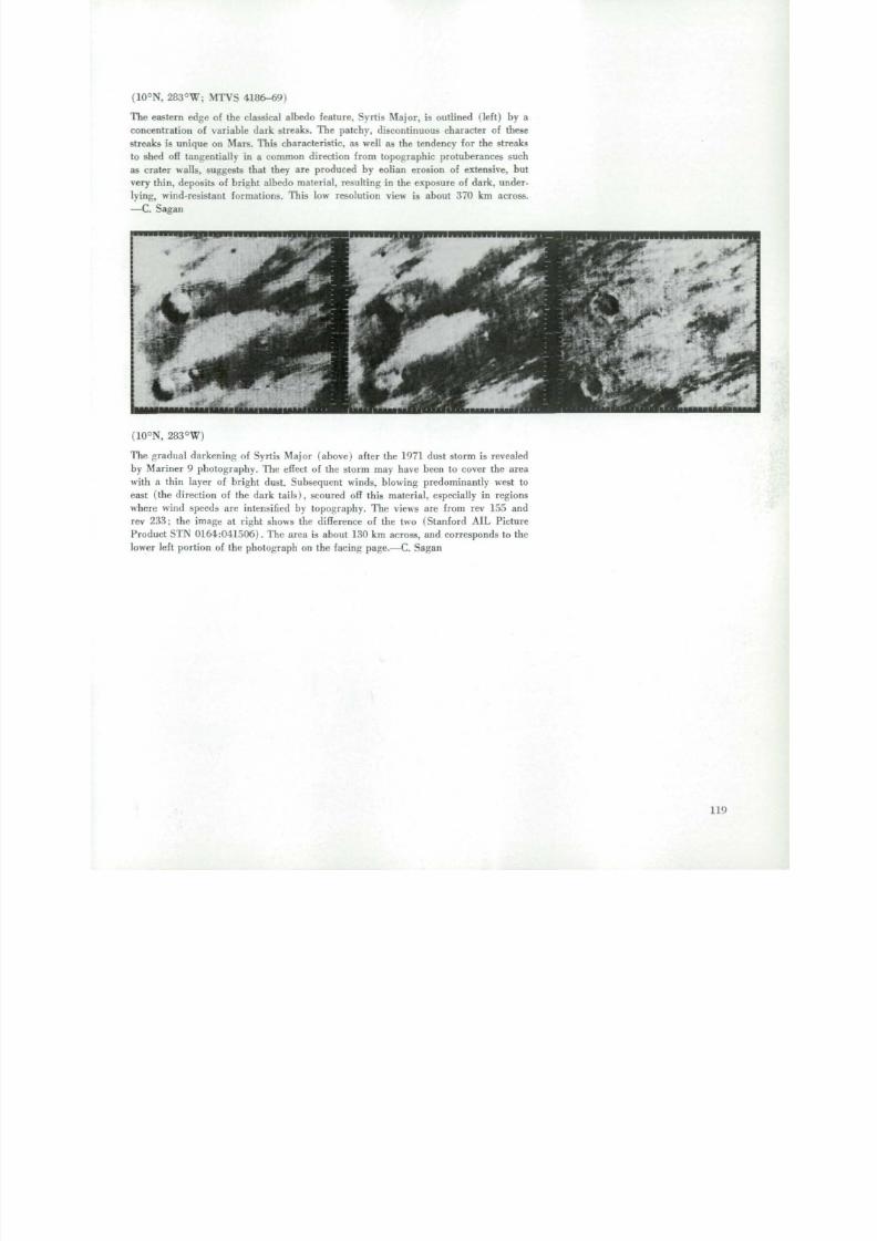
8/8/2019 MARS as Viewed by Mariner 9
http://slidepdf.com/reader/full/mars-as-viewed-by-mariner-9 118/222
(10°N, 283°W; M T V S 4186-69)
The eastern edge of the classical albedo feature. Syrtis Major, is outlined (left) by a
concentration of variable dark streaks. The patchy, discontinuous character of these
streaks is un i q ue on Mars . This characteristic , as well as the tendency for the streaks
to shed off tangent ial ly in a c o m m o n d i r e c t i o n f rom topographic pro tuberances such
as crater walls, suggests that they are produced by eolian erosion of extensive, bu tvery thin, deposits of bright albedo material , resulting in the exposure of dark, under-
ly ing , wind- resis tan t format ions. This low resolution view is about 370 km across.
— C. Sagan
• f **>-
(10°N, 283°W)
The gradual darkening of Syr t i s M a j o r ( ab o ve ) after the 1971 dust storm is revealed
by Mariner 9 photography. The effect of the storm may have been to cover the area
with a th in layer of br ight dust . Subsequent winds, b lowing predominant ly west to
east (the direction of the dark tail s), scoured o ff this ma terial , especially in regions
where wind speeds ar e intensified by t o po g raph y . The views ar e f rom rev 155 andre v 233; th e image at r igh t shows th e dif ference of the two (S tan f o r d A IL Pic ture
Produc t S T N 0164:041506). T he area is about 130 km across, an d corresponds to the
lower left po r t i o n of the ph o t o g raph on the fac ing page .—C. Sagan
119
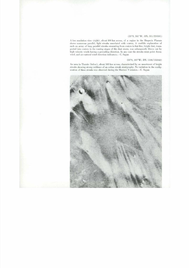
8/8/2019 MARS as Viewed by Mariner 9
http://slidepdf.com/reader/full/mars-as-viewed-by-mariner-9 119/222
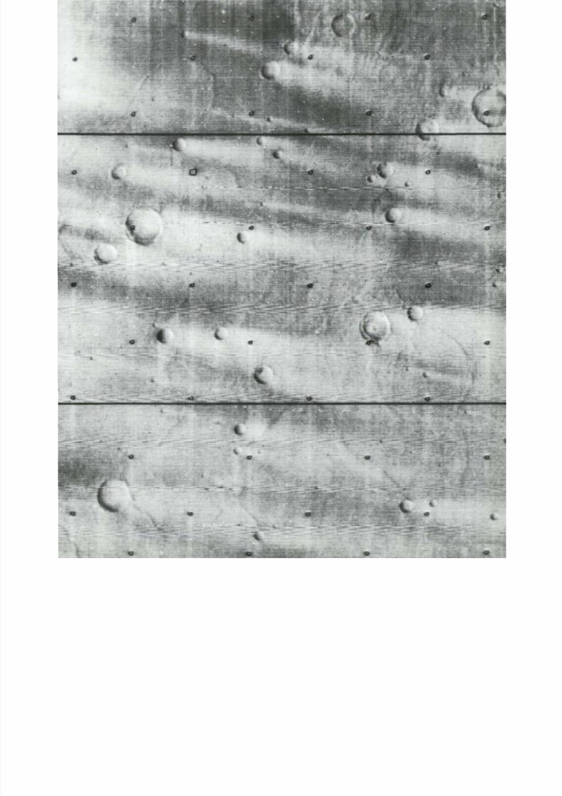
8/8/2019 MARS as Viewed by Mariner 9
http://slidepdf.com/reader/full/mars-as-viewed-by-mariner-9 120/222
A
* *T
i
v
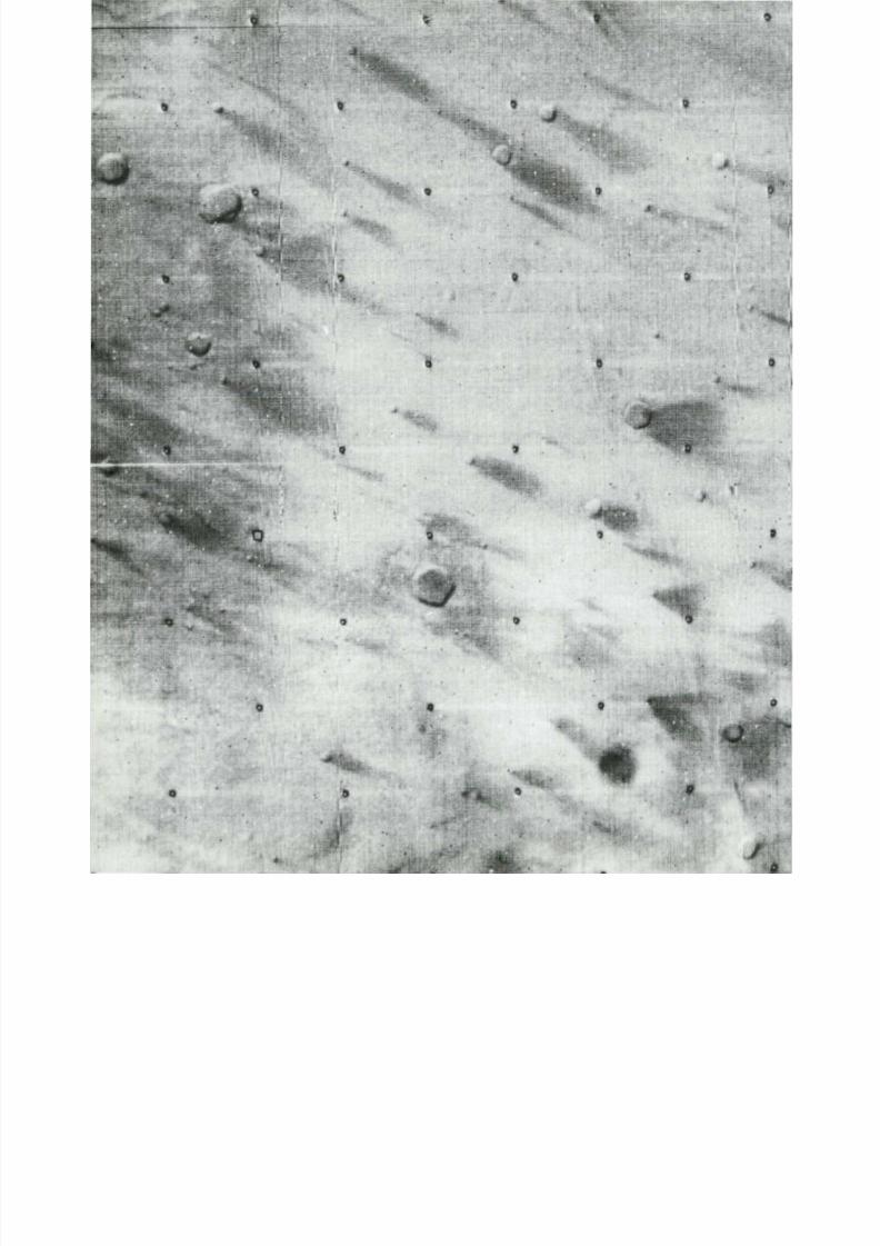
8/8/2019 MARS as Viewed by Mariner 9
http://slidepdf.com/reader/full/mars-as-viewed-by-mariner-9 121/222
0
*if :
' T ^ W
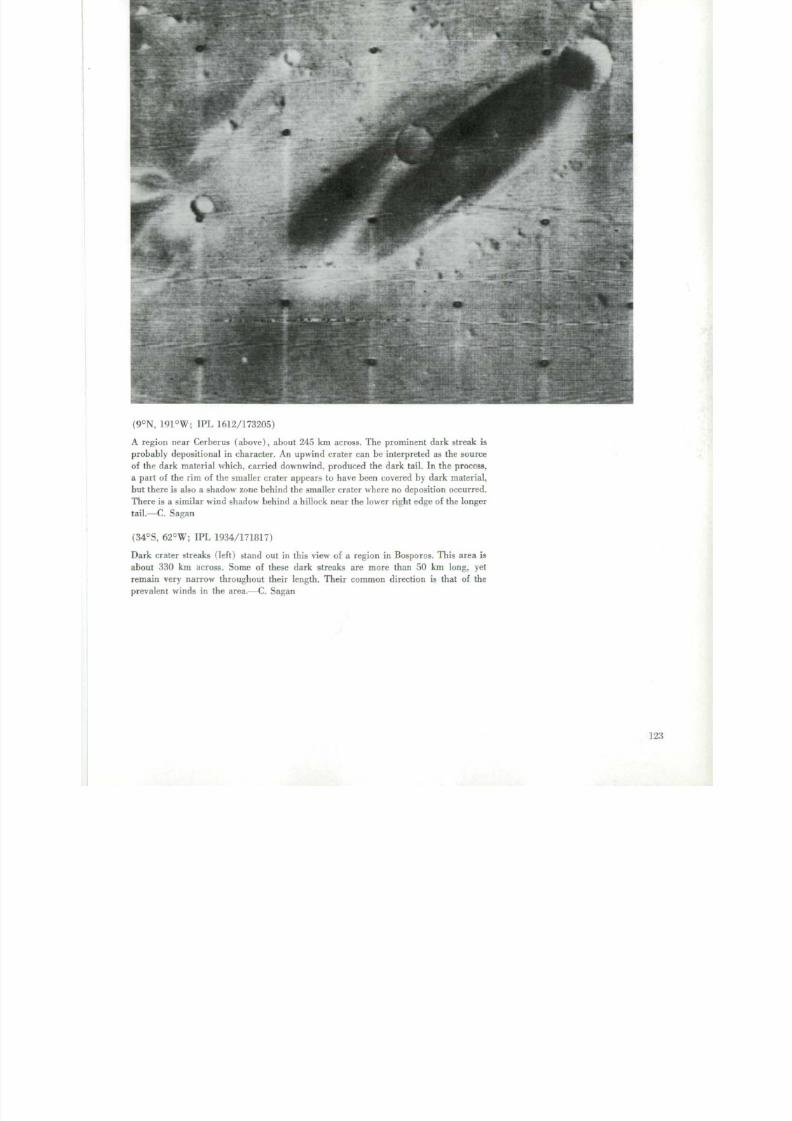
8/8/2019 MARS as Viewed by Mariner 9
http://slidepdf.com/reader/full/mars-as-viewed-by-mariner-9 122/222
(9°N, 191°W; IPL 1612/173205)
A reg ion near Cerberus (above) , about 245 km across. The prominent dark s t reak is
probably dep osi t ional in charac te r. A n upw ind c rate r can be in te rpre ted as the source
of the dark m ate r ial which , carr ied dow nwin d , produced the d ark tail. In the process,
a part of the rim of the smaller crater appears to have been covered by dark material ,
but there is also a shadow zone behind the smaller crater where no deposition occurred.
T he re i s a s imilar win d shadow behind a h i l lock near the lower r ight edge of the longer
tail.—C. Sagan
(34°S, 62°W; IPL 1934/171817)
Dark c rate r s t reaks ( left) stand out in this view of a region in B o spo ro s . This area is
about 330 km across. Some of these dark streaks are more than 50 km long, yet
remain very narrow throughout the i r length . T he i r common d i rec t ion is tha t of the
prevalent win ds in the area.—C. Sagan
123

8/8/2019 MARS as Viewed by Mariner 9
http://slidepdf.com/reader/full/mars-as-viewed-by-mariner-9 123/222

8/8/2019 MARS as Viewed by Mariner 9
http://slidepdf.com/reader/full/mars-as-viewed-by-mariner-9 124/222
(14°S, 185°W; M T V S 4211-42)
Almost fea tureless even to the high resolu t ion came ra , th i s p la in (abov e) in the center of
th e Am azon is bas in shows on ly a few small , widely spaced craters. The largest crater in upper
center is approximately 2 km in diameter and the smallest crater that can be seen is approxi -
mate ly 500 m in diameter . Except for three prominent cra ters , all craters appear very sub-
dued possibly because o f a haze layer or blowing dust close to the g r o u n d , or because th e
craters are par t ia l ly or almost completely buried by th ick wind-deposi ted sediments .—E. C.
Mor r i s
(46°S, 307°W; M T V S 4167-9)
(46°S, 305°W; IPL 1351/192301)
Smoothness can be the actual nature of the surface, or can be in the eye of the beholder, or
in weather , or in the imaging sys tem. P ic ture taken on J a n u a r y 23 . 1972, s hows an area of
the Hel las P lani t ia (80 km) with no sur face deta i l . (The fa int ci rcular out l ines a re a r t i -facts in the imaging sys tem.) P ic ture taken on March 11 s hows r idges , cra ters , an d other
detail of the same a re a , indica t ing tha t a dust storm w as active at the t i m e the first picture
was taken . His toric ally the Hellas basin has been the si te of large dust s torm s as viewed
telescopically and may have almost semi-permanent obscuration of its floor by blowing dust.
It was probably for tu i tous tha t th e picture taken on M a r c h 11 was at a t ime wh e n the at-
mosphere had c leared s u f f i c i e n t l y to record the detai l seen in the p ic ture . Some dus t stil l m ay
have been in the local atmosphere since details are s om e wha t s u bd u ed . —J . E . Peterson
127

8/8/2019 MARS as Viewed by Mariner 9
http://slidepdf.com/reader/full/mars-as-viewed-by-mariner-9 125/222
(1°N, 147°W; M T V S 4174-5
M o s t of the plains o n Mars probably were f o r m e d when huge volumes of fluid la
e r u p t e d onto the surface and buried the pre-existing terrain. These volcanic plawere subsequently buried under a mantle o f wind deposited sediments. The f lu
and lobate escarpment in the center of the picture at right was probably the termi
end of an old lava flow that h as been stripped of i ts cover o f sand an d dust an d erod
by the action of the violent winds. This erosive process has also etched and enlarg
f r a c t u r e patterns on top of the f low.—E. C. Morris
(17°S, 136°W; M T V S 4179-3
Subdued escarpments ( b e l o w ) may be seen along the margins of some plains. Th
may be the terminal f r o n t s of ancient lava flows, partly mantled by eolian depos
Similar lobate escarpments are seen on the lunar maria.—E. C. Morris
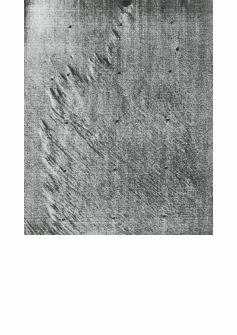
8/8/2019 MARS as Viewed by Mariner 9
http://slidepdf.com/reader/full/mars-as-viewed-by-mariner-9 126/222
\
» '. mm
\
•
«
* • - ™ '
v

8/8/2019 MARS as Viewed by Mariner 9
http://slidepdf.com/reader/full/mars-as-viewed-by-mariner-9 127/222

8/8/2019 MARS as Viewed by Mariner 9
http://slidepdf.com/reader/full/mars-as-viewed-by-mariner-9 128/222
(51°N, 263°W; M T V S 4289-48)
In northern la t i tudes th e plains ar e charac te r ized by numerous smal l c rate rs , hills and
knobs, an d patchy light an d dark markings. T he dark markings appear to create pat-
te rns , a lmost polygonal in f o r m , similar to pat te rned te rrain in the Ear th ' s polar areas.
—E. C. Mo rr i s
131

8/8/2019 MARS as Viewed by Mariner 9
http://slidepdf.com/reader/full/mars-as-viewed-by-mariner-9 129/222
12Polar Regions
T he m a r t i a n p o la r r e g ions are of special interest be-
cause t he y c on t a i n tw o u n u s u a l an d u n i q u e t e r r a i ns ,pi t ted pla in s and layered deposi ts . These two regional
u n i t s are superposed on ancient densely cra tered ter ra ins
in th e south polar region and on relat iv ely l ightly c ra-
tered plains in the n o r t h . T he u n i q u e ne s s of the etch-
pit ted pla in s and layered ter ra ins to the polar regions
leads to the inference tha t thei r for m at io n must involve
f rozen CO-> or FbO.
T he pi t ted or etched p la ins vary widely in appear -
ance, but typica l ly are character ized by a l evel sur face
i n d e n te d by numerous p i t s or i r regular depress ions . In
places th e pi t ted p la ins are being eroded, exposing th e
un d e r ly in g cra tered ter ra in. The processes of bur ia l and
e x h u m a t i o n do not appear to have modif ied t he u nd e r -ly ing t e r r a i n s i gn i f i c a n t l y .
The layered ter ra in i s character ized by nar row,
evenly spaced bands interpre ted to be l edges of outcrop-
p in g s t r a t a o f ne a r l y ho r i z on t a l s tra ta . The s t ra ta a re
f rom 20 m to 50 m h i gh , and a sequence composed of
m or e t ha n 10 0 such uni t s has been measured near th e
s o u th polar region. The absence of craters in layered
ter ra in sugges t s tha t e i ther it is one of the you nge s t u n i t s
o n Ma r s or the most actively e rode d .The polar i ce caps l i e upon the lamin ated ter ra in.
Each pole has a p e r m a n e n t cap composed of f rozen car-
bon dioxide or water and a th in ephemeral l ayer of car -
bo n dioxide , which forms poleward of the 60° parallels
e a c h wi n t e r an d evapora tes each s u m m e r .
The cra tered p la ins a re obviously the oldes t uni t s in
the polar regions because t h e y are overlain by all of the
other uni t s . T he p i t t e d p l a i ns are believed to have been
deposi ted next . T he i r or igin i s p roblemat ica l , but the
most con vincin g exp lanat ion seems to be tha t th ey repre-
sent a thick blanket of f ine dust which has set t led out of
th e a t m o s p h e r e at the poles perhaps t rapped by w a t e r
and carbon dioxide ices. Locally this blanket has sincebeen eroded by the wi nd , p r od u c i ng pits. Layered ter-
ra in , th e younges t uni t , occurs wi thin about 15° of the
poles. T h e obv i ou s s t ra t i f i ca t ion wi th in th e l a m i na t e d t e r -
ra in may have been caused by periodic changes in at-
m os p he r i c c ond i t i ons while the mater ia l was being
deposited.—L. A . Soderblom
13

8/8/2019 MARS as Viewed by Mariner 9
http://slidepdf.com/reader/full/mars-as-viewed-by-mariner-9 130/222
NORTHP O L A R REGION
u
o
O
Airbrush renditions give a generalized overview of the north polar region and the
south polar region. They clearly show the residual ice caps and the distributions of the
various types of terrain. The south polar region seems much more heavily cratered
than the northern one. This is probably because the north pole pictures have much

8/8/2019 MARS as Viewed by Mariner 9
http://slidepdf.com/reader/full/mars-as-viewed-by-mariner-9 131/222
SOUTHP O L A R REGION
poorer resolution. Erosional debris blankets which mantle terrains surrounding both
polar zones were probably derived through th e continual erosion an d transport of
material from polar deposits to lower latitudes.—L. A. Soderblom and T. J. Kreidler

8/8/2019 MARS as Viewed by Mariner 9
http://slidepdf.com/reader/full/mars-as-viewed-by-mariner-9 132/222
T he f ros t in the nor th polar region i s shown above cover ing a region about 2700 km
wide about five or six martian weeks af te r th e vernal equinox (August 1972) and at
right when near ing i t s minimal extent approximately two weeks after the summer
solstice ( O c t o b e r 1972). T he frost cover had a pecul iar polygonal shape tha t became
v e r y p r onou nc e d d u r i ng th e last stages of recession of the cap. It is more l ikely to
136

8/8/2019 MARS as Viewed by Mariner 9
http://slidepdf.com/reader/full/mars-as-viewed-by-mariner-9 133/222
P O L A R REGIONO C T O B E R 1972
have resulted f rom reg ional phenomena than f r o m local scarps or ridges. Regional
tex tural al ignments could have been induced by s table wind pat te rns. Note the c rate r
at 7 3°N, 198°W in the mosaic at r igh t . It t rapped an d shielded frost from th e Sun,
leaving a large patch on its floor.—L. A. Soderblom
137

8/8/2019 MARS as Viewed by Mariner 9
http://slidepdf.com/reader/full/mars-as-viewed-by-mariner-9 134/222

8/8/2019 MARS as Viewed by Mariner 9
http://slidepdf.com/reader/full/mars-as-viewed-by-mariner-9 135/222
(85°S, 355°W; IPL 1312/023810. 7352/184744)
From November unti l March the south polar cap was in the late stages of i ts retreat , shrink-
ing to a res idual cap a bou t 6° in diameter . T he conspicuous curvi l inear markings seen as
br ight bands in 1969 by M a r i n e r 7 . defros ted ear ly in 1971 to become th e dark bands shown
here. These high resolu t ion photographs were taken 11 0 days apar t by Ma r i ne r 9. In the
ini t ial stages of i ts retreat the windows in the cap continually changed, but by early 1971
they became fixed and u nc ha ng i ng . T he dark fea tures ar e ba re ground, where ice has evapo-
rated f rom sun- facing slopes. The permanent cap probably conta ins substant ia l water , i f i t
is not al l water, because a permanent mass of frozen CO-i would collect water even from
Ma r s ' dr y atmosphere . T he wi d t h s hown in each photograph is about 10 0 km.—L. A . Soder-
blom
(89 °N, 2 0 0 ° W ; MTVS 4297-47)
T h e m a r t i a n no r t h p o l a r f ros t c ap approached i t s m i n i m a l e x te n t a bou t one -ha l f m a r t i a n
m o n t h after summer solst ice on October 12 , 1972.The cap is about 1000 km across. It s topog-
raphy and the curved patterns in the interior of the f ros t cap are interpreted as a series
of stacked, sl ightly concaved plates, the upper one of less areal extent , with edges that havebeen smoothed an d m od i f i e d . T he individual plates m ay consist o f f r om 20 to 40 separate
layers , with an aggregate th ickness of perhaps one ki lom eter . The o ut l ine of the res idual cap
and con f igura t io n of the inter ior m arking s ari se f rom the f ros t f ree Sun -facin g s lopes a long
which l ayers outcrop . A dark col lar of rough er t extured ter ra in sur rou nds the smo other polar -
layered sedim entar y complex local ized in the cent ra l regions of both poles.—L. A . Soderblom

8/8/2019 MARS as Viewed by Mariner 9
http://slidepdf.com/reader/full/mars-as-viewed-by-mariner-9 136/222
(82°S, 85°W; M T V S 4247
Contact between layered terrain and pitted plains (above) is shown in this photogr
of an oval mesa of laminated terrain nesting on underlying pitted plains. In sev
cases, craters can be seen emerging f rom beneath th e layered deposits along th
margins. One crater, showing only its rim, protrudes through the blanket of the pit
plains in the upper center of the picture. The jagged pits and hollows of a pitted pl
area are dramatically displayed in the lower part of the view.—L. A. Soderblom
(71°S, 358°W; M T V S 4234-
Integrated pits (right) are etched into a massive layer blanketing much of the so
polar reg ion . An und erlyin g rough bedrock surface with partially exhumed crater
exposed in the pit floors. Slump blocks on pit walls and dark albedo markings at
bases of two or three sunlit walls are pa r t icular ly unus ual . Some pi t wal ls are e
mated to be 500 m high. The plain t h a t is shown here is being eroded by wind act
into irregularly shaped pits that resemble th e m a r k i n g s left on a metallic surface a
it has been etched with acid.—R. P . Sharp
140

8/8/2019 MARS as Viewed by Mariner 9
http://slidepdf.com/reader/full/mars-as-viewed-by-mariner-9 137/222

8/8/2019 MARS as Viewed by Mariner 9
http://slidepdf.com/reader/full/mars-as-viewed-by-mariner-9 138/222
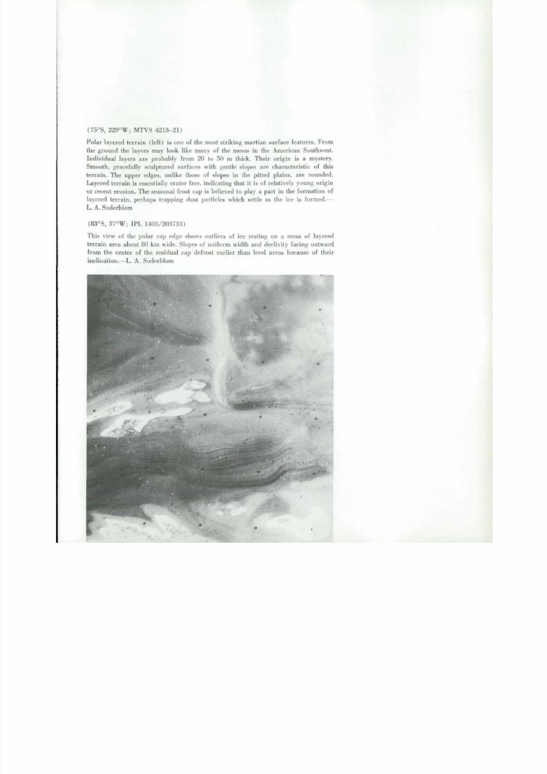
8/8/2019 MARS as Viewed by Mariner 9
http://slidepdf.com/reader/full/mars-as-viewed-by-mariner-9 139/222
(75°S, 2 2 9 ° W ; M T V S 4213-21)
Polar layered terrain ( l e f t ) i s one of the most s t r ik ing mart ian surface features. From
the ground the layers may look like many of the mesas in the A merican Southwest.
Individual layers are probably from 20 to 50 m thick. Their origin is a mystery.
Sm o o t h , gracefully sculptured surfaces with gen tle slopes are charac teristic of this
terrain . The upper edges, unlike those of slopes in the pitted plains, are rounded.
Layered terrain is essentially crater free, indicating that i t is of relatively young origin
or recent erosion. The seasonal frost cap is believed to play a part in the formation of
layered terrain, perhaps trapping dust particles which settle as the ice is formed.—
L. A. Soderblom
(83°S, 37°W; IPL 1403/203733)
This view of the polar cap edge shows outliers of ice resting on a mesa of layered
terrain area about 80 km wide. Slopes of un i f o r m width and declivity facing outward
from the center of the residual cap defrost earlier than level areas because of their
inclination.—L. A . Soderblom

8/8/2019 MARS as Viewed by Mariner 9
http://slidepdf.com/reader/full/mars-as-viewed-by-mariner-9 140/222
(80°S, 245°W; M T V S 4167-
These irregularly shaped features, located in the layered deposits of the martian so
polar region, are probably products of wind erosion. The l ight colored splotch at
left is un usua l in that it bears no relation to local topography. Also visible is a cra
which was at one time buried by the layered deposits, but has now been exhumed
th e w i n d . ( Are a sh o w n is ab o ut 90 km w i d e . ) — L . A . Soderblom and T. J. Kre id le
(86°S, 102°W; IPL 1444/1317
Detai l o f the south polar cap ( r i gh t ) . This pic tur e was taken late in the mission w
the cap had reached its l imit of retreat. The u nd erl yin g layered terrain is revealed
gentle slopes facing away f r o m th e pole.—L. A . Soderblom and T. J. Kre id le r
I II

8/8/2019 MARS as Viewed by Mariner 9
http://slidepdf.com/reader/full/mars-as-viewed-by-mariner-9 141/222
-"
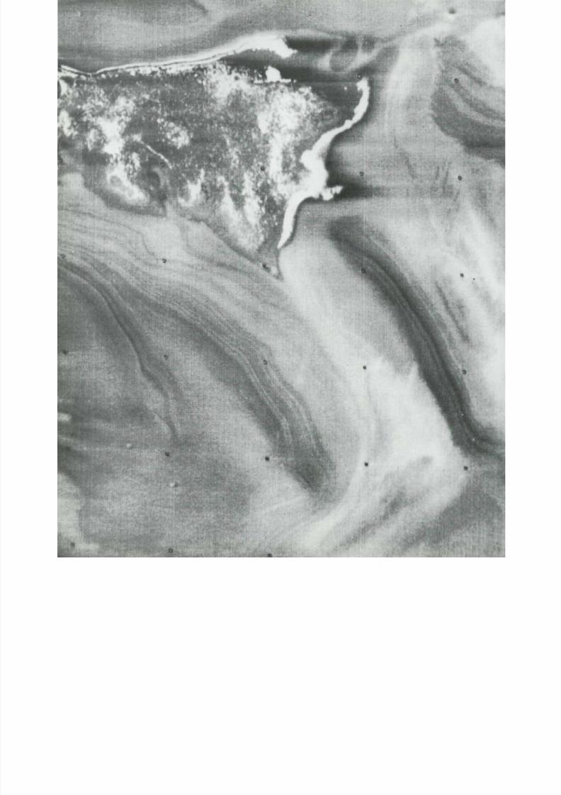
8/8/2019 MARS as Viewed by Mariner 9
http://slidepdf.com/reader/full/mars-as-viewed-by-mariner-9 142/222

8/8/2019 MARS as Viewed by Mariner 9
http://slidepdf.com/reader/full/mars-as-viewed-by-mariner-9 143/222
(83°S, 53°W; M T V S 4261-19)
In t h i s h ig h r e s o lu t io n p ic tu r e , part (70 km) of the res idual south polar cap is seen
res t ing on a mesa of layered te r rain . The patchy appearance of the ice mass occurs
because it consists of a m y r i a d of d i s c o n n e c te d r e mn an t s . —L. A. Soderblom and T. J.
K r e i d l e r
147
8/8/2019 MARS as Viewed by Mariner 9
http://slidepdf.com/reader/full/mars-as-viewed-by-mariner-9 144/222

8/8/2019 MARS as Viewed by Mariner 9
http://slidepdf.com/reader/full/mars-as-viewed-by-mariner-9 145/222
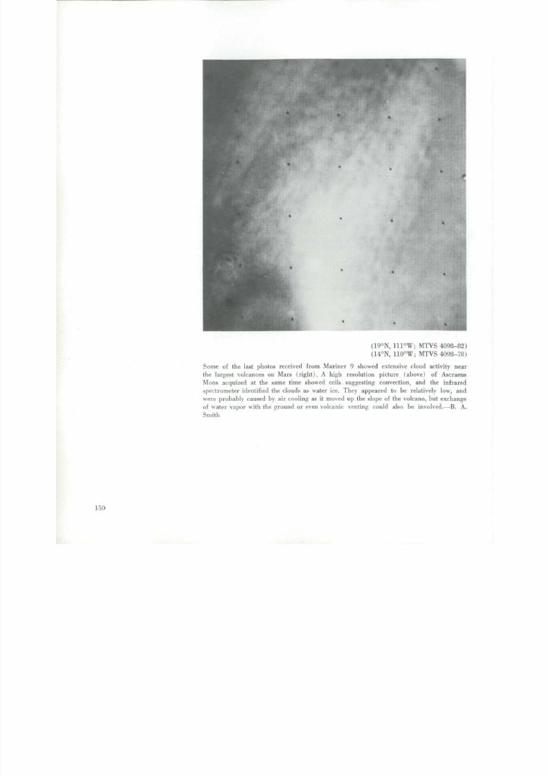
8/8/2019 MARS as Viewed by Mariner 9
http://slidepdf.com/reader/full/mars-as-viewed-by-mariner-9 146/222
(19°N, 111°W; M T V S 4098-8
(14°N, 110°W; M T V S 4098-7
S o m e of the las t photos received f r o m M a r i n e r 9 showed extensive c loud act iv i ty n
th e largest volcanoes on M a r s (right). A high r e s o l u t i o n p i c t u r e ( a b o v e ) of As c r a
M o n s a c q u i r e d at the same time showed cell s suggest ing conve ct ion, and the i n f r a r
s p e c t r o m e t e r iden t i f i ed the clouds as water ice . They ap peared to be re la t ively low, a
w e r e p r o b a b l y c a u s e d by air cool ing as it m o v e d up the slope of the volcano, bu t e x c h a n
o f w a t e r v a p o r w i t h t h e g r o u n d o r e v e n v o l c a n i c v e n t i n g c o u l d a ls o b e i n v o lv e d .— B .
S m i t h
150

8/8/2019 MARS as Viewed by Mariner 9
http://slidepdf.com/reader/full/mars-as-viewed-by-mariner-9 147/222
pus Mons
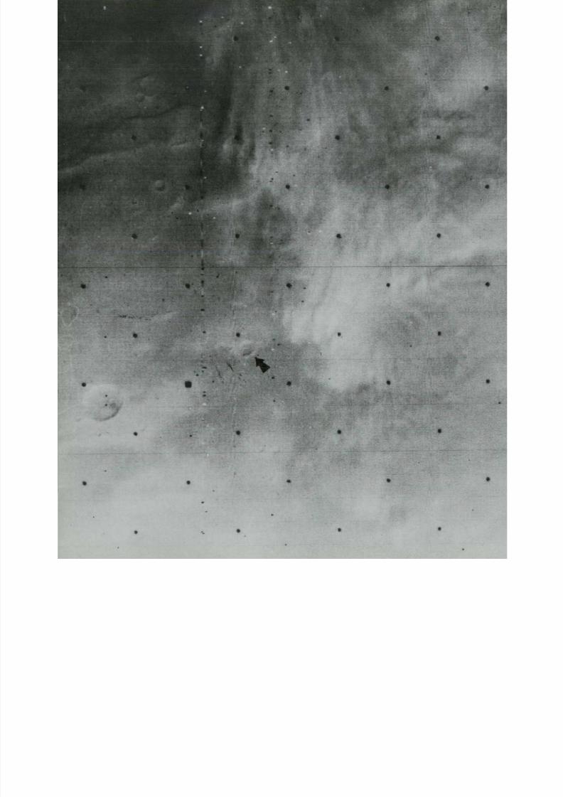
8/8/2019 MARS as Viewed by Mariner 9
http://slidepdf.com/reader/full/mars-as-viewed-by-mariner-9 148/222

8/8/2019 MARS as Viewed by Mariner 9
http://slidepdf.com/reader/full/mars-as-viewed-by-mariner-9 149/222
*
(15°N, 42°W; IPL 1765/105021)
(13°N, 42°W; IPL 1676/210508)
Afte r th e global dust storm subsided and the view of Mars f rom Mariner 9 was gen-
erally clear, local obscuration by streamers l ike those shown at left was observed.
Twenty days later th e st reamers were gone (above) ; the arrows poin t to the same
crater in both pictures. This region is ab o ut 650 km wide. Temp eratures there were
high and the stream ers originated along terrai n irregularit ies where turbulenc e could
enhance the prevai l ing winds ' abil i ty to raise dust. Short-l ived, localized dust storms ofthis type are familiar to astronomers as "yellow clouds" and are very different f rom
th e white clouds produced by condensat ion .—C. B . Leovy
152
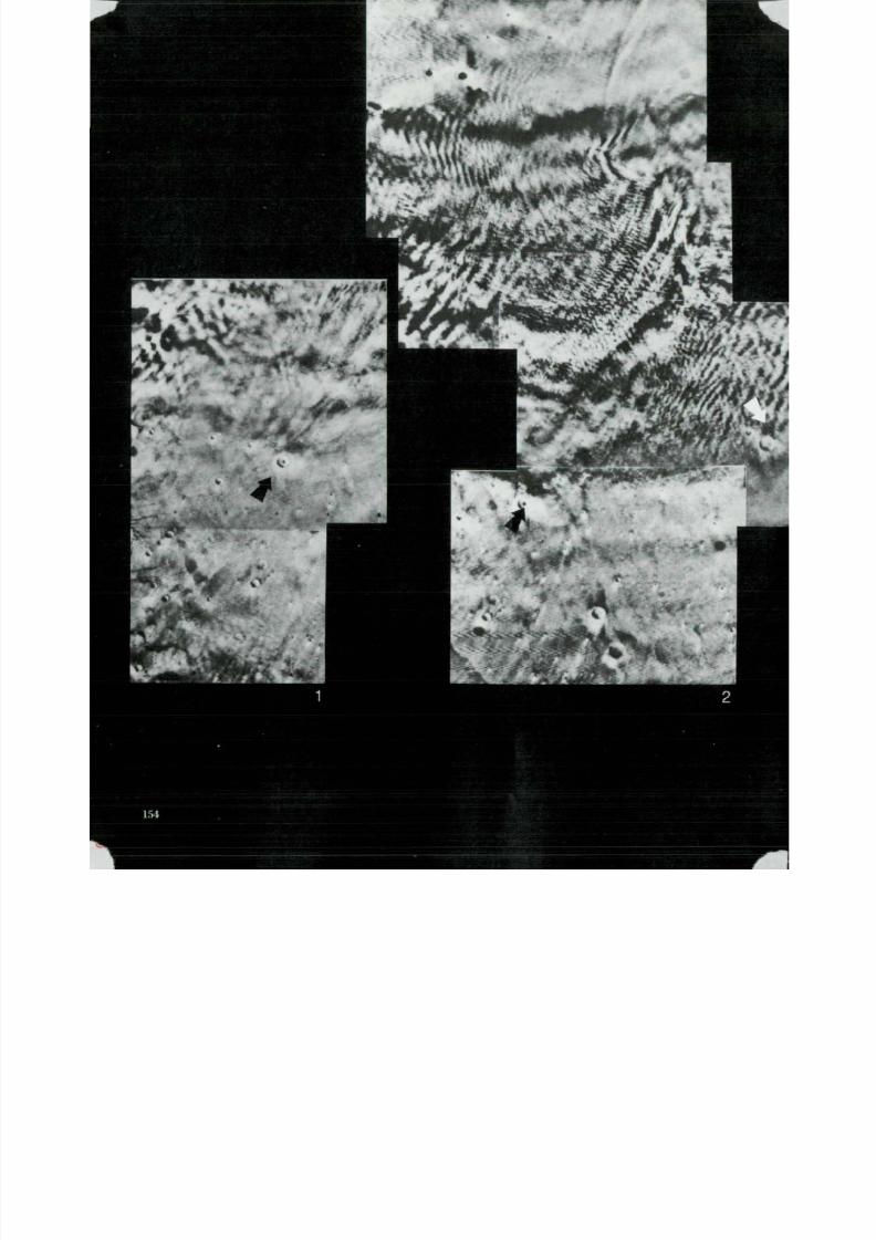
8/8/2019 MARS as Viewed by Mariner 9
http://slidepdf.com/reader/full/mars-as-viewed-by-mariner-9 150/222
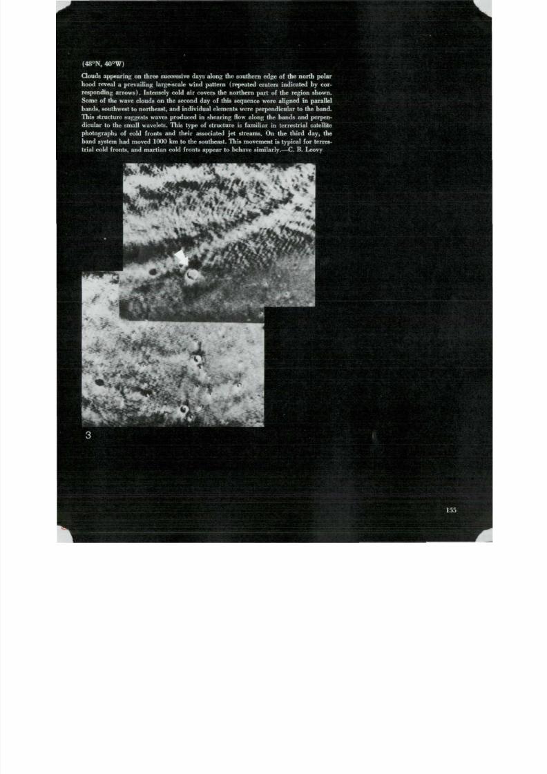
8/8/2019 MARS as Viewed by Mariner 9
http://slidepdf.com/reader/full/mars-as-viewed-by-mariner-9 151/222
(48°N, 40°W)
Clouds appearing on three successive days along the southern edge of the north polar
hood reveal a prevailing large-scale wind pattern (repeated craters indicated by cor-
responding arrows). Intensely cold air covers the northern part of the region shown.
Some of the wave clouds on the second day of this sequence were aligned in parallelbands, southwest to northeast, and individual elements were perpendicular to the band.
This structure suggests waves produced in shearing flow along the bands and perpen-
dicular to the small wavelets. This type of structure is famil iar in terrestrial satellite
photographs of cold fronts an d their associated je t streams. O n t he third day, th e
band system had mo ved 1000 km to the southeast. This mo vemen t is typical for terres-
trial cold fronts, an d mart ian cold fronts appear to behave similarly.—C. B . Leovy

8/8/2019 MARS as Viewed by Mariner 9
http://slidepdf.com/reader/full/mars-as-viewed-by-mariner-9 152/222
(71°N, 351°W; IPL 7283/21301
Mariner 9 sen t back some pic tures in the nor thern spr ing when the polar hood h
cleared and the atmosphere there was general ly very c lear . Late r photographs (o
shown at right) showed that the atmosphere was again partially obscured north of ab
45 ° lati tude. Well defined c loud s t reaks ex tended south an d west f r o m th e edge of
sur face condensate cap. The s t reakiness may have been p roduced by s t rong wi
blowing off the edge of the subliming polar cap, bu t this ph e n o m e n o n is still poo
understood.—C. B. Leovy
(8°S, 95°W; IPL 0083/15144
T he equatorial region aro und Tharsis Mo nies shows a general dust pall in this ea
photo. The peaks of towering volcanoes appear as dark rings at the left, and at rig
th e br ight outline of a vast canyon complex, later identified as the west end of Val
Mariner is , can be seen. Observations showed that th e c an y o n s ar e several kilomet
deep and the brightening here is attributed to the depth of the dust scattering back
Sun's light to Mar i n e r 9 's cameras.—G. A . Briggs
' -
156

8/8/2019 MARS as Viewed by Mariner 9
http://slidepdf.com/reader/full/mars-as-viewed-by-mariner-9 153/222

8/8/2019 MARS as Viewed by Mariner 9
http://slidepdf.com/reader/full/mars-as-viewed-by-mariner-9 154/222

8/8/2019 MARS as Viewed by Mariner 9
http://slidepdf.com/reader/full/mars-as-viewed-by-mariner-9 155/222

8/8/2019 MARS as Viewed by Mariner 9
http://slidepdf.com/reader/full/mars-as-viewed-by-mariner-9 156/222
(63°N, 34 7 °W; M T V S 4210-
This h i g h r e s o l u t i o n p h o t o g r a p h s h o w s d e t a i l s o f t h e f o r m a t i o n o f a w a v e c l o u d o
a cra ter in the n o r t h p o l a r r e g i o n . T h e w i n d is b l o w i n g f r o m upper r ight to l o w e r
and a second wave cloud is f o r m i n g a b o u t 4 0 k m d o w n s t r e a m . B o t h w a v e c l o
appear to be qu i te t u r b u l e n t . Th e g e n e r a l l y di f fuse appearance of the scene i s cau
by par t ia l obscura t ion by a w i d e s p r e a d t h i n h a z e o f condensed C 0 2 o r H z O . T h e la
cra ter s tands o ut p r o m i n e n t l y b e c a u s e o f s u r f a c e ice or s n o w ( C O a o r f t O ) a r o
its r i m .— G . A. Briggs
160
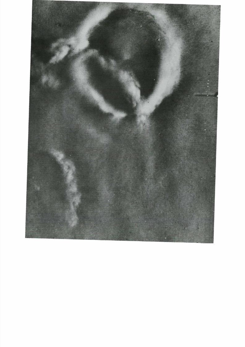
8/8/2019 MARS as Viewed by Mariner 9
http://slidepdf.com/reader/full/mars-as-viewed-by-mariner-9 157/222

8/8/2019 MARS as Viewed by Mariner 9
http://slidepdf.com/reader/full/mars-as-viewed-by-mariner-9 158/222
8/8/2019 MARS as Viewed by Mariner 9
http://slidepdf.com/reader/full/mars-as-viewed-by-mariner-9 159/222
14Natural Satellites
T h e t i n y m a r t i a n m o o n s Phobos a n d D e i m o s ( f r o mthe Greek fo r "Fear an d Dread") are v e r y diff icul t to see
w i t h ter res t r ia l te lescopes . They w ere d iscovered only in
1877 by the A m e r i c a n a s t r o n o m e r A s a p h H a l l , an d w e r e
seen as f a i n t p o i n t s o f l i g h t o r b i t i n g c lo s e t o t h e i r p l a n e t .
V i r t u a l l y n o t h i n g w a s k n o w n a b o u t t h e m u n t i l M a r i n e r 9
r e t u r n e d th e i m a g e s s h o w n here. B e c a u s e t h e i r o r b i t a l
c h a r a c t e r i s t i c s w e r e n o t k n o w n w i t h suff ic ient precis ion,
t h e f i r s t p h o t o g r a p h s w e r e t a k e n a t s u b s t a n t i a l d i s t a n c e s .
These images were then used fo r a c c u r a t e o r b i t a l d e t e r -
m i n a t i o n s , w h i c h p e r m i t t e d a c c u r a t e c a m e r a a i m i n g f o r
c l o s e u p p h o t o g r a p h y .
Phobos, th e i n n e r an d l a r g e r of the m a r t i a n m o o n -
lets, orb i ts at an average d is tance of 6100 km (3750m i l e s ) above th e s u r f a c e o f M a r s . It proves to be an
oblong mass about 20 by 25 km in i ts m a j o r d i m e n s i o n s
(1 2 by 14 m i l e s ) . D e i m o s orbits r o u g h l y 20000 km
(12 000 m i l e s ) a b o v e M a r s , and is 10 by 16 km (6 by 10
m i l e s ) in size. B ecause th e m a r t i a n m o o n s are so smal l ,
t h e i r g r a v i t y f ie lds are too w e a k to f o r c e t h e m i n t o
spher ica l shape. A s w i t h o ur M o o n , e ac h k e e ps th e s a m e
s i d e t u r n e d t o w a r d th e planet .
B o t h Phobos and D e i m o s are heavi ly cra tered by the
i m p a c t of m e t e o r o i d s . T h e n u m b e r o f craters appears to
be close to the s a t u r a t i o n l i m i t , w h i c h o c c u r s w h e n so
m a n y e x i s t o n a s u r f a c e t h a t a n y n e w c r a t e r s f o r m e d d e -
s t roy an equal number of older ones . Rough es t imates ofth e ages o f satell i tes can be m a d e by c o m p a r i n g t h e i r
c r a t e r d e n s i t i e s w i t h those of s imi lar areas o n t h e Ea r t h ' s
M o o n tha t have been posi t ively da ted by the ages of rocksr e t u r n e d b y Ap o l l o a s t r o n a u t s . Phobos an d D e i m o s are
believed to be at least 2 bi l l ion years old , and may date
back to the ear ly his tory of the solar sys tem about
4.5 bi l l ion years ago. The satell i tes also serve as a us e fu l
s t a n d a r d of com par iso n for the cra te r densi t ies on M ars .
This com par ison suggests extens ive erosion o f c r a t e r s
1 km in diameter and smaller.
B o t h Phobos and Deimos are dark objects ; most
a s t e r o i d s an d m e t e o r i t e s are brighter. T h e f e w objects
t h a t a r e a s d a r k c o n t a i n l a r g e a m o u n t s o f c a r b o n o r iron.
Studies of var ia t ion in b r ightness of these sa te l l i tes
suggest tha t they may be covered wi th a layer of f ine
par t ic les . In the case of the Earth's M o o n , such a regol i thresul ts f rom the sha t ter ing of rocks by repeated mete-
o r o i d i m p a c t . T h e g r a v i t y f ie lds of Phobos an d D e i m o s
a r e s o s li g h t t h a t f r a g m e n t s o f im p a c t - s h a t t e r e d rock
w o u l d b e t h r o w n o u t i n t o s pa c e. B u t these ejecta would be
captured by the grav i ty f ie ld of Mars , going in to orb i t
a b o u t M a r s w h e r e t h e w e a k g r a v i t y o f each sa te l l i te could
sweep it up a g a i n .
Theoret ica l s tudies of the smal l sa te l l i tes indica te tha t
t h e y need rockl ike s t reng th to escape to ta l d is in teg ra t ion
f r o m m e t e o r o i d i m p a c t . S i n c e t h e i r w e a k g r a v i t y a p p e a r s
insuff ic ient to have o r i g i n a l l y form ed them into cohesive
m a t e r i a l s o f suff ic ient s t r e n g t h , it seems l ike l y t h a t t h e y
were once par t o f a much larger sol id rock, an d weref r a g m e n t e d by the impact of a la rge meteoroid .—
J. B. Pol lack
163
8/8/2019 MARS as Viewed by Mariner 9
http://slidepdf.com/reader/full/mars-as-viewed-by-mariner-9 160/222

8/8/2019 MARS as Viewed by Mariner 9
http://slidepdf.com/reader/full/mars-as-viewed-by-mariner-9 161/222
(IPL 1579/163600)
Ph o b o s f rom af ar at a ran ge of 12 500 km ( l e f t ) reveals only its largest craters. The
d i am e t e r of the pro m i n e n t c ra t e r n e a r th e t e rm i n a t o r is ab o ut 5 km. The long linear
edge t h a t run s th e length of Ph o bo s is p ro b ab l y th e result of f r a g m e n t a t i o n . — J .
Ve ve rk a
( IPL 83/235451)
The best view yet seen by man of Pho bos i s th is com puter-en hanced pic ture taken at a
range of 5540 km (r ig h t I . The large c rate r a t midd le r igh t , near the te rminator ,
appears to have at least one small crater on its rim. More than a dozen other small
c rate rs ar e visible. The irregular edges of Phobos s t ro ngly suggest f ragm entat ion .
— J . B . Pollack
165

8/8/2019 MARS as Viewed by Mariner 9
http://slidepdf.com/reader/full/mars-as-viewed-by-mariner-9 162/222
( M T V S 4109
The profus ion of craters on Phobos is suggested in this picture, which is also a m
m u m - r a n g e view (5760 k m ) . C ra t e r s as small as 300 m in diameter ar e visible.
Veverka
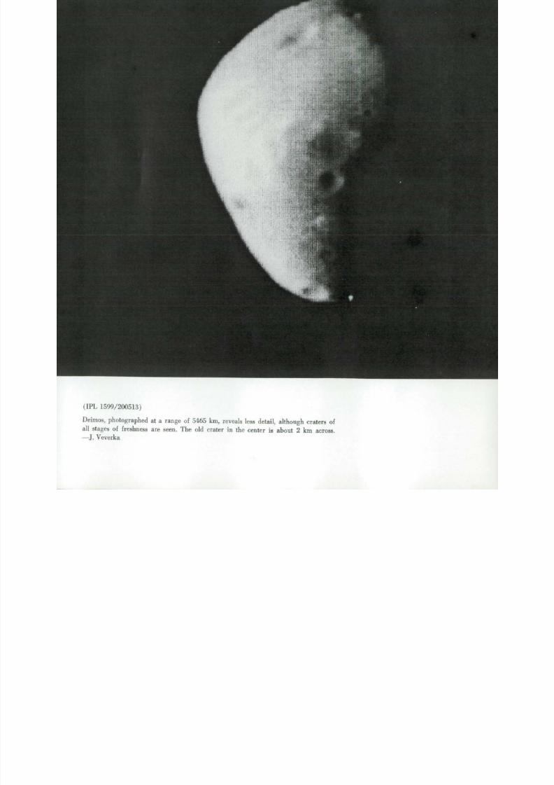
8/8/2019 MARS as Viewed by Mariner 9
http://slidepdf.com/reader/full/mars-as-viewed-by-mariner-9 163/222
(IPL 1599/200513)
Deimos, photographed at a range of 5465 km, reveals less detail , although craters of
all stages of f reshness are seen. The old crater in the center is about 2 km across.
— J. Ve ve rk a

8/8/2019 MARS as Viewed by Mariner 9
http://slidepdf.com/reader/full/mars-as-viewed-by-mariner-9 164/222

8/8/2019 MARS as Viewed by Mariner 9
http://slidepdf.com/reader/full/mars-as-viewed-by-mariner-9 165/222
15Martian Enigmas
M a n y of the mart ian features seen in M a r i n e r 9 pic-
tures can be categorized because of their obvious similar-
it y to features wel l kno wn and long s tudied on the Ear th
and the M oon. Others , however , are puzz l ing . W e cann ot
ye t be sure whethe r the i r charac te r is t ics are un iq ue to
Mars , o r w h e t h e r it is just that th e l imi tat ions on our
c u r r e n t un d e r s t an d i n g of the red planet prevent us f r o m
conf ident ly i n t e rp re t i n g w h a t w e see.
More detailed study will doubtless lead to a better
understanding. Some features may be c lar i f ied i f we
can f ind n a t ura l f e a t u re s o n Ear t h t h a t are analogous,
an d others may be explained if they can be simulated
or modeled in a laboratory. Thus th e present en igmas
m ay lead us to a better un der sta ndi ng of the processes
tha t operate on the cold, dry surface of Mars wi th it s
very th in atmosphere and per iod ic h igh winds. In the
m e a n t i m e , a modest and by no means exhaustive collec-
t ion of these puzzl ing features is presented he re as a
s a m p l i ng of the challenges that have been presented by
Mars .—J. E. Peterson
169

8/8/2019 MARS as Viewed by Mariner 9
http://slidepdf.com/reader/full/mars-as-viewed-by-mariner-9 166/222
• •
i* • ' •

8/8/2019 MARS as Viewed by Mariner 9
http://slidepdf.com/reader/full/mars-as-viewed-by-mariner-9 167/222
'
s
-°S,.335°W; M T V S 4216-54)
A s trange white depos i t occurs on the floor of a cra ter not far f rom th e ma rt ia n
equator. I ts high ref lectivity suggests gr oun d ice but its location m akes this hig hly
improbable . The deep tapering reentrants and the suggestion o f considerable relief
above th e crater floor leads to the in fe rence t ha t it most probably is not a t rans ient
feature but ra ther a per m ane nt depos i t now in the process of being eroded by the
wi nd . The or ig in of the deposit itself , which is about 18 km wide, remains an enigma.
— J. F. M cCauley

8/8/2019 MARS as Viewed by Mariner 9
http://slidepdf.com/reader/full/mars-as-viewed-by-mariner-9 168/222

8/8/2019 MARS as Viewed by Mariner 9
http://slidepdf.com/reader/full/mars-as-viewed-by-mariner-9 169/222
(74°S, 166°W; M T V S 4269-19)
A n in t r icate c rate r I above) in the south polar region displays an arcuate s lump mass inside
th e major c rate r wal l . Both the r im and the slump mass are subdued by a m an t l i n g b l an k e t.
O n th e crate r floor an arcuate scarp appears, which is 35 to 40 km in diameter an d c o m pa-
rable in shape to the big crater . B ranching r idges and f u r r o ws with in may be due to e rosion
of a volcanic construct; dark pattern within may be volcanic ash .—D . B . Potter
(80°S, 245°W; IPL 326/1714111
A complex pattern of delicate swir ls an d i r regular dark tones shows in th is pic ture of
u n u s u a l t e r r a i n in Mars' south polar cap. T he area covered is about 80 by 85 km. Puzzl ing
processes, perhaps some i n t e r p lay of w i n d def la t ion of layered te rrain , have modif ied th e
te r rain .—L. A. Soderblom
173

8/8/2019 MARS as Viewed by Mariner 9
http://slidepdf.com/reader/full/mars-as-viewed-by-mariner-9 170/222
(2°S, 186°W; M T V S 4209-
W r i n k l e s o n t h e face o f M a r s : Th e sm o o t h p l a i n s ar e s o m e t i m e s m a r k e d b y i n c i p
col lapse or f lowage . I t may be analo gou s to the landsl ips tha t oc cur in s i l ty c lay b
in the S t . Lawren ce V al ley in Quebec. Col lapse might com e f r o m disp lacement of s
surface f lu ids , or f r o m me lt ing of a perm afro s t layer . He re collapse occurs on
f lanks of a l o w r i d g e t h a t e x t e n d s f r o m lower r ight to upper lef t .—E. C. Morris
(67°S, 188°W; IPL 1436/1309
D o u b l e i m p a c t c r a t e r s ( b e l o w ) , w i t h r i m s and f loors th inly mant led , boast s t r ik
breached volcanic cones r i s ing f rom each floor. Ea c h c o n e is s u r r o u n d e d by a d
a p r o n t h a t c o u ld be lava or v o l c a n i c a s h .— D . B.Potter
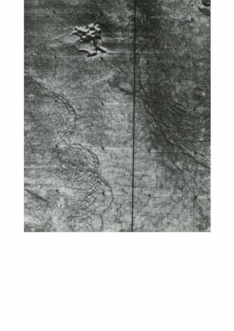
8/8/2019 MARS as Viewed by Mariner 9
http://slidepdf.com/reader/full/mars-as-viewed-by-mariner-9 171/222
;;

8/8/2019 MARS as Viewed by Mariner 9
http://slidepdf.com/reader/full/mars-as-viewed-by-mariner-9 172/222
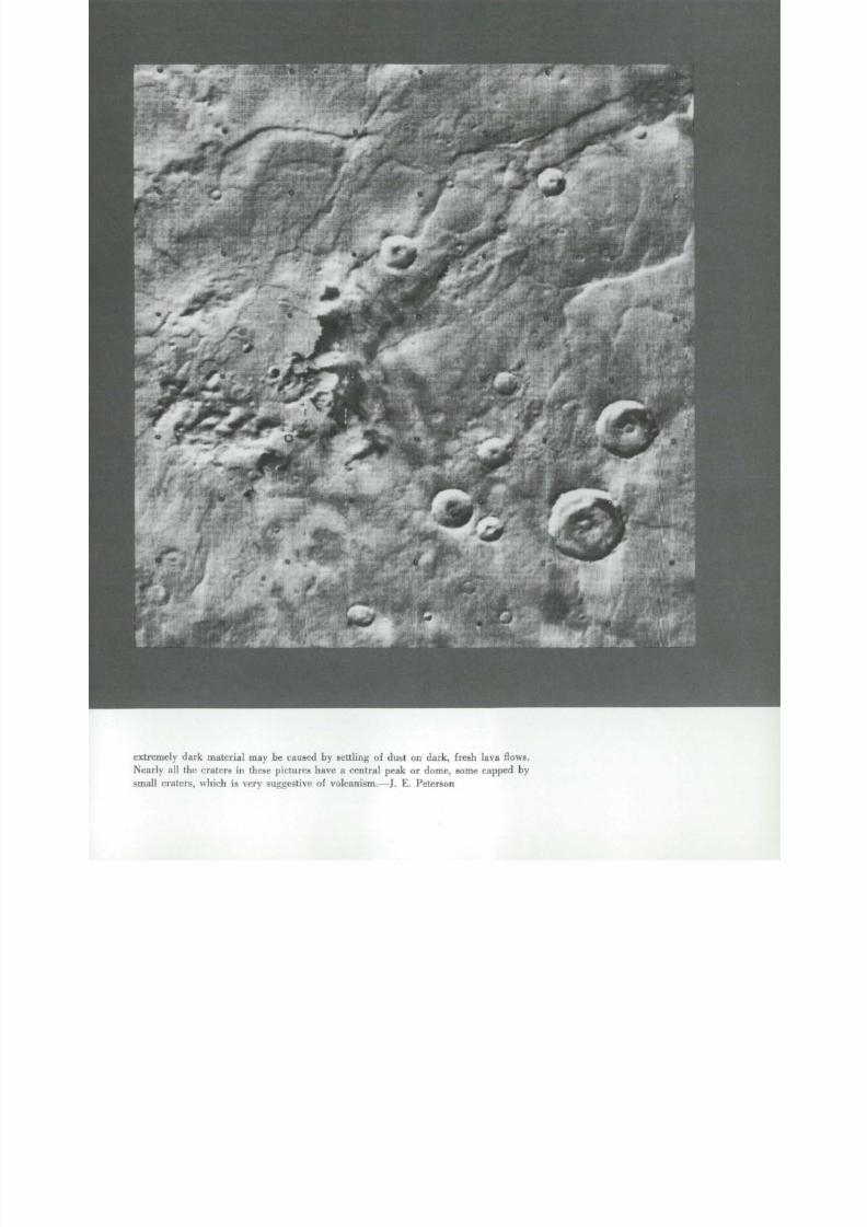
8/8/2019 MARS as Viewed by Mariner 9
http://slidepdf.com/reader/full/mars-as-viewed-by-mariner-9 173/222
extremely dark mate r ial may be caused by se t t l ing of dus t on dark , f resh lava f lows .
N e ar ly all the craters in these pic tures have a central peak or dome, some capped by
small craters, w h i c h is very suggestive of vo lc an i s m. —J . E. Pete r son

8/8/2019 MARS as Viewed by Mariner 9
http://slidepdf.com/reader/full/mars-as-viewed-by-mariner-9 174/222
ata .

8/8/2019 MARS as Viewed by Mariner 9
http://slidepdf.com/reader/full/mars-as-viewed-by-mariner-9 175/222

8/8/2019 MARS as Viewed by Mariner 9
http://slidepdf.com/reader/full/mars-as-viewed-by-mariner-9 176/222
(43°S, 356°W; M T V S 4149-
Three unique features lie in the low resolution area show n below. They are la
crater-l ike depressions of u nknown origin. Being closed forms , they can not have be
caused by fluvial eros ion, an d the ir depth an d steepness of sides rules out wind eros
as the sole cause. Some mechanism of collapse controlled by frac tu re sys tems is pr
ably responsible, but these featur es are still very puzzling .—J. E. Peterson
(49°S, 358°W; IPL 7205/18462
Curving wi thin a 100-km crater is a 60-km long depression, the end of which is s ho
here (r ig ht , to p) . I ts walls a re very steep, and th ere appe ars to b e a flat-lying resist
layer at its rim. It is about 7 km wide at the arrows. Clouds partly obscure the p
ture.—J. E. Peterson
(45°S, 356°W; IPL 1943/2015
A centra l p la teau in this unique 85-km diameter fea ture is connected to the surrou
ing p la ins (r igh t , cen ter) . Th e s teep-walled depress ions are som ewhat s inuous
follow a roughly circular outline. This picture was acquired near the end of
global dust storm an d is som ewh at obscured.—J. E. Peterson
(50°S, 357°W; IPL 7455/23503
A deep linear depression is t e rmina te d ( r igh t , bo t tom) . It is about 5 km wide at
narrowest point . The sides are very steep, with debris-avalanche chutes on the wa
but the bottom seems fair ly smooth and rounded in cross section. Again, clo
apparent ly obscure this picture so me what. This gash extends ne arly across a la
cra ter .—J. E. Peterson
jf
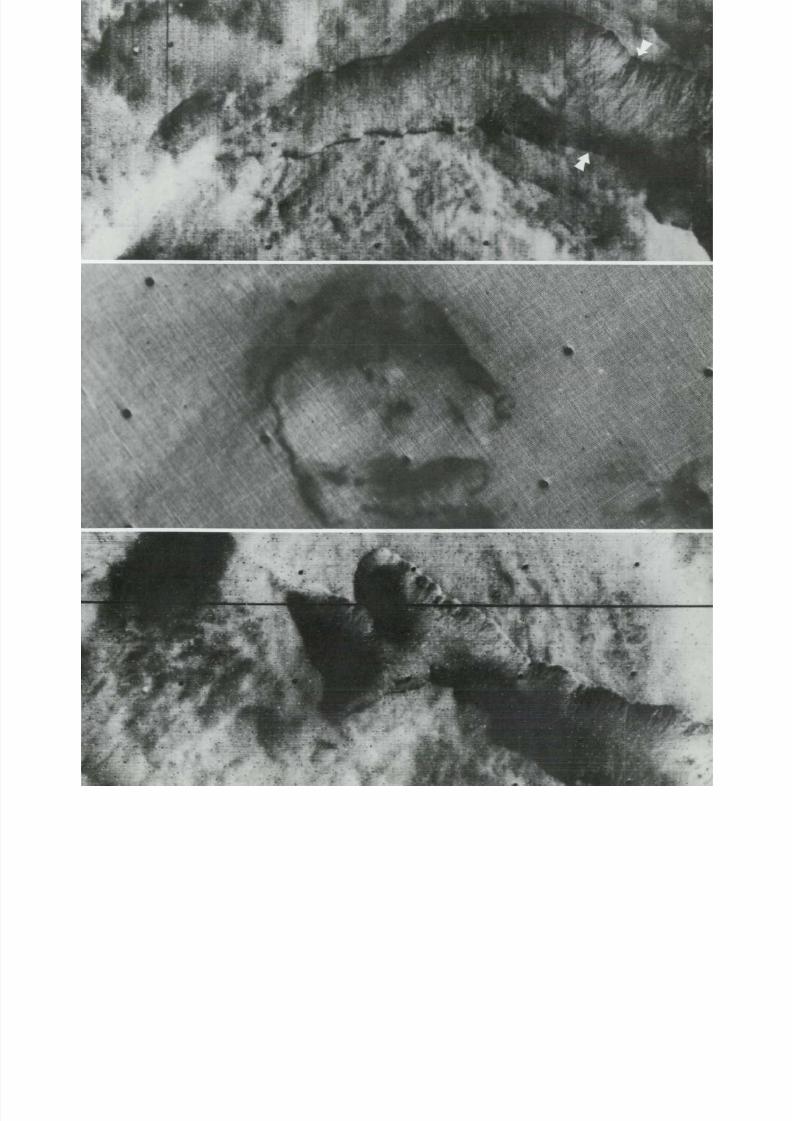
8/8/2019 MARS as Viewed by Mariner 9
http://slidepdf.com/reader/full/mars-as-viewed-by-mariner-9 177/222

8/8/2019 MARS as Viewed by Mariner 9
http://slidepdf.com/reader/full/mars-as-viewed-by-mariner-9 178/222
Tl

8/8/2019 MARS as Viewed by Mariner 9
http://slidepdf.com/reader/full/mars-as-viewed-by-mariner-9 179/222
/'
^
( 20°N , 235°W; IPL 1765/212715)
(18°N, 235°W; IPL 7256/131906, 7256/133526)This strange feature (above), Hephaestius Fossae, is located in the Elysium Planitia.
It is a system of branching t roughs approximate ly 525 km long and 75 km wide . T he
elongate shadow of Mars' moon Phobos can be seen in the low resolution photo (the
roun d black spot is a camera a rti fa ct ). In the high res olution mosaic, the general pat-
te rn of the t roughs ind icates f rac tur ing as a more l ikely cause than fluid flow. Indi-
vidual troughs are up to 2 km wide, an d considerable erosion by wind m ay have
broadened them.—R. S . Saunders
( 9° N, 293°W; M T V S 4266-35)
A n enigmatic collapsed depression (left) occurs in the region of Syrtis M a j o r Planitia.
The structure here has the crisp arcuate scarps that characterize the volcanic calderas
of th e Tharsis Monies. But i t may also be a karst-l ike feature formed by removal ofdeeply buried ice or other subsur face mater ials . (A karst is a region of sinks an d
r idges overlying l imestone .)— T. A . Mut c h
183

8/8/2019 MARS as Viewed by Mariner 9
http://slidepdf.com/reader/full/mars-as-viewed-by-mariner-9 180/222
8/8/2019 MARS as Viewed by Mariner 9
http://slidepdf.com/reader/full/mars-as-viewed-by-mariner-9 181/222
16Similarities:
Mars, Earth, and Moon
It i s imposs ible to look through the thousands of
i m a ge s o f Ma r s r e t u r ne d by M a r i ne r 9 wi t h ou t d i s cov e r -ing fea tures reminiscent of those on our na t ive p lanet .
W h e n a m a t c h - u p is m a d e by geologis t s having profes-
s ional f a m i l i a r i t y with the Ear th ' s fea tures , as on the
fo l lowing pages, th e s imi lar i t i es can be s t r i k i ng . Th e
M o o n , l ibera l ly photographed dur ing the f i r s t years of
space exploration, also has deta i l s tha t appear s imi lar to
t hos e t ha t Ma r i ne r 9 revealed o n Mars . Somet imes labo-
r a t o r y s i m u l a t i ons can help br idge the gap between th e
a p p a r e n t and the k n o w n , as whe n wi nd - t u nne l e xp e r i-
ments on model cra ters seemingly dupl ica te erosion pat-
t e rns seen on the s u r f a c e o f M a r s .
For two reasons these analogs m ay b e less s u r p r i s i ng
or s ig ni f icant than they seem. In a sense i t i s smal l wo nde rt h a t Mars . Ear th , and Moon do, in fac t , look somewhat
al ike, par t icular ly if you e xa m i ne th e E a r th t h r o u g h
geologis t s' eyes. W ind blow n fea tures a re eas i ly ident i f i -
able in , for example , Texas , Idaho, and New Mexico.
Evidence of volcanism can be seen in Ar izona , faul t ing
in Ca l i f o r n i a , s t re a m e r os ion t h r ou gh ou t t he U n i t e d
States, s t ra t i f ied deposi t s in Utah, and glacia l fea tures in
A las k a . T he H a wa i i a n I s l a p d c om p l e x i s c om p a r a bl e i n
s om e respects to the volcanic region of Mars near O lym-
pus M o n s .
We should be caut ious and not make the mis take of
a s s u m i ng that resemblances—limi ted as t he y are to the
phys ical a p p e a r a nc e of s u r f a c e f e a t u r e s —a r e p r oof oft rue s imi lar i t i es . It can be a pro fou nd mis take to assume
t h a t s i m i l a r - l ook i ng fea tures actual ly or igina ted an d
evolved in a l i ke m a nne r . Wi t hou t a doubt , f u t u r e e x-p lo r a t io n of M a r s will show tha t some of the d y n a m i c
processes tha t shaped the sur face of Mars were the same
as those that caused terrestrial features. Geologists are
now co nd uct i ng research prog rams in the southwestern
Uni ted S ta tes , P e r u , an d A nt a r c t i c a to collect data that
may cas t l ight on the ques t ion of whether Mars and
Ear th evolved s imi lar ly. Theoret ica l ca lcula t ions and
l ab o r a to r y e x p e r i m e n t a t i o n will p r ov i d e th e q u a n t i t a t i v e
i n f o r m a t i o n needed to unders tand the physics of these
processes.
T h e exci t ing thing about compara t ive p lanetology is
tha t i t wil l permi t us to unfold the lost p a r t of the
Earth's his tory, now largely obl i tera ted by eros ion, moun-ta in bui lding, an d o t he r processes. A full u nd e r s t a nd i ng
of th e pas t is a rel iable way to accura te predic t ion of the
f u t u r e . This work can help predict th e na t u r e and course
of f u t u r e a t m os p he r i c e v o l u t ion , a ns we r i ng th e d i s t u r b i ng
ques t ion of whether the E a r th ' s envi ronment i s des t ined
t o g r ow s i m i l a r t o t he e nv i r onm e n t o f V e nu s o r Ma r s .
Quest ions l ike these can only be approached by compre-
hending the secrets of the planets in our solar system.
Com para t ive p lanetolog y i s the s ta r t in g point for an
un d e r s tan d in g o f th e physica l f u t u r e o f p l a ne t E a r th .
In the m ean t im e, the analogs on the fol lowing pages
sugges t tha t the old saying may have to be m o d i f i e d to
''It's a smal l solar sys tem."—S. E . D w o r n i k
185

8/8/2019 MARS as Viewed by Mariner 9
http://slidepdf.com/reader/full/mars-as-viewed-by-mariner-9 182/222
ii
(14°N, 142°W; M T V S 4174-7
W in d - p r o d uc e d s t r e a m l i n i ng o f a part of the complexly s t ructured aureole a roun d Olym p
M o n s is seen above. These e longate r idges are 10 to 15 km long and 3 to 5 km wide. Thare para lle l to num ero us smal ler grooves and roug hly el l ip t ica l pits that are also the probab
resul t of wind eros ion. The crests of many of these r idges occ ur sharp and keel - l ike in appea
ance; thei r ends are sharply tapered. These r idges occur in t er res t r ia l deser t s such as I
Valley in P e ru ( r i gh t I whe r e t he y ar e several kilometers in l ength an d h u n d r e d s of m e t
high. The Iqa V al ley r idges have been cut by s t ron g sea w inds tha t f u n n e l almost daily in
thi s v i r tual ly ra inless val ley. The layered rocks here a re re la t ively sof t , Ter t ia ry sedime
upl i f ted f rom the sea by f a u l t i n g s ince the onset of a r id i ty in th i s re g ion .—] . F. McCaul
186

8/8/2019 MARS as Viewed by Mariner 9
http://slidepdf.com/reader/full/mars-as-viewed-by-mariner-9 183/222
187

8/8/2019 MARS as Viewed by Mariner 9
http://slidepdf.com/reader/full/mars-as-viewed-by-mariner-9 184/222
(81°S,64°W: IPL 1417/1603
Another probable result of wind erosion (below I is seen in th is unusual an d comp
array of linear, interconnected reticulate ridges in the south polar region of M
I The pic ture is ab o ut 45 km wide .) A superf ic ial resemblance to anc ien t ruins led
the i r in for m al appe l lat ion as " Inca Ci ty" du r ing the Ma rin er 9 mission . A m ore m
dane explanat ion i s that th is feature almost sure ly represents ye t another var ian t
th e l an d fo rm s p ro d uc e d b y win d on Mars. The origin of the reticulate pattern i t
is u n k n o w n : i gn e ou s o r clastic dikes o r indurated f rac t ure zones are all possibil i
A s can be seen in the photo f rom the almost rainless coastal desert of Peru (ri g
s i m i l a r pa t t e rn s can be pro d uc e d by selective wind scouring. (The mage is about
km across. I The more resis tan t d ikes or f rac tures abrade less rapid ly than th e so
s u r r o u n d i n g m a t e r i a l and thus s tand above th e surrounding plains l ike th e wal ls o
r u i ne d c i ty .—J. F . McCauley
8/8/2019 MARS as Viewed by Mariner 9
http://slidepdf.com/reader/full/mars-as-viewed-by-mariner-9 185/222

8/8/2019 MARS as Viewed by Mariner 9
http://slidepdf.com/reader/full/mars-as-viewed-by-mariner-9 186/222
i
190

8/8/2019 MARS as Viewed by Mariner 9
http://slidepdf.com/reader/full/mars-as-viewed-by-mariner-9 187/222
(18°N, 133°W; IPL 1406/164237)
Calderas on Ear t h ar e created by the collapse of the surface as lava is erupted or w h e n
it drains away at depth. Here repeated collapse events produced complexes of older
large calderas surrounding a smal le r younger one. Sh o w n ar e K i l aue a in Hawai i
( a bov e ) and O l ym p u s M o n s ( left) on M a r s . — K . A . H o w a r d
191

8/8/2019 MARS as Viewed by Mariner 9
http://slidepdf.com/reader/full/mars-as-viewed-by-mariner-9 188/222

8/8/2019 MARS as Viewed by Mariner 9
http://slidepdf.com/reader/full/mars-as-viewed-by-mariner-9 189/222
(1°N, 157°W; M T V S 4254-55)
U-shaped depressions are of t e n produced by the w i n d in the lee of rocks o r other
topographic obstacles. These occur where an active, mobile sheet of loose-moving sand
is present on the surface. Deposition of the sand tends to occur on the upwind side an d
the f lanks of the obstacle and an erosional blowout o r depression occurs on the down-
w i n d side. These features may b e controlled in great part by the presence o f partially
buried crater rims just n o w poking above th e sand blanket. Picture a t left is a high
r e s o l u t i o n image of the Amazonis Planitia on Mars; blowouts shown are up to 3 km
long. T h e picture above i s a low-altitude aerial photo taken in the Coachella Valley,
C a l i f o r n i a , where the blowouts are tens of meters long and occur in the lees of
abandoned shacks.—J. F. McCauley
193

8/8/2019 MARS as Viewed by Mariner 9
http://slidepdf.com/reader/full/mars-as-viewed-by-mariner-9 190/222
(6°S, 84°W; IPL 1356/1142
Stubby, r e lat ive ly deep gul l ies without well developed t r ibutar ies are seen in the photo
r ig h t of an a l luv ia l was h o n t h e shore o f Lak e Me ad , A r iz o n a . T h e y are developed
loosely con sol ida ted m ate r ia l that f a i ls by s lum pin g and so i l flowage due to changes
the lake leve l and degree of satura t ion of the so i l . A s imilar s tubby, poo r ly develo
d e n d r i t i c pa t t e r n ( ab o ve ) is seen in man y t r ib u ta r i e s of the Val l e s Mar in e r i s o n M
sugges ting that they may have form ed by some type of sapping or so i l f lowage pror a th e r th an b y water collected runof f f rom r a i n f a l l d u r i n g a n ear l ie r pluvial episode
Mars.—J. F. Mc C aule y
194
8/8/2019 MARS as Viewed by Mariner 9
http://slidepdf.com/reader/full/mars-as-viewed-by-mariner-9 191/222
8/8/2019 MARS as Viewed by Mariner 9
http://slidepdf.com/reader/full/mars-as-viewed-by-mariner-9 192/222
» = = ?

8/8/2019 MARS as Viewed by Mariner 9
http://slidepdf.com/reader/full/mars-as-viewed-by-mariner-9 193/222
( 2° N, 314°W; M T V S 4178-60)
Central peaks in craters or basins, though widely assumed to have been formed by
imp act or volcan ic processes, can also arise f rom wind deposition. While the origin of
the peak in the Mars c rate r ( l e f t ) i s as ye t unproven , in the basin shown above at
B runeau, Idaho, th e center is dominated by a large sand-dune complex maintained by
wi nd blowing in two main d i rec t ions.—J. D. M urphy, J . S . K ing , and R . Gree ley
197
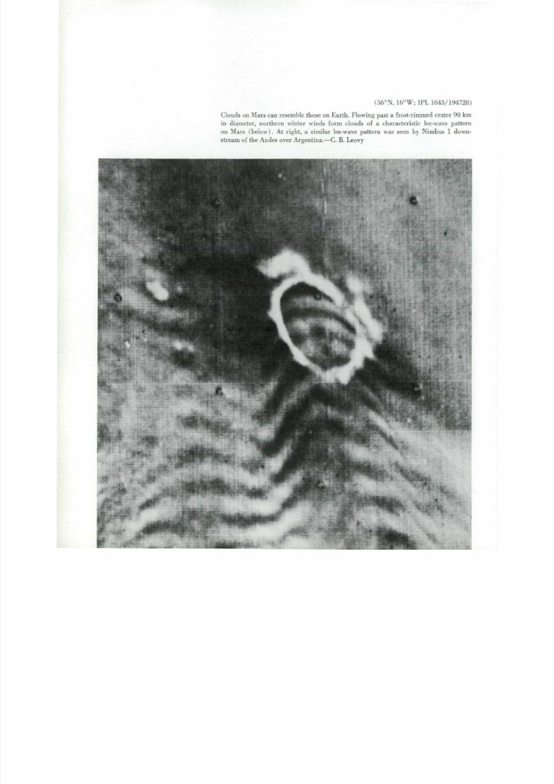
8/8/2019 MARS as Viewed by Mariner 9
http://slidepdf.com/reader/full/mars-as-viewed-by-mariner-9 194/222
(56°N, 16°W; IPL 1643/19472
Clouds on Mars can resemble those on Earth. Flowing past a frost-rimmed crater 90 k
in diameter, northern winter winds form clouds of a characteristic lee-wave patte
o n Mars (below). At right, a similar lee-wave pattern was seen by Nimbus 1 dow
stream of the Andes over Argentina.—C. B. Leovy

8/8/2019 MARS as Viewed by Mariner 9
http://slidepdf.com/reader/full/mars-as-viewed-by-mariner-9 195/222
I
r
\ 1
'it

8/8/2019 MARS as Viewed by Mariner 9
http://slidepdf.com/reader/full/mars-as-viewed-by-mariner-9 196/222

8/8/2019 MARS as Viewed by Mariner 9
http://slidepdf.com/reader/full/mars-as-viewed-by-mariner-9 197/222
(60°N, 2 7 0 ° W ; IPL 1431/193738)
(60°N, 178°W; M T V S 4248-98)
Long cloud lines on Mars (left , top) are formed by convection as cold polar at -
mosphere rushes southward over warmer ground. T h e convection creates long spiral-
ing plumes do wn win d, wi th c louds form ing on the r i s ing par t o f the spiral. At left
bo t t om , similar cloud lines begin to break up into large convective clusters in another
par t o f the mart i an no r th polar reg ion . Above , an A pol lo photo shows c loud l ines on
Earth, where relatively cool air f rom the At lan t ic f lows nor th ward over the w arm
groun d of South Carol ina.— C. B. Leovy
201

8/8/2019 MARS as Viewed by Mariner 9
http://slidepdf.com/reader/full/mars-as-viewed-by-mariner-9 198/222
I
•
T \
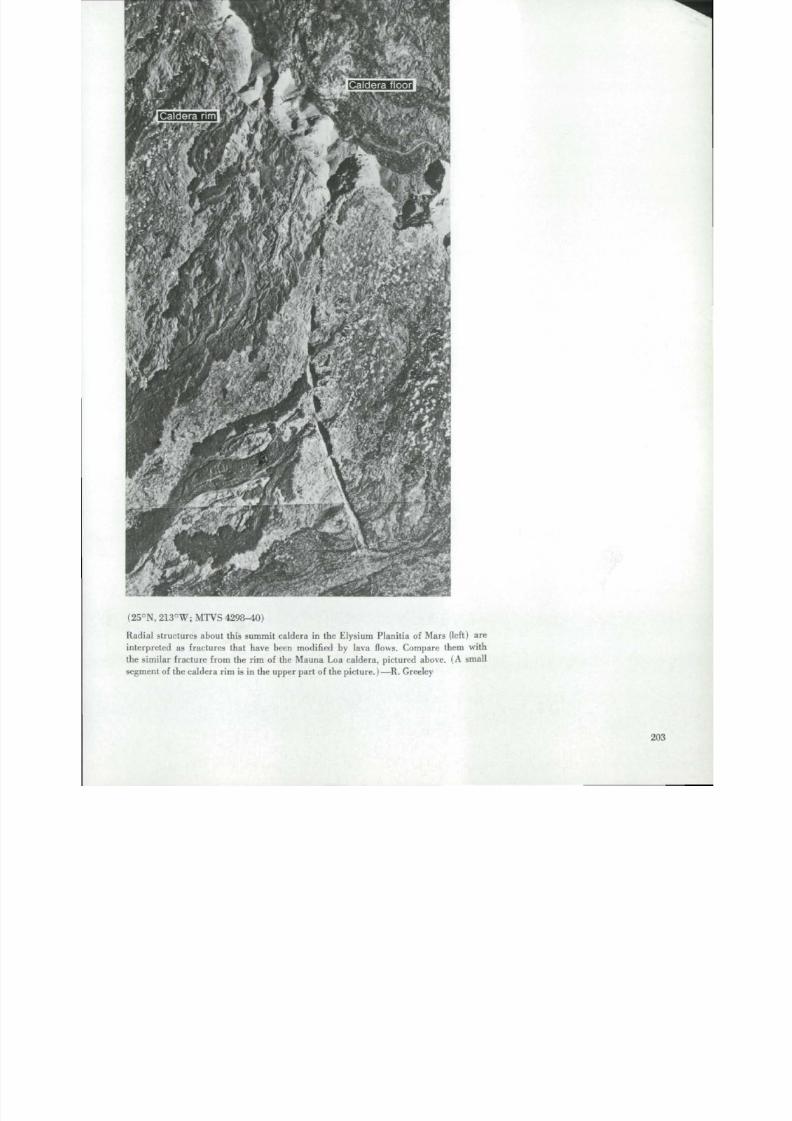
8/8/2019 MARS as Viewed by Mariner 9
http://slidepdf.com/reader/full/mars-as-viewed-by-mariner-9 199/222
( 25°N , 213°W; M T V S 4298-40)
Radial structures about this summit caldera in the Elysium Planitia of Mars (left) are
in te rpre ted as f rac tures that have been modified by lava flows. Compare them with
the s imilar f racture f rom the rim of the Mauna Loa caldera, pictured above. (A small
segment of the caldera rim is in the upper par t of the picture.)—R. Greeley
203

8/8/2019 MARS as Viewed by Mariner 9
http://slidepdf.com/reader/full/mars-as-viewed-by-mariner-9 200/222
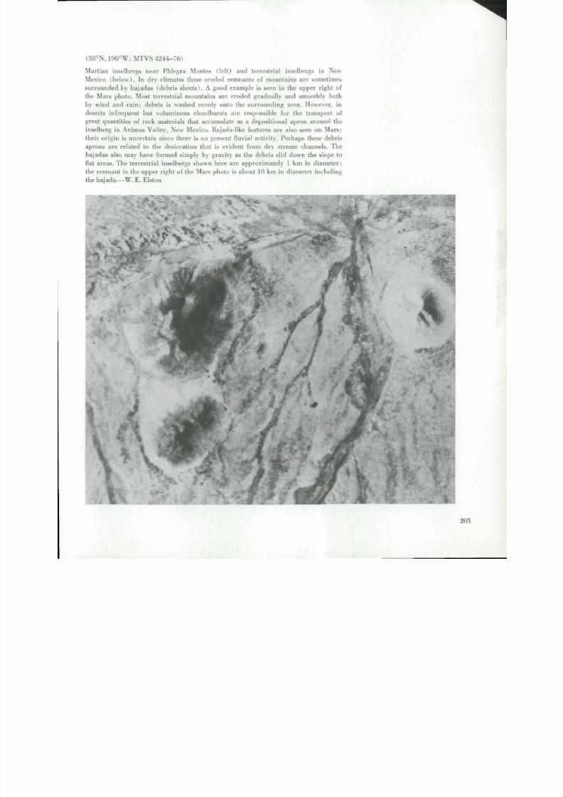
8/8/2019 MARS as Viewed by Mariner 9
http://slidepdf.com/reader/full/mars-as-viewed-by-mariner-9 201/222
i38°N, 196°W; M T V S 4244-76)
Mart ian inse lbergs near Ph leg r a Monies ( lef t ) and terre stria l inselbergs in Ne w
Mexico (b e lo w) . In dry c l imates these e roded rem nants of mo un tain s are somet imes
surrounded by bajadas (deb ris shee ts) . A good example is seen in the upper r igh t of
th e M ars photo . Most te rrest r ial mo unt ain s are e roded g rad ual ly and sm oothly both
by wind and rai n ; debr is i s washed evenly onto the surro und ing area. H owever , indeserts i n f r e q ue n t but volum inou s c loudbur sts are responsible for the t rans port o f
great quant i t ies of rock mate r ials that accum ulate as a deposi t ional apron arou nd the
inselberg in An i m as Va l l e y , N ew Mexico . B aj ad a- l ik e features ar e also seen on M a r s ;
the i r o r ig in is uncer tain s ince there is no present fluvial ac t ivi ty . Perhaps these debris
aprons are re lated to the desiccat ion that i s evident f rom dry s t ream channels . The
bajadas also m ay have formed simply by gravity as the debris sl id down th e slope to
flat areas. The terrestrial inselbergs shown here are approximately 1 km in diameter;
th e r e m n a n t in the upper r igh t of the Mars ph o t o is ab o u t 10 km in d i am e t e r i n c l ud i n g
th e b a j ad a .—W. E . E l s to n
* *, \.
.
205
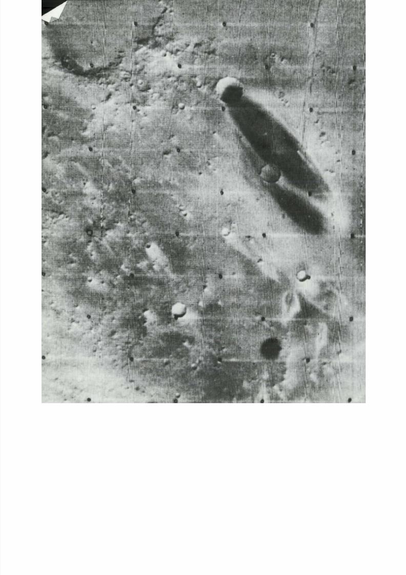
8/8/2019 MARS as Viewed by Mariner 9
http://slidepdf.com/reader/full/mars-as-viewed-by-mariner-9 202/222
1
_
#

8/8/2019 MARS as Viewed by Mariner 9
http://slidepdf.com/reader/full/mars-as-viewed-by-mariner-9 203/222
(9°N, 191°W; IPL 1947/173205)
A d a r k p l u m e ( l e f t ) e x t e nd s m or e t ha n 140 km d o w n w i n d o f th i s l a rge cra ter in the
Elysium Plani t ia . A labora tory s imula t ion above, wi th the wind f lowing f rom top to
bottom, suggests that th e dark mar t ian p lume m ay have been caused by wind eros ion
removing loose par t icula te mater ia l . Al terna t ively, th e dark p lume m a y be deposits of
m a t e r i a l o r i g i na t i ng f r o m within the c ra te r .—R . Greeley

8/8/2019 MARS as Viewed by Mariner 9
http://slidepdf.com/reader/full/mars-as-viewed-by-mariner-9 204/222
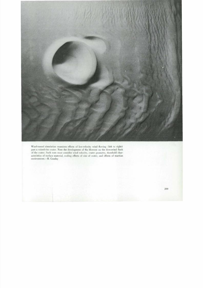
8/8/2019 MARS as Viewed by Mariner 9
http://slidepdf.com/reader/full/mars-as-viewed-by-mariner-9 205/222
W i n d - t u n n e l simulation examines effects o f low-velocity wind f lowing ( le f t to right)
past a raised-rim crater. Note the development of the blowout on the downwind flank
o f th e crater. Such tests must consider wind velocity, crater geometry, threshold char-
acteristics o f s u r f a c e material, scaling effects o f size of crater, an d effects o f martianenvironment.—R. Greeley
209

8/8/2019 MARS as Viewed by Mariner 9
http://slidepdf.com/reader/full/mars-as-viewed-by-mariner-9 206/222
(16°N, 18 2
V e r y la rge , i rr egula rly shaped cra ters exis t o n M a rs (a bov e ) and on the Moon ( r i g
The mart ian cra ter , O rcus Patera , is more than 400 km long ; the lunar cra
Schiller, is about 180 km long. Craters of this shape and s ize are uncom mo n and t
origins uncerta in. Coalescing subcircular segments marked A suggest they m ay h

8/8/2019 MARS as Viewed by Mariner 9
http://slidepdf.com/reader/full/mars-as-viewed-by-mariner-9 207/222
. — - r / t >
been formed by over lapping impacts or as volcanic fea tures , bu t l inear scarps and
t r ou ghs m a r ke d B indicate a tectonic inf luence. Floors of both craters are flat and
smooth. The mar t ian cra ter i s p robably f loored wi th wind-blown dust ; the f loor of
Schiller may be covered by impact e jec ta an d volcanic f lows.—D. H. Scott

8/8/2019 MARS as Viewed by Mariner 9
http://slidepdf.com/reader/full/mars-as-viewed-by-mariner-9 208/222
(31 °N, 2 2 0 °W; IPL 1443/14064
Highly ell iptical craters on Mars and the Moon. Note that both the 12-km-long Mess
A lunar crater (right, bottom) and the 15-km-long unn am ed mart ian c rate r (be lo
have raised rims, l inear structure on their floors, and ridge-like topography outside t
long axis of the ellipse. While certain of these features have been interpreted as e
dence for volcanic origin, laboratory studies have shown that the observed featu
can be reproduced in de tai l by low-angle meteor i te impac t .—N . W. Hinners
m

8/8/2019 MARS as Viewed by Mariner 9
http://slidepdf.com/reader/full/mars-as-viewed-by-mariner-9 209/222
- -

8/8/2019 MARS as Viewed by Mariner 9
http://slidepdf.com/reader/full/mars-as-viewed-by-mariner-9 210/222

8/8/2019 MARS as Viewed by Mariner 9
http://slidepdf.com/reader/full/mars-as-viewed-by-mariner-9 211/222
(13°N, 107°W; M T V S 4184-75)
In te rrupted r i l les appear both on Mars ( lef t ) and on the Moon. In each case low-ele-
vat ion te rrain a d jo i ns high-e levat ion te rrain , an d both ar e transected in varying degree
by ril les. Some of the martian ril les, such as those near th e sinuous channel at upper
left, may have been filled by deposition or sediment. Parts of the lunar rilles seem
to have been somewhat filled by later lavas. Scale: th e middle martian ril le has an
average width of 700 m; the largest lunar ril le shown is about 2 km w i d e .—N. W .
Hi n n e r s
21

8/8/2019 MARS as Viewed by Mariner 9
http://slidepdf.com/reader/full/mars-as-viewed-by-mariner-9 212/222
(23°S, 204°W; IPL 1642/188335
Heavily cra tered terra in on Mars (above) bears striking resemblance to some areas
th e Moon ( r i g h t ) . O ne notable difference is tha t Mars does not appear to have
many smaller, bowl-shaped craters, which leads to the inference that, on Mars, th
mav have been eroded and filled.—N. W. Hinne rs

8/8/2019 MARS as Viewed by Mariner 9
http://slidepdf.com/reader/full/mars-as-viewed-by-mariner-9 213/222
I
(w <
' < Yi /
$ ' - • ' / • >
1L f
t ' . - .../: •• f ?*»
* i<
iAj|dr
• 4« -r 1
f
< 1 ,
•< ' *1 .
i
. x•»'
;>j
I
\ -
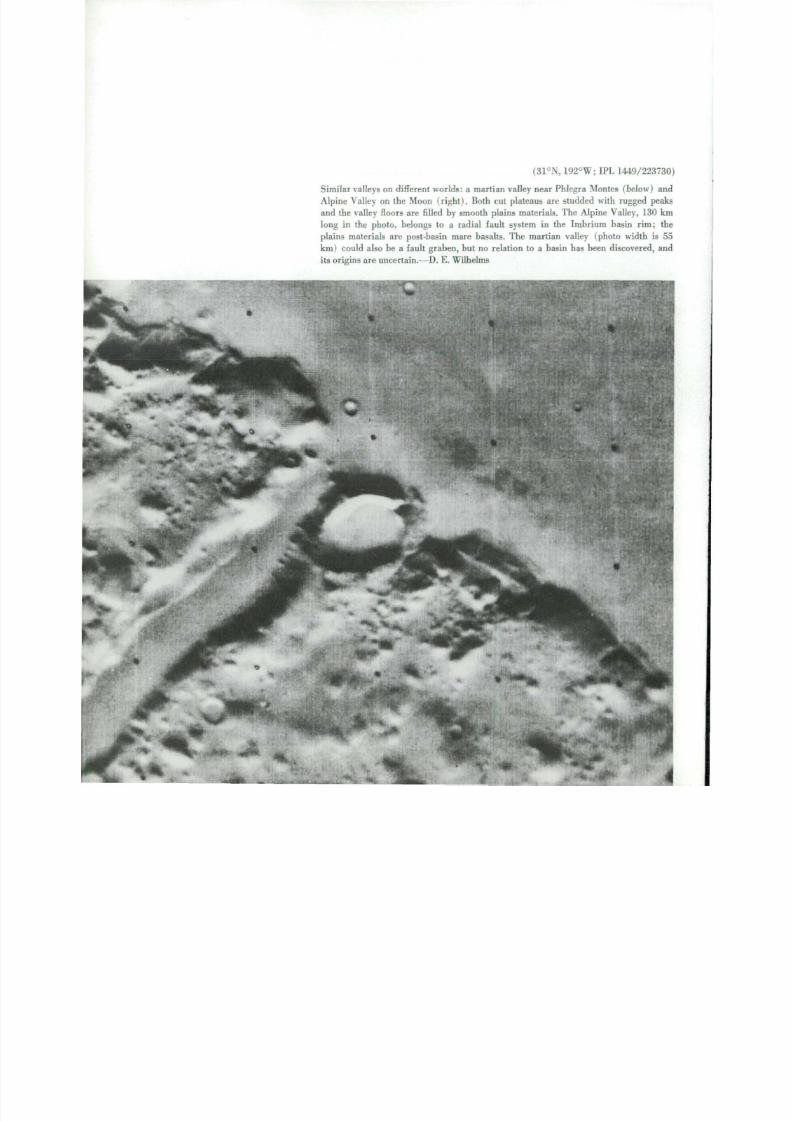
8/8/2019 MARS as Viewed by Mariner 9
http://slidepdf.com/reader/full/mars-as-viewed-by-mariner-9 214/222
(31°N, 192°W; IPL 1449/22373
Similar valleys on different worlds: a martian valley near Phlegra Monies (below) a
Alpine Val ley on the Moon ( r i gh t ) . Bo t h cut plateaus ar e s t u d d e d with rugged pea
an d th e valley floors are filled by smooth plains materials. The Alpine Valley, 130 k
long in the photo, belongs to a radial fault system in the Imbr ium bas in r im; t
plains materials ar e post-basin mare basal ts. T he martian valley (photo width is
km ) could also be a fault gr a be n , but no relation to a basin has been discovered, a
it s origins ar e uncer ta in.—D. E . Wilhelms
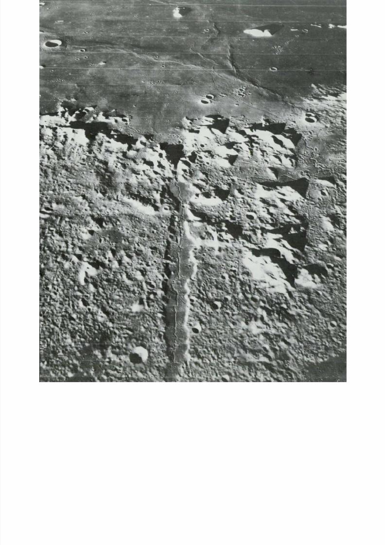
8/8/2019 MARS as Viewed by Mariner 9
http://slidepdf.com/reader/full/mars-as-viewed-by-mariner-9 215/222

8/8/2019 MARS as Viewed by Mariner 9
http://slidepdf.com/reader/full/mars-as-viewed-by-mariner-9 216/222

8/8/2019 MARS as Viewed by Mariner 9
http://slidepdf.com/reader/full/mars-as-viewed-by-mariner-9 217/222
Availabilityof Photographic Prints
T hr ou ghou t t h i s p u bl i c a t i on Ma r s i m a ge r y is ident i -
fied b y M T V S or I PL numbers except where mosaics are
presented. These numbers represent th e best processed
image available.
NSSDC has Mars photos on f i l e for the benefit of
scientists engaged in the s t u d y of Ma r s . I nq u i r i e s (for
MT V S or I P L nu m be r s o n l y ) should be directed to
N a t i ona l Space Science Data Center
Goddard Space Fl ight Center
Code 601
Greenbel t , M D 20771
I n f o r m a t i o n and price l ists for general interest re-
ques t s for any photo in th i s publ ica t ion may be obta ined
f rom
B ara Photographic , Inc.
Post Office Box 486
B l a de ns bu rg , M D 20710
O r d e r s s hou l d i nc l u d e t he p u bli c a t ion n u m b e r ( N A S A
SP-329) and the page number ( indica te "top" or "bot-
t om " whe r e ne c e s s a r y) .
22

8/8/2019 MARS as Viewed by Mariner 9
http://slidepdf.com/reader/full/mars-as-viewed-by-mariner-9 218/222
0
Polar S te reographic Pro jec t ion
au
r- r- o55
\ \\ \ \ \ \ \ \\ \ \ \ V V ^
1000 4000 km
NORTH POLAR REGIONP O L A R CA P A S IT A P P E A R E D O N O C T O B E R 1 2, 1972
,180
22 2

8/8/2019 MARS as Viewed by Mariner 9
http://slidepdf.com/reader/full/mars-as-viewed-by-mariner-9 219/222
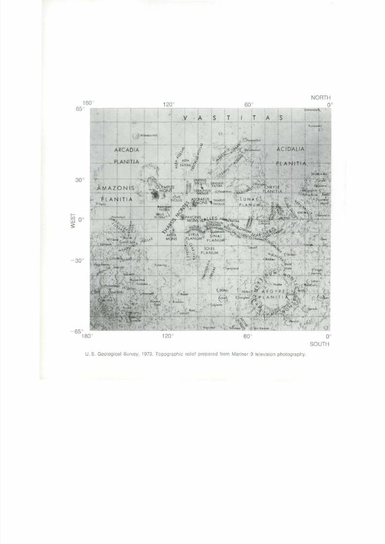
8/8/2019 MARS as Viewed by Mariner 9
http://slidepdf.com/reader/full/mars-as-viewed-by-mariner-9 220/222
18065
1 20 60
NOR
0
•
AM ,
P Ll<
PetM
A R C A I
PLANI
^ Z O N I
A r ) l T I /
3
Niciolson .
.. M,
}IA
r i A
s
^
ankovitch
''
-(CW
'
"JSaMON
rm
\i A
Us
/ 1^ AlBA j3!
1PA
l|
tS
fHOLUS^
ERA
ff :
V1
S
Q
• - f ^
-
&
T
c
^ < £ ?
%s^
|| WNJUS
? CEMUNIUS ..• Fessinkov
(/O «MON5™THOLUS
7AV|£A
V( "'
Px ERA ,.. «PAVQNSJ IF.S.„„ .
1 T
•pet k in
' Barabashov
A
lUN
PLAN
k >r
p
A E
UM..,
".
A
/
— ,'...rr
•
V
C H R Y S
LAN IT
, ? „ „ ,
1AKi T1AL A n
EA . . . . . : .
5S
T T T^
v W
omonosoV
....,..-('
Kunow
SH«,
ky
C
Dw
-,ne
.' ' B oe
tlaughlin V
Rotherford(
-.j
><<• ' MJ .- • . .
MffiM Om
liai
r«
F « 15V
I? «r^ , fc .AS .MQNS .PLANUM p, A M I I M *
CH*s*u<<•,-.
r LA I N U/V T 7" On
«* B
nJon«
-30'
» ' •
Magelhaens
i(l M»nrier
• '
Mip'parchu
,, «it> Cocernicis
^ PLAIUM
""idkenng
m >
•
-LJsse l l
, . , ,
"•- ,,.„V
,Hussev i •
•
^ ^/^ ^ ^. UALJ
o_ >'\
'£ •L/ '
HallevC.-w f
.
. Bo^
^Vo l
,OM. .H_
g > ,'.Lohse
' -Ho^e WkVo
R G Y R E ^
65°1 80
r-Bi
N ti !
:o : yj _;•• 3 kO :«r*/n
'/
1,1 M'' -
•,
•
•'. yon K a r ma n
120 60
SOU
U. S. Geological Survey, 1973. Topographic rel ief prepared from Mariner 9 television photography.

8/8/2019 MARS as Viewed by Mariner 9
http://slidepdf.com/reader/full/mars-as-viewed-by-mariner-9 221/222
Mercator Projection
4000 km
Oc
300 240
,
t
t
MA V-
B
•-
0 R
. t
'
E A L S
• Stokes'
U T O P I A * „ ,kjRenaudiJi 1 -j U
P L A • N 1 t 1 A * £ r^"fen. :HECATBTHOLUJorO
1 8065
.O HSJNG ',
Ma**: ' -
La ss . n T ».S* WJa
-,»-
' SY
^<PLA
•A,ry
v1t»f-. ,.
E L Y•. ,
^ ISIDIS:,
TISP L A N I T I A .
•M fOR
I I T I A
%
* f e f e $ t c $ f t K
,
Adanni
•iockyer
v,PL ANITIAk ^ELYSIUM MONS
T H O L U S •
OEddK
ORCKS /
P A T E K A
.
'
; JarryfDeitoge^'
H E S P E R I A
•PLANUM
K,nobel
• yensWlsl
"--" f a.g.rg^,/ J
t
lamb, ' M.llochao .. , tYR
Newcontb(' M"*
11"5*" .,„..,,„ P A T E R A
'^
RHENA
APOLLINARIS
Reuyl P A T E R A
Halley Q%
r i
no CO
0 <LJJ
' (S
- f. '• ' iu^
JMb0dJ.i
,:.,„
H E t L A
P L A N
P A T E R A
- Mulh, MoleSworrt,'• T«r*y HA0RIACA
PA.TERA f
• Mart*
5 .4-""
I A
....
I T
-30:
C r u l s .
T IK* » , n,. T_l>:no¥ ^ Tycho Br«he
. Oledh.ll . ' ' /• Wallace , Pr Her
C.mpb.H
''*• Spallanzan,A M P H d R I T E S Secchc
• -,„
A M P H I T R I T E S I ' S e r r h ,
P A T E R A ,
8arn,rd *»«
^•ts^yMenH.I
300 240 18 0: 65
225

8/8/2019 MARS as Viewed by Mariner 9
http://slidepdf.com/reader/full/mars-as-viewed-by-mariner-9 222/222