martins creek quarry station street martins creek
TRANSCRIPT
Quality ISO 9001 Certified System
MARTINS CREEK QUARRY
STATION STREET
MARTINS CREEK
Liability limited by a scheme approved under Professional Standards Legislation
Preliminary Environmental Assessment
PRELIMINARY ENVIRONMENTAL ASSESSMENT
Job Ref: 14/0228 Martins Creek Quarry
2
This Report was prepared by:-
Monteath & Powys Pty Ltd
Suite 13 Tonella Commercial Centre 125 Bull Street
NEWCASTLE WEST NSW 2302
PO Box 726 NEWCASTLE NSW 2300
Telephone: (02) 4926 1388 Facsimile: (02) 4929 3475 Web: www.monteathpowys.com.au PROJECT: Martins Creek Quarry CLIENT: Buttai Gravel Pty Ltd OUR REFERENCE: 14/0228 VERSION: Final – 12 September 2014 AUTHOR: Rean Lourens B.A. (Hons), Grad. Dip. Urb. Reg. Plan, M.P.I.A. Senior Planner SIGNATURE:
CHECKED BY: Darren Holloway B.Sci. (Hons), MBEnv Senior Planner Certified Practising Planner SIGNITURE:
PRELIMINARY ENVIRONMENTAL ASSESSMENT
Job Ref: 14/0228 Martins Creek Quarry
3
TABLE OF CONTENTS
1 INTRODUCTION .......................................................................................................................... 4
2 SITE DETAILS .............................................................................................................................. 5 2.1 SITE IDENTIFICATION ................................................................................................................ 5 2.2 EXISTING ENVIRONMENT ......................................................................................................... 5 2.3 OWNERSHIP ARRANGEMENTS ................................................................................................ 8 2.4 PREVIOUS DEVELOPMENT APPROVALS ................................................................................ 8 2.5 ENVIRONMENTAL PROTECTION LICENCE............................................................................ 10
3 PROPOSAL ................................................................................................................................ 11 3.1 APPROVAL FOR EXISTING OPERATIONS ............................................................................. 11 3.2 QUARRY EXPANSION............................................................................................................... 11 3.3 HOURS OF OPERATION ........................................................................................................... 12 3.4 REHABILITATION ...................................................................................................................... 12
4 JUSTIFICATION ......................................................................................................................... 13 4.1 PLANNING/OPERATIONAL JUSTIFICATION ........................................................................... 13 4.2 RESOURCE/ECONOMIC JUSTIFICATION ............................................................................... 13
5 CAPITAL INVESTMENT VALUE ............................................................................................... 14
6 PLANNING CONSIDERATIONS ............................................................................................... 15 6.1 ACTS AND REGULATION ......................................................................................................... 15 6.2 STATE ENVIRONMENTAL PLANNING POLICIES ................................................................... 15 6.3 LOCAL AND REGIONAL PLANNING POLICIES ....................................................................... 19 6.4 OTHER STATUTORY CONSIDERATIONS ............................................................................... 21 6.5 ADDITIONAL POLICIES AND PLANS ....................................................................................... 21
7 ENVIRONMENTAL CONSTRAINTS ANALYSIS ...................................................................... 22 7.1 FLORA AND FAUNA .................................................................................................................. 22 7.2 WATER MANAGEMENT ............................................................................................................ 23 7.3 ACID SULPHATE SOILS ............................................................................................................ 24 7.4 GEOTECHNICAL AND CONTAMINATION................................................................................ 24 7.5 TRAFFIC ..................................................................................................................................... 24 7.6 AGRICULTURE .......................................................................................................................... 25 7.7 BUSHFIRE .................................................................................................................................. 26 7.8 NOISE/VIBRATION .................................................................................................................... 26 7.9 AIR QUALITY .............................................................................................................................. 27 7.10 EUROPEAN HERITAGE ............................................................................................................ 28 7.11 ABORIGINAL ARCHAEOLOGY ................................................................................................. 28 7.12 EROSION AND SEDIMENT CONTROL .................................................................................... 28 7.13 SOCIO-ECONOMIC ISSUES ..................................................................................................... 28
8 STAKEHOLDER CONSULTATION ........................................................................................... 29
9 ENVIRONMENTAL PROJECT RISKS ...................................................................................... 31
10 CONCLUSION ............................................................................................................................ 38
APPENDIX A ..................................................................................................... SITE PLANS
APPENDIX B ............................... RESOURCE ESTIMATION & FUTURE QUARRY AREAS
APPENDIX C ................................................... ENVIRONMENTAL PROTECTION LICENCE
APPENDIX D ............................................ HOURS OF OPERATION COMPARISON TABLE
APPENDIX E ............................................... PRELIMINARY BIODIVERSITY ASSESSMENT
APPENDIX F ................................................ PRELIMINARY SITE REHABILITATION PLAN
APPENDIX G ........................................... PHOTOS OF SITE AND SURROUNDING AREAS
PRELIMINARY ENVIRONMENTAL ASSESSMENT
Job Ref: 14/0228 Martins Creek Quarry
4
1 INTRODUCTION This Preliminary Environmental Assessment (PEA) has been prepared in relation to the existing Martins Creek Quarry, located at Station Street, Martins Creek. Buttai Gravel has been the owner of the long term lease of the Martins Creek Quarry since 2012. The quarry has previously been under the control of the various organisations and corporations of the current State Rail Authority, who controlled the quarry operations since its establishment in 1915. During the history of the quarry’s operations a number of consents and licence conditions have been issued, none of which provide a coherent and logical chain of conditions under which the Quarry is to be operated. This PEA accompanies an application seeking the requirements for the preparation of an Environmental Impact Statement (EIS) to:
regularise the operations at the existing Martins Creek Quarry; and
to seek approval to expand the quarry into previously identified resource rich areas. The operator of the quarry has had discussions with representatives from Dungog Shire Council who, we are informed, are in agreement with Buttai Gravel’s actions.
PRELIMINARY ENVIRONMENTAL ASSESSMENT
Job Ref: 14/0228 Martins Creek Quarry
5
2 SITE DETAILS
2.1 SITE IDENTIFICATION The site is located on Station Street, Martins Creek and comprised of:
Lots 5 & 6 DP242210;
Lot 1 DP204377;
Lot 1 DP1006375;
Lot 42 DP815628;
Lot 21 DP773220; and
Lot 2 DP242210. The quarry covers a total area of approximately 124ha and is bound by the North Coast rail line to the north of the quarry and Martins Creek community to the south. Refer to Figure 1.2 below.
2.2 EXISTING ENVIRONMENT Buttai Gravel, Martins Creek Quarry is located at Station Street, Martins Creek and within the Dungog Local Government Area. Development History Martins Creek Quarry has operated continuously since establishment in 1915. The quarry was established and operated by the New South Wales Government Railways and various subsequent NSW Government transport departments, commissions, corporations and authorities (NSW Railways) until November 2012. The initial quarrying operations was established on Lot 1 DP1006375. The quarry material was depleted in the late 1980’s. Lots 5 & 6 DP242210 and Lot 42 DP815628 was subsequently leased to extend the quarry and ensure the continuation of operations. Existing Resource The existing quarry resource has been estimated by the operator at approximately 51 million tonnes. This includes the area within the existing approval in the West Pit, the northern section of Lot 42 DP815628 and East Pit A (Lot 21 DP773220). A small resource is also located within the existing processing area (East Pit B). Using the figures above, it is estimated that the quarry has a total extraction lifespan of 41.5 years. The site is a source of high quality Andesite hard rock suitable for the production of aggregates, road base, ballast, gabion and other specified materials used in the road, railway, concrete and civil construction. Martins Creek Quarry offers the market a major independent supplier of these quality products with capacity to service significant projects demanding high volume secure supply. The quarry services the markets of Newcastle, Maitland, Cessnock, Singleton, Port Stephens Lower Hunter, Central coast, Lower North Coast and Sydney Metropolitan regions.
PRELIMINARY ENVIRONMENTAL ASSESSMENT
Job Ref: 14/0228 Martins Creek Quarry
6
The quarry has historically supplied many significant infrastructure projects in the region. Projects that would otherwise have been subject to limited market supply through quarries owned by major vertically integrated companies which would have significantly increased price pressures within the market potentially adding significantly to the infrastructure project costs. Current Operations Operations at the site have entailed stripping, drilling and blasting, extraction, crushing and grinding, screening, product blending and product distribution by both rail and road transport. The quarry comprises of a number of areas: Lot 1 DP204377 & Lot 1 DP1006375 The existing processing area is located on Lot 1 DP204377 and Lot 1 DP1006375 that comprise approximately 14ha. Processing involves:
Fixed and mobile crushers for the processing and screening of aggregates;
Rail sidings and rail loading facility;
Site compounds;
Transport and Sales;
Administration building; and
Weighbridge. Lot 5 & 6 DP242210
Blasting;
Material Extraction; and
Ancillary processing. The existing area of West Pit is 32.7ha and contains a number of terraces down to approximately 40.0m AHD. Lot 2 DP242210 and Lot 21 DP773220 The land located within Lot 2 DP242210 and Lot 21 DP773220 is current undisturbed. Lot 42 DP815628 The areas to toward the northern boundary (adjacent to the existing quarry floor) of Lot 42 DP815628 has previously been disturbed. Hours of Operation: The existing operations are generally defined as follows:
Existing pit operations – 7am and 5pm;
Blasting operations – 9am and 3pm;
Plant maintenance – 24 hours a day / 7 days a week (in accordance with EPL); and
Processing operations – 6am to 6pm.
PRELIMINARY ENVIRONMENTAL ASSESSMENT
Job Ref: 14/0228 Martins Creek Quarry
7
Road, Pedestrian and Public Transport Network The main access to the quarry is located at the end of the Station Street. Station Street has a width of approximately 8m with no road shoulder. Although the posted speed limit is 50km/h, the operator has reduced heavy vehicle speeds to 20km/h to reduce the impact on the residents along Station Street. From here the majority of vehicles utilise a set haul route that follows Grace Avenue, Dungog Road and Gresford Road (also known as Tocal Road) to the recently constructed Hunter River crossing in Maitland. The haul route then links with the New England Highway and Hunter Expressway. The haul route passes through the townships of Martins Creek, Paterson, Bolwarra Heights, Bolwarra and Lorn. The majority of the road network has always been part of the road haulage route for the quarry. An alternatively route is used to access markets to the north east of the quarry. The route deviates from the above by diverting trucks via Paterson Road, Butterwick Road and Clarence Town Road to connect to the Pacific Highway in the east. The site also has access to a rail siding that is located east of Station Street and extends approximately 270m along the western boundary of Lot 1 DP1006375. The rail loading facilities are located a short distance to the west of the administration building. The rail siding is accessed from the Northern Railway via Martins Creek Station. During rail loading operations, trains block the main vehicular access to the quarry. An alternative access is utilised during these periods to ensure the continuing operation of the quarry. The alternative access is located a short distance to the south of the administration building and links with Douglas Street before vehicles turn right onto Grace Avenue (also known as Cory Street) and the set haul route. Where possible, materials will be hauled by rail to limit the number of trucks on the local roads along the haul route. Rail transport is however hampered by the limited demand from rail projects and the high priority placed on coal haulage to the Port of Newcastle. This option will be further explored as part of the EIS. Rail dominance for the transport of materials has declined over time with road delivery becoming the preferred method of transport, even for rail infrastructure projects Drainage: Drainage within the quarry site is dominated by a steeply incised gully that drains the north-eastern section of the quarry site. This creek merges with a smaller tributary, which then drains the eastern section of the quarry site, to the northwest of the processing area. The creek flows to the southwest, passing through a culvert under the main haul road and to the west of Station Street. A smaller drainage line in the northern section of the quarry site flows to the west. A sedimentation basin is located towards the south of the railway siding, a short distance to the west of the administration buildings.
PRELIMINARY ENVIRONMENTAL ASSESSMENT
Job Ref: 14/0228 Martins Creek Quarry
8
Surrounding Development The development to the south of the subject land contains the township of Martins Creek. Development in Martins Creek consists predominantly of single storey detached dwellings. The Martins Creek railway station and public school is located further to the south along Grace Avenue and Cory Street. These dwellings/lots were historically located in close proximity to the quarry and utilised as workers accommodation. This has changed over time. Development to the north, east and west consists of rural residential lots. The setback between the quarry and these dwellings ranges between 350m (west) and 550m (north). The land directly to the north and east of the site contains a large stand of vegetation that forms a buffer to the residential development.
2.3 OWNERSHIP ARRANGEMENTS Lot 42 DP815628 and Lot 6 DP242210 is owned by Nodeka Pty Limited and is leased by Hunter Industrial Rental Equipment Pty Limited pursuant to lease AI353347L. The lots below are owned by Noel Francis Mitchell and are leased to Hunter Industrial Rental Equipment Pty Limited pursuant to lease AH831349S:
Lot 5 DP242210;
Lot 1 DP204377;
Lot 1 DP1006375; and
Lot 21 DP773220. Both leases require the operator to seek development consent for further extraction over the individual lease area. Lot 2 DP242210 forms part of the over quarry land and has been included additionally.
2.4 PREVIOUS DEVELOPMENT APPROVALS DA 171/90/79 – Lots 5 & 6 DP 242210 In 1990, the State Rail Authority of NSW applied for: “An Extractive Industry (“designated development”) being a quarry, winning material primarily for railway ballast” The Crown application was made over Lots 5 & 6 DP 242210 and Dungog Shire Council issued a Notice of Determination on 7 March 1991 approving of the development with conditions. On 15 April 1991, correspondence from Freight Rail to Council set out its position with respect to the conditions. The letter states that the State Rail Authority is pleased to receive the consent, however, it cannot accept many of the conditions. The letter then sets out in detail various objections. With regard to Condition 6, the letter states:
PRELIMINARY ENVIRONMENTAL ASSESSMENT
Job Ref: 14/0228 Martins Creek Quarry
9
“State Rail cannot accept that they contribute to road maintenance and have Council control the operation, in effect determining which customers the quarry will sell to. It is the customers, whether State Rail, private or Council, who determine the form of transport they require.” At the time, s.91A of the Environmental Planning and Assessment Act 1979 provided that a consent authority could not impose a condition on an application made by or on behalf of the Crown without the written approval of the Minister or the applicant. By way of letter dated 21 June 1991, the Council purported to issue revised conditions of consent for the development. It is unclear whether State Rail accepted the revised conditions. Given that State Rail has divested its interest in the quarry, this condition makes the ongoing operation of the quarry problematic. Whilst some product is proposed to be taken from the quarry by rail, it is the preferred approach of the current operators of the quarry to take the majority of product off site by road. DA 171/94/41 – Lot 42 DP 815628 Development consent was granted on 8 June 1995 for: “An extractive industry (designated development) being a quarry for the extraction of hard rock for railway ballast and other purposes.” This consent was not acted upon at the time and has subsequently lapsed. This lapsing is acknowledged in Lease AI353347L. DA 162/99 – Lot 1 DP 1006375 Lot 1 DP 1006375, that incorporates Lot 2 DP 524511, was created by subdivision registered 5 November 1999. This land was originally resumed for railway purposes in December 1914 and the first quarrying took place shortly thereafter. On 17 September 1999, the Council issued development consent for the erection and operation of fixed tertiary crushing equipment on Lot 2 DP 524511. DA 171/95/5 – Lots 6 DP 242210
Consent was granted on 8 June 1995 for the crushing of hard rock utilizing crushing plant and associated infrastructure, being crusher and screens, weighbridge and site office and ablution block. Continuing and Existing Use Rights Along with the development consents, there was ongoing dialogue between State Rail and Dungog Shire Council regarding continuing and existing use rights. By letter dated 1 June 1999, the Council advised that: “The documentary evidence supplied by RSA for existing use rights on Lot 2 in DP 524511 (now known as Lot 1 DP 1006375) for the processing of material [is] accepted. . . Processing of materials on Lot 2 in DP 524511 is limited to 449,000 tonnes of bulk material per annum.” Further, Land and Environment Court proceedings were commenced by the Council in 2009 (40477 of 2009), however, these were settled by way of confidential agreement.
PRELIMINARY ENVIRONMENTAL ASSESSMENT
Job Ref: 14/0228 Martins Creek Quarry
10
Given the length of the current leases, the information provided above demonstrates that there is a high degree of uncertainty with regard to the ongoing operation of the quarry. This is best resolved by way of the preparation and lodgement of a fresh development application that allows for a consolidation and comprehensive development permit under which the quarry can continue its operations, providing clarity for the owners, Council and the community.
2.5 ENVIRONMENTAL PROTECTION LICENCE The Martins Creek Quarry is currently operating under Environmental Protection Licence (EPL) No. 1378. The activities permitted under the licence are described as ‘crushing, grinding or separating and extractive activities’ up to a limit of 2,000,000 tonnes of material per annum. The licence includes a number of conditions that regulate the quarrying activities. These include:
Air / Water quality monitoring;
Noise limits;
Blasting operations;
Hours of operation;
Plant maintenance;
Complaint management; and
Reporting requirements. It should be noted that EPL requirements have not been altered since Buttai Gravel took over the operation of the quarry. Buttai Gravel is required to comply with the requirements of the EPL or face penalties.
PRELIMINARY ENVIRONMENTAL ASSESSMENT
Job Ref: 14/0228 Martins Creek Quarry
11
3 PROPOSAL This proponent is seeking to lodge an application to:
regularise the operations at the existing Martins Creek Quarry; and
seek approval to expand the quarry to areas previously identified as resource rich areas.
3.1 APPROVAL FOR EXISTING OPERATIONS In the first instance, Buttai Gravel is applying for fresh development consent to ensure the ongoing operation of Martins Creek Quarry is clearly defined and all required mitigation measures are in place to limit the impact of the operations on the surrounding environment. The operations are currently controlled and regulated by the previous development approvals and the EPL. It is considered that the proposed operations will generally reflect the provisions of the EPL, with additional controls included as conditions of consent. The capacity of the quarry will be limited to an extraction rate of approximately 1,500,000 tonnes of materials per annum. It is considered the extraction rate will provide flexibility in addressing the fluctuating nature of demand that is closely related with civil infrastructure projects.
3.2 QUARRY EXPANSION It is further proposed to expand the quarry operations into Lot 42 DP815628 and Lot 21 DP773220 (East Pit A). The viable resource on Lot 42 DP 815628 is located to the northern section of the lot and spans over approximately 2.5ha. The entire land area of East Pit A has been earmarked for extraction purposes and contains approximately 29 million tonnes of viable resource. It should be noted that the previous approvals over the site permitted that clearing of the undisturbed areas on Lots 5 & 6 DP242210 (within the West Pit). The operator is planning on utilising these areas for future extraction purposes in the short to medium term. The vegetation identified for clearing includes approximately 10ha of land. In addition, some clearing of Lot 42 DP815628 (comprising 2.4ha) will also be included in the proposal. The area to be cleared as part of the proposed extraction operations within East Pit A will comprise approximately 23ha. The initial site preparation works will involve the clearing of the resource areas. Once the overburden has been removed and secured, extraction of the resource will commence in a similar manner to the existing operations. A detailed description of the operations and footprint of the proposed quarry will be provided as part of the EIS. It should be noted that the fixed plant has been designed to manage the processing of sufficient material to service current demand and no additional fixed plant will therefore be required as part of the application. However, mobile plant will be utilised during fixed plant maintenance periods and when specific materials are in high demand.
PRELIMINARY ENVIRONMENTAL ASSESSMENT
Job Ref: 14/0228 Martins Creek Quarry
12
A detailed staging plan has not been included in the preliminary assessment as it is considered unfeasible to provide this information prior to the review of the comprehensive assessments that will be undertaken as part of the EIS.
3.3 HOURS OF OPERATION As stated previously, the existing development consents are dated and do not provide specific parameters for the operation of the quarry. The hours of operation is currently provided through the EPL. It is proposed that the hours of operation at the quarry be amended to create efficiencies and provide flexibility in the production chain. The main changes to the existing hours of operation involve the following operations:
In Pit Operations – Quarrying between 6am and 6pm (Monday to Saturday) Processing between 6am and 10pm (Monday to Saturday);
Pugmill mixing and binder delivery operations – 4:30am to 10pm (Monday to Friday), and 4:30am to 6pm on Saturdays;
Sales Loading and Stockpiling for Road Transport – 5:30am to 7pm (Monday to Saturday); and
Train Loading – 24 hours / 7 days a week. A number of other minor changes are also proposed. All of the proposed changes are shown on the comparison table included in Appendix D of the report. It should be noted that the hours during which blasting operations are permitted will remain unchanged. A review of the proposed hours of operation will be undertaken as part of the EIS preparation.
3.4 REHABILITATION
Site rehabilitation will be undertaken in areas where the resources have been depleted or have become unviable to extract. The rehabilitation process has been outlined in the Preliminary Site Rehabilitation Plan and is included in Appendix F of the report. The rehabilitation process will involve the following:
Reshaping of excavation pit batters
Topsoil treatment
Revegetation
Surface mulching A 5 year maintenance and inspection program will also be developed to ensure the rehabilitation is successful. A comprehensive Site Rehabilitation Plan will be submitted as part of the EIS.
PRELIMINARY ENVIRONMENTAL ASSESSMENT
Job Ref: 14/0228 Martins Creek Quarry
13
4 JUSTIFICATION
4.1 PLANNING/OPERATIONAL JUSTIFICATION There are a number of planning and operational reasons for the current tenant of the lands wanting to prepare and lodge a fresh development application (as discussed above). Firstly, there is an obligation to seek development consent under both of the two leases under which the lands are occupied. Secondly, the lands have a mosaic of consents and regulatory regimes which reflect a century of development of the quarry by the State. Thirdly, there are conditions of consent which, given that State Rail have divested their interests in the quarry, are no longer relevant. Lastly, there is conjecture regarding continuing and existing use rights. These have been litigated in the past. Given the uncertainty, this is best resolved by way of a fresh development application. As a result, it is considered that there is a need to formalise a set of requirements for the operation of the quarry that is appropriate to the current situation.
4.2 RESOURCE/ECONOMIC JUSTIFICATION As stated previously, the total resource is estimated at 51 million tonnes of viable quarry material and will remain in operation for an extended period of time. The economic ramifications of limiting operations or closure of the quarry will therefore significantly impact on the economic development of the region. The economic ramifications of limiting operations will impact significantly on the supply of quarry materials in the Hunter Region. It is noted that a number of infrastructure projects have been identified in the Federal and State government budgets. Limiting supply from Martins Creek Quarry will have significant implications for the projects and could result in materials having to be sourced from areas further afield, thereby incurring higher costs and further land use conflicts. The quarry currently employs 15 full-time and 15 part-time workers, with an additional 70 staff as part of the haulage operations. Based on ABS data, the flow on effects are significant in the region. Any uncertainty on the future of the existing operations may result in the loss of valuable jobs in the LGA and wider Hunter Region. Conversely, approval for the expansion of the quarry will secure the existing jobs into the longer term.
PRELIMINARY ENVIRONMENTAL ASSESSMENT
Job Ref: 14/0228 Martins Creek Quarry
14
5 CAPITAL INVESTMENT VALUE The EP&A Regulations 2000 defines the Capital investment value of a development that ‘includes all costs necessary to establish and operate the project, including the design and construction of buildings, structures, associated infrastructure and fixed or mobile plant and equipment’. The Martins Creek Quarry is currently in operation and has the capacity to extract up to 1,500,000 tonnes of materials per annum. No further capacity upgrade works are therefore included in the proposal. It is noted that the proposed, physical, expansion of the quarry will only be finalised upon completion of detailed environmental studies. Some ancillary facilities maybe required, but this will not be known until the final footprint has been decided. This will be detailed in the EIS. For the current purposes though, the proposal, is still considered State Significant Development (SSD) based on the current extraction rate. A detailed summary of the capital investment will be provided as part of the EIS.
PRELIMINARY ENVIRONMENTAL ASSESSMENT
Job Ref: 14/0228 Martins Creek Quarry
15
6 PLANNING CONSIDERATIONS This chapter outlines the strategic planning polices and statutory provisions that apply to the subject site. A number of other environmental planning instruments have also been reviewed to ascertain whether they apply to the proposed development.
6.1 ACTS AND REGULATION Environmental Planning And Assessment act 1979 The Environmental Planning and Assessment Act 1979 (and associated Regulations) provides the basis for urban and regional planning in NSW. Division 4.1 of Part 4 provides the specific provisions for State Significant Development (SSD) and states that this section of the Act pertains to development declared SSD under the provisions of a State Environmental Planning Policy. Any such development will be assessed and determined by the Minister following public participation in the process. It is considered that the proposal is SSD (as detailed below) and will be determined by the Minister (or delegate). Protection of the Environment Operations Act 1997 The Protection of the Environment Act (POEO Act) aims to ‘protect, restore and enhance the quality of the environment in New South Wales, having regard to the need to maintain ecologically sustainable development’ and ‘reduce risks to human health and prevent the degradation of the environment’. Schedule 1 of the Act contains the activities that require licencing under the provisions of the Act. Part 19 identifies the specific types of Extractive Activities that require licencing and states that land based extractive activities in excess of 30,000 tonnes of extractive materials per annum would trigger the need for an EPL. As stated above in Section 2.5, the Martins Creek Quarry currently operates under the provision of EPL No. 1378. No further licencing under the POEO Act is therefore required.
6.2 STATE ENVIRONMENTAL PLANNING POLICIES State Environmental Planning Policy – State and Regional Development 2011 In October 2011, State Environmental Planning Policy (State and Regional Development) 2011 (SRD SEPP) was enacted. The objectives of the SRD SEPP are:-
a) To identify development that is State Significant Development; b) To identify development that is State Significant Infrastructure and Critical State
Significant Infrastructure; and c) To confer functions on Joint Regional Planning Panels to determine development
applications.
PRELIMINARY ENVIRONMENTAL ASSESSMENT
Job Ref: 14/0228 Martins Creek Quarry
16
This SEPP identifies development that is considered to be State Significant Development (SSD), State Significant Infrastructure (SSI) or by virtue of Schedule 4A of the EP&A Act is considered to be classified as Regional Development. The Schedules of the SRD SEPP identify specific sites or list criteria that determine whether a proposed development is classified as SSD or SSI. The classification of a development as SSD or SSI under this policy determines whether a development is determined by the Minister for Planning, Planning Assessment Commission (PAC), or Department of Planning and Environment (DoPE). Clause 8 of the Policy relates to the declaration of SSD under Section 89C of the EP&A Act 1979. Two classifications of SSD are identified in the Policy and include:
(a) the development on the land concerned is, by the operation of an environmental planning instrument, not permissible without development consent under Part 4 of the Act, and
(b) the development is specified in Schedule 1 or 2. The thresholds for Extractive industries are included in Schedule 1 of the Policy and state that development that exceeds 500,000 tonnes of extractive materials per year or where the total resource exceeds 5 million tonnes is considered SSD. The Martins Creek Quarry operations will have the capacity to extract up to 1,500,000 tonnes of material and the total resource is estimated at approximately 51 million tonnes. The proposal is therefore deemed State Significant Development. The considered that the Policy overrides the Dungog LEP 2014 provisions and the application will therefore be assessed by the Minister for Planning (or delegate). State Environmental Planning Policy – (Mining, Petroleum Production and Extractive Industries) 2007 The objectives Policy are:
a) to provide for the proper management and development of mineral, petroleum and extractive material resources for the purpose of promoting the social and economic welfare of the State, and
b) to facilitate the orderly and economic use and development of land containing mineral, petroleum and extractive material resources, and
(b1) to promote the development of significant mineral resources, and c) to establish appropriate planning controls to encourage ecologically sustainable
development through the environmental assessment, and sustainable management, of development of mineral, petroleum and extractive material resources, and
d) to establish a gateway assessment process for certain mining and petroleum (oil and gas) development:
(i) to recognise the importance of agricultural resources, and (ii) to ensure protection of strategic agricultural land and water resources, and (iii) to ensure a balanced use of land by potentially competing industries, and (iv) to provide for the sustainable growth of mining, petroleum and agricultural
industries. Part 3 of the Policy provides the matters that should be considered during the assessment of the application. These include:
PRELIMINARY ENVIRONMENTAL ASSESSMENT
Job Ref: 14/0228 Martins Creek Quarry
17
Significance of resource;
Compatibility of proposed mine, petroleum production or extractive industry with other land uses;
Natural resource management and environmental management;
Resource recovery;
Transport; and
Rehabilitation. These items will be investigated and discussed as part of the comprehensive EIS. State Environmental Planning Policy – Infrastructure 2007 This SEPP identifies the planning regime for selected infrastructure works in NSW, which are undertaken predominantly by public authorities. Under Clause 104 of the SEPP (and Schedule 3) the provisions of this SEPP apply to the proposed development. As such, the development will need to be referred to the RMS. As part of the EIS, consultations will be conducted with the RMS regarding any potential upgrade works to the surrounding classified roads. State Environmental Planning Policy No. 33 – Hazardous and Offensive Development The main objective of the Policy is to determine whether a development is a hazardous or offensive industry and to ascertain if any specific measures proposed to be employed to reduce the impact of the development are taken into account. The current operations will be assessed against the provisions of the Policy to determine whether any part of the operation can be identified a either hazardous or offensive. State Environmental Planning Policy No. 44 – Koala Habitat Protection The aims of the policy is ‘to encourage the proper conservation and management of areas of natural vegetation that provide habitat for koalas to ensure a permanent free-living population over their present range and reverse the current trend of koala population decline:’ The Dungog Local Government Area (LGA) is known for having areas of koala habitat and therefore the EIS will include an assessment under the provisions of SEPP No. 44. State Environmental Planning Policy No. 55 – Remediation of Land The objectives of this SEPP are to promote the remediation of contaminated land for the purpose of reducing the risk of harm to human health or any other aspect of the environment: (a) By specifying when consent is required, and when it is not required, for a remediation
work. (b) By specifying certain considerations that are relevant in rezoning land and in determining
Development Applications in general and Development Applications for consent to carry out a remediation work in particular.
(c) By requiring that a remediation work meet certain standards and notification requirements.
Under Clause 7(1) of the SEPP a consent authority must not consent to the carrying out of any development on land unless:
PRELIMINARY ENVIRONMENTAL ASSESSMENT
Job Ref: 14/0228 Martins Creek Quarry
18
(a) It has considered whether the land is contaminated. (b) If the land is contaminated, it is satisfied that the land is suitable in its contaminated state
(or will be suitable, after remediation) for the purpose for which the development is proposed to be carried out.
(c) If the land requires remediation to be made suitable for the purpose for which the development is proposed to be carried out, it is satisfied that the land will be remediated before the land is used for that purpose.
The EIS will consider whether any remediation of land is required under the specific provisions of this Policy. State Environmental Planning Policy – Rural Lands 2008 The subject site is zoned rural under Dungog LEP. Thus, SEPP (Rural Lands) will apply to the site. The aims of this SEPP are: To facilitate the orderly and economic use and development of rural lands for rural and related purposes, (a) To identify the Rural Planning Principles and the Rural Subdivision Principles so as to
assist in the proper management, development and protection of rural lands for the purpose of promoting the social, economic and environmental welfare of the State,
(b) To implement measures designed to reduce land use conflicts, (d) To identify State significant agricultural land for the purpose of ensuring the ongoing
viability of agriculture on that land, having regard to social, economic and environmental considerations,
(e) To amend provisions of other environmental planning instruments relating to concessional lots in rural subdivisions.
Under the provisions of Clause 10(2) of the SEPP (Rural Lands) there are a number of matters which must be considered prior to determining a development application for a rural subdivision or rural dwelling. The matters for consideration include: (a) The existing uses and approved uses of land in the vicinity of the development, (b) Whether or not the development is likely to have a significant impact on land uses that,
in the opinion of the consent authority, are likely to be preferred and the predominant land uses in the vicinity of the development,
(c) Whether or not the development is likely to be incompatible with a use referred to in paragraph (a) or (b),
(d) If the land is not situated within a rural residential zone, whether or not the development is likely to be incompatible with a use on land within an adjoining rural residential zone,
(e) Any measures proposed by the applicant to avoid or minimise any incompatibility referred to in paragraph (c) or (d).
During the preparation of the EIS for the proposed quarry these matters will be considered to ensure the project is consistent with the objectives of this SEPP.
PRELIMINARY ENVIRONMENTAL ASSESSMENT
Job Ref: 14/0228 Martins Creek Quarry
19
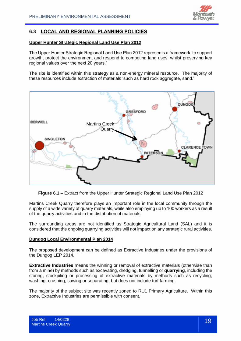
6.3 LOCAL AND REGIONAL PLANNING POLICIES Upper Hunter Strategic Regional Land Use Plan 2012 The Upper Hunter Strategic Regional Land Use Plan 2012 represents a framework ‘to support growth, protect the environment and respond to competing land uses, whilst preserving key regional values over the next 20 years.’ The site is identified within this strategy as a non-energy mineral resource. The majority of these resources include extraction of materials ‘such as hard rock aggregate, sand.’
Figure 6.1 – Extract from the Upper Hunter Strategic Regional Land Use Plan 2012 Martins Creek Quarry therefore plays an important role in the local community through the supply of a wide variety of quarry materials, while also employing up to 100 workers as a result of the quarry activities and in the distribution of materials. The surrounding areas are not identified as Strategic Agricultural Land (SAL) and it is considered that the ongoing quarrying activities will not impact on any strategic rural activities. Dungog Local Environmental Plan 2014
The proposed development can be defined as Extractive Industries under the provisions of the Dungog LEP 2014. Extractive Industries means the winning or removal of extractive materials (otherwise than from a mine) by methods such as excavating, dredging, tunnelling or quarrying, including the storing, stockpiling or processing of extractive materials by methods such as recycling, washing, crushing, sawing or separating, but does not include turf farming. The majority of the subject site was recently zoned to RU1 Primary Agriculture. Within this zone, Extractive Industries are permissible with consent.
Martins Creek Quarry
PRELIMINARY ENVIRONMENTAL ASSESSMENT
Job Ref: 14/0228 Martins Creek Quarry
20
A small section of land within Lot 1 DP204377, located towards the southern extent of the site, is zoned RE1 – Public Recreation. This area does not currently form part of the quarry operations and will therefore not be impacted by the proposal. The objectives of the RU1 zone are:
To encourage sustainable primary industry production by maintaining and enhancing the natural resource base.
To encourage diversity in primary industry enterprises and systems appropriate for the area.
To minimise the fragmentation and alienation of resource lands.
To minimise conflict between land uses within this zone and land uses within adjoining zones.
To provide for recreational and tourist activities that are compatible with the agricultural, environmental and conservation value of the land.
To promote the rural amenity and scenic landscape values of the area and prevent the silhouetting of unsympathetic development on ridgelines.
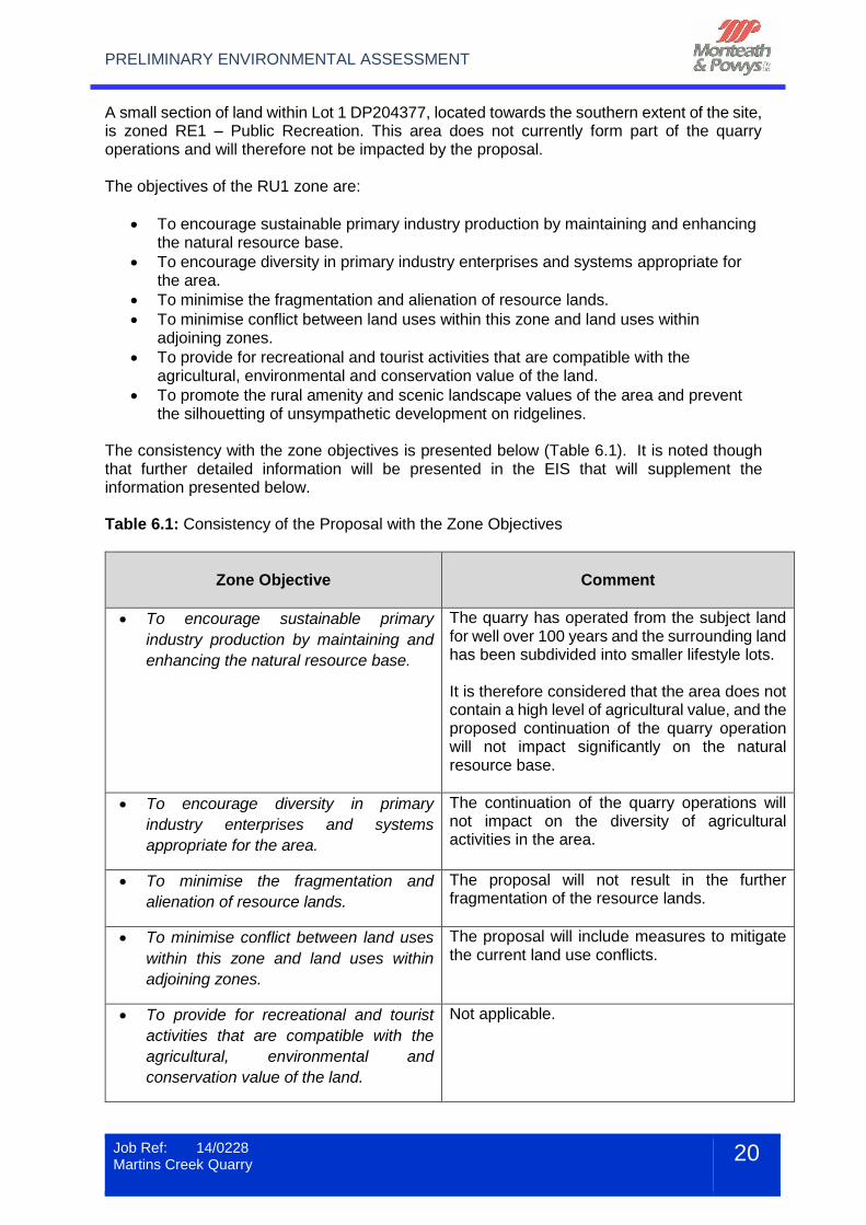
The consistency with the zone objectives is presented below (Table 6.1). It is noted though that further detailed information will be presented in the EIS that will supplement the information presented below. Table 6.1: Consistency of the Proposal with the Zone Objectives
Zone Objective
Comment
To encourage sustainable primary
industry production by maintaining and
enhancing the natural resource base.
The quarry has operated from the subject land for well over 100 years and the surrounding land has been subdivided into smaller lifestyle lots. It is therefore considered that the area does not contain a high level of agricultural value, and the proposed continuation of the quarry operation will not impact significantly on the natural resource base.
To encourage diversity in primary
industry enterprises and systems
appropriate for the area.
The continuation of the quarry operations will not impact on the diversity of agricultural activities in the area.
To minimise the fragmentation and
alienation of resource lands.
The proposal will not result in the further fragmentation of the resource lands.
To minimise conflict between land uses
within this zone and land uses within
adjoining zones.
The proposal will include measures to mitigate the current land use conflicts.
To provide for recreational and tourist
activities that are compatible with the
agricultural, environmental and
conservation value of the land.
Not applicable.
PRELIMINARY ENVIRONMENTAL ASSESSMENT
Job Ref: 14/0228 Martins Creek Quarry
21
6.4 OTHER STATUTORY CONSIDERATIONS There will be a number of other statutory Acts and Regulations that will be considered in preparing the EIS. These include:-
Rural Fire Act 1997 and Rural Fires Regulation 2008.
Fisheries Management Act 1994.
Native Vegetation Act 2003 and Native Vegetation Regulation 2005.
Noxious Weeds Act 1993.
Heritage Act 1977 and Heritage Regulation 2005.
Threatened Species Conservation Act 1995 and Threatened Species Conservation Regulation 2010.
National Parks and Wildlife Act 1974 and National Parks and Wildlife Regulation 2009.
Environment Protection and Biodiversity Conservation Act 1999.
Native Title Act 1993.
Water Management Act 2000.
6.5 ADDITIONAL POLICIES AND PLANS The EIS will also consider the proposed quarry in relation to a number of strategies and plans, including:-
Dungog Shire Community Strategic Plan 2012 – 2030
Dungog Heritage Study Review 2014
Dungog Roads Management Strategy
Dungog Access Routes Development Study
Dungog Roadside Environment Management Plan
Dungog Community/Social Plan 2004-2009
Dungog Land Use Strategy
Hunter Water Catchment Management Plan 2011
PRELIMINARY ENVIRONMENTAL ASSESSMENT
Job Ref: 14/0228 Martins Creek Quarry
22
7 ENVIRONMENTAL CONSTRAINTS ANALYSIS This section of the PEA identifies the environmental constraints that are known to occur on the site and the methodology proposed for addressing the constraints in the EIS.
7.1 FLORA AND FAUNA Conacher Environmental recently undertook a Preliminary Biodiversity Assessment Report for the proposed development. The report was based on preliminary field investigations on 9 July 2014 and a review of the previously completed investigation undertaken by Umwelt (2009) and Ecotone Ecological Consultants (2011). The investigation identified a number of broad habitat types on the subject site. These are:
Dry Sclerophyll Forest
Wet Sclerophyll Forest
Rainforest
Cleared / Disturbed Land Although there are no Endangered Ecological Communities specifically listed with the Dungog Local Government Area, the following communities have suitable habitat mapped within the subject site:
Lowland Rainforest in the NSW North Coast and Sydney Basin Bioregions
Lowland Rainforest on Floodplain in the NSW North Coast Bioregion A search of the Bionet Atlas of NSW Wildlife (NSW OEH 2014a) was undertaken to identify records of threatened flora species located within 20km of the site. There are previous records for the following threatened fauna species within the subject site (Ecotone Ecological Consultants 2010):
Speckled Warbler
Powerful Owl
Koala
Grey-headed Flying-fox
East-coast Freetail Bat
Eastern Bentwing-bat
Little Bentwing-bat
Yellow-bellied Sheathtail-bat
Greater Broad-nosed Bat (possible record only)
A search of the EP&BC Act Protected Matters Search Tool (SEWPaC 2013) was conducted for migratory fauna listed within the EPBC Act (1999) recorded within 10 km of the subject site. The Black-faced Monarch and Rufous Fantail have been previously recorded within the subject site. The subject site provides suitable habitat for a number of nationally listed migratory species. Further surveys are required to determine whether these species are present or are likely to occur within the subject site. Based on the preliminary field survey and information provided in this report it is concluded that:
PRELIMINARY ENVIRONMENTAL ASSESSMENT
Job Ref: 14/0228 Martins Creek Quarry
23
The subject site provides suitable habitats for a range of threatened species listed within the TSC Act (1995) and/or the EPBC Act (1999);
The subject site does not contain suitable habitat for endangered populations listed within the TSC Act (1995) and/or the EPBC Act (1999);
The endangered ecological communities (EECs), ‘Lowland Rainforest in the NSW North Coast and Sydney Basin Bioregions; and ‘Lowland Rainforest on Floodplain in the New South Wales North Coast Bioregion’ have been mapped within the subject site. Further surveys are required to determine if these EECs are present within the subject site.
The subject site provides suitable habitat for several migratory species listed within the EPBC Act (1999);
Detailed seasonal biodiversity surveys should be undertaken in accordance with the relevant Field Survey Methods and Flora and Fauna Survey Guidelines (OEH 2013; DECC 2009;
The Preliminary Site Rehabilitation Plan (refer Appendix F) outlines the basic rehabilitation program that will be implemented at the end of the quarry life. This will contribute towards the re-establishment of vegetation and limit the impact of the proposed vegetation removal as part of the quarry operations. A comprehensive ecological investigation and Site Rehabilitation Plan will be prepared as part of the EIS.
7.2 WATER MANAGEMENT The main water demands associated with the operation of the quarry includes both process water and potable water. The main demands for water are used in dust suppression on the crushing and screening plant, stockpiles and haul roads. Surface Water All surface water runoff is currently captured within the stormwater detention and filtration facility located towards the south west of the administration building. The majority of the filtrated water is then recycled within the quarry as part of the dust suppression measures. During larger storm events some of the treated runoff is released into the local water courses that feed into the Paterson River. Recent water quality measurements indicate that the water quality within the detention basin complies with the relevant EPA standards. The outcome of the further investigations into stormwater runoff will be to ensure protection of the surrounding watercourses and to identify appropriate treatment upgrades where required. Flooding The subject land is situated approximately 1.1 kilometres to the north east of the Paterson River and located between 30m and 40m above the river. It is therefore considered that the site is not affected by riverine flooding.
PRELIMINARY ENVIRONMENTAL ASSESSMENT
Job Ref: 14/0228 Martins Creek Quarry
24
Groundwater At the time of writing there has been no groundwater studies conducted on the site. The water management processes and potential groundwater impacts will be discussed in detail as part of the preparation of the EIS.
7.3 ACID SULPHATE SOILS The Acid Sulphate Soil Planning maps prepared by Dungog Shire Council indicate that the site is not affected by Acid Sulfate Soils.
7.4 GEOTECHNICAL AND CONTAMINATION No previous contamination work has been identified for the site. A search of records issued by OEH under the Contaminated Land Management Act 1997 and actions taken under the Environmentally Hazardous Chemicals Act 1985 revealed no orders or actions have been issued for the subject site or adjacent lots. Geotechnical and contamination issues will be considered in the EIS.
7.5 TRAFFIC The main traffic currently generated by the quarry are associated with the haulage of quarry products to the wider lower Hunter region. Some traffic flows can also be attributed to employees travelling to and from the site. A Traffic Impact Statement is currently being prepared to identify the traffic flows in the area and address the impacts resulting from the existing quarry operations. The localised impacts resulting from the haulage of quarry materials are currently most keenly felt along Station Street in Martins Creek. The existing impacts on these residents will be addressed as part of the comprehensive EIS by taking into account both the traffic volumes and associated noise impacts. The main haulage route is by Dungog Road via the townships of Paterson and Bolwarra Heights to either the New England Highway or Hunter Expressway. An alternatively route is used to access markets to the north east of the quarry. The route deviates from the above by utilising Paterson Road, Butterwick Road and Clarence Town Road to connect to the Pacific Highway. It is understood that the local community has raised the noise generated by the haulage operations through Paterson and Bolwarra Heights as a major concern. The impact on the road infrastructure has also been raised during community consultation. To gain a full understanding of the local impacts in Paterson and Bolwarra Heights, it is proposed that traffic counts be undertaken at the following locations:
PRELIMINARY ENVIRONMENTAL ASSESSMENT
Job Ref: 14/0228 Martins Creek Quarry
25
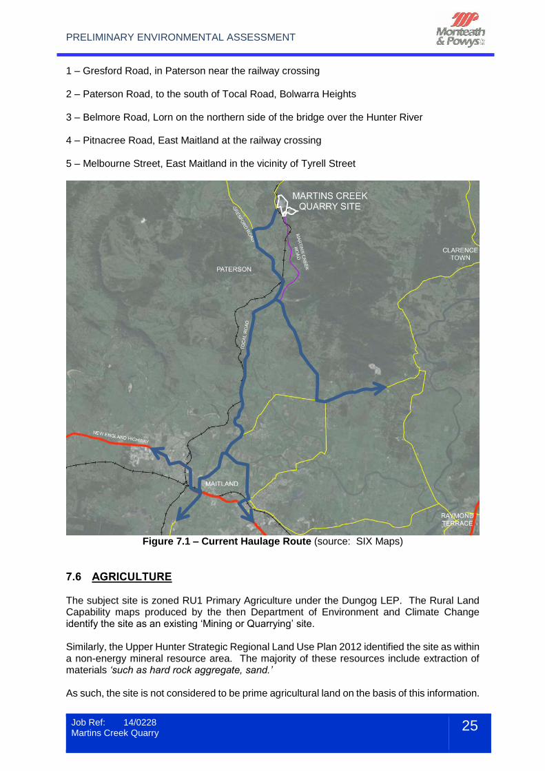
1 – Gresford Road, in Paterson near the railway crossing 2 – Paterson Road, to the south of Tocal Road, Bolwarra Heights 3 – Belmore Road, Lorn on the northern side of the bridge over the Hunter River 4 – Pitnacree Road, East Maitland at the railway crossing 5 – Melbourne Street, East Maitland in the vicinity of Tyrell Street
Figure 7.1 – Current Haulage Route (source: SIX Maps)
7.6 AGRICULTURE The subject site is zoned RU1 Primary Agriculture under the Dungog LEP. The Rural Land Capability maps produced by the then Department of Environment and Climate Change identify the site as an existing ‘Mining or Quarrying’ site. Similarly, the Upper Hunter Strategic Regional Land Use Plan 2012 identified the site as within a non-energy mineral resource area. The majority of these resources include extraction of materials ‘such as hard rock aggregate, sand.’ As such, the site is not considered to be prime agricultural land on the basis of this information.
PRELIMINARY ENVIRONMENTAL ASSESSMENT
Job Ref: 14/0228 Martins Creek Quarry
26
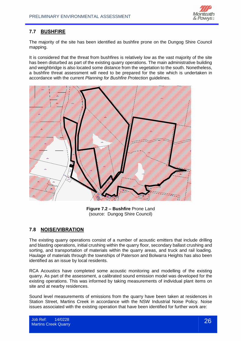
7.7 BUSHFIRE The majority of the site has been identified as bushfire prone on the Dungog Shire Council mapping. It is considered that the threat from bushfires is relatively low as the vast majority of the site has been disturbed as part of the existing quarry operations. The main administrative building and weighbridge is also located some distance from the vegetation to the south. Nonetheless, a bushfire threat assessment will need to be prepared for the site which is undertaken in accordance with the current Planning for Bushfire Protection guidelines.
Figure 7.2 – Bushfire Prone Land (source: Dungog Shire Council)
7.8 NOISE/VIBRATION The existing quarry operations consist of a number of acoustic emitters that include drilling and blasting operations, initial crushing within the quarry floor, secondary ballast crushing and sorting, and transportation of materials within the quarry areas, and truck and rail loading. Haulage of materials through the townships of Paterson and Bolwarra Heights has also been identified as an issue by local residents. RCA Acoustics have completed some acoustic monitoring and modelling of the existing quarry. As part of the assessment, a calibrated sound emission model was developed for the existing operations. This was informed by taking measurements of individual plant items on site and at nearby residences. Sound level measurements of emissions from the quarry have been taken at residences in Station Street, Martins Creek in accordance with the NSW Industrial Noise Policy. Noise issues associated with the existing operation that have been identified for further work are:
PRELIMINARY ENVIRONMENTAL ASSESSMENT
Job Ref: 14/0228 Martins Creek Quarry
27
1. Sound emissions from primary and secondary crushing operations with existing fixed
plant. 2. Sound emissions from rail loading activities. 3. Sound from on-site equipment in certain parts of the operation. 4. Sound from transport operations on public roads. 5. No issues have been identified from existing extraction activities or “in pit crushing”
using mobile crushing plant on the current quarry floor. 6. Existing haul truck operations at the primary crusher stockpile and dump hopper
have been flagged for future investigation. A comprehensive noise impact assessment will be conducted in accordance with the requirements of the NSW Industrial Noise Policy and other relevant guidelines (e.g. NSW Road Noise Policy) and will involve:
Modelling of existing and future stages of operations for 5, 10, 15, 20 and 30 years into the future based on the mine plan supplied by the operator.
Particular focus will be given to extraction and processing in Lot 6 and on the upper levels of the existing and future quarry benches.
Sound control recommendations will be made which may include noise bunds, engineering noise controls for equipment, changes to the mine plan as necessary and which will involve the use of the Best Technology Economically Available.
The assessment will include the effects of noise enhancing meteorological conditions as appropriate.
Given that this is a long established existing operation it is likely that a situation may arise where the target noise goals established under the INP cannot be met. Community consultation will be conducted as necessary to resolve any ongoing issues.
Traffic noise impact assessments will be carried out for Martins Creek and Paterson in accordance with the NSW Road Noise Policy. The outcomes of the studies will be presented in a noise impact assessment report containing predicted received sound levels at potentially effected residential receivers presented in tabular and graphical from (including noise contours) for each stage of the quarry operations both with and without any recommended noise controls. Traffic noise impact assessments for each transport condition and recommended noise control or management strategies for transport noise will also be provided as applicable.
7.9 AIR QUALITY Dust pollution is currently produced during the blasting activities, processing of quarry materials and transportation to end users. The operator continuously conducts dust deposition gauge sampling. These measurements will form part of the preliminary air quality assessment that will be completed as a part of the EIS. The assessment will also incorporate further details of the design and operational safeguards that the operator would implement so that compliance with the quarry specific criteria would be achieved. A review of the current dust suppression techniques will also be presented.
PRELIMINARY ENVIRONMENTAL ASSESSMENT
Job Ref: 14/0228 Martins Creek Quarry
28
7.10 EUROPEAN HERITAGE A search of the NSW Heritage database, Australian Heritage database and Dungog LEP revealed no items of European heritage significance on the site. This will be clarified in the EIS.
7.11 ABORIGINAL ARCHAEOLOGY A search was also conducted of the Aboriginal Heritage Information Management System (AHIMS) maintained by the OEH. The search identified some items of Aboriginal heritage within Lot 1 DP1006375, Lot 5 DP242210 and Lot 42 DP815628. It would appear that the areas identified in the AHIMS database have not been disturbed as part of the previous quarry operations. An Aboriginal archaeological assessment will therefore be required that is consistent with current legislation and guidelines.
7.12 EROSION AND SEDIMENT CONTROL The current Stormwater Management Control Plan incorporates a comprehensive erosion and sedimentation control regime that includes the following:
Construction of all erosion and sediment controls required for the development prior to the commencement of clearing works within the catchment areas;
Construction of catch and diversion drains to ensure areas of sediments dams are complete prior to works commencing in the area;
Construction and regular maintenance of silt fences to contain sediment down slope of disturbed areas;
Maintain plant and vehicle park up areas to ensure no pollution and sedimentation of water ways;
Seeding / Hydro-mulching of disturbed areas to provide rapid growth of vegetation;
Inspections and repair of erosion sediment controls to ensure they are performing adequately;
Construction of drains upslope of areas to be disturbed to convey clean runoff away;
Diversion of surface and road runoff away from disturbed areas;
Limiting the number of roads and tracks established;
Progressively reshaping, topsoiling and vegetating road and cut and fill batters, to maximise long term stability;
Regular maintenance of sediment controls to ensure adequacy of controls in place. A comprehensive assessment of the measures above will be included in the EIS.
7.13 SOCIO-ECONOMIC ISSUES It is expected that the socio-economic impacts of the quarry will be an important component of the EIS. The quarry currently employs up to 100 full-time and part-time workers as part of the quarry operations. Based on ABS data the flow on effects are likely to increase this number significantly. The impacts of the continuing quarry operations will be examined as part of the EIS.
PRELIMINARY ENVIRONMENTAL ASSESSMENT
Job Ref: 14/0228 Martins Creek Quarry
29
8 STAKEHOLDER CONSULTATION Buttai Gravel has been actively involved in discussions and briefing of the key stakeholders and general public. The stakeholder consultation to date has included:
State MPs briefed (in person or by telephone) by Buttai Gravel on the status and consultation proposed;
Dungog Shire Council Mayor and General Manager briefed – indicated support for proposed establishment of Community Consultative Committee (using the Department’s Guidelines for establishing community consultative committee for mining projects as a starting point);
Maitland City Council briefed; Port Stephens Mayor briefed by phone;
Department of Premier and Cabinet – Newcastle staff briefed;
Department of Planning & Environment – Newcastle staff briefed;
Bolwarra Heights Residents Group – meeting held 7 July 2014;
Business NSW – 14 July 2014;
Buttai Gravel attended a forum hosted by Dungog Shire Council on 17 July 2014 facilitated by A Talbot – Dungog Shire Council (staff & Councillors), Maitland City Council, Port Stephens Council, Brandy Hill Action Group, Bolwarra Residents Group, Paterson Progress Association, RMS, EPA representatives;
Brandy Hill Action Group representatives 18 July 2014;
Maitland Council Staff & Maitland Police and Paterson Police regarding voluntary speed reductions for trucks in Paterson and Bolwarra;
Buttai Gravel attended public meeting at Paterson, arranged by Dungog Shire Council on 31 July 2014.
Buttai Gravel is in the process of establishing a community consultative group. This will be active during the environmental assessment stage of the project. Currently draft terms of reference are being produced in consultation with Dungog Shire Council and Paterson Progress Association. The group is proposed to consist of Representatives from:
Chairperson;
Dungog Shire Council representative(s);
3 – 5 key stakeholder and community group representatives;
Buttai Gravel representatives (2-3);
It is anticipated the first meeting of the consultative committee will occur in September. The main feedback received during the consultations includes:
Truck volumes travelling through Paterson & Bolwarra;
Truck noise;
Road damage, upgrade/maintenance of roads/road contribution by proponent;
Use of rail;
Confusion over existing approvals. As part of the EIS process a range of stakeholders will be consulted. In particular, it is expected that the following agencies will be consulted, in addition to the Department of Planning and Environment:
PRELIMINARY ENVIRONMENTAL ASSESSMENT
Job Ref: 14/0228 Martins Creek Quarry
30
NSW Office of Environment and Heritage (OEH);
NSW Office of Water (NOW);
Roads and Maritime Services (RMS). It is expected that Dungog Shire Council will continue to be actively engaged during the preparation of the EIS.
PRELIMINARY ENVIRONMENTAL ASSESSMENT
Job Ref: 14/0228 Martins Creek Quarry
31
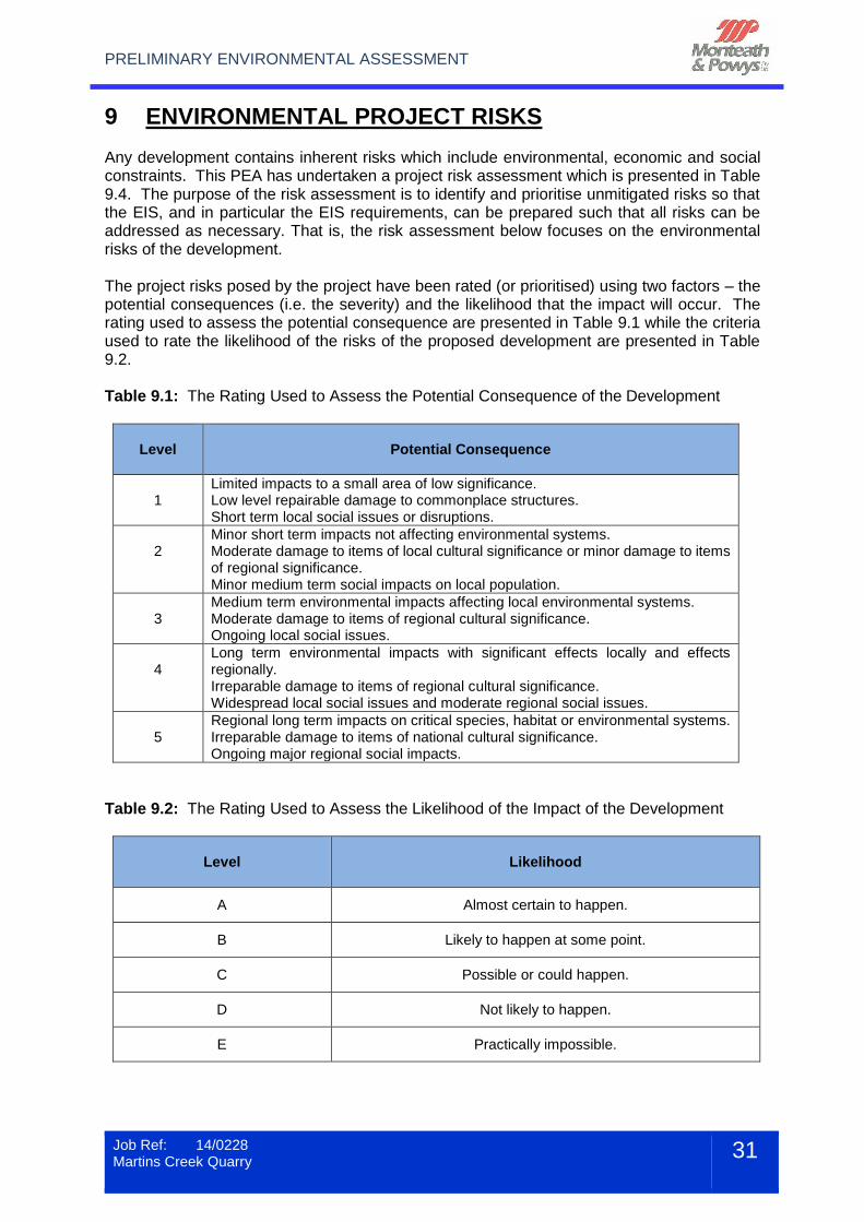
9 ENVIRONMENTAL PROJECT RISKS Any development contains inherent risks which include environmental, economic and social constraints. This PEA has undertaken a project risk assessment which is presented in Table 9.4. The purpose of the risk assessment is to identify and prioritise unmitigated risks so that the EIS, and in particular the EIS requirements, can be prepared such that all risks can be addressed as necessary. That is, the risk assessment below focuses on the environmental risks of the development. The project risks posed by the project have been rated (or prioritised) using two factors – the potential consequences (i.e. the severity) and the likelihood that the impact will occur. The rating used to assess the potential consequence are presented in Table 9.1 while the criteria used to rate the likelihood of the risks of the proposed development are presented in Table 9.2. Table 9.1: The Rating Used to Assess the Potential Consequence of the Development
Level
Potential Consequence
1
Limited impacts to a small area of low significance. Low level repairable damage to commonplace structures. Short term local social issues or disruptions.
2
Minor short term impacts not affecting environmental systems. Moderate damage to items of local cultural significance or minor damage to items of regional significance. Minor medium term social impacts on local population.
3
Medium term environmental impacts affecting local environmental systems. Moderate damage to items of regional cultural significance. Ongoing local social issues.
4
Long term environmental impacts with significant effects locally and effects regionally. Irreparable damage to items of regional cultural significance. Widespread local social issues and moderate regional social issues.
5
Regional long term impacts on critical species, habitat or environmental systems. Irreparable damage to items of national cultural significance. Ongoing major regional social impacts.
Table 9.2: The Rating Used to Assess the Likelihood of the Impact of the Development
Level
Likelihood
A Almost certain to happen.
B Likely to happen at some point.
C Possible or could happen.
D Not likely to happen.
E Practically impossible.
PRELIMINARY ENVIRONMENTAL ASSESSMENT
Job Ref: 14/0228 Martins Creek Quarry
32
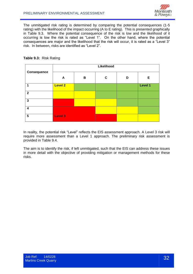
The unmitigated risk rating is determined by comparing the potential consequences (1-5 rating) with the likelihood of the impact occurring (A to E rating). This is presented graphically in Table 9.3. Where the potential consequence of the risk is low and the likelihood of it occurring is low the risk is rated as “Level 1”. On the other hand, where the potential consequences are major and the likelihood that the risk will occur, it is rated as a “Level 3” risk. In between, risks are identified as “Level 2”. Table 9.3: Risk Rating
Consequence
Likelihood
A
B C D E
1
Level 2 Level 1
2
3
4
5
Level 3
In reality, the potential risk “Level” reflects the EIS assessment approach. A Level 3 risk will require more assessment than a Level 1 approach. The preliminary risk assessment is provided in Table 9.4. The aim is to identify the risk, if left unmitigated, such that the EIS can address these issues in more detail with the objective of providing mitigation or management methods for these risks.
PRELIMINARY ENVIRONMENTAL ASSESSMENT
Job Ref: 14/0228 Martins Creek Quarry
33
Table 9.4: Preliminary Environmental Risk Impact Assessment
ISSUE RISK(S) CONSEQUENCES LIKELIHOOD RISK RATING COMMENTS
Flora and Fauna
Potential to impact on threatened species habitat
3 B Level 2
The Preliminary Biodiversity Assessment undertaken by Conacher Environmental found that the site has suitable habitats for a range of threatened species listed within the TSC Act (1995) and/or the EPBC Act (1999). A comprehensive ecological investigation will be undertaken as part of the EIS.
Potential to impact on Endangered Ecological Communities (EECs)
Aboriginal Heritage
Impact on items or areas of Aboriginal significance
3 B Level 2
A search of the AHIMS database identified a number of items or sites of Aboriginal Heritage. An Aboriginal Archaeological assessment will be undertaken on the site to confirm whether any other items or sites may be impacted.
European Heritage
Impact on historic heritage items
1 D Level 1 No historic heritage items are identified on the site.
Air Quality Potential impact of increase in dust
3 B Level 2
The proposed continuation of the quarry has the potential to increase levels of airborne dust principally as a result of vegetation clearing and surface disturbance. In addition there is the potential to increase the mobile and fixed plant operation as production reaches the proposed upper limit. An Air Quality Assessment will be completed as a part of the EIS and will incorporate further details of the design and operational safeguards that the operator would implement so that compliance with the quarry specific criteria would be achieved. A review of the current dust suppression techniques will also be presented.
PRELIMINARY ENVIRONMENTAL ASSESSMENT
Job Ref: 14/0228 Martins Creek Quarry
34
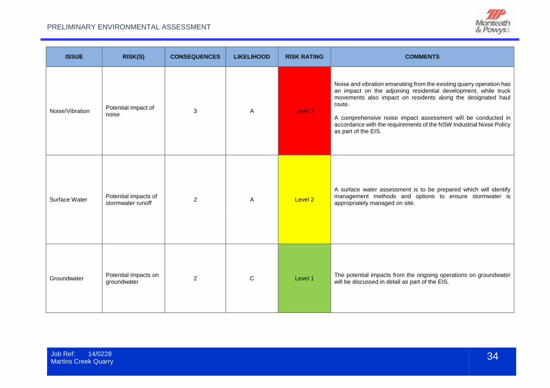
ISSUE RISK(S) CONSEQUENCES LIKELIHOOD RISK RATING COMMENTS
Noise/Vibration Potential impact of noise
3 A Level 3
Noise and vibration emanating from the existing quarry operation has an impact on the adjoining residential development, while truck movements also impact on residents along the designated haul route. A comprehensive noise impact assessment will be conducted in accordance with the requirements of the NSW Industrial Noise Policy as part of the EIS.
Surface Water Potential impacts of stormwater runoff
2 A Level 2
A surface water assessment is to be prepared which will identify management methods and options to ensure stormwater is appropriately managed on site.
Groundwater Potential impacts on groundwater
2 C Level 1 The potential impacts from the ongoing operations on groundwater will be discussed in detail as part of the EIS.
PRELIMINARY ENVIRONMENTAL ASSESSMENT
Job Ref: 14/0228 Martins Creek Quarry
35
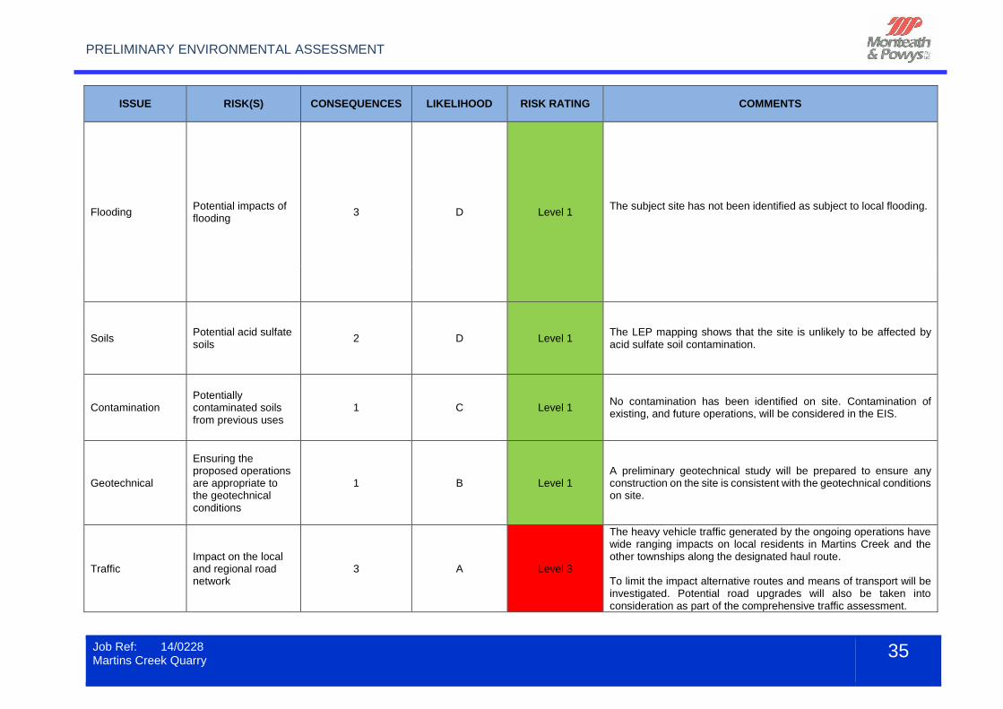
ISSUE RISK(S) CONSEQUENCES LIKELIHOOD RISK RATING COMMENTS
Flooding Potential impacts of flooding
3 D Level 1 The subject site has not been identified as subject to local flooding.
Soils Potential acid sulfate soils
2 D Level 1 The LEP mapping shows that the site is unlikely to be affected by acid sulfate soil contamination.
Contamination Potentially contaminated soils from previous uses
1 C Level 1 No contamination has been identified on site. Contamination of existing, and future operations, will be considered in the EIS.
Geotechnical
Ensuring the proposed operations are appropriate to the geotechnical conditions
1 B Level 1 A preliminary geotechnical study will be prepared to ensure any construction on the site is consistent with the geotechnical conditions on site.
Traffic Impact on the local and regional road network
3 A Level 3
The heavy vehicle traffic generated by the ongoing operations have wide ranging impacts on local residents in Martins Creek and the other townships along the designated haul route. To limit the impact alternative routes and means of transport will be investigated. Potential road upgrades will also be taken into consideration as part of the comprehensive traffic assessment.
PRELIMINARY ENVIRONMENTAL ASSESSMENT
Job Ref: 14/0228 Martins Creek Quarry
36
ISSUE RISK(S) CONSEQUENCES LIKELIHOOD RISK RATING COMMENTS
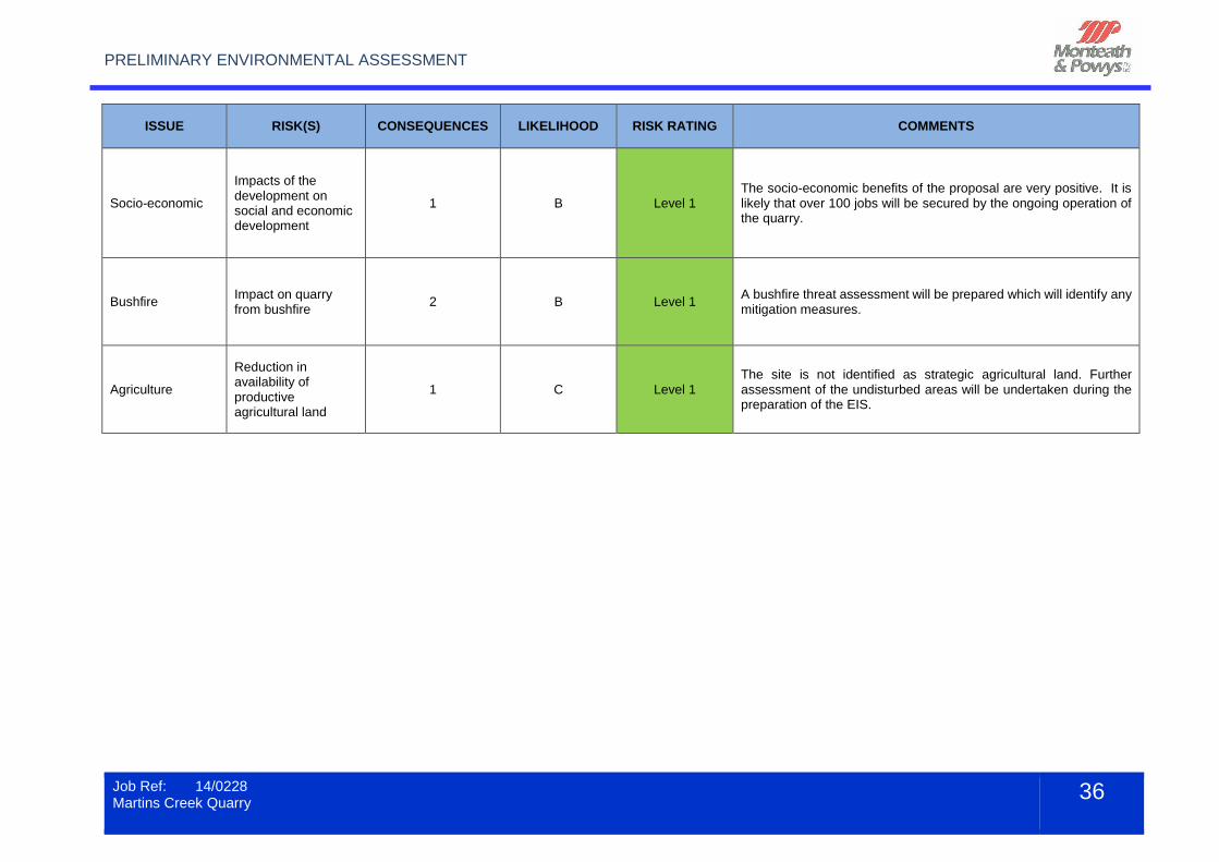
Socio-economic
Impacts of the development on social and economic development
1 B Level 1 The socio-economic benefits of the proposal are very positive. It is likely that over 100 jobs will be secured by the ongoing operation of the quarry.
Bushfire Impact on quarry from bushfire
2 B Level 1 A bushfire threat assessment will be prepared which will identify any mitigation measures.
Agriculture
Reduction in availability of productive agricultural land
1 C Level 1 The site is not identified as strategic agricultural land. Further assessment of the undisturbed areas will be undertaken during the preparation of the EIS.
PRELIMINARY ENVIRONMENTAL ASSESSMENT
Job Ref: 14/0228 Martins Creek Quarry
37
In summary, the project risk assessment identifies that there were six issues that were categorised as a Level 2/3 risk if left unmitigated. These included:
Flora and fauna
Surface water
Traffic
Air quality
Noise/Vibration
Aboriginal heritage Conversely, nine issues were considered to be a Level 1 risk if left unmitigated. This included:
European heritage
Flooding
Groundwater
Contamination
Bushfire
Geotechnical
Socio-economics
Agriculture
Acid Sulfate Soils These issues will also be assessed as part of the EIS.
PRELIMINARY ENVIRONMENTAL ASSESSMENT
Job Ref: 14/0228 Martins Creek Quarry
38
10 CONCLUSION This PEA has been prepared by Monteath and Powys on behalf of Buttai Gravel for proposed quarrying activities at the existing Martins Creek Quarry. This PEA has outlined the planning policies and legislation that apply to the proposed development and has provided a preliminary environmental constraints analysis. The investigations undertaken as part of this PEA have identified that the quarry is permissible within the existing zoning. There are a number of environmental issues that need to be investigated in further detail as part of the EIS. A risk assessment has been provided which identifies the potential environmental risks on the site if left unmitigated. These risks will be assessed as part of the EIS, and potential mitigation and management options identified. During the EIS process it is expected that a number of discussions will be held with relevant government authorities including Dungog Shire Council. The existing operations currently employ up to 100 personnel. With flow-on effects the number of jobs during ongoing operation is expected to be significant. This will create a significant economic benefit to the Dungog area and the wider Hunter Region. The proponent is also engaged with relevant professionals to ensure the quarry is operated to the highest environmental standards.