mass flow deposit south of central andaman trough, andaman...
TRANSCRIPT

Indian Journal of Geo Marine Sciences
Vol.46 (08), August 2017, pp. 1519-1527
Mass flow deposit south of Central Andaman Trough, Andaman Sea:
evidence from sub bottom profiler records
Tripathi S. K1*
, Das S.2, Meitei S. I
1, Rajarama K. N
1, Resmi S.
1 , Tewari H.
1, Kashyap M. P
1 & Pradhan R.K.
1
1M&CS, Geological Survey of India, Kolkata-700091, India 2M&CS, Geological Survey of India, Mangalore- 575001, India
*[E-mail: [email protected]]
Received 24 April 2015 ; revised 22 November 2016
A total of 2577 line-km sub bottom profiler data recorded over East Andaman Basin, Sewell and Mergui ridges, south of
Central Andaman Trough, Andaman Sea, revealed distinctive echo types representing different seabed material and seafloor
morphology. Echo Type I, Type-IIIA, Type-IIIB and Type IVA prevail over ridges, slopes of Sewell rise and Mergui ridge. Scarp
head and slides (Types II, Type IVA) occur extensively over the entire slope areas of the ridges. Whereas in East Andaman Basin
area, top sub bottom reflectors are almost flat in all transects and downward it becomes wavy, chaotic and hummocky in nature. This
means that present day depositional environment is relatively calm as compared to bottom unit, which means the bottom most units
is formed by the mass flow deposit. These evidences from echo pattern, shows a successive slope failure and supports frequent
seismic shaking related to the rifting of Central Andaman Trough.
[Keywords: sub bottom reflectors, chaotic, hummocky, mass flow deposit, neo-tectonic.]
Introduction East Andaman Basin (EAB) and Mergui
Basin are NNE-SSW trending elongate sediment
filled sub-basin, are the product of back arc
extensional tectonics1, 2
. EAB comprises a total of
4600m thick sedimentary unit1. This basin was
under shallow to deep water regime since middle
to late Miocene1,3
and post-rift related
sedimentation was up to 2500 m thick4. At
present, main source of enormous quantity of fine
grained sediments in Andaman Sea is from
Irrawaddy-Salween river system, and apart from
this very small amount reaches into deeper parts
via Martaban Canyon 5-9
. Additional contribution
of terrigenous input in southern part of Andaman
Sea is from Malacca Strait10
.
For analysing depositional behaviour of
sediments in EAB, sub bottom profiler has been
used as a tool during SR-003 cruise of Geological
survey of India (R. V. Samudra Ratnakar), which
provides information about three distinguishing
zones viz., surficial, near-surficial and deep
sedimentary layers. These surficial, near surficial
and deep sedimentary structures depend on the
acoustic wave interactions with seabed and
impedance contrast between two layers. Large
impedance contrast between water and rocky
seabed with a considerable smooth surface
indicates that seabed surface behaves as an almost
perfect reflector. On the other hand, in softer
sediments, acoustic impedance difference is much
less which implies that larger energy will be able
to penetrate this boundary. A portion of energy
reflected back whenever the signal encounters a
different material and recorded back by the system
in form of analog signals. These analog signals
used to reconstruct vertical cross section of
sedimentary environment, obtained as an image of
layer boundaries. These reflected echoes mainly
controlled by geomorphology of seafloor,
subsurface geometry and sediment texture11, 12, 13
.
Highly variable and steep surface topography of
the submarine plateau and ridge generally yields
relatively poor acoustic images, hampering
detailed studies on echo types and their regional
distributions. Aim of this paper is to understand
the echo characters and regional distribution of
sediment deposits and further to understand the
INDIAN J. MAR. SCI., VOL. 46, NO. 08, AUGUST 2017
possible mechanism for extensive mass
movements and slope failures.
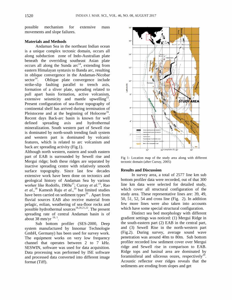
Materials and Methods Andaman Sea in the northeast Indian ocean
is a unique complex tectonic domain, occurs all
along subduction zone of Indo-Australian plate
beneath the overriding southeast Asian plate
occurs all along the Sunda arc14
, extending from
eastern Himalayan syntaxis to Banda arc, resulting
in oblique convergence in the Andaman-Nicobar
sector14
. Oblique plate convergence include
strike-slip faulting parallel to trench axis,
formation of a sliver plate, spreading related to
pull apart basin formation, active volcanism,
extensive seismicity and mantle upwelling15
.
Present configuration of sea-floor topography of
continental shelf has arrived during termination of
Pleistocene and at the beginning of Holocene16
.
Recent days Back-arc basin is known for well
defined spreading axis and hydrothermal
mineralization. South western part of Sewell rise
is dominated by north-south trending fault system
and western part is dominated by volcanic
features, which is related to arc volcanism and
back arc spreading activity (Fig.1).
Although north western, eastern and south eastern
part of EAB is surrounded by Sewell rise and
Mergui ridge; both these ridges are separated by
inactive spreading centre with relatively smooth
surface topography. Since last few decades
extensive work have been done on tectonics and
geological history of Andaman Sea by various
worker like Rodolfo, 1969a17
; Curray et al.15
, Rao
et al.,18
Kamesh Raju et al.,19
but limited studies
have been carried on sediment types20
. Apart from
fluvial sources EAB also receive material from
pelagic, eolian, weathering of sea-floor rocks and
possible hydrothermal sources18,20,21,22
. The present
spreading rate of central Andaman basin is of
about 38 mm/yr 19, 1
.
Sub bottom profiler (SES-2000, Deep
system manufactured by Innomar Technologie
GmbH, Germany) has been used for survey work.
The equipment works on very low frequency
channel that operates between 2 to 7 kHz.
SESWIN, software was used for data acquisition.
Data processing was performed by ISE software
and processed data converted into different image
format (Tiff).
Fig 1- Location map of the study area along with different
tectonic domain (after Curray, 2005)
Results and Discussion
In survey area, a total of 2577 line km sub
bottom profiler data were recorded, out of that 300
line km data were selected for detailed study,
which cover all structural configuration of the
study area. These representative lines are: 39, 49,
50, 51, 52, 54 and cross line (Fig. 2). In addition
few more lines were also taken into accounts
which have some special structural configuration.
Distinct sea bed morphology with different
gradient settings was noticed: (1) Mergui Ridge in
the south-eastern part (2) EAB in the central part,
and (3) Sewell Rise in the north-western part
(Fig.2). During survey, average sound wave
penetration was around 40m to 80m. Sub bottom
profiler recorded low sediment cover over Mergui
ridge and Sewell rise in comparison to EAB.
Ridge tops and basinal area are dominated by
foraminiferal and siliceous oozes, respectively20
.
Acoustic reflector over ridges reveals that the
sediments are eroding from slopes and get
1520

TRIPATHI et al.: MASS FLOW DEPOSIT SOUTH OF CENTRAL ANDAMAN TROUGH, ANDAMAN SEA
deposited in the valley portions (Fig. 3). Reflector
characteristics of the youngest units (study from
grab samples) with recent detritus and biogenic
sedimentation, is well matched with the view of
Keller and Richards10
, Rodolfo5 Colin et al.,
6 and
Tripathi 20
. These reflectors in upper parts are
parallel to each other, whereas, sub bottom depth
reflectors below 20 to 40 m b.s.f were merged and
form chaotic, lenticular and hummocky patterns.
These are inferred as mass transport deposits from
the ridges or due to tectonic mixing of the
sediments (Fig.4).
Fig. 2- Detailed bathymetry and physiographic features
along with cruise track, South of Central Andaman
Trough, Andaman Sea. Where SWR= Sewell Rise, EAB=
East Andaman Basin, MR= Mergui Ridge.
The features are similar to echo characters of the
basinal sediments, which are deformed in a bizarre
manner due to presence of numerous fault.
Considering an average sedimentation of 10 cm
per ka in Andaman basin (Rodolfo5), the age of
sediment which recorded in sub bottom reflectors
are approximately between 0.4 to 0.8 Ma.
Channel noticed in the valley portion of
Mergui ridge (Fig-5), where slope varies from 0.50
to 20 and become almost flat in EAB with some
localized stacking and bathymetric depression
(Fig.6). Sediment deposited in EAB is not only
from the Irrawaddy River but also from the slope
of elevated ridges. In younger sediments, acoustic
internal reflectors are almost parallel up to 20-30
m depth from the sea floor.
Strata Types
Based on different acoustic characteristics, the
entire penetration depth is grouped into four major
strata packages to simplify the depositional
environment (Fig.7). First strata package has an
average thickness of 7m to 15m with distinct
acoustic internal reflector, minor growth fault (Fig-
8) and acoustic voids. These acoustic voids in sub
bottom reflector may be due to amalgamation of
fluid or due to the movement of organic gases in
the sediment. Wavy undulation noticed throughout
entire penetration depth, and it might have formed
because of material flow due to non-cohesiveness
(Fig. 9). Second strata package has an average
thickness of 20 to 40 m, with lots of minor
secondary internal reflectors.
Here reflectors are mostly hummocky,
lenticular and chaotic in nature with very few
internal acoustic transparencies (Fig-8).Third
strata package is sandwiched between second and
fourth strata packages. It has an average thickness
of 20 m and mostly chaotic in nature, moreover
somewhat weak in acoustic transparency (Fig.8).
Fourth strata package is recorded around 60m
b.s.f. It seems that the second and third strata
packages might be deposited under turbidity
induced mass transport system, as similar
observation was recorded by Schwab et al.23
and
also affected by tectonics of the nearby area.
Acoustic internal reflection patterns over Sewell
Rise follow the topography and their
sedimentation nature is very similar to Mergui
Ridge.
1521

INDIAN J. MAR. SCI., VOL. 46, NO. 08, AUGUST 2017
Fig. 3- (A) Sub-bottom reflectors along part of line 39,
showing rugged geomorphological terrains formed due to
erosion of older sediments over Mergui ridge. (B) In 3D
Multi beam map dot line represents the track of the Sub
Bottom Profiler.
Fig.4- Sub bottom image along part of line 29 showing (A)
Distinct bottom echo with several continuous internal
reflections of total length 1km (type I-B), Surface echoes are
flat, distinct to indistinct and become wavy with sub bottom
depth 60m b.s.f (TYPE IV-B) (B). Lenticular / hummocky
bedding showing amplitude 1.5m and wavelength 45.94m.
Fig. 5- A 230m wide and 25 m depth channel in valley
portion of Mergui ridge along part of line 49
Fig.6- Bathymetric Profile line [P-P’] taken from Sewell
Rise to Mergui ridge.
Fig. 7- A) Profile section from south to north, B) Sub
bottom profiler section taken along south to north
representing the overall behaviour of the bottom
reflectors.
Fig. 8- Sub-bottom reflectors along part of line 54 showing
Growth fault due to compression or formed by compactness
of the sediment over Sewell Rise.
1522

TRIPATHI et al.: MASS FLOW DEPOSIT SOUTH OF CENTRAL ANDAMAN TROUGH, ANDAMAN SEA
Fig. 9- Sub-bottom profiles along part of line 10 showing
hyperbolic or wavy echoes (III). Irregular, wavy surface
echo and distinct to indistinct, continuous internal reflectors
(type III-C). Basal reflectors are mingled and transparent. A
downward increase in wave amplitude (open arrow). NIF=
Normal Internal Fault, CIF= Compressional Internal Fault.
Wavy undulations are 2m in amplitude & 64 m wavelength.
Echo Types
The classification criteria of echo character
emphasized by Damuth24
, Damuth and
Hayes13
, Chough et al.25
and Pratson & Laine26
have been used as base to interpret
sedimentary processes of the study area.
Based on these acoustic properties like clarity,
continuity and geometry, different acoustic / or
echo pattern have been identified from three
different settings, viz- Mergui Ridge, EAB and
Sewell Rise. These echo types are classified
into four major classes: 1) distinct echo (Types
I), (2) indistinct echo (Type II), (3) hyperbolic
or wavy echo (Types IIIA to IIIC), and (4)
combined echo (Types IVA & IVB).
Distinct Echo
Type-I: Echo type-I is characterized by distinct
bottom echo with several continuous, parallel
internal reflectors, have an average thickness of
around 20 to 30 m and conformable one over
other. Surface reflectors of Mergui Ridge are
generally flat on top and moderately sloping
towards the fringe and become flat in EAB.
Acoustic reflectors of the recent sediments are
mostly of distinct type and internal reflections are
very prominent in top few meters (Fig. 10 a, b &
c). This type of echoes may form under relatively
uniform environment, which is supported by the
study of grab sample. The nature of the sample
was pelagic20
. In figure 10c, reflectors are
slightly wavy with diffused internal reflection at
top of ridge. Although of type-I, these reflectors
are faulted at most of the places, might be due to
the effect of neo- tectonic activity.
Fig.10- Sub bottom profiles of distinct echoes and indistinct
type. (a, b & c) Distinct bottom echoes with several
continuous internal reflections (Type I). (d) Indistinct echoes
with diffuse internal reflectors (Type-II)
Indistinct Echoes
Type-II: These echoes are generally wedged
shaped with internally transparent as well as
diffuse echo types (Fig. 10 d & 11h). Sediments
of this type commonly show a very weak internal
reflection to almost transparent behaviour. Most
of the places in EAB, below 40 m from seafloor,
a thick pile of sedimentation illustrate internal
acoustic transparent reflector that probably
indicate uniform massive sediment.
Transparencies reflect internal homogenization,
possibly resulting from the collapse of slope
masses that got mixed with ambient water during
sediment deposition27, 28
. This type of echo
patterns has been reported from the regions of
interbedded pelagic and gravity flow deposits11
.
Hyperbolic or Wavy Echo (Type-III)
Type III-A: This type of echo pattern is
characterised by irregular overlapping hyperbolae
with widely varying vertex elevations above
seafloor (Fig. 11e). Each hyperbola generally
shows very strong surface echo and prolonged
sub bottom echo suggestive of basement highs12,
29, 30.
Type III-B: This echo type has regular,
overlapping hyperbolae with slightly varying
vertex elevation and no internal reflectors. Type
III-B is often bounded by eroded sedimentary
layer (Fig. 12). The hummocky echoes have been
commonly ascribed to bed forms on the surface
of gravity induced mass flow deposits31, 27
.
Type III-C: This echo pattern is characterized by
overlapping hyperbolae with widely varying
vertex tangent to the seafloor. These intense,
irregular hyperboles are recorded in regular bed
1523

INDIAN J. MAR. SCI., VOL. 46, NO. 08, AUGUST 2017
form, may form by mass flow/ contour current13
(Fig. 11 g). The wavy topography exhibits a
succession of broad crests and narrow troughs
(Fig. 11g). Waves are 64 m long and 2 m high.
Wave dimensions and thickness of internal
reflective layers vary systematically with change
in depth. In the basal part, this echo type exhibits
mingled reflections that are correlated with
chaotic reflectors overlying the acoustic
transparent homogenized sedimentary layers32
.
Wave amplitude commonly increases with depth
(Fig.4 & Fig. 11g). The irregular, wavy,
continuous reflective layers with internal fault
systems are most likely generated by creep
movements of pelagic materials at much smaller
strains than those formed by slides and slumps32,
33. Wave troughs are commonly associated with
normal or compressional internal faults showing
small scale displacement (Fig.9).
Fig.11- Sub bottom profiles showing, (e) Irregular varying
overlapping hyperbolae; surface echo with distinct to
indistinct vertex elevations (type III-A). (f) Irregular blocky,
lumpy or hyperbolic masses bounded upslope by scarps and
scars (type IV-A). (g) Irregular, intense overlapping
hyperbolae with little or slightly varying sub bottom echo
vertex elevations (type III-C). (h) Wedge shaped transparent
mass (type-II).
Fig. 12- Type-III-B reflector noticed over Mergui ridge
along part of line 23.
Combined Echo
Type IV-A: Scarp heads are underlain by
slightly disturbed sediments or by irregular
drapes or transparent masses. The displaced
masses exhibit various degrees of internal
deformation ranging from intact masses through
folded or faulted internal reflectors to fused
internal echoes (Fig. 11f).
Type IV-B: This type consists of flat, distinct to
indistinct surface echoes and continuous sub
bottom reflections that are initially flat but
become wavy with sub bottom depth (Fig. 4).
Spatial distribution of Reflector Types
East Andaman Basin: It is marked by echoes of
Type-I; Type III-A; Type III-C and Type IV- B.
Large-scale blocky, lumpy or hyperbolic masses
are increasing at sub bottom depths below 20 to
40 m throughout the EAB (Fig. 4). Growth fault,
acoustic chimneys and acoustic voids are noticed
in the sub bottom reflectors. A localized
bathymetric depression is surrounded by
disturbed surface reflectors. However, the basinal
reflectors are dinstict type and have no sign of
distrubance (Fig.13). Sub bottom depth reflectors
are transparent acoustic and chaotic in nature
(Fig. 4). Collapsed reflectors is noticed, which
might have formed due to migration and escaping
of fluid (Fig. 14, A). A drag fault may exhibit a
compression regime and material behaves like a
plastic body (Fig. 15). Upper sequence is
characterized by pelagic sedimentation, which is
well matched with the echoes types reported by
Jha et al.3.
Fig.13- Basinal structure observed at line-52. Transparent
acoustic layer with chaotic reflector pattern.
Mergui Ridge: Generally marked by echoes of
Type-I, II, IIIB and IVA with a localized channel
in valley portion. Echo type IV-B is observed
below the channel, giving information about
mass transportation deposit (Fig-6). As evident at
the edges of Mergui ridge, rugged morphology
may be attributed to erosive processes induced by
bottom currents (Fig. 3). A 50 m wide hump
1524

TRIPATHI et al.: MASS FLOW DEPOSIT SOUTH OF CENTRAL ANDAMAN TROUGH, ANDAMAN SEA
observed, where strata seems to be up-thrusted
and simultaneously fluid tries to migrate upward
under pressure along the fault plane (Fig. 14B).
Fig. 14- A) Reflectors collapsed may be due to fluid escape
along part of line 45, B) 50-meter wide hump, Strata
thrusted Upward may be due to fluid pressure or by any
upward movement along part of line 23.
Sewell Rise: This part is marked by echoes of
Types-I, II, III and IV-A. Where, sediment
internal acoustic reflectors over the ridges,
conformable over the physiographic slope (Fig.
11f). Although northern slope of the ridge is
marked by type -II echo pattern, here sediment
seems to be moved along a plane (Fig. 16).
Faulted sedimentary layers and scarp drape head
are also noticed (Fig.17). Mass flow deposits in
places may be due to the influence by contour
currents. Similar observations were also observed
over Mergui Ridge.
Fig.15- Sub-bottom reflectors showing drag faulting
between along part of line 49.
Conclusions
Based on acoustic echo types, entire study area is
presumed to be related to post-rift sedimentation.
Sedimentary succession in the upper sequence of
East Basin, having stratified reflectors, may
suggest uniform sedimentation under relatively
tranquil condition. While below 40 m depth b.s.f,
sediment contains chaotic pattern, suggest mass
flow deposits. Chaotic facies in the lower
sequences may be related to rifting of Central
Andaman Trough and subsidence of Basin
sediment, as evident in form internal faults.
Ruggedness in reflector pattern over Mergui and
Sewell ridges suggest low rate of sedimentation,
and contour current eroding the materials from
the edge of ridges and deposited in the basinal
area.
Fig.16- Sub marine landslide noticed along the northern part
of line 19. Inset map of multibeam showing the track of
profile. (Section view shows how material slides along a
plain)
Fig. 17- (A) sub-bottom reflector along part of line 54
showing distinct nature over Sewell rise.(B) In 3D
Multibeam map, a dot line showing the cruise track of
the profile.
Acknowledgement The authors are grateful to late Shri N. R.
Biswas, Director M&CSD, Kolkata for his
motivation in respect to defining the objective of
this work and also a special thanks to Deputy
Director General, Marine Wing, GSI, for
providing all possible facilities to carry out the
study. Heartfelt thanks to Chief scientist and
cruise participants for their dedication and hard
work during data acquisition.
1525

INDIAN J. MAR. SCI., VOL. 46, NO. 08, AUGUST 2017
References 1. Curray J R, Tectonics and history of the Andaman
Sea region, Jr. Asian Earth Sci., 25 (2005) 187–
232.
2. Chakraborty P P & Khan P K, Cenozoic
geodynamic evolution of the Andaman–Sumatra
subduction margin, Current understanding, Isl.
Arc, 18 (2009) 184–200, doi:10.1111/j.1440-
1738.2008.00643.x.
3. Jha P, Ros D & Kishore M, Seismic and sequence
stratigraphic framework and depositional
architecture of shallow and deepwater post rift
sediments in East Andaman Basin, An overview,
Geo India (2011), Greater Noida, New Delhi,
India, 12– 14 January,.
4. Jha P, Ros D Degli, Alessandrini A & Kishore M,
Speculative petroleum system and play model of
East Andaman Basin from regional geology and
basin evolution concepts, Addressing the
exploration challenges of an extreme frontier area,
8th Biennial International Conference and
Exposition on Petroleum Geophysics, Hyderabad,
India, (2010) pp-261.
5. Rodolfo K S, Sediments of the Andaman Basin,
northeastern Indian Ocean, Mar. Geol., 7 (1969)
371-402.
6. Colin C, Turpin L, Bertaux J, Desprairies A &
Kissel C, Erosional history of the Himalayan and
Burman ranges during the last two glacial-
interglacial cycles, Earth Planet. Sc. Lett., 171
(1999) 647–660.
7. Ramaswamy V, Rao P S, Rao K H, Thwin S, Rao
N S & Raiker, V, Tidal influence on suspended
sediment distribution and dispersal in the northern
Andaman Sea and Gulf of Martaban, Mar. Geol.,
208 (2004) 33–42,
doi:10.1016/j.margeo.2004.04.019.
8. Rao P S, Ramaswamy V & Thwin S, Sediment
texture, distribution and transport on the
Ayeyarwady continental shelf, Andaman Sea, Mar.
Geol., 216 (2005) 239–247,
doi:10.1016/j.margeo.2005.02.016.
9. Robinson R, Bird M, Oo N, Hoey T, Aye, M.,
Higgitt, D Lu X, Swe A Tun T & Win S, The
Irrawaddy river sediment flux to the Indian Ocean,
The original nineteenth-century data revisited, J.
Geol., 115 (2007) 629–640.
10. Keller G H and Richards A F, Sediments of the
Malacca Strait, Southeast Asia, J. Sediment. Res.,
37, 102–127, doi:10.1306/74d7166d-2b21-11d7-
8648000102c1865d, 1967.
11. Damuth J E, Echo character of the western
equatorial Atlantic floor and its relationship to the
dispersal and distribution of terrigenous sediments,
Mar. Geol. 18(1975) 17-45.
12. Damuth J E, Use of high-frequency (3.5-12 kHz)
echograms in the study of near-bottom
sedimentation processes in the deep-sea: a review,
Mar. Geol. 38 (1980) 51-75.
13. Damuth J E & Hayes D E, Echo character of the
east Brazilian continental margin and its
relationship to sedimentary processes, Mar. Geol.
24 (1977) 73-95.
14. Curray J R, The Sunda Arc: A model for oblique
plate convergence, Neth. J. Sea Res., 24 (1989)
131–140.
15. Curray J R, Moore D G, Lawver L A, Emmel F J,
Raitt R W, Henry M & Kieckhefer R, Tectonics of
the Andaman Sea and Burma. In: Watkins J,
Montadert L, Dickerson P W (Eds.), Geological
and Geophysical Investigations of Continental
Margins American Association Petroleum
Geologists Memoir, 29 (1979) 189–198.
16. Saidova Kh M, Benthic Foraminifera Communities
of the Andaman Sea (Indian Ocean), Oceanology,
48 (2008) 517-523.
17. Rodolfo K S, Bathymetry and marine geology of
the Andaman basin, and tectonic implications for
South East Asia. Geol. Soc. Am. Bull., 80(1969a)
1203-1230.
18. Rao P S, Kamesh Raju K A, Ramprasad T, Nath B
N, Rao B R, Rao Ch M & Nair R R, Evidence for
hydrothermal activity in the Andaman Backarc
Basin, Curr. Sci., 70 (1996) 379-385.
19. Kamesh Raju K A, Ramprasad T, Rao P S, Rao B
R & Varghese J, New insights into the tectonic
evolution of the Andaman basin, northeast Indian
Ocean, Earth Planet. Sci. Lett, 221 (2004) 145-
162.
20. Tripathi S.K., Biogenic Sediment Distribution
around South of Central Andaman Trough,
Andaman Sea: Signatures from
Micropaleontological Studies, Indian Journal of
Geosciences, 68 (2014) 337-346.
21. Chernova T G, Rao P S, Pikovskii Yu I,
Alekseeva T A, Nath B N, Rao B R & Rao Ch M,
The composition and source of hydrocarbons in
sediments taken from the tectonically active
Andaman Backarc Basin, Indian Ocean, Mar.
Chem., 75 (2001) 1-15.
22. Venkatesan M I, Ruth E, Rao P S, Nath B N &
Rao B R, Hydrothermal petroleum in the sediments
of the Andaman Backarc Basin, Indian Ocean,
App. Geochemistry, 18 (2003) 845-861.
23. Schwab J M, Krastel S, Grun M, Gross F,
Pananont P, Jintasaeranee P, Bunsomboonsakul S,
Weinrebe W & Winkelmann D, Submarine mass
wasting and associated tsunami risk offshore
western Thailand, Andaman Sea, Indian Ocean,
Nat. Hazards Earth Syst. Sci., 12 (2012) 2609–
2630,www.nat-hazards-earth-syst-
sci.net/12/2609/2012/doi:10.5194/nhess-12-2609-
2012.
24. Damuth J E, Echo character of the Norwegian-
Greenland Sea: Relationship to Quaternary
sedimentation, Mar. Geol., 28 (1978) 1-36.
25. Chough S K, Mosher D C & Srivastava S P, Ocean
Drilling Program (ODP) site survey (Hudson 84-
30) in the Labrador Sea: 3.5 kHz profiles, Geol.
Surv. Can. Paper 85-1B(1985b) 33-41.
26. Pratson L F & Laine E P, The relative importance
of gravity-induced versus current-controlled
sedimentation during the Quaternary along the
mideast United-States outer continental-margin
revealed by 3.5 kHz echo character, Mar. Geol.,
89(1989) 87-126.
27. Masson D G, Canals M, Alonso B, Urgele R &
Huhnerbach V, The Canary debris flow: source
area morphology and failure mechanisms,
Sedimentology, 45(1998) 411- 432.
28. Lee S H, Chough S K, Back G G, Kim Y B &
Sung B S, Gradual downslope change in high-
resolution acoustic characters and geometry of
large-scale submarine debris lobes in Ulleung
Basin, East Sea (Sea of Japan), Korea. Geo-Mar.
Lett., 19(1999) 254-261.
1526

TRIPATHI et al.: MASS FLOW DEPOSIT SOUTH OF CENTRAL ANDAMAN TROUGH, ANDAMAN SEA
29. Laine E P, Damuth J E & Jacobi R, Surficial
sedimentary processes revealed by echo-characters
mapping in the western North Atlantic Ocean. In:
Vogt, P.R., Tucholke, B.E. (Eds.), The Western
North Atlantic Region. Geology of North America,
M, (1986) 427-436.
30. Wynn R B, Masson D G, Stow D AV & Weaver P
P E, The Northwest African slope apron: a modern
analogue for deep-water system with complex
seafloor topography, Mar. Petrol. Geol., 17 (2000)
253-265.
31. Normark W R & Gutmacher C E, Sub submarine
slide, Monterey Fan, central California,
Sedimentology, 35(1988) 629-647.
32. Lee S H & Chough S K, High-resolution (2-7 kHz)
acoustic and geometric characters of submarine
creep deposits in the Korea Plateau, East Sea,
Sedimentology, 48(2001) 629-644.
33. Lee, S H, Chough S K, Back G G & Kim Y B,
Chirp (2-7-kHz) echo characters of the South
Korea Plateau, East Sea: styles of mass movement
and sediment gravity flow, Mar. Geol., 184(2002)
227-47.
1527