master plan and design guidelines - town of truckee
TRANSCRIPT

MASTER PLAN AND DESIGN GUIDELINES
Adopted August 7, 2008 Council Resolution No. 2008-03


PREPARED BY
Town of Truckee Community Development Department
10183 Truckee Airport Rd, Truckee CA 96161 530.582.7820
SCO PLANNING & ENGINEERING, INC.
140 Litton Drive, Suite 240, Grass Valley, CA 95945 530.272.5841
IN ASSOCIATION WITH
HEMIG & ERLE 11425 Donner Pass Road
Truckee, CA 96161 530.582.8158
VAN TILBURG, BANVARD & SODERBERGH, AIA 225 Arizona Avenue, Penthouse
Santa Monica, CA 90401 310.394.0273
WARD ⋅ YOUNG ARCHITECTS 12010 Donner Pass Road, Suite 201
Truckee, CA 96161 530.587.3859
PROPERTY OWNERS
JAR-HILLTOP INTRAWEST THOMAS YOUNG SILVERWOOD IN TRUCKEE ,LLC DAVIES / FITCH PARTNERS
MASTER PLAN AND DESIGN GUIDELINES Adopted August 7, 2008


tocTABLE OF CONTENTS
PAGE 1. INTRODUCTION and LAND USE
A. DOWNTOWN SPECIFIC PLAN ...................................................................................................................................................1-1
B. THE PLANNING PROCESS .........................................................................................................................................................1-2
C. THE MASTER PLAN.....................................................................................................................................................................1-4
D. LAND USE AND DEVELOPMENT REGULATIONS.....................................................................................................................1-8
E. ZONING .....................................................................................................................................................................................1-9
2. COMMON INFRASTRUCTURE
A. INTRODUCTION...........................................................................................................................................................................2-1
B. OFFERS OF DEDICATION AND EASEMENTS...........................................................................................................................2-1
C. COMMON AREA INFRASTRUCTURE AND IMPROVEMENTS FOR PHASE 1 .........................................................................2-6
D. HILLTOP PARK.............................................................................................................................................................................2-8
E. COMMON AREA INFRASTRUCTURE AND IMPROVEMENTS FOR PHASE 2 .......................................................................2-10
F. FUTURE TRAFFIC......................................................................................................................................................................2-16
G. FINANCING AND REIMBURSEMENT .......................................................................................................................................2-19
H. MAINTENANCE AND SNOW REMOVAL...................................................................................................................................2-21
I. CONTAMINATED SOILS ............................................................................................................................................................2-22
3. PERMITTED LAND USES AND GENERAL DEVELOPMENT STANDARDS
A. INTRODUCTION...........................................................................................................................................................................3-1
B. GENERAL DEVELOPMENT STANDARDS..................................................................................................................................3-1
tocTABLE OF CONTENTS
PAGE
C. VILLAGE CORE DISTRICTS........................................................................................................................................................ 3-6
D. DMU DISTRICT ............................................................................................................................................................................ 3-9
E. DC DISTRICT ............................................................................................................................................................................. 3-11
F. DRH DISTRICT........................................................................................................................................................................... 3-15
G. DRM DISTRICT .......................................................................................................................................................................... 3-20
H. DRS-14 DISTRICT...................................................................................................................................................................... 3-25
I. RS-5 DISTRICT .......................................................................................................................................................................... 3-29
J. OS & OS-SKI DISTRICTS .......................................................................................................................................................... 3-36
4. OVERALL DESIGN GUIDELINES
A. INTRODUCTION........................................................................................................................................................................... 4-1
B. DEVELOPMENT SUBJECT TO DESIGN REVIEW...................................................................................................................... 4-2
C. GENERAL DESIGN GUIDELINES ............................................................................................................................................... 4-3
D. SIGN STANDARDS AND GUIDELINES..................................................................................................................................... 4-12
E. LIGHTING DESIGN GUIDELINES.............................................................................................................................................. 4-12
F. GREEN DESIGN......................................................................................................................................................................... 4-16
G. LANDSCAPE DESIGN GUIDELINES......................................................................................................................................... 4-18
tocTABLE OF CONTENTS
PAGE
5. HISTORICAL RESOURCES
A. INTRODUCTION...........................................................................................................................................................................5-1
B. BACKGROUND.............................................................................................................................................................................5-1
C. HISTORICAL RESOURCES .........................................................................................................................................................5-1
D. HISTORICAL RESOURCES POLICIES .......................................................................................................................................5-1
E. RESTORATION GOALS...............................................................................................................................................................5-2
6. ENVIRONMENTAL POLICIES ..............................................................................................................................................................6-1
A. BIOLOGICAL RESOURCES.........................................................................................................................................................6-1
B. CULTURAL RESOURCES.......................................................................................................................................... 6-1
C. GRADING AND DRAINAGE .........................................................................................................................................................6-2
D. GREENHOUSE GAS EMISSIONS ...............................................................................................................................................6-2
E. PARTICULATE MATTER EMISSIONS.........................................................................................................................................6-3
F. TREE PROTECTION ....................................................................................................................................................................6-4
G. WETLANDS ..................................................................................................................................................................................6-4
H. FIRE PROTECTION......................................................................................................................................................................6-5

tocTABLE OF CONTENTS
TABLES AND FIGURES PAGE
TABLE 1 LAND USE CHART............................................................................................................................................................ 1-10
TABLE 2 ACREAGE BY OWNERSHIP AND PROPORTIONATE SHARE OF COSTS ................................................................... 2-21
TABLE 3 ALLOWED USES AND PERMIT REQUIREMENTS.......................................................................................................... 3-38
TABLE 4 HISTORICAL RESOURCES................................................................................................................................................ 5-3
FIGURE 1 OWNERSHIP AND ACREAGES.......................................................................................................................................... 1-3
FIGURE 2 CONCEPTUAL PLAN .......................................................................................................................................................... 1-5
FIGURE 3 CONCEPTUAL PLAN .......................................................................................................................................................... 1-5
FIGURE 4 LAND USE PLAN................................................................................................................................................................. 1-7
FIGURE 5 EXISTING UTILITY EASEMENTS....................................................................................................................................... 2-4
FIGURE 6 COMMON INFRASTRUCUTRE AND IMPROVEMENTS PLAN ......................................................................................... 2-9
FIGURE 7 HILLTOP PARK ................................................................................................................................................................. 2-10
FIGURE 8 STREET SECTIONS.......................................................................................................................................................... 2-11
FIGURE 9 TRAILS............................................................................................................................................................................... 2-12
FIGURE 10 LEGACY TRAIL CROSS-SECTION................................................................................................................................... 2-12
FIGURE 11 OPTION 1, PALISADES DRIVE CONNECTION ............................................................................................................... 2-13
FIGURE 12 OPTION 2, PALISADES DRIVE CONNECTION ............................................................................................................... 2-14

tocTABLE OF CONTENTS
PAGE
FIGURE 13 LAND USE PLAN .................................................................................................................................................................3-2
FIGURE 14 HEIGHT STANDARDS BY BUILDING AREA ......................................................................................................................3-3
FIGURE 15 STREET SECTION A-A, DMU DISTRICT..........................................................................................................................3-10
FIGURE 16 STREET SECTION E-E, DC DISTRICT.............................................................................................................................3-12
FIGURE 17 STREET SECTION E-E, DRH DISTRICT ..........................................................................................................................3-17
FIGURE 18 STREET SECTION B-B, DRM DISTRICT..........................................................................................................................3-21
FIGURE 19 STREET SECTION C-C, DRS-14 DISTRICT.....................................................................................................................3-27
FIGURE 20 STREET SECTION D-D, RS-5 DISTRICT .........................................................................................................................3-31
FIGURE 21 OPEN SPACE DISTRICT...................................................................................................................................................3-36
FIGURE 22 GREEN BUILDING EXHIBIT..............................................................................................................................................4-17
FIGURE 23 LANDSCAPING ZONES ....................................................................................................................................................4-22

tocTABLE OF CONTENTS

1
INTRODUCTION and LAND USE
MASTER PLAN AND DESIGN GUIDELINES August 7, 2008 1-1
A. Downtown Specific Plan
The Hilltop Master Plan and Design Guidelines have been developed under the provisions set forth in the Downtown Specific Plan. That plan analyzed the unique characteristics, problems and opportunities within the downtown area and divided the Downtown Study Area into eight planning sub-areas. The Hilltop Master Plan Area is one of the eight planning sub-areas, and specific land use policies and implementation measures have been developed to guide future development of the area. One of the primary reasons for designating Hilltop as a planning sub-area is its local outdoor winter recreational significance to Truckee. Chapter 2 of the Downtown Specific Plan, Goal 2.H The Hilltop Area, states the following:
2.H. The Hilltop Area
This sub-area contains a substantial amount of undeveloped land in addition to a popular local restaurant, some high density housing, and a historic ski hill. The Hilltop area forms the southern boundary of the study area. Primary land uses are high density residential, single-family residential, open space, and commercial.
Hilltop Policies:
Implementation of the following policies through preparation of a Master Site Plan required prior to any new development in the Hilltop area.
1. Promote development of the Hilltop area as an attractive residential area incorporating a mix of commercial, office and recreational uses oriented to the pedestrian realm.
2. General guidelines for development density in the area are contained in Table 2.1 (Existing and Projected Growth, Downtown Specific Plan, Volume 2, Chapter 2) under the Hilltop Sub-area.
3. A Master Site Plan shall be prepared prior to any new development to coordinate the mix of land uses and design treatments. This Master Site Plan shall include the following features:
◊ Accommodate affordable housing
◊ Preserve and protect the old Ski Hill in a public park
◊ Primary access shall be from Palisades Drive.

1INTRODUCTION and LAND USE
MASTER PLAN AND DESIGN GUIDELINES August 7, 2008 1-2
◊ Cluster development to protect sensitive resources, ridgelines, scenic views and open space
◊ A mix of retail and office uses shall be included to provide goods and services to the neighborhoods along Brockway Road and the Hilltop area
4. The Master Plan shall include design standards ensuring compatible architecture and site design of the new development with the existing historic mountain character of Truckee.
5. The Master Plan shall protect and improve existing pedestrian trail access to Ponderosa Palisades, the Truckee River and Brockway Road.
6. The Master Plan shall identify how existing historic resources on the site will be protected, consistent with the intent of the historic design guidelines described in Chapter 8 (Downtown Specific Plan, Volume 3).
7. The Master Plan shall identify standards for appropriately scaled and designed development along the lower ridgeline of Hilltop (where the Cottonwood Restaurant is located).
8. The commercially designated parcel at the corner of Palisades Drive and Brockway Road may develop prior to preparation of the Hilltop Master Plan. Site design on this site should consider future pedestrian and vehicle access from the Hilltop Master Plan Area.
In addition to these policies, the Downtown Specific Plan projects additional growth potential in residential, commercial and office categories for the Hilltop area. The growth projections set forth in Chapter 2, Table 2.1 of the Downtown Specific Plan will be modified to reflect the Hilltop Master Plan.
B. The Planning Process
In order to develop the Hilltop Master Plan, five separate property owners, who each have land within the Master Plan area, worked together with Town staff to create a plan that would meet the community’s goals. Since 2000 when work first started on the Master Plan, several of the properties have changed ownership. The current owners are:
• JAR-Hilltop, represented by J. Allen Radford • Davies / Fitch Partners, represented by Bill Fitch • Village Employee Parking Corporation, a subsidiary of Intrawest ULC • Thomas Young • Silverwood in Truckee, LLC, represented by Bill Fitch
1INTRODUCTION and LAND USE
MASTER PLAN AND DESIGN GUIDELINES August 7, 2008 1-3
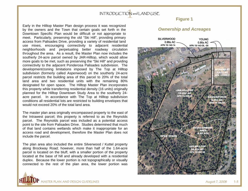
Figure 1
Ownership and Acreages Early in the Hilltop Master Plan design process it was recognized by the owners and the Town that certain goals set forth in the Downtown Specific Plan would be difficult or not appropriate to meet. Particularly, preserving the old “Ski Hill”, providing primary access from Palisades Drive, providing a variety of residential land use mixes, encouraging connectivity to adjacent residential neighborhoods and perpetuating better roadway circulation throughout the area. As a result, the Master Plan now includes the southerly 24-acre parcel owned by JAR-Hilltop, which would allow more goals to be met, such as preserving the “Ski Hill“ and providing connectivity to the adjacent Ponderosa Palisades subdivision. The development/zoning limitations imposed by The Top at Hilltop subdivision (formerly called Aspenwood) on the southerly 24-acre parcel restricts the building area of this parcel to 20% of the total land area and two residential units with the remaining 80% designated for open space. The Hilltop Master Plan incorporates this property while transferring residential density (16 units) originally planned for the Hilltop Downtown Study Area to the southerly 24-acre parcel. In accordance with The Top at Hilltop subdivision conditions all residential lots are restricted to building envelopes that would not exceed 20% of the total land area. The master plan area originally encompassed property to the east of the Intrawest parcel; this property is referred to as the Reynolds parcel. The Reynolds parcel was included as a potential access point to the site from Palisades Drive. Studies determined that much of that land contains wetlands which make it inappropriate for an access road and development, therefore the Master Plan does not include the parcel. The plan area also included the entire Silverwood / Kuttel property along Brockway Road; however, more than half of the 1.64-acre parcel is located on the bluff, with a smaller portion of the property located at the base of hill and already developed with a residential duplex. Because the lower portion is not topographically or visually connected to the rest of the plan area, the lower portion was
1INTRODUCTION and LAND USE
MASTER PLAN AND DESIGN GUIDELINES August 7, 2008 1-4
transferred to the westerly adjacent parcel through a lot line adjustment and is now excluded from the Hilltop Master Plan Area. C. The Master Plan
The Master Plan incorporates a mixed-use concept that is intended to create a walkable neighborhood/village. While the design theme for the village will be within the Town’s regulatory and design framework, it is more use-restrictive and enhances the concept of a village within the Town. The use of design details will encourage harmonious architecture that will help create identity, contributing to a village feel.
To implement the goals of the Downtown Specific Plan, the Hilltop Master Plan and Design Guidelines have been designed using form-based zoning concepts that allow building locations within designated building envelopes. This allows for specific uses and detailed roadway sections for each Zoning District. In addition to the form-based zoning design standards, the Master Plan also sets forth the following:
◊ Land use designation, building and intensity provisions, and development standards for each of the properties within the Hilltop Master Plan Area.
◊ Design guidelines integrated to promote related design themes, pedestrian orientation, mixed-use residential/ commercial activities and infrastructure.
◊ Common infrastructure improvements and associated design standards including offers of dedication and easement abandonments, where applicable.
◊ Open space, trail networks and implementation programs for the Master Plan.
◊ Environmental policies addressing greenhouse gas emissions, particulate matter emissions, protection of wetlands and open space, and preservation of trees.
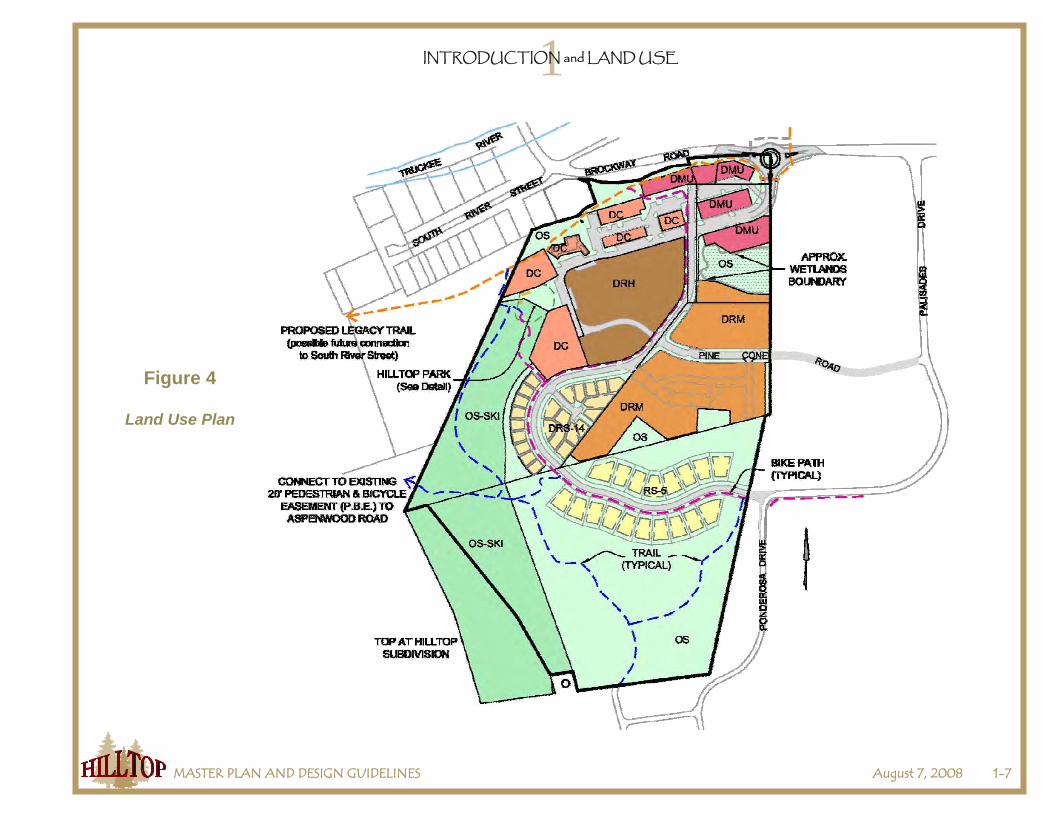
The Land Use Plan in Figure 4 shows the land use designations for the Hilltop Master Plan area. Please note, all site layout plans and building footprints are presented for conceptual purposes only. All future development projects are subject to the development and design review requirements of the Truckee Development Code and this Master Plan. In conjunction with the common infrastructure requirements described below, each land use is required to meet the “overall design” standards of the applicable land use district contained within the Master Plan. These design standards have been developed to promote consistency of the various land uses within the Hilltop Master Plan Area. The intent is to provide one, planned development pattern unique to the Hilltop area. The land use districts contained in the Master Plan have been refined to reflect the purpose and intent of the Downtown Specific Plan. The refined land use district standards are intended to carry out the provisions of the Master Plan.

1INTRODUCTION and LAND USE
MASTER PLAN AND DESIGN GUIDELINES August 7, 2008 1-5
Figure 3
A conceptual plan used in preparing the Hilltop Master Plan
Figure 2
Early conceptual form-based land use plan used for planning purposes
in preparing the land use plan.

1INTRODUCTION and LAND USE
MASTER PLAN AND DESIGN GUIDELINES August 7, 2008 1-6
Specific design standards have been created for each of the land use districts within the Master Plan. These standards are intended to reflect the desired goals of the property owners, while implementing the Downtown Specific Plan. Both specific and overall design standards are proposed to develop the following themes:
◊ Provide a human scale of architecture. The use of design details, such as porches, entranceway detailing, lighting, trimming, dormers and window massing, are intended to provide a more human scale to the residential components of the project.
◊ Emphasize craftsmanship and detailing. The overall design theme is to provide simplistic forms with an emphasis on detailing, such as doors, windows, paint colors and building materials that are appropriate to the alpine environment of the Truckee area. Utilization of natural building materials is emphasized throughout the following sections.
◊ Pedestrian-friendly streets. Utilize the streetscape design of the Downtown Mixed-Use (DMU) designation as a key factor in creating a neighborhood focal point for development of the Hilltop area. Streetscape design standards focus on size, scale, landscaping and traffic calming features to encourage pedestrian activity. The concentration of residential uses, in combination with commercial uses in the DMU area, will provide the intensity of activity needed to create a vibrant streetscape.
The Hilltop Master Plan and Design Guidelines reflect the goals, policies and desired growth rates outlined in the Downtown Specific Plan. The goal of the Hilltop Master Plan and Design Guidelines is to establish design guidelines that, when implemented into the various use areas, create the Hilltop Village, a neighborhood/village within the Town of Truckee. The Hilltop Master Plan and Design Guidelines are generally consistent with the Town’s overall design guidelines and development standards set forth in the Town of Truckee Development Code, but have been adjusted to recognize the uniqueness of the Hilltop site.
The Master Plan also recognizes and includes off-site vehicular access improvements and connections to the Legacy Trail. To this end improvements to the Ponderosa Drive and Palisades Drive intersection and the installation of a roundabout entrance on Brockway Road west of Palisades Drive are included in the plan. The Hilltop Master Plan will connect to and provide a westerly extension of the Legacy Trail.
If the Town does not approve any development in the Master Plan area within three years of adoption of the Master Plan, the Community Development Director will confer with the property owners to identify possible obstructions to the implementation of the Master Plan. The Planning Commission will then meet to discuss the Community Development Director’s findings and any recommendations for future action on the Master Plan.
1INTRODUCTION and LAND USE
MASTER PLAN AND DESIGN GUIDELINES August 7, 2008 1-7
Figure 4
Land Use Plan
1INTRODUCTION and LAND USE
MASTER PLAN AND DESIGN GUIDELINES August 7, 2008 1-8
D. Land Use and Development Regulations
In order to provide greater flexibility in the development standards and accommodate the density transfer, the Hilltop Master Plan will also be adopted as a “Planned Development.” Approval as a “Planned Development” will allow applicable specific Master Plan provisions to apply to the property. The Hilltop Master Plan and Design Guidelines is the controlling document for the purposes of establishing land uses, density and intensity of use and the development standards expressed in the plan. If there are any conflicts or differences with the Truckee Development Code or Downtown Specific Plan, the specific provisions of the Hilltop Master Plan and Design Guidelines document shall govern. All other development standards (e.g., temporary and accessory uses, parking ratios, snow storage and removal, hillside development standards, signs, grading, affordable housing) of the Development Code shall apply.
The Master Plan reflects the development potential assigned to each parcel within the Master Plan area. Table 1 lists the uses and maximum number of residential units and/or maximum intensity of commercial development allowed on each parcel. It is also noted that the Master Plan level of planning has not reflected all of the on-site development standards that would apply should projects come forth. While the Master Site Plan demonstrates overall uses and relationships, it is illustrative when it comes to building location, site design and parking. Future land use permits may result in lower densities and/or intensities of uses based on the applicable development standards required by the Master Plan and those of the Truckee Development Code in effect at the time of future project approval. It is also noted that the uses reflected on the master site plan could be different, as the specific land use districts within the Master Plan contains a list of permitted uses that is more restrictive than Development Code standards.
Because this is a Master Plan, there are certain development standards that will not apply on a project-by-project basis. These standards include open space and parking. Open space is allocated throughout the development area based on environmental constraints (wetlands, steep slopes, etc.), other values (i.e., retention of the historic Hilltop ski hill) and buffers from nearby existing development. The parking standards are being adjusted through the approved use of on-street parking (to create a more pedestrian atmosphere and result in traffic calming), shared parking and the “park once” concept. The latter concept reflects the goal for Hilltop visitors to the commercial village area to park their car anywhere and walk to their destination(s). As a result, all parking spaces and the access driveways (if off-street) to parking are shared. While all parking may be shared, the Development Permit review for each project must demonstrate adequate parking in accordance with the Truckee Development Code except as modified by Section 3.B.7. Each project will be required to grant mutual use easements for off-street parking and access to and through parking lots.
The Master Plan reflects that development along the ridgeline of the northerly area of the JAR-Hilltop North, Silverwood in Truckee and Young properties require special design parameters, including height limits and tree protection to protect views from the downtown area of Truckee. To that extent, special building standard limits are included in the Master Plan to protect and preserve these view sheds.
Existing uses that were legally established and maintained before the adoption of the Master Plan may continue to operate in accordance with the regulations and standards of Chapter 18.130 (Nonconforming Uses, Structures, and Parcels) and other applicable regulations and standards of the Development Code. Any legal nonconforming land use, including the Cottonwood Restaurant and the single family
1INTRODUCTION and LAND USE
MASTER PLAN AND DESIGN GUIDELINES August 7, 2008 1-9
residence on the Young parcel, shall count towards the maximum allowable development of the parcel unless and until the legal nonconforming land use is discontinued and the building is removed. A land use permit shall not be required to continue operation of the Cottonwood Restaurant and its ancillary building. The Cottonwood Restaurant shall be deemed a conforming use upon completion of the common infrastructure improvements for Phase 1 and the driveway and parking improvements for the JAR-Hilltop North parcel.
E. Zoning
In order to implement the Master Plan, the individual parcels will need to be rezoned from Master Plan to a zoning district consistent with the Master Plan land use district for the parcel. An owner’s parcel will not be rezoned until the owner meets their obligations by conveying the required offers of dedications and easements as set forth in Section 2.B and being current with any reimbursements to other owners as set forth in Section 2.G.

1INTRODUCTION and LAND USE
MASTER PLAN AND DESIGN GUIDELINES August 7, 2008 1-10
Table 1 Land Use Chart
Maximum Allowable Development
Residential
(units)
Parcel (Acres)
Land Use District
Commercial
(sq. ft.)
Lodging (rooms)
Multiple Family
Single Family
Notes
Young (.95 acres)
7,000 0
4 0 See Note 1.
Silverwood in Truckee (.99 acres)
DMU
7,000 0 4 0 See Note 2.
Intrawest (3.67 acres)
DMU / DRM 19,180 0 18 See Note 3.
Davies / Fitch Partners (8.08 acres)
DRM 0 0 94 See Note 4.
JAR-Hilltop North (19.83 acres)
DC DRH
DRS-14 OS
19,085 60 129 28 See Notes 5, 6, 7, 8, 9, 10, 11, and 12.
JAR-Hilltop South (24.03 acres)
RS-5 0 0 0 18 See Notes 12 and 13.
ESTIMATED TOTAL
52,265 60 249 46
1INTRODUCTION and LAND USE
MASTER PLAN AND DESIGN GUIDELINES August 7, 2008 1-11
Table 1 Land Use Chart
(Continued)
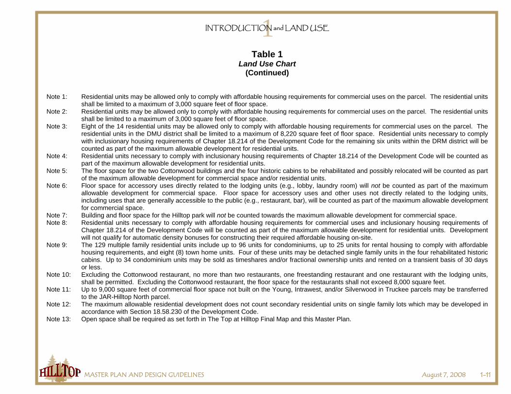
Note 1: Residential units may be allowed only to comply with affordable housing requirements for commercial uses on the parcel. The residential units shall be limited to a maximum of 3,000 square feet of floor space.
Note 2: Residential units may be allowed only to comply with affordable housing requirements for commercial uses on the parcel. The residential units shall be limited to a maximum of 3,000 square feet of floor space.
Note 3: Eight of the 14 residential units may be allowed only to comply with affordable housing requirements for commercial uses on the parcel. The residential units in the DMU district shall be limited to a maximum of 8,220 square feet of floor space. Residential units necessary to comply with inclusionary housing requirements of Chapter 18.214 of the Development Code for the remaining six units within the DRM district will be counted as part of the maximum allowable development for residential units.
Note 4: Residential units necessary to comply with inclusionary housing requirements of Chapter 18.214 of the Development Code will be counted as part of the maximum allowable development for residential units.
Note 5: The floor space for the two Cottonwood buildings and the four historic cabins to be rehabilitated and possibly relocated will be counted as part of the maximum allowable development for commercial space and/or residential units.
Note 6: Floor space for accessory uses directly related to the lodging units (e.g., lobby, laundry room) will not be counted as part of the maximum allowable development for commercial space. Floor space for accessory uses and other uses not directly related to the lodging units, including uses that are generally accessible to the public (e.g., restaurant, bar), will be counted as part of the maximum allowable development for commercial space.
Note 7: Building and floor space for the Hilltop park will not be counted towards the maximum allowable development for commercial space. Note 8: Residential units necessary to comply with affordable housing requirements for commercial uses and inclusionary housing requirements of
Chapter 18.214 of the Development Code will be counted as part of the maximum allowable development for residential units. Development will not qualify for automatic density bonuses for constructing their required affordable housing on-site.
Note 9: The 129 multiple family residential units include up to 96 units for condominiums, up to 25 units for rental housing to comply with affordable housing requirements, and eight (8) town home units. Four of these units may be detached single family units in the four rehabilitated historic cabins. Up to 34 condominium units may be sold as timeshares and/or fractional ownership units and rented on a transient basis of 30 days or less.
Note 10: Excluding the Cottonwood restaurant, no more than two restaurants, one freestanding restaurant and one restaurant with the lodging units, shall be permitted. Excluding the Cottonwood restaurant, the floor space for the restaurants shall not exceed 8,000 square feet.
Note 11: Up to 9,000 square feet of commercial floor space not built on the Young, Intrawest, and/or Silverwood in Truckee parcels may be transferred to the JAR-Hilltop North parcel.
Note 12: The maximum allowable residential development does not count secondary residential units on single family lots which may be developed in accordance with Section 18.58.230 of the Development Code.
Note 13: Open space shall be required as set forth in The Top at Hilltop Final Map and this Master Plan.

1INTRODUCTION and LAND USE
MASTER PLAN AND DESIGN GUIDELINES August 7, 2008 1-12

2COMMON INFRASTRUCTURE
MASTER PLAN AND DESIGN GUIDELINES August 7, 2008 2-1
A. Introduction
The Hilltop Master Plan common infrastructure and improvements are benefits to all the owners of the Hilltop properties and the community. These common improvements reflect the requirements of the Downtown Specific Plan and other Town standards and include the Brockway Road roundabout, the main access road from the roundabout to Palisades Drive, Pine Cone Road extension, main utility lines, trails, and the Hilltop Park. Most of these improvements will be installed as part of the first development project of the Hilltop Master Plan, and the owners will need to grant the necessary easements to each other in order for these improvements to be installed. Although the first developer will be responsible for installing these improvements, the costs for the common infrastructure and improvements, including those in Phase 2, will be paid by all property owners of the Hilltop Master Plan at a proportionate share based on the percentage of land ownership between the five property owners. These property owners will also be responsible for maintenance of the common infrastructure and improvements unless and until the improvements are accepted by a public agency for maintenance.
B. Offers of Dedication and Easements 1. Timing. Within 90 days of the approval of the Master Plan by the Truckee Town Council, each owner shall make roadway, trail,
snow storage, utilities, park, etc., dedications and record said easements on the owner’s property as necessary to implement the Master Plan, and in any event prior to rezoning of the owner’s parcel and the filing of the first project development application on their parcel.
2. Reimbursement. The owners will not receive from the other owners or the Town any compensation or reimbursement for costs or
value associated with the conveyance of offers of dedication and easements required below for the common area infrastructure and improvements.
3. Required Offers of Dedication and Easements. The owners shall grant or acquire the following offers of dedication and
easements. If approved by the Town Engineer, the owners may grant an interim offer of dedication or easement for the improvements with legal guarantees that a final offer of dedication or easement will be established upon completion of the improvements.
a. All Property Owners
i. A minimum 20-foot wide trail easement for the off-site portion of the Legacy Trail from JAR-Hilltop North parcel to the
north or west property line of the adjacent TDPUD property to the west and through the Truckee Regional Park to connect to the existing Legacy Trail to the north. The location and width of the easement will be determined by the Town Engineer in general conformance with the alignment shown in Figure 9. The easements are to be acquired by the Hilltop property owners from the underlying property owners on behalf of the Town. The property owners will be responsible for any costs associated with acquiring the easements.

2COMMON INFRASTRUCTURE
MASTER PLAN AND DESIGN GUIDELINES August 7, 2008 2-2
ii. A right-of-way offer of dedication for the off-site portions of the Roundabout and Main Access Road. The location and
width of the offer of dedication will be determined by the Town Engineer in general conformance with the alignment shown in Figure 9. The offer of dedication is to be acquired by the Hilltop property owners from the underlying property owners on behalf of the Town. The property owners will be responsible for any fair share costs associated with acquiring the easement, but may be reimbursed for a fair share of the costs upon development of the Reynolds parcel.
b. Owner of the Silverwood in Truckee Parcel
i. A minimum 20-foot wide trail easement for the Legacy Trail alignment from the eastern property line to the western
property line. The width and location of the trail easement will be determined by the Town Engineer in general conformance with the alignment shown in Figure 9.
ii. A pedestrian access easement for the stairway or similar pedestrian facilities from JAR-Hilltop North parcel to
Brockway Road. The location and width of the easement will be determined by the Town Engineer in general conformance with the alignment shown in Figure 9.
iii. A trail easement for the Class I Trail along the southern property line, heading northwest to connect to the Legacy
Trail. The location and width of the trail easement will be determined by the Town Engineer in general conformance with the alignment shown in Figure 9.
c. Owner of the Young Parcel
i. A right-of-way offer of dedication for that portion of the Brockway Road Roundabout located within the property. The
location and width of the offer of dedication will be determined by the Town Engineer in general conformance with the alignment shown in Figure 6.
ii. A right-of-way offer of dedication for the Main Access Road from the roundabout to the southeast property corner.
The location and width of the offer of dedication will be determined by the Town Engineer in general conformance with the alignment shown in Figure 6.
iii. A minimum 20-foot wide trail easement for the Legacy Trail from the roundabout to the western property line. The
location and width of the easement will be determined by the Town Engineer in general conformance with the alignment shown in Figure 9. The Town Engineer may approve an interim trail alignment and easement. If an interim trail alignment is constructed, the interim trail will be part of the common infrastructure improvements, and the owner

2COMMON INFRASTRUCTURE
MASTER PLAN AND DESIGN GUIDELINES August 7, 2008 2-3
of the underlying parcel will be required to construct the permanent trail upon development of the parcel and will be responsible for all costs associated with construction of the permanent trail.
d. Owner of the Intrawest Parcel
i. A right-of-way offer of dedication for the Main Access Road from the northeast property corner to western property line
as shown on the Common Infrastructure and Improvements Plan. The location and width of the offer of dedication will be determined by the Town Engineer in general conformance with the alignment shown in Figure 6.
ii. A parking and driveway easement granted to the owner of the Young parcel as described in Section 3.B.7.b.
e. Owner of Davies / Fitch Partners Parcel
i. A right-of-way offer of dedication for the Main Access Road from the northwest property corner along western property line and near the southwest property corner as shown on the Common Infrastructure and Improvements Plan. The location and width of the offer of dedication will be determined by the Town Engineer in general conformance with the alignment shown in Figure 6.
ii. A right-of-way offer of dedication for the Pine Cone Road Extension from the eastern property line to western property
line as shown on the Common Infrastructure and Improvements Plan. The location and width of the offer of dedication will be determined by the Town Engineer in general conformance with the alignment shown in Figure 6.
iii. An access easement granted to the owner of the Intrawest parcel to provide access to the southerly DRM portion of
the Intrawest parcel.
f. Owner of the JAR-Hilltop North
i. A right-of-way offer of dedication for the Main Access Road from the Town-owned property to southeast property corner as shown on the Common Infrastructure and Improvements Plan. The location and width of the offer of dedication will be determined by the Town Engineer in general conformance with the alignment shown in Figure 6.
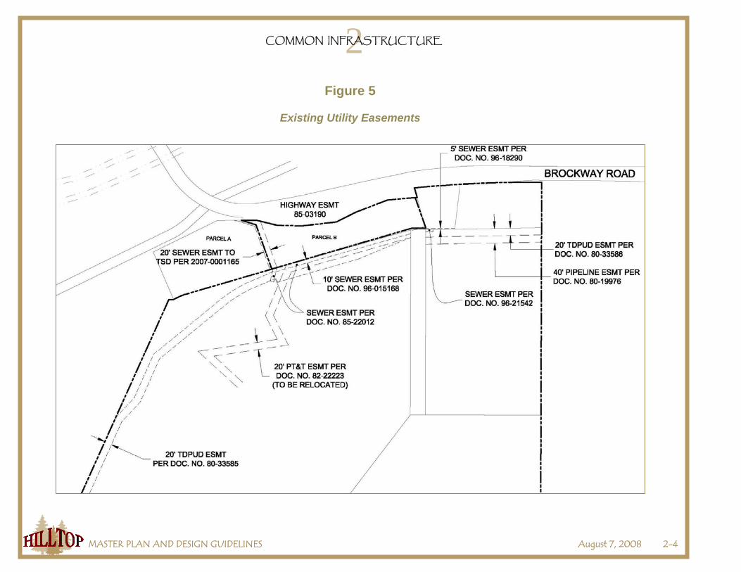
ii. An easement for the sewer line connection to the Main Access Road as shown on the Common Infrastructure and
Improvements Plan. The location and width of the easement will be determined by the Truckee Sanitary District.
2COMMON INFRASTRUCTURE
MASTER PLAN AND DESIGN GUIDELINES August 7, 2008 2-4
Figure 5
Existing Utility Easements
2COMMON INFRASTRUCTURE
MASTER PLAN AND DESIGN GUIDELINES August 7, 2008 2-5
iii. An offer of dedication for the Hilltop Park as shown in the Common Infrastructure and Improvements Plan and as described in the Master Plan. The location and size of the offer of dedication will be determined by the Community Development Director.
iv. A minimum 20-foot wide trail easement for the Legacy Trail alignment through the northwest corner of the property.
The location and width of the easement will be determined by the Town Engineer in general conformance with the alignment shown in Figure 9.
v. Trail easements for the soft surface trails within the parcel as shown on the Common Infrastructure and Improvements
Plan. The location and width of the easements will be determined by the Town Engineer in general conformance with the alignment shown in Figure 9.
vi. A trail easement for the Class I Trail along the northern property line to connect the on-site Class I Trail to the Legacy
Trail, through the Silverwood in Truckee parcel. The location and width of the easement will be determined by the Town Engineer in general conformance with the alignment shown in Figure 9.
g. Owner of the JAR-Hilltop South
i. A right-of-way offer of dedication for the Main Access Road from the northern property line to Palisades Drive right-of-
way as shown on the Common Infrastructure and Improvements Plan. The location and width of the offer of dedication will be determined by the Town Engineer in general conformance with the alignment shown in Figure 6.
ii. An easement for the water line connection from the Main Access Road to TDPUD water tank as shown on the
Common Infrastructure and Improvements Plan. The location and width of the easement will be determined by the Truckee Donner Public Utility District.
iii. Trail easements for the soft surface trails within the parcel as shown on the Common Infrastructure and Improvements
Plan. The location and width of the easements will be determined by the Town Engineer in general conformance with the alignment shown in Figure 9.
4. Town Right of Way. Upon completion or bonding of the main access road, the Town will convey to the Hilltop Master Plan property
owners any property owned in fee title by the Town necessary for the main access road and Silverwood in Truckee access road. The Town will reserve an offer of dedication on the property which will allow the Town to accept the property if and when the road is accepted into the Town-maintained road system.

2COMMON INFRASTRUCTURE
MASTER PLAN AND DESIGN GUIDELINES August 7, 2008 2-6
C. Common Area Infrastructure and Improvements for Phase 1 The owners shall comply with the following for the common infrastructure and improvements for Phase 1.
1. Infrastructure / Improvements. The common infrastructure and improvements for Phase 1 shall include:
a. Roundabout at Brockway Road. A single-lane roundabout complying with the requirements of the Town Engineer shall be constructed at the intersection of Brockway Road and the Main Access Road. The roundabout shall include transit stops as required by the Town Engineer and stormwater runoff and detention facilities. The roundabout will be located on Brockway Road near the northeast corner of the Master Plan area as shown in Figure 6 and may be located to the north and/or to the east from what is shown in Figure 6 if approved by the Town Engineer.
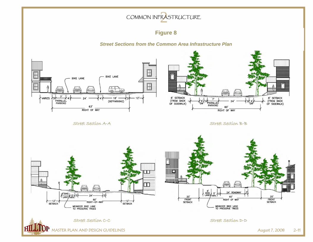
b. Main Access Road. A main access road as shown in the Common Infrastructure and Improvements Plan and described in
Street Sections A-A and C-C shall be constructed from the roundabout to the extension of Pine Cone Road. The road shall include a Class I trail and necessary stormwater runoff detention and treatment facilities, but shall exclude the on-street parking.
c. Road to be Abandoned. When the roundabout at Brockway Road is completed, the Town may close the Old Brockway
encroachment onto Brockway Road and require the owner of the Young parcel to access the parcel from the Main Access Road. Upon the owner of the Young parcel offering for dedication the Legacy Trail easement pursuant to Section 2.B.3.c.iii and providing reimbursement for the master plan and the common area infrastructure improvements in accordance with Section 2.G, the Old Brockway Road encroachment and the roadway to be abandoned may be physically removed and the underlying land may be restored to a natural state. The owners of the master plan parcels will relinquish any rights to this roadway upon completion of the main access road.
d. Silverwood in Truckee Access Road. A road as described in Street Section C-C shall be constructed from the Main Access
Road to the southerly property line of the Silverwood in Truckee parcel. The road shall include a Class I trail and necessary stormwater runoff detention and treatment facilities.
e. Pine Cone Road Extension. A road as described in Street Section B-B shall be constructed from the Main Access Road to
the Town-maintained portion of Pine Cone Road. The road shall include sidewalks and necessary stormwater runoff detention and treatment facilities.
f. Pine Cone Road Repaving. The Town-maintained portion of Pine Cone Road from the Hilltop Master Plan area to Palisades
Drive shall be repaved in accordance with the requirements of the Town Engineer.

2COMMON INFRASTRUCTURE
MASTER PLAN AND DESIGN GUIDELINES August 7, 2008 2-7
g. Utilities. Water, electrical, sewer, and other utilities located in areas with Phase 1 common infrastructure and improvements,
and utilities in areas with Phase 2 common infrastructure and improvements required by the Town Engineer or a special district to be installed in Phase 1.
h. Trails. Class I trails shall be constructed as shown in Figures 9 and 10. The Legacy Trail shall be constructed from the
existing Legacy Trail in the Truckee Regional Park, through the Hilltop Master Plan area as shown in Figure 9, and continuing through the Truckee Donner Public Utility District properties to the west. The Town Engineer may approve adjustments to the Legacy Trail dimensions and alignments in certain constrained areas. The Legacy Trail shall be designed in a manner to minimize impacts (e.g., trespassing, falling debris) on downhill properties. The Legacy Trail within the Young Parcel may include an interim alignment inside or outside the parcel to avoid the existing residence on the parcel and a final alignment upon development of the parcel. If an interim trail alignment is constructed, the interim trail will be part of the common infrastructure improvements. The owner of the underlying parcel may be required to construct the permanent trail upon development of the parcel and may be responsible for all costs associated with construction of the permanent trail.
i. Brockway Road Sidewalk. A sidewalk shall be constructed along Brockway Road from the roundabout to the Truckee River
bridge. The sidewalk shall be built in accordance with the specifications of the Town Engineer. j. Brockway Road Stairway. A stairway or similar pedestrian facility shall be constructed within the Silverwood in Truckee
parcel from the top of the ridge to Brockway Road. The stairway shall be built as shown in Figure 9 and in accordance with the specifications of the Town Engineer.
k. Sierra Motors Building. If the Sierra Motors Building on the Young Parcel conflicts with the construction of the improvements
for the roundabout and/or the main access road, the owner of the Young Parcel shall remove the building prior to or concurrent with the construction of the improvements. If there are no special demolition or clean up procedures (e.g., asbestos) involved with the removal of the building, the costs for the removal of the building are considered part of the common area infrastructure and improvements. If there are any special demolition or clean up procedures, the owner of the Young Parcel will be responsible for those costs.
2. Timing and Review Process.
a. Prior to or concurrent with the application for the first development within the Hilltop Master Plan area, plans for construction of the Phase 1 common area infrastructure and improvements shall be prepared and submitted to the Town Engineer, including all necessary easements and land dedications to accommodate the infrastructure and improvements. It is anticipated that the one of the owners will submit said common infrastructure and improvement plans.
2COMMON INFRASTRUCTURE
MASTER PLAN AND DESIGN GUIDELINES August 7, 2008 2-8
b. The Town Engineer shall be the review authority for approval of the infrastructure and improvement plans and may approve the plans if the Town Engineer finds that the plans are consistent with the Hilltop Master Plan, the Public Improvement and Engineering Standards, and other applicable Town regulations and standards and that all necessary easements and offers of dedication for the construction and use of the improvements have been acquired.
c. The Phase 1 common area infrastructure and improvements shall be fully approved, constructed, and completed prior to
issuance of any grading, building, or other construction permits for development and prior to recordation of any subdivision map on any owner’s parcel unless the Town Engineer, if deemed appropriate, approves the infrastructure and improvement plans and bonding for the improvements.
d. Once construction drawings for common area infrastructure improvements are completed and approved by the Town
Engineer, all property owners in the master plan shall have access to and be able to use such plans for construction of the required common area infrastructure improvements.
D. Hilltop Park 1. Improvements. The Hilltop Park shall be constructed as shown in Figure 7. Features will include bicycle parking, a replicate
building of Historic Resource No. 211 (Valerie Building) as a warming hut with restroom, public parking, and hardscape features. The rope tow could potentially be developed by a private contractor selected by and on behalf of the property owner, although it is not a requirement of the park improvement. The old ski hill will be reserved for recreational use. A trail will also be installed from the Class I Trail on the Main Access Road, through Hilltop park, and north to the Legacy Trail. The Town Engineer may require this trail to be upgraded to a Class I trail.
2. Timing.
a. Prior to or concurrent with the application for the first residential development within the JAR-Hilltop North or JAR-Hilltop South parcels, plans for construction of the Hilltop Park infrastructure and improvements shall be prepared by the owner of the JAR-Hilltop North Parcel and submitted to the Town, including all necessary easements and land dedications to accommodate the infrastructure and improvements.
b. The Town Engineer shall be the review authority for approval of the infrastructure and improvement plans and may approve
the plans if the Town Engineer finds that the plans are consistent with the Hilltop Master Plan, the Public Improvement and Engineering Standards, and other applicable Town regulations and standards and that all necessary easements for the construction and use of the improvements have been acquired.

2COMMON INFRASTRUCTURE
MASTER PLAN AND DESIGN GUIDELINES August 7, 2008 2-9
Figure 6
Common Infrastructure and Improvements Plan

2COMMON INFRASTRUCTURE
MASTER PLAN AND DESIGN GUIDELINES August 7, 2008 2-10
c. The Hilltop Park infrastructure and improvements shall be fully approved, constructed, and completed prior to issuance of any grading, building, or other construction permits for residential development within the JAR-Hilltop North or JAR-Hilltop South parcels, unless the Town Engineer, if deemed appropriate, approves the infrastructure and improvement plans and bonding for the improvements.
3. Indemnification. Prior to operation of a rope tow or use of the
old ski hill, the owner of the land and operator of said facilities shall indemnify and hold harmless the Town and other owners within the Hilltop Master Plan area.
E. Common Area Infrastructure and Improvements for Phase 2 The owners shall comply with the following for the common infrastructure and improvements for Phase 2.
1. Infrastructure / Improvements. The common infrastructure and improvements for Phase 2 shall include: a. Main Access Road. A main access road and/or
emergency access road as described in Street Sections C-C and D-D and Figures 11 and 12 shall be constructed from the main access road constructed in Phase 1 to the intersection of Palisades Drive / Ponderosa Way. The road shall include a Class I trail and necessary stormwater runoff detention and treatment facilities, but shall exclude any on-street parking.
b. Palisades Drive / Ponderosa Way Intersection. The goal
of this improvement is to create a safer, more standard intersection. Alternative designs shall be considered that will improve safety and traffic flow satisfactory to the Town Engineer. Improvements may require geometry reconfiguration of the intersection; regrading the slope on Ponderosa Way to reduce the steepness entering the intersection; smoothing out the 90-degree turn in the road to make the northerly, downhill, through direction more obvious; and adjusting the new connection of the Hilltop main access road to come into the reconfigured intersection perpendicularly.
Figure 7
Hilltop Park
2COMMON INFRASTRUCTURE
MASTER PLAN AND DESIGN GUIDELINES August 7, 2008 2-11
Figure 8
Street Sections from the Common Area Infrastructure Plan
Street Section A-A Street Section B-B
Street Section C-C Street Section D-D

2COMMON INFRASTRUCTURE
MASTER PLAN AND DESIGN GUIDELINES August 7, 2008 2-12
Figure 9
Trails
Figure 10
Legacy Trail Cross-Section

2COMMON INFRASTRUCTURE
MASTER PLAN AND DESIGN GUIDELINES August 7, 2008 2-13
Figure 11

2COMMON INFRASTRUCTURE
MASTER PLAN AND DESIGN GUIDELINES August 7, 2008 2-14
Figure 12
2COMMON INFRASTRUCTURE
MASTER PLAN AND DESIGN GUIDELINES August 7, 2008 2-15
c. Utilities. Water, electrical, sewer, and other utilities needed to serve the Hilltop Master Plan that were not constructed and
installed in Phase1. d. Trails. Earthen trails shall be constructed as shown in Figure 9. A Class I trail shall be constructed from the intersection of
Palisades Drive / Ponderosa Way to the intersection of Palisades Drive / Torrey Pine Road. 2. Timing and Review Process.
a. Prior to or concurrent with the application for development within the DRS-14 district in the JAR-Hilltop North parcel or within the JAR-Hilltop South parcel, plans for construction of the Phase 2 common area infrastructure and improvements shall be prepared and submitted to the Town Engineer, including all necessary easements and land dedications to accommodate the infrastructure and improvements and any information required by the Town Engineer. It is anticipated that the owner of the JAR-Hilltop parcels will submit said common infrastructure and improvement plans.
b. The Planning Commission shall be the review authority for approval of the infrastructure and improvement plans. Prior to
making a decision on whether to extend the main access road to Palisades Drive or to end the main access road in a cul-de-sac with an emergency road connection to Palisades Drive, the Commission shall hold at least one public meeting and shall accept public comment. The Commission shall take into consideration public comments, the General Plan, the Hilltop Master Plan, the Development Code, the Public Improvement and Engineering Standards, other applicable Town regulations and standards, and potential traffic hazards, including winter traffic hazards, at or near the intersection of Palisades Drive and Ponderosa Drive. The Commission, based on the recommendations of the Town Engineer, may approve the plans if the Commission finds that the plans are consistent with the Hilltop Master Plan, the Public Improvement and Engineering Standards, and other applicable Town regulations and standards and that all necessary easements for the construction and use of the improvements have been acquired.
c. The Community Development Director shall require improved outreach beyond the standard noticing requirements, including
notifying by mail the Sierra Meadows Homeowners Association, all property owners within 500 feet of the property in Phase 2 of the Master Plan, including the open space property, any persons requesting notification, and persons on the Hilltop Master Plan e-mail distribution list at least 10 days prior to the public meeting. The Community Development Director shall require the JAR-Hilltop owner to install a sign(s) at the intersection of Palisades Drive and Ponderosa Drive and place an advertisement in the local newspaper at least 10 days prior to the public meeting.
d. The decision of the Planning Commission may be appealed to the Town Council in accordance with Chapter 18.140 of the
Development Code.

2COMMON INFRASTRUCTURE
MASTER PLAN AND DESIGN GUIDELINES August 7, 2008 2-16
e. The Phase 2 common area infrastructure and improvements shall be fully approved, constructed, and completed prior to issuance of any grading, building, or other construction permits for development or prior to recordation of any subdivision map on any owner’s parcel unless the Planning Commission, if deemed appropriate, approves the infrastructure and improvement plans and bonding for the improvements.
f. Once construction drawings for common area infrastructure improvements are completed and approved by the Town
Engineer, all property owners in the master plan shall have access to and be able to use such plans for construction of the required common area infrastructure improvements.
F. Future Traffic
1. Introduction. Future traffic volumes on Brockway Road may adversely affect levels of service and vehicle queuing lengths at the
intersections of Brockway Road / Main Access Road and Brockway Road / Palisades Drive. Traffic volumes at 2025 with buildout of the project may result in a failing level of service at Brockway Road / Main Access Road and create long vehicle queuing lengths that will extend through and past neighboring intersections. To address these significant circulation impacts, the Hilltop Master Plan owners may need to make additional improvements to the Brockway Road / Main Access Road intersection when warranted and fund their proportional costs to improvements at the Brockway Road / Palisades Drive intersection, and/or reduce development in the Master Plan thereby reducing vehicular traffic trips, and/or demonstrate by updated traffic studies and best available information that the proposed Phase 1 roundabout improvements will be able to accommodate future traffic volumes (2025 + Project) at a level of service (LOS) E or better and will not create significant vehicle queuing lengths.
2. Brockway Road. Brockway Road between Palisades Drive and the Main Access Road shall not have more than two through travel lanes. Intersection improvements consisting of turn lanes, acceleration / deceleration lanes, and roundabout bypass lanes are acceptable.
3. Brockway Road / Main Access Road Intersection. a. In conjunction with the improvement plans for Phase 1 of the common area infrastructure and improvements, the owners shall
submit 30% preliminary engineered design plans for future improvements to the Brockway Road / Main Access Road roundabout. The preliminary design plans shall include improvements that will be able to accommodate future traffic volumes (2025 + Project) at a level of service (LOS) E or better and to address significant vehicle queuing lengths. The owners shall prepare the preliminary design plans in accordance with the requirements and specifications of the Town Engineer and shall make all corrections and revisions required by the Town Engineer.
b. Prior to approval of the improvement plans for Phase 1 of the common area infrastructure and improvements, the Planning
Commission, based on the recommendations of the Town Engineer, shall approve the preliminary design plans for future
2COMMON INFRASTRUCTURE
MASTER PLAN AND DESIGN GUIDELINES August 7, 2008 2-17
improvements to the Brockway Road / Main Access Road roundabout. The Planning Commission shall verify that the improvements will be able to be constructed as shown on the preliminary design plan and that such improvements will accommodate future traffic volumes (2025 + Project) at a LOS E or better, not create significant vehicle queuing lengths, and be consistent with Town policies.
c. Prior to issuance of any grading or building permits for the first development in the Hilltop Master Plan, the owners shall offer to the Town of Truckee the necessary right-of-way to encompass the future improvements shown in the approved preliminary design plans. The location, size, and method of the offer of dedication shall meet the requirements of the Town Engineer and Planning Commission.
d. Prior to issuance of any grading or building permits for the first development in the Hilltop Master Plan, the owners shall submit, and the Planning Commission, based on the recommendations of the Town Engineer shall approve, a funding and construction agreement for the future construction of the improvements to the roundabout as shown on the approved preliminary design plan. The agreement shall incorporate all requirements of the Town Engineer and Planning Commission and shall ensure that the improvements will be completed before the roundabout reaches a LOS F or before significant vehicle queuing lengths are created.
4. Brockway Road / Palisades Drive. Prior to approval of the improvement plans for Phase 1 of the common area infrastructure and
improvements, the Planning Commission, based on the recommendations of the Town Engineer, shall approve a “fair share” impact fee program for properties in the Hilltop Master Plan. The program shall identify the proportional impact that development in the Hilltop Master Plan will have on future (2025 + Project) queuing lengths at the Brockway Road / Palisades Drive intersection, the approximate costs of future improvements that will be needed to reduce the queuing lengths to less than significant thresholds, and the fee that will be required for Hilltop Master Plan development. The owners shall provide information and documentation needed to prepare the program as required by the Town Engineer and Planning Commission.
5. Reduction of Development and Vehicle Trips. a. As an alternative to or in conjunction with Section 2.F.3, the owners may modify and/or reduce the maximum allowed
development on the parcels, thereby reducing potential vehicular traffic that may be generated by development. By reducing vehicular traffic generated from development in the Hilltop Master Plan, future improvements to the Brockway Road roundabout and Brockway Road / Palisades Drive intersection may be avoided.
b. The owners may mutually agree to modify and/or reduce the maximum allowed development on the owners’ parcels as follows:

2COMMON INFRASTRUCTURE
MASTER PLAN AND DESIGN GUIDELINES August 7, 2008 2-18
i. In conjunction with the improvement plans for Phase 1 of the common area infrastructure and improvements, the owners shall submit a preliminary owners agreement to modify and/or reduce the maximum allowed development on the owners’ parcels. The modification and/or reduction of the maximum allowed development shall reduce vehicular traffic trips generated from the Hilltop Master Plan to a level that would eliminate the need for future improvements to Brockway Road and the Brockway Road / Palisades Drive intersection.
ii. Prior to approval of the improvement plans for Phase 1 of the common area infrastructure and improvements, the Planning Commission shall approve the preliminary owners agreement. The Planning Commission shall verify that the agreement will reduce vehicular traffic trips generated from the Hilltop Master Plan to a level that would eliminate the need for future improvements to Brockway Road and the Brockway Road / Palisades Drive intersection.
iii. Prior to issuance of any grading or building permits for the first development in the Hilltop Master Plan, the owners shall approve and sign the agreement. The agreement shall be prepared, executed, and recorded in accordance with the requirements of the Planning Commission.
c. If the owners do not mutually agree to modify and/or reduce the maximum allowed development on the owners’ parcels, the Planning
Commission may modify and/or reduce the maximum allowed development as follows:
i. In order maintain a LOS E or better for the single lane roundabout at the Old Brockway Road/Brockway (roundabout) intersection and adequate vehicle queuing lengths on Brockway Road in conformance with the projected 2025 traffic volumes, trip generation resulting from development within the Hilltop Master Plan shall be limited to 62% of the estimated trip generation specified in the December 2007 Hilltop Master Plan Updated Traffic Impact Analysis prepared by LSC Transportation Consultants, Inc. The percentage of estimated trip generation may be increased based on updated traffic studies and best available information per Section 2.F.6.
ii. Additional trip generation resulting from build-out of the Hilltop Master Plan may be considered when subsequent
project review for development is considered by the Town, provided that updated traffic studies and best available information per Section 2.F.6 demonstrate that the single lane roundabout can accommodate future traffic volumes (2025 + Project) at a LOS E or better and will not create significant vehicle queuing lengths.
iii. Each development application shall provide documentation that the proposed development in conjunction with other
developed property (built, under construction, or approved) within the Hilltop Master Plan area does not in total exceed 62% of the estimated trip generation outlined above. If the total of existing development and the proposed development exceeds the 62% limit, the proposed new development shall be limited to uses that do not exceed the total 62% cap unless accompanied with an updated traffic study and best available information that demonstrates that the single lane roundabout can accommodate future traffic volumes (2025 + Project) at a LOS E or better and will not
2COMMON INFRASTRUCTURE
MASTER PLAN AND DESIGN GUIDELINES August 7, 2008 2-19
create significant vehicle queuing lengths. The percentage of estimated trip generation may be increased based on updated traffic studies and best available information per Section 2.F.6.
6. Updated Traffic Studies. As an alternative to or in conjunction with Sections 2.F.3 and 2.F.5, the owners may demonstrate by
updated traffic studies and best available information approved by the Planning Commission, based on the recommendations of the Town Engineer, that the proposed Phase I roundabout improvements will accommodate future traffic volumes (2025 + Project) at a LOS E or better, not create significant vehicle queuing lengths, and be consistent with Town policies.
G. Financing and Reimbursement 1. Introduction. Each owner will pay their pro-rata share of the approved costs and expenses for preparing and processing the Hilltop
Master Plan and the common area infrastructure and improvements including accrued interest. The costs for the common infrastructure and improvements, including those in Phase 2, will be paid by all property owners of the Hilltop Master Plan at a proportionate share based on the percentage of land ownership between the five property owners.
2. Timing. The owner shall provide documentation to the Town that all reimbursements have been made to the owner advancing payment (or as otherwise directed by the Town Community Development Director) as a part of any project land use permit application submittal. No owner may obtain grading or building permits for any project on the owner’s property within the Hilltop Master Plan until the owner submits proof of payment in full, of the owner’s pro-rate share of the approved common expenses described above, including interest. Furthermore, payments/reimbursement of said expenses and compliance with the requirements of the Master Plan shall be a condition of approval for any owner’s project within the Hilltop Master Plan.
3. Master Plan Reimbursement. Reimbursement of approved costs and expenses associated with the planning, preparation processing, and adoption of the Hilltop Master Plan and other related costs and expenses, as approved by the Community Development Director, shall be made by all property owners in accordance with the percentages indicated in Table 2. Records of the costs and expenses incurred in furtherance of the preparation and adoption of the Master Plan shall be submitted to the Truckee Community Development Director for approval, and only approved costs and expenses shall be subject to reimbursement as described below. Interest on the costs and expenses incurred in preparation, furtherance of the preparation and adoption of the Master Plan shall commence upon adoption of the Hilltop Master Plan by the Town Council at the rate of 7% compounded annually by all property owners in accord with the percentages indicated in Table 2.
4. Common Area Infrastructure and Improvements Reimbursement. Reimbursement of approved costs and expenses associated with the design, engineering, and construction of the Phase 1 and 2 common improvements shall be made by all property owners in accord with the percentages indicated in Table 2. Records of the costs and expenses incurred in furtherance of the design, planning, engineering, and construction of the common improvements shall be submitted to the Truckee Community Development Director for approval, and only approved costs and expenses shall be subject to reimbursement as described below. Interest on the engineering
2COMMON INFRASTRUCTURE
MASTER PLAN AND DESIGN GUIDELINES August 7, 2008 2-20
and construction costs and expenses, at the rate of 7% compounded annually as approved by the Community Development Director, shall accrue starting at the date when the Town approves construction of each phase of the improvements. Approved costs and expenses will include, but not be limited to:
◊ Past and future construction drawings for common area improvements; and other related costs and expenses as described above, as approved by the Truckee Community Development Director.
◊ Common area access and utility construction, including roads, roundabout, trails, bonding, utilities, etc. as described in this Chapter including the off-site Legacy Trail extension through the Truckee Donner Public Utility District property. Permitted on-street parking is not to be included in shared common area costs or construction, rather to be developed by individual owners.
◊ Construction of Hilltop Park, described above in the Master Plan.
5. Procedures for Reimbursement. The Owners may adopt procedures for reimbursement of costs and expenses. However, in absence of any owners’ agreement, the Truckee Community Development Director, subject to appeal to the Town Council, shall adopt procedures consistent with the Master Plan for approving the costs and expenses incurred by owners and the reimbursement mechanism. The party responsible for planning and construction of the infrastructure and improvements, anticipated to be an owner or owners, shall maintain records of the costs associated with the design, planning, engineering, and construction of the improvements, including necessary and related costs and expenses such as accounting and legal, separate from the costs specific to the owner’s private development.
2COMMON INFRASTRUCTURE
MASTER PLAN AND DESIGN GUIDELINES August 7, 2008 2-21
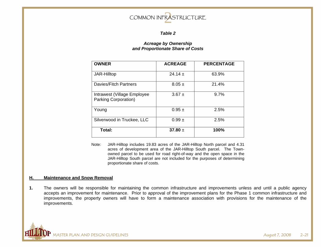
Table 2
Acreage by Ownership and Proportionate Share of Costs
OWNER ACREAGE PERCENTAGE
JAR-Hilltop 24.14 ± 63.9%
Davies/Fitch Partners 8.05 ± 21.4%
Intrawest (Village Employee Parking Corporation)
3.67 ± 9.7%
Young 0.95 ± 2.5%
Silverwood in Truckee, LLC 0.99 ± 2.5%
Total: 37.80 ± 100%
Note: JAR-Hilltop includes 19.83 acres of the JAR-Hilltop North parcel and 4.31
acres of development area of the JAR-Hilltop South parcel. The Town-owned parcel to be used for road right-of-way and the open space in the JAR-Hilltop South parcel are not included for the purposes of determining proportionate share of costs.
H. Maintenance and Snow Removal 1. The owners will be responsible for maintaining the common infrastructure and improvements unless and until a public agency
accepts an improvement for maintenance. Prior to approval of the improvement plans for the Phase 1 common infrastructure and improvements, the property owners will have to form a maintenance association with provisions for the maintenance of the improvements.

2COMMON INFRASTRUCTURE
MASTER PLAN AND DESIGN GUIDELINES August 7, 2008 2-22
2. The following maintenance and snow removal costs and expenses for common area infrastructure and improvements will be borne by each property owner on a proportionate, fair share basis as agreed in Table 2:
• Ongoing road, sidewalk, trail, drainage facilities, and park common improvement maintenance, including adequate comprehensive general liability insurance. The owners shall form and agree to be bound by a road and common area improvement maintenance agreement.
• Snow removal for all common area roadways and facilities that are not accepted by the Town for maintenance and snow removal.
Some minor roadway and other utility costs may also be shared via private agreements by adjoining landowners to the extent they derive a benefit from these improvements.
3. The common improvements will include the agreed fair share participation in the design and construction and ongoing maintenance of the following features:
• Developing and implementing a comprehensive on-site snow storage and/or removal plan is required as part of the Phase 1 improvement plans. All on-site snow storage areas shall be designated and protected through an easement or other reservation acceptable to the Town Engineer. All owners shall grant reasonable snow storage easements as requested by the Town Engineer and shall cooperate and participate, including financial participation, in the Hilltop Master Plan snow removal program.
• Snow storage shall not be allowed on sidewalks and Class I trails.
I. Contaminated Soils 1. Investigation. Each owner will investigate and test as necessary their individual parcels for potentially contaminated soils. The
owner will conduct their investigation prior to conveyance of the offers of dedication and easements described in Section 2.B of this Chapter.
2. Clean Up. Each owner will clean any contaminated soils on their own individual parcels in accordance with Lahontan RWQCB and
Nevada County Department of Health requirements. The owner will initiate and complete, if possible, the clean up of contaminated soils prior to the construction and installation of common area infrastructure and improvements.
3. Costs. Any costs associated with the investigation, testing, and clean up of contaminated soils will not be considered costs for
common area infrastructure and improvements and will be the sole responsibility of each and every property owner for their own individual parcel.