masterclass on disaster mitigation collaborations in asia
TRANSCRIPT

Masterclass on Disaster Mitigation
Collaborations in Asia
6
30 & 31 Aug. 2017Dalian, China
CollaboratorsUNESCO Jakarta Office
Disaster Mitigation Competence Centre of EGI-Engage & APAN Disaster Mitigation Working Group

• Partners: TW(AS), PH(ASTI), MY(UPM), ID(ITB), DE(LMU)• Schedule of EGI-Engage: March 2015 - August 2017• Goals: Improving strategy of prevention and reduction of
disasters• By better knowledge of the Earth’s physical phenomena, we can
mitigate the consequences of similar disasters in the future. • Advancement of prediction accuracy on target disasters
• Deliverables• D6.9: Web portals for tsunami wave propagation simulations and
for WRF-based weather simulation• D6.20: Application of the simulation portals for scientific scenario
in disaster mitigation • D6.22: Design larger scale multi-hazards simulation attempting to
reduce uncertainty of climate change assessment7
Disaster Mitigation Competence Centre (DMCC) in EGI-Engage

APAN Disaster Mitigation Working Group• Chair: Eric Yen (TW); Co-Chair: Peter Banzon (PH)• Initiated in APAN41 in Jan. 2016• Case Study: Disaster Case Study and Impact Analysis
on Agriculture first• Service Directory: Welcome all parties provide any
service end point• Data Directory:
• Weather, geospatial, observation, satellite images/data, earthquake, etc.
• Public open data sources• Proof of Concept Experiment • Review the Progress at least once every year at APAN
meeting

• EGI-APAN Collaboration connects regional resources on disaster mitigation• DMCC (EGI) + DM WG (APAN)• Making disaster mitigation application as services• Extending to social-economic impact analysis
• Availability of local detailed data is crucial for deeper understanding of natural disasters
• This is the best opportunity based on deeper understand of disasters by close collaborations with Scientists and users• Different disciplines to work together such as Typhoon Haiyan• Global data and local data combined together• Worldwide communities and resources working with local scientists
• Deep understanding will lead to more accurate Alert System
Disaster Mitigation in Asia PacificA New Collaboration Paradigm between EGI and APAN

Volcano
Earthquake
Observation Data (eg, Radar, Sensor Network and satellite, etc.)
Theory (Scientific Discovery)
Initial & Boundary Condition (Multi-)Hazards
ModelingAnalysis & Simulation Retrospective
Analysis
Case Study
e-Science Infrastructure & Application Platform
Fast Reporting
Complex, Inter- disciplinary Process
Knowledge Base & Archive
Biomass Burning/Forest Fire
Aerosol/Dust Transportation Tsunami
Extreme Weather
Flood
Landslide
Typhoon/Tropical Cyclone
Stormsurge
Deeper Understanding Model Enhancement
Improving Disaster Mitigation by Deeper Understandings
Deeper Understanding on Multi-Hazards

Partner Selected Case Required Data Sets Status Check Point
Simulation Framework
PH, TW Typhoon Haiyan
Doppler Radar, Tidal gauge, air pressure, wind speed, typhoon path; hourly resolution
Finish 1st numerical study by combining atmospheric and
ocean model
Demo @ APAN41
gWRF, iCOMCOT
MY, TW Flooding 2014-15
Simulations by AS (global data) and MY have been
achieved. Need more observation data to refine and
confirm the model.
Demo @ APAN43
gWRF, Scouring
TH, TWFlooding 2011 (Comparative Study)
Simulation by NECTEC and AS (global data) were done. Aim to improve the accuracy
and EWS.
gWRF, Scouring
ID, TWLong-Dist Dust Transportation of Forest Fire
air pollutants such as, CO, NOx (NO, NO2),SO2, O3, PM10, PM2.5 etc. with high temporal resolution
Simulations have been done. Need more observation data to refine and confirm the model.
Demo @ APAN43
WRF-Chem
Nepal, TW Flooding 2014
High altitude and geographical features need to consider
Waiting for more necessary observation data
gWRF, Scouring
TW, PHTsunami Impact Analysis in South China Sea
Bathymetry, fault geometry, historical events,
In progress. Depends on high resolution bathymetry data
from partnersiCOMCOT
Case Study & Collaboration Model
DE provides advanced visualization support whenever it is possible 11


Technical Group
13
Identification of Case Studies
Simulation Model Validation
& Development
Observation Data & Supporting Materials
Collection
Partner Scientific Groups and Coordinators
Project Coordination
Infrastructure Integration & Performance Tuning/
Optimization
Simulation Portal (Scientific Gateway)
Development User Support Group
Core Simulation
Facility
Infrastructure Support Group
Core Scientific Groups
DMCC Collaboration Framework on Case Studies
13

Weather Data
NWP by WRFModel improvement
by validation with observation data Wind Field
& Pressure
Data Alignment
COMCOT Tidal Data
Bathymetry & Topography
Model improvement by validation with observation data
Tidal Record
Inundation Max Storm Surge Height
Storm Surge Velocity
Wind Field & Pressure
3KM resolution
2KM - 0.2KM resolution
Atmospheric Model
Oceanic & Global Tide Model
1. Understanding science behind the event2. Improve the coupled model3. Early warning4. Providing hazard maps and risk potential analysis
Applications
A New Storm Surge Model for Typhoon Haiyan by Coupling Atmospheric and Oceanic Models
• Adopt the large computational domain to cover the complete typhoon life cycle and full storm surge propagation.
• Couple COMCOT with the dynamic atmospheric WRF model.
• Couple with the global TPXO tidal model.
• Calculate high-resolution storm surge inundation.
• High-speed calculation for the operational system.
14

Pressure Field
Wind Field
15
Storm Surge Modeling on 2013 Typhoon Haiyanby Coupling Ocean and Atmospheric WRF Model
• Asymmetric effect • Topographic effect• Hydrodynamic Pressure
Eastern SamarLeyte
Samar
CSouthern
Leyte
Offshore Storm Surge Inundation Induced by Typhoon Haiyan
15

16
Studies of Simulation Schemes in Capturing Mechanisms of Rainfall Prediction in WRF on
Malaysia Floods

17
Long-Distance Dust Transportation from Biomass Burning

18
Flood Case Study in Nepal

• Local Scouring case study is the first example by collaboration between NCU, ASGC and LRZ
• 3D Typhoon Morakot Visualization is the next case study
Advanced Visualization

iCOMCOT User Interface (I)

iCOMCOT User Interface (II)
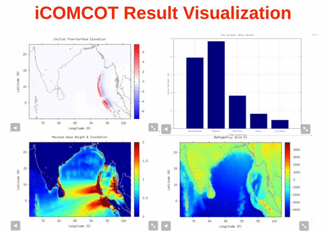
iCOMCOT Result Visualization

Running WRF1. WPS - WRF Preprocessing System
• geogrid: Define size/location of model domains and interpolate static terrestrial fields to simulation grids
• ungrib: Extract meteorological fields from GRIB files
• metgrid: Horizontally interpolate meteorological fields (from ungrib) to simulation grids (defined by geogrid)
ARWpost3. ARWpost is a Fortran program that reads WRF-ARW input and output files, then generates GrADS output files.
GrADS
2. Running WRF


25
Taiwan Storm Surge Operational System Our COMCOT storm surge model has been the official operational system
at the Central Weather Bureau of Taiwan in 2016

Multi-Hazards Risk AnalysisStorm Surge (Stormsurge)
Typhoon/ Tropical
Cyclone (WRF)
Changes of wind intensity, rainfall or
pressure Flood (FloodForecasting)
Landslide (Landslide Simulation)
Changes of rainfall
Earthquake (RCS)
Chang of energy released
Tsunami (iCOMCOT)
Landslide (Landslide Simulation)
Changes of rainfall
Fire/Chemical Aerosol Transportation (WRF/Chem)
Changes of Inundation Distance and Wave
Height
A) Meteorology & Hydrology Oriented
B) Seismology & Oceanology Oriented

• Observation data is the key for our simulations and model validations• Need a systematic approach to integrate data from various
sources —> Exception better solutions from Open Science Platform
• Application portal is the right service model for simulation, training and promotion• Need to be flexibly support workflows of different needs• API should be also provided
• Need to be flexible enough to make use of various types of resources, such as grids, clouds, HPC, local clusters, or even volunteer resources
• Achieving the Open Science Platform for Disaster Mitigation
Regional Infrastructure & Technology Requirements
27

• Observation data is the most important and is also hard to acquire
• Insufficient knowledge to the root causes and drivers of disasters leads to invalid and inefficient risk estimation.
• Hard to estimate the risk dynamically before the hazard happens in high level of accuracy
• Every disaster event is unique which needs careful identification of initial condition, boundary condition and right resolution for each simulation in time. Efficient sharing and benefit from expert know-how is still a barrier.
• Duplicate efforts and investments occurred in different countries. Sharing and collaborations across disciplines and across administrative boundaries are demanding.
28
Challenges & Lessons Learned

Open Collaboration Model for Disaster Mitigation Based on Deeper Understanding & Moving Towards Open Science
29
Simulation Portal
Case Study Knowledge Base
Deeper Understanding &
Collaboration by e-Infrastructure
Reproducibility & Data Reuse
Knowledge Sharing &
Advancement
Simulation Model & Services Innovation
Continuous Enrichment and Enhancement by more
Case Studies and Providing Geophysical
Environment Knowledge Discovery
Customized Science Gateway & API for flexible
Integration
Driving Advancement of Science, Technology,
Collaboration & Services by More Case Studies

• Partners grows from 4+1 (DMCC) to 8+4 (DMCC+@EOSC-Hub)
• Capacity Building: Develop capacities of natural hazards risk analysis by more accurate and high performance numerical simulations from case studies
• Facilitate Share of Data, Tools, Resource and Knowledge: Buildup the Open Science Platform prototype on Disaster Mitigation to share the data, tools, case studies, services and knowledge
• Extending the Collaboration Network by Training, Dissemination and Support
• Plan for Long-term Collaborations30
Extending Disaster Mitigation Capacity and Collaboration

Sustainability Model

Earth scale – TaiESM (100-200km)
TCCIP
CCliCS
Cross-scale Climate Modeling System
RCEC/AS
(20km)
(< 5km)
(5-10km)
Large eddy scale (< 1km)
• Support effective disaster mitigation based on deep understandings
• Facilitate scientific advancement on disaster modeling and simulation
• Provide e-Services for Scientists, Governments and wider user communities
Source: Prof. Huang-Hsiang Hsu (RCEC, AS), EnvComp Workshop 2016

DMCC+ in EOSC-Hub (I)
33
• EOSC-Hub (Call:H2020-EINFRA-2016-2017): Jan 2018 - Dec 2020• Vision: Reduce the natural disaster risks by numerical
simulations based on deeper understandings of the sciences• Goals: DMCC+ will become the regional open collaboration
platform of disaster mitigation by e-Science (EOSC supported high performance numerical simulation services and scientific data sharing) and facilitate the sustainability development of Asia countries.
• Methodology: • Develop innovative simulation models and provide scientific gateway
services: • focusing on meteorological disasters including flood, typhoon, storm surge,
landslide, extreme temperature, and long-distance dust transportation as well as tsunami;
• single hazard and multi-hazards• Towards Open Science Platform: Simulation Portal + Case Studies +
Knowledge DB

DMCC+ in EOSC-Hub (II)
34
• Tasks• Demonstrate the effective collaboration model to engage end users, scientific
groups, technical groups, infrastructure support group, user support groups and simulation facility in partner countries to accomplish the planned case studies based on deeper investigation of the underlying causes.
• Make the existing DMCC regional e-Infrastructure compatible with EOSC framework and support the case studies and shares of data, tools and knowledge to DMCC+ partners and potential collaborators in Asia, Europe and other continents.
• Open Data: Make data, tools, processes, and derived results from the case studies sharable through EOSC framework and services.
• Dissemination & Outreach: Collaborate with APAN Disaster Mitigation Working Group, series of master classes on the DMCC+ simulation facilities, web portals and hands-on trainings will take place in various Asia countries. More user communities and cloud resource providers in Asia would be engaged through the EGI-APAN collaboration framework.
• Deliverables• EOSC Technology assessment and integration plan (milestone in month 6): Goal is
to integrate Asia Pacific regional infrastructure with EOSC framework and making use of EOSC services for DMCC+ applications.
• Online services integrated into a unified e-infra platform (milestone in month 21): Finish planned case studies by simulation portals over EOSC framework and EOSC services.