masterplanning st pauls - bristol
DESCRIPTION
MArch project for urban planningTRANSCRIPT
BUS STOP
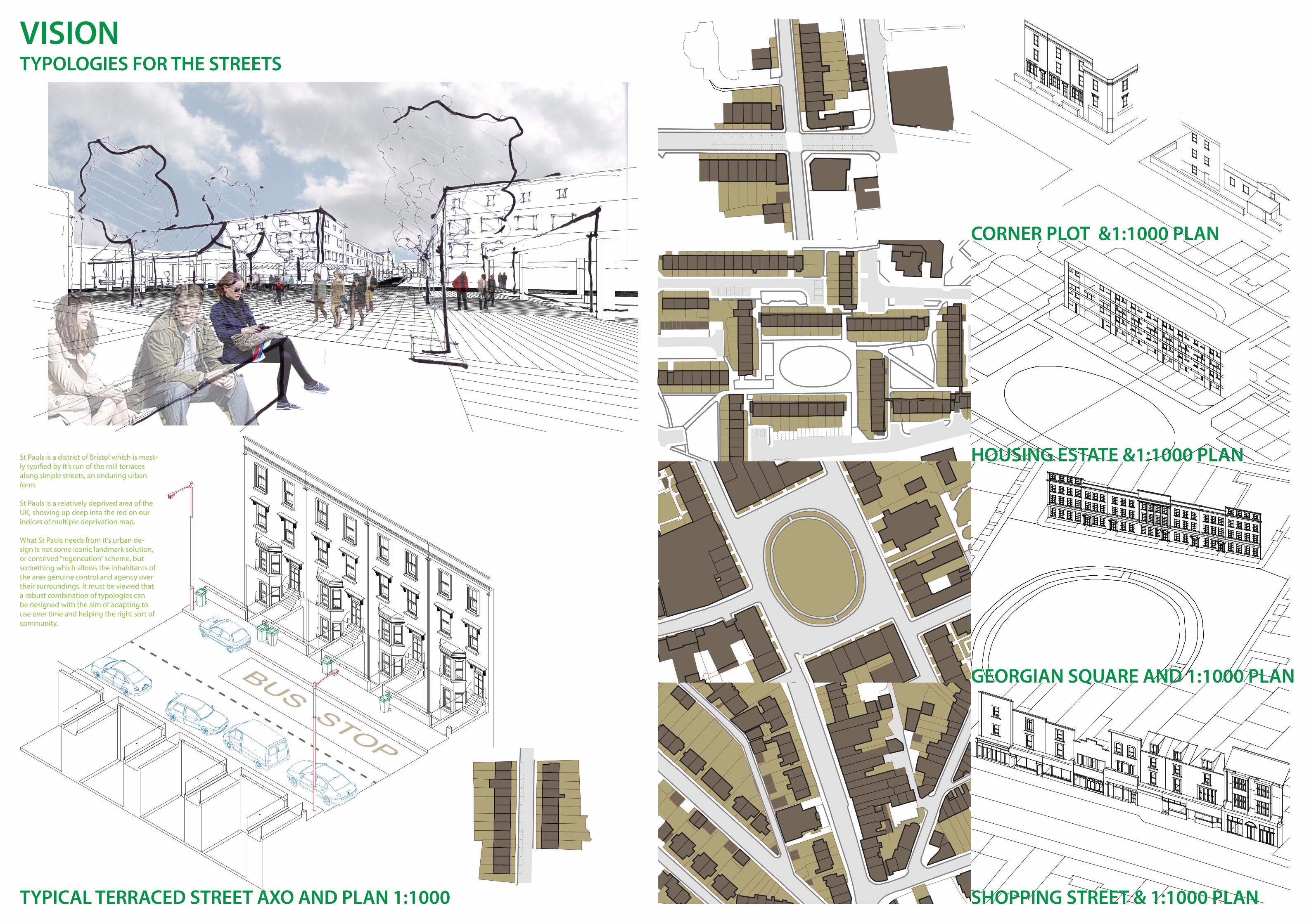
TYPOLOGIES FOR THE STREETS
TYPICAL TERRACED STREET AXO AND PLAN 1:1000
CORNER PLOT &1:1000 PLAN
HOUSING ESTATE &1:1000 PLAN
GEORGIAN SQUARE AND 1:1000 PLAN
SHOPPING STREET & 1:1000 PLAN
VISION
St Pauls is a district of Bristol which is most-ly typified by it’s run of the mill terraces along simple streets, an enduring urban form.
St Pauls is a relatively deprived area of the UK, showing up deep into the red on our indices of multiple deprivation map.
What St Pauls needs from it’s urban de-sign is not some iconic landmark solution, or contrived “regeneation” scheme, but something which allows the inhabitants of the area genuine control and agency over their surroundings. It must be viewed that a robust combination of typologies can be designed with the aim of adapting to use over time and helping the right sort of community.
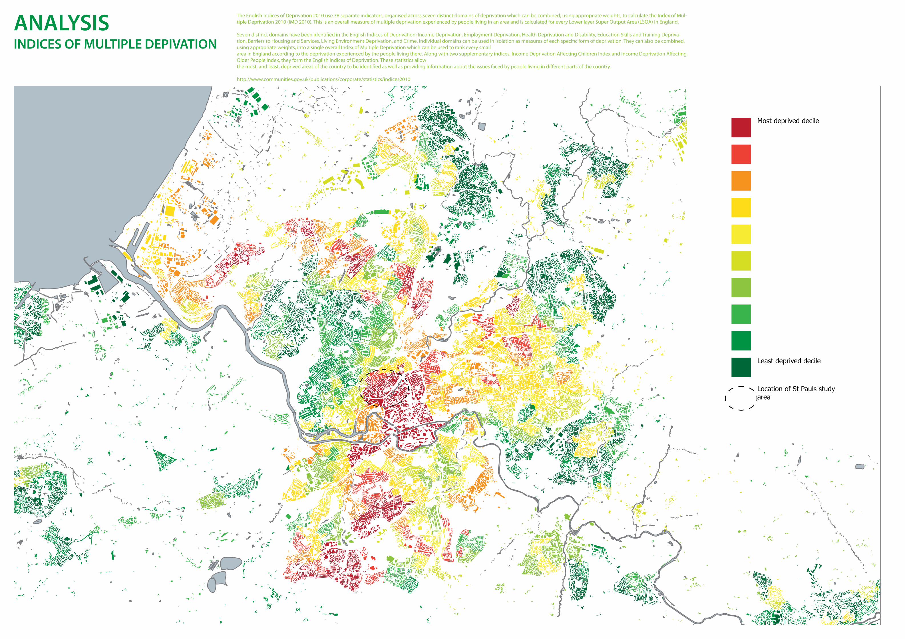
INDICES OF MULTIPLE DEPIVATIONANALYSIS
Most deprived decile
Least deprived decile
Location of St Pauls study area
The English Indices of Deprivation 2010 use 38 separate indicators, organised across seven distinct domains of deprivation which can be combined, using appropriate weights, to calculate the Index of Mul-tiple Deprivation 2010 (IMD 2010). This is an overall measure of multiple deprivation experienced by people living in an area and is calculated for every Lower layer Super Output Area (LSOA) in England.
Seven distinct domains have been identified in the English Indices of Deprivation; Income Deprivation, Employment Deprivation, Health Deprivation and Disability, Education Skills and Training Depriva-tion, Barriers to Housing and Services, Living Environment Deprivation, and Crime. Individual domains can be used in isolation as measures of each specific form of deprivation. They can also be combined, using appropriate weights, into a single overall Index of Multiple Deprivation which can be used to rank every small area in England according to the deprivation experienced by the people living there. Along with two supplementary indices, Income Deprivation Affecting Children Index and Income Deprivation Affecting Older People Index, they form the English Indices of Deprivation. These statistics allow the most, and least, deprived areas of the country to be identified as well as providing information about the issues faced by people living in different parts of the country.
http://www.communities.gov.uk/publications/corporate/statistics/indices2010

“Organic” commercial street
Georgian district
City centre
Semi detached
Modern estates
“Bread and butter” terraces
St Pauls - As is.
>Retail frontage>Commercial frontage>Park>Community Use>Sports facilities
St Pauls - Aspirations according to St Pauls Neighbourhood Plan
>Proposed redevelopment>Regeneration area
ANALYSISST PAULS ACCORDING TO NEIGHBOURHOOD PLAN
GROUPINGS OF TYPOLOGIES
PUBLIC OPEN SPACES PRIVATE OPEN SPACES
Looking at the groupings of typolo-gies diagram, we can see that there emerges a distinct pattern of urban typologies.
The red indicates the primary com-mercial streets throughout. These are more “organic” and are clearly the result of gradual change over time. One such example borders the study area.
The bulk of the study area is made up of the victorian terraces shown in green, and the more commercial Georgian era construction in pink.
This is also the more public of the areas, whereas the Victorian area is mostly private dwelling houses with private gardens.
I have chosen to look at a precedent organisation in Bristol called “the Watershed”. In the diagrams I ex-plain the relationship it has to the people of Bistol.
This is the type of organisation working with the community of which there are a few.
The study area and the Dove Lane site should be suitable to create the right type of environment to foster these organisations, among the ele-ments of themasterplan.
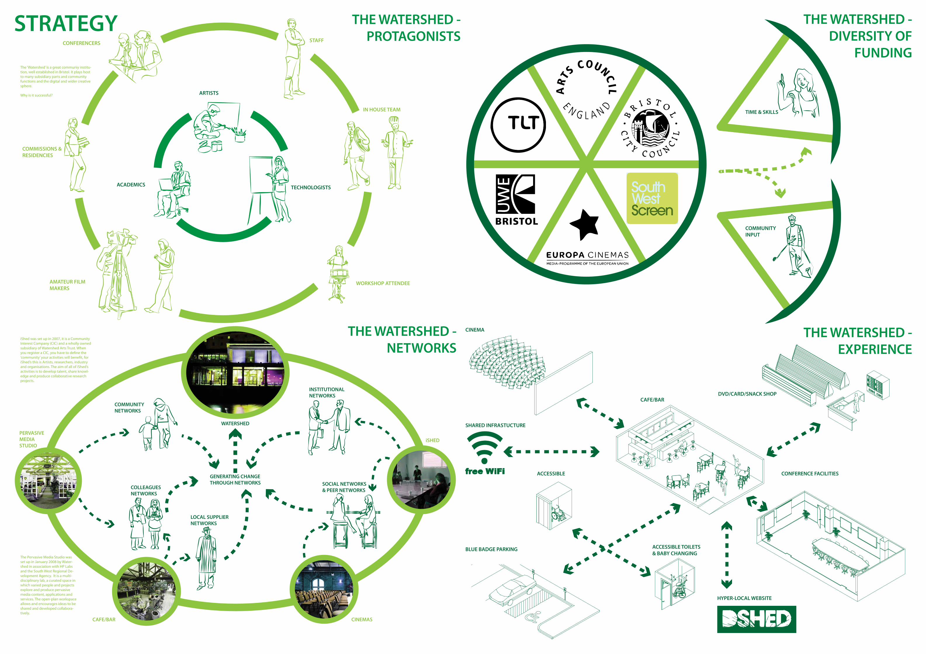
THE WATERSHED - PROTAGONISTS
THE WATERSHED - DIVERSITY OF
FUNDING
THE WATERSHED - EXPERIENCE
THE WATERSHED - NETWORKS
ARTISTS
TECHNOLOGISTSACADEMICS
AMATEUR FILMMAKERS
COMMISSIONS &RESIDENCIES
CONFERENCERS STAFF
IN HOUSE TEAM
WORKSHOP ATTENDEE
TIME & SKILLS
COMMUNITY INPUT
SOCIAL NETWORKS& PEER NETWORKSCOLLEAGUES
NETWORKS
LOCAL SUPPLIER NETWORKS
INSTITUTIONAL NETWORKS
COMMUNITY NETWORKS
WATERSHED
GENERATING CHANGETHROUGH NETWORKS
PERVASIVE MEDIA STUDIO
iSHED
CINEMASCAFE/BAR
BLUE BADGE PARKING
ACCESSIBLE
ACCESSIBLE TOILETS& BABY CHANGING
CAFE/BAR
CINEMA
CONFERENCE FACILITIES
DVD/CARD/SNACK SHOP
SHARED INFRASTUCTURE
HYPER-LOCAL WEBSITE
STRATEGY
iShed was set up in 2007, it is a Community Interest Company (CIC) and a wholly owned subsidiary of Watershed Arts Trust. When you register a CIC, you have to define the ‘community’ your activities will benefit, for iShed’s this is Artists, researchers, industry and organisations. The aim of all of iShed’s activities is to develop talent, share knowl-edge and produce collaborative research projects.
The Pervasive Media Studio was set up in January 2008 by Water-shed in association with HP Labs and the South West Regional De-velopment Agency. It is a multi-disciplinary lab, a curated space in which varied people and projects explore and produce pervasive media content, applications and services. The open-plan workspace allows and encourages ideas to be shared and developed collabora-tively.
The ‘Watershed’ is a great communiy institu-tion, well established in Bristol. It plays host to many subsidiary parts and community functions and the digital and wider creative sphere.
Why is it successful?

CHANGE THROUGH NETWORKS
THE EXPERIENCE OF PLACE
MIXTURE OF TYPOLOGIES -THE PAINTWORKS PRECEDENT
VACANT AND DEMOLISHED BUILDINGS
STRATEGYINDYMEDIA BRISTOL
HAMILTON HOUSE POWERED BY COEXIST
ST PAULS LEARNING & FAMILY CENTRE
KNOWLE WEST MEDIA CENTRE
Hamilton House is a vibrant community hub on Stokes Croft in which people can coexist in harmony with themselves, with each other and the environment.
We have grown organically and will continue to do so, open to respond to what is needed by the community within and without the building. Our direction and action has a single purpose - to support innovative solutions for all. This means personal, social and collective, within and without the space we facilitate, and for current and future generations.
Bristol Indymedia is a volunteer-run open-access news website composed of the news, views, images and videos of its readers/contributors. It is part of the global Indymedia movement, a project focused on grassroots non-commercial news written by ordinary people.
KWMC is a media arts charity and limited company that aims to develop and support cultural, social and economic regeneration.
For over 15 years we have been supporting commu-nities to engage with, and bene�t from, digital technologies and the arts.
The St Pauls Learning & Family Centre is part of Bristol Libraries run and managed by Bristol City Council. The Council supports the programme of activities and services run from the building and works with learning partners to deliver courses and adult learn-ing. This St. Pauls Conversation is about �nding out what customers, sta� and the community think is working well, could be improved and how the future might develop.
ORGANISATIONALTRANSPARENCY
CELEBRATING THECONTRIBUTORS
PRESENTING SHARED EXPERIENCES
USING PRODCUCTSTO INSPIRE
DESIGNING INDETERMINANTLY- USERS CAN IMPRINT THEIR OWN STORIES
Large volume structure capable of conversion/fitting out to two storeys 3080m2
Two lower storeys only 1021m2
Ground floors only 351m2
4 storeys 2294m2
1 lowest storey only 1150m2
Street level only 175m2
On deck 370m2
On deck 83m2
2 levels - upper on deck 402m2
In the ship, part 2 storey 185m2
2 levels 110m2
Bike Bar 90m2
4 storeys 2478m2
2 upper floors 1021m2
All levels 2310m2
5 upper floors 1005m2
2 upper levels 3450m2
3 upper levels - some at lower ground 2234m2
3 single level flyovers 225m2
7 levels 3143m2
Existing building backing onto wine warehouse 510m2
3 blocks 1440m2
1 storey on deck 336m2
2 storeys on deck 518m2
3 storeys on deck 885m2
2 storeys on deck 518m2
Office / Studies / Light production
Live/Work Floorspace
Residential Floorspace
Retail / Restaurant / Bar
Hotel
A successful masterplanning scheme in Bristol is “the Paintworks”. Looking at their design and access statement we can see the progammatic elements which form the scheme. This diagram illustrates the types of uses that have gone into the program of the Paintworks.
In my masterplan a similar proportion of program has been implemented.
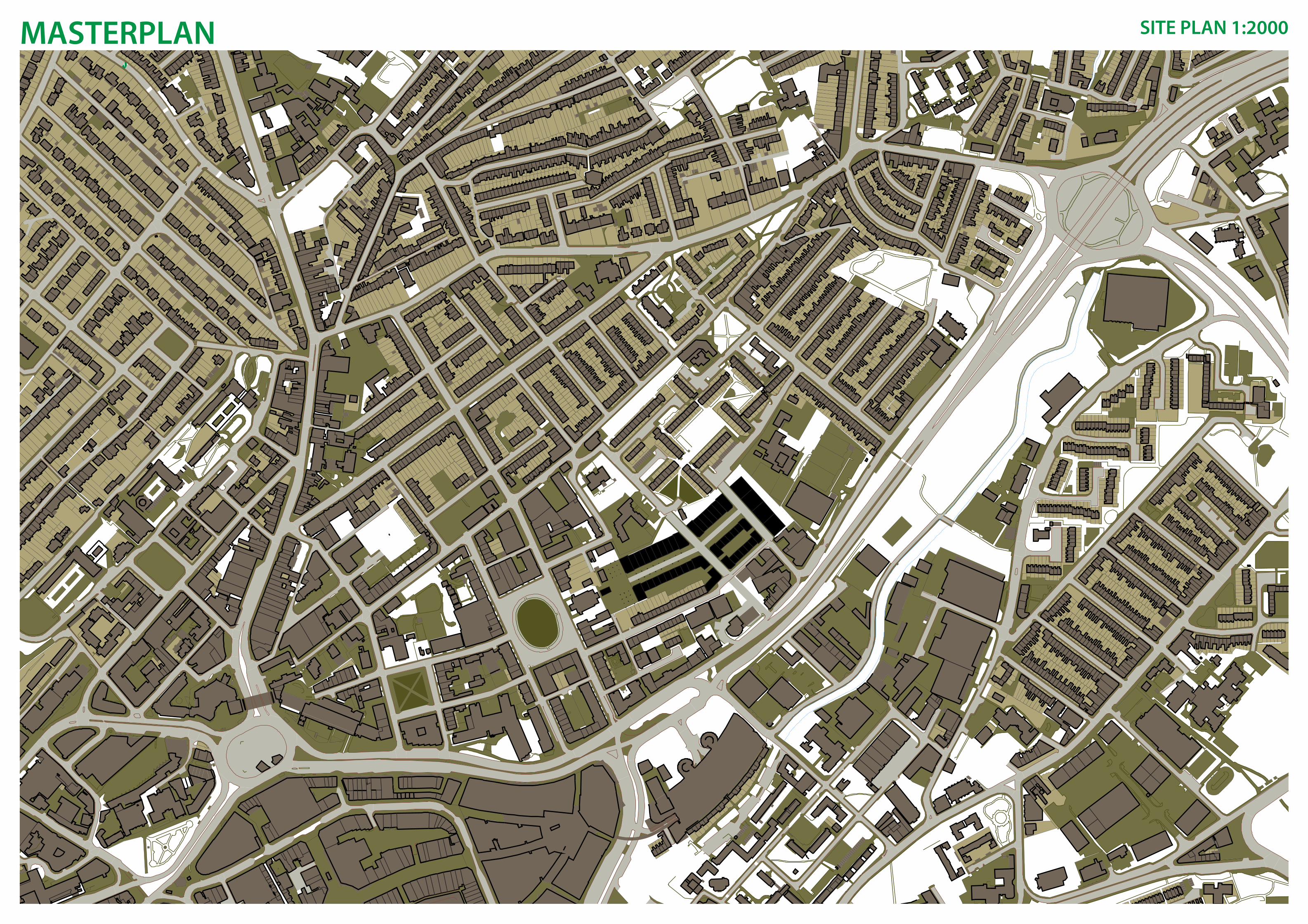
1:2000 PLANMASTERPLAN SITE PLAN 1:2000
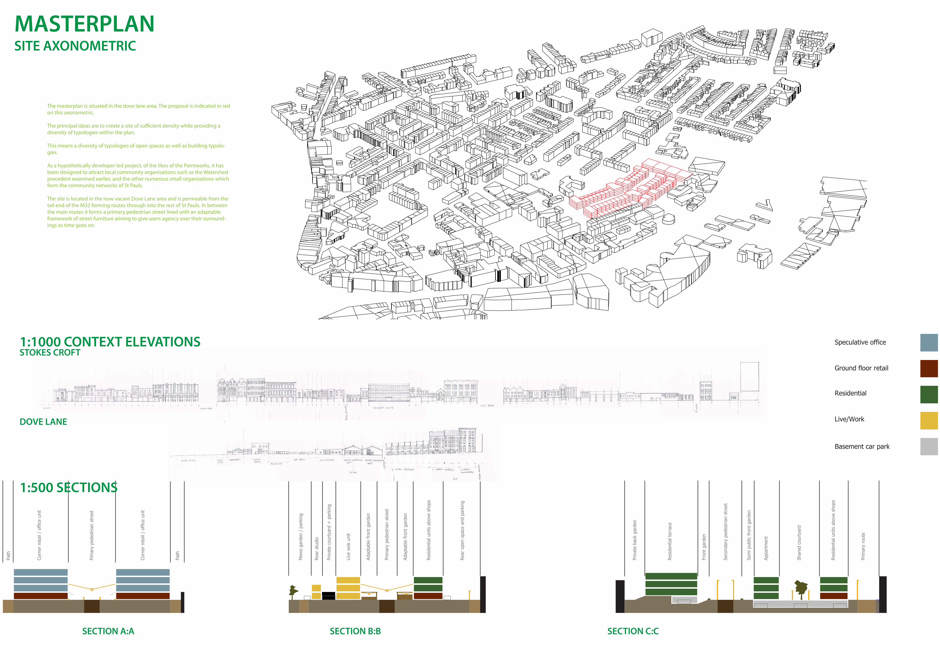
SITE AXONOMETRICMASTERPLAN
Ground floor retail
Speculative office
Residential
Live/Work
Basement car park
Path
Corn
er r
etai
l / o
ffic
e un
it
Pim
ary
pede
stria
n st
reet
Corn
er r
etai
l / o
ffic
e un
it
Path
Mew
s ga
rden
/ p
arki
ng
Rear
stu
dio
Priv
ate
cour
tyar
d +
par
king
Live
wok
uni
t
Adap
tabl
e fr
ont
gard
en
Prim
ary
pede
stria
n st
reet
Adap
tabl
e fr
ont
gard
en
Resi
dent
ial u
nits
abo
ve s
hops
Rear
ope
n sp
ace
and
park
ing
Priv
ate
back
gar
den
Resi
dent
ial t
erra
ce
Fron
t ga
rden
Seco
ndar
y pe
dest
rian
stre
et
Sem
i pub
lic f
ront
gar
den
Appa
rtm
ent
Shar
ed c
ourt
yard
Resi
dent
ial u
nits
abo
ve s
hops
Prim
ary
rout
e
1:500 SECTIONS
1:1000 CONTEXT ELEVATIONS
SECTION A:A
STOKES CROFT
DOVE LANE
SECTION B:B SECTION C:C
The masterplan is situated in the dove lane area. The proposal is indicated in red on this axonometric.
The principal ideas are to create a site of sufficient density while providing a diversity of typologies within the plan.
This means a diversity of typologies of open spaces as well as building typolo-gies.
As a hypothetically developer led project, of the likes of the Paintworks, it has been designed to attract local community organisations such as the Watershed precedent examined earlier, and the other numerous small organisations which form the community networks of St Pauls.
The site is located in the now vacant Dove Lane area and is permeable from the tail end of the M32 forming routes through into the rest of St Pauls. In between the main routes it forms a primary pedestrian street lined with an adaptable framework of street furniture aiming to give users agency over their surround-ings as time goes on.
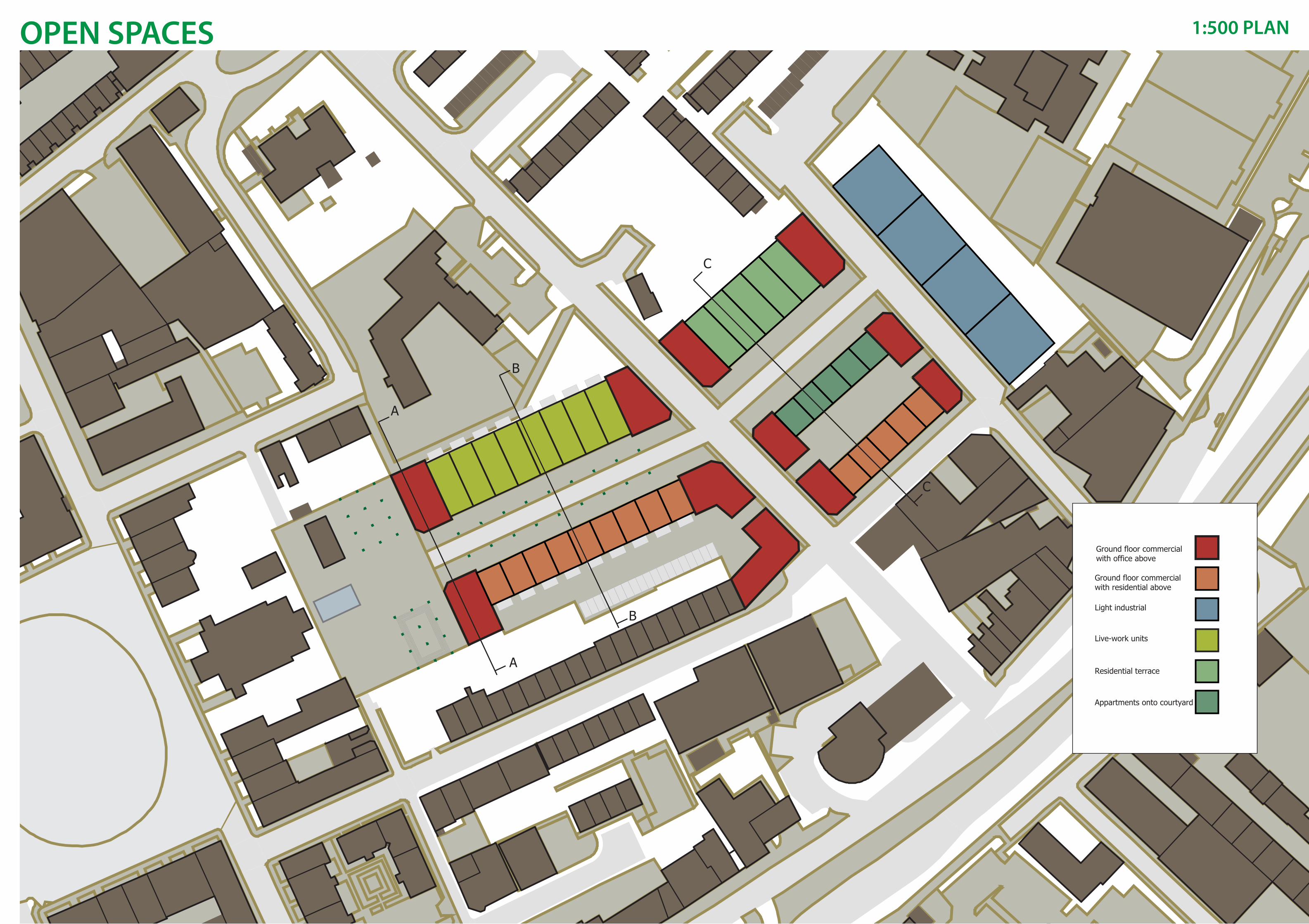
Ground floor commercialwith office above
A
A
B
B
C
C
Ground floor commercialwith residential above
Light industrial
Live-work units
Residential terrace
Appartments onto courtyard
1:500 PLANOPEN SPACES
1:200 PLAN
1:100 SECTION
1:100 PLAN
MAJOR OPEN SPACE VIEW MINOR OPEN SPACE VIEWOPEN SPACES
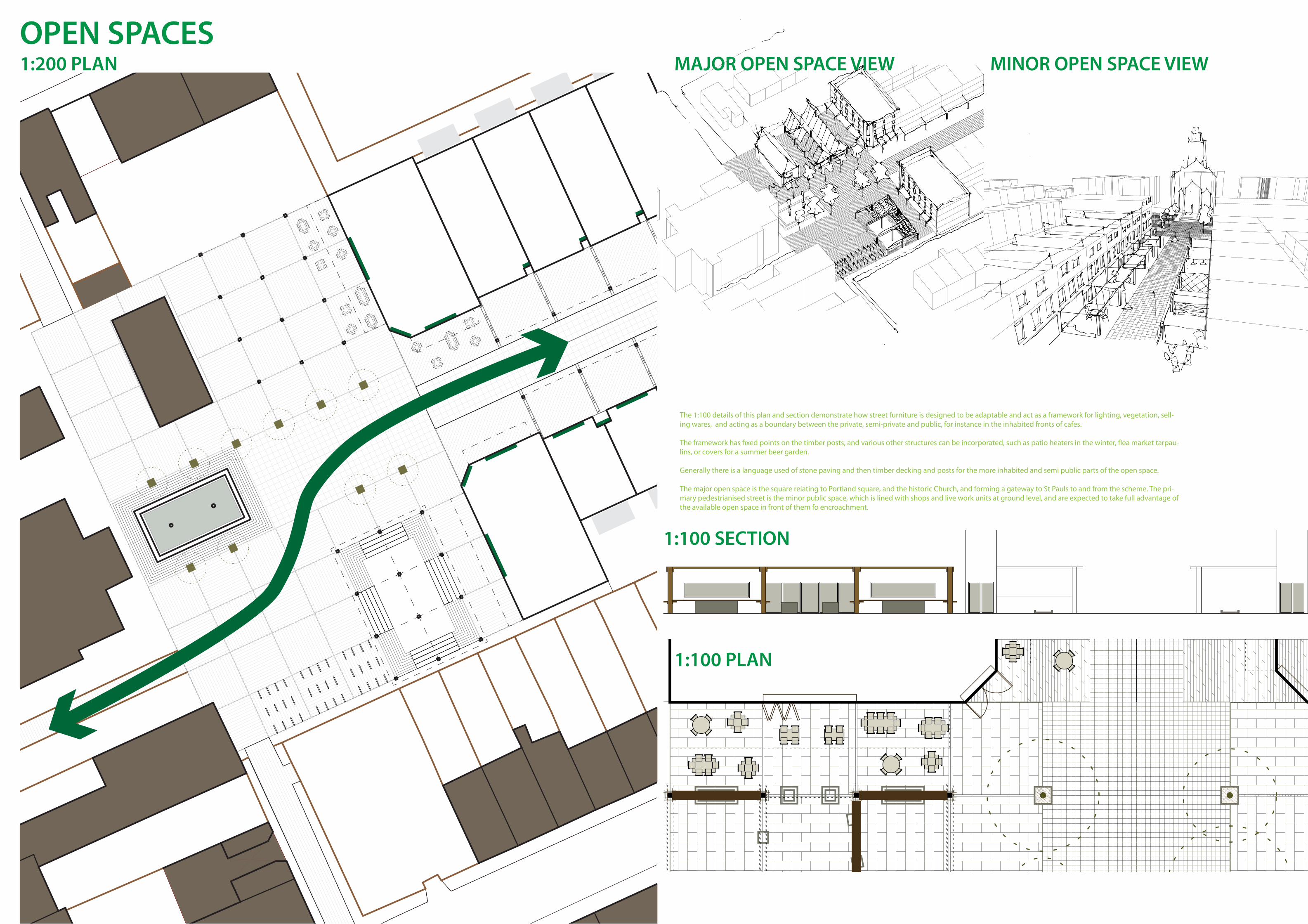
The 1:100 details of this plan and section demonstrate how street furniture is designed to be adaptable and act as a framework for lighting, vegetation, sell-ing wares, and acting as a boundary between the private, semi-private and public, for instance in the inhabited fronts of cafes.
The framework has fixed points on the timber posts, and various other structures can be incorporated, such as patio heaters in the winter, flea market tarpau-lins, or covers for a summer beer garden.
Generally there is a language used of stone paving and then timber decking and posts for the more inhabited and semi public parts of the open space.
The major open space is the square relating to Portland square, and the historic Church, and forming a gateway to St Pauls to and from the scheme. The pri-mary pedestrianised street is the minor public space, which is lined with shops and live work units at ground level, and are expected to take full advantage of the available open space in front of them fo encroachment.