mate mate mate mate mate mate mate mate mate ... - …€¦ · chapter 37 ugv navigation in ros...
TRANSCRIPT
The research leading to these results has received funding from the RoboCity2030-
III-CM project (Robótica aplicada a la mejora de la calidad de vida de los
ciudadanos. fase III; S2013/MIT-2748), funded by Programas de Actividades I+D
en la Comunidad de Madrid and cofunded by Structural Funds of the EU.
2016
R. F
erná
ndez
, H.
Mon
tes
Edited by:Roemi E. FernándezHéctor Montes
May 2016
MATE MATE MATE MATE MATE MATE MATE MATE MATE MATE MATE MATE MATE MATE MATE MATAE MATE MATE MATE MATE MATE MATE MATE

RoboCity16 Open Conference on
Future Trends in Robotics
Editors Roemi E. Fernández Saavedra Héctor Montes Franceschi
Madrid, 26 May 2016

Edited by: Consejo Superior de Investigaciones Científicas Printed by: AFERTA SG S.L. Legal Deposit: M-17804-2016 ISBN: 978-84-608-8452-1
CHAPTER 37
UGV NAVIGATION IN ROS USING LIDAR 3D
A. LÁZARO1, R. BAREA2, L.M. BERGASA3 and E. LOPEZ4
1Robesafe group, Universidad de Alcalá, 2Robesafe group, Universidad de Alcalá, 3Robesafe group, Universidad de Alcalá, 4Robesafe group, Univer-sidad de Alcalá, [email protected].
This paper addresses to give a step more forward the achievement of ro-bust Unmanned Ground Vehicles (UGVs), which can drive in urban envi-ronments. More specifically, it focuses in the management of a four wheeled vehicle in ROS using mainly the inputs provided by a LIDAR 3D. Simulations are carried out in ad-hoc scenarios designed and run using GAZEBO. The vehicle and the LIDAR sensor physical models have been added to the simulation environment in order to get a higher degree of real-ity. Navigation tests will be provided in the final version.
1 Introduction
Unmanned Ground Vehicles (UGVs) are becoming more and more used every single day. They can carry out lots of different tasks with no human supervision, achieving lower costs or working in areas where it would be dangerous for humans to work in. Those are the reasons why they are commonly used in industrial environments.
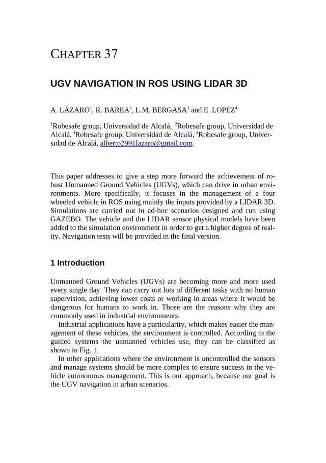
Industrial applications have a particularity, which makes easier the man-agement of these vehicles, the environment is controlled. According to the guided systems the unmanned vehicles use, they can be classified as shown in Fig. 1.
In other applications where the environment is uncontrolled the sensors and manage systems should be more complex to ensure success in the ve-hicle autonomous management. This is our approach, because our goal is the UGV navigation in urban scenarios.
302 Open Conference on Future Trends in Robotics
In this work, an UGV is managed through ROS using a LIDAR 3D sen-sor. This management is carried out in GAZEBO, a simulator where the needed models have been built.
Fig. 1: (1) Laser UGV (2) Magnetic UGV (3) Dual UGV
(4) Rail guided UGV (5) Optical band UGV.
The reason why GAZEBO world has been build is to create a virtual re-construction of real scenarios, where testing the perception and vehicle management systems. Virtual simulations are usually used in the first im-plementation steps of autonomous vehicles. It allows us to test the devel-oped systems as many times as needed in a safety way with reduced costs.
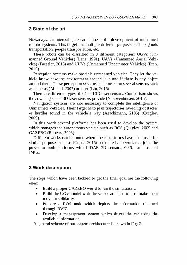
The sensor used to be mounted in the vehicle is the VLP-16 (Velodyne Lidar Puck). It creates a 360º 3D images using 16 laser/detector pairs mounted in a compact housing. The housing rapidly spins to scan the sur-rounding environment. The lasers fire thousands of times per second, providing a rich, 3D point cloud in real time. VLP-16 includes the following characteristics:
• Horizontal Field of View (FOV) of 360° • Rotational speed of 5-20 rotations per second (adjustable) • Vertical Field of View (FOV) of 30° • Returns of up to 100 meters (useful range depends on application)
UGV NAVIGATION IN ROS USING LIDAR 3D 303
2 State of the art
Nowadays, an interesting research line is the development of unmanned robotic systems. This target has multiple different purposes such as goods transportation, people transportation, etc.
These robots can be classified in 3 different categories: UGVs (Un-manned Ground Vehicles) (Lane, 1991), UAVs (Unmanned Aerial Vehi-cles) (Faessler, 2015) and UUVs (Unmanned Underwater Vehicles) (Eren, 2016).
Perception systems make possible unmanned vehicles. They let the ve-hicle know how the environment around it is and if there is any object around them. These perception systems can consist on several sensors such as cameras (Ahmed, 2007) or laser (Liu, 2015).
There are different types of 2D and 3D laser sensors. Comparison shows the advantages that 3D laser sensors provide (Nieuwenhuisen, 2015).
Navigation systems are also necessary to complete the intelligence of Unmanned Vehicles. Their target is to plan trajectories avoiding obstacles or hurdles found in the vehicle´s way (Aeschimann, 2105) (Quigley, 2009).
In this work several platforms has been used to develop the system which manages the autonomous vehicle such as ROS (Quigley, 2009 and GAZEBO (Roberts, 2003).
Different works can be found where these platforms have been used for similar purposes such as (Gupta, 2015) but there is no work that joins the power or both platforms with LIDAR 3D sensors, GPS, cameras and IMUs.
3 Work description
The steps which have been tackled to get the final goal are the following ones:
• Build a proper GAZEBO world to run the simulations.• Build the UGV model with the sensor attached to it to make them
move in solidarity.• Prepare a ROS node which depicts the information obtained
through RVIZ.• Develop a management system which drives the car using the
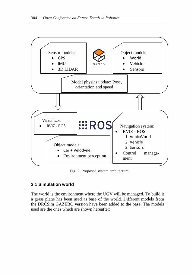
available information.A general scheme of our system architecture is shown in Fig. 2.
304 Open Conference on Future Trends in Robotics
Fig. 2: Proposed system architecture.
3.1 Simulation world
The world is the environment where the UGV will be managed. To build it a grass plane has been used as base of the world. Different models from the DRCSim GAZEBO version have been added to the base. The models used are the ones which are shown hereafter:
Sensor models: • GPS • IMU • 3D LIDAR
Object models • World • Vehicle • Sensors
Model physics update: Pose, orientation and speed
Visualizer: • RVIZ - ROS Navigation system:
• RVIZ - ROS 1. VehicWorld 2. Vehicle 3. Sensors
• Control manage-ment
Object models: • Car + Velodyne • Environment perception
UGV NAVIGATION IN ROS USING LIDAR 3D 305
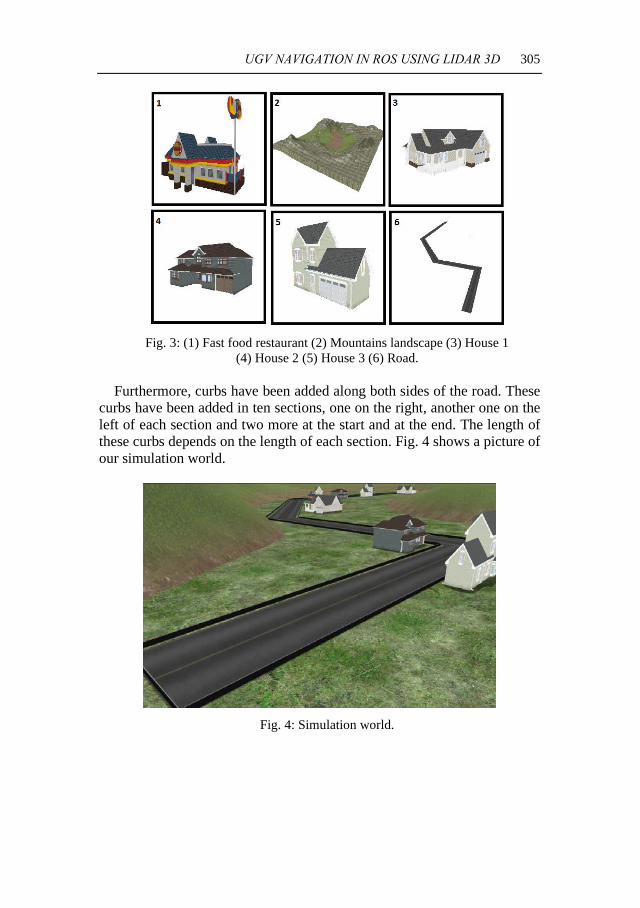
Fig. 3: (1) Fast food restaurant (2) Mountains landscape (3) House 1 (4) House 2 (5) House 3 (6) Road.
Furthermore, curbs have been added along both sides of the road. These
curbs have been added in ten sections, one on the right, another one on the left of each section and two more at the start and at the end. The length of these curbs depends on the length of each section. Fig. 4 shows a picture of our simulation world.
Fig. 4: Simulation world.
306 Open Conference on Future Trends in Robotics
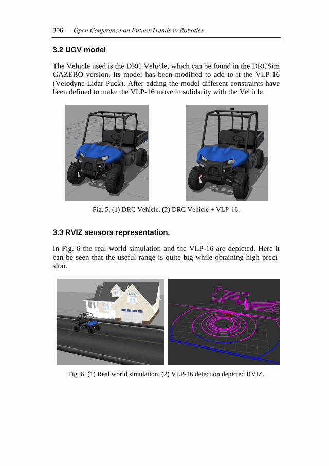
3.2 UGV model
The Vehicle used is the DRC Vehicle, which can be found in the DRCSim GAZEBO version. Its model has been modified to add to it the VLP-16 (Velodyne Lidar Puck). After adding the model different constraints have been defined to make the VLP-16 move in solidarity with the Vehicle.
Fig. 5. (1) DRC Vehicle. (2) DRC Vehicle + VLP-16.
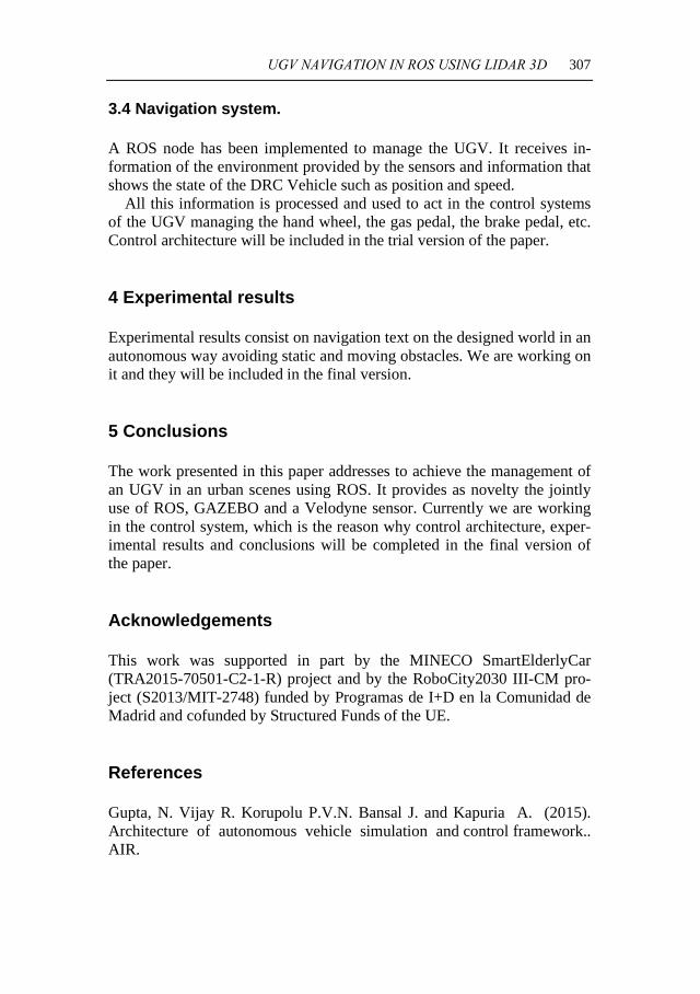
3.3 RVIZ sensors representation.
In Fig. 6 the real world simulation and the VLP-16 are depicted. Here it can be seen that the useful range is quite big while obtaining high preci-sion.
Fig. 6. (1) Real world simulation. (2) VLP-16 detection depicted RVIZ.
UGV NAVIGATION IN ROS USING LIDAR 3D 307
3.4 Navigation system.
A ROS node has been implemented to manage the UGV. It receives in-formation of the environment provided by the sensors and information that shows the state of the DRC Vehicle such as position and speed.
All this information is processed and used to act in the control systems of the UGV managing the hand wheel, the gas pedal, the brake pedal, etc. Control architecture will be included in the trial version of the paper.
4 Experimental results
Experimental results consist on navigation text on the designed world in an autonomous way avoiding static and moving obstacles. We are working on it and they will be included in the final version.
5 Conclusions
The work presented in this paper addresses to achieve the management of an UGV in an urban scenes using ROS. It provides as novelty the jointly use of ROS, GAZEBO and a Velodyne sensor. Currently we are working in the control system, which is the reason why control architecture, exper-imental results and conclusions will be completed in the final version of the paper.
Acknowledgements
This work was supported in part by the MINECO SmartElderlyCar (TRA2015-70501-C2-1-R) project and by the RoboCity2030 III-CM pro-ject (S2013/MIT-2748) funded by Programas de I+D en la Comunidad de Madrid and cofunded by Structured Funds of the UE.
References
Gupta, N. Vijay R. Korupolu P.V.N. Bansal J. and Kapuria A. (2015). Architecture of autonomous vehicle simulation and control framework.. AIR.
308 Open Conference on Future Trends in Robotics
Lane G. R. Lescoe P. Cooper S. 1991. Unmanned Ground Vehicle control technology. Telesystems Conference, 1991. Proceedings. Vol.1., NTC '91., National. Aeschimann R. and Borges P. V. K. 2015. Ground or obstacles? Detecting clear paths in vehicle navigation. 2015 IEEE International Conference on Robotics and Automation (ICRA). Ahmed J. Shah M. Miller A. Harper D. and Jafri M.N. 2007. A Vision-Based System for a UGV to Handle a Road Intersection", AAAI Twenty-Second Conference on Artificial Intelligence. Nieuwenhuisen M. Droeschel D. Beul M. and Behnke S. 2014. Obstacle detection and navigation planning for autonomous micro aerial vehicles. Unmanned Aircraft Systems (ICUAS), 2014 International Conference on. Quigley, M. Conley, K. Gerkey B.P. Faust J. Foote T. Leibs J. Wheeler R. and Ng A.Y. 2009. ROS: an open-source Robot Operating System. In ICRA Workshop on Open Source Software . Eren F. Pe’eri S. Rzhanov Y. Thein W. M. and Celeikkol B. 2016. Optical Detector Array Design for Navigational Feedback Between Unmanned Underwater Vehicles (UUVs). IEEE Journal of Oceanic Engineering. Faessler, M., Fontana, F., Forster, C., Mueggler, E., Pizzoli, M. and Scar-amuzza, D. 2015, Autonomous, Vision-based Flight and Live Dense 3D Mapping with a Quadrotor Micro Aerial Vehicle. J. Field Robotics. doi: 10.1002/rob.21581 Liu S. Atia M.M. Karamat T.B. and Noureldin A. 2015. A LiDAR-Aided Indoor Navigation System for UGVs. Journal of Navigation. Roberts D. Wolff R. Otto O. and Steed A. 2003. Constructing a Gazebo: Supporting Teamwork in a Tightly Coupled, Distributed Task in Virtual Reality. Presence.
CHAPTER 38
PEDESTRIAN MOTION PREDICTION: A GRAPH BASED APPROACH
D. GARZÓN-RAMOS, M. GARZON and A. BARRIENTOS
Centro de Automática y Robótica UPM-CSIC, Calle José Gutiérrez Abas-cal, 2. 28006 Madrid, Spain, [email protected]
A novel pedestrian motion prediction technique is presented in this paper. Its main achievement regards to none previous observation, any knowledge of pedestrian trajectories nor the existence of possible destina-tions is required; hence making it useful for autonomous surveillance ap-plications. Prediction only requires initial position of the pedestrian and a 2D representation of the scenario as occupancy grid. First, it uses the Fast Marching Method (FMM) to calculate the pedestrian arrival time for each position in the map and then, the likelihood that the pedestrian reaches those positions is estimated. The technique has been tested with synthetic and real scenarios. In all cases, accurate probability maps as well as their representative graphs were obtained with low computational cost.
1 Introduction
Nowadays, the need of improving the surveillance and security systems in critical infrastructures has led to develop novel strategies that minimize se-curity weaknesses and provide solutions for responding efficiently and on-time to potential threats. In this sense, human motion prediction arises as a powerful tool to enhance the detection capabilities and reaction in possible presence or approximation of intruders to restricted or vulnerable loca-tions. For these reasons, in this paper a novel approach for pedestrian mo-tion prediction that can be used in any given scenario with the minimum requirements of situational information is presented.
Most of previous work on pedestrian motion prediction has been fo-cused on identifying motion patterns from previous observations, and then,