may 2012 - national environment commission | royal ... 2012 foreword in 1999, the national...
TRANSCRIPT
ENVIRONMENTAL ASSESSMENT GUIDELINE FOR HYDROPOWER PROJECTS
National Environment CommissionRoyal Government of Bhutan
May 2012
National Environment CommissionRoyal Government of Bhutan
P.O. Box 446, Thimphu : BhutanTele: 00975-2-323384/324323 Fax: 00975-2-323385
www.nec.gov.bt
Printed @ Phama Printers & Publishers
ENVIRONMENTAL ASSESSMENT GUIDELINE FOR HYDROPOWER PROJECTS
May 2012


Foreword In 1999, the National Environment Commission published six sectoral environmental assessment guidelines for the mining, roads, industries, hydropower, power transmission lines and forestry sectors. These guidelines were intended to guide different project proponents through the process of acquiring an environmental clearance for their projects. These sectoral guidelines were later revised in the year 2003 to make them more practical and relevant to the Bhutanese context and also to streamline with the provisions of the Environmental Assessment Act 2000 and its Regulation 2002. The revised sectoral guidelines of 2003 have played a very instrumental role in guiding the proponents and the sector agencies in the Environment Assessment (EA) process. However, these sectoral guidelines were long overdue for revision and through the World Bank IDF grant the guidelines were revisited and proposed for revision. All the relevant stakeholders were consulted several times for this revision and through the expert input from both local and international consultants the guidelines were revised to align with the changing government policies and rules and with the long-term objectives of protecting our pristine environment. The NEC is grateful to the World Bank for their financial assistance to revise and update these guidelines. The revision and updating of these guidelines were accomplished through close consultation with all the relevant stakeholders. We would also like to express our gratitude and appreciation to all the ministries and stakeholders for their active participation, support and inputs. The NEC would also like to thank the team from the Centre for Science and Environment, New Delhi for their hard work and inputs in updating these guidelines especially Mr. Chandra Bhushan, Mr. Sujit Kumar Singh and Ms. Swati Singh Syambal. We are confident that the revised guidelines will be more useful documents that facilitate and expedite the environmental clearance process. The environmental assessment process endeavors to mitigate and prevent undesirable impacts of developmental activities. It is in no way intended to hamper socio-economic development in Bhutan but to guide project proponents and sector agencies in making right investments in land, manpower, technology and mitigation measures to ensure that their projects have the least possible impacts on the environment. It’s the sincere wish and hopes of NEC that all the stakeholders’ make the best use of these guidelines, which in turn will help in protecting our fragile ecosystem. Sound implementation of these guidelines will go a long way in minimizing the negative impacts of developmental activities on Bhutan’s environment. Dr. Ugyen Tshewang Secretary, NEC


Contents
Chapter 1: Introduction to the hydropower sector ............................................................. 1
1.1. Background ..................................................................................................................... 1
1.2. Introduction to Environmental Impact Assessment (EIA) ....................................... 2
1.3. Generic steps in the EIA process ................................................................................. 2
1.4. Good practices in EIA ................................................................................................... 5
1.5. Environmental and socio-economic impacts of the hydropower projects ............. 7
Chapter 2: Scoping ................................................................................................................... 10
2.1 Introduction .................................................................................................................... 10
2.2 Terms of Reference (ToR) for a hydropower project .............................................. 10
2.2.1 General information ........................................................................................ 11
2.2.2 Essential maps for EA of hydropower projects........................................... 11
2.2.3 Project description .......................................................................................... 13
2.2.4 Activities for site preparation ........................................................................ 15
2.2.5 Impact assessment ........................................................................................... 16
2.2.6 Mitigation and Environmental Management Plan (EMP) ......................... 17
Chapter 3: Impact Assessment .............................................................................................. 19
3.1 Introduction .................................................................................................................... 19
3.2 Impact identification ..................................................................................................... 20
3.3 Impact prediction .......................................................................................................... 20
3.4 Impact evaluation .......................................................................................................... 23
Chapter 4: Mitigation and Environmental Management Plan (EMP) ....................... 24
4.1 Introduction .................................................................................................................... 24

4.2 Mitigation measures and EMP for the hydropower sector ...................................... 26
4.2.1 Catchment Area Treatment (CAT) Plan ...................................................... 26
4.2.2 Resettlement and Rehabilitation Plan ........................................................... 28
4.2.3 Muck disposal Plan ......................................................................................... 30
4.2.4 Compensatory Afforestation Plan ................................................................. 32
4.2.5 Environmental Flow Assessment (EFA)...................................................... 32
4.2.6 Dam Break Analysis and Disaster Management Plan ................................ 33
4.2.7 Biodiversity Conservation & Wildlife Management Plan ......................... 35
4.2.8 Greenbelt Development Plan ......................................................................... 36
4.2.9 Quarry Restoration Plan ................................................................................. 36
4.2.10 Fisheries Conservation & Management Plan .............................................. 36
4.2.11 Air quality and Noise Management Plan ..................................................... 37
4.2.12 Soil Conservation ............................................................................................ 38
4.2.13 Plan for Land Restoration and Landscaping ............................................... 38
4.2.14 Water Management Plan ................................................................................ 38
4.2.15 Reservoir Rim Treatment Plan ...................................................................... 39
4.2.16 Sanitation and Solid Waste Management Plan ........................................... 39
4.2.17 Public Health Delivery Plan/Human Health Management Plan ............... 39
4.2.18 Alternative fuel supply to workers ................................................................ 40
4.2.19 Local Area Development Plan....................................................................... 40
4.2.20 Environmental safeguard during construction ............................................ 40
4.2.21 Environmental Monitoring Programme ....................................................... 40
Chapter 5: Review of an EIA report for a hydropower project .................................. 41
5.1 Introduction .................................................................................................................... 41
5.2 Composition of the EA review team ........................................................................... 41
5.3 Reviewing an EIA report for a hydropower project ................................................. 42
List of Tables
List of Figures
Figure 1.1 Best Practices in EIA ............................................................................................. 6
List of Boxes
Box 1: Integration of EIA in the project cycle ........................................................................... 4
Box 2: Impact evaluation criteria ............................................................................................. 23
Box 3: Possible evaluation criteria for determining the impact significance ..................... 23
Box 4: Environmental Flow Assessment ................................................................................. 33
Forms / Checklists
1. Initial Environmental Examination (IEE Form)
2. Reviewer checklist for hydropower projects
Table 1.1 Impacts due to hydropower projects 7
Table 2.1 Environmental Management Plan for a hydropower project 18
Table 3.1 Parameters which determine impact characteristics 19
Table 3.2 General models/methods used for impact prediction 21
Table 4.1 Year wise target (physical) for Catchment Area Treatment Plan 27
Table 4.2 Recommended outline for R&R plan 29
Table 4.3 Muck Disposal Plan 31
Table 4.4 Mitigation for occupational health and safety 40

List of Abbreviations
BAP Biodiversity Action Plan CA Competent authority
CAT Catchment Area Treatment
CSE Centre for Science and Environment
CSR Corporate Social Responsibility
EA Environmental Assessment
EC Environmental Clearance
EIA Environmental Impact Assessment
EFA Environmental Flow Assessment
EMP Environment Management Plan
ETP Effluent Treatment Plant
FCC False Colour Composite
FDM Fugitive dust model
GIS Geographical Information Systems
GLOF Glacial Lake Outburst Flood
HAPs Habitat Action Plans MCE Maximum Credible Earthquake
MCF Maximum Credible Failure
MWL Maximum Water Level
NEC National Environment Commission
NEERI National Environmental Engineering Research Institute NOC No Objection certificate

PAP Project-affected population PM Particulate matter PPV Peak Particle Velocity R&R Resettlement and Rehabilitation Plan
RGoB Royal Government of Bhutan SAPs Species Action Plans STP Sewage Treatment Plant SYI Silt Yield Index
ToR Terms of Reference
NGO Non-governmental Organisation
CBO Community-based Organisation
USEPA United States Environmental Protection Agency
WHO World Health Organisation

1
CHAPTER 1
Introduction to the Hydropower sector 1.1 Background Hydropower is considered to be the only large scale energy alternative to the electricity produced from fossil fuels. It provides approximately one fifth of the electricity produced worldwide1
• Provide guidance and assistance to various stakeholders involved in the EA process.
. Bhutan has a total hydropower potential of 30,000 MW, but the country is still in the initial stages of developing its hydropower potential. Though, the hydropower sector provides major economic benefits to Bhutan, there are a number of associated adverse impacts, which harm the environment and socio-economic structure of the region. Hydropower projects in most countries today require an Environmental Impact Assessment (EIA) study before they are accorded environmental clearance. This holds true for Bhutan as well. It is regulated under the Environmental Assessment (EA) Act, 2000 and Regulation for Environmental Clearance of Projects 2002. The EA Act and its Regulation establishes procedures for the assessment of potential effects of strategic plans, policies, programs and projects on the environment, and for the determination of policies and measures to reduce potential adverse effects and to promote environmental benefits. According to the EA Act, Environmental Clearance (EC) is mandatory for any project/ activity that may have adverse impact(s) on the environment. The Regulation for Environmental Clearance of Projects 2002 defines responsibilities and procedures for the implementation of the EA Act concerning the issuance and enforcement of environmental clearance. According to the legal framework, the National Environmental Commission (NEC) is the nodal agency for administering and granting Environmental Clearance (EC).
The scope of the guideline is as follows:
• Assist the regulatory agency and EIA practitioners to understand the main areas of concern and use that understanding to enhance the quality of the EIA study and report.
• Inform the regulatory agency and EIA practitioners about the best environmental management practices in the hydropower sector.
• Assist the regulatory agency to better assess the EIA report and arrive at a sound decision.
1Key World Energy Statistics 2011, International Energy Agency

2
1.2 An Introduction to Environmental Impact Assessment (EIA)
According to the United Nations Environment Programme’s Division of Technology, Industry and Economics, an EIA is a tool used to identify the environmental, social and economic impacts of a project prior to decision-making. It aims to predict environmental impacts at an early stage in project planning and design, finding ways and means to reduce the adverse impacts, shaping projects to suit the local environment, and presenting options to decision-makers.
An EIA can bring about both environmental and economic benefits, such as reduction in costs and time taken for implementation and design of a project and lesser intervention of legalities and regulations. A properly conducted EIA lessens conflicts by promoting community participation, informs decision-makers, and helps lay the base for environmentally sound projects (See Box 1: Integration of EIA in the project cycle). 1.3 Generic steps in the EIA process
The EIA process comprises of six key steps:
i. Screening: This first step helps decide whether an EIA is required for a project. An appropriately designed screening system can prove to be an effective tool to prevent the squandering of time and money on assessing projects with insignificant environmental impacts.
ii. Scoping: Scoping is considered the backbone of an EIA process, and is ideally undertaken at the project planning stage. The main objective of the scoping process is to establish the environmental and social priorities, set the boundaries for the study and define the Terms of Reference (ToR). Systematic and well planned scoping forms the basis of an effective and efficient EIA process. It also helps avoid unfocused and voluminous reports. Ideally, the role of scoping is to determine three key issues: a) Site alternatives b) Design alternatives c) Justifications for the project.
SCOPING HELPS FIND ANSWERS TO QUESTIONS LIKE:
• What are the issues to be addressed?
• How should one proceed with the EIA study?
• What is the extent of the analysis needed?
• What is the infrastructure needed?
• What kind of people should be involved in the assessment?
3
iii. Baseline data generation: Baseline data provides a detailed description of the existing status of various environmental and social components in the study area. Both primary and secondary data is collected to describe this status.
iv. Impact assessment: In this step, the characteristics of potential impacts are identified, evaluated and predicted using the baseline information on one hand and the features of the project on the other (cause-effect relationship). Impact predictions are normally done by using common methodologies and models.
v. Mitigation of impacts: At this stage, the possible preventive, remedial and compensatory measures for each adverse impact are determined and recommended.
vi. Environmental Management Plan: An environmental management plan (EMP), also referred to as an impact management plan, is usually prepared as part of the EIA reporting process. It translates recommended mitigation and monitoring measures into specific actions that have to be carried out by the proponent. Depending upon specific requirements, the plan may be included in the EIA report or can be prepared as a separate document.
4
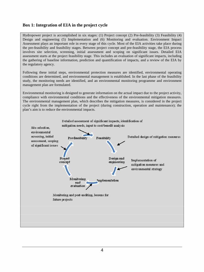
Box 1: Integration of EIA in the project cycle Hydropower project is accomplished in six stages: (1) Project concept (2) Pre-feasibility (3) Feasibility (4) Design and engineering (5) Implementation and (6) Monitoring and evaluation. Environment Impact Assessment plays an important role in every stage of this cycle. Most of the EIA activities take place during the pre-feasibility and feasibility stages. Between project concept and pre-feasibility stage, the EIA process involves site selection, screening, initial assessment and scoping on significant issues. Detailed EIA assessment starts at the project feasibility stage. This includes an evaluation of significant impacts, including the gathering of baseline information, prediction and quantification of impacts, and a review of the EIA by the regulatory agency.
Following these initial steps, environmental protection measures are identified, environmental operating conditions are determined, and environmental management is established. In the last phase of the feasibility study, the monitoring needs are identified, and an environmental monitoring programme and environment management plan are formulated.
Environmental monitoring is designed to generate information on the actual impact due to the project activity, compliance with environmental conditions and the effectiveness of the environmental mitigation measures. The environmental management plan, which describes the mitigation measures, is considered in the project cycle right from the implementation of the project (during construction, operation and maintenance); the plan’s aim is to reduce the environmental impacts.

5
1.4 Good practices in EIA An EIA should not be used just as a tool for obtaining an environmental clearance; rather, the project implementer should see it as a management tool for sound planning of the hydropower project. On the other hand, it should be the responsibility of NEC and the Competent Authorities to ensure that the project causes minimal environmental impacts and brings maximum social and economic benefits. The effectiveness of the EIA process depends on many guiding factors – these include:
• The extent and kind of legal support it is getting in the host countries • How the EIA is being conducted • The stakeholders involvement at different stages • The quality of the EIA report • Accreditation status of consultants who prepare the EIA report • Composition and skills of the review committee
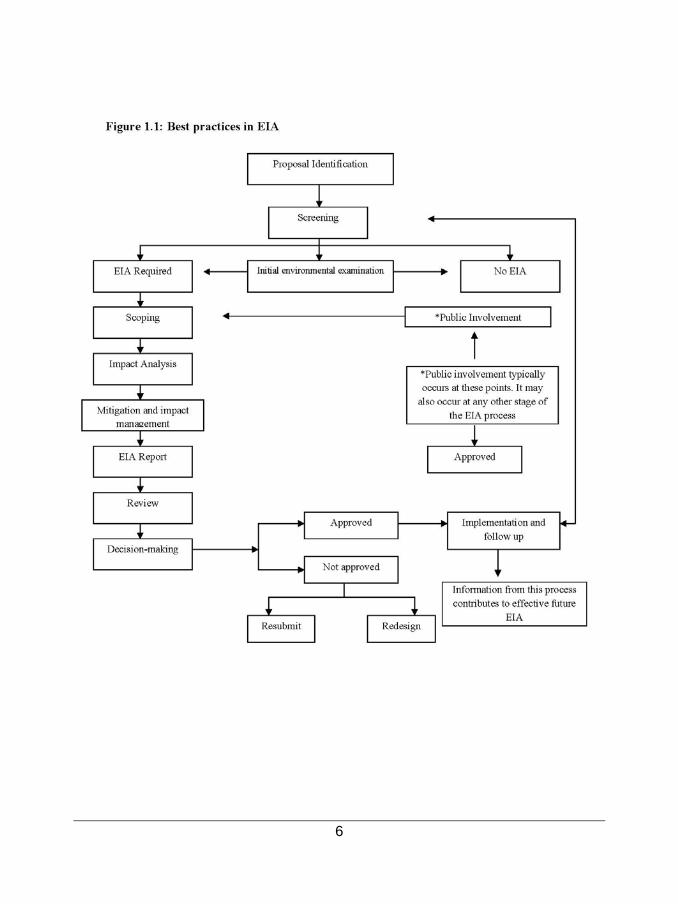
As a good practice, it is always recommended to conduct an Initial Environmental Examination (IEE) of the project to determine if it requires an EIA or not. It is also advisable to involve the public from the very beginning from scoping process to the review of the EIA report (See Figure 1.1: Best Practices in EIA).It is also recommended to consider the size, scale, site sensitivity and pollution potential while deciding the study area, duration and scope of the EA study. Best practices in the EA process include preparing a report which is comprehensive and focused, and contains only the significant parameters instead of data and information which are irrelevant to the overall assessment of the project. The extent of the assessment required should be decided after careful examination of impacts on the environmental and existing socio-economic settings at the project site.
6

7
1.5 Environmental and socio-economic impacts of hydropower projects Hydropower projects are large scale construction projects which involve land clearing, tunnelling, diverting of river course, diversion of forest, altering the hydrological regime etc. These activities change the entire environmental regime of the project area. The range of adverse environmental and social impacts that can result from hydropower projects is remarkably diverse and complex. The nature and magnitude of these impacts vary from one project to another depending on the site sensitivity and project scale. Auxiliary construction activities and induced development due to the presence of the project also cause additional pressure on the local environment. The table below lists the environmental and socio-economic impacts that are likely to be caused due to hydropower projects: Table 1.1: Impacts due to hydropower projects Aspects of Environment Impacts A. Land Environment Construction phase • Change in land use patterns.
• Loss of properties (movable and immovable). • Generation of waste (muck): Muck leads to adverse impacts on the land,
water, air environment, vegetation and health of people. • Reservoir impoundment. • Induces land-slides. • Impact on soil due to (i) loss of topsoil, (ii) failure to refill and re-vegetate
borrow areas and temporarily used land, (iii) erosion, (iv) soil contamination/pollution by raw materials used for the project construction, and (v) failure to re-utilize displaced earth during the construction period.
• Generation of solid waste from labour camps/colonies and construction sites.
Operation phase • River fragmentation: The flooding of the reservoir obstructs the free-flowing nature of the river. Diversion of the river into tunnels leads to dry stretches of the river in the downstream.
• Reduction in the flood plain area. • Downstream erosion: Reservoir sedimentation reduces the sediment and
nutrition load of the river. This leads to increased soil erosion in downstream and damages the biological and economic productivity of the river.
• Reservoir triggered seismicity/earthquake: The large amount of water that is impounded alters the pressure on the geological structure of the earth below. This may trigger earthquakes.
• Land contamination due to the release of chemical waste, sanitary waste, oil and hazardous waste from induced development near the project area.
B. Water resources & water quality Construction phase • Loss of natural springs due to tunneling activtiy
• Increased turbidity in the downstream due to muck disposal and infrastructure development in the dam area like road building, labour camp, etc.
• Run off from crushed and ground rock material from the drilling, blasting

8
and stone crushing plant (quarry) pollute the water bodies. • Oil and chemical spills from workshop and release of chemical wastes lead
to water pollution. • Sanitary effluent from the labour camp is a major concern which affects the
water quality. Operation phase • Reservoir sedimentation over a period of time reduces the live storage and
the power generation. • Eutrophication risks. • Modification of the hydrologic regime of the river. • Decrease in dissolved oxygen levels thereby impacting the aquatic life. • Thermal stratification of the reservoir
C. Biodiversity: Aquatic and Terrestrial ecology Construction and Operation phase
• Due to flow regulation, the riverine ecology gets degraded in the upstream and downstream regions of the project.
• The damming of the river leads to loss of aquatic habitat and also loss of spawning and breeding areas.
• The decreased dissolved oxygen in the reservoir and eutrophication of the reservoir decreases the fish productivity and fisheries yield.
• Adverse impacts on flora and fauna due to increased accessibility in the area and increased level of human interferences.
• Loss of economically/ genetically/ biologically important plant species. • Loss of forest cover. • Impacts on wildlife habitats and corridors due to acquisition of forest and
other categories of land for various project appurtenances. • Migration of workers leads to increase in pressure on the local resources
such as fuel wood, drinking water etc. • The change in hydrological regime downstream of the dam leads to
destabilization of the hilly terrain vegetation. The loss of flood plains downstream leads to loss of agricultural lands and grazing lands.
D. Socio-Economic Aspects Construction phase • Involuntary displacement and loss of livelihood.
• Loss of community properties. • Pressure on existing infrastructure facilities like hospitals, shops, schools
etc. • Cultural conflicts. • The flooding of the impoundment zone behind a hydropower dam may
results in the irreversible disappearance, fragmentation or dislocation of existing human settlements and infrastructure. It also leads to the loss through submergence or fragmentation of riverine agricultural land, vegetation and alluvia, forests and wildlife areas, mineral resources, historic, cultural and religious resources, and scenic areas.
• Impacts on vulnerable minority groups, tribals and indigenous people. • Impacts on human-heritage and cultural landscapes.
Operation phase • Reduced fish catch may result in loss of livelihoods • The damming of a river can also obstruct the traditional mechanisms of
transportation like mountain passes and bridges across rivers. Log driving may also be affected due to changes in the water resource regime.
• Class or Gender Related Impacts: The change in the economy and in the society near the project area changes the employment and livelihood
9
scenario. This may create class based differences and also gender related issues. The dispossessed small land holders often become farm workers dependant on seasonal wages.
• Impacts on Community Traditions and Ways-of-Life: Improved access to the outside world can lead to a loosening of social bonds and solidarity within the community, and to increased risks of competition or conflicts with outsiders for available resources.
E. Air Pollution Construction and Operation Phase
• Fugitive emissions and increased dust levels from construction machinery, vehicular movement, tunnel construction, rock blasting, quarry sites, foundation excavation, cement mixing, and road construction. The construction activities will generate airborne dust as well as NOx, SOx and particulate matter.
• Impacts due to emissions from Diesel Generator (DG) set • Induced development activities due to the hydropower project leads to
overall degradation of the air quality.
F. Noise Pollution Construction and Operation Phase
• During construction, noise is generated from vehicular movements, sand and aggregate processing, concrete mixing, excavation, machinery, construction noise and blasting.
• Noise due to increased vehicular movement, operation of DG set and other construction equipment
• During operation, noise will mainly be generated from the power station.
G. Public Health Construction Phase • Increased incidence of water related diseases.
• Transmission of diseases by immigrant labour population. • Risk and accidents: Workers on hydropower project sites are exposed to
various hazardous situations, operate heavy machinery and other potentially dangerous equipment.
Operation phase • Increased incidence of vector borne diseases • Spread of new diseases due to migration of population and workers • Land-slide prone areas on the banks of reservoir also poses a threat. • Risk of Dam failure and catastrophic floods.

10
CHAPTER 2 Scoping 2.1 Introduction The primary function of scoping also referred to as setting the Terms of Reference (ToR) of an Environmental Assessment (EA), is to establish the environmental priorities and set the boundaries for the study. The objective of the ToR is to make the assessment process concise and focused, and avoid creating a voluminous or data deficient report. The ToR provides the benchmark for data collection and limits the possibility of inefficiency in the EA process. It also acts as a benchmark to be used by the appraisal committee to decide whether the EIA report has been compiled after meeting all the requirements or not. There are various tools that can be used for scoping, such as questionnaire checklists, network method, comparison with other similar projects, matrix and ad-hoc methods, etc. The selection of scoping tools largely depends on the size of the project and the existing environmental and social characteristics of the project area. The ToR given below is a generic one and can be framed as per the project requirements. While framing the ToR, ground realities, background information of the study area(such as population in and around the project site), applicable laws, rules, policies and guidelines and project-specific peculiarities need to be added to make it relevant and realistic. Site visit is also recommended before framing the ToR; this enhances the scope of the EA process and makes it more efficient. 2.2 Terms of Reference (TOR) for a hydropower project For assessment of environmental and socio-economic impacts, the study area should be clearly defined. The study area should include the following:
• Catchment Area • Submergence Area • Project Area - to be acquired for various appurtenant works - area within 10 km from
main project components (i.e. reservoir boundary, dam/barrage/diversion structure, power house etc). The extent of the project area can be modified as deemed fit by NEC, based on the sensitivity of the project.
• Downstream of the dam site (to assess impacts of reduced flow). In case of cascade development, the downstream environmental and socio-economic impacts should be evaluated to the dam site of the next downstream project.
The ToR of a hydropower project should include the following:
11
2.2.1 General information
• Consistency with Power System Master Plans: The hydropower project applicants must indicate whether the proposed project has been identified in the Power System Master Plan or not, and if so, what rank the project holds in the plan.
• Assessment of alternatives: An assessment of project alternatives with respect
to the location, technical design, dam height, displacement and other environmental and social components.
• Executive summary of the project which summarises the project characteristics, environmental and social issues, and the proposed mitigation measures.
• Information about the project proponent and his/her experience in hydropower projects.
• The financial statement including the project cost, funding source and activity schedule for the project.
• Name of the organization/consulting firm preparing the EIA report, and
qualifications and experience of experts involved in the EA/EMP preparation. • List of all regulatory approvals and No Objection certificate (NOC) required for
the project and the status of these approvals. • Project benefits: The local, regional and national benefits of the project should be
explained.
2.2.2 Essential maps for EA of hydropower projects
• A map (1:50,000) specifying the location of the project and the study area.
• An area map (1:50,000) specifying the (a) total catchment area, (b) directly draining catchment area, (c) submergence area, (d) project area to be acquired for various appurtenant works area within 10 km from main project components (i.e. dam/barrage/diversion structure, reservoir boundary, power house etc.).
• A map (1:10,000) showing the land use pattern of the a) directly draining catchment area, b) submergence area, c) project area to be acquired for various appurtenant works area within 10 km from main project components (i.e. dam/barrage/diversion structure, reservoir boundary, power house etc.).

12
• A map (1:10,000) showing locations of human settlements and major constructions including roads and major industries/mines.
• To examine the cascading effect (if applicable), a clear map (1:50,000) showing the approved/under construction/completed hydropower projects on the both upstream and downstream to the proposed project.
• A drainage map (1:50,000) of the directly draining catchment up to the project site showing the submergence area.
• Soil map (1:50,000) of the study area showing different regions and soil characteristics.
• Geological map (1:250,000) and seismo-tectonic map (1:1,000,000) of the study area
• Map (1:10,000) showing active landslide zones, unstable areas and areas vulnerable to landslides due to the project.
• Remote sensing/ Geographical Information Systems (GIS) should be used to develop the land use/land cover pattern of the study area. False colour composite (FCC) generated from satellite data of study area should be presented.
• A map (1:10,000) specifying the forest cover in the upstream and downstream area, and marking the presence of migratory corridors, occurrence of any endangered/threatened flora and fauna species and/or plants and animals of economic/ecological importance.
• A map (1:50,000) clearly showing the locations of various monitoring stations (for ambient air, water, noise and soil).
• A map (1:25,000) specifying the areas vulnerable to floods.
• Demarcation of snow fed and rain fed areas (1:10,000) for a realistic estimate of
the water availability.
• Map (1:10,000) showing the number of villages (with population) getting affected due to the project.
Note: Depending upon the type, size and location sensitivity, NEC can decide the study area and recommend appropriate scale for Environmental Assessment.
13
2.2.3 Project description The essential project related information is:
• Location of project: a. Dzonkhag(s) b. Geog(s) c. Village(s) d. Geographical coordinates for location of dam e. Geographical coordinates for location of powerhouse f. Accessibility
• Catchment area characteristics a. Name of river and major tributaries. b. Overall description of the catchment area. c. Total catchment area in km² including the catchment area at the dam. d. Rivers mean annual flow at project site in Mm³ (MCM). e. Maximum mean monthly flow at project site in Mm³ (MCM). f. Minimum mean monthly flow at project site in Mm³ (MCM). g. Probable maximum flood in Mm³ (MCM). h. Headworks/spillway design flood in Mm³ (MCM). i. Minimum flow of river in m³/sec. j. Minimum dry season flow from side streams/rivers in the de-watered stretch.
• Type of project
a. Simple run-off-river. b. Reservoir run-off-river. c. Seasonal storage. d. Pumped storage. e. With or without an inter-basin diversion. f. Location of power house in relation to dam. g. Installed capacity in megawatts. h. Energy generation.
• Engineering characteristics
a. Type of dam. b. Dam height in meters. c. Dam length in meters. d. Power house type. e. Type of turbine(s). f. Flow through turbine(s). g. Tunnel length in km.

14
h. Tunnel diameter in meters. i. Total length of access roads in kilometers. j. Surge shaft top and its location
• Reservoir characteristics
a. Reservoir area in hectares. b. Reservoir length in km. c. Reservoir volume in Mm³. d. Reservoir live storage in Mm³. e. Reservoir dead storage in Mm³. f. Dead storage available for sediments above intake in Mm³. g. Reservoir draw-down height.
• Permanent infrastructure for power generation:
a. Main dam b. Bottom outlet c. Secondary dams and dykes d. Intake e. Spillway f. De-sander, De-siltation tanks g. Tunnel h. Surge tank i. Valve house j. Penstock k. Power house l. Switchyard m. Tailrace and Headrace tunnels n. Re-regulation weir o. Permanent access roads p. Offices and residential areas q. Reservoir r. Adits
• Construction phase
a. The location, area and accommodation details of the camp and office areas b. Temporary access roads c. Size, number, location and the capacity of the burrow pits and quarry sites to
be used for construction purpose d. Spoil areas (in hectares)
15
• Operational phase a. Reservoir filling b. Reservoir operation c. Downstream hydrology and water quality below intake point d. Downstream hydrology and water quality below tailrace e. Downstream hydrology and water quality below re-regulation weir
2.2.4 Activities for site preparation
The EIA report should discuss environmental and socio-economic issues particular to the project area/study area. Also, there should be a mention of site specific sensitive receptors wherever applicable. The following activities should be conducted for the site preparation for a hydropower project:
• Detailed description and distance of forest areas, mineral bearing sites, fossil bearing sites (if applicable), places of worship, sanctuaries and corridors, national parks, archaeological sites, and sites of religious importance from the project site.
• The past records of landslides occurrence in the region should be scrutinized and
information such as past events of landslides, area affected, frequency of occurrence per decade, geomorphologic conditions and degree of susceptibility to mass movement should be provided.
• The data related to the frequency of floods, its location and maximum flood
levels should be collected and presented in the EIA report. • The resource requirement (cement, aggregates, steel etc.), its sourcing, storage
areas, mode of transportation and construction schedule should be presented in the EIA report.
• Detailed description of the seismic character of the study area should be included.
A site specific study of the earthquake parameters should be done. Proper design of the dam must be ensured by implementing appropriate load factors and design considerations. The design must incorporate the Maximum Credible Earthquake (MCE) condition and the risk of reservoir induced seismicity.
• The possibility of a Glacial Lake Outburst Flood (GLOF) must be evaluated and
necessary mitigation measures must be specified. The source of the GLOF must also be identified.

16
• A detailed geotechnical survey of the reservoir rim area should be conducted and all the landslide/landslip zones around the reservoir periphery (up to Maximum Water Level-MWL) should be identified.
• Loss of forest-based economy in terms of revenue (Bhutanese ngultrum BTN
/acre), if any. • The carbon capturing potential of the forest land to be diverted or submerged, if
applicable.
2.2.5 Impact assessment Impact Assessment due to the project on the following mentioned components should be carried out for construction and operation phases using qualitative or quantitative methods. The section of impact assessment has been discussed in detail in Chapter 3(Impact Assessment) of this guideline.
• Land Environment
i. Changes in land use/land cover and drainage pattern. This should include drainage of the command area in detail.
ii. Immigration of labour population. iii. Impact of muck disposal on water bodies iv. Changes in land quality including effects of waste disposal. v. Riverbank and their stability.
vi. Impact due to submergence and diversion of the river course vii. Impact of the workforce on the local resources
viii. Impact due to induced infrastructure development (if applicable) • Biological Environment
i. Impact on forests, flora, fauna including wildlife, migratory avi-fauna, rare threatened and endangered species, medicinal plants etc.
ii. Pressure on existing natural resources. iii. Deforestation and disturbance to wildlife, habitat fragmentation and wild
animals’ migratory corridors. iv. Changes in aquatic ecosystem. v. Impact on fish migration and habitat degradation due to decreased flow of
water, if applicable. vi. Impact on breeding and nesting grounds of animals and fish, if applicable.
17
• Socio-economic Aspects
i. Impact of land acquisition. ii. Impact on local economy.
iii. Impact on human health. iv. Impact due to increase in traffic. v. Impact on vulnerable groups.
vi. Impact on holy places and tourism. • Water Environment
i. Changes in surface and ground water quality due to construction activities and induced development
ii. Impact due to the reduced flow in the diverted stretch iii. Changes in the hydraulic regime and down stream flow. iv. Impact on the ground water springs, lakes, water bodies etc
• Air Environment and Noise
i. Changes in ambient and ground level concentrations due to total emissions from point, line and area sources.
ii. Impact of emissions from DG sets used for power during the construction on air environment.
iii. Impact on human health due to changes in air quality. iv. Changes in ambient levels due to noise generated from equipment, blasting
operations and movement of vehicles. 2.2.6 Mitigation and Environmental Management Plan (EMP) The EMP should discuss the mitigation measures to be taken against each impact, the timeline for completion, the responsible departments for implementation, the plan budget, post-monitoring provisions and the process of reporting to the concerned regulatory authority. Environmental management plans for hydropower project is discussed in detail in Chapter 4 (Mitigation and Environmental Management Plan (EMP). The following EMPs should be included in an EIA report of a hydropower project:

18
Table 2.1: Environmental Management Plan for a hydropower project: 1. Catchment Area
Treatment (CAT) Plan
2. Resettlement and Rehabilitation Plan 3. Muck Disposal Plan
4. Compensatory Afforestation Plan
5. Environmental Flow Assessment
6. Dam Break Analysis and Disaster Management Plan
7. Biodiversity Conservation & Wildlife Management Plan
8. Green Belt Development Plan
9. Quarry Restoration Plan
10. Fisheries Conservation & Management Plan
11. Air Quality & Noise Management plan
12. Labour Management Plan/Fuel Supply
13. Plan for Land Restoration and Landscaping
14. Water Management Plan
15. Reservoir Rim Treatment Plan
16. Sanitation and Solid Waste Management Plan
17. Public Health Delivery Plan/Human Health Management Plan
18. Local Area Development Plan
19. Environmental Safeguards during construction
20. Indigenous communities Development plan
21. Environmental Monitoring Programme
22. Others

19
CHAPTER 3
Impact Assessment 3.1 Introduction
The scientific and technical reliability of an EA study depends on the skills of the EA practitioners/reviewers, who estimate and review the nature and magnitude of the environmental change that the proposed project may entail. Impact prediction and evaluation is a vital exercise for assessing impacts, deciding alternatives, setting down mitigation measures and developing an environmental management plan. Predicting the magnitude of impacts and evaluating their significance is the core exercise of impact assessment. This process is also known as impact analysis and can be broadly broken down into three overlapping phases:
• Identification: To specify the impacts associated with each phase of the project and the activities undertaken
• Prediction: To forecast the nature, magnitude, extent and duration of the main impacts; and
• Evaluation: To determine the significance of residual impacts after taking into account how mitigation will reduce a predicted impact.
In assessing environmental impacts and their significance, some key concerns have to be kept in mind:
• Identity who or what is affected • Description of how they are affected • Evaluation against a set of consistent assessment criteria
Normally, in impact assessment, potential impacts can be categorized into various parameters ranging from its type and nature to magnitude and reversibility, each signifying its importance in impact prediction and decision making (See Table 3.1: Parameters which determine impact characteristics). Table 3.1 Parameters which determine impact characteristics Parameters Description Type Positive or negative Nature Direct, indirect, cumulative Magnitude or severity Low, moderate, high Timing Short term, long term, intermittent, continuous Duration Temporary/permanent Reversibility Reversible/irreversible Significance Local, regional or global

20
Source: EIA Training Resource Manual, Second Edition 2002, United Nations Environment Programme (UNEP), p 263 Hydropower projects have several environmental impacts, which have already been discussed in Section 1.5(Environmental and socio-economic impacts of hydropower projects). Many of the environmental and social repercussions of a hydropower project can be managed by selecting an appropriate site at the planning stage.. There are also some socio-economic and cultural impacts, which local communities feel most acutely in their everyday lives. It is, therefore, necessary that these impacts are given the prominence they deserve in the EA study, while describing the changes expected to result from major development projects. A consideration of socio-economic and cultural impacts should be integrated, wherever possible, into every discussion of physical and biological changes and not just treated separately as a minor issue. 3.2 Impact identification In the EA of a hydropower project, the potential impacts are globally well documented, and do not normally require extensive impact identification. These impacts have been listed in Table 1.1: Impacts due to hydropower projects. However, there are some impacts such as displacement, loss of livelihoods, influence of topography and meteorology on water and air pollution, feasibility with respect to land use, geological characteristics, other sensitive receptors such as forest/biodiversity etc., which are site-specific and can only be identified once the data on them is available or generated. There are various tools that can be used for impact identification, such as questionnaires, checklists, network method, matrix and ad-hoc methods and comparison with other similar projects. To ensure effective impact identification, one should always opt for a simple, logical and systematic approach. As a good practice in EA, it is always recommended to consider all potential project impacts and their interactions. At the same time, it is important to ensure that indirect and cumulative effects which may be potentially significant are not unintentionally omitted. All the identified impacts may not require a detailed analysis and evaluation – the level of detailing should match the scale, sensitivity and complexity of the impact. The choice of the chosen methodologies should reflect these criteria. 3.3 Impact prediction Predictions of impacts are normally based on commonly used qualitative and quantitative methods and models. Expert judgment and comparison with similar projects can also be used for impact prediction. While there are a number of models for predicting impacts on physical environment (air, water and noise), modeling socio-economic and cultural impacts is difficult and is generally done through qualitative assessment or economic analysis. A model can be effective only if the input data is correctly inserted. The use of models, therefore, should be done with care and prudence considering factors like availability and reliability of data

21
The sophistication of the prediction methods to be used should be kept in proportion to the ‘scope’ of the EA. For instance, a complete mathematical model of atmospheric dispersion should not be used if only a small amount of relatively harmless pollutants is emitted. However, if the project has a very high air pollution potential, then all possible modeling exercises should be done to predict the impact on ambient air quality. All prediction techniques involve assumptions and uncertainties. While quantifying and stating an impact, these assumptions should be clearly identified. Also, uncertainty of prediction in terms of probability and the margins of error should be mentioned. Table 3.2 gives the list of general prediction models/methods used for assessing the impact of hydropower projects. Table 3.2: General models/methods used for impact prediction Impacts Assessment method/model Water resources: hydrological regime downstream the power house
Statistical indices, flow duration curves, hydrographs, design features of the power house/dam are used to determine the impact of the project on stream flow variability
Water resources: River fragmentation Calculation of the river length that is impounded upstream the project and the length of the river that is diverted downstream the project.
Water resources: Environmental Flow Assessment
More than 200 methods have been used worldwide to estimate the environmental flow. These are broadly categorized as hydrological, hydraulic rating, habitat simulation and holistic methods.
Water resources: Impact on ground water and springs
Measurement of groundwater levels and fluctuations through observation wells and piezometers.
Socio-economic: Social Impacts including Resettlement and Rehabilitation and Involuntary Displacement
• Cost-benefit analysis • Metaphors and analogies: Experience gained in similar kinds
of projects is used to predict the socio-economic impacts. • Extrapolative methods: Prediction based on the linear
extrapolation of current trends. • Normative methods: Desired socio-economic goals specified,
and an attempt made to project the social environment backwards in time to examine whether existing or planned resources and environmental programmes are adequate to meet the goals.
Geology including landslides The geomorphic, lithologic, structural and tectonic aspects of the basin; classification of the study area into different geotracts; preparation of Landslide Susceptibility Zonation map
Seismology Seismic zoning map; review of available historically recorded and monitored earthquakes; seismo tectonic models and reservoir induced seismicity; Deterministic Seismic Hazard Analysis (DSHA) to estimate the Maximum Considered Earthquake (MCE),
Dam Break Analysis DAMBRK for dam break modeling. Soil erosion Soil loss models such as revised universal soil loss equation
(RUSLE); Integration with GIS, ArcSWAT (Soil and Water Assessment Tool); prioritization of basins using Silt Yield Index (SYI)

22
Floods • Peak flow hydrograph for rainfall-runoff events in large river basins or small urban watersheds
• HEC-HMS • FLO-2D • TUFLOW
Biodiversity including aquatic and terrestrial ecology
Shannon Wiener Diversity index; Importance Value Index or IVI; quadrat method; Expert opinion;
Land use pattern including submergence and loss of natural cover
GIS and Remote sensing; Comparative valuation against structure and/or local plans
Noise • Dhwani: For prediction of impacts due to multiple noise sources, developed by NEERI, Nagpur, India
• SoundPLAN: Noise and air pollution planning and mapping software
Air quality Air dispersion models • ISCST 3 (appropriate for point, area and line sources;
applicable for flat or rolling terrains; requires source data, meteorological data and receptor data as inputs).
Note: ISCST 3 is a common model widely used in India for the air
pollution modeling • PTMAX (screening model applicable for a single point source;
computes maximum concentration and the distance of maximum concentration occurrence as a function of wind speed and stability class).
• PTDIS (screening model applicable for a single point source; computes maximum pollutant concentration and its occurrence for the prevailing meteorological conditions; requires average meteorological data (wind speed, temperature, stability class etc.); used mainly to see the possible impacts of a single source.
• Fugitive dust model (FDM) Potential risk and disaster • Risk assessment

23
3.4 Impact evaluation In impact evaluation, the predicted adverse impacts are judged for their significance. Therefore, the criteria for evaluating the significance of impacts and their effects should be set in advance (See Box 2: Impact evaluation criteria). The criteria for evaluating the significance should be based on local standards wherever possible. Where local standards are not available, acceptable international standards should be used (e.g. IFC, WHO or USEPA standards and guidelines of others countries, etc.). In all cases, the choice of the appropriate standard must be robust, defensible and relevant to the local situation. If there are no appropriate existing standards available, then the criteria should be developed and their use must be clearly explained in the EA. As a good practice in impact evaluation, it is better to use established procedures or guidelines, or relevant criteria which are comparable. While doing impact evaluation, it is equally important to understand the nature and characteristics of impacts on potential target areas, such as air, water, land, human beings, etc. to understand the significance, importance and intensity (See Box 3: Possible evaluation criteria for determining impact significance). It is also essential to find out the answers to the following three questions: • Are there residual environmental
impacts? • If yes, are these likely to be
significant? • If yes, are these significant effects
likely to occur? Is the probability high, moderate or low?
Box 3: Possible evaluation criteria for determining impact significance
• No impacts • No significant impacts without or with
available and practicable mitigative measures
• Impacts, but significance not quantifiable
• Significant impacts even with available and practicable mitigative measures
• Impacts cannot be mitigated
Box 2: Impact evaluation criteria • Comparison with laws, regulations or
accepted national or international standards.
• Consistency with international conventions or protocols.
• Reference to pre-set criteria such as conservation or protected status of a site, features or species.
• Consistency with government policy objectives.
• Comparison with best practices • Existing environmental and social
stress in the area. • Extent of impact on biodiversity • Acceptability to local community or
general public. • Severity of the impact (reversible or
irreversible). • Probability of potential risk or disaster. • Social and economic improvement of
the country.

24
CHAPTER 4
Mitigation and Environmental Management Plan (EMP) 4.1 Introduction Mitigation is the process of providing solutions to prevent impacts, or reduce them to acceptable levels. The objectives of mitigation are:
• To enhance the environmental and social benefits of a proposal; • To avoid, minimize or remediate the adverse impacts; and • To ensure that the residual adverse impacts are kept within acceptable levels.
A good hydropower project should incorporate environmental and social alternatives at the initial stages of project development. However, there are some which can be managed only after impact identification and prediction. Mitigation measures can be classified into structural and non-structural measures.
• Structural measures include design or location changes, engineering modifications and construction changes, landscape or site treatment, mechanization and automation, etc.
• Non-structural measures include economic incentives, legal, institutional and policy instruments, provision of community services and training and capacity building. Non-structural measures are increasingly being used now. They can be applied to reinforce or supplement structural measures or to address specific impacts.
An Environmental Management Plan (EMP) is a framework for the implementation and execution of mitigation measures and alternatives. It usually covers all phases of the project, right from pre-construction to the operation and maintenance phases of the hydropower project. The plan outlines mitigation measures that will be undertaken to ensure compliance with environmental laws and regulations and to eliminate adverse impacts. The objectives of an EMP, thus, are:
• To ensure that mitigation measures are implemented; • To establish systems and procedures for this purpose; • To monitor the effectiveness of mitigation measures • To ensure compliance with environmental laws and regulations • To take any necessary action when unforeseen impacts occur.

25
The EMP outlines:
• The technical work schedule to carry out the mitigation, including details of the required tasks and reports, and the necessary staff skills and equipment.
• The detailed accounting of the estimated costs to implement the mitigation plan.
• A plan for operation or implementation of the mitigation plan, including a staff-chart and proposed schedules of participation by the members of the project team, and activities and inputs from various government agencies.
• The EMP should also address the formation of a monitoring committee, with the objective of finding out whether different pollution-related issues and social development programmes related to health, education, infrastructure, employment etc., are keeping to the time schedule or not. In case of delays, the reasons for the delays need to be identified and suggestions should be made for removing them.
A good EMP should contain the following:
• A summary of all potential impacts • A detailed description of recommended mitigation measures • A time-line for implementation of mitigation measures • Resource allocation and responsibilities for implementation • A programme for surveillance, monitoring and auditing • A statement of compliance with relevant standards • A contingency plan when the impacts are greater than expected
An EMP should also incorporate a monitoring plan that is carefully designed and is related to the predictions made in the EA and to key environmental indicators. The EMP should also outline the need for monitoring, its duration and reporting procedures. The programme for surveillance, monitoring and auditing should clearly identify the following:
• Parameters for monitoring all significant impacts, including impacts on bio-diversity and socio-economic impacts.
• Monitoring locations, including sample surveys, to assess the socio-economic impacts
• Frequency of monitoring • Reporting frequency to the regulatory agency (NEC) • Provision for annual environmental and social audit of the project

26
4.2 Mitigation measures and EMP for the hydropower sector The EMP should discuss the mitigation measures to be taken against each impact, the timeline for completion, the responsible departments for implementation, the plan budget, post-monitoring provisions and the process of reporting to the concerned regulatory authority. This section explains the different EMPs for hydropower projects. 4.2.1 Catchment Area Treatment (CAT) Plan: The overall objective of CAT plan is to improve the catchment area by restricting soil erosion. The following are the salient features of a CAT plan:
• The CAT plan should include details on field investigations, identification of
biological and engineering control measures for sediment arrest, infrastructure requirements, manpower requirements, feasibility of implementation, development of administrative guidance for identifying and determining feasibility of such activities.
• While preparing the treatment plan it is essential to identify areas
prone/vulnerable to erosion and estimate the extent of soil erosion that is taking place in the catchment area. Various factors that are responsible for soil erosion are the drainage pattern in the area, slope, soil type and the land use/land cover, etc. which have to be studied for the formulation of the catchment area treatment plan. The CAT plan should be prepared at micro-watershed level. Areas/watersheds falling under very severe and severe erosion categories are required to be treated more intensively.
• Both biological and engineering measures should be proposed in consultation
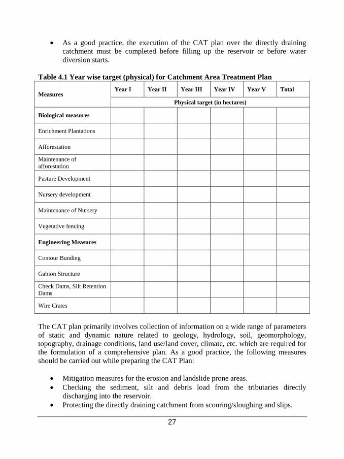
with the forest department. Ideally, CAT plan is to be completed prior to the reservoir impoundment; therefore, it is crucial that the year-wise schedule and monetary requirements should be worked out at the planning stage, See Table 4.1: Year wise target for catchments area treatment plant.
• Prioritization for Catchment Area Treatment: It is important to prioritize the area
for CAT as the entire catchment cannot be treated with soil conservation measures due to financial and logistic limitations. The priority catchments are those from which the sediment outflow is high. The prioritization of the areas should be based on the Sediment Yield Indices (SYI). The sub watersheds are then rated into various categories corresponding to their respective values. Adoption of a proper mix of various erosion control (soil conservation) measures in “very high” priority catchments can reduce the reservoir sedimentation rate to a large extent. The plan should not be limited only to the directly draining catchment area.
27
• As a good practice, the execution of the CAT plan over the directly draining catchment must be completed before filling up the reservoir or before water diversion starts.
Table 4.1 Year wise target (physical) for Catchment Area Treatment Plan
Measures Year I Year II Year III Year IV Year V Total
Physical target (in hectares)
Biological measures
Enrichment Plantations
Afforestation
Maintenance of afforestation
Pasture Development
Nursery development
Maintenance of Nursery
Vegetative fencing
Engineering Measures
Contour Bunding
Gabion Structure
Check Dams, Silt Retention Dams
Wire Crates
The CAT plan primarily involves collection of information on a wide range of parameters of static and dynamic nature related to geology, hydrology, soil, geomorphology, topography, drainage conditions, land use/land cover, climate, etc. which are required for the formulation of a comprehensive plan. As a good practice, the following measures should be carried out while preparing the CAT Plan:
• Mitigation measures for the erosion and landslide prone areas. • Checking the sediment, silt and debris load from the tributaries directly
discharging into the reservoir. • Protecting the directly draining catchment from scouring/sloughing and slips.
28
• Use of Geographical Information System (GIS) and data base management for preparation of CAT plan as well as monitoring.
• Payment mechanism as per the CAT schedule, organisation setup and completion of work
• Compilation of the costs and activity schedule for the entire catchment area • Monitoring mechanisms for implementation of CAT should be prepared in
consultation with the Forest Department and NEC. 4.2.2 Resettlement and Rehabilitation Plan: Displacement is a significant issue in this sector because the land requirement for a hydropower project is very large. The best practices in land acquisition and R&R are as follows:
• Land should not be acquired without the consent of the majority of the project-affected population (PAP). The project proponent should receive ‘free, prior and informed consent’ from the PAP.
• The PAP should include not only landholders but also people dependent on land for livelihood like share-croppers, landless laborers, etc.
• The R&R plan should be a comprehensive framework within which compensation, benefit sharing and community development plans are integrated and the roles of local communities, governments and power companies are clearly delineated.
• Compensation for land should be based on the current market price.
• The R&R plan should be framed in consultation with the PAP.
• The PAP should have a say in the selection of the resettlement site and design of the housing and other infrastructure facilities.
• Attempt should be made to resettle the displaced people as near as possible to the project sites, so that they can obtain access to facilities as well as economic benefits generated from the project. The R&R plan should recognise not only landholders, but also those dependent on land for livelihood like share-croppers and landless laborers, etc. Compensation should also be provided to them.
• There should be a provision for a life-time monthly pension for the old, disabled
and widows (who have no alternate livelihoods).

29
• Basic amenities should be provided at the new resettlement site. This should include roads, safe drinking water, sanitation facilities, educational and health facilities, markets, community centers, playgrounds, etc.
• There should be a provision for employment to at least one family member from each project affected household. All unskilled and semi-skilled direct employment created in the project should ideally go to the PAPs.
• Financial assistance and training for self-employment should be provided to the PAPs.
• There should be a provision for land-for-land compensation for indigenous communities.
• No physical displacement should be resorted to till the complete R&R package has been implemented.
• Displacement should be used as an opportunity for development. A good resettlement and Rehabilitation (R&R) plan should have components as listed in Table 4.2: Recommended outline for R&R plan:
Table 4.2 Recommended outline for R&R plan: Topic Contents Scope of land acquisition and resettlement
• Describe, with the use of maps, the scope of land acquisition and why it is necessary for the main investment project.
• Describe alternative options that can be considered to minimize land acquisition and its effects, and why the remaining effects are unavoidable.
• Summarize key effects in terms of land acquired, assets lost, and people displaced from homes or livelihoods.
• Specify primary responsibilities for land acquisition and resettlement. Socio-economic information
• Define, identify and provide details of the people to be affected. • Describe likely impacts of land acquisition on affected people, taking into account
social, cultural, and economic parameters. • Identify all losses for the people affected by land acquisition. • Provide details of any common property resources. • Specify how the project will impact the poor, indigenous people, ethnic minorities,
and other vulnerable groups, including women, and any special measures needed to restore fully, or enhance, their economic and social base.
Objectives, policy and framework
• Describe the purposes and objectives of land acquisition and resettlement. • Describe the key national and local land, compensation and resettlement policies,
laws, and guidelines that apply entitlements to the project. • Prepare an eligibility policy and entitlement matrix for all categories of loss,
including compensation rates. Consultation, and grievance redress Participation
• Identify project stakeholders. • Describe mechanisms for stakeholder participation in planning, management,
monitoring, and evaluation. • Identify local institutions or organizations to support the affected people.

30
• Review potential role of non-government organizations (NGOs) and community-based organizations (CBOs).
• Establish procedures for addressing the grievances of the affected people. Relocation of housing and settlements
• Identify options for relocation of housing and other structures, including replacement housing, replacement cash compensation, and self-selection.
• Specify measures to assist with transfer and establishment at new sites. • Review options for developing relocation sites, if required, in terms of location,
quality of site, and development needs. • Provide a plan for layout, design and social infrastructure for each site. • Specify means for safeguarding income and livelihoods. • Identify special measures for addressing gender issues and those related to vulnerable
groups. • Identify any environmental risks and show how these will be managed and
monitored. Income restoration strategy
• Identify livelihoods at risk. • Develop an income restoration strategy with options to restore all types of
livelihoods. • Specify job opportunities in a job creation plan, including provisions for income
substitution, retraining, self-employment and pensions, wherever required. • Prepare a plan to relocate and restore businesses, including income substitution,
wherever required. • Identify any environmental risks and show how these will be managed and
monitored. Institutional framework
• Identify main tasks and responsibilities in planning, negotiating, approving, coordinating, implementing, financing, monitoring and evaluating land acquisition and resettlement.
• Review the mandate of the land acquisition and resettlement agencies and their capacity to plan and manage these tasks.
• Provide for capacity building, including technical assistance, if required. • Specify the role of NGOs, if involved, and that of organizations of affected
populations in resettlement planning and management. Resettlement budget and financing
• Identify land acquisition and resettlement costs. • Prepare an annual budget and specify timing for release of funds. • Specify sources of funding for all land acquisition and resettlement activities.
Implementation schedule
• Provide a time schedule showing start and finish dates for major resettlement tasks. • Show how the affected people will be provided for proper rehabilitation before
demolition begins. Monitoring and evaluation
• Prepare a plan for internal monitoring of resettlement targets, specifying key indicators of progress, mechanisms for reporting, and resource requirements.
• Prepare an evaluation plan, with provision for external, independent evaluation of extent to which policy objectives have been achieved.
• Specify participation for people.
4.2.3 Muck Disposal Plan: The various construction activities produce large quantities of muck. Even though some of the muck can be utilized for back filling, but a large quantity of the excavated material will need to be relocated and stabilised so that it does not pose any negative impact on terrestrial and aquatic environment. A muck disposal plan comprises of the following features:

31
• Quantification of muck: Estimation of total quantity/volume of muck to be dug out or excavated during the project construction (SeeTable 4.3: Muck Disposal Plan).
Table 4.3: Muck Disposal Plan
S.No
Name of component from where Muck/Debris is to be produced (m³)
Total Quantity of Muck/Debris to be produced (m³)
Factor of increase in volume for Dumping (40%) (m3)
Quantity of Muck/ Debris to be dumped on compact basis (m³)
Quantity of Muck/ Debris to be Utilised Locally (m³)
Quantity of Muck/ Debris to be Dumped on basis of increase. (m³)
• Identification of locations and activities wherein muck is generated (such as excavation and blasting operation). Identify sites for muck disposal by considering the environmental and social impacts.
• The angle at which the muck needs to be disposed should be decided keeping in view the ground characteristics and sensitivity.
• Suitable sites for dumping of excavated material should be identified in
consultation with the NEC/Competent Authority and Forest Department. All Muck disposal sites should be at a safe distance (must be decided in consultation with NEC) from the river or any water bodies.
• Identify landscaping measures for appropriate disposal of muck and for
stabilisation of the stacked material. Afforestation with suitable plant species of high ecological and economic value, which can adapt to local habitat, should be considered.
• Suitable retaining walls should be constructed prior to dumping of muck and terraces should be developed so as to support the muck on vertical slope and for optimum space utilization. Loose muck should be compacted layer‐wise.
• Soil bulking factor should be considered while estimating the total volume of
muck to be disposed. The percentage increase in volume is taken to be 30% to 40%.
• Identify modes of transportation and manpower requirements for muck disposal. • Plantation of suitable tree species and soil binding using bio‐fertilizer technology
for vegetative growth on muck spreads.

32
• Determination of unit costs for engineering/biological control measures. • Determination of total cost for muck disposal for each identified site. • The organisational setup for the execution of the plan and the schedule for action
should be clearly mentioned. A monitoring mechanism for the implementation of Muck Disposal Plan should also be prepared.
4.2.4 Compensatory Afforestation Plan: The plan aims to maintain the total forest cover in the project affected area. The following are the major components of the compensatory afforestation plan:
• Identification of land to compensate the loss of forest that have been submerged
or lost due to construction of the project. • The project proponent should demarcate funds for the compensatory afforestation
plan based on the net present value of the forest that have been diverted or submerged.
• The choice of plants for afforestation should be made in consultation with the
Forest Department, preference should be given to economically/ecologically important indigenous plants species. Mixed plant species should be selected to conserve the soil moisture.
• Productivity of plantations must be increased through use of improved seeds and suitable plantations. Planting of fuel wood trees and fodder should be encouraged.
• The project proponent, in consultation with NEC and forest department, should ensure technical, administrative and financial setup for the afforestation plan. A dedicated monitoring mechanism should be put in place to ensure timely afforestation.
• Maintenance and security of the forest area should be done for at-least five years (in consultation with the forest department). Measures such as fencing, watch guards and fire protection should be considered.
4.2.5 Environmental Flow Assessment (EFA): The term “environmental flows” is used to represent the quantity, timing, and quality of water flows and levels required to sustain the river ecology and the human livelihoods and well-being that depend on these ecosystems.
33
The process of applying a methodology to estimate EF is called Environmental Flow Assessment (EFA). Once an EFA is estimated at a particular site, then one can estimate the amount of water that must flow (in cumecs-cubic metre per second) at a daily/monthly/yearly basis. We can also estimate over a period of time, the total quantity of water (in cubic metres) that must be allocated for environmental purpose. The following measures should be taken by the project proponent to ensure environmental flow in the downstream region of the project.
• A project specific EFA must be conducted using the recognised methodologies
(See Box 4: Environmental Flow Assessment). The ecological and social requirements of the downstream population must be taken into consideration.
• Flow monitoring is a crucial part of EFA. Flow measurement and display devices should be developed for all the regulated river stretches by the project implementer.
• Flow Adaptation: The flows released from the project site should be analysed with respect to the downstream requirement and adjusted accordingly.
• The design parameters of projects must be adjusted and reservoir operation must be based on the requirement of environmental flows.
4.2.6 Dam Break Analysis and Disaster Management Plan: This plan is necessary to evaluate the potential risk of a dam break and to formulate emergency preparedness measures. To evaluate the risk potential of a proposed dam, a Maximum Credible Failure (MCF) condition is considered. The MCF condition is maximum historical flood (period of 100 years) coupled with a dam break. The condition is given to any dam break software, by which the flood/channel routing studies are carried out.
Dam Break Analysis: The objective of dam break analysis is to simulate the movement of a dam break flood (using dam break models) wave along a valley or any downstream area that would be impacted as a result of dam failure. Models such as DAMBRK is used for
Box 4: Environmental Flow Assessment Given the varied topography, and variable flows in different rivers in Bhutan, it is probably more appropriate to determine environmental flow for an individual river on a case-by-case basis. Amongst all, most widely used method for environmental flow assessment is: a) Hydrology based: Sets flow on assumption that maintaining some percentage of the natural
flow will keep the river wet and fulfil all requirements. b) Hydraulic rating: Measures changes in the river flow, based on a single cross-section,
(perimeter, depth, velocity) to assess changes in the habitat affected by it. c) Habitat simulation: Employs multiple cross-sections to the hydraulic model rating to simulate
the conditions in a given stretch of the river. d) Holistic methodologies: Employs a multi-disciplinary approach to provide a consensus view.
The team could include hydrologists, biologists, geo-morphologists, water quality specialists and socio-economists.

34
the purpose of dam break modelling. The outputs of the model should be illustrated with appropriate graphs and maps, clearly bringing out the impact of dam break scenario. The key information required at any point of interest within this flood zone is generally:
• Time of first arrival of flood water • Peak water level extent of inundation • Time of peak water level • Depth and velocity of flood water (allowing estimation of damage potential) • Duration of flooding
Based on the output of dam break model, followings information are predicted and evaluated:
• People at risk • Identification of structures (bridges etc.) likely to be destroyed. • Indication of main flow areas (damage potential of flow). • Timing of the arrival and peak of the flood wave. • Identification of features likely to affect mobility / evacuation during and after
the event including impact on infrastructure, deposition and scour of debris and sediment.
Accordingly, the emergency action plan is formulated some of the keys feature includes:
a) Demarcation/prioritization of areas to be evacuated. b) Restricting human settlements in the downstream areas which are susceptible to
risk. c) Notification procedures and evacuation instructions. d) Safe routes, transport and traffic control. e) Shelter areas f) Functions and responsibilities of members of evacuation team.
Disaster Management Plan: To meet any unforeseen events either due to dam break or cloud burst or Glacier Lake Outburst Flood (GLOF), the project proponent need to prepare extensive disaster management plan to ensure minimum impact on the people and environment. The important measures are:
• To provide flood forecasting services and quick dissemination of forecasts to
important and heavily populated towns, villages, including other potential areas. • To formulate flood proof communication system. • To form a disaster mitigation network/system, including relief fund.
35
• Appropriate organisational setup for emergency response like an emergency control center. A notification list that includes the names and telephone number of all the prone downstream residents, project operator, dam safety office, local emergency official and appropriate government agencies.
• Disaster management drills • The flood prone zone in the event of dam break should be marked properly at the
locations with adequate factor of safety. As the flood wave takes sufficient time in reaching, the population should be informed well in time through wireless and sirens etc.
• Materials and facilities like boats, ropes, medicines, first aid etc. should be kept ready with the onset of monsoon every year.
• Regular verification of the functioning of the gates, sluices etc. • Raised platforms should be constructed as part of the strategy to meet any
disasters. These platforms should be higher than the maximum expected flood water level, safe from erosion by the recurring floods and should be located near health centers.
4.2.7 Biodiversity Conservation & Wildlife Management Plan: Some of the mitigation measures for the protection and conservation of biodiversity area as follows:
• Conservation of threatened, endemic and newly recorded species. • Special efforts for in situ or ex situ conservation of critical/ important plant/
animal species affected by the project. • To protect and utilise the traditional knowledge of the local people for protecting
the species. • To provide incentives for research, training and public education to increase
awareness regarding biodiversity. • Providing financial support to the traditional institutions to protect natural
resources. • Development of nurseries and gardens for native threatened plant species. • The forest protection plan should include measures like setting up of watch
towers, wildlife personnel (forest guards), vigilance equipment, construction of inspection paths, creation of veterinary facilities, rescue camps for healthcare and controlling diseases of wild animals, public awareness programmes through training camps and provision of fire lines in the critical areas.
• Restriction should be imposed on construction workers at project sites so that they do not harm forests and the animals. Special provisions should be made for the fuel wood requirements of the workers. No labour colonies should be set up in the vicinity of forest or wildlife areas.
• Measures should be taken to ensure that noise levels would be kept as minimum as possible in the project area, particularly where human and wildlife habitats are located.

36
• Setting up of a Biodiversity Monitoring Committee which will take care of funds and appropriate implementation of the plan.
4.2.8 Greenbelt Development Plan: Apart from compensatory afforestation, the extensive greenbelt should be developed around the project area and reservoir periphery. A good greenbelt development plan should include the following:
• Planning such as number of trees to be planted, species selection, areas to be
covered and the density of trees should be estimated well in advance. • Species selection and plantation should be done in consultation with forestry
department. • Planting of trees should be undertaken in appropriate encircling rows around the
project site. • Generally fast growing species should be planted. • Prepare plan for nursery development, year wise plantation and maintenance. • Description of the staffing pattern for execution of green belt development plan • Determination of the unit costs of the different plantations and the total cost for
the various areas under the development plan.
4.2.9 Quarry Restoration Plan: The ultimate goal of quarry restoration is to change the landscape, as closely as possible, to its previous physical and biological state. A good quarry restoration plan should include the following:
• Cost estimate (including labour cost) for the restoration of quarry site. • Year-wise progressive reclamation plans including a detail final closure plan to
create productive and sustainable land use of the excavated area after cessation of quarry operations. The plan must be accepted by the quarry owners, regulating agencies, and local communities.
• Measures to protect the health and safety of the surrounding habitat. • Measures to eliminate/contain all possible sources of pollution during post-
quarrying. • Measures to conserve valuable attributes and aesthetics of the surrounding area.
4.2.10 Fisheries Conservation &Management Plan: For conservation and development of fisheries, the impounded area and other nearby water bodies should be considered. The following are the components of the plan:
• Identification of fish stocking zones for pisciculture development,
estimate potential for fish stock creation, evaluate the feasibility of fish production in newly created water areas, identifying areas for production and stocking of fish seeds.
• Setting up of hatchery units.
37
• Rights of the local fisherman should be defined as per the resettlement and rehabilitation policy, in consultation with the local government.
• Identification and selection of species of fish. • Design of Fish Seed Farms: Develop suitable designs and methods of fish
farming, design of civil requirements, plan for fish seedling acquisition, farm development, maintenance and completion of works and staffing pattern for execution of fisheries development schemes.
• Cost Aspects and Implementation: Determination of costs for fish farm development, acquisition of fish seedlings and maintenance works.
4.2.11 Air Quality and Noise Management Plan: Some of the air pollution control measures during construction phase of the project are given below.
• Transportation of construction material: Covering of trucks/dumpers to avoid
spillage; compacted roads, speed control on vehicles and provision for mobile water sprinklers on roads.
• The crushers should be fitted with bag filters and have covered unloading points so as to minimize dust emissions.
• The chimney height as well as the emission from DG set should meet the national standards. If national standards are not available then any international standards should be followed.
• Regular water sprays around the crushing sites, haul road, quarry as well as the dumping sites should be ensured.
• Masks should be provided to the workers and staff. • Development of a green belt of suitable width on both sides of road, which acts
as wind break and traps fugitive dust.
Control of Noise Pollution: Various measures for control of noise pollution in the project area are suggested below:
• Ear protection aids such as ear plugs, earmuffs, noise helmets, etc., must be
provided to the workers. • Noise producing machines (such as crushers, aggregate processing plants, etc.)
must be enclosed. • Proper and regular maintenance /lubrication of machines should be done. • Quieter machines and vehicles with high quality silencers should be used. • Afforestation in the form of green belt around the project area, residential
colonies and office complexes should be done effectively which will also help in reducing the noise pollution to a greater exten
38
4.2.12 Soil Conservation Some of best practices for soil protection and conservation are as follows:
• Scrap the topsoil prior to land clearing. • Scraped topsoil should be used immediately for plantation/landscaping,
restoration etc. • If it is not possible to use the topsoil immediately, then it should be stacked at a
designated area. The location of the storage site should ensure that it does not lead to erosion. The probability of erosion is high if the storage site is proposed at an elevated area.
• The topsoil heap’s height should not exceed more than 6 meters. Storage must be done in a pyramidal form, with garland drains all around.
• If the topsoil is to be stored for a long duration, it should have a vegetal cover of, preferably, leguminous species (grasses and shrubs). If biological reclamation is not done in time, leaching will drain away the nutrients and impair the nutrient cycle, thereby making the soil unproductive.
4.2.13 Plan for Land Restoration and Landscaping: The following are the salient features of the plan:
• This plan deals with the identification of land areas for landscaping, restoration
and beautification of the project area. Such measures also reduce soil erosion in the region.
• The plan also includes development of nature parks, children parks, gardens, and other recreation facilities near the project area once the construction activities of the project are over.
4.2.14 Water Management Plan: During project construction phase, sufficient measures need to be implemented to ameliorate the problem of water pollution from various sources. Some of the mitigation measures to prevent water pollution are as follows:
• Construction of silt traps such as check dams, gabion structures etc. should be
encouraged at the steep areas and muck disposal sites. • During tunnelling the ground water flows into the tunnel along with construction
water which is used for various works like drilling, concreting, etc. The effluent thus generated in the tunnel contains high suspended solids. Settling tanks should be constructed to allow settling of the suspended impurities. The sludge from the settling tanks should be collected and disposed at the designed site.
• The sanitation management plan for sewage generated from various labour camps and project colony should be effectively implemented. A sewage treatment plant must be provided for the colony and labour camps

39
4.2.15 Reservoir Rim Treatment Plan
• A detailed survey on the basis of geology of the reservoir rim area should be conducted and all the landslide zones/landslip zones around the reservoir periphery (up to MWL) should be identified.
• Suitable engineering and biological measures (check dams, vegetation cover, geo textile work, etc.) for the treatment of identified land slip zones to be provided with physical and financial schedule.
• Layout map showing the landslide/landslip zones should be prepared.
4.2.16 Sanitation and Solid Waste Management Plan: Site specific measures should be implemented for appropriate disposal of domestic waste from colonies and labour camps etc.
4.2.17 Public Health Delivery Plan/Human Health Management Plan: For the improvement of public health following are the key areas which need to be addressed:
• Setting up of medical and health care centers. • The manpower requirement and infrastructure set up cost must be specified. • The reservoir basin should be cleared prior to the filling, for the removal of
unwanted materials in the reservoir. These materials may lead to unhealthy conditions giving rise to breeding grounds for mosquito. The clearing involves removal of trees, floating materials, undergrowth etc.
• The site selected for habitation of workers should be properly planned and should not be in the path of natural drainage. Adequate drainage system to dispose storm water drainage and sewage water from the labour colonies should be provided.
• Strict procedures should be followed in importing labour force from outside the state. Quarantine measures should be adopted and any possibility of importing any fatal diseases should be eliminated by keeping close vigil on the potential carriers. A thorough medical screening of the labours should be conducted for all the labour coming from outside.
• The project authorities should ensure that all preventive measures and norms are strictly enforced to avoid outbreak of any diseases. Surface sprays on the reservoir waters and stagnant water bodies to eliminate breeding of insects.
• Adequate vaccination and immunization facilities should be provided for workers at the construction site.
• The labour camps and resettlement sites should be at considerable distance from the main water body or quarry areas.
• Determine unit costs for the execution of periodic surveys for disease spread and water quality
• Determine total costs for provision of emergency preparedness plan and mobile clinic.
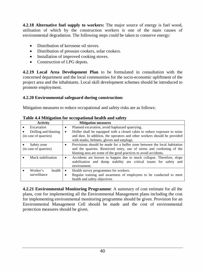
40
4.2.18 Alternative fuel supply to workers: The major source of energy is fuel wood, utilisation of which by the construction workers is one of the main causes of environmental degradation. The following steps could be taken to conserve energy:
• Distribution of kerosene oil stoves. • Distribution of pressure cookers, solar cookers. • Installation of improved cooking stoves. • Construction of LPG depots.
4.2.19 Local Area Development Plan to be formulated in consultation with the concerned department and the local communities for the socio-economic upliftment of the project area and the inhabitants. Local skill development schemes should be introduced to promote employment.
4.2.20 Environmental safeguard during construction: Mitigation measures to reduce occupational and safety risks are as follows: Table 4.4 Mitigation for occupational health and safety
Activity Mitigation measures • Excavation • Drilling and blasting (in case of quarries)
• Planned excavation, avoid haphazard quarrying. • Driller shall be equipped with a closed cabin to reduce exposure to noise
and dust. In addition, the operators and other workers should be provided with masks, helmets, gloves and earplugs.
• Safety zone (in case of quarries)
• Provisions should be made for a buffer zone between the local habitation and the quarries. Restricted entry, use of sirens and cordoning of the blasting area are some of the good practices to avoid accidents.
• Muck stabilisation • Accidents are known to happen due to muck collapse. Therefore, slope stabilization and dump stability are critical issues for safety and environment.
• Worker’s health surveillance
• Health survey programmes for workers. • Regular training and awareness of employees to be conducted to meet
health and safety objectives 4.2.21 Environmental Monitoring Programme: A summary of cost estimate for all the plans, cost for implementing all the Environmental Management plans including the cost for implementing environmental monitoring programme should be given. Provision for an Environmental Management Cell should be made and the cost of environmental protection measures should be given.
41
CHAPTER 5
Review of an EIA report for a hydropower project 5.1 Introduction The purpose of reviewing an EIA report is to take decisions with respect to the following:
• Should the project be cleared in the form proposed by the project proponent? • Should the project be modified to reduce the impacts and then cleared? • Is the ‘No project’ option justified, considering the social and environmental
costs vis-à-vis the benefits to be accrued from the hydropower development? • If the project is cleared, then what conditions may be prescribed for compliance
by the project proponent during design, construction and operation of the project? 5.2 Composition of the EA review team To ensure a proper review of the EIA report, the review committee should include experts from diverse fields with a good understanding of the hydropower project and potential impact areas. The reviewers should be technically sound and competent enough to review the report. They should be able to make valuable suggestions/ recommendations to the project proponent for taking corrective action. Ideally, in the case of a hydropower projects, the team should comprise of the following experts:
• A civil engineer/expert who is well versed with the process and technology and potential impacts of hydropower projects.
• An environmental scientist/engineer to overview the adequacy of mitigation options suggested for air, water and waste management.
• A groundwater expert/hydrologist to review and assess the hydrology of the study area and the drainage pattern.
• A social science expert/anthropologist to review the social issues and the resettlement and rehabilitation plan.
• A biodiversity expert/botanist who can review the biodiversity issues, biodiversity conservation and afforestation plan.
• A meteorological expert who can review the meteorological parameters and adequacy and compatibility of air pollution model.
• A geologist to review the geological risks and associated impacts. • A safety engineer and occupational health expert who can review the levels of
safety, mechanization, disaster management plans, occupational hazards and

42
mitigation strategies to combat these hazards at the planning and operational stages.
• Nominees of the regulatory agency. 5.3 Reviewing an EIA report for a hydropower project While reviewing the EIA report, the following key aspects needs to be carefully examined:
• Has the EIA report evaluated the beneficial and adverse impacts of the project properly and clearly?
• Which are the unavoidable adverse impacts? Are they acceptable? • Is the proposed mitigation plan sufficient to manage and control all adverse
impacts? • What kinds of safeguards need to be incorporated to ensure that the mitigation
plan is implemented effectively? • What are the parameters which need to be monitored during project construction
and operation so that the state of the environment can be studied throughout the project life?
• Is the project acceptable to the local communities? • Are the concerns of the local communities genuine and has the EIA report
adequately addressed these concerns? • Will the project improve the socio-economic status of the local communities?
Guidelines for using the reviewer checklist: By using the reviewer checklist for a hydropower project, the reviewer will be able to gauge the acceptability of the EIA report. This can eventually assist in determining the environmental feasibility of the project being assessed. Scorecard approach: The checklist is designed to follow a “scorecard” approach, using a possible scoring range of 0-10. Scores for each relevant item in the checklist are totalled, and a calculation of the percentage of the total possible score is made. Relevance: The checklist is a generic checklist for the hydropower projects. Not all questions may be relevant to all the hydropower projects. Therefore, the first step is to determine the relevance of each question, for the specific project being considered. For each question that is relevant, “1” is entered in the box under Column “A” of the checklist, “Is question relevant for this project?” Because the number of relevant parameters varies from project to project, the possible total score for each EIA report will vary accordingly.

43
Adequacy: It is then necessary to determine the adequacy of the EIA report in answering only those questions that are judged to be relevant. Under the “adequacy” heading (Column “B”), the reviewer is asked to assign a numeric score from 0-10. The numeric scoring for the various elements of the EIA report, based on their level of completeness, clarity, and quality, is as follows: 9-10: Excellent: Information provided is clear, comprehensive and detailed, with no gaps or weaknesses. 7-8: Good: Information provided is comprehensive, has only very minor weaknesses which are not of importance to the decision-making process. 5-6: Adequate: Information provided has some minor weaknesses, but the deficiencies do not strongly compromise the decision process; no further work is needed to add to the environmental information. 3-4: Weak: Information provided has gaps and weaknesses which will hinder the decision process; some additional work is needed to complete the information. 1-2: Very poor: Information provided has major gaps or weaknesses which would prevent the decision process from moving ahead; major work is required to rectify. 0: Absent: Information needed for decision-making is not included in the report, and needs to be provided in its entirety. Importance: It is also necessary to determine the importance. In many cases, some of the issues is relevant for the project but is not very important or significant in impact assessment. For instance; name of project, project schedule is relevant for the project but it has not much importance in environmental and social impact assessment. Therefore, while assigning the value for importance, reviewer should always keep in his/her mind the level of importance, a) relevant but least important, b) relevant but average important, c) relevant but most important. In addition, for each relevant item, the reviewer is instructed to fill in comments for each relevant item. This should be made a mandatory procedure, so that the justification for assigning a specific value for adequacy as well as importance is well documented. For those items where the information provided in the EIA report is not adequate, it should be indicated in the far-right column what types of information are still required, in order to adequately address the question. As a rule of thumb, an EIA report achieving a score in the range of 50-60% or higher should be considered acceptable. Borderline scores, or scores much lower than this limit, indicate that the EIA report is likely not acceptable. It should be noted, that while this design (i.e., using a numeric scorecard, and requiring reviewers to provide comments and

44
justifications for their itemized determinations) is intended to minimize subjectivity, this “semi-quantitative” approach cannot totally eliminate all subjectivity from the review process, because the assignment of numeric scores is itself, by nature, a subjective process. At the end of each section of the checklist, space is left for “other questions.” The space provided here may be used to elaborate on the listed questions in each section (referencing the question number), or to add questions that may have specific relevance for the project being reviewed. Overall Evaluation: There are six components that need to be evaluated to give the total score.
1. Applicant Information 2. Project Description 3. Baseline information 4. Impact Assessment 5. Mitigation and Environmental Management Plan (EMP) 6. Other Requirements
The final section of the checklist provides a framework for giving an overall evaluation of the EIA report. Each topic covered in the checklist is assigned a score, from 1-10, according to the same system used in the main section of the checklist. The resulting value provides a further basis for determining whether or not the environmental information presented is adequate (“acceptable” or “not acceptable”) for making an informed determination about the quality of the EIA report. This is simply a way to cross-check the results that were obtained through a detailed itemized review of the EIA report (Refer reviewer checklist).