maya agriculture south of the ceren site, el salvador, 2011
TRANSCRIPT
1
Maya Agriculture South of the
Ceren site, El Salvador, 2011
Edited by Payson Sheets and Christine Dixon
2
Table of Contents:
Chapter 1. Introduction. Payson Sheets P. 1
Chapter 2. Classic Period Maize Agriculture South of the Ceren Site. Celine Lamb and Theresa Heindel. P. 13
Chapter 3. Cleared Areas – Field Season 2011. Alexandria Halmbacher. P.34
Chapter 4. Documenting Manioc Agriculture at Ceren. Christine Dixon. P. 41
Chapter 5. A Sacbe Runs Through it: The Ceren Sacbe. Christine Dixon. P. 62
Chapter 6. Ceren Paleoethnobotanical Studies, Season 2011. David Lentz and Christine Hoffer. P. 78
Chapter 7. Lithic Artifacts. Payson Sheets. P. 81
Chapter 8. Ceramics. Payson Sheets. P. 88
Chapter 9. An Ethnographic Examination of Present House-lot Gardens of Joya de Ceren: Preliminary Results for Future Ethnoarchaeological Study. Celine Lamb. P. 99
Chapter 10. Malanga (Xanthosoma): A Root Crop Grown by the Ancient Maya at Ceren. Theresa Heindel. P. 112
Chapter 11. Summary and Conclusions. Payson Sheets P. 121
3
Chapter 1. Introduction
Payson Sheets
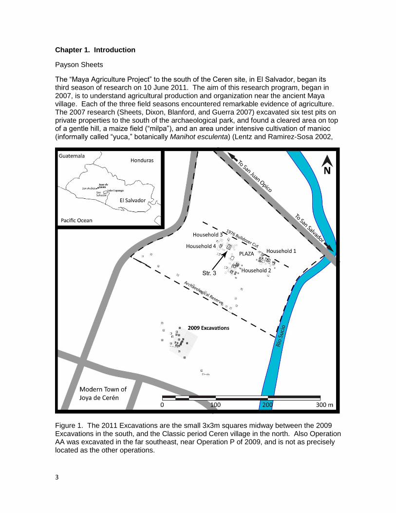
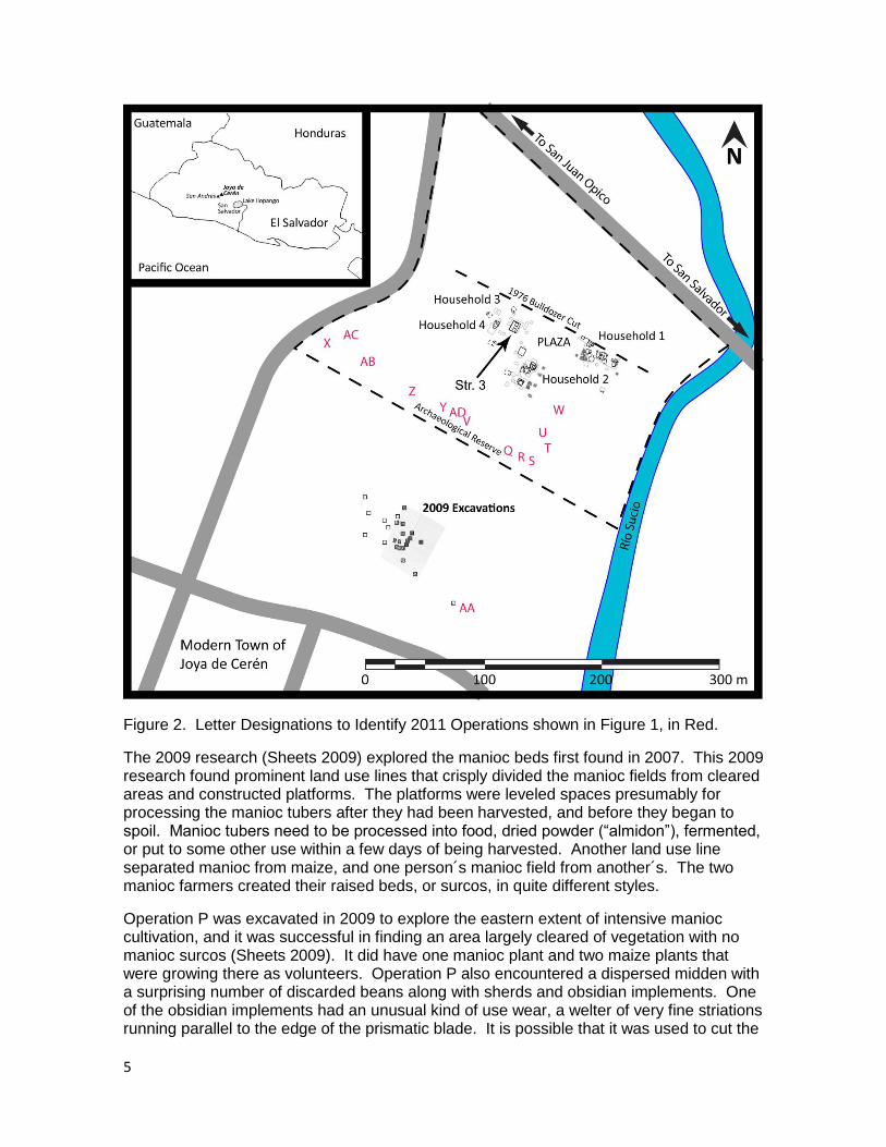
The “Maya Agriculture Project” to the south of the Ceren site, in El Salvador, began its third season of research on 10 June 2011. The aim of this research program, began in 2007, is to understand agricultural production and organization near the ancient Maya village. Each of the three field seasons encountered remarkable evidence of agriculture. The 2007 research (Sheets, Dixon, Blanford, and Guerra 2007) excavated six test pits on private properties to the south of the archaeological park, and found a cleared area on top of a gentle hill, a maize field (“milpa”), and an area under intensive cultivation of manioc (informally called “yuca,” botanically Manihot esculenta) (Lentz and Ramirez-Sosa 2002,
Figure 1. The 2011 Excavations are the small 3x3m squares midway between the 2009 Excavations in the south, and the Classic period Ceren village in the north. Also Operation AA was excavated in the far southeast, near Operation P of 2009, and is not as precisely located as the other operations.
4
Sheets 2002, 2007, 2009). The discovery of large manioc planting beds, called “surcos,” with manioc stems inserted in them as the first stage of planting to grow a new cycle of tubers, was of great importance. These findings led to the submission of a research proposal to the US National Science Foundation that was funded to complete a more ample research season in 2009 to explore the nature and extent of manioc cultivation in the area.
The successes of the first two field seasons led to the submission of another proposal to NSF, which was funded for the 2011 field season. The 2011 season focused on the zone intermediate between the ancient village and the area 200 m south of the village that was the focus of the second field season. During 2011 considerable new data and understanding of agricultural practices and organization, boundaries, authority, cleared areas, areas formerly under manioc cultivation and changed to other uses, the village political economy, and even a sacbe, were achieved.
Background
The 2009 research project focused on agriculture some 200 meters south of the Classic period village of Ceren (see chapters in Sheets 2009 for details). Excavations encountered a very large area of intensive manioc cultivation, where the harvest is estimated to have been more than 10 metric tons of tubers. The harvest was accomplished in a short time before the eruption, a few weeks at most, based on the roughness of the harvested beds. Had more than a couple weeks passed, during the rainy season, the rains would have eroded that roughness. The Loma Caldera eruption occurred in the middle of the rainy season, most probably in August (Sheets 2002, 2006). Three different fields where manioc was grown in large sloping elevated planting beds were found, presumably belonging to three different farmers. They employed very different styles of shaping their planting beds, and some of the boundaries of their fields were discovered.
The Loma Caldera volcanic vent that covered the area with volcanic ash, cinders, and lava bombs (all referred to as “tephra”) was located only 600 m to the north northwest of the ancient Ceren village. The volcanic burial in about AD 630 presents an extraordinary opportunity to study ancient agriculture in and around a Maya village, as the nature of the eruption resulted in unusual preservation. However, the deep burial also presents a challenge in that excavations in 2009 had to dig through over three meters of the volcanic ash to reach the ancient Classic period ground surface, and many excavations during 2011 had to excavate through four to almost five meters of volcanic ash. Two of the first three components of the Loma Caldera volcanic eruption (Units 1 and 3) were very fine-grained and arrived moist, at 100o Celsius because they were blasted onto the landscape by a steam explosion. The steam explosion began when very hot volcanic magma, working its way upward in the geological fault, came in contact with water from the Rio Sucio some 600m north northwest of the Ceren village. That moist tephra coated vegetation, such as maize stalks and ears of corn. After a few months or perhaps years the organic materials decomposed, leaving a hollow space that miraculously survived for 14 centuries. When we encounter hollow spaces we examine them and cast them with dental plaster to preserve them for posterity. The casts of maize, manioc, and other plants, along with all artifacts, are mapped and photographed in place, and then transported to the field laboratory for cleaning, analysis, measurements, and laboratory photography before being accessioned into the Museo Nacional David J. Guzman in San Salvador.
5
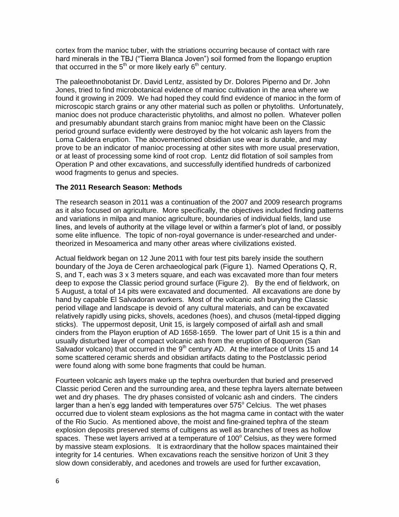
Figure 2. Letter Designations to Identify 2011 Operations shown in Figure 1, in Red.
The 2009 research (Sheets 2009) explored the manioc beds first found in 2007. This 2009 research found prominent land use lines that crisply divided the manioc fields from cleared areas and constructed platforms. The platforms were leveled spaces presumably for processing the manioc tubers after they had been harvested, and before they began to spoil. Manioc tubers need to be processed into food, dried powder (“almidon”), fermented, or put to some other use within a few days of being harvested. Another land use line separated manioc from maize, and one person´s manioc field from another´s. The two manioc farmers created their raised beds, or surcos, in quite different styles.
Operation P was excavated in 2009 to explore the eastern extent of intensive manioc cultivation, and it was successful in finding an area largely cleared of vegetation with no manioc surcos (Sheets 2009). It did have one manioc plant and two maize plants that were growing there as volunteers. Operation P also encountered a dispersed midden with a surprising number of discarded beans along with sherds and obsidian implements. One of the obsidian implements had an unusual kind of use wear, a welter of very fine striations running parallel to the edge of the prismatic blade. It is possible that it was used to cut the
6
cortex from the manioc tuber, with the striations occurring because of contact with rare hard minerals in the TBJ (“Tierra Blanca Joven”) soil formed from the Ilopango eruption that occurred in the 5th or more likely early 6th century.
The paleoethnobotanist Dr. David Lentz, assisted by Dr. Dolores Piperno and Dr. John Jones, tried to find microbotanical evidence of manioc cultivation in the area where we found it growing in 2009. We had hoped they could find evidence of manioc in the form of microscopic starch grains or any other material such as pollen or phytoliths. Unfortunately, manioc does not produce characteristic phytoliths, and almost no pollen. Whatever pollen and presumably abundant starch grains from manioc might have been on the Classic period ground surface evidently were destroyed by the hot volcanic ash layers from the Loma Caldera eruption. The abovementioned obsidian use wear is durable, and may prove to be an indicator of manioc processing at other sites with more usual preservation, or at least of processing some kind of root crop. Lentz did flotation of soil samples from Operation P and other excavations, and successfully identified hundreds of carbonized wood fragments to genus and species.
The 2011 Research Season: Methods
The research season in 2011 was a continuation of the 2007 and 2009 research programs as it also focused on agriculture. More specifically, the objectives included finding patterns and variations in milpa and manioc agriculture, boundaries of individual fields, land use lines, and levels of authority at the village level or within a farmer‟s plot of land, or possibly some elite influence. The topic of non-royal governance is under-researched and under-theorized in Mesoamerica and many other areas where civilizations existed.
Actual fieldwork began on 12 June 2011 with four test pits barely inside the southern boundary of the Joya de Ceren archaeological park (Figure 1). Named Operations Q, R, S, and T, each was 3 x 3 meters square, and each was excavated more than four meters deep to expose the Classic period ground surface (Figure 2). By the end of fieldwork, on 5 August, a total of 14 pits were excavated and documented. All excavations are done by hand by capable El Salvadoran workers. Most of the volcanic ash burying the Classic period village and landscape is devoid of any cultural materials, and can be excavated relatively rapidly using picks, shovels, acedones (hoes), and chusos (metal-tipped digging sticks). The uppermost deposit, Unit 15, is largely composed of airfall ash and small cinders from the Playon eruption of AD 1658-1659. The lower part of Unit 15 is a thin and usually disturbed layer of compact volcanic ash from the eruption of Boqueron (San Salvador volcano) that occurred in the 9th century AD. At the interface of Units 15 and 14 some scattered ceramic sherds and obsidian artifacts dating to the Postclassic period were found along with some bone fragments that could be human.
Fourteen volcanic ash layers make up the tephra overburden that buried and preserved Classic period Ceren and the surrounding area, and these tephra layers alternate between wet and dry phases. The dry phases consisted of volcanic ash and cinders. The cinders larger than a hen‟s egg landed with temperatures over 575o Celcius. The wet phases occurred due to violent steam explosions as the hot magma came in contact with the water of the Rio Sucio. As mentioned above, the moist and fine-grained tephra of the steam explosion deposits preserved stems of cultigens as well as branches of trees as hollow spaces. These wet layers arrived at a temperature of 100o Celsius, as they were formed by massive steam explosions. It is extraordinary that the hollow spaces maintained their integrity for 14 centuries. When excavations reach the sensitive horizon of Unit 3 they slow down considerably, and acedones and trowels are used for further excavation,
7
looking for cavities. When a cavity is found it is inspected, protected, and filled with dental plaster. Once the plaster hardens the tephra surrounding it is carefully removed, revealing the plant, preserved for posterity.
After the casts of plants have been recorded by mapping, field notes, and photography, they are lifted and transported to the field laboratory in the modern town of Joya de Ceren. In the laboratory they are measured, catalogued, photographed, and stored in boxes. At the end of the field season all casts, along with all artifacts encountered, are accessioned into the Museo Nacional David J. Guzman in San Salvador.
Objectives
The finding in 2009 an extraordinary extent and sophistication of manioc fields that had been harvested all at once, within perhaps a week or so, and that had produced an estimated 10 tons of tubers, dramatically changed our understanding of Ceren agriculture. Therefore a proposal was submitted to the National Science Foundation to support the planned research, and it was funded. All but one of the excavations conducted in 2011 were midway between the intensive manioc fields and the village, in order to clarify the nature of agriculture in that intermediate zone.
A success of the 2009 research was in finding boundaries of individual plots of manioc, with farmers creating planting beds in their own individual styles, and that formed a major objective for 2011. An additional boundary was discovered between manioc and maize, and yet another was between manioc surcos (elevated planting beds) and flat platforms. As mentioned above, the platforms probably were used for processing the great volume of tubers harvested. The most prominent boundaries were created by two land use lines that firmly established the eastern and western edges of the manioc fields. The land use lines, if they emanate from the village, could represent non-royal governance of agriculture, perhaps by village elders meeting in Structure 3 in the village. Decision-making and authority are domains of political economy theory, generally focusing on elites in Mesoamerica. It remains an open question the degree of elite authority that was manifested within the Ceren community. This author sees very little evidence of elite authority in the Ceren village. Rather, relations appear to be indirect and symbiotic (Sheets 2000). Certainly surplus production or labor must have been provided to obtain preciosities such as polychrome ceramics, obsidian prismatic blades, and jade axes from elites. This brings up the core theoretical orientation of the research: non-royal political economy within the village.
Theoretical Orientation of Research: Village Political Economy
Conceptualizations of Mesoamerican political economies have become diverse, with top-down, bottom-up, marketplace, heterarchical, and agency approaches (e.g. Dahlin et al. 2010, Douglass 2002, Garraty and Stark 2010, A. Joyce et al. 2001, Masson and Freidel 2002, Schortman and Urban 2004, Sharer 2006, Smith 1991, Wells 2006). Most studies have focused on large sites, and often include their peripheries, with many studies being regional in scope. The degree of elite control or influence over agricultural production is a subject of considerable uncertainty and debate. Webster (2002: 175) argues the “greatest ignorance about Maya farmers concerns the ancient political economy,” referring to the lack of knowledge about possible elite influence on agriculture, how decisions were made, how labor was organized and production distributed. Many scholars argue that food production was locally controlled (e.g. Foias 2002, Hageman and Lohse 2003, Scarborough and Valdez 2003, and McAnany 1989). Others argue that intensive
8
agricultural systems were under the purview of managerial elites who ensured that crops were impelled upward in the social hierarchy (Chase and Chase 1996, Ford 1996). Each may be true, to different degrees in different areas. Houston and Inomata (2009: 240-249) wrestle with these issues of authority and ownership, and note that elite control over agriculture results in highly standardized and large scale features, while household-controlled fields vary considerably. Regarding land tenure, they state “landownership does not leave any clearly recognizable archaeological signature” (ibid: 242), but Freidel and Sabloff (1984) found stone-partitioned fields on Cozumel, and preservation at Ceren may provide ownership insights. An alternative to top-down hierarchical views of economies is based in social theory and focuses on agency, as people negotiate and contest aspects of ownership, production, circulation, and consumption processes (A. Joyce et al. 2001, Wells 2006). This approach is generally “ascending” (bottom-up), exploring the activities of subalterns, or exclusively of commoners. Studies that focused on commoners provided many insights regarding their contributions to society, but often left them disembedded from the dynamics of the full economic system. Commoners are perceived as making their own decisions in certain domains. By managing local resources commoners can be political agents (Robin 2003), for instance in deciding to which market, in which elite center, to take their surplus manioc or other crop, or craft production, along the lines of Carol Smith‟s ambitiously proposed interlocking system (1976). Ceren commoners had some degree of choice in which market to participate (Sheets 2000), and thus could have had at least some effect on local elites. Elites at about a dozen large centers in the Zapotitan valley would have had to compete for the goods and services of commoners, placing constraints on their demands, and evening out exchange ratios in marketplaces. The village economy, as a part of the greater domestic economy, is here defined as the production and distribution of goods such as manioc, and services, inside the village and its environs, beyond the control, but not necessarily the influence, of elites. As surplus food including manioc, basic commodities, construction material, or labor were made available to elites, potentially via markets, commoners supported elites. Jade axes, polychrome ceramics, and obsidian implements were the items commoners took back to Ceren, in an inherently symbiotic relationship (Sheets 2002). Internally, the village economy can function at different levels, the highest being decisions made by village elders in allocating land for farming, or designating open space for processing the harvest, perhaps exemplified by the land use lines, and adjudicating disputes among residents. This could be considered an intra-village political economy, an example of non-royal governance. Or were village elders to some degree influenced by external hierarchies, as documented in northern Yucatan at contact (Roys 1957:6)? The next level down is the “horizontal economy” within the Ceren village (Sheets 2000), in a heterarchical configuration, where each household produced specific commodities beyond what they needed for their own consumption, and exchanged them with other households in the village, or with other villages. The third level is the household economy, where people constructed and maintained their own buildings, produced items for their own consumption, kept a kitchen garden, and maintained milpas in their houselots and manioc south of town that supplied the bulk of their food. When Ceren was founded in the 6th century (Sheets 2002) it is probable the founding lineages held significant local power. With population growth in the village and regionally, competition and conflict must have increased, necessitating transfer of some authority above the household, to the village level, probably to village elders. We interpret Structure 3, the public building with two benches in the front room, as the locus of power and dispute resolution (Sheets 2006), i.e. the locus of non-royal governance. Each bench is 1.7 m
9
long, and thus would seat cross-legged a maximum of three individuals. Six individuals of authority, likely elders of the more prominent households, would represent a small subset of the total number of households in the village. This could represent sub-elite governance, an under-researched topic with the Classic period Maya. Alternatively, the land use lines could represent “horizontal” decision making among individual households allocating land for cultivation and harvest processing among themselves, similar to 16th Century Tepetlaoztoc in the Basin of Mexico (Williams and Harvey 1997). Conceivably the lines could originate from the south, possibly even from San Andres, and thus suggest considerable elite involvement. In summary, the broad organization of the ancient Maya economy has come under close attention in recent years, and a salutary result is a more complete understanding of the full range of economic behavior including elites, secondary elites, commoners, rural households and villagers, markets, hierarchy, heterarchy, and agency at all social levels. Wells‟ broad formulation of ritual economy (2006) encapsulates this theoretical domain and includes the social dimensions of production, distribution, and consumption. At Ceren we believe we are making some progress answering Turner‟s (1983:120) questions of “the degree of control the elite exerted on the farming units, how decisions were made, how labor was organized, how production was distributed….” And “were cropping decisions controlled by communities? What did the farmer gain by supporting the elite, or did they gain?”
Organization of this Report
This report is organized in 11 chapters, each focusing on an aspect or topic of the 2011 research program. Chapter two, by Celine Lamb and Theresa Heindel, focuses on maize milpas, found in many of the excavations. Chapter three explores the topic of areas that were kept largely clear of vegetation, whether cultigens or weeds, and is written by Alexandria Halmbacher. Chapter four, by Christine Dixon, describes and interprets the manioc ridges found in various conditions in different excavations, and an occasional manioc plant. She also deals with Feature 1 in Operation AA, located about 200 m south of the Ceren village. That feature appeared to be a corner of a storage or domicile facility. Chapter five, also by Christine Dixon, presents the exciting discovery of a sacbe, a formal Maya roadway, running from the village toward the south, in the direction of San Andres (the primary regional center of the valley). Chapter six is written by David Lentz and Christine Hoffer, and presents preliminary observations about paleoethnobotany. Chapters seven and eight are by Payson Sheets, and deal with the lithic and ceramic artifacts encountered during the excavations. Chapter 9 is by Celine Lamb and presents an overview of her study of present-day gardens in the modern town of Joya de Ceren, and explores topics of continuity and discontinuity from the ancient gardens of the Classic period. Chapter 10, by Theresa Heindel, presents information about a little-known root crop cultivated by the ancient Maya at Ceren, locally called “malanga” (Xanthosoma). The latter two chapters are special studies conducted within the general framework of the Maya Agriculture Project at Joya de Ceren during the 2011 field season. The final chapter presents an overview of the accomplishments of the research midway between the Ceren village and the manioc and maize fields encountered during the 2009 project season.
Acknowledgements
The funding of the 2011 research season of the Maya Agriculture Project south of the Classic period site of Ceren, El Salvador, was provided by the US National Science

10
Foundation (grant # BCS-1115775), and the assistance of Dr. John Yellen, are gratefully acknowledged.
Permission to conduct the research was graciously granted by Dr. Ramon Rivas (Director del Patrimonio Cultural) and Dr. Hector Samour (Secretaria de Cultura a la Presidencia), San Salvador, El Salvador.
My gratitude is difficult to express adequately for the graduate students on the project, who had to face infestations of termite swarms, three species of biting ants, mosquitos, venom-spitting spiders, pocket gophers, and a welter of other elements of tropical life. The quality of their documentation of all aspects of the research is admirable. They are: Christine Dixon, Theresa Heindel, Alexandria Halmbacher, and Celine Lamb.
Our Salvadoran workers, ably selected by my good friend Salvador Quintanilla, formed an exceptionally hard working group who understood the need to excavate rapidly through the culturally sterile upper and middle levels of the Loma Caldera volcanic ash, and then to turn to extremely careful and slow excavations in the lower three strata, and how to handle the hollow spaces. They are: Salvador Ortega Caravantes, Herber Quintanilla Campos, Jeovani Albarenga, William Alvarez, Oswaldo Guardado, Leandro Flores, Alejandro Quintanilla, Nelson Alvarez, Jose Ortiz, Ricardo Franco, Enriquez Menendez, Jose Mejia Aquino, Manuel Pineda Ramirez, Moises Rivas Vanegas, Marvin Martinez, Eber Gomez Galvez, Jesus Edgardo Franco, Amicar Najarro, Julio Munoz, Marlon Galvez, and Carlos Martinez. We owe them a big debt of gratitude, and they earned our respect.
References Cited
Chase, Arlen, and Diane Chase 1996 More than Kin and King: Centralized political organization among the Late Classic Maya. Current Anthropology 37: 803-810. Dahlin, Bruce H., Daniel Bair, Tim Beach, Matthew Moriarty, and Richard Terry 2010 The Dirt on Food: Ancient Feasts and Markets Among the Lowland Maya. In Pre- Columbian Foodways: Interdisciplinary Approaches to Food, Culture, and Markets in Mesoamerica, edited by J.E. Staller and M. Carrasco, pp. 191-232. Springer-Verlag, New York.
Douglass, John 2002 Hinterland Households: Rural agrarian household diversity in Northwest Honduras. University Press of Colorado, Boulder.
Foias, Antonia 2002 At the Crossroads: The economic basis of political power in the Petexbatun region. In Masson, Marilyn, and David Freidel, editors, Ancient Maya Political Economies. Altamira Press, Walnut Creek, CA. Pp. 223-284.
Freidel, David, and Jeremy Sabloff 1984 Cozumel: Late Maya Settlement Patterns. Academic Press, New York.
Ford, Anabel 1996 Critical Resource Control and the Rise of the Classic Period Maya. In The Managed Mosaic, Edited by Scott Fedick. University of Utah Press, Salt Lake City, UT.
Garraty, Christopher, and Barbara Stark, eds.

11
2010 Archaeological Approaches to Market Exchange in Ancient Societies. University Press of Colorado, Boulder.
Hageman, Jon, and Jon Lohse 2003 Heterarchy, Corporate groups, and Late Classic resource management in Northwestern Belize. In Heterarchy, Political economy, and the Ancient Maya: The Three Rivers Region of the East-Central Yucatan Peninsula. Edited by Vernon Scarborough, Fred Valdez, and Nicholas Dunning. University of Arizona Press, Tucson. Pp. 109-121. Houston, Stephen, and Takeshi Inomata 2009 The Classic Maya. Cambridge University Press, Cambridge.
Joyce, Arthur, Laura Bustamante, and Marc Levine 2001 Commoner Power: A case study for the Classic Period Collapse on the Oaxaca coast. Journal of Archaeological Method and Theory 8: 343-385. Lentz, D.L.and C.R. Ramírez-Sosa. 2002. Cerén plant resources: Abundance and diversity. In: Before the Volcano Erupted: The Cerén Village in Central America, Sheets, P.D., ed., pp. 33-42. University of Texas Press,Austin. Masson, Marilyn, and David Freidel, editors 2002 Ancient Maya Political Economies. Altamira Press, Walnut Creek, CA.
McAnany, Patricia 1989 Economic Foundations of Prehistoric Maya Society: Paradigms and Concepts. In Prehistoric Maya Economies of Belize, Edited by Patricia McAnany and Barry Isaac. Research in Economic Anthropology, Supplement 4. JAI Press, Greenwich. Pp. 347-372. Robin, Cynthia 2003 New directions in Classic Maya household archaeology. Journal of Archaeological Research 11: 307-356. Roys, Ralph 1957 The Political Geography of the Yucatan Maya. Publication 613, Carnegie Institution of Washington, Washington D.C. Scarborough, Vernon L. and Fred Valdez, Jr. 2003 The Engineered Environment and Political Economy of the Three Rivers Region. In Heterarchy, Political Economy, and the Ancient Maya: The Three Rivers Region of the East-Central Yucatán Peninsula, edited by Vernon L. Scarborough, Fred Valdez, Jr., and Nicholas Dunning, Pp. 3-13. The University of Arizona Press, Tempe. Schortman, Edward, and Patricia Urban 2004 Modeling the Roles of Craft Production in Ancient Political Economies. Journal of Archaeological Research 12: 185-226. Sharer, Robert, with Loa Traxler 2006 The Ancient Maya. Stanford University Press, Stanford CA.
Sheets, Payson 2000 Provisioning the Ceren Household: The Vertical Economy, Village Economy, and
12
Household Economy in the Southeast Maya Periphery. Ancient Mesoamerica 11:217-230. Sheets, Payson, editor 2002 Before the Volcano Erupted: The Ancient Ceren Village in Central America. University of Texas Press, Austin. Sheets, Payson 2006 The Ceren Site: An ancient village buried by volcanic ash in Central America. 2nd Edition. Thomson Wadsworth, Belmont, CA. Sheets, Payson, Christine Dixon, Adam Blanford, and Monica Guerra 2007 Descubrimientos de Investigaciones Geofisicas e Arqueologicas al sur de Joya de Ceren. El Salvador Investiga 3:6:20-26. CONCULTURA, San Salvador. Sheets, Payson, editor 2009 Report of the 2009 Maya Agriculture Project, South of Joya de Ceren, El Salvador, edited by Payson Sheets. 8 chapters. Enlace Academico Centroamericano, Fundacion Clic, San Salvador, El Salvador, Pp. 83-106. http://www.colorado.edu/Anthropology/people/bios/sheets.html
Smith, Carol A. 1976 Exchange Systems and the Spatial Distribution of Elites: The Organization of Stratification in Agrarian Societies. In Regional Analysis, Vol. II, edited by Carol.A. Smith, 309-374. Academic Press, New York. Smith, M. Estelle 1991 The ABCs of Political Economy. In Early State Economics, edited by H. Classen and P. van de Velde. Transaction Publishers, New Brunswick, NJ. Pp. 309-374. Turner, B. L. 1983 Once Beneath the Forest: Prehistoric Terracing in the Rio Bec Region of the Maya Lowlands. Boulder, Westview Press. Webster, David 2002 The Fall of the Ancient Maya; Solving the mystery of the Maya Collapse. London, Thames and Hudson. Wells, E. Christian 2006 Recent Trends in Theorizing Prehispanic Mesoamerican Economies. Journal of Archaeological Research 14: 265-312.
Williams, Barbara, and H. Harvey 1997 The Codice de Santa Maria Asuncion. University of Utah Press, Salt Lake City.
13
Chapter 2: Classic Period Maize Agriculture South of the Ceren Site
Celine Lamb (Université Paris 1 Panthéon-Sorbonne) and Theresa Heindel (University of Colorado)
Introduction During the 2011 field season, excavations south of Ceren revealed portions of multiple maize fields in addition to some of their field boundary lines. During excavations of Operations Q, R, S, T, U, W, X, Y, and AD, a variety of planting and field construction techniques were recorded, as well delayed planting . The stylistic differences, combined with the presence of land use lines, may not only reflect different fields, but also different cultivators. In this chapter, previous research concerning maize agriculture is reviewed, followed by descriptions of this season‟s discoveries. Discussions then follow in order to present interpretations and questions for future research. Previous Research Intensive maize field research at Ceren began in 1990, after excavations near Structure 9 (Sauna) revealed a number of maize ridges. Located 2.6 meters to the east of Structure 9, maize plant cavities were first found in Unit 3 and then excavated down to TBJ. Many maize stalks also had the ears of corn (“mazorcas”) still attached, measuring 15-20 cm long, and doubled over. Maize stalk fragments from the same area measured 50-80 cm in height (McKee 1990). Subsequent excavations conducted in 1996 uncovered a larger portion of the 1990 maize field, to the north of the previous excavated portion, associated with Household 2 (McKee 1996). Excavations in 2009 were located in the area south of the site center, focusing specifically on maize and manioc boundaries, as well as the boundaries of individual plots of land. The best preserved maize field (in regards to plant casts) was Operation East, which included a large number of maize stalk fragments. Operations G and L contained evidence of both manioc and maize fields, as well as a clear boundary between the two crops. Like Op East, a large portion of the maize plant casts in Ops G and L were maize stalk fragments (Tetlow 2009:5-6). Operation O from the 2009 field season was situated 35 meters to the northwest of Operation L, but did not have well preserved surcos and calles nor many plants casts. However, as the majority of the plants cast were maize, Tetlow (2009:7) believes the maize in Op L was from a more juvenile field than those seen in Operations East, G and L. The research collected in 2009 guided the beginning excavations of our 2011 field season, with the hope of finding more maize-manioc field boundaries.
Results of the 2011 Excavations
Operation Q Operation Q was a 3 m x 3 m test pit oriented 202 o E of mag. N along one axis and 112 o E of mag. N along the other. Op. Q was one of the four original test pits of the 2011 field season. The location of this operation was selected with the goal of identifying further evidence for agricultural production. Op Q, as well as Ops R, S and T, were excavated in the hopes of finding maize and manioc field boundaries like those identified in the 2009 field season (Sheets 2009).
14
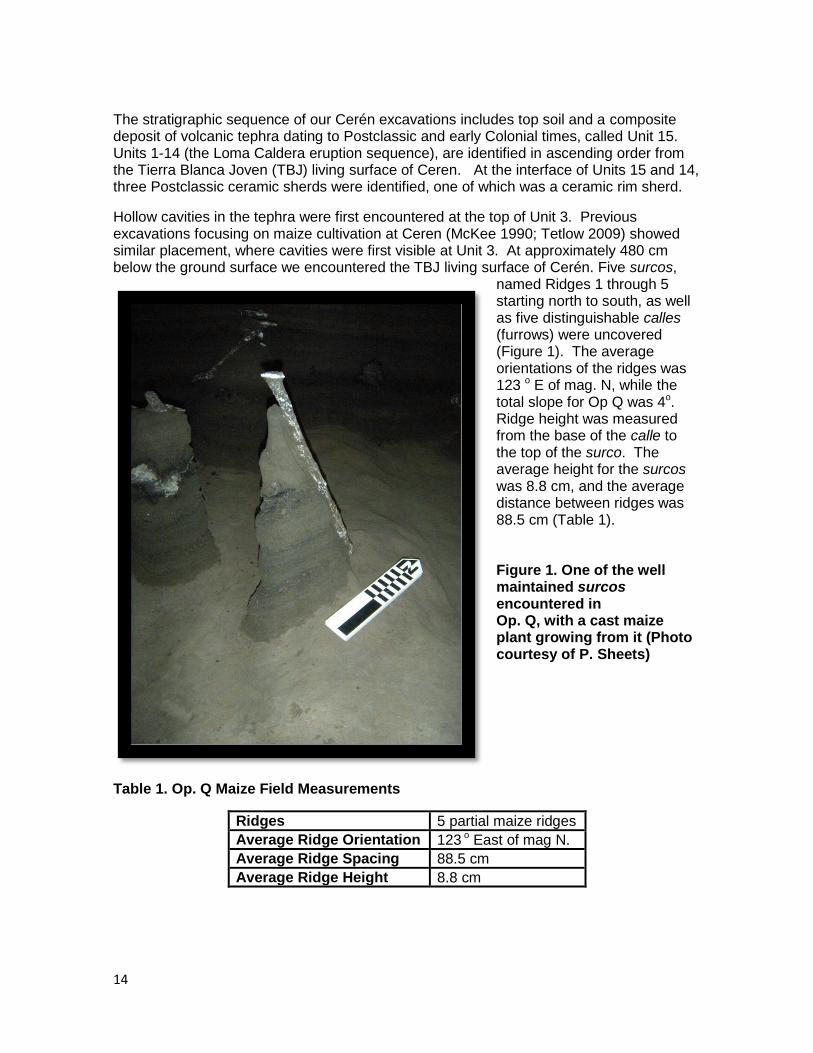
The stratigraphic sequence of our Cerén excavations includes top soil and a composite deposit of volcanic tephra dating to Postclassic and early Colonial times, called Unit 15. Units 1-14 (the Loma Caldera eruption sequence), are identified in ascending order from the Tierra Blanca Joven (TBJ) living surface of Ceren. At the interface of Units 15 and 14, three Postclassic ceramic sherds were identified, one of which was a ceramic rim sherd.
Hollow cavities in the tephra were first encountered at the top of Unit 3. Previous excavations focusing on maize cultivation at Ceren (McKee 1990; Tetlow 2009) showed similar placement, where cavities were first visible at Unit 3. At approximately 480 cm below the ground surface we encountered the TBJ living surface of Cerén. Five surcos,
named Ridges 1 through 5 starting north to south, as well as five distinguishable calles (furrows) were uncovered (Figure 1). The average orientations of the ridges was 123 o E of mag. N, while the total slope for Op Q was 4o. Ridge height was measured from the base of the calle to the top of the surco. The average height for the surcos was 8.8 cm, and the average distance between ridges was 88.5 cm (Table 1). Figure 1. One of the well maintained surcos encountered in Op. Q, with a cast maize plant growing from it (Photo courtesy of P. Sheets)
Table 1. Op. Q Maize Field Measurements
Ridges 5 partial maize ridges
Average Ridge Orientation 123 o East of mag N.
Average Ridge Spacing 88.5 cm
Average Ridge Height 8.8 cm
15
Each surco contained between two and five plant clusters, which were defined based on plant cast proximity. Ultimately, 18 clusters, labeled Clusters A-R, were found from Unit 3 down to the TBJ surface. All of these clusters were identified as maize plants. The majority of Op Q clusters contained multiple plant casts and, as a result, Op Q (along with Op W) had one of the highest densities of plant casts within all the operations excavated this field season. Unfortunately, Op Q was cast early on in the season‟s excavations, when the correct mixture of water and dental plaster had not been completely determined based on outside humidity and ground wetness. As a result, many of the plant casts that were excavated had not dried completely or were very fragile. In turn, as can be seen in the plant cast data (Appendix), parts of plant casts were lost, and a large portion of plant casts could not be properly fit together. There was, however, a surprisingly high number of mazorcas present. Seven mazorcas were identified, as well as five possible mazorcas. This is a higher density of mazorcas than seen in past field seasons (McKee 1990, Tetlow 2009).
Operation R Operation R was located five meters to the east of Operation Q. Like Ops Q, S and T, it was oriented 112 o E of mag. N and 202 o E of mag. N. Five ceramic sherds were identified along the Postclassic horizon at the top of Unit 14. In Op R, 23 hollow cavities were encountered starting in Unit 3, and at approximately 430 cm below the ground surface we identified the Ceren living surface. Four clearly visible ridges, labeled Ridges 1-4 beginning in the southern end of the operation, were present at the TBJ surface (Table 2). The average ridge-top to ridge-top spacing was 85 cm, while the average height of the ridges was 11.75 cm. The ridges were oriented at the same degree as those found in Op Q, at 123 o E of mag. N. Due to the proximity of this operation to Op Q and the similar ridge orientation, it can be presumed that Op Q and Op R have revealed the same milpa. Table 2. Op. R Maize Field Measurements
Ridges 4 partial maize ridges
Average Ridge Orientation 123 o East of mag N
Average Ridge Spacing 85 cm
Average Ridge Height 11.75 cm
Each ridge in Op. R contained three to five plant clusters. A total of 17 clusters were found, labeled A through Q. Cluster Q was the only cluster not located on a ridge. It contained a small plant found in TBJ within the calle between Ridges 3 and 4. Similar to Op. R, the dental plaster put into the holes in Cluster Q did not harden properly and, as a result, not all the casts survived excavation. Op. R contained a lesser amount of mazorcas than Op. Q: only two were recovered, one of which (R-1-E-1a) had visible corn kernels. The rest of the plants recovered were identified as maize stalk fragments, except for those found in Cluster Q. Cluster Q resulted in three unidentified plant fragments.
16
Operation S
Excavations in Op. S revealed a portion of maize field east of a segment of an earthen sacbe. The orientation of the three ridges encountered was 111 degrees E of Mag. N. Their average spacing was 71.5 cm and their average height was 7 cm (Table 3). Four plant clusters were identified in this field (Plant Clusters A-D), one of which contained a mazorca. Further description of this operation and the sacbe are included in Chapter 5 of this report.
Table 3: OP. S Eastern Maize Field Measurements
Ridges 3 partial maize ridges
Average Ridge Orientation 111o E of mag. N
Average Ridge Spacing 71.5 cm
Average Ridge Height 7 cm
Operation T
Operation T (Op. T) was one of the initial four operations excavated during the 2011 field season of the Maya Agriculture Project. This Op. was located along the southern boundary of the archaeological park of Joya de Ceren. The goal of these four initial test pits, including Op. T, was to encounter one of the land use lines between maize and manioc fields identified during the 2009 field season (Sheets et. al 2009). Op. T measured 3 x 3 meters and its east-west axis was oriented 26 o E of mag. N. The northeast corner of Op. T was located 8 meters north and 8 meters east of the northeast corner of Operation S.
The top soil encountered in Op. T was a weathered soil resulting from the El Playon Eruption of 1658 (part of Unit 15 in the Ceren site stratigraphic sequence). A small obsidian prismatic blade core was recovered from the Postclassic cultural horizon, the Interface of Units 14 and 15 (see Sheets Ch 7).
Within Unit 3 of the Loma Caldera sequence, hollow cavities were encountered and filled with dental plaster. One of these cast cavities ran horizontally and was identified as a tree branch broken and blown into its location by the forceful winds created by the eruption. Unfortunately, the species cannot be identified solely by the branch; however, this does indicate there was a tree growing to the north when the volcano erupted.
At approximately 415 centimeters below ground surface, we encountered the TBJ living surface and located a milpa (maize field). The results of Op. T excavations revealed portions of five maize surcos (planting ridges) and three calles (furrows). Only a very small portion of the southern-most ridge was visible in excavation, thus, measurements could not be accurately collected from this area. These surcos were named Ridges 1 through 5, from north to south. In addition, we encountered four somewhat linear earthen features situated in the calles (named Ridge 1A-4A from north to south). These features were labeled as inter-ridges, although their function is not yet fully understood. Notably, the ground-surface and ridges of Op. T demonstrated very irregular topography (Figure 2). The inter-ridges and irregular topography will be further described in the Discussions section below. Two ceramic sherds were recovered from the TBJ surface, both of which had been partially compacted into the surface. Furthermore, a lava bomb, approximately 30 cm in
17
diameter, directly impacted the eastern portions of Ridges 1A and 2. The lava bomb was part of the Unit 2 eruption and left a bomb sag of approximately 60 cm in diameter in the TBJ. The average orientation of the surcos was 116o E of mag. N. The average surco height in Op. T, as measured from the base of the calle to the top of the surco, was approximately 6.5 centimeters. The average height of the inter-ridges was 4 centimeters. The average ridge spacing measured was 80 cm. The average slope encountered in Op. T was 4 o towards the east (Table 4).
Table 4. Op. T Maize Field Measurements
Ridges 5 partial maize ridges
Average Ridge Orientation 116 o East of mag N
Average Ridge Spacing 80 cm
Average Ridge Height 6.5 cm
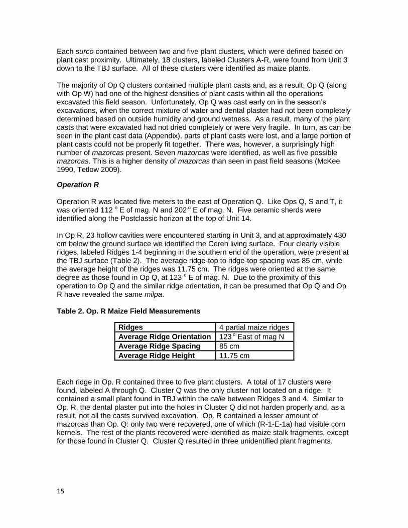
A total of 20 maize plant clusters (named Clusters B-V) were identified and cast with dental plaster. We encountered between 1 and 3 plant casts per planting cluster location. Although only one example of a mazorca (maize cob) was encountered, the presence of doubled over maize stalks indicated that these plants were deemed mature and ready for harvest by the cultivators of this milpa (maize field) (Figure 2)
.
Due to the humid climate in which excavations were conducted, not all plant casts survived excavations. Of the 21 plant clusters, only 17 were recovered (Clusters A; C; D; G; I-J; L-V). An extensive list of all plant casts recovered from excavations can be found in the Appendix of this report. The majority of the casts that survived excavations have been formally identified as maize. Given the size of the casts and the context in which they were recovered, it can be assumed that the unidentifiable casts are maize as well. The maize stalk fragments recovered from Op. T had an average width of 1.54 cm and an average thickness of 1.9 cm.
During the 2011 field season, a earthen sacbe was uncovered in Op. S, U and W (see Dixon Ch 5 in this report). Based on the spatial relationship between these Operations and Op. T, the sacbe would be located approximately 3.5 meters west of the west side wall of Op. T. Given this proximity, we can assume that the milpa encountered in this Op. continued until the sacbe formed its western boundary. Furthermore, the differences between the surcos (in form, maintenance, and orientation) encountered on either side of the sacbe indicate that these may have been different milpas. Thus, we can assume that the sacbe may have served as field boundary for the milpa encountered in Op. T (see Ch 5).
18
Figure 2. View of a well preserved cast of a doubled over maize stalk from Op. T. The irregular surface of the surcos is visible below the cast as well as in the wall profile (Photo courtesy of P. Sheets).
Operation U
In addition to a sacbe, two portions of maize fields were identified in Op. U (named Western and Eastern Fields). In the western field, 4 portions of ridges were identified and were oriented at 126 o E of Mag North (Table 5). The average spacing of these ridges was 85 cm and their average height was 7.5 cm. The ridge spacing was larger than observed in past excavations, although congruent to this year´s findings. Four plant cast clusters identified as maize were recovered from this field, including one mazorca and a doubled over maize stalk. In the eastern field, only two very small segments of maize ridges were encountered, therefore orientation could not be taken (Table 6). The average ridge spacing of these ridges was 85 cm and the average height was 7 cm. No plant casts were recovered east of the sacbe. Further description of the excavations and results of this operation can be found in Chapter 5 of this report.
Table 5: OP. U Western Maize Field Measurements
Ridges 4 partial maize ridges
Average Ridge Orientation 126o E of mag N
Average Ridge Spacing 85 cm
Average Ridge Height 7.5 cm

19
Table 6: OP. U Eastern Maize Field Measurements
Ridges 2 very small segments of maize ridges
Average Ridge Orientation Undetermined
Average Ridge Spacing 83 cm
Average Ridge Height 7 cm
Operation W
Two portions of maize fields were also identified to the east and west of a segment of the sacbe in this operation. In the western field, 4 segments of ridges, oriented at 126o E of Mag N were uncovered (Table 7). These ridges had an average spacing of 84.3 cm and an average height of 7.5 cm. 9 maize plant casts were recovered from this field segment, including seven mazorcas and multiple examples of bent over maize stalks. Two of the mazorcas were recovered from one same maize plant.
In the eastern portion of this operation, 5 segments of ridges oriented at 126o E of Mag North were identified (Table 8). These ridges had an average spacing of 82.3 cm and an average height of 11.2 cm. The ridges of this eastern field were taller and more formally constructed than then those of the western field. 5 maize plant clusters were recovered from this field, including 5 mazorcas and multiple examples of bent over maize stalks. Like in the western field, two of the mazorcas were recovered from one same maize plant. Further description of the excavations and results of this operation can be found in Chapter 5 of this report.
Table 7: OP. W Western Maize Field Measurements
Ridges 4 partial maize ridges
Average Ridge Orientation 126oE of mag N
Average Ridge Spacing 84.3 cm
Average Ridge Height 7.5 cm
Table 8: OP. W Eastern Maize Field Measurements
Ridges 5 partial maize ridges
Average Ridge Orientation 126 oE of mag N
Average Ridge Spacing 82.3 cm
Average Ridge Height 11.2 cm
Operation X Operation X was the furthest operation to the west, located less than 10 meters east of the road cut. The south east corner of this Op. was located 37 meters west and 3.15 meters north of the northwest corner of Op. AB. This position was chosen in order to determine whether the ridges observed in the road cut where for maize or manioc cultivation. Op X was the only operation this season aligned directly with magnetic north.
20
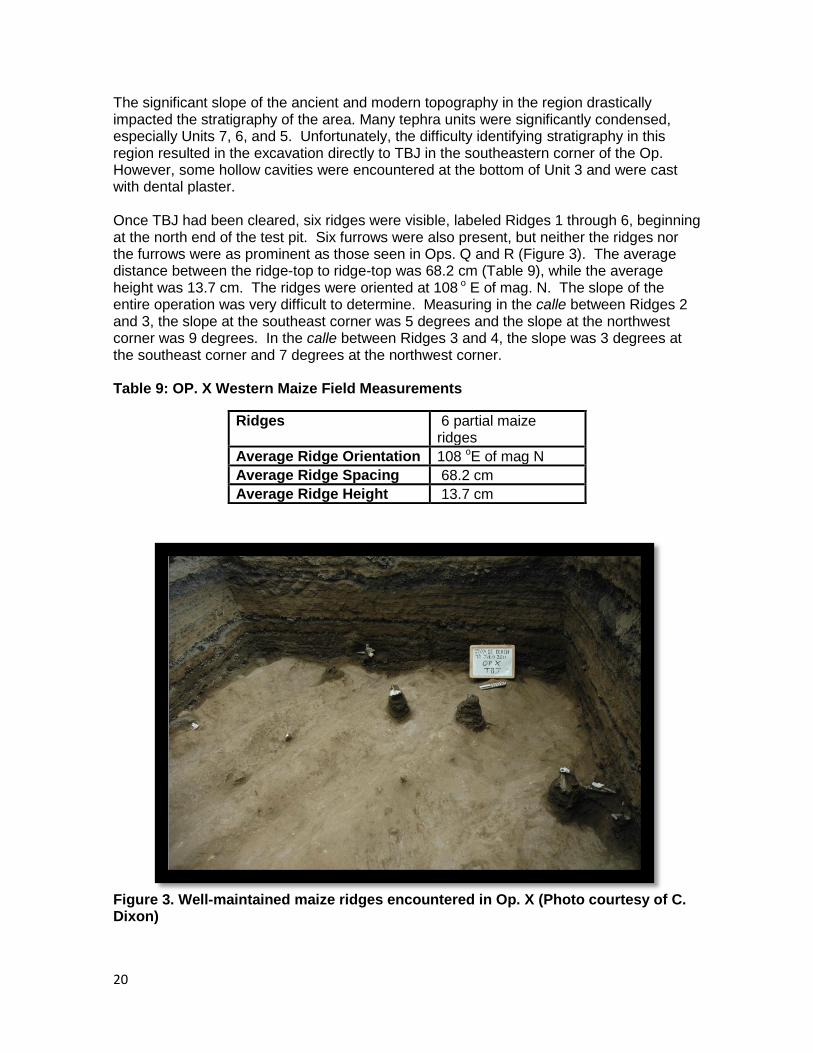
The significant slope of the ancient and modern topography in the region drastically impacted the stratigraphy of the area. Many tephra units were significantly condensed, especially Units 7, 6, and 5. Unfortunately, the difficulty identifying stratigraphy in this region resulted in the excavation directly to TBJ in the southeastern corner of the Op. However, some hollow cavities were encountered at the bottom of Unit 3 and were cast with dental plaster. Once TBJ had been cleared, six ridges were visible, labeled Ridges 1 through 6, beginning at the north end of the test pit. Six furrows were also present, but neither the ridges nor the furrows were as prominent as those seen in Ops. Q and R (Figure 3). The average distance between the ridge-top to ridge-top was 68.2 cm (Table 9), while the average height was 13.7 cm. The ridges were oriented at 108 o E of mag. N. The slope of the entire operation was very difficult to determine. Measuring in the calle between Ridges 2 and 3, the slope at the southeast corner was 5 degrees and the slope at the northwest corner was 9 degrees. In the calle between Ridges 3 and 4, the slope was 3 degrees at the southeast corner and 7 degrees at the northwest corner. Table 9: OP. X Western Maize Field Measurements
Ridges 6 partial maize ridges
Average Ridge Orientation 108 oE of mag N
Average Ridge Spacing 68.2 cm
Average Ridge Height 13.7 cm
Figure 3. Well-maintained maize ridges encountered in Op. X (Photo courtesy of C. Dixon)
21
The ridges contained one to three plant cast clusters each, with a total of 12 clusters (labeled Clusters A through L) recovered from this operation. Cluster A was located in the furrow between Ridges 1 and 2, and Cluster J was located in the furrow between Ridges 4 and 5. All other clusters were found on the ridges. While Op X had far less plant casts relative to most other current excavations, six mazorcas were recovered.
Operation Y
Operation Y (Op. Y) was also located along the southern boundary of the archaeological park of Joya de Cerén in order to further evaluate agricultural production in the region. Op. Y, like most excavations this season, was 3 x 3 m and oriented 112 and 202 o E of mag. N. The southeast corner of Op. Y was located 21 meters west of the northwest corner of Operation V.
In Unit 14, approximately 135 cm below the modern ground surface, a disturbance was encountered where a 31 cm deep pit had been dug. Found within the pit were highly fragmented bones, perhaps human remains. The two bones were poorly preserved long bones and rested in the upper portion of this 70 x 110 cm wide pit. No other bones and no burial goods were encountered. Because Unit 15 was not disrupted, this feature has been dated to the Postclassic. Postclassic ceramic sherds were also recovered from the top of Unit 14, although these were not spatially associated with the bones.
In the lower portion of Unit 3, much further into Until 3 than most other operations, we encountered hollow cavities. The cavities in the southern portion of the Op. were relatively smaller than those of the northern portion.
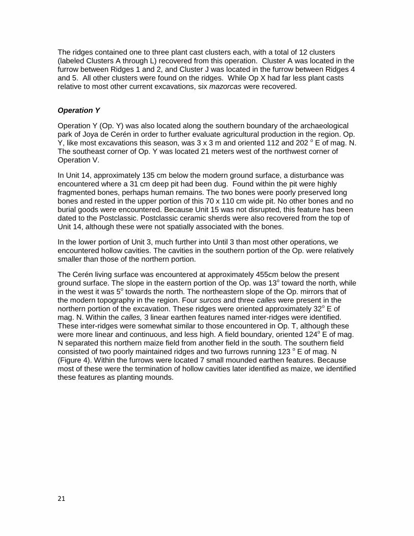
The Cerén living surface was encountered at approximately 455cm below the present ground surface. The slope in the eastern portion of the Op. was 13o toward the north, while in the west it was 5o towards the north. The northeastern slope of the Op. mirrors that of the modern topography in the region. Four surcos and three calles were present in the northern portion of the excavation. These ridges were oriented approximately 32o E of mag. N. Within the calles, 3 linear earthen features named inter-ridges were identified. These inter-ridges were somewhat similar to those encountered in Op. T, although these were more linear and continuous, and less high. A field boundary, oriented 124o E of mag. N separated this northern maize field from another field in the south. The southern field consisted of two poorly maintained ridges and two furrows running 123 o E of mag. N (Figure 4). Within the furrows were located 7 small mounded earthen features. Because most of these were the termination of hollow cavities later identified as maize, we identified these features as planting mounds.
22
Figure 4. Overview of the Southern (on left) and Northern Fields (on right) of Op. Y, separated by a field boundary. The field boundary, located in center of photograph, resembled an eroded surco and was not cultivated. The plant casts in the southern field are located above small planting mounds (Photo courtesy of C. Dixon).
In the north milpa, the average ridge-top to ridge-top spacing was 99.3 cm and the average height from the base of the furrow to the top of the ridges was 12.5 cm (Table 10). It is interesting to note that the height of the ridges progressively became larger from west to east. This may have been done deliberately to avoid erosion and collect more water as the slope increased. Additionally, the spacing between the northern ridges is more typical of manioc than maize ridges. One possible interpretation of these ridges was that they were originally constructed as manioc ridges, and then were reused for maize planting (see Dixon Ch 4 in this report for further discussion). Planting of maize on previous manioc beds was previously recorded in excavations south of the Cerén site (Dixon 2009, 2011).
Table 10. Op. Y North Maize Field Measurements
Ridges 4 ridge segments
Average Ridge Orientation 32 oE of mag N
Average Ridge Spacing 99.3 cm
Average Ridge Height 12.5
In the south milpa, the ridges were spaced on average 89.5 cm apart, while the planting mounds were spaced 87 cm apart on average (Table 11 and 12). This ridge spacing is more typical of maize fields than that in the north milpa, although it is still large ridge spacing the common Cerén maize (Sheets 2002, 2009). The average height of the ridges
23
in the north milpa was 4.9 cm and similarly the average height of the planting mounds was 4.8 cm.
Table 11. Op. Y South Maize Field Measurements- Ridges
Ridges
Average Ridge Orientation 123 oE of mag N
Average Ridge Spacing 89.5
Average Ridge Height 4.9
Table 12 Op. Y South Maize Field Measurements- Planting Mounds
Planting Mounds (P.L.) 7
Average P.L. Spacing 87
Average P.L. Height 4.8
A total of fifteen plant cast clusters were located in Op. Y (Clusters A-O) and all of these were identified as maize. In the northern milpa, 9 plant clusters (Clusters G -N) were encountered, six of which were full mazorca casts and 2 of which were mazorca fragments. The mazorcas of this field had an average diameter of 4.92 cm and an average width of 3.47 cm. The diameter is a more reliable assessment of mazorca maturity because many of these casts were from the bottom of Unit 3 and into the coarse tephra of Unit 2. Since much of the tephra from Unit 2 can influence width, the diameters are more representative of the actual mazorca. Although no examples of doubled over maize stalks were recovered, one mazorca was found upside down, while the others were all located close to TBJ, thus indicating that the maize plants may have been doubled over and ready for harvest.
In addition, 11 maize stock fragments were recovered from the south milpa, with an average diameter of 1.42 cm and an average thickness of 1.25 cm. We encountered between 1 and 3 plant casts per planting location, and one very small mazorca, therefore supporting the interpretation that the plants recovered from this field were younger than those to the north.
In the southern milpa all plant clusters were recovered from above mounds, with the exception of Cluster C. In addition, two very small vertical hollow cavities were noted during excavation of the plant casts but could not be cast because of their size. These were probably weeds. Although not all casts survived excavation, identification of linear striations diagnostic of maize was possible for most of the cavities. In comparison to the other maize casts recovered from the north milpa and from other operations, the casts recovered from the south milpa were very small in diameter and thickness, and were encountered lower in Unit 3. The average diameter for the casts of the south milpa was 1.21 cm, while the average thickness was 0.85 cm. The mazorca had a diameter of 3.4 cm and a thickness of 2.7 cm.

24
Because of the small size of the plant casts encountered in the south milpa, and the presence of one small mazorca, we are led to believe that this milpa was the location of a delayed planting. This practice has been encountered during past excavations (Tetlow 2009) and can be observed today. This will be further discussed below.
Operation AD
Operation AD (Op. AD) was also located along the southern boundary of the archaeological park of Joya de Ceren. It was hoped this test pit would intersect the projected field boundary observed in Op. Y between two maize fields, as well as an additional possibly the field boundary between the milpas encountered in Op. Y and the clear space in Op. V. Op. AD was 3 x 3 meters and oriented 112 and 202o E of mag. N. The northwest corner of Op. AD was located 12.5 meters east and 1.7 meters south of the southeast corner of Op. Y.
Evidence of Postclassic reoccupation was encountered at the top of Unit 14, where one obsidian prismatic blade, two pieces of obsidian debitage, and five ceramic sherds were recovered (see Sheets Ch 7 and Ch 8 in this report).
Within Unit 3 we encountered multiple hollow cavities that were horizontal in direction. The one vertical cavity that was cast was identified as a branch that was blown into its location by the force of the eruption.
At approximately 445 cm below ground surface, we encountered two ridges and two furrows on the TBJ living surface in the southern portion of the Op (southern field). These ridges were oriented 125o E of mag. N. We also identified two likely abandoned planting beds oriented approximately 38 o E of mag. N in the northern portion of the Op (northern field). Between the ridges and the two possible planting beds, we encountered what appears to be the continuation of the field boundary identified in Op. Y. This field boundary, similarly to the field boundary encountered in Op. Y, is linear yet appears partially eroded and flattened on its northern side. The height of the field boundary from the base of the furrow to its south was 8 cm. Additionally, a rise in the topography located in the southern most portion of the Op. was encountered. Because only a very small portion of this feature was uncovered, we cannot identify its function, although one possibility is that this is a portion of another ridge. The ridges of the southern maize field were hard to identify, in part due to the large lava bomb that directly impacted the TBJ and the two earthquake cracks that were encountered in the southwest corner of the Op. In addition three small mounds were located in the furrow between the southern ridges. These may have been planting mounds, although only the western most mound had any evidence of planting.
Table 13. Op. AD South Maize Field Measurements- Ridges
Ridges 2
Average Ridge Orientation 125o E of mag N
Average Ridge Spacing 99.25
Average Ridge Height 6.6
Table 14. Op. AD North Maize Field Measurements- Ridges
Ridges 2
25
Average Ridge Orientation 38o E of Mag N
Average Ridge Spacing 107-110 cm
Average Ridge Height 2-3 cm
The southern maize field had average ridge spacing of 99.25 cm and an average height of 6.6 cm (Table 13). There was a noticeable color difference between the two fields. The southern field and field boundary region of TBJ was a Munsell color of 10YR 4/3 “brown” with a high sand content. The northern beds have a Munsell color of 10YR 3/2 “very dark grayish brown” with much more compaction and relatively little sand content. The spacing between the two possible abandoned planting beds varied between 107 and 110 cm, and their height varied between 2 to 3 cm (Ch 4) (Table 14).
There were nine plant clusters identified in Op. AD (Clusters A-I). As previously mentioned, Cluster I was identified a branch fragment. Cluster D was a small somewhat circular hollow cavity encountered directly above TBJ. The majority of the other plants casts have been identified as maize, although a few remain unidentified. The average diameter for the plant casts identified as maize was 0.99 cm, and the average thickness was 0.93 cm. Cluster B was a fragment of a maize stalk that must have been broken and blown into its present location from the force of the eruption, as it was encountered directly above TBJ.
Importantly, Cluster H was identified as a manioc plant cast (see Dixon Ch 4). The manioc was recovered from the northern field in the eastern bed. It consists of a stalk growing from the TBJ of approximately 15 cm long, and a root system within the TBJ of four roots. The root system grew down to a depth of approximately 25 cm below TBJ surface. Because this manioc plant was found alone, and the feature in which it was located was not a formal ridge, it is probable that this manioc plant was a volunteer (Sheets personal communication 2011). However, due to the spacing between both features, and the presence of a manioc plant, another possible interpretation is that these are abandoned manioc ridges. If so, this would support the hypothesis that the north milpa located in Op. Y was originally constructed as a manioc field (see Dixon Ch 4 in this report).
Discussions
The 2011 field research was aimed to expand our knowledge on the agricultural systems closer to the Ceren site center. Guided by the 2009 discoveries of intensive manioc fields and field boundaries, our goal was to intersect the same field boundaries and observe past cultivation decisions. Through the 2011 discovery of land use lines (field boundaries and sacbe), multiple planting styles and second maize planting, our knowledge has been greatly furthered on the practice of maize planting at Ceren
Variability of cultivation methods and planting and harvesting timing
The milpas found in Ops Q, R and X in the 2011 field season provided continuity with those found in previous excavations. In the highly organized maize fields encountered near Household 2, maize was planted on ridges 10 to 20 cm high that were spaced about 80 cm apart. These received a great deal of energy input, certainly because of their proximity to the Household (McKee 2002). The ridges encountered in Operations Q, R and X demonstrate similar construction technique and maintenance, as well as dimensions of the majority of ridges uncovered during previous excavations.
26
Now that we have examples of this planting style at different distances from the site center, it is clear that the proximity to a household is not the only factor for the regular and meticulous maintenance of fields. It is very possible that these types of ridges demonstrated the widely used construction and maintenance techniques, because they represent the highest ideal of maize cultivation. The microtopography improves the edaphic conditions of the TBJ in order to facilitate highly productive maize fields.
The excavations of Op. T, Y, and AD have afforded us examples of the different agricultural practices that took place at the Ceren site. The construction of the ridges and furrows, as well as the presence of planting beds encountered this season vary greatly from the majority of milpa previously excavated (Sheets 2002, 2009). Additionally, two stages of maturity of maize were again identified this season. The variation of milpa encountered this season includes the lack of maintained ridges of Op. T and AD, the inter-ridges of Op. T and Y, and the planting mounds located in Op. Y.
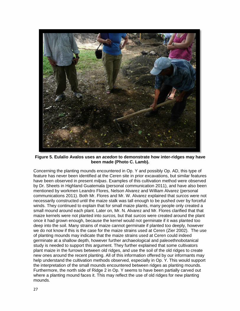
Thanks to informal discussions conducted with some of our workmen and traditional farmers who presently work in milpas, some interpretations on the functions of these different types of ridges have been brought forth.
Eulalio Avalos, a milpero who cultivates maize and beans south of the archaeological park boundary, demonstrated with an acedon how the inter-ridges in Op. T and Y may have been created. When pulling the soil towards himself with the acedon in order to create a ridge, then moving onto to construct another ridge, a linear area of soil between the ridges was left untouched by the acedon (Figure 5). Although the inhabitants of Ceren did not possess metal tools, they may have utilized wooden tools fashioned into paddle like forms (Sheets 2011, personal communication). It is reasonable to assume a similar process of ridge construction with some form of tools would have been undertaken at Cerén in the past.
27
Figure 5. Eulalio Avalos uses an acedon to demonstrate how inter-ridges may have been made (Photo C. Lamb).
Concerning the planting mounds encountered in Op. Y and possibly Op. AD, this type of feature has never been identified at the Ceren site in prior excavations, but similar features have been observed in present milpas. Examples of this cultivation method were observed by Dr. Sheets in Highland Guatemala (personal communication 2011), and have also been mentioned by workmen Leandro Flores, Nelson Alvarez and William Alvarez (personal communications 2011). Both Mr. Flores and Mr. W. Alvarez explained that surcos were not necessarily constructed until the maize stalk was tall enough to be pushed over by forceful winds. They continued to explain that for small maize plants, many people only created a small mound around each plant. Later on, Mr. N. Alvarez and Mr. Flores clarified that that maize kernels were not planted into surcos, but that surcos were created around the plant once it had grown enough, because the kernel would not germinate if it was planted too deep into the soil. Many strains of maize cannot germinate if planted too deeply, however we do not know if this is the case for the maize strains used at Ceren (Zier 2002). The use of planting mounds may indicate that the maize strains used at Ceren could indeed germinate at a shallow depth, however further archaeological and paleoethnobotanical study is needed to support this argument. They further explained that some cultivators plant maize in the furrows between old ridges, and use the soil of the old ridges to create new ones around the recent planting. All of this information offered by our informants may help understand the cultivation methods observed, especially in Op. Y. This would support the interpretation of the small mounds encountered between ridges as planting mounds. Furthermore, the north side of Ridge 2 in Op. Y seems to have been partially carved out where a planting mound faces it. This may reflect the use of old ridges for new planting mounds.
28
It is important to note that the information given by our informants concerning maize cultivation is subjective. Some of the methods explained have not been directly observed by the present authors, and others have but with variable planting conditions. Such observations, particularly in Joya de Cerén and neighboring regions provide a useful analogy to the past, though more ethnoarchaeological study would be required for a proper sample size of the region. Additionally, these data should always be considered in light of the large cultural and natural disruptions that have historically occurred throughout El Salvador‟s prehistory and history.
During the excavations of Op. Y, two phases of maturity of maize were observed. The northern maize field revealed mature maize stalks as well as 6 large mazorcas. In addition, the presence of one mazorca upside-down indirectly suggests that the stalk of this plant may have been doubled over. However, in the southern maize field within the same Op., very small maize stalks and one small mazorca were recovered. This suggests that while the northern field was ready for harvest, the southern field was a delayed planting.
Similarly to different planting times, the cultivators of Ceren may have harvested at different times. The 2011 excavations recovered more mazorcas then in 2009, which were located further from the site center. One interpretation advanced by Christine Dixon, is that harvesting may have started further from the site and progressed towards the site (personal communication 2011). This may have prevented mature mazorcas located further from households to stay untended for longer periods of time. Another interpretation is that harvesting may have taken place at different times as a result of staggered planting. During dry spells of the planting season, some cultivators today take the risk of planting while others wait for the rain (Sheets, personal communication 2011 and personal observation, Lamb 2011). A cultivator may plant at multiple different times to ensure that he has at least one productive crop. In turn, this agriculture technique may have also affected the density of mazorcas found in different fields. However, taphonomic conditions and the quality of excavations and casting must be taken into consideration, as the recorded amount of mazorcas may depend on these conditions. Further excavations are necessary to test this hypothesis.
Presence of Multiple Fields
In addition to the variety of planting styles, ridge construction, and planting timing, the presence of land use lines supports the interpretation that excavations have revealed multiple maize fields.
East of the sacbe, in Ops Q and R, the maize ridges were encountered that demonstrated the same orientation, and similar construction techniques. In addition, ridge height and spacing of these ridges were somewhat similar (Table 14). Due to these similarities, and the proximity of these two Ops, it is probable that the ridges uncovered were part of the same milpa (Maize Field 1).
Table 14. Comparison of Ridges in Operations Q and R
Op. Q Op. R
Ridge Orientation 123 E of mag N 123 E of mag N
Ridge Height (cm) 8.8 11.75
Ridge Spacing (cm) 88.5 85
29
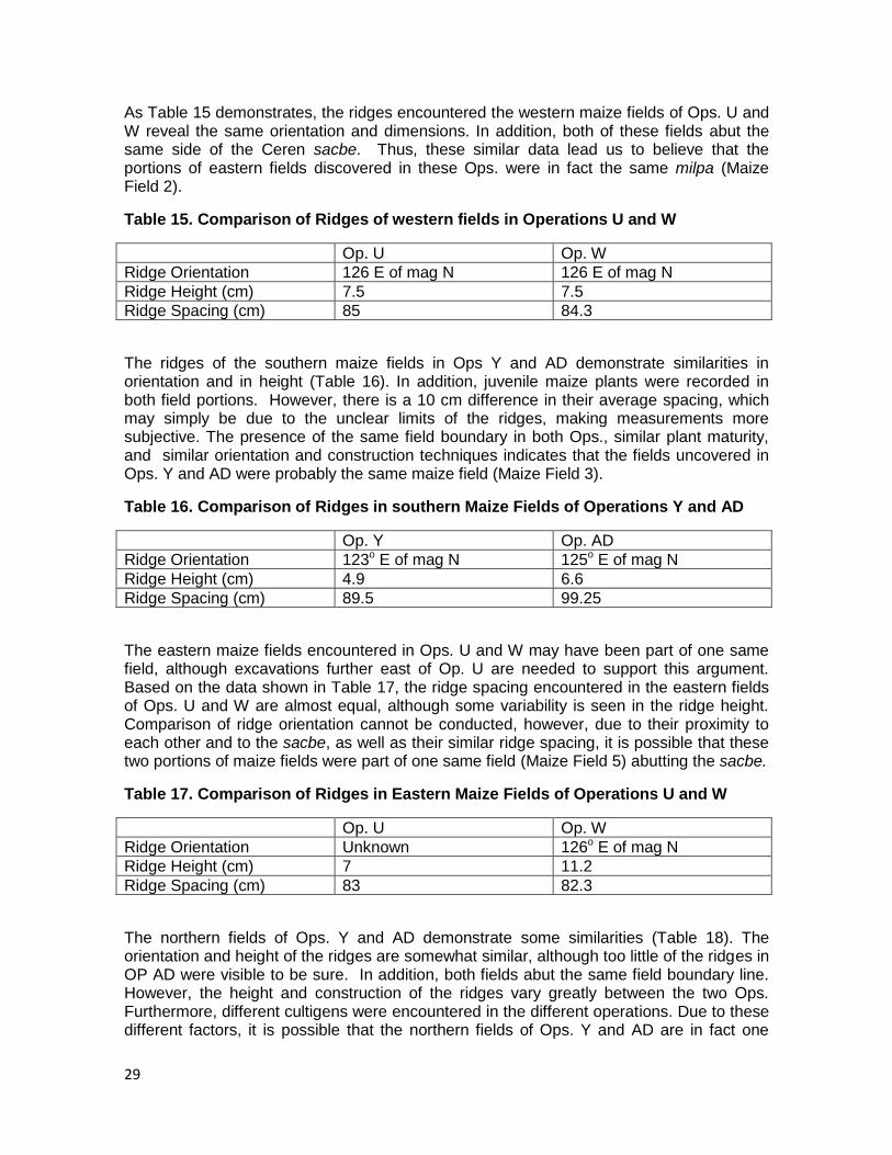
As Table 15 demonstrates, the ridges encountered the western maize fields of Ops. U and W reveal the same orientation and dimensions. In addition, both of these fields abut the same side of the Ceren sacbe. Thus, these similar data lead us to believe that the portions of eastern fields discovered in these Ops. were in fact the same milpa (Maize Field 2).
Table 15. Comparison of Ridges of western fields in Operations U and W
Op. U Op. W
Ridge Orientation 126 E of mag N 126 E of mag N
Ridge Height (cm) 7.5 7.5
Ridge Spacing (cm) 85 84.3
The ridges of the southern maize fields in Ops Y and AD demonstrate similarities in orientation and in height (Table 16). In addition, juvenile maize plants were recorded in both field portions. However, there is a 10 cm difference in their average spacing, which may simply be due to the unclear limits of the ridges, making measurements more subjective. The presence of the same field boundary in both Ops., similar plant maturity, and similar orientation and construction techniques indicates that the fields uncovered in Ops. Y and AD were probably the same maize field (Maize Field 3).
Table 16. Comparison of Ridges in southern Maize Fields of Operations Y and AD
Op. Y Op. AD
Ridge Orientation 123o E of mag N 125o E of mag N
Ridge Height (cm) 4.9 6.6
Ridge Spacing (cm) 89.5 99.25
The eastern maize fields encountered in Ops. U and W may have been part of one same field, although excavations further east of Op. U are needed to support this argument. Based on the data shown in Table 17, the ridge spacing encountered in the eastern fields of Ops. U and W are almost equal, although some variability is seen in the ridge height. Comparison of ridge orientation cannot be conducted, however, due to their proximity to each other and to the sacbe, as well as their similar ridge spacing, it is possible that these two portions of maize fields were part of one same field (Maize Field 5) abutting the sacbe.
Table 17. Comparison of Ridges in Eastern Maize Fields of Operations U and W
Op. U Op. W
Ridge Orientation Unknown 126o E of mag N
Ridge Height (cm) 7 11.2
Ridge Spacing (cm) 83 82.3
The northern fields of Ops. Y and AD demonstrate some similarities (Table 18). The orientation and height of the ridges are somewhat similar, although too little of the ridges in OP AD were visible to be sure. In addition, both fields abut the same field boundary line. However, the height and construction of the ridges vary greatly between the two Ops. Furthermore, different cultigens were encountered in the different operations. Due to these different factors, it is possible that the northern fields of Ops. Y and AD are in fact one
30
same field, although further excavations are needed to support this argument (Maize Field 6).
Table 18. Comparison of Ridges in North fields of Operations Y and AD
Op. Y Op. AD
Ridge Orientation 32o E of mag N 38o E of mag N
Ridge Height (cm) 12.5 2.5
Ridge Spacing (cm) 99.3 108.5
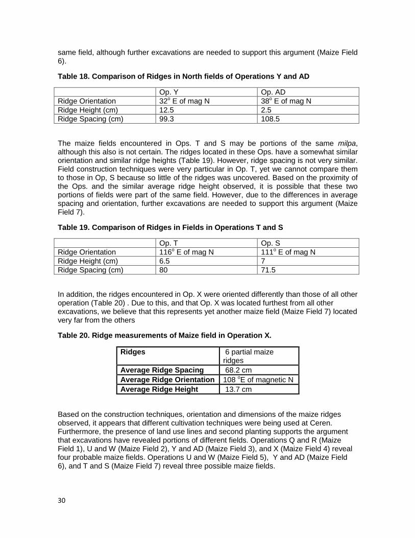
The maize fields encountered in Ops. T and S may be portions of the same milpa, although this also is not certain. The ridges located in these Ops. have a somewhat similar orientation and similar ridge heights (Table 19). However, ridge spacing is not very similar. Field construction techniques were very particular in Op. T, yet we cannot compare them to those in Op, S because so little of the ridges was uncovered. Based on the proximity of the Ops. and the similar average ridge height observed, it is possible that these two portions of fields were part of the same field. However, due to the differences in average spacing and orientation, further excavations are needed to support this argument (Maize Field 7).
Table 19. Comparison of Ridges in Fields in Operations T and S
Op. T Op. S
Ridge Orientation 116o E of mag N 111o E of mag N
Ridge Height (cm) 6.5 7
Ridge Spacing (cm) 80 71.5
In addition, the ridges encountered in Op. X were oriented differently than those of all other operation (Table 20) . Due to this, and that Op. X was located furthest from all other excavations, we believe that this represents yet another maize field (Maize Field 7) located very far from the others
Table 20. Ridge measurements of Maize field in Operation X.
Ridges 6 partial maize ridges
Average Ridge Spacing 68.2 cm
Average Ridge Orientation 108 oE of magnetic N
Average Ridge Height 13.7 cm
Based on the construction techniques, orientation and dimensions of the maize ridges observed, it appears that different cultivation techniques were being used at Ceren. Furthermore, the presence of land use lines and second planting supports the argument that excavations have revealed portions of different fields. Operations Q and R (Maize Field 1), U and W (Maize Field 2), Y and AD (Maize Field 3), and X (Maize Field 4) reveal four probable maize fields. Operations U and W (Maize Field 5), Y and AD (Maize Field 6), and T and S (Maize Field 7) reveal three possible maize fields.
31
Different fields and different cultivation methods: different cultivators?
Field boundaries alone do not demonstrate different cultivators. However, different cultivation methods, especially when observed in association to field boundaries, may reflect choices and techniques of an individual.
Mr. Avalos and his wife Isabela expressed that different families create ridges in different ways, which is clearly visible when observing milpas throughout Joya de Ceren. In addition to edaphic conditions of the soils and topography, this may be a one explanation for the differences in construction techniques and orientations observed between the seven probable fields during this field season. Given that Op. T had doubled-over stalks, we can speculate that this milpa was carefully maintained just before the eruption. Thus, the “lack” of ridge maintenance observed in this milpa is the result of a choice made by the cultivator and not the result of abandonment. In addition, the possible shift from manioc to maize cultivation observed in the northern field of Op.Y reflects a choice concerning subsistence, although it is difficult to know who made that choice (see Dixon Ch 4).
The differences encountered between the variety of milpas uncovered in 2011 and past excavations clearly demonstrate that cultivation is not a standardized activity at Ceren, and may reflect a certain level of independence within a larger agricultural community (Dixon 2009). Christine Dixon argued that “the stylistic differences between manioc beds were likely either to mitigate excess run-off and/or the material expression of how different farmers envision proper manioc planting” (2011:219). This argument can be extended to the variability observed in the milpas at Ceren. Not only do cultivation methods depend on topography, edaphic conditions of soil, or maturity of the plants, they may also reflect personal choices made by cultivator. These data contribute to the model of Smallholders put forth by Netting (1993) that may be used for Ceren (Sheets et al 2009).
Conclusions
Excavations during this field season revealed seven possibly different maize fields and a wide variety of cultivation methods. In addition, a late planting was observed in one Operation. While some of the maize fields are congruent with those observed in past excavations, others have demonstrated that variation in milpas also exists. Thanks to this field season‟s large sample of maize fields, what was considered the planting style in past years can now be viewed as one of many. Stylistic differences in agricultural practices were also encountered in manioc fields excavated in 2009. This variability, now observed through two cultigens, supports the argument that cultivators of Ceren may have enjoyed some form of independence from higher authority concerning their agricultural activities.
References
Dixon, Christine C.
2011 Rethinking Southeast Maya Agriculture: A view from the Manioc Fields of Joya de Ceren. La Universidad (14-15), Numero especial Arqueologia de El Salvador. Editorial Universitaria, San Salvador.
2009 Manioc Agriculture. In Report of the 2009 Maya Agricultural Project South of Joya de Cerén, El Salvador, edited by P. Sheets. Enlace Academico Centroamericano, Fundacion Clic. San Salvador, El Salvador. (www.colorado.edu/Anthropology/people/bios/sheets.html)
32
McKee, Brian R.
1996 Chapter 3: Archaeological Investigations in Operation 2, Joya de Cerén in Preliminary Report of the Cerén Research Project 1996 Field Season. Ed. Payson D. Sheets and Linda A. Brown. 1990 Chapter 8: Excavations at Structure 9 in 1990 Investigations at the Cerén Site, El Salvador: A Preliminary Report. Ed. Payson D. Sheets and Brian R. McKee. Tetlow, Andrew P.
2009 Classic Period Maize Agriculture South of Joya de Ceren. In Report of the 2009 Maya Agricultural Project South of Joya de Cerén, El Salvador, P. Sheets (s.ed). Enlace Academico Centroamericano, Fundacion Clic. San Salvador, El Salvador. (www.colorado.edu/Anthropology/people/bios/sheets.html)
Sheets, Payson
2002, Before the volcano erupted, the ancient Céren village in central America. University of Texas Press, Austin.
Sheets et al.
2009 Report of the 2009 Maya Agricultural Project South of Joya de Cerén, El Salvador. P. Sheets (s. ed.) Enlace Academico Centroamericano, Fundacion Clic. San Salvador, El Salvador. (www.colorado.edu/Anthropology/people/bios/sheets.html)
Zier, Christian J.
2002 Intensive Raised-Field Agriculture in a Posteruption Environment, El Salvador. In Gardens of Prehistory, the archaeology of settlement agriculture in Greater Mesoamerica. Thomas W. Killion (ed. s.). University of Alabama Press, Tuscaloosa.
Acknowledgements from Celine Lamb
I would like to express my deepest gratitude to Payson Sheets, for giving me the incredible opportunity of working at the site of Ceren. Excavating at Ceren under his leadership was a wonderful learning experience. Thank you to Chris Dixon, for the strength that she brought to this project. Chris was a great field and laboratory director, editor, and friend. Her tireless efforts and dedication to all aspects of project life are more than appreciated.
My gratitude to the Salvadorian government, CONCULTURA and Dr. Ramón Rivas, for sharing their history and patrimony with us. It has been a pleasure and an honor to work in El Salvador.
Finally, an immense thank you to the 22 Salvadoran men with whom we worked with for the past two months. Without their hard work and curiosity, none of this research would be possible. I hold them in the upmost respect and can only hope to work with such a great team again. A special thanks to Leandro “Chabelo” Flores, a close friend and colleague.

33
His knowledge was a great asset during excavations, and his generosity and friendliness was most appreciated at all time.
Acknowledgements from Theresa Heindel
Thank you so much to Payson Sheets, who is the reason this research was possible. His dedication to the site of Ceren and to the cultural history of El Salvador is inspiring, and I hope to continue learning through his example. Thank you also to Dr. Ramon Rivas and the El Salvadorean government for their support and allowing me to work in their great country. Thank you as well to Christine Dixon, who worked tirelessly at site and in the lab to ensure the project, and project life, ran as smoothly as possible. I would also like to send a big thank you to the people of Joya de Ceren and El Salvador for all their help and their amazing hospitality. Finally, thank you to the wonderful men who worked at the site this field season. From them, I learned about maize, Spanish, and archaeology, and will always be indebted to them.
34
Chapter 3. Cleared Areas-Field Season 2011
Alexandria Halmbacher
Introduction
The Loma Caldera eruption (c. AD 630) resulted in the preservation of a Classic Period Maya village, including domiciles, agricultural fields, and living spaces (Sheets 2002, 2006). Such preservation has afforded the opportunity to not just study structures and artifacts, but also to examine the ways in which multiple spaces were utilized in the past. Throughout the 2011 field season a significant number of operations recorded cleared areas that were not cultivated immediately prior to the Loma Caldera eruption. The majority of these operations were located along the southern perimeter of the archaeological park where the slope of the natural topography was at its greatest. Only one of the 2011 operations was located outside of the archaeological park, 200 meters south of the site center. This operation, Op. AA, was positioned near operation P from the 2009 field season, which had yielded a botanical midden. Operation P was located 54 meters south, and 41.5 meters east of a corner fence post mapped-in during the 2009 field season. Evidence suggests that these areas were deliberately cleared of vegetation, and given the number of surrounding areas actively producing crops were possibly used as agricultural processing centers. The presence of cleared areas also suggests that the level of cultivation was not geared to maximize every available space, indicating that the pressure for food production faced by the residents of Classic Period Joya de Cerén was likely not extremely high (Christine Dixon, personal communication to George Maloof, 2009). The excavations of 2011 have revealed three distinct types of cleared spaces. The first type, which was found in Operations V and AA, is a deliberately leveled, flat surface area. The second type, found in Operations Z and AA, is an area that was cleared but retained its natural topography. The final type of cleared area, found in Operations AB and AC is abandoned surcos, which previously were used to cultivate manioc.
Operation V
The northeast corner of operation V was located 32 meters west and 5.2 meters north of the northwest corner of operation Q. The northwest corner of V was 5.5 meters east and 1.7 meters north of the northeast corner of operation AD. Twelve pieces of Post Classic ceramics, 11 body sherds and 1 rim sherd, were identified at the top of Unit 14. The entire Loma Caldera sequence was intact. Approximately 479 cm below the ground surface we identified the Cerén living surface, the tierra blanca joven (TBJ) horizon, with a slope of 9 degrees toward the south, and 6 degrees toward the east. Only three plants (plant clusters A-C) were identified in the excavation of Op. V, and all of these were likely branches and roots of a tree contained within Unit 3. Due to the presence of several large branches and roots found in Unit 3, it has been hypothesized that the area to the north of operation V was heavily forested, and might have been a contributing factor in the decision to remove all vegetation to the south. Operation V was a leveled surface and possibly an area for processing actively cultivated crops. This interpretation is based on its proximity of this area to Operations Q, AD, and Y, all of which provide evidence for active maize cultivation. Additionally six pieces of Classic ceramics, all body sherds, were located in this excavation.
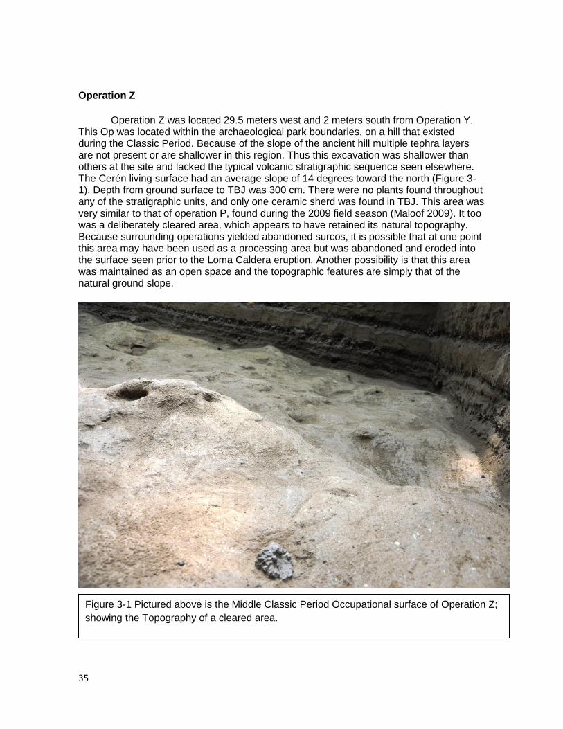
35
Operation Z
Operation Z was located 29.5 meters west and 2 meters south from Operation Y. This Op was located within the archaeological park boundaries, on a hill that existed during the Classic Period. Because of the slope of the ancient hill multiple tephra layers are not present or are shallower in this region. Thus this excavation was shallower than others at the site and lacked the typical volcanic stratigraphic sequence seen elsewhere. The Cerén living surface had an average slope of 14 degrees toward the north (Figure 3-1). Depth from ground surface to TBJ was 300 cm. There were no plants found throughout any of the stratigraphic units, and only one ceramic sherd was found in TBJ. This area was very similar to that of operation P, found during the 2009 field season (Maloof 2009). It too was a deliberately cleared area, which appears to have retained its natural topography. Because surrounding operations yielded abandoned surcos, it is possible that at one point this area may have been used as a processing area but was abandoned and eroded into the surface seen prior to the Loma Caldera eruption. Another possibility is that this area was maintained as an open space and the topographic features are simply that of the natural ground slope.
Figure 3-1 Pictured above is the Middle Classic Period Occupational surface of Operation Z;
showing the Topography of a cleared area.

36
Operation AA
The southwest corner of operation AA is 55 meters east at 118o E of mag. N and 32.8 meters south, at 202 o E of mag. N of a modern fence corner identified on the map of 2009. The depth to TBJ is 312 cm. This shallow depth was due to the compressed volcanic stratigraphy. The slope of the TBJ living surface in Operation AA is 14 degrees to the northwest, and 3 degrees towards the east, (Figure 3-2). The northwest corner of the operation was similar to the cleared area found in Operation Z. It appeared to be a deliberately cleared area, which retained its natural topography. There were two plants (cluster E and F), found in TBJ, and these were identified as roots, likely from trees. Just as in Operation Z, it is possible that additional paleobotanica data in this area might be found in the soil samples. Given only a portion of this area is visible in the excavation, one possibility is that this was not a completely cleared space, but contained some type of vegetation, as indicated by plant clusters E and F. In the southeast corner of operation AA there was an additional cleared space that showed evidence of both deliberate clearing and leveling of the area. This is similar to the cleared and level space seen in Operation V. One interpretation of this leveled region is as a processing area for crops, as it directly borders a manioc field. Alternatively, the cleared area is also adjacent to Feature 1, a storage or domicile facility identified in the southwest corner of the Op. It is possible that the leveled and cleared area in this region was utilized for a variety of activities. If the facility was a domicile, then this might be an intensively utilized outdoor household space. An area such as this one might have been used by those inhabiting the facility for processing of their crops or other daily activities. In the two regions discussed above, there were a total of 58 Post-classic body sherds, and 1 rim sherd. For a more detailed report on all ceramics found within the operation see chapter 8.
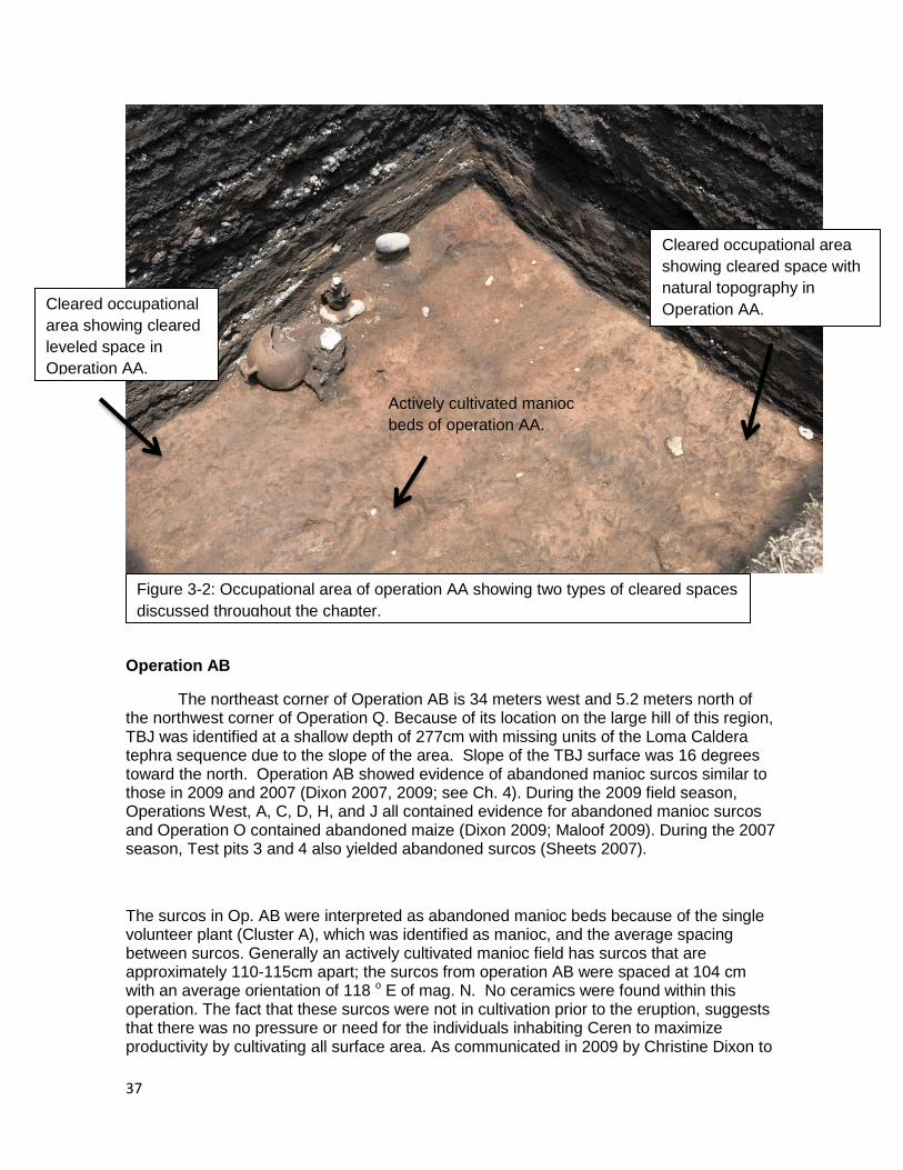
37
Operation AB
The northeast corner of Operation AB is 34 meters west and 5.2 meters north of the northwest corner of Operation Q. Because of its location on the large hill of this region, TBJ was identified at a shallow depth of 277cm with missing units of the Loma Caldera tephra sequence due to the slope of the area. Slope of the TBJ surface was 16 degrees toward the north. Operation AB showed evidence of abandoned manioc surcos similar to those in 2009 and 2007 (Dixon 2007, 2009; see Ch. 4). During the 2009 field season, Operations West, A, C, D, H, and J all contained evidence for abandoned manioc surcos and Operation O contained abandoned maize (Dixon 2009; Maloof 2009). During the 2007 season, Test pits 3 and 4 also yielded abandoned surcos (Sheets 2007).
The surcos in Op. AB were interpreted as abandoned manioc beds because of the single volunteer plant (Cluster A), which was identified as manioc, and the average spacing between surcos. Generally an actively cultivated manioc field has surcos that are approximately 110-115cm apart; the surcos from operation AB were spaced at 104 cm with an average orientation of 118 o E of mag. N. No ceramics were found within this operation. The fact that these surcos were not in cultivation prior to the eruption, suggests that there was no pressure or need for the individuals inhabiting Ceren to maximize productivity by cultivating all surface area. As communicated in 2009 by Christine Dixon to
Cleared occupational area
showing cleared space with
natural topography in
Operation AA. Cleared occupational
area showing cleared
leveled space in
Operation AA.
Figure 3-2: Occupational area of operation AA showing two types of cleared spaces
discussed throughout the chapter.
Actively cultivated manioc
beds of operation AA.
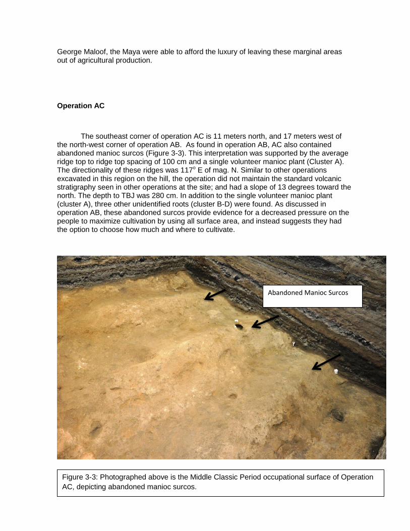
38
George Maloof, the Maya were able to afford the luxury of leaving these marginal areas out of agricultural production.
Operation AC
The southeast corner of operation AC is 11 meters north, and 17 meters west of the north-west corner of operation AB. As found in operation AB, AC also contained abandoned manioc surcos (Figure 3-3). This interpretation was supported by the average ridge top to ridge top spacing of 100 cm and a single volunteer manioc plant (Cluster A). The directionality of these ridges was 117o E of mag. N. Similar to other operations excavated in this region on the hill, the operation did not maintain the standard volcanic stratigraphy seen in other operations at the site; and had a slope of 13 degrees toward the north. The depth to TBJ was 280 cm. In addition to the single volunteer manioc plant (cluster A), three other unidentified roots (cluster B-D) were found. As discussed in operation AB, these abandoned surcos provide evidence for a decreased pressure on the people to maximize cultivation by using all surface area, and instead suggests they had the option to choose how much and where to cultivate.
Figure 3-3: Photographed above is the Middle Classic Period occupational surface of Operation
AC, depicting abandoned manioc surcos.
Abandoned Manioc Surcos
39
Discussion
The 2011 field season has yielded a considerable amount of data about three different types of cleared areas, as well suggestions and ideas about their possible uses. The first of these cleared space types is that which has been cleared of vegetation but retains its natural topography. Within Operation AA and Z we find this type of space. The proximity of these operations to abandoned and actively cultivated surcos might indicate that these were once cleared processing areas, which were also abandoned or no longer used when the nearby fields were no longer in production. Without maintenance of a cleared area the topographic features we see might be the result of weathering. The second type of cleared space is an area that was devoid of vegetation, and its surface had been deliberately leveled. These spaces were also likely used as agricultural processing areas, because they are located near actively cultivated maize milpa and manioc plots. Once manioc has been harvested it only has a maximum use-life of two to three days (Payson Sheets, personal communication to George Maloof, 2009), a method of processing and storage must be considered that would be able to maximize the amount of time that it could be used as a viable food source (Dixon 2009; Maloof, 2009; Sheets 2009). Evidence for this type of cleared space was seen in operations AA and V. Due to the considerable amount of tree roots and branches found throughout operation V, it was also speculated that this area could have been used as a work space because of the shade that would have been provided in this are by nearby trees. Within operation AA there was evidence of a domicile, which alludes to the idea that the inhabitants were using this cleared space to process their crops, and execute other daily activities. The final cleared space type is the abandoned manioc surcos found in operations AB and AC (see Ch 4). These abandoned manioc surcos support the idea that the Maya were not experiencing population pressure on available land. Because manioc beds do not need to be left fallow like those of maize, it becomes apparent that abandoning of manioc beds was a conscious decision (see Ch 4; Dixon 2009). This suggests that there was not a great amount of pressure placed on the Maya to maximize food production by cultivating all available space. The extensive preservation of these cleared areas works to help us understand the complexities of outdoor spaces likely utilized in the past – that rarely preserves to present day (see Cynthia Robin 2002 On Outdoor Spaces).
Conclusion
While an abundance of information has been procured through these cleared spaces, it is important to continue researching the surrounding areas in an effort to gain a better understanding of their use. These cleared spaces are important to understanding how these crops were processed and distributed, providing information about social organization in terms of agriculture. Because of the excellent preservation present at Cerén, areas like these cleared spaces which would have been destroyed otherwise are able to be analyzed. Continued excavation within the archaeological park is vital to understanding more about the outside spaces, activity areas, and agricultural practices of
40
the Maya at Cerén. This perspective will enrich our understandings of household organization and production and afford insight into the use of space in one ancient Maya village.
References Cited
Blanford, Adam
2007 Test Pits 3 & 4 on the Hilltop. In Joya de Cerén 2007 Preliminary Report, Payson D. Sheets (ed.), University of Colorado at Boulder.
Dixon, Christine C.
2007 Classic Period Maya Agriculture: Test Pits 1 and 2, 5 and 6. In Joya de Cerén 2007 Preliminary Report, Payson D. Sheets (ed.), Unpublished manuscript, University of Colorado at Boulder.
Maloof, George
2009 Cleared Spaces. In Joya de Cerén 2009 Preliminary Report, Payson D. Sheets (ed.), University of Colorado at Boulder.
Robin, Cynthia. “Outside of Houses, the practices of everyday life at Chan Nóohol, Belize”. Journal of Social Archaeology. 2.2 (2002): 245-68. Print.
Sheets, Payson
2002 Before the Eruption: The Ancient Cerén Village in Central America. (editor) University of Texas Press: Austin, TX.
Sheets, Payson
2006 The Cerén Site: A Prehistoric Village Buried by Volcanic Ash in Central America. 2nd Edition. Case Studies in Archaeology Series. Harcourt Brace College Publishers: New York, NY
Acknowledgements
I would like to extend my thanks to all those who assisted in making this project possible, especially my colleagues, Celine Lamb, and Theresa Heindel. Special thanks to Christine Dixon for her patience, guidance, advice and support throughout the field season, for without her this project would not be what it is. And to Payson Sheets for his leadership, dedication, and encouragement throughout the entirety of the project, without him I would never been able to participate in this great educational experience. I would also like to extend my thanks to all those who worked on site with us from Joya de Cerén and the surrounding area, without any of their assistance this project would not have been possible. The friendships and hospitality shown by the people of Joya de Cerén will not be forgotten. Finally to the country of El Salvador for granting us permission to excavate at Cerén, it was a truly wonderful experience.
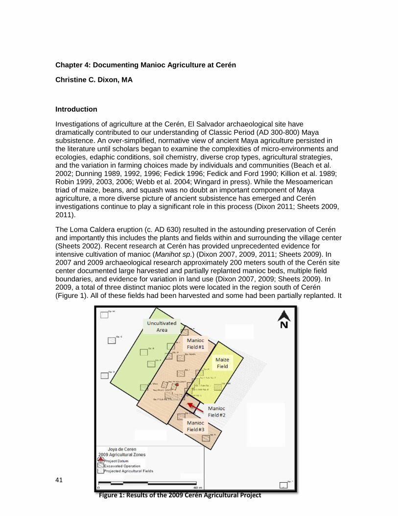
41
Chapter 4: Documenting Manioc Agriculture at Cerén
Christine C. Dixon, MA
Introduction
Investigations of agriculture at the Cerén, El Salvador archaeological site have dramatically contributed to our understanding of Classic Period (AD 300-800) Maya subsistence. An over-simplified, normative view of ancient Maya agriculture persisted in the literature until scholars began to examine the complexities of micro-environments and ecologies, edaphic conditions, soil chemistry, diverse crop types, agricultural strategies, and the variation in farming choices made by individuals and communities (Beach et al. 2002; Dunning 1989, 1992, 1996; Fedick 1996; Fedick and Ford 1990; Killion et al. 1989; Robin 1999, 2003, 2006; Webb et al. 2004; Wingard in press). While the Mesoamerican triad of maize, beans, and squash was no doubt an important component of Maya agriculture, a more diverse picture of ancient subsistence has emerged and Cerén investigations continue to play a significant role in this process (Dixon 2011; Sheets 2009, 2011).
The Loma Caldera eruption (c. AD 630) resulted in the astounding preservation of Cerén and importantly this includes the plants and fields within and surrounding the village center (Sheets 2002). Recent research at Cerén has provided unprecedented evidence for intensive cultivation of manioc (Manihot sp.) (Dixon 2007, 2009, 2011; Sheets 2009). In 2007 and 2009 archaeological research approximately 200 meters south of the Cerén site center documented large harvested and partially replanted manioc beds, multiple field boundaries, and evidence for variation in land use (Dixon 2007, 2009; Sheets 2009). In 2009, a total of three distinct manioc plots were located in the region south of Cerén (Figure 1). All of these fields had been harvested and some had been partially replanted. It
Figure 1: Results of the 2009 Cerén Agricultural Project
42
is estimated that 10 metric tons of manioc were harvested from this area just prior to the Loma Caldera eruption (Sheets 2009).
The 2011 field season was aimed at further exploring agricultural organization and manioc production closer to the Cerén site center. Thus, in 2011 we excavated 14 test pits (Ops. Q-AD) 13 of which were located within the southern boundary of the Joya de Cerén archaeological park. These 14 excavations documented multiple maize fields (see Heindel and Lamb Ch 2), land-use boundaries, a sacbe (causeway) (see Dixon Ch. 5), a possible domicile, cleared spaces (see Halmbacher Ch 3), and both planted and abandoned manioc beds. This chapter focuses on the 2011 evidence for manioc production, as well as the small portion of a possible domicile or storage facility found associated with a manioc field 200 meters south of the Cerén site. These data continue to expand our understanding of the cultivation, organization, and importance of Cerén manioc production.
Background
The 2007 discovery of manioc beds at Cerén afforded direct evidence for intensive manioc production in the Maya area. While the use of manioc and other root crops as a staple had been hypothesized for the ancient Maya (Bronson 1966), the limited evidence for root crops preserved in the archaeological record have long hindered scientific assessments of the role this crop might have played in the past (Sheets 2009). The extraordinary preservation of Cerén allows the examination of entire agricultural fields, plants that often do not survive in the archaeological record, and the organization of agricultural production at one Classic Period Maya site.
What is Manioc?
Manioc (Manihot sp.) is a root crop that grows as a bush and produces approximately five to ten root tubers per plant. The plant grows best with good drainage and less compacted soils (Cock 1985; Hansen 1983). Once harvested manioc typically must be processes or replanted within two to three days to avoid rotting (Queada Perla personal communication 2009). One way manioc is processed is to remove the external cortex of the tubers, cut the tuber into small pieces, dry these in the sun, and then grind them into flour, referred to as almidón throughout Central America today (Quezada Perla personal communication 2009). Additionally, people often harvest and use manioc from their gardens or fields on an as-needed-basis for household consumption. Notably, manioc is very tolerant of droughts, is easy to cultivate, and the tubers have a high caloric content (Cock 1985; Hansen 1983). Given it is much more tolerant of droughts and poor soil compositions than maize, scholars have hypothesized it might have been an important part of ancient Maya diets and even agricultural insurance (Bronson 1966). Unfortunately, the scarcity of direct archaeological evidence for manioc cultivation has greatly limited our understanding of the presence and uses of manioc in the past (Crane 1996; Flannery 1982; Pohl et al. 1996; Pope et al. 2001; Miksieck 1991:180).
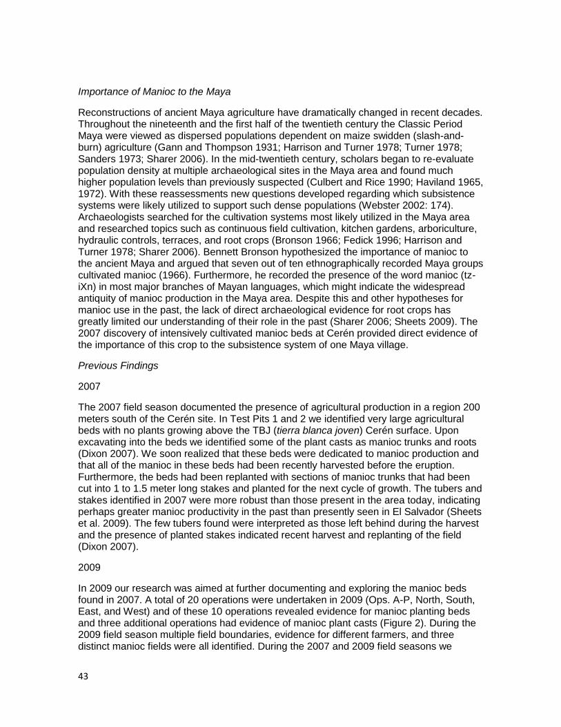
43
Importance of Manioc to the Maya
Reconstructions of ancient Maya agriculture have dramatically changed in recent decades. Throughout the nineteenth and the first half of the twentieth century the Classic Period Maya were viewed as dispersed populations dependent on maize swidden (slash-and-burn) agriculture (Gann and Thompson 1931; Harrison and Turner 1978; Turner 1978; Sanders 1973; Sharer 2006). In the mid-twentieth century, scholars began to re-evaluate population density at multiple archaeological sites in the Maya area and found much higher population levels than previously suspected (Culbert and Rice 1990; Haviland 1965, 1972). With these reassessments new questions developed regarding which subsistence systems were likely utilized to support such dense populations (Webster 2002: 174). Archaeologists searched for the cultivation systems most likely utilized in the Maya area and researched topics such as continuous field cultivation, kitchen gardens, arboriculture, hydraulic controls, terraces, and root crops (Bronson 1966; Fedick 1996; Harrison and Turner 1978; Sharer 2006). Bennett Bronson hypothesized the importance of manioc to the ancient Maya and argued that seven out of ten ethnographically recorded Maya groups cultivated manioc (1966). Furthermore, he recorded the presence of the word manioc (tz-iXn) in most major branches of Mayan languages, which might indicate the widespread antiquity of manioc production in the Maya area. Despite this and other hypotheses for manioc use in the past, the lack of direct archaeological evidence for root crops has greatly limited our understanding of their role in the past (Sharer 2006; Sheets 2009). The 2007 discovery of intensively cultivated manioc beds at Cerén provided direct evidence of the importance of this crop to the subsistence system of one Maya village.
Previous Findings
2007
The 2007 field season documented the presence of agricultural production in a region 200 meters south of the Cerén site. In Test Pits 1 and 2 we identified very large agricultural beds with no plants growing above the TBJ (tierra blanca joven) Cerén surface. Upon excavating into the beds we identified some of the plant casts as manioc trunks and roots (Dixon 2007). We soon realized that these beds were dedicated to manioc production and that all of the manioc in these beds had been recently harvested before the eruption. Furthermore, the beds had been replanted with sections of manioc trunks that had been cut into 1 to 1.5 meter long stakes and planted for the next cycle of growth. The tubers and stakes identified in 2007 were more robust than those present in the area today, indicating perhaps greater manioc productivity in the past than presently seen in El Salvador (Sheets et al. 2009). The few tubers found were interpreted as those left behind during the harvest and the presence of planted stakes indicated recent harvest and replanting of the field (Dixon 2007).
2009
In 2009 our research was aimed at further documenting and exploring the manioc beds found in 2007. A total of 20 operations were undertaken in 2009 (Ops. A-P, North, South, East, and West) and of these 10 operations revealed evidence for manioc planting beds and three additional operations had evidence of manioc plant casts (Figure 2). During the 2009 field season multiple field boundaries, evidence for different farmers, and three distinct manioc fields were all identified. During the 2007 and 2009 field seasons we
44
learned to distinguish between maize and manioc fields based not only on the plants present but also the size, shape, and spacing of the ridges used to grow each of these crops. The manioc beds were approximately 20 cm wide, 22 cm in height, and spaced 1 meter or more apart from ridge-top to ridge-top, whereas maize fields were typically much smaller, being spaced approximately 70 cm from each other and only 10 cm or so in height (Sheets 2009). The three separate manioc plots documented in 2009 were identified by clear boundaries between manioc beds and areas of maize fields, cleared spaces, or other manioc fields (Dixon 2009).
Two different styles of manioc bed construction were recorded during the 2009 field season. The first style consisted of broad beds with flat tops and almost vertical edges. The average ridge-top to ridge-top spacing of these beds was 113 cm with an average height of 22 cm. The second style of manioc planting was much larger and more hyperbolic in shape, with a much larger height and a much smaller width along the flat-top of the bed. The average ridge-top to ridge-top spacing for these manioc beds was 143 cm and the average height was 40cm. The first style of manioc fields was most common, whereas the second style of planting was only found in Ops. South and K, which have been interpreted as one continuous field (Dixon 2009). Thus while the field boundaries and organization demonstrate a level of community cohesion in this region, the different styles of manioc bed construction likely indicate a level of individual autonomy in agricultural choices (Dixon 2009, 2011).
All of the Cerén manioc beds identified in 2007 and 2009 share several characteristics: 1) all are oriented approximately 120o E of mag. N with field boundaries between plots consistently alighted to 120o and 30o E of mag. N, 2) the manioc fields all drain towards the Rio Sucio, and 3) all of these beds had been harvested just prior to the Loma Caldera eruption (Dixon 2009, 2011). The 2011 field season sought to examine if the manioc fields and field boundaries of the 2009 field season continued further north, closer to the site center. While, some evidence for manioc was recorded this season the majority of the manioc beds identified were abandoned and not in current cultivation at the time of the eruption. Only one manioc field identified this season was under cultivation immediately before the eruption and this was located approximately 200 meters south of the site center (Op. AA). The manioc beds of this excavation were a section of yet a fourth manioc field in this region and also provided a connection between manioc and a likely nearby domicile.
Figure 2: Ceren 2009 Op. L Field Boundary between Manioc Field to the west (left) and maize and manioc fields to the east (right)
45
Research Methods
Standard excavation techniques have been developed for archaeological investigation at Cerén. In 2011 we excavated a total of 14 operations, all but one of which were standard 3 x 3 m in size. Op. W was the only operation in which a 1.5 m extension was utilized to document both sides of the Cerén sacbe (see Dixon Ch. 5). Given that the Loma Caldera eruption deposited multiple meters of volcanic ash on top of Cerén in a few days to one week, there was no time for cultural reoccupation of the area during the eruption (Sheets 2002, 2006). The Loma Caldera sequence is identified by Units 1 through 14, with Unit 1 being the tephra sequence first deposited on Cerén c. 1400 years ago. Each operation excavated this year revealed Post Classic artifacts on top of Unit 14, the last portion of Loma Caldera to be deposited. This evidence took the form of ceramics, a few pieces of obsidian, and one burial (see Heindel and Lamb Ch. 3, Op. Y description). After removing any remains of Post Classic reoccupation, excavations continued with picks and shovels through the uppermost stratigraphy of the sequence. The only evidence from Cerén present in the upper stratigraphy of the site was tree branches. While tree branches indicate that trees were present in particular regions before the eruption, branches are not diagnostic to a species level (David Lentz, personal communication 2009). Once we reached Unit 3 we typically began to see the preservation of agricultural remains, thus trowels, azedones (hoes), and chusos (digging sticks) were then used. The last three tephra units were very carefully removed in 5 to 10 cm levels.
The nature of the volcanic eruption resulted in the preservation of agricultural features. Often in Unit 3 hollow cavities were encountered. These cavities were the places where volcanic ash had packed around plants. While very little to none of the organic material from c. AD 630 remains, the impression of the plant that was once here has been preserved in the ash. Thus, when hollow cavities were reached, we investigated them, plugged the hole with newspaper to protect the cavity as we continued excavations and pedestaled around the hollow cavity. Once excavations reached the TBJ surface, we poured dental plaster into the hollow spaces. This was allowed to set and then was excavated to reveal a plaster plant cast of the plant that was growing in this location when the volcano erupted (Sheets 2002).
The Loma Caldera ash also preserved the living surface, artifacts, and features of the site, thus we carefully excavated the TBJ surface. For agricultural ridges and beds we documented the ridge height, ridge-top to ridge-top spacing, orientation, and slope. In the case of manioc beds, once we had finished mapping, photographing, and recording the TBJ surface, we then excavated into the manioc beds to establish if there were manioc roots, stakes, or tubers in these beds at the time of the eruption. Similar to the hollow cavities found above the TBJ surface, we also found hollow cavities within the beds where manioc tubers and roots once grew and utilized the same casting technique to document these plants.
Data
Four operations of the 2011 field season revealed evidence for manioc cultivation (Ops. AA, AB, AC, and AD); however, only Op. AA showed clear evidence for current manioc cultivation at the time of the eruption.
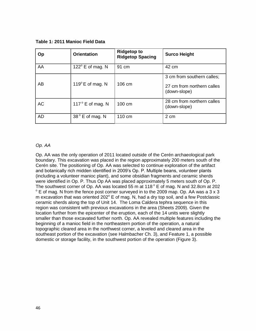
46
Table 1: 2011 Manioc Field Data
Op Orientation Ridgetop to Ridgetop Spacing
Surco Height
AA 122o E of mag. N 91 cm 42 cm
AB 119o E of mag. N 106 cm
3 cm from southern calles;
27 cm from northern calles (down-slope)
AC 117 o E of mag. N 100 cm 28 cm from northern calles (down-slope)
AD 38 o E of mag. N 110 cm 2 cm
Op. AA
Op. AA was the only operation of 2011 located outside of the Cerén archaeological park boundary. This excavation was placed in the region approximately 200 meters south of the Cerén site. The positioning of Op. AA was selected to continue exploration of the artifact and botanically rich midden identified in 2009‟s Op. P. Multiple beans, volunteer plants (including a volunteer manioc plant), and some obsidian fragments and ceramic sherds were identified in Op. P. Thus Op AA was placed approximately 5 meters south of Op. P. The southwest corner of Op. AA was located 55 m at 118 o E of mag. N and 32.8cm at 202
o E of mag. N from the fence post corner surveyed in to the 2009 map. Op. AA was a 3 x 3 m excavation that was oriented 202o E of mag. N, had a dry top soil, and a few Postclassic ceramic sherds along the top of Unit 14. The Loma Caldera tephra sequence in this region was consistent with previous excavations in the area (Sheets 2009). Given the location further from the epicenter of the eruption, each of the 14 units were slightly smaller than those excavated further north. Op. AA revealed multiple features including the beginning of a manioc field in the northeastern portion of the operation, a natural topographic cleared area in the northwest corner, a leveled and cleared area in the southeast portion of the excavation (see Halmbacher Ch. 3), and Feature 1, a possible domestic or storage facility, in the southwest portion of the operation (Figure 3).
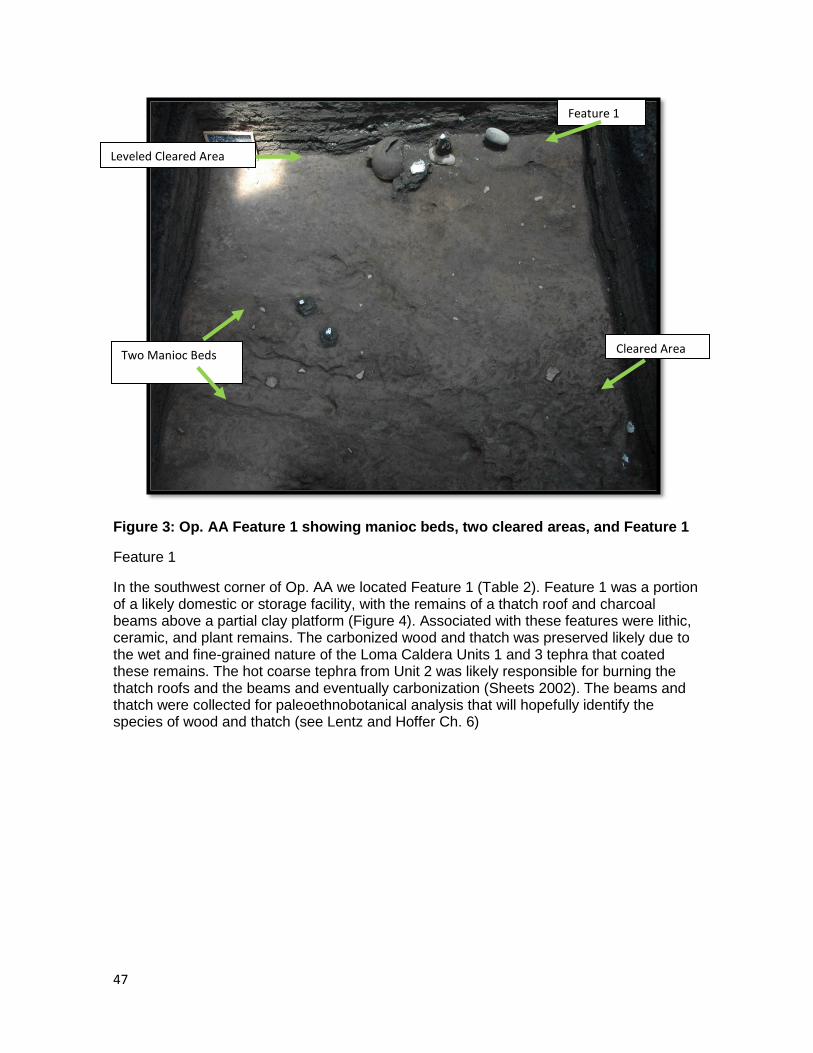
47
Figure 3: Op. AA Feature 1 showing manioc beds, two cleared areas, and Feature 1
Feature 1
In the southwest corner of Op. AA we located Feature 1 (Table 2). Feature 1 was a portion of a likely domestic or storage facility, with the remains of a thatch roof and charcoal beams above a partial clay platform (Figure 4). Associated with these features were lithic, ceramic, and plant remains. The carbonized wood and thatch was preserved likely due to the wet and fine-grained nature of the Loma Caldera Units 1 and 3 tephra that coated these remains. The hot coarse tephra from Unit 2 was likely responsible for burning the thatch roofs and the beams and eventually carbonization (Sheets 2002). The beams and thatch were collected for paleoethnobotanical analysis that will hopefully identify the species of wood and thatch (see Lentz and Hoffer Ch. 6)
Leveled Cleared Area
Two Manioc Beds
Feature 1
Cleared Area
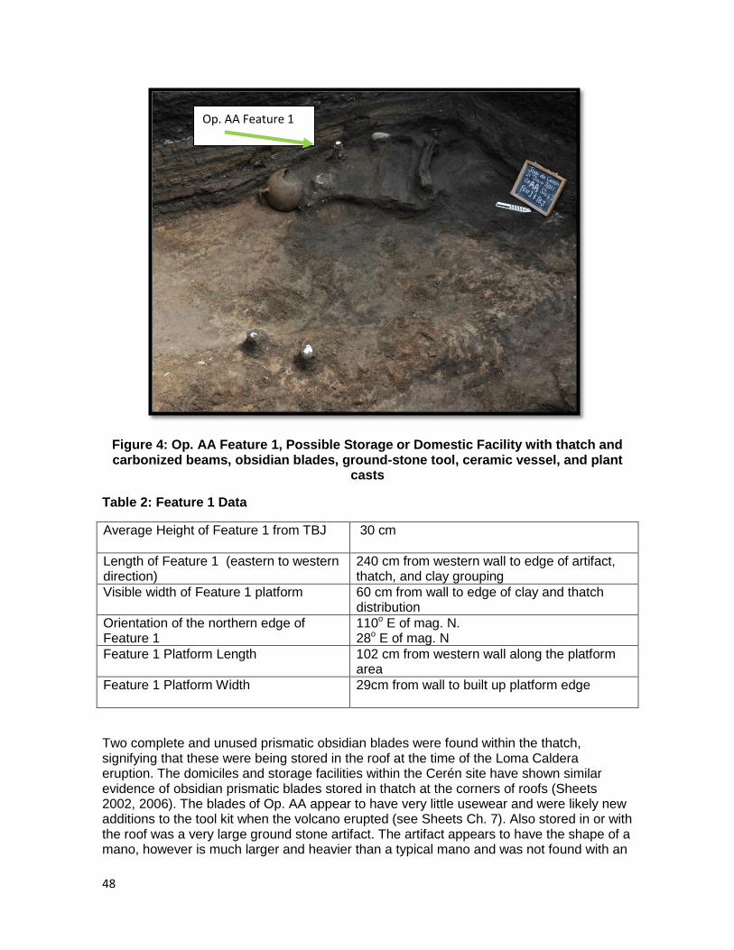
48
Figure 4: Op. AA Feature 1, Possible Storage or Domestic Facility with thatch and carbonized beams, obsidian blades, ground-stone tool, ceramic vessel, and plant
casts
Table 2: Feature 1 Data
Average Height of Feature 1 from TBJ 30 cm
Length of Feature 1 (eastern to western direction)
240 cm from western wall to edge of artifact, thatch, and clay grouping
Visible width of Feature 1 platform 60 cm from wall to edge of clay and thatch distribution
Orientation of the northern edge of Feature 1
110o E of mag. N. 28o E of mag. N
Feature 1 Platform Length 102 cm from western wall along the platform area
Feature 1 Platform Width 29cm from wall to built up platform edge
Two complete and unused prismatic obsidian blades were found within the thatch, signifying that these were being stored in the roof at the time of the Loma Caldera eruption. The domiciles and storage facilities within the Cerén site have shown similar evidence of obsidian prismatic blades stored in thatch at the corners of roofs (Sheets 2002, 2006). The blades of Op. AA appear to have very little usewear and were likely new additions to the tool kit when the volcano erupted (see Sheets Ch. 7). Also stored in or with the roof was a very large ground stone artifact. The artifact appears to have the shape of a mano, however is much larger and heavier than a typical mano and was not found with an
Op. AA Feature 1
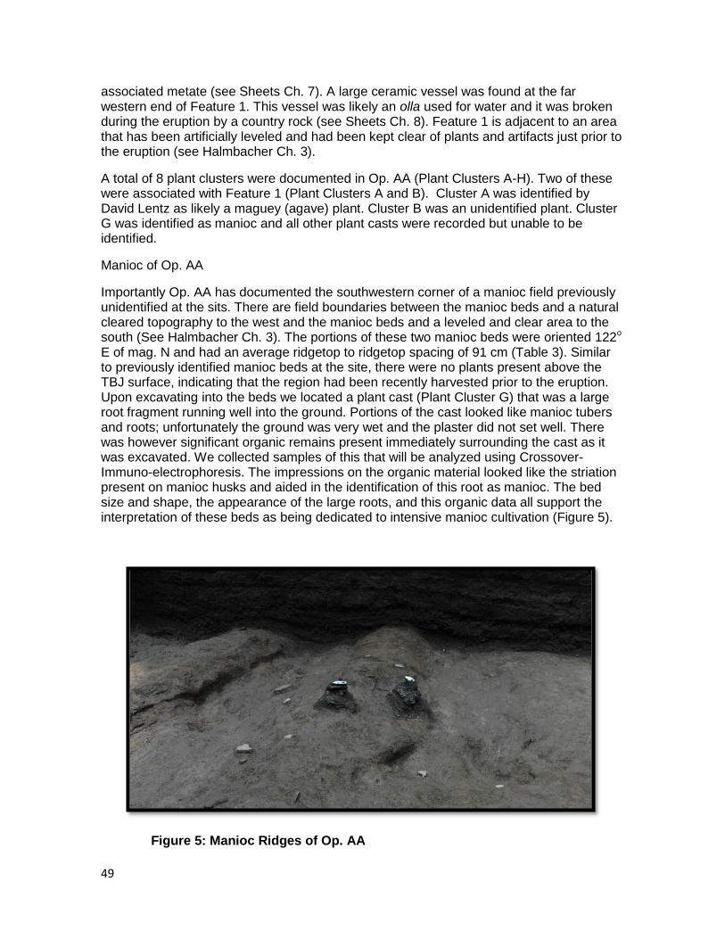
49
associated metate (see Sheets Ch. 7). A large ceramic vessel was found at the far western end of Feature 1. This vessel was likely an olla used for water and it was broken during the eruption by a country rock (see Sheets Ch. 8). Feature 1 is adjacent to an area that has been artificially leveled and had been kept clear of plants and artifacts just prior to the eruption (see Halmbacher Ch. 3).
A total of 8 plant clusters were documented in Op. AA (Plant Clusters A-H). Two of these were associated with Feature 1 (Plant Clusters A and B). Cluster A was identified by David Lentz as likely a maguey (agave) plant. Cluster B was an unidentified plant. Cluster G was identified as manioc and all other plant casts were recorded but unable to be identified.
Manioc of Op. AA
Importantly Op. AA has documented the southwestern corner of a manioc field previously unidentified at the sits. There are field boundaries between the manioc beds and a natural cleared topography to the west and the manioc beds and a leveled and clear area to the south (See Halmbacher Ch. 3). The portions of these two manioc beds were oriented 122o E of mag. N and had an average ridgetop to ridgetop spacing of 91 cm (Table 3). Similar to previously identified manioc beds at the site, there were no plants present above the TBJ surface, indicating that the region had been recently harvested prior to the eruption. Upon excavating into the beds we located a plant cast (Plant Cluster G) that was a large root fragment running well into the ground. Portions of the cast looked like manioc tubers and roots; unfortunately the ground was very wet and the plaster did not set well. There was however significant organic remains present immediately surrounding the cast as it was excavated. We collected samples of this that will be analyzed using Crossover- Immuno-electrophoresis. The impressions on the organic material looked like the striation present on manioc husks and aided in the identification of this root as manioc. The bed size and shape, the appearance of the large roots, and this organic data all support the interpretation of these beds as being dedicated to intensive manioc cultivation (Figure 5).
Figure 5: Manioc Ridges of Op. AA
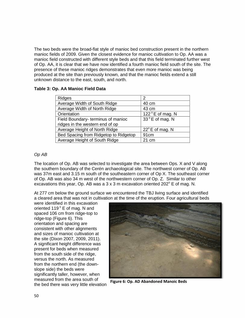
50
The two beds were the broad-flat style of manioc bed construction present in the northern manioc fields of 2009. Given the closest evidence for manioc cultivation to Op. AA was a manioc field constructed with different style beds and that this field terminated further west of Op. AA, it is clear that we have now identified a fourth manioc field south of the site. The presence of these manioc ridges demonstrates that even more manioc was being produced at the site than previously known, and that the manioc fields extend a still unknown distance to the east, south, and north.
Table 3: Op. AA Manioc Field Data
Ridges 2
Average Width of South Ridge 40 cm
Average Width of North Ridge 43 cm
Orientation 122 o E of mag. N
Field Boundary- terminus of manioc ridges in the western end of op
33 o E of mag. N
Average Height of North Ridge 22o E of mag. N
Bed Spacing from Ridgetop to Ridgetop 91cm
Average Height of South Ridge 21 cm
Op AB
The location of Op. AB was selected to investigate the area between Ops. X and V along the southern boundary of the Cerén archaeological site. The northwest corner of Op. AB was 37m east and 3.15 m south of the southeastern corner of Op X. The southeast corner of Op. AB was also 34 m west of the northwestern corner of Op. Z. Similar to other excavations this year, Op. AB was a 3 x 3 m excavation oriented 202o E of mag. N.
At 277 cm below the ground surface we encountered the TBJ living surface and identified a cleared area that was not in cultivation at the time of the eruption. Four agricultural beds were identified in this excavation oriented 119 o E of mag. N and spaced 106 cm from ridge-top to ridge-top (Figure 6). This orientation and spacing are consistent with other alignments and sizes of manioc cultivation at the site (Dixon 2007, 2009, 2011). A significant height difference was present for beds when measured from the south side of the ridge, versus the north. As measured from the northern end (the down-slope side) the beds were significantly taller, however, when measured from the area south of the bed there was very little elevation
Figure 6: Op. AD Abandoned Manoic Beds
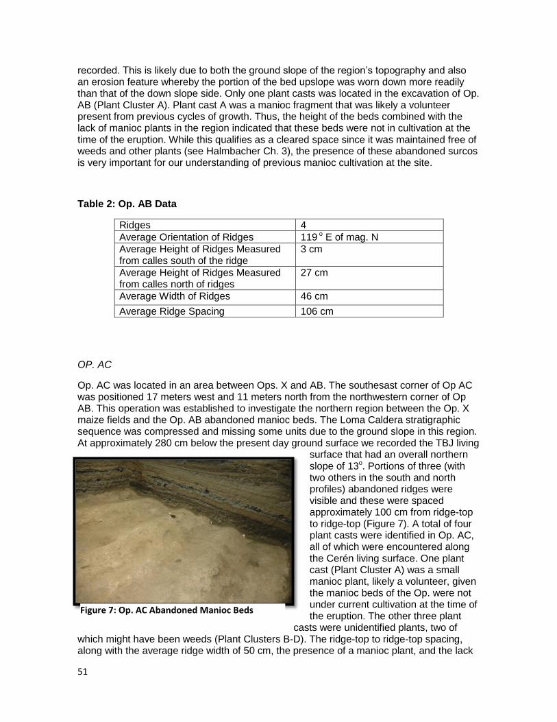
51
recorded. This is likely due to both the ground slope of the region‟s topography and also an erosion feature whereby the portion of the bed upslope was worn down more readily than that of the down slope side. Only one plant casts was located in the excavation of Op. AB (Plant Cluster A). Plant cast A was a manioc fragment that was likely a volunteer present from previous cycles of growth. Thus, the height of the beds combined with the lack of manioc plants in the region indicated that these beds were not in cultivation at the time of the eruption. While this qualifies as a cleared space since it was maintained free of weeds and other plants (see Halmbacher Ch. 3), the presence of these abandoned surcos is very important for our understanding of previous manioc cultivation at the site.
Table 2: Op. AB Data
Ridges 4
Average Orientation of Ridges 119 o E of mag. N
Average Height of Ridges Measured from calles south of the ridge
3 cm
Average Height of Ridges Measured from calles north of ridges
27 cm
Average Width of Ridges 46 cm
Average Ridge Spacing 106 cm
OP. AC
Op. AC was located in an area between Ops. X and AB. The southesast corner of Op AC was positioned 17 meters west and 11 meters north from the northwestern corner of Op AB. This operation was established to investigate the northern region between the Op. X maize fields and the Op. AB abandoned manioc beds. The Loma Caldera stratigraphic sequence was compressed and missing some units due to the ground slope in this region. At approximately 280 cm below the present day ground surface we recorded the TBJ living
surface that had an overall northern slope of 13o. Portions of three (with two others in the south and north profiles) abandoned ridges were visible and these were spaced approximately 100 cm from ridge-top to ridge-top (Figure 7). A total of four plant casts were identified in Op. AC, all of which were encountered along the Cerén living surface. One plant cast (Plant Cluster A) was a small manioc plant, likely a volunteer, given the manioc beds of the Op. were not under current cultivation at the time of the eruption. The other three plant
casts were unidentified plants, two of which might have been weeds (Plant Clusters B-D). The ridge-top to ridge-top spacing, along with the average ridge width of 50 cm, the presence of a manioc plant, and the lack
Figure 7: Op. AC Abandoned Manioc Beds
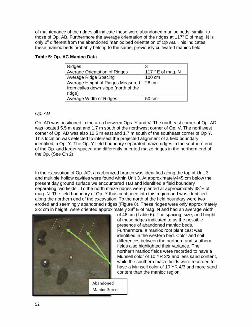
52
of maintenance of the ridges all indicate these were abandoned manioc beds, similar to those of Op. AB. Furthermore the average orientation of the ridges at 117o E of mag. N is only 2o different from the abandoned manioc bed orientation of Op AB. This indicates these manioc beds probably belong to the same, previously cultivated manioc field.
Table 5: Op. AC Manioc Data
Ridges 3
Average Orientation of Ridges 117 o E of mag. N
Average Ridge Spacing 100 cm
Average Height of Ridges Measured from calles down slope (north of the ridge)
28 cm
Average Width of Ridges 50 cm
Op. AD
Op. AD was positioned in the area between Ops. Y and V. The northeast corner of Op. AD was located 5.5 m east and 1.7 m south of the northwest corner of Op. V. The northwest corner of Op. AD was also 12.5 m east and 1.7 m south of the southeast corner of Op Y. This location was selected to intersect the projected alignment of a field boundary identified in Op. Y. The Op. Y field boundary separated maize ridges in the southern end of the Op. and larger spaced and differently oriented maize ridges in the northern end of the Op. (See Ch 2)
In the excavation of Op. AD, a carbonized branch was identified along the top of Unit 3 and multiple hollow cavities were found within Unit 3. At approximately445 cm below the present day ground surface we encountered TBJ and identified a field boundary separating two fields. To the north maize ridges were planted at approximately 38oE of mag. N. The field boundary of Op. Y thus continued into this region and was identified along the northern end of the excavation. To the north of the field boundary were two eroded and seemingly abandoned ridges (Figure 8). These ridges were only approximately 2-3 cm in height, were oriented approximately 38o E of mag. N and had an average width
of 48 cm (Table 6). The spacing, size, and height of these ridges indicated to us the possible presence of abandoned manioc beds. Furthermore, a manioc root plant cast was identified in the western bed. Color and soil differences between the northern and southern fields also highlighted their variance. The northern manioc fields were recorded to have a Munsell color of 10 YR 3/2 and less sand content, while the southern maize fields were recorded to have a Munsell color of 10 YR 4/3 and more sand content than the manioc region.
Abandoned
Manioc Surcos
53
Importantly, in Op Y the northern field was planted with maize, although the ridge spacing was much larger than typical maize ridges. The northern fields of Op. Y were oriented 32o E of mag. N and there were more easily identifiable than the small portions of eroded ridges present in Op. AD. Thus the similar alignment of the northern fields at 38o in Op AD and 32o in Op Y might indicate these are the same field. One possibility is that there is another field boundary between Ops. AD and Y that separate these northern manioc and maize fields of the two operations. Even more likely is the possibility that the maize of Op. Y had been planted in abandoned manioc beds and the manioc root of Op. AD is a volunteer left behind from the last cycle of growth. The latter seems more appropriate given that the northern maize field of Op Y was spaced on average 99 cm from ridge-top to ridge-top and was oriented a similar direction as the beds in Op. AD (Table 7). In 2009 the boundary between a maize field and Manioc Field 2 was marked by a transition area where maize plants were growing in manioc beds (Dixon 2009, 2011). This set a precedent at the site for the dynamic rotation of maize and manioc in Cerén fields.
Table 6: Op. AD Manioc Data
Ridges 2
Average Orientation of Ridges 38o E of mag. N
Average Ridge Spacing 110 cm
Average Height of Ridges 2 cm
Average Width of Ridges 48 cm
Table 7: Op. Y Northern Maize Field Data
Ridges 4
Average Orientation of Ridges 31-32o E of mag. N
Average Ridge Spacing 99 cm
Average Height 12.5 cm
Approximate Width of Ridges 46cm
54
Roadcut
An investigation of ridges along the dirt road, Calle A, leading from the San Juan Opico highway into the modern town of Joya de Cerén was previously interpreted as likely manioc beds (Dixon 2009). In light of discoveries in our 2011 excavation, this interpretation has been reassessed. Multiple maize fields within our 2011 data set were spaced 85cm from ridgetop to ridgetop. Previously, this spacing was thought be more appropriate for manioc than maize, however it has become less clear where the precise spacing boundary is between average spacing for maize and average spacing for manioc. Further complicating this analysis is the 2009 finding that maize was planted on manioc beds (Dixon 2009) and the findings from this year that might indicate a similar pattern of maize planted in areas that were once used for manioc cultivation. Upon further reflection the ridges present in the Calle A road cut are more likely maize. Interestingly, Op. X was positioned along the southern hill to investigate the ridges present in this roadcut; however the paleotopography of the region was much more varied than we expected. The maize ridges of Op. X were much more elevated than the ridges present in the road cut just a few meters away. One likely possibility is that the ancient topography drops off significantly in this location. All of these factors have complicated the picture of agriculture in the area along the southwestern boundary of the Cerén archaeological site.
Discussion
Our 2011 excavations documented additional evidence for manioc cultivation at the Cerén site and highlight further the role of this crop as an important staple in the diets of Cerén villagers. Continued research is needed to assess manioc production in Classic Period Maya agricultural systems and Cerén affords a unique opportunity to examine one community‟s organization and production of intensively cultivated maize and manioc.
Importantly, 200 m south of the Cerén site center we located the southwest corner of an additional manioc field (Op. AA) utilized in active manioc production at the time of the eruption. Similar to other manioc fields in the region, these beds were harvested recently before the volcano erupted. Finding the southwest corner of this field indicates that this manioc field continues an unknown distance east and north. Currently, in the region 200 meters south of the Cerén site center, we still do not know the full extent of manioc production to the south, east, and north of the now four manioc fields identified in this region. These data add to not only our understanding of agricultural organization south of the Cerén site, but also increase estimates of the quantity of manioc grown and harvested at Cerén when the Loma Caldera eruption occurred 1400 years ago.
In addition to the harvested manioc beds of Op. AA, further evidence for manioc cultivation was accrued in the 2011 field season. In Ops. AB, AC, and AD uncultivated manioc beds with a few manioc plant volunteers were documented. The location of these operations along the southern boundary of the Cerén archaeological site and close to the known site center indicates that manioc was a well-established cultigen in the Cerén landscape. The beds in Ops. AB and AC had similar orientations and were likely portions of one old manioc field that had not been replanted or maintained for continued growth. Unlike maize, manioc production does not deplete soils and does not require a period of fallow (Cock 1985). Thus, it is unclear why the Cerén villagers chose to no longer plant crops in this region. If this is one continuous, uncultivated manioc field it would have extended at least 17 meters from north to south and 23 meters from east to west. Was this space selected for alternative activities or were these manioc beds harvested and possibly not replanted
55
during a different time of year? Further study is required to assess how long these beds might have been left without maintenance and replanting.
The uncultivated manioc beds of Op. AD represent a different abandoned manioc field located in the site center. While only a small portion of the beds was visible in the excavation, the small height, evidence for erosion, and compacted nature of the area all support a view that this field had likely been left uncultivated for a period of time. One manioc plant was identified in the western manioc bed of Op. AD. It seems probable this was a volunteer plant from roots that remained after the harvest in this area. The field boundary that marks the southern extent of this manioc field connects with the field boundary of Op. Y. The northern field in Op. Y had maize ridges spaced an average of 99 cm apart and was oriented 31-32o E of mag. N. Thus it appears the northern fields of Ops. AD and Y were connected. It is possible that there was another field boundary separating the maize of the western portion from the uncultivated manioc beds of the eastern area. More likely given the size and spacing of the Op. Y ridges is that maize was planted in an area previously utilized for manioc growth. Our 2009 excavation of maize and manioc fields south of the Cerén site documented an area where manioc beds were clearly planted with maize at the time of the eruption (Dixon 2009, 2011). This evidence highlights the dynamic changes that were likely present in the Cerén fields before the Loma Caldera eruption. If maize was planted in an abandoned manioc field in the region of Ops. Y and AD, this area was a minimum area of 18.5 m along the southern boundary of the field and extended and unknown distance to the east, west, and north.
Conclusions
During the Classic Period, Cerén villagers where engaged in intensive manioc cultivation. The assessment of manioc production in studies of Maya agriculture has been greatly limited by the lack of manioc preservation available in the archaeological record (Bronson 1966; Sheets 2009). Thus, these Cerén data afford a unique opportunity to better assess and understand how manioc production might have been utilized and organized at other Maya sites. Clearly manioc was a well-known and used crop for the ancient Maya, and perhaps was relied on more heavily than previously suspected at other sites.
The 2011 field season has contributed additional data to support a view of the Cerén site as dependent upon the intensive cultivation of both maize and manioc. Furthermore, data from this season suggest that agricultural production at Cerén was dynamic and underwent changes in crop types and location from season to season. The addition of a fourth manioc field in the region 200 meters south of the site center expands the quantity of manioc (and extent of its growth) that had been produced and recently harvested at the time of the Loma Caldera eruption.
Questions remain unanswered in particular about the quantity of manioc present and how this manioc was being used. Given that manioc rots within one to two days of removal from the ground, this large region of harvested manioc would not have been stored long-term as tubers for community consumption. Either these tubers were traded, consumed in a large feast, or they were likely processed into flour, known today as almidón. Once manioc has been processed into flour, it will last at least one year (Quesada Perla personal communication 2009). Could this manioc harvest at Cerén be evidence for the widespread use of flour at the site, or is it evidence for trade within the Zapotitan valley, or might these manioc tubers been made into a fermented beer? The discovery of a sacbe at the Cerén site this field season (see Dixon Ch 5) might contribute to our understanding of the manioc production at the site. Namely, if this sacbe is a larger feature connecting
56
Cerén with San Andres or other surrounding sites, then this might indicate greater political and economic ties within the Zapotitan Valley than previously known.
Future documentation of the full extent of manioc production and harvest in the region 200 meters south of the Cerén site will facilitate better assessment of the quantity of manioc grown and harvested at Cerén and the likely implications of how the manioc was being utilized. We are yet to find a processing area with manioc tubers and stacked stakes, although we have found cleared and leveled spaces that might have served this function. Direct remains of the harvested manioc being processed would greatly aid in our assessment of the uses and processing techniques utilized at the site.
The identification of two likely uncultivated or abandoned manioc fields close to the site center (Ops. AB, AC, AD, and Y) indicate first that for some time before the Loma Caldera eruption even more manioc production had been underway at Cerén than previously known and second that the manioc was an integrated part of the site center. As also evidenced by the positioning of the southern manioc field near to a possible domestic or storage facility (Op. AA), it appears that intensive manioc cultivation was part of the central organization of the Cerén site landscape. Finally, the presence of abandoned manioc fields also indicates choices that were made by Cerén farmers to not plant in this area at this time. Perhaps there was enough manioc south of the Cerén village center or perhaps this area was cultivated during different cycles of growth or seasons. It is speculated that had the Cerén farmers needed more manioc then this region would also have been actively utilized in production. Since it was not this might indicate a greater priority on uncultivated spaces.
Clearly manioc was an important crop for Cerén villagers and provided an important component of both economy and diet. It is hoped that research into obsidian usewear analysis (Sheets 2011) and Crossover-immuno-electrophoresis studies might afford an avenue to investigate the presence of manioc and its processing at other sites in the Maya area. It is unlikely Cerén villagers were unique in their knowledge and uses of manioc, especially given the caloric contributions of the plant, the ease with which it can be cultivated, and the plant‟s resistance to drought. The continued documentation of manioc evidence in the 2011 field season provides a rare glimpse into the farming life of one Classic Period Maya community.
References
Beach, T., S. Luzzadder-Beach, N. Dunning, J. Hageman, and J. Lohse
2002 Upland Agriculture in the Maya Lowlands: Ancient Maya Soil Conservation in
Northwestern Belize The Geographical Review 92 (3): 372-397, July 2002
Bronson, B.
1966 Roots and the Subsistence of the Ancient Maya. Southwestern Journal of Anthropology 22: 251-79.
57
Cock, J.
1985 Cassava: New Potential for a Neglected Crop. Westview Press: Boulder, CO.
Culbert, T. P. and D. Rice
1990 Precolumbian Population History in the Maya Lowlands. (Editors) University of New Mexico Press, Albuquerque, NM.
Crane, C. J.
1996 Archaeobotanical and Palynological Research at a Late Preclassic Maya Community, Cerros, Belize. In The Managed Mosaic: Ancient Maya Agriculture and Resource Use, edited by S. L. Fedick. Pp. 262-277. University of Utah Press: Salt Lake City, UT.
Dixon, C.C
In Press,Feeding the Masses: New Perspectives on Maya Agriculture from Cerén El Salvador. In Living on the Land: The Complex Relationship between Population and Agriculture in the Americas, edited by John D. Wingard and Sue Hayes, pp. 160-198. University of Colorado Press, Denver. In press.
2011 Rethinking Southeast Maya agriculture: A view from the manioc fields of Joya de Cerén, La Universidad Numero 14-15, Abril-Septiembre 2011. Universidad de El Salvador, San Salvador, El Salvador.
2009 Manioc Agriculture in Report of the 2009 Maya Agricultural Project South of Joya de Cerén, El Salvador Enlace Academico Centroamericano, Fundacion Clic. San Salvador, El Salvador. (www.colorado.edu/Anthropology/people/bios/sheets.html)
2007 Classic Period Maya Agriculture: Test Pits 1 and 2, 5 and 6. In Sheets 2007 Technical Report to CONCULTURA.
Dunning, N. P.
1996 Reexamination of Regional Variability in the Pre-Hispanic Agricultural Landscape. In Managed Mosaic: Ancient Maya Agriculture and Resource Use, edited by S. Fedick Pp. 53-68. University of Utah Press: Salt Lake City, UT.
1992 Lords of the hills: ancient Maya settlement of the Puuc region, Yucatan, Mexico. Prehistory Press: Madison, WI.
1989 Archaeological Investigations at Sayil, Yucatan: Intersite Surveys and Soil Studies. In University of Pittsburgh Anthropological Papers No. 2. University of Pittsburgh: Pittsburgh, PA.
58
Fedick ,S
1996 The Managed Mosaic: Ancient Maya Agriculture and Resource Use. University of Utah Press, Salt Lake City
Fedick, S. L., and A. Ford
1990 Prehistoric Agricultural Landscape of the Central Maya Lowlands: An Examination
of Local Variability in a Regional Context. World Archaeology 22(1):18-33.
Flannery, K.
1982 Maya Subsistence: Studies in Memory of Dennis E. Puleston, (Editor) Academic
Press, New York, NY.
Gann, T. W. and J. E. Thompson
1931 The History of the Maya from the Earliest Time to the Present Day. Charles Scribner's Sons, New York.
Hansen, M.
1983 Yuca. In Costa Rican Natural History, edited by Daniel Janzen. University of Chicago Press, Chicago, IL
Harrison, P. and B.L. Turner.
1978 Pre-Hispanic Maya Agriculture. University of New Mexico Press: Albuquerque, NM.
Haviland, W. A.
1972 Estimates of Maya Population: Comments on Thompson's Comments. American Antiquity 37:261-262.
1965 Prehistoric Settlement at Tikal, Guatemala. Expedition 7(3):14-23.
Killion, T.A., J.A. Sabloff, G.Tourtellor, and N.P. Dunning
1989 Intensive Surface Collection of Residential Clusters at Terminal Classic Sayil,
59
Yucatan, Mexico. Journal of Field Archaeology 16(3):273-294.
Miksleck, C.H.
1991 The Ecology and Economy of Cuello I: the natural and cultural landscape of Preclassic Cuello, In Cuello: an early Maya community in Belize, edited by N. Hammond, pp. 70-84. Cambridge University Press: Cambridge, MA.
Pohl, M. D., K. O. Pope, J. G. Jones, J. S. Jacob, D. R. Piperno, S. D. DeFrance, D. L. Lentz, J. A. Gifford, M. E. Danforth, and J. K. Josserand
1996 Early Agriculture in the Maya Lowlands. Latin American Antiquity 7 (4):355-72.
Pope, K., M. Pohl, J. Jones, D.Lentz, C. Von Nagy, F. Vega, and I. Quitmyer
2001 Origin and Environmental Setting of Ancient Agriculture in the Lowlands of Mesoamerica. Science 292:1370-74.
Robin, C.
2006 Gender, Farming, and Long-Term Change: Maya Historical and Archaeological Perspectives. Current Anthropology 47:3.
2003 New Directions in Classic Maya Household Archaeology. Journal of Archaeological Research 11:4: 307-356.
1999 Towards an archaeology of everyday life: Maya farmers of Chan Noòhol, Belize
Ph.D. Dissertation (Anthropology), University of Pennsylvania: Philadelphia, PA.
Sanders, W. T.
1973 The Cultural Ecology of the Lowland Maya: A Re-Evaluation. In The Classic Maya Collapse, edited by P.T. Culbert, pp. 325-265. The University of New Mexico Press: Albuquerque, NM.
Sharer, R. J.
2006 The Ancient Maya, 6th Ed. Stanford University Press: Palo Alto, CA.
Sheets, P.D.
2011 Seeking Durable Indicators of Manioc Processing: Obsidian Cutting Edges. Society for American Archaeology 76th Annual Meeting March 31. Sacramento, CA.
2009 Report of the 2009 Maya Agricultural Project South of Joya de Cerén, El Salvador,
60
(Editor) Enlace Academico Centroamericano, Fundacion Clic. San Salvador, El Salvador.
2006 The Cerén Site: A Prehistoric Village Buried by Volcanic Ash in Central America. 2nd Edition. Case Studies in Archaeology Series. Harcourt Brace Collage Publishers: New York, NY.
2002 Before the Eruption: The Ancient Cerén Village in Central America. (editor)
University of Texas Press: Austin, TX.
Sheets, P. D., C. C. Dixon, A. Blanford, and M. Guerra
2009 Descubrimientos de Investigaciones Geofisicas e Arqueologicas al Sur de Joya de Cerén. In Press: El Salvador Investiga. CONCULTURA: San Salvador, El Salvador.
Turner II, B. L.
1978 The development and demise of the swidden thesis of Maya agriculture. In Pre-Hispanic Maya Agriculture, edited by P. Harrison and B.L. Turner. Pp. 13-22. University of New Mexico Press: Albuquerque, NM.
Webb, E.A., H.P. Schwarcz., and P.F Healy
2004 Carbon isotope evidence for ancient maize agriculture in the Maya lowlands.
Journal of Archaeological Science, 31, 1039–1052.
Webster , D. L.
2002 Fall of the ancient Maya: Solving the Mystery of the Maya Collapse. Thames and Hudson, London.
Wingard, J. and S. Hayes (eds.)
2011 Living on the Land: The Complex Relationship between Population and Agriculture in the Americas, University of Colorado Press, Denver, in press.
Acknowledgments
There are many people to thank for the successful continuation of our research at Cerén, El Salvador. Chief among these is Dr. Payson Sheets. His dedication to the site and to Salvadorian archaeology are matched only by his commitment to helping his students succeed. I am very fortunate to continue working at Joya de Cerén and with Dr. Sheets. Dr. David Lentz has also been a long time contributor to Cerén archaeology and his paleobotanical expertise greatly aids this research. Theresa Heindel, Celine Lamb, and
61
Alexandria Halmbacher have enthusiastically worked for the advancement of this research. Their persistence through the trials of fieldwork, brilliance, and friendship are all greatly appreciated and this field season‟s successes are largely due to these great archaeologists. Thanks is also offered to Christine Hoffer for her participation in and great additions to our fieldwork this summer.
Deep appreciation is expressed to the government of El Salvador, in particular the Patrimonio Cultural de la Secretaria de Cultura de la Presidencia de El Salvador and Dr. Ramón Rivas. I am immensely grateful for the opportunity to continue working in El Salvador and at an archaeological site that is truly remarkable. Also, Roberto Gallardo, MA from the Museo Nacional David J. Guzman has afforded great support and contributions to the Cerén Agricultural Project. I am thankful for all of the energy and time he has spent helping our research. The expertise and agricultural knowledge of Miguel Quesada Perla and the CENTA (Centro Nacional de Tecnologia Agropecuaria y Forestal) engineers are also appreciated.
The crew of excavators we had this year was truly fantastic and the achievements of this project would not have been possible without their hard-work, perseverance, and dedication. It would also not have been as much fun without their humor and good spirits. I continue to be inspired by the Salvadorians I have had the pleasure of working with and those that I have the joy of calling my friends. I am also very grateful for the support and contributions of Salvador “Chamba” Quintania („jefe‟) to the ongoing Cerén research projects. To the Garcia-Muñoz family, the community of Joya de Cerén, and the people of El Salvador, thank you for welcoming us into your home and communities and for sharing this beautiful country and special cultural heritage with us. To my own family, especially my wife Lauren, thank you for your endless support and love.
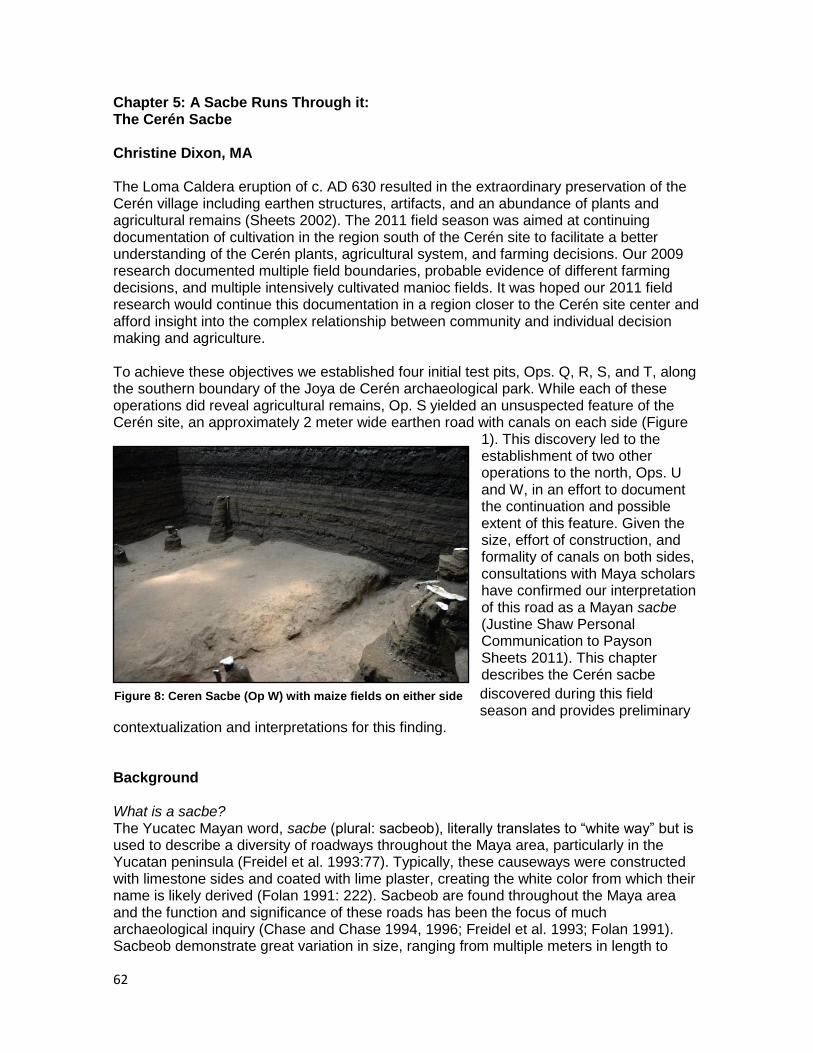
62
Chapter 5: A Sacbe Runs Through it: The Cerén Sacbe Christine Dixon, MA The Loma Caldera eruption of c. AD 630 resulted in the extraordinary preservation of the Cerén village including earthen structures, artifacts, and an abundance of plants and agricultural remains (Sheets 2002). The 2011 field season was aimed at continuing documentation of cultivation in the region south of the Cerén site to facilitate a better understanding of the Cerén plants, agricultural system, and farming decisions. Our 2009 research documented multiple field boundaries, probable evidence of different farming decisions, and multiple intensively cultivated manioc fields. It was hoped our 2011 field research would continue this documentation in a region closer to the Cerén site center and afford insight into the complex relationship between community and individual decision making and agriculture. To achieve these objectives we established four initial test pits, Ops. Q, R, S, and T, along the southern boundary of the Joya de Cerén archaeological park. While each of these operations did reveal agricultural remains, Op. S yielded an unsuspected feature of the Cerén site, an approximately 2 meter wide earthen road with canals on each side (Figure
1). This discovery led to the establishment of two other operations to the north, Ops. U and W, in an effort to document the continuation and possible extent of this feature. Given the size, effort of construction, and formality of canals on both sides, consultations with Maya scholars have confirmed our interpretation of this road as a Mayan sacbe (Justine Shaw Personal Communication to Payson Sheets 2011). This chapter describes the Cerén sacbe
discovered during this field season and provides preliminary
contextualization and interpretations for this finding. Background What is a sacbe? The Yucatec Mayan word, sacbe (plural: sacbeob), literally translates to “white way” but is used to describe a diversity of roadways throughout the Maya area, particularly in the Yucatan peninsula (Freidel et al. 1993:77). Typically, these causeways were constructed with limestone sides and coated with lime plaster, creating the white color from which their name is likely derived (Folan 1991: 222). Sacbeob are found throughout the Maya area and the function and significance of these roads has been the focus of much archaeological inquiry (Chase and Chase 1994, 1996; Freidel et al. 1993; Folan 1991). Sacbeob demonstrate great variation in size, ranging from multiple meters in length to
Figure 8: Ceren Sacbe (Op W) with maize fields on either side
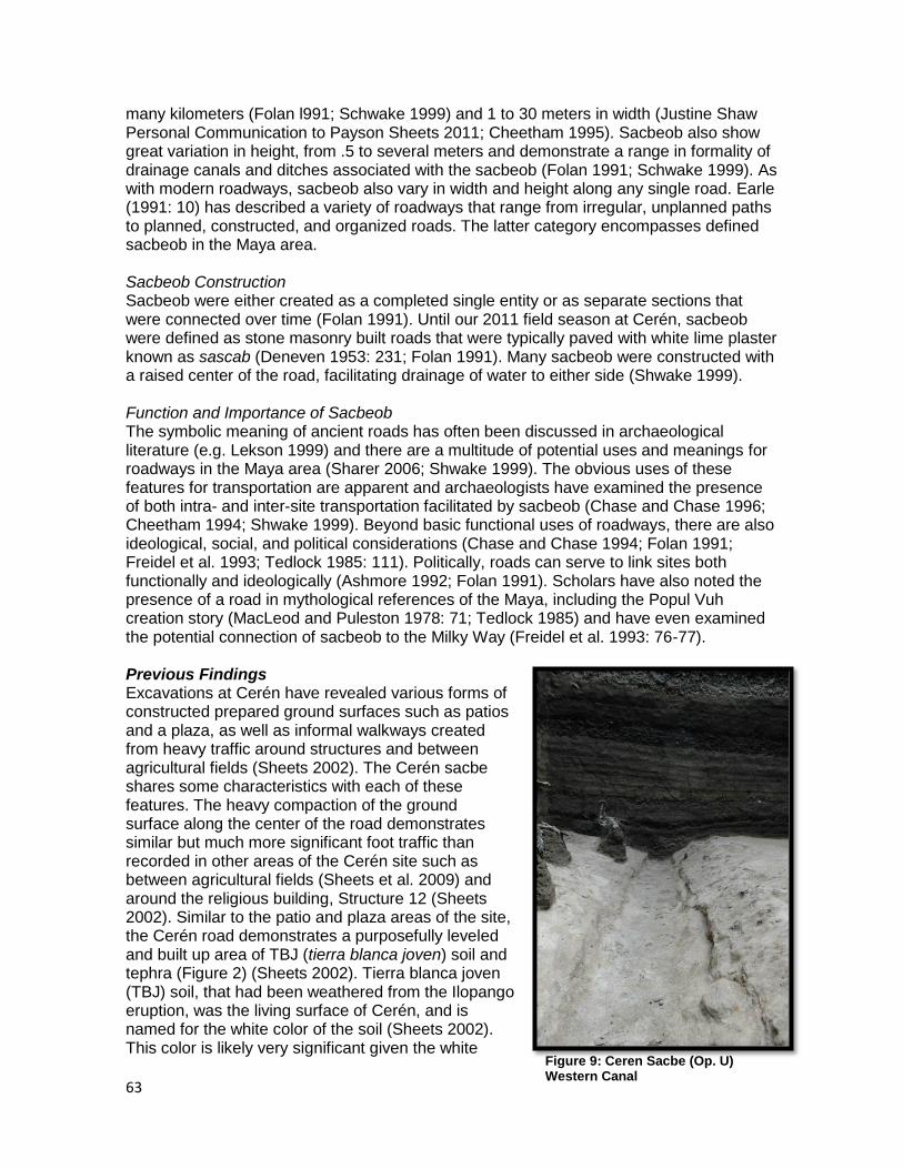
63
many kilometers (Folan l991; Schwake 1999) and 1 to 30 meters in width (Justine Shaw Personal Communication to Payson Sheets 2011; Cheetham 1995). Sacbeob also show great variation in height, from .5 to several meters and demonstrate a range in formality of drainage canals and ditches associated with the sacbeob (Folan 1991; Schwake 1999). As with modern roadways, sacbeob also vary in width and height along any single road. Earle (1991: 10) has described a variety of roadways that range from irregular, unplanned paths to planned, constructed, and organized roads. The latter category encompasses defined sacbeob in the Maya area. Sacbeob Construction Sacbeob were either created as a completed single entity or as separate sections that were connected over time (Folan 1991). Until our 2011 field season at Cerén, sacbeob were defined as stone masonry built roads that were typically paved with white lime plaster known as sascab (Deneven 1953: 231; Folan 1991). Many sacbeob were constructed with a raised center of the road, facilitating drainage of water to either side (Shwake 1999). Function and Importance of Sacbeob The symbolic meaning of ancient roads has often been discussed in archaeological literature (e.g. Lekson 1999) and there are a multitude of potential uses and meanings for roadways in the Maya area (Sharer 2006; Shwake 1999). The obvious uses of these features for transportation are apparent and archaeologists have examined the presence of both intra- and inter-site transportation facilitated by sacbeob (Chase and Chase 1996; Cheetham 1994; Shwake 1999). Beyond basic functional uses of roadways, there are also ideological, social, and political considerations (Chase and Chase 1994; Folan 1991; Freidel et al. 1993; Tedlock 1985: 111). Politically, roads can serve to link sites both functionally and ideologically (Ashmore 1992; Folan 1991). Scholars have also noted the presence of a road in mythological references of the Maya, including the Popul Vuh creation story (MacLeod and Puleston 1978: 71; Tedlock 1985) and have even examined the potential connection of sacbeob to the Milky Way (Freidel et al. 1993: 76-77). Previous Findings Excavations at Cerén have revealed various forms of constructed prepared ground surfaces such as patios and a plaza, as well as informal walkways created from heavy traffic around structures and between agricultural fields (Sheets 2002). The Cerén sacbe shares some characteristics with each of these features. The heavy compaction of the ground surface along the center of the road demonstrates similar but much more significant foot traffic than recorded in other areas of the Cerén site such as between agricultural fields (Sheets et al. 2009) and around the religious building, Structure 12 (Sheets 2002). Similar to the patio and plaza areas of the site, the Cerén road demonstrates a purposefully leveled and built up area of TBJ (tierra blanca joven) soil and tephra (Figure 2) (Sheets 2002). Tierra blanca joven (TBJ) soil, that had been weathered from the Ilopango eruption, was the living surface of Cerén, and is named for the white color of the soil (Sheets 2002). This color is likely very significant given the white
Figure 9: Ceren Sacbe (Op. U) Western Canal
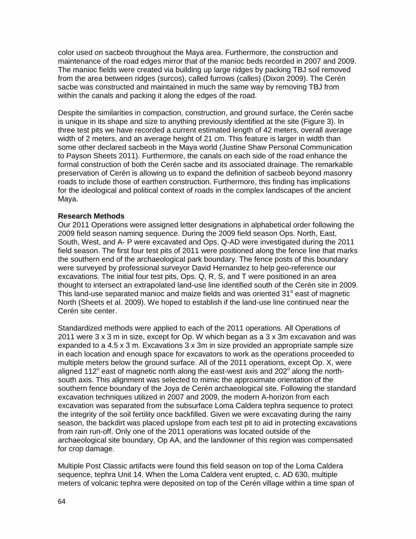
64
color used on sacbeob throughout the Maya area. Furthermore, the construction and maintenance of the road edges mirror that of the manioc beds recorded in 2007 and 2009. The manioc fields were created via building up large ridges by packing TBJ soil removed from the area between ridges (surcos), called furrows (calles) (Dixon 2009). The Cerén sacbe was constructed and maintained in much the same way by removing TBJ from within the canals and packing it along the edges of the road. Despite the similarities in compaction, construction, and ground surface, the Cerén sacbe is unique in its shape and size to anything previously identified at the site (Figure 3). In three test pits we have recorded a current estimated length of 42 meters, overall average width of 2 meters, and an average height of 21 cm. This feature is larger in width than some other declared sacbeob in the Maya world (Justine Shaw Personal Communication to Payson Sheets 2011). Furthermore, the canals on each side of the road enhance the formal construction of both the Cerén sacbe and its associated drainage. The remarkable preservation of Cerén is allowing us to expand the definition of sacbeob beyond masonry roads to include those of earthen construction. Furthermore, this finding has implications for the ideological and political context of roads in the complex landscapes of the ancient Maya. Research Methods Our 2011 Operations were assigned letter designations in alphabetical order following the 2009 field season naming sequence. During the 2009 field season Ops. North, East, South, West, and A- P were excavated and Ops. Q-AD were investigated during the 2011 field season. The first four test pits of 2011 were positioned along the fence line that marks the southern end of the archaeological park boundary. The fence posts of this boundary were surveyed by professional surveyor David Hernandez to help geo-reference our excavations. The initial four test pits, Ops. Q, R, S, and T were positioned in an area thought to intersect an extrapolated land-use line identified south of the Cerén site in 2009. This land-use separated manioc and maize fields and was oriented 31o east of magnetic North (Sheets et al. 2009). We hoped to establish if the land-use line continued near the Cerén site center. Standardized methods were applied to each of the 2011 operations. All Operations of 2011 were 3 x 3 m in size, except for Op. W which began as a 3 x 3m excavation and was expanded to a 4.5 x 3 m. Excavations 3 x 3m in size provided an appropriate sample size in each location and enough space for excavators to work as the operations proceeded to multiple meters below the ground surface. All of the 2011 operations, except Op. X, were aligned 112o east of magnetic north along the east-west axis and 202o along the north-south axis. This alignment was selected to mimic the approximate orientation of the southern fence boundary of the Joya de Cerén archaeological site. Following the standard excavation techniques utilized in 2007 and 2009, the modern A-horizon from each excavation was separated from the subsurface Loma Caldera tephra sequence to protect the integrity of the soil fertility once backfilled. Given we were excavating during the rainy season, the backdirt was placed upslope from each test pit to aid in protecting excavations from rain run-off. Only one of the 2011 operations was located outside of the archaeological site boundary, Op AA, and the landowner of this region was compensated for crop damage. Multiple Post Classic artifacts were found this field season on top of the Loma Caldera sequence, tephra Unit 14. When the Loma Caldera vent erupted, c. AD 630, multiple meters of volcanic tephra were deposited on top of the Cerén village within a time span of
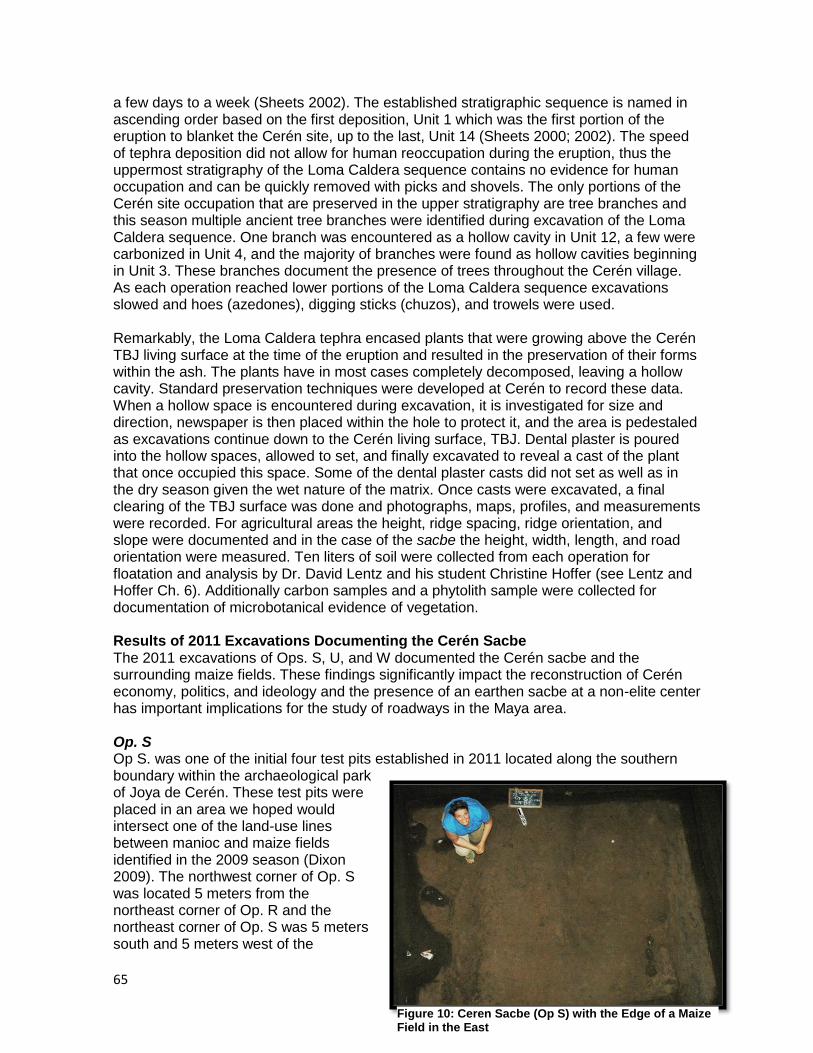
65
a few days to a week (Sheets 2002). The established stratigraphic sequence is named in ascending order based on the first deposition, Unit 1 which was the first portion of the eruption to blanket the Cerén site, up to the last, Unit 14 (Sheets 2000; 2002). The speed of tephra deposition did not allow for human reoccupation during the eruption, thus the uppermost stratigraphy of the Loma Caldera sequence contains no evidence for human occupation and can be quickly removed with picks and shovels. The only portions of the Cerén site occupation that are preserved in the upper stratigraphy are tree branches and this season multiple ancient tree branches were identified during excavation of the Loma Caldera sequence. One branch was encountered as a hollow cavity in Unit 12, a few were carbonized in Unit 4, and the majority of branches were found as hollow cavities beginning in Unit 3. These branches document the presence of trees throughout the Cerén village. As each operation reached lower portions of the Loma Caldera sequence excavations slowed and hoes (azedones), digging sticks (chuzos), and trowels were used. Remarkably, the Loma Caldera tephra encased plants that were growing above the Cerén TBJ living surface at the time of the eruption and resulted in the preservation of their forms within the ash. The plants have in most cases completely decomposed, leaving a hollow cavity. Standard preservation techniques were developed at Cerén to record these data. When a hollow space is encountered during excavation, it is investigated for size and direction, newspaper is then placed within the hole to protect it, and the area is pedestaled as excavations continue down to the Cerén living surface, TBJ. Dental plaster is poured into the hollow spaces, allowed to set, and finally excavated to reveal a cast of the plant that once occupied this space. Some of the dental plaster casts did not set as well as in the dry season given the wet nature of the matrix. Once casts were excavated, a final clearing of the TBJ surface was done and photographs, maps, profiles, and measurements were recorded. For agricultural areas the height, ridge spacing, ridge orientation, and slope were documented and in the case of the sacbe the height, width, length, and road orientation were measured. Ten liters of soil were collected from each operation for floatation and analysis by Dr. David Lentz and his student Christine Hoffer (see Lentz and Hoffer Ch. 6). Additionally carbon samples and a phytolith sample were collected for documentation of microbotanical evidence of vegetation. Results of 2011 Excavations Documenting the Cerén Sacbe The 2011 excavations of Ops. S, U, and W documented the Cerén sacbe and the surrounding maize fields. These findings significantly impact the reconstruction of Cerén economy, politics, and ideology and the presence of an earthen sacbe at a non-elite center has important implications for the study of roadways in the Maya area. Op. S Op S. was one of the initial four test pits established in 2011 located along the southern boundary within the archaeological park of Joya de Cerén. These test pits were placed in an area we hoped would intersect one of the land-use lines between manioc and maize fields identified in the 2009 season (Dixon 2009). The northwest corner of Op. S was located 5 meters from the northeast corner of Op. R and the northeast corner of Op. S was 5 meters south and 5 meters west of the
Figure 10: Ceren Sacbe (Op S) with the Edge of a Maize Field in the East

66
southwest corner of Op. T. Op. S had a weathered Playon top soil that was very loose and dry given the delayed start to the rainy season this year. On top of the Loma Caldera stratigraphy we recovered two ceramic sherds from the Post Classic reoccupation of the area (see Sheets Ch 8). Hollow cavities were first encountered in the upper portions of Unit 3 however these were all located along the far eastern portion of the Op. At approximately 415 cm below the ground surface we encountered the Cerén TBJ horizon and located a large constructed earthen road that was an average of 214 cm wide and ranged in height from 10 cm to 19 cm. The road was oriented 25o E of magnetic N and was approximately 3 meters long (Table 1). The edges of this road were defined by a canal on either side, termed the western and eastern canals. The eastern canal was deeper and more well-formed than that to the western canal. Likely, this was partly due to the slight slope of the sacbe towards the western canal that would have resulted in greater rain runoff and erosion. This slope would have facilitated the drainage of water off of the sacbe area. The full extent of the western canal was not visible in the excavation pit, but the excavation did reveal the entire width of the eastern canal.
Table 3: OP. S, Sacbe Measurements
Sacbe Orientation 25o E of mag. N
Average Width within excavation 214 cm
Average Length within excavation 321 cm
Average Height from West Canal to top of Sacbe
11.5 cm (max. 13 cm)
Average Height from East Canal to top of Sacbe
14.3 cm (max. 19 cm)
Slope towards west 3o towards western canal
Average Canal Slope 1.5o towards North
Additionally, further east of the eastern canal we located the beginning of a maize field that was oriented 112o east of magnetic North and had an average maize ridge spacing of 71.5cm (Table 2). There were 4 plant clusters in the eastern field (Plant Clusters A-D), one of which contained a corn cob (mazorca). Three other plant casts were identified on the sacbe (G, J, and E) and all did not survive casting. These were likely weeds and probably did not survive the casting process because of their small size. Ceramic sherds were also found along the surface of the sacbe, and all had been compacted into the surface of the road. The sacbe formed a western field boundary for the maize field. Given that a maize field was documented in Ops. W and R to the west of Op S (see Heindel and Lamb Ch. 2) the western boundary of the sacbe also appears to form a field boundary for a maize field to the west of Op. S. Table 4: OP. S Eastern Maize Field Measurements
Ridges 3l maize ridges
Average Ridge Spacing 71.5 cm
Average Ridge Orientation 111o E of mag. N
Average Ridge Height 7 cm
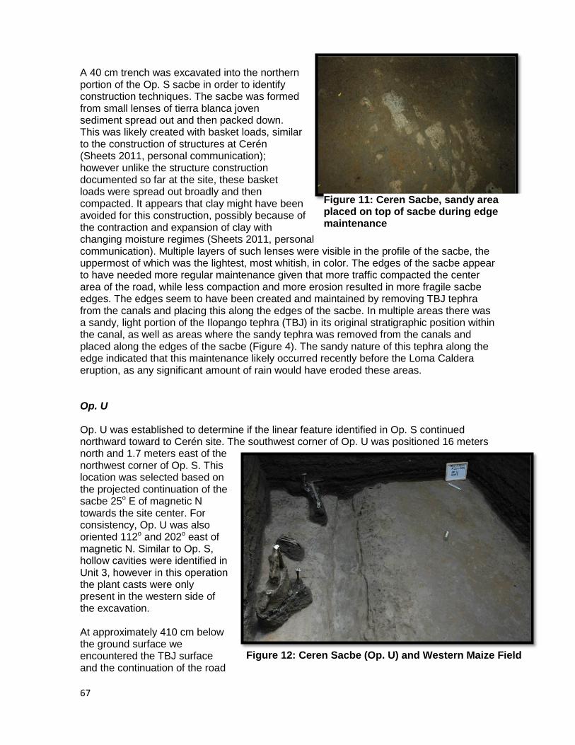
67
A 40 cm trench was excavated into the northern portion of the Op. S sacbe in order to identify construction techniques. The sacbe was formed from small lenses of tierra blanca joven sediment spread out and then packed down. This was likely created with basket loads, similar to the construction of structures at Cerén (Sheets 2011, personal communication); however unlike the structure construction documented so far at the site, these basket loads were spread out broadly and then compacted. It appears that clay might have been avoided for this construction, possibly because of the contraction and expansion of clay with changing moisture regimes (Sheets 2011, personal communication). Multiple layers of such lenses were visible in the profile of the sacbe, the uppermost of which was the lightest, most whitish, in color. The edges of the sacbe appear to have needed more regular maintenance given that more traffic compacted the center area of the road, while less compaction and more erosion resulted in more fragile sacbe edges. The edges seem to have been created and maintained by removing TBJ tephra from the canals and placing this along the edges of the sacbe. In multiple areas there was a sandy, light portion of the Ilopango tephra (TBJ) in its original stratigraphic position within the canal, as well as areas where the sandy tephra was removed from the canals and placed along the edges of the sacbe (Figure 4). The sandy nature of this tephra along the edge indicated that this maintenance likely occurred recently before the Loma Caldera eruption, as any significant amount of rain would have eroded these areas. Op. U Op. U was established to determine if the linear feature identified in Op. S continued northward toward to Cerén site. The southwest corner of Op. U was positioned 16 meters north and 1.7 meters east of the northwest corner of Op. S. This location was selected based on the projected continuation of the sacbe 25o E of magnetic N towards the site center. For consistency, Op. U was also oriented 112o and 202o east of magnetic N. Similar to Op. S, hollow cavities were identified in Unit 3, however in this operation the plant casts were only present in the western side of the excavation. At approximately 410 cm below the ground surface we encountered the TBJ surface and the continuation of the road
Figure 12: Ceren Sacbe (Op. U) and Western Maize Field
Figure 11: Ceren Sacbe, sandy area placed on top of sacbe during edge maintenance
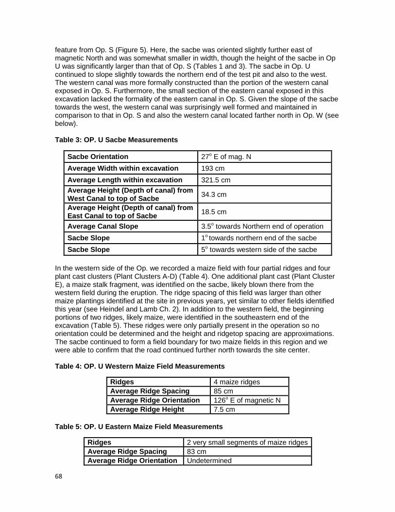
68
feature from Op. S (Figure 5). Here, the sacbe was oriented slightly further east of magnetic North and was somewhat smaller in width, though the height of the sacbe in Op U was significantly larger than that of Op. S (Tables 1 and 3). The sacbe in Op. U continued to slope slightly towards the northern end of the test pit and also to the west. The western canal was more formally constructed than the portion of the western canal exposed in Op. S. Furthermore, the small section of the eastern canal exposed in this excavation lacked the formality of the eastern canal in Op. S. Given the slope of the sacbe towards the west, the western canal was surprisingly well formed and maintained in comparison to that in Op. S and also the western canal located farther north in Op. W (see below). Table 3: OP. U Sacbe Measurements
Sacbe Orientation 27o E of mag. N
Average Width within excavation 193 cm
Average Length within excavation 321.5 cm
Average Height (Depth of canal) from West Canal to top of Sacbe
34.3 cm
Average Height (Depth of canal) from East Canal to top of Sacbe
18.5 cm
Average Canal Slope 3.5o towards Northern end of operation
Sacbe Slope 1o towards northern end of the sacbe
Sacbe Slope 5o towards western side of the sacbe
In the western side of the Op. we recorded a maize field with four partial ridges and four plant cast clusters (Plant Clusters A-D) (Table 4). One additional plant cast (Plant Cluster E), a maize stalk fragment, was identified on the sacbe, likely blown there from the western field during the eruption. The ridge spacing of this field was larger than other maize plantings identified at the site in previous years, yet similar to other fields identified this year (see Heindel and Lamb Ch. 2). In addition to the western field, the beginning portions of two ridges, likely maize, were identified in the southeastern end of the excavation (Table 5). These ridges were only partially present in the operation so no orientation could be determined and the height and ridgetop spacing are approximations. The sacbe continued to form a field boundary for two maize fields in this region and we were able to confirm that the road continued further north towards the site center. Table 4: OP. U Western Maize Field Measurements
Ridges 4 maize ridges
Average Ridge Spacing 85 cm
Average Ridge Orientation 126o E of magnetic N
Average Ridge Height 7.5 cm
Table 5: OP. U Eastern Maize Field Measurements
Ridges 2 very small segments of maize ridges
Average Ridge Spacing 83 cm
Average Ridge Orientation Undetermined
69
Average Ridge Height 7 cm
Op. W The southwest corner of Op. W was positioned 16 meters north and 3.35 meters east of the northwest corner of Op. U. This location was selected in order to intersect the projected continuation of the sacbe found in Op. S and U, towards the site center. Op W began as a 3 x 3m excavation pit and during excavations it was expanded 1.5 meters to the east, resulting in a 3 x 4.5 m excavation. The expansion took place when the original excavation reached Unit 3 and documented multiple hallow cavities on the western side of the pit, interpreted as a likely maize field. The approximate boundary of this maize field and the estimated size of the sacbe (established in Ops. S and U) indicated we would likely only locate one side of the sacbe within a 3 x 3m pit, consequently the extension was added. At roughly 480 cm below the ground surface we encountered the continuation of the Cerén sacbe with an eastern and western canal, as well as maize fields to the east and west (Figure 6). A large lava bomb, approximately 35 cm in diameter directly impacted the southwest side of the Op. W sacbe. The lava bomb was part of the Unit 2 eruption and left a bomb sag in the sacbe.
While similar in construction to the sacbe of Ops. S and U, this region also demonstrated some variation in the size and orientation of the road. In this location the sacbe was narrower than those sections established in Ops. S and U, with an average width of 151 cm. The width of the Op. W sacbe was widest in the northern end of the operation, closest to the site center, and narrower to the south. Interestingly, the other sections of the sacbe south of this area were wider than this segment (Tables 1, 3, and 6). The Op. W region of the sacbe also turned further eastward, with an approximate orientation of 34o E of magnetic N. If the more northern section of the sacbe continues to turn further east, it is likely it would connect with Structure 10 where evidence for community feasting has been identified (Sheets 2002).
The eastern canal of Op. W was very well formed, in particular in the northern end of the operation and had an average depth below the sacbe of approximately 28 cm. The sacbe itself maintained a slight slope to the west and in this area the western canal was less well formed without the almost vertical walls that were present in the eastern canal. Contrary to the other sacbe segments, the sacbe in Op. W and the canals had a slight slope towards the southern end of the operation. This indicates that water in the canals of Ops. S and U would have drained northward and intersected the water draining southward from Op. W. Thus there must have been canals on both sides redirecting the water to another location, likely from the eastern canal to the river (Rio Sucio) and from the western canal to the natural topographic drainage area identified by ground-penetrating radar (Conyers 1995). In conjunction with this evidence, the smaller width and more eastern direction of the sacbe in Op. W might suggest that the sacbe split before reaching Op. W.
The two maize fields of the operation show variation in the formality and size of maize ridges. Those of the eastern field are more developed than that of the western area. Both fields were being harvested, as evidenced by mature mazorcas on doubled-over maize stalks; however, it is possible that the maize to the west had been planted at a different time given the likelihood these received more water runoff but were still slightly smaller in average size, than those of the eastern field. A larger area of the western field was visible
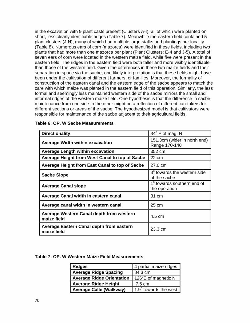
70
in the excavation with 9 plant casts present (Clusters A-I), all of which were planted on short, less clearly identifiable ridges (Table 7). Meanwhile the eastern field contained 5 plant clusters (J-N), many of which had multiple large stalks and plantings per locality (Table 8). Numerous ears of corn (mazorca) were identified in these fields, including two plants that had more than one mazorca per plant (Plant Clusters: E-4 and J-5). A total of seven ears of corn were located in the western maize field, while five were present in the eastern field. The ridges in the eastern field were both taller and more visibly identifiable than those of the western field. Given the differences in these two maize fields and their separation in space via the sacbe, one likely interpretation is that these fields might have been under the cultivation of different farmers, or families. Moreover, the formality of construction of the eastern canal and the eastern edge of the sacbe appears to match the care with which maize was planted in the eastern field of this operation. Similarly, the less formal and seemingly less maintained western side of the sacbe mirrors the small and informal ridges of the western maize field. One hypothesis is that the difference in sacbe maintenance from one side to the other might be a reflection of different caretakers for different sections or areas of the sacbe. The hypothesized model is that cultivators were responsible for maintenance of the sacbe adjacent to their agricultural fields.
Table 6: OP. W Sacbe Measurements
Directionality 34o E of mag. N
Average Width within excavation 151.3cm (wider in north end) Range 170-140
Average Length within excavation 352 cm
Average Height from West Canal to top of Sacbe 22 cm
Average Height from East Canal to top of Sacbe 27.6 cm
Sacbe Slope 3o towards the western side of the sacbe
Average Canal slope 1o towards southern end of the operation
Average Canal width in eastern canal 31 cm
Average canal width in western canal 25 cm
Average Western Canal depth from western maize field
4.5 cm
Average Eastern Canal depth from eastern maize field
23.3 cm
Table 7: OP. W Western Maize Field Measurements
Ridges 4 partial maize ridges
Average Ridge Spacing 84.3 cm
Average Ridge Orientation 126oE of magnetic N
Average Ridge Height 7.5 cm
Average Calle (Walkway) 1.9o towards the west
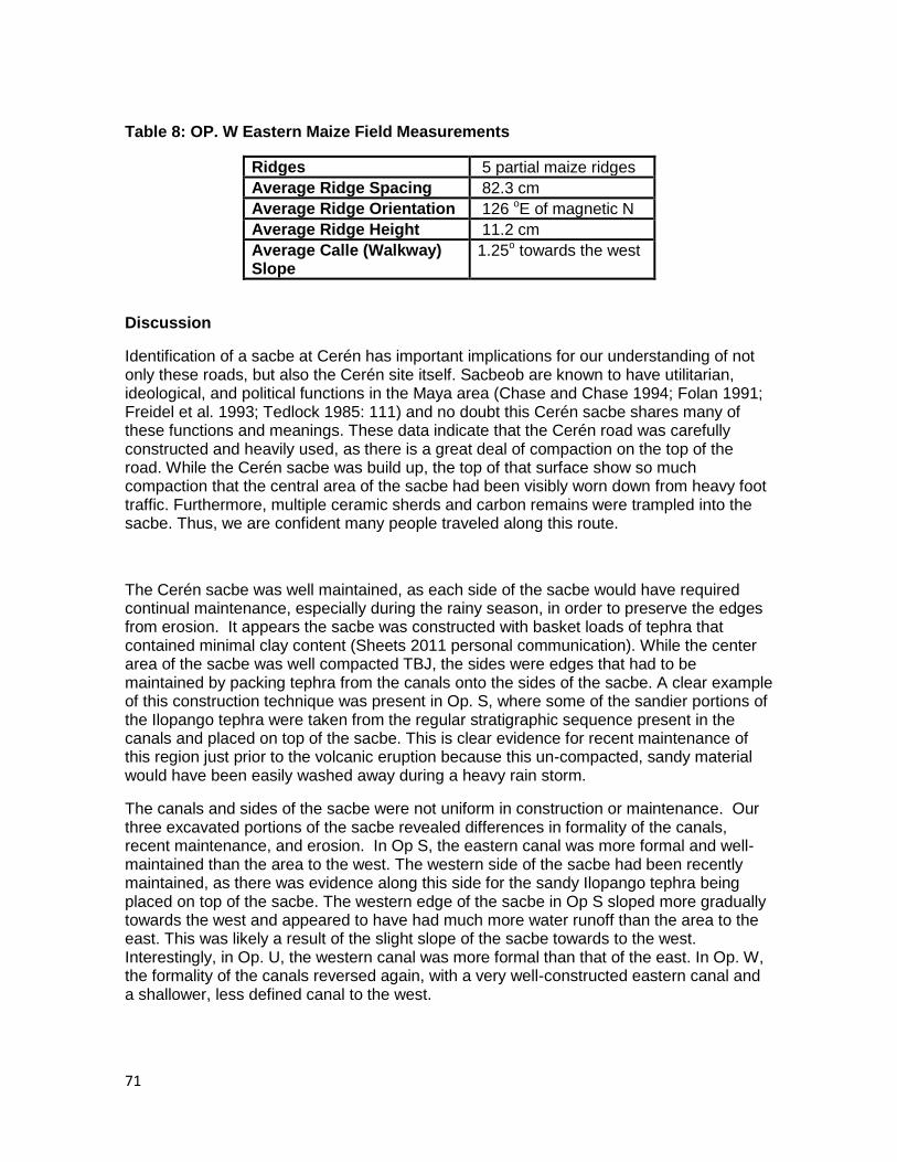
71
Table 8: OP. W Eastern Maize Field Measurements
Ridges 5 partial maize ridges
Average Ridge Spacing 82.3 cm
Average Ridge Orientation 126 oE of magnetic N
Average Ridge Height 11.2 cm
Average Calle (Walkway) Slope
1.25o towards the west
Discussion
Identification of a sacbe at Cerén has important implications for our understanding of not only these roads, but also the Cerén site itself. Sacbeob are known to have utilitarian, ideological, and political functions in the Maya area (Chase and Chase 1994; Folan 1991; Freidel et al. 1993; Tedlock 1985: 111) and no doubt this Cerén sacbe shares many of these functions and meanings. These data indicate that the Cerén road was carefully constructed and heavily used, as there is a great deal of compaction on the top of the road. While the Cerén sacbe was build up, the top of that surface show so much compaction that the central area of the sacbe had been visibly worn down from heavy foot traffic. Furthermore, multiple ceramic sherds and carbon remains were trampled into the sacbe. Thus, we are confident many people traveled along this route.
The Cerén sacbe was well maintained, as each side of the sacbe would have required continual maintenance, especially during the rainy season, in order to preserve the edges from erosion. It appears the sacbe was constructed with basket loads of tephra that contained minimal clay content (Sheets 2011 personal communication). While the center area of the sacbe was well compacted TBJ, the sides were edges that had to be maintained by packing tephra from the canals onto the sides of the sacbe. A clear example of this construction technique was present in Op. S, where some of the sandier portions of the Ilopango tephra were taken from the regular stratigraphic sequence present in the canals and placed on top of the sacbe. This is clear evidence for recent maintenance of this region just prior to the volcanic eruption because this un-compacted, sandy material would have been easily washed away during a heavy rain storm.
The canals and sides of the sacbe were not uniform in construction or maintenance. Our three excavated portions of the sacbe revealed differences in formality of the canals, recent maintenance, and erosion. In Op S, the eastern canal was more formal and well-maintained than the area to the west. The western side of the sacbe had been recently maintained, as there was evidence along this side for the sandy Ilopango tephra being placed on top of the sacbe. The western edge of the sacbe in Op S sloped more gradually towards the west and appeared to have had much more water runoff than the area to the east. This was likely a result of the slight slope of the sacbe towards to the west. Interestingly, in Op. U, the western canal was more formal than that of the east. In Op. W, the formality of the canals reversed again, with a very well-constructed eastern canal and a shallower, less defined canal to the west.

72
That the eastern and western canals of the sacbe were not uniform in maintenance or construction could have important implications. One possibility is that these differences are evidence of sections of the sacbe under the care of different families associated with different farming units in the region. Another possibility is that these differences are indicative of changes in drainage. Importantly, in Op W. exposure of maize fields on either side of the sacbe allowed for the direct comparison between fields on either end of the sacbe. This comparison showed that these two maize fields were likely separate fields, possibly with different land owners given the variation in maize ridge construction and possibly timing of planting (see Heindel and Lamb Ch. 2). This raises an interesting question for future research to explore if there is a link between the field adjacent to the sacbe and the maintenance of that portion of the road. A model for community maintenance has emerged from within the Cerén site, whereby individual domiciles seem to have particular relationships with certain special structures (e.g. Household 1 and Structure 10 and 12). Thus, one possible organization strategy for maintenance of the road would be for those families with fields adjacent to the road to have maintenance responsibilities for the section of road adjacent to their field. Further excavation of the sacbe and fields on either side of the sacbe might provide data to test this hypothesis. Should a relationship be shown between different fields and different maintenance of the sacbe, this would have strong implication for what Dr. Sheets has termed non-royal governance (Sheets 2011, personal communication).
The discovery of a sacbe at Cerén also contributes to a richer perspective of politics at the site. Elsewhere in the Maya world, sacbeob have been preserved at large elite cities, such as Tikal and Caracol, as well as smaller city centers (Chase and Chase 1996; Sharer 2006; Justine Shaw Personal Communication to Payson Sheets 2011). Cerén was not a large elite center and these data support a view of sacbeob as not the exclusive domain of elite centers, but rather a feature connecting large and small centers and providing ideological, political, and economic links throughout the Maya landscape.
One political feature that cannot be overlooked at present is that the Cerén sacbe currently is headed south, possibly towards the major Classic Period regional center of the Zapotitan Valley, San Andres. San Andres is located 5 km southwest of the Cerén site (Sheets 2002). A very important finding is that the Cerén sacbe is oriented 25o E of magnetic N in Op. S, 27o E of mag. N in Op U, and 34o E of mag. N in Op. W. Thus the southern portion of the sacbe is oriented approximately 26o E of mag. N, while the northern most area is aligned 34o E of mag. N. Remarkably, when analyzed from georectified satellite imagery the San Andres buildings were found to be oriented 26-29o E of mag. N. While such alignments are not proof the sacbe runs from Cerén to San Andres, or that it is a representation of the political relationship between these two sites, it does warrant serious investigation. Much more research is required to establish the probability that this sacbe united Cerén and San Andres and beyond this the meaning of such a link if it does exist. It is further interesting that the alignment of the Cerén sacbe closest to the site center is oriented further east of magnetic N, 34o E of mag. N, which is much more similar to the 30oE of mag N. typical of Cerén structure and agricultural orientations (Dixon 2009; Sheets 2002). Is this just a feature of the direction of the road or might this indicate a change in ideology or identity, a proper entry into the settlement that is aligned with the architectural buildings?

73
Maya sacbeob have long been linked with religious and ideological significance and meaning (Chase and Chase 1994; Folan 1991; Freidel et al. 1993; Tedlock 1985: 111). Notably, the known northern extent of the Cerén sacbe indicates it likely connects with the site center at or near Household 1. Household 1 at the Cerén site includes domicile structures as well as two major religious buildings of the site (Sheets 2002). Structure 10 was an area utilized for public feasting and Structure 12 was a building utilized by the religious practitioner of the site (Sheets 2000, 2002). Thus, one possibility for the Cerén sacbe is that it had ideological meaning of uniting the wider community and agricultural fields with the center of the religious practices at the site or creating a symbolic representation using the constructed landscape (Ashmore 1992; Shwake 1999).
Conclusions
The surprising 2011 discovery of a sacbe at Cerén clearly has implication for economic, political, and ideological aspects of Cerén village life. Many questions have arisen from this finding that future research will hopefully explore. For what was the road used? Was this a route to transfer goods and food to and from various settlements in the area? Why was the roadway elevated and so wide? What are the political and ideological meanings of the sacbe? Are there social implications for communities linked by a sacbeob? From the excavation of Ops. S, U, and W, the established length of the sacbe is 42 meters, but both the northern and southern extents of this feature are still unknown. Does the sacbe connect to the religious structures near Household 1? Is there a divergence in the road between Ops. U and W and if so, where else might the sacbe connect with the site center? Understanding the integration of this road into the site center has important implications for its meaning and function. The Cerén sacbe has a width of approximately 2 meters and an average height of 21 cm, this appears much larger and more formal than would be necessary for a simple practical or economic function of basic transportation. This feature was a visible and likely important aspect of the Cerén landscape, but the question remains of what the uses and significance of the road were to Cerén villagers. The unknown southern extent of the sacbe is another avenue of needed future study. Does the sacbe connect the Cerén site center to the agricultural fields, to other sites in the region, or possibly to the major regional center of San Andres? It is important to assess if the Cerén sacbe was utilized primarily for intra- or inter- site connections. If the sacbe does extent to San Andres, this would alter the views of how commoner agricultural villages interacted with elite centers in the Classic Period Maya world or even possibly call into question the existence of Cerén as an independent commoner village. At Caracol, Belize sacbeob have been important in identifying the uses of these roadways for movement of goods and people, as well as for political links between the city center and outlying communities. As Chase and Chase have indicated “at least ten of the known causeway termini would have qualified for the label „minor center‟ had they not been tied to the epicenter by causeways… [they were] initially separate centers that ultimately were engulfed by the expanding urban center of Caracol during the Late Classic Period” (Chase and Chase 1998: 5-6 in Schwake 1999: 7). If Cerén is a causeway terminus with San Andres, might it have a political relationship more formal and direct than previously thought? Additional research questions can be explored with further study of the Cerén sacbe. For example, our 2011 data indicate there might be differences in the sacbe maintenance and one hypothesis is that this is linked with the different land tenure of agricultural fields in the
74
region, similar to the association of different households with particular public buildings. Through further excavation of the Cerén sacbe, canals, and the agricultural fields on each side we might better assess the community strategy for maintaining a feature of this size. Furthermore, at the time of the eruption there was a feast underway, likely linked with the harvest, and many people were probably gathered in the area east of Household 1, around Structure 10 (Sheets 2002). If the sacbe ends in this area, a major evacuation route during the eruption might have been along this road, given its directionality away from the epicenter of the eruption. Exploration of the sacbe further south of the Cerén site has the potential to identify individuals who were fleeing the site at the time of the eruption.
The Cerén sacbe was possibly utilized for a variety of functions, such as transportation of agricultural goods from the fields to the site center, a trade route, agricultural field boundaries, and / or the movement of groups of people into central areas, such as the religious structures of Household 1. While numerous research questions about the sacbe remain, it is clear that this feature was an important part of the economic, political, and ideological landscapes of Cerén. A causeway of this size and the effort required for its maintenance and construction signifies the importance of it to the Cerén community. As Schwake has stated, “To say that sacbeob were simply roadways for the transportation of goods and people is to minimize the wide range of significance which they held to the people that constructed them” (1999: 128). Thus the presence of a sacbe at the site implies more than just that Cerén villagers made and utilized a road, but also our conceptions of the economic, political, social, and ideological world in which Cerén was situated.
References
Ashmore, W.
1992 Deciphering Maya Architectural Plans. In New Theories of the Ancient Maya, edited by E. Danien and R.J. Sharer, pp. 173-184. University of Pennsylvania, Philadelphia.
Chase, A. F.and D. Z. Chase
1996 The Caseways of Caracole. Belize Today 2:31-32.
Chase, D.Z. and A.F. Chase
1994 Studies in the Archaeology of Caracol, Belize, edited by D.Z. Chase and A.F. Chase. Pre-Colombian Art Research Institute, San Francisco.
Cheetham, D.
1995 Excavations on the Main Causeway at Baking Pot: A Brief Note. In Belize Valley Archaeological Reconnaissance Project: Progress Report of the 1994 Field Season, Volume 2. Edited by J.M. Conlon and J.J. Awe, pp. 33-40. Institute of Archaeology, University College London.
75
Conyers, L. 1995 The use of ground-penetrating radar to map the topography and structures at the
Cerén site, El Salvador. PhD. Dissertation. Department of Anthropology: University of Colorado, Boulder.
Deneven, W.
1991 Prehistoric Roads and Causeways of Lowland Tropical America. In Ancient Road Networks and Settlement Hierarchies in the New World, edited by C.D. Trombold, pp. 230-242. Cambridge Univresity Press, Cambridge.
Dixon, C. C.
2009 Manioc Agriculture in Report of the 2009 Maya Agricultural Project South of Joya de Cerén, El Salvador, edited by P. Sheets. Enlace Academico Centroamericano, Fundacion Clic. San Salvador, El Salvador. (www.colorado.edu/Anthropoloyg/people/bios/sheets.html)
Earle, T.
1991 Paths and Roads in Evolutionary Perspective. In Ancient Road Networks and Settlement Hierarchies in the New World, edited by C.D. Trombold, pp. 10-16. Cambridge University Press, Cambridge.
Folan, W.J.
1991 Sacbes of the Northern Maya. In Ancient Road Networks and Settlements Hierarchies in the New World, edited by C.D. Trombold, pp. 222-229. Cambridge University Press, Cambridge.
Freidel, D., L. Schele, and J. Parker
1993 Maya Comos: Three Thousand Years on the Shaman’s Path. William Morrow, New York.
Lekson, S.
1999 The Chaco Meridian: Centers of Political Power in the Ancient Southwest. Altamira Press, Walnut Creek, CA.
MacLeod, B. and D. Puleston
1978 Pathways into Darkness: the Search for the Road to Xibalba. In Tercera mesa Redonda de Palenque. Vol. IV. Edited by M.G. Robertson and D.C. Jeffers, pp. 71-77. Pre-Colombian Art Research Center, Monteray, CA.
76
Schwake, S.
1999 On the Road: Excavation Along the maya Sacbe at X-Ual-Canil, Cayo District, Belize. Master of Arts Thesis, Trent University, Peterborough, Ontario, Canada.
Sharer, R.
2006 The Ancient Maya. Sixth Edition. Stanford University Press, Palo Alto, CA.
Sheets, P.
2009 Report of the 2009 Maya Agricultural Project, South of Joya de Cerén, El Salvador, edited by P. Sheets. Enlace Adademico Centroamericano, Fundacion Clic, San Salvador, pp 83-106. http://www.colorado.edu/Anthropology/people/bios/sheets.html
2006 The Cerén Site: A Prehistoric Village Buried by Volcanic Ash in Central America. 2nd edition. Case Studies in Archaeology Series. Harcourt Brace Collage Publishers: New York, NY.
2002 Before the Volcano Erupted: The Ancient Cerén Village in Central America. University of Texas Press, Austin.
2000 Provisioning the Cerén Household: The vertical economy, village economy, and household economy in the southeastern Maya periphery. Ancient Mesoamerica, 11 (2000), 217–230. Cambridge University Press: Cambridge, MA.
Sheets, P. D., C. C. Dixon, A. Blanford, and M. Guerra 2009 Descubrimientos de Investigaciones Geofisicas e Arqueologicas al Sur de Joya de
Cerén. In Press: El Salvador Investiga. CONCULTURA: San Salvador, El Salvador.
Tedlock, D.
1985 Popul Vuh: The Definitive Edition of the Mayan Book of the Dawn of Life and the Glories of Gods and Kings. Simon and Schuster, New York.
Acknowledgments My gratitude for the opportunity to work at the site of Joya de Cerén and with such extraordinary individuals is immense. Deep gratitude is owed to Dr Payson Sheets for sharing his passion and enthusiasm for Salvadorian archaeology and for the opportunity to participate in this research. I am exceptionally grateful for his continued guidance and support and it is an honor to be his student. Thankfully he also reviewed earlier drafts of both Ch 4 and 5 for this publication. Any errors are my own. The paleobotanical expertise of Dr. David Lentz is also deeply appreciated. Dr. Lentz is a great scholar and I am very thankful for his contributions and guidance in our research. The successes of this season are in large part due to the fantastic archaeologists I had the privilege of working with this

77
year. Celine Lamb, Alexandria (Zan) Halmbacher, and Theresa Heindel have significantly contributed to our ongoing Cerén research and it is truly a pleasure to have each of these women as colleagues and friends. Celine‟s work on researching gardens in Joya de Cerén and her engagement with the community has enriched all of our experiences of Cerén and generated new thinking about planting techniques utilized in the past and present. Zan‟s intellectual curiosity, big-picture ideas, and fresh perspective significantly aided in advancing our research. Additionally, her good spirits and dedication were a dynamic and important contribution to the project. Finally, the tireless efforts and persistence of Theresa in digitizing all maps and profiles from this season has been inspiring. Theresa‟s research on malanga added a new dimension of our understanding of root crops at Cerén and her contributions to our project are very much valued. I am privileged and grateful to work with each of these individuals. Christine Hoffer also afforded paleobotanical expertise and her participation in our fieldwork this summer was appreciated by all. Special thanks are reserved for the Salvadorian government, in particular the Patrimonio Cultural de la Secretaria de Cultura de la Presidencia de El Salvador and Dr. Ramón Rivas. It is truly an honor to work in a country with both inspiring people and a deeply rich cultural history. Our research in El Salvador continues to be greatly supported and aided by the contributions of Roberto Gallardo, MA of the Museo Nacional “David J. Guzman”. His efforts have facilitated our research at Cerén and his friendship is appreciated. Roberto is an excellent archaeologist who continues to significantly enhance the work presented here. The expertise of Justine Shaw, the foremost expert on sacbeob, has greatly aided our research and interpretations. „ To the 22 workers who made these excavations both possible and fun, I owe a great debt of gratitude and respect. Each of these men are exceptional workers, people, and friends. Thank you to Salvador “Chamba” Quintania („jefe”) whose love and care of the Cerén site is both obvious and contagious. Special thanks are also owed to the Garcia-Munas family and members of the Joya de Cerén community who have generously shared a piece of their home with us. Dr. Errin Weller and Dr. Nancy Gonlin have each provided me with great support and friendship throughout this research. Finally, my deepest gratitude is reserved for my family, without whom I would not be where I am today and in particular the patience and loving support of my wife, Lauren.
78
Chapter 6. Ceren Paleoethnobotanical Studies, Season 2011
David Lentz and Christine Hoffer
University of Cincinnati
Paleothnobotancial research at the Ceren site resumed in July of 2011. The focus of this round of investigation was to identify the plant remains retrieved from the recent excavations at Ceren and provide interpretive perspectives on the results. As in previous years, the main emphasis of the paleoethnobotanical study is to determine the kinds of plants used by the Ceren inhabitants for food, fuel, house construction, medicinal applications and for commercial exchange. Of particular interest this year is to ascertain how the agricultural fields were oriented and what crops were grown in each. More specifically, the project seeks to learn the importance of manioc (Manihot esculenta) as a crop resource for the Ancient Maya; not merely to discover if it was being grown, but more significantly, how much of the plant was being grown, using what farming techniques and how it stands in importance to other cultigens, e.g., maize (Zea mays), beans (Phaseolus spp.), peppers (Capsicum annuum) and squashes (Cucurbita spp.). The plant retrieval methodology is oriented to these objectives and the sampling strategy was adjusted accordingly.
To meet the overall objectives of the project, our plant remain retrieval strategy was streamlined and tailored to obtain plants from agricultural zones. The main focus of our plant retrieval effort was the recovery of macroremains (carbonized plant materials) and plaster casts of plants whose impressions were entombed in the ground by the ashfall that emanated from the Loma Caldera eruption in about A.D. 600.
The macroremians were collected when encountered by excavators as they removed tephra and cinders from cultural strata, often several meters below the modern ground surface. In general, remains recovered in this way produce the most valuable plant remains because they are large enough for successful identification, particularly if the samples are comprised of wood remains. These are always carefully stored in vials, paper bags or small boxes as soon as discovered; the protection afforded by these containers ensures that the moist plant material, in its most fragile condition, will be protected from physical action in its long journey from field site to laboratory. To ensure that the containers would be available when needed, each project archaeologist was issued a packet of collection materials along with instructions on how they could be used most effectively.
Despite the most vigorous efforts on behalf of any careful excavator, it would be impossible to collect all of the plant remains contained within sediments that contain substantial amounts of cultural material. Small seeds and other plant parts that might not be obvious to an excavator require a more systematic approach that will routinely recover those tiny, yet important plant remains on a consistent basis. In order to recover all carbonized plant remains from our excavated soils, we implemented a water flotation process that would be applied to all cultural strata excavated by project personnel. Water flotation is a process that involves submersing sediments from cultural zones in water, allowing burned plant parts to float to the surface were they can be scooped off, dried and examined in the laboratory. In an effort to maximize our recovery rate, the project expanded the standard quantity of soil to be floated from 2 liters to 10 liters per cultural level encountered in each excavation operation. Preliminary sorting of the samples were done on site. Each floatation sample was sorted by size. Samples were grouped starting
79
from less than one millimeter, between one and two millimeters, and greater than two millimeters. Of those samples the charred remnants were collected and placed within vials for return travel. The sediment and tephra that remained from each flotation was then labeled and retained for further examination with a higher powered microscope to ensure that all possible plant matter is recovered. Although we are just beginning our analysis of those materials (see Table 1), our anecdotal impression is that the modified process is returning benefits because the number of identifiable plant remains seems to have improved significantly. More on this subject will be known as our analyses progress.
Another form of paleoethnobotanical recovery that is actively being pursued by the project is the study of phytoliths. Phytoliths are silcaceous bodies that appear within the tissues of many species of plants. Unlike pollen, these silicaceous bodies are resistant to degradation by moderate levels of heat (such as the steamy ash that fell on the Ceren village and was apparently so damaging to pollen and starch grains) and have been preserved in previous recovery efforts at Ceren. Accordingly, we are systematically recovering soil samples for phytolith analysis. Every time we collect a flotation sample we also will collect a companion phytolith sample. The combination of phytolith data with macrofossil results provides a synergistic data set that will help insure that we can maximize our retrieval of plant information at Ceren.
In addition to plant data from macroremains and phytoliths, plant casts at Ceren offer an unusually valuable component to our understanding of the plant use practices of the Precolumbian occupants. This process is described in detail elsewhere in this report and it is an extremely valuable aspect of the study of plant use at Ceren. What it means for this study is that at Ceren we can learn what plants were grown in what fields and in what arrangements. This is information that can be obtained at few, if any other sites.
Preliminary Results
Up to this point, we have focused on the collection of paleoethnobotanical samples and have had little time for the actual analysis. From the cursory analysis of carbonized plant remains that has been carried out thus far, we can offer a few insights. As stated above, the flotation process has been successful in generating archeological plant data. Many of the remains that have been retrieved have been of hardwood charcoal. These would be from Angiosperm trees of a tropical forest that covered much of El Salvador during Precolumbian times. Analysis by electron microscopy will enable us to identify many of the burned pieces of wood to species. Seeds found during initial screening of flotation samples were from Encelia sp., a weedy species in the Asteraceae. Among the plant casts, numerous examples of maize (Zea mays) stems and cobs were found, notably to the east and especially to the west of the sacbe (Operations S, U, and W) and elsewhere at the site. In addition to the stems and cobs, there seems to be a higher concentration of other macrobotanical remains along the sacbe. Flotation has revealed a more diverse assortment of seeds in these operations, including a frijol seed (P. vulgaris (?)). The largest concentration of seeds appears in the smaller sample sizes which measure less than two millimeters. Further analysis of this size sample will require microscopic evaluation for additional identification.
In Feature 1 in Operation AA, the corner of what appears to be a house structure was uncovered. Several carbonized beams were exposed and their analysis will help us to understand more about how the structures were built and the surrounding environment of the Ceren inhabitants. Identification of the beams‟ species will shed further light on the materials used in household construction. Among a host of household artifacts were two
80
casts of what appear to be maguey (Agave sp.) plants. Much more will be learned from this interesting feature and its associated plant remains as well as from other excavations at Ceren. In the midst of the carbonized remains of Operation AA, hardened bits of tephra were recovered from the soil samples gathered in situ from Unit Three. These pieces of tephra appear to have seed imprints, which under closer inspection, may be identifiable. Other samples were obtained in situ from Operation AA. These included a sample from within a ceramic vessel as well as around a groundstone artifact. More research will need to be done upon return to the University of Cincinnati to determine if there were any residual macroremains. Two more large carbonized segments of wood were uncovered within Operation AD. These charred remains were found within Unit Four. At the time of Unit Four, the area‟s inhabitants were already evacuated. The charred remains are parts of a tree that remained standing until the very hot Unit Four tephra fell, with larger particles hotter than 575 degrees centigrade. When the species of tree is known, it will contribute significantly to the knowledge of the flora living at Ceren before the eruption occurred.
81
Chapter 7. Lithic Artifacts
Payson Sheets
This chapter focuses on stone tools, largely obsidian, with one large groundstone artifact, all excavated during the 2011 field season of the Maya Agriculture Project. All lithic artifacts encountered are described and illustrated here. The area under investigation was midway between the Joya de Ceren village and the agricultural area excavated in 2009 that is some 200 meters south of the village. The objective here is to describe and interpret the lithic implements, in spite of the small size of the collection. The reader of this chapter is encouraged to pay attention to stratigraphic and therefore chronological contex, as some of the artifacts came from the Classic period ground surface, the juvenile soil developed on the tierra blanca joven (TBJ) tephra from the Ilopango eruption, and a significant amount of the collection is from the top of the Loma Caldera tephra that buried Joya de Ceren, and dates to the Postclassic period.
The 2009 research of the Maya Agriculture Project at Joya de Ceren encountered some stone artifacts, largely of obsidian but some of dacite, that apparently had some agricultural applications (Sheets 2009). The obsidian artifacts, largely broken obsidian prismatic blades, would have been useful in a wide range of cutting and slicing activities, many of them involved in food preparation. Of particular interest was a dacite scraper and a relatively long segment of an obsidian prismatic blade found in Operation P in a modest sheet midden. The midden was adjacent to a large area devoted exclusively to manioc production, and even had one manioc plant volunteer growing in it. Therefore permission is being requested to conduct crossover immunoelectrophoresis analysis (CIEP) of some artifacts to see if organic residues from removing the cortex from the manioc tuber might be detected on them.
Description of Chipped Stone Tools
Operation T
A small prismatic blade core of obsidian was discovered toward the bottom of volcanic Unit 15. That is the Postclassic cultural horizon, above the Boqueron eruption, and below the Playon eruption. This is a short core, that may have begun as a longer core, and was reduced in length and circumference by sequential blade removals from the core. Or it is possible that it is a core from a relatively less skilled obsidian blade manufacturer. The knapper did hinge-fracture a blade just below the platform, making further blade detachments extremely difficult from that part of the core. Two manufacturing problems were posed by xenolith inclusions in the obsidian. Those three problems probably resulted in core discard. The core platform was lightly striated, a departure from the usual Postclassic procedure of thoroughly grinding the platform.
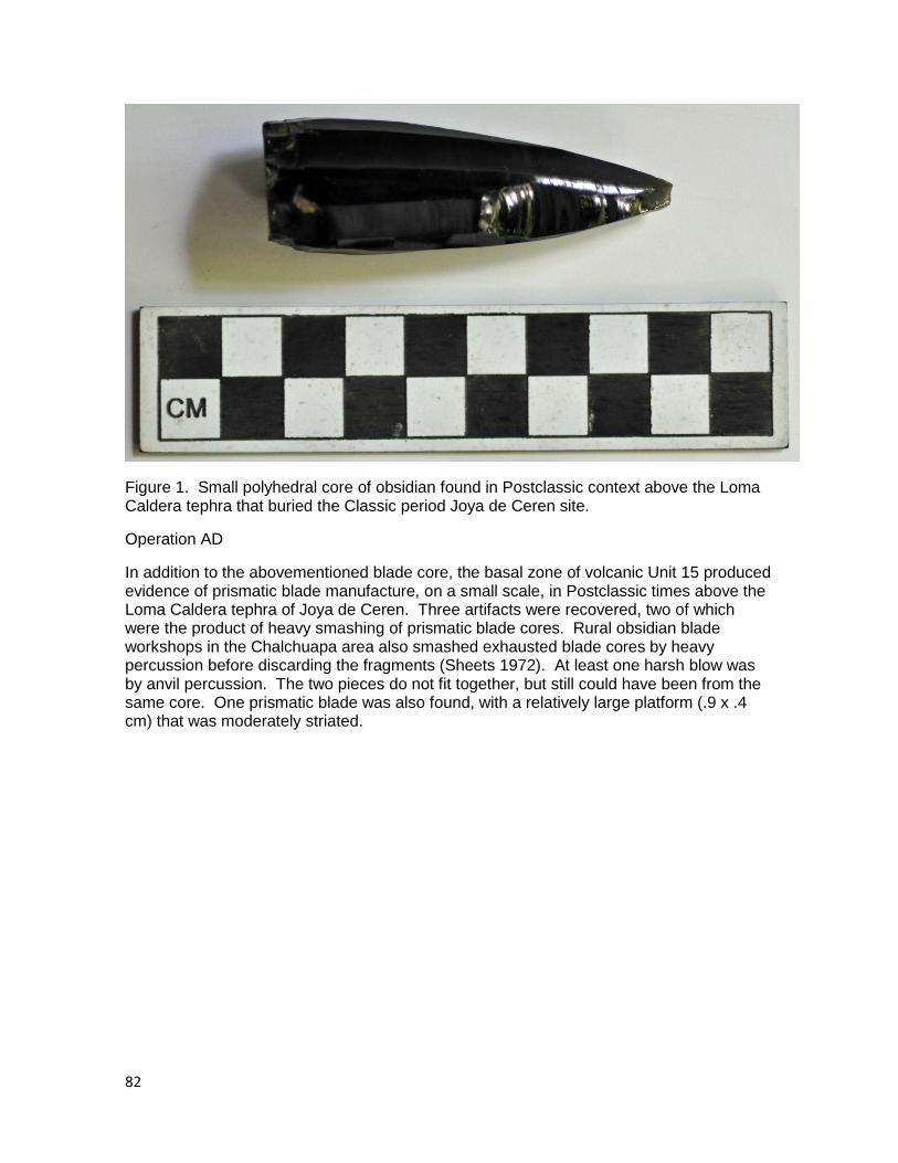
82
Figure 1. Small polyhedral core of obsidian found in Postclassic context above the Loma Caldera tephra that buried the Classic period Joya de Ceren site.
Operation AD
In addition to the abovementioned blade core, the basal zone of volcanic Unit 15 produced evidence of prismatic blade manufacture, on a small scale, in Postclassic times above the Loma Caldera tephra of Joya de Ceren. Three artifacts were recovered, two of which were the product of heavy smashing of prismatic blade cores. Rural obsidian blade workshops in the Chalchuapa area also smashed exhausted blade cores by heavy percussion before discarding the fragments (Sheets 1972). At least one harsh blow was by anvil percussion. The two pieces do not fit together, but still could have been from the same core. One prismatic blade was also found, with a relatively large platform (.9 x .4 cm) that was moderately striated.
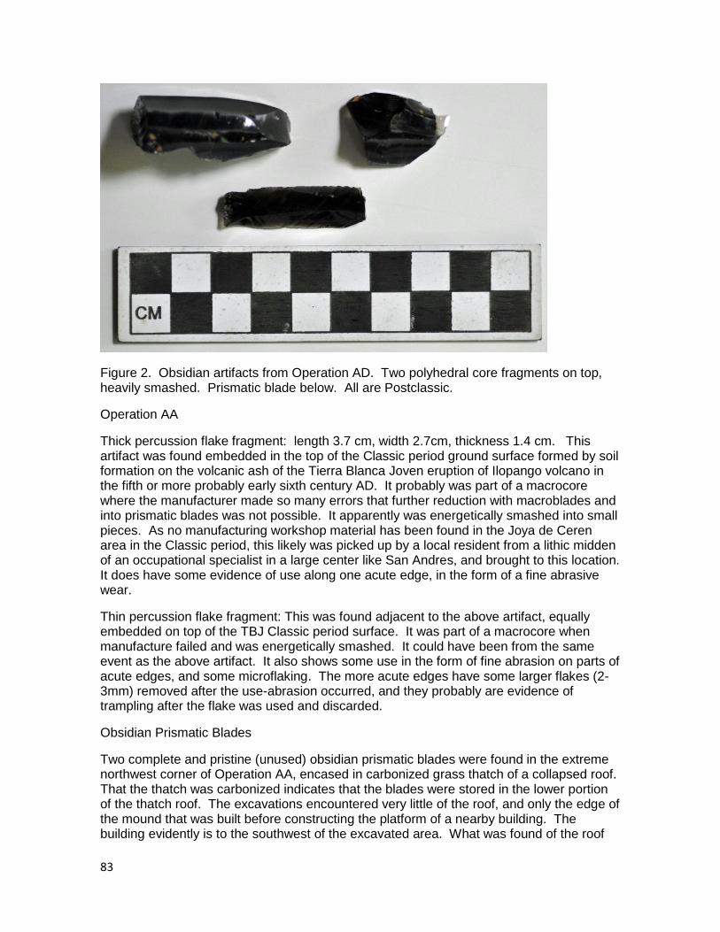
83
Figure 2. Obsidian artifacts from Operation AD. Two polyhedral core fragments on top, heavily smashed. Prismatic blade below. All are Postclassic.
Operation AA
Thick percussion flake fragment: length 3.7 cm, width 2.7cm, thickness 1.4 cm. This artifact was found embedded in the top of the Classic period ground surface formed by soil formation on the volcanic ash of the Tierra Blanca Joven eruption of Ilopango volcano in the fifth or more probably early sixth century AD. It probably was part of a macrocore where the manufacturer made so many errors that further reduction with macroblades and into prismatic blades was not possible. It apparently was energetically smashed into small pieces. As no manufacturing workshop material has been found in the Joya de Ceren area in the Classic period, this likely was picked up by a local resident from a lithic midden of an occupational specialist in a large center like San Andres, and brought to this location. It does have some evidence of use along one acute edge, in the form of a fine abrasive wear.
Thin percussion flake fragment: This was found adjacent to the above artifact, equally embedded on top of the TBJ Classic period surface. It was part of a macrocore when manufacture failed and was energetically smashed. It could have been from the same event as the above artifact. It also shows some use in the form of fine abrasion on parts of acute edges, and some microflaking. The more acute edges have some larger flakes (2-3mm) removed after the use-abrasion occurred, and they probably are evidence of trampling after the flake was used and discarded.
Obsidian Prismatic Blades
Two complete and pristine (unused) obsidian prismatic blades were found in the extreme northwest corner of Operation AA, encased in carbonized grass thatch of a collapsed roof. That the thatch was carbonized indicates that the blades were stored in the lower portion of the thatch roof. The excavations encountered very little of the roof, and only the edge of the mound that was built before constructing the platform of a nearby building. The building evidently is to the southwest of the excavated area. What was found of the roof
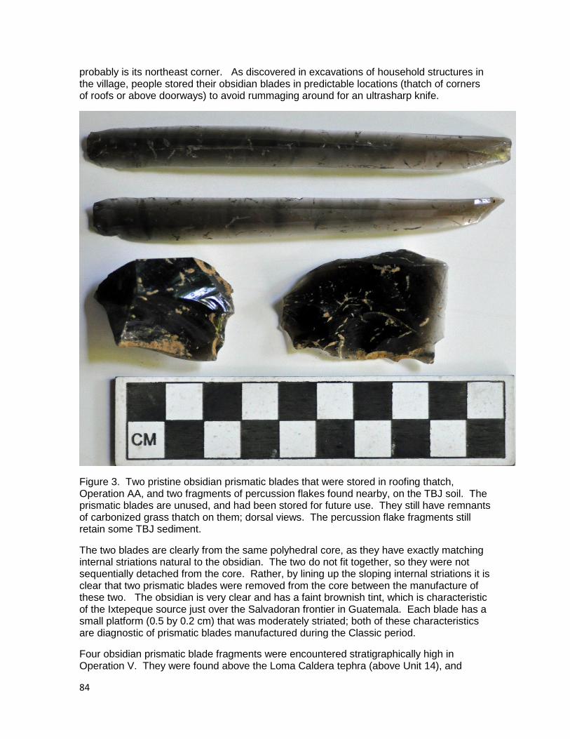
84
probably is its northeast corner. As discovered in excavations of household structures in the village, people stored their obsidian blades in predictable locations (thatch of corners of roofs or above doorways) to avoid rummaging around for an ultrasharp knife.
Figure 3. Two pristine obsidian prismatic blades that were stored in roofing thatch, Operation AA, and two fragments of percussion flakes found nearby, on the TBJ soil. The prismatic blades are unused, and had been stored for future use. They still have remnants of carbonized grass thatch on them; dorsal views. The percussion flake fragments still retain some TBJ sediment.
The two blades are clearly from the same polyhedral core, as they have exactly matching internal striations natural to the obsidian. The two do not fit together, so they were not sequentially detached from the core. Rather, by lining up the sloping internal striations it is clear that two prismatic blades were removed from the core between the manufacture of these two. The obsidian is very clear and has a faint brownish tint, which is characteristic of the Ixtepeque source just over the Salvadoran frontier in Guatemala. Each blade has a small platform (0.5 by 0.2 cm) that was moderately striated; both of these characteristics are diagnostic of prismatic blades manufactured during the Classic period.
Four obsidian prismatic blade fragments were encountered stratigraphically high in Operation V. They were found above the Loma Caldera tephra (above Unit 14), and
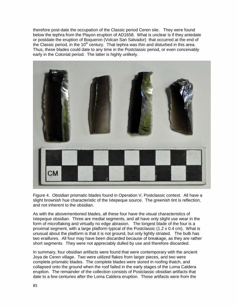
85
therefore post-date the occupation of the Classic period Ceren site. They were found below the tephra from the Playon eruption of AD1658. What is unclear is if they antedate or postdate the eruption of Boqueron (Volcan San Salvador) that occurred at the end of the Classic period, in the 10th century. That tephra was thin and disturbed in this area. Thus, these blades could date to any time in the Postclassic period, or even conceivably early in the Colonial period. The latter is highly unlikely.
Figure 4. Obsidian prismatic blades found in Operation V, Postclassic context. All have a slight brownish hue characteristic of the Ixtepeque source. The greenish tint is reflection, and not inherent to the obsidian.
As with the abovementioned blades, all these four have the visual characteristics of Ixtepeque obsidian. Three are medial segments, and all have only slight use wear in the form of microflaking and virtually no edge abrasion. The longest blade of the four is a proximal segment, with a large platform typical of the Postclassic (1.2 x 0.4 cm). What is unusual about the platform is that it is not ground, but only lightly striated. The bulb has two eraillures. All four may have been discarded because of breakage, as they are rather short segments. They were not appreciably dulled by use and therefore discarded.
In summary, four obsidian artifacts were found that were contemporary with the ancient Joya de Ceren village. Two were utilized flakes from larger pieces, and two were complete prismatic blades. The complete blades were stored in roofing thatch, and collapsed onto the ground when the roof failed in the early stages of the Loma Caldera eruption. The remainder of the collection consists of Postclassic obsidian artifacts that date to a few centuries after the Loma Caldera eruption. Those artifacts were from the
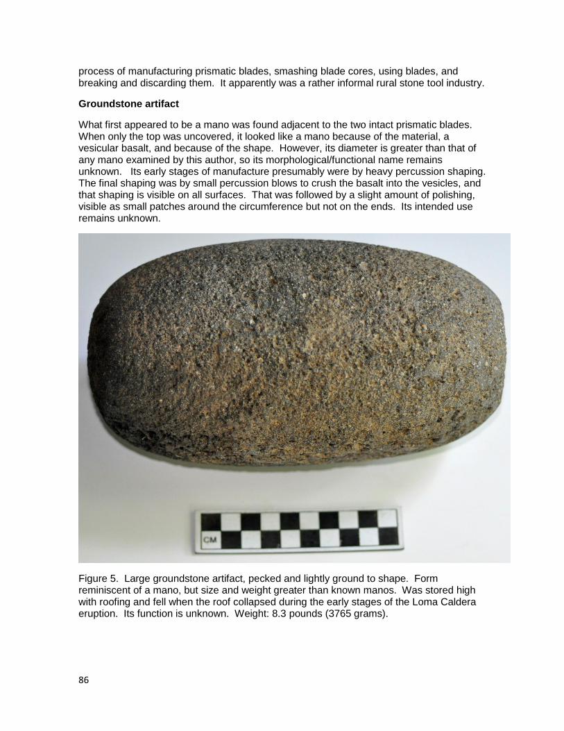
86
process of manufacturing prismatic blades, smashing blade cores, using blades, and breaking and discarding them. It apparently was a rather informal rural stone tool industry.
Groundstone artifact
What first appeared to be a mano was found adjacent to the two intact prismatic blades. When only the top was uncovered, it looked like a mano because of the material, a vesicular basalt, and because of the shape. However, its diameter is greater than that of any mano examined by this author, so its morphological/functional name remains unknown. Its early stages of manufacture presumably were by heavy percussion shaping. The final shaping was by small percussion blows to crush the basalt into the vesicles, and that shaping is visible on all surfaces. That was followed by a slight amount of polishing, visible as small patches around the circumference but not on the ends. Its intended use remains unknown.
Figure 5. Large groundstone artifact, pecked and lightly ground to shape. Form reminiscent of a mano, but size and weight greater than known manos. Was stored high with roofing and fell when the roof collapsed during the early stages of the Loma Caldera eruption. Its function is unknown. Weight: 8.3 pounds (3765 grams).
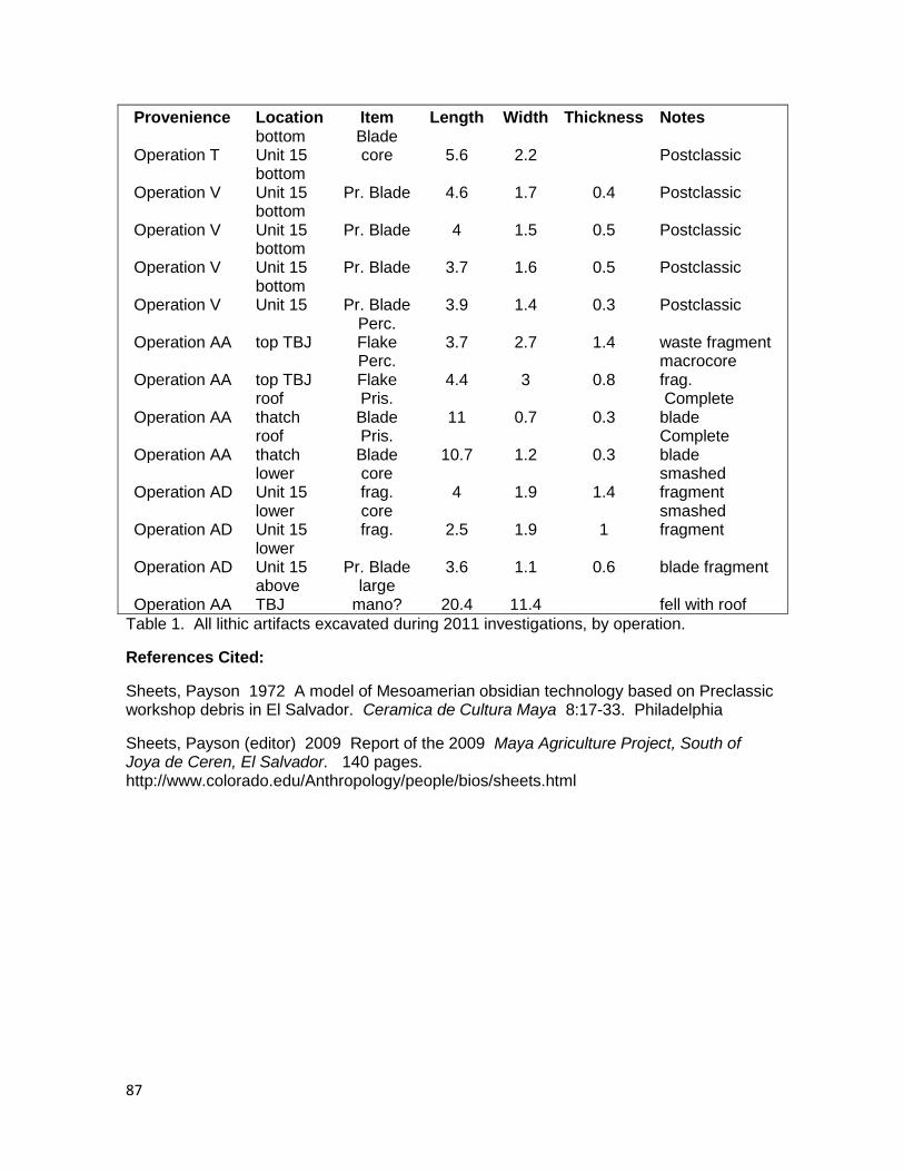
87
Provenience Location Item Length Width Thickness Notes
Operation T bottom Unit 15
Blade core 5.6 2.2
Postclassic
Operation V bottom Unit 15 Pr. Blade 4.6 1.7 0.4 Postclassic
Operation V bottom Unit 15 Pr. Blade 4 1.5 0.5 Postclassic
Operation V bottom Unit 15 Pr. Blade 3.7 1.6 0.5 Postclassic
Operation V bottom Unit 15 Pr. Blade 3.9 1.4 0.3 Postclassic
Operation AA top TBJ Perc. Flake 3.7 2.7 1.4 waste fragment
Operation AA top TBJ Perc. Flake 4.4 3 0.8
macrocore frag.
Operation AA roof thatch
Pris. Blade 11 0.7 0.3
Complete blade
Operation AA roof thatch
Pris. Blade 10.7 1.2 0.3
Complete blade
Operation AD lower Unit 15
core frag. 4 1.9 1.4
smashed fragment
Operation AD lower Unit 15
core frag. 2.5 1.9 1
smashed fragment
Operation AD lower Unit 15 Pr. Blade 3.6 1.1 0.6 blade fragment
Operation AA above TBJ
large mano? 20.4 11.4
fell with roof
Table 1. All lithic artifacts excavated during 2011 investigations, by operation.
References Cited:
Sheets, Payson 1972 A model of Mesoamerian obsidian technology based on Preclassic workshop debris in El Salvador. Ceramica de Cultura Maya 8:17-33. Philadelphia
Sheets, Payson (editor) 2009 Report of the 2009 Maya Agriculture Project, South of Joya de Ceren, El Salvador. 140 pages. http://www.colorado.edu/Anthropology/people/bios/sheets.html
88
Chapter 8. Ceramics
Payson Sheets
Introduction
In this chapter, as with the preceding one on lithics, the reader is encouraged to pay attention to stratigraphic context. During the 2011 research season south of the Joya de Ceren archaeological site, excavations encountered ancient ceramics in two different contexts (Table 1). The majority of the ceramics were found on the soil that developed on the Tierra Blanca Joven (TBJ) tephra from the Ilopango eruption, and thus of course are contemporary with the Classic period village of Joya de Ceren. The preliminary analysis of them is the primary focus of this chapter. The ancient village and the surrounding agricultural areas were buried by the eruption of Loma Caldera volcanic vent in the early AD 600s, and sealed away from any kind of disturbance by people, animals, or other factors. People reoccupied the area a few centuries after the Loma Caldera eruption, in the 10th or 11th centuries AD, in the early portion of the Postclassic period. The ceramic sherds they left behind are the second context of this collection. Those ceramics were found at the top of Unit 14, the last stage of the Loma Caldera eruption, and at the base of Unit 15, the composite volcanic unit formed by the eruption of Boqueron in or near the 10th century, and the later eruption of Playon that occurred in AD 1658-1659.
The first comprehensive study of ceramics in ancient El Salvador that included Preclassic through Postclassic periods was by Sharer (1978), and many of the types he described were found during our excavations in 2011. Marilyn Beaudry (1983) focused on the ceramics of the Zapotitan valley, and her report was very useful here. The ceramics of Joya de Ceren specifically have been thoroughly described and interpreted by Marilyn Beaudry-Corbett (2002), and no ceramics were encountered in 2011 that were new or not described by her. The following text and illustrations are initial descriptions of these 2011 ceramics.
By far the most ceramics collected during the 2011 excavations came from one test pit: Operation AA. It yielded such abundant ceramics that it is given particularly detailed attention in this chapter. Its variability encompasses the diversity of ceramics found in the other operations, so it is considered a robust sample of ceramics from the 2011 research season. I also illustrate and describe all Classic period ceramics from all excavations. The Postclassic ceramics form a smaller collection, with less internal variation. All Postclassic ceramics encountered in all operations are described in this chapter. The Postclassic pottery sherds from Operation Y is a representative sample, and therefore is presented in this chapter.
Operation AA
The 3x3 meter excavation of Operation AA was excavated near Operation P of 2009 with the objective of encountering discarded artifacts of a modest sheet midden. It was successful, and the ceramics from this operation are subdivided into four groups based on the differing contexts in which they were encountered. First described and illustrated here is a sample of the sherds recovered from all areas except those three areas presented below. Those three areas are: two cleared areas (Chapter 3), a manioc field (Chapter 4), and a portion of a possible domestic or storage facility (Feature 1, Chapter 4). The overall sample is discussed first here, followed by Feature1 and the two manioc surcos.
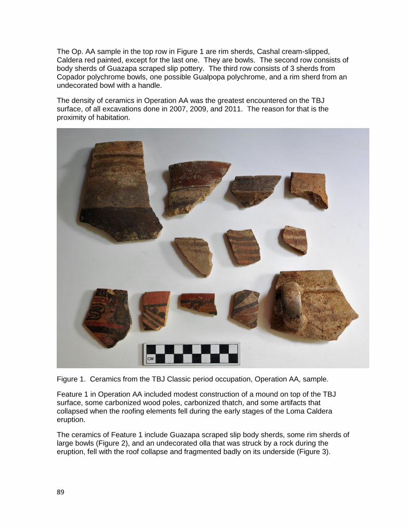
89
The Op. AA sample in the top row in Figure 1 are rim sherds, Cashal cream-slipped, Caldera red painted, except for the last one. They are bowls. The second row consists of body sherds of Guazapa scraped slip pottery. The third row consists of 3 sherds from Copador polychrome bowls, one possible Gualpopa polychrome, and a rim sherd from an undecorated bowl with a handle.
The density of ceramics in Operation AA was the greatest encountered on the TBJ surface, of all excavations done in 2007, 2009, and 2011. The reason for that is the proximity of habitation.
Figure 1. Ceramics from the TBJ Classic period occupation, Operation AA, sample.
Feature 1 in Operation AA included modest construction of a mound on top of the TBJ surface, some carbonized wood poles, carbonized thatch, and some artifacts that collapsed when the roofing elements fell during the early stages of the Loma Caldera eruption.
The ceramics of Feature 1 include Guazapa scraped slip body sherds, some rim sherds of large bowls (Figure 2), and an undecorated olla that was struck by a rock during the eruption, fell with the roof collapse and fragmented badly on its underside (Figure 3).
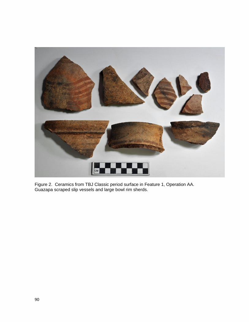
90
Figure 2. Ceramics from TBJ Classic period surface in Feature 1, Operation AA. Guazapa scraped slip vessels and large bowl rim sherds.
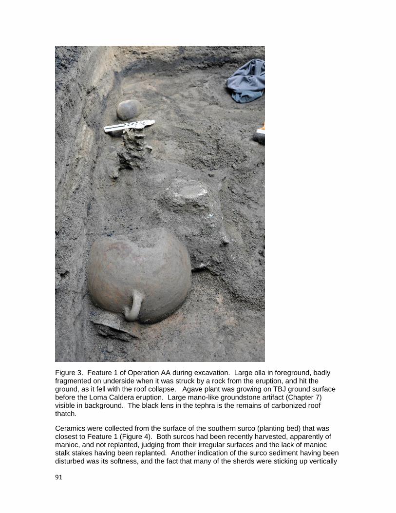
91
Figure 3. Feature 1 of Operation AA during excavation. Large olla in foreground, badly fragmented on underside when it was struck by a rock from the eruption, and hit the ground, as it fell with the roof collapse. Agave plant was growing on TBJ ground surface before the Loma Caldera eruption. Large mano-like groundstone artifact (Chapter 7) visible in background. The black lens in the tephra is the remains of carbonized roof thatch.
Ceramics were collected from the surface of the southern surco (planting bed) that was closest to Feature 1 (Figure 4). Both surcos had been recently harvested, apparently of manioc, and not replanted, judging from their irregular surfaces and the lack of manioc stalk stakes having been replanted. Another indication of the surco sediment having been disturbed was its softness, and the fact that many of the sherds were sticking up vertically
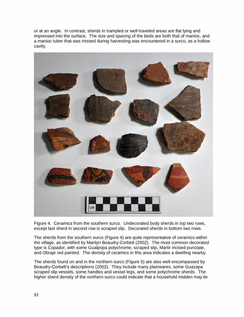
92
or at an angle. In contrast, sherds in trampled or well-traveled areas are flat lying and impressed into the surface. The size and spacing of the beds are both that of manioc, and a manioc tuber that was missed during harvesting was encountered in a surco, as a hollow cavity.
Figure 4. Ceramics from the southern surco. Undecorated body sherds in top two rows, except last sherd in second row is scraped slip. Decorated sherds in bottom two rows.
The sherds from the southern surco (Figure 4) are quite representative of ceramics within the village, as identified by Marilyn Beaudry-Corbett (2002). The most common decorated type is Copador, with some Gualpopa polychrome, scraped slip, Martir incised-punctate, and Obraje red painted. The density of ceramics in this area indicates a dwelling nearby.
The sherds found on and in the northern surco (Figure 5) are also well-encompassed by Beaudry-Corbett‟s descriptions (2002). They include many plainwares, some Guazapa scraped slip vessels, some handles and vessel legs, and some polychrome sherds. The higher sherd density of the northern surco could indicate that a household midden may lie
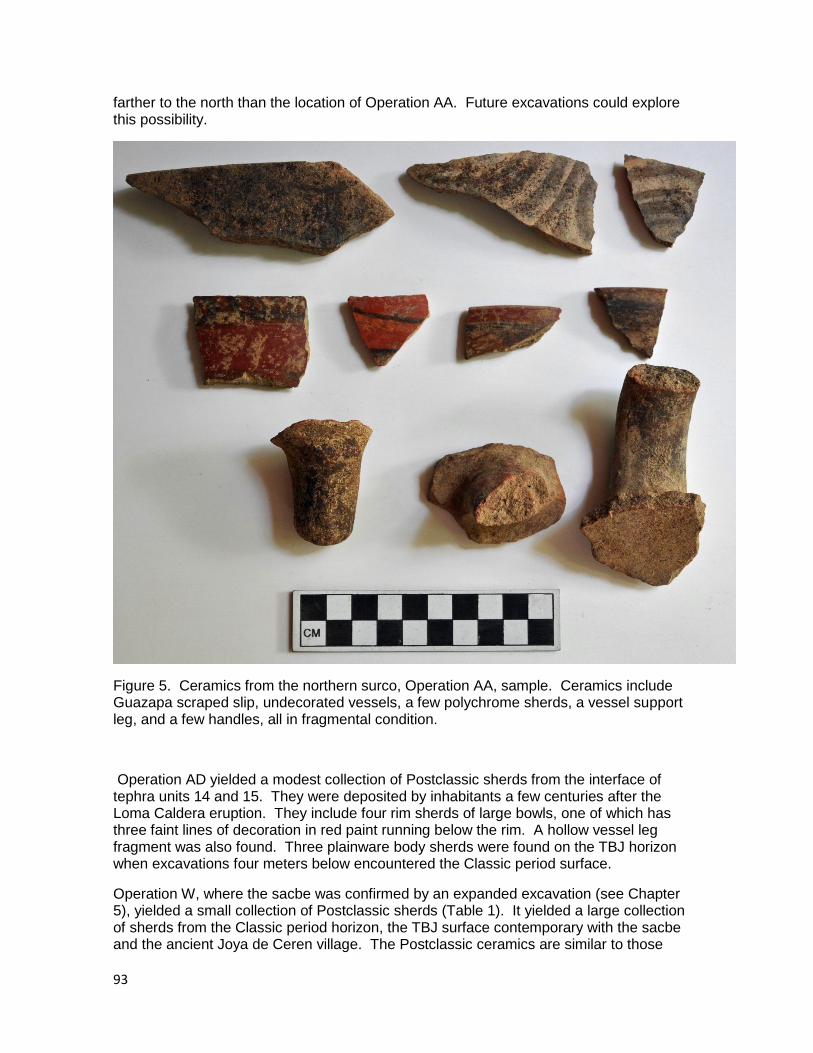
93
farther to the north than the location of Operation AA. Future excavations could explore this possibility.
Figure 5. Ceramics from the northern surco, Operation AA, sample. Ceramics include Guazapa scraped slip, undecorated vessels, a few polychrome sherds, a vessel support leg, and a few handles, all in fragmental condition.
Operation AD yielded a modest collection of Postclassic sherds from the interface of tephra units 14 and 15. They were deposited by inhabitants a few centuries after the Loma Caldera eruption. They include four rim sherds of large bowls, one of which has three faint lines of decoration in red paint running below the rim. A hollow vessel leg fragment was also found. Three plainware body sherds were found on the TBJ horizon when excavations four meters below encountered the Classic period surface.
Operation W, where the sacbe was confirmed by an expanded excavation (see Chapter 5), yielded a small collection of Postclassic sherds (Table 1). It yielded a large collection of sherds from the Classic period horizon, the TBJ surface contemporary with the sacbe and the ancient Joya de Ceren village. The Postclassic ceramics are similar to those

94
described elsewhere in this chapter, with a couple of minor exceptions. One rim sherd from a moderate-sized bowl has a single red line painted on its inside, just below the rim. A body sherd has a red line separating the surface from a zone of orange paint.
The Classic period surface on both sides of the sacbe was in maize milpa, and it yielded many sherds, most of which were undecorated body sherds of variously sized vessels. One sherd (top of Figure 6) was unusually large (27 x 19 cm) and came from a quite large undecorated vessel. A few Guazapa scraped slip sherds were found, along with a few handles. Only a few polychrome sherds were encountered, including one Copador polychrome (bottom row, third from left, in Figure 6).
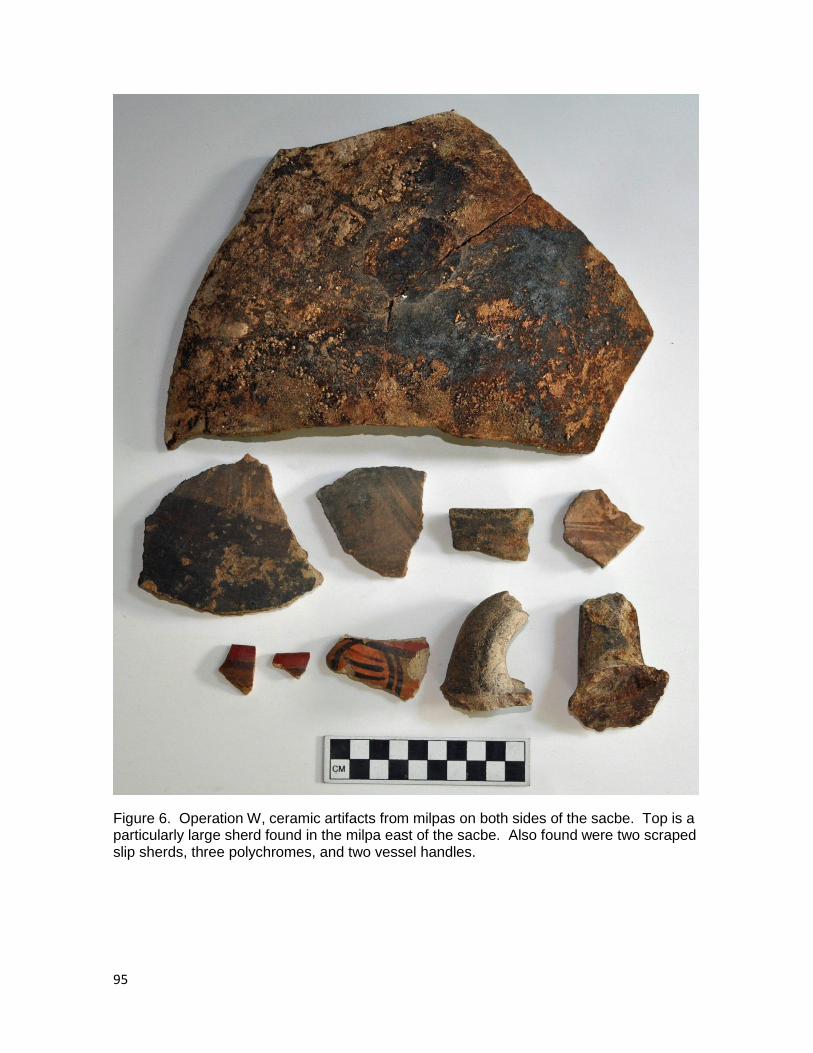
95
Figure 6. Operation W, ceramic artifacts from milpas on both sides of the sacbe. Top is a particularly large sherd found in the milpa east of the sacbe. Also found were two scraped slip sherds, three polychromes, and two vessel handles.
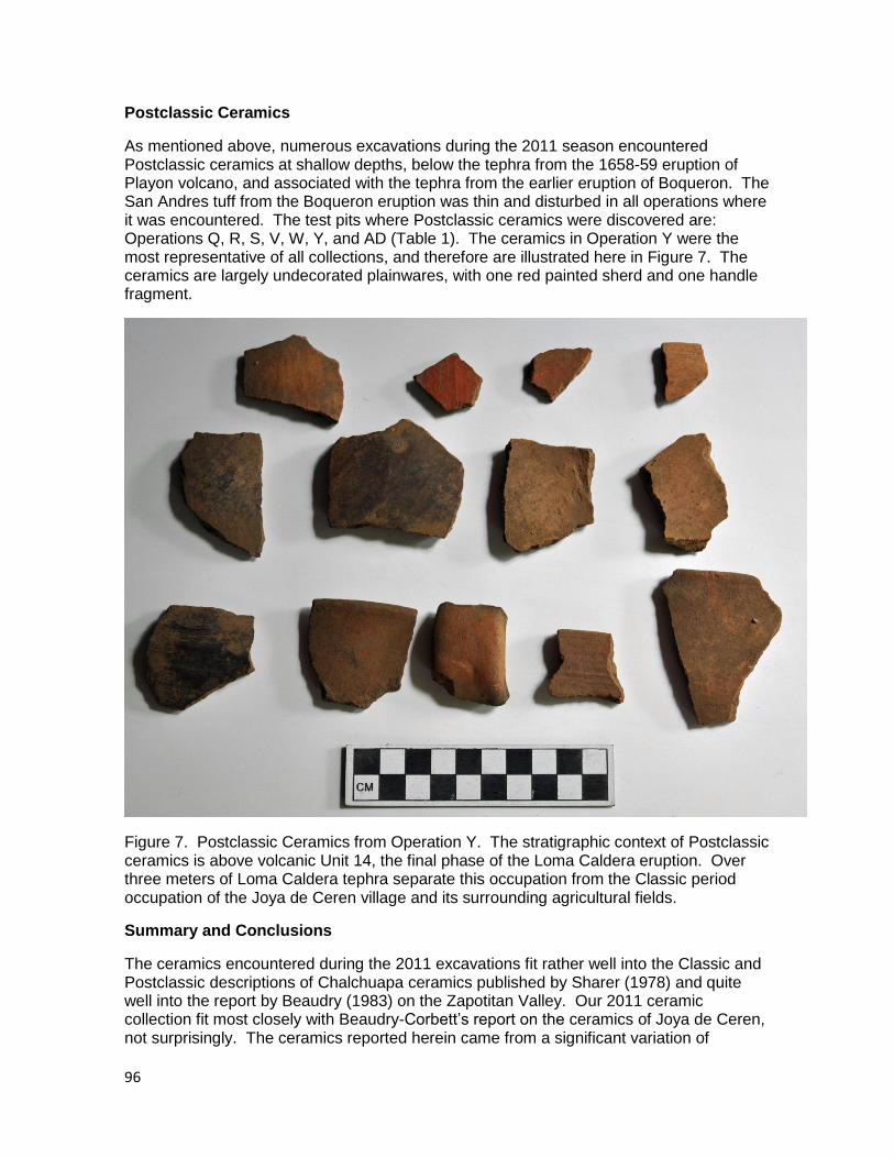
96
Postclassic Ceramics
As mentioned above, numerous excavations during the 2011 season encountered Postclassic ceramics at shallow depths, below the tephra from the 1658-59 eruption of Playon volcano, and associated with the tephra from the earlier eruption of Boqueron. The San Andres tuff from the Boqueron eruption was thin and disturbed in all operations where it was encountered. The test pits where Postclassic ceramics were discovered are: Operations Q, R, S, V, W, Y, and AD (Table 1). The ceramics in Operation Y were the most representative of all collections, and therefore are illustrated here in Figure 7. The ceramics are largely undecorated plainwares, with one red painted sherd and one handle fragment.
Figure 7. Postclassic Ceramics from Operation Y. The stratigraphic context of Postclassic ceramics is above volcanic Unit 14, the final phase of the Loma Caldera eruption. Over three meters of Loma Caldera tephra separate this occupation from the Classic period occupation of the Joya de Ceren village and its surrounding agricultural fields.
Summary and Conclusions
The ceramics encountered during the 2011 excavations fit rather well into the Classic and Postclassic descriptions of Chalchuapa ceramics published by Sharer (1978) and quite well into the report by Beaudry (1983) on the Zapotitan Valley. Our 2011 ceramic collection fit most closely with Beaudry-Corbett‟s report on the ceramics of Joya de Ceren, not surprisingly. The ceramics reported herein came from a significant variation of
97
contexts, including fields that had been cultivated months or even years before the Loma Caldera eruption but had been cleared of vegetation and had not been planted with cultigens. The ceramics also were found in comparatively large amounts on both sides of the sacbe, perhaps because of breakage while people were traveling into or out of the village. Our sample also included active milpas at the time of the eruption and a few places where manioc (“yuca”) was growing. The greatest density of ceramics was near a habitation in Operation AA.
Operation Period Context # Body Sherds
# Rim Sherds Notes
Q Post Cl. Top Unit 14
0 3 All undecorated
R Post Cl. Top Unit 14
3 3 1 red slipped
S Post Cl. Top Unit 14
0 2 1 red painted bowl
S Classic TBJ soil 2 0 1 scraped slip
T Classic TBJ soil 2 0 large sherds, fresh breaks
U Classic TBJ soil 8 1 3 scraped slip
V Post Cl. Top Unit 14
11 1 3 red-painted
V Classic TBJ soil 6 0 none decorated
W Post Cl. Top Unit 14
14 3 2 decorated, 1 handle
W Classic TBJ soil 85 4 5 decorated, 2 handles
Y Post Cl. Top Unit 14
8 4 none decorated, 1 handle
Y Classic TBJ Cluster K 2 1 1 scraped slip
AA Classic TBJ Feature 1 7 2 4 scraped slip
AA Classic TBJ s. Surco 14 2 2 polychrome
AA Classic TBJ n. Surco 39 2 2 handles, 1 vessel leg
AA Classic TBJ sample 4 8 1 handle
AA Classic TBJ gen. coll. 58 1 mostly undecorated body sherds
AD Post Cl. Top Unit 14
10 4 1 hollow vessel leg
AD Classic TBJ soil 3 0 undecorated body sherds Table 1. Ceramic artifacts recovered during 2011 excavations, both Postclassic and Classic periods.
References Cited
Beaudry, Marilyn
1983 The ceramics of the Zapotitan Valley. In Archeology and Volcanism in Central America: The Zapotitan Valley of El Salvador, edited by Payson Sheets. Pp. 161-194. University of Texas Press, Austin.
98
Beaudry-Corbett, Marilyn
2002 Ceramics and their use at Ceren. In Before the Volcano Erupted: The Ancient Ceren Village in Central America, edited by Payson Sheets. Pp. 117-138. University of Texas Press, Austin.
Sharer, Robert
1978 Pottery. In The Prehistory of Chalchuapa, El Salvador, Volume 3, Edited by Robert Sharer. Pp. 2-205. University of Pennsylvania Press, Philadelphia.
99
Chapter 9. An Ethnographic Examination of Present House-lot Gardens of Joya de Ceren: Preliminary Results for Future Ethnoarchaeological Study
Celine Lamb (Université Paris 1 Panthéon Sorbonne)
Introduction
The demise of the “Swidden Thesis” (Turner 1978) has taken a long time, yet it is now broadly accepted that the ancient Maya supported themselves through a wide variety of agricultural systems. The exceptional preservation of the Ceren site has provided examples of many of these agricultural strategies, through the discovery maize and manioc cultivation, domestic kitchen gardens, and household specialty crops such as cane and agave (Sheets and Woodward 2002, Sheets et al. 2009). However, the majority of our knowledge concerning the ancient agricultural ways of the Maya remains based on evidence for the major seed crop staples, particularly maize. Although most scholars accept the existence of domestic gardens, these are still relatively unknown. Most importantly, the role of household garden plants and what they consisted of has been rarely studied and poorly defined. Yet we can easily assume that gardens provided a diversified diet, in addition to other household needs. Ethnographic studies show that gardens are ubiquitous throughout the American tropics and that they play an important role in household economy (Caballero 1992; Turner and Sanders 2002). The goal of the present study is to use an ethnoarchaeological approach at Joya de Ceren and the site of Ceren in order to understand the economic role of the domestic garden in ancient Maya households and communities. In addition, the other functions, besides economic, of the vegetative spaces of households will be addressed.
This report includes the preliminary results of the ethnographic field work conducted. While these data have important archaeological implication, I will discuss the connection and analysis of the Cerén archaeological data in future publications. This report has been written before data gathering was completed and it is possible these preliminary results will be altered by further field work that will broaden the sample size. In addition, botanical studies that will be conducted after this report is published will certainly add to the results presented in this chapter.
The modern community of Joya de Ceren
Joya de Ceren is the largest of five towns which make up the canton of Joya de Ceren. This canton belongs to the Municipio San Juan Opico and is located in the Departamento of La Libertad of present El Salvador. Lara (1997) estimated that the canton counted 5,800 people, although given the rapid population growth in El Salvador, this number has grown significantly since then. At the end of the 20th century, Joya de Ceren proper was made up of just over 300 houses (Lara 1997 in Barber 1999). The community of Joya de Ceren was built in 1954 as part of a government project to break up a large hacienda and create a cooperative farm, providing income to campesinos as well as increasing land productivity through the encouragement of cash crop cultivation, particularly sugar cane (Barber 1999, Lara 2003). According to Lara‟s study of the canton, 84 % of the households of the canton relied upon agriculture as their primary means of income in 1995, thus defining Joya de Ceren as a semicampesino community (Lara 2003). Approximately 72 % of the agricultural households of Joya de Ceren cultivate maize and beans, while only approximately 11% cultivate sugar cane and 5.6 % vegetables. As Lara (2003) states, “there exists other
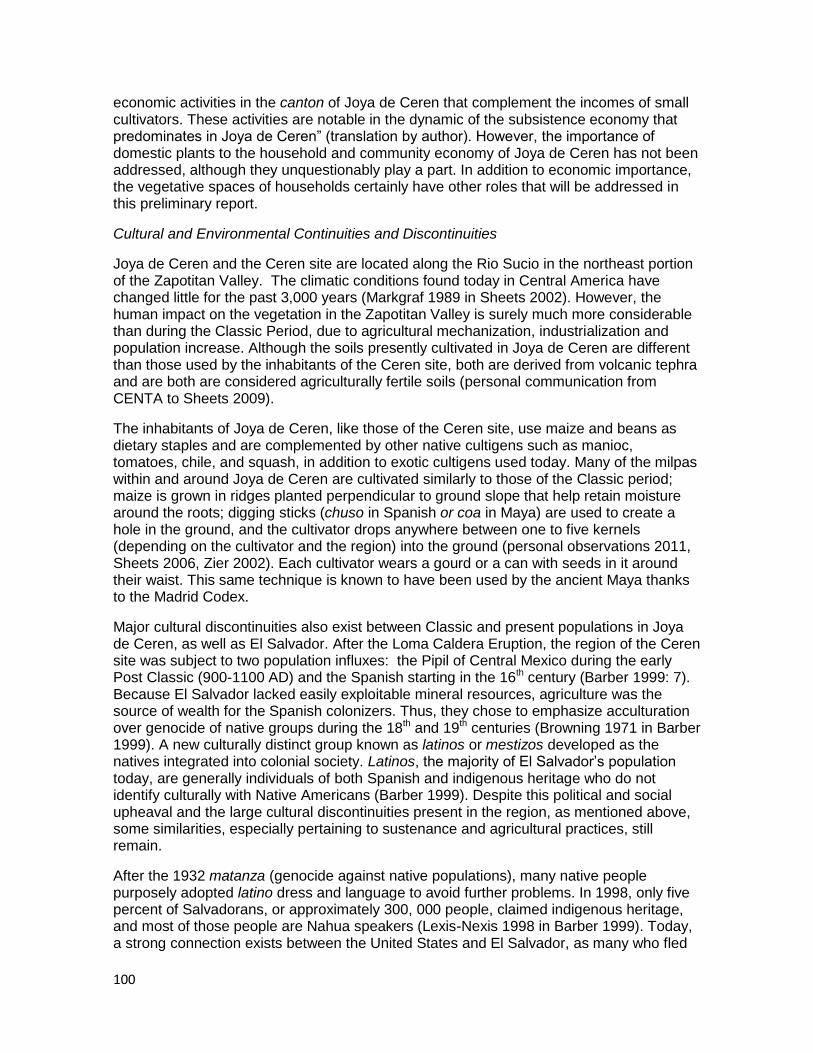
100
economic activities in the canton of Joya de Ceren that complement the incomes of small cultivators. These activities are notable in the dynamic of the subsistence economy that predominates in Joya de Ceren” (translation by author). However, the importance of domestic plants to the household and community economy of Joya de Ceren has not been addressed, although they unquestionably play a part. In addition to economic importance, the vegetative spaces of households certainly have other roles that will be addressed in this preliminary report.
Cultural and Environmental Continuities and Discontinuities
Joya de Ceren and the Ceren site are located along the Rio Sucio in the northeast portion of the Zapotitan Valley. The climatic conditions found today in Central America have changed little for the past 3,000 years (Markgraf 1989 in Sheets 2002). However, the human impact on the vegetation in the Zapotitan Valley is surely much more considerable than during the Classic Period, due to agricultural mechanization, industrialization and population increase. Although the soils presently cultivated in Joya de Ceren are different than those used by the inhabitants of the Ceren site, both are derived from volcanic tephra and are both are considered agriculturally fertile soils (personal communication from CENTA to Sheets 2009).
The inhabitants of Joya de Ceren, like those of the Ceren site, use maize and beans as dietary staples and are complemented by other native cultigens such as manioc, tomatoes, chile, and squash, in addition to exotic cultigens used today. Many of the milpas within and around Joya de Ceren are cultivated similarly to those of the Classic period; maize is grown in ridges planted perpendicular to ground slope that help retain moisture around the roots; digging sticks (chuso in Spanish or coa in Maya) are used to create a hole in the ground, and the cultivator drops anywhere between one to five kernels (depending on the cultivator and the region) into the ground (personal observations 2011, Sheets 2006, Zier 2002). Each cultivator wears a gourd or a can with seeds in it around their waist. This same technique is known to have been used by the ancient Maya thanks to the Madrid Codex.
Major cultural discontinuities also exist between Classic and present populations in Joya de Ceren, as well as El Salvador. After the Loma Caldera Eruption, the region of the Ceren site was subject to two population influxes: the Pipil of Central Mexico during the early Post Classic (900-1100 AD) and the Spanish starting in the 16th century (Barber 1999: 7). Because El Salvador lacked easily exploitable mineral resources, agriculture was the source of wealth for the Spanish colonizers. Thus, they chose to emphasize acculturation over genocide of native groups during the 18th and 19th centuries (Browning 1971 in Barber 1999). A new culturally distinct group known as latinos or mestizos developed as the natives integrated into colonial society. Latinos, the majority of El Salvador‟s population today, are generally individuals of both Spanish and indigenous heritage who do not identify culturally with Native Americans (Barber 1999). Despite this political and social upheaval and the large cultural discontinuities present in the region, as mentioned above, some similarities, especially pertaining to sustenance and agricultural practices, still remain.
After the 1932 matanza (genocide against native populations), many native people purposely adopted latino dress and language to avoid further problems. In 1998, only five percent of Salvadorans, or approximately 300, 000 people, claimed indigenous heritage, and most of those people are Nahua speakers (Lexis-Nexis 1998 in Barber 1999). Today, a strong connection exists between the United States and El Salvador, as many who fled

101
the 1970‟s conflict settled in the United States. Furthermore, many individuals choose to immigrate to the United States in search of employment. In the early 2000‟s, 28.78 % of the domestic groups of Joya de Ceren had at least one family member living in the United States (Lara 2003).
Acculturation is not only visible through language, clothes, music, and other cultural features; it is also clearly visible through the plants that are grown in fields and within the households. This point will be further discussed in the Results section of this paper.
Purpose of Study and Methodology
Purpose of the Present Study
Domestic gardens are notoriously difficult to identify in the archaeological record, particularly in tropical environments because of the perishable nature of agricultural products and the general lack of permanent structures used for gardens. However, scholars have generally accepted the use of this intensive agro-system during pre-Hispanic times, despite little direct evidence. The only site in Mesoamerica that has rendered direct evidence of domestic gardens with exclusively earthen features is Ceren, where two domestic gardens have been encountered, in addition to staple crops in fields. Thanks to unusual preservation conditions of the site, the in situ remains of plants can be identified, preserved, and spatially associated to households (Sheets 2002). The Ceren site therefore renders an excellent opportunity to study an agricultural system that in other circumstances can only be assumed to exist. In this study, present gardens of Joya de Ceren are examined from an archaeological perspective to facilitate a comparative framework between the garden spaces of Joya de Cerén today and the domestic cultivations of ancient Ceren households. My hope is to identify a material-behavior relationship that can be applied to the archaeological context if any similarities between past and present domestic cultivations are found. Specifically, I hope to investigate the use of past gardens, the economic and other roles of these plants and spaces, and how or if they may have fit into the inferred settlement agriculture system of infield-outfield (Turner and Sanders 2002,). In future publication, I hope to extend interpretations outside of the Ceren site in order to add to our debates on ancient Maya settlement agriculture.
Methodology
Defining the cultivated spaces of a household has generated a debate among archaeologists, as well as ethnographers and ethnobotanists. As Turner and Sanders (2002) have stated, standardized terminology and classification are necessary in order to conduct comparative studies and avoid erroneous identification. These authors offer “rather specific and universal” definitions that are cited below and utilized in my study:
“Gardens (kitchen, house, or compound) are spaces for the cultivation of multiple species used for additional or emergency caloric and nutritional needs, medicinal, ornamental, and other “exotic” production […] Almost invariably gardens are located immediately adjacent to the farming abode or within the perimeter of the farming compound, are small in size (especially compared to fields devoted to staple foods), have high labor and other inputs, and commonly are the domain of women, often involving codified proprietary rights”.
It is important to add to this definition that there are plants that are not initially cultivated but are volunteers and these may be tolerated or even cared for. Equally, it should be noted that although “exotic production” is somewhat ambiguous, plants located within the house-lot may serve purposes besides production, such as shade or gifts (this subject will
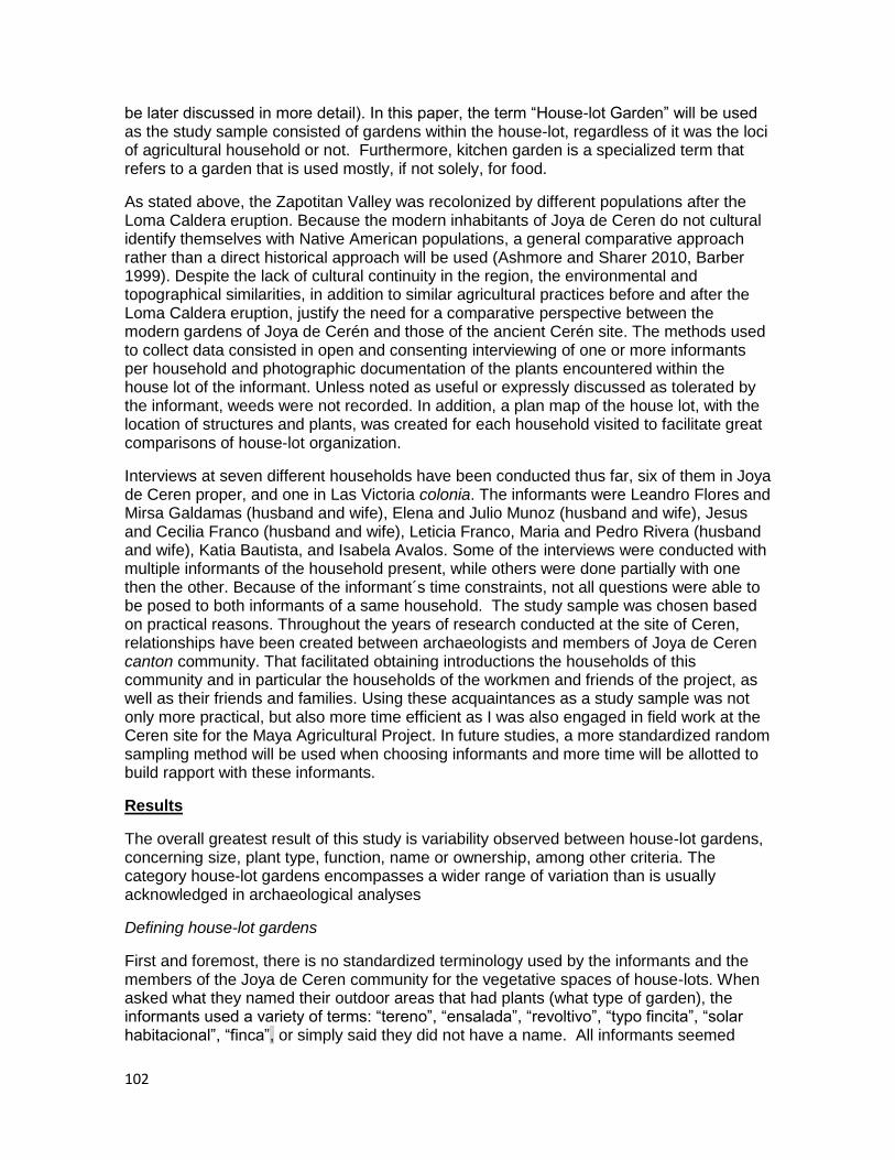
102
be later discussed in more detail). In this paper, the term “House-lot Garden” will be used as the study sample consisted of gardens within the house-lot, regardless of it was the loci of agricultural household or not. Furthermore, kitchen garden is a specialized term that refers to a garden that is used mostly, if not solely, for food.
As stated above, the Zapotitan Valley was recolonized by different populations after the Loma Caldera eruption. Because the modern inhabitants of Joya de Ceren do not cultural identify themselves with Native American populations, a general comparative approach rather than a direct historical approach will be used (Ashmore and Sharer 2010, Barber 1999). Despite the lack of cultural continuity in the region, the environmental and topographical similarities, in addition to similar agricultural practices before and after the Loma Caldera eruption, justify the need for a comparative perspective between the modern gardens of Joya de Cerén and those of the ancient Cerén site. The methods used to collect data consisted in open and consenting interviewing of one or more informants per household and photographic documentation of the plants encountered within the house lot of the informant. Unless noted as useful or expressly discussed as tolerated by the informant, weeds were not recorded. In addition, a plan map of the house lot, with the location of structures and plants, was created for each household visited to facilitate great comparisons of house-lot organization.
Interviews at seven different households have been conducted thus far, six of them in Joya de Ceren proper, and one in Las Victoria colonia. The informants were Leandro Flores and Mirsa Galdamas (husband and wife), Elena and Julio Munoz (husband and wife), Jesus and Cecilia Franco (husband and wife), Leticia Franco, Maria and Pedro Rivera (husband and wife), Katia Bautista, and Isabela Avalos. Some of the interviews were conducted with multiple informants of the household present, while others were done partially with one then the other. Because of the informant´s time constraints, not all questions were able to be posed to both informants of a same household. The study sample was chosen based on practical reasons. Throughout the years of research conducted at the site of Ceren, relationships have been created between archaeologists and members of Joya de Ceren canton community. That facilitated obtaining introductions the households of this community and in particular the households of the workmen and friends of the project, as well as their friends and families. Using these acquaintances as a study sample was not only more practical, but also more time efficient as I was also engaged in field work at the Ceren site for the Maya Agricultural Project. In future studies, a more standardized random sampling method will be used when choosing informants and more time will be allotted to build rapport with these informants.
Results
The overall greatest result of this study is variability observed between house-lot gardens, concerning size, plant type, function, name or ownership, among other criteria. The category house-lot gardens encompasses a wider range of variation than is usually acknowledged in archaeological analyses
Defining house-lot gardens
First and foremost, there is no standardized terminology used by the informants and the members of the Joya de Ceren community for the vegetative spaces of house-lots. When asked what they named their outdoor areas that had plants (what type of garden), the informants used a variety of terms: “tereno”, “ensalada”, “revoltivo”, “typo fincita”, “solar habitacional”, “finca”, or simply said they did not have a name. All informants seemed

103
confused when asked to define the type of garden that they owned. This may reflect the nature of most house-lot gardens studied in Joya de Ceren: besides predominantly ornamental gardens, the majority of house-lot gardens are not formalized and tend to be dispersed throughout the property. In this sense, and through some of the answers of the informants (specifically tereno and solar habitacional), it is clear that plants are not considered apart from the rest of the structures and features of their house-lot; in fact they are an integral part of it. This is especially clear when some of the plant‟s functions are identified by informants as structural support, as fences or sources of shade used as areas for congregating, rest and other activities. The use of the outdoor areas (referred to as vacant spaces in the archaeological literature) of households as activity areas is known through the archaeological record (McAnany 1995). The presence of tree species would certainly make outdoor activities much more tolerable in hot tropical climates. Further studies are needed to support this hypothesis, but one interpretation for the cultivation or tolerance of the tree species encountered recently on the east and west sides of Structure 4 at the Ceren site (Sheets, personal communication 2011) may be that these provided shade for the members of this household. Furthermore, documentation of multiple branches in the Cerén archaeological record indicates that trees were an important part of outdoor spaces at Cerén.
The only type of house-lot garden that seemed to have standardization were those predominated by ornamental plants. These were defined by all informants as “jardin” which literally translates to garden. When asked why this term was used rather than another, I was systematically told that it was because the plants were “decorative” or “ornamental”.
Spatial organization
The study sample shows that there is a spatial segregation between ornamental plants and plants of other functions (these functions will be expanded upon below). Four of the 7 households interviewed had a clearly defined space for ornamental plants or these were spatial segregation of ornamental plants. In addition, the majority of the ornamental gardens studied tended to be located towards the front where outsiders or visitors may see them (Figure 1).
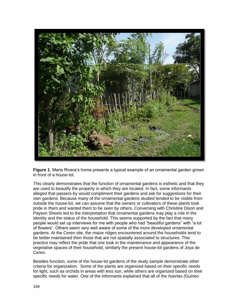
104
Figure 1. Maria Rivera‟s home presents a typical example of an ornamental garden grown in front of a house-lot.
This clearly demonstrates that the function of ornamental gardens is esthetic and that they are used to beautify the property in which they are located. In fact, some informants alleged that passers-by would compliment their gardens and ask for suggestions for their own gardens. Because many of the ornamental gardens studied tended to be visible from outside the house-lot, we can assume that the owners or cultivators of these plants took pride in them and wanted them to be seen by others. Conversing with Christine Dixon and Payson Sheets led to the interpretation that ornamental gardens may play a role in the identity and the status of the household. This seems supported by the fact that many people would set up interviews for me with people who had “beautiful gardens” with “a lot of flowers”. Others seem very well aware of some of the more developed ornamental gardens. At the Ceren site, the maize ridges encountered around the households tend to be better maintained then those that are not spatially associated to structures. This practice may reflect the pride that one took in the maintenance and appearance of the vegetative spaces of their household, similarly the present house-lot gardens of Joya de Ceren.
Besides function, some of the house-lot gardens of the study sample demonstrate other criteria for organization. Some of the plants are organized based on their specific needs for light, such as orchids in areas with less sun, while others are organized based on their specific needs for water. One of the informants explained that all of the huertas (Guineo

105
tree) were planted together because they needed much more water than the rest of the plants.
Three of the gardens visited demonstrated a clear organization by plant species, with the majority of the huertas, lime trees, Orange trees and pineapple plants, for example were grouped together. The others demonstrated a more dispersed organization of plant species, were a few examples of a same species were not necessarily associated while others were. Huertas, however, are not a good indicator of spatial organization based on species because this tree reproduces its self through the root system, therefore generally existing in groups, and not as a sole individual.
Functions of House-lot Garden Plants
Many functional groups were identified by the informants when asked what the use of each of their plants was, although the three most frequent functions were food, medicinal, and ornamental (Table 1). The majority of the functions identified follow the definition of gardens of Sanders and Turner (1992); however, other functions were identified which are rarely considered by archaeologists but are equally important in the structure and use of house-gardens. These include shade, household utensils, privacy, and property boundaries. Examples of house-gardens use for experimental cropping and as nurseries also exist.
In addition to “functional” uses, house-lot gardens have social and also psychological-emotional aspects that should be considered. The shade created by tree species is used as an area to gather or conduct activities in a more comfortable environment. Two of my informants identified their jardin as a source of joy and relaxation. Another informant explained that the jardin was a homage to her deceased sister, because she loved roses. This particular jardin not only had many rose bushes, but was also almost entirely composed of ornamental plants. Indirectly, I was able to observe that house gardens can also create social bonds: knowledge of plants is passed on to friends, family and neighbors they comment on others gardens, plants and flowers are given away as presents, and house-lot gardens are loci of activities, including social gatherings. Figure 2 presents a jardin in which multiple functions, tangible and psychological, have been identified. This interpretation complements Lara‟s observation that subsistence economy values social life such as social congregations, communal living, religious and secular festivities, therefore developing social relationships. In this sense, the house-lot garden should be considered as a living and social space (Lamb 2009).
Table 1. Functions of Plants Identified by Informants and their Distribution
Function of House-Garden Plants Number of Households Identifying this fuction
Food 7
Ornamental 6
Medicinal 6
Shade 3
Household Utensils 2
Property Boundary 2
Personal Care 2
Wood (firewood and construction) 2
Privacy 1
Income 1
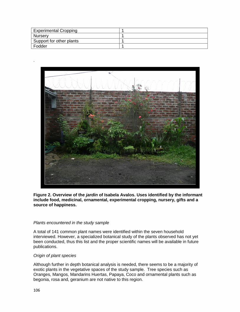
106
Experimental Cropping 1
Nursery 1
Support for other plants 1
Fodder 1
.
Figure 2. Overview of the jardin of Isabela Avalos. Uses identified by the informant include food, medicinal, ornamental, experimental cropping, nursery, gifts and a source of happiness.
Plants encountered in the study sample
A total of 141 common plant names were identified within the seven household interviewed. However, a specialized botanical study of the plants observed has not yet been conducted, thus this list and the proper scientific names will be available in future publications.
Origin of plant species
Although further in depth botanical analysis is needed, there seems to be a majority of exotic plants in the vegetative spaces of the study sample. Tree species such as Oranges, Mangos, Mandarins Huertas, Papaya, Coco and ornamental plants such as begonia, rosa and, geranium are not native to this region.
107
Differential Uses and Names of plants
One interesting result of this study was that a particular species of plant can be used differently depending on the informant. For example, the limon, or lime tree, was identified as used for food, or medicinal properties for both animals and humans, or religious fasting, or washing hands after handling foods with strong odors, or protecting oneself from unpleasant odors while attending a funeral. The medicinal properties of the lime tree identified by the different informants where also variable; the leaves and fruits of lime trees have been used for coughs, stomach aches, to induce vomiting after ingesting poison and to calm the nerves. Another typical example of this phenomenon is savila, or aloe, which has been used to treat ulcers, cuts, sunburns, tooth aches, stomach distress, but also to care for hair and supposedly to make it grow faster.
Additionally, some plants which seem to be the same through visual inspection are identified by different names depending on the informant. For one plant one informant used the name jacinto, while another used sacatillo or sacate, while yet another used both names. This may be that both named are commonly used, and that the usage of one versus the other is simply based on what was taught to the informant. The majority of all other plants have been named consistently the same, although some informants specify the variety, such as mango jade, or naranja victoria. Additionally, the names of at least a few plant species per household were unknown, although their functions were clear to household members. This is not a surprise as there is a large diversity of plants in each house garden studied, and these informants are not trained botanists.
Each household seems to have a preference for plants either used for food, or for medicinal uses, or ornamental objectives. Some informants, such as Leticia Franco and Isabela Avalos, tended to use the same plant for more functions than the other informants, particularly food plants that they also valued for their medicinal properties. Both informants claimed to have learned the medicinal properties of plants on their own through trial and error, and seem to have a higher interest in this specific function then other informants. In fact, besides subsistence, the main factor for what type of plants exists on one‟s property seems to be based on their personal interests. However, the development of the informants‟ personal interests was not discussed.
It should be noted that medicinal plants are also of economic importance, because many people have expressed how expensive commercial medication is. Medicinal plants allow them to treat themselves and their family at negligible cost. This is especially important since most of my informants are not permanently employed and do not have health coverage.
Although a larger sample size is needed to support this observation, it seems that the households which invested in agricultural activities outside their house-lot have more economic (nutritional) species in their house-garden, although the size of the house-lot has been claimed to affect how and what the vegetative spaces are composed of. This phenomenon was observed during my study; within the study sample, the households with the smallest area of outdoor space tended to have more decorative and medicinal plants, while food plants tended to be too small to bear fruit.
Discussion
When studying the function of the plants encountered, one of my first observations was that none of the food plants were also considered ornamental. There are many examples
108
of plants considered both medicinal and decorative, but not one example within the study sample of a plant considered both ornamental and useful for food. One interpretation may be that subsistence is considered so important that the esthetic properties of a comestible plant are overlooked. Another could be gender based segregation, and that esthetic properties, generally considered the domain of women, should not be mixed with sustenance, an activity that may be more associated with men. However, not one informant, both male and female, considered a food plant as ornamental. In addition, while there appears to be a cultural association made between gender and plant type, most of the women interviewed in this study have knowledge and care for their subsistence and ornamental plants. It is possible that gender based segregation may be utilized publically but not observed within the household. It is possible that ornamental (“adorno”) has a very specific definition in this region which separates it from anything economic. Understanding how aestheticism is defined would be another important question to pursue, especially considering that no “decorative” plant remains have been found at the site of Ceren, and rarely in the Maya area. Discussing this subject with Dr. David Lentz, it was clear that esthetics are completely subjective, and are highly variable between time and culture. Who is to say that the chile bush growing by Structure 4 was not only valued for its fruit, but also for its beauty? Iconography and ideological studies may be able to help advance this topic, although it must be recognized this would be mostly from the point of view of the elite society. Further ethnographic research may provide an understanding of how beauty is perceived through plants.
As stated above, some people maintain a spatial segregation between ornamental flowers and other types of plants, particularly cultivating ornamentals in most visible portion of the property from the outside. However, in addition to esthetical reasons, another hypothesis for segregation of these plants is gender based segregations. A pair of informants (husband and wife) explained that flowers and jardines are generally the responsibility of women, while other plants of a house lot are generally the responsibility of men. This same informant expressed that if he were to tell a person that he enjoyed flowers, he would not be expressing an acceptable male attitude and his sexual orientation would be called into question. Similarly, the husband of another informant expressed no interest in the jardin of his wife, who explained that her sons and husband do not like flowers. This same informant explained that the ornamental garden was her responsibility, while the rest of the plants were her husband´s. Finally, when I asked the workmen at the Ceren site if anyone had a jardin that I may study, no one spoke up, and it was only in front of small groups that it would be revealed to me that they had one or knew of one. However, a few of the male informants were the ones to identify many of the ornamental plants. This reluctance to speak of jardines publically also indicates that ornamental plants seem to be considered as part of the feminine realm, and supports the interpretation that the association of gender to plants may simply be utilized when in a public situation. Further gender studies on plants and cultivation, both in present society, and past Maya society, would be very beneficial to understanding the complex intersection of agriculture, domestic space, and gender ideology. Additionally, gender studies would be beneficial to understanding labor organization of households and their gardens. Although many definitions found in the archaeological and ethnographic literature define gardens as the responsibility of the women and sometimes children, throughout my study sample, gender segregation of labor was very variable between households. A larger study sample, as well as more time spent within each household, would certainly clarify whether a pattern exists in Joya de Ceren concerning gender and house-lot garden maintenance.
109
Conclusions
The present study of house-lot gardens in Joya de Ceren has brought forth multiple questions that already exist in archaeological and ethno-archaeological research. One of these is the important archaeological debate of gender studies and the division of labor. Based on the small study sample and informal discussions with members of the community, it appears that plants are associated to a gender based on their utility, as ornamental plants have been generally associated to women. However, during this study, this separation seemed much more important in the public domain, and much less observable within the household. Thus, the association of gender and plants is more likely to be ideological then functional, a relationship that is also known to have existed in Classic Maya society.
Large and small scale cultivation, fields and house-lot gardens, appear to reflect both the continuities and discontinuities between past and present inhabitants of this region. Although numerous introductions of exotic plants have occurred, the basic activity of cultivating non-staple plants in close proximity to the household was conducted both by the inhabitants of Ceren and of Joya de Ceren. Furthermore, both past and present households cultivate and care for a high diversity of plants appreciated for a variety of uses. With this modest study sample, over 140 different plants have been identified with 14 different uses. Although the ancient Maya of Ceren may have not cultivated such a vast array of species within their households, a wide variety a plant remains has been recorded with multiple uses besides subsistence. Biodiversity, multiple uses of plants and spatial proximity to households appear to be three criteria that may support future analogy.
Thanks to the variability observed throughout the house-lot gardens studied in present Joya de Ceren, we may continue to reevaluate their role in ancient Maya households and communities. The plants encountered, as well as their usage, offer a wider definition of the garden which is rarely seen as more than an economic entity in archaeological literature. House-lot gardens should not only be considered useful to subsistence, medicinal and other economical needs. They are also an integral part of the living space and can develop social relationships as well as reflect cultural ideology.
References
Ashmore, Wendy, and Robert J. Sharer.
2010 Discovering Our Past: a Brief Introduction to Archaeology. McGraw Hill, New York, NY.
Barber, Sarah Barr
1999 Ethnoarchaeologicial Approaches to Household Wealth in An Ancient Agricultural Community: Storage and Food Production at Ceren, El Salvador. MA. Thesis, Department of Anthropology, University of Colorado, Boulder.
Caballero, Javier.
1992 Maya Homegardens: Past, Present and Futur. Etnoecologica 1(1).
110
Lamb, Celine
2009 A la recherche du « jardin domestique » préhispanique des Basses Terres Maya : Méthodes et problématiques. Master 1 Thesis, Department of Art History and Archaeology, Universite Paris 1 Pantheon-Sorbonne
Lara Martines, Carlos Benjamin
2003 Joya de Ceren: La dinamica sociocultural de una comunidad semicampesina de El Salvador. Colección Antropologia e Historia. CONCULTURA, San Salvador.
McAnany, Patricia Ann
1995 Living with the ancestors: Kinship and kingship in ancient Maya society. University of Texas Press, Austin.
Sheets, Payson, et al.
2009 Report of the 2009 Maya Agriculture Project, South of Joya de Cerén, El Salvador. CONCULTURA, Ministerio de Educación, El Salvador.
Sheets, Payson and Michelle Woodward
2002 Cultivating Biodiversity: Milpas, Gardens, and the Classic Period Landscape. In Before the volcano erupted, the ancient Céren village in central America, P. Sheets (ed.), University of Texas Press, Austin.
Sheets, Payson
2006 The Ceren Site: An Ancient Village Buried by Volcanic Ash in Central America. Case Studies in Archaeology. Thomas Wadsworth
Turner II., B. L.
1978 The development and the demise of the swidden thesis of Maya agrigulture. In Prehispanic Maya agriculture, P. D. Harrison and B. L. Turner II (eds.), University of New Mexico Press, Albuquerque.
Turner II, B.L., and William T. Sanders
1992 Summary and critique. In Gardens of Prehistory, the archaeology of settlement agriculture in Greater Mesoamerica. Thomas W. Killion (ed. s.). University of Alabama Press, Tuscaloosa.
Zier, Christian
2002 Intensive Raised-Field Agriculture in a Posteruption Environment, El Salvador. In Gardens of Prehistory, the archaeology of settlement agriculture in Greater Mesoamerica. Thomas W. Killion (ed. s.). University of Alabama Press, Tuscaloosa.

111
Acknowledgements
First and foremost, a great deal of gratitude is owed to Dr. Payson Sheets, for offering to me the opportunity to pursue my personal interests and conduct the present study. Without Payson none of this would be possible.
Chris Dixon also deserves an enormous thank you for all of the wonderful suggestions she has made during our many discussions and during the edit of this chapter. Chris has been a great support, both as a co-worker and as a friend. Thanks to Alexandria Halmbacher for helping me during my interviews
My gratitude is sent to the wonderful team of Salvadorans with whom I worked with at the Ceren site, for answering a constant flow of questions and frequently surprising me with exotic fruits and plants.
I would like to acknowledge Dr. David Lentz selfless lending of his knowledge. I very much look forward to working with him again.
Finally, an enormous thanks to Isabela and Eulalio Avalos, Katia Bautista, Leandro Flores and Mirsa Galdamas, Jesus Edgardo Franco, Elena Munoz and Julio Garcia, Leticia Franco, Alejandro Quintanilla, Salvador Quintanilla, and Maria Rivera for opening their homes to me and sharing their interests in plants and gardens. Without them, this present study would not exist. I would like to especially thank Leandro Flores and Elena Munoz. Thanks to Leandro and Elena for their patience, offering their knowledge, opening their homes and heart, and for their wonderful company. They have both become great friends to me.
112
Chapter 10. Malanga (Xanthosoma): a Root Crop grown by the Ancient Maya at Ceren
Theresa Heindel
Introduction
Mesoamerican agriculture (and Maya agriculture more specifically) has often been assumed to have been based on maize cultivation, by slash-and-burn (swidden) techniques. New ideas about alternative subsistence strategies and crops that could supplement swidden or more intensive maize agriculture, however, have led to more questions than answers. Bennet Bronson (1966) first suggested the possibility that root crops (such as manioc (Manihot esculenta) and Xanthosoma, commonly called “malanga,”) were a significant part or even staple crops for the ancient Maya. Since then, discussions about how these root crops may or may not have been cultivated have abounded throughout the literature. Due to the poor preservation of root crops in tropic environments, archaeologists have relied mainly on ethnohistoric and ethnographic sources for information about ancient Mesoamerican uses of root crops. While ethnohistoric and ethnographic sources are highly valuable, they often contain contradictory or biased information, or are simply lacking sufficient information on certain topics. When archaeological evidence can be combined with these types of sources, however, a much more detailed image of the past can be created.
Importantly, the preservation of Cerén, El Salvador has afforded archaeologists evidence that root crops were used both as a supplement and as a staple crop at one Classic Period Maya site. The discovery of intensively cultivated manioc fields continues to revolutionize our understanding of the role of root crops at Cerén (see Ch 4; Dixon 2007, 2009; Sheets 2009). Excavations from within the site center have afforded additional information about the role of root crops at Cerén. This chapter will focus on the detailed investigation of the root crop malanga (Xanthosoma saggitifolium) documented in the kitchen garden of Household 1 (Lentz and Ramírez-Sosa 2002). In particular, I will create a more detailed assessment of the malanga plant casts found at Ceren in order to examine the state of these plants at the time of the Loma Caldera eruption. In addition, I will provide information on the current cultivation and use of malanga today, specifically focusing on
113
the town of Joya de Ceren. Especially coupled with new evidence exhibiting intensive cultivation of manioc (see Ch. 4; Dixon 2007, 2009; Sheets 2009), extensive research on malanga could shed new light on ancient Maya use of other root crops and create a better understanding of root crop use outside of manioc fields.
Root Crops in the Maya World
In calling for more attention to be paid to the role of root crops in ancient Maya subsistence, Bennet Bronson (1966) focused on four different root crops seen in the Maya area today: camote (sweet potato), jicama (yam bean), yuca (manioc), and yautia (often called ¨malanga¨). Drawing on ethnographic data from modern distributions, Bronson claimed that modern groups like the Lacandon Maya, and other “unacculturated” groups, utilize a variety of roots. According to Bronson, the Chorti, who are the closest Maya group living near El Salvador today, used camote, jicama, and manioc (1966:257).
Bronson also looked at the historical distribution of different types of root crops through the use of ethnohistorical documents. According to Bronson, however, one drawback of examining historical distributions of root crops is that many Spanish historians were unfamiliar with, and generally uninterested in, root crops. In contrast to root crops, corn was easily understood by the conquistadors, and as a result, it is likely that a bias towards corn was presented in the records of this era (Bronson 1966:259). One rare exception is Fray Bernardino de Sahagún, who, in his catalog of edible fruits, listed: “camoti” (camote), “xicamoxiutl” (jicama), “quauhcamotli” (manioc), and “quequexqui” (malanga). The Maya word for malanga, “macal,” only appears once in such early literature, in the Book of Chilam Balam (Bronson 1966:263).
In a later attempt to show the usefulness of root crops in Maya subsistence strategies, Philip Drucker and John Fox (1982) suggested that root crops could be particularly important in “artificial rain forests” (see Wiseman 1978 for a full definition) and kitchen gardens. According to Drucker and Fox, Xanthosoma grows slowly, taking two to three years to fully mature, but can be left in the ground for a long period of time, with a few plants being harvested at one time (1982:183). Xanthosoma, then, could easily be used for household consumption comparable to the use of manioc in a similar context. The root for both plants can be dug up when needed, but kept in the ground when not in use (Dixon 2011, personal communication). The general hardiness of malanga allows it to be left alone for long periods, which makes it easier to focus on more temperamental crops. Thus, if used in artificial rain forests or kitchen gardens, malanga would be well suited as an easy to harvest, supplemental crop.
Kitchen gardens are, in fact, one of the most common types of agriculture seen in use by the modern Maya. Defined as a small, often fenced, enclosure, with ornamental flowers, medicinal herbs, crops such as chilies and yuca, and fruit and shade trees (see Ch.9; Wiseman 1978:79). Much of the household activity can be carried out in a shaded garden, and household refuse can be easily used for mulching and fertilizer (Wiseman 1978:81). Archaeologically, remains of Preclassic garden plots have been found at the central lowland sites of Nakbe and El Mirador. Indirect evidence for the use of household gardens by the ancient Maya can also be provided by botanical and settlement pattern studies (Sharer 2006:645). The kitchen garden was an integral part of ancient Maya agriculture, and root crops such as malanga could have been very valuable contributors to this agricultural sector.
Xanthosoma: Botanical Attributes
114
Domesticated both in the new world and the old world, Xanthosoma is a root crop that contains petioles and stems attached to the end of the blade and flowers ascending all the way to the tip. Xanthosoma goes by a variety of names, including cocoyam, yautia (the Antilles), malanga (Central America), angaritos (Brazil), tiquisque (Mexico and Central America), and otó (Panama) (Leone 1968:132). Xanthosomes typically grow 1-2 meters in height above ground, with green or violet foliage, and consist of a subterranean stem or corm (mass of roots) and a crown of large leaves. The particular kind of Xanthosome found at Cerén is called Xanthosoma saggitifolium (Lentz et al. 1996). X. saggitifolium has sagittate (arrow-head shaped) leaves and large lobes in addition to violet leaves and petioles, and yellow rhizomes (Leone 1968:133). Externally, the corm appears divided into narrow horizontal internodes and is covered by scales or fine dry, fibrous leaves emerging from the nodes.
The corms contain many cells filled with crystals of calcium oxalate, which are most numerous in the cortical region of the plant. The oxalate is found in bundles of crystalline needles, which quickly expand when the wall of the cell that contains them is broken. Upon cooking or roasting the corm, the crystals disappear and the gelatinous cover that wraps them is all that remains. These crystalline needles can cause a prickling sensation, or even a severe allergy, which makes cooking the corm that much more important (Leone 1968:134).
Nutrition and productivity, as estimated by Bronson, are particularly important in determining the possible importance of root crops in ancient Maya subsistence. He suggests that, in terms of simple caloric intake, root crops are nearly equal to corn on a weight-for-weight basis. Acknowledging that root crops are inferior to maize in protein content (with 1 or 2 grams of protein for every 100 grams of total weight, vs. maize with 8 grams of protein for every 100 grams), he points out that not even maize has enough protein to enable an individual to subsist on it exclusively. Thus, whether maize or root crops are staple crops, another protein source would have still been required for good nutrition (Bronson 1966:268). In terms of productivity (in product per unit area), root crops are, in general, far superior to maize. Even malanga, which is the least productive of the root crops per unit area, matches the total yield of maize (Bronson 1966:269). However, in terms of product per unit effort, malanga should be considered to have high productivity. While all root crops are generally very reliable, malanga in particular does not require much effort to be grown.
Ethnohistoric and Ethnographic Evidence
The different types of cultivated Xanthosomes (Xanthosoma saggitifolium, X. violaceum, X. yucatanse, etc.) are botanically similar and, as a result, are generally not differentiated in historic literature. Thus, while X. saggitifolium has been identified in the Cerén archaeological record (Lentz 1996), not much is known about the ancient distribution of various Xanthosoma species throughout Mesoamerica. X. yucatense, is known specifically for its edible roots and can be identified as one of the wild Xanthosomes eaten in the Petén and the Yucatán.
Given the differences in Xanthosoma species, it is difficult to know, based on historical sources, whether the Maya used several varieties or even how much of an emphasis was placed on the crop (Bronson 1966:265). As noted before, Sahagún did briefly discuss malanga, but malanga is mentioned the least of all other root crops found in ethnohistoric documents. Historical literature recording paleobotony is particularly prone to confusion and mistakes, given the variability with which plants are named, used, and identified. For
115
example, D´Anghiera wrote about a root called “age.” Listed alongside manioc and batata (sweet-potato), it is apparent that D‟Anghiera saw these three as different kinds of plants, and Bronson suggested that D‟Anghiera was describing malanga. This is because “ages” were described as having roots “in size and shape like a turnip,” which would fit descriptions of the modern Puerto Rican malanga (Bronson 1966:260-261).
Some ethnographic accounts do indicate that Xanthosoma was grown in many parts of Mesoamerica, which may account for the numerous names in different places. According to these accounts, the roots are poisonous when raw, but the poisonous properties (attributed to the presence of “irritating crystals”) are destroyed by cooking (Standley and Steyermark 1958:362). However, as suggested above, determining what species of Xanthosome was being used, or even if a particular plant is Xanthosoma, can be difficult. Since there is not a single common name, with different places referring to the plant as “yautia,” “malanga,” “munul,” “tiquisqui,” etc., confusion is inevitable. In addition, modern Maya call malanga “macal,” which is the same word used for the true yam that was introduced by the Spanish during the 16th century. It has been suggested (Bronson 1966:258-259) that the new plant was given the name of the older Xanthosoma, after which both plants continued to exist side by side as plants cultivated by the Maya.
Evidence of Malanga at Ceren
Multiple casts of malanga stems were found in Operations 1 and 7, which represents the first time this crop has been described from a Mesoamerican archaeological site (Lentz and Ramírez-Sosa 2002:35). Interestingly, an abundance of malanga was found in the Household 1 kitchen garden (Sheets 2002:204). The kitchen garden associated with Household 1, south of Structure 6 and west of Structure 11 in Operation 1, is bordered by a 1 m walkway separating the structures from the garden. Four crop species were planted on top of short ridges running east-west, with ridges spaced about 70 cm apart along the ridgetops. This garden in particular is evidence of a model for zoned biodiversity seen throughout Cerén (Sheets and Woodward 2002). The Household 1 kitchen garden contained six of ridges, and each ridge was devoted largely to a single species. The northern ridge contained manioc on the eastern half and piñuela on the western half (Sheets and Woodward 2002:189). The next two rows were devoted almost entirely to malanga, with one piñuela plant at the west end of the third row. The fourth and sixth rows contained only piñuela, while the fifth row was divided evenly into piñuela on the west and malanga on the east (Sheets and Woodward 2002:188-190).
2011 Research
The goal of my research in the 2011 field season was to create a more detailed description of the malanga plant casts found at Cerén and collect ethnographic comparative data to discuss the uses of malanga in the region today. Standardized research methods were utilized in order to record stalk width and length. The width was measured in the middle of the stalk, unless there was a significant change in width between the top of the stalk and the bottom (see stalks 2, 8 and 9 in Table 1). Length was measured at the point of juncture between the stalk and the base of the plant cast. In addition, the majority of the stalks contained two crescent-shaped cross-sections at the top of the stalk (each at either side of the stalk). A stalk diameter was measured crescent to crescent at the top of the stalk. If there were no crescents available, the diameter was simply measured at the top of the stalk. The crescents paralleled each other in length so that, for each stalk that had crescents, I was able to take crescent length as well.
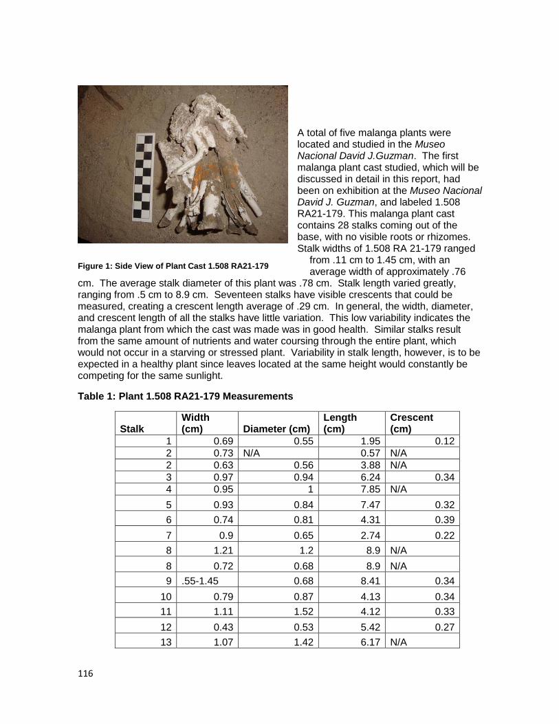
116
A total of five malanga plants were located and studied in the Museo Nacional David J.Guzman. The first malanga plant cast studied, which will be discussed in detail in this report, had been on exhibition at the Museo Nacional David J. Guzman, and labeled 1.508 RA21-179. This malanga plant cast contains 28 stalks coming out of the base, with no visible roots or rhizomes. Stalk widths of 1.508 RA 21-179 ranged
from .11 cm to 1.45 cm, with an average width of approximately .76
cm. The average stalk diameter of this plant was .78 cm. Stalk length varied greatly, ranging from .5 cm to 8.9 cm. Seventeen stalks have visible crescents that could be measured, creating a crescent length average of .29 cm. In general, the width, diameter, and crescent length of all the stalks have little variation. This low variability indicates the malanga plant from which the cast was made was in good health. Similar stalks result from the same amount of nutrients and water coursing through the entire plant, which would not occur in a starving or stressed plant. Variability in stalk length, however, is to be expected in a healthy plant since leaves located at the same height would constantly be competing for the same sunlight.
Table 1: Plant 1.508 RA21-179 Measurements
Stalk Width (cm) Diameter (cm)
Length (cm)
Crescent (cm)
1 0.69 0.55 1.95 0.12
2 0.73 N/A 0.57 N/A
2 0.63 0.56 3.88 N/A
3 0.97 0.94 6.24 0.34
4 0.95 1 7.85 N/A
5 0.93 0.84 7.47 0.32
6 0.74 0.81 4.31 0.39
7 0.9 0.65 2.74 0.22
8 1.21 1.2 8.9 N/A
8 0.72 0.68 8.9 N/A
9 .55-1.45 0.68 8.41 0.34
10 0.79 0.87 4.13 0.34
11 1.11 1.52 4.12 0.33
12 0.43 0.53 5.42 0.27
13 1.07 1.42 6.17 N/A
Figure 1: Side View of Plant Cast 1.508 RA21-179
117
14 1.15 1.1 4.27 N/A
15 1.3 1.1 3.12 0.37
16 0.59 0.78 6.82 0.13
17 0.79 0.95 6.68 0.39
18 0.48 0.64 6.54 0.19
19 0.64 0.9 4.92 N/A
20 1.02 1.2 7.59 0.46
21 0.3 0.27 1.85 N/A
22 0.21 0.2 0.5 0.3
23 0.35 0.45 1.47 N/A
24 0.29 0.49 1.2 0.15
25 0.34 0.15 1.69 N/A
26 0.11 0.36 2.34 N/A
27 0.72 0.8 4.42 0.34
28 0.54 0.84 2.91 N/A
In addition to studying the plant casts from Ceren, I also interviewed local residents of Joya de Ceren about the uses of present-day malanga plants. Initially, my research met a challenging obstacle in that many of the people had not heard of the plant and, those who had, did not regularly eat the root. The larger supermarket located in the city of Lourdes sold other root crops, including potatoes, yuca (manioc) and jicama, but it was difficult to locate malanga. With the help of a local consultant I was able to finally find the plant in the supermarket under a pile of yuca. There were three malanga roots, and all three were already rotting. This revealed the first interesting aspect of my 2011 research, that malanga did not appear to be a widely eaten, or even widely known, root crop in El Salvador today.
Fortunately, some residents of Joya de Ceren were familiar with malanga, including where it was grown and sold in the area Jesus Franco, one of our workers, took me to a small nursery just outside the town, which contained three small plants that he identified as malanga with edible roots. Another garden in the town contained the same plant that was also identified as malanga with edible roots. In addition, at the Joya de Ceren Museum, Salvador Quintanilla showed me a similar (though larger) plant which he called malanga as well. The next challenge of this research soon emerged. It became clear that a local distinction was being made between edible and ornamental malanga. In particular, contradictory accounts of what the visual differences between ornamental and edible malanga plants led to much confusion. Two people insisted that the leaf veins of edible plants were purple, as opposed to green. When asked the same question, two other people said the leaves of ornamental malanga were larger than those of edible malanga. The lack of consensus for the types of malanga in the area further highlighted that this root crop is a lesser known and used part of community life in Joya de Ceren.
118
The final challenge that arose from this research was the botanical identification for malanga. The plant presented by residents of Joya de Cerén as malanga was identified by paleobotanical specialist Dr. David Lentz as not being Xanthosoma. Dr. Lentz identified the plant as “malanga” as actually taro (Alocasia esculenta), a different type of root crop that has similar roots. Taro is a root crop introduced from Asia, and has a perfoliate leaf. Xanthosoma, on the other hand, has a sagittate leaf. This means that, in order to clearly distinguish taro from malanga, a close examination of the leaves (and not just the roots) is needed. A perfoliate leaf is characterized by a stem that enters at the center of the leaf. A sagittate leaf, however, has an arrow shape, with the stem entering the leaf at the juncture. In addition, Lentz said all the modern plants identified as malanga (though were
actually taro) were ornamental. Thus, based on my limited ethnographic research, I was unable to find
edible malanga tubers, or even the malanga plant.
Conclusions
Documentation of malanga in the Ceren kitchen garden of Household 1 indicates that Xanthosoma was present in ancient Maya agriculture at this site. One of the plant casts collected from Ceren indicates the plant was healthy, and the context (and botanical attributes) of the plant suggests that the plant would have been a good, easy supplement to the Maya diet. Today, however, malanga is not well-known or eaten. In fact, what is known as “malanga” in the town of Joya de Ceren is actually taro, and not Xanthosoma. This large discrepancy between the past and the present certainly requires more research. If malanga was an integral part of ancient Maya diet, it could be used to contribute to present-day diet, especially in light of its ability to withstand much in nature. I hope to continue research on Xanthosoma in the future in order to better understand how the plant functioned in the past, and how it transformed into an unknown root crop in the present
References Cited:
Bronson, Bennet
1966 “Roots and the Subsistence of the Ancient Maya.” Southwestern Journal of Anthropology, 22: 251-279.
Drucker, Philip and John W. Fox
1982 “Swidden Didn' Make All That Midden: The Search for Ancient Mayan Agronomies.” Journal of Anthropological Research, 38 (2): 179-193.
Figure 2: Taro Perfoliate Leaf
119
Dixon, Christine C.
2009 Manioc Agriculture in Report of the 2009 Maya Agricultural Project South of Joya de Cerén, El Salvador, edited by P. Sheets. Enlace Academico Centroamericano, Fundacion Clic. San Salvador, El Salvador.
2007 Chapter 5: Classic Period Maya Agriculture: Test Pits 1 and 2, 5 and 6 in Preliminary Report of the Ceren Research Project 2007 Field Season. Ed. Payson D. Sheets.
Lentz, D.L., M.P. Beaudry-Corbett, M.L. Reyna de Aguilar, and L. Kaplan.
1996 Foodstuffs, Forests, Fields, and Shelter: A Paleoethnobotanical Analysis of Vessel Contents from the Ceren Site, El Salvador. Latin American Antiquity 7: 247-262.
Lentz, David L. and Carlos R. Ramírez-Sosa
2002 Cerén Plant Resources: Abundance and Diversity. In Before the Volcano Erupted: The Ancient Cerén Village in Central America, edited by Payson Sheets, pp. 33-42. Austin, TX: The University of Texas Press.
Leone, Jorge
1968 Fundamientos Botanicos de los Cultivos Tropicales. San José, Costa Rica: El Instituto Interamericano de Ciencias Agrícolas de la OEA.
Sharer, Robert J.
2006 The Ancient Maya. Stanford, California: Stanford University Press.
Sheets, Payson
2009 Report of the 2009 Maya Agricultural Project, South of Joya de Cerén, El Salvador, edited by P. Sheets. Enlace Adademico Centroamericano, Fundacion Clic, San Salvador, pp 83-106.
2002 Summary and Conclusions. In Before the Volcano Erupted: The Ancient Cerén Village in Central America, edited by Payson Sheets, pp. 197-206. Austin, TX: The University of Texas Press.
120
Sheets, Payson and Michelle Woodward
2002 Household Production and Specialization at Cerén. In Before the Volcano Erupted: The Ancient Cerén Village in Central America, edited by Payson Sheets, pp. 184-191. Austin, TX: The University of Texas Press.
Standley, Paul C., and J.A. Steyermark
1958 “Flora of Guatemala.” Fieldiana: Botany 24(1). Chicago: Field Museum of Natural History.
Wiseman, Frederick M.
1978 Agricultural and Historical Ecology of the Maya Lowlands. In Pre-Hispanic Maya Agriculture, edited by Peter D. Harrison and B.L. Turner II, pp. 63-116. Albuquerque: University of New Mexico Press.
Acknowledgements
First, thank you to Payson Sheets, who not only allowed me to conduct this research, but guided me throughout the whole process. I am incredibly grateful for all that I have learned, and have yet to learn from him. And of course, thank you to Christine Dixon, who worked tirelessly directing us all in the field and editing throughout the writing process. In addition to all her work, I would also like to thank her for all the emotional and psychological support she has given throughout the field season. I would also like to say a huge thank you to David Lentz, for his amazing botanical expertise. Without him, I would still be studying taro instead of malanga. In addition, I may not have survived if not for the constant aid of Christine Hoffer, Alexandria Halmbacher and Celine Lamb. For providing new ideas, help with my work as well as at home, and entertainment, I owe them my sanity.
A big thank you as well to the hard-working people at the Museo Nacional David J. Guzman, including Roberto Gallardo, Lily Limas, and Jorge Rubio. The effort put into finding Xanthosoma plant casts has been awe-inspiring, and I am beyond appreciative to those who sifted through boxes in order to help me. And, of course, I would like to thank all those who helped me understand malanga-use today, especially Elena and Julio Garcia-Muñoz, Jesus Franco, Salvador Quintanilla, Alejandro Quintanilla, Amicar Najarro, and Oswaldo Guardado. I would also like to thank everyone working at the site of Ceren as well as the citizens of Joya de Ceren, who have been nothing but wonderful to me. I am honored to be able to work in El Salvador, and at the site of Ceren, and am thankful for all the time I have been able to spend here and the opportunity to do my research.
121
Chapter 11. Summary and Conclusions
Payson Sheets
The third field season of the Maya Agriculture Project south of the Ceren site, was completed in 2011. It built upon on the discoveries of the two previous field seasons, in 2007 and 2009, and went beyond them in a number of domains. The two earlier seasons encountered numerous cleared areas, platforms, maize cultivation, plot boundaries, land use lines, and a surprising sophistication and magnitude of manioc (“yuca” or Manihot esculenta) cultivation. More details of these two seasons are presented in Chapter 1. The extraordinary details of agriculture in and around Ceren are not because it was unique as a village. While it was functioning it was much like dozens and probably hundreds of other villages in the southeast periphery of the Maya area during the Classic period. What makes Ceren highly unusual is its burial by the volcanic ash from the Loma Caldera volcanic vent, which resulted in preservation of crops and field features even including the individual hand marks of people re-packing elevated beds after planting manioc are preserved at Ceren. Such evidence for Classic period Maya life provides an important window into the past and affords a deeper understanding of ancient agricultural practices.
This chapter provides a brief summary and discussion of the accomplishments of the 2011 research, and is organized by topics such as maize and manioc agriculture, cleared areas, artifacts, a sacbe, and special studies. These topics are presented in the order they appear in Chapters 2-10.
In Chapter 2 Celine Lamb and Theresa Heindel describe and interpret the seven maize milpas encountered inside the southern boundary of the Joya de Ceren archaeological park. Those maize fields are located about midway between the milpas excavated within the Ceren village and the milpa excavated in 2009. An important element in studying patterns and variations in agriculture at the level of individual cultivators is finding boundaries of fields, and the 2011 research was very successful in discovering those
122
boundaries. Boundaries were found between individual milpas, manioc fields that had been abandoned shortly before the eruption, a sacbe, and cleared areas. A dynamism was discovered that had not been seen before in such detail at Ceren, as one field that had been planted in manioc in an earlier season had been shifted to maize in the months before the Loma Caldera eruption. The size and spacing of the maize ridges (“surcos”) in many of those milpas are quite similar to those within the village. The well-formed surcos run perpendicular to slope to maximize water infiltration and minimize erosion. The planting densities, and thus the productivity per unit area, are comparable. But excavations also encountered milpas where surcos were not built. Rather, the farmers mounded earth around each cluster of maize plants. Each technique may be equally effective in ameliorating wind-throw, but mounding does not contribute much to infiltration or erosion control. And one notable plot was planted in maize, and the maize had matured, but no surcos or mounds were built. The 2011 research documented a wide range of variability in how individual farmers maintained their milpas. The 2011 research took place during the first three months of the rainy season, and project members observed the same range of individual variation among contemporary campesinos with their milpas in the Joya de Ceren area.
Alexandria Halmbacher describes three kinds of areas discovered in 2011 that were kept clear of almost all vegetation, in her Chapter 3. One type of cleared space is an area that was deliberately leveled into a platform and kept clear of vegetation, with a likely use in processing harvested crops, as they occur in the midst of manioc and maize fields. Another type is also kept clear of most vegetation, but where there is no change in the original topography. The third type is manioc fields, with their large surcos and calles, that had been abandoned for a while before the Loma Caldera eruption occurred. The abandonment appears to have been for a few months to perhaps a year or two, and could be considered a short-term fallow. The diversity and extent of cleared areas provide compelling evidence for her argument that population pressure on productive land did not exist. Rather, people in and around Ceren had the luxury to maintain extensive areas not in cultivation.
Christine Dixon‟s Chapter 4 describes in detail the four operations where manioc cultivation was detected in 2011, along with a feature. In all four operations the manioc surcos were larger in size and greater in spacing than maize surcos in milpas, even though some of them were not in active cultivation when the Loma Caldera eruption buried them. In Op. AA manioc surcos were found, with some tubers and roots left behind after the field was harvested. One operation had a juvenile manioc plant starting to grow, perhaps only a month or two after it was planted. Or more likely it was a volunteer that was allowed to grow. These discoveries add even more evidence of the magnitude of manioc production in Classic period Ceren, even beyond that discovered in 2009. Dixon also describes Feature 1 as a possible domestic or storage facility. It included two pristine obsidian prismatic blades stored in thatch, carbonized poles, a mano-like large groundstone artifact, and a ceramic olla badly smashed by a country rock thrown out during the eruption. As with other field seasons, no pre-harvest manioc surcos were discovered. As I spoke with people in the area farming manioc, they state that harvesting en-mass is done preferably in the month of June or July, with replanting in August. That dating of the eruption to August is consistent with other indicators of when it most probably occurred. And that kind of large-scale harvesting by removing the entire manioc plant is completely different from that of the manioc growing in the kitchen garden of Household 1, where a single tuber would presumably be removed for immediate local consumption and the plant would keep growing, and replace that tuber.
123
In Chapter 5 Christine Dixon describes and interprets the most surprising discovery of the 2011 field season: a sacbe. Maya sacbes are formal constructed roadways that can serve practical purposes of communication and transportation, and also function in social and religious domains. In Yucatan the Maya word “sacbe” translates as the “white way” because they are constructed of limestone and lime plaster. At Ceren the name is appropriate because the sacbe was constructed of highly compacted Tierra Blanca Joven (“young white earth”) from the Ilopango eruption, and it too is white. A cross-section trench showed efforts to place the whitest volcanic ash on top of the construction, perhaps in an effort to maintain it as white as possible. It is about two meters wide, with formal drainage canals on each side, and maize milpas beginning just beyond the canals. The sacbe was confirmed in three operations, and it is headed north northeast into the village. It is turning very gently toward the east, and if that curve continues, it could lead to Structure 10, the community ceremonial building. Because a harvest ritual was taking place at the time of the eruption, it is possible the sacbe served its final function as an emergency escape route from that disaster. The sacbe is headed south, to an unknown destination or destinations. As Dixon notes, the sacbe is headed in the general direction of San Andres, the principal regional center of the valley, about five kilometers away. As Dixon notes, the sacbe was highly compacted, and is in fact the most compact open surface discovered at or around the site to date. It is not surprising that civil engineers in El Salvador today favor the TBJ, after compaction, as the favored material upon which to do major construction. Dixon proposed the eminently testable hypothesis that individual milperos had the responsibility of sacbe maintenance where their fields abutted it.
David Lentz and Christine Hoffer present their paleoethnobotanical research objectives and methods in Chapter 6. Both objectives and methods build on the success of the botanical research conducted in 2009, when over 1500 pieces of charcoal were identified to genus and/or species by careful analysis at laboratories at the University of Cincinnati. Soil and phytolith samples were taken from each of the 14 operations, and analyses will begin later in 2011 in Cincinnati.
The very small collection of lithic artifacts is presented in Chapter 7. Only 13 lithic artifacts were found during 2011 excavations, and all but one of them were of obsidian from the Ixtepeque source. The exception was a groundstone artifact shaped like a mano, but weighing about three times more than the usual mano of this length. It was found in Feature 1 of Operation AA, along with four other obsidian artifacts. These five lithic artifacts date to the Classic period, contemporary with the Ceren village to the north. Two unused prismatic blades were found in grass thatch that had partially burned (carbonized), and they fell when a roof of a domestic or storage feature collapsed during the early portion of the Loma Caldera eruption. Near them were two discarded waste flakes that are wastage from core-blade technology. Because no evidence of obsidian tool manufacture has ever been found in or around the Ceren village, it seems likely that local residents picked these percussion waste flakes up at some more distant workshop and carried them to this location, probably used them as utility cutting tools, and discarded them. No obsidian manufacture evidence has been found in or near Ceren. The only chipped stone activity encountered to date is some very limited resharpening of obsidian scrapers in Household 1.
The Postclassic lithic collection was almost as tiny as the Classic collection. It consists of eight obsidian artifacts, including a short polyhedral core, two core fragments smashed by heavy percussion, and some prismatic blades. There was an informal workshop functioning in this area a few centuries after the Loma Caldera eruption. Numerous

124
manufacturing errors are evident in the Postclassic artifacts, in contrast to the low error rate at more highly skilled workshops in major centers.
Ceramics, presented in Chapter 8, were considerably more abundant than lithics in the agricultural fields. The sharpness of obsidian artifacts, even those rather heavily used, can cut a person walking barefoot, and that may have encouraged disposal at a distance. The ceramics recovered from all 2011 operations closely matched Beaudry-Corbett‟s (2002) descriptions of the ceramics from the Ceren village. Operation AA was placed a few meters from Operation P (excavated in 2009) with the objective of encountering more midden and hopefully more information about manioc production and processing. The objective was met, as excavations encountered more artifacts, especially ceramics, than in any other operation in any of the project‟s three field seasons. In addition to abundant sherds, an olla that was smashed by a rock thrown out during the early stages of the eruption was encountered. The sherds included the full range of pottery, including undecorated body sherds, abundant bowls, scraped-slip vessels, and polychromes.
Operation W encountered the sacbe with maize fields on either side, and a comparatively large collection of ceramics. Most of the ceramics were from broken utility wares, with only occasional polychrome sherds. I wonder if many of the sherds were from utility vessels that were broken while being carried along the sacbe, and tossed to the sides. The scarcity of polychromes could be caused by their being kept and used within households, and more rarely carried outside on the sacbe.
Celine Lamb provides an ethnographic study of present-day gardens in and around the modern town of Joya de Ceren in Chapter 9. She presents many insights that can encourage archaeologists to think beyond the typical concept of a kitchen garden as only providing food, as she found many gardens devoted to ornamental plants, and a wide range of variability within the category of gardens. A compelling suggestion she makes is that present gardens express a sense of identity, pride in property, and showing a public face to outsiders. Major differences today in conceptualizing gardens and who maintains them are manifest in the present community. She deals with the important topics of continuity and discontinuity from Classic period times to today. Major natural disasters and cultural interactions have affected populations through the centuries, and the cultural and demographic changes in the past 14 centuries have been dramatic. In spite of that there are a few significant similarities between the two Classic period gardens at Ceren and the modern ones. The categorization of gardens as ornamental versus practical (for food, medical applications, and firewood) is useful in examining ancient gardens, and the reminder that individual plant species can be used for multiple purposes is important for archaeological interpretations.
The penultimate chapter is # 10, by Theresa Heindel. She describes the complexity of dealing with malanga (Xanthosoma) in Classic period Ceren and today. In previous research at Ceren David Lentz identified malanga growing in Household 1 and elsewhere at the site. The people today living in the Zapotitan valley, who know of “malanga” are glad to show visitors the ornamental version and the edible version, and talk about how the latter is prepared, cooked, and consumed. However, David Lentz (personal communication 2011) stated what people today identify as edible malanga is in fact taro that was domesticated in Asia and brought to the New World in colonial times. Taro is not even in the same genus as malanga, but the plants are highly similar in leaves, stalks, and tubers. Thus what first seemed to be continuity turned out to be a botanical discontinuity. But this can be viewed as a continuity in the sense that the plants are so highly similar that the name malanga persisted, and cultivation as well as processing and consumption
125
remained virtually unchanged. Use and knowledge about “malanga” today is fading, with older people being more aware of it and using it, and younger people less aware.
Heindel aptly points out the advantages of cultivating malanga or taro as a food supplement in that it is very easy to plant, needs little care in growing, and like manioc it is stored in the ground for long periods before being harvested.
In overview, the 2011 research of the Maya Agriculture Project south of Joya de Ceren has been highly successful in achieving most of the objectives stated in the proposal. Considerable new data were added to the variation of individual cultivators, both of maize and manioc. Numerous boundaries of agricultural fields were found. Discoveries of different degrees of maturation of maize plants probably indicated that farmers were planting seeds at different times during the beginning of the rainy season. Farmers demonstrated divergent choices in their farming techniques. Three kinds of cleared areas were identified this season, and reasons for their existence proposed. A dynamism in shifting cultivation from one species to another had been perceived in Operation L in 2009, but only in one small area. Considerable new evidence of that dynamism was discovered this season. That dynamism was evidenced by areas formerly in manioc had been shifted to maize, and areas shifted from cultivation to being a cleared open area, probably for a variety of uses. The most gratifying surprise of the field season was the discovery of a formal sacbe. The sacbe deserves a project of investigation in and of itself, as it is the first entirely earthen sacbe found in the Maya area. The extent, uses, and meaning of the sacbe can contribute to our understadings of economic, political, social, and religious matters in ancient Ceren. And special studies are reported here on modern day gardens in the Joya de Ceren area, and on the root crop malanga at Ceren and the complexities of studying it today. All in all, 2011 was a highly successful research season.