melbourne city area noise information pack - … city area noise information pack . ......
TRANSCRIPT

Melbourne city area noise information pack Contents 1. Purpose and scope Page 2 1.1 Noise and Flight Path Monitoring Page 2
1.2 Runway naming convention Page 3 1.3 Runway selection Page 3 1.4 Noise Abatement Procedures Page 3 1.5 Community engagement Page 3
2. Melbourne Airport Page 4 2.1 Aircraft movements Page 4 2.2 Runway configuration Page 5
2.3 Runway use Page 6 2.4 Noise abatement procedures Page 8 2.5 Smart Tracking Page 9
3. Essendon Airport Page 10 3.1 Aircraft movements Page 10 3.2 Noise abatement procedures Page 11 4. Moorabbin Airport Page 12 4.1 Aircraft movements Page 12 4.3 Noise abatement procedures Page 13 5. RAAF Williams Page 14 6. Typical flight track patterns for Melbourne city area Page 15 6.1 Jet aircraft Page 15 6.2 Non jet aircraft Page 16 6.3 Track density plots Page 17 7. Further information Page 20 Disclaimer The information contained in this document is for information purposes only. While Airservices Australia has taken reasonable steps to ensure the accuracy of this information, Airservices Australia makes no warranty or representation that it is current, accurate or complete.
Copyright © This work is copyright. You may download, display, print and reproduce this work in unaltered form (retaining this notice) only for your non-commercial, personal use or non-commercial use within your organisation. You may not otherwise reproduce, transmit, publish or communicate this work or any part of it by any means. Commercial use of any part of this work (including use, reproduction, transmission, publication or communication for a commercial purpose, or as part of providing a commercial service) is strictly prohibited. Apart from any other use as permitted under the Copyright Act 1968, all other rights are reserved.
1

1. Purpose and scope The purpose of this document is to provide information on aircraft operations throughout the Melbourne area to the community. The Melbourne area is mainly affected by aircraft noise from three airfields: Melbourne Airport, Essendon Airport and Moorabbin Airport. The location of these airfields is shown in Figure 1. Figure 1: Locations of airfields in Melbourne area
MELBOURNE AIRPORT
ESSENDON
RAAF POINT COOK
MOORABBIN
AVALON
1.1 Noise and Flight Path Monitoring Airservices operates a Noise and Flight Path Monitoring System (NFPMS) at Melbourne Airport and Essendon Airport. Flight tracks from any suitably equipped aircraft operating within 50km of the airport are captured by the NFPMS. This includes all commercial and scheduled air traffic but may exclude some small fixed wing aircraft (if they are not equipped with a transponder or are outside radar coverage). Airservices operates seven noise monitors, also known as environmental monitoring units (EMUs), in the Melbourne area, which record noise from both Melbourne Airport and Essendon Airport. These are shown in Figure 1. Noise events are captured individually by the noise monitor. The data is then matched with Airservices radar data for aircraft flying in the vicinity of the noise monitor at the time of the event. Airservices provides an internet-based tool where details about individual flights can be obtained and an aircraft noise complaint can be lodged. A link to WebTrak is provided in the “Other Resources” section.
2

1.2 Runway naming convention Runway names consist of the first two digits of the compass bearing for the runway direction. For instance if the runway bearing is 210o its name will be 21. At airports where there are parallel runways an additional character is added; L, C or R to distinguish between the left, centre or right runway. 1.3 Runway selection Runway selection is based on weather conditions, traffic volume and noise abatement procedures. As the wind changes the active runway may change as aircraft primarily take-off and land into the wind for safety and performance reasons. This often results in different areas around the airport being overflown by aircraft at different times of the day. This includes helicopter operations where pilots generally make their approach to or depart from the helipad into the prevailing wind. If the wind is calm or light, other factors such as the amount of traffic are taken into consideration when deciding which runway to use. 1.4 Noise Abatement Procedures Noise Abatement Procedures (NAPs) are designed to help reduce the impact of aircraft noise on the community. They are made up of preferred runways, preferred flight paths and noise abatement areas. The latter have restrictions on what aircraft can operate within these areas. NAPs are included in the Aeronautical Information Publication (AIP), which consists of a package of documents which provides all of the operational information necessary for the safe and efficient conduct of national (civil) and international air navigation throughout Australia and its Territories. NAPs are implemented by Air Traffic Control (ATC) but all aircraft are expected to observe the NAPs outside of ATC hours or operation. The use of NAPs at any time are subject to the weather conditions and aircraft requirements. Their use is not mandatory. Airports also implement measures to reduce the impact of operations under their control, such as ground running restrictions or time restrictions for circuit training. 1.5 Community engagement Melbourne Airport, Essendon Airport and Moorabbin Airport each have independently chaired Airport Community Aviation Consultation Groups (CACGs). The purpose of the CACGs is to ensure community views are heard by the airport and to provide members of the community with an opportunity to obtain information about airport operations. CACGs discuss a range of airport matters including aviation and non-aviation developments and planning or regulatory changes. At Melbourne Airport, a Noise Abatement Committee (NAC) supports the CACG by providing advice on technical and operational issues. This committee includes representatives from the aviation industry, the airport and government, as well as Airservices.
3

2. Melbourne Airport
Melbourne Airport is located around 20km north east of the central business district. It is bounded by residential areas to the east, south and west. To the north of the airport is the township of Bulla. The majority of operations at Melbourne Airport are international and domestic regular passenger services, mostly medium to large jets. Since opening in 1970, Melbourne Airport has always operated 24 hours per day, seven days per week. It is the fastest growing airport in Australia, with significant development on and around the airport site.
2.1 Aircraft movements Figure 2 shows aircraft movements at Melbourne Airport from July 2011 to September 2012. Figure 2: Movements at Melbourne Airport, July 2011 to September 2012
On average, there are around 500 movements per day at Melbourne Airport. The vast majority of these are jets.
4

2.2 Runway configuration Figure 3 shows the main runways at Melbourne Airport. Figure 3: Runway configuration at Melbourne Airport
The main runway at Melbourne Airport, 16/34 is 3.7 km long, orientated north-south. There is a smaller 2.3 km long cross runway, 09/27, orientated east-west. Melbourne Airport is currently working on its 2013 master plan. The draft master plan states that Melbourne Airport has chosen the East-West runway as its preferred option for the Airport’s third runway configuration. This runway would be located 2 km to the south of the current cross runway and would be 3.0 km in length. Planning approval for a new runway would be required through a Major Development Plan process. More information about Melbourne Airport’s draft master plan is available on the airport’s website (http://melbourneairport.com.au/).
5

2.3 Runway use at Melbourne Airport
Figure 4 shows runway use at Melbourne Airport.
Figure 4: Runway use at Melbourne Airport
Fixed wing aircraft perform take-offs and landings into the wind to reduce the take-off roll and provides better lift; along with reducing the ground speed on take-off and landing. In Australia the Civil Aviation Safety Authority (CASA) sets limits upon when an aircraft may operate opposite to the wind direction. Further information on runway selection is available on Airservices website at www.airservicesaustralia.com.
It is clear that runway use is seasonal, with Runway 16 (aligned roughly north to south) used most in summer, and Runway 34 (aligned roughly south to north) used most in winter. This is due to differences in prevailing winds at Melbourne Airport that vary by season.
The Bureau of Meteorology publishes ‘wind roses’ for Melbourne for winter and summer (Figures 5 and 6). These summarise the occurrence of winds at a location, showing the direction, strength and frequency of the winds. Each ‘branch’ (the orange/ brown lines) represents winds coming from that direction, with north to the top of the diagram. The branches are divided into sections of different thickness and colour, which represent wind speed from that direction. Thinner, paler segments represent lighter winds and thicker, darker segments represent stronger winds. The frequency of winds blowing at that speed from that direction is represented by the length of each section within the branch. The longer the branch, the more prevalent is the wind from that direction. Wind roses are published on the Bureau of Meteorology’s website (www.bom.gov.au).
6

Figure 5: Wind rose for Melbourne, winter
In winter the wind at Melbourne Airport tends to be from the north and the west. Therefore, in winter aircraft tend to use Runways 27 and 34 more (see Figure 4) departing to the north and west over areas which are generally not residential, and arriving over suburbs to the south and east of the airport.
7

Figure 6: Wind rose for Melbourne, summer
In summer, winds from the south and south west are more common in Melbourne. Therefore, in summer aircraft tend to use Runway 16 more, taking off to the south over and arriving over the north, as can be seen in Figure 4. 2.4 Noise abatement procedures Melbourne Airport is surrounded by ‘green-wedge’ corridors to the west and north. Where possible, flights are directed over these areas and non-residential areas. For example, aircraft are routed to avoid flying over Bulla, Sunbury, Craigieburn, Keilor, Sydenham, St Albans, Greenvale, Meadow Heights and other areas notified by local instruction. If flying over these suburbs cannot be avoided, a minimum height over these areas is applied:
Jet aircraft – not below 5000 feet above ground level Propeller aircraft – not below 3000 feet above ground level.
Airservices’ NAPs comprise preferred runways and preferred flight paths:
Preferred runways only operate in light winds. Between 6.00am and 11.00pm, when there is not heavy traffic, the preferred runways for landing are Runways 16 and 27, and the preferred runways for departure are Runways 27 and 34. During busy periods between 6.00am and 11.00pm, the preferred runways for landing are Runways 27 and 34, and the preferred runway for
8
Preferred flight paths are designed to maximise overflight of non-residential areas.
2.5 Smart Tracking In recent years, satellite assistance has proved to be a quantum leap in aircraft navigation capability and new aircraft are increasingly being designed to be more capable. Satellite assisted navigation is recognised internationally for its safety benefits which are achieved through navigation with high precision. This technology is referred to as “Smart Tracking”. To achieve the best aircraft safety, noise and emissions outcomes for Melbourne , Airservices is working towards making Smart Tracking technology permanently available for all suitably equipped aircraft landing at Melbourne Airport. Smart Tracking aircraft has been successfully trialled at Melbourne since 2009 and at 16 other Australian airports. Airservices is engaging with the community on these proposals, and more information is available at www.airservicesaustralia.com/projects/smart-tracking/.
9

3. Essendon Airport
Essendon Airport is located around 10km north of the CBD. It provides facilities for corporate jets, airfreight, aircraft maintenance, aircraft charter and emergency air services providers. Essendon Airport is open 24 hours per day. The Control Tower is active seven days a week but not during night time. During the night, a control service is available from Melbourne approach.
At Essendon Airport there are two intersecting runways, a 1.6 km north-south runway 17/35 and a 1.9 km east-west runway 08/26. These are shown in Figure 7. Figure 7: Runway configuration at Essendon Airport
3.1 Aircraft movements Figure 8 shows aircraft movements at Essendon Airport from July 2011 to September 2012. Figure 8: Aircraft movements at Essendon Airport
10

There are around 140 movements per day at Essendon Airport. Of these around half are light aircraft under 5.7 tonnes. 3.2 Noise abatement The Air Navigation (Essendon Airport) Regulations 2001 set out the details of the curfew at Essendon Airport, which restricts take-offs and landings between 11.00 pm and 6.00 am. Exemptions include
Propeller-driven aircraft with a maximum take-off weight not exceeding 8,618 kilograms and that do not exceed specified noise emissions.
Helicopters that comply with the relevant maximum noise levels contained in Chapter 8 or 11 of the International Civil Aviation Organization’s Annex 16, Volume 1.
Aircraft involved in an emergency, or a flight interrupted by an emergency. An ‘emergency’ includes aircraft being used for search and rescue, medical purposes or natural disasters, or emergencies declared by a pilot such as insufficient fuel or an in-flight emergency.
Dispensations may be granted if there are circumstances justifying a take-off or landing. A dispensation will not be granted if the aircraft is on a scheduled commercial operation (carrying passengers or freight).
Further details of the curfew can be found at: http://www.infrastructure.gov.au/aviation/environmental/curfews/EssendonAirport/EssendonCurfewBrief.aspx There are other noise abatement procedures at Essendon Airport:
An aircraft with a maximum take-off weight of 45,000 kilograms or more cannot take-off from or land at Essendon Airport at any time, unless the aircraft is involved in an emergency, or the Secretary (Department of Infrastructure, Transport, Regional Development and Local Government) or his delegate grants a dispensation beforehand.
Use of preferred runway when conditions allow. Use of preferred flight paths where possible to avoid residential areas.
In addition, Essendon Airport has negotiated a Fly Friendly agreement with operators.
11

4. Moorabbin Airport Moorabbin Airport is located around 20km south east of the CBD. It provides facilities for a number of flying schools, as well as for a small number of passenger and freight services and emergency service flights. Moorabbin Airport is open 24 hours per day. The Control Tower is active seven days a week but not during night time. When the tower is closed, pilots must make radio calls advising their positions while in the airport area. Moorabbin Airport has two parallel runways aligned north-south (35L-17R and 35R-17L) and another set of two parallel runways orientated north-east to south-west (31L-13R and 31R-13L). These are of a similar length, 0.8-0.9 km. There is a fifth runway which is shorter (0.5km), aligned south east to north west (04-22). The runway configuration at Moorabbin Airport is shown in Figure 9. Figure 9: Runway configuration at Moorabbin Airport
12

4.1 Aircraft movements Figure 10 shows aircraft movements at Moorabbin Airport from July 2011 to September 2012. Figure 10: Aircraft movements at Moorabbin Airport
There are around 550 movements per day at Moorabbin Airport. Of these, around 80 per cent are light aircraft under 5.7 tonnes and 40 per cent are training flights. 4.2 Noise abatement A number of noise abatement procedures are in place at Moorabbin Airport. These include:
Restrictions on certain training procedures from Runway 17R to avoid noise over residential areas.
Where possible, use of Runway 17L or 35R for jet departures, to avoid residential areas.
Delayed turns from Runway 17R to avoid noise intrusion over Parkdale. Procedures to minimise noise emissions from ground running.
In addition, Moorabbin Airport has a Fly Friendly Program, which encourages pilots to operate in a manner which is considerate of local residents.
13
5. RAAF Williams
Flights operating from RAAF Williams, which is approximately 25km south west of Melbourne’s CBD, may also affect residents. RAAF Williams comprises the two former RAAF bases Point Cook and Laverton, which were merged in 1999. Not all aircraft operating at the base have equipment that allows their movements to be tracked. RAAF Williams has two concrete runways. Runway 04/22 is 1137m long and Runway 17/35 is 1374m long. In addition, there is a grass runway 08/26.
In addition to military flights, a small number of charter flights operate from the base. The museum at the base also organises regular flights of vintage aircraft from the base.
RAAF Williams is the world’s oldest continually operated military flying base. In November 2009, the Department of Defence announced a significant redevelopment of the base, including enhancements to the museum and heritage areas and infrastructure upgrades. The redevelopment, which will start by the end of 2014, is expected to take three years.
14

6. Typical flight track patterns for Melbourne city area 6.1 Jet aircraft Figures 11 and 12 show jet aircraft track plots for arrivals and departures for the Melbourne basin for a typical month (August 2012), coloured according to height (in feet). The period shown has been limited to one month so that the patterns of aircraft movements can be distinguished Figure 11: Jet arrivals for the Melbourne basin, August 2012 (one month)
AVALON
43 60
6
2
61 MELBOURNE
AIRPORT
ESSENDON
MOORABBIN
64
Suburbs in line with the runways at Melbourne Airport up to about 15km are overflown by jet arrivals. However for Avalon Airport the majority of jet arrivals occur either over rural areas or the bay.
15
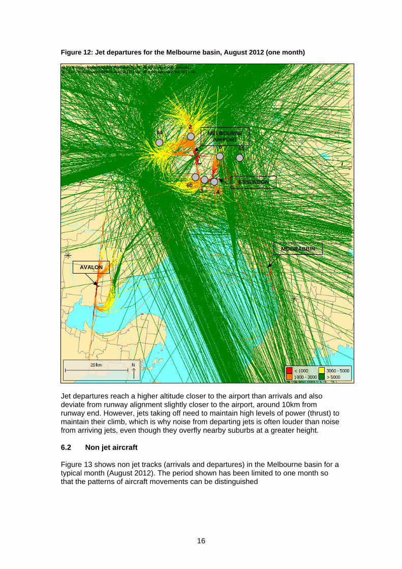
Figure 12: Jet departures for the Melbourne basin, August 2012 (one month)
AVALON
60
2
6 61
3 4
ESSENDON
MELBOURNE AIRPORT
MOORABBIN
64
Jet departures reach a higher altitude closer to the airport than arrivals and also deviate from runway alignment slightly closer to the airport, around 10km from runway end. However, jets taking off need to maintain high levels of power (thrust) to maintain their climb, which is why noise from departing jets is often louder than noise from arriving jets, even though they overfly nearby suburbs at a greater height. 6.2 Non jet aircraft Figure 13 shows non jet tracks (arrivals and departures) in the Melbourne basin for a typical month (August 2012). The period shown has been limited to one month so that the patterns of aircraft movements can be distinguished
16

Figure 13: Non jet arrivals and departures for the Melbourne region, August 2012 (one month)
AVALON
RAAF Point Cook
64 2
6 61
60 3 4
ESSENDON
LILYDALE
MOORABBIN
MELBOURNE AIRPORT
There are very few areas of the Melbourne basin that are not overflown by aircraft at some stage. The circuit pattern (training aircraft) at Moorabbin Airport and Point Cook are visible as red/ orange rings, indicating that aircraft are generally maintaining a height of around 1000ft (in line with Civil Aviation Safety Authority height requirements for circuit operations). 6.3 Track density plots The track plots above show that residents living up to 15km from the airports and in line with Melbourne Airport’s runways are regularly overflown by jet aircraft below 5000ft. However, beyond this the regularity of flight path use is not discernible from the track plot display. A track density plot can be useful in showing the underlying track patterns.
17

To create a track density plot, the land surface is divided into squares, creating a grid. The average number of flights passing over each square per day is then calculated. By colour coding according to frequency of flights, a track density plot can be illustrated. Figure 14 shows a track density plot for all movements over the Melbourne basin in Quarter 3 of 2012. Noise monitors are shown as grey circles. Figure 14: Track density plot for the Melbourne region, Quarter 3 of 2012
MOORABBIN
LILYDALE
MELBOURNE AIRPORT
AVALON
ESSENDON
RAAF Point Cook
43 60
2
6 61
64
Flights in and out of Melbourne Airport are generally aligned with the runways. Suburbs to the south, east and west of the airport are regularly overflown by aircraft. The location of noise monitors aligns well with operations out of Melbourne Airport. Operations out of Essendon are concentrated to the south-east of the airport, which includes the CBD. These aircraft are mostly smaller general aviation aircraft.
18

Operations out of Moorabbin Airport are either training or en route to the northern and eastern edges of the bay. Operations at Point Cook are mainly training operations conducting circuit operations. Circuit operations are also clearly visible at Lilydale Airport, to the top right of the map. Operations at this airport involve smaller general aviation aircraft.
19
20
7. Further information Airservices Resources WebTrak - Airservices provides an internet based system called WebTrak which enables aircraft movements to be observed in near real-time at eight airports around Australia including Melbourne Airport and Essendon Airport. Information on the site has a delay time of 40 minutes and provides data on a map about individual aircraft such as aircraft type, altitude, destination and noise levels. WebTrak is available on the Airservices website at www.airservicesaustralia.com/aircraftnoise/webtrak/. Factsheets – Factsheets available on Airservices’ website contain information on commonly raised topics including management of complaint about aircraft noise, fundamentals of sound, circuit training and airport curfews. Factsheets can be found at www.airservicesaustralia.com/aircraftnoise/airport-information/ Reports – Airservices produces reports summarising noise data from Melbourne Airport and Essendon Airport and complaints from Melbourne Airport. These reports can be found on the Airservices website at www.airservicesaustralia.com/publications/reports-and-statistics/noise-reports/ Other Resources Department of Infrastructure and Transport Website - Information on aircraft noise regulations, airport curfews, factsheets and aviation’s role in reducing carbon emissions is available from this website. This site also has a link to the Federal Government’s Aviation White Paper which details the Government’s aviation policy. www.infrastructure.gov.au/aviation/ Information on the Air Navigation (Essendon Airport) Regulations 2001 can be found on this website at http://www.infrastructure.gov.au/aviation/environmental/curfews/EssendonAirport/EssendonCurfewBrief.aspx Civil Aviation Safety Authority Website - This site provides information on aircraft airworthiness and certification, airspace regulation and issues of aviation safety (for example the rules concerning low flying aircraft). www.casa.gov.au/ Melbourne Airport’s website - http://melbourneairport.com.au/ Essendon Airport’s website - www.essendonairport.com.au/ Moorabbin Airport’s website - www.moorabbinairport.com.au/