meleah ashford, program manager northwest national marine renewable energy center oregon state...
TRANSCRIPT

Federal Advisory CommitteeNOAA’s Hydrographic Services Review Panel
Northwest Regional Stakeholder PanelOffshore Renewable Energy
October 13, 2010
Meleah Ashford, Program ManagerNorthwest National Marine Renewable Energy
CenterOregon State University
The Northwest National Marine Renewable Energy Center
US Department of Energy sponsored research centerA partnership between Oregon State University
(wave) and the University of Washington (tidal)Develop a full range of capabilities to support wave
and tidal energy developmentCenter activities are structured to:
facilitate device commercialization inform regulatory and policy decisions close key gaps in understanding
Other USDOE Centers include Hawaii (wave and OTEC) and Florida Atlantic University (current energy)
Funding for NNMREC is provided by DOE, OSU, UW and multiple partners

NNMREC is a virtual center focused on research and testing of marine renewable energy
Environmental
Sediment Transport
Electromagnetic Fields
Benthic Ecosystems
Acoustics
Social
Fisheries/Crabbing
Outreach/Engagement
Existing Ocean Users
Local/Oregon Economy
Technical
Testing/Demonstration
Wave Forecasting
Survivability/Reliability
Anti-fouling / Corrosion
Device/Array Optimization

Challenges for Marine Renewable Energy DevelopmentLack of standardized U.S. testing facilitiesRegulatory hurdlesLack of knowledge about effects/impacts
which won’t be understood until we deploy them
Infrastructure to manufacture, service & deploy devices
Funding/financingOyster
WaveGen
[Image courtesy Columbia Power, www.columbiapwr.com]
Wave Dragon
Open Hydro - tide

How do we utilize NOAA Hydrographic Data?Marine renewable energy
siting Marine energy permittingMarine spatial planning -
ocean space-use conflictsSurvivability, reliability
and optimal device performance
Environmental effects analysis
Wave forecasting for energy production
Future: adding sites to navigational charts and AIS

Marine Renewable Energy Siting
Conditions developers look for: Depth Bottom Type (rock, soft sandy, etc) Bottom Conditions (gently sloped) Proximity to the electrical grid Proximity to Ports for deployment
and O&M Marine traffic Avoidance of high-value areas
(reefs)
OSU Mobile Ocean Test Berth Siting Example
Future need for sites to be on navigational charts and Automatic Identification Systems (AIS) (Likely to be “areas to be avoided”) Tow lane
Distance from Port
Rocky Surface3NM Line
140ft depthMarine Reserve
Test site
study area
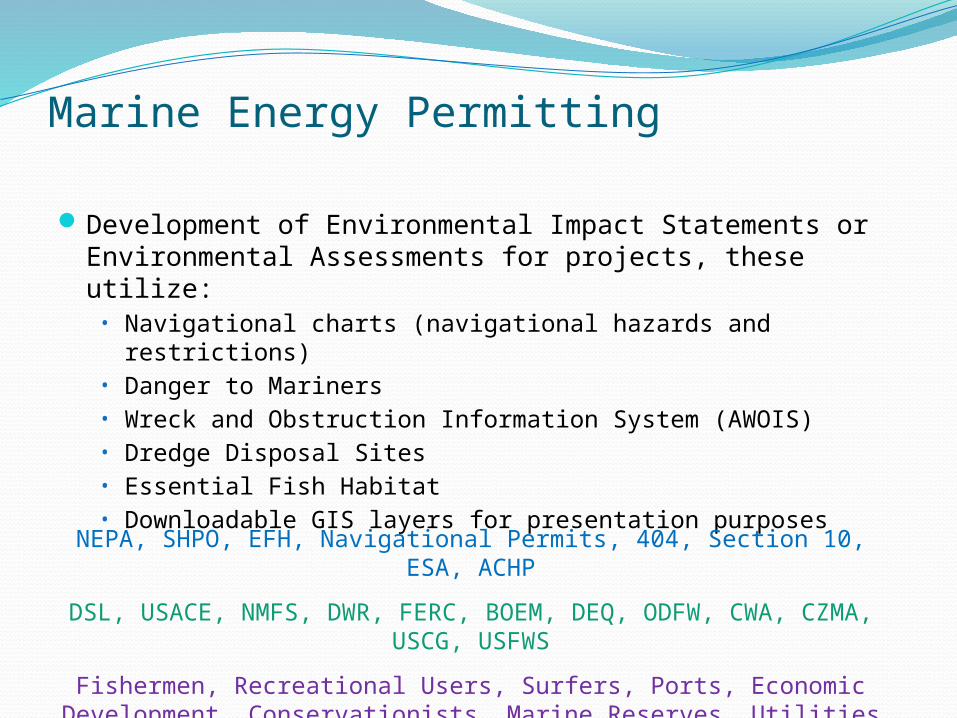
Marine Energy Permitting
Development of Environmental Impact Statements or Environmental Assessments for projects, these utilize:
• Navigational charts (navigational hazards and restrictions)• Danger to Mariners• Wreck and Obstruction Information System (AWOIS)• Dredge Disposal Sites• Essential Fish Habitat • Downloadable GIS layers for presentation purposes
NEPA, SHPO, EFH, Navigational Permits, 404, Section 10, ESA, ACHP
DSL, USACE, NMFS, DWR, FERC, BOEM, DEQ, ODFW, CWA, CZMA, USCG, USFWS
Fishermen, Recreational Users, Surfers, Ports, Economic Development, Conservationists, Marine Reserves, Utilities

Marine Spatial Planning/Ocean Space-use Conflicts
Identifying both the potential for conflict between ocean uses and ways of mitigating conflicts is key to meeting the needs of our economy and society while safeguarding environment and coastal communities.
Type I Conflicts: Areas with existing regulated, restricted, or prohibited access such as:
Major shipping routes. Military exercise grounds. Major coastal or offshore structures (bridges, harbors, oilrigs). Sub-sea cables or pipelines. Marine protected areas for fisheries management or marine conservation.
Type II Conflicts: Areas with conflicting uses such as Commercial and recreational fishing grounds. Resource extraction areas. Tourism and non-consumptive recreational areas. Archaeological sites such as shipwrecks. Cultural significance, for example, customary use or tribal history.
A lack of information and accessible geovisualization tools and spatial decision support tools to assess tradeoffs hinders planning efforts.

Survivability, Reliability and Optimal Performance
What are the conditions that devices must survive?
• Wave spectral (height and period) data from NOAA buoys was used to characterize storm conditions and establish design parameters
• Predicting when waves break in the open ocean is important for survivability design
• Shoreline and bathymetry data for visualization/presentation
Data can be used to optimize device performance
• Directional wave data was useful for optimizing device design
• Not all NOAA buoys have directional data
Pelamis device must face into the waves
Anaconda device must face into the waves

Wave energy devices will extract energy from waves, which can change shoreline features and energy that might affect nearshore life
Environmental Effects
Work by Dr. Tuba Ozkan-
Haller & graduate student
Jeff Oskamp/OSU at OPT’s
Reedsport project site (funded by OWET/DOE)

Environmental Effects Wave energy devices will extract energy from
waves, which can change shoreline features OSU and partners are collecting baseline sediment
data at candidate sites.
Monitoring Beach and Shoreline Morphodynamic, by Jonathan Allan, Oregon Department of Geology and Mineral Industries (work funded by OWET)

Advanced Wave Forecasting Winter Storm Summer
Sea
Wave Height (m)
NDBC buoy 46229
AWACSWAN model is used to predict nearshore waves
• NOAA bathymetry used to refine model
• NOAA NDBC Buoy and nearshore wave measurements used to validate model
• Correlation of model and measured data is within 10%
• Analysis allows us to understand refraction and diffraction around bathymetric features and how that will affect power generation
• For nearshore (<200m depth), disparate data is pieced together for more accurate bathymetry (Corps, NOAA & others). The Tsunami Inundation Mapping Project for the Pacific Northwest has integrated data
• Nearshore bathymetric data is not accurate because of year-to-year changes in bathymetry and often is in need of updating
Reedsport, OR - Site of OPT’s planned Powerbuoy array deployment

NOAA bathymetric data is used for coarse site assessment:• Recent modifications to the NOAA GIS
web interface have made it easier to navigate the site or download products.
NOAA data is used to predict tidal currents for site operations:
• Data generally underpredicts peak currents at our site, as well as misrepresenting the timing of slack water and peak currents by up to an hour. NOAA is aware of this and planning a resurvey effort in Puget Sound in FY11.
Tidal Energy – Puget Sound
m/s
Current Velocity Profile
Siting of Tidal Testing Facilities

Conclusions & Recommendations
Conclusions: Marine Renewable Energy appears to be moving forward as seen by high interest
from developers nationally and internationally The current focus of developers is the technology so interactions with hydrographic
data will likely be expanded with more maturity as developers move to site projects Hydrographic data will be used extensively for
Marine renewable energy siting Marine energy permitting Marine spatial planning - ocean space-use conflicts Survivability, reliability and optimal device performance Environmental effects analysis Wave forecasting for energy production
Recommendations: Outreach/education to developers and agencies about available data Continue improvement of access and interface tools Continue to develop more accurate and recent bathymetry data, particularly in the <200m
nearshore area Incorporate data from others (Corps) more frequently into a single data set Consider sponsoring a navigational impacts study (How will Marine Renewable Energy
project impact navigation?) Requirie notification of project siting for navigational charts and Automated Identification
Systems (AIS)