memo - minnesota department of transportation 2515-21... · subject: sp 2515-21 bridge 25033 ......
TRANSCRIPT

Minnesota Department of Transportation Office of Materials & Road Research 1400 Gervais Avenue, Maplewood, MN 55109
Memo
Page 1 of 5 An Equal Opportunity Employer
Date: December 17, 2014 To: Dan Prather, Preliminary Bridge Engineer
Office of Bridges & Structures From: Rich Lamb, Foundations Design Build Engineer Geotechnical Engineering Section Jason Richter, Chief Geologist Geotechnical Engineering Section Concur: Gary Person, Foundations Engineer Geotechnical Engineering Section Subject: SP 2515-21 Bridge 25033 TH 63 over Mississippi River in Red Wing
Subsurface Investigation
1.0 Project Description This report provides a Subsurface Investigation for constructing Bridge 25033 in Red Wing. This new structure will replace Bridge 9040, an overhead steel truss constructed in 1960 and commonly known as the Eisenhower Bridge. The new bridge will continue to carry traffic over the Mississippi River and CP Rail between Redwing, Minnesota and Hager City, Wisconsin. Based on the preliminary bridge design, the new bridge will be approximately 1,630 ft. long and 52 ft. wide and will be constructed just upstream from the existing structure. The longer bridge spans, including the 432 ft. main river span, will be constructed with steel box girders while the remaining spans will utilize pre-stressed concrete girders.
Hager City
Miss. R.
Bridge 25033
CP
Rai
l
Red Wing
Br 9040
Wisconsin Minnesota
Figure 1: Site Layout

SP 2515-21 Bridge 25033 TH63/Mississippi River and CP Rail Subsurface Investigation
December 17, 2014
Page 2 of 5 An Equal Opportunity Employer
2.0 Site Geology and General Subsurface Conditions Surficial soils within the Redwing Bridge project area consist of coarse sand and gravel alluvial deposits from Glacial River Warren and modern river channel deposits of sand and gravel with areas of silt, clay, and organics.
The surficial soils on the south end of the project, within the city of Redwing are relatively shallow, 4 feet to 10 feet thick, and consist of loamy sand and gravel with some Sandstone colluvium. The soil is underlain by Paleozoic Bedrock of the St. Lawrence Formation, an intermixed Siltstone and Sandstone with some dolomitic zones. The Saint Lawrence ranges from 5 feet to almost 20 feet thick. Below the St. Lawrence is the Franconia Formation. The Franconia Formation is a variably glauconitic, fine to medium grained Sandstone with thin seams of Shale and has zones where the Sandstone has become cemented with dolomite.
Bedrock depths become deeper just north of Redwing within the scoured river valley of Glacial River Warren. Borings within the river for pier 2 are approximately 7 feet to 30 feet of sand overlaying a marly organic silty clay ranging 20 feet to 45 feet thick. Below the organic zone is a 10 to 20 foot zone of sand and gravel with bedrock of the Franconia Formation below.
Bedrock depths become progressively deeper as you head into Wisconsin ranging from 85 to over 145 feet below ground/water surface (approx. 588’ to 537’ in elevation).
Figure 2: Site Geology

SP 2515-21 Bridge 25033 TH63/Mississippi River and CP Rail Subsurface Investigation
December 17, 2014
Page 3 of 5 An Equal Opportunity Employer
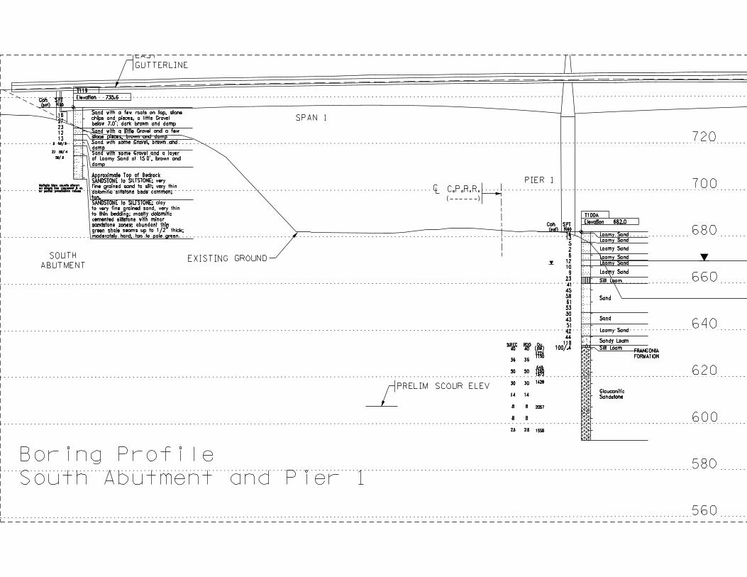
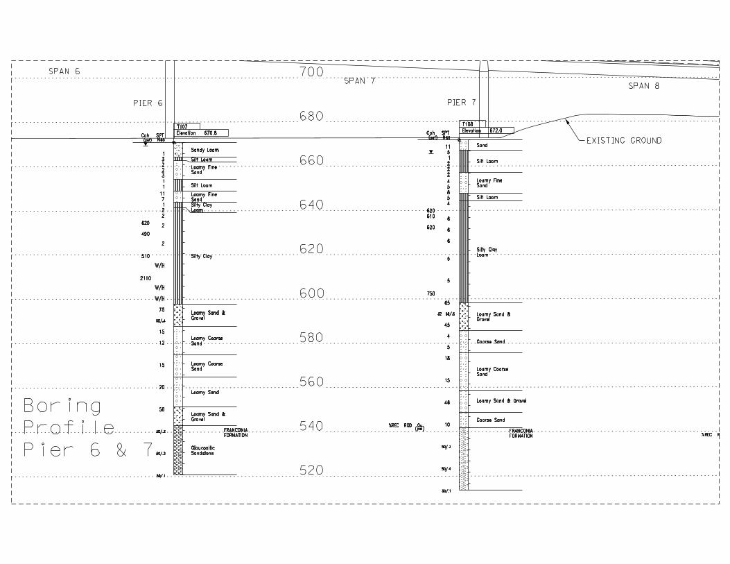
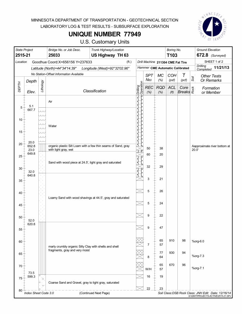
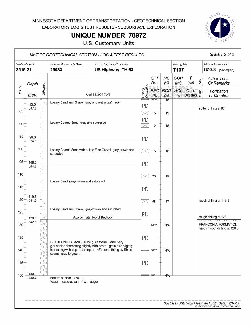
2.1 Subsurface Investigation Eleven foundation borings were taken at the site by MnDOT forces in the summer/fall of 2014. In addition, American Engineering Testing, Inc. (AET) was contracted to perform one boring for Pier 1 in November, 2014. The borings included Standard Penetration Tests, split spoon and thinwall sampling and triple barrel rock coring (NX size). Please refer to the attached boring plan for boring locations. 2.2 Subsurface Conditions The borings encountered typical alluvial materials including soft silty clays, highly organic to organic silt loams, silty clay loams and granular soils underlain by sedimentary bedrock. Please refer to the proceeding descriptions and the attached boring logs for a more complete description of the results of the subsurface investigation. 2.21 South Abutment Based on boring T119, the foundation soils at the south abutment were found to consist of an upper 16 feet of medium dense to very dense Sand with some Gravel overlying bedrock consisting of Sandstone and Siltstone of the St. Lawrence Formation. The top of bedrock was found near elevation 719.1. 2.22 Pier 1 Boring T100A was performed at Pier 1 by American Engineering Testing, Inc. in early November 2014. This boring encountered an upper 20 ft. layer of loose to medium dense gravelly sand with some concrete, bituminous and brick pieces (fill) followed by a 30 ft. layer of dense to very dense sand (Alluvium). Below these soils, sandstone bedrock was encountered to the terminus of the boring. 2.23 Pier 2 Borings T101, T102 and T103 were taken on the river through a barge deck in the fall of 2013. Boring T101, the boring closest to Pier 2, encountered approximately 18 feet of water followed by 8 feet of loose sand and then 45 feet of organic to highly organic, very soft Silty Clay Loam. This material was described as marly and contains shells and shell fragments and a few silt pockets. These soils were underlain by 12 feet of very dense Sand and Gravel resting on top of Sandstone bedrock. Boring T103 was taken in line with Pier 2 and 72 ft. south of the proposed bridge to get subsurface information near the existing pier (located downstream of proposed Pier 2). This boring produced results similar to T101 including 15 ft. of water followed by a three ft. layer of organic Silt Loam, a 29 ft. layer of loose sand, a 21 ft. layer of organic Silty Clay, a 14 ft. layer of very dense Sand and Gravel and finally layers of Sandstone bedrock. Boring T102 was taken halfway between Piers 2 and 3 and also encountered soils similar to T101. 2.24 North Approach Spans (Piers 3-7) and North Abutment Borings T104 – T109 were taken for Piers 3-7 and the north abutment in the floodplain area. These borings encountered an upper 20-25 ft. layer of very loose silty sands followed by 40-50 ft. of very soft to soft, organic to highly organic silty clay material. Below these soils, medium dense to very dese sand and sand and gravel was found down to the top of Sandstone bedrock which was first encountered approximately 120-130 ft. below the surface.

SP 2515-21 Bridge 25033 TH63/Mississippi River and CP Rail Subsurface Investigation
December 17, 2014
Page 4 of 5 An Equal Opportunity Employer
2.3 Groundwater Conditions Groundwater was encountered at varying elevations from south to north along the project. Please refer to the attached boring logs for more details. In general, the water table was found to be near the river level at the time of the investigation. 2.4 Lab Testing Standard lab tests including moisture tests, organic content, unconfined compression and grain size tests were performed on soil samples recovered from the borings. In addition, several one dimensional consolidation tests were performed on the silty clay material near the north abutment. The results show that these cohesive soils are normally consolidated and may strain as much as 5-10% under the proposed embankment loads. Table 1: Consolidation Test Results (average values from T110)
Moisture Content 56% Over Consolidation Ratio 0.8 Initial Void Ratio, e0 1.5 Cc 0.63 Cr 0.06 Cv (ft2/day) 0.13
Rock core samples from Boring T100A (Pier 1) were tested for strength and found to have an unconfined compressive strengths (qu) ranging from 549-2,057 psi and elastic moduli (E) between 33-500 ksi. Table 2: Consolidation Test Results (from rock core recovered from T110)
Average values for unconfined compressive strength and elastic modulus were computed to be 1,350 psi and 290,000 psi respectively. These values are similar to those reported for the St. Croix River Crossing
T100A 51.3 630.7 1.8 1,224 180,000T100A 52.5 629.5 3 1,150 150,000T100A 57.5 624.5 8 1,356 170,000T100A 58.5 623.5 9 549 33,000T100A 59.6 622.4 10.1 1,265 133,000T100A 63.7 618.6 13.9 1,373 280,000T100A 70.3 611.7 20.8 1,708 312,000T100A 74.5 607.5 25 1,429 250,000T100A 84.6 597.4 35.1 2,057 500,000T102 141.5 531 101.5 1197 210,500T102 151.5 521 111.5 603 75,000
E (psi)
Boring Depth (ft.)
Elev (ft.)
Depth below top of bedrock
(ft.)
qu
(psi)
Figure 3: Unconfined Compression Test

SP 2515-21 Bridge 25033 TH63/Mississippi River and CP Rail Subsurface Investigation
December 17, 2014
Page 5 of 5 An Equal Opportunity Employer
project in the similar rock formations. Rock core was recovered from Boring T101 at Pier 2, however, the core pieces were too short to test. 3.0 Bridge 9040 Existing Foundation Information Bridge 9040 was constructed in 1960 as a two lane continuous steel truss to carry US Highway 63 traffic over the west channel of the Mississippi River. The bridge is 1,631 feet long and features a 420 ft. navigation channel span. The Wisconsin side of the bridge acts as a causeway spanning over a seasonal floodplain. Based on pile driving records, the existing bridge substructures were supported on timber piling with the exception of the South Abutment (spread footing on bedrock) and Pier 1 (Steel H Piles). The timber piles had butt diameters ranging from 13-15 in. and tip diameters of 7.5-10.5 in. Bridge inspection reports over the years have noted “settlements and shifting” of the substructures on the north side of the bridge (mainly Pier 8 and North Abutment). This movement was severe enough that, in 1972, a project was let to raise the bridge seat elevations by 1.7 ft. at the north abutment and 1.1 ft. at Pier 8. In following years settlement continued and, in 1984, an inspection report noted vertical deflections ranged from 0.26-0.47 ft. for Pier 2 – Pier 7 and as much as 2.03 ft. for Pier 8 and 3.30 ft. for the north abutment. This amount of settlement could be the result of either pile group settlement and/or pile downdrag. More recent inspection reports have noted that the settlement rates have slowed. 4.0 Addition Subsurface Investigations Additional subsurface investigation information is planned at the following locations to complete the subsurface investigation for final design:
• Pier 2 – Additional core samples suitable for unconfined compression testing are needed to advance the foundation design
• North Abutment near the west side of the proposed footing. Needed to confirm top of bedrock elevation.
Attachments: Boring Plan, Subsurface Profile, Boring Logs cc: J. Brunner C. Hanson K. Western B. Jilk D. Thomas T. Ward Robert Arndorfer (WISDOT)


Vane Shear Test Washed Sample (Collected during plug drilling)
Minnesota Department of Transportation Geotechnical Section
Boring Log Descriptive Terminology (English Units)
USER NOTES, ABBREVIATIONS AND DEFINITIONS - Additional information available in Geotechnical Manual. This boring was made by ordinary and conventional methods and with care deemed adequate for the Department's design purposes. Since this boring was not taken to gather information relating to the construction of the project, the data noted in the field and recorded may not necessarily be the same as that which a contractor would desire. While the Department believes that the information as to the conditions and materials reported is accurate, it does not warrant that the information is necessarily complete. This information has been edited or abridged and may not reveal all the information which might be useful or of interest to the contractor. Consequently, the Department will make available at its offices, the field logs relating to this boring. Since subsurface conditions outside each borehole are unknown, and soil, rock and water conditions cannot be relied upon to be consistent or uniform, no warrant is made that conditions adjacent to this boring will necessarily be the same as or similar to those shown on this log. Furthermore, the Department will not be responsible for any interpretations, assumptions, projections or interpolations made by contractors, or other users of this log. Water levels recorded on this log should be used with discretion since the use of drilling fluids in borings may seriously distort the true field conditions. Also, water levels in cohesive soils often take extended periods of time to reach equilibrium and thus reflect their true field level. Water levels can be expected to vary both seasonally and yearly. The absence of notations on this log regarding water does not necessarily mean that this boring was dry or that the contractor will not encounter subsurface water during the course of construction. WATER MEASUREMENT
Augered Plug Drilled Split Tube Sample (SPT N60 2 in. spilt tube with liners) Thin Wall Sample (3 in. Shelby Tube) Core Drilled (NV Core Barrel unless otherwise noted) Continuous Soil Sample Augered & Jetted Jetted Augered & Plug Drilled
WS
PD
CS
A/J Jet A/P
AB ........................ After Bailing AC ........................ After Completion AF......................... After Flushing w/C ....................... with Casing
Index Sheet No. 3.0 March 2003 G:\geotech\Public\Forms\INDEX30.doc
w/M ...................... with Mud WSD ..................... While Sampling/Drilling w/AUG.................. with Hollow Stem Auger MISCELLANEOUS NA ........................ Not Applicable w/ ......................... with w/o ....................... with out sat ........................ saturated DRILLING OPERATIONS AUG ................. Augered CD .................... Core Drilled DBD.................. Disturbed by Drilling DBJ .................. Disturbed by Jetting PD .................... Plug Drilled ST..................... Split Tube (SPT test) TW.................... Thinwall (Shelby Tube) WS.................... Wash Sample NSR.................. No Sample Retrieved
WH ................... Weight of Hammer WR ................... Weight of Rod Mud.................. Drilling Fluids in Sample CS .................... Continuous Sample SOIL/CORE TESTS SPT N60 ............ ASTM D1586 Modified Blows per foot with 140 lb. hammer and a standard energy of 210 ft-lbs. This energy represents 60% of the potential energy of the system and is the average energy provided by a Rope & Cathead system. MC.................... Moisture Content COH ................. Cohesion γ ....................... Sample Density LL..................... Liquid Limit PI...................... Plasticity Index Φ ...................... Phi Angle REC.................. Percent Core Recovered RQD ................. Rock Quality Description (Percent of total core interval consisting of unbroken pieces 4 inches or longer) ACL .................. Average Core Length (Average length of core that is greater than 4 inches long) Core Breaks .... Number of natural core breaks per 2-foot interval. DISCONTINUITY SPACING Fractures Distance Bedding Very Close........ <2 inches ............Very Thin Close ................ 2-12 inches .........Thin Mod. Close ....... 12-36 inches .......Medium Wide................. >36 inches ..........Thick DRILLING SYMBOLS
RELATIVE DENSITY Compactness - Granular Soils BPF
very loose....................................0-4 loose ...........................................5-10 medium dense ............................11-24 dense ..........................................25-50 very dense...................................>50
Consistency - Cohesive Soils BPF
very soft.......................................0-1 soft ..............................................2-4 firm ..............................................5-8 stiff ..............................................9-15 very stiff.......................................16-30 hard.............................................31-60 very hard .....................................> 60
COLOR blk .................. Black wht ...........White grn ................. Green brn............Brown orng ............... Orange yel.............Yellow dk ................... Dark lt ...............Light IOS ................. Iron Oxide Stained GRAIN SIZE /PLASTICITY VF............. Very Fine pl ............Plastic F ............... Fine slpl .........Slightly Cr ............. Coarse Plastic SOIL/ROCK TERMS C............... Clay Lmst .......Limestone L ............... Loam Sst ..........Sandstone S............... Sand Dolo........Dolostone Si.............. Silt wx...........weathered G .............. Gravel (No. 10 Sieve to 3 inches) Bldr .......... Boulder (over 3 inches) T ............... till (unsorted, nonstratified glacial deposits) Mn/DOT Triangular Textural Soil Classification System
100%
100%
C
90807060 50 40 302010
90
80
70
60
50
40
30
20
10
(plastic)
(slightly plastic)
SC
SCL CL
L SL SiL
Si
SiCL
LSS Si
90
80
70
60
50
40
30
20
10
100 %
% Sand % Clay
% Silt

6.5675.5
9.0673.0
11.5670.5
14.0668.0
16.0666.0
22.0660.0
28.0654.0
12
9
3
12
10
29
28
38
19
63
15
11
12
18
8
12
10
Loamy Sand and Gravel with a few stone pieces, dark brownsand damp
Loamy Sand with Fine Gravel, brown and damp
Loamy Sand and Gravel, gray-brown and very moist
Loamy Sand and Gravel, light gray-brown and moist
malodorous Gravel and stone pieces with some Loamy Sand,dark brown and wet
samples provided to Consultant
Loamy Coarse Sand and Gravel, brown to light brown, wet
Bottom of Hole - 28.0'Water measured at 13.9' with auger
N/A
N/A
N/A
State Project Bridge No. or Job Desc.
T100Trunk Highway/Location
25033Ground Elevation
(Surveyed)US Highway TH 63Boring No.
2515-21 682.0(ft.) Drill Machine
HammerLongitude (West)=92°32'00.11"Drilling
SHEET 1 of 1
Latitude (North)=44°34'10.19"
Goodhue Coord:X=656365 Y=237210Location 205120 CME(LC55) Track
No Station-Offset Information Available
CME Automatic Calibrated 8/19/14Completed
or Member
UNIQUE NUMBER 78968
Depth
COH
Soil Class:DSB Rock Class: Edit: Date: 12/16/14
Breaks
Or Remarks
Elev.
SPT
REC ACL
Dril
ling
Ope
ratio
n
Lith
olog
y
RQD Core
Index Sheet Code 3.0G:\GINT\PROJECTS-ACTIVE\2515-21.GPJ
Roc
k
DE
PT
H
(psf)
(%)
U.S. Customary Units
5
10
15
20
25
(%) (ft)
(pcf)N60
Formation
Soi
lMC(%)
Classification
Other Tests
MINNESOTA DEPARTMENT OF TRANSPORTATION - GEOTECHNICAL SECTION
LABORATORY LOG & TEST RESULTS - SUBSURFACE EXPLORATION

69
9
13
14
14
39
9
9
7
7
7
10
9
13
14
0.5681.5
4.5677.5
9.5672.5
12.0670.0
14.5667.5
19.5662.5
22.0660.0
34.5647.5
39.5642.5
44.5
14
13
5
2
6
12
10
9
23
41
45
58
61
53
30
43
51
42
GRAVELLY LOAMY SAND, brown, damp, A-1-b, fill
GRAVELLY LOAMY SAND, pieces of concrete and bituminous,dark brown, damp, A-1-b, fill
GRAVELLY LOAMY SAND, a little ashes/cinders and pieces ofbrick, dark brown, damp, A-1-b, fill
GRAVELLY LOAMY SAND, a little silt loam, dark grayishbrown, damp, A-1-b, fill
BRICK PIECES, a little loamy sand, brown, damp, A-1-b, fill
GRAVEL, a little loamy sand, dark brown, saturated, A-1-b, fill(oily sheen, but no noticeable odor)
SLIGHTLY ORGANIC SILT LOAM, trace shells and roots, darkbrown, wet, very stiff, A-6, alluvium
GRAVELLY SAND, grayish brown, saturated, dense to verydense, A-1-b, alluvium
SAND, light grayish brown, saturated, dense, A-1-b, alluvium
GRAVELLY LOAMY SAND, light brown, saturated, mediumdense, A-1-b, alluvium
State Project Bridge No. or Job Desc.
T100ATrunk Highway/Location
25033Ground Elevation
(Surveyed)US Highway TH 63Boring No.
2515-21 682.0(ft.) Drill Machine
HammerLongitude (West)=92°32'00.15"Drilling
SHEET 1 of 2
Latitude (North)=44°34'10.16"
Goodhue Coord:X=656362 Y=237207Location 41C
No Station-Offset Information Available
CME Automatic Calibrated 11/3/14Completed
or Member
UNIQUE NUMBER 79081
(Continued Next Page)
Depth
COH
Soil Class: Rock Class: Edit: Date: 12/16/14
Breaks
Or Remarks
Elev.
SPT
REC ACL
Dril
ling
Ope
ratio
n
Lith
olog
y
RQD Core
Index Sheet Code 3.0G:\GINT\PROJECTS-ACTIVE\2515-21.GPJ
Roc
k
DE
PT
H
(psf)
(%)
U.S. Customary Units
5
10
15
20
25
30
35
40
45
(%) (ft)
(pcf)N60
Formation
Soi
l
This boring was taken by AET under a consultantcontract for Mn/DOT
MC(%)
Classification
Other Tests
MINNESOTA DEPARTMENT OF TRANSPORTATION - GEOTECHNICAL SECTION
LABORATORY LOG & TEST RESULTS - SUBSURFACE EXPLORATION
Hammer Calibration: 68%efficiency with 101-lb.hammer, 9/27/13
Water lever measured at 14'deep with HSA to 14.5' deep(maintained same level for 17minutes)
2/.5 + 7/.5 + 16/.5 + 23/.5

19
20
21
637.5
48.5633.549.5632.5
89.2592.8
44
119
100/.4
94
93
98
80
85
77
100
100
40
36
50
30
14
8
8
23
SLIGHTLY PLASTIC SANDY LOAM, greenish brown and darkgreenish brown, a little black, wet, very dense, A-4 (continued)
SILT LOAM, greenish brown, a little black, moist, hard,laminations of sand and loamy sand, A-6 Top of BedrockSANDSTONE, glauconitic, very fine to fine grained sand,slightly weathered, moderately fractured to about 69' thenintensely to very fractured, a few high angle fractures fromabout 61.2' to 65.2', very thin to thinly bedded, a fewthin green and gray shale seams up to ½" thick, soft, darkgreenish gray to about 65.1' then greenish gray
Bottom of Hole - 89.2'
0.50
0.36
0.63
0.50
0.35
0.42
0.42
0.39
State Project Bridge No. or Job Desc.
T100ATrunk Highway/Location
25033Ground Elevation
(Surveyed)US Highway TH 63Boring No.
2515-21 682.0
Mn/DOT GEOTECHNICAL SECTION - LOG & TEST RESULTS SHEET 2 of 2
or Member
UNIQUE NUMBER 79081
Depth
COH
Soil Class: Rock Class: Edit: Date: 12/16/14
Breaks
Or Remarks
Elev.
SPT
REC ACL
Dril
ling
Ope
ratio
n
Lith
olog
y
RQD Core
G:\GINT\PROJECTS-ACTIVE\2515-21.GPJ
Roc
k
DE
PT
H
(psf)
(%)
U.S. Customary Units
50
55
60
65
70
75
80
85
(%) (ft)
(pcf)N60
Formation
Soi
l
This boring was taken by AET under a consultantcontract for Mn/DOT
MC(%)
Classification
Other Tests
MINNESOTA DEPARTMENT OF TRANSPORTATION - GEOTECHNICAL SECTION
LABORATORY LOG & TEST RESULTS - SUBSURFACE EXPLORATION
FRANCONIA FORMATION

5.3667.4
22.5650.2
29.5643.2
34.5638.2
1
9
4
1
1
2
1
W/H
W/H
W/H
W/H
W/H
W/R
26
23
42
56
67
66
65
75
81
77
51
64
Air
Water
Sand, gray and saturated
organic plastic Silt Loam, gray and wet
organic Silty Clay Loam with a few shell fragments, gray andwet
N/A
State Project Bridge No. or Job Desc.
T101Trunk Highway/Location
25033Ground Elevation
(Surveyed)US Highway TH 63Boring No.
2515-21 672.7(ft.) Drill Machine
HammerLongitude (West)=92°32'03.78"Drilling
SHEET 1 of 2
Latitude (North)=44°34'13.63"
Goodhue Coord:X=656097 Y=237556Location 211304 CME Fat Tire
No Station-Offset Information Available
CME Automatic Calibrated 10/31/13Completed
or Member
UNIQUE NUMBER 77947
(Continued Next Page)
Depth
COH
Soil Class:DSB Rock Class: JNH Edit: Date: 12/16/14
Breaks
Or Remarks
Elev.
SPT
REC ACL
Dril
ling
Ope
ratio
n
Lith
olog
y
RQD Core
Index Sheet Code 3.0G:\GINT\PROJECTS-ACTIVE\2515-21.GPJ
Roc
k
DE
PT
H
(psf)
(%)
U.S. Customary Units
5
10
15
20
25
30
35
40
45
50
55
60
(%) (ft)
(pcf)N60
Formation
Soi
lMC(%)
Classification
Other Tests
MINNESOTA DEPARTMENT OF TRANSPORTATION - GEOTECHNICAL SECTION
LABORATORY LOG & TEST RESULTS - SUBSURFACE EXPLORATION
high Fine Sand content29.5'-34.5'

71.0601.7
74.0598.775.0597.7
81.0591.7
85.0587.7
108.0564.7
W/R
25
92
70
77
17
16
85
95
80
100
96
95
8
11
16
0
3450/.5
50/.2
50/.2
organic Silty Clay Loam with a few shell fragments, gray andwet (continued)
thinly varved organic Silty Clay Loam and plastic Silt Loam withtraces of Fine Sand, grays and wet
Coarse Sand with a little Gravel, gray and saturated
Sand and Gravel with a few stone chips, gray and saturated
Gravel, gray and saturated Approximate Top of Bedrock
INTERBEDDED SANDSTONE & SILTSTONE; vf sand to clay;laminated to thin bedding; thin 1/2" and less very soft grn graymicaceous siltstone/shale seams common; minor glauconite;likely a transition zone btw Reno & Tomah member; mod hard;brn to dark grn-gry.
Bottom of Hole - 108.0'No water measured during drilling
0.40
0.56
0.40
N/A
870
870
N/A
N/A
>15
>15
>15
>15
>15
>15
>15
State Project Bridge No. or Job Desc.
T101Trunk Highway/Location
25033Ground Elevation
(Surveyed)US Highway TH 63Boring No.
2515-21 672.7
Mn/DOT GEOTECHNICAL SECTION - LOG & TEST RESULTS SHEET 2 of 2
or Member
UNIQUE NUMBER 77947
Depth
COH
Soil Class:DSB Rock Class: JNH Edit: Date: 12/16/14
Breaks
Or Remarks
Elev.
SPT
REC ACL
Dril
ling
Ope
ratio
n
Lith
olog
y
RQD Core
G:\GINT\PROJECTS-ACTIVE\2515-21.GPJ
Roc
k
DE
PT
H
(psf)
(%)
U.S. Customary Units
65
70
75
80
85
90
95
100
105
(%) (ft)
(pcf)N60
Formation
Soi
lMC(%)
Classification
Other Tests
MINNESOTA DEPARTMENT OF TRANSPORTATION - GEOTECHNICAL SECTION
LABORATORY LOG & TEST RESULTS - SUBSURFACE EXPLORATION
FRANCONIA FORMATIONTomah Member

4.2668.3
8.5664.0
32.0640.5
75.8596.776.0
W/H
W/H
7
15
7
W/H
6
4
5
5
5
W/H
9
16
31
40
26
31
27
48
5749
5357
6665
5555
5058
6679
6263
6022
101
102
97
100
102
98
98
102
Air
Water
Loamy Sand with a few seams and thin seams of plastic SiltLoam, grays and saturated
marly mixed organic Silty Clay and Silty Clay Loam, some layerscrumbly, with shells and shell fragments, a few pockets of Silt;grays with light gray; very moist to wet
organic plastic Silt Loam with thin seams of Silt, light gray andvery moistLoamy Sand with Silt mixed in, gray and wet
550
470
570
630
290
320
850
660
State Project Bridge No. or Job Desc.
T102Trunk Highway/Location
25033Ground Elevation
(Surveyed)US Highway TH 63Boring No.
2515-21 672.5(ft.) Drill Machine
HammerLongitude (West)=92°32'04.52"Drilling
SHEET 1 of 2
Latitude (North)=44°34'14.86"
Goodhue Coord:X=656043 Y=237680Location 211304 CME Fat Tire
No Station-Offset Information Available
CME Automatic Calibrated 11/13/13Completed
or Member
UNIQUE NUMBER 77948
(Continued Next Page)
Depth
COH
Soil Class:DSB Rock Class: JNH Edit: Date: 12/16/14
Breaks
Or Remarks
Elev.
SPT
REC ACL
Dril
ling
Ope
ratio
n
Lith
olog
y
RQD Core
Index Sheet Code 3.0G:\GINT\PROJECTS-ACTIVE\2515-21.GPJ
Roc
k
DE
PT
H
(psf)
(%)
U.S. Customary Units
5
10
15
20
25
30
35
40
45
50
55
60
65
70
75
80
(%) (ft)
(pcf)N60
Formation
Soi
lMC(%)
Classification
Other Tests
MINNESOTA DEPARTMENT OF TRANSPORTATION - GEOTECHNICAL SECTION
LABORATORY LOG & TEST RESULTS - SUBSURFACE EXPLORATION
%org-5.8; CCE-14.13
%org-4.4
%org-6.2
%org-5.7; CCE-20.62
%org-6.7

596.576.4596.176.6595.977.8594.7
96.3576.2
119.0553.5
146.0526.5
149.5523.0151.0521.5
22
12
62
16
30
13
12
19
17
21
18
18
86
86
98
94
91
98
88
0
0
0
0
0
41
15
3650/.3
50/.3
50/.5
50/.5
50/.3
50/.1
plastic Silt Loam, gray and very moistSand, gray and saturated
Sand and Gravel, gray and saturated (continued)
Approximate Top of Bedrock
INTERBEDDED SANDSTONE & SILTSTONE; very fine sandto clay; thin layers of greenish gray micaceous siltstone/shalebeds; pale gray-green.
GLAUCONITIC SANDSTONE; very fine grained sand to claysized particles; thin bedded; highly glauconitic, bioturbatedareas with clasts and thin seams of shale/siltstone, minordolomite cemented zones, glauconitecontent decreases some at approximately 136'; moderatelyhard; dark green to greenish gray.
SANDSTONE; fine to medium grained; thin bedded; blackbrachiopod fossils common; moderately hard; gray.GLAUCONITIC SANDSTONE; same as interval 119'-146'Bottom of Hole - 151.0'
N/A
N/A
N/A
N/A
N/A
0.51
0.73
>15
>15
>15
>15
>15
>15
15
>15
10
14
15
State Project Bridge No. or Job Desc.
T102Trunk Highway/Location
25033Ground Elevation
(Surveyed)US Highway TH 63Boring No.
2515-21 672.5
Mn/DOT GEOTECHNICAL SECTION - LOG & TEST RESULTS SHEET 2 of 2
or Member
UNIQUE NUMBER 77948
Depth
COH
Soil Class:DSB Rock Class: JNH Edit: Date: 12/16/14
Breaks
Or Remarks
Elev.
SPT
REC ACL
Dril
ling
Ope
ratio
n
Lith
olog
y
RQD Core
G:\GINT\PROJECTS-ACTIVE\2515-21.GPJ
Roc
k
DE
PT
H
(psf)
(%)
U.S. Customary Units
85
90
95
100
105
110
115
120
125
130
135
140
145
150
(%) (ft)
(pcf)N60
Formation
Soi
lMC(%)
Classification
Other Tests
MINNESOTA DEPARTMENT OF TRANSPORTATION - GEOTECHNICAL SECTION
LABORATORY LOG & TEST RESULTS - SUBSURFACE EXPLORATION
FRANCONIA FORMATIONTomah Member
Birkmose Member
Possible transition fromFranconia Formation toWonewoc Sandstone -Conformable contact -approximately 146'.
5.1667.7
20.0652.823.0649.8
32.0640.8
52.0620.8
73.5599.3
50
60
32
3
5
5
9
9
7
8
W/H
16
22
38
20
29
21
26
24
22
47
6557
7764
6557
19
23
98
94
96
Air
Water
organic plastic Silt Loam with a few thin seams of Sand, graywith light gray, wet
Sand with wood piece at 24.5', light gray and saturated
Loamy Sand with wood shavings at 44.5', gray and saturated
marly crumbly organic Silty Clay with shells and shellfragments, gray and very moist
Coarse Sand and Gravel, gray to light gray, saturated
910
930
670
State Project Bridge No. or Job Desc.
T103Trunk Highway/Location
25033Ground Elevation
(Surveyed)US Highway TH 63Boring No.
2515-21 672.8(ft.) Drill Machine
HammerLongitude (West)=92°32'02.96"Drilling
SHEET 1 of 2
Latitude (North)=44°34'14.39"
Goodhue Coord:X=656156 Y=237633Location 211304 CME Fat Tire
No Station-Offset Information Available
CME Automatic Calibrated 11/21/13Completed
or Member
UNIQUE NUMBER 77949
(Continued Next Page)
Depth
COH
Soil Class:DSB Rock Class: JNH Edit: Date: 12/16/14
Breaks
Or Remarks
Elev.
SPT
REC ACL
Dril
ling
Ope
ratio
n
Lith
olog
y
RQD Core
Index Sheet Code 3.0G:\GINT\PROJECTS-ACTIVE\2515-21.GPJ
Roc
k
DE
PT
H
(psf)
(%)
U.S. Customary Units
5
10
15
20
25
30
35
40
45
50
55
60
65
70
75
80
(%) (ft)
(pcf)N60
Formation
Soi
lMC(%)
Classification
Other Tests
MINNESOTA DEPARTMENT OF TRANSPORTATION - GEOTECHNICAL SECTION
LABORATORY LOG & TEST RESULTS - SUBSURFACE EXPLORATION
Aapproximate river bottom at20.0'
%org-6.0
%org-7.3
%org-7.1

87.5585.3
109.0563.8
114.0558.8117.0555.8119.0553.8
144.0528.8146.2526.6149.0523.8
10
24
22
26
24
25
90
100
95
98
87
62
96
88
0
23
18
7
0
0
37
7
1028
50/.5
50/.2
3050/.2
50/.4
50/.2
50/.2
Coarse Sand and Gravel, gray to light gray, saturated(continued)
Approximate Top of Bedrock
INTERBEDDED SANDSTONE & SILTSTONE; very fine sandto clay; thin layers of greenish gray micaceous siltstone/shalebeds; pale gray-green.
INTERBEDED SANDSTONE & SILTSTONE; very fine sand toclay; laminated to thin bedding; thin 3/8" and less very softgreenish gray micaceous siltstone/shale beds; minor dolomitecemented zones; moderately hard; brown to dark green-gray.GLAUCONITIC SANDSTONE; very fine grained sand to claysized particles; highly glauconitic and dolomitized; mod hard tohard; dark green and gray.INTERBEDDED SANDSTONE & SILTSTONE; same as 109' -114'.
GLAUCONITIC SANDSTONE; very fine grained sand to clay;highly glauconitic with notable decrease starting at 134',bioturbated areas w/clasts & seams up to 1" of siltstone/shale,minor dolomite cemented zones, ; moderately hard; dark greento greenish gry.
SANDSTONE; fine to medium grained sand; thin bedded; blackBrachiopod fossils common; moderately hard; gray.GLAUCONITIC SANDSTONE; same as 119' - 144' without thedolomitic zones.Bottom of Hole - 149.0'
N/A
0.59
0.46
0.35
N/A
N/A
0.79
0.36
>15
>15
>15
>15
15
15
>15
15
N/A
N/A
8
14
>15
8
State Project Bridge No. or Job Desc.
T103Trunk Highway/Location
25033Ground Elevation
(Surveyed)US Highway TH 63Boring No.
2515-21 672.8
Mn/DOT GEOTECHNICAL SECTION - LOG & TEST RESULTS SHEET 2 of 2
or Member
UNIQUE NUMBER 77949
Depth
COH
Soil Class:DSB Rock Class: JNH Edit: Date: 12/16/14
Breaks
Or Remarks
Elev.
SPT
REC ACL
Dril
ling
Ope
ratio
n
Lith
olog
y
RQD Core
G:\GINT\PROJECTS-ACTIVE\2515-21.GPJ
Roc
k
DE
PT
H
(psf)
(%)
U.S. Customary Units
85
90
95
100
105
110
115
120
125
130
135
140
145
(%) (ft)
(pcf)N60
Formation
Soi
lMC(%)
Classification
Other Tests
MINNESOTA DEPARTMENT OF TRANSPORTATION - GEOTECHNICAL SECTION
LABORATORY LOG & TEST RESULTS - SUBSURFACE EXPLORATION
FRANCONIA FORMATIONTomah Member
Birkmose Member
Tomah Member
Birkmose Member
Possible transition fromFranconia Formation toWonewoc Sandstone -Conformable contact -approximately 144'.

3.5670.25.5
668.2
10.5663.2
15.5658.2
25.5648.227.0646.730.5643.233.0640.7
43.0630.7
72.0601.7
2
1
7
8
13
8
10
16
5
6
2
W/H
3
4
6
4
W/H
3
24
80
6
33
32
29
29
38
22
26
26
27
41
35
42
4653
5150
4765
6164
51
65
71
67
16
17
107
101
102
97
101
94
Loamy Fine Sand with a little Gravel, browns and moist
plastic Silt Loam with wood and a few pockets of Fine Sand,gray with light gray, moistLoamy Fine Sand with thin seams of platic Silt Loam, light graywith gray, very moist
plastic Silt Loam with thin seams and traces of Loamy FineSand, gray with light gray, very moist
Loamy Sand with a few traces of organic matter, grays and wet
plastic Silt Loam, gray and very moist
Loamy Fine Sand, light grays and wet
plastic Silt Loam with traces of Loamy Fine Sand and organicmatter, gray with light gray, very moist
marly organic mixed Silty Clay Loam and plastic Silt Loam witha few shell fragments, gray and very moist
marly organic Silty Clay Loam with some plastic Silt Loam, shelland shell fragments; grays and very moist
Sand and Gravel with a seam of plastic Silt Loam at 79.0', grayand wet
580
520
600
690
830
1010
State Project Bridge No. or Job Desc.
T104Trunk Highway/Location
25033Ground Elevation
(Surveyed)US Highway TH 63Boring No.
2515-21 673.7(ft.) Drill Machine
HammerLongitude (West)=92°32'05.90"Drilling
SHEET 1 of 2
Latitude (North)=44°34'15.76"
Goodhue Coord:X=655942 Y=237770Location 211304 CME Fat Tire
No Station-Offset Information Available
CME Automatic Calibrated 9/11/14Completed
or Member
UNIQUE NUMBER 78969
(Continued Next Page)
Depth
COH
Soil Class:DSB Rock Class: BCL Edit: Date: 12/16/14
Breaks
Or Remarks
Elev.
SPT
REC ACL
Dril
ling
Ope
ratio
n
Lith
olog
y
RQD Core
Index Sheet Code 3.0G:\GINT\PROJECTS-ACTIVE\2515-21.GPJ
Roc
k
DE
PT
H
(psf)
(%)
U.S. Customary Units
5
10
15
20
25
30
35
40
45
50
55
60
65
70
75
80
(%) (ft)
(pcf)N60
Formation
Soi
lMC(%)
Classification
Other Tests
MINNESOTA DEPARTMENT OF TRANSPORTATION - GEOTECHNICAL SECTION
LABORATORY LOG & TEST RESULTS - SUBSURFACE EXPLORATION
smooth and soft drilling to35.0'
high Silt content
drilling smooth and a littleslow "sticky" to 72.0'%0rg-5.5; CCE-16.84
%0rg-7.0; CCE-14.94
%0rg-5.0; CCE-13.95
%0rg-6.4; CCE-30.68
drilling rough 72.0'-72.5' thensmooth 72.5'-73.5'
drilling a little rough to 83.5'

91.0582.7
115.0558.7
128.5545.2
148.6525.1
18
24
17
12
16
18
20
12
17
14
3450/.3
50/.3
50/.2
50/.1
50/.2
50/.1
Sand and Gravel with a seam of plastic Silt Loam at 79.0', grayand wet (continued)
Coarse Sand, gray-brown and saturated
Possible Top of Bedrock
GLAUCONITIC SANDSTONE; silt-sized to fine grained;glauconitic, dolomitic; light yellow brown
GLAUCONITIC SANDSTONE; silt-sized to coarse grained;grain size increasing w/depth; slightly glauconitic; dolomitic;green gray
Bottom of Hole - 148.6'Water measured at 2.8' with auger
N/A
N/A
State Project Bridge No. or Job Desc.
T104Trunk Highway/Location
25033Ground Elevation
(Surveyed)US Highway TH 63Boring No.
2515-21 673.7
Mn/DOT GEOTECHNICAL SECTION - LOG & TEST RESULTS SHEET 2 of 2
or Member
UNIQUE NUMBER 78969
Depth
COH
Soil Class:DSB Rock Class: BCL Edit: Date: 12/16/14
Breaks
Or Remarks
Elev.
SPT
REC ACL
Dril
ling
Ope
ratio
n
Lith
olog
y
RQD Core
G:\GINT\PROJECTS-ACTIVE\2515-21.GPJ
Roc
k
DE
PT
H
(psf)
(%)
U.S. Customary Units
85
90
95
100
105
110
115
120
125
130
135
140
145
(%) (ft)
(pcf)N60
Formation
Soi
lMC(%)
Classification
Other Tests
MINNESOTA DEPARTMENT OF TRANSPORTATION - GEOTECHNICAL SECTION
LABORATORY LOG & TEST RESULTS - SUBSURFACE EXPLORATION
drilling became rough83.5'-88.5'
still rough and hard with smalllayers of softer material
soft and smooth to 115.0'
FRANCONIA FORMATIONhard and just a little rough to118.5'
smooth and a little hard to138.5'
drilling smooth and hard

5.0671.4
10.0666.4
15.6660.816.0660.4
22.5653.925.0651.4
33.2643.2
71.5604.9
34
4
W/H
4
4
4
9
10
3
11
10
1
3
W/H
6
7
3
W/H
52
10
34
36
30
27
44
25
30
41
27
25
32
36
49
5347
5061
71
68
55
64
66
12
16
100
102
94
99
1850/.3
Concrete rubble with some plastic Loam, light gray with brown,damp
slightly plastic to plastic Silt Loam, grays and moist
Loamy Fine Sand, light grays and wet
plastic Silt Loam, gray and very moist
Loamy Fine Sand with a few thin seams of plastic Silt Loam,light gray with gray, wet
plastic Silt Loam with traces of Loamy Fine Sand and someorganic matter, gray and wet
Loamy Sand, light grays and wet
mixed Silty Clay Loam and plastic Silt Loam with shells andshell fragments, gray and very moist
Loamy Coarse Sand and Gravel with a few stone pieces, grayand wet
510
460
670
190
State Project Bridge No. or Job Desc.
T105Trunk Highway/Location
25033Ground Elevation
(Surveyed)US Highway TH 63Boring No.
2515-21 676.4(ft.) Drill Machine
HammerLongitude (West)=92°32'07.01"Drilling
SHEET 1 of 2
Latitude (North)=44°34'16.73"
Goodhue Coord:X=655861 Y=237868Location 211304 CME Fat Tire
No Station-Offset Information Available
CME Automatic Calibrated 9/4/14Completed
or Member
UNIQUE NUMBER 78970
(Continued Next Page)
Depth
COH
Soil Class:DSB Rock Class: BCL Edit: Date: 12/16/14
Breaks
Or Remarks
Elev.
SPT
REC ACL
Dril
ling
Ope
ratio
n
Lith
olog
y
RQD Core
Index Sheet Code 3.0G:\GINT\PROJECTS-ACTIVE\2515-21.GPJ
Roc
k
DE
PT
H
(psf)
(%)
U.S. Customary Units
5
10
15
20
25
30
35
40
45
50
55
60
65
70
75
80
(%) (ft)
(pcf)N60
Formation
Soi
lMC(%)
Classification
Other Tests
MINNESOTA DEPARTMENT OF TRANSPORTATION - GEOTECHNICAL SECTION
LABORATORY LOG & TEST RESULTS - SUBSURFACE EXPLORATION
rough and hard 0.0'-3.0'
smooth and soft to 73.0'
high Silt content
rough and a little harder,bumpy to 96.0'

96.0580.4
116.0560.4
121.0555.4
128.2548.2
88
22
21
67
10
13
12
21
23
19
20
4950/.4
4950/.3
50/.2
Loamy Coarse Sand and Gravel with a few stone pieces, grayand wet (continued)
Coarse Sand, gray and saturated
Sand with a little Gravel and a thin seam of plastic Silt Loam,gray and very moist
GLAUCONITIC SANDSTONE; likely weathered; silt sized tofine grained sand; glauconitic; light green, gray
Bottom of Hole - 128.2'Water measured at 8.8' with auger
State Project Bridge No. or Job Desc.
T105Trunk Highway/Location
25033Ground Elevation
(Surveyed)US Highway TH 63Boring No.
2515-21 676.4
Mn/DOT GEOTECHNICAL SECTION - LOG & TEST RESULTS SHEET 2 of 2
or Member
UNIQUE NUMBER 78970
Depth
COH
Soil Class:DSB Rock Class: BCL Edit: Date: 12/16/14
Breaks
Or Remarks
Elev.
SPT
REC ACL
Dril
ling
Ope
ratio
n
Lith
olog
y
RQD Core
G:\GINT\PROJECTS-ACTIVE\2515-21.GPJ
Roc
k
DE
PT
H
(psf)
(%)
U.S. Customary Units
85
90
95
100
105
110
115
120
125
(%) (ft)
(pcf)N60
Formation
Soi
lMC(%)
Classification
Other Tests
MINNESOTA DEPARTMENT OF TRANSPORTATION - GEOTECHNICAL SECTION
LABORATORY LOG & TEST RESULTS - SUBSURFACE EXPLORATION
36 gal mud loss
smooth and fast 96.0'-98.0'
smooth and soft drilling to116.0'
harder drilling 116.0'-118.0'
drilling a little rough and hardto 121.0'
Driller notes possible bedrockdue to mud change at 121 ftFRANCONIA FORMATION

4.0667.27.0
664.2
12.0659.213.0658.218.0653.220.0651.2
28.5642.7
68.5602.7
5
4
7
72
9
10
4
4
2
4
6
6
5
5
46
75
79
17
3938
28276024
2537
253727
314944
51
5152
5253
5273
6363
60
74
72
15
12
117
103
104
102
103
99
100
94
slightly plastic Sandy Loam, brown and wet
mixed Silty Clay Loam and Silty Clay with a few seams of Sandat 5.9' and a little wood, gray and very moist
Loamy Fine Sand with some organic matter and a few thinseams of Silty Clay Loam, grays and wet
Silty Clay Loam, gray and wery moist
Loamy Fine Sand, light gray and wet
Silty Clay Loam with a few shell fragments, gray and wery moist
Loamy Fine Sand with some seams and thin seams of SiltyClay Loam, light gray with gray, wet
organic marly Silty Clay with shells and shell fragments, grayand very moist
Loamy Sand and Gravel, gray and wet
520
840
620
410
970
1040
1160
1260
N/A
State Project Bridge No. or Job Desc.
T106Trunk Highway/Location
25033Ground Elevation
(Surveyed)US Highway TH 63Boring No.
2515-21 671.2(ft.) Drill Machine
HammerLongitude (West)=92°32'07.95"Drilling
SHEET 1 of 2
Latitude (North)=44°34'17.55"
Goodhue Coord:X=655792 Y=237951Location 205120 CME(LC55) Track
No Station-Offset Information Available
CME Automatic Calibrated 10/8/14Completed
or Member
UNIQUE NUMBER 78971
(Continued Next Page)
Depth
COH
Soil Class:DSB Rock Class: JNH Edit: Date: 12/16/14
Breaks
Or Remarks
Elev.
SPT
REC ACL
Dril
ling
Ope
ratio
n
Lith
olog
y
RQD Core
Index Sheet Code 3.0G:\GINT\PROJECTS-ACTIVE\2515-21.GPJ
Roc
k
DE
PT
H
(psf)
(%)
U.S. Customary Units
5
10
15
20
25
30
35
40
45
50
55
60
65
70
75
80
(%) (ft)
(pcf)N60
Formation
Soi
lMC(%)
Classification
Other Tests
MINNESOTA DEPARTMENT OF TRANSPORTATION - GEOTECHNICAL SECTION
LABORATORY LOG & TEST RESULTS - SUBSURFACE EXPLORATION
soft drilling
a little heave
smooth drilling
%org-5.8; CCE-12.08
%org-5.6; CCE-16.78
%org-7.1
slow drilling
%org-7.5; CCE-29.21
drilling became rough at 69.5'
drilling still rough

121.5549.7
138.1533.1
36
24
15
23
28
13
14
20
21
21
20
16
16
4650/.4
50/.2
50/.1
Loamy Sand and Gravel, gray and wet (continued)
Approximate Top of Bedrock
GLAUCONITIC SANDSTONE; Silt to fine Sand; veryglauconitic decreasing slightly with depth; some thin greenShale seams; gray to green.
Bottom of Hole - 138.1'No water encountered or measured during drilling
State Project Bridge No. or Job Desc.
T106Trunk Highway/Location
25033Ground Elevation
(Surveyed)US Highway TH 63Boring No.
2515-21 671.2
Mn/DOT GEOTECHNICAL SECTION - LOG & TEST RESULTS SHEET 2 of 2
or Member
UNIQUE NUMBER 78971
Depth
COH
Soil Class:DSB Rock Class: JNH Edit: Date: 12/16/14
Breaks
Or Remarks
Elev.
SPT
REC ACL
Dril
ling
Ope
ratio
n
Lith
olog
y
RQD Core
G:\GINT\PROJECTS-ACTIVE\2515-21.GPJ
Roc
k
DE
PT
H
(psf)
(%)
U.S. Customary Units
85
90
95
100
105
110
115
120
125
130
135
(%) (ft)
(pcf)N60
Formation
Soi
lMC(%)
Classification
Other Tests
MINNESOTA DEPARTMENT OF TRANSPORTATION - GEOTECHNICAL SECTION
LABORATORY LOG & TEST RESULTS - SUBSURFACE EXPLORATION
rough then smooth
smooth
FRANCONIA FORMATIONPossible Birkmose MemberHard at 121'hard and smooth at 121.5'

6.5664.38.0
662.8
16.5654.3
22.0648.8
27.0643.829.5641.3
73.0597.8
1
3
2
2
3
1
1
11
7
1
2
2
2
2
W/H
W/H
W/H
75
17
42
43
25
38
30
42
38
23
28
45
53
50
4847
53
65
71
61
73
81
78
10
105
plastic Sandy Loam with a seam and pockets of plastic SiltLoam, dark brown with gray, moist to very moist
plastic Silt Loam with some organic matter, gray with black, wet
Loamy Fine Sand with a few thin seams and a 2"layer of plasticSilt Loam, light gray with gray, saturated
slightly plastic to plastic Silt Loam with thin seams of LoamyFine Sand, gray with light gray, wet
Loamy Fine Sand with a few thin seams of plastic Silt Loam,light gray with gray, wet
Silty Clay Loam with a few traces of Very Fine Sand, gray withlight gray, moist
mixed Silty Clay and Silty Clay Loam with some shells and shellfragments, grays and very moist
Loamy Sand and Gravel, gray and wet
620
490
510
2110
State Project Bridge No. or Job Desc.
T107Trunk Highway/Location
25033Ground Elevation
(Surveyed)US Highway TH 63Boring No.
2515-21 670.8(ft.) Drill Machine
HammerLongitude (West)=92°32'09.40"Drilling
SHEET 1 of 2
Latitude (North)=44°34'18.97"
Goodhue Coord:X=655686 Y=238094Location 207184 CME 850 Track
No Station-Offset Information Available
CME Automatic Calibrated 10/9/14Completed
or Member
UNIQUE NUMBER 78972
(Continued Next Page)
Depth
COH
Soil Class:DSB Rock Class: JNH Edit: Date: 12/16/14
Breaks
Or Remarks
Elev.
SPT
REC ACL
Dril
ling
Ope
ratio
n
Lith
olog
y
RQD Core
Index Sheet Code 3.0G:\GINT\PROJECTS-ACTIVE\2515-21.GPJ
Roc
k
DE
PT
H
(psf)
(%)
U.S. Customary Units
5
10
15
20
25
30
35
40
45
50
55
60
65
70
75
80
(%) (ft)
(pcf)N60
Formation
Soi
lMC(%)
Classification
Other Tests
MINNESOTA DEPARTMENT OF TRANSPORTATION - GEOTECHNICAL SECTION
LABORATORY LOG & TEST RESULTS - SUBSURFACE EXPLORATION
rough drilling/rock at 73'
83.0587.8
96.0574.8
106.0564.8
119.5551.3
128.0542.8
150.1520.7
15
12
15
20
58
15
19
15
18
19
17
50/.4
50/.2
50/.2
50/.1
Loamy Sand and Gravel, gray and wet (continued)
Loamy Coarse Sand, gray and saturated
Loamy Coarse Sand with a little Fine Gravel, gray-brown andsaturated
Loamy Sand, gray-brown and saturated
Loamy Sand and Gravel, gray-brown and saturated
Approximate Top of Bedrock
GLAUCONITIC SANDSTONE; Silt to fine Sand; veryglauconitic decreasing slightly with depth; grain size slightlyincreasing with depth starting at 145'; some thin gray Shaleseams; gray to green.
Bottom of Hole - 150.1'Water measured at 1.4' with auger
N/A
N/A
N/A
State Project Bridge No. or Job Desc.
T107Trunk Highway/Location
25033Ground Elevation
(Surveyed)US Highway TH 63Boring No.
2515-21 670.8
Mn/DOT GEOTECHNICAL SECTION - LOG & TEST RESULTS SHEET 2 of 2
or Member
UNIQUE NUMBER 78972
Depth
COH
Soil Class:DSB Rock Class: JNH Edit: Date: 12/16/14
Breaks
Or Remarks
Elev.
SPT
REC ACL
Dril
ling
Ope
ratio
n
Lith
olog
y
RQD Core
G:\GINT\PROJECTS-ACTIVE\2515-21.GPJ
Roc
k
DE
PT
H
(psf)
(%)
U.S. Customary Units
85
90
95
100
105
110
115
120
125
130
135
140
145
150
(%) (ft)
(pcf)N60
Formation
Soi
lMC(%)
Classification
Other Tests
MINNESOTA DEPARTMENT OF TRANSPORTATION - GEOTECHNICAL SECTION
LABORATORY LOG & TEST RESULTS - SUBSURFACE EXPLORATION
softer drilling at 83'
rough drilling at 119.5
rough drilling at 128'
FRANCONIA FORMATIONhard smooth drilling at 128.5'

4.5667.5
14.5657.5
24.0648.027.5644.5
73.5598.5
11
5
1
2
2
2
4
5
8
5
4
6
6
6
5
5
65
45
14
29
37
41
48
29
30
40
38
45
48
48
5051
4448
4961
64
72
70
4612
14
14
105
102
105
99
3250/.5
Sand, brown and moist
plastic Silt Loam with thin seams and traces of Loamy FineSand, a layer of Loamy Fine Sand at at 85.0', traces of organicmatter 123.5'-14.0', some roots on top; gray with light gray;moist to very moist
Loamy Fine Sand with traces and a seam of plastic Silt Loam,light gray with gray, wet
plastic Silt Loam with thin seams of Loamy Fine Sand andtraces of organic matter at 26.0', gray with light gray, very moist
mixed Silty Clay Loam and plastic Silt Loam with some shellsand shell fragments, gray and very moist
Loamy Coarse Sand and Gravel, gray-brown and wet
620
610
620
750
NSR
NSR
State Project Bridge No. or Job Desc.
T108Trunk Highway/Location
25033Ground Elevation
(Surveyed)US Highway TH 63Boring No.
2515-21 672.0(ft.) Drill Machine
HammerLongitude (West)=92°32'10.90"Drilling
SHEET 1 of 2
Latitude (North)=44°34'20.06"
Goodhue Coord:X=655577 Y=238204Location 205120 CME(LC55) Track
No Station-Offset Information Available
CME Automatic Calibrated 9/16/14Completed
or Member
UNIQUE NUMBER 78973
(Continued Next Page)
Depth
COH
Soil Class:DSB Rock Class: BCL Edit: Date: 12/16/14
Breaks
Or Remarks
Elev.
SPT
REC ACL
Dril
ling
Ope
ratio
n
Lith
olog
y
RQD Core
Index Sheet Code 3.0G:\GINT\PROJECTS-ACTIVE\2515-21.GPJ
Roc
k
DE
PT
H
(psf)
(%)
U.S. Customary Units
5
10
15
20
25
30
35
40
45
50
55
60
65
70
75
80
85
(%) (ft)
(pcf)N60
Formation
Soi
lMC(%)
Classification
Other Tests
MINNESOTA DEPARTMENT OF TRANSPORTATION - GEOTECHNICAL SECTION
LABORATORY LOG & TEST RESULTS - SUBSURFACE EXPLORATION
mixed mud had heave

86.0586.0
96.0576.0
113.0559.0
123.0549.0
130.0542.0
158.1513.9
4
5
18
15
46
10
17
11
18
22
14
19
9
15
50/.2
50/.4
50/.1
Coarse Sand with a little Gravel, gray-brown and wet
Loamy Coarse Sand with a little Gravel, brown and saturated
Loamy sand and gravel brown, saturated
Coarse Sand with wood and a little gravel, gray and saturated
Possible top of bedrock
Possible SILTSTONE to SANDSTONE; samples from roller bit;clay sized to medium grained sands; light green to gray
Bottom of Hole - 158.1'Water measured at 6.1' with auger
N/A
NSR
State Project Bridge No. or Job Desc.
T108Trunk Highway/Location
25033Ground Elevation
(Surveyed)US Highway TH 63Boring No.
2515-21 672.0
Mn/DOT GEOTECHNICAL SECTION - LOG & TEST RESULTS SHEET 2 of 2
or Member
UNIQUE NUMBER 78973
Depth
COH
Soil Class:DSB Rock Class: BCL Edit: Date: 12/16/14
Breaks
Or Remarks
Elev.
SPT
REC ACL
Dril
ling
Ope
ratio
n
Lith
olog
y
RQD Core
G:\GINT\PROJECTS-ACTIVE\2515-21.GPJ
Roc
k
DE
PT
H
(psf)
(%)
U.S. Customary Units
90
95
100
105
110
115
120
125
130
135
140
145
150
155
(%) (ft)
(pcf)N60
Formation
Soi
lMC(%)
Classification
Other Tests
MINNESOTA DEPARTMENT OF TRANSPORTATION - GEOTECHNICAL SECTION
LABORATORY LOG & TEST RESULTS - SUBSURFACE EXPLORATION
rough drilling 101.0.-102.5'smooth drilling
rough drilling
smoother drilling
got harder and smootherFRANCONIA FORMATIONTop of bedrock from drillernotes-harder drilling at 130fthard and smooth
smooth and hard
rough on and offlayeredsmoother drilling to botttom ofhole

17.0665.0
23.5658.5
27.5654.530.0652.0
35.0647.0
42.5639.5
50
50
26
36
50
47
25
13
4
3
6
12
11
6
6
7
7
9
9
6
6
4
5
5
13
7
14
16
142116202024
18
30
32
42
42
44
50
51
47
46
58
60
66
67
75
104
96
90
Sand to Loamy Sand, brown, damp to very moist
Coarse Sand with seams of Loamy Fine Sand, grays and wet
Loamy Fine Sand, gray and wet
Loamy Sand with seams of Loamy Fine Sand, gray and wet
Loamy Fine Sand with a few seams of plastic Silt Loam, lightgray with gray, wet
plastic Silt Loam with traces of Very Fine Sand, gray with lightgray, very moist
Silty Clay Loam with shells and shell fragments below 63.0',gray and very moist
700
820
720
NSR
State Project Bridge No. or Job Desc.
T109Trunk Highway/Location
25033Ground Elevation
(Surveyed)US Highway TH 63Boring No.
2515-21 682.0(ft.) Drill Machine
HammerLongitude (West)=92°32'12.45"Drilling
SHEET 1 of 2
Latitude (North)=44°34'20.90"
Goodhue Coord:X=655464 Y=238288Location 205120 CME(LC55) Track
No Station-Offset Information Available
CME Automatic Calibrated 8/28/14Completed
or Member
UNIQUE NUMBER 78974
(Continued Next Page)
Depth
COH
Soil Class:DSB Rock Class: BCL Edit: Date: 12/16/14
Breaks
Or Remarks
Elev.
SPT
REC ACL
Dril
ling
Ope
ratio
n
Lith
olog
y
RQD Core
Index Sheet Code 3.0G:\GINT\PROJECTS-ACTIVE\2515-21.GPJ
Roc
k
DE
PT
H
(psf)
(%)
U.S. Customary Units
5
10
15
20
25
30
35
40
45
50
55
60
65
70
75
80
85
(%) (ft)
(pcf)N60
Formation
Soi
lMC(%)
Classification
Other Tests
MINNESOTA DEPARTMENT OF TRANSPORTATION - GEOTECHNICAL SECTION
LABORATORY LOG & TEST RESULTS - SUBSURFACE EXPLORATION
0.6 heave
high Silt content to 35.0'
%Si-80.5; %C-19.4
%Si-72.7; %C-25.8
%Si-80.3; %C-18.4

87.1594.9
97.5584.5
145.0537.0
158.1523.9
21
28
29
18
30
12
14
19
20
22
20
20
16
13
2050/.5
650/.5
50/.2
50/.1
Gravel with stone chips and pieces, some Sand; gray-brownand saturated
Coarse Sand, gray-browns and saturated
Possible top of Bedrock
Possible SANDSTONE; silt to coarse grained; very slightlyglauconitic; light gray w/some green
Bottom of Hole - 158.1'Water measured at 12.6' with auger
State Project Bridge No. or Job Desc.
T109Trunk Highway/Location
25033Ground Elevation
(Surveyed)US Highway TH 63Boring No.
2515-21 682.0
Mn/DOT GEOTECHNICAL SECTION - LOG & TEST RESULTS SHEET 2 of 2
or Member
UNIQUE NUMBER 78974
Depth
COH
Soil Class:DSB Rock Class: BCL Edit: Date: 12/16/14
Breaks
Or Remarks
Elev.
SPT
REC ACL
Dril
ling
Ope
ratio
n
Lith
olog
y
RQD Core
G:\GINT\PROJECTS-ACTIVE\2515-21.GPJ
Roc
k
DE
PT
H
(psf)
(%)
U.S. Customary Units
90
95
100
105
110
115
120
125
130
135
140
145
150
155
(%) (ft)
(pcf)N60
Formation
Soi
lMC(%)
Classification
Other Tests
MINNESOTA DEPARTMENT OF TRANSPORTATION - GEOTECHNICAL SECTION
LABORATORY LOG & TEST RESULTS - SUBSURFACE EXPLORATION
FRANCONIA FORMATIONDriller note's: Got harder at145 ft