meridian kessler - mk plan for zoning...
TRANSCRIPT
Meridian KesslerNeighborhood Plan
Adopted by the Metropolitan Development Commission as an element of the Comprehensive Plan for
Indianapolis and Marion County.
June X, 2016
2016-CPS-R-003
DRAFT 4/29/16


Meridian Kessler Neighborhood Plan | 1DRAFT 4/29/16
IntroductionThe Meridian Kessler Neighborhood Plan is an instrument that will provide guidelines for residential and commercial redevelopment, advocate for a sustainable and attractive neighborhood, and promote the area’s unique and historic character.
This plan is also an update of, and replacement to, the Meridian Kessler Subarea Plan adopted by the Metropolitan Development Commission as a Comprehensive Plan segment on January 17, 1979 (79-CPS-R-003).
A comprehensive plan is required by state statute (Indiana Code 36-7-4-501 through 512) as a basis for zoning and must include objectives and policies for future land use development and development of public ways, places, land, structures and utilities.
This plan is also a guide for anyone making a decision about the use of a property. It is useful for property owners, developers, neighbors and neighborhood organizations, City staff and City boards and commissions. This plan will be used to evaluate rezoning applications, to project future population and employment concentrations, and prioritize capital improvements.
The study area for this plan is within Kessler Boulevard, the Monon Rail-Trail, 38th Street, Meridian Street and the Indianapolis Water Company Canal on the city’s northside.
Prior to 1900 the area that became Meridian Kessler was primarily farm fields and orchards. But as Indianapolis expanded through the first half of the 20th century the farms were platted and the plats were built out. As noted in the “Encyclopedia of Indianapolis”:
The emerging neighborhood had become a prestigious address for community and business leaders as well as for those aspiring to influence. The neighborhood’s western edge boasted large homes, many of near mansion proportions, on sizable wooded lots. Homes became more modestly middle class toward the eastern edge where bungalows are predominant. Meridian Kessler also has a number of small apartment buildings located primarily along the major thoroughfares of 38th Street and College Avenue but also scattered along Washington Boulevard, Central Avenue, and Pennsylvania Street.
Commercial centers developed at 49th and Pennsylvania streets and along College Avenue at each major intersection to Kessler Boulevard, provide local residents with groceries, shops and service stations.
Meridian KesslerNeighborhood Plan
ContentsIntroduction...............................................................1
Planning Process......................................................................3
Related Planning Documents..................................................3
Recommendat ions . . . . . . . . . . . . . . . . . . . . . . . . . . . . . . . . . . . . . . . . . . 6
Neighborhood Character....................................................6
Transportation and Infrastructure......................................7
Land Use and Development..............................................8
Land Use Plan..........................................................................9
Land Use Typologies & Overlay Modifiers.....................9
Meridian Street.................................................................10
College Avenue.................................................................12
Monon Corridor.................................................................13
38th Street.........................................................................14
Residential Areas and Institutions...................................15
Appendices
A: Meridian Street Preservation Commission Indiana Code Excerpts..................................................................27
B: Traffic Calming Recommendations.................................28
C: Land Use Classification System.......................................32
Index of MapsMap 1: Planning Area................................................................2
Map 2:Related Plan Boundaries.............................................5
Map 3: Proposed Land Use......................................................9
Map 4: Meridian Street Preservation Commission Area.......11
Map 5: Overlays......................................................................15

2 | Meridian Kessler Neighborhood Plan DRAFT 4/29/16
CANA
L
ILLI
NO
IS S
T
ME
RID
IAN
ST
46TH ST
38TH ST
49TH ST
52ND ST
54TH ST
CE
NTR
AL
AVE
CO
LLE
GE
AVE
PAR
K A
VEC
AP
ITO
L AV
E
40TH ST
WAS
HIN
GTO
N B
LVD
PEN
NS
YLV
AN
IA S
TBOU
LEVA
RD
PL
PRIM
RO
SE
AV
E
BRO
AD
WAY
ST
RO
SS
LYN
AV
E
42ND ST
GU
ILFO
RD
AV
E
51ST ST
RA
LSTO
N A
VE
WIN
THR
OP
AVE
CA
RR
OLL
TON
AV
E53RD ST
KESSLER BLVD EDR
KEN
WO
OD
AV
E
IND
IAN
OLA
AV
E
36TH ST
56TH ST
57TH ST
RU
CK
LE S
T
48TH ST
39TH ST
WES
TFIE
LD B
LVD
60TH ST
55TH ST
CA
RV
EL
AVE
43RD ST
WAT
SO
N R
D
HAMPTON DR
DE
LAW
AR
E S
T
37TH ST
45TH ST
50TH ST
47TH ST
FAIRFIELD AVE
BERKLEY RD
SALE
M S
T
NORTHGATE ST
NE
W J
ER
SE
Y S
T
CO
MP
TON
ST
KESSLER BLVD WDR
FALL
CREEK P
KWY N
DR
IVY LN
GR
AC
ELA
ND
AV
E
GLA
DD
EN D
R
58TH ST
MA
RC
Y LN
41ST ST
CANAL BLV
D
SUNSET LN
44TH ST
59TH ST
GA
RV
ER R
D
RIV
ER
VIE
W D
R
SUTH
ERLA
ND A
VE
CO
RN
ELIUS AVE
HAWKS LN
FOR
EST
LN
ROWIN RD
CR
ES
TVIE
W A
VE
HAV
ER
FOR
D A
VE
STO
NE
HIL
L D
R
PENWAY ST
MADORA DR
BEVERLY DR
LAVEROCK RD
MERIDIAN PL
NICHOLAS RD
CRAWFORD DR
POWELL PL
WILD
WOOD AV
E
CASTLE ROW ST
BRO
AD
WAY
TE
RR
AC
E
RUSKIN PL
OAK
LEA
F D
R
LUZZ
ANE
DR
MERIDIAN DR
LEMANS CT
OAK RIDGE DR
NORTHVIEW AVE
50TH STC
RE
STV
IEW
AV
E
41ST ST
51ST ST
BRO
AD
WAY
ST
44TH ST
37TH ST
48TH ST
IND
IAN
OLA
AV
E
60TH ST
37TH ST
47TH ST
CA
RR
OLL
TON
AV
E
47TH ST
42ND ST
WIN
THR
OP
AVE
39TH ST
45TH ST
47TH ST
CA
RV
EL
AVE
45TH ST
58TH ST
BEVERLY DR
RA
LSTO
N A
VE
NE
W J
ER
SE
Y S
T
41ST ST
DE
LAW
AR
E S
T
42ND ST
KEN
WO
OD
AV
E
44TH ST
HAV
ER
FOR
D A
VE
CA
RR
OLL
TON
AV
E
GU
ILFO
RD
AV
E
PAR
K A
VE
60TH ST
GR
AC
ELA
ND
AV
E
56TH ST
WIN
THR
OP
AVE
43RD ST
44TH ST
53RD ST
57TH ST
37TH ST
DE
LAW
AR
E S
T 58TH ST
36TH ST
57TH ST
55TH ST
NE
W J
ER
SE
Y S
T
58TH ST
CO
RN
ELI
US
AV
E
38TH ST
MER
IDIA
N S
T
CEN
TRA
L AV
E
CO
LLEG
E AV
E
46TH ST
ILLI
NO
IS S
T
52ND STCA
PITO
L AV
E
Meridian Kessler Neighborhood PlanLegend
Major Streets
Street
Rivers
Lakes
Streams
Meridian Kesseler Boundary
0 520 1,040 1,560 2,080260Feet O
Map 1: Plan Boundary
Meridian Kessler Neighborhood Plan | 3DRAFT 4/29/16
Planning ProcessOver the course of three years, a committee of neighborhood volunteers, with assistance from the City’s Division of Planning, worked to develop a plan to update the old 1978 Meridian-Kessler Plan to guide future land use development for decades to come. The plan focuses on important “character areas” within Meridian-Kessler.
The committee sought feedback from residents during ten-plus meetings with residents and businesses. The meetings were conducted by neighborhood volunteers with the assistance of City’s Division of Planning. The meetings were advertised by posters, leaflets, in the Meridian-Kessler Neighborhood Association (MKNA) Newsletters, and on the MKNA website. The content of those meetings were also posted on the MKNA website. The committee also compiled a new email list of interested residents to keep them informed of the progress of the plan, and regularly sought comments on the MKNA web site.
The meetings were keyed to the critical areas, which included:
• College Avenue from 38th Street to Kessler Boulevard,
• Winthrop Avenue from 54th Street to 46th Street & the Monon Trail,
• 38th Street from the State Fairgrounds to Meridian Street,
• 49th & Pennsylvania streets, • Central Avenue from 42nd Street to 46th Street, and • Meridian Street from 38th Street to 40th Street.
The committee released an illustrated final draft of the plan on April 15, 2015. It was made available at the May 14, 2015 MKNA All-Neighborhood meeting. The Plan and Land Use Map were displayed at the College Avenue Branch Library and on the Meridian Kessler Neighborhood Association’s website (www.mkna.org) for sixty days for comments. All feedback received during the comment period was evaluated and, if appropriate, incorporated into the plan.
Related Planning DocumentsThe Meridian Kessler Neighborhood Plan is one of approximately 135 planning documents that make up the Comprehensive Plan for Indianapolis and Marion County. Of particular relevance to the Meridian Kessler Neighborhood are the Red Line Transit-Oriented Development Strategic Plan, the 38th Street Corridor Study, the North Meridian Corridor - Section 6 Plan, and the Meridian Street Preservation Area Plan.
Red Line Transit-Oriented Development Strategic PlanThis plan, adopted in 2015 (2015-CPS-R-001), is a plan to promote development adjacent to bus rapid transit stations along the proposed Red Line. The Red Line, further explained below in the description for the Marion County Transit Plan, is planned to connect Westfield with Greenwood, and uses College Avenue and 38th Street in the Meridian-Kessler area. This plan assigns a land use typology to each proposed station area and provides a policy overlay on existing land use plans. Generally, the plan promotes mixed-use and moderate-density (attached single-family and multi-family) around most of the station areas in the neighborhood in alignment with the recommendations of this Meridian-Kessler plan.
38th Street Corridor Study
This plan was adopted in 1985 and then expanded and readopted in 1998 (98-CPS-R-008). The plan covers the immediate vicinity of 38th Street between Michigan Road/Dr. Martin Luther King Jr. Street and Fall Creek. The study area widens out to 40th Street between Kenwood Avenue and Pennsylvania Street. It widens again at College Avenue to nearly 40th Street. The plan includes recommendations for land use, zoning and design standards. Among the many recommendations are ones to widen the sidewalks along 38th Street and to maintain the architectural character of the area between Pennsylvania and Broadway streets.
In 1998 a three-day charrette was held to generate recommendations for improvements to the 38th Street Corridor. The charrette was a joint project of the Maple Road Development Association, the Indianapolis Chapter of the American Institute of Architects, the Ball State University College of Architecture and Planning and the City of Indianapolis. Among the implemented recommendations of the charrette was the installation of landscaped medians in 38th Street. The charrette also recommended the nomination of the historic apartment buildings between Pennsylvania and Broadway streets to the National Register of Historic Places as a historic district.

4 | Meridian Kessler Neighborhood Plan DRAFT 4/29/16
North Meridian Corridor – Section 6 PlanThis plans looks at Illinois, Meridian and Pennsylvania streets between 30th and 40th streets. The plan was adopted in 1986 (86-CPS-R-010). The plan includes recommendations for land use, zoning and design standards. A general recommendation for the study area was for its inclusion in the Regional Center Secondary District. Recommendations specifically for the area of overlap between this plan and the Section 6 Plan are:
• construction of an office building at southeast corner of 39th and Meridian streets,
• construction of an apartment building at the southwest corner of 39th and Pennsylvania streets,
• tree planting along the major streets, and • reorganizing and expanding the parking lots in the
area to improve safety and increase supply
Meridian Street Preservation Area PlanThe study area for this plan is the jurisdictional area of the Meridian Street Preservation Commission. The MSPC is nine-member board that has authority over land use changes and exterior modifications to structures within its district (see page 11). This plan makes recommendations for land use and zoning. It was adopted in September, 2004 (2004-CPS-R-003).
Other plans of particular importance to the Meridian-Kessler Neighborhood are IndyConnect/Marion County Transit Plan and the Midtown Economic Development Area plan and its related Tax Increment Financing (TIF) District.
Marion County Transit Plan
The Marion County Transit Plan (a component of an initiative commonly known as IndyConnect) is part of an ongoing transportation initiative that seeks to improve transit in Indianapolis and central Indiana. The foundation of the initiative is a recalibration of the current bus service to reduce wait times and move from a hub and spoke route system to one that is more like a grid. The centerpiece of the initiative is a group of four bus rapid transit lines. Two of these proposed lines would be transformative to Meridian-Kessler. The proposed Purple Line would run on 38th Street along the neighborhood’s southern edge and connect the neighborhood to points east, west and downtown. The proposed Red Line would run north/south from Westfield to Greenwood via Broad Ripple, Meridian-Kessler, Ivy Tech, IUPUI, downtown, and UIndy. Through Meridian-Kessler it would use College Avenue and 38th Street.
Economic Development Plan for North Midtown The purpose of the Economic Development Plan for North Midtown was to focus redevelopment efforts on the area of the College Avenue and Monon corridors from White River to Fall Creek. This area includes much of the eastern portion of Meridian-Kessler. The planning area also includes a leg down 38th Street west along Meridian-Kessler and into the Butler-Tarkington neighborhood. The stated intentions of the plan are to:
• Provide better neighborhood services• Provide tools for stimulating private investment• Protect and create jobs• Recycle obsolescent public property, and• Upgrade infrastructure
Among the tools being use to implement the plan is Tax Increment Financing (TIF).

Meridian Kessler Neighborhood Plan | 5DRAFT 4/29/16
Map 2: Related Plan Boundaries
0 0.25 0.50.125MilesO
ILLI
NO
IS S
T MER
IDIA
N S
T
46TH ST
38TH ST
49TH ST
54TH ST
CEN
TRA
L AV
E
CO
LLEG
E AV
E
PAR
K A
VE
40TH ST
CA
PITO
L AV
E
52ND ST
WA
SHIN
GTO
N B
LVD
PEN
NSY
LVA
NIA
ST
BR
OA
DW
AY S
T
RO
SSLY
N A
VE
BO
ULE
VAR
D P
L
42ND ST
51ST ST
GU
ILFO
RD
AVE
WIN
THR
OP
AVE
53RD STC
AR
RO
LLTO
N A
VE
KEN
WO
OD
AVE
IND
IAN
OLA
AVE
48TH ST
RU
CK
LE S
T
WES
TFIE
LD B
LVD
47TH ST
39TH ST
55TH ST
56TH ST
57TH ST
CA
RVE
L AV
E
HAMPTON DR
60TH ST
43RD ST
37TH ST
45TH ST
50TH ST
DEL
AWA
RE
ST
42ND
NEW
JER
SEY
ST
ALL
EN'S
LN
IVY LN
BERKLEY RD
CO
MPT
ON
ST
GR
AC
ELA
ND
AVE
GLA
DDEN
DR
BLUE RIDGE RD
58TH ST
FORE
ST L
N
MA
RC
Y LN
41ST ST
44TH ST
BUCKINGHAM DR
59TH ST
NORTHGATE STG
AR
VER
RD
WAT
SON
RD
ROWIN RD
HAWKS LN
RIV
ERVI
EW D
R
SALE
M S
T
KESSLER BLVD WDR
FAIRFIELD AVE
CR
ESTV
IEW
AVE
HAV
ERFO
RD
AVE
STO
NE
HIL
L D
R
CO
LISE
UM
AVE
BIR
CH
WO
OD
AVE
BEVERLY DR
MADORA DR
MERIDIAN PL
LAVE
ROCK
RD
NICHOLAS RD
CRAWFORD DR
WIL
DWOOD A
VE
SUN
SET LN
56TH PLCASTLE ROW ST
WOODLAND AVE
BR
OA
DW
AY T
ERR
AC
E
RUSKIN PL
ALA
BA
MA
ST
OA
K L
EAF
DR
MERIDIAN DR
CHATFIELD DR
LEMANS CT
SANDY ANN LN
CARROLLTON CT
LEMANS DR
NORTHVIEW AVE
58TH ST
42ND ST
LEMANS CT
CA
RR
OLL
TON
AVE
NEW
JER
SEY
ST
44TH ST
55TH ST
39TH ST
41ST ST
GR
AC
ELA
ND
AVE
43RD ST
CR
ESTV
IEW
AVE
48TH ST
DEL
AWA
RE
ST
KEN
WO
OD
AVE
DEL
AWA
RE
ST
WIN
THR
OP
AVE
42ND ST
NEW
JER
SEY
ST
CA
RVE
L AV
E
58TH ST
44TH ST
51ST ST
BEVERLY DR
CA
RR
OLL
TON
AVE
NORTHVIEW AVE
CA
RR
OLL
TON
AVE
HAMPTON DR
WIN
THR
OP
AVE
HAV
ERFO
RD
AVE
IND
IAN
OLA
AVE
KEN
WO
OD
AVE 39TH ST
47TH ST
HAV
ERFO
RD
AVE
57TH ST
GU
ILFO
RD
AVE
PAR
K A
VE
42ND ST
48TH ST
BR
OA
DW
AY S
T
37TH ST
57TH ST
CA
RR
OLL
TON
AVE
WESTF
IELD
BLV
D 55TH ST
45TH ST
60TH ST
IND
IAN
OLA
AVE
47TH ST
56TH ST
58TH ST
58TH ST
HAV
ERFO
RD
AVE
MER
IDIA
N S
T
38TH ST
CEN
TRA
L AV
E
CO
LLEG
E AV
E
ILLI
NO
IS S
T
46TH ST
52ND ST
CA
PITO
L AV
EKESSLER BLVD EDR
WESTFIELD BLV
D
Legend
Parcels
Major Streets
Street
Meridian Kessler Boundary
Meridian Street Preservation Area Plan
Red Line TOD Strategic Plan
38th Street Corridor Plan
North Meridian Corridor Section 6 Plan
6 | Meridian Kessler Neighborhood Plan DRAFT 4/29/16
Recommendations1. Neighborhood CharacterMeridian Kessler is known and valued for its solid and established character as expressed in its historic homes, mature trees, well-maintained yards, institutions and sidewalk-lined streets. It is a residential neighborhood with a series of commercial nodes that are easily accessible on foot. It is the goal of this plan to preserve and enhance the neighborhood’s essential character.
Recommendations and Actions
1.1 Maintain the character of the neighborhood – building setbacks, heights, styles, materials and size, lot sizes and shapes, and mix of uses.
1.2 Maintain the existing housing stock and discourage demolitions.
1.3 Prepare a tree preservation plan.1.4 Maintain the topographic variations throughout the
neighborhood.1.5 Create a unique high-quality environment and
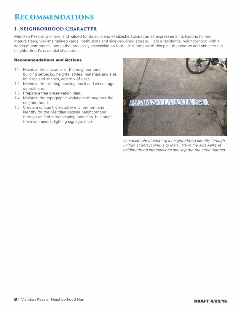
identity for the Meridian Kessler neighborhood through unified streetscaping (benches, bus stops, trash containers, lighting signage, etc.).
One example of creating a neighborhood identity through unified streetscaping is to install tile in the sidewalks at neighborhood intersections spelling out the street names.
Meridian Kessler Neighborhood Plan | 7DRAFT 4/29/16
2. Transportation and InfrastructureMeridian Kessler was originally laid out in a grid. This has created an easily-travelled area with many route options. The neighborhood is also well-connected to the rest of the city by way of arterial streets such as Kessler Boulevard, 38th Street, Meridian Street and College Avenue. A quality pedestrian system of connectivity is critical to a vibrant community. It is the goal of this plan to preserve ease of safe movement within the neighborhood by way of multiple modes of transportation: driving, walking, biking and transit.
Recommendations and Actions
2.1 Promote and support mass transit, accompanied with development density, as an integral part of future plans.
• Promote the vicinity of the intersection of College Avenue and Kessler Boulevard as a mass transit stop.
• Promote the 38th Street corridor as a transit line, with transit-oriented development at certain intersections.
2.2 Install traffic calming elements, as appropriate, throughout the neighborhood. The first priority for traffic calming should be along streets in the “Safe Routes to Schools” program. (See Appendix B) Following are some examples of traffic calming measures:
• Bump outs/curb extensions (narrows lane width at pedestrian crossings).
• Chokers (narrows the roadway to a single lane at points).
• Mini-circles (raised circular islands constructed in the center of residential or minor street intersections - generally not intended for use where one or both streets are arterial streets).
• Traffic circles (larger circular islands at the intersection of major roads).
• Paving pattern variety (colors and materials).• Road humps (similar to speed bumps, but less
aggressive).• Chicanes (serpentine lanes that require a decrease of
speed to navigate).• Islands (provides pedestrian refuges).• Median diverters (prevents left turns or through
movements into residential areas).• Decreased turning radii.• Speed cushions (a series of three small speed humps
that slow cars down but allow emergency vehicles to straddle them so as not to slow response time).
2.3 Provide for strong pedestrian connections throughout the neighborhood and to the Monon Trail.
2.4 Improve east/west connections for pedestrians/bicyclists along 38th Street by creating a collector sidewalk between the State Fairgrounds and the Indianapolis Museum of Art.
2.5 Improve the overall streetscape and street lighting.
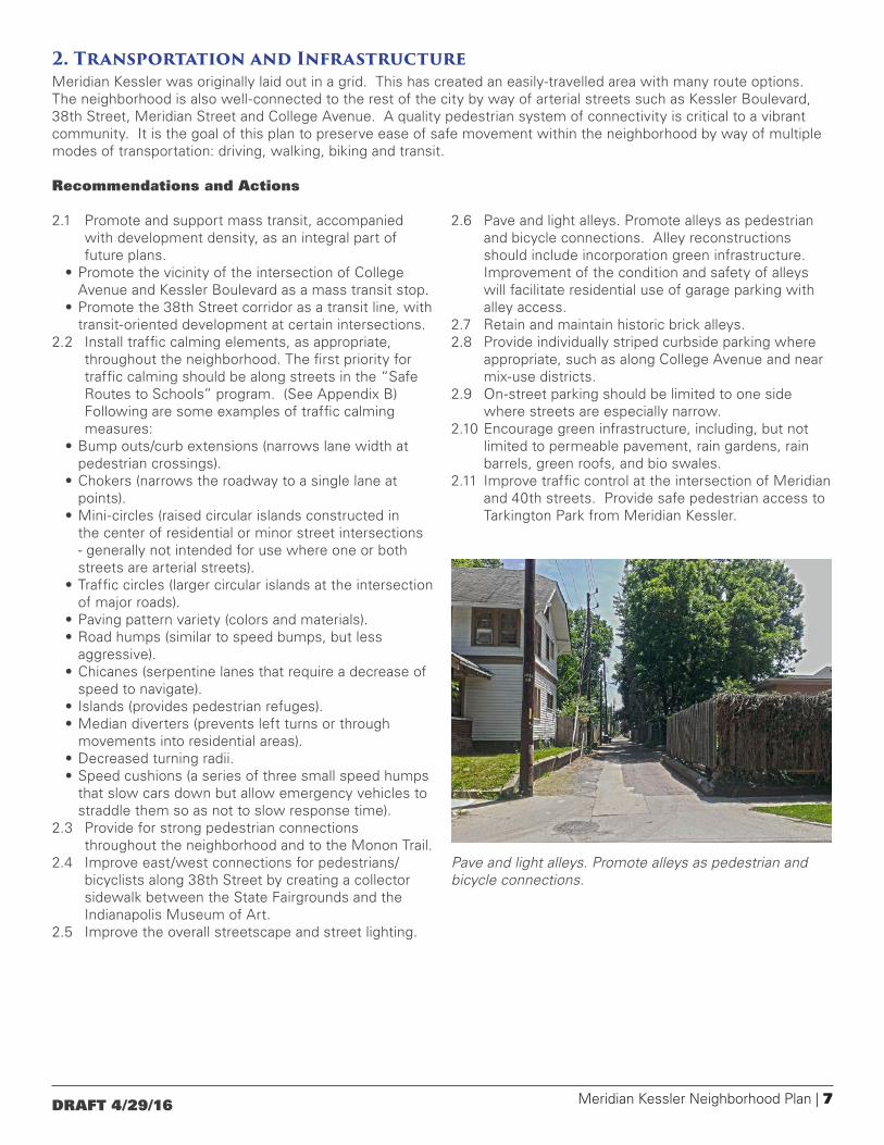
2.6 Pave and light alleys. Promote alleys as pedestrian and bicycle connections. Alley reconstructions should include incorporation green infrastructure. Improvement of the condition and safety of alleys will facilitate residential use of garage parking with alley access.
2.7 Retain and maintain historic brick alleys.2.8 Provide individually striped curbside parking where
appropriate, such as along College Avenue and near mix-use districts.
2.9 On-street parking should be limited to one side where streets are especially narrow.
2.10 Encourage green infrastructure, including, but not limited to permeable pavement, rain gardens, rain barrels, green roofs, and bio swales.
2.11 Improve traffic control at the intersection of Meridian and 40th streets. Provide safe pedestrian access to Tarkington Park from Meridian Kessler.
Pave and light alleys. Promote alleys as pedestrian and bicycle connections.
8 | Meridian Kessler Neighborhood Plan DRAFT 4/29/16
3. Land Use and DevelopmentLand use within Meridian Kessler has been generally stable for many decades. However some parts of the neighborhood are seeing interest in conversion from one land use to another. For example, the popularity of the neighborhood has caused interest in expansion of its commercial nodes. Another example is the conversion of the Monon from a rail line to a rail trail, which has turned an industrial amenity into a residential and commercial amenity. This change is influencing redevelopment along the eastern edge of the neighborhood.
It is the goal of this plan to find harmonious ways to fit new development into the existing fabric of the neighborhood.
Overall Recommendations and Actions:
3.1 Any new structures should be consistent with the setbacks, height, style, material, and mass of the surrounding neighborhood.
3.2 Chain link fencing should be discouraged.3.3 Signage near residences should not be internally
illuminated.3.4 Parking lots should be screened with landscaping.3.5 Appropriately-sized trash containers should be
provided on non-residential properties.3.6 Evening and weekend hours should be limited for
commercial uses adjacent to residences.3.7 Landscaping and green space should be installed
throughout the neighborhood, with particular attention paid to the commercial nodes along College Avenue.
3.8 Uses that would serve the youth of the neighborhood should be provided.
In addition to these overall recommendations, specific recommendations and guidelines are provided for specific portions of the neighborhood on subsequent pages.
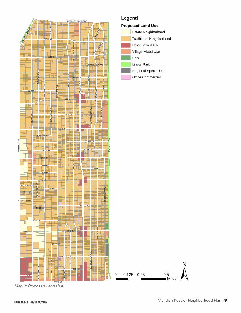
Land Use PlanBase Land Use TypologiesThe Land Use map recommends a land use for each parcel in the study area. This recommendation is modified if the parcel is within an overlay district (see below). The recommendation will also be modified if the site is located in a Critical Area (see page 18).
Land use categories used on the map broadly define development by type of use (for example: residential, commercial, or industrial) and intensity of use (for example, number of employees or amount of traffic generated). This assignment represents the most appropriate and desirable use for the parcel
The plan’s land use categories are:
Living Districts, which include a mix of residential types, public facilities, parks and limited, small-scale and low-intensity retail development
• Estate Neighborhood• Traditional Neighborhood
Mixed-Use Districts, which contain a substantial mix of retail, residential, public facilities, institutions, parks, and low-intensity industrial uses
• Urban Mixed-Use• Village Mixed-Use
Working Districts, which contain a mix of employment-generating uses, public facilities, and parks
• Office Commercial Uses
Other Land Uses, which are single-use areas that may be found between or within the districts above
• Park• Linear Park• Regional Special Use
Overlay modifiersOverlay modifiers are thematic or issue-oriented districts that change the recommendations of the underlying base typology. Overlays do not stand on their own, but work in conjunction with the base typology.
• Environmentally Sensitive Areas (ES)• Wellfield Protection (WP)• Residential Corridor Reserve (RR)• Critical Areas (CA)
These categories are described in more detail in Appendix C.
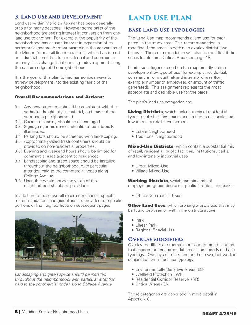
Landscaping and green space should be installed throughout the neighborhood, with particular attention paid to the commercial nodes along College Avenue.
Meridian Kessler Neighborhood Plan | 9DRAFT 4/29/16
CE
NTR
AL
AVE
CO
LLE
GE
AV
E
PAR
K A
VE
PE
NN
SY
LVA
NIA
ST
WA
SH
ING
TON
BLV
D
BR
OA
DW
AY S
T
54TH ST
38TH ST
46TH ST
49TH ST
52ND ST
40TH ST
56TH ST
57TH ST
58TH ST
51ST ST
GU
ILFO
RD
AV
E
WIN
THR
OP
AVE
53RD ST
CA
RR
OLL
TON
AV
E
48TH ST
RU
CK
LE S
T
43RD ST
47TH ST
55TH ST
45TH ST
50TH ST
WES
TFIE
LD B
LVD
NE
W J
ER
SE
Y S
T
DE
LAW
AR
E S
T
FOR
EST
LN
44TH ST
42ND ST
BEVERLY DR
HAMPTON DR
MERIDIAN PL
WILD
WOOD AV
E
41ST ST
BR
OA
DW
AY T
ER
RA
CE
39TH ST
NORTHVIEW AVE
44TH ST
39TH ST
GU
ILFO
RD
AV
E
DE
LAW
AR
E S
T
50TH ST
WIN
THR
OP
AVE
NE
W J
ER
SE
Y S
T
BR
OA
DW
AY S
T
DE
LAW
AR
E S
T
42ND ST
CA
RR
OLL
TON
AV
EC
AR
RO
LLTO
N A
VE
48TH ST
45TH ST
WIN
THR
OP
AVE
NE
W J
ER
SE
Y S
T
±0 0.25 0.50.125Miles
Meridian Kessler Neighborhood PlanLegendProposed Land Use
Estate Neighborhood
Traditional Neighborhood
Urban Mixed Use
Village Mixed Use
Park
Linear Park
Regional Special Use
Office Commercial
MO
NO
N T
RA
IL
ME
RID
IAN
ST
KESSLER BLVD E DR
Map 3: Proposed Land Use

10 | Meridian Kessler Neighborhood Plan DRAFT 4/29/16
Meridian StreetThis plan is intended to work with the land use recommendations of the Meridian Street Preservation Area Plan for the properties lining Meridian Street. The land use objective is the preservation of this architecturally and historically significant corridor.
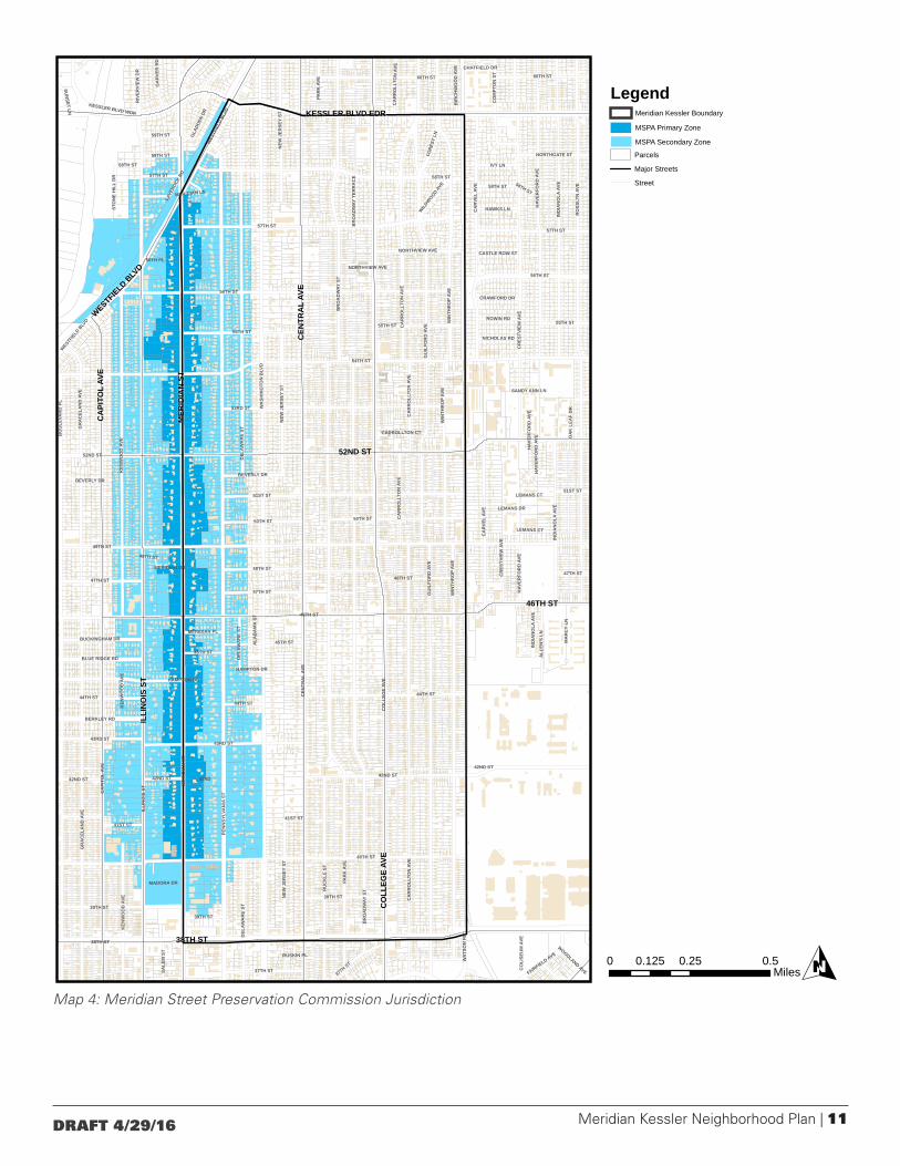
Meridian Street Preservation Commission
Land use along the western edge of the neighborhood is greatly influenced by the Meridian Street Preservation Commission (MSPC). In 1971 the Meridian Street Preservation Act (Indiana Statute PL 260-1971) created the MSPC. Within the boundaries of the Meridian Street preservation district the commission is charged with the task of preserving from deterioration and improperly conceived or implemented change the “historic, scenic, esthetically pleasing, and unique part of a street lying within Indianapolis constituting the backbone of a unique residential area.”
The MSPC consists of a nine-member board, seven of whom are appointed by the Governor of Indiana and two by the Mayor of Indianapolis. The Commission is chaired by a representative of the Indianapolis Department of Metropolitan Development. The Commission meets monthly.
The MSPC’s jurisdiction is split into a Primary Area and a Secondary Area. Property owners in the Primary Area must have proposed modifications of the exterior features of their house and property approved by the Commission prior to beginning any work. This includes construction, reconstruction, alterations or demolitions (See Appendix A). Property owners in both the Primary and Secondary Areas who seek a re-zoning or a zoning variance must receive the approval of the MSPC before their case may be heard by the Metropolitan Development Commission or Board of Zoning Appeals.
Meridian Kessler Neighborhood Plan | 11DRAFT 4/29/16
Map 4: Meridian Street Preservation Commission Jurisdiction
0 0.25 0.50.125MilesO
ILLI
NO
IS S
T MER
IDIA
N S
T
46TH ST
38TH ST
49TH ST
54TH ST
CEN
TRA
L AV
E
CO
LLEG
E AV
E
PAR
K A
VE
40TH ST
CA
PITO
L AV
E
52ND ST
WA
SHIN
GTO
N B
LVD
PEN
NSY
LVA
NIA
ST
BR
OA
DW
AY S
T
RO
SSLY
N A
VE
BO
ULE
VAR
D P
L
42ND ST
51ST ST
GU
ILFO
RD
AVE
WIN
THR
OP
AVE
53RD STC
AR
RO
LLTO
N A
VE
KEN
WO
OD
AVE
IND
IAN
OLA
AVE
48TH ST
RU
CK
LE S
T
WES
TFIE
LD B
LVD
47TH ST
39TH ST
55TH ST
56TH ST
57TH ST
CA
RVE
L AV
E
HAMPTON DR
60TH ST
43RD ST
37TH ST
45TH ST
50TH ST
DEL
AWA
RE
ST
42ND
NEW
JER
SEY
ST
ALL
EN'S
LN
IVY LN
BERKLEY RD
CO
MPT
ON
ST
GR
AC
ELA
ND
AVE
GLA
DDEN
DR
BLUE RIDGE RD
58TH ST
FORE
ST L
N
MA
RC
Y LN
41ST ST
44TH ST
BUCKINGHAM DR
59TH ST
NORTHGATE STG
AR
VER
RD
WAT
SON
RD
ROWIN RD
HAWKS LN
RIV
ERVI
EW D
R
SALE
M S
T
KESSLER BLVD WDR
FAIRFIELD AVE
CR
ESTV
IEW
AVE
HAV
ERFO
RD
AVE
STO
NE
HIL
L D
R
CO
LISE
UM
AVE
BIR
CH
WO
OD
AVE
BEVERLY DR
MADORA DR
MERIDIAN PL
LAVE
ROCK
RD
NICHOLAS RD
CRAWFORD DR
WIL
DWOOD A
VE
SUN
SET LN
56TH PLCASTLE ROW ST
WOODLAND AVE
BR
OA
DW
AY T
ERR
AC
E
RUSKIN PL
ALA
BA
MA
ST
OA
K L
EAF
DR
MERIDIAN DR
CHATFIELD DR
LEMANS CT
SANDY ANN LN
MERIDIAN LN
CARROLLTON CT
LEMANS DR
NORTHVIEW AVE
58TH ST
42ND ST
LEMANS CT
CA
RR
OLL
TON
AVE
NEW
JER
SEY
ST
44TH ST
55TH ST
39TH ST
41ST ST
GR
AC
ELA
ND
AVE
43RD ST
CR
ESTV
IEW
AVE
48TH ST
DEL
AWA
RE
ST
KEN
WO
OD
AVE
DEL
AWA
RE
ST
WIN
THR
OP
AVE
42ND ST
NEW
JER
SEY
ST
CA
RVE
L AV
E
58TH ST
44TH ST
51ST ST
BEVERLY DR
CA
RR
OLL
TON
AVE
NORTHVIEW AVE
CA
RR
OLL
TON
AVE
50TH ST
HAMPTON DR
WIN
THR
OP
AVE
HAV
ERFO
RD
AVE
IND
IAN
OLA
AVE
KEN
WO
OD
AVE 39TH ST
47TH ST
HAV
ERFO
RD
AVE
57TH ST
GU
ILFO
RD
AVE
PAR
K A
VE
42ND ST
48TH ST
BR
OA
DW
AY S
T
37TH ST
57TH ST
CA
RR
OLL
TON
AVE
WESTF
IELD
BLV
D 55TH ST
45TH ST
60TH ST
IND
IAN
OLA
AVE
47TH ST
56TH ST
58TH ST
58TH ST
HAV
ERFO
RD
AVE
MER
IDIA
N S
T
38TH ST
CEN
TRA
L AV
E
CO
LLEG
E AV
E
ILLI
NO
IS S
T
46TH ST
52ND ST
CA
PITO
L AV
EKESSLER BLVD EDR
WESTFIELD BLV
D
Legend
Parcels
Major Streets
Street
Meridian Kessler Boundary
MSPA Primary Zone
MSPA Secondary Zone
12 | Meridian Kessler Neighborhood Plan DRAFT 4/29/16
College AvenueCollege Avenue served as a major public transit route when used by the interurban from 1904 to 1938. Portions of tracks are visible today in some areas. College Avenue remains a heavily traveled street. College Avenue connects north central Marion County and points north to downtown Indianapolis. Currently IndyGo operates two of its 30 routes along College Avenue. College Avenue also has a role in city’s mass transit future. It will be the route of the Red Line, a bus rapid transit (BRT) route.
Properties along College Avenue are primarily residential, with commercial uses around the intersections of Kessler Boulevard East Drive, 54th Street, 52nd Street, 49th Street, 46th Street and 42nd Street. These commercial nodes were developed in response to the public transportation route and trolley stops along College Avenue that served the surrounding neighborhoods.
Traffic Volumes on College Avenue and its Cross-Streets
Land Use Recommendations
• Residential uses should be protected along this corridor by maintaining commercial uses at their present locations.
• Transit oriented development (TOD) should be encouraged at each of the commercial nodes along College Avenue.
• Foster a sense of community and uniqueness by attracting a diversity of locally-owned retail and service businesses to the area, although without an over-reliance on alcoholic beverage establishments.
• Create destinations within the corridor by consolidating or combining a diversified group of small local businesses (specialty stores) that would provide a unique “one-stop shopping” experience.
Design Guidelines
• Heights of new buildings should maintain a 2:1 ratio (two feet of right-of-way for one foot building height – i.e. 60’ right-of-way/30’-40’ tall building) to create a level of comfort and a sense of openness and interaction for pedestrians.
• Provide appropriate buffer between commercial and residential uses to minimize the impact of noise, lighting, and trash.
• Conduct a parking study as part of the Red Line BRT planning effort in order to determine how best to address parking issues along the College Avenue corridor.
• Improve alleys throughout the corridor, including lighting, to provide additional parking, pedestrian access, and service access to businesses.
• Crosswalks should be clearly identified throughout the corridor to improve safety of and encourage use by pedestrians.
• Install bicycle lanes and racks, where appropriate, to accommodate multi-modal means of travel.
• Electronic variable message signs should not be permitted along the corridor due to proximity of the surrounding residential use.
• Encourage the development of green space along the corridor that could be as simple as trees, landscaping, benches, or bicycle racks.
• Parking lots should be screened with adequate landscaping to minimize impact upon adjacent land owners.
Street Thoroughfare plan designation*
Average Annual Daily Traffic (year)
College Avenue Primary arterial 18,464 (2009)
Kessler Boulevard Primary arterial 21,121 (2009)
54th Street Collector street 8,513 (1997)
52nd Street Secondary arterial uncounted
49th Street Collector street uncounted
46th Street Secondary arterial 13,519 east (2009) 6,646 west (2009)
42nd Street Collector street uncounted
* Primary arterials have greater traffic-carrying capabilities and higher levels of service than other at-grade routes. They serve as connecting routes to the freeway system and to other primary arterials. They are oriented to moving through-traffic and often serve as transit and freight corridors. A secondary arterial serves a higher percentage of short trips than do primary arterials, carries a significant traffic volume, and provides system continuity. A collector street collects traffic from an area and moves it to an arterial street while also providing substantial service to abutting land uses.

Meridian Kessler Neighborhood Plan | 13DRAFT 4/29/16
Monon CorridorThe Monon Railroad corridor forms the eastern edge of Meridian Kessler. The Monon Railroad had two main lines. The Chicago to Indianapolis main line was built in 1847 and influenced development of the north central portion of Marion County. Industrial nodes developed on the west side of the Monon at 42nd and 49th streets, on the east side of the Monon at 46th Street, and on both sides of the rail line between 52nd and 54th streets.
The rail line was abandoned between Indianapolis and Delphi, Indiana in 1987. This was a time when abandoned railways nationwide were being converted to greenways for recreation and commuter use. By 2003 the Monon Rail-Trail was completed from 10th Street to 96th Street, approximately 10.4 miles. It connects with the 5.2-mile Monon Greenway in Carmel. The trail has direct connections to the Fall Creek Greenway and the Central Canal Towpath, which leads to the White River Wapahani Trail to form a trail network that reaches south to both sides of downtown and northwest to Fort Harrison State Park. The Monon Trail links commercial districts, schools, parks, the state fairgrounds and a dozen residential neighborhoods. In 2005, the Monon Trail was used more than 1.2 million times, making this urban greenway perhaps one of the busiest in the nation.
The conversion of the Monon from a rail line to a rail-trail has turned an industrial amenity into a residential and commercial amenity, thus influencing redevelopment along the eastern edge of the neighborhood. The four industrial nodes all have existing industrial buildings with industrial or heavy commercial uses in them. This broadens the neighborhood’s tax base and employment base. However, each of the industrial nodes is partially or completely surrounded by residential neighborhoods, which can lead to conflicts due to traffic, noise and smells.
Land Use Recommendations
• East/west pedestrian connections along the Monon Trail corridor should be installed to improve access to, and use of, the trail.
• Increase the amount of green space and pocket parks along the Monon Trail similar to Canterbury Park that would serve the residential areas.
Design Guidelines
• Increase access points to the Monon Trail for the convenience of the users.
• Landscaping guidelines established in the recent Full Circle Greenways Master Plan should be implemented along the Monon Trail corridor.
• Provide appropriate buffers between commercial and residential uses to minimize the impact of noise, lighting, and trash.
• Height of new buildings should be limited to three stories, with a visual presence toward the Monon Trail; as the height is increased, the upper stories should “step back” in order to avoid a tunnel effect along the corridor.
• A parking study should be undertaken to determine the most appropriate way to address the parking shortage.
• Install landscaping along the corridor in those areas where plantings are sparse.
• Improve the appearance of the fencing adjacent to the Monon Trail in the area of the State Fairgrounds (replace the cyclone/razor wire with more aesthetic materials), while maintaining security.
14 | Meridian Kessler Neighborhood Plan DRAFT 4/29/16
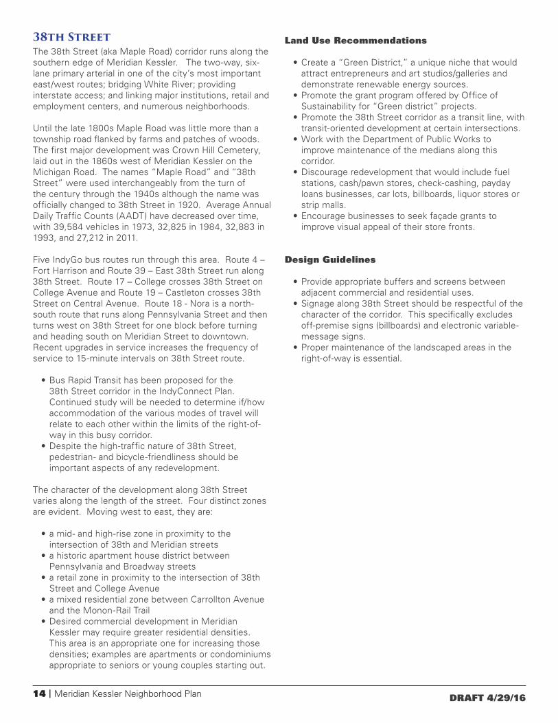
38th StreetThe 38th Street (aka Maple Road) corridor runs along the southern edge of Meridian Kessler. The two-way, six-lane primary arterial in one of the city’s most important east/west routes; bridging White River; providing interstate access; and linking major institutions, retail and employment centers, and numerous neighborhoods.
Until the late 1800s Maple Road was little more than a township road flanked by farms and patches of woods. The first major development was Crown Hill Cemetery, laid out in the 1860s west of Meridian Kessler on the Michigan Road. The names “Maple Road” and “38th Street” were used interchangeably from the turn of the century through the 1940s although the name was officially changed to 38th Street in 1920. Average Annual Daily Traffic Counts (AADT) have decreased over time, with 39,584 vehicles in 1973, 32,825 in 1984, 32,883 in 1993, and 27,212 in 2011.
Five IndyGo bus routes run through this area. Route 4 – Fort Harrison and Route 39 – East 38th Street run along 38th Street. Route 17 – College crosses 38th Street on College Avenue and Route 19 – Castleton crosses 38th Street on Central Avenue. Route 18 - Nora is a north-south route that runs along Pennsylvania Street and then turns west on 38th Street for one block before turning and heading south on Meridian Street to downtown. Recent upgrades in service increases the frequency of service to 15-minute intervals on 38th Street route.
• Bus Rapid Transit has been proposed for the 38th Street corridor in the IndyConnect Plan. Continued study will be needed to determine if/how accommodation of the various modes of travel will relate to each other within the limits of the right-of-way in this busy corridor.
• Despite the high-traffic nature of 38th Street, pedestrian- and bicycle-friendliness should be important aspects of any redevelopment.
The character of the development along 38th Street varies along the length of the street. Four distinct zones are evident. Moving west to east, they are:
• a mid- and high-rise zone in proximity to the intersection of 38th and Meridian streets
• a historic apartment house district between Pennsylvania and Broadway streets
• a retail zone in proximity to the intersection of 38th Street and College Avenue
• a mixed residential zone between Carrollton Avenue and the Monon-Rail Trail
• Desired commercial development in Meridian Kessler may require greater residential densities. This area is an appropriate one for increasing those densities; examples are apartments or condominiums appropriate to seniors or young couples starting out.
Land Use Recommendations
• Create a “Green District,” a unique niche that would attract entrepreneurs and art studios/galleries and demonstrate renewable energy sources.
• Promote the grant program offered by Office of Sustainability for “Green district” projects.
• Promote the 38th Street corridor as a transit line, with transit-oriented development at certain intersections.
• Work with the Department of Public Works to improve maintenance of the medians along this corridor.
• Discourage redevelopment that would include fuel stations, cash/pawn stores, check-cashing, payday loans businesses, car lots, billboards, liquor stores or strip malls.
• Encourage businesses to seek façade grants to improve visual appeal of their store fronts.
Design Guidelines
• Provide appropriate buffers and screens between adjacent commercial and residential uses.
• Signage along 38th Street should be respectful of the character of the corridor. This specifically excludes off-premise signs (billboards) and electronic variable-message signs.
• Proper maintenance of the landscaped areas in the right-of-way is essential.
Meridian Kessler Neighborhood Plan | 15DRAFT 4/29/16
Residential Areas and InstitutionsSingle-family housing is the predominant land use in Meridian Kessler. The density of the single-family housing varies widely throughout the neighborhood and frequently varies widely within a single block.
Multi-family housing is mostly found along 38th Street although apartments are dotted throughout the neighborhood. Churches, schools and other institutions are also found scattered throughout the neighborhood.
Given the historic mixing of densities in the neighborhood, the number of units per acre is less important to the ongoing stability of the neighborhood than maintaining the forms and character of the current development.
The general goal of this plan is to maintain the existing housing stock and discourage demolitions.
However, some change over time is to be expected. New technologies and demographic trends will affect how people will adapt their homes to their needs and wants. Some homes will fall prey to disasters, poor maintenance or functional obsolescence. In instances of redevelopment, new construction should conform to the existing development patterns of the neighborhood.
Parcels
New development should consider the characteristics of the parcels across the neighborhood, but be particularly attuned to the characteristics of the parcels in the immediate vicinity. Among the characteristics to consider are:
• The neighborhood is laid out as a grid and thus enjoys full connectiveness among its parts. Cul-de-sacs are nearly non-existent and dead end streets are anomalous except along the Monon.
• Lots are generally rectangular with a narrow end fronting the street.
• Through lots (lots that face paralleling streets to the front and back) are not characteristic.
• On blocks with a mix of lot sizes, the larger lots are typically on the north/south streets and the smaller lots on the east/west streets.
• Similarly-sized lots are typically found in groups, although there are some exceptions to this.
• Institutions are found at intersections and not mid-block.
Structures
New homes and institutions or additions to existing structures should consider the characteristics of structures across the neighborhood, but be particularly attuned to the characteristics of the homes or institutions in the immediate vicinity.
Setbacks and placement of a home upon its lot generally vary within a narrow range along any given block. New construction or additions should be within that range.
Structures should be compatible with other homes in height, size, building orientation, building shapes, amount and placement of fenestration, and materials.
Open porches provide for more interaction between porch-dwellers and passers-by.
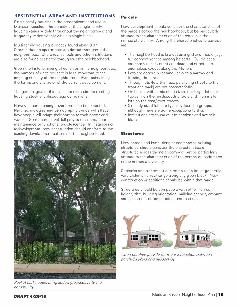
Pocket parks could bring added greenspace to the community.

16 | Meridian Kessler Neighborhood Plan DRAFT 4/29/16
Overlays Overlay modifiers are thematic or issue-oriented districts that change the recommendations of the underlying base typology. Overlays do not stand on their own, but work in conjunction with the base typology. The ways in which the overlays modify the base typology are detailed in Appendix C. Detailed information on Critical Area overlays follows.
Map 5: Overlays
0 0.25 0.50.125MilesO
108
103
112
113
114
115116
117
104
105
101
107
102
106
109
110111
ILLI
NO
IS S
T
MER
IDIA
N S
T
46TH ST
38TH ST
49TH ST
54TH ST
CEN
TRA
L AV
E
CO
LLEG
E AV
E
PAR
K A
VE
40TH ST
CA
PITO
L AV
E
52ND ST
WA
SHIN
GTO
N B
LVD
PEN
NSY
LVA
NIA
ST
BR
OA
DW
AY S
T
RO
SSLY
N A
VE
BO
ULE
VAR
D P
L
42ND ST
51ST ST
GU
ILFO
RD
AVE
WIN
THR
OP
AVE
53RD ST
CA
RR
OLL
TON
AVE
KEN
WO
OD
AVE
KESSLER BLVD EDR
RU
CK
LE S
T
IND
IAN
OLA
AVE
48TH ST
WES
TFIE
LD B
LVD
47TH ST
39TH ST
55TH ST
56TH ST
57TH ST
CA
RVE
L AV
E
HAMPTON DR
60TH ST
43RD ST
37TH ST
45TH ST
50TH ST
DEL
AWA
RE
ST
WAT
SON
RD
42ND
NEW
JER
SEY
ST
ALL
EN'S
LN
IVY LN
BERKLEY RD
CO
MPT
ON
ST
GR
AC
ELA
ND
AVE
GLA
DDEN
DR
BLUE RIDGE RD
58TH ST
FORE
ST L
N
MA
RC
Y LN
41ST ST
44TH ST
BUCKINGHAM DR
59TH ST
NORTHGATE ST
GA
RVE
R R
DSA
LEM
ST
FAIRFIELD AVE
ROWIN RD
HAWKS LN
KESSLER BLVD WDR
RIV
ERVI
EW D
R
CO
LISE
UM
AVE
CR
ESTV
IEW
AVE
HAV
ERFO
RD
AVE
STO
NE
HIL
L D
R
BIR
CH
WO
OD
AVE
BEVERLY DR
MADORA DR
MERIDIAN PL
LAVE
ROCK
RD
NICHOLAS RD
CRAWFORD DR
WIL
DWOOD A
VE
SUN
SET LN
56TH PLCASTLE ROW ST
WOODLAND AVE
BR
OA
DW
AY T
ERR
AC
E
RUSKIN PL
ALA
BA
MA
ST
OA
K L
EAF
DR
LEM
AN
S C
T
SANDY ANN LN
CARROLLTON CT
NORTHVIEW AVE
LEMANS CT
47TH ST
44TH ST
WIN
THR
OP
AVE
42ND ST
DEL
AWA
RE
ST
47TH ST
GR
AC
ELA
ND
AVE
57TH ST
NEW
JER
SEY
ST
42ND ST
IND
IAN
OLA
AVE
50TH ST
39TH ST
58TH ST
BR
OA
DW
AY S
T
DEL
AWA
RE
ST
CR
ESTV
IEW
AVE
NEW
JER
SEY
ST
BEVERLY DR
CA
RR
OLL
TON
AVE
CA
RR
OLL
TON
AVE
NORTHVIEW AVE
58TH ST
44TH ST
51ST ST
CA
RVE
L AV
E
HAV
ERFO
RD
AVE
39TH ST
KEN
WO
OD
AVE
46TH ST
HAV
ERFO
RD
AVE
56TH ST
GU
ILFO
RD
AVE
PAR
K A
VE
42ND ST
48TH ST
43RD ST
WIN
THR
OP
AVE
57TH ST
HAMPTON DR
CA
RR
OLL
TON
AVE
CA
RR
OLL
TON
AVE
48TH ST
55TH ST
37TH ST
60TH ST
41ST ST
KEN
WO
OD
AVE
IND
IAN
OLA
AVE
45TH ST
WESTF
IELD
BLV
D
55TH ST
58TH ST
58TH ST
HAV
ERFO
RD
AVE
MER
IDIA
N S
T
38TH ST
CEN
TRA
L AV
E
CO
LLEG
E AV
E
ILLI
NO
IS S
T
46TH ST
52ND ST
CA
PITO
L AV
EWESTFIELD B
LVD
Legend
Parcels
Major Streets
Overlay-Environmentally Sensitive Areas
Overlay-Wellfield Protection Areas
Overlay-Residential Corridor Reserve
Overlay-Critical Areas
Meridian Kessler Boundary
Street
Meridian Kessler Neighborhood Plan | 17DRAFT 4/29/16
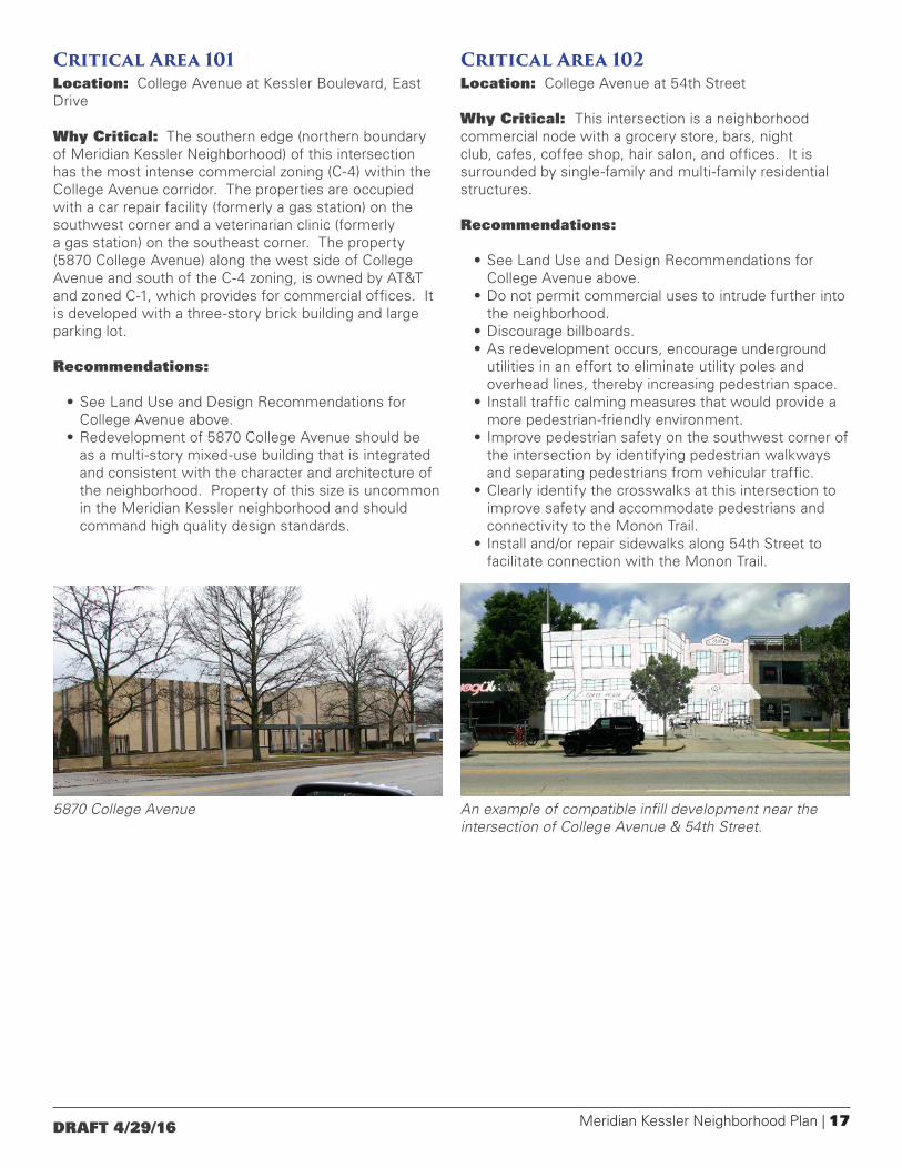
Critical Area 101Location: College Avenue at Kessler Boulevard, East Drive
Why Critical: The southern edge (northern boundary of Meridian Kessler Neighborhood) of this intersection has the most intense commercial zoning (C-4) within the College Avenue corridor. The properties are occupied with a car repair facility (formerly a gas station) on the southwest corner and a veterinarian clinic (formerly a gas station) on the southeast corner. The property (5870 College Avenue) along the west side of College Avenue and south of the C-4 zoning, is owned by AT&T and zoned C-1, which provides for commercial offices. It is developed with a three-story brick building and large parking lot.
Recommendations:
• See Land Use and Design Recommendations for College Avenue above.
• Redevelopment of 5870 College Avenue should be as a multi-story mixed-use building that is integrated and consistent with the character and architecture of the neighborhood. Property of this size is uncommon in the Meridian Kessler neighborhood and should command high quality design standards.
Critical Area 102Location: College Avenue at 54th Street
Why Critical: This intersection is a neighborhood commercial node with a grocery store, bars, night club, cafes, coffee shop, hair salon, and offices. It is surrounded by single-family and multi-family residential structures.
Recommendations:
• See Land Use and Design Recommendations for College Avenue above.
• Do not permit commercial uses to intrude further into the neighborhood.
• Discourage billboards.• As redevelopment occurs, encourage underground
utilities in an effort to eliminate utility poles and overhead lines, thereby increasing pedestrian space.
• Install traffic calming measures that would provide a more pedestrian-friendly environment.
• Improve pedestrian safety on the southwest corner of the intersection by identifying pedestrian walkways and separating pedestrians from vehicular traffic.
• Clearly identify the crosswalks at this intersection to improve safety and accommodate pedestrians and connectivity to the Monon Trail.
• Install and/or repair sidewalks along 54th Street to facilitate connection with the Monon Trail.
5870 College Avenue An example of compatible infill development near the intersection of College Avenue & 54th Street.
18 | Meridian Kessler Neighborhood Plan DRAFT 4/29/16
Critical Area 103Location: Monon Trail between 52nd and 54th Streets
Why Critical: The north side of 54th Street is zoned D-5 on the west side of the Monon Trail and C-3 on the east side of the Monon Trail where a small market is operating. Properties along the south side of 54th Street west of the Monon Trail are zoned C-4 and are home to a pair of restaurants.
The land north of 52nd Street between the Monon Trail and Winthrop Avenue is zoned I-4-U and CS. On the west side of Winthrop Avenue facing the street is a row of houses zoned C1, an office commercial zoning district. These houses are mostly used as homes, although a few are used as offices.
The south side of 52nd Street on either side of the Monon Trail is zoned D-5, but is developed with industrial and commercial uses.
Recommendations:
• See Land Use and Design Recommendations for Monon corridor above.
• Mixed use along the Monon Trail would be appropriate and might include incubator space for start-up businesses, professional offices, art center, and residential uses.
• A boutique hotel in this area could provide accommodations for those visiting Butler University.
• Form-based zoning overlay should be utilized to minimize the impact of the industrial zoned properties upon the surrounding residential community.
• Redevelopment should support a balance of neighborhood needs and services and family-oriented commercial uses.
• Capitalize upon the Monon Trail to develop adjoining green space, pocket parks, and community gardens.
• East/west pedestrian connections to the Monon Trail from both the east and west should be installed to improve community access.
• Provide an access point to the Monon Trail at 53rd St.• Conduct a traffic study that would incorporate
Complete Streets principles and identify appropriate locations for travel lanes, bikes lanes, parking spaces and permit parking for residences.
• Improve the pedestrian experience along Winthrop Avenue and provide a buffer between commercial and industrial uses to the east and the residences to the west of the street.
• Upgrade infrastructure along Winthrop Avenue, including possible storm and sanitary sewer upgrades, burying utility lines, new sidewalks and curbs, street repaving, low level pedestrian lighting, striped curb-side parking (rather than nose-in parking), and fiber optic cable upgrade.
• Renovate alleys between 52nd and 54th Streets and between Winthrop Avenue and College Avenue.
• Upgrade the Monon Trail between 49th and 52nd Streets to include trail lighting and security cameras.
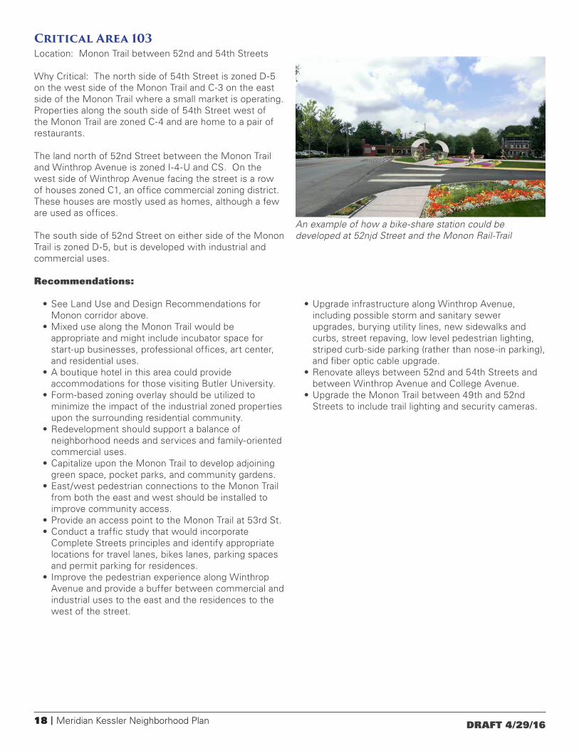
An example of how a bike-share station could be developed at 52njd Street and the Monon Rail-Trail

Meridian Kessler Neighborhood Plan | 19DRAFT 4/29/16
Critical Area 104Location: College Avenue at 52nd Street
Why Critical: This intersection is currently zoned community commercial, with a variety of commercial uses that primarily serve the surrounding neighborhood, including a pet supply store, bars, garden shop, cleaners, restaurants, cafes, hair salon, antique store, and offices. Residences surround these businesses. Historic buildings at this intersection create an urban experience that is warm and welcoming. Building setbacks and wide sidewalks provide comfort and safe passage for pedestrians.
Recommendations:
• See Land Use and Design Recommendations for College Avenue above.
• Preserve the historic buildings and character at this intersection.
• Integrate mixed-use (residential and commercial) at this intersection.
• Upgrade the existing bus stop to include an attractive shelter characteristic of the neighborhood.
• Establish a shared parking policy among the businesses at this intersection.
• Stripe parking along College Avenue and 52nd Street in an effort to organize and provide additional parking spaces.
Critical Area 105Location: 49th and Pennsylvania streets
Why Critical: The intersection of 49th and Pennsylvania streets is a small, but locally significant retail node. Its popularity has brought about an intensification of the uses. Striking a balance between the needs of the businesses and the needs of the surrounding residences is critical.
Recommendations:
• Prohibit the expansion of commercial uses beyond their current extent.
• Avoid auto-intensive uses. Exception: redevelopment of the existing gas station on the southeast corner of the intersection as a gas station.
• Encourage small, neighborhood-serving businesses rather than businesses that would draw from a wide area.
• Avoid high-traffic businesses such as convenience stores.
• Discourage medium or large-scale businesses such as chain drugstores.
• Discourage 24-hour businesses.• Limit the height of any new construction to one story.• Maintain a variety of architectural styles.• Prohibit banners, billboards or other visual clutter.• Provide landscaping between the sidewalk off-street
vehicular zones.• Provide a common entrance for multi-tenant buildings.• Install a bike lane on Pennsylvania Street.• Install new sidewalks where they are absent on the
west side of Pennsylvania Street and the south side of 49th Street.
• Remove obstructions on the sidewalks that interfere with pedestrian passage such as utility poles.
• Provide bike parking.
Crosswalk improvements at 49th and Pennsylvania streets.
Façade improvements at the intersection of 52nd Street and College Avenue.
20 | Meridian Kessler Neighborhood Plan DRAFT 4/29/16
Critical Area 106Location: College Avenue at 49th Street
Why Critical: The northwest corner is zoned CS (W-5). The other three corners at this commercial node are zoned C-3. The CS District is designed to permit, within a single zoning district, multi-use commercial complexes or land use combinations of commercial and non-commercial uses. The primary objective is to encourage development which achieves a high degree of excellence in planning, design, or function and compatibility among varied land use choices.
This commercial node has recently experienced reinvestment into a variety of businesses that serve the surrounding neighborhood. The commercial brick buildings on the southwest and northeast corners are multi-storied and contribute to an “urban feel” at this intersection. The building on the southwest corner (The Uptown) has commercial use on the ground level with living space above - an example of mixed use. The building on the northeast corner is currently home to a liquor store. The site on the northwest corner was recently cleared and environmental remediation undertaken. The southwest corner is home to a small restaurant.
Recommendations
• See Land Use and Design Recommendations for College Avenue above.
• Neighborhood-oriented redevelopment and investment should be encouraged.
• Multi-story buildings should be placed adjacent to the street, with gradation of lower heights adjacent to residences.
• Historic buildings should be preserved.• As properties are redeveloped, building setbacks
should be established that maintain the urban character and provide visibility for safe travel.
• Commercial signage should be scaled for pedestrians and of a quality to reflect the character of the area.
• A parking plan, including striping of on-street parking, should be prepared that provides a parking system that maintains the pedestrian safety while accommodating automobiles and bicycles.
Critical Area 107Location: Monon Trail at 49th Street
Why Critical: The west side of this intersection on either side of 49th Street is zoned C-7 which is a high intensity commercial zoning. On the southeast corner, the property is zoned SU-18 which provides for a light or power substation. The northeast corner is zoned D-5 (residential).
Recommendations
• See Land Use and Design Recommendations for Monon corridor above.
• Continue to support Indy Hostel as an appropriate use for the neighborhood.
• Develop a pocket park at 50th Street and the Monon Trail.
• Install sidewalks in this area for pedestrian safety, comfort, and connectivity.
Meridian Kessler Neighborhood Plan | 21DRAFT 4/29/16
Critical Area 108Location: College Avenue at 46th Street
Why Critical: Three of the corners (northeast, southeast, southwest) of this intersection are zoned C-3. A church occupies the northwest corner and is zoned SU-1. The SU-1 zoning also extends to the south across 46th Street and west of the corner property. That area is used for overflow parking for the church. The southwest property was the site of a gas station. The building has been removed and the property environmentally remediated to commercial standards.
The northeast and southeast corners are commercially developed with a used furniture store and neighborhood grocery, respectively.
Recommendations
• See Land Use and Design Recommendations for College Avenue above.
• Support commercial use on the southwest corner that would be appropriate to and respect the adjacent residential uses in terms of noise, traffic, and trash.
• Support uses at this intersection that would capitalize upon the direct access to Butler University.
• Support uses that would provide a destination experience, rather than a drive-through experience. Examples would be open space, a fitness facility, or farmer’s market.
• Encourage a specialty grocery store or farmer’s market development on the former Kroger site.
• Protect the historical architectural integrity of the existing structures at this intersection.
• Support increased density with mixed use development such as two- to three-story live over work structures.
• Encourage pedestrians by supporting uses that would draw neighbors to this commercial node, while providing safe places for them to walk.
Critical Area 109Location: Northeast corner of Central Avenue and 44th Street.
Why Critical: This property is zoned residential (D2), but has a use variance to permit the building to be used for “office-type businesses generally accepted to be permitted by the C-1 Office Buffer District of the Commercial Zoning Ordinance,” with certain limitations. The use variance is not tied specifically to the current operation. The use variance, therefore, runs with the land until a new use would be proposed, at which time a public hearing would be required. If the use would be returned to a D2 residential use, no public hearing would be necessary.
Recommendations:
• Any future expansion or new structures should be consistent with setbacks, height, style, material, and mass of the surrounding neighborhood.
• Future uses should not intensify above the current office use.
• If the current use would leave the building, future use should be consistent with the current residential zoning.
• Any outdoor seating area for the facility should be placed on the interior of the site and away from adjacent neighbors.

22 | Meridian Kessler Neighborhood Plan DRAFT 4/29/16
Critical Area 110Location: Northeast corner of Central Avenue and 42nd Street.
Why Critical: St. Joan of Arc Catholic Church occupies the site. Through the years the church has expanded by purchasing adjacent properties and vacating an alley and a portion of Ruckle Street. It is zoned SU-1 for religious purposes. The zoning code defines religious use as “a land use devoted primarily to divine worship together with reasonably related accessory uses, which are subordinate to and commonly associated with the primary use, which may include but are not limited to, educational, instructional, social or residential uses.”
The impact of future expansions upon the neighborhood should be carefully studied and kept to a minimum.
Recommendations:
• As expansion plans are made, demolition of adjacent houses should be discouraged.
• If new structures are constructed setbacks, height, style, material, and mass should reflect the surrounding neighborhood.
• As resources become available, site access should be improved, including upgrading of the alley that connects Central Avenue and Park Avenue.
• Any site improvements should consider children and pedestrian safety.
• Curbside parking should be permitted, organized, and striped.
Critical Area 111Location: College Avenue at 42nd Street
Why Critical: This intersection is currently zoned Special Use with categories to provide for government buildings (public safety), church, and library.
Recommendations
• See Land Use and Design Recommendations for College Avenue above.
• Preserve the historic buildings and character at this intersection.
Example of façade improvements to the historic Masonic Lodge at the intersection of 42nd Street and College Avenue.

Meridian Kessler Neighborhood Plan | 23DRAFT 4/29/16
Critical Area 112Location: Monon Trail at 42nd Street
Why Critical: Major state institutions can be found on the east side of the Monon with the state School for the Deaf to the north and the State Fairgrounds to the south. Properties along the western edge of the trail at 42nd Street are zoned C-7.
Recommendations:
• See Land Use and Design Recommendations for Monon corridor above.
• Storage buildings should be maintained and cleaned up.
• Properties should be landscaped to visually improve the appearance.
• Community gardens should be developed and made available to the residents within the neighborhood.
• Abandoned vehicles and houses should be reported to the Department of Code Enforcement and Marion County Health Department.
• Establish relationships with the State School for the Deaf and the State Fair Grounds to facilitate improvements along the Monon Trail corridor including the maintenance of green space and creation of a public park as shown in the land use plan.
Critical Area 113Location: Southeast corner of Central Avenue and 40th Street.
Why Critical: This site is developed with a three-story brick building (constructed 1916) and parking area for approximately 30 vehicles. It is zoned SU-38, which permits the site to be used as a community center.
The location within a residential neighborhood and the size of the building presents special challenges. Any reuse of the building or redevelopment of the property would have immediate impact the surrounding neighborhood. Any new use or redevelopment of the site would require either a variance of use or a rezoning.
Recommendations:
• New use of the site should have minimal impact upon the adjacent residential properties and the neighborhood.
• Historical character of the existing building should be preserved.
• Any new structures should respect the character of the surrounding neighborhood and be consistent with the setbacks, height, style, material, and mass of the existing residential structures.
• Except for low intensity office uses, the site should not be used for commercial operations.
• Vehicular ingress/egress should be upgraded to improve safety.
• Exterior lighting should be directed inward to minimize impact upon adjacent properties.
• Internally-illuminated or neon signs should not be permitted.
The Monon Rail-Trail entrance to the Indiana School for the Deaf located is an example of how public art can be incorporated into the neighborhood.
24 | Meridian Kessler Neighborhood Plan DRAFT 4/29/16
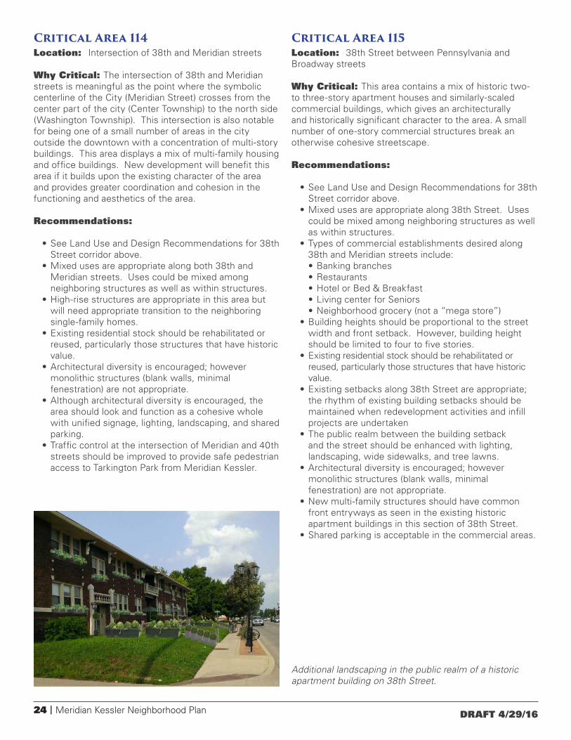
Critical Area 114 Location: Intersection of 38th and Meridian streets
Why Critical: The intersection of 38th and Meridian streets is meaningful as the point where the symbolic centerline of the City (Meridian Street) crosses from the center part of the city (Center Township) to the north side (Washington Township). This intersection is also notable for being one of a small number of areas in the city outside the downtown with a concentration of multi-story buildings. This area displays a mix of multi-family housing and office buildings. New development will benefit this area if it builds upon the existing character of the area and provides greater coordination and cohesion in the functioning and aesthetics of the area.
Recommendations:
• See Land Use and Design Recommendations for 38th Street corridor above.
• Mixed uses are appropriate along both 38th and Meridian streets. Uses could be mixed among neighboring structures as well as within structures.
• High-rise structures are appropriate in this area but will need appropriate transition to the neighboring single-family homes.
• Existing residential stock should be rehabilitated or reused, particularly those structures that have historic value.
• Architectural diversity is encouraged; however monolithic structures (blank walls, minimal fenestration) are not appropriate.
• Although architectural diversity is encouraged, the area should look and function as a cohesive whole with unified signage, lighting, landscaping, and shared parking.
• Traffic control at the intersection of Meridian and 40th streets should be improved to provide safe pedestrian access to Tarkington Park from Meridian Kessler.
Critical Area 115 Location: 38th Street between Pennsylvania and Broadway streets
Why Critical: This area contains a mix of historic two- to three-story apartment houses and similarly-scaled commercial buildings, which gives an architecturally and historically significant character to the area. A small number of one-story commercial structures break an otherwise cohesive streetscape.
Recommendations:
• See Land Use and Design Recommendations for 38th Street corridor above.
• Mixed uses are appropriate along 38th Street. Uses could be mixed among neighboring structures as well as within structures.
• Types of commercial establishments desired along 38th and Meridian streets include:• Banking branches• Restaurants • Hotel or Bed & Breakfast • Living center for Seniors• Neighborhood grocery (not a “mega store”)
• Building heights should be proportional to the street width and front setback. However, building height should be limited to four to five stories.
• Existing residential stock should be rehabilitated or reused, particularly those structures that have historic value.
• Existing setbacks along 38th Street are appropriate; the rhythm of existing building setbacks should be maintained when redevelopment activities and infill projects are undertaken
• The public realm between the building setback and the street should be enhanced with lighting, landscaping, wide sidewalks, and tree lawns.
• Architectural diversity is encouraged; however monolithic structures (blank walls, minimal fenestration) are not appropriate.
• New multi-family structures should have common front entryways as seen in the existing historic apartment buildings in this section of 38th Street.
• Shared parking is acceptable in the commercial areas.
Additional landscaping in the public realm of a historic apartment building on 38th Street.

Meridian Kessler Neighborhood Plan | 25DRAFT 4/29/16
Critical Area 116Location: Intersection of 38th Street and College Avenue
Why Critical: The commercial area at College Avenue is the most notable retail node along the 38th Street within Meridian Kessler. There is a mix of historic two-story structures and newer one-story structures.
Recommendations:
• See Land Use and Design Recommendations for 38th Street corridor above.
• Mixed use (office/retail use on the first floor, with residential on the upper floors) is appropriate at this node.
• Land uses that serve neighborhood needs (i.e. grocery store) would be preferred over uses that would be regional draws.
• A boutique restaurant would be a welcome addition to the corridor.
• The height of the buildings should be limited to four to five stories.
• Existing setbacks are appropriate, but the public realm between the building setback and the street should be enhanced with lighting, landscaping, wide sidewalks, and tree lawns.
• Maintain rhythm of existing building setbacks when redevelopment activities and infill projects are undertaken.
Critical Area 117Location: 38th Street between Carrollton Avenue and the Monon Rail-Trail
Why Critical: Large single-family residences dominate the land use mix. Many of these houses have been converted to multi-family or office uses. Retail structures can be found on northwest and northeast corner of 38th Street and Winthrop Avenue.
Recommendations:
• See Land Use and Design Recommendations for 38th Street corridor above.
• Mixed use (office/retail use on the first floor, with residential on the upper floors) is appropriate along this corridor.
• Existing residential stock should be rehabilitated or reused, particularly those structures that have historic value.
• Existing setbacks along 38th Street are appropriate; the rhythm of existing building setbacks should be maintained when redevelopment activities and infill projects are undertaken.
• The public realm between the building setback and the street should be enhanced with lighting, landscaping, wide sidewalks, and tree lawns.
• A bicycle facility (rental, repair, etc.) would be an appropriate use in the old Monon Train Station that lies adjacent to the Monon Trail.
• Improve relationship with the State Fairgrounds by integrating pedestrian/bicycle connections between the neighborhood and the State Fairgrounds.
Coburn Place on East 38th Street is an example of adaptive re-use.
Additional amenities could be added to the historic Monon Depot on the edge of the Indiana State Fairgrounds.

26 | Meridian Kessler Neighborhood Plan DRAFT 4/29/16
Incremental changes can have an enormous impact on a street. These illustrations show how streetscape improvements and infill development could change Winthrop Avenue.
Meridian Kessler Neighborhood Plan | 27DRAFT 4/29/16
Appendix AA portion of Indiana Code concerning the Meridian Street Preservation Commission.
IC 36-7-11.2-59 Prohibited new or altered structures on Meridian Street
Sec. 59. A new structure may not be erected upon a parcel of Meridian Street property or an existing structure upon the property may not be altered if the structure would do any of the following:
(1) Permit a residential usage that, in relation to the parcel upon which situated, would be of a substantially greater density than the average residential density of Meridian Street property lying within one thousand (1,000) feet of the property in question, excluding for purposes of determining the average Meridian Street property used for multiple family residential or commercial purposes.
(2) Appear substantially smaller or larger in size and scale than the average size and scale of the single and double family residential dwellings situated upon Meridian Street property lying within one thousand (1,000) feet of the property in question.
(3) Have a set-back from Meridian Street significantly less than the average set-back of structures facing upon Meridian Street that are situated upon Meridian Street property lying within one thousand (1,000) feet of the property in question.
(4) Have side lots measuring less than fifteen (15) feet from the property line of the subject property to the wall of the structure erected or altered.
(5) If primarily a residential dwelling, have a ground floor area of less than two thousand (2,000) square feet or forty percent (40%) of the total area of the parcel of land upon which the dwelling lies, whichever is less.
(6) Including all other structures upon the parcel, have a total ground floor area greater than fifty percent (50%) of the total area of the parcel of land upon which the structure lies.
(7) Substantially encroach upon the view and exposure of a residential structure on a neighboring property.
IC 36-7-11.2-60 Subdivision of Meridian Street property
Sec. 60. A parcel of Meridian Street property may not be subdivided into lots having:
(1) an area of less than fifteen thousand (15,000) square feet; or
(2) frontage of less than one hundred (100) feet upon Meridian Street or upon an east-west street intersecting with Meridian Street.
IC 36-7-11.2-61 Conditions for constructing, reconstructing, altering, or demolishing Meridian Street property
Sec. 61. (a) A person may not construct on Meridian Street property a structure or feature or reconstruct, alter, or demolish Meridian Street property unless the following conditions have been met:
(1) The person has previously filed with the commission an application for a certificate of appropriateness in the form and with the plans, specifications, and other materials that the commission prescribes.
(2) A certificate of appropriateness has been issued by the commission as provided in this section.
(b) After the filing of an application for a certificate of appropriateness, the commission shall determine whether the proposed construction, reconstruction, or alteration of the structure in question:
(1) will be appropriate to the preservation of the area comprised of Meridian Street and bordering property; and
(2) complies with the architectural and construction standards then existing in the area.
(c) In determining appropriateness, the commission shall consider, in addition to other factors that the commission considers pertinent, the historical and architectural style, general design, arrangement, size, texture, and materials of the proposed work and the relation of the proposed work to the architectural factor of other structures in the area. The department of metropolitan development may not issue a permit for the construction, reconstruction, alteration, or demolition of a structure in the area unless the application for the permit is accompanied by a certificate of appropriateness.
(d) The issuance of or refusal to issue a permit is a final determination appealable under section 64 of this chapter. With respect to a certificate of appropriateness, the commission may, by rule or regulation, provide for:
(1) the public hearings;
(2) notice of the hearings; or
(3) the filing of the application for the certificate;
that the commission considers necessary.
(e) Notwithstanding this section, the commission may, by rule or regulation:
(1) define; and
(2) exempt from the application of this section;
specific types and categories of construction, reconstruction,
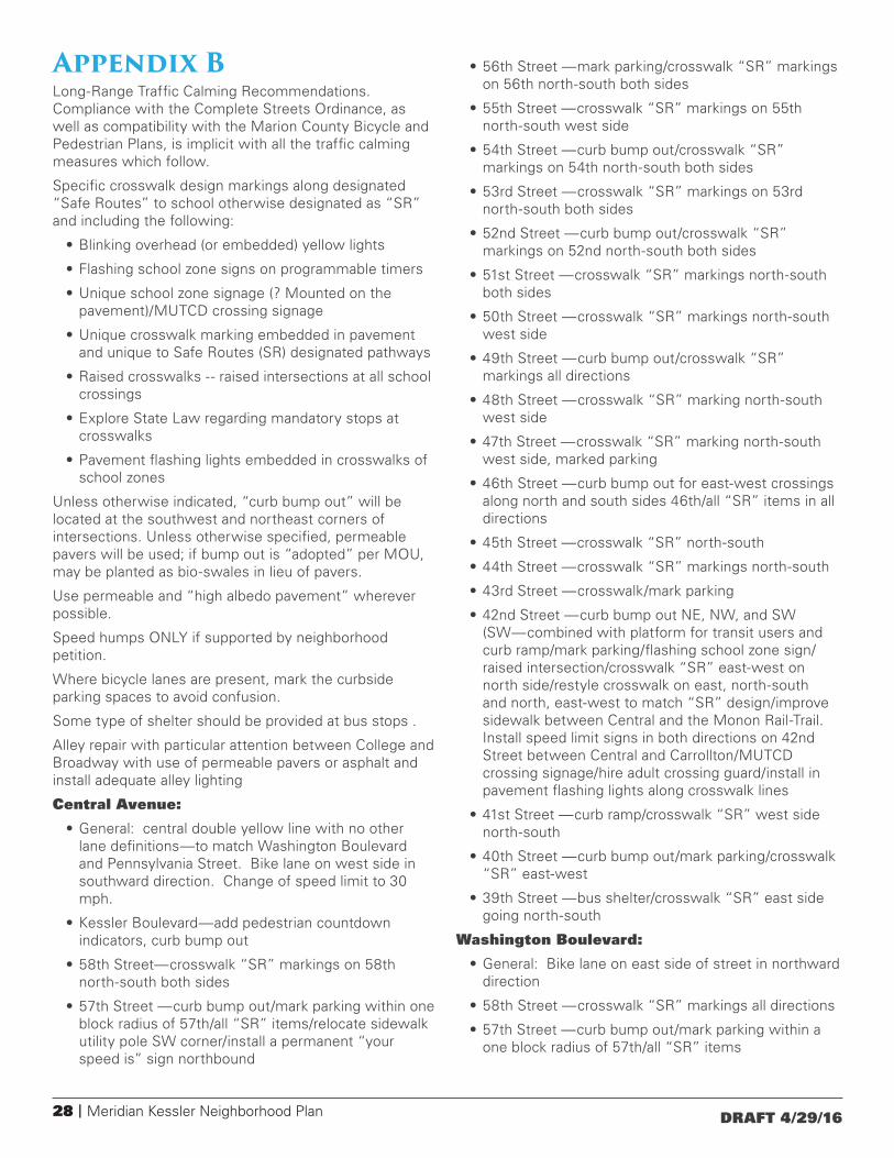
28 | Meridian Kessler Neighborhood Plan DRAFT 4/29/16
Appendix BLong-Range Traffic Calming Recommendations. Compliance with the Complete Streets Ordinance, as well as compatibility with the Marion County Bicycle and Pedestrian Plans, is implicit with all the traffic calming measures which follow.
Specific crosswalk design markings along designated “Safe Routes” to school otherwise designated as “SR” and including the following:
• Blinking overhead (or embedded) yellow lights
• Flashing school zone signs on programmable timers
• Unique school zone signage (? Mounted on the pavement)/MUTCD crossing signage
• Unique crosswalk marking embedded in pavement and unique to Safe Routes (SR) designated pathways
• Raised crosswalks -- raised intersections at all school crossings
• Explore State Law regarding mandatory stops at crosswalks
• Pavement flashing lights embedded in crosswalks of school zones
Unless otherwise indicated, “curb bump out” will be located at the southwest and northeast corners of intersections. Unless otherwise specified, permeable pavers will be used; if bump out is “adopted” per MOU, may be planted as bio-swales in lieu of pavers.
Use permeable and “high albedo pavement” wherever possible.
Speed humps ONLY if supported by neighborhood petition.
Where bicycle lanes are present, mark the curbside parking spaces to avoid confusion.
Some type of shelter should be provided at bus stops .
Alley repair with particular attention between College and Broadway with use of permeable pavers or asphalt and install adequate alley lighting
Central Avenue:
• General: central double yellow line with no other lane definitions—to match Washington Boulevard and Pennsylvania Street. Bike lane on west side in southward direction. Change of speed limit to 30 mph.
• Kessler Boulevard—add pedestrian countdown indicators, curb bump out
• 58th Street—crosswalk “SR” markings on 58th north-south both sides
• 57th Street —curb bump out/mark parking within one block radius of 57th/all “SR” items/relocate sidewalk utility pole SW corner/install a permanent “your speed is” sign northbound
• 56th Street —mark parking/crosswalk “SR” markings on 56th north-south both sides
• 55th Street —crosswalk “SR” markings on 55th north-south west side
• 54th Street —curb bump out/crosswalk “SR” markings on 54th north-south both sides
• 53rd Street —crosswalk “SR” markings on 53rd north-south both sides
• 52nd Street —curb bump out/crosswalk “SR” markings on 52nd north-south both sides
• 51st Street —crosswalk “SR” markings north-south both sides
• 50th Street —crosswalk “SR” markings north-south west side
• 49th Street —curb bump out/crosswalk “SR” markings all directions
• 48th Street —crosswalk “SR” marking north-south west side
• 47th Street —crosswalk “SR” marking north-south west side, marked parking
• 46th Street —curb bump out for east-west crossings along north and south sides 46th/all “SR” items in all directions
• 45th Street —crosswalk “SR” north-south
• 44th Street —crosswalk “SR” markings north-south
• 43rd Street —crosswalk/mark parking
• 42nd Street —curb bump out NE, NW, and SW (SW—combined with platform for transit users and curb ramp/mark parking/flashing school zone sign/raised intersection/crosswalk “SR” east-west on north side/restyle crosswalk on east, north-south and north, east-west to match “SR” design/improve sidewalk between Central and the Monon Rail-Trail. Install speed limit signs in both directions on 42nd Street between Central and Carrollton/MUTCD crossing signage/hire adult crossing guard/install in pavement flashing lights along crosswalk lines
• 41st Street —curb ramp/crosswalk “SR” west side north-south
• 40th Street —curb bump out/mark parking/crosswalk “SR” east-west
• 39th Street —bus shelter/crosswalk “SR” east side going north-south
Washington Boulevard:
• General: Bike lane on east side of street in northward direction
• 58th Street —crosswalk “SR” markings all directions
• 57th Street —curb bump out/mark parking within a one block radius of 57th/all “SR” items
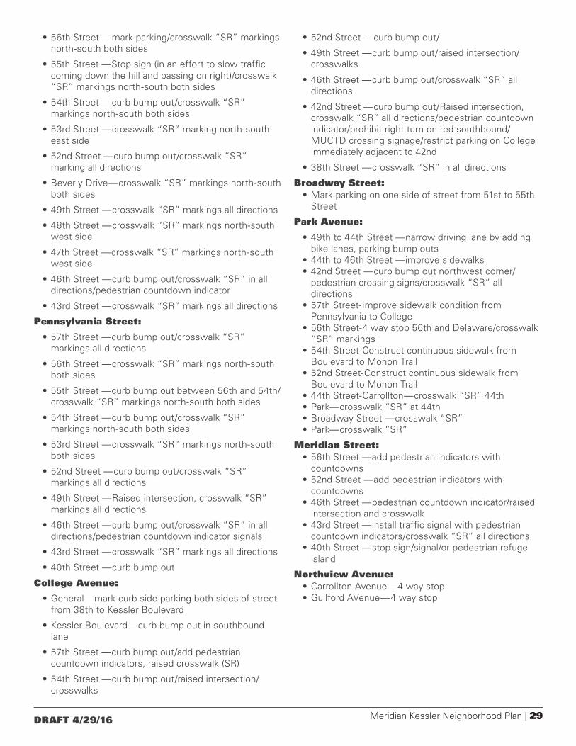
Meridian Kessler Neighborhood Plan | 29DRAFT 4/29/16
• 56th Street —mark parking/crosswalk “SR” markings north-south both sides
• 55th Street —Stop sign (in an effort to slow traffic coming down the hill and passing on right)/crosswalk “SR” markings north-south both sides
• 54th Street —curb bump out/crosswalk “SR” markings north-south both sides
• 53rd Street —crosswalk “SR” marking north-south east side
• 52nd Street —curb bump out/crosswalk “SR” marking all directions
• Beverly Drive—crosswalk “SR” markings north-south both sides
• 49th Street —crosswalk “SR” markings all directions
• 48th Street —crosswalk “SR” markings north-south west side
• 47th Street —crosswalk “SR” markings north-south west side
• 46th Street —curb bump out/crosswalk “SR” in all directions/pedestrian countdown indicator
• 43rd Street —crosswalk “SR” markings all directions
Pennsylvania Street:
• 57th Street —curb bump out/crosswalk “SR” markings all directions
• 56th Street —crosswalk “SR” markings north-south both sides
• 55th Street —curb bump out between 56th and 54th/crosswalk “SR” markings north-south both sides
• 54th Street —curb bump out/crosswalk “SR” markings north-south both sides
• 53rd Street —crosswalk “SR” markings north-south both sides
• 52nd Street —curb bump out/crosswalk “SR” markings all directions
• 49th Street —Raised intersection, crosswalk “SR” markings all directions
• 46th Street —curb bump out/crosswalk “SR” in all directions/pedestrian countdown indicator signals
• 43rd Street —crosswalk “SR” markings all directions
• 40th Street —curb bump out
College Avenue:
• General—mark curb side parking both sides of street from 38th to Kessler Boulevard
• Kessler Boulevard—curb bump out in southbound lane
• 57th Street —curb bump out/add pedestrian countdown indicators, raised crosswalk (SR)
• 54th Street —curb bump out/raised intersection/crosswalks
• 52nd Street —curb bump out/
• 49th Street —curb bump out/raised intersection/crosswalks
• 46th Street —curb bump out/crosswalk “SR” all directions
• 42nd Street —curb bump out/Raised intersection, crosswalk “SR” all directions/pedestrian countdown indicator/prohibit right turn on red southbound/MUCTD crossing signage/restrict parking on College immediately adjacent to 42nd
• 38th Street —crosswalk “SR” in all directions
Broadway Street:• Mark parking on one side of street from 51st to 55th
Street
Park Avenue:
• 49th to 44th Street —narrow driving lane by adding bike lanes, parking bump outs
• 44th to 46th Street —improve sidewalks• 42nd Street —curb bump out northwest corner/
pedestrian crossing signs/crosswalk “SR” all directions
• 57th Street-Improve sidewalk condition from Pennsylvania to College
• 56th Street-4 way stop 56th and Delaware/crosswalk “SR” markings
• 54th Street-Construct continuous sidewalk from Boulevard to Monon Trail
• 52nd Street-Construct continuous sidewalk from Boulevard to Monon Trail
• 44th Street-Carrollton—crosswalk “SR” 44th • Park—crosswalk “SR” at 44th • Broadway Street —crosswalk “SR” • Park—crosswalk “SR”
Meridian Street:• 56th Street —add pedestrian indicators with
countdowns• 52nd Street —add pedestrian indicators with
countdowns• 46th Street —pedestrian countdown indicator/raised
intersection and crosswalk• 43rd Street —install traffic signal with pedestrian
countdown indicators/crosswalk “SR” all directions• 40th Street —stop sign/signal/or pedestrian refuge
island
Northview Avenue:• Carrollton Avenue—4 way stop• Guilford AVenue—4 way stop
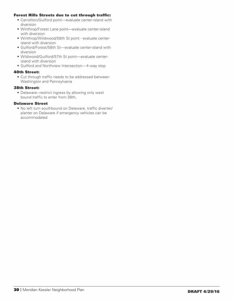
30 | Meridian Kessler Neighborhood Plan DRAFT 4/29/16
Forest Hills Streets due to cut through traffic:• Carrollton/Guilford point—evaluate center-island with
diversion• Winthrop/Forest Lane point—evaluate center-island
with diversion• Winthrop/Wildwood/58th St point - evaluate center-
island with diversion• Guilford/Forest/58th St—evaluate center-island with
diversion• Wildwood/Guilford/57th St point—evaluate center-
island with diversion• Guilford and Northview Intersection—4-way stop
40th Street: • Cut through traffic needs to be addressed between
Washington and Pennsylvania
38th Street:• Delaware--restrict ingress by allowing only west
bound traffic to enter from 38th,
Delaware Street• No left turn southbound on Delaware, traffic diverter/
planter on Delaware if emergency vehicles can be accommodated

Meridian Kessler Neighborhood Plan | 31DRAFT 4/29/16

32 | Meridian Kessler Neighborhood Plan DRAFT 4/29/16
Appendix CLand Use Classification System
Base Land Use TypologyThis Land Use Plan incorporates a typology or district approach. Districts are defined with a range of anticipated uses that are geographically constrained by the presence of a minimum level of infrastructure and the contextual relationship of the use to other adjacent uses. The result is that each use is not necessarily recommended for every site inside the typology, because each use is limited by having the required infrastructure in place and having to meet contextual requirements. This determination is made through the development review process.
Living Districts, which include a mix of residential types, public facilities, parks and limited, small-scale and low-intensity retail development
• Estate Neighborhood• Traditional Neighborhood
Mixed-Use Districts, which contain a substantial mix of retail, residential, public facilities, institutions, parks, and low-intensity industrial uses
• Urban Mixed-Use• Village Mixed-Use
Working Districts, which contain a mix of employment-generating uses, public facilities, and parks
• Office Commercial Uses
Other Land Uses, which are single-use areas that may be found between or within the districts above
• Park• Linear Park• Regional Special Use
Detailed explanations of the base land use typologies, including their indivudal uses and interaction with the overlay modifiers, are provided in subsequent pages.
OVERLAY MODIFIERSOverlay modifiers are thematic or issue-oriented districts that change the recommendations of the underlying base typology. Overlays do not stand on their own, but work in conjunction with the base typology.
• Environmentally Sensitive Areas (ES)• Wellfield Protection (WP)• Residential Corridor Reserve (RR)• Critical Area (CA)
Environmentally Sensitive Areas (ES) The purpose of the Environmentally Sensitive Areas overlay is to protect or conserve special natural characteristics of the land. Five natural qualities are called out in this overlay:
• Natural Woodlands, which are groupings of trees, naturally occurring or planted.
• High Quality Woodlands, which are woodlands that have been relatively undisturbed for over 50 years, and which tend to have greater biodiversity. Based on 1999 data.
• Wetlands, which are based on mapping provided by the Indiana Department of Natural Resources.
• Floodplains, which are areas where floodwater is likely to stand during a flood of such intensity that it is likely to happen once in 100 years. Based on Federal Emergency Management Agency flood panels.
• Steep slopes, which are slopes of 10% or more. These are slopes with greater than one foot of rise in elevation over 10 feet of horizontal distance. Based on 2003 data.
Wellfield Protection (WP) The purpose of the Wellfield Protection overlay is to protect the water taken from wells used by Marion County public water suppliers from contaminants. The Meridian-Kessler neighborhood has both W1 and W5 wellfields. A W1 wellfield is the area around a public well where a drop of water falling on the surface will travel to the well’s intake point within a year. A W5 wellfield is the area around a public well where a drop of water falling on the surface will travel to the well’s intake point within five years.
Residential Corridor Reserve (RR) The purpose of the Residential Corridor Reserve overlay is to protect residential areas along major streets from the destabilizing effects of commercial encroachment.
Critical Area (CA) The purpose of the Critical Area overlay is to provide additional, more detailed, guidance for certain locations that have complex and highly unique circumstances not addressed by other overlays.

Meridian Kessler Neighborhood Plan | 33DRAFT 4/29/16
Land
Use
Infra
stru
ctur
e Req
uire
men
tsCo
ntex
t Req
uire
men
tsEn
viro
nmen
tally
Sens
itive
Ar
eas (
ES)
Wel
lfiel
d Pr
otec
tion
(WP)
Resid
entia
l Cor
ridor
Res
erve
(R
R)
Belo
w ar
e the
land
use
s tha
t are
antic
ipat
ed in
th
is la
nd u
se d
istric
t. H
owev
er, t
he la
nd u
se is
no
t rec
omm
ende
d un
less
the p
roje
ct m
eets
. . .
thes
e inf
rast
ruct
ure
requ
irem
ents
and
. .
.th
ese c
onte
xt re
quire
men
ts.
If th
e pro
pose
d la
nd u
se
is lo
cate
d in
this
over
lay
dist
rict,
its re
quire
men
ts ar
e m
odifi
ed b
y th
e fol
low
ing
If th
e pro
pose
d la
nd u
se
is lo
cate
d in
this
over
lay
dist
rict,
its re
quire
men
ts ar
e m
odifi
ed b
y th
e fol
low
ing
If th
e pro
pose
d la
nd u
se
is lo
cate
d in
this
over
lay
dist
rict,
its re
quire
men
ts ar
e m
odifi
ed b
y th
e fol
low
ing
Deta
ched
Hou
sing
ES-1
n/
mod
n/m
od
Grou
p Ho
me
5ES
-1n/
mod
n/m
od
Bed
and
Brea
kfas
t5
ES-1
n/
mod
RR-1
Larg
e-Sc
ale
Scho
ols,
Plac
es o
f Wor
ship
, an
d Ne
ighb
orho
od-S
ervi
ng In
stitu
tions
/In
frast
ruct
ure
A, E,
F, H
6ES
-1
WP-
1RR
-1
• In
fras
truc
ture
and
Con
text
req
uire
men
t co
des
can
be f
ound
on
page
42.
• O
verla
y di
stric
t m
odifi
catio
n co
des
can
be f
ound
on
page
42.
• n/
mod
= N
o M
odifi
catio
n; t
his
over
lay
dist
rict
does
not
mod
ify
the
requ
irem
ents
of
the
base
dis
tric
t.•
n/a
= N
ot A
pplic
able
; thi
s ba
se d
istr
ict
will
not
be
loca
ted
whe
re t
his
over
lay
dist
rict
is f
ound
.
Esta
te N
eig
hbo
rho
od
Des
crip
tio
n:
The
Est
ate
Res
iden
tial d
istr
ict
is a
livi
ng d
istr
ict
inte
nded
to
prov
ide
low
inte
nsit
y us
es f
or
area
s fo
und
in h
isto
ric a
reas
tha
t w
ere
deve
lope
d as
larg
e es
tate
-sty
le h
omes
on
larg
e lo
ts.
A f
ull c
ompl
emen
t of
cit
y se
rvic
es w
ould
be
expe
cted
.
anti
cipa
ted
Pri
mar
y La
nd
Use
s:
Perf
or
man
ce C
har
acte
rist
ics:
• Ty
pica
l dis
tric
t-av
erag
e re
side
ntia
l den
sity
of
less
tha
n on
e un
it pe
r ac
re.
• S
erve
d by
min
imal
ly-im
prov
ed r
oads
.•
Ped
estr
ian
faci
litie
s ar
e ty
pica
lly li
mite
d to
reg
iona
l gr
eenw
ays.
• Tr
ansi
t se
rvic
e is
min
imal
if p
rese
nt.
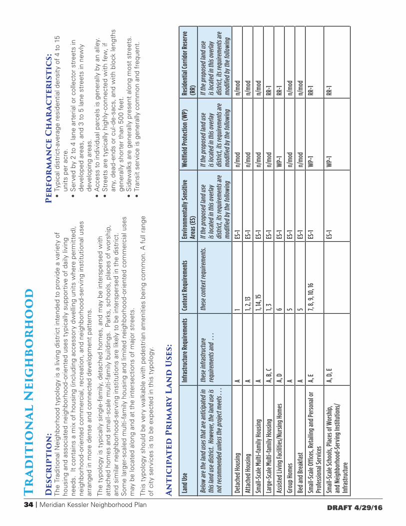
34 | Meridian Kessler Neighborhood Plan DRAFT 4/29/16
Land
Use
Infra
stru
ctur
e Req
uire
men
tsCo
ntex
t Req
uire
men
tsEn
viro
nmen
tally
Sens
itive
Ar
eas (
ES)
Wel
lfiel
d Pr
otec
tion
(WP)
Resid
entia
l Cor
ridor
Res
erve
(R
R)
Belo
w ar
e the
land
use
s tha
t are
antic
ipat
ed in
th
is la
nd u
se d
istric
t. H
owev
er, t
he la
nd u
se is
no
t rec
omm
ende
d un
less
the p
roje
ct m
eets
. . .
thes
e inf
rast
ruct
ure
requ
irem
ents
and
. .
.th
ese c
onte
xt re
quire
men
ts.
If th
e pro
pose
d la
nd u
se
is lo
cate
d in
this
over
lay
dist
rict,
its re
quire
men
ts ar
e m
odifi
ed b
y th
e fol
low
ing
If th
e pro
pose
d la
nd u
se
is lo
cate
d in
this
over
lay
dist
rict,
its re
quire
men
ts ar
e m
odifi
ed b
y th
e fol
low
ing
If th
e pro
pose
d la
nd u
se
is lo
cate
d in
this
over
lay
dist
rict,
its re
quire
men
ts ar
e m
odifi
ed b
y th
e fol
low
ing
Deta
ched
Hou
sing
A1
ES-1
n/
mod
n/m
od
Atta
ched
Hou
sing
A1,
2, 13
ES-1
n/
mod
n/m
od
Smal
l-Sca
le M
ulti-
fam
ily H
ousin
gA
1, 14
, 15
ES-1
n/
mod
n/m
od
Larg
e-Sc
ale
Multi
-fam
ily H
ousin
gA,
B, C
1, 3
ES-1
n/
mod
RR-1
Assis
ted
Livin
g Fa
ciliti
es/N
ursin
g Ho
mes
A, D
6ES
-1
WP-
1RR
-1
Grou
p Ho
mes
A
5ES
-1
n/m
odn/
mod
Bed
and
Brea
kfas
tA
5ES
-1
n/m
odn/
mod
Smal
l-Sca
le O
ffice
s, Re
taili
ng a
nd P
erso
nal o
r Pr
ofes
siona
l Ser
vice
sA,
E7,
8, 9
, 10,
16ES
-1
WP-
1RR
-1
Smal
l-Sca
le Sc
hool
s, Pl
aces
of W
orsh
ip,
and
Neig
hbor
hood
-Ser
ving
Inst
itutio
ns/
Infra
stru
ctur
e
A, D
, EES
-1
WP-
1RR
-1
Trad
itio
nal
Nei
gh
borh
oo
dD
escr
ipti
on
: Th
e Tr
aditi
onal
Nei
ghbo
rhoo
d ty
polo
gy is
a li
ving
dis
tric
t in
tend
ed t
o pr
ovid
e a
varie
ty o
f ho
usin
g an
d as
soci
ated
nei
ghbo
rhoo
d-o
rient
ed u
ses
typi
cally
sup
port
ive
of d
aily
livi
ng
need
s. I
t co
ntai
ns a
mix
of
hous
ing
(incl
udin
g ac
cess
ory
dwel
ling
units
whe
re p
erm
itted
), ne
ighb
orho
od-o
rient
ed c
omm
erci
al, r
ecre
atio
n, a
nd n
eigh
borh
ood
-ser
ving
inst
itutio
nal u
ses
arra
nged
in m
ore
dens
e an
d co
nnec
ted
deve
lopm
ent
patt
erns
.
The
typo
logy
is t
ypic
ally
sin
gle
-fam
ily, d
etac
hed
hom
es, a
nd m
ay b
e in
ters
pers
ed w
ith
atta
ched
hom
es a
nd s
mal
l-sca
le m
ulti
-fam
ily b
uild
ings
. P
arks
, sch
ools
, pla
ces
of w
orsh
ip,
and
sim
ilar
neig
hbor
hood
-ser
ving
inst
itutio
ns a
re li
kely
to
be in
ters
pers
ed in
the
dis
tric
t.
Som
e la
rger
-sca
led
mul
ti-f
amily
hou
sing
and
lim
ited
neig
hbor
hood
-orie
nted
com
mer
cial
use
s m
ay b
e lo
cate
d al
ong
and
at t
he in
ters
ectio
ns o
f m
ajor
str
eets
.
This
typ
olog
y sh
ould
be
very
wal
kabl
e w
ith p
edes
tria
n am
eniti
es b
eing
com
mon
. A f
ull r
ange
of
cit
y se
rvic
es is
to
be e
xpec
ted
in t
his
typo
logy
.
Anti
cipa
ted
Pri
mar
y La
nd
Use
s:
Perf
or
man
ce C
har
acte
rist
ics:
• Ty
pica
l dis
tric
t-av
erag
e re
side
ntia
l den
sity
of
4 to
15
units
per
acr
e.•
Ser
ved
by 2
to
4 la
ne a
rter
ial o
r co
llect
or s
tree
ts in
de
velo
ped
area
s, a
nd 3
to
5 la
ne s
tree
ts in
new
ly
deve
lopi
ng a
reas
.•
Acc
ess
to in
divi
dual
par
cels
is g
ener
ally
by
an a
lley.
• S
tree
ts a
re t
ypic
ally
hig
hly-
conn
ecte
d w
ith f
ew, i
f an
y, d
ead
-end
s or
cul
-de
-sac
s, a
nd w
ith b
lock
leng
ths
gene
rally
sho
rter
tha
n 50
0 fe
et.
• S
idew
alks
are
gen
eral
ly p
rese
nt a
long
mos
t st
reet
s.•
Tran
sit
serv
ice
is g
ener
ally
com
mon
and
fre
quen
t.
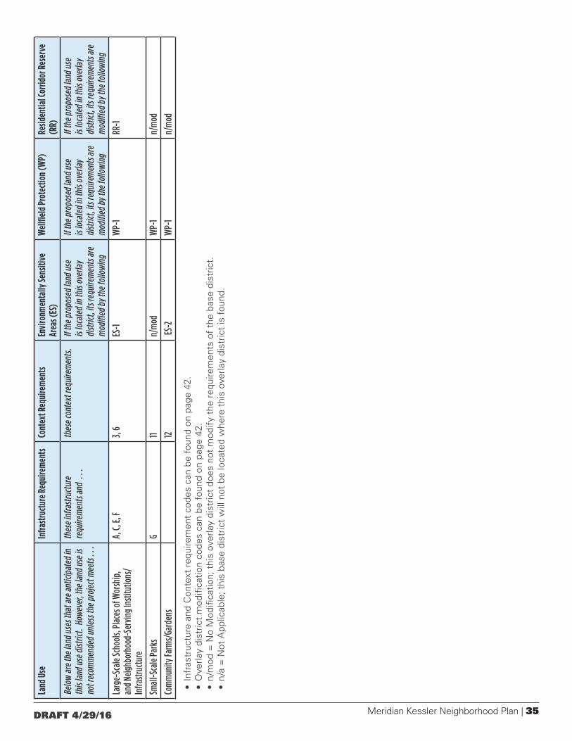
Meridian Kessler Neighborhood Plan | 35DRAFT 4/29/16
Land
Use
Infra
stru
ctur
e Req
uire
men
tsCo
ntex
t Req
uire
men
tsEn
viro
nmen
tally
Sens
itive
Ar
eas (
ES)
Wel
lfiel
d Pr
otec
tion
(WP)
Resid
entia
l Cor
ridor
Res
erve
(R
R)
Belo
w ar
e the
land
use
s tha
t are
antic
ipat
ed in
th
is la
nd u
se d
istric
t. H
owev
er, t
he la
nd u
se is
no
t rec
omm
ende
d un
less
the p
roje
ct m
eets
. . .
thes
e inf
rast
ruct
ure
requ
irem
ents
and
. .
.th
ese c
onte
xt re
quire
men
ts.
If th
e pro
pose
d la
nd u
se
is lo
cate
d in
this
over
lay
dist
rict,
its re
quire
men
ts ar
e m
odifi
ed b
y th
e fol
low
ing
If th
e pro
pose
d la
nd u
se
is lo
cate
d in
this
over
lay
dist
rict,
its re
quire
men
ts ar
e m
odifi
ed b
y th
e fol
low
ing
If th
e pro
pose
d la
nd u
se
is lo
cate
d in
this
over
lay
dist
rict,
its re
quire
men
ts ar
e m
odifi
ed b
y th
e fol
low
ing
Larg
e-Sc
ale
Scho
ols,
Plac
es o
f Wor
ship
, an
d Ne
ighb
orho
od-S
ervi
ng In
stitu
tions
/In
frast
ruct
ure
A, C,
E, F
3, 6
ES-1
W
P-1
RR-1
Smal
l-Sca
le P
arks
G11
n/m
odW
P-1
n/m
od
Com
mun
ity Fa
rms/
Gard
ens
12 ES
-2W
P-1
n/m
od
• In
fras
truc
ture
and
Con
text
req
uire
men
t co
des
can
be f
ound
on
page
42.
• O
verla
y di
stric
t m
odifi
catio
n co
des
can
be f
ound
on
page
42.
• n/
mod
= N
o M
odifi
catio
n; t
his
over
lay
dist
rict
does
not
mod
ify
the
requ
irem
ents
of
the
base
dis
tric
t.•
n/a
= N
ot A
pplic
able
; thi
s ba
se d
istr
ict
will
not
be
loca
ted
whe
re t
his
over
lay
dist
rict
is f
ound
.
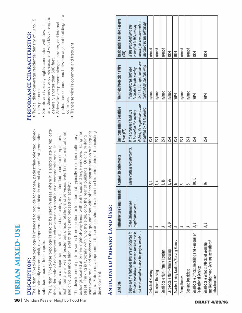
36 | Meridian Kessler Neighborhood Plan DRAFT 4/29/16
Land
Use
Infra
stru
ctur
e Req
uire
men
tsCo
ntex
t Req
uire
men
tsEn
viro
nmen
tally
Sens
itive
Ar
eas (
ES)
Wel
lfiel
d Pr
otec
tion
(WP)
Resid
entia
l Cor
ridor
Res
erve
(R
R)
Belo
w ar
e the
land
use
s tha
t are
antic
ipat
ed in
th
is la
nd u
se d
istric
t. H
owev
er, t
he la
nd u
se is
no
t rec
omm
ende
d un
less
the p
roje
ct m
eets
. . .
thes
e inf
rast
ruct
ure
requ
irem
ents
and
. .
.th
ese c
onte
xt re
quire
men
ts.
If th
e pro
pose
d la
nd u
se
is lo
cate
d in
this
over
lay
dist
rict,
its re
quire
men
ts ar
e m
odifi
ed b
y th
e fol
low
ing
If th
e pro
pose
d la
nd u
se
is lo
cate
d in
this
over
lay
dist
rict,
its re
quire
men
ts ar
e m
odifi
ed b
y th
e fol
low
ing
If th
e pro
pose
d la
nd u
se
is lo
cate
d in
this
over
lay
dist
rict,
its re
quire
men
ts ar
e m
odifi
ed b
y th
e fol
low
ing
Deta
ched
Hou
sing
A1,
4ES
-1
n/m
odn/
mod
Atta
ched
Hou
sing
A1,
4ES
-1
n/m
odn/
mod
Smal
l-Sca
le M
ulti-
fam
ily H
ousin
gA
1, 16
ES-1
n/
mod
n/m
od
Larg
e-Sc
ale
Multi
-fam
ily H
ousin
gA,
D1,
26ES
-1
n/m
odRR
-1
Assis
ted
Livin
g Fa
ciliti
es/N
ursin
g Ho
mes
A6
ES-1
W
P-1
RR-1
Grou
p Ho
mes
A
5ES
-1
n/m
odn/
mod
Bed
and
Brea
kfas
tA
5ES
-1
n/m
odn/
mod
Smal
l-Sca
le O
ffice
s, Re
taili
ng a
nd P
erso
nal o
r Pr
ofes
siona
l Ser
vice
sA,
E10
, 16
ES-1
W
P-1
RR-1
Smal
l-Sca
le Sc
hool
s, Pl
aces
of W
orsh
ip,
and
Neig
hbor
hood
-Ser
ving
Inst
itutio
ns/
Infra
stru
ctur
e
A, E
16ES
-1
WP-
1RR
-1
urb
an m
ixed
-use
Des
crip
tio
n:
The
Urb
an M
ixed
-Use
typ
olog
y is
inte
nded
to
prov
ide
for
dens
e, p
edes
tria
n-or
ient
ed, m
ixed
-us
e (p
rimar
ily c
omm
erci
al),
deve
lopm
ent
with
in t
he h
isto
ric c
entr
al c
ity
and
first
gen
erat
ion
subu
rban
are
as o
f In
dian
apol
is.
The
Urb
an M
ixed
-Use
typ
olog
y is
als
o to
be
used
in a
reas
whe
re it
is a
ppro
pria
te t
o re
plic
ate
this
old
er s
tyle
of
deve
lopm
ent
such
as
arou
nd a
tra
nsit
hub
or c
omm
erci
al n
ode.
In
prox
imit
y to
a m
ajor
tra
nsit
stop
, thi
s la
nd u
se c
ateg
ory
is in
tend
ed t
o cr
eate
com
pact
and
hi
gh in
tens
ity m
ixes
of
resi
dent
ial,
offic
e, r
etai
ling
and
serv
ices
, ent
erta
inm
ent,
inst
itutio
nal
and
civi
c us
es a
nd a
hig
h le
vel o
f tr
ansi
t an
d pe
dest
rian
activ
ity.
The
deve
lopm
ent
patt
ern
varie
s fr
om lo
catio
n to
loca
tion
but
typi
cally
incl
udes
mul
ti-s
tory
bu
ildin
gs lo
cate
d at
or
near
rig
ht-o
f-w
ay li
nes,
with
ent
ranc
es a
nd la
rge
win
dow
s fa
cing
the
st
reet
. P
arki
ng is
typ
ical
ly w
ithin
, to
the
side
, or
to t
he r
ear
of b
uild
ings
. O
rigin
al b
uild
ing
uses
wer
e re
tail
and
serv
ices
on
the
grou
nd fl
oor
with
offi
ces
or a
part
men
ts o
n su
bseq
uent
flo
ors.
Fut
ure
deve
lopm
ent
in t
hese
are
as s
houl
d m
aint
ain
the
hist
oric
fab
ric o
f th
e ex
istin
g de
velo
pmen
t.
Anti
cipa
ted
Pri
mar
y La
nd
Use
s:
Perf
or
man
ce C
har
acte
rist
ics:
• Ty
pica
l dis
tric
t-av
erag
e re
side
ntia
l den
sity
of
10 t
o 15
un
its p
er a
cre.
• S
tree
ts a
re t
ypic
ally
hig
hly-
conn
ecte
d w
ith f
ew, i
f an
y, d
ead
-end
s or
cul
-de
-sac
s, a
nd w
ith b
lock
leng
ths
gene
rally
sho
rter
tha
n 50
0 fe
et.
• S
idew
alks
are
pre
sent
alo
ng a
ll st
reet
s, a
nd in
tern
al
pede
stria
n co
nnec
tions
bet
wee
n ad
jace
nt b
uild
ings
are
co
mm
on.
• Tr
ansi
t se
rvic
e is
com
mon
and
fre
quen
t

Meridian Kessler Neighborhood Plan | 37DRAFT 4/29/16
Land
Use
Infra
stru
ctur
e Req
uire
men
tsCo
ntex
t Req
uire
men
tsEn
viro
nmen
tally
Sens
itive
Ar
eas (
ES)
Wel
lfiel
d Pr
otec
tion
(WP)
Resid
entia
l Cor
ridor
Res
erve
(R
R)
Belo
w ar
e the
land
use
s tha
t are
antic
ipat
ed in
th
is la
nd u
se d
istric
t. H
owev
er, t
he la
nd u
se is
no
t rec
omm
ende
d un
less
the p
roje
ct m
eets
. . .
thes
e inf
rast
ruct
ure
requ
irem
ents
and
. .
.th
ese c
onte
xt re
quire
men
ts.
If th
e pro
pose
d la
nd u
se
is lo
cate
d in
this
over
lay
dist
rict,
its re
quire
men
ts ar
e m
odifi
ed b
y th
e fol
low
ing
If th
e pro
pose
d la
nd u
se
is lo
cate
d in
this
over
lay
dist
rict,
its re
quire
men
ts ar
e m
odifi
ed b
y th
e fol
low
ing
If th
e pro
pose
d la
nd u
se
is lo
cate
d in
this
over
lay
dist
rict,
its re
quire
men
ts ar
e m
odifi
ed b
y th
e fol
low
ing
Larg
e-Sc
ale
Scho
ols,
Plac
es o
f Wor
ship
, an
d Ne
ighb
orho
od-S
ervi
ng In
stitu
tions
/In
frast
ruct
ure
A, C,
E, F
16ES
-1
WP-
1RR
-1
Stru
ctur
ed P
arki
ng17
ES-1
W
P-1
RR-1
Smal
l-Sca
le P
arks
11n/
mod
WP-
1n/
mod
• In
fras
truc
ture
and
Con
text
req
uire
men
t co
des
can
be f
ound
on
page
42.
• O
verla
y di
stric
t m
odifi
catio
n co
des
can
be f
ound
on
page
42.
• n/
mod
= N
o M
odifi
catio
n; t
his
over
lay
dist
rict
does
not
mod
ify
the
requ
irem
ents
of
the
base
dis
tric
t.•
n/a
= N
ot A
pplic
able
; thi
s ba
se d
istr
ict
will
not
be
loca
ted
whe
re t
his
over
lay
dist
rict
is f
ound
.

38 | Meridian Kessler Neighborhood Plan DRAFT 4/29/16
Land
Use
Infra
stru
ctur
e Req
uire
men
tsCo
ntex
t Req
uire
men
tsEn
viro
nmen
tally
Sens
itive
Ar
eas (
ES)
Wel
lfiel
d Pr
otec
tion
(WP)
Resid
entia
l Cor
ridor
Res
erve
(R
R)
Belo
w ar
e the
land
use
s tha
t are
antic
ipat
ed in
th
is la
nd u
se d
istric
t. H
owev
er, t
he la
nd u
se is
no
t rec
omm
ende
d un
less
the p
roje
ct m
eets
. . .
thes
e inf
rast
ruct
ure
requ
irem
ents
and
. .
.th
ese c
onte
xt re
quire
men
ts.
If th
e pro
pose
d la
nd u
se
is lo
cate
d in
this
over
lay
dist
rict,
its re
quire
men
ts ar
e m
odifi
ed b
y th
e fol
low
ing
If th
e pro
pose
d la
nd u
se
is lo
cate
d in
this
over
lay
dist
rict,
its re
quire
men
ts ar
e m
odifi
ed b
y th
e fol
low
ing
If th
e pro
pose
d la
nd u
se
is lo
cate
d in
this
over
lay
dist
rict,
its re
quire
men
ts ar
e m
odifi
ed b
y th
e fol
low
ing
Deta
ched
Hou
sing
A1
ES-1
n/
mod
n/m
od
Atta
ched
Hou
sing
A1
ES-1
n/
mod
n/m
od
Smal
l-Sca
le M
ulti-
fam
ily H
ousin
gA
1, 16
ES-1
n/
mod
n/m
od
Larg
e-Sc
ale
Multi
-fam
ily H
ousin
gA,
D1,
16ES
-1
n/m
odRR
-1
Assis
ted
Livin
g Fa
ciliti
es/N
ursin
g Ho
mes
A6
ES-1
n/
mod
RR-1
Grou
p Ho
mes
A
5ES
-1
n/m
odn/
mod
Bed
and
Brea
kfas
tA
5ES
-1
n/m
odn/
mod
Smal
l-Sca
le O
ffice
s, Re
taili
ng a
nd P
erso
nal o
r Pr
ofes
siona
l Ser
vice
sA,
E10
, 16
ES-1
W
P-1
RR-1
Smal
l-Sca
le Sc
hool
s, Pl
aces
of W
orsh
ip,
and
Neig
hbor
hood
-Ser
ving
Inst
itutio
ns/
Infra
stru
ctur
e
A, E
16ES
-1
WP-
1RR
-1
Vill
age
mix
ed-u
seD
escr
ipti
on
: Th
e V
illag
e M
ixed
-Use
typ
olog
y is
inte
nded
to
prov
ide
for
deve
lopm
ent
focu
sed
on a
mix
ed-
use
Mai
n S
tree
t, V
illag
e C
ente
r or
maj
or t
rans
it st
op.
Its
purp
ose
is t
o st
reng
then
exi
stin
g,
hist
oric
ally
rur
al, s
mal
l tow
ns a
nd c
ities
with
in M
ario
n C
ount
y th
at a
re in
tend
ed t
o co
ntin
ue
as n
eigh
borh
ood
gath
erin
g pl
aces
. It
allo
ws
a w
ide
rang
e of
sm
all b
usin
esse
s, h
ousi
ng t
ypes
, an
d pu
blic
and
sem
i-pub
lic f
acili
ties.
Vill
age
mix
ed-u
se is
als
o ap
prop
riate
whe
re t
he r
etro
fit o
f vi
llage
cha
ract
eris
tics
arou
nd a
tr
ansi
t hu
b or
com
mer
cial
nod
e is
des
ired.
In
prox
imit
y to
a m
ajor
tra
nsit
stop
, thi
s la
nd u
se
cate
gory
is in
tend
ed t
o cr
eate
com
pact
and
med
ium
inte
nsity
mix
es o
f re
side
ntia
l, of
fice,
re
taili
ng a
nd s
ervi
ces,
ent
erta
inm
ent,
inst
itutio
nal a
nd c
ivic
use
s an
d a
high
leve
l of
tran
sit
and
pede
stria
n ac
tivit
y.
Str
ip c
omm
erci
al d
evel
opm
ent,
larg
e-s
cale
fre
esta
ndin
g re
tail
uses
, hea
vy c
omm
erci
al u
ses,
la
rge
-sca
le li
ght
indu
stria
l use
s an
d he
avy
indu
stria
l dev
elop
men
t ar
e in
appr
opria
te in
thi
s di
stric
t.
Dev
elop
men
t in
the
se a
reas
sho
uld
focu
s on
des
ign
issu
es r
elat
ed t
o ar
chite
ctur
e, b
uild
ing
size
, par
king
, lan
dsca
ping
, lig
htin
g, a
nd s
tree
tsca
ping
to
cont
ribut
e to
a p
edes
tria
n-or
ient
ed
villa
ge.
Anti
cipa
ted
Pri
mar
y La
nd
Use
s:
Perf
or
man
ce C
har
acte
rist
ics:
• Ty
pica
l dis
tric
t-av
erag
e re
side
ntia
l den
sity
of
6 to
10
units
per
acr
e.•
Str
eets
are
typ
ical
ly h
ighl
y-co
nnec
ted
with
few
, if
any,
dea
d-e
nds
or c
ul-d
e-s
acs,
and
with
blo
ck le
ngth
s ge
nera
lly s
hort
er t
han
500
feet
.•
Sid
ewal
ks a
re p
rese
nt a
long
all
stre
ets,
and
inte
rnal
pe
dest
rian
conn
ectio
ns b
etw
een
adja
cent
bui
ldin
gs a
re
com
mon
.•
Tran
sit
serv
ice
varie
s.

Meridian Kessler Neighborhood Plan | 39DRAFT 4/29/16
Land
Use
Infra
stru
ctur
e Req
uire
men
tsCo
ntex
t Req
uire
men
tsEn
viro
nmen
tally
Sens
itive
Ar
eas (
ES)
Wel
lfiel
d Pr
otec
tion
(WP)
Resid
entia
l Cor
ridor
Res
erve
(R
R)
Belo
w ar
e the
land
use
s tha
t are
antic
ipat
ed in
th
is la
nd u
se d
istric
t. H
owev
er, t
he la
nd u
se is
no
t rec
omm
ende
d un
less
the p
roje
ct m
eets
. . .
thes
e inf
rast
ruct
ure
requ
irem
ents
and
. .
.th
ese c
onte
xt re
quire
men
ts.
If th
e pro
pose
d la
nd u
se
is lo
cate
d in
this
over
lay
dist
rict,
its re
quire
men
ts ar
e m
odifi
ed b
y th
e fol
low
ing
If th
e pro
pose
d la
nd u
se
is lo
cate
d in
this
over
lay
dist
rict,
its re
quire
men
ts ar
e m
odifi
ed b
y th
e fol
low
ing
If th
e pro
pose
d la
nd u
se
is lo
cate
d in
this
over
lay
dist
rict,
its re
quire
men
ts ar
e m
odifi
ed b
y th
e fol
low
ing
Larg
e-Sc
ale
Scho
ols,
Plac
es o
f Wor
ship
, an
d Ne
ighb
orho
od-S
ervi
ng In
stitu
tions
/In
frast
ruct
ure
A, C,
E, F
6ES
-1
WP-
1RR
-1
Stru
ctur
ed P
arki
ng17
ES-1
W
P-1
RR-1
Smal
l-Sca
le P
arks
11n/
mod
Wp-
1n/
mod
• In
fras
truc
ture
and
Con
text
req
uire
men
t co
des
can
be f
ound
on
page
42.
• O
verla
y di
stric
t m
odifi
catio
n co
des
can
be f
ound
on
page
42.
• n/
mod
= N
o M
odifi
catio
n; t
his
over
lay
dist
rict
does
not
mod
ify
the
requ
irem
ents
of
the
base
dis
tric
t.•
n/a
= N
ot A
pplic
able
; thi
s ba
se d
istr
ict
will
not
be
loca
ted
whe
re t
his
over
lay
dist
rict
is f
ound
.
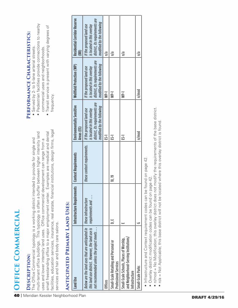
40 | Meridian Kessler Neighborhood Plan DRAFT 4/29/16
Land
Use
Infra
stru
ctur
e Req
uire
men
tsCo
ntex
t Req
uire
men
tsEn
viro
nmen
tally
Sens
itive
Ar
eas (
ES)
Wel
lfiel
d Pr
otec
tion
(WP)
Resid
entia
l Cor
ridor
Res
erve
(R
R)
Belo
w ar
e the
land
use
s tha
t are
antic
ipat
ed in
th
is la
nd u
se d
istric
t. H
owev
er, t
he la
nd u
se is
no
t rec
omm
ende
d un
less
the p
roje
ct m
eets
. . .
thes
e inf
rast
ruct
ure
requ
irem
ents
and
. .
.th
ese c
onte
xt re
quire
men
ts.
If th
e pro
pose
d la
nd u
se
is lo
cate
d in
this
over
lay
dist
rict,
its re
quire
men
ts ar
e m
odifi
ed b
y th
e fol
low
ing
If th
e pro
pose
d la
nd u
se
is lo
cate
d in
this
over
lay
dist
rict,
its re
quire
men
ts ar
e m
odifi
ed b
y th
e fol
low
ing
If th
e pro
pose
d la
nd u
se
is lo
cate
d in
this
over
lay
dist
rict,
its re
quire
men
ts ar
e m
odifi
ed b
y th
e fol
low
ing
Offic
esES
-1
WP-
1n/
a
Smal
l-Sca
le R
etai
ling
and
Pers
onal
or
Prof
essio
nal S
ervi
ces
D, E
18, 1
9ES
-1
WP-
1n/
a
Smal
l-Sca
le Sc
hool
s, Pl
aces
of W
orsh
ip,
and
Neig
hbor
hood
-Ser
ving
Inst
itutio
ns/
Infra
stru
ctur
e
EES
-1
WP-
1n/
a
Smal
l-Sca
le P
arks
Gn/
mod
n/m
odn/
a
Off
ice
Co
mm
erci
alD
escr
ipti
on
: Th
e O
ffice
Com
mer
cial
typ
olog
y is
a w
orki
ng d
istr
ict
inte
nded
to
prov
ide
for
sing
le a
nd
mul
ti-t
enan
t of
fice
build
ings
. Th
is t
ypol
ogy
is o
ften
a b
uffe
r be
twee
n hi
gher
inte
nsit
y la
nd
uses
and
low
er in
tens
ity
land
use
s. O
ffice
com
mer
cial
dev
elop
men
t ca
n ra
nge
from
a
smal
l fre
esta
ndin
g of
fice
to a
maj
or e
mpl
oym
ent
cent
er.
Exa
mpl
es a
re m
edic
al a
nd d
enta
l fa
cilit
ies,
edu
catio
n se
rvic
es, i
nsur
ance
, rea
l est
ate,
fina
ncia
l ins
titut
ions
, des
ign
firm
s, le
gal
serv
ices
and
hai
r an
d bo
dy c
are
salo
ns.
Anti
cipa
ted
Pri
mar
y La
nd
Use
s:
Perf
or
man
ce C
har
acte
rist
ics:
• S
erve
d by
2- t
o 5
-lane
art
eria
l str
eets
.•
Ped
estr
ian
faci
litie
s pr
ovid
e co
nnec
tions
to
near
by
com
mer
cial
use
s an
d ne
ighb
orho
ods.
• Tr
ansi
t se
rvic
e is
pre
sent
with
var
ying
deg
rees
of
freq
uenc
y.
• In
fras
truc
ture
and
Con
text
req
uire
men
t co
des
can
be f
ound
on
page
42.
• O
verla
y di
stric
t m
odifi
catio
n co
des
can
be f
ound
on
page
42.
• n/
mod
= N
o M
odifi
catio
n; t
his
over
lay
dist
rict
does
not
mod
ify
the
requ
irem
ents
of
the
base
dis
tric
t.•
n/a
= N
ot A
pplic
able
; thi
s ba
se d
istr
ict
will
not
be
loca
ted
whe
re t
his
over
lay
dist
rict
is f
ound
.
Meridian Kessler Neighborhood Plan | 41DRAFT 4/29/16
ParkDescription:The Park district is intended for public or private spaces for active or passive recreation. Typical uses include parks, golf courses, recreation centers, aquatic centers, publicly and privately held conservation and preservation areas, civic spaces and community gardens.
Linear ParkDescription:The Linear Park district is intended for public or private property designated for active or passive recreation and is primarily used for the passage of people or wildlife. Examples are greenways, parkways, trails, off-street paths and conservation and preservation areas. Linear parks are frequently along stream or utility corridors. Linear parks that are to be used primarily for humans should link people with destinations.
Regional Special UseDescription:The Regional Special Use district provides for public, semi-public and private land uses that serve a specific institutional purpose for a significant portion of the county. They are large-scale, generally stable institutional uses such as cemeteries, hospitals, and universities, high schools. In Meridian-Kessler the only Regional Special Use is the Indiana State Fairgrounds.
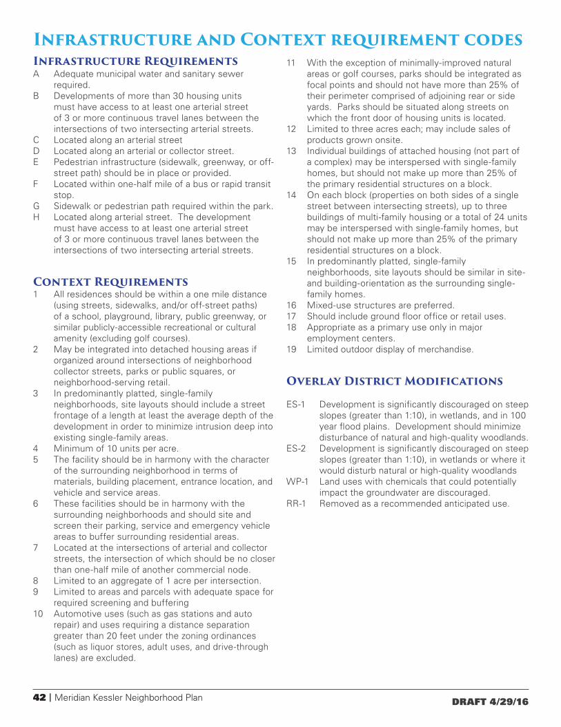
42 | Meridian Kessler Neighborhood Plan DRAFT 4/29/16
Infrastructure and Context requirement codesInfrastructure RequirementsA Adequate municipal water and sanitary sewer
required.B Developments of more than 30 housing units
must have access to at least one arterial street of 3 or more continuous travel lanes between the intersections of two intersecting arterial streets.
C Located along an arterial streetD Located along an arterial or collector street.E Pedestrian infrastructure (sidewalk, greenway, or off-
street path) should be in place or provided.F Located within one-half mile of a bus or rapid transit
stop. G Sidewalk or pedestrian path required within the park.H Located along arterial street. The development
must have access to at least one arterial street of 3 or more continuous travel lanes between the intersections of two intersecting arterial streets.
Context Requirements1 All residences should be within a one mile distance
(using streets, sidewalks, and/or off-street paths) of a school, playground, library, public greenway, or similar publicly-accessible recreational or cultural amenity (excluding golf courses).
2 May be integrated into detached housing areas if organized around intersections of neighborhood collector streets, parks or public squares, or neighborhood-serving retail.
3 In predominantly platted, single-family neighborhoods, site layouts should include a street frontage of a length at least the average depth of the development in order to minimize intrusion deep into existing single-family areas.
4 Minimum of 10 units per acre.5 The facility should be in harmony with the character
of the surrounding neighborhood in terms of materials, building placement, entrance location, and vehicle and service areas.
6 These facilities should be in harmony with the surrounding neighborhoods and should site and screen their parking, service and emergency vehicle areas to buffer surrounding residential areas.
7 Located at the intersections of arterial and collector streets, the intersection of which should be no closer than one-half mile of another commercial node.
8 Limited to an aggregate of 1 acre per intersection.9 Limited to areas and parcels with adequate space for
required screening and buffering10 Automotive uses (such as gas stations and auto
repair) and uses requiring a distance separation greater than 20 feet under the zoning ordinances (such as liquor stores, adult uses, and drive-through lanes) are excluded.
11 With the exception of minimally-improved natural areas or golf courses, parks should be integrated as focal points and should not have more than 25% of their perimeter comprised of adjoining rear or side yards. Parks should be situated along streets on which the front door of housing units is located.
12 Limited to three acres each; may include sales of products grown onsite.
13 Individual buildings of attached housing (not part of a complex) may be interspersed with single-family homes, but should not make up more than 25% of the primary residential structures on a block.
14 On each block (properties on both sides of a single street between intersecting streets), up to three buildings of multi-family housing or a total of 24 units may be interspersed with single-family homes, but should not make up more than 25% of the primary residential structures on a block.
15 In predominantly platted, single-family neighborhoods, site layouts should be similar in site- and building-orientation as the surrounding single-family homes.
16 Mixed-use structures are preferred. 17 Should include ground floor office or retail uses.18 Appropriate as a primary use only in major
employment centers.19 Limited outdoor display of merchandise.
Overlay District Modifications
ES-1 Development is significantly discouraged on steep slopes (greater than 1:10), in wetlands, and in 100 year flood plains. Development should minimize disturbance of natural and high-quality woodlands.
ES-2 Development is significantly discouraged on steep slopes (greater than 1:10), in wetlands or where it would disturb natural or high-quality woodlands
WP-1 Land uses with chemicals that could potentially impact the groundwater are discouraged.
RR-1 Removed as a recommended anticipated use.