metacomet monadnock mattabesett trai l system
TRANSCRIPT

Metacomet Monadnock MattabesettTrail SystemNational Scenic Trail Feasibility Study and Environmental AssessmentDraft Report
Metacomet Monadnock Mattabesett Trail SystemMassachusetts/Connecticut
National Park Service, Northeast Region
Project Manager: Jamie Fosburgh, National Park Service
Project Leader, Connecticut: Kevin Case, NPS
Project Assistant, Connecticut: Dan Hubbard, NPS
Project Leaders, Massachusetts: Christopher Curtis, Pioneer Valley Planning CommissionPeggy Sloan, Franklin Regional Council of Governments
Project Staff, Massachusetts: Jessica Allan, PVPCJessica Atwood, FRCOGEliot Brown, FRCOGAnne Capra, PVPCRaphael Centeno, PVPCRyan Clary, FRCOGMatt Delmonte, PVPCBeth Gianinni, FRCOGShaun Hayes, PVPCSigrid Hughes, FRCOGGretchen Johnson, FRCOGBill Labich, FRCOGJim Scace, PVPCHeather Vinsky, PVPCTracy Zafian, FRCOGTodd Zukowski, PVPC
All cover photos and interior photos for Massachusetts by Christopher Curtis and for Connecticut byRobert Pagini and Connecticut Forests and Parks Association
For further information, or to comment on this draft report, please contact:
MMM Trail National Scenic Trail Feasibility StudyNational Park Service, Northeast Region15 State StreetBoston, MA 02109Tel. 617-223-5051

Summary of Findings 1Trail System Background 1Study Accomplishments 2Important Spin-Offs of the Study 2
Introduction and StudyBackground 5A Summary of National Trails System Act 5B. Background on Metacomet Monadnock-
Mattabesett Trail Study 5C. Study Approach 5D. Summary of Public Involvement and
Participation 7
The Metacomet-Monadnock-Mattabesett Trail System 11A. Development of the Trail 11B. Description of the Trail 12C. Management and Administration of
the Trail 12D. Recreational Use of the Trail 15E. Demographics of Adjacent Trail Towns 18F. Population 18G. Landuse 20H. Community Involvement with the Trail 21I. Natural and Cultural Resources 24
Significant Evaluation 33
Contents
Trail System Issues andOpportunities 43A. Trail Use 43B. Trail Protection 43C. Landowner Issues/Interests 45D. Maintenance and Trail Management
Related Issues 46E. Administration 46F. Community Connections 47G. Trail Continuity and Relocations 47H. Alternate National Scenic Trail Route
in Massachusettts 49I. Alternate National Scenic Trail Route
in Massachusetts 49
A Blueprint For Managementof the Trail 53A. Landowner Issues 53B. Trail Use 54C. Trail Protection 54D. Trail Management and Maintenance 54E. Community Connections 54F. Administrative Framework 55G. Provisions if National Scenic Trail
Designation Occurs 55H. Proposed Blueprint Budget 56
Management Alternatives andEnvironmental Assessment 59A. Purpose and Need 59B. Alternatives Considered and Rejected 59C. Alternatives Considered 60D. The Affected Environment 61E. Impacts of Alternatives 62
Sources 67
West Peak, Connecticut

View of Connecticut River from Hadley, Massachusetts

National Park Service 1
Summary of Findings
Trail System BackgroundThe Metacomet Monadnock Mattabesett(MMM) Trail System is a 190-mile trail route thathas been in existence for over half a century. Ittravels through 39 communities in centralConnecticut and western Massachusetts. Thetrail system is one of two long-distance recre-ational trails, the other being the 92-mileMidstate Trail, serving the south-central regionof New England.
The MMM Trail System hosts an array of scenicfeatures and historic sites. Long distance vistaswith rural towns as the backdrop, agrarian lands,unfragmented forests, and large river valleys areamong the classic New England landscapefeatures located along the trail system. The trailsystem also travels through important NativeAmerican and colonial historical landmarksshowcasing the unique landscape of the area.The trail system harbors a range of diverseecosystems and natural resources, includingtraprock ridges, mountain summits, forestedglades, vernal pools, lakes, streams and waterfalls.
The Connecticut Forest and Park Association(CFPA) is the steward of the trail system inConnecticut through their “Blue-Blazed HikingTrail” program. The Berkshire Chapter of theAppalachian Mountain Club (AMC) is theprincipal steward of the trail system in Massa-chusetts. The entire trail system is predominantlymanaged and maintained by volunteers, andmuch of it relies on the generosity and commit-ment of landowners who voluntarily allow it tocross their lands.
As growth continues to change the landscape ofsouthern New England, portions of the MMMTrail System have experienced increasingpressures that threaten the long-term viability ofthis continuous long-distance trail. Residentialsubdivision and other growth pressures areforcing relocations of the trail system withincreasing frequency, and options for suchrelocations are dwindling. The growth pressureis most acute in Connecticut and in the southernand central regions of Massachusetts.
Study Background and ApproachResponding to the perceived threats to the long-term viability of the trail system, CongressmanJohn Olver of Massachusetts and Congress-woman Nancy Johnson of Connecticut spon-sored federal legislation to study the MetacometMonadnock Mattabesett Trail System inConnecticut and Massachusetts. Based on theexpressed intent of the sponsors and principaltrail steward organizations, two goals wereestablished for the study that became Public Law107-338 in December, 2002:
Primary Goal: To determine the best way toensure the long-term viability of a continuouspublic-use trail system from Long IslandSound through Connecticut to theMassachusetts/New Hampshire border.
Secondary Goal: To determine whether or notdesignation as a National Scenic Trail makessense as a means of achieving the primary goalof long-term trail system viability.
In addition, the study had four guidingprinciples:
• Meaningful investigation of the trail system’slong-term viability can only occur with the fullinvolvement of trail advocates, landowners,and other interested parties.
• Emphasis will be on strengthening existingtrail system partnerships and characteristics ofuse, maintenance, ownership, and voluntarystewardship.
• Respect for private property rights is afundamental component of a successfulproject.
• Federal condemnation of land will not beconsidered as an option in establishing orprotecting the trail system.
Mattabesett Trail, Durham, Connecticutlooking west toward Totoket Mountain

2 Metacomet-Monadnock-Mattabesett Trail System
To ensure broad stakeholder involvement, an ad-hoc steering committee was formed in Connecti-cut and working groups were formed in Massa-chusetts to assist in the completion of the study.Involvement was open to all interested parties,including landowners, trail users, trailmaintainers, non-profit land conservationgroups, regional planning organizations and localand state agencies. The steering committee andthe working groups met quarterly and providedinput and feedback to the National Park Serviceon the study products as they were developed.
Considerable effort was also put into engagingtrail landowners and leaders in each of thecommunities that the trail system travels through.Outreach efforts included trail-use question-naires, newsletters, establishment of a websiteand a series of community meetings that wereheld to introduce the study and provide opportu-nities for public involvement.
Study AccomplishmentsIn addition to researching the trail and its natural,cultural and recreational attributes, severalaccomplishments completed during the study areworthy of particular note, including:
• Mapping the Trail. Modern GIS (GeographicInformation System) and GPS (GlobalPositioning System) mapping techniquesallowed for more detailed and accuratemapping of the existing trail system route.
• Identifying and Communicating with TrailLandowners. By cross referencing accuratetrail location data with tax map records intown and city offices, 613 landowners owning1,070 parcels of land on the trail system wereidentified and communicated with as a part ofthe study.
• Identifying Trail Issues and Opportunities.Working committees, trail landowners, usergroups, community officials, trail stewards andothers all contributed to an understanding oftrail issues and opportunities.
• Research on Successful Long-Distance TrailManagement. The Pioneer Valley PlanningCommission and Franklin Regional Council ofGovernments researched different types oflong-distance trail management practices tobetter inform the study process and products(Appendix G).
• A Blueprint for the Future of the Trail. Aculmination of much of the study’s effort, the“Blueprint for Management” of the trail systemwas developed from all of the input citedabove. The Blueprint is intended to be a usefulguide to the future of the trail whether or notNational Scenic Trail designation is imple-mented.
Important Spin-Offs of the StudyThe mapping, landowner communication, andstakeholder dialogue sponsored by the studygenerated important spin-off accomplishmentsundertaken by volunteer partners:
• Extension to Long Island Sound. Townplanners in Guilford, CT assumed the chal-lenge of connecting the existing trail system toLong Island Sound in coordination with theStudy Steering Committee. A 14-mile potentialroute has been identified and is incorporatedinto the Preferred Management Alternative.
• Successful Trail Relocations. Severallandowners who were contacted during thestudy requested that the trail be removed fromtheir lands. Trail managers and communitypartners subsequently moved several miles oftrail in both Connecticut and Massachusettsonto permanently protected routes.
Preferred Management Alternative: Implemen-tation of the Trail Management Blueprintthrough National Scenic Trail Designation fromLong Island Sound in CT to the NH Border,including a significant re-route in theBelchertown – Leverett area in Massachusetts.The study concludes that the long-term viabilityof the MMM Trail System as a high quality,continuous, long-distance trail will require asustained level of increased focus and resourcesby a wide array of trail partners. National ScenicTrail designation appears to be the most feasibleway to generate such an increased level ofattention and resources. The trail system,proposed to be named the New EnglandNational Scenic Trail, would be approximately220 miles in length, including a new trail exten-sion and relocations.
In summary, the designation would:
• Provide the best opportunity to secure long-term trail viability;
• Provide an opportunity for federal funding fortrail management and protection;
• Address critical landowner issues throughcommitment to a Management Blueprint;
• Coalesce trail partners and communitiesthrough creation of a Trail StewardshipCouncil;
• Facilitate a trail extension to Long IslandSound
• Elevate the profile of the trail system to thelevel of national significance.
The preferred alternative includes the follow-ing elements:

National Park Service 3
Blueprint for Management. The Blueprintdocument was developed with input from a fullrange of study participants to provide the bestpossible plan for long-term trail viability. Futuretrail management, administration and protectionefforts would be based on the Blueprint.
Creation of a Trail Stewardship Council. Thecouncil would bring trail partners and stakehold-ers together on a regular basis to discuss trailissues and coordinate management activities, andgenerally guide implementation of the Blueprint
for Management. The Council would haveadvisory powers only, being non-regulatory innature.
National Park Service Role. The Study identifiedno need for direct federal trail ownership ordirect federal trail management. Thus, theNational Park Service role in implementing theproposed National Scenic Trail designation
would be one of technical and financial assis-tance to existing trail partners, coordinatedthrough the Trail Stewardship Council.
A New Name. A new, unifying name is suggestedfor National Scenic Trail purposes: New EnglandNational Scenic Trail. Traditional trail nameswould continue to be used where appropriate --for example “Mattabesett Trail, part of the NewEngland National Scenic Trail.”
New Route Opportunities. In addition to theproposed extension to Long Island Sound inGuilford, CT, a new conceptual route for theNational Scenic Trail is proposed in theBelchertown-Leverett area of Massachusetts.The route alternative is envisioned to takeadvantage of substantial state-owned lands thatcan provide a quality, protected trail route, whileavoiding a segment of the Metacomet-Monad-nock Trail almost completely devoid of protectedlands. No specific alignment is suggested orproposed.
Ridgetop fall scene, Connecticut

4 Metacomet-Monadnock-Mattabesett Trail System
View of Bare Mountain, Amherst, Massachusetts

National Park Service 5
Introduction and Study Background
Table 1. Designated National Scenic trails
Name of Trail Year Designated Authorized Length (miles)
Appalachian 1968 2170Pacific Crest 1968 2638Continental Divide 1978 3200Ice Age 1980 1000North Country 1980 4100Florida 1983 1300Natchez Trace 1983 440Potomac Heritage 1983 700
A. Summary of the National Trails System ActThe National Trails System Act (Public Law 90-543, as amended through Public Law 107-325)institutes a national system of historic, scenic,and recreation trails. National Scenic Trails aretrails at least 100 miles long that provide formaximum outdoor recreation potential, and forthe conservation and enjoyment of nationallysignificant scenic, historic, natural, or culturalqualities of trail areas.
Section 2 [16USC1241] of the National TrailsSystem Act notes that “trails should be estab-lished (i) primarily, near the urban areas of theNation, and (ii) secondarily, within scenic areasand along historic travel routes of the Nationwhich are often more remotely located.”
Currently, there are a total of eight designatedNational Scenic Trails. See Table 1
B. Background on Metacomet-Monadnock-Mattabesett Trail Study
The Metacomet Monadnock Mattabesett(MMM) Trail System consists of three generallycontiguous trails: the Metacomet, theMetacomet-Monadnock, and the Mattabesett,that travel 190 miles in a north-south directionfrom the Massachusetts-New Hampshire bordersouth towards Long Island Sound in Connecti-cut. The portion of the Metacomet-MonadnockTrail included in the study is located entirelywithin Massachusetts, while the Metacomet andMattabesett Trails are located entirely withinConnecticut.
In December 2002, President George W. Bushsigned Public Law 107-338, directing the U.S.Department of the Interior to conduct a feasibil-ity study of the Metacomet MonadnockMattabesett Trail System in Connecticut andMassachusetts for possible inclusion in the
National Trails System through designation as aNational Scenic Trail. Note that the Metacomet-Monadnock Trail extends into New Hampshire,but that this portion of trail was not included inthe study’s authorizing language.
The MMM Trail System Study was proposedjointly by U.S. Representatives John Olver ofMassachusetts and Nancy Johnson of Connecti-cut. Representatives Johnson and Olver acted inresponse to public interest in the trail and torequests from constituents that it be preserved.House co-sponsors of the study legislationincluded Representatives DeLauro, Larson,Maloney, and Simmons of Connecticut, Repre-sentative Neal of Massachusetts, RepresentativeBass of New Hampshire, and RepresentativeUdall of New Mexico. Senate co-sponsorsincluded Senators Dodd and Lieberman ofConnecticut, and Senators Kennedy and Kerryof Massachusetts.
The principal rationale for the MMM TrailStudy, as expressed in testimony before Con-gress, is that without a concerted effort to protectthe trail system it will cease to exist as a recre-ational resource for future generations.
C.Study ApproachGoals of the StudyThe following goals were established at theoutset of the study, and served to guide develop-ment of the work plan and study products:
• The primary goal of the MMM Trail Systemstudy is to determine the best approach toensure the long-term viability of a continuouspublic use trail system from Long IslandSound through Connecticut to the Massachu-setts/New Hampshire border.

6 Metacomet-Monadnock-Mattabesett Trail System
• A secondary goal is to determine whether ornot designation as a National Scenic Trail is anappropriate means of achieving the primarygoal of long-term trail system viability.
The study engaged a full spectrum of trailstakeholders in an exploration of the trails asthey exist today and their potential for futuregenerations. GIS technology was used to mapthe trail and cross-reference the location withlocal landownership data in the 39 abuttingcommunities, facilitating communication withtrail landowners, in many cases for the first time.
The study team developed a set of principlesbased on the intentions of the study’s Congres-sional sponsors, the operating principles of theNational Park Service, and the input of trailstakeholders in Connecticut and Massachusetts.The principles are as follows:
• Meaningful investigation of the trail system’slong-term viability can only occur with the fullinvolvement of a wide range of trail advocates,landowners, and other interested parties.
• A particular emphasis of the study will be onstrengthening existing partnerships andcharacteristics of use, maintenance, owner-ship, and voluntary stewardship.
• Respect for private property rights is a funda-mental component of a successful study.
• Federal condemnation of land will not beconsidered as an option in establishing orprotecting the trail system.
Overview of the Scope of WorkThe major tasks identified and completed for thestudy were as follows:
1) Establish a detailed and current understandingof the MMM Trail System:
• Map the existing trail system route using GISand GPS technologies. Identify all landownerswhose properties intersect the trail;
• Identify the location and significance ofnatural communities, unique flora and fauna,soils, geology, topography, hydrology, knownand potential archaeological areas, and historicresources;
• Identify the location and quantity of landownership types along the trail system,including private, corporate, municipal,conservation, state, and utility;
• Identify the location and significance offeatures that make the recreational trail systemexperience unique, include scenic view points,multi-use areas, connecting trails, trail accesspoints, road sections, and cultural and/orhistoric features.
2) Conduct a variety of public outreach activitiesdesigned to explain the study process andcollect input, including:
• Regional forums held in separate Connecticutand Massachusetts locations;
• Written and/or verbal communication withmunicipal leaders and state legislators fromeach of the towns the trail system passesthrough;
• Written and/or verbal communication with alllandowners living along or directly abuttingthe trail system;
• Meetings with state, corporate and utilitylandowners along the trail;
• Establishment of a website to provide currentinformation about the study process andprogress.
3) Research existing models and alternatives forsuccessful long-distance trail management,protection, maintenance and administrationamong both designated and non-designated trailsystems.
4)Complete a blueprint for long-term manage-ment, protection and maintenance of the trailsystem based on a vision for the trail that reflectsthe concerns of property owners, trail usergroups, and other stakeholders.
5) Identify and evaluate broad managementalternatives.
View from Peak Mountain, East Granby, Connecticut

National Park Service 7
“in cooperation withinterested interstate,State, and local govern-mental agencies, publicand private organiza-tions, and landownersand land users con-cerned.”
From the above five components this draft studyreport has been drafted for public review andcomment.
D. Summary of Public Involvement andParticipation
Extensive public involvement has been a centralfeature of the MMM Trail System Study, and isbased on a recognition that meaningful investiga-tion of the trail’s long-term viability can onlyoccur with the full involvement of a wide rangeof trail advocates, landowners, and otherinterested parties. Additionally, Sec. (5) (b) of theNational Trails System Act directs that studies oftrails under consideration for Federal designationshall be completed:“in cooperation with interested interstate, State,and local governmental agencies, public andprivate organizations, and landowners and landusers concerned.”
To achieve the primary and secondary goals ofthe feasibility study, the study has included manymethods for public outreach and participation, assummarized below.
Quarterly Open Meetings of Trail Study
Working GroupsStudy Teams in both Connecticut and Massachu-setts held public “working group” meetings on aquarterly basis throughout the study to keep trailstakeholders apprised of study progress andsolicit input on work plan components. Thesemeetings took place between the fall of 2003 andthe spring of 2005.
In Connecticut, a single working group wasformed and adopted the name “MMM TrailStudy Steering Committee,” while in Massachu-setts three separate working groups were formedby the Pioneer Valley Planning Commission(PVPC) and Franklin Regional Council ofGovernments (FRCOG), acting as consultants tothe National Park Service. The quarterlymeetings provided an effective vehicle for review,comment and insight on the development ofstudy work products, beginning with the workplan itself and continuing through to thedevelopment of alternatives and production ofthe draft report. The development of theBlueprint for Management document receivedconsiderable attention, comment, and revisionthrough these forums.
In Connecticut, the MMM Trail Study SteeringCommittee had fairly regular attendance fromthe following organizations and entities:
• Appalachian Mountain Club – ConnecticutChapter
• Central Connecticut Planning Agency• Connecticut Department of Environmental
Protection• Connecticut Horse Council• Connecticut Forest & Park Association• Landowners (both individual and corporate)• Local, non-profit land trust organizations• Municipal government representatives• New England Mountain Bike Association• New England Orienteering Club• Ragged Mountain Foundation
In Massachusetts, the Pioneer Valley PlanningCommission (PVPC) convened one workinggroup for the trail west of the Connecticut River(Hampshire County) and one working group forthe trail east of the Connecticut River (HampdenCounty). The Franklin Regional Council ofGovernments (FRCOG) formed one workinggroup for the Franklin and Worcester Countysections of the trail.
The Massachusetts regional working groupmeetings had much more varied attendance overthe course of the study. However, attendancewas consistent from municipal representatives,property owners, and trail user groups. Individu-als or representatives of groups who attendedone of the meetings were automatically added tothe mailing list to receive future meeting notices.Attendees included:
• Bay State Trail Riders Association• Landowners (both individual and corporate)• Local, non-profit land trust organizations• Municipal government representatives• New England Mountain Bike Association• Snowmobile Association of Massachusetts
Hikers on the MMM trail
8 Metacomet-Monadnock-Mattabesett Trail System
In both states, efforts to encourage participationwere directed toward representatives of thecommunities through which the trail systemtravels, landowners along the trail, representa-tives of trail user groups, state agency representa-tives, trail maintainer organizations, and mem-bers of the general public who were interested inthe project.
Trail Stakeholder Communications
As part of an ongoing effort to identify andcontact all persons with a direct interest in thetrail system (“stakeholders”), the Connecticutand Massachusetts study teams compiled adatabase containing the names of over 2,000 traillandowners, trail user groups, land trust organi-zations, local municipal officials, and otherparties. During the study period a variety ofoutreach communications were delivered tothese stakeholders, including:
• Announcement of the study and relatedactivities
• Description of study goals, work-plan andtimeline
• Description of frequently asked questions andanswers
• Announcement of steering committee andregional working group meetings
• Solicitation of public comment on studyactivities
• Announcement of public forums• Property owner questionnaire
Trail Stakeholder Meetings
During the course of the study, meetings wereheld individually with a number of key stakehold-ers to provide information about the study and tosolicit input on issues concerning the trail system:
• Connecticut Department of EnvironmentalProtection
• Connecticut Department of Public Health• Connecticut Department of Transportation• Connecticut Regional Water Utilities• Massachusetts Department of Conservation
and Recreation• Corporate Landowners• Land Trust Organizations• Trail User Groups
In addition, the Connecticut study team met withrepresentatives of municipal governments fromseventeen of the twenty communities that thetrail system passes through in Connecticut. Theremaining three towns did not wish to meet, andreceived a packet of information to be sharedamong interested town officials.
Typical meeting attendees included townselectmen, planning and zoning officers, recre-ation directors, environmental complianceofficers, and representatives from naturalresource commissions, land trusts, and trail usergroups. Study team members provided abriefing on the study, a timeline for variousactivities, and materials to be posted or shared atmunicipal offices. Significant portions of eachmeeting were devoted to sharing of localconcerns and to question and answer sessions.In Massachusetts, municipal officials wereinvited to attend all working group meetings.
Public Outreach MeetingsIn late 2003 and throughout 2004, the Connecti-cut and Massachusetts study teams sponsored aseries of public meetings designed to publiclyintroduce the trail study and solicit input on avariety of study and trail management issues. InConnecticut, three public forums were held inthe northern, central, and southern regions ofthe state with approximately 200 citizensattending. In Massachusetts, three public forumswere held: one in Hampden County, one inHampshire County, and one in Franklin County.In addition, working committee meetings wereheld quarterly within the same areas.Although the meeting formats varied slightlyfrom state to state and region to region, thefollowing agenda items were covered over thecourse of the public outreach meetings:
• Introduction of study purpose, background,objectives, principles, work plan components,and timeline.
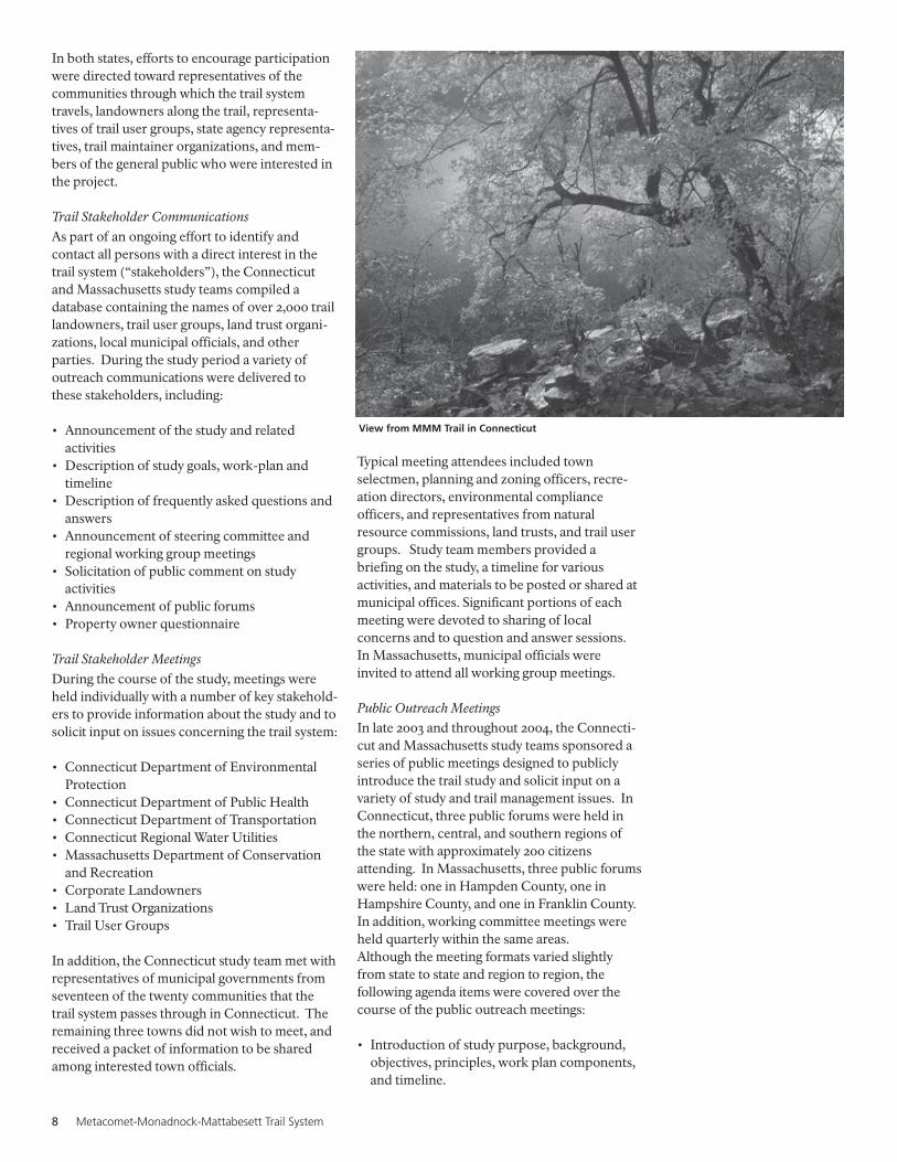
View from MMM Trail in Connecticut

National Park Service 9
• Description (using maps) of the trail system asit currently exists.
• Description of study tasks underway orcompleted, including trail system mapping,natural and cultural assessment reports,identification of current trail system recre-ational uses, and identification of trail systemmanagement issues.
• Solicitation of input on issues and concernsregarding the trail system, including mainte-nance, unauthorized use, signage, parking, andrecreational use liability.
• Solicitation of input on the draft trail manage-ment blueprint.
• Presentation of findings from research onother long-distance trail systems.
• Distribution of trail study public materials,including a study brochure, question/answerdocument, vision statement, and managementplan draft.
• Description of available methods for providingcomment on the study process and trail systemissues.
Data Collection from Trail LandownersIn 2004, two separate questionnaires weredeveloped for use in Connecticut and Massachu-setts. Each questionnaire was designed to gatherinput from property owners whose landsintersect (cross) or abut (lie near) the MMMTrail system.
The questionnaires sought to confirm theaccuracy of trail property ownership data, tocollect data on observed, allowed, and preferredtrail uses, and to provide landowners with theopportunity to comment on the trail system andthe study. Questionnaires were mailed in bothstates to property intersectors and abutters. InConnecticut, a follow-up postcard was mailed toencourage recipients to return the questionnaire.
Trail Study Public WebsiteA web site was developed for the purpose ofdisseminating public information regarding thestudy. The site (www.mmmtrail.org) has receivedover 4,000 separate visits since its inception. Thekey web site informational sections include alisting of study goals and principles, the studywork plan, information on Connecticut TrailStudy Steering Committee activities, a list offrequently asked study questions, photos andmaps, and information on contacting study teammembers with questions and/or comments.
Mormon Hollow Brook along the MMM Trail in Wendell, Massachusetts

10 Metacomet-Monadnock-Mattabesett Trail System
View from Summit House looking towards the Connecticut River

National Park Service 11
The Metacomet-Monadnock-MattabesettTrail System
A. Development of the TrailThe earliest origins of the MMM Trail System inConnecticut and Massachusetts are largelyunknown. Sections of trail in the lower eleva-tions of both states probably originated as Indianfootpaths that later were used by local hunters insearch of game. It is known that some of the firstsections of trail were located in areas thateventually became the cities of Meriden andMiddletown in Connecticut.
Formal development and construction ofindividual sections of the Trail System began inthe early 1930’s. Over the next four decades, theMMM Trail System came to assume its presentstructure and route.
ConnecticutOrganized trail construction and maintenanceactivities for the Metacomet and MattabesettTrails officially began in the 1930’s under theauspices of the Connecticut Forest and ParkAssociation (CFPA). CFPA is the oldest non-profit conservation organization in Connecticut.Its mission is to conserve the land, trails andnatural resources of Connecticut, particularly itswoodlands, farms, and wildlife habitats.
CFPA was first organized as the ConnecticutForestry Association in 1895 and during itsformative years worked to promote statelegislation protecting forests. The nascentorganization lobbied the state to appoint aforester, making Connecticut the first state in thenation to have one. The Connecticut ForestryAssociation also promoted laws to establish localtree wardens and protect shade trees.
In 1929, CFPA President Theodore SalisburyWoolsey sensed an emerging interest in hiking asa recreational activity and responded by creatingCFPA’s first trails committee. Woolsey ap-pointed Edgar L. Heermance, a retired minister,as chairman of the committee, thus changing thedirection of CFPA’s work. At its first meeting onDecember 27, 1929, the committee agreedunanimously to create a system of hiking trailsthroughout the state to support growing publicinterest. With that decision, CFPA establishedthe Blue-Blazed Hiking Trail System, whichtoday consists of over thirty-five distinct trailstotaling over 700 miles in length.
The creators of the Blue-Blazed Hiking Trails,being avid hikers and trail enthusiasts, broughtconsiderable knowledge and experience to thetask of setting up the Blue-Blazed Hiking TrailSystem. The trail system’s colorful monikerreferences the blue paint used to mark the trails.On February 14, 1930, the committee voted tomark the trails with a distinctive shade of bluepaint, one that Heermance had painstakinglymixed himself until settling upon a shade thatcould be seen at twilight. This unique hue is stillused on the trails today.
On April 29, 1931, the trails committee voted toofficially name the Meriden and Middletownsections of trail the Metacomet Trail andMattabesett Trails, respectively, thus retaining atradition of using Native American names forBlue Blazed Trails. The Metacomet Trail wasnamed for the Indian Chief Metacomet, whodirected many Indian raids throughout theConnecticut Valley region of northern Connecti-cut and Massachusetts. Frederick W. Kilbournewas one of the first trail managers (or sectionheads, as they were once known). Kilbourne, alibrarian and associate editor of Webster’sInternational Dictionary, was the first to formallyblaze the Metacomet Trail through Meriden.
The Mattabesett Trail derives its name from theNative American word for Middletown. Karl P.Harrington was responsible for early construc-tion and blazing of the Mattabesett, extendingthe trail to almost 50 continuous miles.Harrington, a professor at Wesleyan University,recruited the Wesleyan Outdoor Club to helpcreate and maintain the Mattabesett Trail.
Massachusetts
By the 1950s, the Connecticut Forest and ParkAssociation (CFPA) had succeeded in fullydeveloping a significant percentage of the Blue-Blazed Hiking Trails System, including theMetacomet and Mattabesett Trails. It is believedthat the Massachusetts section of the trail wasestablished after discussions among CFPAmembers that a ridgeline trail connecting theMetacomet Trail to Mount Monadnock in NewHampshire would be a worthy project.
According to a July 1, 1993 article in The Spring-field, Massachusetts Republican, “with Walter

12 Metacomet-Monadnock-Mattabesett Trail System
Banfield as their leader, a corps of 15 hikingenthusiasts began laying out the (Massachusettssection of the) trail in 1951, taking up a dare toextend the Metacomet.” According to the article,the group worked every weekend for the next 15years.
Walter Banfield was a professor of botany at theUniversity of Massachusetts at Amherst(UMass), a resident of Shutesbury, and an avidhiker who had enjoyed the outdoors sincechildhood. He was also a member ofMetawampe, the faculty hiking club at UMass.According to the Springfield Republican article,the route of the Metacomet-Monadnock Trailwas determined by Banfield to follow “thebeauty and attractiveness of the countryside.”Banfield is quoted in the article as saying, “I hadno great vision of what it would be or what itwould become. We had good beginnings. MountHolyoke, for one, already had a good trailsystem.”
By the early 1960s, Banfield and his team finishedthe trail and published the first Metacomet-Monadnock Trail guide. The trail was describedin the guide book using the United StatesGeological Survey (USGS) topographical mapsas a base with the trail route over-laid in black.
B. Description of the TrailThe MMM Trail System consists of three largelycontiguous trails: the Metacomet-MonadnockTrail, the Metacomet Trail, and the MattabesettTrail. The trails collectively travel 190 miles in anorth-south direction, from the Massachusetts-New Hampshire border south towards LongIsland Sound. The portion of the Metacomet-Monadnock Trail included in the study is locatedentirely within Massachusetts, while theMetacomet and Mattabesett Trails are locatedentirely within Connecticut.
The Metacomet Trail in Connecticut follows atraprock mountain range running from theHanging Hills of Meriden to the MassachusettsState line for approximately 57 miles. The Trailreaches elevations of over 1,000 feet at its highestpoint.
The Mattabesett Trail is approximately 53 milesin length. The trail begins at the ConnecticutRiver, and roughly forms a large horseshoe as ittravels south and west before assuming anortherly direction to its terminus at the BerlinTurnpike in Berlin. A road-walk then connectsto the southern terminus of the Metacomet Trail.
The Metacomet-Monadnock Trail in Massachu-setts is approximately 80 miles in length. Thetrail is located in Hampden, Hampshire,Franklin, and Worcester Counties, passingthrough 19 separate communities. The elevationof the trail varies from 100’ at its lowest pointalong the Westfield River in Agawam to 1,618 feetat its highest point on Mount Grace in Warwick.The trail enters New Hampshire at the state lineand continues northward, eventually reachingthe summit of Mt. Monadnock.
In order to understand the existing trail system, adetailed field survey and inventory was com-pleted. In 2003 and 2004, a combination ofregional planning professionals and volunteershiked the trail system in both Connecticut andMassachusetts, utilizing a global positioningsystem (GPS) to record detailed data. Thefollowing information was collected and com-piled into a geodatabase:
• General descriptions and photographs of thetrails;
• Information on resources, scenic view shedsand other special assets;
• Physical characteristics including geology,hydrology, vegetation and wildlife;
• Cultural resources located along the trails orwithin close proximity;
• Wildlife habitats;• Historic and archaeological features;• Other characteristics that make the trail system
unique.
Other data collected during the field hikingincluded:
• Condition of the trails;• Locations of trailheads and parking areas;• Identification of problem areas needing
attention;• Trail route continuity;• Maintenance issues.
A complete segment-by-segment description ofthe MMM Trail System, including informationon connecting trails, may be found in AppendixA.
C. Management and Administration ofthe Trail
The Metacomet-Monadnock-Mattabesett TrailSystem is a publicly available trail that functionswithout cost to taxpayers. It exists largely due toprivate landowner permission, and is managedand maintained by volunteer organizations, theirmembers, and other members of the public.
MMM Trail passage near Horse Cave

National Park Service 13
Connecticut
In Connecticut, day-to-day managementresponsibility for the Metacomet andMattabesett Trails (and for Connecticut’s entireBlue-Blazed Hiking Trail System) belongs to theConnecticut Forest and Park Association(CFPA), a non-profit conservation organization.As it has done for over seventy-five years, CFPAsets policies and oversees a network of volunteertrail managers.
No current management plan exists for theMetacomet and Mattabesett Trails. With oneexception, CFPA does not own the lands that theMetacomet and Mattabesett Trails pass through.Where the trails traverse state lands they aresubject to Connecticut state statutes and policiesas administered by the state’s Department ofEnvironmental Protection (DEP). In practice,DEP approves trail placements and determinesthe types of recreational uses permitted. Allmaintenance and improvement tasks are left toCFPA to complete. This shared-managementmodel also applies to land owned by municipalgovernments, corporations, non-profit organiza-tions, and private citizens.
The primary management authority within CFPAfor the Blue-Blazed Hiking Trails is its TrailsCommittee, which determines policy andimplements actions for the trails with the statedgoal of managing, maintaining, and protectingthem for present and future users. The commit-tee takes action consistent with the approvedmission, plans and budgets of CFPA. Theirresponsibilities include assigning and trainingnew trail managers, recommending long rangeactivities and budgets for committee operations,and preparing and executing trail protection andmaintenance plans.
Currently there are thirteen volunteer trailmanagers who, with the occasional assistance ofother volunteers, oversee the care of theMetacomet and Mattabesett Trails. Trailmanagers come from a variety of backgrounds.Some are retirees, while others are members (anda designated representative) of local land trustorganizations or trail user groups such as hikingclubs. Assistance is available to trail managers formajor trail construction and relocation projectsfrom two roving trail crews made up of CFPAvolunteers.
Each trail manager is responsible for a variety ofduties such as blazing, building bridges anderosion control measures, and trail clearing andbrushing. They are also responsible for commu-nicating with landowners and helping to try and
re-route trails when necessary. This is often atime consuming process that sometimes pro-duces no suitable alternative route, forcing a trailmanager to close a section of trail. In 2003 alone,trail managers and other volunteers donated over600 hours of their time to work on theMetacomet and Mattabesett Trails.
CFPA also publishes the Connecticut Walk Book,a trail guide covering the entire Blue-BlazedHiking Trail System. Since 1932, eighteen editionsof the Walk Book have been published. Acompletely redesigned Walk Book was publishedin 2005, reflecting the latest information andmaps for all trails including the Metacomet andMattabesett.
Approaches to Trail Protection:
A current challenge in trail protection effortsinvolves trail closures due to unwilling landown-ers and development pressures. Because asignificant portion of the Metacomet andMattabesett Trails lie on private property, CFPAmust work directly with landowners to ensurepublic access.
CFPA employs a variety of different types ofagreements to protect the trail system, includingconservation easements, rights of way, traillicense agreements, and donations of land.
Conservation easements are restrictions placedon a piece of property to protect its associatedresources. The easement is either voluntarilydonated or sold by the landowner. It is legallybinding, and may limit certain types of uses orprevent development from taking place on theland in perpetuity while the land remains inprivate hands. Conservation easements protectland for future generations while allowingowners to retain many private property rightsand to live on and use their land.
CFPA currently has two easement agreements inthe final stages of negotiation. Some towns andprivate land trusts have secured easements onsignificant tracts of land. The towns of Avon,Durham, Farmington, Guilford, Middlefield, andSimsbury have been active in obtaining ease-ments or purchasing land which in turn mayprotect sections of the Metacomet andMattabesett Trails.
Rights of way are less formal written agreementsthat are usually recorded in municipal propertyrecords. They often exist in perpetuity andtransfer from old to new property owner when aparcel of land is sold.
Blue-blazed trail in Connecticut

14 Metacomet-Monadnock-Mattabesett Trail System
The trail license agreement has proven to besuccessful, as it represents a revocable compactbetween an organization such as CFPA and thelandowner, documenting both parties’ expecta-tions for use and maintenance of the trail. Todate, CFPA has obtained at least four trail licenseagreements for the Metacomet and MattabesettTrails. Additional, informal agreements existwith Northeast Utilities, the Hill-Stead Museumand the Town of Avon. CFPA is currentlypursuing trail license agreements with theDurham Conservation Commission and thetowns of Farmington and Middlefield.
Private landowners understandably have manyconcerns regarding the public use of their land.Historically, many of these landowners did notlive on the property in question and merelymaintained their land as woodlots. Concernstypically involved the risk of fire and the prolif-eration of litter. To address these concerns andultimately obtain permission to use their land,individual trail managers met with privatelandowners. After the meeting, most landownersallowed access across their land, often finalizingthe agreement with a simple handshake orinformal letter.
Today the job of securing landowner permissionis a more complex matter. Landowners some-times resist public access to their property out ofliability concerns. However, in 1971, the GeneralAssembly addressed this concern by enacting alandowner liability law (Connecticut GeneralStatutes Sections 52-557), that (with exceptions)limits the liability of property owners who allowtheir land to be used for recreational purposeswithout charge. This critical legislation helpsCFPA to continue the Blue-Blazed Hiking TrailSystem on private lands without increased fear ofliability.
Partnerships:As the oldest non-profit conservation organiza-tion in Connecticut, CFPA has found it advanta-geous to open lines of communication withcorporations, private individual landowners, trailuser groups, local land trusts, and other non-profit organizations to help facilitate constructivedialogue concerning the future of the trails.Discussions are held on trail management andmaintenance issues, land protection strategies,educational opportunities, and other subjects.Partner groups that are involved in discussionsand projects include:
• American Hiking Society• Appalachian Trail Conference• Appalachian Mountain Club
• Connecticut Agricultural Experiment Station• Connecticut Department of Environmental
Protection• Connecticut Forest Stewardship Council• Ensign Bickford Foundation• Friends of Connecticut State Parks• Green Mountain Club• Meshomasic Hiking Club• Metropolitan District Commission• National Wildlife Federation• National Woodland Owners Association• Northeast Utilities• New Haven Hiking Club• Ragged Mountain Foundation• Rockfall Foundation• South Central Regional Water Authority• Society of American Foresters• University of Connecticut, College of Agricul-
ture and Natural Resources• USDA Forest Service• Yale University School of Forestry
Massachusetts
In Massachusetts, the Appalachian MountainClub (AMC) acts as the primary steward for theMetacomet-Monadnock Trail. The AMC is theoldest conservation and recreation organizationin the United States, with over 90,000 membersin total and over 3,400 members in westernMassachusetts.
Soon after the release of the first Metacomet-Monadnock Trail guide book in the early 1960s,the Berkshire Chapter of the AMC assumedoverall responsibility for maintaining andmanaging the trail. The Berkshire Chapter is anall-volunteer organization and is one of twelvechapters of the AMC in the northeast.
The Chair of the Berkshire Chapter’s TrailsCommittee, who is also the Chair of theMetacomet-Monadnock Trail Committee, acts asthe coordinator of all trail maintenance activities.The trail maintenance work is generally com-pleted by approximately two dozen volunteerswho are not necessarily members of the Berk-shire Chapter of the AMC. Generally, the onlyqualifications for the trail maintenance crews arethat they are committed and interested inspending time outdoors along the trail.
Although there is no formal trail maintenanceand/or management plan currently in place, thereis a process followed by the Berkshire Chapter ofthe AMC in its oversight of the Metacomet-Monadnock Trail. The Berkshire Chapter TrailsCommittee Chair recruits volunteer trail “adopt-ers” who oversee the maintenance along aparticular section of the trail. Generally, the trail

National Park Service 15
sections (as defined in the AMC’s Trail Guide)are divided and “adopted.” Two sections of thetrail are currently being maintained by thePioneer Valley Hiking Club, but otherwise thetrail is currently being maintained by individualadopters.
The role of the adopter is to complete threewalk-thru or trail inspections for their section ofthe trail each year (spring, summer and fall).During each walk-thru the adopter will check forfallen limbs that may be blocking the trail, replacesigns as necessary, and complete routine brushtrimming to keep the trail open. Major mainte-nance tasks are reported back to the TrailsCommittee Chair so that group work days can beorganized to complete any more large scale workprojects that are needed. A webpage has alsobeen established that enables hikers to providefeedback on the conditions of the trail. TheTrails Committee Chair may then contact theappropriate adopter about the needed work.
An organizational meeting is held annually inJanuary to plan for maintenance projects for theyear. This meeting is advertised in order toattract new people who may be interested inproviding help along the trail as well. In addition,a get together is usually held with the volunteersin June or July to coordinate other neededmaintenance work and show appreciation fortheir efforts. The bi-annual meetings allowmembers time to discuss any issues or neededtrail work. Decisions are made by consensus.Regular communication between Chaptermembers allows for ongoing discussions of trailissues and trouble shooting. Any changes thatare made to the trails are relayed to the memberwhose responsibility includes the developmentand updating of the guide book and trail maps.A treasurer keeps track of the finances. Revenuesthat are generated from membership dues andthe sale of the trail guide are used to print moretrail guides and fund larger maintenance projects.
Approaches to Trail Protection
AMC’s Berkshire Chapter employs a landprotection approach that is similar to CFPA’s interms of its use of conservation easements,rights-of-way agreements, handshake agree-ments, and direct contact with landowners.The organization is also developing its first traillicense agreement for a section of theMetacomet-Monadnock Trail.
The Berkshire AMC Trails Committee has alsorecently donated $5,000 to the Mt.Grace Land Conservation Trust to assist itsefforts in acquiring a 46 acre parcel of land inNorthfield. The property contains a number oftrails including the Metacomet-MonadnockTrail. The Berkshire AMC chapter has com-pleted six such land protection projets usingdonations and profits from the sale of theMetacomet-Monadnock Trail Guide. Togetherthe donations have protected several miles of thetrail system.
Partnerships:In Massachusetts, the work of AMC volunteershas been completed in collaboration with variouspartners. They include major landowners such asthe managers of the Massachusetts Departmentof Conservation and Recreation (DCR) StateForests and Parks along the trail; conservationland trusts including the Mount Grace LandConservation Trust and the Kestrel Trust.
In addition, organizations such as the PioneerValley Hiking Club have provided volunteerlabor, assistance in maintaining the trail, andcompleted special projects. For example, thePioneer Valley Hiking Club built a shelter off ofthe trail in Royalston. Another example of thiscollaboration in completing projects along thetrail include the Berkshire Chapter of the AMChelping the manager of Wendell State Forestbuild a foot bridge to enable the trail to cross abrook.
D. Recreational Use of the TrailThe MMM Trail System is primarily used as acontinuous hiking trail, with alternative uses(permitted or not) occurring on certain sectionsof trail. Overnight camping is permitted in alimited number of locations, usually on state parkor forest lands. Public and private owners of landcrossed by the trail retain ultimate control overwhat uses are allowed on the portion of the trailthat crosses their property.
ConnecticutAs the manager of the Metacomet andMattabesett Trails in Connecticut, the Connecti-
Looking out onto the Connecticut River from MMM Trail,Connecticut

16 Metacomet-Monadnock-Mattabesett Trail System
cut Forest and Park Association (CFPA) has atrail use policy subcommittee that establishesrecreational use policies. The current policiesstate (in part) that the Metacomet, Mattabesettand other trails in the CFPA Blue-Blazed HikingTrail System are maintained as footpaths, andthey “…are neither designed nor maintained tothe standard necessary to accommodate hoof,bicycle, or motorized vehicle traffic.”
CFPA acknowledges landowner uses that maydiffer from their policies for the trails. If, forexample, a landowner permits horseback ridingon his or her land and CFPA determines that thephysical design of that section of trail is condu-cive to it, they (CFPA) will abide by the wishes ofthe landowner. If they determine that the trail isnot conducive to a specific alternate use, theymay seek to re-locate the trail.
In addition, the organization supports a numberof diverse recreational use activities on theMetacomet and Mattabesett Trails, including:picnicking, running or jogging, outdoor photog-raphy, bird watching, wildlife viewing,snowshoeing and cross-country skiing, visitingcultural sites, and rock climbing. This supportextends to hunting and camping where permittedby landowner. CFPA augments their support ofsuch activities by providing education to hikerson safe trail use during hunting seasons and“leave no trace” camping practices.
CFPA acknowledges the use of motorizedvehicles on the Blue-Blazed Hiking Trails by fire,police, rescue, and Connecticut Department ofEnvironmental Protection vehicles in cases ofemergency or when needed for enforcement, firesuppression or other purposes.
Recognizing Federal Universal Access laws,CFPA seeks to make sections of the Blue-BlazedHiking Trails accessible to those who usewheelchairs and those who have difficultywalking where the host landowner has grantedpermission and where site and trail conditions(distance from trailhead, slope, wetness, rocks,roots, etc.) permit.
CFPA has employed a partnership approach toobtain more official support for their recreationaluse policies. The State of Connecticut hasdesignated those portions of Blue Blazed Trails(including the Metacomet and Mattabesett) thatcross state property as official State Hiking trails;with horse, bicycle and motorized vehicle useprohibited. The State of Connecticut alsodesignated the entire Blue-Blazed hiking TrailSystem as an official State Greenway in 2001.
Use of motorized vehicles is a growing problemfor most trail administrators. CFPA identifiesmotorized, illegal trespass as a “frequent occur-rence” on certain sections of trails, and issupporting legislation to identify, develop andmaintain specific areas for all-terrain and othermotorized vehicle use.
Massachusetts
In Massachusetts, the Metacomet-MonadnockTrail is accessed by recreational users for a varietyof passive and active opportunities, includinghiking, snowshoeing, birding, horseback riding,wildlife and plant observation, cross countryskiing, mountain biking, snowmobiling, andriding all terrain vehicles, (ATV).
Uses that are permitted on the individual sectionsof the trail are determined by the property ownerhosting the trail. Although the trail route includesthe use of abandoned roads and routes used byland owners for mechanized forestry equipment,hiking is a consistent and dominant use on thetrail. It is the use for which the trail was devel-oped, and for which it is currently maintained bythe Berkshire Chapter of the AMC. Along somesections of the trail mountain biking,snowmobiling, and other motorized uses areoccasionally permitted by owners. In many spotssuch uses are not physically possible because ofthe narrow, steep and rocky nature of the terrain.Like many trail systems, conflicts betweenrecreational users can occur. Landowners havethe ability to restrict certain user groups on theirland, such as horseback riders, while permittingother groups, such as hikers.
On the Hampden and Hampshire Countysections of the trail it was noted that passive andactive recreation users access all segments of thetrail, but higher concentrations of ATVs andmountain bikers can be found in a variety oflocations. The Mount Tom Reservation is onearea where there have been conflicts betweenhikers and mountain bikers, while sections of thetrail in Holyoke are more frequently used (withor without permission) by all-terrain vehicleriders.
In Franklin County and Royalston approximately17.5 miles of the trail travels through state forestsincluding the Wendell, Erving, Northfield,Warwick, Mount Grace and Royalston StateForests. These forests are managed by theMassachusetts Department of Conservation andRecreation (DCR). DCR permits horsebackriding, mountain biking and snowmobiling in theWendell, Erving, Northfield, Warwick,Royalston, and Mount Grace State Forests.However, these activities do not occur on all

National Park Service 17
portions of the Metacomet-Monadnock Trailwithin these state forests because sections of thetrail are too steep for uses other than hiking.
DCR does not permit all-terrain vehicle use inany of these state forests. However, a representa-tive of DCR noted that un-permitted ATV useoccurs regularly in the Erving, Warwick, andMount Grace state forests and that such use hasbecome an enforcement issue. In general, motorbikes and all-terrain-vehicles have become morecommon on the trail and are considered to be thetwo trail uses with the greatest negative impacts.The tire ruts created by these vehicles can lead toerosion problems. In addition, in some instancesthe riders of these vehicles have created sidetrails to bypass a footbridge or other routeintended for hikers, which results in braidedtrails systems. This in turn expands the impactthe trail has on bordering vegetation and habitats.
Research on Recreational Trail Use:
Within the resources and time constraints of theTrail Study an effort was made to develop an
Table 2. Types and amount of observed recreational uses along the MMM Trail system in Connecticutand Massachusetts
Types of Observed Use Number of Responses Percentage of Responses
Hiking 482 87.4Mountain biking 240 43.5All-terrain vehicles 174 31.5Horseback riding 145 26.3Other passive uses* 139 25.2Hunting 120 21.7Snowmobiling 92 16.6Other motorized uses** 22 3.9
Total Responses 1414
* “Other passive uses” refer to a variety of uses including but not limited to: camping, cross-country skiing, dog-walking, nature photography, picnicking, rock climbing, and wildlifeobservation.** “Other motorized uses” refers to truck and motorcycle uses.Source: National Park Service, PVPC and FRCOG questionnaires, 2004
Table 3. Types and amount of observed recreational uses along the MMM Trail system in Connecticutand Massachusetts
Types of Observed Use Number of Responses Percentage of Responses
Hiking 468 84.9Mountain biking 163 29.5Other passive uses* 147 26.6Horseback riding 144 26.1Hunting 52 9.4Snowmobiling 46 8.3All-terrain vehicles 34 6.1Other motorized uses** 7 1.2
Total Responses 1061
* “Other passive uses” refer to a variety of uses including but not limited to: camping, cross-country skiing, dog-walking, nature photography, picnicking, rock climbing, and wildlifeobservation.** “Other motorized uses” refers to truck and motorcycle uses.Source: National Park Service, PVPC and FRCOG questionnaires, 2004
understanding of the types and frequency ofrecreational trail use along the MMM TrailSystem. During the summer of 2004, NPS and itsstudy partners developed and distributed aquestionnaire to Connecticut and Massachusettsproperty owners whose lands intersect (cross) orabut (lie near) the trail system.
The questionnaire responses received indicatedthat a wide variety of recreational uses (permittedor not) have been observed along the trail systemby property intersectors and abutters. The typesof uses observed and the number of observationsof each use (by responding land parcels) werereported as follows, see Table 2
Property owners (both intersectors and abutters)strongly indicated that hiking, other passive, andnon-motorized uses of the trails are preferred.The types of uses desired and the number ofresponses (by land parcel) desiring them werereported as follows, see Table 3.

18 Metacomet-Monadnock-Mattabesett Trail System
E. Demographics of Adjacent Trail TownsConnecticutThe Metacomet and Mattabesett Trails inConnecticut travel through some of the moredensely populated and developed areas of thestate, while also crossing rural and lightlypopulated areas. Generally suburban in nature,these communities (similar to Connecticut as awhole) show signs of significant growth pressuresoccurring over the last two decades that arechanging the area’s landscape.
The communities of New Britain, Meriden andMiddletown are considered to be small cities intheir own right, with fairly high populationdensities and urban downtown areas. Avon,Berlin, Bloomfield, Farmington, Plainville,Southington, and West Hartford are bedroomcommunities for the City of Hartford, whileNorth Branford, Guilford, Madison, andWallingford serve as growing bedroom commu-nities for New Haven and parts of upper FairfieldCounty. The towns of Durham, East Granby,Middlefield, Haddam, and Suffield have retainedmore of their rural nature than other Connecticuttrail towns.
Most of the municipal economies are led bybusinesses in the service sector, followed by tradeand manufacturing. The communities vary insize from 10 to 47 square miles, each operatingindependently and governed by a board of chiefelected officials that is responsible for overalltown management. A number of different townboards and commissions can address issuesaffecting the trail including the chief electedofficials, conservation commissions, open spacecommissions, recreation commissions, planningcommissions, and zoning commissions.
Massachusetts
In Massachusetts, the Metacomet-MonadnockTrail travels through communities that are urban,suburban and rural in character.
The southernmost section of the trail passesthrough the communities of Southwick, Agawam,Westfield, West Springfield, and Holyoke inHampden County. These municipalities aremostly suburbs to the cities of Springfield,Massachusetts and Hartford, Connecticut andprovide a mix of rural landscapes and urbanamenities to the residents who live there. All thecommunities have in recent years have seen asharp decline in the farming industry and anincrease in residential and commercialdevelopment.
In Hampshire County, the trail passes throughthe communities of Southampton, Easthampton,
Hadley, South Hadley, Amherst, Granby, Pelhamand Belchertown, primarily along the ridgetop ofthe Mount Holyoke Range. These communitiesare more suburban and rural in character, andmany of them continue to have a significantfarming industry.
To the north, the trail travels through FranklinCounty and a small section of Worcester County(in the town of Royalston) before passing intoNew Hampshire. The Franklin and WorcesterCounty sections of the trail pass throughShutesbury, Leverett, Wendell, Erving,Northfield, Warwick, and Royalston. Thesetowns were originally settled in the mid-to-lateeighteenth century, and still possess the histori-cally rural character of that time period. Today,the towns remain relatively small and primarilyrural, with less dense development patterns.
F. Population:Along its entire length, the MMM Trail Systempasses through some of the most denselypopulated parts of the country. According to the2000 U.S. Census, the 39 municipalities that thetrail system is located in have a combinedpopulation of 775,604 people and an averagepopulation of 686 per square mile, over eighttimes the national average of 80 people persquare mile. Population in the 39 towns grew3.1% between 1990 and 2000, while overallpopulation growth for the same period nationallywas over 13% and in Connecticut and Massachu-setts combined was 4.8%. Population growth intowns along the trail system varied greatly fromover 22% to -9%.
When considering how many people live withincertain distances from the trail, the dichotomy ofa semi-wilderness trail experience located in themiddle of a heavily populated area becomesclear. Nearly two million people live within 10miles of the trail, and within 15 miles that numberincreases to over 2.5 million people. A moredetailed summary of population by state follows.
View from Mount Norwottuck on MMM Trail inAmherst, Massachusetts

National Park Service 19
ConnecticutThe majority of the population along the MMMTrail System is located in Connecticut. In thetwenty communities in Connecticut that MMMTrail System passes through, the total populationwas 526,575, according to the 2000 U.S. Census,representing 68% of the population for the entire39 town area.
Population per town ranged from 4,203 to 71,538with an average population of 26,329, and amedian of 18,901. Population is less than 24,000for 70% of the towns, and 20% have less than8,000 people. While Connecticut ranks 4th in thenation with a population density of 703 peopleper square mile, the 20 communities throughwhich the trail passes had a combined populationdensity of 923 people per square mile, nearly 24%higher than the state average.
Between 1990 and 2000 population in the twentytown region, which represents approximately15.5% of total state population, grew 3.7%, fairlyconsistent with overall statewide growth of 3.6%during the same period. Population changevaried by town over the ten year period from -5.2% to 18.6% with 25% of the communities,primarily mature suburban and urban areas,having virtually no growth or negative growth,while 40% of the communities had growth ratesat least twice the state average.
When considering population within certaindistances from the trail, it becomes clear that the
trail provides a substantial outdoor recreationalopportunity for a significant number of people inConnecticut. According to the 2000 U.S. Census:
• 811,000 people live within 5 miles of the trail;• 1.35 million people live within 10 miles of the
trail;• 1.85 million live within 15 miles of the trail.See Table 4.
Massachusetts
The Metacomet-Monadnock Trail passesthrough nineteen communities in Massachusetts.According to 2000 U.S. Census data, the totalpopulation of these communities is 249,029. Thepopulation per town ranges from 750 to 40,072,with an average population of 13,107 and amedian population of 6,132 (see table below).Fifty-eight percent of the towns have a popula-tion of less than 12,000 for, with 37% having lessthan 2,000 people. Although Massachusettsranks 3rd in the nation with a population densityof 810 people per square mile, the Metacomet-Monadnock Trail travels through more rural areaof the state. The 19 communities through whichthe trail passes have a combined populationdensity of 453 people per square mile, 44% lowerthan the state average.
Between 1990 and 2000 population in the 19-town region, which represents approximately 4%of total state population, grew 2% less than halfof the overall state growth rate of 5.5% during thesame period. Population change varied by town
Table 4. Population Statistics: Metacomet-Mattabesett Trail in Connecticut 2000
Town Name 2000 Population % Change 1990-2000
Avon 15,832 13.60%Berlin 18,215 8.50%Bloomfield 19,587 0.50%Durham 6,627 15.50%East Granby 4,745 10.30%Farmington 23,641 14.70%Guilford 21,398 7.80%Haddam 7,157 5.70%Madison 17,858 15.30%Meriden 58,244 -2.10%Middlefield 4,203 7.10%Middletown 43,167 0.90%New Britain 71,538 -5.20%North Branford 13,906 7.00%Painville 17,328 0.40%Simsbury 23,234 5.50%Southington 39,728 3.10%Suffield 13,552 18.60%Wallingford 43,026 5.40%West Hartford 63,589 5.80%
Total 526,575 3.68%Statewide 3,405,565 3.60%
Source: U.S. Census Bureau, 2000

20 Metacomet-Monadnock-Mattabesett Trail System
over the ten year period from -8.9% to 22.6%with 58% of the communities having growthrates less than the state average, while 26% of thecommunities had growth rates at least twice thestate average.
As the trail travels further north through Massa-chusetts, population becomes substantially lessdense. The seven northern towns the trail passesthrough in Franklin and Worcester Countiesrepresent only 4.4% of the total trail townpopulation. This section of the trail is significantbecause it provides access within a short drive formany trail users to a recreational resource that islocated in a pristine, rural environment with vastareas of unfragmented forest . In Massachusetts,according to the 2000 U.S. Census:
• 363,000 people live within 5 miles of the trail;• 612,000 people live within 10 miles of the trail;
and• 690,000 people live within 15 miles of the trail.See Table 5.
G. Land UseOf the 723,000 acres of land within the 39 townarea the MMM Trail System passes through, 44%is forested, 20% is considered a combination ofopen land, agricultural and turf, and another20% is considered developed. Overall land usetrends in both states show an ongoing conversionof forest and open land to developed land overthe last two to three decades. While the formatof the land use data was somewhat different ineach state, both data sets provide a strong
indication that residential, commercial andindustrial growth continues to expand, whileforest land, farmland and other open areas are indecline. Over a 28 year period between 1971 and1999 Massachusetts trails towns lost 13,452 acresof forest land and 7,871 acres of agricultural land,while gaining 19,243 acres of developed area. InConnecticut trends were similar over a 17 yearperiod between 1985 and 2002 where trail townslost 11, 965 acres of forest and gained 10,930 acresof developed area.
Connecticut
Overall land use patterns and trends within the20-town Connecticut area show that, as with therest of Connecticut and southern New England,there are ongoing growth pressures that arecausing broad changes in the landscape. The trailcorridor includes some of the most heavilydeveloped areas of the state.
As of 2002, nearly 25% of the land area of the 20Connecticut municipalities that the Metacometand Mattabesett Trails pass through is considereddeveloped, while statewide the figure is estimatedat 19%. Developed area ranges widely by townfrom 10% to 68%. At the same time forest coveraccounts for 45% of the 20 town area, whilestatewide it is over 55%. The range of forestedarea by town goes from a low of 11% to a high of72%. Changes in land cover, which reflect to acertain extent growth pressures, tended to mirrorstatewide changes. Between 1985 and 2002 thetwenty town region lost over 13,000 acres, or 7%,of its forest cover while increasing developed
Table 5. Population Statistics: Metacomet-Mattabesett Trail in Massachusetts 2000
Town Name 2000 Population % Change 1990-2000
Agawam 28,144 3.00%Amherst 34,874 -1.00%Belchertown 12,874 22.58%Easthampton 15,994 2.94%Erving 1,467 6.50%Granby 6,132 10.19%Hadley 4,793 13.28%Holyoke 39,838 -8.85%Leverett 1,663 -6.8%Northfield 2,951 4.0%Pelham 1,403 2.18%Royalston 1,254 9.3%Shutesbury 1,810 15.9%South Hadley 17,196 3.06%Southwick 8,835 15.23%Warwick 750 1.4%Wendell 986 9.7%West Springfield 27,899 1.31%Westfield 40,072 4.43%
Total 249,029 2.0%Statewide 6,349,097 5.5%
Source: U.S. Census Bureau, 2000

National Park Service 21
area by nearly 11,000 acres, or 14%. This com-pares statewide with a decrease of nearly 6% offorested area and an increase of almost 15% ofdeveloped area.
Within the twenty Connecticut towns, thedeveloped area increased from 3.5% to nearly28%, with three quarters of the towns experienc-ing an increase in developed area of more than10%. All 20 towns saw a decrease in forested arearanging from -2% to over -15%, with 75% of thetowns experiencing forest loss greater than thestate average. See Table 6.
MassachusettsIn Massachusetts, an analysis of land use data forthe years 1971, 1985 and 1999 revealed that thetowns that the Metacomet-Monadnock Trailpasses through continue to see a loss of farm-land, forests, and other previously undevelopedland. In addition, there was an increase indeveloped land without a significant increase inpopulation.
In 1999, 16% of the land within the 19 Massachu-setts towns the trail passes through was consid-ered developed, while statewide this figure wasestimated at 23%. The percentage of developedarea ranged widely by town, from under 3% toover 47%. At the same time forest cover ac-counted for 65% of the 19 town area, whilestatewide forest cover stood at 57%. Thepercentage of forested area by town ranged from28% to over 90%. Between 1970 and 1999,residential, commercial, and industrial develop-ment increased 52% or 19,243 acres, while theacreage of farmland declined by 18% or 7,873acres. Forests also declined by over 5%, or 13,543acres. At the same time, the total population forthe 19 towns increased by less than 3%.
Within the 19 Massachusetts towns along thetrail, the increase in developed area ranged from18% to over 157%. Fifty three percent (53%) of
the towns experienced an increase in developedarea of more than 50%. All nineteen towns saw adecrease in forested land, which ranged from -2% to over -22%, with 32% of the towns experi-encing forest loss greater than the state average.As noted in the population statistics, the north-ern Franklin and Worcester County towns arethe most rural along the entire two-state trailroute, with forest and agricultural land usedominating between 83% and 92% of thelandscape in each town. Residential land use forthese towns ranges from 6.6% to 2.3%.See Table 7.
H. Community Involvement with the TrailEach of the 39 communities that the MMM TrailSystem passes through in Connecticut andMassachusetts has its own relationship to thetrail. While primarily viewed as a recreationalasset, some local governments have, throughtown planning efforts, taken steps to moreformally recognize the trail system as an impor-tant natural, recreational and historic resource.
ConnecticutIn Connecticut, the community connectionsbetween the trail system and towns are wellestablished, with a range of citizens using the trailfor recreational, social and educational purposes.Local hiking clubs such as the New HavenHiking Club, Green Mountain Hiking Club, andthe Connecticut Chapter of the AppalachianMountain Club regularly sponsor guided hikesalong the Metacomet and Mattabesett Trails fortheir members. Other organized recreationalclubs, including rock climbing, snowmobiling,and horseback riding clubs use approvedportions of the trails for their activities. The trailsare regularly used by Boy Scout troops as aneducational setting for earning merit badges.
School programs involving the trails range frominformal class trips to more organized programs.An example of the latter is the Metacomet Ridge
Table 6. Metacomet-Mattabesett Trail in Connecticut Landcover Profile and Change in Landcover for20 Town Trail Region-1985-2002
Landcover Type 2002 Landcover Change in Landcover 1990-2000
Developed 23.43% 14.26%Turf & Grass 7.63% -1.28%Other Grass & Ag 14.05% 2.16%Forest (Deciduous 7 Coniferous) 45.21% -6.61%Water 2.60% -10.97%Non-forest Wetland 0.42% 73.03%Forested Wetland 3.75% -8.40%Tidal Wetland 0.74% 2.21%Barren Land 1.64% 52.53%Utility ROW 0.52% -2.68%
100.00% n/a
Source: UConn Center fo Land Use Education and Research, 2002

22 Metacomet-Monadnock-Mattabesett Trail System
Interdistrict Academy (MRIA), which bringsapproximately 500 middle and high schoolstudents each school year from eight differentcentral Connecticut school districts to collabo-rate on an interdisciplinary study of theMetacomet Ridge.
This program involves multiple, interdisciplinaryfield studies, interschool visits and exchanges ofinformation through technology. The participat-ing students work in interdistrict teams to collect,organize, and analyze data and to producereports that can be used by the ConnecticutDepartment of Environmental Protection (DEP).The program enables students from a widevariety of racial, ethnic, and sociological back-grounds to acquire and use many specificscientific skills that are highly technical in nature.The students use Global Positioning System(GPS) technology for determining locations, andscientific equipment in the field to collectinformation on the Ridge’s unique geology, plantlife and animal habitats. Computers are incorpo-rated to study the Ridge remotely using Landsatsatellite images and Geographic InformationSystem (GIS) software and databases.Citizens in a number of Connecticut towns arealso involved with the Metacomet andMattabesett Trails through participation inNational Trails Day activities. The program wasconceived by the American Hiking Society tofocus attention on trails across the United States.In Connecticut alone, over 100 events wereorganized by CFPA in 2005 on a single day. Thetypes of events varied from guided trail walks towork parties conducting trail maintenance. Theevents were hosted at sites all over Connecticut,including several on the Metacomet andMattabesett Trails.
Inclusion in Town Plans:In 2001, the Metacomet and Mattabesett Trailswere designated by Connecticut’s governor as
official State Greenways. As such, they areincluded in the “State Plan of Conservation andDevelopment” that is prepared by the Connecti-cut Office of Policy and Management. Munici-palities are required to use this advisory docu-ment as a guide when preparing their own plansof conservation and development.
In each Connecticut municipality, state lawrequires that a plan of conservation and develop-ment be developed, maintained, and updatedevery ten years. These plans generally seek topromote the orderly and beneficial growth oftowns through conservation of existing assetsand through provision for, and regulation of,housing, commercial uses, mixed land uses, andrecreational needs. The plans often reflect thedesire of communities to promote economicgrowth while maintaining a sensitivity to quality-of-life and environmental issues.Based on a survey of conservation and develop-ment plans, 11 of the 20 Connecticut townssurveyed had incorporated language discussingthe importance of the Metacomet or MattabesettTrails in their plans. An example of such lan-guage, taken from the Town of Farmington’s 1995Plan, reads as follows:
Table 7. Land Use Change in Massachusetts Trail Towns: 1971-1999
1971 1985 1999 1971-1999 Acreage % in Acreage % in Acreage % in Acreage %Land Use in Town Town in Town Town in Town Town Change Change
Forest 240,821 68.31% 233,355 66.25% 227,278 64.53% -13,452 -5.53%
Agricultural 43,776 12.43% 41,217 11.70% 35,903 10.19% -7,871 -17.98%
Other OpenSpace &Recreation 30,428 8.64% 31,615 8.98% 32,602 9.26% 2,080 7.38%
Residential 30,020 8.52% 37,279 10.58% 46,200 13.12% 16,182 53.91%
CommercialIndustrial &Infrastructure 7,185 2.04% 8,763 2.49% 10,248 2.91% 3,061 42.60%
Total Acreage 352,231 100% 352,231 100% 352,231 100% 0
Source: UConn Center fo Land Use Education and Research, 2002
View of trail on Mount Holyoke range

National Park Service 23
The Metacomet Trail crosses through the easternportion of the Town of Farmington for approxi-mately 5.5 miles. Such a trail system would beextremely difficult, if not impossible, to reestablishtoday. Farmington, therefore, possesses a trail ofgreat importance not only to its own residents, butto Connecticut as a whole. For most of its lengththrough Farmington the trail exists due to thewillingness and support of private propertyowners. The continued support of these privateproperty owners should be encouraged, whileconservation easements or open space acquisitionshould be considered in some cases to ensure thetrail’s permanent protection.Source: Town of Farmington Plan of Conservation and Development,1995.
At least nine of the Connecticut trail towns arecurrently in the process of updating their plansof conservation and development. In someinstances, language has been proposed for theseplans by town officials or by private citizens thatrefers specifically to the Metacomet orMattabesett Trails. An example of languageproposed in the town of Wallingford reads asfollows:
The Mattabesett Trail passes through the town ofWallingford, providing natural, cultural, andrecreational benefits to its citizens. The town ofWallingford views the Mattabesett Trail system asan important component of its recreational andopen space resources. Accordingly, the futureviability of the trail system should receive prioritywithin any recreational and/or open spaceplanning activities.Source: Connecticut Forest and Park Association
Towns have also worked together to protect thetraprock ridgelines over which much of theMetacomet Trail travels. A statewide focus onridgeline protection was initiated in 1998 with thecreation of the Metacomet Ridge Compact. TheCompact serves as a guide for local land usedecision-makers when discussing land use issuesin ridge-line areas. Ultimately signed by eighteentowns out of the nineteen ridge-line communi-ties, this agreement committed local conserva-tion commissions to:
• Conduct natural resource inventories in ridge-line areas.
• Prioritize these areas for protection and enterthem into local open space, conservation anddevelopment plans.
• Help planning and zoning commissions torework zoning and subdivision regulations.
• Educate citizens within their communitiesabout the value of traprock ridge-lines.
MassachusettsIn Massachusetts, there are a number of commu-nity groups that are involved in preservation ofthe trail system, including conservation organiza-tions, hiking clubs and youth groups. Thesegroups organize hikes and activities to provideopportunities for outdoor recreation andstewardship of the trail.
The Pioneer Valley Hiking Club and the Friendsof the Mt. Holyoke Range are hiking andbackpacking clubs that help maintain severalportions of the trail. The Pioneer Valley HikingClub offers outdoor recreation activities centeredon hiking in New England. They are committedto land stewardship and low-impact camping.The Friends of the Mt. Holyoke Range organizeshikes and maintains 11 miles of trail along the Mt.Holyoke Range.
The Berkshire Chapter of the AppalachianMountain Club recruits and manages a group ofvolunteer “trail adopters” who maintain the trail.Two to four times a year work parties are held tocomplete trail maintenance and improvementprojects. AMC also hosts a Youth OpportunitiesProgram that provides training for youngworkers to lead groups into the outdoors. Theprogram covers technical camping and leader-ship skills, and contains an environmentalawareness component. The Holyoke Boys andGirls Club and the Bright Side program of theSisters of Charity of Providence also helpmaintain sections of trail, under the supervisionof the AMC. The goal is to bring kids whootherwise would have no interaction with natureinto the outdoors.
Inclusion in Town Plans:
A research survey of conservation and develop-ment plans for each of the 19 Massachusetts trailtowns revealed numerous references to theMetacomet-Monadnock Trail. Examples of suchreferences include the following:
• The 1997 Southwick Master Plan discussed aconnection between the Metacomet-Monad-nock Trail and the Southwick Rail-Trail, whichat the time was still in its planning stage.
• The 1999 Holyoke Master Plan emphasized theimportance of protecting natural resourcesalong the Mount Tom and East MountainRanges, which include a long segment of theMetacomet-Monadnock Trail. It addressedthe need for a planning process to identifyparcels that merit permanent preservation andparcels where development might occurwithout damaging natural resources.

24 Metacomet-Monadnock-Mattabesett Trail System
• The 2001 Agawam Open Space and RecreationPlan made recommendations to protect andpreserve Provin Mountain and the portions ofthe Metacomet-Monadnock Trail that runalong its ridge. The mountain is relativelyundeveloped due to its steep slopes and lack ofpublic services. The report stated that thetown will assist the Commonwealth ofMassachusetts in its efforts to maintain the trailfor public use.
•The 2002 Pelham Open Space and RecreationPlan identified the need to preserve access tolands and trails. The plan stated that numeroustrails are minimally protected or unprotected,including abandoned roads, minor trails, andthe Metacomet-Monadnock Trail. These trailswere stated to be vulnerable to destruction bydevelopment and incompatible forestrypractices.
•The existence of the Metacomet-MonadnockTrail is noted in the Shutesbury Open Spaceand Recreation Plan (1999), which is currentlybeing updated by the town’s Open SpaceCommittee.
•The Metacomet-Monadnock Trail is mentionedin the Leverett Open Space and RecreationPlan. The town currently owns the RoaringBrook Conservation Area that the trail travelsthrough.
• The Trail System is discussed in the WendellOpen Space and Recreation Plan as a resourceworthy of future protection.
• There are numerous references to theMetacomet-Monadnock Trail in the town ofErving Open Space and Recreation Plan. Theplan also mentions that the town is interestedin developing a greenway recreational trail thatcould possibly link with the Metacomet-Monadnock Trail.
• The Warwick Open Space and Recreation Plandiscusses the trail as it travels through MountGrace State Forest to the north and west ofWarwick Center. The plan also mentionshiking, cross-country skiing, horseback ridingand snowmobiling trails that connect to theTrail.
• The trail is mentioned in the 2004 RoyalstonOpen Space & Recreation Plan, Regional Trailssection. The plan notes that a short section ofthe Metacomet-Monadnock Trail passesthrough the town and is maintained by theAppalachian Mountain Club’s BerkshireChapter.
I. Natural and Cultural ResourcesThe MMM Trail System hosts an array of diverseeco-systems, natural resources, and culturally-significant features. Resource specialists inConnecticut and Massachusetts conductedseparate natural resource assessments of the trailsystem in 2004 and 2005. A summary of findingsfor both states follows. The full natural resourcereports, offering additional information on topicsincluding soils, climate, and rare and endangeredspecies may be found in Appendix B.
Geology and Glacial GeomorphologyThe Metacomet Range is one of the best places inthe world, and the only area on the easternseaboard with a developed trail system, to view abroad array of well-preserved volcanic andsedimentary features such as columnar basalt.The term “trap rock,” used to describe thiscolumnar basalt, derives from the Swedish word,“trappa,” meaning “step.” Towers of columnarbasalt create the precipitous, west-facing cliffs socharacteristic of the Metacomet Range. Uponexposure to air, the iron-rich minerals of basaltturn a brownish rusty color.
Other volcanic features of interest include pillowlava (magma that instantly cooled into roundedshapes as it bubbled into a water body) and lavatubes (formed as surface lava cooled whileunderground lava continued to flow), both ofwhich are especially well exposed where theMetacomet Trail passes through Talcott Moun-tain State Park in Simsbury, Connecticut.
The sedimentary layers of the Metacomet Rangehold their own fascination, principally in theform of fossils. Dinosaur footprints abound incertain areas, including the Mirror Lake area inHubbard Park, Meriden, Connecticut, and in thesandstone bedrock at Dinosaur FootprintsReservation to the east of Mt. Tom, Massachu-setts. Fossils of bony fish remain on Totoket andPistapaug Mountains in Durham, Connecticut,reminders of when fish abounded in stagnanttropical lakes of the late Jurassic period.
Glaciers made multiple advances through centralConnecticut and Massachusetts between 2.3million and 16,000 years ago, creating ice sheetsmore than a mile deep. Dragging enormousquantities of sediment and rock over the summitsof the Metacomet Range and other local high-lands, ice sheets rounded and scarified thebedrock surface; these scratches are still visibleon Metacomet summits today. Glacial erratics,large boulders transported and strewn about byglaciers, are frequent features along the Trail.
Trap rock ridges on East Peak,Connecticut
Dinosaur footprints along theConnecticut River, Massachusetts
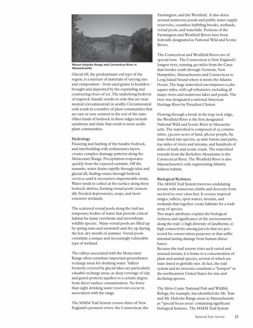
National Park Service 25
Glacial till, the predominant soil type of theregion, is a mixture of materials of varying sizeand composition – from sand grains to boulders –brought and deposited by the expanding andcontracting rivers of ice. The underlying bedrockof traprock (basalt) results in soils that are near-neutral (circumneutral) in acidity. Circumneutralsoils result in a number of plant communities thatare rare or non-existent in the rest of the state.Other kinds of bedrock in these ridges includesandstone and shale that result in more acidicplant communities.
HydrologyFissuring and faulting of the basaltic bedrock,and interbedding with sedimentary layers,creates complex drainage patterns along theMetacomet Range. Precipitation evaporatesquickly from the exposed summits. Off thesummits, water drains rapidly through talus andglacial till, finding routes through bedrockcrevices until it encounters impermeable strata.Water tends to collect at the surface along thesebedrock shelves, forming vernal pools (season-ally flooded depressions), seeps, and moreextensive wetlands.
The scattered vernal pools along the trail aretemporary bodies of water that provide criticalhabitat for many vertebrate and invertebratewildlife species. Many vernal pools are filled upby spring rains and snowmelt and dry up duringthe hot, dry month of summer. Vernal poolsconstitute a unique and increasingly vulnerabletype of wetland.
The valleys associated with the MetacometRange often constitute important groundwaterrecharge areas for drinking water. Valleysformerly covered by glacial lakes are particularlyvaluable recharge areas, as deep coverage of clayand gravel protects aquifers to a certain degreefrom direct surface contamination. No fewerthan eight drinking water reservoirs occur inassociation with the range.
The MMM Trail System crosses three of NewEngland’s premiere rivers: the Connecticut, the
Farmington, and the Westfield. It also skirtsaround numerous ponds and public water supplyreservoirs, countless babbling brooks, wetlands,vernal pools, and waterfalls. Portions of theFarmington and Westfield Rivers have beenfederally designated as National Wild and ScenicRivers.
The Connecticut and Westfield Rivers are ofspecial note. The Connecticut is New England’slongest river, running 410 miles from the Cana-dian border south through Vermont, NewHampshire, Massachusetts and Connecticut toLong Island Sound where it meets the AtlanticOcean. The huge watershed encompasses 11,260square miles, with 148 tributaries, including 38major rivers and numerous lakes and ponds. Theriver was designated a national AmericanHeritage River by President Clinton.
Flowing through a break in the trap rock ridge,the Westfield River is the first designatedNational Wild and Scenic River in Massachu-setts. The watershed is composed of 23 commu-nities, 330,000 acres of land, 98,000 people, 89state-listed rare species, 19 state forests and parks,630 miles of rivers and streams, and hundreds ofmiles of trails and scenic roads. The watershedextends from the Berkshire Mountains to theConnecticut River. The Westfield River is alsoMassachusetts’s only regenerating AtlanticSalmon habitat.
Biological RichnessThe MMM Trail System traverses undulatingterrain with numerous climbs and descents fromsea level to over 1,600 feet. It crosses traprockranges, valleys, open waters, streams, andwetlands that together create habitats for a widearray of species.Two major attributes explain the biologicalrichness and significance of the environmentsalong the trail: 1) high diversity of landforms; 2)high connectivity among parcels that are pro-tected for conservation purposes or that sufferminimal lasting damage from human distur-bance.Because the trail system visits such varied andunusual terrain, it is home to a concentration ofplant and animal species, several of which arestate-listed or globally rare. In fact, the trailsystem and its environs constitute a “hotspot” inthe northeastern United States for rare anddeclining species.
The Silvio Conte National Fish and WildlifeRefuge, for example, has identified the Mt. Tomand Mt. Holyoke Range areas in Massachusettsas “special focus areas’ containing significantbiological features. The MMM Trail System
Mount Holyoke Range and Connecticut River inMassachusetts

26 Metacomet-Monadnock-Mattabesett Trail System
crosses both mountain ranges, which, accordingto the Conte Refuge, contain over 30 rare plantand animal species. Additional informationconcerning biological features along the Trailsystem may be found in Appendix C.
VegetationThe traprock ridges along the Connecticut RiverValley have a high diversity of plant communitiesand species. Traprock ridges have a characteristicecology due to their exposed summits with littleor no soil, steep rocky cliffs with scattered smallledges and cracks, and a talus slope built fromboulders that have broken off the cliff. A fewstunted trees grow on the summits including redcedar, dwarf oak, hickory, and white ash. Forestsdominated by hemlock (Tsuga canadensis) arevery common along the lower slopes and atbrook crossings. The base of the talus slope isoften the most diverse of the traprock habitats.This area is typically dominated by sugar maple,ash and basswood. Wetlands form in level areasand at the base of slopes.
The mixed transitional hardwood forests ofhemlock and oak typically have a higher anddenser canopy than the drier, upland woodlands.Red oak, sugar maple, white ash, and hickoryshare the canopy in various proportions.Hemlock is widespread and variable in theunder-story, along with black, white, and yellowbirch and hop hornbeam.
In sections, the trail passes through reclamationstands of young red pines and stands of old sugarmaples on the sites of abandoned farms. Occa-sional specimen trees – black birch, red oak,white pine, white oak, or hemlock that exceed 40inches in diameter – are found, but there are noknown areas of old growth or virgin forest. Thestate forest land and private lands crossed by thetrail tend to be harvested periodically.
Mountain laurel, witch hazel, striped maple, andmaple-leaf viburnum are the most commonshrubs forming a relatively dense shrub layer. Theherb layer varies in density but includes a moreacidic plant association of teaberry, clubmosses,marginal fern, Christmas fern, sedges, andgrasses. Certain wild shrubs pose threats to theintegrity of the natural communities, includingJapanese barberry, multiflora rose, and glossybuckthorn.
The wooded swamp is the most commonwetland type in southern New England and thetype of wetland generally found along the trailcorridor. These areas are dominated by redmaple (Acer rubrum) with slippery elm often
present in smaller numbers. Other commonplants of this habitat include the shrub known asspicebush (Lindera benzoin) and non-woodyplants such as skunk cabbage, cinnamon fern andjack-in-the pulpit.
WildlifeBecause they are relatively undeveloped,traprock ridges are home to many animals,including some rare and endangered species.
The Mount Tom ridge is an example of animportant habitat for amphibians and reptiles.Thirty-eight species of amphibians and reptileshave been recorded on the Mount Tom ridge,representing 76% of all herp species found inMassachusetts (TTOR, 2005). Of these, the rarestspecies include marbled salamander, box turtle,wood turtle, copperhead snake, timber rattle-snake, and black rat snake.
Hemlock forested areas are popular places fordeer in the winter due to their ability to hold a lotof snow in their canopy, leaving the forest floorless deep in snow pack. Hemlock needles arepreferred food for white-tailed deer and porcu-pine like to feed on hemlock bark and twigs.
Ridge tops along the MMM Trail System are alsoa valuable stop-over habitat for migratory birds.A breeding land bird pre-survey conducted bythe U.S. Fish and Wildlife Service in 2003documented blackburnian warbler, black-throated blue warbler, blue-winged warbler,northern parula, and yellow-rumped warbler.Goat Peak and Mount Holyoke in Massachusettsare known for their hawk migration viewingspots.
Cultural and Historic ResourcesNative American HistoryConnecticut and Massachusetts have beenoccupied by humans for at least 10,000 years, andhuman activity has resulted in critical influenceson the landscapes of the MMM Trail System.
In Connecticut, Native American activity wasintense throughout the central portion of thestate, with the Niantic tribes focused on themouth of the ConnecticutRiver and the Mohegan-Pequot tribes inhabitingareas to the east. Quinnipiac Indians wereknown to create settlements in the Branford andGuilford areas. Numerous Archaic and Wood-land sites dating from 9,000 BC are documentedfrom the region, particularly where streamtributaries meet the main stem of large rivers likethe Connecticut. Low, flat river terraces werepreferentially occupied during spring to fall,
Box Turtle

National Park Service 27
when foragers exploited rich shellfish beds andanadromous fish. Basalt was used for flint andarrowheads.
The name of the Metacomet Trail commemoratesan important Native American figure who onceoccupied the region. Chief Metacomet (aka“King Philip”), son of theWampanoag ally of the Pilgrims, Massasoit, is thetrail’s most notorious namesake,leading some of the most damaging attacksagainst white settlers throughoutMassachusetts and Connecticut in the 1670’s.The promontories of the Metacomet Rangeserved as strategic lookout points for mountingraids on the nascent towns of Connecticut.
Legends, many apocryphal, ascribe naturallandmarks such as “King Phillip’s Cave” (a lavatunnel visible from the Trail at Talcott Mountain)to famous battles between Native Americans andcolonists.
Native Americans likely exerted profound localinfluences on the structure ofnatural communities in the region, but theirprecise impacts are still being reconstructed.Deer hunting, fishing, and plant gathering wouldhave been the predominant activities during theWoodland Period. Intentional burns may havebeen used in limited ways to concentrate wildlife,or to promote growth of blueberries or nut-bearing trees, but evidence for major fires withlarge-scale impacts on forests is not conclusive.
The MMM Trail System in Massachusettsparallels several Native American trails

28 Metacomet-Monadnock-Mattabesett Trail System
Pollen evidence suggests that forests duringNative American occupation were dominated bychestnut (Castanea dentata), oak (Quercus spp.),beech (Fagus grandifolia), hickory (Carya spp.),and pine (Pinus spp.), with chestnuts andhickories providing a major food source. Seden-tary agriculture did not commence until after1,000 years AD, with some tribes in centralConnecticut planting corn, sunflowers, andsquash. Cultivation would have required onlylimited land clearing using axes and hoes.
Although no record has been found of specificNative American dwellings along the trailcorridor in Massachusetts, their presence in theregion is well documented. Regional control ofthe Connecticut River valley from Connecticut inthe south to Vermont in the north was attributedto the Pocumtucs belonging to the Algonquiantribe.
The Pocumtucs were principally located nearDeerfield in a town of the same name. A branchof the Pocumtucs, the Agawams were a nativegroup who by the 17th century are said to haveclaimed control of the land situated within theConnecticut River drainage area between EnfieldFalls in Enfield, Connecticut and South HadleyFalls in South Hadley Massachusetts. By around1660, most of the Agawams had moved across theConnecticut River to live in a village on what isnow Long Hill Street in Springfield. This corre-sponds to the dates at which the first permanenthomes were established in Agawam.
The territory to the east was held by anotherAlgonquin tribe called the Nipmucs. The Nipmucoccupied the central plateau of Massachusetts asfar west as the Connecticut River, concentratingin the southern part of Worcester County, butalso extending into Northern Rhode Island andConnecticut. The territory to the west of thePocumtuc region was controlled by theMohicans, extending over most of BerkshireCounty where they were represented mainly bythe Housatonic or Stockbridge Indians. The fortof the Pocumtuc proper, on Fort Hill nearDeerfield, was destroyed by the Mohawk in 1666.The Pocumtoc combined with the Narragansetand Tunxis in attacks on the Mohegan chiefUncas, and later joined the hostile Indians underKing Philip. At the close of the [King Philip] war,they fled to Scaticook on the Hudson, wheresome of them remained until 1754, going then toSt. Francis, Canada.
Estimates vary greatly, but it is probable that nomore than 5,000 Indians were left in all of NewEngland by 1636 when William Pynchon and hispartners from the Massachusetts Bay Colony
established the plantation of Agaam (or Agawam)which was later to be known as Springfield. Thetwenty-five square mile town was bisected by theConnecticut River and included Provin Moun-tain along its western boundary.It is highly probable that the Agawam Indianstraveled regular paths through the ProvinMountain Range to connect two well-traveledtrails on each side of it. The mountain range andthe Connecticut River separated two welldocumented native trails. The Podunk path ledthrough their land on the east side of theConnecticut River and the great ‘Maya’ or trailthat led from Quinnipiac (New Haven) toCanada, crossed through ‘Mayawauk’ (WestSuffield) and Feeding Hills and Westfield. OldEnglish records speak of this as the Hampton andWestfield paths. A secondary north-south trailalong the east base of the Provin Mountain rangeexisted from the Paucatuck ford on the WestfieldRiver to Johnson Corner in Agawam.
Native American tribes, namely the Pocumtucks,maintained agriculture in the fertile riverfloodplains of the Westfield River. Nativesettlement probably concentrated in the flood-plains during the spring fishing months. Histori-cally (1500-1620), a possible ford existed atPaucatuck across the Westfield River at MayHole. Paucatuck is within the river floodplain,east of East Mountain and in the vicinity of thejunction of Paucatuck Brook and the WestfieldRiver. See map on page 33.
As the trail travels north to its intersection withthe Connecticut River, there is evidence of afortified native site on Fort Hill near the Con-necticut River oxbow in Easthampton. NativeAmericans likely hunted on the Mount TomRange with farming in the fertile river valleylowlands. Local natives were likely involved inthe valley Anglo-Indian fur trades between 1500and 1620.
View of the Mount Holyoke Range from Hadley farmlandin Massachusetts

National Park Service 29
Due to river meandering and seasonal flooding,Native American sites within the floodplain ofthe Connecticut River have never been fullydocumented. However, it is suspected that thePocumtucs lived at the Hockanum flats area ofthe Connecticut River floodplain in Hadley.Local farmers and area historians have foundnumerous arrowheads and other stone imple-ments. Further documenting their existence inthe region, between 1675 and 1775, colonialtroops were attacked repeatedly by native tribesat settlements in Hockanum Flats during KingPhilip’s War. Today, this area is some of the mostproductive farmland in the entire valley.
Native sites are also suspected aroundMetacomet Lake, located southeast of the MMMTrail on Section 9 in Belchertown. The three arealakes (Metacomet, Holland, and Arcadia) wereprobably the focal point of native fishing.
European SettlementEuropeans entered Connecticut in the 1630s, andlarge-scale land clearing, homesteading, tilling,and grazing of the Connecticut River andFarmington River valleys began in the 1650’s(Feder 1999). Intentional fires and loggingbecame widespread throughout the next century,transforming a largely forested landscape to apastoral one. This activity shifted forest composi-tion to young, disturbance-tolerant standsdominated by birch (Betula spp.), maple (Acerspp.), pine (Pinus spp.), cherry (Prunus spp.), andpoplar (Populus spp.). Many house foundationsof the 1700’s were built of trap rock collectedfrom the bases of talus slopes along theMetacomet Range.
Industrialization during the early 1800’s led to theconstruction of innumerable dams on large andsmall rivers, providing hydro-energy for mills,and altering the courses and flow dynamics ofmany waterways. Logging to provide woodfuel for local foundries and other industries mayhave denuded some portions of the Metacometridge from valley to summit. A large traprockquarry opened on East Rock (New Haven,Connecticut) in 1810, and large-scale extractionof traprock to provide crushed paving stone andbrownstone for a large number of buildings inthe Northeast and beyond began in the 1850’s.
In the 1830’s to 1850’s, increasing urbanization,population pressure, and large-scale exploitationof the New England landscape stirred a newaesthetic appreciation among the populace forthe remaining natural areas of the region. HenryDavid Thoreau, Ralph Waldo Emerson, andpainters of the emerging Hudson River School
(Thomas Cole, Thomas Charles Farrar, WilliamHenry Bartlett, and others) extolled the virtues ofnature in writings and artwork. The painters inparticular flocked to the Metacomet Range tocapture its grandeur and views.
In 1836 Thomas Cole visited the summit of Mt.Holyoke and created one of the most well-knownpaintings of the era: View from Mount Holyoke,Massachusetts after a Thunderstorm. Interestingly,the paintings of this time reveal the mountains assome of the only forested land in a sea of agricul-ture and rural settlement, indicating that some ofthe mountains may have provided a critical refugefor plant and animal species for hundreds of years.
Buildings dating from this period began to springup along the summits of the Metacomet Rangefrom Massachusetts to Connecticut. The historicHeublein Tower atop Talcott Mountain, forexample, was the fourth in a series of towers builtat the site from 1810 to 1914 (Leary 2004). Eminentvisitors to these landmarks made the rangefamous: Mark Twain quoted his friend, theReverend Joseph Twichell issuing the cry, “Justlook at this magnificent autumn landscape! Lookat it! Look at it! Feast your eyes on it!”While the ridge was never densely populated, itwas (and continues to be) a popular day-tripdestination for tourists, students, and artists. Thispopularity created the impetus for the establish-ment of a protected system of hiking trails, amongthe first of its kind in the United States.
Local hiking trails attracted visitors from medium-sized, decentralized urban areas (Hartford,Meriden, New Haven, etc.) throughout the state.In the late 1800’s, philanthropic industrialistsdonated large areas of land for parks and recre-ational areas. By 1895, the Connecticut ForestryAssociation (later called the Connecticut Forestand Park Association) formed with a mission topreserve woodlands, and the state of Connecticutformed a park commission in 1913. Many of theprotected areas cobbled together during this timewere very small, but emphasized the same kind ofviews that had thrilled Twain and many others.
Frederick W. Kilbourne, a Meriden resident,pioneered the idea of a “Trap Rock Trail” to spanthe distance from Long Island Sound to theMassachusetts border in 1918, and Edgar LaingHeermance took the project forward. By 1929, theConnecticut Forest and Park Association devisedits first Trails Committee, and the concept of theBlue-Blazed Hiking Trail System was inaugurated.The cumulative effect of this land protection andoutreach was the creation of a trail of almost 50miles, a corridor of green in an urbanized contextunlike any other trail before it.

30 Metacomet-Monadnock-Mattabesett Trail System
Socially, the trail system permitted a burgeoningnumber of recreation seekers to gain a newappreciation for Connecticut’s natural ecosys-tems, and engaged a new class of volunteers inconstruction and maintenance. An utterly newliterary genre – the trail guide – was invented toeducate trail users about their environs, and thetrail received a great deal of attention in thepopular press of the time. Ecologically, theformation of the Metacomet and MattabesettTrails led to the long-term conservation ofdozens of contiguous miles of relatively intacthabitat.
Historic and Culturally Significant AreasA number of noteworthy sites of historical orcultural significance exist along the MMM TrailSystem corridor in Connecticut and Massachu-setts, including:
Connecticut:The Connecticut State Archaeologists Officeprovided a list of 23 sites along or near the trailthat are known archaeological or historic sites.Eleven of the sites are considered highly signifi-cant, with 8 of them having National Registrypotential, and two are already listed on theNational Register. In addition, the study teamidentified a number of other culturally signifi-cant areas. Some of the more significantresources include:
Castle Craig. A tower built with native trap rockand donated to the city of Meriden, Connecticutby local industrialist Walter Hubbard, this 32-foot tall structure is part of a 1,800-acre munici-pal park. Views to Long Island Sound and thehills of Massachusetts are visible.Guilford Historic Town Center and Clap-board Hill District. A proposed extension ofthe Mattabesett Trail south to Long Island Soundwould pass by homes included on the NationalHistoric Register and through the GuilfordHistoric Town Center District.
Historic Town Center District. Numerousabandoned carriage and stagecoach roadsintersect the Trail in the towns of Haddam,Durham, and Middlefield, providing evidence ofearly regional transportation routes.
Hospital Rock. A State Archaeological Preservesurrounds “Small Pox Hospital Rock” inFarmington, a monument to the quarantine at thesite of colonial-era Farmington and Hartfordresidents afflicted by smallpox.Heublein Tower. The present day tower (locatedin Simsbury in Talcott Mountain State Park) isthe fourth in a series of towers built at the sitefrom 1810 to 1914. Heublein Tower is recognizedas a National Register Site and is open to thepublic. The Metacomet Trail travels approxi-mately 1/4 of a mile to the south of the tower.
Nike Missile Installation. An abandonedconcrete base that once stored Nike militarymissiles is located just off the trail in Plainville.
Table 8. MMM Trail System in Connecticut and Massachusetts: Landownership Profile
Ownership Miles of % Total # of % Total # of % TotalType Trail Trail Owners Owners Parcels Parcels
Individuals 37.2 19.58% 355.0 57.91% 391.0 36.54%
Corporate 28.8 15.14% 56.0 9.14% 130.0 12.15%
Municipal 17.7 9.32% 25.0 4.08% 67.0 6.26%
State 40.2 21.15% 9.0 1.47% 118.0 11.03%
Non Profit 11.2 5.88% 17.0 2.77% 43.0 4.02%
Water Utility 24.3 12.77% 11.0 1.79% 47.0 4.39%
Roads,crossings 24.9 13.10% 6.0 0.98% 16.0 1.50%
Miscellaneous 5.8 3.06% 134.0 21.86% 258.0 24.11%
Total 189.9 100% 613 100% 1070 100%
Castle Craig in Meriden, Connecticut

National Park Service 31
Old Newgate Prison. This 18th and 19th centuryprison and copper mine lies within one mile ofthe Metacomet Trail in East Granby, and can beseen from the Metacomet Trail atop CopperMountain. The site is listed on the NationalRegister of Historic Places and is maintained bythe State of Connecticut with the support of localpartners.
Selectman Stones. At a point on the MattabesettTrail where the town boundaries of Durham,Guilford and Madison intersect lie a pile ofinscribed rocks known as Selectman Stones. Itwas common practice once, and still is in sometowns, for elected officials to be required to walkthe boundaries of their towns once elected. Asproof that they completed this task (calledperambulating the border) they would inscribe arock with the date or their name and leave it atthe corner of the town boundary. These piles ofstones still exist along the Mattabesett Trail.
Washington-Rochambeau Route. TheMattabesett Trail intersects the Washington-Rochambeau Revolutionary Route, a network ofland and water routes traversing nine states overwhich traveled the American and French armiesand navies at various times between June 1781 andDecember, 1782. The Route was studied by theNational Park Service in 2003 for possibledesignation as a National Historic Trail. Washing-ton himself is believed to have traveled what isnow the Mattabesett Trail twice, once on his wayto assume command of the new Americanrevolutionary army and again in 1789 when hewas elected President.
Will Warren’s Den. At a site along theMetacomet Trail in Farmington is a cave where,according to legend, a 17th century local citizennamed Will Warren was hidden by NativeAmericans. Warren had tried to burn down thevillage of Farmington after he was flogged for notgoing to church. Driven out of town and pursuedinto the mountains, he hid in the cave, which
Table 9. Metacomet and Mattabesett Trail in Connecticut: Landownership Profile
Ownership Miles of % of Total # of % of Total # of % of TotalType Trail Trail Owners Owners Parcels Parcels
Private Individ. 15.0 13.6% 204 74.5% 215 46.4%
Private Corp. 19.5 17.6% 31 11.3% 84 18.1%
Municipal 14.9 13.5% 15 5.5% 50 10.8%
State 14.7 13.3% 7 2.6% 41 8.9%
Non Profit 6.6 6.0% 10 3.6% 35 7.6%
Water Utility 15.4 13.9% 7 2.6% 23 5.0%
Roads 19.8 17.9% 0 0.0% 0 0.0%
Miscellaneous 4.8 4.3% 0 0.0% 15 3.2%
Total 110.7 100% 274 100% 463 100%
today bears a bronze plaque recounting thelegend.
Massachusetts:Beehive Kilns. East of the Rattlesnake Gutterarea of the Metacomet-Monadnock Trail can befound a series of kilns used in the production ofcharcoal during the 1800’s.
Central Vermont Railroad. Built between 1845-1849 by Charles Paine, the 116-mile line was partof a railroading operation that by 1873 controlled793 miles of track in four states, making it thelargest railroad in New England and seventhlargest in the U.S. The line was sold approximatelyten years ago to the New England CentralRailroad, and is still in operation today. TheMetacomet-Monadnock Trail crosses the railroadtracks near Route 9 and Holland Glen inBelchertown.
Fifth Massachusetts Turnpike. In Warwick, theMetacomet-Monadnock Trail turns southeastdown an old county road, formerly the oldBoston-Albany Toll Road known as the FifthMassachusetts Turnpike.
Hermit Mountain and Erving Castle Trail. InErving, the Metacomet-Monadnock Trial crossesa side trail built in 1998 by a federally fundedAmeriCorps trail crew to allow visits to the 1800’scave home of the hermit John Smith, who came to
Beehive Kiln, Leverett, Massachusetts

32 Metacomet-Monadnock-Mattabesett Trail System
Table 10. Metacomet and Mattabesett Trail in Massachusetts: Landownership Profile
Ownership Miles of % of Total # of % of Total # of % of TotalType Trail Trail Owners Owners Parcels Parcels
Individuals 22.2 28.00% 151.0 72.25% 176.0 47.83%
Corporate 9.3 11.68% 25.0 11.96% 46.0 12.50%
Municipal 2.8 3.525 10.0 4.78% 17.0 4.62%
State 25.5 32.14% 2.0 0.96% 77.0 20.92%
Non Profit 4.6 5.78% 7.0 3.35% 8.0 2.17%
Water Utility 8.9 11.18% 4.0 1.91% 24.0 6.52%
Roads,crossings, 5.1 6.42% 6.0 2.87% 16.0 4.35%
Miscellaneous 1.0 1.28% 4.0 1.91% 4.0 1.09%
Total 79.2 100% 209 100% 368 100%
the area from the British Isles and lived anisolated, eccentric existence here for more than10 years.
J.A. Skinner State Park. The 390-acre SkinnerState Park in Hadley offers breathtaking views ofthe Connecticut River Valley. The summit isaccessible by road from April through November,and by hiking trails year-round, including theMetacomet-Monadnock Trail. The SummitHouse, once a well-known mountain top hotel inthe mid-1800’s, is a popular destination pointoffering tours, programs, historical displays, andspecial events. Other historic sites within the Parkinclude:
• Titan’s Piazza – A well-known columnar traprock formation and cliff named by AmherstCollege Geology Professor Edward Hitchcockin the 1830’s. One is able to overlook theConnecticut River and valley while standingatop it.
Mount Holyoke Range State Park. TheMetacomet-Monadnock Trail travels throughthis recreational area in Amherst in closeproximity to the following sites:
• The Horse Caves – A series of overhangingledges where Daniel Shays, a former Revolu-tionary Army captain, hid horses used in thefarmer’s rebellion known as Shay’s Rebellion.
• US Air Force Bunker – The U.S. Air ForceStrategic Air Command built a massiveunderground communications bunkerfeaturing three-foot thick walls and steel blastdoors. In the event of a nuclear war, it wasdesigned to hold 350 people for 35 days. Thefacility was expanded in 1962. In 1972, theBunker complex was sold to the FederalReserve Bank for record storage.
Mount Tom State Reservation. Mount TomState Reservation in Holyoke is recognized forboth its historic significance to the region andalso its cultural importance today. Mount Tomitself boasts an unparalleled view of the Con-necticut Valley north and south, the Berkshire
Historic illustration of Mount Holyoke Summit House
Cable car to Summit House
The Horse Caves

National Park Service 33
mountains to the west, and the Pelham Hills tothe east. The 1,800-acre reservation includes thefollowing sites of cultural and historic signifi-cance:• Eryie House, Mount Nonotuck - Ruins of an
old hotel, the Eryie House is located on MountNonotuck, the northern most peak on theMount Tom Range. The Eryie House was builtin 1861 by William Street, a wealthy entrepre-neur from Holyoke, and was located near theMount Tom train depot at Smiths Ferry on theConnecticut River.
• Mountain Park – In 1895, the Holyoke StreetRailway Company began construction ofMountain Park, a trolley and amusement parkat the base of Mount Tom. The park opened in1897 and was a popular attraction for bothlocals and tourists for decades. In its heyday,Mountain Park was the largest street railwaypark in the world, comprising more than 400acres.
• Mount Tom Summit House and the MountTom Railroad – The Holyoke Street RailwayCompany opened the Mount Tom SummitHouse with the opening of Mountain Park in1897. The Summit House featured a restaurant,constant entertainment, and a spectacular view.Access to the Summit House was by way of twocounter-balanced trolleys.
• The Airmen Monument – In 1946, a B-17converted into a transport plane crashed intothe side of Mount Tom, killing 25 people. Amonument in memory of those who died waserected at the site of the crash.
Old Adams Homestead. The MMM Trail passesthe Old Adams Homestead in Shutesbury, MA,formerly owned by Walter Banfield, the devel-oper of the Metacomet-Monadnock Trail inMassachusetts. The site contains an old farm-house, mill pond, and mill works.
Westfield-Holyoke Street Car Route. Between1620 and 1675 an interior route across the EastMountain ridge was maintained as Whitney andRock Valley Roads in the vicinity of Ashley Pondin Holyoke. Between 1870 and 1915 a trolley routeto Westfield was established across East Moun-tain on a private way to Appremont Highway inWestfield. The streetcar service was abandonedin the 1920’s. The abandoned road bed still existstoday, and is briefly intersected by theMetacomet-Monadnock Trail.
J. Ownership and Protection of the TrailLand Ownership ProfileThe 190-mile MMM Trail System travels through1,070 parcels of land owned by 613 landowners inConnecticut and Massachusetts. The largestgroup of trail landowners are individuals andcorporations, who combined account for 35% ofthe total trail length. The states are the nextlargest landowner with 21% of the trail. Over 13%of the current trail (almost all of it located inConnecticut) is on roads, most of which areeither woods roads or small local roads. Thesestatistics do not include an additional 10 miles oftrail that are not officially part of the MMM TrailSystem but connect various portions of theMetacomet-Monadnock Trail in Massachusetts.See Table 8.
Connecticut
The Metacomet and Mattabesett Trails inConnecticut travel approximately 110 miles,crossing 463 parcels of land owned by 274landowners. Landownership along the trails is adiversified mix of ownership types. The largestportion of trail length, over 31%, is privatelyowned by individuals and corporations, withwater utilities, municipalities and the state ofConnecticut each owning approximately 13%.Private individuals account for nearly 75% of alltrail owners, owning 46% of the parcels the trailpasses through.
97% of the trail length owned by non-profitorganizations is owned by land conservationorganizations such as the Nature Conservancy
Historic illustrations of Mount Tom Summit House

34 Metacomet-Monadnock-Mattabesett Trail System
and local land trusts. While there are 31 corpo-rate owners identified along the trail, fivecorporate landowners host 79% of the corpo-rately owned trail. These major owners includetwo traprock quarry operations and the primaryelectric utility in the state.
While the largest portion of trail is shown to beon roads a majority of that, 53%, is either onwoods roads traveling through state parks andforests or small local roads traveling throughneighborhoods. Only 6.4% of the trail isconsidered to be on secondary roads and 2% onprimary roads. Four key junctures in the trailaccount for 50% of the trail that is on road, theseinclude where the Mattabesett Trail crossesInterstate 91 (3.4 miles), where the MetacometTrail crosses Interstate 84 (1.6 miles), where theMattabesett and Metacomet Trails come together(2.6 miles) and where the Metacomet Trailintersects with the Metacomet-MonadnockTrail traveling into Massachusetts (2.2 miles). SeeTable 9.
Massachusetts
The Metacomet-Monadnock Trail in Massachu-setts travels 79 miles, crossing 368 parcels ownedby 209 landowners. Private ownership, bothindividual and corporate, is the largest land-owner type, accounting for 40% of the total traillength. The Commonwealth of Massachusettsowns another 32% of the trail while the remain-ing five landownership categories account for28% of the trail length. Private individuals andcorporations account for 86% of all 213 landown-ers and own 66% of the 407 parcels the trailpasses through.
Over 6% of the total trail length is associatedwith roads or road crossings, substantially lowerthan Connecticut’s nearly 18%.
As reported above, these statistics do not includean additional 10 miles of trail consisting of 44parcels owned by a single private landowner,Cowl’s Lumber, that is not officially part of theMMM Trail System but connects variousportions of the Metacomet-Monadnock Trail inMassachusetts. See Table 10.
Level of ProtectionTrail “protection” generally refers to efforts toestablish or preserve the right for the trail to existin a certain location and have public access.Most of the history of trail ownership andprotection along the entire MMM Trail Systemhas been that of handshakes and verbal agree-ments sufficing for permission to locate andmaintain the trail route.
The amount of protected trail on the MMM TrailSystem was determined by the mileage of the trailwhich crossed lands that could be consideredpermanently protected open space. Landsconsidered permanently protected include stateforest and park lands, municipal lands andnonprofit land conservancy lands. Water utilitylands in Massachusetts were also consideredpermanently protected.
Currently 72.7 miles, over 38% of the total traillength, of the MMM Trail System is consideredpermanently protected. An additional 20.4 milesor nearly 11% of the trail is considered partiallyprotected between the two states.Connecticut
The Metacomet and Mattabesett Trails crossstate forest and park lands, municipal lands andnonprofit land conservancy lands for 36.2 miles,or 33%, of the total trail system in Connecticut.
In Connecticut, there are only a very fewinstances where trail easements have beenestablished to permanently protect the traillocation and their total trail length was found tobe an insignificant amount of the total trail.
The trail also crosses municipal and private waterutility lands. In Connecticut lands owned bywater utilities that are considered either class oneor class two based on public health code defini-tion, have a fairly high level of protection (see CTDept. of Public Health Public Health Code 25-37c-1 for details). As a result it was determinedthese sections of trail that cross water utilitylands could be considered partially protected inConnecticut. The total trail length on class oneor two water utilities lands is 11.8 miles or 10% ofthe total trail length.
The overall trail length on either permanentlyprotected or partially protected lands totals 48miles, or 43%, of the total trail length in Con-necticut.
Through Public Act 490 (CGS Sections 12-107athrough 107-f) Connecticut has a local propertytax abatement program that provides the abilityfor landowners to achieve substantial localproperty tax savings by agreeing to keep theirlands in farm, forest or open space. While thismay provide the trail with some partial protec-tion data was not available to assess the amountof trail on “490” lands in Connecticut. All otherland ownership types were not considered toprovide any significant trail protection.

National Park Service 35
View of Connecticut River from MMM Trail
Massachusetts
A large portion of the Metacomet-MonadnockTrail in Massachusetts is located on protectedlands. In all 36.5 miles, or 46%, of the trailtravels across state parks, public water supplies,and municipal conservation properties and isconsidered protected. In Massachusetts it wasdetermined that water utility lands providepermanent protection for the trail, which differsfrom Connecticut.
A total of 8.6 miles or 11% of the Metacomet-Monadnock Trail crosses lands in the Chapter 61program and as such are considered temporarilyprotected. Chapter 61 is designed to encouragethe preservation and enhancement of the
Commonwealth’s forests. It offers significantlocal tax benefits to property owners willing tomake a long term commitment to forestry. Inexchange for these benefits, the municipality inwhich the land is located is given the right torecover some of the tax benefits afforded theowner when the land is removed from classifica-tion and an option to purchase the propertyshould the land be sold or used for non-forestryuses. However, land that is protected for forestrypurposes does not carry an obligation forcontinued trail permission.
The overall trail length on either permanentlyprotected or partially protected lands totals 45.1miles, or 57%, of the total trail length in Massa-chusetts.

36 Metacomet-Monadnock-Mattabesett Trail System
Cedar tree along the MMM Trail

National Park Service 37
Significance Evaluation
Section (5) (b) of the National Trails System Actidentifies a set of factors to be addressed instudies of potential new National Scenic Trails.The following sections describe each of thecriteria in Section (5) (b), and specifies how theMMM Trail System meets them.
National Trails System Act Factors – Sec. (5)(b):
A. The proposed route of the trail:The route of the MMM Trail System generallyfollows the existing route of three contiguoustrails – the Metacomet-Monadnock, theMetacomet, and the Mattabesett – that travelmore than 190 miles in a north-south directionfrom the Massachusetts-New Hampshire bordersouth towards Long Island Sound. The portionof the Metacomet-Monadnock Trail included inthe route is located entirely within Massachu-setts, while the Mattabesett and MetacometTrails are located entirely within Connecticut. Asit exists today, this route is consistent with TheNational Trails System Act Section 3(b) descrip-tion of an extended trail.
The MMM Trail System route avoids whereverpossible highways and other roads, mining areas,power transmission lines, commercial andindustrial developments, private operations, andother activities that might detract from the trail’srecreational purposes. The historical design ofthe trail is tailored to highlight regional landscapefeatures and to provide views of scenic, natural,and geologic resources.
In Connecticut, Public Law 107-338 directed theNational Park Service to examine the feasibilityof extending the Mattabesett Trail south to a newterminus at Long Island Sound. A route has beendetermined to be feasible and is one that would
add desirable new features to the overall trailsystem. The proposed extension of the trailwould travel through state forests, protectedwater utility lands, two village sites listed on theNational Register of Historic Places, and coastalenvironments including tidal marshes and apublic beach.
In Massachusetts, the route that is proposed forinclusion in the National Scenic Trail programwould also deviate from the existing alignment ofthe Metacomet-Monadnock Trail over anapproximately fifteen-to-twenty mile section inthe Belchertown-Leverett area. The deviationwould re-route the trail between the Mt. HolyokeRange and Wendell State Forest, along existingunpaved roads and trails in the Quabbin Reser-voir area, rejoining the existing Metacomet-Monadnock Trail alignment south of the Route 2highway crossing. The intention of this pro-posed, conceptual National Scenic Trail routewould take advantage of substantial protectedlands owned by the Commonwealth of Massa-chusetts, while avoiding an area almost com-pletely devoid of protected land areas.
B. The areas adjacent to the trail to beutilized for scenic, historic, natural, culturalor developmental purposes:
The MMM Trail System hosts an array of scenicfeatures and historic sites. Long vistas of ruraltowns, agrarian lands, extensive unfragmentedforests, and large river valleys, as well as pathwaysthrough important Native American and coloniallandmarks showcase some of the best examplesof classic New England landscapes that areunique in the nation.
The Trail System harbors a range of diverse eco-systems and natural resources, includingmountain summits, forested glades, vernal pools,lakes, streams and waterfalls. Assessments ofthese ecosystems and resources have beencompleted for both the Connecticut and Massa-chusetts portions of the trail, as described inSection III and Appendix B.
At numerous points along the existing trail route,the MMM Trail System intersects or travels neara number of points of national or regionalenvironmental, historic or cultural interest.These intersecting or adjacent features areColumnar basalt is displayed at Titan’s
Piazza, South Hadley, Massachusetts

38 Metacomet-Monadnock-Mattabesett Trail System
described throughout the study report docu-ment, and include:
Silvio O. Conte National Fish and Wildlife Refuge
This 7.2 million acre site protects the biodiversityof the Connecticut River Watershed. The ConteRefuge works with numerous partners to acquirekey parcels, to better manage already protectedland, and to educate the citizens within thewatershed about important habitat issues.
The Connecticut RiverDesignated a National American Heritage Riverby President Clinton, the Connecticut River isone of New England’s premier natural resources.The Mattabesett Trail begins near the banks ofthe Connecticut, and in Massachusetts theMetacomet-Monadnock Trail directly intersectsthe river.
The Metacomet and Mt. Holyoke MountainRanges
The MMM Trail System traverses these scenicranges for much of its length. The Mt. HolyokeRange has been identified as an area of specialfocus by the Silvio O. Conte National WildlifeRefuge Action Plan of 1995.
National Historic Landmarks, National HistoricSites, State-registered Historic Districts andPropertiesSeveral federally-recognized sites are locatedwithin close proximity to the MMM Trail System.They provide examples of New England colonialarchitecture, lifestyle, and industry. Chapter II ofthis report contains a summary of these re-sources and sites.
Connecticut and Massachusetts State Forests andParksThe trail system intersects ten state-managedforests and parks at various locations along itslength. See Chapter II and Appendix B foradditional information.
C. The characteristics which, in the judgmentof the appropriate Secretary, make theproposed trail worthy of designation as anational scenic trail
The MMM Study team has identified the maincharacteristics for consideration in evaluatingNational Scenic Trail status applicability, asdescribed in the following sections.
Significance
The Recreational Experience
The MMM Trail System traverses an outstandingvariety of New England landscapes, offering trailusers a unique recreational opportunity. High-lights of the trail experience include:
• Metacomet, Mt. Tom, and Mt. Holyoke RangesThe trail across these three ranges providesone of the best places in the world and the onlyarea on the eastern seaboard with a developedtrail system, to view a broad array of well-preserved volcanic and sedimentary featuressuch as columnar basalt. The ranges provideoutstanding views of the Connecticut RiverValley, classic New England village settlementpatterns, and a cross-section of the region’s
varied landscapes. One such view wasimmortalized in Thomas Cole’s famouspainting, “The Oxbow” depicting the view in1835 of the Connecticut River Valley from Mt.Holyoke. The trails have existed across theseridges for more than fifty years, and warrantevaluation for listing on the national register ofhistoric places.
• Historic New England Villages - The trailprovides vistas of rural towns, agrarian lands,extensive unfragmented forests, and the rivervalley, and traverses important Native Ameri-can and colonial landmarks. The trail alsoshowcases some of the best examples of classicNew England landscapes that are unique in thenation. Many side trails exist along the MMMtrail route, and connect to or have the potentialto connect hikers to village centers and historicdistricts. Over 50 national register listedhistoric districts are located in communitiesabutting the trail, many of which are visible(church steeples, municipal buildings, towngreens, etc.) from the trail. The proposedextension of the trail to Long Island Soundwould take the trail directly through theNational Register listed Guilford HistoricTown Center District.
• Proximity - The National Trail System Actplaces high priority on locating designated
Thomas Cole painting, “The Oxbow”

National Park Service 39
trails “primarily near the urban areas of theNation,” and being located “so as to providefor maximum outdoor recreation potential.”The MMM Trail System lies in close proximityto towns and suburbs of major cities whileproviding a near wilderness trail user experi-ence. Over 2 million people live within 10 milesof the trail system.
Side trails in many communities connectneighborhoods to the trail, providing access torecreational opportunities for both casual andmore serious athletes alike. Study investigations documented at least 25 formal, connect-ing trails in the two states, and as many as 100informal connections. The trail system offersfuture opportunities to connect to otherestablished trails. In addition to a proposedconnection to Long Island Sound, the trailsystem could be connected to local trailswithin Connecticut and Massachusetts, or tolarger regional long-distance trails such as theAppalachian Trail.
In sum, the existing MMM Trail System is veryaccessible both by proximity to population andexisting and potential side trail connections.
GeologyThe backbone of much of the Metacomet-Monadnock-Mattabesett Trail System consists ofa series of knife-edged ridges collectively known
as the Metacomet Range. The range, as accessedby the trail, is known as one of the best places inthe world to view an array of volcanic, sedimen-tary and glacial geology. Towers of columnarbasalt create the precipitous west facing cliffscharacteristic of the Metacomet Range. Addi-tional volcanic features are well exposed tohikers on the ridge. The range is also rich infossils left over from ancient glacial activity. Inparticular, the area is famous for “world class”dinosaur footprint and fish fossil locales.Professor Edward Hitchcock, President of
Amherst College, became world-renowned forhis three decade study of the region’s prints inthe 1800’s.
Endangered Species and NaturalCommunitiesThe trail system traverses mountain summits,forested glades, vernal pools, lakes, streams, andwaterfalls, including some of the most rugged,picturesque, and diverse landscapes of southernNew England. In Connecticut, the trail and itsenvirons constitute a “hotspot” in the state andthe northeast for rare and declining species.Overall, the trail visits 3 of Connecticut’s 13 mostimperiled ecosystems, namely traprock summits,coastal beaches, and large riparian systems.There are 132 occurrences of rare species ornatural communities recorded within 1,000 feetof the trail in Connecticut, including northerncopperheads, timber rattlesnakes, Jeffersonsalamanders and Peregrine falcons. In additiontwo of the natural communities, poor fens andforest glades along rocky summit outcrops, areconsidered globally rare.
In Massachusetts, the Silvio Conte NationalWildlife Refuge has identified both the Mt. Tomand Mt. Holyoke Ranges as “special focus areas”containing significant biological features,containing over 30 rare plant and animal species.Thirty-eight species of amphibians and reptileshave been recorded on the Mount Tom ridgealone, representing 76% of all herp species foundin Massachusetts.
FeasibilityThe entire MMM Trail System under study hascontinuously existed for nearly 40 years, with theConnecticut sections in place for almost 75 years.It is clearly feasible that this route can exist, as itis already in place today, and is consistent withThe National Trail System Act Section 3(b)description of an extended trail. However, thecontinued existence of this trail system along itscurrent route is not assured as land ownership
Glacial erratic along MMM Trail, Holyoke, Massachusetts
Broad banded Copperhead

40 Metacomet-Monadnock-Mattabesett Trail System
and land use priorities continue to change andevolve, especially for those parts of the trailunder private ownership.
Strategies regarding long-term trail continuityand viability were explored in depth during thestudy and captured in the Trail ManagementBlueprint. Implementation of these Blueprintstrategies, which have broad stakeholder support,will help ensure that the trail exists for futuregenerations.
A current challenge for maintaining the trail,especially in Connecticut, is growing number oftrail miles currently on roadways. Efforts arecontinually being made to limit the amount oftrail on road, but over the last several years theConnecticut Forest & Park Association has beenforced to move approximately three miles of trailonto roadways. In other instances, however,proactive efforts have led to the elimination ofcertain road-walks by relocating sections of trailonto state forest land. This will continue to be anongoing challenge with a trail system that travelsthrough the 4th most densely populated state inthe Nation.
In Massachusetts, trail stewards have been able toavoid relocating the trail to roads. Several suchrelocations were accomplished during the study.However, there is concern that in the long term,options will dwindle, and the trail may be moreoften relocated on roads. Maintaining an off-road trail will require a concerted effort to securepermanent trail routes.
DesirabilityThe MMM Trail System is considered one of themost important long distance trails in NewEngland and the most important in south-centralNew England. It is highly valued by communi-ties, the states, landowners, non-profit organiza-tions and user groups.
The great majority of the landowners who hostthe trail on their property, and attended publicforums or responded to questionnaires showedstrong interest in the long-term viability of thetrail system.
Actions at the municipal level have shown aconsistent interest in sustaining the long-termviability of the trail. From signing the MetacometRidge and Mt. Holyoke Range Compacts, toidentifying specific goals in their plans ofconservation and development and master plans,to taking actions through open space acquisitionand the use of open space set asides whenapproving subdivisions, municipalities have
shown a continued interest in the trail system. In2001, the Mattabesett and Metacomet Trails weredesignated official state greenways in Connecti-cut, and officially listed in the State Plan ofConservation and Development. Likewise, theCommonwealth of Massachusetts has identifiedthe Metacomet-Monadnock Trail as one of thestate’s highest long-distance trail priorities in arecent statewide planning/prioritizing effort(“Commonwealth Connections: A GreenwayVision for Massachusetts”). The AppalachianMountain Club and Connecticut Forest and ParkAssociation have been powerful trail advocatesand include the trail system among their highesttrail priorities.
D. The current status of land ownership andcurrent and potential use along thedesignated route
A summary of landownership can be found inChapter II of this report. Land ownership alongthe entire trail is varied with no one land owner-ship type overly dominant. Overall ownership ofthe trail is fairly evenly distributed betweenprivate individual landowners, private corporatelandowners and the states, with water utilitiesand municipalities having smaller equal portions.In Connecticut 33% of this land is consideredpermanently protected, while in Massachusetts46% is considered permanently protected.
The fact that the trail has existed in harmonywith adjacent land uses for many decades speaksto a broad compatibility between the trail andpresent (and anticipated future) land usepatterns.
Fall view of Merrimere Reservoir,Meriden, Connecticut

National Park Service 41
E. The estimated cost of acquisition of landsor interest in lands, if any
No federal acquisition of land or interest in landis anticipated under the National Scenic Traildesignation model proposed in this draft report.
There will be no eminent domain takings of landfor the trail. The Blueprint for Trail Managementdocument that was developed during the studyprocess anticipates that significant portions ofthe trail system will continue to be hosted byprivate individuals, corporations, and others on avoluntary basis for the foreseeable future.Approximately 62% of the existing trail route ishosted in this manner today.
Permanent protection of the entire trail systemfootprint is a long-term goal; one that willrequire some level of funding for acquisition oflands and easements by entities such as landtrusts, communities, state agencies, and others,working with willing and interested landownersas opportunities arise.
The study’s congressional sponsors haveindicated an interest in providing federalacquisition funds to local, non-profit and statepartners if the trail system is designated as aNational Scenic Trail. These funds might beprovided through established granting mecha-nisms, directly through the NST designation, orthrough other means. The potential costs ofsuch acquisitions are difficult to ascertain givenchanging national and local economies and realestate markets, and the wide variability of terrainand development potential associated withdifferent portions of the trail.
F. The plans for developing and maintainingthe trail and the cost thereof
Unlike other recently proposed National ScenicTrails, the MMM Trail System has already beendeveloped. The entire general trail route hasexisted for 40 years (with large sections in placefor seventy-five years) and has been managedand maintained by non-profit organizations withthe assistance of citizen volunteers. Only theextension of the Mattabesett Trail to Long IslandSound and a proposed trail re-route in theQuabbin Reservoir area of Belchertown/Leverettin Massachusetts would need to be developed.
The estimated annual federal portion of the costsfor implementing the Blueprint for Managementis $271,000 (see budget details in the Blueprint).These costs represent the level of federal fundingestimated to be necessary to support the work of
the local partners who will have primaryresponsibility for implementing the Blueprint forManagement. It is anticipated the funding willsupport one half- time equivalent staff person foreach state. The staff may be either from theNational Park Service or local trail systempartners. It is anticipated that the CooperativeAgreement authority of the National TrailsSystem Act will be utilized to allocate federalfunds to trail partners including CFPA, AMC,state agencies and other appropriate partnersconsistent with the intent of the Trail Manage-ment Blueprint.
In addition to this estimated administrative andmanagement funding need, it is anticipated that ifthe trail system were designated it would alsohave access to the National Park Service Chal-lenge Cost-Share funding dedicated to theNational Scenic and Historic Trails. Thisprogram provides an additional mechanism tosupport non-federal trail partners working inpartnership with the NPS.
G. The proposed Federal administeringagency
The National Park Service would be the leadFederal agency for the trail if designated as aNational Scenic Trail. Administration andmanagement would be accomplished through apartnership approach with the proposed TrailStewardship Council as outlined in the Blueprintfor Trail Management. It is anticipated that theAppalachian Mountain Club and ConnecticutForest and Park Association would continue toplay leadership roles in trail maintenance andmanagement, with support from the additionalpartner organizations comprising the TrailStewardship Council, including the NPS, stateagencies, communities, landowners, land trusts,and trail user groups.
H. The extent to which a State or its politicalsubdivisions and public and privateorganizations might reasonably beexpected to participate in acquiring thenecessary lands and in the administrationthereof
The National Scenic Trail designation modelproposed in this draft report anticipates, and isbased upon, an unprecedented level of commit-ment and involvement from landowners,communities, land trusts, state agencies, andother entities through creation of the TrailStewardship Council. All of these parties have ahistory of commitment to the trail system thathas been demonstrated over a seventy-year

42 Metacomet-Monadnock-Mattabesett Trail System
Chauncey Peak, Berlin, Connecticut
history. The NST designation relies upon theinterest and commitment of these partners inimplementing all aspects of the Blueprint for TrailManagement.
The envisioned Trail Stewardship Council, whilenot proposed to be a federally appointedAdvisory Council, is consistent with the legisla-tive intent of the National Trails System Act thateach designated trail should have an “advisorycouncil” of local, state and non-governmentaltrail interests. In this case, since the NPS wouldnot own or directly manage any of the trailsystem, the Trail Stewardship Council would bemore oriented to establishing an “implementa-tion” dialogue among trail stakeholders than toadvising the National Park Service.
I. The relative uses of the lands involved,including: the number of anticipatedvisitor-days for the entire length of, aswell as segments of, the trail; the numberof months which the trail, or segmentsthereof, will be open for recreationalpurposes; the economic and social benefitswhich might accrue from alternate landuses; and the estimated man-years ofcivilian employment and expendituresexpected for the purposes of maintenance,
supervision, and regulation of the trail
The MMM Trail System is currently open 365days per year. Occasionally segments of the trailsystem (such as the ascent of Ragged Mountainin Connecticut) are closed for safety relatedreasons during winter months when snow andice are present. In these situations, the user isdirected to a side-trail which skirts the closedsection. Determining the number of anticipatedvisitor days was not possible due to a lack ofexisting use data, no availability of comparabledata from other similar trail systems, and thelimited time and resources to complete such ananalysis during the study process.Land uses patterns in the immediate vicinity ofthe MMM Trail System are not expected to besignificantly altered by future managementactivities. All landowner-permitted existing useswill continue. A discussion of proposedmanagement activities is contained in theBlueprint for Management section of the report.
A discussion of the estimated man-years ofcivilian employment and expenditure formaintenance, supervision and regulationpurposes are addressed in the Blueprint forManagement section of the report. It is notedthat the Connecticut Forest and Park Associationcurrently estimates that over 600 volunteerhours of maintenance labor are performed onthe Mattabesett and Metacomet trails each year.
National Park Service 43
Trail System Issues and Opportunities
A substantial amount of time was committedduring the study process to understanding trailmanagement issues and the potential opportuni-ties available to address those issues. Thefollowing is a summary of the findings receivedas a result of questionnaires and public inputsessions. This information provided guidance forthe development of the Blueprint for theManagement of the Trail (Chapter V) and maycontinue to be used as a foundation for address-ing future management issues.
A. Trail UseThe key trail use issues and problems facing theMMM Trail System are:
Wheeled motorized vehicle use: ATVs andother wheeled motorized vehicles causeerosion and damage to the trail in some areas.
Help in controlling unwanted trail users:Some private landowners want the trail, butwant help in controlling unwanted trail users,such as ATVs and other wheeled motorizedvehicles.
Trail users don’t stay on the trail: Trail userssometimes wander off the trail onto privatelands.
Hiking during hunting season: Safe hikingduring hunting season is a concern.
Equestrian use: Equestrian groups haveexpressed a strong interest in expanding accessto the trail for horse use.
Possible strategies or opportunities to addresstrail use issues include:
Limiting wheeled motorized vehicle use:Some options available include:
a) Post signs noting allowed and/or re-stricted uses at trailheads
b) Create physical barriers to ATVs attrailheads, using boulders or gates
c) Request help from state environmentalpolice in severe enforcement problem areas
d) Request help from ATV user groups tohelp police themselves.
Provide trail maps and information: Providemore detailed maps of the trail, posted at trailheads, with printed copies available fordistribution.
Trail markings and blazes: Make sure trailblazes and markers are kept up to date andclearly delineate the route.
Land owner – Trail Steward agreements:
Written agreements could specify the terms ofuse for the trail on private lands, including thetypes of trail users that landowners want or donot want.
Volunteer trail rangers: Establish a system ofvolunteer “ridge runners’ to be the “eyes andears of the trail.”
Safe hiking education: Educate hikers andtrail users on hunting season dates and the useof blaze orange clothing during huntingseason.
Equestrian Use: Explore options (based onlandowner wishes) for increased equestrianaccess to the trail. Consider findings of“Equestrian Trail Survey Evaluations of theMetacomet & Mattabesett Trails” published bythe Connecticut Horse Council.
B. Trail ProtectionThe key trail protection issues and problemsfacing the MMM Trail System are:
Development pressures along the trail: Landsurrounding the trail will increasingly bedeveloped over time if existing trends con-tinue, and the trail will be located in anincreasingly urbanized landscape, detrimen-tally altering its character.
Funding for trail protection: Few of the trailstewardship groups have sufficient funding topurchase properties or easements along thetrail.
Sale of private lands on the trail: Somelandowners may want to sell their properties,and an option to sell a trail corridor orproperty may be desirable to them.
Possible strategies or opportunities to addresstrail protection issues include:
Federal funds for land protection: Federalfunds provided to local land trusts or trailstewards, or local land trust funds, couldprovide another option for landownerswishing to sell land for purposes other thandevelopment.
Municipal actions: In certain trail towns,municipal governments have taken steps toprotect the Trail System. Examples are listedbelow.
State actions: Examples of state involvementin protecting trails are listed below.
Municipal Actions:There are no specific local regulations in

44 Metacomet-Monadnock-Mattabesett Trail System
Connecticut supporting the protection of theMetacomet or Mattabesett Trails. However, somecommunities have adopted zoning regulations topreserve the character of the various traprock“ridgelines”. The Connecticut State GeneralAssembly adopted ridgeline protection enablinglegislation in February, 1998 (Public Act 95-239),allowing towns to create specialized ridgelineprotection ordinances in accordance with theircomprehensive plans.
Ridgeline protection ordinances may seek torestrict development on ridgelines by controllingthe density, height and size of buildings, percent-age of a lot that may be occupied, location anduse of buildings for commercial purposes, or theheight, size and location of advertising signs andbillboards. Other zoning techniques involve thecreation of ridge overlay districts, new zoningdistricts, and cluster subdivision regulations. Thesuccess or failure of these ordinances has notbeen fully evaluated.
A survey of the twenty Connecticut trail commu-nities revealed that fourteen of them haveincluded specific language related to ridgelineprotection in town planning documents. Anexample of language from the town ofMiddlefield reads as follows:
Our traprock ridges have been a natural barrier tothe push of progress across the state, creatingtowering vistas of rocks and trees that lift our eyesand refresh our minds, But the ruggedness ofterrain is not sufficient to prevent inappropriateland uses that can destroy open space values. Thefragile traprock ecosystem needs to be protected bycontrolling its disturbance and by maintaining anunbroken corridor of forest and the associatedscenic vistas and provide public access via desig-nated trails and overlooks where such provisionsdo not adversely impact the ridge ecosystem.Source: Town of Middlefield, 2002 Plan of Conservation andDevelopment.
Seven of twenty towns along the Metacomet andMattabesett Trails in Connecticut have also (attimes) taken regulatory or non-regulatory actionsdesigned to enforce ridgeline protection policies.Examples of regulatory actions might include theenforcement of height restrictions on new homeconstruction, or enforcement of the percentageof a lot within a ridgeline zone that may becleared.
Open space conservation may also be consideredto be a ridgeline protection tool. Non-regulatoryactions in support of ridgeline protection goalsprimarily take the form of land purchases bymunicipalities for protection purposes. Such
actions have been aided considerably by legisla-tion passed by the State of Connecticut in 1998that created and funded a Department ofEnvironmental Protection Open Space GrantProgram. Under the program, land trusts andmunicipalities have received partial fundinggrants to help purchase and preserve importantlands, including ridge tops.
An example of how this program has benefitedthe trail may be found on Mount Pisgah inDurham. For years a portion of the MattabesettTrail remained closed due to an unwillinglandowner until the Town was able to make anoffer and purchase the land through an openspace grant. This eventually led to the re-opening of this very popular section of trail. Thetowns of Avon, Farmington, Guilford,Middlefield, and Simsbury have also have beenactive in obtaining easements or purchasing landwhich in turn may protect sections of ridgelinealong the Metacomet and Mattabesett Trails.
In Massachusetts, examples of municipal actionsinclude the Hadley Land Development Ordi-nance, Section V-H, which mandates that thereshall be no construction of residential dwellingsor commercial buildings on any portion of landwhich is above 350 feet elevation above sea levelwithin one mile of a State Park as defined by U. S.Geological Survey maps. If there is no buildableportion of a lot below 350 feet, no constructionwill be permitted without a special permit fromthe Planning Board. The Planning board willonly grant the permit if it finds the applicant hastaken all feasible measures to eliminate ordiminish the effect of such construction on thescenic, natural and historic values of the MountHolyoke Range.
State Actions:The State of Connecticut is involved in efforts toprotect land. In 1995, the Connecticut GeneralAssembly acted upon the recommendations ofthe Governor’s Greenways Committee andpassed Public Act 95-335, which institutionalizedConnecticut’s Greenways program. Greenwaysare linear open spaces that help to conservenative landscapes and ecosystems by protecting,maintaining and restoring natural connectingcorridors.
In 2001, Governor John Rowland and theConnecticut Greenways Council designated theBlue-Blazed Hiking Trails and the MetacometRidge system as official State Greenways.Because they are excellent examples of connec-tive, open spaces that create new opportunitiesfor outdoor recreation, and protect environmen-

National Park Service 45
tal, cultural and historical qualities they are nowlisted in the State Plan of Conservation andDevelopment. This plan serves as a blueprint forstate agencies and state-funded projects. Thisimportant designation will help attract state grantmoney that may be available and assist in thepursuit of federal designations. In addition to thegreenway designation, the National Park Serviceselected a portion of the Metacomet Trail incooperation with the New Britain Youth Mu-seum as a National Environmental Study Areain 1981.
This legislation has helped with trail systemextensions in recent years. While most exten-sions are small, adding just a few miles, in 1993the Mattabesett Trail saw a major extensionnorth from Reservoir Road to the ConnecticutRiver through the Maromas section ofMiddletown. This extension increased theoverall length of the trail and provided access tothe Connecticut River, a valuable public resource.
C. Landowner Issues/InterestsThe key landowner-related issues and interestsfacing the MMM Trail System are:
Permission for the trail: When the MMMTrail System was originally developed, somelandowners, particularly in Massachusetts,were never asked for permission for the trail tocross their property. In other cases, thepermission was informal, or granted manyyears ago. Lands have changed owners overthe years and some new owners are not awareof any trail agreements.
Landowner liability: Landowners areconcerned about liability and the potential forbeing sued by trail users in the event ofaccidents or injuries on the trail.
Trail users don’t respect private property:Property owners have reported problems withtrail users trespassing on private lands near thetrail system, complaining about forest harvest-ing or other use of private lands, and relatedproblems.
Landowners opposed to the trail: The trailsystem crosses some private properties wherelandowners do not want the trail to exist.
Concerns about National Scenic Traildesignation: Some landowners are concernedthat National Scenic Trail designation couldadversely affect their property, throughincreased federal regulations or restrictions,community land use controls, or increased trailuse and popularity. Private landowners shouldhave the option to individually opt out ofNational Scenic Trail designation.
Concerns of hunters: Hunting clubs alongthe trail system do not want restrictions onhunting and shooting on private lands.
Concerns about local zoning restrictions:Landowners do not want local zoning restric-tions along the trail corridor.
Concerns about eminent domain takings:Landowners do not want eminent domaintakings by the federal government along thetrail.
Possible strategies or opportunities to addresslandowner-related issues include:
Proactive Communication with Landowners:There is an opportunity now, for trail stewardsto reach out to landowners and establish betterrelations. Trail stewards should meet individu-ally with each landowner to discuss trail use,landowner concerns and to secure agreementsfor trail access.
Liability Protection: There are severaloptions for increasing liability protection forlandowners, including:
a) Massachusetts and Connecticut law(MGL Chapter 21, sec. 17c, CGS Sec. 52-557g)limits the liability of landowners making landavailable to the public without a fee forrecreational purposes.
b) Landowners on National Scenic Trailscan enter into agreements with the NationalPark Service through its “Volunteers in Parks”program and receive liability protection fromthe federal government as if they were federalemployees.
c) Seek support from a stewardship orpublic entity to assume liability or establish a“landowner liability fund.”
Signage for Private Lands: Trail stewardscould increase public awareness of privatelands, by posting signs at private propertyboundaries noting that trail users are enteringprivate property and asking that they stay onthe trail and respect private property rights andthe generosity of landowners.
Trail Relocations: Trail stewards could workwith local officials to relocate the trail in areaswhere landowners do not support the trail onprivate lands. In many cases it is possible torelocate the trail to publicly-owned lands.
Limit National Scenic Trail designation:Initial designation could include only publiclyowned land parcels (i.e. state and municipallands), with additional privately owned landsto be added individually at a later date basedupon landowners’ voluntary approval of a“certification” agreement. Private landownersshould have the option to not participate in theNational Scenic Trail.
Local zoning: Work with communities toensure that zoning restrictions do not
Please stay on the trail andrespect the land and rights ofthe private property ownerwho has graciously allowedthe Metacomet-MonadnockTrail to cross this property.Pedestrian use only isallowed, unlesspermission isgranted by theproperty owner.
ENTERING
PRIVATE PROPERTY
MO
NAD
NO
CKM
ETACO
MET
TRAIL
Signs were posted along the MMMtrail by PVPC and AMC to helpaddress private landowner concerns

46 Metacomet-Monadnock-Mattabesett Trail System
adversely affect landowners.Prevent eminent domain takings: Ensure that
any National Scenic Trail legislation specificallyexcludes eminent domain takings.
D. Maintenance and Trail Management RelatedIssues
The key trail maintenance and management issuesand problems facing the MMM Trail are:
Erosion and blow-downs: In some areas of thetrail, there is severe erosion caused largely bymotorized vehicles. In other areas, the trail ispartially blocked by large numbers of trees thathave blown down.
Dumping of litter and garbage: This is aproblem, particularly at some trailhead areas,where old tires, car parts, garbage bags, yardwaste and other trash has been dumped.
Inadequate parking: Parking is very limited orunsafe or not well signed at some trailheadareas.
Beavers cause flooding: Newly constructedbeaver dams have flooded some trail areas.
Logging can obscure trail: In some cases,logging directly on the trail makes the trail hardto find, and debris makes hiking difficult.
Increased trail traffic: There are someconcerns that increased publicity about the trailsystem will result in increased traffic on the trail.
Noise pollution: Noise pollution fromsnowmobiles adversely affects wildlife in winter.
Possible strategies or opportunities to address trailmaintenance and management issues include:
Volunteer work parties: Trail stewards canorganize volunteer work parties to clean uptrash, repair erosion, remove tree blow-downsand other work.
Parking improvements: Make parking andsafety improvements with federal funds or otherfunding sources.
Relocate beavers or trail: Beavers damagingthe trail could be trapped and relocated.Alternatively, the trail could be moved to looparound beaver areas.
Temporary signage in logging areas: Trailstewards may need to put up temporary trailsignage or markers in logged areas. Trailstewards could also work with landowners tovoluntarily minimize the impacts of harvestingactivity on the trail experience.
Trail publicity: In order to minimize impactsassociated with potential overuse, informationon responsible recreational practices should bepromoted or publicized.
Controlling trail use: Restrictions on the use ofthe trail by snowmobiles, ATVs or othermotorized vehicles can only be determined byproperty owners.
Connecticut Horse Patrol: In areas whereequestrian use is permitted explore the possibleuse of the Connecticut Horse Council’s HorsePatrol program.
E. AdministrationThe key trail administration issues and problemsfacing the MMM Trail System are:
Access to trail stewards: Landowners don’tknow how to contact trail stewards.
Coordinated trail management: There is nosingle entity responsible for management andadministrative decisions for the MMM Trail.
Trail maps and route information: Trail usersoften seek information on the trail route,parking, and maps. This information can bedifficult to find.
Trail signage, rules and brochures: Very littlesignage and printed information materials existto inform trail users about the trail and trailrules.
Conflict or problem resolution: There is noentity established to solve trail problems orresolve conflicts between users and/orlandowners.
Possible strategies or opportunities to address trailadministration issues include:
MMM Trail System website: Create a perma-nent website for the MMM Trail System that listscontact information for local trail stewards, aswell as trail maps, trail rules and other trailinformation. Post the website address at trail-
Garbage left at trailhead, MMM Trail, Southwick,Massachusetts
Erosion caused by ATV use, MMM Trail in Holyoke,Massachusetts

National Park Service 47
• Specific instances of illegal or unwantedrecreational use prompt owner to request arelocation of a section of trail
• Acquisition of land by a non-profit organization(primarily a land trust) or public agency createsan opportunity for a section of trail to be re-routed onto such property
It appears that relocations have increased alongthe MMM Trail System over the past several years.A survey of trail managers who are responsible forsections of the MMM Trail provided the followingexamples of trail relocations:
Mattabesett TrailEagle's Beak Point Section:
A section of the trail between Foothill Rd andWeise Albert Road was closed to public access bya property owner. The trail was subsequentlyrelocated onto a paved road, resulting in a roadwalk section totaling approximately 0.7 miles
Mount Pisgah - Mica Ledges Section:The trail was a road walk from Route 79 to CreamPot Road of approximately 1.4 miles. The Town ofDurham permitted the trail to be relocated overMount Pisgah, eliminating all but 0.5 miles of roadwalk.
Mount Higby Section:A section of the trail was rerouted due to thewidening of State Route 66. No additional roadwalk sections were created.Haddam Section:
A short section of trail was moved at the requestof a property owner onto Cockaponset StateForest property. Distance: about 0.1 mile.
Durham Section:Property containing the trail was sold to adeveloper who requested that the trail be re-moved. The trail was relocated onto CockaponsetState Forest and Town of Durham property. Therelocation added approximately 0.8 mile to thetrail.
Metacomet TrailCrooked Brook Section:
The trail was rerouted onto newly-created,protected property as a result of a planning andzoning approval process for the planned construc-tion of a gas power generation plant. The totaldistance of the relocation was about 0.5 miles.
Hanging Hills Section:The trail was closed on West Peak by propertyowners. It was rerouted onto Meriden WaterCompany property to Edgewood Road, which
head kiosks and on trail brochures and guides.Trail signage and brochures: Create and
install informational kiosks at trail-head areasto inform hikers of trail rules, private lands,etc. Create and make available trail systembrochures with trail rules and map.
Trail Stewardship Council: Create a locallybased MMM Trail System StewardshipCouncil, comprised of trail stewards, landown-ers, representatives from land trusts, commu-nities and trail user groups. This group couldassist with trail system management, adminis-tration and conflict resolution.
F. Community ConnectionsThe key community connections issues andproblems facing the MMM Trail are:
Community trail links: Some communitieswould like better links between the MMMTrail system and local trail networks connect-ing to residential areas.
Possible strategies or opportunities to addresscommunity connections issues include:
Grants for trail building: Trail stewards couldwork with communities to apply for Recre-ational Trails Act grants, Self-help grants andother funds to help build a better communitylinked trail system.
Federal funds for trail building: If designationoccurs allocated a portion of potential federalfunding to local community trail-related needs.
G. Trail Continuity and RelocationsVolunteer management organizations such asAMC and CFPA are continually seeking toprotect the continuity of the MMM Trail System.When an individual landowner determines thatthe trail should no longer be located on his or herland, a suitable alternate route must be found.Often times, this involves extensive town hallresearch and negotiations with adjacent land-owners to secure their permission. Only afterpermission is granted can the task of blazing thenew trail begin. In cases where there are nosuitable alternate routes, a portion of the trailsystem must be closed indefinitely or re-routedonto a road.
In general, relocations are initiated for one ormore of the following reasons:
• Change in individual ownership of a parcelresults in an unwillingness to host a section oftrail
• New sub-division of land results in creation ofa number of smaller land parcels that thedeveloper deems are not appropriate forhosting a section of trail

48 Metacomet-Monadnock-Mattabesett Trail System
resulted in 1.4 miles on Edgewood Road. This re-route occurred in the late 1990’s.
Hill-Stead to Talcott Mountain Section:
The trail was closed between Mountain Roadand Route 4 due to development. It was reroutedonto property belonging to the HillsteadMuseum. No road walks were created.
Prattling Pond Section:The trail was rerouted off Prattling Pond Roadonto land trust property, eliminating about 0.5miles of road walk. The trail was also reroutedbetween the end of Prattling Pond Road and OldMountain Road onto easements obtained by thetown of Farmington. No road walk.
Tarriffville Gorge Section:
The trail was rerouted from the Farmington RiverBridge to north of the bridge. A similar roadwalk section to the previous route was created.
Suffield to Massachusetts Section:The trail was closed between Mountain Road(Route168) and the Massachusetts border,resulting in a road walk of approximately 2.3miles.New Britain Water Company lands:
The trail was relocated away from New BritainWater Company facilities in Berlin, New Britainand Southington. The new route is 6.5 mileswhile the old route was 4.0 miles. An 0.8 mileroad walk was replaced by a different 0.8 mileroad walk.
West Hartford, Metropolitan Water District
property:Sections of the trail on MDC lands were re-routed. No new road walks were eliminated orcreated.
Metacomet-Monadnock TrailMassachusetts Fish & Wildlife Department lands:
A 3 mile section of trail was relocated ontopublic, protected land after a request for removalof the trail from private lands by the landowner.
Cherry Street Section:A relocation of the trail off Cherry Street broughtthe trail down to an area where a direct crossingonto protected land could be accomplished.Length: .3 mile.
West Springfield Section:
A 1.5 mile section of trail was taken off a road andplaced on YMCA lands.
West Springfield Section:
At the request of a private landowner, a 2 milesection of trail was successfully re-routed ontoconservation land.
Pratt Corner Section:A two-mile section of trail was relocated at therequest of a private land owner.
Pratt Corner Section:
A one-mile section of trail was moved onto aroad section because of logging operations andland owner concerns.
Atkins Reservoir Section:A major relocation took 6 miles of trail off watercompany property and away from power lines.
Banfield Section:
0.3 miles of trail was relocated to place it onnewly created Leverett Conservation lands.
Leverett Section:A five-mile relocation of the trail was necessarydue to land owner request that the trail be movedoff private property.
Erving Section:A relocation of .05 miles of trail was neededbecause of new land owner building on trail.
Warwick Section:
A ten-mile section of trail was moved off an
Holland Glen, Massachusetts

National Park Service 49
abandoned road at the request of the landownerand onto Mass. DCR lands.
H. Trail Extension To Long Island SoundPublic Law 107-338 in part directed the NationalPark Service to examine the feasibility ofextending the Mattabesett Trail in Connecticutsouth to a new terminus at Long Island Sound.The MMM Trail Study Steering Committeesubsequently authorized a research team toreport on possible extension routes and approvalissues. This team, led by the EnvironmentalPlanner, Town of Guilford, developed a Geo-graphic Information Systems (GIS) map showingthe southernmost portion of the MattabesettTrail and its relationship to roads and existingpublic and private parcel boundaries in bothGuilford and western Madison.
After examining a number of possible trailextension routes, the team identified a generalcorridor of approximately fourteen milesthrough which a route to Long Island Soundcould travel. They subsequently contacted a totalof four landowners in Guilford over whose landsthe proposed trail would travel to explain thenature of the trail extension project. The parcelsalong the generally proposed route are owned bythe following entities:
• South Central Regional Water Authority• Town of Guilford• State of Connecticut• Guilford Land Conservation Trust.
As a result of the research, it appears that a trailextension is feasible and that it would adddesirable new features to the existing MattabesettTrail. The proposed extension of the trail wouldtravel through protected water utility lands, stateforest lands, a National Register Historic District,two State of Connecticut historic districts, andcoastal environments including a tidal marsh andpublic beach.
A map showing the generally proposed trail routeis contained within this report. To finalize a routeand construct a trail path, formal approvals willbe needed from all landowners. Separateapplications will need to be submitted to theSouth Central Regional Water Authority and theConnecticut Department of Public Health forpermission for the trail to travel through water-shed lands. It is estimated that this process couldtake six months or more once initiated.
I.. Alternate National Scenic Trail Route inMassachusetts
In Massachusetts, this study identified a problemand an opportunity: the lack of existing pro-
1) Liability for trail accidents is a concern for land-owners.
2) ATVs and other wheeled motorized vehiclescause trail erosion and disruptions.
3) Trail users do not show respect for private prop-erty.
4) Trail crosses some private properties where land-owners do not want the trail.
5) Trail users sometimes wander off the trail ontoprivate lands.
6) Landowners are concerned that National ScenicTrail designation could adversely affect their prop-erty.
Potential Strategies
a) Massachusetts law (MGL Chapter 21, sec. 17c)limits the liability of landowners.b) Landowners liability protection on National Sce-nic Trails under the federal “Volunteers in Parks”program.c) Seek support from a stewardship or public entityto assume liability or establish a “landowner liabil-ity fund”.
a) Post signs noting restricted uses at trailheadsb) Create physical barriers to ATVs at trailheadsc) Request help from state environmental policed) Self-policing by ATV user groups
a) Post signage at private property boundaries not-ing that trail users are entering private propertyand asking that they stay on the trail and respectprivate property rights and the generosity of land-owners.
a) Work with trail stewards to relocate the trail.
a) Provide better maps of the trail, posted at kiosksat trailheads, and printed copies for distribution.b) Make sure trail blazes and markers are kept upto date and clearly delineate the trail route.
a) Initial designation could include only publiclyowned land parcels (i.e. state and municipal lands),with additional privately owned lands to be addedindividually at a later date based upon landowner’svoluntary approval of a “certification” agreement.
Table 10. Summary of Trail Issues and StrategiesIssue or Problem

50 Metacomet-Monadnock-Mattabesett Trail System
Issue or Problem
7) Landowners either were never asked for per-mission for trail to be on private land, or permis-sion was informal, or was granted many years ago.
8) Landowners don’t want any federal rules or im-pacts on their lands as part of National Scenic Traildesignation.
9) Hunting clubs along trail do not want restric-tions on hunting and shooting.
10) Some landowners want the trail, but want helpcontrolling unwanted trail users (i.e. ATVs).
11) Erosion and blow-downs are problems in a fewareas of the trail.
12) Dumping of litter and garbage is a problem atsome trailhead areas.
13) Beavers cause flooding in some trail areas.
14) In some cases, logging directly on the trailmakes trail hard to find, and debris make hikingdifficult.
15) Parking is not adequate in some trailheadareas.
16) Landowners don’t know how to contact trailstewards.
17) Some landowners may want to sell their trailcorridor or properties.
18) Landowners don’t want local zoning restric-tions along the trail.
19) Landowners don’t want eminent domain tak-ings by the federal government along the trail.
20) Land surrounding the trail will increasingly bedeveloped over time, and trail will be located in anurbanized environment.
21) There are concerns about increased traffic onthe trail with publicity.
Potential Strategies
a) Trail stewards should meet individually with alllandowners, and seek formal permission for trail.b) Agreements could specify types of trail usersthat landowners want or do not want.
a) See 6a above. A “certification” agreementwould provide a printed agreement between land-owners and trail stewards assuring landowners thatno restriction will be imposed.
a) See 3a, 6a and 8a above.
a) Provide assistance to landowners to implement2a-2c above.b) Landowner-Trail Steward Agreements couldspecify types of trail users that landowners want ordo not want.c) Establish a system of volunteer “ridge runners”to be the “eyes and ears of the trail”.
a) Trail stewards can organize volunteer work par-ties to fix problems.
a) Trail stewards can organize volunteer work par-ties to clean up areas.b) Engage local law enforcement to help addressthis issue.
a) Relocate trail or beavers.
a) Trail stewards will need to put up temporarysignage in logged areas.b) Work with property owners to seek advance no-tice of harvesting activity in the trail area and topromote voluntary measures to minimize perma-nent impact to the trail.
a) Make parking and safety improvements withfederal funds or other funding sources.
a) Publicize web address at trail-heads andthrough direct communication with landowners.b) Create a locally based “trail council” of trailsteward and managers, and publicize their contactinformation.
a) Federal funds or local land trusts could provideanother option for landowners other than develop-ment.
a) Work with local communities to help foster con-structive dialogue concerning zoning issues.
a) Ensure that any National Scenic Trail legislationspecifically excludes any eminent domain takings.
a) See 17a above.
a) Develop a current understanding of the carryingcapacity of the trail system.b) Design promotional activities consistent with ob-jectives for managing trail traffic.c) See 3a above.a) Trail use to be determined bylandowners.
Table 10 (cont.d)

National Park Service 51
Issue or Problem
22) Very little signage and printed educational ma-terials exist to inform trail users about the trail andrules.
23) Private landowners should have the option toindividually opt out of National Scenic Trail desig-nation.
24) Hiking during hunting season is a concern.
25) Noise pollution from snowmobiles may ad-versely affect wildlife in winter.
Potential Strategies
a) Create and install informational kiosks attrailhead areas to inform hikers of trail rules, pri-vate lands, etc.b) Create and make available trail brochures withtrail rules and mapc) See 3a above.
a) See 6a above.
a) Educate hikers and trail users on hunting seasondates and appropriate precautions such as the useof blaze orange clothing during hunting season.
a) Trail use to be determined by landowners.
Table 10 (cont.d)
Millers River along the MMM Trail, Massachusetts
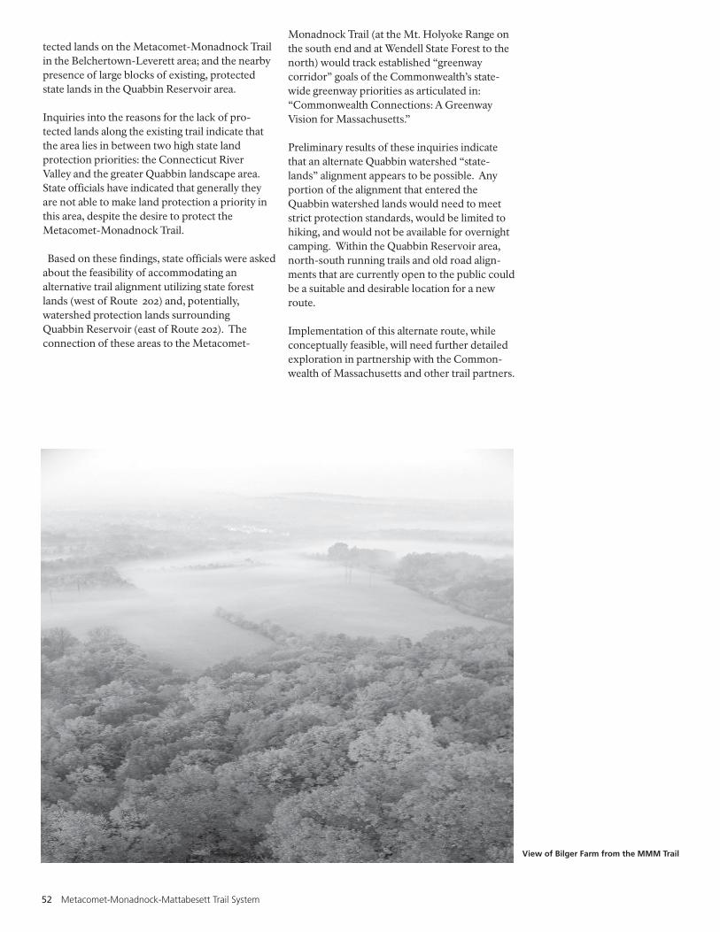
52 Metacomet-Monadnock-Mattabesett Trail System
tected lands on the Metacomet-Monadnock Trailin the Belchertown-Leverett area; and the nearbypresence of large blocks of existing, protectedstate lands in the Quabbin Reservoir area.
Inquiries into the reasons for the lack of pro-tected lands along the existing trail indicate thatthe area lies in between two high state landprotection priorities: the Connecticut RiverValley and the greater Quabbin landscape area.State officials have indicated that generally theyare not able to make land protection a priority inthis area, despite the desire to protect theMetacomet-Monadnock Trail.
Based on these findings, state officials were askedabout the feasibility of accommodating analternative trail alignment utilizing state forestlands (west of Route 202) and, potentially,watershed protection lands surroundingQuabbin Reservoir (east of Route 202). Theconnection of these areas to the Metacomet-
Monadnock Trail (at the Mt. Holyoke Range onthe south end and at Wendell State Forest to thenorth) would track established “greenwaycorridor” goals of the Commonwealth’s state-wide greenway priorities as articulated in:“Commonwealth Connections: A GreenwayVision for Massachusetts.”
Preliminary results of these inquiries indicatethat an alternate Quabbin watershed “state-lands” alignment appears to be possible. Anyportion of the alignment that entered theQuabbin watershed lands would need to meetstrict protection standards, would be limited tohiking, and would not be available for overnightcamping. Within the Quabbin Reservoir area,north-south running trails and old road align-ments that are currently open to the public couldbe a suitable and desirable location for a newroute.
Implementation of this alternate route, whileconceptually feasible, will need further detailedexploration in partnership with the Common-wealth of Massachusetts and other trail partners.
View of Bilger Farm from the MMM Trail

National Park Service 53
A Blueprint for the Management of the Trail
The MMM Trail System Management Blueprinthas two main purposes:
1. Collect the best recommendations andstrategies that have come out of the Connecticutand Massachusetts Trail Study working groups tomeet the Study’s primary objective of ensuringlong-term trail viability.
2. Establish a clear basis for management of thetrail should it be designated as a National ScenicTrail.
The Blueprint is organized into seven sections, asfollows:
Section A. Landowners IssuesSection B. Trail UseSection C. Trail ProtectionSection D. Trail Management and
MaintenanceSection E. Community ConnectionsSection F. Administrative FrameworkSection G. Provisions If National
Scenic Trail DesignationOccurs
Section H. Proposed Blueprint Budget
The implementation of this Blueprint will becoordinated through the Trail StewardshipCouncil as described in Section F: AdministrativeFramework.
The following Management Principles underliethe Blueprint and are critical to its success:- There is full involvement of a wide range of
trail constituents- The Blueprint builds off of existing trail
partnerships and traditions- Private property rights are respected and
landowners participation encouraged- No new regulatory trail protection is proposed
or advocated by this blueprint or by the trailstewardship council on private property.
The cost to implement this blueprint is estimatedat $271,000 and is described in Section H:Proposed Blueprint Budget.
Each section begins with a goal statementfollowed by a set of recommended tasks, policiesand objectives that could be undertaken tosupport achievement of the goal.
A. Landowner IssuesGoal: Work with landowners hosting the trail tofoster good communication along with supportfor, and involvement in, sustaining the trail.
1. Set up a system to communicate with landowners, including:a. All landowners receive at least onenewsletter per year with trail updates andcontact information;b. Keep up-to-date contact information on website (trail maintainers, section leaders, towncontacts).
2. Maintain an up-to-date landowner database(parcel map/ database updated annually).
3. Establish a mechanism to enforce trail policies.a. Develop relationships with enforcement authorities and individuals (local, state, landowner)b. Develop strategies to address trash, illegaldumping, trespassing and parking issues.
4. Provide increased liability protection forlandowners hosting the trail.a. Establish a “liability protection fund” to paylegal costs in the event of a suit;b. Explore additional options, including theNational Park Service VIP program; personalliability policies; adding landowners toinsurance coverage of trail stewardship/protection organizations.
5. Seek to formalize permission for trail accesssuch as through voluntary, revocable writtenagreements that are mutually beneficial to trailstewards and landowners.
6. Trail relocation requests are to be expectedand will be accommodated in a timely fashion.
7. All existing landowner uses and rights includ-ing hunting, fishing, timber management andtrail uses such as equestrian, mountain biking,and snowmobiling will continue to be at thediscretion of landowners.
8. Provide educational materials to local commis-sions, recreational users, and other stakehold-ers regarding private property rights associatedwith the trail.

54 Metacomet-Monadnock-Mattabesett Trail System
B. Trail UseGoal: Set trail system use policies to providepositive trail experiences, respect trail capacityand landowner rights.
1. Support the MMM Trail System primarily as acontinuous, long-distance hiking trail withuses such as mountain biking, equestrian, orsnowmobiling on sections based on landownerwishes and terrain suitability.a. landowners have the final say regarding trailuses on their propertyb. the Stewardship Council will be available toreview and provide recommendations onmulti-use issues brought forth by user groupsor landowners.
2. Develop a conflict resolution process toaddress landowner and trail user issues,utilizing the Trail Stewardship Council.
3. Track trail use levels, types, impacts andconditions including using standard method-ologies for comparison with other trails andtrail systems.
C. Trail ProtectionGoal: Secure a continuous off-road trail systemthat respects natural resources, from Long IslandSound to the MA/NH border.
1. Trail protection is defined as supporting thelong-term existence and use of the MMM trail.
2. Trail protection will occur using a wide rangeof tools including but not limited to: conserva-tion restrictions; revocable recreationaleasements; fee simple acquisition; or memo-
randa of agreement.
3. Trail protection will occur with landowners onvoluntary basis only. No land takings willoccur.
4. No specific trail system corridor width isrequired or established.
5. Trail protection will be encouraged andassisted (financial, coordination, establishingpriorities) by the Stewardship Council,working with the Appalachian Mountain Club(MA), Connecticut Forests and Parks Associa-tion (CT), state agencies, land trusts, commu-nities, and others.
6. Track the current level of protection on mapsand database.
7. No regulatory protection of a “trail corridor”or “view corridor” is required.
8. New or relocated sections of trail will be laidout and constructed in an environmentallysensitive manner.
D. Trail Management and MaintenanceGoal: Support a volunteer-based trail steward-ship program to ensure a well-maintained trailsystem.
1. AMC and CFPA will continue to be the leadvolunteer-based entities for day-to-day trailsystem management and maintenance. TheTrail Stewardship Council will assist andcoordinate with AMC and CFPA as appropri-ate to ensure consistent and successful Trailmanagement across the two states, including:a. consistent guidelines for trail managementand trail volunteers;b. consistent trail signage standards;c. consistent trail relocation procedures;d. consistent mechanisms to monitor trailconditions;e. evaluate and meet parking needs.
2. Use a trail guidebook and signage to clearlyidentify appropriate parking areas, as well asprivate land trail segments which need to berespected.
3. Additional organizations such as the Snowmo-bile Association of Massachusetts and Con-necticut Horse Council have strong trackrecords of volunteer maintenance on certaintrails. These organizations may play lead roleson the MMM Trail System if sections of thetrail are deemed appropriate for such alterna-tive uses.
E. Community ConnectionsGoal: Engage towns as trail system partners, andmaximize trail connections to communities.
1. Appoint town representatives to Trail Stewardship Council.a. encourage towns to appoint two representa-tives: one trail landowner and one from anappropriate “lead” town board/committee
2. Identify and promote physical connectionsbetween the MMM Trail and other resourcessuch as town forests and parks, state forestsand parks, other existing trail systems, downtowns, or other compatible resources.
3. Develop a small grants program for communi-ties to promote trail stewardship, connections,and protection.

National Park Service 55
F. Administrative FrameworkGoal: Create a locally based trail administrativestructure to assist and support the leadership roleCFPA and AMC will continue to have in overalltrail management and maintenance.
1. Establish a Trail Stewardship Council com-prised of individual Councils in Massachusettsand Connecticut.a. Each Trail Stewardship Council will haveonly advisory powers, and will use themanagement blueprint as a guiding documentin the long-term management of the trail whileworking as a supportive partner with CFPAand AMC.b. The Councils will decide if/when they needa formal Memorandum of Understanding;c. By-laws will be developed by the Councilbased on similar groups, such as Westfield andFarmington Wild and Scenic AdvisoryCommittees;d. All meetings will be open to the public andgoverned by the applicable CT and MA statestatutes (open meeting laws, etc.)e. Working committees/subcommittees will beencouraged, and may be formed around trailsegments and/or issues. Participation will beopen to individuals and organizations beyondthe Stewardship Council.
2. Members of the Council will include represen-tatives from:a. Massachusetts and Connecticut – tworepresentatives for each state, to be determinedby the commissioner of the appropriate stateenvironmental agency.b. The AMC – two representativesc. CFPA – two representativesd. Municipalities – one representative pertown, ideally a pertinent town staff member orcommission member, to be appointed by thechief legislative bodye. Landowner – one representative per town tobe appointed by the chief legislative bodyf. User Groups – four seats will be available oneach state Council to represent user interests,including non-hiking interests such as equestrian, snowmobiling and mountain biking.g. Regional Planning Agencies – one seat willbe available for each regional planning agencythat has the trail in their regionh. Nonprofit Land Conservation Organiza-tions – one seat will be available for each landconservation group that owns or managesproperty over which the trail crosses.i. Others as the Council sees appropriateincluding individuals, water utilities orcorporate landowners.
3. The Stewardship Council will operate on aconsensus-based decision-making process formost decisions; there may be certain decisionssuch as adoption of by-laws, changes to themanagement blueprint or election of officerswhere more formal votes will be desired.
4. Bi-state meetings to be held between Massa-chusetts and Connecticut as needed, but atleast once a year.
G. Provisions if National Scenic TrailDesignation Occurs
Goal: If NST designation occurs, provide federalassistance to implement this Blueprint, whilesupporting local management and propertyrights.
1) Trail Stewardship Councila) The National Park Service will become amember of the Trail Stewardship Council andoccupy a single seat.b) The Trail Stewardship Council shall beestablished in a timely manner.c) The National Park Service will not beeligible to chair the Council or hold otherofficer positions.d) The Council and its subcommittees shall notbe considered federal advisory committees forthe purpose of the Federal Advisory Commit-tee Act.
2) National Park Service Assistancea) The primary role of National Park Servicewill be to assist the Council, its member in-stitutions, and other partners in the implemen-tation of this Management Blueprint, subjectto Congressional appropriations.b) The National Park Service will coordinatethe expenditure of federal funds provided byCongress for the Trail with the Council, andwill seek consensus from the Council on themost effective use of such funds.c) Priorities for use of federal funds/assistanceshall include: coordination and support of theCouncil itself and any subcommittees that theCouncil creates; trail continuity; maintainingup-to-date mapping and landowner contactinformation; signage; capital improvementssuch as parking and trailheads; trail mainte-nance; assistance to communities and otherpartners for trail connections, planning,enforcement, protection and enhancement;other priorities as established by the Council.
3) Limitations of NST Designation and Safeguards for Landownersa) For the purposes of NST designation, nospecific trail system corridor width will beestablished.
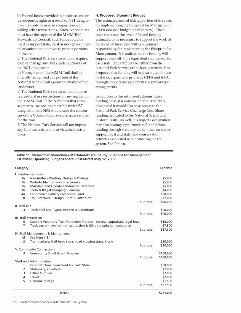
56 Metacomet-Monadnock-Mattabesett Trail System
b) Federal funds provided to purchase land ordevelopment rights as a result of NST designa-tion may only be used in conjunction withwilling seller transactions. Such expendituresmust have the support of the MMM TrailStewardship Council. Such funds could beused to support state, local or non-governmen-tal organization initiatives to protect portionsof the trail.c) The National Park Service will not acquire,own or manage any lands under authority ofthe NST designation.d) No segment of the MMM Trail shall beofficially recognized as a portion of theNational Scenic Trail against the wishes of thelandowner.e) The National Park Service will not imposerecreational use restrictions on any segment ofthe MMM Trail. If the NPS finds that a trailsegment’s uses are incompatible with NSTdesignation, the NPS should seek the consen-sus of the Council to pursue alternative routesfor the trail.f) The National Park Service will not imposeany land use restrictions or viewshed restric-tions.
Category Expense
I. Landowner Issues1a Newsletter - Printing, Design & Postage $5,0001b Website Maintenance – outsource $5,0002a Maintain and Update Landowner Database $5,0003b Trash & Illegal Dumping Clean-up $4,0004a Landowner Liability Protection Fund $20,000
8 Trail Brochure - Design, Print & Distribute $7,000Sub-total $46,000
II. Trail Use3 Track Trail Use, Types, Impacts & Conditions $20,000
Sub-total $20,000III. Trail Protection
5 Support Voluntary Trail Protection Projects - surveys, appraisals, legal fees $10,0007 Track current level of trail protection & GIS data upkeep - outsource $7,500
Sub-total $17,500IV. Trail Management & Maintenance
1d See Item II.3.2 Trail markers, trail head signs, road crossing signs, kiosks $20,000
Sub-total $20,000V. Community Connections
3 Community Small Grant Program $100,000Sub-total $100,000
Staff and Administrative1 One Half-Time Equivalent for Each State $60,0002 Stationary, envelopes $2,0003 Office Supplies $2,0004 Travel $2,0005 General Postage $1,500
Sub-total $67,500
TOTAL $271,000
Table 11. Metacomet-Monadnock-Mattabasett Trail Study Blueprint for ManagementEstimated Operating Budget-Federal Costs-Draft May 12, 2005
H. Proposed Blueprint BudgetThe estimated annual federal portion of the costsfor implementing the Blueprint for Managementis $271,000 (see budget details below). Thesecosts represent the level of federal fundingestimated to be necessary to support the work ofthe local partners who will have primaryresponsibility for implementing the Blueprint forManagement. It is anticipated the funding willsupport one half- time equivalent staff person foreach state. The staff may be either from theNational Park Service or the local partners. It isproposed that funding will be distributed for useby the local partners, primarily CFPA and AMC,through cooperative agreements or similar typearrangements.
In addition to this estimated administrativefunding need, it is anticipated if the trail weredesignated it would also have access to theNational Park Service Challenge Cost-Sharefunding dedicated to the National Scenic andHistoric Trails. As well, it is hoped a designationmay also leverage opportunities for additionalfunding through statutory aid or other means tosupport local and state land conservationactivities associated with protecting the trailsystem. See Table 11.

National Park Service 57
Budget Notes:• This budget is for the entire two state trail
system assuming designation occurs and theblueprint is implemented.
• This budget does not address any potentialfunding associated with voluntary landprotection efforts associated with the trail.
• All other components of the blueprint formanagement not mentioned in the budget areconsidered to require only staff time and haveno additional associated expenses.
• It is anticipated that the Landowner LiabilityProtection Fund (Item I.4a.) will not need to bereplenished annually.
• It is anticipated that funding needs for the trailuse impacts and conditions work (Item II.3.)will not need permanent levels of funding atthe level budgeted. In future years fundingwould evolve to address issues identified in thetrail use, impacts and conditions assessment,such as trail and trail head improvements,parking improvements or other related items.
View of Mount Tom, Easthampton, Massachusetts

58 Metacomet-Monadnock-Mattabesett Trail System
The Connecticut River in the background from the porch of the Summit House, Holyoke, Massachusetts

National Park Service 59
Management Alternatives and EnvironmentalAssessment
This chapter of the Feasibility Study discussesalternative schemes for the management andprotection of the MMM Trail System and thelikely environmental and socio-economic impactof those alternatives.
A. Purpose and NeedThis document is being prepared in response topassage of Public Law 107-338, directing theNational Park service to study the Metacomet-Monadnock-Mattabesett Trail System inConnecticut and Massachusetts for potentialinclusion in the National Trails System throughdesignation as a National Scenic Trail. Based onthe expressed intent of the legislative sponsorsand principal trail steward organizations, twogoals were established for the study:
Primary Goal: To determine the best way toensure the long-term viability of a continuouspublic-use trail system from Long Island Soundthrough Connecticut to the Massachusetts/NewHampshire border.
Secondary Goal: To determine whether or notdesignation as a National Scenic Trail makessense as a means of achieving the primary goal oflong-term trail system viability.
In addition, the study had four guiding prin-ciples:
• Meaningful investigation of the trail system’slong-term viability can only occur with the fullinvolvement of a wide range of trail advocates,landowners, and other interested parties.
• Emphasis will be on strengthening existingtrail system partnerships and characteristics ofuse, maintenance, ownership, and voluntarystewardship.
• Respect for private property rights is a funda-mental component of a successful project.
• Federal condemnation of land will not beconsidered as an option in establishing orprotecting the trail system.
These goals and guiding principles are theframework for the study and for the developmentof alternatives discussed in this Chapter.
B. Alternatives Considered and RejectedOnly alternatives considered practical and feasibleare evaluated in detail, based upon realities of thetrail system, advice of study partners, congres-sional intent and similar limiting factors. Thestudy team eliminated from detailed considerationseveral trail management and protection ap-proaches that relied on an unacceptable level offederal involvement and/or control.
Utilization of Federal Condemnation AuthorityConsistent with Congressional intent and direc-tion expressed prior to and after authorization ofthe MMM Trail System study, any alternativeinvolving federal condemnation of lands waseliminated from consideration prior to com-mencement of the study.
Direct Federal Management of the TrailIn further developing the intent and direction ofthe study, the study team Goals and Principlesemphasized strengthening existing trail traditionsof management and protection. Through workinggroups, landowner feedback, and public forums,this emphasis has been widely supported. Little orno support has been voiced for any direct federalmanagement of the trail. Existing local, state andnongovernmental institutions are well situated toimplement management and protection strategiesfor the trail. Therefore, any alternative calling fordirect federal management of the trail has beeneliminated from consideration.
Federal Ownership of the TrailAs is the case regarding direct federal managementof the trail, little support or need for direct federalownership of the trail has been voiced. Directfederal ownership or acquisition of trail landswould unnecessarily complicate trail protection,management and administration. Direct federalownership of lands under a potential NationalScenic Trail designation has been eliminated fromconsideration.
Abandonment of Long-Distance Trail Continu-ity in Favor of Local/Regional Trail SegmentsAny alternative that considered abandoning thegoal of long-distance trail continuity in favor ofworking toward a series of shorter, unconnectedday hikes was dropped from consideration basedupon congressional intent, historical trail context,

60 Metacomet-Monadnock-Mattabesett Trail System
established goals of the states of CT and MA, andthe input of principal trail partners, including theAMC and CFPA.
National Recreation Trail StatusAlthough more than 50 miles of the Metacomet-Monadnock Trail in Massachusetts weredesignated as a National Recreation Trail in 2001,National Recreation Trail status for the entireMMM Trail System was not sought due in largepart to the requirement that written approval ofall participating landowners be obtained. Withover 600 landowners and 1,000 separate parcelsof land along the trail system, the process ofgathering the necessary written approvals wasnot determined to be feasible.
C. Alternatives Considered• Alternative 1: Continuation of Current
PracticesUnder this alternative, no specific actions ororganized effort would be made to altercurrent trail management practices or adminis-trative structures, and no comprehensive effortto implement the recommendations of theMMM Trail “Blueprint” would be made.Some of the Blueprint’s recommendationsmight be picked up and implemented bygroups such as the Connecticut Forest andPark Association in CT and the AppalachianMountain Club in MA.
• Alternative 2: Implementation of the TrailBlueprint through National Scenic TrailDesignation for the Entire Existing Route ofthe MMM Trails in Connecticut andMassachusettsUnder this alternative, the entire historical trailroute of the MMM Trails in CT and MA wouldbe designated as a National Scenic Trail to bemanaged in accordance with the MMM TrailManagement Blueprint developed as a part ofthe Study. This alternative would adhereclosely to the intent of the Study legislation,and would elevate the profile of the MMMTrail system as a resource of national signifi-cance. This alternative is not considered afeasible alternative due to significant land-owner opposition and the general lack ofexisting trail protection in the trail sectionnorth of the Mt. Holyoke Range (westernBelchertown town boundary). This section oftrail includes several long stretches with littleor no existing trail protection and substantiallandowner opposition to either trail protectionor NST designation.
• Alternative 3: Implementation of the TrailManagement Blueprint through National
Scenic Trail Designation from Long IslandSound in CT to the NH Border, including asignificant re-route in the Belchertown toLeverett area in Massachusetts.Under this alternative the entire trail systemfrom Long Island Sound to the NH borderwould be designated as a National Scenic Trailunder a name such as the New EnglandNational Scenic Trail. The route would includea significant deviation from the existingMetacomet-Monadnock trail for the portionof the designation between the Mt. HolyokeRange and Wendell State Forest, consistentwith the generalized map found within thisreport. This alternate route is conceptual onlyat this time. Preliminary discussions with stateof Massachusetts officials indicate that thispotential route alternative, which may be ableto take advantage of existing State Forest and,possibly, Quabbin Reservoir lands, is concep-tually feasible. The total length of the NationalScenic Trail route from Long Island Sound tothe New Hampshire border is estimated at 220miles. This alternative and its implementationis more fully discussed below.
• Alternative 4: Non-Federal Implementationof “Blueprint” RecommendationsUnder this alternative, another state-based ornon-profit-based entity would take the lead inpromoting the MMM Trail Blueprint in anorganized and comprehensive fashion. Themost likely possibility is that the CFPA and theAMC, cooperating with the states of Massa-chusetts and Connecticut, could form a bi-state partnership whose mission was toimplement the MMM Trail Blueprint andensure long-term trail viability and continuity.CFPA and AMC would need to raise fundsprivately and through various grant sources tofund this effort. This alternative is notconsidered feasible since neither the states ofConnecticut or Massachusetts nor the AMC orCFPA are in a position to undertake the effortsnecessary.
Discussion of Alternative 3: Implementation of theTrail Management Blueprint through NationalScenic Trail Designation from Long Island Soundin CT to the NH Border, including a significant re-route in the Belchertown – Leverett area inMassachusetts
GeneralNational Scenic Trail designation would elevatethe level of importance associated with long-term viability of a continuous trail system fromLong Island Sound to the New Hampshireborder. The creation and support of the envi-

National Park Service 61
sioned Trail Stewardship Council would create avehicle for increased coordination, communica-tion, and partnering among all trail stakeholdersin achieving the goal of long-term trail viability,enhancement and protection articulated in theTrail Management Blueprint developed as a partof this study. The potential availability of federalfunds through the designation, as well as theleveraging effect of the national designation,would help support and catalyze the efforts of alltrail partners. Continued leadership from theAppalachian Mountain Club and the Connecti-cut Forest and Park Association, augmented byincreased funding levels and increasedpartnering opportunities through the TrailStewardship Council appears to be an effectivevehicle for achieving trail system goals, whilemaintaining the heritage and traditions of thetrail system.
Deviations from Historical RoutesExtension to Long-Island Sound - Based onlegislative direction and the interest of CFPAand other trail partners in CT, the studyprocess in Connecticut has included investiga-tion of potential alternatives to connect theexisting Mattabesett Trail to Long IslandSound. A map contained within this reportshows the conceptual route of such anextension that has been developed through theefforts of the CFPA and the Town of Guilford.This extension is believed to have a highdegree of feasibility and is included as a part ofthe NST designation alternative.
New Alignment in Massachusetts North of theMt. Holyoke Range - A new alignment for NSTpurposes is envisioned between the Mt.Holyoke Range and the Wendell State Forest inthe Belchertown-Leverett area. This alterna-tive route warrants exploration based on thepotential to take advantage of existing statelands that lie to the east of the existingMetacomet-Monadnock Trail, and due to thehigh priority for future land protection in thisGreater Quabbin Landscape area. By contrast,the existing route in this area is almostcompletely devoid of protected lands, andsubstantial landowner opposition in this areahas been voiced against land protection andNST designation. Multiple potential variationson a new trail alignment in this area arepossible, and full exploration of this newalignment and options associated therewithwould be necessary before any specificalignment or route is proposed. It may bepossible, for example to stay entirely west ofRoute 202, and continue to cross Mt. Lincoln(both suggestions that have been made throughpublic meetings associated with the Study).
The traditional route of the Metacomet –Monadnock Trail through this area couldcontinue to exist unchanged from presentconditions, managed by the AMC and thelandowners, but would not be considered partof the NST designation.
A New Name for NST PurposesIt is recommended that the National Scenic Traildesignation be pursued under a new name, suchas the New England National Scenic Trail. Thehistorical trail names might be continued forindividual trail segments, where appropriate,such that a guidebook or trail sign might refer to,“Metacomet Trail, part of the New EnglandNational Scenic Trail,” or “Mattabesett Trail, partof New England National Scenic Trail,” etc. Thissame technique has been used on other NationalScenic Trails, where prior existing trail namesegments have kept their historical identities as apart of a later, differently named NST designa-tion. The Trail Stewardship Council, AMC andCFPA would need to determine how to nameand sign various trail segments. For example, theGuilford extension to Long Island Sound couldeither become part of the Mattabesett Trail, orcould simply be a segment of the New EnglandNational Scenic Trail, or some other variationunder the NST umbrella.
A distinct NST name would also help eliminateconfusion in Massachusetts where it is quitepossible that the historical Metacomet-Monad-nock Trail and a new NST route might exist asdistinct alternative hiking routes in the portionnorth of the Mt. Holyoke Range.
D. The Affected EnvironmentThe MMM Trail System consists of three largelycontiguous trails: the Metacomet-MonadnockTrail, the Metacomet Trail, and the MattabesettTrail. The trails collectively travel 190 miles in anorth-south direction, from the Massachusetts-New Hampshire border south towards LongIsland Sound. The portion of the Metacomet-Monadnock Trail included in the study is locatedentirely within Massachusetts, while theMetacomet and Mattabesett Trails are locatedentirely within Connecticut.
The Metacomet Trail in Connecticut follows atraprock mountain range running from theHanging Hills of Meriden to the MassachusettsState line for approximately 57 miles. The Trailreaches elevations of over 1,000 feet at its highestpoint.
The Mattabesett Trail is approximately 53 milesin length. The trail begins at the ConnecticutRiver, and roughly forms a large horseshoe as it

62 Metacomet-Monadnock-Mattabesett Trail System
travels south and west before assuming anortherly direction to its terminus at the BerlinTurnpike in Berlin. A road-walk then connects tothe southern terminus of the Metacomet Trail.
The Metacomet-Monadnock Trail in Massachu-setts is approximately 80 miles in length. TheTrail is located in Hampden, Hampshire,Franklin, and Worcester Counties, passingthrough 19 separate communities. The elevationof the trail varies from 100’ at its lowest pointalong the Westfield River in Agawam to 1,618 feetat its highest point on Mount Grace in Warwick.The trail enters New Hampshire at the state lineand continues northward, eventually reachingthe summit of Mt. Monadnock.
In order to understand the existing trail system, adetailed field survey and inventory was com-pleted. In 2003 and 2004, a combination ofregional planning professionals and volunteershiked the trail system in both Connecticut andMassachusetts, utilizing a global positioningsystem (GPS) to record detailed data. Thefollowing information was collected and com-piled into a geodatabase:
- General descriptions and photographs of thetrails
- Information on resources, scenic view shedsand other special assets
- Physical characteristics including geology,hydrology, vegetation and wildlife
- Cultural resources located along the trails orwithin close proximity
- Wildlife habitatsHistoric and archaeological features
- Other characteristics that make the trail systemunique.
Other data collected during the field hikingincluded:
- Condition of the trails- Locations of trailheads and parking areas- Identification of problem areas needing
attention- Trail route continuity- Maintenance issues
A complete segment-by-segment description ofthe MMM Trail System, including informationon connecting trails, may be found in AppendixSection A.
E. Impacts of AlternativesThis section compares the likely trail viability,environmental, cultural and socio-economicimpacts of the four alternatives.
MethodologyThe study team has evaluated the impacts of thealternatives based on experience with similar trailsystems in the past, and on the substantial datacollected regarding the actual conditions andexperiences on the MMM Trail System whichhas existed on the ground for decades in mostplaces.
ContextThe evaluation of existing trail conditionsdocuments existing environmental damage, poortrail conditions, and opportunities for improve-ment in many sections of the existing MMMTrail System. The provisions of the Blueprint ForManagement have been specifically developed tominimize negative environmental consequencesrelated to existing trail conditions, and to avoidsuch consequences in the future. The context forconsidering existing and potential futureconditions and impacts requires generalization ofthese potentials. Each on-the-ground situationrelated to actual trail conditions and impactsmust be evaluated on a case by case basis in thefuture as a part of ongoing trail management andmaintenance.
TimingThe timing of any particular action or conse-quence related to the alternatives can also only begeneralized. None of the alternatives would haveimmediate on the ground impacts distinguishablefrom the others. Only over the longer term willdifferences begin to emerge. No specifictimeframe can reasonably be assigned to reflectthis reality.
IntensityIntensity of impacts and consequences is alsovery difficult to predict. The ongoing manage-ment of the Trail System, and provisions builtinto the Blueprint For Management will seek totrack trail conditions and trail related impacts.Existing conditions provide a baseline forcomparison in the future.
Direct and Indirect EffectsDirect and indirect effects of the alternatives arealso addressed in a generalized way based uponthe reasonably foreseeable consequences basedon past experiences on similar projects andprofessional judgement.

National Park Service 63
Alternative 1: Continuation ofCurrent Practices
Under this alternative, nospecific actions or organizedeffort would be made to altercurrent trail management practices or administrativestructures, and no comprehen-sive effort to implement therecommendations of the MMMTrail “Blueprint” would be made.
Alternative 2: Implementationof the Trail Blueprint throughNational Scenic Trail Designa-tion for the Entire HistoricalRoute of the MMM Trails in CTand MA
Under this alternative, the entirehistorical trail route of the MMMTrails in CT and MA would bedesignated as a National ScenicTrail to be managed in accor-dance with the MMM TrailManagement Blueprint devel-oped as a part of the Study.
Alternative 3: Implementationof the Trail Management Blue-print through National ScenicTrail Designation from Long Is-land Sound in CT to the NHBorder, including a significantnew route in the Belchertown– Leverett area in Massachu-setts
Under this alternative the entiretrail system from Long IslandSound to the NH border wouldbe designated as a NationalScenic Trail under a name such asthe New England National ScenicTrail. The route would include asignificant deviation from thehistorical Metacomet-Monadnocktrail for the portion of thedesignation north of the Mt.Holyoke Range, consistent withthe generalized map foundwithin this report.
The impacts of this alternative onlong-term trail viability aresimilar to alternative 2, exceptthat trail viability and continuityin the Belchertown-Leverettsection would be enhanced by anew NST route that takesadvantage of nearby state-owned lands and simultaneouslyavoids an area largely devoid ofprotected lands, in whichsubstantial landowner oppositionto NST designation and long-term trail protection has beenvoiced. The new alignmentwould track existing stategreenway priorities and landprotection priorities of thegreater Quabbin landscape.
The impacts of this alternativewould be similar to alternative 2,except that the new alignment ofthe NST in the Belchertown-Leverett area would likely resultin increased usage for that area,as would the creation of the NSTextension through Guilford toLong Island Sound. The extent ofincreased use cannot be knownuntil plans move beyond theconceptual stage, and may varyconsiderably depending uponactual routes chosen. This issuewill require more attention if andwhen the new route optionsmove beyond the conceptualstage.Impacts on types of usage wouldbe similar to alternative 2.
Alternative 4: Non-FederalImplementation of “Blueprint”Recommendations
Under this alternative, somealternative State-based or Non-profit-based entity would takethe lead in promoting the MMMTrail Blueprint in an organizedand comprehensive fashion. Themost likely possibility is that theCFPA and the AMC, cooperatingwith the States of Massachusettsand Connecticut, could form a bi-state partnership whose missionwas to implement the MMM TrailBlueprint and ensure long-termtrail viability and continuity.CFPA and AMC would raise fundsprivately and through variousgrant sources to fund this effort.
This alternative has the potentialto enhance long-term trailviability beyond the status quo.However the lack of increasedstature conferred by potentialNST designation, and the lack ofpotential federal funding supportare significant drawbacks torealizing this alternative. To datenone of the likely entities (states,CFPA, AMC) have expressed anyinterest in this alternative.
Implementation of this alterna-tive would have similar useimpacts to alternative 2 ifincreased attention to the trailresulted in similar improvementsto overall trail conditions andcontinuity.Impacts on types of usage wouldalso be expected to be similar ifadditional resources for steward-ship and enforcement were madeavailable.
Impacts on Long-Term TrailViability
This alternative would donothing to increase the currentlevel of organization, effort, andfunding devoted to the long-term viability of the MMM TrailSystem. Over the long-term, it isexpected that breaks in the trail,road walks, and similar threats totrail continuity will increase, andthat the trail may evolve into aseries of unconnected ridge hikesand shorter trail segments.
Impacts on Recreational TrailUse
No comprehensive data currentlyexists on trail use levels. Certaintrail segments are known to beheavily used (Mt Tom,Metacomet Ridge, for example).Very little “end-to-end” usage isbelieved to occur. Breaks/roadwalk sections (especially in CT)likely limit the use of somesections and long distance useattractiveness.Types of usage are currentlygoverned by the landowner, withhiking a pervasive use and otheruses occurring in some areas.
Table 13Comparison of Impacts by Alternative
This alternative would confer thebenefits of National Scenic Traildesignation (potential federalfunding, national recognitionand status, organizationcommitment to the Trail Steward-ship Council and Trail Manage-ment Blueprint) to the entireexisting trail system. Long-termtrail continuity and viabilitywould be enhanced. However, inthe Belchertown-Leverett sectionof the trail, in MA, short andlong-term trail continuity couldbe adversely affected bysignificant landowner oppositionand potential trail closings
NST designation would likelyserve to publicize the trail abovecurrent levels and could result inincreased usage. Over time, ifadditional resources of designa-tion and attention of theStewardship Council served toimprove overall trail conditionsand continuity, this would likelyresult in increased usage ofcurrently under-used areas andlong distance (end-to-end type)usage.Types of usage would not beexpected to change, since usagewould continue to be governedby the landowner. Additionalresources available for steward-ship and enforcement might havethe effect of reducing unwantedor illegal uses, such as unautho-rized ATV use.

64 Metacomet-Monadnock-Mattabesett Trail System
Impacts on the NaturalEnvironment
Under current practices, theMMM Trail system traverses manysignificant natural landforms,landscapes, and habitat types.The trail serves to connect peopleto these natural features andencourages their appreciationand preservation. Over time,trail protection efforts haveincreased protected lands andpreservation of associatednatural features. At the sametime, some negative humanimpacts are generated throughman’s presence, erosion, litterand similar impacts. Under thisalternative this pattern wouldcontinue unchanged.
Impacts on Sensitive Habitatssuch as Wetlands, Vernal Poolsand Floodplains
The existing trail system traversesor impacts sensitive habitats suchas wetlands, vernal pools, andfloodplains in a variety oflocations, and some of theseareas have been noted to becausing environmental damagesin need of remediation. Littlefunding has been available for asystematic approach to suchissues, though the AMC and CFPAdo attempt to address seriousissues as they become aware ofthem.
Impacts on the CulturalEnvironment
The trail as it exists providesaccess to and through a varietyof culturally significant land-scapes, sites and features.Opportunities to experience theNew England Landscape throughvistas and physical trail connec-tions are high. Appreciation andprotection for these culturalresources and sites is increased byhuman awareness and under-standing. There is little evidenceof negative human impact on thecultural environment from thetrail.
Table 13 (cont’d)
Comparison of Impacts by Alternative
Under this alternative, it isexpected that efforts at trail andassociated natural resourceprotection would be increasedover the status quo, resulting in alikely increase in long-termnatural resource and habitatprotection. Additional resourceswould also be available for usereducation, trail maintenance andsimilar aspects the Trail Manage-ment Blueprint identifies thatmay be expected to reducenegative human impactsassociated with the trail.
NST designation of the existingtrail system has the potential toincrease the amount of atten-tion, funding and resourcedevoted to such issues throughimplementation consistent withthe intent of the Blueprint ForManagement. It may be possibleto utilize the baseline informa-tion collected as a part of thisStudy to implement a systematicapproach to identification,prioritization and resolution ofproblem areas. Over the long-term, it is reasonable to predictthat impacts to sensitiveenvironmental areas will bereduced under this alternative.
Under this alternative additionalresources and attention would bedevoted to cultural resourceinterpretation and connectionthrough efforts of the TrailStewardship Council andimplementation of the TrailManagement Blueprint. Theopportunity to connect with theNew England Landscape as asignificant aspect of the nation’scultural heritage would beemphasized by the NST designa-tion. The Blueprint’s emphasis on“community connections” would
Impacts of this alternative on thenatural environment are similarto alternative 2, except that inthe Belchertown-Leverett areaadditional federal resources andattention of the Trail Steward-ship Council would be directedaway from the historical route ofthe Metacomet-Monadnock Trailand toward the new NST routeto the east. This would increasenatural resource protection andstewardship efforts for the newalignment of the NST, while suchefforts and attention on thatportion of the historical trailwould remain status quo orpotentially decrease. The newNST segments in both MA andGuilford, CT also have thepotential to increase human usein these areas, potentiallyincreasing negative humanimpacts as well. This issue willrequire further consideration ifand when these new routeoptions move beyond theconceptual stage.
Impacts of this alternative aresimilar to those described forAlternative 2, except that thedevelopment of new trailsections in Guilford and the newNST section proposed in Massa-chusetts. For these new trailareas, conceptual plans reflectthe intent of the Blueprint ForManagement to avoid negativeimpacts to sensitive environmen-tal areas. When moving fromconceptual to on-the-groundlayout, these issues will need tobe reassessed to ensure that longand short-term impacts areavoided.
The impacts of this alternativewould be similar to alternative 2,except that a significant newopportunity to connect the NSTto the unique history of theQuabbin Reservoir area and tothe Historic District and featuresof the Town of Guilford could bedeveloped. The potential for atrail overlook and interpretivesignage telling the story of thecommunities removed andflooded in the development ofthe Quabbin Reservoir could addto the culturally significant
This alternative has the potentialto increase natural resourceprotection and stewardshipefforts similar to alternatives 2and 3. However, the lack ofresources and known institu-tional interest in this alternativemakes realization of thispotential unlikely. Over the longand short term it is expected thatthe natural resource impacts ofthis alternative would be mostsimilar to alternative 1: statusquo.
Over the long and short-term it islikely that the impacts of thisalternative to sensitive environ-mental areas would be similar tothose of Alternaive 1: status quo.
As with natural resources above,this alternative has the potentialto increase the attention paid tocultural resources associated withthe trail, but the lack of imple-mentation options makes it likelythat actual impacts would besimilar to the status quo.
Alternative 1 Alternative 2 Alternative 3 Alternative 4

National Park Service 65
Impacts on SocioEconomicResources
The MMM Trail system is highlyvalued by communities, landown-ers and users as a positivecontributor to quality of life inthe areas through which the trailpasses. Many communitiesformally recognize this contribu-tion in local planning documents,town web sites, and similarvenues.Numerous studies have indicatedthat proximity to trails and openspace recreation has a positiveeffect on property values, and itis likely that the MMM TrailSystem has such an effect,though no research on this topicwas conducted as a part of thisStudy.There are no known negativesocio economic impacts relatedto the Trail System.Under this alternative, it is likelythat the positive socio economicvalue of the MMM Trail Systemwill be diminished in some areasof the trail over time, as trailbreaks, road walk sections, andsimilar trail issues increase.
Indirect and CumulativeImpacts
Under the status quo alternativethere is expected to be a slowerosion of the MMM Trail Systemlong distance trail viability.Increased development pressurewill likely continue and acceler-ate the current trend of breaks inthe trail, need for frequentrelocations, and ultimatelyfragmentation of the Trail Systeminto a series of unconnectedshort hiking opportunities.Such a system will still havesubstantial value as a recre-ational and socio economicresource, though the value willbe diminished over time andlikely lost in some areas com-pletely. The indirect andcumulative impacts of such apattern are not expected to belarge or intense, rather minorand subtle. Over time impacts onsecondary values such a propertyvalues, less attention to openspace preservation, and qualityof life indices in negativelyimpacted areas may be noticed.
Table 13 (cont’d)
Comparison of Impacts by Alternative
enhance the opportunities toconnect the trail with heritageresources at the community level.
Under this alternative, additionalattention and resources devotedto the quality, continuity andprotection of the trail, togetherwith the prestige of the NSTdesignation itself, shouldincrease the socio-economicvalue of the trail as a communityresource and contributor toquality of life factors. This wouldbe expected to have a positiveimpact upon property values andrelated socio-economic factors.
The indirect and cumulativeimpact of NST designation willrelate principally to increasedattention to open space preserva-tion, side and connecting trails,Trail System connectivity,partnerships formed through theTrail Stewardship Council, andrelated efforts stimulated andsupported by NST designation.Property values, quality of lifemeasures, open space preserva-tion will be accentuated andfewer areas will experience thelong-term decline in such spin-offvalues that may occur underAlternative 1: status quo.
The short and long-term socioeconomic impacts of thisalternative are expected to besimilar to alternative 1:statusquo.
The lack of likely implementationof this alternative makes indirectand cumulative impacts of thisalternative similar to that ofAlternative 1: status quo.
resources associated with thetrail, as could the connection tothe historical resources of theTown of Guilford.
The short and long-term impactsof this alternative on socioeconomic factors are expected tobe similar to alternative 2. Thedevelopment of the new NSTroutes in the Belchertown-Leverett section of MA and inGuilford, CT would be unlikely togenerate significantly differentsocio-economic impacts fromalternative 2, though, over time,the benefits of the Trail Systemwould be expected to accrue tothe new NST routes, as theybecome established andrecognized.
The indirect and cumulativeimpacts of this alternative aresimilar to those expected forAlternative 2, except that thetwo proposed NST routeextensions are anticipated toincrease the long term MMMTrail System viability, andtherefore extend long-termindirect and cumulative benefits.Because this alternative antici-pates development of new trailroutes that are currently onlyconceptual in nature, the indirectand cumulative impacts of thetrail in these new areas is lesswell understood than for theexisting trail areas, and will needto be considered in the furtherplanning of these extensions.
Alternative 1 Alternative 2 Alternative 3 Alternative 4

66 Metacomet-Monadnock-Mattabesett Trail System
Costs
There are no new costs associ-ated with this alternative. TheAMC and CFPA would continueto lead trail management andprotection efforts throughprimarily volunteer efforts, withsome paid staff support andinvolvement. Communities, thestates, and other partners wouldcontribute to efforts on an adhoc/ opportunistic basis, as theyhave in the past. Taken as awhole, the existing local, state,NGO commitment to the trail issubstantial and is expected tocontinue to be so.
Conclusions
The existing MMM Trail System,together with existing manage-ment and protection systems,represents an excellent recre-ational feature providing positiveenvironmental and socioeconomic values for southernNew England and the 40abutting communities. Continua-tion of current practices willgenerally continue this success,however, increased developmentpressure and trail management/protection issues are evident andexpected to increase. Over time,this alternative will continue atrend of Trail System fragmenta-tion, relocations, encroachingdevelopment and other similarfactors. A long-term downwardtrend in the overall value of theTrail System can therefore beexpected.
Table 13 (cont’d)
Comparison of Impacts by Alternative
The federal component ofmanagement costs associatedwith NST designation in accor-dance with the Blueprint ForManagement are estimated at$271,000 annually (assumingcongressional appropriationsequaling the recommendedfunding level). A breakdown ofhow this figure is arrived at isincluded in Chapter V, Section H).This can be seen as a “match” toexisting local, state and NGOresources represented in thestatus quo. Non-federalcommitment of resources wouldalso be expected to increase,based on an increased level ofactivity stimulated by federalseed $$, the Trail StewardshipCouncil activity, and additionalopportunities that NST designa-tion might reasonably beexpected to generate.
NST designation of the existingMMM Trail System, in accordancewith the Blueprint For Manage-ment, will have the effect ofincreasing the level of attentionpaid to the Trail System. Forma-tion and support of the TrailStewardship Council will increasecommunication and coordina-tion, and will likely stimulatelocal, state, and NGO attentionand resources devoted to theTrail System, associated openspace protection, and side/connecting trails. Long-termimpacts compared to the statusquo will include less trailfragmentation, increased openspace protection, and positiveeffects on socio economic factorssuch as property values andquality of life factors. Thisalternative, however would failto realize extension opportuni-ties in Guilford, CT, and wouldfail to address trail protectionand landowner conflict issues inthe Belchertown-Leverett sectionof Massachusetts.
Implementation of the BlueprintFor Management in the absenceof NST designation would carrywith it the same $271,000 annualprice tag. However, actualimplementation of this level ofsupport would require local,state and NGO partners togreatly increase their existinglevels of staff and funding to theMMM Trail System.
Implementation of the BlueprintFor Management without NSTdesignation is conceptuallyattractive, but is not consideredpractical, as none of the keyparties (States, NGO’s, communi-ties, etc.) have to date shown anyinterest in this alternative.Therefore, the overall impacts ofthis alternative are considered tobe the same as for Alternative 1:status quo.
The costs associated with thisalternative are expected to besimilar to those associated withAlternative 1. The conceptualroute extensions might thereforedivert resources from otherMMM Blueprint priorities. Thisbalancing of resource allocationpriorities would be one of themain functions of the TrailStewardship Council.
NST designation according to theBlueprint For Management, andincluding conceptual new routesin Guilford, CT and Belchertown/Leverett section of Massachusettsoffers the potential to realize thepositive impacts of Alternative 2,plus additional positive benefitsassociated with the new routeproposals. The fact that the newroute extensions are conceptualat this time will necessitatefurther planning and resourcesdevoted to realization of thesebenefits. This could result in adiversion of resources from otherMMM Trail issues/opportunities.It will be up to trail partners onthe Trail Stewardship Council tobalance these competing needsto avoid negative impacts fromthis alternative, while realizingpositive potential long-termbenefits.
F. Environmentally Preferred AlternativeThe Study concludes that the long-term viabilityof the MMM Trail system as a high quality,continuous, long-distance trail will require asustained level of increased focus and resources
by a wide array of trail partners. National ScenicTrail designation as described in Alternative 3appears to be the most feasible way to generatesuch an increased level of attention and re-sources.
Alternative 1 Alternative 2 Alternative 3 Alternative 4

National Park Service 67
SOURCES:
Connecticut Commission on Culture and Tourism
Connecticut Department of Environmental Protection
Connecticut State Office of Archaeology
Massachusetts Historical Commission. Connecticut Valley Study Unit Part I and II, Commonwealthof Massachusetts, Office of the Secretary of State, 294 Washington Street, Boston, MA: 1982.
Kingsley, Elbridge. Hadley: The Regicides, Indian and General History. Picturesque PublishingCompany, Northampton, MA: May 7, 1895.
LaFrancis, Edith. Agawam, Massachusetts: A Town History. The Pond-Ekberg Co., Springfield, MA:1980.
Lockwood, Rev. John H. Westfield and Its Historical Influences 1699-1919. Press of SpringfieldPrinting and Binding Company, Springfield, MA: 1922.
Parmenter, (No First Name Listed). History of Pelham, Massachusetts. (Publisher Page Missing): 1896.
Swanton, John R. The Indian Tribes of North America. Smithsonian Institution Press, City of Wash-ington: 1968.
Swift, Esther M. West Springfield Massachusetts: A Town History. The West Springfield HeritageAssociation, West Springfield, MA: 1969.
Walker, Alice Morehouse. Historic Hadley. The Grafton Press, NY: 1906.
Anderson, M. G. and M. D. Merrill. 1998. Connecticut River watershed: Naturalcommunities and neotropical migrant birds. Report for The Nature Conservancy,Boston, Massachusetts.
Anonymous. 1932. Hiking interest is increasing in Connecticut: Trail building in stateresults in more than 200 miles of trails. Christian Science Monitor, July 9.
Anonymous. 1933. Connecticut trail system lures many hikers: Forests, lakes,woodland brooks provide setting. Telephone News Volume VII, No. 11, July 1933.
Bell, M. 1985. The Face of Connecticut: People, Geology, and the Land. Bulletin 110of the State Geological and Natural History Survey, Hartford, Connecticut.
Berlin Conservation Commission, Meriden Conservation Commission, and MiddletownConservation Commission. 1994. Lamentation Mountain Tri-Town Project Land UsePlan, Connecticut, USA.
Bertness, M. D., P. Ewanchuk, and B. R. Silliman. 2002. Anthropogenic modification ofNew England salt marsh landscapes. Proceedings of the National Academy of Science99:1395-1398.
Bonneau, L. R., K. S. Shields, and D. L. Civco. 1999. Using satellite images to classyand analyze the health of hemlock forests. Biological Invasions 1: 255-267.
Brumbach, J. J. 1965. The Climate of Connecticut. Bulletin 19 of the ConnecticutState Geological and Natural History Survey, Hartford, Connecticut.

68 Metacomet-Monadnock-Mattabesett Trail System
Camacho, A., S. A. Canham, R. Ferik, H. H. Moore, and H. M. Richards. 2002. Amanagement plan for Yale University's Peabody Museum Natural Area, Branford andGuilford, Connecticut. Yale School of Forestry and Environmental Studies, New Haven,Connecticut.
Clapp, M. and D. Kohl. 1978. The Metacomet trail: A resource guide. Revised Edition,New Britain Youth Museum, New Britain, Connecticut.Connecticut Department of Labor. 2004. Connecticut Economic Digest, June 2004.Available at http://www.ctdol.state.ct.us/lmi/misc/cedjun04.htm.
Connecticut Forest and Park Association. 1997. Connecticut Walk Book, 60thAnniversary Edition. Rockfall, Connecticut.
Connecticut Office of Policy and Management. 2003. Census 2000 Population Countsfor Connecticut Municipalities & Counties. Available athttp://www.opm.state.ct.us/pdpd3/data/estimate.htm.42
Connecticut State Climate Center. 2004. Overview of climate in Connecticut. Availableat: http://www.canr.uconn.edu/nrme/cscc/CTweatherstationintroduction/conncticutintroduction.htm
Connecticut State Climate Center. 2004b. Summary climatic data for BradleyInternational Airport, Windsor Locks, Connecticut. Available athttp://www.canr.uconn.edu/nrme/cscc/ CTweatherstationintroduction/mIddletown.htm
Connecticut State Climate Center. 2004c. Summary climatic data for Middletown,Connecticut. Available at http://www.canr.uconn.edu/nrme/cscc/CTweatherstationintroduction/mIddletown.htm
Cronon, W. 1983. Changes in the Land: Indians, Colonists, and the Ecology of NewEngland. Hill and Wang, New York, New York.
Doezema, M. (Editor). 2002. Changing Prospects: The View From Mount Holyoke.Cornell University Press, Ithaca, New York.
Dowhan, J. J. and R. J. Craig. 1976. Rare and Endangered Species of Connecticutand Their Habitats. State Geological and Natural History Survey of Connecticut, Reportof Investigations No. 6, Hartford, Connecticut.
Environmental Protection Agency. 2004. AirData Monitor Values Report forConnecticut. Available athttp://www.epa.gov/air/data/monvals.html?st~CT~Connecticut.
Farnsworth, E. J. 2001. Corydalis flavula (Yellow Corydalis) Conservation andResearch Plan. New England Wild Flower Society, Framingham, Massachusetts.
Farnsworth, E. J. 2003. Planning for the future of over 100 rare species. New EnglandWild Flower 7: 6.
Farnsworth, E. J. In press. The rich get richer while the poor get poorer: Aconservation biologist’s perspective on invasive and rare species. Trends in Ecologyand Evolution, commissioned article.
Fitzgerald, H. 2001. Establishing conservation priorities on Connecticut’s traprockridges: A site conservation plan. Report prepared for The Nature Conservancy,Middletown, Connecticut.

National Park Service 69
Griffith, G. E., J. M. Omernik, and S. M. Pierson. 2004. Ecoregions of Massachusetts,Connecticut, and Rhode Island. U. S. Environmental Protection Agency, WesternEcology Division, Corvallis, Oregon. Available athttp://www.epa.gov/wed/pages/ecoregions/mactri_eco.htm.43
Hall, B., G. Motzkin, D. R. Foster, M. Syfert, and J. Burk. 2002. Three hundred years offorest and land use change in Massachusetts. Journal of Biogeography 29: 1319-1336.
Higbee, M. 2003. Mother’s Day hike becomes nightmare. The Middletown Press 119:1, May 12.
Hitchcock, E. 1857. On surface geology, especially that in the Connecticut Valley inNew England. Pages 1-76 in Smithsonian Contributions to Knowledge: Illustrations ofSurface Geology. Collins Publishers, Philadelphia.
Hubbard Brook Research Foundation. 2003. Nitrogen pollution from the sources to thesea. Science Links Report, Concord, New Hampshire. Available fromhttp://www.hubbardbrook.org/hbrf/page.php3?subject=Publications.
IPCC (Intergovernmental Panel on Climate Change). 2001. Climate Change 2001: TheScientific Basis. Contribution of Working Group I to the Third Assessment Report of theIntergovernmental Panel on Climate Change. Cambridge University Press, Cambridge,UK.
Juli, H. D. 1994. Late prehistory of the Thames River: Survey, landscape, andpreservation along a Connecticut estuary. Northeast Anthropology 47: 21-44.Keegan, W. F. and K. Noble Keegan. 1999. The Archaeology of Connecticut: TheHuman Era – 11,000 Years Ago to the Present. Bibliopola Press, UConn Co-op, Storrs,Connecticut.
Kerlinger, P. 1989. Flight Strategies of Migrating Hawks. Chicago University Press,Chicago, Illinois.
Klemens, M. W. 1993. Amphibians and reptiles of Connecticut and adjacent regions.State Geological and Natural History Survey, Hartford, Connecticut.Kizlinski, M. L., D. A. Orwig, R. C. Cobb, and D. R. Foster. 2002. Direct and indirectecosystem consequences of an invasive pest on forests dominated by eastern hemlock.Journal of Biogeography 29: 1489-1504.
Lapin, B. 1992. Lamentation Mountain natural resources inventory report.Unpublished report for The Nature Conservancy, Middletown, Connecticut.
Lareau, A. 1997. Needless discord: The debate over the future of Connecticut’straprock ridges. Thesis, Wesleyan University, Middletown, Connecticut.
Leary, J. 2004. A Shared Landscape: A Guide and History of Connecticut’s StateParks and Forests. Friends of Connecticut State Parks, Rockfall, Connecticut.44
Lee, C. 1985. West Rock to the Barndoor Hills: The Traprock Ridges of Connecticut.Vegetation of Connecticut Natural Areas No. 4, State Geological and Natural HistorySurvey, Hartford, Connecticut.
Little, R. D. 2003. Dinosaurs, Dunes, and Drifting Continents: The Geology of theConnecticut River Valley. Third Edition. Earth View, L. L. C., Easthampton,Massachusetts.

70 Metacomet-Monadnock-Mattabesett Trail System
Lobel, M., D. Ballon, A. Hausman-Rogers, and M. Mirvis. 2002. Progress, triage, andtraprock: A study of traprock ridge protection efforts in Middletown. Unpublished report,Wesleyan University, Middletown, Connecticut.
Longwell, C. R. and E. S. Dana. 1932. Walks and Rides in Central Connecticut andMassachusetts. Yale University Press, New Haven, Connecticut.
Lyell, C. Sir. 1865. Elements of Geology; Or, The Ancient Changes of the Earth and ItsInhabitants as Illustrated by Geological Monuments. J. Murray Publishers, London.
McCartney, J. M., P. T. Gregory, and K. W. Larsen. 1988. A tabular survey of data onmovements and home ranges of snakes. Journal of Herpetology 22: 61-73.
McDonald, N. 1996. The Connecticut Valley in the Age of Dinosaurs: A Guide to theGeologic Literature, 1681-1995. Bulletin 116, State Geological and Natural HistorySurvey, Hartford, Connecticut.
McShea, W. J., H. B. Underwood, and J. H. Rappole 1997. The Science ofOverabundance : Deer Ecology and Population Management. Smithsonian InstitutionPress, Washington, D. C.
Menunkatuck Audubon Society. 2001. Biodiversity Day 2001: Report of the survey ofbiodiversity in Guilford, Connecticut, September 8, 2001. Guilford, Connecticut.
Metzler, K. J. and D. L. Wagner. 1998. Thirteen of Connecticut’s most imperiledecosystems. Connecticut Department of Environmental Protection, Hartford,Connecticut.
Moorhead, W. H. III. 2003. Farmington River Watershed Association 2002 BiodiversityProject, rare plant and natural community inventory. Summary Report, Farmington,Connecticut.
Motts, W. and O'Brien, Geology and hydrology of wetlands in Massachusetts,Publication No. 123, Special report, Water resources research center, University ofMassachusetts at Amherst, 1981, 45
National Oceanic and Atmospheric Administration. 2004. Connecticut climatesummary, April 2004. Available at http://www.ncdc.noaa.gov/oa/climate/research/cag3/CT.html
NatureServe Explorer. 2004. NatureServe: An online encyclopedia of life [webapplication]. 2000. Version 1.0. NatureServe, Arlington, Virginia. Available at:http://www.natureserve.org.
New England Regional Assessment Group. 2001. Preparing for a Changing Climate:The Potential Consequences of Climate Variability and Change. New England RegionalOverview. U. S. Global Change Research Program, University of New Hampshire,Durham, New Hampshire.
Orwig, D. A. 2002. Ecosystem to regional impacts of introduced pests and pathogens:historical context, questions and issues. Journal of Biogeography 29: 1471-1474.
Orwig, D. A., D. R. Foster, and D. L. Mausel. 2002. Landscape patterns of hemlockdecline in New England due to the introduced hemlock woolly adelgid. Journal ofBiogeography 29: 1475-1488.
Parshall, T. and D. R. Foster. 2002. Fire on the New England landscape: regional andtemporal variation, cultural and environmental controls. Journal of Biogeography 29:1305-1318.

National Park Service 71
Peterson, R. C. and R. W. Fritsch, II. 1986. Connecticut’s venomous snakes: Thetimber rattlesnake and northern copperhead. Bulletin 111, State Geological and NaturalHistory Survey, Hartford, Connecticut.
Reynolds, C. 1979. Soil survey of Middlesex County, Connecticut. United StatesDepartment of Agriculture, Soil Conservation Service, Washington DC.
Ruf, C. 1985a. Natural Resources Inventory of Higby Mountain Preserve. Report forThe Nature Conservancy, 55 High Street, Middletown, Connecticut.
Ruf, C. 1985b. Natural Resources Inventory of Bluff Head Preserve. Report for TheNature Conservancy, 55 High Street, Middletown, Connecticut.
Searcy, K. B., B. F. Wilson, and J. H. Fownes. 2003. Influence of bedrock and aspecton soils and plant distribution in the Holyoke Range, Massachusetts. Journal of theTorrey Botanical Society 130: 158-169.
Shaw, H. B. 1989. Connecticut’s Central Park. M. A. Thesis, Wesleyan University,Middletown, Connecticut.
Sultzmann, L. 1997. First Nations Histories. Available athttp://www.tolatsga.org/Compacts.html46
The Mineral Database. 2004. Regional report: Connecticut, USA. Available athttp://www.mindat.org/rloc.php?loc=Connecticut%2C+USA.
Thorson, R. M. 2002. Stone by Stone. Walker and Company, New York, New York.
Tuttle, M. D. 1995. The little-known world of hoary bats. Bats Magazine 13: 3-6.
Twain, M. 1876. Old Times on the Mississippi. Belford Brothers Publishers, Toronto,Ontario. Quote from reprint of “A literary nightmare” from the Atlantic Monthly, February1876.
U. S. Fish and Wildlife Service. 1996. No ordinary refuge: The Silvio O. Conte NationalFish and Wildlife Refuge Action Plan. Turner’s Falls, Massachusetts.
Waterman, L. and G. Waterman. 1989. Forest and Crag : A History of Hiking, TrailBlazing, and Adventure in the Northeast Mountains. Appalachian Mountain Club,Boston, Massachusetts.
Wetherell, D. V. 1992. Traprock Ridges of Connecticut: A Naturalist’s Guide.Department of Environmental Protection Bulletin 25, Hartford, Connecticut.
Woodside, C. 2004. The trail pioneers. Connecticut Woodlands 69: 8-15.
http://home.mtholyoke.edu/offices/artmuseum/images/pages/exhibition/cole.htmlhttp://www.holyokemass.com/historic/mttomrr/mttomp29.htmlhttp://www.defunctparks.com/parks/MA/mountain/mountainpark.htmhttp://wgby.org/localprograms/mountainpark/summithouse.htmlhttp://fomhr.tripod.com/history2.htmlhttp://www.mass.gov/dcr/parks/central/robn.htmhttp://www.mass.gov/dem/parks/skin.htmhttp://www.mass.gov/dem/parks/hksp.htmhttp://www.mass.gov/dem/parks/mtom.htmhttp://www.mass.gov/dem/parks/crgw.htmhttp://www.agawamrevolver.orghttp://vermonthistory.org/arccat/findaid/vtcentrl.htm

72 Metacomet-Monadnock-Mattabesett Trail System
Holland Glen, Massachusetts