meteor training
TRANSCRIPT

https://meteor-project.org

https://meteor-project.org
Implementation of the model in GIS(illustrated for rainfall-induced landslides)
METEOR TRAINING
https://meteor-project.org
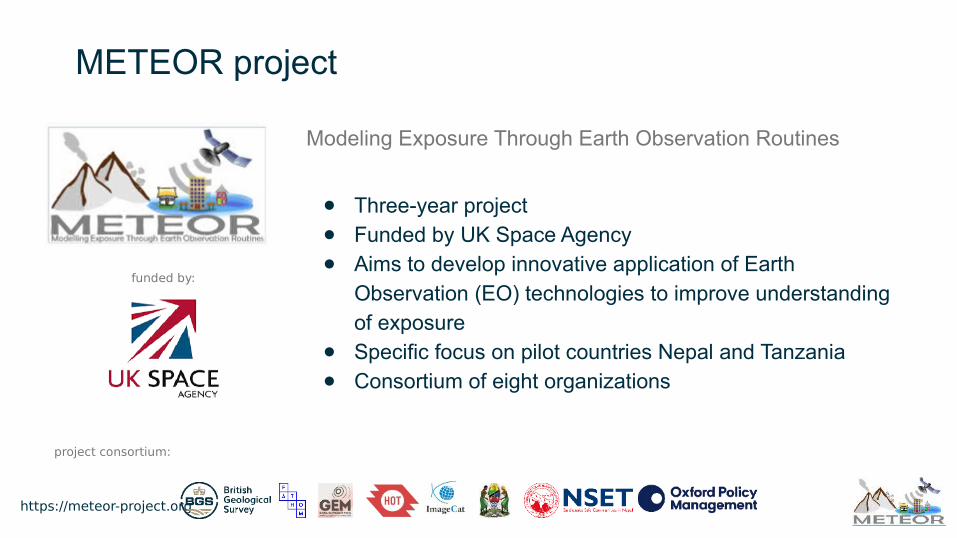
METEOR project
Modeling Exposure Through Earth Observation Routines
● Three-year project● Funded by UK Space Agency● Aims to develop innovative application of Earth
Observation (EO) technologies to improve understanding of exposure
● Specific focus on pilot countries Nepal and Tanzania● Consortium of eight organizations
funded by:
project consortium:

https://meteor-project.org
Contents
Introduction to modelling tool
Input data workflow
Example A: fuzzy membership function for continuous-scaled variables
Example B: fuzzy membership function for categorical variables
Model and resulting susceptibility and hazard maps
https://meteor-project.org
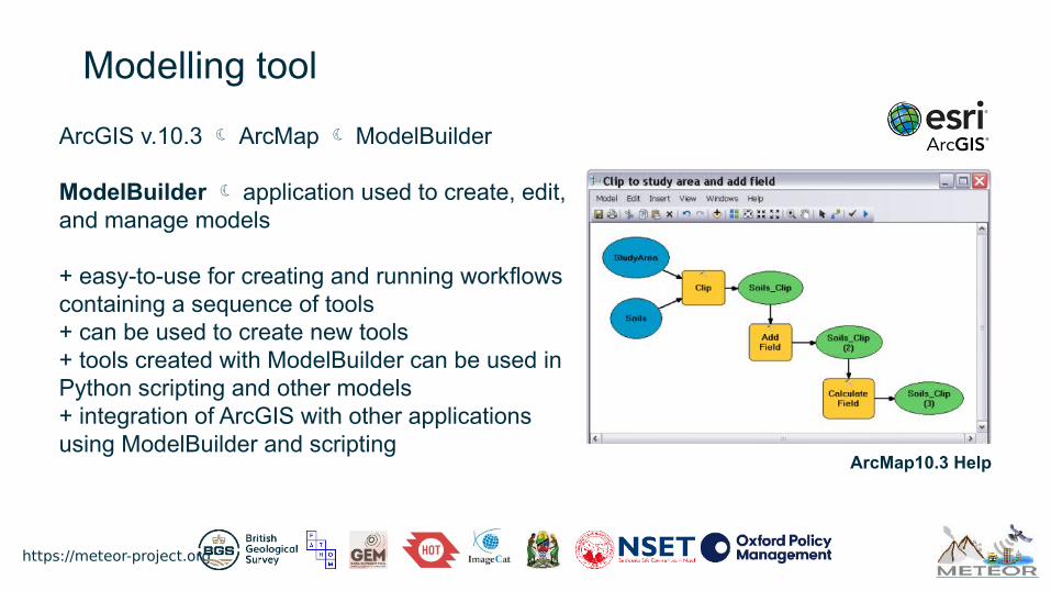
Modelling tool
ArcGIS v.10.3 ArcMap ModelBuilder
ModelBuilder application used to create, edit, and manage models
+ easy-to-use for creating and running workflows containing a sequence of tools+ can be used to create new tools+ tools created with ModelBuilder can be used in Python scripting and other models+ integration of ArcGIS with other applications using ModelBuilder and scripting
ArcMap10.3 Help

https://meteor-project.org
ModelBuilder input data workflow
Predisposing factors
Frequency Ratio FR weights
Definition of rule sets
Function parameters
Fuzzy membership
function
A. Function for continuous-scaled variables:
B. Function for categorical variables:
Zhu et al., 2008, 2014
w = parameter that controls the shape of the curve;w = eLS=1 – eLS=0.5

https://meteor-project.org
Example A: Fuzzy membership function for slope gradient Add picture
Rule set definition:
Susceptibility is at maximum for slopes btw 15° and 35°; as the slope decreases below 15° and increases above 35°, respectively, susceptibility decreases at different rates
Function type:
Bell-shaped

https://meteor-project.org
Example A: Fuzzy membership function for slope gradient
Function parameters
• Right side: w = 25 – 45
• Left side: w = 25 – 15
• S = 1 when Sg = 15° - 35°
• S = 0.5 when Sg ≥ 45° (for right side of curve)
• S = 0.5 when Sg ≤ 15° (for left side of curve)
Function (split in two)
𝑓𝑆𝑙𝑜𝑝𝑒 ሺ𝑆𝑔𝑖𝑗 ሻ= ቐ
1, 𝑆𝑔 = 25
exp ቈ− ൬|𝑆𝑔𝑖𝑗 − 25| × 0.8326
− 20൰
2
𝑓𝑆𝑙𝑜𝑝𝑒 ሺ𝑆𝑔𝑖𝑗 ሻ= ൞1, 𝑆𝑔 = 25
exp − ቆȁ𝑆𝑔𝑖𝑗 − 25ȁ× 0.8326
10ቇ
2
൩

https://meteor-project.org
Example A: Model diagram and elements
Input 1 Parameter
Tool (Raster Calculator)
Output n(final)
Model processes n = 14

https://meteor-project.org
Example A: Model Tool Dialog and Fuzzy slope map
https://meteor-project.org
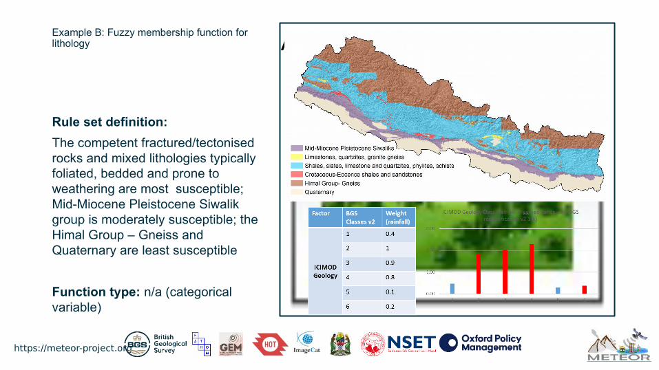
Example B: Fuzzy membership function for lithology Add picture
Rule set definition:
The competent fractured/tectonised rocks and mixed lithologies typically foliated, bedded and prone to weathering are most susceptible; Mid-Miocene Pleistocene Siwalik group is moderately susceptible; the Himal Group – Gneiss and Quaternary are least susceptible
Function type: n/a (categorical variable)

https://meteor-project.org
Example B: Fuzzy membership function for lithology
Function parameters
• S = 1, when G class = 2
• S = 0.9, when G class = 3
• S = 0.8, when G class = 4
• S = 0.4, when G class = 1
• S = 0.2, when G class = 6
• S = 0.1, when G class = 5
Function
𝑓𝐺 ሺ𝐺𝑖𝑗 ሻ=
ەەەەە)۔ەە
)ۓەەەەەەەەەەە+
1, 𝐺 = 𝐿𝑖𝑚𝑒𝑠𝑡𝑜𝑛𝑒𝑠 ,𝑞𝑢𝑎𝑟𝑡𝑧𝑖𝑡𝑒𝑠 ,𝑔𝑟𝑎𝑛𝑖𝑡𝑒 𝑔𝑛𝑒𝑖𝑠𝑠 0.9, 𝐺 = 𝑊𝑒𝑎𝑡 ℎ𝑒𝑟𝑒𝑑 , 𝑓𝑜𝑙𝑖𝑎𝑡𝑒𝑑 ,𝑏𝑒𝑑𝑑𝑒𝑑 𝑚𝑖𝑥𝑒𝑑 𝑙𝑖𝑡 ℎ𝑜𝑙𝑜𝑔𝑖𝑒𝑠0.8, 𝐺 = 𝐾 − 𝐸𝑂 𝑠ℎ𝑎𝑙𝑒𝑠 𝑎𝑛𝑑 𝑠𝑎𝑛𝑑𝑠𝑡𝑜𝑛𝑒𝑠0.4, 𝐺 = 𝑀𝑖𝑑 𝑀𝐼 − 𝑃𝑆 𝑆𝑖𝑤𝑎𝑙𝑖𝑘𝑠0.2, 𝐺 = 𝑅𝑒𝑐𝑒𝑛𝑡0.1, 𝐺 = 𝐻𝑖𝑚𝑎𝑙 𝐺𝑟𝑜𝑢𝑝 − 𝐺𝑛𝑒𝑖𝑠𝑠

https://meteor-project.org
Example B:Model diagram and elements Fuzzy lithology map

https://meteor-project.org
Model diagram and resulting susceptibility map

https://meteor-project.org
Model diagram and resulting hazard map

https://meteor-project.org
References:
Zhu, A.X. (2008) Rule based mapping. In: Wilson, J.P., Fotheringham, A.S. (Eds.), The Handbook of Geographic Information Science. Blackwell, Malden, MA, pp 273–291
Zhu, A.X., Wang, R., Qiao, J., Qin, C. Z., Chen, Y., Liu, J., Du, F., Lin, Y. & Zhu, T. (2014) An expert knowledge-based approach to landslide susceptibility mapping using GIS and fuzzy logic. Geomorphology (214), pp 128-138

https://meteor-project.org