miami beach integrated water management · positive role water has had in miami beach can provide a...
TRANSCRIPT

as
Miami Beach Integrated Water Management
Blue-Green Stormwater Infrastructure Concept Plan
Final
February 28, 2020
City of Miami Beach
RFQ 2018-312-KB

Blue-Green Stormwater Infrastructure Concept Plan
BI0910190550MIA i
Contents Executive Summary .............................................................................................................................. ES-1
1. Introduction ................................................................................................................................. 1-1 1.1 Miami Beach Setting ........................................................................................................ 1-1 1.2 Opportunities and Benefits of BGSI in Miami Beach ....................................................... 1-2 1.3 Public Engagement in Concept Plan Development ......................................................... 1-3 1.4 Implementation Strategies and Partnerships for Blue-Green Stormwater Infrastructure
in Miami Beach ................................................................................................................. 1-3 1.5 Intended Audience and BGSI Concept Plan Organization .............................................. 1-4
2. Blue-Green Stormwater Infrastructure ..................................................................................... 2-1 2.1 Advantages and Limitations of BGSI ............................................................................... 2-1 2.2 Qualitative Evaluation of BGSI Practice Applicability for Miami Beach ........................... 2-2 2.3 Potential BGSI Locations ................................................................................................. 2-3 2.4 BGSI Strategies ............................................................................................................... 2-5 2.5 BGSI and Water Quality ................................................................................................... 2-5 2.6 Size and Cost Considerations .......................................................................................... 2-6 2.7 BGSI Performance Amid Rising Sea Levels and Shallow Groundwater ......................... 2-7 2.8 BGSI and Mosquitoes ...................................................................................................... 2-7 2.9 Maintenance Requirements and Responsibilities ............................................................ 2-8 2.10 BGSI Fact Sheets ............................................................................................................ 2-8 2.11 Additional BGSI Resources ........................................................................................... 2-10
3. Recommendations ...................................................................................................................... 3-1
4. References ................................................................................................................................... 4-1
Appendices
Appendix A BGSI FAQs
Appendix B Public Outreach Summary Report Appendix C BGSI Practices and Strategies Fact Sheets
Appendix D BGSI Plant Matrices/Plant Palette Boards
Appendix E BGSI Pilot Project Concepts/Renderings
Appendix F Potential Project Location Maps
Tables
Table 2-1. BGSI Practice Applicability by Land Use ............................................................................. 2-4 Table 2-2. Pollutant Load Reductions Using BGSI ............................................................................... 2-5
Table 2-3. General BGSI Applicability and Feasibility in Miami Beach .............................................. 2-8
Figures
Figure 2-1. Primary Land Uses and Impervious Cover in Miami Beach ............................................. 2-3
Figure 2-2. Cumulative Rainfall Capture Curve (2000 to 2019) ............................................................ 2-6
Figure 2-3. Miami Beach Soil Storage Capacity .................................................................................... 2-7

Blue-Green Stormwater Infrastructure Concept Plan
BI0910190550MIA ii
Acronyms and Abbreviations BGSI Blue-Green Stormwater Infrastructure
CIP capital improvement plan
DCP design criteria package
EPA U.S. Environmental Protection Agency
FAQs frequently asked questions
ft foot (feet)
ft2 square foot (feet)
ULI Urban Land Institute
Blue-Green Stormwater Infrastructure Concept Plan
BI0910190550MIA ES-1
Executive Summary Southeast Florida is often referred to as “ground zero” for climate change and sea level rise. In particular, the City of Miami Beach (hereafter, “the City”) has shown leadership in adapting to this change, investing in aging infrastructure and committing to use the best available information to continuously improve its approach. The City recently retained the services of the Urban Land Institute (ULI) to review its stormwater management and climate adaptation program. The ULI panel applauded the City’s commitment and encouraged several other approaches including a broader range of strategies such as blue and green infrastructure, not only pumps and pipes, in the City’s stormwater program.
The City already has a rich history in environmental stewardship through the City Commission and the Department of Environment & Sustainability. Examples include banning polystyrene, to the #PlasticFreeMB program, tree and landscape ordinances, a dune management system, progressive green building ordinances and encouraging blue and green roofs. The blue and green stormwater infrastructure (BGSI) strategies and concepts in this Plan are geared toward creating a more robust and well-rounded Miami Beach stormwater program that:
• Reduces flooding from the smaller, more frequent storms (BGSI on its own cannot eliminate flooding);
• Manages non-point source pollution to protect receiving waters from water quality impacts from stormwater runoff;
• Increases the infiltration of rainwater to sustain and replenish the freshwater lens under the City (thereby protecting soils and flora from being degraded by saltwater intrusion);
• Leverages innovative urban design to integrate BGSI practices into the landscape in highly aesthetic ways aligned with the culture and lifestyle of the City; and
• Provides social, environmental, and economic co-benefits that increase the value and contribution of BGSI.
On May 6, 2019, Jacobs was tasked with developing a Blue-Green Stormwater Infrastructure Concept Plan for the City of Miami Beach. In response, Jacobs assembled a multi-disciplinary team of experts including engineers, landscape architects, urban planners, and resiliency specialists to produce this Plan. The Plan included an evaluation of BGSI strategies, concepts, and locations that might be applicable in Miami Beach given its constraints as a densely built-out, low-lying coastal community and the constraints of the environmental regulatory process. The Plan recommends:
• Steps to formally incorporate BGSI policy into master planning, design standards, capital improvement plan (CIP) projects, codes, etc.
• Long-term funding considerations for successful implementation and maintenance
• Implementation of a range of demonstration projects
• Establishing innovation priorities possibilities
• BGSI partnerships among government, business, academia, and/or non-profits
• Advancing the science and modeling to better understand the interactions between flooding, precipitation, groundwater, and water quality as reported in the ULI findings
• The need for continued community engagement
The Plan also includes 15 BGSI practices and strategies fact sheets and 9 BSGI pilot project concept renderings, as well as potential project location maps and an inventory of FAQs from the public process.
Jacobs recommends that the City Commission accept this document and determine the extent by which to amend and incorporate BGSI into the City’s stormwater master plan, Public Works Manual, CIP standard operating procedures, language in future design packages, and guidance documents for staff project managers and consultants to ensure consideration and implementation.

Blue-Green Stormwater Infrastructure Concept Plan
BI0910190550MIA 1-1
1. Introduction The coastal location of the City of Miami Beach (hereafter, the “City”) is what makes it such a desirable place in which to live, work and play. Its coastal location and relatively low elevation also make it susceptible to frequent, intense storm events, rising sea levels, and extreme tidal events (“sunny day” flooding). Additionally, as with all highly urbanized areas, non-point source pollution reduction is both an environmental management priority and critical to maintaining safe and aesthetically pleasing water-oriented lifestyles and tourism.
In 2018, the Urban Land Institute (ULI) issued its Stormwater Management and Climate Adaptation Review report for Miami Beach. ULI praised the City for its proactive efforts and provided a series of recommendations, including further exploration and integration of blue and green stormwater infra-structure (BGSI) into the City’s strategies and projects. The City is acting upon this recommendation with the development of this Concept Plan and the incorporation of BGSI solutions into several City projects currently under design or construction. These solutions harness natural processes using soils, vegetation, and the landscape as infrastructure. When thoughtfully designed, BGSI has been employed throughout the world to improve water and air quality, reduce flooding impacts, mitigate ecosystem fragmentation, reduce elevated surface temperatures, and provide many other community benefits. This document provides a compendium of BGSI practices and strategies that support the following objectives:
• Reduce flooding from the smaller, more frequent storms (BGSI on its own cannot eliminate flooding)
• Better management of non-point source pollution to protect receiving waters (surface and groundwater) from water quality impacts from stormwater runoff
• Increasing the infiltration of rainwater to sustain and replenish the freshwater lens under the City (thereby helping to protect soils and flora from being degraded by saltwater intrusion)
• Leveraging innovative urban design to integrate BGSI practices into the landscape in highly aesthetic ways aligned with the culture and lifestyle of the City
• Providing social, environmental and economic co-benefits that increase the value and contribution of BGSI
The BGSI practices and strategies in this document were developed with the intent of supporting and incentivizing a broad range of stakeholders to implement BGSI such that sufficient implementation scale can be achieved and so that the collective results have meaningful impact.
1.1 Miami Beach Setting Miami Beach lies on a barrier island running along the southeastern coast of Florida with the Biscayne Bay on its western shore, across from the City of Miami. The island of Miami Beach was once covered with mangrove and wetland plant communities that provided a natural defense for Florida’s mainland against storm surge and the increased wave energy from tropical storm events. This natural protection of the Florida mainland coast allowed the Biscayne Bay ecosystem to flourish. In addition to surge and wave mitigation, the mangrove and wetland plant communities that once flourished on Miami Beach acted like a sponge in filtering and absorbing water, while providing habitat for many permanent and migratory
Stormwater planters in public right-of-way

Blue-Green Stormwater Infrastructure Concept Plan
BI0910190550MIA 1-2
species. This attractive South Florida landscape and climate has resulted in dense housing and commercial development over time with surface elevations in the City that range from near 0 to an average of 4.5 feet (ft) above sea level.
The City sits on a bed of porous limestone and groundwater elevations closely follow sea and tide levels. With sea and groundwater levels expected to rise, coupled with more frequent and intense storm events, the City has raised some of the most flood-prone roads and implemented new policies to help protect private development.
1.2 Opportunities and Benefits of BGSI in Miami Beach
In response to such dramatic climatic changes, there is the opportunity to change the way coastal cities like Miami Beach have historically incorporated centralized, grey infrastructure systems, such as pipes, pumps, and canals to address stormwater runoff by implementing an infrastructure system that integrates natural processes within the built environment. BGSI strives for more onsite stormwater management approaches that harness the power of nature to help manage stormwater at its source, instead of at or near the ends of pipes before stormwater discharges to receiving waters like Biscayne Bay. Using Florida-friendly vegetation as infrastructure increases the urban forest canopy, with companion ground-level plants that are urban-tolerant and that mimic the natural stormwater management processes employed by South Florida ecosystems that existed prior to land development. Water quality and regional ecosystem health can be improved using a network of thoughtfully sited Florida-friendly vegetated and soil-based systems that intercept, absorb, and filter pollutants in stormwater before it reaches local waterways, Biscayne Bay, and the ocean.
These systems also provide increased infiltration into the City’s subsurface limestone voids, mimicking the natural water cycle and recharging the City’s freshwater lens. This naturally occurring freshwater supply sits below the soil surface and has a critical role in supporting the health and diversity of Florida-friendly plant communities. A lack of a freshwater recharge, paired with rising sea levels, could result in saltwater intrusion within the root zones of vegetation, including the City’s beautiful trees, causing wilted growth and eventual death. Without shade and the natural cooling process of evapotranspiration from vegetation, surface temperatures will likely rise, further exacerbating the urban heat island effect.
The widespread implementation of BGSI across the City would create the opportunity to integrate innova-tive urban design concepts with improved stormwater management, in the process yielding multiple community and environmental benefits. Water has historically been central to public space design not
Permeable pavers in outside dining area
Bioretention in a public park

Blue-Green Stormwater Infrastructure Concept Plan
BI0910190550MIA 1-3
only as decorative elements but also in its capacity to provide opportunities for relaxation and respite. The incorporation of BGSI and other water features within urban spaces early in the planning process can offer many co-benefits that optimize livability and resilience in Miami Beach. Reclaiming the historically positive role water has had in Miami Beach can provide a living stage for interpretive South Florida education, while allowing alternative forms of transport, such as walking and biking to diversify Miami Beach’s transportation network while reducing carbon emissions that contribute to climate change. Innovative urban design considers the critical point of view that can only be provided by users of Miami Beach public space: the community, whose experiences and preferences are critical in shaping public space planning and design. BGSI should serve as a symbol of innovation through the creation of functional and memorable public spaces, not only for the people of Miami Beach, but also for the millions of annual visitors.
1.3 Public Engagement in Concept Plan Development
For this BGSI approach to be successful, it is critical that solutions fit the context of not only South Florida and Miami Beach, but also the context of existing site uses. Current site usage and programming can only be understood by engaging with the public early and often through various communication forums, such as public meetings, online surveys, social media, and other ways of gathering input across various demographics and neighborhoods. Although this Concept Plan was developed over a relatively short period of time, effective public outreach was conducted and valuable input was received through presentations at two City of Miami Beach Sustainability and Resiliency Committee meetings, a well-advertised and well-attended public meeting dedicated to BGSI, and the Miami Beach Rising Above website (www.mbrisingabove.com). The input and feedback received from these stakeholders guided the selection of BGSI practices and strategies in this Concept Plan and the urban design features to be included. A frequently asked questions (FAQs) document was also prepared to address common concerns related to BGSI implementation and is included in Appendix A. A detailed summary of public outreach activities is included in Appendix B.
1.4 Implementation Strategies and Partnerships for Blue-Green Stormwater Infrastructure in Miami Beach
The success of BGSI implementation also rests with increased partnerships that engage government, private business, residents, local community groups, and non-governmental organizations. Truly integrated solutions require input and expertise across a wide set of partners not only within neighborhoods and across the community, but also among the various City departments and other agencies. Communication and alignment on a strategy across City departments will result in better informed decisions and more holistic solutions through integrated BGSI planning. This alignment will be reinforced through neighborhood-level public outreach as specific local projects are planned, designed, constructed, and maintained.
In addition to site context, public engagement, partnerships, and aligned strategies, the science of BGSI in the Miami Beach context must be further advanced. Performance and other data must be collected, analyzed, and evaluated for solutions to be intelligently designed and to perform effectively.
Well-attended public meeting to discuss BGSI in Miami

Blue-Green Stormwater Infrastructure Concept Plan
BI0910190550MIA 1-4
1.5 Intended Audience and BGSI Concept Plan Organization
This document was developed for a wide range of stakeholders and is intended to inform master planning, capital improvement plan development, design criteria packages (DCPs), and policies on new development, building codes, and zoning. Given this wide audience, the document includes the following sections that can be used individually or collectively for different users and purposes:
• Section 2, Blue-Green Stormwater Infrastructure: includes general information about BGSI, the BGSI evaluation process, and the most and least applicable practices for the City.
• Section 3, Recommendations: focuses on critical next steps that should be taken to launch BGSI in the City and to support achieving sustainable implementation at-scale.
• Section 4, References: provides a partial list of resources used in the preparation of this Concept Plan.
Several appendices are also provided that include FAQs, 1-page fact sheets that focus on specific BGSI practices, multi-page fact sheets that cover BGSI strategies that entail multiple practices in various settings, renderings that illustrate potential application of BGSI in different contexts, and potential project location maps:
• Appendix A BGSI FAQs
• Appendix B Public Outreach Summary Report
• Appendix C BGSI Practices and Strategies Fact Sheets
• Appendix D BGSI Plant Matrices/Plant Palette Boards
• Appendix E BGSI Pilot Project Concepts/Renderings
• Appendix F Potential Project Location Maps

Blue-Green Stormwater Infrastructure Concept Plan
BI0910190550MIA 2-1
2. Blue-Green Stormwater Infrastructure Green stormwater infrastructure typically uses vegetation and/or soils to treat and reduce stormwater flows. Examples are bioretention and permeable pavement.
Blue stormwater infrastructure temporarily stores and treats stormwater without significant reliance on vegetation. Examples are wet ponds and detention basins.
BGSI uses elements from both green and blue stormwater infrastructure. Implemented BGSI can vary greatly in appearance, from high-profile features to those that blend in seamlessly with the surroundings. BGSI is typically designed and sized to capture the more frequent storm events.
The focus of BGSI is stormwater runoff treatment and capture, which makes it different from coastal strategies (for example, living shorelines, dunes, mangrove plantings, and oyster or artificial reefs) that target stressors, such as wave energy, sea level rise, and storm surges.
2.1 Advantages and Limitations of BGSI
BGSI provides several stormwater benefits, as well as co-benefits, that improve regulatory compliance and positively impact the community:
• Water quality: BGSI can reduce many of the pollutants that threaten Biscayne Bay such as heavy metals, nutrients, sediment, and pathogens.
• Groundwater recharge: BGSI recharges the freshwater lens under the island. This can help keep salt water at bay and protect the health of trees.
• Detention/flood mitigation benefits: BGSI helps mitigate flooding from smaller, more frequent storms. Note: BGSI alone will NOT significantly reduce: “sunny day” flooding or flooding from major rainfall events or storm surge.
• Community benefits can include: urban heat island mitigation, air quality improvement, climate resiliency, enhanced aesthetics, and increased ecosystem health and biodiversity.
While the benefits of BGSI are significant, there are also limitations as described in more detail later in this section, including:
• The difficulties of the environmental permitting process.
• The physical space limitations for BGSI given the density of development in much of the City.
• Widespread BGSI requires changes to City policies, codes, and/or standard operating procedures (refer to Section 3).
Rain garden, green roof, and rain barrel at a garden apartment building
Permeable pavement, bioswale, and subsurface infiltration next to a park

Blue-Green Stormwater Infrastructure Concept Plan
BI0910190550MIA 2-2
• BGSI requires a commitment to and funding for maintenance.
2.2 Qualitative Evaluation of BGSI Practice Applicability for Miami Beach
BGSI practice types were qualitatively evaluated based on city/regional/national experience, stormwater performance, ease of implementation/maintenance, community/environmental benefits, cost efficiency, and climate change resilience. Practices that were determined to perform well across these areas and have practical applications in Miami Beach are as follows:
• Bioretention/Bioswales/Rain Gardens1
• Blue & Green Roofs
• Constructed Wetlands/Floating Wetland Islands2
• Detention Basins/Surface Storage
• Enhanced Tree Pits/Trenches
• Injection Wells (Pumped)3
• Permeable Pavement
• Rainwater Harvesting
• Stormwater Planters4
• Subsurface Infiltration/Storage
• Tree Canopy5
• Wet Ponds
When and where to use each recommended BGSI practice depends on a variety of site-specific factors, such as land use, location, topography, groundwater elevation, soil conditions, and existing infrastructure.
The following BGSI practices are less applicable to Miami Beach because of their reduced water quality benefits, higher costs, lack of scalability, lower effectiveness when dealing with sea level rise and high tides, proprietary designs, limited applicability, or low storage capacities:
• Aboveground Detention Tanks • Canal Enhancements • Canopy Trees • Drainage/Gravity Wells • Exfiltration Trenches • High-Flow Media Filters • Living/Green Walls • Subsurface Flow Wetlands
1 Florida-friendly plants are strongly encouraged for vegetated BGSI practices as they are the climate-adapted, excel at ecosystem service,
and enhance sense of place. Species such as duck potato, Fakahatchee grass, and red maple from the Florida wetland plant community are recommended, as are South Florida slash pine and saw palmetto from the South Florida pine flatwood plant community.
2 Ibid.
3 Although not typically thought of as BGSI, injection wells are included here as they reduce the volume of stormwater discharged,
and with proper pretreatment/filtration can provide some water quality benefits. 4 Florida-friendly plants are strongly encouraged for vegetated BGSI practices as they are the climate-adapted, excel at ecosystem service,
and enhance sense of place. Species such as duck potato, Fakahatchee grass, and red maple from the Florida wetland plant community are recommended, as are South Florida slash pine and saw palmetto from the South Florida pine flatwood plant community.
5 Although a BGSI practice fact sheet has not been developed for them, trees are a key component of BGSI, and the City is developing an Urban Forest Master Plan to provide a strategic framework to guide the City in managing, maintaining, planting, and preserving its urban forest. See www.mbrisingabove.com/climate-mitigation/urban-canopy-2/urban-forestry-master-plan/.
Typical bioretention cross-section

Blue-Green Stormwater Infrastructure Concept Plan
BI0910190550MIA 2-3
Although not as readily applicable to Miami Beach, the above BGSI practices might still prove beneficial in certain settings. As discussed previously, such coastal practices as living shorelines, dunes, mangrove plantings, and oyster or artificial reefs are not the focus of this Plan on blue-green stormwater infrastructure. Appendix C provides detailed fact sheets on BGSI practices.
2.3 Potential BGSI Locations
BGSI can be used on and along roads, in parks and other open spaces, at schools and other public facilities, on rooftops, and on residential and commercial properties. Approximately 40 percent of Miami Beach is covered by impervious surfaces (buildings and pavements) that prevent water from soaking into the ground (see Figure 2-1). BGSI should be employed to treat runoff from these impervious surfaces and help preserve, enhance, and increase the City’s remaining pervious or “green” areas.
Figure 2-1. Primary Land Uses and Impervious Cover in Miami Beach BGSI Practices and Strategies were developed with Miami Beach’s primary land uses and impervious cover distribution in mind
When choosing where to place BGSI practices, the following factors should be considered:
• BGSI is often most cost-effective when integrated with ongoing or planned City projects, such as those on the City’s Capital Improvement Plan, General Obligation Bond list, Transportation Master Plan, and Blueways Master Plan.
• Shallow, increasing, and/or seasonal groundwater elevations across the City limit the soil storage capacity and infiltration required for some BGSI practices to function. However, such limitations might potentially be overcome with underdrains, fill, and/or pumping. In addition, existing soil or ground-water contamination may impact BGSI design and construction.
• Depending on the BGSI practice type, offsets from utilities, buildings, and other structures may be required to protect those features from water damage.
• Factors such as budget, permitting, site conditions, neighborhood preferences, and ownership will influence the location and types of BGSI.
Table 2-1 lists the applicability of BGSI practices based on land use.
Miami Beach Land Uses (based on zoning districts) Miami Beach Impervious Areas
Rendering of bioretention and permeable pavement on a typical residential street in Miami Beach

Blue-Green Stormwater Infrastructure Concept Plan
BI0910190550MIA 2-4
Table 2-1. BGSI Practice Applicability by Land Use
Land Use Bio
rete
ntio
n/
Bio
swal
es/R
ain
Gar
dens
Blu
e &
Gre
en R
oofs
Con
stru
cted
Wet
land
s/
Floa
ting
Wet
land
Is
land
s
Det
entio
n B
asin
s/
Surf
ace
Stor
age
Enha
nced
Tre
e Pi
ts/
Tren
ches
Inje
ctio
n W
ells
(P
umpe
d)
Perm
eabl
e Pa
vem
ent
Rai
nwat
er H
arve
stin
g
Stor
mw
ater
Pla
nter
s
Subs
urfa
ce In
filtr
atio
n/
Stor
age
Wet
Pon
ds
Commercial Commercial Sites (Office, Retail, Restaurant, Hotel, High-Rise Residential, etc.)
Institutional/Public Facilities (Police Stations, Fire Stations, etc.)
Schools
Parking
Parking Garages
Parking Lots
Parks and Open Spaces
Golf Courses
Open Spaces (unassigned)
Parks
Pocket Parks/Parklets/ Plazas
Residential
Multi-family
Single-family
Rights-of-Ways (Street Types per Miami Beach Street Design Guidelines - 2016) Street Ends (where a street dead ends at a waterbody)
Alleys (commercial)
Avenues (suburban)
Avenues (urban)
Boulevards
Main Streets
Neighborhood Streets (suburban)
Neighborhood Streets (urban)
Non-Motorized Streets
=yes =no =limited

Blue-Green Stormwater Infrastructure Concept Plan
BI0910190550MIA 2-5
2.4 BGSI Strategies
The following BGSI strategies and their respective sub-strategies represent excellent opportunities throughout Miami Beach to implement numerous BGSI practices. These strategies address all the primary land uses in Miami Beach.
• Commercial and Public Facilities – Schools – Parking garages – Other facilities with building coverage greater than 90 percent of the site – Other facilities with building coverage less than 90 percent of the site
• Parks and Open Spaces – Golf courses – Open spaces – Parks – Pocket parks and plazas
• Right-of-Way – Streets and Alleys – Commercial streets – Residential streets – Street ends (where a street dead ends at
a waterbody) – Non-motorized streets – Alleys
• Single-family Residential
2.5 BGSI and Water Quality
Protecting water quality for Miami Beach’s beaches and waterways is a priority as they provide habitat, a great quality of life, and opportunities for tourism. Stormwater runoff from urban areas can transport pollutants—including bacteria/pathogens, nutrients (such as nitrogen and phosphorus), sediment, and heavy metals—to waterways and beaches. BGSI can reduce many of these pollutants. By retaining rainfall, BGSI reduces stormwater discharges. Lower discharge volumes translate into reduced pollutant loads (see Table 2-2). BGSI also treats stormwater that is not retained (EPA, 2019). It should also be noted that BGSI can only improve the quality of the water that it receives (that is, the runoff from the drainage area that it serves) and has the capacity to treat. Therefore, extensive BGSI coverage would typically be required to have significant overall pollutant load reductions. As with all infrastructure, BGSI must be designed, constructed, and maintained to function properly over the long term.
Table 2-2. Pollutant Load Reductions Using BGSI Pollutant Mass Load Reductions (%)
BGSI Practice Nitrogen Phosphorus Suspended Solids Bioretention/Bioswales/Rain Gardens 70–80% 75–85% 80–90% Blue & Green Roofs 55% 55% 80–90%
Constructed Wetlands 20% 45% 60%
Detention Basins/Surface Storage 20% 20% 60%
Enhanced Tree Pits/Trenches 85% 85% 95%
Injection Wells Depends on type of pretreatment
Permeable Pavement 80% 80% 85%
Rainwater Harvesting Depends on amount of rainwater harvested and type of pretreatment
Stormwater Planters 70–80% 75–85% 80–90%
Subsurface Infiltration/Storage 85% 85% 95%
Wet Ponds 20% 45% 60% Adapted from Tables B-5 and C-1 from Schueler and Lane (2015)
Stormwater planters and enhanced tree trenches on a commercial street

Blue-Green Stormwater Infrastructure Concept Plan
BI0910190550MIA 2-6
2.6 Size and Cost Considerations
An analysis of daily rainfall data for Miami Beach from 2000 to 2019 indicates that slightly more than 90 percent of the total rainfall comes on days with 2 inches or less of rainfall (see Figure 2-2). BGSI is generally sized to manage runoff from these events, which also contribute much of the pollution caused by stormwater. Although representing less than 10 percent of the total rainfall from 2000 to 2019, days with more than 2 inches of rainfall occur on average five to six times per year and often lead to flooding. In addition, the frequency of these larger events is predicted to increase with climate change (CH2M HILL, 2015). Because a 2-inch rainfall event is only approximately 25 percent of the much larger storms typically used to size flood control systems, such as pipes and pumps, BGSI is not considered a replacement for traditional “grey” infrastructure, but it can complement it. BGSI systems are generally sized to manage the runoff for areas that are 10 to 20 times larger than their footprint. For example, a bioretention system that is 1,000 square feet (ft2) can capture runoff from an area that is 10,000 to 20,000 ft2.
The size and complexity of the design and construction influence the cost of BGSI. Examples of the factors impacting cost are project size, type(s) of BGSI, space constraints, the amount of pipe needed, presence of utilities, soil conditions, depth to water table, proximity to roadways/need for traffic control, and current site conditions.
Figure 2-2. Cumulative Rainfall Capture Curve (2000 to 2019) Just over 90% of the total rainfall comes on days with 2 inches or less of rainfall.
50%
55%
60%
65%
70%
75%
80%
85%
90%
95%
100%
0.5 0.75 1 1.25 1.5 1.75 2 2.25 2.5 2.75 3 3.25 3.5
Cum
ulat
ive
Capt
ure
of To
tal R
ainf
all
Capture Depth (in.)
Cumulative Rainfall Capture Curve (Miami Beach daily data 2000-2019)
Cumulative Capture2-inch Capture

Blue-Green Stormwater Infrastructure Concept Plan
BI0910190550MIA 2-7
2.7 BGSI Performance Amid Rising Sea Levels and Shallow Groundwater Shallow and increasing groundwater elevations in portions of the City limit the soil storage capacity (see Figure 2-3) and infiltration required for some BGSI practices to function effectively. However, such limitations might potentially be overcome with underdrains, fill, and/or pumping. Other practices, such as wet ponds and constructed wetlands, can continue to function with shallow groundwater although their storage capacity may be reduced as groundwater levels increase. Blue and green roofs, rainwater harvesting, and floating wetland islands would typically not be impacted by rising groundwater.
Table 2-3 summarizes BGSI applicability and feasibility in Miami Beach based on current elevations and development patterns. Note that the applicability and feasibility of infiltration-based BGSI practices can typically be increased if the area where the BGSI practices are located is raised (that is, if additional separation to groundwater is created).
2.8 BGSI and Mosquitoes
Mosquitoes require standing water to be present for more than 7 days to grow. When properly designed, constructed, and maintained, BGSI will not promote mosquito breeding.
BGSI not intended to retain water is usually designed to fully drain within 3 days after a rainfall event. These BGSI practices require periodic inspections to ensure they are draining down adequately.
BGSI intended to retain water for greater than 7 days must include preventive methods to discourage mosquito growth. These methods can include:
• Screening • Establishing a natural predator population • Appropriate mosquito-specific larvicides
Miami Beach has limited soil storage capacity, especially in the low-lying areas on its west side (Source: Paituvi, 2014)
Figure 2-3. Miami Beach Soil Storage Capacity

Blue-Green Stormwater Infrastructure Concept Plan
BI0910190550MIA 2-8
Table 2-3. General BGSI Applicability and Feasibility in Miami Beach
BGSI Practice Low-lying
Urban Areas Low-lying
Suburban Areas Higher, Coastal Zone (east side,
generally highly developed)
Bioretention (may require a shallow design in low-lying areas)
Bioswales
Blue & Green Roofs
Constructed Wetlands
Detention Basins/Surface Storage
Enhanced Tree Pits/Trenches (typical, higher if ground elevation is raised)
Floating Wetland Islands
Injection Wells (ideally in southern and central areas, where the Biscayne Aquifer is highly absorbent)
Permeable Pavement (typical, higher if ground elevation is raised)
Rain Gardens (residential)
Rainwater Harvesting
Stormwater Planters
Subsurface Infiltration/Storage (typical, higher if ground elevation is raised)
Tree Canopy
Wet Ponds
=low =medium =high
2.9 Maintenance Requirements and Responsibilities
BGSI practices require a variety of maintenance activities depending on the type of BGSI and various site-specific factors. Landscaped BGSI requires maintenance typical of other landscaped areas, potentially including debris and trash removal, pruning, weeding, replanting, erosion repair, and mulching. Many BGSI practices include devices for pretreatment of runoff that require periodic sediment and debris removal. Permeable pavements require the surface to be periodically cleaned (for example, with a street cleaning vehicle) to prevent clogging.
A variety of entities may be involved in BGSI maintenance depending on the situation. In parks and at other City-owned properties, the City would likely lead the maintenance activities (either with City staff or contractors) although they may be supported by residents and businesses through volunteer efforts, “Friends of” groups, “adopt-a-BGSI” programs, neighborhood associations, etc. Along commercial streets, business improvement districts and similar groups may lead maintenance activities. On private property, BGSI maintenance would be the responsibility of the property owner/manager. Maintenance procedures and responsibilities for BGSI on residential roads are still being formulated.
2.10 BGSI Fact Sheets
Each of the eleven BGSI practices recommended for implementation in Miami Beach has its own fact sheet (see Appendix C). Each practice fact sheet contains the following information:
• A general description of the BGSI practice, as well as an example photograph and/or schematic
• Advantages and potential limitations of using the practice in Miami Beach

Blue-Green Stormwater Infrastructure Concept Plan
BI0910190550MIA 2-9
• Applicability of the practice in the Miami Beach context
• Potential enhancements that could be employed to increase the performance of the practice
• Qualitative assessment (“high”, “medium”, or “low”) of various factors for each practice, evaluated relative to other BGSI practices – Expected Stormwater Performance
Water Quality – how effective is the practice at removing typical pollutants in stormwater runoff Freshwater Lens Recharge – how effective is the practice at allowing stormwater to enter the
soil (infiltration) and recharging the groundwater Flood Mitigation – what is the practice’s potential for reducing flooding in its vicinity (that is,
localized flooding)
– Implementation Capital Cost – anticipated cost to implement the practice in Miami Beach Maintenance Cost – anticipated cost to maintain and/or operate the practice in Miami Beach Scalability – what is the practice’s potential to be easily replicated in many locations in Miami
Beach Constructability – how easy will it be to construct the practice in Miami Beach and can
negative impacts to natural and/or human-made features, pedestrians, traffic, businesses, tourism, etc. be limited during construction, with “high” indicating the easiest or least disruptive to such considerations
– Community/Environmental Benefits Improved Aesthetics – what is the practice’s potential to maintain if not enhance the unique
look and feel of Miami Beach Dual Use – what is the practice’s potential to provide other uses in addition to stormwater
runoff control (for example, permeable pavement provides useable hardscape for multiple uses)
Habitat Creation – how effective is the practice at providing habitat for wildlife, including both land and aquatic species
Urban Heat Island Reduction – what is the practice’s potential to lower the ambient air temperature
– Other Factors Climate Change Resilience – how resilient and adaptive will the practice be to changing
climate conditions, such as more frequent and powerful storms and sea level rise Mosquito Vector Resistance – what is the practice’s potential to resist or limit the propagation
of mosquitoes and the diseases they spread
Each of the four BGSI strategies recommended for implementation in Miami Beach has its own fact sheet (see Appendix C). Each strategy fact sheet contains the following information:
• A general description of the BGSI strategy, as well as an example photograph
• Advantages and potential limitations of using the strategy in Miami Beach
• Table of applicable BGSI practices for sites aligning to the specific strategy (that is, summary of which practices apply to most sites, some sites, or few or no sites [limited applicability])
• Descriptions of some of the common variations (or sub-strategies) for each strategy, along with photographs of applicable Miami Beach sites and constructed BGSI practices in similar settings

Blue-Green Stormwater Infrastructure Concept Plan
BI0910190550MIA 2-10
2.11 Additional BGSI Resources • Rising Above Website6
• Best Management Practices for South Florida Urban Stormwater Management Systems7
• Florida Field Guide to Low Impact Development: Bioretention Basins/Rain Gardens8
• Florida Field Guide to Low Impact Development: Green Roofs/Eco-roofs9
• Florida Department of Transportation Drainage Design Guide (Injection Wells covered in Chapter 7)10
• Sarasota County Low Impact Development Guidance Document11
• University of Florida Soil and Water Sciences Video Topics: Green Stormwater Infrastructure12
• Constructed Floating Wetlands: A review of research, design, operation and management aspects, and data meta-analysis13
Note that the City is not specifically endorsing any of the information provided in these sources and is providing them for general information to be used with discretion.
6 http://www.mbrisingabove.com/climate-adaptation
7 https://www.sfwmd.gov/sites/default/files/documents/bmp_manual.pdf
8 http://buildgreen.ufl.edu/Fact_sheet_Bioretention_Basins_Rain_Gardens.pdf
9 http://www.buildgreen.ufl.edu/Fact_sheet_Green_Roofs_Eco_roofs.pdf
10 https://fdotwww.blob.core.windows.net/sitefinity/docs/default-source/roadway/drainage/files/drainagedesignguide.pdf
11 https://www.scgov.net/home/showdocument?id=33258
12 https://soils.ifas.ufl.edu/extension/videos/low-impact-development
13 https://apirs.plants.ifas.ufl.edu/site/assets/files/372369/372369.pdf
Rain gardens, bioswale, and permeable pavement at a street end

Blue-Green Stormwater Infrastructure Concept Plan
BI0910190550MIA 3-1
3. Recommendations The preceding sections of this BGSI Concept Plan were developed to identify BGSI practices and strategies that will help manage stormwater and enhance climate resiliency by providing water quality benefits, freshwater lens recharge, and reduced localized flooding. The City has elected to achieve these goals by integrating BGSI into innovative urban designs that enhance the landscape, provide sustainability co-benefits, honor the local culture and aesthetic, add economic value, and enhance the quality of life for residents.
To achieve significant, widespread benefits, BGSI will need to be implemented throughout Miami Beach and the following recommendations aim to support the successful launch and scale-up of BGSI across the City.
• Formalize BGSI requirements into existing policy, planning, and management systems. For BGSI to achieve the requisite implementation scale and deliver the desired outcomes, specific requirements need to be integrated into the following:
– BGSI Policy. Develop a policy that formally states the objectives of BGSI, including specific requirements to which the City will hold itself accountable, such as how BGSI will be incorporated into both public infrastructure and private development projects as well as retrofits of existing facilities. Existing governance processes (for example, audits and management reviews) should be updated to include confirming compliance with this policy.
– Codes, Ordinances, Zoning, and Permitting. Current City codes, ordinances, and permits that affect stormwater management need to be reviewed and updated as needed to ensure they reflect a priority on BGSI solutions pursuant to the BGSI Policy that is developed. Existing relevant training and guidance for City staff and contractors should be updated to reflect the addition of BGSI priorities.
– Design standards. Develop a design manual that updates or supplements the City’s current design details, typical road sections, and specifications to include BGSI practices.
Highest and best use analyses of the public golf courses will inform potential BGSI implementation

Blue-Green Stormwater Infrastructure Concept Plan
BI0910190550MIA 3-2
– Master Planning and Land Use Planning. All relevant existing and/or in-progress master plans (water, wastewater, stormwater, transportation, urban forest, etc.) should be reviewed and updated as needed to include BGSI practices and strategies. BGSI-specific master planning should be done at the neighborhood level and support DCP development. In addition, highest and best use analyses should be conducted for the two publicly owned golf courses to inform planning discussions regarding the degree to which BGSI should be implemented at these locations.
– Capital Improvement Plans. The current portfolio of capital improvement projects should be reviewed and opportunities to integrate BGSI should be identified. These already planned and funded projects represent a significant opportunity to achieve a robust start to BGSI implementa-tion. Some projects may be good candidates for pilot projects that could demonstrate the benefits of BGSI (see Appendix E).
– Align City Departments on BGSI Policy and Include BGSI in Cross-Departmental Management. The range of BGSI implementation scenarios (for example, transportation, parks, private property, etc.) span the range of City departments, indicating the need for alignment across all Miami Beach departments on BGSI policy, planning, and implementation.
• Ensure long-term funding for BGSI implementation and maintenance, including incentives. The successful scale-up of BGSI across the City depends on adequate funding for construction and long-term maintenance; the City should ensure adequate budgets are established each year. Additionally, to achieve the requisite level of BGSI implementation, practices will need to be imple-mented on both public and private property. The City should consider funding models that provide flexibility to contribute public funds to solutions implemented on private property because in some locations adequate public land may not be available and/or private land may provide a higher performance-to-cost return on investment. The City should also consider formalizing incentives (grants/rebates and stormwater fee credits) for the private implementation of BGSI. Any increase in the City’s stormwater fee should be accompanied with a credit program that not only provides a return on investment for private implementation of BGSI, but also includes a formal mechanism for the City to require maintenance of private BGSI facilities and/or encourage private maintenance of public BGSI systems in the adjacent public right of way.
• Implement a portfolio of demonstration projects across the range of recommended BGSI strategies. Demonstration projects are needed to provide residents, developers, regulators, contractors, and City personnel with a deeper understanding of the best ways to plan and implement BGSI. Ideally, these demonstration projects would be supported by grants such that the City can contribute to advancing the science of implementing BGSI solutions in the context of climate
Parks like Maurice Gibbs often an excellent opportunity to demonstrate BGSI

Blue-Green Stormwater Infrastructure Concept Plan
BI0910190550MIA 3-3
adaptation. These demonstration projects could be designed considering specific innovations and in partnership with regulatory agencies, academia, and the community, so that results would build support for BGSI solutions. Capturing lessons learned and integrating these into subsequent BGSI planning and design standards will be critical to success.
• Develop BGSI innovation priorities. The City should identify specific innovation priorities intended to support the scale-up of high-impact BGSI practices within the unique local context, geared to overcome a variety of factors (for example, land availability, policy, technology, financial) that could impact progress. Innovation could focus on:
– Technology. This innovation area could focus on how best to leverage smart technologies, the internet-of-things, and digital solutions to monitor performance and drive greater efficiency and effectiveness of BGSI solutions. Digital solutions could also provide efficient ways to share results with the community and interested stakeholders that increasingly receive information real-time in digital format.
– One Water or Water Neutrality. This innovation area could focus on integration of grey, blue, and green infrastructure solutions to maximize performance and lower overall lifecycle costs. Water neutrality may offer an opportunity to incentivize the strategic and financial participation of the private sector in scaling BGSI across the City by creating methodologies and programs that enable business to offset their consumptive water use through BGSI solutions that manage/ /infiltrate equivalent volumes of water and deliver co-benefits; this could include a recognition program for businesses that achieve neutrality in support of the City’s sustainability efforts.
– BGSI Design. This could focus on evaluating new and innovative BGSI technologies/techniques and combinations of these that are most effective in Miami Beach and could involve engaging with companies developing cutting-edge products to address local objectives, such as removal of specific pollutants of concern (for example, nitrogen, phosphorus, pathogens, and arsenic), and overcome implementation challenges, such as high groundwater, saline soils, and mosquitoes.
– BGSI Maintenance. This innovation area could focus on meeting long-term maintenance needs of BGSI while also contributing to the development of a green economy workforce. Innovations in BGSI maintenance could be supported by the technology innovations (for example, smart sensors, mobile phone apps) discussed above.
– Alternative Delivery. This innovation could focus on innovative financing and project delivery options. Innovative finance could include engaging the growing socially responsible investor community that are willing to provide lower-cost financing for solutions that deliver social and environmental benefits (for example, through environmental impact bonds). Innovative project delivery could include the purchase of BGSI performance from private enterprises that deliver BGSI solutions on private land.
• Develop BGSI partnerships. Full-scale implementation of BGSI will greatly benefit from leveraging a range of partnerships between government, business, academia, and civil society. Each potential partner has a different value proposition, so a formal strategy is recommended to guide partnership development and management. Potential partners types include:
– Conservation Organizations and Academia – These partners can conduct research, augment technical understanding of risks and issues as well as recommend innovative solutions; they can also add credibility to, and voice their support for, plans and actions that support mutually beneficial goals.
– Regulatory Agencies – These partners can help anticipate regulatory obstacles to innovative solutions and provide guidance on how they can be overcome. For example, one partnership could be with the Miami-Dade Regulatory and Economic Resources with a focus on how to resolve permitting issues related to BGSI.
– Technology Providers – These partners can provide the range of measurement, data manage-ment, analytics, and visualization technologies that can support performance management/ optimization, real-time control, management decisions, and transparency regarding BGSI practices and their performance.

Blue-Green Stormwater Infrastructure Concept Plan
BI0910190550MIA 3-4
– Private Sector Enterprises – There is a broad range of potential partners from the private sector. Theses could include companies developing cutting-edge BGSI products, industry and commercial enterprises incentivized to support BGSI implementation, and socially responsible private equity firms providing low-cost financing for BGSI.
– Miami-Dade County and Florida Department of Transportation. Partnership with these agencies is recommended, given the scale of opportunity for implementing BGSI solutions on county and state roads.
• Advance the Science. An integrated understanding of the hydrologic, hydrogeologic, sea level rise projections, increasing rainfall intensities, and storm surge estimates is needed to provide perspective regarding how these different factors combine to influence the feasibility and performance of BGSI practices. Developing this integrated understanding may require additional hydrologic and hydro-geologic integrated modeling.
• Invigorate community engagement. Miami Beach should continue community outreach on BGSI as its support will be critical to the successful scale-up of BGSI practices across the City. This could include programs that support or incentivize implementation of BGSI practices on residential property (for example, rain barrel and tree planting programs as well as assistance for rain gardens, perme-able pavers, and other practices). A formal, long-term plan for continued community engagement should be developed and shared with the community so that it is aware of the process and can plan for participation. The engagement plan should consider ways to solicit meaningful input from millennials and other groups that may be less likely to attend in-person public meetings.
Miami Beach recently developed a website dedicated to providing information on BGSI Source: www.miamibeachfl.gov/city-hall/public-works/community-outreach/evaluating-blue-green-infrastructure

Blue-Green Stormwater Infrastructure Concept Plan
BI0910190550MIA 4-1
4. References AECOM. 2016. Enhancing Resiliency Sea Level Rise Adaptation Strategies. July 12.
AECOM. 2017. Miami Beach Sea Level Rise Vulnerability Assessment Guidebook. July 12.
Ardaman & Associates, Inc. 2019. Community Park Transient Flow Numerical Analysis.
Bean E., M. Clark, and B. Larson. 2018. Permeable Pavement Systems: Technical Considerations. August 12.
Bloetscher, F., S. Hoermann, and L. Berry. 2017. Adaptation of Florida's urban infrastructure to climate change. In E. P. Chassignet, J. W. Jones, V. Misra, & J. Obeysekera (Eds.), Florida's climate: Changes, variations, & impacts (pp. 311–338). Gainesville, FL: Florida Climate Institute.
Boer, Florian. 2010. Watersquares The Elegant Way of Buffering Rainwater in Cities. August 12.
CDM Smith. December 2011. Comprehensive Stormwater Management Master Plan.
CH2M HILL Inc. 2015. Final Rainfall Intensity, Duration, and Frequency Projections Based on Climate Change for Miami-Dade County. Prepared for Miami-Dade County Water and Sewer Department. May.
Chin, David A. 2004. An Overview of Urban Stormwater-Management Practices in Miami-Dade Country, Florida. July 26.
City of Jacksonville. 2013. Low-Impact Development Manual. Prepared by Jones Edmunds & Associates, Inc. September 11.
City of Miami Beach. 2012. Stormwater Management Master Plan. August 12.
City of Miami Beach. 2016a. Ordinance No 2016-4009. 2016. Ordinance Amendments - Freeboard & Grade Elevation and Height.
City of Miami Beach. 2016b. City of Miami Beach Dune Management Plan. Prepared by Coastal Management and Consulting.
City of Miami Beach. 2017a. Miami Beach Sea Level Rise Vulnerability Assessment Guidebook.
City of Miami Beach. 2017b. Transportation Master Plan Final Report. July 16.
City of Miami Beach. 2019. Sustainability Plan. August 12.
City of Sarasota. 2017. Climate Adaptation Plan. August 19.
Coastal Systems International, Inc. 2019. Maurice Gibb Memorial Park 60% plans. Sheets C-01 to C-15 and C-17 to C-23.
Collective Water Resources, LLC. 2016. Stormwater Master Plan. Vol. 1. August 20.
D’Abreau, Marina. 2010. Plants for Rain Gardens and Pond Edges. September 5.
E Sciences. 2014. Groundwater Elevation Monitoring and Mapping Six Monitoring Stations throughout Miami Beach. August 12.
FEMA. 2019. National Flood Insurance Program Definitions. Accessed September 23. https://www.fema.gov/national-flood-insurance-program/definitions

Blue-Green Stormwater Infrastructure Concept Plan
BI0910190550MIA 4-2
Florida Department of Transportation (FDOT). 2015. Exfiltration Trench Reference Manual. Prepared by A.D.A. Engineering, Inc. August 12.
Florida Department of Transportation (FDOT). 2019. Drainage Design Guide https://fdotwww.blob.core.windows.net/sitefinity/docs/default-source/roadway/drainage/files/ drainagedesignguide.pdf
Greater Miami Beach and the Beaches. 2019. Resilient 305 Resilience Strategy.
Harvard University Graduate School of Design. 2017. South Florida and Sea Level: The Case of Miami Beach. July 16.
Intergovernmental Panel on Climate Change (IPCC). 2019. The Ocean and Cryosphere in a Changing Climate. September.
Marquis Latimer + Halback. 2018. Downtown Improvements District. July 19.
Miami Beach Rising Above. 2019a. Climate Adaptation. Accessed September 20, 2019. http://www.mbrisingabove.com/climate-adaptation
Miami Beach Rising Above. 2019b. Urban Forestry Master Plan Public Presentation. Accessed September 21. www.mbrisingabove.com/climate-mitigation/urban-canopy-2/urban-forestry-master-plan
Miami Beach Rising Above. 2019c. Dunes. Accessed September 24. http://www.mbrisingabove.com/climate-mitigation/natural-resources/dunes
Miami-Dade County. 2016. Miami-Dade County Urban Tree Canopy Assessment. September 5.
Miami-Dade County. 2018. Miami-Dade Local Mitigation Strategy. January.
Miami-Dade County. 2019. Mosquito Control. Accessed September 19. https://www8.miamidade.gov/global/solidwaste/mosquito/home.page
National Oceanographic and Atmospheric Administration (NOAA). 2019. What is a living shoreline? National Ocean Service. Accessed September 25. https://oceanservice.noaa.gov/facts/living-shoreline.html
New York City Department of City Planning. 2008. World Cities Best Practices. August 28.
New York City Department of Environmental Protection. 2017. Cloudburst Resiliency Planning Study. July 18.
Paituvi, M. 2014. “Groundwater elevation monitoring and mapping six monitoring stations throughout Miami Beach”. E Science Project Number 7-0002-005.
Pavlineri, Natalia, Nikolaos Th. Skoulikidis, and Vassilios A. Tsihrintzis. 2016. “Constructed Floating Wetlands: A review of research design, operation, and management aspects, and data meta-analysis.” Chemical Engineering Journal. Elsevier. September 30. https://apirs.plants.ifas.ufl.edu/site/assets/files/372369/372369.pdf
Pinellas County. 2017. Stormwater Manual. September 11.
Ryan, John, Brett Cunningham, Allan Willis, and Molly Williams. 2012. LID Success Stories in Florida. September 11.
Sarasota County. 2015. Low Impact Development Guidance Document. September 11.

Blue-Green Stormwater Infrastructure Concept Plan
BI0910190550MIA 4-3
Savino Miller Design Studio. 2019. Community Park 60% plans (Rev 1). Sheets: LG-01, LA-01, GEN-1, SWPPP-1, DEM-1, CF-1, PGD-1 to PGD-5, LH-01 to LH-04, LH-10 to LH-12, LH-20, LH-21, LP-02, LP-12, LP-30, and A-1.2.
Schueler, Tom and Cecilia Lane. 2015. Recommendations of the Expert Panel to Define Removal Rates for New State Stormwater Performance Standards. January 20.
South Florida Water Management District (SFWMD). 2002. Best Management Practices for South Florida Urban Stormwater Management Systems. April. https://www.sfwmd.gov/sites/default/files/documents/ bmp_manual.pdf
South Florida Water Management District (SFWMD). 2016. Environmental Resource Permit Applicant’s Handbook Volume II. July 30.
South Florida Water Management District (SFWMD). 2017. SWERP Manual. Vol II. App G. Exfiltration Trenches. September 11.
Southeast Florida Regional Climate Change Compact. 2015. Regional Impacts of Climate Change and Issues for Stormwater Management. August 14.
Southeast Florida Regional Climate Change Compact. 2015. Sea Level Rise Work Group. Unified Sea Level Rise Projection for Southeast Florida. August 12.
Southeast Florida Regional Climate Change Compact. 2017. Climate Change Compact Presentation. August 12.
Southeast Florida Regional Climate Change Compact. 2019. Regional Climate Action Plan v2.0.
Street Plans Collaborative. 2016. Miami Beach Street Design Guidelines.
U.S. Environmental Protection Agency (EPA). 2016. City Green: Innovative Green Infrastructure Solutions for Downtowns and Infill Locations. June 21.
U.S. Environmental Protection Agency (EPA). 2019. Benefits of Green Infrastructure. Accessed August 16. https://www.epa.gov/green-infrastructure/benefits-green-infrastructure
University of Florida Institute of Food and Agricultural Sciences Hillsborough County Extension Service (UF-IFAS). 2008. Florida Field Guide to Low Impact Development.
University of Florida Institute of Food and Agricultural Sciences Hillsborough County Extension Service (UF-IFAS). 2010. Rain Gardens: A Manual for Central Florida Residents. September 5.
University of Florida Institute of Food and Agricultural Sciences Hillsborough County Extension Service (UF-IFAS). 2019. Soil and Water Sciences Video Topics: Green Stormwater Infrastructure. Accessed September 30. https://soils.ifas.ufl.edu/extension/videos/low-impact-development
Urban Land Institute (ULI). 2018. Stormwater Management and Climate Adaptation Review. A ULI Advisory Services Panel Report for Miami Beach, Florida. April.
Wade Trim. 2019. Bioswale Basis of Design (Revision No. 1, Final) for 59th Street Bioswale Pilot Project.
Wade Trim. 2019. W. 59th Street Bioswale Exhibit Plan and Details.

Appendix A BGSI FAQs
Miami Beach Integrated Water Management
Blue-Green Stormwater Infrastructure Frequently Asked Questions
Document Version 4
October 25, 2019
City of Miami Beach

Blue-Green Stormwater Infrastructure Frequently Asked Questions
BI0822190828MIA i
Contents What is blue-green stormwater infrastructure? ....................................................................................... 1 Why should we use BGSI? ......................................................................................................................... 1 What are the water quality benefits of BGSI? .......................................................................................... 1 How will BGSI fit into the city’s flood mitigation strategies? ................................................................. 2 What community benefits can BGSI potentially provide? ...................................................................... 2 What BGSI practices are most applicable to Miami Beach? .................................................................. 3 What BGSI practices are less applicable to Miami Beach? .................................................................... 3 What does BGSI look like? ......................................................................................................................... 4 Where can BGSI be used? ......................................................................................................................... 4 Where is the City planning to implement BGSI? ..................................................................................... 6 How will BGSI function with rising sea levels and shallow groundwater? ........................................... 6 How does BGSI get maintained? ............................................................................................................... 6 Who will do the maintenance for BGSI? ................................................................................................... 6 Will BGSI promote mosquito breeding and the spread of disease? ..................................................... 6 Will BGSI reduce parking? ......................................................................................................................... 7 Will BGSI reduce recreational space? ...................................................................................................... 7 What can the public do to promote BGSI in Miami Beach? ................................................................... 7 Where can I find more information on BGSI? .......................................................................................... 8

Blue-Green Stormwater Infrastructure Frequently Asked Questions
BI0822190828MIA 1
Frequently Asked Questions Concerning Blue-Green Stormwater Infrastructure What is blue-green stormwater infrastructure?
Green stormwater infrastructure typically uses rainwater harvesting, vegetation, and/or soils to treat and reduce stormwater flows. Examples include bioretention (rain gardens) and permeable pavement.
Blue stormwater infrastructure temporarily stores and treats stormwater without significant reliance on vegetation. Examples are wet ponds and detention basins.
Blue-green stormwater infrastructure (BGSI) encompasses both green and blue stormwater infrastructure practices. Phrases like low-impact development techniques, sustainable site design, and stormwater best management practices have also been used to describe BGSI.
BGSI is typically designed and sized to capture more frequent storm events (for example, storms up to 1.5 or 2 inches) that make up most of the total rainfall in an average year, rather than extreme events that typically happen only infrequently and lead to larger drainage and flooding issues. Conveyance systems, such as pipes and pumps, are intended to address these larger events.
The focus of BGSI is the treatment and capture of stormwater runoff, therefore BGSI is different from coastal strategies (for example, living shorelines, dunes, mangrove plantings, and oyster or artificial reefs) that target coastal stressors like wave energy, sea level rise, and storm surges.
Why should we use BGSI?
BGSI can provide a range of both stormwater-related benefits as well as other community benefits. Stormwater benefits can include:
• Water quality improvement (more details under the next frequently asked question [FAQ])
• Groundwater recharge and replenishment of the freshwater lens under Miami Beach, helping to reduce saltwater intrusion and protect soils and tree roots from salt damage
• Some detention and flood mitigation benefits (particularly for thunderstorm-type nuisance flooding, more information follows under the FAQ “How will BGSI fit into the city’s flood mitigation strategies?”)
Other community benefits (also known as “co-benefits”) can include:
• Urban heat island mitigation
• Air quality improvement
• Climate resiliency
• Habitat creation and improvement
• Multiple other community benefits, including job creation, improved urban aesthetics, increased property values, improved pedestrian safety, and enhanced recreational spaces.
More details on the stormwater and community benefits are included in the next 3 FAQs.
What are the water quality benefits of BGSI?
Protecting water quality for Miami Beach’s beaches and waterways is a priority as they provide habitat, a great quality of life, and opportunities for tourism. Stormwater runoff from urban areas delivers pollutants—including bacteria/pathogens, nutrients (such as nitrogen and phosphorus), sediment, and heavy metals—to waterways and beaches. BGSI has been shown to reduce many of these pollutants. By
Blue-Green Stormwater Infrastructure Frequently Asked Questions
BI0822190828MIA 2
retaining rainfall, BGSI reduces stormwater discharges. Lower discharge volumes translate into reduced pollutant loads. BGSI also treats stormwater that is not retained.1 It should be noted that BGSI can only improve the quality of the water that it receives (that is, the runoff from the drainage area that it serves) and has the capacity to treat. Therefore, extensive BGSI coverage would typically be required to have significant overall pollutant load reductions.
Like all infrastructure, BGSI must be designed, constructed, and maintained to function properly over the long term (for more on maintenance, see the FAQ “How does BGSI get maintained?”).
How will BGSI fit into the city’s flood mitigation strategies?
BGSI can complement “grey” infrastructure such as pipes and pumps. BGSI can provide some detention and flood mitigation benefits (particularly for thunderstorm-type nuisance flooding), but alone will provide little or no benefit for “sunny day” flooding resulting from king tides, flooding from major rainfall events, or flooding caused by storm surge from the Atlantic Ocean or Biscayne Bay. BGSI is typically designed for storms 2 inches or less (for the drainage area it serves), which is approximately 25 percent of the much larger storms typically used to size flood control systems, such as pipes and pumps.
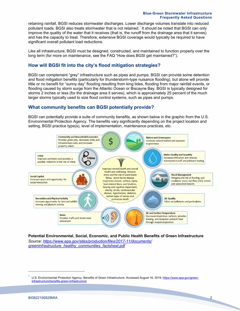
What community benefits can BGSI potentially provide?
BGSI can potentially provide a suite of community benefits, as shown below in the graphic from the U.S. Environmental Protection Agency. The benefits vary significantly depending on the project location and setting, BGSI practice type(s), level of implementation, maintenance practices, etc.
Potential Environmental, Social, Economic, and Public Health Benefits of Green Infrastructure Source: https://www.epa.gov/sites/production/files/2017-11/documents/ greeninfrastructure_healthy_communities_factsheet.pdf
1 U.S. Environmental Protection Agency. Benefits of Green Infrastructure. Accessed August 16, 2019. https://www.epa.gov/green-
infrastructure/benefits-green-infrastructure

Blue-Green Stormwater Infrastructure Frequently Asked Questions
BI0822190828MIA 3
What BGSI practices are most applicable to Miami Beach?
A wide range of BGSI practice types were evaluated based on city/regional/national experience, stormwater performance, ease of implementation/maintenance, community/environmental benefits, cost efficiency, and climate change resilience. The recommended practices were determined to perform well across these areas and have potential applicability in Miami Beach given the local context (soil and groundwater conditions, land uses, development patterns, climate, etc.).
The most applicable BGSI practices are:
• Bioretention/Bioswales/Rain Gardens
• Blue and Green Roofs
• Constructed Wetlands/Floating Wetland Islands
• Detention Basins/Surface Storage
• Enhanced Tree Pits/Trenches
• Injection Wells (Pumped)2
• Permeable Pavement
• Rainwater Harvesting (Cisterns, Rain Barrels)
• Stormwater Planters
• Subsurface Infiltration and Storage
• Tree Canopy3
• Wet Ponds
When and where to use each recommended BGSI practice depends on a variety of site-specific factors, such as land use, location, topography, groundwater elevation, soil conditions, and existing infrastructure.
What BGSI practices are less applicable to Miami Beach?
The following BGSI practices are less applicable to or less effective in Miami Beach due to their reduced water quality benefits, higher costs, lack of scalability, lower effectiveness when dealing with sea level rise and high tides, proprietary designs, limited applicability, or low storage capacities:
• Detention Tanks
• Exfiltration Trenches
• High-Flow Media Filters
• Living/Green Walls
• Gravity Wells
• Subsurface Flow Wetlands
Although not as readily applicable to Miami Beach, the above BGSI practices might still prove beneficial in certain settings.
2 Although not typically thought of as BGSI, injection wells are included here as they reduce the volume of stormwater discharged, and with
proper pretreatment/filtration can provide water quality benefits. 3 Trees are a key component of BGSI, and the City is developing an Urban Forest Master Plan to provide a strategic framework to guide the
City in managing, maintaining, planting, and preserving its urban forest. See www.mbrisingabove.com/climate-mitigation/urban-canopy-2/urban-forestry-master-plan/.

Blue-Green Stormwater Infrastructure Frequently Asked Questions
BI0822190828MIA 4
What does BGSI look like?
BGSI can take many different forms, from landscaping elements such as rain gardens to permeable pavements that can look like normal pavements to wet ponds to blue and green roofs atop buildings. BGSI practices can vary from being dominant, high-profile features to blending in seamlessly with the surroundings. Some example images with established vegetation are provided on the next page (vegetated BGSI, like other landscaping, requires time to get established).
Where can BGSI be used?
BGSI can be used on and along roads, in parks and other open spaces, at schools and other public facilities, on rooftops, and on residential and commercial properties. Approximately 40% of Miami Beach is covered by impervious surfaces (buildings and pavements) that prevent water from soaking into the ground. BGSI should be employed to treat runoff from these impervious surfaces and help preserve, enhance, and increase the City’s remaining pervious or “green” areas.
When choosing where to place BGSI practices, the following factors should be considered:
• Depending on the BGSI practice type, offsets from utilities, buildings, and other structures may be required to protect those features from water damage.
• Factors such as budget, permitting, site conditions, neighborhood preferences, and ownership will influence the location and types of BGSI.
A rendering of bioretention and permeable pavement on a typical residential street in Miami Beach

Blue-Green Stormwater Infrastructure Frequently Asked Questions
BI0822190828MIA 5
Examples of BGSI Applications
Wet Pond Source: Southwest Florida Water Management District
Rain Garden
Normal (left) and Porous Asphalt (Right)
Infiltration Trench
Blue-Green Roof Plaza
Green Roof (in foreground) Adjacent to Marina
Residential Rain Barrel
Residential Rain Garden
Floating Wetland Islands
Stormwater Planter
Permeable Paver Driveway
Pervious Concrete Parking Lot

Blue-Green Stormwater Infrastructure Frequently Asked Questions
BI0822190828MIA 6
Where is the City planning to implement BGSI?
The City is planning to implement BGSI along roads, in parks and other open spaces, and at public facilities. City projects currently under design with BGSI components include Maurice Gibbs Park, Community Park (former par 3 golf course), 59th Street bioswale, and 1st Street stormwater improve-ments. In addition, preliminary concept renderings have been developed for the following:
• Residential street
• Commercial street
• Neighborhood park
• Miami Beach Golf Course (three scenarios)
• Collins Canal
• Street end (where a street dead ends at a waterbody)
• Garden apartments
There is also an opportunity to make policy and code changes to further encourage and/or require public and private BGSI implementation.
How will BGSI function with rising sea levels and shallow groundwater? Shallow and increasing groundwater elevations in portions of the City limit the soil storage capacity and infiltration required for some BGSI practices to function effectively. However, such limitations might potentially be overcome with underdrains, fill, and/or pumping. Other practices, such as wet ponds and constructed wetlands, can continue to function with shallow groundwater although their storage capacity may be reduced as groundwater levels increase. Blue and green roofs, rainwater harvesting, and floating wetland islands would typically not be impacted by rising groundwater.
How does BGSI get maintained?
BGSI practices require a variety of maintenance activities depending on the type of BGSI and site-specific factors. Landscaped BGSI requires maintenance typical of other landscaped areas, potentially including: debris and trash removal, pruning, weeding, replanting, erosion repair, and mulching. Many BGSI practices include devices for pretreatment of runoff that require periodic sediment and debris removal. Permeable pavements require the surface to be periodically cleaned (for example, with a street cleaning vehicle) to prevent clogging.
Who will do the maintenance for BGSI?
A variety of entities may be involved in BGSI maintenance depending on the situation. In parks and at other City-owned properties, the City would likely lead the maintenance activities (either with City staff or contractors) although they may be supported by residents and businesses through volunteer efforts, “Friends of” groups, “adopt-a-BGSI” programs, neighborhood associations, etc. Along commercial streets, business improvement districts and similar groups may lead maintenance activities. On private property, BGSI maintenance would be the responsibility of the property owner/manager. Maintenance procedures and responsibilities for BGSI on residential roads are still being formulated.
Will BGSI promote mosquito breeding and the spread of disease?
If properly designed, constructed, and maintained, BGSI should not promote mosquito breeding. BGSI systems that are not intended to have prolonged ponding should typically empty within 3 days (mosquitoes require standing water to be present for greater than 7 days to grow) and should be checked frequently to ensure they are emptying as expected. BSGI that holds water for prolonged periods (for example, wet ponds, wetlands, and cisterns) must use other methods to prevent mosquito growth, such as screening, establishing a natural predator population, and/or appropriate mosquito specific larvicides.

Blue-Green Stormwater Infrastructure Frequently Asked Questions
BI0822190828MIA 7
It should be noted that mosquitos are present in Miami Beach regardless of BGSI and people should take appropriate precautions to prevent getting bitten (for information from Miami-Dade County, see www8.miamidade.gov/global/solidwaste/mosquito/home.page).
Will BGSI reduce parking?
Impacts to parking will be evaluated and discussed with stakeholders on a project-by-project basis. Some BGSI may reduce parking along streets and in parking lots if areas along them are used for vegetated BGSI. However, BGSI is often strategically located in areas where parking is not permitted already (for example, near fire hydrants and intersections) to minimize impacts to parking. In most cases there are BGSI options (for example permeable pavements) that do not reduce parking.
Will BGSI reduce recreational space?
Locations for BGSI in parks and other open spaces will be carefully considered to minimize impacts to the usage of the sites. In many cases, BGSI may serve both recreational and stormwater purposes (for example, a permeable pavement basketball or tennis court). BGSI can also enhance recreational spaces by providing additional landscape features.
What can the public do to promote BGSI in Miami Beach?
Private properties will be a key partner in the successful implementation of BGSI in Miami Beach. Residents and businesses can implement several types of relatively low-cost, low-maintenance BGSI practices on their properties, including rain gardens, trees, cisterns, and rain barrels. Property owners can also maintain, preserve, and enhance their existing green space, trees, and roadside swales. In addition, the public may be able to volunteer to help protect and maintain City-installed BGSI practices through grassroots adoption programs, if those programs are developed.

Blue-Green Stormwater Infrastructure Frequently Asked Questions
BI0822190828MIA 8
Where can I find more information on BGSI?
More information can be found at the following links/sources.
Resource Source/Location
MB Rising Above Website www.mbrisingabove.com
Best Management Practices for South Florida Urban Stormwater Management Systems
www.sfwmd.gov/sites/default/files/documents/bmp_manual.pdf
Florida Field Guide to Low Impact Development: Bioretention Basins/Rain Gardens
buildgreen.ufl.edu/Fact_sheet_Bioretention_Basins_Rain_Gardens.pdf
Florida Field Guide to Low Impact Development: Green Roofs/Eco-roofs
www.buildgreen.ufl.edu/Fact_sheet_Green_Roofs_Eco_roofs.pdf
Florida Department of Transportation Drainage Design Guide (Injection Wells covered in Chapter 7)
fdotwww.blob.core.windows.net/sitefinity/docs/default-source/roadway/drainage/files/drainagedesignguide.pdf
Sarasota County Low Impact Development Guidance Document
www.scgov.net/home/showdocument?id=33258
University of Florida Soil and Water Sciences Video Topics: Green Stormwater Infrastructure
soils.ifas.ufl.edu/extension/videos/low-impact-development/
Constructed Floating Wetlands: A review of research, design, operation and management aspects, and data meta-analysis
apirs.plants.ifas.ufl.edu/site/assets/files/372369/372369.pdf
Note that the City is not specifically endorsing the information provided in these sources but is providing them for general information to be used with discretion.

Appendix B Public Outreach Summary Report

Resilience Conversation SeriesBlue Green Infrastructure
MIAMIBEACH1
RReessiilliieenntt,, IInntteeggrraatteedd,, SSttrraatteeggiicc EEnnggaaggeemmeenntt
Resilience Conservation Series Blue Green Infrastructure Public OOuuttrreeaacchh RReeppoorrttOOccttoobbeerr 22001199

Resilience Conversation SeriesBlue Green Infrastructure
MIAMIBEACH
Meeting Notices..................................................................................................... 3 - 4
Website Project Page............................................................................................. 5 - 7
Community Outreach............................................................................................. 8 - 29• Every Door Direct Mail• Email Blast• Social Media Posts• Advertisement• Door-to-Door Photos
Public Meeting....................................................................................................... 30 - 71• Summary• Sign-in Sheets• Comment Cards• Social Media Posts• Photos
Appendix............................................................................................................... 72
• Presentation• Boards• FAQ
Table of Contents
2

Resilience Conversation SeriesBlue Green Infrastructure
MIAMIBEACH3
MEETING NOTICES

MIAMIBEACH
Resilience Conversation Series Blue Green Infrastructure
4
IInniittiiaall MMeeeettiinngg
RReesscchheedduulleedd MMeeeettiinngg

Resilience Conversation SeriesBlue Green Infrastructure
MIAMIBEACH5
WEBSITE PROJECT PAGE

Resilience Conversation SeriesBlue Green Infrastructure
MIAMIBEACH6
Resilience Conversation SeriesBlue Green Infrastructure
MIAMIBEACH3
MIAMIBEACH
Resilience Conversation SeriesBlue Green InfrastructurePublic Outreach Report
hhttttppss::////wwwwww..mmiiaammiibbeeaacchhffll..ggoovv//cciittyy--hhaallll//ppuubblliicc--wwoorrkkss//ccoommmmuunniittyy--oouuttrreeaacchh//eevvaalluuaattiinngg--bblluuee--ggrreeeenn--iinnffrraassttrruuccttuurree//

Resilience Conversation SeriesBlue Green Infrastructure
MIAMIBEACH7
hhttttpp::////wwwwww..mmbbrriissiinnggaabboovvee..ccoomm//yyoouurr--cciittyy--aatt--wwoorrkk//rreessiilliieennccee--ssttrraatteeggyy//ccoommmmuunniittyy--mmeeeettiinnggss//

Resilience Conversation SeriesBlue Green Infrastructure
MIAMIBEACH8
COMMUNITY OUTREACHEEvveerryy DDoooorr DDiirreecctt MMaaiill
EEmmaaiill BBllaassttSSoocciiaall MMeeddiiaa PPoossttss
AAddvveerrttiisseemmeennttDDoooorr--ttoo--DDoooorr PPhhoottooss

Resilience Conversation SeriesBlue Green Infrastructure
MIAMIBEACH9
Resilience Conversation SeriesBlue Green Infrastructure
MIAMIBEACH4MIAMIBEACH
• • ••••• • •• • • • • • ••• ••• • • • ••• •••••••••••••••••••••••••••••• •• • • •• • • •• ••• •••• ••• •••••••••••••••••••••••••Public Outreach Report
EEvveerryy DDoooorr DDiirreecctt MMaaiill ((EEDDDDMM)) -- 5599,,000000 rreessiiddeennttss iinn MMiiaammii BBeeaacchh
Manténgase al día sobre las próximas conversaciones con la comunidad. Para más información sobre las iniciativas de resiliencia de la ciudad, visite: www.MBRisingAbove.com.
CONOZCA MÁS SOBRE LA INFRAESTRUCTURA AZUL Y VERDEPara el Programa de Manejo de Aguas Pluviales de la Ciudad
La Ciudad de Miami Beach y Jacobs Engineering le invitan a La Ciudad de Miami Beach y Jacobs Engineering le invitan a participar en una conversación sobre la Infraestructura Azul y Verde, conocida en la industria como BGI. Aprenda cómo BGI mejora la resistencia urbana al cambio climático mediante la implementación de elementos azules (agua) y verdes (basados en plantas) que mitigan las inundaciones:
•• Vista previa de los conceptos de BGI que se están desarrollando para Miami Beach.
• Aprenda cómo estos métodos proporcionan una experiencia agradable, con espacios recreativos y sociales.
•• Proponga su opinión sobre estos proyectos de la comunidad y permanezca informado sobre los próximos pasos en los planes integrados de la ciudad para la gestión del agua.
Jueves, 5 de septiembre a las 7 PMCámaras de la Comisión del Ayuntamiento1700 Convention Center Drive, Tercer Piso
O vea el evento en vivo por MBTVO vea el evento en vivo por MBTVAT&T U-verse 99/ Atlantic Broadband 660
For more information on the city’s resilience initiatives, visit www.MBRisingAbove.com. Stay tuned for upcoming resilience conversations.
LEARN MORE ABOUT BLUE & GREEN INFRASTRUCTUREFor the City’s Stormwater Management Program
Join the City of Miami Beach and Jacobs Engineering for a Join the City of Miami Beach and Jacobs Engineering for a discussion on Blue & Green Infrastructure (BGI) to advance a more holistic living with water approach. Learn how BGI enhances urban resilience by implementing blue (water) and green (plant-based) elements that mitigate flooding as well as:
• Preview BGI concepts being developed for Miami Beach. • Learn how such methods deliver enjoyable recreational and social spaces. • Provide community feedback and stay informed about what’s next in the city’s integrated water management plans.
Thursday, September 5 at 7 PMCity Hall Commission Chambers1700 Convention Center Drive, Third Floor1700 Convention Center Drive, Third Floor
Or watch LIVE on MBTVAT&T U-verse 99/ Atlantic Broadband 660
************************* ECRWSSEDDM****
RESIDENTIAL CUSTOMER

Resilience Conversation SeriesBlue Green Infrastructure
MIAMIBEACH10
Resilience Conversation SeriesBlue Green Infrastructure
MIAMIBEACH5
MIAMIBEACH 4
Resilience Conversation SeriesBlue Green InfrastructurePublic Outreach Report
EEmmaaiill BBllaasstt -- CCoonnssttaanntt CCoonnttaacctt
EEbbllaasstt sseenntt oonn 0088//1133//22001199 -- ""YYoouu''rree IInnvviitteedd""EEbbllaasstt sseenntt oonn 0088//2266//1199 -- ""YYoouu''rree IInnvviitteedd""
EEbbllaasstt sseenntt oonn 0099//0033//22001199 -- ""DDaattee CChhaannggeedd""EEbbllaasstt sseenntt oonn 0099//0055//22001199 -- ""DDaattee CChhaannggeedd""
EEbbllaasstt SSeenntt oonn 0099//1122//22001199 -- ""RReemmiinnddeerr""EEbbllaasstt sseenntt oonn 0099//1166//22001199 -- ""SSeeee yyoouu
TToommoorrrrooww""
Due to Hurrican Dorian, the September 5 meeting is rescheduled to occur on Tuesday, September 17 at 6:30 p.m.
RSVP below.

Resilience Conversation SeriesBlue Green Infrastructure
MIAMIBEACH11
Resilience Conversation SeriesBlue Green Infrastructure
MIAMIBEACH6MIAMIBEACH
Resilience Conversation SeriesBlue Green InfrastructurePublic Outreach Report
Eblast sent on 09/ 12/ 2019 - " You Are Invited"Eblast sent on 09/ 16/ 2019 - " Reminder"Eblast sent on 09/ 16/ 2019 - " Reminder"
Learn More About Blue and Green InfrastructureNew Date and Time - Tuesday, September 17 at 6:30 p.m.
Due to Hurricane Dorian, we have had to postpone this meeting that was initially scheduled for this Thursday, to Tuesday, September 17 at 6:30 p.m.
Join the City of Miami Beach and Jacobs Engineering for a discussion on Blue & Green Infrastructure (BGI) to advance a more holistic living with water approach. Learn how BGI enhances urban resilience by implementing blue (water) and green (plant-based) elements that mitigate flooding as well as:
Preview BGI concepts being developed for Miami Beach. Learn how such methods deliver enjoyable recreational and social spaces. Provide community feedback and stay informed about what’s next in the city’s integrated water management plans.
Tuesday, September 17 at 6:30 PMCity Hall Commission Chambers1700 Convention Center Drive, Third Floor
Watch live on MBTV AT&T U-verse: Channel 99 | Atlantic Broadband: Channel 660 or visit: miamibeachfl.gov/government/mbtv/ to stream online.
Stay tuned for other resilience conversation dates coming soon.
EEmmaaiill BBllaasstt -- CCiittyy ooff MMiiaammii BBeeaacchh
EEbbllaasstt sseenntt oonn 0088//1122//22001199 -- ""SSaavvee tthhee DDaattee"" EEbbllaasstt sseenntt oonn 0099//1111//22001199 -- ""RReessiilliieennccee
DDiissccuussssiioonn""

Resilience Conversation SeriesBlue Green Infrastructure
MIAMIBEACH12
Resilience Conversation SeriesBlue Green Infrastructure
MIAMIBEACH43
SSoocciiaall MMeeddiiaa PPoossttss
PPoosstteedd oonn AAuugguusstt 1122,, 22001199 -- FFaacceebbooookk PPoosstteedd oonn AAuugguusstt 1199,, 22001199 -- FFaacceebbooookk
PPoosstteedd oonn AAuugguusstt 1199,, 22001199 -- TTwwiitttteerr PPoosstteedd oonn AAuugguusstt 2222,, 22001199 -- FFaacceebbooookk

Resilience Conversation SeriesBlue Green Infrastructure
MIAMIBEACH13
Resilience Conversation SeriesBlue Green Infrastructure
MIAMIBEACH43
PPoosstteedd oonn AAuugguusstt 2222,, 22001199 -- TTwwiitttteerr PPoosstteedd oonn AAuugguusstt 2277,, 22001199 -- TTwwiitttteerr
PPoosstteedd oonn AAuugguusstt 2277,, 22001199 -- FFaacceebbooookk PPoosstteedd oonn SSeepptteemmbbeerr 33,, 22001199 -- TTwwiitttteerr
Resilience Conversation SeriesBlue Green Infrastructure
MIAMIBEACH13
Resilience Conversation SeriesBlue Green Infrastructure
MIAMIBEACH43
PPoosstteedd oonn AAuugguusstt 2222,, 22001199 -- TTwwiitttteerr PPoosstteedd oonn AAuugguusstt 2277,, 22001199 -- TTwwiitttteerr
PPoosstteedd oonn AAuugguusstt 2277,, 22001199 -- FFaacceebbooookk PPoosstteedd oonn SSeepptteemmbbeerr 33,, 22001199 -- TTwwiitttteerr
Posted on August 22, 2019 - Twitter Posted on September 9, 2019 - Twitter
Posted on September 10, 2019 - Facebook

Resilience Conversation SeriesBlue Green Infrastructure
MIAMIBEACH14
Resilience Conversation SeriesBlue Green Infrastructure
MIAMIBEACH43
PPoosstteedd oonn SSeepptteemmbbeerr 33,, 22001199 -- FFaacceebbooookk
PPoosstteedd oonn SSeepptteemmbbeerr 99,, 22001199 -- TTwwiitttteerr
PPoosstteedd oonn SSeepptteemmbbeerr 99,, 22001199 -- FFaacceebbooookk
PPoosstteedd oonn SSeepptteemmbbeerr 1100,, 22001199 -- TTwwiitttteerr
Resilience Conversation SeriesBlue Green Infrastructure
MIAMIBEACH14
Resilience Conversation SeriesBlue Green Infrastructure
MIAMIBEACH43
PPoosstteedd oonn SSeepptteemmbbeerr 33,, 22001199 -- FFaacceebbooookk
PPoosstteedd oonn SSeepptteemmbbeerr 99,, 22001199 -- TTwwiitttteerr
PPoosstteedd oonn SSeepptteemmbbeerr 99,, 22001199 -- FFaacceebbooookk
PPoosstteedd oonn SSeepptteemmbbeerr 1100,, 22001199 -- TTwwiitttteerrPosted on September 17, 2019 - Twitter
Posted on September 16, 2019 - Twitter

Resilience Conversation SeriesBlue Green Infrastructure
MIAMIBEACH15
Resilience Conversation SeriesBlue Green Infrastructure
MIAMIBEACH43
PPoosstteedd oonn SSeepptteemmbbeerr 1100,, 22001199 -- FFaacceebbooookk
PPoosstteedd oonn SSeepptteemmbbeerr 1166,, 22001199 -- FFaacceebbooookkPosted on September 17, 2019 - Facebook
Resilience Conversation SeriesBlue Green Infrastructure
MIAMIBEACH15
Resilience Conversation SeriesBlue Green Infrastructure
MIAMIBEACH43
PPoosstteedd oonn SSeepptteemmbbeerr 1100,, 22001199 -- FFaacceebbooookk
PPoosstteedd oonn SSeepptteemmbbeerr 1166,, 22001199 -- FFaacceebbooookk
Posted on September 17, 2019 - Facebook

Resilience Conversation SeriesBlue Green Infrastructure
MIAMIBEACH16
Resilience Conversation SeriesBlue Green Infrastructure
MIAMIBEACH44 MIAMIBEACH
Resilience Conversation SeriesBlue Green InfrastructurePublic Outreach Report
WWeeeekkllyy MMeeeettiinngg NNoottiicceess AAdd ffoorr tthhee WWeeeekk ooff SSeepptteemmbbeerr 1166 -- 2200,, 22001199 MMiiaammii HHeerraalldd
MIAMIBEACH
MIAMIBEACH

Resilience Conversation SeriesBlue Green Infrastructure
MIAMIBEACH17
Resilience Conversation SeriesBlue Green Infrastructure
MIAMIBEACH45
MIAMIBEACH
Resilience Conversation SeriesBlue Green InfrastructurePublic Outreach Report
DDoooorr--ttoo--DDoooorr PPhhoottooss

Resilience Conversation SeriesBlue Green Infrastructure
MIAMIBEACH18
Resilience Conversation SeriesBlue Green Infrastructure
MIAMIBEACH46
MIAMIBEACH
Resilience Conversation SeriesBlue Green InfrastructurePublic Outreach Report

Resilience Conversation SeriesBlue Green Infrastructure
MIAMIBEACH19
Resilience Conversation SeriesBlue Green Infrastructure
MIAMIBEACH47MIAMIBEACH
Resilience Conversation SeriesBlue Green InfrastructurePublic Outreach Report

Resilience Conversation SeriesBlue Green Infrastructure
MIAMIBEACH20
Resilience Conversation SeriesBlue Green Infrastructure
MIAMIBEACH48MIAMIBEACH
Resilience Conversation SeriesBlue Green InfrastructurePublic Outreach Report

Resilience Conversation SeriesBlue Green Infrastructure
MIAMIBEACH21
Resilience Conversation SeriesBlue Green Infrastructure
MIAMIBEACH49MIAMIBEACH
Resilience Conversation SeriesBlue Green InfrastructurePublic Outreach Report

Resilience Conversation SeriesBlue Green Infrastructure
MIAMIBEACH22
Resilience Conversation SeriesBlue Green Infrastructure
MIAMIBEACH50MIAMIBEACH
Resilience Conversation SeriesBlue Green InfrastructurePublic Outreach Report
Resilience Conversation SeriesBlue Green Infrastructure
MIAMIBEACH23
Resilience Conversation SeriesBlue Green Infrastructure
MIAMIBEACH51MIAMIBEACH
Resilience Conversation SeriesBlue Green InfrastructurePublic Outreach Report
Resilience Conversation SeriesBlue Green Infrastructure
MIAMIBEACH24
Resilience Conversation SeriesBlue Green Infrastructure
MIAMIBEACH52 MIAMIBEACH
Resilience Conversation SeriesBlue Green InfrastructurePublic Outreach Report

Resilience Conversation SeriesBlue Green Infrastructure
MIAMIBEACH25
Resilience Conversation SeriesBlue Green Infrastructure
MIAMIBEACH53MIAMIBEACH
Resilience Conversation SeriesBlue Green InfrastructurePublic Outreach Report

Resilience Conversation SeriesBlue Green Infrastructure
MIAMIBEACH26
Resilience Conversation SeriesBlue Green Infrastructure
MIAMIBEACH55MIAMIBEACH
Resilience Conversation SeriesBlue Green InfrastructurePublic Outreach Report

Resilience Conversation SeriesBlue Green Infrastructure
MIAMIBEACH27
Resilience Conversation SeriesBlue Green Infrastructure
MIAMIBEACH56MIAMIBEACH
Resilience Conversation SeriesBlue Green InfrastructurePublic Outreach Report

Resilience Conversation SeriesBlue Green Infrastructure
MIAMIBEACH28
Resilience Conversation SeriesBlue Green Infrastructure
MIAMIBEACH57MIAMIBEACH
Resilience Conversation SeriesBlue Green InfrastructurePublic Outreach Report

Resilience Conversation SeriesBlue Green Infrastructure
MIAMIBEACH29
Resilience Conversation SeriesBlue Green Infrastructure
MIAMIBEACH58MIAMIBEACH
Resilience Conversation SeriesBlue Green InfrastructurePublic Outreach Report

Resilience Conversation SeriesBlue Green Infrastructure
MIAMIBEACH30
PUBLIC MEETINGSSuummmmaarryy
SSiiggnn--iinn SShheeeettssCCoommmmeenntt CCaarrddss
SSoocciiaall MMeeddiiaa PPoossttssPPhhoottooss

Resilience Conversation SeriesBlue Green Infrastructure
MIAMIBEACH31
Resilience Conversation SeriesBlue Green Infrastructure
MIAMIBEACH3
Resilience Conversation Series Blue Green Infrastructure Discussion
Discussion Briefing Summary September 17, 2019 | 6:30 p.m.
City of Miami Beach City Hall Commission Chambers 1700 Convention Center Drive, Miami Beach, FL 33139
SSttaaffff:: Jacobs Engineering Infinite Source Communications City of Miami Beach Staff See the attached sign-in sheets for attendees
KKeeyy iitteemmss DDiissccuusssseedd:: • Mayor Dan Gelber started the presentation giving a brief introduction of what the City of Miami beach
plans were regarding the project. He also introduced Jacobs Engineering and explained the overall goalof the briefing.
• The Public Works Director Roy Coley explained the purpose of the briefing, which was to review Blue andGreen infrastructure. He also mentioned that the overall goal was to obtain public opinion, thoughts, andquestions regarding the topic.
PPrreesseennttaattiioonn:: • Matt Alvarez of Jacobs Engineering introduced each team member and gave a project overview stating
that together they evaluated all the possible options for Blue and Green Stormwater Infrastructure (BGSI)and looked at which of these options were most applicable in Miami Beach.
• The Jacobs Engineering team presented each slide and provided a detailed explanation on each topic,as well as encouraging feedback from the audience.
o What is BGSI?o The following topics where discuss
during the presentationo Why should we use BGSI?o What are the water quality benefits?o How will the BGSI fit into the city’s
flood mitigation strategies?o Community (Co-Benefits) of BGSI.o What BGSI practices are less
applicable to Miami Beach?
o What BGSI practices are mostapplicable to Miami Beach?
o What does BGSI look like?o Where can BGSI be used?o Where is the city planning to
implement BGSI?o Preliminary concepts for:
o Residential streeto Collins canal

Resilience Conversation SeriesBlue Green Infrastructure
MIAMIBEACH32
Resilience Conversation SeriesBlue Green Infrastructure
MIAMIBEACH4
Resilience Conversation Series BlueGreen Infrastructure Discussion
o Commercial Streeto Neighborhood parko Street endso Miami Beach Golf courseo Garden Apartments
o Will BGSI reduce parking?o Will BGSI promote mosquito
breeding?o Where can the public do to promote
BGSI in Miami Beach?o What are the next steps?
• Resident, Louise Bauer, stated that she would like to propose a solution that will be beneficial to theresidents as well as to the City. She mentioned that the city had a violation on her neighborhood withMiami-Dade County on April 11, 2019 and that five months passed, and they still have not received adetailed response. Ms. Bauer said she feels that it is fair for all neighborhoods to finish the projects thatstarted and after she will be in favor of advancing with future projects. She also stated that she is interestedin Blue and Green infrastructure, but that she would like the City to first complete construction in herneighborhood and all other neighborhoods.
• Resident, Lizette Hassell, asked if the team also speaking with condos and hotels to have them look atwhat they can contribute. Ms. Hassel also asked how these proposals can be incorporated at acondominium or a hotel.
o Public Information Officer, Ms. Monica Diaz, responded that part of the outreach processdiscussed is that there will be a series of opportunities, one-on-one meetings, briefings and alsopublic meetings where they will be able to address these topics and also meet with stakeholdersto make sure everybody is aware of these practices.
o Mr. Andy Potts of Jacobs Engineering stated that as part of the project plan they will haveresidential strategies with property owners and businesses. The team is also looking at potentialopportunities to improve policies to encourage implementation on private properties.
• Resident, Lily Furst, asked who was going to be responsible for the maintenance of the rain gardens at thestreet ends. She also inquired if in the case the residents have saltwater intrusion, would that type ofvegetation be able to handle saltwater, and if the plants will survive. Furthermore, Ms. Furst also askedhow the team will get developers to implement the green roofs and all options into their projects.o Mr. Potts responded that maintenance is highly essential, the specific maintenance procedures
are not set at this stage, but he explained that there will be a variety of entities and techniquesthat will help with the maintenance.
o A Jacobs team member added that on the outside of the room there where different boards,which display different vegetation options that are applicable for Miami Beach, which cansurvive the climate conditions of the City.
o Ms. Furst asked if there would be any flowers? A Jacobs team member responded that there would be a few, but these gardens were
going to be less flowering.

Resilience Conversation SeriesBlue Green Infrastructure
MIAMIBEACH33
Resilience Conversation SeriesBlue Green Infrastructure
MIAMIBEACH5
Resilience Conversation Series Blue Green Infrastructure Discussion
• Resident, Gary Martinez, stated that it would be helpful to get a better idea on how this project is relatedto the Miami Beach’s overall efforts both in terms of infrastructure and conditions of cost. He inquired what would happen to this project, for example, if there was a storm surge, and if it would be able sustain someof the other treats that might be part of the environment. Mr. Martinez inquired if the residents areconsidering spending money on the project, how this would fit cost-wise, and what else should beconsidered in balancing the total cost.
o Mr. Potts responded that there are things that are going through an evaluation process, but interms of costs, there are ways cost can be reduced by integrating other improvements such as the Capital Improvement Projects that are currently going on. This often is very cost-effective andimproves green strategies as part of those ongoing projects. He stated that in addition to costs, theCity is also looking to the values that it brings.
o Mr. Potts referenced the storm surge and stated that BGSI should be designed with this in mind although some damage would likely occur as it would to other landscaped systems andmaintenance protocols will need to be developed for restoring systems after surge events.
• Resident, Glenna Norton, asked if the bioswales and rain gardens that the team are proposing encourage mosquitos, and how will this mosquito growth be prevented. Ms. Norton also asked how the high grassesand plants will impact the environment in terms of security, since this will probably encourage wildlife thatcan be attracted to this vegetation.
o Mr. Potts responded that all the different projects that are being proposed are something that needs tobe designed appropriately, so it will not create that type of environment. For example, if a system is meant to be dry most of the time, we must make sure it is working correctly, and that water leaves the surface within three days, so the mosquitos cannot grow. He further explained that the environment in more significant systems will generate or establish natural predators that will control mosquito growth.
o Ms. Jade Paul of Jacobs Engineering added that these systems do get some predators or crittersthat will take care of the mosquitos.
o Ms. Norton asked what a critter is.o Ms. Paul explained they are wildlife native to South Florida.
• Resident, Michael Laas, asked how this will evolve overtime and how this infrastructure will grow as thingsmove up regarding the built environment, as well as the actual infrastructure itself.
o A Jacob Engineering team member explained that the purpose is to integrate this project into the resident’s decision making, into the planning and overall capital improvement program,as well as in existing processes that are currently established. This is not something that will typically stand alone, it is something that will be integrated.

Resilience Conversation SeriesBlue Green Infrastructure
MIAMIBEACH34
Resilience Conversation SeriesBlue Green Infrastructure
MIAMIBEACH6
Resilience Conversation Series Blue Green Infrastructure Discussion
• Resident, Robert Kunst, mentioned that he is the president of We Love Lakeview Inc., and he stated that hewas unhappy with the fact that they are meeting there for the first time on that level. Mr. Kunst said theyasked several times to comply with the team before and to answer several questions on how the residentswill deal with these issues. He also stated that for a year and a half, the City planned to initiate work in theirneighborhood to have the streets raised even though their streets do not flood. He said the team needs tohave real meetings with all the neighborhoods in the community, and he suggested that there should not beany rush decisions.
o Mr. Joe Rozza of Jacobs Engineering explained that the whole purpose of Blue and Greeninfrastructure is to protect the environment. Mr. Rozza also mentioned that they are currently goingthrough the process of getting feedback from the community and trying to create a vision of what ispossible. He stated that what they are putting together now is a series of good practices thatshould be applied in the context of Miami Beach.
• Resident, Jeff Bercow, mentioned it floods by his house, down the street and most parts of his neighborhood.He would like to know if there is an opportunity within the design criteria management to also address theaging and deteriorating underground infrastructure on a neighborhood by neighborhood bases.
o Mr. Potts responded that he could not give a specific answer at that stage, but he believes that theCity is planning to address neighborhood needs comprehensively.
• Resident, Peter Luria, stated the city has a history of not listening to residents. The massive destruction of themature tree canopy across the island and the main roads among Collins Canal and Indian Creek are primeexamples of the City’s substantial focus on engineering solutions and dismiss residents’ concerns about theneed to protect and enhance green infrastructure and help improve stormwater management. He expressedhis concern that Jacobs engineering is repeating this behavior by refusing to listen to the Lakeview residents.He further stated that keeping the streets dry by pumping stormwater into Biscayne Bay and polluting thisnatural resource and economic engine of the local economy is misguided and short-sided. He continued bystating that the Blue and Green infrastructure discussion needs to address how to minimize harm to theenvironment. This does not resolve from the City resiliencies efforts. He stated that he is counting on the BGSIplan also to include a recommendation to averse the existing Miami Beach landscape order in section126-16, requiring the adjacent property owner to be responsible to maintain trees. He also asked whyMiami Beach was the only city in Miami Dade and Broward counties that does not keep the trees in theirright-of-way. Planting large canopy trees in the right-of-way and requiring the adjacent property owners tobe responsible for their maintenance is counter-productive for implementing and maintaining the healthy treecanopy. He stated this is a critical component of any action plan. Residents want to make sure that the citylearns from their past mistakes.

Resilience Conversation SeriesBlue Green Infrastructure
MIAMIBEACH35
Resilience Conversation SeriesBlue Green Infrastructure
MIAMIBEACH7
Resilience Conversation Series Blue Green Infrastructure Discussion
• Resident, Ben Mosthoff, stated that over the past five years, Biscayne Bay’s entire ecosystem has transformed, and it is now dying, and stormwater is a contributing factor. He explained that Miami Beach should be serving as a role model for stormwater management. It is not sustainable and not blue; there should not be any discharge of stormwater in the Bay.
• Resident, Jennifer Kaiser asked what the overall cost was, and she stated there was not a budget presented. Ms. Kaiser also mentioned that the City has already the highest taxes and she asked if there was a possibility to create a volunteer maintenance program where the community can give back; that way the taxes do not need to go up. She also asked how long the project would take from start to finish and if they are planning to remove any trees.
o Mr. Rozza of Jacobs Engineering responded that there should be an understanding of the relationship between cost and value because sometimes there is a need to focus on the value of things. Most of these issues relate to understanding the full picture of cost and benefits.
o He further explained, in terms of how long this will take, and stated it is about going back to the process. He mentioned that they were on the stage of just bringing ideas, practices, and implementation strategies and trying to get a sense of what is going to work best in Miami Beach. The next step would be the design criteria packages, and that is when the ideas and concepts become specific. The transformation will happen over a long period, looking at gradual change, and as this evolves, the community will be able to see the benefits.
o Ms. Paul of Jacobs Engineering added the goal is certainly to preserve as many trees as is feasible. She also mentioned they will perform an assessment to determine the quality of the tree. She explained saving a diseased tree would not be worthwhile at times.
• Resident, Alexander Zastera, stated that there would be a level of discomfort when it comes to some of the things residents are going to have to take on, but they are investing in the future.
• Resident, Alec Jimenez, asked how long a project like option two and option three for the Miami Beach Golf Course would take to be completed.
o Mr. Matt Friesen of Jacobs Engineering responded that there are different factors to consider, but he stated that realistically they are looking at an approximately10-year period.
• Resident, Rick Kendle, asked what the average cost of a bio-swale is. Moreover, he also asked how sea-level rise would be fixed when politicians dictate where sea level projects should be done.

Resilience Conversation SeriesBlue Green Infrastructure
MIAMIBEACH36
Resilience Conversation SeriesBlue Green Infrastructure
MIAMIBEACH8
Resilience Conversation Series Blue Green Infrastructure Discussion
• Resident, Chi-Chi Truong, asked if there was a possibility of a more permanent groundwater managementsolution or if the intent is that the vertical development will out phase sea level rise. Mr. Truong also askedif the team is looking at other storm events as well such as cloud bursts, because that happens a lot and hewants to know if the Blue and Green strategies can handle its capacity.
o A Jacobs Engineering team member responded that in terms of the cloud burst events, the team islooking at those and completed an analysis over the County on how storms are projected tointensify or change over time, and it would be considered as part of the project. In terms ofgroundwater management, there is a variety of options to maintain that separation from theground over time.
• Resident, Abraan Gonzalez, stated that there are a large amount if problems for the residences and that inevery neighborhood they will be assessing, people are living in these problems every day. Mostimportantly, the result will impact these people’s lives and their quality of life. He encouraged the team toinclude the residents in the process.
o Ms. Paul responded by stating that reaching the residents will be part of the next steps becausethey want the input from the community.
• Resident, Ebru Ozer, stated that her comments would be related to the education component related tothe project. She asked if they are considering an educational facility or school ground component, whereone can also integrate this, because most of the problems that the community is seeing here today arebecause of the lack of education, no signages or perspectives. She added that the team should make thisvisible for the community. Ms. Ozer proposed school grounds to allow easy maintenance and monitoring,and she also asked how these projects would be monitored.
o Ms. Paul responded that there are amazing opportunities to integrate Blue and Green to schoolgrounds.
o A Jacobs Engineering team member responded that they love the idea of education to createawareness; there is also an excellent opportunity to involve universities and conservationorganizations.
• Resident, Jonathan Welsh, stated that he looks forward to working on this project with the team because itis the future.
• Resident, Francois Monot, stated that as a resident, he does not want streets torn down and raised. Hebelieves it is a bad project that will not be helpful. He also mentioned that it looks like the is going forwardwith the project without consulting all the residents.
o A Jacobs Engineering team member responded that the Blue and Green infrastructure doesprovide some flood relief and it also offers many water quality benefits. There is a cost associatedwith this benefit, but it can be very valuable.

Resilience Conversation SeriesBlue Green Infrastructure
MIAMIBEACH37
Resilience Conversation SeriesBlue Green Infrastructure
MIAMIBEACH9
Resilience Conversation Series Blue Green Infrastructure Discussion
• Resident, Dave Duebuer, stated he was very excited with the project because of the water quality benefits.However, there are some concerns about the current designs of pump stations and infrastructure. Heasked if there was an opportunity to investigate ways on how it might be able to build additional Blue andGreen infrastructure into the pump stations.
o Mr. Potts responded that there are opportunities and that the team will be looking at those.
The Public Information Officer Ms. Diaz thanked the participants for attending the meeting and participating, and she encouraged them to continue providing feedback on the boards outside the room.

Resilience Conversation SeriesBlue Green Infrastructure
MIAMIBEACH38
Resilience Conversation SeriesBlue Green Infrastructure
MIAMIBEACH10

Resilience Conversation SeriesBlue Green Infrastructure
MIAMIBEACH
Resilience Conversation SeriesBlue Green Infrastructure
MIAMIBEACH39

Resilience Conversation SeriesBlue Green Infrastructure
MIAMIBEACH40
Resilience Conversation SeriesBlue Green Infrastructure
MIAMIBEACH12

Resilience Conversation SeriesBlue Green Infrastructure
MIAMIBEACH41
Resilience Conversation SeriesBlue Green Infrastructure
MIAMIBEACH13

Resilience Conversation SeriesBlue Green Infrastructure
MIAMIBEACH42
Resilience Conversation SeriesBlue Green Infrastructure
MIAMIBEACH14

Resilience Conversation SeriesBlue Green Infrastructure
MIAMIBEACH43
Resilience Conversation SeriesBlue Green Infrastructure
MIAMIBEACH15

Resilience Conversation SeriesBlue Green Infrastructure
MIAMIBEACH44
Resilience Conversation SeriesBlue Green Infrastructure
MIAMIBEACH16

Resilience Conversation SeriesBlue Green Infrastructure
MIAMIBEACH45
Resilience Conversation SeriesBlue Green Infrastructure
MIAMIBEACH17

Resilience Conversation SeriesBlue Green Infrastructure
MIAMIBEACH46
Resilience Conversation SeriesBlue Green Infrastructure
MIAMIBEACH18

Resilience Conversation SeriesBlue Green Infrastructure
MIAMIBEACH47
Resilience Conversation SeriesBlue Green Infrastructure
MIAMIBEACH19

Resilience Conversation SeriesBlue Green Infrastructure
MIAMIBEACH48
Resilience Conversation SeriesBlue Green Infrastructure
MIAMIBEACH20
Resilience Conversation SeriesBlue Green Infrastructure
MIAMIBEACH49
Resilience Conversation SeriesBlue Green Infrastructure
MIAMIBEACH21

Resilience Conversation SeriesBlue Green Infrastructure
MIAMIBEACH50
Resilience Conversation SeriesBlue Green Infrastructure
MIAMIBEACH22
MIAMIBEACH
Resilience Conversation SeriesBlue Green InfrastructurePublic Outreach Report

Resilience Conversation SeriesBlue Green Infrastructure
MIAMIBEACH51
Resilience Conversation SeriesBlue Green Infrastructure
MIAMIBEACH23MIAMIBEACH
Resilience Conversation SeriesBlue Green InfrastructurePublic Outreach Report

Resilience Conversation SeriesBlue Green Infrastructure
MIAMIBEACH52
Resilience Conversation SeriesBlue Green Infrastructure
MIAMIBEACH24
MIAMIBEACH
Resilience Conversation SeriesBlue Green InfrastructurePublic Outreach Report

Resilience Conversation SeriesBlue Green Infrastructure
MIAMIBEACH53
Resilience Conversation SeriesBlue Green Infrastructure
MIAMIBEACH25
MIAMIBEACH
Resilience Conversation SeriesBlue Green InfrastructurePublic Outreach Report

Resilience Conversation SeriesBlue Green Infrastructure
MIAMIBEACH54
Resilience Conversation SeriesBlue Green Infrastructure
MIAMIBEACH26
MIAMIBEACH
Resilience Conversation SeriesBlue Green InfrastructurePublic Outreach Report
Resilience Conversation SeriesBlue Green Infrastructure
MIAMIBEACH55
Resilience Conversation SeriesBlue Green Infrastructure
MIAMIBEACH27
MIAMIBEACH
Resilience Conversation SeriesBlue Green InfrastructurePublic Outreach Report

Resilience Conversation SeriesBlue Green Infrastructure
MIAMIBEACH56
Resilience Conversation SeriesBlue Green Infrastructure
MIAMIBEACH28
MIAMIBEACH
Resilience Conversation SeriesBlue Green InfrastructurePublic Outreach Report

Resilience Conversation SeriesBlue Green Infrastructure
MIAMIBEACH57
Resilience Conversation SeriesBlue Green Infrastructure
MIAMIBEACH29MIAMIBEACH
Resilience Conversation SeriesBlue Green InfrastructurePublic Outreach Report

Resilience Conversation SeriesBlue Green Infrastructure
MIAMIBEACH58
Resilience Conversation SeriesBlue Green Infrastructure
MIAMIBEACH30
MIAMIBEACH
Resilience Conversation SeriesBlue Green InfrastructurePublic Outreach Report

Resilience Conversation SeriesBlue Green Infrastructure
MIAMIBEACH59
Resilience Conversation SeriesBlue Green Infrastructure
MIAMIBEACH31MIAMIBEACH
Resilience Conversation SeriesBlue Green InfrastructurePublic Outreach Report

Resilience Conversation SeriesBlue Green Infrastructure
MIAMIBEACH60
Resilience Conversation SeriesBlue Green Infrastructure
MIAMIBEACH32
MIAMIBEACH
Resilience Conversation SeriesBlue Green InfrastructurePublic Outreach Report

Resilience Conversation SeriesBlue Green Infrastructure
MIAMIBEACH61
Resilience Conversation SeriesBlue Green Infrastructure
MIAMIBEACH33
MIAMIBEACH
Resilience Conversation SeriesBlue Green InfrastructurePublic Outreach Report

Resilience Conversation SeriesBlue Green Infrastructure
MIAMIBEACH62
Resilience Conversation SeriesBlue Green Infrastructure
MIAMIBEACH34
MIAMIBEACH
Resilience Conversation SeriesBlue Green InfrastructurePublic Outreach Report

Resilience Conversation SeriesBlue Green Infrastructure
MIAMIBEACH63
Resilience Conversation SeriesBlue Green Infrastructure
MIAMIBEACH35MIAMIBEACH
Resilience Conversation SeriesBlue Green InfrastructurePublic Outreach Report

Resilience Conversation SeriesBlue Green Infrastructure
MIAMIBEACH64
Resilience Conversation SeriesBlue Green Infrastructure
MIAMIBEACH36MIAMIBEACH
Resilience Conversation SeriesBlue Green InfrastructurePublic Outreach Report

Resilience Conversation SeriesBlue Green Infrastructure
MIAMIBEACH65
Resilience Conversation SeriesBlue Green Infrastructure
MIAMIBEACH43
PPoosstteedd oonn SSeepptteemmbbeerr 1177,, 22001199 -- FFaacceebbooookk
PPoosstteedd oonn SSeepptteemmbbeerr 1177,, 22001199 -- FFaacceebbooookk
PPoosstteedd oonn SSeepptteemmbbeerr 1177,, 22001199 -- TTwwiitttteerr
PPoosstteedd oonn SSeepptteemmbbeerr 1177,, 22001199 -- FFaacceebbooookk
Social Media Posts

Resilience Conversation SeriesBlue Green Infrastructure
MIAMIBEACH66
Resilience Conversation SeriesBlue Green Infrastructure
MIAMIBEACH43
PPoosstteedd oonn SSeepptteemmbbeerr 1177,, 22001199 --FFaacceebbooookk
PPoosstteedd oonn SSeepptteemmbbeerr 1177,, 22001199 -- TTwwiitttteerr

Resilience Conversation SeriesBlue Green Infrastructure
MIAMIBEACH67
Resilience Conversation SeriesBlue Green Infrastructure
MIAMIBEACH59
MIAMIBEACH
Resilience Conversation SeriesBlue Green InfrastructurePublic Outreach Report
PPhhoottooss

Resilience Conversation SeriesBlue Green Infrastructure
MIAMIBEACH68
Resilience Conversation SeriesBlue Green Infrastructure
MIAMIBEACH60
MIAMIBEACH
Resilience Conversation SeriesBlue Green InfrastructurePublic Outreach Report

Resilience Conversation SeriesBlue Green Infrastructure
MIAMIBEACH69
Resilience Conversation SeriesBlue Green Infrastructure
MIAMIBEACH61
MIAMIBEACH
Resilience Conversation SeriesBlue Green InfrastructurePublic Outreach Report
Resilience Conversation SeriesBlue Green Infrastructure
MIAMIBEACH70
Resilience Conversation SeriesBlue Green Infrastructure
MIAMIBEACH62
MIAMIBEACH
Resilience Conversation SeriesBlue Green InfrastructurePublic Outreach Report
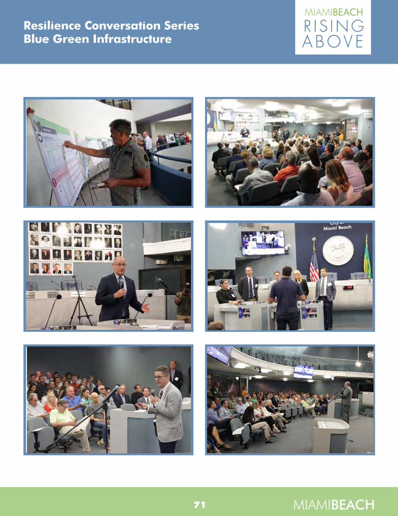
Resilience Conversation SeriesBlue Green Infrastructure
MIAMIBEACH71
Resilience Conversation SeriesBlue Green Infrastructure
MIAMIBEACH63
MIAMIBEACH
Resilience Conversation SeriesBlue Green InfrastructurePublic Outreach Report

Resilience Conversation SeriesBlue Green Infrastructure
MIAMIBEACH72
APPENDIXPPrreesseennttaattiioonn
BBooaarrddssFFAAQQ

RESILIENCE CONVERSATION SERIES: BLUE-GREEN INFRASTRUCTURESeptember 17, 2019

Project Leadership Team
2
Matt Alvarez Project Manager
years 25
Tom Ryburn Deputy Project Manager/ Implementation Task Lead
years 30
Laurens van der TakClimate AdaptationAdvisory Panel
years 30
Jason Bird Planning Task Lead
years 19
Andy PottsBlue-Green Infrastructure Task Lead
years 19
Joe RozzaBlue-Green & Sustainability
years 25
Monica DiazPublic Outreach
years 15
Matt FriesenUrban Design
years 13
Jade PaulUrban Design
years 19

BI0909191410MIA
REMINDER – PLEASE SUBMIT QUESTIONS AND COMMENTS TONIGHT!• Submit Question Card• Online viewers email questions to:
[email protected]• Open comment period through
September 24, 2019
Questions on Citywide Stormwater Management? Please contact:Liz Bello-MatthewsPublic Information Officer – Public Works Department305-673-7000 ext. 6902E-mail: [email protected]
3

BI0909191410MIA
AGENDA• What is BGSI? Why is it used?
• Where can it be used?
• How does it impact:– Parking?
– Mosquitoes?
• How can the public get involved?
• What are the next steps?
• Questions and Answers
4

BI0909191410MIA
WHAT IS BGSI?• Green stormwater infrastructure typically
uses vegetation and/or soils to treat and reduce stormwater flows
• Blue stormwater infrastructuretemporarily stores and treats stormwater
• BGSI is typically designed and sized to capture more frequent storm events
• Different from coastal strategies, such as living shorelines, dunes, mangrove plantings, and oyster or artificial reefs Rain Garden
5

BI0909191410MIA
WHY SHOULD WE USE BGSI?• Stormwater benefits
– Water quality (WQ)
– Groundwater recharge
– Some detention/flood mitigation
• Community benefits
– Urban heat island mitigation
– Air quality
– Climate resiliency
– Ecosystem health/biodiversityFrost Museum of
Science
6

BI0909191410MIA
WHAT ARE THE WATER QUALITY BENEFITS?• BGSI can reduce pollutants
that threaten the Bay, such as metals, nutrients, sediment, and pathogens
• By retaining rainfall, BGSI reduces stormwater discharges and pollutant loads
• BGSI can also filter stormwater that is not retained
Biscayne Bay at Maurice Gibbs Park
7
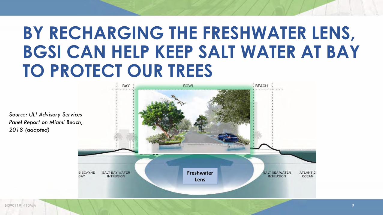
BI0909191410MIA
BY RECHARGING THE FRESHWATER LENS, BGSI CAN HELP KEEP SALT WATER AT BAY TO PROTECT OUR TREES
Source: ULI Advisory Services Panel Report on Miami Beach, 2018 (adapted)
Freshwater Lens
8

BI0909191410MIA
HOW WILL BGSI FIT INTO THE CITY’S FLOOD MITIGATION STRATEGIES?• Complements “grey” infrastructure
• Provides some detention/flood mitigation, but alone will provide little or no benefit for:– “sunny day” flooding – flooding from major rainfall– storm surge
• Designed for storms 2 inches or less, which is about 25% of the much larger storms typically used for flood control
Flooding on May 16, 2019
9

BI0909191410MIA
COMMUNITY (CO-BENEFITS) OF BGSI
Source: Potential Environmental, Social, Economic, and Public Health Benefits of Green Infrastructure by U.S. Environmental Protection Agency (2017)
10

BI0909191410MIA
BGSI CAN HELP MITIGATE THE URBAN HEAT ISLAND IN THE CITY
Hotter
Cooler
Heat Island Effect: higher temperatures in developed areasMap source: Davey Resource Group
11

BI0909191410MIA
WHAT BGSI PRACTICES ARE LESS APPLICABLE TO MIAMI BEACH?• Although not as readily applicable to Miami Beach, these might still prove
beneficial in certain settings:BGSI Practice Why Less Applicable to Miami BeachDetention Tanks
limited water quality benefit, relatively high costs, lower effectiveness with sea level rise and high tides, proprietary, limited applicability, limited storage capacity
Exfiltration Trenches
High-Flow Media Filters
Living/Green Walls
Gravity Wells
Subsurface Flow Wetlands 12
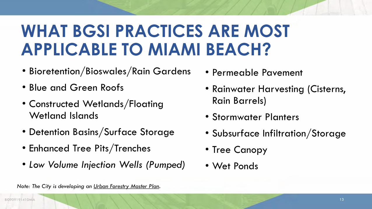
BI0909191410MIA
WHAT BGSI PRACTICES ARE MOST APPLICABLE TO MIAMI BEACH?
• Permeable Pavement
• Rainwater Harvesting (Cisterns, Rain Barrels)
• Stormwater Planters
• Subsurface Infiltration/Storage
• Tree Canopy
• Wet Ponds
• Bioretention/Bioswales/Rain Gardens
• Blue and Green Roofs
• Constructed Wetlands/Floating Wetland Islands
• Detention Basins/Surface Storage
• Enhanced Tree Pits/Trenches
• Low Volume Injection Wells (Pumped)
Note: The City is developing an Urban Forestry Master Plan.
13

BI0909191410MIA
WHAT DOES BGSI LOOK LIKE?• Takes many different forms, from
landscaping elements to permeable pavements to ponds to green roofs
• Can vary greatly in appearance, from high-profile features to those that blend in
• Vegetation requires time to get established
Bioretention
14

BI0909191410MIA
Permeable Concrete Permeable Pavers
15

BI0909191410MIA
Blue-Green Roof Plaza
16

BI0909191410MIA
Subsurface Infiltration Trench
17

BI0909191410MIA
Bioretention (Rain Garden)
18

BI0909191410MIA
Stormwater Planters
19

BI0909191410MIA
Vegetated (“Green”) Roof
20
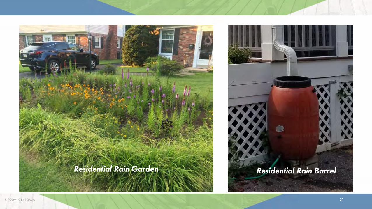
BI0909191410MIA
Rain BarrelResidential Rain Garden Residential Rain Barrel
21

BI0909191410MIA
Floating wetland islands in Florida and similar settings
22

BI0909191410MIA
WHERE CAN BGSI BE USED?• In a variety of locations:
– Roads
– Parks and other open spaces
– Schools/public facilities
– On rooftops
– Residential and commercial properties
• Miami Beach is approximately 40% impervious area
• Goal is to preserve and increase pervious (“green”) area
Roads
23

BI0909191410MIA
Street Ends
24
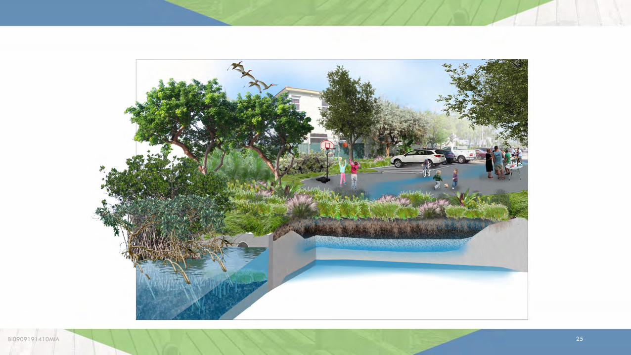
BI0909191410MIA
Parks
25

BI0909191410MIA
WHERE IS THE CITY PLANNING TO IMPLEMENT BGSI?• Roads, parks/open spaces, public
facilities; integrated with other planned improvements
• City projects with BGSI under design:– Community Park (former Par 3)
– Maurice Gibbs Park
– 59th Street Bioswale
– 1st Street Stormwater Improvements
• Preliminary concepts for:– Residential and commercial streets
– Neighborhood parks
– Golf Courses
– Collins Canal
• There is an opportunity to make policy/code changes to further encourage/require private BGSI implementation
26

BI0909191410MIA
Note: all concepts are preliminary and subject to change during budgeting, design, permitting, etc.
RENDERING OF PAR 3 COMMUNITY PARK POND COURTESY OF SAVINO MILLER
27

BI0909191410MIA
COLLINS CANAL
28

BI0909191410MIA
COMMERCIAL STREET
29

BI0909191410MIA
RESIDENTIAL STREET
30

BI0909191410MIA
NEIGHBORHOOD PARK
31
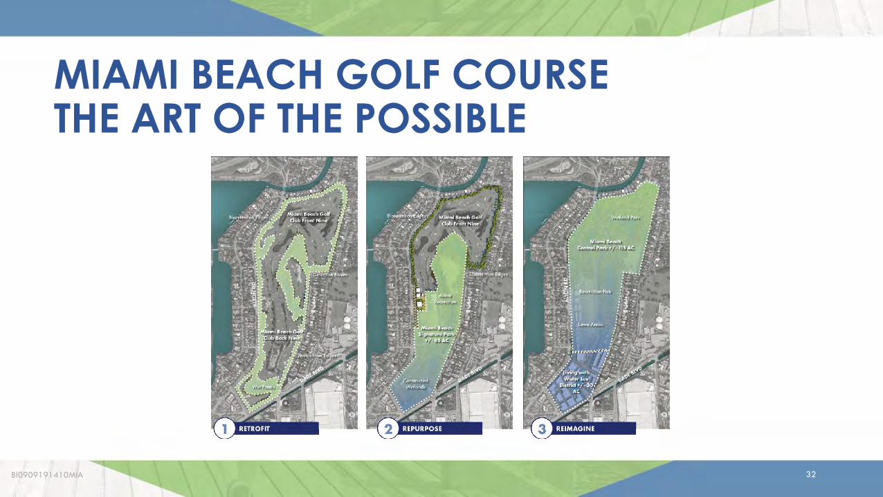
BI0909191410MIA
MIAMI BEACH GOLF COURSETHE ART OF THE POSSIBLE
32

BI0909191410MIA
MIAMI BEACH GOLF COURSEThe Art of the Possible
Scenario 1 – Retrofit
• Bioswales
• Detention Basins
• Wet Ponds
• Permeable Pavement
• Rainwater Harvesting
• 18 Holes of Golf
33

BI0909191410MIA
MIAMI BEACH GOLF COURSEThe Art of the PossibleScenario 2 – Repurpose• Bioretention Edges• Detention Basin• “Green” Recreation
Center• Wet Ponds• Constructed Wetlands• 9 Holes of Golf
34

BI0909191410MIA
MIAMI BEACH GOLF COURSEThe Art of the PossibleScenario 3 – Reimagine• Wetland Park• “Green” Edges• “Green” Recreation
Hub• Living Machine
Gardens• “Living with Water”
Eco-District
35
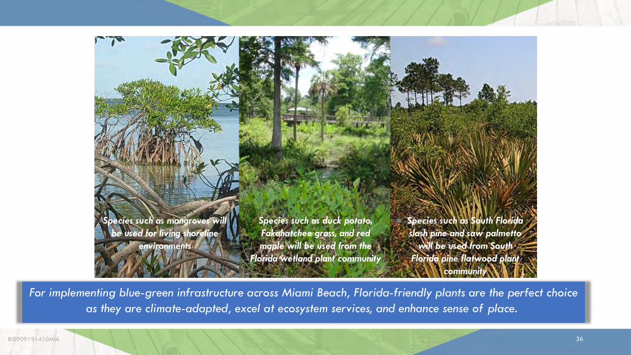
BI0909191410MIA
For implementing blue-green infrastructure across Miami Beach, Florida-friendly plants are the perfect choice as they are climate-adapted, excel at ecosystem services, and enhance sense of place.
Species such as mangroves will be used for living shoreline
environments
Species such as duck potato, Fakahatchee grass, and red maple will be used from the
Florida wetland plant community
● Species such as South Florida slash pine and saw palmetto
will be used from South Florida pine flatwood plant
community
36

BI0909191410MIA
Note: suggestions are subject to budgetary and other constraints.
37

BI0909191410MIA
WILL BGSI REDUCE PARKING?• Parking will be evaluated and discussed with
stakeholders on a project-by-project basis
• BGSI is often strategically located in areas where parking is already not permitted to minimize impacts
38

BI0909191410MIA
• Some BGSI may reduce parking along streets and in parking lots if vegetated BGSI is used
• In most cases there are options that do not reduce parking
39

BI0909191410MIA
WILL BGSI PROMOTE MOSQUITO BREEDING?• No, if properly designed, constructed, and
maintained
• BGSI that is typically dry should empty within 3 days, and should be checked frequently
• BSGI that holds water over 7 days must use other methods to prevent mosquito growth
– Screening
– Natural predator populations
– Mosquito-specific larvicides
Note: Appropriate precautions against mosquitoes should be taken whether there are BGSI practices present or not.
40

WHAT CAN THE PUBLIC DO TO PROMOTE BGSI IN MIAMI BEACH? • Advocate for it
• Implement/maintain it on your property: – Roadside swales– Rain barrels– Rain gardens – Trees
• Help protect and maintain public BGSI (once it is constructed) through grassroots adoption programs
• Residents and businesses will be a key partner for BGSIRain Barrel
41BI0909191410MIA

Residential Rain Garden
42BI0909191410MIA

Existing Grass Swales and Trees in Neighborhoods are Important to Stormwater Management
43BI0909191410MIA

BI0909191410MIA
WHAT ARE THE NEXT STEPS?• Compile and incorporate public input
• Additional opportunities for input:– Public comment period (9/17 - 9/24)
– Sustainability & Resiliency Committee (9/25)
– Commission meeting (10/16)
– Future neighborhood meetings for specific projects
– Grassroots efforts neighborhood by neighborhood
– Website updates - www.MBrisingAbove.com
Questions on BGSI? Please contact:Monica R. DiazInfinite Source Communications Group305-573-0089E-mail: [email protected]
Questions on Citywide Stormwater Management? Please contact:Liz Bello-MatthewsPublic Information Officer – Public Works Department305-673-7000 ext. 6902E-mail: [email protected]
44
RESILIENCE CONVERSATION SERIES: BLUE-GREEN INFRASTRUCTURESeptember 17, 2019
45BI0909191410MIA

BI0909191410MIA
ADDITIONAL SLIDES FOR Q&A
46

BI0909191410MIA
Source: Groundwater Elevation Monitoring and Mapping (E Sciences, 2014)
SHALLOW GROUNDWATER ELEVATIONS MAY LIMIT USE OF SOME BGSI PRACTICES
47

BI0909191410MIA
OUTLINE OF BGSI CONCEPT PLAN• Introduction (Objectives, User’s Guide)• Miami Beach Context (land use, hydrology,
topography, etc.)• Blue-Green Infrastructure Practices and Strategies
– 1-page Fact Sheets of Practices– 2-page Fact Sheets of Strategies/Scenarios
• Site Concepts and Renderings• RecommendationsMeant for a Wide Range of UsersIntended to inform Master Planning, CIP Planning, Design Criteria Packages (DCPs), New Development and Other Policies
48

BI0909191410MIA
Residential Rain Garden
49

BI0909191410MIA
Garden Apartments
50

BI0909191410MIA
ADDITIONAL BGSI FAQs• How does BGSI get maintained?
• Will BGSI reduce recreational space?
• Where can I find more information on BGSI?
• How much will BGSI cost?
• What other City projects might incorporate BGSI?
51

BI0909191410MIA
HOW DOES BGSI GET MAINTAINED?• BGSI practices require a variety of
maintenance activities depending on the type of BGSI and site-specific factors
• Landscaped BGSI require maintenance typical of other landscaped areas, potentially including trash removal, pruning, weeding, and erosion repair
• Many BGSI practices include devices for pretreatment of runoff that require periodic sediment and debris removal
• Permeable pavements require the surface to be cleaned to prevent clogging
52

BI0909191410MIA
WILL BGSI REDUCE RECREATIONAL SPACE?
• Locations for BGSI in parks and other open spaces will be carefully considered to minimize impacts to the usage of the sites
• In many cases, BGSI may serve both recreational and stormwater purposes (for example, a permeable pavement basketball or tennis court)
• BGSI can also enhance recreational spaces by providing additional landscape features Freedom Park, Naples, FL
53

BI0909191410MIA
HOW MUCH WILL BGSI COST? • BGSI is about value• Specific BGSI project costs will be determined in future phases • Costs vary greatly based on practice type, site conditions, sizing, type of site, etc.• BGSI is less expensive when part of development/redevelopment vs. retrofitted in later• Potential cost reduction strategies include:
– Integrate with other infrastructure projects/planned improvements– Standardize designs and streamline implementation– Seek economies of scale through Practices that hold a greater volume or manage larger drainage areas By bundling projects Through neighborhood-scale projects
54

BI0909191410MIA
ADDITIONAL INFORMATION
Note that the City and Jacobs are not specifically endorsing all of the information provided in these sources but is providing them for general information to be used with discretion.
Resource Source/LocationRising Above web site http://www.mbrisingabove.com/climate-adaptation/Best Management Practices for South Florida Urban Stormwater Management Systems
https://www.sfwmd.gov/sites/default/files/documents/bmp_manual.pdf
Florida Field Guide to Low Impact Development: Bioretention Basins/Rain Gardens
http://buildgreen.ufl.edu/Fact_sheet_Bioretention_Basins_Rain_Gardens.pdf
Florida Field Guide to Low Impact Development: Green Roofs/Eco-roofs http://www.buildgreen.ufl.edu/Fact_sheet_Green_Roofs_Eco_roofs.pdf
Florida Department of Transportation Drainage Design Guide (Injection Wells covered in Chapter 7)
https://fdotwww.blob.core.windows.net/sitefinity/docs/default-source/roadway/drainage/files/drainagedesignguide.pdf
Sarasota County Low Impact Development Guidance Document https://www.scgov.net/home/showdocument?id=33258
University of Florida Soil and Water Sciences Video Topics: Green Stormwater Infrastructure
https://soils.ifas.ufl.edu/extension/videos/low-impact-development/
Constructed Floating Wetlands: A review of research, design, operation and management aspects, and data meta-analysis
https://apirs.plants.ifas.ufl.edu/site/assets/files/372369/372369.pdf
55

BI0909191410MIA
POTENTIAL BGSI (INTEGRATED W/ PLANNED CITY PROJECTS)
56

BI0909191410MIA
ADDITIONAL POTENTIAL BGSI (INTEGRATED W/PLANNED TRANSPORTATION IMPROVEMENTS AND TRIANGULAR OPEN SPACES)
57

Tell us what you think of the draft concept for...
WELCOME TO THE CITY OF MIAMI BEACH’S RESILIENCE CONVERSATION SERIES ON
BLUE GREEN INFRASTRUCTURE
130 min.
Join us for a presentation to discuss the proposed approach to blue green infrastructure and the potential co-benefits for recreation and social spaces.
Did you know Miami Beach is implementing creative infrastructure techniques to mitigate flooding and improve our water quality as part of our Integrated Water Management Strategy?
Tonight, you’ll get a sneak peek at the overall approach and draft concepts for specific projects.
Following the presentation there are displays of proposed concepts that could help our city live with water, including:
Share your thoughts by voting with dot stickers and writing your comments on the boards.
30 min.
2 Typical interventions that will be
recommended in the City’s upcoming Blue Green Infrastructure
Concept Plan
Alternative conceptual designs for transformative,
city-scale, blue green infrastructure projects.
Small interventions that will be employed throughout the city,
often on private property
These major projects are high-impact interventions, generally on public property
+
MIAMIBEACH
RISINGABOVE
MIAMIBEACH
MIAMIBEACH
RISINGABOVE

Spartina bakeriiSand Cord Grass
Crinum americanumSwamp Lily
Tripsacum dactyloidesFakahatchee Grass
Tripsacum floridanumFlorida Gamagrass
Muhlenbergia capillarisMuhly Grass
Conoclinium coelestinumBlue Mistflower
Sagittaria latifoliaArrowhead
Eleocharis cellulosaSpikerush
Stachytarpheta jamaicensisBlue Porterweed
Iris virginicaBlue Flag Iris
Eleocharis interstinctaKnotted Spikerush
Sagittaria lancifoliaDuck Potato
Nymphaea odorataFragrant Water Lily
Canna flaccidaGolden Canna
Taxodium ascendansPond Cypress
Ilex cassineDahoon Holly
Coccothrinax argentataSilver Palm
Thrinax morrisiiKey Thatch Palm
Quercus virginianaLive oak
Lysiloma latisiliquum Wild Tamarind
Erythrina herbaceaCoralbean
Pontederia cordataPickerelweed
Serenoa repensSaw Palmetto
Heliotropium angiospermumScorpion Tail
FLORIDA-FRIENDLY PLANTS FOR CONSTRUCTED WETLANDS
FLORIDA-FRIENDLY PLANTS FOR BIORETENTION + BIOSWALE APPLICATIONS
BLUE GREEN INFRASTRUCTURE PILOT PROJECT CONCEPT
MIAMIBEACH
RISINGABOVE
STR
ATE
GIC
VA
LUE
BGI PLANT MATRIXSouth Florida is home to a diverse and vibrant tapestry of plant communities and ecosystems. For implementing blue green infrastructure across Miami Beach, Florida-friendly plants are the perfect choice as they are climate adapted, excel at ecosystem services and enhance sense of place. The list below is a summary of species that may be used in the BGI program.

Spartina patensSalt Marsh Cord Grass
Coccoloba uviferaSea Grape
Avicennia germinansBlack Mangrove
Languncularia racemosaWhite Mangrove
Rhizophora mangleRed Mangrove
Borrichia arborescensSea Ox-Eye
Acer rubrumRed Maple
Helianthus debilis Beach Sunflower
Codia sebestenaGeiger Tree
Heliotropium currasavicumSeaside Heliotrope
Quercus laurifoliaLaurel Oak
Portulaca pilosaHairy Portaluca
Conocarpus erectus Green Buttonwood
Swietenia mahagoniAmerican Mahogany
Salicornia bigeloviiGlasswort
Juncus roemerianusBlack Rush
Amphitecna latifoliaBlack Calabash
Bursera simarubaGumbo Limbo Tree
Conocarpus erectus var. sericeusSilver Buttonwood
Strumphia maritimaStrumpfia
Coccoloba diversifoliaPigeon plum
Krugiodendron ferreumBlack Ironwood
Pinus elliottii var. densaSouth Florida Slash Pine
Ocotea coriacea Lancewood
FLORIDA-FRIENDLY TREES FOR URBAN CANOPY RESTORATION
FLORIDA-FRIENDLY PLANTS FOR CONSTRUCTED SALT MARSHES AND MANGROVES
BLUE GREEN INFRASTRUCTURE PILOT PROJECT CONCEPT
MIAMIBEACH
RISINGABOVE
STR
ATE
GIC
VA
LUE
BGI PLANT MATRIXSouth Florida is home to a diverse and vibrant tapestry of plant communities and ecosystems. For implementing blue green infrastructure across Miami Beach, Florida-friendly plants are the perfect choice as they are climate adapted, excel at ecosystem services and enhance sense of place. The list below is a summary of species that may be used in the BGI program.

FLOATING WETLANDS
FOR
WATER
QUALITYMANGROVE
PLANTINGS
MANAGED AQUATIC PLANT SYSTEMS
PASSIVE RECREATION
NEIGHBORHOOD ACCESS
FLOATING BOARDWALK
FLORIDA- FRIENDLY
STREET TREES
NEIGHBORHOOD LANDING PARK
BIKE & PEDESTRIAN LANES
OLD ROADWAYELEVATION
SUBSURFACE INFILTRATION TRENCH
SUBSURFACE INFILTRATION WITH SUSPENDED PAVEMENT FOR TREE GROWTH
OVER FLOW THROUGH BULKHEAD WALL BEFORE AND BEYOND LANDINGS
WATER MANAGEMENT BENEFITS Capture of roadway runoff helps to reduce peak flows (during high
frequency events)
Treatment of roadway runoff reduces hydrocarbons and heavy
metal pollution
Treatment uptakes nitrogen and phosphorus, reducing likelihood of
algae blooms
ADDITIONAL BENEFITS+Walking and biking
pathsWaterfront SeatingNeighborhood
BeautificationKayak drop-in
points
COLLINS CANAL
ATLANTIC OCEAN
BISCAYNE BAY
BLUE GREEN INFRASTRUCTURE PILOT PROJECT CONCEPT
MIAMIBEACH
RISINGABOVE
STR
ATE
GIC
VA
LUE
COLLINS CANAL
HO
W IT
WO
RK
S
1MANAGED AQUATIC PLANT SYSTEMSManaged Aquatic Plant Systems (MAPS) provide habitat, enhance aesthetics, and improve water quality in the canal by reducing common pollutants such as nitrogen, phosphorus, and suspended solids. MAPS will be anchored into the canal bottom, allowing them to rise during flood/high-tide conditions and remain functional and resilient.
2ENHANCED TREE PITS/TRENCHESFilters and stores stormwater flows to improve water quality prior to discharging into the canal, while providing significant rooting volume for street trees
3PERMEABLE PAVEMENTStormwater from Dade Boulevard will flow onto bike and pedestrian lanes constructed of permeable pavement, which looks similar to standard pavement but allows water to drain through its openings and into an underlying infiltration / storage trench. Permeable pavement will reduce the amount of stormwater flowing into the canal.
The Collins Canal is an existing, man-made channel that runs parallel to Dade Boulevard, connecting Indian Creek to Biscayne Bay. By adding constructed wetlands, enhanced tree pits and trenches, and permeable pavement to its design, we can increase the amount of water that is absorbed and treated.
TODAY
ENHANCED

PROTECTION OF EXISTING CANOPY TREES
TRAFFIC CHICANES WITH BIORETENTION
MODIFIED VALLEY CURBS TO CONVEY STORMWATER TO GREEN INFRASTRUCTURE
TRENCH DRAINS
INFILTRATION
DELINEATED ON-STREET PARKING WITH PERMEABLE
PAVEMENT
BIOFILTRATION
STORAGE
INFILTRATION
INCREASED CANOPY TO MITIGATE HEAT ISLAND
EFFECT
WATER MANAGEMENT BENEFITS Capture of roadway runoff helps to reduce peak flows (during high
frequency events)
Treatment of roadway runoff reduces hydrocarbons and heavy
metal pollution
Treatment and infiltration of stormwater to recharge groundwater
supplies and replenish freshwater lens
ADDITIONAL BENEFITS+Additional shade for walking and biking
Increased biodiversity
Neighborhood beautification
Reduced heat island effect
Traffic calming
BLUE GREEN INFRASTRUCTURE PILOT PROJECT CONCEPT
MIAMIBEACH
RISINGABOVE
STR
ATE
GIC
VA
LUE
RESIDENTIAL STREET
OVERFLOWS TO STORM SEWER
STORAGE
DEEP ROOTING FLORIDA-FRIENDLY VEGETATION TO FILTER
STORMWATER AND MAINTAIN CLEAR SIGHT LINES FOR ROADWAY
USERS
In Miami Beach residential streets vary in whether they include on-street parking, curbs, sidewalks, and other improvements, while often accommodating numerous driveways, alleys, and roadway intersections. Permeable pavement, enhanced tree pits, traffic chicanes, and other drainage features such as trench drains can be incorporated within varying residential roadway conditions to improve water quality, calm traffic, and reduce flows to private property.
HO
W IT
WO
RK
S
1PERMEABLE PAVEMENT / DELINEATED ON-STREET PARKINGStormwater will discharge in defined permeable pavement parking areas. Permeable pavement looks like standard pavement but allows water to drain into an underlying infiltration trench. Permeable pavement will reduce stormwater flowing into private property, minimize soil compaction from parked vehicles on lawns, recharge groundwater, and filter stormwater.
2ENHANCED TREE PITS/TRAFFIC CHICANESEnhanced tree pits located in traffic chicanes will provide shade for residents, reduce traffic speeds on local roads, reduce stormwater discharges, and improve water quality. Enhanced tree pits will also provide significant rooting volume for trees and a diverse understory to contribute to a healthier native South Florida ecosystem.
3TRENCH DRAINSTrench drains are depressed linear troughs which manage stormwater flows within the public roadway and allow stormwater to drain through into an underlying infiltration trench. Along with valley curbs, enhanced tree pits, and permeable pavement, trench drains can maintain stormwater flows within a raised public roadway and out of private property.
TODAYENHANCED

ENHANCED TREE PITS
ENHANCED TREE PITS
DOWNSPOUT DISCONNECT
GREEN ROOF
WATER MANAGEMENT BENEFITS Capture of roadway runoff helps to reduce peak flows (during high
frequency events)
Treatment of roadway runoff reduces hydrocarbons and heavy
metal pollution
Treatment and infiltration of stormwater to recharge groundwater supplies and replenish the freshwater
lens
ADDITIONAL BENEFITS +Increased walking and
biking opportunitiesTraffic calmingNeighborhood
BeautificationImproved sidewalk
seating opportunities
BLUE GREEN INFRASTRUCTURE PILOT PROJECT CONCEPT
MIAMIBEACH
RISINGABOVE
STR
ATE
GIC
VA
LUE
COMMERCIAL STREET
1PERMEABLE PAVEMENTStormwater will discharge in defined permeable pavement parking areas. Permeable pavement looks like standard pavement but allows water to drain into an underlying infiltration trench. Permeable pavement will reduce stormwater flowing into private property, minimize soil compaction from parked vehicles on lawns, recharge groundwater, and filter stormwater.
HO
W IT
WO
RK
S
2ENHANCED TREE PITS/BUMP-OUTSEnhanced tree pits located in bump-outs will provide increased shade for residents, reduce traffic speeds on local roads, reduce stormwater discharges, and improve water quality. Enhanced tree pits will also provide significant rooting volume for trees and a diverse understory to contribute to a healthier native South Florida ecosystem.
3BALANCED ON-STREET PARKING On-street parking will serve various modes of transportation and beenhanced with bump-outs and sidewalks accommodating lush plants to mitigate elevated surface temperatures, manage stormwater, enhance walkability, and improve aesthetics for neighborhood.
4GREEN ROOFSGreen Roofs accept stormwater to filter and absorb flows, as well as cool urban heat islands and provide habitat
Commercial streets often accommodate on-street parking, curbs, and sidewalks serving varying land uses. Lessened driveway conflicts within these corridors provide opportunities for longer segments of permeable pavement, trees, infiltration and storage trenches to improve water quality.
TODAY ENHANCED
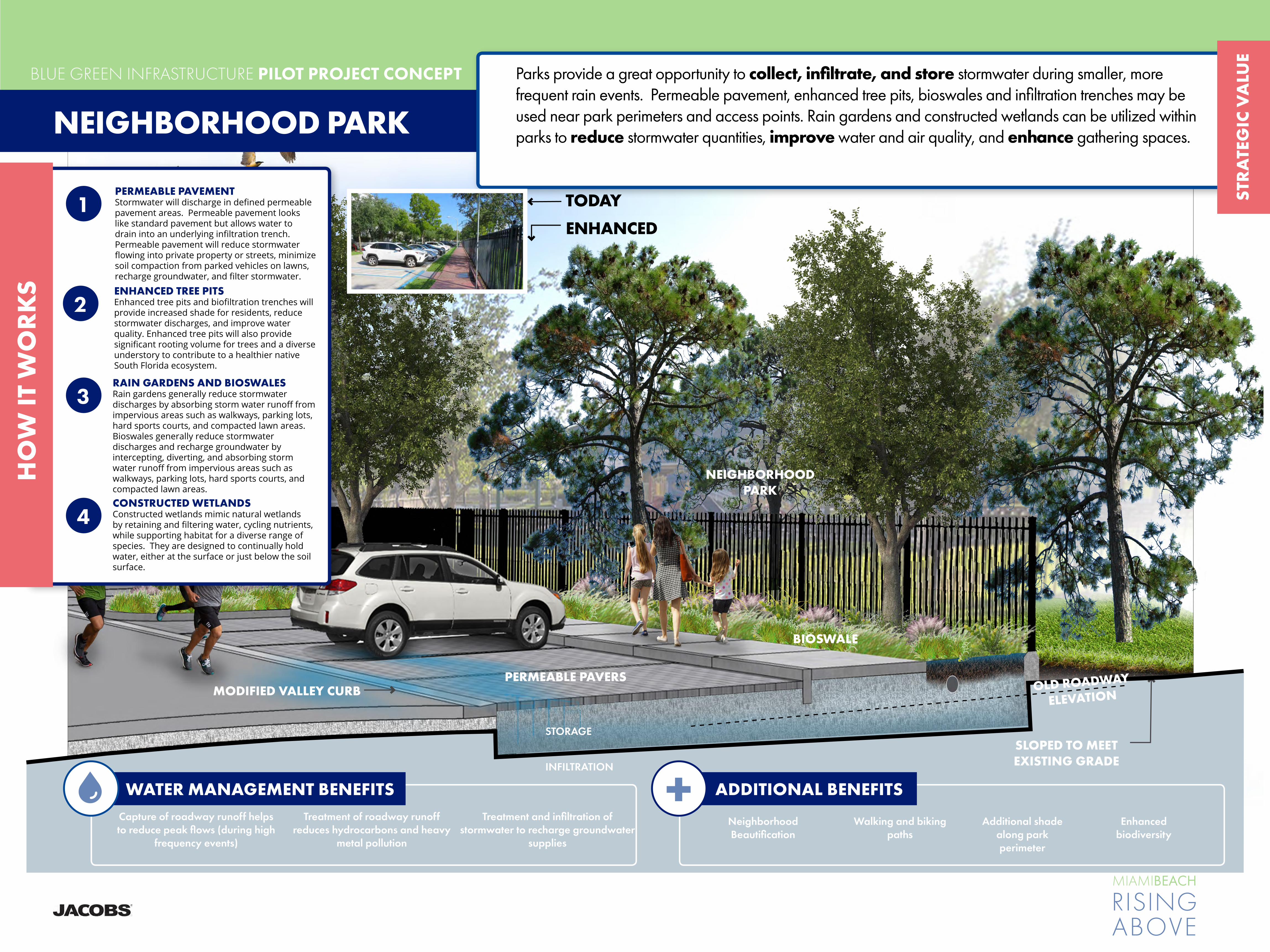
PERMEABLE PAVERS
BIOSWALE
MODIFIED VALLEY CURB
STORAGE
INFILTRATION
SLOPED TO MEET EXISTING GRADE
NEIGHBORHOOD PARK
4
WATER MANAGEMENT BENEFITS Capture of roadway runoff helps to reduce peak flows (during high
frequency events)
Treatment of roadway runoff reduces hydrocarbons and heavy
metal pollution
Treatment and infiltration of stormwater to recharge groundwater
supplies
ADDITIONAL BENEFITS +Walking and biking
pathsAdditional shade
along park perimeter
Neighborhood Beautification
Enhanced biodiversity
BLUE GREEN INFRASTRUCTURE PILOT PROJECT CONCEPT
MIAMIBEACH
RISINGABOVE
STR
ATE
GIC
VA
LUE
NEIGHBORHOOD PARK
OLD ROADWAY
ELEVATION
HO
W IT
WO
RK
S
Parks provide a great opportunity to collect, infiltrate, and store stormwater during smaller, more frequent rain events. Permeable pavement, enhanced tree pits, bioswales and infiltration trenches may be used near park perimeters and access points. Rain gardens and constructed wetlands can be utilized within parks to reduce stormwater quantities, improve water and air quality, and enhance gathering spaces.
1PERMEABLE PAVEMENTStormwater will discharge in defined permeable pavement areas. Permeable pavement looks like standard pavement but allows water to drain into an underlying infiltration trench. Permeable pavement will reduce stormwater flowing into private property or streets, minimize soil compaction from parked vehicles on lawns, recharge groundwater, and filter stormwater.
2ENHANCED TREE PITSEnhanced tree pits and biofiltration trenches will provide increased shade for residents, reduce stormwater discharges, and improve water quality. Enhanced tree pits will also provide significant rooting volume for trees and a diverse understory to contribute to a healthier native South Florida ecosystem.
3RAIN GARDENS AND BIOSWALESRain gardens generally reduce stormwater discharges by absorbing storm water runoff from impervious areas such as walkways, parking lots, hard sports courts, and compacted lawn areas.Bioswales generally reduce stormwater discharges and recharge groundwater by intercepting, diverting, and absorbing storm water runoff from impervious areas such as walkways, parking lots, hard sports courts, and compacted lawn areas.
4CONSTRUCTED WETLANDSConstructed wetlands mimic natural wetlands by retaining and filtering water, cycling nutrients, while supporting habitat for a diverse range of species. They are designed to continually hold water, either at the surface or just below the soil surface.
TODAY
ENHANCED

RETROFIT1 REPURPOSE2 REIMAGINE3
Miami BeachSignature Park
+/- 65 AC
Miami Beach Golf Club Front Nine
Living with Water Eco
District +/- 30 AC
Constructed Wetlands
Active Recreation
Miami Beach Golf Club Back Nine
Wet Ponds
Detention Basins
Bioretention EdgesMiami Beach Golf
Club Front Nine
Miami BeachCentral Park +/- 115 AC
Lawn Areas
Wetland Park
Bioretention Edges
Bioretention Edges
Bioretention Edges
DADE BLVD
ALT
ON
RD
ALT
ON
RD
DADE BLVD
COLLINS CANAL
COLLINS CANAL
COLLINS CANAL
DADE BLVD
Recreation Hub
BLUE GREEN INFRASTRUCTURE PILOT PROJECT CONCEPT
MIAMIBEACH
RISINGABOVE
STR
ATE
GIC
VA
LUE
MIAMI BEACH GOLF CLUBThe Art of the Possible - below are three high-level scenarios exploring the redevelopment of the Miami Beach Golf Club into a blue green infrastructure asset: 1) a retrofit scenario - keeping all eighteen holes; 2) a repurpose scenario - converting the back nine holes into a signature park; and 3) a reimagine scenario - converting the club into a central park with potential development opportunities.
ALT
ON
RD

RETROFIT1
Miami Beach Golf Club Front Nine
Miami Beach Golf Club Back Nine
Wet Ponds
Detention Basins
Detention Basins
Permeable Pavement
Rainwater Harvesting
Bioretention Edges
Bioswales
Bioswales
ALT
ON
RD
DADE BLVD
SUNSET HARBOR
COLLINS CANAL
Bioretention Edges
Permeable Pavement
Detention Basin
Rainwater Harvesting
Wet Ponds
BLUE GREEN INFRASTRUCTURE PILOT PROJECT CONCEPT
MIAMIBEACH
RISINGABOVE
STR
ATE
GIC
VA
LUE
MIAMI BEACH GOLF CLUBScenario 1 retrofits the Miami Beach Golf Club with tactical blue green infrastructure interventions to reduce stormwater volumes and improve water quality. The existing water hazards and edges of the golf club would be enhanced and redesigned with blue green practices. All eighteen holes and golf facilities would be maintained more or less as they are today.
and
1GOLF CLUB REMAINS INTACTThe existing eighteen hole golf course remains largely intact and functioning much the same as it does today.
2RETROFIT THE WATER HAZARDSThe water hazards and out of bounds areas are redesigned to include BGI interventions such as stormwater detention, wet ponds and bioswales.
3TRANSFORM THE EDGES TO BGIThe edges of the golf club will be redesigned to include bioretention zones, pervious pavement and facilities may be retrofitted to include rainwater harvesting features.
4CONNECT TO DISTRICT SYSTEMSThe increased stormwater capacity and water quality treatment facilities may allow for networking the interventions to other BGI projects, such as Collins Canal.
HO
W IT
WO
RK
S

REPURPOSE2
Wetland Park+/- 65 AC
Ball Fields
Miami Beach Golf Club Front Nine
Recreation Center
Wetland Boardwalks
Wet Ponds
Constructed Wetlands
Detention Basins
Bioretention Edges
ALT
ON
RD
DADE BLVD
SUNSET HARBOR
COLLINS CANAL
Bioretention Edges
“Green” Recreation Center
Detention Basin
Constructed Wetlands
Wet Ponds
BLUE GREEN INFRASTRUCTURE PILOT PROJECT CONCEPT
MIAMIBEACH
RISINGABOVE
STR
ATE
GIC
VA
LUE
MIAMI BEACH GOLF CLUBScenario 2 repurposes the back nine holes of the Miami Beach Golf Club to create a new signature park focused on integrating passive and active recreation with a robust blue green infrastructure program to mitigate stormwater volumes and improve water quality. In this high-level concept the front nine holes of the Golf Club remain intact as an executive course.
1GOLF CLUB FRONT NINE STAYS AS-ISThe land area of the front nine of the golf club is kept intact and reconfigured as necessary for an executive course.
2REPURPOSE THE BACK NINEConsider repurposing the 65 acres comprising the back nine to accommodate BGI interventions and the potential for a substantial open space improvement.
3CREATE A SIGNATURE PARK SPACERepurposing the back nine into a signature modern park space. A park which balances environmental, social and economic considerations and provides a framework for district-wide resiliency.
4LINK BGI SYSTEMS IN PARK TO THE NEIGHBORHOODStormwater storage and water quality measures may be designed to accept and integrate with adjacent BGI improvements, such as Collins Canal.
HO
W IT
WO
RK
S

Living with Water Eco District +/- 30 AC
Miami BeachCentral Park +/- 115 AC
Neighborhood Lawn
Recreation Hub
Living Machine Gardens
Wetland Boardwalks
Wet Ponds
Constructed WetlandsBioretention Edges
ALT
ON
RD
DADE BLVD
SUNSET HARBOR
REIMAGINE3COLLINS CANAL
“Living with Water” Eco-District
Wetland Park
“Green” Recreation Hub
“Green” Edges
Living MachineGardens
BLUE GREEN INFRASTRUCTURE PILOT PROJECT CONCEPT
MIAMIBEACH
RISINGABOVE
STR
ATE
GIC
VA
LUE
2MIAMI BEACH’S CENTRAL PARKReimagining the golf club as a new central park for Miami Beach. A 21st century open space working to bring people together while improving the city’s resiliency.
3A POSTCARD DESTINATIONThe potential is to create a new postcard moment for Miami Beach - one that advertises its proactive approach to mitigating climate change impacts and understanding urban placemaking.
4LIVING WITH WATER Additional potential opportunities may include leveraging a portion of the land for public and private development, such as a mixed-use eco-district working to fulfill the City’s objectives on sustainability, social equity and environmental justice.
HO
W IT
WO
RK
S
MIAMI BEACH GOLF CLUBScenario 3 reimagines the entire Miami Beach Golf Club to establish a 21st century “Central Park” for Miami Beach. This initial concept sketch explores the potential of a new neighborhood predicated on a Living with Water theme, a recreation hub, and a signature wetland park with hiking and biking trails and passive and active recreation opportunities.
1REIMAGINE ALL 145 ACRESThe entire publicly-owned golf club may be transformed into an amenity for all Miami Beach residents. One that responds to a holistic view of sustainability.

BLUE GREEN INFRASTRUCTURE PILOT PROJECT CONCEPT
MIAMIBEACH
RISINGABOVE
STR
ATE
GIC
VA
LUE
GARDEN APARTMENTS
Garden apartments as well as other private properties can be important partners in augmenting a comprehensive blue-green infrastructure system in Miami Beach. Property owners can make a difference citywide taking simple steps such as incorporating downspout disconnections, rain barrels, and tree plantings on their properties. Other BGSI BMPs such as permable pavement for parking spaces, rain gardens, green roofs, and enhanced tree pits can be used to manage stormwater on private property.
HO
W IT
WO
RK
S
GREEN & BLUE ROOFS
FLORIDA FRIENDLY VEGETATION
RAIN GARDENS
DOWNSPOUT DISCONNECTS
ENHANCED TREE PITS
PERMEABLEPARKING
PAVEMENT
ENHANCED TREE PITS
WATER MANAGEMENT BENEFITS Capture of driveway and roof runoff helps to reduce peak flows (during
high frequency events)
Treatment of residential runoff reduces sediment transfer, as well
as fertilizer, pesticides, bacteria, and hydrocarbon pollution
Treatment uptakes nitrogen and phosphorus reducing
likelihood of algae blooms
ADDITIONAL BENEFITS +Reduction in urban heat
island effect / cooler ambient temperatures
Enhanced biodiversity and
habitat
Neighborhood Beautification
Increased shade from
trees plantings
1PERMEABLE PAVEMENTStormwater will discharge in defined permeable pavement parking areas. Permeable pavement looks like standard pavement but allows water to drain into an underlying infiltration trench. Permeable pavement can manage and filter stormwater, minimize soil compaction from parked vehicles on lawns and recharge groundwater.
2ENHANCED TREE PITSEnhanced tree pits and biofiltration trenches will provide increased shade for residents, reduce stormwater discharges, and improve water quality. Enhanced tree pits will also provide significant rooting volume for trees and a diverse understory to contribute to a healthier native South Florida ecosystem.
3RAIN GARDENSRain gardens generally reduce stormwater discharges by absorbing stormwater runoff from impervious areas such as walkways, parking lots, hard sports courts, and compacted lawn areas.
4GREEN & BLUE ROOFSGreen Roofs filter and absorb stormwater flows, as well as cool urban heat islands and provide habitat. Blue roofs can be used in conjuction with green roofs to store water volumes on building roofs when the structure allows.
5DOWNSPOUT DISCONNECTSDownspout disconnects take roofwater that would otherwise enter the storm sewer and route it into cisterns/rainbarrels for storage and/or stormwater BMPs for treatment.
TODAYENHANCED

CONSTRUCTED WETLANDSVolupita venimus voluptat aut et ut es nulloreicisit, untiusa perciet rem fuga. Nequo maio
BLUE GREEN INFRASTRUCTURE PILOT PROJECT CONCEPT
MIAMIBEACH
RISINGABOVE
STR
ATE
GIC
VA
LUE
STREET ENDSOften located at waterfront locations, street ends provide opportunities to incorporate BGSI which absorb and filter stormwater prior to discharging into canals, the Biscayne Bay, and the ocean, while incorporating and enhancing habitat for land and aquatic species, and providing flexible parking and play spaces for residents.
4LIVING SHORELINE Improves water and soil quality in water bodies, reduces wave action during severe storms, and provides habitat for wildlife
HO
W IT
WO
RK
S
WATER MANAGEMENT BENEFITS Capture of roadway runoff helps to reduce peak flows (during high
frequency events)
Treatment of roadway runoff reduces hydrocarbons and heavy
metal pollution
Treatment uptakes nitrogen and phosphorus reducing likelihood of
algae blooms
ADDITIONAL BENEFITS +Walking and biking
pathsWaterfront SeatingNeighborhood
BeautificationKayak drop in
points
TODAY
ENHANCEDRAIN GARDENSRain gardens generally reduce stormwater discharges by absorbing storm water runoff from impervious areas such as walkways, parking lots, hard sports courts, and compacted lawn areas.
1
2ENHANCED TREE PITSEnhanced tree pits and biofiltration trenches will provide increased shade for residents, reduce stormwater discharges, and improve water quality. Enhanced tree pits will also provide significant rooting volume for trees and a diverse understory to contribute to a healthier native South Florida ecosystem.
3ENHANCED TREE PITSEnhanced tree pits and biofiltration trenches will provide increased shade for residents, reduce stormwater discharges, and improve water quality. Enhanced tree pits will also provide significant rooting volume for trees and a diverse understory to contribute to a healthier native South Florida ecosystem.
FLORIDA FRIENDLY VEGETATION
RAIN GARDENS
BIOSWALE
LIVING SHORELINEBIOFILTRATION
STORAGE
INFILTRATION
FRESHWATER LENSFILTERED STORMWATER
OVERFLOWS INTO NATURAL WATER BODIES
PERMEABLE PAVEMENT

Miami Beach Integrated Water Management
Blue-Green Stormwater Infrastructure
Frequently Asked Questions
Document Version 3
City of Miami Beach

Blue-Green Stormwater Infrastructure Frequently Asked Questions
BI0822190828MIA i
Contents
What is blue-green stormwater infrastructure? ....................................................................................... 1 Why should we use BGSI? ......................................................................................................................... 1 What are the water quality benefits of BGSI? .......................................................................................... 1 How will BGSI fit into the city’s flood mitigation strategies? ................................................................. 2 What community benefits can BGSI potentially provide? ...................................................................... 2 What BGSI practices are most applicable to Miami Beach? .................................................................. 3 What BGSI practices are less applicable to Miami Beach? .................................................................... 3 What does BGSI look like?......................................................................................................................... 4 Where can BGSI be used? ......................................................................................................................... 4 Where is the City planning to implement BGSI? ..................................................................................... 6 How will BGSI function with rising sea levels and shallow groundwater? ........................................... 6 How does BGSI get maintained? ............................................................................................................... 6 Who will do the maintenance for BGSI? ................................................................................................... 6 Will BGSI promote mosquito breeding and the spread of disease? ..................................................... 6 Will BGSI reduce parking? ......................................................................................................................... 7 Will BGSI reduce recreational space? ...................................................................................................... 7 What can the public do to promote BGSI in Miami Beach? ................................................................... 7 Where can I find more information on BGSI? .......................................................................................... 8


Blue-Green Stormwater Infrastructure Frequently Asked Questions
BI0822190828MIA 1
Frequently Asked Questions Concerning Blue-Green Stormwater Infrastructure What is blue-green stormwater infrastructure?
Green stormwater infrastructure typically uses rainwater harvesting, vegetation, and/or soils to treat and reduce stormwater flows. Examples include bioretention (rain gardens) and permeable pavement.
Blue stormwater infrastructure temporarily stores and treats stormwater without significant reliance on vegetation. Examples are wet ponds and detention basins.
Blue-green stormwater infrastructure (BGSI) encompasses both green and blue stormwater infrastructure practices. Phrases like low-impact development techniques, sustainable site design, and stormwater best management practices have also been used to describe BGSI.
BGSI is typically designed and sized to capture the frequent storm events that make up most of the total rainfall in an average year (storms of up to 1.5 or 2 inches of rain). Extreme events that happen less frequently are often associated with flooding and will require larger stormwater infrastructure such as stormwater pump stations and conveyance systems to address them.
The focus of BGSI is the treatment and capture of stormwater runoff, therefore BGSI is different from coastal strategies (for example, living shorelines, dunes, mangrove plantings, and oyster or artificial reefs) that target coastal stressors like wave energy, sea level rise, and storm surges.
Why should we use BGSI?
BGSI can provide a range of both stormwater-related benefits as well as other community benefits. Stormwater benefits can include:
• Water quality improvement (more details under the next frequently asked question [FAQ])
• Groundwater recharge and replenishment of the freshwater lens under Miami Beach, helping to reduce saltwater intrusion and protect soils and tree roots from salt damage
• Some detention and flood mitigation benefits (particularly for thunderstorm-type nuisance flooding, more information follows under the FAQ “How will BGSI fit into the city’s flood mitigation strategies?”)
Other community benefits (also known as “co-benefits”) can include:
• Urban heat island mitigation
• Air quality improvement
• Climate resiliency
• Habitat creation and improvement
• Multiple other community benefits, including job creation, improved urban aesthetics, increased property values, improved pedestrian safety, and enhanced recreational spaces.
More details on the stormwater and community benefits are included in the next three (3) FAQs.
What are the water quality benefits of BGSI?
Protecting water quality for Miami Beach’s beaches and waterways is a priority as they provide habitat, a great quality of life, and opportunities for tourism. Stormwater runoff from urban areas can deliver pollutants—including bacteria/pathogens, nutrients (such as nitrogen and phosphorus), sediment, and

Blue-Green Stormwater Infrastructure Frequently Asked Questions
2 BI0822190828MIA
heavy metals—to waterways and beaches. Where these pollutants are present, BGSI can play an important role in partially removing them from the runoff.
BGSI reduces stormwater discharges by retaining rainfall. Lower discharge volumes translate into reduced pollutant loads. BGSI also treats stormwater that is not retained.1 It should be noted that BGSI can only improve the quality of the water that it receives (that is, the runoff from the drainage area that it serves) and has the capacity to treat. Therefore, extensive BGSI coverage would typically be required to have significant overall pollutant load reductions.
Like all infrastructure, BGSI must be designed, constructed, and maintained to function properly over the long term (for more on maintenance, see the FAQ “How does BGSI get maintained?”).
How will BGSI fit into the city’s flood mitigation strategies?
BGSI can complement “grey” infrastructure such as pipes and pumps. BGSI can provide some detention and flood mitigation benefits (particularly for thunderstorm-type nuisance flooding). Alone, BGSI will provide little or no benefit for “sunny day” flooding resulting from king tides, flooding from major rainfall events, or flooding caused by storm surge from the Atlantic Ocean or Biscayne Bay. BGSI is typically designed for storms of 2 inches or less (for the drainage area it serves), which is approximately 25 percent of the much larger storms typically used to size flood control systems, such as pipes and pumps.
What community benefits can BGSI potentially provide?
BGSI can potentially provide a suite of community benefits, as shown below in the graphic from the U.S. Environmental Protection Agency. The benefits vary significantly depending on the project location and setting, BGSI practice type(s), level of implementation, maintenance practices, etc.
Potential Environmental, Social, Economic, and Public Health Benefits of Green Infrastructure Source: https://www.epa.gov/sites/production/files/2017-11/documents/ greeninfrastructure_healthy_communities_factsheet.pdf
1 U.S. Environmental Protection Agency. Benefits of Green Infrastructure. Accessed August 16, 2019. https://www.epa.gov/green-
infrastructure/benefits-green-infrastructure

Blue-Green Stormwater Infrastructure Frequently Asked Questions
BI0822190828MIA 3
What BGSI practices are most applicable to Miami Beach?
A wide range of BGSI practice types were evaluated based on city/regional/national experience, stormwater performance, ease of implementation/maintenance, community/environmental benefits, cost efficiency, and climate change resilience. The recommended practices were determined to perform well across these areas and have potential applicability in Miami Beach given the local context (soil and groundwater conditions, land uses, development patterns, climate, etc.).
The most applicable BGSI practices are:
• Bioretention/Bioswales/Rain Gardens
• Blue and Green Roofs
• Constructed Wetlands/Floating Wetland Islands
• Detention Basins/Surface Storage
• Enhanced Tree Pits/Trenches
• Injection Wells (Pumped)2
• Permeable Pavement
• Rainwater Harvesting (Cisterns, Rain Barrels)
• Stormwater Planters
• Subsurface Infiltration and Storage
• Tree Canopy3
• Wet Ponds
When and where to use each recommended BGSI practice depends on a variety of site-specific factors, such as land use, location, topography, groundwater elevation, soil conditions, and existing infrastructure.
What BGSI practices are less applicable to Miami Beach?
The following BGSI practices are less applicable to or less effective in Miami Beach due to their reduced water quality benefits, higher costs, lack of scalability, lower effectiveness when dealing with sea level rise and high tides, proprietary designs, limited applicability, or low storage capacities:
• Detention Tanks
• Exfiltration Trenches
• High-Flow Media Filters
• Living/Green Walls
• Gravity Wells
• Subsurface Flow Wetlands
Although not as readily applicable to Miami Beach, the above BGSI practices might still prove beneficial in certain settings.
2 Although not typically thought of as BGSI, injection wells are included here as they reduce the volume of stormwater discharged, and with
proper pretreatment/filtration can provide water quality benefits. 3 Trees are a key component of BGSI, and the City is developing an Urban Forest Master Plan to provide a strategic framework to guide the
City in managing, maintaining, planting, and preserving its urban forest. See www.mbrisingabove.com/climate-mitigation/urban-canopy-2/urban-forestry-master-plan/.

Blue-Green Stormwater Infrastructure Frequently Asked Questions
4 BI0822190828MIA
What does BGSI look like?
BGSI can take many different forms, from landscaping elements such as rain gardens to permeable pavements that can look like normal pavements to wet ponds to blue and green roofs atop buildings. BGSI practices can vary from being dominant, high-profile features to blending in seamlessly with the surroundings. Some example images with established vegetation are provided on the next page (vegetated BGSI, like other landscaping, requires time to get established).
Where can BGSI be used?
BGSI can be used on and along roads, in parks and other open spaces, at schools and other public facilities, on rooftops, and on residential and commercial properties. Approximately 40% of Miami Beach is covered by impervious surfaces (buildings and pavements) that prevent water from percolating into the ground. BGSI should be employed to treat runoff from these impervious surfaces and help preserve, enhance, and increase the City’s remaining pervious or “green” areas.
When choosing where to place BGSI practices, the following factors should be considered:
• Depending on the BGSI practice type, offsets from utilities, buildings, and other structures may be required to protect those features from water damage.
• Factors such as budget, permitting, site conditions, neighborhood preferences, and ownership will influence the location and types of BGSI.
A rendering of bioretention and permeable pavement on a typical residential street in Miami Beach

Blue-Green Stormwater Infrastructure Frequently Asked Questions
BI0822190828MIA 5
Examples of BGSI Applications
Wet Pond Source: Southwest Florida Water Management District
Rain Garden Source: Jacobs
Normal (left) and Porous Asphalt (Right) Source: Jacobs
Infiltration Trench Source: Jacobs
Blue-Green Roof Plaza Source: Jacobs
Green Roof (in foreground) Adjacent to Marina Source: Jacobs
Residential Rain Barrel Source: Jacobs
Residential Rain Garden Source: Jacobs
Floating Wetland Islands Source: Jacobs
Stormwater Planter Source: Jacobs
Permeable Paver Driveway Source: Jacobs
Pervious Concrete Parking Lot Source: Jacobs

Blue-Green Stormwater Infrastructure Frequently Asked Questions
6 BI0822190828MIA
Where is the City planning to implement BGSI?
The City is planning to implement BGSI along roads, in parks and other open spaces, and at public facilities. City projects currently under design with BGSI components include Maurice Gibbs Park, Community Park (former par 3 golf course), 59th Street bioswale, and 1st Street stormwater improve-ments. In addition, preliminary concept renderings have been developed for the following:
• Residential street
• Commercial street
• Neighborhood park
• Miami Beach Golf Course (three scenarios)
• Collins Canal
• Street end (where a street dead ends at a waterbody)
• Garden apartments
There is also an opportunity to make policy and code changes to further encourage and/or require public and private BGSI implementation.
How will BGSI function with rising sea levels and shallow groundwater? Shallow and increasing groundwater elevations in portions of the City limit the soil storage capacity and infiltration required for some BGSI practices to function effectively. However, such limitations might potentially be overcome with underdrains, fill, and/or pumping. Other practices, such as wet ponds and constructed wetlands, can continue to function with shallow groundwater although their storage capacity may be reduced as groundwater levels increase. Blue and green roofs, rainwater harvesting, and floating wetland islands would typically not be impacted by rising groundwater.
How does BGSI get maintained?
BGSI practices require a variety of maintenance activities depending on the type of BGSI and site-specific factors. Landscaped BGSI requires maintenance typical of other landscaped areas, potentially including: debris and trash removal, pruning, weeding, replanting, erosion repair, and mulching. Many BGSI practices include devices for pretreatment of runoff that require periodic sediment and debris removal. Permeable pavements require the surface to be periodically cleaned (for example, with a street cleaning vehicle) to prevent clogging.
Who will do the maintenance for BGSI?
A variety of entities may be involved in BGSI maintenance depending on the situation. In parks and at other City-owned properties, the City would likely lead the maintenance activities (either with City staff or contractors) although they may be supported by residents and businesses through volunteer efforts, “Friends of” groups, “adopt-a-BGSI” programs, neighborhood associations, etc. Along commercial streets, business improvement districts and similar groups may lead maintenance activities. On private property, BGSI maintenance would be the responsibility of the property owner/manager. Maintenance procedures and responsibilities for BGSI on residential roads are still being formulated.
Will BGSI promote mosquito breeding and the spread of disease?
If properly designed, constructed, and maintained, BGSI should not promote mosquito breeding. BGSI systems that are not intended to have prolonged ponding should typically empty within 3 days (mosquitoes require standing water to be present for more than 7 days to grow). BGSI systems should be checked frequently to ensure they are emptying as expected. Systems that hold water for prolonged periods (for example, wet ponds, wetlands, and cisterns) must use other methods to prevent mosquito

Blue-Green Stormwater Infrastructure Frequently Asked Questions
BI0822190828MIA 7
growth, such as screening, establishing a natural predator population, and/or appropriate mosquito specific larvicides.
It should be noted that mosquitos are present in Miami Beach regardless of BGSI. Residents and visitors should take appropriate precautions to prevent getting bitten (for information from Miami-Dade County, see www8.miamidade.gov/global/solidwaste/mosquito/home.page).
Will BGSI reduce parking?
Impacts to parking will be evaluated and discussed with stakeholders on a project-by-project basis. However, BGSI is often strategically located in areas where parking is not permitted (for example, in swale areas, near fire hydrants and close to intersections). In many cases there are BGSI options that can be implemented (for example permeable pavements) that do not affect parking. Some BGSI systems may reduce parking along streets and in parking lots if areas along them are used for vegetated BGSI.
Will BGSI reduce recreational space?
Locations for BGSI in parks and other open spaces will be carefully considered to minimize impacts to the usage of the sites. In many cases, BGSI may serve both recreational and stormwater retention purposes (for example, a permeable pavement basketball or tennis court). BGSI can also enhance recreational spaces by providing additional landscape features.
What can the public do to promote BGSI in Miami Beach?
Private properties will be a key partner in the successful implementation of BGSI in Miami Beach. Residents and businesses can implement several types of relatively low-cost, low-maintenance BGSI practices on their properties, including rain gardens, trees, cisterns, and rain barrels. Property owners can maintain, preserve, and enhance their existing green space, trees, and roadside swales. In addition, the public may be able to volunteer to help protect and maintain City-installed BGSI practices through grassroots adoption programs, if those programs are developed.

Blue-Green Stormwater Infrastructure Frequently Asked Questions
8 BI0822190828MIA
Where can I find more information on BGSI?
More information can be found at the following links/sources.
Resource Source/Location
MB Rising Above Website www.mbrisingabove.com
Best Management Practices for South Florida Urban Stormwater Management Systems
www.sfwmd.gov/sites/default/files/documents/bmp_manual.pdf
Florida Field Guide to Low Impact Development: Bioretention Basins/Rain Gardens
buildgreen.ufl.edu/Fact_sheet_Bioretention_Basins_Rain_Gardens.pdf
Florida Field Guide to Low Impact Development: Green Roofs/Eco-roofs
www.buildgreen.ufl.edu/Fact_sheet_Green_Roofs_Eco_roofs.pdf
Florida Department of Transportation Drainage Design Guide (Injection Wells covered in Chapter 7)
fdotwww.blob.core.windows.net/sitefinity/docs/default-source/roadway/drainage/files/drainagedesignguide.pdf
Sarasota County Low Impact Development Guidance Document
www.scgov.net/home/showdocument?id=33258
University of Florida Soil and Water Sciences Video Topics: Green Stormwater Infrastructure
soils.ifas.ufl.edu/extension/videos/low-impact-development/
Constructed Floating Wetlands: A review of research, design, operation and management aspects, and data meta-analysis
apirs.plants.ifas.ufl.edu/site/assets/files/372369/372369.pdf
Note that the City is not specifically endorsing the information provided in these sources but is providing them for general information to be used with discretion.

Appendix C BGSI Practices and Strategies
Fact Sheets

Miami Beach Integrated Water Management ~ Rising to the Challenge 1
Blue-Green StormwaterInfrastructure Practices
Bioretention/Bioswales/Rain Gardens
Bioretention facilities are sunken landscape beds containing plants in a specialsoil mix (called engineered soil) that sits above a gravel drainage layer. Theyreplicate the natural water cycle by allowing water to enter the soil (infiltration),evaporate to the air (evapotranspiration), or be ponded for up to 2 to 3 days.Bioretention facilities use Florida-friendly plants that can withstand bothoccasional dry periods and flooding. Combined with engineered soil, theseplants also provide natural filtration and treatment of stormwater runoff,removing many pollutants often found in stormwater runoff. Bioretention cantake many forms including bioretention basins, bioswales (or bioretentionswales), rain gardens, vegetated curb extensions, etc. and work well withinfiltration/storage facilities below the ground.
Advantages· Excellent water quality and freshwater lens recharge capabilities· Versatile, with broad applicability· Enhanced site aesthetics, tree canopy, biodiversity, and wildlife habitat
Potential Limitations· 6 to 18 inches of separation to groundwater recommended· Higher maintenance until plants are established· If not designed, installed, and maintained correctly, can promote
mosquito breeding
ApplicabilityBioretention is highly adaptable to most site types and conditions—from large andheavily landscaped features in parks, schools, and other public facilities to smalland simple rain gardens at residences. Bioretention can also be implementedalong roadways and in medians and parking lots.
Potential Enhancements for Increased Performance· Real-time controls: dynamic, predictive technology that controls flows
in/out of system, improving storage efficiency· Modular/high-porosity media: increases storage capacity· Engineered soil enhancements: improve pollutant removal· High-flow filter media: allows rapid surface infiltration/treatment in tight spaces· Underdrains (if needed): allow systems to drain within 72 hours
Performance Implementation Community/Environmental Other
Water Quality Capital Cost Improved Aesthetics Climate ChangeResilience
Freshwater LensRecharge Maintenance Cost Dual Use Mosquito Vector
Resistance
Flood Mitigation Scalability Habitat Creation
Constructability Urban Heat IslandReduction
= low = medium = high
Bioretention facility at the University ofFlorida Southwest Recreation Center(Source: Stephen Hofstetter, Alachua Co.Env.Protection Dept.)
Typical bioretention cross-section withsurface depression, Florida-friendlyplants, engineered soil, and gravel layer

Miami Beach Integrated Water Management ~ Rising to the Challenge 1
Blue-Green StormwaterInfrastructure Practices
Blue and Green Roofs
Blue and green roofs provide stormwater storage on flat roofs or those with up to30-degree slopes. If feasible, they can be especially useful in the areas of MiamiBeach where ground-level BGSI practices are not feasible because of limitedspace, utility conflicts, and/or high groundwater. Blue and green roofs typicallyonly capture direct rainfall and not runoff diverted from other areas but can stillprovide meaningful water quality and runoff reduction benefits. Blue roofs storewater either directly on the roof or in chambers beneath raised decking. Greenroofs (or vegetated roofs) consist of vegetation on top of several other layers(growing, drainage, and storage media) and are divided into three types, varyingin their complexity and thickness: extensive, semi-intensive, and intensive.Extensive roofs are the lightest, simplest, and thinnest type of green roof, whileintensive roofs are the most elaborately vegetated, attractive, and thickest type.Semi-intensive green roofs fall between extensive and intensive types.
Advantages· Use a generally otherwise unused space with fewer conflicts than may be on the ground· Reduce urban heat island and noise levels and provide potential energy savings for the building· Provide enhanced site aesthetics, biodiversity, and wildlife habitat
Potential Limitations· Roof must be capable of supporting additional weight, therefore it may be difficult to implement on existing buildings· Reduced stormwater capture potential compared to other BGSI practices, as drainage area is limited to the roof area· Potentially high maintenance needs until vegetation is established
ApplicabilityBlue and green roofs can be adapted to fit many different roof sizes, shapes,slopes (up to 30 degrees), weight limitations, and levels of wind exposure.Extensive systems can be used on roofs with more limited structural capacities,while intensive ones can be used on roofs capable of supporting more weight.
Potential Enhancements for Increased Performance· Use a wide variety of different plants· Modular/high-porosity media: increases storage capacity· Integrating with rainwater harvesting to increase effectiveness and have a
source of irrigation during dry periods
Performance Implementation Community/Environmental Other
Water Quality Capital Cost Improved Aesthetics(if visible)
Climate ChangeResilience
Freshwater LensRecharge N/A Maintenance Cost Dual Use Mosquito Vector
Resistance
Flood Mitigation Scalability Habitat Creation
Constructability Urban Heat IslandReduction
= low = medium = high
Example of a green or “vegetated” roof (onroofs in the foreground)
Example of a building with sections ofboth blue and green roof systems(Source: NYC Environmental Protection)
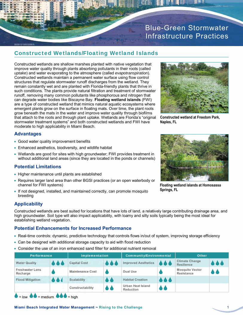
Miami Beach Integrated Water Management ~ Rising to the Challenge 1
Blue-Green StormwaterInfrastructure Practices
Constructed Wetlands/Floating Wetland Islands
Constructed wetlands are shallow marshes planted with native vegetation thatimprove water quality through plants absorbing pollutants in their roots (calleduptake) and water evaporating to the atmosphere (called evapotranspiration).Constructed wetlands maintain a permanent water surface using flow controlstructures that regulate stormwater runoff discharges from the wetland. Theyremain constantly wet and are planted with Florida-friendly plants that thrive insuch conditions. The plants provide natural filtration and treatment of stormwaterrunoff, removing many common pollutants like phosphorous and nitrogen thatcan degrade water bodies like Biscayne Bay. Floating wetland islands (FWI)are a type of constructed wetland that mimics natural aquatic ecosystems whereemergent plants grow on the surface in floating mats. Over time, the plant rootsgrow beneath the mats in the water and improve water quality through biofilmsthat attach to the roots and through plant uptake. Wetlands are Florida’s “originalstormwater treatment systems” and both constructed wetlands and FWI havemoderate to high applicability in Miami Beach.
Advantages· Good water quality improvement benefits· Enhanced aesthetics, biodiversity, and wildlife habitat· Wetlands are good for sites with high groundwater; FWI provides treatment in
without additional land areas (since they are located in the ponds or channels)
Potential Limitations· Higher maintenance until plants are established· Requires larger land area than other BGSI practices (or an open waterbody or
channel for FWI systems)· If not designed, installed, and maintained correctly, can promote mosquito
breeding
ApplicabilityConstructed wetlands are best suited for locations that have lots of land, a relatively large contributing drainage area, andhigh groundwater. Soil type will also impact applicability, with loamy and silty soils typically being the most ideal forestablishing wetland vegetation.
Potential Enhancements for Increased Performance· Real-time controls: dynamic, predictive technology that controls flows in/out of system, improving storage efficiency· Can be designed with additional storage capacity to aid with flood reduction· Consider the use of an iron enhanced sand filter for additional nutrient removal
Performance Implementation Community/Environmental Other
Water Quality Capital Cost Improved Aesthetics Climate ChangeResilience
Freshwater LensRecharge Maintenance Cost Dual Use Mosquito Vector
Resistance
Flood Mitigation Scalability Habitat Creation
Constructability Urban Heat IslandReduction
= low = medium = high
Constructed wetland at Freedom Park,Naples, FL
Floating wetland islands at HomosassaSprings, FL

Miami Beach Integrated Water Management ~ Rising to the Challenge 1
Blue-Green StormwaterInfrastructure Practices
Detention Basins/Surface Storage
Detention basins are dry ponds thatfill up with stormwater runoff duringrain events. Stormwater is then slowlyreleased (over 2 to 3 days) to mini-mize downstream flooding. They’retypically geared more towards floodcontrol than improved water quality.However, they can be enhanced withnative vegetation and configured as“infiltration basins”, if conditions allow.Surface storage facilities, like detention basins, can provide some flood protection benefits, especially in the low-lyingareas of Miami Beach where working below ground is challenging due to high groundwater conditions. Through subtleintegration into the existing landscape, especially at parks/open spaces, surface storage can be blended into the site,appearing as dry and usable space most times and filling up during rain or high water events. By directing stormwater tosites with detention basins or surface storage, other parts of the City could experience reduced flooding.
Advantages· Potentially significant flood control benefits· Typically less costly to construct compared to other BGSI practices· Potentially allows for the “dual use” of stormwater capture and recreation
Potential Limitations· Larger storage volumes for flood control require more land area· Provides less freshwater lens recharge and low water quality improvements· Since it involves temporarily flooding public land, requires community
acceptance and education
ApplicabilityDetention basins are best suited for locations with lots of open land and a relatively large contributing drainage area (atleast 10 acres). Surface storage facilities are most applicable where it is acceptable to construct perimeter earthen berms(or similar structures) for temporary surface inundation.
Potential Enhancements for Increased Performance· Real-time controls: dynamic, predictive technology that controls flows in/out of system, improving storage efficiency· Can be designed as “infiltration basins”, as well as vegetated with Florida-friendly plants to improve water quality
Performance Implementation Community/Environmental Other
Water Quality Capital Cost Improved Aesthetics Climate ChangeResilience
Freshwater LensRecharge Maintenance Cost Dual Use Mosquito Vector
Resistance
Flood Mitigation Scalability Habitat Creation
Constructability Urban Heat IslandReduction
= low = medium = high
Detention basin planted with dense native vegetation and designed for infiltration
Example of a plaza designed to providetemporary surface storage during stormevents (Source: De Urbanisten)

Miami Beach Integrated Water Management ~ Rising to the Challenge 1
Blue-Green StormwaterInfrastructure Practices
Enhanced Tree Pits/Trenches
Enhanced tree pits/trenches combine the stormwater capture benefits of sub-surface infiltration/storage systems with the water and air quality benefits of trees.This BGSI practice can be subtly integrated into most sites, appearing as either asingle tree (pit) or a row of trees (trench) in pavement, lawn, or landscaping.These structures typically capture stormwater runoff that is piped in from street orparking lot drains or runoff that flows through permeable pavement. The runoffthen slowly enters the underlying soil (called infiltration) or drains into the City’sdrainage system within 2 to 3 days. Trees selected for these systems are hardyFlorida-friendly species that can withstand both extended dry and wet conditions.Tree pits/trenches are well suited to the look and feel of Miami Beach becausethey can help maintain a high visual appeal.
Advantages· Increased tree canopy, evapotranspiration (water evaporating into the air),
and site aesthetics, as well as reduced urban heat island· Flexibility to be configured and sized for a variety of specific site conditions· Can be integrated with planned streetscape or utility improvements to reduce
construction cost
Potential Limitations· 6 to 18 inches of separation to groundwater recommended· Utilities in sidewalks should be avoided/protected· Regular watering required until trees are well rooted and established
ApplicabilityEnhanced tree pits/trenches are applicable on most streets, commercial/publicfacilities, parking lots, and open spaces in Miami Beach where their use wouldnot hinder vehicular or pedestrian circulation. They are often most effective whenseamlessly integrated into streetscapes or within parking lot islands and can alsowork well with road raising, which creates the opportunity for greater stormwaterstorage capacity above groundwater.
Potential Enhancements for Increased Performance· Sand-based structural soil or suspended pavement system with modular soil cells: increases rooting volume and
enhances tree health/longevity· Modular/high-porosity media: increases storage capacity· Underdrains (if needed): allow systems to drain and minimize the time tree roots are kept saturated (overly wet)
Performance Implementation Community/Environmental Other
Water Quality Capital Cost Improved Aesthetics Climate ChangeResilience
Freshwater LensRecharge Maintenance Cost Dual Use Mosquito Vector
Resistance
Flood Mitigation Scalability Habitat Creation
Constructability Urban Heat IslandReduction
= low = medium = high
Example of an enhanced tree trench withpermeable pavers
Typical enhanced tree trench sectionusing suspended pavement system/modular soil cells (Source: ViridianLandscape Studio)

Miami Beach Integrated Water Management ~ Rising to the Challenge 1
Blue-Green Stormwater Infrastructure Practices
Rainwater Harvesting
Rainwater harvesting involves capturing rainwater from roofs or other surfaces and reusing it as an alternative or supplement to potable water (water that is safe to drink/use). Rainwater harvesting systems intercept water, typically from roof drains, before it drains to municipal stormwater pipes and store it in either rain barrels (above ground) or in cisterns (water storage tanks above or below the ground). Rain barrels and cisterns are made from a variety of materials (wood, concrete, plastic, fiberglass, etc.) and the water they store can be reused for non-potable applications, such as landscape irrigation or toilet flushing. Although stormwater benefits can be limited when the systems are partially full, they also can reduce potable water use, which lowers both individual water bills and the demand on the public water system.
Advantages • Wide applicability with respect to different types of roofs and storage options
(type, size, shape, and location – above or below ground, inside or outside) • Can be integrated with site features, such as artwork, stairs, and benches • Less impacted by high groundwater in Miami Beach
Potential Limitations • Requires space to install storage system and a use for the captured rainwater • Typically sized for smaller rainfall events (to refill often) and therefore may
need to be coupled with other BGSI practices • Depending on the anticipated use of rainwater (for example, toilet flushing)
and/or the source of runoff (whether roof or other surface), enhanced treatment, permitting, or additional maintenance may be required
Applicability With its ability to fit many shapes, sizes, and aesthetic standards, rainwater harvesting has wide applicability in Miami Beach. Implementation can range from small aboveground rain barrels used for landscape irrigation at homes to larger above/belowground cisterns used for toilet flushing or other non-potable uses at commercial or public facilities. Many other factors influence applicability and feasibility, including accessibility of roof drains, demand for harvested rainwater, and size of the area generating runoff.
Potential Enhancements for Increased Performance • Water treatment systems (filtration and/or disinfection) or “first flush” diverters: improve pollutant removal and allow
more applications for water re-use (toilet flushing) • Real-time controls: dynamic, predictive technology that controls flows in/out of system, improving system efficiency
Performance Implementation Community/Environmental Other
Water Quality Capital Cost Improved Aesthetics Climate Change Resilience
Freshwater Lens Recharge
Maintenance Cost Dual Use N/A Mosquito Vector Resistance
Flood Mitigation Scalability Habitat Creation N/A
Constructability Urban Heat Island Reduction
= low = medium = high
This cistern at a restaurant reuses roof runoff to irrigate a vegetable garden in a raised planter (also shown)
Schematic/photo of an artistic cistern at a library used for landscape irrigation
1) Rainwater enters the cistern from the rooftop runoff.
3) A hose is attached to the nozzle and stored rainwater is used for irrigation.
2) Stormwater is stored inside the blocks.

Miami Beach Integrated Water Management ~ Rising to the Challenge 1
Blue-Green StormwaterInfrastructure Practices
Subsurface Infiltration/Storage
Subsurface infiltration/storage systems temporarily hold stormwater runoff under-ground in material like gravel, high-strength plastic boxes/arches, large-diameterpipes, and concrete chambers. This allows the stormwater to be detained until iteither infiltrates into the soil or drains into Miami Beach’s existing drainagesystem, emptying within 2 to 3 days. The systems can be placed under almostany type of finished surface, whether pavement, grass, landscaping, or othermaterial and are often “fed” by surface drains and pipes or potentially bypumping from other (lower) areas.
Advantages· Depending on the storage media, potential to capture large volumes of
stormwater runoff and thus reduce localized flooding (caused by rainfall)· Freshwater lens recharge· Allows for the “dual use” of stormwater capture and a variety of surface
treatments such as pavement (including raised roads), lawn, and landscaping
Potential Limitations· 6 to 18 inches of separation to groundwater recommended for infiltration (from
bottom of system)· Given the high groundwater conditions common in Miami Beach, these
systems would typically need to be constructed near or above the existingground elevation, which could limit the amount of water they capture withoutpumping
· Depending on site conditions, pretreatment structures (filters, sediment storagechambers, etc.) intended to capture trash, sediment, and other materials withhigh clogging potential may require frequent maintenance
ApplicabilityThese practices are applicable to locations in Miami Beach with adequate separation between their lowest elevations andgroundwater, or in those areas where such separation could be achieved by raising the ground surface and installingthem at or above the existing ground surface. These practices can be readily combined with other BGSI practices, suchas permeable pavement, bioretention, and rainwater harvesting.
Potential Enhancements for Increased Performance· Real-time controls: dynamic, predictive technology that controls flows in/out of system, improving storage efficiency· Modular/high-porosity media: increase storage capacity· Sand (or other media) filter layer at bottom to enhance pollutant removal, especially when close to groundwater
Performance Implementation Community/Environmental Other
Water Quality Capital Cost Improved Aesthetics Climate ChangeResilience
Freshwater LensRecharge Maintenance Cost Dual Use Mosquito Vector
Resistance
Flood Mitigation Scalability Habitat Creation
Constructability Urban Heat IslandReduction
= low = medium = high
Subsurface infiltration/storage system withplastic chambers being installed along withthe raising of a playfield at a school
Typical cross-section for subsurfaceinfiltration/storage system filled with gravel

Miami Beach Integrated Water Management ~ Rising to the Challenge 1
Blue-Green StormwaterInfrastructure Practices
Stormwater Injection Wells (Pumped)
Stormwater injection well systems collect stormwater runoff in an undergroundtank or basin and pump the water to one or several shallow injection wells. Thesystems don’t treat stormwater before it enters the aquifer but often containbaffles or other devices that settle debris and grit before pumping. In the City ofMiami Beach, most injection wells consist of a 24-inch-diameter steel casing setto a depth between 60 and 100 ft below the ground, with the open space aroundthe casing grouted to the land surface. Injection wells in the City typically featureopen-hole construction in the Biscayne Aquifer, drilled to depths of 80 to 200 ft. Insouthern and central portions of the City, the aquifer is composed of corallinelimestone that receives water at rates over 1,000 gallons per minute (gpm). Whileinjection wells don’t provide all the stormwater and community benefits of theother recommended BGSI practices, they can still prove beneficial in the City.
Advantages· Can help manage flooding during moderate storms or during the rainy season· Where the capacity to absorb is high, gets rid of stormwater runoff rapidly· Occupy little space, once wells and collection systems installed· May help recharge the freshwater lens from below in areas where present
Potential Limitations· Sea level rise makes stormwater injection more difficult/less effective· The ability to absorb water (called permeability) of the Biscayne Aquifer
declines in northern portions of the City, limiting injection to about 50 gpm· May require annual maintenance to remove debris and prevent clogging· Reliance on collection and pumping systems to deliver water to wells
ApplicabilityInjection well systems work most effectively in the southern and central portionsof the City, where the aquifer is highly absorbent. Injection wells offer analternative method of disposing stormwater runoff from roofs, parking lots,streets, and other non-porous (impermeable) surfaces.
Potential Enhancements for Increased Performance· Enhanced pretreatment and storage before injection reduces chances of clogging in injection wells· Maximizing the length of the open interval increases potential disposal rates· Regular well rehabilitation can restore injection well performance to near-new levels
Performance Implementation Community/Environmental Other
Water Quality Capital Cost Improved Aesthetics N/A Climate ChangeResilience
Freshwater LensRecharge Maintenance Cost Dual Use N/A Mosquito Vector
Resistance
Flood Mitigation Scalability Habitat Creation N/A
Constructability Urban Heat IslandReduction N/A
= low = medium = high
Typical pumped injection well section
Example of a small injection wellinstallation

Miami Beach Integrated Water Management ~ Rising to the Challenge 1
Blue-Green Stormwater Infrastructure Practices
Permeable Pavement
Permeable pavement often looks like ordinary pavement but allows stormwater to drain through it and into an underlying storage system (or reservoir). The storage reservoir under the permeable pavement provides a place for the stormwater to be retained until it can infiltrate into the soil, filtering out pollutants in the process. The storage reservoir typically consists of clean and evenly sized stone that can store water in its gaps (typically 40 percent of its volume), though pipes or different types of chambers (plastic or concrete) can also be used to increase storage capacity. A variety of permeable pavement types can used depending on the specific characteristics of a site including concrete, asphalt, paver blocks, and reinforced turf or gravel systems, among others. Permeable pavement has high applicability in Miami Beach, where it can reduce stormwater that would otherwise run off pavement surfaces and into streets, private properties, or receiving waters like Biscayne Bay.
Advantages • Stormwater runoff capture and freshwater lens recharge • Versatile, with broad applicability • Allows for “dual use” of hard surface and stormwater capture
Potential Limitations • 6 to 18 inches of separation to groundwater recommended (from bottom of stone subbase) • Careful design, construction, and maintenance necessary to ensure long-term performance • Permeable pavements not suitable for all sites (for example, high-speed roadways or certain land uses with high potential pollutant loads like gas stations)
Applicability Permeable pavement provides stable and reliable surfaces for vehicles and pedestrians, while providing freshwater lens recharge, water quality benefits, and even localized flood reduction. Permeable pavement is well suited for parking lots (especially the parking spaces), bike/walking paths, sidewalks, playgrounds, plazas, tennis or basketball courts, and other similar uses. It can also be used on low-volume (minimally used) residential roadways and/or parking lanes.
Potential Enhancements for Increased Performance • Real-time controls: dynamic, predictive technology that controls flows in/out of system, improving storage efficiency • Underdrains (if needed): allow systems to drain within 72 hours
Performance Implementation Community/Environmental Other
Water Quality Capital Cost Improved Aesthetics Climate Change Resilience
Freshwater Lens Recharge Maintenance Cost Dual Use
Mosquito Vector Resistance
Flood Mitigation Scalability Habitat Creation
Constructability Urban Heat Island Reduction
= low = medium = high
Permeable paver in outside dining area
Typical permeable pavement cross section for common pavement types (Source: Eban Bean, UF/IFAS)
Porous Asphalt
Pervious Concrete
Concrete
Paver

Miami Beach Integrated Water Management ~ Rising to the Challenge 1
Blue-Green Stormwater Infrastructure Practices
Stormwater Planters
Stormwater planters are similar to bioretention facilities; both are sunken landscape beds containing Florida-friendly plants in a special soil mix (called engineered soil) that sit above a gravel drainage layer. But unlike bioretention facilities, stormwater planters are enclosed by concrete, brick, wood, or other materials, and can be placed either above or below the ground elevation. Depending on the specific site conditions, they can be either flow-through or infiltration planters. Flow-through planters typically have sealed bottoms to detain water for up to 3 days. Infiltration planters have open bottoms to allow water to enter (or infiltrate) the soil beneath the planter. Both provide filtration and treatment of stormwater runoff, which flows into them from nearby paved areas, such as sidewalks or roadways, or is piped in from roof downspouts. Because stormwater planters are irrigated by rainfall, they can provide a more sustainable alternative to traditional landscaping that uses potable water (water that’s safe to drink).
Advantages • Flow-through planters can be placed in areas of the City with high groundwater • Flexible design allows them to be elevated and/or configured to fit in tight spaces • Increased water quality, as well as enhanced site aesthetics and biodiversity
Potential Limitations • 6 to 18 inches of separation to groundwater recommended for infiltration planters • Higher maintenance until plants are established, and regular maintenance after • Utilities in roadway and sidewalks should be considered
Applicability Stormwater planters are highly applicable throughout Miami Beach as they can be placed along many roadways, sidewalks, and parking lots, as well as adjacent to buildings where they can capture roof runoff. Planters can often be installed in conjunction with planned sidewalk or roadway improvements, including road raising.
Potential Enhancements for Increased Performance • Modular/high-porosity media: increases storage capacity • Engineered soil enhancements/high-flow filter media: improve pollutant removal,
increase surface infiltration rates • Underdrains: allow systems to drain within 72 hours • Enhanced pretreatment (for example, screens/filters to pretreat roof runoff) • If possible, elevate planters in areas with high groundwater
Performance Implementation Community/Environmental Other
Water Quality Capital Cost Improved Aesthetics Climate Change Resilience
Freshwater Lens Recharge Maintenance Cost Dual Use
Mosquito Vector Resistance
Flood Mitigation Scalability Habitat Creation
Constructability Urban Heat Island Reduction
= low = medium = high
Stormwater planter between a sidewalk and roadway
Typical cross-section of an elevated stormwater planter against a building, with roof leader, surface depression, Florida-friendly plants, engineered soil, and gravel layer

Miami Beach Integrated Water Management ~ Rising to the Challenge 1
Blue-Green Stormwater Infrastructure Practices
Wet Ponds
Wet ponds are among the most recognizable BGSI practices in Florida. They accept and hold stormwater runoff long enough to allow pollutants to settle out, resulting in cleaner water. Wet ponds are designed to maintain a permanent water surface (or permanent pool) through flow control structures that regulate discharge from the pond. Aeration systems are often installed in wet ponds to introduce oxygen into the water, which encourages growth of beneficial aerobic bacteria that consume nutrients and improve water quality. Water quality can also be improved by placing aquatic and wetland plants around the pond perimeter or on floating wetland islands. Vegetation filters runoff and helps reoxygenate the water, which further improves water quality. Vegetation also provides habitat for fish and other aquatic organisms.
Advantages • Good water quality improvement benefits • Good option for sites with high groundwater • Potential for enhanced site aesthetics, biodiversity, and wildlife habitat opportunities
Potential Limitations • Larger storage volumes for the permanent pool and flood
control require more land area. • Infiltration and freshwater lens recharge are minimal, and so
runoff volume reduction is minimal. • Invasive species and vector control are often necessary.
Applicability Wet ponds are best suited for locations with large open areas, a relatively large contributing drainage area, and high groundwater conditions. They are generally implemented in residential, commercial, or open space areas. Some of the existing water features at golf courses may function as, or could potentially be converted to, wet ponds. Ponds can be lined to help address soil/groundwater contamination concerns.
Potential Enhancements for Increased Performance • Real-time controls: dynamic, predictive technology that controls flows in/out of system, improving storage efficiency • Can be designed with additional storage volume to help reduce flooding (often called an extended-detention wet pond)
Performance Implementation Community/Environmental Other
Water Quality Capital Cost Improved Aesthetics Climate Change Resilience
Freshwater Lens Recharge
Maintenance Cost Dual Use Mosquito Vector Resistance
Flood Mitigation Scalability Habitat Creation
Constructability Urban Heat Island Reduction
= low = medium = high
Wet pond in Naples, Florida
Rendering of a wet pond in a Miami Beach park that will capture and store neighborhood stormwater (Source: Savino & Miller Design Studio)

Miami Beach Integrated Water Management ~ Rising to the Challenge 1
Blue-Green StormwaterInfrastructure Strategies
Commercial and Public Facilities
BGSI has wide applicability at Miami Beach’s manycommercial and public facilities, whether they are sitesdominated by buildings, sites that balance buildings withother needs (such as parking and landscaping), schools andother educational facilities, parking garages, or otherfacilities. These locations range from highly visible andvisited (schools, apartment buildings, and restaurants) tomore utilitarian (storage/maintenance yards and police/firestations).
Various BGSI practices can be applied at these facilities,with careful consideration given to their specificopportunities and constraints. While some facilities may onlybe able to capture their own stormwater runoff, otherfacilities—especially larger public ones—may be able tocapture significant volumes from adjacent areas.
Advantages
Improved commercial or public spaces through aesthetics, amenities, site restoration, and/or increased tree canopy
Improved water quality, reduced stormwater runoff volume, and increased freshwater lens recharge
Reduction of urban heat island
Potential to capture large volumes of stormwater and thus reduce localized flooding
High visibility/educational value
Dual-use opportunities (for example, permeable pavement parking areas)
Other potential advantages for BGSI at buildings: reduced potable water use (water that’s safe to drink) and reducedneed for cooling (less energy use)
Potential Limitations
Accessibility and public safety concerns, especially at schools
Cost of implementation
Due to flat topography, directing runoff into public facilities can be challenging
Capturing roof drainage might be challenging due to inaccessible downspouts
Limited maintenance capabilities (budget, experience, and/or resources) depending on owner
Construction and maintenance activities might need to be scheduled around operating hours, especially at schools
Other limitations: building utilities, structural loading capacity (for blue or green roofs), limited ground space (for other typesof BGSI practices), future expansion/redevelopment plans, etc.
Applicable Practices
Applicable to Most Sites Applicable to Some Sites Limited Applicability
Bioretention/Bioswales (except parkinggarages, which have limited applicability)
Injection Wells
Rainwater Harvesting
Stormwater Planters
Blue & Green Roofs (limited to sites withsuitable buildings)
Enhanced Tree Pits/Trenches (site perimeter)
Permeable Pavement
Subsurface Infiltration/Storage
Constructed Wetlands
Detention Basins/Surface Storage
Wet Ponds
Bioswale adjacent to a public library

Fact Sheet Commercial and Public Facilities
Miami Beach Integrated Water Management ~ Rising to the Challenge 2
Facilities with Building Coverage Greater Than 90% of the Site
Many commercial and public facilities with large building footprints and thus limited ground space present uniquechallenges for BGSI. BGSI practice feasibility generally depends on the type of building, the accessibility of its roof drains(whether they are internal or external to the building), and even its water demand (if considering rainwater harvesting andreuse). Blue and green roofs can be well suited to these sites if the roof is able to support them. Stormwater planters canbe placed against exterior building walls if there is space and roof drains are external or can be re-directed. Cisterns(water storage tanks) can also be placed next to buildings or even in unused spaces inside them to allow rainwater to beharvested for non-potable uses like toilet flushing and/or landscape irrigation. In some cases, opportunities for managingrunoff outside the parcel (for example, in the right-of-way) should be explored.
New World Symphony Building Vegetated rooftop plaza
Facilities with Building Coverage Less Than 90% of the Site
Commercial and public facilities with a smaller percentage of building space and larger areas for parking, walkways,landscaping, courtyards, or other uses provide many opportunities to integrate BGSI and enhance their use andaesthetics. Existing green spaces at such sites may be well suited to BGSI practices, such as bioretention/bioswales,enhanced tree trenches, stormwater planters, subsurface infiltration/storage, and constructed wetlands (though on a muchmore limited basis). Parking lots—especially relatively large ones, those with minimal underground utilities, and thosewithout significant landscaping or trees—are ideal candidates for BGSI implementation and for maximizing capture ofstormwater runoff generated both within and potentially outside the site. Permeable pavement and subsurfaceinfiltration/storage systems can be cost-effectively coupled with parking lot repaving or reconstruction efforts. Bioswalesand enhanced tree trenches can be incorporated into islands, no parking zones, or in paved areas slated for removal(based on a reduced need for parking). In some cases, parking lots (or portions of them) can be allowed to temporarilypond, providing surface storage.
Scott Rakow Youth Center Parking Lot Bioswale in a parking lot

Fact Sheet Commercial and Public Facilities
Miami Beach Integrated Water Management ~ Rising to the Challenge 3
Schools
Miami Beach’s schools and other educational institutions provide many compelling opportunities for BGSI in ways thatpotentially enhance their value. Such sites typically have ample areas for recreation and/or parking. These sites cantypically be feasibly, safely, and cost-effectively adapted for a variety of BGSI practices, especially bioretention,permeable pavement, and subsurface infiltration/storage. In addition to managing stormwater generated onsite, BGSI atschools can often be made large enough to capture stormwater runoff from adjacent areas. These sites can also provideunique opportunities to educate students and the public about BGSI (for example, educational signage and observationplatforms) and to demonstrate different BGSI technologies and variations (for example, interactive rainwater cisterns).Such demonstrations can give the City useful and practical information that yields more streamlined and cost-effectiveBGSI projects in the future.
Miami Beach Senior High School Bioretention (above middle) and permeable pavement (asphalt) parking lot at school sites
Parking Garages
Similar to locations dominated by buildings, Miami Beach’s parking garages provide both significant challenges to BGSIimplementation and also unique opportunities to use practices with more limited applicability at other sites. In general, ifthere is sufficient space (especially landscaping) next to parking garages, the most suitable (and cost-effective) BGSIpractices are bioretention/bioswales or stormwater planters. For sites that are more constrained (and more likely in MiamiBeach), exterior practices such as permeable pavement or subsurface infiltration/storage may prove feasible if roof drainsare accessible. Otherwise, practices such as blue roofs (possibly on the upper-most parking level), green roofs (on non-parking areas or canopies on the upper-most parking level), or rainwater harvesting cisterns (placed in unused space andassuming there is a demand for such water) could be further explored.
Parking garage in Miami Beach Bioretention adjacent to parking garage

Miami Beach Integrated Water Management ~ Rising to the Challenge 1
Blue-Green StormwaterInfrastructure Strategies
Parks and Open Spaces
Miami Beach contains a variety of recreational areas, including golf courses, openspaces, parks, and pocket parks/plazas. These facilities are generally excellentopportunities to implement many types of BGSI practices. Parks can offer moresignificant water quality, flood mitigation, and freshwater lens recharge benefitsby capturing runoff from adjacent areas through gravity drainage or pumping.
Successfully implementing BGSI at parks often involves a balancing act betweenpreserving or enhancing existing recreational uses and providing the spacerequired for BGSI. Given the challenges of Miami Beach (flat topography, highgroundwater, etc.), BGSI practices at recreational sites should ideally entailtemporarily storing water on the surface and/or raising the ground elevation andstoring water underground.
Advantages· Improved public spaces through aesthetics, amenities, and site restoration· Increased tree canopy· Natural source of irrigation for Florida-friendly landscaping· Less restrictive with respect to existing utilities or other infrastructure· Potential to capture large volumes of stormwater· High visibility/educational value· Dual-use opportunities (e.g., permeable pavement play surfaces)
Potential Limitations· Accessibility and public safety concerns· Sediment and trash may impact aesthetics and functionality, especially in dense urban areas and sites with large
drainage areas· Diverse and sometimes unpredictable usage and preferred pathways for park visitors· Due to flat topography, directing runoff into parks can be challenging· Working around public art/monuments and existing vegetation, especially trees
Applicable Practices
Applicable to Most Sites Applicable to Some Sites Limited Applicability
Bioretention/Bioswales
Detention Basins/Surface Storage
Injection Wells
Subsurface Infiltration/Storage
Constructed Wetlands
Enhanced Tree Pits/Trenches (site perimeter)
Permeable Pavement
Rainwater Harvesting
Stormwater Planters
Wet Ponds
Blue & Green Roofs (limited to sites withsuitable buildings, but have high educationalvalue)
Bioretention adjacent to a permeableasphalt basketball court at a public park

Fact Sheet Parks and Open Spaces
Miami Beach Integrated Water Management ~ Rising to the Challenge 2
Golf Courses
By their size and open nature, Miami Beach’s two public golf courses (Miami Beach and Normandy Shores Golf Courses)offer unique opportunities to capture large volumes of water. Larger BGSI practices that have limited applicability at mostother sites (i.e., detention basins/surface storage, wet ponds, and constructed wetlands) can be readily integrated into golfcourses, especially those that can be reconfigured or repurposed. Fairways provide locations for extensive temporarysurface storage surrounded by perimeter earthen berms. Wet ponds can store and treat water before it is used forirrigation.
Miami Beach Golf Course Constructed wetlands for stormwater capture and treatment
Open Spaces
Miami Beach has a variety of triangular or similarly shaped open spaces that appear to have no defined usage or formalprogramming. These spaces provide opportunities to implement smaller-scaled BGSI practices, such as bioretention/bioswales, enhanced tree pits/trenches, and subsurface infiltration/storage. These practices can be seamlessly integratedinto the landscape, replacing unused lawn areas and avoiding impacts to existing trees and vegetation. In general,these sites are best suited to capturing stormwater runoff from adjacent streets, though some may be able to storeadditional runoff.
Triangular open space at 1st Street and Alton Road Bioretention facility in unused triangular open space that was converted to a public park

Fact Sheet Parks and Open Spaces
Miami Beach Integrated Water Management ~ Rising to the Challenge 3
Parks
Miami Beach’s larger parks provide a wide variety of opportunities for virtually all types of BGSI practices. BGSI can beintegrated into the corners, edges, and other underutilized areas of parks to both enhance and avoid disrupting existinguses—from larger practices like wet ponds and constructed wetlands to smaller practices like bioretention and bioswales.Permeable pavements can provide dual-use benefits by creating stable surfaces for basketball courts, tennis courts, andwalkways, while also capturing stormwater. Detention basins/surface storage can also allow dual use by temporarilystoring water on depressed athletic fields or those enclosed by perimeter earthen berms. Some parks can be raised offthe ground to create significant underground storage of water that is piped in from outside the site.
Fairway Park Bioretention facility near the entrance to a public park
Pocket Parks/Plazas
By definition pocket parks and plazas are the most space-limited recreational areas. However, Miami Beach’s pocketparks and plazas provide ample opportunities for BGSI. For pocket parks with little green space and dominated byhardscape surfaces, such as pavement or pavers, BGSI practices such as permeable pavement and subsurfaceinfiltration/storage facilities are most applicable. Another option for such sites is to turn them into “water plazas” thattemporarily store stormwater on the surface during rain events. Such sites may also serve as “floating parks” that haveplatforms and other features that rise and fall with changing water elevations. Other types of pocket parks may be well-suited to BGSI practices such as bioretention, enhanced tree pits/trenches, and stormwater planters.
Rue Vendome/Normandy Isle Monument Permeable pavers and enhanced tree pits in urban plaza
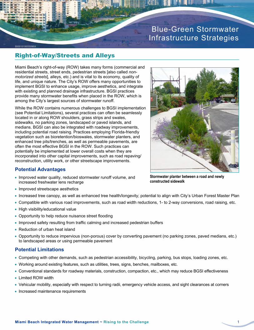
Miami Beach Integrated Water Management ~ Rising to the Challenge 1
Blue-Green Stormwater Infrastructure Strategies
Right-of-Way/Streets and Alleys
Miami Beach’s right-of-way (ROW) takes many forms (commercial and residential streets, street ends, pedestrian streets [also called non-motorized streets], alleys, etc.) and is vital to its economy, quality of life, and unique nature. The City’s ROW offers many opportunities to implement BGSI to enhance usage, improve aesthetics, and integrate with existing and planned drainage infrastructure. BGSI practices provide many stormwater benefits when placed in the ROW, which is among the City’s largest sources of stormwater runoff.
While the ROW contains numerous challenges to BGSI implementation (see Potential Limitations), several practices can often be seamlessly located in or along ROW shoulders, grass strips and swales, sidewalks, no parking zones, landscaped or paved islands, and medians. BGSI can also be integrated with roadway improvements, including potential road raising. Practices employing Florida-friendly vegetation such as bioretention/bioswales, stormwater planters, and enhanced tree pits/trenches, as well as permeable pavements, are often the most effective BGSI in the ROW. Such practices can potentially be implemented at lower overall costs when they are incorporated into other capital improvements, such as road repaving/ reconstruction, utility work, or other streetscape improvements.
Potential Advantages • Improved water quality, reduced stormwater runoff volume, and
increased freshwater lens recharge • Improved streetscape aesthetics • Increased tree canopy, as well as enhanced tree health/longevity; potential to align with City’s Urban Forest Master Plan • Compatible with various road improvements, such as road width reductions, 1- to 2-way conversions, road raising, etc. • High visibility/educational value • Opportunity to help reduce nuisance street flooding • Improved safety resulting from traffic calming and increased pedestrian buffers • Reduction of urban heat island • Opportunity to reduce impervious (non-porous) cover by converting pavement (no parking zones, paved medians, etc.)
to landscaped areas or using permeable pavement
Potential Limitations • Competing with other demands, such as pedestrian accessibility, bicycling, parking, bus stops, loading zones, etc. • Working around existing features, such as utilities, trees, signs, benches, mailboxes, etc. • Conventional standards for roadway materials, construction, compaction, etc., which may reduce BGSI effectiveness • Limited ROW width • Vehicular mobility, especially with respect to turning radii, emergency vehicle access, and sight clearances at corners • Increased maintenance requirements
Stormwater planter between a road and newly constructed sidewalk

Fact Sheet Right-of-Way/Streets and Alleys
Miami Beach Integrated Water Management ~ Rising to the Challenge 2
Applicable Practices
Applicable to Most Sites Applicable to Some Sites Limited Applicability
Bioretention/Bioswales Enhanced Tree Pits/Trenches (not in alleys) Injection Wells Permeable Pavement (parking and bike lanes, sidewalks) Stormwater Planters
Subsurface Infiltration/Storage (in areas with higher elevations or integrated with road raising)
Blue & Green Roofs Constructed Wetlands (applicable to street ends only) Detention Basins/Surface Storage Rainwater Harvesting Wet Ponds
Commercial Streets
Miami Beach’s commercial streets, which encompass its avenues, boulevards, and main streets, are some of the City’s most visible and heavily traveled. While perhaps the most challenging of the City’s ROW with respect to BGSI, they also provide rich BGSI opportunities. Bioretention/bioswales and stormwater planters can be carefully located in “underused” ROW spaces, where they can effectively treat stormwater runoff and also create visual interest through an attractive, layered planting scheme. Subsurface infiltration/storage systems, especially when integrated with road raising, can store and infiltrate runoff to help reduce localized flooding. Enhanced tree pits/trenches, when coupled with suspended pavement systems or structural soil, can greatly increase urban canopy and tree health. Permeable pavements can be used in many ways, whether in sidewalks, around tree pits, or in parking lanes, but their selection and design must appropriately consider the anticipated vehicular use, loading, and frequency, as well as the City’s unique aesthetic character. In general, implementing BGSI in commercial streets has great potential, and should maintain or even enhance existing public uses, safety, and accessibility.
Typical commercial street in Miami Beach Artistic rendering of stormwater planters and enhanced tree trenches
Residential Streets
Compared to Miami Beach’s commercial streets, the City’s residential streets generally have more space and less utility and other constraints for BGSI. Their grass strips and swales, as well as landscaped or paved islands, represent good opportunities for BGSI practices, such as bioswales, rain gardens, and stormwater planters. Subsurface infiltration/storage systems may also be viable, especially when integrated with road raising. Vegetated BGSI practices would likely be

Fact Sheet Right-of-Way/Streets and Alleys
Miami Beach Integrated Water Management ~ Rising to the Challenge 3
focused in locations where parking is not currently permitted to minimize parking impacts for residents. Permeable pavements can provide the “dual use” benefits of a stabilized parking surface and stormwater capture. In general, implementing BGSI in residential streets can have a variety of stormwater quality and volume benefits, while being seamlessly integrated into the landscape, enhancing streetscape aesthetics, and potentially increasing property values.
Typical residential street in Miami Beach Artistic rendering of bioswales and permeable pavers
Street Ends
Typically located at waterfront locations, Miami Beach’s numerous street ends provide unique opportunities to incorporate BGSI that absorbs and filters stormwater immediately prior to discharging into Indian Creek, canals, and Biscayne Bay. At the same time, such locations have the potential for incorporating and enhancing habitat for land and aquatic species, as well as providing flexible parking and active or passive recreational spaces for residents. BGSI practices, such as bioretention/bioswales/rain gardens, constructed wetlands, enhanced tree pits/trenches, permeable pavement, and stormwater planters, can all be implemented at street ends, but their use will depend on the size, location, and intended purpose of the street ends.
Typical street end in Miami Beach Artistic rendering of bioretention, bioswales, and permeable pavement at a street end

Fact Sheet Right-of-Way/Streets and Alleys
Miami Beach Integrated Water Management ~ Rising to the Challenge 4
Non-motorized Street
Non-motorized streets, also known as pedestrian malls or pedestrian streets, are not very common in Miami Beach. However, the non-motorized streets that do exist in the City, most notably Lincoln Road, are important cultural landmarks, as well as key shopping, dining, and strolling destinations. Bioretention/bioswales, stormwater planters, enhanced tree pits/trenches, and permeable pavement can be implemented in such streets, but their placement and sizing must balance stormwater improvements with high aesthetic standards and passive recreational needs. In addition, such practices must consider existing trees and vegetation, public artwork, water features, and the many other amenities often found on these streets.
Lincoln Road in Miami Beach (Source: Kevin Sprague, Bioretention, permeable pavers, and stormwater planters Lincoln Road Business Improvement District) in non-motorized ROW
Alleys
Compared to the City’s other ROWs, Miami Beach’s alleys offer more limited opportunities for BGSI. However, implementing BGSI practices, such as permeable pavement and subsurface infiltration/storage systems, especially when integrated with road raising, can still provide meaningful stormwater runoff improvements, as well as improved alley aesthetics and resilience. The proximity of alleys to buildings can pose challenges to BGSI implementation, both during construction and with respect to long-term foundation impacts. However, such constraints can often be overcome by waterproofing the sides of BGSI installations and being extra careful when they’re installed. As with other ROW areas, permeable pavements must carefully consider the anticipated vehicular use, loading, and frequency, as well as fit within the City’s unique aesthetic character.
Typical alley in downtown Miami Beach Permeable pavers above an infiltration trench in an urban alley

Miami Beach Integrated Water Management ~ Rising to the Challenge 1
Blue-Green Stormwater Infrastructure Strategies
Single-Family Residential Parcels
Miami Beach’s single-family residential parcels provide unique opportunities to directly engage and educate the public on BGSI practices. Single-family residential parcels have more limited space for BGSI practices, but implementing BGSI in residential locations can still provide meaningful improvements to stormwater quality and freshwater lens recharge, especially if widely employed across neighborhoods.
The most applicable BGSI practices at single-family residential parcels are vegetated systems (rain gardens and bioswales) planted with Florida-friendly plants, rainwater harvesting with rain barrels, and permeable pavements. BGSI practices in these settings are usually simpler and easier to maintain than those implemented in public or commercial sites. What these relatively low-tech practices may lack in storage capacity, they can make up for in aesthetic beauty and educational value. Ultimately, significant stormwater improvements in Miami Beach will require public engagement and adoption of BGSI practices on residential parcels.
Advantages • Improved water quality and increased freshwater lens recharge • Improved aesthetics and potentially increased property values • Reduced localized flooding • Reduced potable water use, especially when rain barrels are used to harvest rainwater for landscape irrigation,
downspouts are directed into landscaped areas, and when Florida-friendly plants are used • Multiple public resources available, including Miami-Dade County’s free Adopt-a-Tree program and Rain Barrel
Workshops1
Potential Limitations • Cost of installation • Lack of experience with design and/or installation • Lack of existing drainage infrastructure to connect overflow or underdrain pipes from BGSI practices • Limited stormwater storage capacity, as well as smaller contributing drainage areas • Routine and/or restorative maintenance needs
Applicable Practices
Applicable to Most Sites Applicable to Some Sites Limited Applicability
Bioretention/Bioswales/Rain Gardens Permeable Pavement (driveways and patios) Rainwater Harvesting (rain barrels)
Stormwater Planters Blue & Green Roofs
Constructed Wetlands Detention Basins/Surface Storage Enhanced Tree Pits/Trenches Injection Wells Subsurface Infiltration/Storage Wet Ponds
1 Information about these programs can be found on Miami-Dade County’s web site at www.miamidade.gov
Residential rain garden

Fact Sheet Single-Family Residential Parcels
Miami Beach Integrated Water Management ~ Rising to the Challenge 2
Front yard rain garden Downspout that has been disconnected from a stormwater pipe and directed toward landscaped area (Source: Wisconsin Department of Natural Resources)
Rain barrel connected to residential downspout Permeable pavement driveway

Appendix D BGSI Plant Matrices/Plant Palette Boards

Spartina bakeriiSand Cord Grass
Crinum americanumSwamp Lily
Tripsacum dactyloidesFakahatchee Grass Florida Gamagrass
Muhlenbergia capillarisMuhly Grass
Conoclinium coelestinum
Sagittaria latifoliaArrowhead
Eleocharis cellulosaSpikerush
Stachytarpheta jamaicensisBlue Porterweed
Iris virginicaBlue Flag Iris
Eleocharis interstinctaKnotted Spikerush
Sagittaria lancifoliaDuck Potato
Nymphaea odorataFragrant Water Lily
Golden Canna
Taxodium ascendansPond Cypress
Ilex cassineDahoon Holly
Coccothrinax argentataSilver Palm
Thrinax morrisiiKey Thatch Palm
Quercus virginianaLive oak
Lysiloma latisiliquum Wild Tamarind
Erythrina herbaceaCoralbean
Pontederia cordataPickerelweed
Serenoa repens
Saw Palmetto
Heliotropium angiospermumScorpion Tail
FLORIDAFRIENDLY PLANTS FOR CONSTRUCTED WETLANDS
FLORIDAFRIENDLY PLANTS FOR BIORETENTION + BIOSWALE APPLICATIONS
BLUE GREEN INFRASTRUCTURE PILOT PROJECT CONCEPT
MIAMIBEACH
RISING
ABOVE
STR
ATE
GIC
VA
LUE
BGI PLANT MATRIX
South Florida is home to a diverse and vibrant tapestry of plant communities and ecosystems. For implementing blue green infrastructure across Miami Beach, Florida-friendly plants are the perfect choice as they are climate adapted, excel at ecosystem services and enhance sense of place. The list below is a summary of species that may be used in the BGI program.

Spartina patensSalt Marsh Cord Grass
Coccoloba uviferaSea Grape
Avicennia germinans
Black Mangrove
Languncularia racemosaWhite Mangrove
Rhizophora mangleRed Mangrove
Borrichia arborescens
Sea Ox-Eye
Acer rubrumRed Maple
Helianthus debilis
Codia sebestenaGeiger Tree
Heliotropium currasavicumSeaside Heliotrope
Quercus laurifoliaLaurel Oak
Portulaca pilosaHairy Portaluca
Conocarpus erectus Green Buttonwood
Swietenia mahagoniAmerican Mahogany
Salicornia bigeloviiGlasswort
Juncus roemerianusBlack Rush
Amphitecna latifoliaBlack Calabash
Bursera simarubaGumbo Limbo Tree
Conocarpus erectus var. sericeusSilver Buttonwood
Strumphia maritima
Coccoloba diversifoliaPigeon plum
Krugiodendron ferreumBlack Ironwood
Pinus elliottii var. densaSouth Florida Slash Pine
Ocotea coriacea Lancewood
FLORIDAFRIENDLY TREES FOR URBAN CANOPY RESTORATION
FLORIDAFRIENDLY PLANTS FOR CONSTRUCTED SALT MARSHES AND MANGROVES
BLUE GREEN INFRASTRUCTURE PILOT PROJECT CONCEPT
MIAMIBEACH
RISING
ABOVE
STR
ATE
GIC
VA
LUE
BGI PLANT MATRIX
South Florida is home to a diverse and vibrant tapestry of plant communities and ecosystems. For implementing blue green infrastructure across Miami Beach, Florida-friendly plants are the perfect choice as they are climate adapted, excel at ecosystem services and enhance sense of place. The list below is a summary of species that may be used in the BGI program.

Appendix E BGSI Pilot Project Concepts/Renderings

MANGROVE PLANTINGS
MANAGED AQUATIC PLANT SYSTEMS
PASSIVE RECREATION
NEIGHBORHOOD ACCESS
FLOATING BOARDWALK
FLORIDA-FRIENDLY
STREET TREES
NEIGHBORHOOD LANDING PARK
BIKE & PEDESTRIAN LANES
OLD ROADWAY ELEVATION
SUBSURFACE INFILTRATION TRENCH
SUBSURFACE INFILTRATION WITH SUSPENDED PAVEMENT FOR TREE GROWTH
OVER FLOW THROUGH BULKHEAD WALL BEFORE AND BEYOND LANDINGS
WATER MANAGEMENT BENEFITS
Capture of roadway runoff helps to reduce peak flows (during high
frequency events)
Treatment of roadway runoff reduces hydrocarbons and heavy
metal pollution
Treatment uptakes nitrogen and phosphorus, reducing likelihood of
algae blooms
ADDITIONAL BENEFITS +Walking and biking
pathsWaterfront SeatingNeighborhood
BeautificationKayak drop-in
points
COLLINS CANAL
ATLANTIC O
CEAN
BISCAYNE BAY
BLUE GREEN INFRASTRUCTURE PILOT PROJECT CONCEPT
MIAMIBEACH
RISING
ABOVE
STR
ATE
GIC
VA
LUE
COLLINS CANALH
OW
IT
WO
RK
S
1MANAGED AQUATIC PLANT SYSTEMSManaged Aquatic Plant Systems (MAPS) provide habitat, enhance aesthetics, and improve water quality in the canal by reducing common pollutants such as nitrogen, phosphorus, and suspended solids. MAPS will be anchored into the canal bottom, allowing them to rise during
and resilient.
2ENHANCED TREE PITS/TRENCHES
water quality prior to discharging into the
3PERMEABLE PAVEMENT
onto bike and pedestrian lanes constructed
to standard pavement but allows water to drain through its openings and into an
Permeable pavement will reduce the amount
The Collins Canal is an existing, man-made channel that runs parallel to Dade Boulevard, connecting Indian Creek to Biscayne Bay. By adding constructed wetlands, enhanced tree pits and trenches, and permeable pavement to its design, we can increase the amount of water that is absorbed and treated.
TODAY
ENHANCED

PROTECTION OF EXISTING CANOPY TREES
TRAFFIC CHICANES WITH BIORETENTION
MODIFIED VALLEY CURBS TO CONVEY STORMWATER TO GREEN INFRASTRUCTURE
TRENCH DRAINS
INFILTRATION
DELINEATED ON-STREET PARKING WITH PERMEABLE
PAVEMENT
BIOFILTRATION
STORAGE
INFILTRATION
INCREASED CANOPY TO MITIGATE HEAT ISLAND
EFFECT
WATER MANAGEMENT BENEFITS
Capture of roadway runoff helps to reduce peak flows (during high
frequency events)
Treatment of roadway runoff reduces hydrocarbons and heavy
metal pollution
Treatment and infiltration of stormwater to recharge groundwater
supplies and replenish freshwater lens
ADDITIONAL BENEFITS +Additional shade for walking and biking
Increased biodiversity
Neighborhood beautification
Reduced heat island effect
Traffic calming
BLUE GREEN INFRASTRUCTURE PILOT PROJECT CONCEPT
MIAMIBEACH
RISING
ABOVE
STR
ATE
GIC
VA
LUE
RESIDENTIAL STREET
OVERFLOWS TO STORM SEWER
STORAGE
DEEP ROOTING FLORIDA-FRIENDLY VEGETATION TO FILTER STORMWATER AND
MAINTAIN CLEAR SIGHT LINES FOR ROADWAY USERS
In Miami Beach residential streets vary in whether they include on-street parking, curbs, sidewalks, and other improvements, while often accommodating numerous driveways, alleys, and roadway intersections. Permeable pavement, enhanced tree pits, traffic chicanes, and other drainage features such as trench drains can be incorporated within varying residential roadway conditions to improve water quality, calm traffic, and reduce flows to private property.
HO
W I
T W
OR
KS
1PERMEABLE PAVEMENT / DELINEATED ONSTREET PARKING
pavement parking areas. Permeable pavement looks like standard pavement but allows water
Permeable pavement will reduce stormwater
2ENHANCED TREE PITS/TRAFFIC CHICANES
on local roads, reduce stormwater discharges, and improve water quality. Enhanced tree pits
trees and a diverse understory to contribute to a healthier native South Florida ecosystem.
3TRENCH DRAINSTrench drains are depressed linear troughs
public roadway and allow stormwater to drain
Along with valley curbs, enhanced tree pits, and permeable pavement, trench drains can maintain
TODAY
ENHANCED

ENHANCED TREE PITS
ENHANCED TREE PITS
DOWNSPOUT DISCONNECT
GREEN ROOF
WATER MANAGEMENT BENEFITS
Capture of roadway runoff helps to reduce peak flows (during high
frequency events)
Treatment of roadway runoff reduces hydrocarbons and heavy
metal pollution
Treatment and infiltration of stormwater to recharge groundwater supplies and replenish the freshwater
lens
ADDITIONAL BENEFITS +Increased walking and
biking opportunitiesTraffic calmingNeighborhood
BeautificationImproved sidewalk
seating opportunities
BLUE GREEN INFRASTRUCTURE PILOT PROJECT CONCEPT
MIAMIBEACH
RISING
ABOVE
STR
ATE
GIC
VA
LUE
COMMERCIAL STREET
1PERMEABLE PAVEMENT
pavement parking areas. Permeable pavement looks like standard pavement but allows water
Permeable pavement will reduce stormwater
HO
W I
T W
OR
KS
2ENHANCED TREE PITS/BUMPOUTSEnhanced tree pits located in bump-outs will
discharges, and improve water quality. Enhanced
contribute to a healthier native South Florida ecosystem.
3BALANCED ONSTREET PARKING
transportation and beenhanced with bump-outs and sidewalks accommodating lush plants to
stormwater, enhance walkability, and improve
4GREEN ROOFS
and provide habitat
Commercial streets often accommodate on-street parking, curbs, and sidewalks serving varying land uses. Lessened driveway conflicts within these corridors provide opportunities for longer segments of permeable pavement, trees, infiltration and storage trenches to improve water quality.
TODAY ENHANCED

PERMEABLE PAVERS
BIOSWALE
MODIFIED VALLEY CURB
STORAGE
INFILTRATION
SLOPED TO MEET EXISTING GRADE
NEIGHBORHOOD PARK
4
WATER MANAGEMENT BENEFITS
Capture of roadway runoff helps to reduce peak flows (during high
frequency events)
Treatment of roadway runoff reduces hydrocarbons and heavy
metal pollution
Treatment and infiltration of stormwater to recharge groundwater
supplies
ADDITIONAL BENEFITS +Walking and biking
pathsAdditional shade
along park perimeter
Neighborhood Beautification
Enhanced biodiversity
BLUE GREEN INFRASTRUCTURE PILOT PROJECT CONCEPT
MIAMIBEACH
RISING
ABOVE
STR
ATE
GIC
VA
LUE
NEIGHBORHOOD PARK
OLD ROADWAY
ELEVATION
4
HO
W I
T W
OR
KS
Parks provide a great opportunity to collect, infiltrate, and store stormwater during smaller, more frequent rain events. Permeable pavement, enhanced tree pits, bioswales and infiltration trenches may be used near park perimeters and access points. Rain gardens and constructed wetlands can be utilized within parks to reduce stormwater quantities, improve water and air quality, and enhance gathering spaces.
1PERMEABLE PAVEMENT
pavement areas. Permeable pavement looks like standard pavement but allows water to
Permeable pavement will reduce stormwater
2ENHANCED TREE PITS
stormwater discharges, and improve water quality. Enhanced tree pits will also provide
understory to contribute to a healthier native South Florida ecosystem.
3RAIN GARDENS AND BIOSWALESRain gardens generally reduce stormwater
impervious areas such as walkways, parking lots, hard sports courts, and compacted lawn areas.Bioswales generally reduce stormwater discharges and recharge groundwater by intercepting, diverting, and absorbing storm
walkways, parking lots, hard sports courts, and compacted lawn areas.
4CONSTRUCTED WETLANDSConstructed wetlands mimic natural wetlands
species. They are designed to continually hold
TODAY
ENHANCED

RETROFIT1 REPURPOSE2 REIMAGINE3
Miami BeachSignature Park
+/- 65 AC
Miami Beach Golf Club Front Nine
Living with Water Eco
District +/- 30 AC
Constructed
Wetlands
Active
Recreation
Miami Beach Golf Club Back Nine
Wet Ponds
Detention Basins
Bioretention EdgesMiami Beach Golf
Club Front Nine
Miami BeachCentral Park +/- 115 AC
Lawn Areas
Wetland Park
Bioretention Edges
Bioretention Edges
Bioretention Edges
DADE BLV
D
ALTO
N R
D
ALTO
N R
D
DADE BLV
D
COLLIN
S CAN
AL
COLLIN
S CAN
AL
COLLIN
S CAN
AL
DADE BLV
D
Recreation Hub
BLUE GREEN INFRASTRUCTURE PILOT PROJECT CONCEPT
MIAMIBEACH
RISING
ABOVE
STR
ATE
GIC
VA
LUE
MIAMI BEACH GOLF CLUB
The Art of the Possible - below are three high-level scenarios exploring the redevelopment of the Miami Beach Golf Club into a blue green infrastructure asset: 1) a retrofit scenario - keeping all eighteen holes; 2) a repurpose scenario - converting the back nine holes into a signature park; and 3) a reimagine scenario - converting the club into a central park with potential development opportunities.
ALTO
N R
D

RETROFIT1
Miami Beach Golf Club Front Nine
Miami Beach Golf Club Back Nine
Wet Ponds
Detention Basins
Detention Basins
Permeable Pavement
Rainwater Harvesting
Bioretention Edges
Bioswales
Bioswales
ALTO
N R
D
DADE BLV
D
SUNSET HARBOR
COLLIN
S CAN
AL
Bioretention Edges
Permeable Pavement
Detention Basin
Rainwater Harvesting
Wet Ponds
BLUE GREEN INFRASTRUCTURE PILOT PROJECT CONCEPT
MIAMIBEACH
RISING
ABOVE
STR
ATE
GIC
VA
LUE
MIAMI BEACH GOLF CLUB
Scenario 1 retrofits the Miami Beach Golf Club with tactical blue green infrastructure interventions to reduce stormwater volumes and improve water quality. The existing water hazards and edges of the golf club would be enhanced and redesigned with blue green practices. All eighteen holes and golf facilities would be maintained more or less as they are today.
PePermPePerm
and
1GOLF CLUB REMAINS INTACT
the same as it does today.
2RETROFIT THE WATER HAZARDS
are redesigned to include BGI interventions such as stormwater detention, wet ponds and bioswales.
3TRANSFORM THE EDGES TO BGI
4CONNECT TO DISTRICT SYSTEMSThe increased stormwater capacity and water
networking the interventions to other BGI
HO
W I
T W
OR
KS

REPURPOSE2
Wetland Park+/- 65 AC
Ball Fields
Miami Beach Golf Club Front Nine
Recreation Center
Wetland Boardwalks
Wet Ponds
Constructed Wetlands
Detention Basins
Bioretention Edges
ALTO
N R
D
DADE BLV
D
SUNSET HARBOR
COLLIN
S CAN
AL
Bioretention Edges
“Green” Recreation Center
Detention Basin
Constructed Wetlands
Wet Ponds
BLUE GREEN INFRASTRUCTURE PILOT PROJECT CONCEPT
MIAMIBEACH
RISING
ABOVE
STR
ATE
GIC
VA
LUE
MIAMI BEACH GOLF CLUB
Scenario 2 repurposes the back nine holes of the Miami Beach Golf Club to create a new signature park focused on integrating passive and active recreation with a robust blue green infrastructure program to mitigate stormwater volumes and improve water quality. In this high-level concept the front nine holes of the Golf Club remain intact as an executive course.
1GOLF CLUB FRONT NINE STAYS ASIS
executive course.
2REPURPOSE THE BACK NINEConsider repurposing the 65 acres comprising the back nine to accommodate
substantial open space improvement.
3CREATE A SIGNATURE PARK SPACERepurposing the back nine into a signature modern park space. A park which balances environmental, social and economic
district-wide resiliency.
4LINK BGI SYSTEMS IN PARK TO THE NEIGHBORHOODStormwater storage and water quality measures may be designed to accept and
such as Collins Canal.
HO
W I
T W
OR
KS

Living with Water Eco District +/- 30 AC
Miami BeachCentral Park +/- 115 AC
Neighborhood
Lawn
Recreation Hub
Living Machine
Gardens
Wetland Boardwalks
Wet Ponds
Constructed WetlandsBioretention Edges
ALTO
N R
D
DADE BLV
D
SUNSET HARBOR
REIMAGINE3CO
LLINS C
ANAL
“Living with Water” Eco-District
Wetland Park
“Green” Recreation Hub
“Green” Edges
Living MachineGardens
BLUE GREEN INFRASTRUCTURE PILOT PROJECT CONCEPT
MIAMIBEACH
RISING
ABOVE
STR
ATE
GIC
VA
LUE
2MIAMI BEACH’S CENTRAL PARK
space working to bring people together while improving the city’s resiliency.
3A POSTCARD DESTINATIONThe potential is to create a new postcard
its proactive approach to mitigating climate change impacts and understanding urban placemaking.
4LIVING WITH WATER Additional potential opportunities may include
private development, such as a mixed-use eco-
sustainability, social equity and environmental
HO
W I
T W
OR
KS
MIAMI BEACH GOLF CLUB
Scenario 3 reimagines the entire Miami Beach Golf Club to establish a 21st century “Central Park” for Miami Beach. This initial concept sketch explores the potential of a new neighborhood predicated on a Living with Water theme, a recreation hub, and a signature wetland park with hiking and biking trails and passive and active recreation opportunities.
1REIMAGINE ALL 145 ACRES
Beach residents. One that responds to a

BLUE GREEN INFRASTRUCTURE PILOT PROJECT CONCEPT
MIAMIBEACH
RISING
ABOVE
STR
ATE
GIC
VA
LUE
GARDEN APARTMENTS
Garden apartments as well as other private properties can be important partners in augmenting a comprehensive blue-green infrastructure system in Miami Beach. Property owners can make a difference citywide taking simple steps such as incorporating downspout disconnections, rain barrels, and tree plantings on their properties. Other BGSI BMPs such as permable pavement for parking spaces, rain gardens, green roofs, and enhanced tree pits can be used to manage stormwater on private property.
HO
W I
T W
OR
KS
GREEN & BLUE ROOFS
FLORIDA FRIENDLY VEGETATION
RAIN GARDENS
DOWNSPOUT DISCONNECTS
ENHANCED TREE PITS
PERMEABLEPARKING
PAVEMENT
ENHANCED TREE PITS
WATER MANAGEMENT BENEFITS
Capture of driveway and roof runoff helps to reduce peak flows (during
high frequency events)
Treatment of residential runoff reduces sediment transfer, as well
as fertilizer, pesticides, bacteria, and hydrocarbon pollution
Treatment uptakes nitrogen and phosphorus reducing
likelihood of algae blooms
ADDITIONAL BENEFITS +Reduction in urban heat
island effect / cooler ambient temperatures
Enhanced biodiversity and
habitat
Neighborhood Beautification
Increased shade from
trees plantings
1PERMEABLE PAVEMENT
pavement parking areas. Permeable pavement looks like standard pavement but allows
trench. Permeable pavement can manage and
groundwater.
2ENHANCED TREE PITS
stormwater discharges, and improve water quality. Enhanced tree pits will also provide
understory to contribute to a healthier native South Florida ecosystem.
3RAIN GARDENSRain gardens generally reduce stormwater
impervious areas such as walkways, parking lots, hard sports courts, and compacted lawn areas.
4GREEN & BLUE ROOFS
as well as cool urban heat islands and provide
5DOWNSPOUT DISCONNECTS
would otherwise enter the storm sewer and
TODAYENHANCED
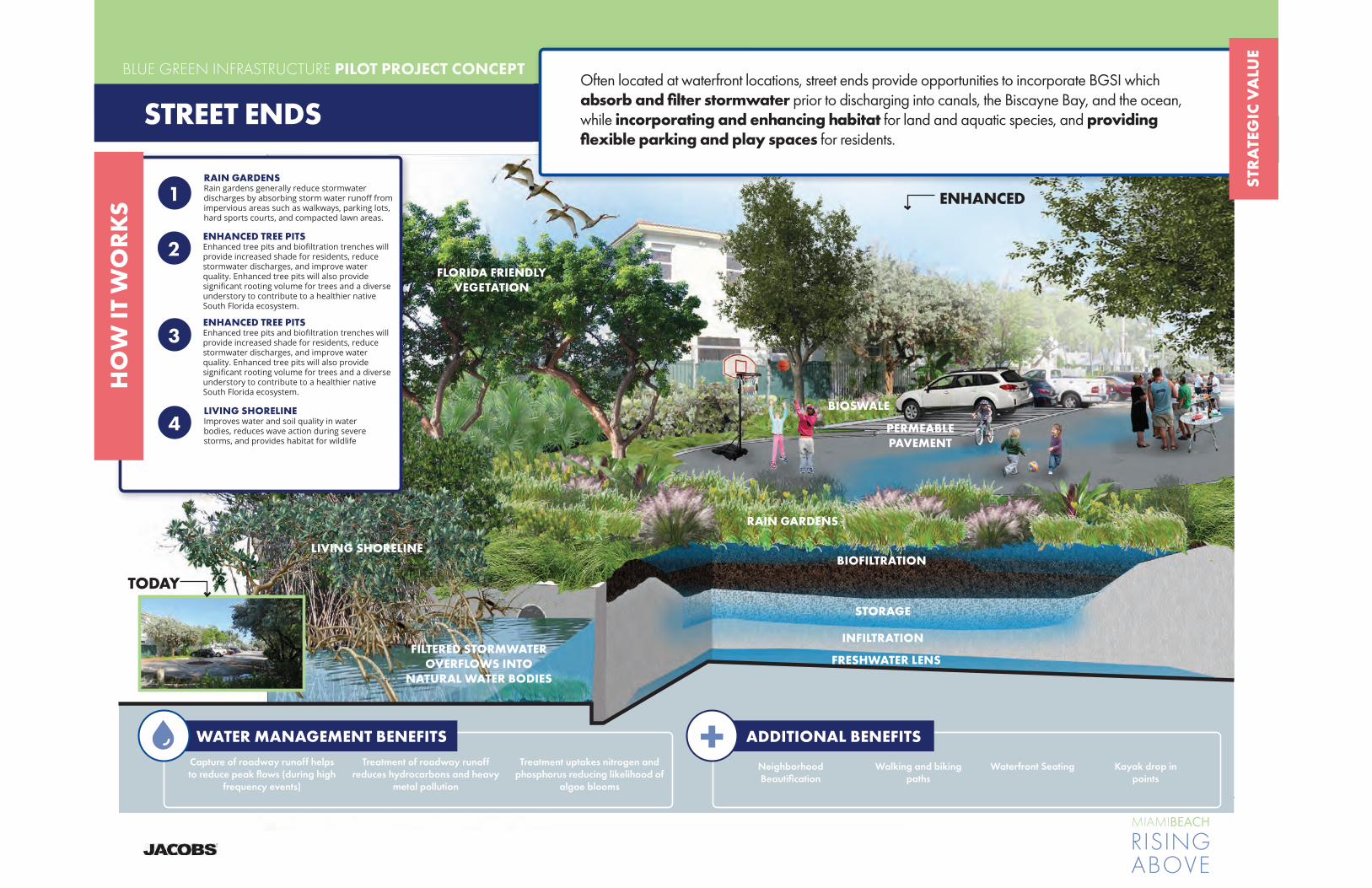
CONSTRUCTED WETLANDSVolupita venimus voluptat aut et ut es
maio
BLUE GREEN INFRASTRUCTURE PILOT PROJECT CONCEPT
MIAMIBEACH
RISING
ABOVE
STR
ATE
GIC
VA
LUE
CONSTRUCTED WETLANDSVolupita venimus vs vs vs voluptat aut et ut es
maio
STREET ENDS
Often located at waterfront locations, street ends provide opportunities to incorporate BGSI which absorb and filter stormwater prior to discharging into canals, the Biscayne Bay, and the ocean, while incorporating and enhancing habitat for land and aquatic species, and providing flexible parking and play spaces for residents.
4LIVING SHORELINE Improves water and soil quality in water bodies, reduces wave action during severe
HO
W I
T W
OR
KS
WATER MANAGEMENT BENEFITS
Capture of roadway runoff helps to reduce peak flows (during high
frequency events)
Treatment of roadway runoff reduces hydrocarbons and heavy
metal pollution
Treatment uptakes nitrogen and phosphorus reducing likelihood of
algae blooms
ADDITIONAL BENEFITS +Walking and biking
pathsWaterfront SeatingNeighborhood
BeautificationKayak drop in
points
TODAY
ENHANCED
RAIN GARDENSRain gardens generally reduce stormwater
impervious areas such as walkways, parking lots, hard sports courts, and compacted lawn areas.
1
2ENHANCED TREE PITS
stormwater discharges, and improve water quality. Enhanced tree pits will also provide
understory to contribute to a healthier native South Florida ecosystem.
3ENHANCED TREE PITS
stormwater discharges, and improve water quality. Enhanced tree pits will also provide
understory to contribute to a healthier native South Florida ecosystem.
FLORIDA FRIENDLY VEGETATION
RAIN GARDENS
BIOSWALE
LIVING SHORELINEBIOFILTRATION
STORAGE
INFILTRATION
FRESHWATER LENSFILTERED STORMWATER
OVERFLOWS INTO NATURAL WATER BODIES
PERMEABLE PAVEMENT

Appendix F Potential Project Location Maps

Stormwater Projects(Yes or Potential and BW Master Plan)
Project Site Name1 1 Street between Alton Road and Washinton Avenue2 11 Street5 41st Street Corridor
6 Above Ground Improvements - City center
7 Above Ground Improvements - LaGorce Island
8 Above Ground Improvements - Indian Creek Pathway
9 Above Ground Improvements -Above Ground Improvements - Nautilus & Middle North Bay
10 Above Ground Improvements - Normandy Isle South
11 Above Ground Improvements - South Pointe
12 Above Ground Improvements - Sunset Island 1 and 2
13 Above Ground Improvements - Belle Isle
14 Alexander Muss Park15 Altos Del Mar Park16 Art Deco Museum Expansion17 Baywalk20 Brittany Bay Park and Seawall22 Central Bayshore South
23 Chase Avenue Parking Lot24 Collins Canal26 Collins Park Performing Arts Venue27 Convention Center Park29 Crespi Street End Pocket Parks31 Fairway Park (Artificial Turf Soccer Field, Drainage and Playground Replacement)32 Fire Station #133 Fire Station #334 Fisher Park35 Flamingo Park - Phase II36 Flamingo Park - Phase III37 Flamingo Park Master Plan Improvements
39 Indian Creek Drive Flooding Mitigation Project
40 La Gorce and Lakeview41 La Gorce Park43 La Gorce Vacant Corner57 Lot P2 at Ocean Drive and 1 Street (Nikki Beach)58 Lummus Park59 Marjory Stoneman Douglas Park60 Maurice Gibb Park Redesign64 Mount Sinai South Open Space65 Muss Park
66 Neighborhood Traffic Calming and Pedestrian-Friendly Streets - Nautilus
67 Neighborhood Traffic Calming and Pedestrian-Friendly Streets - Bayshore
68 Neighborhood Traffic Calming and Pedestrian-Friendly Streets - Normandy Isle
69 Neighborhood Traffic Calming and Pedestrian-Friendly Streets - Palm View70 Normandy Isle Park Turf Replacement74 Normandy Shores Park79 North Beach Police Sub-Station
96 North Shore Neighborhood Improvements97 North Shore Park Tennis Facility98 Ocean Rescue North Beach Facility99 P16 Parking Garage
100 P86 Surface Lot
101 Palm and Hibiscus Islands Right of Way Improvements102 Palm Island Park104 Parkview Park Annex105 Pinetree Park106 Pocket Park at 20 Street & Sunset Drive107 Polo Park108 Roof Replacements at Cultural Facilities - Bass Museum109 Roof Replacements at Cultural Facilities - Colony Theater110 Rue Vendome Public Plaza111 Scott Rakow Youth Center119 Shane Boating Center120 Shared Path on Parkview Island Park (73-77 streets)121 Skate Park122 SoundScape Park125 South Pointe Park128 Sunset Islands III and IV130 Surface Lot at Biscayne Beach131 Tatum Park133 Venetian Islands Right of Way Improvements134 W 42 Sheridan Street to Pine Tree Druve Reconfiguration135 Washington Avenue Corridor138 West Lots Redevelopment
Project Site Name1 1 Street between Alton Road and Washinton Avenue2 11 Street3 27th Street Waterfront Area4 40th Street and Indian Creek Street Side5 41st Street Corridor6 Above Ground Improvements - City center7 Above Ground Improvements - LaGorce Island8 Above Ground Improvements - Indian Creek Pathway9 Above Ground Improvements -Above Ground Improvements - Nautilus & Middle North Bay
10 Above Ground Improvements - Normandy Isle South11 Above Ground Improvements - South Pointe12 Above Ground Improvements - Sunset Island 1 and 213 Above Ground Improvements - Belle Isle14 Alexander Muss Park15 Altos Del Mar Park16 Art Deco Museum Expansion17 Baywalk18 Beachwalk Phase II19 Bike Paths20 Brittany Bay Park and Seawall21 Carl Fisher Clubhouse Restoration22 Central Bayshore South23 Chase Avenue Parking Lot24 Collins Canal25 Collins Park Garage26 Collins Park Performing Arts Venue27 Convention Center Park28 Crespi Kayak Launch29 Crespi Street End Pocket Parks30 Espanola Way Bollard Installation31 Fairway Park (Artificial Turf Soccer Field, Drainage and Playground Replacement)32 Fire Station #133 Fire Station #334 Fisher Park35 Flamingo Park - Phase II36 Flamingo Park - Phase III37 Flamingo Park Master Plan Improvements38 Indian Beach Park39 Indian Creek Drive Flooding Mitigation Project40 La Gorce and Lakeview41 La Gorce Park42 La Gorce Street End43 La Gorce Vacant Corner44 Lake Pancoast45 LED Lighting in Parks - Flamingo Park46 LED Lighting in Parks - North Shore Park & Youth Center47 LED Lighting in Parks - Normandy Isle Park48 LED Lighting in Parks - Tatum Park49 LED Lighting in Parks - Stillwater Park50 LED Lighting in Parks - Crespi Park51 Lincoln Road between Collins Avenue and Lenox Avenue52 Meridian between Lincoln Road and 17th Street53 Drexal between Lincoln Road and 17th Street54 Pennsylvania Avenue between Lincoln Road and 17th Street55 Lincoln Road Street End56 Log Cabin Reconstruction57 Lot P2 at Ocean Drive and 1 Street (Nikki Beach)58 Lummus Park59 Marjory Stoneman Douglas Park60 Maurice Gibb Park Redesign61 Miami Beach Marina62 Middle Beach Recreational Corridor Phase 363 Monument Island64 Mount Sinai South Open Space65 Muss Park66 Neighborhood Traffic Calming and Pedestrian-Friendly Streets - Nautilus67 Neighborhood Traffic Calming and Pedestrian-Friendly Streets - Bayshore68 Neighborhood Traffic Calming and Pedestrian-Friendly Streets - Normandy Isle69 Neighborhood Traffic Calming and Pedestrian-Friendly Streets - Palm View70 Normandy Isle Park Turf Replacement71 Normandy Isle Phase II - Marseille Drive from Trouville Esplanade to Rue Notre Dame72 Normandy Isle Phase II - Calais Drive between Trouville Esplanade and Rue Bordeaux73 Normandy Isle Street End74 Normandy Shores Park75 Normandy Shores Street End76 North Bay Street End (North Bay Road)77 North Bay Street End (West 23rd Street)78 North Beach Ocean Side Park Renovation79 North Beach Police Sub-Station80 North Beach Waterfront Street End (Bay Drive)81 North Beach Waterfront Street End (Hagen Street)82 North Beach Waterfront Street End (Jones Street)83 North Beach Waterfront Street End (North Henedon Avenue)84 North Beach Waterfront Street End (North Rue Granville)85 North Beach Waterfront Street End (North Rue Notre Dame)86 North Beach Waterfront Street End (North Shore Drive)87 North Beach Waterfront Street End (Ray Street)88 North Beach Waterfront Street End (Rue Bordeaux Drive)89 North Beach Waterfront Street End (Rue Versailles Drive)90 North Beach Waterfront Street End (South Henedon Avenue)91 North Beach Waterfront Street End (South Rue Granville)92 North Beach Waterfront Street End (South Rue Notre Dame)93 North Beach Waterfront Street End (Trouville Esplanade)94 North Beach Waterfront Street End (Vardon Street)95 North Beach Yard96 North Shore Neighborhood Improvements97 North Shore Park Tennis Facility98 Ocean Rescue North Beach Facility99 P16 Parking Garage100 P86 Surface Lot101 Palm and Hibiscus Islands Right of Way Improvements102 Palm Island Park103 Parkview Island Waterfront Street End104 Parkview Park Annex105 Pinetree Park106 Pocket Park at 20 Street & Sunset Drive107 Polo Park108 Roof Replacements at Cultural Facilities - Bass Museum109 Roof Replacements at Cultural Facilities - Colony Theater110 Rue Vendome Public Plaza111 Scott Rakow Youth Center112 Security Cameras in Entertainment District113 Security Cameras on Beachwalk114 Security for Public Spaces - MB Convention Center115 Security for Public Spaces - Lincoln Road116 Security for Public Spaces - Ocean Drive117 Security for Public Spaces - SoundScape Park118 Security for Public Spaces - South Pointe119 Shane Boating Center120 Shared Path on Parkview Island Park (73-77 streets)121 Skate Park122 SoundScape Park123 South Beach Street End124 South Beach Street End (Bay Road)125 South Pointe Park126 Stillwater Park127 Sunset Islands 1 & 2 Guardhouse128 Sunset Islands III and IV129 Sunset Lake130 Surface Lot at Biscayne Beach131 Tatum Park132 Tent (Canopy) for the North Shore Bandshell133 Venetian Islands Right of Way Improvements134 W 42 Sheridan Street to Pine Tree Druve Reconfiguration135 Washington Avenue Corridor136 Water Main Installation on 63137 West Avenue Bridge138 West Lots Redevelopment
Project Site Name1 1 Street between Alton Road and Washinton Avenue2 11 Street5 41st Street Corridor6 Above Ground Improvements - City center7 Above Ground Improvements - LaGorce Island8 Above Ground Improvements - Indian Creek Pathway9 Above Ground Improvements -Above Ground Improvements - Nautilus & Middle North Bay10 Above Ground Improvements - Normandy Isle South11 Above Ground Improvements - South Pointe12 Above Ground Improvements - Sunset Island 1 and 213 Above Ground Improvements - Belle Isle14 Alexander Muss Park15 Altos Del Mar Park16 Art Deco Museum Expansion17 Baywalk20 Brittany Bay Park and Seawall22 Central Bayshore South23 Chase Avenue Parking Lot25 Collins Park Garage26 Collins Park Performing Arts Venue27 Convention Center Park29 Crespi Street End Pocket Parks30 Espanola Way Bollard Installation31 Fairway Park (Artificial Turf Soccer Field, Drainage and Playground Replacement)32 Fire Station #133 Fire Station #334 Fisher Park35 Flamingo Park - Phase II36 Flamingo Park - Phase III37 Flamingo Park Master Plan Improvements39 Indian Creek Drive Flooding Mitigation Project40 La Gorce and Lakeview41 La Gorce Park43 La Gorce Vacant Corner45 LED Lighting in Parks - Flamingo Park46 LED Lighting in Parks - North Shore Park & Youth Center47 LED Lighting in Parks - Normandy Isle Park48 LED Lighting in Parks - Tatum Park49 LED Lighting in Parks - Stillwater Park50 LED Lighting in Parks - Crespi Park51 Lincoln Road between Collins Avenue and Lenox Avenue52 Meridian between Lincoln Road and 17th Street53 Drexal between Lincoln Road and 17th Street54 Pennsylvania Avenue between Lincoln Road and 17th Street56 Log Cabin Reconstruction57 Lot P2 at Ocean Drive and 1 Street (Nikki Beach)58 Lummus Park59 Marjory Stoneman Douglas Park60 Maurice Gibb Park Redesign64 Mount Sinai South Open Space65 Muss Park66 Neighborhood Traffic Calming and Pedestrian-Friendly Streets - Nautilus67 Neighborhood Traffic Calming and Pedestrian-Friendly Streets - Bayshore68 Neighborhood Traffic Calming and Pedestrian-Friendly Streets - Normandy Isle69 Neighborhood Traffic Calming and Pedestrian-Friendly Streets - Palm View70 Normandy Isle Park Turf Replacement71 Normandy Isle Phase II - Marseille Drive from Trouville Esplanade to Rue Notre Dame72 Normandy Isle Phase II - Calais Drive between Trouville Esplanade and Rue Bordeaux74 Normandy Shores Park78 North Beach Ocean Side Park Renovation79 North Beach Police Sub-Station95 North Beach Yard96 North Shore Neighborhood Improvements97 North Shore Park Tennis Facility98 Ocean Rescue North Beach Facility99 P16 Parking Garage
100 P86 Surface Lot101 Palm and Hibiscus Islands Right of Way Improvements102 Palm Island Park104 Parkview Park Annex105 Pinetree Park106 Pocket Park at 20 Street & Sunset Drive107 Polo Park108 Roof Replacements at Cultural Facilities - Bass Museum109 Roof Replacements at Cultural Facilities - Colony Theater110 Rue Vendome Public Plaza111 Scott Rakow Youth Center112 Security Cameras in Entertainment District113 Security Cameras on Beachwalk114 Security for Public Spaces - MB Convention Center115 Security for Public Spaces - Lincoln Road116 Security for Public Spaces - Ocean Drive117 Security for Public Spaces - SoundScape Park118 Security for Public Spaces - South Pointe119 Shane Boating Center120 Shared Path on Parkview Island Park (73-77 streets)121 Skate Park122 SoundScape Park125 South Pointe Park126 Stillwater Park127 Sunset Islands 1 & 2 Guardhouse128 Sunset Islands III and IV129 Sunset Lake130 Surface Lot at Biscayne Beach131 Tatum Park132 Tent (Canopy) for the North Shore Bandshell133 Venetian Islands Right of Way Improvements134 W 42 Sheridan Street to Pine Tree Druve Reconfiguration135 Washington Avenue Corridor136 Water Main Installation on 63137 West Avenue Bridge138 West Lots Redevelopment
Legend
¬«# Facility
¬«# Neighborhood Improvements
¬«# Parking
¬«# Parks
¬«# Redevelopment
¬«# Street
¬«# Other
Canal
Miami Beach City Limits
BAYSHORE
BISCAYNE POINT
CITY CENTER NEIGHBORHOOD
FLAMINGO/LUMMUS
LA GORCE
NAUTILUS NEIGHBORHOOD
NORMANDY ISLES
NORMANDY SHORES
NORTH SHORE
OCEANFRONT
SOUTH AND VENETIAN ISLANDS
SOUTH POINTE
STAR/PALM/HIBISCUS
WEST AVENUE AND BAY ROAD
Legend
¬«# Coastal/Waterway
¬«# Facility
¬«# Neighborhood Improvements
¬«# Parking
¬«# Parks
¬«# Redevelopment
¬«# Street
¬«# Other
Canal
Miami Beach City Limits
BAYSHORE
BISCAYNE POINT
CITY CENTER NEIGHBORHOOD
FLAMINGO/LUMMUS
LA GORCE
NAUTILUS NEIGHBORHOOD
NORMANDY ISLES
NORMANDY SHORES
NORTH SHORE
OCEANFRONT
SOUTH AND VENETIAN ISLANDS
SOUTH POINTE
STAR/PALM/HIBISCUS
WEST AVENUE AND BAY ROAD
Coastal / WaterwayProject Site Name
3 27th Street Waterfront Area4 40th Street and Indian Creek Street Side18 Beachwalk Phase II19 Bike Paths21 Carl Fisher Clubhouse Restoration25 Collins Park Garage28 Crespi Kayak Launch38 Indian Beach Park42 La Gorce Street End44 Lake Pancoast55 Lincoln Road Street End61 Miami Beach Marina62 Middle Beach Recreational Corridor Phase 363 Monument Island73 Normandy Isle Street End75 Normandy Shores Street End76 North Bay Street End (North Bay Road)77 North Bay Street End (West 23rd Street)80 North Beach Waterfront Street End (Bay Drive)81 North Beach Waterfront Street End (Hagen Street)82 North Beach Waterfront Street End (Jones Street)83 North Beach Waterfront Street End (North Henedon Avenue)84 North Beach Waterfront Street End (North Rue Granville)85 North Beach Waterfront Street End (North Rue Notre Dame)86 North Beach Waterfront Street End (North Shore Drive)87 North Beach Waterfront Street End (Ray Street)88 North Beach Waterfront Street End (Rue Bordeaux Drive)89 North Beach Waterfront Street End (Rue Versailles Drive)90 North Beach Waterfront Street End (South Henedon Avenue)91 North Beach Waterfront Street End (South Rue Granville)92 North Beach Waterfront Street End (South Rue Notre Dame)93 North Beach Waterfront Street End (Trouville Esplanade)94 North Beach Waterfront Street End (Vardon Street)
103 Parkview Island Waterfront Street End123 South Beach Street End124 South Beach Street End (Bay Road)
Legend
¬«# Coastal/Waterway
Canal
Miami Beach City Limits
BAYSHORE
BISCAYNE POINT
CITY CENTER NEIGHBORHOOD
FLAMINGO/LUMMUS
LA GORCE
NAUTILUS NEIGHBORHOOD
NORMANDY ISLES
NORMANDY SHORES
NORTH SHORE
OCEANFRONT
SOUTH AND VENETIAN ISLANDS
SOUTH POINTE
STAR/PALM/HIBISCUS
WEST AVENUE AND BAY ROAD
63
6118
55124
24
77
3
44
4
38
4276
62
8892
89
7391
848082 93
81
8785
9475
90
86
28
103
83
123
21
25
Neighborhood ImprovementsProject Site Name
6 Above Ground Improvements - City center7 Above Ground Improvements - LaGorce Island8 Above Ground Improvements - Indian Creek Pathway9 Above Ground Improvements -Above Ground Improvements - Nautilus & Middle North Bay10 Above Ground Improvements - Normandy Isle South11 Above Ground Improvements - South Pointe12 Above Ground Improvements - Sunset Island 1 and 213 Above Ground Improvements - Belle Isle14 Alexander Muss Park23 Chase Avenue Parking Lot39 Indian Creek Drive Flooding Mitigation Project40 La Gorce and Lakeview66 Neighborhood Traffic Calming and Pedestrian-Friendly Streets - Nautilus67 Neighborhood Traffic Calming and Pedestrian-Friendly Streets - Bayshore68 Neighborhood Traffic Calming and Pedestrian-Friendly Streets - Normandy Isle69 Neighborhood Traffic Calming and Pedestrian-Friendly Streets - Palm View71 Normandy Isle Phase II - Marseille Drive from Trouville Esplanade to Rue Notre Dame72 Normandy Isle Phase II - Calais Drive between Trouville Esplanade and Rue Bordeaux96 North Shore Neighborhood Improvements
101 Palm and Hibiscus Islands Right of Way Improvements128 Sunset Islands III and IV129 Sunset Lake133 Venetian Islands Right of Way Improvements136 Water Main Installation on 63
Legend
¬«# Neighborhood Improvements
Canal
Miami Beach City Limits
BAYSHORE
BISCAYNE POINT
CITY CENTER NEIGHBORHOOD
FLAMINGO/LUMMUS
LA GORCE
NAUTILUS NEIGHBORHOOD
NORMANDY ISLES
NORMANDY SHORES
NORTH SHORE
OCEANFRONT
SOUTH AND VENETIAN ISLANDS
SOUTH POINTE
STAR/PALM/HIBISCUS
WEST AVENUE AND BAY ROAD
136
133
129
128
101
96
72 71
69
68
67
66
40
39
22
14
13
12
11
10
9
8
7
6
OtherProject Site Name
20 Brittany Bay Park and Seawall30 Espanola Way Bollard Installation43 La Gorce Vacant Corner45 LED Lighting in Parks - Flamingo Park46 LED Lighting in Parks - North Shore Park & Youth Center47 LED Lighting in Parks - Normandy Isle Park48 LED Lighting in Parks - Tatum Park49 LED Lighting in Parks - Stillwater Park50 LED Lighting in Parks - Crespi Park95 North Beach Yard
104 Parkview Park Annex110 Rue Vendome Public Plaza112 Security Cameras in Entertainment District113 Security Cameras on Beachwalk114 Security for Public Spaces - MB Convention Center115 Security for Public Spaces - Lincoln Road116 Security for Public Spaces - Ocean Drive117 Security for Public Spaces - SoundScape Park118 Security for Public Spaces - South Pointe120 Shared Path on Parkview Island Park (73-77 streets)137 West Avenue Bridge
Legend
¬«# Other
Canal
Miami Beach City Limits
BAYSHORE
BISCAYNE POINT
CITY CENTER NEIGHBORHOOD
FLAMINGO/LUMMUS
LA GORCE
NAUTILUS NEIGHBORHOOD
NORMANDY ISLES
NORMANDY SHORES
NORTH SHORE
OCEANFRONT
SOUTH AND VENETIAN ISLANDS
SOUTH POINTE
STAR/PALM/HIBISCUS
WEST AVENUE AND BAY ROAD
137
120
118
116
115
114
113
112
110
104
95
50
49
48
47
46
45
43
30
20
19
StreetProject Site Name
1 1 Street between Alton Road and Washinton Avenue2 11 Street5 41st Street Corridor
134 W 42 Sheridan Street to Pine Tree Druve Reconfiguration135 Washington Avenue Corridor
Legend
¬«# Street
Canal
Miami Beach City Limits
BAYSHORE
BISCAYNE POINT
CITY CENTER NEIGHBORHOOD
FLAMINGO/LUMMUS
LA GORCE
NAUTILUS NEIGHBORHOOD
NORMANDY ISLES
NORMANDY SHORES
NORTH SHORE
OCEANFRONT
SOUTH AND VENETIAN ISLANDS
SOUTH POINTE
STAR/PALM/HIBISCUS
WEST AVENUE AND BAY ROAD
135
134
5
2
1
ParkingProject Site Name
24 Collins Canal57 Lot P2 at Ocean Drive and 1 Street (Nikki Beach)
100 P86 Surface Lot130 Surface Lot at Biscayne Beach
Legend
¬«# Parking
Canal
Miami Beach City Limits
BAYSHORE
BISCAYNE POINT
CITY CENTER NEIGHBORHOOD
FLAMINGO/LUMMUS
LA GORCE
NAUTILUS NEIGHBORHOOD
NORMANDY ISLES
NORMANDY SHORES
NORTH SHORE
OCEANFRONT
SOUTH AND VENETIAN ISLANDS
SOUTH POINTE
STAR/PALM/HIBISCUS
WEST AVENUE AND BAY ROAD
130
100
57
23
ParksProject Site Name
15 Altos Del Mar Park16 Art Deco Museum Expansion29 Crespi Street End Pocket Parks31 Fairway Park (Artificial Turf Soccer Field, Drainage and Playground Replacement)34 Fisher Park35 Flamingo Park - Phase II36 Flamingo Park - Phase III37 Flamingo Park Master Plan Improvements41 La Gorce Park58 Lummus Park59 Marjory Stoneman Douglas Park60 Maurice Gibb Park Redesign64 Mount Sinai South Open Space65 Muss Park70 Normandy Isle Park Turf Replacement74 Normandy Shores Park78 North Beach Ocean Side Park Renovation97 North Shore Park Tennis Facility
102 Palm Island Park105 Pinetree Park106 Pocket Park at 20 Street & Sunset Drive107 Polo Park121 Skate Park125 South Pointe Park126 Stillwater Park131 Tatum Park132 Tent (Canopy) for the North Shore Bandshell
Legend
¬«# Parks
Canal
Miami Beach City Limits
BAYSHORE
BISCAYNE POINT
CITY CENTER NEIGHBORHOOD
FLAMINGO/LUMMUS
LA GORCE
NAUTILUS NEIGHBORHOOD
NORMANDY ISLES
NORMANDY SHORES
NORTH SHORE
OCEANFRONT
SOUTH AND VENETIAN ISLANDS
SOUTH POINTE
STAR/PALM/HIBISCUS
WEST AVENUE AND BAY ROAD
132
131
126
125
121
107
106
105
102
97
78
74
70
65
64
60
59
58
41
3635
34
31
29
16
15
RedevelopmentProject Site Name
51 Lincoln Road between Collins Avenue and Lenox Avenue52 Meridian between Lincoln Road and 17th Street53 Drexal between Lincoln Road and 17th Street54 Pennsylvania Avenue between Lincoln Road and 17th Street
138 West Lots Redevelopment
Legend
¬«# Redevelopment
Canal
Miami Beach City Limits
BAYSHORE
BISCAYNE POINT
CITY CENTER NEIGHBORHOOD
FLAMINGO/LUMMUS
LA GORCE
NAUTILUS NEIGHBORHOOD
NORMANDY ISLES
NORMANDY SHORES
NORTH SHORE
OCEANFRONT
SOUTH AND VENETIAN ISLANDS
SOUTH POINTE
STAR/PALM/HIBISCUS
WEST AVENUE AND BAY ROAD
138
545352 51
FacilityProject Site Name
17 Baywalk22 Central Bayshore South26 Collins Park Performing Arts Venue27 Convention Center Park32 Fire Station #133 Fire Station #356 Log Cabin Reconstruction79 North Beach Police Sub-Station98 Ocean Rescue North Beach Facility99 P16 Parking Garage
108 Roof Replacements at Cultural Facilities - Bass Museum109 Roof Replacements at Cultural Facilities - Colony Theater111 Scott Rakow Youth Center119 Shane Boating Center122 SoundScape Park127 Sunset Islands 1 & 2 Guardhouse
Legend
¬«# Facility
Canal
Miami Beach City Limits
BAYSHORE
BISCAYNE POINT
CITY CENTER NEIGHBORHOOD
FLAMINGO/LUMMUS
LA GORCE
NAUTILUS NEIGHBORHOOD
NORMANDY ISLES
NORMANDY SHORES
NORTH SHORE
OCEANFRONT
SOUTH AND VENETIAN ISLANDS
SOUTH POINTE
STAR/PALM/HIBISCUS
WEST AVENUE AND BAY ROAD
127
122
119
117
111
109
108
99
98
79
56
33
32
27
26
17
Project Site Name Source1 1 Street between Alton Road and Washinton Avenue CMB Website2 11 Street CMB Website3 27th Street Waterfront Area Blueways MP4 40th Street and Indian Creek Street Side Blueways MP5 41st Street Corridor G.O. Bond List6 Above Ground Improvements - City center G.O. Bond List7 Above Ground Improvements - LaGorce Island G.O. Bond List8 Above Ground Improvements - Indian Creek Pathway G.O. Bond List9 Above Ground Improvements -Above Ground Improvements - Nautilus & Middle North Bay G.O. Bond List
10 Above Ground Improvements - Normandy Isle South G.O. Bond List11 Above Ground Improvements - South Pointe G.O. Bond List12 Above Ground Improvements - Sunset Island 1 and 2 G.O. Bond List13 Above Ground Improvements - Belle Isle G.O. Bond List
14 Alexander Muss Park CMB Website15 Altos Del Mar Park CMB Website16 Art Deco Museum Expansion G.O. Bond List17 Baywalk G.O. Bond List18 Beachwalk Phase II CMB Website19 Bike Paths CMB Website20 Brittany Bay Park and Seawall CMB Website21 Carl Fisher Clubhouse Restoration CMB Website22 Central Bayshore South CMB Website23 Chase Avenue Parking Lot Blueways MP24 Collins Canal Blueways MP25 Collins Park Garage CMB Website26 Collins Park Performing Arts Venue CMB Website27 Convention Center Park CMB Website28 Crespi Kayak Launch CMB Website29 Crespi Street End Pocket Parks Blueways MP30 Espanola Way Bollard Installation CMB Website31 Fairway Park (Artificial Turf Soccer Field, Drainage and Playground Replacement) CMB Website32 Fire Station #1 G.O. Bond List33 Fire Station #3 G.O. Bond List34 Fisher Park G.O. Bond List35 Flamingo Park - Phase II CMB Website36 Flamingo Park - Phase III CMB Website37 Flamingo Park Master Plan Improvements CMB Website38 Indian Beach Park Blueways MP39 Indian Creek Drive Flooding Mitigation Project CMB Website40 La Gorce and Lakeview CMB Website41 La Gorce Park G.O. Bond List42 La Gorce Street End Blueways MP43 La Gorce Vacant Corner Blueways MP44 Lake Pancoast Blueways MP45 LED Lighting in Parks - Flamingo Park G.O. Bond List46 LED Lighting in Parks - North Shore Park & Youth Center G.O. Bond List47 LED Lighting in Parks - Normandy Isle Park G.O. Bond List48 LED Lighting in Parks - Tatum Park G.O. Bond List49 LED Lighting in Parks - Stillwater Park G.O. Bond List50 LED Lighting in Parks - Crespi Park G.O. Bond List51 Lincoln Road between Collins Avenue and Lenox Avenue CMB Website52 Meridian between Lincoln Road and 17th Street CMB Website53 Drexal between Lincoln Road and 17th Street CMB Website54 Pennsylvania Avenue between Lincoln Road and 17th Street CMB Website55 Lincoln Road Street End Blueways MP56 Log Cabin Reconstruction G.O. Bond List57 Lot P2 at Ocean Drive and 1 Street (Nikki Beach) CMB Website58 Lummus Park G.O. Bond List59 Marjory Stoneman Douglas Park G.O. Bond List60 Maurice Gibb Park Redesign CMB Website
61 Miami Beach Marina Blueways MP62 Middle Beach Recreational Corridor Phase 3 CMB Website63 Monument Island Blueways MP64 Mount Sinai South Open Space Blueways MP65 Muss Park G.O. Bond List66 Neighborhood Traffic Calming and Pedestrian-Friendly Streets - Nautilus G.O. Bond List67 Neighborhood Traffic Calming and Pedestrian-Friendly Streets - Bayshore G.O. Bond List68 Neighborhood Traffic Calming and Pedestrian-Friendly Streets - Normandy Isle G.O. Bond List69 Neighborhood Traffic Calming and Pedestrian-Friendly Streets - Palm View G.O. Bond List70 Normandy Isle Park Turf Replacement CMB Website71 Normandy Isle Phase II - Marseille Drive from Trouville Esplanade to Rue Notre Dame CMB Website72 Normandy Isle Phase II - Calais Drive between Trouville Esplanade and Rue Bordeaux CMB Website73 Normandy Isle Street End Blueways MP74 Normandy Shores Park Blueways MP75 Normandy Shores Street End Blueways MP76 North Bay Street End (North Bay Road) Blueways MP
77 North Bay Street End (West 23rd Street) Blueways MP78 North Beach Ocean Side Park Renovation CMB Website79 North Beach Police Sub-Station Blueways MP80 North Beach Waterfront Street End (Bay Drive) Blueways MP81 North Beach Waterfront Street End (Hagen Street) Blueways MP82 North Beach Waterfront Street End (Jones Street) Blueways MP83 North Beach Waterfront Street End (North Henedon Avenue) Blueways MP84 North Beach Waterfront Street End (North Rue Granville) Blueways MP85 North Beach Waterfront Street End (North Rue Notre Dame) Blueways MP86 North Beach Waterfront Street End (North Shore Drive) Blueways MP87 North Beach Waterfront Street End (Ray Street) Blueways MP88 North Beach Waterfront Street End (Rue Bordeaux Drive) Blueways MP89 North Beach Waterfront Street End (Rue Versailles Drive) Blueways MP90 North Beach Waterfront Street End (South Henedon Avenue) Blueways MP91 North Beach Waterfront Street End (South Rue Granville) Blueways MP92 North Beach Waterfront Street End (South Rue Notre Dame) Blueways MP93 North Beach Waterfront Street End (Trouville Esplanade) Blueways MP94 North Beach Waterfront Street End (Vardon Street) Blueways MP95 North Beach Yard CMB Website96 North Shore Neighborhood Improvements G.O. Bond List97 North Shore Park Tennis Facility CMB Website98 Ocean Rescue North Beach Facility G.O. Bond List99 P16 Parking Garage CMB Website100 P86 Surface Lot CMB Website101 Palm and Hibiscus Islands Right of Way Improvements CMB Website102 Palm Island Park G.O. Bond List103 Parkview Island Waterfront Street End Blueways MP104 Parkview Park Annex Blueways MP105 Pinetree Park G.O. Bond List106 Pocket Park at 20 Street & Sunset Drive CMB Website107 Polo Park G.O. Bond List108 Roof Replacements at Cultural Facilities - Bass Museum G.O. Bond List109 Roof Replacements at Cultural Facilities - Colony Theater G.O. Bond List110 Rue Vendome Public Plaza CMB Website111 Scott Rakow Youth Center GO Bond List112 Security Cameras in Entertainment District GO Bond List113 Security Cameras on Beachwalk GO Bond List114 Security for Public Spaces - MB Convention Center GO Bond List115 Security for Public Spaces - Lincoln Road GO Bond List116 Security for Public Spaces - Ocean Drive GO Bond List117 Security for Public Spaces - SoundScape Park GO Bond List118 Security for Public Spaces - South Pointe GO Bond List119 Shane Boating Center Blueways MP120 Shared Path on Parkview Island Park (73-77 streets) CMB Website121 Skate Park G.O. Bond List122 SoundScape Park G.O. Bond List123 South Beach Street End Blueways MP124 South Beach Street End (Bay Road) Blueways MP125 South Pointe Park G.O. Bond List126 Stillwater Park G.O. Bond List127 Sunset Islands 1 & 2 Guardhouse CMB Website128 Sunset Islands III and IV CMB Website129 Sunset Lake Blueways MP130 Surface Lot at Biscayne Beach CMB Website131 Tatum Park G.O. Bond List132 Tent (Canopy) for the North Shore Bandshell CMB Website133 Venetian Islands Right of Way Improvements CMB Website134 W 42 Sheridan Street to Pine Tree Druve Reconfiguration CMB Website135 Washington Avenue Corridor G.O. Bond List136 Water Maine Installation on 63 CMB Website137 West Avenue Bridge CMB Website138 West Lots Redevelopment G.O. Bond List
Data Sources:ESRI, City of Miami Beach October 2019

LA
G
OR
GE
G
OL
F C
OU
RS
E
LA
G
OR
GE
G
OL
F C
OU
RS
E
NORMANDY SHORES GOLF COURSE
NORMANDY SHORES GOLF COURSE
µ
Legend
Transportation Management Plan Projects
Triangular Open Spaces
Canal
Miami Beach City Limits
Building Footprints
Parcels
Parks
0 0.50.25
Mile
City of Miami BeachTransportation Management Plan
Projects
2
34
5
6
30
4
31
17
16
3320
19
22
18
21
3426
23
3
2524
2827
29
120
66
77
12978
121
80
11079
109
44
119
42
43
9564
69
11886
102
92
68
624894
54
47
115
45
59
84
ID NAME
2 Fisher Park
3 Normandy Isle Monument
4 Crespi Park
5 Tatum Park
6 Stillwater Park
16 Triangle at Sheridan Ave and Pine Tree Dr
17 Triangle at W 46th St and Sheridan Ave
18 Triangle at Alton Rd and W 51st St
19 Triangle at La Gorce Dr and Pine Tree Dr
20 La Gorce Park
21 Triangle at La Gorce Cir and Pine Tree Ln
22 Triangle at La Gorce Cir and Brevity Ln
23 Pana de Bryan
24 Triangle at John F Kennedy Causeway and Bay Dr
25 Triangle at Biarritz Dr and 71st St
26 Triangle at Normandy Dr and 71st St
27 Triangle at Daytonia Rd and S Biscayne Point Rd
28 Triangle at Crespi Rd and Hawthorne Ave
29 Triangle at Stillwater Dr S and Hawthorne Ave
30 Triangle at Tatum Waterway Dr and 80th St
31 Triangle at Indian Creek Dr and Dickens Ave
32 Triangle at Bonita Dr and 71st St
33 Triangle at Indian Creek Dr and W 63rd St
34 Triangle at Indian Creek Dr and Collins Ave
Triangular Open Spaces
ID NAME
42 73rd St One Way Protected Bicycle Lanes
43 72nd St One Way Protected Bicycle Lanes
44 Byron Avenue Protected Bicycle Lanes/Neighborhood Greenway
45 North Bay Rd Neighborhood Greenway
47 51st St Green Bicycle Lanes
48 63rd St: Feasibility Study for Bicycle Alternatives
54 La Gorce Dr/Pine Tree Dr Protected/Buffered Bicycle Lanes
57 Dickens Ave and SR 934/71st St Geometric Modifications
59 SR 907/Alton Road's Feasibility Study of Adaptive Signal Controls
62 Intersection of SR A1A/Indian Creek Dr and 63rd St Feasibility Study of Intersection Improvements
64 SR 934/71st St/Normandy Dr Safety Improvements
66 85th St Neighborhood Greenway
68 SR A1A/Collins Ave and Indian Creek Dr Signal Optimization Study
69 SR 934/71st Street Feasibility Study
77 81st St Neighborhood Greenway
78 81st St Neighborhood Greenway
79 77th St Neighborhood Greenway
80 Tatum Waterway Dr Neighborhood Greenway
84 47th Street Enhanced Bicycle Lane
86 Bay Drive Neighborhood Greenway
92 69th Street Buffered Bicycle Lanes
94 63rd Street Protected/buffered bicycle lanes
95 SR 934/71st St/Normandy Dr Exclusive Transit Lanes/Protected/buffered bicycle lanes
102 Fairway Drive Shared-Use Path
107 SR 934/79th St Cswy Exclusive transit, Shared Uses Path, and protected/buffered bicycle lanes
109 77th Street Shared Path
110 77th Street Neighborhood Greenway
115 SR 907/Alton Rd Exclusive transit lanes
118 Biarritz Drive Protected/buffered bicycle lanes
119 Wayne Avenue Shared Path
120 SR A1A Collins Ave/Indian Creek Dr/Harding Ave Exclusive transit lanes protected bicycle lanes
121 Hawthorne Avenue Neighborhood Greenway
129 Crespi Avenue Neighborhood Greenway
Transportation Master Plan Projects
107
Data Sources:ESRI, City of Miami Beach October 2019

MIA
MI B
EA
CH
G
OL
F C
LU
B
MIA
MI B
EA
CH
G
OL
F C
LU
B
µ
Legend
Transportation Management Plan Projects
Triangular Open Spaces
Canal
Miami Beach City Limits
Building Footprints
Parcels
Parks
0 0.50.25
Mile
City of Miami BeachTransportation Management Plan
Projects
98
76
75
7
1535
8 13
14
112
38
39
1136
37
10
9
97
85
123
87122
104
70, 96
63
71
8182
67
125
61117
103105
67
90116
106
60
93
93
99
50
100
101
83
4689
112
41
126
131
113
5173
72
91
52
55
58
8856
111
40
74
127
130
49
53
65, 124
114
128
ID NAME
1 Scott Rakow Playground
7 Triangle at Chase Ave and Prairie Ave
8 Triangle at Chase Ave and W 34th St
9 Triangle at 1st St and Jefferson Ave
10 Triangle at Sunset Dr and Alton Rd
11 Triangle at Dade Blvd and Washington Ave
12 Triangle at Prairie Ave and W 28th St
13 Triangle at W 35th St and Flamingo Dr
14 Triangle at W 33rd St and Flamingo Dr
15 Triangle at Flamingo Dr and Pine Tree Dr
35 Triangle at Indian Creek Dr and W 41st St
36 Triangle at Lake Ave and Sunset Dr
37 Triangle at Sunset Dr and W 21st St
38 Triangle at Alton Rd and W 34th St
39 Triangle at Alton Rd and Alton Rd
Triangular Open Spaces
ID NAME
40 SR A1A/MacArthur Causeway Complete Streets Feasibility Study
41 West Avenue Protected Bicycle Lanes
46 SR 907/Alton Rd and 17th St Intersection Improvements
49 SR 907 Bicycle Alternatives Analysis and Implementation
50 Dade Blvd Shared Use Path and Road Diet
51 Euclid Avenue Protected Bicycle Lanes
52 Meridian Avenue Bicycle Facilities
53 Meridian Avenue and 28th Street Shared Use Path
55 6th St and Michigan Ave Bicycle Facilities Analysis
56 SR A1A/5th St and SR 907/Alton Rd Intersection Improvements
58 SR A1A/MacArthur Causeway and SR A1A/5th St Feasibility Study of Adaptive Signal Controls
60 23rd Street Complete Streets Feasibility Study
61 SR A1A/Indian Creek Drive Bicycle/Pedestrian Safety Improvements
63 Intersection of 907/Alton Road and 43rd St/Ed Sullivan Rd
65 SR 112/Julia Tuttle Causeway Feasibility Study
67 Trolly Route: SR 907/Alton Rd SR 112/41st St SR A1A/Indian Creek Dr/Collins Ave Dade Blvd Prop MB
67 Trolly Route: SR 907/Alton Rd SR 112/41st St SR A1A/Indian Creek Dr/Collins Ave Dade Blvd Prop MB
70 SR 112 / 41st Street and SR 907/Alton Road Auxiliary Turn/Shoulder Lane Study
71 SR 112/Julia Tuttle Causeway Westbound Ramp
72 11th Street Neighborhood Greenway
73 10th Street Neighborhood Greenway
74 SR 907/Alton Rd and Michigan Ave Intersection Improvements
75 Middle Beach Recreational Corridor
76 SR A1A/Collins Ave/Indian Creek Dr and SR 112/41st St Intersection Safety Study and Improvements
81 Chase Avenue Shared-Use Path Feasibility Study
82 Alton Rd and North Bay Rd Intersection Bicycle Improvements
83 16th St Bicycle Facilities Improvements
85 42nd St Enhanced Bicycle Lanes
87 Royal Palm Ave Neighborhood Greenway
88 South Beach Pedestrian Priority Zones
89 17th Street Exclusive transit and protected/buffered bicycle lanes
90 SR A1A/Collins Ave/Indian Creek Dr Exclusive transit and protected/buffer ed bicycle lanes
91 Meridian Avenue Protected/buffered bicycle lanes
93 21st Street and 22nd Street/Park Avenue Protected Bicycle Lanes Feasibility Study
93 21st Street and 22nd Street/Park Avenue Protected Bicycle Lanes Feasibility Study
96 SR 907/Alton Rd and SR 112/41st St Safety Feasibility Study
97 SR 112/41st St and Pine Tree Dr Safety Feasibility Study
98 44th St and SR A1A/Collins Ave Safety Feasibility Study
99 Meridian Avenue Bicycle Greenway Analysis
100 Lincoln Road Shared Space
101 Lincoln Lane North Bicycle Connection/ Neighborhood Greenway
103 SR A1A / Collins Avenue Protected/buffered bicycle lanes
104 Prairie Avenue Neighborhood Greenway
105 SR A1A Collins Avenue Exclusive transit lanes
106 SR A1A Collins Ave/Indian Creek Dr Exclusive transit and protected/buffered bicycle lanes
111 South Pointe Drive Protected/buffered bicycle lanes
112 Alton Road Exclusive transit and protected/buffered bicycle lanes
113 Washington Avenue Exclusive transit and protected/buffered bicycle lanes
114 Venetian Causeway Conventional Bike Lanes
116 24th Street / Liberty Avenue Protected/buffered bicycle lanes
117 Flamingo Drive Protected/buffered bicycle lanes
122 Pine Tree Drive Protected Bicycle Lanes
123 SR 112/41st St Exclusive transit lanes and protected/buffered bicycle lanes
124 SR 112/Julia Tuttle Cswy Exclusive Transit Lane/Shared-Use Path
125 SR A1A/ Indian Creek Drive Protected Bicycle Lanes
126 15th Street Neighborhood Greenway
127 20 Street Neighborhood Greenway
128 Ocean Drive Shared Space
130 Purdy Avenue Neighborhood Greenway
131 Drexel Avenue Neighborhood Greenway
Transportation Master Plan Projects
Data Sources:ESRI, City of Miami Beach October 2019