mid-america regional council
TRANSCRIPT

Mid-America Regional Council
On the MapConservation Planning for the Kansas City Region
Mid-America Regional CouncilFebruary 2005

On the Map: Conservation Planning for the Kansas City RegionOn the Map: Conservation Planning for the Kansas City Region
In 2003, the Mid-America Regional Council (MARC) began developing an inventory of digital map data showing valuable natural resource assets and ecological features in the Kansas City region. The map is intended to provide a framework for environmental planning at local and regional levels.
This initiative, funded by the U.S. Environmental Protection Agency, provides the opportunity for Kansas City to join other national leaders such as Chicago and Milwaukee in using conservation planning tools to sustain future environmental quality. Further, this effort is expected to help create high quality livable environments through coordinated conservation and economic development.
The newly consolidated environmental data will help local communities proactively conserve or restore natural resources during the development process. This booklet introduces the Kansas City regional natural resource inventory, explains how and why it was developed, and, shows how it may be used to protect the high quality of life prized by area residents.
Introduction
On the cover: Rolling hills and wooded bluffs offer many scenic vistas of the Missouri River Valley, like this view near Fort Leavenworth. Photo by Bill Stephens

Mid-America Regional CouncilMid-America Regional Council
On the MapThe photo above centers on the confluence of the Kansas and Missouri rivers, a key element of the region’s green infrastructure.
I. The Vision Page 2
II. The Problem Page 4
III. The Solution Page 7
1

On the Map: Conservation Planning for the Kansas City RegionOn the Map: Conservation Planning for the Kansas City Region
The VisionPart I:
Looking north along the Kansas River, as it flows toward the Missouri River. The Kansas City, Missouri, stockyards, circa 1955, are visible in the upper right.
2
Mid-America Regional CouncilMid-America Regional Council
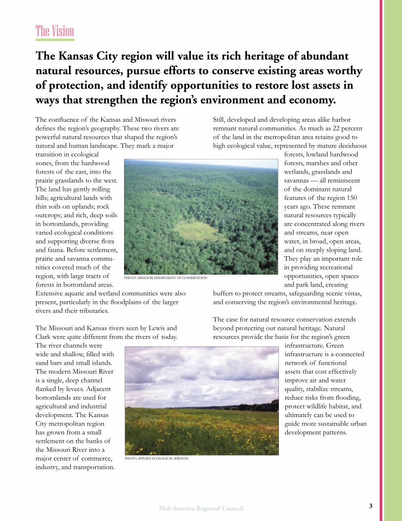
The confluence of the Kansas and Missouri rivers defines the region’s geography. These two rivers are powerful natural resources that shaped the region’s natural and human landscape. They mark a major transition in ecological zones, from the hardwood forests of the east, into the prairie grasslands to the west. The land has gently rolling hills; agricultural lands with thin soils on uplands; rock outcrops; and rich, deep soils in bottomlands, providing varied ecological conditions and supporting diverse flora and fauna. Before settlement, prairie and savanna commu-nities covered much of the region, with large tracts of forests in bottomland areas. Extensive aquatic and wetland communities were also present, particularly in the floodplains of the larger rivers and their tributaries.
The Missouri and Kansas rivers seen by Lewis and Clark were quite different from the rivers of today. The river channels were wide and shallow, filled with sand bars and small islands. The modern Missouri River is a single, deep channel flanked by levees. Adjacent bottomlands are used for agricultural and industrial development. The Kansas City metropolitan region has grown from a small settlement on the banks of the Missouri River into a major center of commerce, industry, and transportation.
Still, developed and developing areas alike harbor remnant natural communities. As much as 22 percent of the land in the metropolitan area retains good to high ecological value, represented by mature deciduous
forests, lowland hardwood forests, marshes and other wetlands, grasslands and savannas — all reminiscent of the dominant natural features of the region 150 years ago. These remnant natural resources typically are concentrated along rivers and streams, near open water, in broad, open areas, and on steeply sloping land. They play an important role in providing recreational opportunities, open spaces and park land, creating
buffers to protect streams, safeguarding scenic vistas, and conserving the region’s environmental heritage.
The case for natural resource conservation extends beyond protecting our natural heritage. Natural resources provide the basis for the region’s green
infrastructure. Green infrastructure is a connected network of functional assets that cost effectively improve air and water quality, stabilize streams, reduce risks from flooding, protect wildlife habitat, and ultimately can be used to guide more sustainable urban development patterns.
The Kansas City region will value its rich heritage of abundant natural resources, pursue efforts to conserve existing areas worthy of protection, and identify opportunities to restore lost assets in ways that strengthen the region’s environment and economy.
Looking north along the Kansas River, as it flows toward the Missouri River. The Kansas City, Missouri, stockyards, circa 1955, are visible in the upper right.
3
The Vision
PHOTO, APPLIED ECOLOGICAL SERVICES
PHOTO, MISSOURI DEPARTMENT OF CONSERVATION

On the Map: Conservation Planning for the Kansas City RegionOn the Map: Conservation Planning for the Kansas City Region
Part 2:
Aerial view looking south across the Fairfax District at the confluence of the Kansas and Missouri Rivers during the 1951 flood.
The Problem4

Mid-America Regional CouncilMid-America Regional Council
Kansas City’s natural resources, from forests and glades to prairies, wetlands and stream corridors, are threatened by intense development pressure.
Expansive urban development throughout the metropolitan region since the early 1800s has degraded valuable natural resource areas. This trend is expected to continue unabated. By 2030, the region’s population is expected to increase by more than 500,000. Growth is projected to consume approximately 260,000 acres, an area roughly equal to Clay County in size.
Land-use changes in the Kansas City region need to be understood from a broad landscape perspective
in order to view their full impacts. Broad-scale environmental planning has been limited because access to environmental data has been scarce, and limited data focuses on problems within individual jurisdictional boundaries.
Lack of coordination among the region’s communities means that local land-use planning and development projects seldom reflect an understanding of how the projects affect the region’s ecology. Likewise, local or regional benefits produced by conservation are also not recognized. This is especially true in cases where conserving nature provides needed services like flood control less expensively than conventional techniques.
Aerial view looking south across the Fairfax District at the confluence of the Kansas and Missouri Rivers during the 1951 flood.
Growth and development impacts Kansas City’s natural resources.
Remote sensing images show the pace of development in metro Kansas City between 1980–2002. The change detection map was created using three dates of satellite imagery. This map was produced for the Mid-America Regional Council by the Kansas Applied Remote Sensing Program, a division of the Kansas Biological Survey. Funding for this work is provided by the Kansas Department of Health and Environment through a U.S. Environmental Protection Agency 319 Grant.
Development 1982 - 1990
Development 1990 - 2001
5
The Problem

On the Map: Conservation Planning for the Kansas City RegionOn the Map: Conservation Planning for the Kansas City Region
The impacts of growth are considerable and well understood. Kansas City, like other major metropolitan areas, experiences many symptoms of natural resource decline, including:
• increased frequency and severity of flooding
• reduced stream health and water quality
• soil erosion and sedimentation of important waterways
• high levels of noise and temperatures
• high levels of air pollution
• high infrastructure maintenance costs
• destabilization and degradation of urban natural areas
• habitat fragmentation and degradation
• declining populations of previously common or sensitive species, and
• increased populations of nuisance plant and animal species.
Isolated fragments of a rich biological heritage remain scattered throughout the region, found in scores of small and large units often separated from each other by houses, offices, roads, factories, railroads, agricultural fields, and concrete. These fragmented natural areas still contain remnants of tallgrass prairie, oak savanna and woodland, fen, dolomite prairie, and other natural communities. The Kansas City region also possesses an abundance of degraded, biologically impoverished land in need of restoration. Noted conservationist and author of A Sand County Almanac Aldo Leopold pointed out that the land has an innate capacity for self-renewal. But because the region’s natural resources are part of the mix of urban land uses, the land has little chance of restoring itself to ecological health without help from the people who live on it.
The Problem
6
Flooding
Streambank erosion
Threats to public infrastructure
Invasive plants
PHO
TO
, DAV
ID D
OD
S, UR
SPH
OT
O, D
AVID
DO
DS, U
RS
PHO
TO
, DAV
ID D
OD
S, UR
S
Mid-America Regional CouncilMid-America Regional Council
Part 3:
Schumacher Park in south Kansas City is located along the Santa Fe, Oregon and California National Historic Trails alignment and has 1.3 acres of restored native prairie and several National Parks Service interpretive panels.
The SolutionA New Tool For Conservation Planning
7

On the Map: Conservation Planning for the Kansas City RegionOn the Map: Conservation Planning for the Kansas City Region
There is growing awareness and interest among public officials and the public at large of the need to restore and protect natural resources in the Kansas City region. But, creating effective conservation plans and policies requires information about natural resource location, abundance and quality.
The project’s environmental map data will aid proactive consideration of environmental factors in community plans related to land use, stormwater, parks, transportation, and habitat restoration. Over time, as updated or additional map information is produced, this tool will become more powerful across multiple geographic scales, from the site or project level, to broader community, watershed or regional levels.
How was the Natural Resource Inventory (NRI) map developed? To complete the NRI, a natural resources classification and inventory method was created to provide consistent data across the state line and among collaborating agencies. The methodology involved several steps. Field surveys were completed at more than 300 locations throughout the region; descriptions of ecological land-cover types were developed based on methods used by state and federal resource management agencies. Field data then was combined with digital data and maps obtained from state and federal agencies, and from local counties and cities.
A geographic information system (GIS) was used to identify lands that have conditions likely to support high quality natural resources — areas that may warrant special attention in future community planning and design. In essence, the maps, and their underlying data, are a flexible new tool that may be applied in creative ways. The tool will evolve to accommodate updated or better information, and to meet the changing needs of the community.
Planning for Natural Resource Conservation and Use
The inventory found that 22 percent of the metropolitan region retains conditions that may harbor good and, in many locations, high-quality vegetative communities worthy of conservation. These high-quality areas are limited in number but are often contained within extensive tracts of natural
lands. Overall, this portion of the region’s land area presents many opportunities for ecosystem conservation or habitat protection. From a green infrastructure perspective, woodlands, grasslands and wetlands can be restored to achieve more cost-effective stormwater management, leading to cleaner water and healthier stream corridors. Inventory results also revealed a great need for ecological restoration to improve water quality and
fish habitat, and to sustain native species in forests, savannas, and grasslands.
The NRI map provides rich information about the community’s natural resource elements, such as lakes, rivers, streams, wetlands, prairies and forests. The maps then relate NRI information to other community infrastructure like streets and roads, parks or MetroGreen trails. Maps offer community planners and policymakers the opportunity to see where potentially high-value natural resources are located in relation to developed areas and other community assets. For example, when communities know the location of stream corridors with valuable wetland or riparian (streamside) communities, or uplands with historic prairies and savannas, they can link these resources to parks, greenways, development initiatives, transportation corridors, or stormwater management areas.
The maps at right show how a county detail map might be used for various planning applications.
The Kansas City region recognizes that now is the time to conserve natural resources.
The Solution
8
PHOTO, PAT WHALEN, MISSOURI DEPARTMENT OF CONSERVATION

Mid-America Regional CouncilMid-America Regional Council
Natural Resources Inventory Map: Southeastern Johnson County, Kansas
9
Proposed MetroGreen trails present opportunities to conserve natural resources, such as bottomland and upland woodlands, prairies, and water resources for recreational purposes.
Linkages among upland forests, grasslands, fl ood plains and water resources create natural stormwater retention and treatment opportunities in expanding suburban areas.
Conservation easements, vegetative buffers, and stormwater treatment systems offer opportunities to protect water quality and to buffer resources from the negative impacts of stormwater runoff.
Parks may be managed or acquired for recreation and for their ecosystem services, natural resources value, water quality and fl ood protection capabilities, and their beauty.
Growth of the Kansas City region into southern Johnson County, Kansas, threatens the Blue River and its abundant natural resources within its watershed. NRI data shows the locations of potentially valuable vegetative communities and water resources in relation to existing or planned development.
Using this information allows conservation of scenic natural areas, stormwater management, and numerous
recreational opportunities for the region’s residents. By managing stormwater where it falls in the watershed, instead of conveying it directly to the Blue River, fl ood protection in southern Johnson County and, perhaps downstream in Jackson County, Missouri, becomes more manageable. Conserving natural vegetation helps maintain healthy, diverse habitats and wildlife, allowing the built and natural environments to complement each other in more sustainable ways.
Planning for conservation along the Blue River
Legend
MetroGreen trails and greenways
Planned
Open water
Lowland hardwood forest
Wetlands
Mixed evergreen/deciduous
Deciduous woodland/immature forest
Grasslands
Parks
100-year flood plain
On the Map: Conservation Planning for the Kansas City RegionOn the Map: Conservation Planning for the Kansas City Region
The natural resource inventory provides a practical new tool intended to balance environmental protection with other community goals. Several opportunities to apply this information in different planning contexts are discussed below, including:
• MetroGreen – Parks and Greenways
• Watershed and Stormwater Management
• Land-Use/Growth and Development
• Natural Heritage Conservation
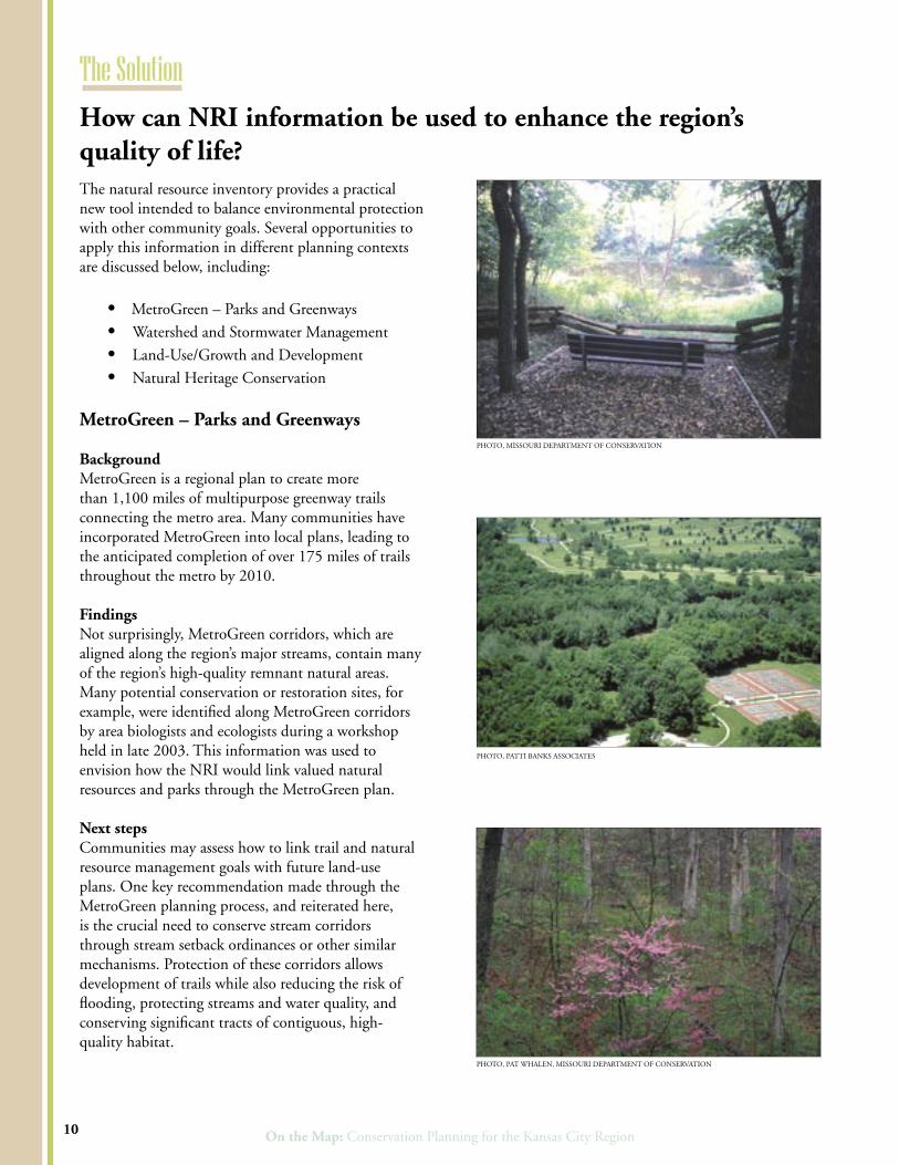
MetroGreen – Parks and Greenways BackgroundMetroGreen is a regional plan to create more than 1,100 miles of multipurpose greenway trails connecting the metro area. Many communities have incorporated MetroGreen into local plans, leading to the anticipated completion of over 175 miles of trails throughout the metro by 2010.
FindingsNot surprisingly, MetroGreen corridors, which are aligned along the region’s major streams, contain many of the region’s high-quality remnant natural areas. Many potential conservation or restoration sites, for example, were identified along MetroGreen corridors by area biologists and ecologists during a workshop held in late 2003. This information was used to envision how the NRI would link valued natural resources and parks through the MetroGreen plan.
Next stepsCommunities may assess how to link trail and natural resource management goals with future land-use plans. One key recommendation made through the MetroGreen planning process, and reiterated here, is the crucial need to conserve stream corridors through stream setback ordinances or other similar mechanisms. Protection of these corridors allows development of trails while also reducing the risk of flooding, protecting streams and water quality, and conserving significant tracts of contiguous, high-quality habitat.
The Solution
10
How can NRI information be used to enhance the region’s quality of life?
PHOTO, PATTI BANKS ASSOCIATES
PHOTO, MISSOURI DEPARTMENT OF CONSERVATION
PHOTO, PAT WHALEN, MISSOURI DEPARTMENT OF CONSERVATION
Mid-America Regional CouncilMid-America Regional Council
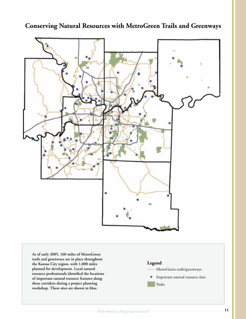
Conserving Natural Resources with MetroGreen Trails and Greenways
As of early 2005, 160 miles of MetroGreen trails and greenways are in place throughout the Kansas City region, with 1,000 miles planned for development. Local natural resource professionals identified the locations of important natural resource features along these corridors during a project planning workshop. These sites are shown in blue.
11
LegendMetroGreen trails/greenways
! Important natural resource sites
Parks

On the Map: Conservation Planning for the Kansas City RegionOn the Map: Conservation Planning for the Kansas City Region
Watershed and Stormwater Management
BackgroundNew science and engineering demonstrate the value of sustainable natural resource management to successful stormwater management. With urban growth and the transformation of open spaces into impervious surfaces, conventional methods of land development and stormwater management tend to increase the volume and rate of stormwater runoff and to reduce water quality. Increased runoff causes substantial erosion, stream deterioration, and flooding, degrading otherwise valuable areas.
FindingsWhile the region considers 22 percent of its land area to be of significant natural value, remnant resource areas are already degraded from urbanization. Indicators of degradation are ubiquitous, including flash flooding, massive sediment transport into streams and lakes, nitrogen loading, and eroded stream banks — all of which impair surface water quality.
Solutions are best achieved by planning at the site level and at the regional and watershed scales. Problems routinely emerge within a watershed, impacting both upstream and downstream environments. While area communities recognize the need to work together to address these issues, broad-based watershed partnerships across jurisdictions remain rare in the region.
Next stepsThe NRI data shows how watersheds extend beyond city, county and state political boundaries. Planners, then, may examine how stormwater management in their community affects other communities in shared watersheds, and identify opportunities to work together to achieve shared stormwater goals. Basin-wide partnerships will be invaluable to achieve regional level benefits from more localized, site specific planning and design processes.
NRI data also can be used to identify natural resource areas that might be managed to accommodate stormwater needs generated by future development.
Inventory information will supplement new stormwater engineering standards and planning guidelines adopted by a growing list of communities. Among the “best management practices” highlighted by this study is integrated planning — that is, protecting and managing natural systems and open spaces before development to better manage the rate, volume and quality of runoff.
Land Use/Growth and Development
BackgroundGrowth and development are not only inevitable but also desired. Today, people demand that new growth be planned in a more coherent, environmentally responsible way. Incorporating natural resource conservation within new or re-development creates quality-of-life benefits for residents by
providing recreation; by maintaining and raising land values; and by creating multipurpose landscape management opportunities.
FindingsUsing the NRI map will benefit future planning for growth and development when determining locations for new industrial, commercial, or residential developments, examining transportation
corridors, or assessing potential community develop-ment issues. The map identifies locations where valued natural resources may exist and be incorporated as prized features of new development.
Next StepsLand-use planning involves tradeoffs among competing uses and values. Use of the natural resource data will allow local communities and developers to more thoughtfully protect and restore the environment as they make other complementary infrastructure investments.
At the regional level, more collaborative, participatory planning will begin to assess how natural resource information may complement other priorities and needs — like transit and transportation, affordable housing, greenways, redevelopment in the urban core or first-ring suburbs, watershed management or economic development.
The Solution
12
PHOTO, TETRA TECH
Mid-America Regional CouncilMid-America Regional Council
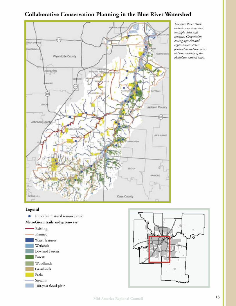
The Blue River Basin includes two states and multiple cities and counties. Cooperation among agencies and organizations across political boundaries will aid conservation of the abundant natural assets.
Collaborative Conservation Planning in the Blue River Watershed
13
Legend! Important natural resource sites
MetroGreen trails and greenways
Existing
Planned
Water features
Wetlands
Lowland Forests
Forests
Woodlands
Grasslands
Parks
Streams
100-year flood plain
On the Map: Conservation Planning for the Kansas City RegionOn the Map: Conservation Planning for the Kansas City Region
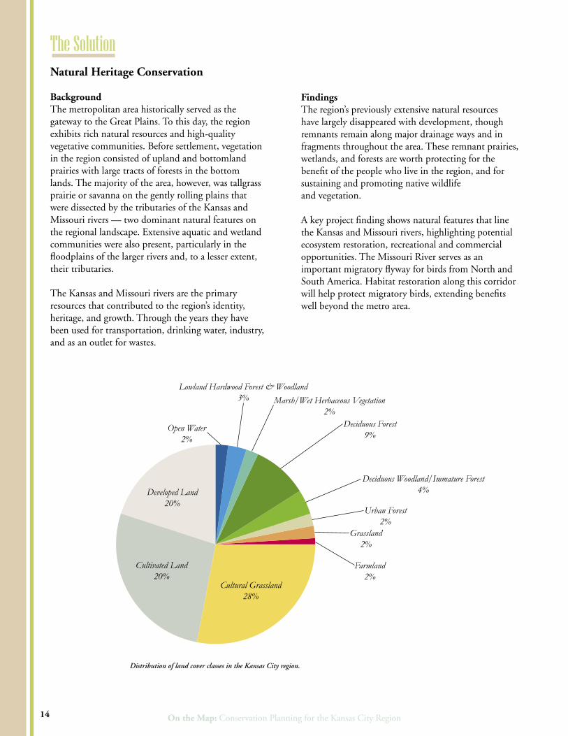
Natural Heritage Conservation
BackgroundThe metropolitan area historically served as the gateway to the Great Plains. To this day, the region exhibits rich natural resources and high-quality vegetative communities. Before settlement, vegetation in the region consisted of upland and bottomland prairies with large tracts of forests in the bottom lands. The majority of the area, however, was tallgrass prairie or savanna on the gently rolling plains that were dissected by the tributaries of the Kansas and Missouri rivers — two dominant natural features on the regional landscape. Extensive aquatic and wetland communities were also present, particularly in the floodplains of the larger rivers and, to a lesser extent, their tributaries.
The Kansas and Missouri rivers are the primary resources that contributed to the region’s identity, heritage, and growth. Through the years they have been used for transportation, drinking water, industry, and as an outlet for wastes.
FindingsThe region’s previously extensive natural resources have largely disappeared with development, though remnants remain along major drainage ways and in fragments throughout the area. These remnant prairies, wetlands, and forests are worth protecting for the benefit of the people who live in the region, and for sustaining and promoting native wildlife and vegetation.
A key project finding shows natural features that line the Kansas and Missouri rivers, highlighting potential ecosystem restoration, recreational and commercial opportunities. The Missouri River serves as an important migratory flyway for birds from North and South America. Habitat restoration along this corridor will help protect migratory birds, extending benefits well beyond the metro area.
Developed Land 20%
Cultivated Land 20%
Cultural Grassland 28%
Open Water 2%
Lowland Hardwood Forest & Woodland 3% Marsh/Wet Herbaceous Vegetation
2%Deciduous Forest
9%
Deciduous Woodland/Immature Forest 4%
Urban Forest 2%
Grassland2%
Farmland 2%
Distribution of land cover classes in the Kansas City region.
The Solution
14

Mid-America Regional CouncilMid-America Regional Council
Next StepsEcological conservation and restoration opportunities are abundant in the region. Multi-purpose plans and designs can recapture natural heritage and contribute to functional green infrastructure benefits.
Conservation planning may find special applications in park lands currently in public ownership. For example, intensification of habitat restoration on public parks and reserves — following the leadership of KC Wildlands, a nonprofit organization dedicated to that purpose — will ensure that native species thrive in ways that add real value to the future of the region.
Future focus on restoration opportunities along the banks of the Missouri and Kansas rivers will add substantially to the region’s ecological health. Riverfront areas in the region are recognized as key economic development opportunities. Trails and ecosystem restoration will add value and depth over the long term, and help the community better understand how local actions relate to ecological processes occurring on a regional, national and even international scale.
Possible Approaches to Future Policies Future community discussions among local governments, planning and resource management agencies, developers, and other interested parties will help guide the use of the NRI planning tool, possibly
evolving toward a regional green infrastructure and natural resource conservation plan. Future planning would build upon key areas of agreement previously established through broad-based, regional initiatives like Creating Quality Places (a guide to the design of quality places in the Kansas City region) and MetroGreen.
Preliminary planning suggests that further exploration of a number of policy directions and approaches may well catalyze many of the desired outcomes described in this report. Prospective policy directions are organized by three proposed planning principles:
• Think regionally, act locally.
• Protect and restore natural resources.
• Integrate resource protection into development plans and regulations.
Policy directions outlined on the next page include normative statements about potential community policies, action-oriented priorities, and implementation and funding strategies. Future policy development, however, will require a robust community discussion to ensure that community decision making credibly balances environmental, social and economic factors.
This digital elevation model (DEM) of the Kansas City region shows the prominence of the Kansas and Missouri river valleys in the region’s geography.
15
PHOTO, PAT WHALEN, MISSOURI DEPARTMENT OF CONSERVATION
On the Map: Conservation Planning for the Kansas City RegionOn the Map: Conservation Planning for the Kansas City Region
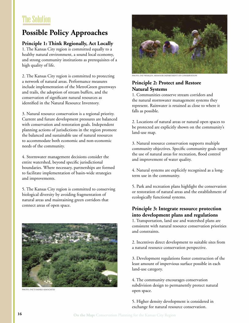
Principle 1: Think Regionally, Act Locally 1. The Kansas City region is committed equally to a healthy natural environment, a sound local economy, and strong community institutions as prerequisites of a high quality of life.
2. The Kansas City region is committed to protecting a network of natural areas. Performance measures include implementation of the MetroGreen greenways and trails, the adoption of stream buffers, and the conservation of significant natural resources as identified in the Natural Resource Inventory.
3. Natural resource conservation is a regional priority. Current and future development pressures are balanced with conservation and restoration goals. Independent planning actions of jurisdictions in the region promote the balanced and sustainable use of natural resources to accommodate both economic and non-economic needs of the community.
4. Stormwater management decisions consider the entire watershed, beyond specific jurisdictional boundaries. Where necessary, partnerships are formed to facilitate implementation of basin-wide strategies and improvements.
5. The Kansas City region is committed to conserving biological diversity by avoiding fragmentation of natural areas and maintaining green corridors that connect areas of open space.
Principle 2: Protect and Restore Natural Systems1. Communities conserve stream corridors and the natural stormwater management systems they represent. Rainwater is retained as close to where it falls as possible.
2. Locations of natural areas or natural open spaces to be protected are explicitly shown on the community’s land-use map.
3. Natural resource conservation supports multiple community objectives. Specific community goals target the use of natural areas for recreation, flood control and improvement of water quality.
4. Natural systems are explicitly recognized as a long-term use in the community.
5. Park and recreation plans highlight the conservation or restoration of natural areas and the establishment of ecologically functional systems.
Principle 3: Integrate resource protection into development plans and regulations1. Transportation, land use and watershed plans are consistent with natural resource conservation priorities and constraints.
2. Incentives direct development to suitable sites from a natural resource conservation perspective. 3. Development regulations foster construction of the least amount of impervious surface possible in each land-use category.
4. The community encourages conservation subdivision design to permanently protect natural open space.
5. Higher density development is considered in exchange for natural resource conservation.
The Solution
16
Possible Policy Approaches
PHOTO, PAT WHALEN, MISSOURI DEPARTMENT OF CONSERVATION
PHOTO, PATTI BANKS ASSOCIATES

Mid-America Regional CouncilMid-America Regional Council

On the Map: Conservation Planning for the Kansas City Region
Project Partners Successful implementation of multi-purpose conservation and green infrastructure plans will require continued strong partnerships among communities, city and county departments, and local state and federal agencies.
MARC would like to thank the agencies and organizations listed below for their invaluable assistance in this project. Project funding was provided by the US Environmental Protection Agency, Region 7.
Missouri Department of Natural Resources; Missouri Department of ConservationKansas Data Access & Support CenterMissouri Spatial Data Information ServiceKansas Applied Remote SensingU.S. Environmental Protection Agency, Region 7 U.S. Geological Survey
Kansas Biological SurveyU.S. Army Corps of Engineers Natural Resources Conservation Service Johnson County, Kansas Jackson County, MissouriUSDA National Agroforestry CenterUniversity of Missouri Center for Agroforestry
The Blue River Glade is one of the region’s key ecological conservation and restoration sites.
PHO
TO
, PAT W
HA
LEN
, MISSO
UR
I DE
PAR
TM
EN
T O
F CO
NSE
RV
ATIO
N