midterm review of the ready ii project - climate-eval
TRANSCRIPT

United Nations Development Programme
Midterm Review of the READY II Project
Prepared by Antonio L. Fernandez and Alwynn C. Javier
January 2010

Midterm Review of the READY II Project 2
Contents
I. Introduction 3
II. Performance Assessment 5 Component 1: Multi-hazard Mapping 7 Component 2: Community-based Disaster Preparedness 13 Component 3: Mainstreaming DRR in Local Development Planning 18 Cross Cutting Findings 23
III. Conclusion 30
ANNEX: Focus Group Discussion Questionnaire 33
Midterm Review of the READY II Project 3
I. INTRODUCTION This report contains the findings and recommendations of an independent evaluation study conducted by a team of UNDP consultants called the Midterm Review of the Hazards Mapping and Assessment for Effective Community-Based Disaster Risk Management (READY II) Project, hereinafter referred to as MTR. The MTR is undertaken as part of standard program requirements by the UNDP and AusAID to determine, midway through the Project, how it has progressed in pursuit of its target outputs and outcomes. This process is also expected to identify future courses of action, both for the remainder of Project life and beyond, to ensure the achievement and sustainability of gains. The period covered for the MTR is from June 2006 to June 2009, though some important information from within the period of study (September to November 2009) were taken into account as well.
The READY Project’s overall goal is “to contribute to the goal of strengthening the capacities of key stakeholders in localities vulnerable to natural hazards to protect/enhance the quality of the environment and sustainably manage their natural resources, as well as their capacities to prepare and respond appropriately to natural disasters.” This goal links the project to national priorities articulated in PD 1566, the current legislative framework for the country’s disaster management, and the NDCC Four Point Action Plan on Disaster Preparedness. The READY project aims to provide immediate, reliable information to the communities at risk, on the various geological and hydro-meteorological hazards in their respective localities. Its three immediate objectives are:
1. Equip key stakeholder groups with the resources (financial, technical, and/or advisory services), knowledge and training that enable them to perform effectively for disaster risk reduction;
2. Strengthen coordination processes and procedures, within organizations and sectors (public, private and community) for effective risk reduction; and
3. Initiate the mainstreaming of risk reduction into local development planning.
The three project Components, and their corresponding target outputs and Responsible Partners (RPs) are shown in the table below: Table 1: Project Components, Outputs and Responsible Partners
Components Target Outputs Responsible Partners
1 Multi-hazard Identification and Disaster Risk Assessment
Multi-hazard maps for 27 target provinces (1:50,000 scale) and priority municipalities/ cities/ barangays (1:10,000 scale)
CSCAND Technical Working Group (PHIVOLCS, PAGASA, MGB, NAMRIA)
2 Community-based Disaster Preparedness
(a) Community-based Early Warning System (CBEWS)
(b) Information, Education and Communication
For floods: 13 provinces For tsunami: 18 coastal communities
CSCAND TWG, Philippine Information Agency (PIA)
3 Mainstreaming of Disaster Risk Reduction
Review of local development plans by LGUs/ local ordinances to implement DRR
OCD, LGUs

Midterm Review of the READY II Project 4
The Responsible Partners – Mines and Geosciences Bureau (MGB), National Mapping and Information Resources Authority (NAMRIA), Philippine Atmospheric, Geophysical and Astronomical Services Administration (PAGASA), and Philippine Institute of Volcanology and Seismology (PHIVOLCS) – belong to the Collective Strengthening of Community Awareness for Natural Disasters (CSCAND) Technical Working Group (the Office of Civil Defense under the Department of National Defense is also a member.) The group is mandated to improve our understanding of natural hazard risks in the country. CSCAND aims to expand the current READY program to: (1) include new methodologies and appropriate computation models, (2) provide impact and risk assessments (as compared to hazard maps), and (3) include new provinces (with options to revisit current READY provinces in the future to implement new methodologies).1 As a stakeholder in disaster risk reduction, the group is composed of government agencies that are part of the technical and scientific institutions or services dealing with risk identification, hazard mapping, hazards monitoring, early warning and preparedness. The country’s warning agencies are PAGASA for hydro-meteorological hazards, and PHIVOLCS for earthquake, volcanic eruption, and tsunami; both operate under the Department of Science and Technology. MGB assess hazards in urban areas and prepare hazard maps and information on potential areas of landslide, liquefaction, subsidence and other ground instabilities. MGB and NAMRIA are under the Department of Environment and Natural Resources. All agencies have mapping capabilities, with the exception of NAMRIA and OCD.
The field of disaster risk management (DRM) is just taking root in the country and needs full cooperation among scientists and engineers. Since hazard maps are the bases of understanding risks and vulnerabilities, appropriate protocols and procedures must be put in place to ensure maps delivered where and when needed.
The study was conducted during the period September to November 2009. The review and evaluation methodology consisted of:
An opening meeting with the Implementing Partner (IP) headed by the Administrator of the Office of Civil Defense, the READY II Project Team, the Team Leaders of the or RPs and relevant officials of the OCD;
Review of READY II documents such as the Project Document, Annual Work Plans, Annual Project Reports, quarterly reports, past audit reports, and other provided by the IP and the RPs;
Focus group discussion (FGD) with representatives from the RPs and the IP, specifically RP Team Leaders and concerned Technical Specialists from the IP and the RP for each project component, OCD Planning and designated Staff (see Annex for FGD guide);
Key informant interviews with the READY Project Manager, RP team leaders, OCD planning staff, administrative and financial officer, Project Management Board members, Technical Working Group members, and UNDP Country Office in Manila in- charge of the READY II Projects.
1 Simpson, Alanna and Trevor Dhu, Enhancing Natural Hazard Risk Assessment Capacity in the CSCAND
Agencies – an Options Paper, AusAID, CSCAND, and NDCC, (April) 2009

Midterm Review of the READY II Project 5
This was supplemented by semi-structured interviews with project beneficiaries in the field: (1) Related to Community-based Early Warning System (CBEWS) for tsunami: a municipal mayor and two municipal officers; (2) Related to Rapid Earthquake Damage Assessment System (REDAS) training, and information education and communication (IEC) campaign in Laguna: a City Planning and Development Officer, a provincial planning officer, an officer of the regional OCD office. Using the unstructured method, a municipal officer of a municipality covered by the REINA project2 and participant at the same REDAS training was interviewed to gain insights about success factors in sustaining gains from REINA in terms of REDAS and CBEWS.
II. PERFORMANCE ASSESSMENT
The READY project, as implemented on the ground, consists of a set of activities that begins with hazard mapping, and followed by a series of Information, Education and Communication (IEC) activities. Alongside mapping and IEC activities, the Project also installs a Community-based Early Warning System (CBEWS) in particular barangays that are identified as pilot sites for either tsunami or flood CBEWS. Multi-hazard maps are produced based on existing base maps and by using standard methodologies, field surveys and historical studies. By the time these are prepared by concerned agencies, a provincial-level IEC campaign is launched, where the hazards are introduced to municipal officers, barangay leaders and other local actors. The next step is the establishment of CBEWS in at least two priority barangays/areas identified by the LGU. In these CBEWS areas, a “special IEC” is held for the residents of the selected barangay, where participants devise an evacuation plan and conduct drills. Subsequently at the provincial level, planners and other local officers are trained on how to use a GIS-based hazard and risk assessment tool called Rapid Earthquake Damage Assessment System (REDAS). In all of these steps, agreements like Memoranda of Agreement/Understanding (MOAs/MOUs) and user license agreements (for REDAS) are forged to secure the commitment of LGUs and the participants in managing the process and technology in their areas. The project’s modus operandi has thus maintained a string of activities in provinces which comprise one complete cycle. It may be seen as a cycle as the process begins at the provincial capitol and ends there. The process starts as provincial authorities are approached for a buy-in of the project activities. It goes through a period where cooperation and information exchanges ensue. Then finally, the READY team turns to providing REDAS for the provincial government to promote mainstreaming DRR in planning and day-to-day operations. Upon completion of the activities, concerned READY team members render a report to the provincial government as its exit strategy and give assurances that technical advice and support related to the continuance
2 Funded by the UNDP-Manila and UN-Office for the Coordination of Humanitarian Affairs (UN-OCHA), the
2005 REINA Project, entitled “Strengthening the Disaster Preparedness Capacities of the Municipalities of Real, Infanta and Nakar (REINA), Quezon Province, Philippines to Geologic and Meteorological Hazards” is the forerunner of READY II Project. Thus, it is sometimes referred to as READY I Project. The collaborative undertaking among OCD, MGB, PAGASA, and PHIVOLCS began in REINA. READY II includes NAMRIA besides the four agencies.
Midterm Review of the READY II Project 6
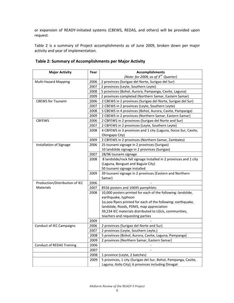
or expansion of READY-initiated systems (CBEWS, REDAS, and others) will be provided upon request. Table 2 is a summary of Project accomplishments as of June 2009, broken down per major activity and year of implementation.
Table 2: Summary of Accomplishments per Major Activity
Major Activity Year Accomplishments (Note: for 2009, as of 3
rd Quarter)
Multi-Hazard Mapping 2006 2 provinces (Surigao del Norte, Surigao del Sur)
2007 2 provinces (Leyte, Southern Leyte)
2008 5 provinces (Bohol, Aurora, Pampanga, Cavite, Laguna)
2009 2 provinces completed (Northern Samar, Eastern Samar)
CBEWS for Tsunami 2006 2 CBEWS in 2 provinces (Surigao del Norte, Surigao del Sur)
2007 2 CBEWS in 2 provinces (Leyte, Southern Leyte)
2008 5 CBEWS in 4 provinces (Bohol, Aurora, Cavite, Pampanga)
2009 2 CBEWS in 2 provinces (Northern Samar, Eastern Samar)
CBFEWS 2006 2 CBFEWS in 2 provinces (Surigao del Norte and Sur)
2007 2 CBFEWS in 2 provinces (Leyte, Southern Leyte)
2008 4 CBFEWS in 3 provinces and 1 city (Laguna, Ilocos Sur, Cavite, Olongapo City)
2009 2 CBFEWS in 2 provinces (Northern Samar, Zambales)
Installation of Signage 2006 25 tsunami signage in 2 provinces (Surigao) 10 landslide signage in 2 provinces (Surigao)
2007 28/96 tsunami signage
2008 8 landslide/rock fall signage installed in 2 provinces and 1 city (Laguna, Benguet and Baguio City) 50 tsunami signage installed
2009 39 tsunami signage in 2 provinces (Eastern and Northern Samar)
Production/Distribution of IEC Materials
2006 -
2007 8556 posters and 10695 pamphlets
2008 10,000 posters printed for each of the following: landslide, earthquake, typhoon 1o,ooo flyers printed for each of the following: earthquake, landslide, floods, PDMS, map appreciation 39,234 IEC materials distributed to LGUs, communities, teachers and requesting parties
2009 -
Conduct of IEC Campaigns 2006 2 provinces (Surigao del Norte and Sur)
2007 2 provinces (Leyte, Southern Leyte,)
2008 5 provinces (Bohol, Aurora, Cavite, Laguna, Pampanga)
2009 2 provinces (Northern Samar, Eastern Samar)
Conduct of REDAS Training 2006 -
2007 -
2008 1 province (Leyte, 2 batches)
2009 5 provinces, 1 city (Surigao del Sur, Bohol, Pampanga, Cavite, Laguna, Iloilo City); 6 provinces including Dinagat
Midterm Review of the READY II Project 7
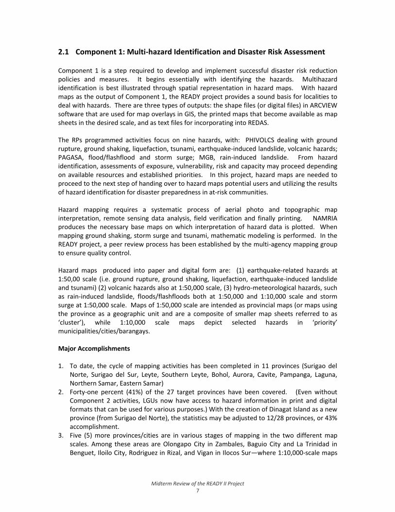
2.1 Component 1: Multi-hazard Identification and Disaster Risk Assessment Component 1 is a step required to develop and implement successful disaster risk reduction policies and measures. It begins essentially with identifying the hazards. Multihazard identification is best illustrated through spatial representation in hazard maps. With hazard maps as the output of Component 1, the READY project provides a sound basis for localities to deal with hazards. There are three types of outputs: the shape files (or digital files) in ARCVIEW software that are used for map overlays in GIS, the printed maps that become available as map sheets in the desired scale, and as text files for incorporating into REDAS. The RPs programmed activities focus on nine hazards, with: PHIVOLCS dealing with ground rupture, ground shaking, liquefaction, tsunami, earthquake-induced landslide, volcanic hazards; PAGASA, flood/flashflood and storm surge; MGB, rain-induced landslide. From hazard identification, assessments of exposure, vulnerability, risk and capacity may proceed depending on available resources and established priorities. In this project, hazard maps are needed to proceed to the next step of handing over to hazard maps potential users and utilizing the results of hazard identification for disaster preparedness in at-risk communities. Hazard mapping requires a systematic process of aerial photo and topographic map interpretation, remote sensing data analysis, field verification and finally printing. NAMRIA produces the necessary base maps on which interpretation of hazard data is plotted. When mapping ground shaking, storm surge and tsunami, mathematic modeling is performed. In the READY project, a peer review process has been established by the multi-agency mapping group to ensure quality control. Hazard maps produced into paper and digital form are: (1) earthquake-related hazards at 1:50,00 scale (i.e. ground rupture, ground shaking, liquefaction, earthquake-induced landslide and tsunami) (2) volcanic hazards also at 1:50,000 scale, (3) hydro-meteorological hazards, such as rain-induced landslide, floods/flashfloods both at 1:50,000 and 1:10,000 scale and storm surge at 1:50,000 scale. Maps of 1:50,000 scale are intended as provincial maps (or maps using the province as a geographic unit and are a composite of smaller map sheets referred to as ‘cluster’), while 1:10,000 scale maps depict selected hazards in ‘priority’ municipalities/cities/barangays. Major Accomplishments 1. To date, the cycle of mapping activities has been completed in 11 provinces (Surigao del
Norte, Surigao del Sur, Leyte, Southern Leyte, Bohol, Aurora, Cavite, Pampanga, Laguna, Northern Samar, Eastern Samar)
2. Forty-one percent (41%) of the 27 target provinces have been covered. (Even without Component 2 activities, LGUs now have access to hazard information in print and digital formats that can be used for various purposes.) With the creation of Dinagat Island as a new province (from Surigao del Norte), the statistics may be adjusted to 12/28 provinces, or 43% accomplishment.
3. Five (5) more provinces/cities are in various stages of mapping in the two different map scales. Among these areas are Olongapo City in Zambales, Baguio City and La Trinidad in Benguet, Iloilo City, Rodriguez in Rizal, and Vigan in Ilocos Sur—where 1:10,000-scale maps

Midterm Review of the READY II Project 8
have been completed. Earthquake-induced landslide and liquefaction maps for Antique have been partially completed.
For the remainder of the project till March 2010, the multi-hazard mapping of Iloilo may be accomplished with a budget of PhP 1.9 million, according to NDCC-OCD’s estimate. Planning activities around the actual available project funds, also requires determining how much can be generated as GOP’s counterpart is mobilized. The Annual Work Plan for 2009 has targeted to cover five (5) provinces, namely Northern Samar, Eastern Samar, Zambales, Iloilo, and Antique. Also, “remaining activities for the previous provinces, will still be done,” according to the PMO. The cumulative target remains at 27 provincial hazard maps at 1:50,000 scale and 10 hazard maps at 1:10,000 scale. Major Issues and Risks Based on actual experience and under the current circumstances, RP representatives are in agreement that in a year, only four (4) provinces can be tackled in a complete cycle. For Component 1, the risks identified and explicitly stated in the project document are: (a) the occurrence of natural disasters, and (b) temporary freeze hiring for government offices due to current government rationalization process. The logical framework also assumes full commitment of government and development partners. The December 2007 project report mentions the reorganization at NAMRIA that also delayed mapping processes in the agency. Apart from the natural hazard events that occurred during the study period, the first risk manifested early in terms a technological hazard – an oil spill off the coast of Guimaras Island triggered by a passenger ferry that sank during a typhoon. The ‘environmental emergency’ created by such an accident is beyond anyone’s control. For hazard events, the mitigating measure had been to ensure that key team personnel are not assigned to ‘disaster response.’ This is a symptom of a staffing problem which unfortunately could not be resolved. (The request to exempt the RPs from freeze hiring was submitted to the Department of Budget and Management was not granted.) In relation to the above, the second risk is extremely relevant in terms of getting hazard maps done completely and on schedule. Group interview with RPs brought out the fact that additional work load has been put by the READY project activities on the technical staff (who were for the most part also doing field work). Geologists and mappers particularly are in short supply across all government agencies needing their skills and expertise. Staff turnover is high in PAGASA, and MGB which lose READY-trained personnel to the private sector, both locally and overseas. At PHIVOLCS, a few staff members are officially on leave or doing other collaborative work. From accounts of RP key staff, the mapping steps involve several agency personnel and demands several person-hours for field work (done at least twice per province). Initially, 60 person-days were approved to map an area. This was reduced to 42 person-days after January 2009, when the United Nations daily subsistence allowance for out-of-town mission increased by 50% from PHP1,800 to PHP2,700. This adjustment was inevitable to conserve available funds. Hazard mapping, though is not all field work; it also involves desk study such as review of historical accounts.

Midterm Review of the READY II Project 9
When mapping ground rupture hazard, field workers may need to visit areas outside a province A being mapped when the active fault stretches beyond the boundary to a neighboring province B. This is necessary to complete the scientific investigation. The policy has been that field workers shall not stay in province B, but need to spend the night in the province being studied. Making base maps is also affected by the size (land area) of target province, number of composite municipalities/cities, and accessibility. Findings and Observations Hazard Mapping 1. With the significant improvement of inter-agency coordination and collaboration
mechanisms created under the Project, mapping and related technologies are now shared and enhanced more systematically by the agencies concerned.
2. Local scientists take pride in the fact that the country has expertise to generate the multi-hazard maps and the project has been instrumental in demonstrating this. This underlines the fact that it is not always necessary to depend on foreign experts for a project where S&T inputs are needed. It is however useful to note that “getting there” or arriving to the goal of producing hazard maps through a multi-agency peer review team has been a challenging incremental and learning process for all concerned. Reaching agreements on matters like georeferencing maps, GIS software, and map colors, as they pertain to harmonizing and prioritization of maps has been a necessary step.
3. The Peer Review process for maps has proven to be a very good and effective mechanism to ensure inter-agency coordination and high-quality professional output. While some concerns were raised about its cost-effectiveness (i.e., “costly,” “time-consuming”), overall it remains to be one of the most successful innovations introduced by the Project in achieving its targets.
4. The quality of maps produced was never sacrificed even as the mapping process proved to be the single most important limiting factor in the project. Being a time-bound process, mapping still remains the source of bottlenecks despite demands for faster delivery.
5. In the development of multi-hazard maps, both scientific and lay knowledge were utilized. Lay knowledge is considered as an input to the final hazard maps in Component 2 (IEC) activities. The IEC process serves as field verification of hazard maps through participation by barangay officials. Often, barangay officials think (or expect) that the READY Project can help them resolve boundary issues; however, the Project always emphasizes that boundaries in the maps are based on the NSO database and boundary issues are in the purview of the local government and other relevant government agencies.
6. Hazard maps produced by the project are being utilized by NEDA and other agencies. Requests are being handled on a case-to-case basis. Protocol for public access to maps is yet to be established though.
7. Requests by OCD are being attended to by NAMRIA. Requests from external organizations are now screened by OCD. This situation has not been without unclear delineation on who spends for what in matters related to READY-produced hazard maps. At present, cost of printing of such maps is charged to the READY project.
8. The Project is also contributing to the goal of resilience to natural disasters by making hazard maps available to investment projects such as other AusAID-funded projects on provincial road maintenance and classroom construction, as well as other government projects.

Midterm Review of the READY II Project 10
Base Maps
9. Among the areas covered by the Project, the only updated base map was that of Pampanga (for 1:50,000 scale). All other base maps were last updated from the 1950s-1980s. Those areas that are available in NAMRIA were readily given to the Project, though many base maps of 1:10,000 scale were not available for many Project areas. This was identified as one of the causes of delay for dependent Project activities.
10. Available base maps, though mostly outdated, were utilized considering the urgent tasks at hand. These were subjected to the process of digitization for them to be compatible with computer software that would be used for overlays and digital modeling. To cope with high demand on staff time, NAMRIA hired contractual employees to digitize maps and perform other mapping tasks.
11. Considering these, embarking on hazard mapping entailed verifying the availability of base maps of the needed scale, but more importantly, what implications of producing one would mean money-wise and time-wise. NAMRIA hired contractual employees to digitize maps and perform other mapping tasks done within office premises.
12. The CSCAND Technical Working Group expressed to a scoping mission by GeoSciences Australia and AusAID in June 2008 their concerns about availability of topographic, bathymetric, and digital elevation model data in appropriate resolution or scale. In relation to this, NAMRIA has given first priority to the need of putting in place a suitable management system of spatial data at a workshop held by AusAID with technical support from GeoSciences Australia on 31 March 2009.3
Geographic Coverage
13. In terms of geographical coverage, previously hard-to-reach areas (e.g., Mindanao) could now be reached through the READY project making the government’s presence felt in these areas. An RP team leader mentioned this in the context of budget priorities set by each agency, and how the READY Project has indirectly enabled their agency in providing other services to READY and nearby areas.
Mapping Resources
14. Landslide-proneness is associated with steep slope areas that are a rare feature of many
urban areas in the selected READY provinces. Since 1999, MGB has been proactive in generating landslide hazard map; already, it has a priority list submitted for government budget allocation. MGB shares hazard maps generated by its National Geohazards Mapping Program.
15. MGB, however, has seen the need to acquire budget to revalidate its 1:50,000 maps and has therefore advanced a request to the PMO for support. No money has been allocated for the purpose out of READY funds until January 2009. MGB estimates that 15 person-days using its equipment are needed per month. READY funds will have been realigned to accommodate this request. Through its regional offices all over the country, MGB is able to focus on local and regional needs, and serves as resource to the READY project. (PAGASA
3 Simpson, Alanna and Trevor Dhu, Enhancing Natural Hazard Risk Assessment Capacity in the CSCAND Agencies – an Options Paper, AusAID, CSCAND, and NDCC, (April) 2009.
Midterm Review of the READY II Project 11
and PHIVOLCS through its field stations have also local resources available for some provinces.)
16. Ten to 12 MGB Central Office technical personnel (mainly geologists) and one additional mapper have been mobilized for the READY project. The validation of the landslide hazard map for Antique, one of the READY provinces, has already been undertaken under the geohazard assessment program using MGB’s regular budget. For this purpose, MGB need to hire contractual personnel and spend for logistics. If validation is not undertaken, the Information, Education and Communication campaign in the province will be in jeopardy.
17. The Government of the Philippines approved a grants-in-aid budget of 1:10,000 scale base mapping of 16 provinces which are not covered by the READY projects and updating of READY provincial maps to complement the READY project. The said project is the counterpart project of the GOP to the READY project. The amount of PHP 80 million has been released to NAMRIA by the Department of Budget and Management. The remaining PHP36 million for multi-hazards mapping and production of a manual is currently not yet available for the rest of the RPs. Through this arrangement, the Project team felt that 1:10,000 scale mapping will have been fast-tracked although the workload of NAMRIA’s mapping personnel will have increased as a result.
Workload
18. The Project Management Board is yet to meet for the last semester of the remaining project period. Meeting the said cumulative targets cannot be attained, given the meager remaining budget and work overload of RP staff. As of October 2009, an estimate drawn by the RP teams from the project’s three years and four months experience pegs the Project completion pace at an average of four provinces per year. Since this estimate emerged from business-as-usual assumptions, it ought not to set the limit for accomplishing targets for the future. With systemic difficulties overcome by appropriate measures, bottlenecks are not necessarily insurmountable.
Recommendations For the Remaining Project Period 1. With the realization that awareness on the importance of hazard maps, as well as the
demand for them from both government and private users in development and disaster response applications is increasing, the OCD, in consultation with RPs, should establish a protocol for public access to maps.
2. With the prioritization of hazard mapping, more of the remaining Project funds should be allocated for such activities.
3. On the note that the READY project gave rise to practices that could eventually be integrated into regular hazard mapping procedures in the Philippines, the concerned agencies should examine the formal internal processes and systems (e.g., executive issuances, policies, funding) that may be needed in order to formally institutionalize these practices.

Midterm Review of the READY II Project 12
Beyond the Project Period 4. It is recommended that the OCD and partner agencies the staff requirement carefully based
on projected work load, and explore staff augmentation through service contracts paid from the project budget. In this way, the Project may also see an increase in the average pace of Project completion (i.e., increase in the current projection of 4 provinces/year).
5. Also, the Project may explore the option of formally collaborating with appropriate academic and research institutions and other organizations in conducting its activities, not just to augment its workforce, but also to enhance its partnership and networking efforts.
6. The Project could devise a new system of prioritization in the selection process of areas/provinces to be mapped; prioritization may not be singularly based on level of hazard severity but also other factors such as quality of updated base maps and the existence of functional local disaster coordinating councils.
7. On hazard mapping. Hazard mapping in the country reached a new milestone through the READY project. Though local scientists take pride in the fact that the country has expertise to generate the multi-hazard maps, they also recognize the need for a functioning spatial data management system (as discussed in the Options Paper).

Midterm Review of the READY II Project 13
2.2 Component 2: Community-Based Disaster Preparedness This Component has two (2) major activities: conduct of Information, Education and Communication (IEC) activities, and installation of Community-based Early Warning Systems (CBEWS) for tsunami and flood, and. Under IEC, the key sub-activities are: development, production and distribution of IEC collaterals; and the conduct of information campaigns. Under CBEWS, the key sub-activities: conduct of disaster preparedness trainings, and installation of early warning signage in tsunami- and flood-prone areas. Information, Education and Communication (IEC) Aside from serving as a vehicle for information dissemination and education, IEC activities (i.e., orientation) serve as venue for validating mapping results. In every province covered by the Project, the key IEC activity is the Project orientation for municipal and barangay officials, where the results of the multi-hazard mapping are presented and validated. Workshops are conducted to validate the maps vis-à-vis the ground-level knowledge of participants. The results are then used to serve as basis for map finalization by concerned agencies. Further, the Project orientation activity provides an opportunity for the Project to disseminate information related to local-level disaster management, mainly through audio-visual presentations and face-to-face discussions among participants and technical experts from the READY agencies. Typically, the Project conducts these orientation-workshops for a number of identified area clusters in a particular province over a period of 1 week. Corollary to the orientation-workshops, the Project also embarks on the development and distribution of IEC materials such as brochures, pamphlets and posters. These materials are distributed in various READY activities and serve as important vehicles for disseminating basic and crucial information on the various hazards present in a the country and how these can be managed and mitigated by local stakeholders. Existing communication materials of the agencies (presentations, videos and posters) developed under their regular activities are also used to complement READY information materials. Community-based Early Warning System The installation of a Community-based Early Warning System is done by the READY Project alongside its mapping and IEC activities. There are two major types of CBEWS methodologies conducted—one for tsunami-prone areas (CBEWS for tsunami), managed by PHIVOLCS; and another for flood-prone areas (Community-based Flood Early Warning System of CBFEWS), managed by PAGASA. Information for identifying tsunami CBEWS areas is generated from existing seismic maps and the 1:50000-scale multi-hazard maps prepared under Component 1; while flood-prone areas are identified through 1:10000-scale flood hazard maps. Once the areas are identified, the Project proceeds with conducting a series of capacity-building activities for local stakeholders. For the CBEWS for tsunami-prone areas, a province-wide training is conducted to orient local officials and community leaders on the results of multi-hazard mapping activities, as well as make them more aware of the risks and mitigating measures related to the hazards. After the training, a pilot barangay is selected as a site for community-level orientation, installation of
Midterm Review of the READY II Project 14
warning system. The pilot barangay is selected using a set of agreed-upon criteria. Subsequently, the Barangay Disaster Coordinating Council (BDCC) is activated; after which, tsunami signage (using the local language) are installed. The installation locations of the three types of signage are dependent on the extent of the tsunami inundation found in the tsunami hazard maps. A tsunami evacuation plan is also developed together with the barangay, after which a Training of Trainers (TOT) is conducted where planners, disaster action officers and engineers are guided on the evacuation procedure. Coinciding with the TOT is the holding of a tsunami drill. During this drill, two sets of groups are taught: the trainees who are expected to replicate the activities, and the residents who are expected to learn from the process. During the drill, other officials from other areas are invited to observe the process, and for them to pass the information on to their own localities. On a larger scale, the barangay-level communication system is activated with the issuance of tsunami warnings by warning agencies such as the PHIVOLCS and international tsunami warning centers. For a far-field tsunami, a communication test is conducted to verify how many hours it takes from PHIVOLCS down to a barangay, should a tsunami warning emanate from PHIVOLCS. Meanwhile, CBEWS for flood-prone areas (CBFEWS) utilizes a watershed approach. These are usually generated by the 1:10000 scale maps prepared by PAGASA and NAMRIA. To start the CBFEWS, a training/orientation activity is conducted for all flood-prone municipalities and barangays within a given river basin. Upon training, these areas are provided with warning equipment (e.g., rain gauge, 2-way radio) to serve as local-level warning and communication systems. These are run locally by identified watchers, and are also linked to regional forecasting centers of PAGASA. An evacuation drill also takes place a day after the gauges are installed. As in the case of tsunami CBEWS, signage are installed under CBFEWS, followed by a training and evacuation drill. For both CBEWS for tsunami and CBFEWS, a Memorandum of Agreement/Understanding (MOA/MOU) is signed between the Project and the barangay stipulating the barangay’s agreement to manage and maintain the installed system and equipment. Likewise, watchers/observers are identified to run the warning and communication system. It has to be noted that warning signage were also installed in a number of identified areas vulnerable to earthquake- and rain-induced landslides even without the full implementation of the CBEWS set of activities. These were led by MGB. Major Accomplishments 1. In aggregate terms to date, 12 provinces and 1 city have completed either or both tsunami
CBEWS and CBFEWS. Of these, 10 provinces (Surigao del Norte, Surigao del Sur, Leyte, Southern Leyte, Bohol, Aurora, Cavite, Pampanga, Northern Samar and Eastern Samar) underwent CBEWS for tsunami, while 8 provinces (Surigao del Norte, Surigao del Sur, Leyte, Southern Leyte, Cavite, Laguna, Northern Samar and Zambales) had CBFEWS. In addition, one (1) other province (Zamboanga del Sur) has undergone CBEWS for tsunami but other activities were discontinued due to security concerns.
2. Landslide signage were installed in the provinces of Surigao del Norte, Surigao del Sur, Laguna, Zambales, Benguet and Rizal.

Midterm Review of the READY II Project 15
3. Under IEC, 11 of the abovementioned provinces (with the exception of Zambales) have undergone the main component of IEC, which is the conduct of cluster orientation-workshops.
4. A total of 10,000 posters have been printed for each of the following: landslide, earthquake, typhoon, while a total of 10,000 flyers printed for each of the following: earthquake, landslide, floods, PDMS and map appreciation
5. 39,234 IEC materials have been distributed to LGUs, communities, teachers and requesting parties
Major Issues and Risks 1. As Component 2 activities were mainly dependent on the availability of base maps and
completion of multi-hazard maps, delays in implementation were observed in the early stages of the Project. As such, the progression of Component 2 activities was determined largely by the progression of mapping activities.
2. For IEC activities in the field, the Project usually faces the challenge of having to manage the influx of participants who were not on the original list of invitees, as in the case of special IEC activities in barangays or in provincial activities involving local officials (bringing their assistants).
3. Another concern is the non-existence of a mechanism to ensure transfer of knowledge and technology from trainees to other LGU employees or community members, which poses a potential continuity problem especially when local administrations change in 2010.
4. In the case of Zamboanga del Sur, CBEWS activities were conducted but had to be discontinued due to security concerns in the area.
5. Concerns were raised by the agencies and LGU representatives about the sustainability of the volunteer system encouraged for CBEWS maintenance. In areas where it is effective, those tapped are either barangay officials or those receiving minimal honoraria. Otherwise, cases have been reported of volunteers not functioning due to non-existence of compensation.
Findings and Observations Information, Education and Communication 1. IEC activities are implemented by the various RPs on a rotation basis. To ensure the
standard delivery of activities, a checklist of activities serves as guide for responsible agencies in implementing minimum standards. Also, agency staff members are provided an orientation on IEC and facilitation techniques before they are sent to the field. Procedural improvements have been made along the way based on local context and the lessons learned by other agencies in previous areas.
2. Beyond the IEC checklist and staff orientation, there seemed to be no overall IEC or Communication Plan guiding the conduct of IEC activities, which could serve as a strategic guide for implementers and identify the key objectives, messages and behavioral change agenda of the Project.
3. The IEC process adopted the Peer Review mechanism being utilized in the multi-hazard mapping function. It has proven to be an effective mechanism for ensuring the development and localization of IEC materials.
4. IEC materials were developed through the agencies’ collaborative efforts, with drafts periodically subjected to peer review. Some IEC materials have also been translated by local

Midterm Review of the READY II Project 16
READY Teams to the relevant local languages to localize and ensure effectiveness of information dissemination materials
5. It was gathered that in Infanta, Quezon (a major site for the REINA Project), it was learned that an exhaustive per-barangay approach to IEC is very effective in ensuring community ownership. This was also further strengthened by the involvement of NGOs in various disaster-related activities within and outside of the REINA Project
CBEWS 6. The CBEWS is seen by communities as highly beneficial in ensuring a high level of disaster
awareness and preparedness among barangays. Mechanisms for ensuring sustainability of the CBEWS technology/process are highly dependent on the leadership of Mayors and barangay captains. However, no deliberate mechanisms are implemented for formally sustaining CBEWS beyond the terms of politicians. While some LGUs have, on by themselves, activated their DCCs and created related committees/task forces as a result of READY activities, the Project only “encourages” the LGUs to conduct such activities.
7. There exists a Memorandum of Agreement (MOA) between the Project and barangays for the maintenance of the CBEWS. This MOA stipulates the maintenance by the LGU of early warning facilities to be installed, as well as ensuring the participation of trained watchers in subsequent early warning efforts. Concerns were raised by stakeholders about some areas where watchers/observers not performing their role during disasters mainly due to compensation issues. Volunteerism is an alternative that has worked when combined with an accompanying incentive scheme.
Recommendations For the Remaining Project Period 1. Review the Project’s priorities with regard to uncompleted CBEWS and IEC activities. This
must be considered alongside the multi-hazard mapping priorities and the remaining budget available.
2. In relation to some concerns raised about the cost-effectiveness of IEC activities (peer review process, strategy for clustering and selection of participants, etc), it is recommended that the Project undertakes a cost-effectiveness analysis of all major Project activities to serve as basis for prioritization for scheduling and funding. It is also important to review the conduct of certain activities and the resources allocated for them vis-à-vis their relevance to Project objectives.
3. With the agreement among READY agencies that mapping be a priority for funding allocation, CBEWS and IEC activities that will not be funded may be noted as priority areas for subsequent support, in the event that the Project gets extended or a new Project is implemented.
4. Document lessons learned and case studies related to the installation of CBEWS in various areas; i.e., identify success and impeding factors, as well as the specific mechanisms that were utilized (e.g., MOA, volunteer system, compensation mechanisms); and forward these lessons for consideration in succeeding Project efforts. Similarly, this can be done for IEC activities and materials.
5. To help address the difficulty of sustaining CBEWS, the MOA between READY and the LGU should be reviewed to include specific provisions for volunteer arrangements and LGU focal

Midterm Review of the READY II Project 17
person (i.e., a relevant career officer such as the MPDC or MSWDO can be assigned as focal person).
6. Upon the identification of remaining activities, the Project can develop an Exit/Sustainability Strategy for areas that have been covered. Activities like Exit Meetings or Handover Rites (where Project gains are reported to communities and handed over to specific LGUs, with sustainability agreements) may still be conducted to give beneficiaries a sense of accomplishment and closure.
7. At the national level, a major IEC activity can be conducted that may serve as a report on Project accomplishments, lessons and best practices to national and local stakeholders. It may also serve as a national forum for discussing subsequent efforts on DRM. Part of the remaining planned activities is a national REDAS convention (see next section). These 2 activities may be merged and turned into a national stakeholder conference instead.
Beyond the Project Period 1. Should a new Project be designed, it is critical to review the Project’s strategy for
community engagement in its IEC and CBEWS activities. A community engagement/mobilization strategy may be formulated using the established processes used by similar multi-stakeholder programs, or by other groups such as NGOs or other government agencies (e.g., DAR, DOH, DSWD, DENR) involved in community mobilization. Another component of the community engagement strategy may be the development of a Sustainability Plan that would guide the operationalization of specific sustainability mechanisms for CBEWS and other services, activities and equipment that would be given to LGUs and communities. A key aspect of this would be the review of previous mechanisms (e.g., MOA) and how they can be improved to ensure more sustainable outcomes, and the introduction of appropriate Entry and Exit strategies for the Project.
2. It is recommended that an Operations Manual for local mobilization/engagement be drafted based on Project experience and the existing body of knowledge on engaging communities and local governments. This shall serve as a guide for Project implementers (especially in orienting new staff) to ensure standard delivery of services and outputs.
3. Corollary to the community engagement strategy, the (new) Project will also need to formulate a Project-wide Communication Plan that contains key messages, implementation strategies and guiding principles; and plots specific target outputs and timelines. A Communications Specialist may be tapped by the Project to lead the development of the Plan and help manage its implementation. Other communication needs of the Project overall and per component, national and local, could also be covered by this Plan.
4. In the process of formulating the Communication Plan, the Project may consider developing standard presentation materials (e.g., videos, PowerPoint presentations) to be used across agencies (with flexibility for area- and language-specific presentations). This “standardization” process may come with the definition of what the Project “brand” or “image” should be, if there is one, vis-à-vis the existing strategy of partner agencies.
5. For future activities, it would be highly beneficial to tap the expertise of development communication specialists, LGU specialists and experienced community workers who can enrich the process of public education and information.

Midterm Review of the READY II Project 18
2.3 Component 3: Initiate the Mainstreaming of Risk Reduction into the Local Development Planning Process
The 2009 annual work plan lists three activities with annual targets under this component namely: Activity 1: Mainstreaming in local development plans; Activity 2: Strengthening NDCC-OCD; and Activity 3: Use of REDAS Software. In component 3, local government units at the municipal/city and barangay levels are to be encouraged to incorporate DRR in their development planning process. According to the project document: “As this is primarily not funded substantially by the project, this component is also used to generate support from other donors and partners for DRR in the Philippines.” Over the course of Project implementation, activity 3 (REDAS) had become the main activity for Component 3. It was decided by the PMB to develop LGU capacity to integrate risk reduction in development planning though the use of a risk assessment tool called Rapid Earthquake Damage Assessment System (or REDAS). The Options Paper4 describes REDAS as “a scenario tool designed and built by PHIVOLCS to model impacts from different sized earthquakes.” PHIVOLCS is working to expand REDAS to include information and READY maps about other hazards as well. In terms of a mainstreaming strategy, the REDAS provides a tool by which planners and disaster managers can be guided in the performance of disaster-related tasks. In the account submitted by the READY team to HYPERBASE, the REDAS is described as follows: It is “a seismic hazard and risk assessment software developed by PHIVOLCS-DOST that can produce hazard and risk information which can guide disaster managers in assessing the potential impact and appropriate response immediately after the occurrence of a strong earthquake or in establishing earthquake scenarios. Although originally designed for earthquake hazards assessment, other hazard maps, such as those produced under the READY project are easily incorporated into the REDAS Software. The software also contains a database of earthquake occurrences in the Philippines and also of available data of elements at risk such as location of population centers, houses, roads, bridges, schools and other critical facilities. The database on exposure can be updated easily by local governments. Thus, the software is a tool that can be used not only by disaster managers in planning for preparedness, response or mitigation activities but also by development planners in integrating hazards and risk information in land use and development planning.” Before preparations for holding a five-day REDAS training course is held, the READY project team must have already completed the province-level IEC. It is thus highly likely that some IEC participants from LGUs will also participate in the training course. The training course is targeted for provincial (such as Provincial Disaster Coordinating Council members) and city or town development planners and disaster managers. Apart from the conduct of user training courses, participants are freely provided the REDAS software to be used in their respective offices.
4 The Options Paper is a document that “describes opportunities for supporting the CSCAND agencies to
enhance their capacity to assess the risk and impact from natural hazards based on an assessment of current gaps.” It is a Geosciences Australia report prepared for AusAID in April 2009 based on interviews and a workshop with the CSCAND agencies.
Midterm Review of the READY II Project 19
As practiced before any project activity, the project teams meets with provincial officials to seek agreement co-host a five-day training workshop and to secure commitments, after REDAS is introduced. The whole REDAS training activity is primarily the responsibility of PHIVOLCS with support from the PMO and the OCD Regional Office. Aside from REDAS, the Annual Work Plan (AWP) also identifies other mainstreaming and project management activities under Activity 2 (Strengthening of the OCD), to wit: conduct of meetings; coordination, monitoring and evaluation; conduct of symposium; and acquisition of equipment. Major Accomplishments 1. REDAS Training conducted in 6 provinces (Surigao del Norte, Surigao del Sur, Leyte, Cavite,
Pampanga, and Laguna) and 1 city (Iloilo City). The training was also given recently to the province of Dinagat Island, formerly a part of Surigao del Norte.
2. The REDAS software, while originally intended for earthquakes, has been significantly improved to allow for inclusion of multi-hazard data.
3. Partnerships with some private sector and civil society organizations were forged to support some Project activities
For the Project’s accomplishments under Activity 2 (Strengthening of the OCD), the 2008 Annual Report indicates the conduct of the following activities:
Conduct of the annual project planning meeting and Project Management Board meetings
Conduct of organizational assessment of the executing agency
Annual audit exercise required by UNDP (for 2006-2007)
Launching of the project in five provinces
Provision of technical assistance to a municipality with the CSCAND Coordinator
Conduct of IEC in one province
Provision of administrative requirements of the project (e.g., procurement, financial management, ensuring financial availability)
READY activities undertaken by the various teams. Many of these activities can be classified as regular project management functions. Some observations on this area are noted under the Project Management part of the succeeding section on Cross-cutting Findings.
Findings and Observations READY as Catalyst 1. The project’s 2008 Annual Report mentioned READY project as catalyst for a project funded
by the European Commission, “Mainstreaming Disaster Risk Reduction in Sub-National Development and Land Use/Physical Framework Planning in the Philippines Project.” Implemented by the National Economic and Development Authority (NEDA), the project was completed in May 2008 with some results that are not only relevant to provinces already covered by the READY project but also have potentially far-reaching effects on the country’s
Midterm Review of the READY II Project 20
future disaster risk management practice. The project had already utilized hazard maps produced through the READY project.
Role of Local Chief Executives in REDAS and DRR 2. Experience by READY RP teams in dealing with various local government units has brought
to the fore how central the role of the local chief executive is in achieving success especially of Component 2 and 3 activities. This is why his/her support is always elicited at every possible occasion. It should be also be pointed out many interviewees felt that a change in leadership risks losing whatever gains were made during the project.
3. The successful application of REDAS for development and emergency planning may depend on how much DRR is given priority by the LCE. The target group consists of technical personnel. Technical know-how and scientific-based insights can be the basis of decisions concerning planning issues, on one hand, and disaster response strategies, on the other. REDAS equips technical personnel with a tool that is a potent force to make wise investment decisions. Thus, the training participant, in behalf of the agency, signs the license agreement on the use of REDAS. A proactive LCE may indeed direct relevant department to use of REDAS for the needs at hand. On the other end of the spectrum is a reactive LCE that thwarts technical personnel advice and opts to do what is politically expedient.
4. It becomes essential then to highlight from the very start of the training course a list of what REDAS is capable of or what are its specific applications. The LCE needs even a simpler explanation of REDAS capabilities so that much higher chance of a buy-in is assured especially to local decision-makers.
REDAS Training 5. It is essential to highlight from the very start of the REDAS training course a list of what
REDAS is capable of or what are its specific applications. While these are made clear to technical staff members who attend the training, there may be a need to formally introduce the REDAS concept to LCEs to ensure sustained use and guide LGU investment decisions.
6. Through the partnership between NDCC-CSCAND and Geosciences Australia, turning REDAS into a practical risk management tool for LGUs has become more possible. The current REDAS is envisioned to incorporate risk data including climate-change risks and do simulations of impacts influenced by climate change on existing hazards.
Role of OCD Regional Offices
7. Personnel of OCD regional offices certainly became part of provincial-level and barangay-level activities of the READY project. Their participation increased opportunities for them to establish and maintain rapport with LGUs and communities on a different plane, i. e. not limited to disaster response only but an expanded view of disaster risk reduction that includes hazard assessment, early warning, and mitigation planning.
LGU Ownership
8. For Component 3 activities, counterparting is an excellent practice which helps in increasing a sense of ownership over all scheduled activities.

Midterm Review of the READY II Project 21
Good Practices
9. Project annual reports have identified ‘complementary initiatives’ that were catalyzed by READY. In terms of local mainstreaming, it is also relevant to note what local government units have initiated through council resolutions, providing outlays for systems turned over from READY-initiated activities, providing means for local government staff members to build their capacities and perform tasks with a perspective to reduce disaster risk, and applying recommendations by the READY team to mitigate risks.
10. Following the conduct of a series of READY activities in provincial and city governments, a few LGUs have shown greater awareness for disaster prevention and preparedness. Officials have recognized the opportunities presented by the linkage and commitment of technical assistance and support brought about READY. Such activities are READY project offshoots that are no longer funded from READY project funds but from requesting LGUs and national agencies concerned. All examples show good practices that highlight a proactive LGU using the READY generated products and processes. Mentioned during the interviews are listed below. - As a consequence of READY project, there were READY local government units wishing
to adopt a certain DRR method or technique. Through a resolution passed by Baguio City Council, the city requested assistance from MGB to conduct CBEWS for landslide (specialized IEC, drill and early warning signage). A hazard assessment was required to determine land suitability before a building permit could be issued by the city government. This depicts heightened level of awareness among the LCE and the Sanggunian or Council.
- While activities were being conducted in the Surigao provinces, Dinagat Island was officially established a separate province from Surigao del Norte. Hazard maps from the READY project are being utilized for planning and development in the Province of Dinagat Islands (formerly part of Surigao del Sur). As the province is just starting, the provincial governor requested PHIVOLCS to provide a training course on REDAS for its technical staff. The training course under a cost-sharing arrangement was conducted in October 2009.
- On the application of knowledge on how to properly respond in a situation, residents of Duero, Bohol have utilized the CBEWS for response to an earthquake through timely evacuation. In other LGUs, tsunami drills were conducted and additional signage was installed at Hinatuan, Surigao del Sur.
11. The Annual Work Plan (AWP) for 2008 identifies the holding of REDAS training courses in five (5) provinces and one (1) REDAS convention, in addition to two (2) PMB meetings, evaluation and monitoring activities in three (3) provinces. A REDAS convention or synthesis workshop is certainly in order so that common issues can be identified for even larger groups but should be expanded to include good practices that were generated as project outcomes.
12. Through the partnership between NDCC-CSCAND and Geosciences Australia, turning REDAS into a practical risk management tool for LGUs has become more possible. The current REDAS is envisioned to incorporate risk data including climate-change risks and do simulations of impacts influenced by climate change on existing hazards.
Midterm Review of the READY II Project 22
Recommendations For the Remaining Project Period
1. On Ownership. Counterpart funding increases the sense of ownership by local government
units. READY team could continue and extend this practice to joint activities other than IEC or REDAS training. This recommendation can be explored as part of the development of an Exit/Sustainability Strategy (recommended under Component 2) so that Project gains are presented and handed over to LGUs in one package when the Project ends.
2. On Good Practice. The experiences in the LGUs have been uneven; while some are successful others are not as successful. There are a number of good practices that may not come to notice, and lessons that can be learned mutually by the participating LGUs. Therefore, a venue for exchange information such as a convention or synthesis workshop can be held to focus on good practices as well as lessons learned in the interest of a progressing to a new phase in the project. It should have wide participation, if budget allows, including those LGUs where REDAS training courses have not been conducted.
Beyond the Project Period
3. On Local Governance. Disaster risk reduction is often not a priority of the local government and many LDCCs are not functional. The project’s approach to local government units could be reviewed in light of these and relevant project experiences. PMO could seek advice or partner with local governance institutions with expertise in the field. This new approach may also consider forging a ‘blanket’ memorandum of agreement that provides the range of READY products and services which can be availed of through an incentive scheme
4. On Communication. Technical language can be a barrier to communication and eventually, participation or success of a REDAS training course or IEC campaign. A communication plan should be designed and implemented. The plan clearly identifies steps in order to address barriers to communication, as well as explore other media, for instance film, to communicate hazards. Using effective media can potentially reduce the number of RP staff members that need to go on field work.
Midterm Review of the READY II Project 23
2.4 Cross-Cutting Findings and Observations
Project Management 1. Planning and Monitoring & Evaluation
- While there exists a Monitoring and Evaluation Framework in the Project Document, this was not further operationalized and defined into usable reporting tools, processes and formats. As such, accomplishment data in reports, while mostly complete, are presented versus varying targets using mostly narrative formats and/or changing table formats. Likewise, the gathering of field information by agency staff is guided by previously existing monitoring practices (e.g., travel reports, technical reports, etc.) and not so much by READY-specific requirements.
- Some RPs expressed having some difficulty preparing Project reports alongside regular government deadlines. This concern is symptomatic of the observation presented above, and could be addressed by having a more definite and rationalized data-gathering and reporting system.
2. Financial Management
- Financial data are available and sufficiently maintained, including audit reports. - The only concerns identified under financial management are: a) on a per-year basis,
low utilization rates were registered under the 3 Project components, either brought about by delays in funding release or delays in the implementation of activities that are prerequisites for funding; b) on a cumulative basis the utilization rate is high, though this can be attributed to the on-rush of activities and expenditures after delayed funds were released, or to the completion of delayed activities.
- The delay in funding release from UNDP in the first quarter of 2009 is seen by some implementers as one cause of delay. Upon validation, it was found out the delay in funding release was caused by delays in the submission by the Project of some requirements (reports and actual accomplishments) needed for subsequent funding support
- Some delays were noted in the procurement process, specifically for technical equipment by PAGASA (i.e., leveling equipment).
3. The Project operated based on a learning-by-doing approach to Planning, with some Component activities operationalized after they have been tested in the field (CBEWS, IEC, and REDAS). This practice has resulted in the eventual improvement of procedures. From a planning perspective, however, these “improvements” can be seen as “changes” made to the Project design. As such, necessary changes should have been made to the Project design (and logframe) to avoid the eventual difficulties faced by the Project in the appropriation of funds.
4. Contractual personnel to support RP operations have been utilized in mapping at NAMRIA and PAGASA, administrative work at MGB, data conversion, layouting, digitization and meeting minutes preparation at PHIVOLCS. There is much room for the use of contract services in order to accomplish tasks where additional help is needed.
5. The OCD lost 64 personnel who were not replaced when EO 266 was issued. The EO prohibited the hiring of additional staff in government offices. This had in some way affected the OCD’s capacity as provider of project support.
Midterm Review of the READY II Project 24
Implementation Arrangements 6. Inter-agency arrangement very beneficial for partner agencies—increased coordination and
cooperation, improved organizational capacity and individual capabilities in DRR 7. Relatively weak presence of PMO in agencies, especially in monitoring the quality of
information in reports and in validating field results. 8. Concerns were raised by all agencies about the difficulty of having to juggle work for READY
with regular work. PHIVOLCS addressed this by introducing an understudy system, where middle-level staff are paired with their seniors in field activities for eventual transfer of responsibilities. NAMRIA hired contractual/casual employees under their regular funds to beef up their mapping team. MGB hired 1 contractual support staff under their regular funds to assist in administrative work. PAGASA, meanwhile, hired 2 technicians charged under the Project to assist in their mapping activities. Notably, the OCD expressed its difficulty in running the Project, as only 1 regular staff and 1 UNDP consultant are assigned, given the restrictions set by EO 266 and the Paris Declaration.
9. The Project Management Board composition is almost the same as the READY Project Team. This composition should be reviewed to reflect a steering committee-like composition (at least Undersecretary level) to serve as a check-and-balance mechanism for Project implementers.
10. Following a 2008 gender assessment of disaster preparedness and response by AusAID, participation data in READY activities have been sex-disaggregated in more recent IEC and CBEWS activities.
Strategic Partnerships 11. No deliberate mechanism (Plan or Funding) for implementing partnership activities 12. Some achievements noted were partnership activities with the following groups:
- SMART Communications - NGOs in Guinsaugon/Saint Bernard participated in information dissemination - NGOs in Infanta - Media participation through coverage in all province-wide IEC and in a few REDAS
training events as in Leyte - Other projects (PNRC 143, Oxfam GB-DIPECHO, KOICA) using READY hazard maps.
Knowledge Management 13. To accomplish adaptive management, the stakeholders must be involved in the process of
gathering information, monitoring environmental parameters, and doing further research to help decision-makers to make the optimal choice. Through hazard mapping, knowledge about hazards has been created for the targeted provinces. The produced maps are tools to utilize knowledge. As the REINA and READY II experience have shown, knowledge creation and utilization do not take place in a socio-political vacuum. There are social underpinnings that need to be recognized and dealt. Scientific inquiry and action need to be combined so that scientific findings are known and utilized for better social outcomes.
14. Knowledge sharing mechanisms in the form of IECs and CBEWS have achieved the purpose of imparting information as well equipping means for project beneficiaries to respond during times of emergency.

Midterm Review of the READY II Project 25
15. Internal reporting procedures in the RPs are well set-up and strictly adhered to. Still, however, much information is lost after reports are consolidated reports. It is thus a necessity to provide opportunity for RPs to conduct a synthesis workshop apart from project reports.
16. The production of hazard maps has been accomplished through collective learning as the RP staff devised the peer review and finally adopted an agreed methodology.
17. Project results were written up for presentations and papers delivered in fora and technical sessions in conferences, both local and foreign. Dissemination of results through this route has brought applied science to the public and in that sense, has value for researchers or scientists.
18. Options to obtain new knowledge through R&D should be explored. For example, MGB team suggests site-specific landslide hazard studies.
19. On knowledge-sharing and transfer
In the course of provincial activities, media has been made part of launching activities thus popularizing READY through media reports (particularly, print and radio).
Knowledge transfer by sharing post-project experiences from READY LGUs can be facilitated through study tours and documentation of good practices (such as use of batingaw in Zambales landslide where warning signs had been placed, pre-emptive evacuation in Calamba Barangay 2). After the recent typhoons (Ondoy, Pepeng, Ramil), the effectiveness of signs and evacuation plans are yet to be checked and confirmed.
Policy Environment 20. Dealing with disaster has never been identified wholly with a particular sector in the
Philippine government. Although OCD is part of the Department of National Defense, the NDCC is a multi-agency, multi-sectoral collegial body. The project disaster management policy takes place at a time when DRR is in a state of flux. The Mid-Term Philippine Development Plan has aspects of disaster management imbedded in environmental, national security and poverty reduction. (By analogy, the environmental management field was in a similar situation in the 1970s when no single body or sector could be tracked as responsible for the developing field.) A national platform for disaster risk reduction, a role which the NDCC fills by default, can serve as a mechanism to involve multi-stakeholders in the DRR process.
21. The READY project is considered by the Executive Officer as a flagship project that has been groundbreaking to trigger more DRR projects implemented by OCD-NDCC. The technical assistance project called Mainstreaming Disaster Risk Reduction in Sub-national Development and Physical Planning in the Philippines implemented and completed by NEDA in 2008 is acknowledged a complementary project to the READY project. Funded by EC-DIPECHO and UNDP, the project’s use of a mathematical model assisted risk assessment and semi-quantitative approach using a matrix are designed to use the mapping results of READY in hazard identification.
22. Occurring as the project had been progressing were the formulation of the Strategic National Action Plan for Disaster Risk Reduction (SNAP), Congressional hearings on the Disaster Management Bill, and the formulation of a disaster risk reduction framework. Taken in this broader context, the READY project has injected more strongly a mitigation and preparedness perspective to the disaster management at the local level, and thus lends concrete support to the aforementioned activities of national significance.

Midterm Review of the READY II Project 26
23. Never in the history of disaster management in the Philippines have S&T played such a significant role. By incorporating features of the REINA project, the READY project provided a platform for involving the four agencies to provide the much-needed scientific support to DRR in the country.
24. Outcomes from the READY project can be institutionalized further through robust disaster risk management legislation.
25. Hazard identification and mapping that will be mainstreamed comprehensively with the agency’s structure, staffing and budget as part of the Strategic National Action Plan for Disaster Risk Reduction (SNAP). The SNAP as submitted to the DND Secretary contains at least two programs/projects in which READY is already “a part.” This only proves that READY has all the elements needed to integrate DRR into the planning and development process.
26. Much governmental support is needed in terms of further mainstreaming DRR into even the disaster-related S&T agencies (MGB, PAGASA and PHIVOLCS) manifested through beefing up of staff complement for hazard mapping. Staff increases shall then reflect the linkage between disaster risk reduction and climate change through mitigation and preparedness work concerning extreme weather and weather variability risks.
Sustainability and Institutionalization 27. The PMO interprets Activity 2 (Strengthening the NDCC-OCD) of Component 3 in at least
three facets that cover: (a) institutionalization of four RPs working together, (b) linking LGUs with NDCC and other organizations, and (c) capacity building in OCD regional offices.
28. Institutionalization among the four RP agencies: - Most of RP counterpart is personnel (particularly, PAGASA and PHIVOLCS)– READY
helped build capacity of junior staff in the area of mapping. - Hazard mapping responsibilities currently rest on the three RPs, with each of the RPs
dealing with specific hazards relevant to the agency’s mandate. The manual to be produced out of the GOP project will be an important step towards realizing a sustained institutionalized process.
29. Linking LGUs with NDCC and other organizations - The central role played by the LCE was pointed out. - Working with several LGUs, READY team members recognized a functioning local
disaster coordinating council (LDCC) as requisite to succeed in sustaining gains made through READY. It is essential for a group tasked to carry on the READY-initiated activities.
- It was suggested by some READY Team members that sites be revisited (for example, to monitor maintenance and reading of rain gages), say two weeks then four weeks after the drill was conducted.
- Threats to the sustainability of project gains especially with respect to CBEWS maintenance are related to local governance issues. Hardware such as signs and rain gages need to be maintained. The project uses the memorandum of agreement (MOA) as a tool to establish the responsibilities of the LGU after the signs and instruments are installed. Threats including theft are not insurmountable to handle, as shown by practices that work in some communities. Firstly, in the aspect of reading and maintaining rain gages, two options have arisen. One is pure volunteerism and the other is through compensation to dedicated persons. Current compensation practices include a monthly salary (up to PHP800 per month) and the transfer of cellphone load to
Midterm Review of the READY II Project 27
dedicated persons; both are paid from barangay funds. The local calamity fund as source of compensation may also be explored. (A number of LGUs are not aware that the Department of Interior and Local Government and the Department of Budget and Management issued a joint memorandum in 2003 that the local calamity fund can be used for pre-disaster activities and without the LCE having to declare a state of calamity.
- The differences in the composition and characteristics of LGUs and even barangays in the same LGU should also be recognized. Consequently, an alternative most acceptable to residents must be sought consultatively as far as possible. An alternative that the municipal government of Maragondon, Cavite is implementing is assigning the municipal social welfare officer (MSWO) to do regular check on the signs and rain gages as part of routine barangay field inspection. The MSWO is deputized to the OCD regional office and assigned as civil defense officer by the mayor. Apart from this, an action officer heads the text brigade to transmit to announce emergency messages through cellphones. To address the difficulty of sustaining CBEWS, memoranda of understanding struck between READY and the LGU should be discussed with appropriate LGUs officials with specific attention to ensuring that a career officer be held in charge of monitoring.
- In highly urbanized areas, many residents show indifference to READY activities; no residents may volunteer. Some RP teams commented how urban perceptions or attitudes differ from those in rural areas. Based on random interviews by an RP, a number of residents in highly urbanized Santa Rosa, Laguna feel that the government has to provide them everything they need in terms disaster response. No money outlay from residents should be imposed were expressed by some though no such financial obligation from residents was asked of them. Level of participation in the CBEWS IEC and drill was very low too. The maintenance of signs and instruments is doubly challenging in such urban situations. The BDCC, in any case, should be responsible for ensuring that the CBEWS is adequately practiced by communities.
- The above can be complicated when BDCC member are replaced as the barangay leadership changes. The same is true with post election changes made by a newly-elected new chief executive or barangay captain. Trained people need to be retained in defined capacities. In highly politicized localities where technical personnel are practically ignored by LCEs, the local capacity is not built up because of such maneuverings by LCEs who are not sensitized to DRR.
30. Capacity building in OCD regional offices. Capacity building in OCD regional offices is
accomplished through the liaison work that is often necessary setting up project activity arrangements with the local government authorities and coordinating with regional offices of the RPs as mapping, IEC and CBEWS are undertaken. The level of involvement by OCD regional offices may vary from place to place, depending on the social and political dynamics. The PMO cites these as “on-the-job” training for OCD regional staff.
31. Some Insights from Maragondon, Cavite - Disaster risk reduction in whatever form needs to be linked with livelihood. In the same
field interview in Maragondon, Cavite, the mayor’s concern is that the municipal government can constantly provide support to the economic well-being of the rural folk. In Barangay Santa Mercedes, fishermen have been taught the use of bamboo artificial reef (called ‘payaw’) as fish sanctuary, a technology that was introduced by the NGO World Vision. Fish catch in the area is supplied in Ocean Park, a marine recreational zone located along Manila Bay in the city of Manila. In the event of a tsunami or strong

Midterm Review of the READY II Project 28
typhoon, the bamboo artificial reefs could be destroyed and would need to be replaced. The economic vulnerability of fishermen should also be addressed by the authorities.
- Another area where another challenge of disaster risk reduction is how it is linked with other development projects not only of the municipal government but also of other levels of government such as the province, the region, or the country. Recent flashfloods and creek overflows caused by extreme amount of rainfall have made evacuation to higher ground a challenge. It was pointed out by a municipal officer that a local condition of some barangays requires better connections with national roads to eventually lead residents out of harm’s way.
- The Municipal Disaster Coordinating Council of Maragondon updates its disaster preparedness plan annually since it was began in 2001. Recently, the PNP-PPO (under DILG) issued a memorandum requiring the municipality to prepare a Search and Rescue (SAR) Plan. The Sangguniang Bayan quickly organized a committee that drafted the plan with some funds from the local calamity fund. Directives such as these are often unplanned and unsynchronized with other DRR related activities. It was coincidental, in a sense, that another disaster preparedness measure needed to be tackled. On hindsight, these activities could be better sequenced or scheduled so that capacity is built up in local communities in a sustained manner.
Recommendations For the Remaining Project Period 1. Explore the various options available on how to utilize remaining Project funds and which
activities to prioritize (options already identified in the PMB Meeting in Iloilo). An “assembly line” concept may be adopted where provinces/areas are identified and are subjected to a defined series of activities; and upon completion, the Project moves to another area.
2. In addition to priority activities, consider the option of requesting for Project extension from donors/GOP based on a detailed study of Project priorities and the impact that can still be achieved within a set timeframe.
3. Should an extension be sought and granted, the MTR recommends the prioritization of mapping activities, as well as the introduction of sustainability mechanisms in previously covered areas. This would include the conduct of exit/handover meetings, documentation of best practices and lessons learned, and the conduct of a national stakeholder conference to serve as Project closure.
4. The documentation of best practices and lessons learned can be made by assigning Project staff skilled in research to review relevant documents and revisit potential sites to generate necessary information. A Process Documentation approach can be adopted for this purpose.
5. Knowledge transfer by sharing post-project experiences from READY LGUs can be facilitated through study tours and documentation of good practices
6. Explore the possibility of hiring contractual project management and technical specialists/consultants (roving, but reporting to OCD) to coordinate activities and provide technical support to agencies. Likewise, RP agencies should also identify which functions need staff complement to ensure the accomplishment of priority activities.
7. Regional OCD offices perform a crucial role in field implementation and sustainability; their role should be specifically defined and enhanced to be able to undertake a more central role in sustainability activities, with appropriate provision of staff complement and other resources needed.

Midterm Review of the READY II Project 29
8. The Project could extend the practice of LGU counterparting to joint activities other than IEC or REDAS training. This recommendation can be explored as part of the development of an Exit/Sustainability Strategy (recommended under Component 2) so that Project gains are presented and handed over to LGUs in one package when the Project ends.
Beyond the Project Period 1. READY is a Project where national agencies were the main implementers. However, as DRR
is adopted at the local level, approaches to move away from a national, top-down orientation needs to be fashioned out of the READY experience so far. One way to do this is to proactively involve LGUs in the Project planning and decision-making processes. On the other hand, the Project may expand the role of LGUs by making counterpart resources part of the site selection/prioritization criteria.
2. To enhance the participation of other stakeholders (e.g., civil society, academe, private sector) in the Project, a Partnership Strategy may be formulated to spell out specific means to engage these groups. A stakeholder scanning may be conducted early on to define which groups can be made as partners, co-implementers and service providers, at what point they may be engaged, and at what level of implementation (national or local) they can be most helpful.
3. Operationalize the Project’s Monitoring and Evaluation (M&E) Framework to guide implementers as to what information should be generated and reported, and in what specific formats.
4. Options to obtain new knowledge through Research and Development (R&D) should be explored. For example, MGB team suggests site-specific landslide hazard studies, similar to what they did in the post-disaster scenario of the La Trinidad landslide caused by Typhoon Pepeng.
5. READY introduced practices in mapping, IEC campaigns, and CBEWS that need to be integrated fully into NDCC day-to-day operations.
6. Given that NEDA is implementing projects and activities that are complementary to READY, it would be useful for NEDA and OCD/NDCC to jointly appraise the possible directions of the READY Project. This also becomes more useful considering NEDA’s critical role as an oversight agency and its role in directing the country’s overall investment program.

Midterm Review of the READY II Project 30
III. CONCLUSION The Ready project was conceived “to contribute to the goal of strengthening the capacities of key stakeholders in localities to natural hazards to protect/enhance the quality of environment and sustainably manage their natural resources, as well as their capacities to prepare and response appropriately to natural disasters.” This goal is significantly in sync with the global commitment towards national and community resilience typified by the Hyogo Framework for Action 2005-2015 (HFA).5 The project covers all HFA Priorities for Action. Through hazard mapping (Component 1), information to communities at risk is made available. This information also forms the basis for preparedness and mitigation measures. Hazard information is useful for determining safe places and evacuation routes, and other precautions. In the process of introducing a few ways to be prepared for disasters, hazard information, warning signals and signs are utilized to raise awareness among barangay residents (Component 2). Promoting the use of scenario tool using geospatial risk information for impact simulation to LGUs to boost disaster preparedness and integrate disaster risk into planning introduces mainstreaming into the local development process (Component 3). Thus, through these three components the goal is being achieved. The project has been dynamic and incremental in terms of responding to needs that the project team observed from working with local stakeholders in the targeted provinces. It is useful to point out that while the identified indicators for the three project components, as reflected in the Project log frame, remain valid—specific variables for achieving the overall objective need to be re-examined. The learning-by-doing approach (which, though unintentionally, became the default Project “implementation strategy”) proved to be beneficial in some ways, giving room for collective inter-agency learning and paving the way for some procedural innovations. However, this “strategy” is not sound from a project management standpoint, as it resulted in numerous planning difficulties. This was also compounded by the lack of a well-defined M&E framework, resulting in a sub-par data-gathering/reporting system that in turn failed to catch up with the emergence of new or revised sets of activities that had new monitoring requirements. With respect to the three immediate Project Objectives, the MTR presents the following assessment: 1. Equip key stakeholders groups with the resources (financial, technical, and/or advisory
services), knowledge and training that enable them to perform effectively for DRR
5 The Hyogo Framework for Action (HFA) was adopted by the Philippines together with 167 other
governments at the World Conference on Disaster Reduction, held in Kobe, Japan, 18-22 January 2005. It is based on careful study of trends in disaster risks and practical experience in disaster risk reduction, and went through intensive negotiations during 2004 and early 2005. The HFA identifies five Priorities for Action: (1) Making disaster risk reduction a priority, (2) Improving risk information and early warning, (3) Building a culture of safety and resilience, (4) Reducing the risks in key sectors, and (5) Strengthening preparedness for response.
Midterm Review of the READY II Project 31
The key stakeholders may be classified into national (the RPs and IP) and local (LGU, local communities/barangays). The national stakeholders have been endowed with financial and technical resources while local stakeholders received technical resources and advisory services. Knowledge and training have been imparted through IEC, CBEWS and REDAS to respective target audiences. Visualization of hazards through hazard maps has served as the means for information dissemination and knowledge-sharing. Component 2 contributes to local preparedness capacity, which is important for effective DRR. 2. Strengthen coordination processes and procedures, within organizations and sectors (public,
private and community) for effective risk reduction Disaster risk reduction requires much coordination among various sectors. One major accomplishment of the Project is the much-improved coordination developed among the implementing agencies. Likewise, a few partnership arrangements were successfully forged between government and private enterprises and NGOs, as pointed out in the previous sections. It has to be reiterated that for this objective to be fully realized, the Project needs to formulate a strategy that spells out its partnership activities, as well as specific mechanisms for ensuring the institutionalization of Project practices/innovations in the internal policies and systems of the organizations/groups involved. With respect to the inter-agency set-up, the project provides a framework with which to work out, first and foremost, a hazard-mapping process. However, as the project transitions to institutionalization, a formalization process is envisaged among and within the organizations of the RPs. This is particularly applicable to the hazard-mapping process that has evolved. A typical management system that utilizes instruments such as policy issuances and memoranda, either singly or jointly among agencies may need to be devised to ensure that the suitable set-up remains.
Although the READY processes have been inclusive, the entry strategy at the provincial level may in fact be ‘too official’ to allow any involvement of civil society and other groups right from the start. Multi-stakeholder participation must be assured early on in the READY project implementation in each province. To enhance the participation of other stakeholders (e.g., civil society, academe, private sector) in the Project, a Partnership Strategy may be formulated to spell out specific means to engage these groups. A stakeholder scanning may be conducted early on to define which groups can be made as partners, co-implementers and service providers, at what point they may be engaged, and at what level of implementation (national or local) they can be most helpful. 3. Initiate the mainstreaming of risk reduction into local development planning While it was made clear that the NEDA mainstreaming project plays a contributory role in achieving this objective, the MTR still assessed the value of READY activities under Component 3 relative to mainstreaming DRR. The main activity identified is the conduct of REDAS trainings for LGUs, the link of which has been established in earlier sections of this Report. A further examination of its value towards achieving Objective 3 would reveal that it needs to be linked to a broader mainstreaming mechanism—a feature that is not well-defined in the Project. For one, it needs to be linked to the NEDA mainstreaming project as it potentially provides a good
Midterm Review of the READY II Project 32
physical planning platform. For another, it needs to be integrated to the local development planning practice of LGUs. While efforts have been made by the Project to encourage training participants to integrate REDAS to development plans, more specific activities still need to be conducted to really ensure full buy-in by LGUs (i.e., LCEs). Another aspect that also needs to be explored is the role of the Department of Interior and Local Government (DILG) in the local mainstreaming process. Some Project Team members have expressed hesitation in engaging DILG due to previous non-cooperation by the agency in READY and NDCC activities. Nonetheless, the Project still needs to define the agency’s role so that it can have a formal basis for engagement. It has to be noted that, similar to NEDA, the DILG plays an important role in facilitating that mainstreaming of DRR—especially if the direction is from national government to LGUs. In any case, as DILG was not identified as an actor in the Project document, this recommendation may be considered if a new Project is to be designed. Looking Forward Following is a list of priority activities identified by the OCD and Project Management Board for implementation in 2010 and beyond. Though not directly covered by the MTR, these plans are presented here to provide a context with regard to the planned directions of the Project. 1. Priority Areas and Activities for 2010
a. Mapping - 1st Semester: Antique, Iloilo - 2nd Semester: Catanduanes, Rizal
b. REDAS - Aurora, Southern Leyte, Surigao del Norte, Laguna
c. No Component 2 (CBDP) Implementation These targets and activities were determined in consideration of the Project’s remaining funds, the national election campaign period, and the subsequent change of leadership in Project LGUs. As such, a request to realign the available budget of Component 2 to Component 3 has been made. In its December 2009 meeting, the PMB decided that Community-based Disaster Preparedness activities (Component 2) shall be deferred because of the risks posed by the upcoming national election. Mapping, REDAS training for local planners and Monitoring and Evaluation shall be the major Project activities for the 1st semester. Towards the end of the MTR, discussions were already underway for exploring the possibility of extending the Project to complete its remaining targets. The details of the requested extension, as well as the identified priority activities to be covered can be found in Annex B. Concluding Findings and Recommendations 1. The READY Project has not been able to meet its targets to date partly due to operational
delays (Component 1), and mainly due to the unanticipated demands of having to fully implement the Project in target provinces. The MTR recommends that a more realistic targeting be set (e.g., 4-5 provinces per year, or more if additional resources will be provided and operational process are improved) if a new Project is to be designed.

Midterm Review of the READY II Project 33
2. While the target outputs were not met on a yearly basis, the Project demonstrates that its outputs thus far are all contributing positively towards the achievement of Project Objectives.
3. Considering the recent developments in the local DRR scene (e.g., Typhoons Ondoy and Pepeng, creation of Climate Change Commission, etc.), the Project Objectives remain very much relevant. A review of the Project Logical Framework may be necessary for it to be more attuned to actual Project implementation experience.
4. Given the imposition of certain conditions (e.g., more resources for the agencies, strengthened staff capabilities, installation of appropriate systems/mechanisms), the current team of READY agencies remains to be the most appropriate institutions to carry out a Project of this magnitude.
5. The Government of the Philippines (GOP), as manifested by the READY agencies, remains fully committed to the READY endeavor. As such, funding negotiations within GOP and between the GOP and donors must be initiated to pursue the achievement of Project goals. These may either be in the direction of extending the Project or designing a new phase. (It has been noted earlier that discussions to achieve this have been initiated.)
Midterm Review of the READY II Project 34
ANNEX A
Focus Group Discussion (FGD) Design
Background The Hazards Mapping and Assessment for Effective Community-Based Disaster Risk Management (READY II) Project is now on its third year of implementation since starting in June 2006. As part of UNDP and AusAID requirements, a midterm review (MTR) of the project is being undertaken to determine where the Project is vis-à-vis its target outputs and outcomes. This exercise is expected to inform key decision-makers from the UNDP, AusAID and the Philippine Government of the gains of the Project thus far, and make recommendations on what else needs to be done for the remainder of Project life. The MTR will assess Project performance in terms of: (a) Progress towards achievement of results; (b) Factors affecting successful implementation and achievement or results; (c) Project Management performance; and (d) Strategic partnerships. Objectives of the FGD 1. To understand how Team Leaders and concerned Technical Specialists from the
Implementation Partner (IP) and Responsible Partners (RPs) feel or think about: (a) progress towards achievement of the READY II project outputs and outcomes; (b) facilitating and hindering factors in project implementation; and (c) future course(s) of action to ensure sustainability of gains.
2. To validate the initial findings of documentation review to date and augment gaps where they exist.
Target Participants Seven to eight representatives from the RPs and the IP, specifically RP Team Leaders and concerned Technical Specialists from the IP and the RP for each project component, OCD Planning and designated Staff. Representatives may come from the Technical Working Group. Methodology The method for conducting the FGD shall be through a guided open forum revolving around progress among RPs and IP in achieving the target outputs and outcomes of the READY II Project. Attached is the FGD Questionnaire, which shall be distributed as printed handouts to all participants.

Midterm Review of the READY II Project 35
Focus Group Discussion (FGD) Questionnaire 1) How would you assess the progress of project implementation vis-à-vis the planned/target
outputs?
Reference Table: Project Components, Major Activities and Targets
Component 1 This Component seeks to determine the probability of occurrence of specific natural hazards and the assessment will also determine the intensities and areas of impact of the hazards. The outputs of the assessment are various maps, which delineate vulnerable areas to the hazards. The mapping procedures of the lead agencies (PHIVOLCS, PAGASA and MGB) shall be adopted. Multi-hazard maps at 1:50,000 scale will be produced at the provincial level, and 1:10,000 scale at the municipality/city/barangay levels.
Major Activity Cumulative Target
Implementation Status (as of 2nd Q
2009)
Remarks
Multi-Hazard Mapping (Integrated/ Preliminary)
Flood Maps
Storm Surge Maps
Ground Rupture Maps
Ground Shaking Maps
Liquefaction Maps
Earthquake-induced landslide Maps
Tsunami Maps
Volcanic Maps
Component 2 For the priority provinces, cities and municipalities, there are 2 basic strategies: 1) to develop and package specific set of IEC strategies and materials for decision-makers/LCEs and technical personnel and communities; 2) to forge multi-sectoral partnerships to engage other sectors in order to optimize available resources for disaster risk reduction.
Major Activity Cumulative Target Implementation Status (to date)
Remarks
CBEWS for Tsunami
CBEWS for Floods

Midterm Review of the READY II Project 36
Installation of Signage
Production/distribution of IEC materials
Conduct of IEC activities and events
Component 3 This Component seeks to encourage concerned LGUs at the municipal and barangay levels to review their local development plans and assist them in promulgating relevant local ordinances for the implementation of DRR activities. One of the important elements under this Component is to assist LGUs and members of MDCCs and BDCCs in paling quantifiable value to disaster risk.
Major Activity Cumulative Target Implementation Status (to date)
Remarks
REDAS Training
2) What were the factors (internal and external) that facilitated the implementation of
activities that were implemented on target and on time? ________________________________________________________________________________________________________________________________________________________________________________________________________________________________________________________________________________________________________________________________________________________________
3) What were the factors (internal and external) that hindered the implementation of activities that were delayed or not completed? ________________________________________________________________________________________________________________________________________________________________________________________________________________________________________________________________________________________________________________________________________________________________
4) Do you think the implementation strategies undertaken for the major Project Activities were
effective to ensure the achievement of target outputs? (e.g., specialized agency for hazard mapping, draw lots system for IEC, etc.) ________________________________________________________________________________________________________________________________________________________________________________________________________________________________________________________________________________________________________________________________________________________________
5) Do you think the activities identified by the Project Design under each Component are enough to ensure the achievement of the objectives of their corresponding Component? (please refer to Component Objectives) ___________________________________________________________________________
Midterm Review of the READY II Project 37
_____________________________________________________________________________________________________________________________________________________________________________________________________________________________________________________________________________________
6) Do you think the resources (funding, equipment and other logistics) set for Project activities were adequate to support the targets set? What, if any, can you recommend to enhance project resources for the remainder of the project? ________________________________________________________________________________________________________________________________________________________________________________________________________________________________________________________________________________________________________________________________________________________________
7) Do you think the institutional implementation arrangements/mechanisms for the Project (as designed) are adequate to ensure its success? What, if any, can you recommend to improve the current arrangements?
Reference Table: Institutional and Implementation Arrangements
Arrangement/Mechanism Strengths Weaknesses Recommendations
a) Inter-agency implementation arrangement
b) Project Management Board
c) Technical Working Group
d) Field Implementation
e) Role of LGUs
f) NDCC Oversight (if any)
g) UNDP/AusAID oversight and technical support
h) Project Assurance Committee
8) How would you assess the effectiveness of the following project management mechanisms?
Reference Table: Project Management Areas
Areas Strengths Weaknesses Recommendations
a) Planning
Midterm Review of the READY II Project 38
b) Monitoring
c) Reporting
d) Financial Management/Support
e) Other: ____________
Notes: - Monitoring refers to Field Visits, data-gathering mechanisms, documentation, issues tracking,
regular management meetings, etc. - Reporting may be assessed according to compliance, quality, accuracy and timeliness - Financial Management/Support may be assessed according to adequacy, timeliness and integrity
9) One other dimension mentioned in the Project Document is the conduct of Partnerships
activities with LGUs, the private sector, civil society organizations/NGOs and other groups in implementing the Project. How would you assess this dimension at this point of the Project?
Stakeholder Group Types of Activities
Strengths Weaknesses Recommendations
a) LGUs
b) Private Sector
c) CSOs/NGOs
d) Other Groups ______________
e) Other Groups ____________
10) Have any of the risks previously identified in the Project Document transpired in actual
Project implementation? How did the Project mitigate these risks? ________________________________________________________________________________________________________________________________________________________________________________________________________________________________________________________________________________________________________________________________________________________________
11) What other risks, aside from those previously identified, have emerged as the Project nears

Midterm Review of the READY II Project 39
its completion? What are your recommendations to address these? ________________________________________________________________________________________________________________________________________________________________________________________________________________________________________________________________________________________________________________________________________________________________
12) What strategies/activities have been undertaken, if any, with regard to knowledge
management (i.e. identification and promotion of learning, feedback and knowledge-sharing on results and lessons learned)? ________________________________________________________________________________________________________________________________________________________________________________________________________________________________________________________________________________________________________________________________________________________________
13) What recommendations can you give to ensure the sustainability of Project outcomes and innovations (possibly in the areas of policy development, institutionalization, technology/knowledge transfer and mainstreaming)? ________________________________________________________________________________________________________________________________________________________________________________________________________________________________________________________________________________________________________________________________________________________________
Midterm Review of the READY II Project 40
ANNEX B
Planned Priority Activities for 2010 and Beyond I. Prioritization of Areas and Activities for 2010
1. Mapping 1st Semester: Antique, Iloilo 2nd Semester: Catanduanes, Rizal
2. REDAS (Aurora, Southern Leyte, Surigao del Norte, Laguna) 3. No CBDP Implementation
For 2010, targets and activities are designed in consideration with the national election campaign period and subsequent change of possible leadership at the LGU level which is treated as the dominant risk in this year’s project implementation. Relative to this, a budget revision of the project is requested, particularly, realigning the available budget of second component to the third component. As agreed during the planning and PMB meetings of the Project in December 8-9, 2009, community-based disaster preparedness field activities will be held in abeyance for first semester because of the risks posed by the upcoming national election. Mapping, REDAS training for local planners who are permanent employees of the LGU and revisiting, monitoring and evaluation are major activities of the Project for the semester. Initially, six (6) months project extension from July-December 2010 is requested, to officially finish the activities given the remaining budget of the project phase. Ultimately, we believe that the Project is worthy to be completed, thus, continuing implementation is planned ahead. Therefore, an extension of four (4) years with an additional budget will be requested with the AusAID, and we hope that UNDP will usher the Government of the Philippines through the process. II. Prioritization of Areas and Activities for 2011 and Beyond Cluster approach for 2011-2012 Target for 2011: (1:50k scale) Benguet, Abra, Ilocos Sur, Ilocos Norte Target for 2012: (1:50k scale) Cagayan, Isabela, Nueva Vizcaya, Quirino Target for 2013: (1:50k scale) Agusan Del Sur, Zamboanga Del Sur, Zamboanga Sibugay The Project identified the following additional strategies/action in future implementation:
include climate change in the lecture during the IEC;
integrate/redesign the project to include risks and vulnerability assessment under component I; and
augmentation of rainfall monitoring specifically on areas identified as landslide prone
III. Proposed Recommendations to Fast track Project Implementation - Hiring of additional personnel to help with the project should increase the number of provinces covered per year thus hastening the accomplishment
Midterm Review of the READY II Project 41
- Utilize local READY team (personnel from regional offices) as facilitator/coordinators. - Capacity building through training local READY teams. IV. Recommended Action for June 2010 Onwards -Extension of four (4) years with additional funding from UNDP and AusAID -Amendment to the project document will be done relative to the extension of the Project Resources identified:
• Additional funding support from AusAID and UNDP for the requested extension to finish the remaining target provinces: PhP 125,000,000 (approximately US$2.66M)
• Counterpart funding from the GOP representing the in-kind contribution of READY
member-agencies such as salaries, office space, provision of REDAS Software license, regular geo-hazard mapping program, base mapping and map integration as well as LGU counterpart and Private sector is estimated at PhP 300,000,000 (approximately US$6.38)